
| Transcriber’s note: |
A few typographical errors have been corrected. They
appear in the text like this, and the
explanation will appear when the mouse pointer is moved over the marked
passage. Sections in Greek will yield a transliteration
when the pointer is moved over them, and words using diacritic characters in the
Latin Extended Additional block, which may not display in some fonts or browsers, will
display an unaccented version. Links to other EB articles: Links to articles residing in other EB volumes will be made available when the respective volumes are introduced online. |
Articles in This Slice
KELLY, EDWARD (1854-1880), Australian bushranger, was born at Wallan Wallan, Victoria. His father was a transported Belfast convict, and his mother’s family included several thieves. As boys he and his brothers were constantly in trouble for horse-stealing, and “Ned” served three years’ imprisonment for this offence. In April 1878, an attempt was made to arrest his brother Daniel on a similar charge. The whole Kelly family resisted this and Ned wounded one of the constables. Mrs Kelly and some of the others were captured, but Ned and Daniel escaped to the hills, where they were joined by two other desperadoes, Byrne and Hart. For two years, despite a reward of £8000 offered jointly by the governments of Victoria and New South Wales for their arrest, the gang under the leadership of Kelly terrorized the country on the borderland of Victoria and New South Wales, “holding up” towns and plundering banks. Their intimate knowledge of the district, full of convenient hiding-places, and their elaborate system of well-paid spies, ensured the direct pecuniary interest of many persons and contributed to their long immunity from capture. They never ill-treated a woman, nor preyed upon the poor, thus surrounding themselves with an attractive atmosphere of romance. In June 1880, however, they were at last tracked to a wooden shanty at Glenrowan, near Benalla, which the police surrounded, riddled with bullets, and finally set on fire. Kelly himself, who was outside, could, he claimed, easily have escaped had he not refused to desert his companions, all of whom were killed. He was severely wounded, captured and taken to Beechworth, where he was tried, convicted and hanged in October 1880. The total cost of the capture of the Kelly gang was reckoned at £115,000.
See F. A. Hare, The Last of the Bushrangers (London, 1892).
KELLY, SIR FITZROY (1796-1880), English judge, was born in London in October 1796, the son of a captain in the Royal Navy. In 1824 he was called to the bar, where he gained a reputation as a skilled pleader. In 1834 he was made a king’s counsel. A strong Tory, he was returned as member of parliament for Ipswich in 1835, but was unseated on petition. In 1837 however he again became member for that town. In 1843 he sat for Cambridge, and in 1852 was elected member for Harwich, but, a vacancy suddenly occurring in East Suffolk, he preferred to contest that seat and was elected. He was solicitor-general in 1845 (when he was knighted), and again in 1852. In 1858-1859 he was attorney-general in Lord Derby’s second administration. In 1866 he was raised to the bench as chief baron of the exchequer and made a member of the Privy Council. He died at Brighton on the 18th of September 1880.
See E. Foss, Lives of the Judges (1870).
KELLY, HUGH (1739-1777), Irish dramatist and poet, son of a Dublin publican, was born in 1739 at Killarney. He was apprenticed to a staymaker, and in 1760 went to London. Here he worked at his trade for some time, and then became an attorney’s clerk. He contributed to various newspapers, and wrote pamphlets for the booksellers. In 1767 he published Memoirs of a Magdalen, or the History of Louisa Mildmay (2 vols.), a novel which obtained considerable success. In 1766 he published anonymously Thespis; or, A Critical Examination into the Merits of All the Principal Performers belonging to Drury Lane Theatre, a poem in the heroic couplet containing violent attacks on the principal contemporary actors and actresses. The poem opens with a panegyric on David Garrick, however, and bestows foolish praise on friends of the writer. This satire was partly inspired by Churchill’s Rosciad, but its criticism is obviously dictated chiefly by personal prejudice. In 1767 he produced a second part, less scurrilous in tone, dealing with the Covent Garden actors. His first comedy, False Delicacy, written in prose, was produced by Garrick at Drury Lane on the 23rd of January 1768, with the intention of rivalling Oliver Goldsmith’s Good-Natured Man. It is a moral and sentimental comedy, described by Garrick in the prologue as a sermon preached in acts. Although Samuel Johnson described it as “totally void of character,” it was very popular and had a great sale. In French and Portuguese versions it drew crowded houses in Paris and Lisbon. Kelly was a journalist in the pay of Lord North, and therefore hated by the party of John Wilkes, especially as being the editor of the Public Ledger. His Thespis had also made him many enemies; and Mrs Clive refused to act in his pieces. The production of his second comedy, A Word to the Wise (Drury Lane, 3rd of March 1770), occasioned a riot in the theatre, repeated at the second performance, and the piece had to be abandoned. His other plays are: Clementina (Covent Garden, 23rd of February 1771), a blank verse tragedy, given out to be the work of a “young American Clergyman” in order to escape the opposition of the Wilkites; The School for Wives (Drury Lane, 11th of December 1773), a prose comedy given out as the work of Major (afterwards Sir William) Addington; a two-act piece, The Romance of an Hour (Covent Garden, 2nd of December 1774), borrowed from Marmontel’s tale L’Amitié à l’épreuve; and an unsuccessful comedy, The Man of Reason (Covent Garden, 9th of February 1776). He was called to the bar at the Middle Temple in 1774, and determined to give up literature. He failed in his new profession and died in poverty on the 3rd of February 1777.
See The Works of Hugh Kelly, to which is prefixed the Life of the Author (1778); Genest, History of the Stage (v. 163, 263-269, 308, 399, 457, 517). Pamphlets in reply to Thespis are: “Anti-Thespis ...” (1767); “The Kellyad ...” (1767), by Louis Stamma; and “The Rescue or Thespian Scourge ...” (1767), by John Brown-Smith.
KELLY, MICHAEL (1762-1826), British actor, singer and composer, was the son of a Dublin wine-merchant and dancing-master. He had a musical education at home and in Italy, and for four years from 1783 was engaged to sing at the Court Theatre at Vienna, where he became a friend of Mozart. In 1786 he sang in the first performance of the Nozze di Figaro. Appearing in London, at Drury Lane in 1787, he had a great success, and thenceforth was the principal English tenor at that theatre. In 1793 he became acting-manager of the King’s Theatre, and he was in great request at concerts. He wrote a number of songs (including “The Woodpecker”), and the music for many dramatic pieces, now fallen into oblivion. In 1826 he published his entertaining Reminiscences, in writing which he was helped by Theodore Hook. He combined his professional work with conducting a music-shop and a wine-shop, but with disastrous financial results. He died at Margate on the 9th of October 1826.
KELP (in M.E. culp or culpe, of unknown origin; the Fr. equivalent is varech), the ash produced by the incineration of various kinds of sea-weed (Algae) obtainable in great abundance on the west coasts of Ireland and Scotland, and the coast of Brittany. It is prepared from the deep-sea tangle (Laminaria digitata), sugar wrack (L. saccharina), knobbed wrack (Fucus nodosus), black wrack (F. serratus), and bladder wrack (F. vesiculosus). The Laminarias yield what is termed “drift-weed kelp,” obtainable only when cast up on the coasts by storms or other causes. The species of Fucus growing within the tidal range are cut from the rocks at low water, and are therefore known as “cut-weeds.” The weeds are first dried in the sun and are then collected into shallow pits and burned till they form a fused mass, which while still hot is sprinkled with water to break it up into convenient pieces. A ton of kelp is obtained from 20 to 22 tons of wet sea-weed. The average composition may vary as follows: potassium sulphate, 10 to 12%; potassium chloride, 20 to 25%; sodium carbonate, 5%; other sodium and magnesium salts, 15 to 20%; and insoluble ash from 40 to 50%. The relative richness in iodine of different samples varies largely, good drift kelp yielding as much as 10 to 15 ℔ per ton of 22½ cwts., whilst cut-weed kelp will not give more than 3 to 721 4 ℔. The use of kelp in soap and glass manufacture has been rendered obsolete by the modern process of obtaining carbonate of soda cheaply from common salt (see Iodine).
KELSO, a police burgh and market town of Roxburghshire, Scotland, on the left bank of the Tweed, 52 m. (43 m. by road) S.E. of Edinburgh and 10¼ m. N.E. of Jedburgh by the North British railway. Pop. (1901), 4008. The name has been derived from the Old Welsh calch, or Anglo-Saxon cealc, “chalk”, and the Scots how, “hollow,” a derivation more evident in the earlier forms Calkon and Calchon, and illustrated in Chalkheugh, the name of a locality in the town. The ruined abbey, dedicated to the Virgin and St John the Evangelist, was founded in 1128 by David I. for monks from Tiron in Picardy, whom he transferred hither from Selkirk, where they had been installed fifteen years before. The abbey, the building of which was completed towards the middle of the 13th century, became one of the richest and most powerful establishments in Scotland, claiming precedence over the other monasteries and disputing for a time the supremacy with St Andrews. It suffered damage in numerous English forays, was pillaged by the 4th earl of Shrewsbury in 1522, and was reduced to ruins in 1545 by the earl of Hertford (afterwards the Protector Somerset). In 1602 the abbey lands passed into the hands of Sir Robert Ker of Cessford, 1st earl of Roxburghe. The ruins were disfigured by an attempt to render part of them available for public worship, and one vault was long utilized as the town gaol. All excrescences, however, were cleared away at the beginning of the 19th century, by the efforts of the Duke of Roxburghe. The late Norman and Early Pointed cruciform church has an unusual ground-plan, the west end of the cross forming the nave and being shorter than the chancel. The nave and transepts extend only 23 ft. from the central tower. The remains include most of the tower, nearly the whole of the walls of the south transept, less than half of the west front with a fragment of the richly moulded and deeply-set doorway, the north and west sides of the north transept, and a remnant of the chancel. The chancel alone had aisles, while its main circular arches were surmounted by two tiers of triforium galleries. The predominant feature is the great central tower, which, as seen from a distance, suggests the keep of a Norman castle. It rested on four Early Pointed arches, each 45 ft. high (of which the south and west yet exist) supported by piers of clustered columns. Over the Norman porch in the north transept is a small chamber with an interlaced arcade surmounted by a network gable.
The Tweed is crossed at Kelso by a bridge of five arches constructed in 1803 by John Rennie. The public buildings include a court house, the town hall, corn exchange, high school and grammar school (occupying the site of the school which Sir Walter Scott attended in 1783). The public park lies in the east of the town, and the race-course to the north of it. The leading industries are the making of fishing tackle, agricultural machinery and implements, and chemical manures, besides coach-building, cabinet-making and upholstery, corn and saw mills, iron founding, &c. James and John Ballantyne, friends of Scott, set up a press about the end of the 18th century, from which there issued, in 1802, the first two volumes of the Minstrelsy of the Scottish Border; but when the brothers transferred their business to Edinburgh printing languished. The Kelso Mail, founded by James Ballantyne in 1797, is now the oldest of the Border newspapers. The town is an important agricultural centre, there being weekly corn and fortnightly cattle markets, and, every September, a great sale of Border rams.
Kelso became a burgh of barony in 1634 and five years later received the Covenanters, under Sir Alexander Leslie, on their way to the encampment on Duns Law. On the 24th of October 1715 the Old Pretender was proclaimed James VIII. in the market square, but in 1745 Prince Charles Edward found no active adherents in the town.
About 1 m. W. of Kelso is Floors or Fleurs Castle, the principal seat of the duke of Roxburghe. The mansion as originally designed by Sir John Vanbrugh in 1718 was severely plain, but in 1849 William Henry Playfair converted it into a magnificent structure in the Tudor style.
On the peninsula formed by the junction of the Teviot and the Tweed stood the formidable castle and flourishing town of Roxburgh, from which the shire took its name. No trace exists of the town, and of the castle all that is left are a few ruins shaded by ancient ash trees. The castle was built by the Northumbrians, who called it Marchidum, or Marchmound, its present name apparently meaning Rawic’s burgh, after some forgotten chief. After the consolidation of the kingdom of Scotland it became a favoured royal residence, and a town gradually sprang up beneath its protection, which reached its palmiest days under David I., and formed a member of the Court of Four Burghs with Edinburgh, Stirling and Berwick. It possessed a church, court of justice, mint, mills, and, what was remarkable for the 12th century, grammar school. Alexander II. was married and Alexander III. was born in the castle. During the long period of Border warfare, the town was repeatedly burned and the castle captured. After the defeat of Wallace at Falkirk the castle fell into the hands of the English, from whom it was delivered in 1314 by Sir James Douglas. Ceded to Edward III. in 1333, it was regained in 1342 by Sir Alexander Ramsay of Dalhousie, only to be lost again four years later. The castle was finally retaken and razed to the ground in 1460. It was at the siege that the king, James II., was killed by the explosion of a huge gun called “the Lion.” On the fall of the castle the town languished and was finally abandoned in favour of the rising burgh of Kelso. The town, whose patron-saint was St James, is still commemorated by St James’s Fair, which is held on the 5th of every August on the vacant site, and is the most popular of Border festivals.
Sandyknowe or Smailholm Tower, 6 m. W. of Kelso, dating from the 15th century, is considered the best example of a Border Peel and the most perfect relic of a feudal structure in the South of Scotland. Two m. N. by E. of Kelso is the pretty village of Ednam (Edenham, “The Village on the Eden”), the birthplace of the poet James Thomson, to whose memory an obelisk, 52 ft. high, was erected on Ferney Hill in 1820.
KELVIN, WILLIAM THOMSON, Baron (1824-1907), British physicist, the second son of James Thomson, LL.D., professor of mathematics in the university of Glasgow, was born at Belfast, Ireland, on the 26th of June 1824, his father being then teacher of mathematics in the Royal Academical Institution. In 1832 James Thomson accepted the chair of mathematics at Glasgow, and migrated thither with his two sons, James and William, who in 1834 matriculated in that university, William being then little more than ten years of age, and having acquired all his early education through his father’s instruction. In 1841 William Thomson entered Peterhouse, Cambridge, and in 1845 took his degree as second wrangler, to which honour he added that of the first Smith’s Prize. The senior wrangler in his year was Stephen Parkinson, a man of a very different type of mind, yet one who was a prominent figure in Cambridge for many years. In the same year Thomson was elected fellow of Peterhouse. At that time there were few facilities for the study of experimental science in Great Britain. At the Royal Institution Faraday held a unique position, and was feeling his way almost alone. In Cambridge science had progressed little since the days of Newton. Thomson therefore had recourse to Paris, and for a year worked in the laboratory of Regnault, who was then engaged in his classical researches on the thermal properties of steam. In 1846, when only twenty-two years of age, he accepted the chair of natural philosophy in the university of Glasgow, which he filled for fifty-three years, attaining universal recognition as one of the greatest physicists of his time. The Glasgow chair was a source of inspiration to scientific men for more than half a century, and many of the most advanced researches of other physicists grew out of the suggestions which Thomson scattered as sparks from his anvil. One of his earliest papers dealt with the age of the earth, and brought him into collision with the geologists of the Uniformitarian school, who were claiming thousands of millions of years for the formation of the stratified portions of the earth’s crust. Thomson’s calculations on the conduction of heat showed that at some time between twenty millions and four hundred millions, probably about one hundred millions, of years ago, the physical conditions of the earth must have been entirely different from those which now obtain. This led to a long controversy, in which the physical principles held their ground. In 1847 Thomson first met James Prescott Joule at the Oxford meeting of the British Association. A fortnight later they again met in Switzerland, and together measured the rise of the temperature of the water in a mountain torrent due to its fall. Joule’s views of the nature of heat strongly influenced Thomson’s mind, with the result that in 1848 722 Thomson proposed his absolute scale of temperature, which is independent of the properties of any particular thermometric substance, and in 1851 he presented to the Royal Society of Edinburgh a paper on the dynamical theory of heat, which reconciled the work of N. L. Sadi Carnot with the conclusions of Count Rumford, Sir H. Davy, J. R. Mayer and Joule, and placed the dynamical theory of heat and the fundamental principle of the conservation of energy in a position to command universal acceptance. It was in this paper that the principle of the dissipation of energy, briefly summarized in the second law of thermodynamics, was first stated.
Although his contributions to thermodynamics may properly be regarded as his most important scientific work, it is in the field of electricity, especially in its application to submarine telegraphy, that Lord Kelvin is best known to the world at large. From 1854 he is most prominent among telegraphists. The stranded form of conductor was due to his suggestion; but it was in the letters which he addressed in November and December of that year to Sir G. G. Stokes, and which were published in the Proceedings of the Royal Society for 1855, that he discussed the mathematical theory of signalling through submarine cables, and enunciated the conclusion that in long cables the retardation due to capacity must render the speed of signalling inversely proportional to the square of the cable’s length. Some held that if this were true ocean telegraphy would be impossible, and sought in consequence to disprove Thomson’s conclusion. Thomson, on the other hand, set to work to overcome the difficulty by improvement in the manufacture of cables, and first of all in the production of copper of high conductivity and the construction of apparatus which would readily respond to the slightest variation of the current in the cable. The mirror galvanometer and the siphon recorder, which was patented in 1867, were the outcome of these researches; but the scientific value of the mirror galvanometer is independent of its use in telegraphy, and the siphon recorder is the direct precursor of one form of galvanometer (d’Arsonval’s) now commonly used in electrical laboratories. A mind like that of Thomson could not be content to deal with any physical quantity, however successfully from a practical point of view, without subjecting it to measurement. Thomson’s work in connexion with telegraphy led to the production in rapid succession of instruments adapted to the requirements of the time for the measurement of every electrical quantity, and when electric lighting came to the front a new set of instruments was produced to meet the needs of the electrical engineer. Some account of Thomson’s electrometer is given in the article on that subject, while every modern work of importance on electric lighting describes the instruments which he has specially designed for central station work; and it may be said that there is no quantity which the electrical engineer is ordinarily called upon to measure for which Lord Kelvin did not construct the suitable instrument. Currents from the ten-thousandth of an ampere to ten thousand amperes, electrical pressures from a minute fraction of a volt to 100,000 volts, come within the range of his instruments, while the private consumer of electric energy is provided with a meter recording Board of Trade units.
When W. Weber in 1851 proposed the extension of C. F. Gauss’s system of absolute units to electromagnetism, Thomson took up the question, and, applying the principles of energy, calculated the absolute electromotive force of a Daniell cell, and determined the absolute measure of the resistance of a wire from the heat produced in it by a known current. In 1861 it was Thomson who induced the British Association to appoint its first famous committee for the determination of electrical standards, and it was he who suggested much of the work carried out by J. Clerk Maxwell, Balfour Stewart and Fleeming Jenkin as members of that committee. The oscillatory character of the discharge of the Leyden jar, the foundation of the work of H. R. Hertz and of wireless telegraphy were investigated by him in 1853.
It was in 1873 that he undertook to write a series of articles for Good Words on the mariner’s compass. He wrote the first, but so many questions arose in his mind that it was five years before the second appeared. In the meanwhile the compass went through a process of complete reconstruction in his hands a process which enabled both the permanent and the temporary magnetism of the ship to be readily compensated, while the weight of the 10-in. card was reduced to one-seventeenth of that of the standard card previously in use, although the time of swing was increased. Second only to the compass in its value to the sailor is Thomson’s sounding apparatus, whereby soundings can be taken in 100 fathoms by a ship steaming at 16 knots; and by the employment of piano-wire of a breaking strength of 140 tons per square inch and an iron sinker weighing only 34 ℔, with a self-registering pressure gauge, soundings can be rapidly taken in deep ocean. Thomson’s tide gauge, tidal harmonic analyser and tide predicter are famous, and among his work in the interest of navigation must be mentioned his tables for the simplification of Sumner’s method for determining the position of a ship at sea.
It is impossible within brief limits to convey more than a general idea of the work of a philosopher who published more than three hundred original papers bearing upon nearly every branch of physical science; who one day was working out the mathematics of a vortex theory of matter on hydrodynamical principles or discovering the limitations of the capabilities of the vortex atom, on another was applying the theory of elasticity to tides in the solid earth, or was calculating the size of water molecules, and later was designing an electricity meter, a dynamo or a domestic water-tap. It is only by reference to his published papers that any approximate conception can be formed of his life’s work; but the student who had read all these knew comparatively little of Lord Kelvin if he had not talked with him face to face. Extreme modesty, almost amounting to diffidence, was combined with the utmost kindliness in Lord Kelvin’s bearing to the most elementary student, and nothing seemed to give him so much pleasure as an opportunity to acknowledge the efforts of the humblest scientific worker. The progress of physical discovery during the last half of the 19th century was perhaps as much due to the kindly encouragement which he gave to his students and to others who came in contact with him as to his own researches and inventions; and it would be difficult to speak of his influence as a teacher in stronger terms than this.
One of his former pupils, Professor J. D. Cormack, wrote of him: “It is perhaps at the lecture table that Lord Kelvin displays most of his characteristics.... His master mind, soaring high, sees one vast connected whole, and, alive with enthusiasm, with smiling face and sparkling eye, he shows the panorama to his pupils, pointing out the similarities and differences of its parts, the boundaries of our knowledge, and the regions of doubt and speculation. To follow him in his flights is real mental exhilaration.”
In 1852 Thomson married Margaret, daughter of Walter Crum of Thornliebank, who died in 1870; and in 1874 he married Frances Anna, daughter of Charles R. Blandy of Madeira. In 1866, perhaps chiefly in acknowledgment of his services to trans-Atlantic telegraphy, Thomson received the honour of knighthood, and in 1892 he was raised to the peerage with the title of Baron Kelvin of Largs. The Grand Cross of the Royal Victorian Order was conferred on him in 1896, the year of the jubilee of his professoriate. In 1890 he became president of the Royal Society, and he received the Order of Merit on its institution in 1902. A list of the degrees and other honours which he received during the fifty-three years he held his Glasgow chair would occupy as much space as this article; but any biographical sketch would be conspicuously incomplete if it failed to notice the celebration in 1896 of the jubilee of his professorship. Never before had such a gathering of rank and science assembled as that which filled the halls in the university of Glasgow on the 15th, 16th and 17th of June in that year. The city authorities joined with the university in honouring their most distinguished citizen. About 2500 guests were received in the university buildings, the library of which was devoted to an exhibition of the instruments invented by Lord Kelvin, together with his certificates, diplomas and medals. The Eastern, the Anglo-American and the Commercial 723 Cable companies united to celebrate the event, and from the university library a message was sent through Newfoundland, New York, Chicago, San Francisco, Los Angeles, New Orleans, Florida and Washington, and was received by Lord Kelvin seven and a half minutes after it had been despatched, having travelled about 20,000 miles and twice crossed the Atlantic during the interval. It was at the banquet in connexion with the jubilee celebration that the Lord Provost of Glasgow thus summarized Lord Kelvin’s character: “His industry is unwearied; and he seems to take rest by turning from one difficulty to another—difficulties that would appal most men and be taken as enjoyment by no one else.... This life of unwearied industry, of universal honour, has left Lord Kelvin with a lovable nature that charms all with whom he comes in contact.”
Three years after this celebration Lord Kelvin resigned his chair at Glasgow, though by formally matriculating as a student he maintained his connexion with the university, of which in 1904 he was elected chancellor. But his retirement did not mean cessation of active work or any slackening of interest in the scientific thought of the day. Much of his time was given to writing and revising the lectures on the wave theory of light which he had delivered at Johns Hopkins University, Baltimore, in 1884, but which were not finally published till 1904. He continued to take part in the proceedings of various learned societies; and only a few months before his death, at the Leicester meeting of the British Association, he attested the keenness with which he followed the current developments of scientific speculation by delivering a long and searching address on the electronic theory of matter. He died on the 17th of December 1907 at his residence, Netherhall, near Largs, Scotland; there was no heir to his title, which became extinct.
In addition to the Baltimore lectures, he published with Professor P. G. Tait a standard but unfinished Treatise on Natural Philosophy (1867). A number of his scientific papers were collected in his Reprint of Papers on Electricity and Magnetism (1872), and in his Mathematical and Physical Papers (1882, 1883 and 1890), and three volumes of his Popular Lectures and Addresses appeared in 1889-1894. He was also the author of the articles on “Heat” and “Elasticity” in the 9th edition of the Encyclopaedia Britannica.
See Andrew Gray, Lord Kelvin (1908); S. P. Thompson, Life of Lord Kelvin (1910), which contains a full bibliography of his writings.
KEMBLE, the name of a family of English actors, of whom the most famous were Mrs Siddons (q.v.) and her brother John Philip Kemble, the eldest of the twelve children of Roger Kemble (1721-1802), a strolling player and manager, who in 1753 married an actress, Sarah Wood.
John Philip Kemble (1757-1823), the second child, was born at Prescot, Lancashire, on the 1st of February 1757. His mother was a Roman Catholic, and he was educated at Sedgeley Park Catholic seminary, near Wolverhampton, and the English college at Douai, with the view of becoming a priest. But at the conclusion of the four years’ course he discovered that he had no vocation for the priesthood, and returning to England he joined the theatrical company of Crump & Chamberlain, his first appearance being as Theodosius in Lee’s tragedy of that name at Wolverhampton on the 8th of January 1776. In 1778 he joined the York company of Tate Wilkinson, appearing at Wakefield as Captain Plume in Farquhar’s The Recruiting Officer; in Hull for the first time as Macbeth on the 30th of October, and in York as Orestes in Ambrose Philips’s Distressed Mother. In 1781 he obtained a “star” engagement at Dublin, making his first appearance there on the 2nd of November as Hamlet. He also achieved great success as Raymond in The Count of Narbonne, a play taken from Horace Walpole’s Castle of Otranto. Gradually he won for himself a high reputation as a careful and finished actor, and this, combined with the greater fame of his sister, led to an engagement at Drury Lane, where he made his first appearance on the 30th of September 1783 as Hamlet. In this rôle he awakened interest and discussion among the critics rather than the enthusiastic approval of the public. But as Macbeth on the 31st of March 1785 he shared in the enthusiasm aroused by Mrs Siddons, and established a reputation among living actors second only to hers. Brother and sister had first appeared together at Drury Lane on the 22nd of November 1783, as Beverley and Mrs Beverley in Moore’s The Gamester, and as King John and Constance in Shakespeare’s tragedy. In the following year they played Montgomerie and Matilda in Cumberland’s The Carmelite, and in 1785 Adorni and Camiola in Kemble’s adaptation of Massinger’s A Maid of Honour, and Othello and Desdemona. Between 1785 and 1787 Kemble appeared in a variety of rôles, his Mentevole in Jephson’s Julia producing an overwhelming impression. On the 8th of December 1787 he married Priscilla Hopkins Brereton (1756-1845), the widow of an actor and herself an actress. Kemble’s appointment as manager of Drury Lane in 1788 gave him full opportunity to dress the characters less according to tradition than in harmony with his own conception of what was suitable. He was also able to experiment with whatever parts might strike his fancy, and of this privilege he took advantage with greater courage than discretion. His activity was prodigious, the list of his parts including a large number of Shakespearian characters and also a great many in plays now forgotten. In his own version of Coriolanus, which was revived during his first season, the character of the “noble Roman” was so exactly suited to his powers that he not only played it with a perfection that has never been approached, but, it is said, unconsciously allowed its influence to colour his private manner and modes of speech. His tall and imposing person, noble countenance, and solemn and grave demeanour were uniquely adapted for the Roman characters in Shakespeare’s plays; and, when in addition he had to depict the gradual growth and development of one absorbing passion, his representation gathered a momentum and majestic force that were irresistible. His defect was in flexibility, variety, rapidity; the characteristic of his style was method, regularity, precision, elaboration even of the minutest details, founded on a thorough psychological study of the special personality he had to represent. His elocutionary art, his fine sense of rhythm and emphasis, enabled him to excel in declamation, but physically he was incapable of giving expression to impetuous vehemence and searching pathos. In Coriolanus and Cato he was beyond praise, and possibly he may have been superior to both Garrick and Kean in Macbeth, although it must be remembered that in it part of his inspiration must have been caught from Mrs Siddons. In all the other great Shakespearian characters he was, according to the best critics, inferior to them, least so in Lear, Hamlet and Wolsey, and most so in Shylock and Richard III. On account of the eccentricities of Sheridan, the proprietor of Drury Lane, Kemble withdrew from the management, and, although he resumed his duties at the beginning of the season 1800-1801, he at the close of 1802 finally resigned connexion with it. In 1803 he became manager of Covent Garden, in which he had acquired a sixth share for £23,000. The theatre was burned down on the 20th of September 1808, and the raising of the prices after the opening of the new theatre, in 1809, led to riots, which practically suspended the performances for three months. Kemble had been nearly ruined by the fire, and was only saved by a generous loan, afterwards converted into a gift, of £10,000 from the duke of Northumberland. Kemble took his final leave of the stage in the part of Coriolanus on the 23rd of June 1817. His retirement was probably hastened by the rising popularity of Edmund Kean. The remaining years of his life were spent chiefly abroad, and he died at Lausanne on the 26th of February 1823.
See Boaden, Life of John Philip Kemble (1825); Fitzgerald, The Kembles (1871).
Stephen Kemble (1758-1822), the second son of Roger, was rather an indifferent actor, ever eclipsed by his wife and fellow player, Elizabeth Satchell Kemble (c. 1763-1841), and a man of such portly proportions that he played Falstaff without padding. He managed theatres in Edinburgh and elsewhere.
Charles Kemble (1775-1854), a younger brother of John Philip and Stephen, was born at Brecon, South Wales, on the 25th of November 1775. He, too, was educated at Douai. 724 After returning to England in 1792, he obtained a situation in the post-office, but this he soon resigned for the stage, making his first recorded appearance at Sheffield as Orlando in As You Like It in that year. During the early period of his career as an actor he made his way slowly to public favour. For a considerable time he played with his brother and sister, chiefly in secondary parts, and this with a grace and finish which received scant justice from the critics. His first London appearance was on the 21st of April 1794, as Malcolm to his brother’s Macbeth. Ultimately he won independent fame, especially in such characters as Archer in George Farquhar’s Beaux’ Stratagem, Dorincourt in Mrs Cowley’s Belle’s Stratagem, Charles Surface and Ranger in Dr Benjamin Hoadley’s Suspicious Husband. His Laertes and Macduff were hardly less interesting than his brother’s Hamlet and Macbeth. In comedy he was ably supported by his wife, Marie Therèse De Camp (1774-1838), whom he married on the 2nd of July 1806. His visit, with his daughter Fanny, to America during 1832 and 1834, aroused much enthusiasm. The later period of his career was clouded by money embarrassments in connexion with his joint proprietorship in Covent Garden theatre. He formally retired from the stage in December 1836, but his final appearance was on the 10th of April 1840. For some time he held the office of examiner of plays. In 1844-1845 he gave readings from Shakespeare at Willis’s Rooms. He died on the 12th of November 1854. Macready regarded his Cassio as incomparable, and summed him up as “a first-rate actor of second-rate parts.”
See Gentleman’s Magazine, January 1855; Records of a Girlhood, by Frances Anne Kemble.
Elizabeth Whitlock (1761-1836), who was a daughter of Roger Kemble, made her first appearance on the stage in 1783 at Drury Lane as Portia. In 1785 she married Charles E. Whitlock, went with him to America and played with much success there. She had the honour of appearing before President Washington. She seems to have retired about 1807, and she died on the 27th of February 1836. Her reputation as a tragic actress might have been greater had she not been Mrs Siddons’s sister.
Frances Anne Kemble (Fanny Kemble) (1800-1893), the actress and author, was Charles Kemble’s elder daughter; she was born in London on the 27th of November 1809, and educated chiefly in France. She first appeared on the stage on the 25th of October 1829 as Juliet at Covent Garden. Her attractive personality at once made her a great favourite, her popularity enabling her father to recoup his losses as a manager. She played all the principal women’s parts, notably Portia, Beatrice and Lady Teazle, but Julia in Sheridan Knowles’s The Hunchback, especially written for her, was perhaps her greatest success. In 1832 she went with her father to America, and in 1834 she married there a Southern planter, Pierce Butler. They were divorced in 1849. In 1847 she returned to the stage, from which she had retired on her marriage, and later, following her father’s example, appeared with much success as a Shakespearian reader. In 1877 she returned to England, where she lived—using her maiden name—till her death in London on the 15th of January 1893. During this period Fanny Kemble was a prominent and popular figure in the social life of London. Besides her plays, Francis the First, unsuccessfully produced in 1832, The Star of Seville (1837), a volume of Poems (1844), and a book of Italian travel, A Year of Consolation (1847), she published a volume of her Journal in 1835, and in 1863 another (dealing with life on the Georgia plantation), and also a volume of Plays, including translations from Dumas and Schiller. These were followed by Records of a Girlhood (1878), Records of Later Life (1882), Notes on some of Shakespeare’s Plays (1882), Far Away and Long Ago (1889), and Further Records (1891). Her various volumes of reminiscences contain much valuable material for the social and dramatic history of the period.
Adelaide Kemble (1814-1879), Charles Kemble’s second daughter, was an opera singer of great promise, whose first London appearance was made in Norma on the 2nd of November 1841. In 1843 she married Edward John Sartoris, a rich Italian, and retired after a brief but brilliant career. She wrote A Week in a French Country House (1867), a bright and humorous story, and of a literary quality not shared by other tales that followed. Her son, Algernon Charles Sartoris, married General U. S. Grant’s daughter.
Among more recent members of the Kemble family, mention may also be made of Charles Kemble’s grandson, Henry Kemble (1848-1907), a sterling and popular London actor.
KEMBLE, JOHN MITCHELL (1807-1857), English scholar and historian, eldest son of Charles Kemble the actor, was born in 1807. He received his education partly from Dr Richardson, author of the Dictionary of the English Language, and partly at the grammar school of Bury St Edmunds, where he obtained in 1826 an exhibition to Trinity College, Cambridge. At the university his historical essays gained him high reputation. The bent of his studies was turned more especially towards the Anglo-Saxon period through the influence of the brothers Grimm, under whom he studied at Göttingen (1831). His thorough knowledge of the Teutonic languages and his critical faculty were shown in his Beowulf (1833-1837), Über die Stammtafel der Westsachsen (1836), Codex Diplomaticus Aevi Saxonici (1839-1848), and in many contributions to reviews; while his History of the Saxons in England (1849; new ed. 1876), though it must now be read with caution, was the first attempt at a thorough examination of the original sources of the early period of English history. He was editor of the British and Foreign Review from 1835 to 1844; and from 1840 to his death was examiner of plays. In 1857 he published State Papers and Correspondence illustrative of the Social and Political State of Europe from the Revolution to the Accession of the House of Hanover. He died at Dublin on the 26th of March 1857. His Horae Ferales, or Studies in the Archaeology of Northern Nations, was completed by Dr R. G. Latham, and published in 1864. He married the daughter of Professor Amadeus Wendt of Göttingen in 1836; and had two daughters and a son; the elder daughter was the wife of Sir Charles Santley, the singer.
KEMÉNY, ZSIGMOND, Baron (1816-1875), Hungarian author, came of a noble but reduced family. In 1837 he studied jurisprudence at Marosvásárhely, but soon devoted himself entirely to journalism and literature. His first unfinished work, On the Causes of the Disaster of Mohacs (1840), attracted much attention. In the same year he studied natural history and anatomy at Vienna University. In 1841, along with Lajos Kovács, he edited the Transylvanian newspaper Erdélyi Hiradó. He also took an active part in provincial politics and warmly supported the principles of Count Stephen Széchenyi. In 1846 he moved to Pest, where his pamphlet, Korteskedés és ellenszerei (Partisanship and its Antidote), had already made him famous. Here he consorted with the most eminent of the moderate reformers, and for a time was on the staff of the Pesti Hirlap. The same year he brought out his first great novel, Pál Gyulay. He was elected a member of the revolutionary diet of 1848 and accompanied it through all its vicissitudes. After a brief exile he accepted the amnesty and returned to Hungary. Careless of his unpopularity, he took up his pen to defend the cause of justice and moderation, and in his two pamphlets, Forradalom után (After the Revolution) and Még egysz ó a forradalom után (One word more after the Revolution), he defended the point of view which was realized by Deák in 1867. He subsequently edited the Pesti Napló, which became virtually Deák’s political organ. Kemény also published several political essays (e.g. The Two Wesselényis, and Stephen Szechenyi) which are among the best of their kind in any literature. His novels published during these years, such as Férj és nö (Husband and Wife), Szivörvényei (The Heart’s Secrets), &c., also won for him a foremost rank among contemporary novelists. During the ’sixties Kemény took an active part in the political labours of Deák, whose right hand he continued to be, and popularized the Composition of 1867 which he had done so much to bring about. He was elected to the diet of 1867 for one of the divisions of Pest, but took no part in the debates. The last years of his life were passed in complete seclusion in Transylvania. To the works of Kemény already 725 mentioned should be added the fine historical novel Rajongok (The Fanatics) (Pest, 1858-1859), and Collected Speeches (Hung.) (Pest, 1889).
See L. Nogrady, Baron Sigismund Kemény’s Life and Writings (Hung.) (Budapest, 1902); G. Beksics, Sigismund Kemény, the Revolution and the Composition (Hung.) (Budapest, 1888).
KEMP, WILLIAM (fl. 1600), English actor and dancer. He probably began his career as a member of the earl of Leicester’s company, but his name first appears after the death of Leicester in a list of players authorized by an order of the privy council in 1593 to play 7 m. out of London. Ferdinand Stanley, Lord Strange, was the patron of the company of which Kemp was the leading member until 1598, and in 1594 was summoned with Burbage and Shakespeare to act before the queen at Greenwich. He was the successor, both in parts and reputation, of Richard Tarlton. But it was as a dancer of jigs that he won his greatest popularity, one or two actors dancing and singing with him, and the words doubtless often being improvised. Examples of the music may be seen in the MS. collection of John Dowland now in the Cambridge University library. At the same time Kemp was given parts like Dogberry, and Peter in Romeo and Juliet; indeed his name appears by accident in place of those of the characters in early copies. Kemp seems to have exhibited his dancing on the Continent, but in 1602 he was a member of the earl of Worcester’s players, and Philip Henslowe’s diary shows several payments made to him in that year.
KEMPE, JOHN (c. 1380-1454), English cardinal, archbishop of Canterbury, and chancellor, was son of Thomas Kempe, a gentleman of Ollantigh, in the parish of Wye near Ashford, Kent. He was born about 1380 and educated at Merton College, Oxford. He practised as an ecclesiastical lawyer, was an assessor at the trial of Oldcastle, and in 1415 was made dean of the Court of Arches. Then he passed into the royal service, and being employed in the administration of Normandy was eventually made chancellor of the duchy. Early in 1419 he was elected bishop of Rochester, and was consecrated at Rouen on the 3rd of December. In February 1421 he was translated to Chichester, and in November following to London. During the minority of Henry VI. Kempe had a prominent position in the English council as a supporter of Henry Beaufort, whom he succeeded as chancellor in March 1426. In this same year he was promoted to the archbishopric of York. Kempe held office as chancellor for six years; his main task in government was to keep Humphrey of Gloucester in check. His resignation on the 28th of February 1432 was a concession to Gloucester. He still enjoyed Beaufort’s favour, and retaining his place in the council was employed on important missions, especially at the congress of Arras in 1435, and the conference at Calais in 1438. In December 1439 he was created cardinal, and during the next few years took less share in politics. He supported Suffolk over the king’s marriage with Margaret of Anjou; but afterwards there arose some difference between them, due in part to a dispute about the nomination of the cardinal’s nephew, Thomas Kempe, to the bishopric of London. At the time of Suffolk’s fall in January 1450 Kempe once more became chancellor. His appointment may have been due to the fact that he was not committed entirely to either party. In spite of his age and infirmity he showed some vigour in dealing with Cade’s rebellion, and by his official experience and skill did what he could for four years to sustain the king’s authority. He was rewarded by his translation to Canterbury in July 1452, when Pope Nicholas added as a special honour the title of cardinal-bishop of Santa Rufina. As Richard of York gained influence, Kempe became unpopular; men called him “the cursed cardinal,” and his fall seemed imminent when he died suddenly on the 22nd of March 1454. He was buried at Canterbury, in the choir. Kempe was a politician first, and hardly at all a bishop; and he was accused with some justice of neglecting his dioceses, especially at York. Still he was a capable official, and a faithful servant to Henry VI., who called him “one of the wisest lords of the land” (Paston Letters, i. 315). He founded a college at his native place at Wye, which was suppressed at the Reformation.
For contemporary authorities see under Henry VI. See also J. Raine’s Historians of the Church of York, vol. ii.; W. Dugdale’s Monasticon, iii. 254, vi. 1430-1432; and W. F. Hook’s Lives of Archbishops of Canterbury, v. 188-267.
KEMPEN, a town in the Prussian Rhine Province, 40 m. N. of Cologne by the railway to Zevenaar. Pop. (1900), 6319. It has a monument to Thomas à Kempis, who was born there. The industries are considerable, and include silk-weaving, glass-making and the manufacture of electrical plant. Kempen belonged in the middle ages to the archbishopric of Cologne and received civic rights in 1294. It is memorable as the scene of a victory gained, on the 17th of January 1642, by the French and Hessians over the Imperialists.
See Terwelp, Die Stadt Kempen (Kempen, 1894), and Niessen, Heimatkunde des Kreises Kempen (Crefeld, 1895).
KEMPENFELT, RICHARD (1718-1782), British rear-admiral, was born at Westminster in 1718. His father, a Swede, is said to have been in the service of James II., and subsequently to have entered the British army. Richard Kempenfelt went into the navy, and saw his first service in the West Indies, taking part in the capture of Portobello. In 1746 he returned to England, and from that date to 1780, when he was made rear-admiral, saw active service in the East Indies with Sir George Pocock and in various quarters of the world. In 1781 he gained, with a vastly inferior force, a brilliant victory, fifty leagues south-west of Ushant, over the French fleet under De Guichen, capturing twenty prizes. In 1782 he hoisted his flag on the “Royal George,” which formed part of the fleet under Lord Howe. In August this fleet was ordered to refit at top speed at Portsmouth, and proceed to the relief of Gibraltar. A leak having been located below the waterline of the “Royal George,” the vessel was careened to allow of the defect being repaired. According to the version of the disaster favoured by the Admiralty, she was overturned by a breeze. But the general opinion of the navy was that the shifting of her weights was more than the old and rotten timbers of the “Royal George” could stand. A large piece of her bottom fell out, and she went down at once. It is estimated that not fewer than 800 persons went down with her, for besides the crew there were a large number of tradesmen, women and children on board. Kempenfelt, who was in his cabin, perished with the rest. Cowper’s poem, the “Loss of the Royal George,” commemorates this disaster. Kempenfelt effected radical alterations and improvements in the signalling system then existing in the British navy. A painting of the loss of the “Royal George” is in the Royal United Service Institution, London.
See Charnock’s Biog. Nav., vi. 246, and Ralfe’s Naval Biographies, i. 215.
KEMPT, SIR JAMES (1764-1854), British soldier, was gazetted to the 101st Foot in India in 1783, but on its disbandment two years later was placed on half-pay. It is said that he took a clerkship in Greenwood’s, the army agents (afterwards Cox & Co.). He attracted the notice of the Duke of York, through whom he obtained a captaincy (very soon followed by a majority) in the newly raised 113th Foot. But it was not long before his regiment experienced the fate of the old 101st; this time however Kempt was retained on full pay in the recruiting service. In 1799 he accompanied Sir Ralph Abercromby to Holland, and later to Egypt as an aide-de-camp. After Abercromby’s death Kempt remained on his successor’s staff until the end of the campaign in Egypt. In April 1803 he joined the staff of Sir David Dundas, but next month returned to regimental duty, and a little later received a lieutenant-colonelcy in the 81st Foot. With his new regiment he went, under Craig, to the Mediterranean theatre of operations, and at Maida the light brigade led by him bore the heaviest share of the battle. Employed from 1807 to 1811 on the staff in North America, Brevet-Colonel Kempt at the end of 1811 joined Wellington’s army in Spain with the local rank of major-general, which was, on the 1st of January 1812, made substantive. As one of Picton’s brigadiers, Kempt took part in the great assault on Badajoz and was severely wounded. On rejoining for duty, he was posted to the command of a brigade of the Light Division (43rd, 52nd and 95th Rifles), 726 which he led at Vera, the Nivelle (where he was again wounded), Bayonne, Orthez and Toulouse. Early in 1815 he was made K.C.B., and in July for his services at Waterloo, G.C.B. At that battle he commanded the 28th, 32nd and 79th as a brigadier under his old chief, Picton, and on Picton’s death succeeded to the command of his division. From 1828 to 1830 he was Governor-General of Canada, and at a critical time displayed firmness and moderation. He was afterwards Master-General of the Ordnance. At the time of his death in 1854 he had been for some years a full General.
KEMPTEN, a town in the kingdom of Bavaria on the Iller, 81 m. S.W. of Munich by rail. Pop. (1905), 20,663. The town is well built, has many spacious squares and attractive public grounds, and contains a castle, a handsome town-hall, a gymnasium, &c. The old palace of the abbots of Kempten, dating from the end of the 17th century, is now partly used as barracks, and near to it is the fine abbey church. The industries include wool-spinning and weaving and the manufacture of paper, beer, machines, hosiery and matches. As the commercial centre of the Algäu, Kempten carries on active trade in timber and dairy produce. Numerous remains have been discovered on the Lindenberg, a hill in the vicinity.
Kempten, identified with the Roman Cambodunum, consisted in early times of two towns, the old and the new. The continual hostility that existed between these was intensified by the welcome given by the old town, a free imperial city since 1289, to the Reformed doctrines, the new town keeping to the older faith. The Benedictine abbey of Kempten, said to have been founded in 773 by Hildegarde, the wife of Charlemagne, was an important house. In 1360 its abbot was promoted to the dignity of a prince of the Empire by the emperor Charles IV.; the town and abbey passed to Bavaria in 1803. Here the Austrians defeated the French on the 17th of September 1796.
See Förderreuther, Die Stadt Kempten und ihre Umgebung (Kempten, 1901); Haggenmüller, Geschichte der Stadt und der gefürsteten Grafschaft Kempten, vol. i. (Kempten, 1840); and Meirhofer, Geschichtliche Darstellung der denkwürdigsten Schicksale der Stadt Kempten (Kempten, 1856).
KEN, THOMAS (1637-1711), the most eminent of the English non-juring bishops, and one of the fathers of modern English hymnology, was born at Little Berkhampstead, Herts, in 1637. He was the son of Thomas Ken of Furnival’s Inn, who belonged to an ancient stock,—that of the Kens of Ken Place, in Somersetshire; his mother was a daughter of the now forgotten poet, John Chalkhill, who is called by Walton an “acquaintant and friend of Edmund Spenser.” Ken’s step-sister, Anne, was married to Izaak Walton in 1646, a connexion which brought Ken from his boyhood under the refining influence of this gentle and devout man. In 1652 Ken entered Winchester College, and in 1656 became a student of Hart Hall, Oxford. He gained a fellowship at New College in 1657, and proceeded B.A. in 1661 and M.A. in 1664. He was for some time tutor of his college; but the most characteristic reminiscence of his university life is the mention made by Anthony Wood that in the musical gatherings of the time “Thomas Ken of New College, a junior, would be sometimes among them, and sing his part.” Ordained in 1662, he successively held the livings of Little Easton in Essex, Brighstone (sometimes called Brixton) in the Isle of Wight, and East Woodhay in Hampshire; in 1672 he resigned the last of these, and returned to Winchester, being by this time a prebendary of the cathedral, and chaplain to the bishop, as well as a fellow of Winchester College. He remained there for several years, acting as curate in one of the lowest districts, preparing his Manual of Prayers for the use of the Scholars of Winchester College (first published in 1674), and composing hymns. It was at this time that he wrote, primarily for the same body as his prayers, his morning, evening and midnight hymns, the first two of which, beginning “Awake, my soul, and with the sun” and “Glory to Thee, my God, this night,” are now household words wherever the English tongue is spoken. The latter is often made to begin with the line “All praise to Thee, my God, this night,” but in the earlier editions over which Ken had control, the line is as first given.1 In 1674 Ken paid a visit to Rome in company with young Izaak Walton, and this journey seems mainly to have resulted in confirming his regard for the Anglican communion. In 1679 he was appointed by Charles II. chaplain to the Princess Mary, wife of William of Orange. While with the court at the Hague, he incurred the displeasure of William by insisting that a promise of marriage, made to an English lady of high birth by a relative of the prince, should be kept; and he therefore gladly returned to England in 1680, when he was immediately appointed one of the king’s chaplains. He was once more residing at Winchester in 1683 when Charles came to the city with his doubtfully composed court, and his residence was chosen as the home of Nell Gwynne; but Ken stoutly objected to this arrangement, and succeeded in making the favourite find quarters elsewhere. In August of this same year he accompanied Lord Dartmouth to Tangier as chaplain to the fleet, and Pepys, who was one of the company, has left on record some quaint and kindly reminiscences of him and of his services on board. The fleet returned in April 1684, and a few months after, upon a vacancy occurring in the see of Bath and Wells, Ken, now Dr Ken, was appointed bishop. It is said that, upon the occurrence of the vacancy, Charles, mindful of the spirit he had shown at Winchester, exclaimed, “Where is the good little man that refused his lodging to poor Nell?” and determined that no other should be bishop. The consecration took place at Lambeth on the 25th of January 1685; and one of Ken’s first duties was to attend the deathbed of Charles, where his wise and faithful ministrations won the admiration of everybody except Bishop Burnet. In this year he published his Exposition on the Church Catechism, perhaps better known by its sub-title, The Practice of Divine Love. In 1688, when James reissued his “Declaration of Indulgence,” Ken was one of the “seven bishops” who refused to publish it. He was probably influenced by two considerations: first, by his profound aversion from Roman Catholicism, to which he felt he would be giving some episcopal recognition by compliance; but, second and more especially, by the feeling that James was compromising the spiritual freedom of the church. Along with his six brethren, Ken was committed to the Tower on the 8th of June 1688, on a charge of high misdemeanour; the trial, which took place on the 29th and 30th of the month, and which resulted in a verdict of acquittal, is matter of history. With the revolution which speedily followed this impolitic trial, new troubles encountered Ken; for, having sworn allegiance to James, he thought himself thereby precluded from taking the oath to William of Orange. Accordingly, he took his place among the non-jurors, and, as he stood firm to his refusal, he was, in August 1691, superseded in his bishopric by Dr Kidder, dean of Peterborough. From this time he lived mostly in retirement, finding a congenial home with Lord Weymouth, his friend from college days, at Longleat in Wiltshire; and though pressed to resume his diocese in 1703, upon the death of Bishop Kidder, he declined, partly on the ground of growing weakness, but partly no doubt from his love for the quiet life of devotion which he was able to lead at Longleat. His death took place there on the 19th of March 1711.
Although Ken wrote much poetry, besides his hymns, he cannot be called a great poet; but he had that fine combination of spiritual insight and feeling with poetic taste which marks all great hymn-writers. As a hymn-writer he has had few equals in England; it can scarcely be said that even Keble, though possessed of much rarer poetic gifts, surpassed him in his own sphere (see Hymns). In his own day he took high rank as a pulpit orator, and even royalty had to beg for a seat amongst his audiences; but his sermons are now forgotten. He lives in history, apart from his three hymns, mainly as a man of unstained purity and invincible fidelity to conscience, weak only in a certain narrowness of view which is a frequent attribute of the intense character which he possessed. As an ecclesiastic he was a High Churchman of the old school.
Ken’s poetical works were published in collected form in four volumes by W. Hawkins, his relative and executor, in 1721; his prose 727 works were issued in 1838 in one volume, under the editorship of J. T. Round. A brief memoir was prefixed by Hawkins to a selection from Ken’s works which he published in 1713; and a life, in two volumes, by the Rev. W. L. Bowles, appeared in 1830. But the standard biographies of Ken are those of J. Lavicount Anderdon (The Life of Thomas Ken, Bishop of Bath and Wells, by a Layman, 1851; 2nd ed., 1854) and of Dean Plumptre (2 vols., 1888; revised, 1890). See also the Rev. W. Hunt’s article in the Dict. Nat. Biog.
1 The fact, however, that in 1712—only a year after Ken’s death—his publisher, Brome, published the hymn with the opening words “All praise,” has been deemed by such a high authority as the 1st earl of Selborne sufficient evidence that the alteration had Ken’s authority.
KEN, a river of Northern India, tributary to the Jumna on its right bank, flowing through Bundelkhand. An important reservoir in its upper basin, which impounds about 180 million cubic feet of water, irrigates about 374,000 acres in a region specially liable to drought.
KENA, or Keneh (sometimes written Qina), a town of Upper Egypt on a canal about a mile E. of the Nile and 380 m. S.S.E. of Cairo by rail. Pop. (1907), 20,069. Kena, the capital of a province of the same name, was called by the Greeks Caene or Caenepolis (probably the Νέη πόλις of Herodotus; see Akhmim) in distinction from Coptos (q.v.), 15 m. S., to whose trade it eventually succeeded. It is a remarkable fact that its modern name should be derived from a purely Greek word, like Iskenderia from Alexandria, and Nekrāsh from Naucratis; in the absence of any known Egyptian name it seems to point to Kena having originated in a foreign settlement in connexion with the Red Sea trade. It is a flourishing town, specially noted for the manufacture of the porous water jars and bottles used throughout Egypt. The clay for making them is obtained from a valley north of Kena. The pottery is sent down the Nile in specially constructed boats. Kena is also known for the excellence of the dates sold in its bazaars and for the large colony of dancing girls who live there. It carries on a trade in grain and dates with Arabia, via Kosseir on the Red Sea, 100 m. E. in a direct line. This inconsiderable traffic is all that is left of the extensive commerce formerly maintained—chiefly via Berenice and Coptos—between Upper Egypt and India and Arabia. The road to Kosseir is one of great antiquity. It leads through the valley of Hammāmāt, celebrated for its ancient breccia quarries and deserted gold mines. During the British operations in Egypt in 1801 Sir David Baird and his force marched along this road to Kena, taking sixteen days on the journey from Kosseir.
KENDAL, DUKEDOM OF. The English title of duke of Kendal was first bestowed in May 1667 upon Charles (d. 1667), the infant son of the duke of York, afterwards James II. Several persons have been created earl of Kendal, among them being John, duke of Bedford, son of Henry IV.; John Beaufort, duke of Somerset (d. 1444); and Queen Anne’s husband, George, prince of Denmark.
In 1719 Ehrengarde Melusina (1667-1743), mistress of the English king George I., was created duchess of Kendal. This lady was the daughter of Gustavus Adolphus, count of Schulenburg (d. 1691), and was born at Emden on the 25th of December 1667. Her father held important positions under the elector of Brandenburg; her brother Matthias John (1661-1747) won great fame as a soldier in Germany and was afterwards commander-in-chief of the army of the republic of Venice. Having entered the household of Sophia, electress of Hanover, Melusina attracted the notice of her son, the future king, whose mistress she became about 1690. When George crossed over to England in 1714, the “Schulenburgin,” as Sophia called her, followed him and soon supplanted her principal rival, Charlotte Sophia, Baroness von Kilmannsegge (c. 1673-1725), afterwards countess of Darlington, as his first favourite. In 1716 she was created duchess of Munster; then duchess of Kendal; and in 1723 the emperor Charles VI. made her a princess of the Empire. The duchess was very avaricious and obtained large sums of money by selling public offices and titles; she also sold patent rights, one of these being the privilege of supplying Ireland with a new copper coinage. This she sold to a Wolverhampton iron merchant named William Wood (1671-1730), who flooded the country with coins known as “Wood’s halfpence,” thus giving occasion for the publication of Swift’s famous Drapier’s Letters. In political matters she had much influence with the king, and she received £10,000 for procuring the recall of Bolingbroke from exile. After George’s death in 1727 she lived at Kendal House, Isleworth, Middlesex, until her death on the 10th of May 1743. The duchess was by no means a beautiful woman, and her thin figure caused the populace to refer to her as the “maypole.” By the king she had two daughters: Petronilla Melusina (c. 1693-1778), who was created countess of Walsingham in 1722, and who married the great earl of Chesterfield; and Margaret Gertrude, countess of Lippe (1703-1773).
KENDAL, WILLIAM HUNTER (1843- ), English actor, whose family name was Grimston, was born in London on the 16th of December 1843, the son of a painter. He made his first stage appearance at Glasgow in 1862 as Louis XIV., in A Life’s Revenge, billed as “Mr Kendall.” After some experience at Birmingham and elsewhere, he joined the Haymarket company in London in 1866, acting everything from burlesque to Romeo. In 1869 he married Margaret (Madge) Shafto Robertson (b. 1849), sister of the dramatist, T. W. Robertson. As “Mr and Mrs Kendal” their professional careers then became inseparable. Mrs Kendal’s first stage appearance was as Marie, “a child,” in The Orphan of the Frozen Sea in 1854 in London. She soon showed such talent both as actress and singer that she secured numerous engagements, and by 1865 was playing Ophelia and Desdemona. She was Mary Meredith in Our American Cousin with Sothern, and Pauline to his Claud Melnotte. But her real triumphs were at the Haymarket in Shakespearian revivals and the old English comedies. While Mr Kendal played Orlando, Charles Surface, Jack Absolute and Young Marlowe, his wife made the combination perfect with her Rosalind, Lady Teazle, Lydia Languish and Kate Hardcastle; and she created Galatea in Gilbert’s Pygmalion and Galatea (1871). Short seasons followed at the Court theatre and at the Prince of Wales’s, at the latter of which they joined the Bancrofts in Diplomacy and other plays. Then in 1879 began a long association with Mr (afterwards Sir John) Hare as joint-managers of the St James’s theatre, some of their notable successes being in The Squire, Impulse, The Ironmaster and A Scrap of Paper. In 1888, however, the Hare and Kendal régime came to an end. From that time Mr and Mrs Kendal chiefly toured in the provinces and in America, with an occasional season at rare intervals in London.
KENDAL, a market town and municipal borough in the Kendal parliamentary division of Westmorland, England, 251 m. N.N.W. from London on the Windermere branch of the London & North-Western railway. Pop. (1901), 14,183. The town, the full name of which is Kirkby-Kendal or Kirkby-in-Kendal, is the largest in the county. It is picturesquely placed on the river Kent, and is irregularly built. The white-walled houses with their blue-slated roofs, and the numerous trees, give it an attractive appearance. To the S.W. rises an abrupt limestone eminence, Scout Scar, which commands an extensive view towards Windermere and the southern mountains of the Lake District. The church of the Holy Trinity, the oldest part of which dates from about 1200, is a Gothic building with five aisles and a square tower. In it is the helmet of Major Robert Philipson, who rode into the church during service in search of one of Cromwell’s officers, Colonel Briggs, to do vengeance on him. This major was notorious as “Robin the Devil,” and his story is told in Scott’s Rokeby. Among the public buildings are the town hall, classic in style; the market house, and literary and scientific institution, with a museum containing a fossil collection from the limestone of the locality. Educational establishments include a free grammar school, in modern buildings, founded in 1525 and well endowed; a blue-coat school, science and art school, and green-coat Sunday school (1813). On an eminence east of the town are the ruins of Kendal castle, attributed to the first barons of Kendal. It was the birthplace of Catherine Parr, Henry VIII.’s last queen. On the Castlebrow Hill, an artificial mound probably of pre-Norman origin, an obelisk was raised in 1788 in memory of the revolution of 1688. The woollen manufactures of Kendal have been noted since 1331, when Edward III. is said to have granted letters of protection to John Kemp, a Flemish weaver who settled in the town; and, although the coarse cloth 728 known to Shakespeare as “Kendal green” is no longer made, its place is more than supplied by active manufactures of tweeds, railway rugs, horse clothing, knitted woollen caps and jackets, worsted and woollen yarns, and similar goods. Other manufactures of Kendal are machine-made boots and shoes, cards for wool and cotton, agricultural and other machinery, paper, and, in the neighbourhood, gunpowder. There is a large weekly market for grain, and annual horse and cattle fairs. The town is governed by a mayor, 6 aldermen and 18 councillors. Area, 2622 acres.
The outline of a Roman fort is traceable at Watercrook near Kendal. The barony and castle of Kendal or Kirkby-in-Kendal, held by Turold before the Conquest, were granted by William I. to Ivo de Taillebois, but the barony was divided into three parts in the reign of Richard II., one part with the castle passing to Sir William Parr, knight, ancestor of Catherine Parr. After the death of her brother William Parr, marquess of Northampton, his share of the barony called Marquis Fee reverted to Queen Elizabeth. The castle, being evidently deserted, was in ruins in 1586. Kendal was plundered by the Scots in 1210, and was visited by the rebels in 1715 and again in 1745 when the Pretender was proclaimed king there. Burgesses in Kendal are mentioned in 1345, and the borough with “court housez” and the fee-farm of free tenants is included in a confirmation charter to Sir William Parr in 1472. Richard III. in 1484 granted the inhabitants of the barony freedom from toll, passage and pontage, and the town was incorporated in 1576 by Queen Elizabeth under the title of an alderman and 12 burgesses, but Charles I. in 1635 appointed a mayor, 12 aldermen and 20 capital burgesses. Under the Municipal Reform Act of 1835 the corporation was again altered. From 1832 to 1885 Kendal sent one member to parliament, but since the last date its representation has been merged in that of the southern division of the county. A weekly market on Saturday granted by Richard I. to Roger Fitz Reinfred was purchased by the corporation from the earl of Lonsdale and Captain Bagot, lords of the manor, in 1885 and 1886. Of the five fairs which are now held three are ancient, that now held on the 29th of April being granted to Marmaduke de Tweng and William de Ros in 1307, and those on the 8th and 9th of November to Christiana, widow of Ingelram de Gynes, in 1333.
See Victoria County History, Westmorland; Cornelius Nicholson, The Annals of Kendal (1861).
KENDALL, HENRY CLARENCE (1841-1882), Australian poet, son of a missionary, was born in New South Wales on the 18th of April 1841. He received only a slight education, and in 1860 he entered a lawyer’s office in Sydney. He had always had literary tastes, and sent some of his verses in 1862 to London to be published in the Athenaeum. Next year he obtained a clerkship in the Lands Department at Sydney, being afterwards transferred to the Colonial Secretary’s office; and he combined this work with the writing of poetry and with journalism. His principal volumes of verse were Leaves from an Australian Forest (1869) and Songs from the Mountains (1880), his feeling for nature, as embodied in Australian landscape and bush-life, being very true and full of charm. In 1869 he resigned his post in the public service, and for some little while was in business with his brothers. Sir Henry Parkes took an interest in him, and eventually appointed him to an inspectorship of forests. He died on the 1st of August 1882. In 1886 a memorial edition of his poems was published at Melbourne.
KENEALY, EDWARD VAUGHAN HYDE (1819-1880), Irish barrister and author, was born at Cork on the 2nd of July 1819, the son of a local merchant. He was educated at Trinity College, Dublin; was called to the Irish bar in 1840 and to the English bar in 1847; and obtained a fair practice in criminal cases. In 1868 he became a Q.C. and a bencher of Gray’s Inn. It was not, however, till 1873, when he became leading counsel for the Tichborne claimant, that he came into any great prominence. His violent conduct of the case became a public scandal, and after the verdict against his client he started a paper to plead his cause and to attack the judges. His behaviour was so extreme that in 1874 he was disbenched and disbarred by his Inn. He then started an agitation throughout the country to ventilate his grievances, and in 1875 was elected to parliament for Stoke; but no member would introduce him when he took his seat. Dr Kenealy, as he was always called, gradually ceased to attract attention, and on the 16th of April 1880 he died in London. He published a great quantity of verse, and also of somewhat mystical theology. His second daughter, Dr Arabella Kenealy, besides practising as a physician, wrote some clever novels.
KĒNG TŪNG, the most extensive of the Shan States in the province of Burma. It is in the southern Shan States’ charge and lies almost entirely east of the Salween river. The area of the state is rather over 12,000 sq. m. It is bounded N. by the states of Mang Lön, Möng Lem and Kēng Hūng (Hsip Hsawng Pannā), the two latter under Chinese control; E. by the Mekong river, on the farther side of which is French Lao territory; S. by the Siamese Shan States, and W. in a general way by the Salween river, though it overlaps it in some places. The state is known to the Chinese as Mêng Kêng, and was frequently called by the Burmese “the 32 cities of the Gôn” (Hkön). Kēng Tūng has expanded very considerably since the establishment of British control, by the inclusion of the districts of Hsen Yawt, Hsen Mawng, Möng Hsat, Möng Pu, and the cis-Mekong portions of Kēng Cheng, which in Burmese times were separate charges. The “classical” name of the state is Khemarata or Khemarata Tungkapuri. About 63% of the area lies in the basin of the Mekong river and 37% in the Salween drainage area. The watershed is a high and generally continuous range. Some of its peaks rise to over 7000 ft., and the elevation is nowhere much below 5000 ft. Parallel to this successive hill ranges run north and south. Mountainous country so greatly predominates that the scattered valleys are but as islands in a sea of rugged hills. The chief rivers, tributaries of the Salween, are the Nam Hka, the Hwe Lông, Nam Pu, and the Nam Hsīm. The first and last are very considerable rivers. The Nam Hka rises in the Wa or Vü states, the Nam Hsīm on the watershed range in the centre of the state. Rocks and rapids make both unnavigable, but much timber goes down the Nam Hsīm. The lower part of both rivers forms the boundary of Kēng Tūng state. The chief tributaries of the Mekong are the Nam Nga, the Nam Lwe, the Nam Yawng, Nam Līn, Nam Hôk and Nam Kôk. Of these the chief is the Nam Lwe, which is navigable in the interior of the state, but enters the Mekong by a gorge broken up by rocks. The Nam Līn and the Nam Kôk are also considerable streams. The lower course of the latter passes by Chieng Rai in Siamese territory. The lower Nam Hôk or Mē Huak forms the boundary with Siam.
The existence of minerals was reported by the sawbwa, or chief, to Francis Garnier in 1867, but none is worked or located. Gold is washed in most of the streams. Teak forests exist in Möng Pu and Möng Hsat, and the sawbwa works them as government contracts. One-third of the price realized from the sale of the logs at Moulmein is retained as the government royalty. There are teak forests also in the Mekong drainage area in the south of the state, but there is only a local market for the timber. Rice, as elsewhere in the Shan States, is the chief crop. Next to it is sugar-cane, grown both as a field crop and in gardens. Earth-nuts and tobacco are the only other field crops in the valleys. On the hills, besides rice, cotton, poppy and tea are the chief crops. The tea is carelessly grown, badly prepared, and only consumed locally. A great deal of garden produce is raised in the valleys, especially near the capital. The state is rich in cattle, and exports them to the country west of the Salween. Cotton and opium are exported in large quantities, the former entirely to China, a good deal of the latter to northern Siam, which also takes shoes and sandals. Tea is carried through westwards from Kēng Hūng, and silk from the Siamese Shan States. Cotton and silk weaving are dying out as industries. Large quantities of shoes and sandals are made of buffalo and bullock hide, with Chinese felt uppers and soft iron hobnails. There is a good deal of pottery work. The chief work in iron is the manufacture of guns, which has been carried on for many years in certain villages of the Sam Tao district. The gun barrels and springs are rude but effective, though not very durable. The revenue of the state is collected as the Burmese thathameda, a rude system of income-tax. From 1890, when the state made its submission, the annual tributary offerings made in Burmese times were continued to the British government, but in 1894 these offerings were converted into tribute. For the quinquennial period 1903-1908 the state paid Rs. 30,000 (£2000) annually.
The population of the state was enumerated for the first time in 1901, giving a total of 190,698. According to an estimate made by Mr G. C. Stirling, the political officer in charge of the state, in 1897-1898, of the various tribes of Shans, the Hkün and Lü contribute about 36,000 each, the western Shans 32,000, the Lem and Lao Shans about 7000, and the Chinese Shans about 5000. Of the hill tribes, the Kaw or Aka are the most homogeneous with 22,000, but probably the Wa (or Vü), disguised under various tribal names, are at least equally numerous. Nominal Buddhists make up a total of 133,400, and the remainder are classed as animists. Spirit-worship is, however, very conspicuously prevalent amongst all classes even of the Shans. The present sawbwa or chief received his patent from the British government on the 9th of February 1897. The early history of Kēng Tūng is very obscure, but Burmese influence seems to have been maintained since the latter half, at any rate, of the 16th century. The Chinese made several attempts to subdue the state, and appear to have taken the capital in 1765-66, but were driven out by the united Shan and Burmese troops. The same fate seems to have attended the first Siamese invasion of 1804. The second and third Siamese invasions, in 1852 and 1854, resulted in great disaster to the invaders, though the capital was invested for a time.
Kēng Tūng, the capital, is situated towards the southern end of a valley about 12 m. long and with an average breadth of 7 m. The town is surrounded by a brick wall and moat about 5 m. round. Only the central and northern portions are much built over. Pop. (1901), 5695. It is the most considerable town in the British Shan States. In the dry season crowds attend the market held according to Shan custom every five days, and numerous caravans come from China. The military post formerly was 7 m. west of the town, at the foot of the watershed range. At first the headquarters of a regiment was stationed there; this was reduced to a wing, and recently to military police. The site was badly chosen and proved very unhealthy, and the headquarters both military and civil have been transferred to Loi Ngwe Lông, a ridge 6500 ft. above sea-level 12 m. south of the capital. The rainfall probably averages between 50 and 60 in. for the year. The temperature seems to rise to nearly 100° F. during the hot weather, falling 30° or more during the night. In the cold weather a temperature of 40° or a few degrees more or less appears to be the lowest experienced. The plain in which the capital stands has an altitude of 3000 ft.
KENILWORTH, a market town in the Rugby parliamentary division of Warwickshire, England; pleasantly situated on a tributary of the Avon, on a branch of the London & North-Western railway, 99 m. N.W. from London. Pop. of urban district (1901), 4544. The town is only of importance from its antiquarian interest and the magnificent ruins of its old castle. The walls originally enclosed an area of 7 acres. The principal portions of the building remaining are the gatehouse, now used as a dwelling-house; Caesar’s tower, the only portion built by Geoffrey de Clinton now extant, with massive walls 16 ft. thick; the Merwyn’s tower of Scott’s Kenilworth; the great hall built by John of Gaunt with windows of very beautiful design; and the Leicester buildings, which are in a very ruinous condition. Not far from the castle are the remains of an Augustinian monastery founded in 1122, and afterwards made an abbey. Adjoining the abbey is the parish church of St Nicholas, restored in 1865, a structure of mixed architecture, containing a fine Norman doorway, which is supposed to have been the entrance of the former abbey church.
Kenilworth (Chinewrde, Kenillewurda, Kinelingworthe, Kenilord, Killingworth) is said to have been a member of Stoneleigh before the Norman Conquest and a possession of the Saxon kings, whose royal residence there was destroyed in the wars between Edward and Canute. The town was granted by Henry I. to Geoffrey de Clinton, a Norman who built the castle round which the whole history of Kenilworth centres. He also founded a monastery here about 1122. Geoffrey’s grandson released his right to King John, and the castle remained with the crown until Henry III. granted it to Simon de Montfort, earl of Leicester. The famous “Dictum de Kenilworth” was proclaimed here in 1266. After the battle of Evesham the rebel forces rallied at the castle, which, after a siege of six months, was surrendered by Henry de Hastings, the governor, on account of the scarceness of food and of the “pestilent disease” which raged there. The king then granted it to his son Edmund. Through John of Gaunt it came to Henry IV. and was granted by Elizabeth in 1562 to Robert Dudley, afterwards earl of Leicester, but on his death in 1588 again merged in the possessions of the Crown. The earl spent large sums on restoring the castle and grounds, and here in July 1575 he entertained Queen Elizabeth at “excessive cost,” as described in Scott’s Kenilworth. On the queen’s first entry “a small floating island illuminated by a great variety of torches ... made its appearance upon the lake,” upon which, clad in silks, were the Lady of the Lake and two nymphs waiting on her, and for the several days of her stay “rare shews and sports were there exercised.” During the civil wars the castle was dismantled by the soldiers of Cromwell and was from that time abandoned to decay. The only mention of Kenilworth as a borough occurs in a charter of Henry I. to Geoffrey de Clinton and in the charters of Henry I. and Henry II. to the church of St Mary of Kenilworth confirming the grant of lands made by Geoffrey to this church, and mentioning that he kept the land in which his castle was situated and also land for making his borough, park and fishpond. The town possesses large tanneries.
KENITES, in the Bible a tribe or clan of the south of Palestine, closely associated with the Amalekites, whose hostility towards Israel, however, it did not share. On this account Saul spared them when bidden by Yahweh to destroy Amalek; David, too, whilst living in Judah, appears to have been on friendly terms with them (1 Sam. xv. 6; xxx. 29). Moses himself married into a Kenite family (Judges i. 16), and the variant tradition would seem to show that the Kenites were only a branch of the Midianites (see Jethro, Midian). Jael, the slayer of Sisera (see Deborah), was the wife of Heber the Kenite, who lived near Kadesh in Naphtali; and the appearance of the clan in this locality may be explained from the nomadic habits of the tribe, or else as a result of the northward movement in which at least one other clan or tribe took part (see Dan). There is an obscure allusion to their destruction in an appendage to the oracles of Balaam (Num. xxiv. 21 seq., see G. B. Gray, Intern. Crit. Comm. p. 376); and with this, the only unfavourable reference to them, may perhaps be associated the curse of Cain. Although some connexion with the name of Cain is probable, it is difficult, however, to explain the curse (for one view, see Levites). More important is the prominent part played by the Kenite (or Midianite) father-in-law of Moses, whose help and counsel are related in Exod. xviii.; and if, as seems probable, the Rechabites (q.v.) were likewise of Kenite origin (1 Chron. ii. 55), this obscure tribe had evidently an important part in shaping the religion of Israel.
See on this question, Hebrew Religion, and Budde, Religion of Israel to the Exile, vol. i.; G. A. Barton, Semitic Origins, pp. 272 sqq.; L. B. Paton, Biblical World (1906, July and August). On the migration of the Kenites into Palestine (cf. Num. x. 29 with Judges i. 16), see Caleb, Genesis, Jerahmeel, Judah.
KENMORE, a village and parish of Perthshire, Scotland, 6 m. W. of Aberfeldy. Pop. of parish (1901), 1271. It is situated at the foot of Loch Tay, near the point where the river Tay leaves the lake. Taymouth Castle, the seat of the Marquess of Breadalbane, stands near the base of Drummond Hill in a princely park through which flows the Tay. It is a stately four-storeyed edifice with corner towers and a central pavilion, and was built in 1801 (the west wing being added in 1842) on the site of the mansion erected in 1580 for Sir Colin Campbell of Glenorchy. The old house was called Balloch (Gaelic, bealach, “the outlet of a lake”). Two miles S.W. of Kenmore are the Falls of the Acharn, 80 ft. high. When Wordsworth and his sister visited them in 1803 the grotto at the cascade was fitted up to represent a “hermit’s mossy cell.” At the village of Fortingall, on the north side of Loch Tay, are the shell of a yew conjectured to be 3000 years old and the remains of a Roman camp. Glenlyon House was the home of Campbell of Glenlyon, chief agent in the massacre of Glencoe. At Garth, 2½ m. N.E., are the ruins of an ancient castle, said to have been a stronghold of Alexander Stewart, the Wolf of Badenoch (1343-1405), in close proximity to the modern mansion built for Sir Donald Currie.
KENMURE, WILLIAM GORDON, 6th viscount (d. 1716), Jacobite leader, son of Alexander, 5th viscount (d. 1698), was descended from the same family as Sir John Gordon of Lochinvar (d. 1604), whose grandson, Sir John Gordon (d. 1634), was 730 created Viscount Kenmure in 1633. The family had generally adhered to the Presbyterian cause, but Robert, the 4th viscount, had been excepted from the amnesty granted to the Scottish royalists in 1654, and the 5th viscount, who had succeeded his kinsman Robert in 1663, after some vacillation, had joined the court of the exiled Stuarts. The 6th viscount’s adherence to the Pretender in 1715 is said to have been due to his wife Mary Dalzell (d. 1776), sister of Robert, 6th earl of Carnwath. He raised the royal standard of Scotland at Lochmaben on the 12th of October 1715, and was joined by about two hundred gentlemen, with Carnwath, William Maxwell, 5th earl of Nithsdale, and George Seton, 5th earl of Wintoun. This small force received some additions before Kenmure reached Hawick, where he learnt the news of the English rising. He effected a junction with Thomas Forster and James Radclyffe, 3rd earl of Derwentwater, at Rothbury. Their united forces of some fourteen hundred men, after a series of rather aimless marches, halted at Kelso, where they were reinforced by a brigade under William Mackintosh. Threatened by an English army under General George Carpenter, they eventually crossed the English border to join the Lancashire Jacobites, and the command was taken over by Forster. Kenmure was taken prisoner at Preston on the 13th of November, and was sent to the Tower. In the following January he was tried with other Jacobite noblemen before the House of Lords, when he pleaded guilty, and appealed to the king’s mercy. Immediately before his execution on Tower Hill on the 24th of February he reiterated his belief in the claims of the Pretender. His estates and titles were forfeited, but in 1824 an act of parliament repealed the forfeiture, and his direct descendant, John Gordon (1750-1840), became Viscount Kenmure. On the death of the succeeding peer, Adam, 8th viscount, without issue in 1847, the title became dormant.
KENNEDY, the name of a famous and powerful Scottish family long settled in Ayrshire, derived probably from the name Kenneth. Its chief seat is at Culzean, or Colzean, near Maybole in Ayrshire.
A certain Duncan who became earl of Carrick early in the 13th century is possibly an ancestor of the Kennedys, but a more certain ancestor is John Kennedy of Dunure, who obtained Cassillis and other lands in Ayrshire about 1350. John’s descendant, Sir James Kennedy, married Mary, a daughter of King Robert III. and their son, Sir Gilbert Kennedy, was created Lord Kennedy before 1458. Another son was James Kennedy (c. 1406-1465), bishop of St Andrews from 1441 until his death in July 1465. The bishop founded and endowed St Salvator’s college at St Andrews and built a large and famous ship called the “St Salvator.” Andrew Lang (History of Scotland, vol. i.) says of him, “The chapel which he built for his college is still thronged by the scarlet gowns of his students; his arms endure on the oaken doors; the beautiful silver mace of his gift, wrought in Paris, and representing all orders of spirits in the universe, is one of the few remaining relics of ancient Scottish plate.” Before the bishop had begun to assist in ruling Scotland, a kinsman, Sir Hugh Kennedy, had helped Joan of Arc to drive the English from France.
One of Gilbert Kennedy’s sons was the poet, Walter Kennedy (q.v.), and his grandson David, third Lord Kennedy (killed at Flodden, 1513), was created earl of Cassillis before 1510; David’s sister Janet Kennedy was one of the mistresses of James IV. The earl was succeeded by his son Gilbert, a prominent figure in the history of Scotland from 1513 until he was killed at Prestwick on the 22nd of December 1527. His son Gilbert, the 3rd earl (c. 1517-1558), was educated by George Buchanan, and was a prisoner in England after the rout of Solway Moss in 1542. He was soon released and was lord high treasurer of Scotland from 1554 to 1558, although he had been intriguing with the English and had offered to kill Cardinal Beaton in the interests of Henry VIII. He died somewhat mysteriously at Dieppe late in 1558 when returning from Paris, where he had attended the marriage of Mary Queen of Scots, and the dauphin of France. He was the father of the “king of Carrick” and the brother of Quintin Kennedy (1520-1564), abbot of Crossraguel. The abbot wrote several works defending the doctrines of the Roman Catholic Church, and in 1562 had a public discussion on these questions with John Knox, which took place at Maybole and lasted for three days. He died on the 22nd of August 1564.
Gilbert Kennedy, 4th earl of Cassillis (c. 1541-1576), called the “king of Carrick,” became a protestant, but fought for Queen Mary at Langside in 1568. He is better known through his cruel treatment of Allan Stewart, the commendator abbot of Crossraguel, Stewart being badly burned by the earl’s orders at Dunure in 1570 in order to compel him to renounce his title to the abbey lands which had been seized by Cassillis. This “ane werry greedy man” died at Edinburgh in December 1576. His son John (c. 1567-1615), who became the 5th earl, was lord high treasurer of Scotland in 1599 and his lifetime witnessed the culmination of a great feud between the senior and a younger branch of the Kennedy family. He was succeeded as 6th earl by his nephew John (c. 1595-1668), called “the grave and solemn earl.” A strong presbyterian, John was one of the leaders of the Scots in their resistance to Charles I. In 1643 he went to the Westminster Assembly of Divines and several times he was sent on missions to Charles I. and to Charles II.; for a time he was lord justice general and he was a member of Cromwell’s House of Lords. His son, John, became the 7th earl, and one of his daughters, Margaret, married Gilbert Burnet, afterwards bishop of Salisbury. His first wife, Jean (1607-1642), daughter of Thomas Hamilton, 1st earl of Haddington, has been regarded as the heroine of the ballad “The Gypsie Laddie,” but this identity is now completely disproved. John, the 7th earl, “the heir,” says Burnet, “to his father’s stiffness, but not to his other virtues,” supported the revolution of 1688 and died on the 23rd of July 1701; his grandson John, the 8th earl, died without sons in August 1759.
The titles and estates of the Kennedys were now claimed by William Douglas, afterwards duke of Queensberry, a great-grandson in the female line of the 7th earl and also by Sir Thomas Kennedy, Bart., of Culzean, a descendant of the 3rd earl, i.e. by the heir general and the heir male. In January 1762 the House of Lords decided in favour of the heir male, and Sir Thomas became the 9th earl of Cassillis. He died unmarried on the 30th of November 1775, and his brother David, the 10th earl, also died unmarried on the 18th of December 1792, when the baronetcy became extinct. The earldom of Cassillis now passed to a cousin, Archibald Kennedy, a captain in the royal navy, whose father, Archibald Kennedy (d. 1763), had migrated to America in 1722 and had become collector of customs in New York. His son, the 11th earl, had estates in New Jersey and married an American heiress; in 1765 he was said to own more houses in New York than any one else. He died in London on the 30th of December 1794, and was succeeded by his son Archibald (1770-1846), who was created Baron Ailsa in 1806 and marquess of Ailsa in 1831. His great-grandson Archibald (b. 1847) became 3rd marquess.
See the article in vol. ii. of Sir R. Douglas’s Peerage of Scotland, edited by Sir J. B. Paul (1905). This is written by Lord Ailsa’s son and heir, Archibald Kennedy, earl of Cassillis (b. 1872).
KENNEDY, BENJAMIN HALL (1804-1889), English scholar, was born at Summer Hill, near Birmingham, on the 6th of November 1804, the eldest son of Rann Kennedy (1772-1851), who came of a branch of the Ayrshire family which had settled in Staffordshire. Rann Kennedy was a scholar and man of letters, several of whose sons rose to distinction. B. H. Kennedy was educated at Birmingham and Shrewsbury schools, and St John’s College, Cambridge. After a brilliant university career he was elected fellow and classical lecturer of St John’s College in 1828. Two years later he became an assistant master at Harrow, whence he went to Shrewsbury as headmaster in 1836. He retained this post until 1866, the thirty years of his rule being marked by a long series of successes won by his pupils, chiefly in classics. When he retired from Shrewsbury a large sum was collected as a testimonial to him, and was devoted partly to the new school buildings and partly to the founding of a Latin professorship at Cambridge. The first two occupants of the chair were both Kennedy’s old pupils, H. A. J. 731 Munro and J. E. B. Mayor. In 1867 he was elected regius professor of Greek at Cambridge and canon of Ely. From 1870 to 1880 he was a member of the committee for the revision of the New Testament. He was an enthusiastic advocate for the admission of women to a university education, and took a prominent part in the establishment of Newnham and Girton colleges. He was also a keen politician of liberal sympathies. He died near Torquay on the 6th of April 1889. Among a number of classical school-books published by him are two, a Public School Latin Primer and Public School Latin Grammar, which were for long in use in nearly all English schools.
His other chief works are: Sophocles, Oedipus Tyrannus (2nd ed., 1885), Aristophanes, Birds (1874); Aeschylus, Agamemnon (2nd ed., 1882), with introduction, metrical translation and notes; a commentary on Virgil (3rd ed., 1881); and a translation of Plato, Theaetetus (1881). He contributed largely to the collection known as Sabrinae Corolla, and published a collection of verse in Greek, Latin and English under the title of Between Whiles (2nd ed., 1882), with many autobiographical details.
His brother, Charles Rann Kennedy (1808-1867), was educated at Shrewsbury school and Trinity College, Cambridge, where he graduated as senior classic (1831). He then became a barrister. From 1849-1856 he was professor of law at Queen’s College, Birmingham. As adviser to Mrs Swinfen, the plaintiff in the celebrated will case Swinfen v. Swinfen (1856), he brought an action for remuneration for professional services, but the verdict given in his favour at Warwick assizes was set aside by the court of Common Pleas, on the ground that a barrister could not sue for the recovery of his fees. The excellence of Kennedy’s scholarship is abundantly proved by his translation of the orations of Demosthenes (1852-1863, in Bohn’s Classical Library), and his blank verse translation of the works of Virgil (1861). He was also the author of New Rules for Pleading (2nd ed., 1841) and A Treatise on Annuities (1846). He died in Birmingham on the 17th of December 1867.
Another brother, Rev. William James Kennedy (1814-1891), was a prominent educationalist, and the father of Lord Justice Sir William Rann Kennedy (b. 1846), himself a distinguished Cambridge scholar.
KENNEDY, THOMAS FRANCIS (1788-1879), Scottish politician, was born near Ayr in 1788. He studied for the bar and became advocate in 1811. Having been elected M.P. for the Ayr burghs in 1818, he devoted the greater part of his life to the promotion of Liberal reforms. In 1820 he married the only daughter of Sir Samuel Romilly. He was greatly assisted by Lord Cockburn, then Mr Henry Cockburn, and a volume of correspondence published by Kennedy in 1874 forms a curious and interesting record of the consultations of the two friends on measures which they regarded as requisite for the political regeneration of their native country. One of the first measures to which he directed his attention was the withdrawal of the power of nominating juries from the judges, and the imparting of a right of peremptory challenge to prisoners. Among other subjects were the improvement of the parish schools, of pauper administration, and of several of the corrupt forms of legal procedure which then prevailed. In the construction of the Scottish Reform Act Kennedy took a prominent part; indeed he and Lord Cockburn may almost be regarded as its authors. After the accession of the Whigs to office in 1832 he held various important offices in the ministry, and most of the measures of reform for Scotland, such as burgh reform, the improvements in the law of entail, and the reform of the sheriff courts, owed much to his sagacity and energy. In 1837 he went to Ireland as paymaster of civil services, and set himself to the promotion of various measures of reform. Kennedy retired from office in 1854, but continued to take keen interest in political affairs, and up to his death in 1879 took a great part in both county and parish business. He had a stern love of justice, and a determined hatred of everything savouring of jobbery or dishonesty.
KENNEDY, WALTER (c. 1460-c. 1508), Scottish poet, was the third son of Gilbert, 1st Lord Kennedy. He matriculated at Glasgow University in 1475 and took his M.A. degree in 1478. In 1481 he was one of four examiners in his university, and in 1492 he acted as depute for his nephew, the hereditary bailie of Carrick. He is best known for his share in the Flyting with Dunbar (q.v.). In this coarse combat of wits Dunbar taunts his rival with his Highland speech (the poem is an expression of Gaelic and “Inglis,” i.e. English, antagonism); and implies that he had been involved in treason, and had disguised himself as a beggar in Galloway. With the exception of this share in the Flyting Kennedy’s poems are chiefly religious in character. They include The Praise of Aige, Ane Agit Manis Invective against Mouth Thankless, Ane Ballat in Praise of Our Lady, The Passion of Christ and Pious Counsale. They are printed in the rare supplement to David Laing’s edition of William Dunbar (1834), and they have been re-edited by Dr J. Schipper in the proceedings of the Kais. Akad. der Wissenschaften (Vienna).
See also the prolegomena in the Scottish Text Society’s edition of Dunbar; and (for the life) Pitcairn’s edition of the Historie of the Kennedies (1830).
KENNEL, a small hut or shelter for a dog, also extended to a group of buildings for a pack of hounds (see Dog). The word is apparently from a Norman-French kenil (this form does not occur, but is seen in the Norman kinet, a little dog), modern French chenil, from popular Latin canile, place for a dog, canis, cf. ovile, sheep-cote. The word “kennel,” a gutter, a drain in a street or road, is a corruption of the Middle English canel, cannel, in modern English “channel,” from Latin canalis, canal.
KENNETH, the name of two kings of the Scots.
Kenneth I., MacAlpin (d. c. 860), often described as the first king of Scotland (kingdom of Scone), was the son of the Alpin, called king of the Scots, who had been slain by the Picts in 832 or 834, whilst endeavouring to assert his claim to the Pictish throne. On the death of his father, Kenneth is said to have succeeded him in the kingdom of the Scots. The region of his rule is matter of conjecture, though Galloway seems the most probable suggestion, in which case he probably led a piratic host against the Picts. On the father’s side he was descended from the Conall Gabhrain of the old Dalriadic Scottish kingdom, and the claims of father and son to the Pictish throne were probably through female descent. Their chief support seems to have been found in Fife. In the seventh year of his reign (839 or 841) he took advantage of the effects of a Danish invasion of the Pictish kingdom to attack the remaining Picts, whom he finally subdued in 844 or 846. In 846 or 848 he transported the relics of St Columba to a church which he had constructed at Scone. He is said also to have carried out six invasions of Northumbria, in the course of which he burnt Dunbar and took Melrose. According to the Scalacronica of Sir Thomas Gray he drove the Angles and Britons over the Tweed, reduced the land as far as that river, and first called his kingdom Scotland. In his reign there appears to have been a serious invasion by Danish pirates, in which Cluny and Dunkeld were burnt. He died in 860 or 862, after a reign of twenty-eight years, at Forteviot and was buried at Iona. The double dates are due to a contest of authorities. Twenty-eight years is the accepted length of his reign, and according to the chronicle of Henry of Huntingdon it began in 832. The Pictish Chronicle, however, gives Tuesday, the 13th of February as the day, and this suits 862 only, in which case his reign would begin in 834.
Kenneth II. (d. 995), son of Malcolm I., king of Alban, succeeded Cuilean, son of Indulph, who had been slain by the Britons of Strathclyde in 971 in Lothian. Kenneth began his reign by ravaging the British kingdom, but he lost a large part of his force on the river Cornag. Soon afterwards he attacked Eadulf, earl of the northern half of Northumbria, and ravaged the whole of his territory. He fortified the fords of the Forth as a defence against the Britons and again invaded Northumbria, carrying off the earl’s son. About this time he gave the city of Brechin to the church. In 977 he is said to have slain Amlaiph or Olaf, son of Indulph, king of Alban, perhaps a rival claimant 732 to the throne. According to the English chroniclers, Kenneth paid homage to King Edgar for the cession of Lothian, but these statements are probably due to the controversy as to the position of Scotland. The mormaers, or chiefs, of Kenneth were engaged throughout his reign in a contest with Sigurd the Norwegian, earl of Orkney, for the possession of Caithness and the northern district of Scotland as far south as the Spey. In this struggle the Scots attained no permanent success. In 995 Kenneth, whose strength like that of the other kings of his branch of the house of Kenneth MacAlpin lay chiefly north of the Tay, was slain treacherously by his own subjects, according to the later chroniclers at Fettercairn in the Mearns through an intrigue of Einvela, daughter of the earl of Angus. He was buried at Iona.
See Chronicles of the Picts and Scots, ed. W. F. Skene (Edinburgh, 1867), and W. F. Skene, Celtic Scotland (Edinburgh, 1876).
KENNETT, WHITE (1660-1728), English bishop and antiquary, was born at Dover in August 1660. He was educated at Westminster school and at St Edmund’s Hall, Oxford, where, while an undergraduate, he published several translations of Latin works, including Erasmus In Praise of Folly. In 1685 he became vicar of Ambrosden, Oxfordshire. A few years afterwards he returned to Oxford as tutor and vice-principal of St Edmund’s Hall, where he gave considerable impetus to the study of antiquities. George Hickes gave him lessons in Old English. In 1695 he published Parochial Antiquities. In 1700 he became rector of St Botolph’s, Aldgate, London, and in 1701 archdeacon of Huntingdon. For a eulogistic sermon on the first duke of Devonshire he was in 1707 recommended to the deanery of Peterborough. He afterwards joined the Low Church party, strenuously opposed the Sacheverel movement, and in the Bangorian controversy supported with great zeal and considerable bitterness the side of Bishop Hoadly. His intimacy with Charles Trimnell, bishop of Norwich, who was high in favour with the king, secured for him in 1718 the bishopric of Peterborough. He died at Westminster in December 1728.
Kennett published in 1698 an edition of Sir Henry Spelman’s History of Sacrilege, and he was the author of fifty-seven printed works, chiefly tracts and sermons. He wrote the third volume (Charles I.-Anne) of the composite Compleat History of England (1706), and a more detailed and valuable Register and Chronicle of the Restoration. He was much interested in the Society for the Propagation of the Gospel.
The Life of Bishop White Kennett, by the Rev. William Newton (anonymous), appeared in 1730. See also Nichols’s Literary Anecdotes, and I. Disraeli’s Calamities of Authors.
KENNEY, JAMES (1780-1849), English dramatist, was the son of James Kenney, one of the founders of Boodles’ Club in London. His first play, a farce called Raising the Wind (1803), was a success owing to the popularity of the character of “Jeremy Diddler.” Kenney produced more than forty dramas and operas between 1803 and 1845, and many of his pieces, in which Mrs Siddons, Madame Vestris, Foote, Lewis, Liston and other leading players appeared from time to time, enjoyed a considerable vogue. His most popular play was Sweethearts and Wives, produced at the Haymarket theatre in 1823, and several times afterwards revived; and among the most successful of his other works were: False Alarms (1807), a comic opera with music by Braham; Love, Law and Physic (1812); Spring and Autumn (1827); The Illustrious Stranger, or Married and Buried (1827); Masaniello (1829); The Sicilian Vespers, a tragedy (1840). Kenney, who numbered Charles Lamb and Samuel Rogers among his friends, died in London on the 25th of July 1849. He married the widow of the dramatist Thomas Holcroft, by whom he had two sons and two daughters.
His second son, Charles Lamb Kenney (1823-1881), made a name as a journalist, dramatist and miscellaneous writer. Commencing life as a clerk in the General Post Office in London, he joined the staff of The Times, to which paper he contributed dramatic criticism. In 1856, having been called to the bar, he became secretary to Ferdinand de Lesseps, and in 1857 he published The Gates of the East in support of the projected construction of the Suez Canal. Kenney wrote the words for a number of light operas, and was the author of several popular songs, the best known of which were “Soft and Low” (1865) and “The Vagabond” (1871). He also published a Memoir of M. W. Balfe (1875), and translated the Correspondence of Balzac. He included Thackeray and Dickens among his friends in a literary coterie in which he enjoyed the reputation of a wit and an accomplished writer of vers de société. He died in London on the 25th of August 1881.
See John Genest, Some Account of the English Stage, 1660-1830, vols. vii. and viii. (10 vols., London, 1832); P. W. Clayden, Rogers and his Contemporaries (2 vols., London, 1889); Dict. National Biog.
KENNGOTT, GUSTAV ADOLPH (1818-1897), German mineralogist, was born at Breslau on the 6th of January 1818. After being employed in the Hofmineralien Cabinet at Vienna, he became professor of mineralogy in the university of Zürich. He was distinguished for his researches on mineralogy, crystallography and petrology. He died at Lugano, on the 7th of March 1897.
Publications.—Lehrbuch der reinen Krystallographie (1846); Lehrbuch der Mineralogie (1852 and 1857; 5th ed., 1880); Übersicht der Resultate mineralogischer Forschungen in den Jahren 1844-1865 (7 vols., 1852-1868); Die Minerale der Schweiz (1866); Elemente der Petrographie (1868).
KENNICOTT, BENJAMIN (1718-1783), English divine and Hebrew scholar, was born at Totnes, Devonshire, on the 4th of April 1718. He succeeded his father as master of a charity school, but by the liberality of friends he was enabled to go to Wadham College, Oxford, in 1744, where he distinguished himself in Hebrew and divinity. While an undergraduate he published two dissertations, On the Tree of Life in Paradise, with some Observations on the Fall of Man, and On the Oblations of Cain and Abel (2nd ed., 1747), which procured him the honour of a bachelor’s degree before the statutory time. In 1747 he was elected fellow of Exeter College, and in 1750 he took his degree of M.A. In 1764 he was made a fellow of the Royal Society, and in 1767 keeper of the Radcliffe Library. He was also canon of Christ Church (1770) and rector of Culham (1753), in Oxfordshire, and was subsequently presented to the living of Menheniot, Cornwall, which he was unable to visit and resigned two years before his death. He died at Oxford, on the 18th of September 1783.
His chief work is the Vetus Testamentum hebraicum cum variis lectionibus (2 vols. fol., Oxford, 1776-1780). Before this appeared he had written two dissertations entitled The State of the Printed Hebrew Text of the Old Testament considered, published respectively in 1753 and 1759, which were designed to combat the then current ideas as to the “absolute integrity” of the received Hebrew text. The first contains “a comparison of 1 Chron. xi. with 2 Sam. v. and xxiii. and observations on seventy MSS., with an extract of mistakes and various readings”; the second defends the claims of the Samaritan Pentateuch, assails the correctness of the printed copies of the Chaldee paraphrase, gives an account of Hebrew MSS. of the Bible known to be extant, and catalogues one hundred MSS. preserved in the British Museum and in the libraries of Oxford and Cambridge. In 1760 he issued his proposals for collating all Hebrew MSS. of date prior to the invention of printing. Subscriptions to the amount of nearly £10,000 were obtained, and many learned men addressed themselves to the work of collation, Bruns of Helmstadt making himself specially useful as regarded MSS. in Germany, Switzerland and Italy. Between 1760 and 1769 ten “annual accounts” of the progress of the work were given; in its course 615 Hebrew MSS. and 52 printed editions of the Bible were either wholly or partially collated, and use was also made (but often very perfunctorily) of the quotations in the Talmud. The materials thus collected, when properly arranged and made ready for the press, extended to 30 vols. fol. The text finally followed in printing was that of Van der Hooght—unpointed however, the points having been disregarded in collation—and the various readings were printed at the foot of the page. The Samaritan Pentateuch stands alongside the Hebrew in parallel columns. The Dissertatio generalis, appended to the second volume, contains an account of the MSS. and other authorities collated, and also a review of the Hebrew text, divided into periods, and beginning with the formation of the Hebrew canon after the return of the Jews from the exile. Kennicott’s great work was in one sense a failure. It yielded no materials of value for the emendation of the received text, and by disregarding the vowel points overlooked the one thing in which some result (grammatical if not critical) might have been derived from collation of Massoretic MSS. But the negative result of the publication and of the Variæ 733 lectiones of De Rossi, published some years later, was important. It showed that the Hebrew text can be emended only by the use of the versions aided by conjecture.
Kennicott’s work was perpetuated by his widow, who founded two university scholarships at Oxford for the study of Hebrew. The fund yields an income of £200 per annum.
KENNINGTON, a district in the south of London, England, within the municipal borough of Lambeth. There was a royal palace here until the reign of Henry VII. Kennington Common, now represented by Kennington Park, was the site of a gallows until the end of the 18th century, and was the meeting-place appointed for the great Chartist demonstration of the 10th of April 1848. Kennington Oval is the ground of the Surrey County Cricket Club. (See Lambeth.)
KENORA (formerly Rat Portage), a town and port of entry in Ontario, Canada, and the chief town of Rainy River district, situated at an altitude of 1087 ft. above the sea. Pop. (1891), 1806; (1901) 5222. It is 133 m. by rail east of Winnipeg, on the Canadian Pacific railway, and at the outlet of the Lake of the Woods. The Winnipeg river has at this point a fall of 16 ft., which, with the lake as a reservoir, furnishes an abundant and unfailing water-power. The industrial establishments comprise reduction works, saw-mills and flour-mills, one of the latter being the largest in Canada. It is the distributing point for the gold mines of the district, and during the summer months steamboat communication is maintained on the lake. There is important sturgeon fishing.
KENOSHA, a city and the county-seat of Kenosha county, Wisconsin, U.S.A., on the S.W. shore of Lake Michigan, 35 m. S. of Milwaukee and 50 m. N. of Chicago. Pop. (1900), 11,606, of whom 3333 were foreign-born; (1910), 21,371. It is served by the Chicago & North-Western railway, by interurban electric lines connecting with Chicago and Milwaukee, and by freight and passenger steamship lines on Lake Michigan. It has a good harbour and a considerable lake commerce. The city is finely situated on high bluffs above the lake, and is widely known for its healthiness. At Kenosha is the Gilbert M. Simmons library, with 19,300 volumes in 1908. Just south of the city is Kemper Hall, a Protestant Episcopal school for girls, under the charge of the Sisters of St Mary, opened in 1870 as a memorial to Jackson Kemper (1789-1870), the first missionary bishop (1835-1859), and the first bishop of Wisconsin (1854-1870) of the Protestant Episcopal Church. Among Kenosha’s manufactures are brass and iron beds (the Simmons Manufacturing Co.), mattresses, typewriters, leather and brass goods, wagons, and automobiles—the “Rambler” automobile being made at Kenosha by Thomas B. Jeffery and Co. There is an extensive sole-leather tannery. The total value of the factory product in 1905 was $12,362,600, the city ranking third in product value among the cities of the state. Kenosha, originally known as Southport, was settled about 1832, organized as the village of Southport in 1842, and chartered in 1850 as a city under its present name.
KENSETT, JOHN FREDERICK (1818-1872), American artist, was born in Cheshire, Connecticut, on the 22nd of March 1818. After studying engraving he went abroad, took up painting, and exhibited at the Royal Academy, London, in 1845. In 1849 he was elected to the National Academy of Design, New York, and in 1859 he was appointed a member of the committee to superintend the decoration of the United States Capitol at Washington, D.C. After his death the contents of his studio realized at public auction over $150,000. He painted landscapes more or less in the manner of the Hudson River School.
KENSINGTON, a western metropolitan borough of London, England, bounded N.E. by Paddington, and the city of Westminster, S.E. by Chelsea, S.W. by Fulham, N.W. by Hammersmith, and extending N. to the boundary of the county of London. Pop. (1901), 176,628. It includes the districts of Kensal Green (partly) in the north, Notting Hill in the north-central portion, Earl’s Court in the south-west, and Brompton in the south-east. A considerable but indefinite area adjoining Brompton is commonly called South Kensington; but the area known as West Kensington is within the borough of Fulham.
The name appears in early forms as Chenesitun and Kenesitune. Its origin is obscure, and has been variously connected with a Saxon royal residence (King’s town), a family of the name of Chenesi, and the word caen, meaning wood, from the forest which originally covered the district and was still traceable in Tudor times. The most probable derivation, however, finds in the name a connection with the Saxon tribe or family of Kensings. The history of the manor is traceable from the time of Edward the Confessor, and after the Conquest it was held of the Bishop of Coutances by Aubrey de Vere. Soon after this it became the absolute property of the de Veres, who were subsequently created Earls of Oxford. The place of the manorial courts is preserved in the name of the modern district of Earl’s Court. With a few short intervals the manor continued in the direct line until Tudor times. There were also three sub-manors, one given by the first Aubrey de Vere early in the 12th century to the Abbot of Abingdon, whence the present parish church is called St Mary Abbots; while in another, Knotting Barnes, the origin of the name Notting Hill is found.
The brilliant period of history for which Kensington is famous may be dated from the settlement of the Court here by William III. The village, as it was then, had a reputation for healthiness through its gravel soil and pure atmosphere. A mansion standing on the western flank of the present Kensington Gardens had been the seat of Heneage Finch, Lord Chancellor and afterwards Earl of Nottingham. It was known as Nottingham House, but when bought from the second earl by William, who was desirous of avoiding residence in London as he suffered from asthma, it became known as Kensington Palace. The extensive additions and alterations made by Wren according to the taste of the King resulted in a severely plain edifice of brick; the orangery, added in Queen Anne’s time, is a better example of the same architect’s work. In the palace died Mary, William’s consort, William himself, Anne and George II., whose wife Caroline did much to beautify Kensington Gardens, and formed the beautiful lake called the Serpentine (1733). But a higher interest attaches to the palace as the birthplace of Queen Victoria in 1819; and here her accession was announced to her. By her order, towards the close of her life, the palace became open to the public.
Modern influences, one of the most marked of which is the widespread erection of vast blocks of residential flats, have swept away much that was reminiscent of the historical connexions of the “old court suburb.” Kensington Square, however, lying south of High Street in the vicinity of St Mary Abbots church, still preserves some of its picturesque houses, nearly all of which were formerly inhabited by those attached to the court; it numbered among its residents Addison, Talleyrand, John Stuart Mill, and Green the historian. In Young Street, opening from the Square, Thackeray lived for many years. His house here, still standing, is most commonly associated with his work, though he subsequently moved to Onslow Square and to Palace Green. Another link with the past is found in Holland House, hidden in its beautiful park north of Kensington Road. It was built by Sir Walter Cope, lord of the manor, in 1607, and obtained its present name on coming into the possession of Henry Rich, earl of Holland, through his marriage with Cope’s daughter. He extended and beautified the mansion. General Fairfax and General Lambert are mentioned as occupants after his death, and later the property was let, William Penn of Pennsylvania being among those who leased it. Addison, marrying the widow of the 6th earl, lived here until his death in 1719. During the tenancy of Henry Fox, third Lord Holland (1773-1840), the house gained a European reputation as a meeting-place of statesmen and men of letters. The formal gardens of Holland House are finely laid out, and the rooms of the house are both beautiful in themselves and enriched with collections of pictures, china and tapestries. Famous houses no longer standing were Campden House, in the district north-west of the parish church, formerly known as the Gravel Pits; and Gore House, on the site 734 of the present Albert Hall, the residence of William Wilberforce, and later of the countess of Blessington.
The parish church of St Mary Abbots, High Street, occupies an ancient site, but was built from the designs of Sir Gilbert Scott in 1869. It is in Decorated style, and has one of the loftiest spires in England. In the north the borough includes the cemetery of Kensal Green (with the exception of the Roman Catholic portion, which is in the borough of Hammersmith); it was opened in 1838, and great numbers of eminent persons are buried here. The Roman Catholic church of Our Lady of Victories lies close to Kensington Road, and in Brompton Road is the Oratory of St Philip Neri, a fine building with richly decorated interior, noted for the beauty of its musical services, as is the Carmelite Church in Church Street. St Charles’s Roman Catholic College (for boys), near the north end of Ladbroke Grove, was founded by Cardinal Manning in 1863; the buildings are now used as a training centre for Catholic school mistresses. Of secular institutions the principal are the museums in South Kensington. The Victoria and Albert, commonly called the South Kensington, Museum contains various exhibits divided into sections, and includes the buildings of the Royal College of Science. Close by is the Natural History Museum, in a great building by Alfred Waterhouse, opened as a branch of the British Museum in 1880. Near this stood Cromwell House, erroneously considered to have been the residence of Oliver Cromwell, the name of which survives in the adjacent Cromwell Road. In Kensington Gardens, near the upper end of Exhibition Road, which separates the two museums, was held the Great Exhibition of 1851, the hall of which is preserved as the Crystal Palace at Sydenham. The greater part of the gardens, however, with the Albert Memorial, erected by Queen Victoria in memory of Albert, prince consort, the Albert Hall, opposite to it, one of the principal concert-halls in London, and the Imperial Institute to the south, are actually within the city of Westminster, though commonly connected with Kensington. The gardens (275 acres) were laid out in the time of Queen Anne, and have always been a popular and fashionable place of recreation. Extensive grounds at Earl’s Court are open from time to time for various exhibitions. Further notable buildings in Kensington are the town-hall and free library in High Street, which is also much frequented for its excellent shops, and the Brompton Consumption Hospital, Fulham Road. In Holland Park Road is the house of Lord Leighton (d. 1896), given to the nation, and open, with its art collection, to the public.
Kensington is a suffragan bishopric in the diocese of London. The parliamentary borough of Kensington has north and south divisions, each returning one member. The borough council consists of a mayor, 10 aldermen and 60 councillors. Area, 2291.1 acres.
KENT, EARLS AND DUKES OF. The first holder of the English earldom of Kent was probably Odo, bishop of Bayeux, and the second a certain William de Ypres (d. 1162), both of whom were deprived of the dignity. The regent Hubert de Burgh obtained this honour in 1227, and in 1321 it was granted to Edmund Plantagenet, the youngest brother of Edward II. Edmund (1301-1330), who was born at Woodstock on the 5th of August 1301, received many marks of favour from his brother the king, whom he steadily supported until the last act in Edward’s life opened in 1326. He fought in Scotland and then in France, and was a member of the council when Edward III. became king in 1327. Soon at variance with Queen Isabella and her lover, Roger Mortimer, Edmund was involved in a conspiracy to restore Edward II., who he was led to believe was still alive; he was arrested, and beheaded on the 19th of March 1330. Although he had been condemned as a traitor his elder son Edmund (c. 1327-1333) was recognized as earl of Kent, the title passing on his death to his brother John (c. 1330-1352).
After John’s childless death the earldom appears to have been held by his sister Joan, “the fair maid of Kent,” and in 1360 Joan’s husband, Sir Thomas de Holand, or Holland, was summoned to parliament as earl of Kent. Holand, who was a soldier of some repute, died in Normandy on the 28th of December 1360, and his widow married Edward the Black Prince, by whom she was the mother of Richard II. The next earl was Holand’s eldest son Thomas (1350-1397), who was marshal of England from 1380 to 1385, and was in high favour with his half-brother, Richard II. The 3rd earl of Kent of the Holand family was his son Thomas (1374-1400). In September 1397, a few months after becoming earl of Kent, Thomas was made duke of Surrey as a reward for assisting Richard II. against the lords appellant; but he was degraded from his dukedom in 1399, and was beheaded in January of the following year for conspiring against Henry IV. However, his brother Edmund (1384-1408) was allowed to succeed to the earldom, which became extinct on his death in Brittany in September 1408.
In the same century the title was revived in favour of William, a younger son of Ralph Neville, 1st earl of Westmorland, and through his mother Joan Beaufort a grandson of John of Gaunt, duke of Lancaster. William (c. 1405-1463), who held the barony of Fauconberg in right of his wife, Joan, gained fame during the wars in France and fought for the Yorkists during the Wars of the Roses. His prowess is said to have been chiefly responsible for the victory of Edward IV. at Towton in March 1461, and soon after this event he was created earl of Kent and admiral of England. He died in January 1463, and, as his only legitimate issue were three daughters, the title of earl of Kent again became extinct. Neville’s natural son Thomas, “the bastard of Fauconberg” (d. 1471), was a follower of Warwick, the “Kingmaker.”
The long connexion of the family of Grey with this title began in 1465, when Edmund, Lord Grey of Ruthin, was created earl of Kent. Edmund (c. 1420-1489) was the eldest son of Sir John Grey, while his mother, Constance, was a daughter of John Holand, duke of Exeter. During the earlier part of the Wars of the Roses Grey fought for Henry VI.; but by deserting the Lancastrians during the battle of Northampton in 1460 he gave the victory to the Yorkists. He was treasurer of England and held other high offices under Edward IV. and Richard III. His son and successor, George, 2nd earl of Kent (c. 1455-1503), also a soldier, married Anne Woodville, a sister of Edward IV.’s queen, Elizabeth, and was succeeded by his son Richard (1481-1524). After Richard’s death without issue, his half-brother and heir, Henry (c. 1495-1562), did not assume the title of earl of Kent on account of his poverty; but in 1572 Henry’s grandson Reginald (d. 1573), who had been member of parliament for Weymouth, was recognized as earl; he was followed by his brother Henry (1541-1615), and then by another brother, Charles (c. 1545-1623). Charles’s son, Henry, the 8th earl (c. 1583-1639), married Elizabeth (1581-1651), daughter of Gilbert Talbot, 7th earl of Shrewsbury. This lady, who was an authoress, took for her second husband the jurist John Selden. Henry died without children in November 1639, when the earldom of Kent, separated from the barony of Ruthin, passed to his cousin Anthony (1557-1643), a clergyman, who was succeeded by his son Henry (1594-1651), Lord Grey of Ruthin. Henry had been a member of parliament from 1640 to 1643, and as a supporter of the popular party was speaker of the House of Lords until its abolition. The 11th earl was his son Anthony (1645-1702), whose son Henry became 12th earl in August 1702, lord chamberlain of the royal household from 1704 to 1710, and in 1706 was created earl of Harold and marquess of Kent, becoming duke of Kent four years later. All his sons predeceased their father, and when the duke died in June 1740, his titles of earl, marquess and duke of Kent became extinct.
In 1799 Edward Augustus, fourth son of George III., was created duke of Kent and Strathearn by his father. Born on the 2nd of November 1767, Edward served in the British army in North America and elsewhere, becoming a field marshal in 1805. To quote Sir Spencer Walpole, Kent, a stern disciplinarian, “was unpopular among his troops; and the storm which was created by his well-intentioned effort at Gibraltar to check the licentiousness and drunkenness of the garrison compelled him finally to retire from the governorship of this colony.” Owing to pecuniary difficulties his later years were mainly passed on the continent of Europe. He died at Sidmouth on the 23rd 735 of January 1820. In 1818 the duke married Maria Louisa Victoria (1786-1861), widow of Emich Charles, prince of Leiningen (d. 1814), and sister of Leopold I., king of the Belgians; and his only child was Queen Victoria (q.v.).
KENT, JAMES (1763-1847), American jurist, was born at Philippi in New York State on the 31st of July 1763. He graduated at Yale College in 1781, and began to practise law at Poughkeepsie, in 1785 as an attorney, and in 1787 at the bar. In 1791 and 1702-93 Kent was a representative of Dutchess county in the state Assembly. In 1793 he removed to New York, where Governor Jay, to whom the young lawyer’s Federalist sympathies were a strong recommendation, appointed him a master in chancery for the city. He was professor of law in Columbia College in 1793-98 and again served in the Assembly in 1796-97. In 1797 he became recorder of New York, in 1798 judge of the supreme court of the state, in 1804 chief justice, and in 1814 chancellor of New York. In 1822 he became a member of the convention to revise the state constitution. Next year, Chancellor Kent resigned his office and was re-elected to his former chair. Out of the lectures he now delivered grew the Commentaries on American Law (4 vols., 1826-1830), which by their learning, range and lucidity of style won for him a high and permanent place in the estimation of both English and American jurists. Kent rendered most essential service to American jurisprudence while serving as chancellor. Chancery law had been very unpopular during the colonial period, and had received little development, and no decisions had been published. His judgments of this class (see Johnson’s Chancery Reports, 7 vols., 1816-1824) cover a wide range of topics, and are so thoroughly considered and developed as unquestionably to form the basis of American equity jurisprudence. Kent was a man of great purity of character and of singular simplicity and guilelessness. He died in New York on the 12th of December 1847.
To Kent we owe several other works (including a Commentary on International Law) of less importance than the Commentaries. See J. Duer’s Discourse on the Life, Character and Public Services of James Kent (1848); The National Portrait Gallery of Distinguished Americans, vol. ii. (1852); W. Kent, Memoirs and Letters of Chancellor Kent (Boston, 1898).
KENT, WILLIAM (1685-1748), English “painter, architect, and the father of modern gardening,” as Horace Walpole in his Anecdotes of Painting describes him, was born in Yorkshire in 1685. Apprenticed to a coach-painter, his ambition soon led him to London, where he began life as a portrait and historical painter. He found patrons, who sent him in 1710 to study in Italy; and at Rome he made other friends, among them Lord Burlington, with whom he returned to England in 1719. Under that nobleman’s roof Kent chiefly resided till his death on the 12th of April 1748—obtaining abundant commissions in all departments of his art, as well as various court appointments which brought him an income of £600 a year. Walpole says that Kent was below mediocrity in painting. He had some little taste and skill in architecture, of which Holkham palace is perhaps the most favourable example. The mediocre statue of Shakespeare in Westminster Abbey sufficiently stamps his powers as a sculptor. His merit in landscape gardening is greater. In Walpole’s language, Kent “was painter enough to taste the charms of landscape, bold and opinionative enough to dare and to dictate, and born with a genius to strike out a great system from the twilight of imperfect essays.” In short, he was the first in English gardening to vindicate the natural against the artificial. Banishing all the clipped monstrosities of the topiary art in yew, box or holly, releasing the streams from the conventional canal and marble basin, and rejecting the mathematical symmetry of ground plan then in vogue for gardens, Kent endeavoured to imitate the variety of nature, with due regard to the principles of light and shade and perspective. Sometimes he carried his imitation too far, as when he planted dead trees in Kensington gardens to give a greater air of truth to the scene, though he himself was one of the first to detect the folly of such an extreme. Kent’s plans were designed rather with a view to immediate effect over a comparatively small area than with regard to any broader or subsequent results.
KENT, one of the kingdoms of Anglo-Saxon Britain, the dimensions of which seem to have corresponded with those of the present county (see below). According to tradition it was the first part of the country occupied by the invaders, its founders, Hengest and Horsa, having been employed by the British king Vortigern against the Picts and Scots. Their landing, according to English tradition, took place between 450-455, though in the Welsh accounts the Saxons are said to have arrived in 428 (cf. Hist. Britt. 66). According to The Anglo-Saxon Chronicle, which probably used some lost list of Kentish kings, Hengest reigned 455-488, and was succeeded by his son Aesc (Oisc), who reigned till 512; but little value can be attached to these dates. Documentary history begins with Aethelberht, the great-grandson of Aesc, who reigned probably 560-616. He married Berhta, daughter of the Frankish king Haribert, or Charibert, an event which no doubt was partly responsible for the success of the mission of Augustine, who landed in 597. Aethelberht was at this time supreme over all the English kings south of the Humber. On his death in 616 he was succeeded by his son Eadbald, who renounced Christianity and married his stepmother, but was shortly afterwards converted by Laurentius, the successor of Augustine. Eadbald was succeeded in 640 by his son Erconberht, who enforced the acceptance of Christianity throughout his kingdom, and was succeeded in 664 by his son Ecgbert, the latter again by his brother Hlothhere in 673. The early part of Hlothhere’s reign was disturbed by an invasion of Aethelred of Mercia. He issued a code of laws, which is still extant, together with his nephew Eadric, the son of Ecgbert, but in 685 a quarrel broke out between them in which Eadric called in the South Saxons. Hlothhere died of his wounds, and was succeeded by Eadric, who, however, reigned under two years.
The death of Eadric was followed by a disturbed period, in which Kent was under kings whom Bede calls “dubii vel externi.” An unsuccessful attempt at conquest seems to have been made by the West Saxons, one of whose princes, Mul, brother of Ceadwalla, is said to have been killed in 687. There is some evidence for a successful invasion by the East Saxon king Sigehere during the same year. A king named Oswine, who apparently belonged to the native dynasty, seems to have obtained part of the kingdom in 688. The other part came in 689 into the hands of Swefheard, probably a son of the East Saxon king Sebbe. Wihtred, a son of Ecgbert, succeeded Oswine about 690, and obtained possession of the whole kingdom before 694. From him also we have a code of laws. At Wihtred’s death in 725 the kingdom was divided between his sons Aethelberht, Eadberht and Alric, the last of whom appears to have died soon afterwards. Aethelberht reigned till 762; Eadberht, according to the Chronicle, died in 748, but some doubtful charters speak of him as alive in 761-762. Eadberht was succeeded by his son Eardwulf, and he again by Eanmund, while Aethelberht was succeeded by a king named Sigered. From 764-779 we find a king named Ecgbert, who in the early part of his reign had a colleague named Heaberht. At this period Kentish history is very obscure. Another king named Aethelberht appears in 781, and a king Ealhmund in 784, but there is some reason for suspecting that Offa annexed Kent about this time. On his death (796) Eadberht Praen made himself king, but in 798 he was defeated and captured by Coenwulf, who made his own brother Cuthred king in his place. On Cuthred’s death in 807 Coenwulf seems to have kept Kent in his own possession. His successors Ceolwulf and Beornwulf likewise appear to have held Kent, but in 825 we hear of a king Baldred who was expelled by Ecgbert king of Wessex. Under the West Saxon dynasty Kent, together with Essex, Sussex and Surrey, was sometimes given as a dependent kingdom to one of the royal family. During Ecgbert’s reign it was entrusted to his son Aethelwulf, on whose accession to the throne of Wessex, in 839, it was given to Aethelstan, probably his son, who lived at least till 851. From 855 to 860 it was governed by Aethelberht son of Aethelwulf. During the last years of Alfred’s reign it seems to have been entrusted by him to his son Edward. Throughout the 9th century we hear also of two earls, whose spheres of authority may have corresponded to those of the two 736 kings whom we find in the 8th century. The last earls of whom we have any record were the two brothers Sigehelm and Sigewulf, who fell at the Holm in 905 when the Kentish army was cut off by the Danes, on Edward the Elder’s return from his expedition into East Anglia. At a later period Kent appears to have been held, together with Sussex, by a single earl.
The internal organization of the kingdom of Kent seems to have been somewhat peculiar. Besides the division into West Kent and East Kent, which probably corresponds with the kingdoms of the 8th century, we find a number of lathes, apparently administrative districts under reeves, attached to royal villages. In East Kent there were four of these, namely, Canterbury, Eastry, Wye and Lymne, which can be traced back to the 9th century or earlier. In the 11th century we hear of two lathes in West Kent, those of Sutton and Aylesford.
The social organization of the Kentish nation was wholly different from that of Mercia and Wessex. Instead of two “noble” classes we find only one, called at first eorlcund, later as in Wessex, gesithcund. Again below the ordinary freeman we find three varieties of persons called laetas, probably freedmen, to whom we have nothing analogous in the other kingdoms. Moreover the wergeld of the ceorl, or ordinary freeman, was two or three times as great as that of the same class in Wessex and Mercia, and the same difference of treatment is found in all the compensations and fines relating to them. It is not unlikely that the peculiarities of Kentish custom observable in later times, especially with reference to the tenure of land, are connected with these characteristics. An explanation is probably to be obtained from a statement of Bede—that the settlers in Kent belonged to a different nationality from those who founded the other kingdoms, namely the Jutes (q.v.).
See Bede, Historiae ecclesiasticae, edited by C. Plummer (Oxford, 1896); Two of the Saxon Chronicles, edited by J. Earle and C. Plummer (Oxford, 1892-1899); W. de G. Birch, Cartularium Saxonicum (London, 1885-1889); B. Seebohm, Tribal Custom in Anglo-Saxon Law (London, 1902); H. M. Chadwick, Studies on Anglo-Saxon Institutions (Cambridge, 1905); and T. W. Shore, Origin of the Anglo-Saxon Race (London, 1906).
KENT, a south-eastern county of England, bounded N. by the Thames estuary, E. and S.E. by the English Channel, S.W. by Sussex, and W. by Surrey. In the north-west the administrative county of London encroaches upon the ancient county of Kent, the area of which is 1554.7 sq. m. The county is roughly triangular in form, London lying at the apex of the western angle, the North Foreland at that of the eastern and Dungeness at that of the southern. The county is divided centrally, from west to east, by the well-marked range of hills known as the North Downs, entering Kent from Surrey. In the west above Westerham these hills exceed 800 ft.; to the east the height is much less, but even in Kent (for in Surrey they are higher) the North Downs form a more striking physical feature than their height would indicate. They are intersected, especially on the north, by many deep valleys, well wooded. At three points such valleys cut completely through the main line of the hills. In the west the Darent, flowing north to the Thames below Dartford, pierces the hills north of Sevenoaks, but its waters are collected chiefly from a subsidiary ridge of the Downs running parallel to the main line and south of it, and known as the Ragstone Ridge, from 600 to 800 ft. in height. The Medway, however, cuts through the entire hill system, rising in the Forest Ridges of Sussex, flowing N.E. and E. past Tonbridge, collecting feeders from south and east (the Teise, Beult and others) near Yalding, and then flowing N.E. and N. through the hills, past Maidstone, joining the Thames at its mouth through a broad estuary. The rich lowlands, between the Downs and the Forest Ridges to the south (which themselves extend into Kent), watered by the upper Medway and its feeders, are called the Vale of Kent, and fall within the district well known under the name of the Weald. The easternmost penetration of the Downs is that effected by the Stour (Great Stour) which rises on their southern face, flows S.E. to Ashford, where it receives the East Stour, then turns N.E. past Wye and Canterbury, to meander through the lowlands representing the former channel which isolated the Isle of Thanet from the mainland. The channel was called the Wantsume, and its extent may be gathered from the position of the village of Fordwich near Canterbury, which had formerly a tidal harbour, and is a member of the Cinque Port of Sandwich. The Little Stour joins the Great Stour in these lowlands from a deep vale among the Downs.
About two-thirds of the boundary line of Kent is formed by tidal water. The estuary of the Thames may be said to stretch from London Bridge to Sheerness in the Isle of Sheppey, which is divided from the mainland by the narrow channel (bridged at Queensbridge) of the Swale. Sheerness lies at the mouth of the Medway, a narrow branch of which cuts off a tongue of land termed the Isle of Grain lying opposite Sheerness. Along the banks of the Thames the coast is generally low and marshy, embankments being in several places necessary to prevent inundation. At a few points, however, as at Gravesend, spurs of the North Downs descend directly upon the shore. In the estuary of the Medway there are a number of low marshy islands, but Sheppey presents to the sea a range of slight cliffs from 80 to 90 ft. in height. The marshes extend along the Swale to Whitstable, whence stretches a low line of clay and sandstone cliffs towards the Isle of Thanet, when they become lofty and grand, extending round the Foreland southward to Pegwell Bay. The coast from Sheppey round to the South Foreland is skirted by numerous flats and sands, the most extensive of which are the Goodwin Sands off Deal. From Pegwell Bay south to a point near Deal the coast is flat, and the drained marshes or levels of the lower Stour extend to the west; but thence the coast rises again into chalk cliffs, the eastward termination of the North Downs, the famous white cliffs which form the nearest point of England to continental Europe, overlooking the Strait of Dover. These cliffs continue round the South Foreland to Folkestone, where they fall away, and are succeeded west of Sandgate by a flat shingly shore. To the south of Hythe this shore borders the wide expanse of Romney Marsh, which, immediately west of Hythe, is overlooked by a line of abrupt hills, but for the rest is divided on the north from the drainage system of the Stour only by a slight uplift. The marsh, drained by many channels, seldom rises over a dozen feet above sea-level. At its south-eastern extremity, and at the extreme south of the county, is the shingly promontory of Dungeness. Within historic times much of this marsh was covered by the sea, and the valley of the river Rother, which forms part of the boundary of Kent with Sussex, entering the sea at Rye harbour, was represented by a tidal estuary for a considerable distance inland.
Geology.—The northern part of the county lies on the southern rim of the London basin; here the beds are dipping northwards. The southern part of the county is occupied by a portion of the Wealden anticline. The London Clay occupies the tongue of land between the estuaries of the Thames and Medway, as well as Sheppey and a district about 8 m. wide stretching southwards from Whitstable to Canterbury, and extending eastwards to the Isle of Thanet. It reappears at Pegwell Bay, and in the neighbourhood of London it rises above the plastic clay into the elevation of Shooter’s Hill, with a height of about 450 ft. and a number of smaller eminences. The thickness of the formation near London is about 400 ft., and at Sheppey it reaches 480 ft. At Sheppey it is rich in various kinds of fossil fish and shells. The plastic clay, which rests chiefly on chalk, occupies the remainder of the estuary of the Thames, but at several places it is broken through by outcrops of chalk, which in some instances run northwards to the banks of the river. The Lower Tertiaries are represented by three different formations known as the Thanet beds, the Woolwich and Reading beds, and the Oldhaven and Blackheath beds. The Thanet beds resting on chalk form a narrow outcrop rising into cliffs at Pegwell Bay and Reculver, and consist (1) of a constant base bed of clayey greenish sand, seldom more than 5 ft. in thickness; (2) of a thin and local bed composed of alternations of brown clay and loam; (3) of a bed of fine light buff sand, which in west Kent attains a thickness of more than 60 ft.; (4) of bluish grey sandy marl containing fossils, and almost entirely confined to east Kent, the thickness of the formation being more than 60 ft.; and (5) of fine light grey sand of an equal thickness, also fossiliferous. The middle series of the Lower Tertiaries, known as the Woolwich and Reading beds, rests either on the Thanet beds or on chalk, and consists chiefly of irregular alternations of clay and sand of very various colours, the former often containing estuarine and oyster shells and the latter flint pebbles. The thickness of the formation varies from 15 to 80 ft., but most commonly it is from 25 to 40 ft. The highest and most local series of the Lower Tertiaries is the Oldhaven and Blackheath beds lying between the London Clay and the Woolwich beds. They consist chiefly of flint pebbles or of light-coloured quartzose sand, the thickness being from 20 to 30 ft, and, are best seen at Oldhaven and Blackheath. To the south the London 737 basin is succeeded by the North Downs, an elevated ridge of country consisting of an outcrop of chalk which extends from Westerham to Folkestone with an irregular breadth generally of 3 to 6 miles, but expanding to nearly 12 miles at Dartford and Gravesend and also to the north of Folkestone. After dipping below the London Clay at Canterbury, it sends out an outcrop which forms the greater part of Thanet. Below the chalk is a thin crop of Upper Greensand between Otford and Westerham. To the south of the Downs there is a narrow valley formed by the Gault, a fossiliferous blue clay. This is succeeded by an outcrop of the Lower Greensand—including the Folkestone, Sandgate and Hythe beds with the thin Atherfield Clay at the base—which extends across the country from west to east with a breadth of from 2 to 7 m., and rises into the picturesque elevations of the Ragstone hills. The remains of Iguanodon occur in the Hythe beds. The valley, which extends from the borders of Sussex to Hythe, is occupied chiefly by the Weald clays, which contain a considerable number of marine and freshwater fossils. Along the borders of Sussex there is a narrow strip of country consisting of picturesque sandy hills, formed by the Hastings beds, whose highest elevation is nearly 400 ft. and the south-west corner of the county is occupied by Romney Marsh, which within a comparatively recent period has been recovered from the sea. Valley gravels border the Thames, and Pleistocene mammalia have been found in fissures in the Hythe beds at Ightham, where ancient stone implements are common. Remains of crag deposits lie in pipes in the chalk near Lenham. Coal-measures, as will be seen, have been found near Dover.
The London Clay is much used for bricks, coarse pottery and Roman cement. Lime is obtained from the Chalk and Greensand formations. Ironstone is found in the Wadhurst Clay, a subdivision of the Hastings beds, clays and calcareous ironstone in the Ashdown sand, but the industry has long been discontinued. The last Wealden furnace was put out in 1828.
Climate and Agriculture.—The unhealthiness of certain portions of the county caused by the marshes is practically removed by draining. In the north-eastern districts the climate is somewhat uncertain, and damage is often done to early fruit-blossoms and vegetation by cold easterly winds and late frosts. In the large portion of the county sheltered by the Downs the climate is milder and more equable, and vegetation is somewhat earlier. The average temperature for January is 37.9° F. at Canterbury, and 39.8° at Dover; for July 63.3° and 61.6° respectively, and the mean annual 50° and 50.2° respectively. Rainfall is light, the mean annual being 27.72 in. at Dover, and 23.31 at Margate, compared with 23.16 at Greenwich. The soil is varied in character, but on the whole rich and under high cultivation. The methods of culture and the kinds of crop produced are perhaps more widely diversified than those of any other county in England. Upon the London Clay the land is generally heavy and stiff, but very fruitful when properly manured and cultivated. The marsh lands along the banks of the Thames, Medway, Stour and Swale consist chiefly of rich chalk alluvium. In the Isle of Thanet a light mould predominates, which has been much enriched by fish manure. The valley of the Medway, especially the district round Maidstone, is the most fertile part of the county, the soil being a deep loam with a subsoil of brick-earth. On the ragstone the soil is occasionally thin and much mixed with small portions of sand and stone; but in some situations the ragstone has a thick covering of clay loam, which is most suitable for the production of hops and fruits. In the district of the Weald marl prevails, with a substratum of clay. The soil of Romney Marsh is a clay alluvium.
No part of England surpasses the more fertile portions of this county in the peculiar richness of its rural scenery. About three-quarters of the total area is under cultivation. Oats and wheat are grown in almost equal quantities, barley being of rather less importance. A considerable acreage is under beans, and in Thanet mustard, spinach, canary seed and a variety of other seeds are raised. But the county is specially noted for the cultivation of fruit and hops. Market gardens are very numerous in the neighbourhood of London. The principal orchard districts are the valleys of the Darent and Medway, and the tertiary soils overlying the chalk, between Rochester and Canterbury. The county is specially famed for cherries and filberts, but apples, pears, plums, gooseberries, strawberries, raspberries and currants are also largely cultivated. In some cases apples, cherries, filberts and hops are grown in alternate rows. The principal hop districts are the country between Canterbury and Faversham, the valley of the Medway in mid Kent, and the district of the Weald. Much of the Weald, which originally was occupied by a forest, is still densely wooded, and woods are specially extensive in the valley of the Medway. Fine oaks and beeches are numerous, and yew trees of great size and age are seen in some Kentish churchyards, as at Stansted, while the fine oak at Headcorn is also famous. A large extent of woodland consists of ash and chestnut plantations, maintained for the growth of hop poles. Cattle are grazed in considerable numbers on the marsh lands, and dairy farms are numerous in the neighbourhood of London. For the rearing of sheep Kent is one of the chief counties in England. A breed peculiar to the district, known as Kents, is grazed on Romney Marsh, but Southdowns are the principal breed raised on the uplands. Bee-keeping is extensively practised. Dairy schools are maintained by the technical education committee of the county council. The South-eastern Agricultural College at Wye is under the control of the county councils of Kent and Surrey.
Other Industries.—There were formerly extensive iron-works in the Weald. Another industry now practically extinct was the manufacture of woollen cloth. The neighbourhood of Lamberhurst and Cranbrook was the special seat of these trades. Among the principal modern industries are paper-making, carried on on the banks of the Darent, Medway, Cray and neighbouring streams; engineering, chemical and other works along the Thames; manufactures of bricks, tiles, pottery and cement, especially by the lower Medway and the Swale. A variety of industries is connected with the Government establishments at Chatham and Sheerness. Ship-building is prosecuted here and at Gravesend, Dover and other ports. Gunpowder is manufactured near Erith and Faversham and elsewhere.
Deep-sea fishing is largely prosecuted all round the coast. Shrimps, soles and flounders are taken in great numbers in the estuaries of the Thames and Medway, along the north coast and off Ramsgate. The history of the Kentish oyster fisheries goes back to the time of the Roman occupation, when the fame of the oyster beds off Rutupiae (Richborough) extended even to Rome. The principal beds are near Whitstable, Faversham, Milton, Queenborough and Rochester, some being worked by ancient companies or gilds of fishermen.
After the cessation in 1882 of works in connexion with the Channel tunnel, to connect England and France, coal-boring was attempted in the disused shaft, west of the Shakespeare Cliff railway tunnel near Dover. In 1890 coal was struck at a depth of 1190 ft., and further seams were discovered later. The company which took up the mining was unsuccessful, and boring ceased in 1901, but the work was resumed by the Consolidated Kent Collieries Corporation, and an extension of borings revealed in 1905 the probability of a successful development of the mining industry in Kent.
Communications.—Railway communications are practically monopolized by the South Eastern & Chatham Company, a monopoly which has not infrequently been the cause of complaint on the part of farmers, traders and others. This system includes some of the principal channels of communication with the continent, through the ports of Dover, Folkestone and Queenborough. The county contains four of the Cinque Ports, namely, Dover, Hythe, New Romney and Sandwich. Seaside resorts are numerous and populous—on the north coast are Minster (Sheppey), Whitstable and Herne Bay; there is a ring of watering-places round the Isle of Thanet—Birchington, Westgate, Margate, Broadstairs, Ramsgate; while to the south are Sandwich, Deal, Walmer, St Margaret’s-at-Cliffe, Dover, Folkestone, Sandgate and Hythe. Tunbridge Wells is a favourite inland watering-place. The influence of London in converting villages into outer residential suburbs is to be observed at many points, whether seaside, along the Thames or inland. The county is practically without inland water communications, excluding the Thames. The Royal military canal which runs along the inland border of Romney Marsh, and connects the Rother with Hythe, was constructed in 1807 as part of a scheme of defence in connexion with the martello towers or small forts along the coast.
Population and Administration.—The area of the ancient county is 995,014 acres, with a population in 1901 of 1,348,841. In 1801 the population was 308,667. Excluding the portion which falls within the administrative county of London the area is 974,950 acres, with a population in 1891 of 807,269 and in 1901 of 935,855. The area of the administrative county is 976,881 acres. The county contains 5 lathes, a partition peculiar to the county. The municipal boroughs are Bromley (pop. 27,354), Canterbury, a city and county borough (24,889), Chatham (37,057), Deal (10,581), Dover (41,794), Faversham (11,290), Folkestone (30,650), Gillingham (42,530), Gravesend (27,196), Hythe (5557), Lydd (2675), Maidstone (33,516), Margate (23,118), New Romney (1328), Queenborough (1544), Ramsgate (27,733), Rochester, a city (30,590), Sandwich (3170), Tenterden (3243), Tunbridge Wells (33,373). The urban districts are Ashford (12,808), Beckenham (26,331), Bexley (12,918), Broadstairs and St Peter’s (6466), Cheriton (7091), Chislehurst (7429), Dartford (18,644), Erith (25,296), Foots Cray (5817), Herne Bay (6726), Milton (7086), Northfleet (12,906), Penge (22,465), Sandgate (2294), Sevenoaks (8106), Sheerness (18,179), Sittingbourne (8943), Southborough (6977), Tonbridge (12,736), Walmer (5614), Whitstable (7086), Wrotham (3571). Other small towns are Rainham (3693) near Chatham, Aylesford (2678), East Mailing (2391) and West Mailing (2312) in the Maidstone district; Edenbridge (2546) and Westerham (2905) on the western border of the county; Cranbrook (3949), Goudhurst (2725) and Hawkhurst (3136) in the south-west. Among villages which have grown into residential towns through their 738 proximity to London, beyond those included among the boroughs and urban districts, there should be mentioned Orpington (4259). The county is in the south-eastern circuit, and assizes are held at Maidstone. It has two courts of quarter sessions, and is divided into 17 petty sessional divisions. The boroughs having separate commissions of the peace and courts of quarter sessions are Canterbury, Deal, Dover, Faversham, Folkestone, Gravesend, Hythe, Maidstone, Margate, Rochester, Sandwich and Tenterden; while those of Lydd, New Romney, Ramsgate and Tunbridge Wells have separate commissions of the peace. The liberty of Romney Marsh has petty and general sessions. The justices of the Cinque Ports exercise certain jurisdiction, the non-corporate members of the Cinque Ports of Dover and Sandwich having separate commissions of the peace and courts of quarter sessions. The central criminal court has jurisdiction over certain parishes adjacent to London. All those civil parishes within the county of Kent of which any part is within twelve miles of, or of which no part is more than fifteen miles from, Charing Cross are within the metropolitan police district. The total number of civil parishes is 427. Kent is mainly in the diocese of Canterbury, but has parts in those of Rochester, Southwark and Chichester. It contains 476 ecclesiastical parishes or districts, wholly or in part. The county (extra-metropolitan) is divided into 8 parliamentary divisions, namely, North-western or Dartford, Western or Sevenoaks, South-western or Tunbridge, Mid or Medway, North-eastern or Faversham, Southern or Ashford, Eastern or St Augustine’s and the Isle of Thanet, each returning one member; while the boroughs of Canterbury, Chatham, Dover, Gravesend, Hythe, Maidstone and Rochester each return one member.
History.—For the ancient kingdom of Kent see the preceding article. The shire organization of Kent dates from the time of Aethelstan, the name as well as the boundary being that of the ancient kingdom, though at first probably with the addition of the suffix “shire,” the form “Kentshire” occurring in a record of the folkmoot at this date. The inland shire-boundary has varied with the altered course of the Rother. In 1888 the county was diminished by the formation of the county of London.
At the time of the Domesday Survey Kent comprised sixty hundreds, and there was a further division into six lests, probably representing the shires of the ancient kingdom, of which two, Sutton and Aylesford, correspond with the present-day lathes. The remaining four, Borowast Lest, Estre Lest, Limowast Lest and Wiwart Lest, existed at least as early as the 9th century, and were apparently named from their administrative centres, Burgwara (the burg being Canterbury), Eastre, Lymne and Wye, all of which were meeting places of the Kentish Council. The five modern lathes (Aylesford, St Augustine, Scray, Sheppey and Sutton-at-Hone) all existed in the time of Edward I., with the additional lathe of Hedeling, which was absorbed before the next reign in that of St Augustine. The Nomina Villarum of the reign of Edward II. mentions all the sixty-six modern hundreds, more than two-thirds of which were at that date in the hands of the church.
Sheriffs of Kent are mentioned in the time of Æthelred II., and in Saxon times the shiremoot met three times a year on Penenden Heath near Maidstone. After the Conquest the great ecclesiastical landholders claimed exemption from the jurisdiction of the shire, and in 1279 the abbot of Battle claimed to have his own coroner in the hundred of Wye. In the 13th century twelve liberties in Kent claimed to have separate bailiffs. The assizes for the county were held in the reign of Henry III. at Canterbury and Rochester, and also at the Lowey of Tonbridge under a mandate from the Crown as a distinct liberty; afterwards at different intervals at East Greenwich, Dartford, Maidstone, Milton-next-Gravesend and Sevenoaks; from the Restoration to the present day they have been held at Maidstone. The liberty of Romney Marsh has petty and quarter sessions under its charters.
Kent is remarkable as the only English county which comprises two entire bishoprics, Canterbury, the see for East Kent, having been founded in 597, and Rochester, the see for West Kent, in 600. In 1291 the archdeaconry of Canterbury was co-extensive with that diocese and included the deaneries of Westbere, Bridge, Sandwich, Dover, Elham, Lympne, Charing, Sutton, Sittingbourne, Ospringe and Canterbury; the archdeaconry of Rochester, also co-extensive with its diocese, included the deaneries of Rochester, Dartford, Malling and Shoreham. In 1845 the deaneries of Charing, Sittingbourne and Sutton were comprised in the new archdeaconry of Maidstone, which in 1846 received in addition the deaneries of Dartford, Malling and Shoreham from the archdeaconry of Rochester. In 1853 the deaneries of Malling and Charing were subdivided into North and South Malling and East and West Charing. Lympne was subdivided into North and South Lympne in 1857 and Dartford into East and West Dartford in 1864. Gravesend and Cobham deaneries were created in 1862 and Greenwich and Woolwich in 1868, all in the archdeaconry of Rochester. In 1873 East and West Bridge deaneries were created in the archdeaconry of Canterbury, and Croydon in the archdeaconry of Maidstone. In 1889 Tunbridge deanery was created in the archdeaconry of Maidstone. In 1906 the deaneries of East and West Dartford, North and South Malling, Greenwich and Woolwich were abolished, and Shoreham and Tunbridge were transferred from Maidstone to Rochester archdeaconry.
Between the Conquest and the 14th century the earldom of Kent was held successively by Odo, bishop of Bayeux, William of Ypres and Hubert de Burgh (sheriff of the county in the reign of Henry III.), none of whom, however, transmitted the honour, which was bestowed by Edward I. on his youngest son Edmund of Woodstock, and subsequently passed to the families of Holland and Neville (see Kent, Earls and Dukes of). In the Domesday Survey only five lay tenants-in-chief are mentioned, all the chief estates being held by the church, and the fact that the Kentish gentry are less ancient than in some remoter shires is further explained by the constant implantation of new stocks from London. Greenwich is illustrious as the birthplace of Henry VIII., Mary and Elizabeth. Sir Philip Sidney was born at Penshurst, being descended from William de Sidney, chamberlain to Henry II. Bocton Malherbe was the seat of the Wottons, from whom descended Nicholas Wotton, privy councillor to Henry VIII., Edward VI., Mary and Elizabeth. The family of Leiborne of Leiborne Castle, of whom Sir Roger Leiborne took an active part in the barons’ wars, became extinct in the 14th century. Sir Francis Walsingham was born at Chislehurst, where his family had long flourished; Hever Castle was the seat of the Boleyns and the scene of the courtship of Anne Boleyn by Henry VIII. Allington Castle was the birthplace of Sir Thomas Wyat.
Kent, from its proximity to London, has been intimately concerned in every great historical movement which has agitated the country, while its busy industrial population has steadily resisted any infringement of its rights and liberties. The chief events connected with the county under the Norman kings were the capture of Rochester by William Rufus during the rebellion of Odo of Bayeux; the capture of Dover and Leeds castles by Stephen; the murder of Thomas à Becket at Canterbury in 1170; the submission of John to the pope’s legate at Dover in 1213, and the capture of Rochester Castle by the king in the same year. Rochester Castle was in 1216 captured by the dauphin of France, to whom nearly all Kent submitted, and during the wars of Henry III. with his barons was captured by Gilbert de Clare. In the peasants’ rising of 1381 the rebels plundered the archbishop’s palace at Canterbury, and 100,000 Kentishmen gathered round Wat Tyler of Essex. In 1450 Kent took a leading part in Jack Cade’s rebellion; and in 1554 the insurrection of Sir Thomas Wyat began at Maidstone. On the outbreak of the Great Rebellion feeling was much divided, but after capturing Dover Castle the parliament soon subdued the whole county. In 1648, however, a widespread insurrection was organized on behalf of Charles, and was suppressed by Fairfax. The county was among the first to welcome back Charles II. In 1667 the Dutch fleet under De Ruyter advanced up the Medway, levelling the fort at Sheerness and burning the ships at Chatham. In 739 the Kentish petition of 1701 drawn up at Maidstone the county protested against the peace policy of the Tory party.
Among the earliest industries of Kent were the iron-mining in the Weald, traceable at least to Roman times, and the salt industry, which nourished along the coast in the 10th century. The Domesday Survey, besides testifying to the agricultural activity of the country, mentions over one hundred salt-works and numerous valuable fisheries, vines at Chart Sutton and Leeds, and cheese at Milton. The Hundred Rolls of the reign of Edward I. frequently refer to wool, and Flemish weavers settled in the Weald in the time of Edward III. Tiles were manufactured at Wye in the 14th century. Valuable timber was afforded by the vast forest of the Weald, but the restrictions imposed on the felling of wood for fuel did serious detriment to the iron-trade, and after the statute of 1558 forbidding the felling of timber for iron-smelting within fourteen miles of the coast the industry steadily declined. The discovery of coal in the northern counties dealt the final blow to its prosperity. Cherries are said to have been imported from Flanders and first planted in Kent by Henry VIII., and from this period the culture of fruits (especially apples and cherries) and of hops spread rapidly over the county. Thread-making at Maidstone and silk-weaving at Canterbury existed in the 16th century, and before 1590 one of the first paper-mills in England was set up at Dartford. The statute of 1630 forbidding the exportation of wool, followed by the Plague of 1665, led to a serious trade depression, while the former enactment resulted in the vast smuggling trade which spread along the coast, 40,000 packs of wool being smuggled to Calais from Kent and Sussex in two years.
In 1290 Kent returned two members to parliament for the county, and in 1295 Canterbury, Rochester and Tunbridge were also represented; Tunbridge however made no returns after this date. In 1552 Maidstone acquired representation, and in 1572 Queenborough. Under the act of 1832 the county returned four members in two divisions, Chatham was represented by one member and Greenwich by two, while Queenborough was disfranchised. Under the act of 1868 the county returned six members in three divisions and Gravesend returned one member. By the act of 1885 the county returned eight members in eight divisions, and the representation of Canterbury, Maidstone and Rochester was reduced to one member each. By the London Government Act of 1892 the borough of Greenwich was taken out of Kent and made one of the twenty-eight metropolitan boroughs of the county of London.
Antiquities.—As was to be expected from its connexion with the early history of England, and from its beauty and fertility, Kent possessed a larger than average number of monastic foundations. The earliest were the priory of Christ’s Church and the abbey of St Peter and St Paul, now called St Augustine’s, both at Canterbury, founded by Augustine and the monks who accompanied him to England. Other Saxon foundations were the nunneries at Folkestone (630), Lyminge (633; nunnery and monastery), Reculver (669), Minster-in-Thanet (670), Minster-in-Sheppey (675), and the priory of St Martin at Dover (696), all belonging to the Benedictine order. Some of these were refounded, and the principal monastic remains now existing are those of the Benedictine priories at Rochester (1089), Folkestone (1095), Dover (1140); the Benedictine nunneries at Malling (time of William Rufus), Minster-in-Sheppey (1130), Higham (founded by King Stephen), and Davington (1153); the Cistercian Abbey at Boxley (1146); the Cluniac abbey at Faversham (1147) and priory at Monks Horton (time of Henry II.), the preceptory of Knights Templars at Swingfield (time of Henry II.); the Premonstratensian abbey of St Radigund’s, near Dover (1191); the first house of Dominicans in England at Canterbury (1221); the first Carmelite house in England, at Aylesford (1240); and the priory of Augustinian nuns at Dartford (1355). Other houses of which there are slight remains are Lesnes abbey, near Erith, and Bilsington priory near Ashford, established in 1178 and 1253 respectively, and both belonging to the Augustinian canons; and the house of Franciscans at Canterbury (1225). But no remains exist of the priories of Augustinian canons at Canterbury (St Gregory’s; 1084), Leeds, near Maidstone (1119), Tunbridge (middle of 12th century), Combwell, near Cranbrook (time of Henry II.); the nunnery of St Sepulchre at Canterbury (about 1100) and Langdon abbey, near Walmer (1192), both belonging to the Benedictines; the Trinitarian priory of Mottenden near Headcorn, the first house of Crutched Friars in England (1224), where miracle plays were presented in the church by the friars on Trinity Sunday; the Carmelite priories at Sandwich (1272) and Losenham near Tenterden (1241); and the preceptory of Knights of St John of Jerusalem at West Peckham, near Tunbridge (1408).
Even apart from the cathedral churches of Canterbury and Rochester, the county is unsurpassed in the number of churches it possesses of the highest interest. For remains of a date before the Conquest the church of Lyminge is of first importance. Here, apart from the monastic remains, there may be seen portions of the church founded by Æthelburga, wife of Edwin, king of Northumberland, and rebuilt, with considerable use of Roman material, in 965 by St Dunstan. There is similar early work in the church of Paddlesworth, not far distant. Among numerous Norman examples the first in interest is the small church at Barfreston, one of the most perfect specimens of its kind in England, with a profusion of ornament, especially round the south doorway and east window. The churches of St Margaret-at-Cliff, Patrixbourne and Darenth are hardly less noteworthy, while the tower of New Romney church should also be mentioned. Among several remarkable Early English examples none is finer than Hythe church, but the churches of SS. Mary and Eanswith, Folkestone, Minster-in-Thanet, Chalk, with its curious porch, Faversham and Westwell, with fine contemporary glass, are also worthy of notice. Stone church, near Dartford, a late example of this style, transitional to Decorated, is very fine; and among Decorated buildings Chartham church exhibits in some of its windows the peculiar tracery known as Kentish Decorated. Perpendicular churches, though numerous, are less remarkable, but the fine glass of this period in Nettlestead church may be noticed. The church of Cobham contains one of the richest collections of ancient brasses in England.
Kent is also rich in examples of ancient architecture other than ecclesiastical. The castles of Rochester and Dover are famous; those of Canterbury and Chilham are notable among others. Ancient mansions are very numerous; among these are the castellated Leeds Castle in the Maidstone district, Penshurst Place, Hever Castle near Edenbridge, Saltwood and Westenhanger near Hythe, the Mote House at Ightham near Wrotham, Knole House near Sevenoaks, and Cobham Hall. Minor examples of early domestic architecture abound throughout the county.
Authorities.—A full bibliography of the many earlier works on the county and its towns is given in J. R. Smith’s Bibliotheca Cantiana (London, 1837). There may be mentioned here W. Lambarde, Perambulation of Kent (London, 1576, 1826); R. Kilburne, Topographie or Survey of the County of Kent (London, 1659); J. and T. Philipot, Villare Cantianum (London, 1659, 1776); J. Harris, History of Kent (London, 1719); E. Hasted, History and Topographical Survey of Kent (4 vols. folio, Canterbury, 1778-1799; 2nd ed., 12 vols. 8vo, Canterbury, 1797-1801); W. H. Ireland, History of the County of Kent (London, 1828-1830); C. Sandys, Consuetudines Kantiae (London, 1851); A. Hussey, Notes on the Churches of Kent (London, 1852); L. B. Larking, The Domesday Book of Kent (1869); R. Furley, History of the Weald of Kent (Ashford, 1871-1874); W. A. Scott Robertson, Kentish Archaeology (London, 1876-1884); Sir S. R. Glynne, Notes on Churches of Kent, ed. W. H. Gladstone (London, 1877); J. Hutchinson, Men of Kent and Kentish Men (London, 1892); Victoria County History, “Kent.” See also Archaeologia Cantiana (translations of the Kent Archaeological Society, London, from 1858).
KENTIGERN, ST, or Mungo (“dear friend,” a name given to him, according to Jocelyn, by St Servanus), a Briton of Strathclyde, called by the Goidels In Glaschu, “the Grey Hound,” was, according to the legends preserved in the lives which remain, of royal descent. His mother when with child was thrown down from a hill called Dunpelder (Traprain Law, Haddingtonshire), but survived the fall and escaped by sea to Culross on the farther side of the Firth of Forth, where Kentigern was born. It is possible that she may have been a nun, as a convent had been founded in earlier times on Traprain Law. The life then describes the training of the boy by Servanus, but the date of the latter renders this impossible. Returning to Strathclyde Kentigern lived for some time at Glasgow, near a cemetery ascribed to St Ninian, and was eventually made bishop of that region by the king and clergy. This story is partially attested by Welsh documents, in which Kentigern appears as the bishop of Garthmwl, apparently the ruler of the region about Glasgow. Subsequently he was opposed by a pagan king called Morken, whose relatives after his death succeeded in forcing the saint to retire from Strathclyde. He thereupon took refuge with St David at Menevia (St David’s), and eventually founded a monastery at Llanelwy (St Asaph’s), for which purpose he received grants from Maelgwn, prince of Gwynedd. After the battle of Ardderyd in 573 in which King Rhydderch, leader of the Christian party in Strathclyde, was victorious, Kentigern was recalled. He fixed his see first at Hoddam in Dumfriesshire, but afterwards 740 returned to Glasgow. He is credited with missionary work in Galloway and north of the Firth of Forth, but most of the dedications to him which survive are north of the Mounth in the upper valley of the Dee. The meeting of Kentigern and Columba probably took place soon after 584, when the latter began to preach in the neighbourhood of the Tay.
Authorities.—Lives of St Kentigern; Fragment used by John of Fordun, and complete “Life” by Jocelyn of Furness in Forbes’s Historians of Scotland (Edinburgh, 1874), vol. v.; Four Ancient Books of Wales (Edinburgh, ed. W. F. Skene, 1868), ii. 457; Myvyrian Archaeology (London, 1801), ii. 34; D. R. Thomas, History of Diocese of St Asaph (London, 1874), p. 5; Index of Llyfr Coch Asaph, Archaeologia Cambrensis, 3rd series, 1868, vol. xiv. p. 151; W. F. Skene, Celtic Scotland (Edinburgh, 1877), ii. 179 ff.; John Rhys, Celtic Britain (London, 1904), pp. 145, 146, 174, 199, 250.
KENTON, a city and the county seat of Hardin county, Ohio, U.S.A., on the Scioto river, 60 m. N.W. of Columbus. Pop. (1900), 6852, including 493 foreign-born and 271 negroes; (1910), 7185. It is served by the Erie, the Cleveland, Cincinnati, Chicago & St Louis, and the Ohio Central railways. It is built on the water-parting between Lake Erie and the Gulf of Mexico, here about 1,000 ft. above sea-level. There are shops of the Ohio Central railway here, and manufactories of hardware. The municipality owns and operates its waterworks. Kenton was named in honour of Simon Kenton (1755-1836), a famous scout and Indian fighter, who took part in the border warfare, particularly in Kentucky and Ohio, during the War of American Independence and afterwards. It was platted and became the county seat in 1833, and was chartered as a city in 1885.
KENT’S CAVERN, or Kent’s Hole, the largest of English bone caves, famous as affording evidence of the existence of Man in Devon (England) contemporaneously with animals now extinct or no longer indigenous. It is about a mile east of Torquay harbour and is of a sinuous nature, running deeply into a hill of Devonian limestone. Although long known locally, it was not until 1825 that it was scientifically examined by Rev. J. McEnery, who found worked flints in intimate association with the bones of extinct mammals. He recognized the fact that they proved the existence of man in Devonshire while those animals were alive, but the idea was too novel to be accepted by his contemporaries. His discoveries were afterwards verified by Godwin Austen, and ultimately by the Committee of the British Association, whose explorations were carried on under the guidance of Wm. Pengelly from 1865 to 1880. There are four distinct strata in the cave. (1) The surface is composed of dark earth and contains medieval remains, Roman pottery and articles which prove that it was in use during the Iron, Bronze and Neolithic Ages. (2) Below this is a stalagmite floor, varying in thickness from 1 to 3 ft., and covering (3) the red earth which contained bones of the hyaena, lion, mammoth, rhinoceros and other animals, in association with flint implements and an engraved antler, which proved man to have been an inhabitant of the cavern during its deposition. Above this and below the stalagmite there is in one part of the cave a black band from 2 to 6 in. thick, formed of soil like No. 2, containing charcoal, numerous flint implements, and the bones and teeth of animals, the latter occasionally perforated as if used for ornament. (4) Filling the bottom of the cave was a hard breccia, with the remains of bears and flint implements, the latter in the main ruder than those found above; in some places it was no less than 12 ft. thick. The most remarkable animal remains found in Kent’s Cavern are those of the Sabre-toothed tiger, Machairodus latidens of Sir Richard Owen. While the value of McEnery’s discoveries was in dispute the exploration of the cave of Brixham near Torquay in 1858 proved that man was coeval with the extinct mammalia, and in the following year additional proof was offered by the implements that were found in Wookey Hole, Somerset. Similar remains have been met with in the caves of Wales, and in England as far north as Derbyshire (Cresswell), proving that over the whole of southern and middle England men, in precisely the same stage of rude civilization, hunted the rhinoceros, the mammoth and other extinct animals.
See Sir John Evans, Ancient Stone Implements of Great Britain (London, 1897); Lord Avebury’s Prehistoric Times (1900); W. Pengelly, Address to the British Association (1883) and Life of him by his daughter (1897); Godwin Austen, Proc. Geo. Soc. London, 111. 286; Pengelly, “Literature of Kent’s Cavern” in Trans. Devonshire Association (1868); William Boyd Dawkins, Cave-hunting and Early Man in Britain.
KENTUCKY, a South Central State of the United States of America, situated between 36° 30′ and 39° 6′ N., and 82° and 89° 38′ W. It is bounded N., N.W., and N.E. by Illinois, Indiana and Ohio; E. by the Big Sandy river and its E. fork, the Tug, which separates it from West Virginia, and by Virginia; S.E. and S. by Virginia and Tennessee; and W. by the Mississippi river, which separates it from Missouri. It has an area of 40,598 sq. m.; of this, 417 sq. m., including the entire breadth of the Ohio river, over which it has jurisdiction, are water surface.
Physiography.—From mountain heights along its eastern border the surface of Kentucky is a north-western slope across two much dissected plateaus to a gracefully undulating lowland in the north central part and a longer western slope across the same plateaus to a lower and more level lowland at the western extremity. The narrow mountain belt is part of the western edge of the Appalachian Mountain Province in which parallel ridges of folded mountains, the Cumberland and the Pine, have crests 2000-3000 ft. high, and the Big Black Mountain rises to 4000 ft. The highest point in the state is The Double on the Virginia state line, in the eastern part of Harlan county with an altitude of over 4100 ft. The entire eastern quarter of the state, coterminous with the Eastern Kentucky coal-field, is commonly known as the region of the “mountains,” but with the exception of the narrow area just described it properly belongs to the Alleghany Plateau Province. This plateau belt is exceedingly rugged with sharp ridges alternating with narrow valleys which have steep sides but are seldom more than 1500 ft. above the sea. The remainder of the state which lies east of the Tennessee river is divided into the Highland Rim Plateau and a lowland basin, eroded in the Highland Rim Plateau and known as the Blue Grass Region; this region is separated from the Highland Rim Plateau by a semicircular escarpment extending from Portsmouth, Ohio, at the mouth of the Scioto river, to the mouth of the Salt river below Louisville; it is bounded north by the Ohio river. The Highland Rim Plateau, lying to the south, east and west of the escarpment, embraces fully one-half of the state, slopes from elevations of 1000-1200 ft. or more in the east to about 500 ft. in the north-west, and is generally much less rugged than the Alleghany Plateau; a peculiar feature of the southern portion of it is the numerous circular depressions (sink holes) in the surface and the cavernous region beneath. Kentucky is noted for its caves, the best-known of which are Mammoth Cave and Colossal Cavern (qq.v.). The caves are cut in the beds of limestone (lying immediately below the coal-bearing series) by streams that pass beneath the surface in the “sink holes,” and according to Professor N. S. Shaler there are altogether “doubtless a hundred thousand miles of ways large enough to permit the easy passage of man.” Down the steep slopes of the escarpment the Highland Rim Plateau drops 200 ft. or more to the famous Blue Grass Region, in which erosion has developed on limestone a gracefully undulating surface. This Blue Grass Region is like a beautiful park, without ragged cliffs, precipitous slopes, or flat marshy bottoms, but marked by rounded hills and dales. Especially within a radius of 20 m. around Lexington, the country is clothed with an unusually luxuriant vegetation. During spring, autumn, and winter in particular, the blue-grass (Poa compressa and Poa pratensis) spreads a mat, green, thick, fine and soft, over much of the country, and it is a good winter pasture; about the middle of June it blooms, and, owing to the hue of its seed vessels, gives the landscape a bluish hue. Another lowland area embraces that small part of the state in the extreme south-east which lies west of the Tennessee river; this belongs to that part of the Coastal Plain Region which extends north along the Mississippi river; it has in Kentucky an average elevation of less than 500 ft. Most of the larger rivers of the state have their sources among the mountains or on the Alleghany Plateau and flow more or less circuitously in a general north-western direction into the Ohio. Although deep river channels are common, falls or impassable rapids are rare west of the Alleghany Plateau, and the state has an extensive mileage of navigable waters. The Licking, Kentucky, Green and Tradewater are the principal rivers wholly within the state. The Cumberland, after flowing for a considerable distance in the south-east and south central part of the state, passes into Tennessee at a point nearly south of Louisville, and in the extreme south-west the Cumberland and the Tennessee, with only a short distance between them, cross Kentucky and enter the Mississippi at Smithland and Paducah respectively. The drainage of the region under which the caverns lie is mostly underground.
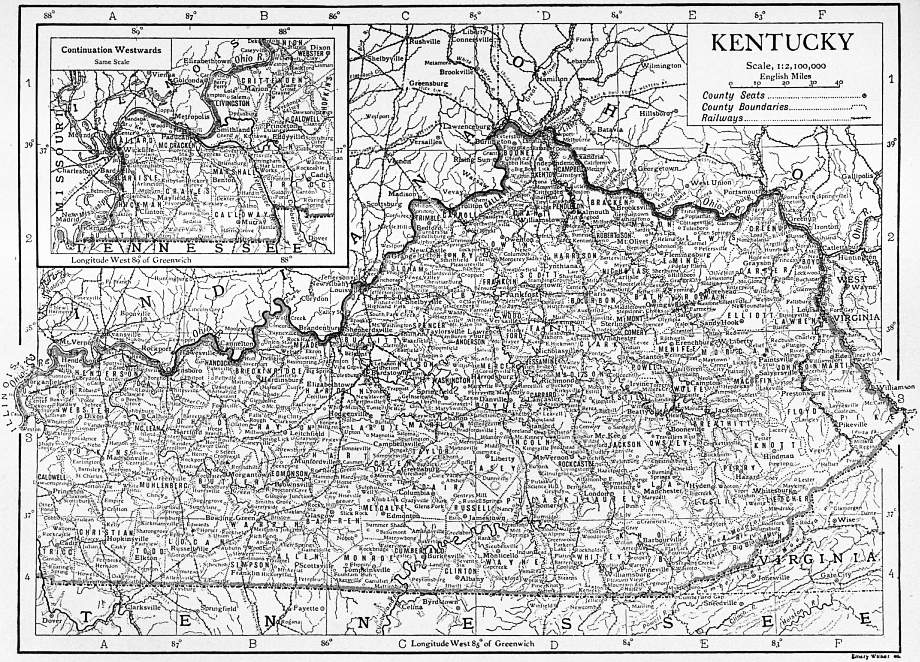
Fauna and Flora.—The first white settlers found great numbers of buffaloes, deer, elks, geese, ducks, turkeys and partridges, also many bears, panthers, lynx, wolves, foxes, beavers, otters, minks, musk-rats, rabbits, squirrels, raccoons, woodchucks, opossums and 741 skunks, and the streams were inhabited by trout, perch, buffalo-fish, sun-fish, mullet, eels, and suckers. Of the larger game there remain only a few deer, bears and lynx in the mountain districts, and the numbers of small game and fish have been greatly reduced. In its primeval state Kentucky was generally well timbered, but most of the middle section has been cleared and here the blue grass is now the dominant feature of the flora. Extensive forest areas still remain both in the east and the west. In the east oak, maple, beech, chestnut, elm, tulip-tree (locally “yellow poplar”), walnut, pine and cedar trees are the most numerous; in the west the forests are composed largely of cypress, ash, oak, hickory, chestnut, walnut, beech, tulip-tree, gum and sycamore trees. Locust, pawpaw, cucumber, buck-eye, black mulberry and wild cherry trees also abound, and the grape, raspberry and strawberry are native fruits.
Climate.—The climate is somewhat more mild and even than that of the neighbouring states. The mean annual temperature, about 50° F. on the mountains in the S.E., and 60° W. of the Tennessee, is about 55° F. for the entire state; the thermometer seldom registers as high as 100° or as low as -10°. The mean annual precipitation ranges from about 38 in. in the north-east to 50 in. in the south, and is about 46 in. for the entire state; it is usually distributed evenly throughout the year and very little is in the form of snow. The prevailing winds blow from the west or south-west; rain-bearing winds blow mostly from the south; and the cold waves come from the north or north-west.
Soil.—The best soils are the alluvium in the bottom-lands along some of the larger rivers and that of the Blue Grass Region, which is derived from a limestone rich in organic matter (containing phosphorus) and rapidly decomposing. The soil within a radius of some 20 m. around Lexington is especially rich; outside of this area the Blue Grass soil is less rich in phosphorus and contains a larger mixture of sand. The soils of the Highland Rim Plateau as well as of the lowland west of the Tennessee river vary greatly, but the most common are a clay, containing more or less carbonate of lime, and a sandy loam. On the escarpment around the Blue Grass Region the soils are for the most part either cherty or stiff with clay and of inferior quality. On the mountains and on the Alleghany Plateau, also, much of the soil is very light and thin.
Agriculture.—Kentucky is chiefly an agricultural state. Of the 752,531 of its inhabitants who, in 1900, were engaged in some gainful occupation, 408,185 or 54.2%, were agriculturists, and of its total land surface 21,979,422 acres, or 85.9%, were included in farms. The percentage of improved farm land increased from 35.2 in 1850 to 49.9 in 1880 and to 62.5 in 1900. The number of farms increased from 74,777 in 1850 to 166,453 in 1880 and to 234,667 in 1900; and their average size decreased from 226.7 acres in 1850 to 129.1 acres in 1880 and to 93.7 acres in 1900, these changes being largely due to the breaking up of slave estates, the introduction of a considerable number of negro farmers, and the increased cultivation of tobacco and market-garden produce. In the best stock-raising country, e.g. in Fayette county, the opposite tendency prevailed during the latter part of this period and old farms of a few hundred acres were combined to form some vast estates of from 2000 to 4000 acres. Of the 234,667 farms in 1900, 155,189 contained less than 100 acres, 76,450 contained between 100 and 500 acres, and 558 contained more than 1000 acres; 152,216 or 64.86%, were operated by owners or part owners, of whom 5320 were negroes; 16,776 by cash tenants, of whom 789 were negroes; and 60,289 by share tenants, of whom 4984 were negroes. In 1900 the value of farm land and improvements was $291,117,430; of buildings on farms, $90,887,460; of livestock, $73,739,106. In the year 1899 the value of all farm products was $123,266,785 (of which $21,128,530 was the value of products fed to livestock), including the following items: crops, $74,783,365; animal products, $44,303,940; and forest products, $4,179,840. The total acreage of all crops in 1899 was 6,582,696. Indian corn is the largest and most valuable crop. As late as 1849, when it produced 58,672,591 bu., Kentucky was the second largest Indian-corn producing state in the Union. In 1899 the crop had increased to 73,974,220 bu. and the acreage was 3,319,257 (more than half the acreage of all crops in the state), but the rank had fallen to ninth in product and eleventh in acreage; in 1909 (according to the Yearbook of the United States Department of Agriculture) the crop was 103,472,000 bu. (ninth among the states of the United States), and the acreage was 3,568,000 (twelfth among the states). Among the cereals wheat is the next largest crop; it increased from 2,142,822 bu. in 1849 to 11,356,113 bu. in 1879, and to 14,264,500 bu. in 1899; in 1909 it was only 7,906,000 bu. The crop of each of the other cereals is small and in each case was less in 1899 than in 1849. The culture of tobacco, which is the second most valuable crop in the state, was begun in the north part about 1780 and in the west and south early in the 19th century, but it was late in that century before it was introduced to any considerable extent in the Blue Grass Region, where it was then in a measure substituted for the culture of hemp. By 1849 Kentucky ranked second only to Virginia in the production of tobacco, and in 1899 it was far ahead of any other state in both acreage and yield, there being in that year 384,805 acres, which was 34.9% of the total acreage in the continental United States, yielding 314,288,050 ℔. As compared with the state’s Indian corn crop of that year, the acreage was only a little more than one-ninth, but the value ($18,541,982) was about 63%. In 1909 the tobacco acreage in Kentucky was 420,000, the crop was 350,700,000 ℔, valued at $37,174,200; the average price per pound had increased from 5.9 cents in 1899 to 10.6 cents in 1909. The two most important tobacco-growing districts are: the Black Patch, in the extreme south-west corner of the state, which with the adjacent counties in Tennessee grows a black heavy leaf bought almost entirely by the agents of foreign governments (especially Austria, Spain and Italy) and called “regie” tobacco; and the Blue Grass Region, as far east as Maysville, and the hill country south and east, whose product, the red and white Burley, is a fine-fibred light leaf, peculiarly absorbent of licorice and other adulterants used in the manufacture of sweet chewing tobacco, and hence a peculiarly valuable crop, which formerly averaged 22 cents a pound for all grades.1 The high price received by the hill growers of the Burley induced farmers in the Blue Grass to plant Burley tobacco there, where the crop proved a great success, more than twice as much (sometimes 2000 ℔) being grown to the acre in the Blue Grass as in the hills and twice as large patches being easily managed. In the hill country the share tenant could usually plant and cultivate only four acres of tobacco, had to spend 120 days working the crop, and could use the same land for tobacco only once in six years. So, although a price of 6.5 cents a pound covered expenses of the planter of Burley in the Blue Grass, who could use the same land for tobacco once in four years, this price did not repay the hill planter. The additional production of the Blue Grass Region sent the price of Burley tobacco down to this figure and below it. The planters in the Black Patch had met a combination of the buyers by forming a pool, the Planters’ Protective Association, into which 40,000 growers were forced by “night-riding” and other forms of coercion and persuasion, and had thus secured an advance to 11 cents a pound from the “regie” buyers and had shown the efficacy of pooling methods in securing better prices for the tobacco crop. Following their example, the planters of the Burley formed the Burley Tobacco Society, a Burley pool, with headquarters at Winchester and associated with the American Society of Equity, which promoted in general the pooling of different crops throughout the country. The tobacco planters secured legislation favourable to the formation of crop pools. The Burley Tobacco Society attempted to pool the entire crop and thus force the buyers of the American Tobacco Company of New Jersey (which usually bought more than three-fourths of the crop of Burley) to pay a much higher price for it. In 1906 and in 1907 the crop was very large; the pool sold its lower grades of the 1906 crop at 16 cents a pound to the American Tobacco Company and forced the independent buyers out of business; and the Burley Society decided in 1907 to grow no more tobacco until the 1906 and 1907 crops were sold, making the price high enough to pay for this period of idleness. Members of the pool had used force to bring planters into the pool; and now some tobacco growers, especially in the hills, planted new crops in the hope of immediate return, and a new “night-riding” war was begun on them. Bands of masked men rode about the country both in the Black Patch and in the Burley, burning tobacco houses of the independent planters, scraping their newly-planted tobacco patches, demanding that planters join their organization or leave the country, and whipping or shooting the recalcitrants. Governor Willson, immediately after his inauguration, took measures to suppress disorder. In general the Planters’ Protective Association in the Black Patch was more successful in its pool than the Burley Tobacco Society in its, and there was more violence in the “regie” than in the “Burley” district. In November 1908 the lawlessness subsided in the Burley after the agreement of the American Tobacco Company to purchase the remainder of the 1906 crop at a “round” price of 20½ cents and a part of the 1907 crop at an average price of 17 cents, thus making it profitable to raise a full crop in 1909.
Kentucky is the principal hemp-growing state of the Union; the crop of 1899, which was grown on 14,107 acres and amounted to 10,303,560 ℔, valued at $468,454, was 87.7% of the hemp crop of the whole country. But the competition of cheaper labour in other countries reduced the profits on this plant and the product of 1899 was a decrease from 78,818,000 ℔ in 1859. Hay and forage, the fourth in value of the state’s crops in 1899, were grown on 683,139 acres and amounted to 776,534 tons, valued at $6,100,647; in 1909 the acreage of hay was 480,000 and the crop of 653,000 tons was valued at $7,771,000. In 1899 the total value of fruit grown in Kentucky was $2,491,457 (making the state rank thirteenth among the states of the Union in the value of this product), of which $1,943,645 was the value of orchard fruits and $435,462 that of small fruits. Among fruits, apples are produced in greatest abundance, 6,053,717 bu. in 1899, an amount exceeded in only nine states; in 1889 the crop had been 10,679,389 bu. and was exceeded only by the crop of Ohio and by that of Michigan. Kentucky also grows considerable quantities of cherries, pears, plums and peaches, and, for its size, ranks high in its crops of strawberries, blackberries and raspberries. Indian corn is grown in all parts of the state but most largely in the western portion. Wheat is grown both in the Blue Grass Region and farther west; and the best country for fruit is along the Ohio river between Cincinnati and Louisville and in the hilly land surrounding the Blue Grass Region. In the eastern part of the state 742 where crops are generally light, Indian corn, oats and potatoes are the principal products, but tobacco, flax and cotton are grown. The thoroughbred Kentucky horse has long had a world-wide reputation for speed; and the Blue Grass Region, especially Fayette, Bourbon and Woodford counties, is probably the finest horse-breeding region in America and has large breeding farms. In Fayette county, in 1900, the average value of colts between the ages of one and two years was $377.78. In the Blue Grass Region many thoroughbred shorthorn cattle and fine mules are raised. The numbers of horses, mules, cattle and sheep increased quite steadily from 1850 to 1900, but the number of swine in 1880 and in 1900 was nearly one-third less than in 1850. In 1900 the state had 497,245 horses, 198,110 mules, 364,025 dairy cows, 755,714 other neat cattle, 1,300,832 sheep and 2,008,989 swine; in 1910 there were in Kentucky 407,000 horses, 207,000 mules, 394,000 milch cows, 665,000 other neat cattle, 1,060,000 sheep and 989,000 swine. The principal sheep-raising counties in 1905 were Bourbon, Scott and Harrison, and the principal hog-raising counties were Graves, Hardin, Ohio, Union and Hickman.
Forests and Timber.—More than one-half of the state (about 22,200 sq. m.) was in 1900 still wooded. In 1900 of the total cut of 777,218 M. ft., B.M., 392,804 were white oak and 279,740 M. ft. were tulip-tree. Logging is the principal industry of several localities, especially in the east, and the lumber product of the state increased in value from $1,502,434 in 1850 to $4,064,361 in 1880, and to $13,774,911 in 1900. The factory product in 1900 was valued at $13,338,533 and in 1905 at $14,539,000. In 1905 of a total of 586,371 M. ft., B.M., of sawed lumber, 295,776 M. ft. were oak and 153,057 M. ft. were “poplar.”
The planing mill industry is increasing rapidly, as it is found cheaper to erect mills near the forests; between 1900 and 1905 the capital of planing mills in the state increased 117.2% and the value of products increased 142.8%.
Manufactures.—Kentucky’s manufactures are principally those for which the products of her farms and forests furnish the raw material. The most distinctive of these is probably distilled liquors, the state’s whisky being famous. A colony of Roman Catholic immigrants from Maryland settled in 1787 along the Salt river about 50 m. S.S.E. of Louisville and with the surplus of their Indian corn crop made whisky, a part of which they sold at settlements on the Ohio and the Mississippi. The industry was rapidly developed by distillers, who immediately after the suppression of the Whisky Insurrection, in 1794, removed from Pennsylvania and settled in what is now Mason county and was then a part of Bourbon county—the product is still known as “Bourbon” whisky. During the first half of the 19th century the industry became of considerable local importance in all parts of the state, but since the Civil War the heavy tax imposed has caused its concentration in large establishments. In 1900 nearly 40% and in 1905 more than one-third of the state’s product was distilled in Louisville. Good whisky is made in Maryland and in parts of Pennsylvania from rye, but all efforts in other states to produce from Indian corn a whisky equal to the Bourbon have failed, and it is probable that the quality of the Bourbon is largely due to the character of the Kentucky lime water and the Kentucky yeast germs. The average annual product of the state from 1880 to 1900 was about 20,000,000 gallons; in 1900 the product was valued at $9,786,527; in 1905 at $11,204,649. In 1900 and in 1905 Kentucky ranked fourth among the states in the value of distilled liquors.
The total value of all manufactured products of the state increased from $126,719,857 in 1890 to $154,166,365 in 1900, or 21.7%, and from 1900 to 1905 the value of factory-made products alone increased from $126,508,660 to $159,753,968, or 26.3%.2 Measured by the value of the product, flour and grist mill products rose from third in rank in 1900 to first in rank in 1905, from $13,017,043 to $18,007,786, or 38.3%; and chewing and smoking tobacco and snuff fell during the same period from first to third in rank, from $14,948,192 to $13,117,000, or 12.3%; in 1900 Kentucky was second, in 1905 third, among the states in the value of this product. Lumber and timber products held second rank both in 1900 ($13,338,533) and in 1905 ($14,539,000). Distilled liquors were fourth in rank in 1900 and in 1905. Men’s clothing rose from tenth in rank in 1900 to fifth in rank in 1905, from $3,420,365 to $6,279,078, or 83.6%. Other important manufactures, with their product values in 1900 and in 1905, are iron and steel ($5,004,572 in 1900; $6,167,542 in 1905); railway cars ($4,248,029 in 1900; $5,739,071 in 1905); packed meats ($5,177,167 in 1900; $5,693,731 in 1905); foundry and machine shop products ($4,434,610 in 1900; $4,699,559 in 1905); planing mill products, including sash, doors and blinds ($1,891,517 in 1900; $4,593,251 in 1905—an increase already remarked); carriages and wagons ($2,849,713 in 1900; $4,059,438 in 1905); tanned and curried leather ($3,757,016 in 1900; $3,952,277 in 1905); and malt liquors ($3,186,627 in 1900; $3,673,678 in 1905). Other important manufactures (each with a product value in 1905 of more than one million dollars) were cotton-seed oil and cake (in 1900 Kentucky was fifth and in 1905 sixth among the states in the value of cotton-seed oil and cake), cooperage, agricultural implements, boots and shoes, cigars and cigarettes, saddlery and harness, patent medicines and compounds, cotton goods, furniture, confectionery, carriage and wagon materials, wooden packing boxes, woollen goods, pottery and terra cotta ware, structural iron-work, and turned and carved wood. Louisville is the great manufacturing centre, the value of its products amounting in 1905 to $83,204,125, 52.1% of the product of the entire state, and showing an increase of 25.9% over the value of the city’s factory products in 1900. Ashland is the principal centre of the iron industry.
Minerals.—The mineral resources of Kentucky are important and valuable, though very little developed. The value of all manufactures in 1900 was $154,166,365, and the value of manufactures based upon products of mines or quarries in the same year was $25,204,788; the total value of mineral products was $19,294,341 in 1907. Bituminous coal is the principal mineral, and in 1907 Kentucky ranked eighth among the coal-producing states of the Union; the output in 1907 amounted to 10,753,124 short tons, and in 1902 to 6,766,984 short tons as compared with 2,399,755 tons produced in 1889. In 1902 the amount was about equally divided between the eastern coalfield, which is for the most part in Greenup, Boyd, Carter, Lawrence, Johnson, Lee, Breathitt, Rockcastle, Pulaski, Laurel, Knox, Bell and Whitley counties, and has an area of about 11,180 sq. m., and the western coalfield, which is in Henderson, Union, Webster, Daviess, Hancock, McLean, Ohio, Hopkins, Butler, Muhlenberg and Christian counties, and has an area of 5800 sq. m. In 1907 the output of the western district was 6,295,397 tons; that of the eastern, 4,457,727. The largest coal-producing counties in 1907 were Hopkins (2,064,154 short tons) and Muhlenberg (1,882,913 short tons) in the western coalfield, and Bell (1,437,886 short tons) and Whitley (762,923 short tons) in the south-western part of the eastern coalfield. All Kentucky coal is either bituminous or semi-bituminous, but of several varieties. Of cannel coal Kentucky is the largest producer in the Union, its output for 1902 being 65,317 short tons, and, according to state reports, for 1903, 72,856 tons (of which 46,314 tons were from Morgan county), and for 1904, 68,400 tons (of which 52,492 tons were from Morgan county); according to the Mineral Resources of the United States for 1907 (published by the United States Geological Survey) the production of Kentucky in 1907 of cannel coal (including 4650 tons of semi-cannel coal) was 77,733 tons, and exclusive of semi-cannel coal the output of Kentucky was much larger than that of any other state. Some of the coal mined in eastern Kentucky is an excellent steam producer, especially the Jellico coal of Whitley county, Kentucky, and of Campbell county, Tennessee. But with the exception of that mined in Hopkins and Bell counties, very little is fit for making coke; in 1880 the product was 4250 tons of coke (value $12,250), in 1890, 12,343 tons ($22,191); in 1900, 95,532 tons ($235,505); in 1902, 126,879 tons ($317,875), the maximum product up to 1906; and in 1907, 67,068 tons ($157,288). Coal was first mined in Kentucky in Laurel or Pulaski county in 1827; between 1829 and 1835 the annual output was from 2000 to 6000 tons; in 1840 it was 23,527 tons and in 1860 it was 285,760 tons.
Petroleum was discovered on Little Rennick’s Creek, near Burkesville, in Cumberland county, in 1829, when a flowing oil well (the “American well,” whose product was sold as “American oil” to heal rheumatism, burns, &c.) was struck by men boring for a “salt well,” and after a second discovery in the ’sixties at the mouth of Crocus Creek a small but steady amount of oil was got each year. Great pipe lines from Parkersburg, West Virginia, to Somerset, Pulaski county, and with branches to the Ragland, Barbourville and Prestonburg fields, had in 1902 a mileage of 275 m. The principal fields are in the “southern tier,” from Wayne to Allen county, including Barren county; farther east, Knox county, and Floyd and Knott counties; to the north-east the Ragland field in Bath and Rowan counties on the Licking river. In 1902 the petroleum produced in the state amounted to 248,950 barrels, valued at $172,837, a gain in quantity of 81.4% over 1901. Kentucky is the S.W. extreme of the natural gas region of the west flank of the Appalachian system; the greatest amount is found in Martin county in the east, and Breckinridge county in the north-west. The value of the state’s natural gas output increased from $38,993 in 1891 to $99,000 in 1896, $286,243 in 1900, $365,611 in 1902, and $380,176 in 1907.
Iron ore has been found in several counties, and an iron furnace was built in Bath county, in the N. E. part of the state, as early as 1791, but since 1860 this mineral has received little attention. In 1902 it was mined only in Bath, Lyon and Trigg counties, of which the total product was 71,006 long tons, valued at only $86,169; in 1904 only 35,000 tons were mined, valued at the mines at $35,000.
In 1898 there began an increased activity in the mining of fluorspar, and Crittenden, Fayette and Livingston counties produced in 1902, 29,030 tons (valued at $143,410) of this mineral, in 1903 30,835 tons (valued at $153,960) and in 1904 19,096 tons (valued at $111,499), amounts (and values) exceeding those produced in any other state for these years; but in 1907 the quantity (21,058 tons) was less than the output of Illinois. Lead and zinc are mined in small quantities near Marion in Crittenden county and elsewhere in connexion with mining for fluorspar; in 1907 the output was 75 tons of lead valued at $7950 and 358 tons of zinc valued at $42,244. Jefferson, Jessamine, Warren, Grayson and Caldwell counties have valuable quarries of an excellent light-coloured 743 öolitic limestone, resembling the Bedford limestone of Indiana, and best known under the name of the finest variety, the “Bowling Green stone” of Warren county; and sandstones good for structural purposes are found in both coal regions, and especially in Rowan county. In 1907 the total value of limestone quarried in the state was $891,500, and of all stone, $1,002,450. Fire and pottery clay and cement rock also abound within the state. The value of clay products was $2,406,350 in 1905 (when Kentucky was tenth among the states) and was $2,611,364 in 1907 (when Kentucky was eleventh among the states). The manufacture of cement was begun in 1829 at Shippingport, a suburb of Louisville, whence the natural cement of Kentucky and Indiana, produced within a radius of 15 m. from Louisville, is called “Louisville cement.” In 1905 the value of natural cement manufactured in the state (according to the United States Geological Survey) was only $83,000. The manufacture of Portland cement is of greater importance.
There are mineral springs, especially salt springs, in various parts of the state, particularly in the Blue Grass Region; these are now of comparatively little economic importance; no salt was reported among the state’s manufactures for 1905, and in 1907 only 736,920 gallons of mineral waters were bottled for sale. Historically and geologically, however, these springs are of considerable interest. According to Professor N. S. Shaler, state geologist in 1873-1880, “When the rocks whence they flow were formed on the Silurian sea-floors, a good deal of the sea-water was imprisoned in the strata, between the grains of sand or mud and in the cavities of the shells that make up a large part of these rocks. This confined sea-water is gradually being displaced by the downward sinking of the rain-water through the rifts of the strata, and thus finds its way to the surface: so that these springs offer to us a share of the ancient seas, in which perhaps a hundred million of years ago the rocks of Kentucky were laid down.” To these springs in prehistoric and historic times came annually great numbers of animals for salt, and in the marshes and swamps around some of them, especially Big Bone Lick (in Boone county, about 20 m. S.W. of Cincinnati) have been found many bones of extinct mammals, such as the mastodon and the long-legged bison.3 The early settlers and the Indians came to the springs to shoot large game for food, and by boiling the waters the settlers obtained valuable supplies of salt. Several of the Kentucky springs have been somewhat frequented as summer resorts; among these are the Blue Lick in Nicholas county (about 48 m. N.E. of Lexington), Harrodsburg, Crab Orchard in Lincoln county (about 115 m. S.E. of Louisville), Rock Castle springs in Pulaski county (about 23 m. E. of Somerset) and Paroquet Springs (near Shepherdsville, Bullitt county), which was a well-known resort before the Civil War, and near which, at Bullitt Lick, the first salt works in Kentucky are said to have been erected.
Pearls are found in the state, especially in the Cumberland River, and it is supposed that there are diamonds in the kimberlite deposits in Elliott county.
Transportation.—Kentucky in 1909 had 3,503.98 m. of railway. Railway building was begun in the state in 1830, and in 1835 the first train drawn by a steam locomotive ran from Lexington to Franklin, a distance of 27 m. Not until 1851 was the line completed to Louisville. Kentucky’s trade during the greater part of the 19th century was very largely with the South, and with the facilities which river navigation afforded for this the development of a railway system was retarded. Up to 1880 the railway mileage had increased to only 1,530; but during the next ten years it increased to 2,942, and railways were in considerable measure substituted for water craft. The principal lines are the Louisville & Nashville, the Chesapeake & Ohio, the Illinois Central, and the Cincinnati Southern (Queen & Crescent route). Most of the lines run south or south-west from Cincinnati and Louisville, and the east border of the state still has a small railway mileage and practically no wagon roads, most of the travel being on horseback. The wagon roads of the Blue Grass Region are excellent, because of the plentiful and cheap supply of stone for road building. The assessment of railway property, and in some measure the regulation of railway rates, are entrusted to a state railway commission.
Population.—The population of Kentucky in 18804 was 1,648,690; in 1890, 1,858,635, an increase within the decade of 12.7 %; in 1900 it was 2,147,174; and in 1910 it had reached 2,289,905. Of the total population of 1900, 284,865 were coloured and 50,249 were foreign-born; of the coloured, 284,706 were negroes, 102 were Indians, and 57 were Chinese; of the foreign-born, 27,555 were natives of Germany, 9874 were natives of Ireland, and 3256 were natives of England. Of the foreign-born, 21,427, or 42.6 %, were inhabitants of the city of Louisville, leaving a population outside of this city of which 98.4 % were native born. The rugged east section of the state, a part of Appalachian America, is inhabited by a people of marked characteristics, portrayed in the fiction of Miss Murfree (“Charles Egbert Craddock”) and John Fox, Jr. They are nearly all of British—English and Scotch-Irish—descent, with a trace of Huguenot. They have good native ability, but through lack of communication with the outside world their progress has been retarded. Before the Civil War they were owners of land, but for the most part not owners of slaves, so that a social and political barrier, as well as the barriers of nature, separated them from the other inhabitants of the state. In their speech several hundred words persist which elsewhere have been obsolete for three centuries or occur only in dialects in England. Their life is still in many respects very primitive; their houses are generally built of logs, their clothes are often of homespun, Indian corn and ham form a large part of their diet, and their means of transportation are the saddle-horse and sleds and wheeled carts drawn by oxen or mules. In instincts and in character, also, the typical “mountaineers” are to a marked degree primitive; they are, for the most part, very ignorant; they are primitively hospitable and are warm-hearted to friends and strangers, but are implacable in their enmities and are prone to vendettas and family feuds, which often result in the killing in open fight or from ambush of members of one faction by members of another; and their relative seclusion and isolation has brought them, especially in some districts, to a disregard for law, or to a belief that they must execute justice with their own hands. This appears particularly in their attitude toward revenue officers sent to discover and close illicit stills for the distilling from Indian corn of so-called “moon-shine” whisky (consisting largely of pure alcohol). The taking of life and “moon-shining,” however, have become less and less frequent among them, and Berea College, at Berea, the Lincoln Memorial University, and other schools in Kentucky and adjoining states have done much to educate them and bring them more in harmony with the outside community.
The population of Kentucky is largely rural. However, in the decade between 1890 and 1900 the percentage of urban population (i.e. population of places of 4000 inhabitants or more) to the total population increased from 17.5 to 19.7 and the percentage of semi-urban (i.e. population of incorporated places with a population of less than 4000) to the total increased from 8.86 to 9.86 %; but 48.3 % of the urban population of 1900 was in the city of Louisville. In 1910 the following cities each had a population of more than 5000. Louisville (223,928), Covington (53,270), Lexington (35,099), Newport (30,309), Paducah (22,760), Owensboro (16,011), Henderson (11,452), Frankfort, the capital (10,465), Hopkinsville (9419), Bowling Green (9173), Ashland (8688), Middlesboro (7305), Winchester (7156), Dayton (6979), Bellevue (6683), Maysville (6141), Mayfield (5916), Paris (5859), Danville (5420), Richmond (5340). Of historical interest are Harrodsburg (q.v.), the first permanent settlement in the state, and Bardstown (pop. in 1900, 1711), the county-seat of Nelson county. Bardstown was settled about 1775, largely by Roman Catholics from Maryland. It was the see of a Roman Catholic bishop from 1810 to 1841, and the seat of St Joseph’s College (Roman Catholic) from 1824 to 1890; and was for some time the home of John Fitch (1743-1798), the inventor, who built his first boat here. The Nazareth Literary and Benevolent Institution, at Nazareth (2 m. N. of Bardstown), was founded in 1829 and is a well-known Roman Catholic school for girls. Boonesborough, founded by Daniel Boone in 1775, in what is now Madison county, long ago ceased to exist, though a railway station named Boone, on the Louisville & Nashville railroad, is near the site of the old settlement.
In 1906 there were 858,324 communicants of different religious denominations in the state, including 311,583 Baptists, 165,908 Roman Catholics, 156,007 Methodists, 136,110 Disciples of Christ, 47,822 Presbyterians and 8091 Protestant Episcopalians.
Administration.—Kentucky is governed under a constitution adopted in 1891.5 A convention to revise the constitution or to draft a new one meets on the call of two successive legislatures, ratified by a majority of the popular vote, provided that majority be at least one-fourth of the total number of votes cast at the preceding general election. Ordinary amendments are proposed by a three-fifths majority in each house, and are also subject to popular approval. With the usual exceptions of criminals, 744 idiots and insane persons, all male citizens of the United States, who are at least 21 years of age, and have lived in the state one year, in the county six months, and in the voting precinct sixty days next preceding the election, are entitled to vote. The legislature provides by law for registration in cities of the first, second, third and fourth classes—the minimum population for a city of the fourth class being 3000. Corporations are forbidden to contribute money for campaign purposes on penalty of forfeiting their charters, or, if not chartered in the state, their right to carry on business in the state. The executive is composed of a governor, a lieutenant-governor, a treasurer, an auditor of public accounts, a register of the land office, a commissioner of agriculture, labour, and statistics, a secretary of state, an attorney-general and a superintendent of public instruction. All are chosen by popular vote for four years and are ineligible for immediate re-election, and each must be at least 30 years of age and must have been a resident citizen of the state for two years next preceding his election. If a vacancy occurs in the office of governor during the first two years a new election is held; if it occurs during the last two years the lieutenant-governor serves out the term. Lieutenant-governor Beckham, elected in 1900 to fill out the unexpired term of Governor Goebel (assassinated in 1900), was re-elected in 1903, the leading lawyers of the state holding that the constitutional inhibition on successive terms did not apply in such a case.
The governor is commander-in-chief of the militia when it is not called into the service of the United States; he may remit fines and forfeitures, commute sentences, and grant reprieves and pardons, except in cases of impeachment; and he calls extraordinary sessions of the legislature. His control of patronage, however, is not extensive and his veto power is very weak. He may veto any measure, including items in appropriation bills, but the legislature can repass such a measure by a simple majority of the total membership in each house. Among the various state administrative boards are the board of equalization of five members, the board of health of nine members, a board of control of state institutions with four members (bipartisan), and the railroad commission, the prison commission, the state election commission and the sinking fund commission of three members each. Legislative power is vested in a General Assembly, which consists of a Senate and a House of Representatives. Senators are elected for four years, one-half retiring every two years; representatives are elected for two years. The minimum age for a representative is 24 years, for a senator 30 years. There are thirty-eight senators and one hundred representatives. The Senate sits as a court for the trial of impeachment cases. A majority of either house constitutes a quorum, but as regards ordinary bills, on the third reading, not only must they receive a majority of the quorum, but that majority must be at least two-fifths of the total membership of the house. For the enactment of appropriation bills and bills creating a debt a majority of the total membership in each house is required. All revenue measures must originate in the House of Representatives, but the Senate may introduce amendments. There are many detailed restrictions on local and special legislation. The constitution provides for local option elections on the liquor question in counties, cities, towns and precincts; in 1907, out of 119 counties 87 had voted for prohibition.
The judiciary consists of a court of appeals, circuit courts, quarterly courts, county courts, justice of the peace courts, police courts and fiscal courts. The court of appeals is composed of from five to seven judges (seven in 1909), elected, one from each appellate district, for a term of eight years. The senior judge presides as chief justice and in case two or more have served the same length of time one of them is chosen by lot. The governor may for any reasonable cause remove judges on the address of two-thirds of each house of the legislature. The counties are grouped into judicial circuits, those containing a population of more than 150,000 constituting separate districts; each district has a judge and a commonwealth’s attorney. The county officials are the judge, clerk, attorney, sheriff, jailor, coroner, surveyor and assessor, elected for four years. Each county contains from three to eight justice of the peace districts. The financial board of the county is composed of the county judge and the justices of the peace, or of the county judge and three commissioners elected on a general ticket.
The municipalities are divided into six classes according to population, a classification which permits considerable special local legislation in spite of the constitutional inhibition. Marriages between whites and persons of negro descent are prohibited by law, and a marriage of insane persons is legally void. Among causes for absolute divorce are adultery, desertion for one year, habitual drunkenness for one year, cruelty, ungovernable temper, physical incapacity at time of marriage, and the joining by either party of any religious sect which regards marriage as unlawful. A homestead law declares exempt from execution an unmortgaged dwelling-house (with appurtenances) not to exceed $1000 in value, and certain property, such as tools of one’s trade, libraries (to the value of $500) of ministers and lawyers, and provisions for one year for each member of a family. Child labour is regulated by an act passed by the General Assembly in 1908; this act prohibits the employment of children less than 14 years of age in any gainful occupation during the session of school or in stores, factories, mines, offices, hotels or messenger service during vacations, and prohibits the employment of children between 14 and 16 unless they have employment certificates issued by a superintendent of schools or some other properly authorized person, showing the child’s ability to read and write English, giving information as to the child’s age (based upon a birth certificate if possible), and identifying the child by giving height and weight and colour of eyes and hair. These certificates must be kept on file and lists of children employed must be posted by employers; labour inspectors receive monthly lists from local school boards of children receiving certificates; and children under 16 are not to work more than 10 hours a day or 60 hours a week, or between 7 p.m. and 7 a.m.
Charitable and Penal Institutions.—The charitable and penal institutions are managed by separate boards of trustees appointed by the governor. There are a deaf and dumb institution at Danville (1823), an institution for the blind at Louisville (1842), and an institution for the education of feeble-minded children at Frankfort (1860). The Eastern Lunatic Asylum at Lexington, established in 1815 as a private institution, came under the control of the state in 1824. The Central Lunatic Asylum at Anchorage, founded in 1869 as a house of refuge for young criminals, became an asylum in 1873. The Western Lunatic Asylum at Hopkinsville was founded in 1848. The main penitentiary at Frankfort was completed in 1799 and a branch was established at Eddyville in 1891. Under an act of 1898 two houses of reform for juvenile offenders, one for boys, the other for girls, were established near Lexington.
Education.—The early history of the schools of Kentucky shows that the rural school conditions have been very unsatisfactory. A system of five trustees, with a sixty-day term of school, was replaced by a three trustee system, first with a one-hundred-day term of school, and subsequently with a one-hundred-and-twenty-day term of school annually. The state fund has not been supplemented locally for the payment of teachers, who have consequently been underpaid. The rural teachers, however, have been paid from the state fund, so that the poorer districts receive aid from the richer districts of the commonwealth. The rural schools are supervised by a superintendent in each county. Throughout the state white and negro children are taught in separate schools. The state makes provision for revenue for school purposes as follows: (1) the interest on the Bond of the Commonwealth for $1,327,000.00; (2) dividends on 798 shares of the capital stock of the Bank of Kentucky—representing a par value of $79,800.00; (3) the interest at 6 % on the Bond of the Commonwealth for $381,986.08, which is a perpetual obligation in favour of the several counties; (4) the interest at 6 % on $606,641.03, which was received from the United States; (5) the annual tax of 26½ cents on each $100 of value of all real and personal estate and corporate franchises directed to be assessed for taxation; (6) a certain portion of fines, forfeitures and licences realized by the state; and (7) a portion of the dog taxes of each county. The present school system of Kentucky may be summarized under three heads: the rural schools, the graded schools, and the high schools (which are further classified as city and county high schools). The 1908 session of the General Assembly passed an act providing: that each county of the state be the unit for taxation; that the county tax be mandatory; that there be a local subdistrict tax; and that each county be divided into four, six or eight educational divisions, that one trustee be elected for each subdistrict, that the trustees of the subdistricts form division Boards of Education, and that the chairmen of these various division boards form a County Board of Education together with the county superintendent, who is ex officio chairman. This system of taxation and supervision is a great advance in the administration of public schools. Any subdistrict, town or city of the fifth or sixth class may provide for a graded school by voting for an ad valorem and poll tax which is limited as to amount. There were in 1909 135 districts which had complied with this act, and were known as Graded Common School districts. By special charters the General Assembly has also established 25 special graded schools. Statutes provide that all children between the ages of 7 and 14 years living in such districts must attend school annually for at least eight consecutive weeks. In each city of the first, second and third class there must be, and of the fourth class there may be, maintained under control of a city Board of Education a system of public schools, in which all children between the ages of 6 and 20 residing in the city may be taught at public expense. There were in 1909 62 city public high schools whose graduates are admitted to the State University without examination. A truancy act (1908) provides that every child between the ages of 7 and 14 years living in a city of the first, second, third or fourth class must attend school regularly for the full term of said school. It was provided by statute that before June 1910, 745 there should have been established in each county of the state at least one County High School to which all common school graduates of the county should be admitted without charge. Separate institutes for white and coloured teachers are conducted annually in each county. These institutes are held for a five or ten day session and attendance is required of every teacher. The state provides for the issuance of three kinds of certificates. A state diploma issued by the State Board of Examiners is good for life. A state certificate issued by the State Board of Examiners is good for eight years with one renewal. County certificates issued by the County Board of Examiners are of three classes, valid for one, two and four years respectively.
According to a school census there was in 1908-1909 a school population of 739,352, of which 587,051 were reported from the rural districts. In the school year 1907-1908 the school population was 734,617, the actual enrolment in public schools was 441,377, the average attendance was 260,843; there were approximately 3392 male and 5257 female white teachers and 1274 negro teachers; and the total revenue for school purposes was $3,805,997, of which sum $2,437,942.56 came from the state treasury.
What was formerly the State Agricultural and Mechanical College at Lexington became the State University by legislative enactment (1908); there is no tuition fee except in the School of Law. The State University has a Department of Education. The state maintains for the whites two State Normal Schools, which were established in 1906—one, for the eastern district, at Richmond, and the other, for the western district, at Bowling Green. Under the law establishing State Normal Schools, each county is entitled to one or more appointments of scholarships, one annually for every 500 white school children listed in the last school census. A Kentucky Normal and Industrial School (1886) for negroes is maintained at Frankfort. Among the private and denominational colleges in Kentucky are Central University (Presbyterian), at Danville; Transylvania University, at Lexington; Georgetown College (Baptist) at Georgetown; Kentucky Wesleyan College (M.E. South), at Winchester; and Berea College (non-sectarian) at Berea.
Finance.—Kentucky, in common with other states in this part of the country, suffered from over-speculation in land and railways during 1830-1850. The funded debt of the state amounted to four and one-half millions of dollars in 1850, when the hew constitution limited the power of the legislature to contract further obligations or to decrease or misapply the sinking funds. From 1850 to 1880 there was a gradual reduction except during the years of the war. The system of classifying the revenue into separate funds has frequently produced annual deficits, which are, as a rule only nominal, since the total receipts exceed the total expenditures. In 1902 the net bonded debt, exclusive of about two millions of dollars held for educational purposes, was $1,171,394, but this debt was paid in full in the years immediately following. The sinking fund commission is composed of the governor, attorney-general, secretary of state, auditor and treasurer. The first banking currency in Kentucky was issued in 1802 by a co-operative insurance company established by Mississippi Valley traders. The Bank of Kentucky, established at Frankfort in 1806, had a monopoly for several years. In 1818-1819 the legislature chartered 46 banks, nearly all of which went into liquidation during the panic of 1819. The Bank of the Commonwealth was chartered in 1820 as a state institution and the charter of the Bank of Kentucky was revoked in 1822. A court decision denying the legal tender quality of the notes issued by the Bank of the Commonwealth gave rise to a bitter controversy which had considerable influence upon the political history of the state. This bank failed in 1829. In 1834 the legislature chartered the Bank of Kentucky, the Bank of Louisville and the Northern Bank of Kentucky. These institutions survived the panic of 1837 and soon came to be recognized as among the most prosperous and the most conservative banks west of the Alleghanies. The state banking laws are stringent and most of the business is still controlled by banks operating under state charters.
History.—The settlement and the development of that part of the United States west of the Alleghany Mountains has probably been the most notable feature of American history since the close of the Seven Years’ War (1763). Kentucky was the first settlement in this movement, the first state west of the Alleghany Mountains admitted into the Union. In 1763 the Kentucky country was claimed by the Cherokees as a part of their hunting grounds, by the Six Nations (Iroquois) as a part of their western conquests, and by Virginia as a part of the territory granted to her by her charter of 1609, although it was actually inhabited only by a few Chickasaws near the Mississippi river and by a small tribe of Shawnees in the north, opposite what is now Portsmouth, Ohio. The early settlers were often attacked by Indian raiders from what is now Tennessee or from the country north of the Ohio, but the work of colonization would have been far more difficult if those Indians had lived in the Kentucky region itself. Dr Thomas Walker (1715-1794), as an agent and surveyor of the Loyal Land Company, made an exploration in 1750 into the present state from the Cumberland Gap, in search of a suitable place for settlement but did not get beyond the mountain region. In the next year Christopher Gist, while on a similar mission for the Ohio Company, explored the country westward from the mouth of the Scioto river. In 1752 John Finley, an Indian trader, descended the Ohio river in a canoe to the site of Louisville. It was Finley’s descriptions that attracted Daniel Boone, and soon after Boone’s first visit, in 1767, travellers through the Kentucky region became numerous. The first permanent English settlement was established at Harrodsburg in 1774 by James Harrod, and in October of the same year the Ohio Indians, having been defeated by Virginia troops in the battle of Point Pleasant (in what is now West Virginia), signed a treaty by which they surrendered their claims south of the Ohio river. In March 1775 Richard Henderson and some North Carolina land speculators met about 1200 Cherokee Indians in council on the Watauga river and concluded a treaty with them for the purchase of all the territory south of the Ohio river and between the Kentucky and Cumberland rivers. The purchase was named Transylvania, and within less than a month after the treaty was signed, Boone, under its auspices, founded a settlement at Boonesborough which became the headquarters of the colony. The title was declared void by the Virginia government in 1778, but Henderson and his associates received 200,000 acres in compensation, and all sales made to actual settlers were confirmed. During the War of Independence the colonists were almost entirely neglected by Virginia and were compelled to defend themselves against the Indians who were often under British leadership. Boonesborough was attacked in April and in July 1777 and in August 1778. Bryant’s (or Bryan’s) Station, near Lexington, was besieged in August 1782 by about 600 Indians under the notorious Simon Girty, who after raising the siege drew the defenders, numbering fewer than 200, into an ambush and in the battle of Blue Licks which ensued the Kentuckians lost about 67 killed and 7 prisoners. Kentucky county, practically coterminous with the present state of Kentucky and embracing all the territory claimed by Virginia south of the Ohio river and west of Big Sandy Creek and the ridge of the Cumberland Mountains, was one of three counties which was formed out of Fincastle county in 1776. Four years later, this in turn was divided into three counties, Jefferson, Lincoln and Fayette, but the name Kentucky was revived in 1782 and was given to the judicial district which was then organized for these three counties. The War of Independence was followed by an extensive immigration from Virginia, Maryland and North Carolina6 of a population of which fully 95%, excluding negro slaves, were of pure English, Scotch or Scotch-Irish descent. The manners, customs and institutions of Virginia were transplanted beyond the mountains. There was the same political rivalry between the slave-holding farmers of the Blue Grass Region and the “poor whites” of the mountain districts that there was in Virginia between the tide-water planters and the mountaineers. Between these extremes were the small farmers of the “Barrens”7 in Kentucky and of the Piedmont Region in Virginia. The aristocratic influences in both states have always been on the Southern and Democratic side, but while they were strong enough in Virginia to lead the state into secession they were unable to do so in Kentucky.
At the close of the War of Independence the Kentuckians complained because the mother state did not protect them against their enemies and did not give them an adequate system of local government. Nine conventions were held at Danville from 1784 to 1790 to demand separation from Virginia. The Virginia authorities expressed a willingness to grant the demand provided Congress would admit the new district into the Union as a state. The delay, together with the proposal of John Jay, the Secretary for Foreign Affairs and commissioner to negotiate a commercial treaty with the Spanish envoy, to surrender navigation rights on the lower Mississippi for twenty-five years in order to remove the one obstacle to the negotiations, aroused so much feeling that General James Wilkinson and a few other leaders began to intrigue not only for a separation from Virginia, but also from the United States, and for the formation of a close alliance with the Spanish at New Orleans. Although most of the settlers were too loyal to be led into any such plot they generally agreed that it might have a good effect by bringing pressure to bear upon the Federal government. Congress passed a preliminary act in February 1791, and the state was formally admitted into the Union on the 1st of June 1792. In the Act of 1776 for dividing Fincastle county, Virginia, the ridge of the Cumberland Mountains was named as a part of the east boundary of Kentucky; and now that this ridge had become a part of the boundary between the states of Virginia and Kentucky they, in 1799, appointed a joint commission to run the boundary line on this ridge. A dispute with Tennessee over the southern boundary was settled in a similar manner in 1820.8 The constitution of 1792 provided for manhood suffrage and for the election of the governor and of senators by an electoral college. General Isaac Shelby was the first governor. The people still continued to have troubles with the Indians and with the Spanish at New Orleans. The Federal government was slow to act, but its action when taken was effective. The power of the Indians was overthrown by General Anthony Wayne’s victory in the battle of Fallen Timbers, fought the 20th of August 1794 near the rapids of the Maumee river a few miles above the site of Toledo, Ohio; and the Mississippi question was settled temporarily by the treaty of 1795 and permanently by the purchase of Louisiana in 1803. In 1798-1799 the legislature passed the famous Kentucky Resolutions in protest against the alien and sedition acts.
For several years the Anti-Federalists or Republicans had contended that the administration at Washington had been exercising powers not warranted by the constitution, and when Congress had passed the alien and sedition laws the leaders of that party seized upon the event as a proper occasion for a spirited public protest which took shape principally in resolutions passed by the legislatures of Kentucky and Virginia. The original draft of the Kentucky Resolutions of 1798 was prepared by Vice-President Thomas Jefferson, although the fact that he was the author of them was kept from the public until he acknowledged it in 1821. They were introduced in the House of Representatives by John Breckinridge on the 8th of November, were passed by that body with some amendments but with only one dissenting vote on the 10th, were unanimously concurred in by the Senate on the 13th, and were approved by Governor James Garrard on the 16th. The first resolution was a statement of the ultra states’-rights view of the relation of the states to the Federal government9 and subsequent resolutions declare the alien and sedition laws unconstitutional and therefore “void and of no force,” principally on the ground that they provided for an exercise of powers which were reserved to the state. The resolutions further declare that “this Commonwealth is determined, as it doubts not its co-states are, tamely to submit to undelegated and therefore unlimited powers in no man or body of men on earth,” and that “these and successive acts of the same character, unless arrested on the threshold, may tend to drive these states into revolution and blood.” Copies of the resolutions were sent to the governors of the various states, to be laid before the different state legislatures, and replies were received from Connecticut, Delaware, Massachusetts, New Hampshire, New York, Rhode Island, Vermont and Virginia, but all except that from Virginia were unfavourable. Nevertheless the Kentucky legislature on the 22nd of November 1799 reaffirmed in a new resolution the principles it had laid down in the first series, asserting in this new resolution that the state “does now unequivocally declare its attachment to the Union, and to that compact [the Constitution], agreeably to its obvious and real intention, and will be among the last to seek its dissolution,” but that “the principle and construction contended for by sundry of the state legislatures, that the General Government is the exclusive judge of the extent of the powers delegated to it, stop nothing [short] of despotism—since the discretion of those who administer the government, and not the Constitution, would be the measure of their powers,” “that the several states who formed that instrument, being sovereign and independent, have the unquestionable right to judge of the infraction,” and “that a nullification by those sovereignties of all unauthorized acts done under color of that instrument is the rightful remedy.” These measures show that the state was Democratic-Republican in its politics and pro-French in its sympathies, and that it was inclined to follow the leadership of that state from which most of its people had come.
The constitution of 1799 adopted the system of choosing the governor and senators by popular vote and deprived the supreme court of its original jurisdiction in land cases. The Burr conspiracy (1804-1806) aroused some excitement in the state. Many would have followed Burr in a filibustering attack upon the Spanish in the South-West, but scarcely any would have approved of a separation of Kentucky from the Federal Union. No battles were fought in Kentucky during the War of 1812, but her troops constituted the greater part of the forces under General William Henry Harrison. They took part in the operations at Fort Wayne, Fort Meigs, the river Raisin and the Thames.
The Democratic-Republicans controlled the politics of the state without any serious opposition until the conflict in 1820-1826, arising from the demands for a more adequate system of currency and other measures for the relief of delinquent debtors divided the state into what were known as the relief and anti-relief parties. After nearly all the forty-six banks chartered by the legislature in 1818 had been wrecked in the financial panic of 1819, the legislature in 1820 passed a series of laws designed for the benefit of the debtor class, among them one making state bank notes a legal tender for all debts. A decision of the Clark county district court declaring this measure unconstitutional was affirmed by the court of appeals. The legislature in 1824 repealed all of the laws creating the existing court of appeals and then established a new one. This precipitated a bitter campaign 747 between the anti-relief or “old court” party and the relief or “new court” party, in which the former was successful. The old court party followed the lead of Henry Clay and John Quincy Adams in national politics, and became National Republicans and later Whigs. The new court party followed Andrew Jackson and Martin Van Buren and became Democrats. The electoral vote of the state was cast for Jackson in 1828 and for Clay in 1832. During the next thirty years Clay’s conservative influence dominated the politics of the state.10 Kentucky voted the Whig ticket in every presidential election from 1832 until the party made its last campaign in 1852. When the Whigs were destroyed by the slavery issue some of them immediately became Democrats, but the majority became Americans, or Know-Nothings. They elected the governor in 1855 and almost succeeded in carrying the state for their presidential ticket in 1856. In 1860 the people of Kentucky were drawn toward the South by their interest in slavery and by their social relations, and toward the North by business ties and by a national sentiment which was fostered by the Clay traditions. They naturally assumed the leadership in the Constitutional Union movement of 1860, casting the vote of the state for Bell and Everett. After the election of President Lincoln they also led in the movement to secure the adoption of the Crittenden Compromise or some other peaceful solution of the difficulties between the North and the South.
A large majority of the state legislature, however, were Democrats, and in his message to this body, in January 1861, Governor Magoffin, also a Democrat, proposed that a convention be called to determine “the future of Federal and inter-state relations of Kentucky;” later too, in reply to the president’s call for volunteers, he declared, “Kentucky will furnish no troops for the wicked purpose of subduing her sister Southern States.” Under these conditions the Unionists asked only for the maintenance of neutrality, and a resolution to this effect was carried by a bare majority—48 to 47. Some of the secessionists took this as a defeat and left the state immediately to join the Confederate ranks. In the next month there was an election of congressmen, and an anti-secession candidate was chosen in nine out of ten districts. An election in August of one-half the Senate and all of the House of Representatives resulted in a Unionist majority in the new legislature of 103 to 35, and in September, after Confederate troops had begun to invade the state, Kentucky formally declared its allegiance to the Union. From September 1861 to the fall of Fort Donelson in February 1862 that part of Kentucky which is south and west of the Green River was occupied by the Confederate army under General A. S. Johnston, and at Russellville in that district a so-called “sovereignty convention” assembled on the 18th of November. This body, composed mostly of Kentucky men who had joined the Confederate army, passed an ordinance of secession, elected state officers, and sent commissioners to the Confederate Congress, which body voted on the 9th of December to admit Kentucky into the Confederacy. Throughout the war Kentucky was represented in the Confederate Congress—representatives and senators being elected by Confederate soldiers from the state. The officers of this “provisional government,” headed by G. W. Johnson, who had been elected “governor,” left the state when General A. S. Johnston withdrew; Johnson himself was killed at Shiloh, but an attempt was subsequently made by General Bragg to install this government at Frankfort. General Felix K. Zollicoffer (1812-1862) had entered the south-east part of the state through Cumberland Gap in September, and later with a Confederate force of about 7000 men attempted the invasion of central Kentucky, but in October 1861 he met with a slight repulse at Wild Cat Mountain, near London, Laurel county, and on the 19th of January 1862, in an engagement near Mill Springs, Wayne county, with about an equal force under General George H. Thomas, he was killed and his force was utterly routed. In 1862 General Braxton Bragg in command of the Confederates in eastern Tennessee, eluded General Don Carlos Buell, in command of the Federal Army of the Ohio stationed there, and entering Kentucky in August 1862 proceeded slowly toward Louisville, hoping to win the state to the Confederate cause and gain recruits for the Confederacy in the state. His main army was preceded by a division of about 15,000 men under General Edmund Kirby Smith, who on the 30th of August defeated a Federal force under General Wm. Nelson near Richmond and threatened Cincinnati. Bragg met with little opposition on his march, but Buell, also marching from eastern Tennessee, reached Louisville first (Sept. 24), turned on Bragg, and forced him to withdraw. On his retreat, Bragg attempted to set up a Confederate government at Frankfort, and Richard J. Hawes, who had been chosen as G. W. Johnson’s successor, was actually “inaugurated,” but naturally this state “government” immediately collapsed. On the 8th of October Buell and Bragg fought an engagement at Perryville which, though tactically indecisive, was a strategic victory for Buell; and thereafter Bragg withdrew entirely from the state into Tennessee. This was the last serious attempt on a large scale by the Confederates to win Kentucky; but in February 1863 one of General John H. Morgan’s brigades made a raid on Mount Sterling and captured it; in March General Pegram made a raid into Pulaski county; in March 1864 General N. B. Forrest assaulted Fort Anderson at Paducah but failed to capture it; and in June General Morgan made an unsuccessful attempt to take Lexington.
Although the majority of the people sympathized with the Union, the emancipation of the slaves without compensation even to loyal owners, the arming of negro troops, the arbitrary imprisonment of citizens and the interference of Federal military officials in purely civil affairs aroused so much feeling that the state became strongly Democratic, and has remained so almost uniformly since the war. Owing to the panic of 1893, distrust of the free silver movement and the expenditure of large campaign funds, the Republicans were successful in the gubernational election of 1895 and the presidential election of 1896. The election of 1899 was disputed. William S. Taylor, Republican, was inaugurated governor on the 12th of December, but the legislative committee on contests decided in favour of the Democrats. Governor-elect Goebel was shot by an assassin on the 30th of January 1900, was sworn into office on his deathbed, and died on the 3rd of February. Taylor fled the state to escape trial on the charge of murder. Lieutenant-Governor Beckham filled out the unexpired term and was re-elected in 1903. In 1907 the Republicans again elected their candidate for governor.
Governors of Kentucky
* Died in office.
† Governor Crittenden resigned on the 31st of July to become Attorney-General of the United States and John L. Helm served out the unexpired term.
‡ Governor Stevenson resigned on the 13th of February 1871 to become U.S. Senator from Kentucky. P. H. Leslie filled out the remainder of the term and was elected in 1871 for a full term.
§ Taylor’s election was contested by Goebel, who received the certificate of election.
Bibliography.—For descriptions of physical features and accounts of natural resources see Reports of the Kentucky Geological Survey, the Biennial Reports of the Bureau of Agriculture, Labor and Statistics, the Reports of the United States Census and various publications of the U.S. Geological Survey, and other publications listed in Bulletin 301 (Bibliography and Index of North American Geology for 1901-1905) and other bibliographies of the Survey. For an early description, see Gilbert Imlay, A Topographical Description of the Western Territory of North America (London, 3rd ed., 1797), in which John Filson’s “Discovery, Settlement and Present State of Kentucke” (1784) is reprinted. For a brief description of the Blue Grass Region, see James Lane Allen’s The Blue Grass Region of Kentucky and other Kentucky Articles (New York, 1900). An account of the social and industrial life of the people in the “mountain” districts is given in William H. Haney’s The Mountain People of Kentucky (Cincinnati, 1906). For administration, see the Official Manual for the Use of the Courts, State and County Officials and General Assembly of the State of Kentucky (Lexington), which contains the Constitution of 1891; The Report of the Debates and Proceedings of the Convention ... of 1849 (Frankfort, 1849); The Official Report of the Proceedings and Debates of the Constitutional Convention of 1890 (4 vols., Frankfort, 1890); B. H. Young, History and Texts of Three Constitutions of Kentucky (Louisville, 1890); J. F. Bullitt and John Feland, The General Statutes of Kentucky (Frankfort and Louisville, 1877, revised editions, 1881, 1887); and the Annual Reports of state officers and boards. For history see R. M. McElroy’s Kentucky in the Nation’s History (New York, 1909, with bibliography); or (more briefly) N. S. Shaler’s Kentucky (Boston, 1885), in the American Commonwealths Series. John M. Brown’s The Political Beginnings of Kentucky (Louisville, 1889) is a good monograph dealing with the period before 1792; it should be compared with Thomas M. Green’s The Spanish Conspiracy: A Review of Early Spanish Movements in the Southwest (Cincinnati, 1891), written in reply to it. Among older histories are Humphrey Marshall, The History of Kentucky ... and the Present State of the Country (2 vols., Frankfort, 1812, 1824), extremely Federalistic in tone; Mann Butler, History of Kentucky from its Exploration and Settlement by the Whites to the close of the Southwestern Campaign of 1813 (Louisville, 1834; 2nd ed., Cincinnati, 1836), and Lewis Collins, The History of Kentucky (2 vols., revised edition, Covington, Ky., 1874), a valuable store-house of facts, the basis of Shaler’s work. E. D. Warfield’s The Kentucky Resolutions of 1798 (New York, 2nd ed., 1887) is an excellent monograph. For the Civil War history see “Campaigns in Kentucky and Tennessee,” in the 7th volume of Papers of the Military Historical Society of Massachusetts (Boston, 1908); Thomas Speed, The Union Cause in Kentucky (New York, 1907); Basil W. Duke, History of Morgan’s Cavalry (Cincinnati, 1867), and general works on the history of the war. See also Alvin F. Lewis, History of Higher Education in Kentucky, in Circulars of Information of the U.S. Bureau of Education (Washington, 1899), and R. G. Thwaites, Daniel Boone (New York, 1902). There is much valuable material in the Register (Frankfort, 1903 seq.) of the Kentucky State Historical Society, and especially in the publications of the Filson Club of Louisville. Among the latter are R. T. Durrett’s John Filson, the first Historian of Kentucky (1884); Thomas Speed, The Wilderness Road (1886); W. H. Perrin, The Pioneer Press of Kentucky (1888); G. W. Ranck, Boonesborough: Its Founding, Pioneer Struggles, Indian Experiences, Transylvania Days and Revolutionary Annals (1901), and The Centenary of Kentucky (1892), containing an address, “The State of Kentucky: its Discovery, Settlement, Autonomy and Progress in a Hundred Years,” by Reuben T. Durrett.
1 North of the Black Patch is a district in which is grown a heavy-leaf tobacco, a large part of which is shipped to Great Britain; and farther north and east a dark tobacco is grown for the American market.
2 In the census of 1905 statistics for other than factory-made products, such as those of the hand trades, were not included.
3 For a full account of the “licks,” see vol. i. pt. ii. of the Memoirs of the Kentucky Geological Survey (1876).
4 The population of the state at the previous censuses was: 73,677 in 1790; 220,955 in 1800; 406,511 in 1810; 564,317 in 1820; 687,917 in 1830; 779,828 in 1840; 982,405 in 1850; 1,155,684 in 1860 and 1,321,011 in 1870.
5 There were three previous constitutions—those of 1792, 1799 and 1850.
6 Most of the early settlers of Kentucky made their way thither either by the Ohio river (from Fort Pitt) or—the far larger number—by way of the Cumberland Gap and the “Wilderness Road.” This latter route began at Inglis’s Ferry, on the New river, in what is now West Virginia, and proceeded west by south to the Cumberland Gap. The “Wilderness Road,” as marked by Daniel Boone in 1775, was a mere trail, running from the Watauga settlement in east Tennessee to the Cumberland Gap, and thence by way of what are now Crab Orchard, Danville and Bardstown, to the Falls of the Ohio, and was passable only for men and horses until 1795, when the state made it a wagon road. Consult Thomas Speed, The Wilderness Road (Louisville, Ky., 1886), and Archer B. Hulbert, Boone’s Wilderness Road (Cleveland, O., 1903).
7 The “Barrens” were in the north part of the state west of the Blue Grass Region, and were so called merely because the Indians had burned most of the forests here in order to provide better pasturage for buffaloes and other game.
8 The southern boundary to the Tennessee river was surveyed in 1779-1780 by commissioners representing Virginia and North Carolina, and was supposed to be run along the parallel of latitude 36° 30′, but by mistake was actually run north of that parallel. By a treaty of 1819 the Indian title to the territory west of the Tennessee was extinguished, and commissioners then ran a line along the parallel of 36° 30′ from the Mississippi to the Tennessee. In 1820 commissioners representing Kentucky and Tennessee formally adopted the line of 1779-1780 and the line of 1819 as the boundary between the two states.
9 This resolution read as follows: Resolved, that the several states composing the United States of America are not united on the principle of unlimited submission to their general government; but that by compact under the style of a Constitution for the United States and of amendments thereto, they constituted a general government for special purposes, delegated to that government certain definite powers, reserving each state to itself the residuary mass of right to their own self-government; and that whensoever the general government assumes undelegated powers its acts are unauthoritative, void, and of no force: That to this compact each state acceded as a state, and is an integral party, its co-states forming, as to itself, the other party: That the government created by this compact was not made the exclusive or final judge of the extent of the powers delegated to itself, since that would have made its discretion, and not the Constitution, the measure of its powers; but that, as in all other cases of compact among parties having no common judge, each party has an equal right to judge for itself as well of infractions as of the mode and measure of redress.
10 He died in 1852, but the traditions which he represented survived.
KENYA, a great volcanic mountain in British East Africa, situated just south of the equator in 37° 20′ E. It is one of the highest mountains of Africa, its highest peak reaching an altitude of 17,007 ft. (with a possible error of 30 ft. either way). The central core, which consists of several steep pyramids, is that of a very denuded old volcano, which when its crater was complete may have reached 2000 ft. above the present summit. Lavas dip in all directions from the central crystalline core, pointing to the conclusion that the main portion of the mountain represents a single volcanic mass. From the central peaks, of which the axis runs from W.N.W. to S.S.E., ridges radiate outwards, separated by broad valleys, ending upwards in vast cirques. The most important ridges centre in the peak Lenana (16,300 ft.) at the eastern end of the central group, and through it runs the chief water-parting of the mountain, in a generally north to south direction. Three main valleys, known respectively as Hinde, Gorges and Hobley valleys, run down from this to the east, and four—Mackinder, Hausberg, Teleki and Höhnel—to the west. From the central peaks fifteen glaciers, all lying west of the main divide, descend to the north and south, the two largest being the Lewis and Gregory glaciers, each about 1 m. long, which, with the smaller Kolb glacier, lie immediately west of the main divide. Most of the glaciers terminate at an altitude of 14,800-14,900 ft., but the small César glacier, drained to the Hausberg valley, reaches to 14,450. Glaciation was formerly much more extensive, old moraines being observed down to 12,000 ft. In the upper parts of the valleys a number of lakes occur, occupying hollows and rock basins in the agglomerates and ashes, fed by springs, and feeding many of the streams that drain the mountain slopes. The largest of these are Lake Höhnel, lying at an altitude of 14,000 ft., at the head of the valley of the same name, and measuring 600 by 400 yds.; and Lake Michaelson (12,700 ft.?) in the Gorges Valley. At a distance from the central core the radiating ridges become less abrupt and descend with a gentle gradient, finally passing somewhat abruptly, at a height of some 7000 ft., into the level plateau. These outer slopes are clothed with dense forest and jungle, composed chiefly of junipers and Podocarpus, and between 8000 and 9800 ft. of huge bamboos. The forest zone extends to about 10,500 ft., above which is the steeper alpine zone, in which pasturages alternate with rocks and crags. This extends to a general height of about 15,000 ft., but in damp, sheltered valleys the pasturages extend some distance higher. The only trees or shrubs in this zone are the giant Senecio (groundsel) and Lobelia, and tree-heaths, the Senecio forming groves in the upper valleys. Of the fauna of the lower slopes, tracks of elephant, leopard and buffalo have been seen, between 11,500 and 14,500 ft. That of the alpine zone includes two species of dassy (Procavia), a coney (Hyrax), and a rat (Otomys). The bird fauna is of considerable interest, the finest species of the upper zone being an eagle-owl, met with at 14,000 ft. At 11,000 ft. was found a brown chat, with a good deal of white in the tail. Both the fauna and flora of the higher levels present close affinities with those of Mount Elgon, of other mountains of East Africa and of Cameroon Mountain. The true native names of the mountain are said to be Kilinyaga, Doenyo Ebor (white mountain) and Doenyo Egeri (spotted mountain). It was first seen, from a distance, by the missionary Ludwig Krapf in 1849; approached from the west by Joseph Thomson in 1883; partially ascended by Count S. Teleki (1889), J. W. Gregory (1893) and Georg Kolb (1896); and its summit reached by H. J. Mackinder in 1899.
See J. W. Gregory, The Great Rift-Valley (London, 1896); H. J. Mackinder, “Journey to the Summit of Mount Kenya,” Geog. Jnl., May 1900.
KENYON, LLOYD KENYON, 1st Baron (1732-1802), lord chief-justice of England, was descended by his father’s side from an old Lancashire family; his mother was the daughter of a small proprietor in Wales. He was born at Gredington, Flintshire, on the 5th of October 1732. Educated at Ruthin grammar school, he was in his fifteenth year articled to an attorney at Nantwich, Cheshire. In 1750 he entered at Lincoln’s Inn, London, and in 1756 was called to the bar. As for several years he was almost unemployed, he utilized his leisure in taking notes of the cases argued in the court of King’s Bench, which he afterwards published. Through answering the cases of his friend John Dunning, afterwards Lord Ashburton, he gradually became known to the attorneys, after which his success was so rapid that in 1780 he was made king’s counsel. He showed conspicuous ability in the cross-examination of the witnesses at the trial of Lord George Gordon, but his speech was so tactless that the verdict of acquittal was really due to the brilliant effort of Erskine, the junior counsel. This want of tact, indeed, often betrayed Kenyon into striking blunders; as an advocate he was, 749 moreover, deficient in ability of statement; and his position was achieved chiefly by hard work, a good knowledge of law and several lucky friendships. Through the influence of Lord Thurlow, Kenyon in 1780 entered the House of Commons as member for Hindon, and in 1782 he was, through the same friendship, appointed attorney-general in Lord Buckingham’s administration, an office which he continued to hold under Pitt. In 1784 he received the mastership of the rolls, and was created a baronet. In 1788 he was appointed lord chief justice as successor to Lord Mansfield, and the same year was raised to the peerage as Baron Kenyon of Gredington. As he had made many enemies, his elevation was by no means popular with the bar; but on the bench, in spite of his capricious and choleric temper, he proved himself not only an able lawyer, but a judge of rare and inflexible impartiality. He died at Bath, on the 4th of April 1802. Kenyon was succeeded as 2nd baron by his son George (1776-1855), whose great-grandson, Lloyd (b. 1864), became the 4th baron in 1869.
See Life by Hon. G. T. Kenyon, 1873.
KEOKUK, a city of Lee county, Iowa, U.S.A., on the Mississippi river, at the mouth of the Des Moines, in the S.E. corner of the state, about 200 m. above St Louis. Pop. (1900), 14,641; (1905), 14,604, including 1534 foreign-born; (1910), 14,008. It is served by the Chicago, Burlington & Quincy, the Chicago, Rock Island & Pacific, the Wabash, and the Toledo, Peoria & Western railways. There is a bridge (about 2200 ft. long) across the Mississippi, and another (about 1200 ft. long) across the Des Moines. The city has a public library and St Joseph and Graham hospitals, and is the seat of the Keokuk Medical College (1849). There is a national cemetery here. Much of the city is built on bluffs along the Mississippi. Keokuk is at the foot of the Des Moines Rapids, round which the Federal Government has constructed a navigable canal (opened 1877) about 9 m. long, with a draft at extreme low water of 5 ft.; at the foot a great dam, 1½ m. long and 38 ft. high, has been constructed. Keokuk has various manufactures; its factory product in 1905 was valued at $4,225,915, 38.6% more than in 1900. The city was named after Keokuk, a chief of the Sauk and Foxes (1780-1848), whose name meant “the watchful” or “he who moves alertly.” In spite of Black Hawk’s war policy in 1832 Keokuk was passive and neutral, and with a portion of his nation remained peaceful while Black Hawk and his warriors fought. His grave, surmounted by a monument, is in Rand Park. The first house on the site of the city was built about 1820, but further settlement did not begin until 1836. Keokuk was laid out as a town in 1837, was chartered as a city in 1848, and in 1907 was one of five cities of the state governed by a special charter.
KEONJHAR, a tributary state of India, within the Orissa division of Bengal; area, 3096 sq. m.; pop. (1901), 285,758; estimated revenue, £20,000. The state is an offshoot from Mayurbhanj. Part of it consists of rugged hills, rising to more than 3000 ft. above sea-level. The residence of the raja is at Keonjhar (pop. 4532).
KEONTHAL, a petty hill state in the Punjab, India, with an area of 116 sq. m.; pop. (1901), 22,499; estimated revenue, £4400. The chief, a Rajput, received the title of raja in 1857. After the Gurkha War in 1815, a portion of Keonthal, which had been occupied by the Gurkhas, was sold to the maharaja of Patiala, the remainder being restored to its hereditary chief. In 1823 the district of Punar was added to the Keonthal state. The raja exercises rights of lordship over the petty states of Kothi, Theog, Madhan and Ratesh.
KEPLER, JOHANN (1571-1630), German astronomer, was born on the 27th of December 1571, at Weil, in the duchy of Württemberg, of which town his grandfather was burgomaster. He was the eldest child of an ill-assorted union. His father, Henry Kepler, was a reckless soldier of fortune; his mother, Catherine Guldenmann, the daughter of the burgomaster of Eltingen, was undisciplined and ill-educated. Her husband found campaigning in Flanders under Alva a welcome relief from domestic life; and, after having lost all he possessed by a forfeited security and tried without success the trade of tavern-keeping in the village of Elmendingen, he finally, in 1589, deserted his family. The misfortune and misconduct of his parents were not the only troubles of Kepler’s childhood. He recovered from small-pox in his fourth year with crippled hands and eyesight permanently impaired; and a constitution enfeebled by premature birth had to withstand successive shocks of severe illness. His schooling began at Leonberg in 1577—the year, as he himself tells us, of a great comet; but domestic bankruptcy occasioned his transference to field-work, in which he was exclusively employed for several years. Bodily infirmity, combined with mental aptitude, were eventually considered to indicate à theological vocation; he was, in 1584, placed at the seminary of Adelberg, and thence removed, two years later, to that of Maulbronn. A brilliant examination for the degree of bachelor procured him, in 1588, admittance on the foundation to the university of Tübingen, where he laid up a copious store of classical erudition, and imbibed Copernican principles from the private instructions of his teacher and life-long friend, Michael Maestlin. As yet, however, he had little knowledge of, and less inclination for, astronomy; and it was with extreme reluctance that he turned aside from the more promising career of the ministry to accept, early in 1594, the vacant chair of that science at Gratz, placed at the disposal of the Tübingen professors by the Lutheran states of Styria.
The best recognized function of German astronomers in that day was the construction of prophesying almanacs, greedily bought by a credulous public. Kepler thus found that the first duties required of him were of an astrological nature, and set himself with characteristic alacrity to master the rules of the art as laid down by Ptolemy and Cardan. He, moreover, sought in the events of his own life a verification of the theory of planetary influences; and it is to this practice that we owe the summary record of each year’s occurrences which, continued almost to his death, affords for his biography a slight but sure foundation. But his thoughts were already working in a higher sphere. He early attained to the settled conviction that for the actual disposition of the solar system some abstract intelligible reason must exist, and this, after much meditation, he believed himself to have found in an imaginary relation between the “five regular solids” and the number and distances of the planets. He notes with exultation the 9th of July 1595, as the date of the pseudo-discovery, the publication of which in Prodromus Dissertationum Cosmographicarum seu Mysterium Cosmographicum (Tübingen, 1596) procured him much fame, and a friendly correspondence with the two most eminent astronomers of the time, Tycho Brahe and Galileo.
Soon after his arrival at Gratz, Kepler contracted an engagement with Barbara von Mühleck, a wealthy Styrian heiress, who, at the age of twenty-three, had already survived one husband and been divorced from another. Before her relatives could be brought to countenance his pretensions, Kepler was obliged to undertake a journey to Württemberg to obtain documentary evidence of the somewhat obscure nobility of his family, and it was thus not until the 27th of April 1597 that the marriage was celebrated. In the following year the archduke Ferdinand, on assuming the government of his hereditary dominions, issued an edict of banishment against Protestant preachers and professors. Kepler immediately fled to the Hungarian frontier, but, by the favour of the Jesuits, was recalled and reinstated in his post. The gymnasium, however, was deserted; the nobles of Styria began to murmur at subsidizing a teacher without pupils; and he found it prudent to look elsewhere for employment. His refusal to subscribe unconditionally to the rigid formula of belief adopted by the theologians of Tübingen permanently closed against him the gates of his alma mater. His embarrassment was relieved however by an offer from Tycho Brahe of the position of assistant in his observatory near Prague, which, after a preliminary visit of four months, he accepted. The arrangement was made just in time; for in August 1600 he received definitive notice to leave Gratz, and, having leased his wife’s property, he departed with his family for Prague.
By Tycho’s unexpected death (Oct. 24, 1601) a brilliant career seemed to be thrown open to Kepler. The emperor Rudolph II. 750 immediately appointed him to succeed his patron as imperial mathematician, although at a reduced salary of 500 florins; the invaluable treasure of Tycho’s observations was placed at his disposal; and the laborious but congenial task was entrusted to him of completing the tables to which the grateful Dane had already affixed the title of Rudolphine. The first works executed by him at Prague were, nevertheless, a homage to the astrological proclivities of the emperor. In De fundamentis astrologiae certioribus (Prague, 1602) he declared his purpose of preserving and purifying the grain of truth which he believed the science to contain. Indeed, the doctrine of “aspects” and “influences” fitted excellently with his mystical conception of the universe, and enabled him to discharge with a semblance of sincerity the most lucrative part of his professional duties. Although he strictly limited his prophetic pretensions to the estimate of tendencies and probabilities, his forecasts were none the less in demand. Shrewd sense and considerable knowledge of the world came to the aid of stellar lore in the preparation of “prognostics” which, not unfrequently hitting off the event, earned him as much credit with the vulgar as his cosmical speculations with the learned. He drew the horoscopes of the emperor and Wallenstein, as well as of a host of lesser magnates; but, though keenly alive to the unworthy character of such a trade, he made necessity his excuse for a compromise with superstition. “Nature,” he wrote, “which has conferred upon every animal the means of subsistence, has given astrology as an adjunct and ally to astronomy.” He dedicated to the emperor in 1603 a treatise on the “great conjunction” of that year (Judicium de trigono igneo); and he published his observations on a brilliant star which appeared suddenly (Sept. 30, 1604), and remained visible for seventeen months, in De stella nova in pede Serpentarii (Prague, 1606). While sharing the opinion of Tycho as to the origin of such bodies by condensation of nebulous matter from the Milky Way, he attached a mystical signification to the coincidence in time and place of the sidereal apparition with a triple conjunction of Mars, Jupiter and Saturn.
The main task of his life was not meanwhile neglected. This was nothing less than the foundation of a new astronomy, in which physical cause should replace arbitrary hypothesis. A preliminary study of optics led to the publication, in 1604, of his Astronomiae pars optica, containing important discoveries in the theory of vision, and a notable approximation towards the true law of refraction. But it was not until 1609 that, the “great Martian labour” being at length completed, he was able, in his own figurative language, to lead the captive planet to the foot of the imperial throne. From the time of his first introduction to Tycho he had devoted himself to the investigation of the orbit of Mars, which, on account of its relatively large eccentricity, had always been especially recalcitrant to theory, and the results appeared in Astronomia nova αἱτιολογητός, seu Physica coelestis tradita commentariis de motibus stellae Martis (Prague, 1609). In this, the most memorable of Kepler’s multifarious writings, two of the cardinal principles of modern astronomy—the laws of elliptical orbits and of equal areas—were established (see Astronomy: History); important truths relating to gravity were enunciated, and the tides ascribed to the influence of lunar attraction; while an attempt to explain the planetary revolutions in the then backward condition of mechanical knowledge produced a theory of vortices closely resembling that afterwards adopted by Descartes. Having been provided, in August 1610, by Ernest, archbishop of Cologne, with one of the new Galilean instruments, Kepler began, with unspeakable delight, to observe the wonders revealed by it. He had welcomed with a little essay called Dissertatio cum Nuncio Sidereo Galileo’s first announcement of celestial novelties; he now, in his Dioptrice (Augsburg, 1611), expounded the theory of refraction by lenses, and suggested the principle of the “astronomical” or inverting telescope. Indeed the work may be said to have founded the branch of science to which it gave its name.
The year 1611 was marked by Kepler as the most disastrous of his life. The death by small-pox of his favourite child was followed by that of his wife, who, long a prey to melancholy, was on the 3rd of July carried off by typhus. Public calamity was added to private bereavement. On the 23rd of May 1611 Matthias, brother of the emperor, assumed the Bohemian crown in Prague, compelling Rudolph to take refuge in the citadel, where he died on the 20th of January following. Kepler’s fidelity in remaining with him to the last did not deprive him of the favour of his successor. Payments of arrears, now amounting to upwards of 4000 florins, was not, however, in the desperate condition of the imperial finances, to be hoped for; and he was glad, while retaining his position as court astronomer, to accept (in 1612) the office of mathematician to the states of Upper Austria. His residence at Linz was troubled by the harsh conduct of the pastor Hitzler, in excluding him from the rites of his church on the ground of supposed Calvinistic leanings—a decision confirmed, with the addition of an insulting reprimand, on his appeal to Württemberg. In 1613 he appeared with the emperor Matthias before the diet of Ratisbon as the advocate of the introduction into Germany of the Gregorian calendar; but the attempt was for the time frustrated by anti-papal prejudice. The attention devoted by him to chronological subjects is evidenced by the publication about this period of several essays in which he sought to prove that the birth of Christ took place five years earlier than the commonly accepted date.
Kepler’s second courtship forms the subject of a highly characteristic letter addressed by him to Baron Stralendorf, in which he reviews the qualifications of eleven candidates for his hand, and explains the reasons which decided his choice in favour of a portionless orphan girl named Susanna Reutlinger. The marriage was celebrated at Linz, on the 30th of October 1613, and seems to have proved a happy and suitable one. The abundant vintage of that year drew his attention to the defective methods in use for estimating the cubical contents of vessels, and his essay on the subject (Nova Stereometria Doliorum, Linz, 1615) entitles him to rank among those who prepared the discovery of the infinitesimal calculus. His observations on the three comets of 1618 were published in De Cometis, contemporaneously with De Harmonice Mundi (Augsburg, 1619), of which the first lineaments had been traced twenty years previously at Gratz. This extraordinary production is memorable as having announced the discovery of the “third law”—that of the sesquiplicate ratio between the planetary periods and distances. But the main purport of the treatise was the exposition of an elaborate system of celestial harmonies depending on the various and varying velocities of the several planets, of which the sentient soul animating the sun was the solitary auditor. The work exhibiting this fantastic emulation of extravagance with genius was dedicated to James I. of England, and the compliment was acknowledged with an invitation to that island, conveyed through Sir Henry Wotton. Notwithstanding the distracted state of his own country, he refused to abandon it, as he had previously, in 1617, declined the post of successor to G. A. Magini in the mathematical chair of Bologna.
The insurmountable difficulties presented by the lunar theory forced Kepler, after an enormous amount of fruitless labour, to abandon his design of comprehending the whole scheme of the heavens in one great work to be called Hipparchus, and he then threw a portion of his materials into the form of a dialogue intended for the instruction of general readers. The Epitome Astronomiae Copernicanae (Linz and Frankfort, 1618-1621), a lucid and attractive textbook of Copernican science, was remarkable for the prominence given to “physical astronomy,” as well as for the extension to the Jovian system of the laws recently discovered to regulate the motions of the planets. The first of a series of ephemerides, calculated on these principles, was published by him at Linz in 1617; and in that for 1620, dedicated to Baron Napier, he for the first time employed logarithms. This important invention was eagerly welcomed by him, and its theory formed the subject of a treatise entitled Chilias Logarithmorum, printed in 1624, but circulated in manuscript three years earlier, which largely contributed to bring the new method into general use in Germany.
His studies were interrupted by family trouble. The restless 751 disposition and unbridled tongue of Catherine Kepler, his mother, created for her numerous enemies in the little town of Leonberg; while her unguarded conduct exposed her to a species of calumny at that time readily circulated and believed. As early as 1615 suspicions of sorcery began to be spread against her, which she, with more spirit than prudence, met with an action for libel. The suit was purposely protracted, and at length, in 1620, the unhappy woman, then in her seventy-fourth year, was arrested on a formal charge of witchcraft. Kepler immediately hastened to Württemberg, and owing to his indefatigable exertions she was acquitted after having suffered thirteen month’s imprisonment, and endured with undaunted courage the formidable ordeal of “territion,” or examination under the imminent threat of torture. She survived her release only a few months, dying on the 13th of April 1622.
Kepler’s whole attention was now devoted to the production of the new tables. “Germany,” he wrote, “does not long for peace more anxiously than I do for their publication.” But financial difficulties, combined with civil and religious convulsions, long delayed the accomplishment of his desires. From the 24th of June to the 29th of August 1626, Linz was besieged, and its inhabitants reduced to the utmost straits by bands of insurgent peasants. The pursuit of science needed a more tranquil shelter; and on the raising of the blockade, Kepler obtained permission to transfer his types to Ulm, where, in September 1627, the Rudolphine Tables were at length given to the world. Although by no means free from errors, their value appears from the fact that they ranked for a century as the best aid to astronomy. Appended were tables of logarithms and of refraction, together with Tycho’s catalogue of 777 stars, enlarged by Kepler to 1005.
Kepler’s claims upon the insolvent imperial exchequer amounted by this time to 12,000 florins. The emperor Ferdinand II., too happy to transfer the burden, countenanced an arrangement by which Kepler entered the service of the duke of Friedland (Wallenstein), who assumed the full responsibility of the debt. In July 1628 Kepler accordingly arrived with his family at Sagan in Silesia, where he applied himself to the printing of his ephemerides up to the year 1636, and whence he issued, in 1629, a Notice to the Curious in Things Celestial, warning astronomers of approaching transits. That of Mercury was actually seen by Gassendi in Paris on the 7th of November 1631 (being the first passage of a planet across the sun ever observed); that of Venus, predicted for the 6th of December following, was invisible in western Europe. Wallenstein’s promises to Kepler were but imperfectly fulfilled. In lieu of the sums due, he offered him a professorship at Rostock, which Kepler declined. An expedition to Ratisbon, undertaken for the purpose of representing his case to the diet, terminated his life. Shaken by the journey, which he had performed entirely on horseback, he was attacked with fever, and died at Ratisbon, on the 15th of November (N.S.), 1630, in the fifty-ninth year of his age. An inventory of his effects showed him to have been possessed of no inconsiderable property at the time of his death. By his first wife he had five, and by his second seven children, of whom only two, a son and a daughter, reached maturity.
The character of Kepler’s genius is especially difficult to estimate. His tendency towards mystical speculation formed a not less fundamental quality of his mind than its strong grasp of positive scientific truth. Without assigning to each element its due value, no sound comprehension of his modes of thought can be attained. His idea of the universe was essentially Pythagorean and Platonic. He started with the conviction that the arrangement of its parts must correspond with certain abstract conceptions of the beautiful and harmonious. His imagination, thus kindled, animated him to those severe labours of which his great discoveries were the fruit. His demonstration that the planes of all the planetary orbits pass through the centre of the sun, coupled with his clear recognition of the sun as the moving power of the system, entitles him to rank as the founder of physical astronomy. But the fantastic relations imagined by him of planetary movements and distances to musical intervals and geometrical constructions seemed to himself discoveries no less admirable than the achievements which have secured his lasting fame. Outside the boundaries of the solar system, the metaphysical side of his genius, no longer held in check by experience, fully asserted itself. The Keplerian like the Pythagorean cosmos was threefold, consisting of the centre, or sun, the surface, represented by the sphere of the fixed stars, and the intermediate space, filled with ethereal matter. It is a mistake to suppose that he regarded the stars as so many suns. He quotes indeed the opinion of Giordano Bruno to that effect, but with dissent. Among his happy conjectures may be mentioned that of the sun’s axial rotation, postulated by him as the physical cause of the revolutions of the planets, and soon after confirmed by the discovery of sun-spots; the suggestion of a periodical variation in the obliquity of the ecliptic; and the explanation as a solar atmospheric effect of the radiance observed to surround the totally eclipsed sun.
It is impossible to consider without surprise the colossal amount of work accomplished by Kepler under numerous disadvantages. But his iron industry counted no obstacles, and secured for him the highest triumph of genius, that of having given to mankind the best that was in him. In private character he was amiable and affectionate; his generosity in recognizing the merits of others secured him against the worst shafts of envy; and a life marked by numerous disquietudes was cheered and ennobled by sentiments of sincere piety.
Kepler’s extensive literary remains, purchased by the empress Catherine II. in 1724 from some Frankfort merchants, and long inaccessibly deposited in the observatory of Pulkowa, were fully brought to light, under the able editorship of Dr Ch. Frisch, in the first complete edition of his works. This important publication (Joannis Kepleri opera omnia, Frankfort, 1858-1871, 8 vols. 8vo) contains, besides the works already enumerated and several minor treatises, a posthumous scientific satire entitled Joh. Keppleri Somnium (first printed in 1634) and a vast mass of his correspondence. A careful biography is appended, founded mainly on his private notes and other authentic documents. His correspondence with Herwart von Hohenburg, unearthed by C. Anschütz at Munich, was printed at Prague in 1886.
Authorities—C. G. Reuschle, Kepler und die Astronomie (Frankfort, 1871); Karl Goebel, Über Keplers astronomische Anschauungen (Halle, 1871); E. F. Apelt, Johann Keplers astronomische Weltansicht (Leipzig, 1849); J. L. C. Breitschwert, Johann Keplers Leben und Wirken (Stuttgart, 1831); W. Förster, Johann Kepler und die Harmonie der Sphären (Berlin, 1862); R. Wolf, Geschichte der Astronomie (Munich, 1877); J. von Hasner, Tycho Brahe und J. Kepler in Prag (1872); H. Brocard, Essai sur la Météorologie de Kepler (Grenoble, 1879, 1881); Siegmund Günther, Johannes Kepler und der tellurisch-kosmische Magnetismus (Wien, 1888); N. Herz, Keplers Astrologie (1895); Ludwig Günther, Keplers Traum vom Mond (1898; an annotated translation of the Somnium); A. Müller, Johann Keppler, der Gesetzgeber der neueren Astronomie (1903); Allgemeine Deutsche Biographie, Bd. XV. (1882).
KEPPEL, AUGUSTUS KEPPEL, Viscount (1725-1786), British admiral, second son of the second earl of Albemarle, was born on the 25th of April 1725. He went to sea at the age of ten, and had already five years of service to his credit when he was appointed to the “Centurion,” and was sent with Anson round the world in 1740. He had a narrow escape of being killed in the capture of Paita (Nov. 13, 1741), and was named acting lieutenant in 1742. In 1744 he was promoted to be commander and post captain. Until the peace of 1748 he was actively employed. In 1747 he ran his ship the “Maidstone” (50) ashore near Belleisle while chasing a French vessel, but was honourably acquitted by a court martial, and reappointed to another command. After peace had been signed he was sent into the Mediterranean to persuade the dey of Algiers to restrain the piratical operations of his subjects. The dey is said to have complained that the king of England should have sent a beardless boy to treat with him, and to have been told that if the beard was the necessary qualification for an ambassador it would have been easy to send a “Billy goat.” After trying the effect of bullying without success, the dey made a treaty, and Keppel returned in 1751. During the Seven Years’ War he saw constant service. He was in North America in 1755, on the coast of France in 1756, was detached on a cruise to reduce the French settlements on the west coast of Africa in 1758, and his ship the “Torbay” (74) was the first to get into action in the battle of Quiberon in 1759. In 1757 he had formed part of the court martial which had condemned Admiral Byng, and had been active among those who had endeavoured to secure a pardon for him; but neither he nor those who had acted with him could produce any serious reason why the sentence should not be carried out. When Spain joined France in 1762 he was sent as second in command with Sir George Pocock in the expedition which took Havannah. His health suffered from the fever which carried off an immense proportion of the soldiers and sailors, but the 752 £25,000 of prize money which he received freed him from the unpleasant position of younger son of a family ruined by the extravagance of his father. He became rear-admiral in October 1762, was one of the Admiralty Board from July 1765 to November 1766, and was promoted vice-admiral on the 24th of October 1770. When the Falkland Island dispute occurred in 1770 he was to have commanded the fleet to be sent against Spain, but a settlement was reached, and he had no occasion to hoist his flag. The most important and the most debated period of his life belongs to the opening years of the war of American Independence. Keppel was by family connexion and personal preference a strong supporter of the Whig connexion, led by the Marquess of Rockingham and the Duke of Richmond. He shared in all the passions of his party, then excluded from power by the resolute will of George III. As a member of Parliament, in which he had a seat for Windsor from 1761 till 1780, and then for Surrey, he was a steady partisan, and was in constant hostility with the “King’s Friends.” In common with them he was prepared to believe that the king’s ministers, and in particular Lord Sandwich, then First Lord of the Admiralty, were capable of any villany. When therefore he was appointed to command the Western Squadron, the main fleet prepared against France in 1778, he went to sea predisposed to think that the First Lord would be glad to cause him to be defeated. It was a further misfortune that when Keppel hoisted his flag one of his subordinate admirals should have been Sir Hugh Palliser (1723-1796), who was a member of the Admiralty Board, a member of parliament, and in Keppel’s opinion, which was generally shared, jointly responsible with his colleagues for the bad state of the navy. When, therefore, the battle which Keppel fought with the French on the 27th of July 1778 ended in a highly unsatisfactory manner, owing mainly to his own unintelligent management, but partly through the failure of Sir Hugh Palliser to obey orders, he became convinced that he had been deliberately betrayed. Though he praised Sir Hugh in his public despatch he attacked him in private, and the Whig press, with the unquestionable aid of Keppel’s friends, began a campaign of calumny to which the ministerial papers answered in the same style, each side accusing the other of deliberate treason. The result was a scandalous series of scenes in parliament and of courts martial. Keppel was first tried and acquitted in 1779, and then Palliser was also tried and acquitted. Keppel was ordered to strike his flag in March 1779. Until the fall of Lord North’s ministry he acted as an opposition member of parliament. When it fell in 1782 be became First Lord, and was created Viscount Keppel and Baron Elden. His career in office was not distinguished, and he broke with his old political associates by resigning as a protest against the Peace of Paris. He finally discredited himself by joining the Coalition ministry formed by North and Fox, and with its fall disappeared from public life. He died unmarried on the 2nd of October 1786. Burke, who regarded him with great affection, said that he had “something high” in his nature, and that it was “a wild stock of pride on which the tenderest of all hearts had grafted the milder virtues.” His popularity disappeared entirely in his later years. His portrait was six times painted by Sir Joshua Reynolds. The copy which belonged originally to Burke is now in the National Gallery.
There is a full Life of Keppel (1842), by his grand-nephew, the Rev. Thomas Keppel.
KEPPEL, SIR HENRY (1809-1904), British admiral, son of the 4th earl of Albemarle and of his wife Elizabeth, daughter of Lord de Clifford, was born on the 14th of June 1809, and entered the navy from the old naval academy of Portsmouth in 1822. His family connexions secured him rapid promotion, at a time when the rise of less fortunate officers was very slow. He became lieutenant in 1829 and commander in 1833. His first command in the “Childers” brig (16) was largely passed on the coast of Spain, which was then in the midst of the convulsions of the Carlist war. Captain Keppel had already made himself known as a good seaman. He was engaged with the squadron stationed on the west coast of Africa to suppress the slave trade. In 1837 he was promoted post captain, and appointed in 1841 to the “Dido” for service in China and against the Malay pirates, a service which he repeated in 1847, when in command of H.M.S. “Maeander.” The story of his two commands was told by himself in two publications, The Expedition to Borneo of H.M.S. “Dido” for the Suppression of Piracy (1846), and in A Visit to the Indian Archipelago in H. M. S. “Maeander” (1853). The substance of these books was afterwards incorporated into his autobiography, which was published in 1809 under the title A Sailor’s Life under four Sovereigns. In 1853 he was appointed to the command of the “St Jean d’Acre” of 101 guns for service in the Crimean War. But he had no opportunity to distinguish himself at sea in that struggle. As commander of the naval brigade landed to co-operate in the siege of Sevastopol, he was more fortunate, and he had an honourable share in the latter days of the siege and reduction of the fortress. After the Crimean War he was again sent out to China, this time in command of the “Raleigh,” as commodore to serve under Sir M. Seymour. The “Raleigh” was lost on an uncharted rock near Hong-Kong, but three small vessels were named to act as her tenders, and Commodore Keppel commanded in them, and with the crew of the “Raleigh,” in the action with the Chinese at Fatshan Creek (June 1, 1857). He was honourably acquitted for the loss of the “Raleigh,” and was named to the command of the “Alligator,” which he held till his promotion to rear-admiral. For his share in the action at Fatshan Creek he was made K.C.B. The prevalence of peace gave Sir Henry Keppel no further chance of active service, but he held successive commands till his retirement from the active list in 1879, two years after he attained the rank of Admiral of the Fleet. He died at the age of 95 on the 17th of January 1904.
KER, JOHN (1673-1726), Scottish spy, was born in Ayrshire on the 8th of August 1673. His true name was Crawfurd, his father being Alexander Crawfurd of Crawfurdland; but having married Anna, younger daughter of Robert Ker, of Kersland, Ayrshire, whose only son Daniel Ker was killed at the battle of Steinkirk in 1692, he assumed the name and arms of Ker in 1697, after buying the family estates from his wife’s elder sister. Having become a leader among the extreme Covenanters, he made use of his influence to relieve his pecuniary embarrassments, selling his support at one time to the Jacobites, at another to the government, and whenever possible to both parties at the same time. He held a licence from the government in 1707 permitting him to associate with those whose disloyalty was known or suspected, proving that he was at that date the government’s paid spy; and in his Memoirs Ker asserts that he had a number of other spies and agents working under his orders in different parts of the country. He entered into correspondence with Catholic priests and Jacobite conspirators, whose schemes, so far as he could make himself cognisant of them, he betrayed to the government. But he was known to be a man of the worst character, and it is improbable that he succeeded in gaining the confidence of people of any importance. The duchess of Gordon was for a time, it is true, one of his correspondents, but in 1707 she had discovered him to be “a knave.” He went to London in 1709, where he seems to have extracted considerable sums of money from politicians of both parties by promising or threatening, as the case might be, to expose Godolphin’s relations with the Jacobites. In 1713, if his own story is to be believed, business of a semi-diplomatic nature took Ker to Vienna, where, although he failed in the principal object of his errand, the emperor made him a present of his portrait set in jewels. Ker also occupied his time in Vienna, he says, by gathering information which he forwarded to the electress Sophia; and in the following year on his way home he stopped at Hanover to give some advice to the future king of England as to the best way to govern the English. Although in his own opinion Ker materially assisted in placing George I. on the English throne, his services were unrewarded, owing, he would have us believe, to the incorruptibility of his character. Similar ingratitude was the recompense for his revelations of the Jacobite intentions in 1715; 753 and as he was no more successful in making money out of the East India Company, nor in certain commercial schemes which engaged his ingenuity during the next few years, he died in a debtors’ prison, on the 8th of July 1726. While in the King’s Bench he sold to Edmund Curll the bookseller, a fellow-prisoner, who was serving a sentence of five months for publishing obscene books, the manuscript of (or possibly only the materials on which were based) the Memoirs of John Ker of Kersland, which Curll published in 1726 in three parts, the last of which appeared after Ker’s death. For issuing the first part of the Memoirs, which purported to make disclosures damaging to the government, but which Curll in self-justification described as “vindicating the memory of Queen Anne,” the publisher was sentenced to the pillory at Charing Cross; and he added to the third part of the Memoirs the indictment on which he had been convicted.
See the above-mentioned Memoirs (London, 1726-1727), and in particular the “preface” to part i.; George Lockhart, The Lockhart Papers (2 vols., London, 1817); Nathaniel Hooke, Correspondence, edited by W. D. Macray (Roxburghe Club, 2 vols., London, 1870), in which Ker is referred to under several pseudonyms, such as “Wicks,” “Trustie,” “The Cameronian Mealmonger,” &c.
KERAK, a town in eastern Palestine, 10 m. E. of the southern angle of the Lisan promontory of the Dead Sea, on the top of a rocky hill about 3000 ft. above sea-level. It stands on a platform forming an irregular triangle with sides about 3000 ft. in length, and separated by deep ravines from the ranges around on all sides but one. The population is estimated at 6000 Moslems and 1800 Orthodox Greek Christians. Kerak is identified with the Moabite town of Kir-Hareseth (destroyed by the Hebrew-Edomite coalition, 2 Kings iii. 25), and denounced by Isaiah under the name Kir of Moab (xv. 1), Kir-Hareseth (xvi. 7) or Kir-Heres (xvi. 11): Jeremiah also refers to it by the last name (xxxix. 31, 36). The modern name, in the form Χάραξ, appears in 2 Macc. xii. 17. Later, Kerak was the seat of the archbishop of Petra. The Latin kings of Jerusalem, recognizing its importance as the key of the E. Jordan region, fortified it in 1142; from 1183 it was attacked desperately by Saladin, to whom at last it yielded in 1188. The Arabian Ayyubite princes fortified the town, as did the Egyptian Mameluke sultans. The fortifications were repaired by Bibars in the 13th century. For a long time after the Turkish occupation of Palestine and Egypt it enjoyed a semi-independence, but in 1893 a Turkish governor with a strong garrison was established there, which has greatly contributed to secure the safety of travellers and the general quiet of the district. The town is an irregular congeries of flat mud-roofed houses. In the Christian quarter is the church of St George; the mosque also is a building of Christian origin. The town is surrounded by a wall with five towers; entrance now is obtained through breaches in the wall, but formerly it was accessible only by means of tunnels cut in the rocky substratum. The castle, now used as the headquarters of the garrison and closed to visitors, is a remarkably fine example of a crusaders’ fortress.
KERALA, or Chera, the name of one of the three ancient Dravidian kingdoms of the Tamil country of southern India, the other two being the Chola and the Pandya. Its original territory comprised the country now contained in the Malabar district, with Travancore and Cochin, and later the country included in the Coimbatore district and a part of Salem. The boundaries, however, naturally varied much from time to time. The earliest references to this kingdom appear in the edicts of Asoka, where it is called Keralaputra (i.e. son of Kerala), a name which in a slightly corrupt form is known to Pliny and the author of the Periplus. There is evidence of a lively trade carried on by sea with the Roman empire in the early centuries of the Christian era, but of the political history of the Kerala kingdom nothing is known beyond a list of rajas compiled from inscriptions, until in the 10th century the struggle began with the Cholas, by whom it was conquered and held till their overthrow by the Mahommedans in 1310. These in their turn were driven out by a Hindu confederation headed by the chiefs of Vijayanagar, and Kerala was absorbed in the Vijayanagar empire until its destruction by the Mahommedans in 1565. For about 80 years it seems to have preserved a precarious independence under the naiks of Madura, but in 1640 was conquered by the Adil Shah dynasty of Bijapur and in 1652 seized by the king of Mysore.
See V. A. Smith, Early Hist. of India, chap. xvi. (2nd ed., Oxford, 1908).
KERASUND (anc. Choerades, Pharnacia, Cerasus), a town on the N. coast of Asia Minor, in the Trebizond vilayet, and the port—an exposed roadstead—of Kara-Hissar Sharki, with which it is connected by a carriage road. Pop. just under 10,000, Moslems being in a slight minority. The town is situated on a rocky promontory, crowned by a Byzantine fortress, and has a growing trade. It exports filberts (for which product it is the centre), walnuts, hides and timber. Cerasus was the place from which the wild cherry was introduced into Italy by Lucullus and so to Europe (hence Fr. cerise, “cherry”).
KÉRATRY, AUGUSTE HILARION, Comte de (1769-1859), French writer and politician, was born at Rennes on the 28th of December 1769. Coming to Paris in 1790, he associated himself with Bernardin de St Pierre. After being twice imprisoned during the Terror he retired to Brittany, where he devoted himself to literature till 1814. In 1818 he returned to Paris as deputy for Finistère, and sat in the Chamber till 1824, becoming one of the recognized liberal leaders. He was re-elected in 1827, took an active part in the establishment of the July monarchy, was appointed a councillor of state (1830), and in 1837 was made a peer of France. After the coup d’état of 1851 he retired from public life. Among his publications were Contes et Idylles (1791); Lysus et Cydippe, a poem (1801); Inductions morales et physiologiques (1817); Documents pour servir à l’histoire de France (1820); Du Beau dans les arts d’imitation (1822); Le Dernier des Beaumanoir (1824). His last work, Clarisse (1854), a novel, was written when he was eighty-five. He died at Port-Marly on the 7th of November 1859.
His son, comte Emile de Kératry (1832- ), became deputy for Finistère in 1869, and strongly supported the war with Germany in 1870. He was in Paris during part of the siege, but escaped in a balloon, and joined Gambetta. In 1871 Thiers appointed him to the prefecture, first of the Haute-Garonne, and subsequently of the Bouches-du-Rhône, but he resigned in the following year. He is the author of La Contre-guérilla française au Mexique (1868); L’Élévation et la chute de l’empereur Maximilien (1867); Le Quatre-septembre et le gouvernement de la défense nationale (1872); Mourad V. (1878), and some volumes of memories.
KERBELA, or Meshed-Ḥosain, a town of Asiatic Turkey, the capital of a sanjak of the Bagdad vilayet, situated on the extreme western edge of the alluvial river plain, about 60 m. S.S.W. of Bagdad and 20 m. W. of the Euphrates, from which a canal extends almost to the town. The surrounding territory is fertile and well cultivated, especially in fruit gardens and palm-groves. The newer parts of the city are built with broad streets and sidewalks, presenting an almost European appearance. The inner town, surrounded by a dilapidated brick wall, at the gates of which octroi duties are still levied, is a dirty Oriental city, with the usual narrow streets. Kerbela owes its existence to the fact that Ḥosain, a son of ‘Ali, the fourth caliph, was slain here by the soldiers of Yazid, the rival aspirant to the caliphate, on the 10th of October A.D. 680 (see Caliphate, sec. B, § 2). The most important feature of the town is the great shrine of Ḥosain, containing the tomb of the martyr, with its golden dome and triple minarets, two of which are glided. Kerbela is a place of pilgrimage of the Shi’ite Moslems, and is only less sacred to them than Meshed ‘Ali and Mecca. Some 200,000 pilgrims from the Shi’ite portions of Islam are said to journey annually to Kerbela, many of them carrying the bones of their relatives to be buried in its sacred soil, or bringing their sick and aged to die there in the odour of sanctity. The mullahs, who fix the burial fees, derive an enormous revenue from the faithful. Formerly Kerbela was a self-governing hierarchy and constituted an inviolable sanctuary for criminals; but in 1843 the Turkish 754 government undertook to deprive the city of some of these liberties and to enforce conscription. The Kerbelese resisted, and Kerbela was bombarded (hence the ruined condition of the old walls) and reduced with great slaughter. Since then it has formed an integral part of the Turkish administration of Irak. The enormous influx of pilgrims naturally creates a brisk trade in Kerbela and the towns along the route from Persia to that place and beyond to Nejef. The population of Kerbela, necessarily fluctuating, is estimated at something over 60,000, of whom the principal part are Shi’ites, chiefly Persians, with a goodly mixture of British Indians. No Jews or Christians are allowed to reside there.
See Chodzko, Théâtre persan (Paris, 1878); J. P. Peters, Nippur (1897).
KERCH, or Kertch, a seaport of S. Russia, in the government of Taurida, on the Strait of Kerch or Yenikale, 60 m. E.N.E. of Theodosia, in 45° 21′ N. and 36° 30′ E. Pop. (1897), 31,702. It stands on the site of the ancient Panticapaeum, and, like most towns built by the ancient Greek colonists in this part of the world, occupies a beautiful situation, clustering round the foot and climbing up the sides of the hill (called after Mithradates) on which stood the ancient citadel or acropolis. The church of St John the Baptist, founded in 717, is a good example of the early Byzantine style. That of Alexander Nevsky was formerly the Kerch museum of antiquities, founded in 1825. The more valuable objects were subsequently removed to the Hermitage at St Petersburg, while those that remained at Kerch were scattered during the English occupation in the Crimean War. The existing museum is a small collection in a private house. Among the products of local industry are leather, tobacco, cement, beer, aerated waters, lime, candles and soap. Fishing is carried on, and there are steam saw-mills and flour-mills. A rich deposit of iron ore was discovered close to Kerch in 1895, and since then mining and blasting have been actively prosecuted. The mineral mud-baths, one of which is in the town itself and the other beside Lake Chokrak (9 m. distant), are much frequented. Notwithstanding the deepening of the strait, so that ships are now able to enter the Sea of Azov, Kerch retains its importance for the export trade in wheat, brought thither by coasting vessels. Grain, fish, linseed, rapeseed, wool and hides are also exported. About 6 m. N.E. are the town and old Turkish fortress of Yenikale, administratively united with Kerch. Two and a half miles to the south are strong fortified works defending the entrance to the Sea of Azov.
The Greek colony of Panticapaeum was founded about the middle of the 6th century B.C., by the town of Miletus. From about 438 B.C. till the conquest of this region by Mithradates the Great, king of Pontus, about 100 B.C., the town and territory formed the kingdom of the Bosporus, ruled over by an independent dynasty. Phanaces, the son of Mithradates, became the founder of a new line under the protection of the Romans, which continued to exist till the middle of the 4th century A.D., and extended its power over the maritime parts of Tauris. After that the town—which had already begun to be known as Bospora—passed successively into the hands of the Eastern empire, of the Khazars, and of various barbarian tribes. In 1318, the Tatars, who had come into possession in the previous century, ceded the town to the Genoese, who soon raised it into new importance as a commercial centre. They usually called the place Cerchio, a corruption of the Russian name K’rtchev (whence Kerch), which appears in the 11th century inscription of Tmutarakan (a Russian principality at the north foot of the Caucasus). Under the Turks, whose rule dates from the end of the 15th century, Kerch was a military port; and as such it plays a part in the Russo-Turkish wars. Captured by the Russians under Dolgorukov in 1771, it was ceded to them along with Yenikale by the peace of Kuchuk-Kainarji, and it became a centre of Russian naval activity. Its importance was greatly impaired by the rise of Odessa and Taganrog; and in 1820 the fortress was dismantled. Kerch suffered severely during the Crimean War.
Archaeologically Kerch is of particular interest, the kurgans or sepulchral mounds of the town and vicinity having yielded a rich variety of the most beautiful works of art. Since 1825 a large number of tombs have been opened. In the Altun or Zolotai-oba (Golden Mound) was found a great stone vault similar in style to an Egyptian pyramid; and within, among many objects of minor note, were golden dishes adorned with griffins and beautiful arabesques. In the Kul-oba, or Mound of Cinders (opened in 1830-1831), was a similar tomb, in which were found what would appear to be the remains of one of the kings of Bosporus, of his queen, his horse and his groom. The ornaments and furniture were of the most costly kind; the king’s bow and buckler were of gold; his very whip intertwined with gold; the queen had golden diadems, necklace and breast-jewels, and at her feet lay a golden vase. In the Pavlovskoi kurgan (opened in 1858) was the tomb of a Greek lady, containing among other articles of dress and decoration a pair of fine leather boots (a unique discovery) and a beautiful vase on which is painted the return of Persephone from Hades and the setting out of Triptolemus for Attica. In a neighbouring tomb was what is believed to be “the oldest Greek mural painting which has come down to us,” dating probably from the 4th century B.C. Among the minor objects discovered in the kurgans perhaps the most noteworthy are the fragments of engraved boxwood, the only examples known of the art taught by the Sicyonian painter Pamphilus.
Very important finds of old Greek art continue to be made in the neighbourhood, as well as at Tamañ, on the east side of the Strait of Kerch. The catacombs on the northern slope of Mithradates Hill, of which nearly 200 have been explored since 1859, possess considerable interest, not only for the relics of old Greek art which some of them contain (although most were plundered in earlier times), but especially as material for the history and ethnography of the Cimmerian Bosporus. In 1890 the first Christian catacomb bearing a distinct date (491) was discovered. Its walls were covered with Greek inscriptions and crosses.
See H. D. Seymour’s Russia on the Black Sea and Sea of Azoff (London, 1855); J. B. Telfer, The Crimea (London, 1876); P. Bruhn, Tchernomore, 1852-1877 (Odessa, 1878); Gilles, Antiquités du Bosphore Cimmérien (1854); D. Macpherson, Antiquities of Kertch (London, 1857); Compte rendu de la Commission Imp. Archéologique (St Petersburg); L. Stephani, Die Alterthümer vom Kertsch (St Petersburg, 1880); C. T. Newton, Essays on Art and Archaeology (London, 1880); Reports of the [Russian] Imp. Archaeological Commission; Izvestia (Bulletin) of the Archives Commission for Taurida; Antiquités du Bosphore Cimmérien, conservées au Musée Impérial de l’Ermitage (St Petersburg, 1854); Inscriptiones antiquae orae septentrionalis Ponti Euxini graecae et latinae, with a preface by V. V. Latyshev (St Petersburg, 1890); Materials for the Archaeology of Russia, published by the Imp. Arch. Commission (No. 6, St Petersburg, 1891).
KERCKHOVEN, JAN POLYANDER VAN DEN (1568-1646), Dutch Protestant divine, was born at Metz, in 1568. He became French preacher at Dort in 1591, and afterwards succeeded Franz Gomarus as professor of theology at Leiden. He was invited by the States General of Holland to revise the Dutch translation of the Bible, and it was he who edited the canons of the synod of Dort (1618-1619).
His many published works include Responsio ad sophismata A. Cocheletii doctoris surbonnistae (1610), Dispute contre l’adoration des reliques des Saincts trespassés (1611), Explicatio somae prophetae (1625).
KERGUELEN ISLAND, Kerguelen’s Land, or Desolation Island, an island in the Southern Ocean, to the S.E. of the Cape of Good Hope, and S.W. of Australia, and nearly half-way between them. Kerguelen lies between 48° 39′ and 49° 44′ S. and 68° 42′ and 70° 35′ E. Its extreme length is about 85 m., but the area is only about 1400 sq. m. The island is throughout mountainous, presenting from the sea in some directions the appearance of a series of jagged peaks. The various ridges and mountain masses are separated by steep-sided valleys, which run down to the sea, forming deep fjords, so that no part of the interior is more than 12 m. from the sea. The chief summits are Mounts Ross (6120 ft.), Richards (4000), Crozier (3251), Wyville Thomson (3160), Hooker (2600), Moseley (2400). The coast-line is extremely irregular, and the fjords, at least on the north, east and south, form a series of well-sheltered harbours. As the prevailing winds are westerly, the safest anchorage is on the north-east. Christmas Harbour on the north and Royal Sound on the south are noble harbours, the latter with a labyrinth of islets interspersed over upwards of 20 m. of land-locked waters. The scenery is generally magnificent. A district of considerable extent in the centre of the island is occupied 755 by snowfields, whence glaciers descend east and west to the sea. The whole island, exclusive of the snowfields, abounds in freshwater lakes and pools in the hills and lower ground. Hidden deep mudholes are frequent.
Kerguelen Island is of undoubted volcanic origin, the prevailing rock being basaltic lavas, intersected occasionally by dikes, and an active volcano and hot springs are said to exist in the south-west of the island. Judging from the abundant fossil remains of trees, the island must have been thickly clothed with woods and other vegetation of which it has no doubt been denuded by volcanic action and submergence, and possibly by changes of climate. It presents evidences of having been subjected to powerful glaciation, and to subsequent immersion and immense denudation. The soundings made by the “Challenger” and “Gazelle” and the affinities which in certain respects exist between the islands, seem to point to the existence at one time of an extensive land area in this quarter, of which Kerguelen, Prince Edward’s Islands, the Crozets, St Paul and Amsterdam are the remains. The Kerguelen plateau rises in many parts to within 1500 fathoms of the surface of the sea. Beds of coal and of red earth are found in some places. The summits of the flat-topped hills about Betsy Cove, in the south-east of the island, are formed of caps of basalt.
According to Sir J. D. Hooker the vegetation of Kerguelen Island is of great antiquity; and may have originally reached it from the American continent; it has no affinities with Africa. The present climate is not favourable to permanent vegetation; the island lies within the belt of rain at all seasons of the year, and is reached by no drying winds; its temperature is kept down by the surrounding vast expanse of sea, and it lies within the line of the cold Antarctic drift. The temperature, however, is equable. The mean annual temperature is about 39° F., while the summer temperature has been observed to approach 70°. Tempests and squalls are frequent, and the weather is rarely calm. On the lower slopes of the mountains a rank vegetation exists, which, from the conditions mentioned, is constantly saturated with moisture. A rank grass, Festuca Cookii, grows thickly in places up to 300 ft., with Azorella, Cotula plumosa, &c. Sir J. D. Hooker enumerated twenty-one species of flowering plants, and seven of ferns, lycopods, and Characeae; at least seventy-four species of mosses, twenty-five of Hepaticae, and sixty-one of lichens are known, and there are probably many more. Several of the marine and many species of freshwater algae are peculiar to the island. The characteristic feature of the vegetation, the Kerguelen’s Land cabbage, was formerly abundant, but has been greatly reduced by rabbits introduced on to the island. Fur-seals are still found in Kerguelen, though their numbers have been reduced by reckless slaughter. The sea-elephant and sea-leopard are characteristic. Penguins of various kinds are abundant; a teal (Querquedula Eatoni) peculiar to Kerguelen and the Crozets is also found in considerable numbers, and petrels, especially the giant petrel (Ossifraga gigantea), skuas, gulls, sheath-bills (Chionis minor), albatross, terns, cormorants and Cape pigeons frequent the island. There is a considerable variety of insects, many of them with remarkable peculiarities of structure, and with a predominance of forms incapable of flying.
The island was discovered by the French navigator, Yves Joseph de Kerguelen-Trémarec, a Breton noble (1745-1797), on the 13th of February 1772, and partly surveyed by him in the following year. He was one of those explorers who had been attracted by the belief in a rich southern land, and this island, the South France of his first discovery, was afterwards called by him Desolation Land in his disappointment. Captain Cook visited the island in 1776, and, among other expeditions, the “Challenger” spent some time here, and its staff visited and surveyed various parts of it in January 1874. It was occupied from October 1874 to February 1875 by the expeditions sent from England, Germany and the United States to observe the transit of Venus. The German South Polar expedition in 1901-1902 established a meteorological and magnetic station at Royal Sound, under Dr Enzensperger, who died there. In January 1893 Kerguelen was annexed by France, and its commercial exploitation was assigned to a private company.
See Y. J. de Kerguelen-Trémarec, Relation de deux voyages dans les mers australes (Paris, 1782); Narratives of the Voyages of Captain Cook and the “Challenger” Expedition; Phil. Trans., vol. 168, containing account of the collections made in Kerguelen by the British transit of Venus expedition in 1874-1875; Lieutard, “Mission aux îles Kerguelen,” &c., Annales hydrographiques (Paris, 1893).
KERGUELEN’S LAND CABBAGE, in botany, Pringlea antiscorbutica (natural order Cruciferae), a plant resembling in habit, and belonging to the same family as, the common cabbage (Brassica oleracea). The cabbage-like heads of leaves abound in a pale yellow highly pungent essential oil, which gives the plant a peculiar flavour but renders it extremely wholesome. It was discovered by Captain Cook during his first voyage, but the first account of it was published by (Sir) Joseph Hooker in The Botany of the Antarctic Voyage of the “Erebus” and “Terror” in 1839-1843. During the stay of the latter expedition on the island, daily use was made of this vegetable either cooked by itself or boiled with the ship’s beef, pork or pea-soup. Hooker observes of it, “This is perhaps the most interesting plant procured during the whole of the voyage performed in the Antarctic Sea, growing as it does upon an island the remotest of any from a continent, and yielding, besides this esculent, only seventeen other flowering plants.”
KERKUK, or Qerqūq, the chief town of a sanjak in the Mosul vilayet of Asiatic Turkey, situated among the foot hills of the Kurdistan Mountains at an elevation of about 1100 ft. on both banks of the Khassa Chai, a tributary of the Tigris, known in its lower course as Adhem. Pop. estimated at 12,000 to 15,000, chiefly Mahommedan Kurds. Owing to its position at the junction of several routes, Kerkuk has a brisk transit trade in hides, Persian silks and cottons, colouring materials, fruit and timber; but it owes its principal importance to its petroleum and naphtha springs. There are also natural warm springs at Kerkuk, used to supply baths and reputed to have valuable medical properties. In the neighbourhood of the city is a burning mountain, locally famous for many centuries. Kerkuk is evidently an ancient site, the citadel standing upon an artificial mound 130 ft. high. It was a metropolitan see of the Chaldean Christians. There is a Jewish quarter beneath the citadel, and the reputed sarcophagi of Daniel and the Hebrew children are shown in one of the mosques.
KERMADEC, a small group of hilly islands in the Pacific, about 30° S., 178° W., named from D’Entrecasteaux’s captain, Huon Kermadec, in 1791. They are British possessions. The largest of the group is Raoul or Sunday Island, 20 m. in circumference, 1600 ft. high, and thickly wooded. The flora and fauna belong for the most part to those of New Zealand, on which colony the islands are also politically dependent, having been annexed in 1887.
KERMAN (the ancient Karmania), a province of Persia, bounded E. by Seistan and Baluchistan, S. by Baluchistan and Fars, W. by Fars, and N. by Yezd and Khorasan. It is of very irregular shape, expanding in the north to Khorasan and gradually contracting in the south to a narrow wedge between Fars and Baluchistan; the extreme length between Seistan and Fars (E. and W.) is about 400 m., the greatest breadth (N. and S.) from south of Yezd to the neighbourhood of Bander Abbasi about 300 m., and the area is estimated at about 60,000 sq. m. Kerman is generally described as consisting of two parts, an uninhabitable desert region in the north and a habitable mountainous region in the south, but recent explorations require this view to be considerably modified. There are mountains and desert tracts in all parts, while much of what appears on maps as forming the western portion of the great Kerman desert consists of the fertile uplands of Kuhbanan, Raver and others stretching along the eastern base of the lofty range which runs from Yezd south-east to Khabis. West of and parallel to this range are two others, one culminating north-west of Bam in the Kuh Hazar (14,700 ft.), the other continued at about the same elevation under the name of the Jamal Bariz (also Jebel Bariz) south-eastward to Makran. These chains traverse fertile districts dividing them into several longitudinal valleys of considerable length, but not averaging more than 12 m. in width. Snow lies on them for a considerable part of the year, feeding the springs and canals by means of which large tracts in this almost rainless region in summer are kept under cultivation. Still farther west the Kuh Dina range is continued from Fars, also in a south-easterly direction to Bashakird beyond Bander Abbasi. Between the south-western highlands and the Jamal Bariz there is some arid and unproductive land, but the true desert of Kerman lies mainly in the north and north-east, where it merges northwards in the great desert “Lut,” which stretches into 756 Khorasan.1 These southern deserts differ from the kavir of central Persia mainly in three respects: they are far less saline, are more sandy and drier, and present in some places tracts of 80 to 100 miles almost absolutely destitute of vegetation. Yet they are crossed by well-known tracks running from Kerman eastwards and north-eastwards to Seistan and Khorasan and frequently traversed by caravans. It appears that these sandy wastes are continually encroaching on the fertile districts, and this is the case even in Narmashir, which is being invaded by the sands of the desolate plains extending thence north-westwards to Bam. There are also some kefeh or salt swamps answering to the kavir in the north, but occurring only in isolated depressions and nowhere of any great extent. The desert of Kerman lies about 1000 ft., or less, above the sea, apparently on nearly the same level as the Lut, from which it cannot be geographically separated. The climate, which varies much with the relief of the land, has the reputation of being unhealthy, because the cool air from the hills is usually attended by chills and agues. Still many of the upland valleys enjoy a genial and healthy climate. The chief products are cotton, gums, dates of unrivalled flavour from the southern parts, and wool, noted for its extreme softness, and the soft underhair of goats (kurk), which latter are used in the manufacture of the Kerman shawls, which in delicacy of texture yield only to those of Kashmir, while often surpassing them in design, colour and finish. Besides woollen goods (shawls, carpets, &c.) Kerman exports mainly cotton, grain and dates, receiving in return from India cotton goods, tea, indigo, china, glass, sugar, &c. Wheat and barley are scarce. Bander Abbasi is the natural outport; but, since shipping has shown a preference for Bushire farther west, the trade of Kerman has greatly fallen off.
For administrative purposes the province is divided into nineteen districts, one being the capital of the same name with its immediate neighbourhood (humeh); the others are Akta and Urzu; Anar; Bam and Narmashir; Bardsir; Jiruft; Khabis; Khinaman; Kubenan (Kuhbanan); Kuhpayeh; Pariz; Rafsinjan; Rahbur; Raver; Rayin; Rudbar and Bashakird; Sardu; Sirjan; Zerend. The inhabitants number about 700,000, nearly one-third being nomads.
1 The word lut means bare, void of vegetation, arid, waterless, and has nothing in common with the Lot of Holy Writ, as many have supposed.
KERMAN, capital of the above province, situated in 30° 17′ N., 56° 59′ E., at an elevation of 6100 ft. Its population is estimated at 60,000, including about 2000 Zoroastrians, 100 Jews, and a few Shikarpuri Indians. Kerman has post and telegraph offices (Indo-European Telegraph Department), British and Russian consulates, and an agency of the Imperial bank of Persia. The neighbouring districts produce little grain and have to get their supplies for four or five months of the year from districts far away. A traveller has stated that it was easier to get a mann (6½ ℔) of saffron at Kerman than a mann of barley for his horse, and in 1879 Sir A. Houtum-Schindler was ordered by the authorities to curtail his excursions in the province “because his horses and mules ate up all the stock.” Kerman manufactures great quantities of carpets and felts, and its carpets are almost unsurpassed for richness of texture and durability. The old name of the city was Guvashir. Adjoining the city on hills rising 400 to 500 ft. above the plain in the east are the ruins of two ancient forts with walls built of sun-dried bricks on stone foundations. Some of the walls are in perfect condition. Among the mosques in the city two deserve special notice, one the Masjid i Jama, a foundation of the Muzaffarid ruler Mubariz ed din Mahommed dating from A.H. 1349, the other the Masjid i Malik built by Malik Kaverd Seljuk (1041-1072).
KERMANSHAH, or Kermanshahan, an important province of Persia, situated W. of Hamadan, N. of Luristan, and S. of Kurdistan, and extending in the west to the Turkish frontier. Its population is about 400,000, and it pays a yearly revenue of over £20,000. Many of its inhabitants are nomadic Kurds and Lurs who pay little taxes. The plains are well watered and very fertile, while the hills are covered with rich pastures which support large flocks of sheep and goats. The sheep provide a great part of the meat supply of Teheran. The province also produces much wheat and barley, and could supply great quantities for export if the means of transport were better.
Kermanshah (Kermisin of Arab geographers), the capital of the province, is situated at an elevation of 5100 ft., in 34° 19′ N., and 46° 59′ E., about 220 m. from Bagdad, and 250 m. from Teheran. Although surrounded by fortifications with five gates and three miles in circuit, it is now practically an open town, for the walls are in ruins and the moat is choked with rubbish. It has a population of about 40,000. The town is situated on the high road between Teheran and Bagdad, and carries on a transit trade estimated in value at £750,000 per annum.
KERMES (Arab. qirmiz; see Crimson), a crimson dye-stuff, now superseded by cochineal, obtained from Kermes ilicis (= Coccus ilicis, Lat. = C. vermilio, G. Planchon). The genus Kermes belongs to the Coccidae or Scale-insects, and its species are common on oaks wherever they grow. The species from which kermes is obtained is common in Spain, Italy and the South of France and the Mediterranean basin generally, where it feeds on Quercus coccifera, a small shrub. As in the case of other scale-insects, the males are relatively small and are capable of flight, while the females are wingless. The females of the genus Kermes are remarkable for their gall-like form, and it was not until 1714 that their animal nature was discovered.
In the month of May, when full grown, the females are globose, 6 to 7 millim. in diameter, of a reddish-brown colour, and covered with an ash-coloured powder. They are found attached to the twigs or buds by a circular lower surface 2 millim. in diameter, and surrounded by a narrow zone of white cottony down. At this time there are concealed under a cavity, formed by the approach of the abdominal wall of the insect to the dorsal one, thousands of eggs of a red colour, and smaller than poppy seed, which are protruded and ranged regularly beneath the insect. At the end of May or the beginning of June the young escape by a small orifice, near the point of attachment of the parent. They are then of a fine red colour, elliptic and convex in shape, but rounded at the two extremities, and bear two threads half as long as their body at their posterior extremity. At this period they are extremely active, and swarm with extraordinary rapidity all over the food plant, and in two or three days attach themselves to fissures in the bark or buds, but rarely to the leaves. In warm and dry summers the insects breed again in the months of August and September, according to Eméric, and then they are more frequently found attached to the leaves. Usually they remain immovable and apparently unaltered until the end of the succeeding March, when their bodies become gradually distended and lose all trace of abdominal rings. They then appear full of a reddish juice resembling discoloured blood. In this state, or when the eggs are ready to be extruded, the insects are collected. In some cases the insects from which the young are ready to escape are dried in the sun on linen cloths—care being taken to prevent the escape of the young from the cloths until they are dead. The young insects are then sifted from the shells, made into a paste with vinegar, and dried on skins exposed to the sun, and the paste packed in skins is then ready for exportation to the East under the name of “pâte d’écarlate.”
In the pharmacopoeia of the ancients kermes triturated with vinegar was used as an outward application, especially in wounds of the nerves. From the 9th to the 16th century this insect formed an ingredient in the “confectio alkermes,” a well known medicine, at one time official in the London pharmacopoeia as an astringent in doses of 20 to 60 grains or more. Syrup of kermes was also prepared. Both these preparations have fallen into disuse.
Mineral kermes is trisulphide of antimony, containing a variable portion of trioxide of antimony both free and combined with alkali. It was known as poudre des Chartreux because in 1714 it is said to have saved the life of a Carthusian monk who had been given up by the Paris faculty; but the monk Simon who administered it on that occasion called it Alkermes mineral. Its reputation became so great that in 1720 the French government bought the recipe for its preparation. It still appears in the pharmacopoeias of many European countries and in that of the United States. The product varies somewhat according to the mode of preparation adopted. According to the French directions the official substance is obtained by adding 60 grammes of powdered antimony trisulphide to a boiling solution of 1280 grammes of crystallized sodium carbonate in 12,800 grammes of distilled water and boiling for one hour. The liquid is then filtered hot, and on being allowed to cool slowly deposits the 757 kermes, which is washed and dried at 100° C.; prepared in this way it is a brown-red velvety powder, insoluble in water.
See G. Planchon, Le Kermes du chêne (Montpellier, 1864); Lewis, Materia Medica (1784), pp. 71, 365; Memorias sobre la grana Kermes de España (Madrid, 1788); Adams, Paulus Aegineta, iii. 180; Beckmann, History of Inventions.
KERMESSE (also Kermis and Kirmess), originally the mass said on the anniversary of the foundation of a church and in honour of the patron, the word being equivalent to “Kirkmass.” Such celebrations were regularly held in the Low Countries and also in northern France, and were accompanied by feasting, dancing and sports of all kinds. They still survive, but are now practically nothing more than country fairs and the old allegorical representations are uncommon. The Brussels Kermesse is, however, still marked by a procession in which the effigies of the Mannikin and medieval heroes are carried. At Mons the Kermesse occurs annually on Trinity Sunday and is called the procession of Lumeçon (Walloon for limaçon, a snail): the hero is Gilles de Chin, who slays a terrible monster, captor of a princess, in the Grand Place. This is the story of George and the Dragon. At Hasselt the Kermesse (now only septennial) not only commemorates the Christian story of the foundation of the town, but even preserves traces of a pagan festival. The word Kermesse (generally in the form “Kirmess” ) is applied in the United States to any entertainment, especially one organized in the interest of charity.
See Demetrius C. Boulger, Belgian Life in Town and Country (1904).
KERN, JAN HENDRIK (1833- ), Dutch Orientalist, was born in Java of Dutch parents on the 6th of April 1833. He studied at Utrecht, Leiden and Berlin, where he was a pupil of the Sanskrit scholar, Albrecht Weber. After some years spent as professor of Greek at Maestricht, he became professor of Sanskrit at Benares in 1863, and in 1865 at Leiden. His studies included the Malay languages as well as Sanskrit. His chief work is Geschiedenis van het Buddhisme in Indië (Haarlem, 2 vols., 1881-1883); in English he wrote a translation (Oxford, 1884) of the Saddharma Pundarîka and a Manual of Indian Buddhism (Strassburg, 1896) for Bühler Kielhorn’s Grundriss der indoarischen Philologie.
KERNEL (O.E. cyrnel, a diminutive of “corn,” seed, grain), the soft and frequently edible part contained within the hard outer husk of a nut or the stone of a fruit; also used in botany of the nucleus of a seed, the body within its several integuments or coats, and generally of the nucleus or core of any structure; hence, figuratively, the pith or gist of any matter.
KERNER, JUSTINUS ANDREAS CHRISTIAN (1786-1862), German poet and medical writer, was born on the 18th of September 1786 at Ludwigsburg in Württemberg. After attending the classical schools of Ludwigsburg and Maulbronn, he was apprenticed in a cloth factory, but, in 1804, owing to the good services of Professor Karl Philipp Conz (1762-1827) of Tübingen, was enabled to enter the university there; he studied medicine but had also time for literary pursuits in the company of Uhland, Gustav Schwab and others. He took his doctor’s degree in 1808, spent some time in travel, and then settled as a practising physician in Wildbad. Here he completed his Reiseschatten von dem Schattenspieler Luchs (1811), in which his own experiences are described with caustic humour. He next co-operated with Uhland and Schwab in producing the Poetischer Almanack für 1812, which was followed by the Deutscher Dichterwald (1813), and in these some of Kerner’s best poems were published. In 1815 he obtained the official appointment of district medical officer (Oberamtsarzt) in Gaildorf, and in 1818 was transferred in a like capacity to Weinsberg, where he spent the rest of his life. His house, the site of which at the foot of the historical Schloss Weibertreu was presented by the municipality to their revered physician, became the Mecca of literary pilgrims. Hospitable welcome was extended to all, from the journeyman artisan to crowned heads. Gustavus IV. of Sweden came thither with a knapsack on his back. The poets Count Christian Friedrich Alexander von Württemberg (1801-1844) and Lenau (q.v.) were constant guests, and thither came also in 1826 Friederike Hauffe (1801-1829), the daughter of a forester in Prevorst, a somnambulist and clairvoyante, who forms the subject of Kerner’s famous work Die Seherin von Prevorst, Eröffnungen über das innere Leben des Menschen und über das Hineinragen einer Geisterwelt in die unsere (1829; 6th ed., 1892). In 1826 he published a collection of Gedichte which were later supplemented by Der letzte Blütenstrauss (1852) and Winterblüten (1859). Among others of his well-known poems are the charming ballad Der reichste Fürst; a drinking song, Wohlauf, noch getrunken, and the pensive Wanderer in der Sägemühle.
In addition to his literary productions, Kerner wrote some popular medical books of great merit, dealing with animal magnetism, a treatise on the influence of sebacic acid on animal organisms, Das Fettgift oder die Fettsäure und ihre Wirkungen auf den tierischen Organismus (1822); a description of Wildbad and its healing waters, Das Wildbad im Königreich Württemberg (1813); while he gave a pretty and vivid account of his youthful years in Bilderbuch aus meiner Knabenzeit (1859); and in Die Bestürmung der württembergischen Stadt Weinsberg im Jahre 1525 (1820), showed considerable skill in historical narrative. In 1851 he was compelled, owing to increasing blindness, to retire from his medical practice, but he lived, carefully tended by his daughters, at Weinsberg until his death on the 21st of February 1862. He was buried beside his wife, who had predeceased him in 1854, in the churchyard of Weinsberg, and the grave is marked by a stone slab with an inscription he himself had chosen: Friederike Kerner und ihr Justinus. Kerner was one of the most inspired poets of the Swabian school. His poems, which largely deal with natural phenomena, are characterized by a deep melancholy and a leaning towards the supernatural, which, however, is balanced by a quaint humour, reminiscent of the Volkslied.
Kerner’s Ausgewählte poetische Werke appeared in 2 vols. (1878); Sämtliche poetische Werke, ed. by J. Gaismaier, 4 vols. (1905); a selection of his poems will also be found in Reclam’s Universalbibliothek (1898). His correspondence was edited by his son in 1897. See also D. F. Strauss, Kleine Schriften (1866); A. Reinhard, J. Kerner und das Kernerhaus zu Weinsberg (1862; 2nd ed., 1886); G. Rümelin, Reden und Aufsätze, vol. iii. (1894); M. Niethammer (Kerner’s daughter), J. Kerners Jugendliebe und mein Vaterhaus (1877); A. Watts, Life and Works of Kerner (London, 1884); T. Kerner, Das Kernerhaus und seine Gäste (1894).
KERRY, a county of Ireland in the province of Munster, bounded W. by the Atlantic Ocean, N. by the estuary of the Shannon, which separates it from Clare, E. by Limerick and Cork, and S.E. by Cork. The area is 1,159,356 acres, or 1811 sq. m., the county being the fifth of the Irish counties in extent. Kerry, with its combination of mountain, sea and plain, possesses some of the finest scenery of the British Islands. The portion of the county south of Dingle Bay consists of mountain masses intersected by narrow valleys. Formerly the mountains were covered by a great forest of fir, birch and yew, which was nearly all cut down to be used in smelting iron, and the constant pasturage of cattle prevents the growth of young trees. In the north-east towards Killarney the hills rise abruptly into the ragged range of Macgillicuddy’s Reeks, the highest summit of which, Carntual (Carrantuohill), has a height of 3414 ft. The next highest summit is Caper (3200 ft.), and several others are over 2500 ft. Lying between the precipitous sides of the Tomies, the Purple Mountains and the Reeks is the famous Gap of Dunloe. In the Dingle promontory Brandon Mountain attains a height of 3127 ft. The sea-coast, for the most part wild and mountainous, is much indented by inlets, the largest of which, Tralee Bay, Dingle Bay and Kenmare River, lie in synclinal troughs, the anticlinal folds of the rocks forming extensive promontories. Between Kenmare River and Dingle Bay the land is separated by mountain ridges into three valleys. The extremity of the peninsula between Dingle Bay and Tralee Bay is very precipitous, and Mount Brandon, rising abruptly from the ocean, is skirted at its base (in part) by a road from which magnificent views are obtained. From near the village of Ballybunion to Kilconey Point near the Shannon there is a remarkable succession 758 of caves, excavated by the sea. One of these caves inspired Tennyson with some lines in “Merlin and Vivien,” which he wrote on the spot. The principal islands are the picturesque Skelligs, Valencia Island and the Blasquet Islands.
The principal rivers are the Blackwater, which, rising in the Dunkerran Mountains, forms for a few miles the boundary line between Kerry and Cork, and then passes into the latter county; the Ruaughty, which with a course resembling the arc of a circle falls into the head of the Kenmare River; the Inny and Ferta, which flow westward, the one into Ballinskellig Bay and the other into Valencia harbour; the Flesk, which flows northward through the lower Lake of Killarney, after which it takes the name of Laune, and flows north-westward to Dingle Bay; the Caragh, which rises in the mountains of Dunkerran, after forming several lakes falls into Castlemaine harbour; the Maine, which flows from Castle Island and south-westward to the sea at Castlemaine harbour, receiving the northern Flesk, which rises in the mountains that divide Cork from Kerry; and the Feale, Gale and Brick, the junction of which forms the Cashin, a short tidal river which flows into the estuary of the Shannon. The lakes of Kerry are not numerous, and none is of great size, but those of Killarney (q.v.) form one of the most important features in the striking and picturesque mountain scenery amidst which they are situated. The other principal lakes are Lough Currane (Waterville Lake) near Ballinskellig, and Lough Caragh near Castlemaine harbour. Salmon and trout fishing with the rod is extensively prosecuted in all these waters. Near the summit of Mangerton Mountain an accumulation of water in a deep hollow forms what is known as the Devil’s Punchbowl, the surplus water, after making a succession of cataracts, flowing into Muckross Lake at the foot of the mountain. There are chalybeate mineral springs near Killarney, near Valencia Island, and near the mouth of the Inny; sulphurous chalybeate springs near Dingle, Castlemaine and Tralee; and a saline spring at Magherybeg in Corkaguiney, which bursts out of clear white sand a little below high-water mark. Killarney is an inland centre widely celebrated and much visited on account of its scenic attractions; there are also several well-known coast resorts, among them Derrynane, at the mouth of Kenmare Bay, the residence of Daniel O’Connell the “liberator”; Glenbeigh on Dingle Bay, Parknasilla on Kenmare Bay, Waterville (an Atlantic telegraph station) between Ballinskellig Bay and Lough Currane, and Tarbert, a small coast town on the Shannon estuary. Others of the smaller villages have grown into watering-places, such as Ballybunion, Castlegregory and Portmagee.
Geology.—Kerry includes on the north and east a considerable area of Carboniferous shales and sandstones, reaching the coal-measures, with unproductive coals, east of Listowel and on the Glanruddery Mountains. The Carboniferous Limestone forms a fringe to these beds, and is cut off by the sea at Knockaneen Bay, Tralee and Castlemaine. In all the great promontories, Old Red Sandstone, including Jukes’s “Glengariff Grits,” forms the mountains, while synclinal hollows of Carboniferous Limestone have become submerged to form marine inlets between them. The Upper Lake of Killarney lies in a hollow of the Old Red Sandstone, which here rises to its greatest height in Macgillicuddy’s Reeks; Lough Leane however, with its low shores, rests on Carboniferous Limestone. In the Dingle promontory the Old Red Sandstone is strikingly unconformable on the Dingle beds and the Upper Silurian series; the latter include volcanic rocks of Wenlock age. The evidences of local glaciation in this county, especially on the wild slopes of the mountains, are as striking as in North Wales. A copper-mine was formerly worked at Muckross, near Killarney, in which cobalt ores also occurred. Slate is quarried in Valencia Island.
Fauna.—Foxes are numerous, and otters and badgers are not uncommon. The alpine hare is very abundant. The red deer inhabits the mountains round Killarney. The golden eagle, once frequently seen in the higher mountain regions, is now rarely met. The sea eagle haunts the lofty marine cliffs, the mountains and the rocky islets. The osprey is occasionally seen, and also the peregrine falcon. The merlin is common. The common owl is indigenous, the long-eared owl resident, and the short-eared owl a regular winter visitor. Rock pigeons breed on the sea-cliffs, and the turtle-dove is an occasional visitant. The great grey seal is found in Brandon and Dingle bays.
Climate and Agriculture.—Owing to the vicinity of the sea and the height of the mountains, the climate is very moist and unsuitable for the growth of cereals, but it is so mild even in winter that arbutus and other trees indigenous to warm climates grow in the open air, and several flowering plants are found which are unknown in England. In the northern parts the land is generally coarse and poor, except in the valleys, where a rich soil has been formed by rocky deposits. In the Old Red Sandstone valleys there are many very fertile regions, and several extensive districts now covered by bog admit of easy reclamation so as to form very fruitful soil, but other tracts of boggy land scarcely promise a profitable return for labour expended on their reclamation. Over one-third of the total area is quite barren. The numbers of live stock of every kind are generally increased or sustained. Dairy-farming is very largely followed. The Kerry breed of cattle—small finely-shaped animals, black or red in colour, with small upturned horns—are famed for the quality both of their flesh and milk, and are in considerable demand for the parks surrounding mansion-houses. The “Dexter,” a cross between the Kerry and an unknown breed, is larger but without its fine qualities. Little regard is paid to the breed of sheep, but those in most common use have been crossed with a merino breed from Spain. Goats share with sheep the sweet pasturage of the higher mountain ridges, while cattle occupy the lower slopes.
Other Industries.—In former times there was a considerable linen trade in Kerry, but this is now nearly extinct, the chief manufacture being that of coarse woollens and linens for home use. At Killarney a variety of articles are made from the wood of the arbutus. A considerable trade in agricultural produce is carried on at Tralee, Dingle and Kenmare, and in slate and stone at Valencia. The deep-sea and coast fisheries are prosperous, and there are many small fishing settlements along the coast, but the centres of the two fishery districts are Valencia and Dingle. Salmon fishing is also an industry, for which the district centres are Kenmare and Killarney.
Communications.—The Great Southern & Western railway almost monopolizes the lines in the county. The principal line traverses the centre of the county, touching Killarney, Tralee and Listowel, and passing ultimately to Limerick. Branches are from Headford to Kenmare; Farranfore to Killorglin, Cahersiveen and Valencia harbour, Tralee to Fenit and to Castlegregory; and the Listowel and Ballybunion railway. All these are lines to the coast. The Tralee and Dingle railway connects these two towns. The only inland branch is from Tralee to Castleisland.
Population and Administration.—The population (179,136 in 1891; 165,726 in 1901) decreases to an extent about equal to the average of the Irish counties, but the emigration returns are among the heaviest. The chief towns are Tralee (the county town, pop. 9867); Killarney (5656), Listowel (3605) and Cahersiveen or Cahirciveen (2013), while Dingle, Kenmare, Killorglin and Castleisland are smaller towns. The county comprises 9 baronies, and contains 85 civil parishes. Assizes are held at Tralee, and quarter sessions at Cahersiveen, Dingle, Kenmare, Killarney, Listowel and Tralee. The headquarters of the constabulary force is at Tralee. Previous to the Union the county returned eight members to the Irish parliament, two for the county, and two for each of the boroughs of Tralee, Dingle and Ardfert. At the Union the number was reduced to three, two for the county and one for the borough of Tralee; but the divisions now number four: north, south, east and west, each returning one member. The county is in the Protestant diocese of Limerick and the Roman Catholic dioceses of Kerry and Limerick.
History.—The county is said to have derived its name from Ciar, who with his tribe, the Ciarraidhe, is stated to have inhabited about the beginning of the Christian era the territory lying between Tralee and the Shannon. That portion lying south of the Maine was at a later period included in the kingdom of Desmond (q.v.). Kerry suffered frequently from invasions of the Danes in the 9th and 10th centuries, until they were finally overthrown at the battle of Clontarf in 1014. In 1172 Dermot MacCarthy, king of Cork and Desmond, made submission to Henry II. on certain conditions, but was nevertheless gradually compelled to retire within the limits of Kerry, which is one of the areas generally considered to have been made shire ground by King John. An English adventurer, Raymond le Gros, received from this MacCarthy a large portion of the county round Lixnaw. In 1579-1580 attempts were made by the Spaniards to invade Ireland, landing at Limerick harbour, near Dingle, and a fortress was erected here, but was destroyed by the English in 1580. The Irish took advantage of the disturbed state of England at the time of the Puritan revolution to attempt the overthrow of the English rule in Kerry, and ultimately obtained possession of Tralee, but in 1652 the rebellion was completely subdued, and a large number of estates were afterwards confiscated.
There are remains of a round tower at Aghadoe, near Killarney, and another, one of the finest and most perfect specimens in Ireland, 92 ft. high, at Rattoe, not far from Ballybunion. On 759 the summit of a hill to the north of Kenmare River is the remarkable stone fortress known as Staigue Fort. There are several stone cells in the principal Skellig island, where penance, involving the scaling of dangerous rocks, was done by pilgrims, and where there were formerly monastic remains which have been swept away by the sea. The principal groups of sepulchral stones are those on the summits of the Tomie Mountains, a remarkable stone fort at Cahersiveen, a circle of stones with cromlech in the parish of Tuosist, and others with inscriptions near Dingle. The remote peninsula west of a line from Dingle to Smerwick harbour is full of remains of various dates. The most notable monastic ruins are those of Innisfallen, founded by St Finian, a disciple of St Columba, and the fine remains of Muckross Abbey, founded by the Franciscans, but there are also monastic remains at Ardfert, Castlemaine, Derrynane, Kilcoleman and O’Dorney. Among ruined churches of interest are those of Aghadoe, Kilcrohane, Lough Currane, Derrynane and Muckross. The cathedral of Ardfert, founded probably in 1253, was partly destroyed during the Cromwellian wars, but was restored in 1831. Some interesting portions remain (see Tralee). There is a large number of feudal castles.
KERSAINT, ARMAND GUY SIMON DE COETNEMPREN, Comte de (1742-1793), French sailor and politician, was born at Paris on the 29th of July 1742. He came of an old family, his father, Guy François de Coetnempren, comte de Kersaint, being a distinguished naval officer. He entered the navy in 1755, and in 1757, while serving on his father’s ship, was promoted to the rank of ensign for his bravery in action. By 1782 he was a captain, and in this year took part in an expedition to Guiana. At that time the officers of the French navy were divided into two parties—the reds or nobles, and the blues or roturiers. At the outbreak of the Revolution, Kersaint, in spite of his high birth, took the side of the latter. He adopted the new ideas, and in a pamphlet entitled Le Bon Sens attacked feudal privileges; he also submitted to the Constituent Assembly a scheme for the reorganization of the navy, but it was not accepted. On the 4th of January 1791 Kersaint was appointed administrator of the department of the Seine by the electoral assembly of Paris. He was also elected as a député suppléant to the Legislative Assembly, and was called upon to sit in it in place of a deputy who had resigned. From this time onward his chief aim was the realization of the navy scheme which he had vainly submitted to the Constituent Assembly. He soon saw that this would be impossible unless there were a general reform of all institutions, and therefore gave his support to the policy of the advanced party in the Assembly, denouncing the conduct of Louis XVI., and on the 10th of August 1792 voting in favour of his deposition. Shortly after, he was sent on a mission to the armée du Centre, visiting in this way Soissons, Reims, Sedan and the Ardennes. While thus occupied he was arrested by the municipality of Sedan; he was set free after a few days’ detention. He took an active part in one of the last debates of the Legislative Assembly, in which it was decided to publish a Bulletin officiel, a report continued by the next Assembly, and known by the name of the Bulletin de la Convention Nationale. Kersaint was sent as a deputy to the Convention by the department of Seine-et-Oise in September 1792, and on the 1st of January 1793 was appointed vice-admiral. He continued to devote himself to questions concerning the navy and national defence, prepared a report on the English political system and the navy, and caused a decree to be passed for the formation of a committee of general defence, which after many modifications was to become the famous Committee of Public Safety. He had also had a decree passed concerning the navy on the 11th of January 1793. He had, however, entered the ranks of the Girondins, and had voted in the trial of the king against the death penalty and in favour of the appeal to the people. He resigned his seat in the Convention on the 20th of January. After the death of the king his opposition became more marked; he denounced the September massacres, but when called upon to justify his attitude confined himself to attacking Marat, who was at the time all-powerful. His friends tried in vain to obtain his appointment as minister of the marine; and he failed to obtain even a post as officer. He was arrested on the 23rd of September at Ville d’Avray, near Paris, and taken before the Revolutionary Tribunal, where he was accused of having conspired for the restoration of the monarchy, and of having insulted national representation by resigning his position in the legislature. He was executed on the 4th of December 1793.
His brother, Guy Pierre (1747-1822), also served in the navy, and took part in the American war of independence. He did not accept the principles of the Revolution, but emigrated. He was restored to his rank in the navy in 1803, and died in 1822, after having been préfet maritime of Antwerp, and prefect of the department of Meurthe.
See Kersaint’s own works, Le Bon Sens (1789); the Rubicon (1789); Considérations sur la force publique et l’institution des gardes nationales (1789); Lettre à Mirabeau (1791); Moyens présentés à l’Assemblée nationale pour rétablir la paix et l’ordre dans les colonies; also E. Chevalier, Histoire de la Marine française sous la première République; E. Charavay, L’Assemblée électorale de Paris en 1790 et 1791 (Paris, 1890); and Agénor Bardoux, La Duchesse de Duras (Paris, 1898), the beginning of which deals with Kersaint, whose daughter married Amédée de Duras.
KERVYN DE LETTENHOVE, CONSTANTINE BRUNO, Baron, (1817-1891), Belgian historian, was born at Saint-Michel-les-Bruges in 1817. He was a member of the Catholic Constitutional party and sat in the Chamber as member for Eecloo. In 1870 he was appointed a member of the cabinet of Anethan as minister of the interior. But his official career was short. The cabinet appointed as governor of Lille one Decker, who had been entangled in the financial speculations of Langand-Dumonceau by which the whole clerical party had been discredited, and which provoked riots. The cabinet was forced to resign, and Kervyn de Lettenhove devoted himself entirely to literature and history. He had already become known as the author of a book on Froissart (Brussels, 1855), which was crowned by the French Academy. He edited a series of chronicles—Chroniques relatives à l’histoire de la Belgique sous la domination des ducs de Bourgogne (Brussels, 1870-1873), and Rélations politiques des Pays Bas et de l’Angleterre sous le regne de Philippe II. (Brussels, 1882-1892). He wrote a history of Les Hugenots et les Gueux (Bruges, 1883-1885) in the spirit of a violent Roman Catholic partisan, but with much industry and learning. He died at Saint-Michel-les-Bruges in 1891.
See Notices biographiques et bibliographiques de l’académie de Belgique for 1887.
KESHUB CHUNDER SEN (Keshava Chandra Sena) (1838-1884), Indian religious reformer, was born of a high-caste family at Calcutta in 1838. He was educated at one of the Calcutta colleges, where he became proficient in English literature and history. For a short time he was a clerk in the Bank of Bengal, but resigned his post to devote himself exclusively to literature and philosophy. At that time Sir William Hamilton, Hugh Blair, Victor Cousin, J. H. Newman and R. W. Emerson were among his favourite authors. Their works made the deepest impression on him, for, as he expressed it, “Philosophy first taught me insight and reflection, and turned my eyes inward from the things of the external world, so that I began to reflect on my position, character and destiny.” Like many other educated Hindus, Keshub Chunder Sen had gradually dissociated himself from the popular forms of the native religion, without abandoning what he believed to be its spirit. As early as 1857 he joined the Brahma Samaj, a religious association aiming at the reformation of Hinduism. Keshub Chunder Sen threw himself with enthusiasm into the work of this society and in 1862 himself undertook the ministry of one of its branches. In the same year he helped to found the Albert College and started the Indian Mirror, a weekly journal in which social and moral subjects were discussed. In 1863 he wrote The Brahma Samaj Vindicated. He also travelled about the country lecturing and preaching. The steady development of his reforming zeal led to a split in the society, which broke into two sections, Chunder Sen putting himself at the head of the reform movement, which took the name “Brahma Samaj of India,” and tried to propagate 760 its doctrines by missionary enterprise. Its tenets at this time were the following: (1) The wide universe is the temple of God. (2) Wisdom is the pure land of pilgrimage. (3) Truth is the everlasting scripture. (4) Faith is the root of all religions. (5) Love is the true spiritual culture. (6) The destruction of selfishness is the true asceticism. In 1866 he delivered an address on “Jesus Christ, Europe and Asia,” which led to the false impression that he was about to embrace Christianity. This helped to call attention to him in Europe, and in 1870 he paid a visit to England. The Hindu preacher was warmly welcomed by almost all denominations, particularly by the Unitarians, with whose creed the new Brahma Samaj had most in common, and it was the committee of the British and Foreign Unitarian Association that organized the welcome soirée at Hanover Square Rooms on the 12th of April. Ministers of ten different denominations were on the platform, and among those who officially bade him welcome were Lord Lawrence and Dean Stanley. He remained for six months in England, visiting most of the chief towns. His eloquence, delivery and command of the language won universal admiration. His own impression of England was somewhat disappointing. Christianity in England appeared to him too sectarian and narrow, too “muscular and hard,” and Christian life in England more materialistic and outward than spiritual and inward. “I came here an Indian, I go back a confirmed Indian; I came here a Theist, I go back a confirmed Theist. I have learnt to love my own country more and more.” These words spoken at the farewell soirée may furnish the key to the change in him which so greatly puzzled many of his English friends. He developed a tendency towards mysticism and a greater leaning to the spiritual teaching of the Indian philosophies, as well as a somewhat despotic attitude towards the Samaj. He gave his child daughter in marriage to the raja of Kuch Behar; he revived the performance of mystical plays, and himself took part in one. These changes alienated many followers, who deserted his standard and founded the Sadhārana (General) Brahma Samaj (1878). Chunder Sen did what he could to reinvigorate his own section by a new infusion of Christian ideas and phrases, e.g. “the New Dispensation,” “the Holy Spirit.” He also instituted a sacramental meal of rice and water. Two lectures delivered between 1881 and 1883 throw a good deal of light on his latest doctrines. They were “The Marvellous Mystery, the Trinity,” and “Asia’s Message to Europe.” This latter is an eloquent plea against the Europeanizing of Asia, as well as a protest against Western sectarianism. During the intervals of his last illness he wrote The New Samhita, or the Sacred Laws of the Aryans of the New Dispensation. He died in January 1884, leaving many bitter enemies and many warm friends.
See the article Brahma Samaj; also P. Mozoomdar, Life and Teachings of Keshub Chunder Sen (1888).
KÉSMÁRK (Ger. Käsmark), a town of Hungary, in the county of Szepes, 240 m. N.E. of Budapest by rail. Pop. (1900), 5560. It is situated on the Poprad, at an altitude of 1950 ft., and is surrounded on all sides by mountains. Among its buildings are the Roman Catholic parish church, a Gothic edifice of the 15th century with fine carved altars; a wooden Protestant church of the 17th century; and an old town-hall. About 12 m. W. of Késmárk lies the famous watering-place Tatrafüred (Ger. Schmecks), at the foot of the Schlagendorfer peak in the Tatra Mountains. Késmárk is one of the oldest and most important Saxon settlements in the north of Hungary, and became a royal free town at the end of the 13th century, In 1440 it became the seat of the counts of Szepes (Ger., Zips), and in 1464 it was granted new privileges by King Matthias Corvinus. During the 16th century, together with the other Saxon towns in the Szepes county, it began to lose both its political and commercial importance. It remained a royal free town until 1876.
KESTREL (Fr. Cresserelle or Créçerelle, O. Fr. Quercerelle and Quercelle, in Burgundy Cristel), the English name1 for one of the smaller falcons. This bird, though in the form of its bill and length of its wings one of the true falcons, and by many ornithologists placed among them under its Linnaean name of Falco tinnunculus, is by others referred to a distinct genus Tinnunculus as T. alaudarius—the last being an epithet wholly inappropriate. We have here a case in which the propriety of the custom which requires the establishment of a genus on structural characters may seem open to question. The differences of structure which separate Tinnunculus from Falco are of the slightest, and, if insisted upon, must lead to including in the former birds which obviously differ from kestrels in all but a few characters arbitrarily chosen; and yet, if structural characters be set aside, the kestrels form an assemblage readily distinguishable by several peculiarities from all other Falconidae, and an assemblage separable from the true Falcons of the genus Falco, with its subsidiary groups Aesalon, Hypotriorchis, and the rest (see Falcon). Scarcely any one outside the walls of an ornithological museum or library would doubt for a moment whether any bird shown to him was a kestrel or not; and Gurney has stated his belief (Ibis, 1881, p. 277) that the aggregation of species placed by Bowdler Sharpe (Cat. Birds Brit. Mus. i. 423-448) under the generic designation of Cerchneis (which should properly be Tinnunculus) includes “three natural groups sufficiently distinct to be treated as at least separate subgenera, bearing the name of Dissodectes, Tinnunculus and Erythropus.” Of these the first and last are not kestrels, but are perhaps rather related to the hobbies (Hypotriorchis).
The ordinary kestrel of Europe, Falco tinnunculus or Tinnunculus alaudarius, is by far the commonest bird of prey in the British Islands. It is almost entirely a summer migrant, coming from the south in early spring and departing in autumn, though examples (which are nearly always found to be birds of the year) occasionally occur in winter, some arriving on the eastern coast in autumn. It is most often observed while hanging in the air for a minute or two in the same spot, by means of short and rapid beats of its wings, as, with head pointing to windward and expanded tail, it is looking out for prey—which consists chiefly of mice, but it will at times take a small bird, and the remains of frogs, insects and even earthworms have been found in its crop. It generally breeds in the deserted nest of a crow or pie, but frequently in rocks, ruins, or even in hollow trees—laying four or five eggs, mottled all over with dark brownish-red, sometimes tinged with orange and at other times with purple. Though it may occasionally snatch up a young partridge or pheasant, the kestrel is the most harmless bird of prey, if it be not, from its destruction of mice and cockchafers, a beneficial species. Its range extends over nearly the whole of Europe from 68° N. lat., and the greater part of Asia—though the form which inhabits Japan and is abundant in north-eastern China has been by some writers deemed distinct and called T. japonicus—it is also found over a great part of Africa, being, however, unknown beyond Guinea on the west and Mombasa on the east coast (Ibis, 1881, p. 457). The southern countries of Europe have also another and smaller species of kestrel, T. tinnunculoides (the T. cenchris and T. naumanni of some writers), which is widely spread in Africa and Asia, though specimens from India and China are distinguished as T. pekinensis.
Three other species are found in Africa—T. rupicola, T. rupicoloides and T. alopex—the first a common bird in the Cape, while the others occur in the interior. Some of the islands of the Ethiopian region have peculiar species of kestrel, as the T. newtoni of Madagascar, T. punctatus of Mauritius and T. gracilis of the Seychelles; while, on the opposite side, the kestrel of the Cape Verde Islands has been separated as T. neglectus.
The T. sparverius, commonly known in Canada and the United States as the “sparrow-hawk,” is a beautiful little bird. Various attempts have been made to recognize several species, more or less in accordance with locality, but the majority of ornithologists seem unable to accept the distinctions which have been elaborated chiefly by Bowdler Sharpe in his Catalogue and R. Ridgway (North American Birds, iii. 150-175), the former of whom recognizes six species, while the latter admits but 761 three—T. sparverius, T. leucophrys and T. sparverioides—with five geographical races of the first, viz. the typical T. sparverius from the continent of North America except the coast of the Gulf of Mexico; T. australis from the continent of South America except the North Atlantic and Caribbean coasts; T. isabellinus, inhabiting continental America from Florida to Fr. Guiana; T. dominicensis from the Lesser Antilles as far northwards as St Thomas; and lastly T. cinnamominus from Chile and western Brazil. T. leucophrys is said to be from Haiti and Cuba; and T. sparverioides peculiar to Cuba only. This last has been generally allowed to be a good species, though Dr Gundlach, the best authority on the birds of that island, in his Contribucion á la Ornitologia Cubana (1876), will not allow its validity. More recently it was found (Ibis, 1881, pp. 547-564) that T. australis and T. cinnamominus cannot be separated, that Ridgway’s T. leucophrys should properly be called T. dominicensis, and his T. dominicensis T. antillarum; while Ridgway has recorded the supposed occurrence of T. sparverioides in Florida. Of other kestrels T. moluccensis is widely spread throughout the islands of the Malay Archipelago, while T. cenchroides seems to inhabit the whole of Australia, and has occurred in Tasmania (Proc. Roy. Soc. Tasmania, 1875, pp. 7, 8). No kestrel is found in New Zealand, but an approach to the form is made by the very peculiar Hieracidea (or Harpe) novae-zelandiae (of which a second race or species has been described, H. brunnea or H. ferox), the “sparrow-hawk,” “quail-hawk” and “bush-hawk” of the colonists—a bird of much higher courage than any kestrel, and perhaps exhibiting the more generalized and ancestral type from which both kestrels and falcons may have descended.
1 Other English names are windhover and standgale (the last often corrupted into stonegale and stannell).
KESWICK, a market town in the Penrith parliamentary division of Cumberland, England, served by the joint line of the Cockermouth Keswick & Penrith, and London & North-Western railways. Pop. of urban district (1901), 4451. It lies in the northern part of the Lake District, in an open valley on the banks of the river Greta, with the mountain of Skiddaw to the north and the lovely lake of Derwentwater to the south. It is much frequented by visitors as a centre for this famous district—for boating on Derwentwater and for the easy ascent of Skiddaw. Many residences are seen in the neighbourhood, and the town as a whole is modern. Fitz Park, opened in 1887, is a pleasant recreation ground. The town-hall contains a museum of local geology, natural history, &c. In the parish church of Crosthwaite, ¾ m. distant, there is a monument to the poet Southey. His residence, Greta Hall, stands at the end of the main street, close by the river. Keswick is noted for its manufacture of lead pencils; and the plumbago (locally wad) used to be supplied from mines in Borrowdale. Char, caught in the neighbouring lakes, are potted at Keswick in large quantities and exported.
KESWICK CONVENTION, an annual summer reunion held at the above town for the main purpose of “promoting practical holiness” by meetings for prayer, discussion and personal intercourse. It has no denominational limits, and is largely supported by the “Evangelical” section of the Church of England. The convention, started in a private manner by Canon Harford-Battersby, then vicar of Keswick, and Mr Robert Wilson in 1874, met first in 1875, and rapidly grew after the first few years, both in numbers and influence, in spite of attacks on the alleged “perfectionism” of some of its leaders and on the novelty of its methods. Its members take a deep interest in foreign missions.
In the History of the C.M.S., vol. iii. (by Eugene Stock), the missionary influence of the “Keswick men” in Cambridge and elsewhere may be readily traced. See also The Keswick Convention: its Message, its Method and its Men, edited by C. F. Harford (1906).
KET (or Kett), ROBERT (d. 1549), English rebel, is usually called a tanner, but he certainly held the manor of Wymondham in Norfolk. With his brother William he led the men of Wymondham in their quarrel with a certain Flowerden, and having thus come into prominence, he headed the men of Norfolk when they rose in rebellion in 1549 owing to the hardships inflicted by the extensive enclosures of common lands and by the general policy of the protector Somerset. A feast held at Wymondham in July 1549 developed into a riot and gave the signal for the outbreak. Leading his followers to Norwich, Ket formed a camp on Mousehold Heath, where he is said to have commanded 16,000 men, introduced a regular system of discipline, administered justice and blockaded the city. He refused the royal offer of an amnesty on the ground that innocent and just men had no need of pardon, and on the 1st of August 1549 attacked and took possession of Norwich. John Dudley, earl of Warwick, marched against the rebels, and after his offer of pardon had been rejected he forced his way into the city, driving its defenders before him. Then, strengthened by the arrival of some foreign mercenaries, he attacked the main body of the rebels at Dussindale on the 27th of August. Ket’s men were easily routed by the trained soldiery, and Robert and William Ket were seized and taken to London, where they were condemned to death for treason. On the 7th of December 1549 Robert was executed at Norwich, and his body was hanged on the top of the castle, while that of William was hanged on the church tower at Wymondham.
See F. W. Russell, Kett’s Rebellion (1859), and J. A. Froude, History of England, vol. iv. (London, 1898).
KETCH, JOHN (d. 1686), English executioner, who as “Jack Ketch” gave the nickname for nearly two centuries to his successors, is believed to have been appointed public hangman in the year 1663. The first recorded mention of him is in The Plotters Ballad, being Jack Ketch’s incomparable Receipt for the Cure of Traytorous Recusants and Wholesome Physick for a Popish Contagion, a broadside published in December 1672. The execution of William, Lord Russell, on the 21st of July 1683 was carried out by him in a clumsy way, and a pamphlet is extant which contains his “Apologie,” in which he alleges that the prisoner did not “dispose himself as was most suitable” and that he was interrupted while taking aim. On the scaffold, on the 15th of July 1685, the duke of Monmouth, addressing Ketch, referred to his treatment of Lord Russell, the result being that Ketch was quite unmanned and had to deal at least five strokes with his axe, and finally use a knife, to sever Monmouth’s head from his shoulders. In 1686 Ketch was deposed and imprisoned at Bridewell, but when his successor, Pascha Rose, a butcher, was, after four months in the office, hanged at Tyburn, Ketch was reappointed. He died towards the close of 1686.
KETCHUP, also written catsup and katchup (said to be from the Chinese kôe-chiap or kê-tsiap, brine of pickled fish), a sauce or relish prepared principally from the juice of mushrooms and of many other species of edible fungi, salted for preservation and variously spiced. The juices of various fruits, such as cucumbers, tomatoes, and especially green walnuts, are used as a basis of ketchup, and shell-fish ketchup, from oysters, mussels and cockles, is also made; but in general the term is restricted to sauces having the juice of edible fungi as their basis.
KETENES, in chemistry, a group of organic compounds which may be considered as internal anhydrides of acetic acid and its substitution derivatives. Two classes may be distinguished: the aldo-ketenes, including ketene itself, together with its mono-alkyl derivatives and carbon suboxide, and the keto-ketenes which comprise the dialkyl ketenes. The aldo-ketenes are colourless compounds which are not capable of autoxidation, are polymerized by pyridine or quinoline, and are inert towards compounds containing the groupings C:N and C:O. The keto-ketenes are coloured compounds, which undergo autoxidation readily, form ketene bases on the addition of pyridine and quinoline, and yield addition compounds with substances containing the C:N and C:O groupings. The ketenes are usually obtained by the action of zinc on ethereal or ethyl acetate solutions of halogen substituted acid chlorides or bromides. They are characterized by their additive reactions: combining with water to form acids, with alcohols to form esters, and with primary amines to form amides.
Ketene, CH2:CO, was discovered by N. T. M. Wilsmore (Jour. Chem. Soc., 1907, vol. 91, p. 1938) among the gaseous products formed 762 when a platinum wire is electrically heated under the surface of acetic anhydride. It is also obtained by the action of zinc on bromacetyl bromide (H. Staudinger, Ber. 1908, 41, p. 594). At ordinary temperatures it is a gas, but it may be condensed to a liquid and finally solidified, the solid melting at −151° C. It is characterized by its penetrating smell. On standing for some time a brown-coloured liquid is obtained, from which a colourless liquid boiling at 126-127° C., has been isolated (Wilsmore, ibid., 1908, 93, p. 946). Although originally described as acetylketen, it has proved to be a cyclic compound (Ber., 1909, 42, p. 4908). It is soluble in water, the solution showing an acid reaction, owing to the formation of aceto-acetic acid, and with alkalis it yields acetates. It differs from the simple ketenes in that it is apparently unacted upon by phenols and alcohols. Dimethyl ketene, (CH3)2C:CO1 obtained by the action of zinc on α-brom-isobutyryl bromide, is a yellowish coloured liquid. At ordinary temperatures it rapidly polymerizes (probably to a tetramethylcylobutanedione). It boils at 34° C (750 mm.) (Staudinger, Ber. 1905, 38, p. 1735; 1908, 41, p. 2208). Oxygen rapidly converts it into a white explosive solid. Diethyl ketene, (C2H5)2C:CO, is formed on heating diethylmalonic anhydride (Staudinger, ibid.). Diphenyl ketene, (C6H5)2C:CO, obtained by the action of zinc on diphenyl-chloracetyl chloride, is an orange-red liquid which boils at 146° C. (12 mm.). It does not polymerize. Magnesium phenyl bromide gives triphenyl vinyl alcohol.
KETI, a seaport of British India, in Karachi district, Sind, situated on the Hajamro branch of the Indus. Pop. (1901), 2127. It is an important seat of trade, where seaborne goods are transferred to and from river boats.
KETONES, in chemistry, organic compounds of the type R·CO·R′, where R, R′ = alkyl or aryl groups. If the groups R and R′ are identical, the ketone is called a simple ketone, if unlike, a mixed ketone. They may be prepared by the oxidation of secondary alcohols; by the addition of the elements of water to hydrocarbons of the acetylene type RC CH; by oxidation of primary alcohols of the type RR′CH·CH2OH:RR′·CH·CH2OH → R·CO·R′ + H2O + H2CO2; by distillation of the calcium salts of the fatty acids, CnH2nO2; by heating the sodium salts of these acids CnH2nO2 with the corresponding acid anhydride to 190° C. (W. H. Perkin, Jour. Chem. Soc., 1886, 49, p. 322); by the action of anhydrous ferric chloride on acid chlorides (J. Hamonet, Bull. de la soc. chim., 1888, 50, p. 357),
| 2C2H5COCl | → C2H5·CO·CH(CH3)·COCl |
| → C2H5·CO·CH(CH3)·CO2H | |
| → C2H5·CO·CH2·CH3; |
and by the action of zinc alkyls on acid chlorides (M. Freund, Ann., 1861, 118, p. 1), 2CH3COCl + ZnC(H3)2 = ZnCl2 + 2CH3·CO·CH3. In the last reaction complex addition products are formed, and must be quickly decomposed by water, otherwise tertiary alcohols are produced (A. M. Butlerow, Jahresb., 1864, p. 496; Ann. 1867, 144, p. 1). They may also be prepared by the decomposition of ketone chlorides with water; by the oxidation of the tertiary hydroxyacids; by the hydrolysis of the ketonic acids or their esters with dilute alkalis or baryta water (see Aceto-acetic Ester); by the hydrolysis of alkyl derivatives of acetone dicarboxylic acid, HO2C·CH2·CO·CHR·CO2H; and by the action of the Grignard reagent on nitriles (E. Blaise, Comptes rendus, 1901, 132, p. 38),
R·CN + R′MgI → RR′C:N·MgI → R·CO·R′ + NH3 + MgI·OH.
The ketones are of neutral reaction, the lower members of the series being colourless, volatile, pleasant-smelling liquids. They do not reduce silver solutions, and are not so readily oxidized as the aldehydes. On oxidation, the molecule is split at the carbonyl group and a mixture of acids is obtained. Sodium amalgam reduces them to secondary alcohols; phosphorus pentachloride replaces the carbonyl oxygen by chlorine, forming the ketone chlorides. Only those ketones which contain a methyl group are capable of forming crystalline addition compounds with the alkaline bisulphites (F. Grimm, Ann., 1871, 157, p. 262). They combine with hydrocyanic acid to form nitriles, which on hydrolysis furnish hydroxyacids,
(CH2)2CO → (CH3)2C·OH·CN → (CH3)2·C·OH·CO2H;
with phenylhydrazine they yield hydrazones; with hydrazine they yield in addition ketazines RR′·C:N·N:C·RR′ (T. Curtius), and with hydroxylamine ketoximes. The latter readily undergo the “Beckmann” transformation on treatment with acid chlorides, yielding substituted acid amides.
RR′·C:NOH → RC(NR′)·OH → R·CO·NHR′
(see Oximes, also A. Hantzsch, Ber., 1891, 24, p. 13). The ketones react with mercaptan to form mercaptols (E. Baumann, Ber., 1885, 18, p. 883), and with concentrated nitric acid they yield dinitroparaffins (G. Chancel, Bull. de la soc. chim., 1879, 31, p. 503). With nitrous acid (obtained from amyl nitrite and gaseous hydrochloric acid, the ketone being dissolved in acetic acid) they form isonitrosoketones, R·CO·CH:NOH (L. Claisen, Ber., 1887, 20, pp. 656, 2194). With ammonia they yield complex condensation products; acetone forming di- and tri-acetonamines (W. Heintz, Ann. 1875, 178, p. 305; 1877, 189, p. 214). They also condense with aldehydes, under the influence of alkalis or sodium ethylate (L. Claisen, Ann., 1883, 218, pp. 121, 129, 145; 1884, 223, p. 137; S. Kostanecki and G. Rossbach, Ber., 1896, 29, pp. 1488, 1495, 1893, &c.). On treatment with the Grignard reagent, in absolute ether solution, they yield addition products which are decomposed by water with production of tertiary alcohols (V. Grignard, Comptes rendus, 1900, 130, P. 1322 et seq.),
RR′CO → RR′·C(OMgI)·R″ → RR′R″·C(OH) + MgI·OH.
Ketones do not polymerize in the same way as aldehydes, but under the influence of acids and bases yield condensation products; thus acetone gives mesityl oxide, phorone and mesitylene (see below).
For dimethyl ketone or acetone, see Acetone. Diethyl ketone, (C2H5)2·CO, is a pleasant-smelling liquid boiling at 102.7° C. With concentrated nitric acid it forms dinitroethane, and it is oxidized by chromic acid to acetic and propionic acids. Methylnonylketone, CH3·CO·C9H19, is the chief constituent of oil of rue, which also contains methylheptylketone, CH3·CO·C7H15, a liquid of boiling-point 85-90° C. (7 mm.), which yields normal caprylic acid on oxidation with hypobromites.
Mesityl oxide, (CH3)2C:CH·CO·CH3, is an aromatic smelling liquid of boiling point 129.5-130° C. It is insoluble in water, but readily dissolves in alcohol. On heating with dilute sulphuric acid it yields acetone, but with the concentrated acid it gives mesitylene, C9H12. Potassium permanganate oxidizes it to acetic acid and hydroxyisobutyric acid (A. Pinner, Ber., 1882, 15, p. 591). It forms hydroxyhydrocollidine when heated with acetamide and anhydrous zinc chloride (F. Canzoneri and G. Spica, Gazz. chim. Ital., 1884, 14, p. 349). Phorone, (CH3)2C:CH·CO·CH:C(CH3)2, forms yellow crystals which melt at 28° C. and boil at 197.2° C. When heated with phosphorus pentoxide it yields acetone, water and some pseudo-cumene. Dilute nitric acid oxidizes it to acetic and oxalic acids, while potassium permanganate oxidizes it to acetone, carbon dioxide and oxalic acid.
Diketones.—The diketones contain two carbonyl groups, and are distinguished as α or 1.2 diketones, β or 1.3 diketones, γ or 1.4 diketones, &c., according as they contain the groupings -CO·CO-, -CO·CH2·CO-, -CO·CH2·CH2·CO-, &c.
The α-diketones may be prepared by boiling the product of the action of alkaline bisulphites on isonitrosoketones with 15% sulphuric acid (H. v. Pechmann, Ber., 1887, 20, p. 3112; 1889, 22, p. 2115), CH3·CO·C:(N·OH)·CH3 → CH3·CO·C:(NHSO3)·CH3 → CH3·CO·CO·CH3; or by the action of isoamyl nitrite on the isonitrosoketones (O. Manasse, Ber., 1888, 21, p. 2177), C2H5·CO·C = (NOH)·CH3 + 11C5HONO = C2H5·CO·CO·CH3 + C5H11OH + N2O. They condense with orthodiamines to form quinoxalines (O. Hinsberg, Ann., 1887, 237, p. 327), and with ammonia and aldehydes to form imidazoles. Diacetyl, CH3·CO·CO·CH3, is a yellowish green liquid, which boils at 87-88°C., and possesses a pungent smell. It combines with sodium bisulphite and with hydrocyanic acid. Dilute alkalis convert it into paraxyloquinone.
The β-diketones form characteristic copper salts, and in alcoholic solution they combine with semicarbazide to form products which on boiling with ammoniacal silver nitrate solution give pyrazoles (T. Posner, Ber., 1901, 34, p. 3975); with hydroxylamine they form isoxazoles, and with phenylhydrazine pyrazoles. Acetyl acetone, CH3·CO·CH2·CO·CH3, may be prepared by the action of aluminium chloride on acetyl chloride, or by condensing ethyl acetate with acetone in the presence of sodium (L. Claisen). It is a liquid of boiling point 136° C. It condenses readily with aniline to give αγ-dimethyl quinoline.
The γ-diketones are characterized by the readiness with which they yield furfurane, pyrrol and thiophene derivatives, the furfurane derivatives being formed by heating the ketones with a dehydrating agent, the thiophenes by heating with phosphorus pentasulphide, and the pyrrols by the action of alcoholic ammonia or amines. Acetonyl acetone, CH3·CO·CH2·CH2·CO·CH3, a liquid boiling at 194° C., may be obtained by condensing sodium aceto-acetate with mono-chloracetone (C. Paal, Ber., 1885, 18, p. 59),
| CH3COCH2Cl + Na·CH·COCH3(COOR) |
| → CH3CO·CH2·CH·COCH3(COOR) |
| → CH3CO·CH2·CH2·COCH3; |
or by the hydrolysis of diaceto-succinic ester, prepared by the action of iodine on sodium aceto-acetate (L. Knorr, Ber., 1889, 22, pp. 169, 2100).
1.5 diketones have been prepared by L. Claisen by condensing ethoxymethylene aceto-acetic esters and similar compounds with β-ketonic esters and with 1.3 diketones. The ethoxymethylene aceto-acetic esters are prepared by condensing aceto-acetic ester with ortho-formic ester in the presence of acetic anhydride (German patents 77354, 79087, 79863). The 1.5 diketones of this type, when heated with aqueous ammonia, form pyridine derivatives. Those in which the keto groups are in combination with phenyl residues give pyridine derivatives on treatment with hydroxylamine, thus benzamarone, C6H5CH[CH(C6H5)·CO·C6H5], gives pentaphenylpyridine, NC5(C6H5)5. On the general reactions of the 1.5 diketones, see E. Knoevenagel (Ann., 1894, 281, p. 25 et seq.) and H. Stobbe (Ber., 1902, 35, p. 1445).
Many cyclic ketones are known, and in most respects they resemble the ordinary aliphatic ketones (see Polymethylenes; Terpenes).
KETTELER, WILHELM EMMANUEL, Baron von (1811-1877), German theologian and politician, was born at Harkotten, in Bavaria, on the 25th of December 1811. He studied theology at Göttingen, Berlin, Heidelberg and Munich, and was ordained priest in 1844. He resolved to consecrate his life to maintaining the cause of the freedom of the Church from the control of the State. This brought him into collision with the civil power, an attitude which he maintained throughout a stormy and eventful life. Ketteler was rather a man of action than a scholar, and he first distinguished himself as one of the deputies of the Frankfort National Assembly, a position to which he was elected in 1848, and in which he soon became noted for his decision, foresight, energy and eloquence. In 1850 he was made bishop of Mainz, by order of the Vatican, in preference to the celebrated Professor Leopold Schmidt, of Giessen, whose Liberal sentiments were not agreeable to the Papal party. When elected, Ketteler refused to allow the students of theology in his diocese to attend lectures at Giessen, and ultimately founded an opposition seminary in the diocese of Mainz itself. He also founded orders of School Brothers and School Sisters, to work in the various educational agencies he had called into existence, and he laboured to institute orphanages and rescue homes. In 1858 he threw down the gauntlet against the State in his pamphlet on the rights of the Catholic Church in Germany. In 1863 he adopted Lassalle’s Socialistic views, and published his Die Arbeitfrage und das Christenthum. When the question of papal infallibility arose, he opposed the promulgation of the dogma on the ground that such promulgation was inopportune. But he was not resolute in his opposition. The opponents of the dogma complained at the very outset that he was wavering, half converted by his hosts, the members of the German College at Rome, and further influenced by his own misgivings. He soon deserted his anti-Infallibilist colleagues, and submitted to the decrees in August 1870. He was the warmest opponent of the State in the Kulturkampf provoked by Prince Bismarck after the publication of the Vatican decrees, and was largely instrumental in compelling that statesman to retract the pledge he had rashly given, never to “go to Canossa.” To such an extent did Bishop von Ketteler carry his opposition, that in 1874 he forbade his clergy to take part in celebrating the anniversary of the battle of Sedan, and declared the Rhine to be a “Catholic river.” He died at Burghausen, Upper Bavaria, on the 13th of July 1877.
KETTERING, a market town in the eastern parliamentary division of Northamptonshire, England, 72 m. N.N.W. from London by the Midland railway. Pop. of urban district (1891), 19,454; (1901), 28,653. The church of SS Peter and Paul, mainly Perpendicular, has a lofty and ornate tower and spire. The chief manufactures are boots, shoes, brushes, stays, clothing and agricultural implements. There are iron-works in the immediate neighbourhood. The privilege of market was granted in 1227 by a charter of Henry III.
KETTLE, SIR RUPERT ALFRED (1817-1894), English county court judge, was born at Birmingham on the 9th of January 1817. His family had for some time been connected with the glass-staining business. In 1845 he was called to the bar, and in 1859 he was made judge of the Worcestershire county courts, becoming also a bencher of the Middle Temple (1882). He acted as arbitrator in several important strikes, and besides being the first president of the Midland iron trade wages board, he was largely responsible for the formation of similar boards in other staple trades. His name thus became identified with the organization of a system of arbitration between employers and employed, and in 1880 he was knighted for his services in this capacity. In 1851 he married; one of his sons subsequently became a London police magistrate. Kettle died on the 6th of October 1894 at Wolverhampton.
KETTLEDRUM1 (Fr. timbales; Ger. Pauken; Ital. timpani; Sp. timbal), the only kind of drum (q.v.) having a definite musical pitch. The kettledrum consists of a hemispherical pan of copper, brass or silver, over which a piece of vellum is stretched tightly by means of screws working on an iron ring, which fits closely round the head of the drum. In the bottom of the pan is a small vent-hole, which prevents the head being rent by the concussion of air. The vellum head may thus be slackened or tightened at will to produce any one of the notes within its compass of half an octave. Each kettledrum gives but one note at a time, and as it takes some little time to alter all the screws, two or three kettledrums, sometimes more, each tuned to a different note, are used in an orchestra or band. For centuries kettledrums have been made and used in Europe in pairs, one large and one small; the relative proportions of the two instruments being well defined and invariable. Even when eight pairs of drums, all tuned to different notes, are used, as by Berlioz in his “Grand Requiem,” there are still but the two sizes of drums to produce all the notes. Various mechanisms have been tried with the object of facilitating the change of pitch, but the simple old-fashioned model is still the most frequently used in England. Two sticks, of which there are several kinds, are employed to play the kettledrum; the best of these are made of whalebone for elasticity, and have a small wooden knob at one end, covered with a thin piece of fine sponge. Others have the button covered with felt or india-rubber. The kettledrum is struck at about a quarter of the diameter from the ring.
The compass of kettledrums collectively is not much more than
an octave, between  ; the larger instruments,
which it is inadvisable to tune below F, take any one of the following
notes:—
; the larger instruments,
which it is inadvisable to tune below F, take any one of the following
notes:—
and the smaller are tuned to one of the notes completing the
chromatic and enharmonic scale from  . These
limits comprise all the notes of artistic value that can be obtained
from kettledrums. When there are but two drums—the term
“drum” used by musicians always denotes the kettledrum—they
are generally tuned to the tonic and dominant or to the tonic and
subdominant, these notes entering into the composition of most of
the harmonies of the key. Formerly the kettledrums used to be
treated as transposing instruments, the notation, as for the horn,
being in C, the key to which the kettledrums were to be tuned being
indicated in the score. Now composers write the real notes.
. These
limits comprise all the notes of artistic value that can be obtained
from kettledrums. When there are but two drums—the term
“drum” used by musicians always denotes the kettledrum—they
are generally tuned to the tonic and dominant or to the tonic and
subdominant, these notes entering into the composition of most of
the harmonies of the key. Formerly the kettledrums used to be
treated as transposing instruments, the notation, as for the horn,
being in C, the key to which the kettledrums were to be tuned being
indicated in the score. Now composers write the real notes.
The tone of a good kettledrum is sonorous, rich, and of great power. When noise rather than music is required uncovered sticks are used. The drums may be muffled or covered by placing a piece of cloth or silk over the vellum to damp the sound, a device which produces a lugubrious, mysterious effect and is indicated in the score by the words timpani coperti, timpani con sordini, timbales couvertes, gedämpfte Pauken. Besides the beautiful effects obtained by means of delicate gradations of tone, numerous rhythmical figures may be executed on one, two or more notes. German drummers who were 764 renowned during the 17th and 18th centuries, borrowing the terms from the trumpets with which the kettledrums were long associated, recognized the following beats:—
Single tonguing
(Einfache Zungen)

Double tonguing
(Doppel oder gerissene Zungen)

Legato tonguing
(Tragende Zungen)

Whole double-tonguing
(Ganze Doppel-Zungen)
Double cross-beat2
(Doppel Kreuzschläge)

The roll
(Wirbel)
The double roll
(Doppel Wirbel)

It is generally stated that Beethoven was the first to treat the kettledrum as a solo instrument, but in Dido, an opera by C. Graupner performed at the Hamburg Opera House in 1707, there is a short solo for the kettledrum.3
The tuning of the kettledrum is an operation requiring time, even when the screw-heads, as is now usual, are T-shaped; to expedite the change, therefore, efforts have been made in all countries to invent some mechanism which would enable the performer to tune the drum to a fixed note by a single movement. The first mechanical kettledrums date from the beginning of the 19th century. In Holland a system was invented by J. C. N. Stumpff4; in France by Labbaye in 1827; in Germany Einbigler patented a system in Frankfort-on-Main in 18365; in England Cornelius Ward in 1837; in Italy C. A. Boracchi of Monza in 1839.6
The drawback in most of these systems is the complicated nature of the mechanism, which soon gets out of order, and, being very cumbersome and heavy, it renders the instrument more or less of a fixture. Potter’s kettledrum with instantaneous system of tuning, the best known at the present day in England, and used in some military bands with entire success, is a complete contrast to the above. There is practically no mechanism; the system is simple, ingenious, and neither adds to the weight nor to the bulk of the instrument. There are no screws round the head of Potter’s kettledrum; an invisible system of cords in the interior, regulated by screws and rods in the form of a Maltese cross, is worked from the outside by a small handle connected to a dial, on the face of which are twenty-eight numbered notches. By means of these the performer is able to tune the drum instantly to any note within the compass by remembering the numbers which correspond to each note and pointing the indicator to it on the face of the dial. Should the cords become slightly stretched, flattening the pitch, causing the representative numbers to change, the performer need only give his indicator an extra turn to bring his instrument back to pitch, each note having several notches at its service. The internal mechanism, being of an elastic nature, has no detrimental effect on the tone but tends to increase its volume and improve its quality.
The origin of the kettledrum is remote and must be sought in the East. Its distinctive characteristic is a hemispherical or convex vessel, closed by means of a single parchment or skin drawn tightly over the aperture, whereas other drums consist of a cylinder, having one end or both covered by the parchment, as in the side-drum and tambourine respectively. The Romans were acquainted with the kettledrum, including it among the tympana; the tympanum leve, like a sieve, was the tambourine used in the rites of Bacchus and Cybele.7 The comparatively heavy tympanum of bronze mentioned by Catullus was probably the small kettledrum which appears in pairs on monuments of the middle ages.8 Pliny9 states that half pearls having one side round and the other flat were called tympania. If the name tympania (Gr. τύμπανον, from τύπτειν, to strike) was given to pearls of a certain shape because they resembled the kettledrum, this argues that the instrument was well known among the Romans. It is doubtful, however, if it was adopted by them as a military instrument, since it is not mentioned by Vegetius,10 who defines very clearly the duties of the service instruments buccina, tuba, cornu and lituus.
The Greeks also knew the kettledrum, but as a warlike instrument of barbarians. Plutarch11 mentions that the Parthians, in order to frighten their enemies, in offering battle used not the horn or tuba, but hollow vessels covered with a skin, on which they beat, making a terrifying noise with these tympana. Whether the kettledrum penetrated into western Europe before the fall of the Roman Empire and continued to be included during the middle ages among the tympana has not been definitely ascertained. Isidore of Seville gives a somewhat vague description of tympanum, conveying the impression that his information has been obtained second-hand: “Tympanum est pellis vel corium ligno ex una parte extentum. Est enim pars media symphoniae in similitudinem cribri. Tympanum autem dictum quod medium est. Unde, et margaritum medium tympanum dicitur, et ipsum ut symphonia ad virgulam percutitur.”12 It is clear that in this passage Isidore is referring to Pliny.
The names given during the middle ages to the kettledrum are derived from the East. We have attambal or attabal in Spain, 765 from the Persian tambal, whence is derived the modern French timbales; nacaire, naquaire or nakeres (English spelling), from the Arabic nakkarah or noqqārich (Bengali, nāgarā), and the German Pauke, M.H.G. Bûke or Pûke, which is probably derived from byk, the Assyrian name of the instrument.
 |
| (Geo. Potter & Co. of Aldershot.) |
| Fig. 1.—Mechanical Kettledrum, showing the system
of cords inside the head. This regiment is now the 21st (Empress of India) Lancers. |
A line in the chronicles of Joinville definitely establishes the identity of the nakeres as a kind of drum: “Lor il fist sonner les tabours que l’on appelle nacaires.” The nacaire is among the instruments mentioned by Froissart as having been used on the occasion of Edward III.’s triumphal entry into Calais in 1347: “trompes, tambours, nacaires, chalemies, muses.”13 Chaucer mentions them in the description of the tournament in the Knight’s Tale (line 2514):—
| “Pipes, trompes, nakeres and clarionnes, That in the bataille blowen blody sonnes.” |
The earliest European illustration showing kettledrums is the scene depicting Pharaoh’s banquet in the fine illuminated MS. book of Genesis of the 5th or 6th century, preserved in Vienna. There are two pairs of shallow metal bowls on a table, on which a woman is performing with two sticks, as an accompaniment to the double pipes.14 As a companion illumination may be cited the picture of an Eastern banquet given in a 14th century MS. at the British Museum (Add. MS. 27,695), illuminated by a skilled Genoese. The potentate is enjoying the music of various instruments, among which are two kettledrums strapped to the back of a Nubian slave. This was the earlier manner of using the instrument before it became inseparably associated with the trumpet, sharing its position as the service instrument of the cavalry. Jost Amman15 gives a picture of a pair of kettledrums with banners being played by an armed knight on horseback.
 |
| (From Härtel u. Wickhoff’s “Die Wiener Genesis,” Jahrbuch der kunslhistorischen Sammlungen des allerhöchsten Kaiserhauses.) |
| Fig. 2.—Kettledrums in an early Christian MS. |
 |
| Fig. 3.—Medieval Kettledrums, 14th century. (Brit. Museum.) |
As in the case of the trumpet, the use of the kettledrum was placed under great restrictions in Germany and France and to some extent in England, but it was used in churches with the trumpet.16 No French or German regiment was allowed kettledrums unless they had been captured from the enemy, and the timbalier or the Heerpauker on parade, in reviews and marches generally, rode at the head of the squadron; in battle his position was in the wings. In England, before the Restoration, only the Guards were allowed kettledrums, but after the accession of James II. every regiment of horse was provided with them.17 Before the Royal Regiment of Artillery was established, the master-general of ordnance was responsible for the raising of trains of artillery. Among his retinue in time of war were a trumpeter and kettledrummer. The kettledrums were mounted on a chariot drawn by six white horses. They appeared in the field for the first time in a train of artillery during the Irish rebellion of 1689, and the charges for ordnance 766 include the item, “large kettledrums mounted on a carriage with cloaths marked I.R. and cost £158, 9s.”18 A model of the kettledrums with their carriage which accompanied the duke of Marlborough to Holland in 1702 is preserved in the Rotunda Museum at Woolwich. The kettledrums accompanied the Royal Artillery train in the Vigo expedition and during the campaign in Flanders in 1748. Macbean19 states that they were mounted on a triumphal car ornamented and gilt, bearing the ordnance flag and drawn by six white horses. The position of the car on march was in front of the flag gun, and in camp in front of the quarters of the duke of Cumberland with the artillery guns packed round them. The kettledrummer had by order “to mount the kettledrum carriage every night half an hour before the sun sett and beat till gun fireing.” In 1759 the kettledrums ceased to form part of the establishment of the Royal Artillery, and they were deposited, together with their carriage, in the Tower, at the same time as a pair captured at Malplaquet in 1709. These Tower drums were frequently borrowed by Handel for performances of his oratorios.
The kettledrums still form part of the bands of the Life Guards and other cavalry regiments.
1 From “drum” and “kettle,” a covered metal vessel for boiling water or other liquid; the O.E. word is cetel, cf. Du. ketel, Ger. Kessel, borrowed from Lat. catillus, dim. of catinus, bowl.
2 This rhythmical use of kettledrums was characteristic of the military instrument of percussion, rather than the musical member of the orchestra. During the middle ages and until the end of the 18th century, the two different notes obtainable from the pair of kettledrums were probably used more as a means of marking and varying the rhythm than as musical notes entering into the composition of the harmonies. The kettledrums, in fact, approximated to the side drums in technique. The contrast between the purely rhythmical use of kettledrums, given above, and the more modern musical use is well exemplified by the well-known solo for four kettledrums in Meyerbeer’s Robert le Diable, beginning thus—

3 See Wilhelm Kleefeld, Das Orchester der Hamburger Oper (1678-1738); Internationale Musikgesellschaft, Sammelband i. 2, p. 278 (Leipzig, 1899).
4 See J. Georges Kastner, Méthode complète et raisonnée de timbales (Paris), p. 19, where several of the early mechanical kettledrums are described and illustrated.
5 See Gustav Schilling’s Encyklopädie der gesammten musikal. Wissenschaften (Stuttgart, 1840), vol. v., art. “Pauke.”
6 See Manuale pel Timpanista (Milan, 1842), where Boracchi describes and illustrates his invention.
7 Catullus, lxiii. 8-10; Claud. De cons. Stilich. iii. 365; Lucret. ii. 618; Virg. Aen. ix. 619, &c.
8 John Carter, Specimens of Ancient Sculpture, bas-relief from seats of choir of Worcester cathedral and of collegiate church of St Katherine near the Tower of London (plates, vol. i. following p. 53 and vol. ii. following p. 22).
9 Nat. Hist. ix. 35, 23.
10 De re militari, ii. 22; iii. 5, &c.
11 Crassus, xxiii. 10. See also Justin xli. 2, and Polydorus, lib. 1, cap. xv.
12 See Isidore of Seville, Etymologiarum, lib. iii. cap. 21, 141; Migne, Patr. curs. completus, lxxxii. 167.
13 Panthéon littéraire (Paris, 1837), J. A. Buchon, vol. i. cap. 322, p. 273.
14 Reproduced by Franz Wickhoff, “Die Wiener Genesis,” supplement to the 15th and 16th volumes of the Jahrb. d. kunsthistorischen Sammlungen d. allerhöchsten Kaiserhauses (Vienna, 1895); see frontispiece in colours and plate illustration XXXIV.
15 Artliche u. kunstreiche Figuren zu der Reutterey (Frankfort-on-Main, 1584).
16 See Michael Praetorius, Syntagma Musicum and Monatshefte f. Musikgeschichte, Jahrgang x. 51.
17 See Georges Kastner, op. cit., pp. 10 and 11; Johann Ernst Altenburg, Versuch einer Anleitung z. heroisch-musikalischen Trompeter u. Paukerkunst (Halle, 1795), p. 128; and H. G. Farmer, Memoirs of the Royal Artillery Band p. 23, note 1 (London, 1904).
18 Miller’s Artillery Regimental History; see also H. G. Farmer, op. cit., p. 22; illustration 1702, p. 26.
19 Memoirs of the Royal Artillery.
KEUPER, in geology the third or uppermost subdivision of the Triassic system. The name is a local miners’ term of German origin; it corresponds to the French marnes irisées. The formation is well exposed in Swabia, Franconia, Alsace and Lorraine and Luxemburg; it extends from Basel on the east side of the Rhine into Hanover, and northwards it spreads into Sweden and through England into Scotland and north-east Ireland; it appears flanking the central plateau of France and in the Pyrenees and Sardinia. In the German region it is usual to divide the Keuper into three groups, the Rhaetic or upper Keuper, the middle, Hauptkeuper or gypskeuper, and the lower, Kohlenkeuper or Lettenkohle. In Germany the lower division consists mainly of grey clays and schieferletten with white, grey and brightly coloured sandstone and dolomitic limestone. The upper part of this division is often a grey dolomite known as the Grenz dolomite; the impure coal beds—Lettenkohle—are aggregated towards the base. The middle division is thicker than either of the others (at Göttingen, 450 metres); it consists of a marly series below, grey, red and green marls with gypsum and dolomite—this is the gypskeuper in its restricted sense. The higher part of the series is sandy, hence called the Steinmergel; it is comparatively free from gypsum. To this division belong the Myophoria beds (M. Raibliana) with galena in places; the Estheria beds (E. laxitesta); the Schelfsandstein, used as a building-stone; the Lehrberg and Berg-gyps beds; Semionotus beds (S. Bergeri) with building-stone of Coburg; and the Burgand Stubensandstein. The salt, which is associated with gypsum, is exploited in south Germany at Dreuze, Pettoncourt, Vie in Lorraine and Wimpfen on the Neckar. A ½-metre coal is found on this horizon in the Erzgebirge, and another, 2 metres thick, has been mined in Upper Silesia. The upper Keuper, Rhaetic or Avicula contorta zone in Germany is mainly sandy with dark grey shales and marls; it is seldom more than 25 metres thick. The sandstones are used for building purposes at Bayreuth, Culmbach and Bamberg. In Swabia and the Wesergebirge are several “bone-beds,” thicker than those in the middle Keuper, which contain a rich assemblage of fossil remains of fish, reptiles and the mammalian teeth of Microlestes antiquus and Triglyptus Fraasi. The name Rhaetic is derived from the Rhaetic Alps where the beds are well developed; they occur also in central France, the Pyrenees and England. In S. Tirol and the Judicarian Mountains the Rhaetic is represented by the Kössener beds. In the Alpine region the presence of coral beds gives rise to the so-called “Lithodendron Kalk.”
In Great Britain the Keuper contains the following sub-divisions: Rhaetic or Penarth beds, grey, red and green marls, black shales and so-called “white lias” (10-150 ft.). Upper Keuper marl, red and grey marls and shales with gypsum and rock salt (800-3000 ft.). Lower Keuper sandstone, marls and thin sandstones at the top, red and white sandstones (including the so-called “waterstones”) below, with breccias and conglomerates at the base (150-250 ft.). The basal or “dolomitic conglomerate” is a shore or scree breccia derived from local materials; it is well developed in the Mendip district. The rock-salt beds vary from 1 in. to 100 ft. in thickness; they are extensively worked (mined and pumped) in Cheshire, Middlesbrough and Antrim. The Keuper covers a large area in the midlands and around the flanks of the Pennine range; it reaches southward to the Devonshire coast, eastward into Yorkshire and north-westward into north Ireland and south Scotland. As in Germany, there are one or more “bone beds” in the English Rhaetic with a similar assemblage of fossils. In the “white lias” the upper hard limestone is known as the “sun bed” or “Jew stone”; at the base is the Cotham or landscape marble.
Representatives of the Rhaetic are found in south Sweden, where the lower portion contains workable coals, in the Himalayas, Japan, Tibet, Burma, eastern Siberia and in Spitzbergen. The upper portion of the Karroo beds of South Africa and part of the Otapiri series of New Zealand are probably of Rhaetic age.
The Keuper is not rich in fossils; the principal plants are cypress-like conifers (Walchia, Voltzia) and a few calamites with such forms as Equisetum arenaceum and Pterophyllum Jaegeri, Avicula contorta, Protocardium rhaeticum, Terebratula gregaria, Myophoria costata, M. Goldfassi and Lingula tenuessima, Anoplophoria lettica may be mentioned among the invertebrates. Fishes include Ceratodus, Hybodus and Lepidotus. Labyrinthodonts represented by the footprints of Cheirotherium and the bones of Labyrinthodon, Mastodonsaurus and Capitosaurus. Among the reptiles are Hyperodapedon, Palaeosaurus, Zanclodon, Nothosaurus and Belodon. Microlestes, the earliest known mammalian genus, has already been mentioned.
See also the article Triassic System.
KEW, a township in the Kingston parliamentary division of Surrey, England, situated on the south bank of the Thames, 6 m. W.S.W. of Hyde Park Corner, London. Pop. (1901), 2699. A stone bridge of seven arches, erected in 1789, connecting Kew with Brentford on the other side of the river, was replaced by a bridge of three arches opened by Edward VII. in 1903 and named after him. Kew has increased greatly as a residential suburb of London; the old village consisted chiefly of a row of houses with gardens attached, situated on the north side of a green, to the south of which is the church and churchyard and at the west the principal entrance to Kew Gardens. From remains found in the bed of the river near Kew bridge it has been conjectured that the village marks the site of an old British settlement. The name first occurs in a document of the reign of Henry VII., where it is spelt Kayhough. The church of St Anne (1714) has a mausoleum containing the tomb of the duke of Cambridge (d. 1850) son of George III., and is also the burial-place of Thomas Gainsborough the artist, Jeremiah Meyer the painter of miniatures (d. 1789), John Zoffany the artist (d. 1810), Joshua Kirby the architect (d. 1774), and William Aiton the botanist and director of Kew Gardens (d. 1793).
The free school originally endowed by Lady Capel in 1721 received special benefactions from George IV., and the title of “the king’s free school.”
The estate of Kew House about the end of the 17th century came into the possession of Lord Capel of Tewkesbury, and in 1721 of Samuel Molyneux, secretary to the prince of Wales, afterwards George II. After his death it was leased by Frederick prince of Wales, son of George II., and was purchased about 1789 by George III., who devoted his leisure to its improvement. The old house was pulled down in 1802, and a new mansion was begun from the designs of James Wyatt, but the king’s death prevented its completion, and in 1827 the portion built was removed. Dutch House, close to Kew House, was sold by Robert Dudley, earl of Leicester, to Sir Hugh Portman, a Dutch merchant, late in the 16th century, and in 1781 was purchased by George III. as a nursery for the royal children. It is a plain brick structure, now known as Kew Palace.
The Royal Botanic Gardens of Kew originated in the exotic garden formed by Lord Capel and greatly extended by the princess dowager, widow of Frederick, prince of Wales, and by George III., aided by the skill of William Aiton and of Sir Joseph Banks. In 1840 the gardens were adopted as a national establishment, and transferred to the department of woods and forests. The gardens proper, which originally contained only about 11 acres, were subsequently increased to 75 acres, and the pleasure grounds or arboretum adjoining extend to 270 acres. There are extensive conservatories, botanical museums, including the magnificent herbarium and a library. A lofty Chinese pagoda was erected in 1761. A flagstaff 159 ft. high is made out of the fine single trunk of a Douglas pine. In the neighbouring Richmond Old Park is the important Kew Observatory.
KEWANEE, a city of Henry county, Illinois, U.S.A., in the N. W. part of the state, about 55 m. N. by W. of Peoria. Pop. (1900), 8382, of whom 2006 were foreign-born; (1910 census), 9307. It is served by the Chicago Burlington & Quincy railroad and by the Galesburg & Kewanee Electric railway. Among its manufactures are foundry and machine-shop products, boilers, carriages and wagons, agricultural implements, pipe and fittings, working-men’s gloves, &c. In 1905 the total factory product was valued at $6,729,381, or 61.5% more than in 1900. Kewanee was settled in 1836 by people from Wethersfield, Connecticut, and was first chartered as a city in 1897.
KEY, SIR ASTLEY COOPER (1821-1888), English admiral, was born in London in 1821, and entered the navy in 1833. His father was Charles Aston Key (1793-1849), a well-known surgeon, the pupil of Sir Astley Cooper, and his mother was the latter’s niece. After distinguishing himself in active service abroad, on the South American station (1844-1846), in the Baltic during the Crimean War (C.B. 1855) and China (1857), Key was appointed in 1858 a member of the royal commission on national defence, in 1860 captain of the steam reserve at Devonport, and in 1863 captain of H.M.S. “Excellent” and superintendent of the Royal Naval College. He had a considerable share in advising as to the reorganization of administration, and in 1866, having become rear-admiral, was made director of naval ordnance. Between 1869 and 1872 he held the offices of superintendent of Portsmouth dockyard, superintendent of Malta dockyard, and second in command in the Mediterranean. In 1872 he was made president of the projected Royal Naval College at Greenwich, which was organized by him, and after its opening in 1873 he was made a K.C.B, and a vice-admiral. In 1876 he was appointed commander-in-chief on the North American and West Indian station. Having become full admiral in 1878, he was appointed in 1879 principal A.D.C., and soon afterwards first naval lord of the admiralty, retaining this post till 1885. In 1882 he was made G.C.B. He died at Maidenhead on the 3rd of March, 1888.
See Memoirs of Sir Astley Cooper Key, by Vice-Admiral Colomb (1898).
KEY, THOMAS HEWITT (1799-1875), English classical scholar, was born in London on the 20th of March, 1799. He was educated at St John’s and Trinity Colleges, Cambridge, and graduated 19th wrangler in 1821. From 1825 to 1827 he was professor of mathematics in the university of Virginia, and after his return to England was appointed (1828) professor of Latin in the newly founded university of London. In 1832 he became joint headmaster of the school founded in connexion with that institution; in 1842 he resigned the professorship of Latin, and took up that of comparative grammar together with the undivided headmastership of the school. These two posts he held till his death on the 29th of November 1875. Key is best known for his introduction of the crude-form (the uninflected form or stem of words) system, in general use among Sanskrit grammarians, into the teaching of the classical languages. This system was embodied in his Latin Grammar (1846). In Language, its Origin and Development (1874), he upholds the onomatopoeic theory. Key was prejudiced against the German “Sanskritists,” and the etymological portion of his Latin Dictionary, published in 1888, was severely criticized on this account. He was a member of the Royal Society and president of the Philological Society, to the Transactions of which he contributed largely.
See Proceedings of the Royal Society, vol. xxiv. (1876); R. Ellis in the Academy (Dec. 4, 1875); J. P. Hicks, T. Hewitt Key (1893), where a full list of his works and contributions is given.
KEY (in O. Eng. caég; the ultimate origin of the word is unknown; it appears only in Old Frisian kei of other Teutonic languages; until the end of the 17th century the pronunciation was kay, as in other words in O. Eng. ending in aég; cf. daég, day; claég, clay; the New English Dictionary takes the change to kee to be due to northern influence), an instrument of metal used for the opening and closing of a lock (see Lock). Until the 14th century bronze and not iron was most commonly used. The terminals of the stem of the keys were frequently decorated, the “bow” or loop taking the form sometimes of a trefoil, with figures inscribed within it; this decoration increased in the 16th century, the terminals being made in the shape of animals and other figures. Still more elaborate ceremonial keys were used by court officials; a series of chamberlains’ keys used during the 18th and 19th centuries in several courts in Europe is in the British Museum. The terminals are decorated with crowns, royal monograms and ciphers. The word “key” is by analogy applied to things regarded as means for the opening or closing of anything, for the making clear that which is hidden. Thus it is used of an interpretation as to the arrangement of the letters or words of a cipher, of a solution of mathematical or other problems, or of a translation of exercises or books, &c., from a foreign language. The term is also used figuratively of a place of commanding strategic position. Thus Gibraltar, the “Key of the Mediterranean,” was granted in 1462 by Henry IV. of Castile, the arms, gules, a castle proper, with key pendant to the gate, or; these arms form the badge of the 50th regiment of foot (now 2nd Batt. Essex Regiment) in the British army, in memory of the part which it took in the siege of 1782. The word is also frequently applied to many mechanical contrivances for unfastening or loosening a valve, nut, bolt, &c., such as a spanner or wrench, and to the instruments used in tuning a pianoforte or harp or in winding clocks or watches. A farther extension of the word is to appliances or devices which serve to lock or fasten together distinct parts of a structure, as the “key-stone” of an arch, the wedge or piece of wood, metal, &c., which fixes a joint, or a small metal instrument, shaped like a U, used to secure the bands in the process of sewing in bookbinding.
In musical instruments the term “key” is applied in certain wind instruments, particularly of the wood-wind type, to the levers which open and close valves in order to produce various notes, and in keyboard instruments, such as the organ or the pianoforte, to the exterior white or black parts of the levers which either open or shut the valves to admit the wind from the bellows to the pipes or to release the hammers against the strings (see Keyboard). It is from this application of the word to these levers in musical instruments that the term is also used of the parts pressed by the finger in typewriters and in telegraphic instruments.
A key is the insignia of the office of chamberlain in a royal household (see Chamberlain and Lord Chamberlain). The “power of the keys” (clavium potestas) in ecclesiastical usage represents the authority given by Christ to Peter by the words, “I will give unto thee the keys of the kingdom of heaven” (Matt. xvi. 19). This is claimed by the Roman Church to have been transmitted to the popes as the successors of St Peter.
“Key” was formerly the common spelling of “quay,” a wharf, and is still found in America for “cay,” an island reef or sandbank off the coast of Florida (see Quay).
The origin of the name Keys or House of Keys, the lower branch of the legislature, the court of Tynwald, of the Isle of Man, has been much discussed, but it is generally accepted that it is a particular application of the word “key” by English- and not Manx-speaking 768 people. According to A. W. Moore, History of the Isle of Man, i. 160 sqq. (1900), in the Manx statutes and records the name of the house was in 1417 Claves Manniae et Claves legis, Keys of Man and Keys of the Law; but the popular and also the documentary name till 1585 seems to have been “the 24,” in Manx Kiare as feed. From 1585 to 1734 the name was in the statutes, &c., “the 24 Keys,” or simply “the Keys.” Moore suggests that the name was possibly originally due to an English “clerk of the rolls,” the members of the house being called in to “unlock or solve the difficulties of the law.” There is no evidence for the suggestion that Keys is an English corruption of Kiare-as, the first part of Kiare as feed. Another suggestion is that it is from a Scandinavian word keise, chosen.
KEYBOARD, or Manual (Fr. clavier; Ger. Klaviatur; Ital. tastatura), a succession of keys for unlocking sound in stringed, wind or percussion musical instruments, together with the case or board on which they are arranged. The two principal types of keyboard instruments are the organ and the piano; their keyboards, although similarly constructed, differ widely in scope and capabilities. The keyboard of the organ, a purely mechanical contrivance, is the external means of communicating with the valves or pallets that open and close the entrances to the pipes. As its action is incapable of variation at the will of the performer, the keyboard of the organ remains without influence on the quality and intensity of the sound. The keyboard of the piano, on the contrary, besides its purely mechanical function, also forms a sympathetic vehicle of transmission for the performer’s rhythmical and emotional feeling, in consequence of the faithfulness with which it passes on the impulses communicated by the fingers. The keyboard proper does not, in instruments of the organ and piano types, contain the complete mechanical apparatus for directly unlocking the sound, but only that external part of it which is accessible to the performer.
The first instrument provided with a keyboard was the organ; we must therefore seek for the prototype of the modern keyboard in connexion with the primitive instrument which marks the transition between the mere syrinx provided with bellows, in which all the pipes sounded at once unless stopped by the fingers, and the first organ in which sound was elicited from a pipe only when unlocked by means of some mechanical contrivance. The earliest contrivance was the simple slider, unprovided with a key or touch-piece and working in a groove like the lid of a box, which was merely pushed in or drawn out to open or close the hole that formed the communication between the wind chest and the hole in the foot of the pipe. These sliders fulfilled in a simple manner the function of the modern keys, and preceded the groove and pallet system of the modern organ. We have no clear or trustworthy information concerning the primitive organ with sliders. Athanasius Kircher1 gives a drawing of a small mouth-blown instrument under the name of Magraketha (Mashroqitha’, Dan. iii. 5), and Ugolini2 describes a similar one, but with a pair of bellows, as the magrēphah of the treatise ‘Arākhīn.3 By analogy with the evolution of the organ in central and western Europe from the 8th to the 15th century, of which we are able to study the various stages, we may conclude that in principle both drawings were probably fairly representative, even if nothing better than efforts of the imagination to illustrate a text.
The invention of the keyboard with balanced keys has been placed by some writers as late as the 13th or 14th century, in spite of its having been described by both Hero of Alexandria and Vitruvius and mentioned by poets and writers. The misconception probably arose from the easy assumption that the organ was the product of Western skill and that the primitive instruments with sliders found in 11th century documents4 represent the sum of the progress made in the evolution; in reality they were the result of a laborious effort to reconquer a lost art. The earliest trace of a balanced keyboard we possess is contained in Hero’s description of the hydraulic organ said to have been invented by Ctesibius of Alexandria in the 2nd century B.C. After describing the other parts (see Organ), Hero passes on to the sliders with perforations corresponding with the open feet of the speaking pipes which, when drawn forward, traverse and block the pipes. He describes the following contrivances: attached to the slider is a three-limbed, pivoted elbow-key, which, when depressed, pushes the slider inwards; in order to provide for its automatic return when the finger is lifted from the key, a slip of horn is attached by a gut string to each elbow-key. When the key is depressed and the slider pushed home, the gut string pulls the slip of horn and straightens it. As soon as the key is released, the piece of horn, regaining its natural bent by its own elasticity, pulls the slider out so that the perforation of the slider overlaps and the pipe is silenced.5 The description of the keyboard by Vitruvius Pollio, a variant of that of Hero, is less accurate and less complete.6 From evidence discussed in the article Organ, it is clear that the principle of a balanced keyboard was well understood both in the 2nd and in the 5th century A.D. After this all trace of this important development disappears, sliders of all kinds with and without handles doing duty for keys until the 12th or 13th century, when we find the small portative organs furnished with narrow keys which appear to be balanced; the single bellows were manipulated by one hand while the other fingered the keys. As this little instrument was mainly used to accompany the voice in simple chaunts, it needed few keys, at most nine or twelve. The pipes were flue-pipes. A similar little instrument, having tiny invisible pipes furnished with beating reeds and a pair of bellows (therefore requiring two performers) was known as the regal. There are representations of these medieval balanced keyboards with keys of various shapes, the most common being the rectangular with or without rounded corners and the T-shaped. Until the 14th century all the keys were in one row and of the same level, and although the B flat was used for modulation, it was merely placed between A and B natural in the sequence of notes. During the 14th century small square additional keys made their appearance, one or two to the octave, inserted between the others in the position of our black keys but not raised. An example of this keyboard is reproduced by J. F. Riaño7 from a fresco in the Cistercian monastery of Nuestra Señora de Piedra in Aragon, dated 1390.
So far the history of the keyboard is that of the organ. The only stringed instruments with keys before this date were the organistrum and the hurdy-gurdy, in which little tongues of wood manipulated by handles or keys performed the function of the fingers in stopping the strings on the neck of the instruments, but they did not influence the development of the keyboard. The advent of the immediate precursors of the pianoforte was at hand. In the Wunderbuch8 (1440), preserved in the Grand Ducal Library at Weimar, are represented a number of musical instruments, all named. Among them are a clavichordium and a clavicymbalum with narrow additional keys let in between the wider ones, one to every group of two large keys. The same arrangement prevailed in a clavicymbalum figured in an anonymous MS. attributed to the 14th century, preserved in the public library at Ghent9; from the lettering over the jacks and strings, of which there are but eight, it would seem as though the draughtsman had left the accidentals out of the scheme of notation. These are the earliest known representations of instruments with keyboards. The exact date at which our chromatic keyboard came into use has not been discovered, but it existed in the 15th century and may be studied in the picture of St Cecilia playing the organ on the Ghent altarpiece painted by the brothers Hubert and Jan van Eyck. Praetorius distinctly states that the large Halberstadt organ had the keyboard which he figures (plates xxiv. and xxv.) from the outset, and reproduces the inscription asserting that the organ was built in 1361 by the priest Nicolas Fabri and was renovated in 1495 by Gregorius Kleng. The keyboard of this organ has the arrangement of the present day with raised black notes; it is not improbable that Praetorius’s statement was correct, for Germany and the Netherlands led the van in organ-building during the middle ages.
At the beginning of the 16th century, to facilitate the playing of contrapuntal music having a drone bass or point d’orgue, the arrangement of the pipes of organs and of the strings of spinets and harpsichords was altered, with the result that the lowest octave of the keyboard was made in what is known as short measure, or mi, ré, ut, i.e. a diatonic with B flat included, but grouped in the space of a sixth instead of appearing as a full octave. In order to carry out this device, the note below F was C, instead of E, the missing D and E and the B flat being substituted for the three sharps of F, G and A, and appearing as black notes, thus:—
D E B♭
C F G A B C,
or if the lowest note appeared to be B, it sounded as G and the arrangement was as follows:—
A B
G C D E F G.
This was the most common scheme for the short octave during the 16th and 17th centuries, although others are occasionally found. Praetorius also gives examples in which the black notes of the short octave were divided into two halves, or separate keys, the forward 769 half for the drone note, the back half for the chromatic semitone, thus:—

This arrangement, which accomplishes its object without sacrifice, was to be found early in the 17th century in the organs of the monasteries of Riddageshausen and of Bayreuth in Vogtland.
See A. J. Hipkins, History of the Pianoforte (London, 1896), and the older works of Girolamo Diruta (1597), Praetorius (1618), and Mersenne (1636).
1 See Musurgia, bk. II., iv. § 3.
2 Thes. Antiq. Sacra. (Venice, 1744-1769), xxxii. 477.
3 II. 3 and fol. 10, 2. ‘Arākhīn (“Valuations”) is a treatise in the Babylonian Talmud. The word Magrephah occurs in the Mishna, the description of the instrument in the gemārā.
4 See the Cividale Prayer Book of St Elizabeth in Arthur Haseloff’s Eine Sächs.-thüring. Malerschule, pl. 26, No. 57, also Bible of St Etienne Harding at Dijon (see Organ: History).
5 See the original Greek with translation by Charles Maclean in “The Principle of the Hydraulic Organ,” Intern. Musikges. vi. 2, 219-220 (Leipzig 1905).
6 See Clément Loret’s account in Revue archéologique, pp. 76-102 (Paris, 1890).
7 Early Hist. of Spanish Music (London, 1807).
8 Reproduced by Dr Alwin Schulz in Deutsches Leben im XIV. u. XV. Jhdt., figs. 522 seq. (Vienna, 1892).
9 “De diversis monocordis, pentacordis, etc., ex quibus diversa formantur instrumenta musica,” reproduced by Edm. van der Straeten in Hist. de la musique aux Pays-Bas, i. 278.
KEYSTONE, the central voussoir of an arch (q.v.). The Etruscans and the Romans emphasized its importance by decorating it with figures and busts, and, in their triumphal arches, projected it forward and utilized it as an additional support to the architrave above. Throughout the Italian period it forms an important element in the design, and serves to connect the arch with the horizontal mouldings running above it. In Gothic architecture there is no keystone, but the junction of pointed ribs at their summit is sometimes decorated with a boss to mask the intersection.
KEY WEST (from the Spanish Cayo Hueso, “Bone Reef”), a city, port of entry, and the county-seat of Monroe county, Florida, U.S.A., situated on a small coral island (4½ m. long and about 1 m. wide) of the same name, 60 m. S. W. of Cape Sable, the most southerly point of the mainland. It is connected by lines of steamers with Miami and Port Tampa, with Galveston, Texas, with Mobile, Alabama, with Philadelphia and New York City, and with West Indian ports, and by regular schooner lines with New York City, the Bahamas, British Honduras, &c. There is now an extension of the Florida East Coast railway from Miami to Key West (155 m.). Pop. (1880), 9890; (1890), 18,080; (1900), 17,114, of whom 7266 were foreign-born and 5562 were negroes; (1910 census), 19,945. The island is notable for its tropical vegetation and climate. The jasmine, almond, banana, cork and coco-nut palm are among the trees. The oleander grows here to be a tree, and there is a banyan tree, said to be the only one growing out of doors in the United States. There are many species of plants in Key West not found elsewhere in North America. The mean annual temperature is 76° F., and the mean of the hottest months is 82.2° F.; that of the coldest months is 69° F.; thus the mean range of temperature is only 13°. The precipitation is 35 in.; most of the rain falls in the “rainy season” from May to November, and is preserved in cisterns by the inhabitants as the only supply of drinking water. The number of cloudy days per annum averages 60. The city occupies the highest portion of the island. The harbour accommodates vessels drawing 27 ft.; vessels of 27-30 ft. draft can enter by either the “Main Ship” channel or the south-west channel; the south-east channel admits vessels of 25 ft. draft or less; and four other channels may be used by vessels of 15-19 ft. draft. The harbour is defended by Fort Taylor, built on the island of Key West in 1846, and greatly improved and modernized after the Spanish-American War of 1898. Among the buildings are the United States custom house, the city hall, a convent, and a public library.
In 1869 the insignificant population of Key West was greatly increased by Cubans who left their native island after an attempt at revolution; they engaged in the manufacture of tobacco, and Key West cigars were soon widely known. Towards the close of the 19th century this industry suffered from labour troubles, from the competition of Tampa, Florida, and from the commercial improvement of Havana, Cuba; but soon after 1900 the tobacco business of Key West began to recover. Immigrants from the Bahama Islands form another important element in the population. They are known as “Conchs,” and engage in sponge fishing. In 1905 the value of factory products was $4,254,024 (an increase of 37.7% over the value in 1900); the exports in 1907 were valued at $852,457; the imports were valued at $994,472, the excess over the exports being due to the fact that the food supply of the city is derived from other Florida ports and from the West Indies.
According to tradition the native Indian tribes of Key West, after being almost annihilated by the Caloosas, fled to Cuba. There are relics of early European occupation of the island which suggest that it was once the resort of pirates. The city was settled about 1822. The Seminole War and the war of the United States with Mexico gave it some military importance. In 1861 Confederate forces attempted to seize Fort Taylor, but they were successfully resisted by General William H. French.
KHABAROVSK (known as Khabarovka until 1895), a town of Asiatic Russia, capital of the Amur region and of the Maritime Province. Pop. (1897), 14,932. It was founded in 1858 and is situated on a high cliff on the right bank of the Amur, at its confluence with the Usuri, in 48° 28′ N. and 135° 6′ E. It is connected by rail with Vladivostok (480 m.), and is an important entrepôt for goods coming down the Usuri and its tributary the Sungacha, as well as a centre of trade, especially in sables. The town is built of wood, and has a large cathedral, a monument (1891) to Count Muraviev-Amurskiy, a cadet corps (new building 1904), a branch of the Russian Geographical Society, with museum, and a technical railway school.
KHAIRAGARH, a feudatory state in the Central Provinces, India. Area, 931 sq. m.; pop. (1901), 137,554, showing a decrease of 24% in the decade due to the effects of famine; estimated revenue, £20,000; tribute £4600. The chief, who is descended from the old Gond royal family, received the title of raja as an hereditary distinction in 1898. The state includes a fertile plain, yielding rice and cotton. Its prosperity has been promoted by the Bengal-Nagpur railway, which has a station at Dongargarh, the largest town (pop. 5856), connected by road with Khairagarh town, the residence of the raja.
KHAIREDDIN (Khair-ed-Din = “Joy of Religion”) (d. 1890), Turkish statesman, was of Circassian race, but nothing is known about his birth and parentage. In early boyhood he was in the hands of a Tunisian slave-dealer, by whom he was sold to Hamuda Pasha, then bey of Tunis, who gave him his freedom and a French education. When Khaireddin left school the bey made him steward of his estates, and from this position he rose to be minister of finance. When the prime minister, Mahmud ben Ayad, absconded to France with the treasure-chest of the beylic, Hamuda despatched Khaireddin to obtain the extradition of the fugitive. The mission failed; but the six years it occupied enabled Khaireddin to make himself widely known in France, to become acquainted with French political ideas and administrative methods, and, on his return to Tunisia, to render himself more than ever useful to his government. Hamuda died while Khaireddin was in France, but he was highly appreciated by the three beys—Ahmet (1837), Mohammed (1855), and Sadok (1859)—who in turn followed Hamuda, and to his influence was due the sequence of liberal measures which distinguished their successive reigns. Khaireddin also secured for the reigning family the confirmation from the sultan of Turkey of their right of succession to the beylic. But although Khaireddin’s protracted residence in France had imbued him with liberal ideas, it had not made him a French partisan, and he strenuously opposed the French scheme of establishing a protectorate over Tunisia upon which France embarked in the early ’seventies. This rendered him obnoxious to Sadok’s prime minister—an apostate Jew named Mustapha ben Ismael—who succeeded in completely undermining the bey’s confidence in him. His position thus became untenable in Tunisia, and shortly after the accession of Abdul Hamid he acquainted the sultan with his desire to enter the Turkish service. In 1877 the sultan bade him come to Constantinople, and on his arrival gave him a seat on the Reform Commission then sitting at Tophane. Early in 1879 the sultan appointed him grand vizier, and shortly afterwards he prepared a scheme of constitutional government, but Abdul Hamid refused to have anything to do with it. Thereupon Khaireddin resigned office, on the 28th of July 1879. More than once the sultan offered him anew the grand vizierate, but Khaireddin persistently refused it, and thus incurred disfavour. He died on the 30th of January 1890, practically a prisoner in his own house.
KHAIRPUR, or Khyrpoor, a native state of India, in the Sind province of Bombay. Area, 6050 sq. m.; pop. (1901), 770 199,313, showing an apparent increase of 55% in the decade; estimated revenue, £90,000. Like other parts of Sind, Khairpur consists of a great alluvial plain, very rich and fertile in the neighbourhood of the Indus and the irrigation canals, the remaining area being a continuous series of sand-hill ridges covered with a stunted brushwood, where cultivation is altogether impossible. A small ridge of limestone hills passes through the northern part of the state, being a continuation of a ridge known as the Ghar, running southwards from Rohri. The state is watered by five canals drawn off from the Indus, besides the Eastern Nara, a canal which follows an old bed of the Indus. In the desert tracts are pits of natron.
Khairpur town is situated on a canal 15 m. E. of the Indus, with a railway station, 20 m. S. of Sukkur, on the Kotri-Rohri branch of the North-Western railway, which here crosses a corner of the state. Pop. (1901), 14,014. There are manufactures of cloth, carpets, goldsmiths’ work and arms, and an export trade in indigo, grain and oilseeds.
The chief, or mir, of Khairpur belongs to a Baluch family, known as the Talpur, which rose on the fall of the Kalhora dynasty of Sind. About 1813, during the troubles in Kabul incidental to the establishment of the Barakzai dynasty, the mirs were able to withhold the tribute which up to that date had been somewhat irregularly paid to the rulers of Afghanistan. In 1832 the individuality of the Khairpur state was recognized by the British government in a treaty under which the use of the river Indus and the roads of Sind were secured. When the first Kabul expedition was decided on, the mir of Khairpur, Ali Murad, cordially supported the British policy; and the result was that, after the battles of Meeanee and Daba had put the whole of Sind at the disposal of the British, Khairpur was the only state allowed to retain its political existence under the protection of the paramount power. The chief mir, Faiz Mahommed Khan, G.C.I.E., who was an enlightened ruler, died in 1909, shortly after returning from a pilgrimage to the Shiite shrine of Kerbela.
KHAJRAHO, a village of Central India, in the state of Chhatarpur, famous for its old temples; pop. (1901), 1242. It is believed to have been the capital of the ancient kingdom of Jijhoti, corresponding with modern Bundelkhand. The temples consist of three groups: Saiva, Vaishnav and Jain, almost all built in the 10th and 11th centuries. They are covered outside and inside with elaborate sculptures, and also bear valuable inscriptions.
KHAKI (from Urdu khak, dust), originally a dust-coloured fabric, of the character of canvas, drill or holland, used by the British and native armies in India. It seems to have been first worn by the Guides, a mixed regiment of frontier troops, in 1848, and to have spread to other regiments during the following years. Some at any rate of the British troops had uniforms of khaki during the Indian Mutiny (1857-58), and thereafter drill or holland (generally called “khaki” whatever its colour) became the almost universal dress of British and native troops in Asia and Africa. During the South African War of 1899-1902, drill of a sandy shade of brown was worn by all troops sent out from Great Britain and the Colonies. Khaki drill, however, proved unsuitable material for the cold weather in the uplands of South Africa, and after a time the troops were supplied with dust-coloured serge uniforms. Since 1900 all drab and green-grey uniforms have been, unofficially at any rate, designated khaki.
KHALIFA, THE. Abdullah et Taaisha (Seyyid Abdullah ibn Seyyid Mahommed) (1846-1899), successor of the mahdi Mahommed Ahmed, born in 1846 in the south-western portion of Darfur, was a member of the Taaisha section of the Baggara or cattle-owning Arabs. His father, Mahommed et Taki, had determined to emigrate to Mecca with his family; but the unsettled state of the country long prevented him, and he died in Africa after advising his eldest son, Abdullah, to take refuge with some religious sheikh on the Nile, and to proceed to Mecca on a favourable opportunity. Abdullah, who had already had much connexion with slave-hunters, and had fought against the Egyptian conquest of Darfur, departed for the Nile valley with this purpose; hearing on the way of the disputes of Mahommed Ahmed, who had not yet claimed a sacred character, with the Egyptian officials, he went to him in spite of great difficulties, and, according to his own statement, at once recognized in him the mahdi (“guide”) divinely appointed to regenerate Islam in the latter days. His advice to Mahommed to stir up revolt in Darfur and Kordofan being justified by the result, he became his most trusted counsellor, and was soon declared principal khalifa or vicegerent of the mahdi, all of whose acts were to be regarded as the mahdi’s own. The mahdi on his deathbed (1885) solemnly named him his successor; and for thirteen years Abdullah ruled over what had been the Egyptian Sudan. Khartum was deserted by his orders, and Omdurman, at first intended as a temporary camp, was made his capital. At length the progress of Sir Herbert (afterwards Lord) Kitchener’s expedition compelled him to give battle to the Anglo-Egyptian forces near Omdurman, where on the 2nd of September 1898 his army, fighting with desperate courage, was almost annihilated. The khalifa, who had not left Omdurman since the death of the mahdi, fled to Kordofan with the remnant of his host. On the 25th of November 1899 he gave battle to a force under Colonel (afterwards General Sir) F. R. Wingate, and was slain at Om Debreikat. He met death with great fortitude, refusing to fly, and his principal amirs voluntarily perished with him.
The khalifa was a man of iron will and great energy, and possessed some military skill. By nature tyrannical, he was impatient of all opposition and appeared to delight in cruelty. It must be remembered, however, that he had to meet the secret or open hostility of all the tribes of the Nile valley and that his authority was dependent on his ability to overawe his opponents. He maintained in public the divine character of the power he inherited from the mahdi and inspired his followers to perform prodigies of valour. Although he treated many of his European captives with terrible severity he never had any of them executed. It is said that their presence in Omdurman ministered to his vanity—one of the most marked features of his character. In private life he showed much affection for his family.
Personal sketches of the khalifa are given in Slatin Pasha’s Fire and Sword in the Sudan (London, 1896), and in Father Ohrwalder’s Ten Years in the Mahdi’s Camp (London, 1892). See also Sir F. R. Wingate’s Mahdiism and the Egyptian Sudan (London, 1891).
KHALĪL IBN AḤMAD [ABŪ ‘Abdurraḥmān ul-Khalīl Ibn Aḥmad ibn ‘Amr ibn Tamīm] (718-791), Arabian philologist, was a native of Oman. He was distinguished for having written the first Arabic dictionary and for having first classified the Arabic metres and laid down their rules. He was also a poet, and lived the ascetic life of a poor student. His grammatical work was carried on by his pupil Sībawaihī. The dictionary known as the Kitāb-ul-‘Ain is ascribed, at least in its inception, to Khalīl. It was probably finished by one of his pupils and was not known in Bagdad until 862. The words were not arranged in alphabetical order but according to physiological principles, beginning with ‘Ain and ending with Ya. The work seems to have been in existence as late as the 14th century, but is now only known from extracts in manuscript.
Various grammatical works are ascribed to Khalīl, but their authenticity seems doubtful; cf. C. Brockelmann, Gesch. der arabischen Literatur, i. 100 (Weimar, 1898).
KHAMGAON, a town of India, in the Buldana district of Berar, 340 m. N.E. of Bombay. Pop. (1901), 18,341. It is an important centre of the cotton trade. The cotton market, the second in the province, was established about 1820. Khamgaon was connected in 1870 with the Great Indian Peninsula railway by a short branch line.
KHAMSEH, a small but important province of Persia, between Kazvin and Tabriz. It consisted formerly of five districts, whence its name Khamseh, “the five,” but is now subdivided into seventeen districts. The language of the inhabitants is Turkish. The province pays a revenue of about £20,000 per annum, and its capital is Zenjān.
KHAMSIN (Arabic for “fifty”), a hot oppressive wind arising in the Sahara. It blows in Egypt at intervals for about fifty days during March, April and May, and fills the air with sand. In Guinea the wind from the Sahara is known as harmattan (q.v.).
KHAMTIS, a tribe of the north-east frontier of India, dwelling in the hills bordering the Lakhimpur district of Assam. They are of Shan origin, and appear to have settled in their present abode in the middle of the 18th century. In 1839 they raided the British outpost of Sadiya, but they have since given no trouble. Their headquarters are in a valley 200 m. from Sadiya, which can be reached only over high passes and through dense jungle. In 1901 the number of speakers of Khamti was returned as only 1490, mostly in Burma.
KHAN (from the Turkī, hence Persian and Arabic Khān), a title of respect in Mahommedan countries. It is a contracted form of khāqān (khakan), a word equivalent to sovereign or emperor, used among the Mongol and Turkī-nomad hordes. The title khan was assumed by Jenghis when he became supreme ruler of the Mongols; his successors became known in Europe as the Great Khans (sometimes as the Chams, &c.) of Tatary or Cathay. Khan is still applied to semi-independent rulers, such as the khans of Russian Turkestan, or the khan of Kalat in Baluchistan, and is also used immediately after the name of rulers such as the sultan of Turkey; the meaning of the term has also extended downwards, until in Persia and Afghanistan it has become an affix to the name of any Mahommedan gentleman, like Esquire, and in India it has become a part of many Mahommedan names, especially when Pathan descent is claimed. The title of Khan Bahadur is conferred by the British government on Mahommedans and also on Parsis.
KHANDESH, EAST and WEST, two districts of British India, in the central division of Bombay. They were formed in 1906 by the division of the old single district of Khandesh. Their areas are respectively 4544 sq. m. and 5497 sq. m., and the population on these areas in 1901 was 957,728 and 469,654. The headquarters of East Khandesh are at Jalgaon, and those of West Khandesh at Dhulia.
The principal natural feature is the Tapti river, which flows through both districts from east to west and divides each into two unequal parts. Of these the larger lie towards the south, and are drained by the rivers Girna, Bori and Panjhra. Northwards beyond the alluvial plain, which contains some of the richest tracts in Khandesh, the land rises towards the Satpura hills. In the centre and east the country is level, save for some low ranges of barren hills, and has in general an arid, unfertile appearance. Towards the north and west, the plain rises into a difficult and rugged country, thickly wooded, and inhabited by wild tribes of Bhils, who chiefly support themselves on the fruits of the forests and by wood-cutting. The drainage of the district centres in the Tapti, which receives thirteen principal tributaries in its course through Khandesh. None of the rivers is navigable, and the Tapti flows in too deep a bed to be useful for irrigation. The district on the whole, however, is fairly well supplied with surface water. Khandesh is not rich in minerals. A large area is under forest; but the jungles have been denuded of most of their valuable timber. Wild beasts are numerous. In 1901 the population of the old single district was 1,427,382, showing an increase of less than 1% in the decade. Of the aboriginal tribes the Bhils are the most important. They number 167,000, and formerly were a wild and lawless robber tribe. Since the introduction of British rule, the efforts made by kindly treatment, and by the offer of suitable employment, to win the Bhils from their disorderly life have been most successful. Many of them are now employed in police duties and as village watchmen. The principal crops are millets, cotton, pulse, wheat and oilseeds. There are many factories for ginning and pressing cotton, and a cotton-mill at Jalgaon. The eastern district is traversed by the Great Indian Peninsula railway, which branches at Bhusawal (an important centre of trade) towards Jubbulpore and Nagpur. Both districts are crossed by the Tapti Valley line from Surat. Khandesh suffered somewhat from famine in 1896-1897, and more severely in 1899-1900.
KHANDWA, a town of British India, in the Nimar district of the Central Provinces, of which it is the headquarters, 353 m. N.E. of Bombay by rail. Pop. (1901), 19,401. Khandwa is an ancient town, with Jain and other temples. As a centre of trade, it has superseded the old capital of Burhanpur. It is an important railway junction, where the Malwa line from Indore meets the main line of the Great Indian Peninsula. There are factories for ginning and pressing cotton, and raw cotton is exported.
KHANSĀ (Tumāḍir bint ‘Amr, known as al-Khansā) (d. c. 645), Arabian poetess of the tribe Sulaim, a branch of Qais, was born in the later years of the 6th century and brought up in such wealth and luxury as the desert could give. Refusing the offer of Duraid ibn uṣ-Ṣimma, a poet and prince, she married Mirdās and had by him three sons. Afterwards she married again. Before the time of Islam she lost her brothers Ṣakhr and Moawiya in battle. Her elegies written on these brothers and on her father made her the most famous poetess of her time. At the fair of ‘Ukāz Nābigha Dhubyāni is said to have placed A‘sha first among the poets then present and Khansā second above Hassān ibn Thābit. Khansā with her tribe accepted Islam somewhat late, but persisted in wearing the heathen sign of mourning, against the precepts of Islam. Her four sons fought in the armies of Islam and were slain in the battle of Kadisīya. Omar wrote her a letter congratulating her on their heroic end and assigned her a pension. She died in her tent c. 645. Her daughter ‘Amra also wrote poetry. Opinion was divided among later critics as to whether Khansā or Laila (see Arabic Literature: § Poetry) was the greater.
Her diwan has been edited by L. Cheikho (Beirut, 1895) and translated into French by De Coppier (Beirut, 1889). Cf. T. Nöldeke’s Beiträge zur Kenntniss der Poesie der alten Araber (Hanover, 1864). Stories of her life are contained in the Kitāb ul-Aghāni, xiii. 136-147.
KHAR, a small but very fertile province of Persia, known by the ancients as Choara and Choarene; pop. about 10,000. The governor of the province resides at Kishlak Khar, a large village situated 62 m. S.E. of Teheran, or at Aradān, a village 10 m. farther E. The province has an abundant water-supply from the Hableh-rūd, and produces great quantities of wheat, barley and rice. Of the £6000 which it pays to the state, more than £4000 is paid in kind—wheat, barley, straw and rice.
KHARAGHODA, a village of British India, in the Ahmedabad district of Bombay, situated on the Little Runn of Cutch, and the terminus of a branch railway; pop. (1901), 2108. Here is the government factory of salt, known as Baragra salt, producing nearly 2,000,000 cwt. a year, most of which is exported to other provinces in Central and Northern India.
KHARGA (Wah el-Kharga, the outer oasis), the largest of the Egyptian oases, and hence frequently called the Great Oasis. It lies in the Libyan desert between 24° and 26° N. and 30° and 31° E., the chief town, also called Kharga, being 435 m. by rail S. by W. of Cairo. It is reached by a narrow-gauge line (opened in 1908) from Kharga junction, a station on the Nile valley line near Farshut. The oasis consists of a depression in the desert some 1200 sq. m. in extent, and is about 100 m. long N. to S. and from 12 to 50 broad E. to W. Formerly, and into historic times, a lake occupied a considerable part of the depression, and the thick deposits of clay and sand then laid down now form the bulk of the cultivated lands of the oasis. It includes, however, a good deal of desert land. The inhabitants numbered (1907 census) 8348. They are of Berber stock. Administratively the oasis forms part of the mudiria of Assiut. It is practically rainless, and there is not now a single natural flowing spring. There are, however, numerous wells, water being obtained freely from the porous sandstone which underlies a great part of the Libyan desert. Some very ancient wells are 400 ft. deep. In water-bearing sandstones near the surface there are underground aqueducts dating from Roman times. The oasis contains many groves of date palms, there being over 60,000 adult trees in 1907. The dom palm, tamarisk, acacia and wild senna are also found. Rice, barley and wheat are the chief cereals cultivated, and lucerne for fodder. Besides agriculture the only industry is basket and mat making—from palm leaves and fibre. Since 1906 extensive boring and land reclamation works have been undertaken in the oasis.
The name of the oasis appears in hieroglyphics as Kenem, and that of its capital as Hebi (the plough). In Pharaonic times it supported a large population, but the numerous ruins are mostly of later date. The principal ruin, a temple of Ammon, built under Darius, is of sandstone, 142 ft. long by 63 ft. broad and 30 ft. in height. South-east is another temple, a square stone building with the name of Antoninus Pius over one off the entrances. On the eastern escarpment of the oasis on the way to Girga are the remains of a large Roman fort with twelve bastions. On the road to Assiut is a fine Roman columbarium or dove-cote. Next to the great temple the most interesting ruin in the oasis is, however, the necropolis, a burial-place of the early Christians, placed on a hill 3 m. N. of the town of Kharga. There are some two hundred rectangular tomb buildings in unburnt brick with ornamented fronts. In most of the tombs is a chamber in which the mummy was placed, the Egyptian Christians at first continuing this method of preserving the bodies of their dead. In several of the tombs and in the chapel of the cemetery is painted the Egyptian sign of life, which was confounded with the Christian cross. The chapel is basilican; in it and in another building in the necropolis are crude frescoes of biblical subjects.
Kharga town (pop. 1907 census, 5362) is picturesquely situated amid palm groves. The houses are of sun-dried bricks, the streets narrow and winding and for the most part roofed over, the roofs carrying upper storeys. Some of the streets are cut through the solid rock. South of the town are the villages of Genna, Guehda (with a temple dedicated to Ammon, Mut and Khonsu), Bulak (pop. 1012), Dakakin, Beris (pop. 1564), Dush (with remains of a fine temple bearing the names of Domitian and Hadrian), &c.
Kharga is usually identified with the city of Oasis mentioned by Herodotus as being seven days’ journey from Thebes and called in Greek the Island of the Blessed. The oasis was traversed by the army of Cambyses when on its way to the oasis of Ammon (Siwa), the army perishing in the desert before reaching its destination. During the Roman period, as it had also been in Pharaonic times, Kharga was used as a place of banishment, the most notable exile being Nestorius, sent thither after his condemnation by the council of Ephesus. Later it became a halting-place for the caravans of slaves brought from Darfur to Egypt.
About 100 m. W. of Kharga is the oasis of Dakhla, the inner or receding oasis, so named in contrast to Kharga as being farther from the Nile. Dakhla has a population (1907) of 18,368. Its chief town, El Kasr, has 3602 inhabitants. The principal ruin, of Roman origin and now called Deir el Hagar (the stone convent), is of considerable size. The Theban triad were the chief deities worshipped here. Some 120 m. N.W. of Dakhla is the oasis of Farafra, population about 1000, said to be the first of the oases conquered by the Moslems from the Christians. It is noted for the fine quality of its olives. The Baharia, or Little Oasis (pop. about 6000), lies 80 m. N.N.E. of Farafra. Many of its inhabitants, who are of Berber race, are Senussites. Baharia is about 250 m. E.S.E. of the oasis of Siwa (see Egypt: The Oases; and Siwa).
See H. Brugsch, Reise nach dem grossen Oase el-Khargeh in der Libyschen Wüste (Leipzig, 1878); H. J. L. Beadnell, An Egyptian Oasis (London, 1909); Murray’s Handbook for Egypt, 11th ed. (London, 1907); Geological and Topographical Report on Kharga Oasis (1899), on Farafra Oasis (1899), on Dakhla Oasis (1900), on Baharia Oasis (1903), all issued by the Public Works Department, Cairo.
KHARKOV, a government of Little Russia, surrounded by those of Kursk, Poltava, Ekaterinoslav, territory of the Don Cossacks, and Voronezh, and belonging partly to the basin of the Don and partly to that of the Dnieper. The area is 21,035 sq. m. In general the government is a table-land, with an elevation of 300 to 450 ft., traversed by deep-cut river valleys. The soil is for the most part of high fertility, about 57% of the surface being arable land and 24% natural pasture; and though the winter is rather severe, the summer heat is sufficient for the ripening of grapes and melons in the open air. The bulk of the population is engaged in agricultural pursuits and the breeding of sheep, cattle and horses, though various manufacturing industries have developed rapidly, more especially since the middle of the 19th century. Horses are bred for the army, and the yield of wool is of special importance. The ordinary cereals, maize, buckwheat, millet, hemp, flax, tobacco, poppies, potatoes and beetroot are all grown, and bee-keeping and silkworm-rearing are of considerable importance. Sixty-three per cent. of the land is owned by the peasants, 25% by the nobility, 6% by owners of other classes, and 6% by the crown and public institutions. Beetroot sugar factories, cotton-mills, distilleries, flour-mills, tobacco factories, brickworks, breweries, woollen factories, iron-works, pottery-kilns and tanneries are the leading industrial establishments. Gardening is actively prosecuted. Salt is extracted at Slavyansk. The mass of the people are Little Russians, but there are also Great Russians, Kalmucks, Germans, Jews and Gypsies. In 1867 the total population was 1,681,486, and in 1897 2,507,277, of whom 1,242,892 were women and 367,602 lived in towns. The estimated population in 1906 was 2,983,900. The government is divided into eleven districts. The chief town is Kharkov (q.v.). The other district towns, with their populations in 1897, are Akhtyrka (25,965 in 1900), Bogodukhov (11,928), Izyum (12,959), Kupyansk (7256), Lebedin (16,684), Starobyelsk (13,128), Sumy (28,519 in 1900), Valki (8842), Volchansk (11,322), and Zmiyev (4652).
KHARKOV, a town of southern Russia, capital of the above government, in 56° 37′ N. and 25° 5′ E., in the valley of the Donets, 152 m. by rail S.S.E. of Kursk. Oak forests bound it on two sides. Pop. (1867), 59,968; (1900), 197,405. Kharkov is an archiepiscopal see of the Orthodox Greek Church, and the headquarters of the X. army corps. The four annual fairs are among the busiest in Russia, more especially the Kreshchenskaya or Epiphany fair, which is opened on the 6th (19th) of January, and the Pokrovsky fair in the autumn. The turnover at the former is estimated at £3,000,000 to £4,000,000. Thousands of horses are bought and sold. At the Trinity (Troitsa) fair in June an extensive business (£800,000) is done in wool. A great variety of manufactured goods are produced in the town—linen, felt, beetroot sugar, tobacco, brandy, soap, candles, cast-iron. Kharkov is an educational centre for the higher and middle classes. Besides a flourishing university, instituted in 1805, and attended by from 1600 to 1700 students, it possesses a technological institute (400 students), a railway engineering school, an observatory, a veterinary college, a botanical garden, a theological seminary, and a commercial school. The university building was formerly a royal palace. The library contains 170,000 volumes; and the zoological collections are especially rich in the birds and fishes of southern Russia. Public gardens occupy the site of the ancient military works; and the government has a model farm in the neighbourhood. Of the Orthodox churches one has the rank of cathedral (1781). Among the public institutions are a people’s palace (1903) and an industrial museum.
The foundation of Kharkov is assigned to 1650, but there is archaeological evidence of a much earlier occupation of the district, if not of the site. The Cossacks of Kharkov remained faithful to the tsar during the rebellions of the latter part of the 17th century; in return they received numerous privileges, and continued to be a strong advance-guard of the Russian power, till the final subjugation of all the southern region. With other military settlements Kharkov was placed on a new footing in 1765; and at the same time it became the administrative centre of the Ukraine.
KHARPUT, the most important town in the Kharput (or Mamuret el-Aziz) vilayet of Asia Minor, situated at an altitude of 4350 ft., a few miles south of the Murad Su or Eastern Euphrates, and almost as near the source of the Tigris, on the Samsun-Sivas-Diarbekr road. Pop. about 20,000. The town is built on a hill terrace about 1000 ft. above a well-watered plain of exceptional fertility which lies to the south and supports a large population. Kharput probably stands on or near the site of Carcathiocerta in Sophene, reached by Corbulo in A.D. 65. The early Moslem geographers knew it as Hisn Ziyad, but the Armenian name was Khartabirt or Kharbirt, whence Kharput. Cedrenus (11th century) writes Χάρποτε. There is a story that in 1122 773 Joscelin (Jocelyn) of Courtenay, and Baldwin II., king of Jerusalem, both prisoners of the Amir Balak in its castle, were murdered by being cast from its cliffs after an attempted rescue. The story is told by William of Tyre, who calls the place Quart Piert or Pierre, but it is a mere romance. Kharput is an important station of the American missionaries, who have built a college, a theological seminary, and boys’ and girls’ schools. In November 1895 Kurds looted and burned the Armenian villages on the plain; and in the same month Kharput was attacked and the American schools were burned down. A large number of the Gregorian and Protestant Armenian clergy and people were massacred, and churches, monasteries and houses were looted. The vilayet Kharput was founded in 1888, being the result of a provincial rearrangement, designed to ensure better control over the disturbed districts of Kurdistan. It has much mineral wealth, a healthy climate and a fertile soil. The seat of government is Mezere, on the plain 3 m. S. of Kharput.
KHARSAWAN, a feudatory state of India, within the Chota Nagpur division of Bengal; area 153 sq. m.; pop. (1901), 36,540; estimated revenue £2600. Since the opening of the main line of the Bengal-Nagpur railway through the state trade has been stimulated, and it is believed that both iron and copper can be worked profitably.
KHARTUM, the capital of the Anglo-Egyptian Sudan, on the left bank of the Blue Nile immediately above its junction with the White Nile in 15° 36′ N., 32° 32′ E., and 1252 ft. above the sea. It is 432 m. by rail S.W. of Port Sudan, on the Red Sea, and 1345 m. S. of Cairo by rail and steamer. Pop. (1907) with suburbs, but excluding Omdurman, 69,349.
The city, laid out on a plan drawn up by Lord Kitchener in 1898, has a picturesque aspect with its numerous handsome stone and brick buildings surrounded by gardens and its groves of palms and other trees. The river esplanade, 2 m. long, contains the chief buildings. Parallel with it is Khedive Avenue, of equal length. The rest of the city is in squares, the streets forming the design of the union jack. In the centre of the esplanade is the governor-general’s palace, occupying the site of the palace destroyed by the Mahdists in 1885. It is a three-storeyed building with arcaded verandas and a fine staircase leading to a loggia on the first floor. Here a tablet indicates the spot in the old palace where General Gordon fell. In the gardens, which cover six acres, is a colossal stone “lamb” brought from the ruins of Soba, an ancient Christian city on the Blue Nile. The “lamb” is in reality a ram of Ammon, and has an inscription in Ethiopian hieroglyphs. In front of the southern façade, which looks on to Khedive Avenue, is a bronze statue of General Gordon seated on a camel, a copy of the statue by Onslow Ford at Chatham, England. Government offices and private villas are on either side of the palace, and beyond, on the east, are the Sudan Club, the military hospital, and the Gordon Memorial College. The college, the chief educational centre in the Sudan, is a large, many-windowed building with accommodation for several hundred scholars and research laboratories and an economic museum. At the western end of the esplanade are the zoological gardens, the chief hotel, the Coptic church and the Mudiria House (residence of the governor of Khartum). Running south from Khedive Avenue at the spot where the Gordon statue stands, is Victoria Avenue, leading to Abbas Square, in the centre of which is the great mosque with two minarets. On the north-east side of the square are the public markets. The Anglican church, dedicated to All Saints, the principal banks and business houses, are in Khedive Avenue. There are Maronite and Greek churches, an Austrian Roman Catholic mission, a large and well-equipped civil hospital and a museum for Sudan archaeology. Outside the city are a number of model villages (each of the principal tribes of the Sudan having its own settlement) in which the dwellings are built after the tribal fashion. Adjacent are the parade ground and racecourse and the golf-links. A line of fortifications extends south of the city from the Blue to the White Nile. The buildings are used as barracks. Barracks for British troops occupy the end of the line facing the Blue Nile.
On the right (northern) bank of the Blue Nile is the suburb of Khartum North, formerly called Halfaya,1 where is the principal railway station. It is joined to the city by a bridge (completed 1910) containing a roadway and the railway, Khartum itself being served by steam trams and rickshaws. The steamers for the White and the Blue Nile start from the quay along the esplanade. West of the zoological gardens is the point of junction of the Blue and White Niles and here is a ferry across to Omdurman (q.v.) on the west bank of the White Nile a mile or two below Khartum. In the river immediately below Khartum is Tuti Island, on which is an old fort and an Arab village.
From its geographical position Khartum is admirably adapted as a commercial and political centre. It is the great entrepôt for the trade of the Anglo-Egyptian Sudan. By the Nile waterways there is easy transport from the southern and western equatorial provinces and from Sennar and other eastern districts. Through Omdurman come the exports of Kordofan and Darfur, while by the Red Sea railway there is ready access to the markets of the world. The only important manufacture is the making of bricks.
The population is heterogeneous. The official class is composed chiefly of British and Egyptians; the traders are mostly Greeks, Syrians and Copts, while nearly all the tribes of the Sudan are represented in the negro and Arab inhabitants.
At the time of the occupation of the Sudan by the Egyptians a small fishing village existed on the site of the present city. In 1822 the Egyptians established a permanent camp here and out of this grew the city, which in 1830 was chosen as the capital of the Sudanese possessions of Egypt. It got its name from the resemblance of the promontory at the confluence of the two Niles to an elephant’s trunk, the meaning of khartum in the dialect of Arabic spoken in the locality. The city rapidly acquired importance as the Sudan was opened up by travellers and traders, becoming, besides the seat of much legitimate commerce, a great slave mart. It was chosen as the headquarters of Protestant and Roman Catholic missions, and had a population of 50,000 or more. Despite its size it contained few buildings of any architectural merit; the most important were the palace of the governor-general and the church of the Austrian mission. The history of the city is intimately bound up with that of the Sudan generally, but it may be recalled here that in 1884, at the time of the Mahdist rising, General Gordon was sent to Khartum to arrange for the evacuation by the Egyptians of the Sudan. At Khartum he was besieged by the Mahdists, whose headquarters were at Omdurman. Khartum was captured and Gordon killed on the 26th of January 1885, two days before the arrival off the town of a small British relief force, which withdrew on seeing the city in the hands of the enemy. Nearly every building in Khartum was destroyed by the Mahdists and the city abandoned in favour of Omdurman, which place remained the headquarters of the mahdi’s successor, the khalifa Abdullah, till September 1898, when it was taken by the Anglo-Egyptian forces under General (afterwards Lord) Kitchener, and the seat of government again transferred to Khartum. It speedily arose from its ruins, being rebuilt on a much finer scale than the original city. In 1899 the railway from Wadi Haifa was completed to Khartum, and in 1906 through communication by rail was established with the Red Sea.
1 The village of Halfaya, a place of some importance before the foundation of Khartum, is 4 m. to the N., on the eastern bank of the Nile. From the 15th century up to 1821 it was the capital of a small state, tributary to Sennar, regarded as a continuation of the Christian kingdom of Aloa (see Dongola).
KHASI AND JAINTIA HILLS, a district of British India, in the Hills division of Eastern Bengal and Assam. It occupies the central plateau between the valleys of the Brahmaputra and the Surma. Area, 6027 sq. m.; pop. (1901), 202,250, showing an increase of 2% in the decade.
The district consists of a succession of steep ridges running east and west, with elevated table-lands between. On the southern side, towards Sylhet, the mountains rise precipitously from the valley of the Bārāk or Surma. The first plateau is about 4000 ft. above sea-level. Farther north is another plateau, on which is situated the station of Shillong, 4900 ft. above the sea; behind lies the Shillong range, of which the highest peak rises to 6450 ft. On the north side, towards Kamrūp, are two similar plateaus of lower elevation. The 774 general appearance of all these table-lands is that of undulating downs, covered with grass, but destitute of large timber. At 3000 ft. elevation the indigenous pine predominates over all other vegetation, and forms almost pure pine forests. The highest ridges are clothed with magnificent clumps of timber trees, which superstition has preserved from the axe of the wood-cutter. The characteristic trees in these sacred groves chiefly consist of oaks, chestnuts, magnolias, &c. Beneath the shade grow rare orchids, rhododendrons and wild cinnamon. The streams are merely mountain torrents; many of them pass through narrow gorges of wild beauty. From time immemorial, Lower Bengal has drawn its supply of lime from the Khasi Hills, and the quarries along their southern slope are inexhaustible. Coal of fair quality crops out at several places, and there are a few small coal-mines.
The Khasi Hills were conquered by the British in 1833. They are inhabited by a tribe of the same name, who still live in primitive communities under elective chiefs in political subordination to the British government. There are 25 of these chiefs called Siems, who exercise independent jurisdiction and pay no tribute. According to the census of 1901 the Khasis numbered 107,500. They are a peculiar race, speaking a language that belongs to the Mon-Anam family, following the rule of matriarchal succession, and erecting monolithic monuments over their dead. The Jaintia Hills used to form a petty Hindu principality which was annexed in 1835. The inhabitants, called Syntengs, a cognate tribe to the Khasis, were subjected to a moderate income tax, an innovation against which they rebelled in 1860 and 1862. The revolt was stamped out by the Khasi and Jaintia Expedition of 1862-63. The headquarters of the district were transferred in 1864 from Cherrapunji to Shillong, which was afterwards made the capital of the province of Assam. A good cart-road runs north from Cherrapunji through Shillong to Gauhati on the Brahmaputra; total length, 97 m. The district was the focus of the great earthquake of the 12th of June 1897, which not only destroyed every permanent building, but broke up the roads and caused many landslips. The loss of life was put at only 916, but hundreds died subsequently of a malignant fever. In 1901 the district had 17,321 Christians, chiefly converts of the Welsh Calvinistic Mission.
See District Gazetteer (1906); Major P. R. T. Gurdon, The Khasis (1907).
KHASKOY (also Chaskoi, Haskoi, Khaskioi, Chaskovo, Haskovo, and in Bulgarian Khaskovo), the capital of the department of Khaskoy in the eastern Rumelia, Bulgaria; 45 m. E.S.E. of Philippopolis. Pop. (1900), 14,928. The town has a station 7 m. N. on the Philippopolis-Adrianople section of the Belgrade-Constantinople railway. Carpets and woollen goods are manufactured, and in the surrounding country tobacco and silk are produced.
KHATTAK, an important Pathan tribe in the North-West Frontier Province of India, inhabiting the south-eastern portion of the Peshawar district and the south-eastern and eastern portions of Kohat. They number 24,000, and have always been quiet and loyal subjects of the British government. They furnish many recruits to the Indian army, and make most excellent soldiers.
KHAZARS (known also as Chozars, as Ἀκάζιροι or Χάζαροι in Byzantine writers, as Khazirs in Armenian and Khwalisses in Russian chronicles, and Ugri Bielii in Nestor), an ancient people who occupied a prominent place amongst the secondary powers of the Byzantine state-system. In the epic of Firdousi Khazar is the representative name for all the northern foes of Persia, and legendary invasions long before the Christian era are vaguely attributed to them. But the Khazars are an historic figure upon the borderland of Europe and Asia for at least 900 years (A.D. 190-1100). The epoch of their greatness is from A.D. 600 to 950. Their home was in the spurs of the Caucasus and along the shores of the Caspian—called by medieval Moslem geographers Bahr-al-Khazar (“sea of the Khazars”); their cities, all populous and civilized commercial centres, were Itil, the capital, upon the delta of the Volga, the “river of the Khazars,” Semender (Tarkhu), the older capital, Khamlidje or Khalendsch, Belendscher, the outpost towards Armenia, and Sarkel on the Don. They were the Venetians of the Caspian and the Euxine, the organizers of the transit between the two basins, the universal carriers between East and West; and Itil was the meeting-place of the commerce of Persia, Byzantium, Armenia, Russia and the Bulgarians of the middle Volga. The tide of their dominion ebbed and flowed repeatedly, but the normal Khazari may be taken as the territory between the Caucasus, the Volga and the Don, with the outlying province of the Crimea, or Little Khazaria. The southern boundary never greatly altered; it did at times reach the Kur and the Aras, but on that side the Khazars were confronted by Byzantium and Persia, and were for the most part restrained within the passes of the Caucasus by the fortifications of Dariel. Amongst the nomadic Ugrians and agricultural Slavs of the north their frontier fluctuated widely, and in its zenith Khazaria extended from the Dnieper to Bolgari upon the middle Volga, and along the eastern shore of the Caspian to Astarabad.
Ethnology.—The origin of the Khazars has been much disputed, and they have been variously regarded as akin to the Georgians, Finno-Ugrians and Turks. This last view is perhaps the most probable. Their king Joseph, in answer to the inquiry of Ḥasdai Ibn Shaprūt of Cordova (c. 958), stated that his people sprang from Thogarmah, grandson of Japhet, and the supposed ancestor of the other peoples of the Caucasus. The Arab geographers who knew the Khazars best connect them either with the Georgians (Ibn Athīr) or with the Armenians (Dimishqi, ed. Mehren, p. 263); whilst Aḥmad ibn Faḍlān, who passed through Khazaria on a mission from the caliph Moqtaḍir (A.D. 921), positively asserts that the Khazar tongue differed not only from the Turkish, but from that of the bordering nations, which were Ugrian.
Nevertheless there are many points connected with the Khazars which indicate a close connexion with Ugrian or Turkish peoples. The official titles recorded by Ibn Faḍlān are those in use amongst the Tatar nations of that age, whether Huns, Bulgarians, Turks or Mongols. The names of their cities can be explained only by reference to Turkish or Ugrian dialects (Klaproth, Mém. sur les Khazars; Howorth, Khazars). Some too amongst the medieval authorities (Ibn Ḥauqal and Iṣṭakhri) note a resemblance between the speech in use amongst the Khazars and the Bulgarians; and the modern Magyar—a Ugrian language—can be traced back to a tribe which in the 9th century formed part of the Khazar kingdom. These characteristics, however, are accounted for by the fact that the Khazars were at one time subject to the Huns (A.D. 448 et seq.), at another to the Turks (c. 580), which would sufficiently explain the signs of Tatar influence in their polity, and also by the testimony of all observers, Greeks, Arabs and Russians, that there was a double strain within the Khazar nation. There were Khazars and Kara (black) Khazars. The Khazars were fair-skinned, black-haired and of a remarkable beauty and stature; their women indeed were sought as wives equally at Byzantium and Bagdad; while the Kara Khazars were ugly, short, and were reported by the Arabs almost as dark as Indians. The latter were indubitably the Ugrian nomads of the steppe, akin to the Tatar invaders of Europe, who filled the armies and convoyed the caravans of the ruling caste. But the Khazars proper were a civic commercial people, the founders of cities, remarkable for somewhat elaborate political institutions, for persistence and for good faith—all qualities foreign to the Hunnic character.
They have been identified with the Ἀκάτζιροι (perhaps Ak-Khazari, or White Khazars) who appear upon the lower Volga in the Byzantine annals, and thence they have been deduced, though with less convincing proof, either from the Ἀγάθυρσοι (Agathyrsi) or the Κατίαροι of Herodotus, iv. 104. There was throughout historic times a close connexion which eventually amounted to political identity between the Khazars and the Barsileens (the Passils of Moses of Chorene) who occupied the delta of the Volga; and the Barsileens can be traced through the pages of Ptolemy (Geog. v. 9), of Pliny (iv. 26), of Strabo (vii. 306), and of Pomponius Mela (ii. c. 1, p. 119) to the so-called Royal Scyths, Σκύθαι βασιλῆες, who were known to the Greek colonies upon the Euxine, and whose political superiority and commercial enterprise led to this rendering of their name. Such points, however, need not here be further pursued than to establish the presence of this white race around the Caspian and the Euxine throughout historic times. They appear in European history as White Huns (Ephthalites), White Ugrians (Sar-ogours), White Bulgarians. Owing to climatic causes the tract they occupied was slowly drying up. They were the outposts of civilization towards the encroaching desert, and the Tatar nomadism that advanced with it. They held in precarious subjection the hordes whom the conditions of the climate and the soil made it impossible to supplant. They bore the brunt of each of the great waves of Tatar conquests, and were eventually overwhelmed.
History.—Amidst this white race of the steppe the Khazars can be first historically distinguished at the end of the 2nd century A.D. They burst into Armenia with the Barsileens, A.D. 198. They were repulsed and attacked in turn. The pressure of the nomads of the steppe, the quest of plunder or revenge, these seem the only motives of these early expeditions; but in the long struggle between the Roman and Persian empires, of which Armenia was often the battlefield, and eventually the prize, the attitude of the Khazars assumed political importance. Armenia inclined to the civilization and ere long to the Christianity of Rome, whilst her Arsacid princes maintained an inveterate feud with the Sassanids of Persia. It became therefore the policy of the Persian kings to call in the Khazars in every collision with the empire (200-350). During the 4th century however, the growing power of Persia culminated in the annexation of eastern Armenia. The Khazars, endangered by so powerful a neighbour, passed from under Persian influence into that remote alliance with Byzantium which thenceforth characterized their policy, and they aided Julian in his invasion of Persia (363). Simultaneously with the approach of Persia to the Caucasus the terrible empire of the Huns sprang up among the Ugrians of the northern steppes. The Khazars, straitened on every side, remained passive till the danger culminated in the accession of Attila (434). The emperor Theodosius sent envoys to bribe the Khazars (Ἀκάτζιροι) to divert the Huns from the empire by an attack upon their flank. But there was a Hunnic party amongst the Khazar chiefs. The design was betrayed to Attila; and he extinguished the independence of the nation in a moment. Khazaria became the apanage of his eldest son, and the centre of government amongst the eastern subjects of the Hun (448). Even the iron rule of Attila was preferable to the time of anarchy that succeeded it. Upon his death (454) the wild immigration which he had arrested revived. The Khazars and the Sarogours (i.e. White Ogors, possibly the Barsileens of the Volga delta) were swept along in a flood of mixed Tatar peoples which the conquests of the Avars had set in motion. The Khazars and their companions broke through the Persian defences of the Caucasus. They appropriated the territory up to the Kur and the Aras, and roamed at large through Iberia, Georgia and Armenia. The Persian king implored the emperor Leo I. to help him defend Asia Minor at the Caucasus (457), but Rome was herself too hard pressed, nor was it for fifty years that the Khazars were driven back and the pass of Derbent fortified against them (c. 507).
Throughout the 6th century Khazaria was the mere highway for the wild hordes to whom the Huns had opened the passage into Europe, and the Khazars took refuge (like the Venetians from Attila) amongst the seventy mouths of the Volga. The pressure of the Turks in Asia precipitated the Avars upon the West. The conquering Turks followed in their footsteps (560-580). They beat down all opposition, wrested even Bosporus in the Crimea from the empire, and by the annihilation of the Ephthalites completed the ruin of the White Race of the plains from the Oxus to the Don. The empires of Turks and Avars, however, ran swiftly their barbaric course, and the Khazars arose out of the chaos to more than their ancient renown. They issued from the land of Barsilia, and extended their rule over the Bulgarian hordes left masterless by the Turks, compelling the more stubborn to migrate to the Danube (641). The agricultural Slavs of the Dnieper and the Oka were reduced to tribute, and before the end of the 7th century the Khazars had annexed the Crimea, had won complete command of the Sea of Azov, and, seizing upon the narrow neck which separates the Volga from the Don, had organized the portage which has continued since an important link in the traffic between Asia and Europe. The alliance with Byzantium was revived. Simultaneously, and no doubt in concert, with the Byzantine campaign against Persia (589), the Khazars had reappeared in Armenia, though it was not till 625 that they appear as Khazars in the Byzantine annals. They are then described as “Turks from the East,” a powerful nation which held the coasts of the Caspian and the Euxine, and took tribute of the Viatitsh, the Severians and the Polyane. The khakan, enticed by the promise of an imperial princess, furnished Heraclius with 40,000 men for his Persian war, who shared in the victory over Chosroes at Nineveh.
Meanwhile the Moslem empire had arisen. The Persian empire was struck down (637), and the Moslems poured into Armenia. The khakan, who had defied the summons sent him by the invaders, now aided the Byzantine patrician in the defence of Armenia. The allies were defeated, and the Moslems undertook the subjugation of Khazaria (651). Eighty years of warfare followed, but in the end the Moslems prevailed. The khakan and his chieftains were captured and compelled to embrace Islam (737), and till the decay of the Mahommedan empire Khazaria with all the other countries of the Caucasus paid an annual tribute of children and of corn (737-861). Nevertheless, though overpowered in the end, the Khazars had protected the plains of Europe from the Mahommedans, and made the Caucasus the limit of their conquests.
In the interval between the decline of the Mahommedan empire and the rise of Russia the Khazars reached the zenith of their power. The merchants of Byzantium, Armenia and Bagdad met in the markets of Itil (whither since the raids of the Mahommedans the capital had been transferred from Semender), and traded for the wax, furs, leather and honey that came down the Volga. So important was this traffic held at Constantinople that, when the portage to the Don was endangered by the irruption of a fresh horde of Turks (the Petchenegs), the emperor Theophilus himself despatched the materials and the workmen to build for the Khazars a fortress impregnable to their forays (834). Famous as the one stone structure is in that stoneless region, the post became known far and wide amongst the hordes of the steppe as Sarkel or the White Abode. Merchants from every nation found protection and good faith in the Khazar cities. The Jews, expelled from Constantinople, sought a home amongst them, developed the Khazar trade, and contended with Mahommedans and Christians for the theological allegiance of the Pagan people. The dynasty accepted Judaism (c. 740), but there was equal tolerance for all, and each man was held amenable to the authorized code and to the official judges of his own faith. At the Byzantine court the khakan was held in high honour. The emperor Justinian Rhinotmetus took refuge with him during his exile and married his daughter (702). Justinian’s rival Vardanes in turn sought an asylum in Khazaria, and in Leo IV. (775) the grandson of a Khazar sovereign ascended the Byzantine throne. Khazar troops were amongst the bodyguard of the imperial court; they fought for Leo VI. against Simeon of Bulgaria; and the khakan was honoured in diplomatic intercourse with the seal of three solidi, which marked him as a potentate of the first rank, above even the pope and the Carolingian monarchs. Indeed his dominion became an object of uneasiness to the jealous statecraft of Byzantium, and Constantine Porphyrogenitus, writing for his son’s instruction in the government, carefully enumerates the Alans, the Petchenegs, the Uzes and the Bulgarians as the forces he must rely on to restrain it.
It was, however, from a power that Constantine did not consider that the overthrow of the Khazars came. The arrival of the Varangians amidst the scattered Slavs (862) had united them into a nation. The advance of the Petchenegs from the East gave the Russians their opportunity. Before the onset of those fierce invaders the precarious suzerainty of the khakan broke up. By calling in the Uzes, the Khazars did indeed dislodge the Petchenegs from the position they had seized in the heart of the kingdom between the Volga and the Don, but only to drive them inwards to the Dnieper. The Hungarians, severed from their kindred and their rulers, migrated to the Carpathians, whilst Oleg, the Russ prince of Kiev, passed through the Slav tribes of the Dnieper basin with the cry “Pay nothing to the Khazars” (884). The kingdom dwindled rapidly to its ancient limits between the Caucasus, the Volga and the Don, whilst the Russian traders of Novgorod and Kiev supplanted the Khazars as the carriers between Constantinople and the North. When Ibn Faḍlān visited Khazaria forty years later, Itil was even yet a great city, with baths and market-places and thirty mosques. But there was no domestic product nor manufacture; the kingdom depended solely upon the now precarious transit dues, and administration was in the hands of a major domus also called khakan. At the assault of Swiatoslav of Kiev the rotten fabric crumbled into dust. His troops were equally at home on land and water. Sarkel, Itil and Semender surrendered to him (965-969). He pushed his conquests to the Caucasus, and established Russian colonies upon the Sea of Azov. The principality of Tmutarakan, founded by his grandson Mstislav (988), replaced the kingdom of Khazaria, the last trace of which was extinguished by a joint expedition of Russians and Byzantines (1016). The last of the khakans, George, Tzula, was taken prisoner. A remnant of the nation took refuge in an island of the Caspian (Siahcouyé); others retired to the Caucasus; part emigrated to the district of Kasakhi in Georgia, and appear for the last time joining with Georgia in her successful effort to throw off the yoke of the Seljuk Turks (1089). But the name is thought to survive in Kadzaria, the Georgian title for Mingrelia, and in Kadzaro, the Turkish word for the Lazis. Till the 13th century the Crimea was known to European travellers as Gazaria; the “ramparts of the Khazars” are still distinguished in the Ukraine; and the record of their dominion survives in the names of Kazarek, Kazaritshi, Kazarinovod, Kozar-owka, Kozari, and perhaps in Kazan.
Authorities.—Khazar: The letter of King Joseph to R. Hasdai Ibn Shaprūt, first published by J. Akrish, Kol Mebasser (Constantinople, 1577), and often reprinted in editions of Jehuda hal-Levy’s Kuzari. German translations by Zedner (Berlin, 1840) and Cassel, Magyar. Alterth. (Berlin, 1848); French by Carmoly, Rev. Or. (1841). Cf. Harkavy, Russische Revue, iv. 69; Graetz, Geschichte, v. 364, and Carmoly, Itinéraires de la Terre Sainte (Brussels, 1847). Armenian: Moses of Chorene; cf. Saint-Martin, Mémoires historiques et géographiques sur l’Armènie (Paris, 1818). Arabic: The account of Ibn Faḍlān (921) is preserved by Yākūt, ii. 436 seq. See also Iṣṭakhry (ed. de Geoje, pp. 220 seq.), Mas‘ūdy, ch. xvii. pp. 406 seq. of Sprenger’s translation; Ibn Ḥauḳal (ed. de Goeje, pp. 279 seq.) and the histories of Ibn el Athīr and Ṭabary. Much of the Arabic material has been collected and translated by Fraehn, “Veteres Memoriae Chasarorum” in Mém. de St Pét. (1822); Dorn (from the Persian Ṭabary), Mém. de St Pét. (1844); Dufrémery, Journ. As. (1849). See also D’Ohsson’s imaginary Voyage d’Abul Cassim, based on these sources. Byzantine Historians: The relative passages are collected in Stritter’s Memoriae populorum (St Petersburg, 1778). Russian: The Chronicle ascribed to Nestor.
Modern: Klaproth, “Mém. sur les Khazars,” in Journ. As. 1st series, vol. iii.; id., Tableaux hist. de l’Asie (Paris, 1823); id., Tabl. hist. de Caucases (1827); memoirs on the Khazars by Harkavy and by Howorth (Congrès intern. des Orientalistes, vol. ii.); Latham, Russian and Turk, pp. 209-217; Vivien St Martin, Études de géog. ancienne (Paris, 1850); id., Recherches sur les populations du Caucase (1847); id., “Sur les Khazars,” in Nouvelles ann. des voyages (1857); D’Ohsson, Peuples du Caucase (Paris, 1828); S. Krauss, “Zur Geschichte der Chazaren,” in Revue orientale pour les études Ourals-altaïques (1900).
KHEDIVE, a Persian word meaning prince or sovereign, granted as a title by the sultan of Turkey in 1867 to his viceroy in Egypt, Ismail, in place of that of “vali.”
KHERI, a district of British India, in the Lucknow division of the United Provinces, which takes its name from a small town with a railway station 81 m. N.W. of Lucknow. The area of the district is 2963 sq. m., and its population in 1901 was 905,138. It consists of a series of fairly elevated plateaus, separated by rivers flowing from the north-west, each bordered by alluvial land. North of the river Ul, the country is considered very unhealthy. Through this tract, probably the bed of a lake, flow two rivers, the Kauriala and Chauka, changing their courses constantly, so that the surface is seamed with deserted river beds much below the level of the surrounding country. The vegetation is very dense, and the stagnant waters are the cause of endemic fevers. The people reside in the neighbourhood of the low ground, as the soil is more fertile and less expensive to cultivate than the forest-covered uplands. South of the Ul, the scene changes. Between every two rivers or tributaries stretches a plain, considerably less elevated than the tract to the north. There is very little slope in any of these plains for many miles, and marshes are formed, from which emerge the headwaters of many secondary streams, which in the rains become dangerous torrents, and frequently cause devastating floods. The general drainage of the country is from north-west to south-east. Several large lakes exist, some formed by the ancient channels of the northern rivers, being fine sheets of water, from 10 to 20 ft. deep and from 3 to 4 m. long; in places they are fringed with magnificent groves. The whole north of the district is covered with vast forests, of which a considerable portion are government reserves. Sāl occupies about two-thirds of the forest area. The district is traversed by a branch of the Oudh & Rohilkhand railway from Lucknow to Bareilly.
KHERSON, a government of south Russia, on the N. coast of the Black Sea, bounded W. by the governments of Bessarabia and Podolia, N. by Kiev and Poltava, S. by Ekaterinoslav and Taurida. The area is 27,497 sq. m. The aspect of the country, especially in the south, is that of an open steppe, and almost the whole government is destitute of forest. The Dniester marks the western and the Dnieper the south-eastern boundary; the Bug, the Ingul and several minor streams drain the intermediate territory. Along the shore stretch extensive lagoons. Iron, kaolin and salt are the principal minerals. Nearly 45% of the land is owned by the peasants, 31% by the nobility, 12% by other classes, and 12% by the crown, municipalities and public institutions. The peasants rent 1,730,000 acres more from the landlords. Agriculture is well developed and 9,000,000 acres (51.1%) are under crops. Agricultural machinery is extensively used. The vine is widely grown, and yields 1,220,000 gallons of wine annually. Some tobacco is grown and manufactured. Besides the ordinary cereals, maize, hemp, flax, tobacco and mustard are commonly grown; the fruit trees in general cultivation include the cherry, plum, peach, apricot and mulberry; and gardening receives considerable attention. Agriculture has been greatly improved by some seventy German colonies. Cattle-breeding, horse-breeding and sheep-farming are pursued on a large scale. Some sheep farmers own 30,000 or 40,000 merinos each. Fishing is an important occupation. There are manufactures of wool, hemp and leather; also iron-works, machinery and especially agricultural machinery works, sugar factories, steam flour-mills and chemical works. The ports of Kherson, Ochakov, Nikolayev, and especially Odessa, are among the principal outlets of Russian commerce; Berislav, Alexandriya Elisavetgrad, Voznesenask, Olviopol and Tiraspol play an important part in the inland traffic. In 1871 the total population was 1,661,892, and in 1897 2,744,040, of whom 1,332,175 were women and 785,094 lived in towns. The estimated pop. in 1906 was 3,257,600. Besides Great and Little Russians, it comprises Rumanians, Greeks, Germans (123,453), Bulgarians, Bohemians, Swedes, and Jews (30% of the total), and some Gypsies. About 84% belong to the Orthodox Greek Church; there are also numerous Stundists. The government is divided into six districts, the chief towns of which are: Kherson (q.v.), Alexandriya (14,002 in 1897), Ananiev (16,713), Elisavetgrad (66,182 in 1900), Odessa (449,673 in 1900), and Tiraspol (29,323 in 1900). This region was long subject to the sway of the Tatar khans of the Crimea, and owes its rapid growth to the colonizing activity of Catherine II., who between 1778 and 1792 founded the cities of Kherson, Odessa and Nikolayev. Down to 1803 this government was called Nikolayev.
KHERSON, a town of south Russia, capital of the above government, on a hill above the right bank of the Dnieper, about 19 m. from its mouth. Founded by the courtier Potemkin in 1778 as a naval station and seaport, it had become by 1786 a place of 10,000 inhabitants, and, although its progress was checked by the rise of Odessa and the removal (in 1794) of the naval establishments to Nikolayev, it had in 1900 a population of 73,185. The Dnieper at this point breaks into several arms, forming islands overgrown with reeds and bushes; and vessels of burden must anchor at Stanislavskoe-selo, a good way down the stream. Of the traffic on the river the largest share is due to the timber, wool, cereals, cattle and hides trade; wool-dressing, soap-boiling, tallow-melting, brewing, flour-milling and the manufacture of tobacco are the chief industries. Kherson is a substantially built and regular town. The cathedral is the burial-place of Potemkin, and near Kherson lie the remains of John Howard, the English philanthropist, who died here in 1790. The fortifications have fallen into decay. The name Kherson was given to the town from the supposition that the site was formerly that of Chersonesus Heracleotica, the Greek city founded by the Dorians of Heraclea.
KHEVENHÜLLER, LUDWIG ANDREAS (1683-1744), Austrian field-marshal, Count of Aschelberg-Frankenburg, came of a noble family, which, originally Franconian, settled in Carinthia in the 11th century. He first saw active service under Prince Eugène in the War of the Spanish Succession, and by 1716 had risen to the command of Prince Eugène’s own regiment of dragoons. He distinguished himself greatly at the battles of Peterwardein and Belgrade, and became in 1723 major-general of cavalry (General-Wachtmeister), in 1726 proprietary colonel of a regiment and in 1733 lieutenant field marshal. In 1734 the War of the Polish Succession brought him into the field again. He was present at the battle of Parma (June 29), where Count Mercy, the Austrian commander, was killed, and after Mercy’s death he held the chief command of the army in Italy till Field Marshal Königsegg’s arrival. Under Königsegg he again distinguished himself at the battle of Guastalla (September 19). He was once more in command during the operations which followed the battle, and his skilful generalship won for him the grade of general of cavalry. He continued in military and diplomatic employment in Italy to the close of the war. In 1737 he was made field marshal, Prince Eugène recommending him to his sovereign as the best general in the service. His chief exploit in the Turkish War, which soon followed his promotion, was at Radojevatz (September 28, 1737), where he cut his way through a greatly superior Turkish army. It was in the Austrian Succession War that his most brilliant work was done. As commander-in-chief of the army on the Danube he not only drove out the French and Bavarian invaders of Austria in a few days of rapid marching and sharp engagements (January, 1742), but overran southern Bavaria, captured Munich, and forced a large French corps in Linz to surrender. Later in the summer of 1742, owing to the inadequate forces at his disposal, he had to evacuate his conquests, but in the following campaign, though now subordinated to Prince Charles of Lorraine, Khevenhüller 777 reconquered southern Bavaria, and forced the emperor in June to conclude the unfavourable convention of Nieder-Schönfeld. He disapproved the advance beyond the Rhine which followed these successes, and the event justified his fears, for the Austrians had to fall back from the Rhine through Franconia and the Breisgau, Khevenhüller himself conducting the retreat with admirable skill. On his return to Vienna, Maria Theresa decorated the field marshal with the order of the Golden Fleece. He died suddenly at Vienna on the 26th of January 1744.
He was the author of various instructional works for officers and soldiers (Des G. F. M. Grafen v. Khevenhüller Observationspunkte für sein Dragoner-regiment (1734 and 1748) and a règlement for the infantry (1737), and of an important work on war in general, Kurzer Begriff aller militärischen Operationen (Vienna, 1756; French version, Maximes de guerre, Paris, 1771).
KHEVSURS, a people of the Caucasus, kinsfolk of the Georgians. They live in scattered groups in East Georgia to the north and north-west of Mount Borbalo. Their name is Georgian and means “People of the Valleys.” For the most part nomadic, they are still in a semi-barbarous state. They have not the beauty of the Georgian race. They are gaunt and thin to almost a ghastly extent, their generally repulsive aspect being accentuated by their large hands and feet and their ferocious expression. In complexion and colour of hair and eyes they vary greatly. They are very muscular and capable of bearing extraordinary fatigue. They are fond of fighting, and still wear armour of the true medieval type. This panoply is worn when the law of vendetta, which is sacred among them as among most Caucasian peoples, compels them to seek or avoid their enemy. They carry a spiked gauntlet, the terrible marks of which are borne by a large proportion of the Khevsur faces.
Many curious customs still prevail among the Khevsurs, as for instance the imprisonment of the woman during childbirth in a lonely hut, round which the husband parades, firing off his musket at intervals. After delivery, food is surreptitiously brought the mother, who is kept in her prison a month, after which the hut is burnt. The boys are usually named after some wild animal, e.g. bear or wolf, while the girls’ names are romantic, such as Daughter of the Sun, Sun of my Heart. Marriages are arranged by parents when the bride and bridegroom are still in long clothes. The chief ceremony is a forcible abduction of the girl. Divorce is very common, and some Khevsurs are polygamous. Formerly no Khevsur might die in a house, but was always carried out under the sun or stars. The Khevsurs like to call themselves Christians, but their religion is a mixture of Christianity, Mahommedanism and heathen rites. They keep the Sabbath of the Christian church, the Friday of the Moslems and the Saturday of the Jews. They worship sacred trees and offer sacrifices to the spirits of the earth and air. Their priests are a combination of medicine-men and divines.
See G. F. R. Radde, Die Chevs’uren und ihr Land (Cassel, 1878); Ernest Chantre, Recherches anthropologiques dans le Caucase (Lyons, 1885-1887).
KHILCHIPUR, a mediatized chiefship in Central India, under the Bhopal agency; area, 273 sq. m.; pop. (1901), 31,143; estimated revenue, £7000; tribute payable to Sindhia, £700. The residence of the chief, who is a Khichi Rajput of the Chauhan clan, is at Khilchipur (pop. 5121).
KHINGAN, two ranges of mountains in eastern Asia.
(1) Great Khingan is the eastern border ridge of the immense plateau which may be traced from the Himalaya to Bering Strait and from the Tian-shan Mountains to the Khingan Mountains. It is well known from 50° N. to Kalgan (41° N., 115° E.), where it is crossed by the highway from Urga to Peking. As a border ridge of the Mongolian plateau, it possesses very great orographical importance, in that it is an important climatic boundary, and constitutes the western limits of the Manchurian flora. The base of its western slope, which is very gentle, lies at altitudes of 3000 to 3500 ft. Its crest rises to 4800 to 6500 ft., but its eastern slope sinks very precipitately to the plains of Manchuria, which have only 1500 to 2000 ft. of altitude. On this stretch one or two subordinate ridges, parallel to the main range and separated from it by longitudinal valleys, fringe its eastern slope, thus marking two different terraces and giving to the whole system a width of from 80 to 100 m. Basalts, trachytes and other volcanic formations are found in the main range and on its south-eastern slopes. The range was in volcanic activity in 1720-1721.
South-west of Peking the Great Khingan is continued by the In-shan mountains, which exhibit similar features to those of the Great Khingan, and represent the same terraced escarpment of the Mongolian plateau. Moreover, it appears from the map of the Russian General Staff (surveys of Skassi, V. A. Obruchev, G. N. Potanin, &c.) that similar terrace-shaped escarpments—but considerably wider apart than in Manchuria—occur in the Shan-si province of China, along the southern border of the South Mongolian plateau. These escarpments are pierced by the Yellow River or Hwang-ho south of the Great Wall, between 38° and 39° N., and in all probability a border range homologous to the Great Khingan separates the upper tributaries of the Hwang-ho (namely the Tan-ho) from those of the Yang-tsze-kiang. But according to Obruchev the escarpments of the Wei-tsi-shan and Lu-huang-lin, by which southern Ordos drops towards the Wei-ho (tributary of the Hwang-ho), can hardly be taken as corresponding to the Kalgan escarpment. They fall with gentle slopes only towards the high plains on the south of them, while a steep descent towards the low plain seems to exist further south only, between 32° and 34°. Thus the southern continuations of the Great Khingan, south of 38° N., possibly consist of two separate escarpments. At its northern end the place where the Great Khingan is pierced by the Amur has not been ascertained by direct observation. Prince P. Kropotkin considers that the upper Amur emerges from the high plateau and its border-ridge, the Khingan, below Albazin and above Kumara.1 If this view prevail—Petermann has adopted it for his map of Asia, and it has been upheld in all the Gotha publications—it would appear that the Great Khingan joins the Stanovoi ridge or Jukjur, in that portion of it which faces the west coast of the Sea of Okhotsk. At any rate the Khingan, separating the Mongolian plateau from the much lower plains of the Sungari and the Nonni, is one of the most important orographical dividing-lines in Asia.
See Semenov’s Geographical Dictionary (in Russian); D. V. Putiata, Expedition to the Khingan in 1891 (St Petersburg, 1893); Potanin, “Journey to the Khingan,” in Izvestia Russ. Geog. Soc. (1901).
(2) The name Little Khingan is applied indiscriminately to two distinct mountain ranges. The proper application of the term would be to reserve it for the typical range which the Amur pierces 40 m. below Ekaterino-Nikolsk (on the Amur), and which is also known as the Bureya mountains, and as Dusse-alin. This range, which may be traced from the Amur to the Sea of Okhotsk, seems to be cleft twice by the Sungari and to be continued under different local names in the same south-westerly direction to the peninsula of Liao-tung in Manchuria. The other range to which the name of Little Khingan is applied is that of the Ilkhuri-alin mountains (51° N., 122°-126° E.), which run in a north-westerly direction between the upper Nonni and the Amur, west of Blagovyeshchensk.
1 See his sketch of the orography of East Siberia (French trans., with addenda, published by the Institut Géographique of Brussels in 1902).
KHIVA, formerly an important kingdom of Asia, but now a much reduced khanate, dependent upon Russia, and confined to the delta of the Amu-darya (Oxus). Its frontier runs down the left bank of the Amu, from 40° 15′ N., and down its left branch to Lake Aral; then, for about 40 m. along the south coast of Lake Aral, and finally southwards, following the escarpment of the Ust-Urt plateau. From the Transcaspian territory of Russia Khiva is separated by a line running almost W.N.W.-E.S.E. under 40° 30′ N., from the Uzboi depression to the Amu-darya. The length of the khanate from north to south is 200 m., and its greatest width 300 m. The area of the Khiva oasis is 5210 sq. m. while the area of the steppes is estimated at 17,000 sq. m. The population of the former is estimated at 400,000, and that of the latter also at 400,000 (nomadic). The water of the Amu is brought by a number of irrigation canals to the oasis, the general declivity of the surface westwards facilitating the irrigation. Several old beds of the Amu intersect the territory. The water of the Amu and the very thin layer of ooze which it deposits render the oasis very fertile. Millet, rice, wheat, barley, oats, peas, flax, hemp, madder, and all sorts of vegetables and fruit (especially melons) are grown, as also the vine and cotton. The white-washed houses scattered amidst the elms and poplars, and surrounded by flourishing fields, produce the most agreeable contrast with the arid steppes. Livestock, especially sheep, camels, horses and cattle, is extensively bred by the nomads.
The population is composed of four divisions: Uzbegs (150,000 to 200,000), the dominating race among the settled inhabitants of the oasis, from whom the officials are recruited; Sarts and Tajiks, agriculturists and tradespeople of mixed race; Turkomans (c. 170,000), who live in the steppes, south and west of the oasis, and formerly plundered the settled inhabitants by their raids; and the Kara-kalpaks, or Black Bonnets, a Turki tribe some 50,000 in number. They live south of Lake Aral, and in the towns of Kungrad, Khodsheili and Kipchak form the prevailing element. They cultivate the soil, breed cattle, and their women make carpets. There are also about 10,000 Kirghiz, and when the Russians took Khiva in 1873 there were 29,300 Persian slaves, stolen by Turkoman raiders, and over 6500 liberated slaves, mostly Kizil-bashes. The former were set free and the slave trade abolished. Of domestic industries, the embroidering of cloth, silks and leather is worthy of notice. The trade of Khiva is considerable: cotton, wool, rough woollen cloth and silk cocoons are exported to Russia, and various animal products to Bokhara. Cottons, velveteen, hardware and pepper are imported from Russia, and silks, cotton, china and tea from Bokhara. Khivan merchants habitually attend the Orenburg and Nizhniy-Novgorod fairs.
History.—The present khanate is only a meagre relic of the great kingdom which under the name of Chorasmia, Kharezm (Khwārizm) and Urgenj (Jurjānīya, Gurganj) held the keys of the mightiest river in Central Asia. Its possession has consequently been much disputed from early times, but the country has undergone great changes, geographical as well as political, which have lessened its importance. The Oxus (Amu-darya) has changed its outlet, and no longer forms a water-way to the Caspian and thence to Europe, while Khiva is entirely surrounded by territory either directly administered or protected by Russia.
Chorasmia is mentioned by Herodotus, it being then one of the Persian provinces, over which Darius placed satraps, but nothing material of it is known till it was seized by the Arabs in A.D. 680. When the power of the caliphs declined the governor of the province probably became independent; but the first king known to history is Mamun-ibn-Mahommed in 995. Khwārizm fell under the power of Mahmud of Ghazni in 1017, and subsequently under that of the Seljuk Turks. In 1097 the governor Kutb-ud-din assumed the title of king, and one of his descendants, ‘Ala-ud-din-Mahommed, conquered Persia, and was the greatest prince in Central Asia when Jenghiz Khan appeared in 1219. Khiva was conquered again by Timur in 1379; and finally fell under the rule of the Uzbegs in 1512, who are still the dominant race under the protection of the Russians.
Russia established relations with Khiva in the 17th century. The Cossacks of the Yaik during their raids across the Caspian learnt of the existence of this rich territory and made more than one plundering expedition to the chief town Urgenj. In 1717 Peter the Great, having heard of the presence of auriferous sand in the bed of the Oxus, desiring also to “open mercantile relations with India through Turan” and to release from slavery some Russian subjects, sent a military force to Khiva. When within 100 miles of the capital they encountered the troops of the khan. The battle lasted three days, and ended in victory for the Russian arms. The Khivans, however, induced the victors to break up their army into small detachments and treacherously annihilated them in detail. It was not until the third decade of the 19th century that the attention of the Muscovite government was again directed to the khanate. In 1839 a force under General Perovsky moved from Orenburg across the Ust-Urt plateau to the Khivan frontiers, to occupy the khanate, liberate the captives and open the way for trade. This expedition likewise terminated in disaster. In 1847 the Russians founded a fort at the mouth of the Jaxartes or Syr-darya. This advance deprived the Khivans not only of territory, but of a large number of tax-paying Kirghiz, and also gave the Russians a base for further operations. For the next few years, however, the attention of the Russians was taken up with Khokand, their operations on that side culminating in the capture of Tashkent in 1865. Free in this quarter, they directed their thoughts once more to Khiva. In 1869 Krasnovodsk on the east shore of the Caspian was founded, and in 1871-1872 the country leading to Khiva from different parts of Russian Turkestan was thoroughly explored and surveyed. In 1873 an expedition to Khiva was carefully organized on a large scale. The army of 10,000 men placed at the disposal of General Kaufmann started from three different bases of operation—Krasnovodsk, Orenburg and Tashkent. Khiva was occupied almost without opposition. All the territory (35,700 sq. m. and 110,000 souls) on the right bank of the Oxus was annexed to Russia, while a heavy war indemnity was imposed upon the khanate. The Russians thereby so crippled the finances of the state that the khan is in complete subjection to his more powerful neighbour.
KHIVA, capital of the khanate of Khiva, in Western Asia, 25 m. W. of the Amu-darya and 240 m. W.N.W. of Bokhara. Pop. about 10,000. It is surrounded by a low earthen wall, and has a citadel, the residence of the khan and the higher officials. There are a score of mosques, of which the one containing the tomb of Polvan, the patron saint of Khiva, is the best, and four large madrasas (Mahommedan colleges). Large gardens exist in the western part of the town. A small Russian quarter has grown up. The inhabitants make carpets, silks and cottons.
KHNOPFF, FERNAND EDMOND JEAN MARIE (1858- ), Belgian painter and etcher, was born at the château de Grembergen (Termonde), on the 12th of September 1858, and studied under X. Mellery. He developed a very original talent, his work being characterized by great delicacy of colour, tone and harmony, as subtle in spiritual and intellectual as in its material qualities. “A Crisis” (1881) was followed by “Listening to Schumann,” “St Anthony” and “The Queen of Sheba” (1883), and then came one of his best known works, “The Small Sphinx” (1884). His “Memories” (1889) and “White, Black and Gold” (1901) are in the Brussels Museum; “Portrait of Mlle R.” (1889) in the Venice Museum; “A Stream at Fosset” (1897) at Budapest Museum; “The Empress” (1899) in the collection of the emperor of Austria, and “A Musician” in that of the king of the Belgians. “I lock my Door upon Myself” (1891), which was exhibited at the New Gallery, London, in 1902 and there attracted much attention, was acquired by the Pinakothek at Munich. Other works are “Silence” (1890), “The Idea of Justice” (1905) and “Isolde” (1906), together with a polychrome bust “Sibyl” (1894) and an ivory mask (1897). In quiet intensity of feeling Khnopff was influenced by Rossetti, and in simplicity of line by Burne-Jones, but the poetry and the delicately mystic and enigmatic note of his work are entirely individual. He did good work also as an etcher and dry-pointist.
See L. Dumont-Wilden, Fernand Khnopff (Brussels, 1907).
KHOI, a district and town in the province of Azerbaijan, Persia, towards the extreme north-west frontier, between the Urmia Lake and the river Aras. The district contains many flourishing villages, and consists of an elevated plateau 60 m. by 10 to 15, highly cultivated by a skilful system of drainage and irrigation, producing fertile meadows, gardens and fields yielding rich crops of wheat and barley, cotton, rice and many kinds of fruit. In the northern part and bounding on Maku lies the plain of Chaldaran (Kalderan), where in August 1514 the Turks under Sultan Selim I. fought the Persians under Shah Ismail and gained a great victory.
The town of Khoi lies in 38° 37′ N., 45° 15′ E., 77 m. (90 by road) N.W. of Tabriz, at an elevation of 3300 ft., on the great trade route between Trebizond and Tabriz, and about 2 m. from the left bank of the Kotur Chai (river from Kotur) which is crossed there by a seven-arched bridge and is known lower down as the Kizil Chai, which flows into the Aras. The walled part of the town is a quadrilateral with faces of about 1200 yds. in length and fortifications consisting of two lines of bastions, ditches, &c., much out of repair. The population numbers about 35,000, a third living inside the walls. The Armenian quarter, with about 500 families and an old church, is outside the walls. The city within the walls forms one of the best laid out towns in 779 Persia, cool streams and lines of willows running along the broad and regular streets. There are some good buildings, including the governor’s residence, several mosques, a large brick bazaar and a fine caravanserai. There is a large transit trade, and considerable local traffic across the Turkish border. The city surrendered to the Russians in 1827 without fighting and after the treaty of peace (Turkman Chai, Feb. 1828) was held for some time by a garrison of 3000 Russian troops as a guarantee for the payment of the war indemnity. In September 1881 Khoi suffered much from a violent earthquake. It has post and telegraph offices.
KHOJENT, or Khojend, a town of the province of Syr-darya, in Russian Turkestan, on the left bank of the Syr-darya or Jaxartes, 144 m. by rail S.S.E. from Tashkent, in 40° 17′ N. and 69° 30′ E., and on the direct road from Bokhara to Khokand. Pop. (1900), 31,881. The Russian quarter lies between the river and the native town. Near the river is the old citadel, on the top of an artificial square mound, about 100 ft. high. The banks of the river are so high as to make its water useless to the town in the absence of pumping gear. Formerly the entire commerce between the khanates of Bokhara and Khokand passed through this town, but since the Russian occupation (1866) much of it has been diverted. Silkworms are reared, and silk and cotton goods are manufactured. A coarse ware is made in imitation of Chinese porcelain. The district immediately around the town is taken up with cotton plantations, fruit gardens and vineyards. The majority of the inhabitants are Tajiks.
Khojent has always been a bone of contention between Khokand and Bokhara. When the amir of Bokhara assisted Khudayar Khan to regain his throne in 1864, he kept possession of Khojent. In 1866 the town was stormed by the Russians; and during their war with Khokand in 1875 it played an important part.
KHOKAND, or Kokan, a town of Asiatic Russia, in the province of Ferghana, on the railway from Samarkand to Andijan, 85 m. by rail S.W. of the latter, and 20 m. S. of the Syr-darya. Pop. (1900), 86,704. Situated at an altitude of 1375 ft., it has a severe climate, the average temperatures being—year, 56°; January, 22°; July, 65°. Yearly rainfall, 3.6 in. It is the centre of a fertile irrigated oasis, and consists of a citadel, enclosed by a wall nearly 12 m. in circuit, and of suburbs containing luxuriant gardens. The town is modernized, has broad streets and large squares, and a particularly handsome bazaar. The former palace of the khans, which recalls by its architecture the mosques of Samarkand, is the best building in the town. Khokand is one of the most important centres of trade in Turkestan. Raw cotton and silk are the principal exports, while manufactured goods are imported from Russia. Coins bearing the inscription “Khokand the Charming,” and known as khokands, have or had a wide currency.
The khanate of Khokand was a powerful state which grew up in the 18th century. Its early history is not well known, but the town was founded in 1732 by Abd-ur-Rahim under the name of Iski-kurgan, or Kali-i-Rahimbai. This must relate, however, to the fort only, because Arab travellers of the 10th century mention Hovakend or Hokand, the position of which has been identified with that of Khokand. Many other populous and wealthy towns existed in this region at the time of the Arab conquest of Ferghana. In 1758-1759 the Chinese conquered Dzungaria and East Turkestan, and the begs or rulers of Ferghana recognized Chinese suzerainty. In 1807 or 1808 Alim, son of Narbuta, brought all the begs of Ferghana under his authority, and conquered Tashkent and Chimkent. His attacks on the Bokharan fortress of Ura-tyube were however unsuccessful, and the country rose against him. He was killed in 1817 by the adherents of his brother Omar. Omar was a poet and patron of learning, but continued to enlarge his kingdom, taking the sacred town of Azret (Turkestan), and to protect Ferghana from the raids of the nomad Kirghiz built fortresses on the Syr-darya, which became a basis for raids of the Khokand people into Kirghiz land. This was the origin of a conflict with Russia. Several petty wars were undertaken by the Russians after 1847 to destroy the Khokand forts, and to secure possession, first, of the Ili (and so of Dzungaria), and next of the Syr-darya region, the result being that in 1866, after the occupation of Ura-tyube and Jizakh, the khanate of Khokand was separated from Bokhara. During the forty-five years after the death of Omar (he died in 1822) the khanate of Khokand was the seat of continuous wars between the settled Sarts and the nomad Kipchaks, the two parties securing the upper hand in turns, Khokand falling under the dominion or the suzerainty of Bokhara, which supported Khudayar-khan, the representative of the Kipchak party, in 1858-1866; while Alim-kul, the representative of the Sarts, put himself at the head of the gazawat (Holy War) proclaimed in 1860, and fought bravely against the Russians until killed at Tashkent in 1865. In 1868 Khudayar-khan, having secured independence from Bokhara, concluded a commercial treaty with the Russians, but was compelled to flee in 1875, when a new Holy War against Russia was proclaimed. It ended in the capture of the strong fort of Makhram, the occupation of Khokand and Marghelan (1875), and the recognition of Russian superiority by the amir of Bokhara, who conceded to Russia all the territory north of the Naryn river. War, however, was renewed in the following year. It ended, in February 1876, by the capture of Andijan and Khokand and the annexation of the Khokand khanate to Russia. Out of it was made the Russian province of Ferghana.
Authorities.—The following publications are all in Russian: Kuhn, Sketch of the Khanate of Khokand (1876); V. Nalivkin, Short History of Khokand (French trans., Paris, 1889); Niazi Mohammed, Tarihi Shahrohi, or History of the Rulers of Ferghana, edited by Pantusov (Kazañ, 1885); Makshéev, Historical Sketch of Turkestan and the Advance of the Russians (St Petersburg, 1890); N. Petrovskiy, Old Arabian Journals of Travel (Tashkent, 1894); Russian Encyclopaedic Dictionary, vol. xv. (1895).
KHOLM (Polish Chelm), a town of Russian Poland, in the government of Lublin, 45 m. by rail E.S.E. of the town of Lublin. Pop. (1897), 19,236. It is a very old city and the see of a bishop, and has an archaeological museum for church antiquities.
KHONDS, or Kandhs, an aboriginal tribe of India, inhabiting the tributary states of Orissa and the Ganjam district of Madras. At the census of 1901 they numbered 701,198. Their main divisions are into Kutia or hill Khonds and plain-dwelling Khonds; the landowners are known as Raj Khonds. Their religion is animistic, and their pantheon includes eighty-four gods. They have given their name to the Khondmals, a subdivision of Angul district in Orissa: area, 800 sq. m.; pop. (1901), 64,214. The Khond language, Kui, spoken in 1901 by more than half a million persons, is much more closely related to Telugu than is Gondi. The Khonds are a finer type than the Gonds. They are as tall as the average Hindu and not much darker, while in features they are very Aryan. They are undoubtedly a mixed Dravidian race, with much Aryan blood.
The Khonds became notorious, on the British occupation of their district about 1835, from the prevalence and cruelty of the human sacrifices they practised. These “Meriah” sacrifices, as they were called, were intended to further the fertilization of the earth. It was incumbent on the Khonds to purchase their victims. Unless bought with a price they were not deemed acceptable. They seldom sacrificed Khonds, though in hard times Khonds were obliged to sell their children and they could then be purchased as Meriahs. Persons of any race, age or sex, were acceptable if purchased. Numbers were bought and kept and well treated; and Meriah women were encouraged to become mothers. Ten or twelve days before the sacrifice the victim’s hair was cut off, and the villagers having bathed, went with the priest to the sacred grove to forewarn the goddess. The festival lasted three days, and the wildest orgies were indulged in.
See Major Macpherson, Religious Doctrines of the Khonds; his account of their religion in Jour. R. Asiatic Soc. xiii. 220-221 and his Report upon the Khonds of Ganjam and Cuttack (Calcutta, 1842); also District Gazetteer of Angul (Calcutta, 1908).
KHORASAN, or Khorassan (i.e. “land of the sun”), a geographical term originally applied to the eastern of the four 780 quarters (named from the cardinal points) into which the ancient monarchy of the Sassanians was divided. After the Arab conquest the name was retained both as the designation of a definite province and in a looser sense. Under the new Persian empire the expression has gradually become restricted to the north-eastern portion of Persia which forms one of the five great provinces of that country. The province is conterminous E. with Afghanistan, N. with Russian Transcaspian territory, W. with Astarabad and Shahrud-Bostam, and S. with Kerman and Yezd. It lies mainly within 29° 45′-38° 15′ N. and 56°-61° E., extending about 320 m. east and west and 570 m. north and south, with a total area of about 150,000 sq. m. The surface is mountainous. The ranges generally run in parallel ridges, inclosing extensive valleys, with a normal direction from N.W. to S.E. The whole of the north is occupied by an extensive highland system composed of a part of the Elburz and its continuation extending to the Paropamisus. This system, sometimes spoken of collectively as the Kuren Dagh, or Kopet Dagh from its chief sections, forms in the east three ranges, the Hazar Masjed, Binalud Kuh and Jagatai, enclosing the Meshed-Kuchan valley and the Jovain plain. The former is watered by the Kashaf-rud (Tortoise River), or river of Meshed, flowing east to the Hari-rud, their junction forming the Tejen, which sweeps round the Daman-i-Kuh, or northern skirt of the outer range, towards the Caspian but loses itself in the desert long before reaching it. The Jovain plain is watered by the Kali-i-mura, an unimportant river which flows south to the Great Kavir or central depression. In the west the northern highlands develop two branches: (1) the Kuren Dagh, stretching through the Great and Little Balkans to the Caspian at Krasnovodsk Bay, (2) the Ala Dagh, forming a continuation of the Binalud Kuh and joining the mountains between Bujnurd and Astarabad, which form part of the Elburz system. The Kuren Dagh and Ala Dagh enclose the valley of the Atrek River, which flows west and south-west into the Caspian at Hassan Kuli Bay. The western offshoots of the Ala Dagh in the north and the mountains of Astarabad in the south enclose the valley of the Gurgan River, which also flows westwards and parallel to the Atrek to the south-eastern corner of the Caspian. The outer range has probably a mean altitude of 8000 ft., the highest known summits being the Hazar Masjed (10,500) and the Kara Dagh (9800). The central range seems to be higher, culminating with the Shah-Jehan Kuh (11,000) and the Ala Dagh (11,500). The southern ridges, although generally much lower, have the highest point of the whole system in the Shah Kuh (13,000) between Shahrud and Astarabad. South of this northern highland several parallel ridges run diagonally across the province in a N.W.-S.E. direction as far as Seistan.
Beyond the Atrek and other rivers watering the northern valleys a few brackish and intermittent rivers lose themselves in the Great Kavir, which occupies the central and western parts of the province. The true character of the kavir, which forms the distinctive feature of east Persia, has scarcely been determined, some regarding it as the bed of a dried-up sea, others as developed by the saline streams draining to it from the surrounding highlands. Collecting in the central depressions, which have a mean elevation of scarcely more than 500 ft. above the Caspian, the water of these streams is supposed to form saline deposits with a thin hard crust, beneath which the moisture is retained for a considerable time, thus producing those dangerous and slimy quagmires which in winter are covered with brine, in summer with a treacherous incrustation of salt. Dr Sven Hedin explored the central depressions in 1906.
The surface of Khorasan thus consists mainly of highlands, saline, swampy deserts and upland valleys, some fertile and well-watered. Of the last, occurring mainly in the north, the chief are the longitudinal valley stretching from near the Herat frontier through Meshed, Kuchan and Shirvan to Bujnurd, the Derrehgez district, which lies on the northern skirt of the outer range projecting into the Akhal Tekkeh domain, now Russian territory, and the districts of Nishapur and Sabzevar which lie south of the Binalud and Jagatai ranges. These fertile tracts produce rice and other cereals, cotton, tobacco, opium and fruits in profusion. Other products are manna, suffron, asafoetida and other gums. The chief manufactures are swords, stoneware, carpets and rugs, woollens, cottons, silks and sheepskin pelisses (pustin, Afghan poshtin).
The administrative divisions of the province are: 1, Nishapur; 2, Sabzevar; 3, Jovain; 4, Asfarain; 5, Bujnurd; 6, Kuchan; 7, Derrehgez; 8, Kelat; 9, Chinaran; 10, Meshed; 11, Jam; 12, Bakharz; 13, Radkan; 14, Serrakhs; 15, Sar-i-jam; 16, Bam and Safiabad; 17, Turbet i Haidari; 18, Turshiz; 19, Khaf; 20, Tun and Tabbas; 21, Kain; 22, Seistan.
The population consists of Iranians (Tajiks, Kurds, Baluchis), Mongols, Tatars and Arabs, and is estimated at about a million. The Persians proper have always represented the settled, industrial and trading elements, and to them the Kurds and the Arabs have become largely assimilated. Even many of the original Tatar, Mongol and other nomad tribes (ilat), instead of leading their former roving and unsettled life of the sahara-nishin (dwellers in the desert), are settled and peaceful shahr-nishin (dwellers in towns). In religion all except some Tatars and Mongols and the Baluchis have conformed to the national Shiah faith. The revenues (cash and kind) of the province amount to about £180,000 a year, but very little of this amount reaches the Teheran treasury. The value of the exports and imports from and into the whole province is a little under a million sterling a year. The province produces about 10,000 tons of wool and a third of this quantity, or rather more, valued at £70,000 to £80,000, is exported via Russia to the markets of western Europe, notably to Marseilles, Russia keeping only a small part. Other important articles of export, all to Russia, are cotton, carpets, shawls and turquoises, the last from the mines near Nishapur.
KHORREMABAD, a town of Persia, capital of the province of Luristan, in 33° 32′ N., 48° 15′ E., and at an elevation of 4250 ft. Pop. about 6000. It is situated 138 m. W.N.W. of Isfahan and 117 m. S.E. of Kermanshah, on the right bank of the broad but shallow Khorremabad river, also called Ab-i-istaneh, and, lower down, Kashgan Rud. On an isolated rock between the town and the river stands a ruined castle, the Diz-i-siyah (black castle), the residence of the governor of the district (then called Samha) in the middle ages, and, with some modern additions, one of them consisting of rooms on the summit, called Felek ul aflak (heaven of heavens), the residence of the governors of Luristan in the beginning of the 19th century. At the foot of the castle stands the modern residence of the governor, built c. 1830, with several spacious courts and gardens. On the left bank of the river opposite the town are the ruins of the old city of Samha. There are a minaret 60 ft. high, parts of a mosque, an aqueduct, a number of walls of other buildings and a four-sided monolith, measuring 9½ ft. in height, by 3 ft. long and 21⁄3 broad, with an inscription partly illegible, commemorating Mahmud, a grandson of the Seljuk king Malik Shah, and dated A.H. 517, or 519 (A.D. 1148-1150). There also remain ten arches of a bridge which led over the river from Samha on to the road to Shapurkhast, a city situated some distance west.
KHORSABAD, a Turkish village in the vilayet of Mosul, 12½ m. N.E. of that town, and almost 20 m. N. of ancient Nineveh, on the left bank of the little river Kosar. Here, in 1843, P. E. Botta, then French consul at Mosul, discovered the remains of an Assyrian palace and town, at which excavations were conducted by him and Flandin in 1843-1844, and again by Victor Place in 1851-1855. The ruins proved to be those of the town of Dur-Sharrukin, “Sargon’s Castle,” built by Sargon, king of Assyria, as a royal residence. The town, in the shape of a rectangular parallelogram, with the corners pointing approximately toward the cardinal points of the compass, covered 741 acres of ground. On the north-west side, half within and half without the circuit of the walls, protruding into the plain like a great bastion, stood the royal palace, on a terrace, 45 ft. in height, covering about 25 acres. The palace proper was divided into three sections, built around three sides of a large court on the south-east or city side, into which opened the great outer gates, guarded by winged stone bulls, each section containing suites of rooms built around several smaller inner courts. In the centre was the serai, occupied by the king and his retinue, with an extension towards the north, opening on a large inner court, containing the public reception rooms, elaborately decorated with 781 sculptures and historical inscriptions, representing scenes of hunting, worship, feasts, battles, and the like. The harem, with separate provisions for four wives, occupied the south corner, the domestic quarters, including stables, kitchen, bakery, wine cellar, &c., being at the east corner, to the north-east of the great entrance court. In the west corner stood a temple, with a stage-tower (ziggurat) adjoining. The walls of the rooms, which stood only to the height of one storey, were from 9 to 25 ft. in thickness, of clay, faced with brick, in the reception rooms wainscoted with stone slabs or tiles, elsewhere plastered, or, in the harem, adorned with fresco paintings and arabesques. Here and there the floors were formed of tiles or alabaster blocks, but in general they were of stamped clay, on which were spread at the time of occupancy mats and rugs. The exterior of the palace wall exhibited a system of groups of half columns and stepped recesses, an ornament familiar in Babylonian architecture. The palace and city were completed in 707 B.C., and in 706 Sargon took up his residence there. He died the following year, and palace and city seem to have been abandoned shortly thereafter. Up to 1909 this was the only Assyrian palace which had ever been explored systematically, in its entirety, and fortunately it was found on the whole in an admirable state of preservation. An immense number of statues and bas-reliefs, excavated by Botta, were transported to Paris, and formed the first Assyrian museum opened to the world. The objects excavated by Place, together with the objects found by Fresnel’s expedition in Babylonia and a part of the results of Rawlinson’s excavations at Nineveh, were unfortunately lost in the Tigris, on transport from Bagdad to Basra. Flandin had, however, made careful drawings and copies of all objects of importance from Khorsabad. The whole material was published by the French government in two monumental publications.
See P. E. Botta and E. Flandin, Monument de Ninive (Paris, 1849-1850; 5 vols. 400 plates); Victor Place, Ninïve et l’Assyrie, avec des essais de restauration par F. Thomas (Paris, 1866-1869; 3 vols.).
KHOTAN (locally Ilchi), a town and oasis of East Turkestan, on the Khotan-darya, between the N. foot of the Kuen-lun and the edge of the Takla-makan desert, nearly 200 m. by caravan road S.E. from Yarkand. Pop., about 5000. The town consists of a labyrinth of narrow, winding, dirty streets, with poor, square, flat-roofed houses, half a dozen madrasas (Mahommedan colleges), a score of mosques, and some masars (tombs of Mahommedan saints). Dotted about the town are open squares, with tanks or ponds overhung by trees. For centuries Khotan was famous for jade or nephrite, a semi-precious stone greatly esteemed by the Chinese for making small fancy boxes, bottles and cups, mouthpieces for pipes, bracelets, &c. The stone is still exported to China. Other local products are carpets (silk and felt), silk goods, hides, grapes, rice and other cereals, fruits, tobacco, opium and cotton. There is an active trade in these goods and in wool with India, West Turkestan and China. The oasis contains two small towns, Kara-kash and Yurun-kash, and over 300 villages, its total population being about 150,000.
Khotan, known in Sanskrit as Kustana and in Chinese as Yu-than, Yu-tien, Kiu-sa-tan-na, and Khio-tan, is mentioned in Chinese chronicles in the 2nd century B.C. In A.D. 73 it was conquered by the Chinese, and ever since has been generally dependent upon the Chinese empire. During the early centuries of the Christian era, and long before that, it was an important and flourishing place, the capital of a kingdom to which the Chinese sent embassies, and famous for its glass-wares, copper tankards and textiles. About the year A.D. 400 it was a city of some magnificence, and the seat of a flourishing cult of Buddha, with temples rich in paintings and ornaments of the precious metals; but from the 5th century it seems to have declined. In the 8th century it was conquered, after a struggle of 25 years, by the Arab chieftain Kotaiba ibn Moslim, from West Turkestan, who imposed Islam upon the people. In 1220 Khotan was destroyed by the Mongols under Jenghiz Khan. Marco Polo, who passed through the town in 1274, says that “Everything is to be had there [at Cotan, i.e. Khotan] in plenty, including abundance of cotton, with flax, hemp, wheat, wine, and the like. The people have vineyards and gardens and estates. They live by commerce and manufactures, and are no soldiers.”1 The place suffered severely during the Dungan revolt against China in 1864-1875, and again a few years later when Yakub Beg of Kashgar made himself master of East Turkestan.
The Khotan-darya rises in the Kuen-lun Mountains in two headstreams, the Kara-kash and the Yurun-kash, which unite towards the middle of the desert, some 90 m. N. of the town of Khotan. The conjoint stream then flows 180 m. northwards across the desert of Takla-makan, though it carries water only in the early summer, and empties itself into the Tarim a few miles below the confluence of the Ak-su with the Yarkand-darya (Tarim). In crossing the desert it falls 1250 ft. in a distance of 270 m. Its total length is about 300 m. and the area it drains probably nearly 40,000 sq. m.
See J. P. A. Rémusat, Histoire de la ville de Khotan (Paris, 1820); and Sven Hedin, Through Asia (Eng. trans., London, 1898), chs. lx. and lxii., and Scientific Results of a Journey in Central Asia, 1899-1902, vol. ii. (Stockholm, 1906).
1 Sir H. Yule, The Book of Ser Marco Polo, bk. i. ch. xxxvi. (3rd ed., London, 1903).
KHOTIN, or Khoteen (variously written Khochim, Choczim, and Chocim), a fortified town of South Russia, in the government of Bessarabia, in 48° 30′ N. and 26° 30′ E., on the right bank of the Dniester, near the Austrian (Galician) frontier, and opposite Podolian Kamenets. Pop. (1897), 18,126. It possesses a few manufactures (leather, candles, beer, shoes, bricks), and carries on a considerable trade, but has always been of importance mainly as a military post, defending one of the most frequented passages of the Dniester. In the middle ages it was the seat of a Genoese colony; and it has been in Polish, Turkish and Austrian possession. The chief events in its annals are the defeat of the Turks in 1621 by Ladislaus IV., of Poland, in 1673 by John Sobieski, of Poland, and in 1739 by the Russians under Münnich; the defeat of the Russians by the Turks in 1768; the capture by the Russians in 1769, and by the Austrians in 1788; and the occupation by the Russians in 1806. It finally passed to Russia with Bessarabia in 1812 by the peace of Bucharest.
KHULNA, a town and district of British India, in the Presidency division of Bengal. The town stands on the river Bhairab, and is the terminus of the Bengal Central railway, 109 m. E. of Calcutta. Pop. (1901), 10,426. It is the most important centre of river-borne trade in the delta.
The District of Khulna lies in the middle of the delta of the Ganges, including a portion of the Sundarbans or seaward fringe of swamps. It was formed out of Jessore in 1882. Area (excluding the Sundarbans), 2077 sq. m. Besides the Sundarbans, the north-east part of the district is swampy; the north-west is more elevated and drier, while the central part, though low-lying, is cultivated. The whole is alluvial. In 1901 the population was 1,253,043, showing an increase of 6% in the decade. Rice is the principal crop; mustard, jute and tobacco are also grown, and the fisheries are important. Sugar is manufactured from the date palm. The district is entered by the Bengal Central railway, but by far the greater part of the traffic is carried by water.
See District Gazetteer (Calcutta, 1908).
KHUNSAR, a town of Persia, sometimes belonging to the province of Isfahan, at others to Irak, 96 m. N.W. of Isfahan, in 33° 9′ N., 50° 23′ E., at an elevation of 7600 ft. Pop., about 10,000. It is picturesquely situated on both sides of a narrow valley through which the Khunsar River, a stream about 12 ft. wide, flows in a north-east direction to Kuom. The town and its fine gardens and orchards straggle some 6 m. along the valley with a mean breadth of scarcely half a mile. There is a great profusion of fruit, the apples yielding a kind of cider which, however, does not keep longer than a month. The climate is cool in summer and cold in winter. There are five caravanserais, three mosques and a post office.
KHURJA, a town of British India, in the Bulandshahr district of the United Provinces, 27 m. N.W. of Aligarh, near the main 782 line of the East Indian railway. Pop. (1901), 29,277. It is an important centre of trade in grain, indigo, sugar and ghi, and has cotton gins and presses and a manufacture of pottery. Jain traders form a large and wealthy class; and the principal building in the town is a modern Jain temple, a fine domed structure richly carved and ornamented in gold and colours.
KHYBER PASS, the most important of the passes which lead from Afghanistan into India. It is a narrow defile winding between cliffs of shale and limestone 600 to 1000 ft. high, stretching up to more lofty mountains behind. No other pass in the world has possessed such strategic importance or retains so many historic associations as this gateway to the plains of India. It has probably seen Persian and Greek, Seljuk, Tatar, Mongol and Durani conquerors, with the hosts of Alexander the Great, Mahmud of Ghazni, Jenghiz Khan, Timur, Baber, Nadir Shah, Ahmed Shah, and numerous other warrior chiefs pass and repass through its rocky defiles during a period of 2000 years. The mountain barrier which separates the Peshawar plains from the Afghan highlands differs in many respects from the mountain barrier which intervenes between the Indus plains and the plateau farther south. To the south this barrier consists of a series of flexures folded parallel to the river, through which the plateau drainage breaks down in transverse lines forming gorges and clefts as it cuts through successive ridges. West of Peshawar the strike of the mountain systems is roughly from west to east, and this formation is maintained with more or less regularity as far south as the Tochi River and Waziristan. Almost immediately west of Peshawar, and stretching along the same parallel of latitude from the meridian of Kabul to within ten miles of the Peshawar cantonment, is the great central range of the Safed Koh, which forms throughout its long, straight line of rugged peaks the southern wall, or water-divide, of the Kabul River basin. About the meridian of 71 E. it forks, sending off to the north-east what is locally known as a spur to the Kabul River, but which is geographically only part of that stupendous water-divide which hedges in the Kunar and Chitral valleys, and, under the name of the Shandur Range, unites with the Hindu Kush near the head of the Taghdumbash Pamir. The Kabul River breaks through this northern spur of the Safed Koh; and in breaking through it is forced to the northward in a curved channel or trough, deeply sunk in the mountains between terrific cliffs and precipices, where its narrow waterway affords no foothold to man or beast for many miles. To reach the Kabul River within Afghan territory it is necessary to pass over this water-divide; and the Khyber stream, flowing down from the pass at Landi Kotal to a point in the plains opposite Jamrud, 9 m. W. of Peshawar, affords the opportunity.
Pursuing the main road from Peshawar to Kabul, the fort of Jamrud, which commands the British end of the Khyber Pass, lies some 11 m. W. of Peshawar. The road leads through a barren stony plain, cut up by water-courses and infested by all the worst cut-throats in the Peshawar district. Some three miles beyond Jamrud the road enters the mountains at an opening called Shadi Bagiar, and here the Khyber proper begins. The highway runs for a short distance through the bed of a ravine, and then joins the road made by Colonel Mackeson in 1839-1842, until it ascends on the left-hand side to a plateau called Shagai. From here can be seen the fort of Ali Masjid, which commands the centre of the pass, and which has been the scene of more than one famous siege. Still going westward the road turns to the right, and by an easy zigzag descends to the river of Ali Masjid, and runs along its bank. The new road along this cliff was made by the British during the Second Afghan War (1879-80), and here is the narrowest part of the Khyber, not more than 15 ft. broad, with the Rhotas hill on the right fully 2000 ft. overhead. Some three miles farther on the valley widens, and on either side lie the hamlets and some sixty towers of the Zakka Khel Afridis. Then comes the Loargi Shinwari plateau, some seven miles in length and three in its widest part, ending at Landi Kotal, where is another British fort, which closes this end of the Khyber and overlooks the plains of Afghanistan. After leaving Landi Kotal the great Kabul highway passes between low hills, until it debouches on the Kabul River and leads to Dakka. The whole of the Khyber Pass from end to end lies within the country of the Afridis, and is now recognized as under British control. From Shadi Bagiar on the east to Landi Kotal on the west is about 20 m. in a straight line.
The Khyber has been adopted by the British as the main road to Kabul, but its difficulties (before they were overcome by British engineers) were such that it was never so regarded by former rulers of India. The old road to India left the Kabul River near its junction with the Kunar, and crossed the great divide between the Kunar valley and Bajour; then it turned southwards to the plains. During the first Afghan War the Khyber was the scene of many skirmishes with the Afridis and some disasters to the British troops. In July 1839 Colonel Wade captured the fortress of Ali Masjid. In 1842, when Jalalabad was blockaded, Colonel Moseley was sent to occupy the same fort, but was compelled to evacuate it after a few days owing to scarcity of provisions. In April of the same year it was reoccupied by General Pollock in his advance to Kabul. It was at Ali Masjid that Sir Neville Chamberlain’s friendly mission to the amir Shere Ali was stopped in 1878, thus causing the second Afghan War; and on the outbreak of that war Ali Masjid was captured by Sir Samuel Browne. The treaty which closed the war in May 1879 left the Khyber tribes under British control. From that time the pass was protected by jezailchis drawn from the Afridi tribe, who were paid a subsidy by the British government. For 18 years, from 1879 onward, Colonel R. Warburton controlled the Khyber, and for the greater part of that time secured its safety; but his term of office came to an end synchronously with the wave of fanaticism which swept along the north-west border of India during 1897. The Afridis were persuaded by their mullahs to attack the pass, which they themselves had guaranteed. The British government were warned of the intended movement, but only withdrew the British officers belonging to the Khyber Rifles, and left the pass to its fate. The Khyber Rifles, deserted by their officers, made a half-hearted resistance to their fellow-tribesmen, and the pass fell into the hands of the Afridis, and remained in their possession for some months. This was the chief cause of the Tirah Expedition of 1897. The Khyber Rifles were afterwards strengthened, and divided into two battalions commanded by four British officers.
See Eighteen Years in the Khyber, by Sir Robert Warburton (1900); Indian Borderland, by Sir T. Holdich (1901).
KIAKHTA, a town of Siberia, one of the chief centres of trade between Russia and China, on the Kiakhta, an affluent of the Selenga, and on an elevated plain surrounded by mountains, in the Russian government of Transbaikalia, 320 m. S.W. of Chita, the capital, and close to the Chinese frontier, in 50° 20′ N., 106° 40′ E. Besides the lower town or Kiakhta proper, the municipal jurisdiction comprises the fortified upper town of Troitskosavsk, about 2 m. N., and the settlement of Ust-Kiakhta, 10 m. farther distant. The lower town stands directly opposite to the Chinese emporium of Maimachin, is surrounded by walls, and consists principally of one broad street and a large exchange courtyard. From 1689 to 1727 the trade of Kiakhta was a government monopoly, but in the latter year it was thrown open to private merchants, and continued to improve until 1860, when the right of commercial intercourse was extended along the whole Russian-Chinese frontier. The annual December fairs for which Kiakhta was formerly famous, and also the regular traffic passing through the town, have considerably fallen off since that date. The Russians exchange here leather, sheepskins, furs, horns, woollen cloths, coarse linens and cattle for teas (in value 95% of the entire imports), porcelain, rhubarb, manufactured silks, nankeens and other Chinese produce. The population, including Ust-Kiakhta (5000) and Troitskosavsk (9213 in 1897), is nearly 20,000.
KIANG-SI, an eastern province of China, bounded N. by Hu-peh and Ngan-hui, S. by Kwang-tung, E. by Fu-kien, and 783 W. by Hu-nan. It has an area of 72,176 sq. m., and a population returned at 22,000,000. It is divided into fourteen prefectures. The provincial capital is Nan-ch’ang Fu, on the Kan Kiang, about 35 m. from the Po-yang Lake. The whole province is traversed in a south-westerly and north-easterly direction by the Nan-shan ranges. The largest river is the Kan Kiang, which rises in the mountains in the south of the province and flows north-east to the Po-yang Lake. It was over the Meiling Pass and down this river that, in old days, embassies landing at Canton proceeded to Peking. During the summer time it has water of sufficient depth for steamers of light draft as far as Nan-ch’ang, and it is navigable by native craft for a considerable distance beyond that city. Another river of note is the Chang Kiang, which has its source in the province of Ngan-hui and flows into the Po-yang Lake, connecting in its course the Wu-yuen district, whence come the celebrated “Moyune” green teas, and the city of King-te-chên, celebrated for its pottery, with Jao-chow Fu on the lake. The black “Kaisow” teas are brought from the Ho-kow district, where they are grown, down the river Kin to Juy-hung on the lake, and the Siu-ho connects by a navigable stream I-ning Chow, in the neighbourhood of which city the best black teas of this part of China are produced, with Wu-ching, the principal mart of trade on the lake. The principal products of the province are tea, China ware, grass-cloth, hemp, paper, tobacco and tallow. Kiu-kiang, the treaty port of the province, opened to foreign trade in 1861, is on the Yangtsze-kiang, a short distance above the junction of the Po-yang Lake with that river.
KIANG-SU, a maritime province of China, bounded N. by Shantung, S. by Cheh-kiang, W. by Ngan-hui, and E. by the sea. It has an area of 45,000 sq. m., and a population estimated at 21,000,000. Kiang-su forms part of the great plain of northern China. There are no mountains within its limits, and few hills. It is watered as no other province in China is watered. The Grand Canal runs through it from south to north; the Yangtsze-kiang crosses its southern portion from west to east; it possesses several lakes, of which the T’ai-hu is the most noteworthy, and numberless streams connect the canal with the sea. Its coast is studded with low islands and sandbanks, the results of the deposits brought down by the Hwang-ho. Kiang-su is rich in places of interest. Nanking, “the Southern Capital,” was the seat of the Chinese court until the beginning of the 15th century, and it was the headquarters of the T’ai-p’ing rebels from 1853, when they took the city by assault, to 1864, when its garrison yielded to Colonel Gordon’s army. Hang-chow Fu and Su-chow Fu, situated on the T’ai-hu, are reckoned the most beautiful cities in China. “Above there is Paradise, below are Su and Hang,” says a Chinese proverb. Shang-hai is the chief port in the province. In 1909 it was connected by railway (270 m. long) via Su-Chow and Chin-kiang with Nanking. Tea and silk are the principal articles of commerce produced in Kiang-su, and next in importance are cotton, sugar and medicines. The silk manufactured in the looms of Su-chow is famous all over the empire. In the mountains near Nanking, coal, plumbago, iron ore and marble are found. Shang-hai, Chin-kiang, Nanking and Su-chow are the treaty ports of the province.
KIAOCHOW BAY, a large inlet on the south side of the promontory of Shantung, in China. It was seized in November 1897 by the German fleet, nominally to secure reparation for the murder of two German missionaries in the province of Shantung. In the negotiations which followed, it was arranged that the bay and the land on both sides of the entrance within certain defined lines should be leased to Germany for 99 years. During the continuance of the lease Germany exercises all the rights of territorial sovereignty, including the right to erect fortifications. The area leased is about 117 sq. m., and over a further area, comprising a zone of some 32 m., measured from any point on the shore of the bay, the Chinese government may not issue any ordinances without the consent of Germany. The native population in the ceded area is about 60,000. The German government in 1899 declared Kiaochow a free port. By arrangement with the Chinese government a branch of the Imperial maritime customs has been established there for the collection of duties upon goods coming from or going to the interior, in accordance with the general treaty tariff. Trade centres at Ts’ingtao, a town within the bay. The country in the neighbourhood is mountainous and bare, but the lowlands are well cultivated. Ts’ingtao is connected by railway with Chinan Fu, the capital of the province; a continuation of the same line provides for a junction with the main Lu-Han (Peking-Hankow) railway. The value of the trade of the port during 1904 was £2,712,145 (£1,808,113 imports and £904,032 exports).
KICKAPOO (“he moves about”), the name of a tribe of North American Indians of Algonquian stock. When first met by the French they were in central Wisconsin. They subsequently removed to the Ohio valley. They fought on the English side in the War of Independence and that of 1812. In 1852 a large band went to Texas and Mexico and gave much trouble to the settlers; but in 1873 the bulk of the tribe was settled on its present reservation in Oklahoma. They number some 800, of whom about a third are still in Mexico.
KIDD, JOHN (1775-1851), English physician, chemist and geologist, born at Westminster on the 10th of September 1775, was the son of a naval officer, Captain John Kidd. He was educated at Bury St Edmunds and Westminster, and afterwards at Christ Church, Oxford, where he graduated B.A. in 1797 (M.D. in 1804). He also studied at Guy’s Hospital, London (1797-1801), where he was a pupil of Sir Astley Cooper. He became reader in chemistry at Oxford in 1801, and in 1803 was elected the first Aldrichian professor of chemistry. He then voluntarily gave courses of lectures on mineralogy and geology: these were delivered in the dark chambers under the Ashmolean Museum, and there J. J. and W. D. Conybeare, W. Buckland, C. G. B. Daubeny and others gained their first lessons in geology. Kidd was a popular and instructive lecturer, and through his efforts the geological chair, first held by Buckland, was established. In 1818 he became a F.R.C.P.; in 1822 regius professor of medicine in succession to Sir Christopher Pegge; and in 1834 he was appointed keeper of the Radcliffe Library. He delivered the Harveian oration before the Royal College of Physicians in 1834. He died at Oxford on the 7th of September 1851.
Publications.—Outlines of Mineralogy (2 vols., 1809); A Geological Essay on the Imperfect Evidence in Support of a Theory of the Earth (1815); On the Adaptation of External Nature to the Physical Condition of Man, 1833 (Bridgewater Treatise).
KIDD, THOMAS (1770-1850), English classical scholar and schoolmaster, was born in Yorkshire. He was educated at Giggleswick School and Trinity College, Cambridge. He held numerous scholastic and clerical appointments, the last being the rectory of Croxton, near Cambridge, where he died on the 27th of August 1850. Kidd was an intimate friend of Porson and Charles Burney the younger. He contributed largely to periodicals, chiefly on classical subjects, but his reputation mainly rests upon his editions of the works of other scholars: Opuscula Ruhnkeniana (1807), the minor works of the great Dutch scholar David Ruhnken; Miscellanea Critica of Richard Dawes (2nd ed., 1827); Tracts and Miscellaneous Criticisms of Richard Porson (1815). He also published an edition of the works of Horace (1817) based upon Bentley’s recension.
KIDD, WILLIAM [Captain Kidd] (c. 1645-1701), privateer and pirate, was born, perhaps, in Greenock, Scotland, but his origin is quite obscure. He told Paul Lorraine, the ordinary of Newgate, that he was “about 56” at the time of his condemnation for piracy in 1701. In 1691 an award from the council of New York of £150 was given him for his services during the disturbances in the colony after the revolution of 1688. He was commissioned later to chase a hostile privateer off the coast, is described as an owner of ships, and is known to have served with credit against the French in the West Indies. In 1695 he came to London with a sloop of his own to trade. Colonel R. Livingston (1654-1724), a well-known New York landowner, recommended him to the newly appointed colonial governor Lord Bellomont, as a fit man to command a vessel to cruise against the pirates in the Eastern seas (see Pirate). 784 Accordingly the “Adventure Galley,” a vessel of 30 guns and 275 tons, was privately fitted out, and the command given to Captain Kidd, who received the king’s commission to arrest and bring to trial all pirates, and a commission of reprisals against the French. Kidd sailed from Plymouth in May 1696 for New York, where he filled up his crew, and in 1697 reached Madagascar, the pirates’ principal rendezvous. He made no effort whatever to hunt them down. On the contrary he associated himself with a notorious pirate named Culliford. The fact would seem to be that Kidd meant only to capture French ships. When he found none he captured native trading vessels, under pretence that they were provided with French passes and were fair prize, and he plundered on the coast of Malabar. During 1698-1699 complaints reached the British government as to the character of his proceedings. Lord Bellomont was instructed to apprehend him if he should return to America. Kidd deserted the “Adventure” in Madagascar, and sailed for America in one of his prizes, the “Quedah Merchant,” which he also left in the West Indies. He reached New England in a small sloop with several of his crew and wrote to Bellomont, professing his ability to justify himself and sending the governor booty. He was arrested in July 1699, was sent to England and tried, first for the murder of one of his crew, and then with others for piracy. He was found guilty on both charges, and hanged at Execution Dock, London, on the 23rd of May 1701. The evidence against him was that of two members of his crew, the surgeon and a sailor who turned king’s evidence, but no other witnesses could be got in such circumstances, as the judge told him when he protested. “Captain Kidd’s Treasure” has been sought by various expeditions and about £14,000 was recovered from Kidd’s ship and from Gardiner’s Island (off the E. end of Long Island); but its magnitude was palpably exaggerated. He left a wife and child at New York. The so-called ballad about him is a poor imitation of the authentic chant of Admiral Benbow.
Much has been written about Kidd, less because of the intrinsic interest of his career than because the agreement made with him by Bellomont was the subject of violent political controversy. The best popular account is in An Historical Sketch of Robin Hood and Captain Kidd by W. W. Campbell (New York, 1853), in which the essential documents are quoted. But see Pirate.
KIDDERMINSTER, a market town and municipal and parliamentary borough of Worcestershire, England, 135½ m. N.W. by W. from London and 15 m. N. of Worcester by the Great Western railway, on the river Stour and the Staffordshire and Worcestershire canal. Pop. (1901), 24,692. The parish church of All Saints, well placed above the river, is a fine Early English and Decorated building, with Perpendicular additions. Of other buildings the principal are the town hall (1876), the corporation buildings, and the school of science and art and free library. There is a free grammar school founded in 1637. A public recreation ground, Brinton Park, was opened in 1887. Richard Baxter, who was elected by the townsfolk as their minister in 1641, was instrumental in saving the town from a reputation of ignorance and depravity caused by the laxity of their clergy. He is commemorated by a statue, as is Sir Rowland Hill, the introducer of penny postage, who was born here in 1795. Kidderminster is chiefly celebrated for its carpets. The permanency of colour by which they are distinguished is attributed to the properties of the water of the Stour, which is impregnated with iron and fuller’s earth. Worsted spinning and dyeing are also carried on, and there are iron foundries, tinplate works, breweries, malthouses, &c. The parliamentary borough returns one member. The town is governed by a mayor, 6 aldermen and 18 councillors. Area, 1214 acres.
In 736 lands upon the river Stour, called Stour in Usmere, which have been identified with the site of Kidderminster (Chideminstre), were given to Earl Cyneberght by King Æthelbald to found a monastery. If this monastery was ever built, it was afterwards annexed to the church of Worcester, and the lands on the Stour formed part of the gift of Coenwulf, king of the Mercians, to Deneberht, bishop of Worcester, but were exchanged with the same king in 816 for other property. At the Domesday Survey, Kidderminster was still in the hands of the king and remained a royal manor until Henry II. granted it to Manser Biset. The poet Edmund Waller was one of the 17th century lords of the manor. The town was possibly a borough in 1187 when the men paid £4 to an aid. As a royal possession it appears to have enjoyed various privileges in the 12th century, among them the right of choosing a bailiff to collect the toll and render it to the king, and to elect six burgesses and send them to the view of frankpledge twice a year. The first charter of incorporation, granted in 1636, appointed a bailiff and 12 capital burgesses forming a common council. The town was governed under this charter until the Municipal Reform Act of 1835. Kidderminster sent two members to the parliament of 1295, but was not again represented until the privilege of sending one member was conferred by the Reform Act of 1832. The first mention of the cloth trade for which Kidderminster was formerly noted occurs in 1334, when it was enacted that no one should make woollen cloth in the borough without the bailiff’s seal. At the end of the 18th century the trade was still important, but it began to decline after the invention of machinery, probably owing to the poverty of the manufacturers. The manufacture of woollen goods was however replaced by that of carpets, introduced in 1735. At first only the “Kidderminster” carpets were made, but in 1749 a Brussels loom was set up in the town and Brussels carpets were soon produced in large quantities.
See Victoria County History: Worcestershire; J. R. Burton, A History of Kidderminster, with Short Accounts of some Neighbouring Parishes (1890).
KIDNAPPING (from kid, a slang term for a child, and nap or nab, to steal), originally the stealing and carrying away of children and others to serve as servants or labourers in the American plantations; it was defined by Blackstone as the forcible abduction or stealing away of a man, woman or child from their own country and sending them into another. The difference between kidnapping, abduction (q.v.) and false imprisonment is not very great; indeed, kidnapping may be said to be a form of assault and false imprisonment, aggravated by the carrying of the person to some other place. The term is, however, more commonly applied in England to the offence of taking away children from the possession of their parents. By the Offences against the Person Act 1861, “whosoever shall unlawfully, by force or fraud, lead or take away or decoy or entice away or detain any child under the age of fourteen years with intent to deprive any parent, guardian or other person having the lawful care or charge of such child of the possession of such child, or with intent to steal any article upon or about the person of such child, to whomsoever such article may belong, and whosoever shall with any such intent receive or harbour any such child, &c.,” shall be guilty of felony, and is liable to penal servitude for not more than seven years, or to imprisonment for any term not more than two years with or without hard labour. The abduction or unlawfully taking away an unmarried girl under sixteen out of the possession and against the will of her father or mother, or any other person having the lawful care or charge of her, is a misdemeanour under the same act. The term is used in much the same sense in the United States.
The kidnapping or forcible taking away of persons to serve at sea is treated under Impressment.
KIDNEY DISEASES.1 (For the anatomy of the kidneys, see Urinary System.) The results of morbid processes in the kidney may be grouped under three heads: the actual lesions produced, the effects of these on the composition of the urine, 785 and the effects of the kidney-lesion on the body at large. Affections of the kidney are congenital or acquired. When acquired they may be the result of a pathological process limited to the kidney, in which case they are spoken of as primary, or an accompaniment of disease in other parts of the body, when they may be spoken of as secondary.
Congenital Affections.—The principal congenital affections are anomalies in the number or position of the kidneys or of their ducts; atrophy; cystic disease and growths. The most common abnormality is the existence of a single kidney; rarely a supernumerary kidney may be present. The presence of a single kidney may be due to failure of development, or to atrophy in foetal life; it may also be dependent on the fusion of originally separate kidneys in such a way as to lead to the formation of a horse-shoe kidney, the two organs being connected at their lower ends. In some cases of horse-shoe kidney the organs are united merely by fibrous tissue. Occasionally the two kidneys are fused end to end, with two ureters. A third variety is that where the fusion is more complete, producing a disk-like mass with two ureters. The kidneys may be situated in abnormal positions; thus they may be in front of the sacro-iliac articulation, in the pelvis, or in the iliac fossa. The importance of such displacements lies in the fact that the organs may be mistaken for tumours. In some cases atrophy is associated with mal-development, so that only the medullary portion of the kidney is developed; in others it is associated with arterial obstruction, and sometimes it may be dependent upon obstruction of the ureter. In congenital cystic disease the organ is transformed into a mass of cysts, and the enlargement of the kidneys may be so great as to produce difficulties in birth. The cystic degeneration is caused by obstruction of the uriniferous tubules or by anomalies in development, with persistence of portions of the Wolffian body. In some cases cystic degeneration is accompanied by anomalies in the ureters and in the arterial supply. Growths of the kidney are sometimes found in infants; they are usually malignant, and may consist of a peculiar form of sarcoma, which has been spoken of as rhabdo-sarcoma, owing to the presence in the mass of involuntary muscular fibres. The existence of these tumours is dependent on anomalies of development; the tissue which forms the primitive kidney belongs to the same layer as that which gives rise to the muscular system (mesoblast). Anomalies of the excretory ducts: in some cases the ureter is double, in others it is greatly dilated; in others the pelvis of the kidney may be greatly dilated, with or without dilatation of the ureter.
Acquired Affections. Movable Kidney.—One or both of the kidneys in the adult may be preternaturally mobile. This condition is more common in women, and is usually the result of a severe shaking or other form of injury, or of the abdominal walls becoming lax as a sequel to abdominal distension, to emaciation or pregnancy, or to the effects of tight-lacing. The more extreme forms of movable kidney are dependent, generally, on anomalies in the arrangement of the peritoneum, so that the organ has a partial mesentery; and to this condition, where the kidney can be moved freely from one part of the abdomen to another, the term floating kidney is applied. But more usually the organ is loose under the peritoneum, and not efficiently supported in its fatty bed. Movable kidney produces a variety of symptoms, such as pain in the loin and back, faintness, nausea and vomiting—and the function of the organ may be seriously interfered with, owing to the ureter becoming kinked. In this way hydronephrosis, or distension of the kidney with urine, may be produced. The return of blood through the renal vein may also be hindered, and temporary vascular engorgement of the kidney, with haematuria, may be produced.
In some cases the movable kidney may be satisfactorily kept in its place by a pad and belt, but in other cases an operation has to be undertaken. This consists in exposing the kidney (generally the right) through an incision below the last rib, and fixing it in its proper position by several permanent sutures of silk or silkworm gut. The operation is neither difficult nor dangerous, and its results are excellent.
Embolism.—The arrangement of the blood-vessels of the kidney is peculiarly favourable to the production of wedge-shaped areas of necrosis, the result of a blocking by clots. Sometimes the clot is detached from the interior of the heart, the effect being an arrest of the circulation in the part of the kidney supplied by the blocked artery. In other cases, the plug is infective owing to the presence of septic micro-organisms, and this is likely to lead to the formation of small pyaemic abscesses. It is exceptional for the large branches of the renal artery to be blocked, so that the symptoms produced in the ordinary cases are only the temporary appearance of blood or albumen in the urine. Blocking of the main renal vessels as a result of disease of the walls of the vessels may lead to disorganization of the kidneys. Blocking of the veins, leading to extreme congestion of the kidney, also occurs. It is seen in cases of extreme weakness and wasting, sometimes in septic conditions, as in puerperal pyaemia, where a clot, formed first in one of the pelvic veins, may spread up the vena cava and secondarily block the renal veins. Thrombosis of the renal vein also occurs in malignant disease of the kidney and in certain forms of chronic Bright’s disease.
Passive congestion of the kidneys occurs in heart-diseases and lung-diseases, where the return of venous blood is interfered with. It may also be produced by tumours pressing on the vena cava. The engorged kidneys become brownish red, enlarged and fibroid, and they secrete a scanty, high-coloured urine.
Active congestion is produced by the excretion in the urine of such materials as turpentine and cantharides and the toxins of various diseases. These irritants produce engorgement and inflammation of the kidney, much as they would that of any other structures with which they come in contact. Renal disturbance is often the result of the excretion of microbic poisons. Extreme congestion of the kidneys may be produced by exposure to cold, owing to some intimate relationship existing between the cutaneous and the renal vessels, the constriction of the one being accompanied by the dilatation of the other. Infective diseases, such as typhoid fever, pneumonia, scarlet fever, in fact, most acute specific diseases, produce during their height a temporary nephritis, not usually followed by permanent alteration in the kidney; but some acute diseases cause a nephritis which may lay the foundation of permanent renal disease. This is most common as a result of scarlet fever.
Bright’s disease is the term applied to certain varieties of acute and chronic inflammation of the kidney. Three forms are usually recognized—acute, chronic and the granular or cirrhotic kidney. In the more common form of granular kidney the renal lesion is only part of a widespread affection involving the whole arterial system, and is not actually related to Bright’s disease. Chronic Bright’s disease is sometimes the sequel to acute Bright’s disease, but in a great number of cases the malady is chronic from the beginning. The lesions of the kidney are probably produced by irritation of the kidney-structures owing to the excretion of toxic substances either ingested or formed in the body; it is thought by some that the malady may arise as a result of exposure to cold. The principal causes of Bright’s disease are alcoholism, gout, pregnancy and the action of such poisons as lead; it may also occur as a sequel to acute diseases, such as scarlet fever. Persons following certain occupations are peculiarly liable to Bright’s disease, e.g. engineers who work in hot shops and pass out into the cold air scantily clothed; and painters, in whom the malady is dependent on the action of lead on the kidney. In the case of alcohol and lead the poison is ingested; in the case of scarlet fever, pneumonia, and perhaps pregnancy, the toxic agent causing the renal affection is formed in the body. In Bright’s disease all the elements of the kidney, the glomeruli, the tubular epithelium, and the interstitial tissue, are affected. When the disease follows scarlet fever, the glomerular structures are mostly affected, the capsules being thickened by fibrous tissue, and the glomerular tuft compressed and atrophied. The epithelium of the convoluted tubules undergoes degeneration; considerable quantities of it are shed, and form the well-known casts in the urine. The tubules become blocked by the epithelium, and distended with the pent-up urine; this is one cause of the increase in size that the kidneys undergo in certain forms of Bright’s disease. The lesions in the tubules and in the glomeruli are not generally uniform. The interstitial tissue is always affected, and exudation, proliferation and formation of fibrous tissue occur. In the granular and contracted kidney the lesion in the interstitial tissue reaches a high degree of development, little renal secreting tissue being left. Such tubules as remain are dilated, and the epithelium lining them is altered, the cells becoming hyaline and losing their structure. The vessels are narrowed owing to thickening of the subendothelial layer, and the muscular coat undergoes hypertrophic and fibroid changes, so that the vessels are abnormally rigid. When the overgrowth of fibrous tissue is considerable, the surface of the organ becomes uneven, and it is for this reason that the term granular kidney has been applied to the condition. In acute Bright’s disease the kidney is increased in size and engorged with blood, the changes described above being in active progress. In the chronic form the kidney may be large or small, and is usually white or mottled. If large, the cortex is thickened, pale and waxy, and the pyramids are congested; if small, the fibrous change has advanced and the cortex is diminished. Bright’s disease, both acute and chronic, is essentially a disease of the cortical secreting portion of the kidney. The true granular kidney, classified by some as a third variety, is usually part of a general arterial degeneration, the overgrowth of fibrous tissue in the kidney and the lesions in the arteries being well marked.
The principal degenerations affecting the kidney are the fatty and the albuminoid. Fatty degeneration often reaches a high degree in alcoholics, where fatty degeneration of the heart and liver are also present. Albuminoid disease is frequently associated with some varieties of Bright’s disease, and is also seen as a result of chronic bone disease, or of long-continued suppuration involving other parts of the body, or of syphilis. It is due to irritation of the kidneys by toxic products.
Growths of the Kidney.—The principal growths are tubercle, adenoma, sarcoma and carcinoma. In addition, fatty and fibrous growths, the nodules of glanders and the gummata of syphilis, may be mentioned. Tuberculous disease is sometimes primary; more frequently it is secondary to tubercle in other portions of the genito-urinary apparatus. The genito-urinary tract may be infected by 786 tubercle in two ways; ascending, in which the primary lesion is in the testicle, epididymis, or urinary bladder, the lesion travelling up by the ureter or the lymphatics to the kidney; descending, where the tubercle bacillus reaches the kidney through the blood-vessels. In the latter case, miliary tubercles, as scattered granules, are seen, especially in the cortex of the kidney; the lesion is likely to be bilateral. In primary tuberculosis, and in ascending tuberculosis, the lesion is at first unilateral. Malignant disease of the kidney takes the form of sarcoma or carcinoma. Sometimes it is dependent on the malignant growths starting in what are spoken of as “adrenal rests” in the cortex of the kidney. Sarcoma is most often seen in the young; carcinoma in the middle-aged and elderly. Carcinoma may be primary or secondary, but the kidney is not so prone to malignant disease as other organs, such as the stomach, bowel or liver.
Cystic Kidneys.—Cysts may be single—sometimes of large size. Scattered small cysts are met with in chronic Bright’s disease and in granular contracted kidney, where the dilatation of tubules reaches a high degree. Certain growths, such as adenomata, are liable to cystic degeneration, and cysts are also found in malignant disease. Finally, there is a rare condition of general cystic disease somewhat similar to the congenital affection. In this form the kidneys, greatly enlarged, consist of a congeries of cysts separated by the remains of renal tissue.
Parasitic Affections.—The more common parasites affecting the kidney, or some other portion of the urinary tract, and causing disease, are filaria, bilharzia and the cysticercus form of the taenia echinococcus (hydatids). The presence of filaria in the thoracic duct and other lymph-channels may determine the presence of chyle in the urine, together with the ova and young forms of the filaria, owing to the distension and rupture of a lymphatic vessel into some portion of the urinary tract. This is the common cause of chyluria in hot climates, but chyluria is occasionally seen in the United Kingdom without filaria. Bilharzia, especially in Egypt and South Africa, causes haematuria. The cysticercus form of the taenia echinococcus leads to the production of hydatid cysts in the kidney; this organ, however, is not so often affected as the liver.
Stone in the Kidney.—Calculi are frequently found in the kidney, consisting usually of uric acid, sometimes of oxalates, more rarely of phosphates. Calculous disease of the bladder (q.v.) is generally the sequel to the formation of a stone in the kidney, which, passing down, becomes coated by the salts in the urine. Calculi are usually formed in the pelvis of the kidney, and their formation is dependent either on the excessive amounts of uric acid, oxalic acid, &c., in the urine, or on an alteration in the composition of the urine, such as increased acidity, or on uric acid or oxalate of lime being present in an abnormal amount. The formation of abnormal crystals is often due to the presence of some colloid, such as blood, mucus or albumen, in the secretion, modifying the crystalline form. Once a minute calculus has been formed, its subsequent growth is highly probable, owing to the deposition on it of the urinary constituent forming it. Calculi formed in the pelvis of the kidney may be single and may reach a very large size, forming, indeed, an actual cast of the interior of the expanded kidney. At other times they are multiple and of varying size. They may give rise to no symptoms, or on the other hand may cause distressing renal colic, especially when they are small and loose and are passed or are trying to be passed. Serious complications may result from the presence of a stone in the kidney, such as hydronephrosis, from the urinary secretion being pent up behind the obstruction, or complete suppression, which is apparently produced reflexly through the nervous system. In such cases the surgical removal of the stone is often followed by the restoration of the renal secretion.
The symptoms of renal calculus may be very slight, or they may be entirely absent if the stone is moulding itself into the interior of the kidney; but if the stone is movable, heavy and rough, it may cause great distress, especially during exercise. There will probably be blood in the urine; and there will be pain in the loin and thigh and down into the testicle. The testicle also may be drawn up by its suspensory muscle, and there may be irritability of the bladder. With stone in one kidney the pains may be actually referred to the kidney of the other side. Generally, but not always, there is tenderness in the loin. If the stone is composed of lime it may throw a shadow on the Röntgen plate, but other stones may give no shadow.
Renal colic is the acute pain felt when a small stone is travelling down the ureter to the bladder. The pain is at times so acute that fomentations, morphia and hot baths fail to ease it, and nothing short of chloroform gives relief.
For the operative treatment of renal calculus an incision is made a little below the last rib, and, the muscles having been traversed, the kidney is reached on the surface which is not covered by peritoneum. Most likely the stone is then felt, so it is cut down upon and removed. If it is not discoverable on gently pinching the kidney between the finger and thumb, the kidney had better be opened in its convex border and explored by the finger. Often it has happened that when a man has presented most of the symptoms of renal calculus and has been operated on with a negative result as regards finding a stone, all the symptoms have nevertheless disappeared as the direct result of the blank operation.
Pyelitis.—Inflammation of the pelvis of the kidney is generally produced by the extension of gonorrhoeal or other septic inflammation upwards from the bladder and lower urinary tract, or by the presence of stone or of tubercle in the pelvis of the kidney. Pyonephrosis, or distension of the kidney with pus, may result as a sequel to pyelitis or as a complication of hydronephrosis; in many cases the inflammation spreads to the capsule of the kidney, and leads to the formation of an abscess outside the kidney—a perinephritic abscess. In some cases a perinephritic abscess results from a septic plug in a blood-vessel of the kidney, or it may occur as the result of an injury to the loose cellular tissue surrounding the kidney, without lesion of the kidney.
Hydronephrosis, or distension of the kidney with pent-up urine, results from obstruction of the ureter, although all obstructions of the ureter are not followed by it, calculous obstruction, as already noted, often causing complete suppression of urine. Obstruction of the ureter, causing hydronephrosis, is likely to be due to the impaction of a stone, or to pressure on the ureter from a tumour in the pelvis—as, for instance, a cancer of the uterus—or to some abnormality of the ureter. Sometimes a kink of the ureter of a movable kidney causes hydronephrosis. The hydronephrosis produced by obstruction of the ureter may be intermittent; and when a certain degree of distension is produced, either as a result of the shifting of the calculus or of some other cause, the obstruction is temporarily relieved in a great outflow of urine, and the urinary discharge is re-established. When the hydronephrosis has long existed the kidney is converted into a sac, the remains of the renal tissues being spread out as a thin layer.
Effects on the Urine.—Diseases of the kidney produce alterations in the composition of the urine; either the proportion of the normal constituents being altered, or substances not normally present being excreted. In most diseases the quantity of urinary water is diminished, especially in those in which the activity of the circulation is impaired. There are diseases, however, more especially the granular kidney and certain forms of chronic Bright’s disease, in which the quantity of urinary water is considerably increased, notwithstanding the profound anatomical changes that have occurred in the kidney. There are two forms of suppression of the urine: one is obstructive suppression, seen where the ureter is blocked by stone or other morbid process; the other is non-obstructive suppression, which is apt to occur in advanced diseases of the kidney. In other cases complete suppression may occur as the result of injuries to distant parts of the body, as after severe surgical operations. In some diseases in which the quantity of urinary water excreted is normal, or even greater than normal, the efficiency of the renal activity is really diminished, inasmuch as the urine contains few solids. In estimating the efficiency of the kidneys, it is necessary to take into consideration the so-called “solid urine,” that is to say, the quantity of solid matter daily excreted, as shown by the specific gravity of the urine. The nitrogenous constituents—urea, uric acid, creatinin, &c.—vary greatly in amount in different diseases. In most renal diseases the quantities of these substances are diminished because of the physiological impairment of the kidney. The chief abnormal constituents of the urine are serum-albumen, serum-globulin, albumoses (albuminuria), blood (haematuria), blood pigment (haemoglobinuria), pus (pyuria), chyle (chyluria) and pigments such as melanuria and urobilinuria.
Effects on the Body at large.—These may be divided into the persistent and the intermittent or transitory. The most important persistent effects produced by disease of the kidney are, first, nutritional changes leading to general ill health, wasting and cachexia; and, secondly, certain cardio-vascular phenomena, such as enlargement (hypertrophy) of the heart, and thickening of the inner, and degeneration of the middle, coat of the smaller arteries. Amongst the intermittent or transitory effects are dropsy, secondary inflammations of certain organs and serous cavities, and uraemia. Some of these effects are seen in every form of severe kidney disease, and uraemia may occur in any advanced kidney disease. Renal dropsy is chiefly seen in certain forms of Bright’s disease, and the cardiac and arterial changes are commonest in cases of granular or contracted kidney, but may be absent in other diseases which destroy the kidney tissue, such as hydronephrosis. Uraemia is a toxic condition, and three varieties of it are recognized—the acute, the chronic and the latent. Many of these effects are dependent upon the action of poisons retained in the body owing to the deficient action of the kidneys. It is also probable that abnormal substances having a toxic action are produced as a result of a perverted metabolism. Uraemia is of toxic origin, and it is probable that the dropsy of renal disease is due to effects produced in the capillaries by the presence of abnormal substances in the blood. High arterial tension, cardiac hypertrophy and arterial degeneration may also be of toxic origin, or they may be produced by an attempt of the body to maintain an active circulation through the greatly diminished amount of kidney tissue available.
Rupture of the kidney may result from a kick or other direct injury. Vomiting and collapse are likely to ensue, and most likely blood will appear in the urine, or a tumour composed of blood and urine may form in the renal region. An incision made into the swelling from the loin may enable the surgeon to see the torn kidney. An attempt should be made to save the kidney by suturing and draining; unless 787 the damage is obviously past repair, the kidney should not be removed without giving nature a chance.
1 The word “kidney” first appears in the early part of the 14th century in the form kidenei, with plural kideneiren, kideneris, kidneers, &c. It has been assumed that the second part of the word is “neer” or “near” (cf. Ger. Niere), the common dialect word for “kidney” in northern, north midland and eastern counties of England (see J. Wright, English Dialect Dictionary, 1903, s.v. Near), and that the first part represents the O.E. cwið, belly, womb; this the New English Dictionary considers improbable; there is only one doubtful instance of singular kidnere and the ordinary form ended in -ei or ey. Possibly this represents M.E. ey, plur. eyren, egg, the name being given from the resemblance in shape. The first part is uncertain.
KIDWELLY (Cydweli), a decayed market-town and municipal borough of Carmarthenshire, Wales, situated (as its name implies) near the junction of two streams, the Gwendraeth Fawr and the Gwendraeth Fach, a short distance from the shores of Carmarthen Bay. Pop. (1901), 2285. It has a station on the Great Western railway. The chief attraction of Kidwelly is its magnificent and well-preserved castle, one of the finest in South Wales, dating chiefly from the 13th century and admirably situated on a knoll above the Gwendraeth Fach. The parish church of St Mary, of the 14th century, possesses a lofty tower with a spire. The quiet little town has had a stirring history. It was a place of some importance when William de Londres, a companion of Fitz Hamon and his conquering knights, first erected a castle here. In 1135 Kidwelly was furiously attacked by Gwenllian, wife of Griffith ap Rhys, prince of South Wales, and a battle, fought close to the town at a place still known as Maes Gwenllian, ended in the total defeat and subsequent execution of the Welsh princess. Later, the extensive lordship of Kidwelly became the property through marriage of Henry, earl of Lancaster, and to this circumstance is due the exclusive jurisdiction of the town. Kidwelly received its first charter of incorporation from Henry VI.; its present charter dating from 1618. The decline of Kidwelly is due to the accumulation of sand at the mouth of the river, and to the consequent prosperity of the neighbouring Llanelly.
KIEF, Kef or Keif (a colloquial form of the Arabic kaif, pleasure or enjoyment), the state of drowsy contentment produced by the use of narcotics. To “do kef,” or to “make kef,” is to pass the time in such a state. The word is used in northern Africa, especially in Morocco, for the drug used for the purpose.
KIEL, the chief naval port of Germany on the Baltic, a town of the Prussian province of Schleswig-Holstein. Pop. (1900), 107,938; (1905), 163,710, including the incorporated suburbs. It is beautifully situated at the southern end on the Kieler Busen (bay or harbour of Kiel), 70 m. by rail N. from Hamburg. It consists of a somewhat cramped old town, lying between the harbour and a sheet of water called Kleiner Kiel, and a better built and more spacious new town, which has been increased by the incorporation of the garden suburbs of Brunswick and Düsternbrook. In the old town stands the palace, built in the 13th century, enlarged in the 18th and restored after a fire in 1838. It was once the seat of the dukes of Holstein-Gottorp, who resided here from 1721 to 1773, and became the residence of Prince Henry of Prussia. Other buildings are the church of St Nicholas (restored in 1877-1884), dating from 1240, with a lofty steeple; the old town-hall on the market square; the church of the Holy Ghost; three fine modern churches, those of St James, and St Jürgen and of St Ansgar; and the theatre. Further to the north and facing the bay is the university, founded in 1665 by Christian Albert, duke of Schleswig, and named after him “Christian Albertina.” The new buildings were erected in 1876, and connected with them are a library of 240,000 volumes, a zoological museum, a hospital, a botanical garden and a school of forestry. The university, which is celebrated as a medical school, is attended by nearly 1000 students, and has a teaching staff of over 100 professors and docents. Among other scientific and educational institutions are the Schleswig-Holstein museum of national antiquities in the old university buildings, the Thaulow museum (rich in Schleswig-Holstein wood-carving of the 16th and 17th centuries), the naval academy, the naval school and the school for engineers.
The pride of Kiel is its magnificent harbour, which has a comparatively uniform depth of water, averaging 40 ft., and close to the shores 20 ft. Its length is 11 m. and its breadth varies from ¼ m. at the southern end to 4½ m. at the mouth. Its defences, which include two forts on the west and four on the east side, all situated about 5 m. from the head of the harbour at the place (Friedrichsort) where its shores approach one another, make it a place of great strategic strength. The imperial docks (five in all) and ship-building yards are on the east side facing the town, between Gaarden and Ellerbeck, and comprise basins capable of containing the largest war-ships afloat. The imperial yard employs 7000 hands, and another 7000 are employed in two large private ship-building works, the Germania (Krupp’s) and Howalds’. The Kaiser Wilhelm Canal, commonly called the Kiel Canal, connecting the Baltic with the North Sea at Brunsbüttel, has its eastern entrance at Wik, 1½ m. N. of Kiel (see Germany: Waterways). The town and adjacent villages, e.g. Wik, Heikendorf and Laboe, are resorted to for sea-bathing, and in June of each year a regatta, attended by yachts from all countries, is held. The Kieler Woche is one of the principal social events in Germany, and corresponds to the “Cowes week” in England. Kiel is connected by day and night services with Korsör in Denmark by express passenger boats. The harbour yields sprats which are in great repute. The principal industries are those connected with the imperial navy and ship-building, but embrace also flour-mills, oil-works, iron-foundries, printing-works, saw-mills, breweries, brick-works, soap-making and fish-curing. There is an important trade in coal, timber, cereals, fish, butter and cheese.
The name of Kiel appears as early as the 10th century in the form Kyl (probably from the Anglo-Saxon Kille = a safe place for ships). Kiel is mentioned as a city in the next century; in 1242 it received the Lübeck rights; in the 14th century it acquired various trading privileges, having in 1284 entered the Hanseatic League. In recent times Kiel has been associated with the peace concluded in January 1814 between Great Britain, Denmark and Sweden, by which Norway was ceded to Sweden. In 1773 Kiel became part of Denmark, and in 1866 it passed with the rest of Schleswig-Holstein to Prussia. Since being made a great naval arsenal, Kiel has rapidly developed in prosperity and population.
See Prahl, Chronika der Stadt Kiel (Kiel, 1856); Erichsen, Topographie des Landkreises Kiel (Kiel, 1898); H. Eckardt, Alt-Kiel in Wort und Bild (Kiel, 1899); P. Hasse, Das Kieler Stadtbuch, 1264-1289 (Kiel, 1875); Das älteste Kieler Rentebuch 1300, 1487, edited by C. Reuter (Kiel, 1893); Das zweite Kieler Rentebuch 1487, 1586, edited by W. Stern (Kiel, 1904); and the Mitteilungen der Gesellschaft für Kieler Stadtgeschichte (Kiel, 1877, 1904).
KIELCE, a government in the south-west of Russian Poland, surrounded by the governments of Piotrkow and Radom and by Austrian Galicia. Area, 3896 sq. m. Its surface is an elevated plateau 800 to 1000 ft. in altitude, intersected in the north-east by a range of hills reaching 1350 ft. and deeply trenched in the south. It is drained by the Vistula on its south-east border, and by its tributaries, the Nida and the Pilica, which have a very rapid fall and give rise to inundations. Silurian and Devonian quartzites, dolomite, limestones and sandstones prevail in the north, and contain rich iron ores, lead and copper ores. Carboniferous deposits containing rich coal seams occur chiefly in the south, and extend into the government of Piotrkow. Permian limestones and sandstones exist in the south. The Triassic deposits contain very rich zinc ores of considerable thickness and lead. The Jurassic deposits consist of iron-clays and limestones, containing large caves. The Cretaceous deposits yield gypsum, chalk and sulphur. White and black marble are also extracted. The soil is of great variety and fertile in parts, but owing to the proximity of the Carpathians, the climate is more severe than might be expected. Rye, wheat, oats, barley and buckwheat are grown; modern intensive culture is spreading, and land fetches high prices, the more so as the peasants’ allotments were small at the outset and are steadily decreasing. Out of a total of 2,193,300 acres suitable for cultivation 53.4% are actually cultivated. Grain is exported. Gardening is a thriving industry in the south; beet is grown for sugar in the south-east. Industries are considerably developed: zinc ores are extracted, as well as some iron and a little sulphur. Tiles, metallic goods, leather, timber goods and flour are the chief products of the manufactures. Pop. (1897), 765,212, for the most part Poles, with 11% Jews; (1906, estimated), 910,900. By religion 88% of the people are Roman Catholics. Kielce is divided into seven districts, the chief towns of which, with 788 populations in 1897, are Kielce (q.v.), Jedrzejow (Russ. Andreyev, 5010), Miechow (4156), Olkusz (3491), Pinczów (8095), Stopnica (4659) and Wloszczowa (23,065).
KIELCE, a town of Russian Poland, capital of the above government, 152 m. by rail S. of Warsaw, situated in a picturesque hilly country. Pop. (1890), 12,775; (1897), 23,189. It has a castle, built in 1638 and for some time inhabited by Charles XII.; it was renowned for its portrait gallery and the library of Zaluski, which was taken to St Petersburg. The squares and boulevards are lined with handsome modern buildings. The principal factories are hemp-spinning, cotton-printing and cement works. The town was founded in 1173 by a bishop of Cracow. In the 16th century it was famous for its copper mines, but they are no longer worked.
KIEPERT, HEINRICH (1818-1899), German geographer, was born at Berlin on the 31st of July 1818. He was educated at the university there, studying especially history, philology and geography. In 1840-1846, in collaboration with Karl Ritter, he issued his first work, Atlas von Hellas und den hellenischen Kolonien, which brought him at once into eminence in the sphere of ancient historical cartography. In 1848 his Historisch-geographischer Atlas der alten Welt appeared, and in 1854 the first edition of the Atlas antiquus, which has obtained very wide recognition, being issued in English, French, Russian, Dutch and Italian. In 1894 Kiepert produced the first part of a larger atlas of the ancient world under the title Formae orbis antiqui; his valuable maps in Corpus inscriptionum latinarum must also be mentioned. In 1877-1878 his Lehrbuch der alten Geographie was published, and in 1879 Leitfaden der alten Geographie, which was translated into English (A Manual of Ancient Geography, 1881) and into French. Among Kiepert’s general works one of the most important was the excellent Neuer Handatlas über alle Teile der Erde (1855 et seq.), and he also compiled a large number of special and educational maps. Asia Minor was an area in which he took particular interest. He visited it four times in 1841-1888; and his first map (1843-1846), together with his Karte des osmanischen Reiches in Asien (1844 and 1869), formed the highest authority for the geography of the region. Kiepert was professor of geography in the university of Berlin from 1854. He died at Berlin on the 21st of April 1899. He left unpublished considerable material in various departments of his work, and with the assistance of this his son Richard (b. 1846), who followed his father’s career, was enabled to issue a map of Asia Minor in 24 sheets, on a scale of 1 : 400,000 (1902 et seq.), and to carry on the issue of Formae orbis antiqui.
KIERKEGAARD, SÖREN AABY (1813-1855), Danish philosopher, the seventh child of a Jutland hosier, was born in Copenhagen on the 5th of May 1813. As a boy he was delicate, precocious and morbid in temperament. He studied theology at the university of Copenhagen, where he graduated in 1840 with a treatise On Irony. For two years he travelled in Germany, and in 1842 settled finally in Copenhagen, where he died on the 11th of November 1855. He had lived in studious retirement, subject to physical suffering and mental depression. His first volume, Papers of a Still Living Man (1838), a characterization of Hans Andersen, was a failure, and he was for some time unnoticed. In 1843 he published Euten—Eller (Either—or) (4th ed., 1878), the work on which his reputation mainly rests; it is a discussion of the ethical and aesthetic ideas of life. In his last years he carried on a feverish agitation against the theology and practice of the state church, on the ground that religion is for the individual soul, and is to be separated absolutely from the state and the world. In general his philosophy was a reaction against the speculative thinkers—Steffens (q.v.), Niels Treschow (1751-1833) and Frederik Christian Sibbern (1785-1872); it was based on the absolute dualism of Faith and Knowledge. His chief follower was Rasmus Nielsen (1809-1884) and he was opposed by Georg Brandes, who wrote a brilliant account of his life and works. As a dialectician he has been described as little inferior to Plato, and his influence on the literature of Denmark is considerable both in style and in matter. To him Ibsen owed his character Brand in the drama of that name.
See his posthumous autobiographical sketch, Syns punktetfor min Forfattervirksomhed (“Standpoint of my Literary Work”); Georg Brandes, Sören Kierkegaard (Copenhagen, 1877); A. Bärthold, Noten zu K.’s Lebensgeschichte (Halle, 1876), Die Bedeutung der ästhetischen Schriften S. Kierkegaarde (Halle, 1879) and S. K.’s Persönlichkeit in ihrer Verwirklichung der Ideale (Gütersloh, 1886); F. Petersen, S. K.’s Christendomsforkyndelae (Christiania, 1877). For Kierkegaard’s relation to recent Danish thought, see Höffding’s Archiv für Geschichte der Philosophie (1888), vol. ii.
KIEV, Kieff, or Kiyeff, a government of south-western Russia, conterminous with those of Minsk, Poltava, Chernigov, Podolia, Kherson and Volhynia; area 19,686 sq. m. It represents a deeply trenched plateau, 600 to 800 ft. in altitude, reaching 950 to 1050 ft. in the west, assuming a steep character in the middle, and sloping gently northwards to the marshy regions of the Pripet, while on the east it falls abruptly to the valley of the Dnieper, which lies only 250 to 300 ft. above the sea. General A. Tillo has shown that neither geologically nor tectonically can “spurs of the Carpathians” penetrate into Kiev. Many useful minerals are extracted, such as granites, gabbro, labradorites of a rare beauty, syenites and gneiss, marble, grinding stones, pottery clay, phosphorites, iron ore and mineral colours. Towards the southern and central parts the surface is covered by deep rich “black earth.” Nearly the whole of the government belongs to the basin of the Dnieper, that river forming part of its eastern boundary. In the south-west are a few small tributaries of the Bug. Besides the Dnieper the only navigable stream is its confluent the Pripet. The climate is more moderate than in middle Russia, the average temperatures at the city of Kiev being—year, 44.5°; January, 21°; July, 68°; yearly rainfall, 22 inches. The lowlands of the north are covered with woods; they have the flora of the Polyesie, or marshy woodlands of Minsk, and are peopled with animals belonging to higher latitudes.1 The population, which was 2,017,262 in 1863, reached 3,575,457 in 1897, of whom 1,791,503 were women, and 147,878 lived in towns; and in 1904 it reached 4,042,526, of whom 2,030,744 were women. The estimated population in 1906 was 4,206,100. In 1897 there were 2,738,977 Orthodox Greeks, 14,888 Nonconformists, 91,821 Roman Catholics, 423,875 Jews, and 6820 Protestants.
No less than 41 % of the land is in large holdings, and 45 % belongs to the peasants. Out of an area of 12,600,000 acres, 11,100,000 acres are available for cultivation, 4,758,000 acres are under crops, 650,000 acres under meadows, and 1,880,000 acres under woods. About 290,000 acres are under beetroot, for sugar. The crops principally grown are wheat, rye, oats, millet, barley and buckwheat, with, in smaller quantities, hemp, flax, vegetables, fruit and tobacco. Camels have been used for agricultural work. Bee-keeping and gardening are general. The chief factories are sugar works and distilleries. The former produce 850,000 to 1,150,000 tons of sugar and over 50,000 tons of molasses annually. The factories include machinery works and iron foundries, tanneries, steam flour-mills, petroleum refineries and tobacco factories. Two main railways, starting from Kiev and Cherkasy respectively, cross the government from N.E. to S.W., and two lines traverse its southern part from N.W. to S.E., parallel to the Dnieper. Steamers ply on the Dnieper and some of its tributaries. Wheat, rye, oats, barley and flour are exported. There are two great fairs, at Kiev and Berdichev respectively, and many of minor importance. Trade is very brisk, the river traffic alone being valued at over one million sterling annually. The government is divided into twelve districts. The chief town is Kiev (q.v.)and the district towns, with their populations in 1897, Berdichev (53,728), Cherkasy (29,619), Chigirin (9870), Kanev (8892), Lipovets (6068), Radomysl (11,154), Skvira (16,265), Tarashcha (11,452), Umañ (28,628), Vasilkov (17,824) and Zvenigorodka (16,972).
The plains on the Dnieper have been inhabited since probably the Palaeolithic period, and the burial-grounds used since the 789 Stone Age. The burial mounds (kurgans) of both the Scythians and the Slavs, traces of old forts (gorodishche), stone statues, and more recent caves offer abundant material for anthropological and ethnographical study.
1 Schmahlhausen’s Flora of South-West Russia (Kiev, 1886) contains a good description of the flora of the province.
KIEV, a city of Russia, capital of the above government, on the right or west bank of the Dnieper, in 50° 27′ 12″ N. and 30° 30′ 18″ E., 628 m. by rail S.W. of Moscow and 406 m. by rail N.N.E. of Odessa. The site of the greater part of the town consists of hills or bluffs separated by ravines and hollows, the elevation of the central portions being about 300 ft. above the ordinary level of the Dnieper. On the opposite side of the river the country spreads out low and level like a sea. Having received all its important tributaries, the Dnieper is here a broad (400 to 580 yds.) and navigable stream; but as it approaches the town it divides into two arms and forms a low grassy island of considerable extent called Tukhanov. During the spring floods there is a rise of 16 or even 20 ft., and not only the island but the country along the left bank and the lower grounds on the right bank are laid under water. The bed of the river is sandy and shifting, and it is only by costly engineering works that the main stream has been kept from returning to the more eastern channel, along which it formerly flowed. Opposite the southern part of the town, where the currents have again united, the river is crossed by a suspension bridge, which at the time of its erection (1848-1853) was the largest enterprise of the kind in Europe. It is about half a mile in length and 52½ ft. in breadth, and the four principal spans are each 440 ft. The bridge was designed by Vignoles, and cost about £400,000. Steamers ply in summer to Kremenchug, Ekaterinoslav, Mogilev, Pinsk and Chernigov. Altogether Kiev is one of the most beautiful cities in Russia, and the vicinity too is picturesque.
Until 1837 the town proper consisted of the Old Town, Pechersk and Podoli; but in that year three districts were added, and in 1879 the limits were extended to include Kurenevka, Lukyanovka, Shulyavka and Solomenka. The administrative area of the town is 13,500 acres.
The Old Town, or Old Kiev quarter (Starokievskaya Chast), occupies the highest of the range of hills. Here the houses are most closely built, and stone structures most abundant. In some of the principal streets are buildings of three to five storeys, a comparatively rare thing in Russia, indeed in the main street (Kreshchatik) fine structures have been erected since 1896. In the 11th century the area was enclosed by earthen ramparts, with bastions and gateways; but of these the only surviving remnant is the Golden Gate. In the centre of the Old Town stands the cathedral of St Sophia, the oldest cathedral in the Russian empire. Its external walls are of a pale green and white colour, and it has ten cupolas, four spangled with stars and six surmounted each with a cross. The golden cupola of the four-storeyed campanile is visible for many miles across the steppes. The statement frequently made that the church was a copy of St Sophia’s in Constantinople has been shown to be a mistake. The building measures in length 177 ft., while its breadth is 118 ft. But though the plan shows no imitation of the great Byzantine church, the decorations of the interior (mosaics, frescoes, &c.) do indicate direct Byzantine influence. During the occupation of the church by the Uniats or United Greek Church in the 17th century these were covered with whitewash, and were only discovered in 1842, after which the cathedral was internally restored; but the chapel of the Three Pontiffs has been left untouched to show how carefully the old style has been preserved or copied. Among the mosaics is a colossal representation of the Virgin, 15 ft. in height, which, like the so-called “indestructible wall” in which it is inlaid, dates from the time (1019-1054) of Prince Yaroslav. This prince founded the church in 1037 in gratitude for his victory over the Petchenegs, a Turkish race then settled in the Dnieper valley. His sarcophagus, curiously sculptured with palms, fishes, &c., is preserved. The church of St Andrew the Apostle occupies the spot where, according to Russian tradition, that apostle stood when as yet Kiev was not, and declared that the hill would become the site of a great city. The present building, in florid rococo style, dates from 1744-1767. The church of the Tithes, rebuilt in 1828-1842, was founded in the close of the 10th century by Prince Vladimir in honour of two martyrs whom he had put to death; and the monastery of St Michael (or of the Golden Heads—so called from the fifteen gilded cupolas of the original church) claims to have been built in 1108 by Svyatopolk II., and was restored in 1655 by the Cossack chieftain Bogdan Chmielnicki. On a plateau above the river, the favourite promenade of the citizens, stands the Vladimir monument (1853) in bronze. In this quarter, some distance back from the river, is the new and richly decorated Vladimir cathedral (1862-1896), in the Byzantine style, distinguished for the beauty and richness of its paintings.
Until 1820 the south-eastern district of Pechersk was the industrial and commercial quarter; but it has been greatly altered in carrying out fortifications commenced in that year by Tsar Nicholas I. Most of the houses are small and old-fashioned. The monastery—the Kievo-Pecherskaya—is the chief establishment of its kind in Russia; it is visited every year by about 250,000 pilgrims. Of its ten or twelve conventual churches the chief is that of the Assumption. There are four distinct quarters in the monastery, each under a superior, subject to the archimandrite: the Laura proper or New Monastery, that of the Infirmary, and those of the Nearer and the Further Caves. These caves or catacombs are the most striking characteristic of the place; the name Pechersk, indeed, is connected with the Russian peshchera, “a cave.” The first series of caves, dedicated to St Anthony, contains eighty saints’ tombs; the second, dedicated to St Theodosius, a saint greatly venerated in Russia, about forty-five. The bodies were formerly exposed to view; but the pilgrims who now pass through the galleries see nothing but the draperies and the inscriptions. Among the more notable names are those of Nestor the chronicler, and Iliya of Murom, the Old Cossack of the Russian epics. The foundation of the monastery is ascribed to two saints of the 11th century—Anthony and Hilarion, the latter metropolitan of Kiev. By the middle of the 12th century it had become wealthy and beautiful. Completely ruined by the Mongol prince Batu in 1240, it remained deserted for more than two centuries. Prince Simeon Oblkovich was the first to begin the restoration. A conflagration laid the buildings waste in 1716, and their present aspect is largely due to Peter the Great. The cathedral of the Assumption, with seven gilded cupolas, was dedicated in 1089, destroyed by the Mongols in 1240, and restored in 1729; the wall-paintings of the interior are by V. Vereshchagin. The monastery contains a school of picture-makers of ancient origin, whose productions are widely diffused throughout the empire, and a printing press, from which have issued liturgical and religious works, the oldest known examples bearing the date 1616. It possesses a wonder-working ikon or image of the “Death of the Virgin,” said to have been brought from Constantinople in 1073, and the second highest bell-tower in Russia.
The Podol quarter lies on the low ground at the foot of the bluffs. It is the industrial and trading quarter of the city, and the seat of the great fair of the “Contracts,” the transference of which from Dubno in 1797 largely stimulated the commercial prosperity of Kiev. The present regular arrangement of its streets arose after the great fire of 1811. Lipki district (from the lipki or lime trees, destroyed in 1833) is of recent origin, and is mainly inhabited by the well-to-do classes. It is sometimes called the palace quarter, from the royal palace erected between 1868 and 1870, on the site of the older structure dating from the time of Tsaritsa Elizabeth. Gardens and parks abound; the palace garden is exceptionally fine, and in the same neighbourhood are the public gardens with the place of amusement known as the Château des Fleurs.
In the New Buildings, or the Lybed quarter, are the university and the botanical gardens. The Ploskaya Chast (Flat quarter) or Obolon contains the lunatic asylum; the Lukyanovka Chast, the penitentiary and the camp and barracks; and the Bulvarnaya Chast, the military gymnasium of St Vladimir and the 790 railway station. The educational and scientific institutions of Kiev rank next to those of the two capitals. Its university, removed from Vilna to Kiev in 1834, has about 2500 students, and is well provided with observatories, laboratories, libraries and museums; five scientific societies and two societies for aid to poor students are attached to it. There are, besides, a theological academy, founded in 1615; a society of church archaeology, which possesses a museum built in 1900, very rich in old ikons, crosses, &c., both Russian and Oriental; an imperial academy of music; university courses for ladies; a polytechnic, with 1300 students—the building was completed in 1900 and stands on the other side of Old Kiev, away from the river. Of the learned societies the more important are the medical (1840), the naturalists’ (1869), the juridical (1876), the historical of Nestor the Chronicler (1872), the horticultural (1875), and the dramatic (1879), the archaeological commission (1843), and the society of church archaeology.
Kiev is the principal centre for the sugar industry of Russia, as well as for the general trade of the region. Its Stryetenskaya fair is important. More than twenty caves were discovered on the slope of a hill (Kirilov Street), and one of them, excavated in 1876, proved to have belonged to neolithic troglodytes. Numerous graves, both from the pagan and the Christian periods, the latter containing more than 2000 skeletons, with a great number of small articles, were discovered in the same year in the same neighbourhood. Many colonial Roman coins of the 3rd and 4th centuries, and silver dirhems, stamped at Samarkand, Balkh, Merv, &c., were also found in 1869.
In 1862 the population of Kiev was returned as 70,341; in 1874 the total was given as 127,251; and in 1902 as 319,000. This includes 20,000 Poles and 12,000 Jews. Kiev is the headquarters of the IX. Army Corps, and of a metropolitan of the Orthodox Greek Church.
The history of Kiev cannot be satisfactorily separated from that of Russia. According to Nestor’s legend it was founded in 864 by three brothers, Kiy, Shchek and Khoriv, and after their deaths the principality was seized by two Varangians (Scandinavians), Askold and Dir, followers of Rurik, also in 864. Rurik’s successor Oleg conquered Kiev in 882 and made it the chief town of his principality. It was in the waters of the Dnieper opposite the town that Prince Vladimir, the first saint of the Russian church, caused his people to be baptized (988), and Kiev became the seat of the first Christian church, of the first Christian school, and of the first library in Russia. For three hundred and seventy-six years it was an independent Russian city; for eighty years (1240-1320) it was subject to the Mongols; for two hundred and forty-nine years (1320-1569) it belonged to the Lithuanian principality; and for eighty-five years to Poland (1569-1654). It was finally united to the Russian empire in 1686. The city was devastated by the khan of the Crimea in 1483. The Magdeburg rights, which the city enjoyed from 1516, were abolished in 1835, and the ordinary form of town government introduced; and in 1840 it was made subject to the common civil law of the empire.
The Russian literature concerning Kiev is voluminous. Its bibliography will be found in the Russian Geographical Dictionary of P. Semenov, and in the Russian Encyclopaedic Dictionary, published by Brockhaus and Efron (vol. xv., 1895). Among recent publications are: Rambaud’s La Russie épique (Pans, 1876); Avenarius, Kniga o Kievskikh Bogatuiryakh (St Petersburg, 1876), dealing with the early Kiev heroes; Zakrevski, Opisanie Kieva (1868); the materials issued by the commission for the investigation of the ancient records of the city; Taranovskiy, Gorod Kiev (Kiev, 1881); De Baye, Kiev, la mère des villes russes (Paris, 1896); Goetz, Das Kiewer Höhlenkloster als Kulturzentrum des Vormongolischen Russlands (Passau, 1904). See also Count Bobrinsky, Kurgans of Smiela (1897); and N. Byelyashevsky, The Mints of Kiev.
KILBARCHAN, a burgh of barony of Renfrewshire, Scotland, 1 m. from Milliken Park station on the Glasgow & South-Western railway, 13 m. W. by S. of Glasgow. Pop. (1901), 2886. The public buildings include a hall, library and masonic lodge (dating from 1784). There is also a park. In a niche in the town steeple (erected in 1755) is the statue of the famous piper, who died about the beginning of the 17th century and is commemorated in the elegy on “The Life and Death of Habbie Simson, Piper of Kilbarchan” by Robert Sempill of Beltrees (1595-1665). The chief industries are manufactures of linen (introduced in 1739 and dating the rise of the prosperity of the town), cotton, silks and “Paisley” shawls, and calico-printing, besides quarries, coal and iron mines in the neighbourhood. Two miles south-west is a great rock of greenstone called Clochoderick, 12 ft. in height, 22 ft. in length, and 17 ft. in breadth. About 2 m. north-west on Gryfe Water, lies Bridge of Weir (pop. 2242), the industries of which comprise tanning, currying, calico-printing, thread-making and wood-turning. It has a station on the Glasgow & South-Western railway. Immediately to the south-west of Bridge of Weir are the ruins of Ranfurly Castle, the ancient seat of the Knoxes. Sir John de Knocks (fl. 1422) is supposed to have been the great-grandfather of John Knox; and Andrew Knox (1550-1633), one of the most distinguished members of the family, was successively bishop of the Isles, abbot of Icolmkill (Iona), and bishop of Raphoe. About 4 m. N.W. of Bridge of Weir lies the holiday resort of Kilmalcolm (pronounced Kilmacome; pop. 2220), with a station on the Glasgow & South-Western railway. It has a golf-course, public park and hydropathic establishment. Several charitable institutions have been built in and near the town, amongst them the well-known Quarrier’s Orphan Homes of Scotland.
KILBIRNIE, a town in north Ayrshire, Scotland, on the Garnock, 20½ m. S.W. of Glasgow, with stations on the Glasgow & South-Western and the Caledonian railways. Pop. (1901), 4571. The industries include flax-spinning, rope works, engineering works, and manufactures of linen thread, wincey, flannels and fishing-nets, and there are iron and steel works and coal mines in the vicinity. The parish church is of historical interest, most of the building dating from the Reformation. In the churchyard are the recumbent effigies of Captain Thomas Crawford of Jordanhill (d. 1603), who in 1575 effected the surprise of Dumbarton Castle, and his lady. Near Kilbirnie Place, a modern mansion, are the ruins of Kilbirnie Castle, an ancient seat of the earls of Crawford, destroyed by fire in 1757. About 1 m. E. is Kilbirnie Loch, 11⁄3 m. long.
KILBRIDE, WEST, a town on the coast of Ayrshire, Scotland, near the mouth of Kilbride Burn, 4 m. N.N.W. of Ardrossan and 35¾ m. S.W. of Glasgow by the Glasgow & South-Western railway. Pop. (1901), 2315. It has been growing in repute as a health resort; the only considerable industry is weaving. In the neighbourhood are the ruins of Law Castle, Crosbie Castle and Portincross Castle, the last, dating from the 13th century, said to be a seat of the Stuart kings. Farland Head, with cliffs 300 ft. high, lies 2 m. W. by N.; and the inland country is hilly, one point, Kaim Hill, being 1270 ft. above sea-level.
KILDARE, a county of Ireland in the province of Leinster, bounded W. by Queen’s County and King’s County, N. by Meath, E. by Dublin and Wicklow, and S. by Carlow. The area is 418,496 acres or about 654 sq. m. The greater part of Kildare belongs to the great central plain of Ireland. In the east of the county this plain is bounded by the foot-hills of the mountains of Dublin and Wicklow; in the centre it is interrupted by an elevated plateau terminated on the south by the hills of Dunmurry, and on the north by the Hill of Allen (300 ft.) which rises abruptly from the Bog of Allen. The principal rivers are the Boyne, which with its tributary the Blackwater rises in the north part of the county, but soon passes into Meath; the Barrow, which forms the boundary of Kildare with Queen’s County, and receives the Greese and the Lane shortly after entering Kildare; the Lesser Barrow, which flows southward from the Bog of Allen to near Rathangan; and the Liffey, which enters the county near Ballymore Eustace, and flowing north-west and then north-east quits it at Leixlip, having received the Morrel between Celbridge and Clane, and the Ryewater at Leixlip. Trout are taken in the upper waters, and there are salmon reaches near Leixlip.
Geology.—The greater part of the county is formed of typical grey Carboniferous limestone, well seen in the flat land about Clane. The natural steps at the Salmon Falls at Leixlip are formed from similar strata. Along the south-east the broken ground of Silurian shales forms the higher country, rising towards the Leinster chain. The granite core of the latter, with its margin of mica-schist produced by the metamorphism of the Silurian beds, appears in the south round Castledermot. A parallel ridge of Silurian rocks, 791 including an interesting series of basic lavas, rises from the plain north of Kildare town (Hill of Allen and Chair of Kildare), with some Old Red Sandstone on its flanks. The limestone in this ridge is rich in fossils of Bala age, and has been compared with that at Portrane in county Dublin. The low ground is diversified by eskers and masses of glacial gravel, notably at the dry sandy plateau of the Curragh; but in part it retains sufficient moisture to give rise to extensive bogs. The Liffey, which comes down as a mountain-stream in the Silurian area, forming a picturesque fall in the gorge of Pollaphuca, wanders through the limestone region between low banks as a true river of the plain.
Climate and Industries.—Owing to a considerable degree to the large extent of bog, the climate of the northern districts is very moist, and fogs are frequent, but the eastern portion is drier, and the climate of the Liffey valley is very mild and healthy. The soil, whether resting on the limestone or on the clay slate, is principally a rich deep loam inclining occasionally to clay, easily cultivated and very fertile if properly drained. About 40,000 acres in the northern part of the county are included in the Bog of Allen, which is, however, intersected in many places by elevated tracts of firm ground. To the east of the town of Kildare is the Curragh, an undulating down upwards of 4800 acres in extent. The most fertile and highly cultivated districts of Kildare are the valleys of the Liffey and a tract in the south watered by the Greese. The demesne lands along the valley of the Liffey are finely wooded. More attention is paid to drainage and the use of manures on the larger farms than is done in many other parts of Ireland. The pastures which are not subjected to the plough are generally very rich and fattening. The proportion of tillage to pasture is roughly as 1 to 2½. Wheat is a scanty crop, but oats, barley, turnips and potatoes are all considerably cultivated. Cattle and sheep are grazed extensively, and the numbers are well sustained. Of the former, crosses with the shorthorn or the Durham are the commonest breed. Leicesters are the principal breed of sheep. Poultry farming is a growing industry.
Though possessing a good supply of water-power the county is almost destitute of manufactures; there are a few small cotton, woollen and paper mills, as well as breweries and distilleries, and several corn mills. Large quantities of turf are exported to Dublin by canal. The main line of the Midland Great Western follows the northern boundary of the county, with a branch to Carbury and Edenderry; and that of the Great Southern & Western crosses the county by way of Newbridge and Kildare, with southward branches to Naas (and Tullow, county Carlow) and to Athy and the south. The northern border is traversed by the Royal Canal, which connects Dublin with the Shannon at Cloondara. Farther south the Grand Canal, which connects Dublin with the Shannon at Shannon Harbour, occupies the valley of the Liffey until at Sallins it enters the Bog of Allen, passing into King’s County near the source of the Boyne. Several branch canals afford communication with the southern districts.
Population and Administration.—The decreasing population (70,206 in 1891; 63,566 in 1901) shows an unusual excess of males over females, in spite of an excess of male emigrants. About 86% of the population are Roman Catholics. The county comprises 14 baronies and contains 110 civil parishes. Assizes are held at Naas, and quarter sessions at Athy, Kildare, Maynooth and Naas. The military stations at Newbridge and the Curragh constitute the Curragh military district, and the barracks at Athy and Naas are included in the Dublin military district. The principal towns are Athy (pop. 3599), Naas (3836) and Newbridge (2903); with Maynooth (which is the seat of a Roman Catholic college), Celbridge, Kildare (the county town), Monasterevan, Kilcullen and Leixlip. Ballitore, one of the larger villages, is a Quaker settlement, and at a school here Edmund Burke was educated. Kildare returned ten members to the Irish parliament, of whom eight represented boroughs; it sends only two (for the north and south divisions of the county) to the parliament of the United Kingdom. The county is in the Protestant diocese of Dublin and the Roman Catholic dioceses of Dublin and of Kildare and Leighlin.
History and Antiquities.—According to a tale in the Book of Leinster the original name of Kildare was Druim Criaidh (Drumcree), which it retained until the time of St Brigit, after which it was changed to Cilldara, the church of the oak, from an old oak under whose shadow the saint had constructed her cell. For some centuries it was under the government of the Macmurroughs, kings of Leinster, but with the remainder of Leinster it was granted by Henry II. to Strongbow. On the division of the palatinate of Leinster among the five grand-daughters of Strongbow, Kildare fell to Sibilla, the fourth daughter, who married William de Ferrars, earl of Derby. Through the marriage of the only daughter of William de Ferrars it passed to William de Vescy—who, when challenged to single combat by John Fitz Thomas, baron of Offaly, for accusing him of treason, fled to France. His lands were thereupon in 1297 bestowed on Fitz Thomas, who in 1316 was created earl of Kildare, and in 1317 was appointed sheriff of Kildare, the office remaining in the family until the attainder of Gerald, the ninth earl, in the reign of Henry VIII. Kildare was a liberty of Dublin until 1296, when an act was passed constituting it a separate county.
In the county are several old gigantic pillar-stones, the principal being those at Punchestown, Harristown, Jigginstown and Mullamast. Among remarkable earthworks are the raths at Mullamast, Knockcaellagh near Kilcullen, Ardscull near Naas, and the numerous sepulchral mounds in the Curragh. Of the round towers the finest is that of Kildare; there are remains of others at Taghadoe, Old Kilcullen, Oughterard and Castledermot. Formerly there were an immense number of religious houses in the county. There are remains of a Franciscan abbey at Castledermot. At Graney are ruins of an Augustinian nunnery and portions of a building said to have belonged to the Knights Templars. The town of Kildare has ruins of four monastic buildings, including the nunnery founded by St Brigit. The site of a monastery at Old Kilcullen, said to date from the time of St Patrick, is marked by two stone crosses, one of which is curiously sculptured. The fine abbey of Monasterevan is now the seat of the marquess of Drogheda. On the Liffey are the remains of Great Connel Abbey near Celbridge, of St Wolstan’s near Celbridge, and of New Abbey. At Moone, where there was a Franciscan monastery, are the remains of an ancient cross with curious sculpturings. Among castles may be mentioned those of Athy and Castledermot, built about the time of the Anglo-Norman invasion; Maynooth Castle, built by the Fitzgeralds; Kilkea, originally built by the seventh earl of Kildare, and restored within the 19th century; and Timolin, erected in the reign of King John.
KILDARE, a market town and the county town of county Kildare, Ireland, in the south parliamentary division, a junction on the main line of the Great Southern & Western railway, 30. m. S.W. from Dublin, the branch line to Athy, Carlow and Kilkenny diverging southward. Pop. (1901), 1576. The town is of high antiquarian interest. There is a Protestant cathedral church, the diocese of which was united with Dublin in 1846. St Brigit or Bridget founded the religious community in the 5th century, and a fire sacred to the memory of the saint is said to have been kept incessantly burning for several centuries (until the Reformation) in a small ancient chapel called the Fire House, part of which remains. The cathedral suffered with the town from frequent burnings and destructions at the hands of the Danes and the Irish, and during the Elizabethan wars. The existing church was partially in ruins when an extensive restoration was begun in 1875 under the direction of G.E. Street; while the choir, which dated from the latter part of the 17th century, was rebuilt in 1896. Close to the church are an ancient cross and a very fine round tower (its summit unhappily restored with a modern battlement) 105½ ft. high, with a doorway with unusual ornament of Romanesque character. There are remains of a castle of the 13th century, and of a Carmelite monastery. From the elevated situation of the town, a striking view of the great central plain of Ireland is afforded. Kildare was incorporated by James II., and returned two members to the Irish parliament.
KILHAM, ALEXANDER (1762-1798), English Methodist, was born at Epworth, Lincolnshire, on the 10th of July 1762. He was admitted by John Wesley in 1785 into the regular itinerant ministry. He became the leader and spokesman of the democratic party in the Connexion which claimed for the laity the free election of class-leaders and stewards, and equal representation with ministers at Conference. They also contended that the ministry should possess no official authority or pastoral prerogative, but should merely carry into effect the decisions of majorities in the different meetings. Kilham further advocated the complete separation of the Methodists from the Anglican Church. In the violent controversy that ensued he 792 wrote many pamphlets, often anonymous, and frequently not in the best of taste. For this he was arraigned before the Conference of 1796 and expelled, and he then founded the Methodist New Connexion (1798, merged since 1906 in the United Methodist Church). He died in 1798, and the success of the church he founded is a tribute to his personality and to the principles for which he strove. Kilham’s wife (Hannah Spurr, 1774-1832), whom he married only a few months before his death, became a Quaker, and worked as a missionary in the Gambia and at Sierra Leone; she reduced to writing several West African vernaculars.
KILIA, a town of S. Russia, in the government of Bessarabia, 100 m. S.W. of Odessa, on the Kilia branch of the Danube, 20 m. from its mouth. Pop. (1897), 11,703. It has steam flour-mills and a rapidly increasing trade. The town, anciently known as Chilia, Chele, and Lycostomium, was a place of banishment for political dignitaries of Byzantium in the 12th-13th centuries. After belonging to the Genoese from 1381-1403 it was occupied successively by Walachia and Moldavia, until in 1484 it fell into the hands of the Ottoman Turks. It was taken from them by the Russians in 1790. After being bombarded by the Anglo-French fleet in July 1854, it was given to Rumania on the conclusion of the war; but in 1878 was transferred to Russia with Bessarabia.
KILIAN (Chilian, Killian), ST, British missionary bishop and the apostle of eastern Franconia, where he began his labours towards the end of the 7th century. There are several biographies of him, the first of which dates back to the 9th century (Bibliotheca hagiographica latina, Nos. 4660-4663). The oldest texts which refer to him are an 8th century necrology at Würzburg and the notice by Hrabanus Maurus in his martyrology. According to Maurus, Kilian was a native of Ireland, whence with his companions he went to eastern Franconia. After having preached the gospel in Würzburg, the whole party were put to death by the orders of an unjust judge named Gozbert. It is difficult to fix the period with precision, as the judge (or duke) Gozbert is not known through other sources. Kilian’s comrades, Coloman and Totman, were, according to the Würzburg necrology, respectively priest and deacon. The elevation of the relics of the three martyrs was performed by Burchard, the first bishop of Würzburg, and they are venerated in the cathedral of that town. His festival is celebrated on the 8th of July.
See Acta Sanctorum, Julii, ii. 599-619; F. Emmerich, Der heilige Kilian (Würzburg, 1896); J. O’Hanlon, Lives of the Irish Saints, vii. 122-143 (Dublin, 1875-1904); A. Hauck, Kirchengeschichte Deutschlands, 3rd ed., i. 382 seq.
KILIMANJARO, a great mountain in East Africa, its centre lying in 3° 5′ S. and 37° 23′ E. It is the highest known summit of the continent, rising as a volcanic cone from a plateau of about 3000 ft. to 19,321 ft. Though completely isolated it is but one of several summits which crown the eastern edge of the great plateau of equatorial Africa. About 200 m. almost due north, across the wide expanse of the Kapte and Kikuyu uplands, lies Mount Kenya, somewhat inferior in height and mass to Kilimanjaro; and some 25 m. due west rises the noble mass of Mount Meru.
The major axis of Kilimanjaro runs almost east and west, and on it rise the two principal summits, Kibo in the west, Mawenzi (Ki-mawenzi) in the east. Kibo, the higher, is a truncated cone with a nearly perfect extinct crater, and marks a comparatively recent period of volcanic activity; while Mawenzi (16,892 ft.) is the very ancient core of a former summit, of which the crater walls have been removed by denudation. The two peaks, about 7 m. apart, are connected by a saddle or plateau, about 14,000 ft. in altitude, below which the vast mass slopes with great regularity in a typical volcanic curve, especially in the south, to the plains below. The sides are furrowed on the south and east by a large number of narrow ravines, down which flow streams which feed the Pangani and Lake Jipe in the south and the Tsavo tributary of the Sabaki in the east. South-west of Kibo, the Shira ridge seems to be of independent origin, while in the north-west a rugged group of cones, of comparatively recent origin, has poured forth vast lava-flows. In the south-east the regularity of the outline is likewise broken by a ridge running down from Mawenzi.
The lava slopes of the Kibo peak are covered to a depth of some 200 ft. with an ice-cap, which, where ravines occur, takes the form of genuine glaciers. The crater walls are highest on the south, three small peaks, uncovered by ice, rising from the rim on this side. To the central and highest of these, the culminating point of the mountain, the name Kaiser Wilhelm Spitze has been given. The rim here sinks precipitously some 600 ft. to the interior of the crater, which measures rather over 2000 yds. in diameter, and is in part covered by ice, in part by a bare cone of ashes. On the west the rim is breached, allowing the passage of an important glacier formed from the snow which falls within the crater. Lower down this cleft, which owed its origin to dislocation, is occupied by two glaciers, one of which reaches a lower level (13,800 ft.) than any other on Kilimanjaro. On the north-west three large glaciers reach down to 16,000 ft.
Mawenzi peak has no permanent ice-cap, though at times snow lies in patches. The rock of which it is composed has become very jagged by denudation, forming stupendous walls and precipices. On the east the peak falls with great abruptness some 6500 ft. to a vast ravine, due apparently to dislocation and sinking of the ground. Below this the slope is more gradual and more symmetrical. Like the other high mountains of eastern Africa, Kilimanjaro presents well-defined zones of vegetation. The lowest slopes are arid and scantily covered with scrub, but between 4000 and 6000 ft. on the south side the slopes are well watered and cultivated. The forest zone begins, on the south, at about 6500 ft., and extends to 9500, but in the north it is narrower, and in the north-west, the driest quarter of the mountain, almost disappears. In the alpine zone, marked especially by tree lobelias and Senecio, flowering plants extend up to 15,700 ft. on the sheltered south-west flank of Mawenzi, but elsewhere vegetation grows only in dwarfed patches beyond 13,000 ft. The special fauna and flora of the upper zone are akin to those of other high African mountains, including Cameroon. The southern slopes, between 4000 and 6000 ft., form the well-peopled country of Chaga, divided into small districts.
As the natives believe that the summit of Kilimanjaro is composed of silver, it is conjectured that Aristotle’s reference to “the so-called Silver Mountain” from which the Nile flows was based on reports about this mountain. It is possible, however, that the “Silver Mountain” was Ruwenzori (q.v.), from whose snow-clad heights several headstreams of the Nile do descend. It is also possible, though improbable, that Ruwenzori and not Kilimanjaro nor Kenya may be the range known to Ptolemy and to the Arab geographers of the middle ages as the Mountains of the Moon. Reports of the existence of mountains covered with snow were brought to Zanzibar about 1845 by Arab traders. Attracted by these reports Johannes Rebmann of the Church Missionary Society journeyed inland from Mombasa in 1848 and discovered Kilimanjaro, which is some 200 m. inland. Rebmann’s account, though fully borne out by his colleague Dr Ludwig Krapf, was at first received with great incredulity by professional geographers. The matter was finally set at rest by the visits paid to the mountain by Baron Karl von der Decken (1861 and 1862) and Charles New (1867), the latter of whom reached the lower edge of the snow. Kilimanjaro has since been explored by Joseph Thomson (1883), Sir H. H. Johnston (1884), and others. It has been the special study of Dr Hans Meyer, who made four expeditions to it, accomplishing the first ascent to the summit in 1889. In the partition of Africa between the powers of western Europe, Kilimanjaro was secured by Germany (1886) though the first treaties concluded with native chiefs in that region had been made in 1884 by Sir H. H. Johnston on behalf of a British company. On the southern side of the mountain at Moshi is a German government station.
See R. Thornton (the geologist of von der Decken’s party) in Proc. of Roy. Geog. Soc. (1861-1862); Ludwig Krapf, Travels in East Africa (1860); Charles New, Life ... in East Africa (1873); Sir J. D. Hooker in Journal of Linnean Society (1875); Sir H. H. Johnston, The Kilimanjaro Expedition (1886); Hans Meyer, Across East African Glaciers (1891); Der Kilimanjaro (Berlin, 1900). Except the last-named all these works were published in London.
KILIN, or Ch’-i-lin, one of the four symbolical creatures which in Chinese mythology are believed to keep watch and ward over the Celestial Empire. It is a unicorn, portrayed in Chinese art as having the body and legs of a deer and an ox’s 793 tail. Its advent on earth heralds an age of enlightened government and civic prosperity. It is regarded as the noblest of the animal creation and as the incarnation of fire, water, wood, metal and earth. It lives for a thousand years, and is believed to step so softly as to leave no footprints and to crush no living thing.
KILKEE, a seaside resort of county Clare, Ireland, the terminus of a branch of the West Clare railway. Pop. (1901), 1661. It lies on a small and picturesque inlet of the Atlantic named Moore Bay, with a beautiful sweep of sandy beach. The coast, fully exposed to the open ocean, abounds in fine cliff scenery, including numerous caves and natural arches, but is notoriously dangerous to shipping. Moore Bay is safe and attractive for bathers. Bishop’s Island, a bold isolated rock in the vicinity, has remains of an oratory and house ascribed to the recluse St Senan.
KILKENNY, a county of Ireland, in the province of Leinster, bounded N. by Queen’s County, E. by Carlow and Wexford, S. by Waterford, and W. by Waterford and Tipperary. The area is 511,775 acres, or about 800 sq. m. The greater part of Kilkenny forms the south-eastern extremity of the great central plain of Ireland, but in the south-east occurs an extension of the mountains of Wicklow and Carlow, and the plain is interrupted in the north by a hilly region forming part of the Castlecomer coal-field, which extends also into Queen’s County and Tipperary. The principal rivers, the Suir, the Barrow and the Nore, have their origin in the Slieve Bloom Mountains (county Tipperary and Queen’s County), and after widely divergent courses southward discharge their waters into Waterford Harbour. The Suir forms the boundary of the county with Waterford, and is navigable for small vessels to Carrick. The Nore, which is navigable to Innistioge, enters the county at its north-western boundary, and flows by Kilkenny to the Barrow, 9 m. above Ross, having received the King’s River at Jerpoint and the Argula near Innistioge. The Barrow, which is navigable beyond the limits of Kilkenny into Kildare, forms the eastern boundary of the county from near New Bridge. There are no lakes of any extent, but turloughs or temporary lakes are occasionally formed by the bursting up of underground streams.
The coal of the Castlecomer basin is anthracite, and the most productive portions of the bed are in the centre of the basin at Castlecomer. Hematitic iron of a rich quality is found in the Cambro-Silurian rocks at several places; and tradition asserts that silver shields were made about 850 B.C. at Argetros or Silverwood on the Nore. Manganese is obtained in some of the limestone quarries, and also near the Barrow. Marl is abundant in various districts. Pipeclay and potter’s clay are found, and also yellow ochre. Copper occurs near Knocktopher.
The high synclinal coal-field forms the most important feature of the north of the county. A prolongation of the field runs out south-west by Tullaroan. The lower ground is occupied by Carboniferous limestone. The Old Red Sandstone, with a Silurian core, forms the high ridge of Slievenaman in the south; and its upper laminated beds contain Archanodon, the earliest known freshwater mollusc, and plant-remains, at Kiltorcan near Ballyhale. The Leinster granite appears mainly as inliers in the Silurian of the south-east. The Carboniferous sandstones furnish the hard pavement-slabs sold as “Carlow flags.” The black limestone with white shells in it at Kilkenny is quarried as an ornamental marble. Good slates are quarried at Kilmoganny, in the Silurian inlier on the Slievenaman range.
On account of the slope of the country, and the nature of the soil, the surface occupied by bog or wet land is very small, and the air is dry and healthy. So temperate is it in winter that the myrtle and arbutus grow in the open air. There is less rain than at Dublin, and vegetation is earlier than in the adjacent counties. Along the banks of the Suir, Nore and Barrow a very rich soil has been formed by alluvial deposits. Above the Coal-measures in the northern part of the county there is a moorland tract devoted chiefly to pasturage. The soil above the limestone is for the most part a deep and rich loam admirably adapted for the growth of wheat. The heath-covered hills afford honey with a flavour of peculiar excellence. Proportionately to its area, Kilkenny has an exceptionally large cultivable area. The proportion of tillage to pasturage is roughly as 1 to 2¼. Oats, barley, turnips and potatoes are all grown; the cultivation of wheat has very largely lapsed. Cattle, sheep, pigs and poultry are extensively reared, the Kerry cattle being in considerable request.
The linen manufacture introduced into the county in the 17th century by the duke of Ormonde to supersede the woollen manufacture gradually became extinct, and the woollen manufacture now carried on is also very small. There are, however, breweries, distilleries, tanneries and flour-mills, as well as marble polishing works. The county is traversed from N. to S. by the Maryborough, Kilkenny and Waterford branch of the Great Southern & Western railway, with a connexion from Kilkenny to Bagenalstown on the Kildare and Carlow line; and the Waterford and Limerick line of the same company runs for a short distance through the southern part of the county.
The population (87,496 in 1891; 79,159 in 1901) includes about 94% of Roman Catholics. The decrease of population is a little above the average, though emigration is distinctly below it. The chief towns and villages are Kilkenny (q.v.), Callan (1840), Castlecomer, Thomastown and Graigue. The county comprises 10 baronies and contains 134 civil parishes. The county includes the parliamentary borough of Kilkenny, and is divided into north and south parliamentary divisions, each returning one member. Kilkenny returned 16 members to the Irish parliament, two representing the county. Assizes are held at Kilkenny, and quarter sessions at Kilkenny, Pilltown, Urlingford, Castlecomer, Callan, Grace’s Old Castle and Thomastown. The county is in the Protestant diocese of Ossory and the Roman Catholic dioceses of Ossory and Kildare and Leighlin.
Kilkenny is one of the counties generally considered to have been created by King John. It had previously formed part of the kingdom of Ossory, and was one of the liberties granted to the heiresses of Strongbow with palatinate rights. Circular groups of stones of very ancient origin are on the summits of Slieve Grian and the hill of Cloghmanta. There are a large number of cromlechs as well as raths (or encampments) in various parts of the county. Besides numerous forts and mounds there are five round towers, one adjoining the Protestant cathedral of Kilkenny, and others at Tulloherin, Kilree, Fertagh and Aghaviller. All, except that at Aghaviller, are nearly perfect. There are remains of a Cistercian monastery at Jerpoint, said to have been founded by Dunnough, King of Ossory, and of another belonging to the same order at Graigue, founded by the earl of Pembroke in 1212. The Dominicans had an abbey at Rosbercon founded in 1267, and another at Thomastown, of which there are some remains. The Carmelites had a monastery at Knocktopher. There were an Augustinian monastery at Inistioge, and priories at Callan and Kells, of all of which there are remains. There are also ruins of several old castles, such as those of Callan, Legan, Grenan and Clonamery, besides the ancient portions of Kilkenny Castle.
KILKENNY, a city and municipal and parliamentary borough (returning one member), the capital of county Kilkenny, Ireland, finely situated on the Nore, and on the Great Southern and Western railway, 81 m. S.W. of Dublin. Pop. (1901), 10,609. It consists of Englishtown (or Kilkenny proper) and Irishtown, which are separated by a small rivulet, but although Irishtown retains its name, it is now included in the borough of Kilkenny. The city is irregularly built, possesses several spacious streets with many good houses, while its beautiful environs and imposing ancient buildings give it an unusual interest and picturesque appearance. The Nore is crossed by two handsome bridges. The cathedral of St Canice, from whom the town takes its name, dates in its present form from about 1255. The see of Ossory, which originated in the monastery of Aghaboe founded by St Canice in the 6th century, and took its name from the early kingdom of Ossory, was moved to Kilkenny (according to conjecture) about the year 1200. In 1835 the diocese of Ferns and Leighlin was united to it. With the exception of St Patrick’s, Dublin, the cathedral is the largest 794 ecclesiastical building in Ireland, having a length from east to west of 226 ft., and a breadth along the transepts from north to south of 123 ft. It occupies an eminence at the western extremity of Irishtown. It is a cruciform structure mainly in Early English style, with a low massive tower supported on clustered columns of the black marble peculiar to the district. The building was extensively restored in 1865. It contains many old sepulchral monuments and other ancient memorials. The north transept incorporates the parish church. The adjacent library of St Canice contains numerous ancient books of great value. A short distance from the south transept is a round tower 100 ft. high; the original cap is wanting. The episcopal palace near the east end of the cathedral was erected in the time of Edward III. and enlarged in 1735. Besides the cathedral the principal churches are the Protestant church of St Mary, a plain cruciform structure of earlier foundation than the present cathedral; that of St John, including a portion of the hospital of St John founded about 1220; and the Roman Catholic cathedral, of the diocese of Ossory, dedicated to St Mary (1843-1857), a cruciform structure in the Early Pointed style, with a massive central tower. There are important remains of two monasteries—the Dominican abbey founded in 1225, and now used as a Roman Catholic church; and the Franciscan abbey on the banks of the Nore, founded about 1230. But next in importance to the cathedral is the castle, the seat of the marquess of Ormonde, on the summit of a precipice above the Nore. It was originally built by Strongbow, but rebuilt by William Marshall after the destruction of the first castle in 1175; and many additions and restorations by members of the Ormonde family have maintained it as a princely residence. The Protestant college of St John, originally founded by Pierce Butler, 8th earl of Ormonde, in the 16th century, and re-endowed in 1684 by James, 1st duke of Ormonde, stands on the banks of the river opposite the castle. In it Swift, Farquhar, Congreve and Bishop Berkeley received part of their education. On the outskirts of the city is the Roman Catholic college of St Kyran (Kieran), a Gothic building completed about 1840. The other principal buildings are the modern court-house, the tholsel or city court (1764), the city and county prison, the barracks and the county infirmary. In the neighbourhood are collieries as well as long-established quarries for marble, the manufactures connected with which are an important industry of the town. The city also possesses corn-mills, breweries and tanneries. Not far from the city are the remarkable limestone caverns of Dunmore, which have yielded numerous human remains. The corporation of Kilkenny consists of a mayor, 6 aldermen and 18 councillors.
Kilkenny proper owes its origin to an English settlement in the time of Strongbow, and it received a charter from William Marshall, who married Strongbow’s daughter. This charter was confirmed by Edward III., and from Edward IV. Irishtown received the privilege of choosing a portreeve independent of Kilkenny. By Elizabeth the boroughs, while retaining their distinct rights, were constituted one corporation, which in 1609 was made a free borough by James I., and in the following year a free city. From James II. the citizens received a new charter, constituting the city and liberties a distinct county, to be styled the county of the city of Kilkenny, the burgesses of Irishtown continuing, however, to elect a portreeve until the passing of the Muncipal Reform Act. Frequent parliaments were held at Kilkenny from the 14th to the 16th century, and so late as the reign of Henry VIII. it was the occasional residence of the lord-lieutenant. In 1642 it was the meeting-place of the assembly of confederate Catholics. In 1648 Cromwell, in the hope of obtaining possession of the town by means of a plot, advanced towards it, but before his arrival the plot was discovered. In 1650 it was, however, compelled to surrender after a long and resolute defence. At a very early period Kilkenny and Irishtown returned each two members to the Irish parliament, but since the Union one member only has been returned to Westminster for the city of Kilkenny.
The origin of the expression “to fight like Kilkenny cats,” which, according to the legend, fought till only their tails were left, has been the subject of many conjectures. It is said to be an allegory on the disastrous municipal quarrels of Kilkenny and Irishtown which lasted from the end of the 14th to the end of the 17th centuries (Notes and Queries, 1st series, vol. ii. p. 71). It is referred also to the brutal sport of some Hessian soldiers, quartered in Kilkenny during the rebellions of 1798 or 1803, who tied two cats together by their tails, hung them over a line and left them to fight. A soldier is said to have freed them by cutting off their tails to escape censure from the officers (ibid. 3rd series, vol. v. p. 433). Lastly, it is attributed to the invention of J. P. Curran. As a sarcastic protest against cock-fighting in England, he declared that he had witnessed in Sligo (?) fights between trained cats, and that once they had fought so fiercely that only their tails were left (ibid. 7th series, vol. ii. p. 394).
KILKENNY, STATUTE OF, the name given to a body of laws promulgated in 1366 with the object of strengthening the English authority in Ireland. In 1361, when Edward III. was on the English throne, he sent one of his younger sons, Lionel, duke of Clarence, who was already married to an Irish heiress, to represent him in Ireland. From the English point of view the country was in a most unsatisfactory condition. Lawless and predatory, the English settlers were hardly distinguishable from the native Irish, and the authority of the English king over both had been reduced to vanishing point. In their efforts to cope with the prevailing disorder Lionel and his advisers summoned a parliament to meet at Kilkenny early in 1366 and here the statute of Kilkenny was passed into law. This statute was written in Norman-French, and nineteen of its clauses are merely repetitions of some ordinances which had been drawn up at Kilkenny fifteen years earlier. It began by relating how the existing state of lawlessness was due to the malign influence exercised by the Irish over the English, and, like Magna Carta, its first positive provision declared that the church should be free. As a prime remedy for the prevailing evils all marriages between the two races were forbidden. Englishmen must not speak the Irish tongue, nor receive Irish minstrels into their dwellings, nor even ride in the Irish fashion; while to give or sell horses or armour to the Irish was made a treasonable offence. Moreover English and not Breton law was to be employed, and no Irishman could legally be received into a religious house, nor presented to a benefice. The statute also contained clauses for compelling the English settlers to keep the laws. For each county four wardens of the peace were to be appointed, while the sheriffs were to hold their tourns twice a year and were not to oppress the people by their exactions. An attempt was made to prevent the emigration of labourers, and finally the spiritual arm was invoked to secure obedience to these laws by threats of excommunication. The statute, although marking an interesting stage in the history of Ireland, had very little practical effect.
The full text is published in the Statutes and Ordinances of Ireland. John to Henry V., by H. F. Berry (1907).
KILLALA (pron. Killálla), a small town on the north coast of county Mayo, Ireland, in the northern parliamentary division, on the western shore of a fine bay to which it gives name. Pop. (1901), 510. It is a terminus of a branch of the Midland Great Western railway. Its trade is almost wholly diverted to Ballina on the river Moy, which enters the bay, but Killala is of high antiquarian and historical interest. It was for many centuries a bishop’s see, the foundation being attributed to St Patrick in the 5th century, but the diocese was joined with Achonry early in the 17th century and with Tuam in 1833. The cathedral church of St Patrick is a plain structure of the 17th century. There is a fine souterrain, evidently connected with a rath, or encampment, in the graveyard. A round tower, 84 ft. in height, stands boldly on an isolated eminence. Close to Killala the French under Humbert landed in 1798, being diverted by contrary winds from the Donegal coast. Near the Moy river, south of Killala, are the abbeys of Moyne and Roserk or Rosserick, both Decorated in style, and both possessing fine cloisters. At Rathfran, 2 m. N., is a Dominican abbey (1274), and in the neighbourhood are camps, cromlechs, and an inscribed ogham stone, 12 ft. in height. Killala gives name to a Roman Catholic diocese, the seat of which, however, is at Ballina.
KILLALOE, a town of county Clare, Ireland, in the east parliamentary division, at the lower extremity of Lough Derg on the river Shannon, at the foot of the Slieve Bernagh mountains. Pop. (1901), 885. It is connected, so as to form one town, with Ballina (county Tipperary) by a bridge of 13 arches. Ballina is the terminus of a branch of the Great Southern and Western railway, 15 m. N.E. of Limerick. Slate is quarried in the vicinity, and there were formerly woollen manufactures. The cathedral of St Flannan occupies the site of a church founded by St Dalua in the 6th century. The present building is mainly of the 12th century, a good cruciform example of the period, preserving, however, a magnificent Romanesque doorway. It was probably completed by Donall O’Brien, king of Munster, but part of the fabric dates from a century before his time. In the churchyard is an ancient oratory said to date from the period of St Dalua. Near Killaloe stood Brian Boru’s palace of Kincora, celebrated in verse by Moore; for this was the capital of the kings of Munster. Killaloe is frequented by anglers for the Shannon salmon-fishing and for trout-fishing in Lough Derg. Killaloe gives name to Protestant and Roman Catholic dioceses.
KILLARNEY, a market town of county Kerry, Ireland, in the east parliamentary division, on a branch line of the Great Southern & Western railway, 185¼ m. S.W. from Dublin. Pop. of urban district (1901), 5656. On account of the beautiful scenery in the neighbourhood the town is much frequented by tourists. The principal buildings are the Roman Catholic cathedral and bishop’s palace of the diocese of Kerry, designed by A. W. Pugin, a large Protestant church and several hotels. Adjoining the town is the mansion of the earl of Kenmare. There is a school of arts and crafts, where carving and inlaying are prosecuted. The only manufacture of importance now carried on at Killarney is that of fancy articles from arbutus wood; but it owed its origin to iron-smelting works, for which abundant fuel was obtained from the neighbouring forests.
The lakes of Killarney, about 1½ m. from the town, lie in a basin between several lofty mountain groups, some of which rise abruptly from the water’s edge, and all clothed with trees and shrubbery almost to their summits. The lower lake, or Lough Leane (area 5001 acres), is studded with finely wooded islands, on the largest of which, Ross Island, are the ruins of Ross Castle, an old fortress of the O’Donoghues; and on another island, the “sweet Innisfallen” of Moore, are the picturesque ruins of an abbey founded by St Finian the leper at the close of the 6th century. Between the lower lake and the middle or Torc lake (680 acres in extent) stands Muckross Abbey, built by Franciscans about 1440. With the upper lake (430 acres), thickly studded with islands, and close shut in by mountains, the lower and middle lakes are connected by the Long Range, a winding and finely wooded channel, 2½ m. in length, and commanding magnificent views of the mountains. Midway in its course is a famous echo caused by the Eagle’s Nest, a lofty pyramidal rock.
Besides the lakes of Killarney themselves, the immediate neighbourhood includes many features of natural beauty and of historic interest. Among the first are Macgillicuddy’s Reeks and the Torc and Purple Mountains, the famous pass known as the Gap of Dunloe, Mount Mangerton, with a curious depression (the Devil’s Punchbowl) near its summit, the waterfalls of Torc and Derrycunihy, and Lough Guitane, above Lough Leane. Notable ruins and remains, besides Muckross and Innisfallen, include Aghadoe, with its ruined church of the 12th century (formerly a cathedral) and remains of a round tower; and the Ogham Cave of Dunloe, a souterrain containing inscribed stones. The waters of the neighbourhood provide trout and salmon, and the flora is of high interest to the botanist. Innumerable legends centre round the traditional hero O’Donoghue.
KILLDEER, a common American plover, so called in imitation of its whistling cry, the Charadrius vociferus of Linnaeus, and the Aegialitis vocifera of modern ornithologists. About the size of a snipe, it is mostly sooty-brown above, but showing a bright buff on the tail coverts, and in flight a white bar on the wings; beneath it is pure white except two pectoral bands of deep black. It is one of the finest as well as the largest of the group commonly known as ringed plovers or ring dotterels,1 forming the genus Aegialitis of Boie. Mostly wintering in the south or only on the sea-shore of the more northern states, in spring it spreads widely over the interior, breeding on the newly ploughed lands or on open grass-fields. The nest is made in a slight hollow, and is often surrounded with small pebbles and fragments of shells. Here the hen lays her pear-shaped, stone-coloured eggs, four in number, and always arranged with their pointed ends touching each other, as is the custom of most Limicoline birds. The parents exhibit the greatest anxiety for their offspring on the approach of an intruder. It is the best-known bird of its family in the United States, where it is less abundant in the north-east than farther south or west. In Canada it does not range farther northward than 56° N.; it is not known in Greenland, and hardly in Labrador, though it is a passenger in Newfoundland every spring and autumn.2 In winter it finds its way to Bermuda and to some of the Antilles, but it is not recorded from any of the islands to the windward of Porto Rico. In the other direction, however, it travels down the Isthmus of Panama and the west coast of South America to Peru. The killdeer has several other congeners in America, among which may be noticed Ae. semipalmata, curiously resembling the ordinary ringed plover of the Old World, Ae. hiaticula, except that it has its toes connected by a web at the base; and Ae. nivosa, a bird inhabiting the western parts of both the American continents, which in the opinion of some authors is only a local form of the widely spread Ae. alexandrina or cantiana, best known as Kentish plover, from its discovery near Sandwich towards the end of the 18th century, though it is far more abundant in many other parts of the Old World. The common ringed plover, Ae. hiaticula, has many of the habits of the killdeer, but is much less often found away from the sea-shore, though a few colonies may be found in dry warrens in certain parts of England many miles from the coast, and in Lapland at a still greater distance. In such localities it paves its nest with small stones (whence it is locally known as “Stone hatch”), a habit almost unaccountable unless regarded as an inherited instinct from shingle-haunting ancestors.
1 The word dotterel seems properly applicable to a single species only, the Charadrius morinellus of Linnaeus, which, from some of its osteological characters, may be fitly regarded as the type of a distinct genus, Eudromias. Whether any other species agree with it in the peculiarity alluded to is at present uncertain.
2 A single example is said to have been shot near Christchurch, in Hampshire, England, in April 1857 (Ibis, 1862, p. 276).
KILLIECRANKIE, a pass of Perthshire, Scotland, 3¾ m. N.N.W. of Pitlochry by the Highland railway. Beginning close to Killiecrankie station it extends southwards to the bridge of Garry for nearly 1½ m. through the narrow, extremely beautiful, densely wooded glen in the channel of which flows the Garry. A road constructed by General Wade in 1732 runs up the pass, and between this and the river is the railway, built in 1863. The battle of the 27th of July 1689, between some 3000 Jacobites under Viscount Dundee and the royal force, about 4000 strong, led by General Hugh Mackay, though named from the ravine, was not actually fought in the pass. When Mackay emerged from the gorge he found the Highlanders already in battle array on the high ground on the right bank of the Girnaig, a tributary of the Garry, within half a mile of where the railway station now is. Before he had time to form on the more open table-land, the clansmen charged impetuously with their claymores and swept his troops back into the pass and the Garry. Mackay lost nearly half his force, the Jacobites about 900, including their leader. Urrard House adjoins the spot where Viscount Dundee received his death-wound.
KILLIGREW, SIR HENRY (d. 1603), English diplomatist, belonged to an old Cornish family and became member of parliament for Launceston in 1553. Having lived abroad 796 during the whole or part of Mary’s reign, he returned to England when Elizabeth came to the throne and at once began to serve the new queen as a diplomatist. He was employed on a mission to Germany, and in conducting negotiations in Scotland, where he had several interviews with Mary Queen of Scots. He was knighted in 1591, and after other diplomatic missions in various parts of Europe he died early in 1603. Many of Sir Henry’s letters on public matters are in the Record Office, London, and in the British Museum. His first wife, Catherine (c. 1530-1583), daughter of Sir Anthony Cooke (1504-1576), tutor to Edward VI., was a lady of talent.
Another celebrated member of this family was Sir Robert Killigrew (c. 1579-1633), who was knighted by James I. in the same year (1603) as his father, Sir William Killigrew. Sir William was an officer in Queen Elizabeth’s household and a member of parliament; he died in November 1622. Sir Robert was a member of all the parliaments between 1603 and his death, but he came more into prominence owing to his alleged connexion with the death of Sir Thomas Overbury. A man of some scientific knowledge, he had been in the habit of supplying powders to Robert Carr, earl of Somerset, but it is not certain that the fatal powder came from the hands of Killigrew. He died early in 1633, leaving five sons, three of whom attained some reputation (see below).
KILLIGREW, THOMAS (1612-1683), English dramatist and wit, son of Sir Robert Killigrew, was born in Lothbury, London, on the 7th of February 1612. Pepys says that as a boy he satisfied his love of the stage by volunteering at the Red Bull to take the part of a devil, thus seeing the play for nothing. In 1633 he became page to Charles I., and was faithfully attached to the royal house throughout his life. In 1635 he was in France, and has left an account (printed in the European Magazine, 1803) of the exorcizing of an evil spirit from some nuns at Loudun. In 1641 he published two tragi-comedies, The Prisoners and Claracilla, both of which had probably been produced before 1636. In 1647 he followed Prince Charles into exile. His wit, easy morals and accommodating temper recommended him to Charles, who sent him to Venice in 1651 as his representative. Early in the following year he was recalled at the request of the Venetian ambassador in Paris. At the Restoration he became groom of the bedchamber to Charles II., and later chamberlain to the queen. He received in 1660, with Sir William Davenant, a patent to erect a new playhouse, the performances in which were to be independent of the censorship of the master of the revels. This infringement of his prerogative caused a dispute with Sir Henry Herbert, then holder of the office, but Killigrew settled the matter by generous concessions. He acted independently of Davenant, his company being known as the King’s Servants. They played at the Red Bull, until in 1663 he built for them the original Theatre Royal in Drury Lane. Pepys writes in 1664 that Killigrew intended to have four opera seasons of six weeks each during the year, and with this end in view paid several visits to Rome to secure singers and scene decorators. In 1664 his plays were published as Comedies and Tragedies. Written by Thomas Killigrew. They are Claracilla; The Princess, or Love at First Sight; The Parson’s Wedding; The Pilgrim; Cicilia and Clorinda, or Love in Arms; Thomaso, or the Wanderer; and Bellamira, her Dream, or Love of Shadows. The Parson’s Wedding (acted c. 1640, reprinted in the various editions of Dodsley’s Old Plays and in the Ancient British Drama) is an unsavoury play, which displays nevertheless considerable wit, and some of its jokes were appropriated by Congreve. It was revived after the Restoration in 1664 and 1672 or 1673, all the parts being in both cases taken by women. Killigrew succeeded Sir Henry Herbert as master of the revels in 1673. He died at Whitehall on the 19th of March 1683. He was twice married, first to Cecilia Crofts, maid of honour to Queen Henrietta Maria, and secondly to Charlotte de Hesse, by whom he had a son Thomas (1657-1719), who was the author of a successful little piece, Chit-Chat, played at Drury Lane on the 14th of February 1719, with Mrs Oldfield in the part of Florinda.
Killigrew enjoyed a greater reputation as a wit than as a dramatist. Sir John Denham said of him:—
| Had Cowley ne’er spoke, Killigrew ne’er writ, Combined in one, they’d made a matchless wit. |
Many stories are related of his bold speeches to Charles I. Pepys (Feb. 12, 1668) records that he was said to hold the title of King’s Fool or Jester, with a cap and bells at the expense of the king’s wardrobe, and that he might therefore revile or jeer anybody, even the greatest, without offence.
His elder brother, Sir William Killigrew (1606-1695), was a court official under Charles I. and Charles II. He attempted to drain the Lincolnshire fens, and was the author of four plays (printed 1665 and 1666) of some merit.
A younger brother, Dr Henry Killigrew (1613-1700), was chaplain and almoner to the duke of York, and master of the Savoy after the Restoration. A juvenile play of his, The Conspiracy, was printed surreptitiously in 1638, and in an authenticated version in 1653 as Pallantus and Eudora. He had two sons, Henry Killigrew (d. 1712), an admiral, and James Killigrew, also a naval officer, who was killed in an encounter with the French in January 1695; and a daughter, Anne (1660-1685), poet and painter, who was maid of honour to the duchess of York, and was the subject of an ode by Dryden, which Samuel Johnson thought the noblest in the language.
A sister, Elizabeth Killigrew, married Francis Boyle, 1st Viscount Shannon, and became a mistress of Charles II.
KILLIN, a village and parish of Perthshire, Scotland, at the south-western extremity of Loch Tay, 4 m. N.E. of Killin Junction on a branch line of the Callander & Oban railway. Pop. of parish (1901), 1423. It is situated near the confluence of the rivers and glens of the Dochart and Lochay, and is a popular tourist centre, having communication by steamer with Kenmore at the other end of the lake, and thence by coach to Aberfeldy, the terminus of a branch of the Highland railway. It has manufactures of tweeds. In a field near the village a stone marks the site of what is known as Fingal’s Grove. An island in the Dochart (which is crossed at Killin by a bridge of five arches) is the ancient burial-place of the clan Macnab. Finlarig Castle, a picturesque mass of ivy-clad ruins, was a stronghold of the Campbells of Glenorchy, and several earls of Breadalbane were buried in ground adjoining it, where the modern mausoleum of the family stands. Three miles up the Lochay, which rises in the hills beyond the forest of Mamlorn and has a course of 15 m., the river forms a graceful cascade. The Dochart, issuing from Loch Dochart, flows for 13 m. in a north-easterly direction and falls into Loch Tay. The ruined castle on an islet in the loch once belonged to the Campbells of Lochawe.
KILLIS, a town of N. Syria, in the vilayet of Aleppo, 60 m. N. of Aleppo city. It is situated in an extremely fertile plain, and is completely surrounded with olive groves, the produce of which is reckoned the finest oil of all Syria; and its position on the carriage-road from Aleppo to Aintab and Birejik gives it importance. The population (20,000) consists largely of Circassians, Turkomans and Arabs, the town lying just on the northern rim of the Arab territory. As Killis lies also very near the proposed junction of the Bagdad and the Beirut-Aleppo railways (at Tell Habesh), it is likely to increase in importance.
KILLYBEGS, a seaport and market town of county Donegal, Ireland, in the south parliamentary division, on the north coast on Donegal Bay, the terminus of the Donegal railway. Pop. (1901), 607. It derives some importance from its fine land-locked harbour, which, affording accommodation to large vessels, is used as a naval station, and is the centre of an important fishery. There is a large pier for the fishing vessels. The manufacture of carpets occupies a part of the population, employing both male and female labour—the productions being known as Donegal carpets. There are slight remains of a castle and ancient church; and a mineral spring is still used. The town received a charter from James I., and was a parliamentary borough, returning two members, until the Union.
KILLYLEAGH, a small seaport and market town of county Down, Ireland, in the east parliamentary division, on the western shore of Strangford Lough. Pop. (1901), 1410. Linen manufacture is the principal industry, and agricultural produce is exported. Killyleagh was an important stronghold in early times, and the modern castle preserves the towers of the old building. Sir John de Courcy erected this among many other fortresses in the neighbourhood; it was besieged by Shane O’Neill (1567), destroyed by Monk (1648), and subsequently rebuilt. The town was incorporated by James I., and returned two members to the Irish parliament.
KILMAINE, CHARLES EDWARD (1751-1799), French general, was born at Dublin on the 19th of October 1751. At the age of eleven he went with his father, whose surname was Jennings, to France, where he changed his name to Kilmaine, after a village in Mayo. He entered the French army as an officer in a dragoon regiment in 1774, and afterwards served as a volunteer in the Navy (1778), during which period he was engaged in the fighting in Senegal. From 1780 to 1783 he took part in the War of American Independence under Rochambeau, rejoining the army on his return to France. In 1791, as a retired captain, he took the civic oath and was recalled to active service, becoming lieutenant-colonel in 1792, and colonel, brigadier-general, and lieutenant-general in 1793. In this last capacity he distinguished himself in the wars on the northern and eastern frontiers. But he became an object of suspicion on account of his foreign birth and his relations with England. He was suspended on the 4th of August 1793, and was not recalled to active service till 1795. He then took part in the Italian campaigns of 1796 and 1797, and was made commandant of Lombardy. He afterwards received the command of the cavalry in Bonaparte’s “army of England,” of which, during the absence of Desaix, he was temporarily commander-in-chief (1798). He died on the 15th of December 1799.
See J. G. Alger, Englishmen in the French Revolution (1889); Eugène Fieffé, Histoire des troupes étrangères au service de France (1854); Etienne Charavay, Correspondance de Carnot, tome iii.
KILMALLOCK, a market town of county Limerick, Ireland, in the east parliamentary division, 124¼ m. S.W. of Dublin by the Great Southern & Western main line. Pop. (1901), 1206. It commands a natural route (now followed by the railway) through the hills to the south and south-west, and is a site of great historical interest. It received a charter in the reign of Edward III., at which time it was walled and fortified, and entered by four gates, two of which remain. It was a military post of importance in Elizabeth’s reign, but its fortifications were for the most part demolished by order of Cromwell. Two castellated mansions are still to be seen. The church of St Peter and St Paul belonged to a former abbey, and has a tower at the north-west corner which is a converted round tower. The Dominican Abbey, of the 13th century, has Early English remains of great beauty and a tomb to Edmund, the last of the White Knights, a branch of the family of Desmond intimately connected with Kilmallock, who received their title from Edward III. at the battle of Halidon Hill. The foundation of Kilmallock, however, is attributed to the Geraldines, who had several towns in this vicinity. Eight miles from the town is Lough Gur, near which are numerous stone circles and other remains. Kilmallock returned two members to the Irish parliament.
KILMARNOCK, a municipal and police burgh of Ayrshire, Scotland, on Kilmarnock Water, a tributary of the Irvine, 24 m. S.W. of Glasgow by the Glasgow & South-Western railway. Pop. (1901), 35,091. Among the chief buildings are the town hall, court-house, corn-exchange (with the Albert Tower, 110 ft. high), observatory, academy, corporation art gallery, institute (containing a free library and a museum), Kay schools, School of Science and Art, Athenaeum, theatre, infirmary, Agricultural Hall, and Philosophical Institution. The grounds of Kilmarnock House, presented to the town in 1893, were laid out as a public park. In Kay Park (48¾ acres), purchased from the duke of Portland for £9000, stands the Burns Memorial, consisting of two storeys and a tower, and containing a museum in which have been placed many important MSS. of the poet and the McKie library of Burns’s books. The marble statue of the poet, by W. G. Stevenson, stands on a terrace on the southern face. A Reformers’ monument was unveiled in Kay Park in 1885. Kilmarnock rose into importance in the 17th century by its production of striped woollen “Kilmarnock cowls” and broad blue bonnets, and afterwards acquired a great name for its Brussels, Turkey and Scottish carpets. Tweeds, blankets, shawls, tartans, lace curtains, cottons and winceys are also produced. The boot and shoe trade is prosperous, and there are extensive engineering and hydraulic machinery works. But the iron industry is prominent, the town being situated in the midst of a rich mineral region. Here, too, are the workshops of the Glasgow & South-Western railway company. Kilmarnock is famous for its dairy produce, and every October holds the largest cheese-show in Scotland. The neighbourhood abounds in freestone and coal. The burgh, which is governed by a provost and council, unites with Dumbarton, Port Glasgow, Renfrew and Rutherglen in returning one member to parliament. Alexander Smith, the poet (1830-1867), whose father was a lace-pattern designer, and Sir James Shaw (1764-1843), lord mayor of London in 1806, to whom a statue was erected in the town in 1848, were natives of Kilmarnock. It dates from the 15th century, and in 1591 was made a burgh of barony under the Boyds, the ruling house of the district. The last Boyd who bore the title of Lord Kilmarnock was beheaded on Tower Hill, London, in 1746, for his share in the Jacobite rising. The first edition of Robert Burns’s poems was published here in 1786.
KILMAURS, a town in the Cunningham division of Ayrshire, Scotland, on the Carmel, 21½ m. S. by W. of Glasgow by the Glasgow & South-Western railway. Pop. (1901), 1803. Once noted for its cutlery, the chief industries now are shoe and bonnet factories, and there are iron and coal mines in the neighbourhood. The parish church dates from 1170, and was dedicated either to the Virgin or to a Scottish saint of the 9th century called Maure. It was enlarged in 1403 and in great part rebuilt in 1888. Adjoining it is the burial-place of the earls of Glencairn, the leading personages in the district during several centuries, some of whom bore the style of Lord Kilmaurs. Their family name was Cunningham, adopted probably from the manor which they acquired in the 12th century. The town was made a burgh of barony in 1527 by the earl of that date. Burns’s patron, the thirteenth earl, on whose death the poet wrote his touching “Lament,” sold the Kllmaurs estate in 1786 to the marchioness of Titchfield.
KILN (O.E. cylene, from the Lat. culina, a kitchen, cooking-stove), a place for burning, baking or drying. Kilns may be divided into two classes—those in which the materials come into actual contact with the flames, and those in which the furnace is beneath or surrounding the oven. Lime-kilns are of the first class, and brick-kilns, pottery-kilns, &c., of the second, which also includes places for merely drying materials, such as hop-kilns, usually called “oasts” or “oast-houses.”
KILPATRICK, NEW, or EAST, also called Bearsden, a town of Dumbartonshire, Scotland, 5½ m. N.W. of Glasgow by road, with a station on the North British railway company’s branch line from Glasgow to Milngavie. Pop. (1901), 2705. The town is largely inhabited by business men from Glasgow. The public buildings include the Shaw convalescent home, Buchanan, Retreat, house of refuge for girls, library, and St Peter’s College, a fine structure, presented to the Roman Catholic Church in 1892 by the archbishop of Glasgow. There is some coal-mining, and lime is manufactured. Remains of the Wall of Antoninus are close to the town. At Garscube and Garscadden, both within 1½ m. of New Kilpatrick, are extensive iron-works, and at the former place coal is mined and stone quarried.
KILPATRICK, OLD, a town of Dumbartonshire, Scotland, on the right bank of the Clyde, 10½ m. N.W. of Glasgow by rail, with stations on the North British and Caledonian railways. Pop. (1901), 1533. It is traditionally the birthplace of St Patrick, 798 whose father is said to have acted there as a Roman magistrate. Roman remains occur in the district, and the Wall of Antoninus ran through the parish. To the north, occupying an area of about 6 m. from east to west and 5 m. from north to south run the Kilpatrick Hills, of which the highest points are Duncomb and Fynloch Hill (each 1313 ft.).
KILRUSH, a seaport and watering-place of county Clare, Ireland, in the west parliamentary division, on the north shore of the Shannon estuary 45 m. below Limerick. Pop. of urban district (1901), 4179. It is the terminus of a branch of the West Clare railway. The only seaport of importance in the county, it has a considerable export trade in peat fuel, extensive fisheries, and flagstone quarries; while general fairs, horse fairs and annual agricultural shows are held. The inner harbour admits only small vessels, but there is a good pier a mile south of the town. Off the harbour lies Scattery Island (Inis Cathaigh), where St Senan (d. 544) founded a monastery. There are the remains of his oratory and house and of seven rude churches or chapels, together with a round tower and a holy well still in repute. The island also received the epithet of Holy, and was a favourite burial-ground until modern times.
KILSYTH, a police burgh of Stirlingshire, Scotland, on the Kelvin, 13 m. N.N.E. of Glasgow by the North British railway, and close to the Forth and Clyde canal. Pop. (1901), 7292. The principal buildings are the town and public halls, and the academy. The chief industries are coal-mining and iron-works; there are also manufactures of paper and cotton, besides quarrying of whinstone and sandstone. There are considerable remains of the Wall of Antoninus south of the town, and to the north the ruins of the old castle. Kilsyth dates from the middle of the 17th century and became a burgh of barony in 1826. It was the scene of Montrose’s defeat of the Covenanters on the 15th of August 1645. The town was the centre of remarkable religious revivals in 1742-3 and 1839, the latter conducted by William Chalmers Burns (1815-1868), the missionary to China.
KILT, properly the short loose skirt or petticoat, reaching to the knees and usually made of tartan, forming part of the dress of a Scottish Highlander (see Costume). The word means that which is “girded or tucked up,” and is apparently of Scandinavian origin, cf. Danish kilte, to tuck up. The early kilt was not a separate garment but was merely the lower part of the plaid, in which the Highlander wrapped himself, hanging down in folds below the belt.
KILWA (Quiloa), a seaport of German East Africa, about 200 m. S. of Zanzibar. There are two Kilwas, one on the mainland—Kilwa Kivinje; the other, the ancient city, on an island—Kilwa Kisiwani. Kilwa Kivinje, on the northern side of Kilwa Bay, is regularly laid out, the houses in the European quarter being large and substantial. The government house and barracks are fortified and are surrounded by fine public gardens. The adjacent country is fertile and thickly populated, and the trade of the port is considerable. Much of it is in the hands of Banyans. Kilwa is a starting-point for caravans to Lake Nyasa. Pop. about 5000. Most of the inhabitants are Swahili.
Kilwa Kisiwani, 18 m. to the south of the modern town, possesses a deep harbour sheltered from all winds by projecting coral reefs. The island on which it is built is separated from the mainland by a shallow and narrow channel. The ruins of the city include massive walls and bastions, remains of a palace and of two large mosques, of which the domed roofs are in fair preservation, besides several Arab forts. The new quarter contains a customs house and a few Arab buildings. Pop. about 600. On the island of Songa Manara, at the southern end of Kilwa Bay, hidden in dense vegetation, are the ruins of another city, unknown to history. Fragments of palaces and mosques in carved limestone exist, and on the beach are the remains of a lighthouse. Chinese coins and pieces of porcelain have been found on the sea-shore, washed up from the reefs.
The sultanate of Kilwa is reputed to have been founded about A.D. 975 by Ali ibn Ḥasan, a Persian prince from Shiraz, upon the site of the ancient Greek colony of Rhapta. The new state, at first confined to the town of Kilwa, extended its influence along the coast from Zanzibar to Sofala, and the city came to be regarded as the capital of the Zenj “empire” (see Zanzibar: “Sultanate”). An Arab chronicle gives a list of over forty sovereigns who reigned at Kilwa in a period of five hundred years (cf. A. M. H. J. Stokvis, Manuel d’histoire, Leiden, 1888, i. 558). Pedro Alvares Cabral, the Portuguese navigator, was the first European to visit it. His fleet, on its way to India, anchored in Kilwa Bay in 1500. Kilwa was then a large and wealthy city, possessing, it is stated, three hundred mosques. In 1502 Kilwa submitted to Vasco da Gama, but the sultan neglecting to pay the tribute imposed upon him, the city in 1505 was occupied by the Portuguese. They built a fort there; the first erected by them on the east coast of Africa. Fighting ensued between the Arabs and the Portuguese, the city was destroyed; and in 1512 the Portuguese, whose ranks had been decimated by fever, temporarily abandoned the place. Subsequently Kilwa became one of the chief centres of the slave trade. Towards the end of the 17th century it fell under the dominion of the imams of Muscat, and on the separation in 1856 of their Arabian and African possessions became subject to the sultan of Zanzibar. With the rest of the southern part of the sultan’s continental dominions Kilwa was acquired by Germany in 1890 (see Africa, § 5; and German East Africa).
KILWARDBY, ROBERT (d. 1279), archbishop of Canterbury and cardinal, studied at the university of Paris, where he soon became famous as a teacher of grammar and logic. Afterwards joining the order of St Dominic and turning his attention to theology, he was chosen provincial prior of his order in England in 1261, and in October 1272 Pope Gregory X. terminated a dispute over the vacant archbishopric of Canterbury by appointing Kilwardby. Although the new archbishop crowned Edward I. and his queen Eleanor in August 1274, he took little part in business of state, but was energetic in discharging the spiritual duties of his office. He was charitable to the poor, and showed liberality to the Dominicans. In 1278 Pope Nicholas III. made him cardinal-bishop of Porto and Santa Rufina; he resigned his archbishopric and left England, carrying with him the registers and other valuable property belonging to the see of Canterbury. He died in Italy on the 11th of September 1279. Kilwardby was the first member of a mendicant order to attain a high position in the English Church. Among his numerous writings, which became very popular among students, are De ortu scientiarum, De tempore, De Universali, and some commentaries on Aristotle.
See N. Trevet, Annales sex regum Angliae, edited by T. Hog (London, 1845); W. F. Hook, Lives of the Archbishops of Canterbury, vol. iii. (London, 1860-1876); J. Quétif and J. Échard, Scriptores ordinis Predicatorum (Paris, 1719-1721).
KILWINNING, a municipal and police burgh of Ayrshire, Scotland, on the right bank of the Garnock, 24 m. S.W. of Glasgow by the Caledonian railway, and 26¾ m. by the Glasgow & South-Western railway. Pop. (1901), 4440. The chief buildings include the public library, the Masonic hall and the district hospital. The centre of interest, however, is the ruined abbey, originally one of the richest in Scotland. Founded about 1140 by Hugh de Morville, lord of Cunninghame, for Tyronensian monks of the Benedictine order, it was dedicated to St Winnin, who lived on the spot in the 8th century and has given his name to the town. This beautiful specimen of Early English architecture was partly destroyed in 1561, and its lands were granted to the earl of Eglinton and others. Kilwinning is the traditional birthplace of Scottish freemasonry, the lodge, believed to have been founded by the foreign architects and masons who came to build the abbey, being regarded as the mother lodge in Scotland. The royal company of archers of Kilwinning—dating, it is said, as far back as 1488—meet every July to shoot at the popinjay. The industry in weaving shawls and lighter fabrics has died out; and the large iron, coal and fire-clay works at Eglinton, and worsted spinning, employ most of the inhabitants. About a mile from Kilwinning is Eglinton Castle, the seat of the earls of Eglinton, built in 1798 in the English castellated style.
KIMBERLEY, JOHN WODEHOUSE, 1st Earl of (1826-1902), English statesman, was born on the 7th of January 1826, being the eldest son of the Hon. Henry Wodehouse and grandson of the 2nd Baron Wodehouse (the barony dating from 1797), whom he succeeded in 1846. He was educated at Eton and Christ Church, Oxford, where he took a first-class degree in 799 classics in 1847; in the same year married Lady Florence Fitzgibbon (d. 1895), daughter of the last earl of Clare. He was by inheritance a Liberal in politics, and in 1852-1856 and 1859-1861 he was under secretary of state for foreign affairs in Lord Aberdeen’s and Lord Palmerston’s ministries. In the interval (1856-1858) he had been envoy-extraordinary to Russia; and in 1863 he was sent on a special mission to Copenhagen on the forlorn hope of finding a peaceful solution of the Schleswig-Holstein question. The mission was a failure, but probably nothing else was possible. In 1864 he became under secretary for India, but towards the end of the year was made Lord-Lieutenant of Ireland. In that capacity he had to grapple with the first manifestations of Fenianism, and in recognition of his vigour and success he was created (1866) earl of Kimberley. In July 1866 he vacated his office with the fall of Lord Russell’s ministry, but in 1868 he became Lord Privy Seal in Mr Gladstone’s cabinet, and in July 1870 was transferred from that post to be secretary of state for the colonies. It was the moment of the great diamond discoveries in South Africa, and the new town of Kimberley was named after the colonial secretary of the day. After an interval of opposition from 1874 to 1880, Lord Kimberley returned to the Colonial Office in Mr Gladstone’s next ministry; but at the end of 1882 he exchanged this office first for that of chancellor of the duchy of Lancaster and then for the secretaryship of state for India, a post he retained during the remainder of Mr Gladstone’s tenure of power (1882-1886, 1892-1894), though in 1892-1894 he combined with it that of the lord presidency of the council. In Lord Rosebery’s cabinet (1894-1895) he was foreign secretary. Lord Kimberley was an admirable departmental chief, but it is difficult to associate his own personality with any ministerial act during his occupation of all these posts. He was at the colonial office when responsible government was granted to Cape Colony, when British Columbia was added to the Dominion of Canada, and during the Boer War of 1880-81, with its conclusion at Majuba; and he was foreign secretary when the misunderstanding arose with Germany over the proposed lease of territory from the Congo Free State for the Cape to Cairo route. He was essentially a loyal Gladstonian party man. His moderation, common sense, and patriotism had their influence, nevertheless, on his colleagues. As leader of the Liberal party in the House of Lords he acted with undeviating dignity; and in opposition he was a courteous antagonist and a critic of weight and experience. He took considerable interest in education, and after being for many years a member of the senate of London University, he became its chancellor in 1899. He died in London on the 8th of April 1902, being succeeded in the earldom by his eldest and only surviving son, Lord Wodehouse (b. 1848).
KIMBERLEY, a town of the Cape province, South Africa, the centre of the Griqualand West diamond industry, 647 m. N.E. of Cape Town and 310 m. S.W. of Johannesburg by rail. Pop. (1904), 34,331, of whom 13,556 were whites. The town is built on the bare veld midway between the Modder and Vaal Rivers and is 4012 ft. above the sea. Having grown out of camps formed round the diamond mines, its plan is very irregular and in striking contrast with the rectangular outline common to South African towns. Grouped round market square are the law courts, with a fine clock tower, the post and telegraph offices and the town-hall. The public library and the hospital are in Du Toits Pan Road. In the district of Newton, laid out during the siege of 1899-1900, a monument to those who fell during the operations has been erected where four roads meet. Siege Avenue, in the suburb of Kenilworth, 250 ft. wide, a mile and a quarter long, and planted with 16 rows of trees, was also laid out during the siege. In the public gardens are statues of Queen Victoria and Cecil Rhodes. The diamond mines form, however, the chief attraction of the town (see Diamond). Of these the Kimberley is within a few minutes’ walk of market square. The De Beers mine is one mile east of the Kimberley mine. The other principal mines, Bultfontein, Du Toits Pan and Wesselton, are still farther distant from the town. Barbed wire fencing surrounds the mines, which cover about 180 acres.
The Kaffirs who work in the mines are housed in large compounds. Wire netting is spread over these enclosures, and every precaution taken to prevent the illicit disposal of diamonds. Ample provision is made for the comfort of the inmates, who in addition to food and lodging earn from 17s. to 24s. a week. Most of the white workmen employed live at Kenilworth, laid out by the De Beers company as a “model village.” Beaconsfield, near Du Toits Pan Mine, is also dependent on the diamond industry.
Kimberley was founded in 1870 by diggers who discovered diamonds on the farms of Du Toits Pan and Bultfontein. In 1871 richer diamonds were found on the neighbouring farm of Vooruitzight at places named De Beers and Colesberg Kopje. There were at first three distinct mining camps, one at Du Toits Pan, another at De Beers (called De Beers Rush or Old De Beers) and the third at the Colesberg Kopje (called De Beers New Rush, or New Rush simply). The Colesberg Kopje mine was in July 1873 renamed Kimberley in honour of the then secretary of state for the colonies, the 1st earl of Kimberley, by whose direction the mines were—in 1871—taken under the protection of Great Britain. Kimberley was also chosen as the name of the town into which the mining camps developed. Doubt having arisen as to the rights of the crown to the minerals on Vooruitzight farm, litigation ensued, ending in the purchase of the farm by the state for £100,000 in 1875. In 1880 the town was incorporated in Cape Colony (see Griqualand). In 1874 a great part of the population left for the newly discovered gold diggings in the Lydenburg district of the Transvaal, but others took their place. Among those early attracted to Kimberley were Cecil Rhodes and “Barney” Barnato, who in time came to represent two groups of financiers controlling the mines. The amalgamation of their interests in 1889—when the De Beers group purchased the Kimberley mine for £5,338,650—put the whole diamond production of the Kimberley fields in the hands of one company, the De Beers Consolidated Mines, Ltd., so named after the former owners of the farms on which are situated the chief mines. Kimberley in consequence became largely dependent on the good-will of the De Beers corporation, the town having practically no industries other than diamond mining. Horse-breeding is carried on to a limited extent. The value of the annual output of diamonds averages about £4,500,000. The importance of the industry led to the building of a railway from Cape Town, opened in 1885. On the outbreak of war between the British and the Boers in 1899 Kimberley was invested by a Boer force. The siege began on the 12th of October and lasted until the 15th of February 1900, when the town was relieved by General Sir John French. Among the besieged was Cecil Rhodes, who placed the resources of the De Beers company at the disposal of the defenders. In 1906 the town was put in direct railway communication with Johannesburg, and in 1908 the completion of the line from Bloemfontein gave Natal direct access to Kimberley, which thus became an important railway centre.
KIMERIDGIAN, in geology, the basal division of the Upper Oolites in the Jurassic system. The name is derived from the hamlet of Kimeridge or Kimmeridge near the coast of Dorsetshire, England. It appears to have been first suggested by T. Webster in 1812; in 1818, in the form Kimeridge Clay, it was used by Buckland. From the Dorsetshire coast, where it is splendidly exposed in the fine cliffs from St Alban’s Head to Gad Cliff, it follows the line of Jurassic outcrop through Wiltshire, where there is a broad expanse between Westbury and Devizes, as far as Yorkshire, there it appears in the vale of Pickering and on the coast in Filey Bay. It generally occupied broad valleys, of which the vale of Aylesbury may be taken as typical. Good exposures occur at Seend, Calne, Swindon, Wootton Bassett, Faringdon, Abingdon, Culham, Shotover Hill, Brill, Ely and Market Rasen. Traces of the formation are found as far north as the east coast of Cromarty and Sutherland at Eathie and Helmsdale.
In England the Kimeridgian is usually divisible into an Upper Series, 600-650 ft. in the south, dark bituminous shales, paper 800 shales and clays with layers and nodules of cement-stones and septaria. These beds merge gradually into the overlying Portlandian formation. The Lower Series, with a maximum thickness of 400 ft., consists of clays and dark shales with septaria, cement-stones and calcareous “doggers.” These lithological characters are very persistent. The Upper Kimeridgian is distinguished as the zone of Perisphincles biplex, with the sub-zone of Discina latissima in the higher portions. Cardioceras alternans is the zonal ammonite characteristic of the lower division, with the sub-zone of Ostrea deltoidea in the lower portion. Exogyra virgula is common in the upper part of the lower division, and the lower part of the Upper Kimeridgian. A large number of ammonites are peculiar to this formation, including Reineckia eudoxus, R. Thurmanni, Aspidoceras longispinus, &c. Large dinosaurian reptiles are abundant, Cetiosaurus, Gigantosaurus, Megalosaurus, also plesiosaurs and ichthyosaurs; crocodilian and chelonian remains are also found. Protocardia striatula, Thracia depressa, Belemnites abreviatus, B. Blainvillei, Lingula ovalis, Rhynchonella inconstans and Exogyra nana are characteristic fossils. Alum has been obtained from the Kimeridge Clay, and the cement-stones have been employed in Purbeck; coprolites are found in small quantities. Bricks, tiles, flower-pots, &c., are made from the clay at Swindon, Gillingham, Brill, Ely, Horncastle, and other places. The so-called “Kimeridge coal” is a highly bituminous shale capable of being used as fuel, which has been worked on the cliff at Little Kimeridge.
The “Kimeridgien” of continental geologists is usually made to contain the three sub-divisions of A. Oppel and W. Waagen, viz.:—
| Kimeridgien | Upper | (Virgulian) | with Exogyra virgula |
| Middle | (Pteroceran) | with Pteroceras oceani | |
| Lower | (Astartian) | with Astarte supracorallina; |
but the upper portion of this continental Kimeridgian is equivalent to some of the British Portlandian; while most of the Astartian corresponds to the Corallian. A. de Lapparent now recognizes only the Virgulian and Pteroceran in the Kimeridgien. Clays and marls with occasional limestones and sandstones represent the Kimeridgien of most of northern Europe, including Russia. In Swabia and some other parts of Germany the curious ruiniform marble Felsenkalk occurs on this horizon, and most of the Kimeridgien of southern Europe, including the Alps, is calcareous. Representatives of the formation occur in Caucasia, Algeria, Abyssinia, Madagascar; in South America with volcanic rocks, and possibly in California (Maripan beds), Alaska and King Charles’s Land.
See “Jurassic Rocks of Britain,” vols. v. and i., Memoirs of the Geological Survey (vol. v. contains references to literature up to 1895).
ḲIMḤI, or Qimḥi, the family name of three Jewish grammarians and biblical scholars who worked at Narbonne in the 12th century and the beginning of the 13th, and exercised great influence on the study of the Hebrew language. The name, as is shown by manuscript testimony, was also pronounced Ḳamḥi and further mention is made of the French surname Petit.
Joseph Ḳimḥi was a native of southern Spain, and settled in Provence, where he was one of the first to set forth in the Hebrew language the results of Hebraic philology as expounded by the Spanish Jews in their Arabic treatises. He was acquainted moreover with Latin grammar, under the influence of which he resorted to the innovation of dividing the Hebrew vowels into five long vowels and five short, previous grammarians having simply spoken of seven vowels without distinction of quantity. His grammatical textbook, Sefer Ha-Zikkaron, “Book of Remembrance” (ed. W. Bacher, Berlin, 1888), was marked by methodical comprehensiveness, and introduced into the theory of the verbs a new classification of the stems which has been retained by later scholars. In the far more ample Sefer Ha-Galuy, “Book of Demonstration” (ed. Matthews, Berlin, 1887), Joseph Ḳimḥi attacks the philological work of the greatest French Talmud scholar of that day, R. Jacob Tam, who espoused the antiquated system of Menaḥem b. Saruq, and this he supplements by an independent critique of Menaḥem. This work is a mine of varied exegetical and philological details. He also wrote commentaries—the majority of which are lost—on a great number of the scriptural books. Those on Proverbs and Job have been published. He composed an apologetic work under the title Sefer Ha-Berith (“Book of the Bond”), a fragment of which is extant, and translated into Hebrew the ethico-philosophical work of Baḥya ibn Paquda (“Duties of the Heart”). In his commentaries he also made contributions to the comparative philology of Hebrew and Arabic.
Moses Ḳimḥi was the author of a Hebrew grammar, known—after the first three words—as Mahalak Shebile Ha-daat, or briefly as Mahalak. It is an elementary introduction to the study of Hebrew, the first of its kind, in which only the most indispensable definitions and rules have a place, the remainder being almost wholly occupied by paradigms. Moses Ḳimḥi was the first who made the verb paqadh a model for conjugation, and the first also who introduced the now usual sequence in the enumeration of stem-forms. His handbook was of great historical importance as in the first half of the 16th century it became the favourite manual for the study of Hebrew among non-Judaic scholars (1st ed., Pesaro, 1508). Elias Levita (q.v.) wrote Hebrew explanations, and Sebastian Münster translated it into Latin. Moses Ḳimḥi also composed commentaries to the biblical books; those on Proverbs, Ezra and Nehemiah are in the great rabbinical bibles falsely ascribed to Abraham ibn Ezra.
David Ḳimḥi (c. 1160-1235), also known as Redaq (= R. David Ḳimḥi), eclipsed the fame both of his father and his brother. From the writings of the former he quotes a great number of explanations, some of which are known only from this source. His magnum opus is the Sefer Miklol, “Book of Completeness.” This falls into two divisions: the grammar, to which the title of the whole, Miklol, is usually applied (first printed in Constantinople, 1532-1534, then, with the notes of Elias Levita, at Venice, 1545), and the lexicon, Sefer Hashorashim, “Book of Roots,” which was first printed in Italy before 1480, then at Naples in 1490, and at Venice in 1546 with the annotations of Elias. The model and the principal source for this work of David Ḳimḥi’s was the book of R. Jonah (Abulwalid), which was cast in a similar bipartite form; and it was chiefly due to Ḳimḥi’s grammar and lexicon that, while the contents of Abulwalid’s works were common knowledge, they themselves remained in oblivion for centuries. In spite of this dependence on his predecessors his work shows originality, especially in the arrangement of his material. In the grammar he combined the paradigmatic method of his brother Moses with the procedure of the older scholars who devoted a close attention to details. In his dictionary, again, he recast the lexicological materials independently, and enriched lexicography itself, especially by his numerous etymological explanations. Under the title Eṭ Sofer, “Pen of the Writer” (Lyk, 1864), David Ḳimḥi composed a sort of grammatical compendium as a guide to the correct punctuation of the biblical manuscripts; it consists, for the most part, of extracts from the Miklol. After the completion of his great work he began to write commentaries on portions of the Scriptures. The first was on Chronicles, then followed one on the Psalms, and finally his exegetical masterpiece—the commentary on the prophets. His annotations on the Psalms are especially interesting for the polemical excursuses directed against the Christian interpretation. He was also responsible for a commentary on Genesis (ed. A. Günsburg, Pressburg, 1842), in which he followed Moses Maimonides in explaining biblical narratives as visions. He was an enthusiastic adherent of Maimonides, and, though far advanced in years, took an active part in the battle which raged in southern France and Spain round his philosophico-religious writings. The popularity of his biblical exegesis is demonstrated by the fact that the first printed texts of the Hebrew Bible were accompanied by his commentary: the Psalms 1477, perhaps at Bologna; the early Prophets, 1485, Soncino; the later Prophets, ibid. 1486.
His commentaries have been frequently reprinted, many of them in Latin translations. A new edition of that on the Psalms was begun by Schiller-Szinessy (First Book of Psalms, Cambridge, 1883). Abr. Geiger wrote of the three excursuses Ḳimḥis in the Hebrew periodical Oẓar Neḥmad (vol. ii., 1857 = A. Geiger, Gesammelte Schriften, v. 1-47). See further the Jewish Encyclopedia.
KIN (O.E. cyn, a word represented in nearly all Teutonic languages, cf. Du. kunne, Dan. and Swed. kön, Goth kuni, tribe; the Teutonic base is kunya; the equivalent Aryan root gan-to beget, produce, is seen in Gr. γένος, Lat. genus, cf. “kind”), a collective word for persons related by blood, as descended from a common ancestor. In law, the term “next of kin” is applied to the person or persons who, as being in the nearest degree of blood relationship to a person dying intestate, share according to 801 degree in his personal estate (see Intestacy, and Inheritance). “Kin” is frequently associated with “kith” in the phrase “kith and kin,” now used as an emphasized form of “kin” for family relatives. It properly means one’s “country and kin,” or one’s “friends and kin.” Kith (O.E. cyððe and cyð, native land, acquaintances) comes from the stem of cunnan, to know, and thus means the land or people one knows familiarly.
The suffix -kin, chiefly surviving in English surnames, seems to have been early used as a diminutive ending to certain Christian names in Flanders and Holland. The termination is represented by the diminutive -chen in German, as in Kindchen, Häuschen, &c. Many English words, such as “pumpkin,” “firkin,” seem to have no diminutive significance, and may have been assimilated from earlier forms, e.g. “pumpkin” from “pumpion.”
KINCARDINESHIRE, or The Mearns, an eastern county of Scotland, bounded E. by the North Sea, S. and S.W. by Forfarshire, and N.W. and N. by Aberdeenshire. Area, 243,974 acres, or 381 sq. m. In the west and north-west the Grampians are the predominant feature. The highest of their peaks is Mount Battock (2555 ft.), where the counties of Aberdeen, Forfar and Kincardine meet, but there are a score of hills exceeding 1500 ft. in height. In the extreme north, on the confines of Aberdeenshire, the Hill of Fare, famous for its sheep walks, attains an altitude of 1545 ft. In the north the county slopes from the Grampians to the picturesque and finely-wooded valley of the Dee, and in the south it falls to the Howe (Hollow) of the Mearns, which is a continuation north-eastwards of Strathmore. The principal rivers are Bervie Water (20 m. long), flowing south-eastwards to the North Sea; the Water of Feugh (20 m.) taking a north-easterly direction and falling into the Dee at Banchory, and forming near its mouth a beautiful cascade; the Dye (15 m.) rising in Mount Battock and ending its course in the Feugh; Luther Water (14 m.) springing not far from the castle of Drumtochty and meandering pleasantly to its junction with the North Esk; the Cowie (13 m.) and the Carron (8½ m.) entering the sea at Stonehaven. The Dee and North Esk serve as boundary streams during part of their course, the one of Aberdeenshire, the other of Forfarshire. Loch Loirston, in the parish of Nigg, and Loch Lumgair, in Dunnottar parish, both small, are the only lakes in the shire. Of the glens Glen Dye in the north centre of the county is remarkable for its beauty, and the small Den Fenella, to the south-east of Laurencekirk, contains a picturesque waterfall. Its name perpetuates the memory of Fenella, daughter of a thane of Angus, who was slain here after betraying Kenneth II. to his enemies, who (according to local tradition) made away with him in Kincardine Castle. Excepting in the vicinity of St Cyrus, the coast from below Johnshaven to Girdle Ness presents a bold front of rugged cliffs, with an average height of from 100 to 250 ft., interrupted only by occasional creeks and bays, as at Johnshaven, Gourdon, Bervie, Stonehaven, Portlethen, Findon, Cove and Nigg.
Geology.—The great fault which traverses Scotland from shore to shore passes through this county from Craigeven Bay, about a mile north of Stonehaven, by Fenella Hill to Edzell. On the northern side of this line are the old crystalline schists of the Dalradian group; on the southern side Old Red Sandstone occupies all the remaining space. Good exposures of the schists are seen, repeatedly folded, in the cliffs between Aberdeen and Stonehaven. They consist of a lower series of greenish slates and a higher, more micaceous and schistose series with grits; bands of limestone occur in these rocks near Bunchory. Besides the numerous minor flexures the schists are bent into a broad synclinal fold which crosses the county, its axis lying in a south-westerly-north-easterly direction. Rising through the schists are several granite masses, the largest being that forming the high ground around Mt Battock; south of the Dee are several smaller masses, some of which have been extensively quarried. The lower part of the Old Red Sandstone consists of flags, red sandstones and purple clays in great thickness; these are followed by coarse conglomerates, well seen in the cliff at Dunnottar Castle, with ashy grits and some thin sheets of diabase. The diabase forms the Bruxie and Leys Hills and some minor elevations. Above the volcanic series more red sandstones, conglomerates and marls appear. The Old Red Sandstone is folded synclinally in a direction continuing the vale of Strathmore; south of this is an anticline, as may be seen on the coast between St Cyrus and Kinneff. Glacial striae on the higher ground and débris on the lower ground show that the direction taken by the ice flow was south-eastward on the hills but as the shore was approached it gradually took on an easterly and finally a northerly direction.
Climate and Agriculture.—The climate is healthy, but often cold, owing to the exposure to east winds. The average temperature for the year is 45° F., for July 58°, and for January 37°. The average annual rainfall is 34 in. Much of the Grampian territory is occupied by grouse moors, but the land by the Dee, in the Howe and along the coast, is scientifically farmed and yields well. The soil of the Howe is richer and stronger than that in the Dee valley, but the most fertile region is along the coast, where the soil is generally deep loam resting on clay, although in some places it is poor and thin, or stiff and cold. Oats are the principal crop, wheat is not largely grown, but the demands of the distillers maintain a very considerable acreage under barley. Rather more than one-tenth of the total area is under wood. Turnips form the main green crop, but potatoes are extensively raised. A little more than half the holdings consist of 50 acres and under. Great attention is paid to livestock. Shorthorns are the most common breed, but the principal home-bred stock is a cross between shorthorned and polled, though there are many valuable herds of pure polled. Cattle-feeding is carried on according to the most advanced methods. Blackfaced sheep are chiefly kept on the hill runs, Cheviots or a cross with Leicesters being usually found on the lowland farms. Most of the horses are employed in connexion with the cultivation of the soil, but several good strains, including Clydesdales, are retained for stock purposes. Pigs are also reared in considerable numbers.
Other Industries.—Apart from agriculture, the principal industry is the fishing, of which Stonehaven is the centre. The coast being dangerous and the harbours difficult in rough weather, the fishermen often run great risks. The village of Findon (pron. Finnan) has given its name to the well-known smoked haddocks, which were first cured in this way at that hamlet. The salmon fisheries of the sea and the rivers yield a substantial annual return. Manufactures are of little more than local importance. Woollens are made at Stonehaven, and at Bervie, Laurencekirk and a few other places flax-spinning and weaving are carried on. There are also some distilleries, breweries and tanneries. Stonehaven, Gourdon and Johnshaven are the chief ports for seaborne trade.
The Deeside railway runs through the portion of the county on the northern bank of the Dee. The Caledonian and North British railways run to Aberdeen via Laurencekirk to Stonehaven, using the same metals, and there is a branch line of the N.B.R. from Montrose to Bervie. There are also coaches between Blairs and Aberdeen, Bervie and Stonehaven, Fettercairn and Edzell, Banchory and Birse, and other points.
Population and Government.—The population was 35,492 in 1891, and 40,923 in 1901, when 103 persons spoke Gaelic and English. The chief town is Stonehaven (pop. in 1901, 4577) with Laurencekirk (1512) and Banchory (1475), but part of the city of Aberdeen, with a population of 9386, is within the county. The county returns one member to parliament, and Bervie, the only royal burgh, belongs to the Montrose group of parliamentary burghs. Kincardine is united in one sheriffdom with the shires of Aberdeen and Banff, and one of the Aberdeen sheriffs-substitute sits at Stonehaven. The county is under school-board jurisdiction. The academy at Stonehaven and a few of the public schools earn grants for higher education. The county council hands over the “residue” grant to the county secondary education committee, which expends it in technical education grants. At Blairs, in the north-east of the shire near the Dee, is a Roman Catholic college for the training of young men for the priesthood.
History.—The annals of Kincardineshire as a whole are almost blank. The county belonged of old to the district of Pictavia and apparently was overrun for a brief period by the Romans. In the parish of Fetteresso are the remains of the camp of Raedykes, in which, according to tradition, the Caledonians under Galgacus were lodged before their battle with Agricola. It is also alleged that in the same district Malcolm I. was killed (954) whilst endeavouring to reduce the unruly tribes of this region. Mearns, the alternative name for the county, is believed to have been derived from Mernia, a Scottish king, to whom the land was granted, and whose brother, Angus, had obtained the adjoining shire of Forfar. The antiquities consist mostly of stone circles, cairns, tumuli, standing stones and a structure in the parish of Dunnottar vaguely known as a “Picts’ kiln.” By an extraordinary reversion of fortune the town which gave the shire its name has practically vanished. It stood about 2 m. N.E. of Fettercairn, and by the end of the 16th century had declined to a mere hamlet, being represented now only by 802 the ruins of the royal castle and an ancient burial-ground. The Bruces, earls of Elgin, also bear the title of earl of Kincardine.
See A. Jervise, History and Traditions of the Lands of the Lindsays (1853), History and Antiquities of the Mearns (1858), Memorials of Angus and the Mearns (1861); J. Anderson, The Black Book of Kincardineshire (Stonehaven, 1879); C. A. Mollyson, The Parish of Fordoun (Aberdeen, 1893); A. C. Cameron, The History of Fettercairn (Paisley, 1899).
KINCHINJUNGA, or Kanchanjanga, the third (or second; see K2) highest mountain in the world. It is a peak of the eastern Himalayas, situated on the boundary between Sikkim and Nepal, with an elevation of 28,146 ft. Kinchinjunga is best seen from the Indian hill-station of Darjeeling, where the view of this stupendous mountain, dominating all intervening ranges and rising from regions of tropical undergrowth to the altitude of eternal snows, is one of the grandest in the world.
KIND (O.E. ge-cynde, from the same root as is seen in “kin,” supra), a word in origin meaning birth, nature, or as an adjective, natural. From the application of the term to the natural disposition or characteristic which marks the class to which an object belongs, the general and most common meaning of “class,” genus or species easily develops; that of race, natural order or group, is particularly seen in such expressions as “mankind.” The phrase “payment in kind,” i.e. in goods or produce as distinguished from money, is used as equivalent to the Latin in specie; in ecclesiastical usage “communion in both kinds” or “in one kind” refers to the elements of bread and wine (Lat. species) in the Eucharist. The present main sense of the adjective “kind,” i.e. gentle, friendly, benevolent, has developed from the meaning “born,” “natural,” through “of good birth, disposition or nature,” “naturally well-disposed.”
KINDERGARTEN, a German word meaning “garden of children,” the name given by Friedrich Froebel to a kind of “play-school” invented by him for furthering the physical, moral and intellectual growth of children between the ages of three and seven. For the theories on which this type of school was based see Froebel. Towards the end of the 18th century Pestalozzi planned, and Oberlin formed, day-asylums for young children. Schools of this kind took in the Netherlands the name of “play school,” and in England, where they have especially thriven, of “infant schools” (q.v.). But Froebel’s idea of the “Kindergarten” differed essentially from that of the infant schools. The child required to be prepared for society by being early associated with its equals; and young children thus brought together might have their employments, especially their chief employment, play, so organized as to draw out their capacities of feeling and thinking, and even of inventing and creating.
Froebel therefore invented a course of occupations, most of which are social games. Many of the games are connected with the “gifts,” as he called the simple playthings provided for the children. These “gifts” are, in order, six coloured balls, a wooden ball, a cylinder and a cube, a cube cut to form eight smaller cubes, another cube cut to form eight parallelograms, square and triangular tablets of coloured wood, and strips of lath, rings and circles for pattern-making. In modern kindergartens much stress has been laid on such occupations as sand-drawing, modelling in clay and paper, pattern-making, plaiting, &c. The artistic faculty was much thought of by Froebel, and, as in the education of the ancients, the sense of rhythm in sound and motion was cultivated by music and poetry introduced in the games. Much care was to be given to the training of the senses, especially those of sight, sound and touch. Intuition or first-hand experience (Anschauung) was to be recognized as the true basis of knowledge, and though stories were to be told, instruction of the imparting and “learning-up” kind was to be excluded. Froebel sought to teach the children not what to think but how to think, in this following in the steps of Pestalozzi, who had done for the child what Bacon nearly two hundred years before had done for the philosopher. Where possible the children were to be much in the open air, and were each to cultivate a little garden.
The first kindergarten was opened at Blankenburg, near Rudolstadt, in 1837, but after a needy existence of eight years was closed for want of funds. In 1851 the Prussian government declared that “schools founded on Froebel’s principles or principles like them could not be allowed.” As early as 1854 it was introduced into England, and Henry Barnard reported on it that it was “by far the most original, attractive and philosophical form of infant development the world has yet seen” (Report to Governor of Connecticut, 1854). The great propagandist of Froebelism, the Baroness Berta von Marenholtz-Bülow (1811-1893), drew the attention of the French to the kindergarten from the year 1855, and Michelet declared that Froebel had “solved the problem of human education.” In Italy the kindergarten was introduced by Madame Salis-Schwabe. In Austria it is recognized and regulated by the government, though the Volks-Kindergärten are not numerous. But by far the greatest developments of the kindergarten system are in the United States and in Belgium. The movement was begun in the United States by Miss Elizabeth Peabody in 1867, aided by Mrs Horace Mann and Dr Henry Barnard. The first permanent kindergarten was established in St Louis in 1873 by Miss Susan Blow and Dr W. T. Harris. In Belgium the mistresses of the “Écoles gardiennes” are instructed in the “idea of the kindergarten” and “Froebel’s method,” and in 1880 the minister of public instruction issued a programme for the “Écoles Gardiennes Communales,” which is both in fact and in profession a kindergarten manual.
For the position of the kindergarten system in the principal countries of the world see Report of a Consultative Committee upon the School Attendance of Children below the Age of Five, English Board of Education Reports (Cd. 4259, 1908); and “The Kindergarten,” by Laura Fisher, Report of the United States Commissioner for Education for 1903, vol. i. ch. xvi. (Washington, 1905).
KINDĪ [Abū Yūsuf Ya’qūb ibn Ishāq ul-Kindī, sometimes called pre-eminently “The Philosopher of the Arabs”] flourished in the 9th century, the exact dates of his birth and death being unknown. He was born in Kufa, where his father was governor under the Caliphs Mahdi and Harun al-Rashīd. His studies were made in Baṣra and Bagdad, and in the latter place he remained, occupying according to some a government position. In the orthodox reaction under Motawakkil, when all philosophy was suspect, his library was confiscated, but he himself seems to have escaped. His writings—like those of other Arabian philosophers—are encyclopaedic and are concerned with most of the sciences; they are said to have numbered over two hundred, but fewer than twenty are extant. Some of these were known in the middle ages, for Kindī is placed by Roger Bacon in the first rank after Ptolemy as a writer on optics. His work De Somniorum Visione was translated by Gerard of Cremona (q.v.) and another was published as De medicinarum compositarum gradibus investigandis Libellus (Strassburg, 1531). He was one of the earliest translators and commentators of Aristotle, but like Fārābī (q.v.) appears to have been superseded by Avicenna.
See G. Flügel, Al Kindi genannt der Philosoph der Araber (Leipzig, 1857), and T. J. de Boer, Geschichte der Philosophie im Islam (Stuttgart, 1901), pp. 90 sqq.; also Arabian Philosophy.
KINEMATICS (from Gr. κίνημα, a motion), the branch of mechanics which discusses the phenomena of motion without reference to force or mass (see Mechanics).
KINETICS (from Gr. κινεῖν, to move), the branch of mechanics which discusses the phenomena of motion as affected by force; it is the modern equivalent of dynamics in the restricted sense (see Mechanics).
KING, CHARLES WILLIAM (1818-1888), English writer on ancient gems, was born at Newport (Mon.) on the 5th of September 1818. He entered Trinity College, Cambridge, in 1836; graduated in 1840, and obtained a fellowship in 1842; he was senior fellow at the time of his death in London on the 25th of March 1888. He took holy orders, but never held any cure. He spent much time in Italy, where he laid the foundation of his collection of gems, which, increased by subsequent purchases in London, was sold by him in consequence of his failing eyesight and was presented in 1881 to the Metropolitan Museum of Art, New York. King was recognized universally as one of the greatest authorities in this department of art. His chief works on the subject are: Antique Gems, their Origin, Uses and Value (1860), a complete and exhaustive treatise; The Gnostics and their Remains (2nd ed. by J. Jacobs, 1887, which 803 led to an animated correspondence in the Athenaeum); The Natural History of Precious Stones and Gems and of the Precious Metals (1865); The Handbook of Engraved Gems (2nd ed., 1885); Early Christian Numismatics (1873). King was thoroughly familiar with the works of Greek and Latin authors, especially Pausanias and the elder Pliny, which bore upon the subject in which he was most interested; but he had little taste for the minutiae of verbal criticism. In 1869 he brought out an edition of Horace, illustrated from antique gems; he also translated Plutarch’s Moralia (1882) and the theosophical works of the Emperor Julian (1888) for Bonn’s Classical Library.
KING, CLARENCE (1842-1901), American geologist, was born at Newport, Rhode Island, U.S.A., on the 6th of January 1842. He graduated at Yale in 1862. His most important work was the geological exploration of the fortieth parallel, of which the main reports (1876 and 1877) comprised the geological and topographical atlas of the Rocky Mountains, the Green River and Utah basins, and the Nevada plateau and basin. When the United States Geological Survey was consolidated in 1879 King was chosen director, and he vigorously conducted investigations in Colorado, and in the Eureka district and on the Comstock lode in Nevada. He held office for a year only; in later years his only noteworthy contribution to geology was an essay on the age of the earth, which appeared in the annual report of the Smithsonian Institution for 1893. He died at Phoenix, Arizona, on the 24th of December 1901.
KING, EDWARD (1612-1637), the subject of Milton’s Lycidas, was born in Ireland in 1612, the son of Sir John King, a member of a Yorkshire family which had migrated to Ireland. Edward King was admitted a pensioner of Christ’s College, Cambridge, on the 9th of June 1626, and four years later was elected a fellow. Milton, though two years his senior and himself anxious to secure a fellowship, remained throughout on terms of the closest friendship with his rival, whose amiable character seems to have endeared him to the whole college. King served from 1633 to 1634 as praelector and tutor of his college, and was to have entered the church. His career, however, was cut short by the tragedy which inspired Milton’s verse. In 1637 he set out for Ireland to visit his family, but on the 10th of August the ship in which he was sailing struck on a rock near the Welsh coast, and King was drowned. Of his own writings many Latin poems contributed to different collections of Cambridge verse survive, but they are not of sufficient merit to explain the esteem in which he was held.
A collection of Latin, Greek and English verse written in his memory by his Cambridge friends was printed at Cambridge in 1638, with the title Justa Edouardo King naufrago ab amicis moerentibus amoris et μνείας χάριν. The second part of this collection has a separate title-page, Obsequies to the Memorie of Mr Edward King, Anno Dom. 1638, and contains thirteen English poems, of which Lycidas1 (signed J. M.) is the last.
1 J. W. Hales, in the Athenaeum for the 1st of August 1891, suggests that in writing King’s elegy Milton had in his mind, besides the idylls of Theocritus, a Latin eclogue of Giovanni Baptista Amalteo entitled Lycidas, in which Lycidas bids farewell to the land he loves and prays for gentle breezes on his voyage. He was familiar with the Italian Latin poets of the Renaissance, and he may also have been influenced in his choice of the name by the shepherd Lycidas in Sannazaro’s eclogue Phillis.
KING, EDWARD (1829-1910), English bishop, was the second son of the Rev. Walter King, archdeacon of Rochester and rector of Stone, Kent. Graduating from Oriel College, Oxford, he was ordained in 1854, and four years later became chaplain and lecturer at Cuddesdon Theological College. He was principal at Cuddesdon from 1863 to 1873, when he became regius professor of pastoral theology at Oxford and canon of Christ Church. To the world outside he was only known at this time as one of Dr Pusey’s most intimate friends and as a leading member of the English Church Union. But in Oxford, and especially among the younger men, he exercised an exceptional influence, due, not to special profundity of intellect, but to his remarkable charm in personal intercourse, and his abounding sincerity and goodness. In 1885 Dr King was made bishop of Lincoln. The most eventful episode of his episcopate was his prosecution (1888-1890) for ritualistic practices before the archbishop of Canterbury, Dr Benson, and, on appeal, before the judicial committee of the Privy Council (see Lincoln Judgment). Dr King, who loyally conformed his practices to the archbishop’s judgment, devoted himself unsparingly to the work of his diocese; and, irrespective of his High Church views, he won the affection and reverence of all classes by his real saintliness of character. The bishop, who never married, died at Lincoln on the 8th of March 1910.
See the obituary notice in The Times, March 9, 1910.
KING, HENRY (1591-1669), English bishop and poet, eldest son of John King, afterwards bishop of London, was baptized on the 16th of January 1591. With his younger brother John he proceeded from Westminster School to Christ Church, Oxford, where both matriculated on the 20th of January 1609. Henry King entered the church, and after receiving various ecclesiastical preferments he was made bishop of Chichester in 1642, receiving at the same time the rich living of Petworth, Sussex. On the 29th of December of that year Chichester surrendered to the Parliamentary army, and King was among the prisoners. After his release he found an asylum with his brother-in-law, Sir Richard Hobart of Langley, Buckinghamshire, and afterwards at Richkings near by, with Lady Salter, said to have been a sister of Dr Brian Duppa (1588-1662). King was a close friend of Duppa and personally acquainted with Charles I. In one of his poems dated 1649 he speaks of the Eikon Basilike as the king’s own work. Restored to his benefice at the Restoration, King died at Chichester on the 30th of September 1669. His works include Poems, Elegies, Paradoxes and Sonets (1657), The Psalmes of David from the New Translation of the Bible, turned into Meter (1651), and several sermons. He was one of the executors of John Donne, and prefixed an elegy to the 1663 edition of his friend’s poems.
King’s Poems and Psalms were edited, with a biographical sketch, by the Rev. J. Hannah (1843).
KING, RUFUS (1755-1827), American political leader, was born on the 24th of March 1755 at Scarborough, Maine, then a part of Massachusetts. He graduated at Harvard in 1777, read law at Newburyport, Mass., with Theophilus Parsons, and was admitted to the bar in 1780. He served in the Massachusetts General Court in 1783-1784 and in the Confederation Congress in 1784-1787. During these critical years he adopted the “states’ rights” attitude. It was largely through his efforts that the General Court in 1784 rejected the amendment to the Articles of Confederation authorizing Congress to levy a 5% impost. He was one of the three Massachusetts delegates in Congress in 1785 who refused to present the resolution of the General Court proposing a convention to amend the articles. He was also out of sympathy with the meeting at Annapolis in 1786. He did good service, however, in opposing the extension of slavery. Early in 1787 King was moved by the Shays Rebellion and by the influence of Alexander Hamilton to take a broader view of the general situation, and it was he who introduced the resolution in Congress, on the 21st of February 1787, sanctioning the call for the Philadelphia constitutional convention. In the convention he supported the large-state party, favoured a strong executive, advocated the suppression of the slave trade, and opposed the counting of slaves in determining the apportionment of representatives. In 1788 he was one of the most influential members of the Massachusetts convention which ratified the Federal Constitution. He married Mary Alsop (1769-1819) of New York in 1786 and removed to that city in 1788. He was elected a member of the New York Assembly in the spring of 1789, and at a special session of the legislature held in July of that year was chosen one of the first representatives of New York in the United States Senate. In this body he served in 1789-1796, supported Hamilton’s financial measures, Washington’s neutrality proclamation and the Jay Treaty, and became one of the recognized leaders of the Federalist party. He was minister to Great Britain in 1796-1803 and again in 1825-1826, and was the Federalist candidate for vice-president in 1804 and 1808, and for president in 1816, when he 804 received 34 electoral votes to 183 cast for Monroe. He was again returned to the Senate in 1813, and was re-elected in 1819 as the result of a struggle between the Van Buren and Clinton factions of the Democratic-Republican party. In the Missouri Compromise debates he supported the anti-slavery programme in the main, but for constitutional reasons voted against the second clause of the Tallmadge Amendment providing that all slaves born in the state after its admission into the Union should be free at the age of twenty-five years. He died at Jamaica, Long Island, on the 29th of April 1827.
The Life and Correspondence of Rufus King, begun about 1850 by his son, Charles King, was completed by his grandson, Charles R. King, and published in six volumes (New York, 1894-1900).
Rufus King’s son, John Alsop King (1788-1867), was educated at Harrow and in Paris, served in the war of 1812 as a lieutenant of a cavalry company, and was a member of the New York Assembly in 1819-1821 and of the New York Senate in 1823. When his father was sent as minister to Great Britain in 1825 he accompanied him as secretary of the American legation, and when his father returned home on account of ill health he remained as chargé d’affaires until August 1826. He was a member of the New York Assembly again in 1832 and in 1840, was a Whig representative in Congress in 1849-1851, and in 1857-1859 was governor of New York State. He was a prominent member of the Republican party, and in 1861 was a delegate to the Peace Conference in Washington.
Another son, Charles King (1789-1867), was also educated abroad, was captain of a volunteer regiment in the early part of the war of 1812, and served in 1814 in the New York Assembly, and after working for some years as a journalist was president of Columbia College in 1849-1864.
A third son, James Gore King (1791-1853), was an assistant adjutant-general in the war of 1812, was a banker in Liverpool and afterwards in New York, and was president of the New York & Erie railroad until 1837, when by his visit to London he secured the loan to American bankers of £1,000,000 from the governors of the Bank of England. In 1849-1851 he was a representative in Congress from New Jersey.
Charles King’s son, Rufus King (1814-1876), graduated at the U.S. Military Academy in 1833, served for three years in the engineer corps, and, after resigning from the army, became assistant engineer of the New York & Erie railroad. He was adjutant-general of New York state in 1839-1843, and became a brigadier-general of volunteers in the Union army in 1861, commanded a division in Virginia in 1862-1863, and, being compelled by ill health to resign from the army, was U.S. minister to the Papal States in 1863-1867.
His son, Charles King (b. 1844), served in the artillery until 1870 and in the cavalry until 1879; he was appointed brigadier-general U.S. Volunteers in the Spanish War in 1898, and served in the Philippines. He wrote Famous and Decisive Battles (1884), Campaigning with Crook (1890), and many popular romances of military life.
KING, THOMAS (1730-1805), English actor and dramatist, was born in London on the 20th of August 1730. Garrick saw him when appearing as a strolling player in a booth at Windsor, and engaged him for Drury Lane. He made his first appearance there in 1748 as the Herald in King Lear. He played the part of Allworth in the first presentation of Massinger’s New Way to Pay Old Debts (1748), and during the summer he played Romeo and other leading parts in Bristol. For eight years he was the leading comedy actor at the Smock Alley theatre in Dublin, but in 1759 he returned to Drury Lane and took leading parts until 1802. One of his earliest successes was as Lord Ogleby in The Clandestine Marriage (1766), which was compared to Garrick’s Hamlet and Kemble’s Coriolanus, but he reached the climax of his reputation when he created the part of Sir Peter Teazle at the first representation of The School for Scandal (1777). He was the author of a number of farces, and part-owner and manager of several theatres, but his fondness for gambling brought him to poverty. He died on the 11th of December 1805.
KING, WILLIAM (1650-1729), Anglican divine, the son of James King, an Aberdeen man who migrated to Antrim, was born in May 1650. He was educated at Trinity College, Dublin, and after being presented to the parish of St Werburgh, Dublin, in 1679, became dean of St Patrick’s in 1689, bishop of Derry in 1691, and archbishop of Dublin in 1702. In 1718 he founded the divinity lectureship in Trinity College, Dublin, which bears his name. He died in May 1729. King was the author of The State of the Protestants in Ireland under King James’s Government (1691), but is best known by his De Origine Mali (1702; Eng. trans., 1731), an essay deemed worthy of a reply by Bayle and Leibnitz. King was a strong supporter of the Revolution, and his voluminous correspondence is a valuable help to our knowledge of the Ireland of his day.
See A Great Archbishop of Dublin, William King, D.D., edited by Sir C. S. King, Bart. (1908).
KING, WILLIAM (1663-1712), English poet and miscellaneous writer, son of Ezekiel King, was born in 1663. From his father he inherited a small estate and he was connected with the Hyde family. He was educated at Westminster School under Dr Busby, and at Christ Church, Oxford (B.A. 1685; D.C.L. 1692). His first literary enterprise was a defence of Wycliffe, written in conjunction with Sir Edward Hannes (d. 1710) and entitled Reflections upon Mons. Varillas’s History of Heresy ... (1688). He became known as a humorous writer on the Tory and High Church side. He took part in the controversy aroused by the conversion of the once stubborn non-juror William Sherlock, one of his contributions being an entertaining ballad, “The Battle Royal,” in which the disputants are Sherlock and South. In 1694 he gained the favour of Princess Anne by a defence of her husband’s country entitled Animadversions on the Pretended Account of Denmark, in answer to a depreciatory pamphlet by Robert (afterwards Viscount) Molesworth. For this service he was made secretary to the princess. He supported Charles Boyle in his controversy with Richard Bentley over the genuineness of the Epistles of Phalaris, by a letter (printed in Dr Bentley’s Dissertations ... (1698), more commonly known as Boyle against Bentley), in which he gave an account of the circumstances of Bentley’s interview with the bookseller Bennet. Bentley attacked Dr King in his Dissertation in answer (1699) to this book, and King replied with a second letter to his friend Boyle. He further satirized Bentley in ten Dialogues of the Dead relating to ... the Epistles of Phalaris (1699). In 1700 he published The Transactioneer, with some of his Philosophical Fancies, in two Dialogues, ridiculing the credulity of Hans Sloane, who was then the secretary of the Royal Society. This was followed up later with some burlesque Useful Transactions in Philosophy (1709). By an able defence of his friend, James Annesley, 5th earl of Anglesey, in a suit brought against him by his wife before the House of Lords in 1701, he gained a legal reputation which he did nothing further to advance. He was sent to Ireland in 1701 to be judge of the high court of admiralty, and later became sole commissioner of the prizes, keeper of the records in the Bermingham Tower of Dublin Castle, and vicar-general to the primate. About 1708 he returned to London. He served the Tory cause by writing for The Examiner before it was taken up by Swift. He wrote four pamphlets in support of Sacheverell, in the most considerable of which, “A Vindication of the Rev. Dr Henry Sacheverell ... in a Dialogue between a Tory and a Whig” (1711), he had the assistance of Charles Lambe of Christ Church and of Sacheverell himself. In December 1711 Swift obtained for King the office of gazetteer, worth from £200 to £250. King was now very poor, but he had no taste for work, and he resigned his office on the 1st of July 1712. He died on the 25th of December in the same year.
The other works of William King include: A Journey to London, in the year 1698. After the Ingenious Method of that made by Dr Martin Lister to Paris, in the same Year ... (1699), which was considered by the author to be his best work; Adversaria, or Occasional Remarks on Men and Manners, a selection from his critical note-book, which shows wide and varied reading; Rufinus, or An Historical Essay on the Favourite Ministry (1712), a satire on the duke of Marlborough. His chief poems are: The Art of Cookery: in imitation of Horace’s 805 Art of Poetry. With some Letters to Dr Lister and Others (1708), one of his most amusing works; The Art of Love; in imitation of Ovid ... (1709); “Mully of Mountoun,” and a burlesque “Orpheus and Eurydice.” A volume of Miscellanies in Prose and Verse appeared in 1705; his Remains ... were edited by J. Brown in 1732; and in 1776 John Nichols produced an excellent edition of his Original Works ... with Historical Notes and Memoirs of the Author. Dr Johnson included him in his Lives of the Poets, and his works appear in subsequent collections.
King is not to be confused with another William King (1685-1763), author of a mock-heroic poem called The Toast (1736) satirizing the countess of Newburgh, and principal of St Mary Hall, Oxford.
KING [OF OCKHAM], PETER KING, 1st Baron (1669-1734), lord chancellor of England, was born at Exeter in 1669. In his youth he was interested in early church history, and published anonymously in 1691 An Enquiry into the Constitution, Discipline, Unity and Worship of the Primitive Church that flourished within the first Three Hundred Years after Christ. This treatise engaged the interest of his cousin, John Locke, the philosopher, by whose advice his father sent him to the university of Leiden, where he stayed for nearly three years. He entered the Middle Temple in 1694 and was called to the bar in 1698. In 1700 he was returned to parliament for Beer Alston in Devonshire; he was appointed recorder of Glastonbury in 1705 and recorder of London in 1708. He was chief justice of the common pleas from 1714 to 1725, when he was appointed speaker of the House of Lords and was raised to the peerage. In June of the same year he was made lord chancellor, holding office until compelled by a paralytic stroke to resign in 1733. He died at Ockham, Surrey, on the 22nd of July 1734. Lord King as chancellor failed to sustain the reputation which he had acquired at the common law bar. Nevertheless he left his mark on English law by establishing the principles that a will of immovable property is governed by the lex loci rei sitae, and that where a husband had a legal right to the personal estate of his wife, which must be asserted by a suit in equity, the court would not help him unless he made a provision out of the property for the wife, if she required it. He was also the author of the Act (4 Geo. II. c. 26) by virtue of which English superseded Latin as the language of the courts. Lord King published in 1702 a History of the Apostles’ Creed (Leipzig, 1706; Basel, 1750) which went through several editions and was also translated into Latin.
His great-great-grandson, William (1805-1893), married in 1835 the only daughter of Lord Byron the poet, and was created earl of Lovelace in 1838. Another descendant, Peter John Locke King (1811-1885), who was member of parliament for East Surrey from 1847 to 1874, won some fame as an advocate of reform, being responsible for the passing of the Real Estate Charges Act of 1854, and for the repeal of a large number of obsolete laws.
KING (O. Eng. cyning, abbreviated into cyng, cing; cf. O. H. G. chun- kuning, chun- kunig, M.H.G. künic, künec, künc, Mod. Ger. König, O. Norse konungr, kongr, Swed. konung, kung), a title, in its actual use generally implying sovereignty of the most exalted rank. Any inclusive definition of the word “king” is, however, impossible. It always implies sovereignty, but in no special degree or sense; e.g. the sovereigns of the British Empire and of Servia are both kings, and so too, at least in popular parlance, are the chiefs of many barbarous peoples, e.g. the Zulus. The use of the title is, in fact, involved in considerable confusion, largely the result of historic causes. Freeman, indeed, in his Comparative Politics (p. 138) says: “There is a common idea of kingship which is at once recognized however hard it may be to define it. This is shown among other things by the fact that no difficulty is ever felt as to translating the word king and the words which answer to it in other languages.” This, however, is subject to considerable modification. “King,” for instance, is used to translate the Homeric ἄναξ equally with the Athenian βασιλεύς or the Roman rex. Yet the Homeric “kings” were but tribal chiefs; while the Athenian and Roman kings were kings in something more than the modern sense, as supreme priests as well as supreme rulers and lawgivers (see Archon; and Rome: History). In the English Bible, too, the title of king is given indiscriminately to the great king of Persia and to potentates who were little more than Oriental sheiks. A more practical difficulty, moreover, presented itself in international intercourse, before diplomatic conventions became, in the 19th century, more or less stereotyped. Originally the title of king was superior to that of emperor, and it was to avoid the assumption of the superior title of rex that the chief magistrates of Rome adopted the names of Caesar, imperator and princeps to signalize their authority. But with the development of the Roman imperial idea the title emperor came to mean more than had been involved in that of rex; very early in the history of the Empire there were subject kings; while with the Hellenizing of the East Roman Empire its rulers assumed the style of βασιλεύς, no longer to be translated “king” but “emperor.” From this Roman conception of the supremacy of the emperor the medieval Empire of the West inherited its traditions. With the barbarian invasions the Teutonic idea of kingship had come into touch with the Roman idea of empire and with the theocratic conceptions which this had absorbed from the old Roman and Oriental views of kingship. With these the Teutonic kingship had in its origin but little in common.
Etymologically the Romance and Teutonic words for king have quite distinct origins. The Latin rex corresponds to the Sanskrit rajah, and meant originally steersman. The Teutonic king on the contrary corresponds to the Sanskrit ganaka, and “simply meant father, the father of a family, the king of his own kin, the father of a clan, the father of a people.”1 The Teutonic kingship, in short, was national; the king was the supreme representative of the people, “hedged with divinity” in so far as he was the reputed descendant of the national gods, but with none of that absolute theocratic authority associated with the titles of rex or βασιλεύς. This, however, was modified by contact with Rome and Christianity. The early Teutonic conquerors had never lost their reverence for the Roman emperor, and were from time to time proud to acknowledge their inferiority by accepting titles, such as “patrician,” by which this was implied. But by the coronation of Charles, king of the Franks, as emperor of the West, the German kingship was absorbed into the Roman imperial idea, a process which exercised a profound effect on the evolution of the Teutonic kingship generally. In the symmetrical political theory of medieval Europe pope and emperor were sun and moon, kings but lesser satellites; though the theory only partially and occasionally corresponded with the facts. But the elevation of Charlemagne had had a profound effect in modifying the status of kingship in nations that never came under his sceptre nor under that of his successors. The shadowy claim of the emperors to universal dominion was in theory everywhere acknowledged; but independent kings hastened to assert their own dignity by surrounding themselves with the ceremonial forms of the Empire and occasionally, as in the case of the Saxon bretwaldas in England, by assuming the imperial style. The mere fact of this usurpation showed that the title of king was regarded as inferior to that of emperor; and so it continued, as a matter of sentiment at least, down to the end of the Holy Roman Empire in 1806 and the cheapening of the imperial title by its multiplication in the 19th century. To the 806 last, moreover, the emperor retained the prerogative of creating kings, as in the case of the king of Prussia in 1701, a right borrowed and freely used by the emperor Napoleon. Since 1814 the title of king has been assumed or bestowed by a consensus of the Powers; e.g. the elector of Hanover was made king by the congress of Vienna (1814), and per contra the title of king was refused to the elector of Hesse by the congress of Aix-la-Chapelle (1818). In general the title of king is now taken to imply a sovereign and independent international position. This was implied in the recognition of the title of king in the rulers of Greece, Rumania, Servia and Bulgaria when these countries were declared absolutely independent of Turkey. The fiction of this independent sovereignty is preserved even in the case of the kings of Bavaria, Saxony and Württemberg, who are technically members of a free confederation of sovereign states, but are not independent, since their relations with foreign Powers are practically controlled by the king of Prussia as German emperor.
The theory of the “divine right” of kings, as at present understood, is of comparatively modern growth. The principle that the kingship is “descendible in one sacred family,” as George Canning put it, is not only still Divine Right of Kings. that of the British constitution, as that of all monarchical states, but is practically that of kingship from the beginning. This is, however, quite a different thing from asserting with the modern upholders of the doctrine of “divine right” not only that “legitimate” monarchs derive their authority from, and are responsible to, God alone, but that this authority is by divine ordinance hereditary in a certain order of succession. The power of popular election remained, even though popular choice was by custom or by religious sentiment confined within the limits of a single family. The custom of primogeniture grew up owing to the obvious convenience of a simple rule that should avoid ruinous contests; the so-called “Salic Law” went further, and by excluding females, removed another possible source of weakness. Neither did the Teutonic kingship imply absolute power. The idea of kingship as a theocratic function which played so great a part in the political controversies of the 17th century, is due ultimately to Oriental influences brought to bear through Christianity. The crowning and anointing of the emperors, borrowed from Byzantium and traceable to the influence of the Old Testament, was imitated by lesser potentates; and this “sacring” by ecclesiastical authority gave to the king a character of special sanctity. The Christian king thus became, in a sense, like the Roman rex, both king and priest. Shakespeare makes Richard II. say, “Not all the water in the rough rude sea can wash the balm off from an anointed king” (act iii. sc. 2); and this conception of the kingship tended to gather strength with the weakening of the prestige of the papacy and of the clergy generally. Before the Reformation the anointed king was, within his realm, the accredited vicar of God for secular purposes; after the Reformation he became this in Protestant states for religious purposes also. In England it is not without significance that the sacerdotal vestments, generally discarded by the clergy—dalmatic, alb and stole—continued to be among the insignia of the sovereign (see Coronation). Moreover, this sacrosanct character he acquired not by virtue of his “sacring,” but by hereditary right; the coronation, anointing and vesting were but the outward and visible symbol of a divine grace adherent in the sovereign by virtue of his title. Even Roman Catholic monarchs, like Louis XIV., would never have admitted that their coronation by the archbishop constituted any part of their title to reign; it was no more than the consecration of their title. In England the doctrine of the divine right of kings was developed to its extremest logical conclusions during the political controversies of the 17th century. Of its exponents the most distinguished was Hobbes, the most exaggerated Sir Robert Filmer. It was the main issue to be decided by the Civil War, the royalists holding that “all Christian kings, princes and governors” derive their authority direct from God, the parliamentarians that this authority is the outcome of a contract, actual or implied, between sovereign and people. In one case the king’s power would be unlimited, according to Louis XIV.’s famous saying: “L’état, c’est moi!” or limitable only by his own free act; in the other his actions would be governed by the advice and consent of the people, to whom he would be ultimately responsible. The victory of this latter principle was proclaimed to all the world by the execution of Charles I. The doctrine of divine right, indeed, for a while drew nourishment from the blood of the royal “martyr”; it was the guiding principle of the Anglican Church of the Restoration; but it suffered a rude blow when James II. made it impossible for the clergy to obey both their conscience and their king; and the revolution of 1688 made an end of it as a great political force. These events had effects far beyond England. They served as precedents for the crusade of republican France against kings, and later for the substitution of the democratic kingship of Louis Philippe, “king of the French by the grace of God and the will of the people,” for the “legitimate” kingship of Charles X., “king of France by the grace of God.”
The theory of the crown in Britain, as held by descent modified and modifiable by parliamentary action, and yet also “by the grace of God,” is in strict accordance with the earliest traditions of the English kingship; but the rival theory of inalienable divine right is not dead. It is strong in Germany and especially in Prussia; it survives as a militant force among the Carlists in Spain and the Royalists in France (see Legitimists); and even in England a remnant of enthusiasts still maintain the claims of a remote descendant of Charles I. to the throne (see Jacobites).
See J. Neville Figgis, Theory of the Divine Right of Kings (Cambridge, 1896).
1 Max Müller, Lect. Sci. Lang., 2nd series, p. 255, “All people, save those who fancy that the name king has something to do with a Tartar khan or with a ‘canning’ ... man, are agreed that the English cyning and the Sanskrit ganaka both come from the same root, from that widely spread root whence comes our own cyn or kin and the Greek γένος. The only question is whether there is any connexion between cyning and ganaka closer than that which is implied in their both coming from the same original root. That is to say, are we to suppose that cyning and ganaka are strictly the same word common to Sanskrit and Teutonic, or is it enough to think that cyning is an independent formation made after the Teutons had separated themselves from the common stock? ... The difference between the two derivations is not very remote, as the cyn is the ruling idea in any case; but if we make the word immediately cognate with ganaka we bring in a notion about ‘the father of his people’ which has no place if we simply derive cyning from cyn.” See also O. Schrader, Reallexikon der Indogermanischen Altertumskunde (Strassburg, 1901) s.v. “König”: the chuning (King) is but the chunni (Kin) personified; cf. A.S. léod masc. = “prince”; léod fem. = “race,” i.e. Lat. gens.
KING-BIRD, the Lanius tyrannus of Linnaeus, and the Tyrannus carolinensis or T. pipiri of most later writers, a common and characteristic inhabitant of North America, ranging as high as 57° N. lat. or farther, and westward to the Rocky Mountains, beyond which it is found in Oregon, in Washington (State), and in British Columbia, though apparently not occurring in California. In Canada and the northern states of the Union it is a summer visitor, wintering in the south, but also reaching Cuba; and, passing through Central America, it has been found in Bolivia and eastern Peru. Both the scientific and common names of this species are taken from the way in which the cock will at times assume despotic authority over other birds, attacking them furiously as they fly, and forcing them to divert or altogether desist from their course. Yet it is love of his mate or his young that prompts this bellicose behaviour, for it is only in the breeding season that he indulges in it; but then almost every large bird that approaches his nest, from an eagle downwards, is assaulted, and those alone that possess greater command of flight can escape from his repeated charges, which are accompanied by loud and shrill cries. On these occasions it may be that the king-bird displays the emblem of his dignity, which is commonly concealed; for, being otherwise rather plainly coloured—dark-ashy grey above and white beneath—the erectile feathers of the crown of the head, on being parted, form as it were a deep furrow, and reveal their base, which is of a bright golden-orange in front, deepening into scarlet, and then passing into silvery white. This species seems to live entirely on insects, which it captures on the wing; it is in bad repute with bee-keepers,1 though, according to Dr E. Coues, it “destroys a thousand noxious insects for every bee it eats.” It builds, often in an exposed situation, a rather large nest, coarsely constructed outside, but neatly lined with fine roots or grasses, and lays five or six eggs of a pale salmon colour, beautifully marked with blotches and spots of purple, brown and orange, generally disposed in a zone near the larger end.
Nearly akin to the king-bird is the petchary or chicheree, so called from its loud and petulant cry, T. dominicensis, or T. griseus, one of the most characteristic and conspicuous birds of the West Indies, and the earliest to give notice of the break of day. In habits, except that it eats a good many berries, it is the very counterpart of its congener, and is possibly even more jealous of any intruder. At all events its pugnacity extends to 807 animals from which it could not possibly receive any harm, and is hardly limited to any season of the year.
 |
| King-Bird. |
In several respects both of these birds, with several of their allies, resemble some of the shrikes; but it must be clearly understood that the likeness is but of analogy, and that there is no near affinity between the two families Laniidae and Tyrannidae, which belong to wholly distinct sections of the great Passerine order; and, while the former is a comparatively homogeneous group, much diversity of form and habits is found among the latter. Similarly many of the smaller Tyrannidae bear some analogy to certain Muscicapidae, with which they were at one time confounded (see Flycatcher), but the difference between them is deep seated.2 Nor is this all, for out of the seventy genera, or thereabouts, into which the Tyrannidae have been divided, comprehending perhaps three hundred and fifty species, all of which are peculiar to the New World, a series of forms can be selected which find a kind of parallel to a series of forms to be found in the other group of Passeres; and the genus Tyrannus, though that from which the family is named, is by no means a fair representative of it; but it would be hard to say which genus should be so accounted. The birds of the genus Muscisaxicola have the habits and almost the appearance of wheat-ears; the genus Alectorurus calls to mind a water-wagtail; Euscarthmus may suggest a titmouse, Elaenia perhaps a willow-wren; but the greatest number of forms have no analogous bird of the Old World with which they can be compared; and, while the combination of delicate beauty and peculiar external form possibly attains its utmost in the long-tailed Milvulus, the glory of the family may be said to culminate in the king of king-birds, Muscivora regia.
1 It is called in some parts the bee-martin.
2 Two easy modes of discriminating them externally may be mentioned. All the Laniidae and Muscicapidae have but nine primary quills in their wings, and their tarsi are covered with scales in front only; while in the Tyrannidae there are ten primaries, and the tarsal scales extend the whole way round. The more recondite distinction in the structure of the trachea seems to have been first detected by Macgillivray, who wrote the anatomical descriptions published in 1839 by Audubon (Orn. Biography, v. 421, 422); but its value was not appreciated till the publication of Johannes Müller’s classical treatise on the vocal organs of Passerine birds (Abhandl. k. Akad. Wissensch. Berlin, 1845, pp. 321, 405).
KING-CRAB, the name given to an Arachnid, belonging to the order Xiphosurae, of the grade Delobranchia or Hydropneustea. King-crabs, of which four, possibly five, existing species are known, were formerly referred to the genus Limulus, a name still applied to them in all zoological textbooks. It has recently been shown, however, that the structural differences between some of the species are sufficiently numerous and important to warrant the recognition of three genera—Xiphosura, of which Limulus is a synonym, Tachypleus and Carcinoscorpius. In Xiphosura the genital operculum structurally resembles the gill-bearing appendages in that the inner branches consist of three distinct segments, the distal of which is lobate and projects freely beyond the margin of the adjacent distal segment of the outer branch; the entosternite (see Arachnida) has two pairs of antero-lateral processes, and in the male only the ambulatory appendages of the second pair are modified as claspers. In Tachypleus and Carcinoscorpius, on the other hand, the genital operculum differs from the gill-bearing appendages in that the inner branches consist of two segments, the distal of which are apically pointed, partially or completely fused in the middle line, and do not project beyond the distal segments of the outer branches; the entosternite has only one pair of antero-lateral processes, and in the male the second and third pairs of ambulatory limbs are modified as claspers. Tachypleus differs from Carcinoscorpius in possessing a long movable spur upon the fourth segment of the sixth ambulatory limb, in having the postanal spine triangular in section instead of round, and the claspers in the male hemichelate, owing to the suppression of the immovable finger, which is well developed in Carcinoscorpius. At the present time king-crabs have a wide but discontinuous distribution. Xiphosura, of which there is but one species, X. polyphemus, ranges along the eastern side of North America from the coast of Maine to Yucatan. Carcinoscorpius, which is also represented by a single species, C. rotundicauda, extends from the Bay of Bengal to the coast of the Moluccas and the Philippines, while of the two better-known species of Tachypleus, T. gigas (= moluccanus) ranges from Singapore to Torres Straits, and T. tridentatus from Borneo to southern Japan. A third species, T. hoeveni, has been recorded from the Moluccas. But although Xiphosura is now so widely sundered geographically from Tachypleus and Carcinoscorpius, the occurrence of the remains of extinct species of king-crabs in Europe, both in Tertiary deposits and in Triassic, Jurassic and Cretaceous strata, suggests that there was formerly a continuous coast-line, with tropical or temperate conditions, extending from Europe westward to America, and eastward to southern Asia. There are, however, no grounds for the assumption that the supposed coast-line between America and Europe synchronized with that between Europe and south Asia. King-crabs do not appear to differ from each other in habits. Except in the breeding season they live in water ranging in depth from about two to six fathoms, and creep about the bottom or bury themselves in the sand. Their food consists for the most part of soft marine worms, which are picked up in the nippers, thrust into the mouth, and masticated by the basal segments of the appendages between which the mouth lies. At the approach of the breeding season, which in the case of Xiphosura polyphemus is in May, June and July, king-crabs advance in pairs into very shallow water at the time of the high tides, the male holding securely to the back of the female by means of his clasping nippers. No actual union between the sexes takes place, the spawn of the female being fertilized by the male at the time of being laid in the sand or soon afterwards. This act accomplished, the two retreat again into deeper water. Deposited in the mud or sand near high-water mark, the eggs are eventually hatched by the heat of the sun, to which they are exposed every day for a considerable time. The newly hatched young is minute and subcircular in shape, but bears a close resemblance to its parents except in the absence of the caudal spine and in the presence of a fringe of stiff bristles round the margin of the body. During growth it undergoes a succession of moults, making its exit from the old integument through a wide split running round the edge of the carapace. Moulting is effected in exactly the same way in scorpions, Pedipalpi, and normally in spiders. The caudal spine appears at the second moult and gradually increases in length with successive changes of the skin. This organ is of considerable importance, since it enables the king-crab to right itself when overturned by rough water or other causes. Without it the 808 animal would remain helpless like an upturned turtle, because it is unable to reach the ground with its legs when lying on its back. Before the tail is sufficiently developed to be used for that purpose, the young king-crab succeeds in regaining the normal position by flapping its flattened abdominal appendages and rising in the water by that means. The king-crab fishery is an industry of some importance in the United States, and in the East Indies the natives eat the animal and tip their lances and arrows with the caudal spine. They also use the hollow empty shell as a water-ladle or pan—hence the name “pan-fish” or “saucepan-crab” by which the animal is sometimes known. Fossil king-crabs have been recorded from strata of the Tertiary and Secondary epochs, and related but less specialized types of the same order are found in rocks of Palaeozoic age. Of these the most important are Belinurus of the Carboniferous, Protolimulus of the Devonian, and Hemiaspis of the Silurian periods. These ancient forms differ principally from true king-crabs in having the segments of the opisthosoma or hinder half of the body distinctly defined instead of welded into a hexagonal shield.
 |
| Fig. 1. |
| 1, Limulus polyphemus, adult (dorsal aspect). 2, Limulus polyphemus, young (dorsal aspect). 3, Prestwichia rotundata, Coal M., Shropshire. 4, Prestwichia Birtwelli, Coal M., Lancashire. 5, Neolimulus falcatus, U. Silurian, Lanark. 6, Hemiaspis limuloides, L. Ludlow, Leintwardine, Shropshire. 7, Pseudoniscus aculeatus, U. Silurian, Russia. |
KINGFISHER (Ger.1 Königsfischer; Walloon Roi-péheux = pêcheur), the Alceḍo ispida of ornithologists, one of the most beautiful and well-known of European birds, being found, though nowhere very abundantly, in every European country, as well as in North Africa and South-Western Asia as far as Sindh. Its blue-green back and rich chestnut breast render it conspicuous as it frequents the streams and ponds whence it procures its food, by plunging almost perpendicularly into the water, and emerging a moment after with the prey—whether a small fish, crustacean, or an aquatic insect—it has captured. In hard frosts it resorts to the sea-shore, but a severe winter is sure to occasion a great mortality in the species, for many of its individuals seem unable to reach the tidal waters where only in such a season they could obtain sustenance; and to this cause rather than any other is perhaps to be ascribed its general scarcity. Very early in the year it prepares its nest, which is at the end of a tunnel bored by itself in a bank, and therein the six or eight white, glossy, translucent eggs are laid, sometimes on the bare soil, but often on the fishbones which, being indigestible, are thrown up in pellets by the birds; and, in any case, before incubation is completed these rejectamenta accumulate so as to form a pretty cup-shaped structure that increases in bulk after the young are hatched, but, mixed with their fluid excretions and with decaying fishes brought for their support, soon becomes a dripping fetid mass.
The kingfisher is the subject of a variety of legends and superstitions, both classical and medieval. Of the latter one of the most curious is that having been originally a plain grey bird it acquired its present bright colours by flying towards the sun on its liberation from Noah’s ark, when its upper surface assumed the hue of the sky above it and its lower plumage was scorched by the heat of the setting orb to the tint it now bears.2 More than this, the kingfisher was supposed to possess many virtues. Its dried body would avert thunderbolts, and if kept in a wardrobe would preserve from moths the woollen stuffs therein laid, or hung by a thread to the ceiling of a chamber would point with its bill to the quarter whence the wind blew. All readers of Ovid (Metam., bk. xi.) know how the faithful but unfortunate Ceyx and Alcyone were changed into kingfishers—birds which bred at the winter solstice, when through the influence of Aeolus, the wind-god and father of the fond wife, all gales were hushed and the sea calmed so that their floating nest might ride uninjured over the waves during the seven proverbial “Halcyon days”; while a variant or further development of the fable assigned to the halcyon itself the power of quelling storms.3
The common kingfisher of Europe is the representative of a well-marked family of birds, the Alcedinidae or Halcyonidae of ornithologists, which is considered by most authorities4 to be closely related to the Bucerotidae (see Hornbill); but the affinity can scarcely be said as yet to be proved. Be that as it may, the present family forms the subject of an important work by Bowdler Sharpe.5 Herein are described one hundred and twenty-five species, nearly all of them being beautifully figured by Keulemans, and that number may be taken even now as approximately correct; for, while the validity of a few has been denied by some eminent men, nearly as many have since been made known, and it seems likely that two or three more described by older writers may yet be rediscovered. These one hundred and twenty-five species Sharpe groups in nineteen genera, and divides into two sub-families, Alcedininae and Daceloninae,6 the one containing five and the other fourteen genera. With existing anatomical materials perhaps no better arrangement could have been made, but the method afterwards published by Sundevall (Tentamen, pp. 95, 96) differs from it not inconsiderably. Here, however, it will be convenient to follow Sharpe. Externally, which is almost all we can at present say, kingfishers present a great uniformity of structure. One of their most remarkable features is the feebleness of their feet, and the union (syndactylism) of the third and fourth digits for the greater part of their length; while, as if still 809 further to show the comparatively functionless character of these members, in two of the genera, Alcyone and Ceyx, the second digit is aborted, and the birds have but three toes. In most forms the bill does not differ much from that of the common Alcedo ispida, but in Syma its edges are serrated, while in Carcineutes, Dacelo and Melidora the maxilla is prolonged, becoming in the last a very pronounced hook. Generally the wings are short and rounded, and the tail is in many forms inconspicuous; but in Tanysiptera, one of the most beautiful groups, the middle pair of feathers is greatly elongated and spatulate, while this genus possesses only ten rectrices, all the rest having twelve. Sundevall relies on a character not noticed by Sharpe, and makes his principal divisions depend on the size of the scapulars, which in one form a mantle, and in the other are so small as not to cover the back. The Alcedinidae are a cosmopolitan family, but only one genus, Ceryle, is found in America, and that extends as well over a great part of the Old World, though not into the Australian region, which affords by far the greater number both of genera and species, having no fewer than ten of the former and fifty-nine of the latter peculiar to it.7
In habits kingfishers display considerable diversity, though all, it would seem, have it in common to sit at times motionless on the watch for their prey, and on its appearance to dart upon it, seize it as they fly or dive, and return to a perch where it may be conveniently swallowed. But some species, and especially that which is the type of the family, are not always content to await at rest their victim’s showing itself. They will hover like a hawk over the waters that conceal it, and, in the manner already described, precipitate themselves upon it. This is particularly the way with those that are fishers in fact as well as in name; but no inconsiderable number live almost entirely in forests, feeding on insects, while reptiles furnish the chief sustenance of others. The last is characteristic of at least one Australian form, which manages to thrive in the driest districts of that country, where not a drop of water is to be found for miles, and the air is at times heated to a degree that is insupportable by most animals. The belted kingfisher of North America, Ceryle alcyon, is a characteristic bird of that country, though its habits greatly resemble those of the European species; and the so-called “laughing jackass” of New South Wales and South Australia, Dacelo gigas—with its kindred forms, D. leachi, D. cervina and D. occidentalis, from other parts of the country—deserve special mention. Attention must also be called to the speculations of Dr Bowdler Sharpe (op. cit., pp. xliv.-xlvii.) on the genetic affinity of the various forms of Alcedinidae, and it is to be regretted that hitherto no light has been shed by palaeontologists on this interesting subject, for the only fossil referred to the neighbourhood of the family is the Halcyornis toliapicus of Sir R. Owen (Br. Foss. Mamm. and Birds, p. 554) from the Eocene of Sheppey—the very specimen said to have been previously placed by König (Icon. foss. secliles, fig. 153) in the genus Larus.
1 But more commonly called Eisvogel, which finds its counterpart in the Anglo-Saxon Isern or Isen.
2 Rolland, Faune populaire de la France, ii. 74.
3 In many of the islands of the Pacific Ocean the prevalent kingfisher is the object of much veneration.
4 Cf. Eyton, Contrib. Ornithology (1850), p. 80; Wallace, Ann. Nat. History, series 2, vol. xviii. pp. 201, 205; and Huxley, Proc. Zool. Society (1867), p. 467.
5 A Monograph of the Alcedinidae or Family of the Kingfishers, by R. B. Sharpe, 4to (London, 1868-1871). Some important anatomical points were briefly noticed by Professor Cunningham (Proc. Zool. Soc., 1870, p. 280).
6 The name of this latter sub-family as constituted by Sharpe would seem to be more correctly Ceycinae—the genus Ceyx, founded in 1801 by Lacépède, being the oldest included in it. The word Dacelo, invented by Leach in 1815, is simply an anagram of Alcedo, and, though of course without any etymological meaning, has been very generally adopted.
7 Cf. Wallace. Geog. Distr. Animals, ii. 315.
KINGHORN, a royal and police burgh of Fifeshire, Scotland. Pop. (1901), 1550. It is situated on the Firth of Forth, 2¼ m. E. by N. of Burntisland, on the North British railway. The public buildings include a library and town-hall. It enjoys some repute as a summer resort. The leading industries are ship-building, bleaching and the making of flax and glue. At the time of his visit Daniel Defoe found thread-making in vogue, which employed the women while the men were at sea. Alexander III. created Kinghorn a burgh, but his connexion with the town proved fatal to him. As he was riding from Inverkeithing on the 12th of March 1286 he was thrown by his horse and fell over the cliffs, since called King’s Wud End, a little to the west of the burgh, and killed. A monument was erected in 1887 to mark the supposed scene of the accident. The Witch Hill used to be the place of execution of those poor wretches. Kinghorn belongs to the Kirkcaldy district group of parliamentary burghs. At Pettycur, 1 m. to the south, is a good harbour for its size, and at Kinghorn Ness a battery has been established in connexion with the fortifications on Inchkeith. The hill above the battery was purchased by government in 1903 and is used as a point of observation. About 1 m. to the north of Kinghorn is the estate of Grange, which belonged to Sir William Kirkcaldy. Inchkeith, an island in the fairway of the Firth of Forth, 2½ m. S. by E. of Kinghorn and 3½ m. N. by E. of Leith, belongs to the parish of Kinghorn. It has a north-westerly and south-easterly trend, and is nearly 1 m. long and ¼ m. wide. It is a barren rock, on the summit of which stands a lighthouse visible at night for 21 m. In 1881 forts connected by a military road were erected on the northern, western and southern headlands.
KINGLAKE, ALEXANDER WILLIAM (1800-1891), English historian and traveller, was born at Taunton on the 5th of August 1809. His father, a successful solicitor, intended his son for a legal career. Kinglake went to Eton and Trinity College, Cambridge, where he matriculated in 1828, being a contemporary and friend of Tennyson and Thackeray. After leaving Cambridge he joined Lincoln’s Inn, and was called to the bar in 1837. While still a student he travelled, in 1835, throughout the East, and the impression made upon him by his experiences was so powerful that he was seized with a desire to record them in literature. Eothen, a sensitive and witty record of impressions keenly felt and remembered, was published in 1844, and enjoyed considerable reputation. In 1854 he went to the Crimea, and was present at the battle of the Alma. During the campaign he made the acquaintance of Lord Raglan, who was so much attracted by his talents that he suggested to Kinglake the plan for an elaborate History of the Crimean War, and placed his private papers at the writer’s disposal. For the rest of his life Kinglake was engaged upon the task of completing this monumental history. Thirty-two years elapsed between its commencement and the publication of the last volume, and eight volumes in all appeared at intervals between 1863 and 1887. Kinglake lived principally in London, and sat in parliament for Bridgwater from 1857 until the disfranchisement of the borough in 1868. He died on the 2nd of January 1891. Kinglake’s life-work, The History of the Crimean War, is in scheme and execution too minute and conscientious to be altogether in proportion, but it is a wonderful example of painstaking and talented industry. It is not without errors of partisanship, but it shows remarkable skill in the moulding of vast masses of despatches and technical details into an absorbingly interesting narrative; it is illumined by natural descriptions and character-sketches of great fidelity and acumen; and, despite its length, it remains one of the most picturesque, most vivid and most actual pieces of historical narrative in the English language.
KINGLET, a name applied in many books to the bird called by Linnaeus Motacilla regulus, and by most modern ornithologists Regulus cristatus, the golden-crested or golden-crowned wren of ordinary persons. This species is the type of a small group which has been generally placed among the Sylviidae or true warblers, but by certain systematists it is referred to the titmouse family, Paridae. That the kinglets possess many of the habits and actions of the latter is undeniable, but on the other hand they are not known to differ in any important points of organization or appearance from the former—the chief distinction being that the nostril is covered by a single bristly feather directed forwards. The golden-crested wren is the smallest of British birds, its whole length being about 3½ in., and its wing measuring only 2 in. from the carpal joint. Generally of an olive-green colour, the top of its head is bright yellow, deepening into orange, and bounded on either side by a black line, while the wing coverts are dull black, and some of them tipped with white, forming a somewhat conspicuous bar. The cock has a pleasant but weak song. The nest is a beautiful object, thickly felted of the softest moss, wool, and spiders’ webs, lined with feathers, and usually built under and near the end of the branch of a yew, fir or cedar, supported by the interweaving of two or three laterally diverging and pendent twigs, and sheltered by the rest. The eggs are from six to ten in number, of a dull white sometimes finely freckled with reddish-brown. The species is particularly social, living for the most part of the 810 year in family parties, and often joining bands of any species of titmouse in a common search for food. Though to be met with in Britain at all seasons, the bird in autumn visits the east coast in enormous flocks, apparently emigrants from Scandinavia, while hundreds perish in crossing the North Sea, where they are well known to the fishermen as “woodcock’s pilots.” A second and more local European species is the fire-crested wren, R. ignicapillus, easily recognizable by the black streak on each side of the head, before and behind the eye, as well as by the deeper colour of its crown. A third species, R. maderensis, inhabits the Madeiras, to which it is peculiar; and examples from the Himalayas and Japan have been differentiated as R. himalayensis and R. japonicus. North America has two well-known species, R. satrapa, very like the European R. ignicapillus, and the ruby-crowned wren, R. calendula, which is remarkable for a loud song that has been compared to that of a canary-bird or a skylark, and for having the characteristic nasal feather in a rudimentary or aborted condition.
KINGS, FIRST AND SECOND BOOKS OF, two books of the Bible, the last of the series of Old Testament histories known as the Earlier or Former Prophets. They were originally reckoned as a single book (Josephus; Origen ap. Eus., H.E. vi. 25; Peshitta; Talmud), though modern Bibles follow the bipartition which is derived from the Septuagint. In that version they are called the third and fourth books of “kingdoms” (βασιλειῶν), the first and second being our books of Samuel. The division into two books is not felicitous, and even the old Hebrew separation between Kings and Samuel must not be taken to mean that the history from the birth of Samuel to the exile was treated by two distinct authors in independent volumes. We cannot speak of the author of Kings or Samuel, but only of an editor or of successive editors whose main work was to arrange in a continuous form extracts or abstracts from earlier sources. The introduction of a chronological scheme and of a series of editorial comments and additions, chiefly designed to enforce the religious meaning of the history, gives a kind of unity to the book of Kings as we now read it; but beneath this we can still distinguish a variety of documents, which, though sometimes mutilated in the process of piecing together, retain sufficient individuality of style and colour to prove their original independence.
Of these documents one of the best defined is the vivid picture of David’s court at Jerusalem (2 Sam. ix.-xx.) from which the first two chapters of 1 Kings manifestly cannot be separated. As it would be unreasonable to suppose that the editor of the history of David closed his work abruptly before the death of the king, breaking off in the middle of a valuable memoir which lay before him, this observation leads us to conclude that the books of Samuel and Kings are not independent histories. They have at least one source in common, and a single editorial hand was at work on both. From an historical point of view, however, the division which makes the beginning of Solomon’s reign the beginning of a new book is very convenient. The conquest of Palestine by the Israelite tribes, recounted in the book of Joshua, leads up to the era of the “judges” (Judg. ii. 6-23; iii. sqq.), and the books of Samuel follow with the institution of the monarchy and the first kings. The books of Kings bring to a close the life of David (c. 975 B.C.), which forms the introduction to the reign of Solomon (1 Kings ii. 12-xi.), the troubles in whose time prepared the way for the separation into the two distinct kingdoms, viz. Judah and the northern tribes of Israel (xii. sqq.). After the fall of Samaria, the history of these Israelites is rounded off with a review (2 Kings xvii.-xviii. 12). The history of the surviving kingdom of Judah is then carried down to the destruction of Jerusalem and the exile (5 and 6), and, after an account of the Chaldean governorship, concludes with the release of the captive king Jehoiachin (561 B.C.) and with an allusion to his kind treatment during the rest of his lifetime.
The most noticeable feature in the book is the recurring interest in the centralization of worship in the Temple at Jerusalem as prescribed in Deuteronomy and enforced by Josiah. Amidst the great variety in style and manner which marks the several parts of the history, features which are imbued with the teaching of Deuteronomy recur regularly in similar stereotyped forms. They point in fact to a specific redaction, and thus it would seem that the editor who treated the foundation of the Temple, the central event of Solomon’s life, as a religious epoch of the first importance, regarded this as the beginning of a new era—the history of Israel under the one sanctuary.
When we assume that the book of Kings was thrown into its present form by a Deuteronomistic redactor we do not affirm that he was the first who digested the sources of the history into a continuous work, nor must we ascribe Successive Redactions. absolute finality to his work. He gave the book a definite shape and character, but the recognized methods of Hebrew literature left it open to additions and modifications by later hands. Even the redaction in the spirit of Deuteronomy seems itself to have had more than one stage, as Ewald long ago recognized.
The evidence to be detailed presently shows that there was a certain want of definiteness about the redaction. The mass of disjointed materials, not always free from inconsistencies, which lay before the editor in separate documents or in excerpts already partially arranged by an earlier hand, could not have been reduced to real unity without critical sifting, and an entire recasting of the narrative in a way foreign to the ideas and literary habits of the Hebrews. The unity which the editor aimed at was limited to (a) chronological continuity in the events recorded and (b) a certain uniformity in the treatment of the religious meaning of the narrative. Even this could not be perfectly attained in the circumstances, and the links of the history were not firmly enough riveted to prevent disarrangement or rearrangement of details by later scribes.
(a) The continued efforts of successive redactors can be traced in the chronology of the book. The chronological method of the narrative appears most clearly in the history after Solomon, where the events of each king’s reign are thrown into a kind of stereotyped framework on this type: “In the twentieth year of Jeroboam, king of Israel, Asa began to reign over Judah, and reigned in Jerusalem forty-one years.” ... “In the third year of Asa, king of Judah, Baasha began to reign over Israel in Tirzah twenty-four years.” The history moves between Judah and Israel according to the date of each accession; as soon as a new king has been introduced, everything that happened in his reign is discussed, and wound up by another stereotyped formula as to the death and burial of the sovereign; and to this mechanical arrangement the natural connexion of events is often sacrificed. In this scheme the elaborate synchronisms between contemporary monarchs of the north and south give an aspect of great precision to the chronology. But in reality the data for Judah and Israel do not agree, and remarkable deviations are sometimes found. The key to the chronology is 1 Kings vi. 1, which, as Wellhausen has shown, was not found in the original Septuagint, and contains internal evidence of post-Chaldean date. In fact the system as a whole is necessarily later than 535 B.C., the fixed point from which it counts back, and although the numbers for the duration of the reigns may be based upon early sources, the synchronisms appear to have been inserted at a much later stage in the history of the text.
(b) Another aspect in the redaction may be called theological. Its characteristic is the retrospective application to the history of a standard belonging to the later developments of Old Testament religion. Thus the redactor regards the sins of Jeroboam as the real cause of the downfall of Israel (2 Kings xvii. 21 seq.), and passes an unfavourable judgment upon all its rulers, not merely to the effect that they did evil in the sight of Yahweh but that they followed in the way of Jeroboam. But his opinion was manifestly not shared by Elijah or Elisha, nor by the original narrator of the lives of these prophets. Moreover, the redactor in 1 Kings iii. 2 seq. regards worship at the high places as sinful after the building of the Temple, although even the best kings before Hezekiah made no attempt to suppress these shrines. This feature in the redaction displays itself not only in occasional comments or homiletical excursuses, but in that part of the narrative in which all ancient historians allowed themselves free scope for the development of their reflections—the speeches placed in the mouths of actors in the history. Here also there is often textual evidence that the theological element is somewhat loosely attached to the earlier narrative and underwent successive additions.
Consequently it is necessary to distinguish between the older sources and the peculiar setting in which the history has been placed; between earlier records and that specific colouring which, from its affinity to Deuteronomy General Structure. and to other portions of the Old Testament which appear to have been similarly treated under the influence of its teaching, may be conveniently termed “Deuteronomistic.” For 811 his sources the compiler refers chiefly to two distinct works, the “words” or “chronicles” of the kings of Israel and those of the kings of Judah. Precisely how much is copied from these works and how much has been expressed in the compiler’s own language is of course uncertain. It is found on inspection that the present history consists usually of an epitome of each reign. It states the king’s age at succession (so Judah only), length of reign, death and burial, with allusions to his buildings, wars, and other political events.1 In the case of Judah, also, the name of the royal or queen-mother is specifically mentioned. The references to the respective “chronicles,” made as though they were still accessible, are wanting in the case of Jehoram and Hoshea of Israel, and of Solomon, Ahaziah, Athaliah, Jehoahaz, Jehoiachin and Zedekiah of Judah. But for Solomon the authority cited, “book of the acts of Solomon” (1 Kings xi. 41), presumably presupposes Judaean chronicles, and the remaining cases preserve details of an annalistic character. Moreover, distinctive annalistic material is found for the Israelite kings Saul and Ishbosheth in 1 Sam. xiii. 1; xiv. 47-51; 2 Sam. ii. 8-10a (including even their age at accession), and for David in 2 Sam. ii. 11 and parts of v. and viii.
The use which the compiler makes of his sources shows that his aim was not the history of the past but its religious significance. It is rare that even qualified praise is bestowed upon the kings of Israel (Jehoram, 2 Kings iii. 2; Jehu x. 30; Hoshea xvii. 2). Kings of great historical importance are treated with extreme brevity (Omri, Jeroboam (2), Uzziah), and similar meagreness of historical information is apparent when the editorial details and the religious judgments are eliminated from the accounts of Nadab, Baasha, and the successors of Jeroboam (2) in Israel or of Abijam and Manasseh in Judah.
To gain a more exact idea of the character of the book we may divide the history into three sections: (1) the life of Solomon, (2) the kingdoms of Ephraim (or Samaria)2 and Judah, and (3) the separate history of Judah after Solomon. the fall of Samaria. I. Solomon.—The events which lead up to the death of David and the accession of Solomon (1 Kings i., ii.) are closely connected with 2 Sam. ix.-xx. The unity is broken by the appendix 2 Sam. xxi. xxi.-xxiv. which is closely connected, as regards general subject-matter, with ibid. v.-viii.; the literary questions depend largely upon the structure of the books of Samuel (q.v.). It is evident, at least, that either the compiler drew upon other sources for the occasion and has been remarkably brief elsewhere, or that his epitomes have been supplemented by the later insertion of material not necessarily itself of late origin. At present 1 Kings i., ii. are both the close of David’s life (no source is cited) and the necessary introduction to Solomon. But Lucian’s recension of the Septuagint (ed. Lagarde), as also Josephus, begin the book at ii. 12, thus separating the annalistic accounts of the two. Since the contents of 1 Kings iii.-xi. do not form a continuous narrative, the compiler’s authority (“Acts of S.” xi. 41) can hardly have been an ordinary chronicle. The chapters comprise (a) sundry notices of the king’s prosperous and peaceful career, severed by (b) a description of the Temple and other buildings; and they conclude with (c) some account of the external troubles which prove to have unsettled the whole of his reign. After an introduction (iii.), a contains generalizing statements of Solomon’s might, wealth and wisdom (iv. 20 seq., 25, 29-34; x. 23-25, 27) and stories of a distinctly late and popular character (iii. 16-28, x. i-10, 13). The present lack of unity can in some cases be remedied by the Septuagint, which offers many deviations from the Hebrew text; this feature together with the present form of the parallel texts in Chronicles will exemplify the persistence of fluctuation to a late period (4th-2nd cent. B.C.).
Thus iii. 2 seq. cannot be by the same hand as v. 4, and v. 2 is probably a later Deut. gloss upon v. 3 (earlier Deut.), which represents the compiler’s view and (on the analogy of the framework) comes closely after ii. 12.3 Ch. iii. 1 can scarcely be severed from ix. 16, and in the Septuagint they appear in iv. in the order: iv. 1-19 (the officers), 27 seq. (their duties), 22-24 (the daily provision), 29-34 (Solomon’s reputation), iii. 1; ix. 16-17a (alliance with Egypt); iv. 20 seq. 25 are of a generalizing character and recur in the Septuagint with much supplementary matter in ii. Ch. iv. 26 is naturally related to x. 26 (cf. 2 Chron. i. 14) and takes its place in Lucian’s recension (cf. 2 Chron. ix. 25). There is considerable variation again in ix. 10-x. 29, and the order ix. 10-14, 26-28, x. 1-22 (so partly Septuagint) has the advantage of recording continuously Solomon’s dealings with Hiram. The intervening verses belong to a class of floating notices (in a very unnatural order) which seem to have got stranded almost by chance at different points in the two recensions; contrast also 2 Chron. viii. Solomon’s preliminary arrangements with Hiram in ch. v. have been elaborated to emphasize the importance of the Temple (vv. 3-5, cf. 2 Sam. vii.); further difficulty is caused by the relation between 13 seq. and 15 seq. (see 2 Chron. ii. 17 seq.) and between both of these and ix. 20 seq. xi. 28. The account of the royal buildings now sandwiched in between the related fragments of a is descriptive rather than narrative, and the accurate details might have been obtained by actual observation of the Temple at a date long subsequent to Solomon. It is not all due to a single hand. Ch. vi. 11-14 (with several late phrases) break the connexion and are omitted by the Septuagint; vv. 15-22, now untranslatable, appear in a simple and intelligible form in the Septuagint. The account of the dedication contains many signs of a late date; viii. 14-53, 54-61 are due to a Deuteronomic writer, and that they are an expansion of the older narrative (vv. 1-13) is suggested by the fact that the ancient fragment, vv. 12, 13 (imperfect in the Hebrew) appears in the Septuagint after v. 53 in completer form and with a reference to the book of Jashar as source (βιβλίον τῆς ᾠδῆς ספר (השיר) הישר). The redactional insertion displaced it in one recension and led to its mutilation in the other. With viii. 27-30, cf. generally Isa. xl.-lvi.; vv. 44-51 presuppose the exile, vv. 54-61 are wanting in Chron., and even the older parts of this chapter have also been retouched in conformity with later (even post-exilic) ritual and law. The Levites who appear at v. 4 in contrast to the priests, in a way unknown to the pre-exilic history, are not named in the Septuagint, which also omits the post-exilic term “congregation” (‘ēdah) in v. 5. There is a general similarity of subject with Deut. xxviii.
The account of the end of Solomon’s reign deals with (a) his religious laxity (xi. 1-13, now in a Deuteronomic form), as the punishment for which the separation of the two kingdoms is announced; and (b) the rise of the adversaries who, according to xi. 25, had troubled the whole of his reign, and therefore cannot have been related originally as the penalty for the sins of his old age. Both, however, form an introduction to subsequent events, and the life of Solomon concludes with a brief annalistic notice of his death, length of reign, successor, and place of burial. (See further Solomon.)
II. Ephraim and Judah.—In the history of the two kingdoms the redactor follows a fixed scheme determined, as has been seen, by the order of succession. The fluctuation of tradition concerning the circumstances of the The Divided Kingdom. schism is evident from a comparison with the Septuagint, and all that is related of Ahijah falls under suspicion of being foreign to the oldest history.4 The story of the man of God from Judah (xiii.) is shown to be late by its general tone (conceptions of prophetism and revelation),5 and by the term “cities of Samaria” (v. 32, for Samaria as a province, cf. 2 Kings xvii. 24, 26; for the building of the city by Omri see 1 Kings xvi. 24). It is a late Judaean narrative inserted after the Deuteronomic redaction, and 812 breaks the connexion between xii. 31 and xiii. 33 seq. The latter describe the idolatrous worship instituted by the first king of the schismatic north, and the religious attitude occurs regularly throughout the compiler’s epitome, however brief the reigns of the kings. In the account of Nadab, xv. 25 seq., 29b, 30 seq. are certainly the compiler’s, and the synchronism in v. 28 must also be editorial; xv. 32 (Septuagint omit) and 16 are duplicates leading up to the Israelite and Judaean accounts of Baasha respectively. But xv. 33-xvi. 7 contains little annalistic information, and the prophecy in xvi. 1-4 is very similar to xiv. 7-11, which in turn breaks the connexion between vv. 6 and 12. Ch. xvi. 7 is a duplicate to vv. 1-4 and out of place; the Septuagint inserts it in the middle of v. 8. The brief reign of Elah preserves an important entract in xvi. 9, but the date in v. 10a (LXX. omits) presupposes the late finished chronological scheme. Zimri’s seven days receive the inevitable condemnation, but the older material embedded in the framework (xvi. 15b-18) is closely connected with v. 9 and is continued in the non-editorial portions of Omri’s reign (xvi. 21 seq., length of reign in v. 23, and v. 24). The achievements of Omri to which the editor refers can fortunately be gathered from external sources (see Omri). Under Omri’s son Ahab the separate kingdoms converge.
Next, as to Judah: the vivid account of the accession of Rehoboam in xii. 1-16 is reminiscent of the full narratives in 2 Sam. ix.-xx.; 1 Kings i., ii. (cf. especially v. 16 with 2 Sam. xx. 1); xii. 15b refers to the prophecy of Ahijah (see above), and “unto this day,” v. 19, cannot be by a contemporary author; v. 17 (LXX. omits) finds a parallel in 2 Chron. xi. 16 seq., and could represent an Ephraimite standpoint. The Judaean standpoint is prominent in vv. 21-24, where (a) the inclusion of Benjamin and (b) the cessation of war (at the command of Shemaiah) conflict with (a) xi. 32, 36, xii. 20 and (b) xiv. 30 respectively. Rehoboam’s history, resumed by the redactor in xiv. 21-24, continues with a brief account of the spoiling of the Temple and palace by Sheshonk (Shishak). (The incident appears in 2 Chron. xii. in a rather different context, before the details which now precede v. 21 seq.) The reign of Abijam is entirely due to the editor, whose brief statement of the war in xv. 7b is supplemented by a lengthy story in 2 Chron. xiii. (where the name is Abijah). Ch. xv. 5b (last clause) and v. 6 are omitted by the Septuagint, the former is a unique gloss (see 2 Sam. xi. seq.), the latter is a mere repetition of xiv. 30; with xv. 2 cf. v. 10. The account of Asa’s long reign contains a valuable summary of his war with Baasha, xv. 16-22; the isolated v. 15 is quite obscure and is possibly related to v. 18 (but cf. vii. 51). His successor Jehoshaphat is now dealt with completely in xxii. 41-50 after the death of Ahab; but the Septuagint, which follows a different chronological scheme (placing his accession in the reign of Omri), gives the summary (with some variations) after xvi. 28. Another light is thrown upon the incomplete annalistic fragments (xxii. 44, 47-49) by 2 Chron. xx. 35-37: the friendship between Judah and Israel appears to have been displeasing to the redactor of Kings.
The history of the few years between the close of Ahab’s life and the accession of Jehu covers about one-third of the entire book of Kings. This is due to the inclusion of a number of narratives which are partly of Ephraim from Ahab to Jehu. a political character, and partly are interested in the work of contemporary prophets. The climax is reached in the overthrow of Omri’s dynasty by the usurper Jehu, when, after a period of close intercourse between Israel and Judah, its two kings perished. The annals of each kingdom would naturally deal independently with these events, but the present literary structure of 1 Kings xvii.-2 Kings xi. is extremely complicated by the presence of the narratives referred to. First as regards the framework, the epitome of Ahab is preserved in xvi. 29-34 and xxii. 39; it contains some unknown references (his ivory house and cities), and a stern religious judgment upon his Phoenician alliance, on which the intervening chapters throw more light. The colourless summary of his son Ahaziah (xxii. 51-53)6 finds its conclusion in 2 Kings i. 17 seq. where v. 18 should precede the accession of his brother Jehoram (v. 17b). Jehoram is again introduced in iii. 1-3 (note the variant synchronism), but the usual conclusion is wanting. In Judah, Jehoshaphat was succeeded by his son Jehoram, who had married Athaliah the daughter of Ahab and Jezebel (viii. 16-24); to the annalistic details (vv. 20-22) 2 Chron. xxi. 11 sqq. adds a novel narrative. His son Ahaziah (viii. 25 sqq.) is similarly denounced for his relations with Israel. He is again introduced in the isolated ix. 29, while Lucian’s recension adds after x. 36 a variant summary of his reign but without the regular introduction. Further confusion appears in the Septuagint, which inserts after i. 18 (Jehoram of Israel) a notice corresponding to iii. 1-3, and concludes “and the anger of the Lord was kindled against the house of Ahab.” This would be appropriate in a position nearer ix. seq. where the deaths of Jehoram and Ahaziah are described. These and other examples of serious disorder in the framework may be associated with the literary features of the narratives of Elijah and Elisha.
Of the more detailed narratives those that deal with the northern kingdom are scarcely Judaean (see 1 Kings xix. 3), and they do not criticize Elijah’s work, as the Judaean compiler denounces the whole history of the north. But they are plainly not of one origin. To supplement the articles Elijah and Elisha, it is to be noticed that the account of Naboth’s death in the history of Elijah (1 Kings xxi.) differs in details from that in the history of Elisha and Jehu (2 Kings ix.), and the latter more precise narrative presupposes events recorded in the extant accounts of Elijah but not these events themselves. In 1 Kings xx., xxii. 1-28 (xxi. follows xix. in the LXX.) Ahab is viewed rather more favourably than in the Elijah-narratives (xix., xxi.) or in the compiler’s summary. Ch. xxii. 6, moreover, proves that there is some exaggeration in xviii. 4, 13; the great contest between Elijah and the king, between Yahweh and Baal, has been idealized. The denunciation of Ahab in xx. 35-43 has some notable points of contact with xiii. and seems to be a supplement to the preceding incidents. Ch. xxii. is important for its ideas of prophetism (especially vv. 19-23; cf. Ezek. xiv. 9; 2 Sam. xxiv. 1 [in contrast to 1 Chron. xxi. 1]); a gloss at the end of v. 28, omitted by the Septuagint, wrongly identifies Micaiah with the well-known Micah (i. 2). Although the punishment passed upon Ahab in xxi. 20 sqq. (20b-26 betray the compiler’s hand; cf. xiv. 10 seq.) is modified in v. 29, this is ignored in the account of his death, xxii. 38, which takes place at Samaria (see below).
The episode of Elijah and Ahaziah (2 Kings i.) is marked by the revelation through an angel. The prophet’s name appears in an unusual form (viz. ēliyyah, not -yahu), especially in vv. 2-8. The prediction of Ahaziah’s fate finds a parallel in 2 Chron. xxi. 12-15; the more supernatural additions have been compared with the late story in 1 Sam. xix. 18-24. The ascension of Elijah (2 Kings ii.) is related as the introduction to the work of Elisha, which apparently begins before the death of Jehoshaphat (see iii. 1, 11 sqq.; contrast 2 Chron. loc. cit.). Among the stories of Elisha are some which find him at the head of the prophetic gilds (iv. 1, 38-44, vi. 1-7), whilst in others he has friendly relations with the “king of Israel” and the court. As a personage of almost superhuman dignity he moves in certain narratives where political records appear to have been utilized to describe the activity of the prophets. The Moabite campaign (iii.) concerns a revolt already referred to in the isolated i. 1; there are parallels with the story of Jehoshaphat and Ahab (iii. 7, 11 seq.; cf. 1 Kings xxii. 4 seq., 7 sqq.), contrast, however, xxii. 7 (where Elijah is not even named) and iii. 11 seq. But Jehoshaphat’s death has been already recorded (1 Kings xxii. 50), and, while Lucian’s recension in 2 Kings iii. reads Ahaziah, i. 17 presupposes the accession of the Judaean Jehoram. Other political narratives may underlie the stories of the Aramaean wars; with vi. 24-vii. 20 (after the complete cessation of hostilities in vi. 23) compare the general style of 1 Kings xx., xxii.; with the famine in Samaria, vi. 25; cf. ibid. xvii.; with the victory, cf. ibid. xx. The account of Elisha and Hazael (viii. 7-15) implies friendly relations with Damascus (in v. 12 the terrors of war are in the future), but the description of Jehu’s accession (ix.) is in the midst of hostilities. Ch. ix. 7-10a are a Deuteronomic insertion amplifying the message in vv. 3-6 (cf. 1 Kings xxi. 20 seq.). The origin of the repetition in ix. 14-15a (cf. viii. 28 seq.) is not clear. The oracle in ix. 25 seq. is not that in 1 Kings xxi. 19 seq., and mentions the additional detail that Naboth’s sons were slain. Here his field or portion is located near Jezreel, but in 1 Kings xxi. 18 his vineyard is by the royal palace in Samaria (cf. xxii. 38 and contrast xxi. 1, where the LXX. omits reference to Jezreel). This fluctuation reappears in 2 Kings x. 1, 11 seq., and 17; in ix. 27 compared with 2 Chron. xxii. 9; and in the singular duplication of an historical incident, viz. the war against the Aramaeans at Ramoth-Gilead (a) by Jehoshaphat and Ahab, and (b) by Ahaziah and Jehoram, in each 813 case with the death of the Israelite king, at Samaria and Jezreel respectively (see above and observe the contradiction in 1 Kings xxi. 29 and xxii. 38). These and other critical questions in this section are involved with (a) the probability that Elisha’s work belongs rather to the accession of Jehu, with whose dynasty he was on most intimate terms until his death some forty-five years later (2 Kings xiii. 14-21), and (b) the problem of the wars between Israel and Syria which appear to have begun only in the time of Jehu (x. 32). See Jew. Quart. Rev. (1908), pp. 597-630, and Jews: History, § 11 seq.
In the annals of Jehu’s dynasty the editorial introduction to Jehu himself is wanting (x. 32 sqq.), although Lucian’s recension in x. 36 concludes in annalistic manner the lives of Jehoram of Israel and Ahaziah of Dynasty of Jehu. Judah. The summary mentions the beginning of the Aramaean wars, the continuation of which is found in the redactor’s account of his successor Jehoahaz (xiii. 1-9). But xiii. 4-6 modify the disasters, and by pointing to the “saviour” or deliverer (cf. Judg. iii. 9, 15) anticipate xiv. 27. The self-contained account of his son Jehoash (xiii. 10-13) is supplemented (a) by the story of the death of Elisha (vv. 14-21) and (b) by some account of the Aramaean wars (vv. 22-25), where v. 23, like vv. 4-6 (Lucian’s recension actually reads it after v. 7), is noteworthy for the sympathy towards the northern kingdom. Further (c) the defeat of Amaziah of Judah appears in xiv. 8-14 after the annals of Judah, although from an Israelite source (v. 11b Bethshemesh defined as belonging to Judah, see also v. 15, and with the repetition of the concluding statements in v. 15 seq., see xiii. 12 seq.). These features and the transference of xiii. 12 seq. after xiii. 25 in Lucian’s recension point to late adjustment. In Judaean history, Jehu’s reform and the overthrow of Jezebel in the north (ix., x. 15-28) find their counterpart in the murder of Athaliah and the destruction of the temple of Baal in Judah (xi. 18). But the framework is incomplete. The editorial conclusion of the reign of Ahaziah, the introduction to that of Athaliah, and the sources for both are wanting. A lengthy Judaean document is incorporated detailing the accession of Joash and the prominence of the abruptly introduced priest Jehoiada. The interest in the Temple and temple-procedure is obvious; and both xi. and xii. have points of resemblance with xxii. seq. (see below and cf. also xi. 4, 7, 11, 19, with 1 Kings xiv. 27 seq.). The usual epitome is found in xi. 21-xii. 3 (the age at accession should follow the synchronism, so Lucian), with fragments of annalistic matter in xii. 17-21 (another version in 2 Chron. xxiv. 23 sqq.). For Joash’s son Amaziah see above; xiv. 6 refers to Deut. xxiv. 16, and 2 Chron. xxv. 5-16 replaces v. 7 by a lengthy narrative with some interesting details. Azariah or Uzziah is briefly summarized in xv. 1-7, hence the notice in xiv. 22 seems out of place; perhaps the usual statements of Amaziah’s death and burial (cf. xiv. 20b, 22b), which were to be expected after v. 18, have been supplemented by the account of the rebellion (vv. 19, 20a, 21).7 The chronological notes for the accession of Azariah imply different views of the history of Judah after the defeat of Amaziah; with xiv. 17, cf. xiii. 10, xiv. 2, 23, but contrast xv. 1, and again v. 8.8
The important reign of Jeroboam (2) is dismissed as briefly as that of Azariah (xiv. 23-29). The end of the Aramaean war presupposed by v. 25 is supplemented by the sympathetic addition in v. 26 seq. (cf. xiii. 4 seq. 23). Of his successors Zechariah, Shallum and Menahem only the briefest records remain, now imbedded in the editorial framework (xv. 8-25). The summary of Pekah (perhaps the same as Pekahiah, the confusion being due to the compiler) contains excerpts which form the continuation of the older material in v. 25 (cf. also vv. 10, 14, 16, 19, 20). For an apparently similar adjustment of an earlier record to the framework see above on 1 Kings xv. 25-31, xvi. 8-25. The account of Hoshea’s conspiracy (xv. 29 seq.) gives the Israelite version with which Tiglath-Pileser’s own statement can now be compared. Two accounts of the fall of Samaria are given, one of which is under the reign of the contemporary Judaean Hezekiah (xvii. i-6, xviii. 9-12); the chronology is again intricate. Reflections on the disappearance of the northern kingdom appear in xvii. 7-23 and xviii. 12; the latter belongs to the Judaean history. The former is composite; xvii. 21-23 (cf. v. 18) look back to the introduction of calf-worship by Jeroboam (1), and agree with the compiler’s usual standpoint; but vv. 19-20 include Judah and presuppose the exile. The remaining verses survey types of idolatry partly of a general kind (vv. 9-12, 16a), and partly characteristic of Judah in the last years of the monarchy (vv. 16b, 17). The brief account of the subsequent history of Israel in xvii. 24-41 is not from one source, since the piety of the new settlers (v. 32-34a, 41) conflicts with the later point of view in 34b-40. The last-mentioned supplements the epilogue in xvii. 7-23, forms a solemn conclusion to the history of the northern kingdom, and is apparently aimed at the Samaritans.
III. Later History of Judah.—The summary of Jotham (xv. 32-38) shows interest in the Temple (v. 35) and alludes to the hostility of Pekah (v. 37) upon which the Israelite annals are silent. 2. Chron. xxvii. expands Judah. the former but replaces the latter by other not unrelated details (see Uzziah). But xv. 37 is resumed afresh in the account of the reign of Ahaz (xvi. 5 sqq.; the text in v. 6 is confused)—another version in 2 Chron. xxviii. 5 sqq.—and is supplemented by a description, evidently from the Temple records, in which the ritual innovations by “king Ahaz” (in contrast to “Ahaz” alone in vv. 5-9) are described (vv. 10-18). There is further variation of detail in 2 Chron. xxviii. 20-27. The summary of Hezekiah (xviii. 1-8) emphasizes his important religious reforms (greatly expanded in 2 Chron. xxix. seq. from a later standpoint), and includes two references to his military achievements. Of these v. 8 is ignored in Chron., and v. 7 is supplemented by (a) the annalistic extract in vv. 13-16, and (b) narratives in which the great contemporary prophet Isaiah is the central figure. The latter are later than Isaiah himself (xix. 37 refers to 681 B.C.) and reappear, with some abbreviation and rearrangement, in Isa. xxxvi.-xxxix. (see Isaiah). They are partly duplicate (cf. xix. 7 with vv. 28, 33; vv. 10-13 with xviii. 28-35), and consist of two portions, xviii. 17-xix. 8 (Isa. xxxvi. 2-xxxvii. 8) and xix. 9b-35 (Isa. xxxvii. 9b-36); to which of these xix. 9a and v. 36 seq. belong is disputed. 2 Chron. xxxii. (where these accounts are condensed) is in general agreement with 2 Kings xviii. 7, as against vv. 14-16. The poetical fragment, xix. 21-28, is connected with the sign in vv. 29-31; both seem to break the connexion between xix. 20 and 32 sqq. Chap. xx. 1-19 appears to belong to an earlier period in Hezekiah’s reign (see v. 6 and cf. 2 Chron. xxxii. 25 seq.); with vv. 1-11 note carefully the forms in Isa. xxxviii. 1-8, 21 seq., and 2 Chron. xxxii. 24-26; with xx. 12-19 (Isa. xxxix) contrast the brief allusion in 2 Chron. xxxii. 31. In v. 17 seq. the exile is foreshadowed. Use has probably been made of a late cycle of Isaiah-stories; such a work is actually mentioned in 2 Chron. xxxii. 32. The accounts of the reactionary kings Manasseh and Amon, although now by the compiler, give some reference to political events (see xxi. 17, 23 seq.); xxi. 7-15 refer to the exile and find a parallel in xxiii. 26 seq., and xxi. 10 sqq. are replaced in 2 Chron. xxxiii. 10-20 by a novel record of Manasseh’s penitence (see also ibid. v. 23 and note omission of 2 Kings xxiii. 26 from Chron).
Josiah’s reign forms the climax of the history. The usual framework (xxii. 1; 2, xxiii. 28, 30b) is supplemented by narratives dealing with the Temple repairs and the reforms of Josiah. These are closely related to xi. seq. (cf. xxii. 3-7 with xii. 4 sqq.), but show many signs of revision; xxii. 16 seq., xxiii. 26 seq., point distinctly to the exile, and xxiii. 16-20 is an insertion (the altar in v. 16 is already destroyed in v. 15) after 1 Kings xiii. But it is difficult elsewhere to distinguish safely between the original records and the later additions. In their present shape the reforms of Josiah are described in terms that point to an acquaintance with the teaching of Deuteronomy which promulgates the reforms themselves.9
The annalistic notice in xxiii. 29 seq. (contrast xxii. 20) should precede v. 28; 2 Chron. xxxv. 20-27 gives another version in the correct position and ignores 2 Kings xxiii. 24-27 (see however the Septuagint). For the last four kings of Judah, the references to the worship at the high places (presumably abolished by Josiah) are wanting, and the literary source is only cited for Jehoiakim; xxiv. 3 seq. (and probably v. 2), which treat the fall of Judah as the punishment for Manasseh’s sins, are a Deuteronomistic insertion (2 Chron. xxxvi. 6 sqq. differs widely; see, however, the Septuagint); v. 13 seq. and v. 15 seq. are duplicates. With xxiv. 18-xxv. 21 cf. Jer. lii. 1-27 (the text of the latter, especially vv. 19 sqq. is superior); and the fragments ibid. xxxix. 1-10. Ch. xxv. 22-26 appears in much fuller form in Jer. xl. seq. (see xl. 7-9, xli. 1-3, 17 seq.). It is noteworthy that Jeremiah does not enter into the history in Kings (contrast Isaiah above). The book of Chronicles in general has a briefer account of the last years, and ignores both the narratives which also appear in Jeremiah and the concluding hopeful note struck by the restoration of Jehoiachin (xxv. 27-30). This last, with the addition of statistical data, forms the present conclusion also of the book of Jeremiah.
Conclusions.—A survey of these narratives as a whole strengthens our impression of the merely mechanical character of the redaction by which they are united. Though editors have written something of their own in almost every chapter, generally from the standpoint of religious pragmatism, there is not the least attempt to work the materials into a history in our sense of the word; and in particular the northern and southern histories are practically independent, being merely pieced together in a sort of mosaic in consonance with the chronological system, which we have seen to be really later than the main redaction. It is very probable that the order of the pieces was considerably readjusted by the author of the chronology; of this indeed the Septuagint still shows traces. But with all its imperfections as judged from a modern standpoint, the redaction has the great merit of preserving material nearer to the actual history than would have been the case had narratives been rewritten from much later standpoints—as often in the book of Chronicles.
Questions of date and of the growth of the literary process are still unsettled, but it is clear that there was an independent history of (north) Israel with its own chronological scheme. It was based upon annals and fuller political records, and at some period apparently passed through circles where the purely domestic stories of the prophets (Elisha) were current.10 This was ultimately taken over by a Judaean editor who was under the influence of the far-reaching reforms ascribed to the 18th year of Josiah (621 B.C.). Certain passages seem to imply that in his time the Temple was still standing and the Davidic dynasty uninterrupted. Also the phrase “unto this day” sometimes apparently presupposes a pre-exilic date. On the other hand, the history is carried down to the end of Jehoiachin’s life (xxv. 27 refers to his fifty-fifth year, vv. 29 seq. look back on his death), and a number of allusions point decisively to the post-exilic period. Consequently, most scholars are agreed that an original pre-exilic Deuteronomic compilation made shortly after Josiah’s reforms received subsequent additions from a later Deuteronomic writer.
These questions depend upon several intricate literary and historical problems. At the outset (a) the compiler deals with history from the Deuteronomic standpoint, selecting certain notices and referring further to separate chronicles of Israel and Judah. The canonical book of Chronicles refers to such a combined work, but is confined to Judah; it follows the religious judgment passed upon the kings, but it introduces new details apparently derived from extant annals, replaces the annalistic excerpts found in Kings by other passages, or uses new narratives which at times are clearly based upon older sources. Next (b) the Septuagint proves that Kings did not reach its present form until a very late date; “each represents a stage and not always the same stage in the long protracted labours of the redactors” (Kuenen).11 In agreement with this are the unambiguous indications of the post-exilic age (especially in the Judaean history) consisting of complete passages, obvious interpolations, and also sporadic phrases in narratives whose pre-exilic origin is sometimes clear and sometimes only to be presumed. Further (c), the Septuagint supports the independent conclusion that the elaborate synchronisms belong to a late stage in the redaction. Consequently it is necessary to allow that the previous arrangement of the material may have been different; the actual wording of the introductory notices was necessarily also affected. In general, it becomes ever more difficult to distinguish between passages incorporated by an early redactor and those which may have been inserted later, though possibly from old sources. Where the regular framework is disturbed such considerations become more cogent. The relation of annalistic materials in 1 Sam. (xiii. i; xiv. 47-51, &c.) to the longer detailed narratives will bear upon the question, as also the relation of 2 Sam. ix-xx. to 1 Kings i. seq. (see Samuel, Books of). Again (d) the lengths of the reigns of the Judaean kings form an integral part of the framework, and their total, with fifty years of exile, allows four hundred and eighty years from the beginning of the Temple to the return from Babylon.12 This round number (cf. again 1 Kings vi. 1) points to a date subsequent to 537, and Robertson Smith has observed that almost all events dated by the years of the kings of Jerusalem have reference to the affairs of the Temple. This suggests a connexion between the chronology and the incorporation of those narratives in which the Temple is clearly the centre of interest. (e) But, apart from the question of the origin of the more detailed Judaean records, the arguments for a pre-exilic Judaean Deuteronomic compilation are not quite decisive. The phrase “unto this day” is not necessarily valid (cf. 2 Chron. v. 9, viii. 8, xxi. 10 with 1 Kings viii. 8, ix. 21, 2 Kings viii. 22), and depends largely upon the compiler’s sagacity. Also, the existence of the Temple and of the Davidic dynasty (1 Kings viii. 14-53; ix. 3; xi. 36-38; xv. 4; 2 Kings viii. 19; cf. 2 Chron. xiii. 5) is equally applicable to the time of the second temple when Zerubbabel, the Davidic representative, kindled new hopes and aspirations. Indeed, if the object of the Deuteronomic compiler is to show from past history that “the sovereign is responsible for the purity of the national religion” (Moore, Ency. Bib. col. 2079), a date somewhere after the death of Jehoiachin (released in 561) in the age of Zerubbabel and the new Temple equally satisfies the conditions. With this is concerned (f) the question whether, on historical grounds, the account of the introduction of Deuteronomic reforms by Josiah is trustworthy.13 Moreover, although a twofold Deuteronomic redaction of Kings is generally recognized, the criteria for the presumably pre-exilic form are not so decisive as those which certainly distinguish the post-exilic portions, and it is frequently very difficult to assign Deuteronomic passages to the earlier rather than to the later. Again, apart from the contrast between the Israelite detailed narratives (relatively early) and those of Judaean origin (often secondary), it is noteworthy that the sympathetic treatment of northern history in 2 Kings xiii. 4 seq. 23, xiv. 26 has literary parallels in the Deuteronomic redaction of Judges (where Israelite tradition is again predominant), but is quite distinct from the hostile feeling to the north which is also Deuteronomic. Even the northern prophet Hosea (q.v.) approximates the Deuteronomic standpoint, and the possibility that the first Deuteronomic compilation of Kings could originate outside Judah is 815 strengthened by the fact that an Israelite source could be drawn upon for an impartial account of Judaean history (2 Kings xiv. 8-15). Finally, (g) literary and historical problems here converge. Although Judaean writers ultimately rejected as heathen a people who could claim to be followers of Yahweh (Ezra iv. 2; 2 Kings xvii. 28, 33; contrast ibid. 34-40, a secondary insertion), the anti-Samaritan feeling had previously been at most only in an incipient stage, and there is reason to infer that relations between the peoples of north and south had been closer.14 The book of Kings reveals changing historical conditions in its literary features, and it is significant that the very age where the background is to be sought is that which has been (intentionally?) left most obscure: the chronicler’s history of the Judaean monarchy (Chron.—Ezra—Nehemiah), as any comparison will show, has its own representation of the course of events, and has virtually superseded both Kings and Jeremiah, which have now an abrupt conclusion. (See further S. A. Cook, Jew. Quart. Rev. (1907), pp. 158 sqq.; and the articles Jews: History, §§ 20, 22; Palestine: History).
Literature.—A. Kuenen, Einleitung; J. Wellhausen, Compos. d. Hexateuch, pp. 266-302; H. Winckler, Alttest. Untersuchungen (1892); and B. Stade, Akademische Reden (1899; on 1 Kings v.-vii.; 2 Kings x.-xiv.; xv.-xxi.); S. R. Driver, Lit. of O. T. (1909); see also C. Holzhey, Das Buch. d. Könige (1899); the commentaries of Benzinger (1899) and Kittel (1900), and especially F. C. Kent, Israel’s Hist. and Biog. Narr. (1905). The article by W. R. Smith, Ency. Brit., 9th ed. (partly retained here), is revised and supplemented by E. Kautzsch in the Ency. Bib. For the Hebrew text see Klostermann’s Sam. u. Könige (1887); C. F. Burney, Notes on the Hebrew Text (1903); and Stade and Schwally’s edition in Haupt’s Sacred Books of the Old Testament (1904). For English readers, J. Skinner’s commentary in the Century Bible, and W. E. Barnes in the Cambridge Bible, are useful introductions.
1 Cp. the brief annalistic form of the Babylonian chronicles (for a specimen, see C. F. Kent, Israel’s Hist. and Biog. Narratives, p. 502 seq.). For a synchronistic history of Assyria and Babylonia, prepared for diplomatic purposes, see Schrader’s Keilinschr. Bibl. i. 194 sqq.; also L. W. King, Studies in Eastern Hist. i. (Tukulti-Ninib), pp. i, 75 seq. (with interesting variant traditions).
2 The term “Israel” as applied to the northern kingdom is apt to be ambiguous, since as a general national name, with a religious significance, it can include or suggest the inclusion of Judah.
3 Here and elsewhere a careful study (e.g. of the marginal references in the Revised Version) will prove the close relation between the “Deuteronomic” passages and the book of Deuteronomy itself. The bearing of this upon the traditional date of that book should not be overlooked.
4 See art. Jeroboam; also W. R. Smith, Old Test. in Jew. Church, pp. 117 sqq.; H. Winckler, Alttest. Untersuchungen, pp. 1 sqq., and the subsequent criticisms by C. F. Burney (Kings, pp. 163 sqq.); J. Skinner (Kings, pp. 443 sqq.); and Ed. Meyer (Israeliten u. Nachbarstämme, pp. 357 sqq.).
5 Notice should everywhere be taken of those prophetical stories which have the linguistic features of the Deuteronomic writers, or which differ in style and expression from the prophecies of Amos, Hosea and others, previous to Jeremiah.
6 The division of the two books at this point is an innovation first made in the LXX. and Vulgate.
7 Both xiv. 22 and xv. 5 presuppose fuller records of which 2 Chron. xxvi. 6-7, 16-20 may represent merely later and less trustworthy versions.
8 See F. Rühl, Deutsche Zeit. f. Geschichtwissens, xii. 54 sqq.; also Jews: History, § 12.
9 See further the special study by E. Day, Journ. Bib. Lit. (1902), pp. 197 sqq.
10 Cf. similarly the prophetic narratives in the books of Samuel (q.v.).
11 “The LXX. of Kings is not a corrupt reproduction of the Hebrew receptus, but represents another recension of the text. Neither recension can claim absolute superiority. The defects of the LXX. lie on the surface, and are greatly aggravated by the condition of the Greek text, which has suffered much in transmission, and particularly has in many places been corrected after the later Greek versions that express the Hebrew receptus of the 2nd century of our era. Yet the LXX. not only preserves many good readings in detail, but throws much light on the long-continued process of redaction at the hand of successive editors or copyists of which the extant Hebrew of Kings is the outcome. Even the false readings of the Greek are instructive, for both recensions were exposed to corrupting influences of precisely the same kind” (W. R. Smith).
12 See W. R. Smith, Journ. of Philology, x. 209 sqq.; Prophets of Israel, p. 147. seq.; and K. Marti, Ency. Bib. art. “Chronology.”
13 Against earlier doubts by Havet (1878), Vernes (1887) and Horst (1888), see W. E. Addis, Documents of Hexateuch, ii. 2 sqq.; but the whole question has been reopened by E. Day (loc. cit. above) and R. H. Kennett (Journ. Theol. Stud., July 1906, 481 sqq.).
14 See Kennett. Journ. Theol. Stud. 1905, pp. 169 sqq.; 1906, pp. 488 sqq.; and cf. J. A. Montgomery, The Samaritans (1907), pp. 47, 53 seq., 57, 59, 61 sqq.
KING’S BENCH, COURT OF, in England, one of the superior courts of common law. This court, the most ancient of English courts—in its correct legal title, “the court of the king before the king himself,” coram ipso rege—is far older than parliament itself, for it can be traced back clearly, both in character and the essence of its jurisdiction, to the reign of King Alfred. The king’s bench, and the two offshoots of the aula regia, the common pleas and the exchequer, for many years possessed co-ordinate jurisdiction, although there were a few cases in which each had exclusive authority, and in point of dignity precedence was given to the court of king’s bench, the lord chief justice of which was also styled lord chief justice of England, being the highest permanent judge of the Crown. The court of exchequer attended to the business of the revenue, the common pleas to private actions between citizens, and the king’s bench retained criminal cases and such other jurisdiction as had not been divided between the other two courts. By an act of 1830 the court of exchequer chamber was constituted as a court of appeal for errors in law in all three courts. Like the court of exchequer, the king’s bench assumed by means of an ingenious fiction the jurisdiction in civil matters which properly belonged to the common pleas.
Under the Judicature Act 1873 the court of king’s bench became the king’s bench division of the High Court of Justice. It consists of the lord chief justice and fourteen puisne judges. It exercises original jurisdiction and also appellate jurisdiction from the county courts and other inferior courts. By the act of 1873 (sec. 45) this appellate jurisdiction is conferred upon the High Court generally, but in practice it is exercised by a divisional court of the king’s bench division only. The determination of such appeals by the High Court is final, unless leave to appeal is given by the court which heard the appeal or by the court of appeal. There was an exception to this rule as regards certain orders of quarter sessions, the history of which involves some complication. But by sec. 1 (5) of the Court of Session Act 1894 the rule applies to all cases where there is a right of appeal to the High Court from any court or person. It may be here mentioned that if leave is given to appeal to the court of appeal there is a further appeal to the House of Lords, except in bankruptcy (Bankruptcy Appeals (County Courts) Act 1884), when the decision of the court of appeal on appeal from a divisional court sitting in appeal is made final and conclusive.
There are masters in the king’s bench division. Unlike the masters in the chancery division, they have original jurisdiction, and are not attached to any particular judge. They hear applications in chambers, act as taxing masters and occasionally as referees to conduct inquiries, take accounts, and assess damages. There is an appeal from the master to the judge in chambers. Formerly there was an appeal from the judge in chambers to a divisional court in every case and thence to the court of appeal, until the multiplication of appeals in small interlocutory matters became a scandal. Under the Supreme Court of Judicature (Procedure) Act 1894 there is no right of appeal to the court of appeal in any interlocutory matters (except those mentioned in subs. (b)) without the leave of the judge or of the court of appeal, and in matters of “practice and procedure” the appeal lies (with leave) directly to the court of appeal from the judge in chambers.
KINGSBRIDGE, a market town in the Totnes parliamentary division of Devonshire, England, 48 m. S.S.W. of Exeter, on a branch of the Great Western railway. Pop. of urban district (1901), 3025. It lies 6 m. from the English Channel, at the head of an inlet or estuary which receives only small streams, on a sharply sloping site. The church of St Edmund is mainly Perpendicular, but there are Transitional Norman and Early English portions. The town-hall contains a natural history museum. A house called Pindar Lodge stands on the site of the birthplace of John Wolcot (“Peter Pindar,” 1738-1819). William Cookworthy (1705-1780), a porcelain manufacturer, the first to exploit the deposits of kaolin in the south-west of England, was also born at Kingsbridge. The township of Dodbrooke, included within the civil parish, adjoins Kingsbridge on the north-east. Some iron-founding and ship-building, with a coasting trade, are carried on.
Kingsbridge (Kyngysbrygge) was formerly included in the manor of Churchstow, the first trace of its separate existence being found in the Hundred Roll of 1276, which records that in the manor of Churchstow there is a new borough, which has a Friday market and a separate assize of bread and ale. The name Kingsbridge however does not appear till half a century later. When Kingsbridge became a separate parish is not certainly known, but it was before 1414 when the church was rebuilt and consecrated to St Edmund. In 1461 the abbot of Buckfastleigh obtained a Saturday market at Kingsbridge and a three-days’ fair at the feast of St Margaret, both of which are still held. The manor remained in possession of the abbot until the Dissolution, when it was granted to Sir William Petre. Kingsbridge was never represented in parliament or incorporated by charter, the government being by a portreeve, and down to the present day the steward of the manor holds a court leet and court baron and appoints a portreeve and constables. In 1798 the town mills were converted into a woollen manufactory, which up to recent times produced large quantities of cloth, and the serge manufacture was introduced early in the 19th century. The town has been famous from remote times for a beverage called “white ale.” Included in Kingsbridge is the little town of Dodbrooke, which at the time of the Domesday Survey had a population of 42, and a flock of 108 sheep and 27 goats; and in 1257 was granted a Wednesday market and a fair at the Feast of St Mary Magdalene.
See “Victoria County History”: Devonshire; Kingsbridge and Sulcombe, with the intermediate Estuary, historically and topographically depicted (Kingsbridge, 1819); S. F. Fox, Kingsbridge Estuary (Kingsbridge, 1864).
KING’S COUNTY, a county of Ireland in the province of Leinster, bounded N. by Meath and Westmeath, W. by Roscommon, Galway and Tipperary (the boundary with the first two counties being the river Shannon); S. by Tipperary and Queen’s County, and E. by Kildare. The area is 493,999 acres or about 772 sq. m. The greater part of the county is included in the central plain of Ireland. In the south-east the Slieve Bloom Mountains form the 816 boundary between King’s County and Queen’s County, and run into the former county from south-west to north-east for a distance of about 20 m. consisting of a mass of lofty and precipitous crags through which there are two narrow passes, the Black Gap and the Gap of Glandine. In the north-east Croghan Hill, a beautiful green eminence, rises to a height over 700 ft. The remainder of the county is flat, but a range of low hills crosses its north-eastern division to the north of the Barrow. In the centre of the county from east to west a large portion is occupied by the Bog of Allen. The county shares in the advantage of the navigation of the Shannon, which skirts its western side. The Brosna, which issues from Loch Ennell in Westmeath, enters the county near the town of Clara, and flowing south-westwards across its north-west corner, discharges itself into the Shannon after receiving the Clodagh and the Broughill. A small portion of the north-eastern extremity is skirted by the upper Boyne. The Barrow forms the south-eastern boundary with Queen’s County. The Little Brosna, which rises in the Slieve Bloom Mountains, forms the boundary of King’s County with Tipperary, and falls into the Shannon.
This county lies in the great Carboniferous Limestone plain, with clay-soils and bogs upon its surface, and many drier deposits of esker-gravels rising as green hills above the general level. The Slieve Bloom Mountains, consisting of Old Red Sandstone with Silurian inliers, form a bold feature in the south. North of Philipstown, the prominent mass of Croghan Hill is formed of basic volcanic rocks contemporaneous with the Carboniferous Limestone, and comparable with those in Co. Limerick.
Notwithstanding the large area occupied by bogs, the climate is generally healthy, and less moist than that of several neighbouring districts. The whole of the county would appear to have been covered formerly by a vast forest, and the district bordering on Tipperary is still richly wooded. The soil naturally is not of great fertility except in special cases, but is capable of being rendered so by the judicious application of bog and lime manures according to its special defects. It is generally either a deep bog or a shallow gravelly loam. On the borders of the Slieve Bloom Mountains there are some very rich and fertile pastures, and there are also extensive grazing districts on the borders of Westmeath, which are chiefly occupied by sheep. Along the banks of the Shannon there are some fine tracts of meadow land. With the exception of the tract occupied by the Bog of Allen, the remainder of the county is nearly all under tillage, the most productive portion being that to the north-west of the Hill of Croghan. The percentage of tillage to pasture is roughly as 1 to 2¼. Oats, barley and rye, potatoes and turnips, are all considerably grown; wheat is almost neglected, and the acreage of all crops has a decreasing tendency. Cattle, sheep, pigs and poultry are bred increasingly; dairies are numerous in the north of the county, and the sheep are pastured chiefly in the hilly districts.
The county is traversed from S.E. to N.W. by the Portarlington, Tullamore, Clara and Athlone line of the Great Southern and Western railway, with a branch from Clara to Banagher; from Roscrea (Co. Tipperary) a branch of this company runs to Parsonstown (Birr); while the Midland Great Western has branches from its main line from Enfield (Co. Kildare) to Edenderry, and from Streamstown (Co. Westmeath) to Clara. The Grand Canal runs through the length of the county from east to west, entering the Shannon at Shannon harbour.
The population (65,563 in 1891; 60,187 in 1901), decreasing through emigration, includes about 89% of Roman Catholics. The decrease is rather below the average. The chief towns are Tullamore (the county town, pop. 4639) and Birr or Parsonstown (4438), with Edenderry and Clara. Philipstown near Tullamore was formerly the capital of the county and was the centre of the kingdom of Offaly. The county comprises 12 baronies and 46 civil parishes. It returns two members to parliament, for the Birr and Tullamore divisions respectively. Previous to the Union, King’s County returned six members to parliament, two for the county, and two for each of the boroughs of Philipstown and Banagher. Assizes are held at Tullamore and quarter sessions at Parsonstown, Philipstown and Tullamore. The county is divided into the Protestant dioceses of Killaloe, Meath and Ossory; and the Roman Catholic dioceses of Ardagh, Kildare and Leighlin, Ossory and Clonfert.
King’s County, with portions of Tipperary, Queen’s County and Kildare, at an early period formed one kingdom under the name of Offaly, a title which it retained after the landing of the English. Subsequently it was known as Glenmallery, Western Glenmallery pretty nearly corresponding to the present King’s County, and Eastern Glenmallery to Queen’s County. By a statute of 1556 the western district was constituted a shire under the name of King’s County in honour of Philip, consort of Queen Mary—the principal town, formerly the seat of the O’Connors, being called Philipstown; and the eastern district at the same time received the name of Queen’s County in honour of Mary. Perhaps the oldest antiquarian relic is the large pyramid of white stones in the Slieve Bloom Mountains called the Temple of the Sun or the White Obelisk. There are a considerable number of Danish raths, and a chain of moats commanding the passes of the bogs extended throughout the county. On the borders of Tipperary is an ancient causeway leading presumably to a crannog or lake-dwelling. The most important ecclesiastical ruins are those of the seven churches of Clonmacnoise (q.v.) on the Shannon in the north-west of the county, where an abbey was founded by St Kieran in 648, and where the remains include those of churches, two round towers, crosses, inscribed stones and a castle. Among the more famous religious houses in addition to Clonmacnoise were Durrow Abbey, founded by St Columba in 550; Monasteroris founded in the 14th century by John Bermingham, earl of Louth; and Seirkyran Abbey, founded in the beginning of the 5th century. The principal old castles are Rathmore, probably the most ancient in the county; Banagher, commanding an important pass on the Shannon; Leap Castle, in the Slieve Bloom Mountains; and Birr or Parsonstown, now the seat of the earl of Rosse.
KINGSDOWN, THOMAS PEMBERTON LEIGH, Baron (1793-1867), the eldest son of Thomas Pemberton, a chancery barrister, was born in London on the 11th of February 1793. He was called to the bar at Lincoln’s Inn in 1816, and at once acquired a lucrative equity practice. He sat in parliament for Rye (1831-1832) and for Ripon (1835-1843). He was made a king’s counsel in 1829. Of a retiring disposition, he seldom took part in parliamentary debates, although in 1838 in the case of Stockdale v. Hansard he took a considerable part in upholding the privileges of parliament. In 1841 he accepted the post of attorney-general for the duchy of Cornwall. In 1842 a relative, Sir Robert H. Leigh, left him a life interest in his Wigan estates, amounting to some £15,000 a year; he then assumed the additional surname of Leigh. Having accepted the chancellorship of the duchy of Cornwall and a privy councillorship, he became a member of the judicial committee of the privy council, and for nearly twenty years devoted his energies and talents to the work of that body; his judgments, more particularly in prize cases, of which he took especial charge, are remarkable not only for legal precision and accuracy, but for their form and expression. In 1858, on the formation of Lord Derby’s administration, he was offered the Great Seal, but declined; in the same year, however, he was raised to the peerage as Baron Kingsdown. He died at his seat, Lorry Hill, near Sittingbourne, Kent, on the 7th of October 1867. Lord Kingsdown never married, and his title became extinct.
See Recollections of Life at the Bar and in Parliament, by Lord Kingsdown (privately printed for friends, 1868); The Times (8th of October 1867).
KING’S EVIL, an old, but not yet obsolete, name given to the scrofula, which in the popular estimation was deemed capable of cure by the royal touch. The practice of “touching” for the scrofula, or “King’s Evil,” was confined amongst the nations of Europe to the two Royal Houses of England and France. As the monarchs of both these countries owned the exclusive right of being anointed with the pure chrism, and not with the ordinary sacred oil, it has been surmised that the common belief in the sanctity of the chrism was in some manner inseparably connected 817 with faith in the healing powers of the royal touch. The kings both of France and England claimed a sole and special right to this supernatural gift: the house of France deducing its origin from Clovis (5th century) and that of England declaring Edward th e Confessor the first owner of this virtue. That the Saxon origin of the royal power of healing was the popular theory in England is evident from the striking and accurate description of the ceremony in Macbeth (act vi. scene iii.). Nevertheless the practice of this rite cannot be traced back to an earlier date than the reign of Edward III. in England, and of St Louis (Louis IX.) in France; consequently, it is believed that the performance of healing by the touch emanated in the first instance from the French Crusader-King, whose miraculous powers were subsequently transmitted to his descendant and representative, Isabella of Valois, wife of Edward II. of England. In any case, Queen Isabella’s son and heir, Edward III., claimant to the French throne through his mother, was the first English king to order a public display of an attribute that had hitherto been associated with the Valois kings alone. From his reign dates the use of the “touch-piece,” a gold medal given to the sufferer as a kind of talisman, which was originally the angel coin, stamped with designs of St Michael and of a three-masted ship.
The actual ceremony seems first to have consisted of the sovereign’s personal act of washing the diseased flesh with water, but under Henry VII. the use of an ablution was omitted, and a regular office was drawn up for insertion in the Service Book. At the “Ceremonies for the Healing” the king now merely touched his afflicted subject in the presence of the court chaplain who offered up certain prayers and afterwards presented the touch-piece, pierced so that it might be suspended by a ribbon round the patient’s neck. Henry VII.’s office was henceforth issued with variations from time to time under successive kings, nor did it disappear from certain editions of the Book of Common Prayer until the middle of the 18th century. The practice of the Royal Healing seems to have reached the height of its popularity during the reign of Charles II., who is stated on good authority to have touched over 100,000 strumous persons. So great a number of applicants becoming a nuisance to the Court, it was afterwards enacted that special certificates should in future be granted to individuals demanding the touch, and such certificates are occasionally to be found amongst old parish registers of the close of the 17th century. After the Revolution, William of Orange refused to touch, and referred all applicants to the exiled James II. at St Germain; but Queen Anne touched frequently, one of her patients being Dr Samuel Johnson in his infancy. The Hanoverian kings declined to touch, and there exists no further record of any ceremony of healing henceforward at the English court. The practice, however, was continued by the exiled Stuarts, and was constantly performed in Italy by James Stuart, “the Old Pretender,” and by his two sons, Charles and Henry (Cardinal York).
KINGSFORD, WILLIAM (1819-1898), British engineer and Canadian historian, was born in London on the 23rd of December 1819. He first studied architecture, but disliking the confinement of an office enlisted in the 1st Dragoon Guards, obtaining his discharge in Canada in 1841. After serving for a time in the office of the city surveyor of Montreal he made a survey for the Lachine canal (1846-1848), and was employed in the United States in the building of the Hudson River railroad in 1849, and in Panama on the railroad being constructed there in 1851. In 1853 he was surveyor and, afterwards district superintendent for the Grand Trunk railroad, remaining in the employment of that company until 1864. The following year he went to England but returned to Canada in 1867 in the hope of taking part in the construction of the Intercolonial Railway. In this he was unsuccessful, but from 1872 to 1879 he held a government post in charge of the harbours of the Great Lakes and the St Lawrence. He had previously written books on engineering and topographical subjects, and in 1880 he began to study the records of Canadian history at Ottawa. Among other books he published Canadian Archaeology (1886) and Early Bibliography of Ontario (1892). But the great work of his life was a History of Canada in 10 volumes (1887-1897), ending with the union of Upper and Lower Canada in 1841. Kingsford died on the 28th of September 1898.
KINGSLEY, CHARLES (1819-1875), English clergyman, poet and novelist, was born on the 12th of June 1819, at Holne vicarage, Dartmoor, Devon. His early years were spent at Barnack in the Fen country and at Clovelly in North Devon. The scenery of both made a great impression on his mind, and was afterwards described with singular vividness in his writings. He was educated at private schools and at King’s College, London, after his father’s promotion to the rectory of St Luke’s, Chelsea. In 1838 he entered Magdalene College, Cambridge, and in 1842 he was ordained to the curacy of Eversley in Hampshire, to the rectory of which he was not long afterwards presented, and this, with short intervals, was his home for the remaining thirty-three years of his life. In 1844 he married Fanny, daughter of Pascoe Grenfell, and in 1848 he published his first volume, The Saint’s Tragedy. In 1859 he became chaplain to Queen Victoria; in 1860 he was appointed to the professorship of modern history at Cambridge, which he resigned in 1869; and soon after he was appointed to a canonry at Chester. In 1873 this was exchanged for a canonry at Westminster. He died at Eversley on the 23rd of January 1875.
With the exception of occasional changes of residence in England, generally for the sake of his wife’s health, one or two short holiday trips abroad, a tour in the West Indies, and another in America to visit his eldest son settled there as an engineer, his life was spent in the peaceful, if active, occupations of a clergyman who did his duty earnestly, and of a vigorous and prolific writer. But in spite of this apparently uneventful life, he was for many years one of the most prominent men of his time, and by his personality and his books he exercised considerable influence on the thought of his generation. Though not profoundly learned, he was a man of wide and various information, whose interests and sympathies embraced many branches of human knowledge. He was an enthusiastic student in particular of natural history and geology. Sprung on the father’s side from an old English race of country squires, and on his mother’s side from a good West Indian family who had been slaveholders for generations, he had a keen love of sport and a genuine sympathy with country-folk, but he had at the same time something of the scorn for lower races to be found in the members of a dominant race.
With the sympathetic organization which made him keenly sensible of the wants of the poor, he threw himself heartily into the movement known as Christian Socialism, of which Frederick Denison Maurice was the recognized leader, and for many years he was considered as an extreme radical in a profession the traditions of which were conservative. While in this phase he wrote his novels Yeast and Alton Locke, in which, though he pointed out unsparingly the folly of extremes, he certainly sympathized not only with the poor, but with much that was done and said by the leaders in the Chartist movement. Yet even then he considered that the true leaders of the people were a peer and a dean, and there was no real inconsistency in the fact that at a later period he was among the most strenuous defenders of Governor Eyre in the measures adopted by him to put down the Jamaican disturbances. He looked rather to the extension of the co-operative principle and to sanitary reform for the amelioration of the condition of the people than to any radical political change. His politics might therefore have been described as Toryism tempered by sympathy, or as Radicalism tempered by hereditary scorn of subject races. He was bitterly opposed to what he considered to be the medievalism and narrowness of the Oxford Tractarian Movement. In Macmillan’s Magazine for January 1864 he asserted that truth for its own sake was not obligatory with the Roman Catholic clergy, quoting as his authority John Henry Newman (q.v.). In the ensuing controversy Kingsley was completely discomfited. He was a broad churchman, who held what would be called a liberal theology, but the Church, its organization, its creed, its dogma, had ever an increasing hold upon him. Although at one 818 period he certainly shrank from reciting the Athanasian Creed in church, he was towards the close of his life found ready to join an association for the defence of this formulary. The more orthodox and conservative elements in his character gained the upper hand as time went on, but careful students of him and his writings will find a deep conservatism underlying the most radical utterances of his earlier years, while a passionate sympathy for the poor, the afflicted and the weak held possession of him till the last hour of his life.
Both as a writer and in his personal intercourse with men, Kingsley was a thoroughly stimulating teacher. As with his own teacher, Maurice, his influence on other men rather consisted in inducing them to think for themselves than in leading them to adopt his own views, never, perhaps, very definite. But his healthy and stimulating influence was largely due to the fact that he interpreted the thoughts which were stirring in the minds of many of his contemporaries.
As a preacher he was vivid, eager and earnest, equally plain-spoken and uncompromising when preaching to a fashionable congregation or to his own village poor. One of the very best of his writings is a sermon called The Message of the Church to Working Men; and the best of his published discourses are the Twenty-five Village Sermons which he preached in the early years of his Eversley life.
As a novelist his chief power lay in his descriptive faculties. The descriptions of South American scenery in Westward Ho!, of the Egyptian desert in Hypatia, of the North Devon scenery in Two Years Ago, are among the most brilliant pieces of word-painting in English prose-writing; and the American scenery is even more vividly and more truthfully described when he had seen it only by the eye of his imagination than in his work At Last, which was written after he had visited the tropics. His sympathy for children taught him how to secure their interests. His version of the old Greek stories entitled The Heroes, and Water-babies and Madam How and Lady Why, in which he deals with popular natural history, take high rank among books for children.
As a poet he wrote but little, but there are passages in The Saint’s Tragedy and many isolated lyrics, which are worthy of a place in all standard collections of English literature. Andromeda is a very successful attempt at naturalizing the hexameter as a form of English verse, and reproduces with great skill the sonorous roll of the Greek original.
In person Charles Kingsley was tall and spare, sinewy rather than powerful, and of a restless excitable temperament. His complexion was swarthy, his hair dark, and his eye bright and piercing. His temper was hot, kept under rigid control; his disposition tender, gentle and loving, with flashing scorn and indignation against all that was ignoble and impure; he was a good husband, father and friend. One of his daughters, Mary St Leger Kingsley (Mrs Harrison), has become well known as a novelist under the pseudonym of “Lucas Malet.”
Kingsley’s life was written by his widow in 1877, entitled Charles Kingsley, his Letters and Memories of his Life, and presents a very touching and beautiful picture of her husband, but perhaps hardly does justice to his humour, his wit, his overflowing vitality and boyish fun.
The following is a list of Kingsley’s writings:—Saint’s Tragedy, a drama (1848); Alton Locke, a novel (1849); Yeast, a novel (1849); Twenty-five Village Sermons (1849); Phaeton, or Loose Thoughts for Loose Thinkers (1852); Sermons on National Subjects (1st series, 1852); Hypatia, a novel (1853); Glaucus, or the Wonders of the Shore (1855); Sermons on National Subjects (2nd series, 1854); Alexandria and her Schools (1854); Westward Ho! a novel (1855); Sermons for the Times (1855); The Heroes, Greek fairy tales (1856); Two Years Ago, a novel (1857); Andromeda and other Poems (1858); The Good News of God, sermons (1859); Miscellanies (1859); Limits of Exact Science applied to History (Inaugural Lectures, 1860); Town and Country Sermons (1861); Sermons on the Pentateuch (1863); Water-babies (1863); The Roman and the Teuton (1864); David and other Sermons (1866); Hereward the Wake, a novel (1866); The Ancient Regime (Lectures at the Royal Institution, 1867); Water of Life and other Sermons (1867); The Hermits (1869); Madam How and Lady Why (1869); At last (1871); Town Geology (1872); Discipline and other Sermons (1872); Prose Idylls (1873); Plays and Puritans (1873); Health and Education (1874); Westminster Sermons (1874); Lectures delivered in America (1875). He was a large contributor to periodical literature; many of his essays are included in Prose Idylls and other works in the above list. But no collection has been made of some of his more characteristic writings in the Christian Socialist and Politics for the People, many of them signed by the pseudonym he then assumed, “Parson Lot.”
KINGSLEY, HENRY (1830-1876), English novelist, younger brother of Charles Kingsley, was born at Barnack, Northamptonshire, on the 2nd of January 1830. In 1853 he left Oxford, where he was an undergraduate at Worcester College, for the Australian goldfields. This venture, however, was not a success, and after five years he returned to England. He achieved considerable popularity with his Recollections of Geoffrey Hamlyn (1859), a novel of Australian life. This was the first of a series of novels of which Ravenshoe (1861) and The Hillyars and The Burtons (1865) are the best known. These stories are characterized by much vigour, abundance of incident, and healthy sentiment. He edited for eighteen months the Edinburgh Daily Review, for which he had acted as war correspondent during the Franco-German War. He died at Cuckfield, Sussex, on the 24th of May 1876.
KINGSLEY, MARY HENRIETTA (1862-1900), English traveller, ethnologist and author, daughter of George Henry Kingsley (1827-1892), was born in Islington, London, on the 13th of October 1862. Her father, though less widely known than his brothers, Charles and Henry (see above), was a man of versatile abilities, with a passion for travelling which he managed to indulge in combination with his practice as a doctor. He wrote one popular book of travel, South Sea Bubbles, by the Earl and the Doctor (1872), in collaboration with the 13th earl of Pembroke. Mary Kingsley’s reading in history, poetry and philosophy was wide if desultory, but she was most attracted to natural history. Her family moved to Cambridge in 1886, where she studied the science of sociology. The loss of both parents in 1892 left her free to pursue her own course, and she resolved to study native religion and law in West Africa with a view to completing a book which her father had left unfinished. With her study of “raw fetish” she combined that of a scientific collector of fresh-water fishes. She started for the West Coast in August 1893; and at Kabinda, at Old Calabar, Fernando Po and on the Lower Congo she pursued her investigations, returning to England in June 1894. She gained sufficient knowledge of the native customs to contribute an introduction to Mr R. E. Dennett’s Notes on the Folk Lore of the Fjort (1898). Miss Kingsley made careful preparations for a second visit to the same coast; and in December 1894, provided by the British Museum authorities with a collector’s equipment, she proceeded via Old Calabar to French Congo, and ascended the Ogowé River. From this point her journey, in part across country hitherto untrodden by Europeans, was a long series of adventures and hairbreadth escapes, at one time from the dangers of land and water, at another from the cannibal Fang. Returning to the coast Miss Kingsley went to Corisco and to the German colony of Cameroon, where she made the ascent of the Great Cameroon (13,760 ft.) from a direction until then unattempted. She returned to England in October 1895. The story of her adventures and her investigations in fetish is vividly told in her Travels in West Africa (1897). The book aroused wide interest, and she lectured to scientific gatherings on the fauna, flora and folk-lore of West Africa, and to commercial audiences on the trade of that region and its possible developments, always with a protest against the lack of detailed knowledge characteristic of modern dealings with new fields of trade. In both cases she spoke with authority, for she had brought back a considerable number of new specimens of fishes and plants, and had herself traded in rubber and oil in the districts through which she passed. But her chief concern was for the development of the negro on African, not European, lines and for the government of the British possessions on the West Coast by methods which left the native “a free unsmashed man—not a whitewashed slave or an enemy.” With undaunted energy Miss Kingsley made preparations for a third journey to the West Coast, but the Anglo-Boer War changed her plans, and she 819 decided to go first to South Africa to nurse fever cases. She died of enteric fever at Simon’s Town, where she was engaged in tending Boer prisoners, on the 3rd of June 1900. Miss Kingsley’s works, besides her Travels, include West African Studies, The Story of West Africa, a memoir of her father prefixed to his Notes on Sport and Travel (1899), and many contributions to the study of West African law and folk-lore. To continue the investigation of the subjects Miss Kingsley had made her own “The African Society” was founded in 1901.
Valuable biographical information from the pen of Mr George A. Macmillan is prefixed to a second edition (1901) of the Studies.
KING’S LYNN (Lynn or Lynn Regis), a market town, seaport and municipal and parliamentary borough of Norfolk, England, on the estuary of the Great Ouse near its outflow into the Wash. Pop. (1901), 20,288. It is 97 m. N. by E. from London by the Great Eastern railway, and is also served by the Midland and Great Northern joint line. On the land side the town was formerly defended by a fosse, and there are still considerable remains of the old wall, including the handsome South Gate of the 15th century. Several by-channels of the river, passing through the town, are known as fleets, recalling the similar flethe of Hamburg. The Public Walks forms a pleasant promenade parallel to the wall, and in the centre of it stands a picturesque octagonal Chapel of the Red Mount, exhibiting ornate Perpendicular work, and once frequented by pilgrims. The church of St Margaret, formerly the priory church, is a fine building with two towers at the west end, one of which was formerly surmounted by a spire, blown down in 1741. Norman or transitional work appears in the base of both towers, of which the southern also shows Early English and Decorated work, while the northern is chiefly Perpendicular. There is a fine Perpendicular east window of circular form. The church possesses two of the finest monumental brasses in existence, dated respectively 1349 and 1364. St Nicholas chapel, at the north end of the town, is also of rich Perpendicular workmanship, with a tower of earlier date. All Saints’ church in South Lynn is a beautiful Decorated cruciform structure. Of a Franciscan friary there remains the Perpendicular Grey Friars’ Steeple, and the doorway remains of a priests’ college founded in 1502. At the grammar school, founded in the reign of Henry VIII., but occupying modern buildings, Eugene Aram was usher. Among the other public buildings are the guildhall, with Renaissance front, the corn exchange, the picturesque custom-house of the 17th century, the athenaeum (including a museum, hall and other departments), the Stanley Library and the municipal buildings. The fisheries of the town are important, including extensive mussel-fisheries under the jurisdiction of the corporation, and there are also breweries, corn-mills, iron and brass foundries, agricultural implement manufactories, ship-building yards, rope and sail works. Lynn Harbour has an area of 30 acres and an average depth at low tide of 10 ft. There is also good anchorage in the roads leading from the Wash to the docks. There are two docks of 6¾ and 10 acres area respectively. A considerable traffic is carried on by barges on the Ouse. The municipal and parliamentary boroughs of Lynn are co-extensive; the parliamentary borough returns one member. The town is governed by a mayor, 6 aldermen and 18 councillors. Area, 3061 acres.
As Lynn (Lun, Lenne, Bishop’s Lynn) owes its origin to the trade which its early settlers carried by the Ouse and its tributaries its history dates from the period of settled occupation by the Saxons. It belonged to the bishops of Thetford before the Conquest and remained with the see when it was translated to Norwich. Herbert de Losinga (c. 1054-1119) granted its jurisdiction to the cathedral of Norwich but this right was resumed by a later bishop, John de Gray, who in 1204 had obtained from John a charter establishing Lynn as a free borough. A fuller grant in 1206 gave the burgesses a gild merchant, the husting court to be held once a week only, and general liberties according to the customs of Oxford, saving the rights of the bishop and the earl of Arundel, whose ancestor William D’Albini had received from William II. the moiety of the tolbooth. Among numerous later charters one of 1268 confirmed the privilege granted to the burgesses by the bishop of choosing a mayor; another of 1416 re-established his election by the aldermen alone. Henry VIII. granted Lynn two charters, the first (1524) incorporating it under mayor and aldermen; the second (1537) changing its name to King’s Lynn and transferring to the corporation all the rights hitherto enjoyed by the bishop. Edward VI. added the possessions of the gild of the Trinity, or gild merchant, and St George’s gild, while Queen Mary annexed South Lynn. Admiralty rights were granted by James I. Lynn, which had declared for the Crown in 1643, surrendered its privileges to Charles II. in 1684, but recovered its charter on the eve of the Revolution. A fair held on the festival of St Margaret (July 20) was included in the grant to the monks of Norwich about 1100. Three charters of John granting the bishop fairs on the feasts of St Nicholas, St Ursula and St Margaret are extant, and another of Edward I., changing the last to the feast of St Peter ad Vincula (Aug. 1). A local act was passed in 1558-1559 for keeping a mart or fair once a year. In the eighteenth century besides the pleasure fair, still held in February, there was another in October, now abolished. A royal charter of 1524 established the cattle, corn and general provisions market, still held every Tuesday and Saturday. Lynn has ranked high among English seaports from early times.
See E. M. Beloe, Our Borough (1899); H. Harrod, Report on Deeds, &c.;, of King’s Lynn (1874); Victoria County History: Norfolk.
KING’S MOUNTAIN, a mountainous ridge in Gaston county, North Carolina and York county, South Carolina, U.S.A. It is an outlier of the Blue Ridge running parallel with it, i.e. N.E. and S.W., but in contrast with the other mountains of the Blue Ridge, King’s Mountain has a crest marked with sharp and irregular notches. Its highest point and great escarpment are in North Carolina. About 1½ m. S. of the line between the two states, where the ridge is about 60 ft. above the surrounding country and very narrow at the top, the battle of King’s Mountain was fought on the 7th of October 1780 between a force of about 100 Provincial Rangers and about 1000 Loyalist militia under Major Patrick Ferguson (1744-1780), and an American force of about 900 backwoodsmen under Colonels William Campbell (1745-1781), Benjamin Cleveland (1738-1806), Isaac Shelby, John Sevier and James Williams (1740-1780), in which the Americans were victorious. The British loss is stated as 119 killed (including the commander), 123 wounded, and 664 prisoners; the American loss was 28 killed (including Colonel Williams) and 62 wounded. The victory largely contributed to the success of General Nathanael Greene’s campaign against Lord Cornwallis. There has been some dispute as to the exact site of the engagement, but the weight of evidence is in favour of the position mentioned above, on the South Carolina side of the line. A monument erected in 1815 was replaced in 1880 by a much larger one, and a monument for which Congress appropriated $30,000 in 1906, was completed in 1909.
See L. C. Draper, King’s Mountain and its Heroes (Cincinnati, 1881); and Edward McCrady, South Carolina in the Revolution 1775-1780 (New York, 1901).
KINGSTON, ELIZABETH, Duchess of (1720-1788), sometimes called countess of Bristol, was the daughter of Colonel Thomas Chudleigh (d. 1726), and was appointed maid of honour to Augusta, princess of Wales, in 1743, probably through the good offices of her friend, William Pulteney, earl of Bath. Being a very beautiful woman Miss Chudleigh did not lack admirers, among whom were James, 6th duke of Hamilton, and Augustus John Hervey, afterwards 3rd earl of Bristol. Hamilton, however, left England, and on the 4th of August 1744 she was privately married to Hervey at Lainston, near Winchester. Both husband and wife being poor, their union was kept secret to enable Elizabeth to retain her post at court, while Hervey, who was a naval officer, rejoined his ship, returning to England towards the close of 1746. The marriage was a very unhappy one, and the pair soon ceased to live together; but when it appeared probable that Hervey would succeed his brother as earl 820 of Bristol, his wife took steps to obtain proof of her marriage. This did not, however, prevent her from becoming the mistress of Evelyn Pierrepont, 2nd duke of Kingston, and she was not only a very prominent figure in London society, but in 1765 in Berlin she was honoured by the attentions of Frederick the Great. By this time Hervey wished for a divorce from his wife; but Elizabeth, although equally anxious to be free, was unwilling to face the publicity attendant upon this step. However she began a suit of jactitation against Hervey. This case was doubtless collusive, and after Elizabeth had sworn she was unmarried, the court in February 1769 pronounced her a spinster. Within a month she married Kingston, who died four years later, leaving her all his property on condition that she remained a widow. Visiting Rome the duchess was received with honour by Clement XIV.; after which she hurried back to England to defend herself from a charge of bigamy, which had been preferred against her by Kingston’s nephew, Evelyn Meadows (d. 1826). The house of Lords in 1776 found her guilty, and retaining her fortune she hurriedly left England to avoid further proceedings on the part of the Meadows family, who had a reversionary interest in the Kingston estates. She lived for a time in Calais, and then repaired to St Petersburg, near which city she bought an estate which she named “Chudleigh.” Afterwards she resided in Paris, Rome, and elsewhere, and died in Paris on the 26th of August 1788. The duchess was a coarse and licentious woman, and was ridiculed as Kitty Crocodile by the comedian Samuel Foote in a play A Trip to Calais, which, however, he was not allowed to produce. She is said to have been the original of Thackeray’s characters, Beatrice and Baroness Bernstein.
There is an account of the duchess in J. H. Jesse’s Memoirs of the Court of England 1688-1760, vol. iv. (1901).
KINGSTON, WILLIAM HENRY GILES (1814-1880), English novelist, son of Lucy Henry Kingston, was born in London on the 28th of February 1814. Much of his youth was spent at Oporto, where his father was a merchant, but when he entered the business, he made his headquarters in London. He early wrote newspaper articles on Portuguese subjects. These were translated into Portuguese, and the author received a Portuguese order of knighthood and a pension for his services in the conclusion of the commercial treaty of 1842. In 1844 his first book, The Circassian Chief, appeared, and in 1845 The Prime Minister, a Story of the Days of the Great Marquis of Pombal. The Lusitanian Sketches describe Kingston’s travels in Portugal. In 1851 Peter the Whaler, his first book for boys, came out. These books proved so popular that Kingston retired from business, and devoted himself to the production of tales of adventure for boys. Within thirty years he wrote upwards of one hundred and thirty such books. He had a practical knowledge of seamanship, and his stories of the sea, full of thrilling adventures and hairbreadth escapes, exactly hit the taste of his boy readers. Characteristic specimens of his work are The Three Midshipmen; The Three Lieutenants; The Three Commanders; and The Three Admirals. He also wrote popular accounts of famous travellers by land and sea, and translated some of the stories of Jules Verne.
In all philanthropic schemes Kingston took deep interest; he was the promoter of the mission to seamen; and he acted as secretary of a society for promoting an improved system of emigration. He was editor of the Colonist for a short time in 1844 and of the Colonial Magazine and East Indian Review from 1849 to 1851. He was a supporter of the volunteer movement in England from the first. He died at Willesden on the 5th of August 1880.
KINGSTON, the chief city of Frontenac county, Ontario, Canada, at the north-eastern extremity of Lake Ontario, and the mouth of the Cataraqui River. Pop. (1901), 17,961. It is an important station on the Grand Trunk railway, the terminus of the Kingston & Pembroke railway, and has steamboat communication with other ports on Lake Ontario and the Bay of Quinte, on the St Lawrence and the Rideau canal. It contains a fine stone graving dock, 280 ft. long, 100 ft. wide, and with a depth of 16 ft. at low water on the sill. The fortifications, which at one time made it one of the strongest fortresses in Canada, are now out of date. The sterility of the surrounding country, and the growth of railways have lessened its commercial importance, but it still contains a number of small factories, and important locomotive works and ship-building yards. As an educational and residential centre it retains high rank, and is a popular summer resort. It is the seat of an Anglican and of a Roman Catholic bishopric, of the Royal Military College (founded by the Dominion government in 1875), of an artillery school, and of Queen’s University, an institution founded in 1839 under the nominal control of the Presbyterian church, now including about 1200 students. In the suburbs are a Dominion penitentiary, and a provincial lunatic asylum. Founded by the French in 1673, under the name of Kateracoui, soon changed to Fort Frontenac, it played an important part in the wars between English and French. Taken and destroyed by the English in 1758, it was refounded in 1782 under its present name, and was from 1841 to 1844 the capital of Canada.
KINGSTON, a city and the county-seat of Ulster county, New York, U.S.A., on the Hudson River, at the mouth of Rondout Creek, about 90 m. N. of New York and about 53 m. S. of Albany. Pop. (1900), 24,535—3551 being foreign-born; (1910 census) 25,908. It is served by the West Shore (which here crosses Rondout Creek on a high bridge), the New York Ontario & Western, the Ulster & Delaware, and the Wallkill Valley railways, by a ferry across the river to Rhinecliff, where connexion is made with the New York Central & Hudson River railroad, and by steamboat lines to New York, Albany and other river points. The principal part of the city is built on a level plateau about 150 ft. above the river; other parts of the site vary from flatlands to rough highlands. To the N.W. is the mountain scenery of the Catskills, to the S.W. the Shawangunk Mountains and Lake Mohonk, and in the distance across the river are the Berkshire Hills. The most prominent public buildings are the post office and the city hall; in front of the latter is a Soldiers’ and Sailors’ Monument. The city has a Carnegie library. The “Senate House”—now the property of the state, with a colonial museum—was erected about 1676; it was the meeting place of the first State Senate in 1777, and was burned (except the walls) in October of that year. The court house (1818) stands on the site of the old court house, in which Governor George Clinton was inaugurated in July 1777, and in which Chief Justice John Jay held the first term of the New York Supreme Court in September 1777. The Elmendorf Tavern (1723) was the meeting-place of the New York Council of Safety in October 1777. Kingston Academy was organized in 1773, and in 1864 was transferred to the Kingston Board of Education and became part of the city’s public school system; its present building dates from 1806. Kingston’s principal manufactures are tobacco, cigars and cigarettes, street railway cars and boats; other manufactures are Rosendale cement, bricks, shirts, lace curtains, brushes, motor wheels, sash and blinds. The city ships large quantities of building and flag stones quarried in the vicinity. The total value of the factory product in 1905 was $5,000,922, an increase of 26.5% since 1900.
In 1614 a small fort was built by the Dutch at the mouth of Rondout Creek, and in 1652 a settlement was established in the vicinity and named Esopus after the Esopus Indians, who were a subdivision of the Munsee branch of the Delawares, and whose name meant “small river,” referring possibly to Rondout Creek. The settlement was deserted in 1655-56 on account of threatened Indian attacks. In 1658 a stockade was built by the order of Governor Peter Stuyvesant, and from this event the actual founding of the city is generally dated. In 1659 the massacre of several drunken Indians by the soldiers caused a general rising of the Indians, who unsuccessfully attacked the stockade, killing some of the soldiers and inhabitants, and capturing and torturing others. Hostilities continued into the following year. In 1661 the governor named the place Wiltwyck and gave it a municipal charter. In 1663 it suffered from another Indian attack, a number of the inhabitants being slain or taken prisoners. The English took possession 821 in 1664, and in 1660 Wiltwyck was named Kingston, after Kingston Lisle, near Wantage, England, the family seat of Governor Francis Lovelace. In the same year the English garrison was removed. In 1673-1674 Kingston was again temporarily under the control of the Dutch, who called it Swanenburg. In 1777 the convention which drafted the new state constitution met in Kingston, and during part of the year Kingston was the seat of the new state government. On the 16th of October 1777 the British under General Sir John Vaughan (1748-95) sacked it and burned nearly all its buildings. In 1908 the body of George Clinton was removed from Washington, D.C., and reinterred in Kingston on the 250th anniversary of the building of the stockade. In 1787 Kingston was one of the places contemplated as a site for the national capital. In 1805 it was incorporated as a village, and in 1872 it absorbed the villages of Rondout and Wilbur and was made a city.
See M. Schoonmaker, History of Kingston (New York, 1888).
KINGSTON, a borough of Luzerne county, Pennsylvania, U.S.A., on the North Branch of the Susquehanna river, opposite Wilkes-Barré. Pop. (1900), 3846 (1039 foreign-born); (1910) 6449. Kingston is served by the Delaware, Lackawanna &. Western and the Lehigh Valley railways. It is the seat of Wyoming Seminary (1844; co-educational), a well-known secondary school. Anthracite coal is mined here; there are railway repair and machine-shops; and among the borough’s manufactures are hosiery, silk goods, underwear and adding machines. Kingston (at first called “Kingstown,” from Kings Towne, Rhode Island) was commonly known in its early days as the “Forty Township,” because the first permanent settlement was made by forty pioneers from Connecticut, who were sent out by the Susquehanna Company and took possession of the district in its name in 1769. In 1772 the famous “Forty Fort,” a stockade fortification, was built here, and in 1777 it was rebuilt, strengthened and enlarged. Here on the 3rd of July 1778 about 400 men and boys met, and under the command of Colonel Zebulon Butler (1731-95) went out to meet a force of about 1100 British troops and Indians, commanded by Major John Butler and Old King (Sayenqueraghte). The Americans were defeated in the engagement that followed, and many of the prisoners taken were massacred or tortured by the Indians. A monument near the site of the fort commemorates the battle and massacre. Kingston was incorporated as a borough in 1857. (See Wyoming Valley.)
KINGSTON, the capital and chief port of Jamaica, West Indies. Pop. (1901), 46,542, mostly negroes. It is situated in the county of Surrey, in the south-east of the island, standing on the north shore of a land-locked harbour—for its size one of the finest in the world—and with its suburbs occupying an area of 1080 acres. The town contains the principal government offices. It has a good water supply, a telephone service and a supply of both gas and electric light, while electric trams ply between the town and its suburbs. The Institute of Jamaica maintains a public library, museum and art gallery especially devoted to local interests. The old parish church in King Street, dating probably from 1692 was the burial-place of William Hall (1699) and Admiral Benbow (1702). The suburbs are remarkable for their beauty. The climate is dry and healthy, and the temperature ranges from 93° to 66° F. Kingston was founded in 1693, after the neighbouring town of Port Royal had been ruined by an earthquake in 1692. In 1703, Port Royal having been again laid waste by fire, Kingston became the commercial, and in 1872 the political, capital of the island. On several occasions Kingston was almost entirely consumed by fire, the conflagrations of 1780, 1843, 1862 and 1882 being particularly severe. On the 14th of January 1907 it was devastated by a terrible earthquake. A long immunity had led to the erection of many buildings not specially designed to withstand such shocks, and these and the fire which followed were so destructive that practically the whole town had to be rebuilt. (See Jamaica.)
KINGSTON-ON-THAMES, a market town and municipal borough in the Kingston parliamentary division of Surrey, England, 11 m. S.W. of Charing Cross, London; on the London and South-Western railway. Pop. (1901), 34,375. It has a frontage with public walks and gardens upon the right bank of the Thames, and is in close proximity to Richmond and Bushey Parks, its pleasant situation rendering it a favourite residential district. The ancient wooden bridge over the river, which was in existence as early as 1223, was superseded by a structure of stone in 1827. The parish church of All Saints, chiefly Perpendicular in style, contains several brasses of the 15th century, and monuments by Chantrey and others; the grammar school, rebuilt in 1878, was originally founded as a chantry by Edward Lovekyn in 1305, and converted into a school by Queen Elizabeth. Near the parish church stood the chapel of St Mary, where it is alleged the Saxon kings were crowned. The ancient stone said to have been used as a throne at these coronations was removed to the market-place in 1850. At Norbiton, within the borough, is the Royal Cambridge Asylum for soldiers’ widows (1854). At Kingston Hill is an industrial and training school for girls, opened in 1892. There are large market gardens in the neighbourhood, and the town possesses oil-mills, flour-mills, breweries and brick and tile works. The borough is under a mayor, 8 aldermen and 24 councillors. Area, 1133 acres.
The position of Kingston (Cyningestun, Chingestune) on the Thames where there was probably a ford accounts for its origin; its later prosperity was due to the bridge which existed in 1223 and possibly long before. In 836 or 838 it was the meeting-place of the council under Ecgbert, and in the 10th century some if not all of the West Saxon kings were crowned at Kingston. In the time of Edward the Confessor it was a royal manor, and in 1086 included a church, five mills and three fisheries. Domesday also mentions bedels in Kingston. The original charters were granted by John in 1200 and 1209, by which the free men of Kingston were empowered to hold the town in fee-farm for ever, with all the liberties that it had while in the king’s hands. Henry III. sanctioned the gild-merchant which had existed previously, and granted other privileges. These charters were confirmed and extended by many succeeding monarchs down to Charles I. Henry VI. incorporated the town under two bailiffs. Except for temporary surrenders of their corporate privileges under Charles II. and James II. the government of the borough continued in its original form until 1835, when it was reincorporated under the title of mayor, aldermen and burgesses. Kingston returned two members to parliament in 1311, 1313, 1353 and 1373, but never afterwards. The market, still held on Saturdays, was granted by James I., and the Wednesday market by Charles II. To these a cattle-market on Thursdays has been added by the corporation. The only remaining fair, now held on the 13th of November, was granted by Henry III., and was then held on the morrow of All Souls and seven days following.
KINGSTON-UPON-HULL, EARLS AND DUKES OF. These titles were borne by the family of Pierrepont, or Pierrepoint, from 1628 to 1773.
Robert Pierrepont (1584-1643), second son of Sir Henry Pierrepont of Holme Pierrepont, Nottinghamshire, was member of parliament for Nottingham in 1601, and was created Baron Pierrepont and Viscount Newark in 1627, being made earl of Kingston-upon-Hull in the following year. He remained neutral on the outbreak of the Civil War; but afterwards he joined the king, and was appointed lieutenant-general of the counties of Lincoln, Rutland, Huntingdon, Cambridge and Norfolk. Whilst defending Gainsborough he was taken prisoner, and was accidentally killed on the 25th of July 1643 while being conveyed to Hull. The earl had five sons, one of whom was Francis Pierrepont (d. 1659), a colonel in the parliamentary army and afterwards a member of the Long Parliament; and another was William Pierrepont (q.v.), a leading member of the parliamentary party.
His son Henry Pierrepont (1606-1680), 2nd earl of Kingston and 1st marquess of Dorchester, was member of parliament for Nottinghamshire, and was called to the House of Lords as Baron Pierrepont in 1641. During the earlier part of the Civil War he was at Oxford in attendance upon the king, whom he represented at the negotiations at Uxbridge. In 1645 he was made a privy 822 councillor and created marquess of Dorchester; but in 1647 he compounded for his estates by paying a large fine to the parliamentarians. Afterwards the marquess, who was always fond of books, spent his time mainly in London engaged in the study of medicine and law, his devotion to the former science bringing upon him a certain amount of ridicule and abuse. After the Restoration he was restored to the privy council, and was made recorder of Nottingham and a fellow of the Royal Society. Dorchester had two daughters, but no sons, and when he died in London on the 8th of December 1680 the title of marquess of Dorchester became extinct. He was succeeded as 3rd earl of Kingston by Robert (d. 1682), a son of Robert Pierrepont of Thoresby, Nottinghamshire, and as 4th earl by Robert’s brother William (d. 1690).
Evelyn Pierrepont (c. 1655-1726), 5th earl and 1st duke of Kingston, another brother had been member of parliament for East Retford before his accession to the peerage. While serving as one of the commissioners for the union with Scotland he was created marquess of Dorchester in 1706, and took a leading part in the business of the House of Lords. He was made a privy councillor and in 1715 was created duke of Kingston; afterwards serving as lord privy seal and lord president of the council. The duke, who died on the 5th of March 1726, was a prominent figure in the fashionable society of his day. He was twice married, and had five daughters, among whom was Lady Mary Wortley Montagu (q.v.), and one son, William, earl of Kingston (d. 1713).
The latter’s son, Evelyn Pierrepont (1711-1773), succeeded his grandfather as second duke of Kingston. When the rebellion of 1745 broke out he raised a regiment called “Kingston’s light horse,” which distinguished itself at Culloden. The duke, who attained the rank of general in the army, is described by Horace Walpole as “a very weak man, of the greatest beauty and finest person in England.” He is chiefly famous for his connexion with Elizabeth Chudleigh, who claimed to be duchess of Kingston (q.v.). The Kingston titles became extinct on the duke’s death without children on the 23rd of September 1773, but on the death of the duchess in 1788 the estates came to his nephew Charles Meadows (1737-1816), who took the name of Pierrepont and was created Baron Pierrepont and Viscount Newark in 1796, and Earl Manvers in 1806. His descendant, the present Earl Manvers, is thus the representative of the dukes of Kingston.
KINGSTOWN, a seaport of Co. Dublin, Ireland, in the south parliamentary division, at the south-eastern extremity of Dublin Bay, 6 m. S.E. from Dublin by the Dublin & South-Eastern railway. Pop. of urban district (1901), 17,377. It is a large seaport and favourite watering-place, and possesses several fine streets, with electric trams, and terraces commanding picturesque sea views. The original name of Kingstown was Dunleary, which was exchanged for the present designation after the embarkation of George IV. at the port on his return from Ireland in 1821, an event which is also commemorated by a granite obelisk erected near the harbour. The town was a mere fishing village until the construction of an extensive harbour, begun in 1817 and finally completed in 1859. The eastern pier has a length of 3500 ft. and the western of 4950 ft., the total area enclosed being about 250 acres, with a varying depth of from 15 to 27 ft. Kingstown is the station of the City of Dublin Steam Packet Company’s mail steamers to Holyhead in connexion with the London & North-Western railway. It has large export and import trade both with Great Britain and foreign countries. The principal export is cattle, and the principal imports corn and provisions. Kingstown is the centre of an extensive sea-fishery; and there are three yacht clubs: the Royal Irish, Royal St George and Royal Alfred.
KING-TÊ CHÊN, a town near Fu-liang Hien, in the province of Kiang-si, China, and the principal seat of the porcelain manufacture in that empire. Being situated on the south bank of the river Chang, it was in ancient times known as Chang-nan Chên, or “town on the south of the river Chang.” It is unwalled, and straggles along the bank of the river. The streets are narrow, and crowded with a population which is reckoned at a million, the vast majority of whom find employment at the porcelain factories. Since the Ch’in dynasty (557-589) this has been the great trade of the place, which was then called by its earlier name. In the reign of King-tê (Chên-tsung) of the Sung dynasty, early in the 11th century A.D., a manufactory was founded there for making vases and objects of art for the use of the emperor. Hence its adoption of its present title. Since the time of the Ming dynasty a magistrate has been specially appointed to superintend the factories and to despatch at regulated intervals the imperial porcelain to Peking. The town is situated on a vast plain surrounded by mountains, and boasts of three thousand porcelain furnaces. These constantly burning fires are the causes of frequent conflagrations, and at night give the city the appearance of a place on fire. The people are as a rule orderly, though they have on several occasions shown a hostile bearing towards foreign visitors. This is probably to be accounted for by a desire to keep their art as far as possible a mystery, which appears less unreasonable when it is remembered that the two kinds of earth of which the porcelain is made are not found at King-tê Chên, but are brought from K’i-mun in the neighbouring province of Ngan-hui, and that there is therefore no reason why the trade should be necessarily maintained at that place. The two kinds of earth are known as pai-tun-tsze, which is a fine fusible quartz powder, and kaolin, which is not fusible, and is said to give strength to the ware. Both materials are prepared in the shape of bricks at K’i-mun, and are brought down the Chang to the seat of the manufacture.
KINGUSSIE, a town of Inverness-shire, Scotland. Pop. (1901), 987. It lies at a height of 750 ft. above sea-level, on the left bank of the Spey, here crossed by a bridge, 46½ m. S. by S.E. of Inverness by the Highland railway. It was founded towards the end of the 18th century by the duke of Gordon, in the hope of its becoming a centre of woollen manufactures. This expectation, however, was not realized, but in time the place grew popular as a health resort, the scenery in every direction being remarkably picturesque. On the right bank of the river is Ruthven, where James Macpherson was born in 1736, and on the left bank, some 2½ m. from Kingussie, is the house of Belleville (previously known as Raitts) which he acquired from Mackintosh of Borlum and where he died in 1796. The mansion, renamed Balavil by Macpherson’s great-grandson, was burned down in 1903, when the fine library (including some MSS. of Sir David Brewster, who had married the poet’s second daughter) was destroyed. Of Ruthven Castle, one of the residences of the Comyns of Badenoch, only the ruins of the walls remain. Here the Jacobites made an ineffectual rally under Lord George Murray after the battle of Culloden.
KING WILLIAM’S TOWN, a town of South Africa, in the Cape province and on the Buffalo River, 42 m. by rail W.N.W. of the port of East London. Pop. (1904), 9506, of whom 5987 were whites. It is the headquarters of the Cape Mounted Police. “King,” as the town is locally called, stands 1275 ft. above the sea at the foot of the Amatola Mountains, and in the midst of a thickly populated agricultural district. The town is well laid out and most of the public buildings and merchants’ stores are built of stone. There are manufactories of sweets and jams, candles, soap, matches and leather, and a large trade in wool, hides and grains is done with East London. “King” is also an important entrepôt for trade with the natives throughout Kaffraria, with which there is direct railway communication. Founded by Sir Benjamin D’Urban in May 1835 during the Kaffir War of that year, the town is named after William IV. It was abandoned in December 1836, but was reoccupied in 1846 and was the capital of British Kaffraria from its creation in 1847 to its incorporation in 1865 with Cape Colony. Many of the colonists in the neighbouring districts are descendants of members of the German legion disbanded after the Crimean War and provided with homes in Cape Colony; hence such names as Berlin, Potsdam, Braunschweig, Frankfurt, given to settlements in this part of the country.
KINKAJOU (Cercoleptes caudivolvulus or Potos flavus), the single species of an aberrant genus of the raccoon family (Procyonidae). It has been split up into a number of local races. A 823 native of the forests of the warmer parts of South and Central America, the kinkajou is about the size of a cat, of a uniform pale, yellowish-brown colour, nocturnal and arboreal in its habits, feeding on fruit, honey, eggs and small birds and mammals, and is of a tolerably gentle disposition and easily tamed. (See Carnivora.)
KINKEL, JOHANN GOTTFRIED (1815-1882), German poet, was born on the 11th of August 1815 at Obercassel near Bonn. Having studied theology at Bonn and afterwards in Berlin, he established himself at Bonn in 1836 as privat docent of theology, later became master at the gymnasium there, and was for a short time assistant preacher in Cologne. Changing his religious opinions, he abandoned theology and delivered lectures on the history of art, in which he had become interested on a journey to Italy in 1837. In 1846 he was appointed extraordinary professor of the history of art at Bonn University. For his share in the revolution in the Palatinate in 1849 Kinkel was arrested and, sentenced to penal servitude for life, was interned in the fortress of Spandau. His friend Carl Schurz contrived in November 1850 to effect his escape to England, whence he went to the United States. Returning to London in 1853, he for several years taught German and lectured on German literature, and in 1858 founded the German paper Hermann. In 1866 he accepted the professorship of archaeology and the history of art at the Polytechnikum in Zürich, in which city he died on the 13th of November 1882.
The popularity which Kinkel enjoyed in his day was hardly justified by his talent; his poetry is of the sweetly sentimental type which was much in vogue in Germany about the middle of the 19th century. His Gedichte first appeared in 1843, and have gone through several editions. He is to be seen to most advantage in the verse romances, Otto der Schütz, eine rheinische Geschichte in zwölf Abenteuern (1846) which in 1896 had attained its 75th edition, and Der Grobschmied von Antwerpen (1868). Among Kinkel’s other works may be mentioned the tragedy Nimrod (1857), and his history of art, Geschichte der bildenden Künste bei den christlichen Völkern (1845). Kinkel’s first wife, Johanna, née Mockel (1810-1858), assisted her husband in his literary work, and was herself an author of considerable merit. Her admirable autobiographical novel Hans Ibeles in London was not published until 1860, after her death. She also wrote on musical subjects.
See A. Strodtmann, Gottfried Kinkel (2 vols., Hamburg, 1851); and O. Henne am Rhyn, G. Kinkel, ein Lebensbild (Zürich, 1883).
KINNING PARK, a southern suburb of Glasgow, Scotland. Pop. (1901), 13,852. It is situated on the left bank of the Clyde between Glasgow, with which it is connected by tramway and subway, and Govan. Since 1850 it has grown from a rural village to a busy centre mainly inhabited by artisans and labourers. Its principal industries are engineering, bread and biscuit baking, soap-making and paint-making.
KINNOR (Gr. κινύρα), the Hebrew name for an ancient stringed instrument, the first mentioned in the Bible (Gen. iv. 21), where it is now always translated “harp.” The identification of the instrument has been much discussed, but, from the standpoint of the history of musical instruments, the weight of evidence is in favour of the view that the Semitic kinnor is the Greek cithara (q.v.). This instrument was already in use before 2000 B.C. among the Semitic races and in a higher state of development than it ever attained in Greece during the best classic period. It is unlikely that an instrument (which also appears on Hebrew coins) so widely known and used in various parts of Asia Minor in remote times, and occurring among the Hittite sculptures, should pass unmentioned in the Bible, with the exception of the verses in Dan. iii.
KINO, the West African name of an astringent drug introduced into European medicine in 1757 by John Fothergill. When described by him it was believed to have been brought from the river Gambia in West Africa, and when first imported it was sold in England as Gummi rubrum astringens gambiense. It was obtained from Pterocarpus erinaceus. The drug now recognized as the legitimate kind is East Indian, Malabar or Amboyna kino, which is the evaporated juice obtained from incisions in the trunk of Pterocarpus Marsupium (Leguminosae), though Botany Bay or eucalyptus kino is used in Australia. When exuding from the tree it resembles red-currant jelly, but hardens in a few hours after exposure to the air and sun. When sufficiently dried it is packed into wooden boxes for exportation. When these are opened it breaks up into angular brittle fragments of a blackish-red colour and shining surface. In cold water it is only partially dissolved, leaving a pale flocculent residue which is soluble in boiling water but deposited again on cooling. It is soluble in alcohol and caustic alkalis, but not in ether.
The chief constituent of the drug is kino-tannic acid, which is present to the extent of about 75 %; it is only very slightly soluble in cold water. It is not absorbed at all from the stomach and only very slowly from the intestine. Other constituents are gum, pyrocatechin, and kinoin, a crystalline neutral principle. Kino-red is also present in small quantity, being an oxidation product of kino-tannic acid. The useful preparations of this drug are the tincture (dose ½-1 drachm), and the pulvis kino compositus (dose 5-20 gr.) which contains one part of opium in twenty. The drug is frequently used in diarrhoea, its value being due to the relative insolubility of kino-tannic acid, which enables it to affect the lower part of the intestine. In this respect it is parallel with catechu. It is not now used as a gargle, antiseptics being recognized as the rational treatment for sore-throat.
KINORHYNCHA, an isolated group of minute animals containing the single genus Echinoderes F. Dujardin, with some eighteen species. They occur in mud and on sea-weeds at the bottom of shallow seas below low-water mark and devour organic débris.
 |
| (After Hartog, from Cambridge Natural History, vol. ii., “Worms, &c.,” by permission of Messrs. Macmillan & Co., Ltd.) |
b, bristle; cs, caudal spine; ph, pharynx; s & s′, the spines on the two segments of the proboscis; sg, salivary glands; st, stomach. |
The body is enclosed in a stout cuticle, prolonged in places into spines and bristles. These are especially conspicuous in two rings round the proboscis and in the two posterior caudal spines. The body is divided into eleven segments and the protrusible proboscis apparently into two, and the cuticle of the central segment is thickened to form three plates, one dorsal and two ventrolateral. The cuticle is secreted by an epidermis in which no cell boundaries are to be seen; it sends out processes into the bristles. The mouth opens at the tip of the retractile proboscis; it leads into a short thin-walled tube which opens into an oval muscular gizzard lined with a thick cuticle; at the posterior end of this are some minute glands and then follows a large stomach slightly sacculated in each segment, this tapers through the rectum to the terminal anus. A pair of pear-shaped, ciliated glands inside lie in the eighth segment and open on the ninth. They are regarded as kidneys. The nervous system consists of a ganglion or brain, which lies dorsally about the level of the junction of the pharynx and the stomach, a nerve ring and a segmented neutral cord. The only sense organs described are eyes, which occur in some species, and may number one to four pairs.
The Kinorhyncha are dioecious. The testes reach forward to the fifth and even to the second segment, and open one each side of the anus. The ovaries open in a similar position but never reach farther forward than the fourth segment. The external openings in the male are armed with a pair of hollowed spines. The animals are probably oviparous.
Literature.—F. Dujardin, Ann. Sci. Nat., 3rd series, Zool. xv. 1851, p. 158; W. Reinhard, Zeitschr. wiss. Zool. xlv. 1887, pp. 401-467, t. xx.-xxii.; C. Zelinka, Verh. d. Deutsch. Zool. Ges., 1894.
KINROSS-SHIRE, a county of Scotland, bounded N. and W. by Perthshire, on the extreme S.W. by Clackmannanshire and S. and E. by Fifeshire. Its area is 52,410 acres or 81.9 sq. m. Excepting Clackmannan it is the smallest county in Scotland both in point of area and of population. On its confines the shire is hilly. To the N. and W. are several peaks of the Ochils, the highest being Innerdouny (1621 ft.) and Mellock (1573); to the E. are the heights of the Lomond group, such as White Craigs (1492 ft.) and Bishop Hill; to the S. are Benarty (1131 ft.) on the Fife border and farther west the Cleish Hills, reaching in Dumglow an altitude of 1241 ft. With the exception of the Leven, which drains Loch Leven and of which only the first mile of its course belongs to the county, all the streams are short. Green’s Burn, the North and South Queich, and the Gairney are the principal. Loch Leven, the only lake, is remarkable rather for its associations than its natural features. The scenery on the Devon, west of the Crook, the river here forming the boundary with Perthshire, is of a lovely and romantic character. At one place the stream rushes through the rocky gorge with a loud clacking sound which has given to the spot the name of the Devil’s Mill, and later it flows under the Rumbling Bridge. In reality there are two bridges, one built over the other, in the same vertical line. The lower one dates from 1713 and is unused; but the loftier and larger one, erected in 1816, commands a beautiful view. A little farther west is the graceful cascade of the Caldron Linn, the fall of which was lessened, however, by a collapse of the rocks in 1886.
Geology.—The northern higher portion of the county is occupied by the Lower Old Red Sandstone volcanic lavas and agglomerates of the Ochils. The coarse character of some of the lower agglomerate beds is well seen in the gorge at Rumbling Bridge. The beds dip gently towards the S.S.E.; in a north-easterly direction they contain more sandy sediments, and the agglomerates and breccias frequently become conglomerates. The plain of Kinross is occupied by the soft sandstones, marls and conglomerates of the upper Old Red Sandstone, which rest unconformably upon the lower division with a strong dip. Southward and eastward these rocks dip conformably beneath the Lower Carboniferous cement stone series of the Calciferous Sandstone group. The overlying Carboniferous limestone occupies only a small area in the south and east of the county. Intrusive basalt sheets have been intercalated between some of the Carboniferous strata, and the superior resisting power of this rock has been the cause of the existence of West Lomond, Benarty, Cleish Hills and Bishop Hill, which are formed of soft marls and sandstones capped by basalt. The Hurlet limestone is worked on the Lomond and Bishop Hills. East- and west-running dikes of basalt are found in the north-east of the county, traversing the Old Red volcanic rocks. Kames of gravel and sand and similar glacial detritus are widely spread over the older rocks.
Climate and Industries.—The lower part of the county is generally well sheltered and adapted to all kinds of crops; and the climate, though wet and cold, offers no hindrance to high farming. The average annual rainfall is 35.5 inches, and the temperature for the year is 48° F., for January 38° F. and for July 59°.5 F. More than half of the holdings exceed 50 acres each. Much of the land has been reclaimed, the mossy tracts when drained and cultivated being very fertile. Barley is the principal crop, and oats also is grown largely, but the acreage under wheat is small. Turnips and potatoes are the chief green crops, the former the more important. The raising of livestock is pursued with great enterprise, the hilly land being well suited for this industry, although many cattle are pastured on the lowland farms. The cattle are mainly a native breed, which has been much improved by crossing. The number of sheep is high for the area. Although most of the horses are used for agricultural work, a considerable proportion are kept solely for breeding. Tartans, plaids and other woollens, and linen are manufactured at Kinross and Milnathort, which is besides an important centre for livestock sales. Brewing and milling are also carried on in the county town, but stock-raising and agriculture are the staple interests. The North British railway company’s lines, from the south and west run through the county via Kinross, and the Mid-Fife line branches off at Mawcarse Junction.
Population and Government.—The population was 6673 in 1891 and 6981 in 1901, when 55 persons spoke Gaelic and English. The only towns are Kinross (pop. in 1901, 2136) and Milnathort (1052). Kinross is the county town, and of considerable antiquity. The county unites with Clackmannanshire to return one member to parliament. It forms a sheriffdom with Fifeshire and a sheriff-substitute sits at Kinross. The shire is under school-board jurisdiction.
History.—For several centuries the shire formed part of Fife, and during that period shared its history. Towards the middle of the 13th century, however, the parishes of Kinross and Orwell seem to have been constituted into a shire, which, at the date (1305) of Edward I.’s ordinance for the government of Scotland, had become an hereditary sheriffdom, John of Kinross then being named for the office. James I. dispensed with the attendance of small barons in 1427 and introduced the principle of representation, when the shire returned one member to the Scots parliament. The inclusion of the Fife parishes of Portmoak, Cleish and Tullibole in 1685, due to the influence of Sir William Bruce, the royal architect and heritable sheriff, converted the older shire into the modern county. Excepting, however, the dramatic and romantic episodes connected with the castle of Loch Leven, the annals of the shire, so far as the national story is concerned, are vacant. As to its antiquities, there are traces of an ancient fort or camp on the top of Dumglow, and on a hill on the northern boundary of the parish of Orwell a remarkable cairn, called Cairn-a-vain, in the centre of which a stone cist was discovered in 1810 containing an urn full of bones and charcoal. Close to the town of Kinross, on the margin of Loch Leven, stands Kinross House, which was built in 1685 by Sir William Bruce as a residence for the Duke of York (James II.) in case the Exclusion Bill should debar him from the throne of England. The mansion, however, was never occupied by royalty.
See Æ. J. G. Mackay, History of Fife and Kinross (Edinburgh, 1896); W. J. N. Liddall, The Place Names of Fife and Kinross (Edinburgh, 1895); C. Ross, Antiquities of Kinross-shire (Perth, 1886); R. B. Begg, History of Lochleven Castle (Kinross, 1887).
KINSALE, a market town and seaport of Co. Cork, Ireland, in the south-east parliamentary division, on the east shore of Kinsale Harbour (the estuary of the Bandon river) 24 m. south of Cork by the Cork Bandon & South Coast railway, the terminus of a branch line. Pop. of urban district (1901), 4250. The town occupies chiefly the acclivity of Compass Hill, and while of picturesque appearance is built in a very irregular manner, the streets being narrow and precipitous. The Charles Fort was completed by the duke of Ormonde in 1677 and captured by the earl of Marlborough in 1690. The parish church of St Multose is an ancient but inelegant structure, said to have been founded as a conventual church in the 12th century by the saint to whom it is dedicated. Kinsale, with the neighbouring villages of Scilly and Cove, is much frequented by summer visitors, and is the headquarters of the South of Ireland Fishing Company, with a fishery pier and a commodious harbour with 6 to 8 fathoms of water; but the general trade is of little importance owing to the proximity of Queenstown and Cork. The Old Head of Kinsale, at the west of the harbour entrance, affords fine views of the coast, and is commonly the first British land sighted by ships bound from New York, &c., to Queenstown.
Kinsale is said to derive its name from cean taile, the headland in the sea. At an early period the town belonged to the De Courcys, a representative of whom was created baron of Kinsale or Kingsale in 1181. It received a charter of incorporation from Edward III., having previously been a borough by prescription, and its privileges were confirmed and extended by 825 various subsequent sovereigns. For several centuries previous to the Union it returned two members to the Irish parliament. It was the scene of an engagement between the French and English fleets in 1380, was forcibly entered by the English in 1488, captured by the Spaniards and retaken by the English in 1601, and entered by the English in 1641, who expelled the Irish inhabitants. Finally, it was the scene of the landing of James II. and of the French army sent to his assistance in 1689, and was taken by the English in the following year.
KINTORE, a royal and police burgh of Aberdeenshire, Scotland. Pop. (1901), 789. It is situated on the Don, 13¼ m. N.W. of Aberdeen by the Great North of Scotland railway. It is a place of some antiquity, having been made a royal burgh in the reign of William the Lion (d. 1214). Kintore forms one of the Elgin group of parliamentary burghs, the others being Banff, Cullen, Elgin, Inverurie and Peterhead. One mile to the south-west are the ruins of Hallforest Castle, of which two storeys still exist, once a hunting-seat of Robert Bruce and afterwards a residence of the Keiths, earls marischal. There are several examples of sculptured stones and circles in the parish, and 2 m. to the north-west is the site of Bruce’s camp, which is also ascribed to the period of the Romans. Near it is Thainston House, the residence of Sir Andrew Mitchell (1708-1771), the British envoy to Frederick the Great. Kintore gives the title of earl in the Scottish, and of baron in the British peerage to the head of the Keith-Falconer family.
KIOTO (Kyoto), the former capital of Japan, in the province of Yamashiro, in 35° 01′ N., 135° 46′ E. Pop. (1903), 379,404. The Kamo-gawa, upon which it stands, is a mere rivulet in ordinary times, trickling through a wide bed of pebbles; but the city is traversed by several aqueducts, and was connected with Lake Biwa in 1890 by a canal 67⁄8 m. long, which carries an abundance of water for manufacturing purposes, brings the great lake and the city into navigable communication, and forms with the Kamo-gawa canal and the Kamo-gawa itself a through route to Osaka, from which Kioto is 25 m. distant by rail. Founded in the year 793, Kioto remained the capital of the empire during nearly eleven centuries. The emperor Kwammu, when he selected this remarkably picturesque spot for the residence of his court, caused the city to be laid out with mathematical accuracy, after the model of the Tang dynasty’s capital in China. Its area, 3 m. by 3½, was intersected by 18 principal thoroughfares, 9 running due north and south, and 9 due east and west, the two systems being connected at intervals by minor streets. At the middle of the northern face stood the palace, its enclosure covering three-quarters of a square mile, and from it to the centre of the south face ran an avenue 283 ft. wide and 3½ m. long. Conflagrations and subsequent reconstructions modified the regularity of this plan, but much of it still remains, and its story is perpetuated in the nomenclature of the streets. In its days of greatest prosperity Kioto contained only half a million inhabitants, thus never even approximating to the size of the Tokugawa metropolis, Yedo, or the Hojo capital Kamakura. The emperor Kwammu called it Heian-jo, or the “city of peace,” when he made it the seat of government; but the people knew it as Miyako, or Kyoto, terms both of which signify “capital,” and in modern times it is often spoken of as Saikyo, or western capital, in opposition to Tokyo, or eastern capital. Having been so long the imperial, intellectual, political and artistic metropolis of the realm, the city abounds with evidences of its unique career. Magnificent temples and shrines, grand monuments of architectural and artistic skill, beautiful gardens, gorgeous festivals, and numerous ateliers where the traditions of Japanese art are obeyed with attractive results, offer to the foreign visitor a fund of interest. Clear water ripples everywhere through the city, and to this water Kioto owes something of its importance, for nowhere else in Japan can fabrics be bleached so white or dyed in such brilliant colours. The people, like their neighbours of Osaka, are full of manufacturing energy. Not only do they preserve, amid all the progress of the age, their old-time eminence as producers of the finest porcelain, faience, embroidery, brocades, bronze, cloisonné enamel, fans, toys and metal-work of all kinds, but they have also adapted themselves to the foreign market, and weave and dye quantities of silk fabrics, for which a large and constantly growing demand is found in Europe and America. Nowhere else can be traced with equal clearness the part played in Japanese civilization by Buddhism, with its magnificent paraphernalia and imposing ceremonial spectacles; nowhere else, side by side with this luxurious factor, can be witnessed in more striking juxtaposition the austere purity and severe simplicity of the Shinto cult; and nowhere else can be more intelligently observed the fine faculty of the Japanese for utilizing, emphasizing and enhancing the beauties of nature. The citizens’ dwellings and the shops, on the other hand, are insignificant and even sombre in appearance, their exterior conveying no idea of the pretty chambers within or of the tastefully laid-out grounds upon which they open behind. Kioto is celebrated equally for its cherry and azalea blossoms in the spring, and for the colours of its autumn foliage.
KIOWAS, a tribe and stock of North American Indians. Their former range was around the Arkansas and Canadian rivers, in Indian Territory (Oklahoma), Colorado and New Mexico. A fierce people, they made raids upon the settlers in western Texas until 1868, when they were placed on a reservation in Indian Territory. In 1874 they broke out again, but in the following year were finally subdued. In number about 1200, and settled in Oklahoma, they are the sole representatives of the Kiowan linguistic stock.
See J. Mooney, “Calendar History of the Kiowa Indians,” 17th Report of Bureau of American Ethnology (Washington, 1898).
KIPLING, RUDYARD (1865- ), British author, was born in Bombay on the 30th of December 1865. His father, John Lockwood Kipling (1837-1911), an artist of considerable ability, was from 1875 to 1893 curator of the Lahore museum in India. His mother was Miss Alice Macdonald of Birmingham, two of whose sisters were married respectively to Sir E. Burne-Jones and Sir Edward Poynter. He was educated at the United Services College, Westward Ho, North Devon, of which a somewhat lurid account is given in his story Stalky and Co. On his return to India he became at the age of seventeen the sub-editor of the Lahore Civil and Military Gazette. In 1886, in his twenty-first year, he published Departmental Ditties, a volume of light verse chiefly satirical, only in two or three poems giving promise of his authentic poetical note. In 1887 he published Plain Tales from the Hills, a collection mainly of the stories contributed to his own journal. During the next two years he brought out, in six slim paper-covered volumes of Wheeler’s Railway Library (Allahabad), Soldiers Three, The Story of the Gadsbys, In Black and White, Under the Deodars, The Phantom ’Rickshaw and Wee Willie Winkee, at a rupee apiece. These were in form and substance a continuation of the Plain Tales. This series of tales, all written before the author was twenty-four, revealed a new master of fiction. A few, but those the best, he afterwards said that his father gave him. The rest were the harvest of his own powers of observation vitalized by imagination. In method they owed something to Bret Harte; in matter and spirit they were absolutely original. They were unequal, as his books continued to be throughout; the sketches of Anglo-Indian social life being generally inferior to the rest. The style was to some extent disfigured by jerkiness and mannered tricks. But Mr Kipling possessed the supreme spell of the story-teller to entrance and transport. The freshness of the invention, the variety of character, the vigour of narrative, the raciness of dialogue, the magic of atmosphere, were alike remarkable. The soldier-stories, especially the exuberant vitality of the cycle which contains the immortal Mulvaney, established the author’s fame throughout the world. The child-stories and tales of the British official were not less masterly, while the tales of native life and of adventure “beyond the pale” disclosed an even finer and deeper vein of romance. India, which had been an old story for generations of Englishmen, was revealed in these brilliant pictures as if seen for the first time in its variety, colour and passion, vivid as mirage, enchanting as the Arabian Nights. The new author’s talent was quickly 826 recognized in India, but it was not till the books reached England that his true rank was appreciated and proclaimed. Between 1887 and 1889 he travelled through India, China, Japan and America, finally arriving in England to find himself already famous. His travel sketches, contributed to The Civil and Military Gazette and The Pioneer, were afterwards collected (the author’s hand having been forced by unauthorized publication) in the two volumes From Sea to Sea (1899). A further set of Indian tales, equal to the best, appeared in Macmillan’s Magazine and were republished with others in Life’s Handicap (1891). In The Light that Failed (1891, after appearing with a different ending in Lippincott’s Magazine) Mr Kipling essayed his first long story (dramatized 1905), but with comparative unsuccess. In his subsequent work his delight in the display of descriptive and verbal technicalities grew on him. His polemic against “the sheltered life” and “little Englandism” became more didactic. His terseness sometimes degenerated into abruptness and obscurity. But in the meanwhile his genius became prominent in verse. Readers of the Plain Tales had been impressed by the snatches of poetry prefixed to them for motto, certain of them being subscribed “Barrack Room Ballad.” Mr Kipling now contributed to the National Observer, then edited by W. E. Henley, a series of Barrack Room Ballads. These vigorous verses in soldier slang, when published in a book in 1892, together with the fine ballad of “East and West” and other poems, won for their author a second fame, wider than he had attained as a story-teller. In this volume the Ballads of the “Bolivar” and of the “Clampherdown,” introducing Mr Kipling’s poetry of the ocean and the engine-room, and “The Flag of England,” finding a voice for the Imperial sentiment, which—largely under the influence of Mr Kipling’s own writings—had been rapidly gaining force in England, gave the key-note of much of his later verse. In 1898 Mr Kipling paid the first of several visits to South Africa and became imbued with a type of imperialism that reacted on his literature, not altogether to its advantage. Before finally settling in England Mr Kipling lived some years in America and married in 1892 Miss Caroline Starr Balestier, sister of the Wolcott Balestier to whom he dedicated Barrack Room Ballads, and with whom in collaboration he wrote the Naulahka (1891), one of his less successful books. The next collection of stories, Many Inventions (1893), contained the splendid Mulvaney extravaganza, “My Lord the Elephant”; a vividly realized tale of metempsychosis, “The Finest Story in the World”; and in that fascinating tale “In the Rukh,” the prelude to the next new exhibition of the author’s genius. This came in 1894 with The Jungle Book, followed in 1895 by The Second Jungle Book. With these inspired beast-stories Kipling conquered a new world and a new audience, and produced what many critics regard as his most flawless work. His chief subsequent publications were The Seven Seas (poems), 1896; Captains Courageous (a yarn of deep-sea fishery), 1897; The Day’s Work (collected stories), 1898; A Fleet in Being (an account of a cruise in a man-of-war), 1898; Stalky and Co. (mentioned above), 1899; From Sea to Sea (mentioned above), 1899; Kim, 1901; Just So Stories (for children), 1902; The Five Nations (poems, concluding with what proved Mr Kipling’s most universally known and popular poem, “Recessional,” originally published in The Times on the 17th of July 1897 on the occasion of Queen Victoria’s second jubilee), 1903; Traffics and Discoveries (collected stories), 1904; Puck of Pook’s Hill (stories), 1906; Actions and Reactions (stories), 1909. Of these Kim was notable as far the most successful of Mr Kipling’s longer narratives, though it is itself rather in the nature of a string of episodes. But everything he wrote, even to a farcical extravaganza inspired by his enthusiasm for the motor-car, breathed the meteoric energy that was the nature of the man. A vigorous and unconventional poet, a pioneer in the modern phase of literary Imperialism, and one of the rare masters in English prose of the art of the short story, Mr Kipling had already by the opening of the 20th century won the most conspicuous place among the creative literary forces of his day. His position in English literature was recognized in 1907 by the award to him of the Nobel prize.
See Rudyard Kipling’s chapter in My First Book (Chatto, 1894); “A Bibliography of Rudyard Kipling,” by John Lane, in Rudyard Kipling: a Criticism, by Richard de Gallienne; “Mr Kipling’s Short Stories” in Questions at Issue, by Edmund Gosse (1893); “Mr Kipling’s Stories” in Essays in Little, by Andrew Lang; “Mr Kipling’s Stories,” by J. M. Barrie in the Contemporary Review (March 1891); articles in the Quarterly Review (July 1892) and Edinburgh Review (Jan. 1898); and section on Kipling in Poets of the Younger Generation, by William Archer (1902). See also for bibliography to 1903 English Illustrated Magazine, new series, vol. xxx. pp. 298 and 429-432.
KIPPER, properly the name by which the male salmon is known at some period of the breeding season. At the approach of this season the male fish develops a sharp cartilaginous beak, known as the “kip,” from which the name “kipper” is said to be derived. The earliest uses of the word (in Old English cypera and Middle English kypre) seem to include salmon of both sexes, and there is no certainty as to the etymology. Skeat derives it from the Old English kippian, “to spawn.” The term has been applied by various writers to salmon both during and after milting; early quotations leave the precise meaning of the word obscure, but generally refer to the unwholesomeness of the fish as food during the whole breeding season. It has been usually accepted, without much direct evidence, that from the practice of rendering the breeding (i.e. “kipper”) salmon fit for food by splitting, salting and smoke-drying them, the term “kipper” is also used of other fish, particularly herrings cured in the same way. The “bloater” as distinct from the “kipper” is a herring cured whole without being split open.
KIPPIS, ANDREW (1725-1795), English nonconformist divine and biographer, son of Robert Kippis, a silk-hosier, was born at Nottingham on the 28th of March 1725. From school at Sleaford in Lincolnshire he passed at the age of sixteen to the nonconformist academy at Northampton, of which Dr Doddridge was then president. In 1746 Kippis became minister of a church at Boston; in 1750 he removed to Dorking in Surrey; and in 1753 he became pastor of a Presbyterian congregation at Westminster, where he remained till his death on the 8th of October 1795. Kippis took a prominent part in the affairs of his church. From 1763 till 1784 he was classical and philological tutor in Coward’s training college at Hoxton; and subsequently for some years at another institution of the same kind at Hackney. In 1778 he was elected a fellow of the Antiquarian Society, and a fellow of the Royal Society in 1779.
Kippis was a very voluminous writer. He contributed largely to The Gentleman’s Magazine, The Monthly Review and The Library; and he had a good deal to do with the establishment and conduct of The New Annual Register. He published also a number of sermons and occasional pamphlets; and he prefixed a life of the author to a collected edition of Dr Nathaniel Lardner’s Works (1788). He wrote a life of Dr Doddridge, which is prefixed to Doddridge’s Exposition of the New Testament (1792). His chief work is his edition of the Biographia Britannica, of which, however, he only lived to publish 5 vols. (folio, 1778-1793). In this work he had the assistance of Dr Towers. See notice by A. Rees, D.D., in The New Annual Register for 1795.
KIRBY, WILLIAM (1759-1850), English entomologist, was born at Witnesham in Suffolk on the 19th of September 1759. From the village school of Witnesham he passed to Ipswich grammar school, and thence to Caius College, Cambridge, where he graduated in 1781. Taking holy orders in 1782, he spent his entire life in the peaceful seclusion of an English country parsonage at Barham in Suffolk. His favourite study was natural history; and eventually entomology engrossed all his leisure. His first work of importance was his Monographia Apum Angliae (2 vols. 8vo, 1802), which as the first scientific treatise on its subject brought him into notice with the leading entomologists of his own and foreign countries. The practical result of a friendship formed in 1805 with William Spence, of Hull, was the jointly written Introduction to Entomology (4 vols., 1815-1826; 7th ed., 1856), one of the most popular books of science that have ever appeared. In 1830 he was chosen to write one of the Bridgewater Treatises, his subject being The History, Habits, and Instincts of Animals (2 vols., 1835). This undeniably fell short of his earlier works in point of scientific value. He died on the 4th of July 1850.
Besides the books already mentioned he was the author of many papers in the Transactions of the Linnean Society, the Zoological Journal and other periodicals; Strictures on Sir James Smith’s Hypothesis respecting the Lilies of the Field of our Saviour and the Acanthus of Virgil (1819); Seven Sermons on our Lord’s Temptations (1829); and he wrote the sections on insects in the Account of the Animals seen by the late Northern Expedition while within the Arctic Circle (1821), and in Fauna Boreali-Americana (1837). His Life by the Rev. John Freeman, published in 1852, contains a list of his works.
KIRCHER, ATHANASIUS (1601-1680), German scholar and mathematician, was born on the 2nd of May 1601, at Geisa near Fulda. He was educated at the Jesuit college of Fulda, and entered upon his noviciate in that order at Mainz in 1618. He became professor of philosophy, mathematics, and Oriental languages at Würzburg, whence he was driven (1631) by the troubles of the Thirty Years’ War to Avignon. Through the influence of Cardinal Barberini he next (1635) settled in Rome, where for eight years he taught mathematics in the Collegio Romano, but ultimately resigned this appointment to study hieroglyphics and other archaeological subjects. He died on the 28th of November 1680.
Kircher was a man of wide and varied learning, but singularly devoid of judgment and critical discernment. His voluminous writings in philology, natural history, physics and mathematics often accordingly have a good deal of the historical interest which attaches to pioneering work, however imperfectly performed; otherwise they now take rank as curiosities of literature merely. They include Ars Magnesia (1631); Magnes, sive de arte magnetica opus tripartitum (1641); and Magneticum naturae regnum (1667); Prodromus Coptus (1636); Lingua Aegyptiaca restituta (1643); Obeliscus Pamphilius (1650); and Oedipus Aegyptiacus, hoc est universalis doctrinae hieroglyphicae instauratio (1652-1655)—works which may claim the merit of having first called attention to Egyptian hieroglyphics; Ars magna lucis et umbrae in mundo (1645-1646); Musurgia universalis, sive ars magna consoni et dissoni (1650); Polygraphia, seu artificium linguarum quo cum omnibus mundi populis poterit quis respondere (1663); Mundus subterraneus, quo subterrestris mundi opificium, universae denique naturae divitiae, abditorum effectuum causae demonstrantur (1665-1678); China illustrata (1667); Ars magna sciendi (1669); and Latium (1669), a work which may still be consulted with advantage. The Specula Melitensis Encyclica (1638) gives an account of a kind of calculating machine of his invention. The valuable collection of antiquities which he bequeathed to the Collegio Romano has been described by Buonanni (Musaeum Kircherianum, 1709; republished by Battara in 1773).
KIRCHHEIM-UNTER-TECK, a town of Germany, in the kingdom of Württemberg, is prettily situated on the Lauter, at the north-west foot of the Rauhe Alb, 15 m. S.E. of Stuttgart by rail. Pop. (1905), 8830. The town has a royal castle built in 1538, two schools and several benevolent institutions. The manufactures include cotton goods, damask, pianofortes, machinery, furniture, chemicals and cement. The town also has wool-spinning establishments and breweries, and a corn exchange. It is the most important wool market in South Germany, and has also a trade in fruit, timber and pigs. In the vicinity are the ruins of the castle of Teck, the hereditary stronghold of the dukes of that name. Kirchheim has belonged to Württemberg since 1381.
KIRCHHOFF, GUSTAV ROBERT (1824-1887), German physicist, was born at Königsberg (Prussia) on the 12th of March 1824, and was educated at the university of his native town, where he graduated Ph.D. in 1847. After acting as privat-docent at Berlin for some time, he became extraordinary professor of physics at Breslau in 1850. Four years later he was appointed professor of physics at Heidelberg, and in 1875 he was transferred to Berlin, where he died on the 17th of October 1887. Kirchhoff’s contributions to mathematical physics were numerous and important, his strength lying in his powers of stating a new physical problem in terms of mathematics, not merely in working out the solution after it had been so formulated. A number of his papers were concerned with electrical questions. One of the earliest was devoted to electrical conduction in a thin plate, and especially in a circular one, and it also contained a theorem which enables the distribution of currents in a network of conductors to be ascertained. Another discussed conduction in curved sheets; a third the distribution of electricity in two influencing spheres; a fourth the determination of the constant on which depends the intensity of induced currents; while others were devoted to Ohm’s law, the motion of electricity in submarine cables, induced magnetism, &c. In other papers, again, various miscellaneous topics were treated—the thermal conductivity of iron, crystalline reflection and refraction, certain propositions in the thermodynamics of solution and vaporization, &c. An important part of his work was contained in his Vorlesungen über mathematische Physik (1876), in which the principles of dynamics, as well as various special problems, were treated in a somewhat novel and original manner. But his name is best known for the researches, experimental and mathematical, in radiation which led him, in company with R. W. von Bunsen, to the development of spectrum analysis as a complete system in 1859-1860. He can scarcely be called its inventor, for not only had many investigators already used the prism as an instrument of chemical inquiry, but considerable progress had been made towards the explanation of the principles upon which spectrum analysis rests. But to him belongs the merit of having, most probably without knowing what had already been done, enunciated a complete account of its theory, and of thus having firmly established it as a means by which the chemical constituents of celestial bodies can be discovered through the comparison of their spectra with those of the various elements that exist on this earth.
KIRCHHOFF, JOHANN WILHELM ADOLF (1826-1908), German classical scholar and epigraphist, was born in Berlin on the 6th of January 1826. In 1865 he was appointed professor of classical philology in the university of his native city. He died on the 26th of February 1908. He is the author of Die Homerische Odyssee (1859), putting forward an entirely new theory as to the composition of the Odyssey; editions of Plotinus (1856), Euripides (1855 and 1877-1878). Aeschylus (1880), Hesiod (Works and Days, 1889), Xenophon, On the Athenian Constitution (3rd ed., 1889); Über die Entstehungszeit des Herodotischen Geschichtswerkes (2nd ed., 1878); Thukydides und sein Urkundenmaterial (1895).
The following works are the result of his epigraphical and palaeographical studies: Die Umbrischen Sprachdenkmäler (1851); Das Stadlrecht von Bantia (1853), on the tablet discovered in 1790 at Oppido near Banzi, containing a plebiscite relating to the municipal affairs of the ancient Bantia; Das Gotische Runenalphabet (1852); Die Fränkischen Runen (1855); Studien zur Geschichte des Griechischen Alphabets (4th ed., 1887). The second part of vol. iv. of the Corpus Inscriptionum Graecarum (1859, containing the Christian inscriptions) and vol. i. of the C. I. Atticarum (1873, containing the inscriptions before 403) with supplements thereto (vol. iv. pts. 1-3, 1877-1891) are edited by him.
KIRGHIZ, a large and widespread division of the Turkish family, of which there are two main branches, the Kara-Kirghiz of the uplands and the Kirghiz-Kazaks of the steppe. They jointly number about 3,000,000, and occupy an area of perhaps the same number of square miles, stretching from Kulja westwards to the lower Volga, and from the headstreams of the Ob southwards to the Pamir and the Turkoman country. They seem closely allied ethnically to the Mongolians and in speech to the Tatars. But both Mongols and Tatars belonged themselves originally to one racial stock and formed part of the same hordes or nomadic armies: also the Western Turks have to a large extent lost their original physique and become largely assimilated to the regular “Caucasian” type. But the Kirghiz have either remained nearly altogether unmixed, as in the uplands, or else have intermingled in the steppe mainly with the Volga Kalmucks in the west, and with the Dzungarian nomads in the east, all alike of Mongol stock. Hence they have everywhere to a large extent preserved the common Mongolian features, while retaining their primitive Tatar speech. Physically they are a middle-sized, square-built race, inclined to stoutness, especially in the steppe, mostly with long black hair, scant beard or none, small, black and oblique eyes, though blue or grey also occur in the south, broad Mongoloid features, high cheekbones, broad, flat nose, small mouth, brachycephalous head, very small hands and feet, dirty brown or swarthy complexion, 828 often yellowish, but also occasionally fair. These characteristics, while affiliating them directly to the Mongol stock, also betray an admixture of foreign elements, probably due to Finnish influences in the north, and Tajik or Iranian blood in the south. Their speech also, while purely Turkic in structure, possesses, not only many Mongolian and a few Persian and even Arabic words, but also some terms unknown to the other branches of the Mongolo-Tatar linguistic family, and which should perhaps be traced to the Kiang-Kuan, Wu-sun, Ting-ling, and other peoples of South Siberia partly absorbed by them.
The Kara-Kirghiz.—The Kara or “Black” Kirghiz, so called from the colour of their tents, are known to the Russians either as Chernyie (Black) or Dikokammenyie (Wild Stone or Rocky) Kirghiz, and are the Block Kirghiz of some English writers. They are on the whole the purest and best representatives of the race, and properly speaking to them alone belongs the distinctive national name Kirghiz or Krghiz. This term is commonly traced to a legendary chief, Kirghiz, sprung of Oghuz-Khan, ninth in descent from Japheth. It occurs in its present form for the first time in the account of the embassy sent in 569 by the East Roman emperor Justin II. to the Uighur Khan, Dugla-Ditubulu, where it is stated that this prince presented a slave of the Kirghiz tribe to Zemark, head of the mission. In the Chinese chronicles the word assumes the form Ki-li-ki-tz’, and the writers of the Yuan dynasty (1280-1367) place the territory of these people 10,000 li north-west of Pekin, about the headstreams of the Yenisei. In the records of the T’ang dynasty (618-907) they are spoken of under the name of Kha-kia-tz’ (pronounced Khaka, and sometimes transliterated Haka), and it is mentioned that these Khakas were of the same speech as the Khoei-khu. From this it follows that they were of Mongolo-Tatar stock, and are wrongly identified by some ethnologists with the Kiang-Kuan, Wu-sun, or Ting-ling, all of whom are described as tall, with red hair, “green” or grey eyes, and fair complexion, and must therefore have been of Finnish stock, akin to the present Soyotes of the upper Yenisei.
The Kara-Kirghiz are by the Chinese and Mongolians called Burut, where ut is the Mongolian plural ending, as in Tangut, Yakut, modified to yat in Buryat, the collective name of the Siberian Mongolians of the Baikal district. Thus the term Bur is the common Mongolian designation both of the Baikal Mongols and of the Kara-Kirghiz, who occupied this very region and the upper Yenisei valley generally till comparatively recent times. For the original home of their ancestors, the Khakas, lay in the south of the present governments of Yeniseisk and Tomsk, stretching thence southwards beyond the Sayan range to the Tannuola hills in Chinese territory. Here the Russians first met them in the 17th century, and by the aid of the Kazaks exterminated all those east of the Irtish, driving the rest farther west and south-westwards. Most of them took refuge with their kinsmen, the Kara-Kirghiz nomad highlanders, whose homes, at least since the 13th century, have been the Ala-tau range, the Issyk-kul basin, the Tekes, Chu and Talass river valleys, the Tian-shan range, the uplands draining both to the Tarim and to the Jaxartes and Oxus, including Khokand, Karateghin and Shignan southwards to the Pamir table-land, visited by them in summer. They thus occupy most of the uplands along the Russo-Chinese frontier, between 35° and 50° N. lat. and between 70° and 85° E. long.
The Kara-Kirghiz are all grouped in two main sections—the On or “Right” in the east, with seven branches (Bogu, Sary-Bagishch, Son-Bagishch, Sultu or Solye, Cherik, Sayak, Bassinz), and the Sol or “Left” in the west, with four branches (Kokche or Kûchy, Soru, Mundus, Kitai or Kintai). The Sol section occupies the region between the Talass and Oxus headstreams in Ferghana (Khokand) and Bokhara, where they come in contact with the Galchas or Highland Tajiks. The On section lies on both sides of the Tian-shan, about Lake Issyk-kul, and in the Chu, Tekes and Narin (upper Jaxartes) valleys.
The total number of Kara-Kirghiz exceeds 800,000.
All are essentially nomads, occupied mainly with stock breeding, chiefly horses of a small but hardy breed, sheep of the fat-tailed species, oxen used both for riding and as pack animals, some goats, and camels of both species. Agriculture is limited chiefly to the cultivation of wheat, barley and millet, from the last of which a coarse vodka or brandy is distilled. Trade is carried on chiefly by barter, cattle being taken by the dealers from China, Turkestan and Russia in exchange for manufactured goods.
The Kara-Kirghiz are governed by the “manaps,” or tribal rulers, who enjoy almost unlimited authority, and may even sell or kill their subjects. In religious matters they differ little from the Kazaks, whose practices are described below. Although generally recognizing Russian sovereignty since 1864, they pay no taxes.
The Kazaks.—Though not unknown to them, the term Kirghiz is never used by the steppe nomads, who always call themselves simply Kazaks, commonly interpreted as riders. The first authentic reference to this name is by the Persian poet and historian Firdousi (1020), who speaks of the Kazak tribes as much dreaded steppe marauders, all mounted and armed with lances. From this circumstance the term Kazak came to be gradually applied to all freebooters similarly equipped, and it thus spread from the Aralo-Caspian basin to South Russia, where it still survives under the form of Cossack, spelt Kazak or Kozak in Russian. Hence though Kazak and Cossack are originally the same word, the former now designates a Mongolo-Tatar nomad race, the latter various members of the Slav family. Since the 18th century the Russians have used the compound expression Kirghiz-Kazak, chiefly in order to distinguish them from their own Cossacks, at that time overrunning Siberia. Siegmund Herberstein (1486-1566) is the first European who mentions them by name, and it is noteworthy that he speaks of them as “Tartars,” that is, a people rather of Turki than Mongolian stock.
In their present homes, the so-called “Kirghiz steppes,” they are far more numerous and widespread than their Kara-Kirghiz kinsmen, stretching almost uninterruptedly from Lake Balkash round the Aral and Caspian Seas westwards to the lower Volga, and from the river Irtish southwards to the lower Oxus and Ust-Urt plateau. Their domain, which is nearly 2,000,000 sq. m. in extent, thus lies mainly between 45° and 55° N. lat. and from 45° to 80° E. long. Here they came under the sway of Jenghiz Khan, after whose death they fell to the share of his son Juji, head of the Golden Horde, but continued to retain their own khans. When the Uzbegs acquired the ascendancy, many of the former subjects of the Juji and Jagatai hordes fell off and joined the Kazaks. Thus about the year 1500 were formed two powerful states in the Kipchak and Kheta steppes, the Mogul-Ulus and the Kazak, the latter of whom, under their khan Arslane, are said by Sultan Baber to have had as many as 400,000 fighting men. Their numbers continued to be swollen by voluntary or enforced accessions from the fragments of the Golden Horde, such as the Kipchaks, Naimans, Konrats, Jalairs, Kankali, whose names are still preserved in the tribal divisions of the Kazaks. And as some of these peoples were undoubtedly of true Mongolian stock, their names have given a colour to the statement that all the Kazaks were rather of Mongol than of Turki origin. But the universal prevalence of a nearly pure variety of the Turki speech throughout the Kazak steppes is almost alone sufficient to show that the Tatar element must at all times have been in the ascendant. Very various accounts have been given of the relationship of the Kipchak to the Kirghiz, but at present they seem to form a subdivision of the Kirghiz-Kazaks. The Kara-Kalpaks are an allied but apparently separate tribe.
The Kirghiz-Kazaks have long been grouped in three large “hordes” or encampments, further subdivided into a number of so-called “races,” which are again grouped in tribes, and these in sections, branches and auls, or communities of from five to fifteen tents. The division into hordes has been traditionally referred to a powerful khan, who divided his states amongst his three sons, the eldest of whom became the founder of the Ulu-Yuz, or Great Horde, the second of the Urta-Yuz, or Middle Horde, and the third of the Kachi-Yuz, or Little Horde. The last two under their common khan Abulkhair voluntarily submitted in 1730 to the Empress Anne. Most of the Great Horde were subdued by Yunus, khan of Ferghana, in 1798, and all the still independent tribes finally accepted Russian sovereignty in 1819.
Since 1801 a fourth division, known as the Inner or Bukeyevskaya Horde, from the name of their first khan, Bukei, has been settled in the Orenburg steppe.
But these divisions affect the common people alone, all the higher orders and ruling families being broadly classed as White and Black Kost or Bones. The White Bones comprise only the khans and their descendants, besides the issue of the khojas or Moslem “saints.” The Black Bones include all the rest, except the Telengut or servants of the khans, and the Kûl or slaves.
The Kazaks are an honest and trustworthy people, but heavy, sluggish, sullen and unfriendly. Even the hospitality enjoined by the Koran is displayed only towards the orthodox Sunnite sect. So essentially nomadic are all the tribes that they cannot adopt a settled life without losing the very sentiment of their nationality, and becoming rapidly absorbed in the Slav population. They dwell exclusively in semicircular tents consisting 829 of a light wooden framework, and red cloth or felt covering, with an opening above for light and ventilation.
The camp life of the Kazaks seems almost unendurable to Europeans in winter, when they are confined altogether to the tent, and exposed to endless discomforts. In summer the day is spent mostly in sleep or drinking koumiss, followed at night by feasting and the recital of tales, varied with songs accompanied by the music of the flute and balalaika. But horsemanship is the great amusement of all true Kazaks, who may almost be said to be born in the saddle. Hence, though excellent riders, they are bad walkers. Though hardy and long-lived, they are uncleanly in their habits and often decimated by small-pox and Siberian plague. They have no fixed meals, and live mainly on mutton and goat and horse flesh, and instead of bread use the so-called balamyk, a mess of flour fried in dripping and diluted in water. The universal drink is koumiss, which is wholesome, nourishing and a specific against all chest diseases.
The dress consists of the chapân, a flowing robe of which one or two are worn in summer and several in winter, fastened with a silk or leather girdle, in which are stuck a knife, tobacco pouch, seal and a few other trinkets. Broad silk or cloth pantaloons are often worn over the chapân, which is of velvet, silk, cotton or felt, according to the rank of the wearer. Large black or red leather boots, with round white felt pointed caps, complete the costume, which is much the same for both sexes.
Like the Kara-Kirghiz, the Kazaks are nominally Sunnites, but Shamanists at heart, worshipping, besides the Kudai or good divinity, the Shaitan or bad spirit. Their faith is strong in the talchi or soothsayer and other charlatans, who know everything, can do everything, and heal all disorders at pleasure. But they are not fanatics, though holding the abstract doctrine that the “Kafir” may be lawfully oppressed, including in this category not only Buddhists and Christians, but even Mahommedans of the Shiah sect. There are no fasts or ablutions, mosques or mollahs, or regular prayers. Although Mussulmans since the beginning of the 16th century, they have scarcely yet found their way to Mecca, their pilgrims visiting instead the more convenient shrines of the “saints” scattered over eastern Turkestan. Unlike the Mongolians, the Kazaks treat their dead with great respect, and the low steppe hills are often entirely covered with monuments raised above their graves.
Letters are neglected to such an extent that whoever can merely write is regarded as a savant, while he becomes a prodigy of learning if able to read the Koran in the original. Yet the Kazaks are naturally both musical and poetical, and possess a considerable number of national songs, which are usually repeated with variations from mouth to mouth.
The Kazaks still choose their own khans, who, though confirmed by the Russian government, possess little authority beyond their respective tribes. The real rulers are the elders or umpires and sultans, all appointed by public election. Brigandage and raids arising out of tribal feuds, which were formerly recognized institutions, are now severely punished, sometimes even with death. Capital punishment, usually by hanging or strangling, is inflicted for murder and adultery, while three, nine or twenty-seven times the value of the stolen property is exacted for theft.
The domestic animals, daily pursuits and industries of the Kazaks differ but slightly from those of the Kara-Kirghiz. Some of the wealthy steppe nomads own as many as 20,000 of the large fat-tailed sheep. Goats are kept chiefly as guides for these flocks; and the horses, though small, are hardy, swift, light-footed and capable of covering from 50 to 60 miles at a stretch. Amongst the Kazaks there are a few workers in silver, copper and iron, the chief arts besides, being skin dressing, wool spinning and dyeing, carpet and felt weaving. Trade is confined mainly to an exchange of live stock for woven and other goods from Russia, China and Turkestan.
Since their subjection to Russia the Kazaks have become less lawless, but scarcely less nomadic. A change of habit in this respect is opposed alike to their tastes and to the climatic and other outward conditions. See also Turks.
Literature.—Alexis Levshin, Description des hordes et des steppes des Kirghiz-Kazaks, translated from the Russian by Ferry de Cigny (1840); W. Radloff, Proben der Volksliteratur der Türkischen Stämme Südsiberiens; Ch. de Ujfalvy, Le Kohistan, le Ferghanah, et Kouldja; also Bull. de la Soc. de Géo. (1878-1879); Semenoff, paper in Petermann’s Mittheilungen (1859), No. 3; Valikhanov’s Travels in 1858-1859; Madame de Ujfalvy, papers in Tour du Monde (1874); Vambéry, Die primitive Cultur des Turko-Tatarischen Volkes; P. S. Pallas, Observations sur les Kirghiz (1769; French trans., 1803); Andriev, “La Horde Moyenne,” in Bull. de la Soc. de Géogr. de St Petersburg (1875); Radomtsev, Excursion dans le steppe Kirghiz; Lansdell, Russian Centralasia (1885); Jadrinzer, La Sibérie (1886). Skrine and Ross, Heart of Asia (1899); E. H. Parker, A Thousand Years of the Tartars (1895). Various Russian works by Nalivkin, published in Turkestan, contain much valuable information, and N. N. Pantusov, Specimens of Kirghiz Popular Poetry, with Russian translations (Kazan, 1903-1904).
KIRIN, a province of central Manchuria, with a capital bearing the same name. The province has an area of 90,000 sq. m., and a population of 6,500,000. The chief towns besides the capital are Kwang-chêng-tsze, 80 m. N.W. of the capital, and Harbin on the Sungari river. The city of Kirin is situated at the foot of the Lau-Ye-Ling mountains, on the left bank of the Sungari or Girin-ula, there 300 yds. wide, and is served by a branch of the Manchurian railway. The situation is one of exceptional beauty; but the streets are narrow, irregular and indescribably filthy. The western part of the town is built upon a swamp and is under water a great part of the year. The dockyards are supplied with machinery from Europe and are efficient. Tobacco is the principal article of trade, the kind grown in the province being greatly prized throughout the Chinese empire under the name of “Manchu leaf.” Formerly ginseng was also an important staple, but the supply from this quarter of the country has been exhausted. Outside the town lies a plain “thickly covered with open coffins containing the dead bodies of Chinese emigrants exposed for identification and removal by their friends; if no claim is made during ten years the remains are buried on the spot.” Kirin was chosen by the emperor K’anghi as a military post during the wars with the Eleuths; and it owes its Chinese name of Ch’uen-ch’ang, i.e. Naval Yard, to his building there the vessels for the transport of his troops. The population was estimated at 300,000 in 1812; in 1909 it was about 120,000.
KIRK, SIR JOHN (1832- ), British naturalist and administrator, son of the Rev. John Kirk, was born at Barry, near Arbroath, on the 19th of December 1832. He was educated at Edinburgh for the medical profession, and after serving on the civil medical staff throughout the Crimean War, was appointed in February 1858 physician and naturalist to David Livingstone’s second expedition to Central Africa. He was by Livingstone’s side in most of his journeyings during the next five years, and was one of the first four white men to behold Lake Nyassa (Sept. 16, 1859). He was finally invalided home on the 9th of May 1863. The reputation he gained during this expedition led to his appointment in January 1866 as acting surgeon to the political agency at Zanzibar. In 1868 he became assistant political agent, being raised to the rank of consul-general in 1873 and agent in 1880. He retired from that post in 1887. The twenty-one years spent by Kirk in Zanzibar covered the most critical period of the history of European intervention in East Africa; and during the greater part of that time he was the virtual ruler of the country. With Seyyid Bargash, who became sultan in 1870, he had a controlling influence, and after the failure of Sir Bartle Frere’s efforts he succeeded in obtaining (June 5, 1873) the sultan’s signature to a treaty abolishing the slave trade in his dominions. In 1877 Bargash offered to a British merchant—Sir W. Mackinnon—a lease of his mainland territories, and he gave Kirk a declaration in which he bound himself not to cede territory to any other power than Great Britain, a declaration ignored by the British government. When Germany in 1885 claimed districts considered by the sultan to belong to Zanzibar, Kirk intervened to prevent Bargash going in person to Berlin to protest and induced him to submit to the dismemberment of his dominions. In the delicate negotiations which followed 830 Kirk used his powers to checkmate the German designs to supplant the British in Zanzibar itself; this he did without destroying the Arab form of government. He also directed the efforts, this time successful, to obtain for Britain a portion of the mainland—Bargash in May 1887 granting to Mackinnon a lease of territory which led to the foundation of British East Africa. Having thus served both Great Britain and Zanzibar, Kirk resigned his post (July 1887), retiring from the consular service. In 1889-1890 he was a plenipotentiary at the slave trade conference in Brussels, and was one of the delegates who fixed the tariff duties to be imposed in the Congo basin. In 1895 he was sent by the British government on a mission to the Niger; and on his return he was appointed a member of the Foreign Office committee for constructing the Uganda railway. As a naturalist Kirk took high rank, and many species of the flora and fauna of Central Africa were made known by him, and several bear his name, e.g. the Otogale kirkii (a lemuroid), the Madoqua kirkii (a diminutive antelope), the Landolphia kirkii and the Clematis kirkii. For his services to geography he received in 1882 the patrons’ medal of the Royal Geographical Society, of which society he became foreign secretary. Kirk was created K.C.B. in 1900. He married, in 1867, Miss Helen Cooke.
KIRKBY, JOHN (d. 1290), English ecclesiastic and statesman, entered the public service as a clerk of the chancery during the reign of Henry III. Under Edward I. he acted as keeper of the great seal during the frequent absences of the chancellor, Robert Burnell, being referred to as vice-chancellor. In 1282 he was employed by the king to make a tour through the counties and boroughs for the purpose of collecting money; this and his other services to Edward were well rewarded, and although not yet ordained priest he held several valuable benefices in the church. In 1283 he was chosen bishop of Rochester, but owing to the opposition of the archbishop of Canterbury, John Peckham, he did not press his claim to this see. In 1286, however, two years after he had become treasurer, he was elected bishop of Ely, and he was ordained priest and then consecrated by Peckham. He died at Ely on the 26th of March 1290. Kirkby was a benefactor to his see, to which he left some property in London, including the locality now known as Ely Place, where for many years stood the London residence of the bishop of Ely.
Kirkby’s Quest is the name given to a survey of various English counties which was made under the bishop’s direction probably in 1284 and 1285. For this see Inquisitions and Assessments relating to Feudal Aids, 1284-1431, vol. i. (London, 1899).
KIRKCALDY (locally pronounced Kerkawdi), a royal, municipal and police burgh and seaport of Fifeshire, Scotland. Pop. (1901), 34,079. It lies on the Firth of Forth, 26 m. N. of Edinburgh by the North British railway, via the Forth Bridge. Although Columba is said to have planted a church here, the authoritative history of the town does not begin for several centuries after the era of the saint. In 1240 the church was bestowed by David, bishop of St Andrews, on Dunfermline Abbey, and in 1334 the town with its harbour was granted by David II. to the same abbey, by which it was conveyed to the bailies and council in 1450, when Kirkcaldy was created a royal burgh. In the course of another century it had become an important commercial centre, the salt trade of the district being then the largest in Scotland. In 1644, when Charles I. raised it to a free port, it owned a hundred vessels, and six years later it was assessed as the sixth town in the kingdom. After the Union its shipping fell off, Jacobite troubles and the American War of Independence accelerating the decline. But its linen manufactures, begun early in the 18th century, gradually restored prosperity; and when other industries had taken root its fortunes advanced by leaps and bounds, and there is now no more flourishing community in Scotland. The chief topographical feature of the burgh is its length, from which it is called the “lang toun.” Formerly it consisted of little besides High Street, with closes and wynds branching off from it; but now that it has absorbed Invertiel, Linktown and Abbotshall on the west, and Pathhead, Sinclairtown and Gallatown on the east, it has reached a length of nearly 4 m. Its public buildings include the parish church, in the Gothic style, St Brycedale United Free church, with a spire 200 ft. high, a town-hall, corn exchange, public libraries, assembly rooms, fever hospital, sheriff court buildings, people’s club and institute, high school (1894)—on the site of the ancient burgh school (1582)—the Beveridge hall and free library, and the Adam Smith memorial hall. To the west lies Beveridge Park of 110 acres, including a large sheet of water, which was presented to the town in 1892. The harbour has an inner and outer division, with wet dock and wharves. Plans for its extension were approved in 1903. They include the extension of the east pier, the construction of a south pier 800 ft. in length, and of a tidal harbour 5 acres in area and a dock of 4 acres. Besides the manufacture of sheeting, towelling, ticks, dowlas and sail-cloth, the principal industries include flax-spinning, net-making, bleaching, dyeing, tanning, brewing, brass and iron founding, and there are potteries, flour-mills, engineering works, fisheries, and factories for the making of oil-cloth and linoleum. In 1847 Michael Nairn conceived the notion of utilizing the fibre of cork and oil-paint in such a way as to produce a floor-covering more lasting than carpet and yet capable of taking a pattern. The result of his experiments was oil-cloth, in the manufacture of which Kirkcaldy has kept the predominance to which Nairn’s enterprise entitled it. Indeed, this and the kindred linoleum business (also due to Nairn, who in 1877 built the first linoleum factory in Scotland) were for many years the monopoly of Kirkcaldy. There is a large direct export trade with the United States. Among well-known natives of the town were Adam Smith, Henry Balnaves of Halhill, the Scottish reformer and lord of session in the time of Queen Mary; George Gillespie, the theologian and a leading member of the Westminster Assembly, and his younger brother Patrick (1617-1675), a friend of Cromwell and principal of Glasgow University; John Ritchie (1778-1870), one of the founders of the Scotsman; General Sir John Oswald (1771-1840), who had a command at San Sebastian and Vittoria. Sir Michael Scott of Balwearie castle, about 1½ m. W. of the town, was sent with Sir David Wemyss to bring the Maid of Norway to Scotland in 1290; Sir Walter Scott was therefore in error in adopting the tradition that identified him with the wizard of the same name, who died in 1234. Carlyle and Edward Irving were teachers in the town, where Irving spent seven years, and where he made the acquaintance of the lady he afterwards married. Kirkcaldy combines with Dysart, Kinghorn and Burntisland to return one member to parliament.
KIRKCALDY OF GRANGE, SIR WILLIAM (c. 1520-1573), Scottish politician, was the eldest son of Sir James Kirkcaldy of Grange (d. 1556), a member of an old Fifeshire family. Sir James was lord high treasurer of Scotland from 1537 to 1543 and was a determined opponent of Cardinal Beaton, for whose murder in 1546 he was partly responsible. William Kirkcaldy assisted to compass this murder, and when the castle of St Andrews surrendered to the French in July 1547 he was sent as a prisoner to Normandy, whence he escaped in 1550. He was then employed in France as a secret agent by the advisers of Edward VI., being known in the cyphers as Corax; and later he served in the French army, where he gained a lasting reputation for skill and bravery. The sentence passed on Kirkcaldy for his share in Beaton’s murder was removed in 1556, and returning to Scotland in 1557 he came quickly to the front; as a Protestant he was one of the leaders of the lords of the congregation in their struggle with the regent, Mary of Lorraine, and he assisted to harass the French troops in Fife. He opposed Queen Mary’s marriage with Darnley, being associated at this time with Murray, and was forced for a short time to seek refuge in England. Returning to Scotland, he was accessory to the murder of Rizzio, but he had no share in that of Darnley; and he was one of the lords who banded themselves together to rescue Mary after her marriage with Bothwell. After the fight at Carberry Hill the queen surrendered herself to Kirkcaldy, and his generalship was mainly responsible for her defeat at Langside. 831 He seems, however, to have believed that an arrangement with Mary was possible, and coming under the influence of Maitland of Lethington, whom in September 1569 he released by a stratagem from his confinement in Edinburgh, he was soon “vehemently suspected of his fellows.” After the murder of Murray Kirkcaldy ranged himself definitely among the friends of the imprisoned queen. About this time he forcibly released one of his supporters from imprisonment, a step which led to an altercation with his former friend John Knox, who called him a “murderer and throat-cutter.” Defying the regent Lennox, Kirkcaldy began to strengthen the fortifications of Edinburgh castle, of which he was governor, and which he held for Mary, and early in 1573 he refused to come to an agreement with the regent Morton because the terms of peace did not include a section of his friends. After this some English troops arrived to help the Scots, and in May 1573 the castle surrendered. Strenuous efforts were made to save Kirkcaldy from the vengeance of his foes, but they were unavailing; Knox had prophesied that he would be hanged, and he was hanged on the 3rd of August 1573.
See Sir James Melville’s Memoirs, edited by T. Thomson (Edinburgh, 1827); J. Grant, Memoirs and Adventures of Sir W. Kirkaldy (Edinburgh, 1849); L. A. Barbé, Kirkcaldy of Grange (1897); and A. Lang, History of Scotland, vol. ii. (1902).
KIRKCUDBRIGHT (pron. Ker-kú-bri), a royal and police burgh, and county town of Kirkcudbrightshire, Scotland. Pop. (1901), 2386. It is situated at the mouth of the Dee, 6 m. from the sea and 30 m. S.W. of Dumfries by the Glasgow & South-Western railway, being the terminus of a branch line. The old form of the name of the town was Kilcudbrit, from the Gaelic Cil Cudbert, “the chapel of Cuthbert,” the saint’s body having lain here for a short time during the seven years that lapsed between its exhumation at Lindisfarne and the re-interment at Chester-le-Street. The estuary of the Dee is divided at its head by the peninsula of St Mary’s Isle, but though the harbour is the best in south-western Scotland, the great distance to which the tide retreats impairs its usefulness. Among the public buildings are the academy, Johnstone public school, the county buildings, town-hall, museum, Mackenzie hall and market cross, the last-named standing in front of the old court-house, which is now used as a drill hall and fire-station. No traces remain of the Greyfriars’ or Franciscan convent founded by Alexander II., nor of the nunnery that was erected in the parish of Kirkcudbright. The ivy-clad ruins of Bomby castle, founded in 1582 by Sir Thomas Maclellan, ancestor of the barons of Kirkcudbright, stand at the end of the chief street. The town, which witnessed much of the international strife and Border lawlessness, was taken by Edward I. in 1300. It received its royal charter in 1455. After the battle of Towton, Henry VI. crossed the Solway (August 1461) and landed at Kirkcudbright to join Queen Margaret at Linlithgow. It successfully withstood the English siege in 1547 under Sir Thomas Carleton, but after the country had been overrun was compelled to surrender at discretion. Lord Maxwell, earl of Morton, as a Roman Catholic, mustered his tenants here to act in concert with the Armada; but on the approach of King James VI. to Dumfries he took ship at Kirkcudbright and was speedily captured. The burgh is one of the Dumfries district group of parliamentary burghs. On St Mary’s Isle was situated the seat of the earl of Selkirk, at whose house Robert Burns gave the famous Selkirk grace:—
| “Some ha’e meat; and canna eat, And some wad eat that want it; But we ha’e meat, and we can eat, And sae the Lord be thankit.” |
Fergus, lord of Galloway, a celebrated church-builder of the 12th century, had his principal seat on Palace Isle in a lake called after him Loch Fergus, near St Mary’s Isle, where he erected the priory de Trayle, in token of his penitence for rebellion against David I. The priory was afterwards united as a dependent cell to the abbey of Holyrood. Dundrennan Abbey, 4½ m. S.E., was, however, his greatest achievement. It was a Cistercian house, colonized from Rievaulx, and was built in 1140. There now remain only the transept and choir, a unique example of the Early Pointed style. Tongueland (or Tungland), 2½ m. N. by E., has interesting historical associations. It was the site of a Premonstratensian abbey built by Fergus, and it was here that Queen Mary rested in her flight from the field of Langside (May 13, 1568). The well near Tongueland bridge from which she drank still bears the name of the Queen’s Well.
KIRKCUDBRIGHTSHIRE (also known as the Stewartry of Kirkcudbright and East Galloway), a south-western county of Scotland, bounded N. and N.W. by Ayrshire, W. and S.W. by Wigtownshire, S. and S.E. by the Irish Sea and Solway Firth, and E. and N.E. by Dumfriesshire. It includes the small islands of Hestan and Little Ross, which are utilized as lighthouse stations. It has an area of 575,565 acres or 899 sq. m. The north-western part of the shire is rugged, wild and desolate. In this quarter the principal mountains are Merrick (2764 ft.), the highest in the south of Scotland, and the group of the Rinns of Kells, the chief peaks of which are Corscrine (2668), Carlins Cairn (2650), Meikle Millyea (2446) and Millfire (2350). Towards the south-west the chief eminences are Lamachan (2349), Larg (2216), and the bold mass of Cairnsmore of Fleet (2331). In the south-east the only imposing height is Criffel (1866). In the north rises the majestic hill of Cairnsmuir of Carsphairn (2612), and close to the Ayrshire border is the Windy Standard (2287). The southern section of the shire is mostly level or undulating, but characterized by much picturesque scenery. The shore is generally bold and rocky, indented by numerous estuaries forming natural harbours, which however are of little use for commerce owing to the shallowness of the sea. Large stretches of sand are exposed in the Solway at low water and the rapid flow of the tide has often occasioned loss of life. The number of “burns” and “waters” is remarkable, but their length seldom exceeds 7 or 8 m. Among the longer rivers are the Cree, which rises in Loch Moan and reaches the sea near Creetown after a course of about 30 m., during which it forms the boundary, at first of Ayrshire and then of Wigtownshire; the Dee or Black Water of Dee (so named from the peat by which it is coloured), which rises in Loch Dee and after a course mainly S.E. and finally S., enters the sea at St Mary’s Isle below Kirkcudbright, its length being nearly 36 m.; the Urr, rising in Loch Urr on the Dumfriesshire border, falls into the sea a few miles south of Dalbeattie 27 m. from its source; the Ken, rising on the confines of Ayrshire, flows mainly in a southerly direction and joins the Dee at the southern end of Loch Ken after a course of 24 m. through lovely scenery; and the Deugh which, rising on the northern flank of the Windy Standard, pursues an extraordinarily winding course of 20 m. before reaching the Ken. The Nith, during the last few miles of its flow, forms the boundary with Dumfriesshire, to which county it almost wholly belongs. The lochs and mountain tarns are many and well distributed; but except Loch Ken, which is about 6 m. long by ½ m. wide, few of them attain noteworthy dimensions. There are several passes in the hill regions, but the only well-known glen is Glen Trool, not far from the district of Carrick in Ayrshire, the fame of which rests partly on the romantic character of its scenery, which is very wild around Loch Trool, and more especially on its associations with Robert Bruce. It was here that when most closely beset by his enemies, who had tracked him to his fastness by sleuth hounds, Bruce with the aid of a few faithful followers won a surprise victory over the English in 1307 which proved the turning-point of his fortunes.
Geology.—Silurian and Ordovician rocks are the most important in this county; they are thrown into oft-repeated folds with their axes lying in a N.E.-S.W. direction. The Ordovician rocks are graptolitic black shales and grits of Llandeilo and Caradoc age. They occupy all the northern part of the county north-west of a line which runs some 3 m. N. of New Galloway and just S. of the Rinns of Kells. South-east of this line graptolitic Silurian shales of Llandovery age prevail; they are found around Dalry, Creetown, New Galloway, Castle Douglas and Kirkcudbright. Overlying the Llandovery beds on the south coast are strips of Wenlock rocks; they extend from Bridgehouse Bay to Auchinleck and are well exposed in Kirkcudbright Bay, and they can be traced farther round the coast between the granite and the younger rocks. Carboniferous rocks appear in small faulted tracts, unconformable on the Silurian, on 832 the shores of the Solway Firth. They are best developed about Kirkbean, where they include a basal red breccia followed by conglomerates, grits and cement stones of Calciferous Sandstone age. Brick-red sandstones of Permian age just come within the county on the W. side of the Nith at Dumfries. Volcanic necks occur in the Permian and basalt dikes penetrate the Silurian at Borgue, Kirkandrews, &c. Most of the highest ground is formed by the masses of granite which have been intruded into the Ordovician and Silurian rocks; the Criffel mass lies about Dalbeattie and Bengairn, another mass extends east and west between the Cairnsmore of Fleet and Loch Ken, another lies N.W. and S.E. between Loch Doon and Loch Dee and a small mass forms the Cairnsmore of Carsphairn. Glacial deposits occupy much of the low ground; the ice, having travelled in a southerly or south-easterly direction, has left abundant striae on the higher ground to indicate its course. Radiation of the ice streams took place from the heights of Merrick, Kells, &c.; local moraines are found near Carsphairn and in the Deagh and Minnoch valleys. Glacial drumlins of boulder clay lie in the vales of the Dee, Cree and Urr.
Climate and Agriculture.—The climate and soil are better fitted for grass and green crops than for grain. The annual rainfall averages 45.7 in. The mean temperature for the year is 48° F.; for January 38.5°; for July 59°. The major part of the land is either waste or poor pasture. More than half the holdings consist of 50 acres and over. Oats is the predominant grain crop, the acreage under barley being small and that under wheat insignificant. Turnips are successfully cultivated, and potatoes are the only other green crop raised on a moderately large scale. Sheep-rearing has been pursued with great enterprise. The average is considerably in excess of that for Scotland. Blackfaced and Cheviots are the most common on the high ground, and a cross of Leicester with either is also in favour. Cattle-breeding is followed with steady success; the black polled Galloway is the general breed, but Aryshires have been introduced for dairying, cheese-making occupying much of the farmers’ attention. Horses are extensively raised, a breed of small-sized hardy and spirited animals being specifically known as Galloways. Most of the horses are used in agricultural work, but a large number are also kept for stock; Clydesdales are bred to some extent. Pig-rearing is an important pursuit, pork being supplied to the English markets in considerable quantities. During the last quarter of the 19th century the number of pigs increased 50%. Bee-keeping has been followed with special care and the honey of the shire is consequently in good repute. The proportion of woodland in the county is small.
Industries.—The shire ranks next to Aberdeen as a granite-yielding county and the quarries occupy a large number of hands. In some towns and villages there are manufactures of linen, woollen and cotton goods; at various places distilling, brewing, tanning and paper-making are carried on, and at Dalbeattie there are brick and tile works. There is a little ship-building at Kirkcudbright. The Solway fishery is of small account, but salmon fishing is prosecuted at the mouth of certain rivers, the Dee fish being notable for their excellence.
The only railway communication is by the Glasgow & South-Western railway running from Dumfries to Castle Douglas, from which there is a branch to Kirkcudbright, and the Portpatrick and Wigtownshire railway, beginning at Castle Douglas and leaving the county at Newton Stewart. These are supplemented by coaches between various points, as from New Galloway to Carsphairn, from Dumfries to New Abbey and Dalbeattie, and from Auchencairn to Dalbeattie.
Population and Government.—The population was 39,985 in 1891 and 39,383 in 1901, when 98 persons spoke Gaelic and English. The chief towns are Castle Douglas (pop. in 1901, 3018), Dalbeattie (3469), Kirkcudbright (2386), Maxwelltown (5796) with Creetown (991), and Gatehouse of Fleet (1013). The shire returns one member to parliament, and the county town (Kirkcudbright) belongs to the Dumfries district group of parliamentary burghs, and Maxwelltown is combined with Dumfries. The county forms part of the sheriffdom of Dumfries and Galloway, and there is a resident sheriff-substitute at Kirkcudbright. The county is under school-board jurisdiction. There is an academy at Kirkcudbright, high schools at Dumfries and Newton Stewart, and technical classes at Kirkcudbright, Dalbeattie, Castle Douglas and Dumfries.
History.—The country west of the Nith was originally peopled by a tribe of Celtic Gaels called Novantae, or Atecott Picts, who, owing to their geographical position, which prevented any ready intermingling with the other Pictish tribes farther north, long retained their independence. After Agricola’s invasion in A.D. 79 the country nominally formed part of the Roman province, but the evidence is against there ever having been a prolonged effective Roman occupation. After the retreat of the Romans the Novantae remained for a time under their own chiefs, but in the 7th century accepted the overlordship of Northumbria. The Saxons, soon engaged in struggles with the Norsemen, had no leisure to look after their tributaries, and early in the 9th century the Atecotts made common cause with the Vikings. Henceforward they were styled, probably in contempt, Gallgaidhel, or stranger Gaels (i.e. Gaels who fraternized with the foreigners), the Welsh equivalent for which, Gallwyddel, gave rise to the name of Galloway (of which Galway is a variant), which was applied to their territory and still denotes the Stewartry of Kirkcudbright and the shire of Wigtown. When Scotland was consolidated under Kenneth MacAlpine (crowned at Scone in 844), Galloway was the only district in the south that did not form part of the kingdom; but in return for the services rendered to him at this crisis Kenneth gave his daughter in marriage to the Galloway chief, Olaf the White, and also conferred upon the men of Galloway the privilege of marching in the van of the Scottish armies, a right exercised and recognized for several centuries. During the next two hundred years the country had no rest from Danish and Saxon incursions and the continual lawlessness of the Scandinavian rovers. When Malcolm Canmore defeated and slew Macbeth in 1057 he married the dead king’s widow Ingibiorg, a Pictish princess, an event which marked the beginning of the decay of Norse influence. The Galloway chiefs hesitated for a time whether to throw in their lot with the Northumbrians or with Malcolm; but language, race and the situation of their country at length induced them to become lieges of the Scottish king. By the close of the 11th century the boundary between England and Scotland was roughly delimited on existing lines. The feudal system ultimately destroyed the power of the Galloway chiefs, who resisted the innovation to the last. Several of the lords or “kings” of Galloway, a line said to have been founded by Fergus, the greatest of them all, asserted in vain their independence of the Scottish crown; and in 1234 the line became extinct in the male branch on the death of Fergus’s great-grandson Alan. One of Alan’s daughters, Dervorguila, had married John de Baliol (father of the John de Baliol who was king of Scotland from 1292 until his abdication in 1296), and the people, out of affection for Alan’s daughter, were lukewarm in support of Robert Bruce. In 1308 the district was cleared of the English and brought under allegiance to the king, when the lordship of Galloway was given to Edward Bruce. Later in the 14th century Galloway espoused the cause of Edward Baliol, who surrendered several counties, including Kirkcudbright, to Edward III. In 1372 Archibald the Grim, a natural son of Sir James Douglas “the Good,” became Lord of Galloway and received in perpetual fee the Crown lands between the Nith and Cree. He appointed a steward to collect his revenues and administer justice, and there thus arose the designation of the Stewartry of Kirkcudbright. The high-handed rule of the Douglases created general discontent, and when their treason became apparent their territory was overrun by the king’s men in 1455; Douglas was attainted, and his honours and estates were forfeited. In that year the great stronghold of the Thrieve, the most important fortress in Galloway, which Archibald the Grim had built on the Dee immediately to the west of the modern town of Castle Douglas, was reduced and converted into a royal keep. (It was dismantled in 1640 by order of the Estates in consequence of the hostility of its keeper, Lord Nithsdale, to the Covenant.) The famous cannon Mons Meg, now in Edinburgh Castle, is said, apparently on insufficient evidence, to have been constructed in order to aid James III. in this siege. As the Douglases went down the Maxwells rose, and the debateable land on the south-east of 833 Dumfriesshire was for generations the scene of strife and raid, not only between the two nations but also among the leading families, of whom the Maxwells, Johnstones and Armstrongs were always conspicuous. After the battle of Solway Moss (1542) the shires of Kirkcudbright and Dumfries fell under English rule for a short period. The treaty of Norham (March 24, 1550) established a truce between the nations for ten years; and in 1552, the Wardens of the Marches consenting, the debateable land ceased to be matter for debate, the parish of Canonbie being annexed to Dumfriesshire, that of Kirkandrews to Cumberland. Though at the Reformation the Stewartry became fervent in its Protestantism, it was to Galloway, through the influence of the great landowners and the attachment of the people to them, that Mary owed her warmest adherents, and it was from the coast of Kirkcudbright that she made her luckless voyage to England. Even when the crowns were united in 1603 turbulence continued; for trouble arose over the attempt to establish episcopacy, and nowhere were the Covenanters more cruelly persecuted than in Galloway. After the union things mended slowly but surely, curious evidence of growing commercial prosperity being the enormous extent to which smuggling was carried on. No coast could serve the “free traders” better than the shores of Kirkcudbright, and the contraband trade flourished till the 19th century. The Jacobite risings of 1715 and 1745 elicited small sympathy from the inhabitants of the shire.
See Sir Herbert Maxwell, History of Dumfries and Galloway (Edinburgh, 1896); Rev. Andrew Symson, A Large Description of Galloway (1684; new ed., 1823); Thomas Murray, The Literary History of Galloway (1822); Rev. William Mackenzie, History of Galloway (1841); P. H. McKerlie, History of the Lands and their Owners in Galloway (Edinburgh, 1870-1879); Galloway Ancient and Modern (Edinburgh, 1891); J. A. H. Murray, Dialect of the Southern Counties of Scotland (London, 1873).
KIRKE, PERCY (c. 1646-1691), English soldier, was the son of George Kirke, a court official to Charles I. and Charles II. In 1666 he obtained his first commission in the Lord Admiral’s regiment, and subsequently served in the Blues. He was with Monmouth at Maestricht (1673), and was present during two campaigns with Turenne on the Rhine. In 1680 he became lieutenant-colonel, and soon afterwards colonel of one of the Tangier regiments (afterwards the King’s Own Royal Lancaster Regt.) In 1682 Kirke became governor of Tangier, and colonel of the old Tangier regiment (afterwards the Queen’s Royal West Surrey). He distinguished himself very greatly as governor, though he gave offence by the roughness of his manners and the wildness of his life. On the evacuation of Tangier “Kirke’s Lambs” (so called from their badge) returned to England, and a year later their colonel served as a brigadier in Faversham’s army. After Sedgemoor the rebels were treated with great severity; but the charges so often brought against the “Lambs” are now known to be exaggerated, though the regiment shared to the full in the ruthless hunting down of the fugitives. It is often stated that it formed Jeffreys’s escort in the “Bloody Assize,” but this is erroneous. Brigadier Kirke took a notable part in the Revolution three years later, and William III. promoted him. He commanded at the relief of Derry, and made his last campaign in Flanders in 1691. He died, a lieutenant-general, at Brussels in October of that year. His eldest son, Lieut.-General Percy Kirke (1684-1741), was also colonel of the “Lambs.”
KIRKEE (or Kirki), a town and military cantonment of British India in Poona district, Bombay, 4 m. N.W. of Poona city. Pop. (1901), 10,797. It is the principal artillery station in the Bombay presidency, and has a large ammunition factory. It was the scene of a victory over Baji Rao, the last peshwa, in 1817.
KIRKINTILLOCH, a municipal and police burgh of Dumbartonshire, Scotland. Pop. (1901), 10,680. It is situated 8 m. N.E. of Glasgow, by the North British railway, a portion of the parish extending into Lanarkshire. It lies on the Forth & Clyde canal, and the Kelvin—from which Lord Kelvin, the distinguished scientist, took the title of his barony—flows past the town, where it receives from the north the Glazert and from the south the Luggie, commemorated by David Gray. The Wall of Antoninus ran through the site of the town, the Gaelic name of which (Caer, a fort, not Kirk, a church) means “the fort at the end of the ridge.” The town became a burgh of barony under the Comyns in 1170. The cruciform parish church with crow-stepped gables dates from 1644. The public buildings include the town-hall, with a clock tower, the temperance hall, a convalescent home, the Broomhill home for incurables (largely due to Miss Beatrice Clugston, to whom a memorial was erected in 1891), and the Westermains asylum. In 1898 the burgh acquired as a private park the Peel, containing traces of the Roman Wall, a fort, and the foundation of Comyn’s Castle. The leading industries are chemical manufactures, iron-founding, muslin-weaving, coal mining and timber sawing. Lenzie, a suburb, a mile to the south of the old town, contains the imposing towered edifice in the Elizabethan style which houses the Barony asylum. David Gray, the poet, was born at Merkland, near by, and is buried in Kirkintilloch churchyard, where a monument was erected to his memory in 1865.
KIRK-KILISSEH (Kirk-Kilisse or Kirk-Kilissia), a town of European Turkey, in the vilayet of Adrianople, 35 m. E. of Adrianople. Pop. (1905), about 16,000, of whom about half are Greeks, and the remainder Bulgarians, Turks and Jews. Kirk-Kilisseh is built near the headwaters of several small tributaries of the river Ergene, and on the western slope of the Istranja Dagh. It owes its chief importance to its position at the southern outlet of the Fakhi defile over these mountains, through which passes the shortest road from Shumla to Constantinople. The name Kirk-Kilisseh signifies “four churches,” and the town possesses many mosques and Greek churches. It has an important trade with Constantinople in butter and cheese, and also exports wine, brandy, cereals and tobacco.
KIRKSVILLE, a city and the county-seat of Adair county, Missouri, U.S.A., about 129 m. N. by W. of Jefferson City. Pop. (1900), 5966, including 112 foreign-born and 291 negroes; (1910), 6347. It is served by the Wabash and the Quincy, Omaha & Kansas City railways. It lies on a rolling prairie at an elevation of 975 ft. above the sea. It is the seat of the First District Missouri State Normal School (1870); of the American School of Osteopathy (opened 1892); and of the related A. T. Still Infirmary (incorporated 1895), named in honour of its founder, Andrew Taylor Still (b. 1820), the originator of osteopathic treatment, who settled here in 1875. In 1908 the School of Osteopathy had 18 instructors and 398 students. Grain and fruit are grown in large quantities, and much coal is mined in the vicinity of Kirksville. Its manufactures are shoes, bricks, lumber, ice, agricultural implements, wagons and handles. Kirksville was laid out in 1842, and was named in honour of Jesse Kirk. It was incorporated as a town in 1857 and chartered as a city of the third class in 1892. In April 1899 a cyclone caused serious damage to the city.
KIRKWALL (Norse, Kirkjuvagr, “church bay”), a royal, municipal and police burgh, seaport and capital of the Orkney Islands, county of Orkney, Scotland. Pop. (1901), 3711. It is situated at the head of a bay of the same name on the east of the island of Pomona, or Mainland, 247 m. N. of Leith and 54 m. N. of Wick by steamer. Much of the city is quaint-looking and old-fashioned, its main street (nearly 1 m. long) being in parts so narrow that two vehicles cannot pass each other. The more modern quarters are built with great regularity and the suburbs contain several substantial villas surrounded by gardens. Kirkwall has very few manufactures. The linen trade introduced in the middle of the 18th century is extinct, and a like fate has overtaken the kelp and straw-plaiting industries. Distilling however prospers, and the town is important not only as regards its shipping and the deep-sea fishery, but also as a distributing centre for the islands and the seat of the superior law courts. The port has two piers. Kirkwall received its first charter from James III. in 1486, but the provisions of this instrument being disregarded by such men as Robert (d. 1592) and Patrick Stewart (d. 1614), 1st and 2nd earls of Orkney, and others, the Scottish 834 parliament passed an act in 1670 confirming the charter granted by Charles II. in 1661. The prime object of interest is the cathedral of St Magnus, a stately cruciform red sandstone structure in the severest Norman, with touches of Gothic. It was founded by Jarl Rognvald (Earl Ronald) in 1137 in memory of his uncle Jarl Magnus who was assassinated in the island of Egilshay in 1115, and afterwards canonized and adopted as the patron saint of the Orkneys. The remains of St Magnus were ultimately interred in the cathedral. The church is 234 ft. long from east to west and 56 ft. broad, 71 ft. high from floor to roof, and 133 ft. to the top of the present spire—the transepts being the oldest portion. The choir was lengthened and the beautiful eastern rose window added by Bishop Stewart in 1511, and the porch and the western end of the nave were finished in 1540 by Bishop Robert Reid. Saving that the upper half of the original spire was struck by lightning in 1671, and not rebuilt, the cathedral is complete at all points, but it underwent extensive repairs in the 19th century. The disproportionate height and narrowness of the building lend it a certain distinction which otherwise it would have lacked. The sandstone has not resisted the effects of weather, and much of the external decorative work has perished. The choir is used as the parish church. The skellat, or fire-bell, is not rung now. The church of St Olaf, from which the town took its name, was burned down by the English in 1502; and of the church erected on its site by Bishop Reid—the greatest building the Orkneys ever had—little more than the merest fragment survives. Nothing remains of the old castle, a fortress of remarkable strength founded by Sir Henry Sinclair (d. 1400), earl and prince of Orkney and 1st earl of Caithness, its last vestiges having been demolished in 1865 to provide better access to the harbour; and the earthwork to the east of the town thrown up by the Cromwellians has been converted into a battery of the Orkney Artillery Volunteers. Adjoining the cathedral are the ruins of the bishop’s palace, in which King Haco died after his defeat at Largs in 1263. The round tower, which still stands, was added in 1550 by Bishop Reid. It is known as the Mass Tower and contains a niche in which is a small effigy believed to represent the founder, who also endowed the grammar school which is still in existence. To the east of the remains of the bishop’s palace are the ruins of the earl’s palace, a structure in the Scottish Baronial style, built about 1600 for Patrick Stewart, 2nd earl of Orkney, and on his forfeiture given to the bishops for a residence. Tankerness House is a characteristic example of the mansion of an Orkney laird of the olden time. Other public buildings include the municipal buildings, the sheriff court and county buildings, Balfour hospital, and the fever hospital. There is daily communication with Scrabster pier (Thurso), via Scapa pier, on the southern side of the waist of Pomona, about 1½ m. to the S. of Kirkwall; and steamers sail at regular intervals from the harbour to Wick, Aberdeen and Leith. Good roads place the capital in touch with most places in the island and a coach runs twice a day to Stromness. Kirkwall belongs to the Wick district group of parliamentary burghs, the others being Cromarty, Dingwall, Dornoch and Tain.
KIRRIEMUIR, a police burgh of Forfarshire, Scotland. Pop. (1901), 4096. It is situated on a height above the glen through which the Gairie flows, 6¼ m. N.W. of Forfar by a branch line of the Caledonian railway of which it is the terminus. There are libraries, a public hall and a park. The staple industry is linen-weaving. The hand-loom lingered longer here than in any other place in Scotland and is not yet wholly extinct. The Rev. Dr Alexander Whyte (b. 1837) and J. M. Barrie (b. 1860) are natives, the latter having made the town famous under the name of “Thrums.” The original Secession church—the kirk of the Auld Lichts—was founded in 1806 and rebuilt in 1893. Kinnordy, 1½ m. N.W., was the birthplace of Sir Charles Lyell the geologist; and Cortachy castle, a fine mansion in the Scottish Baronial style, about 4 m. N., is the seat of the earl of Airlie.
KIRSCH (or Kirschenwasser), a potable spirit distilled from cherries. Kirsch is manufactured chiefly in the Black Forest in Germany, and in the Vosges and Jura districts in France. Generally the raw material consists of the wild cherry known as Cerasus avium. The cherries are subjected to natural fermentation and subsequent distillation. Occasionally a certain quantity of sugar and water are added to the cherries after crushing, and the mass so obtained is filtered or pressed prior to fermentation. The spirit is usually “run” at a strength of about 50% of absolute alcohol. Compared with brandy or whisky the characteristic features of kirsch are (a) that it contains relatively large quantities of higher alcohols and compound ethers, and (b) the presence in this spirit of small quantities of hydrocyanic acid, partly as such and partly in combination as benzaldehyde-cyanhydrine, to which the distinctive flavour of kirsch is largely due.
KIR-SHEHER, the chief town of a sanjak of the same name in the Angora vilayet of Asia Minor, situated on a tributary of the Kizil Irmak (Halys), on the Angora-Kaisarieh road. It is on the line of the projected railway from Angora to Kaisarieh. The town gives its name to the excellent carpets made in the vicinity. On the outskirts there is a hot chalybeate spring. Population about 9000 (700 Christians, mostly Armenians). Kir-sheher represents the ancient Mocissus, a small town which became important in the Byzantine period: it was enlarged by the emperor Justinian, who re-named it Justinianopolis, and made it the capital of a large division of Cappadocia, a position it still retains.
KIRWAN, RICHARD (1733-1812), Irish scientist, was born at Cloughballymore, Co. Galway, in 1733. Part of his early life was spent abroad, and in 1754 he entered the Jesuit novitiate either at St Omer or at Hesdin, but returned to Ireland in the following year, when he succeeded to the family estates through the death of his brother in a duel. In 1766, having conformed to the established religion two years previously, he was called to the Irish bar, but in 1768 abandoned practice in favour of scientific pursuits. During the next nineteen years he resided chiefly in London, enjoying the society of the scientific men living there, and corresponding with many savants on the continent of Europe, as his wide knowledge of languages enabled him to do with ease. His experiments on the specific gravities and attractive powers of various saline substances formed a substantial contribution to the methods of analytical chemistry, and in 1782 gained him the Copley medal from the Royal Society, of which he was elected a fellow in 1780; and in 1784 he was engaged in a controversy with Cavendish in regard to the latter’s experiments on air. In 1787 he removed to Dublin, where four years later he became president of the Royal Irish Academy. To its proceedings he contributed some thirty-eight memoirs, dealing with meteorology, pure and applied chemistry, geology, magnetism, philology, &c. One of these, on the primitive state of the globe and its subsequent catastrophe, involved him in a lively dispute with the upholders of the Huttonian theory. His geological work was marred by an implicit belief in the universal deluge, and through finding fossils associated with the trap rocks near Portrush he maintained basalt was of aqueous origin. He was one of the last supporters in England of the phlogistic hypothesis, for which he contended in his Essay on Phlogiston and the Constitution of Acids (1787), identifying phlogiston with hydrogen. This work, translated by Madame Lavoisier, was published in French with critical notes by Lavoisier and some of his associates; Kirwan attempted to refute their arguments, but they proved too strong for him, and he acknowledged himself a convert in 1791. His other books included Elements of Mineralogy (1784), which was the first systematic work on that subject in the English language, and which long remained standard; An Estimate of the Temperature of Different Latitudes (1787); Essay of the Analysis of Mineral Waters (1799), and Geological Essays (1799). In his later years he turned to philosophical questions, producing a paper on human liberty in 1798, a treatise on logic in 1807, and a volume of metaphysical essays in 1811, none of any worth. Various stories are told of his eccentricities as well as of his conversational powers. He died in Dublin in June 1812.
KISFALUDY, KÁROLY [Charles] (1788-1830), Hungarian author, was born at Téte, near Raab, on the 6th of February 835 1788. His birth cost his mother her life and himself his father’s undying hatred. He entered the army as a cadet in 1804; saw active service in Italy, Servia and Bavaria (1805-1809), especially distinguishing himself at the battle of Leoben (May 25, 1809), and returned to his quarters at Pest with the rank of first lieutenant. It was during the war that he composed his first poems, e.g. the tragedy Gyilkos (“The Murder,” 1808), and numerous martial songs for the encouragement of his comrades. It was now, too, that he fell hopelessly in love with the beautiful Katalin Heppler, the daughter of a wealthy tobacco merchant. Tiring of the monotony of a soldier’s life, yet unwilling to sacrifice his liberty to follow commerce or enter the civil service, Kisfaludy, contrary to his father’s wishes, now threw up his commission and made his home at the house of a married sister at Vörröck, where he could follow his inclinations. In 1812 he studied painting at the Vienna academy and supported himself precariously by his brush and pencil, till the theatre at Vienna proved a still stronger attraction. In 1812 he wrote the tragedy Klára Zách, and in 1815 went to Italy to study art more thoroughly. But he was back again within six months, and for the next three years flitted from place to place, living on the charity of his friends, lodging in hovels and dashing off scores of daubs which rarely found a market. The united and repeated petitions of the whole Kisfaludy family failed to bring about a reconciliation between the elder Kisfaludy and his prodigal son. It was the success of his drama Ilka, written for the Fehérvár dramatic society, that first made him famous and prosperous. The play was greeted with enthusiasm both at Fehérvár and Buda (1819). Subsequent plays, The Voivode Stiber and The Petitioners (the first original Magyar dramas), were equally successful. Kisfaludy’s fame began to spread. He had found his true vocation as the creator of the Hungarian drama. In May 1820 he wrote three new plays for the dramatic society (he could always turn out a five-act drama in four days) which still further increased his reputation. From 1820 onwards, under the influence of the great critic Kazinczy, he learnt to polish and refine his style, while his friend and adviser György Gaal (who translated some of his dramas for the Vienna stage) introduced him to the works of Shakespeare and Goethe. By this time Kisfaludy had evolved a literary theory of his own which inclined towards romanticism; and in collaboration with his elder brother Alexander (see below) he founded the periodical Aurora (1822), which he edited to the day of his death. The Aurora was a notable phenomenon in Magyar literature. It attracted towards it many of the rising young authors of the day (including Vörösmarty, Bajza and Czuczor) and speedily became the oracle of the romanticists. Kisfaludy’s material position had now greatly improved, but he could not shake off his old recklessness and generosity, and he was never able to pay a tithe of his debts. The publication of Aurora so engrossed his time that practically he abandoned the stage. But he contributed to Aurora ballads, epigrams, short epic pieces, and, best of all, his comic stories. Kisfaludy was in fact the founder of the school of Magyar humorists and his comic types amuse and delight to this day. When the folk-tale became popular in Europe, Kisfaludy set to work upon folk-tales also and produced (1828) some of the masterpieces of that genre. He died on the 21st of November 1830. Six years later the great literary society of Hungary, the Kisfaludy Társaság, was founded to commemorate his genius. Apart from his own works it is the supreme merit of Kisfaludy to have revived and nationalized the Magyar literature, giving it a range and scope undreamed of before his time.
The first edition of Kisfaludy’s works, in 10 volumes, appeared at Buda in 1831, shortly after his death, but the 7th edition (Budapest 1893) is the best and fullest. See Ferenc Toldy, Lives of the Magyar Poets (Hung.) (Budapest, 1870); Zsolt Beöthy, The Father of Hungarian Comedy (Budapest, 1882); Tamás Szana, The Two Kisfaludys (Hung.) (Budapest, 1876). Kisfaludy’s struggles and adventures are also most vividly described in Jókai’s novel, Eppur si muove (Hung.).
Sándor [Alexander] Kisfaludy (1772-1844), Hungarian poet, elder brother of the preceding, was born at Zala on the 27th of September 1772, educated at Raab, and graduated in philosophy and jurisprudence at Pressburg. He early fell under the influence of Schiller and Kleist, and devoted himself to the resuscitation of the almost extinct Hungarian literature. Disgusted with his profession, the law, he entered the Life Guards (1793) and plunged into the gay life of Vienna, cultivating literature, learning French, German and Italian, painting, sketching, assiduously frequenting the theatre, and consorting on equal terms with all the literary celebrities of the Austrian capital. In 1796 he was transferred to the army in Italy for being concerned with some of his brother officers of the Vienna garrison in certain irregularities. When Milan was captured by Napoleon Kisfaludy was sent a prisoner of war to Vaucluse, where he studied Petrarch with enthusiasm and fell violently in love with Caroline D’Esclapon, a kindred spirit to whom he addressed his melancholy Himfy Lays, the first part of the subsequently famous sonnets. On returning to Austria he served with some distinction in the campaigns of 1798 and 1799 on the Rhine and in Switzerland; but tiring of a military life and disgusted at the slowness of his promotion, he quitted the army in September 1799, and married his old love Rózá Szegedy at the beginning of 1800. The first five happy years of their life were passed at Kám in Vás county, but in 1805 they removed to Sümeg where Kisfaludy gave himself up entirely to literature.
At the beginning of the 19th century he had published a volume of erotics which made him famous, and his reputation was still further increased by his Regék or Tales. During the troublous times of 1809, when the gentry of Zala county founded a confederation, the palatine appointed Kisfaludy one of his adjutants. Subsequently, by command, he wrote an account of the movement for presentation to King Francis, which was committed to the secret archives, and Kisfaludy was forbidden to communicate its contents. In 1820 the Marczebánya Institute crowned his Tales and the palatine presented him with a prize of 400 florins in the hall of the Pest county council. In 1822 he started the Aurora with his younger brother Károly (see above). When the academy was founded in 1830 Kisfaludy was the first county member elected to it. In 1835 he resigned because he was obliged to share the honour of winning the academy’s grand prize with Vörösmarty. After the death of his first wife (1832) he married a second time, but by neither of his wives had he any child. The remainder of his days were spent in his Tusculum among the vineyards of Sümeg and Somla. He died on the 28th of October 1844. Alexander Kisfaludy stands alone among the rising literary schools of his day. He was not even influenced by his friend the great critic Kazinczy, who gave the tone to the young classical writers of his day. Kisfaludy’s art was self-taught, solitary and absolutely independent. If he imitated any one it was Petrarch; indeed his famous Himfy szerelmei (“The Loves of Himfy”), as his collected sonnets are called, have won for him the title of “The Hungarian Petrarch.” But the passion of Kisfaludy is far more sincere and real than ever Petrarch’s was, and he completely Magyarized everything he borrowed. After finishing the sonnets Kisfaludy devoted himself to more objective writing, as in the incomparable Regék, which reproduce the scenery and the history of the delightful counties which surround Lake Balaton. He also contributed numerous tales and other pieces to Aurora. Far less successful were his plays, of which Hunyádi János (1816), by far the longest drama in the Hungarian language, need alone be mentioned.
The best critical edition of Sándor Kisfaludy’s works is the fourth complete edition, by David Angyal, in eight volumes (Budapest, 1893). See Tamás Szana, The two Kisfaludys (Hung.) (Budapest, 1876); Imre Sándor, The Influence of the Italian on the Hungarian Literature (Hung.) (Budapest, 1878); Kálmán Sümegi, Kisfaludy and his Tales (Hung.) (Budapest, 1877).
KĪSH, or Kais (the first form is Persian and the second Arabic), an island in the Persian Gulf. It is mentioned in the 12th century as being the residence of an Arab pirate from Oman, who exacted a tribute from the pearl fisheries of the gulf and had the title of “King of the Sea,” and it rose to importance in the 836 13th century with the fall of Siraf as a transit station of the trade between India and the West. In the 14th century it was supplanted by Hormuz and lapsed into its former insignificance. The island is nearly 10 m. long and 5 m. broad, and contains a number of small villages, the largest, Mashi, with about 100 houses, being situated on its north-eastern corner in 26° 34′ N. and 54° 2′ E. The highest part of the island has an elevation of 120 ft. The inhabitants are Arabs, and nearly all pearl fishers, possessing many boats, which they take to the pearl banks on the Arabian coast. The water supply is scanty and there is little vegetation, but sufficient for sustaining some flocks of sheep and goats and some cattle. Near the centre of the north coast are the ruins of the old city, now known as Harira, with remains of a mosque, with octagonal columns, masonry, water-cisterns (two 150 ft. long, 40 ft. broad, 24 ft. deep) and a fine underground canal, or aqueduct, half a mile long and cut in the solid rock 20 ft. below the surface. Fragments of glazed tiles and brown and blue pottery, of thin white and blue Chinese porcelain, of green céladon (some with white scroll-work or figures in relief), glass beads, bangles, &c., are abundant. Kīsh is the Kataia of Arrian; Chisi and Quis of Marco Polo; Quixi, Queis, Caez, Cais, &c., of Portuguese writers; and Khenn, or Kenn, of English.
KISHANGARH, a native state of India, in the Rajputana agency. Area, 858 sq. m.; pop. (1901), 90,970, showing a decrease of 27% in the decade, due to the famine of 1899-1900; estimated revenue, £34,000; there is no tribute. The state was founded in the reign of the emperor Akbar, by a younger son of the raja of Jodhpur. In 1818 Kishangarh first came into direct relations with the British government, by entering into a treaty, together with the other Rajput states, for the suppression of the Pindari marauders by whom the country was at that time overrun. The chief, whose title is maharaja, is a Rajput of the Rathor clan. Maharaja Madan Singh ascended the throne in 1900 at the age of sixteen, and attended the Delhi Durbar of 1903 as a cadet in the Imperial Cadet Corps. The administration, under the diwan, is highly spoken of. Irrigation from tanks and wells has been extended; factories for ginning and pressing cotton have been started; and the social reform movement, for discouraging excessive expenditure on marriages, has been very successful. The state is traversed by the Rajputana railway. The town of Kishangarh is 18 m. N.W. of Ajmere by rail. Pop. (1901), 12,663. It is the residence of many Jain merchants.
KISHINEV (Kishlanow of the Moldavians), a town of south-west Russia, capital of the government of Bessarabia, situated on the right bank of the Byk, a tributary of the Dniester, and on the railway between Odessa and Jassy in Rumania, 120 m. W.N.W. from the former. At the beginning of the 19th century it was but a poor village, and in 1812 when it was acquired by Russia from Moldavia it had only 7000 inhabitants; twenty years later its population numbered 35,000, while in 1862 it had with its suburbs 92,000 inhabitants, and in 1900 125,787, composed of the most varied nationalities—Moldavians, Walachians, Russians, Jews (43%), Bulgarians, Tatars, Germans and Gypsies. A massacre (pogrom) of the Jews was perpetrated here in 1903. The town consists of two parts—the old or lower town, on the banks of the Byk, and the new or upper town, situated on high crags, 450 to 500 ft. above the river. The wide suburbs are remarkable for their gardens, which produce great quantities of fruits (especially plums, which are dried and exported), tobacco, mulberry leaves for silkworms, and wine. The buildings of the town are sombre, shabby and low, but built of stone; and the streets, though wide and shaded by acacias, are mostly unpaved. Kishinev is the seat of the archbishop of Bessarabia, and has a cathedral, an ecclesiastical seminary with 800 students, a college, and a gardening school, a museum, a public library, a botanic garden, and a sanatorium with sulphur springs. The town is adorned with statues of Tsar Alexander II. (1886) and the poet Pushkin (1885). There are tallow-melting houses, steam flour-mills, candle and soap works, distilleries and tobacco factories. The trade is very active and increasing, Kishinev being a centre for the Bessarabian trade in grain, wine, tobacco, tallow, wool and skins, exported to Austria and to Odessa. The town played an important part in the war between Russia and Turkey in 1877-78, as the chief centre of the Russian invasion.
KISHM (also Arab. Jazīrat ut-tawīlah, Pers. Jazarīh i darāz, i.e. Long Island), an island at the mouth of the Persian Gulf, separated from the Persian mainland by the Khor-i-Jafari, a strait which at its narrowest point is less than 2 m. broad. On British Admiralty charts it figures as “Clarence Strait,” the name given to it by British surveyors in 1828 in honour of the duke of Clarence (William IV.). The island is 70 m. long, its main axis running E.N.E. by W.S.W. Its greatest breadth is 22 m. and the mean breadth about 7 m. A range of hills from 300 to 600 ft. high, with strongly marked escarpments, runs nearly parallel to the southern coast; they are largely composed, like those of Hormuz and the neighbouring mainland, of rock salt, which is regularly quarried in several places, principally at Nimakdan (i.e. salt-cellar) and Salakh on the south coast, and forms one of the chief products of the island, finding its way to Muscat, India and Zanzibar. In the centre of the island some hills, consisting of sandstone and marl, rise to an elevation of 1300 ft. In its general aspect the island is parched and barren-looking, like the south of Persia, but it contains fertile portions, which produce grain, dates, grapes, melons, &c. Traces of naphtha were observed near Salakh, but extensive boring operations in 1892 did not lead to any result. The town of Kishm (pop. 5000) is on the eastern extremity of the island. The famous navigator, William Baffin, was killed here in January 1622 by a shot from the Portuguese castle close by, which a British force was then besieging. Lafit (Laft, Leit), the next place in importance (reduced by a British fleet in 1809), is situated about midway on the northern coast in the most fertile part of the island. There are also many flourishing villages. At Basidu or Bassadore (correct name Baba Sa’idu), on the western extremity of the island, the British government maintained until 1879 a sanatorium for the crews of their gunboats in the gulf, with barracks for a company of sepoys belonging to the marine battalion at Bombay, workshops, hospital, &c. The village is still British property, but its occupants are reduced to a couple of men in charge of a coal depot, a provision store and about 90 villagers. In December 1896 a terrible earthquake destroyed about four-fifths of the houses on the island and over 1000 persons lost their lives. The total population is generally estimated at about 15,000 to 20,000, but the German Admiralty’s Segelhandbuch für den Persischen Golf for 1907 has 40,000.
Kishm is the ancient Oaracta, or Uorochta, a name said to have survived until recently in a village called Brokt, or Brokht. It was also called the island of the Beni Kavan, from an Arab tribe of that name which came from Oman.
KISKUNFÉLEGYHÁZA, a town of Hungary, in the county of Pest-Pilis-Solt-Kiskun, 80 m. S.S.E. of Budapest by rail. Pop. (1900), 33,242. Among the principal buildings are a fine town hall, a Roman Catholic gymnasium and a modern large parish church. The surrounding country is covered with vineyards, fruit gardens, and tobacco and corn fields. The town itself, which is an important railway junction, is chiefly noted for its great cattle-market. Numerous Roman urns and other ancient relics have been dug up in the vicinity. In the 17th century the town was completely destroyed by the Turks, and it was not recolonized and rebuilt till 1743.
KISLOVODSK, a town and health-resort of Russian Caucasia, in the province of Terek, situated at an altitude of 2690 ft., in a deep caldron-shaped valley on the N. side of the Caucasus, 40 m. by rail S.W. of Pyatigorsk. Pop. (1897), 4078. The limestone hills which surround the town rise by successive steps or terraces, and contain numerous caves. The mineral waters are strongly impregnated with carbonic acid gas and have a temperature of 51° F. The principal spring is known as Narsan, and its water is called by the Circassians the “drink of heroes.”
KISMET, fate, destiny, a term used by Mahommedans to express all the incidents and details of man’s lot in life. The 837 word is the Turkish form of the Arabic gismat, from gasama, to divide.
KISS, the act of pressing or touching with the lips, cheek, hand or lips of another, as a sign or expression of love, affection, reverence or greeting. Skeat (Etym. Dict., 1898) connects the Teut. base kussa with Lat. gustus, taste, and with Goth. kustus, test, from kinsan, to choose, and takes “kiss” as ultimately a doublet of “choice.”
For the liturgical osculum pacis or “kiss of peace,” see Pax. See further C. Nyrop, The Kiss and its History, trans. by W. F. Harvey (1902); J. J. Claudius, Dissertatio de salulationibus veterum (Utrecht, 1702); and “Baisers d’étiquette” (1689) in Archives curieuses de l’histoire de France (1834-1890, series ii. tom. 12).
KISSAR, or Gytarah Barbaryeh, the ancient Nubian lyre, still in use in Egypt and Abyssinia. It consists of a body having instead of the traditional tortoiseshell back a shallow, round bowl of wood, covered with a sound-board of sheepskin, in which are three small round sound-holes. The arms, set through the sound-board at points distant about the third of the diameter from the circumference, have the familiar fan shape. Five gut strings, knotted round the bar and raised from the sound-board by means of a bridge tailpiece similar to that in use on the modern guitar, are plucked by means of a plectrum by the right hand for the melody, while the left hand sometimes twangs some of the strings as a soft drone accompaniment.
KISSINGEN, a town and watering-place of Germany, in the kingdom of Bavaria, delightfully situated in a broad valley surrounded by high and well-wooded hills, on the Franconian Saale, 656 ft. above sea-level, 62 m. E. of Frankfort-on-Main, and 43 N.E. of Würzburg by rail. Pop. (1900), 4757. Its streets are regular and its houses attractive. It has an Evangelical, an English, a Russian and three Roman Catholic churches, a theatre, and various benevolent institutions, besides all the usual buildings for the lodging, cure and amusement of the numerous visitors who are attracted to this, the most popular watering-place in Bavaria. In the Kurgarten, a tree-shaded expanse between the Kurhaus and the handsome colonnaded Konversations-Saal, are the three principal springs, the Rákóczy, the Pandur and the Maxbrunnen, of which the first two, strongly impregnated with iron and salt, have a temperature of 51.26° F.; the last (50.72°) is like Selters or Seltzer water. At short distances from the town are the intermittent artesian spring Solensprudel, the Schönbornsprudel and the Theresienquelle; and in the same valley as Kissingen are the minor spas of Bocklet and Brückenau. The waters of Kissingen are prescribed for both internal and external use in a great variety of diseases. They are all highly charged with salt, and productive government salt-works were at one time stationed near Kissingen. The number of persons who visit the place amounts to about 20,000 a year. The manufactures of the town, chiefly carriages and furniture, are unimportant; there is also a trade in fruit and wine.
The salt springs were known in the 9th century, and their medicinal properties were recognized in the 16th, but it was only during the 19th century that Kissingen became a popular resort. The town belonged to the counts of Henneberg until 1394, when it was sold to the bishop of Würzburg. With this bishopric it passed later to Bavaria. On the 10th of July 1866 the Prussians defeated the Bavarians with great slaughter near Kissingen. On the 13th of July 1874 the town was the scene of the attempt of the fanatic Kullmann to assassinate Prince Bismarck, to whom a statue has been erected. There are also monuments to Kings Louis I. and Maximilian I. of Bavaria.
See Balling, Die Heilquellen und Bäder zu Kissingen (Kissingen, 1886); A. Sotier, Bad Kissingen (Leipzig, 1883); Werner, Bad Kissingen als Kurort (Berlin, 1904); Leusser, Kissingen für Herzkranke (Würzburg, 1902); Diruf, Kissingen und seine Heilquellen (Würzburg, 1892); and Roth, Bad Kissingen (Würzburg, 1901).
KISTNA, or Krishna, a large river of southern India. It rises near the Bombay sanatorium of Mahabaleshwar in the Western Ghats, only about 40 m. from the Arabian Sea, and, as it discharges into the Bay of Bengal, it thus flows across almost the entire peninsula from west to east. It has an estimated basin area of 97,000 sq. m., and its length is 800 m. Its source is held sacred, and is frequented by pilgrims in large numbers. From Mahabaleshwar the Kistna runs southward in a rapid course into the nizam’s dominions, then turns to the east, and ultimately falls into the sea by two principal mouths, carrying with it the waters of the Bhima from the north and the Tungabadhra from the south-west. Along this part of the coast runs an extensive strip of land which has been entirely formed by the detritus washed down by the Kistna and Godavari. The river channel is throughout too rocky and the stream too rapid to allow navigation even by small native craft. In utility for irrigation the Kistna is also inferior to its two sister streams, the Godavari and Cauvery. By far the greatest of its irrigation works is the Bezwada anicut, begun by Sir Arthur Cotton in 1852. Bezwada is a small town at the entrance of the gorge by which the Kistna bursts through the Eastern Ghats and immediately spreads over the alluvial plain. The channel there is 1300 yds. wide. During the dry season the depth of water is barely 6 ft., but sometimes it rises to as much as 36 ft., the maximum flood discharge being calculated at 1,188,000 cub. ft. per second. Of the two main canals connected with the dam, that on the left bank breaks into two branches, the one running 39 m. to Ellore, the other 49 m. to Masulipatam. The canal on the right bank proceeds nearly parallel to the river, and also sends off two principal branches, to Nizampatam and Comamur. The total length of the main channels is 372 m. and the total area irrigated in 1903-1904 was about 700,000 acres.
KISTNA (or Krishna), a district of British India, in the N.E. of the Madras Presidency. Masulipatam is the district headquarters. Area, 8490 sq. m. The district is generally a flat country, but the interior is broken by a few low hills, the highest being 1857 ft. above sea-level. The principal rivers are the Kistna, which cuts the district into two portions, and the Munyeru, Paleru and Naguleru (tributaries of the Gundlakamma and the Kistna); the last only is navigable. The Kolar lake, which covers an area of 21 by 14 m., and the Romparu swamp are natural receptacles for the drainage on the north and south sides of the Kistna respectively.
In 1901 the population was 2,154,803, showing an increase of 16% in the decade. Subsequently the area of the district was reduced by the formation of the new district of Guntur (q.v.), though Kistna received an accretion of territory from Godavari district. The population in 1901 on the area as reconstituted (5899 sq. m.) was 1,744,138. The Kistna delta system of irrigation canals, which are available also for navigation, connect with the Godavari system. The principal crops are rice, millets, pulse, oil-seeds, cotton, indigo, tobacco and a little sugar-cane. There are several factories for ginning and pressing cotton. The cigars known in England as Lunkas are partly made from tobacco grown on lankas or islands in the Kistna. The manufacture of chintzes at Masulipatam is a decaying industry, but cotton is woven everywhere for domestic use. Salt is evaporated, under government supervision, along the coast. Bezwada, at the head of the delta, is a place of growing importance, as the central junction of the East Coast railway system, which crosses the inland portion of the district in three directions. Some seaborne trade, chiefly coasting, is carried on at the open roadsteads of Masulipatam and Nizampatam, both in the delta. The Church Missionary Society supports a college at Masulipatam.
The early history of Kistna is inseparable from that of the northern Circars. Dharanikota and the adjacent town of Amravati were the seats of early Hindu and Buddhist governments; and the more modern Rajahmundry owed its importance to later dynasties. The Chalukyas here gave place to the Cholas, who in turn were ousted by the Reddi kings, who flourished during the 14th century, and built the forts of Bellamkonda, Kondavi and Kondapalli in the north of the district, while the Gajapati dynasty of Orissa ruled in the north. Afterwards the entire district passed to the Kutb Shahis of Golconda, until annexed to the Mogul empire by Aurangzeb in 1687. Meantime the English had in 1611 established a small factory at Masulipatam, where they traded with varying fortune from 1759, when, 838 Masulipatam being captured from the French by Colonel Forde, with a force sent by Lord Clive from Calcutta, the power of the English in the greater part of the district was complete.
KIT (1) (probably an adaptation of the Middle Dutch kitie, a wooden tub, usually with a lid and handles; in modern Dutch kit means a tankard), a tub, basket or pail used for holding milk, butter, eggs, fish and other goods; also applied to similar receptacles for various domestic purposes, or for holding a workman’s tools, &c. By transference “kit” came to mean the tools themselves, but more commonly personal effects such as clothing, especially that of a soldier or sailor, the word including the knapsack or other receptacle in which the effects are packed. (2) The name (perhaps a corruption of “cittern” Gr. κιθάρα) of a small violin, about 16 in. long, and played with a bow of nearly the same length, much used at one time by dancing-masters. The French name is pochette, the instrument being small enough to go into the pocket.
KITAZATO, SHIBASABURO (1856- ), Japanese doctor of medicine, was born at Kumamoto in 1856 and studied in Germany under Koch from 1885 to 1891. He became one of the foremost bacteriologists of the world, and enjoyed the credit of having discovered the bacilli of tetanus, diphtheria and plague, the last in conjunction with Dr Aoyama, who accompanied him to Hong-Kong in 1894 during an epidemic at that place.
KIT-CAT CLUB, a club of Whig wits, painters, politicians and men of letters, founded in London about 1703. The name was derived from that of Christopher Cat, the keeper of the pie-house in which the club met in Shire Lane, near Temple Bar. The meetings were afterwards held at the Fountain tavern in the Strand, and latterly in a room specially built for the purpose at Barn Elms, the residence of the secretary, Jacob Tonson, the publisher. In summer the club met at the Upper Flask, Hampstead Heath. The club originally consisted of thirty-nine, afterwards of forty-eight members, and included among others the duke of Marlborough, Lords Halifax and Somers, Sir Robert Walpole, Vanbrugh, Congreve, Steele and Addison. The portraits of many of the members were painted by Sir Godfrey Kneller, himself a member, of a uniform size suited to the height of the Barn Elms room in which the club dined. The canvas, 36 × 28 in., admitted of less than a half-length portrait but was sufficiently long to include a hand, and this is known as the kit-cat size. The club was dissolved about 1720.
KITCHEN (O.E. cycene; this and other cognate forms, such as Dutch keuken, Ger. Küche, Dan. kökken, Fr. cuisine, are formed from the Low Lat. cucina, Lat. coquina, coquere, to cook), the room or place in a house set apart for cooking, in which the culinary and other domestic utensils are kept. The range or cooking-stove fitted with boiler for hot water, oven and other appliances, is often known as a “kitchener” (see Cookery and Heating). Archaeologists have used the term “kitchen-midden,” i.e. kitchen rubbish-heap (Danish kökken-mödding) for the rubbish heaps of prehistoric man, containing bones, remains of edible shell-fish, implements, &c. (see Shell-heaps). “Midden,” in Middle English mydding, is a Scandinavian word, from myg, muck, filth, and dyng, heap; the latter word gives the English “dung.”
KITCHENER, HORATIO HERBERT KITCHENER, Viscount (1850- ), British field marshal, was the son of Lieut.-Colonel H. H. Kitchener and was born at Bally Longford, Co. Kerry, on the 24th of June 1850. He entered the Royal Military Academy, Woolwich, in 1868, and was commissioned second lieutenant, Royal Engineers, in 1871. As a subaltern he was employed in survey work in Cyprus and Palestine, and on promotion to captain in 1883 was attached to the Egyptian army, then in course of re-organization under British officers. In the following year he served on the staff of the British expeditionary force on the Nile, and was promoted successively major and lieutenant-colonel by brevet for his services. From 1886 to 1888 he was commandant at Suakin, commanding and receiving a severe wound in the action of Handub in 1888. In 1888 he commanded a brigade in the actions of Gamaizieh and Toski. From 1889 to 1892 he served as adjutant-general of the army. He had become brevet-colonel in the British army in 1888, and he received the C.B. in 1889 after the action of Toski. In 1892 Colonel Kitchener succeeded Sir Francis (Lord) Grenfell as sirdar of the Egyptian army, and three years later, when he had completed his predecessor’s work of re-organizing the forces of the khedive, he began the formation of an expeditionary force on the vexed military frontier of Wady Halfa. The advance into the Sudan (see Egypt, Military Operations) was prepared by thorough administrative work on his part which gained universal admiration. In 1896 Kitchener won the action of Ferket (June 7) and advanced the frontier and the railway to Dongola. In 1897 Sir Archibald Hunter’s victory of Abu Hamed (Aug. 7) carried the Egyptian flag one stage farther, and in 1898 the resolve to destroy the Mahdi’s power was openly indicated by the despatch of a British force to co-operate with the Egyptians. The sirdar, who in 1896 became a British major-general and received the K.C.B., commanded the united force, which stormed the Mahdist zareba on the river Atbara on the 8th of April, and, the outposts being soon afterwards advanced to Metemmeh and Shendy, the British force was augmented to the strength of a division for the final advance on Khartum. Kitchener’s work was crowned and the power of the Mahdists utterly destroyed by the victory of Omdurman (Sept. 2), for which he was raised to the peerage as Baron Kitchener of Khartoum, received the G.C.B., the thanks of parliament and a grant of £30,000. Little more than a year afterwards, while still sirdar of the Egyptian army, he was promoted lieutenant-general and appointed chief-of-staff to Lord Roberts in the South African War (see Transvaal, History). In this capacity he served in the campaign of Paardeberg, the advance on Bloemfontein and the subsequent northward advance to Pretoria, and on Lord Roberts’ return to England in November 1900 succeeded him as commander-in-chief, receiving at the same time the local rank of general. In June 1902 the long and harassing war came to its close, and Kitchener was rewarded by advancement to the dignity of viscount, promotion to the substantive rank of general “for distinguished service,” the thanks of parliament and a grant of £50,000. He was also included in the Order of Merit.
Immediately after the peace he went to India as commander-in-chief in the East Indies, and in this position, which he held for seven years, he carried out not only many far-reaching administrative reforms but a complete re-organization and strategical redistribution of the British and native forces. On leaving India in 1909 he was promoted field marshal, and succeeded the duke of Connaught as commander-in-chief and high commissioner in the Mediterranean. This post, not of great importance in itself, was regarded as a virtual command of the colonial as distinct from the home and the Indian forces, and on his appointment Lord Kitchener (after a visit to Japan) undertook a tour of inspection of the forces of the empire, and went to Australia and New Zealand in order to assist in drawing up local schemes of defence. In this mission he was highly successful, and earned golden opinions. But soon after his return to England in April 1910 he declined to take up his Mediterranean appointment, owing to his dislike of its inadequate scope, and he was succeeded in June by Sir Ian Hamilton.
KITE,1 the Falco milvus of Linnaeus and Milvus ictinus of modern ornithologists, once probably the most familiar bird of prey in Great Britain, and now one of the rarest. Three or four hundred years ago foreigners were struck with its abundance in the streets of London. It was doubtless the scavenger in ordinary of that and other large towns (as kindred species now are in Eastern lands), except where its place was taken by the raven; for Sir Thomas Browne (c. 1662) wrote of the latter at Norwich—“in good plentie about the citty which makes so few kites to be seen hereabout.” John Wolley has well remarked of the modern Londoners that few “who see the paper toys hovering over the parks in fine days of summer, have any idea that the bird from which they derive their name used to float all day in hot weather high over the heads of their ancestors.” Even at the beginning of the 19th century the kite formed a feature of many 839 a rural landscape in England, as they had done in the days when the poet Cowper wrote of them. “But an evil time soon came upon the species. It must have been always hated by the henwife, but the resources of civilization in the shape of the gun and the gin were denied to her. They were, however, employed with fatal zeal by the gamekeeper; for the kite, which had long afforded the supremest sport to the falconer, was now left friendless,”2 and in a very few years it seems to have been exterminated throughout the greater part of England, certain woods in the Western Midlands, as well as Wales, excepted. In these latter a small remnant still exists; but the well-wishers of this beautiful species are naturally chary of giving information that might lead to its further persecution. In Scotland there is no reason to suppose that its numbers suffered much diminution until about 1835, or even later, when the systematic destruction of “vermin” on so many moors was begun. In Scotland, however, it is now as much restricted to certain districts as in England or Wales, and those districts it would be most inexpedient to indicate.
The kite is, according to its sex, from 25 to 27 in. in length, about one half of which is made up by its deeply forked tail, capable of great expansion, and therefore a powerful rudder, enabling the bird while soaring on its wide wings, more than 5 ft. in extent, to direct its circling course with scarcely a movement that is apparent to the spectator below. Its general colour is pale reddish-brown or cinnamon, the head being greyish-white, but almost each feather has the shaft dark. The tail feathers are broad, of a light red, barred with deep brown, and furnish the salmon fisher with one of the choicest materials of his “flies.” The nest, nearly always built in the crotch of a large tree, is formed of sticks intermixed with many strange substances collected as chance may offer, but among them rags3 seem always to have a place. The eggs, three or four in number, are of a dull white, spotted and blotched with several shades of brown, and often lilac. It is especially mentioned by old authors that in Great Britain the kite was resident throughout the year; whereas on the Continent it is one of the most regular and marked migrants, stretching its wings towards the south in autumn, wintering in Africa, and returning in spring to the land of its birth.
There is a second European species, not distantly related, the Milvus migrans or M. ater of most authors,4 smaller in size, with a general dull blackish-brown plumage and a less forked tail. In some districts this is much commoner than the red kite, and on one occasion it has appeared in England. Its habits are very like those of the species already described, but it seems to be more addicted to fishing. Nearly allied to this black kite are the M. aegyptius of Africa, the M. govinda (the common pariah kite of India),5 the M. melanotis of Eastern Asia, and the M. affinis and M. isurus; the last is by some authors removed to another genus or sub-genus as Lophoictinia, and is peculiar to Australia, while M. affinis also occurs in Ceylon, Burma, and some of the Malay countries as well. All these may be considered true kites, while those next to be mentioned are more aberrant forms. First there is Elanus, the type of which is E. caeruleus, a beautiful little bird, the black-winged kite of English authors, that comes to the south of Europe from Africa, and has several congeners—E. axillaris and E. scriptus of Australia being most worthy of notice. An extreme development of this form is found in the African Nauclerus riocourii, as well as in Elanoides furcatus, the swallow-tailed kite, a widely-ranging bird in America, and remarkable for its length of wing and tail, which gives it a marvellous power of flight, and serves to explain the unquestionable fact of its having twice appeared in Great Britain. To Elanus also Ictinia, another American form, is allied, though perhaps more remotely, and it is represented by I. mississippiensis, the Mississippi kite, which is by some considered to be but the northern race of the Neotropical I. plumbea. Gampsonyx, Rostrhamus and Cymindis, all belonging to the Neotropical region, complete the series of forms that seem to compose the sub-family Milvinae, though there may be doubt about the last, and some systematists would thereto add the perns or honey-buzzards, Perninae.
1 In O.E. is cýta; no related word appears in cognate languages. Glede, cognate with “glide,” is also another English name.
2 George, third earl of Orford, died in 1791, and Colonel Thornton, who with him had been the latest follower of this highest branch of the art of falconry, broke up his hawking establishment not many years after. There is no evidence that the pursuit of the kite was in England or any other country reserved to kings or privileged persons, but the taking of it was quite beyond the powers of the ordinary trained falcons, and in older days practically became limited to those of the sovereign. Hence the kite had attached to it, especially in France, the epithet of “royal,” which has still survived in the specific appellation of regalis applied to it by many ornithologists. The scandalous work of Sir Antony Weldon (Court and Character of King James, p. 104) bears witness to the excellence of the kite as a quarry in an amusing story of the “British Solomon,” whose master-falconer, Sir Thomas Monson, being determined to outdo the performance of the French king’s falconer, who, when sent to England to show sport, “could not kill one kite, ours being more magnanimous than the French kite,” at last succeeded, after an outlay of £1000, in getting a cast of hawks that took nine kites running—“never missed one.” On the strength of this, James was induced to witness a flight at Royston, “but the kite went to such a mountee as all the field lost sight of kite and hawke and all, and neither kite nor hawke were either seen or heard of to this present.”
3 Thus justifying the advice of Shakespeare’s Autolycus (Winter’s Tale, iv. 3)—“When the kite builds, look to lesser linen”—very necessary in the case of the laundresses in olden time, when the bird commonly frequented their drying-grounds.
4 Dr R. Bowdler Sharpe (Cat. Birds Brit. Mus. i. 322) calls it M. korschun, but the figure of S. G. Gmelin’s Accipiter Korschun, whence the name is taken, unquestionably represents the moor-buzzard (Circus aeruginosus).
5 The Brahminy kite of India, Haliastur Indus, seems to be rather a fishing eagle.