Transcriber's Notes:
Every effort has been made to replicate this text as faithfully as possible.
Punctuation has been standardised. Spelling has been retained as it appears in the original publication except as marked like this in the text. The original text appears when hovering the cursor over the marked text. A list of amendments is at the end of the text.
| CHAP. | PAGE | |
| I | The Beginnings of Modern Geography | 7 |
| II | Surface-Relief and the Process of Erosion | 19 |
| III | Ice and its Work | 51 |
| IV | Climate and Weather | 82 |
| V | The Principles of Plant Geography and the Chief Plant Formations of Europe and North America | 112 |
| VI | The Distribution of Animal Life | 143 |
| VII | Cultivated Plants and Domesticated Animals | 168 |
| VIII | The Races of Europe and their Origin | 196 |
| IX | The Distribution of Minerals and the Localisation of Industries and of Towns | 219 |
| Notes on Books | 249 | |
| Index | 251 |
In the year 1859 there occurred three events which, though not all comparable to one another, yet make the year one of such importance that we may take it as marking the beginning of the distinctively modern period of geographical science. These three events were, first, the deaths of Humboldt and Ritter, two great geographical pioneers who hewed tracks through the tangled jungle of unsystematised geographical facts, and second, the publication of the Origin of Species, by Charles Darwin, a book which supplied the compass which has made further road-making in that same jungle possible. In other words, as a result of the life-work of the two great geographers named, and of the throwing by Charles Darwin of[8] a new ferment into the mass of contemporary thought, what had been a mere collection of facts began to be a reasoned and ordered science. Both Humboldt and Ritter lived to a great age, so that at the time of their deaths not only was their work done, but there had been time also for their influence to permeate the literature of the subject.
Humboldt was, above all, a great traveller, but he was also a man of science in the largest sense, interested not in one group of facts, but in many. The extent of his knowledge and the breadth of his interests enabled him to observe a vast number of phenomena while his particular genius was manifest in the way in which he correlated these, and considered them in their relation to each other. Though it is true that his influence was most direct in the case of natural history, yet in this respect also he pointed to the future, for the geographers of to-day are indebted to the naturalists for some of their finest generalisations.
Ritter was a great teacher, the prototype of those who alike by their personal influence and by their books have enriched geographical science within the last fifty years. He had not Humboldt’s breadth of knowledge[9] and interest, but in the stress which he laid upon the earth as above all interesting in that it is the field of the activity of man, he emphasised an aspect of the subject in which perhaps the most interesting modern developments have taken place.
Darwin had a twofold effect upon the progress of geography. In the first place, in his detailed work, e. g. in connection with coral reefs, and with the distribution of animals, and less directly in his investigation of the part played by earthworms in the formation of soil, he himself added to geographical knowledge. But he did much more than this. The doctrine of evolution which he made common property has had and is having an enormous effect upon geographical science, both directly and indirectly.
As is well known, in connection with his own theory of the cause of evolution, Darwin laid great stress upon the “Struggle for Existence.” But he himself expressly stated that he used the term in a “large and metaphorical sense,” a sense which in popular language it has tended to lose. From the geographer’s standpoint, therefore, it is better to say that Darwin’s work has added a new interest to the study of interrelations. Humboldt,[10] as we have indicated, was greatly interested in such subjects as the connection between the climate of a region and the vegetation, between the activities of man in a particular region and the physical conditions, and so on. But Darwin added a new interest to such studies. For example, it is a curious fact that desert plants have often spiny leaves, long roots, and so forth, and it is interesting to note how these peculiarities fit the plants for life in an arid climate. But when Darwin showed that there was evidence that the physical conditions of the desert gave rise to certain types of vegetation, it became worth while to study both the physical conditions and the characters of the plants in much greater detail than before.
If we simply lay it down as an axiom that, e. g. cactuses live in deserts, the fact has only a moderate interest, but when we find that almost any natural group of plants, if exposed through long ages to gradually increasing conditions of drought, will produce “cactus” types, then the whole subject acquires new importance. This illustration may serve to suggest what Darwin has done for geography.
He showed that there is a delicately adjusted balance between organisms and their surroundings, taken in their widest sense. But geology proves that through the ages there have been constant, if slight, changes in the physical conditions, and the effort of the organisms to readjust the balance thus disturbed has led to evolution. Thus to some extent at least the characters of organisms can be explained by the nature of their surroundings. A further interest is added by the fact that in this respect human societies and settlements can be shown to behave like organisms. Therefore we can hope to explain at least partially the manifold differences in man and his societies in different parts of the globe by the minor differences in physical conditions. In other words, the doctrine of evolution has added a unifying and co-ordinating principle which has not only prevented geography from being crushed by the enormous recent increase in known facts, but has also for the first time raised it to the level of a science.
This addition of a co-ordinating principle may be said to be the direct effect of the publication of the Origin of Species, but there has been an indirect effect almost as[12] important. The principles enunciated in that book had a stimulating effect, not upon one science only but upon every department of thought. Phenomena of no importance suddenly became interesting, and the result of this interest was an enormous addition to known facts. Not only has research been stimulated in every direction, but as this research has been largely directed by the desire to discover the interrelation of phenomena, we find that many of the old barriers between the sciences are breaking down.
The botanists are no longer content to study the facts of plant distribution; they now want to be able to give reasons for particular distributions. Therefore they must seek the aid of the meteorologists to explain differences of climate; of the physical geographer to make clear the effects of relief, of differences of soil, and of drainage; of the cartographer to represent the facts which emerge from their surveys, and so on. The physician must now seek the assistance of the zoologist before he can deal adequately with tropical disease, and the zoologist must have the help of the physical geographer before he can give adequate aid. The result is that in all directions geography is being enriched[13] by facts brought from the collateral sciences, while at the same time its position as a central unifying science is becoming more and more established; as a science which can deal with all these varied facts, but deal with them from a standpoint peculiarly its own.
At the present time, geography may be compared to one of Rodin’s statues in which we see a beautiful figure as it were struggling to escape from the marble in which it is imprisoned. So the geography of to-day is in the act of escaping from the matrix of mere facts in which it has been too long imprisoned. It is now displaying itself as a great unity in the making of which all the sciences have played their part.
But even in this general survey of recent developments two other sets of facts must be touched upon. We have given fifty years as the period within which most of what is distinctively modern in geography has developed. It must not be forgotten that within the same period there has been a remarkable renewal of interest in geographical exploration. Roughly speaking, within this period Africa has ceased to be an unknown continent; the innermost recesses of[14] Asia have been largely explored; the Arctic and Antarctic areas have yielded many, though by no means the whole, of their secrets; a great deal of exploration has been done in America as a whole, as well as much detailed survey work in the United States and Canada; the oceans have been investigated by successive series of expeditions. Generally it may be said that in its broad outlines our knowledge of the world has been completed, so that geographical science is free to pass from the mere collection of raw material to the higher task of arranging, classifying, and making deductions, as well as to the more detailed surveys which are still necessary.
The other point of interest is that the last fifty years have seen an enormous increase in the facilities for travel, a fact which has led to a great increase in the number of people to whom geography appeals. The decade between 1830 and 1840 saw the beginning of two great series of guide-books, Murray’s Handbooks and Baedeker’s Guides, whose importance for the travelling public can hardly be over-estimated. The first “Baedeker” was a little guide to the Rhine, and since it was first published this firm of publishers has not only extended its field of[15] operations over nearly the whole world, but has issued a constant stream of new editions, which for the most frequented tourist regions are practically annual. That great tourist agency whose name is now a household word began operations in the early forties, and like the firm of Baedeker has now taken the world as its sphere of action. We may say, then, that during the course of the nineteenth century, travel, previously a pastime of the rich, was brought within the reach of very moderate purses. This democratisation of travel is still going on, and in certain recent visits of British working men to Germany and elsewhere we may perhaps see the beginning of a process which will eventually bring some amount of journeying abroad within the reach of all.
As yet the effect upon geography of this increase in travelling has been chiefly to enhance popular interest in the science, rather than to enrich it, for the vast majority of “popular” travel books have added little, if anything, to the sum total of knowledge. But this is partly because geographical teaching has hitherto been badly organised, and the greater number of travellers have started on[16] their journeys without having been taught what to observe or how to observe. There are already indications that this condition of affairs is passing away, and that the traveller of the future will start better equipped, and will demand in his guide-books a new point of view. Starting from a higher level he will bring back more from his travels.
Meantime it should be noted that some knowledge of the generalisations laid down by geographers during the course of the last half century adds enormously to the interest of travel, both at home and abroad, and that for this reason, if for no other, geography is worth study by all.
In the following chapters we shall look, so far as possible, at those aspects of the subject which make the widest appeal, and which are best fitted to enable the ordinary man to understand his surroundings, whatever they may be, and so aid him in that delicate task of adjustment which, consciously or unconsciously, is the task of every living thing. As limitations of space involve a similar limitation of subject-matter, it has been thought best to lay most stress upon the conditions which prevail in Europe and North America, the areas which have been most[17] thoroughly studied. Europe has the special interest that it has given origin to the type of civilisation which has most profoundly modified the earth’s surface. This limitation cannot, however, be made rigid, for it is of the essence of the modern standpoint that no area can be understood without reference to the world at large. The geography of Europe no less than of North America is determined by the position of the respective continents on the surface of the globe, and cannot be understood without a consideration of this position and its implications. The standpoint adopted here is frankly anthropological, that is, the world is considered as the home of man, its physical peculiarities being regarded as interesting chiefly in their relation to man and his activities.
Finally, we may note that the development of the subject within recent years has been such that it is quite impossible, even within the limitations already laid down, to give a complete survey of the subject. All that will be attempted, therefore, is to suggest some of the lines along which research is proceeding most actively at the present time, special stress being laid upon those aspects[18] of the subject which are not as yet fully treated in the smaller text-books. The list of books of reference at the end will, it is hoped, enable those interested to fill in the blanks which such a scheme necessarily leaves.
It is not necessary here to consider the various formal definitions of geography which have been proposed in the last few years. As is only natural with a developing subject, much discussion has taken place as to the exact limits of its field of action, and many definitions have been proposed with the object of setting forth these limits as clearly as possible. But it is sufficient for our purpose to note that geography deals with the surface-relief of the earth, and with the influence which that relief exercises upon the distribution of other phenomena, and especially upon the life of man. Before we proceed to study detailed problems, then, it is obviously necessary to look at some general points connected with the relief of the earth’s surface and its causes.
In the words of the physical geographer,[20] the earth’s surface consists of the solid crust, or lithosphere, of the mass of water forming the seas and oceans and constituting the hydrosphere, and of that envelope of gas which we call the atmosphere. Considered separately, each of these is the concern of special sciences, and not of the geographer proper. His business it is to take the facts furnished by the meteorologists, the physicists, the geologists, and so forth, and with these facts in hand to proceed to consider the effect of the interaction of earth and water and air in a way which the separate sciences cannot do. We must further note that it is the interactions of these three which make the earth a possible home for life as we know it, and it is these interactions therefore which influence the distribution of life on the surface of the globe.
There may have been a period when the crust of the earth was clothed in a uniform sheet of water, just as the globe is now enveloped in a complete covering of air, but at present, as through the long ages of geological time, the lithosphere consists of elevations and hollows, and it is in the hollows that the water accumulates, so that we can distinguish between the dry land and the ocean[21] beds. Both chemically and physically the fluid hydrosphere differs markedly from the solid lithosphere, and it is, above all, the physical differences which are of supreme importance to the geographer. Because of them sea and land respond differently to the stream of solar energy which pours down upon our globe, and it is this different response which is the predominating factor in the production of the different climates, which again determine in its main outlines the distribution of living organisms.
This being so, it is clear that it is of great importance to the geographer to know exactly the distribution of land and water over the surface of the earth. As the North Polar regions are still inadequately known, and the South Polar regions hardly known at all, we cannot as yet determine exactly this distribution, but any globe will show that land and ocean are very unequally distributed. The great land masses cluster round the North Pole, while the southern hemisphere consists largely of water. We thus have a land hemisphere and a water one. According to recent calculations the oceans occupy some 72 per cent. of the entire surface of the globe, leaving only 28 per cent. of land. But while[22] in the northern hemisphere there is about one and a half times more water than land, in the southern there is about six times more water, both figures being liable to error, as indicated above, owing to our uncertainty as to the land and water of the Polar zones.
This distribution is of great importance in connection with certain theories as to the actual plan of the earth, but this is a difficult subject which need not concern us here. It is discussed in Prof. J. W. Gregory’s volume on The Making of the Earth. More interesting is the effect which the arrangement of land and water has had upon that part of the life of the earth which was evolved in late geological time. Though the geographer for convenience’ sake recognizes three separate continents in the Old World—Europe, Asia and Africa—yet these form practically one land mass, which in its turn approaches America very nearly at Bering Straits, and, less nearly, in the North Atlantic through the intervention of the British Isles, the Faeroes, Iceland, Greenland, etc. The centre of this land mass lies in Europe, a point not without its importance.
In this great land mass of the northern[23] hemisphere life has reached its highest degree of development, both as regards animal form and as regards human societies. It was in the northern hemisphere that the highest mammals, the placentals, arose. There are many remarkable resemblances between the faunas of Europe, of Asia and of Africa, and a similar, if less marked, resemblance between those of North America on the one hand and of Europe and temperate Asia on the other. On the other hand, the two great land masses which occur in the southern hemisphere, South America and Australia, show very marked differences in their fauna, both from each other and from the northern land masses, and in both cases the fauna has a primitive aspect, which is best marked in Australia.
When we come to consider man, somewhat similar conditions present themselves. The great civilisations developed in the land mass of the Old World, though the waterless desert of the Sahara cut off much of Africa from participation in them. America developed a relatively high civilisation of its own, but as the icefields and ice-pack of the north formed a greater barrier to the migrations of man than to those of the northern animals, this[24] American civilisation was for long cut off from that of the Old World, and when free communication became possible, it went down before that of the eastern world.
We must connect these facts directly with the peculiar distribution of land and water in the northern hemisphere, which made free intercourse possible, alike for the land animals and for man. The importance of this intercourse may be suggested in a few words. When a group of organisms is limited, from whatever cause, to a particular zone of the earth’s surface, the members of the group tend to acquire characters fitting them for this restricted area. But if the area is open, constantly or periodically, to incursions of organisms from adjacent areas, then, with the widening of the environment, and the greater intensity of the struggle for existence, evolution is quickened and new characters appear. The men of the Eurasian continent learnt, on the fierce battle-grounds of that continent, lessons which enabled them to conquer without difficulty the more isolated human groups of the southern hemisphere. The fact that they took south with them the mammals of the north, who also have thriven at the expense of the native[25] forms, shows that the hold of the southern animals upon their habitat was no less precarious than that of man himself.
One other point is worth notice in connection with the distribution of land and water over the surface of the globe. We have seen that the northern hemisphere is the region where organic evolution has been most marked. It is, as it were, a great biological laboratory. On the other hand, in the southern hemisphere, which has fewer land masses to interfere with the circulation of the atmosphere, many physical phenomena occur in a more marked and orderly fashion than to the north. The westerly winds of the south blow with a force and a constancy which makes it impossible to compare them with the more variable westerlies of the north. Even the ocean currents of the south seem to show more constancy than those of the north. If the northern hemisphere is a great biological laboratory, the southern may be described as a physical one, and one of the great interests of the further exploration of the Antarctic is that it will probably cast light upon some important meteorological problems. (See Dr. W. S. Bruce’s volume on Polar Exploration.)
The distribution of land and water, with all its effects on climate and on the distribution of life, is, as we have seen, caused by the main features of the relief of the earth, by the existence of vast depressions in which the water accumulates, and of relative elevations from which it flows. But the minor details of relief, hill and valley, ocean depth and continental shelf, are also important, and exercise a very marked effect upon distribution. They therefore demand in their turn some consideration.
Taking first the prime distinction between land surface and ocean floor, we note that the two differ from one another markedly, alike in their characteristics and in the conditions to which they are exposed. The land is subjected to constantly varying conditions: to the alternation of day and night, and to the changes of the seasons, with corresponding variations in temperature; to the fluctuations of the weather; to running water, and so forth. In the great ocean depths at least, on the other hand, the conditions are remarkably uniform. Neither diurnal nor seasonal changes have here any effect; the temperature seems to fluctuate but little; the water is almost still. This uniformity of physical[27] conditions is reflected in the uniformity of the surface over wide areas. While the land surface shows marked irregularities, the ocean floor has a monotonous character, with more gentle outlines.
In its most general form the characters of the sea bottom may be briefly stated. Round the great land masses there is an area of relatively shallow water, which is sometimes only a few miles wide, and at other times extends outwards for hundreds of miles. This region is the Continental Shelf, and its seaward boundary for convenience’ sake is taken at a depth of 100 fathoms, or 600 feet. Within this zone the influence of the land is still felt, and some of the characters of land surfaces appear. Thus we sometimes find that river valleys are prolonged outwards over the Continental Shelf, giving a markedly irregular appearance to the ocean floor. The British Islands lie upon a Continental Shelf of this kind, and this is one of our reasons for knowing that they are really only a part of the continent of Europe, separated from it by a slight depression.
The Continental Shelf slopes away from the land gently, and is widest where it fringes low continents, and narrowest where mountains[28] approach the coast. Over it is spread the waste of the land, the coarser lying near the shore-line, the finer extending outwards to the steep seaward slope. This rapid slope leads down to the more or less uniform ocean plateau, whose surface is broken by the great ocean abysses, the greatest of which has a depth of about six miles. Relative but not absolute uniformity thus characterises all that part of the ocean floor which lies below about 100 fathoms.
Again, though the ocean floor is doubtless being slowly raised by the deposition upon it of the oceanic oozes, yet it is also true that as compared with the land surface it displays great constancy. While the land surface is constantly changing owing to the varying forces which act upon it, the floor of the ocean can vary but little from age to age, unless it is acted upon by the internal forces of the earth.
Turn now to the land. We note at once the two characters of marked irregularity of surface, and of changeableness. The changeableness is due to the forces of erosion which act upon the surface, and of these forces the most important to the geographer is running water. It is running water, aided by other agents, which carves the land into hill and[29] valley, which produces gorge and lake, only ultimately to fill up the lake and plane away the gorge. It is running water which spreads out on the lower ground the waste of the higher, and thus prepares the way for the operations of man.
The result of the long-continued action of the varied forces of erosion must necessarily be to reduce the surface to an almost level condition. The denuding agents first produce irregularities and then finally remove these, until the whole surface is once again almost level. The whole globe would thus be reduced to the condition of a plain were it not for the intervention of the internal forces which raise up the surface anew into folds, or which produce volcanoes and outbursts of molten rock.
This constantly repeated series of changes may be said to be chiefly the concern of the geologist, especially as it is a series which has repeated itself in all time. But it is to be noted that at various parts of the surface of the globe at the present time every stage in the process occurs, and everywhere the question whether a particular land area has been exposed for a relatively long or for a relatively short period to the forces of erosion,[30] has a profound influence upon life. It is therefore important for the geographer to be able to recognise the different stages. This he cannot hope to do without some detailed knowledge of the effects of erosion.
Theoretically every land surface elevated above sea-level should pass through what has been called a cycle of erosion. There should be a period when the active forces are working upon a surface as yet but little modified; this is the period called by analogy youth. At a later stage the drainage has been well established, and the rivers run in broad valleys, from which lakes and waterfalls have largely disappeared. To this condition the term mature has been applied. At a still later stage the land surface has been so worn by the eroding forces that the whole process of erosion is slackened, and an uplift must occur before the erosive forces regain their lost strength. This is the so-called “cycle of normal erosion,” but it is constantly liable to variations due to local crust movements, to changes in climate, and to local conditions, though at the same time the distinction of the various stages has value for the geographer because of their varying effects upon human life. It is necessary for us, therefore,[31] to consider how the different stages may be recognized, and how the forces of erosion act.
Let us begin our study of erosion by a general survey of the striking features of the earth’s surface at the present day. We know that at various parts of the surface there rise lofty mountain chains, whose summits are often permanently snow-clad, and which, from the sharpness of their forms and from the masses of rock rubbish which are accumulating round them, have obviously only been exposed for a geologically short period to the action of the atmosphere and of running water. When examined such mountain chains are all found to have the same peculiarities of internal form, the rocks composing them being elaborately folded and fractured. Careful investigation has convinced geologists that all the existing great chains owe their origin to a series of earth movements which occurred in the period called Tertiary, that is, in the third of the great geological periods, the one immediately preceding that in which we live.
These lofty mountain chains of Tertiary origin are most familiar in the great series of folds which appear at the surface to form the[32] Pyrenees, the Alps, the Caucasus and the Himalayas, but the Atlas Mountains belong to the same series, as does also that great mountain chain which, under various names, runs down the western coast of the American continent.
 Fig. 1.—The main points in regard to the structure of
Europe. The shaded areas (1) are regions of ancient rocks,
much folded and crumpled, which once formed mountain
regions but are now mostly worn down to uplands. The lines
(2) show the regions affected by Tertiary folding, largely occupied
by mountain chains. The unshaded areas are mostly
plains and basins, only slightly affected by folding, and made
up of rocks which are often almost horizontal.
Fig. 1.—The main points in regard to the structure of
Europe. The shaded areas (1) are regions of ancient rocks,
much folded and crumpled, which once formed mountain
regions but are now mostly worn down to uplands. The lines
(2) show the regions affected by Tertiary folding, largely occupied
by mountain chains. The unshaded areas are mostly
plains and basins, only slightly affected by folding, and made
up of rocks which are often almost horizontal.
As already indicated, these areas are recognised not only by the fact that there appear at the surface a great number of peaks forming a mountain chain, but also by the internal structure, the characteristically complex folding of the rocks. Now outside of these recently elevated areas in, for example, the continent of Europe, we find two conditions. On the one hand, there are regions of upland type but with rounded and smoothed forms, which are sometimes almost reduced to the condition of a plain. Such regions occur in Ireland, in the west of Great Britain generally, in Brittany, in the central plateau of France, in the Ardennes, in Bohemia, in the central plateau of Spain, in Scandinavia, and so forth. Between these relatively elevated areas we have plains and low-lying river basins, such as the London basin, the Paris basin, and so on. When the rocks are examined in both cases it is found that in the basins and plains the rocks, as a general rule, are only slightly inclined, while in the uplands and plateaux there are obvious remnants of folding, and the rocks are of ancient types, not relatively modern like those of the Alps, Himalayas, etc. (see fig. 1).
If, then, the existing mountain chains show[34] complex folding in their constituent rocks, and though geologically but of yesterday have been already deeply affected by the denuding agents, must we not suppose that the folded and contorted uplands of Europe and elsewhere are the last remnants of very ancient mountain chains? It is they which form the framework of the continents, and by their wear and tear the low grounds have been formed, owing to the filling in of the great gulfs which ran between the old mountain chains.
We may elaborate a little further this very interesting subject. Let us first note that the geologists group the rocks composing the earth’s crust into three great divisions. We have, first, the Primary rocks, which are the oldest, and include as their most generally interesting member the Carboniferous rocks, with their coal-bearing beds, so important in the modern industrial world. Second, we have the Secondary beds, the most interesting members of which is the Chalk, so well-developed in parts of England and France. Finally, the Tertiary series includes the rocks of the period immediately preceding that in which the first undoubted remains of man occur.
Each of these periods was of enormous length, and the labours of successive generations of geologists have brought to light, at least in broad outline, the general appearance of the globe in so far as affected by the distribution of land and water, and the main earth movements, in each separate period. Thus we know that during that long period of time which is included in the Primary epoch, very extensive earth movements, resulting in extensive folding and mountain formation, took place. The geologists distinguish no less than three separate periods of folding in Primary times. It is not necessary for us to consider these in detail; their total result was to produce the mountain regions whose worn-down stumps now form those uplands which we have described in Europe. But they do not occur in Europe alone. That vast and relatively infertile area in Eastern Canada which geologists call the Canadian Shield is a region of very old rocks, once folded into a mountain region, but long since worn down to an upland. In the eastern United States that long, but interrupted, range of hills, which, under various names, runs from the mouth of the St. Lawrence to Alabama and Georgia, and partially shuts the seaboard off[36] from the prairies and plains beyond, is a region where the folding is still well marked, in spite of long denudation.
The Secondary period seems to have been one in which comparatively little folding took place, while, as already indicated, the Tertiary was one in which there was enormous folding in almost all parts of the globe, the result being the appearance at the surface of the great mountain chains of the present day. The structure of these chains makes them relatively unstable, and the forces of erosion are now acting upon them with extraordinary activity, beginning that process of wearing down which has reduced their prototypes of the Primary period to mere remnants of their former greatness.
Extensive as the Tertiary folding was, however, it left great areas unaffected, or but slightly affected, and such areas form plains or basins, where the rocks are but slightly tilted, or show a very simple form of folding. In Europe such slightly modified rocks occur, e. g. in the Paris basin, and in the fertile plains of south-eastern England.
In the United States beds of a similar character occur right over the great plains, filling what seems once to have been a great[37] gulf between the old highlands to the east and the towering modern mountain chains of the west.
It must be realised that this is only a very summary and partial account of a difficult and complicated problem; but from the standpoint of pure geography it seems desirable to distinguish between those remnants of ancient mountains which form the backbone of the continents, the recently elevated mountain chains where enormously rapid erosion is taking place, and the largely unmodified rocks which often form fertile plains.
Let us next proceed to consider how the eroding agents act upon the surface of the land as soon as it is exposed. We may begin with the effect of running water upon a recently exposed surface, e. g. upon land slowly emerging above sea-level, or even with the effect of heavy rain upon sloping ground unprotected by a covering of vegetation. Alike in the one case and in the other the first effect is the formation of a number of shallow rills, which at first run parallel to one another. Sooner or later, however, these parallel channels tend to converge, and a torrent is formed such as may be seen in any mountain region.
 Fig. 2.—An ideal profile of a mature river (AC), showing the
increase in the slope towards the source. The dotted line BC
shows an earlier stage, when there are smooth reaches and
rapid reaches with waterfalls, etc. Note that progressive
erosion causes the source to retreat (i. e. from B to A).
Fig. 2.—An ideal profile of a mature river (AC), showing the
increase in the slope towards the source. The dotted line BC
shows an earlier stage, when there are smooth reaches and
rapid reaches with waterfalls, etc. Note that progressive
erosion causes the source to retreat (i. e. from B to A).
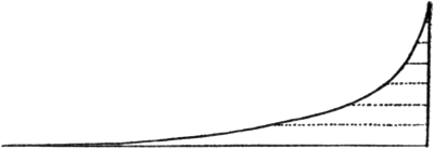 Fig. 3.—An actual profile of the Loire. It will be noted that
the Loire is a mature river, its profile nearly coinciding with
the "ideal" condition. (After de Martonne.)
Fig. 3.—An actual profile of the Loire. It will be noted that
the Loire is a mature river, its profile nearly coinciding with
the "ideal" condition. (After de Martonne.)
Such a torrent consists of three often well-defined parts. First we have the numerous tiny rills which collect together to form what the French physiographers call a receiving basin (bassin de réception); then there is the stream proper forming a canal which drains the basin, while below, where the torrent[39] debouches on the low ground, we find that it spreads out fanwise and throws down its load of débris to form a cone (cône de déjection). The torrent therefore already imitates a full-grown river, with its threefold division into mountain track, valley track, and plain track. It further illustrates the twofold work of the river, that of erosion and deposition.
Observation on an unprotected surface after a heavy rainfall will illustrate another point which is of much interest in connection with the work of rivers. This is that the water has most excavating power, not, as might be supposed, in the collecting basin, but in the valley region, where the slope is still great, where the volume of the water is at its maximum, and where it has acquired a load of débris by means of which it carves out its bed. The excavation of the bed therefore proceeds from below upwards towards the collecting basin. The result is that the slope of the valley floor diminishes as we pass from the upper region to the lower, owing to the levelling effect of erosion. The process of levelling down cannot be carried beyond a certain point, the so-called base level of erosion, which in a lateral stream is determined[40] by the point of junction with the main stream, and in a main stream by the point which marks sea or lake level, for obviously no point in the river valley can be worn down much below its mouth.
When the work of a river is completed, the line which marks the profile of its bed should have a gentle and continuous slope downwards to base level. The existence of irregularities, of breaks in the smoothness of the slope, means that the work of excavation has not proceeded far, that the river is young. But it is not necessary to proceed to the laborious drawing of a profile in order to determine the extent to which the process of excavation has been carried. The existence of rapids, of waterfalls, the alternation of swift and slow-flowing reaches are all proofs that it has not been carried far. In short, if a river is navigable, the navigable reach at least is mature; if it is capable of furnishing power, that region at least is youthful. If, as sometimes happens, the middle course is navigable and slow-flowing, and the lower course broken by rapids and falls, then the probability is that earth movements have occurred, so that the two regions are of different[41] age. This is a condition which occurs relatively often in the case of large rivers.
One other point is worth notice, because it illustrates another way in which the analogy of youth and maturity holds good. The youthful river, with its interrupted slope, its lakes and falls, does not permit the water to flow off with the same regularity as the mature river with its smoothed outlines. The mature river is thus a more perfect instrument of drainage.
It is not necessary for our purpose to consider in detail the characteristic forms of river erosion. It may be sufficient to notice that rapids and waterfalls are due to the varying hardness of the rocks forming the bed of the river, and that the normal course of events is the transition from waterfall to rapid, and from rapid to stream flowing quietly at the bottom of a rocky gorge. Long gorges or canyons tend to occur in regions where river erosion is not greatly assisted by the other eroding agents. As a general rule, as the river cuts its way down, the other agents cut back the walls so exposed, so that a wide valley is formed.
But a river does not only eat out its bed in its valley track. A necessary consequence of[42] this erosion is that it is also able to eat back the slope on which it is rising, as a result of the smoothing out of the curves of its bed, so that its source retreats further and further into the mountain. In regions of abundant rainfall every slope is abundantly supplied with streams, and therefore those streams which cut back their region of origin most rapidly will necessarily encroach upon their neighbours’ territory. They therefore tend to tap some of the tributaries of the other streams, a phenomenon which has sometimes considerable human importance, and has been extensively studied of late years under the name of river-capture.
Some examples may serve to make the phenomenon clear. Every one who has travelled up the Rhone valley in Switzerland has noted the enormous number of lateral streams, of all sizes, which tumble down the mountain sides into the Rhone. These streams on, e. g., the south side, are, roughly speaking, parallel to each other, and to a large extent enter the main stream independently. That is, for the most part they are very youthful streams. In some cases, however, e. g. in the case of the Dranse and the Visp, the drainage is of a more advanced character, and we find a large[43] stream with tributaries of considerable size as distinct from mere torrents. A glance at any great river system on the map, e. g. the Mississippi, the Amazon, etc., will show that the condition of a great stream with many[44] tributaries is normal in a district where the drainage is of the developed type. How are the two conditions, that of numerous parallel mountain torrents and that of a great river system, related to one another? There is no doubt that capture, the encroachment of one stream upon the territory of another, has played an important part in the process.
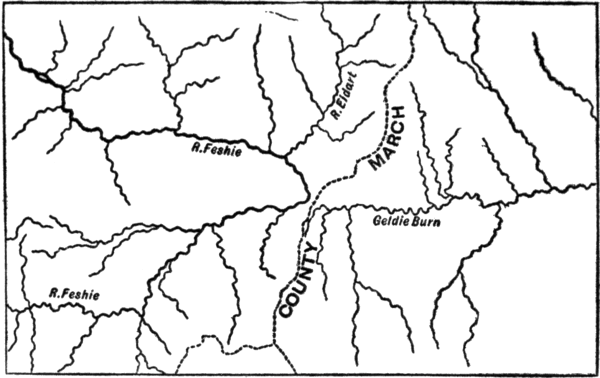
A very simple example of this widespread phenomenon may be taken in illustration. The accompanying sketch-map, drawn by Mr. Lionel Hinxman, shows part of the course of the River Feshie, one of the tributaries of the Spey, and part of the Geldie Burn, one of the tributaries of the Aberdeenshire Dee. It will be noted that the Feshie shows a very curious bend, or elbow. Mr. Hinxman points out that this curious condition can be explained on the supposition that the River Eidart, shown on the map to the north of the bend, once formed the headwaters of the Feshie, which cut its valley back until it captured the headwaters of the Geldie, and thus brought water which formerly flowed into the Dee into the Spey valley. The boundary between the two counties of Aberdeen and Inverness is shown on the map by a dotted line, and it is seen that the march[45] follows the watershed, which between the present Geldie and the bend on the Feshie is very low. Formerly, however, this watershed lay much further to the west, and its shifting is due to the capture.
A careful study of large scale maps will show many examples of similar river-capture, some old and some recent. A sharp bend, the so-called elbow of capture, on a river in close proximity to another stream affords in itself a certain presumption that capture has taken place, though this presumption can only be verified by study on the spot.
It may be noted that before the capture is finally accomplished there may be an intermediate stage when the water has the choice of two channels, both of which may be utilised in a time of flood. A very curious case is that of the Casiquiare, a river in South America which connects together the two systems of the Amazon and the Orinoco, while another is the connection recently discovered by Captain Lenfant, a French explorer, between the systems of the Shari and the Niger in Africa. Such conditions are obviously unstable, for one stream must sooner or later predominate over the other, and deprive it even of flood water.
Another example may help to explain the evolution of a complex river system with many tributaries. A glance at the map of England (see diagram) shows that while the rivers of Northumberland and Durham flow independently into the sea, those of Yorkshire are united into a characteristic bunch, and all reach the ocean by means of the Humber. This estuary breaks through the high ground formed by the Wolds of Yorkshire and Lincolnshire, which consists of hard rock. At one time it is probable that the rivers of Yorkshire entered the sea separately, while the other great factor of the Humber, the Trent, mingled its waters with the present Witham. At this time the weathering of the land surface had not reached its present stage so the land would lie higher. In what is now the vale of York the rocks are much softer than where the Wolds now stand, and the present Ouse, which was at first a longitudinal tributary of a transverse stream, eating its way back through these soft rocks, tapped successively the streams flowing eastwards from the Pennines, and with the help of the abundant water so obtained was enabled to cut out the wide estuary of the Humber.
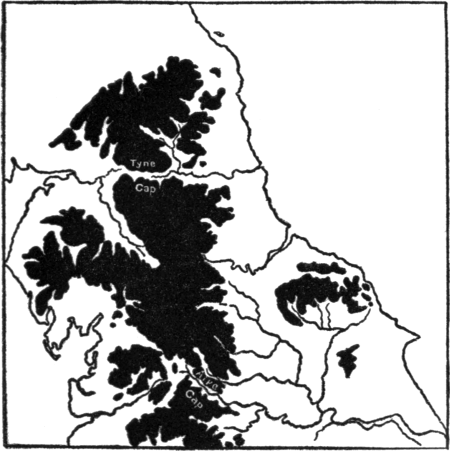 Fig. 5.—Sketch-map of northern England, to show the
position of the Tyne and Aire Gaps, and the peculiar character
of the rivers of Yorkshire. The black areas are heights above
600 feet.
Fig. 5.—Sketch-map of northern England, to show the
position of the Tyne and Aire Gaps, and the peculiar character
of the rivers of Yorkshire. The black areas are heights above
600 feet.
One other important point in connection with river-capture has been already suggested in the account given of the Feshie. In the little sketch-map we see clearly the shift of the watershed to the east. The ultimate cause of this shift is doubtless the fact that in[48] Great Britain the rainfall diminishes to the east, so that, generally speaking, the westerly streams have more erosive power than the easterly. But the special interest of the case is simply that it may serve to suggest a fact not at first sight obvious, which is that water-partings are excessively unstable features. One set of streams is continually striving to encroach upon the others, and by capturing their headwaters to reduce their erosive power. A very striking example of capture on the large scale is seen in southern Patagonia, where the water-parting does not lie near the summit of the chain of the Andes, as might be expected, but considerably to the east, the western streams (or glaciers) having captured all the headwaters of the eastern streams, which lie in a region of much lower rainfall.
The net result is that running water not only scours valleys in the sides of mountain chains, but also, sooner or later, wears away the crest itself, and with the assistance of the other agents of denudation tends to reduce the mountains to plains—or at least “peneplains.” The deduction is, of course, old enough, but the recent emphasis placed upon river-capture helps us to realise it, showing[49] us the actual “shift of the divide,” or, in other words, the wearing down of the summit levels.
This is a theoretical matter, but there is another point which has practical significance. Referring once again to the sketch-map on p. 43, we note that just at the sharp bend in the Feshie, that is, at the elbow of capture, there is a narrow region, crossed by the boundary line, which was once traversed by the headwaters of the Geldie, but is now a dry valley. Such “gaps,” as they are called, are present where recent capture has occurred, and where they occur in hilly country they sometimes form useful passes, permitting the construction of an easy road across the hills. A good example is the Aire Gap (see fig. 5) in the Pennine range of Great Britain, apparently connected with the fact that the Ribble has captured the headwaters of the Aire. Another interesting example is the so-called Tyne Gap, that breach in the Pennines which occurs near the present head of the South Tyne; it was traversed by the Roman wall, and is now crossed by the road and the railway from Newcastle to Carlisle.
As we shall see, ice appears to have this[50] power of cutting passes through mountain chains to a much greater extent than running water; but here, as in many other respects, there does not appear to be a sharp breach between the action of the two.
In the last chapter we have spoken of the moulding of the surface of the earth by means of running water and the agents summed up in the term “weathering.” The process is sometimes called “normal erosion,” to distinguish it from that other form of surface moulding in which ice and frost play a prominent part. At the present time ice, in the form of ice-sheets or glaciers, is confined to relatively small areas of the globe, so that we are justified in regarding its action as exceptional when compared with the work of running water. It is, however, well known that this limitation of the field of action of ice is very recent, and that during a period which geologically is only yesterday, a much greater part of the surface than at present was ice-clad.
In point of fact, much of Europe, especially the northern parts and those regions which lie close to the lofty mountain chains, much of North America, and, probably, considerable parts of the southern hemisphere, were subjected to the action of ice so recently that the processes of normal erosion have not had time to obliterate, hardly even to blur, the tracks which the ice left.
The results of the great extension of ice action in that period which geologists call Pleistocene were twofold. In the first place, as the result of the presence of the ice-sheet, we have vast accumulations of débris spread over the lower grounds. These accumulations sometimes form great sheets of boulder clay; sometimes they are collected into the curious sandy and gravelly mounds called kames which in parts of, e. g. Scotland, have a great extension; sometimes they have formed great heaps of material at the entrances of valleys. Again, these deposits have sometimes blocked valleys and so formed lakes, and they have supplied the post-glacial rivers with a vast amount of material which has been used to scour out the river-beds, and has been often re-sorted and re-arranged by running water.
Secondly, the fact that the northern region and the high grounds further south, in both Europe and North America, have been recently clad in ice is associated with many peculiarities of surface form, some of which have exercised a marked influence on human settlements and ways of communication.
These peculiarities of surface moulding have been the object of singularly detailed study in late years, and from this detailed study many interesting facts have emerged. It may be well to state at once that this study has been largely stimulated by the fact that there is at present a great want of unanimity of opinion as to the exact cause of these peculiarities of form. According to one school ice is a more powerful eroding agent than water; according to another its action is largely conservative, and its power of erosion is slight as compared with that of water.
The beginnings of a possible solution of the problem are perhaps to be seen in the suggestions of those who seek the causes of the peculiar features of glaciated regions in the way in which running water works when it is controlled and modified by the existence of ice; but we must admit that, on the whole, the conflict is still hot and many[54] members of the opposing schools will have no compromise.
To the geographer, however, the very fierceness of the controversy has been useful. The question as to the exact part played respectively by water and by ice in surface moulding is really a question for the geologist. It is, however, of great importance to the geographer that recently glaciated surfaces should be studied from every point of view, for from this detailed study are emerging many important generalisations. We shall, therefore, in this chapter only touch very lightly upon the actual points in dispute, but shall lay stress upon the interesting facts admitted by both parties.
When the conception of a just-vanished period of great glaciation was being established by the labours of many geologists, stress was naturally laid upon the obvious resemblances between parts of, e. g. Scotland and Wales, and those parts of the Alps which have been exposed by the retreat of the existing glaciers. Thus we find that most of the text-books emphasise the occurrence of perched blocks, of erratics, i. e. of blocks of rock which must have been carried from a distance, of the phenomenon of crag and tail,[55] of giants’ kettles, and so on. All these are of more geological than geographical importance; they do not in themselves greatly affect the distribution of other phenomena over the surface. We shall not, therefore, stop to consider them in detail. It is otherwise with those indications of recent glaciation which have been studied within the last few years, and they demand the geographer’s most careful consideration.
The most active discussion has taken place in regard to the peculiar features of the valleys in recently-glaciated districts, and we shall discuss especially this point.
We have already described the general features presented by valleys which owe their origin to running water. In such valleys, as we have seen, the longer the forces work the more nearly is the valley floor reduced to an even slope, whose angle decreases in passing from the mountain to the plain track. In the ordinary river valley the shape of the valley approximates to that of a V, that is, the valley narrows downwards, the river occupying the narrowest region.
Again, as a general rule there is no great difference of level between the tributary[56] valleys—at least at their extremities—and the main valley, that is, there is no sharp discordance between the two. While, however, the “mature” river valley shows a gentle, continuous slope, we usually find that “young” rivers, at least in their mountain track, show an alternation of plain and gorge, which is very easily observed in any hilly region.
In other words, we find that, owing to the inclination of the rocks, or to their varying hardness, or to other causes, particular reaches are less easily eroded than others. These form waterfalls, which ultimately, as we have seen, give place to gorges. Beyond the waterfall the diminishing slope checks the rapidity of flow, and the stream tends to widen out, and also to throw down its load of débris, so that an alluvial plain may be formed.
One other character of an ordinary river valley may be noted. It heads, as we have seen, in a collecting basin, which receives the surface runnels and the outflows of the springs which form the beginning of the river.
Let us now turn to the valleys in a recently glaciated country. We omit any description[57] of existing glaciers; these will be found described in the volume on the Alps, and further, photography and the picture postcard have rendered the main features of a glacier familiar to every one. Almost every large railway station now shows fine coloured photographs of some of the important Swiss glaciers.
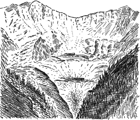
Taking, then, a valley known to have been occupied by a Pleistocene glacier, we find the following features. As contrasted with an ordinary river valley, the glacial valley is usually flat-bottomed, a condition described as U-shaped to point the contrast with the river valley. Examples in Great Britain and elsewhere are frequent, but some of the Alpine valleys show the phenomenon in a very striking form. Two good examples are the Aar valley at Meiringen, and the Lauterbrunnen valley at the village of the same name. Both have been rendered more or less familiar by constant photographing (see fig. 7).
The reason why they have been so much photographed leads us to consider another peculiarity of the glaciated valley. In both the cases named a steep cliff wall rises from either side of the broad, flat valley floor,[58] and from the summit of this cliff the lateral streams leap into the main valley by often superb waterfalls. This is a very important feature of glaciated valleys—the fact that their tributaries are markedly discordant, that is, that there is marked difference of level between the beds of the side and main streams.
Because the side valleys lie high above the main they are said to “hang,” and are called hanging valleys, while the main valley is said to be over-deepened. The rocky height over which the water springs may be called the junction step, as an attempt to translate the French term gradin de confluence which is applied to it.
Incidentally we may note that in the Alps the junction step is of great human importance. Its presence gives the water the power which is used in lighting the Alpine villages with electricity, and in driving the trains which often carry the tourist to those villages. In the French and Italian Alps especially, the power is being more and more used to supply the motive force for various minor manufactures, notably for the production of nitrogenous manure from the air.
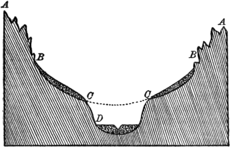 Fig. 6.—A diagrammatic cross-section of a recently glaciated
valley. AB, the mountain slope which rose above the ancient
glacier and has therefore retained the sharp, unrounded forms
due to ordinary weathering. BC, the shelf or shoulder, formerly
covered by the ice, and therefore strewn with glacial débris.
It now usually forms a pasture or alp. The dotted line connecting
CC shows the probable form of the pre-glacial valley;
CD, the rocky wall of the existing U-shaped valley on whose
floor the river now flows.
Fig. 6.—A diagrammatic cross-section of a recently glaciated
valley. AB, the mountain slope which rose above the ancient
glacier and has therefore retained the sharp, unrounded forms
due to ordinary weathering. BC, the shelf or shoulder, formerly
covered by the ice, and therefore strewn with glacial débris.
It now usually forms a pasture or alp. The dotted line connecting
CC shows the probable form of the pre-glacial valley;
CD, the rocky wall of the existing U-shaped valley on whose
floor the river now flows.
Associated with the hanging valleys of[59] Alpine regions is the presence of a curious shelf, shoulder, or “bench,” which frequently lies on the top of the cliff from which the lateral streams spring (see figs. 6 and 7). Any one who has done some walking in the Alps, must have noticed a peculiar and often trying feature of any walk which leads up the side of the valley. This is that the[60] walk begins with a very steep ascent, where the road or track zig-zags to and fro. After this steep and trying climb the walker reaches a broad shelf (BC in figs. 6 and 7), where the slope is much less, and where the extent of relatively level ground gives room for the erection of a huge hotel, or perhaps only of a group of chalets. This shelf is covered with fine herbage, destined to be cropped by the cows of the community.
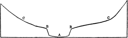 Fig. 7.—An actual cross-section of the Lauterbrunnen valley.
The vertical and horizontal scales are the same. B marks the
edge of the cliff wall over which the streams leap in cascades. A
is the position of the stream at the bottom of the U-shaped
valley. BC marks the position of the shelf, largely occupied by
the pastures or alps. Above them are rocky, unsmoothed
slopes.
Fig. 7.—An actual cross-section of the Lauterbrunnen valley.
The vertical and horizontal scales are the same. B marks the
edge of the cliff wall over which the streams leap in cascades. A
is the position of the stream at the bottom of the U-shaped
valley. BC marks the position of the shelf, largely occupied by
the pastures or alps. Above them are rocky, unsmoothed
slopes.
If the traveller continue his walk he will find that above this pasture ground or alp the slopes are again steep up to the mountain summits. Possibly, however, his walk has been to see a famous waterfall from above, and he will find that the streams which[61] flow with relative slowness over the comparatively gentle slopes of the alp or shelf, will at some point tumble over the region up which he climbed, probably in a series of leaps or cascades.
The U-shaped valley, the “hanging” tributaries, the shelf or shoulder running along the upper part of the cliff wall which bounds the main valley, all these are striking features of glaciated regions. We shall not here discuss the probable causes of this striking “break of slope,” so different from the characteristically continuous slopes of an ordinary mature river valley. As has been indicated, it is here that active controversy rages. It is, however, important to note that the shoulder or bench of which we have spoken was almost certainly once covered by the ice, its gentle slope indicating the original valley floor, before over-deepening took place.
The reason why pasture now grows upon it is that it is covered with fine glacial débris, which makes fertile soil. The fertile soil, which is often irrigated by milky water from existing glaciers, combined with the effect of altitude upon the plants, produces rich pasturage, and makes cattle-rearing an important alpine industry.
The next interesting feature of glaciated regions is the occurrence of those curious mountain forms which have special names in nearly every recently-glaciated region. Those gigantic arm-chair-shaped notches, high up on the mountain sides, which the Welsh call cwms, the Scotch corries, the French cirques, and the Germans kare, are very widespread in the Highlands of Scotland, in the mountains of Wales, in the Tyrol, and in other parts of the Alps (though they are not common in the Central region), and in North America as well as elsewhere.
A cirque (fig. 8) is shaped something like an office arm-chair. The floor has only a gentle downward slope, and often lodges a lake; or in other cases it is marshy, showing that a lake was once present. The back and sides are steep and precipitous. In some instances, if several cirques occur near together, the side walls may be eroded through, so that a shelf is produced, as one might produce a bench by putting two chairs side by side, and cutting away the contiguous arms. Very often, as one may easily see in the Highlands of Scotland, a series of cirques occur, one above the other, so that a climber proceeding from the valley floor upwards has[63] a succession of steep “pitches,” to use a mountaineering term, alternating with easy if wet walks across the floors of the successive cirques.
It quite often happens in the case of high mountains in the Alps that the topmost of such a series of cirques still retains a glacier, what is called a dead glacier, that is, one which has practically ceased to move.
In other cases, again, we may find that[64] what should be the flat floor of the cirque has been largely eaten away, as it were, by a huge rounded trough, which occupies what would be the extreme front of the seat of the arm-chair. In this trough a stream runs, and the trough has the characteristic U-shaped rounding characteristic of glacial forms. Further, at the top of the wall of the trough a bench or shelf exists, which is obviously the remains of the old cirque floor. In the case of all characteristic glacial cirques, however, the special feature is that the flat bottom of the cirque is discontinuous with the valley below; they are not parts of the same system of drainage. What we may call an unconformity appears between the two regions, more or less marked according as running water has or has not had time to begin the work of the removal of the unconformity.
The immediate human importance of these corries or cirques is not so apparent as in the case of hanging valleys, but they must be mentioned, if only because of their extraordinary abundance in glaciated regions, and especially in Great Britain. There are two views as to their origin, and we shall indicate both here without making any attempt[65] to decide which is the correct one. A very full and clear statement of one position will be found in an article by Prof. Garwood in the Geographical Journal for September 1910, while previous articles by Prof. Davis and others in this journal formulate the opposed view.
To the first school the corrie is simply in origin the collecting basin of a pre-glacial stream, such a basin tending to acquire, roughly speaking, a flattish bottom and somewhat steep sides. With the onset of the ice the floor of the basin was protected by the ice from further erosion, while the frost ate back the wall and so steepened it, and the glacier carried away all débris as it formed. At a later stage the lower part of the glacier disappeared and only the cirque glacier was left. It continued its protective action, while below the powerful torrents hollowed out a trough. This process was perhaps repeated several times, with the final result that the protected cirque was left as a much-modified remnant of pre-glacial conditions, while the valley below was powerfully eroded by the glacial torrents. Thus a cirque lying above an existing valley is to be regarded as the beheaded end of an old[66] valley, preserved by its ice covering, while below the old valley has been fundamentally modified by the scour of the glacial torrents. On this view the sharp distinction between the two angles of slope marks the distinction between the work of ice (protective) and the work of water (erosive). A series of cirques means a succession of glacial and interglacial periods.
According to the other school, for whom ice is a more powerful eroding agent than water, the cirque was produced by the ice, its presence or absence, in e. g. the Alps, being determined by the shape of the pre-glacial mountains. Cirques are believed to have been produced by the ice wherever the form of the mountains conduced to the accumulation of snow, and the occurrence of a series of cirques, and of the troughs which seem sometimes to eat into their floors, is ascribed to the successive retreat of the great ice-plough, i. e. to the action of the retreating ice itself, and not to the water which flows from beneath it.
Another striking feature of many glacial valleys is a very marked want of continuity in the slope of the main valley. Not only do[67] the side valleys “hang” over the main valleys, but, further, this main valley itself often consists of relatively level reaches alternating with rocky bars, through which the river has sometimes later cut a gorge. Examples of this are very frequent. The famous gorge of the Aar above Meiringen is a river gorge cut through a rocky bar of this kind.
The Pyrenees are somewhat less familiar, both to tourists and in the form of pictures, but there, also, the same thing occurs. Above the health resort of Cauterets lies the little Lac de Gaube, whose mouth is blocked by a rocky bar through which the little torrent is cutting a tiny gorge. If the tourist crosses the lake in a boat and begins to walk up the valley above it, he will find that it has the form of a staircase, the huge steps being separated from one another by broad plateaux, which are flat and swampy, and have obviously been occupied by lakes not long ago. Above each plateau there is a rocky wall, almost precipitous, down which the stream flows in cascades. In other parts of the Pyrenees the same phenomenon occurs, and the lakes sometimes persist, lying one above the other in a series.
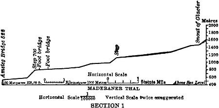 Fig. 9.—Profile of the Maderaner thal in Switzerland, to
show the staircase arrangement peculiar to recently glaciated
valleys. (From Garwood.)
Fig. 9.—Profile of the Maderaner thal in Switzerland, to
show the staircase arrangement peculiar to recently glaciated
valleys. (From Garwood.)
The phenomenon is so common that it markedly affects human life in the Alps. The “landings,” as the French call them, usually afford good pasture ground, while those which lie at no great elevation can be cultivated. Further, as the ground is level there is room for houses or even for a considerable village. The intervening region or step is too rocky to give level ground for human habitations or for pasture and cultivation. Where the river has had time to cut a gorge, the road must leave the stream, and can often be constructed only with difficulty. The result is that an Alpine valley often consists of a chain of villages, linked together[69] by a difficult mule track or path. The abundant water-power, however, makes mechanical traction relatively easy, and we have sometimes the curious condition that a mule track is replaced by a railway, without the intervention of a road fit for wheeled traffic.
We need not stop to discuss the probable cause of this step and stair arrangement, which presents much the same problem as the series of cirques at the head of the valley. It is enough to indicate that according to one group of physical geographers the flat landings are due to the way in which the gradually decreasing glacier protected its bed from erosion, while the torrent which issued from it eroded very rapidly below; according to another school the landings are due to direct glacial erosion. There are other observers, again, who lay especial stress upon the modifications of the erosive powers of running water, due to the presence of the ice. For us it is of interest to notice that, as has been already indicated, the staircase effect occurs also, though on a smaller scale, in the case of mountain streams generally, some of which must be post-glacial in origin. In other words, there seems to be fundamental similarity between[70] the work of ice and of water, the differences being differences of degree rather than of kind, and due largely to the varying fluidity of the two.
There is still one other feature of glaciated regions to which reference must be made. This is the occurrence of peculiarly open passes in considerable numbers across mountain regions which have been recently glaciated. In the geography books and in some maps, the Alps, for example, are represented as a great barrier, shutting off the fertile plains of Italy from the countries of Central Europe. But history shows that they have never been such a barrier, and the phrase of “splendid traitor” has been applied to the whole mountain range, in order to emphasise its total inadequacy as a barrier, either to armed or to peaceful invasion.
Since the time of Napoleon I public attention has been focussed upon a few great Alpine passes, notably the Mont Cenis, the Simplon and the St. Gothard, which are crossed by great carriage roads, now functionally replaced by railway tunnels beneath. But we must not forget that in addition to these and the other great passes there are almost innumerable ways of crossing the Alps[71] on foot, and the presence either of Hospices or of small inns on many of the smaller passes shows that they are constantly used at the present time, in spite of railway tunnels and carriage roads elsewhere. Even a pass relatively so difficult as the Théodule, was used by very large numbers of Italian peasants during the time when work on the Simplon railway made great demands on Italian labour.
Any one of the passes, great or small, shows in outline the same characters. There is a steep ascent, often steeper on the Italian than on the other side, then a broad, windswept, open summit, sometimes almost level, below which the rapid descent begins. Not infrequently a lake, or lakes, may be found near the summit.
On a smaller scale the same phenomenon occurs in such glaciated regions as Scotland, the relatively low connections between one valley system and another greatly facilitating communication, and usually carrying both road and railway, where the latter exists. Such connections between two drainage systems (that is, the existence of a very low divide between the two) only exist on a small scale outside glaciated regions, so that[72] they, with all their effects upon communications, must be largely ascribed to ice-action. We shall describe one case in a little detail, with the proviso that while no one denies the frequency of such passes in glaciated regions, some authorities believe that their production was due more to glacial torrents than to the erosive action of ice itself.
A very pretty example is the picturesque pass known as the Gemmi, which is traversed only by a mule path, and connects Kandersteg, and thus the lake of Thun and the town of Berne, with the Rhone valley, which the path enters at the village of Leuk. The walk proper is, however, over at the Baths of Leuk, a small health resort lying at the foot of the great Gemmiwand, a wall of rock over 1,600 feet in height on the summit of which is the Gemmi pass. Readers of Mark Twain’s A Tramp Abroad will remember his interesting description of the crossing of the pass, which is part of the regulation tour in Switzerland.
The excursion may be very briefly described. The traveller starts from the village of Kandersteg, and almost immediately begins a steep climb, which after a rise of over 2,000 feet leads him over a ridge to a pasture, once swept by an avalanche. Another short[73] but steep rise (note the staircase arrangement) leads him to the lonely Daubensee, a little lake which is frozen for more than half the year and has no outlet. It is itself fed by a glacier lying to the traveller’s right, the Laemmern glacier, which is shrinking and exposing more and more of its old bed. Even to the most inexperienced traveller it is obvious that this present day shrinkage is, as it were, the last remnant of a shrinkage which has been going on for a prolonged period, so that the route by which the traveller ascended from Kandersteg is but a remnant of the bed of the old glacier. The point of special interest, however, is that at the end of the Daubensee the traveller leaves the glacial valley by which he has ascended, and passing through a great notch or gateway in a wall of rock, begins the almost precipitous descent to Leukerbad, which lies at his feet, 1,600 feet below. It is this notch which makes the pass, and it is fundamentally a breach in the mountain wall which separates the drainage of the Rhine from that of the Rhone. Comparing small things with great we may note that this gateway presents some resemblance to the Tyne and Aire Gaps in the Pennines, already mentioned,[74] which may also have been modified by ice-action.
The explanation given is as follows:—At the time when the glaciation reached its maximum height the mass of ice in what is now the Laemmern glacier was so great that it could not be contained within its own valley. The ice was piled up so high that it over-rode the watershed, rose up beyond the containing wall of its own valley, and pushed a long arm over the valley wall, down into the Rhone valley. This tongue of ice, either by its own erosive power, or because of the glacial and sub-glacial streams which it produced, wore out a notch in the wall as it crossed, and it is this notch which makes the pass. As the glacier gradually shrank, it could no longer send this tributary over the wall into the valley below, and was constrained to send all its drainage into its own valley, that is ultimately into the Rhine. But the Gemmi pass persists as a proof of its former magnitude, of the fact that once part of the Laemmern drainage reached the Mediterranean instead of the North Sea, that there was once a communication between the Rhine and the Rhone drainage systems.
Many at least of the great Alpine passes[75] are believed to have been produced in this way, and therefore we must add to the peculiarities of recently-glaciated countries, the fact that passes are likely to be frequent across their hills and valleys, owing to the power which ice possesses, when enormously developed, of rising above valley walls, and streaming down into another valley system. Some of the great Alpine passes, perhaps, arose in other ways, but this brief description may be of interest as suggesting one, probably common, mode of origin.
If we sum up what has been said as to the special features of glaciated regions, we may note that their valleys tend to be U-shaped, and to be discontinuous with their tributary valleys, which “hang” over them. On the top of the cliff from which these tributary streams leap is a shelf, which is clearly a portion of the floor of the pre-glacial valley and is covered by glacial débris. At the heads of the valleys there are often cirques or plateaux, which again are markedly discordant, hanging high above the valley below. In the main valley itself there are similar discordances, giving rise to a staircase arrangement. Finally, different valley systems often[76] communicate with each other by passes, natural highways which hang high above both valley systems alike.
Obviously, however, we might replace this detailed summary by the simple statement that whereas in a region subjected only to the action of running water, there is a marked tendency to continuity of slopes throughout, a tendency more and more marked the longer the water acts, in glaciated regions there is an equally obvious discordance, a discontinuity of slope, most marked where water has not had time to begin its smoothing action. As every glaciated valley which we can study in detail has been subjected to the action both of ice and of water, it is a simple deduction that the discontinuity is due to the differential action of the two. This is the point of geographical importance, and to the geographer it is of minor importance to know whether it is the passive resistance of the ice which has caused the discontinuity, or whether it is the water which has been unable to keep pace with the activity of the ice.
There is one other point which must be alluded to even in this very brief consideration[77] of the effect of the ice age upon the physical geography of the glaciated regions. This is the fact that it greatly modified the numbers and distribution of plants and animals throughout the areas affected. Obviously the covering of ice must have rendered a large part of Europe uninhabitable both for man and for the vast majority of animals and plants. In Europe, therefore, as also in North America, there must have been a southward sweep of all living organisms, driven from their original habitat by the onset of the cold period. But the conditions in the two continents differed greatly.
In North America, especially in the east, there are no transverse chains of mountains, there is no southern sea until the Gulf of Mexico is reached in lat. 30°, and even here Florida almost touches the tropic, and Mexico extends far beyond it. In this continent, therefore, the plants and animals, though driven far to the south, still found room to live and multiply, and had no great obstacle to cross either in their southward journey, or when they strove to re-annex their old territory as the cold conditions passed away again.
It is a curious fact that the forest trees of eastern Asia and of eastern North America show a remarkable resemblance to one another, and both regions are very rich in species and in genera. It is believed that this rich North American flora is a remnant of pre-glacial conditions, and that its persistence is due to the ease with which the trees obtained an asylum to the south during the period when the climate was most severe.
In Europe, in spite of the fact that the winter climate is much milder than in corresponding latitudes in North America, the number of kinds of forest trees is much less, there is little resemblance to those of Asia and the eastern United States, and the trees have generally a less southern aspect. This is the more remarkable in that trees of southern facies introduced from China and Japan and from the United States thrive admirably in Europe, showing that there is no climatic obstacle to their presence there. To mention only a few examples, the Tree of Heaven (Ailanthus glandulosa), so very common, even as a wild tree in many parts of the continent of Europe, was introduced from[79] China, while the beautiful Sophora japonica, so frequently planted in towns, comes, as its name indicates, from Japan, and the various species of those beautiful flowering trees known as Catalpa are either American or Asiatic. The western plane (Platanus occidentalis), another favourite town tree, comes from the United States, and other American trees which are found very abundantly in towns in the warmer parts of Europe are the black walnut and the honey locust (Gleditschia tricanthos). Perhaps more striking than any of these is the case of the so-called false acacia (Robinia pseudacacia), which is as common over a great part of the continent of Europe as hawthorn bushes or wild roses are with us, and yet is a North American species, introduced less than three hundred years ago. Generally, we may say that all the more beautiful trees now growing in the warmer parts of Europe come either from eastern Asia or from the United States. In other words, the Ice Age seems to have greatly impoverished the flora of Europe. To a less extent this is also true of western North America, which has fewer species of trees than the east.
Why had the ice this impoverishing effect upon Europe? The topography of the continent supplies the answer. In the first place, in Europe there are numerous transverse chains of mountains. The Pyrenees, the Alps, the Caucasus, each with its load of ice, each with glaciers deploying on the low ground at its feet, must have been obstacles in the way of the southern migration alike of plants and of animals. Again, even if these obstacles were passed or turned, the great inland sea formed another barrier further south. In consequence of this difficulty in finding asylums the pre-glacial plants and animals must have perished in considerable numbers, and thus a general impoverishment took place. One must not of course exaggerate. A proportion of the pre-glacial forms did succeed in living through the period of stress, but many must have been, as it were, squeezed out of Europe or out of existence by the unfavourable climatic conditions.
As the climate improved the lands swept bare once again became inhabitable, and there was a recolonisation by movements from the south and from the east. We shall[81] indicate later how man himself came from the south and the east to colonise the west and north, but his movements were only part of a great series which included also those of plants and animals.
To the superficial observer those daily variations in the atmospheric conditions in any one locality which we sum up under the term weather, may appear to occur without order or regularity, but detailed quantitive study soon shows that even British weather displays constancy in its irregularity. The existence of such basal constancy, indeed, lies at the root of all intelligent utilisation of the soil. The irresponsible amateur gardener may lightheartedly assume that a particular spring will be “early,” but the professional is not easily induced to abandon his rule that such and such operations must not be undertaken before certain fixed dates. The farmer, if he is to avoid bankruptcy, must know within what limits the first autumn frost is[83] likely to make its appearance, and when the last spring one may be expected.
Collective experience, then, whether expressed in the meteorologist’s figures or in a less accurate form, leads us to the conclusion that for every locality on the earth’s surface there is a certain fixed average succession of weather, which we sum up in the term climate.
In the case of both climate and weather our knowledge may be summed up in such general terms as “wet” or “dry,” “warm” or “cold,” and so forth, or we may borrow the meteorologist’s notations, and express the facts in degrees of temperature, inches of rainfall and of pressure, percentages of humidity, and so on. But it should be understood that such figures can be used by the geographer with justification only when he is himself aware, and can assume that his audience is aware, of the significance of the figures in connection with the processes of erosion and the phenomena of life. To say that the mean January temperature of a particular place is 30° F., is only a convenient shorthand way of saying that in this place in winter plant life is arrested, water is ice-bound, and most animals sleep or migrate. In other words, the use of the figures assumes[84] a certain knowledge of biology and of physics on the part of the audience.
We do not propose here to treat either climate or weather with any fullness, for there is a volume in the series specially devoted to these and kindred subjects. All that will be attempted, therefore, is to discuss one or two important climates with the object of considering later their respective effects on the distribution of other phenomena on the surface of the globe. This is the more worth doing in that the subject is one which has had a great deal of attention devoted to it in recent years.
Certain points in regard to climate, e. g. the fact that the regions of the earth near the equator get more solar heat than those nearer the poles, and that parts of the globe are subjected to variable winds, as contrasted with those regions where the extraordinarily regular winds called “trades” blow, have of course been known for long enough. But not till the latter half of the nineteenth century did the civilised nations begin regular meteorological observations, and these observations are still scanty for the uncivilised and partially civilised regions. The meteorological raw material necessary for the exact study of climates has thus only been available[85] for a comparatively short period, and is still incomplete.
We may begin with that type of climate which has so profoundly influenced the civilisation of western Europe, and therefore also the new civilisations of America, Australia, South Africa, and so on. This is the type called Mediterranean, because it reaches its best development and has been most studied round the Mediterranean area. But it also occurs in California, in parts of Chile, in South Africa round Cape Colony, and in south and south-western Australia. Generally, it is characteristic of lands lying on the western side of continents, in the latitudes between tropical and temperate, and is therefore sometimes called the maritime sub-tropical climate. The term maritime is applied because, as we shall see, for some part of the year oceanic influences prevail, sub-tropical indicates the position in latitude.
A very curious illustration of the similarity of climate in the different regions named is to be found in the fact that in parts of the Mediterranean area two introduced American plants, the agave and the prickly pear, are more obvious and abundant than most native plants; while in California, Cape Colony and[86] southern Australia the cultivated plants are chiefly of Mediterranean origin.
The main features of the Mediterranean climate may be briefly summarised. The most important character, next to the mild temperature, is the fact that no rain (or very little) falls in summer, the growing season further north, which is here largely a period of cessation of plant growth. The rain, which tends to be scanty or even absent in the interior of land masses, e. g. in Spain and Asia Minor, and also to the south, e. g. in the Desert of Sahara, in the Mediterranean region proper falls in the winter months. It is this winter rainfall and the summer drought which define the Mediterranean type of climate.
The reason for this seasonal distribution of rainfall is as interesting as the fact itself, and to understand it we must turn to the circulation of air on the surface of the globe.
In the following description we shall restrict ourselves, for the sake of clearness, to the Mediterranean region itself, the region where the Mediterranean type of climate is developed over the largest area, and where, for many reasons, it is most important. But it must be noted that the conditions which give rise to the Mediterranean type of climate are[87] the same wherever it occurs, though in the Mediterranean area they are greatly modified by the great inland sea of that name, which carries oceanic conditions far into the land.
We must note, first, that at all seasons those regions of the earth which are directly beneath the vertical rays of the sun are heated most intensely. Therefore the air over these regions, being rendered light by heating, rises, and a belt of low pressure is thus formed. Only at the equinoxes does this belt of high temperature, low pressure, and light winds or calms, coincide with the equator. In the northern summer it moves north with the sun; in the northern winter it travels south with the sun, being always over what is called the heat equator. Into this belt of low pressure air from north and south, where the pressure is greater, tends to rush in, and we have thus formed the constant or “trade” winds, which, owing to the deflection produced by the earth’s rotation, appear as the north-east trades in the northern hemisphere and the south-east in the south. These winds are dry winds, because they blow from colder to warmer latitudes, and they accompany[88] the equatorial low-pressure belt in its north and south movements.
In the northern summer the trade winds may extend northward to lat. 35° or even 40°, while in winter their northern limit is 10° to 15° further south. A glance at the map, then, will show that in summer the Mediterranean area is within or near the sphere of action of the dry trade winds, which are continental, sweeping into the region after having blown over land surfaces.
We must next consider the atmospheric movements in the region to the north of the trade wind belt. An area of more or less permanent low pressure, best marked in winter, exists in the North Atlantic, in about 60° N. lat., and draws the air into it in the direction known as counterclockwise, that is, in the direction opposite to that of the hands of the clock. The result is the production of the winds which appear off the coast of western Europe as the warm south-westerly winds of winter, while they appear off the coast of North America as cold northerly winds. In the southern hemisphere, where, as we have seen, there is less land to interfere with the development of the atmospheric circulation, these winds form the prevailing westerlies.
In the Atlantic these south-westerly winds obviously blow in a direction opposite to the north-east trades, whence the name of anti-trades often given to them. As they blow across the broad Atlantic they arrive off Europe saturated with moisture. As they come from lower latitudes they are warmth bringing. In winter these winds reach the Mediterranean area owing to the southern shift of the trades, and bring moisture with them; while in summer they lie more to the north, and though their moisture affects the coast of Portugal it does not reach the greater part of the Mediterranean area.
Within that area the northern limit of the rainless summer may be said, in a rough sense, to correspond with about the 40th parallel of latitude, though it varies according to local conditions in the different peninsulas. To the north of this line, therefore, the climate is more or less affected even in summer by the anti-trades.
It must not be supposed that the region of the trade winds and of the anti-trades lie side by side. Between the two there is a zone of variable winds, but in general terms we can explain the peculiarities of the Mediterranean rainfall by saying that the region[90] lies within or just at the edge of the dry trades in summer, and within the zone of the moist anti-trades in winter.
Let us next consider how the area is demarcated from the surrounding regions. There is of course no hard and fast line, but we can indicate in broad outline the meteorological limits. To take the absolutely rainless summer as the limit would cut out, as we have suggested above, the greater part of the northern shore of the Mediterranean, except the southern halves of all the great peninsulas. Quite generally, however, we may say that the northern limit of the Mediterranean region, in its western half, is defined by the occurrence of considerable summer rain. That is, it is bounded to the north by a region which is within reach of the rain-bringing anti-trades in summer as well as in winter, and which has a lower temperature than the Mediterranean region proper. To the east the region is limited by deserts, for the westerlies of winter can only carry their moisture a certain distance inwards, and though they are greatly assisted by the long, eastward-stretching, inland sea, yet there comes a time when all their load of moisture is lost, and desert conditions supervene.
To the south the desert again forms the boundary, though here for a different cause. North Africa behind the Atlas is permanently within the trade-wind belt, that is, it is permanently subjected to the action of drying winds, and its rainfall is therefore small or nil. Similarly in California the southern limit of the Mediterranean zone of climate is the desert region of Arizona, Mexico, and the north of Lower California. A similar band of desert separates the Mediterranean zone from the tropical region of summer rain in the other places where the Mediterranean type occurs.
This may be summed up as follows:—Defining the Mediterranean climate only by its rainfall, we may say that it prevails over lands both to the north and south of that sea, and these have all or most of their rainfall in winter, when the winds, though typically westerly, are often stormy and rendered variable by local conditions. In the summer there may be no rain at all, or, to the north, small amounts. To the north the region passes gradually into that colder zone where rain occurs abundantly both in summer and winter, while to the east and south the rainfall diminishes greatly, and there is a gradual transition to desert conditions. To the[92] west the boundary of the region is theoretically the ocean, but the western coastline owes to its peculiar position a more abundant precipitation, which makes the vegetation of, e. g., Portugal present quite a different appearance from that of southern Italy or Algiers. These peculiarities of rainfall the region owes to its position between two great wind systems, of which one gains the mastery in winter and the other in summer.
So far in this discussion we have spoken only of the distribution of the rainfall throughout the year, but there are other features of the Mediterranean climate which are almost as important in considering the effects of the climate on the life of the region. These are the amount of the rainfall, and the temperature.
Beginning with general points, it is very important to notice that the rainfall throughout the area as a whole is relatively scanty, except where special conditions, e. g. great elevation, or local rain-bringing winds, increase it. Translated into terms of plant life this means that continuous forests of the type so characteristic of the greater part of Europe till man interfered, are relatively rare within the limits of the Mediterranean region.[93] Looking at the same fact from the human standpoint we may say that the rainfall is often so scanty that irrigation is necessary before man can prosper. These two facts, that Mediterranean man had not to clear forests before he planted and sowed, as the Teutons were obliged to do, and that he had often to bring water artificially before his crops would grow, have been of supreme importance in the evolution of Mediterranean civilisation. Even at this stage it is interesting to note that France in this, as in many other respects, has shared in two civilisations, for her territory to the south shows Mediterranean characters, and elsewhere resembles the cool temperate zone of Europe.
The next general point of importance is that of temperature. As was to be expected from its latitude the basin of the Mediterranean is a relatively warm region. Local conditions, and especially the presence of a great mass of water, make the winter exceptionally mild, while the summers, though not excessively hot they are considerably cooler than those of similar latitudes in Asia, are yet warm and sunny. The result is that, given water artificially supplied, or given[94] crops which can take water from the deeper layers of the soil, the region is productive, the destructive frost of the north not being a menace. This relative easiness of life in the more favoured parts of the region has been of great importance in its history.
We may give next some actual figures to illustrate what has been said about temperature and rainfall. Let us begin with rainfall, and in order to have a basis of comparison we may first note that Edinburgh has a mean annual rainfall of about 28 inches, and London one of about 25 inches. In other words, when the total amount of rain which falls in any one year is estimated for many years in either of these places, these totals added together and divided by the number of years of observation, the quotient is the figure given. The figures show that the rainfall in London is less than that in Edinburgh, while in Paris it is less than in either.
Passing now to consider the Mediterranean area we find that, speaking generally, the rainfall diminishes, for the reasons already explained, in passing from west to east, and in passing from north to south. Thus Gibraltar, at one end of the basin has a fall of 32"[95] per annum, as compared with one of 15" at Athens near the other extremity. Genoa in the north has the heavy fall of 51", while Biskra in Algiers has only 8".
There are many local variations, due to local causes, and in comparing the falls with those of Edinburgh and London we must remember that the higher temperatures mean much greater evaporation. Sunny Naples has about 4" more rain in the year than Edinburgh, and has 7" more than foggy London, but yet has not a wet climate.
For temperatures a few figures may suffice. In London the mean January temperature is 39° F., while it is only 36° F. at Paris. In Nice the mean January temperature is 45°, which is about the same as that of Athens, and rather less than that of Naples. In January, then, the temperature of Nice is only 6° higher than that of London. In July the mean temperature at London is 62°, as against 73° at Nice and over 80° at Athens. In other words, owing to our mild winters and cool summers, there is far more difference between British and Mediterranean temperatures in summer than in winter. In the Mediterranean region itself the difference between the[96] temperatures of summer and winter increases as we pass eastwards, so that it is especially to the west that characteristically Mediterranean conditions occur, i. e. mild, frost-free winters, and summers which for the latitude are not excessively hot. This feature also has been of importance in the development of the Mediterranean civilisations.
We have treated the climate of the Mediterranean area in some detail, as an example of the methods and results of modern climatology. We may note much more briefly the characteristics of one or two other climatic provinces.
Mediterranean influences, expressed in winter rains, are continued eastward into Mesopotamia and even into Persia, the rain always becoming scantier, and desert conditions tending to supervene. Still further east, however, we come to a region where the rainfall is abundant, and where the population is once more dense. These are the monsoon countries, including India and China, where the usually plentiful rainfall again permits the land to nourish man abundantly.
Excluding Africa south of the Sahara from consideration, we may indeed say that the[97] Old World has two regions of abundant rainfall and dense population, the one to the west and the other to the south-east, separated from each other by warm and cold deserts. Each of these two regions has given rise to its own civilisation, each has produced its own types of cultivated plants and domestic animals, and the root differences between the two must be regarded as largely the result of climatic conditions.
The monsoon countries are so named because of the regular seasonal reversal of the winds, which blow from land to sea in winter and from sea to land in summer, affording an example of a land and sea breeze on the gigantic scale. The result is that, subject to local modifications, the summer winds are moisture-bringing, and the winter winds are dry. Whereas, then, in the Mediterranean the heat of summer is largely wasted, from the agriculturist’s point of view, on account of the scarcity of the water necessary for growth, in monsoon regions, unless the rain fail, as it sometimes does, the hot season is the moist season, and, therefore, other things being equal, growth must be faster here than in the Mediterranean area.[98] The monsoon countries extend over a great stretch of latitude, and therefore temperature conditions vary greatly, while the great variety of surface-relief produces here abnormally heavy rainfall, and there desert conditions. The essential contrast with the Mediterranean type is, however, the summer rainfall.
Taking the globe as a whole we find that summer rainfall is more common than winter, and in addition to occurring in monsoon regions, it tends to occur in tropical regions generally. As we approach the equator from the tropics we find that the total fall increases, and tends to show two maxima, which occur when the sun is overhead, i. e. at the equinoxes. For our particular purpose, however, the climatic conditions in tropical and equatorial regions generally, though of great importance to the climatologist, are not of great interest, for except in monsoon countries the hot parts of the earth do not show the most highly developed human societies.
Let us turn next to that part of Europe which is outside the reach of Mediterranean influences. Here we find that the rain is distributed throughout the year, and is usually[99] abundant, though it decreases in passing eastwards from the seaboard. Temperatures are naturally lower than in the Mediterranean basin, and winter frost plays an important part in determining the choice of cultivated plants. As the figures which we have already quoted for London and Paris suggest, the winter cold increases on passing eastward. Paris is colder in winter than London, though it lies south of it. Vienna is again colder than Paris. But the increase in winter cold is compensated for by an increase in the summer heat. In other words, as the distance from the sea increases in Europe the climate becomes drier and more extreme.
This observation naturally leads up to a consideration of the effect of the proximity of the sea upon climate. Water heats more slowly than land, but also cools more slowly, and therefore the proximity of large masses of water has, speaking generally, a moderating influence upon climate, producing the so-called maritime climate. In the case of the British Isles this effect is very marked, because the ocean to the west of us is unusually warm, and the circulation of the atmosphere is such that the prevailing winds of winter[100] blow towards us from the warmer parts of this ocean, while the fact that the summer winds often have a northerly component helps to keep the summer temperatures down.
The peculiar conditions of the British Islands illustrate the fact that climate does not depend upon latitude alone, but may be greatly modified by local conditions, especially by the distribution of land and water, and the direction of the wind.
Let us now sum up what has been said in regard to the main types of climate found in Europe. Round the Mediterranean basin we have an area with mild winters and warm summers, where the rain tends to fall during the winter season, making summer a period of drought. This climate extends beyond the limits of Europe into Northern Africa and Western Asia, and is separated from the regions of tropical climate, which have no winter and have rains at the hottest season, by a belt of desert.
The western seaboard of Europe has a maritime climate, the sea tempering the winter, but diminishing the summer heat. The prevailing winds are westerly, and the rainfall is typically abundant and distributed[101] throughout the year. On passing inwards this type of climate changes into the continental type, with cold winters and hot summers, and diminishing rainfall. Though precipitation occurs at all seasons of the year, it tends to be greatest in summer, giving, e. g. in parts of the Balkan States, a type eminently suited to the cereal maize, which needs more summer rain than wheat.
If we bear in mind that North America is a large continent, and Europe a very small one, and that while Europe has no eastern seaboard, it is the eastern seaboard of America which faces Europe, we may realise that the climates of North America show a remarkable analogy to the European. On the western side we have in British Columbia and California respectively the same two types of maritime climate which occur in Europe, that is, British Columbia has a mild equable climate with abundant and equally distributed rainfall, and California has a Mediterranean climate.
At the eastern side the conditions are a little different, and show us that the mere presence of the sea is not sufficient to produce a “maritime” climate. The prevailing winds[102] in eastern North America are off the shore; they cannot therefore carry oceanic influences landwards. To the north the winds tend to have a northerly component, and cold currents of water also stream out of the Arctic and chill eastern North America. The result is that we find that Labrador, though lying in the latitude of Great Britain, has a very severe climate. Further south the conditions are of the “continental” character even on the seaboard, the winters being very cold and the summers hot. Rainfall is equally distributed throughout the year, but on passing inland it diminishes in amount and tends to be limited to the warm season. The diminution would be much more obvious than it actually is were it not that the existence of the large Gulf of Mexico, and also the size of the North American continent, give rise in the south to a monsoon effect, which greatly increases the rainfall of the south-eastern corner of the States. Further to the west, in the lee of the great barrier of the Rocky Mountains, the rainfall is slight.
Incidentally, we may notice that the eastern seaboard of the great Eurasian continent also has a more extreme climate than the[103] western, offering in this respect an analogy to the conditions which prevail on the eastern and western halves of temperate North America. The cause in both cases is the same—the direction of the prevailing winds.
We cannot close this chapter without some reference to weather, a subject of more geographical importance than is generally realised. In speaking of climate we have used figures which were invariably means, i. e. have been obtained by averaging a great number of observations. But where a great number of mean figures are used in a discussion, it is always found that the different averages are based upon varying numbers of observations, and are therefore not strictly comparable with one another. There is always a risk that such figures may mask facts of real geographical importance. No doubt some of the difficulties will disappear with the progress of meteorological science, which will enable the geographer only to select figures which are strictly comparable. Meantime, however, observations for long periods are rare, and the meteorologist must be content to take the figures which are available. For this reason as well as for others, it[104] is advisable to add to the somewhat abstract study of means, that is, of climate, some note upon the actual conditions, that is, upon weather.
 Fig. 10.—Diagram to illustrate a cyclone travelling towards
the east. The two concentric circles represent isobars, that is,
they are lines drawn through points where the barometer
registers the same (low) pressure. Into the area of low pressure
so formed the winds blow strongly in the direction known as
counterclockwise, and are represented by the arrows whose
double barbs signify their strength. It will be noted that in
the rear of the cyclone the winds are northerly. They thus
chill the air here, and by chilling it raise the pressure. The
winds to the front of the cyclone are warm because southerly,
they therefore tend to lower the pressure here by warming the
air, and the result is that the isobars tend to be displaced
towards the east, and at the same time become deformed.
In other words, the cyclone moves to the east.
Fig. 10.—Diagram to illustrate a cyclone travelling towards
the east. The two concentric circles represent isobars, that is,
they are lines drawn through points where the barometer
registers the same (low) pressure. Into the area of low pressure
so formed the winds blow strongly in the direction known as
counterclockwise, and are represented by the arrows whose
double barbs signify their strength. It will be noted that in
the rear of the cyclone the winds are northerly. They thus
chill the air here, and by chilling it raise the pressure. The
winds to the front of the cyclone are warm because southerly,
they therefore tend to lower the pressure here by warming the
air, and the result is that the isobars tend to be displaced
towards the east, and at the same time become deformed.
In other words, the cyclone moves to the east.
We may take British weather, which has become a proverb on account of its variableness, as a text for a brief discussion of the subject.
The daily variations in our weather, as all who have read weather reports know, are chiefly determined by the movements of areas of low pressure or cyclones, which mostly come to us from the Atlantic, and continue eastwards past us, often towards the Baltic. We have already noted the occurrence of what we have called a permanent area of low pressure in the North Atlantic, but this “permanent area” in point of fact is due chiefly to the constant passage here of cyclones, or moving areas of low pressure.
The causes of the eastward displacement of these depressions are interesting. One cause is the general eastward movement of the atmosphere in this region, produced in the fashion already described. This movement necessarily raises the pressure to the west of the depression, owing to the influx of fresh air, while the onward movement of the air in front of the depression lowers the pressure there, and so produces displacement. Again, the air is sucked into a depression in the direction opposite to the hands of a clock, and a moment’s reflection will show that this means that the winds to the east of the depression are southerly and those to the west of[106] it northerly. The warm southerly winds in front tend to lower the pressure by warming the air, while the cold northerly winds behind it raise the pressure by cooling the air. This again produces a displacement of the depression towards the east (see fig. 10).
The fact just described has an interesting practical result. If after a day or night of storm and rain, the temperature falls, we know that the depression causing the storm has passed us, and that we are feeling the effects of the colder winds in its rear. If the thermometer suddenly rises again, then a new depression is approaching, and we are feeling its warm breath before its winds reach us. The clearness and chilliness of the air after a stormy or windy period gives us one of our commonest meteorological sensations, and produces a marked psychical effect, reflected in much of our literature.
One other reason for the eastward motion of the cyclones with us is that they seem to prefer damp air, and so tend to follow the North Sea and pass towards the Baltic, where they often die away.
In the British area, though the depressions move faster in winter than in summer, they[107] have only a mean speed of about 16 miles an hour, while in the United States their mean speed is 25 miles per hour, and their effects are often disastrous except when discounted by the warnings of the Weather Bureau.
In the case of the British Isles cyclones are most frequent and best marked in winter, and they are of great importance in producing our mild and windy winters. In summer they travel further northwards, and as a rule affect our climate less. When, however, from causes still inadequately known, they are better marked in summer than usual, we have a “bad” summer, that is, one which is wet and relatively windy.
The fact that the English Channel is one of the favourite tracks of cyclones has been an important element in protecting the British Islands from foreign invasion, while we all know that it is also a factor in diminishing free intercourse with the Continent.
 Fig. 11.—Diagram showing the changes in temperature,
pressure and wind due to a cyclone passing to the north of
a point of observation A. The passage of the cyclone figured
occupied a period of six days. It will be noted that as it
approaches A the wind is southerly and light (arrows with
single barbs) and the temperature high. As it passes the winds
become violent (arrows with double barbs), and shift to the
south-west, and the barometer falls rapidly. As it disappears
the pressure rises, the temperature falls, and the wind veers
to the north-west, while remaining violent. The fall of the
wind and its shifting to a south-westerly direction mark the
return to the normal condition of affairs, the influence of the
cyclone being past.
Fig. 11.—Diagram showing the changes in temperature,
pressure and wind due to a cyclone passing to the north of
a point of observation A. The passage of the cyclone figured
occupied a period of six days. It will be noted that as it
approaches A the wind is southerly and light (arrows with
single barbs) and the temperature high. As it passes the winds
become violent (arrows with double barbs), and shift to the
south-west, and the barometer falls rapidly. As it disappears
the pressure rises, the temperature falls, and the wind veers
to the north-west, while remaining violent. The fall of the
wind and its shifting to a south-westerly direction mark the
return to the normal condition of affairs, the influence of the
cyclone being past.
The second point of importance about our
weather is the periodic occurrence at some
part of our area of anticyclones, or areas of
high pressure, out of which the winds stream
gently in the same direction as the hands of[108]
[109]
the clock. These areas of high pressure do
not display the same tendency to move as do
the cyclones, and are most frequently merely
displaced by advancing cyclones. For reasons
into which space does not permit us to go
fully here, anticyclones have a very different
effect in summer and in winter. In winter
they may bring to us the continental cold,
and make our weather abnormally severe,
though often bright and fine. On the other
hand, in summer they bring to us continental
warmth, so that “good” summers are those
in which anticyclonic conditions are most frequent,
while “severe” winters are due to the
same cause. Anticyclones also sometimes induce
a curious form of inversion, in that places
to the north of a given spot may have temporarily
a higher temperature than places
to the south. It is such facts which are
entirely masked by “mean” figures.
We do not as yet understand the causes which make cyclones sometimes more numerous or better marked than usual, which cause them sometimes to cross our area, and at other times to travel too far north or too far south to influence our weather. It is possible that further investigation in the future may[110] unravel this problem; it is practically certain that a freer use of wireless telegraphy, and the establishing of meteorological stations in northern seas, would give weather forecasting a definiteness and accuracy which it does not yet possess.
 Fig. 12.—British weather map for Nov. 29, 1910. A cyclone
lies over the south of Scandinavia, and into it the winds are
sweeping strongly in a counterclockwise direction. An anticyclone
lies over Iceland, and from it the winds are streaming
gently in a clockwise direction.
Fig. 12.—British weather map for Nov. 29, 1910. A cyclone
lies over the south of Scandinavia, and into it the winds are
sweeping strongly in a counterclockwise direction. An anticyclone
lies over Iceland, and from it the winds are streaming
gently in a clockwise direction.
We cannot follow this interesting subject[111] further here, but we have said enough to illustrate its geographical significance. As a science or sub-science by itself it will form the subject of a special volume in this series. It may be enough to point out that the Daily Weather Report, published by the Meteorological Office at a cost of one penny, and reproduced in some daily newspapers, is a document well worth the careful study of those with any interest in geography.
We have now taken a general survey of the earth’s surface, have noted its mountain heights and its ocean depths, watched the formation of hills and valleys which is due to the joint action of atmospheric agents, running water and ice, and considered briefly some of the points of interest about climate. We next pass to that most characteristic feature of the surface, its clothing of plants. Except where the surface of the ground has been artificially sterilised by man, or is rendered unproductive by ice, by lava, by a total lack of water, or by the existence of poisonous salts, it is clothed with vegetation, and it is the presence of this vegetation which is its most obvious character.
Here, however, as in other regions of thought, the geographical standpoint has only been reached slowly. Man’s habit of analysis made him study grasses and trees for long generations before he got back to the forest and to the grassland as they occur in nature. Plants as individuals are the province of the botanist, but those plant groups which are the expression of the interaction of climatic factors, soil, and surface relief, are the concern of the geographer.
When we take a general survey of the face of the earth from the point of view of plant geography, we note three main conditions. In certain regions, alike in the tropics and in temperate zones, we find that plants reach their maximum size, combined with great differentiation of structure, and the formation of woody stems which offer great resistance to varying conditions of climate and weather. Such highly-organised plants form forests, which still dominate over a large part of the earth’s surface.
Man’s nearest allies, the anthropoid apes and the monkeys, are for the most part forest animals, and the lowest races of men are still forest dwellers. Where man is a forest dweller he seems not to reach his full size,[114] as we see in the case of the pigmies of the Congo forest, and the negritos of the Philippines, and he suffers from a chronic insufficiency of food, which acts as a check both to his mental and physical development. There has, therefore, always been war between evolving man and the giants of the plant world, a war which has swept the forests away from many of the more civilised parts of the globe, and which still continues, though man’s victory is now so complete that he can afford to be generous, and give protection to the remnants of his former foe.
But over parts of the globe the climate, and especially the amount or distribution of the rainfall, makes it difficult or impossible for forests to grow naturally. Here other types of plants, lower in stature, and evading rather than facing the problems of winter cold or summer drought, flourish and form what we call the grasslands. The grasslands favour man in several respects. They feed the animals upon which he depends for food, for clothing, and for the conveyance of his person or property, and they offer much less resistance than the forest to his agricultural operations. Even the large herbivorous mammals which in their wild state haunt the[115] forests, usually leave these at night to feed upon the grasslands, so that it is the grasslands which have largely fed man at every stage of civilisation. The atmospheric conditions within the woodlands also, the deficient sunlight, the humidity, and so forth, seem unfavourable to human development.
Where the conditions are especially unfavourable to plant life, we find that even the grassland plants are unable to keep up the struggle, and diminish in number, losing their power of forming a complete covering for the soil, and thus the grassland passes into desert, whether the hot waterless desert of low latitudes, or the cold frozen desert of northern ones.
In the most general sense, then, we may say that these three formations, woodland, grassland and desert, divide the surface of the land among them, and between them there is constant conflict. The grasslands are for ever attempting to encroach upon the woodlands, and in this attempt they have been assisted, sometimes to too great an extent, by the operations of man. Similarly the desert is always striving to encroach upon the grassland, and in this endeavour it has been sometimes involuntarily aided by man,[116] who has also done much voluntarily to reclaim the desert land for the grasses.
Let us note next the particular conditions which favour woodland, grassland and desert respectively. The distribution of plants over the surface of the earth at large is determined by a number of factors, by the amount of heat, by the amount and distribution of precipitation, by the nature and strength of the winds, by the characters of the soil, and so on. But forests occur under the equator and also far to the north; we have cold deserts as well as hot ones; there are extensive grasslands in the Sudan as well as in the Canadian Far West. This proves that the varying amounts of heat may be neglected in considering the cause of the distribution of the three great plant formations.
Again, the soil is of minor importance, for different types of forest and of grassland occur on different types of soils. We are thus led to the conclusion that it is the precipitation and the wind which determine the distribution. To understand the reason for this we must consider the needs of different types of plants in the matter of water.
Plants can only take in the mineral constituents[117] of their food in the form of a solution, and this solution must be weak, or it has a poisonous effect. For example, sulphate of ammonia is a valuable manure, but if a considerable amount be dissolved in water and applied to the roots of a growing plant, death may very likely take place.
It is a necessary consequence of the fact that plants can only absorb weak solutions of their food salts, that their roots take in more water than is actually needed by the plant. One of the functions of the leaves is therefore to get rid of surplus water, the process being called transpiration. Transpiration takes place faster in a tall plant like a tree, which grows up into dry layers of the air, than in a low plant like a grass. It takes place faster in windy weather than in calm. Other things being equal it takes place faster in warm weather than in cold, and the larger the plant and the more numerous its leaves the more water is given off, that is, the more water is returned to the air from the soil.
The result of all this is that forest trees require far more water than grassland. It has been calculated that a beech wood aged 50 to 60 years gives off during the growing[118] season 354 tons of water per acre, which illustrates the drying effect of the presence of the wood. Similarly, the effect of tree-planting in the marshy regions of France and Italy, where the soil as a consequence has dried and the marshes disappeared, shows how great a demand upon ground water trees make, as compared with grasses and low growing herbs.
On the other hand, although trees take an enormous amount of water from the soil, they can draw their supplies from a large area. It is the extremities of the fine branches of the roots which take in the water, and these pass deep down into the soil, and spread out over a vast area. In other words, trees avail themselves of the water in the deeper layers of the soil, and can tolerate relatively long periods of drought, if the surface drying of the soil does not extend to the deeper layers. In hot summer weather grasslands brown and wither long before the trees show any signs of water-famine.
In consequence, we may say that as long as the total rainfall of a region is sufficient to ensure a constant supply of moisture in the subsoil during the growing season, trees can thrive, even if little or no rain falls[119] during this season. On the other hand, drying winds are very hurtful to trees, especially if they occur at a period when the tree is unable, either because of the coldness of the subsoil, or because of its dryness, to take in fresh water to replace that which is lost. The hurtfulness of late frosts is largely due to the cold suddenly checking root absorption at a time when the growing parts, acted upon by the spring winds, are giving out water freely.
Grasses transpire less freely than trees, but their root system is much shallower and less well-developed. They depend upon the water in the upper layers of soil, and must have frequent, even if gentle, showers during their growing season, while they are quite indifferent to drought and even to cutting winds during their resting period.
A little reflection will show that it results from these facts that woodland, grassland and desert do not form a continuous series. It may quite well be that woodland passes through scrub into desert without the intervention of grassland. Right across Europe there is (or was) a broad belt of forest. Southward towards the Mediterranean this thins out into a characteristic form of scrub, called[120] maquis, whose characters we shall describe later, and this scrub passes in all directions into desert land. Here no belt of grassland intervenes, for the rainless Mediterranean summer makes the growth of grass virtually impossible, except where special conditions, e. g. hills, introduce modifications. Contrasted with this we have the conditions in North America where, e. g. in Canada, the western coast is densely forest-clad, as is also the eastern region. In journeying eastward after crossing the Rocky Mountains the forest dies away into grassland, and the same thing happens, though more slowly, in a westward journey. The reason is that in this case there is a steady diminution of precipitation on passing to the interior, but what precipitation remains is, as we have seen, largely, though not wholly, summer rain, and is, therefore, sufficient to determine the growth of grass, though not of trees.
Again, in North Africa the forests of the Atlas Mountains pass directly, without intervening grassland, into the Sahara desert, but to the south of the desert the grassy and park-like Sudan separates the desert from the luxuriant tropical forest. In the latter[121] case, however, it is possible that man’s influence has counted for something.
On mountains, in whatever latitude, the conditions are much more uniform, partly because it is wind, assisted by temperature variations, which is the dominating factor. Moisture is usually abundant, but high up what is called physiological drought occurs; that is, the temperature is too low for the plants to be able to absorb the abundant water.
In ascending any mountain, the following are the chief changes which occur. The lower slopes will probably be cultivated. As we ascend the precipitation increases, and forests appear. First we have probably a belt of deciduous trees, passing above into the more resistant conifers. This belt usually ascends higher on the south than on the north side, and higher on mountains which occur in a group than on isolated peaks. As the wind is more and more felt, and increases the dangerous transpiration of winter the trees become more and more dwarfed to escape its force. There may be a belt of prostrate mountain pines above, marking the tree limit; in any case the trees are gradually replaced by dwarfed shrubs. Then comes[122] the zone of Alpine plants, the grasses making a complete sward, but being accompanied by many other plants. Gradually, as the soil becomes scantier, and the surface more rocky and exposed, the continuous sward disappears, and the conditions of a cold desert appear. A few scattered plants occur, ceasing near the snow-line, the highest being usually plants of simple structure like mosses and lichens.
As we have already indicated, in the case of the mountains of Europe there are often glacial shelves at considerable elevations, whose covering of fine débris determines the growth of peculiarly fine grass. The economic value of this grassland has in many cases in the Alps induced man to destroy the forest in order to increase pasture land. The result has often been disastrous, for once the trees are cut down the forest soil is rapidly destroyed by weathering, especially on slopes, the courses of streams are altered by the more rapid run-off, and widespread flooding and destruction of pastures have sometimes resulted. In North America, similarly, man’s attempt to increase pasture land or arable land at the expense of woodland has often led to disastrous consequences.
We have already spoken of the special features of the Mediterranean climate, and indicated that its peculiarities are reflected in its vegetation; we must now consider this vegetation in a little more detail. The fact that the region is chiefly visited by the inhabitants of more northern climates in spring gives rise to a somewhat erroneous impression in regard to the plants. In spring the Mediterranean vegetation is at its best. The mild winters permit the plants which further north die down or cease to grow, to go on blooming. The rains so moisten the soil that the first warm days cause very rapid growth in those plants which finish their activities before the hot, dry summer begins. They must flower and seed in spring, and die down till the rains of autumn awaken them again.
In our own country we have a few plants which hurry through their activities in this way. The lesser celandine, the wood anemone and a few others strive to flower and fruit before the forest trees are thickly clad with leaves. The snowdrop, even the wild hyacinth, though it is much later, similarly limit their active life to a short period in spring. This phenomenon, only suggested[124] in our climate, is very marked in the Mediterranean area.
That region is especially characterised by its richness in bulbous and tuberous plants. These, as all who have grown hyacinths or narcissuses know, demand relatively large amounts of water during their short growing period. In spring, therefore, the shores of the Mediterranean are bright with many kinds of anemones, with narcissus, asphodel, bell hyacinth, Allium, tulips, and so on, all awakened by the spring warmth and the spring rains. Accompanying them are many bright-coloured annuals, also in a hurry to race through their life-history before the terrible drought of summer. Now also the grass grows, and the autumn-sown corn becomes tall. As the weather grows hotter and drier, the plants with bulbous and tuberous roots die down to the ground, the annuals die altogether, leaving their seeds to wait till the autumn rains before they sprout. The grasses turn brown, and the peculiar parched appearance of the Mediterranean summer spreads over the land.
To a northern visitor at this season it is not luxuriance but desolation which is the prevailing note. Except on the hill slopes[125] there are no masses of broad-leafed foliage trees—there is not the deep bright green characteristic of the summer woods further north. The trees do not reach a great size; the leaves are usually small, and the fact that they strive to avoid the sun by arranging themselves with the edge upwards instead of the flat surface, makes them appear smaller than they are. They are often needle-shaped, sometimes shining and coated with resin, sometimes silvery owing to a coating of hairs on the under surface. Many plants have spines or thorns, and succulent plants like agave, aloe and prickly pear are common. The absence of a complete covering of vegetation causes the surface soil to dry completely, and so form clouds of dust which adds to the generally desolate appearance. Indeed, the brown powdery appearance of the soil is one of the points which especially strikes the stranger, accustomed to the darker, moister soil of the north, always covered with vegetation, except where man has interfered.
Here and there, however, are indications that even this parched brown earth holds wealth for man. The vines, if dusty and far less luxuriant than one expects, are loaded[126] with ripening fruit. The gorgeous scarlet flowers of the double pomegranate gleam amid the dark foliage; the gnarled and twisted olives show on close inspection masses of small green fruits; the oleander bushes are covered with pink flowers; there are great round balls on the orange and lemon trees, and many other fruit trees are loaded with produce.
Let us sum up first what man gains from the plants of the Mediterranean, and then look at some points in regard to the wild plants. In the first place, we see that man takes advantage of the rapid growth of annuals in the early part of the year. The annuals most useful to him, here as elsewhere, are, of course, the cereals, especially wheat, which, if sown in autumn, is nourished by the winter rains, and grows rapidly with the warmth of spring to ripen in May, June or July, according to the locality.
In the second place, certain trees or shrubs, by reason of their resistance to drought, and their elaborate root system, which enables them to gather water from the deeper layers of the soil, will produce succulent fruits without needing artificial supplies of water. The most important of these, throughout the[127] whole Mediterranean area, are the vine and the olive. The olive supplies the oil which is all the more necessary in that the absence of grass makes pastoral industries, and therefore the production of cheese and butter difficult or impossible except in the high grounds, while the vine supplies the wine which with bread and oil form the essential parts of the diet of Mediterranean man.
The olive tree, which is indigenous, may be regarded as one of the most characteristic trees of the area, and it is interesting to note that the novice not infrequently confuses it with another tree, almost as characteristic the evergreen or holm oak. The two are not nearly related, the olive belonging to the same family as the lilac and privet, while the evergreen oak is a true oak. Both trees, however, show similar adaptations to summer drought, and their resemblance to one another is a good example of convergence due to a similar environment. Both have small evergreen leaves; small that they may not lose too much water in summer, evergreen that they may assimilate even during the winter. Both have their leaves silvery beneath, which again prevents loss of water; both have gnarled trunks, branching low[128] down, in order that the leaves may avoid the dry upper layers of the air. Adaptations of this kind are present to a greater or less degree in all the trees which are tolerant of Mediterranean conditions, and many of these trees yield useful fruits.
In addition to the cultivated plants mentioned, a great number of others are grown within the area, as we shall see later, but the point of interest is that the plants which have been of importance in the history of the region have been either annuals which ripened early, or fruit-bearing trees with special adaptations to resist drought.
Apart from the annuals and the bulbous and tuberous plants already described, the wild plants are chiefly shrubs or stunted trees with similar drought-resisting characters. During the long ages he has inhabited the Mediterranean, man has doubtless contributed largely to the destruction of the forests which are now, as we have seen, represented by the stunted scrub or maquis. But on climatic grounds we cannot suppose that the Mediterranean forests had ever the luxuriance of those further north, or of the tropical forests of the south.
Where there is sufficient rain chestnut[129] woods occur, but this is only on the hill slopes. Above the chestnut, beech may occur, as in Sicily. The maritime pine and the Corsican pine form open woods in the damper places, and the picturesque stone pine, with its rounded head, is very characteristic. We have already mentioned the evergreen or holm oak as common, and the cork oak occurs abundantly in some places. These trees, with the cypress, must have formed the primitive forests, and they still constitute the most important forest trees of the area. The occurrence of a native palm (Chamærops) is interesting as suggesting the warmth of the climate, and even on the European shores the date palm is extensively planted, though its true home is the margin of the African and Arabian deserts.
Of the characteristic shrubs the most striking are perhaps the many species of Cistus, with large almost rose-like flowers, and leaves which attempt to adapt themselves to the climate by many different devices. Sometimes they are stiff and leathery, sometimes resinous, sometimes hairy. Many plants in the area have a coating of resin on their leaves. This, no doubt, preserves them against loss of water, but also probably protects against[130] grazing animals. Goats thrive in the Mediterranean partly because of the catholicity of their taste in vegetation, and in consequence the plants have had to protect themselves against their appetite as well as against drought. Only those with some disagreeable quality, hairs, spines, resin, strong flavour, etc., could hope to protect themselves in the dry season, when grass is virtually absent. It is in consequence common to find aromatic or strongly-flavoured plants with glandular leaves; lavender, rosemary, myrtle, etc., are examples.
Other shrubby plants associated with the Mediterranean are oleander, the noble laurel, the tree heath, arbutus, many kinds of broom, and generally evergreen shrubs specially adapted to resist drought.
Let us turn from this picture to the appearance presented by Central and Northern Europe. As we have seen, the forest which once covered most of the area, except the steppe region of southern Russia, has largely disappeared, but enough remains to enable us to reconstruct the picture of the original forest.
As contrasted with the (chiefly) evergreen woodland of the Mediterranean, the forests[131] of the low grounds are here deciduous. In summer clothed in magnificent foliage, well adapted to give off enormous quantities of water, in winter the trees stand tall and bare, exposing nothing but their branches to the winter blasts. While the buds of Mediterranean plants have no special means of protection, the typical forest trees of Central Europe have their buds carefully sheathed in scales, clothed in hairs, or coated with resin, to keep out alike the cold and the damp of the northern winter. While the leaves of Mediterranean plants are usually small, often coated with hairs beneath, often resinous, and so on, the forest trees further north have large leaves of delicate texture, with no special protection against drought.
Again, while the luxuriant forest of the tropics includes many different species of trees, the deciduous forests of cool temperate regions contain few species, and are often pure woods, that is, consist of one dominant species, forming beech woods or oak woods, and so on. The dense shade of the beech makes undergrowth difficult or impossible, but the other woods have a complicated undergrowth of many different kinds of plants, especially pronounced in spring before[132] the leaves appear on the trees. But this undergrowth never reaches the luxuriance that it does in the tropical forest, and creepers and climbing plants are few.
As we ascend from the low ground to the higher, or as we travel northwards to high latitudes, the broad-leafed deciduous forests are replaced by coniferous ones. European conifers, with the exception of the larch, are evergreen, and all are more tolerant of cold and wind than deciduous trees. Pines, spruce, fir, larch, and silver fir are the most important kinds. Both at high altitudes and in high latitudes these conifers are often accompanied by birch, which is not a cone-bearing tree, but is very tolerant of cold and wind.
To the north there comes sooner or later a limit beyond which the cold and winds make further tree growth impossible. Here we come to a tundra region, where the place of trees is taken by low-growing shrubs, with small leaves and other adaptations to ensure against excessive loss of water. It is, as it were, the reappearance of the Mediterranean type, but here the cause is, not the absence of water, but the fact that the cold makes it impossible for the roots to absorb it. A condition[133] of physiological drought results, and only plants well adapted to prevent undue loss of water can resist such conditions of life.
A somewhat similar type of vegetation occurs over vast areas in the more northern parts of Europe, forming the moors and heaths of much of Scotland, of parts of England and Ireland, of parts of Germany, and so on. Here the presence of peat produces conditions very unfavourable to plant life, except to certain shrubby plants such as heather and other plants of the heather family, juniper, bog myrtle, and so on, and some grasses and sedges, etc., all of which have special adaptations to life in a peaty soil. Over the large areas, therefore, covered by these heaths, trees are absent, or few, and this stunted shrubby vegetation takes their place.
Large areas of natural grassland, except for the tracts of pasture land already described in the mountain regions, are infrequent in Europe. They occur in Southern Russia and in the Hungarian plain, and form part of that great series of steppes and plains which stretches into Asia, and passes into a region of deserts.
The conditions favourable to the growth of[134] grass here, instead of trees, seem to be purely climatic. Very important is the prevalence of strong cold winds during winter, which is a period of drought. The scanty rains come in early summer, which suits grasses admirably, while the total precipitation is too slight for trees. The summers are hot, and the rains cease early and give place to a period of drought, very injurious to trees, while it injures the grasses little, owing to the fact that they have had time to make their growth.
The abundant natural growth of grass makes these steppe regions well suited to the pastoral industries, which tend, as civilisation progresses, to give place to agriculture.
To sum up, we have seen that looking at Europe as a whole three great plant formations are represented. We have, first, the cool temperate forest, which once extended over the greater part of the continent, wherever the conditions were suitable. This has now largely given place to arable land. Next, we find round the Mediterranean sea, and in those great peninsulas and islands which are bathed by it, a zone of modified woodland passing into scrub, remarkable for the rapid growth of annuals in the early part of the year,[135] and for the abundance of trees bearing useful fruits. Finally, linking Europe to temperate Asia, we have belts of steppe land, characterised by a luxuriant growth of grass in the early summer, and fitted by nature for pastoral industries, which do not thrive near the Mediterranean. Another way of putting the same facts would be to say that Europe proper is a region of temperate forest, linked to Africa by scrub land passing into desert, and to Asia by steppe land passing into desert.
The flora of North America, owing to the size of the continent, offers more resemblance to that of Asia than to Europe.
Bearing in mind what has been already said about the structure of North America—with its western mountain range and eastern uplands enclosing between them a region of moderate relief—and also what has been said in regard to its climates and to the influence of climate upon vegetation, it is relatively easy to deduce the main points in regard to the flora.
To the far north there is a treeless tundra region, quite comparable to that which occurs over vast areas in North Asia, and on[136] a reduced scale in the northern part of the continent of Europe. Next we have a wide band of predominantly coniferous forest, which, although its species are different, yet in broad outline is entirely homologous with the coniferous forest found in northern Asia, south of the tundra region. In Canada this forest consists of spruces and larches, the species being peculiar to the continent. Mingled with the conifers are smaller numbers of the hardier deciduous trees, such as birches, poplars, and willows.
What we have already said as to the climatic differences between the eastern and western sides of continents will at once suggest that this band of forest is not likely to run directly across the continent from east to west. In point of fact it stretches from Labrador in a north-westerly direction to Alaska, leaving almost the whole of the western seaboard to be occupied by another type. This type is the extraordinarily luxuriant and beautiful western forest, consisting for the most part of conifers. It is largely these conifers which have enriched European parks and gardens within recent years, and although it is perhaps the great Sequoia (Wellingtonia) gigantea which has most impressed[137] popular imagination, it must be remembered that size and luxuriance are characteristic of many species. This western forest stretches down the western seaboard to the State of California, and, indeed, persists until increasing aridity makes forest growth impossible. Its great luxuriance, compared with the scantier forests of the Mediterranean region in Europe, is partly to be ascribed to a greater rainfall, and doubtless partly to man’s interference, for the original forests of the Mediterranean must have been largely destroyed, as the western American forests are in process of being. One must remember also that the proximity of mountain ranges to the seaboard in western North America gives a heavy rainfall, and suitable places for forest growth. The fact that the trees are predominantly coniferous gives them great resistance to the summer drought. In front of the mountain ranges the coastal plain is occupied by an evergreen scrub vegetation comparable to that of the lowlands of the Mediterranean basin.
In British Columbia, where the Cascade Range lies at no great distance from the Rocky Mountains, the western coniferous forest practically clothes the whole area from[138] the coast to the main range, but further south, where the Cascade Range and its continuation the Sierra Nevada are widely separated from the main range, a dry and semi-desert region occurs, between the two, which bears a desert type of vegetation, including especially a plant related to our wormwood, called sagebrush, with cactuses in the warmer parts. Another area which is too arid to carry trees, except where local conditions raise the rainfall, extends from Texas northwards to about the latitude of Edmonton or Battleford, and lies in the “rain shadow” of the Rocky Mountains. This is the region of the Great Plains, mostly too arid to carry anything but herds of cattle, and mostly forming natural pasture, being thus analogous to the steppes of Asia.
Eastward the rainfall increases, and we pass from the area of unreclaimed pasture to the prairies, now largely laid down to wheat and other food plants. Southward the Great Plains pass into the deserts of Mexico, but northwards they are separated from the northern coniferous forest by a belt of aspen, and it is in this region that the Canadians are steadily pushing the cultivation of wheat[139] into the plains, wherever the local rainfall makes this possible.
So far we have left south-eastern Canada and the whole of the eastern and south-eastern States out of consideration. Speaking very broadly, we may say that all this area is clothed by a forest of mixed coniferous and broad-leaved trees which is comparable to the forest which covers the greater part of temperate Europe. But it is not to be expected that a forest which extends from the northern shores of the Gulf of St. Lawrence to the extremity of the peninsula of Florida, that is, through about 25 degrees of latitude, should be uniform throughout. In point of fact, botanists distinguish three separate zones. In south-eastern Canada and the New England states the Weymouth pine (Pinus strobus) predominates, being accompanied by limes, ashes, maples, oaks, elms, chestnuts, and so forth. Further south, and especially further west, extending to the Mississippi plains, there is a deciduous forest extraordinarily rich in species. Practically all our common genera of forest trees are represented, sometimes by very fine species, but in addition there are many genera with no European representatives.[140] Very striking is the abundance of magnolias (whence the name of magnolia forest sometimes given to this type), and species of the laurel family, as well as of liquidambar. The magnolias and liquidambar are especially interesting, because they once occurred in Europe, their disappearance there being probably caused by the glacial period as explained on p. 78.
We have emphasised above (p. 137) the luxuriance of the forests of the west coast of the States, but it should be noticed that luxuriant as its conifers are, there is a remarkable poverty in broad-leaved forms, as compared with these eastern forests, and this even in the warmer parts of the west coast. The reason is probably the same as in the Mediterranean region in Europe. The existence of a belt of desert to the south of the present “Mediterranean” region of western America made it difficult for the trees to migrate southwards at the onset of cold conditions in the glacial period, and thus many forms, which are known to have existed in California in Tertiary times, have now completely disappeared from the region, while they persist in the eastern forests to this day.
The third type of forest which occurs in the eastern half of North America is the “rain forest” of Florida and parts of the adjacent states. Here the rainfall is abundant all the year round, with a summer maximum, and the temperature is high. There is thus no need to economise water, and where the soil permits there is a luxuriant type of forest, which recalls that of the tropics, although it is poorer. Where soil conditions are unfavourable we have pine woods, conifers throughout the eastern United States always taking advantage of conditions relatively unfavourable to the broad-leafed trees.
Thus if we follow the eastern seaboard of the United States from Labrador to Florida we pass through the following floral regions:—(1) Coniferous forest, with relatively few species, (2) mixed coniferous and deciduous forest with chiefly the harder types of deciduous trees, (3) predominantly deciduous forest with many of the larger-leafed and more delicate forms, and finally (4) forest of the sub-tropical rainy type, intermixed with coniferous woods on the barren sandy soil and in the swamps.
The western coast shows more uniformity, the western type of coniferous forest stretching[142] from Alaska to California, though it is richer, and more luxuriant in the warmer regions when moisture is still obtainable. As the moisture diminishes the forest dies away and desert or semi-desert conditions supervene.
In the last chapter we looked at a few of the interesting generalisations which have emerged of late years from the study of plant distribution. An enormous amount of detailed investigation had been done before these generalisations were arrived at, and though still much remains to be done, yet the broad lines of a science of plant distribution may now be said to be established. The scientific study of animal distribution has not yet reached a corresponding stage of advancement, partly no doubt because the dependence of the more highly organised and active animal upon the physical conditions is less close than that of the stationary plant, so that the subject is more difficult. Facts are accumulating on all sides, but the subject is still rather at the level of collecting information[144] than at that of laying down broad generalisations. There are, however, indications of progress in many directions, and an attempt will be made here to suggest some of the lines along which research is especially busy at the present time.
In speaking of plants we confined our attention exclusively to land plants, for the reason that aquatic plants are usually small in size, relatively simple in structure, of somewhat limited vertical distribution, owing to their dependence upon light, and of little direct importance to man. In considering animals, on the other hand, we cannot exclude the aquatic forms, which are often of great human importance. In many regions man depends largely, sometimes even exclusively, on the animals of the sea for his food. We shall, then, begin with some account of aquatic animals, considering the subject, as before, especially from the point of view of the inhabitants of Europe and North America.
Beginning with the sea we find that the scientific study of marine animals received an enormous impetus from the work of the Challenger expedition. The results of that expedition appeared in many large volumes, which form a conspicuous feature in any[145] complete scientific library and contain a mass of useful material. The Challenger expedition was followed by many others, European and American, and the result is that we now know a great deal about marine animals and their distribution. Further, the Fishery Boards of various Governments carry on continuous observations on the conditions of life in the seas near their coasts, which have added and are adding enormously to our knowledge.
We cannot here consider in detail the various facts brought to light by these means. Only a few general points can be touched upon. One interesting generalisation is that the life of the ocean can be divided into three groups: the life of the littoral or shore zone, the life of the open ocean (pelagic fauna), and the life of the great ocean depths (abyssal fauna). The last, though of great zoological interest, is so remote from human life that we need not consider it. The pelagic forms include both the small delicate organisms which float passively with the ocean currents, and also powerful swimmers like many fish, and aquatic mammals such as whales and seals. The littoral forms live in the region which is within the reach of land[146] influences, that is, from low-tide mark to the edge of the Continental Shelf (cf. p. 27). Among forms directly important to man they include many fish; crustaceans such as crabs and lobsters; shell-fish such as oysters, mussels, clams, etc.; less important forms such as sea-urchins, which are extensively eaten in the Mediterranean; sponges, an important article of commerce; the various corals, especially the precious coral, and so on.
Of the useful marine animals, those which are most readily captured are the littoral forms, many of which, on shores where the tides are well marked, are exposed, or at least brought within easy reach, by the daily ebb and flow of the tide, and can be obtained with the minimum of apparatus. The extensive shell-mounds found on many shores, e. g. on those of Denmark, show at how early a date man availed himself of the abundant food supply to be obtained on the shore rocks. All edible animals found in the sea are “fish” to maritime populations, but fish in the restricted sense are usually more active, and require more skill for their capture than the less intelligent molluscs or crustaceans, and were probably not used at so early a date. They are by no means equally distributed in[147] all seas, and their distribution shows many points of interest.
We must notice, in the first instance, that the waste of the land is of great importance in feeding marine forms, whether directly or indirectly. Marine animals, therefore, occur most abundantly over the Continental Shelf, where they are within reach of the food brought down by the rivers from the land. Again, many fish, or the organisms upon which fish feed, depend largely upon those minute plants called diatoms which float in the upper layers of the waters of the ocean. These are especially abundant in the colder seas, which doubtless helps to explain the abundance of fish in high latitudes. These diatoms, like many other small organisms in the sea, are swept about by the ocean currents, whose course greatly influences the movements of fish.
We saw in the case of forests that hot climates conduce to a great variety of species, while in colder climates the species are few, but the number of individuals very great. Something of the same sort seems to occur with fishes. In warm seas the number of species is very great, while in colder seas there are fewer species, but those which do[148] occur are sometimes found in vast numbers. Fortunately for man these prolific northern species are often edible, whereas in warm seas poisonous or inedible forms are common. The valuable cod family is found chiefly in high latitudes.
The consequence of the facts just described is that valuable fisheries tend to occur in cool or cold climates rather than hot ones, and because of the dependence of so many forms on the Continental Shelf, they occur in the northern or land hemisphere rather than in the southern or oceanic one.
The most valuable fisheries in the world seem to be those off Newfoundland, where the broad Continental Shelf, forming the so-called “banks,” feeds myriads of cod. The mingling of the waters brought by the cold Labrador currents with those brought by the warm Gulf Stream perhaps influences this marvellous abundance of fish, as does also the waste brought by the icebergs.
Next to the banks of Newfoundland the most valuable fishing ground is the shallow North Sea, which, as we have seen, lies on the surface of the Continental Shelf. Fish are much more abundant here than on the narrower shelf on the western coast of Britain,[149] and the wealth of the North Sea has been an important factor in the development of the countries bordering it.
The warm, salt, relatively deep, and tide-less Mediterranean is not nearly so rich in food fishes as the more northerly seas, a fact reflected in the large importation of dried fish alike from Newfoundland and from the region of the North Sea. But this is an economic and not a zoological statement, for the Mediterranean is in reality richer in fish species than the North Sea, in this respect, as in some others, approaching tropical regions. Among the economically important fish are the tunny, a very large form allied to the mackerel, which is dried, and sardines and anchovies, which are preserved in oil. Otherwise the fish are eaten fresh, and do not enter into general trade.
Fresh-water fish are abundant all over Europe, but with some exceptions they are not greatly prized in those countries where the better-flavoured marine fish can be obtained. Elsewhere, as in Russia, Germany, and parts of France, they become important.
Much more valuable than fresh-water fish in the strict sense are the various kinds of salmon, which come up the rivers to breed,[150] but spend much time also in salt water. In the rivers of Scotland and Scandinavia salmon are still very important, but the fisheries in both cases are insignificant when compared with those of western North America. Salmon are inhabitants of temperate waters, and in North America do not extend further south than the rivers flowing into the north of the Gulf of California. Off the coast of Alaska and British Columbia, especially the former, they are enormously abundant, and being caught in quantities which far exceed the local demand are largely canned for export.
It is interesting to note that in regard to fresh-water fish, as with marine forms, the northern part of the world is especially rich in edible species, as compared alike with the southern hemisphere and with the tropics. The salmon family is confined to the northern hemisphere, and the carp family, though not peculiar, is largely represented in the north. To it belong the whitefish, which form important food fish in many parts of America. Sturgeon, which are important in Russia, occur in the great rivers of eastern Europe, and in parts of Asia, and also on the eastern coast of North America, and off California.
Turning next to the distribution of land[151] animals within the European area, the first point is to note that for the globe at large zoologists employ zoogeographical divisions based chiefly upon the distribution of the land mammals. The reasons for this are manifold.
In the first place, mammals are of relatively recent origin, and in taking account of their spread over the globe, we may assume that in broad outline the continents, or at least the deep oceans, were much the same when the existing mammals were evolved as at present. This naturally simplifies the problem, for if we divided the globe into regions on the basis of the distribution of reptiles, for example, we should find it necessary to take account of many differences between the world in which the first reptiles arose and the world as it is at present.
Again, the chances of land mammals passing from one region to another, except by the crossing of land surfaces, are small. Thus the occurrence of similar land mammals in two regions now widely separated is almost certain proof of a former land connection between the two regions. The difficulty which most land mammals find in crossing mountain chains, or deserts, or considerable extents of water,[152] makes it easy to define zoogeographical regions separated from one another by the existence of such “barriers to distribution” as they are called. Finally, mammals are highly organised animals of relatively large size, and their distribution is more easily studied than that of insects, for instance.
Without going into the zoogeographical regions in detail, we may note that there is, as already stated, considerable resemblance between the mammals of Europe, Asia, Africa and North America, that is, of the land hemisphere, while South America, which was for long isolated from North America, has a peculiar and relatively primitive fauna, and Australia, whose isolation has lasted longer, has an even more peculiar and a much more primitive fauna.
When we look at the fauna of the great land mass formed by the continents of Europe, Asia, Africa and North America, sometimes called by zoogeographers the Arctogæic realm, we find that North America differs from the eastern land mass as regards its land mammals in several respects. Though long separated from South America it has been connected long enough for some of the southern forms to find their way northwards, so that we[153] find skunks, raccoons, and other mammals strikingly different from analogous forms found in the Old World. Again, it is relatively so long since there was any free communication between the eastern and western hemispheres that the two faunas have had time to diverge without destroying the fundamental resemblance.
Beginning with the fauna of the Old World, we find that no effective barrier of any sort separates the animals of Europe, even of western Europe, from the animals of temperate Asia, even of eastern Asia. Right across from the British Isles to Japan, through about a hundred and fifty degrees of longitude, there is great general similarity in the land animals. To the south, on the other hand, the Atlas mountains and the African desert cut off the greater part of the continent of Africa, and eastwards the transverse mountain chains, no less than the difference of climate and the cold, barren nature of the uplands of central Asia, cut off the rich fauna of the peninsula of India with Further India, etc., from the habitable regions of temperate Asia, with their scantier fauna.
We are thus left with the conception of a very large and tolerably uniform zoological[154] region, stretching right across Europe and temperate and northern Asia. This is the Palæarctic region of zoogeographers.
The European section of it is somewhat impoverished as compared with the Asiatic section, partly perhaps because of the effects of the ice, and certainly also because for long ages Europe has been densely populated, and the larger wild animals have thus been exterminated. Asia, with its northern forests and its more southerly steppes, has always been a great reservoir of life, which has periodically overflowed into Europe. Some of these overflowing animals, like the black and the brown rats, succeeded in establishing themselves very firmly; others, like the saiga antelope, died out rapidly except in the extreme east of the European area.
It is possible that further investigation will show that not the mammals only, but land animals in general can be grouped according to their habitat like plants, but so far the attempts made in this direction have been tentative only. Generally, we may say that the mammals of Central Europe are of the woodland type, but no detailed classification into steppe and woodland animals exists. It may be useful, therefore, to indicate the chief[155] kinds of mammals found in the European area, grouped according to affinity, in the absence of a geographical classification.
Mammals, apart from the egg-laying monotremes, and the marsupials of Australia, are divided into nine orders, and of these, one, that including the anteaters, etc., of South America, Africa and India, is entirely unrepresented in Europe. Another, the Cetaceans, or whales, has no land representatives; and the same is true of the aberrant sea-cows, though their ancestors lived on land and occurred in Egypt.
Excluding these orders we are left with six which have European representatives. These are the following:—
Primates, or monkeys and apes.
Insectivores, or insect-eating mammals, such as moles, shrews and hedgehogs.
Chiroptera, or bats.
Ungulates, or hoofed animals, including horses, cattle, sheep, deer, pigs, etc.
Carnivores, or flesh-eaters, including lions, cats, foxes, dogs, etc.
Rodents, or gnawing animals, among which are rats, mice, squirrels, etc.
The Primates are represented by one form only, the Barbary ape, found in Gibraltar.[156] Bats are numerous, but are of less geographical interest than land forms. The remaining four orders are all important. The Ungulates include the largest land mammals, and their size and conspicuous nature have led to the gradual replacement of the wild forms by domesticated ones. Only a very few, such as deer, wild goats (ibex), the wild boar, the wild sheep (moufflon) of Corsica, manage to survive, and that mostly by aid of special protection. The presence of the large wild forms is incompatible with almost any form of agriculture as is often proved disastrously in Africa, hence man’s ruthless warfare upon them.
But if man has destroyed the large ungulates he has found himself unable even to reduce the numbers of the Rodents, who gain in many ways by civilisation. The destruction of their rivals, the grass-eating ungulates, increases their natural food-supply. In South America, where there were very few ungulates till the white man brought his flocks and herds, the rodents were very numerous and reached a great size. Again, the operations of agriculture give the rodents enormous artificial sources of food-supply, and the number of man’s domesticated or[157] semi-domesticated animals makes him wage a bitter war against the small carnivores, the natural enemies of the rodents. Protected from their enemies, abundantly fed by man’s providence, it is no wonder that these small animals have multiplied greatly.
Their multiplication has been assisted by the fact that they inherit from their early days, when the struggle was keen, an enormous fertility. Many of the rodents are steppe animals, and share with steppe organisms in general the power of periodic multiplication in enormous numbers.
The steppe is a region where the rainfall is normally just enough to ensure a free growth of grass at certain seasons. Variations in rainfall, which perhaps occur in great cycles, may at one time produce a luxuriance of growth which increases the food-supply all round, and at another give rise to semi-desert conditions with a resulting enormous death-rate. The steppe organisms, then, must be very fertile because of the risks of their environment, and the Asiatic overflow is possibly determined by successions of years of abundant rainfall, which increase the number of individuals, followed by a series of years of scanty rain, which make it[158] necessary for the overflow of population to migrate.
Among examples of European rodents we may mention the very destructive rats, mice and voles, which practically feed everywhere at man’s expense; and the hamster, an Asiatic form which reaches as far west as the Rhine, and stores large quantities of corn and other food in an elaborately made burrow. The hamster has the rodent power of rapid multiplication, and is often terribly destructive to cultivated crops. Rabbits are similarly very destructive where special precautions are not taken. Even the porcupine of southern Europe is capable of doing considerable damage. Less serious enemies of man are such forms as the following:—lemmings; marmots, of which there are two forms, an Alpine and an Asiatic, the latter extending like the other steppe animals into the plains of central Europe; beavers; squirrels; dormice; etc. These examples may be sufficient to illustrate the important points in regard to the rodents—their destructiveness, their fertility, and the fact that many were originally inhabitants of steppes and open plains, but tend, as man clears the forest-land for his own purposes, to extend their range to the[159] cleared land, and to appropriate the new and extensive food-supply furnished by man’s industry.
While the ungulates, because of the nature of their food, must almost necessarily be rather large animals, the carnivores occur both in large and small forms. The tendency is for the large forms to be killed out with the progress of civilisation; thus the lion has wholly disappeared from Europe, wolf and bear are almost gone, but a considerable number of smaller forms still remain, such as badger, genet, wolverene, lynx, wild cat, stoat, marten, weasel, etc. The last order to be mentioned, that of the Insectivores, includes small mammals, such as moles, shrews, and hedgehogs, which feed largely on insects, but may be partially vegetarians.
As was to be expected from the climate and from the peculiar flora, the Mediterranean region possesses a richer fauna than central Europe, both as regards mammals and lower forms. Even the European portion shows considerable African influence.
A few words must be said about other land animals apart from mammals. In regard to birds it is noticeable that the habit of migration, and the fact that the greater part[160] of the continent of Europe lies on the direct line between the northern breeding grounds of many species and the southern winter quarters, gives Europe a very rich bird fauna. The British Islands owe to their peculiarly mild climate a rich bird fauna at all seasons, for while the summer climate attracts many forms for nesting purposes, the mild winter brings many migrants flying from the cold of continental Europe.
In regard to birds as well as to other animals, the Mediterranean owes to its warm climate a richer fauna than countries farther north. Some interesting southern forms, such as pelican, flamingo and ibis, reach this region, though not extending into central Europe, except as stragglers.
The climate of Europe is not hot enough anywhere to lead to the presence of a rich reptilian fauna, but there is, again, a marked increase to the south. It is stated that there are only twenty-one species of reptiles in central Europe, while there are fifty-nine in southern Europe, and no less than a hundred and forty in the Mediterranean region taken in the large sense. Poisonous forms are few, and do not, as in hotter countries, constitute a serious menace to man. Very interesting[161] is the presence of the chameleon in southern Spain, as in north Africa.
Perhaps the most important human aspect of the European reptiles is the presence of numbers of insect-eating forms. In the warmer parts of Europe every wall or patch of rock seems alive with lizards in the summer sunshine, and these must play a not inconsiderable part in the keeping down of noxious insects.
Omitting a great number of other groups, we may say something about insects, which are of enormous importance in human life, both directly and indirectly.
It has been shown of late years that many insects are the sole means by which certain very deadly diseases are transmitted from man to man, or from one animal to another. Almost every few months a new announcement of an insect-carried disease is made, but the most important forms are the following:—Mosquitoes and gnats transmit such diseases as malaria, yellow fever, and more horrible diseases still, due to the presence in the blood of small parasitic worms. Tsetse flies carry sleeping sickness, and also transmit the very fatal fly disease of domesticated animals, a fact which has been and is of great importance[162] in the settlement of Africa. In the case of most diseases there seems to be a close connection between one particular species of insect and a particular disease.
Mosquitoes and gnats are very abundant in many parts of Europe, and the forms belonging to the genus Anopheles, which carry the germ of malaria, are widely distributed. In parts of the Mediterranean area their presence is associated with the prevalence of malaria, which has existed there for a prolonged period, and is believed by some to have had an important bearing upon the fates of the ancient civilisations of the Mediterranean basin.
The regions in Europe affected, or seriously affected, by malaria are diminishing yearly. This is now due to conscious efforts, but a similar process has been going on probably for a long period, for many obscure diseases, notably “ague,” seem to have been forms of malaria. Their disappearance seems to be due to drainage, which diminishes the breeding places of the mosquitoes, and also to the progress of agriculture, for ponds which form on rich, well-manured land are apparently unsuited to mosquito larvæ. The subject is of great geographical importance,[163] for the spread of man over the surface of the globe, and the progress of civilisation must have been influenced in all time by the prevalence of fly-borne disease. Such diseases have hitherto been the greatest obstacle in the way of the civilisation of Africa.
In Uganda extensive tracts of fertile wooded land have had to be abandoned on account of the presence there of the tsetse fly, while, prior to this abandonment, there were districts in which every living soul had been destroyed by the deadly sleeping sickness transmitted by this fly. We can hardly suppose that such facts are without a parallel in human history; and man’s distribution over the surface of the globe, and in detail the distribution of his settlements within a country, have doubtless been greatly influenced by the distribution even of such insignificant creatures as the various kinds of flies.
Even apart from their power of transmitting disease, the blood-sucking flies must have influenced man in his choice of localities for settlements, and must have been an important factor in the process of adjustment to his surroundings. The naturalist Brehm gives an appalling picture of the number and[164] blood-thirstiness of the mosquitoes of the Siberian tundra, which render life almost intolerable there for both man and beast in summer. Even within the British Islands the uncultivated and undrained regions are often badly infested with small blood-sucking flies, and their numbers must have been vastly greater in the old days before drainage and intensive cultivation had reduced them. It is quite possible that some of the anomalies in regard to the spread of particular races of men over the surface can be explained by the varying susceptibility of different races to insect attack, and there can be no doubt that the blood-sucking insects must have had some effect in determining the rapidity or slowness with which particular tracts were colonised by man.
Apart from the blood-sucking flies, there are many other interesting points about the insects of Europe, notably the wealth of beautiful and striking forms which occur round the Mediterranean basin. One of these, which extends northwards and westwards to northern France, is the curious Praying Mantis, a predatory insect belonging to the same order as the locust. It is an eastern form, which, like so many others, has[165] taken advantage of the mild climate of western Europe to extend its range far beyond what we must regard as its natural limits. In France it shows the effect of relatively unfavourable conditions in the fact that it takes some nine to ten months for the eggs to hatch, whereas in hotter countries the process may take place in a few weeks.
In the warmer parts of Europe a very striking feature is the number and large size of the members of the locust and grasshopper families, whose shrill noise is so characteristic a sound in, for example, the pastures of Switzerland in summer-time. Among the locusts there occur, in many parts of Europe, those migratory forms which possess that power of periodic enormous multiplication which we have already noted so frequently among grassland animals. The migratory instinct only seems to develop when the numbers have greatly increased in any given locality, and in Europe generally the climate does not permit this to take place. It does, however, occur in the south-east of the Mediterranean basin, notably in the island of Cyprus, in Syria, and also in Northern Africa, where locusts sometimes reach the dimensions of a plague.
We may add to this account of land animals a few details on the land mammals of North America. The great point of contrast here is that Europe, from the beginning of the historic period, has always been a relatively well-peopled region, while in America, prior to the advent of the white man, the population was scanty. There was thus far more room in North America than in Europe for great flocks of large mammals. Thus the plains and prairies carried great herds of bison, while to the north there were other herds of reindeer, which were never tamed by the inhabitants of North America as they were in the Old World by the Lapps and others. The musk-ox is another interesting animal found in the north of America. It once also lived in Europe, but died out long ago. Just as the coniferous forest and tundra in Asia produce many small fur-bearing animals, so do the forest and tundra of North America. Deer are present as in the Old World, though they are of different types, and there is a curious animal known as the prong-buck which is peculiar. Wild sheep occur as they do in Europe, but no wild horse nor ass roams the plains of America as they roam to-day the wastes of Asia. Without[167] going into further detail, we may say generally that as regards wild animals, no less than as regards wild plants, North America shows a closer resemblance to Asia than to that favoured peninsula of Asia which the geographers call Europe.
Before proceeding to discuss the chief races of men in Europe, something must be said of its cultivated plants and animals. Originally, doubtless, the various human groups which have mingled in Europe had each their own type of culture, based upon the possession and cultivation of particular animals and plants. The lapse of time has caused so complete an intermixture that it is only possible to a very small extent to disentangle the different elements which have gone to the making of present day civilisation. Nevertheless, as climatic differences remain and still determine minor differences, it seems worth while to consider briefly the distribution of cultivated plants and domesticated animals at the present day.
Europe has been so strongly influenced by[169] the neighbouring land-masses of which it forms a part, that we must begin with a few words about them.
The great continent of Asia, of which Europe, as we have seen, is but a peninsula, can be divided into a series of zones, distinguished alike by climate and by vegetation. To the north we have the cold tundra region, passing to the south into the forest region. The Asiatic forest region is continuous with that of Europe, but while the European forest extends southward till Mediterranean conditions intervene, close to the sea of that name, the Asiatic forest has its southern limit in about the latitude of London. To the south of the Asiatic forest stretches a zone of steppes passing into desert, and even into tundra in the elevated regions of Central Asia. The steppe region, as we have already indicated, enters Europe by way of Russia and pushes a long arm up the Danube into Hungary.
South of the Asiatic steppes and deserts comes an interrupted band of warm temperate or tropical forest, luxuriant to the east where there are summer rains, scanty and scrub-like to the west, where Asia meets the Mediterranean.
The steppes and desert of Asia are populated, scantily enough, with wandering pastoral nomads, who constantly tend to overflow from their own region into those of the surrounding agricultural populations. These agricultural populations are concentrated in three areas, all specially favoured by nature. To the east the summer rains, the luxuriant indigenous flora, and the presence of great river valleys, that is, of naturally fertile regions, led to the early establishment of agricultural populations in China and India. Further to the west, the fertile valleys of the Tigris and Euphrates early saw the founding of a great civilisation. This region, the Mesopotamia of geographers, is very near the third area, the Mediterranean, though far enough removed to have a very scanty rainfall, which made irrigation a necessity for agriculture. Its inter-relations with the Mediterranean must have begun early, and, remembering that part of the Mediterranean itself is in Asia, we need not stop to discuss the vexed question as to whether the Mediterranean civilisation was largely indigenous, or originated in the continent of Asia. It is often difficult to ascertain whether plants which have long been grown in the Mediterranean[171] area, and are well-fitted to it, are really indigenous there, or were brought to it from the Mesopotamian countries. There is much similarity of climatic conditions, and for our purpose it is sufficient to note that the cultivated plants of the Mediterranean basin fall into three main categories. There are, first, the plants specially adapted to its climate; these are either native or were introduced from the countries close at hand. Second, there are many plants, much less perfectly adapted to conditions of drought, and therefore often demanding irrigation in summer, which were introduced from the Far East, after they had been cultivated there for long periods. Thirdly, and much fewer in number, there are the plants introduced, at a relatively late date, from America.
Of the first group the most important are the cereals barley and wheat, and the olive and the vine. These four have been known in the area from the earliest times, and they still form the basis of the diet of Mediterranean peoples. Bread, olive oil to replace the butter used by pastoral peoples, wine as a beverage, with fresh grapes and the dried forms of raisins and currants, these early made life possible in the Mediterranean area.
Barley is older than wheat, and is more productive but less valuable. It is now largely grown in the basin of the Mediterranean as a food for horses, instead of oats which, like rye, is a cereal not well suited to the Mediterranean climate. As a bread plant it was early replaced in the Mediterranean by wheat, but it is still used to make bread in some other parts of Europe, e. g. in Scandinavia, and is also of importance outside the Mediterranean as the origin of fermented beverages.
Wheat is the most valuable bread plant which exists, both on account of its proteid content and on account of its digestibility. It demands a warm dry period for ripening, with much sunshine, and is well adapted to Mediterranean conditions. Here it is sown in the autumn, to enable it to take advantage of the “early and the latter rain,” i. e. the autumn and spring rains, and ripens early before the excessive drought of summer sets in. Like barley it has always been associated with plough culture, the animal used being the ox. According to most authorities plough culture originated in Mesopotamia.
The vine and olive are apparently both indigenous to the Mediterranean, and both[173] are well adapted to withstand drought. In regard to the vine there are several interesting points. To the traveller from the north it is most familiar in France or Germany, where it is grown on sunny slopes, usually terraced to prevent stagnant water from lying. In the Mediterranean, on the other hand, it is planted in hollows, or low-lying ground, which permits of the collection of water, for it will receive no summer rain. The vintage is more secure than further north, and the resistance to the attacks of parasites is greater, yet, curiously enough, the Mediterranean countries do not produce the finest wines. This seems to be partly because the climate does not permit of the long storage necessary for maturing to take place. The cool cellars, so important in the wine industry further north, are here absent.
To the four plants which we have mentioned we must add such forms as the fig, which if not indigenous was of very early introduction; garlic, greatly valued as a flavouring matter; various kinds of pulse; sesame; millet, once widely grown though no longer important, and flax, known from remote antiquity.
The second group, that comprising plants[174] introduced from the Far East, includes many valuable fruit trees, which in the region of the absolutely rainless summer mostly require irrigation. The peach came from China in the time of Alexander the Great; the various citrus fruits, lemon, orange, lime, citron, etc., now so characteristic a feature, were introduced from China or India. India also gave rice, extensively cultivated during long ages, and still extensively consumed, though the facility with which communication with the East is now effected makes it relatively little grown, except in the plain of Lombardy, which is easily irrigated. China sent the white mulberry, and with it the cultivation of the silkworm, so important in many regions. From the Far East also came the sugar-cane, very important till the recent development of the sugar beet industry. Cotton also was probably introduced from the Far East, which thus supplied many cultivated plants and has enormously enriched life for Mediterranean man.
Of the American plants of late introduction the most interesting is maize, which fed the somewhat limited indigenous civilisation of North America. Maize requires a warm climate with much sunshine, but needs much[175] moisture during its short growing season. It is not a very valuable cereal, but it is enormously productive and therefore cheap. Generally it may be said to be used as food by man only when necessity compels its use. It is thus employed by subject races, e. g. negroes, and by the poor in the warmer parts of Europe. In the Mediterranean it is not sufficiently valuable to be grown on irrigated land, and it will not grow without irrigation where the summer is rainless. Where there are summer rains, however, as in North Italy, or where mountain slopes increase the rainfall, as in parts of Greece, or where the land is rendered valueless for wheat by winter flooding, there maize is grown. Generally it occurs within the Mediterranean area wherever the necessary water occurs naturally or can be supplied cheaply. It forms a very important part of the food of the poor in North Italy, for example, but not in the south, where water is too costly.
Two other important plants of American origin are tobacco and the potato. The latter plant is little grown in the Mediterranean, but a considerable amount of tobacco is produced. Another American plant, the[176] prickly pear, besides furnishing an edible fruit, is important as a hedge plant within the area.
Cereals in the Mediterranean are grown, as we have seen, on ploughed land, as elsewhere. A more characteristic form of cultivation is garden-culture, practised where water can be obtained for irrigation. Such gardens consist primarily of fruit trees, all the citrus fruits, peaches, apricots, pomegranates, pistachio, almonds, and many other forms of nuts, plums, even apples and pears, being grown in this way. So productive is the ground once water is supplied, that plants are grown in association in a fashion hardly suggested in the north. Thus among the fruit trees many different kinds of vegetables, such as garlic, cucumbers, leeks, salad plants, many sorts of melons, tomatoes, egg-plants, beans, and peas, etc., are grown. Elsewhere one may see corn sown beneath the olive trees, and the vine sharing the same ground with them.
The picture of Mediterranean life may be completed by adding a few words about the domesticated animals. These are naturally in essence the same as those further north, but their relative numbers and the uses to which they are put are different.
The dog and cat both occur, but the former has little importance in the pastoral industries, and is largely a watch animal, insufficiently fed, and therefore important as a sanitary agent in that it devours garbage. Among the ungulates or hoofed animals, the ass was domesticated in the region long before the horse, and it and the mule are still more important than the horse, partly, no doubt, because both are hardier, and the problem of food is a difficulty in the largely pastureless Mediterranean region.
Few camels now occur in Europe, where they have been always closely associated with Mahometans, appearing and disappearing with them.
The pasturage difficulty greatly reduces the importance of cattle, which are draught animals rather than a source of food. As draught animals cattle go back to the dawn of history, but their numbers are small and the use of either their flesh or their milk as food is insignificant. Philippson in his book on the Mediterranean gives some striking figures to illustrate the difference in numbers between the cattle of the Mediterranean countries and those of Central Europe. Spain has only 2.1 million cattle, and yet it[178] is scarcely smaller than Germany, which has 19 millions; Switzerland has 1,340,000 head of cattle, and Greece, which is about half as large again, has only 360,000. It is to be noted, however, that the irrigated plains of North Italy now support a considerable amount of cattle, whose milk gives rise to a considerable cheese industry; but, then, the olive will not grow in North Italy, which is therefore not strictly within the Mediterranean area.
The Arabs introduced the Indian buffalo which has spread considerably, and is now found in South Italy and the Balkan peninsula. The pig has been banished from parts of the region on religious grounds, but elsewhere it chiefly thrives where oak forests grow, the acorn being an important part of its food. The really important ungulates, however, are sheep and goats, which are often very numerous, and which, apart from birds and fish, furnish the most important part of the animal food of the inhabitants. The milk furnishes cheese, which is an important element of diet, while leather, wool and hair are also important products.
The goats chiefly feed upon the young shoots of shrubs, and frequent the denser thickets, while the sheep browse upon the[179] grasses and herbs to be found in the more open forms of maquis. The climate permits the animals to remain in the open during the whole year, and this prevents the collection of the manure for the arable lands. Further, the summer drought makes it difficult for even these hardy animals to obtain food, and necessitates in many regions a curious form of nomadism, to which the name of transhumance is given. Transhumance, still well developed in Spain, is the periodic and alternating displacement of flocks and herds between two regions of different climate.
As we have had frequent reason to remark, the rainlessness of the Mediterranean summer is locally modified by many causes, notably by elevation. Mountains may receive frequent showers, while the plains are parched and brown, and therefore there may be pasture on the mountains while there is none in the plains. On lofty mountains also the winter snow lingers long enough to promote the growth of summer pasture. While there are considerable herds of sheep and goats, then, it may be necessary for the flocks and their keepers to travel to the mountains in summer and back to the plains in winter. In Spain these periodic migrations, now largely[180] made by means of the railway, formerly took place by well-defined routes, along which the immense army of sheep, accompanied by a smaller army of attendants, passed twice a year, causing enormous destruction to the cultivated lands through which they passed. Everywhere the conflict between shepherd and husbandman is more or less acute, but it seems to have been especially acute in Spain, which is in some respects a link between Africa and Europe. Its constant liability to Arab invasion made agriculture especially difficult, while frequent wars favoured the pastoral industry; for flocks may be removed to a place of safety on an alarm, but agriculture must have some security before it can develop. In the semi-desert regions of North Africa some form of pastoral nomadism, with the social polity which comes from pastoral nomadism, was the natural result of the physical and climatic conditions, and Spain, like the lands of the eastern part of Europe, has been constantly liable to have its nascent agriculture destroyed by incursions of such pastoral nomads. In both cases the slow victory of the agriculturists, marked by many temporary reverses, affords an extraordinarily interesting chapter in human history.[181] A stable civilisation must always be based upon agriculture, but every disturbance of an old and stable civilisation has temporarily encouraged the pastoral as contrasted with the agricultural industries.
In regard to the other animals of the Mediterranean, mention need only be made of the domesticated birds. The fowl has long been known; it is believed to have been introduced from the East eight centuries B.C. Both the eggs and the flesh are of great importance as a source of food. In spite of Roman history, geese are relatively unimportant, as are also ducks, but the turkey, late introduction from America, is well suited to the climate and has become important. Pigeons are everywhere abundant, sometimes so much so that their manure is extensively used as a fertiliser. We have already mentioned silkworms, and students of classical history know that bees have long been kept.
If we sum up what has been said about Mediterranean cultivated plants, we may note that these have been derived partly from native plants, partly from plants native to the warm forest country of eastern Asia, and partly from American plants. Regarding[182] for a moment the Eurasiatic continent as a whole, we may say that the old civilisations, both to the east and to the west, arose in the forest regions—in the monsoon forests to the east, in the drought-resisting forest or scrub of the west. The temperate forest of Asia has produced no great civilisation, and the civilisation of the temperate forest zone of Europe has owed much to the earlier civilisation of the Mediterranean, with which it has always had free communication.
This free communication has taken place chiefly by means of the Mediterranean seaboard of France, especially by means of the great Rhone valley, which forms a natural highway to the north. France, with both an Atlantic and a Mediterranean seaboard, has been the natural intermediary between the Mediterranean scrub land, with its characteristic civilisation, and the temperate forest region, with its colder climate, and its greater rainfall, which produce a corresponding difference in the cultivated plants.
We have seen that wheat is the great bread plant of the Mediterranean, and it is interesting to note that in this respect France is almost purely Mediterranean. It is, above all, the country of white bread, which plays a very[183] important part in the dietary of the people. In ordinary years the country produces nearly as much wheat as it consumes.
In addition to this large use of wheat as a bread plant, France shows strong Mediterranean influence in the part which wine plays in the dietary of the people, in the variety of vegetables, especially kinds of pulse, which are grown; in the fact that fowls and pork form a large part of the animal food consumed, and in that flax has been grown in considerable amounts for long ages, so that linen is an important part of household wealth. The Midi is of course definitely Mediterranean in culture, but just as the vine extends far to the north and west so also do Mediterranean influences extend far beyond the region of Mediterranean climate and Mediterranean flora.
But fertile as much of France is, it must not be regarded as consisting of nothing but fields of waving wheat. To complete and correct the picture we must add that, as in Russia, considerable amounts of buckwheat are grown for use as human food. Buckwheat, the “black wheat” of the French, perhaps introduced by the Arabs, is not a true cereal, but a relative of the knot-grass[184] of British fields. It is very easily grown, even on poor land, and in France replaces wheat where the conditions are unfavourable, or where agriculture is backward. It is not without interest to note that while its use in France as human food is an indication of extreme poverty, in the United States buckwheat cakes take a place as a luxury. Oatcakes in lowland Scotland, “black bread” in well-to-do households in Germany, are other similar instances of the reappearance of a despised food-stuff as a luxury. Such foods become luxuries when they can be used to supplement, not to replace, white bread. Most of the buckwheat of France, however, is now grown as food for domesticated animals.
Again, fruit trees are extensively grown in France as in the Mediterranean region, with a gradual increase in the forms which require more moisture and less heat as we travel northwards. The typically Mediterranean forms early disappear, while many kinds of plums, pears and apples increase in numbers and in value. As we travel northwards also, the various forms of berries, scarcely represented in the south, increase in importance. The strawberries of Brittany form a good[185] example, but throughout Europe generally this change takes place, culminating in the enormous wealth of wild berries—cranberries, whortleberries, and so on, which is a characteristic feature of the Scandinavian uplands in late summer.
As we travel to the north-west also, with the increase in the rainfall and the consequent increase in pasturage, the number of cattle increases, and with them the increased use of beef as food, and the increased use of cows’ milk and milk products. This is well seen in the broad fields of Normandy, while still further west, in the British Islands, pastures become more and more extensive, and only the existence of a well-marked “rain shadow” on the eastern seaboard, which is robbed of much of its rainfall by the hills of the west, makes the extensive growth of wheat possible in south-eastern England. With the increase of pasture, and the increased cold of winter, as compared with the Mediterranean area, we have stall-feeding, with the possibility of collecting manure for the fields. The consequence is that England, with a climate very different from that which wheat experiences elsewhere, has a yield per acre greater than that of any other country in the world.[186] France, despite her warmth and sunshine, only gets an average of 19 bushels to the acre from her wheat fields, while in England, where wheat can only be grown at a profit when the conditions are especially favourable, the average yield is 30 bushels per acre.
In those parts of Europe where the climate or soil does not suit cereals, even such cereals as oats and rye, there is a tendency for these to be partially replaced as the basis of the diet by plants requiring less sunshine and tolerant of greater moisture. Thus in Ireland and North Germany, the potato is a very important article of diet, while in France and in Mediterranean regions generally it is unimportant. Similarly, towards the north the “fowl in the pot” tends to be replaced by fish, in the case of those who cannot afford beef or mutton.
In the more northern regions also, with their relatively large rainfall, root crops play a very important part. Most of these are grown for the domestic animals, as turnips, mangels, swedes, etc., a phenomenon which does not occur in the Mediterranean area to any extent; but the sugar beet, whose cultivation is spreading greatly in northern[187] and central Europe, is of course grown for its yield of sugar.
We have seen that wine is the universal drink through the greater part of France, and this in spite of the fact that the northern limit of the vine, so far as wine-making is concerned, is in France about lat. 47½°, that is, about the north of the Loire. In Germany, the vine reaches to the east, in the Province of Posen, a latitude of nearly 53° N., owing to the fact that the summers grow warmer as we pass eastward. Nevertheless, in Germany, as a general rule, wine is a luxury, the influence of Mediterranean culture being less felt than in France. Throughout Germany, as throughout northern Europe generally, wine is replaced by beverages made by the fermentation of cereals or other plant products rich in starch. Throughout Germany, as throughout much of England, beer is the characteristic drink, and associated with it we have the growth of hops, used as a flavouring material. Further north stronger beverages tend to be used.
Another plant which is widely grown in the more northerly parts of Europe, especially in Russia and the Baltic countries, is flax,[188] which, though originally Mediterranean, is now grown for its fibre chiefly in the north, partly because it is especially suited for flat moist land.
Having now looked at the cultivated plants of the Mediterranean in their bearing on the life of the inhabitants, and compared with them the plants cultivated in extra-Mediterranean areas, let us conclude this chapter by a few words on the purely pastoral peoples. These do not now occur in Europe in unmodified form, but the Asiatic steppes still contain pastoral folk, diminishing with the progress of civilisation. There can be no doubt that such pastoral folk have repeatedly invaded Europe, and have there undergone modifications owing to the different conditions which prevail.
Of pastoral folk in the unmodified form the Kirghiz of the Asiatic steppes form perhaps the best example. They are pure nomads, wandering about in search of pasture for their numerous herds, and dwelling in a movable tent, or yurt, which can be readily carried from one place to another. The herds consist of horses, sheep, goats, cattle, and camels, and the females of all these animals are milked. The Kirghiz do not cultivate land, or only[189] to a very slight extent, and practically do not eat bread, though flour and rice, obtained by barter, are employed by the richer. Milk and milk-products, with the flesh of the flocks, form the basis of the diet, and a milk-wine or koumiss, produced by the fermentation of milk, is the characteristic drink. This brief description is based upon that of the traveller Brehm, and as it was written some fifty years ago, matters have doubtless changed considerably since, but it remains as the typical picture of the nomadic pastoral life. In the smaller spaces of densely populated Europe it would of course be impossible, and here pastoral nomadism is mostly replaced by that modified form known as transhumance upon which we have already touched.
As the European peoples of Asiatic origin are specially found on high ground, we may conclude by contrasting briefly with the above the life of the pastoral folk of Switzerland. Here there is no yurt or movable tent, but the old conditions are suggested by the fact that each family may possess as many as four houses. Thus in some of the valleys tributary to the Rhone in the canton Valais the following conditions occur.
There is first the true village, where each[190] house is a miniature homestead, with dwelling, cow-house, hayloft, and granaries or store-houses. Round about are fields, where rye, the characteristic cereal, is grown, with some fodder plants. Higher up the valley is the spring pasture or “mayen,” whither the cows are driven in May, to feed until the alps or high pastures are clear of snow. At the mayen there are cow-houses, and also human habitations, though not of an elaborate type. Further up, again, there are necessarily huts near the high pastures, whither a few men only go with the cows as herds, and where the cheese is made. The fourth village is placed on the hot plain of the Rhone valley, and here are the vineyards whose produce gives the much-prized wine, and orchards which yield fruit. We find here therefore a curious combination of pastoral and agricultural life. Mostly of the race called Alpine, believed to be of Asiatic origin, these Swiss folk have borrowed the vine and the use of wine from the Mediterranean peoples. The large part played in their diet by milk products, especially various forms of cheese, must be an inheritance from their nomad ancestors, while the rye, which is their bread plant, is also a heritage from Asiatic ancestors. The[191] occurrence of four sets of dwellings instead of a movable one is an adaptation to life in a settled community, confined to a limited space. The whole social polity is thus a curious example of a transitional condition.
We have thus, in successive chapters, shown that in Europe three chief zones of vegetation exist, the Mediterranean scrub land, the temperate forest zone, the steppe or pasture land, and that as each of these is determined by climate, each, again, has special types of cultivated plants and domesticated animals, involving a special social polity in each case. Now it is interesting to note, what cannot be a pure coincidence, that in Europe three races of men exist, which show a certain rough correspondence to the three zones of vegetation.
The Mediterranean type of vegetation and climate is associated with a particular race, to which the name of Mediterranean has been given. The race is by no means confined to the Mediterranean region—we find representatives of it, e. g. in western Ireland,—nor does it occupy the whole of that region, for in many places it is pressed hard by other races, but it reaches its fullest development[192] within the Mediterranean basin. Curiously enough, also, its presence in western Ireland is associated with the presence of certain representatives of the Mediterranean flora, notably the arbutus or strawberry tree and St. Dabeoc’s heath.
The characteristic inhabitants of the temperate forest region of Europe are the members of the race called Teutonic or Nordic, whose particular type of civilisation is deeply stamped by the lessons they learnt in their early struggle with the forest.
Finally, the steppe and pasture lands, whether in parts of Russia, in the Hungarian plain, or in the Alps and in the uplands of Brittany and Central Europe, etc., tend to be occupied by a third race, which seems to have originated in the steppes of Asia, and to which the somewhat inappropriate name of Alpine has been given, though it occurs in lowlands to the east as well as in uplands to the west. This race seems to be accompanied throughout Europe by plants and animals of Asiatic origin.
The full meaning of this association between racial peculiarities and types of vegetation cannot perhaps be formulated meantime, but it is interesting to note that there are[193] some curiously close connections between human life and the distribution of vegetation. For instance, all travellers in Switzerland must have been struck by the curious fact that in following up the Rhone valley from the lake of Geneva to the Rhone glacier the French language is found to extend up to the town of Sion, and beyond, without any obvious cause, German prevails. It has been pointed out recently that the eastward extension of the French language here marks also the eastward extension of the sweet chestnut—a curious coincidence.
Again, the same writer points out that the battle-ground between the French and German peoples round the Rhine is the region where the growth of the sweet chestnut as a planted tree reaches its eastward limit. Such facts must not, of course, be over-emphasised. Both must indicate a climatic change, but it can hardly be supposed that this change of climate is sufficient to affect man directly. It seems at least justifiable to point out that every human group which reaches any degree of civilisation and stability must depend for its permanence in the early stages on some special skill in the growing of certain cultivated plants, and the rearing of certain domesticated[194] animals. We have much reason to believe that this skill is often difficult to acquire by other groups. The great difficulties which have been experienced in introducing e. g. Smyrna figs and dates into the United States; the fact that Europeans seem to find it impossible to manage camels without native help, and that they have been hitherto unable, despite most elaborate and costly experiments, to tame the African elephant, seem to be minor illustrations of this fact. Given, then, an evolving group spreading over the surface of the globe, and taking with it its characteristic plants and animals, it is probable enough that such a change of climate, even a minor change, as may be sufficient to render it impossible to cultivate these plants, or to rear these animals, may give a definite and more or less permanent check to the spread of the race. There is at least some evidence to this effect, and it gives an additional interest to the study of plant geography.
We have limited ourselves in this chapter practically to a consideration of the European area, because the existing cultivated plants and domesticated animals of North America[195] are almost all derived from Europe, with the exceptions already indicated, and a few others not of great importance, and their distribution in America is determined by the same conditions as in Europe.
We have spoken in the previous chapter of the three chief races of Europe, but before proceeding to discuss them in detail it is necessary to clear the ground of certain misconceptions and difficulties.
The first of these is the notion that nationality has anything to do with race, in the anthropological sense. There is much to be said for the view that the European civilisations owe their development largely to the mingling of races which has occurred within the area; it is at least certain that no European nation, whatever the fervour of its citizens’ patriotism, is of anthropologically pure race. There is no British race, no French race, no German race, even though the word Germanic is sometimes applied to one of the strains which occurs in the German[197] Empire. We recognise this fact, of course, in our popular language, for the contrast between the Briton of Saxon race and the Briton of Celtic race is a favourite literary topic. Unfortunately for accuracy, the people within the British area who speak Celtic languages are not all of the same race, and there is nothing more certain than the fact that few of them, if any, have any distinct trace of Celtic blood. Although in literature also the comparison between the “Celts” of Brittany and the “Celts” of Wales and western Great Britain generally is a favourite one, upon which many deductions have been based, it is certain that the Bretons are not homogeneous, and that they have language but not race in common with the dark-haired Welsh.
This naturally leads us to the second point of importance—that language has nothing to do with race. In his book on the Races of Europe, Ripley illustrates this in a very interesting way by a consideration of the languages and races of the Iberian Peninsula. This peninsula shows at the present time relative purity of race—not absolute purity, for a mingling has certainly occurred, but nevertheless one race, that which we have[198] called Mediterranean, enormously predominates. Yet in spite of this relative purity of race, the peninsula is divided between two nationalities and no less than three languages. Portugal forms a separate nation with its own[199] language, while Spain, though forming one nation, has two languages, Castilian or Spanish, and Catalan. Catalan is nearly related to Langue d’oc, the language of Provence across the French border. Provençal again, before its gradual displacement by the Langue d’oeil, or true French, was spoken by men of the Mediterranean as well as of the Alpine race. Within both French and Spanish territory still another language, Basque, is spoken.
 Fig. 13.—The Iberian Peninsula and part of France, to show
the distribution of languages, and their independence of political
boundaries. (After Ripley.)
Fig. 13.—The Iberian Peninsula and part of France, to show
the distribution of languages, and their independence of political
boundaries. (After Ripley.)
In other words, the almost uniform race of the Iberian peninsula speaks four separate tongues, the Portuguese, Castilian, Catalan, and Basque languages, and the political boundary of the Pyrenees separates at its eastern end two groups of Mediterranean man, speaking similar languages, Catalan or Provençal, the latter of which is also spoken, or was spoken, in France by the men of another race, the Alpine, found in the uplands of southern and central France, as well as elsewhere.
Ripley’s explanation of the heterogeneity of language combined with homogeneity of race in Spain and Portugal is interesting. The peninsula was peopled from Africa before the dawn of history, by a division of the[200] Mediterranean race called Iberian, which traversed the Strait of Gibraltar. This race established itself firmly in the peninsula and has persisted there despite infusions of other races from the north and north-east. But the road from Africa remained open, and the region was constantly liable to new invasions from the area of its prime origin. Differences of culture produced fierce warfare between the incoming and the old established race, and led temporarily to the triumph of the invaders, known to history as Saracens and Moors. The original Iberians, like the people of the same stock in Wales and parts of the Scottish Highlands, were pushed back to the mountains of Galicia, to the hill country of Castile, to the hills of Aragon and round and over the Pyrenees to Languedoc and the south of France generally. Ultimately they reasserted themselves, and drove the Moors out of Europe, but the driving force was exerted from three different centres, Galicia, Castile, and Aragon, which, owing to the configuration of the country, were isolated from each other. A political accident united Castile and Aragon, and imposed Castilian Spanish on a united Spain as the official language, but the geographical conditions[201] have led to the long retention of the Catalan speech, though not of a Catalan nation. The Iberians who found a refuge in the mountains of Galicia, at a later date, formed the nucleus of the Portuguese nation.
With these preliminary considerations we may pass to the discussion of what is known, or surmised, as to the different races of Europe and their origin.
The earliest man who has left traces in Europe is he of the Palæolithic Period, or Old Stone Age, a hunter and cave-dweller without domesticated animals, whose traces are especially found in southern Europe. No traces of his presence have yet been found in Scandinavia or in Scotland, where the climatic conditions perhaps made his existence impossible. Not much is known of this early race, but it seems to have been long-headed, and was probably dark. It is no longer believed that there was a complete rupture between the culture of the Palæolithic period, with its unpolished stone implements, and that of the Neolithic age, with its polished implements, but the relations of the two remain somewhat uncertain. The remains of the Neolithic period are much more extensive and enable us to draw much[202] more satisfactory conclusions as to racial characters. We shall describe briefly some of these Neolithic remains as they appear in Great Britain.
Before doing this, however, it is necessary to say a few words about the means of recognising different races of men. The criterion most employed is that of head form, and especially what is known as the cephalic index, that is, the ratio between the breadth of the skull between the ears and its length from front to back. The ratio is expressed as a percentage, the length being taken as 100, and the breadth stated as a fraction of it. When the index rises above 80, the skull is said to be brachycephalic, or rounded; when it is below 75, the skull is long, or dolichocephalic. The Italian anthropologist, Sergi, adopts another classification of skulls, based upon the shape, but this is only a refinement of the ordinary distinction between long and round skulls.
Another important character, which, like the shape of the skull, can be measured either in the living person or in the skeleton, is the height, which has some racial significance. A third character, of much importance, is the colouring of the skin, eyes and hair.[203] This can only be inferred in the case of pre-historic peoples. Finally, the shape of the features, especially of the nose, has some racial significance.
In the west of Great Britain generally, and extending northwards to Orkney, there occur the burying-places of a Neolithic people, which have yielded abundant remains, including skeletons. The cairns, tumuli, or barrows of this people are recognised by their elongated shape, by the fact that they are chambered, and by the contained skeletons, which are always those of a dolichocephalic people. “Long barrows, long skulls” is an anthropological rule for England and Scotland, no less than for the other parts of Europe in which these tumuli occur. The skeletons within the barrows show no marks of fire, so that inhumation not cremation was practised, and a very curious feature found in Scotland, in Sicily, in Egypt and elsewhere, in tombs supposed to be of similar age, is that the body is usually placed in a doubled-up position. The position corresponds to the pre-natal position of the human infant, and this method of burial is supposed to imply some belief in a future life—is a record of a naïve hope that man could “enter a second time into his mother’s womb and be born again.”
Graves of this type, containing the skeletons of long-headed men, believed to be of the race which we have called Mediterranean, occur not only in western Great Britain, but also in France, in Scandinavia, in Germany, in the Mediterranean basin, and elsewhere. There seems reason to believe that they prove that in Neolithic times the Mediterranean race was widely distributed, especially in the west; it seems, further, tolerably certain that Mediterranean man himself was an immigrant from the north of Africa, and established himself first in the Mediterranean basin.
The members of this race have now, and apparently have always had, the following characters:—The skull is markedly dolichocephalic, the skin tends to be brown, the eyes and hair are dark, the stature is medium and the build slight, and the nose is rather broad.
According to Prof. Sergi there are four great stocks of this race; of these, one remained within Africa, and has been known under various names, the ancient Egyptians, the Libyans, the Berbers being all of this stock. The other three stocks invaded Europe, entering by the three natural routes which present themselves, that is, by the[205] three regions where the sea is most easily crossed. The most western group, the Iberians, crossed, as we have seen, via Gibraltar, and occupied the Iberian peninsula. The next group, the Ligurians, found an entrance into Europe via Sicily, and passing up into Italy extended westwards along the Riviera, till they encountered the Iberians in southern France.
Finally, the third group, the Pelasgians, reached Greece by means of the islands of that part of the Mediterranean. It still remains uncertain whether an earlier migration still had peopled Europe with Palæolithic man, who, on this theory, would belong also to the Mediterranean race, or whether the immigrant African race displaced some earlier unrelated population. In any case, it is tolerably certain that the first peopling of Europe on any considerable scale was the result of this immigration of Mediterranean man.
He doubtless first established himself on the margin of the great sea, and there became thoroughly suited to his environment. Later he spread northwards, being no doubt especially attracted by the relatively mild climate of the west, by what has been called the[206] “winter gulf of warmth” which extends over north-western Europe.
Whatever was the cause of his northward trend, however, Mediterranean man does not appear to have been left long in undisturbed possession of his acquired territory. In Scotland, in the Clyde valley, which is typical of many other parts of Europe, round barrows or cairns are found side by side with the long ones. These are of later origin, as is shown by the nature of the pottery, by the occurrence of ornaments, and especially by the presence of bronze weapons—a great advance upon stone. The skeletons in these cairns mostly show marks of fire, suggesting that cremation was practised, and the skulls are those of a round-headed race. “Round barrows mean round skulls” is a second anthropological maxim for Britain.
These barrows are the first traces of the second great European race, called Alpine, Celtic, Eurasiatic, or Celto-Slavic by different anthropologists. The members of this race are of medium height, but are more stoutly built than Mediterranean man. Though generally resembling him in the coloration of hair and eyes, they are lighter in tint, the hair tending to be chestnut-coloured, and[207] the eyes hazel grey, instead of both being very dark as in the former race. The nose, though variable, is in living types usually rather broad, and the special feature is of course the round head and broad face. As one of the names given indicates, this race is supposed by most anthropologists to have been of Asiatic origin.
Where the two sets of barrows occur there are indications that the incoming race greatly influenced the culture of the old. The use of bronze must have given its members an enormous advantage in the struggle for existence, and they seem to have imposed their customs, burial and other, and apparently also their language, on the older race.
This conflict of races which has left its traces in the Clyde valley apparently occurred in other parts of Europe. Everywhere the new race imposed its language and its customs upon the old, and everywhere its appearance is associated with a change and a rise in culture. It is presumed by the majority that this Alpine race brought with it the use of bronze, and was therefore at a higher level than Mediterranean man, but Prof. Sergi believes that the appearance of bronze and of the new race simultaneously was a mere coincidence,[208] and that the Mediterranean race itself originated the use of metals. Meantime there is no means of deciding this question, which in any case is not of supreme importance, but what seems clear is that everywhere, except in the Mediterranean basin, the new race pressed the old one hard, whether by its skill in the arts of peace or in those of war remains uncertain. Even in the Mediterranean the old languages went down before that of Alpine man.
In the Mediterranean area the new-comers seized the upland regions, that is, as we have suggested, the regions of pasture, and ousted the longheads permanently from them. In Spain and Portugal, perhaps because of the vicinity of the reservoir of the race in North Africa, Mediterranean man kept his hold, and the brachycephalic forms did not succeed in obtaining much foothold. But they are strongly represented in parts of southern France. In southern Italy, in Sicily, Corsica and Sardinia Mediterranean man largely kept out the intruders, though they appear again on the Alpine slopes of the north of Italy. But in the eastern Mediterranean the dark longheads are hard pressed and have kept little save the seaboard from the broadheads.
Outside the Mediterranean area, the success of Alpine man was more checkered, but we are met with the difficulty that here a third race supervened later, so that existing conditions are not necessarily comparable to earlier conditions.
At the present time Alpine man occupies almost all the upland and therefore relatively infertile regions of France, especially Savoy and the Dauphiny, the central uplands, and parts (not the whole) of Brittany. Outliers of this race also occur in other regions, e. g. in parts of the Saône valley, which is not infertile. In Great Britain, despite their first success, the broadlands have left little trace on the existing population. We thus see the absurdity of talking about British Celts, for Celts in the true sense are almost extinct in Britain though their language remains and is spoken by types of Mediterranean man as well as by others. In Scandinavia Alpine man was more successful, for he has left traces in various parts, especially on the coast of Norway. Throughout Belgium and in Southern Germany the broad-headed element in the population is very strong, while in Austria, the Balkan States and Russia this race predominates and is no longer confined[210] to elevated or infertile regions. This increase in numbers and in dominance towards the east is one of the facts which lead anthropologists to believe that Alpine man is of Asiatic origin.
We shall return to him in a moment, but meantime it is necessary to speak of the third element in Europe, the race variously called Nordic, Teutonic, or even Germanic, in spite of the fact that many Germans belong to the Alpine race. The members of this race are remarkable for their tall stature, for their long skulls and face, for their blue eyes and fair hair, their light complexions, and their narrow aquiline noses. The resemblance in skull form leads many anthropologists to regard them as derived from a common stock with the Mediterranean race, but the race seems to have originated in Europe. The place and date of its origin are still quite uncertain. It is possible that it was produced from an early form of the Mediterranean race in adaptation to the moist climate of western Europe. Ripley gives Scandinavia as the probable place of origin, but meantime there can be no certainty.
What we do know is that this race shows as perfect an adaptation to the climate of[211] forest-clad temperate Europe as Mediterranean man does to the dry climate of that region. Just as the border of the Mediterranean is the province of Mediterranean man, and has been his for countless ages, so north-western Europe is the almost unchallenged possession of Nordic man. Between the two, along the great wedge of uplands, is the land of Alpine man, which widens to the east, his original home. Just as Mediterranean man in the days of his prime pushed north wherever conditions permitted, so Nordic man has pushed south, across the Alpine barrier, both in the literal and anthropological sense, and has left traces of his coming even within the territory of Mediterranean man. Just as the dark-haired Welsh and the dark-haired strain of Scottish Highlanders bear witness to the old exploits of Mediterranean man, so do the fair-haired, tall-statured Lombards bear witness to the former activity of Nordic man. Nevertheless, the main territory of the two races is widely separated.
The relation of these two types, at least, to their zones of distribution is relatively easy to explain. Mediterranean man is highly susceptible to diseases of the breathing-organs to which the fair-haired Nordic type is more[212] resistant. Here is one possible explanation of their command of their respective habitats, and there are many others. The forest-dwelling Nordic type, as Prof. Penck points out, must necessarily have had the family as the unit, for only by dwelling in small family groups can primitive man war against the forest. Mediterranean man, with his early use of irrigation, had necessarily to evolve a larger unit, for irrigation means extensive co-operation, so that political organisations would arise early in the Mediterranean. We can hardly doubt that these two facts had some bearing on the survival rate of the two races. The Nordic race with their strong family life, and with their abundant pasturage, had doubtless a relatively low death-rate among the children, though, as Prof. Myres points out, the struggle in adult life must have been keen. In the Mediterranean, as he also notes, the dry summer means difficulties with the water supply, difficulties in sanitation, and the risk of pestilence, which, with the abundant supply of fruit and the absence or scarcity of milk, has probably always meant a very high death-rate among the children. But the fact that the struggle for existence among adults was much less keen[213] than among the forest folk, perhaps prevented this high infantile death-rate from being a great handicap. Once the geographical surroundings of the two peoples were changed by migration, the qualities which aided them to survive in their native habitat might become a positive hindrance. In brief, as two types evolved in harmony with well-defined geographical conditions, the very perfectness of their respective adaptations would hinder either from appropriating the territory of the other, while leaving a considerable margin for struggle on the debatable land between the two geographical regions.
If it seems at the present day that the Nordic race has more than passed the Mediterranean in the race of life, we must remember that the fact that coal is chiefly found in the territory of the former, has given it an enormous economic advantage in recent times, an advantage which it may not be able to keep.
The Alpine race presents a much more difficult problem. We have said nothing here of the so-called Aryan problem, because the whole conception of an Aryan race advancing from Asia with a ready-made culture, and imposing it upon a barbarian Europe, is somewhat[214] out of date, and much that has been written on the subject of the Aryans preceded in time the disentanglement of the complex problems presented by European races. But with all deductions made, the incoming Asiatic race which we have called Alpine presents many curious problems. It seems probable that the languages of Europe are largely due to the grafting of Alpine or Eurasian tongues upon the different tongues already spoken by Mediterranean man. We have still in Britain a Celtic language, though it is spoken by people of Mediterranean characters, and it is an extraordinary fact that a people should impose its language and culture upon another race, and yet be itself unable to keep its footing among that race.
It has been suggested that the new-comers, in Britain at least, were never more than an aristocracy, and that they disappeared by the mingling of their blood with the indigenous people, after having long dominated them. That is, it was as if we might suppose that the British population in India was cut off from the mother country, and ultimately disappeared owing to intermarriage, while their language and their customs remained[215] in greatly modified form and replaced the existing languages and customs.
The difficulties in regard to this hypothesis are twofold. In the first place, such a hypothesis of mingling seems inconsistent with the extraordinary persistency which this race has manifested in other parts of Europe, where it came into contact with the same races as in Britain; and, second, the position of the Alpine race in western Europe generally, its virtual limitation to relatively infertile land, seems inconsistent with the notion that it ever formed an aristocracy, apart from and above the other races. To-day in Germany it is so far from occupying the position of an aristocracy that it sometimes forms the lower classes to a Nordic dominant class, though the Alpine race is sometimes stated to be better adapted to town life than the Nordic.
Of the three races, Mediterranean man seems to be perfectly adapted to a dry region, with deficient pasture, naturally clothed with a drought-resisting type of forest. As he prospered he spread beyond his own region, with the result that he reached a region markedly different in climate and vegetation from his own, to which his adaptation was never very perfect. Where, as in Ireland and[216] western Great Britain, the conditions permitted the natural growth of some of the Mediterranean plants, there his hold was fairly firm, elsewhere it must always have been loose and uncertain.
Into a Europe thus peopled, with probably large vacant spaces, came a pastoral type of man from Asia, certainly a transporter, if not an originator, of a higher culture, best fitted for a region of pasture land, but better fitted than Mediterranean man to withstand cold. He filled the spaces which Mediterranean man could not fill, and pressed him hard in many places. Ultimately the forest region of Europe evolved its own type, perhaps from some aberrant strain of Mediterranean man, and this type, perfectly fitted to the forest regions, conquered the north and west, driving Alpine man up to the hills, and largely displacing Mediterranean man except where distinctively Mediterranean influences prevailed.
To the east, as the European forest dies away into the steppes of Asia, Nordic man can no longer compete successfully with Alpine man, and diminishes in numbers and in strength.
Thus while in Germany the tendency is[217] for the tall, fair longheads of the north to dominate the short, darker broadheads of the south, further to the east this same broad-headed race, under the banner of Panslavism, strives, not unsuccessfully, to dominate the longheads of Finland and elsewhere.
Thus below and beneath the warfare of race is the contrast of physical conditions, which have produced the various types of man, no less than of plants and animals, and from which man cannot fully emancipate himself.
The New World was first colonised by Mediterranean man, but later all the European races contributed their part to its peopling. When we add a strong negro element in the southern United States, a remnant of the original Indian population, and an infusion of eastern races, it is obvious that the mingling of blood which has apparently produced good results in Europe, is being carried out on a much more elaborate scale across the Atlantic.
One other point may be touched upon. We have shown that the nations of Europe are not races in the pure sense. But, at the same time, it may be noted that in the western nations one or other of the two chief races tends to predominate at the expense of the other.
Thus broadly we may say that the antagonism between the French and German nationalities is fed by the fact that in race, in culture, in tradition, the one is predominantly Mediterranean, and the other predominantly Teutonic. In the Iberian peninsula, as we have seen, the Mediterranean strain enormously predominates, while in the countries of the north-west the Teutonic race tends to overbalance the other.
The distribution of minerals over the surface of the earth is much less obvious phenomenon than that of plants and animals, but it has always been of great importance in determining the distribution of man and his settlements. Except in the most primitive communities man must have tools and implements; probably never since he became man has he been without weapons. The first sign of emergence from the rudest barbarism is the use of metals, instead of stone or bone, to construct these tools and weapons and the necessity for finding the metals best suited to his use at each stage of civilisation has always influenced the movements and settlements of man. The existence of useful metals in a particular area must always attract[220] population to that spot, and it is obvious in the case of Australia, of California, and later of Alaska, how strong the attractive power of metals is, even when the other conditions are distinctly unfavourable. As metals have always had this attractive power, the study of their distribution must always be important to the geographer.
We have seen that the first men whose remains have been preserved in Europe used only implements of stone, but that at a later state bronze was used, and corresponded to a marked rise in civilisation, as shown by the improved pottery, the nature of the ornaments used, and so on.
Now bronze is not a metal but an alloy or mixture of two metals, copper and tin. This alloy is very hard, and possesses qualities which make it more valuable for weapons and tools than the relatively soft metal copper. But we can hardly suppose that the first metal-workers discovered, immediately after they had learnt how to smelt metals, that a mixture of metals was more useful than a pure one. In point of fact, it is clear that in some places, at least, the age of bronze was preceded by a period when developing man used pure copper for his implements.
Our word copper is derived from the name of the island of Cyprus, which is particularly rich in copper ores. In this island they were smelted at a very early date, the process being aided by two facts, first, that copper ores are relatively easy to smelt, and, second, that the necessary fuel for the process was furnished by the forests which formerly covered the island, and which were largely destroyed by the early smiths.
For our purpose it is quite unnecessary to discuss the difficult and debated question as to where the use of copper and bronze originated. It is sufficient to note that the island of Cyprus, placed near early centres of civilisation seems to have been the region from which a knowledge of the pure metal and of its more useful alloy radiated over the Mediterranean and ultimately over Europe generally. It is more than probable that the use of copper or of bronze spread faster than the knowledge of the method of producing either. It is at least clear that in many cases the Stone and Bronze Ages co-existed, suggesting that the new type of implements was at first very difficult to obtain. No doubt for long ages they occupied the position which firearms long occupied among savage races,[222] and which they still occupy among those most remote from civilisation.
In Cyprus itself very few stone implements occur, suggesting that the Stone Age was very short, and rapidly gave place to a metal one.
We do not know how the discovery was made that the addition of tin improved copper for human purposes. Bronzes of very varying composition have been found, including many which contain antimony, a somewhat rare metal, still employed in making many useful alloys. It is suggested that the first smiths tried a great number of combinations before they found one which was satisfactory, and finally fixed upon tin as the most suitable addition.
The next point of interest is the source of the tin. This is a question of great interest, for long after iron had been used, and used extensively in the manufacture of implements, the demand for bronze continued, for the iron, even of late Roman days, was very costly and probably very troublesome to make. Bronze also became of importance in connection with the coinage of civilised nations.
Tin is not a very abundant metal, and it is rare in the Mediterranean. The deposits which were utilised by the first makers of[223] bronze have doubtless completely disappeared, for from the early days of civilisation the tin deposits even of Far Britain were sought.
Within the Mediterranean region at the present time only one tin deposit of any importance is known. This occurs in the village of Montecatini, which is situated near Volterra in Italy, in the ancient Etruria. It perhaps played a part in connection with the development of the civilisation of ancient Etruria.
Outside of the Mediterranean the main deposits of tin in Europe occur, or occurred, in three separate areas, which formed as it were three stages in one journey, and whose position certainly made them a factor in promoting the spread of Mediterranean culture to the north-west.
These three rich tin-bearing areas were: (1) Galicia in north-western Spain, (2) the south of Brittany, especially between the estuaries of the Loire and the Vilaine, a deposit long since exhausted, and (3) the still-important deposits of southern England, in Cornwall and parts of Devon, which are believed to have been visited by the Phœnicians. Just as the gold of California brought population and civilisation to the Far West[224] of North America long before the natural increase of eastern peoples would have led to a westward movement, so the rich tin deposits of south-western Britain, with the other metals of those favoured islands, brought merchants and navigators to what was the Far West of ancient Europe.
The bold navigators who had learnt their craft in the Mediterranean Sea left its basin by the Strait of Gibraltar, and visited successively those masses of ancient rocks which project out into the ocean, and form the western extremities of Spain, France and Britain. But it was not only the sea route which was utilised, at least in later times. Perhaps so long ago as five centuries before our era a land route was organised which carried British tin to Marseilles, and thus to the Mediterranean. The great valley of the Rhone renders such a traverse of France feasible, and the passage from the valley to the Rhone to that of the Loire or of the Seine is easy. The existence of a commerce in tin thus ensured that France was early and deeply permeated by Mediterranean civilisation, for it involved the existence of high roads through her land, at a time when northern Europe generally was cut off from the civilisation[225] of the Mediterranean. There is even reason to believe that trade in tin led to the founding of an early maritime power on the barren shores of Brittany. The trade in tin certainly did much to open the way for the future civilisation of France.
Though, as we have indicated, bronze was for long of relatively great importance, yet the use of iron dates back to great antiquity. It seems to have been a rare and precious metal when the Homeric poems took shape, and for long afterwards its use was partial and limited. The fact, however, that it is very readily destroyed by rust when exposed to air and damp, makes it difficult to draw any certain conclusions from its absence in ancient remains.
The slow growth of the use of iron must be largely ascribed to the great difficulties in smelting it, especially when it occurs in impure forms. Iron does not occur in the pure state, as copper does to a small extent, but it is enormously abundant, being found, to a greater or less extent, in almost all rocks. Relatively pure ores are rare, most iron-bearing minerals containing a large number of impurities, some of which are very difficult to remove. Further, the process of[226] smelting always requires much fuel, and, in the case of the more impure ores, remarkable skill and science. The result was that the early smiths could only employ a very high grade of ore; all others were useless to them. Even with a high grade of ore, they could only extract a relatively small amount of the iron present.
A very curious little proof of this latter fact is furnished by the Roman iron workings in the Forest of Dean in Gloucestershire. The refuse thrown out of the ancient furnaces worked by the Romans here, was re-smelted by the British smiths long centuries afterwards, and this refuse fed their furnaces for a period of between two and three hundred years.
The next point of interest in regard to iron is the source of the necessary fuel. At first wood or charcoal was always employed, and therefore iron could only be smelted in the vicinity of forests. Thus the Forest of Dean, already mentioned, supplied the wood used by the Romans in smelting, and the trees of the Weald or “wood” of Sussex and Kent were completely removed during the long centuries when the iron ores of that region were smelted. The Forest of Arden, near[227] Birmingham, is another region where iron was long smelted by the aid of charcoal. The amount of fuel required, especially in the early days, was very great, and as the forests were cleared without any regard for scientific forestry, it naturally followed that in many districts the destruction of the necessary fuel led to a diminution of the industry.
In England coal was not generally employed in the smelting of iron until after the middle of the eighteenth century, and long before that the British forests had been largely destroyed. The result was that the British iron industry had declined, and in the early part of that century considerably more iron was imported than was made in England. The countries which at this time were specially favoured in connection with the industry were those in which pure iron ores co-existed with extensive forests. This condition occurred especially in Germany, where the iron deposits formerly worked were those of the upland regions which have kept their forests till this day. Thus the wood and the ores of the Harz Mountains and of the Erzgebirge, or Iron Mountains, were of great importance before the industrial revolution, and up till the early part of the eighteenth century[228] the German iron industry was more important than the British.
The replacement of charcoal by coal led to a great diminution of the cost of production, and permitted the use of low-grade ores, but it was not in itself a great improvement. Charcoal is a singularly pure form of carbon, and its use as the reducing agent gives a high quality of iron. Coal, on the other hand, often contains impurities which spoil the iron, and have to be provided against in various ways. Not all coal, indeed, is suitable for iron smelting. The result is that where charcoal can still be obtained cheaply, as in the Scandinavian countries and in parts of Russia, it is still used in smelting, and the iron so produced is particularly valuable.
The original demand for iron, as we have seen, was very small, and even down to the middle of the eighteenth century remained insignificant. But with the use of machinery, the spread of railways, the replacement of wood by iron in shipbuilding and for the framework of buildings, etc., the demand in all civilised communities has become enormous, has become too great to permit of any forests supplying the necessary fuel. With the far increased demand has come an elaboration[229] of methods which means very costly installations and much skill and training among the workers.
From the time of the industrial revolution till the present, then, a well-developed iron industry has demanded the following:—fuel, usually furnished by coal; an abundant supply of the ore, either furnished locally or easily obtained by water carriage, ores being so bulky that land carriage is rarely profitable; certain accessories, notedly limestone to serve as a flux, and ganister, a kind of sandstone used to form a lining in parts of the apparatus used; capital, necessary for the purchase and fitting up of the costly plant; the tradition and skill which come from the long practice of the industry.
The significance of these various necessaries may perhaps be realised by a few examples. Let us consider first the Mediterranean area. We have seen that it was civilised from a very early date, that a considerable part at least of that civilisation was indigenous, and that its early smiths showed no lack of skill. But with the advent of the age of iron its natural handicap became obvious. The forests of the region never had the luxuriance of those further north, and must[230] have been early destroyed, and coal is virtually absent. Iron ores are present and are widely distributed; some, like those of Elba and of northern Spain, which is outside the area, are even rich; but the absence of fuel is a terrible handicap, and to its absence we must ascribe the present poverty and backwardness of Mediterranean countries.
It is to be noted, however, that electricity is coming to be used in smelting, and especially for making particular kinds of steel, used for special purposes. To generate this electricity water power is being used, and the appearance of small factories in the valleys of the Alpine border, both in France and Italy, perhaps marks the beginning of a change which will restore to some of the Mediterranean countries their ancient glory.
These small factories are not only employed in manufacturing high-grade steel, but also in making nitrogenous manure from the air, and in other processes. In the valleys in which they occur the inhabitants are forsaking their phylloxera-infested vineyards for the factories, and the association of the neglected land with the busy factories offers a very curious spectacle, and suggests that the twentieth century may see great changes in the present distribution of population.
Meantime this distribution has been almost everywhere in western Europe enormously influenced by the distribution of coal. Everywhere the coal has had an attractive influence, dragging population, wealth, and intelligence from the agricultural regions, even the fertile regions, to the vicinity of the coal measures, where alone great industries can be profitably established.
In Great Britain, where the coal-bearing beds are not only numerous, but in some instances crop out at the surface, coal seems to have been worked earlier than elsewhere in Europe. To its earlier utilisation of coal on a large scale Britain owes its long lead in the struggle for industrial supremacy, and we thus find the effect of coal upon the distribution of the population illustrated in a more striking way here than elsewhere. Further, Great Britain is especially fortunate in that iron usually occurs in close proximity to coal, and that the other necessities for an iron industry are easily obtainable. Its position, sheltered by Ireland, gives it good ports, and it is rich in other minerals as well as in iron ores and coal.
The nature of the change introduced by the great industrial revolution may be realised,[232] for example, by thinking of the great cathedrals of England, and noting how insignificant the towns in which they are placed are at the present day when compared with the great centres which have sprung up near the coalfields. Yet the very existence of these magnificent monuments of the past means that in the old days the towns in which they were placed were not only centres of population and of wealth, but had also prestige enough to draw men’s eyes towards them. Their very peace and cleanliness to-day means that the life of the nation is eddying round other centres. The emotions which found expression in their lofty spires now seek another outlet in the magnificent municipal buildings, the art galleries, the hospitals, the universities and schools of the industrial centres.
The same lesson may be learnt by considering the county towns of some of the counties where the change wrought by the industrial revolution has been greatest. What do the towns of Alnwick, Durham, York, Lancaster, Appleby, Carlisle now signify beside the great towns in Yorkshire and Lancashire, which depend for their existence upon the coalfields?
The great development of North America[233] is similarly the product of the age of iron and coal, and therefore here also population tends to congregate round mineralised regions, and to be sucked away from the early centres, which were determined by other causes.
In brief we say that it is true generally of the civilised world that the attraction of the towns, of which we hear so much, is in reality the attraction of minerals, especially of coal and iron. This attractive power of minerals is no new thing. When the men armed with bronze or copper weapons and tools conquered those with stone implements, when iron was found to be better than all three, then first began that long process which now acts by sucking the countryman into the large industrial towns.
When coal became supremely important the small industries, previously scattered over the localities where some specially favourable conditions presented themselves, began to concentrate near the coalfields. With the cheap power they developed out of all proportion to their old state, and new industries were added to the old. Thus began that process which made the great manufacturing nations seek markets far beyond their own shores, and produce far in excess of their own[234] needs. This, again, has led to enormous improvements in the means of communication. It must itself, however, be necessarily a more or less temporary phenomenon, to be replaced sooner or later by other conditions, as the new nations become manufacturers in their turn, and cease to offer unlimited markets to the old.
In regard to the localisation of industries, it is interesting to note that though the industries are attracted towards coal, local conditions generally determine which industry or industries shall prosper round a particular coalfield. The moist climate of Lancashire, with the relative proximity of the cotton supplies of the Southern United States, has determined the cotton industry of Lancashire. Once established the advantages associated with a going concern make it very difficult for other districts to capture trade, even when they have greater natural advantages, e. g. the Southern States themselves are now manufacturing areas, but cannot compete on equal terms with Lancashire.
It is indeed remarkable that the proximity of raw material, except in cases when this is very bulky, as with ores, seems often to be of minor importance in localising industries.[235] Thus, though Belfast may be said to owe its linen industry primarily to local supplies of flax, it is noticeable that the local supply is very limited, and several towns on the east coast of Scotland, as Dunfermline, Montrose, Arbroath, etc., have a flourishing linen industry maintained entirely by imported raw material. A whole host of facts of this kind emphasise the importance of power in the case of a modern industry, as contrasted with the supreme importance of abundant raw material in the old days when man himself chiefly supplied the motive force.
In other words, modern industry has been very closely associated with improved means of communication, which alone make it possible to carry cheap raw material over great distances, without excessive expense for freight. The study of the development of the means of communication is therefore a problem well worth the attention of the geographer, and is one which has many interesting facts to disclose.
Man himself is an animal relatively ill-adapted for continuous rapid movement or for the transport of goods. As a transport animal he is the costliest and most inefficient known, and were it not for the intelligence[236] which enabled him first to utilise other animals for his own purposes, and later to find mechanical means, the progress of civilisation would have been impossible. Progress in Africa has been greatly checked by the fact that over a large area man is the only transport animal available, a fact which brings in its train the slave trade, and many other serious evils.
Except in certain special localities the surface of the earth is so uneven that progression, especially for a loaded man or animal, is very difficult except on a prepared surface. On the other hand, the diminution of friction over a water surface makes transport over it relatively easy. It has been pointed out that, as a result of this fact, the great civilisations have developed in regions where water transport was possible, and have involved the progressive utilisation of larger and larger masses of water.
The first civilisations developed in river valleys, where water transport in one direction at least is very easy. The next stage was that which saw man settled on the shores of the great inland sea, and witnessed his gradual acquisition of greater and greater skill in navigation. As we have seen, he was soon[237] not content with that sea alone, but launched out into the open, and, hugging the coastline, found his way to far Britain.
Only at a very much later date, however, did he conquer the vast Atlantic outside, which, as Prof. Myres points out, has now become a mere inland sea in its turn, when compared with the greater oceans beyond. To this day, however, the part which water transport plays in human life is reflected in the way in which the denser masses of mankind cluster round the shores of the seas and oceans, as any map of the distribution of population will show.
In water transport the method of propelling the vessel employed is of great importance. In river navigation it is natural to allow the boat to drift with the current, and the use of a pole to steer with would naturally suggest its use as a paddle or oar in order to move against the current. In North America up till the appearance of the white man, the aborigines had not got past the paddle stage, in spite of the fact that they were very skilful navigators, and had a considerable variety of vessels.
The next stage is of course the sail, used by most races who venture on open water, as[238] contrasted with flowing streams and rivers. Although before its virtual replacement by steam, the civilised races had carried the development of the sail to a very high pitch, yet the difficulties associated with it militated against bold navigation, more especially in the early days when there was no science of meteorology. Thus it has been pointed out that the reason why the effective discovery of America was delayed so long was largely due to two meteorological facts. The first of these is that to the north, the place where the crossing is narrowest, the ice which streams down the west coast of Greenland, and even to this day presents difficulties to navigation off the coasts of Newfoundland, formed an effective barrier to early navigators. To the south the great difficulty was the constant north-east trade wind. What ship dare set out towards the unknown blown by a constant wind against which she could not return home again? To Columbus first, says Mr. Mackinder, came the brilliant inspiration that, while travelling outwards with the trade, it would be possible to return with the westerly breezes of more northern latitudes.
When, later, the sail was functionally replaced by steam, man became virtually[239] independent of the wind, and only the name of trade wind remains to carry us back to the period when the ocean breezes determined his movements and his commerce.
Turning now to the surface of the land, we may note that regions which are snow-covered in winter offer special facilities for rapid locomotion. In the northern part of North America, both in the tundra and the forest region, the aborigines used both snow-shoes and sledges. The Eskimos to the north use dogs to draw their heavy sledges, but to the south the Indians used a lighter form of sledge, which was dragged by women, and therefore represents a much more primitive form of transport. Even down to the present time the conditions in Arctic America are such that transport facilities are very much greater in winter than in summer, except in regions close to navigable rivers.
Snow-sledges and snow-shoes of course occur also on the European side of the Atlantic to the north, but the domesticated reindeer replaces the dog in Lapland as the means of traction, though dogs are used in other parts of the tundra region of the old world.
Apart from snow-covered regions deserts afford another example of areas in which the[240] surface is frequently so uniform that friction is greatly reduced, and rapid movement is possible without specially prepared tracks. In the Sahara, for example, which is far from being the waste of sand which is popularly imagined, there are great areas of almost level surface, where “the soil is firm and elastic, strewn with gravel, and like a garden walk.” In Algiers it is possible to drive in high dog-carts over the plateau region in any direction, regardless of roads, and in parts of the North American desert the same thing is true. It has been suggested, indeed, that wheeled vehicles were invented by races living near desert regions, and that the invention thus preceded the making of roads.
In the general case, however, rapid movement is bound up with the existence of roads or tracks. In parts of North America, notably in the region south and east of the Great Lakes, where the rivers are generally unsuitable for navigation by very primitive forms of boats, the original Indian inhabitants mostly moved by means of “trails” through the woods. These trails were the lines of migration of the larger mammals, especially of the bison, and it is a remarkable fact that the roads made later by the white immigrants[241] sometimes followed these old trails, which proved to be the most convenient routes. This suggests one method in which roads and paths might originate, but the Indian trails, like the African negroes’ paths through the forest, were excessively narrow and inconvenient.
Another stage in road evolution is well illustrated in many mountain regions, i. e. in the less-frequented parts of the Alps. Here the mountains are crossed by narrow tracks, which die away at intervals and then reappear. They are chiefly used by the herdsmen and cattle, during the periodical migrations to the higher pastures, and this fact gives rise to certain peculiarities. Where the region traversed is very steep the path is usually well marked, and there may be even attempts to improve difficult parts so as to render it more practicable. When the ground becomes more level the path dies away, or divides up into a multitude of minor tracks. The reason is obvious. In the steep regions the cows must keep together, and their constant journeyings render the road well marked. It must also be easy enough to permit of the passage of the animals, whose agility has its limits. Where the ground is level grass usually[242] grows, and here the cattle spread out in all directions to feed, and the path naturally dies away. It may be marked on the map as going on to cross a col and so reach another valley, but as the number of persons making the traverse is likely to be small, the track is badly marked, as many a tourist has found to his cost.
From such tracks, which are little more than aids in crossing specially difficult areas, to the well-made roads which traverse the civilised countries of the world the gap is great, for, though the Romans made magnificent roads, after their time there was a rapid decay in the art, and the well-kept roads of the western countries of Europe are things but of yesterday.
With the development of tracks and roads, as distinct from a mere animal trail through the bush, there comes the possibility of using pack-animals and wheeled vehicles for transport. The two do not necessarily occur together. Thus in China and Japan wheeled vehicles are drawn by human beings, though in China the wheelbarrows drawn by human porters have also sails to aid their propulsion.
The use of animals, whether as pack-animals[243] or for traction, means a relatively high degree of civilisation, and means also a food supply normally more than enough for the human members of the community. In many parts of tropical Africa, despite the tropical luxuriance of many of the food plants, and the absence of winter, there is practically no food reserve, and the normal condition is that the whole group is within measurable reach of starvation, should any one of a whole series of probable or possible accidents happen to the plantations. Under such conditions large domestic animals, requiring great quantities of food, cannot be kept.
Again, where the population is dense, and all the land is required to grow food for man, it is not possible to set aside regions for the pasturage of domestic animals, whose numbers must necessarily then be small. This is true of China and Japan, where domestic hoofed animals are few in number. The contrary condition is of course seen in new countries, like Australia and the Argentine, where there are far fewer men than sheep and cattle. The United States is beginning to pass from this condition, and there have been published already warnings to the community that it cannot go on giving up much of its[244] fertile land to the growth of crops for its domestic animals, instead of for its citizens directly.
Of the domestic animals which have assisted man in the work of transport there can be no doubt that the horse is by far the most valuable. It is the strongest, the swiftest, and the best fitted for man’s purposes. The camel, of which so much has been written, is in point of fact a poor substitute for the more valuable animal, rendered necessary by desert conditions. Among the other animals which have played their part as beasts of burden or of traction are many kinds of ox, including the yak of Tibet; the llama of South America; the elephant; the reindeer; the dog; and the animals which rank as horses to the zoologist though not to the owner—that is the ass and the mule.
Just as the use of beasts of burden is an enormous improvement upon human porters, and that of wheeled vehicles upon beasts of burden, so is the use of steam an enormous improvement upon wheeled vehicles drawn by animals. Railways have practically revolutionised the problem of land transport, though their cost, especially in countries of marked relief, is a great drawback to their[245] universal use. The last few years have seen in the development of motor-driven vehicles a new change, which has given back to the roads their old importance, and which will probably in the future greatly aid the development of new countries, and take from the railways some of their importance. It is too soon yet to say whether the last development of means of transport, the aeroplane, is destined to affect greatly man’s movements and methods of exchanging commodities.
In connection with means of communication a few words must be said about towns and their position, a subject in which the “new geography” has been greatly interested. In this chapter we have assumed that the progress of civilisation means, and has always meant, an increasing desire on the part of man for freedom of movement, and an increasing number of wants, which have led in their turn to an increasing desire for the exchange of commodities. The desire to possess efficient tools and weapons first attracted him, as we have seen, to the localities where useful minerals occurred. The new powers so obtained increased his desires, and also his mobility, and tended to make him cluster round the spots where his new desires could[246] best be gratified. At a very early stage the desire to exchange commodities must have led to the founding of towns, whose number and size have increased with the passage of time.
Of the various causes which have led to the founding of towns at certain spots, some are obvious. That which has always attracted most attention perhaps is the fortress town, placed on some rocky peak, and commanding a well-marked route. But though such towns are imposing, and seem easily explained, it is obvious that at no stage of his history has warfare been man’s chronic state. Even at the worst period, if there had been no busy group of traders at the foot of the fortress-crowned rock, its significance could only have been trifling, and almost all fortress towns show, in the proximity of another agglomeration more suited to normal human activities, that the fortress itself was always rather spectacular than significant. Edinburgh, with the old city sloping down to the plain from the great rock, Carcassonne with the real city some distance from the theatrical erection on the hill, are two examples which illustrate this fact.
One or two of the chief economic causes of[247] towns may be noted. They tend to occur where there is a “break of bulk” in goods being carried from one region to another. Such break of bulk now takes place at the great ports where the liners unload, but in the old days the small ships came up the rivers with the tide, and towns tended to occur at the tidal limit, as, e. g. at Newcastle-on-Tyne. Towns tend also to occur near natural obstacles to easy transport. Thus we have in England a great number of “bridge towns,” placed at the point where an important river was easily bridged or forded, and thus where co-operative effort was necessary to smooth over an obstacle. Towns tend to occur also where two regions of different natural products meet, for here the inhabitants of the two regions meet for the purpose of exchange of goods. Milan, at the foot of the Alps and yet in the plain, is a good example, for the products of the plains are not those of the mountains.
Many cities owe their origin and their fame to some event, often some religious association which draws great numbers of pilgrims and others. It is often doubtful, however, to what extent the supposed cause is the real cause of the city’s importance. Not every[248] saint founds a city, not every holy city keeps its fame, and in the struggle for existence those cities will persist whose natural advantages are greatest.
Another very important cause of cities is a junction of routes, for this means that many different types of merchandise will pass this way, and will give abundant raw material for many minor industries. London is a good example of a town upon which many routes converge, these being both land routes and water routes.
Even these few examples may serve to suggest the point of view from which the modern geographer regards towns, and to illustrate the fact that in this as in other branches of his subject his interest is in the study of causes and of interrelations.
Most of the subjects which have been treated in this book fall under the heading of physical geography, and therefore we may begin these notes by recommending two large works of reference on this subject. Salisbury’s Physiography (New York: Henry Holt & Co., 1907, $3.50 net) is the most comprehensive work on the subject in English. In French there is an admirable book by E. de Martonne, Traité de Géographie Physique (Paris: Armand Colin, 1909, price 22 fr.), to be especially recommended for its beautiful plates and diagrams, and for its copious references.
For the subjects treated in the individual chapters the following, among others, may be consulted. Suess’s book translated as The Face of the Earth (Oxford: Clarendon Press, still in course of publication, price £4 net) is the classical book on earth structure and relief, and has stimulated research enormously, but it is not easy to read. For climatology the classical book is Hann’s Handbuch, of which the general part has been translated by Ward as Handbook of Climatology (New York: The Macmillan Co., 1903, price 12s. 6d.). For plant geography reference should be made to Schimper’s Plant Geography, translated by Fisher (Oxford: Clarendon Press, 1903, price 42s. net), which is again the classical treatise, and the basis of most of the later work. For the races of Europe we have in W. Z. Ripley’s Races of Europe (London: Kegan Paul, Trench, Trübner & Co., 1900, price 18s. net) a most interesting book, not difficult and full of most instructive diagrams. Another aspect of the same subject is treated in Sergi’s The Mediterranean Race (Contemporary Science Series, London: Walter Scott, 1901, price 6s.), but this is very controversial in tone. For the work of ice, the most important book is Die Alpen im Eiszeitalter by A. Penck and G. Brückner (Leipzig: Tauchnitz, 1909, price 55 marks), but the line of reasoning followed in it does not convince all geographers, and the subject is still fiercely debated.
Turning now to more general aspects of the subject we have in The International Geography, edited by H. R. Mill, and written by many authors (now published by Macmillan, London—new edition 1907, price 12s. net; also published in parts for school use), a most comprehensive and authoritative work, which includes the whole globe in its survey, and has also general chapters on various aspects of geography. It is, however, a difficult book,[250] intended for study rather than for general reading, and is very much condensed. A book which, though dealing only with a very limited region, yet contrives in discussing that area to give the essentials of modern geographical science, is Mackinder’s Britain and the British Seas (second edition. 1907. Oxford: Clarendon Press, price 7s. 6d.).
It should be in all geographical libraries.
As commercial geography is one of the sides from which geography appeals most strongly to the general reader, we may note that the classic is G. G. Chisholm’s Handbook of Commercial Geography (New York: Longmans, Green & Co., price $4.80 net). First published in 1889 it is brought up to date in successive editions, and is full of interest for the general public as well as for the geographer. In the same connection we may note J. G. Bartholomew’s admirable Atlas of the World’s Commerce (London: George Newnes, 1907, price 10s. 6d.), which is of great assistance in studying the subject owing to its very clear maps and diagrams. A smaller and cheaper work by the same author is A School Economic Atlas (Oxford: University Press, 1910, price 2s. 6d. net).
There are an enormous number of small books on geographical subjects, for these as well as for others reference may be made to a useful little volume called Guide to Geographical Books and Appliances, which is compiled by members of the Geographical Association (London: Geo. Philip, 1910, price 5s.). This is especially intended for teachers, but gives full descriptions, with critical notes, of a great number of books. To the list given there we may add one book which, though intended for school use, may be noted as containing a great deal of information of the kind which is just beginning to find its way into the smaller text-books. This is Unstead and Taylor’s General and Regional Geography for Students (London: Geo. Philip, 1910, price 6s.). An excellent practical book is Simmons and Richardson’s Introduction to Practical Geography (New York: The Macmillan Co., 1907, price 90 cts.).
Finally, we may note that the Geographical Journal, published monthly by the Royal Geographical Society in London, and the Scottish Geographical Magazine, published monthly by the Royal Scottish Geographical Society in Edinburgh, both give reviews and accounts of all important geographical books, as they appear, with abstracts of important articles and papers, as well as publishing original papers. Both are obtainable at most libraries.
| LITERATURE AND ART. | ||
| [Order Number] | ||
| 73. | EURIPIDES AND HIS AGE. By Gilbert Murray, Regius Professor of Greek, Oxford. | |
| 101. | DANTE. By Jefferson B. Fletcher, Columbia University. An interpretation of Dante and his teaching from his writings. | |
| 2. | SHAKESPEARE. By John Masefield. “One of the very few indispensable adjuncts to a Shakespearean Library.”—Boston Transcript. | |
| 81. | CHAUCER AND HIS TIMES. By Grace E. Hadow, Lecturer, Lady Margaret Hall, Oxford; Late Reader, Bryn Mawr. | |
| 97. | MILTON. By John Bailey. | |
| 59. | DR. JOHNSON AND HIS CIRCLE. By John Bailey. Johnson’s life, character, works, and friendships are surveyed; and there is a notable vindication of the “Genius of Boswell.” | |
| 83. | WILLIAM MORRIS: HIS WORK AND INFLUENCE. By A. Clutton Brock, author of “Shelley: The Man and the Poet.” William Morris believed that the artist should toil for love of his work rather than the gain of his employer, and so he turned from making works of art to remaking society. | |
| 75. | SHELLEY, GODWIN AND THEIR CIRCLE. By H. N. Brailsford. The influence of the French Revolution on England. | [258] |
| 70. | ANCIENT ART AND RITUAL. By Jane E. Harrison, LL. D., D. Litt. “One of the 100 most important books of 1913.”—New York Times Review. | |
| 45. | MEDIEVAL ENGLISH LITERATURE. By W. P. Ker, Professor of English Literature, University College, London. “One of the soundest scholars. His style is effective, simple, yet never dry.”—The Athenaeum. | |
| 87. | THE RENAISSANCE. By Edith Sichel, author of “Catherine de Medici,” “Men and Women of the French Renaissance.” | |
| 89. | ELIZABETHAN LITERATURE. By J. M. Robertson, M. P., author of “Montaigne and Shakespeare,” “Modern Humanists.” | |
| 27. | MODERN ENGLISH LITERATURE. By G. H. Mair. From Wyatt and Surrey to Synge and Yeats. “One of the best of this great series.”—Chicago Evening Post. | |
| 61. | THE VICTORIAN AGE IN LITERATURE. By G. K. Chesterton. | |
| 40. | THE ENGLISH LANGUAGE. By L. P. Smith. A concise history of its origin and development. | |
| 66. | WRITING ENGLISH PROSE. By William T. Brewster, Professor of English, Columbia University. “Should be put into the hands of every man who is beginning to write and of every teacher of English who has brains enough to understand sense.”—New York Sun. | |
| 58. | THE NEWSPAPER. By G. Binney Dibblee. The first full account from the inside of newspaper organization as it exists to-day. | |
| 48. | GREAT WRITERS OF AMERICA. By W. P. Trent and John Erskine, Columbia University. | |
| 93. | AN OUTLINE OF RUSSIAN LITERATURE. By Maurice Baring, author of “The Russian People,” etc. Tolstoi, Tourgenieff, Dostoieffsky, Pushkin (the father of Russian Literature,) Saltykov (the satirist,) Leskov, and many other authors. | |
| 31. | LANDMARKS IN FRENCH LITERATURE, By G. L. Strachey, Scholar of Trinity College, Cambridge. “It is difficult to imagine how a better account of French Literature could be given in 250 pages.”—London Times. | |
| 64. | THE LITERATURE OF GERMANY. By J. G. Robertson. | |
| 62. | PAINTERS AND PAINTING. By Sir Frederick Wedmore. With 16 half-tone illustrations. | |
| 33. | ARCHITECTURE. By Prof. W. R. Lethaby. An introduction to the history and theory of the art of building. | [259] |
| NATURAL SCIENCE. | ||
| 68. | DISEASE AND ITS CAUSES. By W. T. Councilman, M. D., LL. D., Professor of Pathology, Harvard University. | |
| 85. | SEX. By J. Arthur Thompson and Patrick Geddes, joint authors of “The Evolution of Sex.” | |
| 71. | PLANT LIFE. By J. B. Farmer, D. Sc., F. R. S., Professor of Botany in the Imperial College of Science, London. This very fully illustrated volume contains an account of the salient features of plant form and function. | |
| 63. | THE ORIGIN AND NATURE OF LIFE. By Benjamin M. Moore, Professor of Bio-Chemistry, Liverpool. | |
| 90. | CHEMISTRY. By Raphael Meldola, F. R. S., Professor of Chemistry, Finsbury Technical College. Presents the way in which the science has developed and the stage it has reached. | |
| 53. | ELECTRICITY. By Gisbert Kapp, Professor of Electrical Engineering, University of Birmingham. | |
| 54. | THE MAKING OF THE EARTH. By J. W. Gregory, Professor of Geology, Glasgow University. 38 maps and figures. Describes the origin of the earth, the formation and changes of its surface and structure, its geological history, the first appearance of life, and its influence upon the globe. | |
| 56. | MAN: A HISTORY OF THE HUMAN BODY. By A. Keith, M. D., Hunterian Professor, Royal College of Surgeons, London. Shows how the human body developed. | |
| 74. | NERVES. By David Fraser Harris, M. D., Professor of Physiology, Dalhousie University, Halifax. Explains in non-technical language the place and powers of the nervous system. | |
| 21. | AN INTRODUCTION TO SCIENCE. By Prof. J. Arthur Thomson, Science Editor of the Home University Library. For those unacquainted with the scientific volumes in the series, this should prove an excellent introduction. | |
| 14. | EVOLUTION. By Prof. J. Arthur Thomson and Prof. Patrick Geddes. Explains to the layman what the title means to the scientific world. | |
| 23. | ASTRONOMY. By A. R. Hinks, Chief Assistant at the Cambridge Observatory. “Decidedly original in substance, and the most readable and informative little book on modern astronomy we have seen for a long time.”—Nature. | |
| 24. | PSYCHICAL RESEARCH. By Prof. W. F. Barrett, formerly President of the Society for Psychical Research. | |
| 9. | THE EVOLUTION OF PLANTS. By Dr. D. H. Scott, President of the Linnean Society of London. The story of the development of flowering plants, from the earliest zoological times, unlocked from technical language. | [260] |
| 43. | MATTER AND ENERGY. By F. Soddy, Lecturer in Physical Chemistry and Radioactivity, University of Glasgow. “Brilliant. Can hardly be surpassed. Sure to attract attention.”—New York Sun. | |
| 41. | PSYCHOLOGY, THE STUDY OF BEHAVIOUR. By William McDougall, of Oxford. A well digested summary of the essentials of the science put in excellent literary form by a leading authority. | |
| 42. | THE PRINCIPLES OF PHYSIOLOGY. By Prof. J. G. McKendrick. A compact statement by the Emeritus Professor at Glasgow, for uninstructed readers. | |
| 37. | ANTHROPOLOGY. By R. R. Marett, Reader in Social Anthropology, Oxford. Seeks to plot out and sum up the general series of changes, bodily and mental, undergone by man in the course of history. “Excellent. So enthusiastic, so clear and witty, and so well adapted to the general reader.”—American Library Association Booklist. | |
| 17. | CRIME AND INSANITY. By Dr. C. Mercier, author of "Crime and Criminals,” etc. | |
| 12. | THE ANIMAL WORLD. By Prof. F. W. Gamble. | |
| 15. | INTRODUCTION TO MATHEMATICS. By A. N. Whitehead, author of “Universal Algebra.” | |
| PHILOSOPHY AND RELIGION. | ||
| 69. | A HISTORY OF FREEDOM OF THOUGHT. By John B. Bury, M. A., LL. D., Regius Professor of Modern History in Cambridge University. Summarizes the history of the long struggle between authority and reason and of the emergence of the principle that coercion of opinion is a mistake. | |
| 96. | A HISTORY OF PHILOSOPHY. By Clement C. J. Webb, Oxford. | |
| 35. | THE PROBLEMS OF PHILOSOPHY. By Bertrand Russell, Lecturer and Late Fellow, Trinity College, Cambridge. | |
| 60. | COMPARATIVE RELIGION. By Prof. J. Estlin Carpenter, “One of the few authorities on this subject compares all the religions to see what they have to offer on the great themes of religion.”—Christian Work and Evangelist. | |
| 44. | BUDDHISM. By Mrs. Rhys Davids, Lecturer on Indian Philosophy, Manchester. | |
| 46. | ENGLISH SECTS: A HISTORY OF NONCONFORMITY. By W. B. Selbie. Principal of Manchester College, Oxford. | [261] |
| 55. | MISSIONS: THEIR RISE AND DEVELOPMENT. By Mrs. Mandell Creighton, author of “History of England.” The author seeks to prove that missions have done more to civilize the world than any other human agency. | |
| 52. | ETHICS. By G. E. Moore, Lecturer in Moral Science, Cambridge. Discusses what is right and what is wrong, and the whys and wherefores. | |
| 65. | THE LITERATURE OF THE OLD TESTAMENT. By George F. Moore, Professor of the History of Religion, Harvard University. “A popular work of the highest order. Will be profitable to anybody who cares enough about Bible study to read a serious book on the subject.”—American Journal of Theology. | |
| 88. | RELIGIOUS DEVELOPMENT BETWEEN OLD AND NEW TESTAMENTS. By R. H. Charles, Canon of Westminster. Shows how religious and ethical thought between 180 B. C. and 100 A. D. grew naturally into that of the New Testament. | |
| 50. | THE MAKING OF THE NEW TESTAMENT. By B. W. Bacon, Professor of New Testament Criticism, Yale. An authoritative summary of the results of modern critical research with regard to the origins of the New Testament. | |
| SOCIAL SCIENCE. | ||
| 91. | THE NEGRO. By W. E. Burghardt DuBois, author of “Souls of Black Folks,” etc. A history of the black man in Africa, America or wherever else his presence has been or is important. | |
| 77. | CO-PARTNERSHIP AND PROFIT SHARING. By Aneurin Williams, Chairman, Executive Committee, International Co-operative Alliance, etc. Explains the various types of co-partnership and profit-sharing, and gives details of the arrangements now in force in many of the great industries. | |
| 99. | POLITICAL THOUGHT: THE UTILITARIANS. FROM BENTHAM TO J. S. MILL. By William L. P. Davidson. | |
| 98. | POLITICAL THOUGHT: FROM HERBERT SPENCER TO THE PRESENT DAY. By Ernest Barker, M. A. | |
| 79. | UNEMPLOYMENT. By A. C. Pigou, M. A., Professor of Political Economy at Cambridge. The meaning, measurement, distribution, and effects of unemployment, its relation to wages, trade fluctuations, and disputes, and some proposals of remedy or relief. | [262] |
| 80. | COMMON-SENSE IN LAW. By Prof. Paul Vinogradoff, D. C. L., LL. D. Social and Legal Rules—Legal Rights and Duties—Facts and Acts in Law—Legislation—Custom—Judicial Precedents—Equity—The Law of Nature. | |
| 49. | ELEMENTS OF POLITICAL ECONOMY. By S. J. Chapman, Professor of Political Economy and Dean of Faculty of Commerce and Administration, University of Manchester. | |
| 11. | THE SCIENCE OF WEALTH. By J. A. Hobson, author of “Problems of Poverty.” A study of the structure and working of the modern business world. | |
| 1. | PARLIAMENT. ITS HISTORY, CONSTITUTION, AND PRACTICE. By Sir Courtenay P. Ilbert, Clerk of the House of Commons. | |
| 16. | LIBERALISM. By Prof. L. T. Hobhouse, author of “Democracy and Reaction.” A masterly philosophical and historical review of the subject. | |
| 5. | THE STOCK EXCHANGE. By F. W. Hirst, Editor of the London Economist. Reveals to the non-financial mind the facts about investment, speculation, and the other terms which the title suggests. | |
| 10. | THE SOCIALIST MOVEMENT. By J. Ramsay Macdonald, Chairman of the British Labor Party. | |
| 28. | THE EVOLUTION OF INDUSTRY. By D. H. MacGregor, Professor of Political Economy, University of Leeds. An outline of the recent changes that have given us the present conditions of the working classes and the principles involved. | |
| 29. | ELEMENTS OF ENGLISH LAW. By W. M. Geldart, Vinerian Professor of English Law, Oxford. A simple statement of the basic principles of the English legal system on which that of the United States is based. | |
| 32. | THE SCHOOL: AN INTRODUCTION TO THE STUDY OF EDUCATION. By J. J. Findlay, Professor of Education, Manchester. Presents the history, the psychological basis, and the theory of the school with a rare power of summary and suggestion. | |
| 6. | IRISH NATIONALITY. By Mrs. J. R. Green. A brilliant account of the genius and mission of the Irish people. “An entrancing work, and I would advise every one with a drop of Irish blood in his veins or a vein of Irish sympathy in his heart to read it.”—New York Times Review. | [263] |
| GENERAL HISTORY AND GEOGRAPHY. | ||
| 102. | SERBIA. By L. F. Waring, with preface by J. M. Jovanovitch, Serbian Minister to Great Britain. The main outlines of Serbian history, with special emphasis on the immediate causes of the war, and the question which will be of greatest importance in the after-the-war settlement. | |
| 33. | THE HISTORY OF ENGLAND. By A. F. Pollard, Professor of English History, University of London. | |
| 95. | BELGIUM. By R. C. K. Ensor, Sometime Scholar of Balliol College. The geographical, linguistic, historical, artistic and literary associations. | |
| 100. | POLAND. By J. Alison Phillips, University of Dublin. The history of Poland with special emphasis upon the Polish question of the present day. | |
| 34. | CANADA. By A. G. Bradley. | |
| 72. | GERMANY OF TO-DAY. By Charles Tower. | |
| 78. | LATIN AMERICA. By William R. Shepherd, Professor of History, Columbia. With maps. The historical, artistic, and commercial development of the Central South American republics. | |
| 18. | THE OPENING UP OF AFRICA. By Sir H. H. Johnston. | |
| 19. | THE CIVILIZATION OF CHINA. By H. A. Giles, Professor of Chinese, Cambridge. | |
| 36. | PEOPLES AND PROBLEMS OF INDIA. By Sir T. W. Holderness. “The best small treatise dealing with the range of subjects fairly indicated by the title.”—The Dial. | |
| 26. | THE DAWN OF HISTORY. By J. L. Myers, Professor of Ancient History, Oxford. | |
| 92. | THE ANCIENT EAST. By D. G. Hogarth, M. A., F. B. A., F. S. A. Connects with Prof. Myers’s “Dawn of History” (No. 26) at about 1000 B. C. and reviews the history of Assyria, Babylon, Cilicia, Persia and Macedon. | |
| 30. | ROME. By W. Warde Fowler, author of “Social Life at Rome,” etc. | |
| 13. | MEDIEVAL EUROPE. By H. W. C. Davis, Fellow at Balliol College, Oxford, author of “Charlemagne,” etc. | |
| 3. | THE FRENCH REVOLUTION. By Hilaire Belloc. | |
| 57. | NAPOLEON, By H. A. L. Fisher, Vice-Chancellor of Sheffield University. Author of “The Republican Tradition in Europe.” | |
| 20. | HISTORY OF OUR TIME. (1885-1911). BY C. P. Gooch. | |
| 22. | THE PAPACY AND MODERN TIMES. By Rev. William Barry, D. D., author of “The Papal Monarchy,” etc. The story of the rise and fall of the Temporal Power. | [264] |
| 4. | A SHORT HISTORY OF WAR AND PEACE. By G. H. Perris, author of “Russia in Revolution,” etc. | |
| 94. | THE NAVY AND SEA POWER. By David Hannay, author of “Short History of the Royal Navy,” etc. A brief history of the navies, sea Power, and ship growth of all nations, including the rise and decline of America on the sea, and explaining the present British supremacy. | |
| 8. | POLAR EXPLORATION. By Dr. W. S. Bruce, Leader of the “Scotia” expedition. Emphasizes the results of the expeditions. | |
| 51. | MASTER MARINERS. By John R. Spears, author of “The History of Our Navy,” etc. A history of sea craft adventure from the earliest times. | |
| 86. | EXPLORATION OF THE ALPS. By Arnold Lunn, M. A. | |
| 7. | MODERN GEOGRAPHY. By Dr. Marion Newbigin. Shows the relation of physical features to living things and to some of the chief institutions of civilization. | |
| 76. | THE OCEAN. A GENERAL ACCOUNT OF THE SCIENCE OF THE SEA. By Sir John Murray, K. C. B., Naturalist H. M. S. “Challenger,” 1872-1876, joint author of “The Depths of the Ocean,” etc. | |
| 84. | THE GROWTH OF EUROPE. By Granville Cole, Professor of Geology, Royal College of Science, Ireland. A study of the geology and physical geography in connection with the political geography. | |
| AMERICAN HISTORY. | ||
| 47. | THE COLONIAL PERIOD (1607-1766). By Charles McLean Andrews, Professor of American History, Yale. | |
| 82. | THE WARS BETWEEN ENGLAND AND AMERICA (1763-1815). By Theodore C. Smith, Professor of American History, Williams College. A history of the period, with especial emphasis on The Revolution and The War of 1812. | |
| 67. | FROM JEFFERSON TO LINCOLN (1815-1860). By William MacDonald. Professor of History, Brown University. The author makes the history of this period circulate about constitutional ideas and slavery sentiment. | |
| 25. | THE CIVIL WAR (1854-1865). By Frederick L. Paxson, Professor of American History, University of Wisconsin. | |
| 69. | RECONSTRUCTION AND UNION (1865-1912). By Paul Leland Haworth. A History of the United States in our own times. | |
| OTHER VOLUMES IN PREPARATION | ||
| HENRY HOLT AND COMPANY | ||
| 19 West 44th Street, New York | ||
Punctuation has been standardised.
Most inconsistencies in spelling and hyphenation found in the original text were retained, including:
The following is a list of changes made to the original text. The first passage is the original passage, the second the changed one.