TERRESTRIAL AND CELESTIAL
|
BY
|
VOLUME I
|
NEW HAVEN: PUBLISHED FOR
|
The Project Gutenberg EBook of Terrestrial and Celestial Globes Vol I, by
Edward Luther Stevenson

This eBook is for the use of anyone anywhere at no cost and with
almost no restrictions whatsoever.  You may copy it, give it away or
re-use it under the terms of the Project Gutenberg License included
with this eBook or online at www.gutenberg.org/license


Title: Terrestrial and Celestial Globes Vol I
       Their History and Construction Including a Consideration
              of their Value as Aids in the Study of Geography and
              Astronomy

Author: Edward Luther Stevenson

Release Date: June 11, 2012 [EBook #39866]

Language: English

Character set encoding: UTF-8

*** START OF THIS PROJECT GUTENBERG EBOOK TERRESTRIAL-CELESTIAL GLOBES V.1/2 ***


Produced by Brendan Lane, Turgut Dincer and the Online
Distributed Proofreading Team at http://www.pgdp.net
Transcriber’s note:
Many foreign and English words in the text and
in the references occur in joined, hyphenated and spaced forms with
almost equal frequency. These have not been modified
for the sake of fidelity to the printed text.
The symbol used after q or q̄ as a scribal abbreviation in Latin has been represented by ȝ.
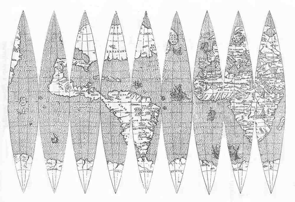
The reversed C used in Roman numerals has been represented by Ɔ.
&c, with scribal abbreviation above c, has been represented by &c̃.
This book was published in two volumes, of which this is the first.
The second volume was released as Project Gutenberg ebook #39867,
available at http://www.gutenberg.org/ebooks/39867.
This volume contains links to pages in the other volume. Although we verify the correctness of these links at the
time of posting, these links may not work, for various reasons, for various people, at various times.
|
| PAGE | ||
| List of Illustrations | xiii | |
| Foreword | xix | |
|
Chapter I: Terrestrial Globes in Antiquity |
1 | |
|
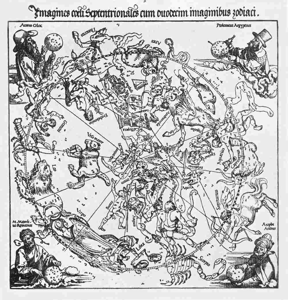
The beginnings of astronomical and of geographical science.—Primitive attempts at map construction, as seen in the Babylonian plan of the world.—Anaximander probably the first scientific cartographer.—Statements of Herodotus.—The place of Hecataeus, Hipparchus, Marinus, Ptolemy.—The Romans as map makers.—The earliest beliefs in a globular earth.—Thales, the Pythagoreans, Aristotle.—Eratosthenes and his measurements of the earth.—Crates probably the first to construct a terrestrial globe.—Statements of Strabo.—Ptolemy’s statements concerning globes and globe construction.—The allusions of Pliny. |
||
|
Chapter II: Celestial Globes in Antiquity |
14 | |
|
Thales’ ideas, probably not a globe maker.—Eudoxus.—The Atlante Farnese.—Archimedes.—Allusion of Lactantius.—Pappus’ allusions.—Armillary spheres.—The astronomer Hipparchus.—Ptolemy.—Globes used for decorative purposes by the Romans.—Roman coins.—The Byzantine Leontius Mechanicus. |
||
|
Chapter III: Globes Constructed by the Arabs |
26 | |
|
Followers of Ptolemy.—Early armillary spheres.—Interest of the Califs in globes and astronomical instruments.—The record of the ‘Fihrist.’—Ibrahim.—Caissar.—Mohammed ben Helal.—Mohammed el Ordhi.—The Paris globes.—Ridhwan Efendi. |
||
|
Chapter IV: Terrestrial and Celestial Globes in the Christian Middle Ages |
35 | |
|
General attitude of the period toward the theories of the Greeks and the Romans.—Scripture statements as sources of information.—Inclination of certain early writers to accept the doctrine of a spherical earth.—The particular attitude of Pope Sylvester II.—The assertedx interest of Emperor Frederick II in scientific studies.—Alfonso the Wise and the Alfonsian tables.—Interesting allusions in Alfonso’s work to globes and globe construction.—Giovanni Campano of Novara and the statements in his ‘Tractatis de sphera solida.’—The attitude of Albertus Magnus, Sacrobosco, Roger Bacon, Vincent of Beauvais, Dante. |
||
|
Chapter V: Globes Constructed in the Early Years of the Great Geographical Discoveries |
46 | |
|
Increasing interest in geographical discovery and maritime enterprise in the fourteenth and the fifteenth century.—Awakened interest in globe construction.—Martin Behaim and his globe of the year 1492.—The Laon globe.—Christopher and Bartholomew Columbus and their interest in globes.—John Cabot and his globe.—Globes of Johannes Stöffler.—Conrad Celtes and his part in arousing an interest in globes. |
||
|
Chapter VI: Globes of the Early Sixteenth Century |
59 | |
|
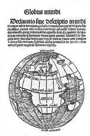
Summary of fifteenth century globe characteristics.—Increasing interest in globes—Globes of Pope Julius II.—Friar Marco da Benevento.—Importance of the Rosselli family of Florence.—The globe of Barnaba Canti.—Friar Giuliano Vannelli.—Interest of Trithemius in globes.—The Bunau globe.—Waldseemüller’s map and globe.—Liechtenstein globes.—Büchlin reference.—Globus Mundi.—Welt Kugel.—Lenox globe.—Jagellonicus globe.—Hauslab.—Green globe of Paris.—Nordenskiöld gores.—So-called Leonardo da Vinci gores.—Boulengier gores.—Acton globes.—Globes of Magellan and of del Cano.—Globes of Schöner. |
||
|
Chapter VII: Globes of the Second Quarter of the Sixteenth Century |
94 | |
|
Globes indicating (a) an Asiatic connection of the New World, (b) globes expressing a doubt of such Old World connection, (c) globes showing an independent position of the New World.—Franciscus Monachus.—Hakluyt’s reference.—The Gilt globe.—Parmentier.—Francesco Libri.—Nancy globe.—Globes of Gemma Frisius.—Robertus de Bailly.—Schöner globe of 1533—-Schiepp.—Furtembach.—Paris Wooden globe.—Vopel globes.—Santa Cruz.—Hartmann gores.—Important globe of Ulpius.—Cardinal Bembo’s globes.—Mercator’s epoch-making activity.—Fracastro.—Ramusio’s references to globes.—Gianelli.—Florence celestial globe. |
||
|
Chapter VIII: Globes and Globe Makers of the Third Quarter of the Sixteenth Century |
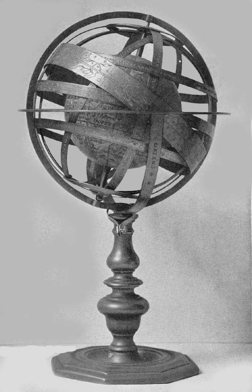
146xi | |
|
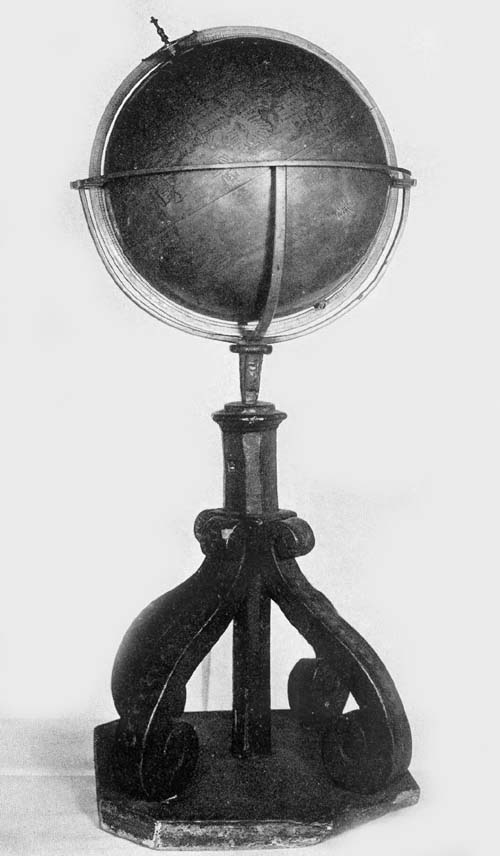
Revival of interest in globe making in Italy.—François De Mongenet of France and the reprint of his globe maps in Italy.—Gore map of Antonius Florianus.—Globe records left by Alessandro Piccolomini.—Ruscelli’s directions for globe construction.—Reference to the work of Sanuto and Gonzaga.—Armillary sphere of Volpaja.—Excellent workmanship in the celestial-terrestrial globe of Christian Heyden.—Metal globes of Johannes Praetorius.—Vasari’s reference to the work of Ignazio Danti.—The iron globe of Francisco Basso.—Armillary sphere of Giovanni Barrocci.—The work of Hieronymo de Boncompagni.—Emanuele Filiberto.—Anonymous globe of 1575.—Laurentian armillary spheres.—Small globes of the Biblioteca Nationale of Florence.—Mario Cartaro. |
||
|
Chapter IX: Globes and Globe Makers of the Last Quarter of the Sixteenth Century |
172 | |
|
Brief summary of sixteenth-century globe making.—The close of the century introducing us to the great Dutch globe makers.—The clock maker Dasypodius.—Peter and Philip Apianus.—The armillary sphere of Carlus Platus.—Roll and Reinhold.—Tycho Brahe and his influence.—Titon du Tillet.—The terrestrial globe of Rouen.—Globes of Emery Molyneux.—Globes of Bürgi.—Zürich globe.—Beaker globes.—Ivory globe of Antonio Spano.—The Van Langren globes.—Santucci.—B. F. globe of Dresden. |
||
| FIG. | CHAPTER I | PAGE |
| 1. |
Fragment Map of Egyptian Gold Mines. From Chabas |
2 |
| 2. |
Tablet Representing Babylonian World-Plan. Original in British Museum, London |
3 |
| 3. |
Ptolemy World Map. From Ebnerianus manuscript in New York Public Library, ca. 1466 |
4 |
| 4. |
Sections of Peutinger Tables. Original in Imperial Library, Vienna |
6 |
| 5. |
Globe according to Crates. From pen drawing |
7 |
| 6. |
Globe according to Strabo. From pen drawing |
9 |
| CHAPTER II | ||
| 7. |
Atlante Farnese, ca. 200 B.C.From Passari’s Atlas Farnesianus |
14 |
| 8. |
Atlante Farnese Constellation Figures. From Passari’s Atlas |
16 |
| 9. |
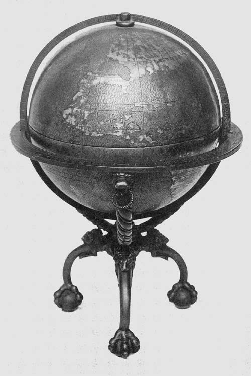
Armillary Sphere according to Ptolemy. From original Vopel globe in National Museum, Washington |
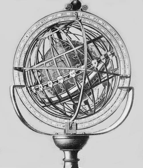
20 |
| 10. |
Bosco Reale Roman Fresco, ca. 50 A.D.From original in Metropolitan Museum, New York |
22 |
| 11. |
Greek and Roman Coins. From originals in collection of American Numismatic Society, New York |
6 |
| 12. |
Roman Gems. From King’s Antique Gems and Rings |
6 |
| CHAPTER III | ||
| 13. |
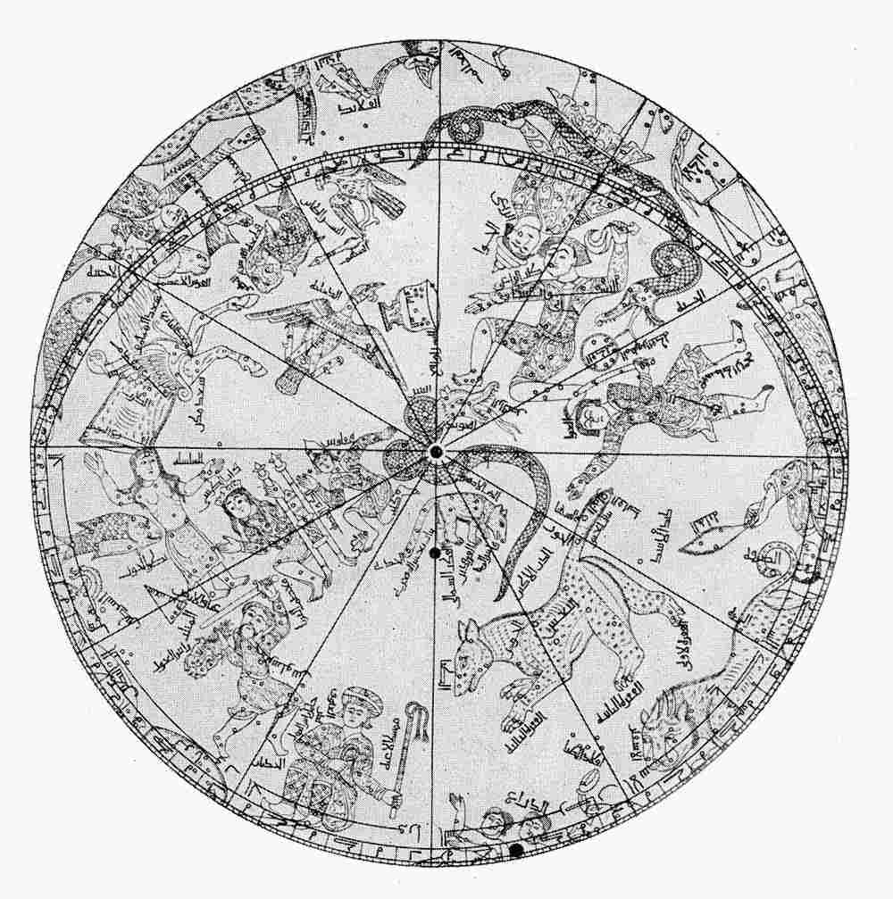
Northern Hemisphere of Globe by Mohammed ben Helal, 1275. From Dorn’s reproduction of original in London Asiatic Society’s collection |
28 |
| 14.xiv |
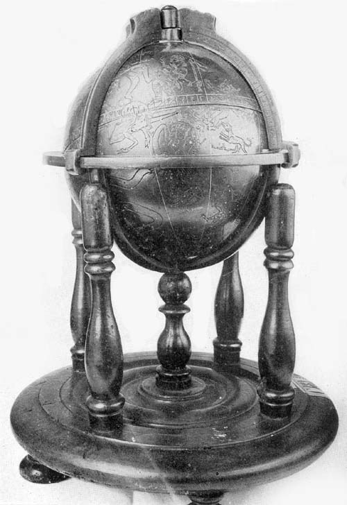
Globe of Mohammed ben Muwajed el Ordhi, 1279. From original in Math. Phys. Salon, Dresden |
30 |
| 15. |
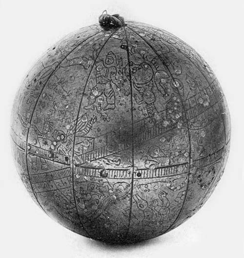
Globe of Diemat Eddin Mohammed, 1573. From original in National Library, Paris |
32 |
| 15a. |
Anonymous Arabic Globe, 1635. From original in Library Professor David E. Smith, New York |
34 |
| CHAPTER IV | ||
| 16. |
The Universe according to Cosmas Indicopleustes, Sixth Century. From reproduction by Montfauçon |
36 |
| 17. |
Cosmas’ Illustration Confuting the Existence of Antipodal Peoples. From reproduction by Montfauçon |
37 |
| 18. |
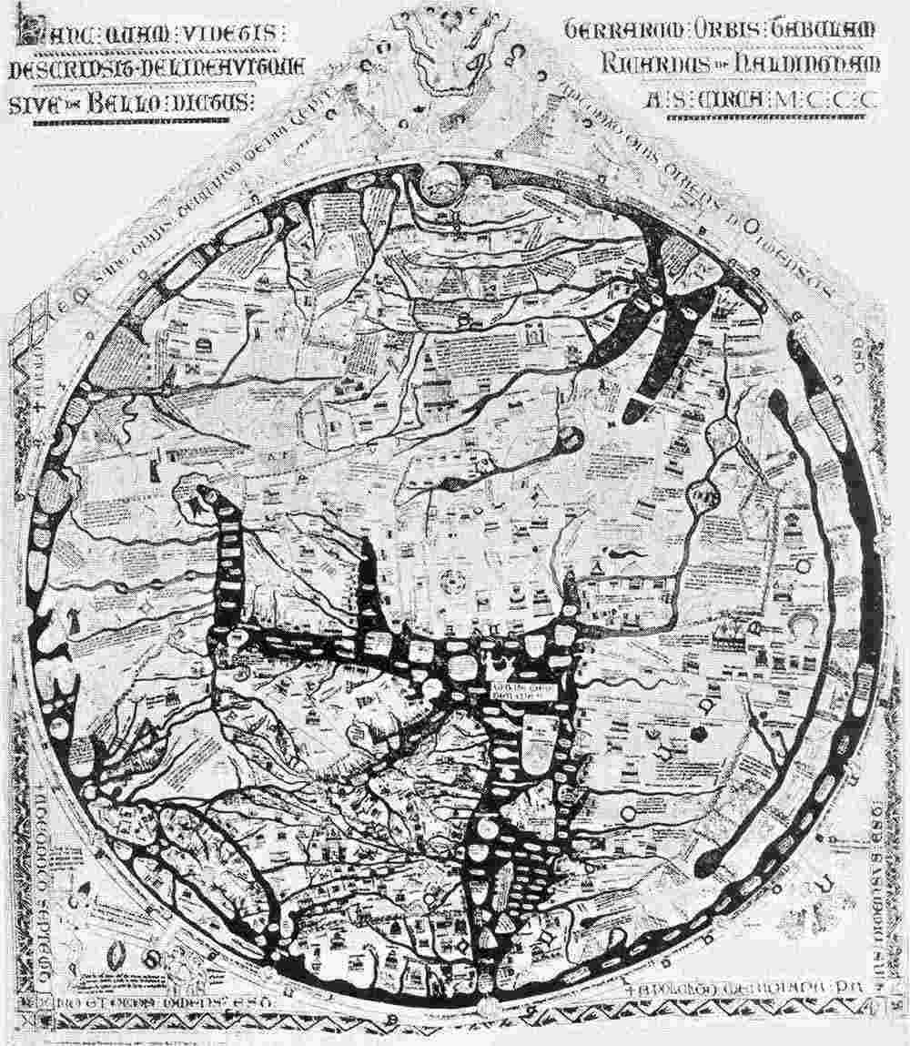
Hereford World Map, ca. 1283 |
38 |
| 19. |
The Earth Pictured as a Sphere by Nicolas d’Oresme, 1377. From reproduction in Santarem’s Atlas |
38 |
| 20. |
The Constellation Taurus. From Rico y Sinobas’ reproduction of Alfonsian Tables |
42 |
| CHAPTER V | ||
| 21. |
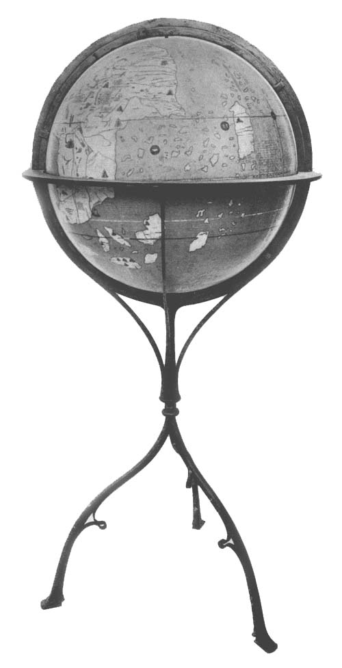
Globe of Martin Behaim, 1492. From reproduction of original in Library of the American Geographical Society, New York |
46 |
| 22. |
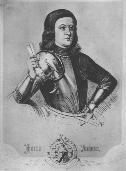
Portrait of Martin Behaim. From Ghillany |
48 |
| 23. |
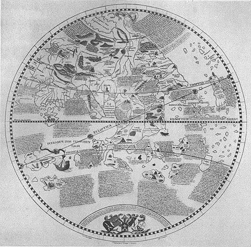
Globe of Martin Behaim in Hemispheres. From Ghillany |
50 |
| 24. |
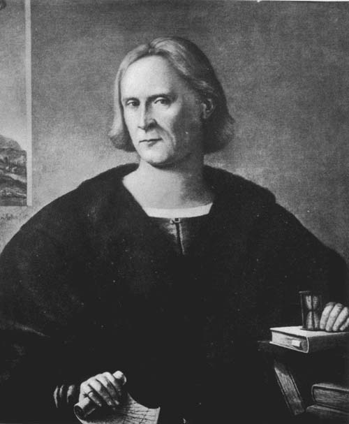
Lorenzo Lotto Portrait of Columbus. From original belonging to James W. Ellsworth, New York |
52 |
| 25. |
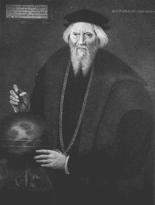
Portrait of Sebastian Cabot, Son of John Cabot. From engraving by Rawle |
54 |
| CHAPTER VI | ||
| 26. |
Title-page of Johann Schöner’s Terrae Descriptio, 1518. From original |
60 |
| 27. |
Second Title-page of Mauro Fiorentino’s Sphera Volgare, 1537. From original |
61 |
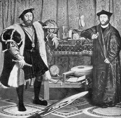
| 28. |
Holbein’s Ambassadors. From original in National Art Gallery, London |
62 |
| 29. |
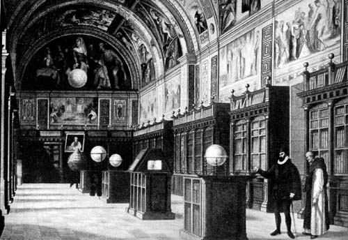
Library of Escorial. From an old print |
64 |
| 30. |
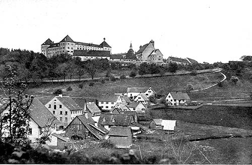
Castle of Prince Waldburg de Wolfegg. From original photograph |
64 |
| 31.xv |
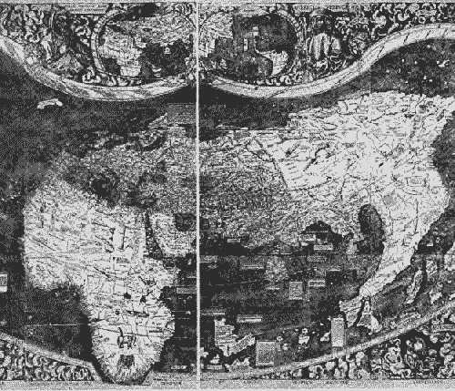
World Map of Martin Waldseemüller, 1507. From Fischer and von Wieser’s reproduction |
68 |
| 32. |
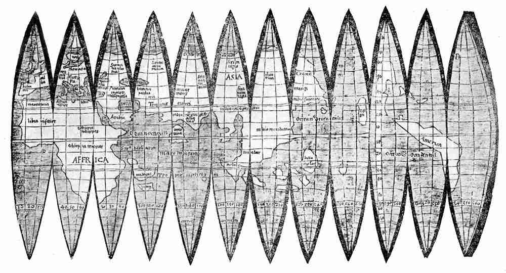
Globe Gores Attributed to Martin Waldseemüller, 1509. From original belonging to Prince Liechtenstein |
70 |
| 33. |
Globus Mundi, 1509. From original |
73 |
| 34. |
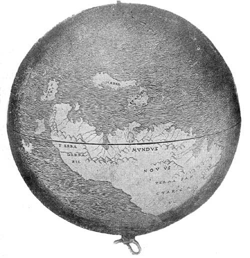
Lenox Globe, 1510. From original in New York Public Library |
73 |
| 35. |
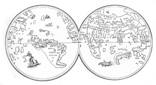
Lenox Globe in Hemispheres. From pen drawing |
72 |
| 36. |
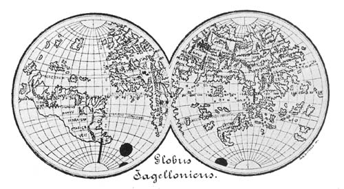
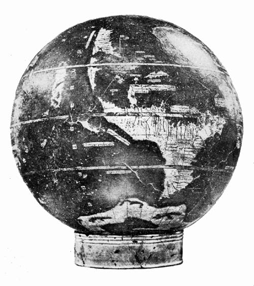
Jagellonicus Globe, 1510. From original in Cracow |
74 |
| 37. |
Jagellonicus Globe in Hemispheres. From reproduction by Estreicher |
74 |
| 38. |
Green Globe, 1515. From original in National Library, Paris |
76 |
| 39. |
Liechtenstein Globe Gores, ca. 1518. From original belonging to Prince Liechtenstein |
78 |
| 40. |
Terrestrial Globe Gores of Boulengier, ca. 1518. From original in New York Public Library |
80 |
| 41. |
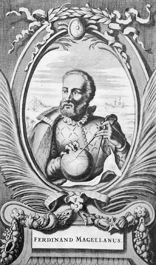
Portrait of Magellan. From an old print |
82 |
| 42. |
Portrait of Johann Schöner. From an old engraving |
84 |
| 43. |
Globe of Johann Schöner in Hemispheres, 1515. From original and Jomard’s Atlas—pen drawing |
84 |
| 44. |
Western Hemisphere of Johann Schöner’s Globe, 1520. From Ghillany |
86 |
| 44a. |
Anonymous Globe Gores, ca. 1540. From original in New York Public Library |
88 |
| 45. |
Stabius World Globe Map, 1515. From original in Imperial Library, Vienna |
88 |
| 46. |
Northern Celestial Hemisphere of Albrecht Dürer. From original in Imperial Library, Vienna |
28 |
| CHAPTER VII | ||
| 47. |
Bartholomew Columbus Sketch Map, 1506. From reproduction by von Wieser |
95 |
| 48. |
Hemispheres of Franciscus Monachus, 1526. From his De orbis situ |
96 |
| 49. |
Gilt Globe, ca. 1528. From Harrisse drawing after the original in National Library, Paris |
98 |
| 50. |
Nancy Globe, ca. 1530. From original in Nancy Museum |
100 |
| 50a. |
Globe of Jacob Stamfer, 1539. From original in Zürich |
102 |
| 50b. |
Nancy Globe in Hemispheres. From Blau’s reproduction |
102 |
| 51. |
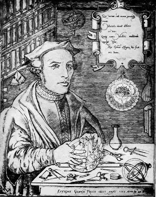
Portrait of Gemma Frisius. From an old print |
104 |
| 52. |
Terrestrial Globe of Robertus de Bailly—Nine of twelve gores exhibiting the map, 1530. Redrawn for Rosenthal’s Catalogue, No. 100 |
108 |
| 53. xvi |
Terrestrial Globe of Robertus de Bailly, 1530. From original in Library of J. P. Morgan, New York |
108 |
| 54. |
Schöner’s Terrestrial Globe, 1533 (Probable). From his Opera Mathematica |
110 |
| 54a. |
Schöner’s Celestial Globe, 1533 (Probable). From his Opera Mathematica |
112 |
| 55. |
Paris Wooden Globe, 1535. From original in National Library, Paris |
114 |
| 56. |
Vopel Globe, 1543. From original in the Library of Congress, Washington |
116 |
| 56a. |
Western Hemisphere of Vopel Terrestrial Globe. From de Costa’s drawing |
98 |
| 57. |
Terrestrial Globe of Euphrosynus Ulpius, 1541. From original in Library New York Historical Society |
118 |
| 58. |
Western Hemisphere of Ulpius Globe, 1541. From the drawing by de Costa |
119 |
| 59. |
Gore Map of Alonso de Santa Cruz, 1542. From Dahlgren’s reproduction |
122 |
| 60. |
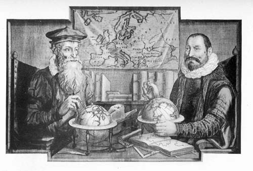
Portraits of Gerhard Mercator and Jodocus Hondius. From an old print |
124 |
| 61. |
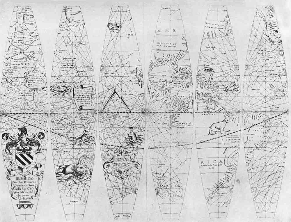
Six of Twelve Terrestrial Globe Gores by Gerhard Mercator, 1541. From reproduction by van Raemdonck |
128 |
| 62. |
Terrestrial Globe of Gerhard Mercator, 1541. From original in Astronomical Museum, Rome |
134 |
| CHAPTER VIII | ||
| 63. |
Terrestrial Globe Gores of François de Mongenet, 1552. From original in New York Public Library |
148 |
| 64. |
Celestial Globe Gores of François de Mongenet, 1552. From original in New York Public Library |
150 |
| 65. |
Globes of François de Mongenet, 1560, and of Gian Francesco Costa, 1784 |
150 |
| 66. |
Globe Gores of Antonius Florianus, 1555. From Lafreri’s Atlas |
152 |
| 67. |
Globe of Christian Heyden, 1560. From original in Math. Phys. Salon, Dresden |
156 |
| 68. |
Globe of Johannes Praetorius, 1566. From original in Math. Phys. Salon, Dresden |
158 |
| 69. |
Terrestrial Globe of Mario Cartaro, 1577. From original in possession of Mr. Reed, New York |
168 |
| CHAPTER IX | ||
| 70. |
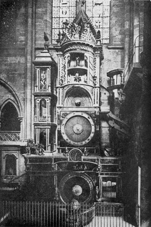
Strassburg Clock and Globe of Conrad Dasypodius, 1574. From Schwilgué |
174 |
| 71. |
Portrait of Peter Apianus. From an old print |
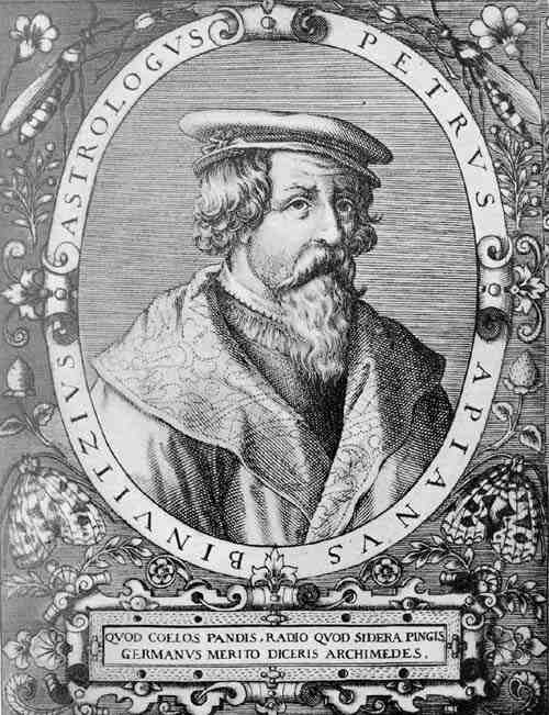
176 |
| 72. |
Globes of Philip Apianus, 1576. From originals in K. B. Hof- u. Staatsbibliothek, Munich |
178 |
| 73. |
Silver-Gilt Globe of Gerhard Emmoser, 1573. From original in Metropolitan Museum, New York |
180 |
| 74. |
Globe of George Roll and Johannes Reinhold, 1586. From original in Math. Phys. Salon, Dresden |
182 |
| 75. |
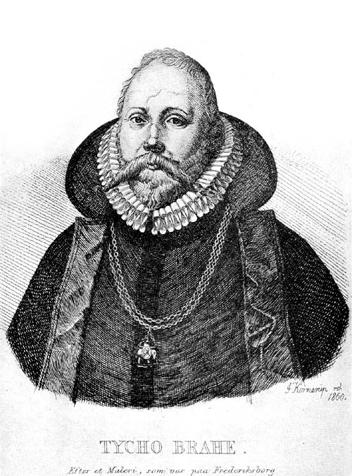
Portrait of Tycho Brahe. From an engraving by Kornenip |
184 |
| 76. |
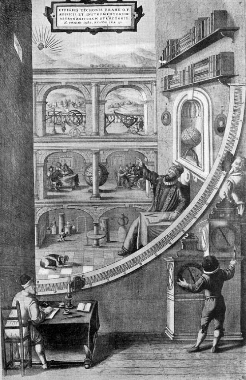
Interior of Tycho Brahe’s Observatory at Uranienburg. From Blaeu’s Atlas |
186 |
| 77. |
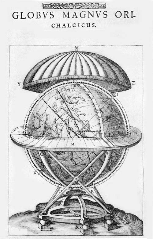
Globus Magnus of Tycho Brahe, 1584. From his Astronomiae Instauratae Mechanica |
188 |
| 78. |
L’Écuy Terrestrial Globe, ca. 1578. From original in National Library, Paris |
190 |
| 79. |
Terrestrial Globe of Emery Molyneux, 1592. From original in Middle Temple, London |
192 |
| 80. |
Anonymous Terrestrial Globe, ca. 1595. From original in Landesmuseum, Zürich |
198 |
| 81. |
Globe-Goblet of Abraham Gessner, ca. 1600. From original in Wolfegg Castle, Wolfegg |
200 |
| 82. |
Gold Globe-Goblet, ca. 1575. From original in Metropolitan Museum, New York |
200 |
| 83. |
Ivory Terrestrial Globe of Antonio Spano, 1593. From original in Library of J. P. Morgan, New York |
202 |
| 84. |
South Polar Region on Globe of Antonio Spano. From original in Library of J. P. Morgan, New York |
204 |
| 84a. |
South Polar Region on Globe of Jodocus Hondius, 1600. From original in Library of Henry E. Huntington, New York |
204 |
| 85. |
Terrestrial Globe of Van Langren, 1612. From original in Royal Geographical Society, Amsterdam |
208 |
| 86. |
Armillary Sphere of Antonio Santucci (?), ca. 1580. From original in Library of Henry E. Huntington, New York |
214 |
| 87. |
Celestial Globe of B. F., 1600. From original in Math. Phys. Salon, Dresden |
216 |
| CHAP. | TAILPIECES | PAGE |
| II. | The Egyptian Gnomon. From pen drawing | 25 |
| III. | Arabic Celestial Globe. From Dorn’s illustration | 34 |
| V. | Ship. From early portolan chart | 58 |
| VI. | Honter Globe. From his Rudimenta cosmographica | 93 |
| VII. | Portuguese Arms | 145 |
| VIII. | Compass Rose. From Martines Atlas, 1582, | 171 |
| IX. | Base of Apianus Globe, 1576. | 218 |
HITHERTO there has not appeared in English a detailed historical treatise on globes terrestrial and celestial. The publications are somewhat numerous, it is true, in which a very general consideration has been given to the uses of globes, including a reference to their important structural features, and to the problems geographical and astronomical in the solution of which they may be counted of service. There are a few studies, critical and historical, touching certain selected examples of the early globe maker’s handiwork which can be cited. Attention, for example, may here be directed to Sir Clements Markham’s valuable introduction to his excellent English translation of Hues’ ‘Tractatus de Globis,’ a work originally prepared for the purpose of furnishing a description of the Molyneaux globes, in which introduction he undertook “to pass in review the celestial and terrestrial globes which preceded or were contemporaneous with the first that were made in England (1592) so far as a knowledge of them has come down to us,” yet the learned author cites but a fraction of the many globes referred to in the following pages. In Ravenstein’s ‘Behaim, His Life and His Globe,’ we have perhaps the most scholarly treatment of its kind in any language, but the study is limited to the work of one man, the maker of the oldest extant terrestrial globe, which is dated 1492.
The bibliographical list which is appended gives striking evidence that there has been a more or less extended interest in the general subject of the use and the construction ofxx globes in France, in Germany, in England, and in Italy. The author makes in this place special mention of his indebtedness to the studies of the distinguished Italian scholar, Professor Matteo Fiorini, adding that with some propriety his name might have a place on the title-page. Had there not been a ready access to his important works, had the Italian Geographical Society not so graciously expressed to the author its willingness for the free use of as much of his published investigations as might be desired, for which it stood in the relation of sponsor publisher, a willingness which Fiorini himself had assured to any who might have access to the printed results of his studies within this field, the preparation of this work necessarily would have extended over a considerable period of time. Special mention must be made of his ‘Sfere Terrestri e Celesti di Autore Italiano oppure fatte o conservate in Italia,’ and of his ‘Sfere cosmografiche e specialmente le Sfere Terrestri.’ These works have been of very signal value for the study of the Italian globes and globe makers. Not an inconsiderable part of his descriptive details has been appropriated, being given in free translation or in paraphrase, quotation marks having been omitted. Special mention may also here be made of Sigmund Günther’s interesting little volume, which he titles ‘Erd- und Himmelsgloben nach dem italienischen Matteo Fiorinis frei bearbeitet.’ This has been of special value for its bibliographical references and for its short chapters on globe-gore construction.
To attempt the listing, with description, of all globes known to have been constructed from the earliest times to the close of the eighteenth century, the latter being a somewhat arbitrary date, is pretentious. The fact is fully appreciated that in many instances the description given is all too brief. Many of the individual terrestrial globe maps of the period in question, it should be especially noted, are of the greatest historical and scientific value; but to have undertaken a more detailed and a more critical study merely ofxxi those which may be called the most important might well have demanded far more time and special research than could have been fittingly allowed for a general survey such as has here been planned; in such a course we should indeed have been led afield from our purpose.
It had been thought when this study was first undertaken that perhaps as many as one hundred existing examples might be located, and that in addition to these not a few important references might be found to work actually done but now lost. Instead of the one hundred, more than eight hundred and fifty have been listed, and from the interesting experience in collecting material for the work, the pleasurable hope is entertained that the published record of this effort will be in some measure the means of bringing to light not a score but scores of other examples. Indulging this hope there have been added to each copy of the book a few blank pages for the insertion of a reference to any not mentioned in the following printed pages. The author begs in this connection to add an expression of his grateful appreciation for any word which may be sent to him concerning unmentioned examples, to the end that in a revised edition such examples may be fittingly noted. The great war checked the search for existing examples, and prevented the inclusion of many illustrations which had been promised, but these were promises which could not be fulfilled.
An attempt has been made, as before noted, to treat the subject historically, beginning with the earliest references to the belief in a spherical earth and a spherical firmament encircling it. It is not easy to fix, with anything like a satisfactory measure of certainty, the beginning of globe construction; very naturally it was not until a spherical theory concerning the heavens and the earth had been accepted, and for this we are led back quite to Aristotle and beyond, back indeed to the Pythagoreans if not yet farther. We find allusions to celestial globes in the days of Eudoxus and Archimedes, to terrestrial globes in the days of Crates andxxii Hipparchus. We find that the Greek geographer Strabo gives us quite a definite word concerning their value and their construction, and that Ptolemy is so definite in his references to them as to lead to a belief that globes were by no means uncommon instruments in his day, and that they were regarded of much value in the study of geography and astronomy, particularly of the latter science. There is, however, but one example known, which has come down to us from that ancient day, this a celestial globe, which is noted below and briefly described as the Farnese globe. It is of marble, and is thought by some to date from the time of Eudoxus, that is, three hundred years before the Christian era.
To the Mohammedans belongs chief credit for keeping alive an interest in astronomical studies during the so-called Christian middle ages, and we find them interested in globe construction, that is, in celestial globe construction; so far as we have knowledge, it seems doubtful that they undertook the construction of terrestrial globes.
Among the Christian peoples of Europe in this same period there was not wanting an interest in both geography and astronomy. We are now learning that those centuries were not entirely barren of a certain interest in sciences other than theological. In Justinian’s day, or near it, one Leontius Mechanicus busied himself in Constantinople with globe construction, and we have left to us his brief descriptive reference to his work. With stress laid, during the many centuries succeeding, upon matters pertaining to the religious life, there naturally was less concern than there had been in the humanistic days of classical antiquity as to whether the earth is spherical in form or flat like a circular disc, nor was it thought to matter overmuch as to the form of the heavens. Yet there was no century, not even in those ages we happily are learning to call no longer dark, that geography and astronomy were not studied and taught, and globes celestial as well as armillary spheres, if not terrestrialxxiii globes, were constructed. The Venerable Bede, Notker Labeo, Pope Sylvester I, the Emperor Frederick II, and King Alfonso of Castile, not to name many others of perhaps lesser significance, displayed an interest in globes and globe making.
The modern age opens with an interest in the expansion of Europe overland eastward, with this interest soon to be followed by greater enthusiasm in transoceanic expansion. With the rapidly increasing knowledge concerning the hitherto unknown or but little known regions of the earth came a desire for better map making, came an interest intelligently directed in the construction of terrestrial globes on which the newly discovered parts might be represented in their relative positions as they are on the real spherical earth. To this interest Martin Behaim gave striking expression, producing in the year 1492 his famous “Erdapfel” referred to above as the oldest extant terrestrial globe. His century closes with every evidence that the spherical theory, as Aristotle had expressed it nearly two thousand years before, could alone be accepted by geographers, and if spherical, the fact could be most impressively taught by the use of a material representation, that is, by means of a terrestrial globe.
The sixteenth century opened with a marvelously increased interest in geography, the result of a climax reached through the transoceanic discoveries in which Columbus led the way. If the makers of plane maps became now increasingly active, so the makers of globes were becoming increasingly numerous, and at first in the countries of trans-alpine Europe. Globes of metal with engraved maps, as the Lenox and the Jagellonicus copper spheres, globes with manuscript maps covering a sphere of special composition, as were those of Schöner, globes in the preparation of which engraved gore maps were employed; as the Waldseemüller, the Boulengier, the Gemma, and the Mercator, make their appearance in ever increasing numbers, the activity encouragedxxiv by those interested in a scientific study of geography and astronomy, and notably by seamen, in whose collection of navigator’s instruments they were long considered to be of the greatest importance.
How the globe interest in the several countries of Europe found expression during the sixteenth, seventeenth, and eighteenth centuries is fully set forth in the following pages, with something of an attempt at a grouping and a classification of the results, to the end of making more clear the trend of that interest, now quickened, now retarded, by certain temporary or permanent national impulses.
It is especially interesting to note how a certain superiority in globe making exhibited itself, now in one country, now in another, with a lingering favor exhibited in Italy for the manuscript or the metal globe, while in the North, globes with copper engraved gore maps found increasing favor from the first, with a certain climax reached in the Netherlands in the days of Hondius and Blaeu.
In the appended tabulated list of globes and globe makers, it will be noted that the makers have been listed alphabetically, that the kind of globe has been indicated, whether terrestrial, celestial or armillary sphere, with the date given, though sometimes only approximately, and with the diameter of each globe recorded in centimeters, so far as obtainable with an acceptable degree of accuracy, fractions thereof being omitted, these same measurements being repeated in the text reference to each individual example or edition.
The author had been ambitious to include in his illustrations a reproduction of each known example or edition, showing at least the general appearance of each, but he fully realizes the more or less unsatisfactory character of a small print, and the unsatisfactory results of an attempt to photograph the curved surface of a sphere. Not a few of the many examples would prove to be of the greatest interestxxv and scientific value could the entire map surface have been given in reproduction and in size to be easily legible. It however can be readily understood how such an undertaking was necessarily considered to be unpractical. Out of the author’s collection of about four hundred globe photographs, a selection has been made of those which it has been thought would be most suitable for illustrative purposes.
It is hoped that the preliminary study herewith presented may lead to a number of independent and thorough investigations of important individual examples, to the end of clearly setting forth their great documentary value.
There have been added to the list of illustrations certain important legends as they appear in the original, likewise a number of contemporary portraits of the distinguished globe and map makers of the last three centuries. In most instances important legends have been cited in the text in the exact language of the original, to which, with very few exceptions, a translation is added. The critical student will occasionally be somewhat astounded at the incorrectness of the language, Latin, Italian, Spanish, French or German, in the original. The translations into English, not infrequently, have been made with difficulty; accordingly it will be noted in some instances that the translation is conjectural. No attempt has been made to correct errors; on the contrary, the greatest care has been exercised to adhere faithfully to the original as given by the map or globe maker.
The bibliographical list appended is full, but completeness is not pretended. Practically all of the works cited have been consulted, and care has been taken to include those held to be of the greatest importance. It will at least serve as a working list for those students who may wish to make further investigations within the field under consideration.
An expression of sincerest thanks is here recorded to the very many librarians, directors of museums, and private individuals who have so graciously responded to requests forxxvi information concerning the globes belonging to their several collections. The privilege so readily conceded for photographing the several examples, and the time and trouble expended in having this work of reproduction well done, are nothing less than a striking evidence of the kindliest fraternal spirit existing among those engaged in scientific and literary pursuits the world over. To the requests presented even the antipodes have responded.
In concluding, the author might refer to his interest in globes as dating from his early boyhood days, when, in that country school in western Illinois, bearing the name Liberty, for it had been established in the first years of the Civil War, he studied his geography and indeed his astronomy lessons with the aid of a terrestrial globe and an orrery. Can it be that we have revised our educational methods so far in this country as practically to have eliminated the intelligent use of aids so valuable in the study of the branches which globes concern? They enter in fact but little into modern methods of instruction. If this work could be made to encourage their extensive use, and serve in their rehabilitation as aids of inestimable interest and value in geographical and astronomical studies, it will have served the purpose which is most pleasing to the author.
The beginnings of astronomical and of geographical science.—Primitive attempts at map construction, as seen in the Babylonian plan of the world.—Anaximander probably the first scientific cartographer.—Statements of Herodotus.—The place of Hecataeus, Hipparchus, Marinus, Ptolemy.—The Romans as map makers.—The earliest beliefs in a globular earth.—Thales, the Pythagoreans, Aristotle.—Eratosthenes and his measurements of the earth.—Crates probably the first to construct a terrestrial globe.—Statements of Strabo.—Ptolemy’s statements concerning globes and globe construction.—The allusions of Pliny.
THE beginnings of the science of astronomy and of the science of geography are traceable to a remote antiquity. The earliest records which have come down to us out of the cradleland of civilization contain evidence that a lively interest in celestial and terrestrial phenomena was not wanting even in the day of history’s dawning. The primitive cultural folk of the Orient, dwellers in its great plateau regions, its fertile valleys, and its desert stretches were wont, as we are told, to watch the stars rise nightly in the east, sweep across the great vaulted space above, and set in the west as if controlled in their apparent movement by living spirits. To them this exhibition was one marvelous and awe-inspiring. In the somewhat strange grouping of the stars they early fancied they could see the forms of many of the objects about them, of many of their gods and heroes, and we find their successors outlining these forms in picture in their representations of the heavens on2 the material spheres which they constructed. Crude and simple, however, were their astronomical theories relative to the shape, the structure, and the magnitude of the great universe in which they found themselves placed.1
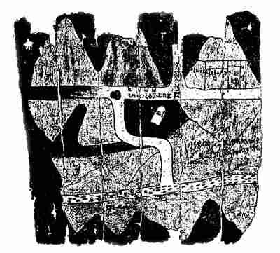
Then too, as stated, there was something of interest to the people of that early day in the simple problems of geography; problems suggested by the physical features of their immediate environment; problems arising as they journeyed for trade or traffic, or the love of adventure, to regions now near, now remote. Very ancient records tell us of the attempts they made, primitive indeed most of them were, to sketch in general outline small areas of the earth’s surface, usually at first the homeland of the map maker, but to which they added as their knowledge expanded. The early Egyptians, for example, as we long have known, made use of rough outline drawings (Fig. 1)2 to represent certain3 features of special sections of their country, and recently discovered tablets in the lower Mesopotamian valley (Fig. 2) interestingly show us how far advanced in the matter of map making the inhabitants of that land were two thousand years before the Christian era.3 We are likewise assured, through references in the literature of classical antiquity, that maps were made by the early Greeks and Romans, and perhaps in great numbers as their civilization advanced, though none of their productions have survived to our day. To the Greeks indeed belongs the credit of first reducing geography and map making to a real science.4 No recent discovery by archaeologist or by historian, interesting as many of their discoveries have been, seems to warrant an alteration of this statement, long accepted as fact.
The credit of being the first scientific cartographer has been generally assigned to the Greek Anaximander of Miletus (610-547 B. C.).5 While there is not a detailed4 description extant of the maps he is reputed to have made, we know that he accepted the so-called Homeric idea, that the earth has the form of a circular disc,6 and is surrounded by the Ocean Stream, an idea generally approved by the Ionic School of Philosophers.7 It is not improbable that we have an allusion to the work of Anaximander in the History of Herodotus (484-400? B. C.), wherein we are told that Aristagoras, the tyrant of Miletus, when on a mission to Cleomenes, the King of Sparta, carried with him “a copper plate on which was engraved the whole circuit of the earth, and likewise all the Seas and Rivers.”8 In another passage, Herodotus takes occasion to criticise maps of this circular character. “I laugh,” he says, “when I see that, though many before this have drawn maps of the Earth, yet no one has set the matter forth in an intelligent way; seeing that they draw the Ocean flowing round the Earth, which is circular as if drawn with compasses, and they make Asia equal in size to Europe. In a few words I shall declare the size of each division and of what nature it is as regards outline.”9 It is, however, interesting to observe that the father of historical geography and of history nowhere records his idea of a properly constructed map, and further that the circular form, which he condemned, is one which found wide acceptance even to the close of the middle ages.
We are not definitely informed as to just the course of improvement or advancement in early scientific map making among the Greeks, yet not a few names are known to us of those who made it a matter of special endeavor, as they specifically stated, to improve the work of their predecessors. We, for example, are told that Hecataeus (550-480 B. C.),10 likewise a native of Miletus, improved the maps of Anaximander, and that scientists of his day were astonished at his results; that Dicaearchus of Massina (350-290 B. C.)11 was the first to employ a central line of orientation on a map, one passing through the Mediterranean east and west, and that he represented on his map all the lands known since 5the expedition of Alexander the Great into the Far East; and further, that Eratosthenes, the librarian of Alexandria (276-196 B. C.),12 was the first to attempt a representation of the curved surface of the earth on a plane in accord with geometrical rules. The scientific cartographical ideas of Eratosthenes were further developed by Hipparchus (180-125 B. C.),13 who is generally referred to as the greatest astronomer of antiquity, and by Marinus of Tyre (fl. ca. 100 A. D.),14 who introduced the idea of inscribing lines of latitude and longitude on a map, crossing the same at right angles, which lines could be made to serve the useful purpose of orientation and be of assistance in giving proper location to all known places on the earth’s surface.
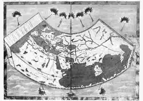
Map making in that early period reached its climax in the work of Claudius Ptolemy of Alexandria (ca. 87-150 A. D.).15 His ideas, however, seem not to have found general favor with his contemporaries, nor with the geographers of the middle ages. (Fig. 3.) It was not until the so-called period of great geographical discoveries and explorations in the fifteenth century that he became a real teacher within his chosen field.
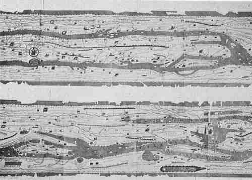
Map making and the science of geography were continuously progressive among the Greeks. Imperial Rome witnessed little progress in either field. Among those who wrote in the Latin language, Pomponius Mela (fl. ca. 43 A. D.)16 and Pliny (ca. 23-79 A. D.)17 alone have rank of importance. In the matter of map construction the Romans held to many of the cruder methods and ideas of the Greeks, a fact which we learn from the fragmentary references in their literature, and from the itinerary or road maps (Fig. 4), of the period of the emperors, which have come down to us.18
The idea of a globular earth was at first accepted by the geographers of antiquity with some hesitancy. That Thales (640-548 B. C.),19 one of the earliest astronomers and cosmographers, openly supported this theory, as is sometimes6 asserted, is hardly probable. It is rather to be assumed that according to his idea the earth has the form of a cylinder, and that it moves within a hollow sphere, an idea upheld by Anaximander, his disciple and successor, to whom reference has been made above. It was the Pythagorean philosophers who appear to have first transferred to the earth that which had already been accepted as a theory relative to the heavens, including the imaginary circles and the circular or spherical form, apparently arguing that the earth is a sphere because that is the most perfect form, that it is located in the center of the universe because that is the place of honor, and that it is at rest because rest is more dignified than motion.20 It however was Aristotle who undertook, in the manner of a philosopher, an elaborate defense of the Pythagorean doctrine of a globular earth, supporting his arguments, first, through a reference to such positive proof as may be found in gravitation or “the tendency of all particles of matter to form themselves about the middle and thus make a sphere,” and secondly, through a reference to the appearance of the earth’s shadow cast during an eclipse of the moon.21 A third proof, so familiar to us today, that distant objects as we approach them gradually reveal themselves above the horizon, seems not to have occurred to Aristotle, but was first employed by Strabo. “It is evident,” says the latter, “that, when persons on shipboard are unable to see at a distance lights which are on a level with the eye, the cause of this is the curvature of the sea; for if those lights are raised to a higher level, they become visible, even though the distance is increased; and in like manner, if the beholder attains a greater elevation he sees what was previously hidden.... Again, when men are approaching the land from the sea, the parts nearest the shore-line come more and more into view, and objects which at first appeared low attain a greater elevation.”22
After the attempt had been made to determine the circumference of the earth, as was done by Eratosthenes with 7more or less satisfactory results, the thought, very naturally, was suggested of making an artificial representation of the entire earth, so far as then understood, that is, of making a terrestrial globe. There is no intimation, however, in any early allusion to Eratosthenes that he was a globe maker, or that he knew anything about globe construction. We know that he thought of the earth as a sphere placed in the center of the universe, around which the celestial sphere revolves every twenty-four hours.23 Strabo, at a much later date, in referring to the geographical ideas of Eratosthenes, censured him for his unnecessarily elaborate proofs of the earth’s spherical character, apparently thinking the fact one too well known to require demonstration.
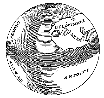
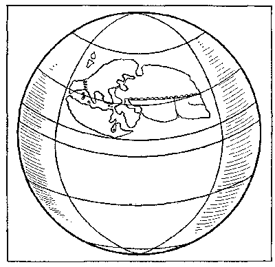
It appears to have been the grammarian Crates of Mallos, a contemporary of Hipparchus, and a member of the Stoic School of Philosophers, who made the first attempt to construct8 a terrestrial globe (Fig. 5), and that he exhibited the same in Pergamum, not far from the year 150 B. C.24 It seems to have been Crates’ idea that the earth’s surface, when represented on a sphere, should appear as divided into four island-like habitable regions. On the one hemisphere, which is formed by a meridional plane cutting the sphere, lies our own oecumene or habitable world, and that of the Antoecians in corresponding longitude and in opposite latitude; on the other hemisphere lies the oecumene of the Perioecians in our latitude and in opposite longitude, and that of the Antipodes in latitude and longitude opposite to us.25 Through the formulation and expression of such a theory the idea of the existence of an antipodal people was put forth as a speculative problem, an idea frequently discussed in the middle ages, and settled only by the actual discovery of antipodal regions and antipodal peoples in the day of great transoceanic discoveries.26 That Strabo, at a later date, had this Pergamenian example in mind when stating certain rules to be observed in the construction of globes seems probable, since he makes mention of Crates’ globe. Strabo alone among ancient writers, so far as we at present know, treats of terrestrial globes, practically such as we find in use at the present day. He thought that a globe to be serviceable should be of large size, and his reasoning can readily be understood, for what at that time was really known of the earth’s surface was small indeed in comparison with what was unknown. Should one not make use of a sphere of large dimensions, the habitable regions (Fig. 6), in comparison with the earth’s entire surface, would occupy but small space. What Strabo states in his geography is interesting and may here well be cited. “Whoever would represent the real earth,” he says, “as near as possible by artificial means, should make a sphere like that of Crates, and upon this draw the quadrilateral within which his chart of geography is to be placed. For this purpose however a large globe is necessary since the section mentioned, though9 but a very small portion of the entire sphere, must be capable of containing properly all the regions of the habitable earth and of presenting an accurate view of them to those who wish to consult it. Any one who is able will certainly do well to obtain such a globe. But it should have a diameter of not less than ten feet; those who can not obtain a globe of this size, or one nearly as large, had better draw their charts on a plane surface of not less than seven feet. Draw straight lines for the parallels, and others at right angles to these. We can easily imagine how the eye can transfer the figure and extent (of these lines) from a plane surface to one that is spherical. The meridians of each country on the globe have a tendency to unite in a single point at the poles; nevertheless on the surface of a plane map there would be no advantage if the right lines alone which should represent the meridians were drawn slightly to converge.”27
It is not at all improbable that Strabo and Ptolemy made10 considerable advance in the practical construction of terrestrial globes, for it seems reasonable to conclude that they were in possession of such objects when writing, as they did, concerning them.
Ptolemy, we may note, expressly allowed that the size of a globe should be that which one might desire, and that it was not necessary it should be of large size. It was this great Alexandrian cosmographer who first demonstrated the scientific value of drawing on the surface of a globe or map the network of parallels and meridians, and of establishing by means of the two geographical coördinates the true geographical position of every known place. To the end of making globes more serviceable he suggested the use of a meridian circle, such as is today employed in globe construction, passing through both poles, within which circle the globe might be made to move freely on its axis. He, however, in this connection, did not give technical directions for the construction of terrestrial globes, but he says enough to assure us that the art of globe construction was measurably well understood in his day, and that the Greeks and the Romans considered them very useful instruments in the study of the heavens and the earth.28
The allusions of the naturalist Pliny (23-79 A. D.) to the spherical shape of the earth give us no particular intimation that he knew of the existence of terrestrial globes, but they are interesting as indicating a belief of his time in its spherical form, a belief, judging from the nature of the argument, apparently drawn from Aristotle. Referring to the shape of the earth, he observes that “everyone agrees it has the most perfect figure. We always speak of the ball of the earth, and we admit it to be a globe bounded by the poles. It has not indeed the form of an absolute sphere, from the number of lofty mountains and flat plains; but if the termination of the lines be bound by a curve, this would compose a perfect sphere. And this we learn from arguments drawn from the nature of things, although not from the11 same considerations which we have made use of with respect to the heavens. For in the heavens the hollow convexity everywhere bends on itself and leans upon the earth as a center, whereas the earth rises up solid and dense like something that swells up and is protruded outward. The heavens bend toward the center, while the earth goes out from the center, the continual rolling of the heavens about it forcing its immense mass into the form of a sphere.”29
1 Most of the larger general works presenting an historical survey of the science of astronomy give consideration to its beginnings, noting the interest in the subject exhibited by the early Egyptians, Assyrians, Babylonians, and by other Eastern peoples. See the introductory pages of such works as Dalambre, M. Histoire de l’astronomie ancienne. Paris, 1817; Lockyer, J. N. The Dawn of Astronomy. New York, 1894; Allan, H. A. Star Names and their Meanings; Wolf, R. Geschichte der Astronomie. München, 1877; Mädler, J. H. Geschichte der Himmelskunde von den ältesten bis auf die neuste Zeit. Braunschweig, 1873. 2 vols.; Narrien, J. N. An Historical Account of Origin and Progress of Astronomy. London, 1833.
2 Chabas, F. Ouvres diverses publiées par G. Maspero. Paris, 1902. Tome deuxième, Plate II, p. 208, “Carte Egyptienne de mines d’or.”
3 Cuneiform Texts from Babylonian Tablets, etc., in British Museum. London, 1906. Vol. 22, Plate 48. This Babylonian plan of the world illustrates the idea concerning the world which was current in the late Babylonian period. It represents the region of Babylonia, Assyria, and the neighboring districts as a circular plain surrounded by the Persian Gulf (Ma-ra-tum). The city Babylon (Babylu) is indicated near the center, and next to it the land of Assyria (Ashshur). The position of certain other cities is indicated. The district toward the south, bordering the Persian Gulf, is represented as being full of canals and marshes. Toward the north is marked a district which is referred to as mountainous. Beyond the circle is represented the Persian Gulf, and a number of triangles pointing outward from the circular zone, each being labeled “region,” indicating a vague conception concerning the same.
4 Numerous works have been published referring to the geography of the ancients. Mention may here be made of the following as being important. In each may be found extensive bibliographical references. Berger, H. Geschichte der wissenschaftlichen Erdkunde der Griechen. Leipzig, 1887-1894. This work was issued in four parts. Forbiger, A. Handbuch der alten Geographie nach den Quellen bearbeitet. Hamburg, 1877; Schmidt, M. C. P. Zur Geschichte der geographischen Litteratur bei den Griechen12 und Römern. Berlin, 1887; Bunbury, E. H. History of Ancient Geography. London, 1883. 2 vols.; Tozer, H. F. A History of Ancient Geography. Cambridge, 1897. See also The History of Herodotus; The Geography of Strabo; The Natural History of Pliny; The Geography of Ptolemy.
5 Schmidt, op. cit., p. 12; Bunbury, op. cit., Vol. I, p. 122; Berger, op. cit., pt. 1, p. 8-14.
6 Iliad, XVIII, 446-447; XXI, 225-228; Odyssey, V, 282; XII, 380.
7 They indulged much in speculation concerning the physical constitution of the world.
8 Herodotus. Historia. Bk. V, chap. 49. Citation from translation by Macaulay, G. C. The History of Herodotus. London, 1890. 2 vols.
9 Herodotus, op. cit., Bk. IV, chap. 8, 36; II, 21, 23.
10 Bunbury, op. cit., Vol. I, chap. v; Schmidt, op. cit., p. 13; Berger, op. cit., pt. 1.
11 Cicero. Epistolae ad Atticum. vi. 2; Bunbury, op. cit., Vol. I, p. 617.
12 Berger, op. cit., pt. 3; Bunbury, op. cit., Vol. I, chap. xvi.
13 Berger, op. cit., pt. 3; Bunbury, op. cit., Vol. II, chap. xvii, sec. 1.
14 Bunbury, op. cit., Vol. II, chap. xxvi. Marinus is known to us only at second-hand. Ptolemy extols him in the highest terms, but he undertook to reform his maps just as Marinus had undertaken to reform the maps of his predecessors.
15 Bunbury, op. cit., Vol. II, chaps. xxviii-xxix; Mollweide, S. Die Mappierungskunst des Ptolemaus. (In: Zachs Monatliche Korrespondence zur Beförderung der Erd- und Himmelskunde. Weimar. Bd. 11, pp. 322 ff.); Nordenskiöld, A. E. Facsimile Atlas. Stockholm, 1889. This last-named work gives consideration to the Atlas of Ptolemy, to the numerous editions of his Geographia, to his geographical errors. The twenty-seven maps printed in the 1490 Rome edition of the Atlas are reproduced. See also the printed lists of the editions of Ptolemy’s Atlas by Eames, W., Winsor, J., Philipps, P. L.
16 Bunbury, op. cit., Vol. II, chap. xxviii, sec. 2; Fink. Mela und seine Geographie. Rosenheim, 1881. Mela titled his work, “De situ orbis.” Excellent tr. into English by Golding, Arthur. London, 1585. Various printed editions, first in 1471.
17 Bunbury, op. cit., Vol. II, chap. xxiv. Various editions of original; various English translations. Pliny titled his work, “Naturalis historia.”
18 Miller, K. Die Weltkarte des Castorius, genannt Peutingersche Tafel. Ravensburg, 1887; Porena, F. Orbis pictus d’Agrippa. Roma, 1883; Desjardins, E. La Table de Peutinger d’après l’original conservé à Vienne. Paris, 1896.
19 Lewis, G. C. Historical survey of the Astronomy of the Ancients. London, 1862. pp. 80 ff.; Berger, op. cit., pt. 1.
20 Bunbury, op. cit., Vol. I, chap. iv, secs. 4, 5.
21 A scientific foundation for the spherical theory seems not to antedate Aristotle. See especially his work, De Coelo, Bk. II, chap. 14, and for a good translation of this work by Taylor, T., bearing title, On the Heavens, from the Greek with copious elucidations. London, 1807. Plato’s statement in Phaedo merely observes that the earth, if like a ball, must be suspended without support in the interior of a hollow sphere. See also the Book of Job, chap. xxvi, v. 7, where reference is made to the earth hanging upon nothing. There is here probably the expression of an early Assyrian or Babylonian belief in a spherical earth.
22 Strabo. Geographia. Bk. I, chap. 1, §20. See translation by Jones, H. L. The Geography of Strabo. New York, 1917. 8 vols.
23 Bunbury, op. cit., Vol. I, pp. 619-620.
24 Wachsmuth, C. De Cratte Mallota. Leipzig, 1860; Berger, H. Entwickelung der Geographie der Erdkugel bei den Hellenen. (In: Grenzboten, Vol. xxxiv, pp. 408 ff.); Müllenhoff, C. (In: Deutsche alterthumskunde. Berlin, 1895. p. 248.) Diodorus Siculus attributes the discovery of the use of the globe to Atlas of Libya.
25 Berger. Geschichte, pt. 2, p. 135; Friedrich, R. Materialien zur Begriffsbestimmung des Orbis Terrarum. Leipzig, 1887.
26 A belief in the existence of antipodal peoples, very clearly was accepted by Pythagoras, Eratosthenes, Crates, Posidonius, Aristotle, Strabo, and later by Capella. Numerous others presupposed the earth to be globular in shape. See Kretschmer, K. Die physische Erdkunde im christlichen Mittelalter. Wien, 1889. pp. 54-59, wherein the author gives consideration to the doctrine of the antipodes as held in the middle ages. Berger. Geschichte, pt. 3, p. 129, notes that the idea of the earth’s division into four parts or quarters persisted for centuries after Crates’ day, if not among scientific geographers, at least among those who could be said to have possessed general culture. Cleomedes, Ampelius, Nonnus, and Eumenius mention the idea as one to be accepted. See in this connection the world map of Macrobius, a reproduction of which may be found in Nordenskiöld, op. cit., pl. XXXI. See also Miller, K. Die Weltkarte des Beatus, 776 nach Christus. Stuttgart, 1895. p. 28.
It was thought that Africa did not extend to the equator, or at least was not habitable to the equator. Below the equator there was thought to be water but beyond the uninhabitable and impassable torrid zone a habitable region. The map of Lambertus well represents this early theory. Pomponius Mela called the inhabitants of this southern region “Antichthoni,” their country being unknown to us because of the torrid zone intervening. Pliny, and after him Solinus, says that for a long time the island of Taprobana (Ceylon) was thought to be the region occupied by the Antichthoni.
27 Strabo, op. cit., Bk. II, chap. v, §10.
28 Ptolemy. Geographia. Bk. I, chap. 22.
29 Pliny, op. cit., Bk. II, chap. 64; Bk. II, chap. 2.
Thales’ ideas, probably not a globe maker.—Eudoxus.—The Atlante Farnese.—Archimedes.—Allusion of Lactantius.—Pappus’ allusions.—Armillary spheres.—The astronomer Hipparchus.—Ptolemy.—Globes used for decorative purposes by the Romans.—Roman coins.—The Byzantine Leontius Mechanicus.
THOUGH we find but an occasional reference to terrestrial globes in the literature of classical antiquity, numerous statements appear therein which assure us that celestial globes, solid balls as well as armillary spheres, were constructed in those early centuries, for both practical and ornamental purposes. There exists, however, considerable uncertainty as to the exact character of the earliest of these globes.
The information we have concerning the Ionic School of Philosophers, of which school Thales is reputed to have been the founder, does not give us any satisfactory evidence that attempts were made by any of their number at a material representation of their astronomical or geographical theories. They were content, in the main, with mere philosophical or cosmical speculations. The statement, therefore, that Thales himself constructed a celestial globe, on which to represent his notion of the crystal sphere, is not well authenticated.30
While not assured to us by any positive statement, there appears to be good reason for believing the astronomer Eudoxus of Cnidos (409-356 B. C.) made use of a celestial 15globe on which to represent certain astronomical theories which he entertained.31 He traveled in Egypt in his later life, where he carried on his studies, and where he seems to have learned the construction of star catalogues. On his return to his own country he is reported to have undertaken the representation of the several constellations known to him, on a celestial sphere. The astronomical poem of Aratus (fl. 270 B. C.),32 so frequently cited and copied in following centuries, is considered to be a description of the constellations according to Eudoxus.
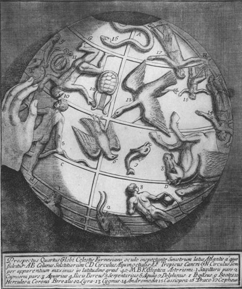
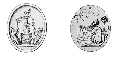
In the Royal Museum of Naples there may be found a large marble celestial globe, 65 cm. in diameter (Fig. 7), which the mythical Atlas bears on his shoulders, the statue itself being 1.86 m. in height, resting on one knee.33 This very interesting and artistic object was transferred to Naples museum from the Farnese Palace in Rome, hence is generally referred to as the Atlante Farnesiano. Forty-two constellations are represented on its surface (Fig. 8), and the five wanting, including Ursa Major and Ursa Minor, probably owe their absence to the obliteration which time has brought about. From the position of the several constellations, relative to the intersecting points of the ecliptic with the equator, it is thought that it must have been constructed at least three hundred years before the Christian era. It seems therefore to date from about the time of Eudoxus, being then the oldest extant globe.
We learn from Cicero and from other early writers that Archimedes (ca. 287-212 B. C.), the celebrated geometrician of Syracuse, constructed a globe or contrivance for the purpose of demonstrating the movements of the heavenly bodies. Cicero’s statements imply that the work of Archimedes was well known in his day, yet he thought it merited a special word of commendation from himself. “I shall propose nothing new to you,” he says, “nor that which I have invented or discovered; but I remember C. Sulpicius Gallus, a very learned man, as you know, when this appearance 16(in the heavens) was spoken of, and he was, by chance, at the house of Marcellus, who had been consul with him, he described a globe among the spoils of that opulent and magnificent city of Syracuse, when captured, as the only thing among all the spoils which he ordered to be carried to his own house; about which globe I have often heard, on account of the fame of Archimedes, although the work itself was not very remarkable, for there was another far more beautiful and more honored by the common people, made by the same Archimedes, and placed in the Temple of Virtue by the same Marcellus. But afterward when Gallus began to explain scientifically the object of the machine, I thought there was more ingenuity in that Sicilian than human nature was capable of. For Gallus informed me that there was another ancient invention of a solid and elaborately formed globe which was made by Thales, the Milesian, to revolve. And afterward the same was, by Eudoxus of Cnidos, the disciple of Plato, adorned with the fixed stars of heaven, and with every ornament and embellishment, as described by Eudoxus, and was many years afterward celebrated by Aratus, not exactly in the scientific language of astronomy, but with the graces of poetry. This species of globe indeed, in which the sun and moon were made to revolve, and five of those stars which have been called travelers, and as it were wanderers, could not possibly be exhibited on that solid sphere. And more especially was that invention of Archimedes to be admired, for he had so contrived that one revolution of the machine served somehow to produce unequal and varied movements through their different paths. For when Gallus set the globe in motion, the moon succeeded the sun by as many turns of the brass wheel of the machine as days in the heavens, so that the globe represented in the heavens the same eclipse of the sun, when the moon arrived at a certain place or point, as the shadow of the earth did when the sun shone from the opposite region.”34
17Lactantius’ allusion to Archimedes, at a later date, is perhaps derived from Cicero, but it is none the less interesting as indicating a belief that such a globe had existed. In his characteristic vein he refers to the mechanical device, finding therein a support for his theological arguments. “Was Archimedes of Sicily able to contrive a likeness and representation of the universe in hollow brass,” he inquires, “in which he so arranged the sun and moon, that they effected, as it were every day, motions unequal and resembling the revolutions of the heavens, and that sphere, while it revolved, exhibited not only the approaches and with drawings of the sun or the increase and waning of the moon, but also the unequal course of the stars, whether fixed or wandering? Was it then impossible for God to plan and create the original, when the skill of man was able to represent them by imitation? Would the stoic, therefore, if he should have seen the figures of the stars painted and fashioned in that brass, say that they moved by their own design, and not by the genius of the artificer?”35 Günther notes that at the beginning of the seventh book of the collection of Pappus, geometrician of Alexandria, may be found a reference to those skilled in mechanical devices in which it is stated that “Mechanicians are those who understand how to construct celestial globes and to represent the heavens and the course of the stars moving in circles by means of like circular movements of water.”36 It has been thought that in this passage we have a reference to a globe such as was probably constructed by Archimedes, although the reference is not to any particular example. It seems not improbable that the globe of Archimedes was made to revolve by an hydraulic contrivance, and that it resembled a planetarium or orrery.37 That the science of hydrostatics had been developed by Archimedes’ time to a high degree is very certain.
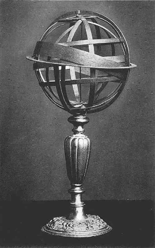
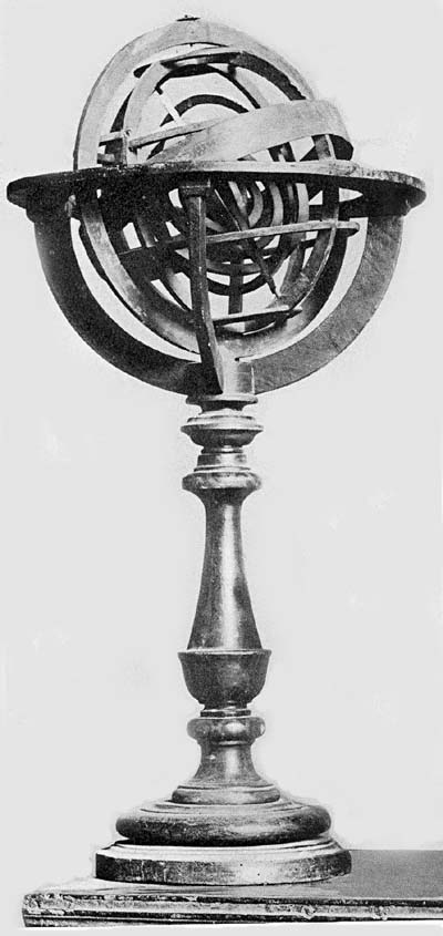
Instruments for measuring angles and distances were very early employed in the field of astronomy as well as in the18 field of geography. Of these instruments the Egyptian gnomon appears to have been the oldest.38 In its best form it consisted of a bowl having a perpendicular rod or staff erected at the central point of the inner curved surface. This rod cast a shadow upon the inner surface of the bowl, which had been graduated, giving a reading in degrees which furnished to the observer the information desired. Time brought improvements and variations in the construction of simple instruments of this character. As early as the third century before the Christian era, adjustable rings, or armillae, for example, were employed by astronomers to aid them in the solution of their problems, which instruments later developed, as noted below, into the more elaborate and complex armillary spheres. The simplest form of such an instrument appears to have been but a single graduated circle. To this, at a very early date, a second was added, thus providing an instrument in which one of the circles was regarded as fixed in the plane of the equator, the other, intersecting this at right angles, served as a meridian circle, being movable around an axis which could be called the world axis, the axis of the celestial sphere, or the axis of the universe. The position of a celestial body in declination could be determined on the meridian circle, and its right ascension on the fixed or horizon circle.39 It seems altogether probable that Eratosthenes made use of such an instrument in his efforts to measure the obliquity of the ecliptic. He tells us that in his time one of large dimensions hung in the portico of the academy of Alexandria.40 With the addition of other circles, and of an adjustable view-tube, that more accurate and detailed measurements might be made, this device, in Hipparchus’ day, came to be known as an astrolabe, and, after the addition of other rings in later years, to be known as an armillary sphere. Even in this last development it was not a true sphere on which could be represented the starry constellations, but an arrangement of circles forming a sort of imaginary sphere, the circles being19 intended to represent the relative position of the principal celestial circles. This instrument seems, at first, to have been suspended, when in use, but later was made to rest upon a base, the whole adjusted to revolve around an axis and within a graduated horizon circle. In the earliest examples, the earth at the center of the circles, it represented the Ptolemaic system (Fig. 9); in the later examples, having the sun at the center, it represented the Copernican system.
It is expressly stated by Ptolemy that a celestial globe was constructed by Hipparchus, who is reputed to have been the founder of spherical trigonometry,41 and Pliny tells us that Hipparchus was the inventor of the astrolabe,42 which statement probably means that he greatly improved the simple armillae used at an earlier date as an instrument for astronomical calculations.
Ptolemy, in his ‘Syntaxis,’ or ‘Almagest’ as it was called by the Arabs, devoted a chapter to the method of constructing, and to the use of the astrolabe, which must have closely resembled the armillary sphere, describing therein, in terms not altogether easy of comprehension, its several rings and cylinders, and the method of adjusting the same for purposes of determining the latitude and the longitude of celestial bodies. He tells us also how to construct a representation of the sphere of the fixed stars by means of a solid ball, how to place thereon the several constellations, and how to use the same in the study of astronomical problems. Such a globe, he says, “should be of a dark color, that it might resemble the night and not the day.” His description is detailed as to the proper method of procedure in marking the position of the celestial circles on this globe, in arranging the movable rings of “hard and well polished material,” in graduating the rings and adjusting them to move about an axis which is likewise an axis of the globe proper. In marking the position of the fixed stars, we are told that the proper method is to commence at some constant and invariable point of a certain constellation, and he20 suggests that the best starting point is the fixed star in Canis Major, that is, the so-called dog star, or Sirius. “The position of the other fixed stars, as they follow in the list, could easily be determined,” he says, “by making the globe to turn upon the poles of the zodiac, thus bringing the graduated circle to the proper point of each. The stars could be marked with yellow or with such other color as one might choose, having due regard for their brilliancy and magnitude. The outline of each of the constellations should be made as simple as possible, indicating with light strokes, differing but little in color from that of the surface of the globe, the figures which the stars in the several constellations represent, preserving in this manner the chief advantage of such representation, which should be to make the several stars very prominent without destroying, by a variety of color, the resemblance of the object to the truth. It will be easy to make and to retain a proper comparison of the stars if we represent upon the sphere the real appearance or magnitude of the several stars. While neither the equator nor the tropics can be represented on the globe, it will not be difficult to ascertain the proper position of these circles. The first could be thought of as passing through that point on the graduated meridian circle which is 90 degrees from the poles. The points on this meridian circle 23 degrees 51 minutes (sic) each side of the equator will indicate the position of the tropics, that toward the north the summer solstitial circle, that toward the south the winter solstitial circle. With the revolution of the globe from east to west, as each star passes under the graduated meridian circle, we should be able to ascertain readily its distance from the equator or from the tropics.”43
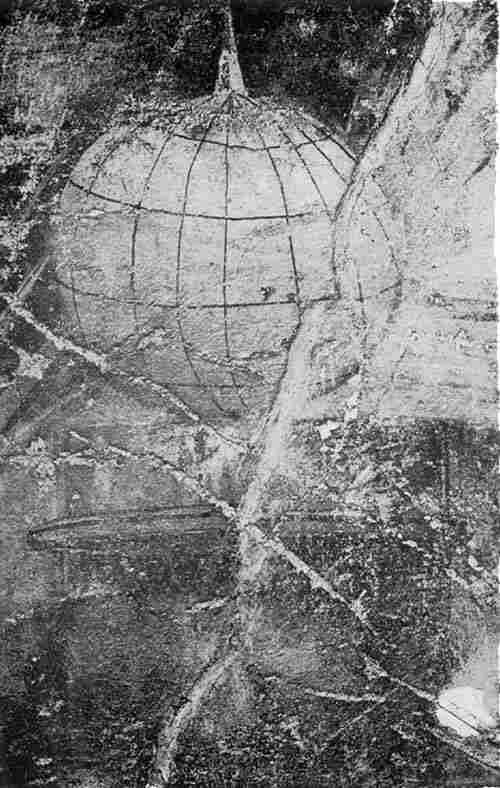
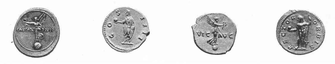
That the Romans especially interested themselves in globes, either celestial or terrestrial, is not at all probable, because of their very practical inclinations. There is evidence, however, that in the time of the emperors celestial globes were constructed, especially in the studios of sculp21tors, but these were made largely for decorative purposes, having therefore an artistic rather than a scientific value. In the year 1900 there was found in a villa at Boscoreale, not far from Pompeii, an interesting fresco (Fig. 10), this being acquired by the Metropolitan Museum of New York in the year 1903. It has been referred to as a sundial, but was clearly intended to represent, in outline, a globe exhibiting the prominent parallels and a certain number of the meridians. It is not at all improbable that such subjects were frequently selected for wall or floor decoration.44 It appears that astrologers at times made use of globes in forecasting events.45 It may further be noted that on certain early Roman coins there may be found the representation of a globe (Figs. 11, 12), which perhaps had as its prime significance the representation of universal dominion.46
Not until the day of the Byzantine Emperors do we meet with a real scholar who made a particular study of such astronomical apparatus, apparatus which he describes in a special treatise. Among historical scholars the work of Leontius Mechanicus seems not to have found the recognition which it deserves.47 He appears to have been a practical man, very active within the field concerning which he wrote, and from his remarkably detailed description we are able to learn something of the extent to which globe technique was carried in the days of the early Eastern Emperors. We at any rate learn from him that globes were constructed in his workshop, which globes, in all important respects, were like those in use at the present time, being, for example, provided with a meridian circle adjusted to move through notches in a horizon circle. The information given us by Leontius, which here follows, is in free translation or paraphrase of his treatise, the whole being condensed. He appears to have been a student of astronomy, as represented by Aratus, for he tells us that he had endeavored to construct a globe on which the constellations and the circles could be made to conform to the records of22 the ancient poet astronomer. He tells us further that he constructed this globe for Elpidius, an estimable man of letters, and one full of zeal for study; that at the time of its construction, though he had the leisure, he did not prepare a description of the globe, but on the insistence of his friends such description he now proposed to write. This appears to be the raison d’être for his treatise. The importance of adhering closely to the statements of Aratus he insists upon, though admitting that writer’s errors, being convinced that most of the globes of which one had knowledge in his day agreed neither with him nor with Ptolemy. Leontius first directs attention to Aratus’ threefold plan in describing the several constellations, in which description that author speaks first of the relation which part bears to part in each; second, of the position of each constellation relative to the celestial circles, as, for example, to the tropics, and third, its position in the heavens relative to the constellations in the zodiac. He follows this statement with a somewhat lengthy reference to the constellation Ophiuchus, or the Serpent, in explanation of the method of description. After having the surface of the globe portioned out for the representation of the several constellations and the important circles, he then proceeds, as he states, to consider the execution, by which he means representing in proper color and outline the several figures, and the mounting of the globe. Upon a properly constructed support should first be placed the horizon circle, through which a second circle should be made to pass; this second circle will serve as a meridian. These circles, he observes, will enclose the ball, all the points of the surface of which should be equally distant from the inner surface of the horizon and meridian circles, that is, there should be a perfect adjustment of the enclosing rings and the enclosed ball. The surface of the sphere should be painted a dark color, as, for example, azure. He sets forth, with considerable detail, the proper method of procedure in locating the several principal23 circles, each of which should be graduated. The zodiac should be divided into twelve parts, and the constellations belonging to each of the several parts should be designated by name, beginning with Cancer, following this with Leo, Virgo, and so on, one after the other. In giving the globe a position which actually conforms to the world, the pole should be set to the north, and the movement of the sky can then be imitated by turning the globe to the left. Leontius, by way of summary and definition, at the conclusion of his treatise, speaks of a sphere as a solid having a surface, from all the points of which, if straight perpendicular lines of equal length be drawn, they will reach a point within called the center. This center in the great sphere of the universe is the earth. The poles of the sphere are the extremities of the axis on which it turns. The horizon cuts the sphere into two hemispheres, the one superior and the other inferior to the earth. The sky, which is continually turning, encircles all, one half of it being above, the other below the earth, which is as far removed from the superior part of the heavens as from the inferior.48
30 Cicero’s allusion to Thales, cited p. 16, is probably a reference to a tradition.
31 Wolf, R. Geschichte der Astronomie. München, 1877, p. 193; Gassendi, P. Opera Omnia. Leipzig, 1658. Vol. V, p. 375. See statement by Cicero, cited below, p. 17.
32 Aratus’ poem bore the title, “Phaenomena.” See, for an excellent edition of this poem, Prince, C. L. Phenomena. A literal translation of the astronomy and meteorology of Aratus. Lewes, 1895. In his “Bibliographical remarks,” the translator refers to one hundred and nineteen editions of this poem, dating from the first printed at Bonn in the year 1474. See also n. 48, below.
33 Passeri, G. B. Atlas Farnesianus Marmoreus insigne vetustatis monumentum. (In: Gori, A. F. Thesaurus gemmarum antiquarum astriferarum. Firenze, 1750. Vol. III.); Denza, P. F. Globi celesti della Specola Vaticana. (In: Publicazioni della Specola Vaticana. Torino, 1894. pp. xx-xxiii.)
34 Cicero. De Republica. Bk. I, chap. xiv. The citation is from the translation by Hardingham, G. G. The Republic. London, 1884.
35 Lactantius. Institutiones divinae. Bk. II, chap. v.
36 Pappus. Collectionum mathematicarum. Edited by Commandino. Urbino, 1588. Bk. VII. See especially the introduction.
37 Hultsch, F. Uber den Himmelsglobus des Archimedes. (In: Zeitschrift für Mathematik und Physik. Leipzig, 1878. Bd. 22. Hist. Litt. Abteilung, p. 106.); Same author. “Archimedes.” (In: Real-encyklopädie der klassischen Alterthumswissenschaft.)
38 Wolf, op. cit., pp. 122-124.
39 Wolf, op. cit., pp. 160-166.
40 Wolf, op. cit., p. 130.
41 Ptolemy, C. Syntaxis. (Almagest.) Various editions. Bk. VII, chap. 1. This work was first printed in Venice, 1496; the first Greek text in Basel, 1538. See Hues, Tractatus de Globis, for an analysis of this work.
42 Pliny. Historia Naturalis.
43 Ptolemy, op. cit., Bk. V, chap. i; Bk. VII,
chap. v; Bk. VIII, chap. iii. Ptolemy mentions by name
forty-eight constellations, all of which he probably
obtained from the earlier Greeks. These constellations, the
names being still retained, are:
The Zodiac.
| Aries | Cancer | Libra | Capricornus |
| Taurus | Leo | Scorpio | Aquarius |
| Gemini | Virgo | Sagittarius | Pisces |
The Northern Hemisphere.
| Andromeda | Corona | Lyra | Ursa Major |
| Aquila | Cygnus | Ophiuchus | Ursa Minor |
| Auriga | Delphinus | Pegasus | Sagitta |
| Boötes | Draco | Perseus | |
| Cassiopeia | Equuleus | Serpens | |
| Cepheus | Hercules | Triangulum |
The Southern Constellations.
| Ara | Cetus | Crater | Lupus |
| Argo Navis | Centaurus | Eridanus | Orion |
| Canis Major | Corona Australis | Hydra | Piscis Australis |
| Canis Minor | Corvus | Lepus |
44 Visconte, P. E. Nota intorno ad un’ antico globo celeste scolpito in marmo porino. Roma, 1835; Gaedechens, R. Der marmorne Himmelsglobus des fürstlich Waldechschen Antikenkabinettes zu Arolsen. Göttingen, 1862.
45 Schanz, M. Geschichte der römischen Litteratur bis zum Gesetzgebungswerk des Kaisers Justinian. München, 1890. See p. 75 for a reference to the astrologer Nigidius Figulus.
46 Coins on which there appears a representation of a globe were numerous. Attention may also here be called to the imperial insignia, a part of which was a globe, which the emperor was represented, in the pictures of the day, as holding in his hand. See King, C. W. Antique Gems 25and Rings. Vol. II, plates xxvi and xxxviii.
47 Weidler, J. F. Historia astronomiae. Vitembergae, 1741. This author is of the opinion that Leontius lived in the eighth century, p. 201; Susemihl. Geschichte der Griechischen Litteratur der alexandriner Zeit. Leipzig, 1891. See Vol. I, p. 294, for a statement of the belief that Leontius lived in the seventh century.
48 Halma, N. Les Phenoménes d’Aratus de Soles, et de Germanicus Cesar; avec les Scholies de Théon, les catasterismes d’Eratosthenes et la sphère de Leontius traduit ... par l’Abbé N. Halma. Gr. avec Fr. Paris, 1821. pp. 65-73.
Followers of Ptolemy.—Early armillary spheres.—Interest of the Califs in globes and astronomical instruments.—The record of the ‘Fihrist.’—Ibrahim.—Caissar.—Mohammed ben Helal.—Mohammed el Ordhi.—The Paris globes.—Ridhwan Efendi.
IN passing from the period of classical antiquity to the so-called Christian middle ages, attention may first be directed to the activities of the Arabs in the field of astronomy and geography, in so far as their activities had to do with the construction of globes.49 The information which we have, concerning their astronomical studies in particular, is more detailed than is that which has come down to us respecting any other peoples who may have been interested in these centuries in the same field of study.
Doubt may be expressed at the outset that the Arabs were interested in the construction of terrestrial globes, since with the matter of descriptive geography they appear to have been very little concerned, a fact which their imperfect cartographical attempts clearly demonstrate.50 Although the theory of a globular earth was early accepted by their learned men,51 there is scarcely a trustworthy allusion in literature to Arabic terrestrial globes which can be cited. An occasional reference, however, has been made by modern writers to a globe said to have been constructed for King Roger of Sicily. Without citing his authority, Freyheer F. v. Zach states that “the oldest terrestrial globe which is 27known was made for King Roger II of Sicily in the twelfth century, and is especially remarkable for the value of the metal which was used in its construction, this being 400 pounds of silver. A knowledge of this globe would not have come down to our day had not Edrisi, a famous geographer of that time, given an especial description of the same, under the title Nothatol mostak (Pleasure of the Soul).”52 It is probable that the reference here is to a circular disc made by Edrisi, or an armillary sphere, but not to a terrestrial globe.53
As to Arabic celestial globes, a different situation presents itself. It is well known that the inhabitants of Arabia, long before the time of Islam, were in the habit of observing the stars, many of which, as Dorn has noted, they knew and designated by names taken from pastoral life, and several of which they worshiped as visible gods.54
Calif al-Mansur, who began his reign in 754 A. D., appears to have been the first to show a decided taste for astronomical science, and for many centuries following him this interest is strikingly pronounced among the people of his country.55 Scholars were eagerly attracted to the works of Ptolemy, which were many times translated into Arabic, and commentaries were written upon his description of the names and figures of the several constellations. The only alteration they allowed themselves to make in the names of the stars was to translate them into their own language, or to substitute for those they could not understand other names that conveyed an idea to their minds, applicable to the constellation before the eyes. Andromeda they called “The Chained Lady”; Cassiopeia they called “The Lady in the Chair”; Orion received the name “The Giant.” They followed in the construction of their armillary spheres and celestial globes the description laid down in Ptolemy’s ‘Syntaxis,’ modifying these astronomical instruments, from time to time, as their studies directed them.56
The list of califs interested in astronomy is a long one, both of those who remained in the original homeland, and 28of those who went to the new home in the Iberian Peninsula.57 The Mohammedan Hulagu Khan, for example, erected, about 1264, an observatory in his Mongol capital, Maragha, near Tabriz, which long remained a noted center for astronomical studies.58 This observatory, however, was but one of a number of similar institutions erected either by the Arabs or by the Persians. We are told that the construction of astronomical instruments was brought to a high degree of perfection by these peoples in the thirteenth century.59 The names of many of the Arabic astronomers who were particularly expert as globe makers are recorded, and there were many who wrote on the subject of celestial spheres, armillary spheres, and astrolabes, even before the tenth century.60 The author of the ‘Fihrist,’ Ibn Abî Ja’kûb an-Nadîm, tells us that Kurra ben Kamîtâ al-Harrânî constructed a globe which he himself had seen.61 This, he says, was made of unbleached material from Dabik, and colored, but that the colors were much faded. Ibn Alnabdi, who was known as a clever mechanic, mentions two globes which he had examined and admired for their excellency of execution, in the public library of Kahira, in the year 1043. One of these globes, he says, was made of brass, by Ptolemy himself; the other, of silver, was constructed by Abul Hassan Alsufi, for the immediate use of the king, Adad Eddoula.62
As a visible evidence of the interest of the Arabs in astronomical science, and of their skill in the construction of astronomical instruments, we have preserved to us, besides numerous astrolabes, no less than seven globes, known to have been constructed prior to the year 1600. The oldest one extant is now in the possession of the R. Istituto di Studi Superiori of Florence, Italy.63 This fine example of the skill which was attained by the instrument makers of Valencia, Spain, at one time a flourishing center of Arabic culture, appears to date from the second half of the eleventh century. According to an inscription on the globe, we learn that it was made at Valencia by Ibrahim Ibn Said-as-Sahli, 29in the year 473 of the Hegira, a date equivalent to 1080 A. D. This date Professor Meucci finds confirmed by a careful study of the position of the stars represented on the globe. He notes, for example, that the star Regulus had been placed at a distance of 16 degrees 40 minutes from the sign of Leo. Ptolemy, in the year 140 A. D., gave this distance as 2 degrees 30 minutes. According to Albaregnius, this star advances about one degree every sixty-six years. Since 140 A.D. the star, therefore, would have moved 14 degrees 10 minutes, which fact would lead astronomers to place this star, about 1080, as it appears on the globe. The globe is of brass, 20 cm. in diameter, having engraved on its surface forty-seven constellations, as given by Ptolemy, omitting only the Cup, with 1042 stars, each with its respective magnitude indicated.
A second Arabic celestial globe, which dates from the year 1225, has been described in detail in a monograph by Assemani, which he issued in the year 1790.64 This remarkably interesting object belonged, at the time, to the extensive and celebrated collection of antiquities and curiosities of Cardinal Borgia, in Velletri, but may now be found in the Museo Nazionale of Naples. It is composed of two brass hemispheres, having both horizon and meridian circles, the whole resting upon four supporting feet. A Cufic inscription tells us that it was made by Caissar ben Abul Casem ben Mosafer Alabiaki Alhanefi, in the year of the Hegira 622. Caissar probably was an astronomer at the court of Cairo, and the Mohammedan date as given, translated into Christian reckoning, gives us the year 1225.
In the year 1829 Dorn published a detailed description of an Arabic globe which had been deposited in the museum of the Asiatic Society of London (Fig. 13) by Sir John Malcolm.65 It is of brass, has a diameter of 24 cm., and is furnished with a substantial mounting. The peculiar features of the figures which represent the several constellations 30suggest Persian workmanship. In the vicinity of the south pole is an inscription in Cufic characters, telling us that it was “Made by the most humble in the supreme god, Mohammed ben Helal, the astronomer of Monsul, in the year of the Hegira 674.” This year answers to the year 1275 of the Christian era, that is, it was constructed about the same time as the Borgian globe and that belonging to the Dresden collection, briefly described below. Forty-seven constellations are represented. On the horizon circle, in their respective places, we find engraved the words, “East,” “West,” “South,” “North.”
The Arabic globe, to be found in the Mathematical Salon of Dresden (Fig. 14), has proved to be one of much interest and scientific value to students of astronomy.66 Bode, who described it in the year 1808, refers to its remarkably fine execution and to its Cufic inscriptions as being among the finest extant specimens of early Arabic writing. The sphere is of brass, having a diameter of 14 cm., and is composed of two parts, separable on the line of the ecliptic. It has a brass horizon circle, on which is engraved at the east the word “rising,” and at the west the word “setting.” It is not supplied with a movable meridian circle, but within the horizon circle, from north to south, and from east to west, there are two brass half circles, of the same diameter as the horizon circle and so adjusted as to form one piece with it. Through such an arrangement it is made possible to turn the globe in any desired direction, one half of it being at all times above the horizon. In addition to the above arrangement, there are two movable half circles, attached at the zenith point by a pivot. These half circles are graduated, and are movable, making it possible to find, by means of them, the declination and right ascension of any star. The base, which must be comparatively modern, consists of a circular plate, from which rise four turned support columns, attached at their upper extremities to the two half circles of brass, on which rests the horizon circle.
The date of construction cannot be far from 1279, which 31is determinable from the position of the stars engraved thereon, relative, for example, to the equinoctial points. The maker’s name, “Mohammed ben Muwajed el Ordhi,” appears near the constellation Ursa Major, and is inlaid in silver. There appear, very artistically engraved, the lines representing the principal circles, the outlines of the several constellations, with their names, some of these being inlaid with silver, some with gold. The equator and the ecliptic are represented on the surface of the sphere, each by two engraved parallel lines, and are graduated, the graduation in each instance being represented by four short and one long line, alternating thus by fives throughout the entire three hundred and sixty degrees. The equator is inlaid with gold, the other circles with silver. The names of the twelve constellations in the zodiac are alternately inlaid with gold and silver, while all star names, except as indicated, are inlaid with silver. The constellations represented number forty-eight, the human figures all being clad, turning the front and right face toward the observer.
The Bibliothèque Nationale of Paris possesses two ancient Arabic globes, one of which, neither signed nor dated, has been thought to have been constructed in the eleventh century.67 This was obtained by Jomard, in Egypt, more than sixty years ago. It has a diameter of about 19 cm., is furnished with a horizon circle, which is upheld by four semicircular arms, these, in turn, resting upon a base composed of four flat and rather inartistic supports. The engraving on the surface of the brass sphere closely resembles that on the Dresden globe. A detailed description of this globe has not been obtainable.
A second Paris Arabic globe,68 like the preceding, belongs to the Bibliothèque Nationale (Fig. 15). It has a diameter of something less than 15 cm., and was constructed by Diemat Eddin Mohammed, in the year of the Hegira 981, which in the Christian reckoning corresponds to the year 1573.
32The Imperial Library of Petrograd possesses an Arabic globe, constructed in the year 1701.69 It is described by Dorn as a fine example of the globe maker’s art, closely resembling, in its general features, the Arabic globe in the collection of the Royal Asiatic Society of London. It has a diameter of about 19 cm., rests upon an ornamental tripod base, and is adjusted to turn within a brass circle, which circle is fitted into a larger one, so marked and graduated as to represent four concentric circles. The first or inner circle, representing the horizon, is divided into thirty-six divisions of ten degrees each; on the second circle the degrees are indicated by letters; on the third circle appear the twelve signs of the zodiac and the four principal directions, east, west, north, south; the fourth circle is divided into thirty-six parts, formed by the extension of the lines which divide the first, or horizon circle, into thirty-six parts. On the last circle the names of one hundred and four cities and countries are given. Not far from the north pole is an inscription which gives us the name of the maker and the date of construction. Therein we read that it was completed in the year 1113 of the flight of the Prophet, or in the year 1701 of Christian reckoning, by Ridhwan, for Maulana Hassan Efendi, who, toward the end of the seventeenth century, was director of the astronomical observatory of Cairo, and gave substantial encouragement to makers of globes and of other instruments employed in astronomical studies. The equator, the ecliptic, and the parallels are represented, the first two by parallel circles which are crossed or joined by lines dividing them into seventy-two principal parts, each part being again subdivided into fifths. The close resemblance of this example to the earlier known Arabic globes suggests that there was little, if any, progress among those peoples in the art of globe construction since the eleventh century.
49 Delambre, J. B. J. Histoire de l’Astronomie ancienne. Paris, 1817. See Vol. I, pp. 372, 516, containing references to globes, celestial and terrestrial, constructed in India and in China about the years 450 and 724 A.D.
50 Peschel, O. Geschichte der Erdkunde bis auf C. Ritter und A. V. Humboldt. Berlin, 1877. See pp. 145-160, wherein reference is made to their lack of interest in descriptive geography; Beazley. Dawn of Modern Geography. Vol. I, chap. vii.
51 Günther, S. Studien zur Geschichte der mathematischen und physikalischen Geographie. Halle, 1877. Heft 2; Ibn Abî Ja’kûb an-Nadîm. Katâb al-Fihrist (Book of Records), ed. by Gustav Flugel. Leipzig, 1871-1872. 2 vols. The greater part of this Arabic work was written about the year 987 A. D. Edrisi states it as “the opinion of philosophers, of illustrious savants, and of skilled observers in the knowledge of celestial bodies, that the earth is round as a sphere.” See Edrisi, Geography, tr. de l’Arabe en français par P. Amédée Jaubert. (In: Receuel de voyages et de mémoires. Paris, 1830. 2 vols.) Vol. I, p. 1.
52 Zach, F. v. Monatliche Korrespondenz. Gotha, 1806. Vol. XIII, p. 157; Suter, H. Das Mathematiker-Verzeichniss im Fihrist. (In: Zeitschrift für Mathematik und Physik. Leipzig, 1892.) This work contains many references to distinguished oriental scholars who treated in their writings the doctrine of the sphere, the astrolabe, and the armillary sphere.
53 Wittstein, T. Historisch-astronomische Fragmente aus der arabischen Litteratur. (In: Abhandlungen zur Geschichte der Mathematik. Leipzig, 1892. Heft 6, p. 98.) The opinion is here expressed that a terrestrial globe by Edrisi never existed; Hadradauer, C. v. Die Feldzeugmeister Ritter von Hauslabische Kartensammlung. (In: Mitteilungen der K. K. Geographische Gesellschaft zu Wien. Wien, 1886. Neue Folge 19, pp. 387-388.) The opinion is expressed that Edrisi constructed a planisphere and not a globe. Amari, M. Storia dei Musulmani di Sicilia. Firenze, 1868. pp. 453 ff., 669 ff.
54 Dorn, B. Description of an Arabic celestial globe. (In: Transactions of the Royal Asiatic Society. London, 1829. Vol. II, pp. 371-392.)
55 Dorn, op. cit.
56 Dorn, op. cit.
57 See the list as given in the Fihrist, referred to in note 4. Naser ben Mohamed Abul Gioush, King of Castile, is referred to as having been much interested in astronomy, in which science he acquired such proficiency as to enable him to construct a number of very useful astronomical instruments.
58 Lelewel, J. Géographie du moyen âge. Bruxelles, 1857. Vol. I, p. 116; Jourdain. Mémoire sur l’observatoire de Méragah. Paris, 1810. It is well known that under the direction of Nasr-Eddin, who was called to the charge of this observatory by Hulagu Khan, astronomical instruments were constructed.
59 Dorn, op. cit.
60 See the Fihrist, also a list as given by Dorn.
61 Dorn, op. cit.
62 Dorn, op. cit.
63 Meucci, F. Il globo celeste arabico del seculo XI esistente nel Gabinetto degli strumenti antichi di Astronomia, Mathematica nel R. Istituto 34di Studi Superiori. Firenze, 1878.
64 Assemani, S. Globus coelestis cufico-arabicus Veliterani Musei Borgiani. Patavii, 1790.
65 Dorn, op. cit.
66 Beigel, W. Nachricht von einer Arabischen Himmelskugel mit Kufischer Schrift, welche im kurfürstlichen Mathematischen Salon zu Dresden aufbewahrt wird. (In: Bodes Astronomisches Jahrbuch für das Jahr 1808. Berlin, 1808. pp. 97 ff.); Drechsler, A. Der arabische Himmelsglobus angefertigt 1279 zu Meragha. Dresden, 1873.
67 Sedillot, L. A. Mémoire sur les instruments astronomiques des Arabes. Paris, 1841. pp. 117 ff.; same author. Matériaux pour servir à l’histoire comparée des sciences mathématiques chez les grecs et les orientaux. Paris, 1845. Vol. I, pp. 334 ff.; Jomard, M. Monuments de la Géographie. Paris, 1854. It is very doubtful that a date so early should be given to this globe.
68 Information courteously given by M. L. Vallée.
69 Dorn, B. Drei in der kaiserlichen öffentlichen Bibliothek zu St. Petersburg befindliche astronomische Instrumente mit arabischen Inschriften. (In: Mémoires de l’Académie Impériale des Sciences de St. Pétersbourg. St. Pétersbourg, 1865. VIIe serie, Tome IX, No. 1.)
General attitude of the period toward the theories of the Greeks and the Romans.—Scripture statements as sources of information.—Inclination of certain early writers to accept the doctrine of a spherical earth.—The particular attitude of Pope Sylvester II.—The asserted interest of Emperor Frederick II in scientific studies.—Alfonso the Wise and the Alfonsian tables.—Interesting allusions in Alfonso’s work to globes and globe construction.—Giovanni Campano of Novara and the statements in his ‘Tractatis de sphera solida.’—The attitude of Albertus Magnus, Sacrobosco, Roger Bacon, Vincent of Beauvais, Dante.
FOR many centuries following the fall of the Western Roman Empire, there appears to have been in Christian Europe but little interest in the fundamental principles of geographical or astronomical science. The theories of the Greeks and the Romans respecting a spherical earth and a spherical firmament encompassing it, in illustration of which they had constructed globes, were not entirely forgotten, but such theories in general were considered to be valueless, hindrances rather than helps to the theological beliefs of the new Christian era.70
Though the early Church Fathers were inclined to reject the idea of a globular earth,71 there were not a few among them who found the theory of a circular earth an acceptable one. The latter, it is true, was an early Greek belief, referred 36to above as having been entertained in Homer’s day, and as having been passed down to succeeding centuries, but Christian writers did not find in the fact of its pagan origin a particular argument for accepting it; on the contrary, the Bible was held by many to be the fountain of all knowledge, and a sure guide no less in the solution of problems pertaining to the physical sciences than in the solution of problems pertaining to faith and doctrine. What was contained in the Scriptures found a more ready acceptance than what was to be found in pagan writers.72 Isaiah’s statement, “It is He that sitteth upon the circle of the earth,” was regarded as one altogether adequate on which to found a theory of the form of the earth, and it was accepted by such biblical interpreters as Lactantius, Cosmas Indicopleustes (Figs. 16, 17), Diodorus of Tarsus, Chrysostom, Severian of Gabala, by those who were known as the Syrians, by Procopius and Decuil.73 Men, however, such as Basil, Gregory of Nyssa, and Philoponos inclined strongly toward the Aristotelian doctrine of a spherical earth.74 Isidore of 37Seville appears to have been a supporter of the spherical doctrine,75 as was also the Venerable Bede, who, in his ‘De natura rerum,’ upholds the doctrine of a spherical earth on practically the same grounds as those advanced by Aristotle.76
Fig. 17. Cosmas’ Illustration Confuting the Existence of Antipodal Peoples.
In illustration of the doctrine of a circular earth, terrestrial globes certainly could not have been thought of as having any practical value. With a rejection of the spherical theory of the ancients very naturally went the rejection of their globes.
The circular or Homeric theory, as noted above, had its supporters, even to the close of the middle ages, but the inclination is more or less marked, even as early as the seventh century, to accept again the doctrine of a spherical earth. It seems to have come into prominence again with the growing belief in the importance of the place of the earth in the universe. After the eighth century this theory may be 38said to have had a very general acceptance by those who, Faust-like, felt a desire for a larger freedom from theological restraint than the church encouraged. (Figs. 18, 19.)
Attention has been called to the attitude of the writings of the Anglo-Saxon Church Father, the Venerable Bede. Although we have no unquestionable proof that Bede, or Alcuin,77 who was greatly influenced by him, insisted on the use of globes in geographical instruction, there is good reason for thinking these scholars would have inclined to encourage their use. The monastic schools, which, in the methods of instruction, rested upon the plan wrought out by Alcuin for the Palace School of Charles the Great, considered globes to be apparatus of great educational value. Professor Günther is inclined to think it probable that celestial globes were used throughout the early centuries of this mediaeval period in the better schools, though no positive statement to that effect can be cited.78
We know that an exact knowledge of the movements of the sun, of the moon, and of the constellations was considered to be of first importance for the priesthood in the middle ages, since it was through a knowledge of their movements that the times for the observance of the rigid church rules were fixed.79 The acquisition of such knowledge could best be secured through the use of the celestial globe.80 We learn from Notker Labeo (950-1022), one of the most distinguished teachers of the monastic school of St. Gallen, that he made use of such globes for astro-geographical instruction, which, in their important features, were like our modern celestial globes, for he tells us “they were supplied with all necessary parts.” It seems evident that those of which he made use could be adjusted to every desired altitude of the pole.81
One of the most distinguished scholars of the tenth century was Bishop Gerbert (ca. 940-1003), later Pope Sylvester II, of whose learning we possess reliable evidence.82 His astronomical knowledge so astonished his contemporaries that he was thought to be a necromancer and was 39accused of being in league with the evil one.83 He was a diligent student of the literature of antiquity, which had survived to his day, especially surpassing all others, it is reported, in his acquaintance with the learning of pagan Rome. In the instruction which he gave in astronomical science he made use of various instruments, to the end that his pupils might the better understand the subject, among which instruments were celestial globes and armillary spheres. These were a source of much wonderment to his contemporaries. It is said that one of these instruments was so skilfully constructed that even the untrained by its use, having one constellation pointed out, would be able to locate all others “with the aid of a globe and without the aid of a teacher.”84 In a letter to the monastic teacher Constantius, with whom Gerbert stood in the friendliest relations for many years at Rheims, he refers to the construction of a celestial globe, and in a more detailed manner he makes mention of this when writing to Remigius of Trier. In four of his letters to this last named prelate, Gerbert touches upon his purpose to construct a globe, but on account of the added duties which were his, occasioned by the death of Archbishop Adalbero, he seems not to have been able to complete his work. He expresses himself, in the third one of these letters, as hopeful that a favorable time might yet come for him to take up the plan, but the increasing opposition of his enemies left him no leisure for scientific labors of this character, and it does not appear that he turned his attention again to globe making.85
The thirteenth century furnishes us with the names of two distinguished princes who were especially active in advancing scientific studies of their times. One of these was the Hohenstaufen Frederick II, concerning whom we are informed that he directed a learned Arabian, who sojourned at his court, to construct for him a celestial globe of gold on which the stars were to be represented by pearls.86 We 40are further told that as an outcome of his friendly relations with the rulers of the East, the Sultan of Egypt sent to him an astronomical tent of wonderful construction. In this the sun and the moon were represented and by means of a skilfully constructed mechanism they were made to rise and set, marking out the hours of day and night.87
As a ruler of like intellectual and scientific interests, the Castilian, Alfonso X, who lived in the thirteenth century, known as “The Wise” and as “The Astronomer,” deserves to be especially mentioned. By his order an elaborate astronomical work was prepared, which holds a place of first importance among mediaeval productions of its character. In this work the construction of globes is discussed in a very detailed manner, mention being made of every feature regarded as belonging to a properly constructed celestial sphere. So significant are certain chapters of this work for the history of globes and of globe making that a free translation is here given of that part relating to materials of which globes may be constructed.88 “A sphere may be made of many materials,” says the author, “as of gold, or silver, or copper, or brass, or iron, or lead, or tin, or of a combination of these metals; or they may be made of stone, or clay, or wood. They may also be made of leather, of cloth, of parchment in many layers, and of many other materials which men employ when they wish to give an exhibition of their skill. Those, however, who have carefully considered these things, have decided that there is nothing more suitable than wood and for the following reasons. If the globe should be made of gold, only a very rich man would be able to possess it; furthermore it would be very heavy. If it should be made of thin sheets of gold it could be easily indented and would not long remain a perfect sphere. If it should be made small, that which was represented thereon would not appear distinct. The same thing may be said of silver, although it is a metal stronger than gold, as it is likewise harder, and therefore is not so easily indented. Copper is a metal harder than either silver or gold, but is 41so dry that it can not be easily fashioned into a globe, which should always be well made. Brass, which is like dark colored copper, may be more easily fashioned, because it is more malleable than copper, and is stronger than either gold or silver. If, however, a globe made of this material should be thin it might easily lose its shape, and if thick it would be very heavy. Of all metals, however, this is the one most suitable for use in making spheres, as it is the one most commonly employed. A globe of iron would be very difficult to make and would be very heavy, and since the rust would have to be removed from it very frequently, there would be much danger of destroying the figures. A globe of tin, if made of a thin sheet, could be easily indented, and would be very heavy if the sheet of which made were thick. Lead, if thin, would offer less resistance to injury than tin, and is a material much heavier. Furthermore, as lead is inclined to turn black, the figures and the stars represented on a globe of this material would soon become so discolored as to be no longer visible. There is no way by which it can be cleaned without wiping out the figures. Although the metal could be combined to form that material of which water jugs and buckets are made it would be so fragile as to break like glass. Clay, which is also used for the making of water jugs, mortars, and fountains, is not suitable for globes, because if thin it would break easily, and if thick it would be very heavy. Moreover this material when prepared must be baked in a kiln which fact renders it unsuitable for use in making spheres. A globe should not be made of stone, since if this were transparent the figures could not easily be seen, and such material would be very heavy. It would not be fitting to make so noble an object as a sphere of the material of which jars are made. Leather would not be suitable, though it might be fashioned into a permanent spherical shape. Such material shrinks in hot weather or when brought near a fire. Cloth would not be suitable, though it were made 42very strong, since heat would cause it to shrink, and moisture would cause it to lose its shape, and this same thing may be said of parchment. A sphere of wood is strong and is of reasonable weight and may be made in the manner which we shall set forth.” The original manuscript of this work is profusely illustrated, including representations of the figures of the several constellations (Fig. 20).
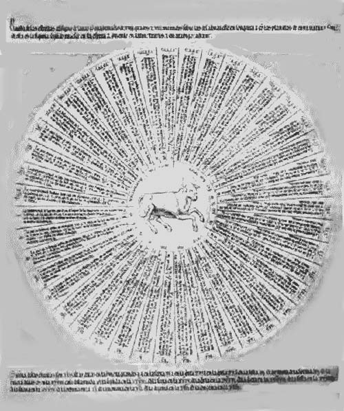
Fig. 20. The Constellation Taurus.
In the latter part of the thirteenth century the mathematician, Giovanni Campano, a native of Novara and it appears a particular friend and supporter of Pope Urban IV, won distinction for his scholarly attainments in the field of astronomy.89 In addition to his work, titled, ‘Teorica planetarum,’ wherein he comments on the subject of astronomy and geometry, and makes copious references to the Greek geometrician Euclid, whose works he had translated into Latin, he prepared a treatise which he called ‘Tractatis de sphera solida.’ In the prologue to this work, after noting that the number of astronomical instruments which have been constructed is large, he states that in the main they agree in their representation of the movements of the heavens, adding that as the heavens are spherical, spherical instruments are to be preferred. In his first chapter, after alluding to the astronomical instruments described by Ptolemy, he proceeds to treat of the composition of solid spheres, which he says may be made of metal, or better, of wood. He gives rules for making the same by the use of the lathe, and notes in conclusion it is well to make the sphere hollow in order to lighten the weight. In the following chapters he treats of the inscription of the circles of the sphere, of the construction of the several rings employed in the mounting, such as the horizon and the meridian circles, and gives consideration to the representation of the several constellations on the surface of the ball. In the second part of his treatise he gives instruction as to how to use the instrument in the solution of astronomical problems.
43There appears to be only the slightest evidence that Campano was acquainted with the work of Alfonso. His presentation of the subject, in all probability, was altogether independent of a knowledge of the Alfonsian tables. It is interesting to observe that in the day when astrology was in great favor in the universities of Europe, Campano continued to be interested in genuine astronomical science.
Albertus Magnus, in his ‘Liber de coelo et mondo,’90 devotes an entire chapter to a theoretical consideration of gravitation, asserting that the earth is spherical (Spherica sive orbicularis necessario), and proceeds to a demonstration of the theory, in which he practically follows the arguments of Aristotle, that every particle of the earth away from the center is continually in movement seeking that center, the result being the formation of a spherical body. He advances further, as argument in proof of a spherical earth, that the shadow it casts in an eclipse of the moon is circular.
Sacrobosco (John of Holywood or Halifax) (fl. 1230),91 who was active in the first half of the thirteenth century, much of the time as professor of mathematics in the University of Paris, prepared a work bearing the title, ‘Tractatus de sphaera,’ being in part a summary of the ‘Almagest’ of Ptolemy. In this work the theory of a spherical earth is supported in much the same manner as was done by Campano. The ‘Tractatus’ proved to be one of the most important quasi scientific geographical and astronomical textbooks of the later middle ages, being frequently copied, and frequently printed after the invention of that art.92
Further reference might be made to a belief in a spherical earth, as held by Roger Bacon (1214-1294),93 by Thomas Aquinas (1225-1274),94 by Vincent of Beauvais (1190-1264),95 by Dante (1265-1321),96 and still others of the thirteenth, fourteenth, and fifteenth centuries. It should, however, be stated that nowhere in the works of these authors does there appear a reference to the construction 44of terrestrial globes, and only incidentally the implication that they knew of or approved the construction of celestial globes.
The increasing interest in geography and in astronomy in the closing years of the middle ages led most naturally, in time, to much activity in globe construction, and to this fact attention is directed in the following chapter.
70 Beazley’s monumental work, previously cited, considers the geographical knowledge of the Christian middle ages, from the closing years of the Western Roman Empire to the early years of the fifteenth century. See especially Vol. I, chap. vi; Vol. II, chap. vi; Vol. III, chap. vi. Marinelli, G. Die Erdkunde bei den Kirchvätern. Leipzig, 1884; Kretschmer, K. Die physische Erdkunde im christlichen Mittelalter. Wien, 1889; Cosmas Indicopleustes. Christian Topography, tr. by J. M. McCrindle. (In: Hakluyt Society Publications. London, 1897); Günther, S. Die kosmographischen Anschauung des Mittelalters. (In: Deutsch. Rundschau für Geographie und Statistik. Vol. IV, pp. 135 ff.)
71 Zöckler, O. Geschichte der Beziehungen zwischen Theologie und Naturwissenschaft. Gütersloh, 1877. pp. 122 ff.; White, A. D. A History of the Warfare of Science with Theology in Christendom. New York, 1895-1897. See especially chaps. ii-iii. See also references in note 1.
72 Isaiah, chap. xl, v. 20; Ezechiel, chap. xxxviii, v. 12; Job, chap, xxvi, v. 7, 10; Psalm cxxxvi, 6.
73 Note summary and citations in Kretschmer, op. cit.
74 Note citations in Kretschmer, op. cit.
75 See his works, Etymologia, 3, 24-71, and De natura rerum, 9-27. Brehaut, E. An Encyclopedist of the Dark Ages. Isidore of Seville. (In: Studies in History, Economics and Public Law, Columbia University. New York, 1912. Vol. xlviii, No. 1.)
It must be admitted that there is considerable incoherence in the views of the world as expressed by the great majority of the mediaeval writers. One not infrequently lands in confusion when undertaking an investigation of their opinions.
76 Beda. Opuscula scientifica. Ed. by J. A. Giles. London, 1843. See De natura rerum, chap. xlvi, titled, “Terram globo similem.”
77 West, A. F. Alcuin and the Rise of Christian Schools. New York, 1892; Mullinger, J. B. The Schools of Charles the Great. New York, 1911; Fellner, R. Kompendium der Naturwissenschaften an der Schule zu Fulda. Berlin, 1879.
The real founder of the monastic schools was Hrabanus Maurus, who was a pupil of Alcuin, and who carried to the monastery of Fulda that Englishman’s love for the Quadrivium.
78 Günther, S.-Fiorini, M. Erd- und Himmelsgloben. Leipzig, 1895. p. 19.
79 Specht, F. A. Geschichte des Unterrichtswesen in Deutschland von den ältesten Zeiten bis zur Mitte des XIII Jahrhunderts. Stuttgart, 1885. pp. 127 ff.
80 Günther-Fiorini, op. cit., p. 18, n. 4, refers to a star map made in the monastery of St. Emeran in the early fifteenth century, and now belonging to the K. K. Hof- und Staats-Bibliothek of Munich, which was intended for a “Compositio spere solido.”
81 Arx, J. v. Geschichte des Kantons St. Gallen. St. Gallen, 1810. p. 265.
82 Büdinger, M. Über Gerberts wissenschaftliche und politische Stellung. Marburg, 1851; Werner, K. Gerbert von Aurillac, die Kirche und die Wissenschaft seiner Zeit. Wien, 1878.
83 Büdinger, op. cit., p. 38.
84 Specht, op. cit., pp. 138-139; Dummler, E. Ekkehart IV von St. Gallen. (In: Zeitschrift für deutsches Altertum. Berlin, 1869. Neue Folge, Vol. 2, p. 23.) The implication in the last named work seems to be that globes were used in many of the schools of this early day. Mabillon, J. Veterum analectorum. Paris, 1676. Tom. 2, p. 212. The statement here made clearly refers to the use of globes in astronomical instruction.
85 Gerbert, Letters of, 983-997, publiées avec une introduction et des notes par J. Havet. Paris, 1889. See especially Nos. 134, 148, 152, 162. Gerbert refers, in these letters to Remigius, to a globe which he intended to construct.
86 Lelewel, op. cit., Vol. II, p. 2.
87 Raumer, F. v. Geschichte der Hohenstaufen und ihre Zeit. Leipzig, 1878. Vol. III, p. 493. This astronomical tent has sometimes been referred to as a globe.
88 Libros del Saber de Astronomia del Rey D. Alfonso X de Castilla. Compilados, anotados y comentados por Don Manuel Rico y Sinobas. Madrid, 1863-1867. See especially Vol. I, pp. 153 ff.
89 Enciclopedia Universal illustrada, “Campano”; Tiraboschi, G. Storia della letteratura italiana. Roma, 1782-1785. Tom. IV, lib. ii, cap. ii, §v; Fiorini. Sfere terrestri. pp. 40-56.
There are numerous manuscripts of Campano to be found in the University Library of Bologna, in the Ambrosiana of Milan, and in the Library of San Marco in Venice. Fiorini refers to a number of writers who may be said to have followed and in part copied Campano.
90 Albertus Magnus. Liber de coelo et mundo. Lib. II 4, c. 9. For a short biography of Albertus see Encyclopaedia Britannica, “Albertus Magnus.”
91 Günther, S. Geschichte des mathematischen Unterrichtes, im deutschen Mittelalter bis zum Jahre 1525. Berlin, 1887. pp. 184 ff.
92 Catalogue of Printed Books in the British Museum contains a list of more than fifty editions, the first being printed in the year 1472.
93 Biographies are numerous. See Dictionary of National Biography, “Roger Bacon,” with bibliographical list. See Bacon’s Opus Magnus, lib. I, 152-153, “necesse est vero mundum extra habere figuram spericam ...”; also lib. IV, in which he treats of the form of the earth.
94 See for a short biography Nouvelle biographie. Paris, 1866. “Thomas d’Aquin.”
95 Bourgeat, J. B. Études sur Vincent de Beauvais. Paris, 1856.
96 Biographies of Dante are numerous. See his Purgatorio, Canto XXVII, lines 1-4, referring to midday on the Ganges when it is dawn in Jerusalem; see also his Aqua et Terra, wherein he gives expression to a belief in the spherical theory.
Increasing interest in geographical discovery and maritime enterprise in the fourteenth and the fifteenth century.—Awakened interest in globe construction.—Martin Behaim and his globe of the year 1492.—The Laon globe.—Christopher and Bartholomew Columbus and their interest in globes.—John Cabot and his globe.—Globes of Johannes Stöffler.—Conrad Celtes and his part in arousing an interest in globes.
THE fourteenth century witnessed among the peoples of Italy and of the Iberian coast regions a rapidly rising interest in maritime enterprise. The expansion of Europe, which for two centuries had been overland and eastward, was now becoming oceanic, with an outlook southward and westward into the Atlantic. In the fifteenth century, under the inspiration of Prince Henry the Navigator, the Portuguese were feeling their way down the coast of Africa, adding year by year to their knowledge of hitherto unknown lands;97 the Atlantic island groups, one by one, were discovered or rediscovered,98 and in 1487 Bartholomew Diaz turned the Cape of Good Hope and opened a new way to the Indies of the East.99 Through all these enterprises a new and vigorous stimulus was given to interest in geographical studies, just as an awakening had followed the disclosure of the riches of the East by Carpini, Rubruquis, and especially by Marco Polo in the earlier post-crusading years.100
47Out of this lively interest in all that pertained to the expansion of knowledge concerning the various regions of the earth came a desire for better map making,101 and attention was again intelligently directed to the construction of terrestrial globes on which to represent the most recently discovered seas, islands, and continental coasts.
It was Martin Behaim of Nürnberg (1459-1507),102 who, in so far as we have knowledge, constructed one of the first modern terrestrial globes (Fig. 21), and it may, indeed, be said of his “Erdapfel,” as he called it, that it is the oldest terrestrial globe extant. Behaim (Fig. 22) belonged to the merchant class of a flourishing South German city. He took advantage of the opportunities which were offered him for travel, though it is hardly probable that he is entitled to that renown as an African coast explorer with which certain of his biographers have attempted to crown him, nor does it appear that he is entitled to a very prominent place among the men famed in his day for their astronomical and nautical knowledge. It was doubtless for reasons primarily commercial that he first found his way to Portugal, where, shortly after his arrival, probably in the year 1484, he was honored by King John with an appointment as a member of a nautical or mathematical Junta. During his earlier years in Portugal he was connected with one or more expeditions down the coast of Africa, was knighted by the king, presumably for his services, and made his home for some years on the island of Fayal. In the year 1490 he returned for a visit to his native city, Nürnberg, and there is reason for believing that on this occasion he was received with much honor by his fellow townsmen. It was the suggestion of George Holzschuher, member of the City Council, and himself somewhat famed as a traveler, that eventually brought special renown to our globe maker, for he it was who proposed to his colleagues of the Council that Martin Behaim should be requested to undertake the construction 48of a globe on which the recent Portuguese and other discoveries should be represented. From a record on the globe itself, placed within the Antarctic circle, we learn that the work was undertaken on the authority of three distinguished citizens, Gabriel Nutzel, Paul Volckamer, and Nikolaus Groland.103 It is an interesting fact that we are able to follow in detail the construction of the globe through its several stages, as the accounts of George Holzschuher, to whom was entrusted the general supervision of the work, have been preserved.104 From his report, presented at the conclusion of the undertaking, we learn the names of those who participated in the production of the globe; we learn the amount received by each for his labors, and that the total cost to the city for the completed product was something less than seventy-five dollars. Information is given therein as to the division of the work; how the spherical shell was prepared; how the vellum covering was fitted to the sphere; how the rings and the globe supports were supplied; finally, how the artist, Glockenthon, transferred the map to the prepared surface of the ball and added to the same the several miniatures, illustrating in rich color a variety of subjects.
The globe, which still belongs to the Behaim family, was removed in the year 1907, by Baron W. Behaim, from his residence in Egedienplatz, Nürnberg, to the Germanic Museum, where it may now be found. It originally stood on a tripod base of wood, but this was later replaced by one of iron. The iron meridian circle is doubtless the work of Behaim himself, while its brass horizon circle probably dates from the year 1510.105
In his scholarly work Ravenstein thus describes this remarkable monument of a period in which there was a rapid expansion of geographical knowledge. “The globe has a circumference of 1595 mm., consequently a diameter of 507 mm. or 20 inches. Only two great circles are laid down upon it, viz., the equator, divided into 360 degrees, and the ecliptic studded with the signs of the zodiac. The Tropics, the Arctic and the Antarctic circles are likewise 49shown. The only meridian is drawn from pole to pole 80 degrees to the west of Lisbon. The sea is colored a dark blue, the land a bright brown or buff with patches of green and silver, representing forests and regions supposed to be buried beneath perennial ice and snow. Perhaps the most attractive feature of the globe consists of 111 miniatures, for which we are indebted to Glockenthon’s clever pencil. The vacant space within the Antarctic circle is occupied by a fine design of the Nürnberg eagle with the virgin’s head, associated with which are the arms of the three chief captains by whose authority the globe was made.... There are, in addition, 48 flags (including 10 of Portugal) and 15 coats of arms, all of them showing heraldic colors. The miniatures represent a variety of subjects. Forty-eight of them show us kings seated within tents or upon thrones; full-length portraits are given of four Saints (St. Peter, St. Paul, St. Matthew, and St. Iago), of missionaries instructing natives, and of travelers. Eleven vessels float upon the sea, which is peopled by fishes, seals, sea-lions, sea-cows, sea-horses, sea-serpents, mermen, and a mermaid. The land animals include elephants, leopards, bears, camels, ostriches, parrots, and serpents.... The only fabulous beings which are represented among the miniatures are a merman and a mermaid, near the Cape Verde Islands, and two Sciapodes in central South Africa, but syrens, satyrs, and men with dogs’ heads are referred to in some of the legends. Nor do we meet with the ‘Iudei clausi,’ or with a ‘garden of Eden,’ still believed in by Columbus.... The globe is crowded with over 1100 place names and numerous legends in black, red, gold, or silver.”106
The legends, in the South German dialect of the period, are very numerous (Fig. 23), and are of great interest to students of history and of historical geography. The following will serve to indicate the character of Behaim’s numerous legends. “Nach cristi unsers lieben hern gepurt 501431 jar also regiert in portugal jinfante don pedro wurden nach notlusse zegericht zway schiff auf 2 Jar gespeisst von den hochgeburnen Jnfanten don heinrichen dess koniks aufs portogalli bruder zu erfahren wass do wer hinder sanct Jacob finisterre weliche schiff also gerüst segelten alweg nach den untergang der sonnen bey 500 teutsche meilen zuletst wurden sy ains tags ansichtig dies 10 inseln und aufs landt trettendt funden nichts dann wildness und vögel die waren so zam dass sy vor niemandt flohen aber von leutten oder thieren mit vier füssen war von wegē der wildnuss keins darkhumen zu wohen um desswillen die vögel mit scheuh waren also wurden sy geheissen insuln dos azores das ist auf teutsch so vil als der habichen inseln und umb weliche wellen der könik von portugal das ander jar schikt 16 schiff mit allerley zame thiere und liess auf jede insel sein tail thun und darzu multiplieieren.” This legend, which lies to the southeast of the Azores Islands, reads in translation: “1431 years after the birth of our dear Lord, when there reigned in Portugal the Infant Don Pedro, the infant Don Henry, the King of Portugal’s brother, had fitted out two vessels and found with all that was needed for two years, in order to find out what was beyond the St. Jacob’s Cape of Finisterre. The ships thus provisioned sailed continuously to the westward for 500 German miles, and in the end they sighted these ten islands. On landing they found nothing but a wilderness and birds which were so tame that they fled from no one. But of men or of four footed animals none had come to live there because of the wildness, and this accounts for the birds not having been shy. On this ground the islands were called dos Azores, that is, Hawk Islands, and in the year after, the king of Portugal sent sixteen ships with various tame animals and put some of these on each island there to multiply.”107
The following legend relates to the islands of Antilia. “Als man zelt nach cristi gepurt 734 jar als ganz hispania von dn̄ heiden auf affrica gewonon wurdt do wurdt bewont di obgeschriben Insuln Antilia genant Septe citade von einem 51erzbischoff von porto portigal mit sech andern bischoffs und andern cristen man und frawen dj zu sciff von hispanie das geflohen kommen mit Irem vieh hab und gut anno 1414 ist ein schiff aus hispania ungefert darbei gewest am negsten.” “In the year 734 of Christ when the whole of Spain had been won by the heathen of Africa, the above island Antilia called Septa Citade (Seven Cities) was inhabited by an archbishop from Porto in Portugal, with six other bishops and other Christians, men and women, who had fled thither from Spain by ship, together with their cattle, belongings and goods. 1414 a ship from Spain got nighest it without being endangered.”108
Through the inspiration of Behaim the construction of globes in the city of Nürnberg became a new industry to which the art activities of the city greatly contributed. The chief magistrate induced his fellow citizen to give instruction in the art of making such instruments, yet this seems to have lasted but a short time, for we learn that not long after the completion of his now famous “Erdapfel,” Behaim returned to Portugal, where he died in the year 1507.
Martin Behaim’s map of the world was drawn on parchment which had been pasted over a large sphere. The Laon globe,109 apparently following closely in time the former, is an engraved and gilded copper ball, having a diameter of 17 cm. There is evidence that at one time it was part of an astronomical clock.110 The engraved surface, on which appear the outlines of continents and islands, is well preserved. It has two meridian circles, which intersect at right angles and which can be moved about a common axis, likewise a horizon circle which is movable. Numerous circles appear engraved on the surface of the ball, including meridians and parallels. The prime meridian passes through the Madeira Islands, a fact which suggests a Portuguese origin, since these islands are generally thought to have been discovered by Lusitanian seamen. One hundred and eighty 52degrees east of this prime meridian, a second meridian is engraved, equally prominent, passing through the middle of the continent of Asia, and 90 degrees still farther to eastward is a third. Each of these meridians is divided into degrees, which are grouped in fifths and are numbered by tens, starting at the equator. The meridians are intersected by a number of parallels, lightly engraved in the northern hemisphere, less distinct in the southern, and represent the seven climates employed by the cosmographers of the Greek and Roman period, as well as by those of the middle ages, in their division of the earth’s surface.
As to its geographical representations, this terrestrial globe appears to be older than that of Martin Behaim, yet at the southern extremity of Africa we find the name “Mons Niger,” inscribed with the legend “Huc usque Portugalenses navigio pervenere 1493.”
The great enterprise of Christopher Columbus (Fig. 24), wherein he may be said to have achieved a final victory for the doctrine of a spherical earth, entitled his name to a place of prominence in the history of terrestrial globes. That Columbus himself constructed globes, as has been sometimes inferred from a statement of Las Casas, may, however, be questioned, since this statement touches the reputed correspondence between Columbus and Toscanelli, which correspondence, in the light of the very searching studies of Mr. Henry Vignaud, must now be considered to be of doubtful authenticity.111 It appears, however, from this letter that the famous Italian cosmographer, Pauolo Toscanelli, himself was accustomed to explain problems arising in the field of discovery by the use of the globe, and Las Casas tells us that Columbus resolved to write to him, making known his intentions, which he desired to be able to fulfil, and sent to him a globe through Lorenzo Girardi, a Florentine, at that time residing in Lisbon.112 Ferdinand Columbus, referring to this incident, says that “the globe was a small one.”113 In referring to Bartholomew, the son of Christopher Columbus, Las Casas observes that “he was 53a man of prudence and of great intelligence in all matters pertaining to the seas. I believe not much less learned in cosmography and in what relates thereto, the making of navigator’s charts and globes and other instruments of that kind.”114 Again, we find in a letter which Christopher Columbus directed to their Catholic Majesties, that he “sent to their Majesties a certain round representation.”115 None of these references to globes, as before stated, necessarily give us to understand that Christopher Columbus was a globe maker. Certain it is that none is now known attributed to him or to his son.
The explorer, John Cabot (1450-1498) (Fig. 25), is likewise reputed to have been interested in the construction of globes. In a dispatch sent from London, December 18, 1497, by the envoy Raimondi di Soncino to the Duke of Milan, we read that “this Master John has a description of the world on a map, and also on a solid sphere, which he has made, and it shows where he landed, and that sailing toward the east (west) he had passed far beyond the region of the Tanais.”116
That terrestrial globes were constructed toward the close of the fifteenth century is of significance, not only as a response to a new desire for more nearly accurate representation of the earth’s surface than could be set forth on a plane map, but it is likewise significant by reason of the fact that such globes as were constructed served to demonstrate the value of globe maps, and this value once demonstrated, they served to awaken a still further interest in globe making, which bears abundant fruitage in the following century.
There is a very remarkable celestial globe of the fifteenth century now belonging to the Lyceum Library of Constance, Switzerland. It is the work of Johannes Stöffler (1452-1531),117 at one time a pastor in the town of Justingen, later a professor of mathematics in the University of Tübingen, 54where he achieved renown as mathematician, astronomer, cosmographer, and mechanic. It appears from the title of a publication attributed to Stöffler, ‘De artificiosa globi terrestris compositione,’118 that he was a maker of terrestrial globes, though no such globe of his is now known, and from his letters to Reuchlin we learn that he made no less than three celestial globes.119 One of the latter he sent to his friend, Probst Peter Wolf of Denkendorf, which represented the movements of the sun and of the moon. A second was constructed for Bishop von Dalberg of Worms, on which the stars were represented in gold.120 Nothing further is definitely known of these two globes. A third was constructed for Bishop Daniel of Constance, which is the one now to be found in that city’s library.121 This sphere has a diameter of 48 cm., rests upon a wooden base, and is furnished with a meridian and with a horizon circle. The forty-eight constellations of Ptolemy are represented on a dark background and are outlined in accord with recognized traditions. To a few of the constellations double names are given, as “Hercules” and “Genuflexus,” “Auriga” and “Agitator”. Stars of the first magnitude are especially distinguished by name, the majority of which are of Arabic origin, and more than one thousand stars are clearly indicated.
To the globe makers themselves, who were active agents in creating a demand for globes, there should here be added the name of Conrad Celtes (1459-1508),122 the distinguished German humanist, as that of one who contributed most in the first years of modern times toward arousing an interest in the use of globes in the schools. Aschbach, in his History of the Vienna University,123 tells us of the school founded in Vienna in the year 1510 by the Emperor Maximilian I, and of the instruction given in this school by Celtes. We are informed that in his lectures on mathematical geography he introduced a good text of Ptolemy in the original Greek; this he translated into Latin, interpreting the same in German, explaining the several sentences by reference to a 55terrestrial and to a celestial globe. Having no record that such a method had been earlier employed we may therefore conclude that this distinguished teacher was the first to proceed in the manner designated, that is, he was the first in modern times to make use of globes in geographical and astronomical instruction.
97 Major, R. H. Life of Prince Henry the Navigator. London, 1868. This is one of the first, and, at the same time, one of the most satisfactory biographies of Prince Henry; Beazley, C. R. Prince Henry the Navigator. New York, 1895; Azurara, Gomez Eannes de. Chronicle of the Discovery and Conquest of Guinea. Tr. and ed. by Charles Raymond Beazley and Edward Prestage. (Hakluyt Society Publications. London, 1896. 2 vols.)
98 D’Avezac, M. A. P. Description et histoire des îles de l’Afrique. Paris, 1848; same author, Notice des découvertes faites au moyen âge dans l’Océan Atlantique. Paris, 1845; same author, Les îles fantastiques de l’Océan occidental au moyen âge. Paris, 1845; Margry, P. La conquête des îles Canaries. Paris, 1896; Beazley. Dawn of Modern Geography. Vol. III, chap. iv.
The Canary Islands, and perhaps others in the eastern Atlantic, were known to the Romans, but appear to have been lost to the knowledge of the Europeans during the greater part of the middle ages, to be rediscovered in the period in which modern geographical exploration was being entered upon.
99 Ravenstein, E. G. The voyages of Diogo Cão and Bartholomew Diaz. (In: Geographical Journal. London, 1900. Vol. XVI, pp. 625-655.)
100 Beazley. Dawn of Modern Geography. Vol. II, chap. v; Vol. III, chap. ii; Yule, H. The Book of Sir Marco Polo, the Venetian, concerning the Kingdoms and Marvels of the East. London, 1903. 2 vols.
101 Nordenskiöld, A. E. Facsimile Atlas. Stockholm, 1889; same author, Periplus. Stockholm, 1897; Stevenson, E. L. Portolan Charts, their origin and characteristics. New York, 1911; same author, Genoese World Map, 1457. New York, 1912; same author, Facsimiles of Portolan Charts. New York, 1916.
From the above-named list of works, to which numerous additions might be made, a general notion of the beginnings of modern cartography can be obtained.
102 Doppelmayr, J. S. Historische Nachricht von den Nürnbergischen Mathematicis und Künstlern. Nürnberg, 1730. pp. 27 ff. Murr, C. G. v. Diplomatische Geschichte des portuguisischen berühmten Ritters Martin Behaim aus Originalurkunden. Nürnberg, 1778; Ghillany, F. W. Der Erdglobus des Martin Behaim von 1492, und der des Johann Schöner 1520. Nürnberg, 1842; same author, Geschichte des Seefahrers Ritter Martin 56Behaim, nach den ältesten vorhandenen Urkunden bearbeitet. Nürnberg, 1853; Ziegler, A. Martin Behaim, der Geistige Entdecker Amerikas. Dresden, 1859; Günther, S. Martin Behaim. Bamberg, 1890; Wieser, F. v. Magalhâes-Strasse und Australkontinent auf den Globen des Johannes Schöner. Innsbruck, 1881; Gallois, L. Les Géographes allemands de la renaissance. Paris, 1890. Chap. iii; Ravenstein, E. G. Martin Behaim, His Life and His Globe. London, 1908; Harrisse, H. The Discovery of North America. London, 1892. pp. 391.
Of the above-named works, that by Ravenstein is the most satisfactory, being a most scholarly and scientific treatment of his subject. His work is indeed a monument in the field of historical geography. Of the reproductions of the globe map, none surpasses the excellent facsimile in the form of globe gores which he prepared to accompany his studies. With the utmost care he deciphered the numerous legends and place names, admitting, here and there, the possibility of inaccuracy in the readings due to the damaged condition of the globe. Vignaud, H., in his Toscanelli and Columbus, pp. 182-186, gives a list of the numerous reproductions of the globe map, with a brief word concerning each. It may here be added that an excellent reproduction of the globe, mounted as is the original, and made for Dr. W. B. James of New York, in Nürnberg, the Ravenstein gores being pasted over the prepared ball, may be seen in the map department of The American Geographical Society. A similar reproduction of the globe, with mounting of wood instead of iron, was obtained by the author for exhibition in the Santa Maria, Spain’s Official Replica of the Flagship of Admiral Columbus, which was to have been exhibited in San Francisco in 1915. It failed, however, to reach its destination, and was returned to Chicago.
104 The itemized statement of expenses, delivered to the Nürnberg Council by George Holzschuher, was first published by Peitz, J. (In: Mitteilungen des Vereins für die Geschichte der Stadt Nürnberg, Heft 6. Nürnberg, 1886.) It is of sufficient interest in the history of globe making to be cited here. The translation is Ravenstein’s, pp. 111-112. “Expenditure on the globe. Expenditure, Nürnberg, August 26, 1494. Below is to be found a statement of what I, George Holzschuher have expended by order of my lords of the city treasury, upon limning and otherwise, for making the ‘apple,’ or mappa mundi in the shape of a sphere, and also for making the map for the clerk’s office, which Mr. Marten Beham, having expended thereon his art and pains, left behind for the enjoyment of my lords of the worshipful council.
“Item first, to Glockenthon, who painted the sphere, and spent 15 weeks over it, fl. 14; to his wife, fl. 1, facit, fl. 15, lb.-dn.-(£2 10s.)
“Item paid for a loam mould over which the sphere was to have been made, as a guide for Kalberger, 28 dn.; also for linen for the first sphere, 21 dn.; also for wine and beer, and other things, for the limner’s dinner whilst painting the globe, and occasionally also for Peham; and for bread for cleansing the globe, and making it nice, fl. 1, lb. 1, dn. 16; also to Gagenhart for lettering, 16 dn.; fecit, miscellaneous expenses.
“Item paid Glockengiesser for a mould broken by Kalperger, and round which Kalperger was to have made a large sphere, both through N. Gross and M. Peham
“Item paid for white vellum (parchment) covering the sphere, 80 dn.; also for a cover lined with skin to protect the sphere from dust, 3 lb., 20 dn.; also to the smith for two iron hoops within which the sphere revolves, 4 lb. 6 dn.; also to the joiner for wooden stand of the sphere, 4 lb. 6 dn. facit, miscellaneous expenses
“Item paid to Mr. Marten Beham for a printed mappa mundi, embracing the whole world, which was used for the globe, and is to be hung in the town office, 1 fl. 3 lb.; also for painting, etc., 1 fl.; also for lining and glueing (mounting) the same, 5 lb. 10 dn.; also to the joiner for a frame and two panels, 1 fl.; also to the starch painter for painting these panels,
“Item, Kalperger has not been paid for making the sphere: he demands 3 fl., but owes for the linen which was used for the old tent over the ‘beautiful fountain,’ in return for which he was to have made the large sphere; he had also broken the pattern or mould for which 2 gulden (20s) had to be paid to Glockengiesser; he also promised Mr. Merten that if he taught him the art of cosmography or the laying out (planning) of the globe he would make another sphere during the time.”
105 An account of October 16, 1510, reads, “Item, 1 lb. Nov for a large brass sign surrounding the map.” This doubtless is a reference to the globe. Ghillany attributes this work to Werner. See also Günther, S. Johann Werner von Nürnberg und seine Beziehungen zur mathematischen und physikalischen Erdkunde. Halle, 1878.
106 Ravenstein, op. cit., pp. 59-60.
107 Ravenstein, op. cit., pp. 75-76.
108 Ravenstein, op. cit., p. 77.
109 D’Avezac, M. A. P. Sur un globe terrestre trouvé a Laon, anterieur à la découverte de l’Amerique. (In: Bulletin de la Société de Géographie de France. Paris, 1860.)
This work contains an announcement of the discovery of the globe, together with a description of the same.
Raemdonck, J. v. Les sphères céleste et terrestre de Gérard Mercator. St. Nicolas, 1874. pp. 25 ff. Nordenskiöld. Facsimile Atlas, p. 73.
110 Britten, F. J. Old clocks and watches and their makers. New York, 1911; Berthoud, F. Histoire de la mesure du temps par les horologes. Paris, 1849.
Globe clocks, or clocks of which globes were a conspicuous feature, were not uncommon in this period. See the reference, p. 73, to the Lenox globe, the reference, p. 74, to the Jagellonicus globe, and the reference, p. 173, to the work of Dasypodius.
111 Vignaud, H. Toscanelli and Columbus. London, 1902.
This is a very remarkable piece of historical criticism. Citation is given for every statement of special importance, including a reference to those students of the question who do not agree with the author’s point of view. See also this distinguished author’s work, Histoire critique de la Grande Entreprise de Christophe Colomb. Paris, 1911. 2 vols.
112 Las Casas, Bartolomè de. Historia de las Indias. Madrid, 1875. Vol. I, p. 92.
113 Ulloa, A. Histoire del S. D. Fernando Colombo. Venice, 1571. Chap. vii, p. 15. See Churchill, Voyages, also Bourne, E. G., Spain in America. New 58York, 1904.
114 Las Casas, op. cit., pp. 224 ff.
115 Las Casas, op. cit., p. 48.
116 Harrisse, H. Jean et Sébastien Cabot. Paris, 1862. Doc. X, p. 324; Tarducci, F. Di Giovanni e Sebastiano Caboto. Venezia, 1892. p. 351; Winsor, J. Narrative and Critical History of America. Boston, 1884. Vol. III, pp. 54-55.
Harrisse and Tarducci print the letter of Soncino in the original Italian; Winsor gives the first translation into English (tr. by Professor B. H. Nash). A very superior work for reference to the Cabots is: Winship, G. P. Cabot Bibliography. London, 1900.
117 Moll, J. C. A. Johannes Stöffler von Justingen, ein Characterbild aus dem ersten Halbjahrhundert der Universität Tübingen. Lindau, 1877.
118 This work is referred to by Moll in his chapter on “Stöfflers Schriften.”
119 Moll, op. cit., chap. ix, “Stöffler als Mechaniker,” refers to him as globe maker and as clock maker, with special mention of his three celestial globes.
120 Günther is in error in referring to this globe as the one now in Constance.
121 Moll, op. cit., pp. 49-51.
122 Günther, S. Geschichte. pp. 250 ff.
123 Aschbach, J. v. Die Wiener Universität und ihre Humanisten im Zeitalters Kaiser Maximilians I. (In: Geschichte der Wiener Universität. Wien, 1877. Vol. II, p. 62.)
Summary of fifteenth century globe characteristics.—Increasing interest in globes.—Globes of Pope Julius II.—Friar Marco da Benevento.—Importance of the Rosselli family of Florence.—The globe of Barnaba Canti.—Friar Giuliano Vannelli.—Interest of Trithemius in globes.—The Bunau globe.—Waldseemüller’s map and globe.—Liechtenstein globes.—Büchlin reference.—Globus Mundi.—Welt Kugel.—Lenox globe.—Jagellonicus globe.—Hauslab.—Green globe of Paris.—Nordenskiöld gores.—So-called Leonardo da Vinci gores.—Boulengier gores.—Acton globes.—Globes of Magellan and of del Cano.—Globes of Schöner.
TERRESTRIAL globes of the early years of great geographical
discoveries, that is, of the fifteenth century, to which
reference was made in the preceding chapter, appear to have been
constructed either of metal, on the surface of which the map was
engraved, of which the Laon globe is an example; of a composition
fashioned into a ball over a mould on which strips of parchment
or paper were then pasted, having the map drawn by hand, as the
Behaim globe; or the ball was of wood with map in manuscript, as
was probably the globe attributed to John Cabot. Here were
beginnings, and the following century witnessed a remarkable
increase of interest in globe construction. 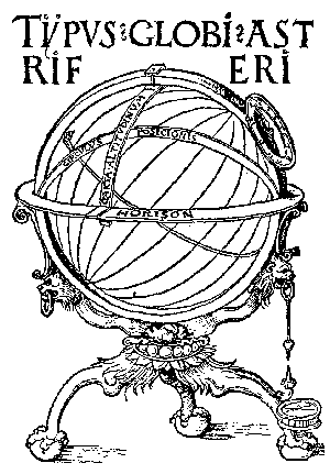 Fig. 26. Title-page of Johann Schöner’s
Terrae Descriptio, 1518.As the true position of places
on the earth’s surface, as well as the distance between any two
places, could best be represented on a globe, cartographers and
globe makers became active in their endeavors to meet the desires
60of those interested in geography. They no longer
confined themselves to such globes as the Behaim and the Laon,
which, in reality, are artistically interesting rather than
scientifically useful, but they sought to make use of the new
invention of printing. Maps giving the outlines of continents,
with place names, rivers, constellations, and star names were
printed from wood blocks or from copper engraved plates on paper
gores, which were so fashioned mathematically that they could be
made to fit the surface of a prepared ball, with careful
adjustment and manipulation. In this manner globes in great
numbers could be prepared, with the added advantage that they
were all alike, or similar. The sixteenth century soon furnished
rules for globe-gore construction, and while the methods of globe
making hitherto common were not entirely given over, as many
artistic pieces of the period, which have come down to us,
testify, the new method was soon in general favor and became in
the course of time practically the only method employed. It is
the globe maker’s method today.
Fig. 26. Title-page of Johann Schöner’s
Terrae Descriptio, 1518.As the true position of places
on the earth’s surface, as well as the distance between any two
places, could best be represented on a globe, cartographers and
globe makers became active in their endeavors to meet the desires
60of those interested in geography. They no longer
confined themselves to such globes as the Behaim and the Laon,
which, in reality, are artistically interesting rather than
scientifically useful, but they sought to make use of the new
invention of printing. Maps giving the outlines of continents,
with place names, rivers, constellations, and star names were
printed from wood blocks or from copper engraved plates on paper
gores, which were so fashioned mathematically that they could be
made to fit the surface of a prepared ball, with careful
adjustment and manipulation. In this manner globes in great
numbers could be prepared, with the added advantage that they
were all alike, or similar. The sixteenth century soon furnished
rules for globe-gore construction, and while the methods of globe
making hitherto common were not entirely given over, as many
artistic pieces of the period, which have come down to us,
testify, the new method was soon in general favor and became in
the course of time practically the only method employed. It is
the globe maker’s method today.
If the actual number of globes constructed shortly before and shortly after 1500 appears to have been small, judging from the number extant, we often find additional assurance of interest in such instruments in the use that was made of them for illustrative purposes, and for decoration. Terrestrial and celestial globes, as well as armillart spheres, 61frequently appeared on title-pages (Figs. 26, 27), in paintings (Fig. 28), or constituted a part of the library furnishings (Fig. 29).124
Among the ducal houses, famous in Italy in this period for interest in matters geographical, none was more conspicuous than was the house of Este of Ferrara.125 We have an 62interesting letter dated Rome, January 17, 1509, and written by Fioramonte Brognoli to Isabel of Este, wife of Francis II, Marquis of Mantua, daughter of Hercules I, Duke of Ferrara, who was responsible for the draughting of the Cantino map of the year 1502,126 and granddaughter of Duke Borso, to whom Donnus Nicholas Germanus dedicated or addressed, in 1466, his twenty-seven Ptolemy maps.127 Brognoli, having received from the Marchioness an order for a copy of the globes, terrestrial and celestial, possessed by Pope Julius II, made reply that “the map and celestial signs which are painted on two solid spheres in the library of the Pope, of which your Excellency would like to have copies, I have ordered, and the same to be made by a good painter of the Palace, who tells me that it will take some time because the matter is quite difficult. I will not fail in care, and will provide the necessary funds, so that as soon as possible I will send them to you by a trusty messenger.”128 Again the Roman correspondent wrote, the letter bearing date February 1, 1505, “That master painter who would like to make copies of the map and the zodiac which are in the library of the Pope, about which Your Excellency wrote me some time ago, tells me that to make them with linen it will cost more than forty ducats, but to draw them on paper according to a certain design which is painted on canvas in that place, it would cost very little. I thought I would inform Your Excellency before giving the order, that I might ascertain your wishes, for I shall do exactly that which you desire.”129 February 20, 1505, the Marchioness replied from Mantua, saying that “the expense of forty ducats will not deter us, if the copy of the map and of the zodiac is well made and is similar to that found in the library of the Pope. You may order it to be made with extreme diligence and with exactness.”130
The globe of Pope Julius II, in question, must then have been constructed prior to 1505, seeing this to be the year of the correspondence to which reference has been made 63above. From the partial description given in the letters we are led to the conclusion that they were not engraved metal globes, but their maps were manuscript, and were well decorated by hand. The Vatican Museum is still in possession of a celestial globe which may well be one of those once belonging to Pope Julius II, the terrestrial globe having disappeared. From the interesting description of Denza131 we learn that this remaining one is a hollow wooden ball, 95 cm. in diameter. That there might be an even surface on which to draw the star map, a covering of plaster had been provided, 4 mm. in thickness. It is furnished with a somewhat elaborate base, ornamented with sphinxes with the heads of eagles and the feet of lions. Its horizon circle, supported by four quarter circles, is a band 5 cm. wide, the surface of which is divided into five concentric circles, within which are the names of the several signs of the zodiac in Latin, the names of the days of the month, and the names of the eight principal winds in the Italian language. Along the outer edge of this horizon circle is the following inscription, “Daniel Chassignet. Fecit. Romae 1617,” a name and date clearly applying only to this circle or to the globe’s mounting. It has a meridian circle within which the sphere revolves. On the surface of the ball we find represented the principal circles, that is, the equator, the tropics, the polar circles, with five meridians, and the ecliptic, its twelve signs being represented in gilded characters. The coat of arms, painted near the south pole, is not that of Pope Julius II, but of Cardinal Gian Stefano Ferrero, Bishop of Bologna, who became a supporter of Juliani della Rovere in his candidacy for the papal office, and to which office he was elected, becoming known as Julius II. Fiorini thinks it probable that the globe was presented by Cardinal Ferrero to the Pope, and that while in his possession the coat of arms was painted on its surface. It is indeed not improbable that it was originally constructed for the Cardinal. Contrary to the opinion of Denza, 64Fiorini’s conclusion is that the decoration of the globe is not to be attributed to Giulio Romano, a distinguished pupil of Raphael, and the arguments presented seem acceptable.132
As proof of an existing interest in globes, in Italy, in the first years of the sixteenth century, other than that given by the letters of Isabel of Este, and the globes of Pope Julius, we find an allusion to the subject by Friar Marco da Benevento, member of the order of Celestini and a renowned mathematician. In his ‘Orbis nova descriptio,’133 which he added to an edition of Ptolemy, issued in Rome in the year 1507 or 1508, he alludes to the difficulty of representing the earth upon a solid sphere, adding that the greater the size of the same the greater the difficulty there is in moving it, and that the larger the globe the more difficult it is to take in at a glance any considerable part of the map. While making no specific mention of any of the globe makers of the time, his reference to the subject seems to assure us that globes were objects more or less familiar to students of geography in his day.
Fiorini cites at some length an inventory relating to the printing establishment of Alexander Rosselli of Florence, under whose father, Francesco, this establishment became famous.134 The father died in the year 1510, but it is probable that this artist, painter, and miniaturist, who issued for his establishment numerous maps, printed, likewise, globe gores. While the inventory gives us intimation of his great activity, we have no further knowledge of his work as a globe maker than is contained therein. It may well have been that the construction of globes with printed gore maps had its origin in Florence in the very early sixteenth century, and that a credit we have been accustomed to give to German map makers135 is in reality due the Rosselli family of Italy, particularly Francesco Rosselli.
Fiorini likewise alludes to a letter written by Friar Zenobio Acciaioli, dated Lucca, May 12, 1509, and addressed to the Florentine, Luigi Pietro Guicciardini, brother 65of the distinguished historian.136 Request is made in this letter that assistance and advice be given to a brother monk, Barnaba Canti, who had been asked to describe a map on which the newly discovered lands were well drawn, there being written on the map the history of the islands, with a description of the lands and of the customs of the peoples. Attention is likewise called to a globe which Canti possessed, it being designated as “sphaerula” or small. The letter further notes, “Cupit autem illam Joannes teutonicus astrologus, ut ex suis ad me literis quas inclusas tibi in his mitto, videre poteris.” “John the German astronomer desires this (map?) as you will be able to see from his letters to me which enclosed I send to you.”
It is ingeniously argued that the Joannes referred to was none other than John Schöner, who later became famous as mathematician and as map and globe maker, and that the globe referred to by Acciaioli was one in the construction of which the globe gores of Rosselli had been used, since “Joannes teutonicus” in all probability would not have thought of receiving from Italy a manuscript globe.
For the history of globe making as practiced in Florence in these early years, there is in the record of the deliberations of the Florentine Signoria, dated December 30, 1515, an entry of interest.137 The Priors and Gonfaloniers directed attention to the sphere, which had been placed in the orologia or clock room, noting that the terrestrial orb which had been painted thereon was greatly damaged, “... super qua depicta est figura et situs orbis terrarum ... devastata et male picta.” They expressed a desire that it should be fully repaired and be made suitable as an adornment of the wonderful clock, and in keeping with the remarkable celestial sphere which was placed near by: “ut similis sit et non discrepet, in sua qualitate, a mirabili orologio predicto, et a convicina et mirabili palla, ubi apparet figura et ambitus celi.” Having knowledge of the ability and 66skill of Friar Giuliano Vannelli, it was decided to entrust the reconstruction to him. We learn that on June 28, 1516, the Signoria directed payment of fifty large florins be made to Friar Giuliano, in addition to the six already paid, for the painted sphere; that on July 17, 1516, the officers of the Monte Comune directed the payment of fifty-six large gold florins to “Don Giuliani Vanegli” “in appreciation of his work, and as a reward for having made one of the two balls of the clock, which is in the large room of the Signoria, which ball he both designed and painted, showing on it the entire universe, according to Ptolemy and other authors who deal with the subject.” Fiorini notes that as at this time the terrestrial sphere was damaged it probably was several years old, and that if badly painted (male picta) the inference is, it failed to record the latest discoveries. If the exact date of the construction of the spheres which adorn this clock cannot be ascertained, it was at least before 1500.138
We have further evidence of Vannelli’s interest in globe construction contained in a letter dated Rome, November, 1524, and addressed to Cardinal Giovanni Salviati, a legate of Lombardy. “Your Excellency has asked me to make for you a small ball de situ orbis, of the size and character of that of Giovanni Ruccellai.... I have made the said ball, and have varnished it, but the weather being bad it will not be dry for eight or ten days.... Your Excellency also tells me that you would like to have a large globe similar to that of Mons. R. Rodulphis, which I have begun. If you desire that I should go on with the work, I shall willingly do so, putting aside all other work to serve you.”139
To the interest in globe making north of the Alps in the first quarter of the sixteenth century attention may next be directed. In a letter written by Johannes Trithemius to Vuilhelmus Veldicus Monapius, dated August 12, 1507, may be found an early allusion to globes. He says: “Orbem terrae marisqui et insularum quem pulchre depictum in Vuormotia scribis esse venalem, me quidem consequi posse 67obtarum, sed quadraginta pro illo expendere florenos, nemo mihi facile persuadet. Comparavi autem mihi, ante paucos dies, pro aere modico sphaeram orbis pulchram in quantitate parva ...” “I wanted to buy a finely painted globe of the earth, seas, and islands, which I wrote was for sale in Worms, but I could hardly be induced to give such a price for it as forty florins. I purchased, however, a few days since at a low price, a beautiful terrestrial globe of small size.”140 He wrote further, “Henricum de Bunau dies vita audini defunctum, sed libros eius et globum cosmographiae quem alim comparavit ex officina tua remanisse apud Saxoniae Principes, quod tu existimas non audini.” “I am informed that Henry Bunau died some time ago, but I never heard it said that his books and the cosmographical globe which he bought in your work-shop remained with the Princes of Saxony, as you believe.”141 It has been thought by some that the globe referred to as having been purchased in Worms was the globe of Waldseemüller.
Since the discovery in 1902 of the long-lost Waldseemüller maps of 1507 and of 1516 by Professor Joseph Fischer, S.J., in the library of Prince de Waldburg-Wolfegg (Fig. 30), great interest has centered especially in the work of that early German map maker. As the new transatlantic discoveries of the Spanish and the Portuguese greatly quickened interest in geographical science and made necessary the construction of new maps in rapid succession, Germany, already a land in which the renaissance spirit had found an enthusiastic reception, and whose people were awake to every new interest, soon became a center for the spread of information concerning the new regions. Commercially important trade cities of this country had been for some time in intimate touch with the important maritime trade centers of Spain and Portugal. Word of the newest discoveries was quickly carried over the Alps to France and 68to Germany, and the latest publication of the writer on matters geographical had its references to the parts of the world newly found of which Ptolemy had not known.
One of the first German geographers of the century, and now justly famed as one of the most distinguished of the period, was Martin Waldseemüller (ca. 1470-1522 ca.), whose name, according to the practice of the time, was classicized as Hylacomylus.142 So significant was the influence of Waldseemüller in the mapping of the New World that a somewhat detailed word concerning him may here well be given. When Duke René of Lorraine (1451-1508) became a patron of learning, with particular interest in cosmography or geography, the cartographical studies of the Germans began to have a place of far-reaching importance. It was under this enlightened duke that the little town of St. Dié became a center of culture. Here was organized the Vosgian Gymnasium,143 a society of learned men not unlike the Platonic Academy of Florence or the Danubian Society, Vienna. Of this St. Dié coterie none was more prominent than Jean Bassin de Sandacourt,144 the translator of the ‘Four Voyages’ of Amerigo Vespucci from the French into the Latin, Lud, the ducal secretary and author of an important little work of but few pages, which he called ‘Speculi orbis succinciss ...,’145 and Waldseemüller, the professor of cosmography, the author of the ‘Cosmographiae Introductio ...,’146 and a cartographer of great skill, who, with Ringmann, planned and carried well on toward completion, as early as 1507 or 1508, an edition of Ptolemy, which in 1513 was printed in the city of Strassburg.147 It probably was as early as 1505 that the plan was under consideration for a new translation of Ptolemy from the Greek into the Latin, and that thought perhaps had its inspiration in the letters of Vespucci, in which he gave an account of his four voyages, and in the new chart which but recently had fallen into the hands of Ringmann. These charts, says Lud, in his ‘Speculum,’ came from Portugal, which, if true, leads one to the belief that 69they exhibited genuine Vespucian data.148 Whatever the truth concerning the origin of these charts, that determination became a starting point for a most important evolution in cartographical history of the world.149 In April, 1507, Waldseemüller had written to his friend, Amerbach, in Basel, “Non credo te latere nos Ptholomei cosmographiam, recognitio et adiectis quibusdam novis tabulis impressuros in oppido Divi Deodati.... Solidum quod ad generale Ptholomei paravimus nondum impressum est, erit autem impressum infra mensis spacium.”150 “I think you know already that I am on the point of printing in the town of St. Dié (Lorraine), the Cosmography of Ptolemy, after having added to the same some new maps.... the globe comprising Ptolemy in general, which we have prepared, is not yet printed, but will be so in a month.” While great interest centers in these “new maps,” prepared for the proposed edition of Ptolemy, a greater interest now centers in the map to which Waldseemüller repeatedly alludes in the years 1507-1511, especially in his ‘Cosmographiae Introductio’ (Fig. 31), which map it was the good fortune of Professor Joseph Fischer, S. J., to bring to light in the year 1902, as noted above.151 In the dedication of his little book to the Emperor Maximilian, he says, “Hinc factū est ṽt me libros Ptholomei ad exēplar Grecū quorunda ope p virili recognoscēte & quatuor Americi Vespucii navigationū lustratioēs adiiciēte: totius orbis typū tā in solido q̄ȝplano (velut preuiam quandā ysagogen) p cōmuno studiosorū vtilitate parauerim.”152 “Therefore studying to the best of my ability and with the aid of several persons, the Books of Ptolemy from a Greek copy, and adding the Relations of the Four Voyages of Amerigo Vespucci, I have prepared for the general use of scholars a map of the whole world, like an introduction, so to speak, both in the solid and on a plane.” Waldseemüller says further, wherein he gives a description of his new map, “Propositum est hoc libello 70quandam Cosmographie introductionē scribere; quam nos tam in solido q̄ȝ plano depinximus. In solido quidem spacio exclusi strictissime. Sed latius in plano....”153 “The purpose of this little book is to write a description of the world map, which we have designed, both as a globe and as a projection. The globe I have designed on a small scale, the map on a larger.”
From the above citation it appears that as early as April, 1507, the same preparation had been made for a globe that had been made for the issue of a large world map. The map, as noted, has been found, but neither a globe nor a set of globe gores is known bearing the indisputable evidence of his authorship. In the library of Prince Liechtenstein, however, is a somewhat crudely executed gore map (Fig. 32) which, according to certain cartographical students, should be accepted as a copy of the work to which the allusions are made in the ‘Cosmographiae.’154 These gores, twelve in number, and each 12 cm. in length, this length representing the length of a meridian of the globe ball which the gores could be made to cover, were printed from a wood engraved block. They exhibit the Old World, in the main, in accord with the Ptolemaic idea, and the New World with a close resemblance to the Canerio map record, and that of Waldseemüller’s world map of 1507.155 The North American region is nameless, but the South American region bears conspicuously the name “America.” At intervals of ten degrees lines of latitude and longitude are marked. As a title to a lithographic reproduction of this map issued some years since by the Prince, is the subscription “Erster gedruckter Globus. Martin Hylocomylus (Waltzemüller). Gehört wahrscheinlich zo seinem 1509 herausgegebenen Buche Globus Mundi.” “First printed globe. Martin Hylacomylus (Waltzemüller). Probably belonging to his Globus Mundus which appeared in 1509.”156
That which adds special significance to this young German’s representations of the new lands, so far as our study of globes is concerned, is the repeated recurrence of his 71particular outlines or contours in the globe maps of the first quarter of the century, produced by such cartographers as Johann Schöner of Nürnberg, and by those of his school, as will be noted below. Both the globe and the large world map were doubtless printed in large numbers and widely distributed. Waldseemüller states in a legend on his marine chart of 1516 that he had printed his map of 1507 in one thousand copies,157 but one of which is now known.
In a little tract, printed in Strassburg in the year 1509, there appears to be a reference to a globe which may be that constructed by Waldseemüller. It is this reference which the Prince of Liechtenstein, as noted above, has taken as a reference to the gore map, a copy of which is in his collection. The title of this tract reads, “Diss büchlin saget wie die zwē durchlüchtigstē herrē her Fernandus, K. zů Castilien und herr Emanuel, K. zů. Portugal haben das weyte mör ersůchet unnd funden vil Insulen unnd ein Nüwe welt von wilden nackenden Leüten vormals vnbekant.” “Gedruct zü Strassburg durch Johānē Grünĭger Im Iar M.CCCCC.IX vff Letare. Wie du aber dye Kugel dü beschreibung der gantzenn welt verston soltt würst die hernach finden vnnd lesen.” “This little book relates how the two most illustrious Lords Ferdinand, King of Castile and Emanuel, King of Portugal have searched through the wide seas and discovered many islands and a new world and naked peoples hitherto unknown.” “Printed at Strassburg by Johann Grüniger. In the year MCCCCCIX on Letaro. But how you shall understand the globe and the description of the whole world you will hereafter find out and read.”158 Harrisse thinks it probable that a real globe accompanied and was sold with this little volume.159
In the same year, 1509, there issued from the press of Grüniger a second volume, in character somewhat like the preceding, but in the Latin language. In this the allusion to the globe is more definite, for its title seems to assure us 72that it was prepared to accompany a real globe. This title reads, “Globus mundi Declaratio siue descriptio mundi et totius orbis terrarum. globulo rotundo comparati vt spera solida. Qua cuiuis etiā mediocriter docto ad oculū videre licet antipodes esse, quos pedes nostris oppositi sunt.” “Valete feliciter ex Argentina ultima Augusti. Anno post natü salutatorē. M.D.ix. Johannes grüniger imprimebat. Adelpho castigatore.” “The world globe. Exposition or description of the world and of the terrestrial sphere constructed as a round globe similar to a solid sphere, whereby every man even of moderate learning can see with his own eyes that there are antipodes whose feet are opposite ours.... Farewell, Strassburg on the last day of August A.D. 1509. Printed by Johann Grüniger. Corrected by Adolphus.”160 Neither the author of this tract nor the maker of the globe is known of certainty. They have been attributed to Glareanus as well as to Waldseemüller.
There is still a third volume printed by Grüniger in this year, 1509, which, however, appears to be but little more than a German translation of the ‘Globus Mundi.’ The title, slightly altered, reads, “Der welt kugel Beschrybūng der Welt und dess gātzēn Erttreichs hie angezogt ūnd vergleicht einer rotunden kugeln die dan sunderlich gemacht hie zū gehōrede darin der Kauffmā und ein ietlicher sehen ūnd mercken mag wie die menschen undē gegē uns wonē ūn wie die son umbgang, herin beschriben mit vil seltzamē dinge (wood cut of globe) Getrucht zū Strassburg. Von Johanne Gruniger in yar. M.D.ix. uff ostern. Johanne Adelpho castigator.” “Description of the world globe, of the world and the entire terrestrial sphere here constructed and made to resemble a round ball and is so arranged that the merchant and every man may clearly see how that men live underneath us, and here may be seen how the sun moves about (the earth) with many wonderful things. Printed at Strassburg. By Johann Grüniger in the year 1509 at easter. Johann Adelpho corrector.”161 This can as confidently be taken to refer to a real globe as the title in the 73tract to which reference has just been made. It is probable that we can obtain some idea of the appearance of the globe from the small woodcut printed on the title-page of both the Latin and the German editions, of which a conspicuous feature is the representation of a small land area southwest of Africa, bearing the inscription “Nüw welt” (Fig. 33). As the little book was issued in both Latin and German, Harrisse thinks it probable that two editions of the globe likewise appeared.162
The Lenox globe163 is often referred to as the oldest extant post-Columbian globe. It is an engraved copper ball of excellent workmanship, 127 mm. in diameter (Figs. 34, 35), neither signed nor dated, and is without mountings. A critical study of its geographical records, particularly of the New World representations, has led to the conclusion that it was made as early as 1510. The two sections or hemispheres of which it is composed are joined at the equator. Neither parallels nor meridians are indicated, and though a striking error appears in giving to the eastern hemisphere, or the Old World, too great an extension in longitude, the principal latitudes are well given. The globe was found in the year 1850, in Paris, by Mr. Richard Hunt, by whom it was presented to Mr. James Lenox, and is now one of the choicest objects in that great collector’s library, which library constitutes an important part of the New York 74Public Library. In its New World representation, South America appears as a large island having three regional names, “Mundus Novus,” “Terra Sanctae Crucis,” and “Terra de Brazil.” “Isabel” (Cuba), “Spagnolla” (Haiti), and a few unnamed islands belonging to the West Indies have been outlined. In the place of North America there are scattered islands, one of which, located near the northwest extremity of “Terra de Brazil,” bears the name “Zipangri” (Japan), and one in the far north, but unnamed, clearly resembles the Cortereal region, as it appears on the Cantino and on the Canerio map. A few of the many islands in the eastern seas are designated by name as “Taprobana,” “Madagascar,” and “Seilan.”
A globe but little known, but resembling in a striking manner the Lenox, is that belonging to the Jagellonicus University Library of Cracow, Poland.164 It is a gilded copper ball, 7.3 cm. in diameter (Figs. 36, 37), and constitutes a part of a fine old clock of the sixteenth century. Meridians and parallels are engraved and numbered on its surface at intervals of ten degrees, the prime meridian passing through the island Ferro. While it is neither signed nor dated, there is scarcely a doubt that it is as old as the Lenox globe; indeed, the geographical features of the two globes are so similar that they appear to be the work of the same globe maker, or copies of a common original, yet it is noteworthy that the nomenclature of the Jagellonicus globe is somewhat richer. The large island which lies southeast of Madagascar and is nameless on the Lenox appears on the Jagellonicus with a very interesting inscription, reading “America noviter reperta.” Comparing the coast of “Mundus Novus” with the coast of this “America noviter reperta,” Tadeus Estreicher finds support for the belief that the globe was constructed soon after the year 1507, in which year Waldseemüller suggested the name America for the region discovered by Amerigo Vespucci. He, however, seems not to have noticed the possibility that the inscription 75appearing on this large island indicated not only an acquaintance, on the part of the Jagellonicus cartographer, with Waldseemüller’s suggestion as to the name America, but a belief that America was actually located in this particular region. In his chapter on climates Waldseemüller says, “Atqȝ in sexto climate Antarcticù versus & pars extrema Africae nuper reperta & Zamzibar Iauva minor & Seula insule & quarta orbis pars (quam quia Americus inveuit Amerigen quasi Americi terrā siue Americā nuncupare licet) sitae sunt.” “In the sixth climate toward the Antarctic there are situated the farthest part of Africa, recently discovered, the islands Zanzibar, the lesser Java, and Seula, and the fourth part of the earth, which, because Amerigo discovered it, we may call Amerige, the land of Amerigo, so to speak, or America.”165 Following the above, Waldseemüller notes what Pomponius Mela has to say concerning “these southern climates,” that is, concerning this antipodal region.
In the rich cartographical collection of Prince Liechtenstein there may be found, in addition to the globe gores referred to above, an interesting globe, usually referred to as the mounted Hauslab globe. 166 It is of wood, having a diameter of about 37 cm. and is covered with a preparation on which a world map has been drawn or painted. It is furnished with a wooden base, a meridian and a horizon circle of brass, and an axis of iron on which it turns, all of which furnishings, however, appear to be of later date than the sphere itself. Though neither signed nor dated, it exhibits many features which suggest a close relationship with the globes of Johann Schöner; indeed, it is not improbable that it is an early example of his workmanship. “I am of the opinion,” says Luksch, “that the globe of Schöner of 1515 and the Hauslab globe were drawn from one common original sketch,” a conclusion based largely upon the fact that on the two globes the outlines of the New World are almost identical. As to the date when constructed, a 76 comparison with other globes of the second decade of the century has led to the conclusion that it must have been prior to the year 1515, and perhaps as early as 1513. In its representation of the Old World, the land is made to extend through 240 degrees, counting from the island of Porto Santo, whose meridian has been taken as the prime meridian. The northern section of the New World is given the name “Par(ias),” the last letters of the word having been obliterated by age, while the southern section is called “America.” The great austral land south of the apex of the southern continent, appearing on the Schöner globe of 1515 as “Brasilie regio,” is omitted on the Hauslab globe. The continents, rivers, and mountains represented are very dark in color, and were probably originally blue, black, or red, and the seas are a dark blue. The equator, as drawn on the surface of the sphere, is divided into degrees, represented alternately in white and black, and every tenth degree is indicated by an appropriate number, beginning, as stated above, at the island of Porto Santo. By way of decoration a border of gold is given to the lines representing the equator, the tropics, and the polar circles.
In the geographical department of the Bibliothèque Nationale of Paris is a globe referred to in cartographical literature as the Green globe, or the Quirini globe, the first name being given to it by Gabriel Marcel, 167 by reason of the prominence of the color green employed in painting the seas (Fig. 38). It is an unsigned and undated wooden sphere, 24 cm. in diameter. Its surface appears to have been covered with a coating of paint, originally white, and on this the world map was drawn. There is much artistic skill displayed in the coast configurations, with the deeply shaded seaboards making the land appear to rise above the ocean surface, and in the representation of the islands, most of which are made conspicuous in red or gold. The inscriptions in dark brown, perhaps originally black, are neatly written, clearly suggesting that the globe was constructed 77in the first quarter of the sixteenth century, perhaps as early as 1513 or 1515. The equator, the tropics, and the polar circles are traced in gold; the degrees of latitude and longitude are marked in red, and at intervals of ten degrees. The prime meridian is made to pass through the Cape Verde Islands, islands referred to as “Insule Portugalensium invente anno Domini 1472.” This globe shows a striking resemblance to those of Schöner of 1515, a fact which has led Marcel to refer it to the Schönerian school, though not to attribute it directly to Schöner himself. A very important and interesting feature of the globe is the appearance of the name “America” no less than four times in the New World; twice in what we now call North America and twice in South America. It is, indeed, the oldest known cartographical monument on which the name America is given both to the north and the south continental areas. In the southern continent we read “America ab inuentore nuncupata,” and near the Antilles “Iste insule per Columbus genuensem almirantem et mandato regis castelle invente sunt.” “These islands were discovered by Columbus, a Genoese admiral, by command of the king of Castile.” Harrisse observes that it appears the cartographer thought of Columbus as the discoverer of the West India Islands only, and that he thought the honor of the discovery of the American continents, north and south, belongs to Vespucius.168 An austral land appears, though nameless, which Schöner called “Brasilie regio” on his globe of 1515, and “Brasilia inferior” on his globe of 1520.
Nordenskiöld has described a set of twelve globe gores, engraved on wood, belonging to his own collection, which he assigns to the year 1518.169 Of these particular gores three sets are known; one being in the collection of Prince Liechtenstein (Fig. 39), one in the Bibliothèque Nationale, and one, as noted, in the possession of Nordenskiöld. On these gore maps North America bears the name “Terra Cuba” and “Parias.” South America has the name “America” 78inscribed in large letters, with an accompanying legend reading “Terra Noua Inuenta est Anno 1497.” “The New World discovered in the year 1497.”170 The austral land, appearing on the Schöner globes, is wanting. By reason of the fact that the names of but two European cities are inscribed, these being “Ingolstadt” and “St. Jacobus,” the suggestion has been made that the map is the work of Apianus, a celebrated geographer of Ingolstadt, author of the important map of 1520 and a globe maker.171 In their general features these gores are of the Schönerian type, which we may also characterize as Lusitano-Germanic.
In the Royal Collections of Windsor Castle may be found a set of eight globe gores (Fig. 135, attributed by Major to Leonardo da Vinci, but with very little more reason for the assignment than the fact that they were found in a collection of papers in the handwriting of that famous artist. They are drawn as equilateral triangles, each representing one eighth of the earth’s surface, not as biangles, which is the usual form for early globe gores.172 Major described the map as the oldest known on which the name America appears, giving as the probable date of construction the year 1514, which date is thought by Harrisse to be five or six years too early.173 Such a distinction as was claimed for the record of the name America by Major, being likewise assigned at various times to other early maps, has at last been definitely fixed as belonging to the world map of Waldseemüller of 1507.174 The outlines of the New World bear a resemblance to those found in the Lenox and the Jagellonicus globes. The North American region is represented by two islands, one of which bears the name “Bacalar,” the other “Terra Florida.” South America, a large island, has conspicuously inscribed the name “America,” together with a few prominent coast names. These gores are chiefly of interest by reason of their peculiar form.
An interesting set of globe gores of the first quarter of the sixteenth century is that attributed to Boulengier, of 79which but one copy, now belonging to the New York Public Library, is known.175 These gores, twelve in number (Fig. 40), were printed from a copper engraved plate 18 by 36 cm. in size, but bear neither date nor name of author. The title appearing across the bottom of the map reads, “Vniversalis cosmographie descriptio tam in solido quem plano.” They were found in a copy of Waldseemüller’s ‘Cosmographiae Introductio,’ printed at Lyons by Jean de la Place, but undated. Harrisse gives as the probable date of the publication between November 27, 1517, and May 26, 1518.176 With this engraved world map were found two other copper plates, one bearing the title “Astrolabium Phisicum,” the other “Motus novae spere et trepidacionis spere MDXIV,” and signed “Artificis Ludovici Boulengier, Allebie, 1514.” As this edition of the ‘Cosmographiae’ was prepared for the press by Boulengier,177 who in his day achieved distinction as a mathematician, astronomer, and geographer, this gore map has been ascribed to him. It appears from a statement on the verso of a folded plate belonging to Chapter VIII that a globe had been prepared to accompany it.178 This statement, while not agreeing in all respects with one to be found in the edition of 1507, is of similar import. Boulengier states in his dedicatory letter that he had noted other globes which had been previously published. As a bit of copper engraving it is very artistically done; its inscriptions, coast outlines, and rivers are drawn in soft ornamental lines. That region representing North America bears simply the name “Nova,” while South America is referred to as “America noviter reperta,” a wording for this information which elsewhere appears only on the Jagellonicus globe. These gores are of sufficient dimensions to cover a ball 11 cm. in diameter.
In the year 1877 or 1878, reports Professor Ferdinando Jacoli, Admiral William Acton acquired two interesting and scientifically valuable terrestrial globes of the early sixteenth 80century once belonging to Count Piloni of Belluno, Italy.179 That one appearing to be the older of the two resembles so closely the Paris green globe in size, having a diameter of 24 cm., and in its details, that there is good reason for thinking it to be the work of the same author. Like the Paris globe it is neither signed nor dated. The surface of the ball is covered with a preparation of plaster on which the geographical details have been written. Seas and lands are colored, the equator, the tropics, and the polar circles are indicated by gilded lines. Meridians are drawn at intervals of ten degrees, the prime meridian passing through the Canary Islands, and parallels are likewise represented at intervals of ten degrees. The metal meridian circle and the stand upon which the sphere rests retain in places some of the old gilding. Professor Jacoli expresses the opinion that it may be of Spanish or of Portuguese origin, an opinion based upon the nomenclature. It seems, however, probable that the author was an Italian and that he merely employed the Spanish or the Portuguese sources, as was so frequent, and in so large a measure necessary, in that day. In Africa the author has represented the “Peludes nili,” and two lakes into which several rivers flow having their source in the Mountains of the Moon. To the south-east of the continent is represented “Zanzibar insula,” and near this are a number of small islands with the legend “Iste insule ex mandato regis Portugalliae lustrate sunt.” The islands of Ceylon and Sumatra are laid down but are given the names “Taprobana” and “Seula” respectively. In the interior of Asia we read “Carama civitas magna,” near this “Thebet provincia mais,” and below “Hic dñat prespiter Johannes rex totius Indiae.” In eastern Asia is the name “Catay” and near this the legend “Zumsay est quedã civitas mag. in medio lacus magnus,” the Paris globe having “Quinsay” instead of “Zumsay.” The New World in its outlines bears striking resemblance to the early globes of Schöner. Along the west coast of South America is the legend “Tota ista provincia inventa est per mandatum regis 81Castelle,” near the same “Terra ultra incognita,” and extending along the west coast of North America “Terra ulterius incognita,” all of which legends, in identical wording, appear on the Paris globe. The Antilles are referred to in the legend “iste insule per Columbum Genuensem Almirantem ex mandato regis Castelle perite sunt,” and in South America “America ab inventore nuncupata.” Near the west coast of Africa we find “Insule portugalensium invente—domini 1477,” one of which is called “visionis insula.” The author has also represented an Antarctic continent but has made no reference to it by specific name or legend. If the Paris globe was constructed before 1520, as Marcel concluded, there is likewise good reason why the Acton globe should also be assigned to the second decade of the sixteenth century.
Las Casas, in his ‘Historia de las Indias,’ tells us that when Magellan (Fig. 41) offered his services to the King of Spain for an expedition to the Moluccas he had a globe to serve him in the demonstration of his plan. “Traìa el Magallanes vn Globo bien pintado, en que toda la tierra estaba, y alli señalò el camino que habia de llevar, salvo que el estracho dejò, de industria, en blanco, porque alguno no se lo saltease.”180 “Magellan had a well painted globe, which exhibited the entire earth, and he showed thereby the route which he thought of taking, but with intention he had left the strait blank so that no one might learn his secret.”
Other allusions to this globe we do not have, unless there is such in a letter written by Sebastian Alvares to King Don Manuel, dated Seville, July 18, 1519. In giving information concerning the plan of Magellan Alvares states: “A rrota que se diz que han de levar he dirto ao cabo fryo ficando lhe o brasy a mão dirta ate pasar a linha da particâo e daly navegar ao eloeste e loes noroeste dirtos a maluco a quall tr̃ra de maluco en vy asentada na poma e carta que ea fez o fo de Reynell a quall nò era acabada quando caa seu pay 82veo por ele, e seu pay acabou tudo e pos estas tr̃ras de maluco e p este paderam se fazem todallas cartas as quaêes faz dio Ribeiro e faz as agulhas quadrantes e esperas, porem nò vay narmada nem q̃r mais q̃ ganhar de comeer p seu engenho.” “The course which it is said they are to take is straight to Cape Frio, Brazil remaining on their right hand until they reach the line of demarcation, thence they are to navigate to the west and west-northwest straight to Moluco, which land of Moluco I have seen laid down on the sphere and map which the son of Reynell made here which was not complete when his father came here for him; and his father finished it all, and placed these islands of Moluco; and after this pattern all the maps are made which Diego Ribeiro makes, and he makes the compasses, quadrants and globes, but he does not go in the fleet, nor does he wish to do more than gain his living by his skill.”181
We find reference to a globe of this early period as belonging to Juan Sebastian del Cano, the reference thereto being contained in his will made on board the Victoria, June 26, 1526, and reading “Una esfera poma del mondo.”182 It probably was made of wood and painted, as there is good reason for believing that such as were carried by early navigators on their vessels were of this character. Harrisse thinks “this globe would probably prove to be one of the most interesting of all for that period, exhibiting, doubtless, the hypothesis of Magellan relative to the configuration of the southwest coast of South America north of 50 degrees south latitude.”183 Although the will of Del Cano is dated 1526 there is reason for thinking the globe was constructed prior to 1520.
Among the globe makers of the early sixteenth century none merits greater distinction than Johann Schöner of Nürnberg (1477-1547) (Fig. 42), mathematician, astronomer, and geographer.184 He was born in Carlstadt, Franconia, held a church office for some years in Bamberg, and in the year 1526, upon the advice of Melanchthon, became a professor of mathematics in the gymnasium of Nürnberg, 83to the fame of which city, as a scientific center, Regiomontanus had so greatly contributed in the preceding century. His activities as a globe maker began as early as the second decade of the century, and his influence soon became very pronounced. In Nürnberg he labored until the time of his death in the year 1547, editing, in addition to his other activities, the literary and scientific works of Regiomontanus and of Werner, and each year until 1543 issued his so-called Calendars. His numerous publications, mathematical, astronomical, and cosmographical, alone entitle him to a place of first importance among German scientific leaders of his day.
It was as early as 1515, at the cost of a wealthy patron, Johann Seylor, that he made in Bamberg what has usually been accepted as his first globe, two copies of which are now known, and for which it has been thought he wrote his tract bearing title ‘Luculentissima quaedā terrae totius descriptio ... cum privilegio Invictis Romanorû Impera Maximiliani per acto annos: ne quis imprimat: aut imprimere procuret codices has: cum globis cosmographicis: Noribergae 1515.’ ‘A most luminous description of the whole earth ... with the privilege of the Invincible Emperor of the Romans, Maximilian, for eight years to the effect that nobody shall print or have any of these books printed, with the cosmographic globe.’185 On the leaf preceding “fol. 1” is the representation of a mounted globe.
One of Schöner’s globes of 1515 is to be found in the Grand Ducal Library of Weimar, and one in the City Museum of Frankfurt (Fig. 43). Wieser,186 after a careful comparison, finds these globes to be practically alike in all details. Each is 27 cm. in diameter, having the usual mountings of brass, the whole resting on a wooden base. While neither signed nor dated, they answer the description contained in Schöner’s little tract referred to above. That region on the globe which we may designate North America, he calls “Parias”; the South American continent bears the name 85“America” and the austral land the name “Brasilie regio.” In addition to these principal regions he has represented the land discovered by the Cortereals, designating the same as “Litus incognitum.” Cuba bears the name “Isabella” and Haiti the name “Spagnolla.” The feature which seems to give special interest to these globes of Schöner is the representation of a strait between “America” and “Brasilie regio.” To the significance of this particular representation Wieser has given very careful consideration. He cites numerous passages from the tract of Schöner, and from the ‘Copia der newen Zeitung aus Presillig Landt,’187 a publication which he finds good reason for believing appeared before 1515, and in which he finds an acceptable explanation of the origin of this geographical notion represented by Schöner, which antedates the Magellan expedition by a period of five years.
It is a point to be especially noted that the dominant cosmographical idea of the map makers of the first quarter of the century represented the New World regions as independent of Asia. It is the idea set forth in the Portuguese maps, such as the Cantino and the Canerio; it is the idea which we find represented in the Waldseemüller maps and practically in all the Lusitano-Germanic maps of the period.188 Schöner had written in his tract of 1515, “Hunc in modum terra quadriparita cognoscitur, et sunt tres primae partes continentes, id est terra firma. Sed quarta est insula, quia omniquoque mari circumdata conspicitur.” “It has now been ascertained that the earth is divided into four parts, and the first three parts are continents, that is, main lands, but the fourth part is an island because we see it surrounded on all sides by the sea.”189 With regard to the relation of “Parias” to Asia, he states, “Parias insula quae non est pars vel portio prioris, sed specialis magna portio terrae huius quartae partis mundi.” “Parias is not a part or portion of the aforesaid country, but a large independent portion of the earth, in that fourth part of the world.”190
86Of the globes constructed by Schöner, none is more important than that bearing date 1520 (Fig. 44).191 The wooden ball on which the map has been drawn and colored by hand has a diameter of about 87 cm. and rests upon a wooden base. Near the south pole is the date 1520 in large gilt letters and an inscription stating that it was made at the expense of Johannes Seyler by Jo. Schöner.192 It is apparent that the same sources were used for the drafting of the map on this globe that had been used in the case of his earlier globes, but the geographical information on this last globe is much more detailed. The New World appears in five distinct parts, the first of which is called “Terra Corterealis,” the second “Terra de Cuba,” the third “Insulae Canibalorum siue Antiglia,” the fourth “Terra nova, America vel Brasilia sive Papagelli Terra,” and the fifth “Brasilia inferior.” The globe is richly decorated in colors, and its numerous descriptive legends, most of them in Latin, give such geographical information as may be found in most of the important maps of this early period.193
In 1523 Schöner issued a little tract of four pages which he called ‘De nuper sub Castiliae ac Portugaliae Regibus Serenissimis repertis Insulis ac Regionibus, Joannis Schöner Charolipolitani epistola et Globus Geographicus, seriem navigationum annotantibus. Clarissimo atque disertissimo viro Dño Rymero de Streytpergk, ecclesiae Babenbergensis Canonico dictae. Timiripae, Anno Incarnat. Dni. 1523.’ ‘An epistle of John Schöner of Carlstadt concerning the islands and regions recently discovered by the Most Serene Kings of Castile and of Portugal, and a geographical globe for the use of marking the course of those navigations. Dedicated to the most distinguished and eloquent Reymer von Streytperg, canon of the Church of Bamberg. Timiripae (Kirch-ehrenbach). In the year of the Lord’s incarnation 1523.’194 Though Schöner alone gives us such information as we possess concerning this globe, it has been the subject of much controversy, and if recovered it doubtless would 87prove to be an object of much interest. There is, in the opinion of the author, scarcely the slightest ground for accepting the conclusions of Henry Stevens and Professor v. Wieser, that the globe gores, now in the possession of the New York Public Library (Fig. 44a), and described by them as the lost globe of Schöner of 1523, are of Schönerian origin. The critical studies of Harrisse are sufficiently convincing to set this question at rest.195 Schöner concludes his little tract in the following words: “Ego tam mirifice orbis pervagationi nonnihil volens adiicere, ut quae lectu videantur mirabilia, aspectu credantur prohabiliora, Globum hunc in orbis modum effingere studui, exemplar haud fallibile aemulatus, quod Hispaniarum solertia cuidam viro honore conspicuo transmisit. Nec ob id quem antea glomeraveram abolitum iri volens, quippē qui es temporè, quantum phas erat homini abdita mundi penetrare, abunde expressit, modo sese consona admissione patientur, quod invenienda inventis non obstent. Accipe igitur hunc a me formatum globum ea animi benignitate, qua eum laborem ad tui nominis honorem lubens aggressus sum. Cognoscam profecto meas lucubratiunculas tuae celsitudini nullatenus despectui fore. Vale.” “Being desirous of making some small addition to this wonderful survey of the earth, so that what appears very extraordinary to the reader may appear more likely, when thus illustrated, I have been at the pains to construct this globe, having copied a very accurate one which an ingenious Spaniard has sent to a person of distinction. I do not however wish to set aside the globe I constructed some time since, as it fully showed all that had, at that time, been discovered: so that the former, as far as it goes, agrees with the latter. Please then to accept this globe in the same friendly spirit in which I undertook to construct it for your gratification. But I am sure you will not despise my humble attempt. Farewell.”196 This statement assures us that he had constructed a globe at the time of issuing his tract, and it gives us a fairly definite idea of its New World configurations, 88and further, that in the main it agreed with his earlier globes. It seems probable, however, that in some manner he indicated an Asiatic connection of the new lands, an idea which is so frequently expressed in the maps of the next quarter of a century, especially in the globe maps, an idea not to be finally set at rest until the discovery of Bering put an end to the controversy.
How Schöner, and others, came to the conclusion that “Parias” (North America) is not “a large independent portion of the earth in that fourth part of the world,” but has an Asiatic connection, and how they set down that conclusion in their maps will receive consideration in the following chapter.
Though not a maker of globes, in so far as we have definite knowledge, Albrecht Dürer turned his attention to the drafting of maps, two of which have for us here a certain interest. In the year 1515 Johannes Stabius designed a map of the Old World on a stereographic projection (Fig. 45), one of the first of its kind, which Dürer is said to have engraved. While the map itself is of little importance it is of interest as an attempt to represent in perspective a spherical earth.197
Dürer likewise undertook the drafting and engraving of a celestial map (Fig. 46), than which of this character there appears to be none earlier known. It was not so drawn as to make possible its application to the surface of a sphere, but its reshaping for that purpose could not have been for him a difficult proposition. He, with others of this time, was giving thought to the problem of globe-gore construction.
124 The illustrations given are typical, and to one familiar with the works of the period on geographical and astronomical subjects, others suggest themselves.
125 For popular accounts of the Este family of Ferrara, see Gardner, E. G. Princes and Poets of Ferrara. London, 1904; Cartwright, J. Isabella d’Este. London, 1903.
126 Harrisse. Discovery. pp. 422-425; same author, Les Corte-Real et leur voyages au Nouveau Monde. Paris, 1883, with reproduction of the western half of the map, in colors; Stevenson, E. L. Maps illustrating early discovery and exploration in America. New Brunswick, 1906. No. 1 of this series is a reproduction of the Cantino map in the size of the original.
127 Fischer, J. The Discoveries of the Norsemen in America. London, 1903. pp. 112-118. Professor Fischer enjoys the distinction of being the foremost living authority on Ptolemy.
128 D’Arco, C. Delle arti e degli artefici di Mantova. Mantova, 1857. Vol. II, p. 53.
129 Bertolotti, A. Artisti in relazione coi Gonzaga Signori di Mantova. Modena, 1885. p. 143. (In: Estr. dagli Atti e Memorie delle Deputazioni di storia patria per le Provincie Modenesi e Parmensi. Série III, Vol. III, parte 1.)
130 Harrisse. Discovery. p. 434.
131 Denza, F. Globi celesti della Specola Vaticana. (In: Publicazioni della Specola Vaticana. Torino, 1894. Vol. IV, p. xvii.)
132 Fiorini, op. cit., pp. 88-89.
133 See the edition of Ptolemy. Geographia—MDVIII. Rome. Chap. xii.
134 Fiorini, op. cit., pp. 94-96, the citation being made from Badia, Jodoco del. La bottega di Alessandro di Francesco Rosselli merciaje e stampatore (1525). (In: Miscellanea fiorentina di erudizione e storia. Luglio, 1894. Vol. II, p. 14.)
135 Zach, F. v. Monatliche Korrespondence. Gotha, 1806. Vol. XIII, p. 157. Harrisse. Discovery. pp. 445-446.
136 Fiorini, op. cit., p. 99.
137 Fiorini, op. cit., p. 101.
138 Fiorini, op. cit., p. 72.
139 Fiorini, op. cit., p. 102. Of the further interest taken by Cardinal Salviati in geography, see Stevenson, op. cit., No. 7.
140 Trithemius. Epistolae familiares. Haganoae, 1536. p. 294.
141 This is part of the letter of August 12.
142 D’Avezac, M. A. P. Martin Hylacomylus Walzemüller ses ouvrages et ses collaborateurs. Paris, 1867; Gallois. Les Géographes. Chap. iv. “L’école Alsacienne-Lorraine”; Schmidt, C. Histoire littéraire de l’Alsace a la fin du XVe et au commencement du XVIe siècle. Paris, 1879.
143 Schmidt, op. cit., Vol. II, p. 111; Humboldt, A. v. Kritische Untersuchungen. Berlin, 1852. Vol. II, p. 363; Gallois, L. Le Gymnase Vosgien. (In: Bulletin de la Société de Géographie de l’Est. Paris, 1900. pp. 88 ff.); D’Avezac, op. cit., p. 11.
144 A canon of the cathedral of St. Dié. Lud gives us the information that he was the translator of the Vespucci narrative from the French into the Latin.
145 Gravier, N. F. Histoire de Saint-Dié. Epinal, 1836. p. 202. The author refers to the character of Lud and to the influence of the St. Dié press. Copies of Lud’s most important little tract may be found in the British Museum, and in the Imperial Library of Vienna; it was printed in the St. Dié in the year 1507.
146 The full title of this significant volume reads: ‘Cosmographiae Introductio cum quibusdam geometriae ac astronomiae principiis ad eam rem necessariis, insuper quatuor Americi Vespucci navigationes. Universalis Cosmographie descriptio tam in solido q̄ȝ plano eis etiam insertis que Ptholomeo ignota a nuperis reperta sunt.’ ‘Introduction to Cosmography with certain necessary principles of geometry and astronomy to which are added the Four Voyages of Amerigo Vespucci a representation of the entire world, both in the solid (globe?) and projected on the plane, including also lands which were unknown to Ptolemy, and have been recently discovered.’ Two editions of the work appeared in 1507, and others at later dates. An excellent reproduction of Waldseemüller’s book in facsimile, with English translation, was published by the United States Catholic Historical Society under the title, ‘The Cosmographiae Introductio of Martin Waldseemüller in Facsimile followed by the Four Voyages of Amerigo Vespucci with their Translation into English.’ Ed. by C. G. Herbermann. New York, 1907.
147 This is one of the best of the early printed editions of Ptolemy.
148 May it not have been the Canerio chart to which allusion was made by Lud, or a chart of exactly that type? See Stevenson, E. L. Marine World Chart of Nicolo de Canerio Januensis (ca.) 1502. With Facsimile of the unique original, measuring 115 x 225 cm. New York, 1908.
149 Stevenson, E. L. Martin Waldseemüller and the early Lusitano-Germanic Cartography of the New World. New York, 1904. (In: Bulletin of the American Geographical Society. New York, 1908. pp. 193-215.)
150 Schmidt, C. (In: Mémoires de la Société d’Archéologie lorraine. Nancy, 1875. p. 227.)
151 Fischer, J. and Wieser, F. R. v. The oldest map with the name America of the year 1507 and the Carta Marina of the year 1516 by M. Waldseemüller (Ilacomilus). Innsbruck, 1903. Text in German and English, the maps in facsimile. The authors in their text have considered such matters as the Wolfegg collective volume, a description of the two maps, the sources of Waldseemüller, and the influence of the maps on the subsequent cartography, especially of the New World.
152 Printed on fol. “Aii.”
153 Printed on the back of folded leaf at the beginning of “Caput IX.”
154 Gallois. Les géographes. p. 48; Fischer and v. Wieser, op. cit., p. 14.
155 The crude character of the map is in striking contrast with the world map of 1507.
156 This is an excellent reproduction of the gores, copy of which was courteously sent the author by Prince Liechtenstein.
157 Printed in the lower corner of the chart on the left, “Generalem igitur totius orbis typum, quem ante annos aucos absolutum non sine grandi labore ex Ptolomei traditione ... in lucem edideramus et in mille exemplaria exprimi curavinius....”
158 Harrisse. B. A. V. No. 62.
159 Harrisse. Discovery. p. 465.
160 Harrisse. B. A. V. No. 61.
161 Harrisse. B. A. V. No. 32, Ad.
162 Harrisse. Discovery. p. 466.
163 De Costa, B. F. The Lenox Globe. (In: Magazine of American History. New York, 1879. pp. 529-540.) De Costa had the globe map redrawn and printed in plane projection. See for reproduction, Winsor, Nordenskiöld, Encyclopaedia Britannica. An excellent reproduction from a direct photograph of the globe may be found in Stevenson, E. L. Typical early maps of the New World. (In: Bulletin of the American Geographical Society. New York, 1907. pp. 202-224.)
164 Estreicher, T. Ein Erdglobus aus dem Anfange des XVI Jh. in der Jagellonischen Bibliothek. (In: Bulletin International de l’Académie des Sciences de Cracovie. Cracovie, 1900. pp. 96-105.)
The construction of the clockwork to be found in this small copper sphere in La Nature, 1892. No. 996, p. 75. The globe is referred to by Stevenson, E. L., in Martin Waldseemüller and the Lusitano-Germanic Cartography of the New World. (In: Bulletin of the American Geographical Society. New York, 1904. pp. 193-215.)
165 Waldseemüller, op. cit., Caput vii.
166 Luksch, M. J. Zwei Denkmale alter Kartographie. Wien, 1886. (In: Mitteilung der k. k. Geog. Gesellschaft. Wien, 1886. pp. 364-373.); Varnhagen, F. A. Jo. Schöner e P. Apianus. Wien, 1872. On p. 52 the opinion is expressed that the globe was made in Brixen from the fact that this relatively unimportant town is inscribed. Harrisse. Discovery. pp. 491, 492; Nordenskiöld. Facsimile Atlas. p. 76.
167 Marcel, G. Un globe manuscrit de l’école de Schöner. Paris, 1889. (In: Bulletin de géographie historique et descriptive. Paris, 1889. p. 173.); same author, Reproduction de carte et de globes relatif à la découverte de l’Amérique. Paris, 1894. pp. 11-14.
168 Harrisse. Discovery. p. 490.
169 Nordenskiöld. Facsimile Atlas. p. 76; reproduced on pl. XXXVII; same author, Om en märklig globakarta frän början af sextonde seklet. Stockholm, 1884. The latter has been translated under the title, A remarkable globe map of the sixteenth century, with facsimile, by E. A. Elfwing, and published in Journal of the American Geographical Society. New York, 1884.
170 Here the name “America” is more clearly assigned to the entire continent than in the Waldseemüller map.
171 See below, p. 176.
172 Major, R. H. Memoir on a mappemonde by Leonardo da Vinci, being the earliest map hitherto known containing the name America: now in the Royal Collection at Windsor. London, 1865; Wieser. Magalhâes-Strasse. pl. III, a reproduction of the gores showing the New World, joined in a hemisphere; d’Adda, Marquis Girolamo. Leonardo da Vinci e la Cosmografia. (In: La Perzeveranza. Milano, 1870.); Richter, J. P. Literary Works of Da Vinci. London, 1883. Both d’Adda and Richter doubt the Da Vinci origin of these gores.
173 Harrisse, op, cit., p. 504.
174 See above, p. 67.
175 Nordenskiöld, op. cit., p. 76; reproduced on pl. XXXVIII; Catalogue de livres appartenant à M. H. Tross. Paris, 1881, item 4924, with a reproduction of the gores.
176 Harrisse, op. cit., pp. 494-496.
177 Marcel, G. Louis Boulengier d’Alby. Paris, 1890. (In: Bulletin de géographie historique et descriptive. Paris, 1890.)
178 This statement reads: “Habes candide lector tabellam preinsculptam tibi latitudinem graduum regionium ... In globo vero diei quantitatem et noctis ... sic comprehendere potes omni de regione tam per globum quam per sexagenarium.” “You have, dear Reader, before you, a small plate on which are inscribed the degrees of latitude of the countries ... on the globe (you see) the duration of the day and night ... thereby you will be able to ascertain (the position of) every country by the globe as well as by the sexennium.”
179 Tessier, A. Di Cesare Vecellio e de’ suoi dipinti e disegni in una Collezione di libri dei secoli XV e XVI. Rome, 1876. (In: Bollettino della Societe geografica italiana. Rome, 1876. Série II, Vol. I, pp. 39-42.)
Tessier’s discourse was delivered at the Venetian Atheneum, 1875. Jacoli, F., likewise refers to this globe in Gazzetta di Venezia, January 15, 1876. It is not known just what disposition has been made of the globes by Admiral Acton.
180 Las Casas. Historia. Tomo IV, lib. III, cap. ci, p. 377; Herrera, A. Descriptione las Indias Ocidentales. Madrid, 1730. Tomo II, lib. II, cap. xix, p. 52.
181 The first voyage around the world by Magellan. Tr. by Stanley of Alderley, Lord. London, 1874. (In: Hakluyt Society Publications. London, 1874. Vol. 52, p. xliv.); Pigafetta, Antonio. Magellan’s Voyage around the world. The original text of the Ambrosian MS., with English translation, notes, bibliography, and index. Ed. by Robertson, J. A. Cleveland, 1906.
182 Documentos ineditos por la Historia de España. Madrid, 1847. Vol. I, p. 265.
183 Harrisse, op. cit., p. 544.
184 Doppelmayr. Nachrichten. pp. 45-50; Varnhagen, F. A. de. Jo. Schöner e P. Apianus (Benewitz) influencia de um e outro e de varios de seus contemporaneos na adopção do nome America. Vienna, 1872; Stevens, H. Johann Schöner, professor of Mathematics at Nuremberg; a reproduction of his globe of 1523 long lost; his dedicatory letter to Reymer von Streytperck and the ‘De Moluccis’ of Maximilianus Transylvanus, with a new translation and notes of the globe. Ed. with an introduction and bibliography by Coote, C. H. London, 1888. pp. xxxix-xliv contains a short biography of Schöner; Algemeine Deutsche Biographie, “Schöner.”
185 Harrisse. B.A.V. No. 80. The full title with bibliographical references are here given. In addition to the mere title we read “Cum Globis cosmographicis: sub mulcta quinquaginta florenorum Rhen. et amissione omnium exemplarium.” “With a cosmographical globe: under a fine of five hundred Rhenish florins and forfeiting all copies.”
186 Wieser. Magalhâes-Strasse. See especially chap. iii, “Der Globus Schöners vom J. 1515,” and reproduction, pl. II; Reproduction in Jomard, Nos. 15-16.
187 Harrisse. B.A.V. p. xlix, note 156; also Nos. 99, 100.
188 Stevenson. Martin Waldseemüller and the early Lusitano-Germanic Cartography.
189 Schöner. Luculentissima. fol. 60.
190 Schöner. Luculentissima. verso of fol. 60.
191 Wieser, op. cit.; Ghillany. Geschichte des Seefahrers Ritter Martin Behaim. pp. 8-12. Ghillany reproduces the western hemisphere of the globe in the original colors; Kohl, J. G. History of the Discovery of Maine. (In: Documentary history of the State of Maine. Portland, 1869.) Vol. I, pp. 158-163. This contains a much reduced reproduction of Ghillany’s facsimile of the western hemisphere; Nordenskiöld, op. cit., p. 80; Santarem. Atlas. pl. 52 (H. S. A. copy); Lelewel. Géographie du moyen âge. pl. 46.
192 The inscription reads as given by Ghillany.
193 Practically all of the works cited relating to Schöner treat more or less fully of the geographical features of Schöner’s globes. Wieser’s work is particularly valuable.
194 Stevens, op. cit., gives this letter in facsimile with translation; Wieser, op. cit., pp. 118-122, reprints the Latin of this letter.
195 Harrisse, op. cit., pp. 519-528.
196 Wieser, op. cit., p. 121.
197 Oberhummer, E. Leonardo da Vinci and the art of the renaissance in its relation to geography. (In: The Geographical Journal. London, 1909. See pp. 561-569 on Albrecht Dürer.)
Globes indicating (a) an Asiatic connection of the New World, (b) globes expressing a doubt of such Old World connection, (c) globes showing an independent position of the New World.—Franciscus Monachus.—Hakluyt’s reference.—The Gilt globe.—Parmentier.—Francesco Libri.—Nancy globe.—Globes of Gemma Frisius.—Robertus de Bailly.—Schöner globe of 1533.—Scheipp.—Furtembach.—Paris Wooden globe.—Vopel globes.—Santa Cruz.—Hartmann gores.—Important globe of Ulpius.—Cardinal Bembo’s globes.—Mercator’s epoch-making activity.—Fracastro.—Ramusio’s references to globes.—Gianelli.—Florence celestial globe.
AS in the first quarter of the sixteenth century, so in the second we find engraved brass and copper globes, globes with manuscript maps, and those with printed or engraved gore maps. Since the latter in this period have especially found favor, attention is more and more directed toward the shaping of the segments or gores with that mathematical nicety which, as previously stated, would admit of a perfect or almost perfect adjustment when they were applied to the surface of a prepared ball.
To the independent position of the New World as represented on the globe maps prior to 1525 attention has been called in the preceding chapter, but the idea of such independence, it may here be noted, is one contrary to that very generally though erroneously entertained by historians who have written of the period, an error doubtless in large measure 95due to a failure on their part to give proper heed to the record of the maps as expressing the geographical notions commonly accepted. Harrisse has well stated the case in referring to the geographical opinions of the earliest explorers, observing that the moment search began for a waterway leading from Oceanus Occidentalis to Oceanus Orientalis, that moment opinion began to become conviction that a new continental region had been found, that a New World had been discovered,198 and practically all of the early explorers had hope of finding such a waterway. It is very true that more than two hundred years passed from Columbus’ day before there was positive proof of an independence of the newly found land, but the earliest map makers outlined it as if believing in its independence of an Old World or Asiatic connection.199 The so-called Bartholomew Columbus sketch maps,200 probably drawn in the first decade of the sixteenth century (Fig. 47), alone can be cited, among the maps of any particular importance in the first quarter of 96this century, as distinctly indicating a belief in an Asiatic connection. Attention was likewise called in the preceding chapter to the fact that toward the close of the century’s first quarter the idea that a veritably independent new continent had been found was beginning to be doubted.201 This doubt seemed to follow close upon the publication of the report of Magellan’s expedition.202 It indeed appears to be generally accepted that to the report of that remarkable circumnavigation, to the letters of Cortes respecting his Mexican expedition,203 and to the failure of his and of other Spanish attempts to find a strait north of the equator through which one might pass from Oceanus Occidentalis to Oceanus Orientalis,204 the changed conception of the geography of the New World was due.
This changed conception seems to have found first expression, on a map, in a little volume prepared by Franciscus Monachus, a friar of Mechlin, about 1525. The title of this volume reads in part,205 ‘De orbis situ ac descriptione. ad Reuerendiss. D. archiepiscopum Panormitanum, Francisci, Monachi ordinis Franciscani, epistola sane quã luculenta ...’ ‘A very excellent letter from Franciscus, 97a monk of the Franciscan Order, to the Most Reverend Archbishop of Palermo, touching the site and description of the world,’ with a colophon reading “Excudebat Martinus Caesar, expensis honesti viri Rolandi Bollaert ...” “Martinus Caesar prepared this at the expense of the upright man Roland Bollert.” Its two small woodcut maps representing the world in hemispheres, respectively the Old and the New World (Fig. 48), are of striking historical interest, while the text contains many references which are of importance for the light they cast upon the geographical opinions of the time respecting the New World. Here, as noted, the New World is first represented on a map as having distinctly an Asiatic connection, the southern continent (South America) being separated from the northern only by that narrow strait which we find so prominently represented on the Maiollo map of 1527, and there called “stretto dubitoso.”206 While these hemispheres cannot themselves be referred to as a globe, they may serve to give us a general idea of the geographical representations on the globe, which, as appears probable, was at that time constructed by the author of the text. To the Ecclesiastical Prince, to whom Franciscus dedicated his little volume, information was sent concerning his globe on which he had drawn by hand a map of the world as he said, the reply to his letter containing the following statement, “Orbis globum, in quo terrae ac maria luculenter depicta sunt, una cum epistola accepimus.” “We accept the globe of the world on which the land and the seas are elegantly depicted, together with the epistle.”207 Being a gift it would seem reasonable to conclude that the globe was not duplicated and offered for sale and that the example referred to was therefore probably unique. The text of the ‘De orbis situ ...,’ as it appears, was printed because it was thought there was much contained therein that was new and not in harmony with geographical ideas hitherto expressed. The first edition was undated, nor was the second dated, but it agreed in practically all particulars with the 98first excepting a slight alteration in the title. A third edition was issued in the year 1565, and is still known in many copies, of which Gallois gives an excellent reprint in his biography of Orontius Finius.208 It is in the first and second editions that the hemispheres appear; they are wanting in the third, but as a substitute therefor a small globe resting on a base appears on the verso of the title-page, which in its general features may be a representation of Franciscus’ globe.
Hakluyt, in his ‘Discourse on Western Planting,’ alludes to “an olde excellent globe in the Queenes privie gallory at Westminster which also seemeth to be of Verarsanus makinge, havinge the coste described in Italian, which laieth oute the very selfe same streite necke of lande in latitude of 40. degrees, with the sea joynninge harde on bothe sides, as it dothe on Panama and Nombre di Dios; which would be a matter of singule importannce, yf it shoulde be true, as it is not unlikely.”209 To this particular globe we do not seem to be able to find any other allusion.
In the geographical department of the Bibliothèque Nationale there may be found an exceedingly well-executed globe, neither signed nor dated, but which appears to have been constructed about the year 1528.210 It is an unmounted gilded copper sphere (Fig. 49), having a diameter of about 23 cm. Its title reads “Nova et integra universi orbs descriptio,” “A new and complete description of the entire world,” which, with all legends and local names, is engraved in small capitals. Based upon the description we possess of the Schöner globe of 1523, and upon the close resemblance of its coast outlines to those of the Weimar globe of 1533, there is reason for assigning it to the Schönerian school. It, however, is to be noted that the nomenclature of the northeast coast of North America is very different from that which appears on the last-mentioned globe, and that it more nearly resembles in that region the simple cordiform map of Orontius Finius of the 99year 1536.211 The latest geographical information which it records seems to relate to the expedition of Verrazano. In the region corresponding to the present New England, we find the legend “Terra Francesca nuper Lustrata.” The Gulf of Mexico is called “Sinus S. Michaelis,” and the Caribbean Sea, “Mare Herbidium.” In South America are the conspicuous legends “America Inventa 1497,” “Brazilio Regio,” and “Terra Nova.” The great Antarctic land bears the inscription “Regio Patalis.” The Amazon appears as a river of considerable length, with numerous tributaries. The course of Magellan’s voyage, so frequently laid down on the maps of the period, here finds record in the threadlike line which encircles the globe. As in the hemispheres of Franciscus, so here, America is laid down as a part of the Asiatic continent. The workmanship of the globe is equal to the best that one could find in the Italy, France or Germany of that day, while the few German words among the numerous Latin names, as “Baden,” “Braunschweig,” and “Wien,” give some support for the claim that it is of German origin. A Spanish origin, as has sometimes been claimed for it, can hardly be accepted.
Parmentier, a native of the famous seaport Dieppe, had in his day, as a maker of charts, a very substantial reputation. Whether one should conclude from references to him as a cartographer that he busied himself with the construction of globes cannot be definitely determined, as these references indicate that his maps were merely constructed on a projection which enabled him in some measure to represent the curved surface of the earth. Schefer, in his work ‘Le discours de la navigation de Jean et Raoul Permentier,’ says, “Permentier estoit bon cosmographe et géographe, et par lui ont esté composez plusieurs mappes monde en globe et en plat et plusieurs cartes marines, sur les quelles plusieurs ont navigué seurement.” “Parmentier was a good cosmographer and geographer, and many maps of the world both in the form of globes and as plane maps were made 100by him, also numerous marine charts by means of which many sailed the seas with safety.”212
Vasari gives us information concerning one Francesco Libri, member of a famous Veronese artist family, who won distinction as a globe maker in the early sixteenth century, and who apparently was most active in this field of endeavor about the year 1530. Although all trace of the globes he is said to have constructed is lost, Vasari’s reference is worthy citation.
“Among other things,” says that interesting, if not always accurate, Italian biographer, “he constructed a large globe of wood, being four feet in diameter; this he then covered externally with a strong glue, so that there should be no danger of crack or other injury. Now the globe or ball thus constructed was to serve as a terrestrial globe. Wherefore when it had been carefully divided and exactly measured under the direction and in the presence of Fracastro and Baroldi, both well versed in physics and distinguished as cosmographers and astrologers, it was afterward to be painted by Francesco for a Venetian gentleman, Messer Andrea Navagero, a most learned orator and poet, who intended to make a present of the same to King Francis of France, to whom he was about to be sent as ambassador from the Republic. But scarcely had Navagero arrived in France and entered on his office, when he died. The work consequently remained unfinished, which was much to be regretted since, executed by Francesco, under the guidance and with the advice and assistance of two men so distinguished as were Fracastro and Baroldi, it would doubtless have turned out a very remarkable production. It remained unfinished, however, as I have said, and what is worse, even that which had been done received considerable injury, I know not of what kind, in the absence of Francesco; yet spoiled as it was, the globe was purchased by Messer Bartolommeo Lonichi who has never been prevailed upon to give it up, although he has been frequently 101much entreated to do so, and offered large sums of money for it.”
“Francesco had made two smaller globes before commencing the large one; and of these one is now in the possession of Mazzanti, Archdeacon of the cathedral of Verona; the other belonging to the Count Raimondo della Torre, and is now the property of his son, the Count Giovanni Battista, by whom it is very greatly valued, seeing that this also was constructed with the assistance and after measurements of Fracastro, who was a very intimate friend of Count Raimondo.”213
As before noted, the exact date when Francesco constructed his globes is unknown. Vasari, however, informs us, as noted above, that the large one was constructed for Andrea Navagero, who wished to present it to the King of France, and that very shortly after his arrival in France on his special mission his death occurred, which we know to have been the eighth of May, 1529. It must therefore have been in that year that Francesco completed the construction of his globe. It would be interesting to know the geographical configuration of the New World as laid down by Fracastro and Francesco on this large globe, remembering that it was not long after the mission of Navagero to King Francis that the first Cartier expedition sailed for the western continent. We cannot be certain, as stated, of its geographical data, but it seems probable that it followed the Verrazanian type as represented, for example, in the Maiollo map of 1527, or in the Verrazano map of 1529.
The Lorraine Museum of Nancy possesses a fine globe, neither signed nor dated, but which usually is referred to as the Nancy globe (Figs. 50, 50a), and is thought to have been constructed about the year 1530.214 It is a silver ball 16 cm. in diameter, divided on the line of the equator into hemispheres, and is supported on a small statue of Atlas. The equator, the tropics, the polar circles, the zodiac, and one meridian circle passing through the western part of Asia 102in the Old World and through the peninsula of Florida in the New World, are represented. It is an object of interest not only for its scientific value in giving us a geographical record of the period, but it is also of interest for its fine workmanship, having its land areas gilded and its seas blue enameled, in which sea monsters and ships of artistic design appear. We have the record that in the year 1662, Charles IV, Duke of Lorraine, presented it to the church of Nôtre Dame de Sion in his residence city, and that by this church it was long used as a pyx.215 There is a striking resemblance of its land configurations, and of its geographical nomenclature to that of the Gilt globe, of the Wooden globe, and of the World map of Orontius Finaeus of 1531. The New World is represented as a part of the Asiatic continent, and the central section of that region, to which we may refer as North America, is designated “Asia Orientalis” and “Asia Major.” To the east of these names are numerous regional names, conspicuous among which are “Terra Francesca,” “Hispania Major,” and “Terra Florida.” The Gulf of Mexico appears as “Mare Cathayum.” Mexico bears the name “Hispania Nova,” while the sea to the west is named “Mare Indicum Australe.” The South American continent is called “America Nova,” and the names are very numerous which have been given to the various sections, among which we find “Terra Firma,” “Papagelli,” “Terra Canibale,” “Parias,” and “Peru Provincia.” The large austral land bears the name “Brasielie Regio,” which name is placed southeast of Africa, and the name “Patalis Regio” appears southwest of South America.
Gemma Frisius (1508-1555), a native of Docum (Fig. 51), and for a number of years professor of medicine and mathematics in the University of Louvain,216 issued a little book, in the year 1530, bearing the title ‘De principiis Astronomiae et Cosmographiae, deque usu globi, ab eodem editi, item de orbis divisione et insulis, rebusque nuper inventis ... Antverp, 1530.’217 It seems probable that this 103was issued to serve as explanatory text for a globe or globes he had constructed or was preparing to construct. In it we have one of the earliest technical yet practical explanations of the parts and uses of the globe, and a somewhat detailed statement how such instruments may be serviceably employed in cosmographical studies. On the title-page there appears the representation of a globe resting on a base having three feet, which has been thought to be a representation of his completed work.218 We are told in his ‘Epistola salutatoria,’ at least in an implied manner, that there were to be numerous copies of the globes, seeing that they were intended for the trade, and Roscelli’s statement would lead us to believe that they had found their way into Italy. All copies, however, appear to have been lost until a few years since, when both a terrestrial and a celestial globe of Frisius’ making was found in the Gymnasium Francisceum of Zerbst, to which discovery a very considerable interest and importance attaches. In a paper read before the International Congress of Americanists in 1904, Dr. W. Walter Ruge, all too briefly, describes them, from which paper the following information is taken.219
The terrestrial globe, he notes, is not well preserved, being in certain parts so injured as to render the inscriptions illegible; but in this fact he, however, finds a certain compensation, as these injuries are of such character as to disclose the manner of construction. The globe ball, he finds, consists of two hemispheres of papier-mâché 3 mm. in thickness over which is a layer of plaster 1½ mm. in thickness. On the smooth surface thus furnished the twelve gores of which the map is composed had been pasted, these gores extending from pole to pole.220 Though undated, the following inscription gives information concerning the map maker and the engravers. “Gemma Frisius Medicus ac Mathematicus ex varijs descripsit geographicorum observationibus, atque in hanc formam redegit; Gerardus Mercator Rupelmundanus coelavit cum Caspare a Myrica, cui et 104sumptibus permaximis et laboribus nequaquam minoribus opus constat.” “Gemma Frisius, physician and mathematician, made (this globe) from the various observations of geographers, and fashioned it in this form. Gerhard Mercator of Rupelmunde with Caspar Miracus engraved (it) and expended on the work a large sum and no little labor.”
Frisius appears in this legend as the maker of the map, with Mercator and Myrica as the engravers. The date of construction is not given, but it clearly does not belong to the issue of 1530 referred to above. We read, for example, along the west coast of South America such names as “Tumbes,” “tangara siue s. michaelis,” and “Turicarami fluvius,” and find that this west coast is sketched as far as latitude 5 degrees south. S. Michaelis was founded in 1532, and information concerning Pizarro’s discoveries probably did not reach Europe until 1534. Europe has still many of the Ptolemaic features, as has also the continent of Asia. North America, which is rather better drawn than on any of the earlier maps, has the legend “Hispania Maior a Nuño Gusmaño devicta anno 1530.” The west coast becomes a very indefinite line at latitude 25 degrees north, at which point we read “Matonchel siue petra portus.” It then sweeps northeastward in a flattened curve to “Baccalearum Regio” with its “Promōtoriū agricule seu cabo del labrador.” From the land around the north pole, which is connected with Asia, the continent is separated by a narrow strait which is referred to as “Fretum arcticum siue trium fratrum, par quod lusitani in orientem et ad Indios et Moluccas nauigare conati sunt.” “The Arctic strait or the strait of the three brothers through which the Portuguese attempted to sail to the East and to the Indies and the Moluccas.” No general name is given to South America, but we find such regional names as “Nw Peru Provincia” and east of this “Bresilia.” In the interior are such legends and local names as “Caxamalca fuit regis Atabaliape,” “Cuzco,” “Cincha,” “Collao.” The nomenclature shows decided Spanish 105influence, as we find “la laguna poblada,” “R. de los esclavos,” “R. d. los furmos,” “Cabo corto.”
Ruge further notes the finding in the same Gymnasium of Zerbst of a celestial globe on which appears the following legend, “Faciebant Gemma Frisius medicus ac mathematicus, Gaspar a Myrica & Gerardus Mercator Rupelmundanus anno a partu virgineo 1537.” “Gemma Frisius physician and mathematician, Gaspar Myrica and Gerhard Mercator of Rupelmunde made this globe in the year 1537.” A comparison of this legend with that of the terrestrial globe leads to the somewhat ingenious argument that the latter, though undated, is the older of the two. We know that Mercator was a pupil of Gemma Frisius,221 and that after leaving his university studies he found employment with the master in draughting maps and in the construction of mathematical instruments. In the dated legend of 1537 Mercator and Myrica appear to have advanced in importance, seeing that in the undated legend they are merely referred to as the engravers, while Frisius alone is mentioned as the maker of the map. Since this discovery we are better informed as to the source of Mercator’s information which he gives in his map of 1538; the evidence being conclusive that in the main he followed the records of Frisius, adapting his map, however, to the double cordiform projection.222
Harrisse describes a gilded copper globe, belonging to the collection of the Bibliothèque Nationale, having a diameter of 14 cm. and bearing the author and date legend reading “Robertus de Bailly 1530.”223 It is composed of two parts rather insecurely joined on the line of the equator, and is entirely without mountings. The engraving of the names, all in small capitals, has been remarkably well done. In outlining the contour of the New World the draughtsman of the map has been influenced by the Verrazanian data, and although exhibiting minor differences in details there is a striking resemblance to the map of Maiollo of 1527,224 to 106that of Verrazano of 1529,225 and to that of Ulpius of 1541.226 The region called by Maiollo “Francesca,” by Verrazano “Verrazana sive Gallia nova,” by Ulpius “Verrazana sive Nova Gallia,” Robertus calls “Verrazana.” In addition we find such names as “Terra Laboratoris,” “Bachaliao,” “La Florida,” “Tenustitan,” “Parias,” “Mundus Novus,” “America,” “St. Crusis,” “Terra Magellanica.”
A second globe by Robertus de Bailly may be found in the library of Mr. J. P. Morgan of New York City (Fig. 52). This example, signed and dated “Robertus de Bailly 1530,” and acquired a few years since, may be counted one of the finest metal globes of the period. None can be referred to which is in a better state of preservation, if we can accept its mounting as the original.227 In Rosenthal’s catalogue No. 100 it is referred to as a “Verrazzano-Globus,” which is clearly an error, if there was thought of ascribing it to Giovanni Verrazano, the explorer, or to his brother Hieronimus, the chart maker. The outlines of its map of the New World are clearly of Verrazanian origin (Fig. 53), which therefore give to it a particular interest and value.
Harrisse, in 1896, called attention to his discovery of two globes apparently of the early fourth decade of the sixteenth century.
The first of these he refers to as a gilded copper sphere about 12 cm. in diameter, and fashioned to contain the mechanism by means of which it is made to revolve. It is neither signed nor dated. At the extremity of the rod passing through the sphere is an arrangement apparently for attachment to a second piece of mechanism, probably a planetarium. It is surrounded by a disc on which the hours are engraved in Roman numerals. The geographical outlines are clearly of Verrazanian origin, representing the New World relatively long and narrow and having no Asiatic connection. With few exceptions the nomenclature is in the Latin language, but we read for instance “El pasaie de S. Michel” and 107 “Rio de las Amazonas”. The name “America” appears only on the southern continent, where we also find such legends as “Francisi Pizarri hoc m(onticu?) lo contra indos insignis victoria anno 1533,” and off the coast of Peru “Ulterius incognitum.”
The second of these globes is likewise of copper, having a diameter of 21 cm. and carries the inscription “Christoff Schiepp sculpsit. Augusta,” which is placed around a cartouch especially designed for a representation of the coat of arms of the Welser family. This family, it will be remembered, figured conspicuously in connection with the German attempt at the colonization of Venezuela. The engraved title of the map is practically the same as that to be found on the Paris gilt globe and reads “Nova et integra universi orbis descriptio.” It omits, however, the legend “Francesca” and “Verrazana sive nova Gallia,” which fact may be due to its German origin. The nomenclature in Mexico and in South America is very detailed. The La Plata River, for example, as in the Gilt globe and in the Wooden globe, is called “Sinus Juliani”; the Pacific is called “Oceanus Magnus Gelanicus.” The austral land is referred to as “Terra australis nuper inventa, sed nondum plene examinata.”
While the first of these globes is unmounted, Scheipp’s globe is furnished with gilded meridian and horizon circle, the whole being supported by a dolphin on a plinth of ebony.
In the year 1533 Johann Schöner issued a small tract bearing the title ‘Joannis Schoneri Carolostadii Opusculum Geographicum ex diversorum libris ac cartis summa cura & diligentia collectum, accomodatum ad recenter elaboratum ab eodem globum descriptiones terrenae.’ ‘A geographical tract of John Schöner of Carlstadt, extracted from various books and maps with much care and diligence and arranged for a recently elaborated globe, being a description of the earth.’228 This little book was dedicated to John Frederick 109of Saxony “Ex urbe Norica Id. Novembris Anno MDXXXIII.” To it more than usual interest attaches. As the title states, it was issued as an explanatory text for a new globe,229 while in referring to the geography of the New World it clearly sets forth a reason for the changed notion concerning that geography, to which allusion has already been made,230 a change from a belief in the independent position of the new lands to a belief that these lands were but a part of the continent of Asia. With reference to this point Schöner says, “Unde longissimo tractu occidentem versus ab Hispani terra est, quae Mexico et Temistitan vocatur superiori India, quam priores vocavere Quinsay id est civitatem coeli eorum lingui.” “By a very long circuit westward, starting from Spain, there is a land called Mexico and Temistitan in Upper India, which in former times was called Quinsay, that is the city of Heaven, in the language of the country.” He adds the statement, “Americus tamen Vesputius maritima loca Indiae superioris ex Hispaniis navigio ad occidentem palustrans, eam partem que superiore Indiae est, credidit esse insulam, quam a suo nomine vocari institituit. Alii vero nunc recentiores Hydrographi eam terram ulterius ex alia parte invenerunt esse continentem Asiae nam sic etiam ad Moluccas insulas superioris Indiae pervenerunt.” “Americus Vespuccius, sailing along the coasts of Upper India, from Spain to the west, thought that the said part which is connected with Upper India, was an island which he had caused to be called after his own name. But now other hydrographers of more recent date have found that that land (South America) and others beyond constitute a continent, which is Asia, and so they reached as far as the Molucca Islands in Upper India.” A later passage in this tract is likewise interesting in this connection. After noting that America had been called the fourth part of the world he adds, “Modo vero per novissimas navigationes, factas anno post Christum 1519 per Magellanum ducem navium invictissimi Caesaris divi Caroli etc. versus 110Moluccas insulas, quas alii Moluquas vocant, in supremo oriente positas, eam terram invenerunt esse continentem superioris Indiae, quae pars est Asiae.” “But very lately, thanks to the very recent navigations accomplished in the year 1519 A. C. by Magellan, the commander of the expedition of the invincible, the divine Charles etc. towards the Molucca Islands, which some call Maluquas which are situated in the extreme east, it has been ascertained that the said country (America) was the continent of Upper India, which is a part of Asia.”
It seems very probable that the globe referred to in this tract is one of those (Figs. 54, 54a), bearing neither date nor name of maker, to be found in the Grand Ducal Library of Weimar.231 This conclusion, it may be stated, is based upon the fact of a striking agreement between the configurations on the globe and the descriptions to be found in Schöner’s tract. The date 1534, which appears on the support, is doubtless of later origin than the globe itself, just as the date 1510 inscribed on the horizon circle of the Behaim globe is known not to indicate the year in which that work was completed. Wieser expresses the conviction that this globe is an improved reproduction of the one constructed in the year 1523, and he notes the interesting fact of its configurations resembling closely those of the Orontius Finaeus map of 1531, believing that it was the latter, however, who was the borrower.
The Schiepp globe, referred to above, appears to have been constructed for a member of the Welser family, a rich patrician of South Germany. To Raymond Fugger, likewise a South German patrician, a member of a rich banker family of Augsburg, one Martin Furtembach dedicated a terrestrial globe which he had constructed in the year 1535.232 This date and the wording of the dedication we get from a record of the year 1565. “Viro Magnifico Dn. Raymundo Fuggero, Invictissimorum Caroli V. Imperatoris, Ferdinandi primi Regis Romanorum a Consilijs, prudentissimo, studiosorum 111Mecaenasi, pauperum Christi asylo cantatissimo, Martinus Furtenbachius Abusiacus, Astrophilus typum hunc Cosmographicum universalem composuit atque dedicavit Anno a nato Christo M.D.XXXV.” “To the Magnificent Dn. Raymond Fugger, most competent counselor of the most invincible Prince Charles V Emperor, and Ferdinand the First King of the Romans, a Maecenas of scholars, a most provident supporter of the poor in Christ, Martin Furtembach lover of astronomy, composed and dedicated this universal cosmographical figure, in the year of Christ 1535.” This globe, which we learn was taken from the Fugger castle of Kirchbay to the Vienna Imperial Library, in what year we do not know, seems to have disappeared some time after 1734, since, as Harrisse notes, no reference to it can be found after that date. It is described as a gilt copper ball of large size and an object of real art, being “ornamented on all sides with various figures of exquisite engraving, and is supported by a figure of Atlas with his right hand holding a compass, but with the rest of his body supported by his left hand, in a stooping posture.”
In addition to the globes previously referred to as belonging to the Bibliothèque Nationale, there is one supposed to have been constructed about the year 1535. It is neither signed nor dated, but is usually referred to as the Paris Wooden globe.233 The diameter of the sphere is 20 cm. It is without the usual mountings of meridian and horizon circles but is supported by an iron rod attached to a wooden base (Fig. 55), which rod serves as an axis about which it may be revolved. A thick layer of paint covers the surface of the ball, on which the geographical names, legends, and configurations have been inscribed with a pen in a running hand. The poor calligraphy suggests that it is not the work of an expert cartographer, but of one who somewhat hastily and carelessly had undertaken to copy a globe map of the type represented in the work of Franciscus, of the maker of the Paris Gilt globe, or of Schöner in his 112globe of 1533. Meridians are represented at intervals of ten degrees commencing at a prime meridian which passes through the Cape Verde Islands, while the parallels are similarly marked, the graduation being indicated on the prime meridian. The globe maker has retained in his representations the old climatic idea, of which climates there are nine specifically designated. We find on this globe such inscriptions as “Baccalarum Regio,” with its neighboring “Pelagus Baccalarum,” “Terra Francesca,” “Hispania Major,” “Terra Florida,” with the Gulf of Mexico bearing the name “M. Cathayum” as in the Nancy globe. The South American continent is conspicuously marked as “America Nova Orbis Pars,” and contains in addition many regional names. The western ocean, beginning with that part which washes the coast of Mexico, thence southward, is called “Mare di Sur,” “Mare Culuacanum,” “Mare Indicum Australe,” “Mare Pacificum,” and “Oceanus Magellanicus.” The location of the colony which was planted by Pizarro in 1532, and which is called “S. Michaelis,” is made prominent.
Caspar Vopel,234 born at Medebach near Cologne, in the year 1511, was of that group of German cartographers and globe makers active in the second quarter of the sixteenth century in giving to the general public a knowledge of the great geographical discoveries of the day. Though much of the information through the maps which they constructed was strikingly inaccurate, their work is none the less interesting to the student of historical geography. It appears that Vopel entered the University of Cologne in the year 1526, that at a later date he became a professor of mathematics in a Cologne gymnasium, and that he continued to reside in this city until his death in the year 1561. During these years he became well known as a maker of maps and globes. Of his very large and important world map, issued in the year 1558, and which so admirably sets forth his geographical notion of an Asiatic connection of the New World, an 113original copy may be found in the collection of Prince Liechtenstein, which is reproduced, after Giriva’s redraughting, in Nordenskiöld’s ‘Facsimile Atlas.’235 In the history of cartography his map of Europe and his Rhine map especially merit a place of prominence.
Nine of his globes are known, most of which are constructed as armillary spheres, having within the numerous armillae or circles a small terrestrial globe, or at least that which passes as a representation of the same. His first work of which we have knowledge, now belonging to the city of Cologne, and to be found in the collection of its archives, is inscribed “Caspar Medebach opus hoc astronomicum fecit 1532 Martii.” It is a credit to the youthful artist and cosmographer, suggesting, says Korth,236 the possession of a technic resembling that of Dürer. This is a celestial globe 28 cm. in diameter, having its star map drawn by hand, which is now somewhat discolored with age.
Four years later Vopel constructed a second celestial globe, apparently a reproduction of the first but having its map printed on gores which he pasted on the surface of the sphere. It bears the inscription “Caspar Vopel, Medebach, hanc Cosmogr. faciebat sphaeram Coloniae Ao 1536,” has the same diameter as the one of 1532, and is now its companion in the city archives of Cologne.237
The National Museum of Washington possesses a fine example of Vopel’s work (Fig. 9), concerning which Mr. Maynard, curator of Mechanical Technology, writes that “the globe in this Museum is an armillary sphere of eleven metal rings, 4½ inches in diameter, with a very small globe in the center. The rings are elaborately inscribed with astronomical signs and scales, with names in Latin. On one of the rings is the inscription, ‘Caspar Vopel, Artium Professor, Hanc Sphaeram Faciebat Colonia, 1541.’”238
In 1542 he constructed his first terrestrial globe, a copy of which is to be found in the Cologne archives.239 It has a diameter of 28 cm., its map gores, as in the case of the celestial 114globe of 1536, being printed from an engraved plate. Excepting the discoloration of age and a slight indentation near the north pole, it is well preserved. The title legend reads “Nova et integra universi orbis descriptio.” “A new and complete description of the entire globe.” A second legend, placed in the middle Atlantic, reads “Caspar Vopel Medebach geographicam sphaeram hanc faciebat Coloniae A. 1542.” “Caspar Vopel of Medebach made this globe in 1542 at Cologne.” His terrestrial map assures us of his acceptance of the idea that the American continent could be but an extension of the continent of Asia; that is, like his predecessor Schöner and others of the second quarter of the sixteenth century, referred to above, he had concluded after Magellan had found a termination of the newly found transatlantic region at the south, and no passageway from the Atlantic to the Pacific north of the equator had been found though search had frequently been made for the same, this country could therefore no longer be considered as an independent continent. The river “Cham,” which on his map he made to empty into the Gulf of Mexico, he gives as the dividing line between “Hispania Nova” and “Cathay.” There is striking evidence that Vopel was acquainted with Orontius Finaeus’ map of 1531 or its source, as, for example, he writes across the great austral continent, “Terra Australis recenter inventa, sed nondum plene cognita,” adding the words “Anno 1499,” which also appear on the Paris Wooden globe of 1535.
In the Old Nordiske Museum of Copenhagen is an armillary sphere of Vopel, composed of eleven brass rings representing the equator, the ecliptic, the tropics, the polar circles, etc., within which is a small terrestrial globe, on the surface of which is a manuscript world map. Quad refers to this globe in the following words: “Item ein Astrolabium novum varium ac plenum das auff alle Landschafften (kann) dirigiert werden beide den Mathematicis unnd Medicis sehr nutz, in funffzehen Stöck und auff acht bogen 115gedruckt, darunder auch ein kleine artige Mappa Mundi ins runde gelegt ist.”240
On the circle representing the Tropic of Cancer is engraved the legend “Caspar Vopell Medebach hanc sphaeram faciebat Coloniae 1543.” “Caspar Vopel of Medebach made this globe in Cologne in the year 1543.” On the bottom of the box in which the globe is kept is a modern label reading “Nocolaus Copernicus 1543 ... ty ... Brah.” Copernicus died in the year designated, and Tycho Brahe was born in the year 1546. It appears, therefore, that this globe once belonged to the great Danish astronomer.
In the Library of Congress, acquired from L. Friedrichsen of Hamburg, is a fine example of the work of Vopel.241 This armillary sphere of eleven rings, encircling a terrestrial globe 7.2 cm. in diameter, is mounted on a copper base. On the circle representing the Tropic of Cancer is the inscription “Caspar Vopel artiv̄ profes. hanc sphaeram faciebat Coloniae 1543.” “Caspar Vopel professor of arts made this globe in Cologne in the year 1543,” while on the remaining circles are engraved numerous cosmographical signs and names. The terrestrial globe is covered with a manuscript map in colors, and bears the title legend “Nova ac generalis orbis descriptio,” and the author legend “Caspar Vopel mathe. faciebat.” Most of the regional names on the map are in red, and a red dot is employed to indicate the location of certain important cities, the names in general being omitted. The globe is remarkably well preserved (Fig. 56).
In the collection of Jodoco del Badia, state archivist of Florence, is a Vopel armillary sphere of the year 1544.242 The engraved inscription on the Tropic of Cancer reads “Caspar Vopel Me. Matem. hanc sphaeram faciebat coloniae 1544.” Within the eleven armillae is a very small wooden sphere intended to represent a terrestrial globe of wood, about 3 cm. in diameter, on which the equator and 116the tropics are represented, but no geographical details of any value appear because of the small size of the ball.
A Vopel armillary sphere, apparently like the preceding, bearing the same date and legends, is reported as belonging to the city museum of Salzburg.243
A somewhat detailed description, by J. H. Graf, of a Vopel armillary sphere in the possession of the Herr Forstinspector Frey of Bern, appeared in the year 1894, in the Jahresbericht of the Geographical Society of Munich.244 It is composed of twelve instead of eleven armillae, and at the common center is a small terrestrial ball. The inscriptions appearing on each of the several rings are given by Graf, and the work of Vopel is compared with that of other map makers of the time. On circle 3, for example, counting from the outermost, is a citation from Ovid (Amores I. 6. 59), “Night, love, and wine are not counselors of moderation.” On circle 5, which represents the Tropic of Cancer, is the author and date legend, reading “Caspar Vopellius Mathe. Profes. hanc sphaeram faciebat Coloniae 1545.” On circle 7 we read “Fate rules the world, all stands secure according to unchangeable law, and the long lapse of time is marked by certain course.” On one of the circles movable about the pole of the ecliptic is the inscription “The sun, called Helios, moves through the entire circle of the zodiac in 365 days and about 6 hours.” Graf notes the striking similarity of this sphere to that belonging to the Old Nordiske Museum of Copenhagen, and adds to his paper a reproduction of the terrestrial globe map in plane projection.245 The feature common to all of the Vopel maps, viz., the connection of the New and the Old Worlds, is particularly emphasized. The name “America” appears only on South America, and rightly so, if at all, in keeping with his geographical ideas.
Günther reports that there may be found in the Hof- und Staatsbibliothek of Munich (Sig. Math. A 41, fol.), a volume of drawings and engravings once belonging to the 117Nürnberg mathematician, George Hartmann.246 In this collection there are two sets of celestial globe gores, the one containing nine, originally ten parts, dated February, 1535, the other containing ten undated parts. It is thought by Günther that we have here, in all probability, the earliest example of engraved celestial globe gores, a second example in date being that by Vopel of 1536, and referred to above.
In the year 1859 Mr. Buckingham Smith obtained in the city of Madrid an engraved copper globe of striking scientific value and interest. On the death of Mr. Smith this globe, now known as the Ulpius globe (Fig. 57), was purchased by Mr. John David Wolf and later was presented to the Library of the New York Historical Society, where it may now be found among that society’s rich collection of historical treasures.247 It is of large size, having a diameter of 39 cm., rests upon an oak base, and measuring from the bottom of the base to the top of the iron cross which tips the north polar axis, its entire height is 111 cm. The hollow hemispheres of which the ball is composed are made to join at the line of the equator, the parts being held together by iron pins. In addition to its copper equatorial circle, which is neatly graduated and engraved with signs of the zodiac, it has a meridian and an hour circle of brass. On the surface of the globe itself the principal parallels are drawn, and meridians at intervals of thirty degrees, the line of the ecliptic being very prominent, and the boundary line proposed by Pope Alexander VI, marking a terminus for the claims of Spain and Portugal to newly discovered regions, is strikingly conspicuous, with its legend reaching from pole to pole, “Terminus Hispanis et Lusitanis ab Alexandro VI P. M. assignatus.”248 “Limit to Spain and Portugal set by Pope Alexander VI.”
That a globe of such large dimensions, and of date so early, should come down to our day scarcely injured in the slightest degree, is a source of much delight to students of early cartography and of early discovery and exploration.
118In a neat cartouch we read the following inscription: “Regiones orbis terrae quae aut aveterib traditae aut nostra patrūq memoria compertae sint. Euphrosynus Ulpius describebat anno salutis M.D.XLII.” “Regions of the terrestrial globe which are handed down by the ancients or have been discovered in our memory or that of our fathers. Delineated by Euphrosynus Ulpius in the year of salvation 1542.” The work is dedicated to “Marcello Cervino S. R. E. Presbitero Cardinali D. D. Rome,” “Marcellus Cervino, Cardinal Presbyter and Doctor of Divinity of the Holy Roman Church, Rome,”249 the dedication being inscribed in a cartouch ornamented with wheat or barley heads, a device to be found in the coat of arms of the Cervino family, and with the deer which may be taken as an allusion to the name.
Not the least interesting feature of its geographical record in the New World is that wherein testimony is given to the voyage of Verrazano in the year 1524. The outline of the North American continent is strikingly like that given in the Verrazano map of 1529 (Fig. 58), showing an isthmus in the vicinity of Chesapeake Bay, beyond which stretches a great unnamed sea to the west, called in some of the early maps the Sea of Verrazano. Ulpius attests the discovery in the following legend, “Verrazana sive Nova Gallia a Verrazano Florentino comperta anno Sal. M.D.” “Verrazana or New France discovered by Verrazano a Florentine in the year of salvation 1500.” The date in this legend is taken to be an incomplete rather than an erroneous record, the correct date being obtainable from the following legend appearing on the map of Hieronimus Verrazano, brother of the explorer, “Verrazana sive nova gallia quale discopri 5 anni fa giovanni di verrazano fiorentino per ordine et commandamento del Christianissimo re di francia.” “Verrazana or New France discovered five years since by Giovanni Verrazano a Florentine by order and command of the Most Christian King of France.”250 Ulpius must have made use of 119this Verrazano map in drawing the outline of North America, though he did not copy slavishly, as we find that he greatly improved on that map in the trend he has given the Atlantic coast line of North America, and in the numerous details he has inscribed. In very many of the Atlantic coast names, however, there is a practical agreement between those on the globe and those on the map.
To the continent of South America is given both the name “America” and “Mundus Novus,” while numerous provincial names appear, as “Peru,” “Bresilia,” “Terra de giganti.” The land areas of both the New and the Old World are liberally ornamented with representations of the local animal life, the traditional belief in the existence of cannibals in Mundus Novus being especially prominent. The oceans are made to abound in sea monsters, and vessels sail hither 120and thither over the courses then followed by navigators. Though South America has the entire coast line represented, that section stretching southward from Peru is marked as “terra incognita.” Separated from the mainland by the Strait of Magellan, marked by the legend, “initium freti magellanici,” is an extensive land area, that part lying to the southwest of the strait being called “Regio Patalis,” that to the southeast as “Terra Australis adhuc incomperta,” while from this particular region there stretches away to the east, as far as the meridian passing through the southern point of Africa, a peninsula across which is the legend “Lusitani ultra promotorium bone spei i Calicutium tendentes hanc terra viderut, veru non accesserunt, quamobrem neq nos certi quidqȝ afferre potuimus.” “The Portuguese sailing beyond the Cape of Good Hope to Calicut, saw this land but did not reach it, wherefore neither have we been able to assert anything with certainty concerning it.”
In the main Ptolemy served as a source of information for the regions of the East, although much of the information which the earlier years of the century had contributed to a knowledge of that far-away country is recorded.
The large size of the globe gave opportunity for the inscription of numerous geographical details, and of this opportunity the engraver fully availed himself. It may well be referred to as one of the most interesting of the early globes, and its map records as possessing great scientific value.
Tiraboschi alludes to a globe possessed by Cardinal Pietro Bembo (1470-1547), citing a letter written by Giacomo Faletti at Venice, June 3, 1561, to Alfonso II D’Este of Ferrara, in which mention is made of the same. “I have bought,” says Faletti, “the globe of Cardinal Bembo for fifteen scudi which is the price of the metal composing it, and I have given it out to be decorated hoping to make of it the most beautiful globe which is possessed by any Prince in the world. It will cost altogether 25 scudi.”251 This globe must have been 121made before the year 1547, in which year occurred the death of the cardinal. Fiorini expresses the opinion that it probably was owned by him while making his residence at Padua, when, free from care, he was giving himself to study and to the collection of scientific and artistic objects.252
One of Spain’s distinguished chart makers of the middle of the sixteenth century was Alonso de Santa Cruz (1500-1572).253 Although but few of his cartographical productions are known, there is to be found in the survivals abundant evidence of his marked ability. We learn concerning him that by royal order of July 7, 1536, he was created cosmographer of the Casa de Contratacion at a salary of 30,000 maravedis, that in this capacity it was his duty to examine and pass upon sailing charts, that shortly after the above-named date he became Cosmografo Major, and that some time before his death, which occurred in the year 1572, Philip II appointed him to the office of Royal Historian.254 His best-known work is his ‘Yslario general del mondo,’ of which three signed manuscript copies are known, no one of which, however, appears to be complete. Two of these copies are to be found in the Royal Library of Vienna;255 the third, now belonging to the City Library of Besançon, was at one time in the possession of Cardinal Granvella.256 The National Library of Madrid possesses a fine manuscript atlas, which has been generally attributed to Garcia Cespedes, since his name appears on the frontispiece, but which now is thought by those who have most carefully examined it to be the work of Santa Cruz. There are evidences that it has been somewhat altered in parts, which alterations may have been the work of Cespedes.257
In addition to his ‘Yslario’ we still have his remarkable map of the city of Mexico, belonging to the University Library of Upsala,258 and one copy of his world map in gores (Fig. 59), preserved in the Royal Library of Stockholm. It is this last-named map which especially interests us here.259
122Though the form of the map suggests that it had been the author’s intention to paste it on the surface of a prepared sphere, there appears to be good reason for thinking that this particular copy was not intended to serve him in a terrestrial globe construction. It is surrounded with an ornamental border finely executed in gold and white, and stretching across the top is a waving scroll in which has been written the inscription “Nova verior et integra totius orbis descriptio nunc primum in lucem edita per Alfonsum de Sancta Cruz Caesaris Charoli V. archicosmographum. A.D. M.D.XLII.” “A very new and complete description of the whole world now first prepared by Alfonso de Santa Cruz Cosmographer Major of the Emperor Charles V. 1542.” The original map is drawn on three connected sheets of parchment, as Dahlgren states in his excellent monograph, the total dimensions of which are 79 by 144 cm. In the lower corner on the left is the dedication: “Potentiss. Caes. Carlo V. Usi sumus et hic ad terrae, marisque simul, demonstractionem, sectione alia, Augustiss. Caesar, per equinotialem lineam Polum quemque, dividui ipsius globi, singula medietas obtinens, depressoque utroque in planum Polo, equinotialem ipsam secantes, rationem prospectivam servavimus, quemadmodum et in alia, veluti solutis Polis, itidem in planum discisis meridianis propalavimus, neque pretermissis hic longitudinum latitudinumque graduum parallelorum climatumque dimensionibus. Vale.” “O powerful Caesar! we have, here also in this map of land and sea, made use of a new division of the globe; namely, at the equator, so that each half of the globe thus divided has one of the poles as its center. By depressing the pole to the plane of the equator and by making incisions from the equator to the pole, we have made a projection similar to that presented to the public on the other map with detached poles and with the meridians separated on the same plane, without disregarding the correct dimensions of the longitude, latitudes, degrees, parallels, and climates. Farewell.”
123The map represents the world in two hemispheres, a northern and a southern, each drawn on thirty-six half gores or sectors. The following appears to have been the method of construction. With the poles as centers, and with a radius equal to one fourth of the length of a meridian circle of the globe he drew his large circle or circles representing the equator and forming the bases of each of the half gores. Each of the large or equatorial circles he divided into thirty-six equal arcs, and from the points establishing such divisions he drew a meridian line extending in each hemisphere to the pole or center of his circle. These meridian lines were graduated and lines or arcs representing parallels of latitude were drawn intersecting them at intervals of ten degrees, having the pole as the common center in each hemisphere. Marking off on each of these parallels or arcs both to right and left a distance representing five degrees of the earth’s longitude, he thus established the points through which to draw his meridians which marked the boundaries of each sector, leaving between the sectors equal spaces to be cut away should the sectors be used for pasting on the surface of a sphere. Every fifth meridian and every tenth parallel is drawn in black; the equator, the tropics, the polar circles, and the prime meridian are gilded. The prime meridian runs somewhat to the west of the Island of Fayal. At longitude 20 degrees west is the papal line of demarcation which is called “Meridianus particionis,” crossing South America south of the mouth of the Amazon. On the one side of this line in the southern hemisphere appears the flag of Spain, on the other that of Portugal, thus designating specifically the “Hemisperium Regis Castelle,” and the “Hemisperium Regis Portugalie.” California is referred to as “ya q̄ descubrio el marq’s del valle,” “island discovered by the Marquis del Valle,” and the coast north of this point is called “ter̄a q̄ cnbio(?) a descubrio dē anto d’ mēdoca,” “land to discover which Don Antonio de Mendoza sent out an expedition.” In drawing the outlines of his continents he seems to have 124made use of the best available sources. The New World follows the Sevillan type, as represented in the Ribeiro maps, particularly the eastern or Atlantic coast regions, including, though in somewhat abbreviated form, the references to Gomez, Ayllon, and Narvaez. There is no distinct coast line north of California, which line follows the meridian of 105 degrees as far north as the Arctic circle, hence there is no positive representation of an Asiatic connection, but rather the indication of a doubt, as was indicated on maps of the type.
If Santa Cruz intended his peculiar gores to serve in the construction of a terrestrial globe, we cannot find that he impressed his method on the globe makers of the period. We seem to have but one striking imitation of his work, viz., in the gore map of Florianas, to which reference is made below.260
To that striking feature of many of the globe maps of the second quarter of the sixteenth century, in which an Asiatic connection of the New World is represented, attention has been called in the preceding pages; there likewise has been noted the fact that not a few of the map makers of the period expressed a certain degree of doubt as to whether the prevailing idea of the first quarter of the century (that the lands discovered in the west constituted a veritable New World) should be given over, preferring to omit altogether the west and northwest coast line of North America, or to make very indefinite allusion to the geography of the region.
We now come to the consideration of a map and globe maker who carries us back to the geographical notion of the earlier years of the century, namely, to the idea that the New World was nothing less than an independent continent. The activities of Gerhard Mercator (1512-1594) (Fig. 60) were epoch making, and a reference to him more detailed than has been accorded his predecessors is fitting.261 He was a native of Rupelmunde, a small town situated in the Pays 125de Waes in East Flanders, not far from the city of Antwerp. His parents died while he was still a mere lad, but in a great-uncle he found a faithful guardian and a generous benefactor, who took care that his education should be the best that was afforded by the schools of the Netherlands. In 1527, at the age of fifteen, he entered the College of Bois-le-Duc in Brabant, where he studied for three and one half years, and in 1530 he was matriculated as a student in the University of Louvain, famous throughout Europe at that early date as a center of learning.262 During his university career he appears to have given much thought to the problems of science, including the “origin, nature, and destiny” of the physical universe. While these studies did not bear directly upon that branch of science in which he was to win for himself such marked distinction in later years, they indicate the early existence of a desire for knowledge scientific rather than for knowledge theological, notwithstanding the fact that his guardian and patron was an ecclesiastic.
In Gemma Frisius, an eminent professor of mathematics in the University of Louvain, and at one time a pupil of Apianus, he appears, as before noted, to have found a sympathetic friend and counselor.263 It probably was Frisius who suggested a career for the young scientist, since we find him, shortly after graduation, turning his attention to the manufacture of mathematical instruments, to the drawing, engraving, and coloring of maps and charts, wherein he found a vocation for the remainder of his life. In 1537 his first publication, a map of Palestine, appeared, to which he gave the title “Amplissima Terrae Sanctae descriptio.”264 Immediately thereafter, at the instance of a certain Flemish merchant, he undertook the preparation of a map of Flanders, making for the same extensive original surveys. This map was issued in the year 1540.265 Mercator’s first published map of the world bears the date 1538. This map was drawn in the double cordiform projection which seems first 126to have been employed by Orontius Finaeus in his world map of 1531.266 In this map Mercator departed from the geographical notions generally entertained at this particular period which made America an extension of Asia. He represented the continent of Asia separated from the continent of America by a narrow sea, an idea which increased in favor with geographers and cartographers long before actual discovery proved this to be a fact. This map is one to which great importance attaches, but it is not the first world map on which there was an attempt to fasten the name America upon both the northern and the southern continents of the New World, although it frequently has been referred to as such; this honor, so far as we at present know, belongs to a globe map referred to and briefly described above.267 His large map of Europe, the draughting of which appears to have claimed much of his time for a number of years, was published in the year 1554, and contributed greatly to his fame as a cartographer.268 In 1564 appeared his large map of England,269 and in the same year his map of Lorraine based upon his own original surveys.270 In the year 1569 a master work was issued, this being his nautical chart, “ad usum navigantium,” as he said of it, based upon a new projection which he had invented.271 It is the original chart setting forth the Mercator projection which is now so extensively employed in map making. In the year 1578 he issued his revised edition of the so-called Ptolemy maps, and eight years later these same maps again, revised with the complete text of Ptolemy’s work on geography. Mercator expressly stated it to be his purpose, in this last work, not to revise the text in order to make it conform to the most recent discoveries and geographical ideas, but the rather to have a text conforming, as nearly as possible, to Ptolemy’s original work. This edition still ranks as one of the best which has ever been issued. His great work, usually referred to as his ‘Atlas of Modern Geography,’ the first part of which appeared in 1585, and a second part in 1590, was 127not completed during his lifetime, though but four months after his death, in the year 1594, Rumold Mercator published his father’s collection of maps, adding a third part to those which previously had been issued. It was this publication which bore the title ‘Atlas sive cosmographicae meditationes de fabrica mundi et fabricati figura.’ Apparently for the first time the term “atlas” had here been employed for a collection of maps, a term which we know had its origin with Gerhard Mercator himself. A reference to his general cartographical work more detailed than the above cannot here find place. It is his globes which call for special consideration.
There is reason for thinking it was Nicolás Perrenot, father of Cardinal Granvella, who suggested to Mercator the construction of a globe; it at least was to this great Prime Minister of the Emperor Charles V that he dedicated his first work of this character, a terrestrial globe dated 1541.272 That Mercator had constructed such a globe had long been known through a reference in Ghymmius’ biography, yet it had been thought, until 1868, that none of the copies of this work had come down to us. In that year there was offered for sale, in the city of Ghent, the library of M. Benoni-Verelst and among its treasures was a copy of Mercator’s engraved globe gores of the year 1541, which were acquired by the Royal Library of Brussels, where they may still be found. Soon thereafter other copies of these gores, mounted and unmounted, came to light in Paris, in Vienna, in Weimar, in Nürnberg, and later yet other copies in Italy, until at present no less than twelve copies are known.
These gores were constructed to cover a sphere 41 cm. in diameter, and the map represents the entire world, with its seas, its continents, and its islands. The names of the various regions of the earth, of the several empires, and of the oceans are inscribed in Roman capital letters; the names of the kingdoms, of the provinces, of the rivers, are inscribed in cursive Italic letters, while for the names of the several 128peoples he employed a different form of letter. The gores, twelve in number, were engraved and printed in groups of threes (Fig. 61), each gore having an equatorial diameter of thirty degrees. Mercator worked out mathematically the problem dealing with the proper relation of the length of each of the gores to its width, or of its longer diameter to its shorter, in his endeavor to devise a map as nearly perfect as possible in shape for covering a ball, knowing full well the difficulty of fitting a flat surface to one that is curved. Each of the gores he truncated twenty degrees from the poles, and for the polar areas he prepared a circular section drawn according to the rule applicable to an equidistant polar projection. It appears, as before noted, that he was the first to apply this method in globe construction.
The ecliptic, the tropics, and the polar circles are represented at their proper intervals, with other parallels at intervals of ten degrees, and meridians at intervals of fifteen degrees. As in his double cordiform map of 1538, his prime meridian passes through the island of “Forte Ventura,” one of the Fortunate Islands of the ancients, but which had long been known as the Canary Islands. To his globe map he added a feature of special value to seamen. From the numerous compass or wind roses, distributed with some regularity over its surface, he drew loxodromic lines, or curved lines cutting the meridians at equal angles.273 This feature could not have failed to win the approval of navigators, since they well knew that the previous attempts to represent these rhumbs as straight lines on maps drawn on a cylindrical projection, led to numerous errors in navigation. A second somewhat curious and interesting feature of his globe, a feature which I do not recall to have noticed in any other, is the representation in various localities on land and on sea of certain stars, his idea being that he could thus assist the traveler to orient himself at night. In his list of stars on his globe map, we find, for example, “Sinister humerus Boötes” near latitude 40 degrees north, longitude 129210 degrees; “Corona septentrionalis” near latitude 29 degrees north, longitude 227 degrees; “Cauda Cygni” near latitude 44 degrees north, longitude 305 degrees; “Humerus Pegasus” near latitude 12 degrees north, longitude 340 degrees; “Crus Pegasi” near latitude 26 degrees north, longitude 339 degrees; six of the important stars in “Ursa Major,” including “Stella Polaris,” and in the present California, somewhat strangely prophetic, “Caput Draconis.”
On the ninth gore, counting from the prime meridian eastward, is a legend giving the author’s name, the date of issue, and a reference to the publication privilege, reading “Edebat Gerardus Mercator Rupelmundanus cum privilegio Ces Maiestatis ad an sex Lovanii an 1541.” “Published by Gerard Mercator of Rupelmunde under the patent of His Imperial Majesty for six years at Louvain in the year 1541.” In a corresponding position on the seventh gore is the dedication “Illustris: Dnō Nicolao Perrenoto Domino à Granvella Sac. Caesaree Mati à consiliis primo dedecatũ.” “Dedicated to the very distinguished Seigneur Nicholás Perrenot, Seigneur de Granvella; first counselor of His Imperial Majesty,” over which is the coat of arms of the Prime Minister. On gore six we read “Ubi & quibus argumentis Lector ab aliorum descriverimus editione libellus noster indicabit.” “Reader, where and in what subjects we have copied from the publications of other men will be pointed out in our booklet,” in which there appears to be a reference to an intended publication wherein his globe was to be described and its uses indicated. No such work by Mercator is known to exist, although we find that in the year 1552 he issued a small pamphlet bearing the title ‘Declaratio insigniorum utilitatum quae sunt in globo terrestri, caelesti et anulo astronomico. Ad invictissimum Romanum Imperatorus Carolum Quintum.’ ‘A presentation of the particular advantages of the terrestrial, celestial, and armillary spheres. 130Dedicated to the invincible Roman Emperor Charles Fifth.’274
He tells us in one of his legends how to find the distance between two places represented on the globe, observing, “Si quorum voles locorū distantiā cognoscere ... trāsferto, hic tibi, q̄ libet particula ĭtercepta millaria referet, Hisp: 18, Gal: 20, Germ: 15, Milia pass; 60, Stadia 500,” from which it appears that he gives as the value of an equatorial degree 60 Italian miles or 500 stadia, equivalent to 18 Spanish miles, to 20 French miles, and to 15 German miles. Finding numerous errors in Ptolemy’s geography of the Old World, he tells us that he undertook to correct these errors from the accounts of Marco Polo, whom he calls “M. Paulo Veneto,” and from the accounts of Vartema, whom he calls “Ludovico, Rom Patricii.” Between parallels 50 degrees and 60 degrees south latitude and meridians 60 degrees and 70 degrees east longitude is the inscription “Psitacorum regio a Lusitanis anno 1500 ad millia passum bis mille praetervectis, sic appellata quod psitacos elat inaudite magnitudinis, ut qui ternos cubitos aequent longitudine.” “Region of parrots discovered by the Portuguese in 1500 who sailed along 2000 miles; so called because it has parrots of unheard-of size, measuring three cubits in length.” America, he notes, is called New India, “America a multis hodie Noua India dicta.” In the Antarctic region an inscription tells of the notion entertained by many geographers of his day and by some in an earlier day, that in addition to the four known parts of the world, Europe, Asia, Africa, and America, there is here a fifth part of large size stretching for a number of degrees from the pole, which region is called “terra Australe.” Mercator undertook, in Chapter X of his ‘Atlas,’ to demonstrate that a large Antarctic continent must of necessity exist as a balance to the weight of the other four continents or parts of the world lying in the northern hemisphere.275
In 1551 he issued his copper engraved gores for a celestial 131globe, dedicating the same to Prince George of Austria, natural son of the Emperor Maximilian, who was Bishop of Brixen, Archbishop of Valencia, and Bishop of Liège in the year 1544. A set of these gores was likewise acquired by the Royal Library of Brussels at the same time it acquired the terrestrial globe gores referred to above.276 The dedication reads “Ampliss: Preculi Principiqȝ Illmo Georgio ab Austria Dei dispositione Episcopo Leodiensi, Duci Bullonensi, Marchioni Francimotensi, Comiti Lossensi &c̃ mecaenati optime merito dd. Gerardus Mercator Rupelmundanus.” “To the Magnificent Protector and Prince, the very distinguished George of Austria, by the Grace of God, Bishop of Liège, Duke of Bouillon, Marquis of Francimontensi, Count of Lossensi, the very splendid patron of arts and science, dedicated by Gerard Mercator of Rupelmunde.” Near the above inscription we find the date and place of issue given as follows, “Lovanii anno Domini 1551 mense Aprili,” and a reference to his privilege “Inhibitum est ne quis hoc opus imitetur, aut alibi factum vendat, intra fines Imperii, vel provinciarum inferiorum Caes: Mt̄is an: te decennium, sub poenis & mulctis in diplomatibus cotentis. Oberburger & Soete subscrib.” “All persons are forbidden to reproduce this work or to sell it when made elsewhere within the Empire or the Low Countries of His Imperial Majesty until after ten years, under the penalties and fines prescribed in the patent. Signed by Oberburger and Soete.” It clearly was the intention that this should serve as the companion of his terrestrial globe of 1541, described above, since the gores are of the same size, each of the twelve being truncated in the same manner, and the circular section being prepared for the polar areas. Mercator’s merits as an astronomer by no means equaled his merits as a geographer. However, his celestial globe, by reason of the exactness of the composition, by reason of its simplicity, and by reason of the artistic skill exhibited in the workmanship, is a most worthy work of that great scientist. On this globe are represented 132the forty-eight constellations of Ptolemy, to which have been added three which he calls Antinous, Lepus and Cincinnus, the first formed of six stars and located on the equator below the constellation Aquila, the second in the southern hemisphere under the feet of Orion, and the third in the northern hemisphere near the tail of Ursa Major.277 His constellations, as well as the principal stars in the same, have, in the majority of instances, Greek, Latin, and Arabic names. It does not appear that Mercator felt himself bound to a strictly scientific representation and interpretation of the celestial bodies, for he pays more or less homage to astrology, inscribing on the horizon circle of his globe the horoscope as used by astrologists in calculating nativities, perhaps recognizing, from a business standpoint, the advantage of an appeal to certain superstitions which he found still lingering among both the learned and the unlearned.
By reason of their size and the great care with which they had been prepared, his globes must have found general favor, not only with those of rank and distinction, for whom copies de luxe were issued, but with geographers and scholars in general, who found it possible to obtain at a comparatively small price the more modest copies. That they found favor in Germany is assured us by Mercator’s correspondence with Camerarius of Nürnberg, in which mention is made of the sale of six pairs of his globes in that city, and of others at the Frankfort book market.278 Thomas Blundeville tells us in his ‘Exercises’ that Mercator’s globes were in common use in England until 1592,279 and the number of his globes which have become known since 1868 in various parts of Europe assure us that copies of that master’s work must have been easily obtainable by those interested. Ruscelli, in referring to printed spheres; notes that they usually were made small, and that those of large size are not exact, but he adds that he had seen some that were three and one half palms in diameter, such as that which years 133ago Aurelio Porcelaga sent to him to examine, printed in Germany, and given to him by Monseigneur Granvella, to whom or to whose father, not recalling which, it had been dedicated, but which he remembered was very beautiful and very exact, being evidently engraved by one very expert, judged by the beauty of the design and the artistic quality of the letters.280 Fiorini is of the opinion that these globes were Mercator’s, and that they were carried into Italy in the late years of the sixteenth century when a friendly relationship existed between certain Italian princes and the Spanish authorities then ruling in Flanders.281
Attention has been called above to the acquisition by the Royal Library of Brussels of a copy each of the terrestrial and the celestial globe gores, and that the discovery of the same having created an especial interest in his work, other examples were soon brought to light in Italy, in Spain, in France, in Germany, and in Austria. A pair may be found in the Muséum Astronomique of Paris, a pair in the Royal Library of Vienna, a pair in the Germanisches National Museum in Nürnberg, a pair in the archives of the town of St. Nicholas de Waes, a copy of the terrestrial globe in the Grand Ducal Library of Weimar, a copy of the celestial in the Convent of Adamont, Istria, and a copy of the terrestrial in the Convent of Stams, Tyrol. Dr. Buonanno, director of the Biblioteca Governativa of Cremona, in 1890 briefly described a pair of Mercator’s globes belonging to that library, and what he was able to learn as a result of their damaged condition of Mercator’s method of construction is not without interest. He found that over a framework composed of thin, narrow strips of wood had been pasted first a cloth covering, over this a thin layer of plaster and that to this was added a covering of a pastelike substance about six or seven millimeters in thickness, consisting of plaster, wood fiber, or sawdust, and glue. On this prepared surface had then been pasted the engraved gores. The learned librarian’s conjecture as to the manner in which 134these globes found their way into Italy, if correct, is of interest, pointing as it does to the formation of a great art collection in that period. He recalls that Caesar Speciano, Bishop of Cremona, had been sent in 1592 as nuncio to Germany, and that he had occasion, during his mission, to attend to certain matters pertaining to the inheritance of William, Duke of Cleves, in whose country there must still have existed the workshop of Mercator. The opinion is expressed that on the return of the Bishop to Italy he carried with him many books and art objects, which had come into his hands either through purchase or through gift, and that the same passed into the possession of the Cremona Library, a library belonging to the Jesuits until the time of the suppression of that order.282
The Biblioteca Municipale of Urbania possesses a pair of Mercator’s globes of 1541 and 1551, which are reported to be in a fair state of preservation. It is thought that they may have come into the library’s collection through the last reigning member of the house, Duke Francesco Maria.
In the Museo Astronomico of Rome two copies of the terrestrial globe of 1541 may be found, and a copy of the celestial of the year 1551. These, it will be seen from the reproduction (Fig. 62), are not in a good state of preservation, although a very considerable portion of the map records can be read.
In addition to the globes of Mercator referred to above, it is known that after taking up his residence in Duisburg he constructed a small celestial globe of glass, on the surface of which he engraved with a diamond the several constellations, and that he likewise constructed a very small terrestrial globe of wood, apparently such as were later called pocket globes, having all geographical records given as accurately presented as on the larger globes.283
How great was the direct influence of Mercator on globe making activities, it may not be easy to trace, but the evidence seems to be conclusive, as Breusing has noted, that 135his should be counted the greatest, among those active within this field, for fifty years and more, following the issue of his first work in the year 1541. It is among the Italian globe makers, and those in the peninsula interested in such instruments, that we seem to find the first and most striking evidence of his influence, which will be noted in the following pages.
Giovanni Gianelli of Cremona is referred to, by certain early Italian writers, as a clock and globe maker of remarkable ability,284 the justice of which estimate is abundantly supported by the character of the one example of his handiwork extant, belonging to the Biblioteca Ambrosiana of Milan, to which it came from the collection of Canon Manfred Settàla about the middle of the seventeenth century. This is an armillary sphere of brass, the diameter of its largest or zodiacal circle being 14 cm. This circle is graduated and has engraved on its outer surface the names of the twelve constellations. It is likewise provided with a graduated equatorial circle, with polar circles and those representing the tropics. At the common center of the several rings is a small ball, 5 cm. in diameter, which is made to serve as a terrestrial globe. On one of the circles is the inscription “Janellus MDXLIX Mediolani fecit,” and we further find inscribed the name “Hermetis Delphini,” which perhaps tells us of a one-time possessor. In a volume describing the museum of Canon Settàla, and issued in the year 1666, Gianelli and his work are thus referred to:
“To that great man Gianelli of Cremona there is due great honor, whose personal qualities made him an especial favorite of His Catholic Majesty Philip II. Among the many globes which he constructed our museum possesses one of surpassing excellence, in that it exhibits, in addition to other movements, that which astrologers call the movement of trepidation, and which movement was set forth in theory by Thebit.”285
The Emperor Charles V, when in Pavia, we are told, had 136his attention directed to an armillary sphere constructed by Dondi in the fourteenth century. On finding this sphere much injured by rust and usage he called upon Giovanni Gianelli to restore it, but it was reported to be beyond repair. Thereupon the Emperor gave direction to have the sphere reproduced, which, when completed, was carried by His Majesty to Spain. No trace of this work by Gianelli can now be found.
Girolamo Fracastoro, a distinguished Italian physician, a famous man of letters, and a great philosopher of the first half of the sixteenth century, was also a skilful globe maker, as we learn from Ramusio,286 and from the sketch of his life which usually appears as an introduction to his collected works.287
Vasari also gives us certain information concerning him, noting that he assisted Francesco dai Libri in the construction of his large globe,288 and we are led to believe that he was often consulted as an expert by globe makers of his day. While none of those he may have constructed are extant, what is known of his interest in these aids to geographical and astronomical studies entitles him here to a word of reference.
Ramusio says289 that on the occasion of a visit, with the architect Michele S. Micheli, to the home of their common friend, Girolamo Fracastoro, at Caffi, they found him in the company of a gentleman, a very distinguished philosopher and mathematician, who was showing him an instrument based on a newly found movement of the heavens; that after they had considered for some time this new movement, they had brought before them a large and very detailed globe of the entire world, and about this the distinguished gentleman began to speak. Fiorini argues, somewhat ingeniously, that this globe may have been one constructed by Mercator in 1541, if not one by Libri, in the making of which Fracastoro himself had assisted. The letters of Fracastoro assure us that he made use of globes in his geographical and astronomical 137studies, and that his friends did likewise. January 25, 1533, he wrote Ramusio, “If you should chance to speak to that master who made your metal spheres, I should like you to ascertain how much a simple but perfect one, one foot in diameter, would cost.” Writing again to Ramusio January 10, 1534, concerning the “Southern Cross,” he adds: “Just reflect a little, and if you have not sent away the celestial globe, look at that Centaurus and you will find all that I am writing to you. You might perhaps write about these doubts to Mr. Oviedo, or perhaps I might; it would be a good idea and we might ask him about the very prominent star in the right foot to ascertain whether it is a separate star or is one of those in the ‘Southern Cross.’” On the twenty-fifth of January, 1548, he again wrote to Ramusio: “On my globe Zeilan is just below the Cape of Calicut, on the equinoctial line, and it may be that which Jambolo discovered was Zeilan or Taprobana; I am inclined to believe it was Taprobana.” His letter of May 10, 1549, also to Ramusio, is of special interest, indicating, as it does, his estimate of the value of terrestrial and celestial globes in the study of astrology (astronomy) and geography. “In regard to what you write me about M. Paolo, I thoroughly approve of his taking up the sacred study of astrology and geography, subjects of study for every learned gentleman and nobleman, as he would have as his guide and teacher the very well-known Piedmontese to whom we owe so many excellent things, but first I should advise you to have M. Paolo construct two solid spheres. On one of these should be represented all the celestial constellations, and the circles should all have their place, that is to say, not as Ptolemy represents the stars as they were located in his time, but according to the investigations of our own times, that is, about twenty degrees further east. The other should be a terrestrial globe constructed according to modern ideas, which he should always follow in his studies. He will use the first globe for a thousand and one things; it will be his 138guide by day and by night, and by making use of the quadrant he will be able easily to locate the things to be seen in the heavens. Then when he shall have been well started I want that you should have him read that little book of mine on homocentricity, wherein he will be able to learn what astrology is, but for the present let him learn ordinary astrology which has been treated in so barbarous a manner as to lose much of its dignity.” Writing again from Verona January 21, 1550, to Paolo, after telling him what he should point out to his father, he says: “You will tell him also that M. Michele di San Michele has seen my globe and that he likes it.... When I come I will make note of the principal places, for I desire very much to verify them with the report of navigators telling what they have found, concerning which matter, I think, no one knows more than you do, or especially your distinguished father. As to the celestial sphere, I should like very much to compare one I have with the one your father is having made, that I may learn how the constellations compare, and how many more of the fixed stars have been inserted. I have changed their position twenty degrees. Whether he agrees with me or not I do not know.”
198 Harrisse. Discovery, p. 247.
199 This is clearly recorded in such important maps as the Cantino, Canerio, Waldseemüller, Schōner globe maps of 1515 and 1520, Boulengier gores, Liechtenstein gores, et al.
200 Wieser, F. R. v. Die Karte des Bartolomeo Columbo über die vierte Reise des Admirals. Innsbruck, 1893.
201 See above, p. 88.
202 A letter written by Maximilianus Transylvanus to the Cardinal of Salzburg, dated Valladolid, October, 1522, and published in Cologne in January, 1523, under the title ‘De Molucca insulis ...,’ gave the first printed notice of Magellan’s voyage. See Harrisse. B. A. V. Nos. 122, 123, 124. There are numerous editions of Antonio Pigafetta’s account of the Magellan voyage, which account is the principal original source of information 139concerning that eventful circumnavigation. See J. A. Robertson (Ed.), Pigafetta, Antonio. Magellan’s Voyage around the World.
203 MacNutt, F. A. Letters of Cortes to Charles V. New York, 1908. This English edition of the letters of Cortes contains a brief biographical sketch with valuable notes. Cortes, to the last, appears to have believed in the existence of a strait through which one might find a shorter way from Spain to the Indies of the East than was hitherto known. Sanuto Livio. Geographia distincta. Venitia, 1588. Argument against the idea of an Asiatic connection is advanced by Sanuto on the ground that the natives were frightened at Cortes’s horses. Asiatics were acquainted with the horse.
204 Estevan Gomes, who had sailed with Magellan, undertook in 1524, under a royal commission, “the search for a new route leading to Cathay between the land of Florida and the Baccalaos,” says Peter Martyr. Decad VI, lib. x.
205 In this volume, verso of seventh leaf, Franciscus states that in attempting to prepare his description of a globe, he had collected all the maps of the world he could find. He especially commends one attributed to Maximilianus Transylvanus, and although constructed with much skill, he could not agree with its geographical representations, admitting, however, that many did accept the same, but objecting to the separation of Calvacania (Mexico) from the eastern country because he believed it to be joined to the kingdom of the Great Khan. See Harrisse. Discovery. pp. 281, 548.
206 Stevenson. Maps illustrating early discovery. No. 10 of this series is a reproduction of Maiollo’s map in the size and in the colors of the original.
207 Harrisse. Discovery. p. 546.
208 Gallois, L. De Orontio Finaeo. Paris, 1890.
209 Hakluyt, R. Discourse on Western Planting. Ed. by Charles Deane, with introduction by Leonard Wood. (In: Maine Historical Society, Collections, second series, ii, and printed as Documentary History of the State of Maine. Vol. II. Cambridge, 1877. Chap. XVII, §11, p. 116.)
In chapter 10 of the Discourse Hakluyt refers to the Locke map and its configurations, which map clearly is a modified reproduction of Verrazano’s map of 1529.
210 Harrisse. Discovery. pp. 562-568.
211 Nordenskiöld. Facsimile Atlas. p. 89. The author reproduces the Finaeus map from a 1566 reprint, observing that he was unable to locate a copy of the 1536 edition.
212 Schefer, C. H. A. Le discours de la navigation de Jean et Raoul Parmentier. Paris, 1883. p. ix. The citation is from a contemporary source.
213 Vasari, G. Lives of the painters. Tr. by Mrs. J. Foster. London, 1850-1885. (In: Bohn Library, Vol. III, pp. 449-450.)
214 Blau, M. Mémoires de la Société Royal de Nancy. Nancy, 1836. pp. xi-xiv, 107. An excellent reproduction of the globe in hemispheres accompanies this article; Vincent, R. P. Histoire de l’ancienne image miraculeuse de Nôtre-Dame de Sion. Nancy, 1698. This work contains the first description of the globe; De Costa, B. F. The Nancy Globe. (In: The Magazine of American History. New York, 1881. pp. 183-187.) A representation of the globe in hemispheres is presented with this article, being a slightly reduced copy of the Blau illustration; Nordenskiöld. Facsimile Atlas. p. 82; same, Periplus, p. 159; Winsor. Narrative and Critical History. Vol. II, p. 433, 140also Vol. III, p. 214; Compt-Rendu, Congrès des Americanistes. Paris, 1877. p. 359.
215 The probability is it was not originally constructed for this purpose, although globe goblets were not uncommon in this century. See below, p. 199.
216 Quetelet, L. A. J. Histoire des sciences mathématiques et physiques chez les Belges. Brussel, 1871, pp. 78 ff.; Ruscelli, G. La Geografia di Claudio Tolomeo. p. 32, there is reference to a “Globo, grande”; Kästner, Vol. II, pp. 579 ff.; Breusing, A. Leitfaden durch das Wiegenalter der Kartographie bis zum Jahre 1600. Frankfurt, 1883. p. 32.
217 This book appears to be one of the earliest works treating of the scientific construction of globes, and of the use of trigonometry in the preparation of the globe gores.
219 Ruge, W. Ein Globus von Gemma Frisius. (In: Internationaler Amerikanisten-Kongress, vierzehnte Tagung. Stuttgart, 1904. pp. 3-10.)
220 See below, p. 128, for the novelty introduced by Mercator, in which he truncated the gores near the poles.
221 Raemdonck, J. van. Gérard Mercator, sa vie et ses oeuvres. St. Nicolas, 1869. p. 38.
222 Nordenskiöld. Facsimile Atlas, pp. 87-90. On map projection in general, see Wagner, H. Lehrbuch, der Geographie. Leipzig, 1903. Chap. iv; Zondervan, H. Allgemeine Kartenkunde. Leipzig, 1901. Chap. iii. See also references below to Mercator’s world map of the year 1538, p. 125.
223 Harrisse, H. Un nouveau globe Verrazanien. (In: Revue de Géographie. Paris, 1895. pp. 175-177.) An extensive Verrazanian bibliography may be found in Phillips, P. L. Descriptive list of maps of Spanish possessions in the United States. Washington, 1912. pp. 39-40.
224 See Stevenson reproduction, n. 9, above.
225 See Stevenson reproduction, n. 9, above.
226 See references to Ulpius below, p. 117.
228 This is a tract of 44 pages.
229 Schöner, J. Opera Mathematica. Norimbergae, 1551. See p. 127 for what has been thought to be a representation of Schöner’s terrestrial and celestial globes of 1533. It will be noted that the maps in each of these globe pictures have been reversed.
230 See above, p. 96.
231 Wieser. Magalhâes-Strasse. p. 76, and Tab. V, which is a copy of the southern hemisphere; Harrisse. Discovery. pp. 592-594, and pl. XVII, which is a copy of the western hemisphere; Santarem, V. de. Notice sur plusieurs monuments géographiques inedits.... (In: Bulletin de la Société de Géographie. Paris, 1847. p. 322.); Stevens, H. Notes. New Haven, 1869. p. 19; Nordenskiöld. Facsimile Atlas, pp. 80, 83; Winsor. Narrative and Critical History. Vol. VIII, p. 388.
232 Harrisse. Discovery. p. 610.
233 Harrisse. Discovery. p. 613, and pl. XXII, which is a representation of the western hemisphere.
234 Michow, H. Caspar Vopell ein Kölner Kartenzeichner des 16 Jahrhunderts mit 2 Tafeln und 4 Figuren. (In: Hamburgische Festschrift zur 141Erinnerung an die Entdeckung von Amerika. Hamburg, 1892. Vol. I, pt. 4.); Graf, J. H. Ein Astrolabium mit Erdkugel aus dem Jahre 1545, von Kaspar Volpellius. (In: Jahresbericht d. Geographischen Gesellschaft zu München. 15 Heft, p. 228); Nordenskiöld, op. cit., p. 83, and pl. XL, which gives a representation of the globe of 1543, twelve gores in colors; Merlo, J. J. Nachrichten vom Leben und den Werken Kölner Künstler, Köln, 1850. p. 493.
235 Nordenskiöld, op. cit., pl. XLV.
236 Korth, L. Die Kölner Globen des Kaspar Vopelius. (In: Globus. Braunschweig, 1883. Vol. XLIV, pp. 62-63.)
237 Described briefly by Michow, op. cit., p. 12.
238 Letter of August 12, 1913.
239 Described briefly by Michow, op. cit., p. 13.
240 Described by Michow, op. cit., p. 14. Michow cites a letter written by Postell to Abr. Ortelius, April 9, 1567, in which the accusation is made against Vopel that merely to please the Emperor Charles V he had joined America and Asia in his globe map. In this letter the New World is called Atlantis.
241 Such globes, it will be noted, represent the Ptolemaic system.
242 Fiorini. Sfere terrestri e celesti. p. 214.
243 Wieser, F. R. v. A. E. Nordenskiöld’s Facsimile Atlas. (In: Petermanns Geographischen Mitteilungen. Gotha, 1890. p. 275.)
244 Graf, op. cit., n. 37.
245 Compare with that reproduced by Nordenskiöld, n. 38 above.
246 Günther. Erd- und Himmelsgloben. p. 57; Doppelmayr, op. cit., p. 56. Hartmann was a noted manufacturer of globes and mathematical instruments in Nürnberg. In his youth he spent several years in Italy, probably in Venice.
247 De Costa, B. F. The Globe of Ulpius. (In: Magazine of American History. New York, 1879. pp. 17-35.) Accompanying the article is a re-draughted representation of the western hemisphere; same author. Verrazano the Explorer. New York, 1881. (In: Magazine of American History. New York, 1881. p. 64.); Winsor, op. cit., Vol. III, p. 214; Harrisse, H. Notes sur la Nouvelle France. Paris, 1872. p. 222; Murphy, H. C. Inquiry into the authenticity of Verrazano’s claims. New York, 1903. p. 114.
248 Thatcher, J. B. Christopher Columbus. New York, 1903. Vol. II, pp. 93-209. In these pages may be found a critical consideration of questions relating to the subject of the Line of Demarcation. Linden, H. V. Alexander VI and the demarcation of the maritime and colonial domains of Spain and Portugal, 1493-1494. (In: American Historical Review. 1916. pp. 1-21.)
249 Polidori, P. De vita gestis et moribus Marceli II, Pontificis Maximi commentarius. Romae, 1744; Cordella, L. Memorie storiche dei Cardinali della Sancta Romana Chiesa. Roma, 1792. Vol. IV, p. 225.
Marcello Cervino was born in the year 1501. For his attainments in the field of literature, Italian, Latin, and Greek, in philosophy, jurisprudence, and mathematics he held a place of great distinction among his contemporaries. In the year 1539 he was made a cardinal prefect of the Vatican, and the year 1555 he was elevated to the Papacy, but died twenty-one days thereafter.
250 Hall, E. H. Giovanni da Verrazano and his Discoveries in North 142America. (In: Fifteenth Annual Report of the American Scenic and Historical Preservation Society. New York, 1910.)
There is an extensive Verrazano literature. The original letter written by the explorer to Francis I of France, under whose auspices he had sailed on his voyage of discovery in the year 1524, seems to have been lost, but copies of the same, it may have been with alterations, were sent to Verrazano’s relatives and friends in Italy. Ramusio, in the year 1556, and Hakluyt, in the year 1582, published one of these copies, and it has since been frequently printed.
In addition to the above, there exists a manuscript copy, sometimes referred to as the Florentine or Magliabechian codex, a fragmentary copy in the Academy of Cimento, and a manuscript copy recently discovered, which from the name of its present owner may be called the Cellere codex. Hall has printed the original document and has given an excellent translation of the same.
251 Tiraboschi. Storia. Tom. VII, pt. i, p. 205.
252 Fiorini, op. cit., p. 117.
253 Navarrete, M. F. de. Noticia biografia de Alonso de Santa Cruz. Madrid, 1835. Reprinted in his Opúsculos. Tom. II; Nicolao, A. Biblioteca Hispana. Romae, 1672. Tom, I, p. 37; Harrisse. Discovery, p. 736; also in his Jean et Sébastian Cabot, p. 173; Espada, J. de la. Relaciones geograficas de Indias, publicalas el Ministerio de Fomento Perú. Madrid, 1885. Tom. II, p. xxi; pp. xxx-xxxvi.
In the second reference is a reprint of an inventory, made at the time of the death of Santa Cruz, of his collection of maps, pictures, and manuscripts and especially referred to in the receipt given by Juan Lopez, his successor as Royal Cosmographer, mention being made of no less than eighty-seven items.
254 He seems to have produced nothing of special importance in his capacity as “Historicus Regius,” giving, however, some attention to the subjects of heraldry, and genealogy. The question of the determination of longitude interested him, and there is still preserved, in the Royal Library of Madrid, his manuscript bearing the title “Libro de las longitudes y manera que hasta ago se ha tenido en el arte de navegar con sus demonstraciones y examplos.” At the time of his death there was also left a paper in manuscript, treating of the subject of longitude, which probably contains a summary of suggestions made to the Junta in Sevilla in the year 1536 “sobre la orden que se ha tenido en el dar de la longitud.”
255 Wieser, F. R. v. Die Karten von Amerika in den Islario General des Alonso de Santa Cruz Cosmografo Mayor des Kaisers Karl V, mit der spanischen original Texte und einer Kritischen Einleitung. Innsbruck, 1908. This work was reviewed by Stevenson, E. L. (In: American Historical Review. 1910. pp. 392-394.)
256 Catalogue Général des Manuscrits des Bibliothèques Publiques de France. Department Tom. XXXII. Paris, 1897. p. 399; Harrisse. Discovery. p. 621.
257 Schuller, R. R. Arcerca del “Yslario General” de Alonso de Santa Cruz. London, 1913. (In: Proceedings of the XVIII Session of the International Congress of Americanists. London, 1913. Vol. II, pp. 415-432.); Islario general de todas las islas del mundo dirigido á la S. C. R. M. del rey don Phelipe miestro Señor por Alo de Santa Cruz su cosmographo 143mayor, con grabados en el texto y varias láminas. (In: Boletin de la Sociedad Geografica de Madrid. Madrid, 1918, 1919.)
258 Harrisse. Discovery. p. 624; Nordenskiöld, Facsimile Atlas, p. 109, gives an excellent reproduction of this map.
259 Dahlgren, E. W. Map of the World by Alonzo de Santa Cruz, 1542. Stockholm, 1892. Dahlgren has given us an excellent facsimile of this map, with critical text including a summary of the work of Santa Cruz and a list of the names on the map.
261 Raemdonck, J. v. Gérard Mercator, sa vie et ses oeuvres. St. Nicolas, 1869; Wauvermans, H. E. Histoire de l’école cartographique belge et anveroise au XVI siècle. Anvers, 1895. Vol. II, pp. 37-109; 174-213; Breusing, A. Gerhard Kremer, genannt Mercator, der deutsche Geograph. Duisbourg, 1869; Raemdonck, J. van. Gérard de Cremer ou Mercator, Géographe Flamand. Réponse à la Conférence du Dr. Breusing, tenue à Duisbourg le 30 mars, 1869. St. Nicolas, 1870; Hall, E. H. Gérard Mercator, his Life and Work. New York, 1878. pp. 163-196.
262 The University Library is reported to have possessed many of the original Mercator manuscripts. One cannot at present tell the fate of these manuscripts. They may have been destroyed at the time of the recent German invasion, or have been carried away with other material by the booty-loving invaders.
264 Raemdonck, J. v. La Géographie ancienne de la Palestine. Lettre de Gérard Mercator, mai 22, 1567. St. Nicolas, 1884. This map of Palestine, published in large folio size, was dedicated to François Craneveld, Counseiller to the Grand-Conseil of Malines, and published at Louvain in the year 1537. A copy of this cannot now be located.
265 Raemdonck, J. v. De groote kaart van Vlaanderen vervaardidg in 1540 door G. Mercator, bij middel van lichtdruk weergeg. naar het ex. behoorende aan het Museum Plantin-Moretus ... en voorzien met eens verklarende inleiding. Antwerp, 1882. This map, in four sheets, measuring 110 by 80.6 cm., was dedicated to Charles V and published at Louvain.
266 Raemdonck, J. v. Orbis Imago. Mappemonde de Gérard Mercator. St. Nicolas, 1882. (In: Annales du Cercle Archéologique du Pays de Waes. St. Nicolas, 1882. Tom. X, 4me Livr.)
On the title-page of a separate of this article we read “Notice publiée à l’occasion de la reproduction par la phototypie du seul exemplaire connu de la susdite mappemonde conserve par la Société de géographie d’Amérique, à New-York, reproduction due à la sollicitude éclairée et généreuse de cette même société.” “Seul exemplaire connu” is not correct. A fine example of the original 1538 edition may be found in the New York Public Library.
In addition to the reproduction prepared by The American Geographical Society a fine facsimile may be found in Nordenskiöld. Facsimile Atlas. pl. XLIII; also by Lafrere about 1560.
A comparison with the Orontius Finaeus double cordiform map of the year 1531 is interesting. It has been stated that Mercator copied the work of Finaeus. The projections appear to be practically identical, but it will be noted that Mercator represents the New World as independent of the Old World, whereas Finaeus represents the Asiatic connection. Fiorini, M. Le projezioni cordiformi nella cartografia. Rome, 1889. (In: Boll. della Societa Geografica Italiana. Roma, 1889.)
268 Heyer, A. Drei Mercatorkarten in der Breslauer Stadtbibliothek. (In: Zeitschrift für Wissenschaftliche Geographie. Weimar, 1890. pp. 379-389; 474-487; 507-528.); Drei Karten von Gerhard Mercator, Europa, Britische Inseln, Weltkarte. Facsimile-Lichtdruck nach den Originalen der Stadtbibliothek zu Breslau. Herausgegeben von der Gesellschaft für Erdkunde zu Berlin. 41 Tafeln. Berlin, 1891. With title “Europae descriptio.”
The map of Europe in six sheets, four of which were engraved at Louvain and two at Duisbourg, was dedicated to Antoine Perrenot, Bishop of Arras, and published at Duisbourg in the year 1554. The only original example now known is that belonging to the Breslau Library.
269 This map with title “Britannicarum insularum descriptio” was published at Duisbourg in the year 1564. Reproduction of the only known original example noted in n. 71.
270 This was prepared with great care and offered in person by Mercator to Duke Charles of Lorraine at Nancy. Apparently no original copy is in existence.
271 Raemdonck. Orbis Imago; Breusing, A. Das Verebnen der Kugeloberfläche. Bremen, 1893. pp. 31-48; Steinhauser, A. Stabius redivivus, eine Reliquie aus dem 16 Jahrhundert. (In: Zeitschrift für Wissenschaftliche Geographie. Wien, 1885. pp. 289-291.); D’Avezac, M. A. P. de. Coup d’oeil historique sur la projection des cartes de géographie. Paris, 1875. (In: Bulletin de la Société de Géographie de Paris. Paris, 1865. Tom. V.); Wright, E. The correction of certain errors in navigation. London, 1599.
There may be found numerous references to the principle underlying the Mercator projection. See in addition to above references Wagner, op. cit.; Zondervand, op. cit.; Hall, op. cit., each with noted citations.
This map, with title “Nova et aucta orbis terrae descriptio ad usum navigantium emendate accommodata,” was dedicated to Duke William of Cleves, and was published at Duisbourg in the year 1569. Original copies may be found in the Bibliothèque Nationale, and in the Stadtbibliothek of Breslau, the former reproduced by Jomard, the latter as noted in n. 71. A long inscription on the map explains the principle of the new projection and its use for navigation.
272 Raemdonck, J. van. Les sphères terrestre et céleste de Gérard Mercator (1541-1551). Notice publiée a l’occasion de la reproduction de ces sphères a l’aide de facsimilé de leurs fuseaux origineaux, gravés par Mercator et conservés a la Bibliothèque Royale a Bruxelles. St. Nicolas, 1875; Fiorini M. Globi di Gerardo Mercatore in Italia. Rome, 1890. (In: Bollitino della Societe Geografica Italiana. Roma, 1890.); Breusing. Gerhard Kremer, p. 9. Gérard Mercator, p. 9.
This author writes: “Auch seine mechanischen Arbeiten hatten bei den Männern der Wissenschaft eine so günstige Aufnahme gefunden, dass er dadurch ermutigt wurde, sich an ein grösseres Werk, einen Erdglobus, zu machen, den er nach anderthalbjähriger Arbeit im Jahre 1541 vollendete und dem kaiserlichen Geheimrate und Reichssiegelbewahrer Granvella widmete. Und wenn Ruscelli uns erzähle, er habe mit Staunen einen herrlichen Globus von drei und halben Palme im Durchmesser betrachten müssen, der von deutscher Arbeit und Granvella gewidmet gewesen sei und an Schönheit der Zeichnung und Schrift alles früher Geleistete übertreffe, so ist wohl kaum ein Zweifel, dass dies der fragliche Globus Mercators gewesen ist. Ich will hier gleich hinzufügen, dass im ganzen XVI Jahrhundert, wenn von 145ausgezeichneten Globen die Rede ist, diejenigen Mercators immer als die besten genannt werden.”
273 Günther, S. Geschichte der loxodromischen Kurve. Halle, 1879. (In: Studien zur Geschichte der mathematischen und physikalischen Geographie. Halle, 1879. Heft 6.); Grünert, J. A. Loxodromische Trigonometrie. Leipzig, 1869; Hues, R. Tractatus de globis; Markham, Ed. See pp. 127-147.
274 This was edited by Van Raemdonck and published at St. Nicolas, 1888.
275 Ghymmius, op. cit. Caput decimum, Gerardi Mercatoris De mundi creatione ac fabrica; Raynaud, A. Le Continent Austral, hypothèses et découvertes. Paris, 1893; Wieser, Magalhâes-Strasse, Chap. VI, with references.
276 See references in n. 75.
277 Baily, F. The Catalogues of Ptolemy, Ulug Beigh, Tycho Brahe, Halley, Hevelius, deduced from the best authorities. London, 1843. Consult for lists of the several constellations.
278 See a reference to the sale of Mercator globes. (In: Zeitschrift für Wissenschaftliche Geographie, I Jahrgang, p. 180.)
279 Blundeville, T. Exercises, pp. 204-243.
280 Ruscelli, op. cit., Cap. IV.
281 Fiorini. Sfere terrestre et celeste, p. 144.
282 Fiorini. Sfere, etc. p. 140.
283 Mercator, G. Declaratio insigniorum utilitatum. St. Nicolas, 1888. Ed. by Raemdonck, J. v.
284 Sacco, B. De italicarum rerum varietate et elegantia. Papiae, 1565, lib. x, fol. 76.
285 Thebit, an Arabic astronomer, to whom reference is here made, lived in the latter part of the ninth century. He was chiefly distinguished for his revision of the ‘Almagest.’
286 Ramusio, G. B. Navigationi et Viaggi. Vol. III.
287 Hieronymi Fracastorii Veronensis opera omnia. The biography is thought to have been written by Adamo Fumano.
289 Ramusio, op. cit., Vol. I.

Revival of interest in globe making in Italy.—François De Mongenet of France and the reprint of his globe maps in Italy.—Gore map of Antonius Florianus.—Globe records left by Alessandro Piccolomini.—Ruscelli’s directions for globe construction.—Reference to the work of Sanuto and Gonzaga.—Armillary sphere of Volpaja.—Excellent workmanship in the celestial-terrestrial globe of Christian Heyden.—Metal globes of Johannes Praetorius.—Vasari’s reference to the work of Ignazio Danti.—The iron globe of Francisco Basso.—Armillary sphere of Giovanni Barrocci.—The work of Hieronymo de Boncompagni.—Emanuele Filiberto.—Anonymous globe of 1575.—Laurentian armillary spheres.—Small globes of the Biblioteca Nationale of Florence.—Mario Cartaro.
AMONG those interested in map and globe making, in the third quarter of the sixteenth century, none seems to have surpassed the Italians. In the art of map engraving they attained to a high degree of merit, and much of the finest work of the middle of the century is the product of the peninsula. With few exceptions it is the Italians who hold the field in this line of scientific activity. There can undoubtedly be traced here the influence of Mercator, but there appear to have been not a few who worked on what might be called independent lines. The interest of illustrious personages in the construction and the possession of globes prompted activity in this field. While the number extant, of those manufactured in this period, 147is not large, there are not a few references in letters and in scientific works assuring us of the construction of many which cannot now be traced.
We may call attention first to François De Mongenet, who appears to have been a native of Franche-Comté and well known in his day as a globe maker. He was, however, quite forgotten until a few years since, when a copy each of his terrestrial and celestial globe gores was purchased by the antiquarian Rosenthal of Munich,290 and sold to Mr. Kalbfleisch of New York, from whose collection they passed into the possession of the New York Public Library. Since this discovery of De Mongenet’s interesting work, a number of copies of the same or of subsequent editions have come to light, both of the terrestrial and of the celestial globe, some of which copies are mounted, some remain unmounted, some are of his first edition of the year 1552, others are of the second edition, undated, somewhat altered, and printed in Italy. All of his globes are of small size, having each a diameter of about 85 mm.
De Mongenet was born at Vesoul in France, and in the university of his town he studied medicine, mathematics, and probably geography or cosmography. There seems to be but little known concerning the family to which François belonged, but such details as it was possible to gather Marcel brought together in a carefully prepared paper.291 This author thinks it probable that he could be counted among the circle of learned and distinguished men whom Granvella was accustomed to bring together in his palace at Besançon on frequent occasions during the five years he passed in that city after he had given over his administration of the Netherlands. If true, there may here be found a connecting link between De Mongenet and Mercator, remembering that the latter dedicated his globe of 1541 to the father of the distinguished cardinal statesman.292 The suggestion of Mercator’s influence on De Mongenet appears quite evident on a comparison of the outlines of their globe maps.
148The Lenox copy of the terrestrial gores (Fig. 63) is dedicated to “Eximio Viro: D:I:P: A Monte Maiore,” while the celestial gores (Fig. 64) carry the dedication “Eximio Viro D. Gabrieli a Tiesbach.” Marcel is of the opinion that the dedication of the first to “Monte Maiore” refers to a prelate of the illustrious house of Granmont, whose name in the sixteenth century was often spelled Grandmont, and that Gabrieli Tiesbach (Diesbach) belonged to a family of Besançon, originally from Freiburg, and that he was a knight of St. George. The author and date legend of the first reads “Faciebat Franciscus De Mongenet anno 1552,” while that of the second reads “Elaborabat Franciscus De Mongenet. Anno 1552.” The gores of each map as printed measure from pole to pole 13.7 cm., the length of the equatorial line being 27.5 cm. Around each set there is a narrow black border. A zodiacal circle is likewise printed on the first sheet 5 cm. in width, and of sufficient length to encompass the gores when mounted, being divided into twelve parts, in which, in regular order, are the figures of the twelve zodiacal constellations. With but few exceptions the several inscriptions are in small capitals, and are well executed.
The draughtsmanship which the terrestrial map exhibits in all parts, as well as that exhibited by the celestial, displays skill of very considerable merit. The general outline of the New World’s coasts is quite as well done as on any of the maps of the day, the Pacific coast line of North America sweeping in a great curve northward and northeastward, while a great broad stretch of ocean separates the continent from Asia. In North America we find only the inscriptions “Hispania maior” and “baccalea.” South America bears the inscription “America,” so extended as to cover the continent. The names of geographical localities are comparatively few, the size of the globe making it impossible to insert many details.
On a second pair of De Mongenet’s globes, referred to by Marcel, the dedications and inscriptions differ slightly from 149those given above. On the terrestrial gores we find “Illustr. Ac Rever. D. D. CL. A. Bauma Arch. Bis.,” and the signature, “Elaborabat Francis. De Mongenet. V. E. V.” On the celestial gores we read “Illustr. Ac Rever. D. D. CL. A. Bauma Arch. Bis. E. V.,” the signature “Elaborabat Franciscus De. Mongenet. V.,” and the privilege “Cum privilegio Pont. Max. Sqe. Ven.” Citing again Marcel’s opinion, the Claudio de la Baume referred to was Archbishop of Besançon, and the letter “V” placed after the name of the globe maker doubtless refers to Vesoul, his birthplace; the letters “E. V.” may stand either for “Excusum Venetiis,” indicating the city in which the work was done, or for “Enea Vico,” the name of the actual engraver of the gores, who is known as having been at that time an engraver of medals, being now especially remembered for his medals of the first twelve Emperors of Rome.293
The gores of the first edition were printed from engraved wooden blocks; the second were printed from engraved copper plates which exhibit a very superior workmanship, and it is to be noted that many more names appear on the terrestrial gores than on those of the first edition. Ruscelli, in his edition of Ptolemy of 1561, makes mention of “a little globe, published lately by Francesco Mongonetto Borgonone,”294 which allusion would seem to indicate a reference to the second edition and to its issue near 1561. Although this second edition contains more names than does the first, it gives little indication that the author had knowledge of discoveries subsequent to the first edition. Like Mercator he represents North America as separated from Asia, as before noted, by a wide expanse of ocean, to which no name has been given, and like Mercator he lays down a large austral continent. His globes could hardly have been received with as much favor as were those by his Flemish contemporary, since they were so small as to appear like mere playthings.
Of the first edition, other than those gores to be found in 150the New York Public Library, a set of the terrestrial and the celestial gores is in the British Museum, and of the terrestrial in the Germanisches Nationalmuseum of Nürnberg.
Of the second edition, copies of the unmounted gores may be found in the Bibliothèque Nationale, in the British Museum, in the private library of Prince Trivulzio of Milan. A mounted pair of the second edition may be found in the Osservatorio Astronomico of Rome (Fig. 65), and in addition a second example of the celestial globe, which is described as having excellent mountings of brass, so arranged as to make possible a revolution of the globe both on an equatorial axis and an axis of the ecliptic. Its horizon circle is supported by two brass semicircles, the whole resting on four wooden columns of modern construction, and these in turn resting on representations of lion’s paws in bronze. An example of the mounted terrestrial globe is said to belong to the collection of Sr. Bazolle of Belluno, which example once belonged to the Counts of Pilloni.
Attention has been called to the peculiar gore map of Santa Cruz,295 and to the fact that his method of construction seems not to have won favor. We, however, find among the map makers of Italy, in the period of which we are now speaking, one Antonius Florianus,296 who, if not copying the plan of Santa Cruz, followed closely his scheme. His map, of which numerous copies are known (Fig. 66), seems to have been prepared for mounting on a ball, although no such mounted example can now be located. With the poles as centers, and with a radius equal to one quarter of the circumference of the sphere he proposed to construct, he drew his equatorial circles, which thus gave him two hemispheres, respectively, a northern and a southern; in the same manner he drew his parallels at intervals of ten degrees, using for each the common polar centers. In each of the hemispheres he drew thirty-six sectors, each sector being made to represent ten degrees of longitude, and they were 151so shaped mathematically that their combined width at the equator would equal the circumference of the sphere of which the selected radius, referred to above, represented one quarter of that circumference. When prepared for mounting, the vacant space between the several sectors could be cut away, leaving the thirty-six engraved sectors, on which the world map appeared, to be pasted on the surface of the sphere. The scheme which Florianus devised was practically that employed by Werner in his equivalent cordiform projection, and likewise that of Finaeus and Mercator.297
It was the eighteenth of January, in the year 1555, that Florianus obtained a copyright from the Venetian senate for his map,298 but it is probable he died before the map appeared in print, since there is evidence of incompleteness in the known copies. In the spaces, with artistic borders, which had been designed for inscriptions, nothing appears, and in but two of the four cartouches evidently intended for portraits do such portraits appear, viz., that of Ptolemy and of the author himself.
The geographical outlines of the map closely resemble those of De Mongenet, as well as those of Mercator. North America is given practically the same shape. The great expanse of ocean lying between this continent and Asia is called “Oceanus orientalis indicus,” and midway between the continents, in latitude 45 degrees, is “Sipango.” North America is called “Americae,” also “Hispania maior,” while South America is likewise called “Americae.” The great austral land is represented but is unnamed. The whole is indeed a fine example of Italian copper engraving.
Numerous copies of Florianus’ map are known. It usually appears in the Lafreri collection, and Fiorini notes that copies may be found in the Archivo di State of Turin, in the Marciana of Venice, in the Biblioteca Vittorio Emanuele of Rome, in the Biblioteca Comunale of Treviso, in the private library of Professor Marinelli of Florence, in the 152British Museum, in the private library of Nordenskiöld. To the above may be added the New York Public Library, the Library of Congress, and the Harvard Library, which likewise possess copies.
Among the numerous references appearing here and there in the literature of Italy, assuring us of the interest in that country in globe construction, reference may be made to the record left by Alessandro Piccolomini, a native of Siena, and author of a work on the extent of the land and water,299 who, in the preparation of his work, made extensive study of the records to be found in plane maps and globes. In his work published in Venice in the year 1558, though his dedication to M. Jacomo Cocco, Archbishop of Corfu, reads August 28, 1557, “Della mia casa di S. Giorgio, di Siena, il di XXVIII di Agosto MDLVII,” he tells of several globes which it had been his privilege to examine. “I have zealously examined geographical maps, both plain and spherical, and especially those which are reputed to be most faithful, for example, among others, a solid terrestrial sphere shown me by Cardinal Viseo.300 Another I saw at the home of the Cardinal of Carpi,301 exhibiting mountain elevations in a new and excellent manner, and still another much larger kept at present at the home of Cardinal of Urbino.302 There is also a globe having a diameter of about an arm’s length, which I saw two years since at the home of the Archbishop of Corfu, and still another I have recently seen about the same size or about one arm’s length in diameter, which had been presented to His Excellency the Duke of Paliano.” He adds that he had made careful geographical computations in his investigations, employing the last-named sphere. As to his method of procedure in his studies he states that “first of all having placed before me a solid sphere of about three feet in diameter, the most exact I have been able to find among those referred to above, namely, the one with the equinoctial circle and with the meridian passing through the Canaries of the Fortunate islands where Ptolemy located the 153prime meridian, I have divided it into four equal parts—two northern and two southern.” It seems probable that the globe here referred to is that which he stated belonged to the Cardinal of Urbino, and which he noted was larger than was that belonging to Cardinal Viseo or to the Cardinal of Carpi, the diameter of which he stated to be an arm’s length. Piccolomini gives us no intimation as to the authorship of the five globes he says he examined. He adds an interesting word concerning the character of the globe of Cardinal Carpi, seeming to imply that it was not a printed globe, since it represented “mountain elevations.” We perhaps are justified, says Fiorini, in concluding from this and other evidence that the maps on these globes were not printed, since they were of very large size, and we know that Mercator’s globes 41 cm. in diameter were then considered to have special value because larger than others constructed in a similar manner, that is, having their maps engraved or printed.
We may here again refer to Ruscelli’s directions for globe construction,303 to which he added certain suggestions for globe adornment, that they might appeal to princes and nobles. “Globes of copper, bronze or silver,” he says, “such as princes would desire to possess, to be fine, durable and rare should be plated, that is, the circles, the letters, the outlines of the countries should first be engraved and then there should be added gold or silver plating.” “A generous prince,” he adds, “could have them made in Asimino or Tausia style, as they say, that is, have the copper surface engraved, and the grooves filled with silver or gold thread. By forcing this in the work can be made very strong.” He states in one of his chapters that globes so constructed are usually small, but he adds that he had seen globes three and a half palms in diameter, such as that sent to him by Zurelio Porcelaga. Of this last he speaks in words of praise, passing on to refer to two large ones then under construction in Venice. “One of these,” he says, “is of copper being 154made by Giulio Sanuto, which it is hoped will be one of the best as one of the most beautiful of any constructed up to the present time.” The implication seems to be, from the words of Ruscelli, that at least some part of the printing was to be made directly on the surface of the sphere. Further information given by Ruscelli touching Sanuto and Gonzaga in this connection is here of interest. He states “besides the fact that Giulio Sanuto is very skilful in drawing and engraving, especially in geographical maps of the world and its parts, he is, in this task, being aided by Livio Sanuto,304 a Venetian nobleman, his brother, among whose many good qualities he possesses to a degree above the ordinary, are his attainments in the profession of geography. Both are giving so much attention to this globe that it is expected, in both matter and form, it will be perfect. Another globe three arm’s length in diameter has, since last year, been begun by Curtio Gonzaga, which he intends shall contain all of those things that Taisnero has included in his globe as well as many other things that the said gentleman intends to add, hoping to make one of the most beautiful and perfect spheres to be seen for many years to come. This can easily be believed, for he will do everything himself, and as the greater diligence will thus be exercised we will have all of the advantages of his great knowledge of geography, to which subject as ever, he is giving all of his attention, and the advantage of his great skill in lettering and designing.”305
Ruscelli maintained that globes are preferable to ordinary maps in geographical studies, stating that “although maps of three or four arm’s length and width are to be found they are not numerous and are not of great value, and furthermore we have globes, which, in extent of space exhibited, surpass them. Granting that some Princes and certain others do have maps very large, as for example, such as Pope Paul II had made for the palace of S. Marco in Rome, there are also Princes and private persons who have globes which in size much surpass the plane maps that I 155have ever seen or heard of.” “Until a few years since no one knew how to print such globes, and all were made with pen and brush, ... later geniuses have found a way for printing globe maps very accurately, which, in a wonderful way they can place over the surface of a sphere; a way has also been found for making the spheres round and exact, and a method for computing measurements for the coverings to fit the sphere, and for the construction of such other things as belong thereto.”306
The Volpaja family of Florence achieved considerable distinction in the late fifteenth and in the sixteenth century, through those members who were interested in the construction of astronomical instruments and particularly in armillary spheres. Vasari tells us that “in the chapel of Santa Trinita, in fresco, is a picture of the Magnificent Lorenzo de’ Medici, father of Pope Leo X.... In the same picture is Lorenzo della Volpaja, a most excellent master in the art of making watches, and a distinguished astrologer, by whom a most beautiful clock was made for Lorenzo de’ Medici, which the most illustrious Duke Cosimo now has in his palace, and wherein all of the movements of the planets are perpetually shown by means of wheels, a very rare thing, and the first that was made in that manner.”307
At the time of its founding there came to the Museo di Strumenti Antichi di Astronomia e di Fisica of Florence a fine armillary sphere inscribed “Hieronimus Camilli Vulpariae Florent: fe: 1557.” It is of gilded metal, having five spheres or rings ranging from 60 to 75 mm. in diameter, and in addition eighteen circles, including polar, tropical, and equatorial circles with meridian and horizon, the latter having a diameter of 144 mm. Further information recorded by Fiorini tells us that it is mounted on a wooden base.308 On the equatorial circle of the smallest sphere is engraved “Deferens Augiem,” on the next, “Deferens Epiciculum,” on the third, “Deferens Augiem,” on the fourth, “Deferens Dragonem.” The fifth sphere is composed of six large circles 156and four small ones. The circles which represent the meridians, the equator, the ecliptic, and the horizon are graduated, while on the ecliptic appear the names of the twelve zodiacal constellations, and on the horizon the names of the principal winds or directions. This globe is referred to as one of special interest because of its peculiar and somewhat complicated construction; it is mounted on a wooden base, which is more modern than the globe proper, and in many parts gives evidence of restoration.
In the same museum there is a second armillary sphere constructed by a member of the Volpaja family, perhaps by the same one who constructed the preceding. It is inscribed “Hieronimus Vulpariae Florentius Fe. A.D.MDLXIIII” and was a gift to the museum by the Grand Duke Leopold I. The diameter of its horizon circle, including the attached parts, is 41 cm., and its height, including its base, 76 cm. It has been described as follows: “An armillary sphere, the armillae of which are of gilded brass. The small globe within the circles representing the earth is of the clearest crystal. The horizon is of gilded brass and rests on a branched support ornamented with human heads in relief. The lower part of the branches is attached to a base resting on three lion’s paws. The branches, the heads, the base, and the paws are all of brass. In the northern and southern sections of the horizon there are attachments containing receptacles for holding the magnetic needle, but which needle in both places is wanting. The equator, the tropics, and the polar circles are not zones but are triangular prisms bent in the form of circles. Furthermore a part of the ecliptic, that is to say, one of its zones, is of gilded brass and is graduated, and shows the names of the months and the signs of the zodiac. The diameter of the sphere is 12.6 pollici (inches?).”309
There is to be found in the Mathematical Salon of Dresden a fine example of the work of Christian Heyden (1525-1576), son of a rector of the St. Sebaldus School of Nürnberg. 157Doppelmayr310 tells us that after years of study in Leipzig and Wittenberg, he returned to his native city, became interested in making mathematical instruments, and in 1564 he was appointed to a professorship of mathematics in the famous Nürnberg gymnasium. His biographer does not refer to his activity as a globe maker, but tells us that about the year 1570 he constructed for the Emperor Maximilian II a mechanical device for illustrating the movement of the sun and the moon, which instrument, he notes, especially interested the noted Frenchman, Petrus Ramus, who carefully examined it on the occasion of a visit to Nürnberg. The Dresden example of his work (Fig. 67), the only example known, consists of a brass celestial globe encased in a covering of brass, on the surface of which is engraved a terrestrial map. It has a diameter of 72 cm., the whole being furnished with a horizon, a meridian, and an hour circle. This is indeed a choice specimen of a sixteenth-century engraved metal globe, of which we have numerous examples, but it is rather an ornamental piece than one of great scientific value.
Doppelmayr likewise gives us a brief biographical note referring to one Johannes Praetorius, a globe maker, born at Joachimsthal in the year 1537.311 After a considerable period of study, chiefly at Wittenberg, where he turned his attention to the philosophical and mathematical sciences, he took up a residence in Nürnberg in the year 1562. Here he became interested in the construction of mechanical and astronomical instruments, and soon won the favor of the Emperor Maximilian II, which favor he enjoyed to the end of that Emperor’s reign. It was about the year 1576 that he became a professor of mathematics at Altdorf, where he died in the year 1616. Doppelmayr refers to a number of the mathematical and astronomical instruments constructed by him, noting that in the year 1566 he completed two globes of metal richly gilded, each having a diameter of 11¼ inches, that each was furnished with an hour circle, a movable 158quadrant and semicircles, and that a compass was set in the base of each. We learn also from the same biographer that in the year 1568 he completed a brass astrolabe having a diameter of “one schuh” (foot?), three and one half inches, and that it was supplied with all parts essential to a complete apparatus of its character. We are further informed that shortly after the beginning of his career in Altdorf he undertook the construction of a large celestial globe of wood and paper, having a diameter of four Nürnberg feet, that he was assisted in this work by the artist and draughtsman, Christopher Heinrichs, and that on the surface of the sphere one thousand six hundred and fifty stars were indicated with appropriate accompanying inscriptions.
Two pairs of Praetorius’ globes are now known, one pair in the Mathematical Salon of Dresden (Fig. 68),312 and the other in the Germanisches National Museum of Nürnberg. These globes are of brass, each having a diameter of 28 cm.; each is supplied with meridian, horizon, and hour circles and rests on a tripod base. They are richly engraved pieces, the terrestrial example being remarkably well preserved, the celestial being slightly injured, through rubbing which has removed parts of certain figures of the constellations.
Among those Italians who, in the sixteenth century, acquired well-merited fame as globe makers may be mentioned Ignazio Danti (1536-1586),313 known as Pellegrino before he entered the order of the preaching friars in his nineteenth year. The name Danti appears to have been given him chiefly on account of his great learning, particularly in the field of mathematics and astronomy. In the same branches of science his father had achieved distinction, and likewise his grandfather, Vicenzo de Rinaldi, who, in the year 1571, issued a translation of the ‘Sfera’ of Sacrobosco, and who constructed, as we are told, an astrolabe and an armillary sphere.314 It seems to have been early in the year 1563 that 159Danti was called to Florence by Duke Cosimo for the purpose of constructing, under his patronage, nautical and astronomical instruments and geographical maps. Of his work which is still known to us there may be first mentioned an astronomical quadrant placed on the façade of the church of Santa Maria Novella, and an equinoctial armilla placed within the same church. We have first mention in Vasari’s ‘Lives’ of the globe and map work of his which especially concerns us here. It is an interesting account of his activity in this field, an account worthy of citation. “Fra Ignazio Danti is very learned in cosmography and a man of distinguished ability in letters, in so much that the Duke Cosimo has committed to his care a work than which none more perfect in design, or more important in the results to be expected from it, has ever been executed in that kind. His excellency has caused a room of considerable extent to be prepared on the second floor of his palace, as a continuation of, and an addition to the guardaroba; around this room he has had cabinets arranged seven braccia high, and richly carved in walnut wood, intending to place within them the most valuable and beautiful works of art in his possession; and on the doors of the same he has caused fifty-seven pictures, about two braccia in height and of proportionate width, to be painted in oil on wood in the manner of miniatures. The subjects delineated are the Ptolemaic Tables, measured by Don Ignazio with the most exact perfection, and corrected according to the latest authorities; sea-charts of the utmost accuracy are added, the scale and the degrees being adjusted with all possible care, and all having the ancient, as well as the modern, names; the division made of these works being as follows. At the principal entrance into the room are seen four pictures executed on the sides of the cabinets, and representing in perspective the halves of four spheres, those below showing the earth, and those above the heavens with all their signs and celestial figures. Proceeding toward the right we have all Europe depicted in fourteen compartments, the 160pictures succeeding each other to the center of the wall which is at the head of the room, and opposite to the principal door, that namely whereon is placed the horologue with its wheels, and the daily motions made by the planets in their spheres; I mean that so much renowned clock made by the Florentine Lorenzo della Volpaja. Above the compartments representing Europe, are those of Africa in eleven divisions; these extend to the horologue itself, beyond which and on the lower part is Asia, which occupies a consecutive range of four compartments, extending to the principal door. There are besides the West Indies, which commence from the clock, and continue to the principal door; the whole series forming the fifty-seven divisions before mentioned. On the lower part of the walls and immediately beneath the geographical delineations, in an equal number of compartments will be the various plants and animals produced by the respective countries, all depicted from nature. Over the cornice of the said cabinets, which completes the decorations, there are to be niches dividing the pictures, and in these will be placed certain antique busts in marble, representing the Emperors and Princes by whom these lands have been possessed, so far as those portraits are known to exist or can be procured. The ceiling is entirely in carved wood-work, and within the compartments of the same are twelve large pictures, in each of which are to be four celestial signs, making in the whole forty-eight; the figures are to be but little less than life size, each accompanied by its stars. On the walls beneath are three hundred portraits of distinguished persons belonging to the last five centuries, or somewhat more; they are painted in oil; but, that I may not make too long a story, I refer the mention of their names to the tables of my work. All have frames of similar size, very richly carved in oak, and producing an exceedingly fine effect.”
“In the two pictures occupying the center of the ceiling, each of which is four braccia wide, are the celestial signs; 161these can be thrown back by means which cannot be perceived; and in a space representing the concave are to be two large spheres, one representing the earth: this will be made to descend by a concealed windlass, and will then be balanced on a support adequate to that purpose, so that when fixed, all the pictures and the maps on the cabinet will be reflected therein, each part being thus readily found on the sphere. On the other globe the forty-eight celestial signs will be arranged, in such sort that all the operations of the astrolabe may be performed most perfectly by the aid thereof. The plan of this work has proceeded from the Duke Cosimo, who desired to have all these parts of the earth and heaven brought for once fairly together in their just positions, exactly and without errors, to the end that they might be observed and measured, either apart or all together, as might be desired by those who study and delight in this most beautiful science. I have therefore thought myself bound to make a memorial of the same in this place, for the sake of Fra Ignazio; and that his ability, with the magnificence of that great Prince, who has judged us worthy to enjoy the benefits of so honorable a labor, may be made known to all the world.”315
Danti must have undertaken this great work shortly after his arrival in Florence, since one of his maps, to which Vasari refers, is dated 1563, and it appears that the terrestrial globe must have been finished by 1567, since the general Depositaria of that year, as cited by Badia, records that twenty lire were paid to the gold-leaf maker, Taddeo di Francesco, for the five hundred leaves of gold to be used for the globe, and there is no succeeding entry referring to this particular piece of work.316 We know that he never completed the task which had been assigned to him. Duke Cosimo’s death occurred in the year 1575, and his son and successor, Francesco, manifested but little interest in furthering the cause of science. It was perhaps at the instance of Francesco that the general of the Dominican Order 162directed Danti to leave Florence, and he passed the remainder of his days in Bologna. Apparently but thirty of the fifty-seven maps which were to be made by Danti were completed at the time of his dismissal, and only the terrestrial globe. As evidence that he did not construct the celestial globe, Badia cites a letter written by Antonio Lupicini to the Grand Duke Ferdinand, dated October 27, 1587. After reference to certain great works planned by Cosimo in the last years of his life, such as those referred to by Vasari, he adds that “when it seemed that nothing else was to be seen in the room, at a certain sign these historical representations disappeared and the cosmography of the whole mechanism, constructed after the manner of Ptolemy, was uncovered; in doing so they opened the ceiling and let down the representations of the planets, resting them on a stand which came out of the floor, and from the floor also appeared a terrestrial and a celestial globe each three and a half braccia in diameter, one of which had been made by Fra Ignazio, and the model of which I myself have.”317 The terrestrial globe, at first placed in the room for which it was intended, was later removed to the gallery, where on account of much handling it was greatly injured, and in the year 1595 the cosmographer, Antonio Santucci, was entrusted with its restoration.318 Admired as it has been for more than three hundred years, on account of its size and excellent workmanship, repeatedly handled through all these years by careless visitors, a second restoration was undertaken a few years since by Ferdinando Meucci, director of the museum to which it finally passed. Meucci directed this work with great care, studying minutely the construction of the globe under the opportunity thus offered. Fiorini, citing information especially given him by Meucci,319 says that the diameter of this globe is 2.04 m.; that the ball is of wood having a papier-mâché covering, protected without by a wrapping of cord and metal plates, and that it is very substantially braced within. Danti himself in describing the construction 163of the globe, on receiving an order for a similar one, says that “the surface of this globe is thirty-six square braccia and it is supported within by an iron frame, as a globe of this size would not stand without bracing; it represents a new invention by means of which, though large, it can be moved in every direction with a single finger, and its pole can be easily elevated or depressed.”320 These Medici globes, it seems, attracted much attention, and not alone in Italy. Pontanus, in the preface of his edition of Hues’ ‘Tractatus de Globis,’ after a reference to the celestial globe of Tycho Brahe, six feet in diameter, adds that Ferdinand I of Tuscany possessed two globes, one terrestrial and the other an armillary sphere with circles and orbs, and that these globes were constructed by the same hand.321 This last statement we now know to be an error, since the terrestrial globe alone was the work of Ignazio Danti, the armillary sphere being the work of Antonio Santucci.
The Biblioteca Nationale of Turin possesses a unique and highly interesting globe signed “Franciscus Bassus Mediolanensis feccit 1570,” called Basso in his day, although his name appears to have been Francesco Pelliccioni or Pilizzoni.322 In this we have one of the finest examples of the style of constructing and ornamenting metal globes, described by Ruscelli as agemina, in which gold and silver threads and plates are forced into the engraved outlines on the surface of the ball.
The globe, a hollow iron sphere about 56 cm. in diameter, is in an excellent state of preservation. The engraved parallels and meridians are indicated at intervals of ten degrees, the prime meridian passing through the Canary Islands. It has thus been described by the librarian, Francesco Carta:323 “The parts of the globe in gold are the equator, the tropics, the polar circles and many mountain chains; the known and the unknown polar regions are flaked with gold. In gold are the crowns which designate the several kingdoms, the small islands and the graduated prime meridian. In gold and silver 164are the ships which sail the seas, the smaller being entirely of gold. The ecliptic, the meridians excepting the prime meridian, the parallels, the majority of the mountain chains of the unknown lands, the rivers, as well as the outlines of the lands and the seas. On the graduated horizon circle are the Latin names of the winds in silver capital letters. These are the twelve winds of Timostene. A graduated metal meridian passes through the poles and is attached to the rational horizon which is supported by four small pyramidal columns having quadrangular bases. At the top, and fastened to the framework of the globe with a silver ribbon, is a silver heart having extended wings, the feathers of which are of gold and silver. From this heart rises a small gilded design representing an olive branch, having leaves of gold. From the lower part of the support hang silver ribbons flaked with gold.” Practically all inscriptions are in silver capital letters, the majority being in Latin, but a few are in Italian and in Spanish. To North America which is connected with Asia, in accord with the idea so prevalent in the second quarter of the century, is given the name “Asia magna quae India borealis,” and to South America the name “America Nova.” In addition to the above inscriptions we find such as “Hispania Major,” “G. d. Anian,” “Oceanus Indicus,” “Sinus Magnus Aphricae.” In Brazil is the inscription, “His Leoni Copia.” The inscription “Terra Australis recenter inventa anno 1499, sed nondum plene cognita terra,” closely resembles an inscription similarly placed on the world map of Orontius Finaeus of 1531, which reads “Terra Australis recenter inventa sed nondum plene cognita.”324 It does not appear that great scientific value attaches to this globe, since there clearly was no attempt to produce a terrestrial map to date. It, however, is a most interesting example of globe construction in a day when globes were so much in favor.
The Lancisiana Biblioteca of Rome possesses an artistically constructed armillary sphere, apparently the work of 165Giovanni Maria Barrocci, who, in the second half of the sixteenth century, achieved distinction as a maker of watches and of mathematical instruments. Fiorini gives reason for thinking this to be of about the year 1570, as well as reason for attributing the work to Barrocci,325 finding it in an epitaph of a member of the family in which there is allusion to the construction of a celestial globe for Pope Pius V.
Two globes, one celestial attributed to Hieronymo de Boncompagni, and one terrestrial attributed to Emanuele Filiberto and probably constructed about the year 1570, are briefly referred to by Fiorini as belonging to the Osservatorio del Collegio Romano.326 Further reference to these globes has not been obtainable, there being no mention of the same in a communication received by the author from this observatory.
The Biblioteca Nationale Vittorio Emanuele of Rome possesses two remarkably fine manuscript globes, a terrestrial and a celestial, the latter bearing the inscription “Anno Jobel327 1575 ad que supputatae sunt stellae.” “In the Jubilee year for which the positions of the stars have been computed.” While not giving with certainty the exact date of their construction, it seems that it could not have been later than that given in the legend. The globes bear the coat of arms of the Jesuits, which may only suggest that the maker was a member of that order. Each of these globes, or globe balls, is constructed of a wooden framework, covered with a preparation of plaster, over which has been added a coat of thick varnish. On the surface thus prepared the map has been drawn and painted in colors. Each has a diameter of about 70 cm., is mounted on a pyramidal base, 77 cm. in height, from which rises a rod 45 cm. in length, supporting two semicircles which serve as a direct base support for the iron horizon circle. The celestial globe has represented on its surface the equator, the tropics, the polar circles, the colures, the ecliptic, and the zodiac, and the figures representing the several constellations. These figures are very 166artistically painted, having their several names written in gold in the Latin language; some figures and names unfortunately are wanting by reason of injury to the surface of the globe. On the terrestrial globe the equator, the tropics, and the polar circles are represented, while but two meridians are indicated, the prime meridian passing through the Canary Islands while the other has been drawn ninety degrees from this, that is, cuts it at right angles at the poles.
The Biblioteca Laurentiana of Florence possesses four small armillary spheres, bearing neither date nor author legends.328 The larger of these has a diameter of about 32 cm., is of brass, and rests upon an artistic support composed of a group of bronze satyrs. The other three, by reason of their close resemblance, appear to be the work of the same artist. Each has a diameter of about 23 cm. and a base of brass on which stands a small bronze statue, which bears on its shoulders a globe. This globe supports the several circles composing the armillary sphere. The supporting statue in one of these is clad and is represented as wearing sandals on the feet, supposedly representing the mythical Atlas. In another of these the statue is that of a man resting on the right knee with the left hand uplifted, while in the third the statue is that of a woman resting upon the left knee, having the right hand uplifted. These globes are reported as not being in good condition, but each exhibits artistic merit of a high order.
There is likewise to be found in the Biblioteca Nationale of Florence a small celestial globe of bronze, and a celestial and terrestrial globe of silver. These globes are neither signed nor dated but are thought to belong to the period now under consideration. The bronze globe has the constellations represented in relief. It is exceedingly small, having a diameter of about 10 cm. The silver globes have diameters about half the preceding, or about 4.5 cm. They are furnished with horizon and meridian circles, and have mountings which clearly are modern. The several constellations 167represented on the celestial globe are exceedingly well done, as are all of the decorative figures appearing on the terrestrial globe. Geographical names are necessarily few because of the size of the globe.
Attention has been called to the references which Ruscelli makes in his ‘Geografia’ to globe construction.329 Notice may likewise here be called to a similar reference, though much more brief, made by Francesco Maurolico, a native of Messina, and often referred to as the new Archimedes, because of his great fame acquired in the field of mathematics and astronomy. In his work, published in the year 1575,330 he devoted part of one chapter to the subject “De sphaera solida,” describing the construction of a celestial globe, and the use of the same. We have no evidence that he was ever engaged in the construction of such instruments as aids in the study of his science.
Lastly, in this chapter, mention may be made of the work of Mario Cartaro. It appears that with his work that of the Italian globe makers of the century practically came to a close; the names of but two or three appear in the last quarter.
Cartaro first achieved distinction as a designer and engraver in Rome, where he issued a work containing the portraits of the first twenty-four Roman Emperors.331 From Rome it appears that he went to Naples, where he continued to reside until the time of his death. That he was much favored in Naples is attested by the fact that he was given a commission to design or to represent all places and plants in the kingdom, and to receive for the same “ten scudi per month.”332 It is probable that as a result of this commission we have that fine manuscript atlas of thirteen maps now belonging to the Biblioteca Nationale of Naples, representing the provinces of the kingdom and signed “M. Cartaro F. 1613.”333 This manuscript gives striking evidence of his cartographical ability. The manuscript is of paper, its first map representing the ancient kingdom of Naples, on which 168is placed the Spanish coat of arms. The remaining twelve represent the following named provinces: Terra di Lavorro, Principato Citra, Principato Ultra, Basilicata, Calabria Citra, Calabria Ultra, Terra d’Otranto, Terra di Bari, Capitanata, Contado di Molise, Abruzzo Citra, Abruzzo Ultra.
Cartaro’s globes are of solid wood about 16 cm. in diameter, the balls being covered with engraved gore maps. On his celestial globes appears the inscription, “Marius Cartarus Viterbensis Autor incidebat Romae cũ priv. 1577.” The twelve or rather twenty-four half gores, since they are cut on the line of the ecliptic, are copper engraved. The equator, the tropics, the polar circles, and the colures are represented, the ecliptic and the equator being graduated, the degrees being alternately colored red and yellow. The several constellations are well drawn, are colored yellow with shading, and stand out prominently against a blue background representing the sky. His terrestrial globes bear the inscription “Marius Cartarus Viterbensis Autor incidebat Romae MDLXXVII cum privilegio,” the gores being divided, as in the preceding, into twenty-four. Meridians and parallels are drawn at intervals of fifteen degrees, alternate degrees being colored red and yellow, the prime meridian passing through the Canary Islands and being graduated. In the Osservatorio del Collegio Romano may be found two copies of the celestial and one example of the terrestrial globe, one of the former once belonging to the astronomer, Virgilio Spada, and later to the Biblioteca Vallicelliana. Neither of these globes is well preserved, the original mountings are wanting, and each rests on a base of wood which has been merely designed to serve as a support.
A copy of the celestial globe may be found in the Museo di Strumenti Antichi of Florence, which was presented to the museum by the Grand Duke Leopold I. This example is reported to be in good condition, being mounted on a base of wood, and having a horizon and a meridian circle of wood, both of which are graduated. On the horizon appear the 169names of the eight principal winds, with representations of the wind heads having distended cheeks.
A fairly well-preserved example of the terrestrial globe (Fig. 69) was recently purchased by Mr. Reed of New York City, by whose courteous permission it was photographed for reproduction in this work. It has a single pedestal base which is gilded, is furnished with horizon and meridian circles, the former being supported by two semicircles, which in turn rest on the pedestal base. Practically all of the inscriptions are in capitals, and all of the work of the engraver has been very artistically done. The outline of the New World resembles closely that given by Mercator and by Zaltiari. In North America we find interestingly represented a great lake drained by two rivers, apparently, but not accurately drawn as the Mississippi and the St. Lawrence. The southwestern part is called “Nova Spagna,” Mexico is designated as “Nova Galitia”; in the northeast we find “La Nova Franza,” and “Terra de Norũbeca,” and in the southeast “Florida,” although the peninsula is not well drawn. South America bears the name “America,” so drawn as practically to cover the continent, and in addition we find “Castiglia de Loro,” “Para,” “Peru Provin,” “Chili,” and lake “Tichia,” located well inland. It will be noted in the reproduction that the sphere is well shot through by the industrious book- or woodworm.
290 See his catalogue No. XLII, item 133; also catalogue No. L, item 327. Nordenskiöld. Facsimile Atlas. Plate XL reproduces the terrestrial globe gores.
291 Marcel, G. François De Mongenet, géographe franc-comtois. (In: Bulletin de géographie, historique et descriptive. Paris, 1889. pp. 31-40.); Günther, S. Die mathematischen Sammlung des Gesmanischen Museums zu Nürnberg. (In: Leopoldina, Heft 14, p. 110.)
292 See above, p. 129.
293 Vasari, op. cit., Vol. III, pp. 500, 512, 514.
294 Ruscelli, G. La geografia di Claudio Tolomeo Alessandrino monumente tradotta di greco in italiano. Venezia, 1561. p. 32.
295 See above, p. 122.
296 Joppi, V. Pittori e scultori. Venezia, 1881. p. 86.
297 Fiorini, M. Le projezioni delle carte geografiche. Bologna, 1881. Chap. vi, §5; same author. Le projezioni cordiformi nella Cartografia. (In: Bolletino della Società Geografica Italiana. Roma, 1889. pp. 554-579.)
298 Joppi, op. cit., pp. 71 ff.
299 The title-page reads, Della grandezza della terra et dell’ acqua. Trattato di M. Alessandro Piccolomini, nuovamente mandato in luce all’ Illustr. et Rev. S. Monsig. M. Jacomo Cocco Arcivescovo di Corfù. Con privilegio. In Venetia MDLVIII.
300 Cardella. Memorie storiche del Cardinali della Santa Romana Chiesa. Roma, 1792. Tom. IV, p. 233.
301 Cardella, op. cit., Tom. IV, p. 173.
302 Cardella, op. cit., Tom. IV, p. 287.
303 Ruscelli, op. cit. See that section appearing as a second part or appendix to this work titled “Espositioni et introductioni.” Chap. ii.
304 Sanuto. Geografia di Livio Sanuto distinta in XII libri. Vinezia, 1588.
305 Ruscelli. Espositioni. Chap. iii.
306 Ruscelli. Geografia. pp. 58, 59.
307 Vasari, op. cit., Vol. II, p. 65.
308 Fiorini. Sfere terrestri e celesti. p. 218.
309 Inventario del Reale Gabinetto redatto nel 1776, Vol. II, n. 175.
310 Doppelmayr, op. cit., p. 75; Gerland, E. Beiträge zur Geschichte der Physik. (In: Leopoldina, Heft 18, p. 69.); Weidler, J. F. Historia astronomiae. Vitembergae, 1741. p. 390; Drechsler, A. Katalog der Sammlung des Königl.-Mathematisch-Physikalischen Salon zu Dresden. Dresden, 1874. p. 53.
311 Doppelmayr, op. cit., pp. 83-90.
312 Drechsler, op. cit., pp. 53, 54; Gerland, op. cit., p. 68.
313 Del Badia, J. Egnazio Danti cosmografo e matematico. Firenze, 1882; Marchese, R. Memorie dei più illustri pittori, scultori ed architetti Dominicani. Bologna, 1879. Vol. II, p. 357; Porena, F. La Geografia in Roma e il mappamondo Vaticano. (In: Boll. della Società Geografica Italiana. Roma, 1888. pp. 221 ff.)
314 Uzielli, G. L’epistolario Colombo-Toscanelliano e di Danti. (In: Boll. della Società Geografica Italiana. Roma, 1889. p. 836.) In this the author refers to the numerous editions of Sacrobosco translated by Rinaldi.
315 Vasari, op. cit., Vol. V, pp. 493-496.
316 Del Badia, op. cit., p. 30.
317 Del Badia, op. cit., p. 28.
318 Del Badia, op. cit., p. 31.
319 Fiorini. Sfere terrestri e celesti. p. 179.
320 Tiraboschi, G. Storia della litteratura italiana. Roma, 1873. Tom. VII, pt. I, lib. ii, p. 439.
321 Hues, R. Tractatus de globis coelesti et terrestri eorumque usu. Amstelodame, 1617. Ed. by Joannis Isaci Pontanus. See the Preface.
322 Moriggia, R. P. F. La nobilita di Milano. Milano, 1595. Lib. V, cap. xvii.
323 Fiorini. Sfere terrestri e celesti. p. 184; Kretschmer, K. Die Entdeckung 171Amerikas in ihrer Bedeutung für die Geschichte des Weltbildes. Berlin, 1892. p. 436, and Tav. xxix.
324 Nordenskiöld. Facsimile Atlas, plate XLI.
325 Fiorini. Sfere terrestri e celesti. p. 220.
326 Fiorini. Sfere terrestri e celesti. p. 284.
327 The word “Jobel” is thought to mean jubilee.
328 Fiorini. Sfere terrestri e celesti. pp. 497-500.
330 His work bears the title D. Francisci Maurolyci Abbatis Messanensis Opuscula mathematica nunc primum in lucem edita. Venetiis, 1575.
331 Gori-Gandellini, G. Notizie storiche degli intagliatori. Siena, 1771. Tom. I, p. 25.
332 Archivo Storico della Provincie Napoletane. Anno primo Napoli. 1876. p. 405.
333 Fiorini. Sfere terrestri e celesti. p. 191. See for catalogue reference Sala dei MSS. Scaffale XII, palchetto D, n. 100.
Brief summary of sixteenth-century globe making.—The close of the century introducing us to the great Dutch globe makers.—The clock maker Dasypodius.—Peter and Philip Apianus.—The armillary sphere of Carlus Platus.—Roll and Reinhold.—Tycho Brahe and his influence.—Titon du Tillet.—The terrestrial globe of Rouen.—Globes of Emery Molyneux.—Globes of Bürgi.—Zürich globe.—Beaker globes.—Ivory globe of Antonio Spano.—The Van Langren globes.—Santucci.—B. F. globe of Dresden.
IN the last three chapters attention has been called to the globes and globe makers of the earlier years of the sixteenth century, special mention having been made in Chapters VI and VII of the notions entertained concerning the geography of the New World as exhibited in the terrestrial globe maps. In the first quarter of the century, as was stated, the newly discovered lands were represented as having no geographical connection with the Old World, and with few exceptions the two continents of the western hemisphere were separated from each other either by a strait or by a wide expanse of ocean. In the second quarter of the century the belief seemed to have found very general acceptance that the New World was but a prolongation or eastward extension of the Asiatic continent, a belief which found expression in the plane as well as in the globe maps. Exceptions to such belief were likewise noted, as was also the inclination manifesting itself in this second quarter to return 173to the earlier notions, that a great body of water separated Asia from the northern continent, in the spread of which notion Mercator seems to have exerted a dominating influence. In the third quarter of the century the globe maps indicate that a belief in the independent position of the New World had again found very general acceptance, although there appeared now and then an expression in the maps that the theory of an Asiatic connection still lingered. In this third quarter it was the Italian globe makers who were the most active, yet it must be admitted that the majority of the globes produced in these years in the peninsula were not of striking importance. In the literature of the period, references to globes which were constructed, and which appear to have been well known, are not infrequent, but one is inclined to a belief, based upon these references, and upon those globes which are extant, that time has destroyed the best of them.
The records of the last quarter of the century, of which we come now to speak in this chapter, seem to show a decline of interest in globe making among the Italians, the examples of their work left to us being exceedingly few. We note a rising interest and activity in globe making in the North in this period, which reaches a climax during the early years of the seventeenth century in the splendid work given out by the great masters of the Netherlands. A well-merited fame especially crowns the labors of members of the Van Langren, the Blaeu, and the Hondius families.334
Although remembered chiefly for his part in the construction of the famous Strassburg cathedral clock, Conrad Dasypodius (1530-1600) can also claim a place among the globe makers of his day, that is, of the period we now have under consideration.335 He was the son of Petrus Dasypodius, a native of Frauenfeld in Switzerland, whose name originally was Rauhfuss or Hasenfuss, and who for some years held a position as professor of the Greek language in Zürich. In the year 1530 he removed to Strassburg to accept a similar 174position in the Strassburg Academy, where he died in the year 1559. Young Conrad, after an association for a period with the then famous Strassburg mathematician, Christian Herlin,336 as his favorite pupil, traveled extensively, going to Paris and later to Lyons, where he continued his mathematical studies. In October, 1562, he became the successor of Herlin, and in the year 1563 canon of St. Thomas. To the impulse which he contributed to mathematical studies is due the high place held for a considerable period by the Strassburg Academy.337 It is a part of his great service that he not only encouraged the study of the Greek mathematicians, but he also was especially interested in having their works brought to the attention of the public through their reissue, especially the works of Euclid. The list of Dasypodius’ publications338 is a long one and is such as to place him among the foremost scholars of his day, but it was, however, his astronomical clock, noted above, which brought him special renown in the larger circles. It was near the middle of the fourteenth century that the first clock, which was of wood, was constructed for the cathedral, but time had wrought its destructive work, and as early as 1547 a commission was appointed to consider the question of its restoration, and of this commission Christian Herlin was a prominent member. His death in the year 1562 left the plan incomplete, and eight years passed before his pupil, Dasypodius, was successful in urging the magistrates of the city to take up the work anew. In the year 1570, through his advice, two young globe makers of Schaffhausen, Isaac and Josias Habrecht,339 who had given aid to their father in the construction of the “Frohnwaagthurm Uhr” of the last-named city, together with the Schaffhausen artists, Tobias and Josias Stimmer,340 were invited to take up the work under his supervision. At the end of three years the clock was completed and soon came to be referred to as one of the seven wonders of Germany. “Truly a masterpiece,” said Montucla, “and the first of its kind in all Europe by reason of the numerous 175movements which it executes.”341 In the year 1580 a description of the same was prepared and published by Dasypodius himself.342 Although calling for frequent repairs the clock continued running until the year 1789, when it ceased, and after fifty years had passed the old mechanism was replaced by new, the work of Schwilgué.343 Remarkable as is the entire masterpiece, it is the globes with which Dasypodius furnished it that especially interest us here. At the base of the clock is placed a celestial sphere (Fig. 70) three feet in diameter, supported by four columns of wood richly carved. On the surface appear the forty-eight Ptolemaic constellations, each constellation having its appropriate figure, and the 1022 stars which had been located in Ptolemy’s day. The globe is so connected with the machinery, by which the various parts of the clock are made to perform their functions, that it makes one revolution on its axis every twenty-four hours, thus representing the rising and the setting of the several celestial bodies. Two circles were added, one carrying the sun and the other the moon, adjusted so as to turn about the globe, the first in twenty-four hours, and the second in about twenty-five. The arrangement of the movements, it appears, was not greatly altered in the reconstruction of 1838-1842, and the clock, as it now stands, is thus described by Britten: “On the floor level is a celestial globe indicating siderial time. In its motion round its axis the globe carries with it the circles that surround it—namely, the equator, the ecliptic, the solstitial and equinoctial colures, while the meridian and horizon circles remain motionless, so that there are shown the rising and the setting, as well as the passage over the meridian of Strassburg, of all stars that are visible to the naked eye, and which appear above the horizon. Behind the celestial globe is the calendar; on a metallic band, nine inches wide and thirty feet in circumference, are the months and the days of the months, Dominical letters, fixed and movable feast days. The band is shifted at midnight, and a statue of Apollo points out the day of the month and 176the name of the saint corresponding to that day. The internal part of the annular band indicates true solar time, the rising and the setting of the sun, the diurnal motion of the moon around the earth, and its passage over the meridian, the phases of the moon and the eclipses of the sun and moon. Adjacent compartments are devoted to a perpetual calendar, solar and lunar cycles and other periodic occurrences, solar and lunar equations, etc. Above the calendar appear allegorical figures, seated in chariots, and representing the days of the week. These chariots, drawn by such animals as are assigned as attributes of the divinities, run on a circular railway and appear each in order. In the story above the globe is a planetarium in which the revolutions of the planets are represented upon a large dial plate, and above the planetarium, and upon a star-decked sky, is a globe devoted to showing the phases of the moon. In the second story of the clock has been placed a terrestrial globe, which likewise is adjusted to revolve in representation of the revolution of the earth.”344
Peter Apianus (Bienewitz or Bennewitz) (1495-1552) was a native of Leisnig, Saxony.345 His earliest education was received in the village of Roschlitz, but at the age of twenty-three he entered the University of Leipzig, where it appears that astronomy and mathematics chiefly claimed his interest (Fig. 71). In 1527 he received and accepted an appointment as professor of mathematics in the University of Ingolstadt, and in 1541, for his distinguished abilities, he was ennobled by the Emperor Charles V. In addition to the fame acquired through his mathematical treatises he became widely known as a maker of physical and astronomical instruments, among which were celestial globes. Numerous as appear to have been these globes of his construction, no example at present is known bearing the unmistakable evidence of his workmanship. Clemens, in his description of the Library of the Escorial,346 gives us to understand that it possessed at one time one or more Peter Apianus globes, which were probably 177carried to Spain by the Emperor himself. It seems probable that a diligent search through public and private libraries and museums in that country would lead to the discovery of some of his globes or mathematical instruments.
Kepler tells us of an Apianus globe which he saw on a journey from Würtemberg to Gratz, noting that it was so constructed that the stars could be removed at pleasure from the sphere.347 Of this particular globe nothing seems now to be known. It is thought hardly probable that the one referred to by Kepler is that fine celestial Apianus globe (Fig. 72) belonging to the K. B. Hof- u. Staats Bibliothek of Munich. There seems to be scarcely a doubt that this, as its companion, a terrestrial globe, is the work of the son Philip. Repeated inquiry has not resulted in obtaining definite answer as to the dimensions of these globes nor a description of such detailed features as would here prove of interest. The photographic reproductions show them to be of remarkably artistic workmanship. Each is furnished with a heavy meridian circle, and with a similarly designed horizon circle supported by a semicircle which rests upon an elaborately constructed base.348 The history of these globes seems not to be known, as stated above. We have an inventory of the Herzoglich-Bayrische collection of mathematical and astronomical instruments, prepared by the Jesuit, Fickler, which contains, page 147, the following entry relative to the globes to be found therein: “Folget die Tafl. Nr. 34. Daraus stehen drey grosser hulzinen Globi Coelestes, davon d. ain in einem messingen gestell, mit ainem messingem zodiaco, der dritt von mettall. 1777. Sechs grosser Globi terrestres von Holz. mit mettallinen zodiacis 1778. Zwei claine Globi der ain Coelestis der ander Terrestris, auf gedraxelten holzen fuesslen.”349 “Next in order is table No. 34. On this there stand three large celestial globes of wood, one of which has a base of brass, with a brass horizon circle, the third of metal, 1777. There are six large terrestrial globes of wood, with metal horizon circles, 1778. Two small globes, one 178celestial, the other terrestrial, resting on turned wooden feet.” It will be noted, however, that there is no mention therein of Apianus globes. Kobalt tells us that Apianus “vertigte allerley mathematische instrumente, als Cosmolabium, Globos duos Caeli et Terrae maximos, und Planisphaerium,” “constructed many kinds of mathematical instruments such as astrolabes, two large globes celestial and terrestrial and planispheres.” This same author gives us the information that “in der k. b. Central-Bibliothek befinden sich zwei grosse, von Apian ververtigte und von Johann Mielichs gemalte Globi Coelestes et Terrestres, worauf folgende Inschrift zo lesen ist, ‘Illustrss Seren. Principi ac Domino D. Alberto Com. Pal. Rheni. Sub. Inf. que Bar. Duci Domino suo Clementissimo Globum hunc geographicum cels. ejus jussu juxta veterum ac recentium Historiographorum Observationes Traditionesque Descr. et Ded. Philippus Apianus M. D. Anno Salutis 1576.’” “In the K. B. Central Library there are two large globes celestial and terrestrial constructed by Apianus and painted by Johan Müelichs, on which is the following inscription: ‘To the Most Illustrious, Most Serene Prince and Lord D. Albert Count of the Rhenish Palatinate, etc. His Most Clement Lord this celestial globe by his command, fashioned according to the observations and traditions of both ancient and modern historiographers dedicates Philip Apianus in the year of Salvation 1576.’”350 It seems, therefore, probable, from the above citation, that it was the son Philip who constructed these Munich globes. It was in the year 1552 that he followed his father as professor of mathematics in the University of Ingolstadt and like his father soon won distinction for himself as cartographer, producing his famous Bayrische Landtafeln as his first work of note. It seems further probable that shortly after this work he became interested in globe construction, in which line of activity he made for himself a place of first rank.
The celestial globe referred to above has represented on 179its surface the several Ptolemaic constellations, exquisitely colored, and the stars have been given names in Greek, Latin, and Arabic. The terrestrial globe map is considerably injured, especially in the polar regions, but the continental and other outlines are all clearly traceable. Three large compass roses, of ornamental pattern, are placed along the Line of Demarcation. The coast outline of Europe is, in the main, well done, as is that of Africa and the New World. The Nile and the Niger rivers no longer find their source in the same common lake. The representations of the far eastern regions indicate that Apianus had a fairly good knowledge of the records of the Holland explorers.
A fine example of the metal worker’s art of this period may be found in a silvered bronze celestial globe (Fig. 73) belonging to the Morgan collection recently placed in the Metropolitan Museum of New York. On the meridian circle we find the maker and date legend reading “Gerhard Emmoser, sac. caes. meis horologiarius, F. Viennae 1579.” The sphere, which can be opened on the line of the ecliptic, has a diameter of about 13 cm. Within has been placed a delicately constructed mechanism by means of which the sphere is made to rotate once in twenty-four hours on its equatorial axis, the key winding stem for this machinery projecting at the north pole through an engraved hour plate with pointer. With its meridian and its horizon circle it is adjusted to make one revolution in three hundred and sixty-five days. A stationary ring, about 2 cm. in width, which closely surrounds the horizon circle and in its same plane, fits the instrument as a calendar. This ring has engraved on its surface crossing lines, one for each day of the year, to each month there being assigned its proper number of days or lines, as, for example, “October habet 31 dies,” “November habet 30 dies.” As the sphere with its circles revolves, a pointer attached to the horizon circle indicates on the calendar ring each day of each month in succession. The surface of the sphere is exquisitely engraved 180with representations of the several constellations, the name of each being given in Latin. The instrument is made to rest upon the back of a winged horse in silvered bronze, this in turn standing upon an artistic circle base. It is well preserved and is a choice example of such instruments, which in this period were in particular favor.
Carlus Platus, a maker of metal globes in the last quarter of the sixteenth century, is known to us through two fine extant examples of his work.351 The first of these, inscribed “Romae a. 1578 Car. Pl.,” may be found in the Museo di Strumenti Antichi of Florence, having been added to this collection by its former distinguished director, F. Meucci. The horizon diameter of this armillary sphere is about 21 cm. It has been described as one beautifully constructed of brass and mounted on a carved wooden base. The circle representing the course of the sun and that made to represent the course of the moon are made to revolve on the axis of the ecliptic, and a small ball, of recent construction, representing the earth, is placed in the common center of the armillae, and is made to revolve on the axis of the equator. A dial attached to the axis of the earth below the meridian circle marks the hours, which are engraved on the Arctic polar circle. A few points marked on the colures indicate the position of the principal stars. All of the circles have been carefully graduated. On that one representing the zodiac have been engraved the names of the months and the pictures of the several zodiacal figures, while on the horizon circle are the names of the principal winds in Greek, Latin, and Italian.
A second globe of Platus, signed “Carolus Platus Romae Anno 1598,” may be found in the Biblioteca Barbarini of Rome. It is composed of two hollow brass hemispheres, making a ball 14 cm. in diameter, which is surrounded by a brass meridian and a brass horizon circle, the whole resting on a tripod base. It is a fine example of an early metal 181engraved globe, the representation of the figures of the constellations in particular being done in a very superior manner. On the surface of the sphere the equator, the ecliptic, the equinoctial, and the solstitial colures are represented. The history of the globe seems not to be known, but it is probable that it came to the Barbarini Palace in the time of Pope Urban VIII, who, before filling his pontifical office, was known as Maffeo Barbarini.
Of the celestial globes constructed by George Roll and Joannes Reinhold three examples are known.352 One of these may be found in the collection of the Mathematical Salon of Dresden (Fig. 74) one in the Osservatorio di Capodimonte of Naples and one in the K. K. Hofbibliothek in Vienna. The Roll and Reinhold globe of the Dresden collection, bearing the inscription “Georg Roll et Joannes Reinhold elaborabant Augustae 1586,” is an exceedingly interesting instrument, unique in the manner of its construction and remarkably well preserved. It is of brass, having a diameter of 36 cm., and is furnished with numerous movable circles, a large meridian circle surmounted with an armillary sphere, and a brass horizon circle on which are marked the old and the new calendars, the names of the twelve months and of the important holy days. The globe base, very artistically wrought, rests upon four griffin’s feet, between which a small terrestrial globe 10 cm. in diameter has been placed, this having been furnished with its own independent support. The large celestial sphere is furnished with a clocklike mechanism by means of which it is made to revolve in representation of the diurnal motion of the heavens. According to existing records it was purchased in the year 1593 by order of the Elector Christian II, and by him was presented to the Academy of Arts of Dresden. Zeiller tells us that this and the Heyden globe were those “with which the Prince Elector Augustus was accustomed to amuse himself.”
It has not been possible to obtain a description of the Vienna globe. It appears that it was constructed in the year 1821588, and that, like the Dresden example, the celestial sphere is made to revolve by means of clockwork.
The Roll and Reinhold globe belonging to the Osservatorio di Capodimonte, according to Fiorini, is one especially worthy of mention.353 This is described as a hollow ball having a diameter of about 21 cm. The sphere itself is made of copper, the remaining parts of gilded brass. The horizon circle is composed of several overlapping brass plates. A clockwork mechanism is supplied, by means of which the sphere and certain circles may be made to revolve. The surface of the copper sphere is artistically engraved, having numerous circles representing the ecliptic system with its parallels and meridians, and the equatorial system including its five zones. The Ptolemaic constellations are represented, the figure of each being engraved in outline with the name in Latin. The several stars are not named but near each is an engraved number to indicate its magnitude, these numbers ranging from 1 to 6. Nebulae are distinguished by small circles, and the Milky Way by numerous dots. The meridian circle, in which the sphere revolves, has the usual graduation from 0 to 90, but has in addition a climatic graduation designed “Climata ex Ptolomeo,” and a division into zones called “Torrida Zona,” “Zona habitabilis temperata,” and “Frigida zona.” On the convex surface of the horizon circle we find engraved the names of the four cardinal points, and on the upper surface of this circle are engraved the Julian and the Gregorian calendars, the names of the saints, the dates on which the sun enters the various signs of the zodiac, and the ancient names of the principal winds. The globe mountings, all of brass, are artistic and well preserved. Like the Dresden example it rests upon a four-branched support, the extremities of each branch representing the claws of the griffin. Including the base, the instrument is 43 cm. in height. It seems not to be known when or how this globe, constructed in Augsburg, found its way to the Naples 183Museum, where it is treasured as one of the choicest of ancient astronomical instruments.
Tycho Brahe, the great Danish astronomer (Fig. 75), was a native of Knudtstrup near Helsingborg, born in the year 1546.354 The care of his early education was assumed by an uncle, George Brahe, who in the year 1559 sent him to the Academy of Copenhagen with the intention of fitting him for the legal profession. Three years later we find him registered at the University of Leipzig, then famous for its department of jurisprudence. Like many another of the world’s great men for whom, in the days of his youth, interested relatives or friends have chosen a life career only to find in later life the choice not well made, Tycho’s bent was not for the legal profession but for science, that is, for mathematics and astronomy. While yet a student in Copenhagen an eclipse of the sun which occurred August 21, 1560, interested him greatly, and here we seem to find the beginning of that great future which was to be his. Forbidden by his schoolmaster to give his time to a study of the stars, in the quiet of the night he would secretly betake himself into the open, there to watch with unaided eye the movements of the heavenly bodies, or to follow these movements as best he could with the assistance of a simple astronomical circle and a small celestial globe which he had been able to purchase. It probably was in his Leipzig days that he became intimate with Bartholomaus Scultetus (Schultz), lecturer on mathematical subjects, and by him was encouraged to pursue further his astronomical studies. Among the first practical results of his activities in this field we have his correction table for readings with the Jacob staff. The death of his uncle in the year 1565 occasioned his return to his native country, but Germany offering him special opportunities for continued study in his favorite field, we soon find him in Wittenberg, later in Rostock, where in a quarrel with a peasant he lost part of his nose and thereafter to the end of his days wore a silver substitute. In 1567 we find him 184in Lauingen engaged in the study of astronomy with the distinguished Cyprian Leowitz, in 1568 in Basel with Peter Ramus, and for two years thereafter in Augsburg with the brothers Johan and Paul Hainzel, with whom he constructed a large quadrant having a radius of seventeen and one half feet. While in Augsburg it appears that he began the construction of a celestial globe four feet in diameter, but there is some uncertainty as to his completion of this work. A short but unhappy sojourn in his native town followed his years of congenial study in Germany, and we soon learn of his visit to the observatory of Landgraf Wilhelm of Cassel, an event of great significance for him. His travels carried him to other cities of Germany, including the city of Regensburg, where he witnessed the coronation of the Emperor Rudolf II. Landgraf Wilhelm, a Maecenas of wide repute in his day, had been greatly impressed with the abilities of Tycho, and he urged upon the Danish King Frederick that he should make suitable provision for the further astronomical studies of his distinguished subject, which suggestion the King generously met. In the year 1575 the documents were signed and sealed granting to Tycho full possession for life of the little Island of Hveen, lying between Seeland and Schonen; in addition he was furnished with all the means necessary for the erection of an observatory and the adequate equipment of the same (Fig. 76). The Uranienburg, as his observatory was called,355 became a great center for astronomical studies, and students came to him from various European lands, among these being Arnold van Langren, Willem Jansz. Blaeu, and Longomontanus (Christian Severin of Longberg). The death of his patron, King Frederick II, in the year 1588 brought misfortune to Tycho, in so far as his life and studies on the Island of Hveen were concerned, since the succeeding ruler, Christian IV, was but little interested in the further promotion of astronomical science. Enduring court intrigue for nine years, he determined, in the year 1597, to leave the scenes of his remarkable successes, and 185after a brief sojourn with Count Henry of Ranzau near Hamburg, he accepted an invitation from the Emperor Rudolf II to become imperial astronomer and counselor at Prague. Thither he went with his family in the year 1599, at the same time taking with him those astronomical instruments which had served him in his studies in the northern island home. While preparations were under way for the erection of a new observatory for him he died in the year 1601. From Tycho’s heirs the Emperor Rudolf purchased his instruments and manuscripts, the latter passing into the hands of Kepler, his successor at the Imperial Court, but as to the fate of his instruments little seems to be known. Kästner tells us that in 1619, during an uprising in the city of Prague, some of these were destroyed while others were carried away, and at present only an iron quadrant, once in his observatory, remains in that city.
His large brass celestial globe, six feet in diameter, was carried back to Copenhagen in the year 1623 by King Christian’s son, Ulrich, and there it was carefully kept until the year 1728, when with the castle in which it had been placed it was destroyed by fire.
Recalling the far-reaching influence of Tycho Brahe on astronomical studies and on celestial globe making, it cannot be without interest to quote here his own reference to his great globe, wherein he describes its construction.
“This globe,” he says,356 “which is a very large one, we have made with great care, but with none the less than we have employed in all of our others. The interior is of wood with many intersecting circles and special supports, strengthened here and there from the center, and being then fashioned into a spherical shape. As for its parts of wood, these were made at Augsburg in the year 1570 before I returned to my native land, as I found there a capable workman, having sought for a long time elsewhere in vain for such an one. There, on account of its size, which made it difficult to move, it had remained for five years, when I 186returned to Augsburg; this was in the year 1575 as I came out of Italy on my way to Ratisbon to be present at the coronation of the August Emperor Rudolf II, when I found the globe had been finished some time previously. But its shape (sphericity) did not altogether satisfy me, moreover certain cracks could be seen. In the following year, and not without much difficulty I had it carried to Denmark. There the cracks were filled in and the sphericity made more nearly perfect by laying over the surface about one hundred skins. There followed a testing for a period of two years to ascertain whether the cracks would reappear after two summers and two winters. When, after this test, I saw that it retained its sphericity, I covered it over with thin brass plates of uniform thickness without mishap, and this I did with such care and skill that you would be led to say the globe was made of solid brass, the joinings of the plates being scarcely visible. I next fashioned it into a perfect sphere and marked thereon the zodiac, and the equator with its poles, also the degrees each of sixty minutes by engraved lines as we do in such work. I then left it for the space of one year, as there was some doubt after putting on the brass plates as to whether the globe would retain its sphericity in winter and in summer. When it had been sufficiently tested not only did I indicate the circles of which I have spoken but also all the stars of the eighth sphere I represented in their proper places, as many stars as were to be seen in the heavens, and I increased their number more and more in succeeding years up to 1600. Thus I with purpose added all the stars visible to the naked eye, in their proper places adapted to the year 1600 which was near at hand. And so there passed nearly twenty-five years from the first work on this globe until it was finished, by the addition of its proper divisions and its stars. This delay, although it might seem tedious, was not without its value; for all things were thus done more carefully and better. ‘Work quickly only if you work well.’ Then the outer circles were fitted to it, that is, a meridian and 187after that a horizon circle. This meridian is made of brass, and each degree is divided into minutes, and the horizon has the width of a palm of the hand, being covered with brass having the degrees and minutes marked. The vertical quadrant passing from the zenith to the horizon is of brass.
“The globe rests on a firm base having two iron supports crossing each other, two of which you see on one side and two on the other. These are for the purpose of giving strength lest the horizon of the instrument should not be firm because of its bulk and weight.
“The entire support is five feet high, and on the lower part of the structure various mathematical devices are to be seen skilfully painted for the sake of ornamentation, and with the other features adding beauty to the whole. The globe itself is approximately six feet in diameter, and from this dimension the size of the meridian, of the horizon and of the rest of the instrument can be obtained.
“Such a globe, so solidly made, so finely wrought, and in every part so finely constructed and properly constituted never before in any part of the world, so I believe and say without the thought of arousing envy, has been completed. It is an immense and a magnificent work; so much so that many have come from various countries to Denmark that they might have a view of it together with my other instruments, while the Kingdom of Urania and its far-famed citadel were standing.
“Around the horizon circle one could read in letters of gold ‘In the year of Christ CIƆ IƆ XXCIV (1584), Frederick II reigning in Denmark, this globe like unto a celestial machine, in which are fixed the stars of the eighth sphere as set down on his globe each exactly in its place, also the wandering stars as they appear among these, Tycho Brahe, to all on earth who desire to understand this matter, shows the heavens by this mechanical device which he perfected for his sons, for himself and for posterity.’
“The date 1584 is inscribed hereon because that is the 188middle of the period of time in which it was in the process of construction, and further it is the year before the death of King Frederick of most worthy memory, who liberally supported both myself and my work, and his princely love followed me as long as he lived. I will add only this one thing—this globe has a canopy indicated by Y Z (Fig. 77) circular, and concave within to enclose the upper half of the globe, which canopy, fastened to the roof by a chain, may be let down as a protection from dust and from other injury. The use of the globe is the same as is that of others, and this use I have decided to describe in a special work during my leisure time, since it cannot be done in few words. This globe has, on account of its great size, an advantage over all others, namely that all details on it can be given with the utmost exactness and minuteness. And those points concerning the doctrine of the primum mobilum and the study of the heavenly bodies in their relations to the position of the ecliptic and the equator and of certain other circles on the globe, are easily determined with a minimum of trouble and without any laborious effort, by the machine.”
Van Raemdonck refers to a globe by Titon du Tillet, of the year 1584, citing a reference to this work to be found in “Memoirs lus à la Sorbonne.” We have been unable to obtain concerning Titon any additional information to that given in the above citations.357
In March, 1861, the Bibliothèque Nationale of Paris acquired by purchase a copper engraved globe mounted on a metal base.358 The record referring to the purchase reads “Trouvé à Lignières (Cher) et provenant de l’abbé L’Écuy.” (Fig. 78.)
Aside from its geographical interest it is particularly significant in that it is the only globe of metal known to have been made in Rouen in that period. It is neither signed nor dated, but its inscriptions seem to assure us that it was not made prior to 1578, yet in all probability before 1600. It seems not to be known how the globe found its way into the 189locality designated. The Abbé L’Écuy died in Paris in the year 1634 at the age of eighty-four, Vicar General of the Prebendary of Nôtre Dame. It is probable that at the death of the Abbé the globe was taken to the province of Cher by some dealer or purchaser, as he was born in the town Yvoi-Carignan in French Luxembourg. Of the earliest history of this remarkably interesting object we know only that it was made in Rouen, at a date we cannot definitely fix.
It has a diameter of 25.6 cm. In an oval cartouch one finds the inscription “Nova et integra universi orbis descriptio. Rothomagi.” “A new and complete description of the world. Rouen.” Below the last line there appears to be space left for the insertion of the author’s name, a thought suggested by the arrangement for the inscription, and underneath the cartouch is engraved a representation of Neptune driving his sea horses and chariot and armed with a trident. There are numerous vessels represented on the globe, sailing the seas, in the style of the sixteenth century. The prime meridian passes through the Canary Islands. The author seems to have drawn largely from Spanish sources, but to some extent from the Portuguese.
The outlines of the several countries of the Old World are not particularly well drawn, and it does not appear that the author thought of making an especial point of accuracy. Africa has the outlines of the maps of the sixteenth century, but with an indifference to details. The Senegal and the Niger are made to unite to form the Nile. Asia is not particularly well drawn. Below the island of Cipango the author has engraved the following legend, “Hoc loco secuti sumus recentiores hanc partem verius a continente separantes.” “In this place we have followed the most recent (observers) who rightly separate this part from the continent.”
The western coast of America gives evidence of a want of detailed knowledge. Here we read “Haec littora nondum cognita,” “this coast is not yet known,” and below this, 190“Novus orbis,” and “Hispania major a Nuño Gusmano devicta anno 1539,” “Greater Spain conquered by Nuño Gusman in the year 1539.” California is represented as a peninsula and not an island as on so many of the maps of the closing years of the sixteenth century. The nomenclature along the coast of Mexico is exceedingly rich. Pizarro’s conquest is referred to, but Chili is unknown, “Ulterius incognitum.” The estuary of La Plata is represented as very large. The coast names north of Florida seem to have been obtained from the Verrazano sources of 1524. In the region of Newfoundland, which is represented as a region of numerous small islands, we find “Baccalearum regio,” “Gamas,” “insule Corteralis,” “terro de laborador.” The strait separating Greenland from the mainland is referred to as “Fretum arcticum per quod Lusitani in orientem et ad Indos et Molucas navigare conati sunt,” “Arctic strait through which the Portuguese attempted to sail to the east and to the Indies and the Moluccas,” an allusion to the unhappy results of the Cortereal expedition. Along the coast of the strait which forms the northern boundary of North America we read “Terra per Britannos inventa,” “Land discovered by the British.” A very curious legend along the east coast of Greenland reads “Quii populi ad quos Joañes Scovus Danus pervenit anno 1476,” “These are the people to whom the Dane John Scovus came in the year 1476.” Humboldt was one of the first to call attention to this expedition, and Gomara was actually the first to mention it, that is, to give a reference to the Dane Skolnus.359
There are no more interesting survivals among the globes of the late sixteenth century than are those constructed by Emery Molyneux, now belonging to the Middle Temple Library of London (Fig. 79), which Sir Clements Markham refers to as “their burial place,” considering this to be “a strange depository for geographical documents of such interest and importance.” In the address “To the Reader” or preface to his ‘Voyages,’ Hakluyt gives the first reference 191in print to these globes. “Nowe,” he says, “because peraduenture it would bee expected as necessarie, that the descriptions of so many parts of the world would farre more easily be conceiued of the Readers, by adding Geographicall, and Hydrographicall tables thereunto, thou art by the way to be admonished that I have contented my selfe with inserting into the worke one of the best generall mappes of the world onely, untill the coming out of a very large and most exact terrestriall Globe, collected and reformed according to the newest, secretest, and latest discoueries, both Spanish, Portugall, and English, composed by M. Emmerie Mollineux of Lambeth, a rare gentleman in his profession, being therein for diuers yeeres, gratly supported by the purse and liberalitie of the worshipfull marchant M. William Sanderson.”360 It was not until near the close of the year 1592 that the globes were completed, and soon thereafter we have their first printed description, which description was given by Dr. Hood of Trinity College, Cambridge, a lecturer on mathematics and navigation in the city of London.361 Blundeville, in his ‘Exercises,’362 refers to them, and in 1594 Robert Hues published the first edition of his most valuable and interesting treatise on globes, bearing the title, ‘Tractatus de Globis et eorum usu, accomodatus iis qui Londini editi sunt anno 1593,’ taking the Molyneux globes as the basis for his observations.
Very little is known of the life of Molyneux. He appears to have been a member of the Cavendish expedition of the years 1586-1588, as is suggested by one of the legends on his terrestrial globe. He was known to Sir Walter Raleigh, to Richard Hakluyt, to Edward Wright, and to John Davis. To the suggestions of the last-named we perhaps owe the existence of these globes.363 As noted by Hakluyt in his preface, the globes were constructed at the expense of William Sanderson, a merchant prince of London, a liberal and patriotic citizen, one interested in geographical exploration, who had fitted out the Davis Arctic Expedition.
192Sir Clements Markham, in his edition of Robert Hues’ ‘Tractatus de Globis,’364 edited for the Hakluyt Society and published in the year 1889, gives in his introduction the following brief but adequate description of these globes: “The Molyneux globes are 2 feet 2 inches in diameter, and are fixed on stands. They have graduated brass meridians, and on that of the terrestrial globe a dial circle or ‘Horarius’ is fixed. The broad wooden equator, forming the upper part of the stand, is painted with the zodiac signs, the months, the Roman calendar, the points of the compass, and the same in Latin, in concentric circles. Rhumb lines are drawn from numerous centers over the surface of the terrestrial globe. The equator, the ecliptic, the polar circles are painted boldly; while the parallels of latitude and meridians, at every ten degrees, are very faint lines. The globe received additions, including the discoveries of Barents in Novaya Zemlya, and the date has been altered with a pen from 1592 to 1603. The constellations and fixed stars on the celestial globe are the same as those on the globe of Mercator, except that the Southern Cross has been added. On both the celestial and the terrestrial globes of Molyneux there is a square label with this inscription ‘This globe, belonging to the Middle Temple, was repaired in the year 1818 by J. and W. Newton, Globe Makers, Chancery Lane.’
“Over North America are the arms of France and England quarterly; supporters, a lion and dragon; motto of the garter; crown, crest, and baldrequin; standing on a label, with a long dedication to Queen Elizabeth.
“The achievement of Mr. William Sanderson is painted on the imaginary southern continent to the south of Africa. The crest is a globe with the sun’s rays behind. It stands on a squire’s helmet with baldrequin. The shield is quarterly; 1st, paly of six azure and argent, over all a bend sable for Sanderson; 2nd, gules, lions, and castles in the quarters for Skirne alias Castilion; 3rd, or, a chevron between 3 eagles displayed sable, in chief a label of three points sable for 193Wall; 4th, quarterly, or and azure, over all a bend gules for Langston. Beneath there is an address from William Sanderson to the gentle reader, English and Latin, in parallel columns.
“In the north polar regions there are several new additions, delineating the discoveries of English and Dutch explorers for the first time. John Davis wrote, in his ‘World’s Hydrographical Discovery’: ‘How far I proceeded doth appear on the globe made by Master Emerie Molyneus.’ Davis Strait is shown with all the names on its shores which were given by its discoverer, and the following legend ‘Joannes Davis Anglus anno 1583-86-87 littora Americae circumspectantia a quinquagesimo quinto grado ad 73 sub polarem scrutando perlegit.’ (‘John Davis, an Englishman in the years 1583-86-87, gave these names when he mapped the shores of America lying between the parallels of 55 degrees and 73 degrees north latitude.’) On another legend we have ‘Additions in the north parts to 1603’; and below it are the discoveries of Barents, with his Novaya Zemlya winter quarters—‘Het behouden huis.’ Between Novaya Zemlya and Greenland there is an island called ‘Sir Hugo Willoghbi his land.’ This insertion arose from a great error in longitude, Willoughby having sighted the coast of Novaya Zemlya; and the island, of course had no existence, though it long remained on the maps. To the north of Siberia there are two legends, ‘Rd. Cancelarius et Stephanus Burrow Angli Lappiae et Coreliae oras marinas et Simm. S. Nicolai vulgo dictum anno 1553 menso Augusto exploraverunt’ (‘Richard Chancelor and Stephen Burrow Englishmen explored the shore of Lapland and Corelia, and of Simm. S. Nicolai commonly so called, in the month of August 1553’), and ‘Joannes Mandevillanus eques Anglius ex Anglia anno 1332 Cathaiae et Tartariae regiones penetravenit.’ (‘John Mandeville an English knight from England in the year 1322 entered the regions of Cathay and Tartary.’)
194“Many imaginary islands, in the Atlantic, are retained on the globe: including ‘Frisland,’ ‘Buss Ins,’ ‘Brasil,’ ‘Maidas,’ ‘Heptapolis,’ ‘St. Brandan.’ On the eastern side of North America are the countries of Florida, Virginia, and Norumbega; and also a large town of Norumbega up a gulf full of islands.
“The learned Dr. Dee had composed a treatise on the title of Queen Elizabeth to Norumbega; and in modern times Professor Horsford has written a memoir to identify Norumbega with a site up the Charles River, near Boston. On the Atlantic, near the American coast, is the following legend ‘Virginia primum lustrata, habitata, et cultu ab Anglis impensis D. Gualteri de Ralegh Equitis Aurati ammenti Elizabethae Angliae Reginae.’ (‘Virginia first surveyed, inhabited and cultivated by the English at the expense of Sir Walter Raleigh, Knight, subsidized by the gold of Elizabeth Queen of England.’)
“A legend in the Pacific Ocean furnishes direct evidence that information, for compiling the globe was supplied by Sir Walter Raleigh. It is in Spanish: ‘Islas estas descubrio Pedro Sarmiento de Gamboa por la Corona de Castella y Leon desde el ano 1568 llamolas Islas de Jesus aunque vulfarmente las llaman Islas de Salomon.’ (‘Pedro Sarmiento of Gamboa discovered these islands in the year 1568 for the crown of Castile and Leon calling them the Islands of Jesus though they are commonly called the Salomon Islands.’)
“Pedro Sarmiento was the officer who was sent to fortify the Strait of Magellan after Drake had passed through. He was taken prisoner by an English ship on his way to Spain, and was the guest of Raleigh in London for several weeks, so that it must have been on information communicated by Raleigh that the statement respecting Sarmiento on this legend was based.
“Besides ‘Insulae Salmonis’ there are two islands in the Pacific, ‘Y Sequenda de los Tubarones,’ and ‘San Pedro,’ 195as well as the north coast of New Guinea, with the names given on Mercator’s map.
“Cavendish also appears to have given assistance, or possibly Molyneux himself accompanied that circumnavigator in his voyage of 1587. The words of a legend off the Patagonian coast seem to countenance this idea, reading, ‘Thomas Caundish 18 Dec. 1587 haec terra sub nostris oculis primum obtulit sub latitud 47 cujus seu admodum salubris Incolae maturi ex parte proceri sunt gigantes et vasti magnitudinis.’
“The great southern continent is made to include Tierra del Fuego and the south coast of Magellan’s Strait, and extends over the greater part of the south frigid zone.
“S. Matheo, an island in the Atlantic, south of the line, was visited by the Spanish ships under Loaysa and Sebastian del Cano, but has never been seen since. It appears on the globe. In the south Atlantic there are painted a sea-serpent, a whale, Orpheus riding on a dolphin, and ships under full sail—fore and main courses and topsails, a sprit sail, and the mizzen with a long lateen yard.
“The track of the voyage of Sir Francis Drake and Master Thomas Cavendish round the world are shown, the one by a red and the other by a blue line. That these tracks were put on when the globe was first made is proved by the reference to them in Blundeville’s ‘Exercises.’
“The name of the author of the globe is thus given: ‘Emerum Mullineus Angl. sumptibus Guilelm Sanderson Londinensis descripsit.’”
Markham likewise tells us that the celestial globe, in its general features, closely resembles the terrestrial. It carries the same arms of Sanderson, and the same label of Newton, but a briefer dedication to the Queen. It appears that the map was engraved and printed by Hondius of Amsterdam, since it carries the brief legend “Judocus Hondius Fon. Sc.” In addition to the Molyneux globes in the Middle Temple, a pair may be found in the Royal Museum of Cassel. A 196detailed description of this pair it has not been possible to obtain.
Jost Bürgi, a native of Lichtensteig in the Toggenburg, Switzerland, was born in the year 1552 and died in Cassel in the year 1632.365 Early in life he became a clock maker’s apprentice, and for some time was engaged with Dasypodius in the construction of the famous Strassburg Cathedral clock. In the year 1579 he was called to the court of Landgrave William IV in Cassel, under whose patronage he won great distinction as a maker of astronomical and mathematical instruments. In the year 1603 he was called into the service of the Emperor at Prague, but in the year 1631 he returned to Cassel, where he died in the following year. Bürgi, skilful workman that he was, seems not to have found time to tell in words of his various activities. “He found pleasure in work,” says one of his biographers, and left it for others to write of his attainments, which, it may here be said, they seem not to have done in a very detailed manner.
Landgrave William’s interest in the promotion of scientific studies led him to the founding of a museum to which he made numerous contributions of apparatus, mathematical and astronomical. This museum, in the course of years, became one of the most famous of its kind in all Europe, and indeed remains such to this day. In its collections the work of Bürgi is well represented, which in the quality of the workmanship exhibited, as in the interest it awakens by reason of its place as a nucleus around which so much of value has been gathered, is unsurpassed.
Among the first of his instruments may be mentioned an astronomical clock, elaborately wrought, with movable discs and circles for illustrating the movements of the heavenly bodies, and surmounted with an engraved celestial globe, which, driven by clockwork, is made to turn on its axis once in twenty-four hours. It seems evident that Bürgi constructed 197other clocks of like character, supplied, as is this example, with a celestial globe.
In this same Museum of Cassel there is a second celestial globe, the work of Bürgi, which was begun in the year 1585, and not entirely completed until the year 1693 by Heinrich van Lannep. This copper sphere, 72 cm. in diameter, is remarkably well preserved. It has a heavy brass meridian circle to which is attached an engraved hour circle 46 cm. in diameter. A large brass semicircle intersects this meridian circle at right angles through the north pole, and is attached to the horizon circle at its extremities. The instrument rests upon an artistic and substantial brass support. On the surface of the sphere are engraved the principal celestial circles, including the colures, the equator, the tropics, the polar circles, the ecliptic, and twelve parallels. The stars, of which the largest are distinguished by a bit of inlaid silver, and the several figures of the constellations which are very artistically engraved, are clearly the work of a master.
A third globe of gilded brass, containing clockwork within by means of which it is made to revolve and apparently the work of Bürgi, may also be found in this Cassel collection. A small silver sun, movable along the equator, is mechanically attached in such manner as to serve admirably for demonstrative purposes. The engraved surface of the globe is equal in its artistic merits to that of the copper globe referred to above.
There is yet a fourth metal globe in this collection, apparently the work of Bürgi, which is not gilded. In other respects it is said to resemble the one designated above as the third globe. Kepler is said to have held in the highest esteem the scientific work of Bürgi, and to have placed him, within his field, as high as he did Albrecht Dürer among artists. There appears to be good reason for attributing the invention of the pendulum clock to Jost Bürgi, and that before 1600 he had proved this method of clock regulation practical.
198Among the numerous and interesting treasures to be found in the Landesmuseum of Zürich is a terrestrial globe (Fig. 80) having neither name of maker nor date of construction, but belonging, undoubtedly, to the late sixteenth century.366 The sphere has a diameter of about 121 cm., is mounted on a substantial wooden base, and appears to have been made for the monastery of St. Gall, from which place it was taken to Zürich in the year 1712. On the semicircular arms which support the equatorial circle are represented the armorial bearings of the abbey and monks of St. Gall, and the date in gold, 1595, which may refer to the date of construction or to the date when it was placed in the monastery. On the equatorial circle one finds represented the signs of the zodiac, the calendar, the names of the saints and of the winds. On the heavy meridian circle are indicated the climatic zones and the degrees of latitude. The prime meridian is made to pass through the Azores Islands. The sphere is of papier-mâché and plaster, on which the engraved gores are mounted. The seas have been colored green, the lands a dull yellow, the mountain ranges brown. Numerous barbaric kings are represented in picture, likewise numerous animals of land and sea, and ships artistically drawn sail hither and thither over the oceans. The austral continent is wanting. Marcel especially notes the striking resemblance of the globe map to the Mercator map of 1569, suggesting the possibility of its Mercatorian origin, in support of which suggestion he quotes a number of geographical names as well as certain legends. The globe, it appears, has never been critically studied, but is clearly an interesting geographical monument of the period.
The making of globe-goblets in the latter half of the sixteenth century and early seventeenth appears to have been in response to a fashion especially pronounced in South Germany, although their construction was not limited to that region. Not a few of such globes are extant, which are fine 199examples of the metal worker’s art, having, however, a decorative rather than a scientific value.
Professor Fischer gives us an interesting description of such a goblet of gilded silver (Fig. 81), dating from the end of the sixteenth or the beginning of the seventeenth century, and it is from his account that the following reference is taken.367 This piece he pronounces the most valuable treasure in the plate room of the princely castle of Wolfegg, to which castle it was the author’s privilege to pay a most interesting visit more than a decade ago. The globe was long considered a christening gift from the Emperor Francis to his godson Francis of the Waldburg zu Wolfegg princely family and was supposed to date from the end of the eighteenth century. Professor Fischer, however, found this “globis terrestris” referred to in a testament dated January 17, 1779, with instructions that it, with certain other treasures, should not be recast or otherwise altered from its ancient form. It was at that time recognized as a masterpiece, but from the hands of an unknown master, and not until recently was it definitely determined to be the work of the Zürich goldsmith, Abraham Gessner (1552-1613). “Gessner appears to have manufactured his globe-goblets,” says Fischer, “not in response to orders previously given, but in the regular pursuit of his trade. At a time when rich merchants and scholars took such a lively interest in geography, and the opening up of new countries, he could count upon a market all the more readily because his goblets were made with the utmost care in every detail and were perfect examples of the various branches of the goldsmith’s art; casting, embossing, chasing, engraving, and solid gilding.”368
The goblet is 58 cm. in height. Its larger globe, a terrestrial, is composed of two hemispheres joined on the line of the equator, and has a diameter of 17 cm. The support is a standing figure of Atlas, which also serves as a stem of the lower half or the lower goblet, just as the celestial sphere 200with its support which tops the piece serves as the stem of the upper half or upper goblet.
The oceans, lakes, and rivers have a silver surface, while the continents, islands, sea monsters, sailing vessels, principal parallels, and meridians are gilded. The continents of Europe, Asia, and Africa, and the “terra australis sive Magallanica” have their outlines drawn in the main as they appear on Mercator’s map of 1569. While certain recent discoveries as “Nowaja Semlja” (Nova Zembla) are represented, it does not appear that Gessner was inclined to insist on his map records being laid down with the strictest accuracy as to geographical detail.
The celestial globe topping the goblet is given an artistic setting. It is furnished with horizon, meridian, and hour circles. The several constellations represented on the surface of the sphere are, through gilding, given special prominence, their execution, like other parts of the piece, being of the finest workmanship.
The figure of Atlas supporting the globes exhibits skill in its construction. It stands with one foot slightly advanced, with the right hand extended upward as if to catch the ball should it fall from the head of the figure. The hair and the beard are gilded, as is also the drapery, one end of which hangs loosely over the right shoulder, while the other covers the front of the body and is held in the left hand at the back, being made to serve in part as a support.
Fischer calls attention to two globe-goblets belonging to the University of Basel and to one privately owned; to one in the town hall of Rappoltsweiler; one in what was formerly the Rothschild Collection of Frankfurt, and to one in the Museum of Stockholm, once the property of Gustavus Adolphus, which probably is the one elsewhere referred to; and he also calls attention to an undated globe-goblet, purchased in Paris in the year 1901 by the Swiss National Museum of Zürich for the sum of forty-two thousand francs. It had previously been referred to by Marcel as the 201work of Gessner, in proof of which he noted that it bears the mark of this goldsmith, the same being the letter “Z.” The terrestrial globe, like that of Wolfegg, has a diameter of 17 cm., the whole being very artistically designed and engraved. It, too, is surmounted by a celestial globe and rests on a figure of Atlas, which figure in turn stands upon an ornamental base. Each of the two globes can be opened on the line of the equator, thus practically making four drinking cups. On the terrestrial globe, Marcel notes, California is represented as an island. Near “Nova Guinea” one finds the inscription “Nova Guinea semper inventa qual ... insula an pars continentas australis.” A large austral land is represented with the inscription “Hanc continentem australem nonvulli Magelanicam regionem ab ejus inventore nuncupant.” The absence of the Strait of Lemaire and of New Zealand, with the representation of the austral land with more or less indefinite outline, Marcel thinks warrants a belief that it was constructed near the close of the sixteenth century. Attention is likewise called by Marcel in his article to three other small globes which he found in the Museum des Cordeliers of Basel, and also to one “très beau et très riche” in the Museé Ariana of Geneva.
A very artistic gold beaker globe (Fig. 82) may be found in the collection presented by Mr. J. P. Morgan to the Metropolitan Museum of New York City. The sphere of this, which opens on the line of the ecliptic, has a diameter of 8 cm. and rests upon the figure of a satyr with uplifted hands forming a part of the support, this figure in turn resting upon an ornamental circular base. Topping the sphere is a small figure of Neptune carrying a trident and standing in a shell or conventionalized small boat. The engraved figures of the many constellations decorate the surface of the sphere.
In the private library of Mr. J. Pierpont Morgan may be found a fine example of an ivory terrestrial globe of this period (Fig. 83). It is hollow, being composed of two 202hemispheres joined on the line of the equator, and has a diameter of about 8 cm. Near the south pole is the author and date legend (Figs. 84, 84a) “Antonius Spano tropiensis fecit 1593.” “Made by Antonio Spano of Tropea, 1593.” In the unnamed southern continent, and over a representation of the Spanish arms, is the dedication to the Infante Philip, afterward Philip III, reading “Principi Philip. Philip II Hisp. Indiar. Neap. e Siciliae Cathol. Regis Filio,” and within the Antarctic circle a salutation reading “Princeps felicissime totus Orbis ad se gubernandum te vocat et expectat.” “O most fortunate ruler, the whole world calls and awaits you to govern it.” Antonio, a native of Tropea, near Naples, was granted in the year 1595 a pension of one hundred ducats, by his master and patron, Philip II. This he seems to have enjoyed until his death, which occurred in Madrid in the year 1615. We learn that this was continued to his son, Francisco Spano, by King Philip III. The mounting of the globe, which is simple, seems to be of a later date than that given as the year of construction in the date legend, but it is well suited to the artistic piece. The world map is well executed, and may be said to be in a perfect state of preservation. Its geographical details, in so far as given, are quite as good as the best to be found at this time, though it is very evident that the piece was primarily intended to possess decorative rather than scientific value. The Mediterranean region gives us in its general features a representation of the Ptolemaic ideas, particularly to be observed in the representation of Italy and the Caspian Sea. In Chinese Asia appears a legend reading, “Hic artem impremendi ante mille años habuerunt.” “Here they had the art of printing a thousand years ago.”
In “Ratai” (Katai) a flag is represented reminding of Marco Polo, and near this the legend “His magnus Cham Tartarorum et Chataiae imperator longe dominatur.”
In this Asiatic region we find such names as “Tabin,” “Ania,” “Quinsai,” “Catigara,” “Zaiton,” “India Orientalis.” 203“Stretto Anian” appears as a long channel. In Africa we read, “His Imperator magnus Presbyter Africae Rex potentis mus.” In the New World we find “America sive India nova,” which is not connected with Asia. The coast in the northern regions is better drawn than in the southern. The St. Lawrence River is represented, but the Great Lakes are omitted. “Estland,” “Frisland,” and “St. Brandan” are laid down. The austral land, as represented, is very large, being designated “Terra Australis: Vastissimas his esse regiones ex M. Pauli Ven. et Lud. Vartomani scriptis perigrinationibus constat.” “Austral land: here is known to be a very extensive region referred to in the travel records of Marco Polo and of Ludovico Vartema.” Mr. Beazley says of the globe that it once belonged to the Kempenaer family of Leenwarden, and was later acquired by Mr. H. J. Pfungst through the firm of Miller & Company of Amsterdam.369 It later passed into the library of Mr. Morgan.
As noted at the beginning of this chapter, leadership in globe and map making, in the closing years of the century, was passing into the Netherlands, which in the second quarter of the century had contributed in this field of scientific endeavor the great Mercator. His influence, as was also noted, found its way into Italy and into favor with certain globe makers, although the individualistic spirit of the Italians seemed to show a marked preference for manuscript and engraved metal globes. In the front rank of those who were to lead the Low Countries into their place of preëminence stood the Van Langren family, the father, Jacobus Florentius, as he was accustomed to call himself, and the sons, Arnoldus Florentius, Henricus Florentius, and Michael Florentius.370 The father was a native of Denmark, but sometime prior to 1580 he transferred his residence to Arnhem in Gelderland, and later to Amsterdam. Legends on his oldest extant globe give us to understand that at the time of its construction he labored jointly with his son Arnold in this work, these legends reading “Jacobus Florentius Ultrajectensis 204autor,” and “Arnoldus Florentius filius sculptor Amstelodami 1585,” that is, the father was the author and the son was the engraver.
In the early seventeenth century the family left Amsterdam, going to Antwerp in the Spanish Netherlands. Here in the year 1609, according to an Antwerp record, Arnold constructed a “Sphaera Mundi,” which he dedicated to the chief magistrate of that city, receiving therefor 120 Artois livres. It probably was not long after this date that he was appointed Globe Maker of the Archdukes, a title he retained until the death of the Archduke Albert in the year 1621, and a somewhat later record tells us that he was honored shortly after that event by an appointment to the office of Royal Cosmographer and Pensioner of His Majesty the Catholic King. Michael became a resident of Brussels, where he carried on his work as an engraver, particularly of maps, but it was as an astronomer that he won special distinction, having given much attention to the investigations of methods for the determination of longitude and he is further credited with having given the so-called seas of the moon the names by which they are still known.
As globe maker perhaps the greater honor is due Jacobus Florentius, since it appears that Arnold, though perhaps the more active, reproduced in the main only the works of his father, adding improvement here and there and endeavoring, perhaps in part for business reasons, to keep his globe maps up to date. Reference has been made above to the oldest extant Van Langren globe, which bears the date 1585. Van der Aa refers to a request of Arnold Floris van Langelaer and of his father, Jacob Floris van Langelaer, presented to the States of Gelderland and accompanying a copy of his globe, which seems to have been dated 1580. Of this globe it is stated that it was “een seer correcte ende schoone Globum terrestrem, van de grootste forme,” and that it was inscribed as is that of the year 1585. A doubt, however, arises as to the accuracy of the date 1580, since Van der Aa states 205in the same article that Arnoldus was born in the year 1571. This particular globe was formerly kept in the “Geldersch Gerichtshof,” as Van Hasselt tells us, but since the destruction of that court nothing has been known of the inventory of the objects which had been placed therein. In support, however, of an early date, perhaps 1580, for the first Van Langren globe, we find in the dedication of a work by Nicolas Petri, published in the year 1588, and issued as a manual for the use of globes, that it was especially made for the use of a Van Langren globe. In this work the author is represented in picture in the act of examining a globe, a picture practically the same as that appearing in a work by Petri issued in the year 1583. It seems, therefore, not to be an erroneous inference that the author gives us here a representation of the Van Langren globe of 1580, which is wanting much in the accuracy with which its details are given.
The globe of 1585, referred to above as the oldest extant of Van Langren, may be found in the collection of the Museo dell’ Osservatorio del Collegio Romano (Fig. 84). The dedication under an elaborately colored coat of arms of Denmark reads, “Serenissimo atque potentissimo Principi Domino D. Christiano nn. Daniae Norvegiae Vandalorum et Gothorum Regi Duci Slesvivi Holsatiae Stormariae et Dithmortiae Comiti Oldenburgi et Del menorsti Jacobus Florentius dedicabat.” “To the Most Serene and mighty Prince Lord D. Christian King of Denmark, Norway, the Wends and the Goths, Duke of Schleswick Holstein, Stormarn, Ditmarsh, Count of Oldenburg and Delmenhorst (this globe) is dedicated by Jacobus Florent.” The usual letter to the reader or to the one who might have occasion to make use of the globe gives the information: “In descriptione hujus globi ubiq: sequuti sumus castigatissimas Tabulas geographicas quibus Hispani et Lusitani in suis americis et indicis navigationibus utantur; aliorumque probatissimas Septentrionalium regionum descriptiones. De nostro suis locis addidimus quadrata ut vocant nautica et ventorum 206regiones quae omnia ad usum navigantium ad amussim accomodavimus quaemadmodum Geographiae candidati propius inspiciendo reperient. Vale fruere.” “In the construction of this globe I have everywhere made use of the most accurate geographical tables, such as were used by the Spaniards and the Portuguese in their voyages to America and the East Indies; as also for the northern regions the very best drawings of others. My own contribution has been to insert in the proper places the nautical squares, as they are called, and the directions of the winds, all of which I have carefully adapted to the need of the navigator, as experts in geography will, on examination, recognize. Farewell and may you be happy.” In a cartouch on the left we read “Jacobus Florentius Ultrajectensis autor,” and on the right “Arnoldus Florentius filius sculptor Amstelodami 1585.” The sphere, which is hollow, is constructed of wooden strips covered with a preparation of plaster. It has a diameter of about 32 cm. and is therefore slightly smaller than is the Mercator globe of 1541. It is furnished with a graduated brass meridian circle and with a horizon circle of the same material, which is supported by four arms or quadrants upheld by a simple base. The engraved gores pasted on the ball are twelve in number and extend to within twenty degrees of the poles, the remaining space being covered with an engraved circular disc, in accord with a method first employed by Mercator. The surface of the globe is not well preserved, yet notwithstanding the injuries which time has brought to it, it remains a masterpiece of engraving and a valuable geographical record of that early day. Its numerous inscriptions are of much interest. We read, for example, in latitude 35 degrees south and longitude 185 degrees, “Vastissimas hic esse regiones ex M. Pauli Veneti et Ludovico Vartomanni scriptis peregrinationibus liquido constat.” “The voyage of Marco Polo and of Ludovico Varthema make it certain that an enormous territory exists here.” In latitude 16 degrees south and longitude 175 degrees is 207the legend, “Moluccae vocantur 5 insulae ordine postiae juxta Gilolo quarum suprema Tarenare deinceps Tidore Motir Machiam et infima Bachiam.” “The Moluccas is the name given to the five islands in a row close to Gilolo, the uppermost of which is Tarenare, then Tidore, Motir, Machiam, and the lowest Bachiam.” In latitude 10 degrees south and longitude 348 degrees we read, “Marañon fluvius investus fuit a Vincentio Yañes Pinzon an: 1499 et an: 1542 totus a fontibus fere ad ostia usq: divulgatus a Francesco Oregliana leucis 1560 mensibus 8 dulces in mari servat aquas usque 40 leucis.” “The Amazon River was discovered by Vicente Yañez Pinzon in 1499, while in 1542 Francisco Orellana explored it a distance of 1560 leagues or almost its entire length from source to mouth in eight months. In the sea its waters are still fresh forty leagues from land.” The following is placed in latitude 28 degrees north and longitude 320 degrees, “B. C. 1492. 12 octobris Christophorus Columbus novam Indiam nomine regis Castellae delexit, prima terra quam conquisit fuit Haiti nunc Hispaniola.” “October 12, 1492, Christopher Columbus took possession of New India in the name of the King of Castile. The first land he conquered was called Haiti now called Hispaniola.” In latitude 65 degrees north and longitude 230 degrees is the legend, “Regio deserta in qua equi oves et boves silvestres sunt plurimi quales esse in una Hebridum insularum narratur.” “A desert country in which there are a great many wild horses, sheep and cattle, as is said to be the case in one of the Hebrides.”
That this Van Langren globe was well received by his contemporaries seems to be witnessed by the special privilege granted September 9, 1592, to Jacobus Florentius a Langren by the Estates of Amsterdam to issue the same.371 On presenting his request for the privilege the author states that he was the inventor of globes of this character, that his globes were unsurpassed in the matter of correctness by any which had been previously issued, and that with the aid 208of his globes certain Dutch navigators had sailed to Pernambuco in Brazil, to the island of St. Thomas under the equator, to the Isle de Principe and to other places. This privilege was renewed to him and to his sons Arnoldus and Henricus in the year 1596. In the following year the Estates General granted a privilege to Jodocus Hondius, who had constructed a globe in England in the year 1593, of which, however, no example appears now to be known. The Van Langrens contested this claim at law, the results of which contest seem not to be recorded, but we know that Jodocus Hondius enumerated at this time what he considered to be the particular points in which his own globes excelled.372 In his report he enumerated no less than fourteen important geographical discoveries which were not represented on the globes of his opponents, the Van Langrens, the majority of which, as corrections, seem to have been accepted, since they appear on the later Van Langren globes and not on the earlier, that is, on the one of 1585.
The Kon. Nederl. Aardrijkskundig Genootschap has recently come into possession of the finest known example of the Van Langren globes (Fig. 85), as indeed it is one of the finest extant globes of that period.373 The engraved gores, twelve in number, are pasted on a hollow sphere of papier-mâché and plaster, having a diameter of 52.8 cm. It is furnished with a graduated copper meridian circle within which it is adjusted to revolve, a horizon circle of wood on which appear the names of the winds in Greek, Latin, and Dutch, the names of the months, the names of the principal feast days, and the signs of the zodiac, the whole resting on a base of oak having six supporting columns. As an example of the engraver’s art the map which covers the sphere is one of superior excellence. A manuscript dedication, pasted on its surface near the “Mar di India” and surmounted by a representation of the Spanish coat of arms, reads, “Collegio Ratiociniorum Brabanti regnantibus; Alberto et Isabellae Opt. Max. Belgii Principibus. Singulari observantia Dedicabat 209Arnoldus Florentinus a Langren. Ano Dni 1612.” “To the College of Computations of Brabant, to Albert and Isabella, the very great Princes of Belgium, Arnold Florentius van Langren dedicates with great respect (this globe) in the year 1612.” Beneath “Nova Guinea” is given the privilege “Cautum est privilegio ordinum Confœderatorum Inferioris Germaniae, ne quis alius ad decennium globum hunc terrestrem absq. consensu Jacobi Florentii civis Amsteldamen. typis mandare vel simili, vel alia forma excudere, vel alibi impressum adducere, aut vendere ausit, sub poena in diplomate statuta, 1608.” “Warning is given by the privilege (copyright) of the Confederated States of the Netherlands that no other individual for a period of ten years, shall venture to print in similar or in other form, to stamp (engrave) or make an impression, or to sell, under penalty set down in the diploma, 1608.” In this legend the date 1608 has been written over the engraved date 1597.
Among the legends appearing in the southern hemisphere is one which is but a repetition of that appearing in the edition of 1585 referring to the source of information beginning, “In descriptio hujus ...” Beneath the artistic cartouch wherein is placed the last-named legend is one in which are recorded the names of the author and the engraver, “Jacobus Florentius Ultrajectensis Author: Arnoldus Florentius filius sculptor Amstelredami Ao. Dni,” the date, partially erased from the copper plate employed in the printing, seems to read 1585. Certain regions are adorned with pictures in which are represented the aborigines, and the local fauna and flora. Sea monsters constitute a part of the decorative features of the globe map, and ships sail hither and thither over the oceans, carrying the flags of their respective countries. The author has laid down the “Streto de Anian” which separated America from Asia, and California is a peninsula. The “Quivira regnum” is made to include a part of western North America, and the great stretch of country to the west of the Mississippi appears to be the home of wild 210horses and cattle. The eastern coast line of America included within the present limits of the United States is represented with a remarkable approach to accuracy, a portion of his information for that region being derived from the report of Thomas Heriot. Following Mercator there have been placed four large islands around the north pole, and in the north Atlantic “Frisland,” “S. Brandain,” and “Brasil.” India, Australia, and other regions of the Far East have been represented with remarkable faithfulness to the latest and best records of Dutch navigators, and the author profited by Dutch records of exploration in his representation of the Nova Zembla region. There is yet a far from accurate delineation of the great eastern archipelago. Java, Celebes, Borneo, and “Nova Guinea” have been fairly well outlined, and about the south pole is that great austral continent conspicuous on the maps of the period, but very generally outlined as the fancy of the map maker directed.
In the library of the University of Ghent is a Van Langren terrestrial globe undated but apparently completed not long after 1616, since it directs attention to the Strait of Lemaire, discovered in that year. It has the authors’ inscription “Jacobus Florentius Ultrajectensis Author. Arnoldus Florentius filius sculptor Amsterdam,” and bears in addition the legend “Arnoldus Florentius a Langren, Serenissum. Archiducu. Austr. Burgundiae, Brabantiae, Ducum, Sphaereographus Author. Cum Privileg.” “Arnoldus Florentius a Langren globe maker and author to the most Serene Archduke of Austria, of Burgundy, Duke of Brabant. With privilege.” This globe is described as one well preserved, resembling very closely that of 1612, particularly in its geographical details as well as in its mountings.
The Bibliothèque Nationale of Paris possesses a Van Langren terrestrial globe, with date illegible, but thought to be 1625, which appears to be a reissue of the previous editions, especially of the later ones. A legend including an address to the reader concludes with a reference to the 211author “Arnoldus Florentio a Langren Reg. Cat. Majis. cosmografo et pensionario.” “Arnoldus Florentius a Langren, cosmographer and pensioner of His Catholic Majesty.”
There are two globes of Arnoldus, a celestial and a terrestrial, formerly in the Municipal Archives of Antwerp, now in the Plantin-Moritus Museum. An inscription on the celestial globe reads: “Globus coelestis stellarum fixarum loca ipsis in coelo ad amussim congrua repraesentans ad annum 1600 juxta accuratas observationes Tychonis Brahe denuo ad annum 162—: diligentiss. restitutus novis item stellis 400 hactenus non notatis. Ornatusque trecentis stellis circa polum antarcticum ab Houtmanno Holando observatis industria Arnoldi Florentii van Langren Cosmographici, qui olim observationibus: Tyconis interfuit. Operam sibi filii parenti felicissime contulerunt.” “A celestial globe which represents the position of the fixed stars, corresponding to the actual position of the stars in the sky in the year 1600, following the accurate observations of Tycho Brahe and with great care again calculated for the year 162—: also 400 new stars are added which had not hitherto been recorded. Also there have been added 300 south polar stars that were observed by Houtman of Holland. Constructed by Arnold Florent van Langren, cosmographer who assisted Tycho in his observations. The sons have aided their father with the happiest effect.”
The terrestrial globe, in a much better state of preservation, contains, in a neat cartouch, an address to the reader, explaining the merits of the globe map: “Quandoquidem quotidiana diversarum nationum, praecipue tamen Holandorum navigatione omnes mundi plagas perlustrantium, varii orbis tractus, remotae insulae et quamplurima regna hactenenus incognita nunc in dies innotuere, et quae fuere cognita majori studio et situs observatione perlustrata sunt. Prodit hic noster Globus multo praecedentibus a nobis editis, qui primi in his provinciis prodierunt accuratior et emendatior. In quo omnium locorum nomina, et quo tempore, et 212cujus auspiciis quaeque detecta sint expressimus. Curavimus praeterea non sine magno labore et cura, ut singulae Regiones, Insulae, Portus, Braevia, et Scopuli suae longitudini et latitudini respondeant, quibus Indices seu lineas ventorum ...” “Inasmuch as, on account of voyages, daily undertaken by various nations, especially the Dutch, who have sailed along all the coasts of the world, the various regions of the earth, distant islands, and innumerable countries hitherto unknown, have every day become better known (additional facts) and our knowledge of those already discovered has become much clearer through a more detailed examination and detailed observation, this present globe of ours, presents itself to the public as one much more exact, more free from errors than those previously issued by us, which were the first ever presented to the public of these provinces. On it we have recorded the names of all places, also when and under whose auspices they were severally discovered. We have taken the greatest care and pains to make the location of the various regions, islands, seaports, shoals, and rocks correspond to the true latitude and longitude, whereby the directions of the winds (loxodromic lines) ...” The concluding lines of this address are illegible, but there seems to be nothing of special importance lost. The author’s signature reads “Auctor Arnoldo Florentio a Langre Reg. Cat: Matis Cosmographo et Pensionario.” “Author Arnoldus Florentius a Langren, cosmographer and pensioner of His Royal Catholic Majesty.”
A copy of a Van Langren globe may be found in the Museum of Zütphen, but information concerning it has not been obtainable other than that it is in a damaged condition, and is apparently another example of the one referred to above as of 1612.
Among those interested in geography, in astronomy, and particularly in the construction of armillary spheres in this period very special mention should be made of Antonio Santucci. For some time he served Prince, later Grand Duke, 213Ferdinand de’ Medici as his cosmographer. It was during this period of service that he restored the famous terrestrial globe of Egnazio Danti which was a particularly creditable piece of work. In the year 1582 he constructed a large armillary sphere composed of wooden rings, very artistically gilded and painted, representing in particular the orbits of the planets. This the Prince is said to have presented to one Battaglioni of Naples; further than this fact nothing seems to be known of this particular example. In the year 1606, we are informed, he collected and sent to the Grand Duke a number of valuable maps relating to Europe, Asia, Africa, and the West Indies, and to the several separate countries of Europe. In the year 1619 he published, through the favor of Duke Ferdinand, a treatise on comets and the new stars appearing between the years 1577 and 1607. What is probably the finest of all his spheres belongs to the Museo di Strumenti Antichi of Florence, which has been restored and interestingly described by the distinguished scholar, Ferdinand Meucci.374 As an instrument intended to represent the entire universe, though constructed for display rather than for use, it remains one of the finest constructed in the peninsula during the century.
The largest of its nine concentric circles has a diameter of 220 cm., the smallest a diameter of 70 cm., and at the common center is a terrestrial globe having a diameter of 60 cm. Each of the nine great circles or spheres has its own smaller circles representing the equator, the ecliptic, the colures, and the polar circles, the ninth having also the tropics and the hour circle. The eighth, representing the starry heavens, has its ecliptic four times the width of the corresponding circles of the other spheres. Meucci states, in his detailed description, that there are no less than eighty-two armillae or rings, large and small, to which, he adds, eight larger ones might be added, these being cut in half and arranged somewhat in the form of a cup, the lower half supporting the horizon circle, the upper half serving as a 214support for an adjustable cover of the entire instrument. This arrangement suggests that it was the author’s intention to have these last-named half circles represent the empyrean or home of the celestial spirits, a thought supported by the fact that at the common intersecting point of the upper half of these circles is placed a disc on which is represented the Deity in the act of contemplating his creation. The whole instrument is topped by a cross.
Meucci, in referring to his own work of restoring and remounting the great sphere, observes that at the poles of the ecliptic there are two discs on which have been painted the coat of arms of the Medici family together with the coat of arms of the Lorena, Christina di Lorena being the wife of Ferdinand, to whom the work had been dedicated. He further notes that his researches led him to the discovery that the instrument originally cost 1052.2 scudi, which, with an incidental addition of 170 scudi, thought proper to be included in the reckoning, would make the entire expense of construction 1222.2 scudi or about 7187 liri, that is, less than $1400. The amount seems insignificant, remembering that the work was begun in the year 1588 and was not completed until the year 1593, claiming therefore five years of the maker’s time. The map on the terrestrial globe seems to have been well drawn, and is remarkable for its representation of the geography of the interior of Africa, particularly for the region about the source of the Nile.
In the library of Mr. Henry E. Huntington may be found an exceedingly fine armillary sphere (Fig. 86). It is neither signed nor dated, but there appears to be good reason for attributing it to Antonio Santucci, and its date to about the year 1580. Constructed entirely of wood, with paper identifying labels pasted on the surface of each of the numerous circles, it is a well-preserved example of Italian workmanship. It is furnished with horizon, meridian, tropical, polar, and ecliptic circles, the first being graduated on both the outer and the inner edge. This horizon circle has a diameter 215of about 50 cm., and a width of about 7 cm., the width of the other circles being well proportioned for artistic effect. Within the circles named are those representing the orbits of “Luna,” “Mercurio,” “Venere,” “Sole,” “Marte,” “Giove,” “Saturno,” with the earth at the center according to the Ptolemaic system. It has a single standard support resting on a solid circular disc about 33 cm. in diameter.
The Mathematisch-Physikal. Salon of Dresden possesses a fine celestial globe signed and dated “B. F. 1600.” It is an exceedingly elaborate piece (Fig. 87), being made of gilded bronze and furnished with a mounting of ornamental design. The sphere, having a diameter of 11.6 cm., exhibits on its engraved surface in outline the figures of the several constellations, with the name of each, and in addition the principal celestial circles including the meridians. It is furnished, in its mountings, with a graduated bronze meridian circle to which is attached, near the north equatorial pole, a clock dial with hour and minute hands, the dial being marked with the hours from I to XII. Surmounting the whole is an artistic bronze box, within which have been placed the works by means of which the clock is driven and the sphere made to revolve. The broad horizon circle, which is engraved with the usual concentric circles, rests upon branched supports, which in turn are attached to a finely wrought base having four curved legs terminating in conventionally designed griffin claws.
Though differing very considerably in the details of its construction, it may be classed with such globes as are those made by Roll and Reinhold, briefly described above. Indeed, the suggestion forces itself upon one that to their workshop or to one who may be referred to as a workman of their school, we owe this interesting example. Attention has been previously called to certain early globes which seem primarily to have been constructed to contain the works of clocks such as the Jagellonicus. Here as in the case of the Roll and Reinhold globes, and as in certain other examples, 216we find clockwork attachments designed to regulate the revolutions of the globe of which they form a part. While the globe is the more elaborately wrought part of this particular example, it does not seem improbable that the clock originally was considered to be the more important part.
335 Kästner. Geschichte der Mathematik. Vol. II, pp. 215 ff.; Wolf, R. Notizen zur Geschichte der Mathematik in der Schweiz, “Conrad Dasypodius.” (In: Mitteilung der naturforschenden Gesellschaft zu Bern. Bern, 1845. No. 56.); Allgemeine deutsche Biographie, “Dasypodius, Conrad.”
336 Doppelmayr. Historische Nachricht. p. 51.
337 Schricker, A. Z. Zur Geschichte der Universität Strassburg. Strassburg, 1872; Heitz, E. Zur Geschichte der alten Strassburger Universität. Strassburg, 1885.
338 The British Museum Catalogue lists many of these works.
339 Wolf, R. Nachrichten. (In: Mitteilung der naturforschenden Gesellschaft zu Bern. Bern, 1854. p. 69.); Doppelmayr, op. cit., p. 115; Habrecht, I. Tractatus de planiglobis coelestis ac terrestris. Strassburg, 1628.
340 Doppelmayr, op. cit., p. 208.
341 Montucla, J. E. Histoire des Mathématiques ... Paris, 1799-1802.
342 Dasypodius, C. Horologii astronomei Argentorati in summo templo erecti descriptio. Argentorati, 1580; same author. Warhafftige Auslegung des astronomischen Uhrwercks zu Strassburg. Strassburg, 1580.
343 Schwilgué, C. Description abrégée de l’horologe astronomique de la cathédrale de Strassbourg. Strassbourg, 1856.
344 Britten, F. J. Old clocks and watches and their makers. London, 1899.
345 Varnhagen, A. de. J. Schöner e P. Apian. Wien, 1872; Günther, S. Peter und Philipp Apian, zwei deutsche Mathematiker und Kartographen. Prag, 1882; Nordenskiöld. Facsimile Atlas, p. 100.
In the year 1520 Peter Apianus published in his edition of Solinus’ Polyhistor a world map, following therein the general design of Waldseemüller in his world map of the year 1507. The map of Apianus has long been regarded as one of the most important of the early printed maps on which the New World is represented. Until the recent discovery by Professor Joseph Fischer of Waldseemüller’s long-lost map, it has frequently been referred to as the first engraved map on which the name “America” appears. The ‘Cosmographia’ of Apianus, first issued in the year 1524, was frequently reissued thereafter, notably by Gemma Frisius.
346 Clemens, C. Musei, sive bibliothecae tam privatae quam publicae extructio. Lugduni, 1635. Liber Quartus. p. 527.
347 Kepler, J. Joannis Kepleri Opera Omnia. Ed. by Frisch. Frankfurt, 1858. Vol. I, p. 812.
348 Gemelin, L. Untersatz eines Globus von Philipp Apian. (In: Stuttgarter Gewerbhalle. Stuttgart, 1885. Taf. 62.); Günther, S. Die Münchener Globen Philipp Apians. (In: Jahrbuch für münchener Geschichte. München, 1888. pp. 131-148.)
349 Günther. Die Münchener Globen. p. 132.
350 Zimmermann, M. Hans Müelich und Herzog Albrecht V. München, 1885. The author thinks it hardly probable that Müelich was the artist employed in the decoration of these globes, but praises the excellent workmanship exhibited. Kobolt, A. M. Bairisches Gelehrten-Lexikon. Landshut, 1795. pp. 52 ff.; also in his Erganzungen und Berichtigungen. Landshut, 1824. p. 21.
351 Fiorini. Sfere terrestri e celesti. p. 221. The author briefly describes the Plautus globes. The information contained therein was also kindly sent for insertion in this work by the director of the Museum.
352 Gerland. Beitrage. p. 69. See Chap. viii, n. 21.
353 Fiorini, op. cit., pp. 200-202.
354 Gassendi, P. Tychonis Brahei equitis Dani astronomorum coryphaei vita. Hagae, 1655; Dreyer, J. L. E. Tycho Brahe, a picture of scientific life and work in the sixteenth century. Edinburgh, 1890; Brahe, T. Astronomiae instauratae mechanica. Noribergae, 1602; Brahe, T. Epistolarum astronomicarum libri. Uraniburgi, 1596; Brahe, T. Tychonis Brahe mathim: eminent: Dani Opera Omnia. Ed. by J. G. Schonvetteri, Francofurti, 1648; Wolf. Geschichte der Astronomie. pp. 269-281; Kästner. Geschichte der Mathematik. Vol. II, pp. 376-411.
355 Dreyer, op. cit., Chaps. v, vi.
356 Tyconis Brahe astronomiae instauratae Mechanica.
357 Raemdonck. Les sphères terrestres. p. 28; Chatel, M. Note sur une globe terrestre ... de la succession de Titon du Tillet. (In: Mémoire lus à la Sorbonne. Paris, 1865. pp. 161-170.)
358 Marcel, G. Note sur une sphère terrestre faite en cuivre à la fin du XVIe Siècle. (In: Bulletin de la Société normande de Géographie. Rouen, 1891. pp. 153-160.)
359 Humboldt, A. Examen Critique. Paris, 1836-1839. Vol. II, pp. 152-155; Harrisse. Discovery, pp. 657-658.
360 Hakluyt, R. The principal Navigations, Voyages and Discoveries of the English Nation. London, 1589.
361 Hood, D. The use of both the Globes, celestial and terrestrial, most plainly delivered in the form of a dialogue. London, 1592.
362 Blundeville, T. Mr. Blundeville his Exercises. London, 1594.
363 See above, p. 193.
364 The several editions of this work are given by Markham, C. Hues, Treatise on Globes, pp. xxxvii-xl.
365 Allgemeine deutsche Biographie “Bürgi, Jobst”; Doppelmayr, op. cit., p. 163; Wolf, R. Bürgi. (In: Biograph. z. Kulturgeschichte, 1 Zyklus, pp. 57 ff.); Weidler, F. Historia astronomiae. Vitembergae, 1741. p. 375; Gerland, op. cit., p. 68.
366 Marcel, G. Note sur une mission géographique en Suisse. (In: Bulletin de la Société de Géographie. Paris, 1899. pp. 76-94.)
367 Fischer, J. The globe-goblet of Wolfegg. (In: United States Catholic Historical Society Historical Records and Studies. New York, 1913. pp. 275-279.) See for mention of other Gessner globe cups.
368 A sixteenth century globe cup. (In: Royal Geographical Journal. London, 1919. pp. 196-197.) This particular globe of Gessner was sold at Christie’s in London, July 23, 1919, for £3800. It is thought to have been made in the year 1595. Attention is called in this article to a globe cup in the British Museum, dated 1569.
369 Beazley, C. R. Globe of 1593. (In: Royal Geographical Journal. London, 1904. pp. 496-498.)
370 Poggendorff, J. C. Biographisch-literarisches Handwörterbuch. Leipzig, 1863; Kästner, op. cit., p. 393; Génard, P. Les Globes du géographe Arnauld Florent van Langren et de Guill. Blaeu. (In: Bulletin de la Société Royale Géographie d’Anvers. Anvers, 1883. pp. 150 ff.; Van der Aa.)
371 Wieder, F. C. De Globe van Van Langren Ao 1612. (In: Kon. Nederlandsch Aardrijkskundig Genootschap, 2e Série Dl. XXXII, 1915, pp. 231-239.)
372 Jonge, J. K. J. de. Opkomst van het Nederlandsch gezag in Oost-Indie. Gravenhage, 1862. Vol. I, p. 179. The author gives here a report rendered by J. Hondius in which he refers to the superiority of his globes to those of Van Langren. The report is dated 1597.
373 Wieder, op. cit., n. 36 above, is a description of this globe with illustrations.
374 Meucci, F. La Sfera armillere di Tolomeo construita da Antonia Santucci. Firenze, 1876.
End of the Project Gutenberg EBook of Terrestrial and Celestial Globes Vol I, by
Edward Luther Stevenson

*** END OF THIS PROJECT GUTENBERG EBOOK TERRESTRIAL-CELESTIAL GLOBES V.1/2 ***

***** This file should be named 39866-h.htm or 39866-h.zip *****
This and all associated files of various formats will be found in:
        http://www.gutenberg.org/3/9/8/6/39866/

Produced by Brendan Lane, Turgut Dincer and the Online
Distributed Proofreading Team at http://www.pgdp.net


Updated editions will replace the previous one--the old editions
will be renamed.

Creating the works from public domain print editions means that no
one owns a United States copyright in these works, so the Foundation
(and you!) can copy and distribute it in the United States without
permission and without paying copyright royalties.  Special rules,
set forth in the General Terms of Use part of this license, apply to
copying and distributing Project Gutenberg-tm electronic works to
protect the PROJECT GUTENBERG-tm concept and trademark.  Project
Gutenberg is a registered trademark, and may not be used if you
charge for the eBooks, unless you receive specific permission.  If you
do not charge anything for copies of this eBook, complying with the
rules is very easy.  You may use this eBook for nearly any purpose
such as creation of derivative works, reports, performances and
research.  They may be modified and printed and given away--you may do
practically ANYTHING with public domain eBooks.  Redistribution is
subject to the trademark license, especially commercial
redistribution.


*** START: FULL LICENSE ***

THE FULL PROJECT GUTENBERG LICENSE
PLEASE READ THIS BEFORE YOU DISTRIBUTE OR USE THIS WORK

To protect the Project Gutenberg-tm mission of promoting the free
distribution of electronic works, by using or distributing this work
(or any other work associated in any way with the phrase "Project
Gutenberg"), you agree to comply with all the terms of the Full Project
Gutenberg-tm License (available with this file or online at
http://gutenberg.org/license).


Section 1.  General Terms of Use and Redistributing Project Gutenberg-tm
electronic works

1.A.  By reading or using any part of this Project Gutenberg-tm
electronic work, you indicate that you have read, understand, agree to
and accept all the terms of this license and intellectual property
(trademark/copyright) agreement.  If you do not agree to abide by all
the terms of this agreement, you must cease using and return or destroy
all copies of Project Gutenberg-tm electronic works in your possession.
If you paid a fee for obtaining a copy of or access to a Project
Gutenberg-tm electronic work and you do not agree to be bound by the
terms of this agreement, you may obtain a refund from the person or
entity to whom you paid the fee as set forth in paragraph 1.E.8.

1.B.  "Project Gutenberg" is a registered trademark.  It may only be
used on or associated in any way with an electronic work by people who
agree to be bound by the terms of this agreement.  There are a few
things that you can do with most Project Gutenberg-tm electronic works
even without complying with the full terms of this agreement.  See
paragraph 1.C below.  There are a lot of things you can do with Project
Gutenberg-tm electronic works if you follow the terms of this agreement
and help preserve free future access to Project Gutenberg-tm electronic
works.  See paragraph 1.E below.

1.C.  The Project Gutenberg Literary Archive Foundation ("the Foundation"
or PGLAF), owns a compilation copyright in the collection of Project
Gutenberg-tm electronic works.  Nearly all the individual works in the
collection are in the public domain in the United States.  If an
individual work is in the public domain in the United States and you are
located in the United States, we do not claim a right to prevent you from
copying, distributing, performing, displaying or creating derivative
works based on the work as long as all references to Project Gutenberg
are removed.  Of course, we hope that you will support the Project
Gutenberg-tm mission of promoting free access to electronic works by
freely sharing Project Gutenberg-tm works in compliance with the terms of
this agreement for keeping the Project Gutenberg-tm name associated with
the work.  You can easily comply with the terms of this agreement by
keeping this work in the same format with its attached full Project
Gutenberg-tm License when you share it without charge with others.

1.D.  The copyright laws of the place where you are located also govern
what you can do with this work.  Copyright laws in most countries are in
a constant state of change.  If you are outside the United States, check
the laws of your country in addition to the terms of this agreement
before downloading, copying, displaying, performing, distributing or
creating derivative works based on this work or any other Project
Gutenberg-tm work.  The Foundation makes no representations concerning
the copyright status of any work in any country outside the United
States.

1.E.  Unless you have removed all references to Project Gutenberg:

1.E.1.  The following sentence, with active links to, or other immediate
access to, the full Project Gutenberg-tm License must appear prominently
whenever any copy of a Project Gutenberg-tm work (any work on which the
phrase "Project Gutenberg" appears, or with which the phrase "Project
Gutenberg" is associated) is accessed, displayed, performed, viewed,
copied or distributed:

This eBook is for the use of anyone anywhere at no cost and with
almost no restrictions whatsoever.  You may copy it, give it away or
re-use it under the terms of the Project Gutenberg License included
with this eBook or online at www.gutenberg.org/license

1.E.2.  If an individual Project Gutenberg-tm electronic work is derived
from the public domain (does not contain a notice indicating that it is
posted with permission of the copyright holder), the work can be copied
and distributed to anyone in the United States without paying any fees
or charges.  If you are redistributing or providing access to a work
with the phrase "Project Gutenberg" associated with or appearing on the
work, you must comply either with the requirements of paragraphs 1.E.1
through 1.E.7 or obtain permission for the use of the work and the
Project Gutenberg-tm trademark as set forth in paragraphs 1.E.8 or
1.E.9.

1.E.3.  If an individual Project Gutenberg-tm electronic work is posted
with the permission of the copyright holder, your use and distribution
must comply with both paragraphs 1.E.1 through 1.E.7 and any additional
terms imposed by the copyright holder.  Additional terms will be linked
to the Project Gutenberg-tm License for all works posted with the
permission of the copyright holder found at the beginning of this work.

1.E.4.  Do not unlink or detach or remove the full Project Gutenberg-tm
License terms from this work, or any files containing a part of this
work or any other work associated with Project Gutenberg-tm.

1.E.5.  Do not copy, display, perform, distribute or redistribute this
electronic work, or any part of this electronic work, without
prominently displaying the sentence set forth in paragraph 1.E.1 with
active links or immediate access to the full terms of the Project
Gutenberg-tm License.

1.E.6.  You may convert to and distribute this work in any binary,
compressed, marked up, nonproprietary or proprietary form, including any
word processing or hypertext form.  However, if you provide access to or
distribute copies of a Project Gutenberg-tm work in a format other than
"Plain Vanilla ASCII" or other format used in the official version
posted on the official Project Gutenberg-tm web site (www.gutenberg.org),
you must, at no additional cost, fee or expense to the user, provide a
copy, a means of exporting a copy, or a means of obtaining a copy upon
request, of the work in its original "Plain Vanilla ASCII" or other
form.  Any alternate format must include the full Project Gutenberg-tm
License as specified in paragraph 1.E.1.

1.E.7.  Do not charge a fee for access to, viewing, displaying,
performing, copying or distributing any Project Gutenberg-tm works
unless you comply with paragraph 1.E.8 or 1.E.9.

1.E.8.  You may charge a reasonable fee for copies of or providing
access to or distributing Project Gutenberg-tm electronic works provided
that

- You pay a royalty fee of 20% of the gross profits you derive from
     the use of Project Gutenberg-tm works calculated using the method
     you already use to calculate your applicable taxes.  The fee is
     owed to the owner of the Project Gutenberg-tm trademark, but he
     has agreed to donate royalties under this paragraph to the
     Project Gutenberg Literary Archive Foundation.  Royalty payments
     must be paid within 60 days following each date on which you
     prepare (or are legally required to prepare) your periodic tax
     returns.  Royalty payments should be clearly marked as such and
     sent to the Project Gutenberg Literary Archive Foundation at the
     address specified in Section 4, "Information about donations to
     the Project Gutenberg Literary Archive Foundation."

- You provide a full refund of any money paid by a user who notifies
     you in writing (or by e-mail) within 30 days of receipt that s/he
     does not agree to the terms of the full Project Gutenberg-tm
     License.  You must require such a user to return or
     destroy all copies of the works possessed in a physical medium
     and discontinue all use of and all access to other copies of
     Project Gutenberg-tm works.

- You provide, in accordance with paragraph 1.F.3, a full refund of any
     money paid for a work or a replacement copy, if a defect in the
     electronic work is discovered and reported to you within 90 days
     of receipt of the work.

- You comply with all other terms of this agreement for free
     distribution of Project Gutenberg-tm works.

1.E.9.  If you wish to charge a fee or distribute a Project Gutenberg-tm
electronic work or group of works on different terms than are set
forth in this agreement, you must obtain permission in writing from
both the Project Gutenberg Literary Archive Foundation and Michael
Hart, the owner of the Project Gutenberg-tm trademark.  Contact the
Foundation as set forth in Section 3 below.

1.F.

1.F.1.  Project Gutenberg volunteers and employees expend considerable
effort to identify, do copyright research on, transcribe and proofread
public domain works in creating the Project Gutenberg-tm
collection.  Despite these efforts, Project Gutenberg-tm electronic
works, and the medium on which they may be stored, may contain
"Defects," such as, but not limited to, incomplete, inaccurate or
corrupt data, transcription errors, a copyright or other intellectual
property infringement, a defective or damaged disk or other medium, a
computer virus, or computer codes that damage or cannot be read by
your equipment.

1.F.2.  LIMITED WARRANTY, DISCLAIMER OF DAMAGES - Except for the "Right
of Replacement or Refund" described in paragraph 1.F.3, the Project
Gutenberg Literary Archive Foundation, the owner of the Project
Gutenberg-tm trademark, and any other party distributing a Project
Gutenberg-tm electronic work under this agreement, disclaim all
liability to you for damages, costs and expenses, including legal
fees.  YOU AGREE THAT YOU HAVE NO REMEDIES FOR NEGLIGENCE, STRICT
LIABILITY, BREACH OF WARRANTY OR BREACH OF CONTRACT EXCEPT THOSE
PROVIDED IN PARAGRAPH 1.F.3.  YOU AGREE THAT THE FOUNDATION, THE
TRADEMARK OWNER, AND ANY DISTRIBUTOR UNDER THIS AGREEMENT WILL NOT BE
LIABLE TO YOU FOR ACTUAL, DIRECT, INDIRECT, CONSEQUENTIAL, PUNITIVE OR
INCIDENTAL DAMAGES EVEN IF YOU GIVE NOTICE OF THE POSSIBILITY OF SUCH
DAMAGE.

1.F.3.  LIMITED RIGHT OF REPLACEMENT OR REFUND - If you discover a
defect in this electronic work within 90 days of receiving it, you can
receive a refund of the money (if any) you paid for it by sending a
written explanation to the person you received the work from.  If you
received the work on a physical medium, you must return the medium with
your written explanation.  The person or entity that provided you with
the defective work may elect to provide a replacement copy in lieu of a
refund.  If you received the work electronically, the person or entity
providing it to you may choose to give you a second opportunity to
receive the work electronically in lieu of a refund.  If the second copy
is also defective, you may demand a refund in writing without further
opportunities to fix the problem.

1.F.4.  Except for the limited right of replacement or refund set forth
in paragraph 1.F.3, this work is provided to you 'AS-IS' WITH NO OTHER
WARRANTIES OF ANY KIND, EXPRESS OR IMPLIED, INCLUDING BUT NOT LIMITED TO
WARRANTIES OF MERCHANTABILITY OR FITNESS FOR ANY PURPOSE.

1.F.5.  Some states do not allow disclaimers of certain implied
warranties or the exclusion or limitation of certain types of damages.
If any disclaimer or limitation set forth in this agreement violates the
law of the state applicable to this agreement, the agreement shall be
interpreted to make the maximum disclaimer or limitation permitted by
the applicable state law.  The invalidity or unenforceability of any
provision of this agreement shall not void the remaining provisions.

1.F.6.  INDEMNITY - You agree to indemnify and hold the Foundation, the
trademark owner, any agent or employee of the Foundation, anyone
providing copies of Project Gutenberg-tm electronic works in accordance
with this agreement, and any volunteers associated with the production,
promotion and distribution of Project Gutenberg-tm electronic works,
harmless from all liability, costs and expenses, including legal fees,
that arise directly or indirectly from any of the following which you do
or cause to occur: (a) distribution of this or any Project Gutenberg-tm
work, (b) alteration, modification, or additions or deletions to any
Project Gutenberg-tm work, and (c) any Defect you cause.


Section  2.  Information about the Mission of Project Gutenberg-tm

Project Gutenberg-tm is synonymous with the free distribution of
electronic works in formats readable by the widest variety of computers
including obsolete, old, middle-aged and new computers.  It exists
because of the efforts of hundreds of volunteers and donations from
people in all walks of life.

Volunteers and financial support to provide volunteers with the
assistance they need, are critical to reaching Project Gutenberg-tm's
goals and ensuring that the Project Gutenberg-tm collection will
remain freely available for generations to come.  In 2001, the Project
Gutenberg Literary Archive Foundation was created to provide a secure
and permanent future for Project Gutenberg-tm and future generations.
To learn more about the Project Gutenberg Literary Archive Foundation
and how your efforts and donations can help, see Sections 3 and 4
and the Foundation web page at http://www.pglaf.org.


Section 3.  Information about the Project Gutenberg Literary Archive
Foundation

The Project Gutenberg Literary Archive Foundation is a non profit
501(c)(3) educational corporation organized under the laws of the
state of Mississippi and granted tax exempt status by the Internal
Revenue Service.  The Foundation's EIN or federal tax identification
number is 64-6221541.  Its 501(c)(3) letter is posted at
http://pglaf.org/fundraising.  Contributions to the Project Gutenberg
Literary Archive Foundation are tax deductible to the full extent
permitted by U.S. federal laws and your state's laws.

The Foundation's principal office is located at 4557 Melan Dr. S.
Fairbanks, AK, 99712., but its volunteers and employees are scattered
throughout numerous locations.  Its business office is located at
809 North 1500 West, Salt Lake City, UT 84116, (801) 596-1887, email
business@pglaf.org.  Email contact links and up to date contact
information can be found at the Foundation's web site and official
page at http://pglaf.org

For additional contact information:
     Dr. Gregory B. Newby
     Chief Executive and Director
     gbnewby@pglaf.org


Section 4.  Information about Donations to the Project Gutenberg
Literary Archive Foundation

Project Gutenberg-tm depends upon and cannot survive without wide
spread public support and donations to carry out its mission of
increasing the number of public domain and licensed works that can be
freely distributed in machine readable form accessible by the widest
array of equipment including outdated equipment.  Many small donations
($1 to $5,000) are particularly important to maintaining tax exempt
status with the IRS.

The Foundation is committed to complying with the laws regulating
charities and charitable donations in all 50 states of the United
States.  Compliance requirements are not uniform and it takes a
considerable effort, much paperwork and many fees to meet and keep up
with these requirements.  We do not solicit donations in locations
where we have not received written confirmation of compliance.  To
SEND DONATIONS or determine the status of compliance for any
particular state visit http://pglaf.org

While we cannot and do not solicit contributions from states where we
have not met the solicitation requirements, we know of no prohibition
against accepting unsolicited donations from donors in such states who
approach us with offers to donate.

International donations are gratefully accepted, but we cannot make
any statements concerning tax treatment of donations received from
outside the United States.  U.S. laws alone swamp our small staff.

Please check the Project Gutenberg Web pages for current donation
methods and addresses.  Donations are accepted in a number of other
ways including checks, online payments and credit card donations.
To donate, please visit: http://pglaf.org/donate


Section 5.  General Information About Project Gutenberg-tm electronic
works.

Professor Michael S. Hart is the originator of the Project Gutenberg-tm
concept of a library of electronic works that could be freely shared
with anyone.  For thirty years, he produced and distributed Project
Gutenberg-tm eBooks with only a loose network of volunteer support.


Project Gutenberg-tm eBooks are often created from several printed
editions, all of which are confirmed as Public Domain in the U.S.
unless a copyright notice is included.  Thus, we do not necessarily
keep eBooks in compliance with any particular paper edition.


Most people start at our Web site which has the main PG search facility:

     http://www.gutenberg.org

This Web site includes information about Project Gutenberg-tm,
including how to make donations to the Project Gutenberg Literary
Archive Foundation, how to help produce our new eBooks, and how to
subscribe to our email newsletter to hear about new eBooks.