The Project Gutenberg EBook of Wind and Weather, by Alexander McAdie

This eBook is for the use of anyone anywhere at no cost and with
almost no restrictions whatsoever.  You may copy it, give it away or
re-use it under the terms of the Project Gutenberg License included
with this eBook or online at www.gutenberg.org


Title: Wind and Weather

Author: Alexander McAdie

Release Date: November 21, 2011 [EBook #38072]

Language: English

Character set encoding: ISO-8859-1

*** START OF THIS PROJECT GUTENBERG EBOOK WIND AND WEATHER ***


Produced by Chris Curnow, Martin Pettit and the Online
Distributed Proofreading Team at http://www.pgdp.net (This
file was produced from images generously made available
by The Internet Archive)
WIND AND WEATHER
THE MACMILLAN COMPANY
NEW YORK · BOSTON · CHICAGO · DALLAS
ATLANTA · SAN FRANCISCO
MACMILLAN & CO., Limited
LONDON · BOMBAY · CALCUTTA
MELBOURNE
THE MACMILLAN CO. OF CANADA, Ltd.
TORONTO
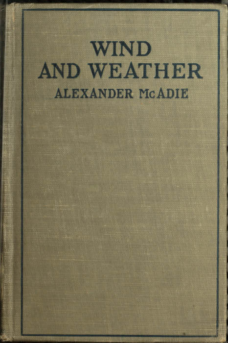
How the Wind Ruffles the Top of a Fog Bank
Frontispiece
A. Lawrence Rotch Professor of Meteorology, Harvard
University and Director of the Blue Hill
Observatory
New York
THE MACMILLAN COMPANY
1922
All rights reserved
Copyright, 1922,
By ALEXANDER McADIE.
Set up and electrotyped. Published November, 1922.
| HOW THE WIND RUFFLES THE TOP OF A FOG BANK |
Frontispiece | |
| PAGE | ||
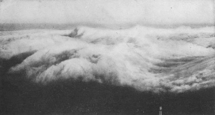
| FIG. 1. | THE TOWER OF THE WINDS | 13 |
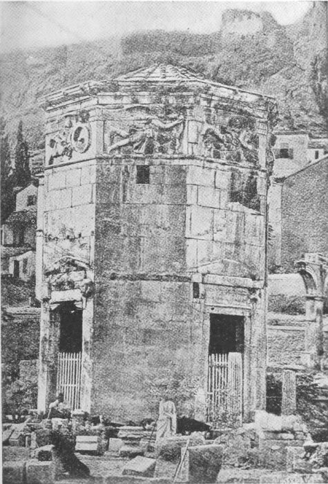
| 2. | BOREAS—THE NORTH WIND | 19 |
| 3. | KAIKIAS—THE NORTHEAST WIND | 23 |
| 4. | APHELIOTES—THE EAST WIND | 29 |
| 5. | EUROS—THE SOUTHEAST WIND | 33 |
| 6. | NOTOS—THE SOUTH WIND | 37 |
| 7. | LIPS—THE SOUTHWEST WIND | 41 |
| 8. | ALL STORMS LEAD TO NEW ENGLAND | 45 |
| 9. | ZEPHYROS—THE WEST WIND | 49 |
| 10. | PATHS OF HIGH AND LOW, JANUARY, 1922 | 55 |
| 11. | SKIRON—THE NORTHWEST WIND | 59 |
| 12. | THE IDEALIZED STORM | 63 |
| 13. | TURNING OF WIND WITH ALTITUDE | 67 |
| 14. | VELOCITY OF SUMMER AND WINTER WINDS | 73 |
| 15. | BLUE HILL OBSERVATORY IN AN ICE STORM | 79 |
WIND AND WEATHER
WIND AND WEATHER
In Athens on the north side and near the base of the hill on which the upper city—the Acropolis—is built, there is a small temple still standing, altho its walls were completed twenty-two centuries ago. It is known as the Tower of the Winds; but as a matter of fact, the citizens of Athens used it to tell the hour of the day and the seasonal position of the sun. It was a public timepiece. It served as a huge sun dial. Water from a spring on the hillside filled the basins of a water clock in the basement of the Tower. And so, whether the day was clear or cloudy the measure of the outflow of water indicated the time elapsed. Also there were markings or dials on each of the eight[Pg 12] walls of the temple, and the position of the shadow of a marker indicated the seasonal advance or retreat of the sun as it moved north from the time of the winter solstice and then south after the summer solstice.
The sun is not an accurate time keeper and no one to-day runs his business or keeps engagements on sun time. But the old Athenians were quite content to do so; and their Tower served excellently for their needs. And they did what we moderns fail to do, namely, give distinctive names to the winds. They represented figuratively the characteristics of the weather as the wind blew from each of the eight cardinal directions.
Fig. 1. The Tower of the Winds
Erected in Athens, on the north side of the Acropolis,
B. C. 150
The allegorical figures of the winds used in this little book are reproductions of the eight bas-reliefs in the library of the Blue Hill Observatory, placed there by the late Professor A.[Pg 15] Lawrence Rotch. They are copied from the frieze of the Tower of the Winds at Athens.
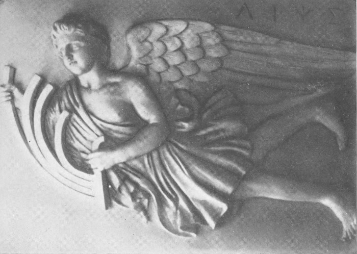
Boreas, the north wind, is perhaps the most important of all winds. At Athens this a cold, boisterous wind from the mountains of Thrace. The noise of the gusts is so loud that the Greek sculptor symbolized the tumult by placing a conch shell in the mouth of Boreas. His modern namesake, the Bora of the Adriatic, is the same noisy, blustering, cold wind-rush from the north.
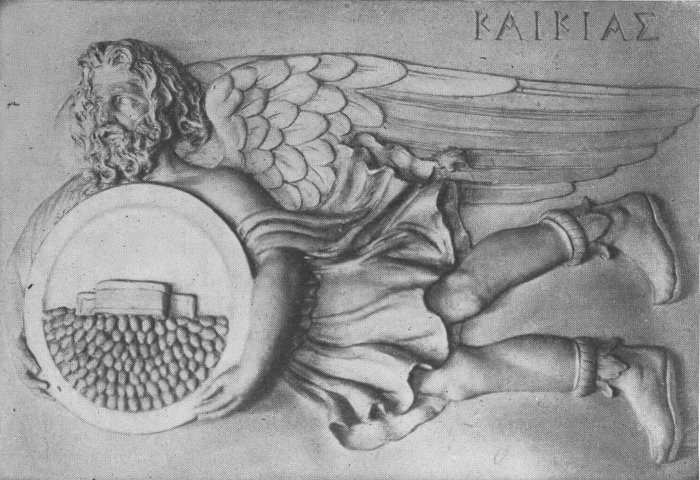
The northeast wind Kaikias is a trifle more pleasant looking than Boreas, but still not much to brag about. Master of the squall and thunderstorm, he carries in his shield an ample supply of hailstones, ready to spill them on defenseless humanity. He might well serve as[Pg 16] the patron saint of air raiders dropping their bombs on helpless humans below.
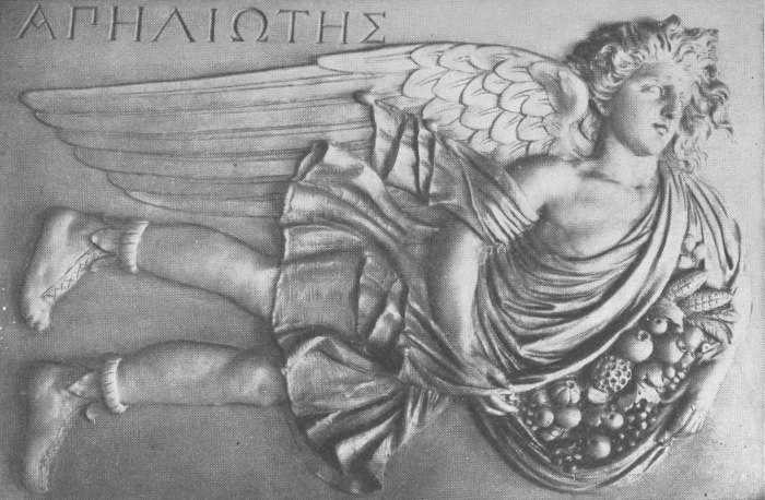
Apheliotes, the east wind, is a graceful youth, with arms full of flowers, fruit and wheat. Naturally this was a favorite wind, blowing in from the sea, with frequent light showers. Some of us who dwell on the Atlantic Coast, in more northern latitudes than Athens, do not always regard with favor the east wind, associating it with chilly, damp and sombre weather. Yet it is the harbinger of good—tempering the cold of winter and the heat of summer. It is an angel of mercy in mid-summer when the temperature is above the nineties and there is no air stirring. Then it is, that we all welcome the refreshing wind from the sea.
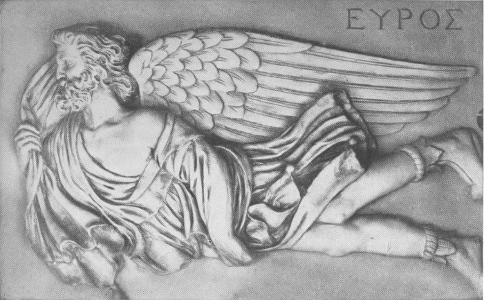
Euros, the southeast wind, and neighbor to Apheliotes, is a cross old fellow, intent on the business of cloud making. He alone of all the winds carries nothing[Pg 17] in his hands. In the New Testament he becomes Euroclydon, wind of the waves. He is no friend of the sailor; and the seasick traveler prays to be rid of his company.
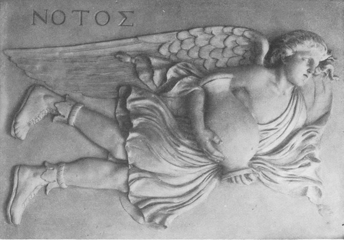
The figure on the south face of the tower, Notos, is the master of the warm rain. He carries with him a water jar which has just been emptied. Compare his light flowing robes and half-clad neck and arms with the close fitting jacket of old Boreas. At his shrine, hydraulic engineers well might worship.
Next, the Mariner's wind, Lips, the southwest favoring breeze bringing the ships speedily into harbor; yes, into that Piraeus, famed in classic history. Incidentally it is the southwest wind which differentiates the climate of Great Britain from that of Labrador. This wind makes Northwest Europe habitable; while on the other side of the Atlantic,[Pg 18] in similar latitudes, but under the influence of prevailing northwest winds, we find Labrador—a section certainly misnamed, for it is not the abode of farmers, as the name implies—but barren and bleak. What a difference it would make thruout this region if the Gulf Stream continued north, close to the shore, and the prevailing winds were from the east. Our North Atlantic Coast would then be the land of zephyrs, using the word in the sense of pleasant, gentle winds.
Fig. 2. Boreas—The North Wind
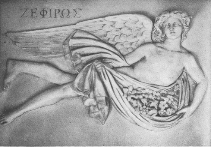
Zephyros, the west wind, is represented as a graceful youth, scantily clad, with his arms filled with flowers. In Greece this wind traversed the Ionian Sea and the Gulf of Corinth before reaching Athens. It is quite unlike our west wind which blows across a continent, and is continuously robbed of its water vapor on the long passage. The Ionian wind is pleasantly moist and refreshing.
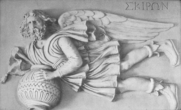
Last of all, but by no means least important, is Skiron, lord of gusty northwest gales. Freezing in winter, parching in summer, he carries with him a brazen fire basket and spills a generous stream of hot air on all below. His husky Highness might not inappropriately adorn legislative halls and editorial sanctums. He would displace the blindfolded lady holding scales very much out of balance. Think of the deep significance of his presence.
In our country the northwest is of all winds, except the west, most persistent. For 1600 hours in a year, this wind is with us. Joining forces with the west wind, these directions prevail one third of the time. These northwest-west winds also have the greatest speed and gustiness. The climate of the United States is essentially determined by the prevalence of the north, northwest and west winds.
In old days, the haruspices (for this is what the Romans called weather men in the days of Caesar) proclaimed the will of the gods by consulting the entrails of some freshly killed animal. Evidently these haruspices did not always make correct forecasts; for there were some Romans who openly questioned their worth. Cato, the Censor, is on record as saying "that he wondered how one haruspex could look another in the face without laughing!"
Fig. 3. Kaikias—The Northeast Wind
The modern professional forecaster would scorn to consult the entrails. There are however many amateur forecasters who foretell weather by their aches and rheumatic pains. Probably there is a high correlation factor between body sensations and dampness; and some individuals are quite sensitive to changes in both relative and absolute humidity.[Pg 25] This, however, does not always mean that a storm is approaching. Humidity or dampness is only one factor and may be quite local, whereas most storms are wide-spread.
The official forecaster consults a daily weather map and certain auxiliary maps which show changes in pressure and temperature for twelve hours or more. He examines closely the contours of pressure as shown on the map. The synoptic map, as it is called, because it is a glance at weather conditions over a large area at one and the same moment, is a map on which are plotted pressure, temperature, wind direction, velocity and rainfall. The lines of equal pressure or isobars generally curve and inclose what is known as a cyclonic centre, or depression or LOW. The arrows point[Pg 26] in, but not exactly toward the centre of the depression.
On the map there will probably appear also an area of high pressure where the surface air flows leisurely outward and away from the place of highest pressure. Such an area is called an anticyclone, a word first used by Sir Francis Galton in 1863 to designate not only high pressure, but general flow of the air in a reversed or opposite direction to that of the low area or cyclone. The word cyclone was first used by Piddington in 1843 in describing the flow of the air in the typhoons of the East Indian Seas. It is from the Greek and literally means the coils of a serpent. The word cyclone must possess some special merit in the minds of journalists for it is quite commonly misused for tornado in descriptions of the smaller and more destructive storm.
Cyclone is simply the generic name for a large rotating air mass. It is a barometric depression or LOW and is characterized by a flow of air inward and around a moving centre. The air circulation is counter-clockwise in the northern hemisphere and clockwise in the south.
Perhaps if the earth stopped rotating and there was no planetary circulation, with the great west-moving trades and east-moving "westerlies," the arrows on the weather map would all point directly toward the centre of the LOW; but, as things are, there are some very good reasons why air can not move directly into a LOW, that is at right angles to the isobars.
Moreover, the weather map does not indicate the true flow of the air, for observations of the wind made at the[Pg 28] ground tell only a part of the story of the balance which the flowing air must maintain under the action of various forces, such as gravitation, rotational deflection, centrifugal tendency, and the various expansion and compression forces.
The winds near the ground are modified both in velocity and direction by friction. The free flow is often interfered with by topography.
One must rise above the ground some distance to get the true air flow, or what is known as the gradient wind, the flow which balances the gradient, i.e. a flow along the isobars. The gradient velocity is found about 300 metres above the ground, and the gradient direction a little higher. The lower clouds as a rule[Pg 31] indicate true wind values very well; and so, it is desirable in studying winds to use cloud directions and velocities rather than surface values. In cloud work a nephoscope is essential. The unaided eye, unless properly shielded, suffers from the glare of a sunlit sky; and moreover, there are no fixed points or references. A black mirror, with suitable sighting rods and measuring devices, enables an observer to follow the cloud, estimate its height and determine with accuracy the direction from which it is moving. There is an average difference of 30 degrees between the cloud direction and the surface wind; the upper direction being more to the right. At times the directions may be opposite.
Fig. 4. Apheliotes—The East Wind
It may seem surprising but few of us, except at sunrise and sunset, really see what is going on in cloud land.
Some meteorologists hold that the[Pg 32] circulation of air 3000 to 5000 metres above the ground controls the path and perhaps the intensity of storms. It is therefore important to know something of the flow at high levels if we would improve the forecasts.
The weather map fails to indicate what shifts of direction and changes in velocity are likely to occur. The forecaster tries to anticipate these, but he bases his conclusions chiefly upon an expected movement of the low area; using the accumulated records of the paths of past storms. But each storm is in reality a law unto itself; and while we know something of the relations between pressure and flow of the air; as yet we know very little about the relations of wind and weather. The problem is [Pg 35]complicated by the behavior of the load of water vapor.
Fig. 5. Euros—The Southeast Wind
The Chief Forecaster of one of the great national weather services recently wrote:
"Despite the fact that maps have now been drawn day by day for over half a century, we may safely say that no two maps have been identical."
It is perhaps unfortunate that so much attention has been given to the cyclone or depression or LOW, and comparatively little to the HIGH or anticyclone. For we are now beginning to understand that while there may seem at first to be nothing specially noteworthy about a mass of air where the pressure varies from 1020 to 1040 kilobars, that is, 2 to 4 per cent above a standard atmosphere, with isobars irregularly curved and feeble surface winds, yet the anticyclone is more important than the cyclone in determining[Pg 36] weather sequence; for the progressive motion of the cyclone depends largely upon the strength of the anticyclone.
Sir Napier Shaw, who has written much on the weather of the British Isles, may be quoted here.
"Anyone who is interested in the weather is always on the lookout for 'lows' and is very keen to know whether he is going to be on the south of the centre or the north of it. He is, of course, interested in the anticyclone too, because as long as an anticyclone is there, there cannot be a depression; but it is the depression which has the life and movement about it, giving it a claim to the attention of everybody who wants to know what the weather and its changes are going to be.
"This has been recognized from the very earliest days of weather maps with isobars. The depressions which pass over our shores (Great Britain) mostly come from the west. Some of them come all the way from America; one or two have been traced from the west coast of Africa and so have crossed the Atlantic twice, first to the westward and then to the eastward. Some have come all the way from a sort of parent 'low' in the North Pacific Ocean. So general is the tendency for 'lows' to go eastward that it was thought at one time, particularly by the 'New York Herald,' that their departure from the American Coast and subsequent arrival on our own shores could be notified by cable, and we (the British) might thus be forewarned of their approach, some three or four days in advance. The attempt was made by the 'New York[Pg 40] Herald' acting in co-operation with the Meteorological Offices of the United Kingdom and France. But a depression keeps to no beaten track; it has as many paths for its centre as there are lines in a bundle of hay. Though groups can be picked out there are many strays, and, moreover, the depression changes its shape and intensity while it travels, so that if you lose sight of it for a day you cannot be at all sure of its identity."
Fig. 6. Notos—The South Wind
If there is so much uncertainty in forecasting the path of a disturbance at sea, how much more uncertain must it be on land? Elaborate statistics of the average daily movement of various types of storms have been officially published. The average speed of storms[Pg 43] (not wind speeds) across the United States is 11 metres per second or 25 miles an hour. Storms travel more rapidly in winter than in summer, about half again as fast; that is, summer storms travel 20 miles, and winter storms 30 miles, an hour.
Fig. 7. Lips—The Southwest Wind
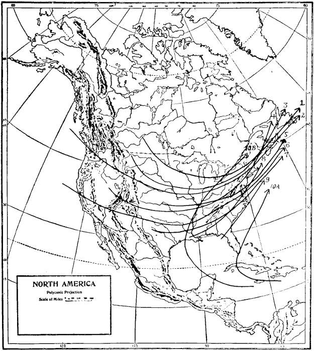
The paths vary widely; from the Gulf storms moving northeast and West Indian hurricanes recurving on the southern coast, to the storms from Alberta and the west which move south and east. Ten types of storms, classified according to the place of origin, are recognized by the official forecasters of the United States. These are North Pacific, Alberta, Northern Rocky Mountain, Colorado, Central, South Pacific, Texas, East Gulf, South Atlantic and West Indian Hurricanes. A better nomenclature would be (1) Alberta, (2) Washington, (3) Kootenay, (4) Utah, (5) Kansas, (6) California, (7) Texas,[Pg 44] (8) Louisiana, (9) Florida, and (10) Hurricanes.
Type 10 is the general class of tropical storms occurring chiefly in the summer and fall which, drifting west, slowly work northward. Similar storms are the typhoons and baguios of the East Indian and China Seas.
The path and point of recurvature will be determined by the position of the Bermuda Hyperbar, that is, the seasonal anticyclone of the Atlantic. This accounts for the swinging east and north of these tracks as the season progresses; for the hyperbar is slowly displaced east, the maximum displacement occurring in September.
BASE MAP BY GOODE
Fig. 8. All Storms Lead to New England
Individual anticyclones also influence individual hurricanes. Thus a hurricane passing west over Havana, will go[Pg 47] farther west if a vigorous "high" is spreading southeast over the Gulf States. And when this "high" passes seaward, the hurricane will work around the southwest quadrant of the "high," recurving and moving northeast.
Altho storms originate or are first detected in nine different sections, it is a fact worth mentioning that they all leave the United States in the vicinity of New England or Nova Scotia. Some of the southern depressions starting near the coast, pass to sea south of New York, but in general an observer standing on Plymouth Rock can virtually encompass within a radius of 500 kilometres, 300 miles, the paths of ninety per cent of the storms that traverse the country.
Thus a storm that originates in Texas (7) will probably pass close to Cape Cod.[Pg 48] Likewise, types (3) and (5); while the other types may pass a little to the north or south. See Chart, Paths of Storms.
Forecasting then would seem to be very easy; for one would only have to know the place of origin of the storm and the rate of travel, to foretell exactly the time of arrival. Unfortunately these are only the average paths; and as with most mean values, represent a value not often experienced in fact. These paths then are not paths which any given storm will follow. One must recall the story of the operating surgeon who gave the average age of his patients in the operating room as 35. There were but two patients, one 69 years old and the other 1 year old.
Fig. 9. Zephyros—The West Wind
As a matter of fact the path of any individual depression depends upon [Pg 51]several factors, some of which are:—the prevailing eastward drift of the air; the extent and motion of some anticyclone advancing before the "LOW"; the duration and speed of relatively dry cold tongues of air from the north; and the supply of water vapor brought from southern waters by south winds. A depression can make little headway if to the north or east the normal path is blocked by what is known as a stagnant "HIGH." So therefore, if the anticyclone is a slow mover, a Texas storm, which would normally pass not far from southern New England, may be deflected farther north than when the HIGH moved rapidly east. So too, with the storms which originate in the western part of the country. A slow moving HIGH will prevent the LOW following it, from moving east at a normal rate along the usual path.
Anticyclones then, are the real weather[Pg 52] controls. There are various types, but all drift from the north or west. Occasionally they enter the country from the Pacific, but the great majority come from Alberta and move leisurely southeast, often reaching the South Atlantic States; but more frequently recurving and passing to the north.
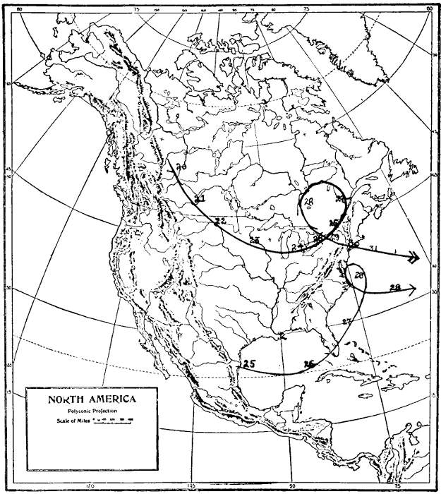
HIGHS are sometimes reinforced and this results in what is called a stagnant HIGH. A good illustration of such a slow moving HIGH and its consequences occurred during the last week of January, 1922.
A surge of cold air from Alberta or farther north reached the international boundary January 21st and spread slowly eastward, reaching the Great Lakes on the 24th and the St. Lawrence Valley two days later. Then seemingly[Pg 53] it halted or moved slowly westward, retrograding. In three days, that is, on the 29th, the centre of the HIGH was apparently 500 miles west of where it had been on the 27th. After the 29th it followed a normal track, moving slowly southeast, reaching the Atlantic near Long Island.
Meanwhile a depression on the south coast of Texas on the 25th, moved across the Gulf of Mexico, passing over Southern Florida on the 27th and advanced steadily northeast, reaching Cape Hatteras in 24 hours. Owing to the presence of the anticyclone referred to above, the depression recurved off Hatteras. The result was a memorable snow storm in Northern Virginia and Maryland. At 8 p.m. January 27th, there had been a fall of 5 cms. (2 inches). Within the following twenty hours the average depth in the city of Washington was 66 cms. (26 inches).[Pg 54] The weight of the snow caused the collapse of the roof of the Knickerbocker Theatre and the death of 97 persons.
The total snowfall in various coast cities was:
| Raleigh | 24 cms.* |
| Richmond | 48 |
| Washington | 71 |
| Baltimore | 67 |
| Wilmington | 46 |
| Philadelphia | 31 |
| Trenton | 27 |
| New York | 18 |
| New Haven | 8 |
| Boston | 1 |
*Note: To convert to inches multiply by 0.4.
The table shows clearly how the snow was formed. On the east side of the LOW a stream of air, relatively warm, carried a load of water vapor, approximately 13 grams in each cubic metre.
BASE MAP BY GOODE
Fig. 10. Paths of High and Low, Great Snow Storm of January 27-28, 1922]
This current was steered around the north side of the LOW and met the north-northeast wind. Under the new conditions the air saturated could hold only 2 or 3 grams; and so condensation and heavy precipitation resulted. The region of maximum snowfall was near Washington, and it will be seen that there is a proportional decrease north and south. The snowfall at Washington was the heaviest ever known at that city.
Unlike most storms, there was no strong cold northwest wind blowing into the depression. The temperature rose slowly. It was less a contrast of winds than a steady slow outward push of the anticyclone, and the consequent turning of the path of the cyclone eastward.
Buys Ballot's Law.
"If you stand with your back to the wind the pressure decreases toward your left, and increases toward your right."
For navigators, this law is more generally expressed in the words of the Hydrographic Office on "Cyclonic Storms."
"Since the wind circulates counter-clockwise in the northern hemisphere, the rule in that hemisphere is to face the wind, and the storm centre will be at the right hand. If the wind traveled in exact circles, the centre would be eight points (90 degrees) to the right when looking directly in the wind's eye. But the wind follows a more or less spiral path inward which brings the centre from eight to twelve points (90 to 135 degrees), to the right of the wind. The centre will bear more nearly eight points from the direction of the lower clouds than from the surface wind."
Fig. 11. Skiron—The Northwest Wind
The law given on the preceding page is named after C. H. D. Buys Ballott, a Dutch meteorologist. It was announced in a paper published in the Comptes rendus in 1857. Two American writers on the Winds, J. H. Coffin and William Ferrell, had however earlier found the law to hold.
* * * * * *
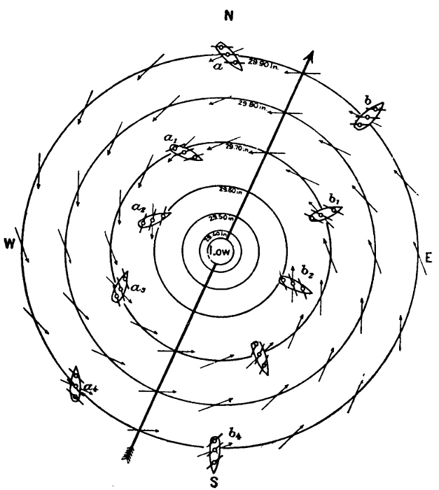
While most of us study storms from a window at home and are not called upon to handle a ship in a storm, yet it may not be out of place to include here the diagram of the winds in an ideal storm and give the rules for maneuvering. See Figure 12. The Winds in an Idealized Storm. The rules apply only to storms in the northern hemisphere.
"Right or dangerous semicircle,—Steamers: Bring the wind on the starboard bow, make as much way as possible, and if obliged to heave-to, do so head to sea.[Pg 62] Sailing vessels: Keep close-hauled on the starboard tack, make as much way as possible, and if obliged to heave-to, do so on the starboard tack.
Left or navigable semicircle,—Steam and sailing vessels: Bring the wind on the starboard quarter, note the course and hold it. If obliged to heave-to, steamers may do so stern to sea; sailing vessels on the port tack.
On the storm track in front of center,—Steam and sailing vessels: Bring the wind two points on the starboard quarter, note the course and hold it, and run for the left semicircle, and when in that semicircle manoeuvre as above.
On the storm track, in rear of center,—Avoid the center by the best practicable route, having due regard to the tendency of cyclones to recurve to the southward and eastward."
FROM HYDROGRAPHIC OFFICE
Fig. 12. The Winds in an Idealized Storm
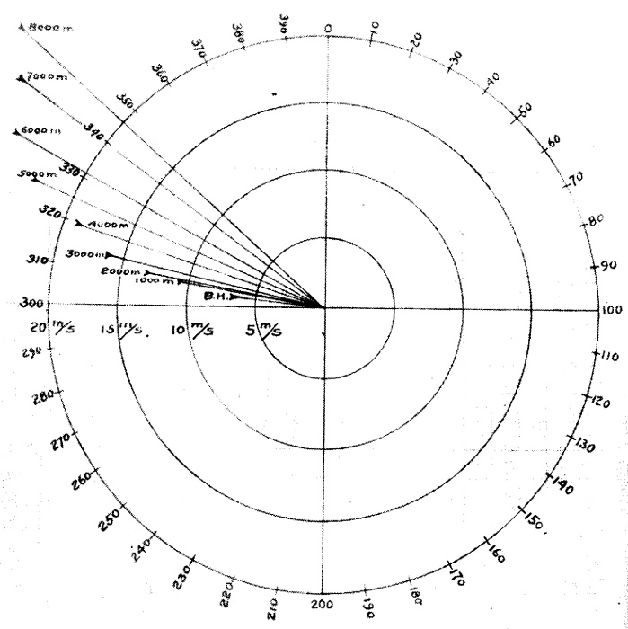
The law of the turning of the wind with altitude.
A casual observation of the lower clouds where no means of measuring small angles is available will not usually show any difference between the motion of the clouds and the surface wind; but with the upper clouds the case is different, and one readily detects a difference.
Several thousand observations with various agencies, such as kites and pilot balloons and more especially measurements made with theodolites and nephoscopes, show that there is a definite twist to the right with elevation. The amount of the deflection is shown in Figure 13. Turning of the Wind with Altitude. Here the average yearly values are given for directions and velocities. Thus if the mean wind direction at Blue Hill is from a point a little to the north of west, 306 grads or 275 degrees, and the mean velocity 7 metres per[Pg 66] second; the clouds at 1000 metres elevation will move from 312 or 280 degrees and at a speed of approximately 11 metres per second (24 miles an hour).
These however, are average values. In individual cases the difference between surface winds and stratus clouds may be considerably greater. It may be as much as 180 degrees; that is, the cloud may move directly opposite to the wind. In general there will be a difference of 10 to 20 degrees.
The law of wind direction, approximate cooling and rain.
When the lower clouds are moving from the north or northwest, without sharply defined edges, the LOW is east or northeast of the observer; and rain or snow is not likely unless there is a rapidly falling temperature.
Fig. 13. Turning of Wind with Altitude
When a stream of warm air with a high absolute humidity flows north on the east side of a LOW, and a cold northwest wind follows quickly after the LOW, rain or snow may be expected.
Any rapid chilling of warm, moist air produces cloudiness and rain or snow; but a cold stream blowing into a warm area will not produce as much rain as a warm stream blowing into a cold area.
The average duration of wind from various directions is as follows:
From the north about 16 hours each week; from the northeast, the same; from the east, 11 hours; from the southeast, 10 hours; from the south, 24 hours; from the southwest, 27 hours; from the west, 33 hours; and from the northwest 31 hours.
During an individual disturbance lasting about 36 hours, we may have 8 hours of southwest wind; 4 hours of west wind, backing during the next 4 hours to south; 2 hours of south wind; 2 hours of southeast wind; 2 hours of east wind; 8 hours northeast wind and 4 hours north wind, 2 hours northwest, when it may be considered that a new pressure distribution prevails.
The above values hold only for a storm moving with normal velocity. LOWS are often blocked by slow moving HIGHS in advance. In such cases the duration of east winds is greater.
The following table shows the marked increase in the prevalence of northwest and west winds during winter months, the decrease in north winds during July, the increase in northeast winds in May, also in east winds; the increase of south and southwest winds in July; and the falling off of southeast winds in December. See Table, page 72.
In cities near the Atlantic Coast, a continuance of northeast wind, especially in the fall and winter months, results in frequent altho not necessarily heavy rains. On the other hand a period of continued northwest and west wind is a dry period.
In summer, southeast and east winds bring fog and cooler weather; while southwest winds are favorable for the development of thunderstorms.
WINDS OF A YEAR
TABLE I.—Number of Hours the Wind Blows from Different Directions.
| Jan. | Feb. | Mar. | Apr. | May | June | July | Aug. | Sept. | Oct. | Nov. | Dec. | Year | ||
| Boreas | (N) | 98 | 74 | 71 | 70 | 60 | 40 | 59 | 59 | 67 | 80 | 82 | 96 | 850 |
| Kaikias | (NE) | 41 | 46 | 65 | 94 | 101 | 55 | 79 | 79 | 77 | 91 | 48 | 30 | 819 |
| Apheliotes | (E) | 34 | 37 | 52 | 58 | 63 | 48 | 51 | 51 | 52 | 58 | 34 | 31 | 576 |
| Euros | (SE) | 37 | 37 | 45 | 41 | 54 | 45 | 62 | 62 | 52 | 45 | 39 | 34 | 534 |
| Notus | (S) | 82 | 66 | 95 | 99 | 143 | 155 | 128 | 128 | 118 | 93 | 81 | 65 | 1245 |
| Lips | (SW) | 112 | 77 | 81 | 79 | 118 | 170 | 135 | 135 | 133 | 108 | 119 | 131 | 1402 |
| Zephyros | (W) | 180 | 177 | 155 | 125 | 107 | 137 | 125 | 125 | 108 | 131 | 169 | 194 | 1732 |
| Skiron | (NW) | 160 | 162 | 183 | 154 | 98 | 94 | 105 | 105 | 113 | 138 | 148 | 163 | 1607 |
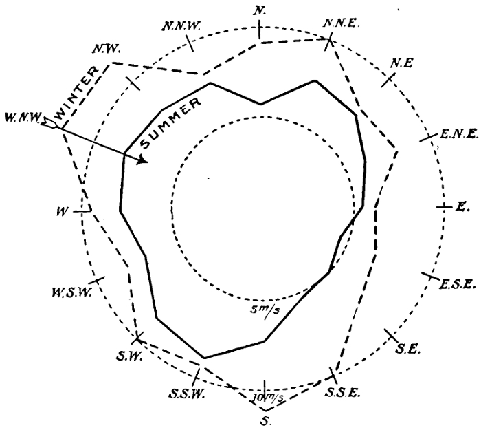
Fig. 14. Velocity of Summer and Winter Winds in Metres per Second
When the weather has been clear and moderately warm for two or more days, and the winds are light and variable, there may occur on the third day a moderate wind from the east, known as the sea-breeze. This occurs during anticyclonic conditions. Preceding the sea-breeze, the winds are very light, there are no clouds, and the temperature rises rapidly during the forenoon. This heating is due to a slow dynamic compression as the air slowly descends and the surface air does not flow away. There is no cooling because there is no evaporation due to air movement. The absolute humidity is low, often less than ten grams per cubic metre. Cumulus clouds do not form because there is no uplift of the lower air and consequently no chance for condensation of whatever water vapor may be present. No thunder-heads form notwithstanding the[Pg 76] heat. The heat, while dry, is nevertheless extremely trying to men and animals. Relief comes in the early hours of the afternoon by the arrival of the sea-breeze.
The usual explanation of the origin of the sea-breeze is that the land being excessively warm, the air over a relatively cool ocean moves in to take the place of the warm and therefore lighter air, which it is assumed has risen. Unfortunately for this explanation, the air over the land has not risen; but on the contrary is falling slowly. Again the sea-breeze does not begin at the place where the temperature contrast is greatest, namely, just inside the shore line; but comes in from the sea. Nor does the flow extend far inland, which would be the case if there were up-rising currents. The sea-breeze is very shallow, generally not extending upward more than 200 metres, and often not above 100 metres. It[Pg 77] does not penetrate far inland, as a rule not more than 15 kilometres, 9 miles.
The sea-breeze is probably caused by a slow descent of dry, warm air, on an incline sloping from northeast to southwest. As it reaches the surface it is twisted more to the right; that is, becomes an east wind. It carries inland with it some of the air over the ocean which is much cooler and heavily saturated.
There are certain days, more noticeable in summer than at other times, when the air is heavily laden with water vapor; and there is little or no cooling of the body due to evaporation. We perspire freely but as the sweat does not evaporate, there is a constantly increasing amount of water on the skin.
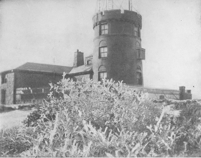
Fig. 15. Blue Hill Observatory During Ice Storm, November 29-30, 1922
It is not altogether a question of temperature, for another day may have as high or even higher temperature. It is essentially a matter of ventilation. On muggy days we are somewhat in the condition of the unfortunate prisoners in the Black Hole at Calcutta. They did not die by poisoning, as has generally been accepted, that is, lack of sufficient oxygen and an excess of carbon dioxide; but because they were unable to keep the skin sufficiently cool. There was no ventilation; no movement of the air and the body became over-heated and exhaustion followed. No matter how[Pg 81] much water there may be on the skin if the surrounding space is saturated, one feels oppressed. A vigorous fanning of the air helps evaporation and cools us. That is why a brisk northwest wind routs a muggy condition.
John Hay wrote of such days spent in Spain. We who live in a land where the winds are more boisterous, occasionally experience what we call a perfect day. Such days have easterly winds of two metres per second or less than five miles an hour. The temperature is midway between freezing and normal body temperature or about 70° F. The relative humidity is approximately 75% and the absolute humidity 12 grams per cubic metre. The table on page 72 explains the paucity of perfect days. The gusty, boisterous winds, Skiron and Zephyros, blow too frequently.
Perhaps certain of our national characteristics may be traceable to this flow of the air and our climatic environment.
End of the Project Gutenberg EBook of Wind and Weather, by Alexander McAdie

*** END OF THIS PROJECT GUTENBERG EBOOK WIND AND WEATHER ***

***** This file should be named 38072-h.htm or 38072-h.zip *****
This and all associated files of various formats will be found in:
        http://www.gutenberg.org/3/8/0/7/38072/

Produced by Chris Curnow, Martin Pettit and the Online
Distributed Proofreading Team at http://www.pgdp.net (This
file was produced from images generously made available
by The Internet Archive)


Updated editions will replace the previous one--the old editions
will be renamed.

Creating the works from public domain print editions means that no
one owns a United States copyright in these works, so the Foundation
(and you!) can copy and distribute it in the United States without
permission and without paying copyright royalties.  Special rules,
set forth in the General Terms of Use part of this license, apply to
copying and distributing Project Gutenberg-tm electronic works to
protect the PROJECT GUTENBERG-tm concept and trademark.  Project
Gutenberg is a registered trademark, and may not be used if you
charge for the eBooks, unless you receive specific permission.  If you
do not charge anything for copies of this eBook, complying with the
rules is very easy.  You may use this eBook for nearly any purpose
such as creation of derivative works, reports, performances and
research.  They may be modified and printed and given away--you may do
practically ANYTHING with public domain eBooks.  Redistribution is
subject to the trademark license, especially commercial
redistribution.


*** START: FULL LICENSE ***

THE FULL PROJECT GUTENBERG LICENSE
PLEASE READ THIS BEFORE YOU DISTRIBUTE OR USE THIS WORK

To protect the Project Gutenberg-tm mission of promoting the free
distribution of electronic works, by using or distributing this work
(or any other work associated in any way with the phrase "Project
Gutenberg"), you agree to comply with all the terms of the Full Project
Gutenberg-tm License (available with this file or online at
http://gutenberg.org/license).


Section 1.  General Terms of Use and Redistributing Project Gutenberg-tm
electronic works

1.A.  By reading or using any part of this Project Gutenberg-tm
electronic work, you indicate that you have read, understand, agree to
and accept all the terms of this license and intellectual property
(trademark/copyright) agreement.  If you do not agree to abide by all
the terms of this agreement, you must cease using and return or destroy
all copies of Project Gutenberg-tm electronic works in your possession.
If you paid a fee for obtaining a copy of or access to a Project
Gutenberg-tm electronic work and you do not agree to be bound by the
terms of this agreement, you may obtain a refund from the person or
entity to whom you paid the fee as set forth in paragraph 1.E.8.

1.B.  "Project Gutenberg" is a registered trademark.  It may only be
used on or associated in any way with an electronic work by people who
agree to be bound by the terms of this agreement.  There are a few
things that you can do with most Project Gutenberg-tm electronic works
even without complying with the full terms of this agreement.  See
paragraph 1.C below.  There are a lot of things you can do with Project
Gutenberg-tm electronic works if you follow the terms of this agreement
and help preserve free future access to Project Gutenberg-tm electronic
works.  See paragraph 1.E below.

1.C.  The Project Gutenberg Literary Archive Foundation ("the Foundation"
or PGLAF), owns a compilation copyright in the collection of Project
Gutenberg-tm electronic works.  Nearly all the individual works in the
collection are in the public domain in the United States.  If an
individual work is in the public domain in the United States and you are
located in the United States, we do not claim a right to prevent you from
copying, distributing, performing, displaying or creating derivative
works based on the work as long as all references to Project Gutenberg
are removed.  Of course, we hope that you will support the Project
Gutenberg-tm mission of promoting free access to electronic works by
freely sharing Project Gutenberg-tm works in compliance with the terms of
this agreement for keeping the Project Gutenberg-tm name associated with
the work.  You can easily comply with the terms of this agreement by
keeping this work in the same format with its attached full Project
Gutenberg-tm License when you share it without charge with others.

1.D.  The copyright laws of the place where you are located also govern
what you can do with this work.  Copyright laws in most countries are in
a constant state of change.  If you are outside the United States, check
the laws of your country in addition to the terms of this agreement
before downloading, copying, displaying, performing, distributing or
creating derivative works based on this work or any other Project
Gutenberg-tm work.  The Foundation makes no representations concerning
the copyright status of any work in any country outside the United
States.

1.E.  Unless you have removed all references to Project Gutenberg:

1.E.1.  The following sentence, with active links to, or other immediate
access to, the full Project Gutenberg-tm License must appear prominently
whenever any copy of a Project Gutenberg-tm work (any work on which the
phrase "Project Gutenberg" appears, or with which the phrase "Project
Gutenberg" is associated) is accessed, displayed, performed, viewed,
copied or distributed:

This eBook is for the use of anyone anywhere at no cost and with
almost no restrictions whatsoever.  You may copy it, give it away or
re-use it under the terms of the Project Gutenberg License included
with this eBook or online at www.gutenberg.org

1.E.2.  If an individual Project Gutenberg-tm electronic work is derived
from the public domain (does not contain a notice indicating that it is
posted with permission of the copyright holder), the work can be copied
and distributed to anyone in the United States without paying any fees
or charges.  If you are redistributing or providing access to a work
with the phrase "Project Gutenberg" associated with or appearing on the
work, you must comply either with the requirements of paragraphs 1.E.1
through 1.E.7 or obtain permission for the use of the work and the
Project Gutenberg-tm trademark as set forth in paragraphs 1.E.8 or
1.E.9.

1.E.3.  If an individual Project Gutenberg-tm electronic work is posted
with the permission of the copyright holder, your use and distribution
must comply with both paragraphs 1.E.1 through 1.E.7 and any additional
terms imposed by the copyright holder.  Additional terms will be linked
to the Project Gutenberg-tm License for all works posted with the
permission of the copyright holder found at the beginning of this work.

1.E.4.  Do not unlink or detach or remove the full Project Gutenberg-tm
License terms from this work, or any files containing a part of this
work or any other work associated with Project Gutenberg-tm.

1.E.5.  Do not copy, display, perform, distribute or redistribute this
electronic work, or any part of this electronic work, without
prominently displaying the sentence set forth in paragraph 1.E.1 with
active links or immediate access to the full terms of the Project
Gutenberg-tm License.

1.E.6.  You may convert to and distribute this work in any binary,
compressed, marked up, nonproprietary or proprietary form, including any
word processing or hypertext form.  However, if you provide access to or
distribute copies of a Project Gutenberg-tm work in a format other than
"Plain Vanilla ASCII" or other format used in the official version
posted on the official Project Gutenberg-tm web site (www.gutenberg.org),
you must, at no additional cost, fee or expense to the user, provide a
copy, a means of exporting a copy, or a means of obtaining a copy upon
request, of the work in its original "Plain Vanilla ASCII" or other
form.  Any alternate format must include the full Project Gutenberg-tm
License as specified in paragraph 1.E.1.

1.E.7.  Do not charge a fee for access to, viewing, displaying,
performing, copying or distributing any Project Gutenberg-tm works
unless you comply with paragraph 1.E.8 or 1.E.9.

1.E.8.  You may charge a reasonable fee for copies of or providing
access to or distributing Project Gutenberg-tm electronic works provided
that

- You pay a royalty fee of 20% of the gross profits you derive from
     the use of Project Gutenberg-tm works calculated using the method
     you already use to calculate your applicable taxes.  The fee is
     owed to the owner of the Project Gutenberg-tm trademark, but he
     has agreed to donate royalties under this paragraph to the
     Project Gutenberg Literary Archive Foundation.  Royalty payments
     must be paid within 60 days following each date on which you
     prepare (or are legally required to prepare) your periodic tax
     returns.  Royalty payments should be clearly marked as such and
     sent to the Project Gutenberg Literary Archive Foundation at the
     address specified in Section 4, "Information about donations to
     the Project Gutenberg Literary Archive Foundation."

- You provide a full refund of any money paid by a user who notifies
     you in writing (or by e-mail) within 30 days of receipt that s/he
     does not agree to the terms of the full Project Gutenberg-tm
     License.  You must require such a user to return or
     destroy all copies of the works possessed in a physical medium
     and discontinue all use of and all access to other copies of
     Project Gutenberg-tm works.

- You provide, in accordance with paragraph 1.F.3, a full refund of any
     money paid for a work or a replacement copy, if a defect in the
     electronic work is discovered and reported to you within 90 days
     of receipt of the work.

- You comply with all other terms of this agreement for free
     distribution of Project Gutenberg-tm works.

1.E.9.  If you wish to charge a fee or distribute a Project Gutenberg-tm
electronic work or group of works on different terms than are set
forth in this agreement, you must obtain permission in writing from
both the Project Gutenberg Literary Archive Foundation and Michael
Hart, the owner of the Project Gutenberg-tm trademark.  Contact the
Foundation as set forth in Section 3 below.

1.F.

1.F.1.  Project Gutenberg volunteers and employees expend considerable
effort to identify, do copyright research on, transcribe and proofread
public domain works in creating the Project Gutenberg-tm
collection.  Despite these efforts, Project Gutenberg-tm electronic
works, and the medium on which they may be stored, may contain
"Defects," such as, but not limited to, incomplete, inaccurate or
corrupt data, transcription errors, a copyright or other intellectual
property infringement, a defective or damaged disk or other medium, a
computer virus, or computer codes that damage or cannot be read by
your equipment.

1.F.2.  LIMITED WARRANTY, DISCLAIMER OF DAMAGES - Except for the "Right
of Replacement or Refund" described in paragraph 1.F.3, the Project
Gutenberg Literary Archive Foundation, the owner of the Project
Gutenberg-tm trademark, and any other party distributing a Project
Gutenberg-tm electronic work under this agreement, disclaim all
liability to you for damages, costs and expenses, including legal
fees.  YOU AGREE THAT YOU HAVE NO REMEDIES FOR NEGLIGENCE, STRICT
LIABILITY, BREACH OF WARRANTY OR BREACH OF CONTRACT EXCEPT THOSE
PROVIDED IN PARAGRAPH 1.F.3. YOU AGREE THAT THE FOUNDATION, THE
TRADEMARK OWNER, AND ANY DISTRIBUTOR UNDER THIS AGREEMENT WILL NOT BE
LIABLE TO YOU FOR ACTUAL, DIRECT, INDIRECT, CONSEQUENTIAL, PUNITIVE OR
INCIDENTAL DAMAGES EVEN IF YOU GIVE NOTICE OF THE POSSIBILITY OF SUCH
DAMAGE.

1.F.3.  LIMITED RIGHT OF REPLACEMENT OR REFUND - If you discover a
defect in this electronic work within 90 days of receiving it, you can
receive a refund of the money (if any) you paid for it by sending a
written explanation to the person you received the work from.  If you
received the work on a physical medium, you must return the medium with
your written explanation.  The person or entity that provided you with
the defective work may elect to provide a replacement copy in lieu of a
refund.  If you received the work electronically, the person or entity
providing it to you may choose to give you a second opportunity to
receive the work electronically in lieu of a refund.  If the second copy
is also defective, you may demand a refund in writing without further
opportunities to fix the problem.

1.F.4.  Except for the limited right of replacement or refund set forth
in paragraph 1.F.3, this work is provided to you 'AS-IS' WITH NO OTHER
WARRANTIES OF ANY KIND, EXPRESS OR IMPLIED, INCLUDING BUT NOT LIMITED TO
WARRANTIES OF MERCHANTIBILITY OR FITNESS FOR ANY PURPOSE.

1.F.5.  Some states do not allow disclaimers of certain implied
warranties or the exclusion or limitation of certain types of damages.
If any disclaimer or limitation set forth in this agreement violates the
law of the state applicable to this agreement, the agreement shall be
interpreted to make the maximum disclaimer or limitation permitted by
the applicable state law.  The invalidity or unenforceability of any
provision of this agreement shall not void the remaining provisions.

1.F.6.  INDEMNITY - You agree to indemnify and hold the Foundation, the
trademark owner, any agent or employee of the Foundation, anyone
providing copies of Project Gutenberg-tm electronic works in accordance
with this agreement, and any volunteers associated with the production,
promotion and distribution of Project Gutenberg-tm electronic works,
harmless from all liability, costs and expenses, including legal fees,
that arise directly or indirectly from any of the following which you do
or cause to occur: (a) distribution of this or any Project Gutenberg-tm
work, (b) alteration, modification, or additions or deletions to any
Project Gutenberg-tm work, and (c) any Defect you cause.


Section  2.  Information about the Mission of Project Gutenberg-tm

Project Gutenberg-tm is synonymous with the free distribution of
electronic works in formats readable by the widest variety of computers
including obsolete, old, middle-aged and new computers.  It exists
because of the efforts of hundreds of volunteers and donations from
people in all walks of life.

Volunteers and financial support to provide volunteers with the
assistance they need, are critical to reaching Project Gutenberg-tm's
goals and ensuring that the Project Gutenberg-tm collection will
remain freely available for generations to come.  In 2001, the Project
Gutenberg Literary Archive Foundation was created to provide a secure
and permanent future for Project Gutenberg-tm and future generations.
To learn more about the Project Gutenberg Literary Archive Foundation
and how your efforts and donations can help, see Sections 3 and 4
and the Foundation web page at http://www.pglaf.org.


Section 3.  Information about the Project Gutenberg Literary Archive
Foundation

The Project Gutenberg Literary Archive Foundation is a non profit
501(c)(3) educational corporation organized under the laws of the
state of Mississippi and granted tax exempt status by the Internal
Revenue Service.  The Foundation's EIN or federal tax identification
number is 64-6221541.  Its 501(c)(3) letter is posted at
http://pglaf.org/fundraising.  Contributions to the Project Gutenberg
Literary Archive Foundation are tax deductible to the full extent
permitted by U.S. federal laws and your state's laws.

The Foundation's principal office is located at 4557 Melan Dr. S.
Fairbanks, AK, 99712., but its volunteers and employees are scattered
throughout numerous locations.  Its business office is located at
809 North 1500 West, Salt Lake City, UT 84116, (801) 596-1887, email
business@pglaf.org.  Email contact links and up to date contact
information can be found at the Foundation's web site and official
page at http://pglaf.org

For additional contact information:
     Dr. Gregory B. Newby
     Chief Executive and Director
     gbnewby@pglaf.org


Section 4.  Information about Donations to the Project Gutenberg
Literary Archive Foundation

Project Gutenberg-tm depends upon and cannot survive without wide
spread public support and donations to carry out its mission of
increasing the number of public domain and licensed works that can be
freely distributed in machine readable form accessible by the widest
array of equipment including outdated equipment.  Many small donations
($1 to $5,000) are particularly important to maintaining tax exempt
status with the IRS.

The Foundation is committed to complying with the laws regulating
charities and charitable donations in all 50 states of the United
States.  Compliance requirements are not uniform and it takes a
considerable effort, much paperwork and many fees to meet and keep up
with these requirements.  We do not solicit donations in locations
where we have not received written confirmation of compliance.  To
SEND DONATIONS or determine the status of compliance for any
particular state visit http://pglaf.org

While we cannot and do not solicit contributions from states where we
have not met the solicitation requirements, we know of no prohibition
against accepting unsolicited donations from donors in such states who
approach us with offers to donate.

International donations are gratefully accepted, but we cannot make
any statements concerning tax treatment of donations received from
outside the United States.  U.S. laws alone swamp our small staff.

Please check the Project Gutenberg Web pages for current donation
methods and addresses.  Donations are accepted in a number of other
ways including checks, online payments and credit card donations.
To donate, please visit: http://pglaf.org/donate


Section 5.  General Information About Project Gutenberg-tm electronic
works.

Professor Michael S. Hart is the originator of the Project Gutenberg-tm
concept of a library of electronic works that could be freely shared
with anyone.  For thirty years, he produced and distributed Project
Gutenberg-tm eBooks with only a loose network of volunteer support.


Project Gutenberg-tm eBooks are often created from several printed
editions, all of which are confirmed as Public Domain in the U.S.
unless a copyright notice is included.  Thus, we do not necessarily
keep eBooks in compliance with any particular paper edition.


Most people start at our Web site which has the main PG search facility:

     http://www.gutenberg.org

This Web site includes information about Project Gutenberg-tm,
including how to make donations to the Project Gutenberg Literary
Archive Foundation, how to help produce our new eBooks, and how to
subscribe to our email newsletter to hear about new eBooks.