The Project Gutenberg EBook of Rocky Mountain [Colorado] National Park, by
United States Dept. of the Interior

This eBook is for the use of anyone anywhere at no cost and with
almost no restrictions whatsoever.  You may copy it, give it away or
re-use it under the terms of the Project Gutenberg License included
with this eBook or online at www.gutenberg.org


Title: Rocky Mountain [Colorado] National Park

Author: United States Dept. of the Interior

Release Date: November 4, 2011 [EBook #37918]

Language: English

Character set encoding: ISO-8859-1

*** START OF THIS PROJECT GUTENBERG EBOOK ROCKY MOUNTAIN NATIONAL PARK ***


Produced by Juliet Sutherland, Steven Brown and the Online
Distributed Proofreading Team at https://www.pgdp.net
Transcriber's Notes:
Some illustration's captions have been moved out of the paragraph.
Spelling has been made consistent throughout.
Tables on more than one page joined together.
Click on illustrations to enlarge
ACADIA, MAINE.—Combination of mountain and seacoast scenery.—Established 1919;—24.08 square miles.
BRYCE CANYON, UTAH.—Canyons filled with exquisitely colored pinnacles.—Established 1928;—55.06 square miles.
CARLSBAD CAVERNS, N. MEX.—Beautifully decorated limestone caverns believed largest in the world.—Established 1930;—15.56 square miles.
CRATER LAKE, OREG.—Astonishingly beautiful lake in crater of extinct volcano.—Established 1902;—250.52 square miles.
GENERAL GRANT, CALIF.—Celebrated General Grant Tree and grove of big trees.—Established 1890;—3.96 square miles.
GLACIER, MONT.—Unsurpassed alpine scenery; 200 lakes; 60 glaciers.—Established 1910;—1,533.88 square miles.
GRAND CANYON, ARIZ.—World's greatest example of erosion.—Established 1919;—1,009.08 square miles.
GRAND TETON, WYO.—Most spectacular portion of Teton Mountains.—Established 1929;—150 square miles.
GREAT SMOKY MOUNTAINS, N.C.-TENN.—Massive mountain uplift covered with magnificent forests.—Established for protection 1930;—617 square miles.
HAWAII: ISLANDS OF HAWAII AND MAUI.—Volcanic areas of great interest, including Kilauea, famous for frequent spectacular outbursts.—Established 1916;—245 square miles.
HOT SPRINGS, ARK.—Forty-seven hot springs reserved by the Federal Government in 1832 to prevent exploitation of waters.—Made national park in 1921;—1.58 square miles.
LASSEN VOLCANIC, CALIF.—Only recently active volcano in continental United States.—Established 1916;—163.32 square miles.
MAMMOTH CAVE, KY.—Interesting caverns, including spectacular onyx cave formation.—Established for protection 1936;—38.34 square miles.
MESA VERDE, COLO.—Most notable cliff dwellings in United States.—Established 1906;—80.21 square miles.
MOUNT McKINLEY, ALASKA.—Highest mountain in North America.—Established 1917;—3,030.46 square miles.
MOUNT RAINIER, WASH.—Largest accessible single-peak glacier system.—Established 1899;—377.78 square miles.
PLATT, OKLA.—Sulphur and other springs.—Established 1902;—1.33 square miles.
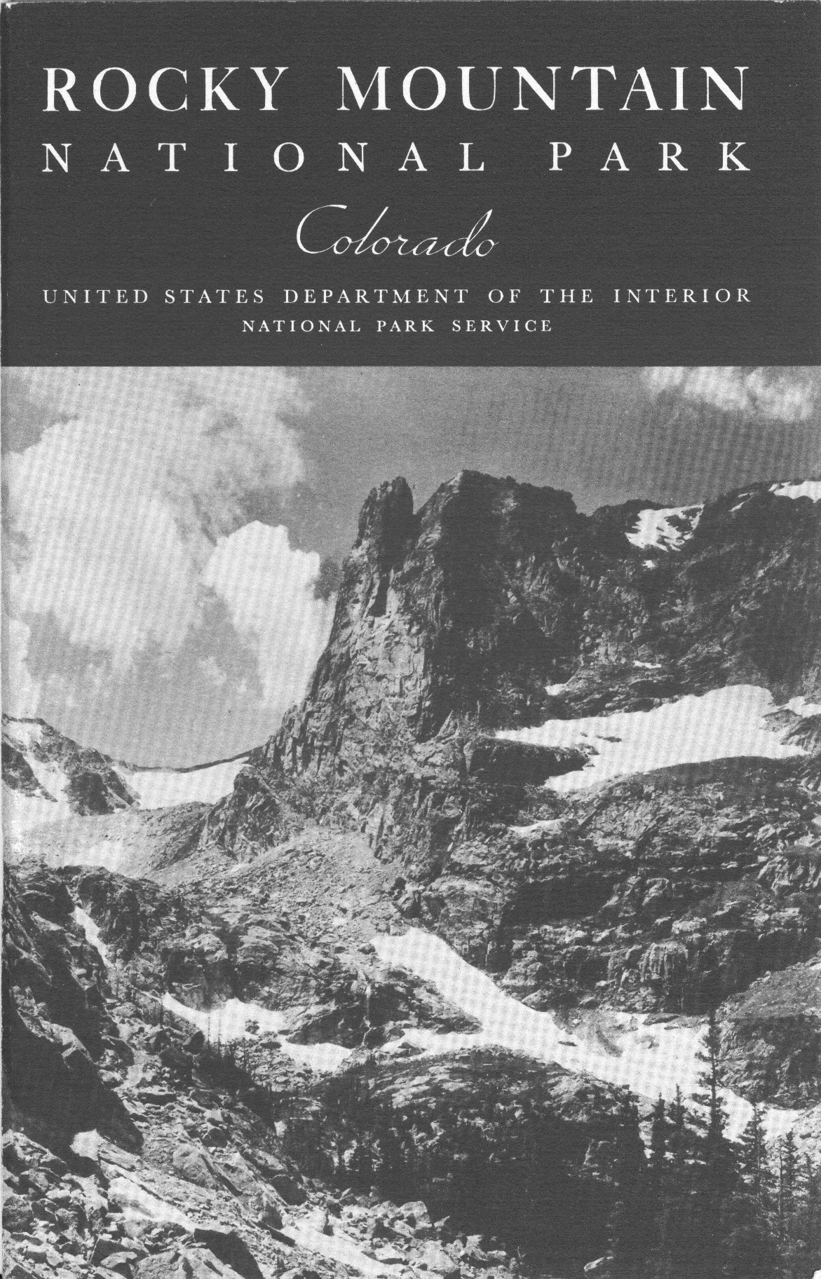
ROCKY MOUNTAIN, COLO.—Peaks from 11,000 to 14,255 feet in heart of Rockies.—Established 1915;—405.33 square miles.
SEQUOIA, CALIF.—General Sherman, largest and possibly oldest tree in the world; outstanding groves of Sequoia gigantea.—Established 1890;—604 square miles.
SHENANDOAH, VA.—Outstanding scenic area in Virginia section of Blue Ridge.—Established 1935;—275.81 square miles.
WIND CAVE, S. DAK.—Beautiful cavern of peculiar formations. No stalactites or stalagmites.—Established 1903;—18.47 square miles.
YELLOWSTONE: WYO.-MONT.-IDAHO.—World's greatest geyser area, and an outstanding game preserve.—Established 1872; 3,471.51—square miles.
YOSEMITE, CALIF.—Valley of world-famous beauty; spectacular waterfalls; magnificent high Sierra country.—Established 1890;—1,176.16 square miles.
ZION, UTAH—Beautiful Zion Canyon 1,500 to 2,500 feet deep. Spectacular coloring.—Established 1919;—148.26 square miles.
The Park Regulations are designed for the protection of your property. You, as prudent owners, will help protect the natural beauties and scenery by warning the careless and reporting infractions of the regulations. The following synopsis is for the general guidance of visitors. Full regulations may be seen at the office of the superintendent and ranger stations.
Fires.—Fires may be lighted only when necessary and in designated places. Before leaving, know your fire is out. Help protect this wonderland so all may enjoy it.
Camps.—Automobile campers must stop in the designated camp grounds. All must be kept clean and sanitary. Burn your garbage in your camp fire. Empty cans and residue must be placed in garbage cans. If no can is provided, bury the refuse.
Public property, trees, flowers, and animals.—The destruction, injury, or disturbance of public property, trees, flowers, rocks, birds, or animals, or other life is prohibited.
Fishing.—Fishing is permitted in all lakes and streams except as closed by order of the superintendent. All fish hooked less than 7 inches long shall be carefully handled with moist hands and returned at once to the water. Fifteen fish (not exceeding a total of 10 pounds) shall constitute the limit for a day's catch.
Automobiles.—Obey park traffic rules. Drive carefully at all times. The Speed limit is 20 miles per hour on grades and curves, and on straight stretches of road 35 miles per hour. All roads are patrolled. Automobiles will be stopped for checking at park entrances. Cars carrying passengers for profit are subject to restrictions.
Dogs and cats.—Must be kept securely on a leash while in the park. If you have no leash, keep the animal in your car.
Park rangers.—Are for your protection and guidance. Do not hesitate to consult them. Accidents, complaints, and suggestions should be reported to the superintendent's office immediately.
| 1820 |
Maj. Stephen H. Long, commanding an exploring party sent out by President Madison in 1819, first sighted Longs Peak. Park area frequented by Arapaho and Ute Indians. |
|||
| 1843 |
Rufus B. Sage, another explorer, visited the area and later published earliest known description in "Rocky Mountain Life, or Startling Scenes and Perilous Adventures in the Far West During an Expedition of Three Years." |
|||
| 1859 |
Joel Estes, the first white settler, entered the park and in 1860 built the first cabin. |
|||
| 1865 |
Charles F. Estes, first white child born in the park. |
|||
| 1868 |
First ascent of Longs Peak. The climb was made by William N. Byers, Maj. J.W. Powell, and five other men. |
|||
| 1868 |
Rocky Mountain Jim, adventurer and frontiersman, settled in area. |
|||
| 1869 |
Earl of Dunraven, famous English sportsman, first visited this area. |
|||
| 1871 |
The Hayden Geographical Survey, under Dr. E.V. Hayden, worked in this region. |
|||
| 1874 |
First stage established between Longmont and Estes Park. |
|||
| 1874 |
Albert Bierstadt, famous artist, first visited the region. |
|||
| 1876 |
First wedding in the park: Anna Ferguson and Richard Hubbell. |
|||
| 1878 |
First hotel built by Earl of Dunraven. |
|||
| 1881 |
First public school established and held in Elkhorn Lodge. |
|||
| 1881 |
The Denver, Utah & Pacific Railroad built to Lyons and projected to Pacific Ocean through Fall River and Milner Passes by Milner, chief engineer for the company. |
|||
| 1900 |
Bear Lake fire. |
|||
| 1904 |
Big Thompson Canyon road completed. |
|||
| 1907 |
Automobile stage line established between Estes Park and Loveland. |
|||
| 1909 |
Automobile stage line established between Estes Park and Lyons. |
|||
| 1912 |
Fall River road begun. Completed in 1920. |
|||
| 1915 |
Rocky Mountain National Park Act approved January 26. |
|||
| 1927 |
Bear Lake road completed. |
|||
| 1929 |
State of Colorado ceded exclusive jurisdiction to Federal Government. |
|||
| 1930 |
Never Summer Range area added to the park. |
|||
| 1932 |
Trail Ridge road opened. |
|||
| Page | |
| Land of Lofty Mountains | 1 |
| Easy to Study Glacial Action | 4 |
| Longs Peak | 4 |
| Natural Beauties | 5 |
| Fauna and Flora | 7 |
| Automobile Trips | 11 |
| 11 | |
| 14 | |
| 14 | |
| 14 | |
| Trail Trips | 14 |
| 15 | |
| 15 | |
| 15 | |
| 18 | |
| 19 | |
| 19 | |
| 19 | |
| 20 | |
| 21 | |
| 21 | |
| What to Do | 22 |
| 22 | |
| 23 | |
| 23 | |
| Administration | 23 |
| 24 | |
| 24 | |
| Park Season | 25 |
| How to Reach the Park | 25 |
| All-Expense Circle Trips | 26 |
| Transportation in the Park | 26 |
| Accommodations and Expenses | 27 |
| 27 | |
| 28 | |
| Distances to Principal Points of Interest | 28 |
| The Park's Mountain Peaks | 32 |
| References | 35 |
| Government Publications | 37 |
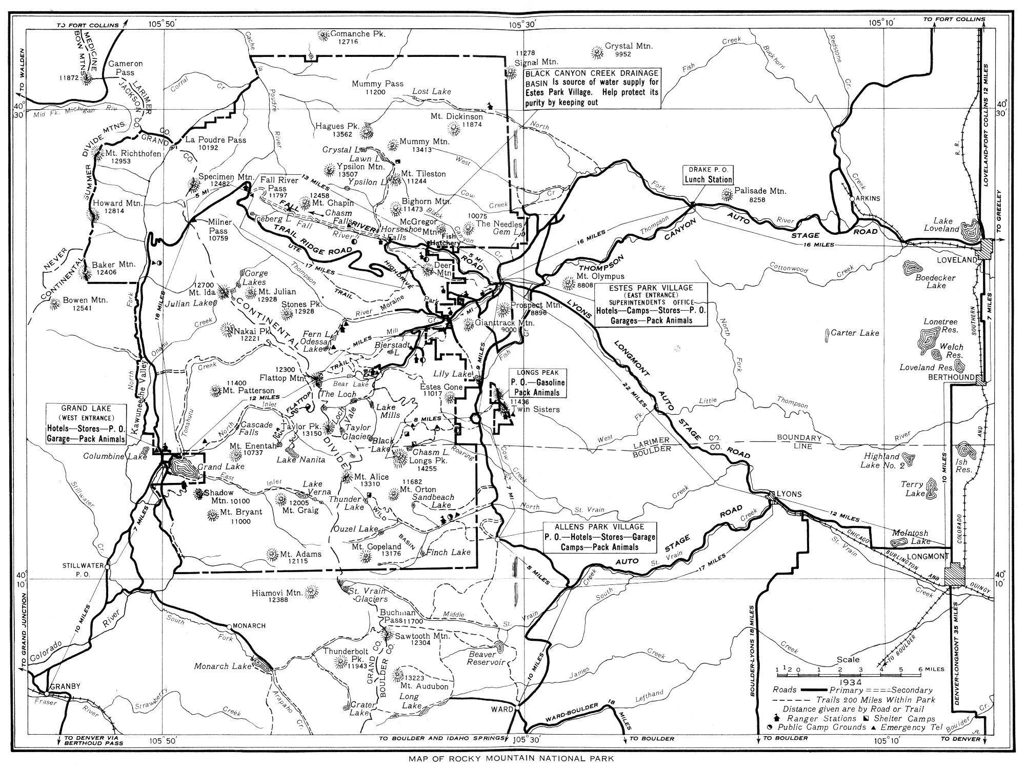
Rocky Mountain National Park includes within its boundaries 405 square miles, or 259,411 acres, of the Front Range of the Rockies in north-central Colorado, about 50 miles in a straight line north-west of Denver. It was established by the act of Congress approved January 26, 1915, and its boundaries adjusted by the acts of Congress approved February 14, 1917, June 9, 1926, and June 21, 1930. Its eastern gateway is the beautiful valley village of Estes Park, from which easy and comfortable access is had up to the noblest heights and into the most picturesque recesses of the mountains.
Rocky Mountain National Park is by far the most accessible of our national parks; that is, nearest to the large centers of population in the East and Middle West.
For many years the Front Range of the Rockies has been the mecca of the mountain lovers of this country. The name conjures European ideas of American mountain grandeur. The selection of this particular section, with its magnificent and diversified scenic range, for national park status, met with popular approval.
It is splendidly representative. In nobility, in calm dignity, in the sheer glory of stalwart beauty, there is no mountain group to excel the company of snow-capped veterans of all the ages which stands at everlasting parade behind its grim, helmeted captain, Longs Peak.
There is probably no other scenic neighborhood of the first order which combines mountain outlines so bold with a quality of beauty so intimate and refined. Just to live in the valley in the eloquent and ever-changing presence of these carved and tinted peaks is in itself satisfaction. But to climb into their embrace, to know them in the intimacy of their bare summits and their flowered glaciated gorges, is to turn a new, unforgettable page in human experience.
This national park reaches lofty heights. The summer visitors who live at the base of the great mountains are 8,000 feet, or more than a mile and a half, above the level of the sea; while the mountains themselves rise precipitously nearly a mile, and often even higher. Longs Peak, the largest of them all, rises 14,255 feet above sea level, and most of the other mountains in the Snowy Range, as it is sometimes called, are more than 12,000 feet high; several are nearly as high as Longs Peak.
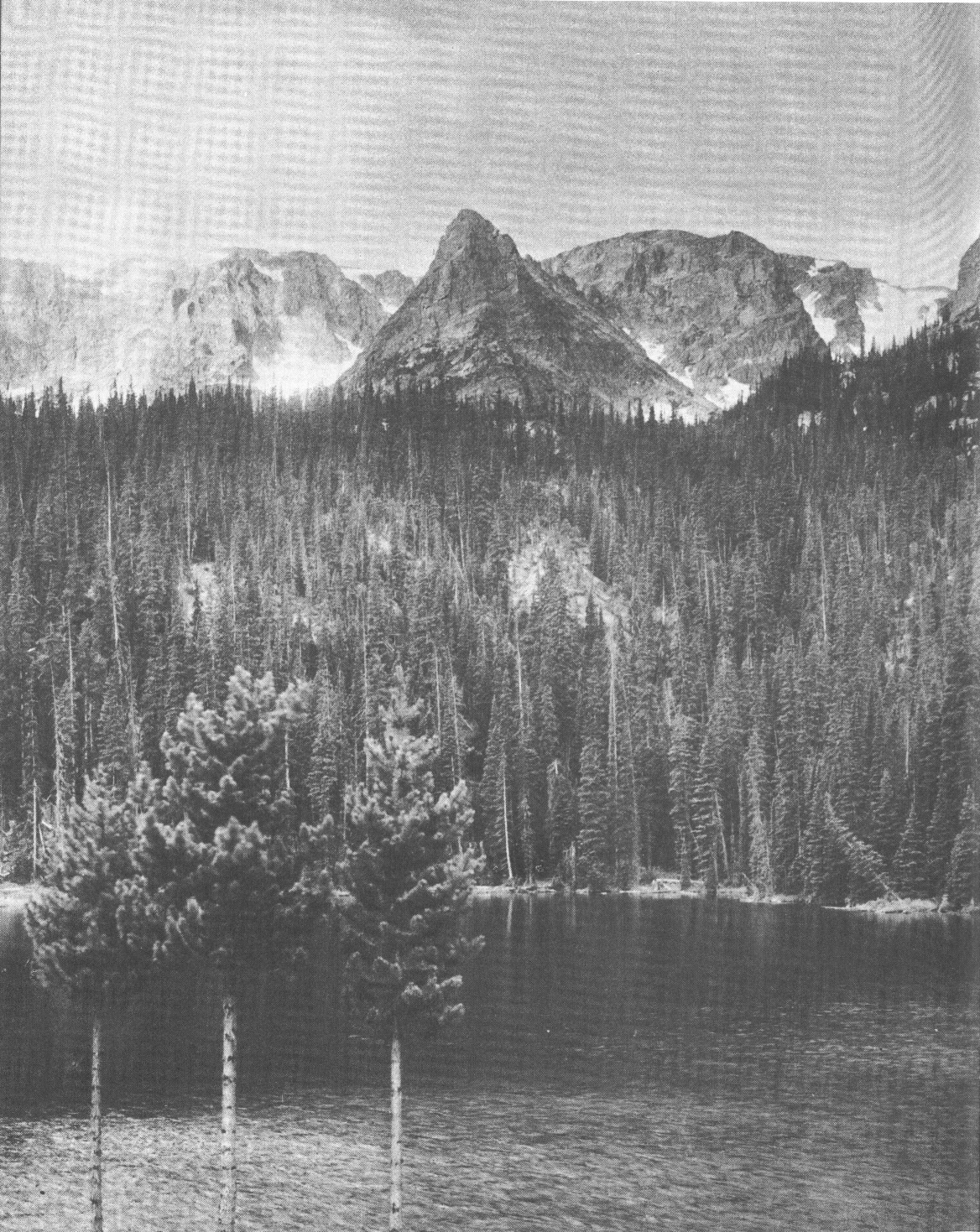
The valleys on both sides of this range and those which penetrate into its recesses are dotted with parklike glades clothed in a profusion of glowing wild flowers and watered with streams from the mountain snows and glaciers. Forests of evergreens and silver-stemmed aspen separate them.
This range was once a famous hunting ground for large game. Lord Dunraven, a famous English sportsman, visited it to shoot its deer, bear, and bighorn sheep, and acquired large holdings by purchase of homesteadings and squatters' claims, much of which was reduced in the contests that followed.
The range lies, roughly speaking, north and south. The gentler slope is on the west. On the east side the descent from the Continental Divide is precipitous in the extreme. Sheer drops of two or three thousand feet into rock-bound gorges carpeted with snow patches and wild flowers are common. Seen from the east-side valleys this range rises in daring relief, craggy in outline, snow spattered, awe inspiring.
In the north-east corner lies a spur from the Continental Divide, the Mummy Range, a tumbled majestic mountain mass which includes some of the loftiest peaks and one of the finest glaciers.
To the south of Longs Peak the country grows even wilder. The range is a succession of superb peaks. The southern park boundary unfortunately cuts arbitrarily through a superlative massing of noble snow-covered summits.
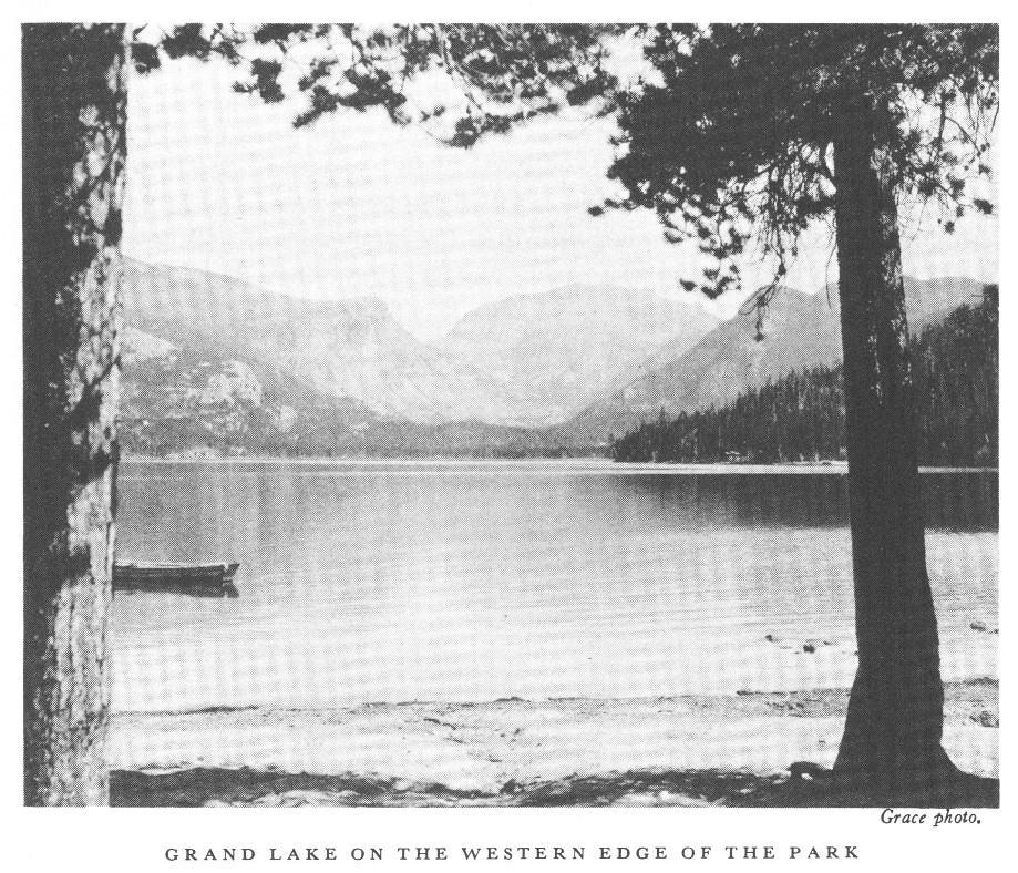
The west side, gentler in its slopes and less majestic in its mountain massings, is a region of loveliness and wildness diversified by splendid mountains, innumerable streams and lakes of great charm. Grand Lake, which has railroad connections nearby, is one of the largest natural lakes in Colorado and the deepest lake in this region.
One of the striking features of Rocky Mountain National Park is the easy accessibility of these mountain tops. One may mount a horse after early breakfast in the valley, ride up Flattop to enjoy one of the great views of the world, and be back for late luncheon. The hardy foot traveler may make better time than the horse on these mountain trails. One may cross the Continental Divide from the hotels of one side to the hotels of the other between early breakfast and late dinner or motor between these points via the Trail Ridge Road in 2 hours.
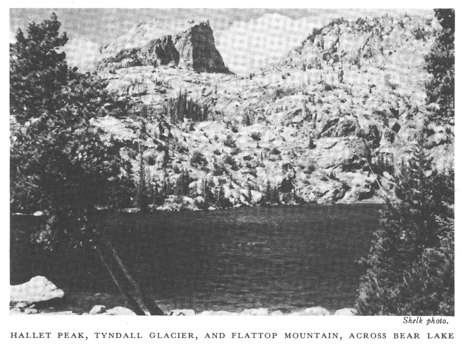
The Trail Ridge Road, which crosses the Continental Divide, connects Estes Park on the east side with Grand Lake on the west side. The road reaches the unusual elevation of 12,183 feet above sea level. Another road leads from the village of Estes Park up the Thompson River Valley to the Bear Lake Entrance. It then follows up the valley of Glacier Creek and ends at Bear Lake at the foot of Hallett Peak and Flattop Mountain.
One of the remarkable features of Rocky Mountain National Park is the legibility of the record left by the glaciers during the ages when America was in the making. The evidences of glacial action, in all their variety make themselves apparent to even the most casual eye.
In fact, there is scarcely any part of the eastern side where some great moraine does not force itself upon the attention. One enormous moraine built up by an ancient glacier and rising with sloping sides nearly a thousand feet above the valley is so prominent that Moraine Park is named for it. From Longs Peak on the east side the Mills Moraine makes a bold curve which instantly draws questions from visitors.
There are several remnants of these mighty ice masses which can be seen at the present time. Three of the largest ice fields, Andrews, Rowe, and Tyndall Glaciers, are visited by many people each year, while the smaller glaciers such as Taylor and Spragues have interest and charm.
In short, this park itself is a primer of glacial geology whose lessons are so simple, so plain to the eye, that they immediately disclose the key to one of nature's scenic secrets.
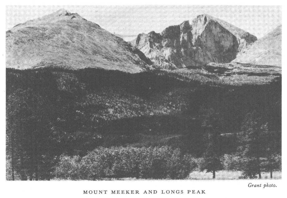
The greatest of all the mountains in the park, Longs Peak, has a massive square head. It is a real architectural structure like an enormous column of solid rock buttressed up on four sides with long rock ledges. On the east side a precipice of 1,200 feet drops sheer from the summit into the wildest lake that one can possibly imagine. It is called Chasm Lake and there is only one month in the year when its surface is not at least partially frozen. Mount Meeker and Mount Lady Washington enclose it on the south and north, and snow fields edge its waters the year round.
In 1820 Maj. S.H. Long first saw the mountain that now bears his name. The report of his expedition records that on June 30 of that year his party caught their first glimpse of the Rocky Mountains, and particularly noted one peak, which they referred to as "the highest peak." Long's expedition followed up the valley of the Platte River, and his closest approach to the peak was at a distance of about 40 miles. Fremont found that the name Longs Peak was in general use among the fur hunters and pioneers in 1842. The first recorded ascent was in 1868, when it was climbed by W.N. Byers, Maj. J.W. Powell (who the following year made the first passage of the Grand Canyon), and five other men.
A distinguishing feature of Rocky Mountain National Park is its profusion of precipice-walled canyons lying between the very feet, so to speak, of the loftiest mountains. Their beauty is romantic to a high degree. Like all the other spectacles of this favored region, they are readily accessible from the valley villages by trail, either afoot or on horseback.
Usually several lakes are found, rock embedded, in such a gorge. Ice-cold streams wander from lake to lake, watering wild-flower gardens of luxuriance and beauty. However, the entire park is a garden of wild flowers. From early June to late September, even into October, the gorges and the meadows, the slopes, and even the loftier summits, bloom with colors that change with the season. Blues, lilacs, and whites are the earlier prevailing tints; yellow predominates as autumn approaches.
There are few wilder and lovelier spots, for instance, than Loch Vale, 3,000 feet sheer below Taylor Peak. Adjoining it lies Glacier Gorge on the precipitous western slope of Longs Peak and holding in its embrace a group of lakelets. These, with lesser gorges cradling romantic Bear Lake, picturesque Dream Lake, beautiful Fern Lake, and exquisite Odessa Lake, and still others yet unnamed, constitute the Wild Gardens of the Rocky Mountain National Park, lying in the angle north of Longs Peak; while in the angle south lies a little known wilderness of lakes and gorges called Wild Basin.
At timberline, where the winter temperature and the fierce icy winds make it impossible for trees to grow tall, the spruces lie flat on the ground like vines; presently they give place to low birches, which, in their turn, give place to small piney growths, and finally to tough, straggling grass, hardy mosses, and tiny alpine flowers. Grass grows in sheltered spots even on the highest peaks, which is fortunate for the large curve-horned mountain sheep which seek these high, open places to escape their special enemies, the mountain lions. Even at the highest altitudes gorgeously colored wild flowers grow in glory and profusion in sheltered gorges. Large and beautiful columbines are found in the lee of protecting masses of snow banks and glaciers.
Nowhere else is the timberline struggle between the trees and the winds more grotesquely exemplified or its scene more easily accessible to visitors of average climbing ability. The first sight of luxuriant Engelmann spruces creeping close to the ground instead of rising 150 feet or more straight and true as masts arouses keenest interest. Many trees which defy the winter gales grow bent in half circles. Others, starting straight in the shelter of some large rock, bend at right angles where they emerge above. Others which have succeeded in lifting their heads in spite of winds have not succeeded in growing branches in any direction except in the lee of their trunks, and suggest big evergreen dust brushes rather than spruces and firs.
Above timberline the bare mountain masses rise from one to three thousand feet, often in sheer precipices. Covered with snow in autumn, winter, and spring, and plentifully spattered with snow all summer long, the vast, bare granite masses, from which, in fact, the Rocky Mountains got their name, are beautiful beyond description. They are rosy at sunrise and sunset. During fair and sunny days they show all shades of translucent grays and mauves and blues. In some lights they are almost fairylike in their delicacy. But on stormy days they are cold and dark and forbidding, burying their heads in gloomy clouds from which sometimes they emerge covered with snow.
The national park is a sanctuary for wildlife. Animals and birds are protected from hunting. Living trees may not be cut or injured. Flowers may not be picked. The cooperation of visitors is requested, in order that the wildlife of the park may be protected, that the flowers may continue in their present abundance, and that the forests of the park may not suffer injury from fire or other cause.
The lofty rocks are the natural home of the celebrated Rocky Mountain sheep, or bighorn. This animal is much larger than any domestic sheep. It is powerful and wonderfully agile. When fleeing from enemies these sheep, even the lambs, make remarkable descents down seemingly impossible slopes. They do not land on their curved horns, as many persons declare, but upon their four feet held closely together. Landing on some nearby ledge, which breaks their fall, they immediately plunge downward again to another ledge, and so on till they reach good footing in the valley below. They also ascend slopes surprisingly steep. They are more agile even than the celebrated chamois of the Swiss Alps, and are larger, more powerful, and much handsomer. A flock of a dozen or more mountain sheep making their way along the volcanic flow which constitutes Specimen Mountain in Rocky Mountain National Park is an unforgettable sight.
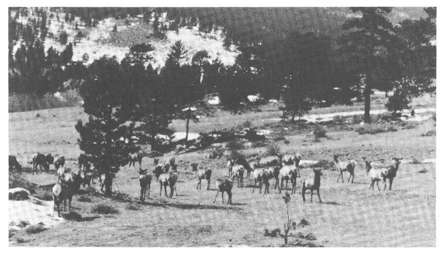
The beaver, whose dams and other structures, both old and new, found along most streams at middle altitudes, are rarely seen except at night or very early morning. Elk occur in numerous places, and deer which are widely distributed are commonly seen. Coyotes and brown or black bear are occasionally seen, but these, like the mountain lion, bobcat, and small carnivorous animals, are not only rare, but so wary that they are seldom seen by visitors.
Among smaller animals, the most familiar are the marmot or woodchuck, Freemont or pine squirrel, three kinds of chipmunks, and the interesting little cony or pika, which lives among the rocks on high mountains and is more often heard than seen. In all, over 60 species of mammals live in the park.
The commonest species are the western robin, the beautiful mountain bluebird, and, at middle elevations, the chickadee and junco. The hermit thrush and the solitaire, generally classed among the finest songbirds in the world, are both fairly common in suitable localities; and but little inferior to these in musical performance are the purple finch, ruby-crowned kinglet, western meadowlark, and rock and canyon wrens. The graceful violet-green swallow is unsurpassed in beauty of form and color, and the crested jay, magpie, and nutcracker are conspicuous for their handsome appearance and vigorous flight. Among birds particularly interesting because of curious and unusual habits are the broadtailed hummingbird, water ouzel, campbird, nuthatch, nighthawk, and the ptarmigan, pipit, and rosy finch of the high peaks.
Although widely distributed through the park, birds are more numerous along streams and near open marshes and meadows than in the dense forests. About 100 species are found regularly in summer, and nearly 150 have been recorded during the whole year.
This park is especially notable for the presence of the blue columbine and many beautiful flowers of the gentian and primrose families; for the profusion of dwarf alpine plants on the meadows above timberline; and for the brilliance of certain species found in moist glades of the subalpine zone. Striking examples of the latter are the tall blue larkspur and monkshood, of many vivid hues, and the curious little red elephant.
Conspicuous and characteristic flowers of the lower altitudes are the mariposa lily, iris, wallflower, gaillardia, and numerous species of cinquefoil, pentstemon, and evening primrose. Among the less common groups, several delicate species of orchid, pyrola, violet, and anemone will delight the botanist. Over 700 distinct species of flowering plants have been collected within the park, and doubtless many more await discovery and identification by the careful student.
The principal trees are the Engelmann spruce, which forms extensive primeval forests in the subalpine region, the lodgepole pine, the prevailing tree of middle elevation, very common in second growth, and the ponderosa pine, a large spreading tree, occurring mainly in the lower valleys and foothills. The limber pine is frequent in high rocky places, assuming picturesque forms at timberline, and the Douglas fir, or false hemlock, is widely distributed, while the blue spruce and alpine fir are confined to moist stream banks. In addition to the coniferous trees, there are three species of poplar, of which the commonest is the well-known quaking aspen, growing in scattered groves throughout the park.
The Trail Ridge Road, which crosses the Continental Divide in Rocky Mountain National Park, offers a grand circuit of Colorado's beauties that forms one of the most attractive and impressive of the scenic automobile trips of our country.
The trip starts from Denver, crosses the Continental Divide at Milner Pass in Rocky Mountain National Park, reaches Grand Lake, crosses the Continental Divide again at Berthoud Pass, traverses the Denver Mountain Parks, and returns to Denver, having completed without any duplication 240 miles of comfortable travel through magnificent country, full of interest and variety; the trip can be made in 2 days or it can be prolonged to suit individual time and inclination. It combines in one trip half a dozen features, any one of which by itself would be worth the journey. The Rocky Mountain Parks Transportation Co. operates daily scheduled trips over this route during the summer season.
On leaving Denver the road leads out Federal Boulevard, crosses Westminster Heights, from which point there is an extensive view of the Great Plains to the east and a panorama of the Front Range of the Rocky Mountains to the west, stretching out before the eye from Pikes Peak to Longs Peak, a rampart of mighty mountains, 125 miles from end to end. The road then passes through a farming section, where irrigation has turned what was once an arid plain into a richly productive district. Fields of deep green alfalfa alternate with the waving wheat, and in the fall of the year the harvesting and threshing add new life to the landscape. Next is the town of Lafayette, where coal mining is the principal industry, and then the road traverses a sugar-beet country. Colorado is the sugar bowl of the United States, and here is one of the regions where the beets are most successfully grown. At Longmont and Loveland are large factories, where sugar is extracted from the beets and refined for table use. At Loveland the road turns westward and soon plunges into the precipitous canyon of the Thompson River, where it follows the turns of the dashing stream, walled in by towering cliffs. Then comes the village of Estes Park at the edge of Rocky Mountain National Park and half surrounded by it. From the green of the meadowland the eye follows the slope, up, up, up, over timbered hills and rocky cliffs, past timberline to the crest of the Continental Divide where snow lingers, and to Longs Peak.
Continuing the journey, two routes lie open to the motorist. One of these follows up the valley of Fall River, 2 miles beyond the Fall River gateway, and then turns left over a portion of the Highdrive to the beginning of the new Trail Ridge Road.
The other road leads past the Government museum and information office to Moraine Park and Deer Ridge, with a magnificent view of Longs Peak and the Continental Divide.
The Trail Ridge Road is the highest continuous automobile road in America. Its 4-mile section over 12,000 feet in altitude is probably the longest stretch of road ever built at such a height. The trip to Grand Lake on this road is a never-to-be-forgotten experience. The road climbs to the very crest of the range and then follows the ridge. Valleys and parks lie thousands of feet below, rivers look like tiny silver threads, and automobiles on the highways of the floor of the valley resemble minute moving dots.
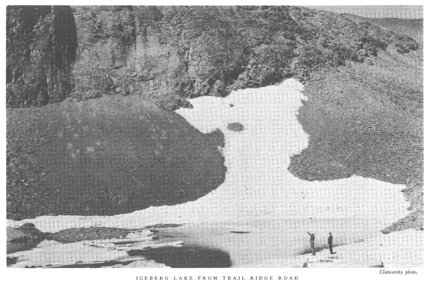
To the south an unexcelled view of the most rugged portion of the Front Range is spread out, while to the north, across Fall River Valley, the view is dominated by the majestic Mummy Range, and the course of the old Fall River Road may be traced as it zigzags up the slope of Mount Chapin toward Fall River Pass. Over a 350-foot cliff one may look into fascinating Iceberg Lake, a rock-bound crystal pool on which float blocks of ice.
A short distance beyond Iceberg Lake the highest point on the road is reached, 12,183 feet above sea level; the road descending to Fall River Pass, elevation 11,797 feet, which divides the waters of the Thompson River from those of the Cache la Poudre. The view from this point is unsurpassed. Below lie streams, valleys, forested slopes, and the realms of civilization. All around are mountains and peaks, no longer towering above but close at hand or seen across some mighty valley. One can easily trace the work done by the glaciers during the ice age on these mountain ranges; the broad U-shaped valleys and precipitous amphitheaters or cirques at the head of the streams are the typical glacial signs, written in bold letters on the landscape. To the south is Trail Ridge. Iceberg Lake, walled in by cliffs, is only a mile distant, though not in sight. To the west is Specimen Mountain, interesting because of the variety of color in its volcanic rocks, geodes lined with crystalline material, volcanic glass, and other curious formations. It is also the home of the mountain sheep.
Farther to the west lies the Medicine Bow Range, or, as the Indians so picturesquely named it, the "Never Summer" range. Of its many peaks the most prominent are Bowen, Nimbus, Red, Cumulus, Howard, Lead, and, highest of all in this range, Mount Richthofen, 12,953 feet in elevation. Strange as it may seem, Milner Pass lies below, and one descends in order to cross the Continental Divide. The road drops down into the forest zone, passes Poudre Lakes, and crosses Milner Pass at an elevation of 10,759 feet. The Atlantic slope lies behind and, crossing the backbone of the continent, one travels down the Pacific slope to the headwaters of the Colorado River. The valley of the North Fork is hemmed in by mountains. The Continental Divide makes a loop here and blocks progress to the west, north, and east. The valley opens to the south, however, and the road proceeds down the north fork of the Colorado River.
Grand Lake, the sapphire gem on the western edge of the national park, is one of the largest and most beautifully situated lakes in the State. It is a mile and a half in length and nearly a mile in width. Its clear, cold water is of great depth. The lake lies at an elevation of 8,369 feet and claims the highest yacht club in the world. The annual regatta is an event of much interest. At the head of the lake Mount Craig rises to a height of 12,005 feet, while Shadow Mountain, Bryant, Wescott, and Mount Enentah are nearby.
This is a point of concentration for park visitors where nearly everybody spends at least one night. Fishing, boating, horseback riding, and mountain climbing are some of the outdoor attractions.
Leaving the lake, the road follows down the Colorado River, passes the town of Granby, and commences the climb up a beautifully timbered valley to Berthoud Pass. Here, close to timberline, the watershed between the two oceans is again crossed. The road approaches near Georgetown, famed for its railroad loop, and then passes through Idaho Springs, with its hot springs and medicinal baths. Soon the valley of Clear Creek is left behind and the climb to Bergen Park is made where the Denver Mountain Parks are entered. In this region is Lookout Mountain, where Colonel Cody, "Buffalo Bill", is buried, overlooking the plains he knew so well.
From Wildcat Point there is a splendid view of foothills and plains, with Denver some 12 or 14 miles away.
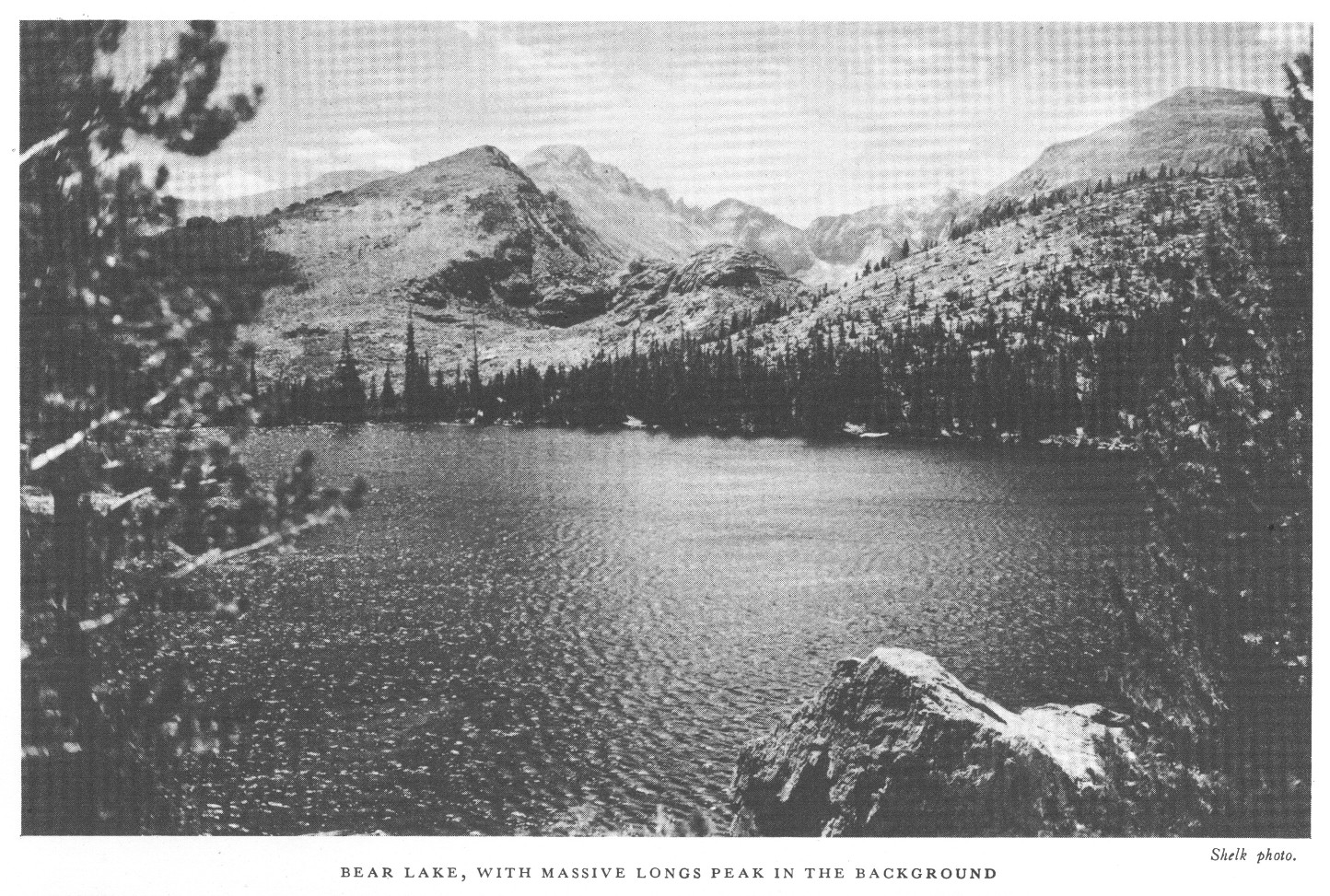
The Bear Lake Road passes the Glacier Basin public campground, 7 miles from Estes Park, and then follows up the valley of Glacier Creek, passing near Sprague's Lodge, and ends at Bear Lake, 12 miles from Estes Park. This is one of the best roads within the park boundaries. Bear Lake Lodge, on the eastern shore of the lake, offers good accommodations. The trail to Loch Vale starts from the Bear Lake Road, about 10 miles from Estes Park. From this trail or from Bear Lake the hiker can reach some beautiful and scenic country, including Glacier Gorge, Loch Vale, Dream Lake, and Tyndall Gorge. The trail to Fern Lake and the Flattop Trail to Grand Lake may be conveniently reached from Bear Lake. North Longs Peak Trail also leaves the road at this point.
One may combine portions of several roads by taking what is known as the loop trip. Starting from Estes Park, the route follows the Fall River Road up to Chasm Falls and back to Horseshoe Park, then over Deer Ridge to Beaver and Moraine Parks, then a side trip up the Bear Lake Road and back, returning to Estes Park by the Moraine Park Road. This loop trip takes one by many of the hotels and other points of interest and offers scenic views. The circuit of the Highdrive is 17 miles. Including the trip to Bear Lake and other points, the distance is about 40 miles.
The main road to the Longs Peak district comes in just east of the village of Estes Park, skirting the east boundary of the park to its south-east corner. It passes between Longs Peak and the Twin Sisters, a detached area of the park on which a fire lookout is stationed, and several of the finest foot trips in the park are accessible from this road.
Continuing in a southerly direction, the road skirts the eastern boundary of the park and leads to Copeland Lodge on North St. Vrain Creek. From this point a trail leads into Wild Basin, a very attractive though less frequented portion of the park.
The road continues to Allens Park, thence to Ward, Nederland, and Boulder; another road leads down the South St. Vrain to Lyons.
Travelers on trails are advised to secure the services of licensed guides for all except the shortest trips. Besides insuring security, the guide adds greatly to one's comfort and enjoyment. He knows the country and its features of interest, and also has a general knowledge of the trees and wild flowers. Information as to guides can be secured at the park information office.
The Flattop Trail crosses the Continental Divide between Estes Park Village on the east and Grand Lake Village on the west. The 16-mile trip may be made on horseback or on foot in 1 day, but it takes a seasoned trail traveler to do it with pleasure. The trail starts at Bear Lake, where horses may be rented, and climbs Bierstadt Moraine. It emerges above timberline, overlooking Emerald Lake and Tyndall Glacier, and commands spectacular views of Longs Peak and other mountains, both in the park and in distant ranges. The grassy slopes above timberline, bedecked with exquisite alpine flowers, afford good summer grazing for elk and mountain sheep.
After descending to timberline on the western slope, the trail leads through evergreen forests, along the North Inlet to Grand Lake.
The glories of the Mummy Range, exemplified chiefly in Lawn Lake and Rowe Glacier, may be seen from a trail starting from Horseshoe Park by way of Roaring River. There is a shelter on beautiful Lawn Lake. This lake, which has an area of 65 acres, lies at the bottom of the main cirque at the head of Roaring River. It is one of the many glacial lakes of the park, and lies just below timberline at an altitude of 10,950 feet.
The trip from Lawn Lake to Rowe Glacier is difficult but well worth while. The glacier is the largest in the park. It is a great crescent of ice partly surrounding a small lake. While the glacier is extremely impressive, still it is small enough to permit a thorough examination without undue fatigue. Hagues Peak is a resort of Rocky Mountain sheep and ptarmigan.
The group of luxuriant canyons east of the Continental Divide and north of the eastern spur which ends in Longs Peak is known as the "Wild Gardens" in distinction from the corresponding and scarcely less magnificent hollow south of Longs Peak, which is known as "Wild Basin."
Of these canyons, one, the most gorgeous, frames two lakes of exquisite beauty. The upper one, Odessa Lake, lies under the Continental Divide and reflects snowy monsters in its still waters. The other, Fern Lake, a mile below, is one of the loveliest examples of forest-bordered waters in the Rockies.
These lakes are reached by trail from Moraine Park. They constitute a day's trip of memorable charm. Fern Lodge, located at the edge of the lake, offers comfortable accommodations. Several splendid trips can be taken on foot with Fern Lake as a starting point. Winter sports are held here every year. Forest Inn, a camp located at the Pool, is close to the Fern Lake trail.
A trail connects Bear Lake with Odessa Lake. One of the finest trail trips in the park is the circle trip from Bear Lake to Odessa Lake, and thence to Fern Lake and Moraine Park. The distance from Bear Lake to the Brinwood by this route is 9 miles, but a day is usually allowed for the trip.
Within a right-angled bend of the Continental Divide lies a glacier-watered, cliff-cradled valley which for sheer rocky wildness and the glory of its flowers has few equals. At its head Taylor Peak lifts itself precipitously 3,000 feet to a total height of more than 13,000 feet, and from its western foot rises Otis Peak, of nearly equal loftiness, the two carrying between them broken perpendicular walls carved by the ages into fantastic shapes. One dent encloses Andrews Glacier and lets its waters find the Loch. On the eastern side another giant, Thatchtop, sheltering the Taylor Glacier, walls in the upper end of Loch Vale. It is easily reached by a trail that leaves the Bear Lake Road, 10 miles from Estes Park, or 1 mile below Bear Lake.
In this wild embrace lies a valley 2 or 3 miles long ascending from the richest of forests to the barren glacier. Through it tinkles Icy Brook, stringing like jewels, three small lakes. Those who love to explore the undeveloped and less frequented regions will enjoy the wild beauty and impressive grandeur of Loch Vale. The Lake of Glass and Sky Pond, just below Taylor Glacier, can be visited in a day's trip. Another wonderful day can be spent in a trip to the foot of Andrews Glacier.
One of the noblest gorges in any mountain range the world over lies south of Loch Vale. It is reached from the Bear Lake Road, by the Loch Vale trail, although there are no trails in the gorge. Above Lake Mills the western wall of the gorge is formed by McHenrys Peak and Thatchtop; its head lies in the hollow between the Continental Divide and Longs Peak, with Chiefs Head and Pagoda looming on its horizon. Its eastern wall is the long sharp northern buttress of Longs Peak itself. It is a gorge of indescribable wildness. Lake Mills lies near the mouth of the valley, Black Lake is toward the upper end, while Shelf Lake, Blue Lake, and several others are perched on benches high above the valley floor.
This gorge is magnificent and worth visiting. There is no trail to Keyhole, on the great shoulder of Longs Peak, but the ascent can be made. The canyon is luxuriantly covered in places with a large variety of wild flowers.
Nine miles south of the village of Estes Park, split by the boundary line of the national park, rises the precipitous, picturesque, and very craggy mountain called the "Twin Sisters", on which the park maintains a fire lookout. Its elevation is 2,400 feet above the valley floor, which is about 9,000 feet high. The trail leads by many zigzags to a peak from which appears the finest view by far of Longs Peak and its guardians, Mount Meeker and Mount Lady Washington.
From the summit of the Twin Sisters an impressive view is also had of the foothills east of the park, with glimpses beyond of the great plains of eastern Colorado and many of their irrigating reservoirs.
Of the many fascinating and delightful mountain climbs, the ascent of Longs Peak is the most inspiring, and it is one of the most strenuous. The great altitude of the mountain, 14,255 feet above sea level and more than 5,000 feet above the valley floor, and its position well east of the Continental Divide, affording a magnificent view back upon the range, make it much the most spectacular viewpoint in the park. The difficulty of the ascent also has its attractiveness. Longs Peak is the big climb of the Rocky Mountain National Park. And yet the ascent is by no means forbidding. One may go more than half-way by horseback. Over a thousand men and women, and occasionally children, climb the peak each season. Those making the Longs Peak trip should have strong, comfortable shoes, stout warm clothing, and remember that cold or stormy weather is sometimes encountered.
The peak may be reached by either of two trails which lead to the Boulder Field, the highest point on the climb to which horses may be taken. The east trail, which begins near Longs Peak post office, 9 miles south of Estes Park, winds up the slope of Battle Mountain, passes timberline at an elevation of more than 11,000 feet, swings to the crest of Mills Moraine, overlooking Chasm Gorge, then skirts the slope of Mount Lady Washington, goes through Granite Pass, and leads to the shelter cabin in the center of the Boulder Field, at an elevation of 12,700 feet, a distance of 6 miles.
From Glacier Gorge Junction on the Bear Lake Road, the north trail winds its way up the north slope of the peak through the great burn of 1900 and joins the east trail at Granite Pass, a mile and a half below the Boulder Field cabin. The distance to the Boulder Field by this trail is 9 miles.From the Boulder Field cabin the ascent to the summit may be made by either of two routes. The north face route, which is the shorter, climbs the precipitous north side of the summit, skirting along the rim of the east precipice, with magnificent views down the sheer drop of 1,200 feet into Chasm Lake in the gorge below. The Longs Peak climb includes the hazards usual to any major mountain ascent. Visitors are cautioned that use of the assisting cables on the North Face route is at their risk and the Government is in no way responsible. The other route leads across the Boulder Field to the Keyhole, half a mile distant and some 500 feet higher, where there is a small storm shelter.
On passing through the Keyhole, one sees the imposing Front Range, and 2,000 feet below the Glacier Gorge. To the left there is a narrow, steeply inclined ice-filled gulch, called the Trough. Finally, after what is to the amateur often an exhausting climb, one passes along the Narrows, up a steep incline known as the Homestretch.
The trip to the Keyhole is well worth while for those who do not care to climb Longs Peak, but who do wish to see at close range the rugged grandeur of the mountains. Another splendid foot trip from the Boulder Field cabin is to Chasm View, half a mile distant, where one sees the precipitous east face of Longs Peak, from the summit down to Chasm Lake, 2,500 feet below.
One may ride on horseback almost to Chasm Lake. The view from here is magnificent, and the upper gorge is one of the most impressive in the park. Both Chasm Lake and the Keyhole may be visited in a day. This is an exceptionally fine trip, and if horses are used it is not difficult.
The splendid Wild Basin area south of Longs Peak and east of the Continental Divide is dotted with lakes of superb beauty in a sublime mountain setting. It is entered from Copeland Lake by an unimproved road up the North Fork of St. Vrain Creek, which soon lapses into a trail. From mountain tops on the south may be had unsurpassed views of the snowy mountains. The largest lakes of Wild Basin—Thunder Lake and Bluebird Lake—are both above timberline but are easily accessible by trails.
The North and East Inlets are the two principal rivers entering beautiful Grand Lake. Each flows from cirques under the Continental Divide. Lake Nokoni and Lake Nanita, among the most romantic of the park, are reached from a trail connecting with both sides of the park by the Flattop Trail. Lake Verna and her unnamed sisters are the beautiful sources of the East Inlet and are reached by trail.
While not yet as celebrated as the showier and more populated east side, the west side of Rocky Mountain National Park has rugged charm. The Continental Divide, bent from the north and called the "Never Summer Mountains", rises from the western shore of the Colorado River. On every side the mountains lift bald peaks, magnificent canyons penetrate the precipices of the Divide, and beautiful streams rush down the mountain slopes to the river.
There are few places which offer as many diversions as Rocky Mountain National Park. The Estes Park Golf and Country Club has an excellent 18-hole golf course and a tennis court. Several hotels have croquet and tennis courts. There is much motoring, horseback riding, fishing, and hiking. The motorist may skirt the loftiest of snow-splashed mountains for miles, or he may motor up the Trail Ridge Road and leave his car to start afoot on mountain-top tramps and picnics, or across the Continental Divide to Grand Lake. The horseback rider may find an infinite variety of valley roads, trails, and cross-country courses, and the hiker strike up the mountain trails into the rocky fastnesses.

Fishing is permitted in all streams and lakes of the park except as closed by order of the superintendent. Information regarding closed areas may be obtained at any ranger station. All of the lower streams and lakes, and many of the lakes in the higher altitudes, are well stocked with trout. The State of Colorado stocks the park waters, and, therefore, a Colorado State license is required for males over 16 years of age. These may be purchased in the villages of Grand Lake and Estes Park. Fishing tackle can be purchased or rented from several stores in the village of Estes Park.
A fish hatchery, operated by the State of Colorado, is located on the Fall River Road, 4 miles west of Estes Park. This hatchery supplies about 1,000,000 trout fry every year to the streams and lakes of this vicinity. The process of hatching and caring for the trout is explained to visitors, and the hatchery has proved to be of interest to many thousands each year.
At Estes Park and the smaller settlements nearby, and at Grand Lake, horses and complete camping outfits may be had at reasonable rates. General groceries and suitable equipment, including clothing and shoes, can be purchased from the general stores in Estes Park Village. Saddle horses may be rented at many of the hotels. There is much horseback riding throughout the entire district.
There are many competent guides in the vicinity who will arrange special trips, either on foot or by saddle horse, and either stopping at hotels or camping out, according to the preference of the party. A list of authorized guides can be secured at the park information office.
Rocky Mountain National Park has unusual advantages for winter sports, interest in which is steadily increasing. The town of Estes Park is readily accessible by automobile, and hotel accommodations are available there every month in the year. The Rocky Mountain National Park Ski Club has constructed ski courses near Estes Park where tournaments are held periodically. Cross-country trips may be taken in the high mountainous country where the snowfall is heavy and where good skiing conditions prevail during the winter and early spring. Allens Park and Grand Lake also have ski clubs and ski courses. Skijoring, snowshoeing, tobogganing, and skating may also be enjoyed.
Rocky Mountain National Park is under the control and supervision of the Director of the National Park Service, who is represented in the administration of the park by a superintendent, assisted by a number of park rangers who patrol the reservation. Thomas J. Allen, Jr., is superintendent of the park, and his post office address is Estes Park, Colo.
Exclusive jurisdiction over the park was ceded to the United States by act of the Colorado Legislature of February 19, 1929, and accepted by Congress by act approved March 2, 1929. The United States commissioner for the park may be reached through the superintendent's office.
An information bureau is maintained at the national park museum building in Estes Park to supply visitors with desired information regarding accommodations, transportation schedules, foot trips, guides, and other information relative to the park.
The post office for the park and many hotels and resorts on the east side is Estes Park, Colo. There are post offices at Longs Peak and Allens Park, but letters addressed to Estes Park will be forwarded. The west-side post office is at Grand Lake, Colo.
Illustrated lectures are given at various points throughout the park and vicinity each evening. Nature hikes, from a few hours to a day in length, are conducted regularly.
A museum of natural history containing interesting exhibits is located near the office. An information office is maintained in the same building, which dispenses road and general information. A small branch museum is located at Fall River Pass. A museum of Indian and historical material is located on the main highway in Moraine Park.
A complete schedule of the week's activities is posted at all hotels, lodges, and campgrounds. For detailed information inquire at the museum. There is no charge for any of the above-mentioned activities.
The National Park Service maintains six free public campgrounds, as follows:
Squeaky Bob Campground, located on the Trail Ridge Road, 38 miles west of Estes Park, and 12 miles north of Grand Lake.
Glacier Basin Campground, located on the Bear Lake Road, 7 miles from Estes Park.
Aspenglen Campground, located on the Fall River Road, 5 miles from Estes Park.
Wild Basin Campground, 15 miles south of Estes Park on the North St. Vrain Creek at the park boundary.
Endovalley Campground, located on the Fall River Road, 9 miles from Estes Park.
Longs Peak Campground, located at the beginning of the east Longs Peak Trail near Longs Peak post office.
Motorists and others who bring camping equipment with them will find that these campgrounds are attractive places in which to enjoy life in the open. Both wood and water are readily available.
From June 15 to September 20 the hotels are open, daily transportation service through the park is available, and the park may be explored most conveniently and thoroughly. The roads to Estes Park, by way of Lyons and the Thompson Canyon, remain open throughout the year and the village has daily transportation and mail service. Some of the hotels in Estes Park are open all the year. The national park is never closed to visitors and every season offers its particular attractions. The autumn coloring is remarkably beautiful. The aspens start to turn early in September, and from that time until the middle of October the hillsides are streaming in golden color. In the winter those who enjoy snowshoeing, skiing, and other sports will find the park excellently adapted to these invigorating pleasures. Those portions of the park having an elevation of 9,000 feet or more are covered with a thick blanket of snow during most of the winter months. In the spring one may watch the snow line climb steadily up the slope of the mountains. Birds and early flowers appear in the valleys while winter still reigns on the higher mountains.
The Trail Ridge Road remains open to travel until the first heavy snowfall. This usually occurs in October, and the road is not passable again before June 15. Other lower roads have a longer season, and even in mid-winter one may usually go by automobile for 5 or 6 miles beyond Estes Park Village before finding the roads closed by snow.
Denver, the gateway to the western national parks, is reached by the Atchison, Topeka & Santa Fe; Chicago, Burlington & Quincy; Rock Island & Pacific; Colorado & Southern; Denver & Rio Grande Western; Denver & Salt Lake; Union Pacific; and Missouri Pacific railroads. For information regarding fares, service, etc., apply to railroad ticket agents.
The Rocky Mountain Parks Transportation Co. operates regular daily automobile service to the park from the following places: Denver, leaving at 8:45 a.m. and 2:30 p.m.; Greeley, 9:15 a.m.; Fort Collins, 7:45 a.m.; Loveland, 9:50 a.m.; Longmont, 9:45 a.m.; Lyons, 11:30 a.m.; Boulder, 9:35 a.m. Corresponding return service from Estes Park is available, return trips for Denver starting from Estes Park at 8:15 a.m. and 1:45 p.m.
From June 15 to September 20 automobile connection is made at Granby, Colo., for a tour of the park by way of Grand Lake and Estes Park to Denver, leaving Granby at 12 noon daily. Auto service is available also, leaving Grand Lake at 5:35 p.m. and arriving at Granby at 6:05 p.m.
The United Airlines, operating 18-hour transcontinental service through Cheyenne, connects with Wyoming Air Service for Denver, which in turn connects at that point with the Rocky Mountain Parks Transportation Co. service to the Rocky Mountain National Park. From the south, T.W.A., Inc., and American Airlines, in their transcontinental services through Albuquerque and El Paso, respectively, connect with Denver by the Varney Speed Lines.
Five special all-expense tours from Denver to the park and return to Denver are offered by the Rocky Mountain Parks Transportation Co. from June 15 to September 20. Denver is about 85 miles from the park, and for $16 (transportation cost only) you can make a 2-day trip, entering the park through picturesque Big Thompson Canyon, crossing the Front Range of the Rocky Mountains twice, and stopping at Grand Lake, Estes Park, Clear Creek Canyon, Idaho Springs, and Lookout Mountain. This tour affords fine panoramas of the Rocky Mountains from elevations above 12,000 feet. Another 2-day tour follows the same route but includes lunch at Estes Park, dinner, night's lodging, and breakfast at Grand Lake Lodge, and lunch the second day at Idaho Springs. The cost is $22.
The 3-day tour is leisurely enough to permit the traveler to spend a night at Estes Park Chalets and 1 at Grand Lake Lodge. The cost is $27, including meals and lodging. The 4-day trip includes 2 nights at Estes Park Chalets and 2 at Grand Lake Lodge; the cost is $32. On the 6-day trip which costs $44, 3 days are spent at Estes Park Chalets and 3 at Grand Lake Lodge. These tours are leisurely and permit ample time for fishing, horseback riding, or hiking.
Tours similar to the above, but connecting with the Denver & Rio Grande Western Railroad at Granby, are available at the same rates. Special all-expense tours from Granby, through the park, to Estes Park and Denver are available also at similar rates.
The traveler who has no car available or does not wish to drive his own machine in the mountains may take advantage of the special trips offered from June 15 to September 20 by the Rocky Mountain Parks Transportation Co. at Estes Park. The Trail Ridge, Fall River, and Highdrive loop trip of about 50 miles costs $5 and requires about 4 hours. One can go in the morning, leaving at 8:30 o'clock, or in the afternoon at 2. The Estes Park-Grand Lake trip of about 47 miles costs $5 one way and $8 for a round trip. One can leave Estes Park at 8:45 a.m. or 2:30 p.m. Two other daily loop trips are made from Estes Park for $4 a person. Stops are made at the Fish Hatchery, Horseshoe Park, Fall River Lodge, Fern Lake Trail, Brinwood Hotel, Stead's Hotel, Glacier Basin, Bear Lake, Sprague's Lodge, and the Y.M.C.A. Cars leave Estes Park at 8 a.m. and 2 p.m. Proportionate charges are made for anyone not desiring to make the entire trip. Between September 20 and June 15 these rates apply only when four or more passengers make the trip.
Touring-car service is also available at 30 cents a mile for two passengers, 40 cents for three, 50 cents for four, and 10 cents a mile for each additional passenger. Waiting time costs $3 an hour.
Passenger and freight service within the park is operated by the Rocky Mountain Parks Transportation Co. under a franchise from the Secretary of the Interior, with rates approved by him.
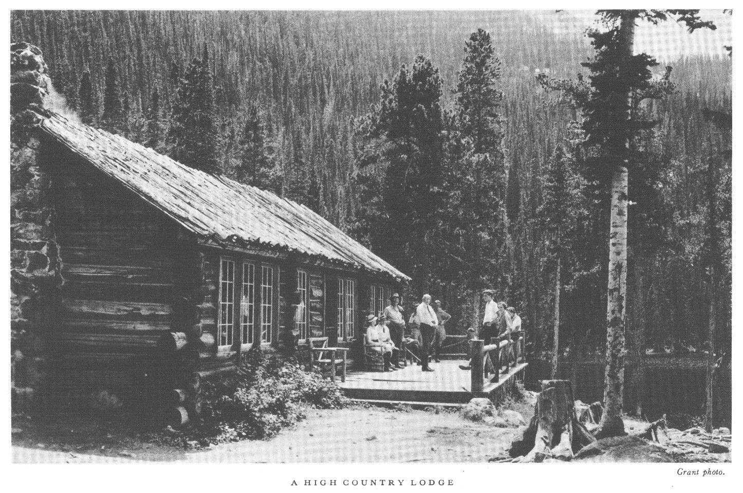
The seven hotel and lodge operations in Rocky Mountain National Park are conducted with private capital under franchise from the Secretary of the Interior at rates subject to his approval.
This booklet is issued once a year and the rates mentioned herein may have changed slightly since issuance, but the latest rates approved by the Secretary are on file with the superintendent.
Bear Lake Lodge, located on Bear Lake, offers cabin accommodations, ranging in price from $2.50 to $3.50 a day and $15 to $20 a week. Meals: Breakfast, a la carte; luncheon, 65 cents to $1; dinner, $1 to $1.50. Rates, American plan, range from $4.25 to $6 a day and $26.50 to $34 a week.
Fern Lodge, on Fern Lake, offers cabin accommodations, without bath, American plan only, at the same rates charged at Bear Lake Lodge.
Forest Inn, located at "The Pool" on Fern Lake Trail, offers board and lodging (tents) at prices from $3 to $4 a day and $15 to $20 a week. For cabin accommodations the charge is from $4 to $5 a day, and $20 to $25 a week. Single meals are 75 cents each.
Grand Lake Lodge, near Grand Lake, open from June 15 to September 20, operates on the American plan and rates are from $5 to $7 a day; weekly rates 10-percent reduction of daily rates. Single meals: Breakfast, 75 cents; luncheon, $1; dinner, $1.25.
Brinwood Hotel, at the head of Moraine Park, offers American-plan service at from $3.50 to $6.50 a day and $21 to $40 a week. Saddle horses may be rented at $2.50 a half day, $4 a day, $21 a week, and $75 a month.
Camp Woods, at the junction of Bear Lake and Moraine Park roads offers housekeeping cottages at from $2.50 a day for two persons to $6 a day for six persons. By the week: From $14 for two persons to $35 for six. By the month: From $45 for two persons to $60 for five persons.
Sprague's Lodge, in the Glacier Basin, provides American-plan accommodations at the following rates: By the day, $4 to $6; by the week, from $24.50 to $40; 4 weeks, $84 to $133.
There are many hotels, lodges, and camps located on private lands in or adjacent to the park. The National Park Service exercises no control over the rates and operations of these hotels. Furnished cottages may be rented in Estes Park, Grand Lake, and elsewhere on private lands in or adjacent to the national park. Information concerning hotels and cottages not under the control of the National Park Service may be obtained by writing the Secretary of the Chamber of Commerce, Estes Park, Colo., or the president of the Grand Lake Commercial Club, Grand Lake, Colo.
| Trips | Elevation Feet |
Miles from Estes Park | Days Round Trip | Remarks (One way distances) | Description |
| 1. Gem Lake. | 8,700 | 4 | ½ |
2 miles by auto, by horse or on foot. |
Good trip with distant view of Longs Peak from top. |
| 2. Prospect Mountain. | 8,896 | 2 | ½ |
2 miles on foot. |
Excellent panorama of range and Estes Park Valley. |
| 3. Old Man Mountain. | 8,300 | 1½ | ¼ - ½ |
¾ by auto; ¾ on foot |
Good snappy climb, with view of village and park. |
| 4. Deer Mountain. | 10,028 | 4 | ½ - 1 |
4 miles by horse or on foot |
Auto can be taken to Mountain top of Deer Ridge and mountain climbed from there. |
| 5. Wonder Basin. | 8,600 | 5½ | ½ - 1 |
2 miles by auto; 3½ on foot. |
Interesting examples of erosion. |
| Trips | Elevation Feet |
Miles from Estes Park | Days Round Trip | Remarks (One way distances) | Description |
| 1. Flattop Mountain. | 12,300 | 15 | 1 |
11 miles by auto; 4½ by horse or on foot. |
Excellent horseback or foot-trail trip to Continental Divide. |
| 2. Bear Lake. | 9,485 | 11 | ½ |
11 miles by auto. |
Glacial Lake. Fishing. |
| 3. Mill Creek. | 8,800 | 7 | ½ |
6 miles by auto; 1 by horse or on foot. |
Former ranger station. |
| 4. Cub Lake Trail. | 9,350 | 9½ | ½ |
6 miles by auto; 3½ by horse or on foot. |
Wooded mountain trail. |
| 5. Fern Lake. | 9,550 | 11½ | 1 |
6 miles by auto; 5½ by horse or on foot. |
Beautiful wooded trail; heavy forest; lake with wonderful setting. |
| 6. Odessa Lake. | 10,000 | 12 | 1 or 2 |
6 miles by auto; 6½ by horse or on foot. |
Lake of spectacular alpine beauty. Flowers and snow. |
| 7. Bierstadt Lake. | 9,350 | 9½ | ½ |
8 miles by auto; 1½ by horse or on foot |
On huge moraine in heavy timber. View of range. |
| 8. Loch Vale. | 10,250 | 12 | ½ |
10 miles by auto; 2½ by horse or on foot. |
Remarkable glacial evidences; fire-killed forest; lake of unusual alpine beauty. |
| 9. Storm Vale. | 10,350 | 11 | 1 |
9 miles by auto; 2 by horse or on foot to pass; 6¼ miles to Bear Lake road. |
Moraine; timberline growth. |
| 10. Lily Lake (via Wind River). | 8,975 | 8 | 1 |
6 miles by auto; 2 by horse or on foot. |
Beautiful aspen and blue-spruce trail. |
| 11. Ypsilon Lake. | 10,550 | 12 | 1 |
8 miles by auto; 4 by horse or on foot. |
Wild trail to glacial lake under precipices of Mount Ypsilon |
| 12. Lawn Lake. | 10,950 | 14¼ | 1 |
8 miles by auto; 6¼ by horse or on foot. |
Good mountain trip of varying interest. Fall fishing. |
| 13. Crystal Lake. | 11,450 | 16 | 1 or 2 |
8 miles by auto; 7½ by horse or on foot; ½ on foot. |
Timberline; glacial lake in glacial cirque. |
| 14. Rowe Glacier. | 13,200 | 17½ | 1 or 2 |
8 miles by auto; 7½ by horse or on foot; 2 on foot. |
Largest glacier in park. Great mountain view. |
| 15. Specimen Mountain. | 12,482 | 24 | 1 or 2 |
22 miles by auto; 2 by horse or on foot. |
Interesting volcanic formations. Mountain sheep. |
| 16. Twin Sisters and Look-out. | 11,436 | 12 | 1 |
8½ miles by auto; 3½ by horse or on foot. |
National Park Service fire lookout. View of entire country. |
| 17. Chasm Lake. | 11,850 | 14¼ | 1 |
10 miles by auto; 4 by horse or on foot; ¼ on foot. |
Timberline; terrific glacial work; high perpendicular precipices. |
| 18. Hallett Peak. | 12,725 | 15½ | 1 |
11 miles by auto; 4½ by horse or on foot; ½ on foot. |
Short stiff climb. Expansive view of hundreds of square miles of country. |
| 19. The Keyhole. | 13,214 | 17½ | 1 |
10 miles by auto; 7 by horse or on foot; ½ on foot. |
Spectacular views of Glacier Gorge and Longs Peak. |
| Trips | Elevation Feet |
Miles One Way | Days Round Trip | Remarks |
| 1. Cascade Falls. | 9,000 | 4 | ½ |
4 miles by horse or on foot. |
| 2. Flattop shelter cabin. | 10,500 | 10 | 1 |
10 miles by horse or on foot. |
| 3. Lake Nanita. | 10,750 | 10 | 1 |
10 miles by horse or on foot. |
|
Lake Nokoni. |
10,850 | 11 | 1 |
10 miles by horse or on foot. |
| 4. Bench Lake. | 10,923 | 12 | 1 |
10 miles by horse; 2 on foot. |
| 5. Flattop Mountain. | 12,300 | 12 | 1 |
12 miles by horse or on foot. |
| 6. Adams Falls. | 9,000 | 2 | ½ |
2 miles by horse or on foot. |
| 7. Shadow Mountain. | 10,100 | 3 | ½ |
3 miles by horse or on foot. |
| 8. Lake Verna. | 10,150 | 8 | 1 |
8 miles by horse or on foot. |
| 9. Hell Canyon Pass. | 11,400 | 13 | 2 |
8 miles by horse; 5 on foot. |
| 10. Colorado River trail. | 8,500 | 5 | ½ |
5 miles by horse or on foot. |
| 11. North Fork Road. | 9,038 | 13 | 1 |
13 miles by horse, on foot, or by auto. |
| 12. Phantom Valley Ranch. | 9,000 | 13 | 1 |
13 miles by horse, on foot, or by auto. |
| 13. Milner Pass. | 10,759 | 18 | 1 |
18 miles by horse, on foot, or by auto. |
| 14. Tonahutu Creek, Big Meadows. | 9,385 | 5 | ½ |
5 miles by horse or on foot. |
| 15. Columbine Lake. | 8,600 | 3 | ½ |
3 miles by horse, on foot, or by auto. |
| 16. Fall River Road to Continental Divide and Fall River Pass. | 11,797 | 22 | ½ |
22 miles by horse, on foot, or by auto. |
| 17. Estes Park. | 7,547 | 47 | 1 |
47 miles by horse or auto. |
| Trips | Starting point |
| 1. Chasm Lake—Longs Peak. |
Longs Peak post office. |
| 2. Glacier Gorge—Lakes Mills, Black, Blue, and Shelf. |
Glacier Basin. |
| 3. Glass Lake—Sky Pond—Taylor Glacier. |
Glacier Basin. |
| 4. Loch Vale—Andrews Glacier—Otis Peak—Otis Gorge—Lake Haiyaha—Nymph Lake—Bear Lake. |
Glacier Basin. |
| 5. Nymph Lake—Dream Lake—Emerald Lake—Tyndall Gorge—Tyndall Glacier—Flattop Mountain. |
Bear Lake. |
| 6. Fern Lake—Odessa Lake—Flattop Mountain—Tyndall Glacier—Hallett Peak—Continental Divide—Tourmaline Gorge. |
Fern Lake. |
| 7. Spruce Lake—Spruce Canyon—Hourglass and Rainbow Lakes—Sprague Glacier—Continental Divide—Tourmaline Lake and Gorge—Odessa and Fern Lakes. |
Fern Lake. |
| 8. The Pool—Forest Canyon. |
The Pool. |
| 9. Wild Basin. |
Copeland Lake. |
| 10. Top of road on Continental Divide—Mount Ida—Gorge Lakes—Forest Canyon—The Pool. |
Estes Park. |
| 11. Fall River Road—Chapin Pass—Mounts Chiquita, Ypsilon, and Chapin—Bill Currence's trail. |
Estes Park. |
| 12. Fall River Pass—Cache la Poudre River—Down to mouth of Hague Creek—Up to Chapin Creek to Chapin Pass—Fall River Road. |
Estes Park. |
| 13. Horseshoe Park—Lawn Lake—"The Saddle"—Cascade Creek—Mouth of Hague Creek back as trip no. 12. |
Horseshoe Park. |
| 14. Fall River Road to Chapin Pass—Chapin Creek and Cache la Poudre to mouth of Hague Creek—Boundary of park to La Poudre Pass—Headwaters of Colorado River—Phantom Valley Ranch. |
Estes Park. |
| 15. Trail Ridge—Continental Divide—Phantom Valle Ranch. |
Estes Park. |
| 16. Phantom Valley Ranch—Headwaters of Colorado River—Thunder Pass and Thunder Mountain. |
Phantom Valley Ranch. |
| 17. Mount Richthofen. |
Phantom Valley Ranch. |
| 18. Specimen Mountain. |
Phantom Valley Ranch. |
| 19. Eight or more good climbs in the Never Summer Range. |
Phantom Valley Ranch. |
| 20. Flattop Mountain—Tyndall Glacier—Andrews Glacier—Flattop shelter cabin—Lakes Nanita and Nokoni. |
Estes Park. |
| 21. North Inlet to source—Mount Alice—Wild Basin. |
Flattop shelter cabin. |
| 22. Grand Lake via Phantom Valley Ranch. |
Estes Park. |
| 23. Grand Lake via Flattop. |
Estes Park. |
| Altitude in feet | Altitude in feet | ||
| Snowdrift Peak | 12,280 | Mount Cairns | 10,800 |
| Nakai Peak | 12,221 | Mount Westcott | 10,400 |
| Mount Patterson | 11,400 | Shadow Mountain | 10,100 |
| Nisa Mountain | 10,791 | Mount Bryant | 11,000 |
| Mount Enentah | 10,737 | Mount Acoma | 10,500 |
| Elevation in feet | Elevation in feet | ||
| Thunder Mountain | 11,700 | Red Mountain | 11,505 |
| Mount Richthofen | 12,953 | Mount Nimbus | 12,730 |
| Lead Mountain | 12,532 | Baker Mountain | 12,406 |
| Mount Cirrus | 12,804 | Parika Peak¹ | 12,400 |
| Howard Mountain | 12,814 | Bowen Mountain¹ | 12,541 |
| Mount Cumulus | 12,724 | Cascade Mountain¹ | 12,320 |
| Altitude in feet | Altitude in feet | ||
| Mount Chapin | 12,458 | Mount Dunraven | 12,548 |
| Mount Chiquita | 13,052 | Mount Dickinson | 11,874 |
| Ypsilon Mountain | 13,507 | Mount Tileston | 11,244 |
| Mount Fairchild | 13,502 | Bighorn Mountain | 11,473 |
| Hagues Peak | 13,562 | McGregor Mountain | 10,482 |
| Mummy Mountain | 13,413 | The Needles | 10,075 |
| A little west of the Divide | On the Continental Divide | A little east of the Divide | Altitude Feet |
|
Specimen Mountain |
12,482 | ||
|
Shipler Mountain |
11,400 | ||
|
Trail Ridge |
12,400 | ||
|
Mount Ida |
12,700 | ||
|
Terra Tomah Mountain |
12,686 | ||
|
Mount Julian |
12,928 | ||
|
Stones Peak |
12,928 | ||
|
Flattop Mountain |
12,300 | ||
|
Hallett Peak |
12,725 | ||
|
Otis Peak |
12,478 | ||
|
Taylor Peak |
13,150 | ||
|
Thatchtop |
12,600 | ||
|
McHenrys Peak |
13,300 | ||
|
Storm Peak |
13,335 | ||
|
Chiefs Head |
13,579 | ||
|
Pagoda |
13,491 | ||
|
Longs Peak |
14,255 | ||
|
Mount Lady Washington |
13,269 | ||
|
Mount Meeker |
13,911 | ||
|
Mount Alice |
13,310 | ||
|
Andrews Peak |
12,564 | ||
|
Tanina Peak |
12,417 | ||
|
Mount Craig |
12,005 | ||
|
Mahana Peak |
12,629 | ||
|
Ouzel Peak |
12,600 | ||
|
Mount Adams |
12,115 | ||
|
Deer Mountain |
10,028 | ||
|
Twin Sisters |
11,436 | ||
|
Estes Cone |
11,017 | ||
|
Battle Mountain |
11,930 | ||
|
Lookout |
10,744 | ||
|
Mount Orton |
11,682 | ||
|
Meadow Mountain |
11,634 | ||
|
Mount Copeland |
13,176 |
The tables on the preceding pages show that there are 65 named mountains within the area of the park that reach altitudes of over 10,000 feet grouped as follows:
|
Over 14,000 feet |
1 |
||
|
Between 13,000 and 14,000 feet |
14 |
||
|
Between 12,000 and 13,000 feet |
27 |
||
|
Between 11,000 and 12,000 feet |
13 |
||
|
Between 10,000 and 11,000 feet |
10 |

Albright, Horace M., and Taylor, Frank J. Oh, Ranger! A book about the national parks. Illustrated.
Bird, Isabella L. A Lady's Life in the Rocky Mountains. 1890. 296 pp., illustrated. G.P. Putnam's Sons, New York.
Bishop, Mrs. Isabella L. (See Bird, Isabella L.)
Boyer, Warren E. Vanishing Trails of Romance. 1923. 94 pp., illustrated.
Chapin, Frederick H. Mountaineering in Colorado. 1890. 168 pp., illustrated. W.B. Clark, Boston, Mass.
Faris, John T.:
Roaming the Rockies. 1930. Farrar & Rinehart. 333 pp., illustrated.
Rocky Mountain National Park on pp. 228-246.
Roaming American Playgrounds. 1934. 331 pp., illustrated. Farrar & Rinehart.
Rocky Mountain National Park on pp. 129-131.
Frothingham, Robert. Trails Through the Golden West. Robert M. McBride, New York.
Hart, John L. Jerome. Fourteen Thousand Feet. 2d ed., 1931. Colorado Mountain Club, Denver. 71 pp.
Hewes, Charles Edwin. Songs of the Rockies. 1914. 129 pp., illustrated. Edgerton.
Jackson, William H., and Driggs, H. R. The Pioneer Photographer. 1929.
Rocky Mountain National Park on pp. 143-152.
Jeffers, Le Roy. The Call of the Mountains. 282 pp., illustrated. Dodd, Mead & Co., New York.
Rocky Mountain National Park on pp. 87-95; 262.
Kane, F.J. Picturesque America, Its Parks and Playgrounds. Published by Frederick Gumbrecht, Brooklyn, N.Y., 1925. 521 pp., illustrated.
Rocky Mountain National Park on pp. 157-176.
Longyear, Burton O.:
Trees and Shrubs of the Rocky Mountain Region. 1927. 244 pp., illustrated. G.P. Putnam's Sons, New York.
Evergreens of Colorado. 1925. 82 pp., illustrated. Multigraph Service Bureau, Fort Collins, Colo.
Mills, Enos A.:
Wild Life on the Rockies. 1909. 263 pp., illustrated. Houghton, Boston.
The Spell of the Rockies. 1911. 348 pp., illustrated. Houghton, Boston.
In Beaver World. 1913. 223 pp., illustrated. Houghton, Boston.
The Story of a Thousand Year Pine. 1914. 38 pp., illustrated. Houghton, Boston.
Rocky Mountain Wonderland. 1915. 362 pp., illustrated, map. Houghton, Boston.
The Story of Scotch. 1916. 63 pp., illustrated. Houghton, Boston.
Your National Parks. 1917. 532 pp., illustrated. Houghton, Boston.
The Grizzly, Our Greatest Wild Animal. 1919. 284 pp., illustrated. Houghton, Boston.
Adventures of a Nature Guide. 1920. 271 pp., illustrated. Houghton, Boston.
Waiting in the Wilderness. 1921. 241 pp., illustrated. Houghton, Boston.
Watched by Wild Animals. 1922. 243 pp., illustrated. Houghton, Boston.
Wild Animal Homesteads. 1923. 259 pp., illustrated. Houghton, Boston.
The Rocky Mountain National Park. 1924. 239 pp., illustrated. Houghton, Boston.
Romance of Geology. 1926. 245 pp., illustrated. Houghton, Boston.
Bird Memories of the Rockies. 1931. 263 pp., illustrated. Houghton, Boston.
Mills, Joe. A Mountain Boyhood. 286 pp. 1926. Sears.
Quinne, Vernon. Beautiful America. 333 pp., illustrated. Frederick A. Stokes Co., New York City. 1923.
Rocky Mountain National Park on pp. 260-262.
Rensch, H. E. Historical Background for the Rocky Mountain National Park. 1935. 42 pp. Rocky Mountain Nature Association.
Rolfe, Mary A. Our National Parks. Book One. 1927. 320 pp., illustrated. Benj. H. Sanborn Co., Chicago.
Yard, Robert Sterling:
The Top of the Continent. 1917. 244 pp., illustrated. Scribners.
Rocky Mountain National Park on pp. 16-43.
The Book of the National Parks. 1926. 444 pp., 74 illustrations, 14 maps and diagrams. Scribners.
Rocky Mountain National Park on pp. 93-117.
Wilbur, Ray Lyman, and Du Puy, William Atherton. Conservation in the Department of the Interior.
Chapter on national parks, pp. 96-112. Illustrated. Government Printing Office, Washington, D.C. 1931.
Yeager, Dorr G.:
Bob Flame, Rocky Mountain Ranger. 1935. Illustrated. Dodd, Mead & Co., New York.
Scarface, the Story of a Grizzly. 1935. Illustrated. Penn, Phila.
Yelm, Betty, and Beals, Ralph L. Indians of the Park Region. 1934. 52 pp. Rocky Mountain Nature Association.

Glimpses of Our National Parks. An illustrated booklet containing descriptions of the national parks.
Address the Director, National Park Service, Washington, D.C.
Free.
Recreational Map. Shows both Federal and State reservations with recreational opportunities throughout the United States.
Brief descriptions of principal ones. Address as above.
Free.
Automobile Road Map of Rocky Mountain National Park.
Shows road and trail system, hotels, camps, garages, superintendent's office, and approaches to the park.
Distributed free in the park only.
National Parks Portfolio. By Robert Sterling Yard.
Cloth bound and illustrated with more than 300 beautiful photographs of the national parks. Superintendent of Documents, Washington, D.C.
Price, $1.50.
Plants of Rocky Mountain National Park. By Ruth E. Ashton. 157 pages. 100 illustrations.
A guide to the flowers of the park with keys for their identification. Superintendent of Documents, Washington, D. C.
25 cents.
The Geologic Story of Rocky Mountain National Park. By Willis T. Lee. 89 pages. 101 illustrations.
Superintendent of Documents, Washington, D.C.
50 cents.
Fauna of the National Parks. Series No. 1. By G.M. Wright, J.S. Dixon, and B.H. Thompson.
Survey of wildlife conditions in the national parks. Illustrated. Superintendent of Documents, Washington, D.C.
20 cents.
Fauna of the National Parks. Series No. 2. By G.M. Wright and B. H. Thompson.
Wildlife management in the national parks. Superintendent of Documents, Washington, D.C.
20 cents.
Booklets about the national parks listed below may be obtained free of charge by writing to:
The Director,
National Park Service,
Washington, D.C.
Acadia, Maine. Carlsbad Caverns, N. Mex.
Crater Lake, Oreg.
General Grant, Calif.
Glacier, Mont.
Grand Canyon, Ariz.
Grant Teton, Wyo.
Great Smoky Mountains, N.C.-Tenn.
Hawaii, Hawaii.
Hot Springs, Ark.
Lassen Volcanic, Calif.
Mesa Verde, Colo.
Mount McKinley, Alaska.
Mount Rainier, Wash.
National Capital Parks, Washington, D.C.
Platt, Okla. Sequoia, Calif.
Wind Cave, S. Dak.
Yellowstone, Wyo.-Idaho-Mont.
Yosemite, Calif.
Zion and Bryce Canyon, Utah.
End of the Project Gutenberg EBook of Rocky Mountain [Colorado] National Park, by
United States Dept. of the Interior

*** END OF THIS PROJECT GUTENBERG EBOOK ROCKY MOUNTAIN NATIONAL PARK ***

***** This file should be named 37918-h.htm or 37918-h.zip *****
This and all associated files of various formats will be found in:
        https://www.gutenberg.org/3/7/9/1/37918/

Produced by Juliet Sutherland, Steven Brown and the Online
Distributed Proofreading Team at https://www.pgdp.net


Updated editions will replace the previous one--the old editions
will be renamed.

Creating the works from public domain print editions means that no
one owns a United States copyright in these works, so the Foundation
(and you!) can copy and distribute it in the United States without
permission and without paying copyright royalties.  Special rules,
set forth in the General Terms of Use part of this license, apply to
copying and distributing Project Gutenberg-tm electronic works to
protect the PROJECT GUTENBERG-tm concept and trademark.  Project
Gutenberg is a registered trademark, and may not be used if you
charge for the eBooks, unless you receive specific permission.  If you
do not charge anything for copies of this eBook, complying with the
rules is very easy.  You may use this eBook for nearly any purpose
such as creation of derivative works, reports, performances and
research.  They may be modified and printed and given away--you may do
practically ANYTHING with public domain eBooks.  Redistribution is
subject to the trademark license, especially commercial
redistribution.


*** START: FULL LICENSE ***

THE FULL PROJECT GUTENBERG LICENSE
PLEASE READ THIS BEFORE YOU DISTRIBUTE OR USE THIS WORK

To protect the Project Gutenberg-tm mission of promoting the free
distribution of electronic works, by using or distributing this work
(or any other work associated in any way with the phrase "Project
Gutenberg"), you agree to comply with all the terms of the Full Project
Gutenberg-tm License (available with this file or online at
https://gutenberg.org/license).


Section 1.  General Terms of Use and Redistributing Project Gutenberg-tm
electronic works

1.A.  By reading or using any part of this Project Gutenberg-tm
electronic work, you indicate that you have read, understand, agree to
and accept all the terms of this license and intellectual property
(trademark/copyright) agreement.  If you do not agree to abide by all
the terms of this agreement, you must cease using and return or destroy
all copies of Project Gutenberg-tm electronic works in your possession.
If you paid a fee for obtaining a copy of or access to a Project
Gutenberg-tm electronic work and you do not agree to be bound by the
terms of this agreement, you may obtain a refund from the person or
entity to whom you paid the fee as set forth in paragraph 1.E.8.

1.B.  "Project Gutenberg" is a registered trademark.  It may only be
used on or associated in any way with an electronic work by people who
agree to be bound by the terms of this agreement.  There are a few
things that you can do with most Project Gutenberg-tm electronic works
even without complying with the full terms of this agreement.  See
paragraph 1.C below.  There are a lot of things you can do with Project
Gutenberg-tm electronic works if you follow the terms of this agreement
and help preserve free future access to Project Gutenberg-tm electronic
works.  See paragraph 1.E below.

1.C.  The Project Gutenberg Literary Archive Foundation ("the Foundation"
or PGLAF), owns a compilation copyright in the collection of Project
Gutenberg-tm electronic works.  Nearly all the individual works in the
collection are in the public domain in the United States.  If an
individual work is in the public domain in the United States and you are
located in the United States, we do not claim a right to prevent you from
copying, distributing, performing, displaying or creating derivative
works based on the work as long as all references to Project Gutenberg
are removed.  Of course, we hope that you will support the Project
Gutenberg-tm mission of promoting free access to electronic works by
freely sharing Project Gutenberg-tm works in compliance with the terms of
this agreement for keeping the Project Gutenberg-tm name associated with
the work.  You can easily comply with the terms of this agreement by
keeping this work in the same format with its attached full Project
Gutenberg-tm License when you share it without charge with others.

1.D.  The copyright laws of the place where you are located also govern
what you can do with this work.  Copyright laws in most countries are in
a constant state of change.  If you are outside the United States, check
the laws of your country in addition to the terms of this agreement
before downloading, copying, displaying, performing, distributing or
creating derivative works based on this work or any other Project
Gutenberg-tm work.  The Foundation makes no representations concerning
the copyright status of any work in any country outside the United
States.

1.E.  Unless you have removed all references to Project Gutenberg:

1.E.1.  The following sentence, with active links to, or other immediate
access to, the full Project Gutenberg-tm License must appear prominently
whenever any copy of a Project Gutenberg-tm work (any work on which the
phrase "Project Gutenberg" appears, or with which the phrase "Project
Gutenberg" is associated) is accessed, displayed, performed, viewed,
copied or distributed:

This eBook is for the use of anyone anywhere at no cost and with
almost no restrictions whatsoever.  You may copy it, give it away or
re-use it under the terms of the Project Gutenberg License included
with this eBook or online at www.gutenberg.org

1.E.2.  If an individual Project Gutenberg-tm electronic work is derived
from the public domain (does not contain a notice indicating that it is
posted with permission of the copyright holder), the work can be copied
and distributed to anyone in the United States without paying any fees
or charges.  If you are redistributing or providing access to a work
with the phrase "Project Gutenberg" associated with or appearing on the
work, you must comply either with the requirements of paragraphs 1.E.1
through 1.E.7 or obtain permission for the use of the work and the
Project Gutenberg-tm trademark as set forth in paragraphs 1.E.8 or
1.E.9.

1.E.3.  If an individual Project Gutenberg-tm electronic work is posted
with the permission of the copyright holder, your use and distribution
must comply with both paragraphs 1.E.1 through 1.E.7 and any additional
terms imposed by the copyright holder.  Additional terms will be linked
to the Project Gutenberg-tm License for all works posted with the
permission of the copyright holder found at the beginning of this work.

1.E.4.  Do not unlink or detach or remove the full Project Gutenberg-tm
License terms from this work, or any files containing a part of this
work or any other work associated with Project Gutenberg-tm.

1.E.5.  Do not copy, display, perform, distribute or redistribute this
electronic work, or any part of this electronic work, without
prominently displaying the sentence set forth in paragraph 1.E.1 with
active links or immediate access to the full terms of the Project
Gutenberg-tm License.

1.E.6.  You may convert to and distribute this work in any binary,
compressed, marked up, nonproprietary or proprietary form, including any
word processing or hypertext form.  However, if you provide access to or
distribute copies of a Project Gutenberg-tm work in a format other than
"Plain Vanilla ASCII" or other format used in the official version
posted on the official Project Gutenberg-tm web site (www.gutenberg.org),
you must, at no additional cost, fee or expense to the user, provide a
copy, a means of exporting a copy, or a means of obtaining a copy upon
request, of the work in its original "Plain Vanilla ASCII" or other
form.  Any alternate format must include the full Project Gutenberg-tm
License as specified in paragraph 1.E.1.

1.E.7.  Do not charge a fee for access to, viewing, displaying,
performing, copying or distributing any Project Gutenberg-tm works
unless you comply with paragraph 1.E.8 or 1.E.9.

1.E.8.  You may charge a reasonable fee for copies of or providing
access to or distributing Project Gutenberg-tm electronic works provided
that

- You pay a royalty fee of 20% of the gross profits you derive from
     the use of Project Gutenberg-tm works calculated using the method
     you already use to calculate your applicable taxes.  The fee is
     owed to the owner of the Project Gutenberg-tm trademark, but he
     has agreed to donate royalties under this paragraph to the
     Project Gutenberg Literary Archive Foundation.  Royalty payments
     must be paid within 60 days following each date on which you
     prepare (or are legally required to prepare) your periodic tax
     returns.  Royalty payments should be clearly marked as such and
     sent to the Project Gutenberg Literary Archive Foundation at the
     address specified in Section 4, "Information about donations to
     the Project Gutenberg Literary Archive Foundation."

- You provide a full refund of any money paid by a user who notifies
     you in writing (or by e-mail) within 30 days of receipt that s/he
     does not agree to the terms of the full Project Gutenberg-tm
     License.  You must require such a user to return or
     destroy all copies of the works possessed in a physical medium
     and discontinue all use of and all access to other copies of
     Project Gutenberg-tm works.

- You provide, in accordance with paragraph 1.F.3, a full refund of any
     money paid for a work or a replacement copy, if a defect in the
     electronic work is discovered and reported to you within 90 days
     of receipt of the work.

- You comply with all other terms of this agreement for free
     distribution of Project Gutenberg-tm works.

1.E.9.  If you wish to charge a fee or distribute a Project Gutenberg-tm
electronic work or group of works on different terms than are set
forth in this agreement, you must obtain permission in writing from
both the Project Gutenberg Literary Archive Foundation and Michael
Hart, the owner of the Project Gutenberg-tm trademark.  Contact the
Foundation as set forth in Section 3 below.

1.F.

1.F.1.  Project Gutenberg volunteers and employees expend considerable
effort to identify, do copyright research on, transcribe and proofread
public domain works in creating the Project Gutenberg-tm
collection.  Despite these efforts, Project Gutenberg-tm electronic
works, and the medium on which they may be stored, may contain
"Defects," such as, but not limited to, incomplete, inaccurate or
corrupt data, transcription errors, a copyright or other intellectual
property infringement, a defective or damaged disk or other medium, a
computer virus, or computer codes that damage or cannot be read by
your equipment.

1.F.2.  LIMITED WARRANTY, DISCLAIMER OF DAMAGES - Except for the "Right
of Replacement or Refund" described in paragraph 1.F.3, the Project
Gutenberg Literary Archive Foundation, the owner of the Project
Gutenberg-tm trademark, and any other party distributing a Project
Gutenberg-tm electronic work under this agreement, disclaim all
liability to you for damages, costs and expenses, including legal
fees.  YOU AGREE THAT YOU HAVE NO REMEDIES FOR NEGLIGENCE, STRICT
LIABILITY, BREACH OF WARRANTY OR BREACH OF CONTRACT EXCEPT THOSE
PROVIDED IN PARAGRAPH 1.F.3.  YOU AGREE THAT THE FOUNDATION, THE
TRADEMARK OWNER, AND ANY DISTRIBUTOR UNDER THIS AGREEMENT WILL NOT BE
LIABLE TO YOU FOR ACTUAL, DIRECT, INDIRECT, CONSEQUENTIAL, PUNITIVE OR
INCIDENTAL DAMAGES EVEN IF YOU GIVE NOTICE OF THE POSSIBILITY OF SUCH
DAMAGE.

1.F.3.  LIMITED RIGHT OF REPLACEMENT OR REFUND - If you discover a
defect in this electronic work within 90 days of receiving it, you can
receive a refund of the money (if any) you paid for it by sending a
written explanation to the person you received the work from.  If you
received the work on a physical medium, you must return the medium with
your written explanation.  The person or entity that provided you with
the defective work may elect to provide a replacement copy in lieu of a
refund.  If you received the work electronically, the person or entity
providing it to you may choose to give you a second opportunity to
receive the work electronically in lieu of a refund.  If the second copy
is also defective, you may demand a refund in writing without further
opportunities to fix the problem.

1.F.4.  Except for the limited right of replacement or refund set forth
in paragraph 1.F.3, this work is provided to you 'AS-IS' WITH NO OTHER
WARRANTIES OF ANY KIND, EXPRESS OR IMPLIED, INCLUDING BUT NOT LIMITED TO
WARRANTIES OF MERCHANTIBILITY OR FITNESS FOR ANY PURPOSE.

1.F.5.  Some states do not allow disclaimers of certain implied
warranties or the exclusion or limitation of certain types of damages.
If any disclaimer or limitation set forth in this agreement violates the
law of the state applicable to this agreement, the agreement shall be
interpreted to make the maximum disclaimer or limitation permitted by
the applicable state law.  The invalidity or unenforceability of any
provision of this agreement shall not void the remaining provisions.

1.F.6.  INDEMNITY - You agree to indemnify and hold the Foundation, the
trademark owner, any agent or employee of the Foundation, anyone
providing copies of Project Gutenberg-tm electronic works in accordance
with this agreement, and any volunteers associated with the production,
promotion and distribution of Project Gutenberg-tm electronic works,
harmless from all liability, costs and expenses, including legal fees,
that arise directly or indirectly from any of the following which you do
or cause to occur: (a) distribution of this or any Project Gutenberg-tm
work, (b) alteration, modification, or additions or deletions to any
Project Gutenberg-tm work, and (c) any Defect you cause.


Section  2.  Information about the Mission of Project Gutenberg-tm

Project Gutenberg-tm is synonymous with the free distribution of
electronic works in formats readable by the widest variety of computers
including obsolete, old, middle-aged and new computers.  It exists
because of the efforts of hundreds of volunteers and donations from
people in all walks of life.

Volunteers and financial support to provide volunteers with the
assistance they need are critical to reaching Project Gutenberg-tm's
goals and ensuring that the Project Gutenberg-tm collection will
remain freely available for generations to come.  In 2001, the Project
Gutenberg Literary Archive Foundation was created to provide a secure
and permanent future for Project Gutenberg-tm and future generations.
To learn more about the Project Gutenberg Literary Archive Foundation
and how your efforts and donations can help, see Sections 3 and 4
and the Foundation web page at https://www.pglaf.org.


Section 3.  Information about the Project Gutenberg Literary Archive
Foundation

The Project Gutenberg Literary Archive Foundation is a non profit
501(c)(3) educational corporation organized under the laws of the
state of Mississippi and granted tax exempt status by the Internal
Revenue Service.  The Foundation's EIN or federal tax identification
number is 64-6221541.  Its 501(c)(3) letter is posted at
https://pglaf.org/fundraising.  Contributions to the Project Gutenberg
Literary Archive Foundation are tax deductible to the full extent
permitted by U.S. federal laws and your state's laws.

The Foundation's principal office is located at 4557 Melan Dr. S.
Fairbanks, AK, 99712., but its volunteers and employees are scattered
throughout numerous locations.  Its business office is located at
809 North 1500 West, Salt Lake City, UT 84116, (801) 596-1887, email
business@pglaf.org.  Email contact links and up to date contact
information can be found at the Foundation's web site and official
page at https://pglaf.org

For additional contact information:
     Dr. Gregory B. Newby
     Chief Executive and Director
     gbnewby@pglaf.org


Section 4.  Information about Donations to the Project Gutenberg
Literary Archive Foundation

Project Gutenberg-tm depends upon and cannot survive without wide
spread public support and donations to carry out its mission of
increasing the number of public domain and licensed works that can be
freely distributed in machine readable form accessible by the widest
array of equipment including outdated equipment.  Many small donations
($1 to $5,000) are particularly important to maintaining tax exempt
status with the IRS.

The Foundation is committed to complying with the laws regulating
charities and charitable donations in all 50 states of the United
States.  Compliance requirements are not uniform and it takes a
considerable effort, much paperwork and many fees to meet and keep up
with these requirements.  We do not solicit donations in locations
where we have not received written confirmation of compliance.  To
SEND DONATIONS or determine the status of compliance for any
particular state visit https://pglaf.org

While we cannot and do not solicit contributions from states where we
have not met the solicitation requirements, we know of no prohibition
against accepting unsolicited donations from donors in such states who
approach us with offers to donate.

International donations are gratefully accepted, but we cannot make
any statements concerning tax treatment of donations received from
outside the United States.  U.S. laws alone swamp our small staff.

Please check the Project Gutenberg Web pages for current donation
methods and addresses.  Donations are accepted in a number of other
ways including including checks, online payments and credit card
donations.  To donate, please visit: https://pglaf.org/donate


Section 5.  General Information About Project Gutenberg-tm electronic
works.

Professor Michael S. Hart was the originator of the Project Gutenberg-tm
concept of a library of electronic works that could be freely shared
with anyone.  For thirty years, he produced and distributed Project
Gutenberg-tm eBooks with only a loose network of volunteer support.


Project Gutenberg-tm eBooks are often created from several printed
editions, all of which are confirmed as Public Domain in the U.S.
unless a copyright notice is included.  Thus, we do not necessarily
keep eBooks in compliance with any particular paper edition.


Most people start at our Web site which has the main PG search facility:

     https://www.gutenberg.org

This Web site includes information about Project Gutenberg-tm,
including how to make donations to the Project Gutenberg Literary
Archive Foundation, how to help produce our new eBooks, and how to
subscribe to our email newsletter to hear about new eBooks.