 A GULLY ON CRAIG YR YSFA
The Project Gutenberg EBook of Climbing in The British Isles, Vol. II, by
W. P. Haskett Smith and H. C. Hart

This eBook is for the use of anyone anywhere at no cost and with
almost no restrictions whatsoever.  You may copy it, give it away or
re-use it under the terms of the Project Gutenberg License included
with this eBook or online at www.gutenberg.org


Title: Climbing in The British Isles, Vol. II
       Wales and Ireland

Author: W. P. Haskett Smith
        H. C. Hart

Illustrator: Ellis Carr

Release Date: September 21, 2011 [EBook #37502]

Language: English

Character set encoding: ISO-8859-1

*** START OF THIS PROJECT GUTENBERG EBOOK CLIMBING IN BRITISH ISLES, VOL II ***


Produced by Chris Curnow, Anna Hall and the Online
Distributed Proofreading Team at https://www.pgdp.net (This
file was produced from images generously made available
by The Internet Archive)
CLIMBING IN THE BRITISH ISLES
3 vols. 16mo. Sold separately.
I.—ENGLAND. By W. P. Haskett Smith, M.A., Member of the Alpine Club. With 23 Illustrations by Ellis Carr, Member of the Alpine Club, and 5 Plans. 3s. 6d.
II.—WALES AND IRELAND. By W. P. Haskett Smith, M.A., and H. C. Hart, Members of the Alpine Club. With 31 Illustrations by Ellis Carr and others, and 9 Plans. 3s. 6d.
III.—SCOTLAND.
[In preparation.]
London and New York: LONGMANS, GREEN, & CO.[Pg iii]
CLIMBING
IN
THE BRITISH ISLES
II—WALES AND IRELAND
WALES
By W. P. HASKETT SMITH, M.A.
Member of the Alpine Club
IRELAND
By H. C. HART
Member of the Alpine Club; Fellow of the Linnean Society
Member of the Royal Irish Academy, etc.
WITH THIRTY-ONE ILLUSTRATIONS BY
ELLIS CARR
Member of the Alpine Club
and others
AND NINE PLANS
LONDON
LONGMANS, GREEN, AND CO.
AND NEW YORK
1895
All rights reserved
The present volume is intended to deal with all parts of the British Isles except England, which was the subject of Vol. I., and Scotland, to which Vol. III. will be devoted. Nothing is here said about the Isle of Man or the Channel Islands, because it would, no doubt, be considered absurd to advise anyone to visit those islands whose main object was the acquisition of mountaineering skill. Pretty as the former island is, its hills are nothing more than hills, except where they are also railways or tea gardens; and even on its cliffs, which are especially fine at the southern end, comparatively little climbing will be found.
In the Channel Islands, on the other hand, the granite cliffs, though very low, being usually only 100-200 ft. high, abound in instructive scrambles. Many such will be found in Guernsey, Jersey, and especially in Sark, but the granite is not everywhere of equally good quality.
The Scilly Isles, again, are by no means to be despised by climbers, especially by such of them as can enjoy knocking about in a small boat, which is almost the only means of getting from climb to climb. The granite forms are somewhat wilder and more fantastic than those in the Channel Islands. Peninnis Head is only one of many[Pg vi] capital scrambling grounds. An article by Dr. Treves [1] gives a very good idea of the kind of thing which may be expected. If anyone should think of proceeding, under the guidance of this volume, to regions with which he is so far unacquainted, he will naturally ask how the climbing here described compares with the climbing in other parts of Britain or of Europe. How does Wales, for instance, stand with regard to Cumberland or the Alps? On this point some good remarks will be found in the Penny Magazine, vii., p. 161 (1838), where the writer assigns to the more northern hills a slight superiority over Wales. An impression prevails among those who know both that the weather of N. Wales is, if possible, more changeable than that of the Lakes. Climbers will notice this chiefly in winter, when the snow on the Welsh mountains less frequently settles into sound condition. Perhaps sudden changes of temperature are partly to blame for the greater frequency in Wales of deaths from exposure. Winter climbing is very enjoyable, but proper precautions must be taken against the cold. A writer on Wales some 300 years ago observes that 'the cold Aire of these Mountainous Regions by an Antiperistasis keeps in and strengthens the internall heat;' but a good woollen sweater, a warm cap to turn down over the ears and neck, and three pairs of gloves, two pairs on and one pair dry in the pocket, will be found quite as effectual. Dangers, however, cease not with the setting sun, and many who have defied frost-bite during the day fall an easy prey to rheumatism in bed at night. A groundless terror of the Welsh language keeps many away [Pg vii]from Wales. The names are certainly of formidable appearance, and Barham's lines are hardly an exaggeration.
But appalling words like 'Slwch Twmp' or 'Cwmtrwsgl' lose half their venom when it is explained that W is only a way of writing OO. In spite of its apparent complication the language is so simple and systematic that anyone can learn enough in a quarter of an hour to enable him to pronounce with ease and moderate accuracy any place-name with which he is likely to meet. Irish is less regular, but wonderfully rich in expressions for slightly varying physical features, while the Manx names are more interesting than the hills by which they are borne.
In comparison with the Alps what was said in Vol. I. of Cumberland applies equally well to Wales, and nearly as well to Kerry or Donegal. The most striking peculiarity of Irish mountains is, next to the size of the bogs, the large amount of car-driving which has to be done before and after the day's work. But this is an intrusion on the province of another. Old Thomas Fuller, on sitting down to write a detailed account of Wales, which he had never seen, genially remarked that 'it matters not how meanly skilled a writer is so long as he hath knowing and communicative friends.' That precisely describes the Editor's position, especially with[Pg viii] regard to Ireland, to the treatment of which no other man could have brought knowledge at once so wide and so accurate as Mr. Hart. Unfortunately he, like his own 'carrabuncle,' was somewhat elusive. After months of mysterious silence he would glide into sight, great with solid mountaineering matter, gleaming with pearls of botany and gems of geologic lore; but, alas! in another moment the waters of bronchitis, or influenza, or inertia would close over the mysterious monster's back, and he would glide away into unknown depths where the harpoon of the penny post was harmless and telegrams tickled him in vain. Now the carrabuncle is caught at last, and readers will be well repaid for a few months' delay. They will be astonished that one pair of eyes could take in so much, and that one pair of legs could cover so much ground.
Among many other 'knowing and communicative friends' the Editor would especially dwell on his indebtedness to Mr. F. H. Bowring and to Mr. O. G. Jones. The latter has contributed the whole of the section dealing with the Arans and Cader Idris, and his minute knowledge of that region will be evident from the fact that the quantity which our space has allowed us to print represents less than half of the matter originally supplied by him.
For most of the sketches we are again indebted to Mr. Ellis Carr, for a striking view of Tryfaen to Mr. Colin Phillips, and for the remainder (taken under most cruel conditions of weather) to Mr. Harold Hughes of Bangor.
W. P. H. S.
August 1895.
Aber.—This station on the Chester and Holyhead Railway is in no sense a centre for mountaineers, though a good deal of work may be done from it. We ourselves 'in our hot youth, when George the Third was King,' and a dozen miles extra tramping at the end of a day was a mere trifle, managed to do many of the mountains of North Wales from it.
Its only attraction is a pretty valley, at the head of which are some not very striking waterfalls. The surrounding rocks have, however, been the scene of a surprising number of accidents. Most of these have been caused by slipping on the path which crosses the steep slope of the eastern bank and leads to the head of the main fall. Such was the fatal accident on April 13, 1873, to Mr. F. T. Payne, a barrister. His sight was very defective, and this fact goes far towards accounting for the accident. [2]
In 1876 a very similar case occurred. A young man called Empson, who was staying at Llanfairfechan, was killed in descending, apparently at the very same spot. [3]
In April 1885 Mr. Maitland Wills, described as an expert mountaineer, while walking with two friends from Capel Curig to Aber, fell near the same spot, and was instantly killed. [4]
In August of the same year Mr. Paget, the Hammersmith Police Magistrate, fell and was severely hurt. [5] And these by no means exhaust the list of casualties, which is, perhaps, only second in length to that of Snowdon itself. It may be mentioned that there is a climb or two on the west and steeper side of the falls.
Bala, reached from London in about 7 hours by the Great Western line, is a very pleasant place to stop at on entering Wales, being situated at the foot of the finest natural sheet of water in the Principality, and having railway facilities in three directions. By the aid of the rail Cader Idris, the Arans, and the Rhinogs can be easily got at. For the first mountains Dolgelly, for the second Drwsynant and Llanuwchllyn, for the third Maentwrog would be the best stations. This is also the best place for Arenig Fawr, which can be done on foot all the way, or better by taking the train to Arenig station and returning by rail from Llanuwchllyn after crossing the hill. Lord Lyttelton made Bala famous last century. What he said of it will sufficiently appear from some lines (long since erased by the [Pg 3]indignant ladies of Bala) which were once to be seen in a visitors' book here:—
There is, however, one objection to this epigram, for the poet talks of trout and the peer of Gwyniad; let us, therefore, hope that in regard to the fair as well as the fish the poet's harsh judgment was equally unsound.
Barmouth, a capital place from which to visit the Rhinog range and Cader Idris; and the Cambrian Railway extends the range of operations in three directions, so that even Snowdon is within the possibilities of a single day's excursion. There is excellent climbing practice to be had, not only just outside the town, but actually within it.
Beddgelert (i.e. 'Gelert's Grave') is one of the gates of Snowdonia, and it is the gate by which the judicious will enter. It is, moreover, perhaps the prettiest mountain resort in Wales. Penygwrhyd is more central for climbers pure—and simple—but has no pretensions to beauty of situation; Llanberis has its railway facilities, its quarries, and its[Pg 4] trippers; Bettws y Coed is delicious, but it is right away from the mountains. For combination of the beauties of mountain, water, and wooded plain Dolgelly is the only rival of Beddgelert. Snowdon on the north, Moel Hebog on the west, and Cynicht and Moelwyn on the east are enough to make the fortune of any place as a mountaineer's abode, even if there were no Pass of Aberglaslyn close by.
The nearest station is Rhyd-ddu, on the Snowdon Ranger line, nearly 4 miles off, and it is uphill nearly all the way. To Portmadoc, on the other hand, the distance is greater, 6 or 7 miles, but the road is fairly level, and nearly every step of it is beautiful, both in winter and in summer. Indeed, there was a time when winter in this romantic village was more enjoyable than summer, for in warm weather the eye was much obstructed by the hand which held the nose; but that was many years ago. The ascent of Snowdon from this side used to be the most frequented, but in the race for popularity it has long been distanced by Llanberis. It is a good path, and easily found. The start is made along the Carnarvon road for some three miles to the Pitt's Head; then up the hill to the right to Llechog, and across the once dreaded Bwlch y Maen. A more direct and very fine route leads straight up and over the ridge of Yr Aran, joining the regular path just short of Bwlch-y-Maen. By going up the Capel Curig some 3½ miles, and taking the turn to the left more than half a mile beyond Llyn y Ddinas, Sir Edward Watkin's path up Cwmyllan may be utilised; but at the cost of 3½ miles' extra walking along the same road the far finer ascent by Cwm Dyli may be[Pg 5] made. This is the same as that from Penygwrhyd, but with the advantage of including the lowest portion and waterfalls of Cwm Dyli, which are extremely fine. The classical climbs of Snowdonia are within reach for good walkers, but others will find abundance of opportunities for practice within a mile or two, and for the Garnedd Goch range (which has in it some choice bits) there is no better base. The road to Portmadoc on the south and to Penygwrhyd on the north are not only among the most beautiful in the kingdom, but present the most alluring of problems to the rock climber within a stone's throw. There is a corner of the road about 6 miles from Beddgelert where Crib Goch shows over a foot-hill of Lliwedd, and a rocky ridge runs down from the east almost on to the road. This ridge, though broken, bears some very choice bits, including a certain wide, short chimney facing south.
A separate guide-book to this place (by J. H. Bransby) appeared in 1840, and there have been several since, among the best being one published at the modest price of one penny by Abel Heywood.
The place plays a great part in Charles Kingsley's Two Years Ago, and it was at the 'Goat' Inn here that George Borrow was so furious at the want of deference with which his utterances were received by the company.
Benglog, at the foot of Llyn Ogwen and the head of Nant Ffrancon, is only second to Penygwrhyd as a climbing centre, but, unfortunately, the accommodation is so very scanty—Ogwen Cottage, the only house, having no more than two bedrooms—that the place is little used.[Pg 6] For Tryfaen, the Glyders, the Carnedds, Twll Du, and the Elider range it is preferable to any other place, and beautiful problems are to be found by the climber literally within a stone's throw of the door. It is about 5 miles from Bethesda station on the north and the same distance from Capel Curig on the east, all three places being on the great Holyhead Road. Penygwrhyd is 2 hours away, whether by road (9 miles) or over the hill. In the latter case the shortest route is by the col which separates Tryfaen and Glyder Fach, and then over the shoulder east of the latter mountain. To Llanberis the way lies by Twll Du and Cwm Patric, and though much longer than the last could probably be done in nearly as short a time.
Bethesda is 5 miles from Benglog, and that much further from all the best climbing. See, however, p. 18.
Capel Curig (600 ft. above sea level) is 5½ miles from Bettws y Coed railway station, 4 miles from Penygwrhyd, and 5 from Benglog, is a very good centre for strong walkers. Most of the best climbs are within reach, but none very near. For Snowdon Penygwrhyd is much nearer; Benglog is better for the Glyders and the Carnedds; so that, while being pretty good for nearly all, Capel Curig is not the best starting-place for any. It has no exclusive rights, except over Moel Siabod on the south and the wild unfrequented district in the opposite direction, which lies at the back of Carnedd Llewelyn.
Hutton, who visited it at the beginning of the century, calls it 'an excellent inn in a desert.'
The Alpine Club had a meeting here in 1879.[Pg 7]
Dinas Mawddwy, reached by rail from Machynlleth, is a pleasant, secluded spot amid mountainous surroundings, but not conveniently situated for climbing anything but Aran Mawddwy. All the advantages of the place may be equally well enjoyed from Machynlleth. Old Pennant records how in his rash youth he used to toboggan down the peat paths of Craig y Dinas, 'which,' says he, 'I now survey with horror.' A Welsh bard, whose poems must have been neglected in the place, declares that it was notable for three things—blue earth, constant rain, and hateful people.
Dolgelly, which ends in -eu in many old books, in -ey on the one side and in -y on the other of the modern railway station, and is commonly pronounced by the residents as if it ended in -a, is said to mean 'hazel dale,' a name which the place can hardly be said to live up to. There is, however, no doubt that it is one of the prettiest places in Wales and one of the pleasantest to stop at. In the first place the communications are very good, for by the Great Western Railway there is a capital service to Shrewsbury and London, while on the seaward side the Cambrian Railway puts Barmouth and Portmadoc on the one side, and Machynlleth and Aberystwith on the other, within easy reach. There is good scenery on all sides of it, while for Cader Idris, the Aran Mountains, and the Rhinog range there is no better centre. Many people have an objection to going up and down a mountain by the same route, and have an equal horror of the long grind round the foot of it, which is the result of going down a different[Pg 8] side of the mountain if you want to return to your starting-point. At Dolgelly you enjoy the advantage of being able to take a train to the far side of your mountain, so as to come back over the top and straight on down to your sleeping-place. For instance, a very fine way of doing Aran Benllyn and Aran Mawddwy is to go by the Great Western to Llanuwchllyn and then come back along the ridge of both mountains. In the same way one can begin a day on the Rhinogs by rail, walking from Llanbedr or Harlech to Cwm Bychan, and so over the Rhinogs and Llethr, and down to Dolgelly again. Even Cader Idris is rendered more enjoyable if the train be taken to Towyn and Abergynolwyn, whence the walk by Talyllyn and up to the summit by way of Llyn y Cae is in turn pretty and impressive. As a rule it is far better to go out by train and come back on foot than to reverse the process, and for two reasons—first, by taking the train at once you make sure of your ride, and have the remainder of the day freed from anxiety and the fear of just missing the last train a dozen miles from home, with less than an hour of daylight remaining; secondly, if you don't miss the train it is because you have come along at racing pace. You are in consequence very hot, and have to stand about in a draughty station till the train (which is twenty minutes late) arrives and then follows half an hour's journey with wet feet, for wet feet and walking on Welsh hills are very close friends indeed.
There used to be a saying about Dolgelly that the town walls there are six miles high. Of course this refers mainly[Pg 9] to the long mural precipice which forms the north point of Cader Idris. Abundant climbing is to be found on this 'wall,' which, with a small part of Aran Mawddwy and a few short, steep bits along the course of the river Mawddach, constitutes the best rock-work in the immediate vicinity of Dolgelly.
Ffestiniog, a very pleasant place to stay at, with good communications by rail with Bala, Bettws y Coed, and Portmadoc. There are climbs near—e.g. on the Manods and on Moelwyn—but on a small scale, the good ones being mostly destroyed by the colossal slate quarries.
Blaenau Ffestiniog is the more central and less beautiful; the old village (3 miles away) is far pleasanter. The Cynfael Falls, about a mile off, include the well-known 'Hugh Lloyd's Pulpit,' and are very pretty, but have been almost as fatal as those at Aber. Readers will probably remember the death of Miss Marzials at this spot. [6]
Llanberis (i.e. 'Church of Peris'), being a station on a railway which has a good service from England, is the most accessible of all the mountain resorts in Wales. As a consequence of these facilities the place is often intolerably overrun, especially during the late summer and autumn. The true lover of the mountains flees the spot, for the day-tripper is a burden and desire fails. Whether the railway will have the power to make things worse in this respect we cannot yet decide, but it seems unlikely. It is only of late years that Llanberis has possessed the most popular [Pg 10]road up Snowdon. The opening of the road over the pass in 1818 did a great deal, and the visit of H.M. the Queen in 1832 did still more to make the place popular, and the pony path up Snowdon and the railway settled the matter. The other mountains which may readily be ascended from here are those in the Elider and Glyder ranges, while climbing is nearly confined to the rocks on both sides of the pass, which includes some work of great excellence.
As early as 1845 a separate guide-book for this place was published by J. H. Bransby. Now there are several.
Machynlleth (pronounced roughly like 'Mahuntly,' and by the rustics very like 'Monkley') lies midway between Plynlimon and Cader Idris, and within reach of both, yet can hardly claim to be a centre for mountaineers. Of submontane walks and scenery it commands a surprising variety, having railway facilities in half a dozen directions. This makes it a capital place for a long stay, varied by an occasional night or two at places like Rhayader, Dolgelly, Barmouth, or Beddgelert. The best way of doing Aran Mawddwy is by way of Dinas Mawddwy, and the ascent of Cader Idris from Corris railway station, returning by way of Abergynolwyn, makes a most enjoyable day.
Nantlle, once a very pretty place, is now little more than an intricate system of slate quarries. A low pass (Drws y Coed) separates it from Snowdon, of which Wilson took a celebrated picture from this side. There are some nice little climbs on both sides of the pass and on Garnedd Goch, which runs away to the southward of it.[Pg 11]
Nantlle has a station, but Penygroes, the junction, is so near as to make it a more convenient stopping-place. Anyone staying at Criccieth can make a good day by taking the train to Nantlle, and returning along Garnedd Goch or over Moel Hebog. Snowdon too is within easy reach.
Penygwrhyd.—In Beddgelert Church is a monument 'to the memory of Harry Owen, for forty-four years landlord of the inn at Penygwrhyd and guide to Snowdon: born April 2, 1822; died May 5, 1891.'
Harry Owen it was who did for Penygwrhyd what Will Ritson did for Wastdale Head and Seiler for Zermatt. Intellectually, perhaps, he was not the equal of either of the other two, but there was a straightforward cordiality about him which made all lovers of the mountains feel at once that in his house they had a home to which they could return again and again with ever renewed pleasure.
The house stands at the foot of the east side of the Llanberis Pass, at the junction of the roads from Capel Curig (4 miles), Beddgelert (8 miles), and Llanberis (6 miles), and at the central point of three mountain groups—Snowdon (the finest and boldest side), the Glyders, and Moel Siabod. The last is of small account, but the other two groups contain some—one may almost say most—of the best climbing and finest scenery in Wales. Most people come to the inn by way of Bettws y Coed and many from Llanberis; but by far the finest approach is that from Beddgelert, and by this way the first approach at any rate ought always to be made. Ascents and climbs innumerable[Pg 12] may be made from here, and many valuable notes on climbs may be found here in a certain volume secured from the profane mob by lock and key.
In the same volume also several sets of verses occur much above the ordinary tourist level, among them being a very smart study of the climbing class in the style of Walt Whitman, and a few telling alphabetic distichs of which habitués will recognise the force.
The visitors' book proper also contains entries of some interest, including some lines (given at length in the Gossiping Guide) written by Charles Kingsley, Tom Taylor, and Tom Hughes, chiefly remarkable for their breezy good temper. The lines are printed, together with a mass of very poor stuff taken from the same source, in a little book called Offerings at the Foot of Snowdon. [7] The inn and the Owens play an important part in Kingsley's novel Two Years Ago. Forty or fifty years ago there was a constant visitor at this inn who might have claimed the invention of the place as a climbing centre. He corresponded in profession, and also in age, to the Rev. James Jackson, the Cumbrian 'Patriarch.' He had a mania for ridge-walking, or, as he termed it, 'following the sky line.' His name I could never learn.
Rhayader (The Waterfall, i.e. of the river Wye, pronounced here 'Rhay-' and not 'Rhy-,' as in North Wales) is a very convenient centre for much scenery which is of great interest to the geologically-minded mountaineer, though the hills are of no great height. The Cambrian Railway has a station here, and makes an expedition to the Brecon Beacons or to the very interesting Black Mountains a very simple matter, while on the way a good deal may be seen of two of the most beautiful rivers in Britain, the Wye and the Usk. Aberedw Rocks and Cwm Elan are quite near, and so is Nant Guillt, with its memories of Shelley, beloved of all who love the mountains, though perhaps few would have cared to be on the same rope with that somewhat erratic genius. Where the Wye enters the Vale of Rhayader there are some remarkably fine rocks (chiefly in the 'Lower Llandovery' formation). Mackintosh calls it 'a deep basin surrounded by very precipitous slopes, which on the side most distant from the river channel present one of the finest and loftiest rocky cliffs in the principality.' The Birmingham Water Works have influenced the town for good in one respect only: they have introduced a barber, who at the end of each week mows navvies' cheeks by the acre.
Snowdon Ranger, a small inn on the west side of Snowdon, readily reached by rail from Carnarvon or coach from Beddgelert, or again by an easy and interesting walk over the low pass of Drws y Coed from Penygroes station. It commands one of the simplest ascents of Snowdon, but by no means the most interesting. Good climbing may be[Pg 14] found near it on Clogwyndurarddu, on Mynydd Mawr, on both sides of Drws y Coed, and on the Garnedd Goch range, but none are on a very large scale.
In the history of Welsh mountaineering it holds a place, having long been the most usual starting-point for the ascent of Snowdon, and all the early travellers came here. Cradock (1770) calls it 'a small thatched hut at the foot of the mountain (Snowdon), near a lake which they call Llyn Cychwhechlyn (i.e. Quellyn), which I leave you to pronounce as well as you are able. We procured a number of blooming country girls to divert us with their music and dancing.' Even these delights, however, could not keep travellers from drifting away towards Beddgelert—a change which, as readers of Wild Wales will remember, had already become marked when Borrow had his interview with the Snowdon guide forty years ago. The early accounts often speak of this place as Bronyfedw (a name which still survives), and for many years there used to be a kind of 'personally conducted' (Hamer's) ascent of Snowdon from Carnarvon once a week by this route.
Tanybwlch.—Wyndham, Pennant, and, indeed, nearly all the early explorers of Wales stayed at this very pleasant place. At that time the highroad from Dolgelly to Beddgelert and Carnarvon passed the door; but the railway having now superseded the post chaise has left the place somewhat out in the cold. It has, however, some assistance from the 'toy' line to Ffestiniog, and is a pretty little place, though Moelwyn, Cynicht, Moel Siabod, and the Rhinogs[Pg 15] are all the mountains which it can command. For those coming from England the best station is Maentwrog Road, on the G.W.R. line from Bala.
Anglesey.—The extreme flatness of the island perhaps gives an increased effect to its fine rock scenery about the Stacks, which will be respected by climbers as perhaps the earliest school of their art in Wales. An old description of the egg-takers here contains some interesting sentences which are not wholly devoid of point even for climbers of the present day. 'The gains bear no tolerable proportion to the danger incurred. The adventurers, having furnished themselves with every necessary implement, enter on the terrific undertaking. Two—for this is a trade in which co-partnership is absolutely necessary—take a station. He whose superior agility renders it eligible prepares for the rupestrian expedition. Dangerous employ! a slip of the foot or the hand would in an instant be fatal to both. To a stranger this occupation appears more dangerous than it really is. In persons habituated to bodily difficulty the nervous system becomes gradually braced, and the solids attain that state of rigidity which banishes irritability, while the mind, accustomed to danger, loses that timidity which frequently leads to the dreaded disaster. Fact demonstrates to what an extent difficulty and danger may be made subordinate to art and perseverance.'
This is the voice of truth, but the solids nowadays (owing[Pg 16] possibly to the fluids or to the want of them) do not banish their irritability completely.
Carnarvonshire.—Both in the quality and the quantity of its climbs this county leaves the rest of Wales far behind. Its superiority is even more marked than that of Cumberland over the rest of England.
Snowdon, the Glyders, and the Carnedds would alone be sufficient to establish this; but there are numbers of less important elevations which would have a great reputation in almost any other county.
The chief mountain centres are Penygwrhyd, Beddgelert, Llanberis, and Snowdon Ranger, all four lying at the foot of Snowdon, Benglog (Ogwen Cottage), Capel Curig, and Ffestiniog.
The appearance of the county must be greatly changed since Leland's time. He tells us that 'the best wood of Caernarvonshire is by Glinne Kledder and by Glin Llughy and by Capel Kiryk and at Llanperis. More upwarde be Eryri Hilles, and in them ys very little corne. If there were the Deere would destroy it.' The destruction of this wood has greatly injured the beauty of the valleys round Snowdon, Nant Gwynant being the only one where it remains in any quantity.
Penmaenmawr (1,553 ft.) is far from being a difficult mountain. The ancient Britons had a fort on the top of it, and it was ascended 'by a person of quality in the reign of Charles II.,' but it is scarcely a paradox to say that it was the greatest obstacle to knowledge of Welsh mountains[Pg 17] during last century. The highroad from Chester crossed it, and our ancestors used to go rolling off it down into the sea, and did not like it. Therefore a journey to Wales was a great and a rare feat. All the early travellers dilate upon its terrors. In 1795 Mr. T. Hucks, B.A., gives a ludicrous account of his ascent, which was actually made without a guide. 'We rashly took the resolution to venture up this stupendous mountain without a guide, and therefore unknowingly fixed upon the most difficult part to ascend, and consequently were continually impeded by a vast number of unexpected obstructions. At length we surmounted every danger and difficulty, and safely arrived at the top.... In the midst of my melancholy cogitations I fully expected that the genius of the mountain would have appeared to me in some formidable shape and have reproached me with rashly presuming to disturb the sacred silence of his solitary reign.' Penmaenmawr was not a frequented tourist resort in those days. The genius would not expect much sacred silence now. The writer knows of no continuous climb on the mountain, though he has often had a scramble on it.
The Carnedd Group.—Carnedd Dafydd (3,426 ft.), said to have been named after David the brother of Prince Llewelyn, rises on the north of Llyn Ogwen and on the west of the river which flows from it. The view, looking southward across Llyn Ogwen at the bold northern front of the Glyder group, is one of the grandest in Wales. That to the north-west is to a great extent cut off by[Pg 18] Carnedd Llewelyn. The usual starting-points are Bethesda, Ogwen Cottage, and Capel Curig, though strong walkers occasionally attack the mountain from the Conway valley on the west and from Aber on the sea coast.
From Bethesda the most direct way to the summit is to steer south-east and straight at the mountain, which is full in view. The distance is 3½ miles, and an active traveller, if by any accident he extricates himself speedily from Bethesda, may reach the summit in two hours. On the other hand he is quite as likely to find himself, at the end of the two hours, still wandering sadly up and down the by-lanes of that maze-like village. The natives are polite, and would willingly give any information; but they cannot speak English, and they do not possess the information.
There is only one street which leads anywhere in particular, only one which can be known at sight and followed fearlessly when known. It is the Holyhead road, and to get from one house in Bethesda to another it is said that even the inhabitants find it safest to make for the Holyhead road at once, and thus secure an intelligible base of operations.
The route up Carnedd Dafydd by way of Penyroleuwen begins with over two miles of this road, and is, consequently, a very sound opening. It is only necessary to turn off at Tynymaes, on the left hand, and strike up the hill and along the ridge to Braichddu, overlooking the tarn of Ffynnon y Lloer. A sharp turn is now made to the left along the shoulder, and the great cairn which marks the summit is soon reached.[Pg 19]
The route from Capel Curig is very easily found. Three and a half miles along the Bangor road, after crossing the river Llugwy, and just before a chapel, a path strikes off on the right-hand side towards a farmhouse. Half a mile along this path strike up the hill to the left, travelling at first about north by compass, and afterwards, as the hill is mounted, inclining more to the west.
A less popular route, but perhaps shorter and more easily found in mist, and certainly more effective in point of scenery, leaves the highroad about a furlong short of Ogwen Lake. Pass a farm and follow a stream for a mile up to Ffynnon Lloer; from the head of the pool pick your way through some rough ground to the left hand up on to Braichddu, when the view of the Glyders bursts upon you suddenly with great effect, and, on turning to the right to make the final mount to the Carnedd, some good peeps may be had down the confused rocks of Craig yr Ysfa.
From Ogwen Cottage the last route is often the best, especially when the party contains some weak members, as the direct line from the foot of the lake is exceedingly steep.
The climbs on this mountain are practically limited to Cefnysgolion Duon on the north and Craig yr Ysfa on the west, overlooking Nantffrancon.
Cefnysgolion Duon—i.e. 'The Black Ladders,' by which name it is commonly known—might be forced into meaning 'The Black Schools,' and this sense greatly bewildered a learned native, who observes, 'It is impossible to imagine a spot less suited to the operations of the school-master.'[Pg 20] But we can assure him that as a school for climbers it leaves little to be desired.
Perhaps 'Black Pinnacles' would be a better rendering, 'ysgol' being often used in that sense, the comparison referring to a step-ladder, seen sideways, so as to present the shape of an isosceles triangle.
The crags are on the south side of Cwm Llafar, the great hollow between the two Carnedds, and there is nothing to do but to follow up from Bethesda the stream which flows down it. In other words, the true line is almost parallel to and about half a mile north of the most direct route to the top of Carnedd Dafydd. As advance is made the slope between the two routes becomes more and more rocky, and when the Ladders themselves come fairly in view the scene is a very grand one. There are two conspicuous gullies, divided by a stretch of rock which looks almost unclimbable. The right-hand or western gully is very steep, and having often quite a stream in it, is then decidedly hard, and requires considerable care in winter. The other gully slopes away sharply to the left, behind a slight projection, and has only one pitch in it, but that is really good. Two ways here present themselves of climbing along the left-hand wall at two different levels, neither of them too easy, or else the gully may be deserted altogether, as the left bank forms a ridge which offers easy but delightful climbing all over it, the hold suddenly becoming magnificent. East of this ridge the hold is still good, but the rocks dwindle in size, until, in the centre of the col between the Carnedds, they wholly disappear.[Pg 21]
This noble crag has never been much frequented by climbers, though in 1879 about a dozen members of the Alpine Club took it on their way from Bangor to Capel Curig. [8]
Some years before 1869 [9] a Birmingham Scripture Reader fell over it, and was, of course, killed.
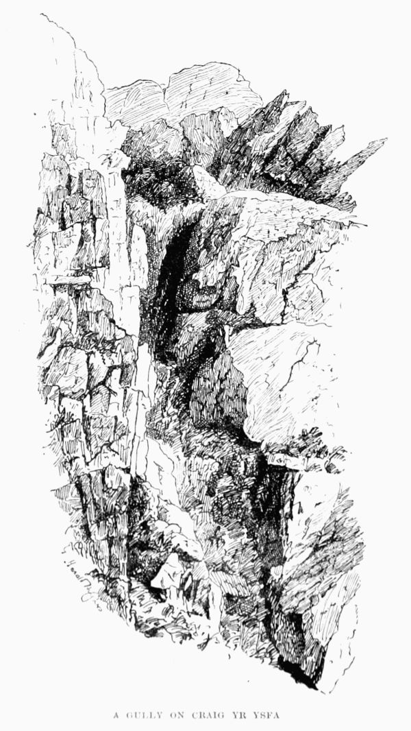
Craig yr Ysfa.—These rugged and in parts highly romantic rocks have attracted but few climbers. A hardworking group of Bangor enthusiasts have done about all the work that has been done here. In November 1894 J. M. A. T., H. H., H. E., and J. S., quitting the road just beyond the eighth milestone from Bangor, reached, in twenty minutes, the mouth of a gully, broad except where it narrows into a gorge, about half-way up. The climbing on the left of the stream is quite easy, on its right less so; but in either case the stream has to be abandoned at the first waterfall, which is quite impracticable when there is any quantity of water falling. One may climb out to the right by a small tributary gully, or up the buttress of rock to the right, and thus turn the lower fall as well as the upper fall, which is a small edition of the Devil's Kitchen. Near the edge of the cliff, on the left of the gorge, is a large tabular rock, which forms the postern to a narrow passage back into the gully, which soon broadens out and leaves a choice of routes; the left-hand branch should be taken by preference, as it contains a rather difficult pitch, above which the ascent to the top of the ridge is simple.
A GULLY ON CRAIG YR YSFA
A second gully lies a few hundred yards nearer Ogwen [Pg 23][Pg 22]Lake, and contains, besides cascades, two distinct waterfalls, of which the first may be surmounted by a small but not easy chimney close to it on the left, which is also the side for attacking the second difficulty. Here a necessary grass ledge above the level of the top of the fall was loosened by heavy rain, and stopped the progress of the above party, who completed the ascent by climbing out to the left.
The craggy portion is just over one mile long. Towards the head of Nant Ffrancon the rocks come lower, and are more fantastic, affording a great variety of fine problems, though few continuous climbs.
Carnedd Llewelyn (3,484 ft.) is the second highest of the Welsh mountains. The last Government Survey gave it a slight lift, and at the same time slightly reduced Snowdon, causing a rumour to go abroad, alarming to conservative minds, that the latter had forfeited its pride of place. This would have been a real misfortune, as the old-established favourite is beyond all question the finest mountain of the two. Only imagine the feelings of a poor peak abandoned in its old age, without cheap trippers, without huts, without a railway, without Sir Edward Watkin. The blow would have been too cruel! The near views from Carnedd Llewelyn are not remarkable. They consist mainly of the crags of Yr Elen and those of the grand north face of Carnedd Dafydd, which, however, practically conceal the Glyders, and these again cut off most of Snowdon. But the seaward view is very fine, and with regard to the very distant places, such as the Cumberland Fells, this mountain has a great[Pg 24] advantage over Snowdon both 'to see and to be seen.' Perhaps the extra 7½ miles make the difference, but it is a fact that for once that Snowdon is to be made out from Scafell or Great Gable, Carnedd Llewelyn can be seen half a dozen times.
For the ascent Bethesda is the nearest. Several ways present themselves, and whichever the traveller takes he will think that he has taken the boggiest. One way is straight up Cwm Llafar to the ridge (Bwlchcyfrwydrum) between the two Carnedds, or inclining left one mile short of this ridge one soon reaches the ridge connecting our mountain with Yr Elen, on the other side of which are some fine crags. The ascent by way of Cwm Caseg, the next valley to the north, is equally simple and affords a good view of these crags from below. In thick weather the long lonely walk from Aber is an education in itself to the mountain rambler, while from Talycafn station, on the north-west, a good road comes to within a mile and a half E.S.E. of the summit. The Capel Curig ascent is perhaps the least interesting of all; by it the two Carnedds are usually combined. Either the ascent or the return should be made along the Pen Helig ridge, with regard to the terrors of which the guide-books have used language as exaggerated as the descriptions of Striding Edge on Helvellyn. In winter, however, there is sometimes pretty work here.
Climbs.—A few rocks will be found round the remarkable tarns of Llyndulyn and Melynllyn, on the north-east side of the mountain, and on the west side of Llyn Eigiau. Better still are the rocks near where the Talycafn road ends by a slate[Pg 25] quarry in the rocks of Elicydu (apparently marked as Pen Helig by the Ordnance Surveyors); but best of all is the north-east side of Yr Elen, where there is a sort of small edition of the Black Ladders, with the same sunless aspect, so that it often keeps its snow in the same way till quite late in the year. In winter, however, the grand cwm which lies due east of the Carnedd offers splendid snow scenes and snow work.
Some years ago a quarryman was lost in the snow, and an upright stone on the north ridge of the mountain marks the spot. One of the earliest ascents of the mountain was that made in 1630 by Johnson, who evidently had the spirit of the mountaineer in him, for he pressed his guide to take him to the more precipitous places, alleging the love of rare plants. That worthy, however, declined to go, alleging the fear of eagles. Mackintosh too had a difficulty here with his guide during a winter's day excursion. But his fears seem to have been entirely without reasonable cause, and he was not so near to being robbed or murdered as he at one time fancied. Mr. Paterson's charming book Below the Snow Line describes the route from Llanfairfechan in wild weather.
In the Philosophical Transactions for 1771 will be found noted an ascent which satisfied the climber and his water-level that the summit was higher than that of Snowdon. Pennant too made the ascent, but came to an opposite conclusion on this point.
Elider Group.—Carnedd y Filiast (i.e. 'Cairn of the Female Greyhound') is a feature on the west side of Nant[Pg 26] Ffrancon, on account of the very remarkable slabs which it exhibits on that side. A hundred and twenty-five years ago Pennant was told here that 'if the fox in extreme danger takes over them in wet weather he falls down and perishes.' Certainly they are dangerous enough to a less sure-footed animal—man—and are best left alone, especially when there is any ice about. The nearest place from which to start is Bethesda. Another hill of the same name lies to the north of Bala.
Foelgoch.—A spur running north-west from Glyder Fawr forms the western bank of Nant Ffrancon, and nearly three miles along this ridge is Foelgoch (i.e. 'Red Hill'). It has a steep western side towards the head of Cwm Dudodyn, and on the other side a very steep rocky recess facing Llyn Idwal. Llanberis and Bethesda stations are about equally distant. From the former place it is seldom visited, except before or after the ascent of Elidyr Fawr.
On August 6, 1886, E. K. writes, 'There is excellent scrambling to be had about this mountain, and some really difficult work.'
On September 29, 1894, a party of three climbed from Nant Ffrancon.
The break in the ridge may be reached either by following the ridge itself or from the cwms on either side of it. The ascent thence to the summit offers easy but steep climbing if the crest of the ridge be scrupulously adhered to. Passing over the summit of Y Garn the descent was made down the southern ridge of Cwm Clyd, which gives a good scramble along its barren arête.[Pg 27]
 TWLL DU
(looking down through it to Llyn Idwal and Llyn Ogwen)
TWLL DU
(looking down through it to Llyn Idwal and Llyn Ogwen)
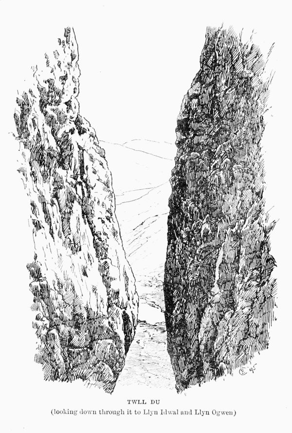
Y Garn (3,104 ft.), near the head of Nant Ffrancon, on the west side, is little visited, but has some very good rock on it. Benglog is much the nearest place. The well-known Twll Du may almost be said to be on it, and is practically the division between it and Glyder Fawr.
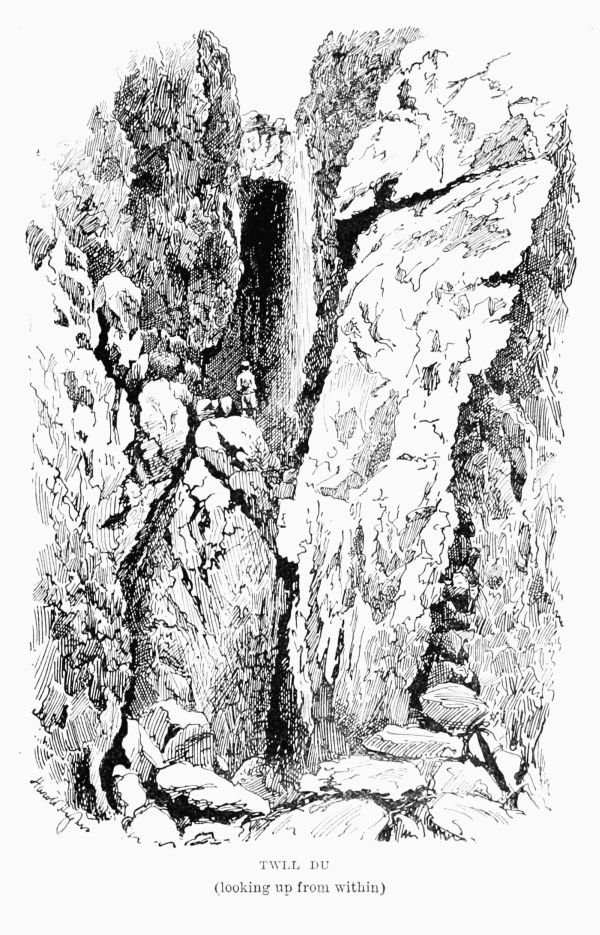
Twll Du (i.e. 'Black Pit'), commonly called the 'Devil's Kitchen,' is a remarkable chasm in the line of cliff which faces the head of Llyn Idwal on the south-west, being a northerly continuation of Glyder Fawr. From Benglog, which is much the nearest place, there is little choice of route; either side of Llyn Idwal will do, but the west side is rather less boggy. Keeping well up you pass the head of Idwal until you bring it on with the head of Llyn Ogwen, and then about 500 ft. above the former you find yourself at the foot of this grand fissure. In dry weather all but the highest patch can be easily ascended; after rain it is sometimes difficult to enter the place at all. In the summer of 1893, which was extraordinarily dry, a young fellow claimed to have done it single-handed, but it was supposed by some that he had mistaken the place. During the intense cold of March 1895 an extraordinary tour de force was accomplished here by J. M. A. T. and H. H., who cut their way up the frozen waterfall, and thus accomplished what was probably the first ascent of this formidable chasm. The height of the final pitch in its normal condition is about 53 ft., measured from the top of the block down to the surface of the pool below. When the climb above described was made, no doubt much of this height was filled up by snow and ice,[Pg 29] [Pg 30]yet the remainder was not surmounted in less than 7 hours, so that the average rate of progress must have been about 5 ft. per hour. The total time from Benglog to the top of the Kitchen was 8½ hours. The party descended in the dark to Llanberis in 3 hours more, having left Ogwen in the morning at 10 o'clock. Those who approach from Upper Llanberis by way of Cwm Patric or from Penygwrhyd over the shoulder west of Glyder Fawr, and, in fact, all who do not come by way of Benglog, have to descend the high cliff out of which the Kitchen is cut. The only convenient passage starts about a furlong to the south of the Kitchen, and is very awkward at night or in mist. It begins as a wide, straight trough (the largest and most regular of two or three), which slopes gently downwards and towards Benglog. Presently it takes a more northerly direction and becomes a steep, wide slope of scree following the line of cliff to the great blocks of fallen stones which mark the mouth of the chasm. An active man can return from the lower to the upper exit of the chimney in ten minutes, and the descent could, of course, be done in even less time. In dry weather there is but one slight difficulty before reaching the grand crux at the head. It can be climbed by passing into a cavern and up to the left, but the easier, and after heavy rain the only practicable, way is up the side-wall just to the left of the choke-stone on to a broad ledge. A little way above this a huge slab, fallen from above, is seen leaning against the wall on the right. The passage to the right of it can always be made, however strong the stream on the left hand may be. The climb to the top of this slab is very neat, and,[Pg 31] besides affording a capital view of the situation, is about all the consolation left for the ardent explorer, who will seldom succeed in penetrating any further. There are, however, two possible lines of advance, both on the left-hand wall, one well in under the colossal cap-stone, which hangs 50 ft. overhead, and the other outside, nearly opposite the great slab. By the latter route 20 ft. or 30 ft. can be climbed with some little difficulty, but the traverse to the right would no doubt prove a very ticklish operation. Cliffe, in June 1843, penetrated to the foot of the final obstacle, and gives a very good description of it.
 TWLL DU
(looking up from within)
TWLL DU
(looking up from within)
Glyder Group.—Glyder Fach (3,262 ft.), though called 'the lesser,' is far finer than its brother peak, so much so that many have found great difficulty in believing that the Ordnance Surveyors were right in ascribing 17 ft. of superiority to the more lumpy western summit. One might be tempted to build a 20-ft. cairn but for the fear of spoiling the great glory of Glyder Fach, the chaos of rocks on its summit. The present cairn was not in existence ten years ago, and must have been built about 1887.
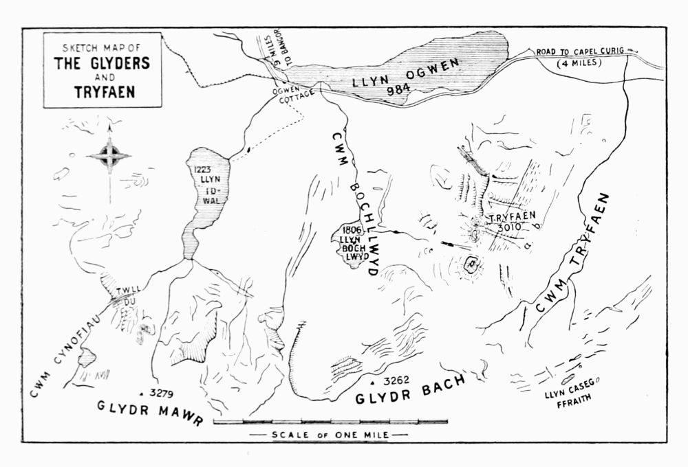 SKETCH MAP OF
THE GLYDERS
AND
TRYFAEN
SKETCH MAP OF
THE GLYDERS
AND
TRYFAEN
Ascents.—From Benglog the most interesting ascent is by the Gribin ridge, between Idwal and Bochllwyd. It involves a slight descent (about 150 ft.) after reaching the ridge, but it is less fatiguing than that by Bwlch Tryfaen and the steep rough screes on the right hand beyond it. From Penygwrhyd you mount behind the inn, crossing the bog as you best can towards a wall which goes straight up the hill. When the direction of the wall changes you make a compromise[Pg 32] [Pg 33]midway between the old and the new, and very soon come on to a line of cairns which continues right on to the boggy tableland above. Tryfaen top now appears over the hill, and as soon as it is fairly lifted you bear to the left and up a stony slope to the cairn. From Capel Curig it is a simple matter to follow the ridge of Cefn y Capel, but quicker to keep along the highroad past the Llynian Mymbyr, and then strike up a grass slope to the right. As often as not both Glyders are ascended in one expedition; the dip between the two is only 300 ft., the distance is under a mile, and stones are the only obstacles.
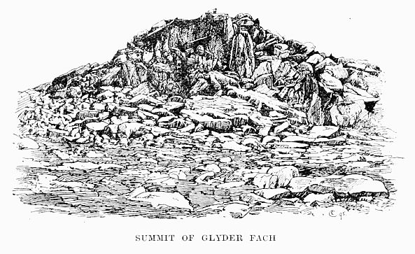 SUMMIT OF GLYDER FACH
Climbs.—The north face of this mountain is remarkably fine and contains all the climbing there is. At the east end is the bristly ridge leading down to Bwlch Tryfaen. This is stimulating, but not difficult. In the centre of the face there[Pg 34] is a large gully, ascended in November 1894 by J. M. A. T., H. H., and H. E. They did not find it necessary to use the rope. The lofty pitch at the foot of the eastern gully is decidedly hard. (J. M. A. T.) In May 1888 W. E. C., A. E., E. B., and E. K. found and ascended a gully close under the west side of Castell Gwynt, and add that they reached Penygwrhyd by way of Cwm Graianog. The last statement is very mysterious. About the Castell itself (the rugged pile of rocks between the two Glyders, marked by its slender outstanding 'sentinel'), and about the summit of the Fach, there are some good scrambles on a small scale.
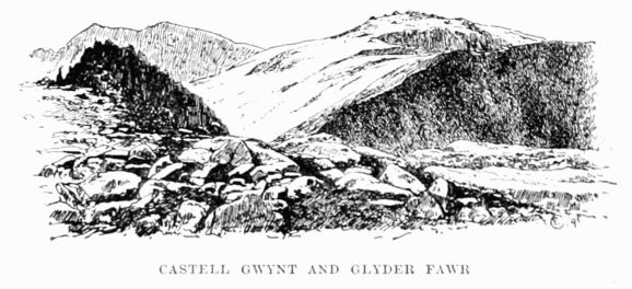 CASTELL GWYNT AND GLYDER FAWR
Directly under the top stone is the minimum thermometer, which has been kept there for some years. [10] The most interesting thing on the whole mountain is undoubtedly the pile of stones on the top. According to the bard Taliesin it is the burial-place of a mighty warrior, one Ebediw. If a kind of Stonehenge was erected there to his memory and [Pg 35]afterwards got upset by an earthquake it might account for present appearances. Edward Lhwyd, the great antiquary, was particularly struck by them 200 years ago, and his description and remarks are equally applicable to-day.
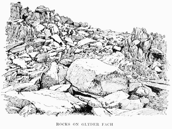 ROCKS ON GLYDER FACH
'On the utmost top of the Glyder,' he says, 'I observed prodigious heaps of stones, many of them of the largeness of those of Stonehenge, but of all the irregular shapes imaginable, and all lying in such confusion as the ruins of any building can be supposed to do.... Had they been in a valley I had concluded they had fallen from the neighbouring rocks ... but, being on the highest part of the hill, they seemed to me much more remarkable.' He goes on to remark upon a precipice which has not been identified (see[Pg 36] Esgair Felen). 'On the west side of the same hill there is, amongst many others, one naked precipice (near or one of the Trigfylchau, but distinguished by no particular name), as steep as any I have seen, but so adorned with numerous equidistant pillars, and these again slightly crossed at certain joints. 'Twas evident that the gullies or interstices were occasioned by a continued dropping of water down this cliff.' Trigfylchau, by the way (i.e. 'Twisting Gaps'), is a name which does not seem to be known at the present day.
Lhwyd's description fired the curiosity of the travellers who explored Wales nearly a century later, and the amusing part of it is that they could not find this wonderful mountain, or even hear of it from the intelligent natives.
Cradock (1770) found an aged man, who told him that the mountain was 'now called the Wythwar (Wyddfa),' which stands 'a few miles south of the parish of Clynog;' and H. P. Wyndham went further by identifying it with 'the mountain called Ryvil in Speed's map' (i.e. Yr Eifl). It shows how little the natives knew about their mountains until the travellers came and taught them. Pennant made the ascent, and gives a picture of the summit. Bingley also went up, and gives a good description.
Kingsley's fine description, in Two Years Ago, of Elsley's ascent really applies mainly to Glyder Fach, though he only mentions the Fawr. Elsley's descent, by the way, was apparently into Bochllwyd by way of Castell Gwynt.
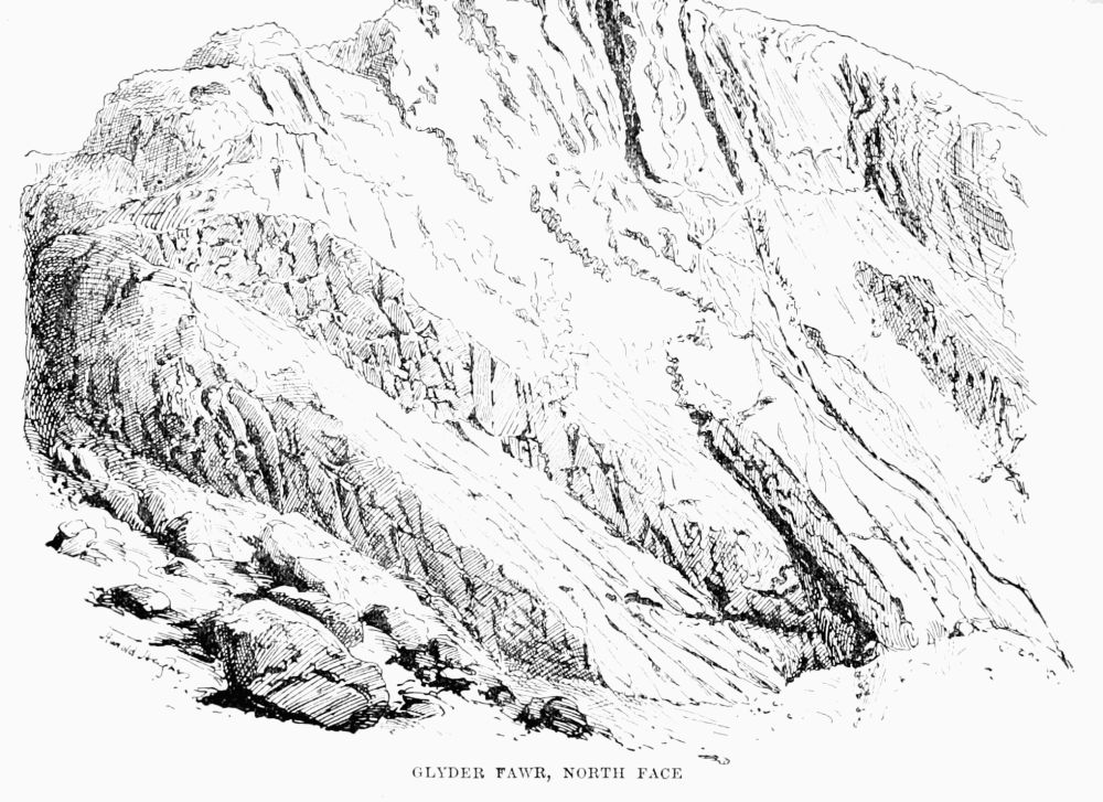 GLYDER FAWR, NORTH FACE
Glyder Fawr (3,279 ft.).—The meaning of the name is a mystery. One Welsh scholar gravely tells us that the[Pg 37] [Pg 38]real name is Clydar, which at once yields the obviously suitable meaning of a 'well-shaded ploughed ground.' Either of these epithets would be quite as appropriate to the Sahara itself, for the two Glyders are among the barest and rockiest mountains in all Wales. The two roads which lead from Capel Curig, one over the Pass of Llanberis and the other through Nant Ffrancon to Bangor, enclose between them the whole of the Glyder group, forming a singular figure, which recalls Menenius Agrippa's description of the Second Citizen as 'the great toe of this assembly.' The toe is slightly bent; Penygwrhyd is the knuckle, Capel Curig the tip of the nail, and Benglog (the head of Nant Ffrancon) is just in the inside bend. The highest point of the group lies practically in a straight line with Snowdon and Carnedd Llewelyn, and, roughly speaking, midway between them. Of Snowdon it commands a profoundly impressive view, and is in turn itself best seen from the Carnedds.
Both Glyders are very frequently ascended from Penygwrhyd, Llanberis, Capel Curig, and Ogwen.
The simplest way up is from the top of the Llanberis Pass, from which a ridge leads to the summit. This is, perhaps, the best way if the start be made from any place not on the north side, though from Penygwrhyd the route may be boggily abbreviated by making up the little valley to the north-west. From Ogwen the usual ascent passes near Twll Du, though the ridge separating the Idwal and Bochllwyd lakelets is sometimes chosen, and certainly affords a greater variety of fine views.
Climbing on this mountain is practically confined to its[Pg 39] northern face, and even there very little has been done. There are also a few rocks on the west side. The climbing-book at Penygwrhyd contains very few references to it. At Easter in 1884 H. and C. S. mention that they enjoyed fine glissades down the snow slopes on the north-west side to Llyn y Cwn, but the first real climb recorded therein is that of the big gully in the north face, made on November 25, 1894, by J. M. A. T., H. H., and H. E. From the far end of Llyn Idwal a long scree leads up to the mouth of the gully, which may be identified from a distance by the pitch which blocks it about half-way up and a broad strip of grass outside it on the west. The point to make for is the head of a wall which runs up from the extreme south end of the llyn to the corner of a huge mass of bare smooth rock. If the traveller reaches this point without being engulfed in the boggy ground which fringes the llyn he will now continue in the same general direction as the wall, and soon sees the gully just before him. A kind of trough, probably produced by weathering of the rock, is now seen on the left, and this, as it appeared more interesting than the steep grass of the central part of the gully, was followed at first by the above-mentioned party. The trough is very easy at the foot, and has good holds, which higher up incline outwards, and become less and less prominent until at last progress becomes a question of delicacy and circumspection. Before the trough came entirely to an end the party traversed into the gully, but even there found the ascent to the pitch far from easy. Utilising the full length of their 80-ft. rope, and moving only one at a time, they reached the cave under the big pitch. Here it[Pg 40] appeared hopeless to climb out on either side, and recourse had to be taken to engineering of the same kind which was successfully put in practice some years ago on Dow Crags, in Lancashire, by a very scientific band of brothers. Similar success crowned the efforts of this party, and brilliant gymnastics on the part of the leader landed them safely at the top of this difficulty. From this point the remainder of the climb has a deceptively easy appearance. Some 80 ft. higher up the difficulties begin again, and continue up to a small pitch just below the top. On one stretch it was found necessary to adopt a compromise between the wisdom of the serpent and the aimlessness of the crab, advancing by lateral jerks in a semi-recumbent attitude. Possibly these extreme measures would not have been necessary but for the fact that on this occasion the conclusion of a spell of three weeks of incessant rain was chosen as a suitable opportunity for attacking this face of the Glyder. It was the opinion of the party that the climb—at any rate in its then condition—is incontestably more difficult than that of the western buttress of Lliwedd. The time taken was 4 hours, including a short halt for luncheon.
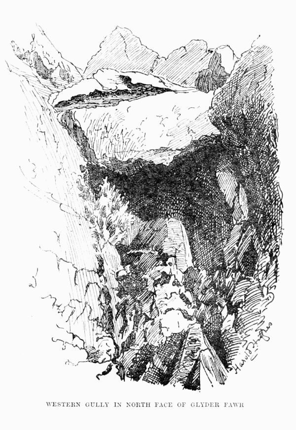 WESTERN GULLY IN NORTH FACE OF GLYDER FAWR
This gully is the more westerly of two. The other one was climbed in May 1895 by J. M. A. T., H. H., and W. E. One of the party says of it, 'We soon came to some rather difficult rocks; we climbed them close under the right-hand wall—a really stiff little bit. The gully here is still quite broad, and on the left side of it we saw another way, which looked much easier. We found no special difficulty in the jammed stone which looks from below such a formidable[Pg 41] [Pg 42]obstacle. Two of us climbed it on the right; the third man circumvented it on the left. From this point to the summit is excellent throughout, the rocks being steep, the holds strong, well defined, and most conveniently distributed. In my opinion it is the best thing on the Glyders, and it can be done by a single man.' Still further east a narrow crack gives a very steep but easy rock staircase, while west of the gully first described is another with two pitches, of which the lower is harder and the upper easier than they look. The 60 ft. just above the latter are climbed by means of slight rugosities in the left-hand wall. It is somewhat curious that when, in February 1873, Glyder Fawr was crossed from Ogwen by way of Twll Du, with John Roberts as guide, it was recorded in the Alpine Journal [11] as something of a feat and something of an eccentricity. Twenty years have made a great change, and now, about Christmas or Easter, the snow on these hills is marked by tracks in many directions.
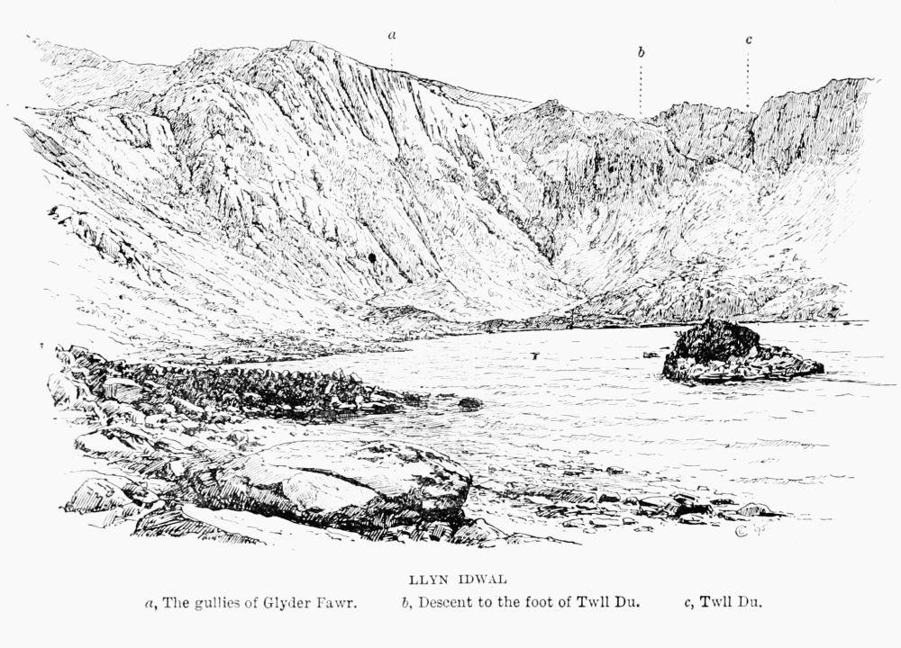 LLYN IDWAL
a, The gullies of Glyder Fawr.
b, Descent to the foot of Twll Du.
c, Twll Du.
LLYN IDWAL
a, The gullies of Glyder Fawr.
b, Descent to the foot of Twll Du.
c, Twll Du.
Esgair Felen (i.e. 'The Yellow Shank').—In August 1893 G. W. de T. found very good rocks and gullies on this shoulder of Glyder Fawr. Ascending from just above the cromlech stone in Llanberis Pass, the buttress immediately above can be climbed on the right or south-west side. The upper half may be climbed by a narrow gully, too narrow at first to enter, and giving little hold for hands or feet, and that little not sound. Apparently the leader climbed up a little way, and then the rest of the party climbed up the leader. They found good climbing without [Pg 44][Pg 43]special difficulty among the rocks on the top of the great gully in the centre.
It is somewhere in this neighbourhood that we must look for the mysterious precipice of which Edward Lhwyd wrote two hundred years ago as being strikingly columnar in structure, and possibly identical with 'one of the Tregvylchau or Treiglvylcheu.' He says it is part of the Glyder, and faces west. Perhaps it is about the east side of Cwm Patric. As seen from well down the Llanberis Pass these rocks have a very striking appearance.
The term 'esgair' is very commonly applied to long straight projections from higher mountains. Instances of its use are E. Weddar, E. Yn-Eira, E. Geiliog, E. Hir, and E. Galed.
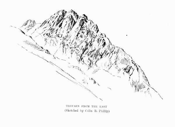 TRYFAEN FROM THE EAST
(Sketched by Colin B. Phillip)
TRYFAEN FROM THE EAST
(Sketched by Colin B. Phillip)
Tryfaen (3,010 ft.), not to be confounded with the hill of the same name on the Llanberis side of Snowdon, or the other near Bettws Garmon, is the most remarkable rock mountain in Wales; it has two pillar stones on its summit, from which it is often said that the name (= 'three rocks') is derived. In answer to this it is enough to point out that the assumed third stone is not there, and could not have disappeared without a trace, while the name would equally well mean 'three peaks,' which the mountain certainly has when viewed from either east or west. The Welsh dictionaries give a word 'tryfan' with the sense of 'anything spotted through,' and, whether or not this has anything to do with the origin of the name, the component rocks certainly are quartz-speckled in a most extraordinary manner. The mountain is practically a ridge of rock running in a[Pg 45] [Pg 46]southerly direction from the head of Llyn Ogwen towards Glyder Fach, from which it is separated by a sharp dip, Bwlch Tryfaen. This dip, which may be reached either from Cwm Bochllwyd on the west or from Cwm Tryfaen on the east, offers by far the easiest ascent of the mountain. The best starting-point for Tryfaen is Ogwen Cottage, at Benglog, from which Llynbochllwyd is reached in 25 and the said dip in 45 minutes; so that, if need were, the whole height (2,000 ft.) and distance (1½ mile) to the summit could be attained within the hour. From Capel Curig, on the other hand, there is a good hour's walking before the highroad is left, beyond Gallt y Gogof, which Borrow calls Allt y Gôg (Cuckoo Cliff), and even then the traveller has about as far to go as if he were starting from Benglog. Most of the Tryfaen climbs being on the east side they can be reached from Capel Curig with much less exertion than from Penygwrhyd, the route from which involves a long, rugged ascent, hot after the sun has risen and ankle-breaking after it has set.
Climbs.—These are extraordinarily abundant, and the hold is nearly everywhere gritty and good. The most popular climbs are:
1. The east side, including especially the two gullies on either side of the summit known as the North and South Gullies.
2. The north ridge up from the head of Llyn Ogwen.
3. The west side.
The South Gully, climbed by R. W. (1887). The first ascent noticed in the Book of Penygwrhyd being that of H. G. G. and W. in 1890. On September 5, 1891, H. G. G.[Pg 47] and E. B. T. offered some clear notes on the subject, to the following effect: The first difficulty consists of three or four jammed stones, each slightly overhanging the one beneath, with a total height of about 10 ft. It can be passed by keeping to the right close to the obstacle, but would not be easy in wet weather for any climber single-handed. At the place where the gully divides the left-hand or nearer division is not difficult. The broad division was found impracticable by a party of four on September 4, 1891, the large smooth rocks at the top being very wet. This place was climbed in 1890 by Messrs. G. and W. by keeping to the extreme right close to the wall of the gully, and then returning along a narrow ledge. It was an awkward place. There is nothing above where the two gullies unite that offers any real difficulty.
The North Gully is the more difficult of the two if the immediate centre is to be followed; but it is always practicable to break out on the face to the right. The difficulties of the South Gully are not so severe, but such as they are they must be climbed, as there is no lateral escape.
Under date of June 9, 1894, a very clear account is given by J. M. A. T., J. R. S., and H. E. At the first obstacle the first man climbed up into the hole formed by the projection of the topmost rock, but, as the next beneath slopes outwards and downwards, found it impossible to relinquish a crouching posture. The pitch was abandoned. The right-hand rocks close by were taken, and the gully rejoined without difficulty. At the fork the northern branch was chosen. It can scarcely be called a gully; the water trickles[Pg 48] down over the crags in several places, but there is no main or well-defined channel. A pinnacle is soon seen on the right, and here the climbing becomes difficult; the footholds are far apart, and the small tufts of grass, which were then wet and slippery, cannot be trusted. The course taken was to the extreme left, and as far as possible from the pinnacle, and in this respect it differs from that taken by Messrs. H. G. G. and W. in 1890. A firm, flat grass-covered shelf, at least a yard square, is seen in a straight line up above, and as soon as the first man has reached this a rope can be used to advantage. A steep rock some 12 ft. in height and of ordinary difficulty remains, and the climb thence to the summit is quite simple. By keeping to the left a cavern is reached, the further end of which opens like a trap door upon the summit; this interesting method of concluding the ascent should not be missed.
On August 25, 1892, G. B. B. with Mr. and Mrs. T. R. climbed the five pitches of the South Gully, a, b, c, d, e; a by the right-hand wall, b in the centre, c by divergence to the right-hand branch and return to the left over a narrow ledge, d and e in the centre or slightly on one side of the face. The gully was never left. Time, about 90 minutes.
North Gully.—This appears to have been climbed in 1888 by R. W. and T. W. Writing on September 5, 1891, H. G. G. and E. B. T. gave the following hints:—
The first difficulty is at the bottom, below the level of any part of the South Gully, and might easily be missed if the horizontal track be followed. On August 30, 1891, these gentlemen found the middle of this (after very wet weather)[Pg 49] quite impracticable, and the smooth rock on the right hand, lying at a very high angle, was also wet and very difficult. Either might possibly be passed in a dry season, the rock almost certainly. The next point of note is a very large lodged stone. Going under this they passed through the hole above, one climbing on the other's shoulder and afterwards giving him help from above. The passage was not easy.
The next difficulty is made up of two lodged stones about 10 ft. apart. The first might be passed in dry weather. A tempting ledge to the left was climbed without result; ultimately they rounded the obstacle by keeping to the right.
On September 19 W. E. C., H. R. B., and M. K. S. ascended the North Gully. They describe it as containing seven pitches, two of which are caverns. They believed that this gully had only once been climbed clean before—namely, in the autumn of 1888, by Messrs. R. W. and T. W.
On April 1, 1892, H. B. D., F. W. G., and A. M. M., with Mrs. D. and Mrs. C., ascended the North Gully in 2 hours 10 minutes. The last pitch gave some trouble.
In August 1892 W. H. P. and G. B. B. climbed all the pitches of the North Gully clean, taking the sixth from the bottom by the right side and the rocks straight to the summit stones, from where the gully divides. Time, 91 minutes. There is a singular difference of opinion among climbers as to the relative difficulty of these two climbs. Varying conditions of rocks and climbers may partly account for this. Without pretending to decide the matter either[Pg 50] way the writer would give it as his experience that unusual conditions more readily affect the southern for evil and the northern for good. For instance, wet or ice makes the former very nasty without altering the latter to the same extent, while really deep and good snow moderately improves the former but converts the latter into a delusion and a mockery, for it ceases altogether to be a climb at all, and becomes a mere snow walk. Even then it is worth doing if it were only to see the wonderful convoluted strata, in the case of more than one great block imitating the rings in the trunk of a tree.
Nor'-Nor' Gully.—On September 18, 1891, Messrs. W. E. C., G. S., and M. K. S. ascended a gully leading on to the north ridge of Tryfaen just to the north of the most northerly of the three peaks. The gully contains three pretty pitches, all of which were climbed, but two of them can be turned.
There is yet a fourth gully, still further north, but it has only one obstacle in it, and more scree than anyone can possibly want. So much attention has been devoted to these gullies during the last few years that the ridges which separate them have been unduly neglected. To the writer at least they have always seemed to offer better climbing than any of the gullies, and that of a kind which is very much less common. The ridges on either side of the North Gully are especially fine, and would satisfy the most exacting but for one thing, and that is that the hold is almost too good.
The North Ridge, from the head of Llyn Ogwen, is of[Pg 51] very imposing appearance, and was long spoken of with bated breath. In reality it is a fine but very simple and safe approach to the summit. The gluttonous climbers of the present day will probably complain that it is not a climb at all, but, though the difficulties, such as they are, can all be turned, the more enterprising members of a party can always find abundant outlets for their energies in numerous wayside problems.
Some of the rocks are very fantastic in shape; one projecting horizontally bears a resemblance to a crocodile and can be easily recognised from the east. Highly crystalline quartz veins render the rock surfaces even rougher than they would otherwise be, and in a few places the face of the rock is covered with egg-like projections, each containing a core of quartz. At a little distance they look like huge barnacles; their real nature may be left to the geologists.
On reaching the heads of the principal gullies the climber will fall in with some capital rocks on or beside his path along the ridge. At the very top he cannot fail even in mist to recognise the two upright rectangular stones, which are so conspicuous from afar. The feat of jumping from one to the other, by the performance of which Mr. Bingley's friend made that eminent traveller's 'blood chill with horror' nearly a hundred years ago, is not as difficult as it has been represented to be, and the danger of falling over the precipice in case of failure is purely imaginary. The unskilful leaper would merely fall on to the rough stones at the base of the pillars. Of the two jumps, that[Pg 52] from north to south is the easier. Bingley's guide, perhaps anxious to cap the Saxon's feat, told him that 'a female of an adjoining parish was celebrated for having often performed this daring leap.' Large as the pillars are it is difficult to believe that they were placed in the position they occupy by unassisted nature; they seem too upright, too well squared, and too level-topped; with a cross-piece on the top they would form a nobly-placed 'trilithon,' of which any 'dolmen-builder' might be proud.
The West Side.—A great part of this is occupied by a series of huge slabs, which have been compared by F. H. B. to Flat Crags on Bow Fell. In places luxuriant heather artfully conceals sudden drops and rolling stones on account of which several tempting descents on this side will prove annoying. The only important gully is well seen from Benglog. To reach it strike south-east by the highroad at a point about half a mile east of Benglog. About half-way up the gully trends away to the left, and comes out at a deep notch in the summit ridge. Excellent scrambling again may be found by climbing up eastward from the shore of Bochllwyd.
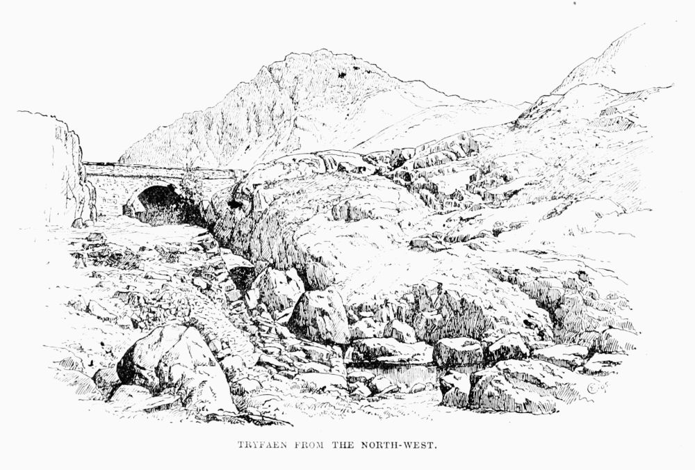 TRYFAEN FROM THE NORTH-WEST.
Moel Siabod (2,860 ft.) is ascended most easily from Capel Curig, but Dolwyddelan and Penygwrhyd are only slightly more distant, though considerably more boggy. The ascent is worth making, for the sake of the excellent view of Snowdon. The east side is by far the most abrupt, and here a few good crags are found. From this side also the mountain looks its best, but even seen from the west, the[Pg 53] [Pg 54]tamer side, it is, especially when snow-clad and lit by the setting sun, a remarkably effective feature in the landscape.
Readers of 'Madoc,' if such indeed there be, may remember that Southey was benighted on the hills around Dolwyddelan. In that episode Moel Siabod may well have played a part.
About the year 1830 Mr. Philip Homer was benighted on it, and died of exhaustion. Mention of this accident is made both by Roscoe (1836) and by Cliffe, who says he heard many details from an eye-witness. The body was taken to Capel Curig and buried there.
Snowdon (3,560 ft.) is the loftiest peak in this island south of Scotland, and one of the most beautiful that is to be seen anywhere. The name seems to have originally described a whole district which the Welsh called Craig Eryri (variously rendered 'rock of eagles' and 'rock of snow'). The peak itself is called Y Wyddfa (pronounced 'E Withva'), which is usually translated 'place of presence' or 'of recognition;' but the splendid suppleness of the Welsh language admits of rival renderings, such as 'place of shrubs or trees,' with which may be compared the name Gwyddallt—i.e. 'woody cliff;' and even, as a non-climber once observed, on seeing a panting form appear at the top of a gully on Clogwyn Garnedd, 'place for a goose.'
Leland speaks of 'the greate Withaw hille,' and says 'all Cregeryri is Forest,' and, in another place, 'horrible with the sight of bare stones as Cregeryri be.'
Snowdon may be climbed from many points. The[Pg 55] nearest inns are Penygwrhyd, Beddgelert, Snowdon Ranger, and Llanberis. The peculiarity of Snowdon consists in the huge cwms which radiate from its summit, and these will[Pg 56] be found described in their order, following the course of the sun, and the climbs to be found in each will be indicated.
Books on Snowdon are simply countless, and the same remark applies to the pictures which have been taken of it and the panoramas which have been drawn from it.
Unfortunately a very large number of fatal accidents have taken place on this mountain, and an interesting but somewhat incomplete article on this subject will be found in Chambers's Journal for May 1887. The Mr. Livesey there mentioned as having been killed by lightning seems to have been really named Livesley, and was of Ashton, in Mackerfield, Lancashire. This occurred on Sunday, September 21, 1884 (the Times, September 23).
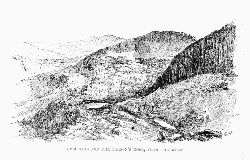 CWM GLAS AND THE PARSON'S NOSE, FROM THE WEST
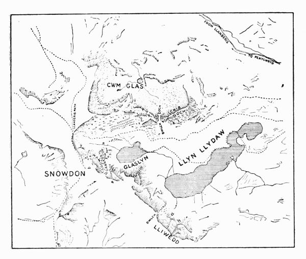
Cwm Glas.—As there are three or four tarns on Snowdon called Llyn Glas, so the name of Cwm Glas appears to have been confusingly popular. Cwm Glas proper lies immediately under Crib y Ddysgl, and Crib Goch on the north side; but, to say nothing of the next hollow to the west, which is called Cwm Glas Bach (i.e. little), a recess lying just north of both is called by the same name, and it would appear, from some of the early topographers, that they understood the term to comprehend the whole valley which forms the west approach to the Llanberis Pass. The proper cwm can only be reached from Llanberis or from Penygwrhyd. From the latter (the usual starting-point) the simplest, though not the shortest, way is to go over the pass and down to Pontygromlech, and there, instead of crossing by the bridge, bear away to the left, and up into[Pg 57] [Pg 58]the cwm. Experts can save something by striking off much earlier near the top of the pass. Those who come from Llanberis will leave the highroad at a point 3½ miles from the station and about half a mile short of the cromlech.
Before the two pools come into sight several short but striking pieces of rock are met with, and, indeed, the rock scenery on all sides is extremely fine. Many people come here for that reason alone, and are content to see the rocks without climbing them. For them there is an easy way up to join the Llanberis path by way of the grassy slope west of the Parson's Nose, of which more anon. Between the two a second ridge is seen, smaller than the Nose, and roughly parallel to it, leading out on to Ddysgl, much further up. Not far from this Mr. F. R. Wilton died in 1874 (see Crib y Ddysgl) and Mr. Dismore was killed in 1882.
Parson's Nose.—The best known climb in Cwm Glas is on the rock called Clogwyn y Person (i.e. 'Parson's Cliff'), alias the Parson's Nose. It is a spur of Crib y Ddysgl, and is easily identified by its projecting in a northerly direction between the two little pools in Cwm Glas. No one seems to know the origin of the name; possibly it may have been scaled by the famous climbing cleric who haunted Snowdonia half a century ago. The most striking feature of this fine arête is the wonderful excellence of the hold. Faces crossed by precarious-looking ledges are found on a closer inspection to have behind those ledges deep, narrow, vertical rifts, affording the perfection of hand-hold, while the rock surface itself is so prickly and tenacious that boot-nails grip splendidly, and the only[Pg 59] difficulty for the fingers is that some of them are apt to get left behind on the rocks. It may be climbed direct up the face, either from the very foot or from a point more to the right and some 30 ft. higher up. The height of the initial climb is something like 100 ft. Again, there is a gully on each side of the actual Nose, and it is usually climbed by one or other of these. The western gully is blocked above by an overhanging rock, over or under which it is necessary to climb or crawl. The gully on the opposite or east side is longer, and generally much wetter, and is on that account considered more difficult either to go up or to come down. The three ascents unite close to the cairn. Above the cairn the ridge continues, broken by only two respectable pitches, and leads on to the great tower on Crib y Ddysgl, some 1,200 ft. above the beginning of the climb. It is not, however, necessary, in order to get up out of Cwm Glas on to the main ridge, to climb the Nose at all; by proceeding west and over some white quartz slabs, close under the ridge, and then turning left, one can get out easily a few feet from the top of the Nose, or nearly the same point may be reached from the east side, only it will be after a less interesting and generally somewhat wetter ascent. If a climb is desired when the gullies are in a dangerous condition, there is a place further to the right than the right-hand or west gully where a very steep but safe scramble among big blocks leads up on to the bridge of the Nose.
The following ascents are noted in the book at Penygwrhyd, that by T. W. and R. W. being probably the first:—
1887, September 18.—W. E. C. and A. E.[Pg 60]
1890, June 21.—W. P. and G. B. B. tried the Parson's Nose, and, climbing the cleft from the south side, crawled between the rocks which block its upper part, then up the crags to the right for a short distance.
1892, April 2.—A party which had ascended the north gully of Tryfaen the day before ascended the Parson's Nose up the ridge, starting from the cleft. About 50 ft. above it a wall of rock is met which must be climbed either round a corner on the right hand or up a steep chimney on the left. The latter route was chosen, but a large stone (the middle one of three on the left side of the chimney) slipped, and remained in a dangerous position.
1892, August.—W. H. P. and G. B. B. climbed the 'wall of rock' straight up, which they thought easier than the chimney to the left or the green gully to the right.
September 23.—Mrs. H., Miss B., and a large party of gentlemen climbed the Parson's Nose by the gully on the Llanberis side and the jammed stone.
Bingley visited this cwm at the close of last century, and gives a good description of it. He was much impressed by Caddy of Cwm Glas, the strong woman. Her real name, by the way, was Catherine Thomas.
Cwm Glas Bach also has some fine rocks, and from the head of it up to Cyrn Las a good climb may be had.
Crib Goch ('The Red Ridge') stretches down westward from Crib y Ddysgl to about opposite the summit of the Pass of Llanberis. The name is sometimes used for the whole length of both cribs. This is admitted on all hands[Pg 61] to be inaccurate, if convenient, but there is some difference of opinion as to where the line of demarcation should be drawn. Some say at Bwlch Goch (2,816 ft.), while others put it a quarter of a mile or more further west. About 500 yards east of the Bwlch, at almost the highest point (3,023 ft.) of the ridge, a side-ridge strikes away to the north, while the main line continues eastward. The well-known pinnacles (including the 'Crazy' one) are close to Bwlch[Pg 62] Goch, and on the north side of the ridge overlooking Cwm Glas. The southern side, sloping into Cwm Dyli, though very steep, is much less precipitous and rocky than the other.
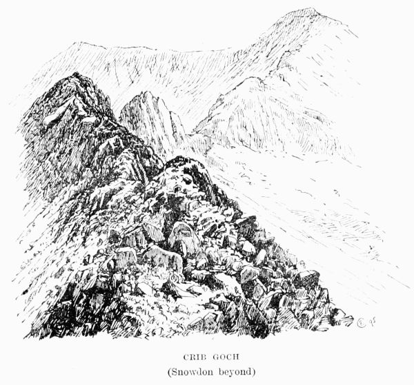 CRIB GOCH
(Snowdon beyond)
CRIB GOCH
(Snowdon beyond)
Starting Points.—Penygwrhyd and Gorphwysfa have almost a monopoly of Crib Goch, because for all other places—such as Llanberis, Beddgelert, Capel Curig, or Bettws y Coed—the distance from Gorphwysfa has simply to be added as so many extra miles along a highroad. In the case of Capel Curig this makes very little difference, seeing that Penygwrhyd lies on the direct route for any ascent of Snowdon, and to the latter there is no nobler approach than that along this ridge. Some have thought it sensational, and many have described its terrors in very sensational language; in fact, it takes the place which among the English lakes is filled by the far less striking Striding Edge on Helvellyn; but in truth, though it is the sort of place where ice, mist, and high wind may encroach to some extent on the margin of safety, to a steady head and foot there is no danger whatever. As for the hands, they are hardly required at all, though for those who like it plenty of real climbing can be had on the way.
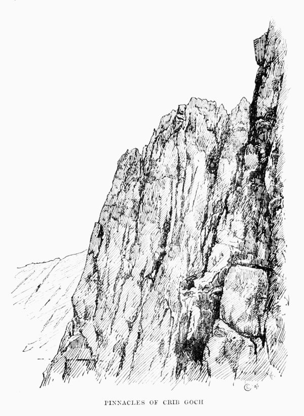 PINNACLES OF CRIB GOCH
Any mountaineer worthy of the name will admit that the ridge walk up Snowdon by Lliwedd and down by Crib Goch is for its length one of the finest in Europe. The mere gymnast also finds here plenty of enjoyment and almost infinite variety. He may mount by the east ridge or by the north ridge, or in the corner between the two. Again, the north ridge may be reached by either of two gullies in[Pg 63] [Pg 64]its eastern flank. Of these two gullies the more southerly is the steepest and longest, and may be recognised at some distance by a peculiar split or gap, while the other and more northerly, formed in rock of most cutting quality, offers a convenient passage to the foot of the steep part of the north ridge, from which point there is, if required, an easy descent into Cwm Glas.
The north ridge gives a short, pleasant scramble, and is somewhat sheltered from southerly winds, which are sometimes an annoyance on the east ridge.
Further west there are several good gullies on the Cwm Glas side, especially round about the pinnacles. The Crazy Pinnacle may be ascended either on the north-east or on the south-west side. The former is now more favoured since the fall of a certain large stone on the latter, which gave a useful hold in former days. Thirty years ago this ridge was almost unknown. A writer of 1833 seems to imply that it had been ascended by saying that 'the passage of it is hazardous, from the shortness and slippery quality of the grass at those seasons of the year when the mountain may be approached;' but this is evidently a mere misapplication of what others had said about Clawdd Goch (Bwlch y Maen), on the other side of the mountain, and we do not hear of anyone climbing here before C. A. O. B. (1847) and F. H. B. a few years later. Between 1865 and 1875 it became better known, and in the books at Penygwrhyd we find it recorded that in April 1884 H. and C. S. climbed from Cwm Dyli, thence along the ridge by Crib y Ddysgl to the summit of Y Wyddfa.[Pg 65]
In 1887, on June 30, E. K. climbed Crib Goch from Cwm Glas by the gully to the left of the outstanding or Crazy Pinnacle. Near the top two big stones are jammed in, and this compelled him to leave the gully; but on June 29, 1890, G. S. S. found these stones climbable by the aid of a crack in the rocks on the left hand. From this point the ridge can be reached by taking to the rocks on the right. They are sound, which is more than can be said for those on the left of the gully a little farther down.
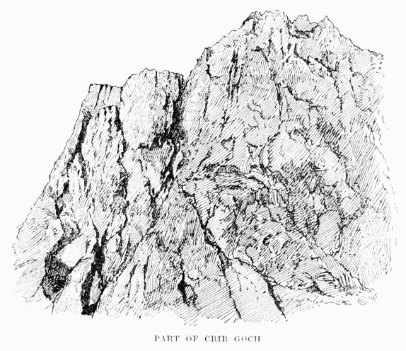 PART OF CRIB GOCH
On July 31 and August 2 E. K. scrambled up the other[Pg 66] gullies nearer Bwlch Goch, and found them easier than the first, which is the main one seen from Cwm Glas. He pronounced these climbs well worth trying, but not fit for beginners.
On June 17, 1890, W. P. and G. B. B. ascended to Bwlch Goch, and bearing round the foot of the first pinnacle, climbed the gully between the first and the second. They found the holding good, but the rocks by which the gully is blocked somewhat difficult to pass.
In 1894, on September 14, W. E. C., S., and B. climbed Crib Goch to the central cairn from Cwm Glas.
On December 9, 1894, J. M. A. T., H. H., and H. E. climbed the face from Cwm Glas beside an insignificant watercourse, reaching the ridge at the ruined cairn, then, passing along to the Crazy Pinnacle, scrambled down the gully on the Llanberis Pass side of it. The latter climb they describe as short but excellent, and the former as also good. No more climbs here are described in the Book of Penygwrhyd, but many others have been made. The truth is that for the last quarter of a century hardly a climber has visited Wales without making Crib Goch a primary object, and consequently there is not a climb on it whereof men say 'See, this is new.'
Crib y Ddysgl.—The name is pronounced practically 'Cribbythiskle,' and sometimes written 'Distyl,' a spelling probably due to a desire to support the common derivation of the name from 'destillare' i.e. 'dripping ridge.' The climate of Wales, however, is not such as to make any ridge remarkable merely because it drips, and moreover the[Pg 67] derivation will not account for the other instances of the word. For instance, two or three miles west of the Pitt's Head we have Trum y Ddysgyl, and the proximity to it of Cwmtrwsgyl suggests that some distinction is expressed by the penultimate syllables. Attempts to derive the name from 'disgl' (= 'dish') seem equally futile. Possibly the explanation may be found in the word 'dysgwyl' ('watch,' 'expect') (compare Disgwylfa, in Cardiganshire), which would make it parallel to names like Lookingstead, &c.
The highest point of Crib y Ddysgl is called Carnedd Ugain, and is a worthy rival of Y Wyddfa itself, being, according to the Ordnance surveyors, only 69 ft. lower—viz. 3,491 ft.—and from some points of view a really beautiful peak.
From the highest point a narrow crest runs due east, reaching in about a quarter of a mile the huge buttress called Clogwyn y Person, which comes up out of Cwm Glas and has been described with it. This part is sometimes spoken of as the Gribin, a name which the large Ordnance map does not give, and I know of no other authority for it, though it is quite a likely place to bear the name. The main ridge continues east until it joins Crib Goch. The ridge, though sharp, is not a likely place for an accident to a climber, and, indeed, no accident seems to have occurred actually on the ridge, but more than one death has taken place close by. On August 10, 1874, a young man of great promise, Mr. Frederick Roberts Wilton, son of Mr. Robert Wilton, of Doncaster, [12] and a master in the City of London School, [Pg 68]ascended Snowdon from Llanberis, and seems to have asked his way to Capel Curig, and to have been informed (not quite accurately) that he must turn to the right 'near the spring,' which is a good bit beyond the proper point of divergence from the Llanberis path. His body was ultimately found a fortnight later 'in the slippery course of a small mountain stream which descends sharply from the most southerly branch of the miners' path immediately below Crib y Ddysgl into the basin known as Cwm Glas. Evidently he had gone down a steep shingly slope with a wall of rock on his right hand over the entrance of a rocky watercourse.' These details are taken from a letter of his colleague, Mr. W. G. Rushbrooke. As the body was found in a posture of repose, and there was no sign of any injury sufficient to cause death, there is some reason to fear that this unfortunate gentleman died of exposure. For further details see the Times for August 22, 24, 26, and 28, 1874.
Another death from exposure took place here in the following year—namely, that of Mr. Edward Grindley Kendall, of Crosby, near Leicester, of whom something will be said under the head of Cwm Dyli.
Cwm Dyli (pronounced 'Dully') is the great eastern recess of Snowdon, and universally admitted to be the finest thing of the kind in Wales. The long sharp ridge of Crib Goch and Crib y Ddysgl bounds it on the north, while the almost equally fine, though less regular, ridge and majestic crags of Lliwedd shut it in on the south. It contains Llyn Llydaw (Hluddow), the largest lake, and Glaslyn, the[Pg 69] finest tarn on the whole mountain, and is one reason why the ascent of Snowdon from Capel Curig is the finest of all.
The stream forms some fine cascades (800 ft. above sea level) in its descent to the Vale of Gwynant. Half a mile above these cascades Clogwyn Aderyn, on the north bank of the stream, and Clogwyn Penllechen, between it and Llyn Teyrn (1,238 ft.), have a climb or two on them. At this llyn the path from Gorphwysfa comes in, and along it the great majority of people enter the cwm. The next landmark as we ascend is Llyn Llydaw (1,416 ft.), nearly a mile long, the elevation of which so close an observer as Cliffe over-estimated by more than 1,000 ft. Climbers bound for Lliwedd leave the lake entirely on the right, and find a foot-bridge close to the exit of the stream from it. The path to Snowdon crosses the lake by a stone causeway, which is rarely submerged by floods. From the head of Llyn Llydaw there is a steep rise—555 ft. in a quarter of a mile—to the tarn called Glaslyn (1,971 ft.) Between this and the sky line at the head of the cwm, 1,290 ft. higher, only one more hollow remains, called Pantylluchfa, and here the crags of Clogwyn y Garnedd show up magnificently. It may be mentioned that many people get hopelessly confused in reading or giving descriptions of Snowdon, because they fail to distinguish Glaslyn, here, from Llyn Glas, half a mile to the north of it, in Cwm Glas, and another Llyn Glas less than a mile due west in Cwm Clogwyn. If they know Glaslyn they naturally assume that it must be in Cwm Glas, and if they know Cwm Glas they place Glaslyn in it. Some of[Pg 70] the confusion would be avoided if the latter were called by what would seem to be its older and true name—Llynffynnonglas.
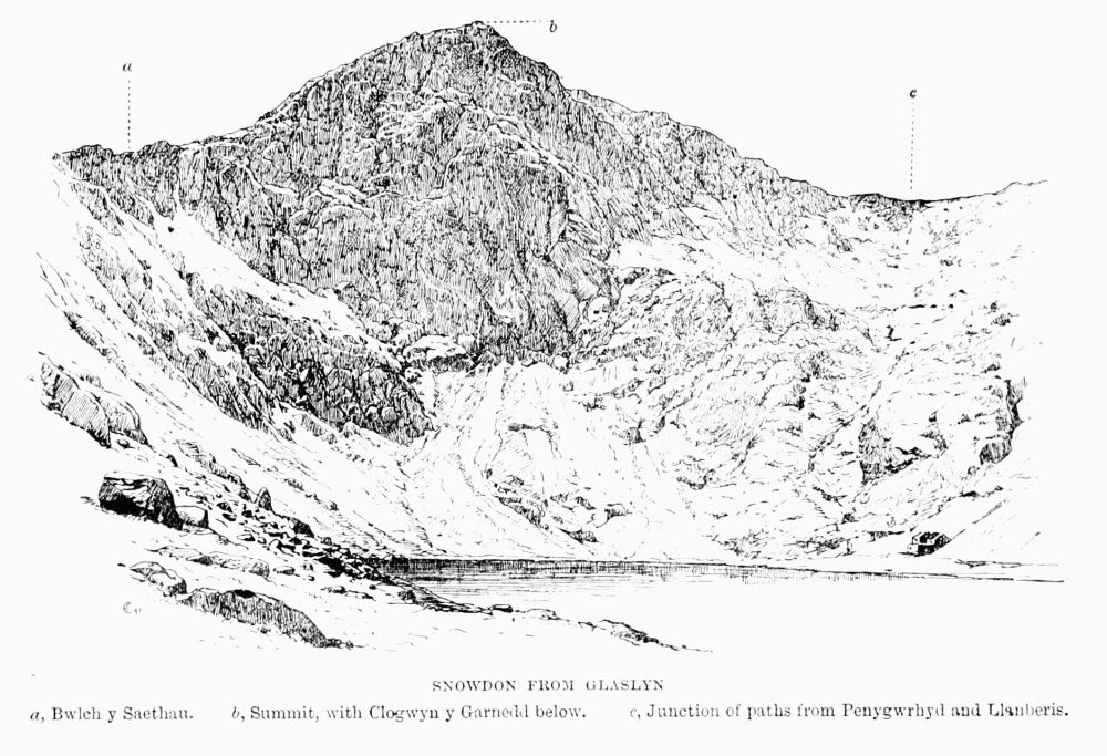 SNOWDON FROM GLASLYN
a, Bwlch y Snethan.
b, Summit, with Clogwyn y Garnedd below.
c, Junction of paths from Penygwrhyd and Llanberis.
SNOWDON FROM GLASLYN
a, Bwlch y Snethan.
b, Summit, with Clogwyn y Garnedd below.
c, Junction of paths from Penygwrhyd and Llanberis.
Cwm Dyli was the scene in 1875 of one of the strangest of all the disasters which have happened on the mountain. The victim was Mr. Edward Grindley Kendal, of Crosby, near Leicester, who on June 11 left Gwynant Valley in order to ascend Snowdon. Nothing more was heard of him or his till the end of that month, when a Mr. and Mrs. David Moseley, descending with a guide, found on the edge of Llyn Llydaw a wet and mouldy pair of boots, each containing a stocking marked 'Kendal' and a garter. It was at once surmised that the missing man had been wading and become engulfed in quicksands, which were stated to be numerous. His friends went so far as to employ a professional diver to explore the bottom of the lake, though it would seem that if the body was in the water simpler means would have answered the purpose, and if it was below the water the diver could neither find it nor follow it. At any rate he did not find it, because it was not there. It was found about ten days later on Crib y Ddysgl uninjured—it was identified by Mr. Ison, brother-in-law of the deceased and the jury at Llanberis found a verdict of 'death from exposure.' It was not precisely stated on what part of Crib y Ddysgl the body was found, and nothing transpired as to the condition of the feet; but it is simply amazing to anyone familiar with the character of the ground that a bare-footed man should ever have got so far. Why he did it and how he did it will always remain among the[Pg 71] [Pg 72]mysteries of Snowdon. [13] Other deaths have taken place in this cwm, for which see under Lliwedd and Clogwyn y Garnedd.
It is curious that two of the lakes in this valley are among those mentioned 200 years ago by the learned Edward Lhwyd as 'distinguished by names scarce intelligible to the best Criticks in the British.'
Clogwyn y Garnedd y Wyddfa—i.e. 'the Precipice under the Cairn of Snowdon'—has been commonly known by the first three words only for at least 200 years. It is one of the grandest cliffs on Snowdon, and gives very fine climbing.
For more than two centuries this precipice has been famous as a refuge for rare ferns and plants. The guide William Williams, well known as a botanist, lost his life here while in search of the Woodsia; so at least says Mr. T. G. Bonney, though he is far from accurate in the date of the accident, which, writing in 1874, he describes as having taken place 'some twenty years ago.' The actual date was June 19, 1861. [14] The old guide had taken up a lady and gentleman from Llanberis, and went from the top alone to gather ferns. The fall was 'down a declivity of three hundred yards.' The body was found at the foot of the precipice, after 'scouts' had been sent out. He had fallen from the point where the slope suddenly changes from about 45° to, perhaps, 75° or 80°. The spot where he slipped was for many years, and perhaps still is, marked by a white stone.
On the shore of Glaslyn, at the south-west corner, there is a small cross of wood marking the spot where the body of Mr. Maxwell Haseler was found. He was making for Snowdon by the Lliwedd ridge, and fell from a short distance above Bwlch y Saethau. The party seem to have been well equipped, and contained members of experience, who were not without ropes and axes. They started on January 26, 1879, for Snowdon by Lliwedd, and, after lunching about 1 P.M. on Bwlch y Saethau, proceeded in the direction of Snowdon. Mr. Haseler took a separate course, more to the right hand, and almost immediately seems to have slipped and fallen. His body was found next morning by the shore of Glaslyn, and it was reckoned that he had fallen some 600 or 700 ft. The inquest was held at Penygwrhyd. The victim of this accident was only twenty-three years old. [15]
The following notes are among the records of Penygwrhyd:—
On September 23, 1887, W. E. C. and A. E. ascended Snowdon from Glaslyn by the first gully on Clogwyn y Garnedd.
In 1890, on June 20, W. P. and G. B. B. descended from Snowdon to Haseler's Cross by the gully immediately above it in Clogwyn y Garnedd.
In 1890, on September 27, F. W. J. found an excellent gully climb, possibly that referred to in the note of September 23, 1887. He started from Glaslyn, keeping to the right edge of the lake, and, facing towards Bwlch y Saethau, [Pg 74]saw a gully choked by jammed stones (five in number), beginning almost from the foot. It has often been climbed. The most interesting and difficult piece is where a large stone roofs a cavern some 15 ft. high. In it there is a kind of skylight, through which the climber must go by an indescribable twist of the body. From the bottom of the gully to the huts where the climb ends is 900 ft., all except a portion of the upper end being narrow gully, and the rest a scramble over rocks.
On December 13, 1891, Mrs. H. ascended the big Clogwyn y Garnedd gully direct to the summit of Snowdon.
On September 24, 1892, Miss B. and a large party of gentlemen climbed (second lady's ascent) the Clogwyn y Garnedd gully through the cavern.
In May 1893 a party climbed up by this and down by the next gully, on the north, which has its head just below the huts.
In September 1893 the two Misses T. descended the great gully in 1 hour 25 minutes.
In 1894, on September 14, Messrs. W. E. C., S., and B. descended the face of Clogwyn y Garnedd to the left of the big gully.
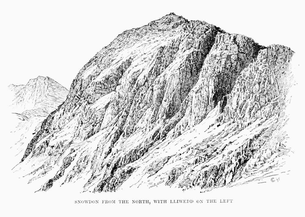 SNOWDON FROM THE NORTH, WITH LLIWEDD ON THE LEFT
Lliwedd (2,947 ft.) stretches away eastward from the summit of Snowdon, dividing Cwm Dyli on the north from Cwm y Llan on the south. Strictly speaking, perhaps the name only applies to the central portion, where its magnificent northern crags overlook the head of Llyn Llydaw, but, as in the case of Crib Goch, the significance of the name has[Pg 75] [Pg 76]been enlarged, and it is frequently used to denote the whole length of the ridge.
At the Nant Gwynant end a transverse ridge, called Gallt y Wenallt, bears near its base some remarkably fine rocks, on which there is very good climbing. West of the Gallt a side valley, called Cwm Merch, runs nearly due south, and beyond this Cwm Lliwedd proper begins. The southern slope of it is steep, but that to the north is imposingly precipitous. It is, in fact, unsurpassed in Wales. Advancing in the direction of Snowdon, the cliffs become less sheer and the crest less broken, and as soon as the highest point of Crib Goch is 'on with' the head of Llydaw Bwlch Ciliau offers a rough descent into Cwm Dyli. Next on the west comes the Criman, corresponding geographically to Clogwyn y Person on Ddysgl, but more broken; beyond them Bwlch y Saethau (i.e. Arrows Gap), leading down to the head of Glaslyn. The last quarter of a mile up to the top of Snowdon is very steep, rising nearly 1,000 ft. in that distance. It was here that Mr. Maxwell Haseler, in 1879, lost his life by keeping too much to the right.
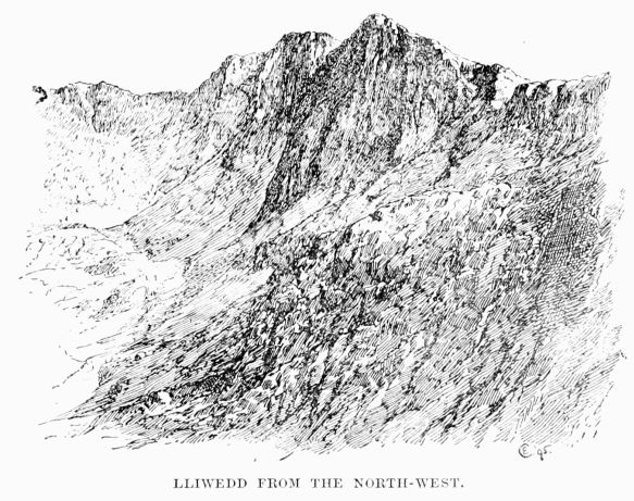 LLIWEDD FROM THE NORTH-WEST.
In August 1872 Mr. T. H. Murray Browne and Mr. W. R. Browne, the discoverers of the Scafell Pinnacle, saw the merits of this climb, and attacked it without success. Public attention was first drawn to Lliwedd as a climbing-ground by the ascent made in 1883 by Messrs. T. W. Wall and A. H. Stocker, and thus described by the former in the Alpine Journal: [16] —
'This northern face consists of four buttresses, with [Pg 77]three fairly well-defined couloirs between them. The summit ridge has two peaks, of which the western, nearer Snowdon, is the higher by a few feet. In January 1882 from the summit of Crib Goch Mr. A. H. Stocker and myself were struck by the grand appearance of the Lliwedd cliffs, and hearing from Owen, the landlord of the Penygwrhyd Hotel, that the northern face had never been climbed, the desire to make the first ascent naturally came upon us. On the 10th we made our first attempt by the central couloir, which leads up to the depression between the two summits. As it was raining the whole day the rocks were in an abominable state, and it was with the[Pg 78] greatest difficulty that we managed to get up about 150 ft.' On January 3, 1883, they tried again. 'On January 4, after carefully observing the rocks of the buttress to the west of the central couloir, we came to the conclusion that it might be possible to cross the face in an upward direction from east to west, and then strike straight up. At 11.15 A.M. we got on the rocks, beginning from the lower of two dark green patches seen from below. From this a ledge runs up to the right, and if it had only been continuous Lliwedd would present no very great difficulties. Unfortunately this was not the case; there were most formidable-looking gaps in it, and the ledges above and below were tacked on to it by smooth and almost perpendicular gullies. Three bits in particular may be mentioned as far the hardest, although they are more or less typical of these crags, which nowhere offer 20 consecutive yards of easy rock-work. The first difficulty which presented itself was where the ledge was broken by a bold face of rock. One of us was pushed to the top of the smooth part, and finding that he could not descend to the ledge on the other side, he ascended a little higher, anchored himself firmly to the rocks, assisted his companion up, and let him down to the required ledge; then, throwing the rope over a pinnacle, he gave both ends to his companion to hold tight, and slid down the 40 ft. of rope to join him. After a few yards of easier work we came to a ledge about 6 inches wide and 4 yards long; the rock above was nearly perpendicular, with no hand-hold, and there was nothing below. It was the only way; we could not turn it, and somehow we got over, but neither of us wishes to be there again. From that ever-to-be-remembered[Pg 79] [Pg 80]ledge the climbing was grand work up to the point where we had to turn from a westerly direction to go straight up the face. Here there was one nasty corner. A narrow ledge about 2 inches wide had below it a sloping face of rock with three minute cracks in it. One of us had crossed this in safety, and so assumed a position in which the rope would have been of very little use. He was then opposed by a steep bit, topped by 4 ft. of perpendicular rock, with a very steep slope of heather above. At the moment that his last foot left the highest peg of rock his other knee slipped, and the heather, grass, and earth began to give way in his left hand. It was an awkward moment, for the other man was not well situated for supporting a jerk at the end of 30 ft. of rope, which would mean a fall of about 50 ft. Happily the other knee got on the heather and the axe held firm in the earth. Our difficulties were then over. The rocks grew less and less difficult as we ascended, and after 4½ hours of incessant work up 850 ft. of rocks we found ourselves on the summit ridge, exactly 13 yards from the cairn.
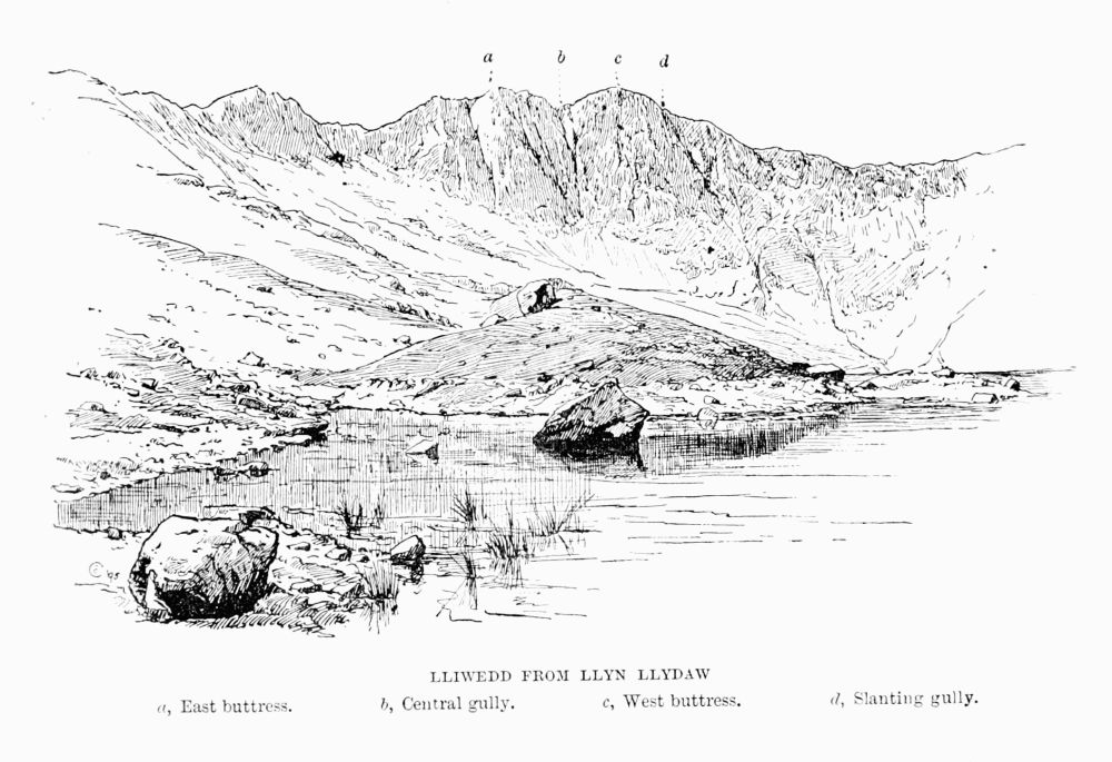 LLIWEDD FROM LLYN LLYDAW
a, East buttress.
b, Central gully.
c, West buttress.
d, Slanting gully.
LLIWEDD FROM LLYN LLYDAW
a, East buttress.
b, Central gully.
c, West buttress.
d, Slanting gully.
'It may be mentioned that the only real difficulties lie in the first 200 ft.; above that point the mountain presents rock-work of a very high order, but nothing stupendously difficult, the rock being very firm.
'Future climbers will probably find that of the three couloirs the western is comparatively easy; the central may perhaps be ascended by climbing the lower rocks on the right, and the eastern by a long détour to the left. The buttress to the left of the central couloir looks as difficult as rocks possibly can look. But there is a chance that a careful[Pg 81] search among the rocks to the left of the central couloir might reward a rock-climber with an exciting and successful scramble. In any case the whole northern face is distinctly difficult.'
Under the date of April 12, 1884, we find recorded by H. S. and C. S. an ascent of Lliwedd by the ridge from Llyn Llydaw, which is apparently nothing more than the ordinary walk, but in 1887, early in April, is an important note in the hand of Mr. Stocker.
'Hints for the Ascent of Lliwedd by the North Face.
(N.B. Lliwedd consists of two peaks—the eastern and western buttress—with a well-defined gully running up between them.)
'1. Ascent of Western Buttress to the Right of Central Gully.—Make for the lower of two green patches easily seen from below just to the right of the foot of the central gully. From it work upwards to the right to the second green patch; then again upwards, still to the right, to a very small, steep green slope. From this the climb is almost straight up, inclining a little to the left at first. This will land the climber a few yards to the west of the cairn.
'2. Ascent by Central Gully and Western Buttress.—Go up the gully till the foot of the steep bit is reached; then climb out of the gully by ledges on the right on to the western buttress. As soon as possible make straight up the face, keeping the gully a little to the left. This will land the climber at the cairn.
'No. 2 is an easier climb than No. 1. All through the[Pg 82] hand and foot hold is very good. The chief difficulties lie in the first 200 ft. after leaving the gully. The upper part is fairly easy. The whole climb is about 850 ft.'
In 1887, April 11, O. E. and T. V. S. ascended Lliwedd by the central gully at first and afterwards in a line rather left of the summit. Time, under 3½ hours.
In September 1887 W. E. C. and A. E. climbed Lliwedd by Mr. Stocker's second route in 1 hour 23 minutes from base to cairn, and subjoined a list of previous ascents, viz.—
First attempt. T. H. M. B. and W. R. B., August 1872 (Vis. Bk.)
January 7, 1883, Messrs. Stocker and Wall, by route 1.
April 24, 1884, Messrs. A. H. S. and P., by route 2.
April 11, 1887, Messrs. O. E. and T. V. S., by route 2.
September 10, 1887, Mr. R. W., by route 1.
September 20, 1887, Messrs. W. E. C. and A. E., by route 2.
On May 20, 1888, Mr. Alfred Evans and two friends, W. E. C. and — K., left Penygwrhyd at 10 A.M., crossed the northern arête of Crib Goch and Cwm Glas, and climbed Clogwyn Person and by Crib y Ddysgl to the top of Snowdon. Evans and K. then descended by the second or third gully from Bwlch Glas on Clogwyn y Garnedd to the head of Llyn Llydaw. C., E., and K. started up the central gully of Lliwedd at 5.5 P.M. At the bottom, and for some distance up, the rocks are water-worn and but little broken up, and the water flowing down rendered this part difficult. At the moment when C. was about 300 ft. above the scree Evans was about 80 ft. below him, and could not advance. C., therefore, went down 3 or 4 ft. and rested. Evans then tried to get out of the gully by the ledge mentioned in Mr. Stocker's[Pg 83] account. This ledge is divided in two parts by a huge outstanding buttress with very scanty footing. Both men passed this; then Evans lowered himself by K.'s ankle on to a rocky foothold and tried to work to the right, but after doing 5 or 6 ft.—half the requisite distance—his feet slipped, his arms were unable to support him, and he fell on his feet about 5 yards on to the edge of a steeply sloping grass ledge running up to this part of the cliff. From this point in four or five terrible leaps he fell over and over, a total distance of 200 ft., to the screes below. The accident happened at 6.55 P.M., and K. is stated to have descended to the body, a distance of 200 ft. of the most awkward climbing in the whole gully, in the space of 5 minutes. This is hardly credible, but under such circumstances people do not judge time accurately.
This accident need never have happened. If ever a party courted disaster it was done on this occasion.
A cross was erected by friends of Mr. Evans on the spot where his body was found, but being much damaged by stones it had to be removed in 1892 to a rocky knoll not far off, where its position is more secure. It records the age of Mr. Evans as 24.
On June 10, 1889, M., A. L. M., and B. climbed the north face of Lliwedd by the rocks of the western buttress, keeping close to the central gully almost the whole of the way.
On January 1, 1893, F. P., F. W. O., and H. J. R. ascended the north face of Lliwedd by the western buttress, starting just to the right of the central gully, and coming up at the cairn. Time, 3 hours.
At Easter 1893 H. G. G. and — W. climbed by the central[Pg 84] gully and the western buttress, coming out at the cairn, in 3 hours 5 minutes, all the rocks being dry.
On April 7, 1893, T. H. M. climbed the north-west face alone in 2½ hours: he found two difficult spots near where Messrs. G. and W. scratched their initials on the rocks. Everything was dry.
On September 14, 1894, W. E. C. and M. K. S. ascended the central gully for about 200 ft., then went up the western buttress, and crossed the gully again to the eastern buttress, about 300 ft. below the top, reaching the summit in 2 hours and 20 minutes.
On October 14, 1894, J. M. A. T., H. H., and H. E. ascended the central gully to a point apparently beyond that where others have broken out upon the face, and continued up a steep stretch of rock by taking a narrow gutter between the centre and right wall, the upper part being found difficult. A broad ledge brought them to a similar reach, where the outward slope of the holds became more and more pronounced. Finding the rocks above quite impassable, the party descended by means of an iron claw, which had to be left, and then by a ledge in the right wall and an awkward corner got out on the face of the west buttress. Here they found the ledges narrow and the crags extremely steep, but working upwards and tending to the right they crossed an incipient gully by an awkward stride, and thereafter met with only ordinary difficulties, but on passing a cleft which opens into the gully enjoyed a magnificent view of the latter, and struck the summit at the cairn. They pronounced the climb to be quite impossible for one man.[Pg 85]
The Slanting Gully.—This gully, on the west side of the western buttress, is easily identified, being the next one to the west of the great central gully and a striking feature of the north face of Lliwedd. It is clearly marked all the way up, and is most readily approached by crossing diagonally up the screes below the great gully and then skirting the base of the rocks of the western buttress. This gully was attacked on January 9, 1894, by Messrs. F. O. W., C. W. N., E. H. K., and H. K. It was then frozen up and covered with snow to a depth varying from a few inches to 3 ft. In 4 hours an estimated height of 350 or 400 ft. above the starting-point was attained, the whole of this distance, with the exception of a few steps in deep snow, having to be climbed. The party kept in the gully the whole way, usually close against the rocks on the western side. Progress was finally arrested at a point where the gully becomes, for some distance, a mere crack, formed by the western rocks overhanging an almost smooth slab, where hold for hand or foot seems almost entirely wanting. With longer time at disposal it seemed possible that this difficulty might have been surmounted by wriggling up inside the crack, or by a dangerous scramble on the face of the slab. Two members of the party were provided with crampons, and derived great steadiness and safety from their use. The uniformly steep angle at which this gully lies may be gathered from the fact that a rücksack dropped from the highest point was picked up at the starting-point on the return. It was the opinion of most of the party that the condition of the snow and rocks was, on the whole, favourable for climbing, as the[Pg 86] ice and snow gave some assistance in places which without them might have been still more difficult.
The next attempt is valuable, as notes were taken on the heights of some of the obstacles.
On March 26, 1894, the gully was attacked by J. C. M., O. M., and W. P. from the screes (2,300 ft.) at 1.55 P.M. They arrived in the cave (2,690 ft.) at 5 P.M. They considered the conditions favourable, except that the snow was melting, but found the climbing difficult all the way. At about 2,500 ft. a chimney 70 ft. high had to be squirmed up. They were of opinion that the gully could not be climbed direct, and all their efforts to break out on either side were frustrated. The climbing does not, as in the central gully, become more easy as progress is made; on the contrary, the difficulties increase. The party carried two ropes, one of 50 ft. and one of 80 ft., and at one place had to use the full length of both together. The descent took 2 hours.
On Thursday, August 30, 1894, this gully cost a valuable life. Mr. J. Mitchell, of Oxford, an assistant editor of the New Historical English Dictionary, started from the foot at about 2 P.M. The first pitch was quickly ascended, and he then proceeded, apparently without difficulty, to the foot of the long chimney, which he passed by means of the face. On reaching the top he waved his handkerchief, and, being asked what it was like, replied that it was very stiff. Not long after he was seen in a cave, which the lookers-on (probably in error) identified with the highest point reached by previous climbers. From this he climbed with great difficulty to the top, as it appeared from below, of a long chasm, with his head[Pg 87] just below an overhanging rock, upwards of 150 ft. above the cave, and after more than half an hour of fruitless endeavour to make further progress he fell at 4.30 P.M., and was killed on the spot. The body was found at the above-mentioned cave, and was brought down by four quarrymen at great personal risk. The lesson which should be drawn from this is, that if a man will insist on climbing alone he should not choose for his attack climbs which parties of greater skill and experience than his own have found to be beyond their powers.
Cwm y Llan.—This large cwm stretches away from Snowdon top to the south-east between Yr Aran and Lliwedd. The scenery consists mainly of the South Snowdon Slate Works, which occupy the centre of the valley, at a height of about 1,100 ft., and of Sir Edward Watkin's road up Snowdon.
There is very little climbing, though some parts of Geuallt and Aran are very steep. On the Lliwedd side there is a good rock (Craig Ddu), not far from the slate works, and others rather smaller near the exit of the valley, while at the head, near Bwlch y Maen, almost under Snowdon and near Bwlch y Saethau, some difficult passages occur.
The slate quarry here must not be confused with 'Cwm y Llan slate quarry,' which is not in this valley at all, but on the western slope of Aran, about a third of a mile beyond Bwlch Cwm y Llan. This little pass (about 1,700 ft.) is very useful to anyone who, after a climb on Lliwedd, wishes to reach the nearest railway station, for Pont Rhyd-ddu is very[Pg 88] much nearer than Llanberis and can be reached without climbing over Snowdon summit. From the top of Lliwedd the pass is in full view, and a stone wall is seen stretching half-way from it towards two little reservoirs which are some 600 yards higher up the valley than the slate works. It is a mile and a half from Lliwedd by way of these reservoirs to the top of the bwlch, which will hardly be reached within half an hour. From the bwlch a fair path on the right bank of the stream leads towards Llynygader, and soon crosses the path from Snowdon to Beddgelert. By keeping round the hill to the right the Carnarvon highroad (which is easily seen from above) is gradually neared. The distance from the bwlch direct to the station may be covered in three-quarters of an hour, making in all 1¼ hour from Lliwedd, as compared with at least 2½ hours which would be required to reach Llanberis from the same point.
Cwm Creigiog is a shallow and unimportant hollow on the south-west side of Snowdon, lying between Aran and the ordinary Beddgelert path to the summit. The cwm has no attractions for a climber, yet at least one life has been lost in it. This was in the winter of 1859, when a Mr. Cox is said to have ascended Snowdon from Llanberis, and to have become exhausted on the way down to Beddgelert, between Llechog and the farm called Fridduchaf. His foolish guide left him alone and went in search of food, with the result, which in such cases usually follows, of finding his unfortunate employer dead on his return. The spot is marked by a heap of stones. Mr. Baddeley says it[Pg 89] 'marks the spot where a tourist lost his life from exhaustion in 1874'—perhaps a mistake arising out of a death of the same kind in that year on quite another part of the mountain.
Clogwyndur Arddu ('Black Precipice') is the magnificent ridge which divides Cwm Clogwyn on the south from Cwm Brwynog on the north, being the western buttress of Y Wyddfa, or more strictly of Carnedd Ugain. The ascent from the Snowdon Ranger traverses nearly the whole length of the ridge, which broadens out at its western end into Moel y Cynghorion, beyond which again is the low pass of Bwlch Maes y Cwm (1,100 ft.), giving an easy passage from Llanberis to Snowdon Ranger and Beddgelert. The cliffs on the north side of the ridge are grand, and have been concerned in more than one fatal accident. In 1846 the Rev. Henry Wellington Starr, B.A., of Magdalen Hall, Oxford, eldest son of Mr. George Starr, of Hilperton, Wiltshire, and then a curate in Northampton, left Dolbadarn Inn on September 6 to ascend Snowdon. He failed to return, and on inquiry being made by his friends people came forward with evidence which seemed to show that he had reached the top of Snowdon, then descended to Gorphwysfa, crossed the head of Llanberis Pass, and ascended Glyder Fawr. At that point a guide professed to have met him, and brought him about half-way down, particularly noting that he wore a single glove, corresponding exactly to another which he had left with his luggage at the hotel. Search was made in every direction, but it was not till the beginning of June in the following year that any light was thrown on the mystery.[Pg 90] On that day some of the clothes were found accidentally by William Hughes, a huntsman, who was exercising his dogs, apparently on Moel Cynghorion, and next day, on further search being made, the skeleton was discovered buried under gravel. His purse and chain were found, but his watch and ring were gone. It appears from the evidence of Griffith Ellis, of Llanberis, who found part of the remains, that the deceased had fallen over the cliff of Clogwyn Coch, on Moel Cynghorion, while ascending from Llyn Cwellyn—that is, by the 'Snowdon Ranger' route. [17]
In 1859 a fatal accident took place near the eastern end of the ridge. The victim, George Henry Frodsham, a clerk in Liverpool, described as a young man of very fine physique, arrived at Llanberis on Saturday, August 13, accompanied by his cousin, F. A. Nicholson, and four friends, T. Clayhills, J. Snape, J. Goodiear, and A. Gardner. It was midnight, but they started off at once for Snowdon. They got as far as the 'half-way house,' where the proper path turns left, and up towards Cyrn Las; they, however, took the right-hand fork, which leads to the old copper level above Llyn du'r Arddu. Struggling up the rocks from the mine, Frodsham, encumbered by an umbrella and a bag, and being, moreover, in the dark, slipped and fell, unknown to his friends, who returned to the proper path and gained the summit. His cousin is said to have searched for him continuously from 4 A.M. on Sunday to 9 P.M. on Monday. At [Pg 91]6 A.M. on Tuesday the body was found by W. Owen; the skull was fractured both at the top and at the back, and the bag and umbrella were found 200 yards higher up, indicating that distance as the extent of his fall. A sapient jury drew from this sad event the moral that a guide should be employed as a safeguard against sudden mists; but few men need fear mists less than those who choose to climb when it is pitch dark. It may be said that this party neglected no precaution which is likely to ensure a fatal accident—inexperience, fatigue, darkness, difficult rocks, the burden of bags and umbrellas.
Llechog (i.e. 'Flat, Slabby Place').—There are two ridges of this name on Snowdon; one is traversed by the ordinary route from Beddgelert and that from Rhyd-ddu, and is precipitous on its curving north front; the other forms the western wall of Cwm Glas Bach, and is traversed for some distance by the pony path from Llanberis. Towards the Llanberis Pass road it presents a fine rocky ridge, very steep and lofty, on which good climbing may here and there be found.
Moel Eilio (2,382 ft.), less than three miles south-west of Llanberis station, has a namesake on the west side of the river Conway, not far from Llanrwst. The name is sometimes spelt Aeliau. The view from the top is extremely fine; the ascent is easy, and, as there is a railway on each side of it, access to the foot of it is very simple. The rockiest side is towards the east. Early in the century a poor little fellow named Closs, while trying to follow his mother from[Pg 92] Bettws Garmon to Llanberis, was lost on this mountain. The story is told by H. L. Jones (1829) in his finely illustrated book, and by Wright (1833) and Bennett (1838). The last-named gives his epitaph.
Garnedd Goch Range.—Garnedd Goch (2,315 ft.) (i.e. 'The Red Cairns') is a very rugged and unfrequented range of hills lying to the west of Beddgelert. The huge Nantlle slate quarries on the north side of it have spoilt some very pretty scenery and some very pretty climbs. Beddgelert and Snowdon Ranger are good starting-points, and better still is Penygroes station, on the line from Portmadoc to Carnarvon.
Moel Hebog ('Hawk Hill,' 2,578 ft.) seems to have been ascended last century by Lord Lyttelton, by the Ordnance surveyors, and in August 1857 by Mr. J. H. Cliffe, who in his book (published 1860) gives a clear description of his ascent. In his opinion one of the cairns on the summit was then 'very ancient.'
It is essentially a Beddgelert mountain, but can be conveniently taken from many other places at the cost of more time, as, for instance, from Snowdon Ranger on the north, Tremadoc and Criccieth on the south, and Brynkir station on the west.
A man in the pink of condition who knows the way well can get to the top from Beddgelert in about three-quarters of an hour, but most people take 1½ or 2 hours. The horizontal distance is under 2 miles, nearly the same as that[Pg 93] from Wastdale Head to Scafell Pike; but the vertical height is less by one-quarter.
The proper route is very simple. A shoulder runs down north-west on to the Carnarvon road, and the ridge of it, after being reached by proceeding due west from Beddgelert, is followed straight to the top. This shoulder may, of course, be used by those who approach from the Snowdon Ranger, but for them a better plan is to take, about ¼ mile after passing the Pitt's Head, a road which continues on the right bank of the stream to Glan y Gors, a few yards beyond which a turning on the right leads across a side stream and past the farm of Hafod Ryffydd to the foot of Cwm Meillionen, and, by following either the cwm or the ridge on the left hand, the top of Moel Hebog is easily reached.
The routes from Tremadoc, Criccieth, and Brynkir all take the dull side of the mountain; but this disadvantage is counterbalanced by the increased effect which this gives to the view of Snowdon on reaching the top, and to the peep down into the valley of Beddgelert, below. The most difficult way to hit off is that from Nantlle, but in point of rock scenery it is the finest of all, and was chosen by the Alpine Club for their excursion when they met here in 1883.
Mynydd Mawr (i.e. 'Great Mountain') rises just opposite to and west of the Snowdon Ranger Inn.
The noble crag Castell Cidwm (i.e. castle of the wolf or robber) runs steeply down to Llyn Cwellyn, and well deserves a visit. Borrow, on seeing it from the south, was[Pg 94] reminded of Gibraltar. Craig y Bera also, which overhangs Drws y Coed, is part of this mountain, and has some very striking rock scenery.
Denbigh.
This county has little climbing. A few rocks near Bettws y Coed offer short climbs, which are more satisfactory than the limestone rocks of Orme's Head, near Llandudno, or of the Eglwyseg cliffs, near Llangollen; but we find in Dinas Bran, close by, an extremely steep, castle-crowned hill, and much favoured by picnickers. It seems, however, to have been the scene of some early climbing, made too, quite properly, with the rope.
Leland says, 'Ther bredith in the Rok Side that the Castelle stondith on every yere an Egle. And the Egle doth sorely assaut hym that distroith the Nest goyng down in one Basket and having a nother over his Hedde to defend the sore Stripe of the Egle.'
Under such circumstances a climber ought to find St. Paul a better patron saint than St. Martin.
Montgomeryshire.
Berwyn Mountains.—The name is said to signify 'White Tops' (Bera-gwen). The range runs parallel to the river Dee, forming its south bank for many miles. It is not lofty, Moel Sych (2,716 ft.) and Cader Fronwen (2,573 ft.) being the highest points. The individual hills are not of striking form, and are really little more than high heathery moors, on which large numbers of grouse breed, but there are many points on the south-east side[Pg 95] where small but striking rocks are found, chiefly about the heads of cwms hollowed out of the 'Llandeilo' and 'Bala' strata. These cwms are occasionally visited for the sake of the waterfalls, two or three of which are exceedingly fine.
The rocks at Llangynog would be remarkably good if they had not fallen a prey to the spoilers in the form of quarrymen.
Merionethshire.
says Taylor, the Water Poet, and, indeed, as a climbing county it is only second to Carnarvon, and contains such fine mountains as Cader Idris, the Arans, and the Rhinogs. The climbing capital is Dolgelly, though the excellent service of the Cambrian Railway makes it easy to scale almost any mountain from almost any place in the county. The reason of this is that all the places of resort are near the coast, and the mountains are not far inland, so that the railway following the coast puts them all in communication with each other, and it is almost equally convenient to stay at Barmouth, Harlech, Towyn, Aberdovey, or Machynlleth. Indeed, this is almost the only county where railways are cheerfully accepted by the mountaineer as friends and not as enemies. He does not love them at Bettws y Coed, he loathes them at Llanberis, but here they are unobtrusive and at the same time supremely useful.
Aberglaslyn.—Through this beautiful defile lies the[Pg 96] only correct approach to Snowdon. It is a true mountain scene, somehow suggesting Scotland rather than Wales, and of such beauty that, according to the story, three Cambridge dons, who went round Wales criticising nature and deducting marks for every defect, unanimously awarded full marks to this. There is fairly good practice climbing on both sides of it, but not very steep, in spite of the fears of some of the early travellers, who (like Hutton in 1803) thought the sides would close before they got through, and reached Beddgelert with a sense of relief.
It was one of the earliest scenes in Wales which the taste of last century admitted to be picturesque. Sandby's view was taken about 120 years ago.
Cnicht or Cynicht (2,265 ft.), Moel Wyn (2,529 ft.)—Mr. J. H. Cliffe ascended the former on September 4, 1857, and declared that he could only hear of one man who had preceded him (the climbing clergyman).
Under certain aspects and conditions it is one of the most striking mountains in Wales, owing to its sharp, conical form, but it bears very little really good rock.
Beddgelert is the best place from which to ascend, and if the old and higher road to Maentwrog be taken to ¼ mile short of the tramway in Cwm Croesor, a ridge on the left hand can be followed right up to the peak without fear of mistake.
If the ascent of Moel Wyn be included it adds less than an hour to the time taken by the last expedition. On the other hand, if Moel Wyn is ascended from Tanygrisiau, on the Ffestiniog line, it is equally easy to take in Cynicht.[Pg 97]
Rhinog Fawr (2,362 ft.—just north of Rhinog Fach) is one of the most striking of the rocky hills which rise behind Harlech. It is more visited than would otherwise be the case because the pretty lake of Cwm Bychan and the famous pass of Bwlch Drws Ardudwy, both places of considerable resort, lie at its feet, one on either side. It is one of the barest and most rocky mountains in all Wales, and yet it has hardly anywhere on it a crag of respectable height. Little nameless problems, however, abound, and men who are content to enjoy a day's promiscuous scrambling, without accomplishing any notorious climb about which they will afterwards be able to boast, may be recommended to ramble over Rhinog Fawr.
Easy Ascents.—Several stations on the Cambrian line are convenient for the start, especially Harlech and Llanbedr. Vehicles can be got in summer to take visitors to near Cwm Bychan (about 5 miles), from the east end of which to reach the top of the mountain requires a long hour, by way of the lakelet of Gloywlyn and up the western slope of the mountain. From Dolgelly the way is not so easy to find. Bwlch Drws Ardudwy, the pass between the two Rhinogs, is the first place to make for, and for this the best plan is to go by the Precipice Walk or by the Trawsfynydd highroad to the Camlan stream, which comes in on the left half a mile or more beyond Tynygroes Inn. A path follows the stream for nearly 3 miles to a slate quarry, which can also be reached rather more quickly by crossing the bridge at Penmaenpool, especially if the train be used as far as that station. Half a mile up the stream beyond the quarry the course leaves the[Pg 98] brook and strikes away north-north-west round Rhinog Fach, rising as little as may be, so as to join the track up Bwlch Drws Ardudwy. From the head of the pass, rugged as it looks, a way may be picked northward to the east slope of the summit, but many people prefer to descend to the west a long way, so as to strike the easier south-western shoulder. A yet simpler route than the last, but, as involving 3 miles more of the hateful Trawsfynydd road, intolerable unless a carriage be taken, turns out of the route to the left half a mile beyond the ninth milestone, and makes for the north side of Rhinog Fawr. The path for nearly 3 miles is that which leads to Bwlch Drws Ardudwy, and is quitted just after passing through a wall. The stream on the right hand is now followed up to the pool at its head, until a turn to the left and south brings the pedestrian up on to the summit. This route may also be used from Trawsfynydd (where the Great Western have a station very useful for Ffestiniog on one side and Bala on the other), and there is no better place to start from if climbing is wanted, for of that there is plenty to be found in Craig Ddrwg, the ridge which stretches away to the north. In winter this range is very fine, but as stern and desolate as it is possible to imagine anything. The writer has reason to remember that here, in January 1895, he experienced the most intense cold that he has met with in Great Britain.
Arenig Fawr (2,800 ft.) is called 'Rennig' by Daines Barrington, who, writing in 1771, adds that it 'is commonly considered as the fifth mountain of North Wales in point of height.'[Pg 99]
The ascent from Arenig station, on the Great Western Railway, between Bala and Ffestiniog, is very easy, as the rise is only 1,700 ft., and the distance about 1¾ mile. The usual and most expeditious way of making the ascent is by proceeding westward from the station for ¼ mile to the farm of Milltergerrig, but for scenery and for climbing an opposite direction should be taken for nearly a mile, till the stream is struck which issues from Llyn Arenig, really a very fine tarn and backed by most respectable cliffs. Further south than the tarn again good rocks will be found. The usual, and indeed the proper, way of dealing with this mountain is to traverse it from north to south, ending up at Llanuwchllyn station, on the Great Western line from Bala to Dolgelly. The eastward view is extremely fine, and superior by far to that from many of the highest points in Wales.
This was one of our earliest mountain meteorological stations, as it was here that the Hon. Daines Barrington conducted his experiments on rainfall in 1771. [18]
Its height, too, was measured, as Pennant (1781) tells us, by Mr. Meredith Hughes, a surveyor of Bala.
One of the ancient Welsh writers mentions this mountain in a most contemptuous manner. Borrow alludes to this, and remarks that upon him, on the contrary, none of all the hills which he saw in Wales made a greater impression.
The Arans.—This mountain is the highest in Merionethshire, and by many wrongly considered the second highest in Wales. It lies between the Berwyns and Cader Idris.
Like the latter, it is of volcanic trap rock, heavily speckled in parts with quartz, and exposed on the east side, where it has been subjected to much weathering. There is a good deal of old débris from the face, that is now grass-covered.
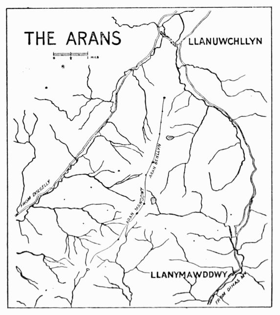
The road between the Aran and the outlying hills of the[Pg 101] Berwyn is over 1,900 ft. high; we have, however, to descend to 860 ft. in passing from the Aran to Cader Idris. The main ridge runs almost exactly north and south for 6 miles, its west side—a large tract of marshy moorland—sloping down gently to the vales of Dyfrdwy (= the goddess's water; sometimes called the Little Dee) and Wnion, and its east side, irregularly escarped, falling for the most part very rapidly for the first thousand feet. Its ridge culminates in two peaks 1½ mile apart, Aran Benllyn (2,902 ft.) and Aran Fawddwy (2,970 ft.) The word Aran means an 'alp,' or a 'high place;' Mawdd is said to mean 'spreading,' and the terminations ach or wy mean 'water.'
Aran Benllyn was one of several of which the height was measured in Pennant's time by 'the ingenious Mr. Meredith Hughes, of Bala,' who made it out to be 30 yards less than Cader Idris.
In April 1881 the Alpine Club had one of their informal meetings at Bala, and chose the east front of the Aran as their route from there to Dolgelly.
The ordinary ascents of the Aran are effected from Llanuwchllyn in 2 hours, from Drws y Nant in 1¼ hour, and from Dinas Mawddwy in about 3 hours.
Rock Climbs.—These are never extensive, though there are many little pieces that require much ingenuity to surmount. Excepting for a few boulder climbs on the ridge itself the crag work is confined to the east face of the mountains, the side overlooking Lliwbran and Craiglyn Dyfi. Climbers are often asked, where can a man start practising rock work? The Arans are first-rate for this. Whatever the[Pg 102] difficulty on the mountain a few minutes' traversing will generally take one out of it, if direct ascent or descent be considered undesirable. The mountain face is so broken up that we have no gullies or arêtes separated by impossible walls of rock from the easy parts of the mountain. In short, from the enthusiastic shin-scraper's point of view the architecture of the Aran face is defective.
(a) From Lliwbran.—The rocks rising from Lliwbran are columnar in structure, and by the time a generation of climbers have torn away the grass from the holds they will show up plenty of neat little problems from 50 to 100 ft. high.
Looking up from the lake the crag, which is a high dependence of Aran Benllyn, shows on the right an almost unrelieved slabbiness at an easy angle, which gives good practice in small footholds. Up to the centre of the crag is a steep grass gully, in a line with a large boulder down near the lake, with an overhanging wall that blocks the direct ascent of the gully, and with a fine clean-cut buttress on the left. We may creep up the corner of the wall on the left, or circumvent it by traversing round to the right.
The route to the ridge from the big boulder is easiest up an oblique gully just invisible from it. Between our crag and the summit of the Benllyn is an easy walk due east down to the green shoulder south of Lliwbran, that takes us quickly by Nant y Barcud and Cwm Croes to the Twrch valley and the main road. This descent to Llannwchllyn, though not direct, recommends itself in wet or misty weather, and is in any case worth taking as a variant. Aran[Pg 103] Benllyn itself offers nothing on its broken escarpments; though the face shows up rather well in profile from a distance, the climber need scarcely use his hands in zigzagging up the face to the cairn. The view from the summit justifies our traversing the peak on the way to Aran Fawddwy. It includes the length of Bala lake and a goodly extent of Llyn Fyrnwy, and the outline of Aran Fawddwy shows up magnificently.
Passing along the ridge to the south of Benllyn we keep up at a high level for the whole distance of 1½ mile to Aran Fawddwy, the greatest depression being less than 250 ft. below Benllyn. If we bear to the left, just dipping below the ridge, we pass along the foot of an overhanging mass of rock of considerable length that is undercut in a remarkable fashion. There are many places along it where one may shelter comfortably in bad weather. It is difficult to climb up the rock direct, but towards its south extremity we may work up into a small cave and climb out by the left on to the ridge again.
Five minutes then bring us to a fine cairn that marks an easy descent to Craiglyn Dyfi, the source of the Dyfi river, with a good view of the best rocks on Aran Fawddwy. The final ascent of this peak begins after a few feet of descent to a wall that crosses the ridge at its lowest.
(b) On Craiglyn Dyfi.—A small terrace at about the level of the wall just referred to leads round the rocks to the left into a large scree gully, which offers good sport in snowy weather. Half-way along this terrace is a 'problem' of unusual severity—a narrow crack in an overhanging face,[Pg 104] with very scanty hand-holds where the crack closes, some 20 ft. up the face. The pleasantest bit of scrambling is on to the summit of Aran Fawddwy from the lake, by the arête that is seen in outline from the large cairn on the ridge, from which point the two vertical portions of the arête are well marked. It can be reached easily from the lake, or we may descend from the cairn for some 600 ft., and then traverse across to the south till a small gully is passed that shows a cave pitch at its lower extremity. The rock arête forms the south side of this gully and runs up for 400 ft. It reminds us of the easy climb up Tryfaen from the Glyder side, though in one or two places we have difficulties here, whereas there are none on the Tryfaen scramble.
It begins below the level of the cave, and after passing over rough rocks at an easy angle we come to a fine wall with a wide crack up it on the left. A huge splintered block is fixed in the lower part of the crack, and we may surmount the block and just squeeze in, passing out on to the roof. There are one or two variations possible here. In fact, instead of starting on the arête we might pass up the gully to the cave. It has mossy walls and a dripping interior. It is marked by a small pile of stones on the right and a well-bleached sheep's skeleton in the gully just above. The pitch may be taken on the left by steep wet grass, which is unpleasant, or we can attack it direct. We go well inside, and with back to the right we find good holds on the left, thus working up until the roof itself offers hold for both hands. From here it is best to pass on to the arête a few feet below the crack above described.[Pg 105]
The way is then easy, but interesting, and leads to a straight-up crack in a wall in front of us that has to be negotiated. It looks severe, but the surface of the rock is so rough that no real trouble is experienced with it. The crack is much more formidable to descend. Shortly after this we find ourselves out on the open face again, the gully on the left having disappeared, and only a few crags above us marking the summit of the mountain. Striking directly upwards we reach the top in a quarter of an hour, the last 25 ft. being, if we choose, by way of a chimney, that begins with some difficulty and lands us just to the left of the large cairn that marks the highest point.
(c) By Llaithnant.—Passing due south of the Aran Fawddwy cairn, along the route to Dinas, we see a fine rock in front between us and the near end of the Dyrysgol ridge, forming the head of Llaithnant. It is marked by an overhanging rock half-way down the left-hand ridge. A steep and wet scree gully leads down to the valley, and we may go part of the way down until we are about 100 ft. below the overhanging block.
Here we can strike across to the arête, and keeping close to the gully on our right have 250 ft. of fairly good scrambling. We skirt close under the big boulder, and passing to the right of it (a traverse can also be managed on the left, lower down) clamber over rather loose rock to the grass terrace above the pitch. Then good rock follows, and bearing towards the right we come in sight of a square-walled chimney overlooking the main gully, marked by small cairns at top and bottom. Its holds are all on the[Pg 106] left, so we back up on the right and find ourselves close to the main ridge again. Another chimney still further to the right might be taken, but it is always very wet; the two pitches in it are both very small, and it is only interesting when ice is about.
A grass gully separates our arête from a few rocks nearer Dyrysgol, which are of basaltic character and rather interesting to descend.
Cader Idris.—The name ('Chair of Idris') includes the whole mountain range, some 7 miles long, that separates the Mawddach from the Dysynni. It is a continuation of the outcrop of volcanic trap rock that stretches from the Arans down to Cardigan Bay, and, as usual with such mountains, its volcanic origin has had much to do with its grand scenery.
The range runs in an E.N.E. direction from the sea south of Barmouth, and reaches its greatest elevation at Pen y Gader (2,929 ft.) It forms two other noteworthy peaks on the chain, Tyrran Mawr (2,600 ft.), 2 miles to the south-west, and Mynydd Moel (2,800 ft.), 1½ mile to the north-east.
The north side presents a fairly even front of precipitous rock for 3½ miles. Near the highest point, however, a huge amphitheatre of rock, a thousand feet in height, suggesting a volcanic crater half fallen away, breaks the continuity of the ridge, and contributes the finest bit of mountain scenery that this side of Cader can offer. Probably this hollow suggested first the name of 'Cader,' though there is a recess on[Pg 107] the summit ridge that is usually taken to be the seat in question.
But the mountain can show something even better on the south side. Its high dependency Mynydd Pencoed joins the main ridge almost at the summit of Pen y Gader, and its extremity Craig y Cae forms with Cader itself another crater-like hollow, which, with Llyn y Cae lying at the foot of the crags, is even wilder and more magnificent than the one on the north side. Excepting the crags in this cwm the south side of Cader consists of steep grass slopes, and the general aspect of the mountain is uninteresting.
An account is published in the Gentleman's Magazine (vol. xxxviii. p. 147) of an ascent of the mountain in 1767 by L. N.
Cader Idris was also climbed in 1863 by Prince Arthur.
Several members of the Alpine Club worked their way up the direct route from Llyn y Gader in 1881, and there is some mention in the Alpine Journal (vol. xii.) of a few ascents by Mr. H. Willink.
The gullies along the north face of the mountain were explored for many years by F. H. B.
The wandering Borrow wordily describes a night adventure on Cader Idris. A pleasantly-written chapter on it may be found in Paterson's Mountaineering Below the Snow Line, and just recently an article has appeared on the same subject in the Scottish Mountaineering Journal. This latter article has a good general view of the whole length of the north face.
On the north face, between Pen y Gader and Cyfrwy, a[Pg 108] tailor named Smith, of Newport, met his death by a fall from the crags in 1864. His body was not found until the following spring.
There is another Pen y Gader in South Wales, the highest point in the Black Forest of Carmarthen (2,630 ft.); also between Y Foel Fras and the Conway River a hill goes by the same name.
The ordinary excursions up the mountain are made from Dolgelly, by the Foxes' Path, in 2¼ hours; by the Bridle Path, in 2¾ hours, or by Mynydd Moel in 3 hours; from Arthog, easily reached by train from Barmouth, in 3 hours; from Tal y Llyn in 2 hours; and from Towyn in 4 hours.
The walk up from Towyn is by the Dysynni valley and the Bird Rock. This has a very bold and steep front, broken up by narrow ledges. It can be ascended with different degrees of ease, and is worth climbing for the view. The rock is named from its usual frequenters, the kite, hawk, and cormorant showing up in large numbers on the face.
Rock Climbs.—(a) On Mynydd Moel.—These are all fairly easy in dry weather, and are worth exploring on a slack day. Standing at the eastern corner of the little square Llyn Aran, we notice the highest point of Mynydd Moel to the west. A fine-looking arête leads up to it from the north, with a well-marked pinnacle apparently half-way up the climb. This we shall call the north ridge. A prominent pillar of unusual steepness is seen to our left, reaching to the height of the Ceu Graig ridge. Its eastern side is cut into by a narrow gully that seems from below to pass behind the pillar.
To the right of the Ceu Graig pillar is seen another[Pg 109] gully, looking steep but grassy; it is found to offer a pleasant route on to the ridge. Above the upper screes at the foot of the higher crags several ascents may be planned from below. The best is marked by two oblique chimneys that start upwards to the left. Between this and the north ridge a large scree gully leads up to the highest part of the mountain, and from it on the right several short scrambles on good slabby rocks are obtainable.
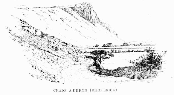 CRAIG ADERYN (BIRD ROCK)
The first of the Ceu Graig gullies, counting from left to right, is to the left of the pillar, and takes three-quarters of an hour to ascend from the lake. It starts with a water slide that we take on the right, and we pass back into the gully immediately afterwards. Then the ascent of an easy chimney makes us a little wet if the weather has been rainy, and a pitch appears just above. This can be taken on the right or left. The right-hand route gives us wet rocks; the left leads up a side chimney, and back into the gully by an awkward grass[Pg 110] traverse. After this the gully divides, and leads us to the neck that joins on to the pillar on our right.
The steep outside face of the pillar can be ascended, but is rather dangerous. It is a sample of mantelpiece climbing, but the holds are mostly of grass and heather, and some of the steps are long.
The next gully, a short distance to the right of the pillar, is more open than the first, and is less steep. Some water is generally coming down. The first obstacle is a wide cavern, that can be mounted immediately to the left or avoided by passing up the easy open chimney on that side of the gully. The second is a waterfall, and that also is by preference passed on the left; the difficulty finishes with a short corkscrew chimney. From this we emerge on to the open face of the mountain, and a few feet of good rock bring us to the main ridge. We are now at about the level of the upper limit of scree on the Mynydd Moel face, and a traverse can be effected round to the oblique chimney already referred to. In doing so we pass first a scree gully and then an inviting cleft up to the left, but this is found to lose its interest after the first 20 ft.
The oblique chimneys can be recommended for beginners, as the climbing is only about 250 ft.; the rocks are very good, and the angle about 45°. Water comes down the gully, but does not offer any trouble, except, perhaps, at the first obstacle. If this is taken direct we climb up the right wall, which overhangs, and cling sufficiently close to permit the water to pass behind us. The second pitch is taken on the right, the rock being so much undercut that we can pass[Pg 111] [Pg 112]behind the water. After this a little more scrambling leads to a scree and an easy finish.
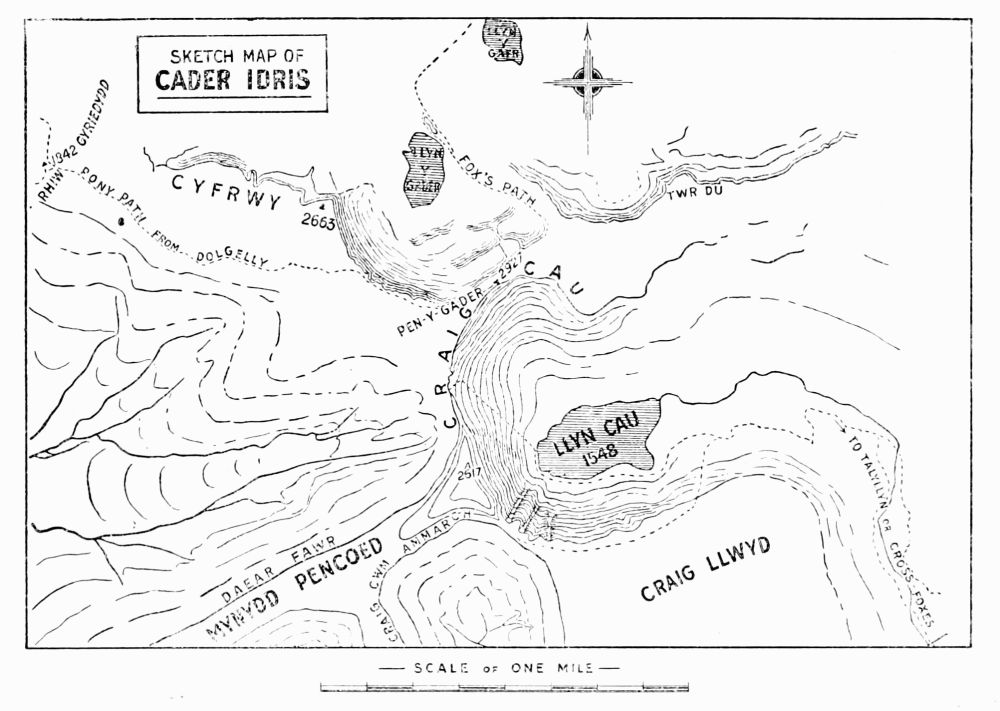 SKETCH MAP OF
CADER IDRIS
SKETCH MAP OF
CADER IDRIS
The north ridge is somewhat disappointing. It works well up to the pinnacle, which may also be approached by a dilapidated chimney on the left. But just above this, where another ridge joins from the north-west, it becomes a mere walk along the edge of a cliff.
Perhaps the neatest way of descending this cliff is by a very narrow vertical chimney, marked at top and bottom by small piles of stones, a little to the north of the big scree gully, and close to the highest point of Mynydd Moel.
(b) West of Mynydd Moel.—Here the north cliff is very much broken. There are innumerable scree gullies up the face, but the rock ridges in between them have no good features. There are one or two pinnacles just below the ridge, easy to reach from above, but difficult from below. One especially is worth a scramble, about 5 minutes' walk from Mynydd Moel; a thin and uncommonly difficult chimney leads up its outside face.
(c) On Pen y Gader.—The central gully up Pen y Gader is a prominent feature of this face of the mountain. It was climbed many years ago, but no definite account of its early history has been obtained. It is in three obvious portions, as indicated in the illustration, and is generally wet. The two shelves that divide the climb stretch obliquely upwards to the right across the whole face, and may be reached in a great variety of ways. Nevertheless the only good climbing is in the two lower portions of the main gully.
The first piece takes us on to the shelf with about 70 ft.[Pg 113] of climbing. The gully narrows considerably, and we are forced on to the right-hand side and up a steep and smooth slope of water-worn rock. Then we cross over the water to the left, and effect an easy exit on to the ledge. We next scramble over some irregular blocks and into a narrow recess at the foot of the second pitch. This is a narrow chimney, very pleasant in dry weather, landing us in 50 ft. on to the second ledge. From here the ground is more open, and the climbing is of a slight character to the summit, except in winter, when the whole gully is apt to be heavily glazed. Under such circumstances the lowest pitch is almost dangerous.
The first pitch may be varied by striking up from the screes a few yards to the left of the main gully, by the cleft shown in the illustration. The second can be quitted altogether, and the columnar rocks to the west taken in a variety of ways; and all along the upper corridor will be found short pitches leading to the summit ridge.
(d) On Cyfrwy.—There are two well-defined arêtes leading up close to the summit of Cyfrwy. The first a a is in an easterly direction, and may be seen in profile from the direction of Pen y Gader. This is easily recognisable by the curious truncated pinnacle or tower some way up. The second bears up from the north, and also shows a pinnacle, but of smaller dimensions. Beyond the two arêtes the climbing on Cyfrwy is inferior, but between them there are a few interesting routes up the crags.
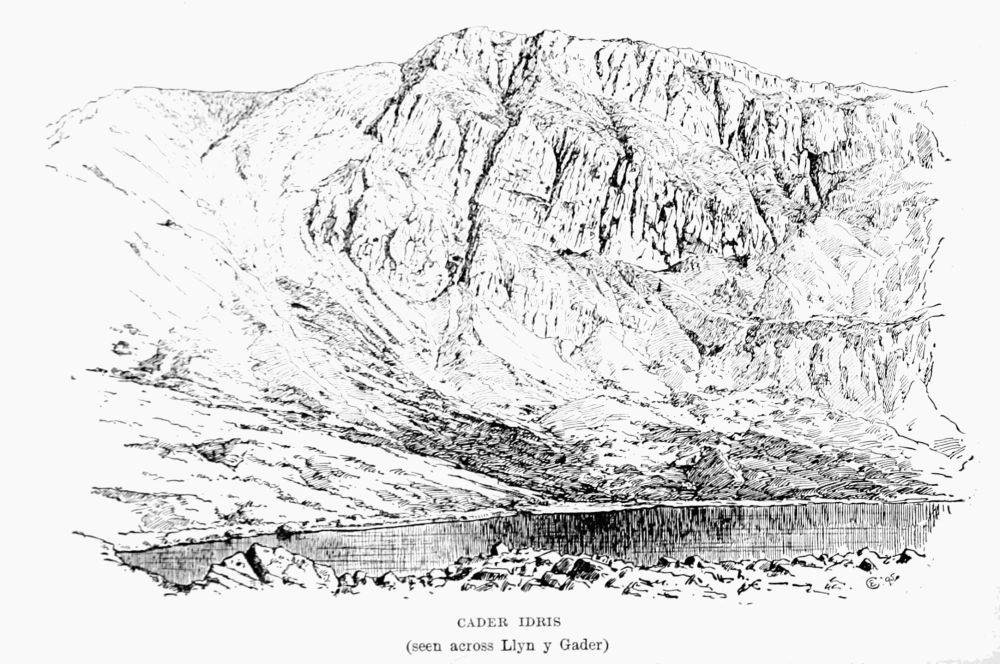 CADER IDRIS
(seen across Llyn y Gader)
CADER IDRIS
(seen across Llyn y Gader)
The terrace e e is easily reached from the screes. From it there are two definite climbs, one b b up a gully to the left, that[Pg 114] [Pg 115]leads out on to the east arête, the other c c up a more open gully that passes to the summit ridge. It is possible that the notch between the great tower and the east arête can be reached from this side, but the upper part looks difficult.
The east arête was climbed in about 1888 by the writer. The first recorded ascent was in January 1891 (H. K., W. E. S., and O. G. J.), and the first ascent by a lady in August 1891 (Miss L. G., K. W. D., and O. G. J.)
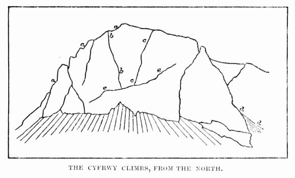 THE CYFRWY CLIMBS, FROM THE NORTH.
It can be followed all the way up. The tower is best turned on the right, and the vertical wall of 40 ft. that immediately follows is climbed direct from the little gap, with just a slight divergence to the left. The only serious difficulty on the arête is a wall of rock 100 ft. higher up. It can be surmounted by a thin cleft, the jammed stones in which are unsafe; or by working up the face a little to the left. The situation is very exposed. This, and any other[Pg 116] bad bits, can generally be avoided by climbing down to the scree gully on our left. Near the top of the arête we pass[Pg 117] the exit of the chimney b b, which descends steeply to the right.
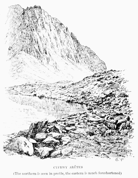 CYFRWY ARÊTES
(The northern is seen in profile, the eastern is much foreshortened)
CYFRWY ARÊTES
(The northern is seen in profile, the eastern is much foreshortened)
The north arête has probably not been climbed, but the gullies on each side have been taken. They call for no special comment. The one to the right is worth ascending for the view of the fine rocks on this face. It is mostly scree with a small pitch near the top, and was once marked above by a little cairn. It is admirable when hard snow is about.
The gully c c to the left is very open and risky, consisting of a series of shelves formed by the falling away of the porphyritic pillars that characterise the face.
The climb b b is rather better. The scrambling from the terrace is easy but steep, until a large overhanging boulder entirely blocks the way. We then climb up the vertical wall on the left and traverse back to the gully. It finishes very abruptly on the narrow upper ridge of the east arête, and in a most unexpected way we find ourselves looking down to Llyn y Gader with the face of Pen y Gader directly opposite.
There are a few short climbs on the face of Tyrrau Mawr, but nothing very definite can be picked out.
(e) On Craig y Cae.—The great gully of Mynydd Pencoed was climbed for the first time on May 18, 1895 (W. P. H. S., E. L. W. H. S., and O. G. J.) It is by far the finest climb in the Cader district; the work in it is as varied as in any of the more familiar gullies in the neighbourhood of Snowdon, and the rock scenery in its upper portion can scarcely be surpassed on British soil. The upper part of the gully attracted the attention of the writer in 1890, but it was not[Pg 118] until April 1895 that he made any attempt to enter the gully at its lower extremity. Then he succeeded in forcing his way over the first pitch, but the great rush of water coming down the gully made the second pitch impossible, and the untimely fracture of an ice axe prompted a temporary withdrawal.
On the day when the successful attempt was made the rocks were unusually dry. In wet weather the difficulties of the climb are likely to be very much increased, more especially in the narrower pitches, where the route chosen by the climber is identical in position with that chosen by the water, though opposite in direction so long as valour needs diluting down to discretion. It seems probable that grass traverses may be found to circumvent the lower pitches. The first and second, for example, may be avoided by traversing into the gully from the left, over the grassy buttress that supports the Pencoed Pillar. The third pitch may be passed immediately on the left, if one treats the loose soil with due consideration. The fourth and fifth seem from above to permit an alternative route up to the right, over steep grass and back to the gully by a treacherous-looking upward traverse to the left. From here the three remaining pitches directly up the gully offer the simplest solution to the rest of the problem; variations to the left and right have been freely suggested, but are still untested.
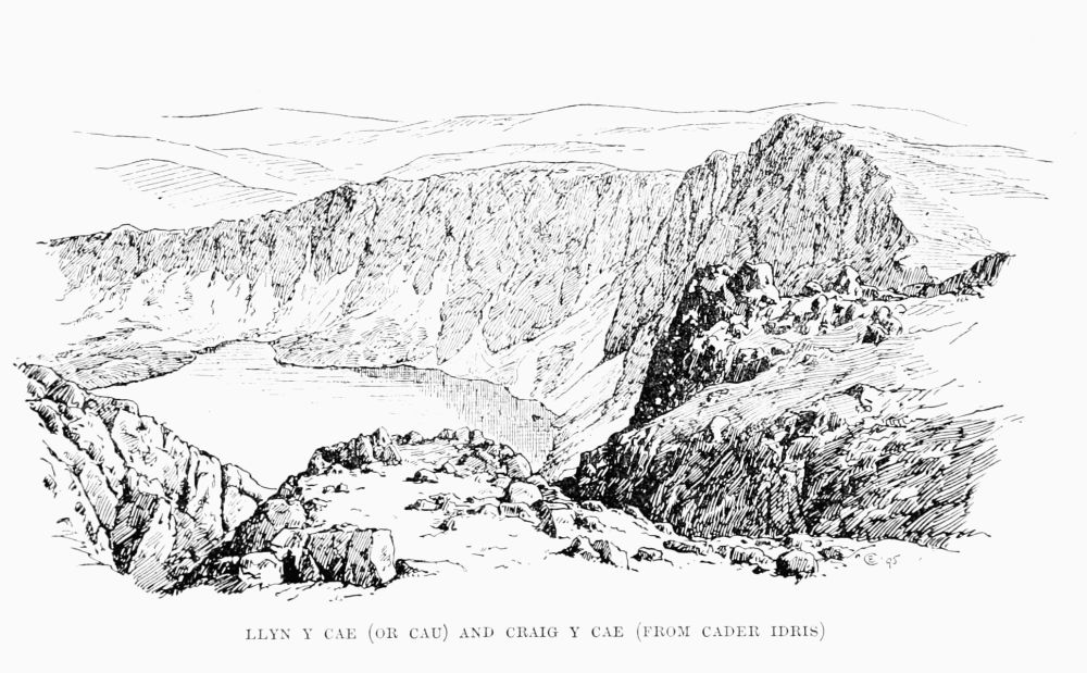 LLYN Y CAE (OR CAU) AND CRAIG Y CAE (FROM CADER IDRIS)
The climbing starts within 200 ft. of the level of Llyn y Cae, with a short pitch some 12 ft. high, marked above by a cairn of stones. The second pitch begins almost immediately, and must be taken direct, the roof of the cave in its upper[Pg 119] [Pg 120]portion to be approached by a serpentine squirm of the body after the cave is entered, up the thin crack on the right. The third pitch is ferocious in aspect, but uncertain in action, on account of the poor quality of its material. It consists of a large cavern with a pendulous mass of brittle rock hanging down from the roof somewhat to the left. The cavern is penetrated as far as possible on this side, and then, with back to the hanging rock and feet on a hold invisible from below, a passage may be effected outwards to the firm hand-holds in the open. A jammed stone with débris attached, in the most handy situation at the corner of the exit, is best left alone.
Soon after this we approach a long narrow chimney close to the left wall of the gully. It is about 35 ft. in length, and the upper part gives trouble. But a very fine foothold some 12 ft. up gives breathing space for the final portion. Then the interest ceases for a while, as we mount some 130 ft. of scree and smooth rocky slabs at an easy angle. This is an excellent arrangement, for the fifth pitch, that now comes on, is likely to demand all our powers of admiration for a while.
It consists of a cavern divided by two steep buttresses into three parts, side by side, the middle one being most open to inspection but most difficult to approach directly. Immediately above the left-hand portion a vertical chimney rises some 40 ft., its lower end projecting well over the cave and manifesting no direct route of approach from below. To get to the foot of this chimney is the chief difficulty. The method adopted was rather intricate, and probably permitted much improvement. It has, however, the advantage that the leader[Pg 121] need not climb straight away the full 80 or 90 ft. without a halt. He first penetrates as far as possible into the cave on the left, until the roof bars further progress. Then he traverses over a dangerously smooth and wet slab, with no perceptible foothold, to the middle portion of the cavern. From here he works upwards and outwards until with a long stride he steps out on to a little ledge on the right wall of the gully. Here a hole through a large block enables him to manipulate the rope with safety, and the second man can join him. The second may reach the terrace more directly, if the rope is available, by working directly up the middle of the gully till the level of the ledge is reached; but the climbing is very uncertain, on account of the treacherous footholds. From the ledge the leader passes back across the centre and over a notched curtain of rock into the upper chimney. Here there is no doubt as to the route; a resting-place is afforded for a moment by a little cave, through the roof of which only the thinnest can hope to wriggle. The edge of this roof is mounted on the right, and a few feet higher a jammed block that dominates the pitch is turned on the right, up some rather treacherous grass that needs very careful treatment. The writer would like to add a word of advice to this already lengthy description of the pitch. Don't attempt to qualify for the through route of the little cave by slipping downwards and jamming in the chimney.
The three remaining pitches are short and near together, the last one finishing a few feet below the summit of the ridge, some 850 ft. above the lake.
East Gully.—The gully immediately to the east of the[Pg 122] Pencoed Pillar was first climbed on May 19, 1895 (W. P. H. S., W. E. S., and O. G. J.) As seen from the opposite shores of the lake it presents a striking appearance, the middle part looking very difficult. It starts higher up the face than the western climb (about 440 ft. above the lake), and finishes on the ridge at a somewhat lower level than the top of the latter (870 ft. above lake). Thus the climbing is much reduced, and the whole ascent can be accomplished in an hour by a party of three. The scrambling in it is almost continuous, and towards the middle, where the rock walls close in the gully, the route is very steep, though none of the pitches are severe.
We begin with oblique slabs of rock rather inclined to be wet. Then the direct route lies over a block of rock with uncertain holds, but a cleft to the left promises much better, and a traverse at the top leads back easily to the gully again. The scrambling is very pleasant where the right wall begins to overhang, and remains interesting till the gully divides. From here screes lead up each part to the crest of the ridge, but a small rock arête separating the two branches give us climbing all the way.
Still more to the east is a shorter gully, composed for the most part of scree, that can be taken in 20 minutes. It has two pitches, the upper one requiring a rope. The first is taken up on either side, and is only about 12 ft. high. The second is a cave pitch with a very fine interior. The ascent is effected by backing up the rather loose walls of the cave, and then bearing out to the left and over the obstacle. From here to the summit is nothing but scree. The gully is afflicted with the near neighbourhood of badly weathered[Pg 123] rocks, and shows signs of having been quite recently bombarded from the crags on the left.
These three gullies on Mynydd Pencoed represent all the climbing that has as yet been attempted on the south side of Cader. It is much to be hoped that a few interesting routes will yet be found between the pillar and the small col that represents the lowest portion of Craig y Cau, and the account of what has been done may induce others to visit this unfrequented region. To the same end it might be advisable to throw out the remark that the Pencoed Pillar, some 700 ft. high, looks quite inaccessible from the grassy buttress at its foot.
South Wales.
It is scarcely worth while to enumerate the southern counties, as all alike are destitute of climbs, except upon the sea cliffs. Some of these are remarkably bold and picturesque, especially about Lydstep (Tenby) and St. David's Head; but they cannot compare in any way with those of Ireland, and least of all for climbing purposes, being mainly of limestone. Just north of Aberystwith are some highly curious rocks, giving a climb or two. Some twenty years ago a schoolboy was killed by falling from them.
Of the inland rocks it will be sufficient to mention a few.
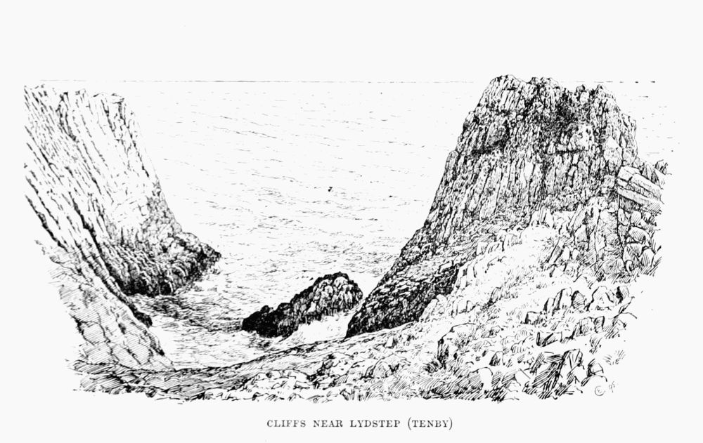 CLIFFS NEAR LYDSTEP (TENBY)
The Brecon Beacons (2,910 ft.), in Brecknockshire (which name the travellers of old, with some justice, modified to 'Breakneckshire'), are sandstone peaks of very striking outline. Indeed, Mackintosh (who saw them from the east)[Pg 124] [Pg 125]says, 'I was more impressed than I have been with any mountain in Wales. Their outline excited a very unusual idea of sublimity.'
Brecon is the best starting-point, and it is a good plan, though by no means necessary, to drive to the Storey Arms inn (1,400 ft.), eight miles towards Merthyr, or to go by train to Torpantau, and thus avoid walking over any part of the way twice.
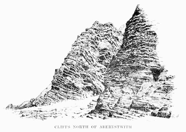 CLIFFS NORTH OF ABERYSTWITH
The way is easy, and easily found; but a wary eye should be kept upon the streams, which in this part of Wales are surprisingly rapid and copious.
A curious notion once prevailed that nothing would fall from the top of this hill. Many years ago an unfortunate[Pg 126] picnicker disproved this. See the Times Index, but the statement there made that he fell 12,000 ft. is somewhat startling.
The Black Mountains, a wide stretch of charming hill-walking, have little to attract the mere climber, nor will he find much on such hills as the bastion-like Blorenge (1,720 ft.), in spite of their possessing caps of 'mill-stone grit.'
Plynlimon (2,469 ft.) is seldom mentioned except with derision.
The Beauties of Wales (1818) does indeed speak of 'the towering summit which bears the name of Plinlimmon,' and quotes the equally appropriate description given by Philips—
But, in truth, the great difficulty which travellers have, whether far or near, is to ken it at all; and many of them have vented their disappointment in words of bitter scorn.
Pennant (1770) candidly admits that he never saw it, which is easily understood, for the mountain is neither easy to see nor worth looking at when seen. The ascent is a protracted bog-walk. It was made in 1767 [19] by L. N., but Taylor, the Water Poet (1652), sensibly calls it
An amusing notice used to be seen at Steddfa Gurig (then an inn), 2½ miles south of the summit, and 13¼ miles by road from Llanidloes: 'The notorious hill Plinlimon is on the premises.' This place, being 1,358 ft. above the sea, is the best starting-point for the ascent of the mountain, and coaches run past it from Llanidloes.
Aberedw Rocks are fairly typical of the kind of climbing which is to be found in South Wales. The rocks being quite close to the station of that name on the Cambrian Railway, are brought within easy reach of Rhayader and Builth Wells on the north and of Brecon on the south. Three or four rock terraces, 15 to 20 ft. high, break the slope of the hill beside the railway, and a sort of rocky cove penetrates it as well. Bits here and there are not unlike the 'chimneys' on Slieve League, but the material is more friable, resembling loose walls of very inferior slaty fragments. A few harder masses stand out picturesquely as small pinnacles, especially in the cove, near the head of which a lofty bulging piece of rock has a vertical rift in it, which for a few feet offers quite a difficult climb.
The river Edw (close by) has extremely steep, cliff-like banks, and these are a common feature in other tributaries of the Wye. The Bachwy, for instance, has a gorge which, seen as the writer has seen it during a winter flood, is profoundly impressive. Malkin's description (1804) should not be missed. He found 'rudely-shaped eccentricities of nature, with all the mysterious gloom of vulgar and traditional ascription,' 'dwarfishly fructified rock,' 'features all of a revolting cast,' and 'a prospect rude and unchastised.'[Pg 128]
The Irvon, again, has sides so rocky as to be chosen by the falcon for nesting.
Cwm Elan, 5 or 6 miles from Rhyader, is a very pretty spot, and the gorge of Cefn Coch is exceedingly striking. Mackintosh says that the height is not less than 800 ft., and the cliffs are in many parts mural and quite perpendicular. He declared that, while the cliffs on the left-hand side of the river are very fine, he had seen nothing to surpass those on the right. This from a hill traveller of his experience is remarkably high praise. The writer has only visited these rocks once, and has never attempted to climb there, nor, indeed, has he ever heard of anyone else doing so. The Birmingham reservoir is to submerge several miles of this cwm and the two houses in which Shelley stayed.
Stanner Rocks are quite near the station of the same name on the branch of the Great Western from Leominster to New Radnor, and on the north side of the railway. The material of which they are composed is superior for climbing purposes to the soft shaly stuff so common in South Wales, being the same eruptive trap rock which forms the hills of Hunter, Worsel, and Old Radnor, and has metamorphosed the surrounding limestone. These rocks narrowly miss being a good climb. The train from Leominster takes about 50 minutes.
Near New Radnor is a precipice down which Cliffe (1854) mentions that a gentleman rode, and he also records that another climbed the fall called Waterbreakitsneck.[Pg 129]
Introduction.—Climbing in Ireland, in the sense in which it is understood in Switzerland, is, of course, unknown, although during a winter of happily rare occurrence, such as that of 1894-5, abundant snow and ice-slope work is no doubt obtainable. It would be accompanied, however, by extreme cold and days of too short a duration for work.
Nor can Ireland boast of such arenas for cliff-climbing as the Lake District, or the Cuchullins in Skye. There is no Pillar Rock, no Old Man of Dearg. But there are ample opportunities for acquiring the art of mountain craft, the instinct which enables the pedestrian to guide himself alone from crest to crest, from ridge to ridge, with the least labour. He will learn how to plan out his course from the base of cliff or gully, marking each foot and hand grip with calm attention; and, knowing when to cease to attempt impossibilities, he will learn to trust in himself and acquire that most necessary of all climbers' acquirements a philosophic, contemplative calm in the presence of danger or difficult dilemmas. If the beginner is desirous of rock practice, or the practised hand requires to test his condition, or improve his form, there is many a rocky coast where the muscles and nerves and stamina can be trained to perfection. Kerry[Pg 130] and Donegal are competent to form a skilled mountaineer out of any capable aspirant. Ice and snow craft is an accomplishment which must of course be acquired elsewhere.
Much of the best scenery in Ireland is available only to the mountaineer. Macgillicuddy's Reeks can hardly be appreciated in less than a week's exploration. Even after three weeks spent amongst them we have wished for more. Donegal alone requires lengthened attention, and there a much longer period will be profitably spent.
The climbing described in the following pages was chiefly undertaken with the object, or excuse, of botanical discovery. All the mountain experiences, except where the contrary is stated, represent the personal—usually the solitary—experiences of the writer. Of roped climbing the author has had no experience outside the Alps. Being tied up in a package and lowered from a cliff to a bird's nest, though not climbing, is, no doubt, a feat requiring nerve and dexterity; but when the nest of the raven, peregrine, or chough is in view, and ropes and companions are 'out of all ho,' and it appears improbable such a chance will come again, the eager naturalist will indeed rejoice that his nerve and dexterity are not wholly dependent on the comfortable security of a friendly cable round his waist. To the botanist such accomplishments are even more essential. A knowledge of rocks—what to trust, what to mistrust, what to attack vertically (such as granite and quartzose usually), what to deal with by their ledges (such as limestone often and sandstone still oftener), what to avoid altogether (such as trap, chalk, and decomposing[Pg 131] basalt), a knowledge of the elementary principles of guidance under varying conditions of weather—can be gleaned from the mountain and sea coast cliffs in Ireland, not, perhaps, to such an extent as to produce an expert, but quite enough to lay the requisite groundwork of one. Form and condition, nerve and activity, will develop in company, and with them the love for the art will grow, and nothing beyond a little local education will be wanting to enable him to follow upon their arduous undertakings real proficients in mountain craft. Any words that can induce the skilled mountaineers of England and Scotland to test the merits of an Irish welcome, of Irish scenery, and of the bracing combination of Atlantic and mountain air in the western counties will have been written to good purpose.
Antrim.—The highest hills are Trostan (1,810 ft.) and Slieveanea (1,782 ft.) The formation is almost entirely trap or basalt, and there is no cliff-climbing, the rock being crumbly and unsafe. Around the coast there is a belt of cretaceous rocks, forming in some places, as at the Giant's Causeway (White Rocks) and at Fair Head, bold cliffs of chalk or rotten trap. On Fair Head, 640 ft. high, there is a magnificent view. Cyclopean columns of greenstone crown a talus always heavy on the Antrim cliffs, owing to their friable nature.
There is a fissure known as the Grey Man's Path on the west side of this Head, in the face of the cliff, by which it is possible to descend and inspect the foot of the columnar prisms.[Pg 132]
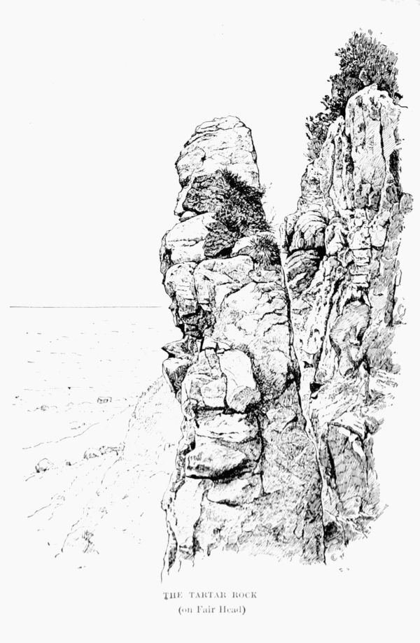 THE TARTAR ROCK
(on Fair Head)
THE TARTAR ROCK
(on Fair Head)
The Antrim glens and the Antrim coast road are deservedly famous for their lovely scenery, and excellent accommodation is everywhere obtainable. Of the glens Glenariff is, perhaps, the gem. It is hemmed in by cliffs 1,000 ft. high, with mural summits. Glenarm is equally beautiful, though in a more tranquil and gentle way. On the north and south sides of the Bay there are considerable precipices.
From Fair Head the prospect is singularly fine. The Head is columnar basalt.
Fair Head is approached from Ballycastle on the west. West of Ballycastle again, about the same distance, is the well-known rocky islet of Carrig-a-Rede, which is severed from the mainland by a chasm nearly a hundred feet deep, spanned by a very slight swinging or flying bridge, which in a storm is not inviting.
On this basaltic islet an interesting climb round the cliffs may be had, and the rock is secure enough on the west and north sides.
From Ballintoy, which is close to Carrig-a-Rede, it is a magnificent cliff walk to the Causeway; and from the Causeway to Portrush the rocky coast scenery is full of interest. Many places will invite a scramble. Below the road, which is adorned with an electric railway, numerous difficult places occur, and several little valleys permit a descent to the sea and a swim. A few miles west of the Causeway the coast becomes low to Portrush, the golfing centre, with its excellent hotel.
At Portrush, or near it, at White Park Bay, the white cretaceous rocks are capped by frowning basalt, and the[Pg 134] contrast of colours is most striking. It is not necessary to describe the well-known Giant's Causeway. Pleaskin Head is the finest feature in its cliff scenery, but unfit for climbing, owing to the crumbling, weathering nature of its beds of lava and iron ore. More fine sea cliffs are found in the Gobbins, on Island Magee.
Antrim, with all its lovely cliff and glen scenery, and all its good hotels, is not a mountaineer's county, like Kerry, Donegal, or Wicklow. It is more highly cultivated and more civilised than a climber with a proper sense of his calling could possibly approve of. It suggests driving, bicycling, picnics, good dinners, and evening dress more than knickers and hard work.
We will turn our attention, therefore, to the mountain county of Ireland.
Donegal has some of the highest and finest mountains in Ireland, and the extent of mountainous country is larger than in any other part of Ireland. No maritime mountain and cliff combined can approach Slieve League, in Donegal, and if the coast cliffs of Mayo have a continuous grandeur that excels any similar stretch in Donegal, there are many higher and finer cliffs on the Donegal coast, in endless succession and variety from Inishowen Head, on Lough Swilly, to the south-west coast.
The Donegal mountains form four groups—(1) Inishowen Mountains; (2) Donegal Highlands; (3) South-West Donegal; (4) South Donegal.
Inishowen Group.—Slieve Snacht, the highest point,[Pg 135] has no interest, except its view, and the same remark applies to Rachtin More, the next highest. Both are composed of barren quartzite. Bulbin has a schistose escarpment looking north-west, of some 300 ft., reaching almost to the summit, and terminating in a short talus and a heather-clad slope. It is a very picturesque little mountain, and possesses some interesting plants.
Inishowen is deficient in accommodation. North of Buncrana there are but one or two inns that will tempt a visitor to return. Accommodation can be obtained at Carndonagh and Culdaff, and at Malin Head there is a house that receives visitors by arrangement.
Malin Head is the proper place from whence to explore the cliffs of Inishowen, and Glennagiveny, under Inishowen Head, to its north, contains lodging-houses also.
The coast line of Inishowen is in many parts wild and magnificent. Inishowen Head affords excellent climbing. The cliffs are from 300 to 400 ft. in height, and various traverses, ascents, and descents can be made between Stroove and Glennagiveny. The Head is in reach of Moville, where there is a good inn.
Further to the north-west the cliffs increase in height. From Glengad Head, a little north-west of Culdaff, to Stookaruddan a series of precipitous headlands (500 to 800 ft.) faces the ocean, looking a little east of north. The walk along this coast from Culdaff to Malin Head, although laborious, on account of the steep-sided inlets, is well worth the trouble. The rugged boldness of Malin Head is most fascinating, and in a storm it is superbly grand. At this point the cliffs have[Pg 136] fallen to a low elevation. The finest bit is at a place about half-way between Glengad and Stookaruddan.
Having put up for the night at Malin Head, if possible, if not at Malin or Carndonagh (the latter for choice), Dunaff Head, guarding the eastern entrance to Lough Swilly, should be visited. Lough Swilly is the finest oceanic inlet round the whole coast of Ireland. The eastern cape, about 700 ft. high, terminates in a range of bold precipices over 600 ft. high for some distance. It is a most enchanting bit of sea cliff. In variety of shape, sheerness of descent, and picturesque grouping and surroundings it is hard to match.
The cliffs can be descended at the nose of Dunaff to an outer rocky continuation, provided there is no storm. In stormy weather this rock, of perhaps a hundred feet, is completely swept by surf. There is a steep gully in another place on the south side, which admits of a descent to the water's edge. For most of their length, however, these cliffs are quite impracticable. For some distance downwards all seems to go well, but the pelting of detritus from above and Atlantic surf from below render the lower parts as smooth as marble and straight as a wall into the water. Here and there the inner bluffs are more practicable, and from a boat, in very calm weather, a study of the cliffs would probably reveal more than the scrutiny from above, which is usually alone possible.
South of Dunaff Head, up Lough Swilly, the precipitous coast of the Erris Mountains gives a most enjoyable stretch of rough work. It is often possible to descend to the sea, and having done so a difficult climb is often preferable to a[Pg 137] tiresome ascent to the headland surmounting one of the numerous creeks.
Across the Lough we find ourselves in the lovely peninsula of Fanet, the coast of which is admirably adapted for rock practice. The highest sea cliff is the Bin, a conspicuous headland 350 ft. high and very precipitous. It can, however, be scaled without much difficulty in one place, a few feet from the summit towards the south. Other parts of it appear practicable, and at low tide the base can be completely compassed—a wild bit of work if there is a sea on. There is an admirable hotel at Portsalon, with a famous golf links, about half-way between this cliff and Knockalla Mountains. The whole coast from Portsalon to the Bin is studded with cliffs, caves, and remarkably beautiful natural arches.
The rock of Fanet is almost entirely quartzite, a metamorphosed sandstone, often pure and glittering quartz. It is firm and safe, but the absence of stratification renders it difficult to negotiate. This barren rock (it disintegrates to silex) is very common in Donegal, and is identical with that of the Twelve Benns, in Connemara.
Before leaving Lough Swilly the remarkable view from Dunaff Head should be referred to. On a clear day the Paps of Jura, the Mull of Cantire, and even the Isles of Arran and Islay, can be seen in Scotland over the low Malin Head. Westwards, in a noble succession, lies the grand series of the outer Donegal capes. Fanet Head, Melmore Head, Breaghy Head, Horn Head, Tory Island, and the Bloody Foreland are all in view, and south-westwards the 'Donegal Highlands'[Pg 138] look so imposing that an immediate expedition to them will probably be decided upon.
Across the peninsula which lies between Mulroy Water and Lough Swilly there is a most comfortable inn at the Rosapenna Golf Links. It is an extremely pretty wooden structure, brought by the philanthropic Lord Leitrim, whose loss the district will never cease to deplore, from Norway, and the complete success of it makes one wonder that this sort of structure is not more often adopted. From Rosapenna expeditions can be made to cliffs and coast in all directions.
Horn Head is a grand range of sea cliffs, ten or twelve miles in extent, which are the largest breeding-place in Ireland for sea fowl. There are a few places where a descent is possible, and a careful exploration (with the proprietor's permission) will be certain to yield excellent climbing. The rock is as firm as iron in most places. Most of the climbing the writer has done on these cliffs has been from a boat upwards in search of sea fowls' eggs. One especially remembered one, after green cormorants' nests, at the entrance to that most noble cave the Gap of Doonmore, was of great difficulty. The absolutely reliable rock had very slight 1–1½-in. ledges, and the latter part of the climb was slightly overhanging. The nests were reached, however.
All round this Head excellent rock-climbing, coupled with magnificent scenery, is available. At the base of the cliffs, not far from the proprietor's dwelling-place, there is a little bay with a cave above the reach of the tide. Here a man once saved his life by climbing. My friend, Mr. Charles Stewart, the proprietor of the Horn Head estates, writes:[Pg 139]—
'I think it was the year 1876 that my man John Stewart was over three weeks in the cave watching my salmon, without the boat being able to go to him. The cliffs above were 600 ft. high. He could easily climb up about 100 ft., most of it cliff-climbing with a little grass. After that there is a very difficult piece of cliff, almost perpendicular, of about 40 ft. It is easy enough to get down to this point from the top. A man went down and lowered a rope to him, but he could not come up straight, as the cliff overhung too much. He tied the rope round him and climbed up in a zigzag way. He was half an hour climbing this short piece, and was very exhausted, with his hands badly cut and bleeding. He had with him his son, a boy of about twelve years old. He had rope about 10 ft. long from his waist to the boy, who slipped twice on the way up, each time very nearly taking his father with him. About five years afterwards the boy was looking for eggs in the cliffs, and fell about 500 ft. to a shingly beach, rolling the first part of the way down a steep grassy bank for about 100 ft., and then a sheer drop of 150 ft. to another grassy bank where a small holly bush grows. When picked up (of course quite dead) he had a holly branch in his hand.'
There is a comfortable hotel at Dunfanaghy, immediately inland of Horn Head.
From Dunfanaghy Tory Island can be visited in calm weather—an interesting boating trip. It is fifteen or twenty miles to the north of west, and Horn Head has to be passed on the way, giving an opportunity of surveying its cliffs. There is a cliff or buttress (called, I believe, Tormore) which[Pg 140] the islanders point out, that is somewhat difficult to climb upon. Once on the summit the successful cragsman can have any wish he may pine for. The highest point of the island is under 300 ft. The inhabitants disregard the payment of all rents, taxes, &c.
The turreted and bold contour of Tory renders it a great embellishment to the north-west coast. It is visible from all elevations for a considerable distance. Seen in a sunset its richly reddish-coloured granites light up with a warm and lovely glow. It formerly possessed monastic or other religious institutions, and several ruins of small churches or oratories are still visible. It abounds with legends—a home of superstition and folk-lore.
From the neighbourhood of Dunfanaghy the most attractive objects upon the horizon are the mountains of the Donegal Highlands, Muckish and Errigal being especially conspicuous.
Muckish ('Pig's Back,' 2,200 ft.) is about 7 miles from Dunfanaghy. It is flat-topped, with short rotten cliffs on the north and west sides.
Errigal (an oratory or small church) is more interesting. The summit is pointed, bifid, and hardly large enough for more than two persons. It is composed chiefly of disintegrating quartzite, flanked on the west by igneous rocks. Between Errigal and Muckish (about 6 miles) lie the pointed summits of Aghla Beg (1,860 ft.) and Aghla More (1,916 ft.) The largest of many lakes is Alton Lough, where the writer was once solemnly cautioned against swimming, on account of the 'Phouea,' which lived there and used to[Pg 141] mingle with the cattle as a cow and lure one down into the depths. So would he do with mankind. Numerous swims in that lake have weakened this prognostication.
Above Alton Lough, on its south-west side, are the cliffs of Beaghy (1,200 ft.), which afford a nice bit of climbing. All these hills can be gone over in a day, though some (especially Errigal) will ask a second visit. About 4 miles from the base of Errigal is the excellent fishing inn at Gweedore. From Dunfanaghy over the summit of Muckish, Aghla, Beaghy, and Errigal down to Gweedore is a bit of mountaineering which can be most thoroughly recommended. Gweedore should be made a head-quarters for a few days; and the comfort obtained at the close of the day will be well earned and appreciated.
The Poisoned Glen, six miles from Gweedore, is a stern and barren scene of almost sheer, polished granite cliffs, nearly 1,000 feet above the base of the glen. The south-west corner of the glen is the most precipitous. Several deep, black, narrow gorges cut deeply into the granite. Some, particularly one at the corner of a commanding buttress on the south side, about half-way up the glen, are of considerable difficulty. Wedged boulders occur frequently. The worst bit is the final struggle to the crest of the ridge, which slopes south-westward to the summit of Slieve Snacht. It will be found necessary in one place to break out of this gully on to the face, and it should only be attempted in dry weather. A full day may be spent going up one gully and down another on the south-west side of the glen. Often the descent is far easier, a jump of 12 or 15 ft. down to the[Pg 142] shingly soft bed of the gully clearing an obstacle difficult to breast upwards.
The most glaciated spots in Donegal are this glen and Slieve Snacht, a rounded hump of granite.
By proceeding to the head of the Poisoned Glen, past the Gweedore Lakes, and past the prettily wooded Dunlewy Lake which lies abreast of the Glen, up the winding stream in its base, and taking the ravine in its apex, we reach a pass known as Ballaghgeeha Gap ('Windy Pass'). From this point it is a short walk across a valley to a road, visible from the pass, which follows the Gweebarra valley south-west down to Doochary. Taking it in the opposite direction, it leads into Glenbeagh, a gorge about eight miles long, with a lake enclosed by steep cliffs on its west shore. On its right a beautifully wooded mountain slope contains the seat of the proprietor, Glenbeagh Castle. This valley is crossed at its mouth by the main road to Gweedore, some 10 miles away, and the circuit described is one of the most beautiful mountain walks imaginable. In order to vary this, and save the road work home, a scramble along the west shore of the lake may be effected to the granite cliffs opposite Glenbeagh Castle, known as Keamnacally. In several places an ascent can be effected of about 1,000 ft. The crest of the cliff leads up by a gradual slope to the summit of Dooish, 2,147 ft. This point is in a straight line for Gweedore from Glenbeagh, and if the mountaineer wants more work the summit of Errigal lies in the same bee-line.
Lough Salt (1,546 ft.), a conspicuous hill, was ascended and described by Otway about seventy years ago, in the language[Pg 143] of that period (Scenes and Sketches in Ireland). He adds some quaint legends about two of the lakes. Into one of these St. Patrick banished the last Irish snake, a rebellious animal that gave him much anxiety.
Gweedore to Carrick.—The pedestrian had better omit the north coast, and proceed westwards round the coast to Dungloe.
Aranmore Island, with its handsome red granites, shows some fine cliffs, especially those at its north-west end, between Torneady and the lighthouse. In the bay formed by these cliffs a grand tooth or monolith stands isolated and vertical, about 100 ft. in height. The cliffs are from 400 to nearly 600 ft., and some rise perpendicularly from the water.
The best point to visit Aran from is Burton Port, about 3 miles off. Skilled boatmen are required, as the passage is winding, amongst islets, rocks, rapid tide currents, and shallows. Aranmore, like many other Atlantic islands, slopes inland or eastward, and faces the Atlantic with a wall of cliffs. The coast north of it is wild and beautiful, with interesting physical features. Across Umfin Island runs a gruesome cleft, through which a heavy sea tears its way in fury, meeting the sea from the other end in frantic commotion. Further east, on Horn Head, is the famous MacSwyne's Gun, for many years a signal to the whole county that a furious sea was raging at the Horn. It is a 'puffing hole' on a large scale, but the little rift, ever widening, has slowly silenced all, or nearly so. On this Head also is the famous Marble Arch, Tempul Breagha, jutting out into the sea.[Pg 144]
At Dungloe good quarters and excellent fishing, as usual, are obtainable.
From Dungloe the road lies through Doochary, Glenties, and Ardara to Carrick. Each of these last villages has a good inn. The best plan is to break the journey at Ardara, and take the magnificent coast walk or climb into Carrick, a good day's work. As far as Maghera the way is plain along a low sandy coast. West of this lies Maum Glen, whose cliffs are precipitous enough, and if the glen be crossed a mile inland it is a steep descent and ascent, though devoid of difficulty. Following the coast, there is a track near the water's margin for some distance. Soon the precipices forming the north face of Slieve-a-Tooey are reached. If the tide is low the base can be followed a long way with one or two ugly corners. The cliffs are up to 1,000 ft. (Slieve-a-Tooey 1,692), but can be ascended in various places, and the land lowers again at Port. All along the scenery is of the most impressive character. Outside Port lies Tormore Island, one of a group of boulders, a rock which, though hardly half a mile round its base, is a tremendous sea fowl breeding-place, second only to Horn Head. At low water Tormore can be reached from the shore, and it is scaled in many places by lads in search of eggs. One native was on the Great Tor when a storm arose, and cut him off from the shore and from all help. After a week he died of starvation and exposure. It is, perhaps, about 500 to 600 ft. high. Pursuing our way along the ever-varying cliffs, most interesting in a storm, the curious promontory called Sturrell is reached in about 4 miles. The knife-edged saddle is[Pg 145] very rotten, but leads to a firm block of rock nearly 1,000 ft. above the sea. So defiant is the challenge of this rock that no cragsman can pass it by. The passage is not pleasant, yet even on a second visit the writer was powerless to resist temptation. The tottering wall of rotten rock gives the impression that the whole connection may slither down. Considering what desperate Atlantic storms this crumbling cliff withstands annually, such fears must be exaggerated. Nevertheless it would be improper to recommend this climb. It is dangerous as well as difficult, very exciting, and exceedingly delightful—after it is over.
The rock along this northern side of the mountainous promontory of Banagh is chiefly quartzite, but in some places, as Sturrell, a rotten schist.
About a mile south of Sturrell another and a grander headland is reached, that of Glen Head. It is 600 ft. of cliff, and deservedly famous. It is easily visited from Carrick Hotel, about 7 miles off. On much of the southern side a descent is practicable.
From Glen Head to the road to Carrick is a short walk. At this hotel we are at the inland base of a renowned sea precipice.
Slieve League (1,972 ft.), whose southern face descends from the summit almost precipitously to the Atlantic, is perhaps the finest ocean cliff in Europe. The ascent from the hotel, almost at sea level, is easy. It is best to drive down to Teelin Bay, and strike up the mountain westwards along the coast. Carrigan Head is soon reached, and from a point north of it, on the south side of Bunglass, the finest[Pg 146] view of Slieve League is obtained. This gradual ascent to about 1,000 ft. is a glorious experience.
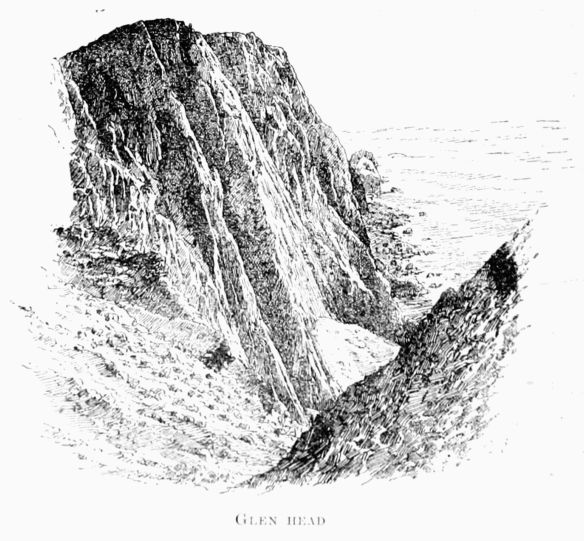 GLEN HEAD
From the southern Bunglass cliffs the view of the richly-coloured precipices opposite is superb. This colouring is a remarkable feature. The cliff is well-nigh sheer for 1,000 ft., descending straight from a heathery brink. With the exception of the wonderful cliff seen in Yellowstone Park from 'Inspiration Point,' the writer could name no rock-face[Pg 147] with such an assemblage of hues. Dolerites, diorites, quartzites, schists, and conglomerates all help to form this remarkable mountain. Below the Atlantic lights up and enhances the whole scene. Though usually breaking into heavy surge it is sometimes as smooth as glass, and then the visitor should secure a boat at Teelin (or Towney Bay), and row beneath, viewing the caves. One of these, with a small entrance and a vast interior, gives forth appalling reverberating echoes to a horn or a gun.
At Bunglass there is a track leading down to the sea, and a swim rewards the descent. Crossing the heavy-shingled foreshore to the base of the opposite cliffs, there is a gully which appears practicable from below, and leads to the very crest of the cliffs. The violence of storms and the pitiless pelting of surf below and dislodged fragments from above have cemented the steep floor of this slit into an uncompromising hardness. The writer tried it, passed one or two bad places, and was rejoiced beyond measure to reach the bottom with unbroken bones.
From the summit of Bunglass cliffs, at a point a little north of the Eagle's Nest, at an altitude of 1,000 ft., it is practicable to traverse the whole face of Slieve, at about the middle height, 700 to 1,000 ft. above sea level, from end to end, to the bluffs of Leahan. In two or three places the ocean edge can be reached, besides the point already mentioned. In search of botanical specimens we have climbed them in all directions. There is a track (of a sort) to the sea at one place between the Eagle's Nest and the One Man's Pass. While scrambling along the sea face[Pg 148] this track was discovered amongst steep heather, bracken, and bear-berry, and a footprint showed it to be a human resort. Finally an old man and a little boy emerged from the ocean brink, loaded with samphire, both inside and outside, and eating it as they rested on their climb. Vastly surprised at the appearance of the only stranger they had ever seen there, they eagerly besought him to remove his boots—a suggestion declined with thanks. Samphire boiled with milk is a cure for a cough, but it was a novelty to see it eaten raw. This track is called Thone-na-culliagh ('Back of the Grouse').
It took the writer three summer days to complete this traverse from end to end of the median height of Slieve League. Several nasty ravines, iron-floored and steep-edged, had to be crossed. At the close of each day an ascent had to be discovered—an anxious undertaking, as the return invariably seemed too dreadful to contemplate. The point relinquished at the close of each day was religiously repaired to on the following.
Excessively steep slopes of cemented gravel, grass, or crumbling rock, half held together by heather, are the usual difficulties. But in four or five places odd right-angled walls of horizontal, loosely-balanced blocks of slaty schist jut out right across the face of the cliff, the legs of the angle being sheer to the sea and horizontal above. The blocks lie loose upon each other, and are not always large enough to give one a sense of anything except the rickets. Usually it was possible to climb beside these buttresses, and, balancing by them, get over in gingerly fashion. But one—the largest—had to be climbed on equilibristic principles. Sheep tracks follow[Pg 149] the face of the cliff in some places. Where a sheep can go a man can go, though he may not like jumps from bad footing to worse landing, where even sheep occasionally come to grief. Accordingly a track going horizontally here looked encouraging to the writer, till a flock of wild goats, signally scared, put his confidence to flight, for a wild goat will lead a man where he may find it necessary to make a prolonged halt. However the goat track vanished upward, and the seven-mile traverse was successfully completed to the Eagle's Nest.
From the summit of Slieve League there is a fine oceanic view of island, headland, bay, and cliff. South-east of the summit, at a slightly lower altitude, is the One Man's Pass, about the terrors of which a great deal of rubbish has been written. It is a steep, narrow, short ridge of firm rock, which any mountaineer would walk up or down with his hands in his pockets. In a storm he would, however, adopt a worm-like attitude. The sides are very steep, but practicable both seaward and inland. It commands a superb view. Among the legends connected with Slieve League one about a Spaniard, a priest, and a pony is the most captivating (see The Donegal Highlands).
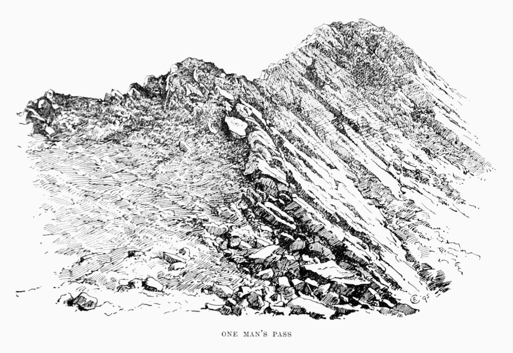 ONE MAN'S PASS
Slieve League is capped by the remnants of outlying beds of lower carboniferous age, conglomerates, with fossil plant remains. Botanically also this mountain is most interesting, rivalling Ben Bulben for first place as a habitat for mountain plants in Ireland. There is an interesting feature visible from the summit—a group of spire-like pinnacles, close below the crest of the ridge. These are known as the 'chimneys,'[Pg 150] [Pg 151]and form an attractive assemblage. They are of the same nature as the flying buttresses already spoken of.
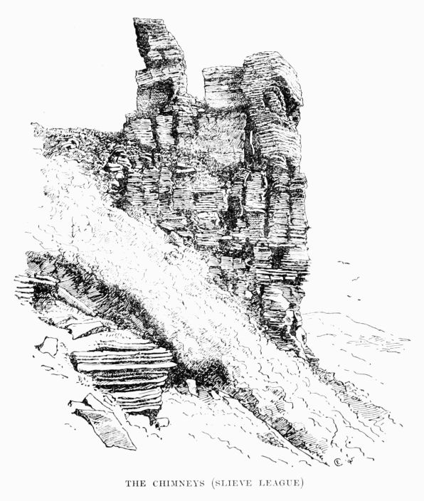 THE CHIMNEYS (SLIEVE LEAGUE)
Slieve League takes its name from 'liag' (flag). There is a flag formation near the summit. Bunglass is 'Green River Mouth,' but a modern guide-book translates Bunglass 'Beautiful View,' a ludicrous error explained by the fact that the point which gives so noble a prospect of Bunglass is known as Awark More ('Great View').
Croagh Gorm and Blue Stack Mountains lie north and west of Barnesmore Gap and above Lough Eske, reaching nearly to Glenties, Lough Eske being about 30 miles east of Slieve League. The coast eastwards from Slieve League becomes suddenly low, and the formation changes to carboniferous limestone, which occupies a broad belt round Donegal Bay. The Blue Stack group is about 7 miles across.
Blue Stack (2,219 ft.) lies above Lough Eske and is granite, although the Lough itself lies in the limestone. About Lough Belshade, which lies north of Lough Eske, about half-way up the east side of Blue Stack, the granite is precipitous, and one bold bluff west of this lake (Belshade), with a sort of little cave in its face, may be taken in the ascent of the mountain. Most of the granite portions of the range are rounded, flowing, gently contoured, barren slopes of bare rock, sometimes at low elevations becoming steep and difficult. The ascent of Blue Stack from Lough Eske should on no account be missed. The lake is about 10 miles round, and most beautifully situated at the southern base of a bold mass of rugged, desolate granitic bosses and cliffs, cleft by a few fairly steep ravines. In direct contrast to this sombre scene is the west shore of the lake, which is girt with timber,[Pg 153] chiefly natural. Ardnamona is the nearest portion of this sylvan scene to the mountain base, and the whole basin is admirably sheltered by the surrounding mountains from the violent storms which of late years have been more destructive than ever.
From the road above Ardnamona, looking down over it upon Lough Eske and its solemn background, the view is perfect. It is a sort of compact Killarney, which the eye and mind will long feast upon.
North-west of Blue Stack, a couple of miles from it, lies Lavagh More (2,211 ft.), a fine upstanding lump of turf-covered schists. Schists and sandstones constitute the greater part of these hills. From Lavagh More, descending southwards, by a series of lakes, the head of the Shrule River is reached, in a valley with a precipitous northern side, which gives difficult bits of crag work. In this valley at the northern end lies a waterfall known as the Grey Mare's Tail.
The Blue Stack Mountains are best explored from Donegal on the south or Glenties on the west, in both of which places there are comfortable inns. It is best to drive to the head of Lough Eske, and it is a fine walk from that, including most of the tops, down to Martin's Bridge, 3 miles from Glenties, over Blue Stack, Lavagh More, and Silver Hill.
In the mountainous district around Glenties other excursions are available. A walk to be recommended is from Barnesmore Gap (drive of 7 miles from Donegal) across the Croagh Gorm and Blue Stack summits to Glenties. Barnesmore[Pg 154] Gap should by all means be visited. The mountains on either side rise 1,500 to 1,700 ft., not quite precipitously, but with bluffs, heavy boulders, and steep rocky faces. Cæsar Otway gives a highly-coloured description of this impressive scene. Another way to explore the group is to follow up the course of the Reelan water through a peculiarly secluded and remote valley. From Glenties to Ardara is about 4 miles, and the latter village is a capital halting place. Fishing and fowling can be had. The road from Ardara to Carrick, about 10 miles, passes up the wild, grand gorge of Glen Gesh by a zigzag road, reminding one of some of the Swiss ascents. For the sake of the varied scenery obtained by these doublings it is almost preferable to stick to the road till near the summit. On the south side of this glen it is bounded by a range known as Altnadewon or Croaghnagcaragh (Reek, 'hill of the thicket'). A steep rock face extends from the main road at the 'nock of the Ballagh,' or Pass, which forms a wide amphitheatre on the north face of the highest point of this range (1,652 ft.) For some distance it is by no means easy to scale this declivity.
Towards the southern verge of the county the coast is low and flat, but the bold precipitous face of Ben Bulben looks highly attractive.
Before leaving Donegal it will be well to mention one useful hint. The Ordnance maps of this county show 100-ft. contours, which are of the utmost advantage upon any excursion, as the height of any point attained by the pedestrian may be fixed within a hundred feet. Very few other parts of Ireland are thus favoured.[Pg 155]
The Ben Bulben Range lies in the northern part of Sligo and Leitrim; a most conspicuous object in the landscape viewed from Slieve League across Donegal Bay. The shapely escarpment of the nearest point looks, indeed, as if it belonged to Donegal, which is 7 miles away. This portion consists of Cloughcorragh (2,007 ft.) and Ben Whiskin (1,666 ft.)
These mountains are almost entirely carboniferous limestone. Much of the group is an elevated plateau, girt round on all sides, or nearly so, by limestone precipices, usually some hundreds of feet high, rising from a long steep slope of débris. The height of the cliff edges is about 1,600 ft., of which the talus occupies about two-thirds. The cliffs are fine, but consist largely of insecure blocks. Occasionally a fissure occurs, permitting ascent or descent, and some very steep ones are used on the south side of the range by turf-cutters.
In consequence of this formation the pedestrian may find himself following a long series of cliff edges, without being able to discover a way of descent. To examine the cliffs the proper course is to follow the sheep walk, which usually occurs at the base of the precipices above the talus. The walk across the range, from Bundoran to Sligo, is full of interest to a mountaineer, and the descent into the valley north of Sligo from King's Mountain is one that will never be effaced from his memory. It is not easy to find the passages leading down. The valley is a vast amphitheatre almost enclosed by cliffs, sheer and, including talus, about 1,000 ft. high.
It is always a pleasant experience to follow the crest of a[Pg 156] line of limestone cliffs. Similar cliffs on a smaller scale are those of Moher and Aran, in the county Clare. It is probably owing to the fissures and laminations of the limestone, which afford a perfect system of internal drainage, that such cliffs are not only dry and clean, but also free from the gullies and valleys which, causing frequent ups and downs, sometimes render cliff walks extremely fatiguing—near Waterford, for example. Again, limestone grows no heather and forms little peat, so that the usual footing is clean grass sod—very pleasant after hummocky tussocks—and yielding 'quaas.'
For these mountains Kinlough is perhaps the most convenient centre. Manor Hamilton and Dromahaire may also be utilised, but Bundoran and Sligo, though the latter commands the beautiful Lough Gill, are too distant from the hills.
It may be mentioned here that there are various attractions in Northern Ireland outside the scope of this work. Fishing is always in reach, and of late years golf has thriven apace. No finer links exist than those of Portsalon, Rosapenna, Portrush, and Newcastle, and there are many others of growing excellence.
Ben Bulben is famous for its mountain flora, a valuable report on which, by Messrs. Barrington and Cowell, has been published by the Royal Irish Academy.
Mayo. Here are the highest mountains in the west of Ireland, Mweelrea (2,688 ft.) and Nephin (2,646 ft.)
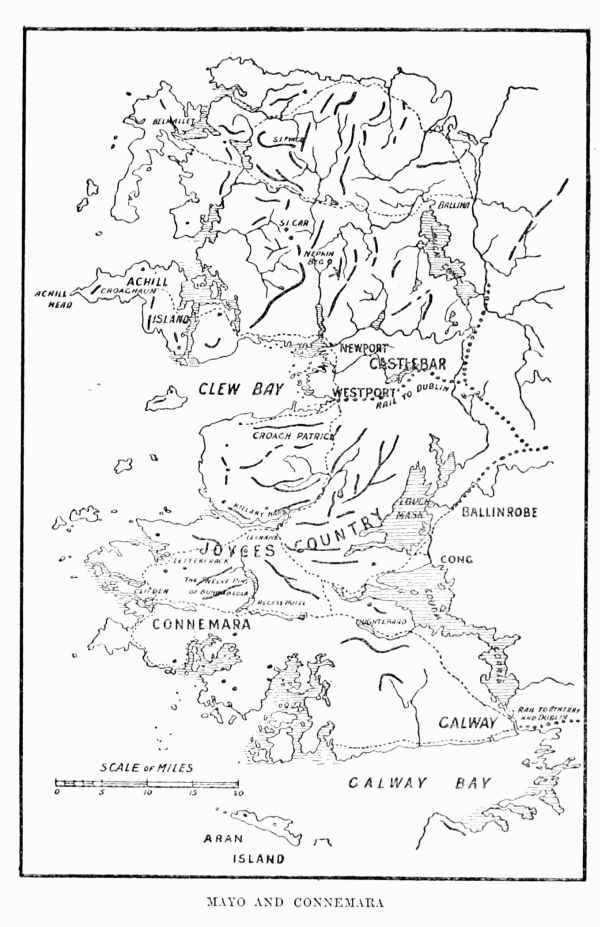 MAYO AND CONNEMARA
Nephin is a round, isolated lump of quartzite, becoming schistose, rapidly disintegrating on a northern spur, where[Pg 157] [Pg 158]the only declivities occur. For the mountaineer it is both distant and unattractive, but on clear days—which are rare—there is an extensive view.
About 10 miles west of Nephin the axis of the Corslieve range is struck near the middle of its almost north and south direction. This chain of hills includes Laghdantybaun (2,369 ft.), at the northern end, Corslieve (1,785 ft.), Nephinbeg (2,065 ft.), and several others over 2,000 ft. The chain is about 15 miles in length, terminating near Newport, where fairly comfortable accommodation can be had. The northern hills are slate or sandstone, the southern quartzite. It is an interesting range, and the scenery is wild and rugged, but there is little true climbing. The best way to approach them is to drive from Leenane Inn to the Deel River, due north, and then strike west over a wet bog, full of dunlins, plover, and curlew.
Achill Island is about 15 miles west of Newport. The mountainous peninsula of Curraun Achill intervenes, and is about 7 miles across, rising to a tableland of 1,300 to 1,500 ft. in height, composed chiefly of horizontally-stratified sandstones and conglomerates, not very safe, but pleasant enough to follow along by the terraces on its north-eastern edge. Juniper is remarkably abundant here, and, at lower levels, Mediterranean heath.
On Achill Island there is a comfortable hotel at the 'missionary settlement,' which is about 10 miles from the ferry. The settlement is at the base of Slieve More (2,204 ft.), the highest point of Achill. This mountain is well worthy of a visit, but far finer are the noble cliffs at Croghaun,[Pg 159] [Pg 160]about 5 miles west of Slieve More and 2,192 ft. above sea level.
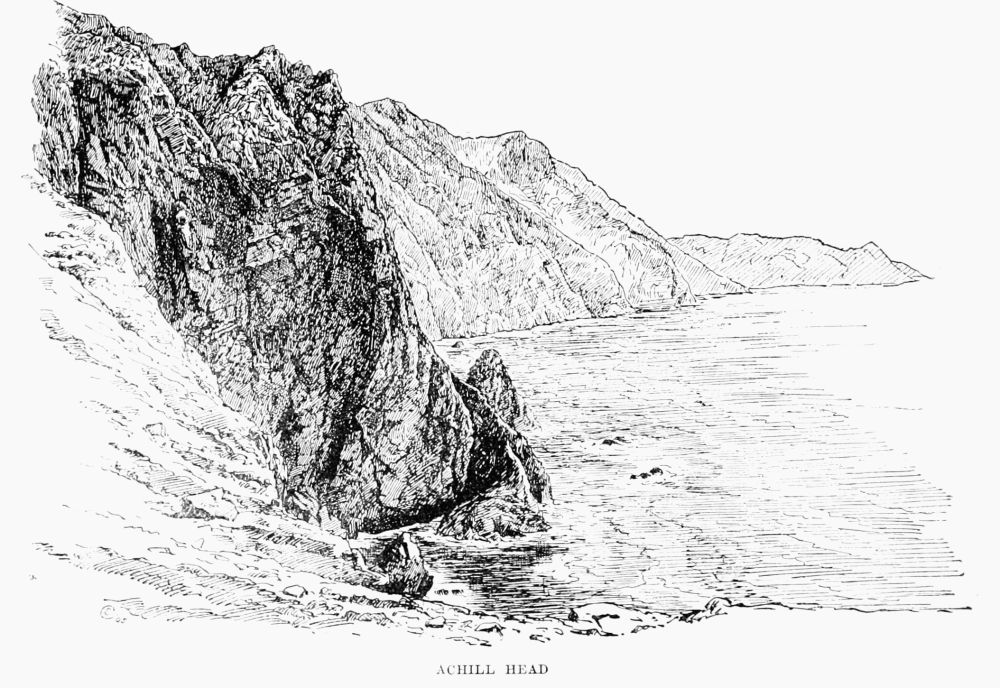 ACHILL HEAD
Achill is mainly quartzite, which rock invariably looks and is barren and forbidding.
There are several points along these cliffs where a descent to the sea is practicable, and plenty of climbing is obtainable along the face of Croghaun, which may be traversed in all directions, the cliffs having the appearance and repute of being more inaccessible than they really are. The rock (quartzite) is broken into screes and heavy shingle in many places.
Croaghpatrick (2,510 ft.), famous for its unrivalled view, and formerly called 'The Reek,' has a northern face of precipitous declivities where the quartzite formation (as on Nephin) gives place to schists and shales. The view to the north of Clew Bay, with its hundreds of islets and Achill beyond, is unsurpassably lovely. The climbing is more of a 'slither' amongst rotten footing or shingle on the northern side. The summit is crowned with numerous cairns, being a famous 'pattern.' The beautiful St. Dabeoc's or Connemara heath abounds. Westport, at its foot, has an excellent hotel, and it is better to return here from Achill, or vice versa.
Mweelrea.—Unlike the quartzite mountains, which are usually conical or dome-shaped, Mweelrea is of a totally different structure. Composed of Silurian slates chiefly, it forms an extensive tableland at the north of Killary Fiord, in the south-west corner of Mayo. It is intersected by three principal valleys, radiating at about equal angles from Doo Lough. One—that of Delphi and Bundorragha—runs southward to the[Pg 161] Killary. Another—that of the Glenummera river and Owenduff river—has an easterly trend to the Eriff. The third valley is that of Doo Lough, Lough Cullin, and Lough Connel, which runs north-west to the sea. The names of many of these points, such as Delphi Mountain, the highest above Doo Lough, and Loughty Mountain, its elevated eastern spur, ending in Glen Laur—are not given on the Ordnance map, and were obtained from the natives. Error easily arises in nomenclature. A hill or ridge may have a name known to a few, or belonging to one slope, or to a people living on one side. Again, it may lie along the boundary of two town lands, and each may give its name to one side of it. Moreover the pronunciation is a study in itself. Near Newport there is a district called on the map Burrishoole, and a bay named Bellacragher. These are pronounced 'Brizzool' and 'Ballycroy.'
The Mweelrea group consists of a series of plateaux, bounded by long ranges of precipices, ridges, and gullies, often ending in sheer ravines. Mweelrea itself fronts the mouth of Killary Fiord, curving in a grand tabular ridge, 2,600 ft. high, above two small lakes at 1,200 ft. The pass of Delphi and Doo Lough are the most imposing scenes in the west of Ireland for wildness and sombre grandeur.
The climbing is of varying difficulty. Between their bases and the screes below tempting ledges wind upwards, but here the strata are almost vertical, rendering them extremely treacherous. A nasty fall impressed this peculiarity on the writer's memory. In other places the rock is sandstone, mixed with decomposing conglomerates—a[Pg 162] formation worse to scale than any except the miocene trap rocks of the Antrim coast.
There is one interesting and difficult climb. A lake—Glencullin ('Glen of Hollies') Lake—lies immediately north of Doo Lough. A stream runs into the south-west corner of this lake out of Glencullin, starting from a series of black, sunless precipices, seamed with gorges and well-nigh 2,000 ft. high. These can be climbed by two gorges at least from base to summit. The name of these cliffs is Asko Keeran ('Ridge of Mountain Ash'), and when the crest is gained a fine walk is the reward, over Ben Bury (2,610 ft.) to the highest point, Mweelrea (2,688 ft.), along a curved ridge one to two miles long.
One portion of the Mweelrea system—that which lies immediately east of Fin Lough or Delphi—is known as Ben Gorm, or Kead-na-binnian. The cliffs upon this mountain are formed chiefly of gneiss, which breaks up into blocks, owing to numerous transverse fissures across the lamination. These blocks lie on one another, often on a steep slope, owing to the roughness of their surfaces, which prevents their sliding. They are then more dangerous even than slaty rocks, since this very roughness beguiles a climber into feeling that the footing is safe at a steeper angle than on the smoother surfaces, while the rocks are merely in unstable equilibrium.
Maamtrasna, Slieve Partry, the Formnamore Mountains, or Letterbrickaun ('Wet Hill of Badgers'), abut upon the head of Killary Fiord. The highest points, or rather flats, are Devils Mother (2,131 ft.), Maamtrasna (Formnamore) (2,239 and 2,209 ft.) They are chiefly composed of sandstone and[Pg 163] sandstone conglomerate, and form a series of high barren tablelands, dotted with pools, and of no interest whatever.
The above group, as well as Mweelrea, is within easy reach of the excellent Leenane Inn at Killary.
Cliffs.—Of the numerous magnificent cliffs on the western seaboard of Ireland none, in the writer's opinion, excel those of North Mayo. Certain aspects of Slieve League are grander, the cliffs of Moher are more splendidly symmetrical, Horn Head, Dunaff Head, Achill, all have their glories, but the Mayo cliffs are unmatched for extent and variety. From Ballina by Ballycastle to Belmullet, round the coast, is the finest sea-cliff walk the writer has ever experienced. For three days there was no cessation of variety in shape, in sculpture, in colouring of the precipices, always lofty and always plunging into a surf-like snow beneath, fringing the blue ocean outside. Occasionally, but rarely, ravines occur, leading to some tiny rock-bound bay. The coast here for many miles is higher than the land inside, and the streams flow away from the sea to the south, and then west to the Atlantic. Perhaps the most hopeless area of undrainable bog in Ireland lies in Western and North-Western Mayo.
Although it was impossible to omit mention of these cliffs, they are not for the climber. They are too sheer, and, what is worse, there is no accommodation. From Ballycastle west to Belderg is within reach. But it is west of Belderg that the cliffs are grandest, as at Glinsk, Doonmara, and Benwee Head. Without the happy fortune which enabled the writer to use a shooting lodge, located west of Belderg, the distances would have been impossible without camping out.[Pg 164]
From Belderg to Belmullet the rock is chiefly a hard and reliable quartzite, often seamed with dykes of basalt. Numerous needle-shaped islets, stacks, and stookawns occur. The whole coast abounds with sea fowl, and is singularly free from human influence, since the absence of bays, strands, or harbours renders long stretches of it uninhabitable even for fishermen.
Otway's Sketches in Erris and Tyrawley (1841) should be read.
Galway Mountains.—The Galway Mountains, besides the Maamtrasna range, spoken of above, are Maamturk range, Benchoona, Bennabeola or Twelve Bens (or 'Pins').
Maamturk range, including the hills which form such a conspicuous feature in Joyce's Country, extend, roughly speaking, from the Killary Hotel south-east to Lough Shindilia, at the Half-way House on the coach road from Clifden to Galway. It forms a zigzag series of beehive-shaped domes, connected by ridges, which are frequently 500 ft. to 1,000 ft. below the neighbouring summits. Usually these connecting ridges are set at angles with the tops quite at variance with the main axis of the chain, and are invisible from the summits, so that compass bearings are most misleading.
These truncated mounds are composed mainly of gneiss, sometimes of quartzite, and in the northern portion the chain becomes more fertile and of a clayey, schistose nature. They are very similar to the Twelve Bens, save that the latter have their conical tops still adhering, apparently showing that[Pg 165] this elongated line was more vulnerable than the self-protecting 'Pins' cluster.
This chain is singularly barren, but so bold and conspicuous a feature in the landscape claims exploration. The writer once traversed the whole length of summits from the Half-way House to Leenane in a walk, or climb, for about 14 hours. The going is often excessively rugged and wearisome, owing to the loose detritus of heavy, angular quartzose blocks. An occasional oasis, as at Maumeen, charms the eye with its verdure and some botanical treasures. Near this an hotel once existed, but at present there is nothing nearer than Glendalough or Leenane, at the extreme ends of the range.
Many a stiff bit of climbing, short and sharp, was met with on this most severe day's work, in making growingly reckless short cuts from summit to summit. From Leckavrea to the Killary there are about fifteen distinct summits, averaging 2,000 ft. in height.
Benchoona (1,975 ft.), a northern outlier of the Twelve Bens, lies at the mouth of the Killary, opposite Mweelrea. Killary Harbour or Fiord runs inland eastwards for some 15 miles. Benchoona is gneissose, with two summits, close on 2,000 ft., and a lake lies between them. Several Alpine plants occur among the north-east cliffs. The rock here is uncommonly dangerous to climb, being loosely constructed and apt to disintegrate in unexpectedly massive segments. On such an occasion, although against the dogma of climbing, a swift and sudden jump or spring is sometimes the only escape. The block—perhaps a ton or two in weight—which[Pg 166] is quietly sliding, or more probably overturning, with its captive, yields momentum enough for a final kick to clear out altogether to any preferable station. These rocks are unfit to climb, and will only be meddled with for some special purpose.
Twelve Bens (2,391 ft.), within easy access of first-class hotels in Connemara, are huddled together in beautiful confusion, and offer problems of special interest in their puzzling geography and watershed system. Bennabeola is entered by no roads of any great penetration, but there are several valleys forming arteries with its very heart. Of these Glen Inagh from the east, Glen Coaghan from the south, and Owenglin from the west are the most important. The best method is to select a glen—Glen Coaghan for choice—and work to its head. Two or three summits will then probably lie equidistant. Most of these summits are of quartzite, with short heavy screes, white and extremely barren. The most interesting climb is upon the north of Muckanaght (2,150 ft.), which is connected with Benfree by a ridge at about 1,000 ft. The cliffs lie about 1,300 to 1,800 ft., and from near their upper edge to the summit (2,150 ft.) is a steep and perilous grassy slope.
Muckanaght is about 2½ miles from the lovely Kylemore Lake. Two 'Pins,' Benbaunbeg and Benfree, intervene. The peak itself is connected by ridges with Bencullagh and Benbaun South. From Muckanaght the heart of Bennabeola is laid bare, and, given a clear day, no better point of vantage could be desired.
The Twelve Bens are in the heart of some of the loveliest[Pg 167] scenery in the world, full of varied and interesting scrambles, and botanically they are pre-eminently the richest in mountain plants in Connaught, Croaghpatrick coming next.
Clare.—The Cliffs of Moher may be visited from excellent quarters at Lisdoonvarna (the 'Fort in the Gap'), in the north-west of Clare, a district known as the Burren. This district is formed of the carboniferous limestone which occupies most of Central Ireland.
This formation, replete with carboniferous fossils, is remarkably monotonous and symmetrical. When it occurs in a cliff formation, as at Moher, or the south-western sides of the Aran Islands, it forms a sheer wall, absolutely vertical, to the sea, or else it is arranged in a series of terraces, like gigantic steps. Very rarely a chasm occurs, connecting two terraces. More often it is possible, by means of slight protruding ledges, to ascend an almost vertical face, since the rock is invariably either absolutely safe or easy to test. Sometimes, as at the southern end of the Moher cliffs, isolated pillars of rock occur, which are most pleasing to climb and pleasant to remain perched upon when climbed.
These rocky surfaces of Aran and Burren are very tiresome and difficult to traverse, as the fissures (2-12 in. in width) between the blocks are often adjacent. The rock is usually cut into slabs, generally rectangular in shape. The loose blocks are piled by the inhabitants into tottering walls, which are difficult either to cross or upset with safety. The easiest way is to ascend gently and then jump with a kick behind. On Aran especially the going is most laborious.[Pg 168]
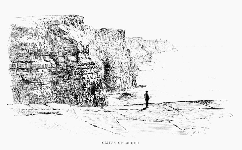 CLIFFS OF MOHER
As an instance of the sheerness of these cliffs on Aran boys may be seen fishing with a rodless line from their edge, 200 ft. above the water. Inland these cliffs run gradually in a series of irregular declivities, a gently sloping flagged platform to low levels.
Much is done here by the natives in the way of egg-collecting, with the assistance of ropes, the eggs being chiefly those of guillemots, gulls, and razor-bills, and required for food.
The cliff scenery of Moher is superb and unequalled. It has not the variety of stack, needle, ravine, that other formations have, but its very regularity is most harmoniously imposing. On the other hand, the brilliant and varying colouring of North Mayo or Slieve League, in Donegal, is entirely absent.
The Aran Islands are visited from Galway by steamer. There is an hotel on the north island. They are full of ethnological and archæological interest.
Co. Down. Mourne Mountains.—This chain of granite hills covers an elliptic space of about 15 miles by 6, the longer axis stretching from Newcastle to Rosstrevor, where there are excellent hotels. From either point to the other is a day's walk that will well repay the labour, and can be made to include all the principal summits. The descent to Newcastle, through Donard Lodge woods, by the waterfall, is very pretty, and by varying the night's accommodation a still more beautiful route lies through Tollymore Park to Bryansford, where good quarters are obtainable.[Pg 170]
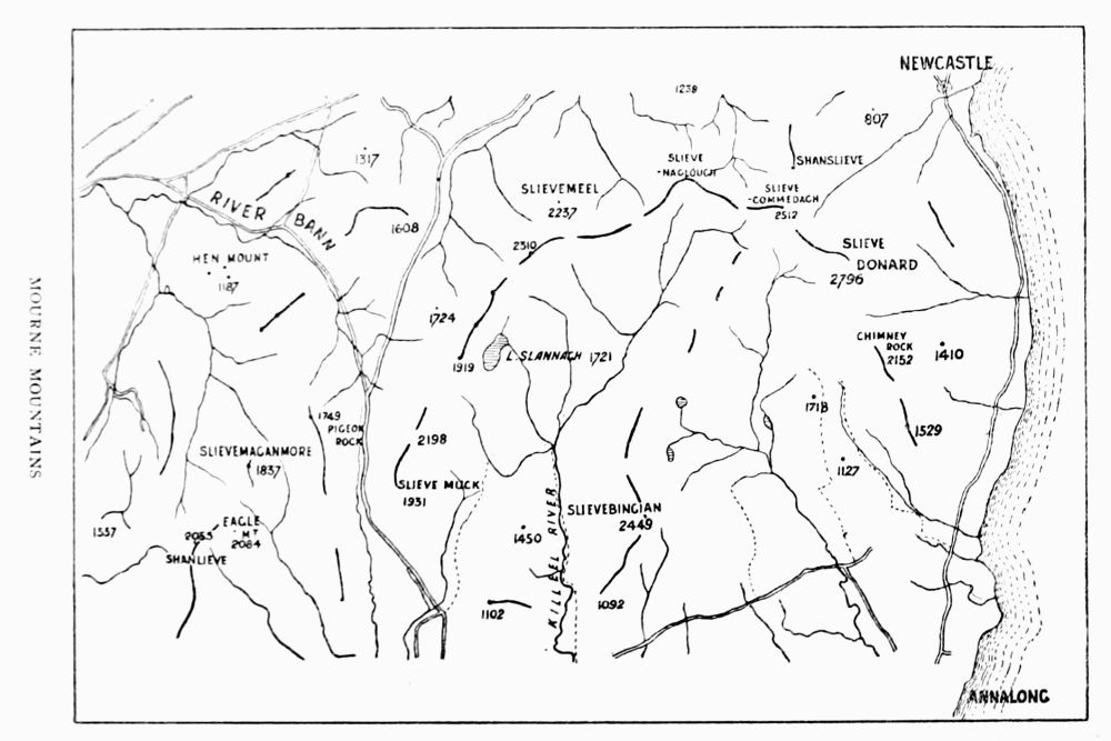 MOURNE MOUNTAINS
The highest points lie at the Newcastle or north-east extremity of the group. The southern portions are less interesting, and the western flanks are very dreary.
These hills, being of granite, have few precipices, many rounded summits, sloping sides, and heavy screes, of the usual uncomfortable angular nature. The 'Eagle's Cliff,' a mile to the north of Slieve Donard, affords some climbing, and a little rock exercise can be had at 'the Castles,' lying on a spur of Slieve Commedagh, to the west of Slieve Donard, below it and half a mile away.
Slieve Bingian, in the south-east of the range, has a little easy climbing.
There is also a considerable cliff on a shoulder north-west of Slieve Meel-more. It is known as Spellick, and is easily visited from Bryansford. It is worth examination, but the writer has not climbed it.
The view from Slieve Donard is, of course, famous.
The ascent from Bryansford, through Tullymore Park, taking Slieve Commedagh and the Castles en route, is perhaps the finest walk, so far as scenery is concerned, to be had in this picturesque cluster of mountains.
Co. Dublin.—Lambay is an island abounding in sea fowl and wild flowers, about 2½ miles from the nearest point of land, and about 10 miles north-east of Dublin. It is best approached by boat from Donabate, or less conveniently from Howth, Malahide, Rush, or Skerries.
The cliffs reach about 250 ft., and are practically sheer in many places, as on the north-east side at Freshwater Bay,[Pg 172] or a little west of it, and on the south-east cliffs below Raven's Well.
Several most interesting climbs are to be obtained on it. The best are on those cliffs west of Freshwater Bay.
About 30 ft. above the water's edge at high-water mark there is a narrow and deep horizontal fissure, which in May is packed with breeding sea fowl. The ornithological visitor will at once feel it his duty to reach that fissure. The writer's first visit to Lambay was made in the company of one Dykes, known to be the best clifter on Howth. He pronounced this fissure inaccessible. There is a bend in the cliffs leading to the right-hand extremity of the fissure. Here lay the only chance, and the first two grips out of the boat are easy enough, raising one 6 or 8 ft. (or perhaps 15 if the tide is out) above the water. After that there are two enormous stretches, with practically no foothold. If these two points are passed, the fissure is in reach, and an ugly wriggle will land the unwelcome intruder on his anterior surface upon the narrow ledge forming its base.
Dykes meantime was highly encouraging, calling out, 'Madness,' 'Break your neck,' 'You can never get down.' The climber had, however, an original plan of descent, and having, with considerable difficulty, divested himself of his garments, he dropped them first into the boat and then himself into the water.
On revisiting these cliffs ten years later, and pointing out this climb to a very good rock-man, he failed to see how the climb was done, and so it had to be done again. This time, however, the tide was out, and on stripping to take the[Pg 173] plunge it became at once apparent that a rock exactly in the line of descent was too near the surface. To climb down had always appeared dangerous, on account of the lack of foothold and the very awkward nature of the backward movement out of the fissure. So an attempt was made on the wall above.
It is marvellous how a naked man can adhere to a cliff. For a full hour an unhappy preadamite man writhed and glued himself against the face of that cliff, descending and reascending by new lines, but always checked by a straight wall about 150 ft. up. Anything appeared better than that hateful descent. Some friends ran to a coastguard station a mile or more away for a rope. However before they reappeared the descent was faced and safely accomplished.
This sketch will serve to show that high mountains are by no means necessary for the practice of rock-climbing, the very best of which is constantly attainable along the coast. Owing to the working of the ocean waves unsafe pieces are almost certainly removed, and the cliff, at its lower parts at any rate, is invariably firm and safe. It is fine sport to choose a steep rocky coast at, say, half-tide in spring, and travel between high and low water marks as far as may be during the six hours. It should be a point of honour not to ascend, but if forced to take to the water excellent practice and much amusement is obtainable in this way, and the slippery nature of the rock teaches sureness of foot. Nailed boots are, of course, indispensable.
The geological formation of Lambay is principally felstone porphyry. Some stratified Silurian shales and limestone occur, and there is a small sheet of old red sandstone,[Pg 174] with conglomerates. The rock is in general hard and reliable.
Howth is a promontory with a village about 9 miles from Dublin, for the people of which it is a favourite resort. From Balscaddan Bay, on the north, to an almost opposite point, Drumleck Point, on the south, the east coast is composed of cliffs (200-300 ft.), sometimes abrupt, sometimes ending above in grass slopes, very slippery in hot weather, which have caused many accidents.
A very interesting scramble, with many nasty traverses over these steep grass slopes, may be had round Howth Head. Keeping to the upper edge of the rocks, it is necessary to ascend once at Kilrock, but after that the whole headland may be climbed at about the medium height of the cliffs. On the way a 'needle' or 'stack' will here and there attract attention, and perhaps seem worth assaulting. About Piper's Gut a small gully is difficult to pass. North of that a saddle rock leads to a pinnacle, but it is of rotten rock. The cliffs of this part of Howth are exceedingly picturesque, but in some places they are extremely unsafe. From Howth, on a very clear day, the Welsh hills, apparently those about Penmaenmawr, are visible.
Ireland's Eye. A small rocky island, 340 ft. high, about a mile north of Howth. At its north-east corner there is a bold columnar rock with a tabular summit, partly severed from the island. On its outer face it is very sheer, and to gain the summit is a very short but interesting and somewhat difficult climb. The return is not so bad, as a sidelong spring saves a portion of the worst bit.[Pg 175]
Wicklow.—Wicklow forms the third county in Ireland in which the mountains rise to a height of over 3,000 ft., Kerry and Tipperary being the other two.
The higher mountains lie in the broad band of granite formation which extends in a nearly southerly direction from near Dublin through Wicklow and Carlow counties.
Being granite they are as a rule round masses of wide extent, often covered with peat bogs; so that although Wicklow contains the most continuous extent of elevated (over 1,000 ft.) moorland in Ireland, there are few cliffs of any consequence, and no peaks or summits presenting upon any side material of interest to the rock-climber. Nevertheless there are fine stretches of mountain, affording excellent training ground. What cliffs there are occupy the most lovely scenery in one of the loveliest Irish counties.
Powerscourt Waterfall.—The rocks to the left of the fall, which is kindly left open to the public by Lord Powerscourt, the popular landlord, are nasty, especially in wet or frosty weather. Although not much over 250 feet in height several lives have been lost in this ascent, chiefly, no doubt, owing to the inexperience of the unfortunate visitors. This dangerous though tempting portion has been for several years railed off, and is not supposed to be trespassed upon. During the severe winter of the present year (February 1895) the waterfall presented an Arctic appearance. An interesting account of an ascent of it, or rather of the above-mentioned rocks, was sent to an Irish paper in that month. The climb was effected by a friend of the writer's (a member of the Alpine Club) and another, with ropes and ice axes. The cliff[Pg 176] was covered with ice and snow. The same party ascended Djonce (2,384 ft.), which lies above the waterfall, during a blizzard at a temperature of 18°, upon the same day. Unhappily a very few days afterwards a promising young life was lost upon these very rocks. The falls are visited by very large numbers of holiday-makers.
The rocks of Powerscourt, which lie against the Wicklow granites, are composed of metamorphic beds of gneiss and schists. Powerscourt is about 7 miles from Bray.
Tonelagee Mountain ('Back to the Wind' Mountain) (2,694 ft.), a round mass of moorland, has on the northern shoulder a crater-like valley, containing a tarn, Lough Ouler, and cliffs of schistose, some 400 to 500 ft. high, descending from near the summit to the margin of the lake. An interesting scramble may be made from the Military Road, about a mile above Glenmacanass Waterfall, which lies some 6 miles from Glendalough Hotel; but a short cut to Lough Ouler is easily found by going up the Glendasan valley 3 miles towards Wicklow Gap, and then striking up northwards over the shoulder of Tonelagee.
Wicklow county is very poor in highland plants, and these cliffs alone possess species of any interest.
Other cliffs in county Wicklow are those of Luggielaw ('Hollow of the Hill'), above Lough Tay; the Eagle's Nest, above Lower Lough Bray; a small series of bluffs above Lough Nahanagan, and the Prisons of Lugnaquilia. In winter the latter, lying high (2,700 to 3,039 ft.), afford excellent glissading and cornice work. But, unless the season is severe there is too much heavy trudging to be done. All the above[Pg 177] precipices lie in most attractive scenery, nor must the famous cliff above Glendalough, containing St. Kevin's Bed, be omitted. But none of them affords desirable scope for climbing practice. The granite 'Prisons' of Lugnaquilia are attractive in appearance, but all the cliff faces are ready to drop to pieces. Mullaghclevaun ('Summit with the Cradle' or 'Creel'), 2,783 ft., contains no climbing.
Since Wicklow affords the nearest opportunities to Dublin mountaineers, we may mention a few one-day walks from that city which have been accomplished by the writer.
Practically the only artery through these mountains is the Military Road, constructed after the rebellion of 1798 to connect a series of now disused barracks. This road, from 'Billy's Bridge' at Upper Rathfarnham, about 5 miles from Dublin, is over 35 miles to Aughavanagh. It passes through an almost uninhabited country, and much of it lies from 1,000 to 1,500 feet above sea level, and it is the pedestrian's main anxiety to regain the comparative security of the Military Road before night sets in on the wide stretches of tussocky moorland.
To clear the suburbs it is well to take the tram to Terenure (3 miles). Terenure; Ballinascorney Gap; Coronation Plantation (3 to 3¼ hours); Sally Gap; Military Road; Lough Bray (5 hours); back to Terenure (7½ hours: 34 miles).
Terenure; Lough Ouler; Tonelagee summit (6 hours); Mullaghclevaun summit (7½ hours); Ballysmutton (9½ hours); home by Ballinascorney Gap (13½ hours: 48 miles). From Bray this walk is about 5 miles shorter.
Bray, over Bray Head, Little Sugarloaf, Big Sugarloaf[Pg 178] (1,680 ft.), Djonce Mountain (2,384 ft.), and Kippure (2,473 ft.); Lough Bray, by Military Road, to Terenure: about 11 hours.
Terenure; Ballinascorney Gap; Seacaun; Kippure; Lough Bray; Terenure (about 8 hours).
Terenure; Lough Bray; Kippure (2½ hours); Gravale (2,352 ft.); Duff Hill (2,364 ft.—very heavy going); Mullaghclevaun summit (6 hours); Tonelagee summit (7½ hours); Lough Ouler; Military Road; Terenure (14 hours; about 50 miles).
Glendalough; Dublin (7¾ hours); Glendasan; Wicklow Gap; summit of Tonelagee (11 hours); summit of Mullaghclevaun; Clevaun Lake; Ballymullagh old road; across Liffey at Ballysmutton bridge; Ballinascorney Gap; Terenure (20 hours, including rests and delays by bog; 62 miles).
Terenure; Lough Bray (3 hours); Laragh (7½ hours); Glenmalure; Drumgoff Hotel (9 hours 5 minutes—1½ hour's rest); Lugnaquilia (3,039 ft., 12¾ hours); Tonelagee summit (16¼ hours); Mullaghclevaun summit (17 hours 40 minutes); Ballysmutton farm (19 hours 40 minutes—35 min. rest); Ballinascorney Gap; Terenure (23 hours 50 minutes; 75 miles).
The ascent of Lugnaquilia direct from Glendalough, over Lugduff, round the head of Glenmalure, and up by Kelly's Lough is perhaps the finest walk in Wicklow.
It is a fine day's walk along the coast from Bray to Arklow, or Bray to New Rath Bridge, and thence by the Devil's Glen to Glendalough.
In a wild, uncultivated county, like Wicklow, experience in the use of map and compass may be gained by setting a[Pg 179] course from Woodenbridge to Glendalough, about 12 miles, or from Glendalough to the Scalp or Sugarloaf, on the way to Dublin, some 40 miles.
Kerry.—Brandon (3,127 ft.) is of the same formation as that of the Reeks, i.e. the lower old red sandstone. The Brandon rocks are, in general, hard grits, firm and good to climb.
The accommodation on this promontory of Corkaguiny is no doubt improved since the construction of Mr. Balfour's light railway from Tralee to Dingle; but Dingle lies 8 miles to the south of Brandon.
I obtained very inferior accommodation at Cloghane, on an inlet at the eastern base of the mountain; and cleaner and better, but not so convenient, from a coastguard at Ballydavid, to the west of Brandon. For the other mountains on the promontory, Castle Gregory is centrally situated, but in all these cases (except Dingle) it is highly advisable to make previous arrangements and supplement the native fare with a hamper.
The coast of the Brandon promontory (which was traversed throughout) is often highly precipitous; indeed, from Cloghane on the north to Anniscaul on the south the western extremity is almost entirely so, and many stiff bits of climbing were accomplished, whether in pursuit of scenery, of a direct course, of objects of natural history, or, perhaps, more frequently out of what an Irishman would call 'natural divilment.' A few years ago no language would have sufficed in abuse of the accommodation at Anniscaul, but, as it is now a railway station, no doubt this is all changed.[Pg 180]
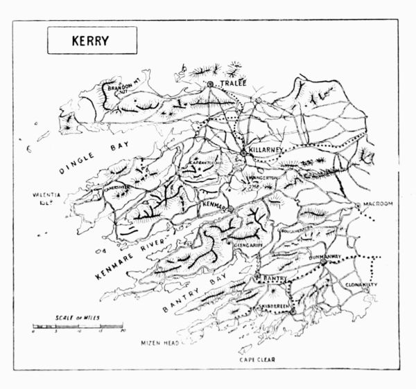 KERRY
KERRY
Brandon Peak and Brandon Summit.—The most enjoyable way to make the first acquaintance with these mountains is to ascend Connor Hill, to the north-west of Dingle, and follow the ridge by Beenduff, Ballysitteragh, Geashane, and Brandon Peak to the summit. The peak is about 400 ft. lower than and a little south of Brandon proper. Along this ridge, looking north and north-west, there is a fine rocky face before reaching the peak. After that point a[Pg 181] range of cliffs, several hundred feet in altitude, meets the loftier cliffs above Lake Nalacken, looking east. At the head of the Feany valley, under Brandon, these cliffs afford an interesting descent. The range gives plenty of practice in rock work.
Alpine plants occur mainly on the north and north-east cliffs, and are more numerous than on the loftier Reeks.
Brandon from Cloghane.—From Cloghane the ascent may be made amongst fine cliffs and rock-climbing, by making south-east for Lough Cruttia, the largest lake under Brandon to its east. It is better to follow the road southwards a mile or two, to save uninteresting moorland. From this lake it is a short distance to the north-west of Lough Nalacken, and by striking in east at once to the cliffs a good climb is obtainable. Lough Cruttia is about 700 ft. above sea level. Between the upper lough and the cliffs the surface is a desolate extent of polished naked grits, strewn with boulders. Crossing this a somewhat dangerous gully leads up to the cliffs at about 1,650 ft. The ascent of this is about 300 ft., and a stiff climb and afterwards some 400 ft. of cliffs may be tackled in various ways.
There are numerous ledges, and it is the best botanical ground in the mountains. The cliffs 'go' splendidly. In a lake south of the two mentioned above, locally named Lough Bawn, or the 'White Lake,' lives the enormous 'carrabuncle.' It appears fitfully at night, glittering like silver in the water with gold and silver and precious stones hanging to it galore. It is partly covered with shells, which are lined with gold. Upon one occasion several men went to the lake at night and[Pg 182] dived in oilskins to catch this valuable monster. They did not catch him; but pearl mussels, no doubt shed from the carrabuncle, are found in the lake.
Brandon Point and Brandon Head.—From Cloghane it is a fine hard walk right round Brandon Point and Brandon Head. At the cliffs of Slieveglass (1,050 ft.) a bay of extreme grandeur is opened, bound on three sides by lofty precipices and with a depth and sea frontage of about half a mile. There is a shepherd's settlement, Arraghglin, on the coast, which has to be closely approached. A more bleak habitation can hardly be conceived; neither road nor even track leads to it. It is now several hours' work to round the sea face of Brandon Head, at altitudes varying from 500 to 1,200 ft., to Ballydavid. If accommodation has not been arranged for here the walk to Dingle will be found most wearisome, and at all trouble a car should be provided.
Macgillicuddy's Reeks contain the highest summits in Ireland. They extend from the Gap of Dunloe, the eastern extremity, to the Beenbane spur near Glencar, about 10 miles west from the Gap. The scenery is magnificent. From Lake Auger, in the Gap, the climber ascends at once by a series of precipitous bluffs to an elevation of about 2,000 ft. Still ascending along a serrated ridge, an elevation of about 3,000 ft. is reached above Lough Cummeenapeasta, about 2½ miles west of the Gap of Dunloe. For several miles this ridge can be traversed at about the above altitude. The ridge frequently becomes a mere knife-edge, and in several places descends abruptly and precipitously to some of the numerous tarns and cooms nestling 1,000 to[Pg 183] 1,500 ft. below. A more perfect mountain excursion can hardly be conceived. The ridge carries us to the shoulder of Carran Tuohill, and from its summit a northern branch extends to Beenkeragh (3,314 ft.) and to Skregmore (2,790 ft.) The axis proper continues to Caher (3,200 ft.) and Curraghmore (2,680 ft.) Here we reach a gap connecting Cummeenacappul (Horse's Valley) with the Valleys of Caragh and Cummeenduff, or the Black Valley. West of it is the Beenbane spur, a lower elevation of no interest. The Reeks are chiefly composed of hard green and purple grits, and sandstone of old red sandstone age. The rocks are generally firm and safe to climb amongst.
There is a comfortable angler's hotel at Glencar, at the western end of the Reeks. This is the best adapted for the immediate neighbourhood of the higher points, but to reach some of the most interesting climbing it is better to distribute one's attentions equally between Killarney and Glencar. From Killarney (Railway Hotel) two methods are available—one by car to the Gap of Dunloe, or further to the Hag's Glen, up a steep mountain road, and from either of these as starting-point some excellent rock work is available. From the Gap as starting-point a long day can be spent, descending at night to Glencar Hotel. The other method is to boat from Killarney (enjoying exquisite scenery) to Lord Brandon's cottage at the western extremity of the upper lake. Here begins a long, dull ascent, rewarded by the splendid view from the ridge into the heart of the Reeks. Or these routes can be reversed.
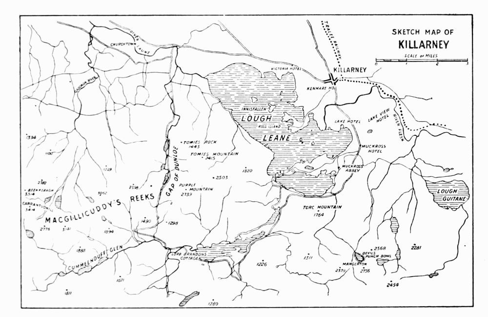 SKETCH MAP OF
KILLARNEY
SKETCH MAP OF
KILLARNEY
Guides swarm here. None of these have the slightest[Pg 184] [Pg 185]knowledge of climbing, and should one be engaged the first deviation from the easiest ascent, or departure into gully or ravine, will put a conclusion to his services. A wiry, bragging, long-legged shepherd undertook to accompany the writer by any ascent he selected from the Hag's Glen to Carran Tuohill, to be paid five shillings at the summit. At the foot of the first gully, with many heart-felt remonstrances and gesticulations, he disappeared, not even thinking it worth while to make an easier ascent. On this account it is all the more necessary to be unfailingly provided with the Ordnance map and a thoroughly good compass. An aneroid barometer is also of great assistance, especially in mist, for a knowledge of the altitude often enables a lake or a peak to be identified.
Cumloughra (3,100 ft.)—Starting from Glencar Hotel, a few tedious miles bring us across a country road to Lake Acoose (507 ft.) Passing round the south edge of the lake, a ridge (about 900 ft.) is crossed, and ere long Lake Eighter, at the entrance to Cumloughra (1,500 ft.), is reached. If we pass along the shores of the lake to the south-western edge, a few hundred feet up an open gully brings us to a series of cliffs south-west from Cumloughra lake. The rock is sound, and a fine, almost vertical ascent of 1,000 ft. may be made, striking the ridge of Caher (3,000 ft.) 200 ft. below the summit. It is a severe climb and very long, entailing many zigzags. There is no main gully to adhere to, and the cliffs are less impracticable than they look. Along the west side of the two lakes the cliffs are easier.
Carran Tuohill (3,414 ft.)—Cars from Killarney stop[Pg 186] at the Geddagh River. Cross it, sweep to the right and back, and then follow the valley by a fair path between two lakes to the Devil's Ladder and up it to the col. The summit is then on the right hand. The writer was once fortunate enough to ascend this summit through a cloud layer of about 1,500 ft. thick, which ceased a short distance below the summit. Above was a clear blue sky, and peering out of the dense white, snowlike bed of mist Caher and Brandon (the latter 30 miles to the north-west, the former not a mile away) alone were visible—a never to be forgotten sight, which seemed shut out entirely from earthly considerations. Descending into the clouds, the ridge leading southwards towards Cummeenoughter, or Devil's Looking Glass (Upper Coom), was taken by mistake, and an exceedingly nasty traverse across huge, dangerously sloping slabs was necessary in order to regain Carran Tuohill and find the Caher ridge.
Beenkeragh (3,100 ft.)—Between Beenkeragh and Skregmore (2,600 ft.) there lies an inviting glen, sunk in black precipices. These cliffs are to be avoided. At several points an attempt was made to scale them, but the rock is most rotten. Near Beenkeragh is a ridge running a little west of north for half a mile, and bounding the Devil's Looking Glass and the Hag's Glen on their west. This ridge is reached by an easy gully known as the Devil's Ladder, about 300 ft. below Beenkeragh.
Devil's Looking Glass (Cummeenoughter). This tarn lies at the head of the Hag's Glen, at an elevation of 2,500 ft. It is three-parts encircled by a fine series of cliffs. At the western corner of this bold girth of precipices the[Pg 187] finest view in the Reeks may be obtained, looking over the Looking Glass, and the lakes below in the Hag's Glen, across heights and peaks and valleys to Cummeenapeasta. Excellent climbing is to be had here. The rock is a purple sandstone, and one shoulder of an inaccessible appearance can be climbed throughout, owing to the firmness of grip and the recurrence of suggestive little footholds.
Lake Auger (Gap of Dunloe).—These cliffs terminate upwards in the Bull's Mountain at about 1,500 ft. The lake is about 350 ft. above sea level. Almost immediately after leaving the lake we come upon a series of bluffs and terraces occasionally communicating with one another, but more often uniting to form smooth-faced walls. Great care and discrimination have to be exercised in selecting ledges that do not terminate upon such faces, as there is little hand grip, and turning to retrace one's steps is most unpleasantly difficult and dangerous. The climbing here is most excellent and exciting, but the writer often felt sorely in need of a companion and a rope. It is in such places as these, inaccessible to sheep and goats, that hawkweeds occur, and in search of these, places were reached which rendered the summit of Bull's Mountain (when gained) extremely welcome.
The Hag's Glen.—Making the ascent from here to the westward, we reach another valley between Hag's Glen and Old Finglas River. At about 1,800 ft. a very black gully leads up to the main ridge from its northern side. It is occasionally blocked with huge masses of rock, which render détours along the boundary walls necessary, and, as is often[Pg 188] the case, it becomes very difficult afterwards to regain the gully. This gully is a very tough climb. The Hag's teeth (there are two) are conical knobs of no difficulty, along a ridge running into the glen.
Lake Googh (1,600 ft.)—This lake lies on the south side of the main axis of the Reeks. Above it rises to the northwards a series of coombs, or high-lying valleys, which can be traversed by separate and often interesting scrambles till the main ridge is reached. This is a very interesting ascent. It is often rather a matter of chance whether the gully selected will be available to its end for the next coomb level, and a retracement of steps will frequently have to be effected. Nothing is less pleasing than to have to go back down a gully which it was a small triumph to have ascended in safety. This valley is singularly dark, damp, and grand; and it is more rich in ferns than any other portion of the Reeks.
Cloon Lake and Lough Reagh.—Although these cliffs are not a portion of the Reeks, they are mentioned here as being easily reached from Glencar Hotel. They lie south of Lough Reagh, which is separated only by a marsh from Lough Cloon, and are a most superbly rugged cluster of sugar-loaf peaks huddled together and often separated by sheer precipices and inaccessible ravines. Unfortunately they are of easy access from the southern or Sneem side. Many gullies of sound rock occur. Bad weather on two different visits rendered climbing here an unpleasant experience, but enough was seen to enable the writer to pronounce the district well worthy of a visit. Mount Aitchin[Pg 189] (Whin Mount) is the chief summit. Golden eagles bred recently amongst these cliffs.
Coming down once from these mountains towards Lough Reagh, facing northwards, in a blinding mist, an uncommon sort of descent was obtained. Not knowing the nature of the ground, or indeed our whereabouts, we struck blindly over a declivity, turning at length to a sheer cliff whose termination was invisible. This cliff or series of cliffs is broken into ledges, all coated with a long growth of woodrush. Glissading and holding on brought us in unexpected safety to the valley below. Return would have been impossible by the way of our descent.
Other mountains in the neighbourhood of Killarney are Mangerton (2,756 ft.); Toomies (2,415 ft.); Purple Mountain (2,739 ft.); Turc Mountain (1,764 ft.), and the Paps (2,268 ft.) Of these none afford any real climbing. On Mangerton, however, the Horse's Glen is surrounded by rocky declivities, and the Devil's Punch Bowl has a slight cliff above it. From Killarney by rail to Headfort, and then back over the Paps and Mangerton, and through the Horse's Glen, is a fine walk. Another fine walk is from the lake, whither one proceeds from Killarney by boat, up Toomies Mountain, over Purple Mountain, and Turc Mountain, and Mangerton can be included on the way back.
The Eagle's Cliff, above the lake, looks climbable and is reported to have been done. The writer, hurrying to the Reeks, always grudged time for the attempt.
Blasquets Islands lie off the extreme west of Kerry. They consist generally of grits and slates.[Pg 190]
Mr. Barrington (Report on the Flora, &c.) describes the Great Blasquet as a ridge about 700 ft. high for most of its length, but for about a mile it exceeds 900 ft. The ridge is almost perpendicular in many places. 'The cliffs and precipices are very grand, notably the north-western face of the Great Blasquet and the north-eastern portion of Inishnabro, which latter resembles, when viewed from the sea, a cathedral 500 ft. high, the towers, spires, and even doors and windows being represented. Inishtooskert has an isolated pinnacle of rock, with a great chasm in the cliff near it, scarcely less striking. The Tearaght is like a black tooth projecting from the ocean, its sides being rocky, desolate, and very barren.' The present writer was prevented from reaching these islands by stormy weather.
Co. Cork.—Sugarloaf Mountain (2,440 ft.)—An isolated, bare, conical peak, at the head of the Black Valley (Cummeenduff), the southern boundary of the Reeks. Sunshine after rain makes it glitter like a snowy peak. The rock is steep and glaciated. On the steepest face an interesting ascent may be made—easy, but requiring extreme care.
South of the Kenmare River the hills are of less interest, though the beautiful Glengariff lies amongst them.
Hungry Hill (2,251 ft.) presents one precipitous face to the west, where a piece of interesting gully work occurs. The writer has reason to remember it, owing to the imprisonment of a bull-terrier, the property of a companion, in the middle of the climb. After completing the ascent the deafening howls of the prisoner made it necessary to work round to the[Pg 191] base of the gully and help the beloved creature down. An almost identical incident occurred in a worse situation in the Poisoned Glen of Donegal. A bit of rope should be attached to the neck of any dog that follows a rock-climber.
Gougaun Barra ('St. Fin Bar's Rock-Cleft') is a gorge on the road west from Macroom to Bantry. The cliffs around rise from a desolate valley to meet the slopes of the mountains, 1,700-1,800 ft. high.
On the road Keimaneigh ('the Pass of the Deer') is traversed, a gorge through the Sheha hills some 2 miles in length. It is a scene of wild beauty, and was the head-quarters of the band under 'Captain' Rock. This defile can be visited from Inchigeelagh, a few miles eastwards, where there is good fishing and accommodation.
On Gougaun Barra, Otway (Scenes and Sketches in Ireland) and Smith (History of Cork) have a good deal to say.
Tipperary.—The Galtee Mountains extend about 15 miles from Caher at the eastern to Massy Lodge at the western extremity. The ridge slopes gently to the south, but abruptly to the vale of Aherlow on the north.
The formation is Silurian, with overlying beds of old red sandstone conglomerate forming the summit of Galtymore (3,018 ft.) The Silurian beds form considerable precipices upon the north, almost enclosing numerous tarns, from which interesting ascents may be made.
The best head-quarters for the mountains is Tipperary, about 6 miles north of the base of the range below its highest point. No doubt, however, accommodation could be arranged[Pg 192] for at some of the farmhouses in the vale of Aherlow. The entire range from Caher to Mitchelstown forms a splendid walk. Lough Curra and Lough Muskry are the most interesting points to make for, and lie amongst the finest cliffs. Lough Diheen is the most remote and barren.
At Lough Curra the cliffs descend 1,000 ft. sheer into the water. These cliffs afford attractive but dangerous climbing. They reach to within a couple of hundred feet of the highest point, known as Dawson's Table, or Galtymore.
Still grander, however, are the cliffs above Lough Muskry. These tower to a height of about 1,200 ft. in great terraces and vegetated walls above the north and north-east ends of the lake. Numerous clefts, ravines, and ledges exist.
Should the climber get pounded here (as not seldom happens) let him beware of undue haste. A mouthful of food has a wonderful effect in steadying the nerves. The holds here are often sods of dubious security, and the Muskry precipices, though they can be traversed in all directions, are the severest amongst the Galtees.
Co. Waterford. Commeragh Mountains.—The Commeragh Mountains may be explored from Kilmacthomas on the south, Clonmell on the west, or Caher on the north. They form an elevated plateau, bounded on all sides by steep and frequently inaccessible precipices, which enclose cooms and tarns. The highest point is 2,597 ft., and the rock is for the most part sandstone or conglomerate of the old red sandstone period. Slates and shales occur on the northern side.
The cliffs can be climbed in many places. As on the[Pg 193] Galtees, a few miles west, dense masses of a species of woodrush often render the holding treacherous. Smith (History of Waterford, 1774) says, 'On the sides of this chain there are many horrid precipices, and steep declivities, with large naked rocks. In the valleys considerable chips, or parings, lie in prodigious heaps.'
The most imposing precipices are those enclosing in a magnificent sweep the Stilloge Lakes, on the south side of the group; and those above Coonshingaun Lough and Crotty's Lough at the eastern end.
This east lake takes its name from one Crotty, an outlaw, who made his home in a cave here during the last century. Legends of this worthy abound in the district.
The cliffs are often wholly inaccessible without a rope, but a great deal of excellent climbing can be effected with no artificial aids. In search of rare plants the writer has made several distinct ascents above the Stilloges, and also at Coonshingaun, quite apart from the easier gully tracks, by which the ordinary visitor gains the top. The mountains are singularly picturesque. The verdure-clad cliffs, overhanging the deep, rock-bound, lonely tarns, have an effect that is at once rare and beautiful.[Pg 195][Pg 194]
| A | B | C | D | E | F | G | H | I | J | K |
| L | M | N | O | P | R | S | T | W | Y |
PRINTED BY SPOTTISWOODE AND CO., NEW-STREET SQUARE LONDON
[Pg 198]FOOTNOTES:
[1] Boy's Own Paper, May 5, 1894.
[2] The Times, April 16, 1873, p. 6.
[3] The Times, September 9, 1876, p. 8.
[4] Ibid. April 7, 1885, p. 7.
[5] Ibid. August 3, 1885, p. 10.
[6] The Times, August 25, 1885, p. 6, and August 27, p. 8. See also the Times, October 2, 1837, p. 3.
[7] Tremadoc, 1875.
[8] Alpine Journal, vol. ix. p. 384.
[9] Mackintosh, p. 809.
[10] See the Journal of the Royal Meteorological Society for April 1893, xix. No. 86, for a summary of the temperatures thus recorded.
[11] Vol. vi. p. 195.
[12] See the Doncaster Chronicle.
[13] The Times, July 2, 6, 8, and 15, 1875.
[14] See the Times, June 25, 1861.
[15] The Times, January 29 and February 7, 1879; Chambers's Journal, May 7, 1887.
[16] Vol. xi. p. 239.
[17] The Times, 1846, October 14, October 24, October 30, November 3, and 1847, June 5; the Globe, October 1846; Chambers's Journal, May 1887.
[18] See the Philosophical Transactions, p. 294, of that year.
[19] Gentleman's Magazine, 1768.
Transcriber's note:
The alternate spellings Carnarvonshire and Caernarvonshire both appear
in the original. I have left them as written (both are accepted
spellings).
Inconsistent hyphenation and dashes (e.g. number-ft vs. number ft) are left as written.
End of the Project Gutenberg EBook of Climbing in The British Isles, Vol. II, by
W. P. Haskett Smith and H. C. Hart

*** END OF THIS PROJECT GUTENBERG EBOOK CLIMBING IN BRITISH ISLES, VOL II ***

***** This file should be named 37502-h.htm or 37502-h.zip *****
This and all associated files of various formats will be found in:
        https://www.gutenberg.org/3/7/5/0/37502/

Produced by Chris Curnow, Anna Hall and the Online
Distributed Proofreading Team at https://www.pgdp.net (This
file was produced from images generously made available
by The Internet Archive)


Updated editions will replace the previous one--the old editions
will be renamed.

Creating the works from public domain print editions means that no
one owns a United States copyright in these works, so the Foundation
(and you!) can copy and distribute it in the United States without
permission and without paying copyright royalties.  Special rules,
set forth in the General Terms of Use part of this license, apply to
copying and distributing Project Gutenberg-tm electronic works to
protect the PROJECT GUTENBERG-tm concept and trademark.  Project
Gutenberg is a registered trademark, and may not be used if you
charge for the eBooks, unless you receive specific permission.  If you
do not charge anything for copies of this eBook, complying with the
rules is very easy.  You may use this eBook for nearly any purpose
such as creation of derivative works, reports, performances and
research.  They may be modified and printed and given away--you may do
practically ANYTHING with public domain eBooks.  Redistribution is
subject to the trademark license, especially commercial
redistribution.


*** START: FULL LICENSE ***

THE FULL PROJECT GUTENBERG LICENSE
PLEASE READ THIS BEFORE YOU DISTRIBUTE OR USE THIS WORK

To protect the Project Gutenberg-tm mission of promoting the free
distribution of electronic works, by using or distributing this work
(or any other work associated in any way with the phrase "Project
Gutenberg"), you agree to comply with all the terms of the Full Project
Gutenberg-tm License (available with this file or online at
https://gutenberg.org/license).


Section 1.  General Terms of Use and Redistributing Project Gutenberg-tm
electronic works

1.A.  By reading or using any part of this Project Gutenberg-tm
electronic work, you indicate that you have read, understand, agree to
and accept all the terms of this license and intellectual property
(trademark/copyright) agreement.  If you do not agree to abide by all
the terms of this agreement, you must cease using and return or destroy
all copies of Project Gutenberg-tm electronic works in your possession.
If you paid a fee for obtaining a copy of or access to a Project
Gutenberg-tm electronic work and you do not agree to be bound by the
terms of this agreement, you may obtain a refund from the person or
entity to whom you paid the fee as set forth in paragraph 1.E.8.

1.B.  "Project Gutenberg" is a registered trademark.  It may only be
used on or associated in any way with an electronic work by people who
agree to be bound by the terms of this agreement.  There are a few
things that you can do with most Project Gutenberg-tm electronic works
even without complying with the full terms of this agreement.  See
paragraph 1.C below.  There are a lot of things you can do with Project
Gutenberg-tm electronic works if you follow the terms of this agreement
and help preserve free future access to Project Gutenberg-tm electronic
works.  See paragraph 1.E below.

1.C.  The Project Gutenberg Literary Archive Foundation ("the Foundation"
or PGLAF), owns a compilation copyright in the collection of Project
Gutenberg-tm electronic works.  Nearly all the individual works in the
collection are in the public domain in the United States.  If an
individual work is in the public domain in the United States and you are
located in the United States, we do not claim a right to prevent you from
copying, distributing, performing, displaying or creating derivative
works based on the work as long as all references to Project Gutenberg
are removed.  Of course, we hope that you will support the Project
Gutenberg-tm mission of promoting free access to electronic works by
freely sharing Project Gutenberg-tm works in compliance with the terms of
this agreement for keeping the Project Gutenberg-tm name associated with
the work.  You can easily comply with the terms of this agreement by
keeping this work in the same format with its attached full Project
Gutenberg-tm License when you share it without charge with others.

1.D.  The copyright laws of the place where you are located also govern
what you can do with this work.  Copyright laws in most countries are in
a constant state of change.  If you are outside the United States, check
the laws of your country in addition to the terms of this agreement
before downloading, copying, displaying, performing, distributing or
creating derivative works based on this work or any other Project
Gutenberg-tm work.  The Foundation makes no representations concerning
the copyright status of any work in any country outside the United
States.

1.E.  Unless you have removed all references to Project Gutenberg:

1.E.1.  The following sentence, with active links to, or other immediate
access to, the full Project Gutenberg-tm License must appear prominently
whenever any copy of a Project Gutenberg-tm work (any work on which the
phrase "Project Gutenberg" appears, or with which the phrase "Project
Gutenberg" is associated) is accessed, displayed, performed, viewed,
copied or distributed:

This eBook is for the use of anyone anywhere at no cost and with
almost no restrictions whatsoever.  You may copy it, give it away or
re-use it under the terms of the Project Gutenberg License included
with this eBook or online at www.gutenberg.org

1.E.2.  If an individual Project Gutenberg-tm electronic work is derived
from the public domain (does not contain a notice indicating that it is
posted with permission of the copyright holder), the work can be copied
and distributed to anyone in the United States without paying any fees
or charges.  If you are redistributing or providing access to a work
with the phrase "Project Gutenberg" associated with or appearing on the
work, you must comply either with the requirements of paragraphs 1.E.1
through 1.E.7 or obtain permission for the use of the work and the
Project Gutenberg-tm trademark as set forth in paragraphs 1.E.8 or
1.E.9.

1.E.3.  If an individual Project Gutenberg-tm electronic work is posted
with the permission of the copyright holder, your use and distribution
must comply with both paragraphs 1.E.1 through 1.E.7 and any additional
terms imposed by the copyright holder.  Additional terms will be linked
to the Project Gutenberg-tm License for all works posted with the
permission of the copyright holder found at the beginning of this work.

1.E.4.  Do not unlink or detach or remove the full Project Gutenberg-tm
License terms from this work, or any files containing a part of this
work or any other work associated with Project Gutenberg-tm.

1.E.5.  Do not copy, display, perform, distribute or redistribute this
electronic work, or any part of this electronic work, without
prominently displaying the sentence set forth in paragraph 1.E.1 with
active links or immediate access to the full terms of the Project
Gutenberg-tm License.

1.E.6.  You may convert to and distribute this work in any binary,
compressed, marked up, nonproprietary or proprietary form, including any
word processing or hypertext form.  However, if you provide access to or
distribute copies of a Project Gutenberg-tm work in a format other than
"Plain Vanilla ASCII" or other format used in the official version
posted on the official Project Gutenberg-tm web site (www.gutenberg.org),
you must, at no additional cost, fee or expense to the user, provide a
copy, a means of exporting a copy, or a means of obtaining a copy upon
request, of the work in its original "Plain Vanilla ASCII" or other
form.  Any alternate format must include the full Project Gutenberg-tm
License as specified in paragraph 1.E.1.

1.E.7.  Do not charge a fee for access to, viewing, displaying,
performing, copying or distributing any Project Gutenberg-tm works
unless you comply with paragraph 1.E.8 or 1.E.9.

1.E.8.  You may charge a reasonable fee for copies of or providing
access to or distributing Project Gutenberg-tm electronic works provided
that

- You pay a royalty fee of 20% of the gross profits you derive from
     the use of Project Gutenberg-tm works calculated using the method
     you already use to calculate your applicable taxes.  The fee is
     owed to the owner of the Project Gutenberg-tm trademark, but he
     has agreed to donate royalties under this paragraph to the
     Project Gutenberg Literary Archive Foundation.  Royalty payments
     must be paid within 60 days following each date on which you
     prepare (or are legally required to prepare) your periodic tax
     returns.  Royalty payments should be clearly marked as such and
     sent to the Project Gutenberg Literary Archive Foundation at the
     address specified in Section 4, "Information about donations to
     the Project Gutenberg Literary Archive Foundation."

- You provide a full refund of any money paid by a user who notifies
     you in writing (or by e-mail) within 30 days of receipt that s/he
     does not agree to the terms of the full Project Gutenberg-tm
     License.  You must require such a user to return or
     destroy all copies of the works possessed in a physical medium
     and discontinue all use of and all access to other copies of
     Project Gutenberg-tm works.

- You provide, in accordance with paragraph 1.F.3, a full refund of any
     money paid for a work or a replacement copy, if a defect in the
     electronic work is discovered and reported to you within 90 days
     of receipt of the work.

- You comply with all other terms of this agreement for free
     distribution of Project Gutenberg-tm works.

1.E.9.  If you wish to charge a fee or distribute a Project Gutenberg-tm
electronic work or group of works on different terms than are set
forth in this agreement, you must obtain permission in writing from
both the Project Gutenberg Literary Archive Foundation and Michael
Hart, the owner of the Project Gutenberg-tm trademark.  Contact the
Foundation as set forth in Section 3 below.

1.F.

1.F.1.  Project Gutenberg volunteers and employees expend considerable
effort to identify, do copyright research on, transcribe and proofread
public domain works in creating the Project Gutenberg-tm
collection.  Despite these efforts, Project Gutenberg-tm electronic
works, and the medium on which they may be stored, may contain
"Defects," such as, but not limited to, incomplete, inaccurate or
corrupt data, transcription errors, a copyright or other intellectual
property infringement, a defective or damaged disk or other medium, a
computer virus, or computer codes that damage or cannot be read by
your equipment.

1.F.2.  LIMITED WARRANTY, DISCLAIMER OF DAMAGES - Except for the "Right
of Replacement or Refund" described in paragraph 1.F.3, the Project
Gutenberg Literary Archive Foundation, the owner of the Project
Gutenberg-tm trademark, and any other party distributing a Project
Gutenberg-tm electronic work under this agreement, disclaim all
liability to you for damages, costs and expenses, including legal
fees.  YOU AGREE THAT YOU HAVE NO REMEDIES FOR NEGLIGENCE, STRICT
LIABILITY, BREACH OF WARRANTY OR BREACH OF CONTRACT EXCEPT THOSE
PROVIDED IN PARAGRAPH 1.F.3.  YOU AGREE THAT THE FOUNDATION, THE
TRADEMARK OWNER, AND ANY DISTRIBUTOR UNDER THIS AGREEMENT WILL NOT BE
LIABLE TO YOU FOR ACTUAL, DIRECT, INDIRECT, CONSEQUENTIAL, PUNITIVE OR
INCIDENTAL DAMAGES EVEN IF YOU GIVE NOTICE OF THE POSSIBILITY OF SUCH
DAMAGE.

1.F.3.  LIMITED RIGHT OF REPLACEMENT OR REFUND - If you discover a
defect in this electronic work within 90 days of receiving it, you can
receive a refund of the money (if any) you paid for it by sending a
written explanation to the person you received the work from.  If you
received the work on a physical medium, you must return the medium with
your written explanation.  The person or entity that provided you with
the defective work may elect to provide a replacement copy in lieu of a
refund.  If you received the work electronically, the person or entity
providing it to you may choose to give you a second opportunity to
receive the work electronically in lieu of a refund.  If the second copy
is also defective, you may demand a refund in writing without further
opportunities to fix the problem.

1.F.4.  Except for the limited right of replacement or refund set forth
in paragraph 1.F.3, this work is provided to you 'AS-IS' WITH NO OTHER
WARRANTIES OF ANY KIND, EXPRESS OR IMPLIED, INCLUDING BUT NOT LIMITED TO
WARRANTIES OF MERCHANTIBILITY OR FITNESS FOR ANY PURPOSE.

1.F.5.  Some states do not allow disclaimers of certain implied
warranties or the exclusion or limitation of certain types of damages.
If any disclaimer or limitation set forth in this agreement violates the
law of the state applicable to this agreement, the agreement shall be
interpreted to make the maximum disclaimer or limitation permitted by
the applicable state law.  The invalidity or unenforceability of any
provision of this agreement shall not void the remaining provisions.

1.F.6.  INDEMNITY - You agree to indemnify and hold the Foundation, the
trademark owner, any agent or employee of the Foundation, anyone
providing copies of Project Gutenberg-tm electronic works in accordance
with this agreement, and any volunteers associated with the production,
promotion and distribution of Project Gutenberg-tm electronic works,
harmless from all liability, costs and expenses, including legal fees,
that arise directly or indirectly from any of the following which you do
or cause to occur: (a) distribution of this or any Project Gutenberg-tm
work, (b) alteration, modification, or additions or deletions to any
Project Gutenberg-tm work, and (c) any Defect you cause.


Section  2.  Information about the Mission of Project Gutenberg-tm

Project Gutenberg-tm is synonymous with the free distribution of
electronic works in formats readable by the widest variety of computers
including obsolete, old, middle-aged and new computers.  It exists
because of the efforts of hundreds of volunteers and donations from
people in all walks of life.

Volunteers and financial support to provide volunteers with the
assistance they need are critical to reaching Project Gutenberg-tm's
goals and ensuring that the Project Gutenberg-tm collection will
remain freely available for generations to come.  In 2001, the Project
Gutenberg Literary Archive Foundation was created to provide a secure
and permanent future for Project Gutenberg-tm and future generations.
To learn more about the Project Gutenberg Literary Archive Foundation
and how your efforts and donations can help, see Sections 3 and 4
and the Foundation web page at https://www.pglaf.org.


Section 3.  Information about the Project Gutenberg Literary Archive
Foundation

The Project Gutenberg Literary Archive Foundation is a non profit
501(c)(3) educational corporation organized under the laws of the
state of Mississippi and granted tax exempt status by the Internal
Revenue Service.  The Foundation's EIN or federal tax identification
number is 64-6221541.  Its 501(c)(3) letter is posted at
https://pglaf.org/fundraising.  Contributions to the Project Gutenberg
Literary Archive Foundation are tax deductible to the full extent
permitted by U.S. federal laws and your state's laws.

The Foundation's principal office is located at 4557 Melan Dr. S.
Fairbanks, AK, 99712., but its volunteers and employees are scattered
throughout numerous locations.  Its business office is located at
809 North 1500 West, Salt Lake City, UT 84116, (801) 596-1887, email
business@pglaf.org.  Email contact links and up to date contact
information can be found at the Foundation's web site and official
page at https://pglaf.org

For additional contact information:
     Dr. Gregory B. Newby
     Chief Executive and Director
     gbnewby@pglaf.org


Section 4.  Information about Donations to the Project Gutenberg
Literary Archive Foundation

Project Gutenberg-tm depends upon and cannot survive without wide
spread public support and donations to carry out its mission of
increasing the number of public domain and licensed works that can be
freely distributed in machine readable form accessible by the widest
array of equipment including outdated equipment.  Many small donations
($1 to $5,000) are particularly important to maintaining tax exempt
status with the IRS.

The Foundation is committed to complying with the laws regulating
charities and charitable donations in all 50 states of the United
States.  Compliance requirements are not uniform and it takes a
considerable effort, much paperwork and many fees to meet and keep up
with these requirements.  We do not solicit donations in locations
where we have not received written confirmation of compliance.  To
SEND DONATIONS or determine the status of compliance for any
particular state visit https://pglaf.org

While we cannot and do not solicit contributions from states where we
have not met the solicitation requirements, we know of no prohibition
against accepting unsolicited donations from donors in such states who
approach us with offers to donate.

International donations are gratefully accepted, but we cannot make
any statements concerning tax treatment of donations received from
outside the United States.  U.S. laws alone swamp our small staff.

Please check the Project Gutenberg Web pages for current donation
methods and addresses.  Donations are accepted in a number of other
ways including including checks, online payments and credit card
donations.  To donate, please visit: https://pglaf.org/donate


Section 5.  General Information About Project Gutenberg-tm electronic
works.

Professor Michael S. Hart was the originator of the Project Gutenberg-tm
concept of a library of electronic works that could be freely shared
with anyone.  For thirty years, he produced and distributed Project
Gutenberg-tm eBooks with only a loose network of volunteer support.


Project Gutenberg-tm eBooks are often created from several printed
editions, all of which are confirmed as Public Domain in the U.S.
unless a copyright notice is included.  Thus, we do not necessarily
keep eBooks in compliance with any particular paper edition.


Most people start at our Web site which has the main PG search facility:

     https://www.gutenberg.org

This Web site includes information about Project Gutenberg-tm,
including how to make donations to the Project Gutenberg Literary
Archive Foundation, how to help produce our new eBooks, and how to
subscribe to our email newsletter to hear about new eBooks.