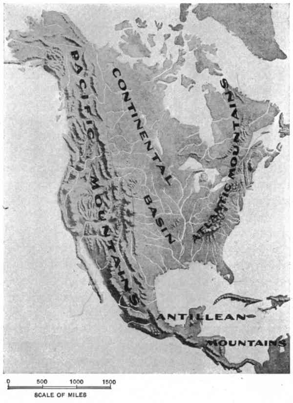
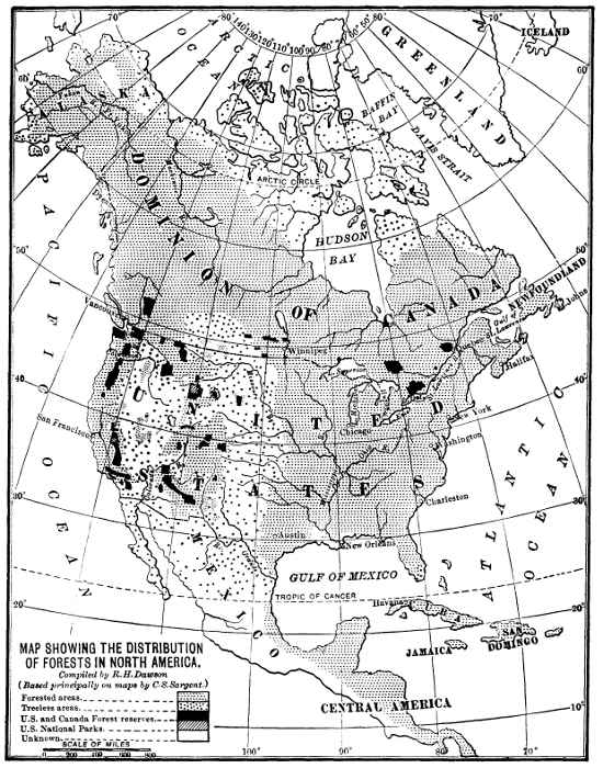
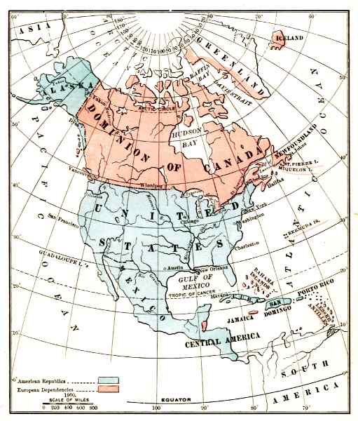
Fig. 1.—North America.
From a photograph of a relief map by Victor and Cosmos Mindeleff. Scales of original: Horizontal, 120 miles to 1 inch; vertical, 40,000 feet to 1 inch: proportion, 1:16.
The Project Gutenberg EBook of North America, by Israel C. Russell

This eBook is for the use of anyone anywhere at no cost and with
almost no restrictions whatsoever.  You may copy it, give it away or
re-use it under the terms of the Project Gutenberg License included
with this eBook or online at www.gutenberg.org


Title: North America

Author: Israel C. Russell

Release Date: May 3, 2011 [EBook #36024]

Language: English

Character set encoding: ISO-8859-1

*** START OF THIS PROJECT GUTENBERG EBOOK NORTH AMERICA ***


Produced by Juliet Sutherland, Henry Gardiner and the
Online Distributed Proofreading Team at http://www.pgdp.net
Fig. 1.—North America.The aim of this book is to give a condensed and, I trust, readable account of the leading facts concerning the North American continent which, from the point of view of the geographer, seem most interesting and instructive. The area of the continent is so vast and the diversity among its various parts so great, however, that the completeness of treatment which characterizes the preceding volumes in the series to which it belongs could not be attempted. To obviate in a measure this confessed shortcoming, there has been appended to each chapter a list of books which will enable the reader to continue the studies outlined in it.
A complete review of the geography of a continent should, as it seems to me, be divided into two parts: first, a discussion of the natural conditions, or physical geography, and, second, man's dependence on and use of the natural resources, or economic geography. Each of these two leading phases of the subject was embraced in the preliminary outline of the present volume, but owing to a desire to make each chapter as complete as practicable, and also on account of limitations as to space, the treatment of the economic phases of geography has been necessarily brief. But little more can be claimed for the book as finished than that it is an attempt to describe some of the more prominent and attractive aspects of the natural conditions pertaining to North America. vi
While writing this book I have become more and more impressed with the incompleteness and inadequacy of the printed records relating to the geography of the continent of which it treats. Extensive tracts, particularly in the far North, have not been traversed by observant men, vast areas throughout the continent have not been surveyed and mapped, and even in the somewhat thickly inhabited portions of the more enlightened countries there are large districts in reference to the geography of which there is but little critical information available. Under these conditions it seemed best to select typical examples of various geographical features from the better known portions of the continent to represent the conditions throughout the less thoroughly explored domain in which they are situated, and at the same time serve to illustrate the highly creditable advances made by American geographers in definitely formulating the principles of physiography. The book may, in a measure, be considered as an attempt to present in popular form a report of progress concerning the study of the geographical development of North America at the beginning of the twentieth century.
I. C. R.
| CHAPTER | PAGE | |
| I. | The Margin Of The Continent | 1 |
| The continental shelf—The submarine topography of the Caribbean region—Movements of the ocean waters—Islands—Topography of the coast—Estuaries and harbours. | ||
| II. | The Topography Of The Land | 60 |
| Coastal plains and plateaus—The Atlantic mountains—The continental basin—The Pacific mountains—The Antillean mountains. | ||
| III. | Climate | 173 |
| The elements of climate—Climatic provinces—Secondary disturbances of the atmosphere—Evaporation. | ||
| IV. | Plant Life | 215 |
| The forests—Prairies, treeless plains, and plateaus—The treeless mountain tops. | ||
| V. | Animal Life | 258 |
| General principles of geographical distribution—Life-regions and life-zones—The mammals—Some representative mammals—The birds. | ||
| VI. | Geology | 299 |
| The growth of the continent—The rocks of which the continent is composed—The concentration of mineral substances. | ||
| VII. | The Aborigines | 355 |
| The Eskimos—The Indians. | ||
| VIII. | Political Geography | 408 |
| Classification of boundaries—Political control—Population in 1900. | ||
| Index | 427 | |
| PLATE | PAGE | |
| I. | Orographical features | 25 |
| II. | Mean annual rainfall and temperature | 173 |
| III. | Climate and life provinces | 185 |
| IV. | Leading geological features | 306 |
| V. | Pleistocene glacial deposits | 315 |
| VI. | Linguistic stocks of Indians North of Mexico | 370 |
| VII. | Distribution of governments | 410 |
| VIII. | Characteristic vegetation | 418 |
| FIG. | PAGE | |
| 1. | Relief map of North America | ii |
| 2. | Profile of a continental shelf | 2 |
| 3. | Map of Gulf of Mexico and the Caribbean region, showing topography of the sea-floor | 17 |
| 4. | Co-tidal lines | 29 |
| 5. | Profile of sea-cliff and cut-and-built terrace | 33 |
| 6. | Map of a portion of the Atlantic coast of the United States | 35 |
| 7. | Map of Mobile Bay | 36 |
| 8. | Map of Cape Cod | 37 |
| 9. | Map of the coast of Texas | 39 |
| 10. | Map of a portion of the coast of Maine | 45 |
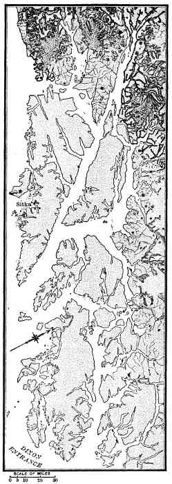
| 11. | Map of the coast of southeastern Alaska | 47 |
| 12. | Map of the delta of the Mississippi | 53 |
| 13. | Map giving the names of the larger physiographic divisions of North America | 61 |
| 14. | Altitude map of North America | 65 |
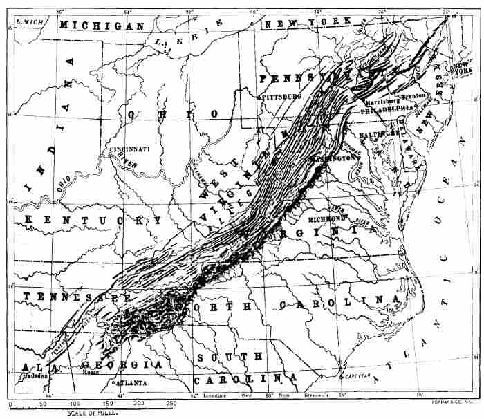
| 15. | Map of the Appalachian Mountains | 74 |
| 16. | Section of anticlinal valleys and synclinal mountains | 78 |
| 17. | Profile showing relation of ancient peneplains in the Appalachians | 81 |
| 18. | Section through the Black Hills of Dakota | 117 |
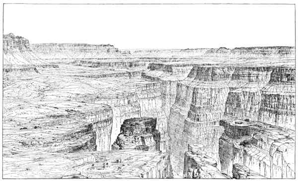
| 19. | Sketch of the Grand Cañon of the Colorado River | 134 |
| 20. | Map of the Great Basin | 137 |
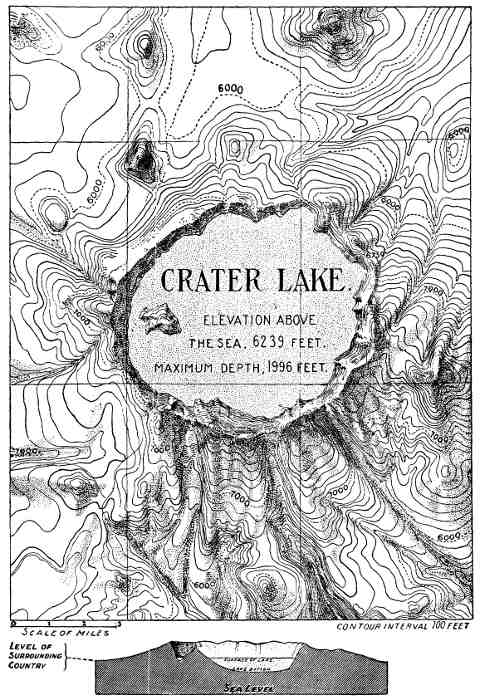
| 21. | Map of Crater Lake, Oregon | 153 |
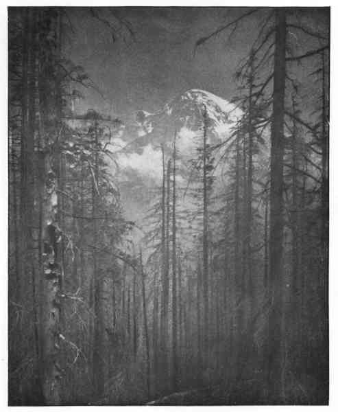
| 22. | Mount Rainier, Washington | 154 |
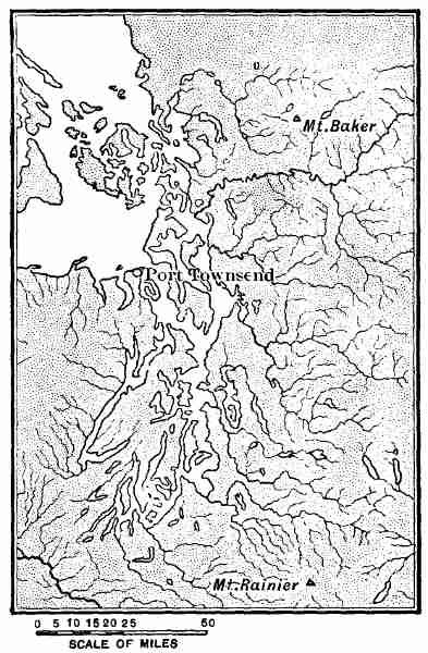
| 23. | Map of Puget Sound | 161 |
| 24. | Map showing isobars for January and July | 175 |
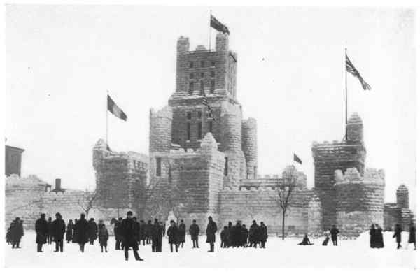
| 25. | Ice-palace, Montreal | 199 |
| 26. | Map showing tracks of West Indian hurricanes | 209 |
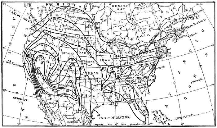
| 27. | Map showing depth of evaporation in the United States | 212 |
| 28. | Map showing distribution of forests | 215 |
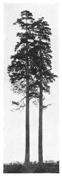
| 29. | Douglas firs, Vancouver | 241 |
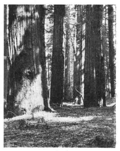
| 30. | View in redwood forest of California, from photograph by U. S. Bureau of Forestry | 242 |
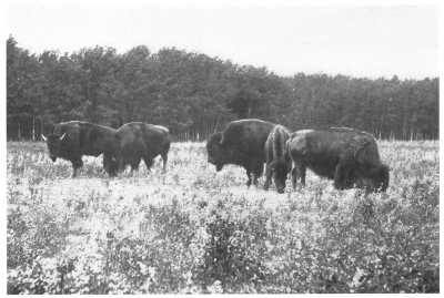
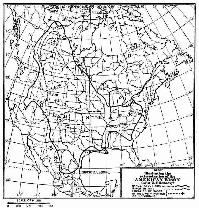
| 31. | Bison at Silver Heights, Winnipeg | 275 |
| 32. | Map showing range of bison | 276 |
| 33. | Maps showing the growth of the North American continent | 303 |
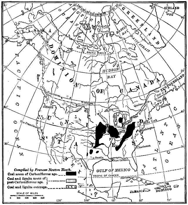
| 34. | Map showing the distribution of coal-fields | 336 |
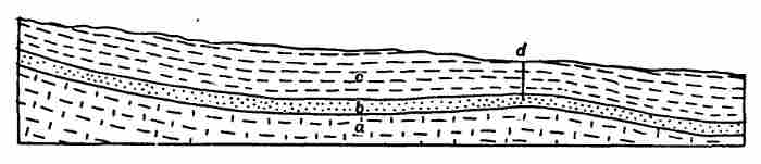
| 35. | Ideal section through an oil and gas pool beneath an anticlinal | 339 |
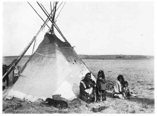
| 36. | Lodge or tepee of Blackfoot Indians, Manitoba | 387 |
| 37. | Panorama of Uxmal, Yucatan | 390 |
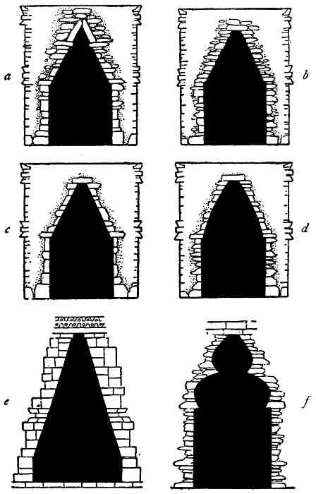
| 38. | Pointed arches in Central American ruins | 393 |
| 39. | Carved stonework, Uxmal, Yucatan | 394 |
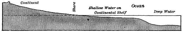
In beginning the study of the physical geography of North America, one of the first facts to claim attention is that the true continental border is in general many miles seaward from the present margin of the land. The boundary of our field of study is defined with considerable accuracy by a line drawn on the bottom of the sea adjacent to the present coast-line of the continent so as to pass through all points where the soundings show a depth of 100 fathoms of water. This 100-fathom contour in the topography of the sea-floor chances to coincide in a general way with the outline of the submerged border of the continent; landward from it the bottom rises with a gentle slope, while seaward the descent is usually steep down to a depth of 2,000 or more fathoms.
A gently sloping shelf-like border surrounds the deep central basin of the Gulf of Mexico (Fig. 3). To the west and north of Yucatan and west of Florida the shelf is from 140 to 160 miles broad, with a surface slope towards the centre of the Gulf of less than 6 feet to a mile—a slope so gentle that were the surface of the shelf exposed to view, no eye could distinguish it from a perfect plain. The deepest sounding yet obtained in the central part of the Gulf, approximately midway between Yucatan and Florida, shows a depth of 2,119 fathoms. The remarkable fact is that the slope from the 100-fathom line to the bottom of the central basin of the Gulf is precipitous. In two places 2 on the border of the Yucatan bank a descent of about 8,500 feet occurs within a horizontal distance of 15 or 20 miles.
On the east side of the southern extremity of Florida, and again on the eastern shore of Yucatan, the continental shelf is only about 5 miles broad; these are the nearest approaches of the present land to the actual border of the continent to be found on the Atlantic coast. The explanation of these exceptional conditions is that both Florida and Yucatan are portions of the continental shelf which have been raised so as to form low emerged plains.
From Cape Hatteras northward to the extremity of the Newfoundland Banks the shelf increases gradually in breadth from about 15 miles in the region of the Carolinas to over 100 miles off the coast of Maine. The outer border of the shelf is an irregular curving line. Opposite the coast of Massachusetts and Maine an extension of the Atlantic basin reaches within 15 or 20 miles of the present margin of the land. The manner in which the low plain fringing the eastern border of the United States passes beneath the waters of the Atlantic and becomes a continental shelf is illustrated by Fig. 2.
Southeast of Newfoundland the continental shelf has an irregular surface, marked by shoals and depressions, and furnishes the most valuable fishing-banks in the world. The 100-fathom curve is there over 500 miles from the coast. This is the broadest portion of the continental shelf now known on the Atlantic border of the continent. Northward of Newfoundland the Atlantic basin extends far into Davis Strait and Baffin Bay, and then its border swings outward about Greenland, but its true margin is there but imperfectly known. 3
To the north of the arctic coast of North America, as is suggested in part by the soundings made by Nansen, the submerged margin of the continent is probably broad and presents a steep escarpment to the arctic basin, but the outline of the true continent, as in the case of the present land extension in that direction, is unknown.
Soundings to the north of Cape Lisburne, on the northwest coast of Alaska, show that the 100-fathom curve is there over 200 miles from land. The exceptionally shallow sea covering this portion of the shelf continues westward to the coast of Asia, and southward through Bering Strait, so as to embrace the eastern portion of Bering Sea. The continental mass of North America is thus directly connected with the continental mass of Asia. A rise of the bottom of less than 200 feet in Bering Strait would bring about a land connection between the Old and the New World. This, as will appear later, is a most significant fact to students of geography and geology.
On the Pacific coast of North America the continental shelf is throughout much narrower than its average breadth on the Atlantic side of the continent, and is also more deeply submerged on its seaward border. The broad platform beneath the northern and eastern portions of Bering Sea—from which rise the low islands, St. Lawrence, St. Matthew, Nunivak, and the Pribilof group, now separated by water from 25 to 35 fathoms deep—extends to the south of the more easterly of the Aleutian Islands, and is prolonged eastward along the south border of Alaska, where the 100-fathom curve is from 10 to 20 miles from the coast-line, and approaches still nearer the land in the neighbourhood of the islands of southeastern Alaska and British Columbia. The shelf is narrow but well defined along the coasts of Washington and Oregon. Adjacent to California, Mexico, and Central America, its outer margin is barely 10 miles from land. Throughout the entire distance from the Aleutian Islands to Panama the outer border of the shelf is in general well defined, and its seaward escarpment descends abruptly to the floor of the vast Pacific 4 basin, where the sounding-line shows depths of from 2,000 to 3,000 fathoms.
Could the waters of the sea be removed and North America viewed from a distance, in the manner we are enabled to examine the surface features of the moon through a powerful telescope, an observer would behold a great plateau, having the present well-known triangular shape of the continent, rising boldly between the Atlantic and the Pacific basins. The surface of the plateau would be rough, in comparison with the generally smooth contours of the adjacent troughs, but even the highest mountains would be less in elevation above its general surface than the crests of its bordering escarpments above the adjacent depressions. The mountain-peaks when illuminated by the sun would appear as points of light with long, tapering morning and evening shadows, and the east and west plateau-borders would be strongly drawn bands of light or shadow, according to the time of day, 6,000 or 8,000 miles in length. The Bermuda, Hawaiian, and other islands now rising above the surface of the deep sea would stand on its desiccated floor as isolated, gigantic mountains—"Bermuda mountain" with an elevation of 15,000 feet, and the Hawaiian group of peaks with a culminating point of light 30,000 feet above the surrounding plain. The bordering slopes of the "North American plateau" and its slightly bevelled margin forming the present continental shelf would be lacking in details, and appear as a vast, smooth, curving belt of light or shadow, in striking contrast to the roughened surface now above water.
The North American continent is not exceptional in being partially submerged at the present time. Similar conditions occur about the margins of other continents which, as is well known, are fringed with broad submarine terraces built in part of their own débris. In fact, every large land mass on the earth under existing climatic conditions and present distribution of life, if it remained moderately stable for a sufficient length of time, would have a submarine shelf built about its borders. 5
Of what is the Continental Shelf Composed?—The rocks forming the present land surface of North America extend seaward from the existing shores and constitute the basal portions of the continental shelf, thus suggesting that the submerged platform is due, in part at least, to shore erosion—the waves having eaten into the land so as to make a terrace. That this is not the true explanation, however, may be shown in several ways.
The superficial covering which gives the continental shelf its smooth contours is composed largely of sediments such as rivers bring from the land. This material is coarsest and in greatest abundance near shore and decreases both in the size of the particles composing it and in abundance towards the seaward borders of the shelf. The wash from the land is mostly deposited within a few miles of the coast-line and, as has been shown by dredging, is seldom carried, even under the most favourable conditions, more than about 100 miles seaward. Supplementing the fragmental material derived from the land, and increasing in thickness towards the seaward margin of the continental shelf—coincident with the increase in depth of the water—is a deposit of light-coloured calcareous mud or ooze, formed of the hard parts of animals and plants which live in the waters of the sea. The organisms which supply this material are in the main microscopic and live especially in the warmer seas in countless myriads. Their dead shells or cases fall to the sea-floor in a constant shower, much as the snow falls from the air, but continuously year after year and century after century. This descent of the hard parts of organisms, both calcareous and siliceous, from the waters of the sea has led to the accumulation of a sheet of slimy sediment over almost the entire sea-bottom. How thick this layer is we have no means of knowing, but it is probably many hundreds of feet.
The organic débris falling on the continental shelf descends through only a few hundred feet of water and is but little affected by its solvent action. The great number of organisms, such as the Foraminifera which secrete calcareous tests or "shells" causes the slime on the continental 6 shelves to be calcareous and in the condition to form limestone if cemented or subjected to sufficient pressure. In the deep sea, where the hard parts of dead organisms fall through many thousands of feet of water, their more soluble portions are removed and the bottom is covered throughout vast areas with a pinkish clay composed of the more insoluble residue of the calcareous shells and the cases of silica-secreting animals and plants.
The continental shelves are, in general, within the influences of ocean currents, and fine débris, as we seem justified in concluding, is removed from their surfaces, carried beyond their margins, and deposited on their seaward slopes. The shelves are thus built outward and are largely constructional topographic forms. Their outer slopes, where best defined, represent about the "angle of repose" in water of the fine material of which they are composed. These slopes are in several regions so precipitous that they probably would not retain their present forms, but descend in landslides, should the restraining pressure of the sea-water be removed.
In certain favoured regions, as about the southern extremity of Florida, over an extensive area in the West Indies, and on both sides of Central America, the conditions favour the growth of reef-building coral-polyps, and portions of the continental shelf in that region are covered with an irregular layer of living coral and dead coral rock. The importance of this resistant superficial layer on the minor features of the relief of the submarine banks, etc., needs to be considered in studying the secondary topographic features of many portions of the floor of shallow tropical seas.
In addition to the débris from the land and the rain of the hard parts of organisms from the water covering the continental shelf there is in northern regions a third but less important source of material furnished by floating ice. About the northern shores of America sea ice forms in winter, some of which is frozen fast to boulders and stones in shallow water, and when this ice-foot, as it is termed, is adjacent to steep cliffs, rock débris falls upon it. When 7 the ice becomes broken into cakes in the spring-time or during storms, it floats away, under the influence of the winds and currents, and as it melts drops its freight on the floor of the sea. This shore ice seldom travels far, and is probably not an important factor in the building of continental shelves. Of greater interest are the bergs derived from glaciers, especially in Greenland, many of which contain hundreds of thousands and even millions of cubic feet of ice and travel hundreds of miles before melting. In some instances these bergs carry with them rock masses, mud, etc., derived from the land over which their parent glaciers flowed, and as they melt, distribute this material over the sea-floor. The greater portion of this ice-carried freight derived from Greenland is dropped on the continental shelf, and not infrequently reaches the latitude of Halifax, and even journeys farther south. This berg-carried débris is mainly deposited on the continental shelf, for the reason that the cold currents which bring the bergs southward follow the coast in a general way, and are bordered on their seaward margins by warmer currents flowing northward. To the north of Nova Scotia the additions of material to the continental shelf through the agency of bergs is considerable in the aggregate, and as the process has been in operation for thousands of years, the banks or shoals in the sea off the Newfoundland coast are due in part to this cause.
Ice-carried débris forms an important source of material for the building of the continental shelf from New England northward and westward about the shores of North America, including Greenland, to Bering Sea, and to a less extent on the south coast of Alaska, where many comparatively small bergs are set afloat by glaciers which reach tide-water. Supplementing the distribution of débris over the continental shelf by shore ice and bergs, is the similar work carried on by the ice discharged into the sea by northern rivers, such as the St. Lawrence, Mackenzie, and the Yukon.
During the glacial epoch great ice-sheets like those now discharging bergs along the Greenland coast, but vastly 8 larger, entered the Atlantic all the way from New York to the Arctic Ocean, and along the Pacific coast from the Aleutian Islands to the State of Washington. During certain periods of this time of intense glaciation great additions of ice-borne débris must have been made to the continental shelf. The banks to the east of Newfoundland and other similar shoals as far south as Nantucket are probably due in large part to the débris deposited by the glaciers which formerly entered the sea in that region. It is of interest in this connection to note that the glaciers, even at the time of their greatest expansion, could not have extended beyond the seaward margin of the continental shelf, for the reason that on passing that boundary and entering deep water they must have broken off and given origin to bergs.
Submerged River Channels.—One of the most interesting features in connection with the continental shelf bordering North America is that its generally plane surface is trenched in several places by cañon-like depressions similar to the narrow steep-sided valleys which streams sometimes cut in the surfaces of plateaus. This suggestion that the surface of the continental shelf is crossed by stream-cut channels is supported by the fact that several such depressions, leading seaward from the present mouths of large rivers, have been discovered by the sounding-line. The best known example occurs off the mouth of the Hudson and has been traced from New York Bay about 120 miles seaward to the edge of the continental shelf. It is deepest and best defined on the outer portion of the submerged plateau, where for a distance of 23 miles, beginning 97 miles from Sandy Hook, it has an average width of 3 miles and a maximum depth of about 2,500 feet below the surface of the bordering submarine plain, which has 20 fathoms of water over it. This cañon opens out in the seaward face of the plateau and forms a deep notch in the generally uniform crest-line of that escarpment. Farther "up-stream," so to speak, the channel narrows to a mile and a quarter, with some irregularities in depth, and near Sandy Hook it is not apparent, owing to the amount of débris, largely sand, swept 9 into it by shore currents. This evidence, strengthened by the fact that the true rock-cut valley of the Hudson as far as Troy is filled with clay and sand to a considerable but unknown depth, is abundant proof that the land was formerly higher than at present by at least 3,000 feet, and that the now submerged continental shelf off Long Island was then a plain above water, across which the ancient Hudson was extended. The river flowed across this plain for a sufficient length of time to excavate a cañon over 2,500 feet deep and 3 miles wide from crest to crest of its walls in its seaward portion. This submerged channel has the characteristics of a young, stream-cut valley and suggests that the plain across which it flowed to the eastward of Long Island was a submerged continental shelf previous to being upraised so as to be trenched by the Hudson.
The evidence as to changes in the elevation of the Atlantic coast furnished by the submerged valley of the Hudson does not stand alone. Similar but less well-defined channels have been discovered by soundings off the mouths of the Delaware and the Susquehanna, while the most remarkable instance of all is furnished by the submerged valley of the St. Lawrence, which has been traced through the Gulf of St. Lawrence and out to the brink of the submerged continental escarpment some 200 miles eastward of Nova Scotia. The tide now rises and falls in the St. Lawrence to within a few miles of Montreal; that is, the "Greater St. Lawrence" has lost about 1,000 miles of its length owing to a downward movement of the land.
Evidence of the nature just considered is lacking, or, more correctly, surveys and soundings which would perhaps reveal the presence of submerged river channels have not been made about the shores of the more northerly portion of the continent, but instructive results in this connection are to be expected when that region is thoroughly studied.
On the Pacific coast several transverse channels in the continental shelf, similar to the submerged valleys of the Hudson, have been discovered by soundings, some of 10 which are thought to be true stream-cut valleys; others, however, start from the coast where there are no rivers entering, and may be due to other and as yet unknown causes.
An exceptional feature in the geography of the Pacific coast to the south of the United States-Canadian boundary is furnished by the islands off the southern portion of California. These islands, of which Santa Rosa, Santa Cruz, Santa Catalina, and San Clemente are the most important, rise from water that is 300 or more fathoms deep to a height of from a few hundred to about 2,000 feet above the present sea-level. These islands are the summit portions of mountains similar to those which give a characteristic relief to southern California. One feature concerning the islands referred to which is of interest in connection with the study of the continental shelf is the presence on them of numerous terraces. These occur on a series of level, step-like areas, which sweep about the slopes of the islands, in a general way parallel to the present shore-line, and are records of an upward movement of the land. The highest well-defined terrace on San Clemente occurs at an elevation of 1,320 feet, but there are less distinct beach-lines up to 1,500 feet above the present sea-level. The evidence of movements of the land along the Pacific border of the continent might be multiplied, but enough has been stated to show that the western border of North America, like its eastern portion, is subject to fluctuation in reference to the level of the sea. The line which marks the passage of the solid earth beneath the waters of the sea is ever changing, owing to movements in the earth's crust. It is ever changing, also, owing to the action of waves and currents on the ocean's shores and other causes.
Life on the Continental Shelf.—No attempt need be made here to give an accurate description of the plants and animals which find a congenial home on the continental shelf. One needs, however, to have in mind a general idea of the wonderful abundance and variety of organic forms in the shallow waters adjacent to the continent to fully appreciate the changes in the relief of the ocean-floor, in which they 11 play a leading part, and also the vast economic importance of these marine harvest-fields and pastures, as they may be termed.
The continental shelf fringing North America reaches from within 500 miles of the equator to probably a less distance of the north pole. Its length following its broader curves is in the neighbourhood of 25,000 miles, and its average width is not far from 50 miles; its area is therefore something like 1,000,000 square miles. On account of the vast extent of this submarine plain and its great range in latitude, the conditions influencing the lives of the plants and animals inhabiting its surface or living in the waters covering it vary from place to place between wide extremes. The waters resting on it have a mean annual surface temperature of from 70° to 80° F. at the south, and about 32° F. at the north. In places great rivers and the turbid waters from glaciers bring in sediments and form muddy deposits; at other localities the currents, as in the path of the Gulf Stream off the Carolina coast, sweep the bottom clear of all light débris; and again bare rocks of limited extent are exposed. The depth of the water resting on the shelf varies through all gradations down to 100 fathoms. At the south the hours of light and darkness are approximately equal each day, but at the north there are six months of sunlight and six months of darkness each year. Still other variations, as of strength of currents, salinity, etc., exert an influence in this realm and lead to great diversity in its living organisms. Throughout its entire extent, however, the continental shelf abounds in both plant and animal life.
The plant life of the sea, as has been shown in recent years by the use of the dredge and net, is most abundant at the surface and is practically absent at the bottom where the water is over 100 fathoms deep. The animals of the sea, like those of the land, are dependent primarily on plants for their food. By far the most abundant supply of food plants in the sea is furnished by minute algæ, which float free in its water. Below a depth of about 100 fathoms algæ are absent because of lack of light, and all the deep-sea animals are believed to be carnivorous. For these reasons the comparatively 12 shallow waters adjacent to the land and mainly covering the continental shelf are the most favourably circumstanced of any portion of the sea for the support of a teeming fauna.
On the continental shelf of North America, especially to the south of Cape Cod on the Atlantic and south of the Aleutian Islands on the Pacific coast, there is a warm temperature, light penetrates to the bottom except in the unfavourable and fortunately restricted areas of muddy water, and motion of the waters produced by currents and the pulsations of waves is present. These several favourable conditions permit of an exuberance of life such as is unknown to persons who confine their attention to the study of land areas.
We may safely say, in the words of Alexander Agassiz, that the abundance of life in the many favoured localities of the ocean far surpasses that of the richest terrestrial faunal districts. The most thickly populated tropical jungle does not compare in wealth of animal or vegetable life with certain portions of the continental shelf on the western border of the Gulf Stream. In this connection we may also cite Humboldt, who before the marvellous revelations in reference to the life of the sea made by recent dredging expeditions wrote: "Upon surfaces less varied than we find on continents, the sea contains in its bosom an exuberance of life of which no other portion of the globe could give us an idea."
The distribution of life in the sea is analogous to the distribution of life on land, but in a reverse direction with reference to sea-level. A traveller passing from the tropical plains of eastern Mexico and ascending Orizaba, for example, crosses successive belts of vegetation, each with its indigenous animals, but merging one with another so as to make a gradation in the luxuriance of the flora and the abundance of animal life from the wonderfully rich plains adjacent to the Gulf coast to the snow-capped mountain top. In the sea, the tropical plains with their tangled vegetation and plentiful animal life are represented by the still more uniform plain forming the submerged continental 13 shelf with its strange forests of flowerless plants, the seaweeds. These submarine jungles shelter hosts of animal species, many of which swarm in countless myriads. This life embraces all grades of invertebrates, such as the microscopic protozoa, sponges, radiate animals like the coral-polyps, starfishes, sea-urchins, etc., and crustaceans in vast variety, and, among vertebrates, includes fishes, reptiles, and mammals. Even birds might be included in this category, since many of them are more at home on the sea than on the land.
The struggle for food among this multitude is intense. As with many animals on the land, adaptive coloration is here a means of escape from enemies, and many of the animals assume the brilliant hues of the surrounding vegetation. The water is less transparent than air, and in the deep sea it is always night. Counteracting to some extent this diminution or absence of sunlight, many marine animals are luminous and shine with phosphorescent light of many different tints. This property is shared also by the animals of the sunny, shallow sea as well as by those always living in the cold midnight of the great deep and in the polar oceans.
The luxuriant vegetation, both attached and floating, and varying from giant kelp, scores of feet in length, to microscopic algæ which an amœba might encompass, clothes the surface of the continental shelf except in unfavourable localities or is carried here and there by the currents moving over it, but has its lower limit at about the 100-fathom line. This inferior limit of marine vegetation is probably more definitely defined than the superior limit of land plants on snow-capped mountains. All attached seaweeds are confined to the shallow seas, but floating kelp, like the well-known Gulf weed or sargasso, which collects in the eddies of the sea currents and forms more or less mythical floating islands, is widely distributed, as are also many kinds of minute algæ which thrive in the upper 100 fathoms of the open ocean in all latitudes. The primary source of food for the hungry millions of marine animals, excepting the comparatively small quantity brought 14 by rivers or blown from the land, is supplied by the marine algæ, and mainly by the minute forms which float in the water.
So much space has just been given to the marvellous luxuriance of life on the southern portion of the great shelf surrounding North America that the reader may perhaps think the cold northern oceans are even more lifeless and desolate than their adjacent shores. This, however, is not the case.
Northward along the continental shelf, with decrease in the strength of the sunlight, the plants and animals lose much of the brilliancy which characterizes many of the denizens of southern waters, and in general assume more subdued colours in harmony with the prevailing gray of their surroundings. The great diversity of animal life to be found in shallow tropical seas decreases as one traces the continental shelf northward, but even in the Arctic Ocean adjacent to the land invertebrate life literally swarms, although the number of species, genera, etc., is comparatively limited. Seaweeds are not absent from the Arctic Ocean, although its shores, owing to the destructive action of ice, usually seem exceedingly barren, and the lower or smaller forms of algæ float in the waters in abundance. Food sufficient for an extensive fauna is thus supplied, and where food is plentiful animals are present also, no matter what the mean annual temperature may be.
The life of the Arctic Ocean has been but inadequately studied, but enough is known concerning it to show that a promising field there awaits the naturalist. On the continental shelf off Point Barrow, the most northern portion of the arctic shore of Alaska (latitude 71° 23'), 180 species of marine invertebrates have been collected. Of these, the molluscs numbered 61 species; the crustaceans, 44 species; the worms, 20 species; and the echinoderms (sea-urchins, starfish, etc.), 17 species.
Nearly all of the Arctic Ocean adjacent to the coast of America is as yet unexplored, and we have therefore no direct testimony as to its flora and fauna. We may reasonably assume, however, that the life is there practically the 15 same as in the waters of similar depth to the north of Eurasia. Nordenskiöld, in his narrative of the voyage of the Vega, speaks of decapods, worms, mussels, crustacea, and asteroids which crawled in myriads over the beds of clay and sand at the bottom of the Kara Sea. A detailed account is given of one unusually successful haul of the trawl when it brought up large asteroids, sponges, crinoids, holothuria, a gigantic spider, masses of worms, crustacea, etc. This was the most abundant yield of the trawl-net at any one time during the voyage of the Vega on the north coast of Asia, and that, too, from the sea off the northern extremity of the continent. The temperature of the water at the surface was from zero to -1.4° C. (32° to 29.48° F.), and at the bottom from -1.4° to 1.6° C. (29.48° to 34.88° F.). In this connection the same distinguished naturalist remarks: "It is singular that a temperature under the freezing-point of pure water should be advantageous for the development of an animal life so extremely rich as that which is found here, and that this animal life should not suffer any harm from the complete darkness which during the greater portion of the year prevails at the bottom of the ice-covered sea."
To persons who have never visited the far north the statements that travellers in those regions give in reference to the abundance of life in the sea seems scarcely to be credited. The assertion, however, that comparing equal areas in the most populous tropical sea and in portions of the Arctic Ocean, the amount of life, or the tons of living animal matter per square mile in the two regions, would be in favour of the northern station is probably true. In addition to the direct evidence indicated above as to the prolific invertebrate life of the cold waters of the north, we have still more impressive testimony from the vast numbers of birds and large-sized mammals which subsist on this abundance, or feed on fishes, which in turn obtain their subsistence from the invertebrate realm.
Every rocky island and headland at the north is a breeding-place for sea-birds. They are to be numbered by millions, yet their daily food is gathered from the surface of the 16 sea. The seals live in large numbers about all the arctic shore, and the walruses, each individual weighing about a ton, occur in herds; while whales and narwhals inhabit the same waters. The presence of such numbers of large mammals is proof that the life on which they subsist is abundant.
The studies which have given to the world so much information concerning the continental shelf surrounding the main body of North America have been continued, or, perhaps more properly, were initiated, in the West Indian waters. For this important work we are indebted mainly to the United States Coast and Geodetic Survey and the United States Fish Commission. The work of officers of the United States Navy in charge of Coast Survey and Fish Commission vessels, in making accurate measurements of depths, temperatures, strength and direction of currents, character of bottom, etc., has, in some instances, been commemorated on maps of the sea-floor by such names as Brownson Deep, Sigsbee Deep, Bartlett Deep, etc. The routine survey work referred to has been supplemented and extended by the labours of Louis Agassiz, L. F. Pourtales, Alexander Agassiz, and others in studying the life in the sea, the origin and history of the material forming the sea-bottom, and the nature of the shelves, banks, deeps, etc., which give diversity to its topography.
The continental shelf bordering Florida on the east is separated from a similar submarine embankment surrounding the Bahama Islands by a channel 56 miles wide and from 200 to 500 fathoms deep (Fig. 3). This channel when followed northward becomes shallower and broader, and opposite the Carolina coast is no longer discernible in the relief of the broad continental shelf. The Gulf Stream flows northward through this Florida channel, as it is termed, with a current of from 2 to 6 miles per hour. These conditions are such as to suggest that the channel referred to has in part been excavated by the Gulf Stream. 17
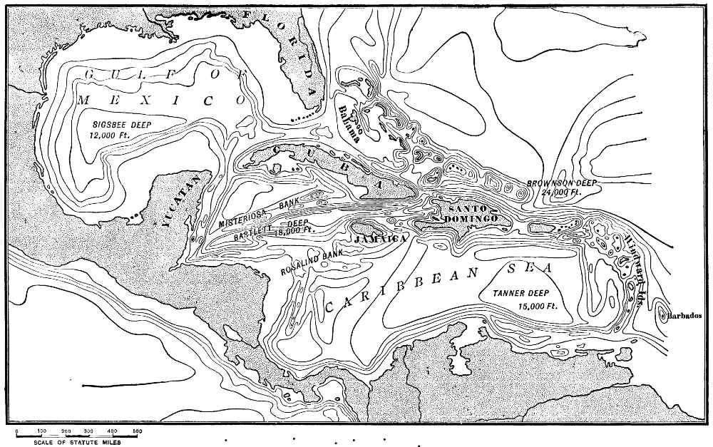 Fig. 3.—Gulf of Mexico and the Caribbean region:
topography of sea-floor. The first contour line from the land indicates
a depth of 600 feet—the outer margin of the continental shelf. Contour interval
below the 600-foot curve, 3,000 feet. After R. T. Hill.
Fig. 3.—Gulf of Mexico and the Caribbean region:
topography of sea-floor. The first contour line from the land indicates
a depth of 600 feet—the outer margin of the continental shelf. Contour interval
below the 600-foot curve, 3,000 feet. After R. T. Hill.The Great Bahama Bank, from which rise the low coral-built Andros Islands and a large number of crags and rocks, measures about 360 geographical miles from southeast to northwest, and has a width of approximately 200 geographical miles. Throughout its entire submerged portion the water is less than 100, and over much of the area less than 10 fathoms deep. It is invaded and given an irregular shape, however, by a "tongue of the ocean" which curves in from the northward, in which soundings of from 700 to 1,000 fathoms have been obtained. To the north of the Great Bahama Bank, and separated from it by water nearly 2,000 fathoms deep, is the Little Bahama Bank, measuring 50 by 150 geographical miles, from which rises the low islands known as Great Bahama, Great Abaco, and a multitude of islets and crags, while beneath the water, as is the case also on the greater submarine plateau to the south, there are numerous shoals. Southeast from the Great Bahama Bank, and in a general view to be classed with it, are several other shallow areas in the sea, of similar character, and with numerous islands and reefs rising from them. The southeastern terminus of this series of plateaus, the surfaces of which have been built up practically to the level of the surface of the sea, is the Navidad Bank, situated about 50 miles to the north of the eastern end of the island of Santo Domingo (Haiti) and forms the west border of Brownson Deep. The length of the series of banks to the north of the Greater Antilles is about 800, and its average width 120 geographical miles.
The unevenness of the surface of the Bahama Banks (and the same is true also of the southern portion of Florida, the Yucatan peninsula, and of nearly all of the submarine plateaus or banks in West India waters) is largely due to the coral reefs and the coral rock formed on them. While the outer portion of the continental shelf, in most instances, is formed of soft, unconsolidated calcareous mud or ooze, in the tropical seas, where the depth, clearness of the water, etc., are favourable, reef-building coral-polyps become attached and form massive corals. The growth of these corals is irregular, and the surface of the plateaus where 19 they are attached becomes roughened. There is a delicate adjustment between the growth of reef-building corals and strength of current, freedom of exposure to the waves, etc., and they flourish in certain localities, as on the windward border of islands, and die at other localities. The growth of coral "heads" and reefs changes the direction of currents, and the spaces of soft ooze and dead coral between the localities most favourable for coral growth are liable to be scoured out and the bottom lowered. When coral, together with the shells of molluscs and other organic refuse of the teeming life of tropical seas, reaches the surface of the water, fragments and even large masses are broken off by the force of the waves, ground into calcareous sand owing to the movements produced by the waves and currents, and much of it heaped on the borders of the reefs so as to raise them above the fair-weather level of the sea. Much of this material, when it becomes dry, is moved by the winds and built into dunes, thus still further increasing the height of the land. Many of the islands in the Bahamas have thus been formed, but the process has been modified in the greater part of that region by movements in the earth's crust which have produced widely extended elevations and depressions. The larger islands in the Bahama group are coral platforms which have been moderately elevated, and bear on their surfaces extensive accumulations of wind-deposited sand. The Yucatan peninsula is also, to a great extent, an upraised coral platform. The surfaces of such exposed areas of easily soluble calcareous rocks are roughened still more by the action of rain and percolating waters, and if subsequently submerged to a moderate depth would give origin to "banks" with uneven, and possibly conspicuously roughened surfaces. Different stages in this varied history are illustrated throughout the West India region.
About the Caribbean coast of Honduras and Nicaragua the continental shelf is broad and is termed the Mosquito Bank, in reference to its proximity to the widely known coast of that name. Off the northeast cape of Honduras this submerged shelf has a breadth of about 125 geographical 20 miles, and is succeeded to the eastward by the much smaller, isolated, submarine plateau known as the Rosalind Bank. Even on a small map, like that forming Fig. 3, it is readily seen that in general terms there is a series of banks and low islands extending from the Mosquito Coast to Jamaica, Santo Domingo, Porto Rico, and the Caribbees. The distance measured along the curved line connecting the several areas of shallow water is about 1,700 geographical miles. Should this region be upraised 600 feet, the new lands that would appear would still, in several instances, be separated by deep water, thus showing that although in a generalized view it is convenient to consider the banks and shelves referred to as parts of a single great group, there are several centres from which they have grown.
A third great group of banks and shoals occurs about the borders of Cuba, especially along its southern margin. Associated with this submerged plain of calcareous mud, roughened by countless coral crags, is a narrow east-and-west ridge in the Caribbean Sea, known in part as the Misteriosa Bank, which rises precipitously on its southeast border from a depth of over 3,400 fathoms, and is indicated at the surface by the Cayman Islands.
The Caribbean and Gulf of Mexico region has great depressions or "deeps" as well as broad banks or shoals. The submarine topography is, in fact, on a more Titanic scale than in any other known region. Brownson Deep, some 50 miles north of Porto Rico, has a depth of 4,561 fathoms (27,366 feet), and the bordering slopes of the depression in certain places, and for long distances, have an inclination of 35 degrees. Between 15 and 30 miles south of Porto Rico the bottom of the Caribbean Sea is 1,500 fathoms below its surface, and rapidly descends to over 2,400 fathoms. Bartlett Deep, a long, narrow depression in the sea-floor, intervening in its eastern portion between Cuba and Jamaica, has a depth of 3,428 fathoms (20,568 feet) measured from the surface of the sea. Sigsbee Deep, in the central portion of the Gulf of Mexico, is a third basin of similar nature, remarkable for the great extent 21 of its nearly level floor, which is from 2,035 to 2,071 fathoms below sea-level. (On Fig. 3 only the general depths of these great depressions are indicated.) Coupled with the profound depth of the sea in the West Indian region are the rugged mountains of the Great Antilles and the volcanic cones of the Caribbees. Some of the elevations of the land referred to are, in feet, as follows: Porto Rico, 3,609; Jamaica, 7,360; Cuba, 8,600; and Santo Domingo, 10,300. The extreme range in the relief of the surface of the solid earth (lithosphere) between the bottom of Brownson Deep and the summit of Santo Domingo is 37,666 feet—the horizontal distance between the two is about 270 geographical miles. No mountain on the earth has such an elevation above sea-level. The islands of the West Indies are thus shown to be the summits of stupendous mountains, the greater portions of which are submerged. The low-lying islands, and even the banks which can be discovered only with the aid of the sounding-line, are in reality the tops of wonderfully steep mountains or plateaus some 20,000 feet in height.
It is a significant fact that the profiles of the partially or wholly submerged mountains of the West Indies are, as a rule, steeper than the slopes of the mountains on the land with which they may reasonably be compared. This is due in part, perhaps, to the greater density of the medium in which they stand, the sea-water affording a greater degree of support than the air, but the main reason is that beneath a few hundred feet of water there is no erosion except the exceedingly slow removal of matter in solution. Could the waters of the sea be withdrawn so as to reveal the Caribbean Mountains in all of their stupendous grandeur, the vast, smooth, sweeping surfaces extending from the horizontal lines drawn about the higher summits by the waves and by the deposition of sediment and coral growths, down to their bases would be unmarked by channels and ridges of the character that give details to the type of mountains with which we are most familiar.
An instructive generalization concerning the relief of the West India region, suggested by Alexander Agassiz 22 and sustained by the later studies of R. T. Hill, is that we there find topographic forms produced by movements in the earth's crust which have not been modified by erosion. The great elevations rising from the floors of the "deeps" are upraised blocks of the earth's crust which have not been beaten by rain, shattered by frost, or trenched by rills, creeks, or rivers. They illustrate the character of the rough blocks of rock from which many of the mountain forms of the land have been sculptured.
This sweeping view, which it seems safe to accept as a generalized outline of the history of the topography of the region in question, needs to be qualified, as there are known to have been extensive up and down movements throughout large areas in that portion of the earth's surface. The mountains on Jamaica are scored by horizontal lines marking former sea-levels up to a height of 2,000 feet, and similar and still higher records are plainly visible on several of the larger West India islands. This evidence shows that the present land over a wide extent of the Caribbean region was formerly deeply submerged. More than this, the rocks forming the higher portions of the Greater Antilles are largely composed of more or less consolidated ooze, such as is now found on the sea-floor in deep water. This line of evidence shows that what in late geological time was the sea-floor has been raised between 20,000 and 30,000 feet. It is thus known that both upward and downward movements of great vertical and great horizontal extent have occurred in the Caribbean region. Whatever minor changes the topography of the now submerged sea-floor may have suffered owing to emergence, the general relief, as suggested above, seems to have resulted from movements in the earth's crust, and that these movements, in certain instances at least, produced faults—that is, breaks or fissures—along which the rocks were upraised on one side or depressed on the other, so as to form great cliffs. The precipitous submarine slope forming the northwest border of Bartlett Deep may reasonably be interpreted as a great fault scarp. A portion of this escarpment rises above the sea and forms the remarkably straight and exceedingly 23 rugged south coast of Cuba in the region of Santiago. In the main the remarkable submarine topography of the West India region presents us with an example of what would have been the leading features of several portions of the earth's surface which are now land, as, for example, the Great Basin region of Utah, Nevada, etc., had deformation gone on without erosion.
To the student of the geography of a continent the climatic and other influences of the great ocean currents, as well as the more tangible results produced by the waves which break on the borders of the land, demand extended and painstaking investigation. The most that we can hope to do at present in this connection is to state briefly some of the more important influences that the movements of the ocean waters have on the climate of North America and on the topography of its shores.
Currents.—The surface waters of both the north Atlantic and the north Pacific, as is the case with all broad water bodies, have a drift and in places flow in well-defined currents, mainly on account of the friction of the wind on the surface of the sea, aided by variations in the density of the water due to differences in temperature and salinity. In each ocean there is a great swirl or eddy, for the reason that the surface drift and the flow of the deeper currents carry the waters about in a rudely circular path, parallel in a general way with the boundaries of the respective basins. The direction of this motion, to one situated in the central part of either basin, is from left to right, or with the movements of the hands of a watch. In the southern portion of each basin there is a westward-flowing equatorial current, which in each instance is deflected northward on approaching the bordering land, and as it continues is still more deflected owing to the influence of the earth's rotation, and acquires a northeast trend; on reaching the eastern side of the oceanic basins, the currents are again deflected, a portion of the one in the Atlantic and all of the one in 24 the Pacific being turned southward so as to complete the circuit.
In the southern portion of the north Atlantic the surface drift is westward at a rate of four or five miles a day. The waters, forced along principally by the trade-winds, flow through the numerous passes between the Lesser Antilles and enter the Caribbean Sea, and from thence are carried through the Yucatan channel into the Gulf of Mexico. The waters are piled up, as it were, in that great landlocked basin, at the same time becoming warmer, and receive additions of fresh water from rain and inflowing streams. Each of these causes tends to decrease the density of the water, while evaporation has a counterbalancing influence. The escape for the waters, both salt and fresh, which enter the Gulf, is by evaporation and by flowing through the only notch in the rim of the Gulf basin which is not in the path of the equatorial current, namely, the strait separating Florida from Cuba and the Bahama Islands. These outflowing waters form the justly celebrated Gulf Stream.
Between Florida and the shoal waters on the Bahama Banks the Gulf Stream is about 50 miles wide, approximately 350 fathoms deep, and flows northward at the rate of from four to five miles an hour. Its temperature is about 80° F. It is estimated that this great river in the ocean carries 90,000,000,000 tons of water per hour past a given cross-section. Its course is northward along the immediate border of the continental shelf until it arrives opposite the Carolina coast, and thence northeastward, thus giving it a constantly increasing distance from the land. To the north of the Bahamas it receives as a tributary the portion of the equatorial current, perhaps even greater in volume than the true Gulf Stream, which is deflected northward by the West India Islands and their associated banks. Continuing its course, it is deflected still more towards the northeast owing to the influence of the earth's rotation, at the same time expanding and losing velocity so as to become a surface drift rather than a well-defined current. Under the influence of the prevailing westerly winds of the north Atlantic, the waters delivered by the Gulf 25 Stream pass the vicinity of the British Islands and in part enter the Greenland Sea.
The transfer of the vast amount of warm water carried by the Gulf Stream far to the north is counterbalanced in part by a southward-flowing cold current which emerges from Davis Strait, and being joined by another cold current from the eastward of Greenland, continues southward under the name of the Labrador current, past Newfoundland and Nova Scotia to the Massachusetts coast, and is thought to exert an influence on the temperature of the sea even as far south as Cape Hatteras. While the Gulf Stream in the northern portion of its course curves eastward and departs from the American coast, the southward-flowing Labrador current is turned westward and follows close along the border of the land, and mainly over the continental shelf.
The chief effect of the cold current from the north in proximity to the coast of the continent is to bring to the adjacent land a lower mean annual temperature and especially colder and more stormy winters than it would otherwise experience. This tendency is augmented by the icebergs carried southward with the Labrador current. In a similar way, the northward-flowing warm current gives Florida and the Carolinas a subtropical climate, admits of the growth of reef-building corals about the Bermuda Islands, and carries so much warmth to northwestern Europe that its climate is milder and more humid than one would expect from its geographical position.
The currents of the north Pacific are analogous to those of the north Atlantic, but simpler, as there is nothing similar to the true Gulf Stream, and as communication with the Arctic Ocean is practically closed, there is no cold current flowing southward from that ocean; but the conditions, so far as they influence the climate of North America, are reversed. A warm current flowing northward off the coast of Japan, and hence known as the Japan current, crosses the Pacific, and on approaching the coast of Alaska and British Columbia is deflected southward. The climate of the northwest coast is thus ameliorated, the prevailing westerly winds are warm and humid, and the mean annual 26 precipitation from western Alaska to Oregon is in the neighbourhood of 100 inches. Under the influence of a mild equitable temperature and abundant moisture, the land bordering the Pacific from southern Alaska to northern California is clothed with the most magnificent forests that the continent affords. The marked contrasts in climate, vegetation, and the conditions that influence civilization between the two sides of the North American continent, produced by the cold Labrador current on the east and the warm Japan current on the west, is shown in a marked way by the sweep of the lines of equal mean annual temperature (isotherms) represented on the map forming Plate II, and again by the distribution of forests, as will be described later. It is instructive to note that the climate of Sitka, in north latitude 57°, is far more temperate and equable than that of New York city, latitude 40° 45', although the cool summers on the northwest coast make the mean annual temperature somewhat lower than on the coast of New York, or even of New England.
The influence of the opposite conditions in reference to ocean currents experienced by the eastern and western borders of the continent are even more marked in the life of the adjacent waters than in the vegetation and fauna of the land itself. The plant and invertebrate life of the shoal waters of the Pacific coast, consisting largely of southern species, is exceedingly rich and varied, even to the inlets of the Alaska coast, where glaciers come down to the sea; while on the Atlantic border, northern species occur on the New England coast, and even farther south. The contrasts in temperature between the waters of the Atlantic and Pacific which cover the submerged border of the continent are well shown by the distribution of the cod, the most valuable of all fishes to man, which, as is well known, belongs to the northern fauna and ranges from the north Atlantic about the arctic coast of both the Old and the New Hemispheres, to the north Pacific. On the east coast of America this circumpolar fish, of which several species are known, is found occasionally as far south as Cape Hatteras, but the most southern "bank" on which it is extensively taken is 27 off Cape Cod, in latitude 42°; on the west coast it travels perhaps as far south as the mouth of the Columbia, but the most southern locality where it occurs in commercial quantities is off the Shumagin Islands, in latitude 55°. The life of the continental shelf, as well as of the adjacent land, thus bears testimony to the vast importance to North America of the great ocean currents washing its shores.
Tides.—The waters of the ocean are subject to wave-like undulations, caused by the attraction of the moon and sun, termed the tides. Every day, at the average interval of twelve hours and fifty-one minutes, the "tide rises," and with equal regularity intermediate between these periods it "falls." This rise and fall of the waters along the coast, accompanied frequently by strong currents, are produced directly by the arrival in the shoal water of a pulsation of the ocean, which becomes a true onward-moving gravity wave as it nears the land. In the open sea the amplitude of the tidal undulations is but two or three feet, and their rate of travel in general 700 to 800 miles per hour. On reaching shoal water, however, the onward movement is decreased by friction on the bottom, the waves become higher, and when they meet an outward-flowing bottom current, their bases are still more retarded and the slope of their fronts increases until the water falls forward and breaks into foam. On the Atlantic coast, each tidal wave reaches the land broadside on, as it were (Fig. 4), and at the outer capes high water occurs at practically the same time from Florida to New England, but its farther landward progression is greatly modified by the shape of the coast and the depth of water in the estuaries and other indentations. When the wave as it rushes landward enters a broad water body through a narrow entrance, as the Gulf of Mexico, for example, it spreads, and as the impulse is transmitted to larger and larger volumes of water, it decreases in height. (In a critical study the tides originating in the Gulf itself should be considered.) At Galveston, Texas, the mean range between high and low tide is less than one foot. When, however, an estuary with a broad mouth receives a tidal wave from the ocean, the impulse is more and more concentrated 28 and the wave rises higher. At the head of the Bay of Fundy the difference between high and low water is from 50 to 60 feet. For the reason just stated, the tidal wave is generally higher in the Atlantic coast estuaries than on the ocean capes, and under favourable conditions may be transmitted for long distances up the rivers emptying into such estuaries, and may be felt where the mean elevation of the stream is several feet above the mean level of the sea on the neighbouring open coast. Tidal waves pass up the Hudson 29 to Troy, a distance of 150 miles from the Narrows, where the mean range is 2.3 feet. In St. John River, New Brunswick, the tidal impulse is felt at Frederickton, 70 miles from the Bay of Fundy, and at an elevation of 14 feet above its surface. In the St. Lawrence estuary and river the tidal waves ascend 283 miles to Three Rivers, a few miles below Montreal, where the mean elevation is about 11 feet and the mean range of the tide 0.9 foot. In the Columbia the range of the tide is about 6 inches at a distance of 140 miles from the ocean.
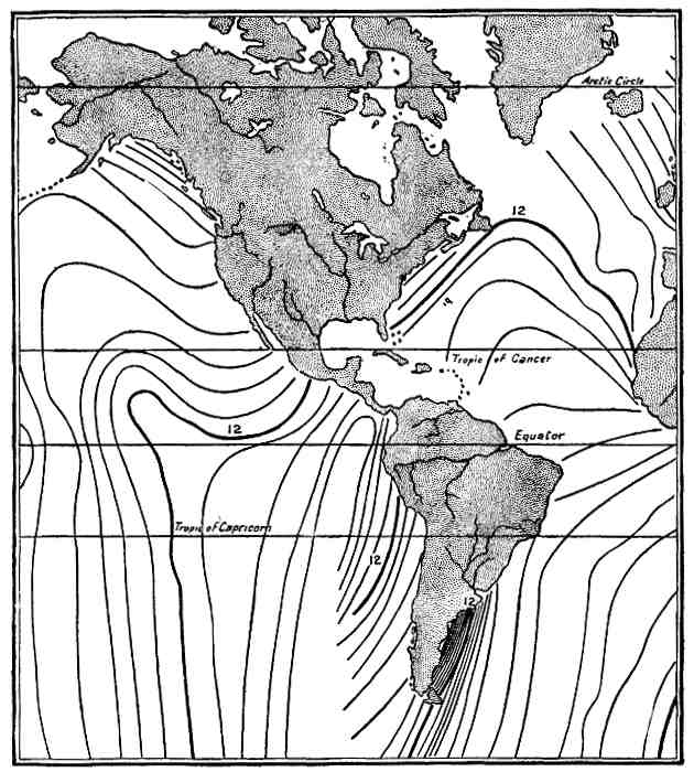 Fig. 4.—Co-tidal lines. A diagrammatic representation of
the advance of tidal waves in the Atlantic and Pacific. Figures refer to
noon and midnight. After R. S. Tarr.
Fig. 4.—Co-tidal lines. A diagrammatic representation of
the advance of tidal waves in the Atlantic and Pacific. Figures refer to
noon and midnight. After R. S. Tarr.
In the north Pacific (Fig. 4) the tidal waves come from the south and expand much the same as the corresponding waves do in the north Atlantic, but instead of striking the coast broadside on, sweep along the shore from south to north.
There are two localities on the coast of North America, one at the head of the Bay of Fundy and the other at the head of Cook's Inlet, Alaska, where the tides present especially interesting features. In each of these inlets the incoming tidal wave meets an outward-flowing current which tends to hold it back. The incoming waters are thus piled up until sufficient head is established to cause them to advance as a steep-fronted wave termed a bore, which curls over and breaks in a long line of foam as it rushes along. At the head of the Bay of Fundy the bore travels at the rate of 6 or 7 miles an hour, and has a height of from 4 to 6 feet. The great disturbance produced by the strong current and breaking waves causes the mud of the bottom to be disturbed and the waters to be charged with sediment. Much of this mud is deposited during the interval of quiet water at high tide, and as the outflow is not so impetuous as the inflow, broad mud-flats are formed. At certain localities about the Bay of Fundy artificial dikes have been made, which admit the mud-charged waters at high tide, and retain them until much of their freight is deposited. In this manner, large areas of rich lands have been secured.
The geographical influences of the tides and of the currents produced by them are of interest in many ways. To navigators they are of special importance. Even in this 30 age of steam, the arrival and departure of vessels from harbours is regulated so as to take advantage of the incoming or outgoing tidal currents. Many harbours can be entered by deep-draft vessels only at high water, for the reason in general that sand-bars are frequently formed at the mouths of tidal estuaries. One of the most marked illustrations of the influence of the rise and fall of the tide on navigation occurs at St. John, New Brunswick, where the tide flows in and out of St. John River so as to form a cascade each way, dependent on the direction of the current. At low water the level of the river is from 11 to 15 feet above the Bay of Fundy, and at high water the level of the bay is from 8 to 12 feet above that of the river when not affected by the tide. There are four periods of from ten to fifteen minutes each during each twenty-four hours when vessels can pass in and out of the river's mouth.
In the Arctic Ocean the tides are small. At Point Barrow, the most northern locality on the coast of Alaska, the difference between high and low water is but 6 or 7 inches. The tide comes from the southward and westward, and there is a prevailing current setting to the eastward. At Herschel Island, near where the east boundary of Alaska reaches the Arctic Ocean, the mean range of the tide is but 1.8 foot. At Cape Sheridan, the northeast point of Grinnell Land, north latitude 82° 25', there is a range of 2.6 feet during two periods each month when the tides are highest, and but 1.2 foot at the lowest or neap tide periods.
In addition to the weakness of the tides and tidal currents along the arctic coast, there is an absence or great diminution of the influence of wave and currents, owing to the prevalence of ice on the sea. Shore erosion is there at a minimum in spite of the abrasion produced by the ice-packs when forced landward by the wind.
Islands.—In the classification of islands used by A. R. Wallace in his Island Life two primary divisions are recognised, namely, continental and oceanic islands.
Continental islands are land masses which have been separated from continents and are rarely far removed from 31 their borders, and, besides, are composed of rocks similar to those of the neighbouring mainland and inhabited by terrestrial animals which are related to the fauna of the larger land area. Ancient and modern continental islands have also been recognised, their age being indicated by the degree of similarity between their faunas and the fauna of the continent with which they were formerly connected. Those of ancient origin are commonly surrounded by deep water, while those which are more modern usually rise from continental shelves, the channels intervening between them and the mainland being less than 100 fathoms deep. Oceanic islands rise from deep water, are either volcanic or so far as their emerged portions are concerned composed of coral rock, and are without warm-blooded terrestrial animals.
About the borders of North America there are islands belonging to each of these classes. The numerous examples rising from the continental shelf all about the margin of the land, but in the Atlantic most numerous from New York northward, and in the Pacific from the Strait of Fuca northward, are plainly recent continental islands. The larger of the West Indies and the group of small islands off the California coast are also continental islands, but show by the character of their faunas and the depth of the water about them that they have been long separated from the main mass of the continent. Typical examples of oceanic islands are furnished by Bermuda, in the Atlantic, and Guadalupe, in the Pacific. In this same class, but less remote from the mainland, and in their faunas and floras showing a nearer relationship to South than to North America, belong the Caribbees.
The generalized coast-line of North America measures about 35,000 miles in extent, and presents a great variety of scenery. The range in diversity embraces all classes of coast topography from the low, sandy mangrove-fringed borders of Florida and the Gulf of Mexico, to the magnificent sea-cliffs of Labrador and British Columbia and the 32 marvellous ice-walls of Greenland and Alaska where tide-water glaciers enter the ocean.
Like nearly all the features of the earth's surface, this narrow intricate belt where the sea and land meet is constantly undergoing changes. The principal processes which lead to alterations in the coast-line may be considered as forming three groups: First, the wearing away of the land through the action of waves and currents and the deposition of the débris thus produced so as to make additions to the borders of the continent; second, the upward and downward movements of the land; and third, the changes produced by glaciers, ice-flows, and icebergs.
With these more active agencies by which the coast-line is being modified may be included chemical solution and deposition, the influence of plants and animals, the weathering of the margin of the land, etc.; but a critical review of all these processes is impracticable in the present treatise.
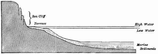
Changes in the Coast-Line due to Waves and Currents.—The waves of the sea beat on the land with never-ceasing activity, but exert the greatest force during storms. The blow which a great surge strikes when it breaks at the base of a cliff, amounting in many instances to 3 or more tons to the square foot, tends to disrupt the rocks both directly by its impact and by the compression of air and water in their interstices. The greatest work of the breaking waves is performed, however, with the aid of the stones which accumulate on the beaches. These are hurled against the land by the force of the landward-rushing waters and break and abrade the rocks with which they come in contact. The friction produced by the impact of waves charged with sand, pebbles, and boulders against the land leads to its removal along a horizontal belt with a narrow vertical range. The waves of the sea, in fact, act like a horizontal saw, the edge of which slowly advances landward. As a result of this process of under-cutting, highly characteristic and frequently most picturesque forms are given to rocky coasts. Whenever the sea is bordered by hard rocks standing well above the surface, but not rising too precipitously 33 from deep water, we find cliffs facing seaward. At the base of each of these sea-cliffs there is a shelf or terrace which records, in part at least, the advance that the sea has made inland.
A cross profile of a wave-cut seashore (Fig. 5) shows two prominent features, namely, a sea-cliff with a horizontal base, and a terrace sloping seaward from the foot of the cliff. Of these, the cliff is by far the more prominent as it stands up boldly to view, while the terrace is in large part and perhaps wholly submerged. These two leading characteristics in the topography of wave-cut shores are shown in the following diagram:
The water carried landward by each wave as it rushes up the sloping surface of a terrace again finds its way seaward, either wholly or in part, as an "undertow." Much of the rock débris ground fine by the ceaseless beating of the surf is separated from the coarser material, thus leaving the latter free to be moved by succeeding waves, and is carried seaward by the bottom current or undertow. During storms especially there is usually to be seen a belt of discoloured water seaward from the white breakers which margin the land. The finer débris carried away from the shore by the undertow is sooner or later deposited, and much of it is laid down on the terrace bordering the land and serves to build out its seaward margin. A normal sea-terrace is thus in part the result of the cutting away of the land, and in part of the deposition of the material removed. The sea not only cuts away the land, however, but at many localities makes important additions to it. 34
Where the water is shallow the larger waves break at a distance perhaps of several miles from the coast-line, and build up long narrow bars, usually of sand, which form barriers, more or less parallel with the shore, and shelter it from further encroachments of the sea. Again, when the wind from the sea blows obliquely to the coast, currents are established in the water which sweep along the loose material on the beach and on the submerged portion of the terrace of which the beach is a visible part, and cause it to travel in the general direction of the prevailing on-shore winds. This action also leads to the building of bars more or less parallel with the coast and at the extremities of capes, particularly where the shore currents enter deeper water and give origin to spits of various shapes, which are frequently curved towards the land and at their extremities become hooks and loops.
There are thus two important processes, one destructive and the other constructive, by which the sea is continually modifying the border of the land.
When once the underlying principles on which depend the characteristics of coastal topography are suggested, any observant person can apply them for himself and thus be able to read the history as well as admire the beauties of seacoast scenery. It is not necessary, therefore, to attempt to present a detailed account of the coasts of North America from a purely geographical point of view; there are certain results of the processes just referred to, however, which are of wide-reaching economic, and especially of commercial interest.
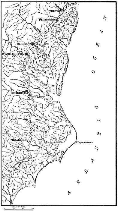
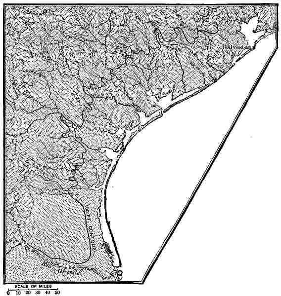
From Central America northward to Cape Cod the rocks bordering the sea are soft or easily soluble, and the adjacent land of low relief. Throughout this section the work of the sea is mostly constructive, and the margin of the land is sheltered by sand-bars from the attack of waves and currents. Where the waves of the open ocean do reach the land, as on the coast of New Jersey, the sea-cliffs are low and the topography of a mild type. Very generally, as along the coast of Mexico and Texas, and from Florida to Long Island, there are long narrow bars adjacent to 36 the shore, with lagoons intervening between them and the mainland. These features are well illustrated on the accompanying map (Fig. 6) of a portion of the Atlantic coast where long narrow bars, sometimes forming skeleton capes, are a characteristic feature. On the middle Atlantic coast of the United States the prevailing winds blow southward and there is a general southward flow of the shore currents, which carry with them the sand on the beaches and bars. An interesting fact in this connection, pointed out by N. S. Shaler, is that although the sands are continually being moved they are not worn out. After the sand-grains have been reduced to a certain size they retain films of water which separate them one from another, and act as cushions which prevent the grains from coming in contact, thus greatly retarding further comminution. But for the protection thus afforded the sand-bars would be removed and the border of the land exposed to the attack of the waves and cut away; whereas under existing conditions lagoons are formed, which in many instances are utilized as harbours or are filled by wind-blown sand, the sediment brought by streams, plant growths, etc., and valuable additions are made to the continent.
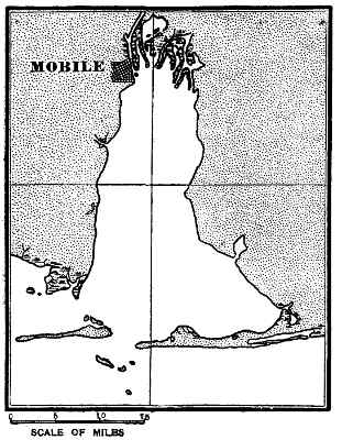
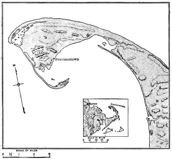
The sand-bars just referred to frequently cross the mouths of rivers, and in such instances a struggle ensues between the currents moving along the shore and the outflowing river-waters aided by the currents produced by the tides. This conflict leads to the formation of sand banks and bars, generally submerged, across the entrances of bays and inlets and to the building of sand-spits from the seaward capes. A typical instance is furnished at the entrance of Mobile Bay (Fig. 7), 37 where a spit from each side has been built by shore currents so as to greatly contract the tideway between. Similar features are presented by Sandy Hook and Coney Island, each of which has been built of sand deposited by shore currents at the seaward entrance of the lower New York Bay. Another illustration of this same general character is furnished by the curved extremity of Cape Cod (Fig. 8), which is a sand-spit of large size with a hooked extremity. Spits of this nature are common on our coasts, and in many instances themselves form harbours, as at Coney Island and near the extremity of Cape Cod. Many other similar examples of the importance of lagoons, sand-bars, spits, etc., to shipping, which occur, especially along the Atlantic coast of the United States, may be studied to advantage on the admirable charts of the United States Coast and Geodetic Survey.
The sand-bars, spits, and other similar structures along the Atlantic coast are also of strategic importance, for the reason that they afford advantageous sites for fortifications, as is illustrated by the strong forts at Sandy Hook which guard the entrance of New York Bay. These sea-built foundations are also utilized in a large number of localities for lighthouses. The waterways shut off from the sea by off-shore bars in some instances permit of the passage of vessels from one harbour to another. In this connection it is of interest to note that an important system of canals is under consideration for making a continuous waterway for deep-draft vessels, some 700 miles long, which will connect the estuaries and lagoons from New York to the Carolinas.
While the islands of sand referred to present many conditions favourable to commerce, fisheries, and other industries, their apparent durability is deceptive, and in some instances faith in their permanence has led to disastrous results. They owe their existence to the action of waves and currents, and unless blown sand is heaped upon them are raised but a few feet above mean sea-level, and are liable to inundation if a high tide is accompanied by an on-shore gale. A sad illustration of this plain conclusion is furnished by the disaster that overwhelmed the city of Galveston on the night of September 8, 1900, during which some 3,000 people perished and $20,000,000 to $30,000,000 worth of property was destroyed. This great loss was in large part due to the fact that the city was inundated by the advance over its site of the storm-driven waters of the Gulf of Mexico. The island on which Galveston stands (Fig. 9) was built by the waters of the Gulf, and during the hurricane referred to they again claimed their own.
Northward of Cape Cod, the rocks adjacent to the ocean are mostly hard and resistant, consisting largely of schist, gneiss, granite, trap, etc., which when undercut by the waves stand as bold cliffs and headlands. This portion of the continental border abounds in picturesque scenery and is abundantly supplied with fine harbours and well-sheltered havens in which boats may take refuge. Typical portions 39 of this rugged coast are furnished by the magnificent sea-cliffs of Mount Desert and Grand Manan islands, the bold shores of Newfoundland and Labrador, and the precipitous border of Greenland. The scenery throughout nearly all of this vast extent of wave and storm beaten rocks is in striking contrast to the mild and generally monotonous sand-built shores to the south of Cape Cod. Between the angular headlands and rugged capes at the north, with their white girdles of surf, there are frequently curved beaches and numerous spits and bars of yellow sand which connect the salients of the shore or extend from them so as to furnish safe anchorages.
On the arctic coast of North America the action of the waves and currents on the land is greatly retarded by ice, 40 and the tides are small, but to what extent these conditions unfavourable to the work of the sea are counterbalanced by the abrasion performed by ice-floes is unknown. The northern border of Alaska, as well as the shore of Bering Sea, is mostly low and the rocks soft, although certain of the sea-capes are bold and are evidently composed of resistant material.
The Aleutian Islands present a peculiar exception to the general coast topography of the rest of the continent. Although this region has not been studied in detail, it seems to furnish an example of a rugged mountain range that has been partially submerged at a comparatively recent date. The rocks in many places descend precipitously into deep water, leaving no room for the formation of beaches, and hence the waves, to a great extent, are without tools with which to cut away the land. At the heads of the many bays and inlets, however, one finds beautiful sand-beaches with gracefully curving lines, in striking contrast to the dark, rugged cliffs bordering their seaward extensions.
The southern and southeastern borders of Alaska are exceedingly bold, and present some of the most sublime coast scenery to be found in the world, but to the geographer the greatest interest of this portion of the continental border, as is true also of the entire Pacific coast of North America, centres in its relation to up and down movements of the land.
Changes in the Coast-Line due to Oscillation of the Land.—Land areas are exposed to the erosive action of wind, rain, streams, etc., and are sculptured by these agencies into valleys, cañons, peaks, ridges, and other familiar topographic forms. The various processes by which land areas are modified lead in general to a roughening of the surface. As an extreme illustration, a high plateau becomes dissected by streams so as to form an intricate system of rugged mountain ridges and peaks, with deep, steep-sided valleys between. The degree of this roughening depends principally on the elevation of the land, together with contrasts in the resistance of the rocks due mainly to variation in hardness, climatic conditions, etc., but in general 41 one may say the higher the land is raised above the sea the more rugged will be its topography as the process of wearing away progresses. It is to be remembered in this connection, however, that land areas pass through a somewhat definite series of changes, from topographic youth to topographic old age, each stage being accompanied by changes in the relief. It is during topographic maturity that the greatest roughness of the surface of a land area is produced.
Land areas are continually wasting away, owing especially to the attacks of the streams, and the material removed is deposited in the sea. The débris brought from the continents by streams is laid down in shallow water—about the shores of North America almost entirely on the surface of the continental shelf—and in this region of deposition the hollows are filled and a generally smooth surface given to the sea-floor.
The topography of the land, for the reason stated above, is nearly everywhere uneven; while the topography of the sea-floor is characterized by uniformity. We can easily predict, therefore, the general character of the changes in a coast which would result from either a subsidence of the land, thus allowing the sea to encroach upon it, or of an elevation, which would expose a portion of the sea-bottom, thereby increasing the area of the land. A subsidence of the land adjacent to the sea permits an extension of the waters landward; the sea will enter the valleys so as to form estuaries, bays, straits, etc., while the high land between the partially water-filled depressions will rise above the water-level and appear as peninsulas, capes, and islands. A bold, deeply sculptured coast when depressed will give origin to an intricate, and what may be termed a ragged shore-line; while a lower region crossed by large river-valleys would be changed to a system of broad estuaries.
An upward movement in the earth's crust along the ocean's shore would expose a portion of the sea-floor and add a strip of generally level country to the previous land area. The boundary between the old and new topography in such an instance would be the upraised coast-line with 42 its sea-cliffs, wave-cut caves, terraces, beaches, and other characteristic features of coast topography.
There are thus two strongly contrasted types of coast scenery, produced by oscillations of the earth's crust where ocean and continents meet. In each class there is a wide range in details, which vary in harmony with the amount the land rises or falls in reference to sea-level.
When one has these general laws in mind a map of the coast-line of North America acquires great significance.
From about the latitude of New York southward to Central America many comparatively small oscillations of the land have occurred in recent geological time, and what was formerly a portion of the continental shelf is now exposed and forms a coastal plain. This plain, in general from 50 to 100 miles broad, slopes gently seaward, and its continuation under the sea forms the present continental shelf (Fig. 2). Evidently a slight up or down movement or a gentle tilting of this partially submerged plain in an east and west direction would cause a marked advance or recession of the sea. Each time the sea advanced the country submerged would be smoothed over by the action of the waves and currents and a sheet of sediment laid down upon it; and each time the sea receded the emerged land would be trenched by the rivers flowing across it. The records show that many such changes have occurred.
The Gulf border of Mexico and Texas, composed of soft marine sediments, forms a gently sloping plain bordered on the west by a roughened upland, and illustrates the general feature of a recently emerged coastal plain (Fig. 9). The same is true also of the entire coast from Texas to New York, but it happens that a recent movement through this region was of such a nature as to allow the sea to encroach on the land, and the previously excavated stream valleys are now, in part, occupied by the sea. This feature is most marked from the Carolinas to New York (Fig. 6), where there are several great estuaries and drowned river-valleys which extend far into the land. The best examples are Albemarle Sound and Chesapeake and Delaware Bays. The James River channel is submerged as far as Richmond, 43 the Potomac to Washington, the Susquehanna to Harrisburg, the Delaware to Trenton, and the Hudson to Troy. These are typical illustrations of what geographers term drowned river-valleys. They are evidence that the land formerly stood higher than now, was trenched by the rivers that flowed across it, and was then depressed or tilted so as to allow the sea to encroach upon it. The importance of these events in the settlement of North America by Europeans and on the subsequent development of commerce, manufactures, the location of cities, etc., needs only to be suggested to permit the reader to fill in the details for himself.
On the Gulf coast and about Florida the later movements of the land have been less than in the region from Albemarle Sound to New York, and estuaries are there absent, with the somewhat marked exception of Mobile Bay. Certain secondary conditions need to be introduced here, but space will not permit of more than a brief presentation of them. Not only have the recent movements of the land been less about the shores of the Gulf of Mexico than in the middle Atlantic region of the United States, but the rivers at the south are in general smaller and less swift than those farther north, and hence are less able to excavate broad valleys. The Southern rivers, such as the Alabama, Mississippi, Rio Grande, etc., are silt-laden and tend to fill their estuaries, while the weaker streams are unable to resist the encroachments of sand-bars and spits built by shore currents, and their mouths have been practically closed. The coast of Texas gives evidence of slight modern subsidence, but the small estuaries formed have, for the most part, been separated from the Gulf by sand-bars.
Northward of the middle Atlantic region the recent oscillations of the land continued to increase and reached a maximum about the shores of the Arctic Ocean; on the Pacific coast also there is similar evidence of an increase in the recent earth movements from the south northward.
In an outline sketch of the present coastal topography of the continent we can generalize, and say that the whole continent during the late Tertiary, glacial, and recent times 44 has swayed up and down about a hinge-line situated in the region of the Gulf of Mexico, and the movements, although not uniform, have increased in amount from the south northward. Let us glance at the evidence on which this broad statement, involving the up and down surging of a vast continent, is based.
The Hudson, as stated above, is a drowned river as far as Troy, a distance from the present land margin of 160 miles. In the next great river to the northward, the St. Lawrence, the tide rises and falls nearly up to Montreal, a distance of about 800 miles from the general shore-line. Still farther north are Hudson Strait and Hudson Bay, which, although but imperfectly explored, seem to be an example not only of the drowning of a river-valley, but of the largest part of a river-basin. The geography of the arctic archipelago fringing the north shore of the continent also suggests that a strongly stream-cut plateau has there been deeply submerged.
In addition to the drowned river-valleys and ragged coasts which record a subsidence of the land, there are raised terraces and beaches which begin at the south near New York and increase in elevation above the present sea-level, when followed northward, all the way to the arctic region, and have in the far north an altitude of about 1,200 feet. These old beaches and terraces show that the land was formerly depressed and has since risen; but, as shown above, has not regained the elevation it had previous to the glacial epoch.
The marked differences in the geography of the coast from New York northward to the Arctic Ocean, and from the same locality southward to Central America, are due primarily to the fact that the oscillations of the land have been such that at the north the continental shelf is entirely submerged and the sea has encroached on a rough land; while at the south the recent oscillations have been less and a broad margin of the continental shelf is exposed and forms the coastal plain.
At the north, we find innumerable islands, bold, rocky shores with many capes and headlands, separated by deep 45 inlets, sounds, straits, bays, etc., or, in brief, a ragged coast such as finds typical illustration on the shores of Maine (Fig. 10), while at the south (Fig. 6) the shores are low, sandy, remarkably uniform in trend, and without islands, excepting such as are built by the waves and currents. The West India Islands will, no doubt, be recalled by the reader, but their history is again different. Intermediate between the land that has experienced great oscillation at the north and the region of less energetic movements at the south is the series of large estuaries mentioned above, in the narrower portions of the coastal plain.
The northern and western coasts of Alaska are mostly low, and correspond in a general way with the coastal plan of the Carolina region. The last well-marked movement of the land in that region has been in the direction of an elevation, and we find low shores, with but few harbours, similar in many ways to the coast of Texas.
It is probably true, as already stated, that the Aleutian Islands, although in part the result of recent volcanic activity, owe their peculiar and exceptional characteristics to the partial subsidence of a deeply sculptured mountain range. On the south coast of Alaska, in the region of 46 Mount St. Elias and Mount Fairweather, a recent and extensive elevation has occurred, which, however, did not bring the bottom of the adjacent portion of the ocean above the sea-level. This apparent anomaly seems to be due to an uprising of the rocks along the north side of a break, or belt of branching fractures, which closely approximates to the coast-line and has determined the position of the continental border in that region. The facts, so far as known, appear to show that we have here what geologists term a fault, the north or landward side of which has been raised at least 5,000 feet in very modern times, but, so far as we can judge, without disturbing the seaward border of the break. The coast between Mount Fairweather and Mount St. Elias is by far the boldest, and from a scenic point of view the most impressive, portion of the entire shore-line of North America. The mountains are young and among the highest on the continent. They rise precipitously from the margin of the sea, and are sheathed in snow and ice from base to summit throughout the year.
The margin of the continent southward from Mount Fairweather to the Columbia River, a distance in a straight line of about 1,200 miles, furnishes some of the best illustrations of the changes in coastal geography due to subsidence that our continent affords (Fig. 11). This wonderfully irregular coast is fringed with a belt of mountainous islands from 50 to 100 or more miles broad. The inlets between the bold capes and the straits separating the numerous islands are deep. The rugged, forest-clothed slopes with precipitous, and in many instances nearly vertical walls, descend into water that is frequently from 50 to over 200 fathoms deep. In brief, a deeply dissected mountain range more than 1,000 miles in length has there been depressed at least 2,000 feet below its former altitude, thus allowing the sea to flood its deep, picturesque valleys.
Puget Sound, with its numerous and frequently narrow arms (Fig. 23), is the southward extension of the partially inundated country considered above. To the west of this magnificent sound rise the Olympic Mountains, which barely escape being an island at the present stage of the 47 swaying of the land. On the west, as on the east border of the continent, there are drowned river-valleys, such as the Stikine, Frazer, Columbia, and Sacramento. It is not to be understood, however, that the entire Pacific coast region has been raised or depressed as a unit. There have been differential movements in some of its parts, but these are not as yet well known. In southern California, for example, raised beaches and a narrow coastal plain about Los Angeles give evidence of a modern rise of the land.
In reference to the broad generalization that the continental mass of North America has undergone up and down movements, greatest at the north and decreasing southward, as if moving on a hinge-line running east and west in the region of the Gulf of Mexico, it is of interest to note that the ragged coasts 48 of Maine, Nova Scotia, Newfoundland and Labrador, due to the partial submergence of a rugged land, lie in the same latitudes as the equally ragged coast of Washington, British Columbia, and Alaska. This is more than a coincidence. The rocks on the two coasts are similar, being for the most part resistant crystalline schists, gneisses, granites, etc., and in each instance stood high above the sea for a long period during which they were deeply trenched by streams and by great glaciers, and then at about the same time, as nearly as can be judged, each region was depressed so as to allow the sea to encroach upon it.
While a deeply sculptured land when partially submerged gives origin to a ragged coast, a region of similar elevation, but not cut by streams or other agencies so as to have deep valleys, when subsidence occurs produces a bold, harbourless shore without islands. The striking contrast between the deeply indented border of the continent, with its broad fringe of islands, from Mount Fairweather southward to Mount Olympus, and the remarkably uniform although bold coast-line from Mount Olympus southward to Mexico, and indeed nearly to Cape Horn, has much significance in this connection.
The mountains bordering the Pacific coast of the United States are among the younger on the continent. These coast ranges, largely on account of their youth, have not been deeply sculptured, but rise boldly from the ocean's shore throughout nearly the entire distance from the Strait of Fuca to the end of the peninsula of Lower California. The mountains of Central America, although but little known, are of comparatively recent date, but differ from the coast ranges in being more largely built of young volcanic rocks. Both the coast ranges and the mountains of Central America are much less deeply sculptured than the mountains bordering the Pacific to the north of Puget Sound, and a subsidence along this shore would produce but moderate changes in the coast-line. In this great extent of coast, measuring nearly 5,000 miles, there are but few harbours; in the portion belonging to the United States the generally bold coast-line is broken but in two places, one 49 where the Columbia reaches the sea, and the other where the Sacramento finds an outlet through the portions of its drowned valley known as the Golden Gate.
The Bay of San Francisco owes its origin to a subsidence of the land which has admitted the sea into the valley of the Sacramento, but this valley, which, uniting with the one at the south drained by the San Joaquin, forms the Great Valley of California, is not due to stream erosion, as in the case of the drowned valley of the Hudson or of the St. Lawrence, but to the upraising of the mountains bordering it. During a former time of greater subsidence than at present the Bay of San Francisco was larger than now, and has been contracted both by the deposition of sediment and by a partial re-elevation of the land. The exceptional character of the Bay of San Francisco and its marked excellence as a harbour give to the city on its shore promises of marvellous development.
The Gulf of California is due, in a general view, to what may be considered as a departure of the Coast mountains away from the general trend of the continental border. We have but little detailed information concerning this region, however, and the studies of modern geographers have likewise been meagre throughout all the coast-line farther south.
The Pacific coast of Mexico is geographically similar to that of California, but instead of a single great harbour there are four of moderate size and excellence, the histories of which have not been studied. Farther south, along the Central American coast, the shores are bold, but several indentations, due in part at least to volcanic agencies, furnish shelter for vessels and offer encouragement to commerce.
The bold and not deeply sculptured mountains along the nearly unbroken coast from the Strait of Fuca to Panama, rise close to the true border of the continent. The continental shelf of this portion of the shore of the Pacific is narrow. An elevation of 100 fathoms would add scarcely more than 10 miles to the extent of the land. This narrowness of the continental shelf seems to be due to the 50 recency of the uplifting of the Coast mountains, and the lack of time for the débris from the land and the organic refuse of the sea to shoal the water. The Pacific basin is deep close to the land bordering it, thus restricting the seaward extension of the continental shelf.
Changes in the Coast-Line due to Ice.—It is now well known that glacial ice many hundreds of feet thick formerly covered the northern half of North America and flowed outward across the present position of the coast-line throughout all of the northern border of the continent from Staten Island in the east and Puget Sound in the west, with the exception of the Arctic and Bering Sea coasts of Alaska.
The effects of this outward-flowing ice on the topography of the continental border crossed by it were in general in two directions. Where the land was rough or moderately so previous to the coming of the ice-sheets the inequalities of surface were increased; but where the land was smooth or but gently undulating its elevations were planed away by the glaciers and made still more smooth. The reason for these differences is that when the land from which the ice flowed was rugged or had previously been deeply trenched by streams, the valleys gave direction to the ice currents and the margins of the continental ice-sheets became divided into separate ice-streams, as is the case in Greenland at the present day. This localization of the ice currents served to deepen and broaden the pre-existing valleys, and especially on the bold coast of Alaska and British Columbia increased in a marked way the inequalities of the surface and favoured the production of a ragged coast-line when the ice melted and was replaced in part by the sea. When, however, the topography of the land was not sufficiently accented to cause the ice flowing over it to gather into well-defined currents the general surface was worn down, thus favouring the production of an even coast-line after the melting of the ice-sheets.
Where the coast-lands were high and rugged, the deepening and broadening of the valleys led to the origin of deep, narrow, canal-like waterways termed fiords (fjords), 51 when the ice withdrew from the partially submerged land or when subsequent depression carried the glaciated troughs below sea-level. On the Atlantic coast from Maine to Labrador, and thence northward to the Arctic Ocean, there are numerous examples of fiords, as is also the case on the Pacific coast from Mount St. Elias to Puget Sound. At the present time the localized ice-streams from the great central ice-sheet of Greenland are continuing this process of fiord excavation. The same is true also, but on a much smaller scale, of the tide-water glaciers of southern Alaska.
The shores of the northern portion of the continent from New England to the Aleutian Islands are now being modified by the grinding of ice-floes, which are driven against the land by the wind. This process, however, although locally important, need claim but little attention in a general view of the geography of the continent.
Changes in the Coast-Line due to the Deposits made by Streams.—The visible loads of silt and sand in suspension carried to the ocean by streams, as well as the material the streams roll and push along their bottoms, is delivered to the waters of the ocean and deposited in various ways. Much of this material, notably the coarser portion, is dropped near land and the finer portion floated far out from the coast before settling to the bottom. Two classes of deposits made in this way may be recognised, namely, those laid down by the streams themselves as they drop their loads on entering still water, or delta deposits; and those spread over the sea-floor by waves and currents after receiving the débris brought from the land. Which of these two modes of deposition will prevail depends on whether the waters of the ocean at the localities where the streams deliver their loads are essentially still or are affected by strong currents. In the former instance all but the finer of the débris derived from the land is quickly dropped and deltas are formed; and in the second instance the currents bear the material away and deposit it either in the shallow water adjacent to the neighbouring shore, forming shoals, bars, embankments, spits, etc., or spread it in a sheet over 52 the sea-floor. The most notable changes in the coast-line resulting from this general process occur where silt-laden streams enter still water and form deltas.
On the coast of North America many of the streams which enter estuaries deliver their loads to waters which are agitated, especially by tidal currents, and ill-defined shoals, sand-banks, etc., are produced. In three conspicuous instances, however, large rivers are engaged in building deltas, and thus producing well-marked changes in the coast-line.
At the north, the Mackenzie enters the nearly tideless Arctic Ocean, where floating ice almost completely counteracts the tendency of the wind to produce currents, and a great delta is being extended seaward. The river divides on its delta into many distributaries and enters the sea by several mouths. The sea near the mouths of the river is reported to be shallow, and obstructed by many sand-banks and islands. No survey of the Mackenzie delta has as yet been made, and but little definite information concerning it is available.
The Yukon on entering the shallow eastern portion of Bering Sea, where the influence of the tides is small and floating ice is present throughout about nine months each year, is also engaged in building a great delta which projects into the sea and gives the coast-line a bold outward curve. The Yukon begins to divide into separate channels, several of which enter the sea as independent distributaries at a distance of about 150 miles from the outer border of its delta. The distance between the outer finger-like division of the stream is about 90 miles. The Yukon is a graded stream—i. e., is able to carry material in suspension, but not to deepen or fill its channel—in the lower portion of its course, and is making an important addition to the land owing to the dropping of its burden of silt as soon as the still water into which it flows is reached. The stream is thus being extended, and in order to enable it to continue its task of transportation and the delivery of its load to the sea, the extended portion of its channel is built up so as to give a slope down which the waters can 53 flow—that is, the beds of the distributaries are raised, and they also shift their positions from time to time and make additions to the entire surface of the delta. This extension of the stream and deposition of silt by its distributaries have added about 1,000 square miles to the land. Although the delta of the Yukon presents an admirable example of the change in a coast-line produced by the sediment dropped by a great river, the partial surveys of it that have been made are not as yet available for study.
Fully as characteristic of the modification of coast-lines made by a stream as any in the world is the well-known example of the delta of the Mississippi. This classical instance illustrates not only the manner in which coast-lines are modified, but the behaviour of a large silt-laden stream which has reduced its valley to a low gradient, and throughout hundreds of miles of its lower course is spreading out a wide flood plain. The extension seaward of this flood plain forms the broad delta at the river's mouth.
During high-water stages the Mississippi widely over-spreads its banks and during such inundations of its valley drops much of the silt it previously held in suspension. The material deposited is laid down most abundantly on the immediate border of its low-water channel. Each side of the channel is thus raised so as to form what is termed a natural levee. During this process also the bed of the stream is raised by the deposition of sediment upon it, thus tending to cause the stream to flow on a raised ridge and producing an unstable condition which from time to time enables the river to break across its confining levees and divide into two or more separate channels. In the lower portion of the river some of the new channels thus formed reach the sea and furnish independent outlets for its waters. The first of these distributaries now departs from the main channel at a distance of 200 miles from the Gulf of Mexico, and farther seaward several other divisions occur (Fig. 12). The area of the delta is about 1,230 square miles. Each distributary is engaged in building a pair of embankments, or natural levees (although this process in recent years has been modified by the construction of artificial embankments 55 for the sake of improving navigation), and each subdivision of the river is also building a delta. Each of the finger-like extensions of the delta, shown on the accompanying map, is due to the prolongation of a pair of embankments into the Gulf by each distributary and the growth of a secondary delta at its mouth. The river is thus building a highly compound delta, composed of the secondary deltas formed at the mouth of each of its distributaries. A conspicuous modification of the otherwise generally evenly curved border of the Gulf of Mexico is thus produced, a result that could only be reached in a water body but little disturbed by wind or tidal currents.
The features of a coast of greatest importance to civilization are its harbours. A coast without harbours is like a Chinese wall, and tends to isolate a people inclosed by it. An indented coast with numerous havens for the shelter of vessels fosters the interests of navigation, including sea fisheries, invites commerce from other lands, and stimulates its inhabitants to explore and travel. A diversity of industries is thus favoured and the people adjacent to an indented coast with good harbours tend to become more progressive and more cosmopolitan than if intercourse with other communities is confined to overland routes.
The Atlantic border of North America is abundantly supplied with fine harbours, which not only favour communication with distant countries, but are within easy reach of agricultural and forest lands and important coal and other mineral deposits adjacent to the coast or in the interior, and are near extensive and valuable fishing grounds. The best of these harbours are at the mouths of rivers which have been depressed so as to form estuaries with wide entrances. These sea-gates, however, are frequently contracted, owing to the presence of sand-bars and spits deposited by shore currents.
The great St. Lawrence estuary reaches to Montreal, and beyond lie the Great Lakes, the rich lands of Ontario 56 and New York, and the now highly productive States of the Middle West. Two geographical features in this basin detract from the conditions otherwise highly favourable to commercial development, namely: the rapids in the St. Lawrence between Montreal and Lake Ontario and the fall in the Niagara, and the winter climate of Canada, which causes the rivers and estuaries to be ice-bound for a considerable part of each year. To obviate the first of these unfavourable conditions far-reaching plans for a deep waterway between the Great Lakes and the Atlantic are now being matured. The splendid harbours from Nova Scotia southward are never seriously obstructed by ice, and south of Virginia ice is practically unknown.
The estuaries at the mouth of the Hudson, Delaware, Susquehanna, Potomac, James, and the Alabama, together with the distributaries of the Mississippi (which is not a partially drowned river, but one that is building up and extending its channel), are the natural outlets of portions of the continent of great fruitfulness. When other, and especially climatic, conditions are considered, it will be seen that to the geographer the Atlantic sea-border from the Gulf of St. Lawrence to the Gulf of Mexico seems destined to be the next great commercial centre in the succession from Greece to Britain. An important adjunct to the present highly favourable geographical conditions pointing to a great future for civilization on the Atlantic coast is the construction of a ship-canal across the isthmus uniting North and South America. This step must soon be taken.
A glance at a map of North America must impress one with the belief that the Pacific coast with its great extent of harbourless water-front is far less favourable to the growth or ideas, institutions, and industries than the deeply indented Atlantic shore-line. From the Isthmus of Panama to the State of Washington there is, as we have seen, but one harbour of the first class, the estuary of the Sacramento, and one of the second or third class, the estuary of the Columbia. From Puget Sound northward harbours are numberless. There are two important geographical reasons, 57 however, why the general absence of good harbours to the south of Puget Sound is not so serious as it perhaps might seem. First, the mountain ranges run north and south parallel with the coast, and the natural lines of interior travel lead to the outlets through the Coast Ranges traversed by the Sacramento and the Columbia. The second and more general reason is that, owing to the warm currents in the Pacific, the portion of the west coast most favourable for a high degree of civilization is situated farther north than the similar belt on the Atlantic border.
By way of a summary of this chapter, the reader is asked to bear in mind the fact that the land forming North America, as is the case with all continents, is not at rest, but is subject to movements which cause elevations and depressions of various portions of its area with reference to sea-level. These movements have been in progress since the birth of the continent, and still continue. An upward movement of the earth's crust where the land and ocean meet causes a portion of the sea-floor to emerge and an addition usually of the nature of a coastal plain to be made to the border of a continent; while a reverse movement enables the sea to advance on the land and to flood the low-grade valleys opening to the ocean.
In a generalized view of the recent history of the coast-line of North America the dominant fact is that to the north of the latitude of the north shore of the Gulf of Mexico the resultant of the later movements of the continent is downward; the amount of the depression thus caused increases in a general way with increase in latitude on both the Atlantic and Pacific coasts. This downward movement has permitted the sea to encroach on the land and to flood many pre-existing valleys. On the Atlantic coast it produced such estuaries as Chesapeake and Delaware Bays, the tide-water portions of such rivers as the Hudson and the St. Lawrence, and farther north, where the submergence was greater, permitted the sea to invade the continental basin and form Hudson Bay. To this same wide-reaching cause is due also the bold ragged coast-line of the 58 Atlantic from New England northward. On the Pacific border the downward movement is recorded by the tide-water portions of the Sacramento, Columbia, etc., and the deep picturesque fiords of the Canadian and Alaskan coasts. The most decided influence of these changes in the geography of the continent's margin on the affairs of men resulted from the production of numerous fine harbours and the extension of estuaries far inland, thus favouring commerce and fisheries in a high degree.
As a result of the oscillations just referred to, the sea has gained important characteristics as well as the land. The broad submerged shelf fringing the continent furnishes conditions highly favourable to both plant and animal life, and affords some of the most valuable fishing-banks of the world.
The Caribbean region is a marked exception to the broader changes that have affected the coast-line throughout the central and northern portions of the continent, and stands by itself as a conspicuous illustration of more localized earth movements which produced a remarkable submarine topography.
In continuation of the studies outlined in this chapter the following books, most of which contain more special references, will be found of assistance:
To the student of the geography of the coast and submerged border of North America, the extensive series of charts published by the United States Coast and Geodetic Survey supply a vast amount of accurate information. A catalogue of these charts, with prices, etc., is issued by the Survey. Many of the charts issued by the United States Hydrographic Office, and a large number of the topographic maps published by the United States Geological Survey, are of value in this same connection. An account of these charts and maps, with instructions as to methods of obtaining them, etc., is given in Government Maps for Use in Schools, by Messrs. Davis, King, and Collie, published by H. Holt & Co., New York, 1894.
Taking the better known portions of North America as a basis on which to classify the leading geographical features of the continent, it is convenient, and in the main sufficiently accurate, to recognise five primary physiographic provinces. These are, in their general order, from east to west:
1. Coastal plains and plateaus, of which the country between the Atlantic Ocean and the Appalachian Mountains furnishes the most typical examples.
2. A series of mountain ranges embracing all of the more elevated country on the east side of the continent from Georgia northward to the arctic archipelago, and in this book termed the Atlantic Mountains.
3. The great system of plains and plateaus extending from the Gulf of Mexico northward to the Arctic Ocean and bordered on the east by the Atlantic Mountains and on the west by a still greater series of mountains, which may be designated with sufficient accuracy as the Continental Basin.
4. A group of mountain chains and mountain ranges on the west side of the continent, including the Rocky Mountains, Sierra Nevada, Cascades, etc., and sometimes termed the Cordilleras. Under the scheme of classification here used, this highly complex belt of rugged country extending from south-central Mexico northward to the Arctic Ocean is termed the Pacific Cordillera, or, in less technical language, the Pacific Mountains.[1]
Each of the four physiographic provinces briefly described above is in a conspicuous manner elongated in a north and south direction. The mountains, valleys, and plateaus, as well as the controlling lines of structure in the rocks below the surface, throughout the main body of the continent coincide in direction more or less nearly with the parallels of longitude. At the south, however, and crossing the trend of each of the provinces named above, is the:
Fifth, or Caribbean province, which includes the West Indies, the southern part of Mexico, and all of Central 62 America. In this province are the Antillean Mountains, now mostly submerged, the principal axes of which trend east and west.
With this brief outline of the larger physical divisions of North America in mind, let us endeavour to become acquainted with the leading characteristics of each of the provinces as they exist to-day, and at the same time learn something of their long and varied histories.
The Coastal Plains.—From New York to Key West and thence about the borders of the Gulf of Mexico to the neighbourhood of Vera Cruz, the border of the present land area of the continent is formed by a low plain, from 30 to 50 miles broad in New Jersey, but increasing in width southward to Georgia and Florida, where its somewhat indefinite inland margin is more than 100 miles from the sea, and reaching its greatest development in the delta of the Mississippi. Extending southward about the west coast of the Gulf, it forms the low, featureless eastern border of Texas, about 50 miles broad, and passes into Mexico, but gradually narrows as the Pacific Mountains approach the coast, and ends in the vicinity of Vera Cruz.
The Atlantic and Gulf coastal plain everywhere slopes gently seaward, and on its landward margin has an elevation in general of from 200 to 300 feet. The character of the material of which the coastal plain is composed, the fossils contained in it, as well as its geographical features, show that it is a continuation of the continental shelf, and was formed at a time when the border of the continent was more deeply submerged than at present. Minor oscillations of the earth's crust have time and again allowed the sea to extend inland, only to be forced to recede when the land again rose. Each invasion of the sea left a sheet of soft sediment over the portion of the land that was submerged. These oscillations are still in progress, as is indicated by the fact that along the New Jersey coast a downward movement at the rate of about 2 feet per century is 63 taking place. A similar depression of the land is also thought to be in progress along the south Atlantic coast and in the delta of the Mississippi. The Atlantic coastal plain has its most characteristic development in South Carolina, and is roughly divisible according to its topography and soil into several belts parallel with the shore-line. At the same time it is transversely divided into strips by the several rivers which flow across it and by the many branches of these rivers originating on the plain itself.
The junction of the portion of the gently sloping border of the continent now above sea-level, with the submerged portion, is characterized by the presence of a belt of swamps, in part marine marshes where the salt water ebbs and flows, and in part fresh-water morasses in which the drainage is obstructed largely by decaying vegetation. Inland from the coastal swamps the surface becomes higher, is for the most part well drained, and when not too sandy furnishes rich agricultural lands. The Atlantic plain as a whole thus has three principal divisions: a submerged portion, a marsh portion, and a subaerial portion. During past ages the position of each of these belts migrated, owing to movements in the earth's crust, but their succession in reference to each other has been the same since the Tertiary period.
One of the most typical portions of the fringe of swamps now bordering the land is situated in eastern Virginia and North Carolina, and is known as the Dismal Swamp. In the central portion of this marshy region, embracing some 700 square miles, lies Lake Drummond, an example of a large number of small fresh-water lakes which are retained by rims composed of plant growths and decaying vegetable matter. The mound of vegetable débris in the summit of which Lake Drummond is situated is from 20 to 30 miles broad and rises some 12 feet above tide-level. The lake is nearly circular, from 2 to 2½ miles in diameter, and from 6 to 10 feet deep. The water is amber-coloured on account of the vegetable matter in solution, but is clear and without sediment in suspension, and is considered as remarkably wholesome. The lake was without definite outlet previous to the cutting of drainage-canals, 64 and is entirely encircled by a dense forest, which has encroached on its border in such a manner as to render its boundaries indefinite. The wall of rank vegetation surrounding the open waters of the lake marks the beginning of the encircling swamp. Standing in the lake and supported by their widely expanded roots are several aged cypress-trees.
Along the coast of the Carolinas and Georgia sand-bars thrown up by the sea have formed many lagoons (Fig. 6), which are being filled by the wash of detritus from the land, by sand blown from their confining ridges, and by vegetation and the hard parts of molluscs, crustaceans, etc., living in their waters. In part, these areas have been converted into swamps, and are gradually being transformed into dry land. Farther southward, about the shores of Florida, and thence along the Gulf border, the low, indefinite margin of the coastal plain is fringed in many places by dense thickets of mangrove-trees, which extend their aerial roots into the salt water, and by retaining sediment and dead vegetation as well as by furnishing conditions favourable for animal life, lead to a gradual extension of the land.
The west border of the coastal plain from New York southward to central Georgia is at the junction of the soft, unconsolidated sands and clays of the emerged portion of the continental shelf, with hard and usually crystalline rocks of great geological age forming, an upland known as the Piedmont plateau, which extends westward to the base of the Appalachian Mountains. The sharply defined boundary between the plain and the plateau is termed the fall line, for the reason that it is marked by the lowest falls and rapids in the streams flowing eastward from the Appalachian Mountains. Throughout the courses of these streams to the west of the fall line they are shallow and swift and broken by many picturesque rapids, while to the east of the fall line they broaden in the soft sediments of the coastal plain, and are deep, placid streams which widen into estuaries. The influence of the tides is felt in these drowned rivers to the fall line. The most important fact in this connection 65 is that the lower courses of the larger rivers, such as the Delaware, Susquehanna, Potomac, James, etc., are navigable for ocean-going vessels, while their upper courses to the west of the fall line are difficult to traverse even in canoes.
 Fig. 14.—Relief map of North America. After United
States Geological Survey and Canadian Geological Survey.
Larger NW Quadrant View.
Fig. 14.—Relief map of North America. After United
States Geological Survey and Canadian Geological Survey.
Larger NW Quadrant View.The fall line is thus the head of navigation in a number of rivers, and for this reason it has determined the sites of several important cities. Its course is marked by Trenton, Philadelphia, Baltimore, Washington, Richmond, Weldon, Raleigh, Augusta, and Macon. Farther south, about the landward margin of the portion of the coastal plain bordering the Gulf of Mexico, the fall line is less distinct, largely for the reason that the rocks bordering it on the north and west are less resistant than those forming the plateau at the east base of the Appalachians.
Exceptions to the fact that the coastal plain is composed mostly of soft sediments occur in southern Florida and in Yucatan, where coral rock has been upraised. Southeastward from Yucatan a coastal plain is wanting and rocky bluffs separated by stream-cut valleys come boldly down to the surf line. Partially drowned valleys on each side of Central America bear record of a recent but moderate downward movement of the land.
From New York northward along the border of the continent the coastal plain is mostly lacking, or if recognisable, is greatly modified by glacial deposits, and the Piedmont plateau, as it is known farther south, swings eastward and becomes a coastal plateau with a more or less roughened surface, which extends northward to Labrador and the Arctic Ocean.
The geologically recent oscillations of the continent, as stated in the preceding chapter, have been greatest in high latitudes, where the last movement, as there are reasons for believing, was upward and is still continuing. This rise, although it has not fully counteracted the changes produced by a preceding downward movement, has caused the shore-line to recede and a great area on the arctic border of the continent which was previously submerged has thus become exposed. The coastal plain on the west side of Hudson Bay, as described by T. B. Tyrrell, is about 50 miles wide in the vicinity of Fort Churchill, latitude 55°, and broadens rapidly northward of that locality. In latitude 64° the boundary between these new lands and the older plains of the interior is about 300 miles from the present 67 shore; thence northwestward it has not been traced, but may be expected to cross the Mackenzie some 250 miles from its mouth and pass westward into Alaska.
This arctic coastal plain is known in part as the Barren Grounds, but in general may be designated as a tundra, as over extensive areas it is similar to the still greater tundras of Siberia. This tundra forms the extreme northern and northwestern border of the continent in arctic Canada and northern and northwestern Alaska, and although but imperfectly explored, has a length of probably 2,000 miles and a width of from 50 to 60, and in places of over 100 miles. On the west coast of Hudson Bay the tundra region slopes gradually from 500 to 600 feet above the sea down to the present coast, and is traversed by sand and gravel terraces and beaches or ridges which mark the former positions of the sea margin. The lower ridges referred to are thickly strewn with shells of molluscs belonging to species still living in the adjacent ocean waters, thus indicating the recency of the emergence of the land. This arctic coastal plain has the same general geographical features as the coast plain on the southern Atlantic and Gulf border of the continent; but, owing mainly to different climatic conditions, differs from its southern representative in nearly every detail.
The tundra may be briefly defined as a vast frozen morass. The dense mat-like vegetation consists principally of mosses and lichens (but not noticeably of Sphagnum or peat-moss, as is sometimes stated), and during the short and not infrequently hot summers is beautified by a multitude of low flowering herbaceous plants. Trees are absent, except along the inland border, where the tundra merges with the subarctic forest. To the north, or seaward from the isolated groves of stunted spruce-trees marking the "continental timber-line," the only representative of arboreal vegetation is usually the slim osier-like arctic willow which grows in sheltered localities and attains a height of 3 to 5 feet. Near the streams there are in some localities broad areas covered with dark-green meadow-like growths of rushes (Equiseta). The luxuriant flowering plants spring 68 into existence as if by magic as soon as the winter's snow melts, and under the warmth and light of the nightless arctic summer grow with wonderful rapidity. In winter the tundra is snow-covered, but the snow is less deep than in more humid regions, and the cold is intense. The bog becomes deeply frozen, and is not completely thawed during the succeeding summer. Even in midsummer, when the surface is a luxuriant garden of flowers and fresh gray-green moss, ice exists a foot or two beneath the luxuriant carpet and extends to a great but unknown depth. Excavations made in Alaska have shown that the perennial, dirt-stained ice beneath the tundra is at least 25 feet thick, but this is by no means its maximum depth. On the shore of Eschscholtz Bay and along the Kowak River sections of the tundra exposed in cliffs indicate a thickness of 150 to 300 feet of ice, covered by a thin layer of black peaty soil. The similar region in Siberia, as shown by borings, is known to be permanently frozen to a depth of 380 feet deep. The subsoil ice is sheltered by the vegetation and the peaty soil resting on it, from the heat of the short summers, and the part softened by the summer's sun is refrozen during the long intensely cold winters. It is probable that under the present climatic conditions a sheet of perennial ice would be formed beneath the tundra, but the suggestion that the ice now present is in part an inheritance from a former period of greater cold is not without support. The vegetation of the tundra grows each year at the surface, while the partially decayed material below is frozen and preserved. This increase in depth of the vegetable matter is much the same as the growth of peat in temperate latitudes, except that the partially decayed material is preserved in cold storage. It was in the tundra of Siberia that the completely preserved bodies of the mammoth and the woolly rhinoceros have been discovered. Similar finds are to be looked for in the tundra of North America, where the bones of these animals have already been found.
On the Pacific border of the continent the shores are mostly bold, and coastal plains comparable with those on 69 its eastern and northern margins are absent. In southern California, however, in the vicinity of Los Angeles, a modern and apparently local elevation of the land has produced a highly fertile plain, now, owing to the magic touch of irrigation, beautified by gardens and orchards.
The Piedmont and Coastal Plateaus.—Adjacent to the western margin of the Atlantic coastal plain, and extending from Alabama northward to New England, there is a plateau region about 150 miles broad in its central part, but narrowing towards its extremities so as to be from 40 to 60 miles broad in Maryland and New Jersey, and of about the same width at the south, in Georgia. The slope of the plateau surface is seaward from an elevation of about 1,000 feet along its western margin to 250 or 300 feet at the fall line where it joins the coastal plain.
From its position at the foot of the Appalachian Mountains this moderately elevated plain is termed the Piedmont plateau. The same plateau extends northeastward, however, where it is known as the New England plateau, and is without any definite boundary to separate it from the similar region in the maritime provinces of Canada. While local divisions of this great extent of moderately elevated plateau country are recognised, yet in a general view of the continent it is evident that the Piedmont plateau, the New England plateau, and the similar region, mostly of crystalline and igneous rocks, extending from Maine to Hudson Strait and beyond, in reality forms a single great geographical unit in which the geological structure and geographical features are much the same. The general history of this great Atlantic plateau, as it may, perhaps, be termed, shows that it consists mainly of metamorphic rocks, such as mica schist, gneiss, slates, etc., together with granite and other igneous rocks, and, to a minor extent, of sandstones, shales, and limestones, mostly of Jura-Trias and Carboniferous age. These rocks were upraised probably in part into lofty mountains, and then worn down by erosion nearly to sea-level, thus forming what is termed a peneplain, or a plain of subaerial denudation. It is not intended by this statement to imply that all of the 70 Atlantic plateau was ever a single great peneplain, but the same general history seems to apply to the entire region. The upheaval of the plains produced by erosion gave the streams greater energy, and they have begun the task of again reducing the land to sea-level, but have not as yet broadened their valleys so as to greatly modify the general plateau character of the region they traverse. The softer or more easily soluble rocks have been eroded away, leaving broad valleys, as in the several instances where sandstones and shales of what is known as the Newark system (Jura-Trias) occur in detached areas from South Carolina to Nova Scotia. Then, too, from northern New Jersey northward to Labrador and beyond, great glaciers have crossed the plateau or developed upon its broad north portion and have ground down its surface or left widely extended hills and ridges of morainal material upon it.
Where the process, just referred to, of planing down a tract of country nearly to sea-level is incomplete and remnants of former uplands still remain as isolated hills or groups of hills, such inheritances from the pre-peneplain stage may still exist when the region is elevated into a plateau and give diversity to its surface. An example of such a residual hill is furnished by Mount Monadnock, in southern New Hampshire, and, as proposed by W. M. Davis, the name of this old landmark is adopted as a technical term by which to designate all similar remnants of old uplands left standing on a peneplain. On the Atlantic plateau there are many monadnocks. They range in size from well-characterized hills to mountain-like forms, and may be isolated or occur in groups. When a monadnock stands alone its history may be easily read, but groups of such eminences, especially when of large size, become ranges of hills or even mountains, and may preserve so much of their former characteristics that they outrank the adjacent peneplain and become the dominant geographic feature of the region to which they give diversity. Such a passage from monadnocks to mountains seems to be furnished by the numerous isolated hills on the Atlantic plateau and the mountains of New England and of eastern Canada. 71
The most characteristic portions of what has just been termed provisionally the Atlantic plateau are the Piedmont plateau, which skirts the east base of the Appalachian Mountains from New York to central Alabama and the Labrador plateau. The eastern border of the Piedmont plateau is determined by the fall line described above, where the hard crystalline rocks of the Piedmont region meet the softer rocks of the Atlantic coastal plain. The rivers flowing eastward from the Appalachian, such as the Delaware, Susquehanna, Potomac, and the James, cross the Piedmont plateau in well-defined but narrow channels, usually from 100 to 200 feet deep, leaving the interstream spaces with generally level surfaces, although etched as it were by the lateral tributaries of the master streams. These rivers are shallow and rapid in their courses across the plateau, or in somewhat technical geographical language are not as yet graded, but on crossing the fall line become sluggish tide-water streams which widen into estuaries, as already described. Owing to the warm humid climate of this region, the rocks in the interstream spaces are usually deeply decayed and furnish clay soils which have characteristic red and yellow colours. Much of the cotton and tobacco of the South Atlantic States is grown on these residual soils which were left as the more soluble portions of the rocks were removed in solution.
Labrador, although in great part unexplored, is known to present the characteristic features of an irregular plateau, with a general elevation of 1,500 to 2,000 feet above the sea. The surface is undulating and has hills and hollows, the latter frequently holding lakes and swamps, but the inequalities seldom exceed 500 feet in vertical range. Although the western boundary of the Labrador plateau is indefinite, its area may be taken at about 500,000 square miles. In its western part, and apparently rising from the plateau as a group of residual hills left by erosion, are the so-called Laurentian or Laurentide Mountains. The eastern border of the plateau forms the bold and excessively rugged Atlantic coast-line of Labrador, characterized by steep cliff with a fringe of small rocky islands. The adjacent 72 sea is deep and the continental shelf narrow. On the south the plateau is bordered by a series of terraces which lead down to the St. Lawrence River and on the west it merges indefinitely with the plains of the continental basin.
The rocks of Labrador are largely metamorphic, but include ancient igneous intrusions, and are hard and resistant. The present surface is the result of deep erosion which has removed a great but unknown thickness of material and left exposed what was once the deeply buried basal portion of a mountainous region. This is a part of the oldest known land of the continent, and, so far as can be learned, has never been covered by the sea since a very ancient geological period. In addition to the long eras of erosion, during which the débris removed was deposited in part farther south, and contributed to the formation of the stratified rocks of the Appalachian region and interior continental basin, there was a comparatively recent extension of great glaciers over the plateau which removed the previously disintegrated and decayed rocks and left the present bare, rounded, and generally subdued hills with intervening basins. The soils are thin, for the reason that under the present climatic conditions rock decay is retarded, and are confined principally to the depression where peaty material has accumulated. Owing to the lack of soil on the uplands, the excess of water in the hollows, and to the severity of the climate, the forest is not continuous, the trees are small, and the vegetation generally of a subarctic character. This vast region is without agricultural possibilities, and thus far has been of value to man almost solely on account of its fur-bearing animals and the fisheries of its coast.
The northern border of the Atlantic plateau cannot at present be accurately defined. Seemingly it should include the Arctic archipelago, which provisionally may be considered as a deeply dissected plateau region, at present less elevated than formerly, thus allowing the sea to enter the valleys and to transform old uplands into islands. The bold and highly instructive explorations conducted in 73 recent years by Robert Bell, for the Canadian Geological Survey, have shown that in the region adjacent to Hudson Strait the plateau features characteristic of the greater part of the Labrador peninsula are absent and mountains occur which rank as the highest on the eastern border of the continent.
On the Pacific coast plateaus corresponding closely with those adjacent to or bordering the Atlantic are wanting. What geographers recognise as deeply dissected plateaus, so extremely rough that they pass for mountain ranges, do occur on the western border of the continent, however, and will be described later.
This title will no doubt appear novel to many persons, and is, perhaps, open to adverse criticism, but it serves to unite in one group all of the mountains in the eastern half of North America. A cordillera, as usually defined, consists of two or more mountain chains associated geographically, but not necessarily of the same age. On the Atlantic border of the continent we have an example of such a family of mountains. The Atlantic mountains, although comprising ranges, systems, etc., of widely different ages, are all geologically old, and have resulted from upheavals along two generally parallel and slightly overlapping northeast and southwest belts adjacent to the Atlantic Ocean. The growth of this group of mountains is believed to have been from the north southward, and several periods of upheaval have been recognised.
The two main divisions or chains referred to are separated by the valley of the St. Lawrence. The mountains at the north are known as the Laurentides or Laurentian Highlands, and those at the south comprise the mountains of New Brunswick and Maine, the White Mountains of New Hampshire, the Green Mountains of Vermont, the Adirondack Mountains of northeastern New York, and the Appalachians. The most convenient method of reviewing the characteristics and histories of these several uplifts is to 74 begin with the Appalachians, which are at the same time the most important and best known, and consider them in their order from south to north.
The Appalachian Mountains.—This beautiful and frequently exceedingly picturesque series of long, narrow ridges separated one from another by trough-like valleys, constitutes a mountain system some 900 miles long and 50 to 130 or more miles wide (Fig. 15). The truly mountainous portion in its widest part, in western North Carolina and eastern Tennessee, is about 70 miles across, but a portion of the adjacent plateau on the west partakes of the same structural features and is a part of the Appalachian uplift. The system is considered as extending from the Hudson southward to central Alabama and central Georgia. At the north its terminus is indefinite, as it merges with the highlands to the east of the Hudson and with the Berkshire Hills of Massachusetts, which in turn are not strictly separable from the Green Mountains of Vermont. At the south, the system ends somewhat abruptly where the crystalline rocks comprising its southern terminus pass beneath the soft sediments of the coastal plain. The eastern border of the system is well defined by its junction with the Piedmont plateau, but on the west it merges through a series of lessening folds with the plateaus and plains of the eastern border of the interior continental basin. The Alleghany plateau, which skirts the western border of what is usually recognised as the Appalachian Mountains, but which is really its moderately disturbed border, extends from the Hudson to Alabama, and in its various portions is known by distinct names. Its northern extension overlooking the Hudson forms the Catskill Mountains; farther south it becomes locally the Alleghany plateau, and still farther south the Cumberland plateau. Separating the bold eastern escarpment of this series of plateaus from the generally higher mountains to the eastward lies the great Appalachian Valley, which under various names extends from the Hudson to central Alabama. This important and highly fruitful valley is underlaid to a great extent by thick bedded limestones and soft shales, and owes its existence 75 to erosion and largely to the removal of limestone in solution.
The Appalachians are nowhere lofty, and only approach the characteristics of great mountains in their southern portion. The culminating summit is Mount Mitchell, in western North Carolina, which has an elevation of 6,711 feet. Roan Mountain, 27 miles to the northward of Mount Mitchell, rises 6,287 feet above the sea. In the neighbouring Unaka and Great Smoky Mountains, to the southwest and west of Mount Mitchell, there are many boldly rounded domes ranging in height from 5,000 to over 6,000 feet Northward of the highly picturesque southern Appalachians, the system decreases in height and is really a deeply dissected plateau, as will be shown later, in which the long, even-crested ridges have a general elevation of 4,000 feet in Virginia and about 2,000 feet in Pennsylvania and New Jersey. At its northern extension in New York it decreases still more in height, and is surpassed in elevation by the plateau on the west, there represented by the Catskill Mountains, the highest portion of which is 3,660 feet above the sea.
The characteristic structural feature of the Appalachians is the presence of a great series of up and down folds, or anticlinals and synclinals as geologists term them, which run in a nearly parallel northeast and southwest direction, but in Pennsylvania especially exhibit many broad curves in their general course. These folds are similar to the waves that may be produced in a heavy rug or carpet by pressing against one of its margins. The rocks have been thrown into a series of great wrinkles which are not continuous throughout the length of the system, but as one dies out another takes its place. The folds overlap at the ends or are arranged en échelon. The longer axes of the folds are seldom horizontal, but have usually a gentle pitch; for this reason one end of a fold frequently passes beneath the surface, while the other end is exposed to erosion. Another characteristic is that the anticlinals, as a rule, are steep on their western margins, and slope more gently on their eastern flanks, or are unsymmetrical. The overturning of 76 the folds where most pronounced has led to the breaking of the rocks on the west side of an upward wrinkle where the descending limb of an anticlinal is sharply bent in order to pass into the ascending limb of the adjacent synclinal. These breaks or faults in certain instances form thrust planes along which one portion of a series of beds has been carried westward, sometimes for several miles, over another portion of the same series. This highly characteristic system of unsymmetrical folds, passing at times, and especially in Tennessee and Alabama, into great thrust planes, is accounted for on the general theory that there has been lateral pressure or a tangential thrust, which has forced the strata into a series of elongated arches, in much the same manner as in the case of a rug, as above suggested, one margin of which has been forced by lateral pressure towards its central part.
The rocks composing the greater portion of the Appalachians are stratified marine sediment such as sandstone, shale, limestone, etc., which were laid down one on another until a great depth was attained, corresponding, as we may fancy, to a pile of rugs, the original thickness in Pennsylvania being about 40,000 feet. Lateral pressure resulting, as it is believed, from the cooling and consequent contraction of the earth's highly heated interior, and the movement of the cool and rigid crust in order to keep in contact with the shrinking mass beneath, has led to the folding and occasional breaking of the rocks, which at the same time were elevated above the sea. A crushing together or folding of the rocks similar to that which has taken place along the central part of the Atlantic border of North America, as is well known, has occurred also in many other regions, and the Appalachians may be taken as the type of a class of mountains, sometimes termed corrugated mountains, which includes the Alps and Pyrenees, the Coast Range of California, etc. For convenience we may speak of such mountains as being of the Appalachian type.
Had the folding in the Appalachian region gone on without erosion, the surface would to-day be a series of 77 great, elongated arches or upward folds, rising in many instances 5,000 or more feet above the intervening valleys, and where breaks or faults occur their upraised borders would stand as mighty cliffs, in some localities a mile or more high. The central part of the region with this strange topography had there been no erosion would, perhaps, be fully as prominent as the Himalayan Mountains are at present. No sooner, however, were the Appalachian Mountains upraised above the sea than the destructive agencies of the atmosphere began their attacks upon them. The rocks were shattered by changes of temperature, and at times at least crumbled by the freezing of absorbed water and also underwent chemical changes which softened and disintegrated them. The rains beat upon them, and streams flowing to the sea cut channels and carried away the material forming the land. These processes of disintegration and erosion have been in progress since islands and continents first appeared on the earth, and every mountain range now giving diversity to the surface of the land represents the net result of elevation over denudation. The Appalachians are not an exception, but a typical illustration of this general law. The great folds of which they are composed have been truncated by erosion and the surfaces thus produced, etched, as it were, by the action of the air, rain, and by streams, so as to leave the edges of the more resistant layers in relief.
One conspicuous result in this general process of erosion is due to the fact that the folded strata consist in many instances of alternating hard, or insoluble and soft, or readily soluble layers. Where resistant layers underlaid by soft, or readily soluble strata formed the summits of arches they have in many instances been broken in the process of folding or cut through by streams flowing down their flanks and the weak beds beneath exposed. After this stage was reached the erosion of the upward folds went on more rapidly than the removal of rock from the compressed downward folds, so that what is structurally a ridge became a valley: while the bordering troughs or synclinals floored with hard layers were left in relief as ridges or table-lands. The anticlinal ridges have thus been transformed 78 into topographic valleys and the original synclinal troughs left in relief as plateaus and ridges.
This reversion of what would have been ridges and troughs had there been no erosion, is illustrated by the following cross-section through Lookout Mountain in Alabama, which is an example of what is known as a synclinal mountain. Many such synclinal mountains or plateaus, separated by narrower anticlinal valleys, occur throughout the Appalachians.
The characteristics in the present topography of the Appalachians just considered are but a minor portion of the great changes that have resulted from erosion. The history of the system has not been the same in this connection throughout, but retains evidences of successive upward movements with long periods of erosion intervening which have produced certain striking differences in its northern and southern portions. These differences are so well marked that it is convenient to divide the system into two portions, termed the northern Appalachians and southern Appalachians. The most conspicuous difference between the two is shown by the direction of flow of the larger rivers. At the north, the principal rivers—the Delaware, Susquehanna, Potomac, and James—rise well to the west of the mountains and flow southeast athwart the numerous folds, and after crossing the Piedmont plateau and coastal plain discharge into the Atlantic. At the south, however, the rivers, particularly New River and the Tennessee, rise on the eastern border of the Appalachians and flow westward, cutting through the Alleghany plateau, and are tributary to the Mississippi and the Gulf of Mexico. The somewhat arbitrary dividing line between these two 79 provinces follows the divide to the north of New River, or in a general way, as has been stated by C. W. Hayes, is marked by a line drawn from the most easterly point of Kentucky southeastward to Cape Fear, on the Atlantic coast.
The fact that several large rivers rising to the northwest of the northern Appalachians flow directly across or through the numerous ridges composing the system in deep, narrow valleys, and the similar behaviour of the streams rising on the eastern border of the southern Appalachians, but flowing westward, are among the most interesting features of the entire region. Why is it that the mountains have not formed a divide or water-parting so as to force all of the streams having their sources on its west side to take what would seem the easier course, and to flow to the Gulf of Mexico, and cause the waters falling on its eastern slopes to flow to the Atlantic? The answer to this apparently puzzling question has been furnished by Davis, Willis, Hayes, Campbell, and others, who have shown that the mountains were not raised all at once, but experienced upward movements at widely separated intervals, with intervening periods of rest during which the elevations previously produced were more or less completely planed away by erosion. During one of these intervals the north Appalachians more especially were worn down to approximately sea-level and a gently sloping plain produced across which the larger rivers flowed to the Atlantic. This peneplain was later upraised into a plateau and its downward inclination towards the east increased. The streams were thus given greater energy and began again to deepen their channels. They held their right of way acquired on the featureless erosion plain and cut deep trenches through the edges of the hard layers which crossed their courses. At the same time lateral branches were developed which followed the outcrops of the less resistant beds and eroded them away so as to leave the hard beds in bold relief. As the edges of the more resistant beds became more and more prominent the eastward-flowing streams cut deeper and deeper into them. The even summits 80 of the ridges, one of the most striking features in the beautiful scenery of the Appalachians, still mark the position of the elevated erosion plain.
In the southern Appalachian the old erosion plain formed nearly at sea-level was tilted gently westward, and the streams flowing over its surface given initial courses in that direction, which were maintained as they deepened their channels, and on account of increased energy originating from the upraising of the region drained by them, developed lateral branches, as is the case of the more northern streams just referred to, and the process of carving away the land to sea-level was again renewed.
Portions of the original upland or mountain mass left unconsumed during the long period of planation, which reduced most of the region nearly to sea-level, still remain in eastern Tennessee, western North Carolina, and northern Georgia, and form the highest and most picturesque portion of the Appalachians.
After the upraised peneplain from which the long, even-crested ridges of the Appalachians were produced by the excavation of the bordering valleys had been deeply dissected and the valleys broadened, another upward movement took place and the streams again deepened their valleys. This is the stage in which we now find the mountains. The crests of the ridges, characteristically displayed in eastern Pennsylvania, are portions of the first peneplain of which a definite record is preserved, while the broad valleys with sharply cut channels in their bottoms represent the much less complete second stage of planation.
The two ancient peneplains referred to above, the histories of which are recorded in the topography, have received definite names in order that they may be readily designated. The older and higher one is termed the Schooley peneplain[2] on account of the preservation of a typical portion at Schooley Mountain in New Jersey, while the lower one, represented by the broad valley through 81 which flows the Shenandoah River, Virginia, is known as the Shenandoah peneplain. A generalized profile in a northwest and southeast direction through a portion of the Appalachians is shown in the following diagram, which will serve to make more definite the description just given. The highest summits in the diagram represent portions of the Schooley peneplain; if the depressions could be refilled the surface of the great plateau formed by the elevation of this plain would be restored. The bottoms of the broad depressions represent the Shenandoah peneplain, which is sharply trenched by the modern river channels.
The Appalachians thus furnish not only a typical example of a mountain system produced by the folding and upheaval of the rocks of the earth's crust, accompanied in many localities by breaks or faults and overthrusts, but also preserve the records of two well-characterized peneplains. The long and varied history of the range has been in part interpreted by geologists from the character of the rocks, the fossils they contain, and the structure that has been impressed upon them; but some of the most instructive chapters are recorded in the topography, and their study has led to a highly creditable advance in methods of geographical research.
The Appalachian Mountains when first seen by Europeans were clothed throughout with a varied and beautiful forest consisting largely of hardwood trees. Nowhere do they invade the region of perpetual snow, and glaciers are absent. These statements are true also for all of the mountains on the eastern side of the continent to the south of Hudson Strait.
The Appalachians abound in beautiful scenery, but, except about a few of the very highest domes and ridges, have 82 little of the stern ruggedness which is typical of truly great mountains. Their countless valleys are now mostly cleared of their primitive forests and under cultivation. To a large extent also even the steep hillsides are tilled. The larger trees which formerly grew on the mountains have nearly all been felled, and where the land is not suitable for cultivation their place is taken by a dense second growth. Under the mild, humid climate that prevails, more especially from the vicinity of the Susquehanna River southward, the rocks are deeply disintegrated and decayed, and even steep mountainsides are mantled with soil and rock débris. It is the excess of disintegration and decay over erosion which gives to the mountains their usually flowing outlines and pleasingly picturesque rather than rugged scenery. The valleys still retain much of the material washed from the uplands, and are deeply floored with rich soil. The characteristic colours of this decayed rock-waste are many shades of red and yellow, which harmonize in a most artistic manner with the prevailing green of the plant-covered uplands and abandoned fields. These red and yellow soils, particularly about the bases of the higher summits of the southern Appalachians, afford abundant crops of cotton, corn (maize), and tobacco.
The Mountains of New England, New York, New Brunswick, etc.—The picturesque Berkshire Hills, in the western portion of Massachusetts, have rounded and flowing outlines and a generally subdued relief. The more prominent of these greatly eroded remnants of what was once a mountain range rise but 2,000 to 3,500 feet above the sea. No satisfactory boundary between these hills of gneiss, schist, and allied metamorphic rocks, and the others of the same general character in the neighbouring portions of New York and New Jersey, has been determined. So far as the relief is concerned, and so far also as the complex geological history has been deciphered, there seems no good reason for separating the Berkshire Hills from the Appalachian Mountains. It is convenient, however, to consider the Appalachians as terminating at the Hudson. The Berkshire Hills when traced northward merge with a 83 region of similar topography which unites them with the Green Mountains of Vermont, the highest summit of which, Mount Mansfield, attains an elevation of 4,364 feet above the sea. To the east of the Green Mountains are situated the still higher and more rugged White Mountains of New Hampshire, which culminate in Mount Washington. This widely known and greatly admired peak has an elevation of 6,293 feet, and, next to Mount Mitchell in the southern Appalachians, is the highest mountain on the eastern side of the continent to the south of the newly discovered group of peaks near Hudson Strait. Associated with Mount Washington are at least 15 peaks, each of which is over 5,000 feet high, and a still larger number of lesser summits which exceed 4,000 feet in elevation above the sea. The remarkable natural beauties of the Green and White Mountains, the ease with which they can be reached by means of railroads, and the numerous summer hotels, and hospitable farmhouses interspersed among them, make this, the most mountainous portion of New England, a favourite region for summer rest and recreation. The Green and White Mountains are nearly parallel north and south ranges, from 30 to 60 miles apart, and separated by a tract of lower but hilly country with a generally southern slope, where many streams unite to form the southward-flowing Connecticut River.
The Adirondack Mountains, in northeastern New York, are situated some 25 miles to the west of the Green Mountains, and separated from them by another tract of hilly country similar to the one dividing the mountains of Vermont from those of New Hampshire. In this space lies the irregular sheet of water over 100 miles long known as Lake Champlain. This beautiful lake discharges northward through Richelieu River to the St. Lawrence. In the same tract of hills, but to the southward of Lake Champlain and tributary to it, lies the smaller but still more charming Lake George.
The Adirondacks are rudely circular in ground plan, and measure from 60 to 70 miles from east to west, and about 100 miles from north to south. The entire area, 84 known to the early settlers of New York State as the North Woods, is rugged and most pleasingly diversified. Its leading charms are the large number of dark, densely forested summits, the many beautiful lakes and clear, sparkling streams. The highest of the numerous steep-sided peaks is Mount Marcy, 5,344 feet, and second in rank is the equally beautiful eminence known as Whiteface, which rises 4,872 feet above the sea and about 3,000 feet above the adjacent valleys. Over 20 neighbouring forest-covered summits have elevations in excess of 4,000 feet.
The rugged region in northeastern New York and the adjacent portion of New England is in general without well-marked boundaries. On the north it extends into Canada, and is margined by the great valley through which flows the St. Lawrence. In the province of Ottawa, to the south of the St. Lawrence, there is a group of bold hills similar in many ways to the Green Mountains, known as the Notre Dame Mountains, which decreases in height when traced northward and merge with a roughened plateau which extends far to the northeast and embraces the Gaspé Peninsula and the table-land and hills of New Brunswick. Much of the country adjacent to the St. Lawrence on the south is rolling and hilly and contains large tracts of rich agricultural land which is highly favourable for dairying and sheep-raising. Mount Sutton, the highest elevation in the Notre Dame Mountains, is 4,000 feet high, and several other forest-covered mountain-like hills range in elevation from 1,000 to 3,000 feet. In the irregular valleys of this region there are a large number of lakes, situated in general from 700 to 1,000 feet above the sea. The Gaspé Peninsula to the north of New Brunswick, bordered on the north by the valley of the St. Lawrence, and on the east by the Gulf of St. Lawrence, has a rough relief and dense forests and is still a wilderness. The general elevation of the uplands in this little known region is about 1,500 feet. The surface is in reality a broad plateau in which numerous valleys have been excavated and from which rises a range of hills termed the Shikshock Mountains, 85 some 65 miles long and 4 or 5 miles wide, with peaks ranging from 3,000 to 4,000 feet in height.
Much of Maine and New Brunswick is similar to the region just referred to, and, in a generalized geographical view, may be considered as a part of the great coastal plateau of the northeastern portion of the continent, roughened by erosion so as to appear to one travelling through its valleys as an endless succession of rugged hills. The highest of the numerous prominences in Maine is Mount Katahdin, 5,200 feet, and in New Brunswick the culminating summit is Bald Mountain, 2,470 feet.
The rugged region embracing the Adirondacks, together with the more elevated portions of New England and of the adjacent provinces of Canada, has many geographical features that are similar to those of the southern Appalachians, but at the same time this, the central portion, differs in a marked way from the southern extension of the Atlantic mountains. The higher mountains in each of these picturesque regions are at least in a general way to be considered as the unconsumed remnants of ancient uplands, the greater part of which have been eroded away. The most marked contrast in the scenery of these two regions of similar elevation is due to the presence of a great number of lakes at the north, many of them of large size, and the total absence of such beautifying elements in the landscapes at the south. The streams at the north are frequently impetuous and broken by many cataracts and rapids, thus furnishing abundant water-power; while at the south the streams flow through more evenly graded channels and are without cascades except near their sources in the mountains. These contrasts are such as are to be found the world over between regions of young and old topography. The differences in the degree of development reached by the streams of the New England region as contrasted with those of the southern Appalachians, finds an explanation in the fact that New England, Canada, etc., was formerly covered with glacial ice, and on the retreat of the glaciers the surface of the land was left with an essentially new relief, while the southern Appalachians were 86 well to the south of the great ice invasion, and the streams of that region have reached a mature development, except near the sources of their head-water branches, which, like the topmost twigs of a tree, are always young.
The central, like the southern portion of the Atlantic mountains, is forest-clothed. All but a few of the highest summits in the Adirondack and White Mountains are concealed beneath a dense and varied growth of trees and shrubs. The summits, which are nearly bare of vegetation, like the upper 800 or 1,000 feet of Mount Washington, owe this condition to lack of soil rather than to elevation. Nowhere in the Atlantic mountains to the south of the but little known peaks near Hudson Strait, is the elevation sufficient to reach above what would be the timber-line under favourable soil conditions. The trees of the White and neighbouring mountains are principally various species of conifers, such as the pine, spruce, hemlock, larch, etc., which grow thickly on all but the most precipitous slopes. Before man disfigured the beauties of the land the lower hills, the river-valleys, and the borders of the numerous lakes and tarns were clothed with a more varied flora than the uplands. In these valley forests the dark foliage of evergreens is in summer mingled with the lighter green of maples, beeches, birches, oaks, locusts, and other broad-leaf trees. The forests are thus highly diversified and partake of the characteristics of both the northern and southern floras. It is in these northern woods that the glorious autumnal colouring for which North America is justly famous is to be seen in its greatest splendour. October is here truly the golden month of the year. At that season the bold hills, with their sombre robes of coniferous trees, rise like dark rugged islands above an undulating sea from which the most gorgeous sunset colours seem to be reflected. The brilliant colouring of the ripe foliage beautifies the land as with a cloth of gold. It is at this season also, during the tranquil days of what is known as Indian Summer, that a purple haze is thrown like a veil over the harlequin landscape, as if to subdue its glories and bring them within the range of man's appreciation. 87
Only a few of the higher summits in the New England region approach the scenic conditions usually associated with truly lofty mountains. In fact, the general lack of rugged escarpments as well as of great elevation leads the geographer to rank even the highest of these rounded summits as hills of large size rather than attempt to burden them with the dignity that the term mountain carries with it. They are beautiful hills, separated one from another by lovely valleys, which draw the beholder to them and fill his memory with tender longings and vague dreamy fancies such as the sterner grandeurs of great mountains fail to awaken.
The Laurentian Highlands.—A vast area in the eastern portion of Canada, to the north of the valley of the St. Lawrence, including Labrador, is underlaid by very ancient crystalline rocks of the same general character as those forming the Adirondacks. This same geological system, the Archean, has a wide development in the continental basin to the north of Lake Superior and about Hudson Bay. To the north of Quebec, in the region drained by the Saguenay and Ottawa Rivers, the land has a general elevation of 1,500 to 1,600 feet, and is known as the Laurentian Highlands, although sometimes dignified by the name Laurentian Mountains, or, more briefly, as the Laurentides. In reality, this broad, indefinitely defined region from a geographical point of view is a roughened plateau and not a mountain range or group of ranges. When the structure and metamorphosed condition of the rocks are considered, however, it is found that they have the characteristics pertaining to the central and more deeply seated portions of true mountains. The rocks are mainly crystalline schist, gneiss, granite, etc., together with igneous intrusions, all of which have been intensely folded, crumpled, and broken. The general interpretation of the existing conditions is that deep erosion has occurred and, in fact, a mountain range or a mountain chain worn down to a generally plane surface. The thickness of the rocks thus removed, or the depth of erosion, is unknown, and owing mainly to the complexity of the geological structure of the terranes remaining, will 88 perhaps never be ascertained, but can be safely estimated as not only hundreds, but several thousands of feet. Erosion has laid bare portions of the earth's crust which were once deeply buried, and reveals the character of the "basement complex," as it has been termed, which forms the foundation of the continent. Owing to the great age of the rocks and the depth to which they were once depressed in the earth's crust, they have experienced great changes. They are not only intensely folded and crushed, but in large part have been caused to flow under great pressure, and have thus acquired a schistose structure. Fissures have been filled with molten rock injected from below so as to form dikes, and possibly still greater or regional intrusions have occurred. Over large areas the amount of once molten and intruded rock exceeds the surface exposure of what are usually, but with some hesitation, classed as metamorphosed sediments.
Long exposure to the air in a region of mild relief is usually accompanied by the formation of a deep soil. The soil over the Laurentian Highlands, however, is generally thin, and large areas of bare rock are exposed. The explanation of this apparent anomaly is that glaciers during a geologically recent period were formed on this region and flowed away from it, carrying most of the previously formed rock débris with them. The time since the melting of the glaciers has been too short for a new soil to form, except in the valleys and depressions among the bare glaciated hills, which hold a peaty accumulation resulting from the partial decay of vegetation. The scarcity of soil is also due in part to the climatic conditions now prevailing, which are unfavourable to rapid rock decay.
To the north of the Laurentian Highlands and in the vicinity of Hudson Strait, the land becomes higher, and as recently reported by Robert Bell, of the Canadian Geological Survey, forms true mountains with elevations in the neighbourhood of 8,000 feet. What revelations are to come from the inhospitable and in large part ice-covered lands still farther north can only be told as exploration and surveys are extended in that direction. 89
This brief review of some of the leading characteristics of the mountains and hills adjacent to the Atlantic coast will, I think, serve to show that they bear a family relationship; like the members of a family, they are of various ages, although all of them are past their prime, and may with propriety be termed the Atlantic Cordillera.
An inspection of the map forming Fig. 14, on which the larger geographical features of North America are indicated, will assist the reader in appreciating the general relations and extent of the plains and plateaus which collectively form the Continental basin.
This medial region of the continent is bordered on the east for some 2,000 miles by the Atlantic mountains, and on the west throughout its entire extent by the Pacific mountains. It is open to the sea at both the north and the south, and extends in one continuous series of plains and plateaus from the Gulf of Mexico to the Arctic Ocean. The southern portion of this interior basin or trough has already been briefly described in discussing the characteristics of the Gulf plains. The northern portion has also been considered in describing the tundra region adjacent to the Arctic Ocean.
The leading geographical features of the North American continental basin are its generally low elevation, the mildness of its topographic details, and, with two exceptions, the absence within its borders of elevations having a mountainous structure. In general the rocks beneath the surface are horizontally stratified marine sediments. The stream-cut valleys are shallow and usually broad, except in the bordering plateaus and foot-hills on the east and west sides, where the streams frequently flow several hundred feet below the surface of the broad, flat-topped interstream spaces. The drainage of the continental basin serves as a convenient basis for subdividing it into three separate portions. These are the Gulf slope, which discharges its surplus waters into the Gulf of Mexico and is drained principally 90 by the Mississippi; the St. Lawrence slope, occupied in part by the Great Lakes and drained by the St. Lawrence River; and the arctic slope, down which the Mackenzie, Nelson, and other rivers flow to the Arctic Ocean or to Hudson Bay. At no place are the Pacific mountains broken by cross-drainage, so as to allow the continental basin to send a tribute to the Pacific Ocean.
The vast extent of the Continental basin, embracing, as it does, some three-fourths of the entire area of North America, makes it necessary, even in a general review of the large geographical features of the continent, to recognise smaller subdivisions than the three great drainage slopes referred to above. For this purpose we select the more or less well-defined plains and plateaus into which the region is naturally subdivided. The portion of the Continental basin embraced within the boundaries of the United States has been shown by J. W. Powell to consist of the following physiographic regions, namely, the Gulf plains; the Prairie plains; the Lake plains, including the region draining to the Great Lakes; and the Great plateaus or Great plains, as they are more generally termed, adjacent to the eastern border of the Pacific mountains. Several of these divisions need to be extended and still others recognised in order to include the entire region under review. The portion of the Continental basin to the north of the United States-Canadian boundary has been only partially explored, and the subdivisions of it suggested below are to be considered as provisional.
The Lake plains include in Canada the country to the north of the Great Lakes, which drains to them, but excepting the flat lands bordering Lakes Erie and Ontario and once covered by their waters, the region referred to is rather a roughened plateau than a plain. From a geological point of view the hilly country composed of crystalline rocks to the north of Lakes Superior and Huron and included within their hydrographic basins partakes more of the character of the Laurentian Highlands than it does of the features of the portion of the Lake plains situated in the United States. 91
The Prairie plains also extend far to the north of the international boundary, and on their northern border merge with the forest-covered plains in central Manitoba and the northern portion of Saskatchewan, which are drained by northward-flowing rivers. These plains in the far north differ from the Prairie plains in the fact that they are forested and acquire greater diversity from the presence of innumerable lakes, several of which are of large size. For convenience we may designate this vast and but little known northern region as the Subarctic Forest plains. Still farther north, where the forest dies away, lie the Barren Grounds, which merge on their northern border with the frozen morasses or tundra of the arctic coastal plain.
To acquire just conceptions of the topographic and other characteristics of the several regions of mild relief which make up the Continental basin is a difficult task, as each one is of great extent and possesses many peculiarities of its own, and besides, in two separate regions, each embracing many hundreds of square miles, movements in the earth's crust have occurred of such a nature as to elevate the rocks and give them the general structure commonly found in mountain ranges. Reference is here made to the Ozark uplift in the southwestern portion of the Prairie plains and the Black Hills of Dakota which rise from the Great plateaus.
The Ozark Uplift.—There is an area embracing about 75,000 square miles in southern Missouri, northern Arkansas, and the eastern border of the Indian Territory, in which the rocks have been upraised above the surrounding Gulf and Prairie plains. The uplift, if we imagine it uneroded, would have the general form of an inverted canoe; that is, it would form an elongated ridge, broad and dome-like in the central portion and dying away on all sides into the great surrounding region of undisturbed and essentially horizontal rocks. The major axis of the uplift, although exhibiting a double curvature, has a general northeast and southwest trend. It is about 500 miles long, and in the widest part is approximately 200 miles broad. What the 92 height of the dome would be had the rocks composing it not yielded to the destructive influences of the air or been removed by streams cannot be readily estimated, since the movements of the earth's crust which upraised it occurred at several widely separated intervals with intervening periods of decay and erosion, and downward movements have also been experienced which submerged the region and permitted the deposit of sheets of sediment over it. If the results of the upbuilding agencies had not in a large measure been counteracted in these several ways, the dome to-day would have a height of several thousand feet. In the present condition the deeply eroded dome presents the net result of elevation over subsidence and erosion. The dome-like form is lost, and in its place is a complex series of ridges and valleys. The higher summits now remaining, situated principally in the Iron Mountain district in northeastern Missouri, rise from 1,400 to 1,800 feet above the neighbouring plains, and from 1,800 to 2,100 feet above the sea.
The greater intensity with which the rocks in the southwestern portion of the Ozark uplift have been folded than in the more northern portion and the varying degrees to which the beds have yielded to denudation have resulted in giving to its various parts different types of topography. This diversity has led to the recognition of several distinct divisions, such as the Shawnee Hills, at the extreme northeastern end of the uplift, where the rocks have been folded and the ridges cut across by the Mississippi; the St. François Mountains, in southeastern Missouri, composed of a large number of isolated hills and rising from 500 to 800 feet above the adjacent valleys; the Ozark plateau, in southwestern Missouri and northwestern Arkansas, the central part of which has a general elevation of 1,500 feet above the sea, and to one travelling over it seems a boundless and featureless plain underlaid by apparently horizontal but in reality gently westward dipping sheets of stratified rocks; the Boston Mountains, in central and western Arkansas, consisting of rugged irregular ridges and truncated summits with a general crest-line elevation of 1,000 feet 93 above the sea; and the Ouachita (pronounced Wichitaw) Mountains, formed of numerous rudely parallel upward folds of hard rock, which rise from 500 to 1,000 feet above the adjacent valleys and form a belt of unusually picturesque, forest-crowned hills, extending from Little Rock, Arkansas, westward into Indian Territory.
The study of the island-like Ozark region in the broad, ocean-like expanse of the prairies is far from being complete. Although topographically distinct and appearing as one of the minor units in the geology of the continent, geologists are inclined to the view that the Ozark uplift as above described should be considered as consisting of two independent but contiguous areas of upheaval, namely, the Ozark Hills, situated mainly in Missouri, and the Ouachita Hills, lying mainly in Arkansas and the Indian Territory. This Ozark-Ouachita region—by whatever name finally designated—is one with a long and varied, nay, even a poetic history. In writing of the Archean rocks of the Iron Mountain region, Missouri, Arthur Winslow states that they "are truly ancient elevations, older than any others in the State, older than the mountains of Arkansas, older than the Appalachians, older than the Rocky Mountains; if venerable be an attribute of great age, they certainly merit that appellation. For not only are all other rocks of Missouri youthful as compared with these, but there is a genetic relationship, and the former are in a sense descendants of the latter. For when the limestones and other sedimentary rocks were yet unformed these crystalline rocks must have existed as parts of a continental mass, and from the degradation of this continent resulted the materials of the later formed sedimentary rocks. The present granite and porphyry hills are but protruding parts of the remnant of this ancient continent which stood as islands above the ocean waters while the beds of limestone and sandstone were being formed about them, which rose with these beds when they were lifted from the waters, which now, rugged and weather-beaten, yet tempered by age and varied experience, rear themselves above the surrounding younger rocks and bid 94 fair still to live when the latter have yielded to the forces of degradation."
Besides its pleasing scenery, varied and abundant mineral resources, and health-giving springs, this oasis of hills amid the unvaried monotony of the grass-covered plains in the southern portion of the continental basin derives an additional attraction from its forest growths in which southern pines are mingled with oaks, hickories, walnuts, and other broad-leaved trees. The soil is generally productive, and great fields of corn and cotton may be seen side by side.
The Gulf Plains.—The Gulf plains include the western portion of Florida, and extend westward and southward about the borders of the Gulf of Mexico in a continuous belt from 50 to 60 to perhaps 100 miles wide, to where the Pacific mountains approach the coast in east-central Mexico. This low, gently seaward-sloping region, underlaid by soft horizontal strata, possesses a generally rich soil well adapted for the cultivation of cotton, corn, sugar-cane, and rice. In the low, hot country of eastern Mexico nearly all tropical fruits can be successfully raised. The most characteristic as well as the broadest portion of this productive belt is in the States of Mississippi and Louisiana, and extends northward with a gradually decreasing width to the mouth of the Ohio. This is the lower Mississippi basin, which owes its existence mainly to the deposits of silt laid down by the river after which it is named. Much of the land is really the delta of the "Father of Waters," over which that river spreads out in vast inundations each year.
The Gulf plains skirt the southern end of the Appalachian Mountains, and to the west of the Mississippi are bordered in part by the Ozark uplift. There are certain reasons for believing that these two regions of elevation, characterized by a similar geological structure, are portions of a single greatly disturbed belt, but are now separated by a broad area which has been depressed and deeply covered with comparatively recent sediments. But that this general view of the origin of the larger features in the 95 relief of the Gulf States can be accepted with entire confidence is questionable. True it is, however, that the delta region of the Mississippi has undergone many up and down movements, and that several successive sheets of sediment have been laid down upon it, but that the folds and crumplings characteristic of the southern Appalachians and of the Ozark uplift extend across the intervening space beneath the covering of horizontal rocks has not been demonstrated.
The Gulf plains throughout are less than 500 feet above the sea, and much of the Gulf margin and the similar tract which extends northward to the mouth of the Ohio has an elevation of less than 100 feet. The fringe of lowland bordering the Gulf and extending up the course of the Mississippi is generally swampy and contains numerous small water bodies which owe their existence to the cutting off of the beds of the river so as to form what are termed ox-bow lakes.
Previous to the settlement of the Gulf plains by Europeans and the clearing of much of the land for plantations it was clothed with such a dense growth of trees and vines as to be almost impenetrable. The southern pine there reaches its greatest perfection and is the basis of a great lumber industry, and oaks of several species, the wide-spreading white-trunked sycamore, the still more stately tulip-tree with its cup-like blossoms of yellow, the fragrant magnolia, the seemingly always aged cypress, the gum-tree, and many other species of arboreal vegetation also find most congenial conditions for their growth. The dwarf palmetto, which forms such a characteristic growth in Florida, extends northward in the Mississippi basin to the southern border of the Ozark uplift. Much of the luxuriant moss and lichen draped forest of the Gulf plains with all its primitive network of shrubs and vines still remains.
The Prairie Plains.—A prairie in the current use of the term is a generally level region, either a plain or a plateau, without forests but clothed with a carpet of luxuriant grasses and flowering annuals. A rolling prairie is an undulating or hilly, grass-covered region. The Great plains 96 of the west-central portion of the Continental basin meet these requirements, and are typical prairies. On their eastern and northern border the Prairie plains merge with the adjacent forested plains, and on the west from Mexico northward to the subarctic forest pass by still less tangible gradations into the more elevated and drier Great plateaus or high plains, where bunch-grass, with bare intervals between the scattered tufts, takes the place of the continuous sod of the true prairies. The reasons for the change from forest to prairie and beyond to the land of the bunch-grass as one travels from east to west across the interior basin, lie in differences in the humidity of the climate.
The Prairie plains have their beginning at the south in Mexico a short distance from the Rio Grande, and are prolonged northward through central Texas, meeting to the north of Red River the forest-covered Ouachita Hills. But to the west of the Ozark uplift the Prairie plains extend northward in a belt about 100 miles wide which expands in Kansas, northern Missouri, eastern Nebraska, Iowa, Illinois, and western Ohio to fully 800 miles. In this highly fertile region, now the most productive agricultural area of comparable size in North America, if not in the world, one may travel in a straight line for nearly 1,000 miles through a land without high hills but pleasingly diversified by undulations of the generally level surface and by winding stream-formed valleys bordered by swelling bluffs, without losing sight of towns, villages, or comfortable farmhouses. In spring this entire region is bright green with pastures and sprouting grain-fields, and in autumn yellow with the harvest. Miles on miles of rustling corn-fields form the most characteristic feature of the summer landscapes.
The Prairie plains contract to the north of Illinois and Iowa to a width of about 200 miles, being encroached upon by the forests of the Great Lakes region, but are prolonged northward through Minnesota and the Dakotas far into Canada. The length of these natural meadows from south to north is nearly 2,000 miles; their entire area is not far from 500,000 square miles. On the north they merge 97 with the vast region of similar relief which is darkened by the pines and spruces of the subarctic forest.
The northern portion of the original prairie region has been given a new and in some respects a more pleasing aspect by the sowing of millions of acres with wheat. This is the most favourable large area for wheat culture in North America, and one of the three great wheat-growing regions in the world. The most productive portion of these northern wheat-lands lies in the valley of the Red River of the North, situated in part in Minnesota and the eastern portion of the Dakotas, but including also the plains of Manitoba. Could we view the broad extent of the Prairie plains as do the birds in their southward migrations, we would see them golden with the sheen of ripening wheat at the north, green and russet in the central portion with corn, and white with cotton to the south. Everywhere from south to north and east to west the vast expanse is dotted with the curling wreaths arising from household fires, and at hundreds of localities blotted by the smoke of towns, factories, smelting-works, and coal-mines.
Throughout the entire extent of the Prairie plains the underlying rocks are essentially horizontal, and consist largely of limestone. An ancient sea-bottom has been broadly upraised with but slight disturbances of the strata to a general elevation of about 800 feet in Minnesota and the Dakotas. From this low continental divide the land slopes gently both to the north and south. The local variations of surface are due mainly to the unequal weathering of the rocks and the excavation of stream-formed valleys. To the north of the mouth of the Ohio, however, the prairie, in common with the adjacent regions, was formerly occupied by glacial ice, which on melting left widely spread deposits of clay, stones, gravel, etc., which gave the region a new surface, and in certain instances turned the streams from their former courses. Much of the rolling prairie inherits its billowy surface from the glaciers. In the midst of the young topography of glacial and more recent date there is an area of about 10,000 square miles in southwestern Wisconsin and adjacent 98 portions of Minnesota and Iowa which is surrounded by the deposits of the ancient ice-sheets (glacial drifts), but not covered by them. This driftless area, as it is termed, has an old topography in striking contrast to the relief of the region about it, in which broad river-valleys bordered by the pinnacled and castellated rocks exposed in the bordering slopes of the adjacent uplands are among the most conspicuous features.
The soil of this driftless region is a ferruginous clay, resulting from the prolonged weathering of the rocks, principally limestone, on which it rests, while the surfaces formerly covered by glacial ice are mantled with soil of a mixed character containing many fragments and large boulders of compact rock. In the prairies to the south of the glacial boundary the soils are mainly of a sedentary origin, and have resulted from the disintegration and decay of the rocks on which they rest, but usually rendered black by the humus resulting from the partial decay of numberless generating grasses and other lowly plants. This black soil is wonderfully productive and furnishes the basis of the greater part of the wealth and industries of the region it covers. The minor exceptions to the general fertility occur where the rocks immediately underlying the surface, as in the zinc and lead region of southwestern Missouri, are highly charged with flint-like material, which remains when the limestone once containing it is dissolved and carried away. The horizontal sheets of rock beneath the broad central portion of the Prairie plains belong to the Carboniferous system and contain highly valuable seams of bituminous coal. The area of these coal-producing lands is estimated at 125,000 square miles. In this same region also there are extensive tracts in which natural gas and petroleum are obtained in remarkable abundance. In southern Wisconsin and the adjacent portions of Illinois valuable deposits of lead occur under conditions similar to those associated with the lead and zinc mines about the northern border of the Ozark uplift.
Owing to the demand for transportation facilities and 99 the mild relief of the land, the entire extent of the Prairie plains is covered with a double-lined network of steel. The ganglia in this pulsating nerve system of intercommunication are Chicago (here included, as it belongs to the prairie as well as to the Great Lakes region), St. Louis, Kansas City, Omaha, Minneapolis, St. Paul, etc., cities with from 100,000 to over 1,500,000 inhabitants, and hundreds of lesser centres of trade, manufacture, and education.
The Lake Plains.—The region draining to the Great Lakes—or the Laurentian lakes, as they may, perhaps, be more properly designated, since they form the source of the river of that name—presents many striking contrasts to the more monotonous treeless prairies skirting it on the south and west.
The name "Lake plains," suggested by J. W. Powell for the portion of the region here referred to within the borders of the United States, when extended to the entire area draining to the Laurentian lakes, is in part a misnomer, since much of its surface is rough and irregular. In a certain sense, however, the term plain is applicable, since it includes a plain of water over 95,000 square miles in area. The combined areas of the lakes are greater than that of the region draining to them. The land bordering the Laurentian lakes is underlaid to a large extent by horizontal or but slightly disturbed sedimentary rocks, but includes on the north a portion of the contorted, crystalline terranes already referred to as forming the Laurentian Highlands, and in general is characterized by the mildness of its relief. The elevations of the surfaces of the several Laurentian lakes above the sea are, in feet, as follows: Superior, 602; Michigan and Huron, 582; Erie, 373; and Ontario, 247. The land forming the margins of these water bodies rises in general less than 300 feet above their surfaces. In portions of northern Michigan and in the region of crystalline rocks to the north of Lakes Superior and Huron, however, the relief is more pronounced and there are many bold rounded hills with basins between them.
The principal part of the nearly plane land surface about the Laurentian lakes is in immediate proximity to their 100 borders, and records the former extent of their waters. These plains, composed of clay deposited from the lakes when more widely expanded than at present, form a fringe from 5 to 50 or more miles broad all about the present lake margins. Across this gently sloping surface the streams from the uplands, increasing in length as the lakes were lowered, have excavated narrow, steep-sided channels. These modern plains furnish typical illustrations of young topography.
In its primitive condition nearly the entire Laurentian lakes region was densely covered with trees. Previous to the destruction which followed the advance of the lumbermen its northern portion contained some of the finest and most valuable white-pine forests on the continent. To the south of the Laurentian Lakes, and in a general way adjacent to the Prairie plains, there were park-like areas in the forest, known as oak-openings, where picturesque bur-oak grew in open groves amid luxuriant natural meadows. These sunlit gardens, yellow and purple with golden-rods and asters in autumn, owed their existence to soil conditions determined long previously by the streams issuing from the margin of the retreating ice-sheet, which formed level areas of sand and gravel. The loose open texture of these deposits renders them less retentive of moisture than the neighbouring morainal hills, and during the long hot summers all but the most deeply rooted of the trees that spring up upon them perished.
The soil throughout the Great Lake region is nearly all of glacial origin and presents many local variations, dependent principally on the fact that the streams flowing from the ice assorted the débris delivered to them. The surface material, technically speaking, is of both glacial and fluvio-glacial origin. The former consists principally of stony clay or till, and the latter of gravel. About the immediate border of the existing lakes lacustral clays form the surface. The leading characteristics of the glacial and fluvio-glacial soils are their varied composition and endurance under cultivation. The glaciers that ploughed the land preparatory to the present harvest gathered together 101 a great variety of rock débris, much of it broken and unweathered and not leached of its more soluble constituents.
The most typical portion of the Lake plains, including the southern part of the province of Ontario and the southern shores of the Laurentian lakes from Minnesota to New York, is highly favourable for agricultural pursuits, and produces in abundance a great variety of crops as well as richly flavoured fruits, luscious berries, and healthful vegetables. The beneficial influence of the neighbouring water bodies on the climate, tempering the heat of the summers and moderating the severity of the winters, is shown especially in the distribution of the fruit belts of Michigan, Ohio, and New York, which are in regions where the prevailing winds blowing over them come from the lakes.
The Subarctic Forest Plains.—The Prairie plains merge at the north with a great tract of forest-covered lowlands, which extend from the Laurentian hills on the east to near the base of the Rocky Mountains on the west. The change as one travels northward from the grassy prairies to the country of equally mild relief, but clothed with trees adapted to a rigorous climate, is gradual. Along the irregular and in part indefinite junction of these two vast plains, the alignment of the forest is broken in many places, and its margin fringed by a picket-line of groves and of isolated trees, which has advanced southward and invaded the grass-lands. Between these outposts the prairie with its wealth of summer bloom reaches well into the realm of perennial shadow. The southward extensions of the forest are mainly in the valleys and adjacent to the streams, while the drier steppes between are open grass-lands. No conspicuous change in the topography of the land or of the rocks or the soil coincides with the change from grass to forest. The differences in vegetation must therefore be sought in climatic conditions, and mainly in the influence of atmospheric changes on the water contained in the soil.
Throughout practically the whole of the region occupied by the subarctic forest, between Hudson Bay and the foot-hills of the Rocky Mountains, the land is low and the 102 valleys monotonous. Many lakes are present, several of them of large size, and the rivers are remarkable for their lengths, low gradients, and large volumes.
The subdued topography of the region here considered, and the presence of vast numbers of lakes and swamps, is due in general to the influence of the ice-sheets which formerly covered it. In a minor way the presence of the innumerable small lakes and swamps is owing to the obstructions formed by growing vegetation, the damming of streams by driftwood, the work of beavers, and possibly the influence of subsoil ice.
To the north of the Subarctic Forest plain, as already described, occur the desolate tracts known in Canada as the Barren Grounds, which form a part or merge into the tundras bordering the Arctic Ocean.
The Great Plateaus.—The boundary between the prairie plains of the central portion of the interior Continental basin and the Great plateaus (Great plains) bordering them on the west is usually indefinite. The prairies pass into the more elevated and drier plateaus by insensible gradations. The plateaus rise gradually from east to west, and along their western margin, adjacent to the east base of the Pacific mountains, attain a general elevation of from 5,000 to 6,000 feet. Over vast areas these monotonous plateaus, with their even sky-lines, are higher above the sea than the crests of the Appalachians, and along their western margin in many localities even surpass in elevation the most prominent peaks in the eastern portion of the United States. Accompanying this increase in elevation from east to west there is a decrease in precipitation, and in consequence a marked change in the vegetation. The plateaus, like the prairies, are treeless in their most characteristic portions, but the larger rivers winding across them are margined in many instances by giant cottonwoods.
The mental picture that a traveller over the broad plateaus retains in after-years is of a vast treeless level tract of country, boundless as the ocean, which is bright green and decked with lowly flowers in the early spring, but becomes 103 yellowish brown as the heat and dryness of summer increase and the grasses lose their freshness. Various portions of the plateaus, however, have their own individuality and present characteristics which make them conspicuously different from other portions of the same great series of steppes. At the south, in the region of the Rio Grande and of the Pecos and Canadian Rivers, the plateau is dissected by stream-cut valleys 1,000 feet or more deep, and from one to two score miles across, which divide it into a number of individual table-lands. The plateau margins for many miles on each side of the larger river-valleys have been carved by a complex system of secondary and usually ephemeral streams into a great variety of rock forms with deep trenches between. These conspicuously sculptured areas constitute what are commonly termed Bad Lands. In certain regions also the surfaces of the plateaus, more especially in Nebraska and South Dakota, are broadly undulating or reveal a seemingly endless succession of ridges and hills separated by shallow depressions, due to the presence of large tracts of drifting sand. In spite of these several variations, however, the leading characteristics of by far the larger portion of the plateau country are the generally level grass-covered surfaces extending away in all directions far beyond the reach of vision. On the rolling prairie one can frequently see the undulating surface about him for a distance of 15 or 20 miles, but the curvature of the earth usually draws still narrower limits to the region within the view of the plainsman. In riding over the plains the scene changes but little from day to day and from week to week. Monotony is the one word that best describes the lives of those whose lot is cast on these broad featureless surfaces. In journeying westward across the plateau over any one of the transcontinental railways a moment of excitement occurs when the even line of the western horizon is broken by the summit of a cloud-like mountain-peak. "Land ho!" is no more thrilling to voyagers on the ocean than the shouts which first made known the presence of a mountain-peak to the bands of immigrants who slowly voyaged across this sea of grass with their picturesque "prairie 104 schooners" previous to the building of the railroads which now bind together the East and the West.
The Great plateaus begin indefinitely to the south of the Rio Grande, broaden in the United States to a general width of about 400 miles, and extend far northward into Canada. Their northern limit has not as yet been determined, but is to be looked for near the head waters of the Mackenzie. The length of the plateau country is in the neighbourhood of 2,000 or 2,500 miles, and its average width about 300 miles. An estimate of the area with a generally plane surface and an elevation of from 1,000 to 6,000 feet above the sea places it at about 700,000 square miles.
The eastern portion of the Great plateaus includes western Texas, Oklahoma, the central and western portions of Kansas and Nebraska, the western half of South Dakota, western North Dakota, western Assiniboia, and thence extend northward so as to include portions of Saskatchewan, Alberta, and Athabasca. On the west the plateau region includes the eastern portions of New Mexico and Colorado, extends far into Wyoming, and embraces central and eastern Montana, and thence reaches northward to Mackenzie.
This region of essentially level plateaus, extending as it does from the hot lands of eastern Mexico nearly to the arctic circle, presents great diversity of climate and also well-marked variations in the secondary features of its relief. Of necessity it needs to be subdivided for more detailed study. The rivers flowing eastward from the Rocky Mountains have excavated valleys in the plateau region, and may be used as a basis for its subdivision. This has been done by J. W. Powell for the portion within the borders of the United States, and the terms Pecos plateau, Arkansas plateau, Platte plateau, and Missouri plateau have been proposed; this category may be extended especially to the northward, so as to include the less well-known Saskatchewan, Athabasca, Peace, and Laird plateaus. Each of these divisions is in reality a group of plateaus, for the reason that the broad areas between the eastward-flowing rivers are trenched by lateral stream channels 105 tributary to the main waterways, and thus subdivided into smaller units. This subdivision of the plateau region by stream channels leaving flat-topped areas between them makes one instructive geographical process prominent—that is, the great table-land has been dissected. The depths of the channels cut across it depend mainly on the elevation of the land and the distance the streams have to travel to reach the sea; but modifying conditions are furnished by the degree of resistance the rocks offer to erosion, the amount of precipitation, etc. If the elevation is great, the stream can cut deeply, and leave bold secondary plateaus between them; if the distance to the sea is short, other conditions being the same, the streams can cut more deeply than when their courses are long; if the rocks are resistant, they are left in bold escarpment bordering the valleys and the margins of the secondary plateaus are well defined, but if they are soft and crumble easily, their débris is washed and blown into the rivers, and a general lowering of the surface without the formation of deep trenches is the result. These and still other conditions have influenced the manner in which the Great plateaus have been dissected, and are of necessity to be considered in a critical discussion of the history of the land as recorded in its relief.
The main reason for the dissection of the region under consideration is to be found in the fact that it is bordered on the west by high mountains where precipitation is abundant, and the streams, supplied largely by the melting of the snow in summer, flow across a comparatively rainless country. The stream channels in general have been deepened at a more rapid rate than the areas between them have been lowered by erosion. Valleys running east and west have thus been excavated, leaving the intervening spaces as uplands, which, however, in certain instances have been minutely dissected by the streams originating on them and supplied by local winter precipitation. Added to these general conditions are differences in rock texture, which have led to great variations in the details due to erosions, particularly on the valley borders.
One other condition which has modified the history 106 of the plateau region throughout, but most decidedly at the north, is the climatic change which culminated in the Glacial epoch. During the time referred to the northern portion of the Great plateaus situated in Canada and the adjacent part of the United States was invaded by glacial ice which spread an irregular sheet of detritus over the country it occupied. Decided changes occurred also in the central and southern portion owing to increased precipitation, the flooding of the rivers leading from the melting ice-front, and to movements in the earth's crust of as yet undetermined extent and amplitude. It is apparent to the geographer that much of the history of the climatic changes of glacial and post-glacial times is recorded in the relief of the interior Continental basin to the south of the limit reached by the ice and in the terraces and alluvial deposits of the valleys, but as yet for the most part this interesting story remains unread.
The most deeply dissected portion of the Great plateaus occurs in western Texas, eastern New Mexico, and Oklahoma. In that region the rivers having their sources in the Rocky Mountains and flowing to the Gulf of Mexico have excavated deep and wide valleys, leaving broad intervening areas in bold relief.
The Pecos River drains a large part of the mountainous region in eastern New Mexico, and flows through a valley of its own making, which is some 30 or more miles broad and its bottom about 1,200 feet below the general surface of the plateau lying to the eastward. The Canadian River has excavated a similar valley, which is some 40 miles broad throughout much of its course, and is bordered by bold rocky escarpments from 1,000 to 1,200 feet high, in which the edges of the horizontal strata underlying the adjacent plateaus are exposed. This region of large and strongly defined topographic features illustrates in a remarkable manner the nature of the work performed by streams which rise amid high mountains and flow across a dry plateau standing well above sea-level.
El Llano Estacado.—A typical portion of the great plateau region left by deep dissection is furnished by the 107 table-land named by early Mexican explorers "El Llano Estacado," or the Staked Plains, in reference to the fact that owing to the monotony of the surface and the scarcity of water the routes of travel were at first marked by stakes. This region, celebrated in the traditions of the Southwest frontier, is described by Captain Marcy, who crossed its eastern portion in 1849, as being "much elevated above the surrounding country, very smooth and level, and spreading out in every direction as far as the eye can penetrate, without a tree, shrub, or any other herbage to intercept the vision. The traveller in passing over it sees nothing but one dreary and monotonous plain of barren solitude. It is an ocean of desert prairie, where the voice of man is seldom heard, and where no living being permanently resides. The almost total absence of water causes all animals to shun it; even the Indians do not venture to cross it, except at two or three points, where they find a few small pools of water." As will be shown below, the barrenness and desolation of this arid tract is not so great as it seemed to those who first invaded its primeval solitude.
El Llano Estacado, or the Llano, as it is frequently termed, is about 500 miles across from north to south, and 280 miles wide from east to west. It is bordered on nearly all portions of its periphery by descending escarpments which lead down to the adjacent valleys. Its surface, although appearing horizontal, in reality slopes eastward at the rate of about 20 feet per mile, and on its highest, northwest border, has an elevation of 5,500 feet above the sea. This great table-land has a smooth floor, and, as reported by recent explorers, is clothed with an abundance of bunch-grass, which formerly furnished sustenance to herds of antelope and deer. It was in this general region also that some of the immense herds of buffalo which once inhabited the broad plateaus found a winter range.
The Llano, together with its southward extension, having the same characteristics and known as the Edwards plateau, is bordered on the west by the deep and broad valley of the southward-flowing Pecos River, and on the north by the equally deep and broad valley carved in the plateau 108 country by the eastward-flowing Canadian River. The eastward slope of the surfaces of the two plateaus is continued throughout the region bordering them on the east all the way to the shore of the Gulf of Mexico. The streams originating on the eastern border of the eastward sloping plateaus and flowing to the Gulf of Mexico, represented at the present time by the Colorado (of Texas), the Brazos, Trinity, and Red Rivers, extended their trunks by head-water corrasion and developed numerous branches so long as the rainfall was sufficient to maintain a surface drainage. But as the streams were lengthened they cut farther and farther westward and into a region that became drier and drier, until finally they reached a land in which all of the scanty rain that fell was absorbed by the thirsty soil. The drainage from this higher and drier region is subterranean, and reaches the head waters of the streams to the eastward to a considerable extent as springs. The streams which lowered the country to the eastward of the Llano developed many branches, some of which were extended westward into the drier plateau country in such a manner as to give the eastern margin of the remaining upland a scalloped and irregular border.
In travelling westward up the courses of the rivers of eastern Texas, one passes from a low region of old topography to one where the head branches of the streams flow in cañons, and the relief has the ruggedness of youth; on gaining the western border of the belt of country having surface streams one ascends to the smooth surface of the high plateau, which is young as regards stream development, although in years older than the country with a deeply eroded surface to the eastward. The Llano and Edwards plateau present us with examples of perpetuated topographic youthfulness.
The Llano, although dreaded by early explorers and shunned so far as possible even by experienced plainsmen, on account of a lack of water, has in recent years become more favourably known. It is crossed at present by two railroads. Water has been found beneath the surface in numerous localities, and the desert-like region now bids 109 fair to become a favourable cattle-raising country. It is not to be expected, however, that all the glowing predictions which have been published concerning this and neighbouring table-lands will be more than partially fulfilled through the use of the subsurface waters.
The Arkansas Plateau.—To the north of the Canadian River the region termed above the Great plateaus is less deeply dissected than in the portion of which the Llano is typical, and the streams from the mountains flow through shallow valleys with less rugged and less picturesque borders than those of the deep wide valleys of western Texas and eastern New Mexico. The broad plateau surfaces adjacent to the valleys of the Arkansas and Platte Rivers probably come nearer to the popular idea of the essential characteristics of the "Great plains" than any other of the larger divisions of the region under review. The most conspicuous geographic features of the Arkansas plateau have been described by W. D. Johnson as consisting of an assemblage of low and broad table-lands separated by shallow erosion valleys. The plateaus are immense unsculptured remnants in light relief of an older and originally perfect plain. The few long and feeble streams, wide apart and flowing eastward from the distant mountains in parallel courses and without tributaries, have blocked out by dissection the larger features of the broad landscape which in future ages will be slowly etched into a multitude of details. The scenery of these featureless plains is ordinarily depressing when once the novelty of being adrift on a sea of grass has passed away. There is nothing that can be termed scenery except that which once a year for a brief period the sky affords when clouds of extraordinary grandeur darken the air. Throughout nearly the entire annual course there is no material for landscape effect except the straight line of the horizon with a featureless breadth of sun-faded brown below it and above a merely broader space of faded blue. There is nowhere a curved line, and though as a scientific fact there is vast expanse of flat plain, there is little to suggest it when the sky is empty of clouds. In June the clouds come with a gradual maturing at some point along 110 the even sky-line, and increase rapidly until the heavens are filled with magnificent vapour banks; but the display is simply spectacular, and passes away in a few hours as quickly as it came, with only local showers to refresh the land.
The one industry that can thrive on the Arkansas plateau, which was formerly at certain seasons blackened by herds of bison, is stock-raising. Wells from which water is pumped by windmills furnish sufficient water for herds of cattle and horses, but not for irrigation.
Bad Lands.—In the northern portion of the Great plateaus within the United States the surface rocks over great areas are soft or but irregularly hardened sediments of ancient lakes and streams and have been sculptured by rain, wind, and ephemeral rills into a most marvellous array of monumental and castellated forms. Localities where this minute dissection of the soft horizontal strata is especially well marked over hundreds of square miles occur in South Dakota and Montana, and especially on the borders of the valleys carved by the Loup Fork, Niobrara, White, Yellowstone, and Missouri Rivers. In this region the rainfall is light, the mean annual precipitation being in the neighbourhood of 15 inches, and occurs mostly during the winter months. In the summer season the lands far out on the plateaus are dry and hot, and all but the larger streams disappear. The rocks, consisting mostly of unconsolidated clays and soft sandstones, with occasional hard layers and irregular concretions, have been cut into innumerable channels, leaving steep-sided remnants of the former plain between. The maze of trench-like valleys, the similarity of the sculptured land-forms one to another, and the absence of water, make these desert regions excessively difficult to traverse. The Canadian-French who explored the north-central portion of the Great plateaus in early days of American settlement termed these tracts of country, so difficult to cross, Mauvaises Terres, a name now seldom used, but replaced by the English name Bad Lands. Although bad to the hunter and the plainsman, these desert regions are of fascinating interest to men of scientific training. The intense heat, the choking alkaline dust, the absence of water, 111 and the danger of being lost and of perishing of thirst in these wild silent regions, have not checked the ardour of explorers. Not only do the Bad Lands present a most attractive field to the student of erosion and of the origin of earth forms, but their deathlike solitudes have been made to yield the most wonderful procession of strange extinct animals yet unearthed by geologists. They are vast cemeteries in which are interred the skeletons of many genera and hundreds of species of animals which lived in the ancient lakes or wandered through the almost tropical forest that in distant ages clothed the adjacent country. The great lesson to be learned by the geographer in these uninviting regions as they seem to most people relates to the way in which the rocks have been eroded. The prevailing softness of the beds with occasional hard layers, the scarcity of vegetation, the occasional heavy rains, and the considerable height of the country above the master streams combine to favour rapid and deep sculpturing. The precipitous slopes of the small mesas and castle-like rock forms destitute of all vegetation excepting succulent cacti and scattered clumps of bunch-grass, reveal a multitude of sunken lines and raised edges, produced by the ephemeral streams, and a less complex series of horizontal ledges due to the prominent edges of hard layers. The steep slopes are worn into alcoves and irregular recesses by the transient rills, and smoothed or etched by the wind-driven sands. The result is an assemblage of architectural forms such as only the most fantastic dream pictures or the strange tricks of the mirage on northern ice-fields can simulate. Nor are the wonderfully intricate topographical forms the sole attraction. The rocks are variously coloured, and present endless combinations of yellow, red, green, purple, etc., in many tints and shades, rendered seemingly brilliant by contrast with the gray of shales and the blackness of occasional coal-seams. Owing to the burning of coal-beds, the rocks are sometimes altered over broad areas and given unusually striking colours, among which various shades of red predominate. Standing on some commanding crag in the Bad Lands in the early morning or when the purple 112 shadows of evening fill the gorges and ravines, the most unimaginative traveller sees in the silence about him the ruins of a vast city, with cathedrals, temples, and palaces of varied colours and weird designs such as no mortal hand ever fashioned. It is at such times that the picturesque and gorgeous, although desolate, landscape kindles the fancy and suggests day dreams which distract one's attention from the more prosaic study of these earth ruins.
The best developed portions of the strange region here referred to occur on the borders of the uplands overlooking the larger valleys, excavated by the rivers flowing eastward from the mountains, and are simply larger examples of erosion, such as may be seen in many bluffs and valley-sides in nearly every country, but rendered conspicuous by their size, extent, endless variety, and unusual colours.
Sand-Hills.—The sands winnowed by the winds from the bare plains and steep bluffs are in certain places on the Great plateaus gathered into dunes which cover great areas with a succession of low dome-shaped hills. On the borders of the Niobrara River there is a detached area of about 20,000 square miles, which has been covered in this manner with loose sands. This region, as described by F. V. Hayden, presents a succession of round-topped hills, some of them scooped out by the swirling winds so as to resemble volcanic craters. These sand-hills were formerly a favourite resort of the bison, which fed upon the scanty but very nutritious grasses in the little valleys and intervals among the mounds and ridges. There is, for the most part, an abundant supply of water in the lakelets scattered through the region, and fed by the seepage from the porous sands, which drink in all the water that falls upon them and allow it to percolate slowly into the adjacent depressions. Some of the lakelets and ponds are highly alkaline, while others are fresh; the former can be easily distinguished from the latter by the absence of vegetation about their borders. The hills, although seemingly utterly desolate, on a nearer view sometimes reveal considerable vegetation, including yuccas or "Spanish needles," which shelter the sands from the winds. 113
Many other regions on the western border of the Great plateaus, in the valleys of the Rocky Mountains and on the desert plains of Utah, Nevada, and California, are buried beneath drifting sands, which have the characteristic features of a dune-covered seacoast. The sources of the sands in these interior plains are usually to be found in the disintegration of the rocks under the action of the dry air with its many and sudden changes of temperature, but occasionally they come from desiccated lake beds not yet clothed with vegetation.
Central Portion of the Great Plateaus.—The State of Nebraska, about 400 miles in length from east to west, and extending across the Great plateaus to within some 60 miles of the mountains bordering them on the west, furnishes a typical example of the west-central portion of the interior Continental basin. As described by Hayden, this State may be divided into two portions, one agricultural and the other pastoral. The eastern part, included in the Prairie plains, contains some of the most beautiful, gently rolling, and fertile agricultural lands in America. But the western part is a treeless, almost waterless plain; yet thick, low, sweet, nutritious grasses cover the entire surface, and render it well adapted for the raising of large numbers of horses, cattle, and sheep. Over western Nebraska not more than 15 or 20 inches of moisture fall annually; the snows of winter are very light and soon pass away, the winds rapidly gathering them into the valleys and gorges, leaving vast areas entirely bare. The grasses, instead of decaying, as in all temperate countries with a humid climate, slowly wither, retaining all their nutritious qualities, and thus continue until April or May, when the fresh shoots spring up, so that all kinds of stock thrive throughout the winter on the open plains without artificial shelter. In this account, however, the author cited fails to note that the winters are frequently marked by exceedingly severe storms termed blizzards, during which gales blow while the temperature is far below freezing, and that at such times cattle have been known to perish by thousands.
In late summer and autumn the streams in this portion 114 of the plateau region for the most part become dry, although water may usually be discovered at long intervals in pools in their beds. In ascending the valleys the water appears and disappears as if by magic. Here one finds a swift-running stream several yards broad, and then for a considerable distance nothing is to be seen but a dry and dusty creek bed, resembling a sunken roadway. Even the broad Platte has so far forgotten itself for several seasons as to cease to be a running stream. It is not uncommon for a river originating in the mountains on the west to be considerably larger towards its source than near its mouth. Many of the important streams that flow from the Black Hills towards the Missouri are lost on their way through the plains. The Yellowstone and the Missouri, the two most important rivers crossing the Great plateaus in the northern portion of the United States, retain their existence throughout the year, although becoming greatly shrunken in autumn, and send eastward a never-ceasing tribute to the Mississippi.
Northern Extension of the Great Plateaus.—The Great plateaus cross the United States-Canadian boundary and extend northwestward through the western portion of Assiniboia and Saskatchewan, and embrace nearly the whole of Alberta and western Athabasca. At the international boundary the plateau region is about 470 miles broad, and extends from longitude 103° 30' westward to the foot-hills of the Rocky Mountains, and in this region embraces what is frequently termed the third prairie steppe, known in part as the Missouri Coteau. The east border of this high plateau throughout much of its extent is well marked by an escarpment which descends some 300 or 400 feet to the second prairie steppe, which together with the first or most easterly of the series, embracing the Red River Valley, is usually considered as belonging to the Prairie plains. The third steppe in the series, or the one extending from the Red River to the Rocky Mountains, has an elevation along its eastern border of about 2,000 feet, rises gradually to the westward, and attains a general elevation of over 4,000 feet on its western border. All of the region of the Great 115 plateaus north of the international boundary, with the exception of about 20,000 square miles tributary to the Missouri, is drained by rivers flowing eastward to Hudson Bay or northward to the Arctic Ocean. It is thus a portion of the northern or arctic slope of the Continental basin. The eastern border of the plateau country trends northwestward, and finally reaches the Rocky Mountains in the vicinity of the head waters of the Mackenzie, but as this region is but imperfectly explored, our knowledge of the boundaries of the natural division of the continent we have been endeavouring to trace there becomes indefinite. The Great plateaus in Canada merge into the Prairie plains bordering them on the east, and in large part the position of the dividing line between the two is arbitrary.
The portion of the Great plateaus in Canada, like the similar region to the south, is covered with bunch-grass, which dries as it stands and forms highly nutritious self-cured hay. Formerly this region was the winter feeding-ground for vast herds of bison. The winters, although cold, are not characterized by a heavy snowfall, and even in midwinter the warm dry chinook winds, as they are termed, similar to the foehn winds of Switzerland, frequently cause the snow to disappear and leave the brown plateau surfaces free for grazing. Now that the bison has disappeared, this immense region is favourable in many ways for stock-raising, but, unlike the lower prairies to the east with their rich black soil and long hot summers, is not suitable for agriculture. The main difficulties in the way of successful farming lie in the dryness of the summers, and the scarcity of water available for irrigation. The rivers flow in valleys several hundred feet below the general plateau surfaces, and hence cannot be made available for irrigating the uplands without too great an expense. In the bottoms of the valleys, however, adjacent to the stream, limited areas are now under cultivation, and it is to be expected that the wheat-fields of the prairie region will be gradually extended into the valley to the westward, and perhaps even to the eastern margin of the plateaus. A greater extension of the wheat-belt to the north and west than is now thought practicable 116 has been predicted, but what the ultimate limit will be cannot be told.
The Black Hills of Dakota.—As stated in the brief account already given of the Prairie plains, their monotony of surface and of geological structure is broken by a single area of disturbance termed the Ozark uplift. Similarly, the vast generally level expanse of the Great plateaus is broken by a single rudely circular region of elevation, the Black Hills of Dakota, which has been sculptured by atmospheric agencies and given a diversified topography, in striking contrast with the even monotony of the country surrounding it.
This protuberance on the surface of the Great plateaus is situated in the southwest portion of South Dakota, and embraces also a part of Wyoming, and about 140 miles east of the nearest range—the Big Horn Mountains—of the Rocky Mountain chain. It rises from the surrounding plateau to a height on an average of about 2,000 to 2,500 feet; the highest summit, Harney Peak, is 3,000 feet above the plain, and 7,216 feet above the sea. The uplift is elliptical in ground plan, with a northwest and southeast axis measuring about 120 miles, and a transverse diameter of 40 to 50 miles. Its area is in the neighbourhood of 6,000 square miles.
While the generally level plateau surface about the Black Hills is treeless, except for the scattered groves of wide-spreading cottonwoods along the immediate banks of the larger streams, the central and higher portions of the elevation itself is clothed with an open but abundant forest, consisting principally of pines. The evergreen forests give to the hills a nearly black colour when seen from a distance, and have gained for them the name they bear.
The rocks which have been forced upward so as to form the Black Hills dome were previously like those in the surrounding plain, quite horizontal, and had a vertical thickness of at least 5,000 feet. The uplift, if uneroded, would rise from the surrounding plain as a flat-topped dome about 6,600 feet high, as is suggested by the highest dotted line in the following diagram. In reality such a dome never 117 existed, for the reason that its growth was slow, and perhaps is not completed even at the present day, and as soon as the rocks began to rise, the rain, wind, streams, etc., commenced their task of destruction. The higher the rocks were elevated the more powerfully those agencies acted. The top of the dome was soon broken and its internal structure revealed.
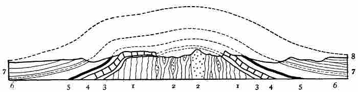 Fig. 18.—Ideal east-and-west section through the Black
Hills. The vertical scale is about six times the horizontal. The dotted
lines indicate the portion of the uplift removed by erosion. After Henry
Newton.
Fig. 18.—Ideal east-and-west section through the Black
Hills. The vertical scale is about six times the horizontal. The dotted
lines indicate the portion of the uplift removed by erosion. After Henry
Newton.By reference to the accompanying generalized section through the Black Hills, which as the uplift is rudely circular would be essentially the same if taken in any direction through the elevated region, it will be seen that there is a central core of slate, schists, and granite which has been forced upward so as to stand in its present eroded condition; it rises well above the surface of the adjacent plateau. About this central core the upturned edges of the sedimentary rocks form concentric zones, the oldest in the series being next the schists, and the youngest 10 to 40 or 50 miles distant. It is the presence in the central part of the hills of an area of resistant crystalline rocks which have weathered into rugged forms, and the series of encircling and concentric belts of rock of varying degrees of hardness and solubility, that has given to the uplift its present peculiar relief and its generally beautiful scenery. The edges of the harder belts form bold hills and ridges, while the softer belts have been eroded into valleys. This series of sharp-crested ridges and intervening valleys forms concentric circles 118 completely surrounding the central group of rugged mountains. The largest and most interesting of the ring-like valleys is underlaid by red sandstone, and is remarkable for its flaming colour as well as for its exceptional form. In this Red Valley one may ride entirely around the rugged central mass of the hills, on a generally level surface, which is inclosed on its outer border by a precipitous wall of yellowish sandstone and shale 300 or 400 feet high. The distance about this "race-course," as it is sometimes termed, is about 200 miles. This series of concentric ridges and intervening valleys, surrounding a high and rugged region of more resistant rock, furnish an admirable illustration of the influence of rock texture, hardness, etc., on topography.
Another instructive geographical lesson afforded by the Black Hills is the manner in which the portion of the dome rising above the level of the rivers which flow across the surrounding plain has been dissected by stream erosion. The streams originating in the central portion of the uplift flowed outward in all directions, and have cut deep narrow gorges through the ridges of hard rock in the base of the truncated dome. Some 20 streams originating in the central portion of the uplift cross Red Valley and escape through notches in its outer wall, about 16 of which are well-defined gateways leading to the encircling plateau. This is one of the most beautiful and most instructive examples of consequent drainage—that is, of streams whose direction has been determined by the inclination of the surface over which they flow—thus far discovered. Still another feature of much geographical interest is furnished by the rivers on the adjacent plain, two of which, branches of the Cheyenne River, cross the north and south extensions, respectively, of the Black Hills dome. These streams flow directly across the arched strata, in cañons of their own making, and, as explained by G. K. Gilbert, are illustrations of superimposed drainage—that is, the portions of the dome crossed by the branches of the Cheyenne after the rocks were upheaved were covered by soft horizontal lake beds, over which the water flowed as consequent streams. The rivers deepened their channels and 119 cut through the soft cover of horizontal rock and into the arched beds beneath. The course of the streams initiated on the covering of soft beds were maintained, as the flowing water charged with sand cut downward into the harder, upturned beds beneath, and now, the covering of soft beds having been eroded away, the rivers flow directly across (or through) the flanks of the great arch, but are not deflected by it.
In the neighbourhood of the Black Hills, and especially about their northern and northwestern border, there are secondary hills formed by the upward protrusion of molten rocks into the generally horizontally stratified rocks underlying the plateau. These intrusions did not reach the surface in such a way as to form volcanoes, but were forced upward, raising domes above them, in which the structure is similar to that in the great Black Hills dome. These secondary domes have been eaten away by erosive agencies in varying degrees. In some of them, as the Little Sundance Hill, near the town of Sundance, Wyoming, the dome of stratified rock is unbroken, and no igneous rock is to be seen; other neighbouring domes in which the plutonic magmas rose higher have been eroded so as to expose the summit portion of the inner core; and in one instance, known as Mato Tepee, the uncovering of the plug of plutonic rock which caused the uplift is so complete that it now forms a prominent fluted column over 600 feet high above its immediate base.
Volcanic Mountains and Table-Lands.—In the south-central portion of the Great plateaus in southwestern Colorado and eastern New Mexico, there are several typical cinder cones with lava-flows associated with them, which impart novel topographic forms to the general monotony of the broad plateau surfaces. The highest of the extinct volcanoes in this region is Mount Capulin, situated in northeastern New Mexico, about 200 miles east of the Rocky Mountains, which rises 2,750 feet above the surrounding plain, and has an elevation of about 9,000 feet above the sea. At the summit of this conical mass there is a well-defined crater a mile in diameter. In the same region there 120 are several other similar volcanic cones, from which lava streams have descended. As has been pointed out by R. T. Hill, these are the most easterly volcanoes of recent geological age in North America. They were formed after the Tertiary rocks of the Llano were laid down.
The Raton Mesa, situated between Mount Capulin and the front range of the Rockies, is capped by a lava flow of more ancient date than the volcanoes just referred to, which has protected the softer rocks beneath from erosion, and now stands as a prominent table-land with precipitous borders.
To the west of the Continental basin is a vast cordillera composed of numerous mountain chains which extends from south-central Mexico northward to the Arctic Ocean, and in its broadest part is about 1,000 miles wide. As already explained, we speak of this region in its entirety as the Pacific cordillera, or less technically as the Pacific mountains. It is a highly complex group of mountain chains, each of which contains two or more distinct mountain systems; each system, again, is usually composed of many ranges, and each range is frequently made up of a multitude of ridges, peaks, buttes, mesas, etc.; there are also many plateaus more or less completely dissected by erosion, and broad valleys, as well as numerous cañons, gulches, ravines, arroyas, and other secondary topographic forms. This vast cordillera not only contains mountains produced by the folding of the rocks of the earth's crust, in a general way similar to the Appalachians in structure, but also upturned blocks many miles in extent, bounded by breaks or faults, and volcanic mountains, vast lava-flows, and elevations due to the injection of molten rock into the earth's crusts so as to elevate domes. In fact, scarcely any topographic form and no important geological structure that is known is lacking in this great family of mountains which dominates the western portion of the continent.
The Pacific mountains begin abruptly at the south, along a generally east and west line passing some 75 miles 121 south of the City of Mexico, where the precipitous border of the table-land of central Mexico overlooks a lower region to the south which is diversified by many volcanic mountains. But little accurate information is available concerning the geology and geography of Mexico, but in general, as is well known, there are three main mountain belts which traverse that republic. One of these mountain belts is adjacent to the Gulf of Mexico, and another is situated near the Pacific coast of the main portion of the republic, while the third forms the rugged and irregular axis of the peninsula of Lower California. Between the leading mountain belts of the mainland there are numerous short ranges and many nearly level-floored valleys. The general level of this inland region is in the neighbourhood of 6,000 feet, while the more prominent peaks and crests attain elevations of from 10,000 to 12,000 feet. The general trend of the main mountain belts, and of the numerous subordinate ranges, is about northwest and southeast. For this reason, and also because the valleys have become deeply filled with débris from the mountains, travelling in directions leading north and south is facilitated by the topography, while in passing from one coast of the republic to the other the rugged bordering mountain belts have to be crossed and detours made in order to pass around the central mountain ranges.
The more elevated portion of central and northern Mexico, together with the peninsula of Lower California, has an arid climate, to which many of the conspicuous features in the geography of the land are due. The precipitation over large areas is insufficient to maintain permanent streams, the vegetation is nearly all of a desert-like character, and several basins exist which do not drain to the sea. In the interior basins there are saline and alkaline lakes, and numerous dry lake beds or playas, which are whitened by saline efflorescences. The rocks exposed in the mountains are largely of sedimentary origin, but a characteristic feature is the geology, especially to the west, in the presence of extensive volcanic areas and lofty mountains of igneous rocks. 122
The Pacific cordillera begins in southern Mexico with a width of some 300 miles and broadens when traced northward. At the boundary between Mexico and the United States it has a width of fully 700 miles, but reaches its greatest breadth in the latitude of San Francisco and Denver, where it is about 1,000 miles across. In its better known, but as yet incompletely studied portion embraced within the boundaries of the United States there are several important subdivisions, such as the Rocky Mountain belt on the east; a less lofty, but yet rugged central region, termed the Great Basin, characterized by having a dry climate and by the fact that the streams do not reach the ocean; and a western mountain chain which includes the Sierra Nevada and Cascade Ranges. To the west of the mountains just named lies the great valley of California, and similar regions in Oregon and Washington occupied in part by Puget Sound. To the west, again, are the several ranges bordering the Pacific coast from Lower California to Vancouver Island, and termed in a general way the coast mountains. Each of the great divisions of the Pacific mountain region has its indefinitely known southern terminus in Mexico, and extends northward to beyond the Canadian boundary. As this central portion of the most westerly of the larger geographical divisions of the continent is well developed in the United States, and has there been more carefully explored than elsewhere, a review of its leading features will serve to give as good an idea of the entire Pacific mountain region as is now practicable.
The Rocky Mountains.—The limitations to the north and south of the region to which this name is more or less specifically applied are not well defined. Perhaps the most accurate statement at present permissible is that the Rocky Mountains begin at the south, in northern Mexico, and extend northward across the United States and Canada to near the shore of the Arctic Ocean. On the east it is sharply defined by its junction with the Great plateaus. Its western border, although less definite than the eastern, is easily traced, at least across the greater portion of the United States, by the marked contrast it presents to the geographical 123 conditions characteristic of the Great Basin region, but owing to the many difficulties met with in attempting to adjust and make use of the current nomenclature in classifying geographical regions more or less artificial boundaries have to be accepted. The Great Basin is so designated because it is a region of interior drainage—that is, it does not send any tribute to the sea. Its boundaries are therefore the crest-lines of the surrounding divides or water-partings. The Rocky Mountains, on the other hand, are defined as an elevated region, the boundaries of which are determined by relief and not by drainage. The basis of classification in these two instances is not the same, and one province overlaps the other. The streams flowing westward from the Rocky Mountains into the Great Basin—such, for example, as Bear, Provo, and Sevier Rivers in Utah—have their sources well within the Rocky Mountain province as defined by uplift, but yet lie wholly within the Great Basin province as defined by drainage. In spite of this inconsistency, geographers recognise as the western border of the Rocky Mountains the irregular and in part indefinite line where the elevated region breaks down and meets the broad level-floored valleys characteristic of the Great Basin. This line, or more properly belt of country, although indefinite at the south, may for convenience be taken as beginning at the head of the Gulf of California, and extending up the Colorado River for about 300 miles, to where that river makes an abrupt bend, turning southward after a westerly course through the Grand Cañon. From the locality indicated, the boundary passes through central Utah, and is sharply defined for most of the way by the bold western escarpment of the Wasatch Range. In the neighbourhood of Great Salt Lake the border of the mountain belt trends more and more to the northwest, crosses Idaho diagonally, and in northern Washington merges with or closely approaches the Cascade Mountains. In this northern region the border of the Rocky Mountains is again indefinite, and until the geological structure of western Canada is more thoroughly studied can only be located provisionally. 124
The unsatisfactory condition of the nomenclature at present applied to the larger topographic features of North America is illustrated by the fact that to the north of the United States-Canadian boundary the term Rocky Mountains is much more restricted than is the custom in the United States. In Canada this name is applied to the most easterly of the ranges or chains of the Pacific cordillera. This difference in the significance of the name referred to on the opposite sides of the international boundary is unfortunate, but is due in large part to our ignorance of the geography and geology not only immediately along the boundary line, but generally throughout the rugged region of the northwest portion of the continent.
One of the most important geographic features in the central part of the United States is the presence in Wyoming of a broad, generally flat, region known as the Laramie plateau (plains) and its extension westward across nearly the entire width of the Rocky Mountains. The general elevation of these "plains" is about 7,000 feet, or approximately 1,000 feet greater than that of the western border of the Great plateaus. The Laramie plateau and country to the west having a similar topography, furnished a convenient pass for the Union Pacific, the oldest of the transcontinental railroads, and divides the Rocky Mountain belt into two portions, which may be termed in a general way the northern and southern Rocky Mountains respectively.
To the north of the Union Pacific Railroad there are several important mountain groups, termed collectively the Stony Mountains by Lewis and Clark in the report of their bold explorations across the continent in 1804, but not generally used since that time. This name has recently been revived by J. W. Powell as a convenient term by which to designate this large division of the Rocky Mountain belt, but unfortunately is not recognised and has no significance to the north of the international boundary. What the natural limitations of the Stony Mountains may be in Canada remains to be determined.
The Stony Mountain system includes the Big Horn Mountains in north-central Wyoming, the sharp and lofty 125 Teton Range to the south of the Yellowstone National Park, and several other rugged uplifts of great extent in Montana and Idaho, and should the name be extended to the north of the international boundary until a natural limit is reached, it will include the Rocky Mountains of Canadian geographers (the most eastern of the great uplifts constituting the Rocky Mountain belt), together with the several ranges of the Gold Mountains. These several mountain ranges and groups of ranges appear to have diverse geological structure, but their histories are by no means thoroughly understood. Some of them, as stated by Powell, are carved out of broad folds, and involve both originally deeply seated igneous and metamorphic rocks and upturned and folded sedimentary beds; while others are due to movements along lines of fracture and in part of overthrust.
The Stony Mountains form a portion of the continental divide which parts the waters flowing to the Pacific from those that find their way to the Atlantic. The thousands of streams tributary to the Missouri head against the equally numerous fountains supplying the westward-flowing Columbia. The broad valleys between the several ranges have a general elevation of between 7,000 and 8,000 feet, and the bold, massive mountains rise from 10,000 to over 13,000 feet above the sea. Owing to the considerable elevation even of the valleys, and the northern position of the region here considered, as well as its distance from the equalizing influence of the sea, the extremes of climate are strongly marked. The summer season is comparatively short, and in the valleys the heat is intense (ranging from 90° to 112° F.) and the rainfall small or none at all, while the winter season is cold (temperatures of from -15° to -30° F. being frequent) and accompanied by an abundant snowfall, especially on the mountains. Agriculture, although carried on in the valleys, is of comparatively small importance, and is usually dependent on irrigation. The mountains are snow-covered through much of the year, and small glaciers occur about the lofty summits of the Teton Range and on the mountains near the international boundary and in Canada. The valleys are generally destitute of trees except 126 along the streams, where white-trunked cottonwoods spread their green leaves in summer and become a tracery of golden yellow in the autumn, marking the courses of the life-giving waters. The lower mountain slopes are covered with dark forests of pine, spruce, and juniper, which increase in density and extent as one follows the ranges northward until the influence of the high northern latitude is felt, and in northern Canada the zone of the subarctic forest is reached.
In the central part of the Stony Mountains is situated the justly famed Yellowstone National Park, which is truly remarkable for its fine scenery, its deeply carved and gorgeously colored cañons, and most of all for its numerous hot springs and spouting geysers. This is the only geyser region on the continent, and the most extensive of the three now existing in the world.
The finest scenery of the northern division of the Rocky Mountain belt lies to the north of the international boundary, and within recent years has been rendered accessible by the building of the Canadian Pacific Railroad. It is in this region that the mountains are highest, most rugged, and clothed most completely with the dark, sombre, evergreen northern forests. Here, too, high up among the bare serrate mountain tops, and mostly above the timber-line, are found the largest of the glaciers in the Rocky Mountain belt. This wonderful region of rugged mountains, deep and formerly glacier-filled valleys, impetuous rivers, and dense forests has only recently become known to the world at large. Vast areas, no doubt as attractive as those about Banff, Lake Louise, Glacier House, etc., already famous, remain to be discovered and described.
In the fastnesses of these wild northern Rockies moose, elk, deer, bear, mountain-sheep, and mountain-goat still abound. The buffalo (bison) is protected in the Yellowstone National Park, and will probably be preserved from extinction. A small herd also survives in Canada. The streams, except those flowing from glaciers, are bright, clear, and swift, and are well stocked with fish. The trout, represented by several species, there finds the cool retreats so essential to its life. To the sportsman and 127 skilled angler the northern Rockies are a paradise. Among the lofty mountains and in the larger valleys there are many lakes, more especially in northern Idaho and Montana and in Canada. Many of these, and particularly those near the heads of the valleys and about the more lofty peaks, are true rock-basin lakes, worn out by the grinding of sand-charged glacial ice when the glaciers were far more extensive than now. The large lakes situated in the trunk portions of the broad-bottomed valleys are in many instances retained by dams of glacially deposited detritus and record the changes in the aspect of the land inherited from the Glacial epoch. These numerous lakes present a vast variety of scenery, and in many instances reflect from their placid mirror-like surfaces as beautiful and inspiring pictures of rugged grandeur as can be found in the world. The natural beauties of the classical lakes of Switzerland and Italy are rivalled by many of the charming water bodies of the northern Rockies, which but few men appreciative of the beauties of nature have ever seen.
To the south of the Laramie plateau the mountains of the Rocky Mountain system are more irregular and more lofty than those to the north of that break. The many rugged ranges in southern Wyoming, Colorado, and northern New Mexico form a great group, to which the name Park Mountains has been applied by J. W. Powell. The several ranges composing this group have a general north and south trend, to which, however, an exception is furnished by the Uintah Mountains in southwestern Wyoming and eastern Utah, which consists of a deeply dissected east and west fold or broadly uplifted plateau. Intervening between several of the adjacent ranges there are wide, nearly flat-bottomed valleys, which owe their leading characteristics to the deep filling of depressions by débris carried from the bordering mountains by the wind and streams. These broad valleys surrounded by rugged peaks are known as parks, and the numerous ranges among which they are situated are hence designated the Park Mountains. The term by which the valleys are known is in some respects misleading, as the word park usually carries the idea of a diversified 128 and in part forested region, with mild, picturesque scenery. Perhaps a city park or the beautiful rural estates of England are most usually brought to mind when the term referred to is mentioned. But in the great mountains of the central portion of the continent one's idea must expand to keep in harmony with his surroundings. The natural parks of that region are broad, generally treeless, valleys with winding streams, the uplands are grass-covered and rolling, and in distant views the courses of the streams are marked by narrow belts of verdure. The picture is framed by a succession of mountain domes and embattled cliffs. Over all arches the dark blue, cloudless sky of a nearly rainless region. In the clear air distances are deceptive, and what appear to be miles to the novice must be extended to leagues in order to acquire adequate conceptions of the magnitude of the scene.
The most famous of the great tracts of generally level land surrounded by the high ranges of the Park Mountains is San Luis Park, situated in southeastern Colorado and extending southward into New Mexico, which has a length from north to south of about 130 miles, and is from 20 to nearly 40 miles wide. Its general elevation is between 7,000 and 8,000 feet. This great valley, level-floored with soft deposits swept in from the bordering highlands, and almost completely surrounded by rugged mountains, although more desolate than the majority of the numerous similar valleys in the same region, is typical of its class. The Rio Grande winds through its entire length and many streams rising in the bordering mountains flow to the valley during the winter season, but in summer, owing to the high temperature, active evaporation, and small rainfall, only a few of the larger of these mountain-born torrents reach the main, southward-flowing river. In the southern portions of the valley large areas are covered with drifting sand, which is fashioned by the winds into ever-changing dunes of a creamy whiteness. Some of the streams from the mountains expand on the plain and form the San Luis lakes, from which the water escapes by evaporation, thus causing them to become alkaline. The land bordering the lakes is whitened 129 as with snow by saline incrustations. On the lower portion of the rim of this mountain-inclosed basin there are scattered groves of pines and junipers, and at higher elevations the mountains are dark with forests. The more lofty peaks, however, rise far above the upper limit of the forests and are rugged and magnificent even under the glare of a cloudless sky.
To the east of the San Luis Park, and rising about 7,000 feet over it, and over 14,000 feet above the sea, stands Sierra Blanca, one of the finest of the many majestic mountains of Colorado. In summer immense cloud banks frequently gather about this cold, isolated peak, and local storms, accompanied by fierce lightning and echoing thunder, beat upon its shrouded sides. These tempests raging on the mountain top, while the adjacent valleys are flooded with sunlight, recall the scriptural accounts of the storms of Mount Sinai. In fact, the southwestern portion of the United States and the adjacent region in Mexico, so far as scenery and climatic peculiarities are concerned, have much in common with Palestine.
The other great parks in Colorado, which have suggested a name for the group of mountains in the midst of which they are sheltered, are less arid and less desert-like than the one just described; but like it, derive their magnificence and fascination from their vast extent, the sublimity of the bordering mountains, and the wonderful transparency of the air above them, rather than from the topography of their nearly level floors or the vegetation that strives ineffectually to clothe their nakedness.
The individual summits as well as the separate ranges composing the Park Mountains are remarkable for their massiveness and the great height of their bare rounded summits rather than for picturesque details. Several of the peaks are among the highest in the United States. One conspicuous feature is the considerable elevation of the valleys, usually over 7,000 feet, and the large number of lofty summits. Of the peaks that have been measured, over 30 exceed 14,000 feet in height. The portion of the Park Mountains above an elevation of 10,000 feet, as is indicated 130 on the map reproduced on page 65, is far greater in area than any other region of similar altitude on the continent.
In the Park Mountains, and generally throughout the southern Rockies, even to central Mexico, the forms that meet the eye are the remnants of vast upheaved folds and domes of the earth's crust sculptured and degraded by erosion. The nearly horizontal rocks of the Great plateaus on meeting the eastern border of the mountains are bent abruptly upward, and in many places stand on edge or have been overturned so as to dip westward. This abrupt upward bending and the presence of remnants of the same beds on the summits of some of the higher mountains shows that the strata have not been simply folded into anticlinals and synclinals, but that there has been a thickening and upswelling of the rocks beneath.
In the northern Rockies, except in western Idaho and adjacent portions of Washington and Oregon, evidences of recent volcanic activity are rare, although igneous rocks cover great areas, and in the Yellowstone Park numerous geysers and hot springs bear evidence to the presence of abnormal heat in the earth's crust. In the southern Rockies, however, volcanic mountains which still preserve their forms are numerous in certain regions, and in Mexico there are mighty volcanic piles and many lesser elevations built up by extrusion of molten material, some of which are still active. Examples are furnished of volcanic mountains ranging from perfect cones with curved slopes typical of the forms produced by the piling up of various sized fragments about the vents from which they were extruded, to irregular serrate peaks which reveal the anatomy of the dissected volcanic masses, and even the dikes which remain after the surface elevation of a volcano has been removed. The most modern volcanoes in this great group of mountains are situated in central Mexico, but others nearly as perfect in form occur in New Mexico and Arizona, and in the plateaus to the east of the Park Mountains. The Spanish peaks in southeastern Colorado are instructive illustrations of the topographic forms produced when a volcanic mountain has been deeply dissected. 131
In the formation of volcanic mountains there is an extrusion of molten and fragmentary material accompanied by an escape of great volumes of steam at the surface. Closely related to this phase of vulcanism is the injection of molten material into the earth's crust from below, so as to force its way between stratified beds and produce intruded sheets. In this latter process the sheets of injected material may be thin in comparison to their lateral extent or thick lens-shaped masses. In the production of either of these forms of intrusion the cover above the injected material is lifted and a change is made in the topography of the surface. The intrusions, which are thick in comparison to their lateral extent, are known as laccoliths. At times intrusions of this nature are of such thickness that they produce true mountain forms. If unmodified, these elevations would be domes, but when their surfaces are broken by erosion and their dissection and removal progresses they frequently assume rugged, serrate forms.
The type of laccolithic mountains made known some years since by the studies of G. K. Gilbert is furnished by the Henry Mountains, in southern Utah. More recently it has been found that this interesting phase of mountain building is illustrated by many other examples in the Rocky Mountain region and elsewhere.
The rocks exposed at the surface in the southern Rockies, as in the northern division of that great chain, embrace almost every variety which enters into the composition of the earth's crust. The central cores of many of the now deeply eroded ranges consist of granite and other similar rocks, and are surrounded by sedimentary beds which range in age from the oldest stratified rocks now known to the youngest. Igneous rocks in great variety and in all forms incident to an extruded or volcanic and intruded or plutonic origin are present. The many disturbances that have occurred have led to the formation of mineral veins and the impregnation of rock masses with ores of various kinds—such as gold, silver, lead, copper, etc.—which have been mined with great success at many localities. 132
The High Plateaus.—To the west and south of the Park Mountains, and situated in the western portions of Colorado and New Mexico, eastern and southern Utah, and northern Arizona, there is an extensive region having a general surface level of 6,000 to 7,000 feet above the sea, known as the High plateaus. This region has suffered great erosion and is deeply trenched by stream-carved cañons. Although not mountainous in the ordinary acceptance of the term, its surface is rugged and difficult to traverse, particularly on account of the deep cañons that intersect it in every direction.
The High plateaus are a part of the Rocky Mountain region and bear a somewhat similar relation to the Park Mountains that the Alleghany plateau does to the Appalachian Mountains. Streams flowing westward from the Park Mountains and from the southwestern portion of the Stony Mountains unite to form the Colorado River—the one great drainage channel of the region. The importance of this remarkable river in the history of the land has led to the adoption of the name Colorado plateau by Powell and others for the region under consideration. As with so many of the grander geographical units of the continent, the precise limits of the one here considered are difficult to define; but in spite of this uncertainty as to meets and bounds, the now classical writings of Newberry, Powell, and Dutton especially have shown that a strange and wonderful land exists in the southwest part of the United States, which is of unusual interest to geologists and geographers.
The High plateaus are underlaid by nearly horizontal rocks. The larger elements in the structure are great blocks of the earth's crust measuring some 60 to 100 miles on their various borders, which are bounded by breaks (faults), or by what are termed monoclinal folds or a change from one plateau to another by a single bend in the strata. The rocks in each of the separate plateaus are usually gently tilted. Their eroded edges stand as lines of massive, gorgeously coloured, and frequently fantastically sculptured cliffs. These cliffs, when seen from below, appear as rugged mountain ranges, but to an observer standing on 133 their deeply sculptured crests are easily recognised as the upturned edges of large gently tilted blocks of the earth's crust.
The basement rocks beneath the High plateaus are very ancient granites, schists, etc., which formed a land surface and were greatly eroded before the first of the superimposed stratified beds were deposited upon them. The first of the sheets of sediment laid down by the primeval ocean belong to the oldest rocks containing records of life that have as yet been recognised—the Algonkian (pre-Cambrian) terranes of modern geology. Above these come other deposits of sandstone, shales, limestone, etc., representing a wide range of geological history, and including as the upper member of the series the sediments of large Tertiary lakes. This vast succession of stratified rocks, some 13,000 feet in thickness, has been upraised in a broad way, without the crumpling and folding, but broken, as stated above, into great blocks which are now variously inclined, but still preserve a plateau-like character.
Besides the movements in the earth's crust which raised the plateaus and caused fractures and simple or monoclinal folds in the rocks of which they are composed, there occurred volcanic eruptions which produced numerous cinder cones, extensive lava-flows, and widely spread sheets of comminuted material known as lapilli, dust, and so-called ashes.
Although the history recorded in the rocks forming the High plateaus is one of fascinating geological interest, the easier and more obvious lesson that the region has to offer, more especially to the geographer, has been engraved and etched on its surface by streams and wind-blown sand.
On the High plateaus the rainfall is comparatively small, and the streams originating there mostly ephemeral. But on the mountains to the east and north the precipitation is more abundant and rivers are formed which flow across the plateau region. The Green and Grand Rivers, fed by many tributaries, unite to form the Colorado, which flows southwestward for some 700 miles and discharges its muddy waters into the Gulf of Lower California. This great river 134 year by year and century after century has deepened its channel through the plateau region where the rainfall is small, more rapidly than the general surface has been lowered by erosion. The main conditions are a broad area of nearly horizontal rocks, raised high above the sea or above the base level of erosion, and an arid climate; crossing this region is the ever-flowing river, which, acting like an endless saw, cuts deeper and deeper into the blocks of the earth's crust which have been raised athwart its course. Resulting from these conditions is a mighty trench or cañon, which is by far the most magnificent of its kind in North America, if not in the world. Not only has the main river sunken its channel into the earth to a depth of more than a mile throughout a large portion of its course, but each tributary stream has been engaged for a long period of time in a similar task. Although most of the streams originating on the surface of the plateaus are ephemeral, they work rapidly when the occasional heavy rains flood their channels. This deepening of the stream channels, while their borders and the intervening portions of the plateau surface suffered but comparatively slight erosion, has produced a wonderful system of deep steep-sided trenches in the borders of which the edges of the dissected rocks are exposed in nearly vertical precipices.
Aside from the lessons of interest to the geologist and geographer so plainly engraved on the surfaces of the plateaus crossed by the Colorado, the region has a wonderful fascination for the purely æsthetic feelings more or less latent in every human breast. To one traversing the open pine forests, in places clothing the plateaus and inclosing many grassy glades and flower-decked parks, in which timid deer may frequently be seen feeding in the early morning, and emerging on the brink of the Grand Cañon, the scene that meets the eye is marvellous beyond all description. C. E. Dutton, to whom we owe some of the most graphic and inspiring descriptions of natural scenery ever written, states that those who have long and carefully studied the Grand Cañon of the Colorado do not hesitate for a moment in pronouncing it the most sublime of all earthly 136 spectacles. "If its sublimity," writes Dutton, "consisted only in its dimensions, it could be sufficiently set forth in a single sentence. It is more than 200 miles long, from 5 to 12 miles wide, and from 5,000 to 6,000 feet deep. But it is not magnitude alone that gives this marvellous cañon its prominence; it is the gorgeous and varied colouring of its mighty walls, the endless details in the sculpturing of its battlements and towers, the ever-changing atmospheric effects of its profound depths, and the wonderful stimulus to the imagination with which it feeds the mind. Standing on the brink of the Grand Cañon, the prosaic search for causes and effects for a time at least must be laid aside, and give place to the emotions."
Wonderfully grand as are the scenes beheld in traversing this region of high plateaus, with its magnificent cliffs and profound cañons, one is constantly reminded that it is an arid land. The higher portions of the plateau, it is true, are in places forested, but over vast areas the rocks are bare. Water is everywhere scarce except in the bottom of the larger excavations. Thirsty, and perhaps perishing, the traveller, Tantalus like, looks down on the shining silvery threads of water in the cañons, hundreds and even thousands of feet below, but separated from them by impassable barriers. To the south the plateaus descend to the desolate valleys of southern Arizona, where strange gigantic cactus-plants and scattered clumps of thorny shrubs alone break the dreary monotony of the hot gravelly deserts. Agriculture is there impossible without irrigation, but where the life-giving waters can be utilized, as in the Gila Valley, marvellous productiveness follows.
To the west of the Rocky Mountain belt in the United States there exists a region embracing about 210,000 square miles, which sends no stream to the ocean. This vast and in large part desert tract is known as the Great Basin. The climate is characterized by its aridity. The annual precipitation is small and evaporation active. All the water 137 reaching the land is returned to the air by evaporation, either directly or from the streams and lakes. Many of the lakes do not overflow and are more or less alkaline and saline, while some of them, as Great Salt Lake, Utah, and Mono and Owens Lakes, California, are dense with mineral matter in solution.
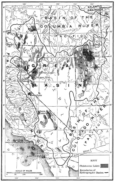 Fig. 20.—The Great Basin.
The Great Basin is not a single level-floored depression, as one might infer from its name, but is traversed by rugged mountain ranges, which divide it into a large number of minor valleys. Some of these secondary basins have lakes and streams which escape from them into lower depressions, but in many instances under present climatic conditions they have no surface water, all the moisture that reaches them being absorbed by the thirsty soil or evaporated without forming lakes. The Great Basin proper, as it may be termed, embraces nearly the whole of Utah and Nevada, together with small portions of the southern parts of Idaho and Oregon and a large area in southeastern California. While the drainage conditions limit the application of the name to this group of associated basins which send no tribute to the sea, the climatic and to a less extent the topographic and geological conditions that characterize it have much wider, although indefinite boundaries. This wider region which resembles the Great Basin proper, extends from British Columbia southward to beyond the city of Mexico, and includes the eastern half of Washington and Oregon, a large part of Idaho, and much of Arizona, New Mexico, and western Texas. In this outer region both to the north and south of the Great Basin proper there are drainless valleys, as those of central Mexico, in which the conditions characteristic of the desert valleys of Utah and Nevada are repeated.
The greater region of arid valleys and desolate mountains surrounding the Great Basin proper is crossed at the north by the Columbia and in the central part by the Colorado. Each of these large rivers has its source in the Rocky Mountains and flows to the Pacific.
The most obvious features of the Great Basin and of the northward and southward extensions of the belt of country 139 having much in common with it, depend on climatic conditions. The rainfall is small throughout the entire belt from the Canadian boundary to south-central Mexico. The average mean annual precipitation, judging from such observations as are available, is probably less than 15 inches, but this broad statement does not truly represent the diverse conditions. The rainfall is confined almost entirely to the winter season, and frequently comes in short heavy downpours. During the summer season, the valleys especially, become so parched that only such plants can grow as are adapted to long-continued droughts. The topography is rough and diversified by many mountain ranges, and the precipitation is more abundant on the uplands than in the valleys. Over large areas in Nevada and southeastern California the mean annual rainfall is less than 5 inches. The author, while carrying on geological work in this region, was informed by some of the older settlers that at times for fully eighteen consecutive months no rain whatever fell in certain of the valleys. From the accounts of travellers in central Mexico, it seems as if some of the interior basins in that region must be fully as arid as those just referred to.
One conspicuous result of the lack of moisture is the absence of forests. Except on the mountains mainly at the north the Great Basin and its extensions, as defined above, is nearly destitute of trees. The valleys are in many instances thickly covered with desert shrubs, notably the sage-brush, but the floors of the driest basins are in many instances almost absolutely without vegetation, and are frequently white with saline incrustations.
Many of the depressions in the Great Basin, as well as some of the outlying valleys referred to, have rivers and lakes which exhibit certain interesting features that are unfamiliar to people dwelling in humid lands. The streams are fed in part by the small precipitation on the desert valleys, and by springs, frequently of heated water, but mainly by the rain and melting snow on the mountains. Many rills and rivulets are born on the valley sides of a single storm, but are absorbed by the thirsty soil or evaporated during the succeeding hours of sunshine. Other streams 140 have a greater lease of life and flow down to valleys and basins, suffering evaporation and absorption as they progress, which cause them to diminish in volume, and finally to vanish. The stronger streams, such as Sevier and Bear Rivers in Utah, the Humboldt River in Nevada, and the Truckee River in California, maintain their existence throughout the year, and expand into lakes in which the inflow is balanced by evaporation.
The lakes of the Great Basin present even greater diversity than the streams. Some of those situated principally in the mountains are of pure, limpid, wholesome water, supplied by cool, sweet brooks and rills or by the melting of the winter's snows, and overflow throughout the year. These lakes, usually of small size, are similar in all respects to the ordinary lakes of humid lands. In eastern Utah, adjacent to the west base of the Wasatch Mountains, the Provo River and other streams supply Utah Lake, the outlet of which, the Jordan River, empties into Great Salt Lake. Utah Lake is well within the Great Basin, and situated at a low elevation for the region, namely, 4,500 feet, or about 280 feet (in 1873) above the level of lake of brine into which it discharges. This is the largest of the fresh lakes in the valleys of the Great Basin, and owes its existence to the fact that a depression there occurs which is filled to overflowing by the streams from the mountains. Bear Lake, in northeastern Utah, is another exceptional example of a fresh lake of considerable size at a comparatively low altitude, in the same region. On the western rim of the Great Basin, at an elevation of 6,247 feet, and surrounded by the forested peaks of the Sierra Nevada, lies Lake Tahoe, "the gem of the Sierra," a water body of remarkable purity, which discharges through Truckee River into Pyramid and Winnemucca Lakes. These lower lakes, situated in desert valleys at an elevation of 3,780 feet above the sea, are without outlets and alkaline and bitter. The most characteristic lakes of the Great Basin, however, are those that do not overflow, and on account of concentration by evaporation are more or less highly charged with mineral matter in solution. These saline and alkaline lakes may be 141 divided into two classes, in reference to their duration, but the line of separation is indefinite. Certain of them have maintained their existence for many years, and probably have not been evaporated to dryness for several centuries, and may be classed as perennial lakes; others are evaporated to dryness each year, or during certain exceptionally dry and hot seasons, and may be termed ephemeral lakes. In many instances the beds of the ephemeral lakes are normally in a state of desiccation, and appear as broad, level, mud plains, usually with a white fringe of saline matter. Frequently these mud plains, or playas, as they are termed, are transformed into shallow lakes during a single storm, but the waters are absorbed by the clays beneath or evaporated within a few days or perhaps a few hours after the rain ceases. The largest and most characteristic of the perennial saline water bodies is Great Salt Lake, the counterpart in many ways of the Dead Sea. The streams discharging into this salt sea have the usual purity of river-waters, and carry but a small fraction of one per cent of saline matter in solution. The lake is supplied also in part, but to an unimportant extent, by springs, the most of which are of essentially fresh water. The source of the salts which make the waters of the lake a brine is evidently, therefore, the small percentage of mineral material brought in by the tributary streams. After reaching the lake these fresh waters, in the ordinary meaning of the term, are concentrated by evaporation. This is the explanation of the leading facts in the chemistry of all of the saline and alkaline lakes of the Great Basin region, such as Pyramid, Winnemucca, and Walker Lakes in Nevada, Mono and Owens Lakes in California, and the saline lakes of Mexico.
The volume of a lake without an outlet, or an "inclosed lake," is determined mainly by the ratio of the inflow (including the rain falling directly on its surface and the tribute from springs) and evaporation. Its volume, and consequently its area, fluctuates from season to season, and frequently varies also during periods embracing several years. With variations in volume there are fluctuations in the percentage of saline matter in solution, even if precipitation of 142 one or more of the contained salts does not take place during the periods of more than usual concentration. In most instances inclosed lakes are concentrated by evaporation in summer seasons, and perhaps become nearly saturated solutions, but are diluted during the rainy winter seasons. Fluctuations in volume, area, depth, salinity, etc., are thus characteristic of inclosed water bodies. They are sensitive to climatic changes which ordinary weather records fail to detect, and are modified in a conspicuous manner when the country about them becomes inhabited and irrigation is practised.
Some of the lakes of the Great Basin are dense brines from which various substances are being precipitated. The economic importance of these natural reservoirs of brine and of various soda salts is great, and will become more and more important as transportation facilities increase. Great Salt Lake, it has been estimated, contains 400,000,000 tons of common salt and 30,000,000 tons of sodium sulphate in solution. During the past ten years about 40,000 tons of common salt have been harvested from it annually. Mono Lake contains some 245,000,000 tons of saline matter in solution, of which about 92,000,000 tons are sodium carbonate and bicarbonate. Owens Lake is similar to Mono Lake in composition, and is now the basis of a large soda industry.
A marked difference between a region which drains to the ocean and one where the streams enter inclosed basins where their waters are evaporated is that in the former the waste from the land carried by the streams as an invisible load in solution or as a visible load consisting mainly of silt and sand in suspension is contributed to the ocean and widely distributed before being deposited—much of the material in solution, in fact, may be said to be a permanent contribution to the salinity of sea-water; but in most instances where streams enter inclosed basins all of the material contributed both in solution and suspension is sooner or later precipitated. The area within an inclosed basin, on which the inflowing streams lay down their loads, is as a rule less extensive than the area that is being denuded to 143 supply the material. The receiving basins are thus filled in or aggraded, and there is a concentration both of the mechanical wash from the land and of the substances taken in solution by the waters of streams and springs. A marked result of this process of concentration, particularly of the fine waste of the uplands and mountains, is seen in the approximately level floors of inclosed valleys. Throughout the Great Basin the valleys have been filled to a depth in many instances of hundreds of feet. Some of the lower mountain ranges in Utah have been so nearly buried beneath these valley deposits that only their summits, termed lost mountains, appear above the even surface of the desert plains. This débris, deeply filling the valleys referred to, is usually a fine yellowish dust-like material, similar in many ways, and probably in mode of origin, to the loess of China in which geologists have taken much interest. With the concentration and deposition of the fine mechanical wash of the uplands there has also been a concentration of the more soluble saline constituents of rocks, which causes the soils of arid regions to differ in an important way from those of humid lands. The leached and characteristically red-tinted soils of warm humid countries, consisting of the oxidized residue of deeply weathered rocks, are absent from arid regions; in their place we find minutely disintegrated, usually light-coloured, and not chemically impoverished soils. In warm humid regions chemical decay of the rocks is the conspicuous feature; in equally warm arid lands mechanical disintegration is carried to an extreme, without the removal of the more soluble constituents. In fact, concentration of saline matter, notably common salt, sodium sulphate, gypsum, etc., is one of the functions, so to speak, of arid climates, when the requisite evaporation basins are present. Among the important industries of the Great Basin region is the gathering and purifying of the various salts contained in the existing water bodies and in the basins of desiccated lakes.
In addition to the characteristics of the region referred to above, which are mainly the result of climatic conditions, the Great Basin has certain geological features, in 144 the main, so far as North America is concerned, peculiar to itself. The leading structural features of the rocks, so far as they find expression in the surface relief, is the presence of a large number of extensive faults trending in general about northeast and southwest. These faults are breaks or cracks along which the rocks have been moved up and down. One side of a fault sometimes stands higher than the opposite side, and forms a narrow and frequently high and rugged mountain range. The number of these faults within the Great Basin is as yet unknown, but they certainly number many hundreds. In a cross profile of the region between the Wasatch Mountains on the east and the Sierra Nevada on the west the number of mountain ridges due to faulting is at least a score. The precipitous western border of the Wasatch Mountains is itself a great fault scarp, as is also the eastern border of the Sierra Nevada. The faults that determine the steeper sides of these mountain ranges are not to be considered as single clean-cut gashes, but as irregular and intersecting fractures traversing a narrow belt of country. The faults referred to divide rocks of all ages, and are evidently due to the most recent disturbances that have affected the region. It is not probable that the break in any given instance was formed all at once. Such vast convulsions would be out of harmony with the rules of nature. But rather many small movements and adjustments of pressure have occurred along the same belt of fracture. This conclusion is sustained by the fact that many of the faults have experienced movements in very recent times. In places fault scarps a score or more feet in height cross the alluvial cones at the mouths of the small high-grade valleys in the mountains. These scarps in loose unconsolidated gravel and similar material, even under an arid climate, could not be expected to preserve their freshness for many years. At times the breaks cross the courses of streams and cascades, and rapids are formed by the waters flowing down escarpments thus produced in loose material. One characteristic fault scarp in Inyo Valley, California, is known to have been formed during an earthquake that shook that portion of the country 145 in 1872. The many small earthquakes that have been felt in the Great Basin region are believed to have been caused by slight movements along the breaks that traverse the region. This and other evidence indicates that the faults to which so much of the characteristic scenery of the Great Basin is due have grown by repeated minor displacements, and that such movements are a common cause of earthquakes.
The most conspicuous topographic features of the better known portion of the Great Basin are long, narrow, and frequently sharp-crested ridges, with a gentle slope on one side and a steep escarpment on the other. The steeper side in a large number of instances is known to be the upraised side of a fault. Each of these basin ranges, as they are termed, may be considered as the upturned edge of a block of the earth's crust, in general from 60 to 100 or more miles long, and 10 to perhaps 20 miles wide. The crest-lines of the tilted blocks are frequently serrate, on account of differences in the hardness and texture of the rocks and the effects of weathering. There is frequently, however, an older structure revealed in them, showing that the region was folded and otherwise disturbed previous to the later movements which produced the leading features in the present topography. It is probable that this older structure in some instances has had an important bearing on the forms of some of the ranges, but our knowledge in this direction is too limited to warrant presentation in a popular treatise.
Many of the basin ranges are imposing on account of their height and ruggedness, when seen from the adjacent, deeply filled valleys, although scarcely more than half of their actual elevation above the sea is revealed from such points of view. Exceptions to this general statement occur, however, in southeastern California, where, in Death Valley, the land is 480 feet below sea-level. This is the only region in North America which, like the basin of the Dead Sea, is below the level of the ocean's surface. On the border of Death Valley the mountain ranges rise from 6,000 to 10,000 feet, and the highest summit, known as Telescope 146 Peak, is reported to have an elevation of nearly 11,000 feet above the sea. In the central and northern portions of the Great Basin the valley floors have a general elevation of from 5,000 to 6,000 feet. The mountains rise from these valleys to a height of from a few hundred to 4,000 or 5,000 feet. Among the highest, if not actually the culminating peaks well within the Great Basin are White Mountain, on the California-Nevada boundary, about 30 miles southeast of Mono Lake, which has a summit elevation of 13,000 feet, and Jeff Davis Peak, in eastern Nevada, which rises 13,100 feet above the sea and 8,000 feet above the adjacent valleys.
The numerous sharp-crested ranges of the region under review are frequently remarkable for the richness of the colours of the naked rocks. The mountain slopes and towering angular summits when outlined against the morning or evening sky are frequently as brilliantly dyed as are the New England hills when clothed in the harlequin foliage of autumn. Before sunrise and after sunset each serrate crest-line is the sharply cut border of a silhouette of the deepest and richest purple. The diversity of scenery in the Great Basin is increased by mountains of volcanic origin, including several modern craters, some of which hold lakes, and by lava-flows of recent date, and by great alluvial fans or detritus cones which stream out into the valleys from the mouths of gorges in the bordering mountains.
The Great Basin proper, with its rugged topography and arid climate, is not an agricultural region. Small portions of it, however, when water can be had for irrigation, have been transformed into fruitful farms and gardens which yield bountiful returns. But even a century hence, when all has been accomplished in the way of reclaiming the arid valleys that can be done by utilizing the available water for irrigation, only a small per cent of the whole will be under cultivation. 147
To the west of the Great Basin, and extending from southern California northward to beyond the United States-Canadian boundary, there is a lofty and extremely rugged belt of mountains consisting of two ranges—the Sierra Nevada at the south and the Cascade Mountains at the north. Topographically, these two ranges form a single elevated belt of country, but custom, and as is now generally understood the geological structure and history, draws a dividing line between them in northern California. The Sierra Nevada-Cascade range extends far into Canada, and is there known as the Coast Range. No adjustment of the nomenclature in use on the two sides of the international boundary has been made, and in order to conform with current usage, it is necessary to consider separately the two portions of the range on opposite sides of the forty-ninth parallel.
The Sierra Nevada has its southern terminus at Tejon Pass, in southern California, and extending from there northward to Lassen Peak, in the northern part of the same State. With the exception of a small area to the east and north of Lake Tahoe, the entire range is included within the boundaries of California. This is geographically one of the best defined of the larger mountain ranges in the United States. Its eastern border especially is easy to trace, as for the most part it is determined by a great escarpment, corresponding to the fault scarp which borders one side of so many of the basin ranges. The Sierra Nevada, in fact, may be considered as one of the basin ranges of great size and forming the western wall of the region of interior drainage lying to the eastward. This abrupt eastward-facing mountain slope is in reality a great fault scarp, formed mainly by the upheaval of the west side of an intersecting system of fractures. It is not known, however, how much of the escarpment is due to the upheaval of the west side of the belt of fracture, or how much to the sinking of the eastern side. There have no doubt been many up and down movements along this belt, of which 148 the present mountain wall is the algebraic sum. The escarpment rises in general from 5,000 to 6,000 feet above the desert valleys to the eastward, and reaches a maximum of about 14,000 feet in the vicinity of Death Valley. It is exceedingly precipitous and rises to an irregular serrate crest-line, from which the general slope westward to the Great Valley of California is gentle.
The best idea of the generalized topographic form as well as of the origin of the Sierra Nevada, which the reader may be asked to hold in mind, is that the range consists of a block of the earth's crust about 500 miles long and from 70 to 100 miles broad, which has been upraised along its eastern edge so as to give its surface a westward inclination. From this vast monolith the profound cañons and multitude of sharp tapering spires which give to the range its magnificent scenery have been sculptured. Like most generalized pictures of great geographical features, however, this outline of the form and structure of the great mountain range of California has to be modified when studied in detail. From extensive and most painstaking studies by H. W. Turner, of the United States Geological Survey, the conclusion is reached that "the Sierra Nevada may be described as a monogenetic range, composed of highly compressed schists and slates with large areas of associated igneous rocks, chiefly granite and diabase, upon which lie uncomfortably a series of later Cretaceous and Tertiary sediments and volcanic rocks."
Could the profound valleys carved in the long western slope of the Sierra Nevada be filled so as to restore the conditions as they existed when the mountain block was first upraised and tilted, we would have an inclined plane in which the edges of previously folded rocks would be exposed. In other words, the western slope is a tilted peneplain, bearing on its surface remnants of older uplands. High up on the range there are detached areas of well-worn gravel, which were deposited when the slopes were less inclined than at present, and before the existing peaks and cañons came into existence. Certain of the valleys carved during a portion of the earlier stage of erosion were 149 subsequently filled by lava-floods, which buried gold-bearing gravel beneath thick layers of basaltic rock. Erosion has since cut away the softer beds bordering these ancient lava-sheets, and left them in bold relief as table mountains, underneath which miners have excavated tunnels in order to reach the stream-deposited gravels of the ancient cañons. In these instances valleys have been changed to uplands, owing to the resistance to erosion afforded by the volcanic rocks discharged into them.
The long gentle slope on the west side of the Sierra Nevada has been dissected by westward-flowing rivers, which have sunk their channels 2,000 or 3,000 feet or more into the rocks. Other streams having much shorter courses flow down the steep eastern slope of the range and have also excavated cañons. These two systems of drainage, one leading westward to the Great Valley of California and the other eastward to the valleys of the Great Basin, extended their head branches until they came into rivalry with each other, and cut deep notches in the crest of the range. During a late stage in its history the higher portions of the mountains were covered with a great field of perennial snow, from which glaciers flowed both eastward and westward. These ice-streams, by deepening and broadening the previously water-cut channels, still further increased the diversity of the topography and impressed upon it characteristics such as only glaciers can produce.
The highest and most typical part of the Sierra Nevada is in its south-central portion, and is known as the High Sierra. This region, although at present not accurately defined, is well worthy of recognition. Throughout its entire extent, from the neighbourhood of Lake Tahoe on the north to Tehichipe Pass at the south, a distance of about 240 miles, it is diversified by rugged serrate peaks and narrow stream-cut valleys of great depth. Many of the mountains attain elevations of from 12,000 to over 13,500 feet. The highest summit is Mount Whitney, in the southern part of the range and near its eastern border, which rises 14,522 feet above the sea and has the added distinction of being the highest mountain in the 150 United States, exclusive of Alaska. It is a notable fact that this great mountain-peak should be situated only about 100 miles from Death Valley, the lowest depression on the continent.
Another of the remarkable features of the Sierra Nevada is the great depth and the wonderfully precipitous walls of some of the valleys carved by the westward-flowing rivers. The most famous of these is the sublime Yosemite Valley, now world-renowned. This cleft as it appears in solid light-coloured granite, over a mile deep, is believed by Turner, the last of several geologists to discuss its origin, to be due to stream erosion. The fact seems well established, however, that glacial ice has assisted in the great task. The Yosemite is not such an unique feature as was at one time supposed, but is approached if not equalled in depth and magnificence by Hetch Hetchy Valley, through which flows the Tuolumne River, and is duplicated, in part at least, by other similar stream-cut gulfs.
Among the chief elements in the glorious scenery of the Sierra Nevada is the multitude of lakes left as a rich inheritance by the departed glaciers. These occur not only high up amid the bare peaks where their basins were excavated by the flowing ice, but also in the lower valleys where the ancient ice-streams built morainal dams.
The High Sierra was swept nearly clean of soil and débris by the ancient glaciers, and the hard rocks thus exposed were rounded and burnished by the ice that flowed over them. But little disintegration or decay of the rocks has taken place since an amelioration of climate changed the drainage from a solid to a liquid form. On account mainly of the general absence of soil the forests are less dense than might be expected from the height of the regions where they occur and its general climatic conditions. The more lofty peaks reach far above the forests and are riven and shattered by frost. The crests and cliffs at somewhat lower altitudes are also bare, but in the cañons and on the meadow-like valley bottoms smoothed by the glaciers, open park-like groves of pine and spruce grow in picturesque disorder. On the ledges of the great precipices, and on 151 many of the secondary summits, gardens of alpine flowers blossom in late summer, and at times impart a rich warm glow to the heights that support them. The views of nature, unmarred by the hand of man, which reward the persistent mountaineer in this silent wonderland of the upper world, are not only grand beyond all description, but beautified by a delicacy of decoration where snow-fields and alpine gardens meet, that is undreamed of by the dwellers in the denser air of the plains and seaside. Lovers of nature who are unable to climb the towering summits of the High Sierra and see for themselves the marvellous beauty there so lavishly displayed can at least find a glowing pen picture of it in John Muir's fascinating book The Mountains of California. On the lower western slope of the Sierra Nevada the forests become continuous and luxuriant, the trees are of large size, and the lovely flowers carpeting the valleys and hillsides take on a more familiar appearance than the gorgeous blossoms of the alpine meadows. It is in this region that the gigantic Sequoia still lingers as a remnant of a nearly extinct flora.
Statements of heights and depths, of geological structures, and of topographic forms are perhaps necessary to enable one to form a mental picture of a snow-crowned mountain range which will bear some faint resemblance to the mighty original; but when one threads his way through the resinous forests on the lower slopes of the Sierra Nevada, ascends some one of the profound water-cut rifts in its side, scales the steep cliffs, traverses the crystal surfaces of the small glaciers, and finally stands on a spire-like summit covered only by the dark blue of the dome above, all thoughts of the arches and walls that support the mighty cathedral are lost in wrapt wonder and admiration of the magnificent scene about him. It is this intense feeling for the sublime and beautiful in nature that the student of geography should strive to cultivate, as well as to acquire skill in reading the prosaic history written everywhere on the mountains. This important lesson can seldom be studied to greater advantage than amid the silent awe-inspiring peaks of California. 152
The Cascade Mountains, as previously stated, are a direct continuation, so far as the relief is concerned, of the Sierra Nevada. The geological structure of the region in northern California, where the two ranges approach each other, has been studied by J. S. Diller, of the United States Geological Survey, who concludes that they present characteristic differences. In the Cascade Mountains in northern California, Oregon, and southern Washington the rocks exposed at the surface are mainly, if not entirely, of volcanic origin, and were poured out in a molten condition as lava-flows, or as fragmental ejections from volcanoes, and in part rose through fissures and formed what are termed fissure eruptions. The rocks thus extruded are mainly composed of dark, heavy basic material, such as basalt and andesite. These outpourings of molten rocks were on a grand scale, and a large number of volcanic mountains were formed which still remain as the dominant peaks of the rugged and densely forested Cascade Range. Although the evidence now available seems to show that there is a striking difference between the Sierra Nevada and the Cascade Mountains, another significant change occurs when one follows the Cascade Mountains into northern Washington. Where the Northern Pacific Railroad crosses the range the volcanic rocks are succeeded northward by granites, schists, serpentine, etc., and Cretaceous and Tertiary sedimentary beds of much the same character as those in the Sierra Nevada.
The study of the Sierra Nevada-Cascade region has not progressed far enough to warrant a decision, but the fact referred to above strongly suggests that the two ranges, as we now term them, are essentially a single uplift, a large portion of which, extending from Lassen Peak, in California, northward across Oregon and into Washington as far as the Northern Pacific Railroad, is buried beneath a great blanket, so to speak, of lava-flows. The tract of elevated and rugged country in northern Washington embraced in the Cascade Mountains, as has been observed by the writer, passes into Canada without a marked change in either its geology or geography, and there is no occasion 153 for a change of name when the international boundary is crossed.
The Cascade Mountains in Oregon and southern Washington, where the surface rocks are mainly and perhaps wholly of volcanic origin, are rugged for two principal reasons: First, volcanic energy has built up great individual peaks; and second, erosion has carved deep valleys and numerous ravines and gorges. The volcanoes are now extinct, or have long been dormant, and their cold summits are in several instances crowned with perennial snow and small glaciers. The forms given to the more prominent elevations by the eruptions which built them have to a great extent been defaced by erosion. As they stand to-day they furnish an instructive series of more or less deeply dissected volcanic mountains.
Not only has erosion changed the characteristic slopes of the peaks built of lava-flows and ejected fragments, but in at least one remarkable instance the volcanic energy itself greatly altered the structure it had previously raised. Mount Mazama, situated in southern Oregon in the summit region of the Cascades, is a truncated volcanic cone in the top of which there is an immense depression now partially filled by the waters of Crater Lake (Fig. 21). The main features in the history of this unique mountain with a lake in its summit, as interpreted by Messrs. Dutton and Diller, of the United States Geographical Survey, are as follows: It once stood as a conical peak, similar to several other mountains of volcanic origin in the same region, some 15,000 feet in height; it was then an active volcano with a summit crater filled with lava, but subsequently, for a time at least, became dormant and was occupied by glacial ice. At a later period an escape for the lava was furnished by a fissure or other opening which admitted of a surface discharge at a more or less distant locality, in a manner similar to the escape of the molten rocks from the great volcanoes of the Hawaiian Islands within historic times. This drawing off of the lava from the crater removed the support afforded its walls from within, and the summit portion of the mountain, embracing about three-fourths of its 154 height above the adjacent valleys, fell in and was engulfed. The mountain was thus truncated, and presents the general appearance of similar cones the upper portions of which are known to have been blown away by explosions. But in the case of Mount Mazama, the hypothesis of truncation by explosion seems to be disproved by the absence of the fragments of the portion removed on the slopes remaining or on the surrounding region. After the falling in of the summit of the mountain comparatively mild volcanic explosions followed which built a cone within the great pit or caldera in the summit of the truncated mountain, but without filling it. The space left vacant is now occupied by water, and thus transformed into a lake. The cone built after the catastrophe referred to now forms Wizard Island, near the southwest border of Crater Lake.
Some idea of the magnitude of the changes wrought in Mount Mazama by the events recorded in its geology and topography may be obtained from the following facts: Crater Lake has a surface elevation of 6,239 feet above the sea, and is nearly 2,000 feet deep in its deepest part; the precipices surrounding it are from 520 to 1,987 feet high. The whole depth of the depression is therefore 4,000 feet. This caldera, as such basins of volcanic origin are termed, is nearly circular, with an east and west diameter measuring 6 miles, and a north and south diameter of 5 miles. The volume of the pit is nearly 12 cubic miles.
Not only is Mount Mazama with its wonderful lake one of the most unique natural features of North America, but it has its full share of the artistic details of lake and mountain scenery which appeal so forcibly to the finer instincts within us. The outer slopes of the mountain are clothed with the all-embracing coniferous forests which cover the Cascades as with a mantle throughout their entire extent, while the precipitous inner slopes are for the most part bare precipices of angular and extremely rugged rock. The lake itself is of the most marvellous blue, in which the encircling cliffs, the crater-island, and the sky above are reflected.
Other peaks along the crest-line of the Cascades to be numbered by the score, although with less romantic histories 156 than Mount Mazama, have instructive answers to give when properly questioned. Among the remarkably picturesque summits rising above the dark coniferous forests of western Oregon are the following, with their respective heights above the sea expressed in feet: Mount Pitt, 9,760; Mount Mazama, 8,228; Mount Union, 7,881; Mount Scott, 7,123; Three Sisters, Mount Jefferson, 10,200; and Mount Hood, 11,225. Of these peaks, the best known, on account of its proximity to the city of Portland, and at the same time one of the most picturesque and beautiful, is Mount Hood, situated about 25 miles south of the Columbia River. The concave slopes so characteristic of volcanic cones are no longer conspicuous on the sides of this once symmetrical mountain, and only remnants of its crater remain. The part it played as a safety-valve for the pent-up energy beneath was long since finished, although heated vapours still escape from an opening near the summit. Similar manifestations of heat have also been observed about several other ancient craters in the Cascades, but these occurrences are not considered as indicating that actual connections still exist with reservoirs or bodies of molten rocks below the surface: they are evidently due to the residual heat of the once molten rock in the conduits of the now extinct or dormant volcanoes.
The lava-flows and volcanic mountains typically displayed in the Cascades throughout the breadth of Oregon continue northward and form at least the surface portion of the same range in Washington as far as the Northern Pacific Railroad, or about 100 miles north of the Columbia. The more important volcanic mountains in western Washington are, in their order from south to north; as follows, the height of each being given in feet: Mount Adams, 9,570; Mount St. Helens, 9,750; Mount Rainier, 14,525; Glacier Peak, 10,436; and Mount Baker, 10,877. Only two of these ancient volcanoes, namely, Mount Adams and Glacier Peak, are situated on the crest-line of the Cascade Mountains; the others are to the westward and more or less completely detached from the main range. 157
The Cascade Mountains are in general parallel with the shore of the Pacific, and rise as a prominent barrier athwart the path of the prevailing westerly winds. Precipitation on their seaward slopes is copious, but their landward sides overlooking the arid plains of central Washington are far less humid. The westward, or rainy slope, is clothed with a magnificent forest of giant trees, while the eastward, or sunny side, is largely without forests, but abounds in natural meadows and pastures. Large portions of the mountains are still almost entirely unknown, and retain their primitive wildness, except that forest fires, particularly near the international boundary, have in places made desolate the once beautiful valleys and precipitous slopes. Elk, deer, bear, the mountain-goat, and mountain-sheep still roam the forests. The large streams abound in salmon, and each cool, clear brook and rushing creek is a favourite haunt of the trout. No more delightful camping-ground for lovers of nature and searchers for recreation can be found than the grassy, park-like valleys on the sunny side of these magnificent mountains.
Many of the details in the scenery of the Cascades are due to the work of ancient glaciers. Numerous lakes, held in rock-basins in the higher portions of the mountains, and many still larger sheets of water retained by morainal dams in the lower valleys, give a superlative charm to many a wild and rugged landscape. The largest and most interesting lake in the entire Cascade region is Lake Chelan, situated in a deep valley on the eastern side of the mountains in north-central Washington. This beautiful sheet of water, a mile or two wide, extending like a placid river for some 70 miles into the mountains, resembles in many of its features the far-famed lakes of northern Italy. The mountains inclosing this hidden gem of the Cascades rise abruptly from the water's edge to great heights, and with one exception are unbroken by deep side-valleys. For fully 50 miles the blue plain of water is overshadowed on each side by crags and precipices from 5,000 to 6,000 or more feet in height. The lower slopes are dark with forests of pine and fir, and the bare serrate spires above are white with snow 158 long after the spring flowers have faded in the lower vales. The water of the lake is clear and sparkling, and has the deep-blue colour of the open ocean. The sounding-line has shown a depth of 1,400 feet, and the bottom is about 300 feet below sea-level. This wonderful lake, clasped in the embrace of the eastward extended arms of the Cascades, is but 2 or 3 miles from the Columbia River, into which it discharges its surplus waters through Chelan River, and may be easily reached from Wenachee, on the Great Northern Railroad, by steamers on the Columbia. Although at present scarcely known to the world of tourists, Lake Chelan is destined to take as an important place in the lives of those who seek rest and recreation as does Lake George in northern New York at the present day.
Before attempting to trace the Pacific mountains northward through Canada and Alaska, let us glance at the leading geographical features to the west of the Sierra Nevada-Cascade uplift.
To the west of the Sierra Nevada-Cascade Mountains, and bordered on the west by another and very nearly parallel series of elevations, known in a general way as the Coast Mountains, there is a succession of long, relatively narrow basins, situated end to end, and constituting what may be termed a valley-chain. This series of basins extends from southern California northward far into Canada, and includes, in their order from south to north, the great Valley of California, the Willamette and Cowlitz Valleys in Oregon and Washington, and the Puget Sound basin, together with its great but indefinitely defined northward extension.
The Great Valley of California has a length of about 500 miles and an average width of approximately 40 miles, and is greater in area than either Belgium, Denmark, or Switzerland. It is divided in reference to drainage into two portions, the San Joaquin Valley at the south and the Sacramento Valley at the north, named respectively after the 159 rivers that drain them. These two streams unite and discharge into San Francisco Bay, the outlet of which is through the Golden Gate to the Pacific. This central basin of California has a generally flat bottom composed of a great depth of unconsolidated gravel, sand, and clay, which are believed to owe their deposition mainly to the streams flowing from the bordering mountains, although in part they may have been deposited when the land was more depressed than now and the basin was a great sound, connected with the ocean by a single narrow opening. The rock-waste swept into the valley served not only to add to the accumulations forming its floor, but to give the bottom some irregularities. A portion of its southern end, shut off by alluvial deposits brought down from the Sierra Nevada, is occupied by the shallow alkaline waters of Tulare Lake. When the great valley was first visited by white men it was without trees, except along the immediate borders of some of the streams, and for the most part was a luxuriant meadow of wild grasses and flowers. On the uplands oak-trees grew in scattered park-like groves with gorgeously flower-decked hills and vales between. This favoured land, clothed in its natural beauties, came as near being an Eden as perhaps any portion of the continent. The changes that have followed the settlement and cultivation of this great mountain-inclosed basin are simply marvellous. Cities and villages have been built, orchards and vineyards planted which yield most bountiful harvests, and the once grass-covered plains are now seemingly boundless wheat-fields. The unkept natural garden of half a century ago has become a granary not only for the people of America, but for those of Asia as well.
To the north of the Klamath Mountains, which shut in the central Valley of California at the north, lies the beautiful Willamette Valley, about 150 miles long, drained by the northward-flowing river of the same name, which joins the Columbia where the thriving city of Portland now stands. The depression between the mountains of which the Valley of the Willamette forms a part, extends north of the Columbia, and is there drained by the southward-flowing 160 Cowlitz River. The relation of these two valleys is much the same, although on a smaller scale, as that existing between the San Joaquin and Sacramento Valleys, except that the Columbia, after passing through the Cascade Mountains, receives the Willamette and Cowlitz rivers as tributaries, one from each side of its course. This Willamette-Cowlitz depression is surrounded by densely forested hills and the snow-capped summits of ancient volcanoes. The soil was originally highly fertile, and although now somewhat impoverished, still furnishes a substantial basis for agriculture, and renders the region one of the most productive as well as most beautiful in the United States.
To the geographer the Willamette-Cowlitz Valley seems scarcely distinct from the great depression farther north in the same valley-chain, which now holds the waters of Puget Sound, except that there is a low water-parting between. This divide, as previously suggested, is thought to be due largely to stream and glacial deposits, which have been laid down in the previously nearly level-floored intermontane trough.
The Puget Sound basin has a length from south to north of about 150 miles, and extends from the Olympic Mountains on the west to the Cascade Mountains on the east, a distance of some 60 miles. The sound terminates at the north at the Strait of Fuca (at Port Townsend, in Fig. 23), but the depression in which it lies continues northward, with similar geographical and geological characteristics. In a general way the same depression may be said to extend northward to southeastern Alaska, but is there deeply water-filled, and its western border is discontinuous and broken into many islands.
There are several features in the Puget Sound basin which especially impress the traveller: Next to the magnificence of the lofty volcanic cones that stand like Titan watch-towers along the western slope of the Cascades and the dense forest of gigantic firs and cedars, the most conspicuous feature of the region is the extreme irregularity of the sound itself. Even such general maps of Puget Sound 161 as are usually available indicate that it is exceptional and different from all other water bodies on the continent, not including the extension of the same series of basins northward. Not only is Puget Sound extremely irregular, and inconsistent with any theory that would ascribe its origin to the subsistence and drowning of stream-eroded valleys, but its waters are deep and the channels narrow. The uplands between the waterways are low plateaus composed of clay, gravel, and glacial moraines. The explanation of these unique conditions is that glacial ice formerly occupied the basin and deposited moraines and gravel-plains and clay-plains about its margins; when the branching and irregular sheet of stagnant ice melted its place was taken by the waters of the sea. This simplified outline of the later history of Puget Sound has many modifications, the most important being that there were at least two periods of ice occupation, with an intervening stage of mild climate between, during which the previously formed glacial deposits were forest covered and thick beds of peat formed.
The ice which occupied Puget Sound was the extreme southern portion of a great but irregular Piedmont glacier which fringed the rough and ragged coast of the continent all the way to southern Alaska. A remnant of this former ice body still exists near Mount St. Elias, and constitutes the very instructive Malaspina glacier. 162
In a preceding chapter the rugged topography of the western margin of the continent has been briefly described, and a general explanation given of the contrasts which it presents to the coastal plains and plateaus on the Atlantic border.
The long, narrow peninsula known as Lower California, as yet unstudied in the light of modern geography, is known to be mountainous throughout. Although nearly surrounded by the waters of the ocean, the climate of the peninsula is hot and arid and its surface desert-like. The Gulf of California, which separates such a large portion of the Pacific border of Mexico from the main body of the republic, has the characteristics of a drowned intermontane or orogenic valley. But whether the great depression was ever dry land or not is unknown. The waters of the gulf are shallow, however, and a moderate upward movement of the earth's crust in that region would transform it into a great valley similar in its general features to the central basin of the State of California.
What are frequently designated collectively as the Coast Mountains begin at the south and adjacent to the shore of the Pacific, in the vicinity of Santa Barbara, Cal., and extend northward along the immediate seaboard far into British Columbia. A continuation or branch of this series of elevations follows the south coast of Alaska, and is prolonged so as to form the Aleutian Islands. The length of the mountain system or succession of ranges referred to is between 3,500 and 4,000 miles. The detailed study of this long, narrow, and in many parts excessively rugged region is as yet in its infancy, and only a brief account of its salient features can be attempted at present.
In southern California the structure of the mountains and the deep stream-deposited gravel, etc., in the intervening valleys, as well as the aridity of the climate and character of the vegetation, correspond closely with the similar conditions in the Great Basin. In fact, the Great Basin region, as the term has been used on a previous page, there 163 meets the Pacific, and the islands rising from the adjacent portion of the ocean seem to be the summits of mountains of the Basin Range type. Owing to the dryness of the climate in southern California and adjacent portions of Mexico, the deeply alluvial-filled valleys are treeless, and agriculture is only possible with the aid of irrigation. Where water can be had, however, there are wonderfully productive orchards, vineyards, and gardens, in which the fruits and flowers of both the temperate and torrid zones flourish side by side with marvellous luxuriance. The palm there casts its shadow on fragrant bowers of the most superb roses. The grass-clothed mountain slopes are either bare of trees or but scantily forested, while the upland valleys produce a dense jungle of native trees and shrubs.
To the north of the irregular and diversified portion of southern California, where the Great Basin region extends southwestward to the Pacific, rises the southern Coast Range of California. The indefinite beginning of this range is in the neighbourhood of Point Conception, to the north of Santa Barbara, and its northern terminus is at the Golden Gate. The same belt of mountains extends northward, however, and forms the northern Coast Range, which extends to the Klamath Mountains in northern California. The coast ranges of California as a whole are about 500 miles long and from 30 to 40 miles broad, and comprise several seemingly distinct uplifts, some of which have culminating peaks from 4,000 to about 7,000 feet high. In general this elevated region is conspicuously sculptured, and in part at least has the characteristics of an eroded plateau. The suggestion has been offered that the northern portion of the Coast Range is a dissected peneplain.
The Coast Ranges, although generally bare of trees to the south of the Golden Gate, become more and more densely forested when followed northward. It is in this northern division that the great forests of redwood occur, now so largely used for lumber. Reference is here made not to the "big trees," which grow in certain restricted areas on the west slope of the Sierra Nevada, but to the far more extensive forests of a related species. 164
Considering mountain forms simply, it is difficult if not impossible to determine where the Coast Mountains of California terminate at the north, but, as has been shown especially by J. S. Diller, there are reasons based on geological structure for separating them from the irregular group of ranges and peaks in northern California and southern Oregon recently named the Klamath Mountains. The coast system is continued north of the Klamath Mountains by the Coast Mountains of Oregon, which extend to the Columbia River, and consist of irregular ridges or series of ridges, with bold lateral spurs, especially on the ocean side. It varies conspicuously in height from place to place, yet nowhere attains a great altitude. The elevations of the bolder summits, although not accurately measured, seldom exceed 3,000 feet.
The Coast Mountains of Oregon are considered as terminating at the northern boundary of the State, there defined by the Columbia River, but no reason is apparent, however, for not including in the same group the elevated land lying in southwestern Washington and adjacent to the Pacific coast. Between the Columbia and Chehalis River in Washington there is a rugged region which attains an elevation of over 4,000 feet, and is separated from the Olympic Mountains to the northward by Chehalis Valley. Although the geology of this group of ridges and peaks is entirely unknown, its position and general appearance, when seen from a distance, suggest that it might properly be considered as a direct extension of the Coast Mountains of Oregon.
Following the general belt of the Coast Ranges still farther northward, we come to the splendid group of forest-clothed mountains, with usually snow-covered summits, situated to the west of Puget Sound, and known as the Olympic Mountains. This magnificent range is in full view from Victoria, Seattle, and Tacoma, and would be far-famed for its grandeur were it not for its near rival, the still more lofty Cascade Range.
There are several fine, sharp peaks in the Olympics that have never been scaled, the highest of which, Mount 165 Olympus, rises 8,150 feet above the sea. Owing to the excessive humidity and other favourable climatic conditions, these mountains are clothed with magnificent forests up to an elevation of about 7,000 feet. On account of the ruggedness of the country, the extreme density of the tangled undergrowth, and the obstructions formed by the fallen moss- and lichen-covered trees, this region is extremely difficult to traverse, and to-day is the least known of the continental portion of the United States. On the north the excessively rugged Olympic peninsula is bordered by a deep, broad fiord known as the Strait of Fuca. To the north of this formerly ice-filled channel lies Vancouver Island, the central and northern portion of which is mountainous. The highest summit on the island rises about 7,500 feet above the sea, and a considerable area in its central part has an elevation of over 2,000 feet.
The Olympics, together with the mountains of Vancouver and Queen Charlotte Islands, and the northern extension of the same belt, embraced in part within the mainland of British Columbia and southeastern Alaska, have been termed the "Vancouver Mountains" by Canadian geographers. The northern boundary of this mountain system, justly named in honour of the celebrated English explorer who mapped large portions of the northwest coast about a century since, remains indefinite, and cannot be determined until geologists have made more thorough explorations of the land it occupies. The leading geographical features of this region, as remarked in a preceding chapter, are due to the deep dissection, by streams and glaciers, of an elevated table-land. When the ice-streams melted, the sea was permitted to enter the valleys, so as to form numerous deep, narrow, steep-walled fiords (Fig. 11). The coast is, in fact, the most ragged of any portion of the border of the continent. All but the higher summits are clothed with a dense mantle of vegetation, the upper limit of which decreases in elevation when followed northward, from about 7,000 feet in the Olympics to approximately 2,500 feet in southern Alaska. Perennial snow exists in the higher valleys and amphitheatres of the Olympics, but the 166 presence of true glaciers in that group of peaks has not been demonstrated. When followed northward the snow-line becomes lower and lower, and well-defined alpine glaciers are known to exist in many of the valleys, more especially on the mainland of British Columbia and southeastern Alaska. There streams of ice descend lower and lower with increase in latitude, and to the north of Stickeen River, in a number of instances, enter the fiords which connect with the ocean and become tide-water glaciers.
To the west of Lynn Canal, and extending to beyond Copper River, is the most rugged portion of North America, and contains also some of the highest mountain-peaks on the continent thus far measured.
The region of high mountains in Alaska and the adjacent portion of Canada begins on the east in the group of magnificent peaks which cluster about Mount Fairweather as a centre and extend westward, with a breadth of some 80 miles, to beyond Mount St. Elias. Farther westward, beyond Copper River, other great mountains are known to exist. One of these, Mount McKinley, has an elevation of 20,400 feet, and so far as now known is the highest peak in North America.
The highest summit to the east of Copper River is Mount Logan, 19,500 feet. This superb ice-sheathed peak is situated in Canada about 40 miles from the coast and 12 miles east of the one hundred and forty-first meridian. Second in rank is Mount St. Elias, 18,070 feet, situated close to the one hundred and forty-first meridian, and within the territory belonging to the United States. These two summits are the highest in a land of lofty snow-covered mountains, and for this reason have claimed a large share of attention. There are many neighbouring peaks, however, that are wonderfully magnificent, but only a few of them have been measured and many of them are still unnamed. Only one of the high mountains of Alaska, namely, Mount St. Elias, has been climbed. This splendid feat of mountaineering was accomplished by Prince Luigi, of Savoy, in 1899.
In southern Alaska the snow-line is only about 2,500 167 feet above tide, and a large number of magnificent glaciers descend to sea-level, and many of them actually enter the ocean. All of the valleys and basins among the higher summits are occupied by snow-fields and glaciers. The general covering of ice and snow as well as the ruggedness of the land makes this the most difficult of all the mountainous portions of North America to traverse.
In the St. Elias region the mountains have been produced by upheaval, and are not volcanic in their origin. The frequently repeated statement that Mount St. Elias is a volcano is incorrect. Although igneous rocks occur near its summit, they are of the nature of dikes or intrusions, probably of ancient date, and not lava-flows. The principal volcanic mountains of Alaska are farther west in the region of the Alaskan peninsula and the Aleutian Islands. This western extension of the continent is excessively rugged, but the mountains rise directly from the ocean and in part form a chain of precipitous islands with irregular topographic forms.
There are mountain ranges also in the central and northern portions of Alaska and the adjacent part of Canada, but this region awaits exploration, and but little accurate information concerning its topography is on record.
The Mountains of Western Canada.—Reference has already been made to the differences in the nomenclature applied to the portions of the Pacific mountains on opposite sides of the United States-Canadian boundary, and at present this lack of harmony cannot be adjusted. As is well known, the great Pacific cordillera crosses the boundary nearly at right angles, and there is no abrupt change in the topography of the land. From the western border of the Great plateaus to the Pacific, between the forty-fifth and fifty-sixth parallels, as stated by the Geological Survey of Canada, the cordillera has an average breadth of about 400 miles, and is composed of four great mountain chains, named in their order from east to west, the Rocky, Gold, Coast, and Vancouver Mountains. These four great chains are nearly parallel and have irregular northwest and southeast trends. 168
The Canadian Rockies rise abruptly from Great plateaus in which the rocks are nearly horizontal, and have a complex structure, due to the folding and other disturbances that have affected the strata. Deep dissection by stream erosion has occurred, as is the case generally throughout the Pacific cordillera, and the peaks and ridges remaining are remarkable for their grandeur. Although less elevated than the higher portions of the same great belt in the United States, many of the summits are from 8,000 to 10,000, and, as reported, in a few instances reach 13,000 feet in height, while the passes range is elevated from about 4,000 to 7,000 feet. The western border of the Rocky Mountain range is well defined for a distance of some 700 miles to the northward of the international boundary by a remarkably straight, wide valley, which is occupied by the head waters of several large rivers, namely, the Kootenay, Columbia, Fraser, Parsnip, and Findley. To the west of the great valley just referred to rises the Gold system, composed principally of the Selkirk, Purcell, Columbia, and Caribou Ranges. It is in this rugged region that some of the most remarkable of the splendid scenery of western Canada occurs.
To the west of the Gold system is a broad region of valleys and lesser mountains, known as the interior plateau of British Columbia, which is a northward extension of the Great Basin region of the United States. The breadth of this belt of comparatively low country is about 100 miles. Like the similar region in Washington and Oregon, it is without forests, but favourable as a grazing country. In part it is occupied by extensive lava-flows, similar to the Columbia River lava of the northwestern part of the United States.
The Coast Mountains of Canada, although stated by geologists to be distinct from the Cascade Mountains, are in part at least, as determined by the present writer, a direct northward extension of that range. The average elevation of the higher peaks in the Canadian Coast Range, as it is termed, is between 6,000 and 7,000 feet, while the culminating points reach an elevation of about 9,000 feet. How 169 far northward the nomenclature applied to the Pacific mountains in southwestern Canada will be found applicable can not be stated, as the region to the north of the fifty-sixth parallel is almost wholly unknown.
As has been clearly pointed out by R. T. Hill, the Pacific cordillera ends at the south in south-central Mexico, while the Andean cordillera at its northern end terminates in the rugged mountains of Venezuela to the south of the Caribbean Sea. These two great cordilleras do not overlap, but there is a difference of about 10 degrees of latitude between them, and if extended they would pass each other at a distance of nearly 1,000 miles. In the space thus indicated, measuring some 600,000 square miles, is included the southern portion of Mexico, Central America, and the West Indies. The rocks in these countries present a great series of folds which trend in an easterly and westerly direction, and thus present a conspicuous exception to the major structural features of both North and South America. To this newly recognised division of the larger geological and geographical characteristics of the New World the name Antillean mountains has been given.
The folds or corrugations in the rocks of the Central American and Caribbean region extend in an east and west direction along the seaward margin of Venezuela and Colombia from the Orinoco westward to the Isthmus of Panama, and thence continue westward through Costa Rica, the eastern portions of Nicaragua, Guatemala, and Honduras, and reach southern Oaxaca in Mexico. The same system of plications is revealed also on the larger West India islands. The rocks of this great region include granite and allied metamorphosed terranes, old lavas, and sedimentary beds.
One of the most conspicuous features of this region with a structure and relief commonly found in mountains is that to a great extent it is depressed beneath the sea, and only the higher summits are in view. Some of the larger 170 inequalities of the rock surface have been discovered by means of the sounding-line. By referring to Fig. 3, it will be seen that two submarine ridges extend in an east and west direction beneath the Caribbean Sea, from the West Indies to the Central American coast, and are separated by Bartlett Deep. These ridges correspond in trend with the longer axes of the folds in the Antillean mountains, and suggest a common origin for the leading geographical features of the land and of the still more remarkable topography of the sea-floor.
In addition to mountains produced by corrugation and upheaval, there are also in the middle American region numerous volcanic mountains. Of these there are two well-defined belts, each trending in general north and south, or directly across the longer axes of the folds of the Antillean mountains. One of these belts of volcanic cones and craters is situated on the Pacific coast of Central America and Mexico, and includes some 25 active volcanoes, and the other is defined by the numerous volcanic islands of the Lesser Antilles. The association of these belts of fracture through which molten rock has been extruded and where earthquakes are of common occurrence, with the junction of the east and west belt of plication to which the Antillean mountains are due, with the north and south belts of mountains forming the Pacific and Andean cordilleras, is significant in connection with the study of the origin of the larger features of the relief of the solid earth.
Varied as is the relief of North America when studied in detail, an outline sketch of its major features may be readily retained in mind. On the east side of the main continental area are the Atlantic mountains, extending from near the Gulf coast northward to beyond Hudson Strait; in the central part is the broad continental basin, a vast region of low relief reaching from the Gulf of Mexico to the Arctic Ocean; west of the continental basin are the Pacific mountains, the greatest of all the elevations on the continent, which begin abruptly in south-central Mexico and extend northward, expanding to a width of about 1,000 171 miles in the United States and reach the Arctic Ocean and Bering Sea. The movements in the earth's crust, which blocked out these major physiographic features, were produced by forces acting in east and west directions, and gave origin to folds and faults with their longer axes trending north and south. To the south of the main body of the continent, in middle America, are situated the Antillean mountains, also a cordillera comparable with the Atlantic and Pacific cordilleras, in which the longer axes of the folds and faults trend east and west, and are due to forces acting in north and south directions. The Antillean mountains in a general way connect or intervene between the Pacific and the Andean cordilleras. Where the Antillean mountains cross the axes of the Pacific and Andean cordilleras are situated the volcanoes of southern Mexico and Central America, and those of the Lesser Antilles.
Geographers will recognise that this outline is drawn boldly, but although it will no doubt have to be modified as detailed studies progress, it should serve to emphasize the leading geographic divisions of the North American continent when viewed as a whole.
The following list of publications relating to the physiography of North America is here presented largely because the books mentioned contain bibliographies or references which indicate sources of more special information:
North America, embracing as it does essentially a quadrant of the earth's surface, presents a variety of climatic conditions ranging from those characteristic of the equatorial belt to those normal to polar regions, as well as every gradation due to variations in elevation from sea-level and even below that horizon in Death Valley, California, to the summits of high plateaus and lofty mountains.
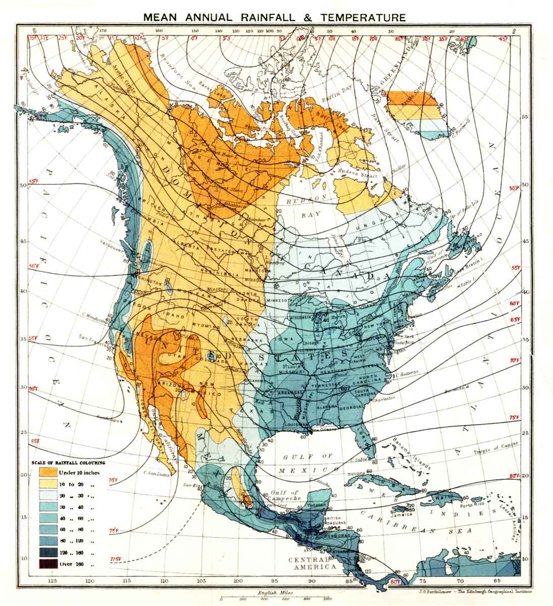 Plate II.—Mean annual rainfall & temperature.
The principal elements of the weather which go to make up the conditions of the atmosphere embraced in the broader term climate are temperature, precipitation, and the winds. On the accompanying map, Plate II, the mean annual temperature of the continent is represented by isotherms, or lines drawn through localities having the same average temperature for the year. On the same map is also shown in blue the average depth of precipitation, including both rains and melted snow. On Fig. 24 lines are drawn through points having the same average barometrical pressure (isobars) for the months of January and July, together with arrows indicating the general direction of the surface winds during each of these months, which may be considered as representative of the summer and winter seasons. The data shown on these maps have been compiled mainly from the reports of the weather bureaus of Canada, the United States, and Mexico, and indicate, at least in a general way, a summary of what is known concerning the main meteorological elements which determine the climatic conditions in North America. An examination of these maps will suggest certain general conclusions in reference to the leading characteristics of the climate 175 in various portions of the continent and the changes they undergo from season to season.
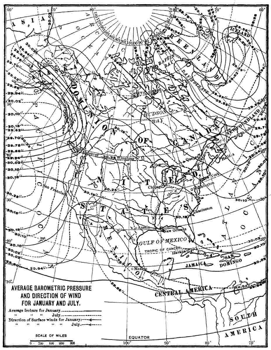 Fig. 24.—Average barometric pressure and direction of
wind for January and July.
Fig. 24.—Average barometric pressure and direction of
wind for January and July.Distribution of Heat and Light.—The distribution over the earth's surface of the heat and light received from the sun is not only of fundamental importance as respects climate, but furnishes a part of the essential conditions on which depend the presence and distribution of living organisms. The heat and light, or more accurately, the radiant energy of the sun, the full significance of which is probably not thoroughly understood, we term, for convenience, insolation. The intensity and seasonal distribution of insolation are prime factors on which many important results hinge.
Owing to the inclination of the axis about which the earth rotates (23° 27') to the plane in which the earth travels about the sun, or the plane of the ecliptic, the northern end of the axis is turned towards the sun in summer and away from it in winter—that is, the axis of rotation of the earth at all times is parallel to the same imaginary straight line. As a result, the sun appears to migrate northward in the heavens during the spring-time of each year, being vertical over the equator on March 21st, and to an observer in north latitude 23° 27' rises higher and higher each moon, until on June 21st it is vertically overhead; and then returns southward. The latitude in which the sun is in the zenith at the time of its greatest northward migration determines the position of an imaginary line on the earth's surface, named the Tropic of Cancer. This line, as shown on the accompanying maps, crosses the Bahama Islands, passes about 40 miles to the northward of Havana, divides Mexico into two approximately equal parts, and cuts the peninsula of Lower California near its southern end. The portion of the continent to the south of the Tropic of Cancer lies within the torrid zone.
When the sun is vertical over the equator, as it is about March 21st and September 23d each year, its rays, not allowing for refraction, are tangent to the earth's surface at the poles, and the hours of light and darkness are equal the world over. During the winter season the sun appears to migrate southward of the equator until December 21st, 176 when it is vertical at noon at all points situated in south latitude 23° 27', which is termed the Tropic of Capricorn. Its rays are then tangent to the earth's surface in the northern hemisphere in latitude 66° 33', which defines the position of the arctic circle. This imaginary line on the earth's surface, as is indicated on the accompanying maps, crosses Canada to the north of Hudson Bay, and passes through Alaska near where the Porcupine River joins the Yukon. To the north of the arctic circle lies the frigid zone. Between the torrid and frigid zones is situated the temperate zone, within which is included about seven-eighths of North America, exclusive of Greenland. The relation of the continent to the three great zones of climate into which the northern hemisphere is divided is thus most fortunate so far as man's activities are concerned.
The climatic zones just referred to, while based on precise astronomical data and representing important facts, are not separated one from another by tangible lines, and might easily pass undiscovered by one who studied only the surface characteristics of the earth. Each summer a wave of heat and light sweeps northward over the continent and reaches beyond the pole; and each winter a counteracting wave of cold and darkness moves southward, the influence of which is marked even well within the torrid zone. A comparison of the isothermal lines drawn on the map forming Plate II with the parallels of latitude shows at a glance that there is only a general relationship between the two. In order to understand this discrepancy between what might be expected from astronomical considerations in reference to the distribution of solar energy and the actual conditions as learned by observation, it is necessary to take a more critical view of the manner in which insolation is received by the continent, and also to consider secondary conditions which exert far-reaching influences on its distribution.
The amount of heat, or to avoid objections, the distribution of insolation over North America, depends on three primary conditions: First, the angle at which the sun's rays strike the earth, the range being from zero to 90°; second, 177 the length of time a particular locality is exposed to sunlight; and third, variations in the distance of the earth from the sun. Each of these conditions varies from day to day for every locality throughout the continent. The sun is highest in the heavens in the torrid zone, being twice vertically overhead each year at every locality, and the hours of light and darkness each day are approximately equal throughout the year. North of the torrid zone, however, the rays of the sun become more and more oblique to the earth's surface, and hence insolation becomes weaker and weaker for a given period of sunshine as one travels from south to north. But the hours of sunlight each day undergo marked variations, lengthening from December 21st to June 21st, and shortening as the sun makes its southward migration. At the north pole, as all know, there are six months of light and six months of darkness each year. The amount of insolation reaching the northern portion of the continent each day increases with the lengthening of the hours of light, and during midsummer is greater for a given area in a single day (twenty-four hours) than the amount received by a similar area in the torrid zone. The almost magical springing into life and bloom of the vegetation over the northern portion of the continent with the lengthening of the hours of sunshine each summer is thus explained. In the portion of the continent within the temperate zone, more especially within the continental basin, the large number of hours of sunshine during a summer's day is frequently accompanied by a temperature as great as is usually experienced in the torrid zone. It is the high summer temperature of this region, together with the lengthened duration of sunshine in the growing season, that makes the Mississippi basin and the adjacent region on the east and north so favourable for agriculture when the requisite amount of moisture is present.
The distribution of heat over the earth's surface depends not only on the direct influence of insolation, but on its transfer from one locality to another through the agency of the winds and ocean currents. The movements of the waters of the ocean, it will be remembered, are largely 178 under the control of the winds, so that the essential factor in the transfer of heat from place to place is atmospheric circulation. The primary causes of movements in the air, as is a matter of current knowledge, are the differences that arise in temperature at various localities. In regions where the air becomes more highly heated than over adjacent areas it expands, and in consequence becomes lighter, volume for volume, than the air over neighbouring areas, and is forced upward and overflows aloft. The overflow or dispersion of the warmer and lighter air above gives origin to a reduction in barometric pressure, the column of mercury in a barometer being counterbalanced by the pressure of the air above it. Briefly stated, the air near the earth's surface flows towards regions of low, and away from regions of high barometric pressure, and winds are established. The directions taken by the winds are influenced or controlled in various ways.
The Planetary Winds.—The great movements in the atmosphere originate from differences in temperature between the warm equatorial and cold polar regions. This alone would cause the cold air from either pole to flow towards the equator as surface winds, and the warm air in the equatorial belt to ascend and overflow aloft towards either pole. The earth's rotation, however, influences the direction of these winds and causes them to be deflected from the lines of longitude which they would otherwise follow. In the northern hemisphere the air-currents are deflected to the right and in the southern hemisphere to the left of their initial directions. The best known examples of these planetary winds, as they are termed, are the trade-winds, which blow from the northeast in the northern and from the southeast in the southern hemisphere. Between these two belts of converging winds lies the equatorial belt of calm, some 300 miles wide, which also encircles the earth and is termed the doldrums.
In the quadrant of the earth's surface occupied by North America the climatic conditions are controlled in a large measure by the planetary winds. In the equatorial belt of calms the barometric pressure is lower than on 179 either side, the temperature is uniformly high, the air is heavily charged with moisture, and torrential rains are frequent. In the belt of the northeast trades the weight of the air for a given area is greater than in the doldrums, the wind blows with remarkable uniformity both of direction and force, the sky is normally clear, and rain infrequent except when the warm moist air is forced upward either by local storms or on coming in contact with high land. The trade-winds blow across the West Indies, Mexico, and much of Central America. To the north of the trade-wind belt is a belt of prevailingly high barometrical pressure, light variable winds, narrower and less well defined than the doldrums, which encircles the earth in the region of the Tropic of Cancer. This belt of calms, although familiar to sailors, to whom it is known as the "horse latitudes," is ill-defined on the land, where its presence is masked by changes due to local conditions. To the north of the tropical calm belt the prevailing surface winds are from the westward, and owe their direction to the constant flow of the upper air-currents in their poleward journey, under the influence of the earth's rotation. This great belt of winds from the westward crosses the portion of North America including the United States and southern Canada, but it is subject to many disturbances. The northern portion of the continent extends into the little known polar region of prevailingly low barometrical pressure, where midsummer and midwinter calms normally prevail.
The great world-encircling currents of the atmosphere, namely, the trade-winds, blowing towards the southwest or west across the Caribbean and Mexican region, and the prevailing westerlies, or winds blowing in an easterly direction, over the broad temperate portion of North America, exert the main control on the climate of the continent.
The Seasons.—Of primary importance to the inhabitants of North America is the fact that the climatic belts determined by the inclination of the earth's axis to the plane of the ecliptic are subject to annual migration towards the north and south. In the torrid zone the equatorial belt of calms, with its humid and oppressively hot atmosphere, prevailing 180 cloudiness, and heavy rains, and the belt of the northeast trades, with its prevailingly clear skies and refreshing breezes, do not occupy the same positions throughout the year, but migrate with the sun. The migration of these two strongly contrasted climatic belts brings to the otherwise remarkably uniform conditions of the atmosphere over the West Indies, Central America, and Mexico, two, in general well-defined, periods each year, namely, a wet and a dry season, the former occurring in the summer and the latter in the winter. It is to be borne in mind that between the tropics there are, with certain local exceptions, but two seasons each year, the leading contrasts of which are determined by differences in rainfall.
To the north of the Tropic of Cancer the seasonal changes are more varied than in the torrid zone, and contrasts in temperature become the most marked climatic feature; while precipitation, although in general somewhat evenly distributed throughout the year, is more abundant in winter than in summer. On account, however, of the greater diversity in the climatic changes experienced each year within the temperate zone, four seasons are recognised, the most distinctive features of which depend on changes in both temperature and humidity.
In the northern portion of the temperate zone, and extending over the arctic zone, the seasons are again reduced to two, summer and winter, the contrasted conditions pertaining mainly to temperature and light.
A marked variation, which has an important bearing not only on climate, but on the distribution of life encountered in passing from equatorial to polar regions, is found in the distribution of light. Between the tropics the number of hours of light and darkness each day is approximately equal; in the temperate zone there is considerable diversity from season to season, which increases with increase in latitude; and uniformity, of a different character than at the far south, again becomes prominent in the frigid zone, where the number of hours of light each day is greatly prolonged during the summer and correspondingly decreased during 181 the winter. The extreme contrast occurs in the neighbourhood of the pole, where during the summer season the sun is continuously above, and in winter continuously below the horizon, or in familiar language, there is a six-months day (light) and a six-months night (darkness).
In going from the equatorial to north polar regions there is a general decrease in mean annual temperature, and in general a decrease also in precipitation, but great variations in these gradual changes, with increase in latitude, occur which are both continental and local in character. In winter the interior portions of the continent, and especially the plateaus and mountains, are colder than the lands in corresponding latitudes near the oceans; while in summer the reverse is true, the margin of the continent being cooler than the broad interior.
In this general view of the climatic zones and the normal changes they undergo we may note that the torrid zone is characterized by its simplicity and monotony of climatic conditions, although disturbed at times, especially in the West Indies, by occasional great cyclonic storms, termed hurricanes, which occur, however, at quite definite seasons. The temperate belt is equally well marked by its complex and frequently changing atmospheric conditions, the winds being subject to numerous and great variations, and storms of diverse character being frequent. The frigid zone, again, is without conspicuous variations except during the change from its monotonous summer to its still more uniform winter weather, and the reverse change six months later. The disturbances in the balance of atmospheric conditions at the far north, or the storms, are of a much less varied character than in the fickle temperate zone—thunder-storms and tornadoes, for example, being unknown.
It is the summer migration of a heated belt from the south northward across the temperate zone, and the equally conspicuous winter advances of cold from the north southward across the same broad region, which gives to the United States and the southern portion of Canada a conspicuously changeable climate. The temperate zone, so far 182 at least as North America is concerned, deserves its name only when the mean of the yearly changes in temperature is considered, as much of it is hotter in summer than equal areas between the tropics, and in winter over all of its northern half the cold is, at times, nearly or quite as intense as during the same season in the far north. As a whole, the portion of the continent embraced in the temperate zone is characterized by its pronounced seasonal changes, including wide extremes of heat and cold over large areas, and by its frequently sudden and strongly marked weather changes during short periods of time. It is a highly suggestive fact that of all the great climatic zones the one having the most changeable climate, the greatest extremes of heat and cold, and the most frequent storms should be the one in which man has reached the highest development both of body and mind. Evidently it is the struggle for existence, when not too severe, which insures advancement. The part of North America most densely inhabited by descendants of Europeans, and the portion of the continent where intellectual development has made the greatest advance, is the east-central portion, where not only the variation of climate from season to season, but the weather changes from week to week and day to day are the most conspicuous.
Secondary Conditions influencing Climate.—While the primary conditions controlling the climate of North America in common with all other portions of the earth's surface depend on the relation of the earth to the sun, there are many secondary conditions to be considered. First in importance among these, so far as the broader features of the climate of the continent are concerned, is the unequal heating of land and water areas. During summer, more especially in the temperate zone, the land becomes more highly heated than the adjacent oceans, and an inflow of the cooler and moister air from the sea over the land occurs. In winter the land cools more quickly and to a greater degree than the adjacent waters, and the tendency of the heavier air over the land is to flow outward as surface winds. Continental winds are thus generated, similar in their origin to the familiar land and sea breezes of the ocean shore in 183 summer, but on a large scale, which have an important bearing on the seasonal changes. The influence of the continental winds is sufficiently well marked to give North America two general classes of climate. One pertains to inland regions, is characterized by great contrasts in temperature and humidity between summer and winter, and is termed continental. The other pertains to the border of the land where, on account of the equalizing influence of large water borders, the contrast between the climate of summer and winter is less pronounced, and has received the general title of oceanic climate. The climate of the Dakotas, for example, is of the continental type, while that of New Jersey is of the oceanic type.
The unequal heating and cooling of adjacent portions of land areas also produces important atmospheric movements, as, for instance, when broad, treeless plains become more highly heated in summer than adjacent forested areas; or on account of rapid radiation become excessively cold in winter and lower the temperature of the air above them. In the first instance an inflow of cooler and heavier air from adjacent regions would be established; and in the second example the chilled air would tend to flow outward, thus, in each instance, establishing winds which usually acquire a more or less well-pronounced circular motion. The Prairie plains and the Great plateaus to the east of the Rocky Mountains become highly heated in summer, and together with several other similar regions in North America, meet the first of the conditions just considered; while the higher portions of the Great plateau, especially at the north, and the still more elevated mountains of Montana, Colorado, etc., become excessively cold in winter and illustrate the other extreme.
Mountains serve to deflect the winds blowing against them either to one side or upward, the former frequently producing important changes in direction of the surface air-currents, and the latter, by causing the air to rise, permits of its expansion and consequent cooling, thus favouring precipitation. For this and other reasons precipitation increases with elevation, at least until an altitude of many 184 thousands of feet is reached, and the mountains are cooler and more humid than the adjacent valleys. The air-currents on passing over a mountain range and descending are warmed by compression, and having lost a part and in many observed instances a large percentage of the moisture they previously contained, become warm, drying winds. The chinook winds, as they are termed in America, are marked examples of the influence exerted by mountains on climatic conditions.
What are termed above the secondary conditions, tending to modify climate, produce such great changes in the distribution of rainfall, temperature, etc., and in the influence of the planetary winds, that the subdivision of the northern hemisphere into torrid, temperate, and frigid zones, while based on astronomical data, does not serve to represent actual conditions, except in a general way, in reference even to the single element of temperature expressed in these names. A comparison of the isotherms and of the distribution of precipitation as indicated on the preceding maps, with the parallels of latitude, shows at once that these two most important elements of climate are conspicuously independent of distance from the equator. A logical basis for subdividing the continent into climatic provinces must therefore be sought in other directions.
In order to obtain a comprehensive idea of the climate of a continent, it is obviously desirable to subdivide it into areas having more or less similar and distinct atmospheric conditions. The leading difficulty in making such subdivisions is the well-known fact that the climate of any region which may be chosen passes by insensible gradations into that of adjacent regions, and any boundaries that may be drawn are to a considerable extent artificial and arbitrary. While the true basis on which to establish climatic areas or provinces is the resultant of all the weather elements which go to make up the atmospheric conditions recognised under the broader term climate, so many factors have to 185 be considered that it is extremely difficult to arrive at a general acceptable conclusion. The principal elements of the weather to be considered are, approximately, in the order of their importance, beginning with the one which exerts almost universal control—temperature, precipitation, the winds, absolute and relative humidity of the air, and evaporation.
In North America there are voluminous records in reference to each of these elements of the weather, embracing considerable lengths of time, and relating mainly to the United States and southeastern Canada, but not sufficient to enable one to subdivide the entire continent into climatic provinces. The lack of weather records embracing the entire continent may be supplied in part by what may be termed the natural records of atmospheric conditions as expressed by the flora and fauna, as well as by soil conditions and topography. In recognition of this principle, the climatic provinces of North America here adopted have been made to conform to its life-zones.
The major climatic divisions of North America here provisionally adopted are, in their general order from south to north, the Tropical, Lower Austral, Upper Austral, Transition, Boreal, and Arctic (Plate III). These several divisions are termed climatic provinces, and are assumed to coincide with those of the life-regions as mapped by C. Hart Merriam. The basis for classification is mainly temperature. In the main, the northern boundaries of the provinces and their higher limits in mountainous regions are determined by the temperature of the season of growth and reproduction among plants and animals; while their southern boundaries or lower limits on the mountains are determined by the temperature of a brief period during the hottest portion of the year. A more definite account of the reasons for choosing these limitations will be given later in discussing life areas. While the principal basis for establishing climatic provinces is temperature, many other conditions are also recognised, chief among which is precipitation. Several of the climatic provinces have two divisions, namely, a humid and an arid, the dividing line being 186 approximately the one hundredth meridian. These are well defined and important in the tropical, austral, and transitional, but less definite and less well known in the boreal and arctic provinces. The regions embraced in the several climatic provinces named above, as well as their humid and arid divisions, so far as now understood, are shown on the accompanying map.
The Tropical Province (Plate III).—This is the most southern of the climatic provinces which it is convenient to recognise in North America, and includes the West Indies, Central America, and southern Mexico, together with a narrow strip on each coast of northern Mexico and the extreme southern ends of the peninsulas of Florida and of Lower California. While the land areas in this widely extended province present conspicuous differences, their climate in general is characterized by a high mean annual temperature with but moderate seasonal or daily variations, and by the occurrence in general of a wet and a dry season each year. The prevailing winds are the northeast trades. While the average yearly temperature is high, being in general about 80° F., the heat in summer is less intense than in many portions of the austral provinces. In winter the temperature does not fall sufficiently to produce frost, except on the higher mountains, which, in fact, belong to one or more of the other provinces named above. On ascending the mountains a rapid change to cooler and even to frigid zones is experienced. Snow occurs on the higher portions of the mountains of Central America and Mexico, and in a few instances, as on the great volcanic cones in sight from the City of Mexico, is perennial. On the mountains just referred to all of the several climatic provinces are represented by well-characterized zones, arranged one above another, and presenting in epitome the general changes one would experience in travelling from the Gulf of Mexico to the Arctic Ocean.
In marked contrast to the prevailing uniformity of temperature at corresponding elevations throughout the tropical provinces is the inequality in rainfall in reference to both seasonal periods and differences in geographical position. 187 Of the annual changes, the most pronounced and characteristic is the alternation of wet and dry periods. During the summer season, or in general from May to October, the air is usually clouded for at least a portion of each day, and heavy downpours of rain occur. Throughout the remainder of the year the clear skies and refreshing breezes, such as on the ocean are normally characteristic of the trade-wind belt, prevail. The remarkable regularity with which these changes occur each year suggests at once that they are due to the migrations northward and southward with the sun of the great climatic belts encircling the equatorial region of the earth. In summer the equatorial belt of calms and heavy rainfall not only migrates northward and occupies a portion of Central America, bringing to Costa Rica and Nicaragua cloudy skies and abundant precipitation, but seems to be carried bodily still farther northward, so that the influence of the southeast trades of the southern hemisphere makes itself felt, and four somewhat well-marked annual changes occur, namely, two wet and two dry seasons. What is known of the climate of this extreme southern portion of the province under review indicates that the seasonal changes, especially on the Caribbean slope, are less well marked than in its central portion, and rain is frequently copious in nearly every month of the year. In the region just mentioned the mean annual precipitation, as at Greytown, for example, at the eastern extremity of the proposed Nicaragua Canal, is about 250 inches, and in exceptionally wet years reaches nearly or quite 300 inches. This is, so far as known, the heaviest annual precipitation in any portion of North America.
In the West Indies the rainy season begins, in general, in May and lasts until October. On the lowlands of eastern and south-central Mexico the wet season commences in June, and the rains increase until the end of July and end in November. This region lies to the north of the northern limit reached by the equatorial belt of calm, but the rains in the summer season are due to the same general influence, namely, the lowering of temperature in the northward-moving upper air-currents, and their effect on the 188 trade-winds. In Cuba and along the northern coast of the Gulf of Mexico when the trade-wind belt migrates southward in winter the influences of the southward-moving storm from the Mississippi Valley and Atlantic States produces what are termed northers, which bring a chill and at times frost, more especially in Florida and on the higher portions of Cuba.
While the wide-reaching seasonal changes within the tropical province depend on the migrations of the planetary winds northward and southward with the sun, and are due primarily to astronomical conditions, there are equally well-marked variations in rainfall dependent on or regulated by geographical conditions. These are of two principal classes: First, elevation of the land; and second, the relation of broad land areas to the direction of the prevailing winds, each of which is abundantly illustrated in the tropical province.
The mountainous islands in the West Indies receive a heavy rainfall, especially on their windward or easterly slopes, while the low islands, and less markedly the southwestern border of the higher islands, are much less humid. The eastern side of Porto Rico, for example, has an abundant rainfall, and was originally clothed with a luxuriant native flora, including large forest-trees, while the lowlands on its southern and southwestern border are subject to drought, and irrigation is desirable to insure the growth of crops. Again, while the mountainous islands of the Lesser Antilles, with their luxuriantly forested slopes, present ideal pictures of tropical loveliness, low-lying Sombrero, Barbuda, St. Martin, and other similar islands are so arid that guano has accumulated on them to such an extent as to be of commercial importance. The reason for these striking contrasts within narrow geographical limits is readily seen in the influence of the highlands on the trade-winds. These air-currents blowing from the Atlantic are warm and contain a high percentage of moisture. As they advance, however, they invade regions that are progressively warmer and warmer, and the capacity of the air for moisture is correspondingly increased. For this reason the trade-winds in 189 crossing low land become drying winds. When the warm humid air-currents are forced upward, however, they are cooled in part by contact with the land, but to a greater extent on account of expansion due to decreased pressure; the dew-point is thus lowered, and when saturation is reached precipitation follows. This explanation applies also to the low peninsula of Yucatan, which is within the trade-wind belt, and is exceptional among the lands of Central America, on account of its dearth of forests, but in this instance, and also in reference to the similar barren condition of the Bahama Islands, in addition to the lowness of the land, the influence of the underlying porous, limestone rocks on the vegetable growths should be considered. In the instances just mentioned the rain that falls is quickly absorbed by the cavernous rocks, and surface streams are rare.
In Central America the influence of mountains on the climate is much the same as in the West India islands; in fact, the narrow rugged belt of land connecting the two Americas may, from our present point of view, be considered as a great island situated mainly within the trade-wind belt, and similar to Jamaica, for example, in its influences on the winds blowing across it. The eastern slopes of the Central American mountains, together with the adjacent lowlands, with the exception, principally, of Yucatan, are well watered and clothed with dense vegetation, while on the western slopes, and especially over the narrow fringe of lowland adjacent to the Pacific, the rainfall is less than on the Caribbean coast, and the forests are open with many grass-covered areas which are favourable for agriculture. In the mountainous portions of the West Indies and of Central America, on account of the more healthy conditions on the leeward or drier sides, as compared with the windward or humid slopes of the mountains, the towns and the principal portion of the white inhabitants are located on their western borders. Owing to the great humidity and the long-continued high temperature during the hotter portion of the year throughout the tropical province, much of the lowland to the eastward of the high mountains is swampy and unhealthy. This low region in Mexico and Central 190 America is known as the tierra caliente, or hot country; on the mountains and plateaus, or in general where the elevation is between 5,000 and 7,000 feet, is the cooler and remarkably salubrious tierra templada; and at still higher elevations occur the tierra frie. Owing to the decrease in temperature with elevation, and the fact that the moist warm air is forced to rise, and in consequence expands on passing over the highland, the rainfall probably increases with elevation through the three zones just referred to.
While the tropical province is characterized by the uniformity with which its atmospheric changes occur, it is nevertheless in part subject to occasional and exceedingly violent cyclonic storms termed hurricanes, which begin in the torrid zone, travel northward (Fig. 26, page 210), and make their influence felt in more than one of the climatic provinces into which North America is here divided. Thunder-storms, frequently of great violence, also occur, especially in the Central American region in summer, when the doldrums migrate northward.
The trade-wind belt broadens in crossing the southern portion of the North American continent, and on the west coast and during its greatest northward migration reaches to southern California. As we have seen, the lowlands not adjacent to mountains in the Caribbean region receive little or no rain from the trade-winds, for the reason that the prevailing air-currents are moving from cooler to warmer regions, and therefore have their capacity for moisture increased as they advance more rapidly than their thirst can be satiated. The trade-winds are thus normally drying winds. The same principle holds true for continents as well as islands. The trade-winds on reaching the eastern border of the Mexican plateau are forced upward and part with much of their moisture in the form of rain and snow, and on descending to the lower lands bordering the Pacific are desiccating winds. The conditions are thus much the same as on the lowlands situated to the leeward of the mountains of the West Indies. The narrow fringe of low-lying country on the west border of the main body of 191 Mexico, together with the peninsula of Lower California and a portion of the southern extremity of California, are arid, although in immediate proximity to the ocean. The leading characteristics of the climate of this, the arid portion of the tropical province, are its small rainfall, clear atmosphere, high mean annual temperature, moderate seasonal changes, and active evaporation.
The most typical portion of the arid region bordering the Pacific from California southward lies in northwestern Mexico, where the mean annual precipitation on the western slope of the central table-land is from 15 to 20 inches, but gradually diminishes as one descends to the lower lands to the westward to 10 inches, and even to 5 inches or less. A great portion of the lowlands is practically a desert, although, as is common on the desert-like tracts of this continent, it is sparingly covered with detached clumps of cacti, yuccas, and other similar plants which live with the minimum of water.
The hot, arid lands of the southwest just referred to are similar in position, in reference to the relation of land areas to the trade-wind belts, as other trade-wind deserts, as they are termed, such as the Sahara, which occur on the leeward side of continents where they are crossed by these drying winds.
The Lower Austral Province (Plate III).—This province embraces the Atlantic and Gulf coasts of the United States from Connecticut southward, with the exception of the tropical portion of southern Florida; the Mississippi basin south of the mouth of the Ohio; and includes also many of the valleys amid the Pacific mountains from the northern boundary of California to central Mexico. The larger geographical conditions on which the boundaries of the province depend are the warm currents in the Atlantic, which ameliorate the temperature of the adjacent land as well as supply it with abundant moisture; the low elevation of the central continental basin, which permits of great extension northward of the climatic conditions originating about the Gulf of Mexico; and the mountainous character of the western portion of the province, where the valleys 192 have a markedly different temperature and rainfall from the highlands.
The most southern portions of the lower austral province within the border of the United States has a semitropical climate and is characterized by its high mean annual temperature, abundant rainfall, and uniformity of weather conditions throughout the year. The summers are hot, but tempered by winds from the Gulf of Mexico and the Atlantic, and the winters, although normally mild and without snow, are varied at intervals by periods of cold which bring occasional frosts. This semitropical division of the lower austral province embraces a narrow strip of coast-land extending from South Carolina to southeastern Texas, with the exception of the extreme southern end of Florida, and forms a transition between the hotter and more humid tropical province to the southward and the cooler and less humid region to the northward.
As the saying is, a tree is judged by its fruit; in a similar way we may judge of the climate of a region by its products. The Gulf strip of the lower austral province is the home of a number of plants and animals not found farther north, as, for example, the cabbage palmetto and Cuban pine, and several species of birds and small mammals. Among the agricultural products of this narrow coastal belt which are suggestive of its climate are rice, sugar-cane, and sea-island cotton; of fruits it produces, especially in Florida, oranges, mandarins, lemons, limes, shaddocks, and pineapples.
The humid portion of the lower austral province extends northward from the Gulf strip, and presents a transition in climatic conditions between the semitropical Gulf coast and the more markedly temperate climate of the upper austral. This eastern division of the lower austral, characterized by its mild winters, general absence of snow, long hot summers with abundant rain, extends from eastern Virginia southward about the southern end of the Appalachian Mountains, and in the Mississippi Valley broadens so as to reach the mouth of the Ohio River. Its western limit is in central Texas, where the mean annual rainfall decreases 193 to less than 20 inches, and forests give place to treeless, grass-covered plains and plateaus.
Through this eastern portion of the lower austral the mean annual precipitation is in general between 50 and 60 inches, and is so distributed throughout the year that each month receives approximately an equal share. In general, however, the rainfall is greater in winter than in summer. The mean annual temperature of the humid portion of the lower austral is from 60° to 68° F., the mean winter temperature 40° to 52°, and the mean summer temperature from 75° to 80° F. From these records it may be inferred that the conditions are favourable for the growth of trees. In its natural condition this entire region was clothed with a varied and beautiful forest, consisting largely of broad-leaved trees, but is also the home of the southern pine and the cypress. The characteristic crops are cotton and corn (maize).
The western or arid portion of the lower austral province embraces western Texas, a large area in northeastern Mexico, and circling about the southern extremity of the Pacific mountains in central Mexico, extends northward adjacent to the tropical border of the Pacific and the Gulf of Lower California, into Arizona and southern California. A detached area of this same province occupies the great Valley of California.
The leading feature in the climate of the extensive and irregular region just outlined is its aridity. The rainfall is too small to insure forest growths; the land is treeless, except along the streams, and irrigation is necessary for successful agriculture. With a sufficient amount of water for irrigation, a great variety of fruits, etc., may be raised, including many products usually considered as indicating tropical conditions, such as mangoes, dates, figs, citrus fruits, olives, pineapples, etc. Not only are the agricultural products numerous and varied, but the yield per acre under the most favourable conditions is far in excess of the best results reached in most regions where rain is relied on to furnish the requisite moisture. Under the prevailingly cloudless skies of the hot arid lands of the southwestern 194 portion of the continent insolation is intense and the growth of vegetation phenomenal when the necessary amount of water is supplied. The land in its present condition presents great contrasts, ranging from desolate, sun-burned tracts which are almost absolute deserts, to the vivid green of irrigated fields and the deep shade of heavily fruit-laden orchards.
The Upper Austral Province (Plate III).—The portion of North America embraced in this climatic province lies principally in the central part of the United States, but includes also a narrow strip in southern Ontario, adjacent to the north shore of Lake Erie, and a large irregular area in the central plateau of Mexico. A marked feature of its geography is its extreme irregularity in the portion occupied by the Pacific mountains in the United States and Mexico. The reasons for this lie mainly in the influence of the relief of the land on climate, the direction of the prevailing winds, and varying distances from the ocean. It is a familiar fact that boreal and even arctic climatic conditions are met with on high mountains. The attention that is given to changes in climate with increase in altitude is no doubt largely due to the fact that the mountains present conditions which are exceptional and more or less novel as seen from our accustomed point of view. A person living in an elevated region, on descending into a deep valley, would be impressed with the reverse order in which the climatic zones occur. In making such a descent he would pass in succession from a boreal or perhaps arctic climate, through a transitional or cold temperate, to the warm temperate or upper austral province, and might even reach the semitropical division of the lower austral. In the Pacific mountains within the border of the United States the valleys are sufficiently deep to have the climatic conditions here ascribed to the upper austral, and in the southwestern portion of the United States descents may be made—as in the Great Valley of California and in the arid basins of southern Nevada, Arizona, etc.—sufficiently great to reach the lower austral. The valleys amid the Pacific mountains, which fall in the upper austral province, are in 195 general low at the north in reference to sea-level, and become higher and higher at the south. For example, the upper austral region in central Washington is but 400 or 500 feet above the sea, while in Mexico it lies in general at an altitude of between 4,000 and 6,000 feet.
The upper austral province may be termed warm temperate, with a marked contrast between the heat of summer and the cold of winter. The summers are long, with an average temperature of 70° or 75°, while the winters are variable, with frequent cold periods when ice forms and snow-storms are not rare. The snow seldom remains on the ground for more than a few days at a time, however, except in the northeast, where the warm temperate climatic conditions of the province under review merge with those of the colder region to the northward embraced in the transition province.
The upper, like the lower austral, presents two well-marked divisions in reference to humidity—an eastern or humid and a western or semihumid portion; the dividing line is in the neighbourhood of the one hundredth meridian. In the eastern division the mean annual precipitation in the Piedmont region to the east of the Appalachians and on the coastal plain adjacent to the Atlantic in Maryland and New Jersey is from 40 to 80 inches, but decreases westward, and on the border of the Great plateaus in Kansas and Nebraska is about 20 inches. In the western division the annual precipitation is less than 20 inches, and agriculture without irrigation is uncertain and usually impossible. To the east of the one hundredth meridian the rain is somewhat evenly distributed throughout the year, although an increasing dryness of the summer is easily detected as one travels from east to west, but in the various upper austral valleys of the Pacific mountain region the precipitation is mostly during the winter, and the summers are practically rainless. The marked difference in precipitation between the humid and semihumid division of the upper austral province is recorded on the surface of the land by the vegetation. In the eastern division the entire region, with the exception of the prairies in the central part of the Mississippi 196 basin, was originally clothed with a varied and beautiful forest, consisting mainly of broad-leaved trees, such as the hickory, maple, oak, etc., while the semihumid western division is treeless, except in immediate proximity to streams.
In the southern portion of the humid division of the upper austral province cotton is one of the staple products, but the northern limit of the region in which it can be successfully cultivated is soon reached as one travels northward. Tobacco is grown extensively in the southeastern and eastern portions of the province. The principal crop of the great central area in the Mississippi Valley is corn (maize). Successful wheat culture begins in the northern portion of the province, but the conditions favouring its cultivation increase to the northward and it becomes the characteristic and most valuable crop of the transition province.
In the western or semihumid division of the upper austral the variety of agricultural products that can be successfully cultivated with the aid of irrigation is greater than in its eastern portion, where irrigation is not generally practised. The northern limit at which tobacco, fruits, the vine, etc., may be advantageously cultivated in the west is greater than in the east. For example, in the east the northern limit at which tobacco is raised on a commercial scale is in Connecticut, while in the west it reaches a large size and excellent quality in central Washington. Various fruits, such as the peach, pear, plum, grape, etc., have their northern limit of successful cultivation in the east in western New York, southern Ontario, and southern Michigan, a region favourably influenced in this connection by the proximity of the Great Lakes; in the west these same fruits reach a high degree of perfection, and are produced in great abundance, with the aid of irrigation, in north-central Washington, fully 5 degrees of latitude farther northward.
On the whole, the upper austral province may be said to have a warm temperate climate, in which the summer season is longer and more pronounced in its characteristics 197 than the winter season. It presents sufficient seasonal variations, however, to favour in a high degree both the physical and intellectual development of man.
The Transition Province (Plate III).—This, the transition region between the austral and boreal provinces, includes the cool temperate portions of North America. Like the austral provinces, its outlines are irregular, and in places it occupies detached or island-like areas, on account of the influence of mountains on climatic conditions. Its largest continuous area is situated along the northern border of the United States, but includes the southern portions of Assiniboia, Ontario, and Quebec, and extends from the Atlantic to the Pacific Ocean. From this main belt there is a marked extension southward along the Appalachian Mountains, which carries a cool temperate climate into northern Georgia, and another and much greater southward extension along the Pacific mountains, which reaches central Mexico. In the northern portion of the United States and adjacent parts of Canada, the region under consideration has, in general, an elevation of 1,000 feet or even less above the sea, but it rises when followed southward along the mountains, and in the southwestern portion of the United States and on the table-land of central Mexico attains an elevation of some 8,000 or 9,000 feet. On the higher portions of the mountains of Central America and the West Indies the climatic conditions are similar to those of the regions farther north here included in the transition climatic province, but these isolated areas are not sufficiently well known to be indicated on the accompanying map.
The mean annual temperature of the transition province is lower than that of the upper austral, and, although a precise average is not at present attainable, may be taken at about 45° F. The winters are long and cold, especially in the northern part of the United States and adjacent portions of Canada, the mean temperature being approximately 20° or 25°, but sudden and great variations are not uncommon. At times, and frequently for continuous periods of several days, the temperature falls to 20° or more below zero of the Fahrenheit scale, then again rises above 198 freezing, and the frozen soil thaws and possibly becomes entirely freed from ice.
In common with the austral provinces, the one under consideration is divided into two portions, an eastern and a western, in reference to precipitation, the dividing line being a little to the eastward of the one hundredth meridian. While the western portion of the province is characterized by its small rainfall, precipitation is greater, mainly on account of greater elevation, than in the adjacent portions of the austral provinces, and in Oregon and Washington there is a markedly humid area.
Snow falls throughout the entire transition province, at least during exceptional winters, and in general during every winter. There is great variation in the depth of the snow from winter to winter, and also with geographical position. It is greatest in the northeast—that is, from the Atlantic coast westward to Wisconsin and Minnesota—and least on the Pacific coast and the southern portion of the Pacific mountains. Over the northeastern portion of the province the snow frequently whitens the ground for weeks, and even for two or three months continuously. A deep accumulation which remains for a long time unmelted is welcome, as it protects the roots of plants from sudden changes of temperature and prevents alternate freezing and thawing of their sap, which is injurious to their tissues in numerous instances. Great variation in the amount of snow that falls annually in a given locality is of common occurrence. A large proportion of the yearly accumulation frequently occurs during one or two great storms. For example, in January and February, 1898, there were two severe storms, accompanied by an unusual depth of snow, the first being most pronounced over New England, and the second in the region of the Great Lakes. Other storms increased the amount of snow so that at the beginning of March the average depth in Maine was 40 to 70 inches, in New Hampshire and Vermont 10 to 40 inches, and in Massachusetts 10 to 20 inches, while in Michigan and Wisconsin the general depth on level ground was 1 to 2 feet, with many drifts 10 to 15 feet deep. 199
The winter in the northeastern portion of the transition province may be said to be the most characteristic feature of the climate, as it is the one that is most pronounced and exceptional, when a comparison is made with other thickly peopled portions of the continent. The period of cold and snow each year is long, extending in general from November to March, and the coming of the flowers and birds in spring is frequently much delayed. The long cold winters have a decided influence on plant and animal life, and in a marked way modify the lives of men. In the northeastern portion of the United States and adjacent provinces of Canada various forms of sleighs are extensively used during the winters, and skating on the frozen lakes and streams and excursions on snow-shoes over the fields and through the forests are a popular and healthful exercise, while coasting and tobogganing—or to explain these terms to people living in regions where snow does not fall, the sliding down steep snow- or ice-covered slopes on sleds or flat-bottomed toboggans—are highly enjoyable sports indulged in by children and grown people alike. In certain cities, notably Montreal and Quebec, what are termed ice-palaces (Fig. 25) are built of blocks of ice and are utilized for winter carnivals.
The summers throughout the transition province are hot, with little rain in the western portion, but refreshing showers and occasional destructive storms in the humid eastern portion. Owing to the latitude of the main transcontinental belt of the province, the number of hours of sunlight each day in summer is increased beyond what it is in the main portions of the austral provinces, thus favouring the growth of vegetation. There is also a lengthening of the morning and evening duration of twilight, and magnificent sunrises and sunsets are frequent. The mean summer temperature is in the neighbourhood of 70° F., but hot spells, lasting for days, and even weeks, are of common occurrence. During these trying and frequently unhealthy intervals the temperature in the shade reaches or even exceeds 100° F., and sunstrokes or prostrations by reason of the heat, particularly in the cities, are numerous. The four 200 seasons of the year are better marked and have more pronounced characteristics in this division of the continent than in any other, and it is the region of greatest seasonal climatic changes as well as of marked weekly and even daily variations in weather conditions. The most delightful months to most people are May, when the returning migratory birds are nesting, the trees unfolding their many tinted leaves, and the air laden with the perfume of multitudes of blossoms, and October, when the rich colours of ripened leaves give to the forests a marvellous variety and brilliancy of colour and the tranquil, hazy atmosphere is undisturbed by storms for days and even weeks together. This annual period of tranquil weather, extending frequently far into November, is known as Indian summer.
In the northern portion of the transition province the broad-leaved, deciduous trees of the central and eastern portions of the United States reach their northern limit, and become mingled with a southward extension of the conifers which form the major portion of the forest of Canada. A similar but less marked change occurs among the Pacific mountains, where the scattered growths of oaks, piñon pines, sycamores, etc., of the lower mountain slopes and stream sides mingle with the spruces and yellow and white pines of the more elevated region, where the climate is similar to that of central Canada. As remarked by Merriam, the province as a whole is characterized by comparatively few distinctive animals or plants, but rather by the occurrence together of southern species which there find their northern limit and northern species which there reach their southern limit. It embraces the northern portion of the truly agricultural lands of the continent. The plants of economic importance which there reach their highest stage of perfection are wheat, oats, and other cereals, the sugar-beet, numerous vegetables, the white potato, apples in great variety and abundance, cherries, plums, grapes, etc. It is the northern limit of corn, and includes nearly the entire area in which maple-sugar is produced. In the eastern portion of the province several varieties of native nuts, such as the beechnut, butternut, chestnut, hazelnut, hickory-nut, walnut, 201 etc., grow wild and in great abundance; but nut-bearing hardwood trees are also a characteristic feature of the forests of the humid portion of the austral provinces.
In the western division of the province a humid area—embracing western Washington and Oregon, part of northern California, including the Coast Range of the same States—presents a marked contrast to the more widely extended and excessively irregular arid portion which surrounds the higher mountains and is for the most part remote from the ocean. Both the humid and arid divisions of the western part of the province are alike favourable for agriculture, as is shown by the vast and highly productive wheat-fields of the semihumid eastern portion of the States just named and the productive hop lands, orchards, and vineyards of their humid western portions.
The climate of a great land area not only finds expression in its fauna and flora, but in the industries and the intellectual development of its people. While it is difficult to translate man's physical and intellectual development into terms of climate, it is evident that the transition province favours both bodily and mental activity more than any of the other climatic provinces into which North America is here divided. Although the boundary between the upper austral and the transition provinces is indefinite, it is easily to be seen, from the geographical distribution of cities, agricultural population, manufactories, colleges, and other institutions of learning, etc., that the climate of the province under review is on the whole the one in which the greatest intellectual advance has been made and the one which holds out the greatest promise for the future.
The Boreal Province (Plate III).—This climatic division of North America extends in a broad belt diagonally across the continent from the eastern portion of Labrador nearly to the shore of Bering Sea, and is represented by detached areas in both the Atlantic and Pacific mountains far beyond its general southern limit. Its northern border, in the Continental basin, is marked by the cessation of forests, and on the mountains to the southward its upper limit coincides with the timber-line. Its leading climatic features 202 are its low mean annual temperature—in general from 32° to 40° F.—its long, cold winters, and short, hot summers. The differences in mean annual precipitation in various parts of the province are less marked than in the several provinces previously noticed, but in the far north a cold arid division should be recognised. Although but few direct measures of precipitation are available for comparison, our general knowledge of the great boreal province and the character of its vegetation indicate that there is a decrease in precipitation from both the eastern and western borders of the continent towards the interior, and also from its central portion both northward and southward. The heaviest precipitation is on the Pacific coast, from California northward to southern Alaska, and the lightest precipitation is probably in the central Continental basin, near the northern limit of the province. Precipitation on the Pacific coast at low elevations is almost entirely in the form of rain, but on the mountains there is in winter deep snow which remains for a number of months unmelted. Throughout the portion of the province included in Canada and Alaska the snowfall is abundant, but heaviest towards the Atlantic coast. Along the northern margin of the province, as indicated by observations at a small number of stations, not only is the mean annual precipitation light, probably under 20 inches, but the winter snow is not deep, although it remains on the ground continuously for five or six months. In the main or northern portion of the boreal province, owing to the comparatively high latitude, the variation in the number of hours of light and darkness each day during a year becomes conspicuous. In summer the sun is above the horizon from eighteen to twenty-four hours each day, and in winter the hours of darkness are correspondingly increased. The year is divided into but two seasons, summer and winter, the distinctive features of spring and fall, so well marked in the upper austral and transition provinces, disappearing. On account of the low mean annual temperature, and especially because of the shortness of the growing season, agriculture is of small importance. Along its southern border, more especially in southeastern Canada and Newfoundland, 203 such small fruits as currants, huckleberries, raspberries, blackberries, cranberries, etc., grow wild and yield abundant returns when cultivated. In favoured localities white potatoes, turnips, beets, and certain varieties of the apple, as well as the more hardy cereals, are cultivated with moderate success.
The Arctic Province (Plate III) comprises the cold, treeless plains sloping to the Arctic Ocean and the summits of the higher mountains at the south which rise above the transition province. The one controlling climatic feature is the low temperature, the mean for each year being 32° F. or lower. The winters are longer and more severe than in the boreal province, and the summers short and hot. Insolation, on account of the length of the days in summer of the main area of the province and the free exposure on the mountain summits to the southward, is intense, but its beneficial effect on vegetation is largely counterbalanced by the influence of the lingering snow and ice. In the mountainous regions of North America the arctic province is the birthplace of numerous glaciers. Although destitute of trees, the arctic, or arctic-alpine province, as it may be termed, is rendered glorious in numberless localities by the profusion and brilliancy of its flowering annuals.
In the broad, general movements of the atmosphere over North America embraced in what are termed the planetary and continental winds there are many disturbances due to more or less local changes in conditions, the most conspicuous of which are whirlwinds, chinook winds, thunder-storms, tornadoes, cyclones, and hurricanes. While some of these disturbances are local, as the whirlwind and tornadoes, and may not extend beyond the boundaries of the particular climatic provinces where they originate, others, as the cyclones and hurricanes, may affect the climate of several provinces.
Whirlwind.—A conspicuous, although minor feature in the atmospheric phenomena of the hot, dry plains and 204 valleys, especially of the Mexican plateau and the Great Basin, and less markedly of the Great plateau to the east of the Rocky Mountains, is the occurrence of small whirlwinds which carry dust and light objects into the air in spiral columns that are not infrequently 2,000 or 3,000 feet high, and have a diameter of perhaps 50 to 100 feet. These small whirls of the air, in which some of the characteristic features of the intensely active tornadoes and widely destructive tropical hurricanes can be studied on a small scale, occur most commonly during hot summer afternoons, when from a commanding station half a dozen or more swaying columns may be seen moving in various directions over the parched valleys and sun-scorched plains. These columns not only move in various directions, showing that they are not due to the same immediate cause, but have different internal motions, some whirling from right to left, and others in the opposite direction.
The generally accepted explanation of these small whirlwinds is that the air over the surface of the deserts, which are frequently almost bare of vegetation and perhaps white with saline incrustations, becomes locally highly heated, especially when there is little or no wind, and is forced upward by the inflow of the surrounding cooler and heavier air. The inflowing currents have different velocities, and on meeting the strongest one gives a rotary or spiral motion to the ascending column, which acts like a chimney in allowing the escape upward of the hot air from below. A central vertical line frequently seen in the dust columns shows that a core of comparatively still air is present, about which the dust-charged air rises in a spiral course. If the conditions just outlined should be greatly increased in magnitude some of the leading features of tornadoes and even of hurricanes would be produced. In short, all of the winds cited above, except the chinook, are concentric, swirling movements in ascending air, due primarily to a local increase in temperature at the lower portion of the atmosphere.
Chinook Winds.—On the Great plateaus adjacent to the Rocky Mountains, and in similar situations to the eastward 205 of the Sierra Nevada and Cascade Mountains, warm, drying winds frequently occur, especially in winter, when they bring a balminess as of spring. The remarkable feature of these interesting winds is that they come from the snow-clad mountains, but are warm and dry in contrast with the preceding condition of the air on the plains. The capacity of the air brought by these winds for moisture is so great that evaporation is active, and the snow in the valleys and over the broad plains disappears without visible melting. The change in the previously winter aspect of a region within the influence of these chinook winds, as they are termed, is truly surprising, and to their influence is due to a marked extent the value of the Great plateaus as stock-ranges, for the reason that the snow is removed from them so as to allow cattle to feed on the naturally dried grasses.
The chinook winds are the counterpart of the foehn winds of Switzerland, and are explained on the principle that descending air is made more dense by the increased pressure to which it is subjected, and its temperature correspondingly raised, its capacity for moisture being at the same time increased on account of its rise in temperature. The apparent anomaly of a warm, dry wind blowing from a snow-clad mountain range is no longer a mystery, if we consider that the air is drawn over the mountains towards a centre of low barometrical pressure owing to the wide-reaching influence of a cyclonic storm or other large atmospheric movement. The air as it rises in order to cross a mountain is cooled, largely on account of relief of pressure, and parts with a portion, possibly a large portion, of its moisture, which condenses on the mountain commonly as snow; on passing the mountain the air descends and is warmed by compression, and having less moisture than before, becomes a drying wind, which produces the sudden and surprising changes on the plains and valleys to the leeward.
The chinook winds of the western portion of Canada and the United States occur principally to the eastward of high mountains, for the reason that the prevailing air-currents of that region are from the west. 206
Thunder-Storms.—In the eastern portion of the United States and adjacent parts of Canada during the summer season the heating of the lower portion of the atmosphere, especially on still, sultry afternoons, causes ascending currents of warm, moist air, which become cooled as they rise, and give origin to vast masses of cumulus clouds. These magnificent "thunder-heads," as they are sometimes termed, illuminated by the full sunlight are most magnificent, and usually herald the coming of heavy showers, accompanied by frequently destructive lightning and heavy thunder. The bases of the clouds when seen from a distance are usually horizontal and may have curtain-like festoons beneath, due to falling rain; while aloft the white vapour boils upward in fleece-like masses, revealing a strong convectional ascent of moist air. The immediate cause of a thunder-storm is the rapid ascent of a column of warm moist air, which becomes cooled as it rises and the moisture contained in it condensed. The cause of the ascent of the air column, at least over plains and plateaus, is the heating of the air in contact with the earth. A layer of warm, and consequently light, air beneath a layer of cooler and heavier air furnishes unstable conditions which favour an overturning and an escape upward of the lighter air, which is forced to ascend much as the hot air in a chimney is made to flow upward by the pressure of cooler and heavier air around. The conditions preceding a thunder-storm are a stagnant atmosphere over a broad region where the lower layer of hot air is also charged with moisture. These conditions are frequently fulfilled on the plains of the Atlantic slope and southeastern portion of the continental basin in summer when warm moist air is drawn in from the Gulf region towards the centre of an area of low atmospheric pressure, and thunder-storms are there a characteristic feature. The storms usually advance northeastward, the direction being determined by the flow of upper air-currents, and move over the country with a breadth of from 10 to perhaps 100 miles, and send down copious supplies of refreshing rain.
Over the Great plateaus the air near the earth's surface 207 is highly heated during the summer season, but it is deficient in moisture, and thunder-storms are rare, except for a brief period in late summer or fall when the normal conditions are disturbed.
Thunder-storms are almost unknown in the great Canadian-Alaska province and along the cool and humid northwest coast. They are also of rare occurrence in the hot and dry atmosphere of the Great Basin and Mexican plateau, but when they do come are of marked intensity, and pass under the name of "cloudbursts." At the far south, in the region brought under the influence of the equatorial belt of calm, thunder-storms are frequent and of great intensity.
An upward ascent of warm moist air, in much the same manner as described above, occurs about isolated mountains, particularly in the southern portion of the Rocky Mountain chain, and summer thunder-storms are there of frequent occurrence, especially in the afternoon, about the higher mountain-peaks, while the adjacent valleys are flooded with sunlight. Reference to this most striking phenomenon has already been made in describing the Park Mountain.
Tornadoes.—The fierce circular whirls in the air producing pendent, spirally twisting clouds, which when they touch the earth are of such intensity as to sweep away houses, trees, and nearly everything in their paths, are known to meteorologists as tornadoes, although popularly, but erroneously, termed cyclones. Storms of this character are of frequent occurrence in the United States to the east of the Great plateau, and are most numerous in the Mississippi Valley. Their path of destruction is seldom over half a mile wide, and as a rule they progress towards the northeast, in obedience to the movement of the upper air-currents, at a rate of from 20 to 40 miles an hour, and may cut a swath from a few miles to 20 or more miles long through forests, farms, villages, and towns. They occur usually in the afternoon, and sometimes in the earlier hours of the night, of warm, sultry days, especially in spring and early summer, but are not strictly confined to that portion 208 of the year. The conditions which precede the coming of a tornado are, in general, the same as those in advance of a thunder-storm—that is, an indraft of hot, moist air beneath a cooler layer, thus establishing unstable conditions. An upward draft is started, the intensity of which becomes so great that the inflowing winds are given a rapid spiral motion about a calm centre. The tornado may be considered as a fully developed or exceptionally energetic thunder-storm, in which a spiral movement is established as in desert whirlwinds. The conditions for the origin of this class of dreaded and locally most destructive storms are best fulfilled in the central portion of the Mississippi basin, where they are somewhat frequent. They occur less commonly over the country to the eastward, and are unknown in the more northern and western climatic provinces, and, so far as the writer is aware, they have not been reported from the region to the north of the United States.
Cyclones.—This name is applied to the great atmospheric disturbances marked by an inflowing of air towards a centre of low barometric pressure from adjacent regions, commonly several hundred miles across, and an escape and overflow aloft. As in whirlwinds and tornadoes, there is a spiral movement established in the inflowing currents, but owing to the large size of the area of low pressure, this seldom reaches destructive violence. Cyclonic storms are of common occurrence, especially in the temperate zone, and bring to that region its characteristic diversity of weather. Most of the rain and snow-storms of the continent are due to the vast swirls of the atmosphere about areas of low atmospheric pressure, which cause air-currents from different directions and with different components of heat and moisture to move over the land.
The cyclonic storm of the Mississippi Valley, the Atlantic coast States, and southeastern Canada frequently originate in the Great plateau province, and are carried towards the Atlantic owing to the influence of the eastward-blowing winds of the upper atmosphere. At times these storms are of such magnitude and intensity that they cross the Atlantic and are observed in England and Scandinavia. 209 The courses they follow may be traced from day to day on the weather-maps issued by the United States Weather Bureau, and from the directions they are likely to follow and the atmospheric conditions pertaining to their various parts predictions of surprising accuracy as to the changes which the weather in a given locality will experience can be made one or two days before the changes occur.
Hurricanes.—Cyclonic storms of the general nature of the tornadoes, but of vastly greater extent and intensity, originate occasionally during the latter portion of the summer season over the tropical portion of the north Atlantic, move slowly westward to the vicinity of the Lesser Antilles, where normally their courses bend northward, and then skirt the Atlantic coast of the United States and drift eastward under the influence of the eastward-flowing upper air-currents, and not infrequently make their influence felt in the western portion of Europe. Occasionally, on account of the presence of an area of high barometric pressure to the north of Cuba, the course of one of these tropical hurricanes, as they are termed, is rendered irregular, and it passes over the Atlantic States or is deflected still more and crosses the Gulf of Mexico before reaching the border of the continent, as was the case in September, 1900, when a large part of Galveston was destroyed. The normal paths of the tropical hurricanes as they approach the coast of the United States and the exceptional course of the one which passed over Galveston, are indicated on the map forming Fig. 26.
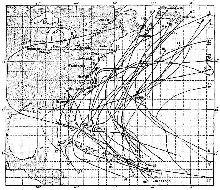 Fig. 26.—Tracks of West Indian hurricanes. The circles
on the tracks indicate the position of the storm centres at Greenwich
mean noon on successive days. The date of the several storms is as
follows:
Fig. 26.—Tracks of West Indian hurricanes. The circles
on the tracks indicate the position of the storm centres at Greenwich
mean noon on successive days. The date of the several storms is as
follows:The analogy of a tropical hurricane to a tornado has already been referred to, but while a tornado may lay waste a tract of country perhaps half a mile wide, and in exceptional cases 20 to 30 miles in length, a hurricane is from 200 to 300 miles in diameter, and may continue to be destructive, on account of the rapid inflow of air from the periphery towards the centre, for 2,000 or 3,000 miles. The velocity of the spirally blowing winds which are the characteristic feature of these great storms is frequently 100 miles or more per hour. In spite of their magnitude, however, the conditions leading to their origin and growth 210 are essentially the same as in the case of tornadoes, and even of the much smaller whirlwinds. They have their birth where the moist, still air above the ocean in the region of the doldrums at the season when the equatorial belt of calms is farthest north, becomes highly heated and rises on account of the pressing in of cooler and heavier air from adjacent regions. The ascending column is at first carried 211 slowly westward, in obedience to the general flow of the atmosphere in the intertropical belt, and at the same time the currents coming in from opposite directions give the ascending air a rotary motion. As the currents from the northeast are stronger than those from other directions, this whirling motion is from right to left, or opposite to the movement of the hands of a watch. The whirling air column extends into the upper atmosphere, and as it moves along past the West Indies becomes influenced by the prevalent flow of the upper air-currents, and is carried northwestward, and later eastward in a path which approximates to a parabolic curve. The inward-rushing spiral winds leave a calm centre, the "eye of the storm," which corresponds to the hollow core of a whirlwind and the calm centre sometimes noted in tornadoes. The upward ascent of warm, humid air is accompanied by a decrease of pressure and consequent expansion and cooling which leads to rapid condensation and a heavy downpour of rain; the change of the moisture from a vaporous to a liquid form liberates heat, which serves to perpetuate the upward flow of air, and thus prolongs the life of the storm. During the passage of the central area of low barometric pressure over a given locality the clouds frequently part and portions of the clear sky may be seen. Accompanying the rain are frequent lightning flashes, as during ordinary thunder-storms.
The tropical hurricanes are the most violent and most dreaded of all the storms that sweep over any portion of our continent, but fortunately for dwellers on the land, are confined for the most part to the sea, since the atmospheric conditions over the land lead to their loss of energy, although in rare instances they may be re-enforced by uniting with a cyclonic storm, as happened in the case of the Galveston hurricane, and thus continued after reaching the land. The destructiveness of the hurricanes at sea has been greatly lessened in recent years, not only on account of the general use of steam as a motive power for vessels instead of the wind, but because meteorologists can designate the time when they are likely to occur and the best method of sailing 212 away from them if encountered. Since the establishment of the United States stations for observing and reporting the atmospheric conditions on the West India islands, the approach of a hurricane can be foretold and warning given to navigators and others of the coming danger.
An important element in climate is the amount of moisture the air contains. The absolute amount of water vapour in a given volume of air is of interest in this connection, but what is of still greater importance is the ratio of the amount of water vapour present to that which the air might contain, or what is termed the relative humidity. The relative humidity, providing the actual amount of vapour present remains unchanged, depends upon the temperature of the atmosphere. For this reason, the warming of an air-current, as the trade-winds, for example, in which the water vapour present may, previous to the warming, have approached saturation, causes it to have a still greater capacity, and hence decreases the relative humidity.
The winds in passing over the land may be either cooled or warmed, and hence their influence on evaporation is continually changing; but the mean rate of evaporation from an open water body can be determined for a definite time, say a year, for various localities, and thus afford a means of comparison between one region and another. Observation of the mean annual evaporation for various stations, mostly within the United States, have been made, and the result shown by lines drawn through places where the rate is the same. A map showing this data, on which the figures indicate the depth of evaporation in inches, is here presented. The systematic study of evaporation, and especially the part played in it by plants, has scarcely more than been begun on this continent, and important results concerning its influence on atmospheric conditions are to be expected. The subject is also of great importance in reference to agriculture, the prevention of frost, etc.
The great storehouse of information pertaining to the weather and climate of the United States is the numerous publications of the United States Weather Bureau, Washington, D. C. Similar bureaus exist at the capitals of Canada and Mexico, which have issued valuable reports.
Of the many elementary and popular books on meteorology, the following will be found helpful in continuing the study of the subjects outlined in this chapter:
If we take the trees as representatives of the flora of North America, and this seems to be the only practicable method in a general treatise, we find them growing most densely and presenting at the same time the greatest variety where the temperature is uniformly high throughout the year and the rainfall heavy and long-continued. From the torrid lowlands the forests in general decrease in the variety and number of trees on a given area, both towards the north, where temperature becomes the controlling factor, and towards regions of small rainfall, where the leading adverse condition is deficiency of moisture. In the most highly favoured localities the struggle for existence between species and species and individual with individual is intense, exposure to the life-giving sunlight being the dominant aim of every one of the contending hosts. As drier or colder regions are approached, but few species can survive and the forests are characterized by their monotony. Where the conditions of heat and moisture are such that the existence of a species is precarious, the balance of power, so to speak, passes to the secondary conditions; and the texture and composition of the soil, slight differences in the relief of the land, and consequently in drainage or in the degree of exposure to light, prevalence of fires, etc., make themselves prominent and limit distribution.
From a geographical point of view, the broadest features in the flora of North America are the forested and unforested areas. The distribution of the forests, prairies, and treeless plains as they existed previous to the coming of Europeans is shown on the accompanying map. For the portion of the continent to the northward of Mexico 217 the data on which this map is based are much more abundant than for the southern portion.
As is indicated on the map just referred to, the forests of North America in a general way form a broad belt, for the most part within the influence of winds from the ocean, which surrounds a large area of treeless plains and plateaus in the west-central portion of the interior continental basin, but is broken and rendered irregular in its southwestern part of the treeless valley of the Great Basin region. The irregular circular belt of tree-covered land is closed at the south by the forest on the lowlands of Mexico and Central America. This vast forest belt, extending from the Atlantic to the Pacific, and from Panama to northern Canada, presents great variations even in its larger features, and, for convenience, and also with the aim of expressing in a rough way natural relationships, needs to be subdivided for purpose of study. The basis for such a subdivision has already been suggested, as the forests, like all other divisions of the life of the continent, are an expression of climatic conditions—that is, the boundaries of the botanical and zoological provinces should agree with those of the climatic provinces.
On this basis we have the tropical forest, which covers the more humid portions of the east and west margins as well as all of the southern portion of Mexico, together with nearly all of Central America and the West Indies, and includes the southern extremity of Florida. Within the tropical forest, however, there are high mountains on which trees with the general characteristic of those more northern floras find a congenial habitat. The two austral and the transition provinces are to a great extent clothed with diversified forests, which are naturally divided into two portions: an eastern division, embracing the Atlantic and Gulf border of the United States, together with the eastern part of the Mississippi Valley and the Great Lakes region; and a western division, in which is included the lands bordering the 218 Pacific from near Mount St. Elias southward to the vicinity of San Francisco, and also several irregular branches or detached island-like areas on the Pacific mountains, in the United States and Mexico. The former of these divisions may, in a general way, be termed the Atlantic, and the latter the Pacific forest. Separating them is the treeless west-central portion of the Continental basin. Both the Atlantic and Pacific forests merge at the north with the boreal forest, which extends diagonally across the continent from Newfoundland to Alaska. Peninsula-like and island-like areas occupied by the boreal forest occur in the sea-like expanse of the transition and austral provinces, on both the Atlantic and Pacific mountains.
The tropical and boreal forests have their greatest extension from east to west or with the parallels of latitude, and are remarkable for their uniformity in general characteristics, the reason being that climatic conditions, and especially the temperature in summer, change less rapidly along east and west than along north and south lines. The Atlantic and Pacific forests, on the other hand, have their greatest extension across the parallels of latitude, and hence experience marked changes from locality to locality in both temperature and precipitation, and are characterized by conspicuous changes from one locality to another in the genera and species of trees of which they are composed. In each of the areas occupied by the major divisions of the encircling continental forest belt there are marked variations in elevation, which are accompanied by corresponding climatic changes, and hence by modifications in the forest growths. Of all portions of the continental forest belt, variation in elevation is least marked in the forests of Canada, and for this reason, in part, we there find the most uniform and most monotonous of all the forests of the continent. The influence of elevation, however, on climate and on both plant and animal life is greater for a given measure, as for 1,000 feet, in the torrid than in the cool or cold zone, for the reason that the possible range in climatic conditions is much greater at the south than at the north.
The Tropical Forest.—There are great areas in southern Mexico which are clothed with a typical tropical forest; while other similar forests cover nearly all of the lower portions of Central America, the larger or more rugged West India islands, and the southern extremity of Florida. Throughout this vast region, within the influence of the trade-winds and of the equatorial rains, the forests are luxuriant and beautiful, except on lowlands not adjacent to the windward side of mountains. The characteristic trees of the hot, humid lowlands extend up the mountain to an elevation of some 4,000 or 5,000 feet, where a change to the aspects familiar in the lowlands of the temperate zone begins, and palms give place to oaks and pines.
Of the many features of the tropical forests which impress a traveller from colder regions, none excite greater wonder than the large number of vegetable species growing in close proximity. It has been said, and apparently the statement cannot be successfully challenged, that a greater variety of plants may be collected on 100 square yards of surface in the humid, tropical lowlands than can be found on 100 square miles in the forest of central Canada. It is probably safe to extend this striking contrast by saying that of the trees on a typical area in the tropical forest of the size mentioned, there are in many localities more species than in the whole of the subarctic forest.
Among the characteristics of tropical forests is the presence of many kinds of plants on a limited area, hundreds of species struggling upward to the light where there seems room but for one; the variety of mosses and lichens; the profusion of flowering parasites; the luxuriance of the vines, many of which are armed with spines; and the abundance of the remarkable aerial roots termed lianas. Of the last there is a great variety, some of them of large size and surprising length; they frequently descend from plants entwined among the topmost branches of great trees, looking not unlike the cordage of a forest of masts in some crowded port, and on reaching the ground send out rootlets in the humid soil.
In the depths of a tropical forest it is always twilight. 220 Even at noontide no shafts of yellow sunlight reach the ground to glorify mossy banks and flower-gemmed dells, as in the open woods of temperate climes, but a diffused greenish light, producing weird effects, alone penetrates the dense leafy canopy far overhead. The roots of even the larger trees in these hot, humid forests do not have to descend deeply in order to find the necessary moisture or to receive protection from frost and sudden changes of temperature, but are usually widely expanded and thickly interwoven over the surface. The earth from which the dense vegetation derives nourishment is surprisingly deficient in vegetable mould, which is a characteristic feature in the moist forests of temperate and even subarctic regions, where the complete decay of dead vegetation is long delayed. In the tropical forests the annual supply of dead vegetable matter suitable to be transformed into humus is far greater than on a corresponding area in the woods of more northern regions, but decay is so rapid, owing to the uniformly high temperature and the conditions favouring the multiplication of bacteria, that even great trees on falling quickly disappear; in many instances, the forms of prostrate tree trunks are preserved and overgrown with luxuriant mosses or gorgeously festooned with ferns and orchids, but soon become fragile shells from which nearly all the woody tissues have been removed by decay or by swarming colonies of insects. Where life is so exuberant and the wants of growing plants so great it seems as if the food supply was insufficient, and that none could be spared to accumulate on the ground and form a soil.
The two most characteristic and distinctive classes of plants in the tropical forests are the palms and the ferns, each of which is represented by many genera, a large number of species, and multitudes of individuals, and in each class there is a gradation in size from low herbaceous growths to arboreal forms.
In every way worthy of first mention among the plants of the Caribbean forests are the palms. A characteristic portion of the forest referred to occurs in Cuba, where, as is stated by R. T. Hill in his recently published and attractive 221 book descriptive of the West Indies, there are some 26 species of palms, which give variety and beauty to the scenery of the "Pearl of the Antilles," as well as shade and food to its inhabitants. At the head of these for height and grace of form stands the royal palm, which might well be chosen for the emblem of the fair island it adorns. The wide-spreading crown of glossy pinnate leaves of this species is borne on a spindle-shaped stem of tough fibrous wood—so strong and pliant that it defies even the hurricane—in many instances 150 feet above the ground. The tree is a marvel of beauty and elasticity, and, fortunately for Cuba, is one of the most abundant of the larger trees on the island. It is met with almost everywhere; in the centre of broad pasture-lands it often stands alone, tall and straight, while bordering the cultivated fields of the rich planter it forms a shady avenue to his dwelling. This well-named royal palm has also been called the blessed tree, for every part of it has its usefulness to mankind. Certain medicinal qualities are claimed for its roots; the outer portion of its trunk is easily split into boards for use in making houses and furniture for the poorer people; in the centre of the cluster of young leaves at the summit is a tender substance which is eaten raw, or cooked as a vegetable, or preserved with sugar as a table delicacy. The broadened leaf-stalks where they leave the main stem form a sheath-like expansion resembling a thin board, often four to six feet long, which is made to serve a variety of purposes, such as plates, and when soaked in water becomes pliable and may be fashioned into baskets and dishes for cooking, and at the same time furnishes salt for the seasoning of the boiling vegetables or meat.
The world-encircling cocoanut-palm is found about the shore of tropical North America, and there, as elsewhere, serves a great variety of uses, being a greater blessing, especially to the natives and the poorer descendants of European and African immigrants, than even the royal palm. The economic importance of its wood-fibres, leaves, and fruit are too well known to require re-enumeration.
While the wealth of palms is confined to the hot, moist 222 regions of Mexico, Central America, and the West Indies, several members of the same great family are found in the United States. The royal palm is native to southern Florida, while the low fan-palms cover much of the northern portion of the same State, and occur even about the Ozark Hills in Arkansas, and the palmetto, growing to be a stately tree, is found near the coast in the Carolinas and is the emblem of South Carolina, the "Palmetto State."
The ferns, although abundant, especially in moist woods from Alaska southward, throughout the continent, reach their greatest variety and richest luxuriance in the West Indies and Central America, where the graceful and most artistically beautiful tree-ferns add an indescribable charm to the always varied foliage. The tree-ferns grow farther up the mountains of the torrid zone than do the larger palms (in the same manner that the smaller ferns extend much farther north than the most hardy palmettoes), and form a conspicuous feature in the foreground of nearly every wide-reaching prospect in the more elevated portions of the West Indies, Central America, and south-central Mexico.
In addition to the palms and ferns, the tropical forests of North America contain a large number of trees of great economic importance. Chief among these are the mahogany, which is native to the lands bordering the Caribbean Sea and Gulf of Mexico, and reaches the largest size and produces the most beautiful and most highly prized wood on Cuba, Haiti, the Bahamas, and Jamaica. As is well known, this hard, dark, heavy, fine-grained, and exceedingly durable wood has been used for the best grades of cabinet-work for about two centuries, and is still unsurpassed for the beauty of its grain, susceptibility of a high polish, and the several ways in which it is adapted for the carver's tool. On account of the great and long-continued demand for its wood it has become scarce in all but the most inaccessible localities. When allowed to reach full maturity it is a large, wide-spreading tree with numerous branches, looking not unlike a giant oak, but has pinnate leaves and small, although somewhat conspicuous, white flowers. 223
Another gift of the tropical forest is the lignum-vitæ, which furnishes the exceedingly tough, hard, resinous wood preferred above all others for the making of pulleys, mallets, etc. Many other highly prized woods, not known, however, by familiar names, are also found in the varied forests of tropical America, as well as numerous vegetable dyes, such as logwood, brazil-wood, indigo, etc.
The lands of the Caribbean-Gulf region are credited with having introduced to civilized man the potato, Indian corn (maize), and tobacco, although the home of the former is probably in the Andean portion of South America. Indian corn grows luxuriantly not only in the hot lowlands of Mexico, but on the border of the central table-land of that republic, where it is supposed to be indigenous, and has now become one of the leading crops of temperate North America, and is cultivated in many other portions of the world. Tobacco was found under cultivation in Mexico at the time of the first coming of Europeans, and retains for its familiar name the appellation of the district where it was first seen. From Mexico also come the dahlia and the giant sunflower, as well as the various species of aloes and cacti now so common in gardens and conservatories the world over.
Of all the plants, excepting Indian corn and the potato, which are native to the region under review, none has proved such an unalloyed blessing to civilized man as the cacao-tree. As this tree is unfamiliar to most residents of temperate lands, it may not be unprofitable to transcribe in part a description of it from Rhind's Vegetable Kingdom. The tree is very handsome, from 12 to 16 feet high, with an upright trunk some 5 feet high; the leaves are lanceolate, with entire margins, and of a bright-green colour; the flowers are inconspicuous, reddish, with yellowish sepals; the fruit, attached by short stems to both trunk and branches, has a yellowish and reddish colour, oblong, about 3 inches in length, and consists of a fleshy rind, half an inch thick, containing a white pulp in which are imbedded about 25 seeds. The seeds, when roasted, freed from their husks, and ground, furnish the chocolate so extensively 224 used, especially in France and Spain and in the former Spanish colonies, and is increasing in favour among English-speaking people.
Vanilla, which is used in flavouring chocolate as well as many other dishes, was also found in use among the Aztecs at the time of the Spanish conquest. The vanilla-plant is a climbing vine, with lanceolate leaves 18 inches or more in length, and produces a pod containing bean-like seeds. The pods and seeds when properly dried furnish the flavouring extract of commerce.
Although the trees which yield rubber in America, as well as the cinchona, from the bark of which quinine is obtained, are justly to be accredited to South America, yet certain varieties of these useful plants occur in Central America and are under cultivation as far northward as central Mexico.
A more detailed account of the plants of great utility in one direction or another native to the tropical forests, should include plantains, bananas, and yams, the wide distribution of which, largely by human agency, throughout the torrid zone is well known. The delicious pineapple is native to the Caribbean region, and was found in the markets of the Aztecs by the early Spanish invaders, although perhaps indigenous to other lands as well. In Mexico especially, but on the borders of the tropical forest and in the drier interior, grows the agave, from which the national beverage, pulque, is obtained, and another species of the same peculiarly American family of plants supplies great quantities of the tough fibre known as sisal or henequen hemp, particularly on the stony, arid portions of the peninsula of Yucatan. Of interest to children especially is the fact that Mexico exports some 3,000,000 pounds of chewing-gum each year, which is obtained from a plant there growing wild. To this list of indigenous products may be added ginger, arrowroot, etc., as well as many fruits scarcely known outside the tropics, such as the mango, alligator-pear, breadfruit, and numerous others. This hasty enumeration might be greatly extended or presented in more detail, but probably enough has been said 225 to indicate the great and probably as yet but partially determined economic importance of the vegetable products of the torrid portion of North America.
Associated with the tropical forest, but thriving best in an advanced skirmish-line about its drier inland borders, is a group of plants indigenous to the two Americas—the strangely shaped and spinous cacti. One of these, the prickly-pear, as it is termed on account of its pear-like edible fruit, is the emblem of Mexico. A fit legend to place about this unique heraldic design would be the motto inscribed on the rattlesnake flag of colonial days in America, "Don't tread on me," as every one will appreciate who has travelled in the southwestern portion of the United States or in the upland regions of Mexico.
The cacti extend from South America northward through the lands bordering the Caribbean Sea and Gulf of Mexico, and east of the Mississippi are represented by a single genus, Opuntia—the prickly-pear, or Indian fig, as it is often termed—which grows in dry situations as far north as Massachusetts and Michigan. In the Great Basin several genera of cacti are plentiful, especially on dry, stony uplands, and two species reach as far northward as the Canadian boundary. Although the cacti tribe is widely distributed, the region where it presents the greatest variety and the largest individuals is in the dry, semi-desert portions of Arizona and the table-lands of central Mexico. It is most at home on sterile, rocky ridges and amid bare cliffs where there appears to be but little soil, but the strong roots strike deep into the earth in search of moisture. The cacti present great diversity of form and an indefinite differentiation of stem and leaf. In fact, there are no easily recognised leaves in the ordinary sense of the term, but the fluted and jointed stems perform the function of foliage. The plants are economical of moisture, and not only present a minimum of surface for evaporation or transpiration, but their epidermal tissues are for the most part without pores, thus retarding the escape of the moisture drawn from the seemingly dry soil.
In size and shape the cacti present great variety, ranging 226 through all gradations from the thick, strongly jointed, pad-like expansions of the prickly-pear, a few inches high, growing in widely extended clusters and massive globular forms, looking not unlike spiny melons, 2 or 3 feet or more in diameter, to jointed and fluted columns, bristling with sharp spines, the largest of which, known as the candelabrum cactus, attains a height of from 40 to 60 feet. In this the largest of all the cacti, which is not uncommon in Arizona and adjacent portions of Mexico, the central upright stem, frequently 20 inches or more in diameter, sends out from 1 to perhaps 7 or 8 club-shaped branches, which leave the parent stem nearly at right angles, but soon bend upward and become parallel with the central stalk, which they frequently surpass in height, their form thus suggesting a branching candlestick or candelabrum.
In spite of the bizarre and frequently repellent appearance of the cacti as seen under cultivation, in their barren homes they are in harmony with their surroundings, and add a characteristic, and even beautiful element to the scenery of the parched and generally desolate valleys and rocky slopes where they thrive best. Their blossoms are large, usually either white or brilliantly coloured, and expand in the hot, dry air, fully exposed to the intense sunlight, and present a freshness and vigour which tell of the abundant store of moisture within the thick rind inclosing their stems. The showy flowers are borne close to the body of the plant or at the ends or edges of the inflated pad-like leaves, and are scentless, except in the case of a few night-blooming species, and attract insects from afar by reason of the conspicuousness of their widely expanded corollas. The fruits also are usually conspicuous, and present many rich tints of red and yellow, which at a little distance give them the appearance of flowers. The fruit of several species are edible, and even delicious, especially when gathered fresh from the thorny stems and eaten on the desert, perhaps many miles from the nearest spring or stream. One species of cactus growing abundantly in Mexico and known as the cochineal-fig, is inhabited by the cochineal-insect, from which the highly prized dye of that name is obtained. 227
A companion of the cacti in the arid region where they flourish best is the yucca, or Spanish bayonet, which sometimes attains the size of small trees and throws out several branches. Its leaves are stiff, thick-stemmed, and each one terminated by a sharp spine, as is well known from the many examples to be seen under cultivation in Europe and America. The flowers are white and borne in luxuriant showy spikes a foot or two in length, and sometimes give to dry, rocky slopes the appearance of a luxuriant garden.
The cacti, yuccas, and associated plants of the most arid portions of the continent stand far apart, without mutual support or shelter, and find protection in their spines, thick rinds, and frequently acrid juices. Their colours are usually neutral, grayish green, rendered still more inconspicuous by the dust that settles on them, but their flowers are as a rule conspicuous, thus serving to attract pollen-bearing insects, and their fruits are in many instances brightly coloured, and furnish food for birds and other animals, which assist in the distribution of their seeds.
The Atlantic Forest.—The originally forest-covered eastern portion of North America, referred to under the term Atlantic forest, embraces the region from the eastern coast of the continent inland across the Appalachian Mountains and interior Continental basin to the eastern border of the prairies or plains; its southern limit, in a general way, is the coast-line of the Gulf of Mexico, but the arbitrary boundary, dividing it from the tropical forest, crosses the southern portion of Florida, and at the extreme southwest is drawn at the Rio Grande. The northern boundary of the Atlantic forest is also an arbitrary line, and follows the fiftieth parallel of latitude from the mouth of the St. Lawrence westward to the region about the Lake of the Woods; along this boundary the varied Atlantic forest merges with the monotonous and mostly coniferous subarctic forest. The region thus roughly outlined comprises over 2,000,000 square miles, and was at the time of the first coming of white men to America almost completely forest-covered, but the natural conditions are now profoundly modified, and to a great extent the trees have been 228 cut or burned, and the land they shaded converted into cultivated fields.
The Atlantic forest as a whole has two leading characteristics, the first being the great variety and frequently large size of the deciduous trees—that is, of broad-leaved trees, such as the oak, hickory, elm, maple, chestnut, etc., which drop their ripe leaves each fall and renew them the following spring—and the second, the intermingling of the trees of the class just mentioned with the coniferous trees, such as the pine, spruce, tamarack, etc., which have narrow, needle-shaped leaves and are usually designated as evergreens. While these general statements are sufficiently accurate for our present purpose, it is to be remembered that some of the broad-leaved trees (Angiosperms) are evergreen, especially in the southern portion of the Atlantic forest, as, for example, some of the oaks, the magnolias, the holly, etc.; while at the north, certain of the conifers (Gymnosperms) shed their leaves each fall, as is conspicuously illustrated by the yellow of the tamarack or larch forests of the northeastern portion of the United States and eastern Canada, in November, and the bright green of the same trees in May of each year. It is in the intermediate temperate region, between the mostly evergreen coniferous subarctic forests and the mostly evergreen broad-leaved trees of the Caribbean forest, that the wonderful transformation in the colours of the mountains and plains each autumn becomes the most conspicuous feature in the annual round of seasonal changes as expressed by the vegetation.
Of the two classes of forest-trees, represented by the oak and the pine, which are intermingled and struggle with each other for supremacy in the Atlantic forest, it is difficult to say which is the more beautiful or which is of the greater service to man. The broad-leaved trees give us our hardwoods, used extensively for furniture, the interior finish of buildings, and for the manufacture of tools, farming implements, wagons, carriages, sleighs, etc. To a great extent it was the availability of these strong, tough, hard, and durable woods which has made American tools and implements of 229 such a high grade of excellence that they are in demand in every civilized country. For example, the American ax-helve, made of hickory, is almost a work of art, as well as of utility, and it is prized above all others by foresters the world over. The same tree has aided no less efficiently in the popularity and excellence of American carriages and sleighs, the equal of which for lightness, strength, and durability has not been reached in other countries. The pines and their near relatives furnish what unfortunately has been considered an unlimited supply of easily workable lumber, suitable for building houses, vessels, bridges, and many other purposes. Of the pine lumber supplied by the Atlantic forest, there are two principal varieties, the far-famed white pine, furnished by New England, the Great Lake region, and southeastern Canada, and the yellow pine, which comes from the South Atlantic and Gulf States.
Of the Angiosperms which reach the dignity of trees, the Atlantic forest possesses a variety and abundance not exceeded elsewhere in the world. The most characteristic examples are the maples, elms, oaks, hickories, walnuts, chestnuts, ashes, basswoods, birches, tulip-trees, magnolias, liquidambar, tupelos, sycamores, etc., nearly all of which are represented by a number of species or varieties and vast numbers of individuals. While this diversity is found throughout the forests of the east-central part of the continent, certain regions are characterized by the abundance and large size of the trees belonging to one or to a few genera, so that a striking change is met with as one travels in any direction. The maples and elms reach their greatest size and abundance at the north, especially in New England, and thence westward to the Mississippi Valley, where they are the favourite shade-trees of villages and farms. In regions where the forests have been removed choice specimens of these trees have frequently been saved or subsequently planted, and standing alone, without competition and fully exposed to the light, reach great perfection of form and a high degree of beauty. The oaks are represented by a large number of species and varieties throughout the entire Atlantic forest, but reach their largest size and greatest 230 abundance, both of species and individuals, in central and southern portions of the eastern United States. The same may be said also of the hickories, except that the maximum in reference to size, number of species, and abundance is attained in the region of the Ozark Hills. The tulip-tree, so named from the profusion of showy yellow blossoms it bears, is large and wide-spreading, with broad, dark-green leaves, and has the centre of its habitat in Kentucky, where many magnificent examples occur along the fences separating the broad meadows and rich pastures of the region of the blue grass, but thrives also from the Atlantic coast westward to beyond the Mississippi, and from Ontario on the north nearly to the Gulf of Mexico on the south. Not only is the tulip-tree an ornament and a blessing on account of its flower-laden branches and dense shade, but its white, even-grained wood is of great value.
To give even a list of the deciduous trees which flourish and reach a high degree of perfection in the Atlantic forest would require far more space than is at present available. There is one other genus, however, which cannot be passed by even by a casual observer, and that is the magnolia, one species of which, the grandiflora, is the most magnificent of all the splendid broad-leaved trees of America. This, the largest and finest of the several species of its genus found in the eastern portion of the United States, attains a great size in the southern Appalachian region, but is best developed in the lower portion of the Mississippi Valley. It is frequently from 50 to 80 feet or more in height, wide-spreading, and in many instances upward of 3 feet in diameter, with dark-green leaves which do not fall in the autumn. In spring the dark foliage is beautified by cup-shaped blossoms of creamy whiteness and remarkable fragrance, which measure 3 or 4 inches in diameter. When the magnolia is in blossom it becomes a centre of delicious perfume and a colony of insect life. Its wood, although creamy white and excellent for cabinet-work and interior finish of houses, has not as yet found favour for these or other purposes.
With the exception of a few species of broad-leaved 231 forest-trees found in greatest perfection in the northern portion of the Atlantic forest, they reach their greatest development in size, number of species, and density of growth in the southern portion of the broad Mississippi basin, where, in addition to magnolias, the tulip-tree, etc., chestnuts, hickories, oaks, and many other genera grow side by side and attain great height and dignity. This is also the centre of dispersion of the American hawthorns, which reach a size and beauty unrivalled elsewhere. The Osage orange is peculiar to this region, and the red cedar (juniper), the most widely distributed of all the American conifers, and also the yellow or southern pine are there at their best. Much of this region still retains its primitive wildness.
The great extent of the Atlantic forest in latitude, the topographic diversity of the region it occupies, and its exposure on the east to maritime and on the west to continental climatic conditions, have led to great variations within itself. From the coast of New England westward and including the entire drainage basin of the St. Lawrence, together with an extension southward along the Appalachians, the forests are composed largely and over extensive areas almost wholly of coniferous trees. This region of northern evergreens contains in its southern portion sturdy growths of broad-leaved deciduous trees. The spruces, the most characteristic of the trees of the subarctic region, are present in abundance on the mountains of New England, and still form a dark mantle over the Adirondack hills; but on the less elevated lands adjacent the white pine dominated and outnumbered all its rivals in the primeval forest.
The white or Weymouth pine, which up to the present time has proved to be of greater commercial value than any other tree on the continent, extends westward from southern Newfoundland and the coasts of the maritime provinces of Canada to Minnesota, and occupies nearly the entire drainage area of the St. Lawrence, together with an extension southward along the Appalachians nearly to their southern limit. 232
The white pine is a large tree for the region in which it grows. Its height is from 70 to 150 feet, with a diameter at the base of from 3 to 9 feet. It thrives best on sandy soil and hills of glacial drift, and endures a severe winter climate, as well as the frequently long-continued droughts of the hot summers. Its wood is soft, compact, with an even, straight grain, and is not conspicuously resinous. The sap-wood is nearly white and the heart of a light brown, slightly tinged with red; it is easily worked and susceptible of a good polish; it is more extensively used for boards, shingles, etc., than any other wood in the eastern portion of the continent, and is in demand also for cabinet-work, the interior finish of buildings, ship-building, and many other purposes.
The southern pine—known also as the "long-leaved pine"; "Georgia pine," for the reason that the lumber derived from it was first extensively shipped from that State; "yellow pine," in reference to the golden colour of its wood; and "hard pine," in distinction from the softer white pine—is another valuable species. The tree with these several synonyms, of which the term southern pine will here be used, forms open forests with but scanty undergrowth, over a region extending from near the Atlantic coast in the Carolinas and Florida, westward to the delta region of the Mississippi, and reappears again to the southward of the Ozark Hills. Although not so large, and to many admirers of beautiful trees not so picturesque or pleasing as its relative in the more rigorous climate of the St. Lawrence basin, the southern pine, growing within the reach of the moist, warm winds from the Atlantic and Gulf of Mexico, is still an attractive tree, especially when young and when freedom is afforded to expand its boughs. It is seldom over 100 feet high, and as cut for lumber has on an average a diameter of about 2 feet at the base, although individuals measuring 3 or 4 feet in diameter are not rare in certain favoured areas. It grows best on dry, sandy soil, outside the flood-plains of streams, where it forms monotonous forests, with but few intergrowths of other trees. The wood is heavy, 233 hard, strong, durable, coarse-grained, very resinous, and of many shades of brown and yellow. When sawed into lumber, it serves a wide range of uses, more especially for the frames of buildings and ships, and for the floors and interior finish of houses.
Next to the southern pine, the most characteristic tree of the Atlantic coastal plain southward from Virginia and westward through the Gulf States, is the cypress, also a conifer, but, like the tamarack, sheds its leaves in the autumn. The cypress grows especially in swampy localities, and has a widely expanded base, suitable for support on marshy soil, and reaches a large girth, although seldom over 75 feet high. Aged and most picturesque examples are growing in isolated positions in Lake Drummond, the central water body of the Dismal Swamp, and in many other similar situations in the belt of low country fringing the borders of the Atlantic and Gulf of Mexico. Its wood is used for most of the purposes for which the southern pine is employed, and now that the white pine is approaching extinction, is to a considerable extent supplying the demand for cabinet-wood.
In glancing at the larger and most numerous trees of the Atlantic forest, and those of greatest utility, we should not neglect the humbler plants, usually of little, if any, purely commercial value, but priceless on account of their beauty and the fragrance of their flowers, which grow beneath the shade of their larger and more stately associates or are content to possess the local areas, perhaps high on the mountains, where the conditions of climate or soil are unfavourable for the growth of large trees. Throughout the eastern portion of the United States, but more especially on the slopes and summit portions of the Appalachians, there are many species of azalea, laurel, rhododendron, etc., which grow luxuriantly and in spring and early summer furnish a wealth of bloom that is scarcely rivalled elsewhere on the continent. In this same region also, but extending westward to Michigan and Minnesota, and even to eastern Nebraska, grows the redbud or Judas-tree, which each May becomes as thickly set throughout 234 all its branches with small crimson blossoms as are the tree-like coral in tropical seas with expanded polyps. This beautiful tree of low growth many times gives to the mountains of Virginia, when seen from a distance, a delicate blush like that which the osiers earlier in the spring impart to the marshy vales and river-banks. A companion of the redbud, but far more widely distributed, is the dogwood or cornel, of several species, the most conspicuous of which, and in the Appalachian region the most common, is the flowering dogwood. In May and June this species puts out a profusion of clusters of small greenish flowers, each of which is surrounded by a broadly expanded and very showy corolla-like involucre, composed of four white or pinkish inversely heart-shaped leaves. When the cornel is at the height of its spring-time glory it stands forth amid the tender greens, russets, and pinks of the unfolding leaves of the various trees and shrubs among which it grows as if the orchards and forests had been commingled by some fairy gardener. In autumn the cornel again becomes conspicuous in the woodlands by reason of its clusters of coral-red fruit.
In the splendid Atlantic forests, with their marvellous intermingling of shining pine-needles, broad, swaying leaves, and many-coloured trunks, there are also vines and creepers sometimes forming impenetrable tangles, as where the broad leaves of the wild grape grow in pendent sheets of green from supporting trees, or the jessamine fills the air with fragrance. Of the many vines which entwine the trunks of trees, mantle the rocks, and quickly claim abandoned fields, especially in Virginia and neighbouring States to the southward, none is more beautiful or more highly prized for the charm it adds alike to fields, fences, and forests than the familiar Virginia creeper. The glory of this widely distributed vine comes in the autumn when its leaves change from green to the most brilliant scarlet. During the season of harvest also, when the trees are arrayed in their greatest splendour, the ground is yellow with golden-rods or purple with asters. This annual carnival of colour embraces the entire Atlantic forest, but 235 is most resplendent in the region of the Hudson and St. Lawrence. A charming little denizen of the Atlantic forest is the lowly and humble arbutus, or Mayflower, which springs up through the dead leaves carpeting the ground in early spring, and fills the air with its delicious perfume. The Mayflower is a trailing plant, but a few inches high, with rounded or oval leaves, which remain green all winter and furnish a pleasing setting for the small pink or rose-coloured blossoms, which appear in early spring even before the snow has melted. It reaches great perfection beneath the pines of New England and about the Laurentian lakes, but extends far southward along the Appalachians, where elevation gives conditions similar to those of the lower region at the north.
The Atlantic forest reaches its western limit in the Mississippi basin (Fig. 28), and is succeeded westward by treeless prairies, which merge along their western margins with the drier and less completely grass-covered high plains adjacent to the east base of the Rocky Mountains. The forest does not terminate abruptly, as on the border of a cleared field, but by gradual transitions. As its western limit is approached, a change in the species is noted, trees which thrive on uplands and can sustain long-continued summer drought replacing the species best adapted for more humid conditions. The forest is most extended, however, along the streams where white-trunked cottonwoods, frequently of great size, with widely spreading branches, extend even into the region of the great plateaus. Much of the prairie region in Illinois, Iowa, etc., was originally nearly surrounded by forest growths. The natural condition of the prairies and higher plains adjacent to them on the west and the reason for the limits set to the western extension of the Atlantic forest will be considered later under the heading Prairies and Plateaus.
The Boreal Forest.—From Nova Scotia, Newfoundland, and Labrador a forest composed mainly of a few species of coniferous trees extends westward, and after passing the southern extremity of Hudson Bay, is prolonged northwestward 236 across the continent and in the region of the mouth of the Mackenzie nearly to the shore of the Arctic Ocean. It extends also through central Alaska to within about 100 miles of the border of Bering Sea. This vast transverse forest belt which unites the northern extremity of the Atlantic forest with the northern portion of the Pacific forest is over 3,000 miles long from southeast to northwest, and on an average fully 600 miles wide. On the north, more especially in arctic Canada and as it approaches the shore of Bering Sea, it thins out, owing to the severity of the winter climate, the trees become dwarfed and stunted in much the same way as the trees adjacent to the timber-line on high mountains, and is succeeded by the broad treeless plains of the Barren Grounds and tundra. Along its south-central border its extension is again limited by climatic conditions, principally the dryness of the hot summers. The trees are there scattered or form isolated groves to the south of the general forest boundary, and are finally succeeded by the treeless prairies and interior plains and plateaus. On the east the great northern forest merges with the pine of the northern portion of the Atlantic forest, and in a similar way at the northwest passes by insensible gradations into the north extension of the coniferous forest growing on the Pacific mountains. In each of the instances there is no well-defined boundary between the east and west belt of northern forests and the north and south forest belts adjacent to the Atlantic and Pacific.
The boreal forest presents a striking contrast to the forests of the torrid zone and to the greater portion of the forests of temperate regions in the fact that it is composed of but a few species of trees. Monotony which becomes oppressive to one who lingers long in its sombre shade is its most conspicuous characteristic. In the main it is composed of but eight species of trees, namely, white and black spruce, larch or tamarack, canoe-birch, balsam-poplar, aspen, balsam-fir, and the gray pine. Of these the spruces are the most abundant and most characteristic as well as the most northern trees of the continent. They 237 frequently reach sufficient size to make them available for building log houses and for lumber.
Four of the species mentioned above, namely, the white spruce, canoe-birch, balsam-poplar, and aspen, cross the entire breadth of the continent from Labrador to Alaska, but the pines and firs in the east and the west are of different species. The larch or tamarack, which forms such an important feature of the forest in eastern Canada and about the Laurentian lakes, extends westward to beyond Hudson Bay, but is represented by other species in the Mackenzie and Yukon basins, and in the northern portion of the Pacific mountains. The region occupied by the great northern forest is interspersed with lakes, some of them of large size, and by innumerable swamps. The spruces and the gray pine grow on the uplands between the lakes and swamps, while the cold, wet bottom-lands are occupied by poplars, dwarf birches, willows, and alders. In the north, near where the forest breaks into outstanding groves and finally gives place to grassy hills, as along the Porcupine River in Alaska, the foliage in the lowlands becomes golden in autumn and forms irregular, far-reaching avenues of brilliant colour separating the hills, which are black with spruce-trees or shimmer with the soft gray tints of ripened grasses. There is much that is beautiful and even lovely along the poleward border of the great forest, but within its deeper recesses the ground is covered with mosses and lichens, and the stiff, sombre trees have a monotonous similarity and unbending rigidity.
In spite of the great area covered by the boreal forest, it being one of the greatest, if not the most widely extended continuous growth of arboreal vegetation in the world, it is of comparatively small economic importance. Even if the trees were within the reach of a market, their wood is of inferior quality and not generally suitable for lumber. A modern industry has been developed, however, which may bring it into demand, namely, the manufacture of wood-pulp, so largely employed in the making of paper and for other purposes. 238
The Pacific Forest.—In the northern portion of the Rocky Mountain region in Canada and Alaska the boreal forest, as already stated, merges by insensible gradations with the forests occupying the Pacific mountains from Alaska southward to Mexico. The junction line between the two is irregular, and what are essentially outliers of the more northern forest occupy the higher portions of the mountains in the western portion of the United States.
The Pacific forest begins at the north near Mount St. Elias, and at first occurs on isolated areas separated by ice-fields and inland reaches of the ocean, but in southeastern Alaska and on the numerous islands adjacent becomes more continuous and extends eastward far into British Columbia. As the timber-line in that region has an elevation of but 2,500 feet at the extreme western extension of the forest, although gradually rising southward, large portions of the mountains are treeless and barren. In the United States, on account of increasing dryness of the valleys from north to south, the forest becomes broken into many detached portions, which occupy the mountains and higher plateaus and in general are restricted to higher and higher locations with decrease in latitude. This distribution illustrates in a striking manner the dependence of trees on humidity. The forest is densest and the trees in general of greatest size and occur at the lowest elevations on the northwest portion of the Pacific coastal region, where the rainfall is excessive and distributed practically throughout the entire year. The Coast Ranges from Alaska southward to central California, as well as the Cascade Mountains and Sierra Nevada, are tree-clothed. In the interior, and especially in the central and southern portion of the Pacific cordillera, where the valleys are hot and dry in summer, trees are absent, and even the borders of the rivers in many instances without shade. In Canada the trees frequently extend across the lowlands, but in Montana and Idaho the valleys resemble the treeless plains to the east of the Rocky Mountains, while the uplands and the lower mountain slopes are dark with firs and pines. Above the forest rise the barren and frequently perpetually snow-covered 239 summit-peaks and ridges. In the Great Basin region, and from there southward, many of the mountains are practically destitute of trees from base to summit.
So vast is the region occupied by the Pacific forest and so varied the conditions dependent upon climate, soil, and elevation which influence its growth, that great variations in the genera and species of trees composing it are to be expected. This prediction is soon verified when one travels through the forest. The extremes may be indicated briefly by referring to the fact that at the north the trees are mainly spruces, firs, and cedars, and at the south include the giant cactus, arboreal yucca, and the fan-leafed palm. In its medial division are the great forests of western Washington and Oregon, composed mainly of firs and cedars, and the no less magnificent forests of redwood-trees on the Coast Ranges of northern California and the west slope of the Sierra Nevada. Like the boreal forest, the one under consideration is largely composed of coniferous trees, although in the valley, and especially along the borders of streams in southern Canada, Washington, etc., a few species of broad-leaved trees, such as the maple, cottonwood, ash, and alder, thrive in close association with dark conifers; while in similar situations farther south oaks growing in scattered groves give a park-like character to the land, as in the southern portion of California.
In contrast with the Atlantic region, the western portion of the continental forest belt is singularly lacking in broad-leaved trees, and such as are found are usually of small size and but little economic importance. This lack, however, is perhaps more than counterbalanced by the number both of individuals and of species and the great size and magnificence of the conifers.
One of the densest and in many ways most thoroughly representative portions of the Pacific forest where it occupies an excessively humid region occurs on the west side of the Cascade Mountains in Washington, inclusive of the Puget Sound basin and the region to the westward from which rise the Olympic Mountains.
In western Washington the forest is composed mainly, 240 and, in fact, over large areas, almost entirely of two species of trees, namely, the red fir and the red cedar, each of which attains gigantic dimensions. Of these two species, the first is the more common, the larger, and by far the more important from a commercial point of view. It frequently, and, in fact, commonly, attains a height of from 200 to 300 feet, with a diameter at the base of from 8 to 10 or more feet. Not only do these magnificent trees reach such great dimensions, but they are thickly set over hundreds of square miles of territory. In thousands of instances the great trunks sheathed in rough thick bark rise straight and massive, with but a slight decrease in diameter, to a height of upward of 80 feet before the first branch is given off. The cedars, the intimate companions of the great firs, are of equally gigantic girth at the base, but taper rapidly to spire-like summits, usually from 100 to 150 feet above the ground, and are thickly set with small branches throughout. They flourish best in excessively moist situations and reach far up the mountains, particularly along the numerous watercourses; while the firs, although perhaps most at home on the less thoroughly water-soaked uplands, thrive on the banks of streams, the sides and summits of hills, and on steep mountainsides alike.
Mere enumeration of the number and size of the trees, however, fails to give an adequate impression of the astonishing magnificence of the wonderful forest of the Puget Sound region. Its grandeur is beyond description, and can only be fully appreciated by one who abides for weeks or months in its perpetual twilight. The great trees, shaggy with mosses and lichens of innumerable tints of brown, green, and yellow, do not form detached groves, as is so frequently the case in less humid lands, but are thickly set for mile after mile and league after league, as one threads his difficult way beneath them. So vast is the forest that a person travelling through it soon becomes impressed with the idea that it is interminable. Beneath the deep shade of the lofty boughs there is a rank undergrowth of young firs, cedars, and hemlocks, while in the 241 valleys especially, and on the frequently inundated flood-plains of the streams, there is usually a tangled growth of vine-like maples, alders, elders, yews, etc. In this lower forest the most conspicuous and frequently too abundant plant is the broad-leaved and excessively spiny devil's-club, the foliage of which changes to brilliant yellow in the early autumn, and forms a most artistic setting for the spikes of crimson fruit borne at the extremities of the upward-bending ends of the usually prostrate stems.
Of still more lowly habits are the ferns, mosses, and lichens which form a thick, luxuriant, and ever-varied carpet over the black humus soil beneath. The ground throughout the forest is encumbered with fallen trunks, sometimes piled one on another to the depth of 20 or 30 feet, which, owing to the continuous moisture, remain undecayed for centuries. Not infrequently a massive cedar or fir, in size and shape not unlike a prostrate column of some great temple, supports three or more trees, each large enough to be cut for lumber, whose gnarled and twisted roots clasp the sides of their host and descend to the earth beneath. The beauty of these fallen giants when overgrown with thick layers of variegated moss and exquisitely decorated with hundreds of small hemlocks and a multitude of gracefully bending fern-fronds, always fresh in colour and usually beaded with moisture, is beyond the power of the most skilful artist 242 to adequately portray. The fascination of the great forest is such that the explorer, although perhaps weary with forcing a passage through the dense undergrowths and climbing over prostrate trunks, is lured by its charms into more and more inaccessible retreats probably never before invaded by man, but at last finding that the wonderland has no attainable limits, is content to rest on some inviting couch of golden-tinted lichens and study the varied charms and endless details of the dream-like picture surrounding him.
From a commercial point of view the forest of the Puget Sound region is of immense importance. Lumber industries have been established there, with the most improved appliances for cutting trees, transporting the logs to mills, and sawing them into lumber, much of which is loaded on ships and widely distributed. So vast is the forest, however, that as yet the natural conditions are but slightly changed, except in the immediate vicinity of tide-water, but the destruction from axe and fire has only been begun; the waste that, no doubt, is to continue is most disheartening.
Another centre in the vast and locally differentiated Pacific forest, as typical in its way as are the dense growths of fir and cedar just referred to, occurs on the Coast Range of north California, where the redwood (Sequoia sempervirens) is the all-important and characteristic tree. This redwood forest begins at the south in the vicinity of San Francisco, and extends northward, mainly on the moist seaward slopes of the Coast Ranges, to southwestern Oregon, but seldom reaches more than 30 miles inland.
The redwood resembles the cedar in habit, general appearance, character of its wood, and colour of bark and leaves. It flourishes best in moist localities, and attains a great size, surpassing in height and diameter of stem even the giant firs of Washington, and is only exceeded on this continent by its cousin, the great sequoia (Sequoia gigantea) of the western slope of the Sierra Nevada, in south-central California. It frequently attains a height of 300 or more feet, with a diameter at the base of 15 or 16, and in certain exceptional instances of over 20 feet. It rarely branches 243 low, but almost invariably has a straight, fluted stem, perfectly symmetrical, rising with a slight taper for about 200 feet to the first limb. The foliage is dull green in colour, fine, and drooping. It is a most beautiful tree both in form and colour, and is markedly gregarious in habit. As stated by Henry Gannett, it forms the densest forest known if the comparison is made on the basis of the amount of merchantable lumber growing on a given unit of area. For example, the yellow-pine forests of the Southern Atlantic and Gulf States contain on an average about 5,000 feet, board measure (square feet of boards an inch thick), of timber per acre, and in the moderately dense portion of the white-pine forests of the Great Lakes region the average is about the same. In each of these regions, famed for their lumber, a tract containing 10,000 feet of lumber per acre would be considered as heavily forested. In the redwood forests of California, however, 50,000 feet of lumber per acre is not rare over extensive areas, while for special tracts containing many square miles this estimate may safely be doubled. Upon 96,443 acres in Humboldt County, California, the average amount of lumber contained in the trees still standing is 84,000 feet per acre. The returns of lumber companies during a continuous period of ten years from tracts which have been cleared show a return of 75,000 to 100,000 feet per acre, but even this is not the maximum. A certain tract of several square miles actually yielded 150,000 feet per acre; and there is on record a yield of 1,431,530 feet from a single acre. One tree is said to have furnished 66,500 feet of lumber, and another, 15 feet in diameter at the base, 244 contained 100,000 feet. Another tree, still standing, measures 22 feet in diameter, and it is estimated will yield 200,000 square feet of boards an inch thick.
The wood of the redwood-tree is of a clear red colour with the exception of a thin layer just under the bark, which is almost pure white, and is light, soft, coarse-grained, and susceptible of a high polish. It is the most common and most valuable of all the forest products of the Pacific coast of North America, and is serviceable for a great variety of purposes.
The celebrated "big trees" of California are not to be confounded with the redwood described above, but belong to a different species of the same genus. The big trees are worthy of their name, as they are by far the largest in North America. When full-grown they average about 275 feet in height, with a diameter near the ground of about 20 feet. One of the tallest as yet measured has a height of 325 feet, and the largest a diameter of 35 feet 8 inches inside the bark and 4 feet above the ground. The age of one of these giants, as shown by the number of rings of growth in its trunk, is about thirteen hundred years; another, 24 feet in diameter, is twenty-two hundred years old; and a third showed over four thousand rings of growth, and must have been in its prime at the time of the birth of Christ. The trees occur in detached groves on the western slope of the Sierra Nevada in south-central California, but become more common southward, where they form a genuine forest belt. Their range from north to south is about 260 miles, and their elevation above the sea from 6,000 to 8,000 feet.
"So exquisitely harmonious," says John Muir, in his charming book The Mountains of California, "and finely balanced are even the very mightiest of these monarchs of the woods in all their proportions and circumstances, that there is never anything overgrown or monstrous about them. On coming in sight of them for the first time, you are likely to say, 'Oh, see what beautiful, noble-looking trees are towering there among the firs and pines!' their grandeur being in the meantime in great part invisible, 245 but to the living eye it will be manifest sooner or later, stealing slowly on the senses like the grandeur of Niagara or the lofty Yosemite domes. Their great size is hidden from the inexperienced observer as long as they are seen at a distance in one harmonious view. When, however, you approach them and walk around them, you begin to wonder at their colossal size and seek a measuring-rod. These giants bulge considerably at the base, but not more than is required for beauty and safety; and the only reason that this bulging seems in some cases excessive is that only a comparatively small section of the shaft is seen at once in near views. One that I measured in the King's River forest was 25 feet in diameter at the ground and 10 feet in diameter 200 feet above the ground, showing that the taper of the trunk as a whole is charmingly fine. And when you stand back far enough to see the massive columns from the swelling instep to the lofty summit dissolving in a dome of verdure, you rejoice in the unrivalled display of combined grandeur and beauty. About 100 feet or more of the trunk is usually branchless, but its massive simplicity is relieved by the bark furrows, which, instead of making an irregular network, run evenly parallel, like the fluting of an architectural column, and to some extent by tufts of slender sprays that wave lightly in the winds and cast flecks of shade, seeming to have been pinned on here and there for the sake of beauty only. The young trees have slender simple branches down to the ground, put on with strict regularity, sharply aspiring at the top, horizontal about half-way down, and drooping in handsome curves at the base. By the time the sapling is five or six hundred years old this spiry, feathery, juvenile habit merges into a firm, rounded dome form of middle age, which in turn takes on the eccentric picturesqueness of old age. No other tree in the Sierra forest has foliage so densely massed or presents outlines so firmly drawn and so steadily subordinate to a special type.... The foliage of the saplings is dark bluish green in colour, while the older trees ripen to a warm brownish-yellow tint, like Libocedrus. The bark is rich crimson brown, purplish in 246 young trees and in shady portions of the old, while the ground is covered with brown leaves and burrs forming colour masses of extraordinary richness, not to mention the flowers and underbrush that rejoice about them in their season. Walk in the sequoia woods at any time of year, and you will say they are the most beautiful and majestic on earth. Beautiful and impressive contrasts meet you everywhere; the colours of tree and flowers, rock and sky, light and shade, strength and frailty, endurance and evanescence, tangles of supple hazel-bushes, tree pillars about as rigid as granite domes, roses and violets the smallest of their kind, blooming around the feet of the giants. Then in winter the trees themselves break forth in bloom, myriads of small four-sided staminate cones crowd the ends of the slender sprays, colouring the whole tree, and when ripe dusting the air and ground with golden pollen."
Owing to the remoteness of the big trees from commercial centres, they have escaped to a great extent the destruction which everywhere attends the advent of the white man, and some of the finest groves are now under state protection.
The sequoias are not only of interest on account of their great size and grandeur, but from the fact that they are the lingering survivors of an ancient and once widely distributed genus. During the Cretaceous and Tertiary divisions of geological history the genus numbered at least 50 species, as has been shown by leaf impressions, fossil wood, and cones buried in the rocks of New Zealand and Chile on the south, Spitzbergen and Greenland on the north. Over North America they extend from the Atlantic to the Pacific. At present the only two species known, both of which, as already stated, are confined to the Pacific coast, and with the exception of a slight extension of the less gigantic of the two into southwestern Oregon, are found only in California.
While the firs, cedars, and redwoods form the major portion of the forests in the more humid regions on the western side of the continent, there are two species of pines growing in drier situations which in a general view 247 are even more characteristic of the Pacific forest than are the sequoias. These two pines, well worthy to stand side by side with the giant firs and still more gigantic redwoods, are known as the sugar-pine and the yellow pine.
The sugar-pine grows amid the mountains from southwestern British Columbia, southward through western Washington, Oregon, and on the Sierra Nevada and Coast Ranges of California, at elevations ranging from 4,000 to 8,000 feet. It frequently clothes steep declivities or bids defiance to the storms on the crests of sharp ridges. In size it is scarcely exceeded by any of its companions excepting the firs and sequoias. It frequently attains a height of from 200 to 275 feet, with a diameter at the base of from 8 to 14, and in some instances of over 20 feet. Individual trees are known which have a height of 245 feet and are 18 feet in diameter. The branches are usually high above the ground and widely spreading. In the case of well-grown individuals they leave the main trunk with a sweeping, downward curve, which midway out changes to an upward curve, and at the extreme distal end droops once more. At the extremity of many of the far-reaching boughs there are suspended one or two cones, each 12 or 14 inches long and sometimes over 8 inches in diameter. The peculiar and frequently remarkably regular curvature of the great branches, giving them the form of half a Cupid's bow, imparts to these mighty pines a grace and symmetry possessed by few other trees. The familiar name of this great pine refers to the fact that from wounds or incisions in its trunk there exudes a sweet sap which is considered by many persons to exceed even the sap of the maple in agreeableness of flavour.
Lovers of beautiful trees will agree in considering the sugar-pine as the noblest of its family growing in the woods of America, if not the most majestic of its kindred in the world. Its only rival, but of a different type of beauty, is the Norfolk Island pine, of the south sea islands.
Of the many pleasant memories of camp life in the forests of America which are a source of delight to the writer none are recalled with greater pleasure than those associated 248 with the sugar-pine of the Sierra Nevada, where the ground is carpeted with the long brown needles that fall in showers at certain seasons from the boughs far overhead. With the faded leaves are strewed also the great cones which always excite wonder and admiration. In the clear air and brilliant sunlight of the Californian mountains the luxuriant plume-like leaves far aloft appear to be formed of burnished silver or have the yellow of gold, according as the light strikes them, and at night the lofty boughs swayed by the winds make music such as no other forest can produce. Nothing in the vegetable world, not even the great sequoias, convey such an abiding impression of strength and majesty as these pines which have withstood the storms of centuries without losing their vigour or their symmetry and beauty of form. Unfortunately as it would seem, however, these magnificent trees are useful, as the term is commonly employed, and are fast falling a prey to lumbermen, who measure their value in dollars.
The yellow pine of the Pacific mountains, not to be confounded, however, with the yellow pine of the southern Appalachian region, fortunately has another common name, the silver pine, which is more appropriate and distinctive. This is the most widely spread, perhaps, of all the pines of North America, and is familiar to every one who has travelled through the Pacific mountains from British Columbia to Mexico, and from the Black Hills of Dakota or the mountains of Colorado and New Mexico westward to within hearing of the surf of the Pacific Ocean. It ranks second in size to the sugar-pine, but is a near rival in strength and nobleness of form. As might be inferred from its wide distribution, the silver pine had adapted itself to a great range of conditions, not only of climate, but of soil and height above the sea. It is found from an elevation of about 2,000 feet above the sea up the mountainsides nearly to timber-line, and flourishes alike in the hot, arid valleys and in regions bordering on perpetual snow and ice. One beautiful feature of the silver-pine forests is their open, park-like character. The trees stand far apart, and thus have room to reach not only a great size, 249 but a remarkable degree of perfection of form. Between the islands of shade on the sunlit ground there is usually but little undergrowth, and the far-extending natural pastures permit one to ride in any direction without inconvenience.
One other pine of the widely extended Pacific forest demands attention even from the passing traveller, not on account of its size, for it is a dwarf in a land of giants, but for its wide distribution and the food its large, oily seeds furnish for birds, squirrels, and even for man. I refer to the piñon pine, of which there are several species. They are seldom over 35 or 40 feet high, and are not remarkable for beauty, although they furnish an agreeable feature in the sparsely forest-clothed and semiarid region where they thrive best, but they bear a profusion of small cones, each of which contains perhaps a dozen edible and nutritious seeds. These seeds were formerly used by the Indians for food on an extensive scale, and are still gathered in large quantities, and may be found in the markets of our cities. The Indian encampments in the piñon forests in the fall of the year are among the most picturesque features of these degenerate days of the aborigines.
In the southwest portions of the United States the forests are confined to the mountains and the higher table-lands, the hot, arid valleys being without trees other than the larger growths of cacti and yucca. Similar conditions are present in northern Mexico, but on the western side of that republic and throughout practically the whole of the peninsula of Lower California the mountains and valleys alike are treeless and desolate.
As stated by C. S. Sargent, the forests of North America, exclusive of Mexico, Central America, and the West Indies, contain arboreal representatives of 158 genera of plants, of which 94 genera occur in the Atlantic and 59 in the Pacific side of the continent, and 48 genera in the tropical portion of southern Florida. Of the number of genera of trees in the Caribbean forest we have no reliable census. 250
To the west of the Atlantic forest lie the broad natural meadows termed prairies, and still farther west the yet more extensive pasture-lands of the great plateaus which reach the eastern base of the Rocky Mountains (Fig. 28). The transition from the luxuriant and varied forest on the east to the treeless, thinly grass-covered plateaus on the west side of the interior Continental basin is gradual. The change occurs in the prairie region, where a struggle has been in progress for thousands of years between the conditions favouring and those adverse to tree growth. The balance of power, so to speak, is the amount of rain or of soil-stored moisture during the summer season. The gradual decrease in the mean annual precipitation from east to west on the inland border of the Atlantic forest continues westward, and on the plateaus adjacent to the Rocky Mountains the aridity is such that no trees can grow except along the immediate border of the stream, unless artificially irrigated.
The explanation of the absence of trees in the central and western portions of the interior Continental basin is found in the mean annual rainfall and the manner in which it is distributed throughout the year, together with variations in the texture and composition of the soil, and the disturbances in the natural conditions brought about by fires. The question, "Why are the prairies treeless?" has been variously answered by different observers. The outcome of a long discussion in this connection seems to be that the main cause of the absence of trees lies in the climatic conditions and principally in the lack of sufficient rain during the long, hot summers. Arid regions the world over are without forests, but the Prairie plains cannot be said to be arid; in fact, the mean annual rainfall over the greater portion of this region is equal to or exceeds that of many well-forested countries, averaging as it does in general about 30 inches. But the prairies lie between the more humid forest-covered regions on the east and the less humid or subarid plateaus on the west, 251 and during the summer season droughts and hot, scorching winds are of common occurrence. It is the long dry summer that establishes the critical conditions, particularly about the eastern and northern borders of the prairies. Of secondary importance is the character of the soil. An exceedingly fine soil, like that of the prairies, as has been pointed out by J. D. Whitney, by excluding the air from the roots of trees is detrimental to their growth. Where the dryness of the summers make the lives of trees precarious the nature of the soil, whether coarse or fine, becomes the controlling factor. In the prairie region where the soil is more open and porous than usual, although other conditions remain the same, as in the Cross Timbers of Texas, trees flourish; while intervening areas where the soil is fine are typical prairies. Again, where the climatic conditions become critical, as during long, dry summers, the grass and other vegetation burns readily, fire spreads rapidly and widely, and young trees are destroyed. In the prairie region, as pointed out by J. W. Powell, the Indians were formerly in the habit of burning the grass each summer in order to insure more favorable pasturage for game during the succeeding spring. This annual burning kept back the forest and led to the eastward extension of the prairie.
During the past decade many groves have been planted on the prairies, and have flourished, especially when the adjacent fields are cultivated so as to allow the earth to store a larger share of the winter rain; the success of this tree planting, it has been claimed, is evidence that the nature of the soil is not a determining factor in the problem, because trees will grow if protected from fire. The success of arboriculture on the formerly treeless plains and plateaus, however, decreases as one travels westward. On the western border of the prairies and on the great plateaus, remote from streams, trees can be made to grow only by the aid of irrigation. If this region had never been swept by fire it is safe to say it would still be treeless. Each of the explanations referred to above to account for the treeless condition of the prairies—one 252 referring it to soil conditions, and the other to the former prevalence of fires—certainly has much in its favour, and for certain localities seems satisfactory, but each point of view should include a broader range and recognise the fact that the requisite critical conditions have been furnished by wide-reaching climatic causes. The Prairie plains furnish but one phase of the gradual change that occurs in the natural mantle of vegetation when traced from the dense, well-watered forests of the Appalachians and the Alleghany plateau westward to the semiarid and truly arid lands of the great plateaus and Rocky Mountain region, where only such plants as are able to withstand long-continued drought can grow. This same broad conclusion is sustained also at the north, where the prairie dovetails, as it were, with the subarctic forest.
The general or underlying reason for the treeless condition of the vast central portion of the continent is doubtless a lack of sufficient rain. The precipitation that does occur comes mainly during the winter season, when the land is colder than the ocean; in summer the land becomes highly heated and imparts its temperature to the air, which thus has its capacity for moisture increased, and prolonged droughts occur. At the south, in Mexico and the adjacent portion of the United States, the trade-winds blow over a region which is more highly heated than the ocean from which they come, and are hence drying winds. To the west of the Great plateaus rise the Rocky Mountains, where climatic conditions are different on account of elevation, and, as we have seen, forests occur at considerable elevations, but not in the broader valleys. The conditions unfavourable for tree growth are continued and even intensified in the valleys of the central portion of the Pacific mountain region, and culminate in the deserts of the Great Basin and western Mexico. Throughout all of this vast treeless region the controlling condition is deficiency of moisture, particularly during the summer or growing season.
The nearest approach to desert conditions to be found in North America occur in the valley of Utah and Nevada 253 and the southern portion of the Great Basin region in Arizona and Mexico. The bottoms of these valleys are, in some instances, occupied by shallow lakes in winter, when scanty rains occur, but during the long, hot summers they become completely desiccated, and are then broad expanses of hard mud, cracked by drying so as to resemble a tessellated pavement of cream-coloured marble. These mud-flats or playas are frequently absolutely without plant life. Excepting the playas, however, and, in numerous instances, a narrow belt of ground encircling them, which is white with efflorescent salts, the valleys of even the most arid portion of the Great Basin region are generally plant-covered. The most common and most widely spread of the shrubs on these shadeless plains is the sage-brush. So characteristic is this plant of countless valleys from Canada to Mexico within the general region of the Pacific mountains that to one familiar with the country the term "sage-brush land" brings to mind the leading features of the region designated. The sage-brush lands are far from being desert areas, however, for in early spring a profusion of low, sweet-scented flowers bloom beneath the gray-green Artemisia, and sufficient bunch-grass to sustain considerable herds may be expected in the same localities.
The vast, irregular belt of forest encircling the central treeless portion of the continent also dies out on its northern border, where the subarctic forest is succeeded northward by the Barren Grounds and tundra plains. Clearly the explanation of the absence of trees in the prairie region and the adjacent plateaus cannot be applied to scarcely less extensive treeless plains at the far north, where rain falls in summer and the soil is always abundantly charged with moisture. It needs no argument to show that the control among the conditions governing tree growth at the north passes to the temperate element of climate, and that the timber-line is there determined, as it is on high mountains, by the severity of the winters' storms and frosts and the shortness of the summers. 254
On the higher mountains of North America above the upper limit at which trees are able to grow there are picturesque regions carpeted and garlanded in late spring and summer with lovely flowers, the indescribable charms of which are only known to those who rejoice in climbing rugged peaks and in following the trails of the mountain-goat along sharp-crested ridges. The gorgeous blossoms of these roof-gardens of the world are much the same on all high mountains in temperate latitudes, but from having become first widely known to civilized man on the mountains of Switzerland, are generally termed alpine flowers. The most attractive features of an alpine flora, which springs into bloom as soon as the snow melts and forms a rapidly widening belt of colour as the margins of the snow-fields recede higher and higher, is the great profusion of brilliantly coloured blossoms. No sooner does the snow of winter melt than the moist ground becomes enamelled in brilliant colours on account of the springing up and quick blossoming of millions of hardy plants. The growing season on mountain heights is short, but the sun's energy is there more intense and the hours of light each day longer than in the valleys below, and the plants adapted to such conditions pass through their annual circle of changes from sprouting seed to mature fruit with remarkable rapidity. In many instances the mountain-climber finds beautiful lilies unfolding their sun-dyed blossoms at the bottom of well-like depressions in lingering snow-banks. The gleaming mountain-peaks when seen from afar are said to be crowned with snow, but the mountaineer rejoices in the knowledge that their cold diadems are wreathed and festooned about their lower margins with lovely blossoms. Many mountains less ambitious than their neighbours have the garlands without the crown. An alpine flora is present on the Pacific mountains from Mexico northward to Alaska. Like the "timber-line" and the "snow-line," the intermediate belt of profusely flowering herbaceous plants descends lower and lower with decrease in latitude; on the great volcanic 255 cones of Mexico it has an elevation of over 15,000 feet; on the Sierra Nevada the greatest wealth of flowers occurs at about 12,000 feet; on Mount Rainier widely extended gardens resplendent with rainbow tints occur at 7,000 to 8,000 feet; and about the foot-hills near Mount St. Elias, at an elevation of 2,500 feet or less above the sea, every knoll and island-like area in the vast ice-fields is so densely overgrown with brilliantly flowered plants that one has to part the rank growths with his hands and press them aside with his alpenstick in order to force a way through the fields of bloom. Admirers of nature's loveliness who have not climbed to aspiring heights will find a new and beautiful world in the public alpine garden on the summit and about the snow-fields of the higher portions of the Pacific mountains, where no sign-boards forbid entry and no fences obstruct the way. In these regions nearest the sun and stars there are few, if any, plants of utility to man, but marvellous beauty and lavish profusion fill the foreground in every view. These glorious mountain heights have their use, however, although as yet known to but few; rest and recreation amid scenes at the same time novel and most inspiring may there be found by the toilers in our crowded cities.
Among the Atlantic mountains only a few summits attain a sufficient elevation to claim a wreath of alpine flowers. Something of the nature of the gorgeous fields of bloom about the great peaks of the Pacific mountains is suggested on the treeless summits of the White Mountains, but although classed by botanists among alpine floras, the plants growing there fail to give a true idea of the display characteristic of the mountains which make a nearer approach to the lower limit of perennial snow. In the southern Appalachians the absence of a luxuriant alpine flora is perhaps more than counterbalanced by the profusion of rhododendrons, azaleas, and laurels.
One instructive lesson suggested by this hasty glance at the plant life of North America is furnished by the quick response that vegetation gives to conditions of environment. 256 Throughout the greater divisions of the forest, prairies, grass-covered plains and valleys, and flower-decked mountain heights there are constant variations from locality to locality in the plant life to meet seemingly obscure or but slight changes in the conditions of temperature, humidity, exposure to sunlight, soil composition, soil texture, etc.; and besides there is a never-ceasing struggle for existence among the plants themselves which leads to important modifications of a flora. These changes occur from locality to locality, frequently within a short radius, but more than this, the resultant of the various modifying conditions on which plant life depends are not constant even for a given locality. The study of extinct floras has shown that during the preceding ages in the earth's history marvellous changes in the plants of many regions, and, in fact, of the entire earth's surface, have taken place. The distinct impressions of palm-leaves, for example, are commonly found in the rocks of the Cascade Mountains, where spruces, firs, and cedars now dominate the landscape. Still more striking is the fact that even treeless Greenland and the largely ice-covered islands of the arctic archipelago were formerly clothed with forests as luxuriant and varied as those now growing in the southern Appalachian region. Although the migrations of existing forests during the few centuries of which we have historic records have been too slow to be appreciated by man, yet it is safe to conclude that changes similar to, and in fact a continuation of, those known by geologists to have taken place in the distribution of the vegetation of the continent since the Tertiary period are still in progress. With far-reaching and exceedingly slow changes in climatic conditions and in elevation above the sea due to upheaval and denudation, the plants of our forests, prairies, and mountainsides, are being moved here and there, in ever-changing combinations. Nature thus secures a rotation in the vegetation of a region, as the careful husbandman varies his crops from year to year. The suggestion in this connection furnished by geologists is that we are living in a spring-time following the great winter, known as the Glacial epoch, and that the tropical, 257 temperate, and subarctic forests are migrating northward in an orderly march, and each in turn ascending higher and higher on the more lofty mountains.
A common ground to zoologists and geographers in the exploration of which they derive mutual pleasure from assisting each other, is the geographical distribution of animals. In this connection the fauna of North America presents perhaps even more interesting problems than does its flora.
In the study of the distribution of animals over a continent, the discovery of the laws determining the intangible boundaries which the members of a species may not pass is even more difficult than the similar task in the case of plants. Plant species for the most part advance and retreat slowly as conditions change, and, with minor exceptions, there is no freedom of movement for the individual; but animals, and especially the higher forms, are sensitive to even slight changes in their environment, and there is more or less individual freedom to travel over the land, to fly through the air, or to swim through the water. Why the members of a given species which have apparently unlimited power to travel should be confined to a certain and frequently a narrowly circumscribed area has excited the curiosity of man for many centuries.
A point is gained in reference to the distribution of animal species when it is remembered that animals are either directly or indirectly dependent on plants for food, and it follows that if plants, as we have seen, are so largely controlled in their distribution by climate, the secret of the distribution of animals is to be sought in the same direction. When a thoroughly satisfactory classification of 259 climatic provinces is arrived at, it will no doubt be found to agree with the larger features of plant distribution, and should coincide, although perhaps less definitely, with the major divisions into which the zoologist partitions the earth's surface. This principle has been recognised by C. Hart Merriam in subdividing the United States into "life-zones and crop-zones," and in the following pages his view will be discernible, although losing much of their clearness by reflection.
The Place of North America in the Life Realms of the Earth.—The geological distribution of animals has been critically studied by P. L. Sclater, A. R. Wallace, T. H. Huxley, and others, and the entire land area of the earth subdivided into realms, regions, etc., in such a manner as to indicate the present grouping of animals. One of the latest of these broad views of the life of the earth is presented by Richard Lydekker, who, from the evidence furnished by both living and extinct mammals, has divided the world into three great "realms," two of which are again subdivided into "regions," as follows:
| Notogæic realm. | 1. | Australian region. |
| 2. | Polynesian region. | |
| 3. | Hawaiian region. | |
| 4. | Austro-Malayan region. | |
| Neogæic realm. | Neotropical region. | |
| Arctogæic realm. | 1. | Malagasy region. |
| 2. | Ethiopian region. | |
| 3. | Oriental region. | |
| 4. | Holarctic region. | |
| 5. | Sonoran region. |
In this classification, North America falls in part in two realms, the Arctogæic and Neogæic, the former embracing the table-land of north-central Mexico and all of that portion of the continent lying to the northward, while the lowland of Mexico, together with Central America and the West Indies, falls in the latter realm. The Arctogæic includes also nearly the whole of the eastern hemisphere. The relationship expressed in this classification of both the living and extinct mammalia of North America to that of Eurasia, is supposed to be due to a former land connection 260 between the Old and the New World at Bering Strait, and is most clearly marked by northern species, the intercontinental bridge being too far north to be available for southern forms. The mammals and many of the other animals of the low, hot borders of Mexico and of Central America are a northward extension of the fauna of South America—that continent constituting nearly the entire Neogæic realm. The mammals of the West Indies are few in species, and have their nearest relationship with the fauna of the continent to the southward.
The detailed study of the zoology of North America is far from complete, but the voluminous results reached have led to several attempts at broad generalization in reference to geographical distribution. Important and highly instructive memoirs have been presented in this connection by J. A. Allen, Angelo Heilprin, E. D. Cope, and others, who have in the main attempted to correlate the distribution of animal species, but principally the mammals, with variations in mean annual temperature. Among the latest of these contributions, and marking the advance made at the close of the nineteenth century, is the classification proposed by C. Hart Merriam, already referred to in the sketches that have been given of the climate and of the flora of the continent. The basis for this classification is the seemingly well-determined law that the northward distribution of terrestrial animals and plants is controlled by the sum of the positive temperatures for the entire season of growth and reproduction, and that the southward distribution is governed by the mean temperature of a brief period during the hotter portion of the year. By "positive temperatures" is meant the sum of the mean daily temperature above that which determines the period of physiological activity in plants and of reproductive activity in animals, assumed to be 6° C. or 43° F. The exact length of the period to be taken as the hottest portion of the year has not been definitely determined, but 261 must be short enough to fall within the hottest part of the summer in high northern latitudes, and probably increases in length from north to south; the time assumed is the six hottest consecutive weeks of the year.
On the basis just stated, Merriam has divided North America into the following life-regions and life-zones:
| Realms of Lydekker. | Regions. | Zones. | Governing Temperatures. | |||
| NORTHERN LIMIT. | SOUTHERN LIMIT. | |||||
| Sum of normal mean daily temperatures above 6° C. or 43° F. | Normal mean temperature of the six hottest consecutive weeks. | |||||
| Deg. C. | Deg. F. | Deg. C. | Deg. F. | |||
| Arctogæic. | Boreal. | Arctic. | … | … | 10[3] | 50[3] |
| Hudsonian. | … | … | 14[3] | 57.2[3] | ||
| Canadian. | … | … | 18 | 64.4 | ||
| Austral. | Transition. | 5,500 | 10,000 | 22 | 71.6 | |
| Upper austral. | 6,400 | 11,500 | 26 | 78.8 | ||
| Lower austral. | 10,000 | 18,000 | … | … | ||
| Neogæic. | Tropical. | (At present unclassified.) | 14,500 | 26,000 | … | … |
The boundaries of the regions and zones given in the above table are shown on the map facing page 173, but for detailed information concerning the basis of the classification the reader is referred to the monographs by Merriam mentioned at the end of this chapter. In the publications referred to lists are presented of the resident mammals and birds characteristic of each region and of its subdivisions to the north of Mexico. While the boundaries shown on the accompanying map can be recognised in nature by the naturalist and serve a useful purpose, to the unskilled observer each region would appear to blend with its neighbours by intangible gradations. In fact, in this, as in the case of so many other similar instances in nature, there is an absence of definite, or what may be termed hard and fast lines. The significance of the boundaries referred to, to the unskilled observer, is still more obscure by the fact that the migratory birds, and to some extent the mammals, annually pass from one zone to another, 262 and besides, several conspicuous mammals and birds are permanent residents in more than one zone.
The relation of the mammals of North America to the similar animals now inhabiting other portions of the earth may be briefly shown by indicating the distribution of the orders into which the mammalia are divided. It will be remembered that in general each order is subdivided into families, these again into genera, the genera into species, and a species may contain several varieties. The classification here adopted is the one used by Lydekker in his Manual of Palæontology. An order when represented in the fauna of a continent is indicated in the following table by a plus, and when absent by a minus sign.
| Sub-Classes. | Orders. | Examples. | DISTRIBUTION. | |||||
| N. Am. | S. Am. | Eurasia. | Africa. | Australia. | ||||
| Eutheria. | 1. | Primates. | Man, lemurs, apes, monkeys. | + | + | + | + | (Man) |
| 2. | Chiroptera. | Bats. | + | + | + | + | + | |
| 3. | Insectivora. | Moles, shrews, hedgehogs. | + | + | + | + | - | |
| 4. | Carnivora. | Lions, tigers, cats, dogs, seals, etc. | + | + | + | + | - | |
| 5. | Rodentia. | Beavers, rats, mice, squirrels, rabbits. | + | + | + | + | + | |
| 6. | Ungulata. | Ox, horse, elephant, tapir, etc. | + | + | + | + | - | |
| 7. | Sirenia. | Dugong and manatee. | + | + | + | + | + | |
| 8. | Cetacea. | Whales, dolphins, narwhals. | + | + | + | + | + | |
| 9. | Edentata. | Sloths, armadillos, ant-eaters. | + | + | + | + | - | |
| Metatheria. | 10. | Marsupialia. | Kangaroos, opossums, etc. | + | + | - | - | + |
| Prototheria. | 11. | Monotremata. | Ornithorhynchus, echidna. | - | - | - | - | + |
1. Of the primates, exclusive of man, the monkeys are the only representatives in North America. Several species are common in Central America, but they are absent from the West Indies, and do not occur north of the terra caliente of Mexico.
2. The bats are world-wide in their distribution, and several genera and species occur on this continent, their northern limit being in central Canada; during the winter in the United States and Canada they hibernate largely in caverns. One family of the Chiroptera, the leaf-nosed bats (Phyllostomatidæ), are strictly American, having their principal habitat in the southern continent, but ranging as far north as the West Indies, Mexico, and southern California. These are the vampires of which many harrowing tales are told. The Central American species are small, not larger than an English sparrow, but do not hesitate to attack cattle, and even men.
3. The insect-eating mammals are represented by a large number of genera and species, of moles and shrews, but hedgehogs are absent.
4. The flesh-eating animals are well represented by the cats (jaguars, panthers, and lynxes), wolves, bears, racoons, martens, etc. Many species of the seal family occur about the entire coast-line from Panama to the Arctic Ocean. The lion, tiger, leopard, hyena, are absent.
5. The rodents are present in great numbers not only of individuals, but of species and genera; as rats, mice, jumping-mice, squirrels, porcupines, beavers, rabbits, etc.
6. The hoofed animals, ungulates, are represented by the bison, musk-ox, several deer, antelope, mountain-sheep and mountain-goat, tapir, and swine (peccary). Abundant remains of extinct species of the horse family have been found, ranging far back in geological time, but native horses are not known to have existed since the coming of Europeans. The most notable vacancies in this order in the living fauna are the rhinoceros, hippopotamus, camel, giraffe, and elephant, although these are abundantly represented by fossil forms.
7. The Sirenia, which includes certain large herbivorous 264 marine mammals of wide distribution, are represented on the borders of the Gulf of Mexico and the Caribbean Sea by the manatee.
8. The Cetacea are present in the marine waters adjacent to the coast, more especially in the north, where whales of several species, dolphins, the narwhal, etc., are found.
9. Of the Edentata, which are so characteristic of the fauna of South America, and with one exception (the scaly ant-eater, not found in America) do not occur in the Old World, only the armadillo can be credited to North America; of this, two species occur from Texas southward.
10. The marsupials, found nowhere else in the world to-day except in Australia and America, are represented by the opossum, of which two species are common in the United States.
11. The lowest known order of the mammalia, the Monotremata, represented in Australia by the duck-billed platypus (Ornithorhynchus) and the Echidna, is unknown in America.
Considered in reference to their abundance, large size of individuals, and number of species, in comparison with the other orders present, North America may be said to be the home of herbivores. The only continent in rivalry with it in this respect is Africa. More abundant in individuals and species than the herbivorous mammals, however, but smaller in size and frequently diminutive, are the rodents. The carnivores are fortunately limited in number of species, although the individuals of certain species are at times numerous, but not in general dangerous to man.
To the general reader the animals of greatest interest are no doubt the mammals, and particularly those which attract the sportsman, are of value for food, or furnish fur and skins for clothing. Of such animals the northern portion of North America and the mountains extending southward into the austral region furnish a large number. 265
The Musk-Ox.—In the far north, mostly beyond the arctic circle, lives the musk-ox, the hardiest of herbivores, in which, as expressed in its generic name, Ovibos, there is a curious mingling of the characteristics of the sheep and the ox. The teeth are similar to those of the sheep, the female has but two mammæ, and beneath the long yellowish-brown hair of the outer coat there is a thick wool-like growth. Its gentle, inoffensive nature is also similar to that of the sheep. The large feet and the horns, however, are like those of the ox tribe. The horns resemble those of the Cape buffalo, being broad at the base and covering nearly the entire forehead. They slope downward at the sides, and then curve forward and outward, at the same time tapering to a sharp point, which renders them efficient weapons. These characteristics, although intermediate between those of the sheep and the ox, are more strongly inclined to the former. In reality, however, the musk-ox is more goat-like than sheep-like, as is indicated by its covering of hair, its short sturdy legs, the cannon-bone being remarkably short, and its ability as a climber.
A full-grown musk-ox measures about 8 feet in length, inclusive of the short tail, and is 3 feet, 8 or 9 inches in height at the shoulders. The thick-set, shaggy body is supported on short stout legs, and the feet are broad, to serve both as scrapers in clearing away the snow from the moss and herbage on which it lives and in climbing ice-covered slopes.
Its range is over the Barren Grounds of Canada, the islands of the arctic archipelago, and the border of Greenland. Peary found it grazing in herds in the far north of Greenland beyond the inland ice, and was saved from starvation by the food it furnished. Although hardy and well adapted by nature to withstand the most severe cold, it moves southward over the Barren Grounds in winter and to some extent at least seeks shelter in the subarctic forest, but apparently does not pass to the southward of latitude 59°. Like certain other animals of the northern portion of the continent, its habitat is to the northeastward and it is unknown in Alaska. 266
Bones of the musk-ox found in the frozen soil of Siberia indicate that it formerly had a circumpolar distribution. A skull obtained near Salt Lake City, Utah, in 1871, and the presence of its bones in the superficial deposit of Europe as far south as the Pyrenees, show that it formerly lived far to the southward of its present southern limit. This was during the Pleistocene division of geological history, when glacial ice covered all of Canada and the arctic animals were crowded southward. As the ice melted and its southern margin receded, the musk-ox moved northward. The absence of this species in northern Europe and Asia, where the climatic conditions, nature of the vegetation, etc., are similar to those of its present home, is perhaps due to the influence of man. The successful introduction of the domesticated reindeer into Alaska suggests that beneficial results would follow the transplanting of the musk-ox to northern Siberia.
The Polar Bear.—About all of the northern coast-line of America, including the shore of Bering Sea and Baffin Bay, lives the well-known polar bear, which is circumpolar in its distribution. The wide range of this the most northern of the bear tribe is due not only to its strength and ability to make long journeys over rough ice-floes and the wide distribution of the animals it feeds upon, principally the hair-seal, but is aided by the fact that it takes to the water readily and is a good swimmer. It has also been known to make long journeys on floating ice.
The Eskimo Dog.—Another animal of circumpolar distribution, the original home of which is unknown, is the Eskimo dog, the range of which has no doubt been extended while the distribution of many other animals has been curtailed, owing to human influences.
The Caribou.—The neighbour of the musk-ox in the desolate solitudes of the far north, and in part ranging over the same ground, is the caribou, the American representative of the reindeer. Indeed the caribou and the reindeer have been considered as belonging to the same species by some naturalists, but recently the American division of the genus has been shown to consist of at least five species, 267 each of which differs from the one found in Europe and Asia. Among hunters and sportsmen, two divisions have long been known, namely, the woodland caribou and the Barren Ground caribou. The former includes the larger species, or the caribou proper, as it may be termed, and the recently described species from Newfoundland and Alaska; while the latter is represented by a single species, the Rangifer articus.
The woodland caribou is in general about twice the size of the species inhabiting the Barren Grounds, has a height of 4½ feet at the shoulder, and weighs some 250 pounds, although the males sometimes reach a weight of 400 pounds. Its range is from Nova Scotia and Newfoundland northwestward through the subarctic forest to British Columbia and northeastern Alaska. As its popular name signifies, its home is in the forest, and although meeting the smaller form during the latter's southward migrations, it does not extend its range to the Barren Grounds. On the south, it was formerly found in northern Michigan and in southern New York, and thence eastward through Vermont, New Hampshire, and Maine. Owing to the activity with which it has been hunted, it has for the most part been crowded to the north of the St. Lawrence, and is reported to be greatly diminished in numbers even in the wilds of Labrador. It still wanders into the woods of New Hampshire and Maine, and occurs somewhat abundantly in Nova Scotia and Newfoundland. It is the caribou of Newfoundland, etc., which comes nearest the reindeer in size and in the shape of its magnificent antlers, but none of the American species has been domesticated.
The Barren-Ground caribou still occurs in large herds in northern Labrador, on the treeless region to the west of Hudson Bay, and in winter migrates southward into the shelter of the subarctic forest. In its northern range it reaches the shore of the Arctic Ocean and the islands adjacent, and on the west follows the tundra to the Bering Sea coast. In Alaska it formerly occurred in immense herds, especially in winter, when it made long inland journeys through the forest and across the frozen rivers, but 268 the invasion of the region by miners and the supplying of the natives with firearms has led to a great reduction in its numbers. In the barren and but seldom traversed region to the west and north of Hudson Bay the caribou is still in its primitive condition and moves in bands numbering several thousand. In this connection an extract from the journal of J. B. Tyrrell, of the Canadian Geological Survey, is of interest: "All day [July 30, 1893] the caribou have been around us in vast numbers, many thousands being assembled in a single herd. One herd collected on the hill behind our camp, and another remained for hours in the wet bog on the point in front of us. The little fawns were running about everywhere, often coming up to within a yard or two of us, uttering their sharp grunts as they stood and looked at us or as they turned and ran back to the does. About noon a large herd had collected on the sides and summit of the hill behind us. Taking a small hand-camera with which we were supplied, we walked quietly among them. As we approached to within a few yards of the dense herd, it opened to let us in and then formed a circle around us, so that we were able to stand for a couple of hours and watch the deer as they stood in the light breeze or rubbed slowly past each other to keep off the black flies. The bucks, with their beautiful branching antlers, kept well to the background. Later in the afternoon a herd of bucks trotted up to us and stood at about 40 yards distant. This was a most beautiful sight, for their horns were fully grown, though still soft at the tips, but unfortunately we had no camera with us. We did no shooting to-day." The herd of caribou just described was estimated to contain between 100,000 and 200,000 animals.
The destruction of the woodland caribou in the eastern portion of Canada has been so great that it is in danger of being exterminated, and great suffering, and even starvation has overtaken the Indians of that region in consequence. Similar, but even more alarming results have followed the thoughtless slaughter of the Barren-Ground caribou in Alaska, and to prevent the suffering and even 269 threatened extermination of the natives, reindeer from Siberia and northern Europe have been introduced by the United States Government[4] and are thriving under the care of herders from Lapland. The moss on which the reindeer feed is abundant in Alaska, and there seems no good reason why they should not become as numerous and useful in their new home as they were in the boreal portion of the Old World. The first reindeer were introduced in Alaska in 1881, and the several herds, collectively, now number 3,323.
The Moose.—This, the largest living representative of the deer tribe, and with the exception of the bison the largest existing land mammal of North America, formerly inhabited the continent throughout its entire breadth from the forty-third to the seventieth degree of latitude, or from the mouth of the Ohio to the mouth of the Mackenzie. Although crowded northward and now found only sparingly in the United States, as, for example, in the extensive forests of Maine and in the still larger forests clothing the mountains of Montana and Idaho, it has held its own in the wildest and most remote portions of the Pacific mountains in Canada and Alaska, where its numbers are perhaps nearly as great as they were a century ago. Its preservation is due not only to its shyness, remarkably quick hearing, and keen sense of smell, but to its solitary habits and the fact that it does not gather in herds during the breeding season, like most other deer.
A full-grown male moose is from 7 to 8 feet high at the shoulder, and from 10 to 12 feet high at the tip of the magnificent antlers when standing erect, and is from 800 270 to 1,200 pounds in weight. The broad palmate antlers with numerous sharp points sometimes measure 8½ feet or more from tip to tip. The does are without antlers, and are still more ungainly than the long-legged and apparently awkward males. Stringent laws are now enforced for the protection of the moose in all of the inhabited portions of its range, and it is likely to survive and to continue to tempt the sportsman to traverse the wild regions it inhabits for several generations to come.
The Wapiti.—Next in size to the moose, and in many ways the grandest of the deer tribe not only of America, but of the world, is the wapiti or American elk. In language not pedantic, W. A. Perry speaks as follows of this noble animal: "Monarch of the wilderness, lord of the mountain, king of the plain, what hunter who has sought thee in thy pine-embowered home whose heart-beat does not quicken and whose eye does not brighten at the mention of thy name! For with it comes the recollection of boundless prairies, grass-robed and flower-decked; of pine-clad, snow-capped mountains; of sweet breezes, gentle melodies, and grand trophies. I once heard an Indian speak his last words, and they were these: 'To-morrow, in the Spirit Land, again shall I chase the wapiti.'"
Although the wapiti is one of the typical animals of the boreal region, in its primitive freedom it overstepped the boundaries of the life-zones which science seeks to define, and marched southward far into the austral region. It was found at the coming of the white man in nearly all parts of what is now the United States, and extended from the table-land of north-central Mexico northward to the fifty-sixth or fifty-seventh degree of latitude, or about the position of Lake Athabasca. Its northern range thus overlapped the region inhabited by the moose and caribou, while at the south it was exposed to the attacks of the jaguar. As civilization advanced across the continent, the wapiti slowly retreated, and in diminished numbers it now lives in the wildest portion of the Pacific mountains to the north of Snake River and the Columbia. It is still abundant in the Olympic Mountains of Washington, the 271 Bitter Root Mountains of Idaho, and in Montana. A large herd finds protection in the Yellowstone National Park, but in winter, when migrating southward, is exposed to most destructive attacks from both white and Indian hunters. Among the mountains of the mainland in British Columbia and the central and more rugged portion of Vancouver Island it is still the "king of the wilderness."
The male wapiti at maturity is some 7 or 8 feet high at the shoulders, and lifts its wide-spreading antlers fully 11 feet from the ground. Its weight is from 800 to possibly 1,100 pounds. The colour is, in general, dark brown, with lighter shades on the thighs, and changing to black beneath the body; there are stripes of light brown on either side of the tail which join an area of similar colour beneath the hind legs; the colour varies, however, at different seasons and in different individuals. The head is small, well formed, and beautiful. The carriage of the animal and its bold, undaunted mien, when roaming its native mountains and glens, is all and more than poets ascribe to the stag of the Old World.
Stringent laws are now on the statute-books for the protection of the wapiti, both in the United States and Canada, but the difficulties in the way of enforcing them in regions remote from civilization are great. The wapiti does not extend into the most forbidding wilds of the far north, where its safety as a species, as in the case of the moose, would be insured, and besides, congregates in bands, which facilitates its slaughter. Its range has been steadily decreasing since the coming of the white man, and particularly since the introduction of firearms among the Indians, and its extinction, outside of reservations and parks, is to be expected in the near future.
The Smaller Deer.—Besides the caribou, moose, and wapiti, there are half a dozen or more members of the deer family (Cervidæ) represented in the fauna of North America. Of these the Virginia deer is best known, as its range embraces the most thickly settled portion of the continent between Maine and the Gulf States, and from the Atlantic coast to the Rocky Mountains. In spite of indiscriminate 272 slaughter and poorly enforced game laws, this species has not only held its own, but in recent years has greatly increased in number in certain localities. To the west of the range of the Virginia deer and merging with it in part, in the Pacific mountain region occur the white-tailed, black-tailed mule, and sonora deer, and perhaps other species. The combined ranges of these several species embrace the larger part of the continent and extend from eastern Canada to the Pacific coast, and from southern Alaska to Panama.
Next to the deer comes the antelope, formerly so common on the Great plateaus. This, the pronghorn antelope, as it is usually termed, is about the size of the domestic sheep, but with long slim legs, and is a most active and exceedingly graceful animal. Its true home is on the treeless plateaus east of the Rocky Mountains, but its range extends from Saskatchewan to northern Mexico, and from the Prairie plains to the Cascade Mountains in Oregon. It has steadily decreased in number, especially during the last quarter of a century, and is now no longer seen in the large bands that were formerly an attractive feature of the sea-like plains over which it travels seemingly with the freedom of a bird.
The animals thus far referred to have their range determined mainly by the broader features of climate, but not in a conspicuous way by the relief of surface. They inhabit mountains, plateaus, and plains alike, as is shown most conspicuously in the case of the wapiti, which formerly grazed in large herds on the prairies of the Mississippi Valley, and has been killed at an elevation of over 10,000 feet in the Pacific mountains. Not so, however, with the mountain-climbers whose names follow, which have their chosen "station" on the mountains at timber-line and ascend as far above that horizon as vegetation grows.
The Bighorn or Mountain-Sheep.—The bighorn, of which three species are now recognised, has its home in the Pacific mountains from northern Mexico to central and northern Alaska. Its vertical range is also great, as it has been seen on the precipitous walls of the Grand Cañon of 273 the Colorado, but a few hundred feet above sea-level, and about the summits of the peaks of Colorado and in the Sierra Nevada and Cascade Mountains at elevations of from 10,000 to 13,000 feet. An exception to the fact that the bighorn is usually found on rugged mountains and is most at home on seemingly inaccessible cliffs is furnished by bands which live and appear to thrive amid the Bad Lands along the Missouri River, some 400 miles to the eastward of the Stony Mountains.
The bighorn resembles the wapiti in colour, although it is of a lighter brown, especially in winter. It is clothed with wool beneath the stiff outer coat of hair, and is a true sheep, but larger than any domesticated variety of Ovis. The rams attain a height of at least 3 feet 6 inches at the shoulder, and weigh some 300 or 400 pounds. Both sexes are provided with horns, but those of the male are much the larger, and in the finest examples attain a length of 30 inches, measured along the outer curve, and a circumference at the base of 15 or 16 inches. The most magnificent head ever obtained, so far as the writer has been able to learn, is that of a ram shot in the Selkirk Mountains, the horns of which are 52½ inches in length, measured along the outer curve, and 18½ inches in circumference at the base. These immense horns are used, as in the case of the domestic ram, in fighting, but the widely current statement in reference to the animals alighting on them when jumping from precipices is entirely mythical. The bighorn is a fearless and skilful mountaineer, and will climb or descend precipices by bounding from ledge to ledge where the most reckless hunter dares not follow. Its ability to find a sure footing on even smoothly glaciated rocks is due to the peculiar structure of the feet, which have a rubber-like pad beneath the sharp-pointed and sharp-edged hoofs.
The Mazama or Mountain-Goat.—The companion of the bighorn on the lofty mountains, but even more thoroughly a mountaineer, is the so-called mountain-goat, Aplocerus montanus, which, in spite of its long hair, short curved horns, sturdy legs, bearded chin, and general goat-like appearance, 274 and more than the goat's ability to climb, is in reality more nearly related to the antelope than it is to the sheep. This alpine antelope, unlike its cousin of the plains, is only at home on dizzy heights, and summer and winter alike lives at timber-line on the mountains or in the alpine gardens adjacent to perpetual snow.
One of the earliest generic names under which it is assumed this alpine antelope was included, namely, Mazama, although rejected by naturalists, has recently been revived and adopted by an enthusiastic mountaineering club in Portland, Oregon, as their name, and is likely to become widely known. Among the hunters and the inhabitants generally of the region where the animal under consideration lives it is termed the mountain-goat, and no protest from naturalists, however well founded, is likely to bring about a change in this connection.
The mazama is entirely white, excepting its hoofs, horns, and narrow lines about the eyes and nostrils, which are black. In general, it is smaller than the bighorn, but bucks have been reported to attain a length of nearly 6 feet and a weight of some 300 or 400 pounds. Its habitat is not only higher on the mountains but more restricted in geographical extent than that of the bighorn. It is said to live about Mount Whitney, the highest summit in the Sierra Nevada, but is unknown farther south; in Colorado it is reported to have been seen on a few of the higher peaks, but its main range begins well to the north of these outlying localities, in the mountains of Montana and Idaho and in the Cascades. To the north of the United States it occurs throughout the higher ranges of British Columbia and in the mountains of southern Alaska as far west at least as Cook Inlet. It is plentiful and as yet undisturbed by hunters on the foot-hills about Mount St. Elias, where the alpine conditions congenial to it occur at an elevation of from 2,000 to 3,000 feet above the sea. Like all of the larger animals, and especially the herbivores, the bighorn and the mazama are sought by sportsmen, but on account of the ruggedness of the regions they inhabit and their wariness they are likely to survive when most other examples 275 of "big game" shall have been exterminated. Both the bighorn and the mazama are sought by Indians for food and for their pelts, and their horns are frequently used, especially in Alaska, in the manufacture of spoons. They are practically of no economic importance to white men, although their flesh when young is excellent food, and their fleeces would be of value to the weaver if they could be obtained in sufficient quantity. They serve, however, to entice the sportsman, who is usually an ardent lover of nature, into some of the wildest and grandest regions the continent affords. Their value in this connection is not to be measured in dollars, and strenuous efforts should be made to insure their continuance.
The Bison.—Of all the larger mammals of North America, none was more numerous at the time Europeans advanced over the continent than the bison or "buffalo" (Bos americanus), and none more important alike to the Indian and the white man. The part played by this relative of the domestic ox in the history of the country is not only instructive, but one of the best illustrations that can be furnished of the practical extermination of a species through the greed and lack of forethought of so-called civilized man.
The bison is a shaggy, brown animal, about the size of the well-known Durham breed of cattle, but with a larger head and a prominent hump on the shoulders (Fig. 31). The hind quarters are small in comparison with the massive head and shoulders, and appear weak. The head, neck, shoulders, and fore legs are covered with thick matted hair, at times 16 inches long and of a dark-brown colour merging into black. The straight black hair beneath the chin of the bull is usually some 10 inches in length, and as the animal carries its head low, frequently sweeps the ground. Back of the medial portion of the body the hair is short and of a yellowish-brown colour, or "between dark umber and a living-liver brown," as Audubon says. There is much variation in colour, however, and distinct varieties have been stated to exist. The horns, 276 hoofs, and a bare space about the nostrils and mouth are black.
The weight of a fully grown bull is about 2,000 pounds, and of a cow 1,200 pounds.
The boundaries of the region in which the bison has been seen by white men, together with the dates of its extermination in various sections of the country, etc., are shown in Fig. 32. In about 1870 the vast herd which ranged over the treeless plateaus and Prairie plains between the Rio Grande and Great Slave Lake was divided, owing to the great slaughter that occurred in the vicinity of the Central Pacific Railroad, into two herds, one of which had its summer range in Montana and neighbouring territory, 277 but moved northward in summer into Canada, while the other fed on the plains of the west Texas region in winter and moved northward in summer as far as southern Nebraska. In each case a southward movement was begun as winter approached, but these seasonal changes scarcely warrant the name of migrations.
The number of these large animals living between the Mississippi and Rocky Mountains previous to 1872, even after being hunted for centuries by the Indians and killed in constantly increasing numbers each year by white men for half a century, can only be reckoned in millions. Many trustworthy observations are on record, however, from which the vastness of the herds can be approximately judged. For example, R. I. Dodge thus refers to a herd which he passed through in the Arkansas Valley in May, 1871, when it was moving northward: "The great herd could not have averaged, at rest, over 15 or 20 individuals to the acre, but was not less than 25 miles wide, and from reports of hunters and others it was about five days in passing a given point, or not less than 50 miles deep. From the top of Pawnee Rock I could see from 6 to 10 miles in almost every direction. This whole vast space was covered with buffalo, looking at a distance like one compact mass, the visual angle not permitting the ground to be seen." From this and other observations, W. T. Hornaday has estimated that the herd referred to numbered not less than 4,000,000 individuals. From the records kept by railroad companies of the number of skins shipped over their lines and other evidences, it has been computed that of the southern herd mentioned above over 3,500,000 individuals were killed during the years 1872, 1873, and 1874. The northern herd seems to have been at least as large as the southern one, so that the entire number on the Great plateaus in any one year for the decade preceding 1870 was not less than 8,000,000, and even this vast number seems to be an underestimate.
The great slaughter of the southern herd occurred from 1872 to 1874, and of the northern herd ten years later. In 1889, as stated by Hornaday, the bisons running 278 at large in North America numbered but 635. In 1902 the number of bison in the United States was reported to be 800, the increase being due to protection extended to the herds, and perhaps also to a more accurate count.
Fur-Bearing Animals.—Of the animals of North America which are taken for their fur, the seal and sea-otter have already been referred to in connection with the brief review presented of the life of the continental shelf. As is well known, the colder regions of the earth are the ones which yield the most valuable furs, and in the fur trade of the world this continent, on account of its wide expansion at the north, has taken the leading place as a producer. In fact, the fur trade is a prominent feature in the history of America, and one whose followers experienced great vicissitudes and countless adventures.
The animals that tempted the tireless and fearless sons particularly of France, England, Scotland, and Russia to build their fortified trading-posts throughout the subarctic forest from the St. Lawrence to the Mackenzie and Yukon, were principally the beaver, sable, ermine, fox, mink, wolverene, bear, otter, wolf, lynx, musk-rat, skunk, marmot, etc. Nearly all of these animals are forest dwellers, and several of them, as the beaver, otter, mink, and musk-rat, haunt the shores of streams and lakes. Of the sable, there are two species, known as the marten and the fisher. The bears are represented by at least four species. The foxes number at least a dozen species, of which four are especially prized for the beauty of their fur, namely, the arctic, red, cross, and silver.
While the fur-bearing animals named above are characteristic of the life of the boreal region of North America, a number of the species, and, in fact, nearly all of them, range southward into the austral region, especially in the more humid and generally forest-covered portions of both the Pacific and Atlantic mountains, while one of the most important as regards the beauty of its fur—the otter (Lutra canadensis), frequently termed the land-otter, in order not to confound it with its larger and far more valuable cousin, the sea-otter (Enhydra marina)—reaches the torrid region 279 and is still living in Florida, and has been reported as occurring in Central America.
Of all the fur-bearing animals referred to above, the most valuable when the total number of skins that have been taken is considered, and in many ways the most interesting, is the beaver, of which but one living species (Castor canadensis), closely allied to the beaver of northern Europe, is known in America. Fully grown individuals are about 3 feet in length, one-third of which is to be credited to the broad, flat, scale-covered tail, and weighs some 50 or 60 pounds. The outer coat of its pelage consists of rather coarse brown hair, beneath which there is a fine, soft, dark fur, which makes its skin of commercial value. In dressing the skins the hair is plucked, the fine fur beneath being clipped to a uniform length and usually dyed. The formerly well-known beaver hat was made from this fur, but in recent years silk has taken its place. The importance of the American beaver is illustrated by the fact that some 7,000,000 skins have been sold in London by the Hudson's Bay Company since the year 1752. Not only is the fur of the beaver in demand, but its flesh, and especially the muscles of the tail, are prized for food by hunters and others who live the free, open-air life of the frontier, although it is seldom exposed for sale in the markets of cities.
The beaver is of interest to the geographer not only on account of its wide distribution, which embraced the entire continent wherever the willow, birch, alder, etc., on which it subsisted, could grow, from northern Mexico to the Arctic Ocean, but for the reason that it made more conspicuous and lasting changes in the minor features of the surface of the land than any other mammal. One of its peculiar habits is that it gnaws down trees frequently 6 or 8 inches in diameter, and after cutting them into sticks a few feet in length, uses them in making dams across small streams. These dams were built in thousands and tens of thousands all through the forested regions, and being plastered with mud, and still further enlarged and strengthened by the accumulation of driftwood and leaves, 280 held the waters of the streams in check and caused them to expand so as to form small lakes, ponds, and swamps. These beaver-dam lakes are common even at the present day, and many of them which have been filled with sediment or drained furnish rich lands, now utilized for gardens and cultivated fields. In Michigan these beaver-dam lakes furnish the rich black soil so favourable for the raising of celery and other vegetables. The beaver has disappeared from all but the wilder and more inaccessible portions of the continent, but the influence of the changes it made in the drainage of the land will endure for many generations to come.
Of the fur-bearing animals mentioned above, none are more definitely American than the skunks, or, to use a more felicitous name, Mephitis, which ranges from central Canada to central Mexico, and is represented by four or five species. As stated by Elliott Coues in his instructive monograph on the North America Mustelidæ, the skunks are closely related to the badgers, being heavy-bodied, short-legged, stout in build, with hairy tails and generally loose pelage. They neither climb trees nor swim in water; their gait is slow, and they do not allow themselves to be hurried, even in the face of danger; their retreats are burrows in the ground or dens in rocks and hollow logs, and sometimes in the nooks and corners of dwellings and outhouses. Their most common representative, Mephitis mephitica, is a beautiful animal some 15 or 20 inches in length, exclusive of its bushy tail, which is usually 12 to 15 inches long. The head is small, the ears low and short, and the hair of a glossy black, relieved by conspicuous white markings which are not only irregular in shape, but vary with individuals. The most marked characteristic of the skunks is their ability to emit at will a fluid which has the most disagreeable and sickening odour known. This fluid is secreted in two glands, each about one inch in diameter, situated at the base of the tail and opening into the rectum, but has no connection with the secretions of the kidneys, and is probably seldom discharged except when the animal is annoyed. It is a unique and most efficient 281 means of defence. In this connection it is to be remembered, however, that the skunks belong to the family Mustelidæ, which is characterized in part by the odoriferous secretions present in its various species, but, above all others, the odours emitted by the genera under consideration are the most dreadful. The stench produced by these animals when startled or enraged is not only horrible beyond description, but endures for months and even a year or more. The yellow liquid which is ejected is squirted in a fine spray for a distance of some 6 or 8 feet, but its odour may sometimes be perceived, even when the wind is still, for a distance of a quarter of a mile.
The skunk having this one unconquerable means of defence from all its enemies except man, exhibits evidence of degeneration in other respects. When discharging its odoriferous fluid it faces its enemy, who is held at bay or retreats, and hence, not being compelled to run, has acquired a slow, wavering gait and deliberate movements; having no occasion to ascend trees for safety, it has lost or failed to develop the ability to climb; and its lack of other powers which are highly developed in its near of kin may be used in illustration in a similar way. It is practically removed from the attacks of enemies excepting dogs and other canines and some birds of prey, but has to adapt itself to conditions of climate and food supply. In winter in the northern portion of its habitat it becomes more or less torpid, and during the coldest weather usually hibernates, thus lessening the exertion required to procure sustenance. When the temperature is not excessively low it seeks its food, which consists of insects, birds' eggs, small reptiles, mice, etc., and in settled regions visits the poultry-yards, and thus increases the enmity extended to it by all mankind, who have ever been disgusted by its odours. Another objectionable fact in reference to this despised yet, we may perhaps say, respectfully treated animal, is that its bite sometimes produces hydrophobia.
The skunks are not only widely distributed in North America, occupying perhaps a larger area in the austral than they do in the boreal region, but are influenced to a less 282 extent by climatic and topographic conditions than probably any other genera among our mammals. It lives among mountains and on plateaus and plains, and in forests as well as on the open prairies, and extends from humid regions like eastern Canada and New England to the dry, semi-desert valley of New Mexico, and from the cold shores of the Great Lakes and central Canada to the warm Gulf States. Although offensive, and everywhere declared a nuisance, and persecuted as such, as well as trapped and hunted for its pelt, its range has been decreased but little since the settlement of the country by Europeans, although its numbers are greatly reduced. Its beautiful fur when deodorized and dyed of a uniform black is sold under the name "Alaskan sable," "black marten," "American sable," etc., and is extensively worn even by the most fashionably attired dames of every land.
The Bears.—Of the bears native to North America, as was stated by S. F. Baird in 1857, the number of species is somewhat indefinite, but four are commonly recognised and mention is sometimes made of two others. This uncertainty as to the number of species of the genus Ursus, I believe, still exists, and in itself is significant. If the bears have not been satisfactorily classified, as is apparently the case, it suggests that they exhibit great variations and that the drawing of hard and fast specific boundaries among them is difficult, and perhaps impossible.
The species which are usually recognised are the polar bear, the grizzly, the cinnamon, and the black. Of the black and brown or cinnamon bears there seems to be several varieties, some of which are perhaps worthy of being considered species. On the other hand, it must be remembered that Baird and others makes the cinnamon a variety of the black bear. Again the grizzly and cinnamon intergrade in such a manner that an experienced naturalist has considered them to be but extremes of a single species.
The polar bear is distinguished from its kindred, at least in a general way, by its large size and white or yellowish-white colour. These and other differences from its relatives have led naturalists to place it in a distinct genus, 283 of which it is the only species. It is circumpolar in its distribution, and in America occurs along the coast, seldom travelling inland except during the breeding season, when it is sometimes met with 25 miles from the ocean. Its southern range on the Atlantic coast is in northern Labrador, but it is occasionally carried on floating ice as far south as Newfoundland. It inhabits the shores of Hudson Bay and the Arctic Ocean. On the west coast it reaches Bering Strait, and is carried on floating ice to the islands in the northern part of Bering Sea, and at rare intervals reaches the Pribilof Islands. It is probably strictly carnivorous, and lives principally on the seal. It is supposed to be the largest of the bear tribe, but is certainly approached if not rivalled in size by the brown bear of southern Alaska. As many arctic explorers testify, it is dangerous to man and will lead in an attack.
The famous grizzly or "silver tip" inhabits the Pacific mountains, but is best known in the Rocky Mountains and Sierra Nevada. Although like all kindred species presenting conspicuous individual variations, it is usually dark in colour, with white tips to some of the hairs. The pelage is long, almost shaggy, and gives the animal even a more formidable appearance than its great size and strength justifies. It is not only one of the largest of the American bears, ranking in this respect with the polar bear and the largest of the huge brown bears, but is also probably the fiercest, and not infrequently has been known to attack man, although it will usually retreat from the presence of human beings if an opportunity is available. Full-grown individuals are about 8 feet in length and weigh in the neighbourhood of 1,000 to 1,200 pounds.
The brown bear, of which there are perhaps three species, including the Barren-Ground bear of the north-central part of Canada, are, as their name signifies, of a brown or cinnamon colour, but present great variation in this respect. Some are of a decided yellow, while others become dark and are scarcely distinguishable from the true grizzly. They reach a great size, particularly in southern Alaska, and possibly in certain instances even exceed the 284 polar bear in dimensions and weight. The tracks of one which I measured near Mount St. Elias were 16 inches long by 8 inches wide, and the stride was 64 inches. The range of the brown bear is confined principally to the Pacific mountains, but is of greater extent than that of the true grizzlies and includes central Canada.
The black bears are of almost continental distribution and occurred in all or nearly all wooded districts before the balance of natural conditions was disturbed by the coming of the white man. They are the smallest of the bear tribe on this continent and are usually harmless, but at times when attacked or approached suddenly, especially if accompanied by their young, become formidable enemies. Their colour is usually a glossy black, but much variation occurs, especially about the head, and this and other differences are thought by some to indicate specific distinctions. A seemingly well-marked variety occurring in southern Alaska, which has a thick bluish-black under-fur, has recently been described as a distinct species.
Near relatives of the bear are the racoons, of which several species are present, one being abundant in the eastern portion of the United States and the other in the Pacific mountains.
The Cats.—The Felidæ are represented by two genera, Felis and Lynx, each of which contains several species.
Of the true cats, the largest is the beautiful jaguar, or American tiger, Felis onza, which is nearly as large, and by some said to be equal in size to its Asiatic relative. It more nearly approaches the leopard, however, in the character of its spots as well as in its arboreal habit, but exceeds it in size. The jaguar is some 4 feet or more in length to the base of the tail, and the tail is about 3 feet long. Its general colour is a soft-yellowish passing into dark brown and black, with large rosette- or somewhat lozenge-shaped spots, which take the form of indefinite rings of dark fur with lighter centres, within which there are one or two dark dots or eyes. The skins are fully as beautiful as those of the tiger or leopard, and are highly prized for rugs, and in some cases have been used for 285 clothing. A dark, nearly black variety (or perhaps more properly, examples of melanism) has been described as a distinct species, and is sometimes spoken of as the black tiger.
The centre of distribution of the jaguar is probably in the great Amazonian forest, but it ranges over nearly all of South America, throughout Central America, and extends northward to Texas and perhaps Louisiana.
Next to the jaguar in importance is the widely known panther. Unlike most of its relatives, this species has an essentially uniform colour. The fur on the back, head, and tail is of a tawny brownish-yellow, but varies somewhat with changes in seasons. The under parts are of a dirty white. The animal when full-grown is of a formidable size, the larger examples being nearly 5 feet long from the tip of the nose to the base of the tail. The stout cylindrical tail is from 20 to over 30 inches long. In spite of its size and great strength the panther is not to be feared so long as room for its escape is open, as it is a great coward. One of the most interesting facts concerning this species is its unusually great range. Before being disturbed by white men it inhabited practically the entire width of both North and South America, from Hudson Bay to Patagonia, an extreme range of some 110 degrees of latitude. It is most at home in the mountains and is seldom seen on open plains. It is still common in the Pacific mountains of the United States and Canada.
Of the smaller cats, several of which are beautifully marked, mention may be made of the ocelot of the Texas region and the lynx or American wildcat. The latter, of which there are at least three varieties, is yet common, and maintains approximately its original range, which embraces the entire width of the continent from the subarctic forest at least as far south as northern Mexico.
The Wolves.—In the history of the establishment of English colonies in this country, and throughout the spread of civilization across the continent, many accounts are given of encounters with wolves. These stories as they have been handed down have probably in many instances 286 been magnified, but there is no doubt but that the larger wolves, such as the gray timber-wolf, once common in the northern portion of the United States, when assembled in packs and pressed by hunger, were formidable antagonists.
Of the wolves, four species are usually recognised, but their great variation, in each instance, has led to the description of numerous varieties, some of which have by certain writers been given the dignity of distinct species. The largest is the gray wolf, which is white or grizzly gray in colour, and frequently 5 feet or more in length and weighs 50 to 60 pounds. Individuals have been killed, however, which exceed these measures. The range of this species, or group of species as the case may be, was originally continental, but more particularly in the forested regions. Its hair, which is frequently 4 inches or more in length, and the fine thick under-fur make the skins valuable for robes, but they are seldom used for clothing, except by the Indians and Eskimos. The hood of the outer garment worn by Eskimos, termed a parkie, is frequently fringed about the face-opening with the long warm hair of the wolf.
A smaller species, the coyote, is still common on the western plains, and is termed the prairie-wolf. It is a comparatively small animal, although frequently 3 feet in length of body with a bushy tail two-thirds as long, and is of a skulking, cowardly nature. Its colour is usually a yellowish gray, and its skin, although used for robes, is much inferior to that of the gray wolf. Its range is from northern Mexico northward throughout the great plateaus, and in the valleys of the Pacific mountains into Canada. It is usually the first of the larger mammals the traveller in that region learns the existence of, even at the present day. Several individuals frequently gather together just after sunset and make their presence known by barking and howling in concert. These serenades last but a short time, however, and are likely to be repeated in the morning just before sunrise. During the night the animals composing these bands seem to scatter and hunt for food 287 singly, but reunite in the early morning, after which they again separate and seek secluded individual retreats.
Brief Mention of Other Mammals.—In order to convey an adequate idea of the large variety and richness of the North American mammalian fauna far more space would be required than is at present available. Indeed, of the smaller mammals much more research is evidently needed before even the number of genera and species can be enumerated, much less their life histories and economic importance made known, as is indicated by the fact that a large number of species previously recognised has been described during the past two or three years.
Of the abundant smaller mammals, none are more attractive or beautiful than the arboreal squirrels, of which several species are widely known. One of these, the common red squirrel, is remarkable for its wide range and adaptability to a great variety of conditions. It is abundant in the valley of the Yukon and even north of the arctic circle, throughout the forest-covered portions of Canada, and as far south as the South Atlantic States. Of less extensive range is the gray squirrel and the black squirrel, common in New England, and the somewhat larger and yet more beautiful fox squirrel of the central part of the continental basin. There are also a large number of species of ground squirrels, and several species of flying-squirrels. The rodents are also represented by the marmots, certain species of which are exceedingly numerous near timber-line in many of the ranges of the Pacific mountains as far north at least as Mount St. Elias, and by gophers, chipmunks, lemmings, the musk-rat, porcupines, rabbits, hares, rats, mice, etc. The list might also be extended by enumerating the bats, shrews, and moles, but we are compelled to cut short this most interesting portion of our review.
Mammalian Families Peculiar to America.—While there are many genera and species of mammals found only on this continent, the number of families that are peculiar to it is small. Among the characteristic families, most of which, however, extend into South America, none are of greater interest in the study of geographical distribution 288 than the opossums, of which there are 3 genera and some 22 species, all of them confined to the New World. Of these, two species are common in North America: one, the Virginia opossum, abundant throughout the eastern portion of the United States to the south of New York, and the other and smaller species, which inhabits Mexico and extends northward into southern California and Texas. Many representatives of this same family occur in Central and South America, some of which are notable on account of their diminutive size. The opossums are of peculiar interest owing to the fact that they are the only representatives of the marsupials now living outside of Australia. Fossil species occur, however, in the Tertiary rock of Europe, so that the American forms cannot be considered as indicating a recent land connection between this continent and Australia.
The porcupines are also representative of the New World fauna, although not strictly confined to it, and belong mostly in the northern continent. The Canadian porcupine is found throughout nearly the entire forested portion of the boreal region and extends as far south as the Middle Atlantic States, and an allied species, but of larger size, inhabits a portion of the same region and extends to the Pacific mountains and occurs in Alaska.
The racoons are strictly American and inhabit both continents. They are common in the forests of Central America and Mexico, and extend as far north as central Canada.
Of the several families of smaller and less well-known mammals peculiar to this continent, mention may be made of the pouched rats of California.
All of the animals to which attention has thus far been directed are now living; should one attempt to describe the great number of fossil forms whose bones have been discovered in the rocks, the menagerie would be vastly enlarged, and many exceedingly strange species, genera, families, and even larger divisions of the animal kingdom, added to the extended procession. 289
When one attempts to write an account of the birds of North America, the heavens seem darkened with such a multitude of varied and beautiful forms and the air filled with such a discordant clamour mingled with the sweetest of music that failure to convey an adequate idea of the countless numbers and diversity of the feathered throng within the compass of a few pages must be recognised from the start.
The important place held by the birds of North America in the avifauna of the world, may perhaps be best indicated by noting first of all what orders and families are without representatives among them.
The orders under which the birds of the world are arranged in the scheme of classification adopted by Wallace in his great work on the geographical distribution of animals are as follows:
| Orders. | Examples. |
| 1. Passeres | Includes the greater number of the smaller birds, such as kingbirds, flycatchers, larks, jays, crows, blackbirds, finches, sparrows, warblers, chickadees, swallows, thrushes, etc., numbering in North America some 328 species and many subspecies. |
| 2. Picariæ | Woodpeckers, cuckoos, toucans, kingfishers, swifts, goat-suckers, humming-birds, etc. |
| 3. Psittaci | Parrots only. |
| 4. Columbæ | Pigeons and the dodo. |
| 5. Gallinæ | Grouse, pheasants, quail, jungle-fowl, turkeys, guinea-fowl, etc. |
| 6. Opisthocomi | The hoazin of Guiana and Brazil only. |
| 7. Accipitres | Eagles, owls, vultures, hawks, buzzards, falcons, etc. |
| 8. Grallæ | Rails, snipes, plovers, cranes, herons, storks, flamingoes, etc. |
| 9. Anseres | Ducks, geese, gulls, petrels, pelicans, penguins, loons, auks, etc. |
| 10. Struthiones | Ostrich, rhea, cassowaries, emeus, apteryx. |
Of these ten orders, all but two are abundantly represented in North America. The missing orders include the ostrich-like birds, of which the only species in the New World is the rhea, of the southern portion of South America, 290 and the peculiar hoazin, represented by a single species found in Guiana and Brazil.
The eight orders under which the birds of North America have been arranged (other classifications, however, have been adopted by various naturalists) have again been subdivided into families, genera, species, etc. According to Wallace's summary, the 8 orders referred to contain 124 families, of which 75 are not represented in North America to the north of the lowlands of Mexico, while 47 families are present. Of these 47 families, 25 are essentially of world-wide distribution, and only 1, containing a single species, a small wren-like bird of the genus Chamæa, found in California, is peculiar to the fauna of the continent.
As the North American continent under the arrangement adopted for the series of books of which the one in hand forms a part, is considered as including the West Indies, Mexico, and Central America, the above summary does not represent its entire bird fauna, but presents, perhaps, the best general idea of it that is at present attainable. To include the birds of the tropical portion of the continent would add greatly to the number of species, but I believe not materially to the number of families and orders, as given above.
In reviewing the distribution of the land birds of North America to the north of Mexico, but including lower California, J. A. Allen places the total number of genera, as given in the check-list of the American Ornithologists' Union, at 181. Of these, 55, or 30 per cent, are circumpolar or otherwise wide-ranging Old World forms; 126 genera, or 70 per cent, are American, of which 35, or 28 per cent, are essentially tropical, leaving 91 genera, or about 50 per cent, as distinctly North American.
The number of species in the avifauna of the continent, according to the latest check-list published by the American Ornithologists' Union (1895), is 768, together with a large number of subspecies. If the tropical portion of the continent were included, this number would be greatly increased and possibly doubled. 291
A further generalization has been advanced by Allen, who states that in the arctic portion of the continent the number of genera of birds present during the breeding season is 65, of which only 5 are exclusively American. In the cold temperate belt 120 genera are represented, of which 98 are circumpolar and 22 American. In the warm temperate belt 95 genera occur which do not range into the cold temperate belt, and of these only 12 are Old World forms, while 83 are exclusively American, and in addition 60 genera are common to both the cold and the warm temperate zone, of which 46 are represented in the fauna of the Old World, while 14 are American. This gives 155 genera for the warm temperate zone, of which 58 are Old World and 97 exclusively American. There are besides 50 essentially tropical genera which extend into the warm temperate zone, of which 43 are American and 7 tropicopolitan. The avifauna of the warm temperate zone thus contains a total of 205 genera.
The above enumeration indicates the rapid increase in the variety of bird life met with as one travels from the arctic to the Gulf coast of the continent, and in this connection it is to be remembered that the land contracts in breadth towards the south. In number of individuals, however, it is doubtful if there are less per square mile at the north than at the south during the breeding season.
There is a decrease in the number of Old World forms inhabiting North America from north to south. A similar decrease in mammalian species common to America and Eurasia has previously been referred to, and the same explanation applies in each case, namely, the near approach of the land areas of the Old and the New World at the north, and the actual union of the two continents in late geological time.
As has been shown by Allen, the species of birds of the temperate and boreal zones of North America were derived in part from the Old World, in part from types almost universally distributed throughout the warmer latitudes, and in part from tropical America, but to a marked extent the species present developed where they are now 292 found. This generalization is in harmony with the geographical relations of the continent to other land areas, and with the fundamental principles of evolution.
Migrations.—Among the many facts of interest to the geographer in connection with the bird life, none present a more fascinating field for study than the annual migrations in which a very large number of the species participate.
As one travels northward from Mexico or the Gulf States, the number of species of birds which remain in essentially the same area throughout the year, or the residents as they are termed, becomes less and less. In New England and about the southern shores of the Great Lakes there are about 30 species which remain all winter and may justly claim to be citizens. Besides these, there are several visitors that come from the north and belong to the vast army of migrants, but which are contented with a comparatively small change of position during the periods of greatest cold or heaviest snow. In the far north the number of residents is still more restricted. On the tundras fringing the arctic coast even the snow-owls, snow-buntings, and the ptarmigans, the hardiest of birds, move southward during the winter to the shelter of the subarctic forest, and bird life on the vast frozen morasses is practically, if not absolutely, wanting.
The millions of birds that journey southward each fall begin their return migrations at the first promise of spring. Even during unusually mild spells of weather in winter, temporary northward movements occur. The migratory birds are actuated by such a strong desire to regain their nesting places and summer homes that they embrace every opportunity to journey towards them, and not infrequently suffer severely for the risks they take. In some instances species which have begun their northward flight too soon are killed by thousands owing to a return of severely cold weather or die for lack of food.
The first definite northward migration in the southern portion of the Mississippi Valley begins during exceptionally favourable years as early as the end of January, but 293 the great movement of the feathered hosts is not usually at its height before the middle of March or the first of April. In New England the current of migration begins between the middle of February and the first of March, and increases in strength until the middle of May, when it is at its height, and then rapidly declines and is practically over by the beginning of June. In the far north, the first arrival from the southward, and that a species which does not make a long annual journey, usually appears early in April. At Point Barrow, the most northern portion of Alaska, as was observed by John Murdock in 1882 and 1883, the first harbinger of spring was a snow-bunting, which arrived the first year on April 9th. The northward-flowing tide of bird life ends early in July in the region of the Yukon, and by the middle of that month the vast flocks have been separated and the many mates have found their nesting places. The time taken for the general movement is thus in the neighbourhood of four months.
The northward flight of the birds is seldom, if ever, one continuous journey, but like many other movements in nature, progresses by pulsations. Well-defined "bird-waves" have been recognised especially in the Mississippi Valley. The direct or immediate cause of the starting of these waves of life is the coming of a wave of heat. Secondary or modifying conditions are furnished by strength and direction of the wind, cloudiness, rain, etc. As the weather in spring-time is fickle, and its variations not the same for any two consecutive years, so the gathering of the birds into flocks and their northward flights vary, although for a term of years the arrival of a given species at a particular station does not depart far from a mean date. With the northward sweep of the waves of bird life over the temperate and boreal portions of the continent comes the awakening of plant life, but the birds, to a marked extent, precede the unfolding of the flowers. This marvellous renewal of the life of the land after the long cold winter makes the budding and nesting spring-time the most joyous portion of the year, and one which exerts a marked effect on human thought and activities. The 294 spring-time awakening in all nature is like a resurrection, and has apparently exerted an influence on the religions of the world.
The bird-waves referred to above are characterized at the start by the presence of great numbers of a single species, but as they progress, scattering occurs, and at the time of the greatest movements in the northern portion of the United States a large number of species frequently arrive at a given locality in a single night. At sunset the groves may be nearly tenantless and silent, while at sunrise they are alive with the flitting of wings of many colours, and the air pulsates with many different songs.
Judging from extended observations on migrations made in the Mississippi Valley, the definite waves of bird life which sweep northward with the spring-tide of temperature are in some instances 100 or 200 miles long and have a breadth of perhaps a score of miles. The distance between the waves varies with variations in the weather and perhaps other causes, and as they progress they apparently become less definite and at the north have yet to be recognised.
The migrations of the birds are performed principally at night. In the northern part of the United States during the hours of darkness in early spring, even when cloudiness prevails or the land is veiled in mist, the voices of geese may frequently be heard overhead, proving that unseen flocks are then winging their way northward. About the lighthouses along the coast and on the shores of the Great Lakes, when migration is in progress, dead birds are frequently found in considerable numbers and of various species. In these cases the birds are evidently attracted by the lights and killed on striking the windows that protect them. This occurs particularly on stormy or cloudy nights, when the birds fly low. Several of the larger species of birds, as the geese, ducks, cranes, etc., which are strong of wing, make long flights without resting. In many instances a single stage in a journey may include 500 or 600 miles. Most of the smaller birds, however, fly comparatively short distances between the pauses made for rest and food. 295
A species on reaching the northern portion of the route over which it usually migrates scatters, and the individuals mate, nests are built, and young reared. At the approach of cold weather reassemblage occurs, frequently great flocks being formed, and the southern movement begins. The southward migration is less conspicuous in most instances than the movement en masse of the birds in the spring, and so far as now seems to be recognised is not divided into definite waves.
While the winter habitat of most birds in the temperate and boreal portions of the continent is to the south of their summer homes, the annual migration is not in all cases great in amount. Some species move only a few hundred, or possibly a few score, miles. Even the winter residents make short migrations, dependent on weather conditions. The greater part of the migratory birds, however, pass the winter in the Gulf States, Mexico, the West Indies, and Central and South America. In some cases they go well to the south of the equator. The annual flight going and coming measured in a straight line, between the nesting place and the winter home, cannot be less in many instances than from 8,000 to 10,000 or 12,000 miles. An interesting fact in this connection is that certain species follow definite routes. The region moved over annually, if marked on a map, would resemble two open or partially opened fans, with their handles pointing towards each other and connected by a narrow band.
The causes of the annual migrations of birds have received much study and been the subject of much speculation. The general consensus of opinion in this connection seems to be that the birds are controlled largely by what we in our ignorance term instinct. The true beginning of the migration seems to be in the fall, when the birds are driven from their homes by cold or, perhaps more accurately in most cases, by scarcity of food. This, however, is not the whole story, since many species start southward before cold weather approaches and while food is yet abundant. Then, too, crippled individuals have been known to survive the winter in regions from which their summer 296 companions have departed. Instinct, therefore, plays a part in even the fall migration, where at first glance sufficient physical reasons may seemingly be claimed for it. During the spring migration the birds are moved by a strong impulse to regain their breeding-grounds. Each species seems to have adapted itself to certain conditions of temperature, food, etc., through long ages of development, and acquired a subtle faculty of regaining the environment to which it is best adapted, as soon as the adverse conditions that caused it to leave its home are ameliorated. How a particular bird is enabled to return to the nest it built the year previous is not known. The study of the homing instinct of pigeons assists in this direction, however, and suggests that birds are endowed with something answering to a sixth sense—that is, a sense of direction or of orientation.
Spring-time Music.—The northward-flowing tide of life each spring brings to the temperate zone of North America a marvellous change not only in colour and movements, but in sound. This is the season of bird courtship and more than usual happiness among the feathered millions. From shore to shore of the continent a chorus more seductive than sirens' songs pulsates on the breezes.
The winter is characteristically a season of silence. The sounds heard at a distance from human habitations are mainly those produced by inanimate nature. The wind causes varied discords amid the bare branches of the deciduous trees or sings weird melodies in the pines. Strange muffled roars come from the frozen lakes, as the ice contracts and breaks during periods of excessive cold. The frost in tree trunks causes sharp explosions. The ice-covered streams are still except where cataracts interrupt their even flow. In the profound silence of a calm winter night the distant dismal howl of a wolf, the cry of an owl, or the bark of a fox alone reminds one that life still continues, but these animate sounds are far more frequently absent than present. With the coming of the spring there is a marvellous awakening and unfolding. The brooks, swollen to overflowing by the melting of the 297 snow, make music as they run. The northward flight of the birds brings to every grove a chorus of song. A host of batrachians and reptiles bestir themselves after a long winter sleep and vociferously proclaim their presence. The insect world, with its unnumbered legions, takes wing. The air vibrates with millions of voices. The trees put forth their leaves, each a harp-string which responds to the touch of the fingers of the wind. The organ-notes of the thunder again startle the hibernating echoes. As the winter is the silent season, so the spring is the time of music.
One of the most charming of the many phases of nature's concert season is the matin songs of the birds. Ere the eastern sky along the New England coast becomes roseate with the first blush of morn, the twitter of birds may be heard amid the shadowy branches of the trees. Soon a thrush or a warbler awakens in full song, and is followed by a host of other voices, until the air pulsates with music. As the sun rises and his first level rays reveal the varied tints of the tree tops, the many-voiced chorus passes the height of its ecstasy and the music gradually subsides. But the glad tidings of the coming of the day are passed westward from grove to grove and from meadow to meadow, and a wave of song sweeps on ahead of the wave of light, induced by its coming. The song-wave spreads to the north and south and flows steadily westward over the forest-covered mountains, across the great central basin of the continent, breaking on the treeless plateaus into many streams which follow the grove-fringed rivers, passes through the depressions in the Rocky Mountains, and although weakened in the arid valleys beyond, is not checked. The larks there listen for its coming and pass the joyful message westward. The timid dwellers in the great forests of Oregon awaken at the magic sound and the lofty tree tops are made to thrill with the voices of unseen choirs while it is yet night in the silent aisles below. The onward rush of sound is not reflected or turned back by the lofty Cascades, but flows through their passes and only ceases when the sea-birds of the 298 Pacific renew a note that was dropped on the distant Atlantic coast.
One of the most fascinating incidents in the life of the explorer in his lonely camps in the great forests or amid the solemn mountains is the coming of the wave of song in the spring and early summer-time which precedes and accompanies the rising of the sun.
The fascination of the field of study touched upon in this chapter invites an attempt to present an account of some of the more characteristic birds of North America, and to endeavour to convey to the reader some idea of the varied reptilian, fish, and invertebrate life of the continent, but the limitations of space prohibit such a review. Even the great problems dealing with the intimate relation that exists between geographical conditions and the distribution of animals cannot be given more attention than the suggestions already offered.
In the preceding chapters an attempt has been made to present outline sketches of the geography, fauna, and flora of North America as they exist now. Yesterday, we may say for the sake of emphasis, there were differences from what exists to-day in each of these great groups of facts. That is, changes are everywhere in progress. With the recognition of this idea comes logically the conclusion that similar changes must have taken place in the past, and that the geography of the earth's surface, and its flora and fauna, at no very distant time must have been markedly different from what they are to-day. To test this hypothesis the geologist studies the records preserved in the rocks in much the same manner that the historian searches the papyri or the monuments of Egypt to discover what changes in the affairs of men have occurred since the days of the Pharaohs. The changes referred to are not essentially different from those now in progress, but in reality the two are parts of a single series. For a very long time there have been continents and oceans, lakes and rivers, and the land has been diversified by mountains and hills, plains and valleys, in the same general way as at the present time. When once the idea is grasped that we are living in a geological age, and that there is no break between the present and the past, it is evident that the history of the past can be interpreted by means of the results produced by known causes. Familiar formulas which express this idea are: "The present is the key to the past"; "Geography is the geology of to-day," etc. The forces or agencies which are now modifying the earth's surface, 300 such as the rending of rocks by changes of temperature and the action of frost, erosion and deposition by streams, the dash of ocean waves against the land, volcanic eruption, the chemical action of organic acids, movements producing upheaval and subsidence, etc., have been in action for geological eras, but their intensity has varied from time to time and from place to place.
The geological history of North America is, in general, the same as that of other continents, but claims attention in certain particulars, largely for the reason that with the exception of Europe it has been studied more thoroughly than any other comparable land area. In Europe, throughout much of geological time, there have been numerous islands, and as a large portion of the records of past changes which have been presented were formed in the ocean, the results are complex. But in North America there has been a comparatively steady growth from one main continental centre or nucleus, and the records of the principal changes that have occurred are, to a greater degree, simple. Not only in the major features of the relief of the continent, as already described, but in its growth and geological history, it is, so far as can be judged from the present state of our knowledge of the various land areas, the most typical of all the continents.
Changes in the outlines and area of a continent are brought about principally by movements of elevation or depression in the earth's crust. Of less importance is the erosion of the margin of the land by waves and currents and the deposition of material brought from the land by streams, together with the spits, bars, and embankments made by waves and currents. By these and other and less conspicuous processes the shape of North America has undergone numerous changes in outline and is still being modified.
General maps have been prepared by J. D. Dana and others, showing the outlines of North America at various 301 stages in the course of its development, and from a series of such maps recently compiled by D. C. Schaffner those here reproduced (Fig. 33) have been selected to illustrate the growth of the continent. As has been shown by various geologists, the outlines of the present continents and ocean-basins had their major features determined at a very early stage in the history of the earth, and at a time preceding the existence of the oldest known sedimentary rocks. At the close of the Archean, the earliest geological era now recognised, and, so far as has been determined, before life existed on the earth, the principal nucleus of North America was a land mass some 2,000,000 square miles in area, situated mainly in what is now the eastern half of Canada, from which there was a southward prolongation represented by the Adirondack hills of New York (Fig. 33, A).
The rocks forming this earliest known land in the Western Hemisphere consist of crystalline schists, gneisses, and granite, which are considered by some geologists at least as having resulted from the metamorphism of sedimentary beds. Penetrating and intimately intermingled with these greatly altered rocks, some of them perhaps metamorphosed lavas and allied terranes, are many rocks that were forced upward from deep in the earth into fissures in a molten condition and have since cooled and crystallized. More than one epoch of metamorphism has perhaps occurred, and the entire record now accessible is exceedingly complicated.
The physical conditions at the earth's surface at the close of the Archean period, as may reasonably be inferred, were not essentially different from what they are now. The land areas were eroded by streams, and the débris carried to the sea and deposited, the coarser near shore and the finer farther seaward. Upward movements in the earth's crust in various places subsequently laid bare a portion of the sea-floor adjacent to the former land, and the continent was enlarged. The outline of the land as it existed previous to the upheaval which exposed this portion of the ocean's bottom would be defined by the landward 302 margin of the material deposited. The exposed sediments would be coarsest near the former coast-line and become finer and finer seaward from it, and the fossils contained in the consolidated sands and clays would also supply evidence bearing on the origin of the rocks. It is by such interpretation of the ancient records in the light of what is now taking place that the geologist is enabled to map approximately the outline of North America at several stages in its growth in the manner shown on the series of maps here presented. Information in this connection, however, concerning both the northern and southern portions of the continent is too meagre at present to be largely utilized in these outline sketches.[5]
The next system thus far recognised, following the Archean, is the Algonkian, at the close of whose deposition some additions had been made to the Archean or pre-Algonkian land. Succeeding the Algonkian system come, in succession, the Cambrian, Ordovician, and Silurian systems. At the close of the Silurian there was a decided increase in the size of the main nucleus of the continent. Owing principally to an excess of elevation over subsidence in the portion of the earth's crust beneath the northeastern part of the region now occupied by the United States, portions of the sediments deposited previous to the close of the Silurian were upraised and important additions made to the extent of the land southward from the Archean area of Canada. This "Appalachian peninsula" would be conspicuous in a map representing the outline of the continent at the close of the Silurian. The eastern margin of the growing continent was then well to the eastward of its present position, but how far beyond the present coast we have no means of determining. Although at the close of the Silurian the continent had greatly increased in area over that of the nucleus at the close of the Archean, it bore but little resemblance to its present form. 303 It is worthy of note, however, that with the exception of the eastward extension of the land at the time referred to, the growth had been within the present continental outline.
A later stage in the growth of the continent is shown in Fig. 33, B, when its eastern margin had much of its present general outline and the Appalachian Mountains were in their prime. The time indicated is at the close of the Paleozoic era, and after the great coal-fields extending from Pennsylvania southward to Alabama and westward to beyond the Mississippi were formed. The eastern half of the continent was approximately completed at the time just referred to, and is older than the western half.
During the Cretaceous period great changes took place in the geography of the still growing continent, as may be seen by the map illustrating that period. The conspicuous features in the geography are the submerged Atlantic and Gulf borders, and the presence of a broad belt of ocean water in the continental basin which reached from the then much expanded Gulf of Mexico to the Arctic Ocean, and divided the land into an eastern and a western continental island.
Following the Cretaceous period came the Tertiary period, during which the continent assumed very nearly its present outline. During this period, however, as is indicated in Fig. 33, D, the Atlantic border of the United States from New England southward and a wide area about the Gulf of Mexico, were submerged and had deep layers of sediment deposited on them. During the Tertiary, bodies of fresh water became for the first time a conspicuous feature on the land, and large lakes and broad silt-depositing rivers existed particularly in the Pacific mountain region of the United States, and at its close the continent was practically completed as we now know it, but several important oscillations, particularly at the north, have since occurred.
 Fig. 33b.
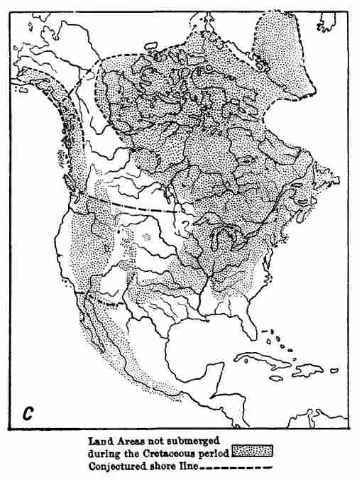 Fig. 33c.
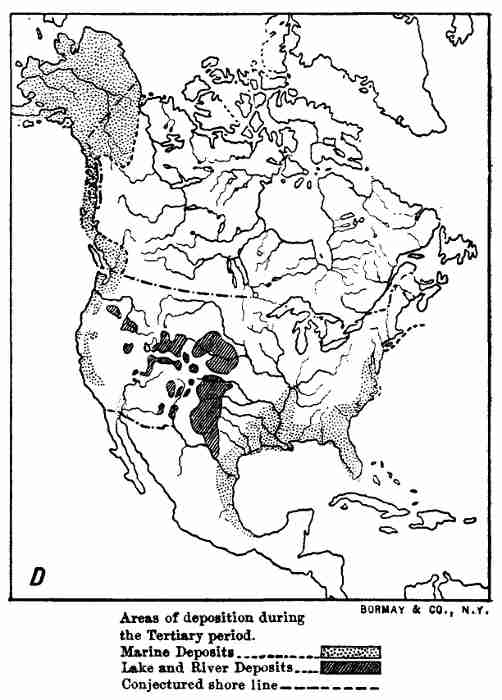 Fig. 33d.
With the growth of the continent, briefly outlined above, came greater and greater diversity in its relief, due 305 principally to the upraising of various mountains in a somewhat orderly succession from east to west.
The oldest mountains on the continent are the Laurentian Highlands of eastern Canada. Although the region referred to—the one mentioned above as being composed of Archean crystalline rocks—is not now of sufficient elevation or ruggedness to be termed mountainous, it shows in the nature and structure of its rocks that deep erosion has taken place. The inference is that truly great mountains have been removed, but the evidence may also sustain the interpretation that slow upheaval has been accompanied by erosion, and that at no time was the land conspicuously elevated.
Next in age after the Laurentian Highlands come the mountains of New England and the maritime province of Canada, which were upraised at the close of the Silurian period. The next great step was the crumpling into folds and upheaval of the rocks in the Appalachian region at the close of the Paleozoic era. The Park and Stony Mountains were upraised at the close of the Mesozoic era, and later came the Sierra Nevada and Cascades, followed by the Coast Ranges. Youngest of all, and in part for that reason the boldest and most lofty, are the magnificent mountains of southern Alaska, with a host of sublime peaks, like Mounts Fairweather, Logan, St. Elias, and perhaps McKinley. The last-named and highest peak of all, however, may be of volcanic origin.
In the above list showing the progressive westward movement of the birth of mountain systems, account is taken only of the elevations produced by upheaval. The mountains due to volcanic eruptions, which are still conspicuous, are all young, in comparison with the mountains situated to the eastward of the Sierra Nevada. The majestic cones of the northwestern portion of the United States, of which Mounts Shasta, Hood, Adams, Rainier, Baker, etc., are the most glorious, are of Tertiary or later age. The same is true, so far as known, of the still more lofty volcanoes in Mexico. The "pine-tree" forms of steam rising from the volcanoes of the Caribbees, Central 306 America, southern Mexico, and southwestern Alaska, proclaim the recency of the birth of the frequently magnificent craters built of rocks that were once molten, from which they emerge.
The rocks of which North America is built belong to three classes, which are world-wide in their distribution. These are: First, rocks produced by the cooling and crystallizing of formerly molten magmas; second, those deposited by water; and third, those which previously belonged to either of the two classes just referred to, but have been recrystallized and so greatly changed that their preceding condition is no longer clearly recognisable.
These three classes or subkingdoms, as perhaps they might be termed from analogy with systems of biological classifications, are in technical language:
1. Igneous rocks, such as the lava of Vesuvius.
2. Sedimentary rocks, such as sandstone, shale, limestone, coal, etc.
3. Metamorphic rocks, such as gneiss, schist, some granites, etc.
These major divisions are based principally on mode of origin, but do not indicate relative age. While theoretically at least, and in a general way, the rocks of these three great classes came into existence on the earth in the order named, it is convenient to consider first those of sedimentary origin.
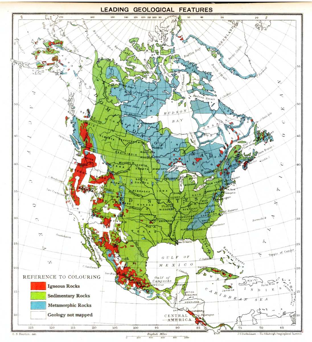 Plate IV.—Leading geological features.
The Sedimentary Rocks (Plate IV).—Whenever land exists or the waves and currents of the ocean come in contact with the rocks denudation occurs. That is, the rocks are broken through the action of mechanical or chemical agencies, such as the friction of the gravel and sand swept along by streams, the solvent power of water, etc., and the fragments thus produced are removed principally through the action of flowing water and deposited. Resulting from this general process of rock decay and disintegration, combined with transportation and deposition, 307 there result mechanically formed sedimentary beds, such as shale, sandstone, conglomerate, etc.; chemically formed sedimentary beds, such as the deposits of springs, the saline precipitates from inclosed lakes, etc.; and organically formed sedimentary beds, as, for example, peat, coal, and limestone.
Since the first appearance of land in the region now occupied by North America, sedimentary rocks have been in process of formation, and in this way the growth of the continent, with the aid of movements in the earth's crust, has been produced.
The superficial extent of the sedimentary beds in North America is very great, as is indicated on the map referred to above. By far the larger portion of the surface of the continent is underlain by them. Their thickness varies from place to place, but probably reaches a maximum in the Appalachian region, where a depth of some 40,000 feet has been measured. Throughout the continental basin their depth is in general from 3,000 to 4,000 feet. In the Pacific mountains their thickness embraces tens of thousands of feet, and the same is true in Mexico, Cuba, and Jamaica. These sedimentary rocks contain fossils which, with comparatively few exceptions, show that they were deposited in the ocean; thus sustaining in an important manner the conclusion already presented in reference to the growth of the continent.
Great as is the area of the sedimentary beds at the present time, it does not show the entire extent to which what is now land has at some time been submerged beneath the sea. In certain broad regions, sedimentary beds which formerly existed have been removed by erosion; in other extensive areas they are covered by volcanic rocks, and in still other portions of the continent, embracing thousands of square miles, they have been metamorphosed and their original characteristics obliterated.
The system of classification of the sedimentary beds that has been adopted, as is well known, is based on the relative age of the formations, determined primarily by the occurrence of one formation above another, in regions 308 where but moderate disturbances in position have occurred. Many of the stratified rocks contain fossils—that is, records of the life of the time they were deposited, and after the order of succession of a large number of formations has been ascertained, the life records they contain may be used as a means of determining the age of a newly discovered terrane.
By grouping the information obtained from the study of the vertical sequence of the formations in many regions, and also the records of life contained in them, a composite geological column has been constructed which shows the relative age of all known formations. The larger divisions of such a scheme of classification are world-wide in their application, but the smaller divisions are usually of restricted geographical extent.
The scheme of classification of general application in North America is shown in the chart on page 308. The arrangement is in order of age, the oldest formation being at the bottom. There is some lack of uniformity among American geologists as to certain of the terms used, more especially in the lower portion of the column, and in part the scheme is provisional, but in general it may be taken as expressing the progress made in the study of the geology of North America up to the present time.
The names of the larger divisions in this scheme of classification, or those designating the groups and systems and the eras and periods, have for the most part been adopted from European geologists. Two important ones, however—namely, Archean and Algonkian—are of American birth.
| Rock-Scale. ☞ | Group. | System. | ||
| Time-Scale. ☞ | Era. | Period. | ||
| Zoic time: embracing the history of the earth since the appearance of life. | Time of Mammals. | Time of Palms and Angiosperms. | Psychozoic. | Human. |
| Cenozoic. | Pleistocene. | |||
| Time of Reptiles. | Tertiary. | |||
| Time of Cycads. | ||||
| Mesozoic. | Cretaceous. | |||
| Time of Amphibians. | Time of Acrogens (Ferns, club-mosses, etc.). | Jura-Trias. | ||
| Paleozoic. | Carboniferous. | |||
| Time of Fishes. | Devonian. | |||
| Silurian. | ||||
| Time of Molluscs and Crustaceans. | ||||
| Time of Algæ. | Ordovician. | |||
| Cambrian. | ||||
| Eozoic. | Algonkian. | |||
| Time of Protozoa? | (As yet unknown pre-Algonkian sediments.) | |||
| Azoic time: preceding the dawn of life. | Azoic. | Archean or Basement Complex. | ||
| Prehistoric | Solid Earth. | |||
| Molten Earth. | ||||
| Gaseous Earth. | ||||
While this scheme of classification is based on the succession of sedimentary beds, igneous and metamorphic rocks have a place in it, providing their age can be determined.
The Archean period includes the time previous to the deposition of the oldest known sedimentary beds, and its lower limit is as yet undefined. The Archean system, or the rocks formed during the Archean period, are without known fossils, and consist largely of gneisses and foliated 309 schists, which are metamorphosed sedimentary or igneous terranes, together with various eruptives. The typical area where these rocks are exposed at the surface is in the Laurentian Highlands of eastern Canada, the main Archean nucleus of the continent, but rocks of the same age and same general character occur in several of the mountain systems of both the Atlantic and Pacific cordilleras, and underlie the sedimentary beds throughout a large part of the Continental basin. The Archean system was named by J. D. Dana, and divided into two portions, namely, the 310 Laurentian below and the Huronian above. More recent studies, especially by C. R. Van Hise, have shown the necessity of removing from the system many of the terranes formerly referred to it, and of placing them in the Algonkian. The Archean as it remains after this adjustment is termed by Van Hise the Basement Complex. This term, although thus far not generally adopted, has much to commend it, since the terranes designated by it are highly complex, and may perhaps be ultimately subdivided into two or more systems, and besides occupy a basal position lower than any known sedimentary formation that has escaped metamorphism.
The Algonkian series embraces a great thickness of sedimentary beds, in part metamorphosed, which in certain localities rest unconformably on the eroded surface of the Basement Complex and in places are overlain unconformably by Cambrian rocks. Both the upper and lower contacts, however, in certain localities, have been rendered obscure by metamorphism. The system derives its name from a tribe of Indians that inhabited the region about the shores of Lake Superior, where it is well developed. The Algonkian terranes are exposed in the Grand Cañon of the Colorado, in the Wasatch and Uintah Mountains, the Black Hills of Dakota, about the southern shore of Lake Superior, and in many parts of eastern Canada, as well as in several other localities. The oldest known fossils occur in these rocks, and consist of a small number of brachiopods, molluscs, crustaceans, etc. These scanty records are suggestive, and at least stimulate the hope that an extensive pre-Cambrian fauna will ultimately be discovered. The few forms found seem to be not far different from the similar life records of the Cambrian.
The Cambrian system, although first studied in Europe, has an important development in North America, and occurs at the surface at a large number of localities ranging from Newfoundland to California. The known distribution of the system and the nature of the rocks composing it indicate that it occurs widely in the Continental 311 basin beneath subsequent deposits. The most interesting results derived from the study of the Cambrian, carried on especially by C. D. Walcott, pertain to its life records. With the exception of a few obscure algæ, all the fossils thus far discovered are marine invertebrates. As regards rank in the zoological scale, certain molluscan remains are the highest, but outclassing them in size, abundance, and degree of specialization are the trilobites, the nearest living representatives of which are certain crustaceans. Of the trilobites about 100 species have been discovered in the Cambrian rocks of North America, the largest individual being about 20 inches in length.
The picture of the continent which the facts just referred to enables one to sketch in fancy includes land areas destitute of animal life, and probably without vegetation, except perhaps the lichens, the lowest of the cryptogams. The sea, especially in its shallower portions near land and over its surface, contains algæ, mostly, we presume, of small size, in fact microscopic, and soft tissued. The animal life subsisting primarily on the algæ are all invertebrates, and nearly all of them, excepting the crustaceans, simple in organization. None of the animals the remains of which have thus far been discovered had strong shells or other well-developed protective or supporting tissues, thus indicating that they were not subject to the attacks of formidable enemies.
As compared with later faunas, the animals of the Cambrian were primitive, but their diversity—every subkingdom of invertebrates being represented—is positive evidence that they were not the first inhabitants of the waters. Considered from the point of view of development, this fauna stands at least half-way, and some students of the ancient history of the earth place it as far as nine-tenths of the way, up the life column—that is, the time from the first appearance of life on the earth to the beginning of the Cambrian was at least as long and possibly nine times as long as the time that has since elapsed. This is a sufficient promise that many records of life, and it seems safe to predict as varied an assemblage of organisms 312 as the at present known Cambrian fauna, will ultimately be discovered in the Algonkian or lower rocks.
The Paleozoic era witnessed the first appearance of vertebrate life. The earliest known forms were fish-like in character and were succeeded in sequence by batrachians and reptiles. In this connection the most important contribution to the world's knowledge, from the study of the American records, include the discovery of a large number of fishes, or fish-like forms, some of them of gigantic size, in the Devonian and Carboniferous rocks of the Ohio region, by J. S. Newberry; numerous batrachians in the Coal Measures of Ohio, by E. D. Cope; of batrachians and probably reptiles in rocks of similar age in Nova Scotia, by J. W. Dawson and O. C. Marsh.
During the Paleozoic era land plants appeared, and before its close the continent was densely clothed with forests consisting of flowerless plants such as ferns and club-mosses, together with a less abundance of trees related to the existing conifers.
Great additions to the world's knowledge of the varied and beautiful floras of the swamps in which the coal-beds of Pennsylvania, Ohio, Nova Scotia, etc., were accumulated have been made by H. D. Rogers, J. S. Newberry, Leo Lesquereux, J. W. Dawson, I. C. White, David White, and others.
The Mesozoic era is characterized among other events by the first appearance and rapid development of flowering plants, the cycads being especially numerous, and of our ordinary broad-leaved trees, such as the oak, willow, sassafras, etc., and by the coming in of palms; and in the animal kingdom by the culmination of reptilian life and the advent of birds and mammals.
The American Mesozoic rocks have yielded a rich store of fossil plants, as is well known from the painstaking studies of J. S. Newberry, Leo Lesquereux, W. M. Fontaine, L. F. Ward, F. H. Knowlton, and others. These same students of the progress of plant life on the continent have also made extensive and critical studies of the Cenozoic floras. 313
The relics of reptilian life brought to light from the Mesozoic rocks of New Jersey, Kansas, Wyoming, etc., by Joseph Leidy, O. C. Marsh, E. D. Cope, and others, have astonished the world, even though marvellous results in a similar direction had previously been made known in Europe. The reptilian age was marked in America by the presence of such huge reptiles, and by the strange development and adaptations in various directions that they surpass the wildest dreams of fable. Lizard-like reptiles walked the earth that were 40 to 60 feet in length and stood 10 to 14 feet high where the massive hind limbs joined the body. Their thigh-bones in certain instances measured over 6 feet in length. Some of these monsters, it is estimated, weighed at least 10 tons. These, the hugest of all land animals, were vegetable feeders. Others, of less size, although still gigantic and more active, were carnivorous. Some of the old lizard-like forms which left their footprints in great abundance in the sands now hardened into sandstone in the Connecticut Valley and New Jersey walked on their hind feet, after the manner of birds, and left three-toed footmarks, some of them 20 inches in length, which are strikingly bird-like in appearance. Other great reptiles, whale-like in appearance, inhabited the ocean. Yet more marvellous forms were provided with wings, resembling those of bats, and in the case of the great Pteranodons found in the rocks of Kansas had a "stretch of wing" of fully 20 feet. But the strange menagerie that has been resurrected contains such a marvellous array of grotesque shapes that not even a catalogue of the genera can be presented here.
While the Mesozoic era was emphatically the age of reptiles, the coming of a more highly developed fauna was foreshadowed. Bird life was represented, and the skeletons of reptilian birds, or birds with teeth like those of reptiles, have been discovered in the Mesozoic rocks of Kansas. Important additions to our knowledge of these strange creatures, which furnish much instructive data in reference to the development of the higher from the lower forms of life, have been made by O. C. Marsh. The humble 314 beginning of mammalian life is shown by insectivorous marsupials, the jaws of which were discovered in the Newark system (Lower Mesozoic) of North Carolina.
The Cenozoic era is the age of mammals, so called because during that time brute mammals succeeded reptiles as the rulers of the earth. From the rocks deposited in North America during this era, principally the sediments of fresh-water lakes and the gravel-beds laid down by streams in the Pacific mountain region, a great number of skeletons of truly remarkable mammals, differing widely from anything now living, have been discovered by Joseph Leidy, O. C. Marsh, E. D. Cope, H. F. Osborn, and others. The profound interest attached to this fauna, and the bearings it has on the study of the geographical distribution of animals, climatic changes, etc., is indicated by the fact that it includes forms related to the rhinoceros, elephant, camel, etc., which are not represented among the animals now living on the continent, although having relatives in other and principally tropical countries.
During the Psychozoic era mind gained ascendency over brute force, and man became the leader. The mammals continued to dominate the earth throughout the Pleistocene period and were then probably more numerous and of even larger size than during the preceding Tertiary period. During the Pleistocene great climatic changes occurred, and large glaciers existed in several regions which now enjoy a temperate climate and are densely populated.
The presence of man in North America during the Pleistocene has not been proved, but important contributions to knowledge concerning the brute mammals, and in reference also to the climatic and physiographic changes, have been made.
In stream-deposited gravels, caverns, peat swamps, etc., over the surface of practically the entire continent, the bones of many species of large mammals have been obtained. These include the mastodon and elephant, megatherium, megalonyx, mylodon, a large horse, a great bison, an elk much exceeding the living species in size, 315 a giant beaver, and many others remarkable for their large dimensions as compared with their living representatives. Several of these large animals survived the vicissitudes of climate characteristic of the Glacial epoch, but have since become extinct.
The chief contributions to Pleistocene history, however, made by American geologists, are in connection with the records of climatic changes. During the earlier portion of the period, and beginning perhaps in late Tertiary time, the continent in large part at least was more elevated than now and the energetic streams of the mountainous portions eroded deep cañons. To this Sierran epoch, as it is termed, is referred the excavation of the larger valleys of the Sierra Nevada, the world-renowned cañons of the Colorado and Snake Rivers, and probably the deep Valley of the St. Lawrence and the Hudson.
A climatic change perhaps initiated by the greater elevation of the land, but not as yet wholly explained, caused glaciers to form about the higher portions of a number of the ranges in the Pacific mountains, and continental glaciers of the type of the ice-sheet now covering Greenland to expand from at least three centres, termed the Labradorean, Keewatin, and Cordilleran, in what is now Canada. During this time of great ice accumulation and of glacial advance and retreat, or the Glacial epoch, as it is termed, fully one-half of North America was buried beneath ice-sheets of the continental type. A composite map showing the portions of the continent which were covered with ice at one time or another during the Glacial epoch is reproduced in Plate V.

During the maximum advance of the ice from the Labradorean centre into the Continental basin it nearly reached the mouth of the Ohio River (near Cincinnati). An earlier advance from the Keewatin centre extended to the Missouri River in Missouri. There is evidence of a succession of advances and retreats of the ice forming a very complex history. With its final retreat the Great Lakes came into existence and the continent reached the stage in its development when man became prominent. 316
The study of glacial geology in North America was initiated, or at least given a fresh start and in the proper direction, by Louis Agassiz, and within recent years energetically carried forward by a large number of earnest workers. The stage of advance reached in this branch of geology which serves so admirably to link the present with the past is well presented in the numerous publications of T. C. Chamberlin and his associates.
The instructive history of the growth of North America and the successive appearance of higher and higher forms of life, the records of which have been discovered in the sedimentary rocks, has been made known by the combined studies of a large number of investigators, but the great task has been carried on mainly under the auspices of various national and State surveys. Chief among these is the present United States Geological Survey, which has published what may be justly termed a library of valuable literature and of topographic and geologic maps.
The Igneous Rocks (Plate IV).—Under the at present popular explanation of the origin of the earth, namely, the nebular hypothesis, and also the modification of it termed the meteoric hypothesis, the planet itself is considered to have been at one time in a molten condition. The starting-point of the study of the rocks composing the earth should be, therefore, the primitive crust cooled from fusion. In addition to this there have been throughout history geologic migrations of molten matter from deep within the earth towards the surface, and a part of the material thus forced outward, principally through fissures, has cooled in the rocks it penetrated, forming intrusions of various kinds, and a part has reached the surface and been extruded, as during volcanic eruptions.
Probably every known phase of vulcanism is illustrated by the igneous rocks of North America, and in certain branches of the subject, as the nature of intrusions and the changes which occur in the cooling of igneous magmas, marked advances in the world's knowledge have been made by American geologists. 317
Examples of volcanic phenomena on a grand scale are furnished by the still active volcanoes of the Caribbees, Central America, Mexico, and Alaska. Between southern Alaska and south-central Mexico there are no active craters, but a large number of volcanic mountains in various stages of erosion which form an instructive series illustrating the internal structure of the mode of accumulation of ejected fragment material and of lava-flows. In this series of mountains built by igneous agencies belongs the great volcanic piles of the Cascade region, of which Mounts Baker, Rainier, Adams, Hood, Jefferson, Mazama, Shasta, etc., are among the leading examples. Many other illustrations in the same connection, some of them in an advanced stage of erosion and now revealing only the dikes and necks of resistant rock that cooled and hardened well below the surface, occur widely throughout the southwest portion of the United States. The still recognisable volcanic mountains of the continent, with the exception of those of the Caribbees, are confined to its western half, and with the exception of certain almost perfect craters in eastern New Mexico are all within the Pacific mountains. A great belt of volcanoes, including a large number of both active and extinct examples, extends from Panama to the Aleutian Islands, a distance of some 7,000 miles, and is a part of the so-called "circle of fire" surrounding the Pacific Ocean. This belt is about 1,000 miles broad in its central part, where only extinct volcanoes exist, and narrows towards both its northern and southern extremities, which are defined by still steaming craters. The narrow northern portion, inclusive of the active volcanoes of the Alaskan Peninsula and the Aleutian Islands, is prolonged westward, and forms a curve concave to the southward, while the equally narrow southern portion marked by the energetic craters of Central America forms a curve concave to the northward. The entire belt has something the shape of a sigmoid curve, with a wide central portion.
In the preceding sketch of the growth of the continent it was shown that the Pacific mountain region is 318 younger than the Atlantic mountain region. In this same connection certain interesting general conclusions have been reached in reference to igneous activity. In each of the great cordilleras referred to there have been extensive breaks in the earth's crust through which molten rocks have been forced upward. Volcanoes and various intrusions have been formed in each region, but in the eastern half of the continent the time since the last eruptions has been so great that all evidence in the relief of the land of the former presence of volcanic mountains has been obliterated. Erosion has cut deeply into the rocks on which the ancient volcanoes stood, and revealed in some instances the dikes occupying the fissures which supplied them. A large number of dikes of igneous rock occur in the Atlantic coast region from Prince Edward Island southward to Alabama and Georgia, and vast lava-flows of ancient date are still preserved about the south shore of Lake Superior. Volcanic eruptions in the older half of the continent have long since ceased and the breaks which gave them existence have been healed. The later movements in the western half of the continent have caused fresh fractures to form, through which molten matter has been forced to the surface. Many facts have been observed in each region which show an intimate connection between movements in the earth's crust which have produced fractures and the distribution of volcanoes.
The lavas poured out by the more recent volcanoes of North America are mainly dark basic rocks, among which basalt predominates. An exception occurs in the case of the Mono craters near Mono Lake, California, which in recent time extruded a thick, viscous, highly siliceous, rhyolitic lava, much of which cooled quickly and formed volcanic glass or obsidian.
In addition to streams and sheets of lava, many volcanoes, and especially those in a state of explosive eruption, blew into the air quantities of fragmental material, such as scoria, bombs, volcanic gravel (lapilli), dust, etc., which was scattered far and wide over the land. More or less extensive sheets of this material, in many instances 319 interstratified with sedimentary beds, and especially with the strata laid down in Tertiary lakes, or separating lava-flows, occur widely throughout the Pacific mountains. Dust showers of the nature just referred to have occurred at a recent date, and the fine white material that fell is now found at the surface in a large number of localities, ranging from Central America to the Yukon Valley and from Kansas and Nebraska to Oregon and Washington.
The most remarkable instance of the addition of volcanic rocks to the surface of North America is in the case of the Columbia River lava, which covers some 200,000 or more square miles of country in Washington, Oregon, and neighbouring States. In that region outwellings of highly liquid rock came from fissures and spread widely over the surface as veritable inundations, which on cooling became black, basaltic rock, but without forming mountains or craters. Where the Snake River has excavated its magnificent cañon in these still horizontal layers of basalt, a thickness of 4,000 feet is revealed, although the stream has not as yet cut through the formation, and in Stein Mountain, Oregon, a similar series of lava-sheets over 5,000 feet thick has been measured. The Columbia River lava was spread over the surface of a deeply eroded land in a series of vast overflows of molten material. The liquid rock covered the broad plains and extended into the valleys in the adjacent mountains, giving them level floors of basalt. Mountain spurs became capes and headlands and outstanding buttes were transformed into islands in the molten sea. The lava since cooled and crystallized has in places been folded and tilted; streams like the Columbia, Snake, Spokane Rivers, etc., have carved great cañons in it, and the surface, especially where it is still nearly horizontal, has decayed and yielded a wonderfully rich soil. It is the fine, rich residual material of these lava plains, redistributed in part by the wind, which furnishes the basis for the immense wheat industry of the northwestern portion of the United States.
The extrusion of molten rock from deep within the earth so as to form volcanoes or fissure eruptions at the surface is only a part of a widely extended and highly 320 varied process. As geologists have discovered, particularly in deeply eroded regions, by no means all of the fissures which permit of the forcing upward of molten material in them reach the surface. Many of them died out before coming to the light and favoured the production of various forms of intrusion.
A fissure originating deep in the earth's crust and extending upward, perhaps with many branches and irregularities, if injected with molten rock from below gives origin to dikes. That is, a dike is a more or less vertical sheet of igneous rock which has cooled and crystallized in a fissure. Such sheets of intruded material cutting across the bedding of stratified rocks, or traversing older igneous or metamorphic terranes, are of common occurrence and are frequently abundant in deeply eroded regions. They occur particularly in mountains of upheaval, thus demonstrating the fact that to a large extent the fissure which became injected with molten magmas and perhaps gave origin to volcanoes, are due to movements in the rocks composing the earth's crust. The force which causes molten rock to rise in such fissures also tends to prolong and enlarge them. The heat of an intruded magma affects the rocks it traverses and produces what is termed contact metamorphism. Examples of dikes in the Newark system have already been referred to, and others are common throughout the Pacific mountains. Where the Columbia River lava in central Washington has been removed by erosion, hundreds, and in fact thousands, of dikes are exposed in the terranes on which it formerly rested.
When a dike ends above in horizontally bedded rocks it sometimes happens that the injected magma, especially if highly fluid, is forced in between the strata and spreads widely between the layers, forming an intruded sheet, which lifts a broad cover to a height equal to its own thickness. An example of an intrusion of this nature is furnished by the palisade trap-sheet in New Jersey and New York, which has a maximum thickness of about 1,000 feet, and is fully 100 miles in length from north to south. 321 The portion which remains is but a remnant and is seldom over 2 or 3 miles wide. This sheet in common with its associated sandstones and shales has been tilted so as to dip westward at an angle of about 15 degrees, and its eastern border eroded so as to form the picturesque Palisades on the west bank of the Hudson opposite New York city. Many other similar intruded sheets are known in Nova Scotia, the Connecticut Valley, among the Pacific mountains, etc.
A marked variation in the process just outlined occurs when, as the controlling condition, the intruded magma is highly viscous instead of highly fluid, and the friction of contact and of flow is greatly increased. Under such circumstances the intruded magma expands less widely than is the case when an intruded sheet is formed, and a thick intrusion results, which lifts a small cover perhaps to a great height. Intrusions of this nature are sometimes expanded in their upper portions into a more or less mushroom shape, and from their fancied resemblance to cisterns of once molten rock within older terranes have been termed laccoliths. The typical examples are furnished by the Henry Mountains in southern Utah, described by G. K. Gilbert. Other similar intrusions in Colorado have been studied by Whitman Cross, and yet other examples have been discovered in various parts of the Pacific mountains. In the case of certain of the laccoliths in the Henry Mountains, now laid bare by erosion, the cistern-like mass of intruded material is 12,000 feet or more in diameter, some 5,000 feet thick in the central part, and lifted a cover of stratified rocks fully 7,000 feet thick.
Where a dike ends above in older rocks, and particularly in horizontally stratified sedimentary beds, in a pipe-like form, similar to the conduit of a volcano, but without reaching the surface, the unexpanded or but slightly enlarged summit portion lifts a comparatively small cover into a dome, and what has been termed a plutonic plug results.
All the various phases of intrusions thus far referred to, it will be readily seen, are variations of one process. 322 The wide range in the results produced are dependent on local conditions, either in respect to terranes invaded, as, for example, whether or not they are undisturbed sedimentary beds, and on the physical condition of the intruded material, in reference especially to its degree of viscosity. There is an intimate and even a genetic connection between intrusions on the one hand and volcanic and fissure eruptions on the other. If fissures lead from portions of the earth's crust sufficiently deep to permit the rocks to become plastic or fused on account of the relief of pressure due to the opening of the fissure, the magma may be forced to the surface, becoming more and more plastic or more perfectly fluid as the weight upon it decreased, and volcanic phenomena result; or if the fissure fails to reach the surface intrusions of various forms may be produced. The simplest form of intrusion, the dike, results under whatever condition the summit portion of the magma comes to rest. A magma forced upward in fissures in the earth's crust may meet moist rocks or even reservoirs of water, and in such instances steam or gases are produced and a new force is added, which may produce explosions.
In addition to the intrusions of the various classes just referred to there are others on a far larger scale, examples of which occur in North America, but as yet their mode of origin has been but little studied. I refer to vast upwellings of molten or plastic material beneath the more rigid portions of the earth's crust, which elevate domes, perhaps 200 or 300 miles or more in their various horizontal diameters. The great areas occupied by intrusive granite, as the one from which the Bitter Root Mountains in Idaho have been sculptured, are of this nature. These "regional intrusions," as they may be termed, elevate mountains in the same general manner as in the case of laccoliths, but of far greater size. To the elevations produced in this manner I have ventured to apply the name subtuberant mountains, in expression of the idea that they have resulted from vertical uplifts, due to the upswelling of molten material beneath. 323
The Metamorphic Rocks (Plate IV).—At the contact of either sedimentary or igneous rocks with intrusive rocks of whatever form, such as dikes, sheets, laccoliths, etc., there has been in many well-known instances an alteration of the terranes penetrated or uplifted which is most intense along the contact and diminishes at a distance. This change or metamorphism, as it is termed, consists of an alteration in the colour, texture, hardness, mineral and chemical composition, etc., of the rocks affected, and may be manifest throughout a thickness of but a few feet, or perhaps only a few inches, but near large intrusions is apt to be traceable for scores or hundreds of feet. In the case of intense contact metamorphism, the altered rock assumes a new form, and may exhibit a crystalline and foliated or schistose structure. The changes referred to are most marked when water is present, and are thought to be due largely to the influence of heated water percolating through the rocks and producing changes by solution and deposition. The principal agencies which take part in contact metamorphism are heat, heated waters, pressure, and perhaps movements within the rocks.
There are extensive regions throughout which the rocks have been changed in a manner similar to the alterations commonly found adjacent to igneous intrusions which, in general, have been brought about in some other way. This regional metamorphism, as it is termed, has affected the rocks in certain instances throughout districts measuring many hundreds of square miles in surface extent, and with a vertical range of many thousands of feet. The rocks referred to have been changed without fusion from a previous condition, during which they were either sedimentary beds or cooled and crystallized igneous magma. This conclusion has been verified in numerous instances by tracing the thoroughly altered rocks to regions where the change has been less intense and finally to where they pass by insensible gradations into easily recognisable sedimentary or igneous terranes. Common examples of metamorphic rocks are mica, schist, gneiss, 324 statuary marble, certain granites, etc. These rocks frequently have a foliated or fissile structure, such as it is presumed would result from a flowing movement within the mass while under great pressure. Characteristically also the rocks are composed of interlocking crystals or portions of crystals, which are not contained in a glassy base, as is the case with most rocks that have crystallized from fusion. That is, the metamorphic rocks are characteristically holocrystalline, while igneous rocks are porphyritic, or cryptocrystalline.
The analogy between rocks altered by contact metamorphism and those affected by regional metamorphism had led to the conclusion that the latter, like the former, have been changed by heat and the passage through them of heated water bearing mineral matter, and especially silica, in solution. More than this, the foliation frequently so characteristic of metamorphic rocks is considered as evidence of a flowing movement or shearing of the material while under pressure. In short, rocks are altered by heat, especially if water is present in them, by motion, and by chemical changes produced by percolating waters, and perhaps in still other ways. The degree of heat required is not definitely known, and probably varies according to the nature of the rocks, the presence or absence of water, etc., but is certainly less than that necessary to produce fusion, and is thought, in general, to be in the neighbourhood of 750° F. While heat alone is considered as sufficient to produce metamorphism, it is probable that in most instances two or more of the agencies just referred to have been in operation at the same time. In the case of the foliated rocks motion within the mass seems to have been the predominating factor, and dynamical metamorphism is considered as important as heat metamorphism.
In North America, as is indicated roughly on the map forming Plate IV, metamorphic rocks occur at the surface over a great region in eastern and northeastern Canada, in Labrador and Newfoundland, in the New England States, and thence southward along the eastern side of the Appalachians. Other extensive regions occupied by similar 325 rocks occur in many of the ranges of the Pacific mountains, from Alaska to Panama, and are known in the West Indies.
Not only do the metamorphosed rocks outcrop at the surface over large areas, but, as may be inferred from such outcrops, as well as from the records of numerous borings, underlies nearly the entire extent of the sedimentary formations. The basal portion of the continent, with the exception of certain areas where igneous rocks occur, is formed of metamorphosed terranes. So generally is this true, that it is safe to say that if a boring is begun at any locality on the continent where sedimentary beds occur, and is continued downward until the sedimentary rocks are passed through, metamorphic terranes will be found beneath. The same is true also where the surface is composed of lava-sheets. The exceptions, where metamorphosed rocks do not occur beneath sedimentary or volcanic beds, are when igneous intrusions or ancient lava-flows are present at a depth.
In the brief description given of the Archean system on a preceding page, it was stated that the rocks composing it are largely metamorphic. But rocks of practically any age may be altered in the several ways mentioned above, and the resulting gneisses, schists, etc., be indistinguishable from those of the Archean. In fact, some of the metamorphosed rocks of North America, as certain gneisses, schists, etc., of the Sierra Nevada and Cascade Mountains, are known to be of Mesozoic and even Cenozoic age.
In speaking of the growth of North America, and again in connection with the distribution of volcanic mountains, it was shown that there has been a progressive migration of the field of action of the forces which upheave the rocks so as to form land areas, and also of the movements in the rocks which produce fractures and lead to the origin of volcanoes. In a similar way the sphere of influence of metamorphism as indicated by the age of the transformed rocks in various regions has in a general way migrated from east to west across the continent. 326
In the Laurentian Highlands the metamorphosed rocks are of pre-Cambrian age; in New England and the Appalachian region they are, in part at least, of Paleozoic age; and in the Sierra Nevada and Cascade Mountains metamorphosed Mesozoic and Cenozoic rocks occur. As movements in the outer portion of the earth's crust may produce fractures in any class of rocks, and as such fractures favour the intrusion of igneous material, the metamorphic rocks may contain igneous intrusions similar to those noted above in connection with sedimentary rocks. As the stratification so marked in sedimentary beds is lacking in metamorphosed rocks, it is not to be expected that intrusions will take the form of sheets, laccoliths, etc., but rather appear as dikes with perhaps irregular branches. As the same region may experience two or more periods of metamorphism, it is evident that great complexities may arise, as, for example, when a metamorphosed terrane is penetrated by dikes and irregular intrusions and again subjected to metamorphosing conditions. These considerations lead to the suggestion that rocks metamorphosed in pre-Cambrian time, for example, would be apt to be more complex than those of Mesozoic date. In general, this has been found to be true, as is suggested by the fact that to the pre-Cambrian metamorphosed terranes, as previously stated, the name Basement Complex has been applied.
Summary.—The relation of the three great divisions into which the rocks composing North America, in common with all other portions of the known lithosphere, are divided, may perhaps be better understood when it is remembered that the igneous rocks came from below in a molten condition; that the sedimentary rocks have been formed at the surface from the débris of either igneous, metamorphic, or previously formed sedimentary beds; and that metamorphic rocks have been produced within the earth's outer crust by the alteration of either igneous or sedimentary rocks. When the heat which produced certain phases of metamorphism is sufficiently increased, greater freedom of molecular and chemical changes occur 327 and the material acted on passes to the condition of an igneous magma. The three great classes of rocks considered above are thus seen to be but stages in a cycle which the material of the lithosphere passes through.
The conditions which bring about these changes are still in action and are intimately associated with movements in the rocks of the earth's crust. When elevation raises a portion of the earth's crust above sea-level, erosion and redeposition ensue and sedimentary rocks are formed; the greater the elevation the more energetically the forces act which bring about denudation, transportation, and sedimentation. When depression occurs of sufficient amount to carry rocks previously at or near the surface into the zone of metamorphism, alterations follow, and in general the deeper the depression the greater the changes until metamorphism culminates in fusion, providing pressure does not counteract the influence of heat. Dynamical and chemical metamorphism may occur at less depth than purely heat metamorphism, and it may be presumed takes place in the axes of mountain ranges, even above sea-level. Such a broad view of the relations and genesis of the three great lithologic divisions of the material forming the earth's outer crust is necessary to the understanding of the conditions observed in the basal portion of the geological column, as it is termed, in which the age and order of succession of the sedimentary rocks is indicated. In certain localities, for example, the Cambrian rocks rest unconformably on a surface of metamorphic and igneous rocks—that is, the Basement Complex was raised above sea-level, eroded and subsequently depressed before the Cambrian sediments were laid upon it. In other localities the Cambrian rocks pass indefinitely into metamorphosed terranes beneath, which means that metamorphism invaded the series after the deposition of the Cambrian, and the characteristics of its junction with older rocks was obliterated. Similar relations may evidently be discovered at any horizon in the geological column. Obviously the chances of a system of stratified rocks becoming metamorphosed or of being removed by erosion, are 328 greater the nearer their position to the base of the sedimentary series; in a similar way the chances of a sedimentary terrane becoming invaded by igneous intrusions is greater the greater its age; again, the older a sedimentary terrane the greater the chances of its becoming buried by subsequent deposition and the less the likelihood of its being exposed for study. The only position in which a sedimentary formation can maintain its integrity and be safe from destruction by erosion or transformation by metamorphism is below sea-level and above the zone of heat metamorphism; but even in this position it may have its distinctive features, including its fossils, obliterated by dynamical and chemical alterations. These suggestions are offered for the sake of indicating, as stated on a previous page, that the Cambrian and Algonkian rocks should not be considered as the first formed sediments, and that there is hope of the discovery of a rich fauna of older date than any at present known. In the search for the earliest evidence of animal life on the earth, North America holds out favourable conditions.
The most important branch of geology treats of the substances in the earth's crust that are of direct service to man, as, for example, building stones, coal, iron, petroleum, gold, etc. Only a glance can here be given at the conditions which have led to the origin of the materials of commercial value and to their geographical distribution.
From the mode of origin of the principal classes of rocks it may be reasonably inferred that certain minerals and ores will be developed or concentrated in one class of rocks and not in the others. To a great extent the facts observed during the development of mines, etc., sustain this prediction.
In the cooling and crystallizing of igneous rocks from a state of fusion many minerals are formed, the most common being silicates of the alkaline earths, which are usually inclosed in a glassy or cryptocrystalline base. The 329 igneous rocks have characteristically a highly complex chemical composition, and although frequently containing the metallic element, etc., which are of economic importance, these are widely disseminated, and in nearly all cases in chemical combinations, as the minor ingredients of siliceous minerals. Although the igneous rocks sometimes contain valuable ores, they are in many, if not all instances, due to secondary enrichment and are not a result of primary crystallization from fusion. As all the material of the earth's crust was at one stage in the series of changes it has experienced consolidated from fusion, it follows that the ores and minerals now of economic value did not then exist, or were widely diffused and have since been formed or concentrated.
The processes of concentration referred to are carried on in various ways through the agency of mechanical, chemical, vital, molecular, and electrical forces, acting singly or in association. For example, concentration through the action of mechanical agencies is illustrated by the manner in which rocks are reduced to fragments in the every-day process of denudation and the resulting débris removed by streams and redeposited. In this process an assorting in reference to size, specific gravity, etc., takes place, and certain substances, as sand, for instance, is accumulated in one locality, and certain other substances, as clay, deposited in another locality. During this process gold, platinum, etc., owing to their high specific gravity, may be concentrated in stream channels. The accumulation of mineral matter through the action mainly of chemical agencies, occurs when the waters percolating through rocks dissolves certain substances, as calcium carbonate, for instance, and on coming to the surface as springs, or dripping from the roofs of caverns, deposit calcareous tufa, stalactites, etc. Silica, iron, manganese, and other substances are frequently concentrated in a similar manner.
Concentration of previously widely disseminated substances principally through the agency of vital forces, is illustrated by the manner in which molluscs and polyps 330 obtain calcium carbonate from water and deposit it in their shells or skeletons. The part played by plants in this same connection is shown by the way in which they eliminate carbon dioxide from the air or from water, and concentrate the carbon in their tissues. From the carbon accumulated in this manner, under certain conditions, deposits of peat, lignite, coal, graphite, etc., have resulted.
What may provisionally at least be termed molecular concentration occurs when similar molecules are brought together largely by water and crystallized to form mineral species. In order to simplify this brief discussion as much as practicable, this phase of concentration will be included under the chemical processes referred to above.
The three principal methods by which mineral substances are concentrated, namely, the mechanical, chemical, and vital, have in the main different fields of action. The mechanical and vital agencies operate at the surface of the lithosphere, although organic products, principally certain acids, descend into the earth in solution in water and play an important part in deep-seated chemical changes, as in the formation of mineral veins. The chemical agencies bring about the concentration of mineral substances both at or near the surface and at a depth.
The intensity with which the several agencies just referred to operate varies according to conditions. The mechanical agencies, for example, acting mainly through the aid of flowing water, are in general most potent in humid regions and where the land is high above sea-level. Vital agencies depend largely on climate and are most active in warm humid regions. The chemical agencies are influenced largely by heat, the presence of water, and by pressure.
It is interesting to note that a high degree of heat leads to the dissipation and wide distribution of substances previously concentrated; fusion, for example, permitting of the intimate mingling or recombination of substances, previously segregated, although during the dying stages of volcanic activity minerals like sulphur, cinnabar, etc., may be directly condensed and thus concentrated from a vaporous condition. 331
During the formation of the three main classes of rocks composing the earth's crust, the agencies leading to the concentration of various substances now of economic importance have to a great extent been different, and hence in a marked way the stones, ores, fuels, gems, etc., to be expected in each of the three classes of rocks, respectively, are distinct. Certain exceptions to this broad conclusion, however, arise from the fact that rocks belonging to each of the classes referred to may have been brought within the influence of the same or similar concentrating agencies and like results produced in each class.
Economic Importance of the Igneous Terranes.—The igneous rocks, as previously noted, are such as have cooled from fusion. On the cooling of magmas various minerals are formed, most commonly silicates, and except in a minor way in connection with the weaker stages of volcanic activity and the slow cooling of the rocks, there does not seem to be any marked tendency towards the concentration or segregation of metallic minerals or ores. Although igneous rocks do contain gold, silver, copper, etc., and a large variety of the rarer metals, they are widely disseminated. As is well known, however, igneous rocks are in some instances of value for the metallic mineral, gems, and ores associated with them, but in the great majority of instances at least, and as a rule, these minerals and ores are the result of subsequent changes and owe their origin mainly to deposition from heated, percolating water. Rich ore bodies frequently occur on the borders of igneous dikes, and in fissures and cavities in igneous rocks, but the process by which they have been formed is similar to that leading to the concentration of mineral matter in metamorphic rocks, and will be referred to later.
The igneous rocks themselves furnish desirable building stones, such as granite, diorite, porphyry, diabase, etc. With the exception of granite and the nearly related diorite, these have not as yet been extensively utilized in North America. Certain of the igneous rocks have been altered to serpentine, which on account of its pleasing green colour and the ease with which it can be cut and 332 polished furnishes a stone valuable for interior uses. It is also employed, usually with a rough surface, in the construction of exterior walls of dwellings, gateways, etc. Large bodies of serpentine occur at a number of localities in the Atlantic mountains from Pennsylvania and Maryland northward, including eastern Canada, and also over extensive areas in the Pacific mountains, particularly in California, Washington, and Alaska.
The principal ores and minerals of commercial importance in the igneous rocks are native copper, as in northern Michigan; copper pyrites, as at Butte, Montana; gold, at many localities, including the Treadwell mine, Alaska; opal, which is mined on a small scale in Idaho and Washington. In practically all these instances, and numerous others that might be enumerated, the substances referred to have been deposited from solution in cavities in the rocks or have replaced other substances, and are due to what is termed above chemical concentration.
Economic Importance of the Sedimentary Terranes.—The sedimentary rocks are composed principally of fragmental material derived from the disintegration of older rocks transported and deposited mechanically, and resulting in the formation of sandstone, shale, etc., and of organically concentrated material, such as shells and corals, which form limestones. The deposits originating in these ways furnish excellent building stones, the principal classes being sandstones and limestones. These occur widely throughout North America, and in formations of all ages subsequent to the Archean. The sandstones were deposited near the shores of the seas, or in lakes, and the limestones principally in moderately deep oceans.
Sandstones occur largely in the Cambrian formation on the south shore of Lake Superior and about the borders of the Adirondack hills of New York. They are usually red or reddish-brown rocks, and their pleasing colours, durability, even grain, and the readiness with which they may be broken in any direction make them desirable building stones.
The Newark system, extending in detached areas from 333 Nova Scotia to South Carolina, contains immense quantities of brown and gray sandstone, which have been extensively quarried, particularly in the Connecticut Valley, New Jersey, Pennsylvania, and Maryland, and largely used in Atlantic coast cities. The Carboniferous and Devonian sandstones, usually of a gray colour, of Pennsylvania, Ohio, and neighbouring States, are largely used in the cities of the interior portions of the United States. Extensive deposits of Mesozoic and Cenozoic sandstones occur throughout the Pacific mountains, and afford a practically unlimited supply of good building material, which as yet has been but little utilized. The colours of sandstones vary from bright red through brown-yellow to gray, and in some cases are nearly white, depending largely on the condition of the iron present. The red rocks are dyed with ferric oxide; the brownstones contain iron, frequently in the cementing material that unites the grains, in various stages of oxidation and hydration; the gray stones may also contain iron, but if present it is in union with organic matter, as the ferric carbonate, for example. The Cambrian and Newark sandstones are prevailingly of some shade of red, for the reason that not enough organic matter is present to change the iron to a carbonate.
The sandstones when of an even fine grain and not too hard, are suitable for sharpening tools, and large quantities of grindstones, whetstones, etc., are made from them, as on the Lake Huron shore of Michigan, in Ohio, etc. Other sandstones, practically free from iron, are used in the manufacture of glass. The best example of "glass sand" is the Sylvania sandstone of southeastern Michigan. Unconsolidated sand is largely used in mixing mortars and cements, for smoothing stones used for architectural and monumental purposes, as foundry sand in making moulds for casting, and many other ways. Seaward from where sand is being deposited we find in the present oceans that as a rule fine bluish or greenish mud occurs, and still farther seaward, except where coral-polyps thrive, usually at a distance of 100 miles or more from land, the bottom is composed of calcareous mud or ooze. The 334 sand and mud are derived from the land, and if consolidated form sandstone and shale. The calcareous ooze is derived from the life of the sea, largely minute lime-secreting foraminifera, together with shells of molluscs, and in the vicinity of coral islands or reefs the hard parts of coral growth are added. That is, the calcareous oozes are formed by the concentration of calcium carbonate through the vital action of animals and to a less extent of plants. Such material, if consolidated, would form ordinary limestone.
In North America there are terranes scores of hundreds of miles across in various directions and hundreds and even thousands of feet thick that have been formed in the manner just indicated. From this mode of origin it may be truthfully inferred that limestone may have been formed during any age since organisms having the power of secreting calcium carbonate existed on the earth. The limestones of North America range in age from the Algonkian period to the present time, and are still being formed in the ocean and in a minor way in lakes.
Impure limestones, frequently coloured or clouded with red, due to ferric oxide, are quarried on an extensive scale in eastern Tennessee, and are used for decorative purposes. The Tennessee limestones referred to are of Paleozoic age; in Florida porous rocks, known as coquina, composed of imperfectly consolidated shells of living species of molluscs, are used in the construction of buildings. Gray limestones susceptible of a good polish occur in Ohio and neighbouring States and are utilized to some extent for columns and interior finish of buildings, but in the main the stones of this nature when employed for architectural purposes are rough-faced. Vast amounts of limestone suitable for masonry occur widely throughout the Mississippi Valley in many of the ranges of the Pacific mountains, especially in the United States and Mexico, and are also of immense thickness in the West Indies.
In many instances limestone has been metamorphosed, as will be described below, and converted into crystalline marble. Commercially, however, all limestone, whether 335 crystalline or not, which is susceptible of a polish, is termed marble.
Under certain conditions calcium carbonate is concentrated at or near the earth's surface by chemical agencies, as about springs where calcareous tufa, travertine, etc., are precipitated, and in caverns where stalactites and stalagmites are formed. Stalagmite sheets are sometimes composed of variegated, laminated layers, and when polished produce a beautiful decorative stone which passes under the name of onyx marble. Deposits of this character of commercial importance occur in Arizona and Mexico.
Calcium carbonate concentrated in lakes through the combined action of chemical and vital agencies produces the so-called marl, now extensively utilized in the manufacture of Portland cement. In this mode of accumulation the calcium carbonate is dissolved by percolating waters from the rocks and soils and carried to lakes in solution; it is there precipitated largely through the vital action of certain algæ and deposited as a fine white ooze. Thousands of deposits of this nature, varying in extent up to several hundred acres, and having a depth of from a few feet to 40 and even 60 or more feet, occur in the portion of the continent covered with glacial drift, and especially in the States from New England to Minnesota. The reasons for the greater abundance of marl in this region than elsewhere are that the glacial drift is there highly calcareous, numerous lakes are present, and the climatic conditions are such as to favour the growth of certain aquatic plants, and especially the Characeæ or stoneworts, which have the property of eliminating calcium carbonate from ordinary lake waters.
The importance of the vital agencies in concentrating substances of economic value is illustrated by the manner in which coal, petroleum, and natural or rock-gas, etc., have been formed.
Land plants have the power, under the influence of light, of decomposing the carbon dioxide (carbonic-acid gas) of the air and fixing the carbon in their tissues, the 336 oxygen being liberated and rendered available for animal respiration. Carbon is thus concentrated, and when plant remains accumulate and are preserved beneath water in swamps, a slow change takes place and peat is formed. The essential conditions for the accumulation of vegetable matter have been present on the earth ever since a land flora existed, and coal-beds occur at many different horizons. The earliest date at which land plants seem to have been sufficiently abundant to furnish material for coal-beds was the Carboniferous period. Although a similar flora existed during the preceding period, the Devonian, no coal-beds of workable thickness are known in the rocks of that age. Since the Carboniferous period coal has been found at many horizons in the sedimentary rocks, and peat is being accumulated at the present day.
The coal-fields of North America are more extensive than those of any other continent, excepting, perhaps, the at present but little known coal-bearing formations of Asia, and are distributed in temperate latitudes, from tide-water on the Atlantic to tide-water on the Pacific coasts, where the greatest commercial and intellectual development has been reached.
Coal of Carboniferous age occurs in large and valuable deposits in Nova Scotia and New Brunswick; there is a small area of graphitic anthracite, not now utilized, in Rhode Island; but the great fields are in Pennsylvania and the States southward to central Alabama, and westward to beyond the Mississippi. A detached coal-basin containing some 6,700 square miles, but a small part of which is productive, however, occurs in the central part of southern Michigan. Small coal-fields in Virginia and North Carolina, the first to be worked in America, are of Jura-Trias age and form part of the Newark system. Extensive fields of valuable coal of Mesozoic age, principally in the Laramie system, occur in New Mexico, Colorado, Wyoming, Montana, and still farther north along the same great belt in Canada.
Another highly valuable field of Mesozoic coal is now being extensively worked on Vancouver Island. The 338 coals of the west side of the Pacific mountains, largely lignites, but in many instances of high grade and serviceable for steam coal, are mostly of Cenozoic age (Tertiary) and occur in California, Oregon, Washington, and Alaska. The distribution of the various coal-fields is indicated on the above map, and space will not be taken in describing their geographical relations.
Peat is present in innumerable swamps throughout the humid, temperate portion of the continent, especially from Louisiana and Florida northward, to the region about the Great Lakes and widely throughout Canada, but is at present of small commercial importance, although steps are being taken for its extensive utilization.
The most valuable of the coal deposits are of Carboniferous age, and lie to the east of the Rocky Mountains. The most of the coal is bituminous, or soft coal, used principally in generating steam and for manufacturing gas and coke. The exceptions occur in eastern Pennsylvania and in Rhode Island. These are considered as metamorphosed coals, although in the Pennsylvania region there is no evidence of the action of a high degree of heat. In the Rhode Island field the rocks associated with the coal are plainly metamorphic in character, and the coal has, in large part, been changed to graphitic anthracite.
That anthracite may be of any age, however, is indicated by the local changes that have occurred in Mesozoic and Cenozoic coals, where they have been penetrated by dikes and other varieties of intrusions, or have been altered by surface lava-flows. In such situations the coal has lost nearly all its volatile matter, and in composition and in certain instances, as in western Colorado, in physical character as well, is essentially an anthracite.
In addition to the various coal deposits referred to above there is a second series of organic compounds found stored in sedimentary rocks which consists of hydrocarbon. This series of substances includes natural or rock-gas, petroleum, maltha or semifluid hydrocarbon, and solid hydrocarbons, such as asphaltum, albertite, grahamite, 339 ozokerite, etc. These substances are usually considered as being of organic origin and to have resulted from changes which take place in vegetable and animal tissues when buried and in most cases subjected to heavy pressure. A large part of the hydrocarbons referred to is thought to have been derived from animal organisms, an opinion which is sustained in an important manner by the fact that large stores of both petroleum and rock-gas have been discovered in rocks which were laid down before land vegetation is known to have existed. Marine algæ were present, however, so that it cannot be affirmed that the hydrocarbon of the earlier Paleozoic rocks came entirely from animal organisms. It is highly probable, however, that a large portion of the hydrocarbons stored in Paleozoic and later strata was derived from the animals whose hard parts occur so abundantly as fossils in the same or adjacent beds.
Besides the concentration of carbon in plant and animal tissues and its change to hydrocarbons, there is a still further concentration necessary in order that stores of petroleum, gas, etc., shall be accumulated so as to be of economic value. This accumulation is dependent largely on physical conditions. The production of hydrocarbons from organic matter contained in sedimentary rocks, and particularly in shale, is going on in many regions, and probably nearly everywhere, especially when the soft parts of animals are buried in the rocks, but the petroleum, gas, etc., generated escape at the surface and pass into the air and are again widely disseminated, unless conditions are present which lead to their accumulation. The conditions favouring the natural storage of the substances referred to are cavities, or more usually porous beds, such 340 as sandstone, beneath impervious beds, such as clay or shale. The conditions are still more favourable when lateral as well as vertical escape is cut off, as, for example, when arches or domes occur. The most favourable conditions result when a bed of shale or other rock, as a, Fig. 35, from which hydrocarbons are being evolved occur beneath a sheet of porous sandstone or fissured rock of any kind, b, above which there is a close-textured, unfractured stratum, such as shale, c, and the series is bent along certain axes into upward folds or anticlinals. Under these conditions, as extended experience has shown, a well drilled at d should yield in succession gas, petroleum, and water.
The conditions for the production of petroleum, gas, etc., have been present on the earth since the first appearance of life, and reservoirs may have originated at any subsequent time. The oldest known reservoirs still charged with these substances that have been discovered occur in the earlier Paleozoic rocks, just above the formations containing the oldest known fauna. Important petroleum and gas fields in rocks of the Trenton period occur in New York, Ontario, Ohio, and Indiana. The Devonian rocks of Pennsylvania, New York, Ontario, etc., also yield large supplies of both oil and gas. Mesozoic rocks of Colorado, Wyoming, etc., are also rich in the concentrated hydrocarbon referred to, and on the Pacific coast, particularly in California, rocks of Cenozoic age are highly productive. Petroleum and gas may occur also in rocks more recent than the Cenozoic, but owing to the absence of reservoirs, and possibly the lack of sufficient time, no important accumulations are known in beds more recent than the Tertiary, unless they come from a deeper source in older rocks. The vast quantity of petroleum stored in the rocks of various ages in North America is indicated by the fact that in 1900 the yield from the wells of the United States was 63,362,704 barrels, and from Canadian wells about 280,000 barrels, making a total of nearly 64,000,000 barrels.
The stores of rock-gas are also enormous, as is indicated by the fact that a single well at Bairdstown, Ohio, 341 yielded over 17,000,000 cubic feet per day. In 1890 the average daily flow of the Indiana gas-wells was 779,525,000 cubic feet. The value of the natural gas consumed in the United States in 1900 was $23,606,463.
In the sedimentary rocks of North America there occur also extensive and valuable deposits of semifluid and solid hydrocarbons, such as maltha, asphaltum, albertite, grahamite, uintahite, etc., which have arisen, under the most plausible explanation thus far offered, from the concentration by evaporation of fluid hydrocarbons such as petroleum. The evaporation, particularly of heavy petroleum, leads to the formation of a solid residue, similar to asphaltum. In fact, there is no definite boundary between the lightest naphtha and the most coal-like asphaltum. They form a connected hydrocarbon series, analogous to the coal series.
Albertite, a bright, coal-like substance, exceedingly rich in volatile hydrocarbon, occupies fissures in Carboniferous rocks in Nova Scotia, and a similar but less lustrous mineral, termed grahamite, occurs in fissures in rock of the same age, near a rich oil-pool in West Virginia. Other similar deposits, but usually wax-like and dull, are found in Utah and neighbouring States. Asphaltum occurs in vast quantities in southern California, and also in Cuba; these deposits resemble the celebrated asphaltum of Trinidad and give promise of being fully as extensive and valuable.
In brief, gaseous, fluid, semifluid, and solid hydrocarbons in great variety are widely distributed throughout the portions of North America where the surface is composed of sedimentary beds, and in a few instances occur in cavities in igneous rocks as well.
The influence of life in leading to the concentration of substances of commercial value is still further illustrated by the beds of diatomaceous earth which are found in various portions of North America and elsewhere, particularly in Cenozoic and more recent terranes. Beds of diatomaceous earth reported to be 40 feet thick and of wide extent have been found near Richmond, Virginia, and similar deposits occur at several localities in Oregon, California, etc. The uses of this fine, white, flour-like powder, each 342 minute grain of which is a beautiful siliceous organism, are for polishing powder, as an ingredient in friction soap, as an absorbent for nitroglycerine in the manufacture of high explosives, etc.
A class of substances of economic importance which owe their accumulation to chemical agencies acting at the surface of the earth is well illustrated by deposits of rock salt and gypsum.
In the Silurian system in New York, Ontario, Michigan, etc., several beds of rock salt and gypsum occur, indicating that there were formerly a number of separate evaporating basins in that region. The beds of salt vary in thickness from a few inches to over 300 feet, as at Tulley, New York. At Goodrich, Ontario, 6 beds of salt from 6 to 35 feet thick have been penetrated in a single well. With the salt in this the Salina formation there are many beds of gypsum. In rocks of Carboniferous age in Michigan, other extensive beds of salt and gypsum have been discovered. In Louisiana, Texas, Utah, and other States, salt and gypsum occur in Mesozoic and Cenozoic rocks. One of the most remarkable of these deposits is beneath small islands in the Gulf of Mexico off the Louisiana coast. On Jefferson Island, for example, rock salt was reached recently at a depth of 260 feet beneath Cenozoic rock, and was penetrated for over 1,800 feet without reaching the base of the deposit. The supply of salt stored in the rocks, and the natural brines of the arid region, such as the waters of Great Salt Lake, afford an inexhaustible supply upon which comparatively small demands have thus far been made.
In addition to salt and gypsum there are other substances that have been accumulated in a similar manner, such, for example, as sodium sulphate, of which large beds occur in the desiccated lake basins of the arid region, sodium bromide, which is obtained from some of the ancient brines pumped from deep wells in Michigan.
Next to the fossil fuels, the most important products of the rocks in North America are the iron ores. Although certain igneous rocks are rich in iron, and in some 343 instances contain it even in a pure or metallic state, none of the rocks that have cooled from fusion carry iron in any form in sufficient quantities to be of commercial importance. Most of the iron in igneous rocks is contained in mineral, usually silicates, and would be difficult to separate. When exposed to the air and to percolating water, the iron-bearing minerals of the igneous or other rocks decay and the iron enters into various new combinations. When organic acids are present, and especially carbon dioxide, ferrous carbonate is formed, which is quite soluble, and is taken into solution by percolating water, some of which emerges as springs, and joins the surface run-off, which may also take up ferrous carbonate in solution. One of the most common methods by which iron ore is accumulated is when water carrying ferrous carbonate in solution forms swamps and lakes, and in many instances as the water is exposed to the air and aided by evaporation it parts with a portion of its carbon dioxide, and the hydrated sesquioxide of iron or limonite results. When, under similar conditions, an excess of organic matter is present, beds of ferrous carbonate are formed. In other instances iron oxide is precipitated in swamps and lakes through the action of low forms of plant life. The ores of iron concentrated in these ways are in many instances in well-defined layers, or lenticular bodies, which are thickest in the central portion and thin out in all directions. Their forms are determined mainly by the shapes of the depressions they occupy. Both ferrous carbonate and limonite, however, occur in irregular surface deposits.
In North America, bog-iron ores occur at the surface in many regions, in existing swamps and about springs, but are seldom of economic importance, owing in part to the great abundance of better ores. Limonite occurs at the surface also, having been deposited in cavities and as a cement for loose fragments, particularly on the weathered outcrops of formations rich in iron. When rocks contain but a fraction of 1 per cent of iron, the soil on their weathered outcrops, owing to the removal of the more soluble ingredients and the leaving of the less soluble 344 oxidized iron, have a yellow, brown, or red colour, and in some instances this process of concentration has produced workable iron ore. Limonite and earthy hematites occur widely throughout the Appalachian region, in central New York, and westward to the Mississippi Valley. One of the most productive formations is the Clinton, a division of the Silurian, the outcrop of which extends in a nearly continuous band from Alabama, where at Birmingham, etc., it is extensively worked, northward along the west side of the Appalachians to central New York, and thence westward to Ohio, and appears again in Wisconsin. At many localities throughout this belt, some 1,300 miles in length, iron furnaces have been built, although now mostly abandoned, the ore supply being the weathered outcrop of the Clinton limestone.
In the Carboniferous rocks of Pennsylvania and neighbouring States to the south and west, layers of ferrous carbonate, formed when there was an excess of organic matter present, termed black-band ore and kidney ore, occur. The former is present as regular strata and the latter in oval concretionary masses. These ores, although not as rich in iron and less pure than certain other and more abundant and more accessible deposits, have been extensively utilized, largely for the reason that they occur in the same formation which furnishes coal available for their reduction.
Deposits of iron ore accumulated in the several ways referred to above may be metamorphosed and changed to hematite and magnetite. The richest iron ores of North America are of this nature, and will be referred to below in connection with other substances of economic importance contained in the metamorphic rocks.
There are various other substances in the stratified rocks of North America of economic importance which owe their value to some process of concentration. Certain rocks, as the so-called greensands or marls of eastern New Jersey, contain from 3 to 10 per cent of potash, which makes them valuable fertilizers. In this instance the concentration took place on the floor of the sea, through the 345 action of decomposing organic matter, and the potash-bearing mineral of the greensand, namely, glauconite, was deposited in the interiors of the minute tests of foraminifera. The importance of this material is indicated by the fact that the greensands of New Jersey have been actively worked for more than half a century, the annual products during many years being upward of 100,000 tons.
Extensive areas in the Carolinas, Florida, etc., underlaid by rocks of Cenozoic age, are rich in phosphatic nodules, which have been derived from organic matter. The guano deposits of the low arid islands in the West Indies illustrate another mode of accumulation of organic material useful as a fertilizer.
The assorting of surface débris by streams and currents has led to the formation of extensive deposits of clay which occur widely throughout the portions of North America where the surface is composed of stratified rock, which is extensively used in the manufacture of earthenware, bricks, tiles, terra-cotta, Portland cement, etc.
When rocks containing gold in nuggets, grains, scales, etc., are disintegrated, and the resulting débris removed by streams, mechanical separation of the heavier from the lighter material takes place and all but the very finest of the gold is concentrated on the stream beds. In this manner the rich placers of the Pacific mountain region from California to Alaska have originated.
The general nature of the ore bodies formed through the action of chemical agencies in sedimentary rocks, by solution and redeposition, is illustrated by the lead and zinc ores of Wisconsin, Missouri, the silver-bearing lodes of the Pacific mountains, etc. In the case of the lead and zinc deposits the ores occupy the interspaces between broken sedimentary beds or line caverns. Under the best explanation of the origin of these deposits that has been offered, although certain modifications of the general hypothesis have been suggested which it is not necessary to consider at length at this time, the lead and zinc are considered to have been at one time widely distributed in the adjacent sedimentary rocks, mainly limestone, and 346 to have been taken in solution by percolating waters and carried to cavities where they were precipitated, together with various other mineral substances, such as calcium carbonate or calcite, barium sulphate or barite, carbonate of calcium and magnesium or dolomite, etc. The minerals containing lead are principally galenite or lead sulphate, cerussite or lead carbonate; while the zinc is contained in the minerals, sphalerite or zinc sulphide, calamine or zinc silicate, smithsonite or zinc carbonate, etc. These minerals, including both those containing lead and zinc, and those intimately associated with them which are at present of no commercial value, are such as are known to crystallize from solution without the aid of high temperatures. In the Missouri lead and zinc districts the ore deposits occur near the surface, the depth of the present working seldom exceeding 150 or 200 feet, and, as nearly as can be judged, have been formed by the downward transfer of mineral matter through the process of solution and recrystallization, as the surface of the land has been lowered by chemical and mechanical denudation.
Many of the rich silver-mines of the Pacific mountains occur in fissures and cavities in sedimentary rocks, mainly limestone. Instances of this nature are furnished by certain mines in northeastern Mexico, where the ore is found in cavities in Cretaceous limestone; at Leadville and Aspen, Colorado; Big and Little Cottonwood cañons, and the Horn silver-mine, Utah, where the principal country rock is Carboniferous limestone; the Eureka district, Nevada, where the ore occurs in cavities in Cambrian limestone. In the case of several of these mines, igneous rock is near at hand, and the ores are believed to owe their concentration largely to the action of heated waters.
In other regions deep fissures, occupied in part by dikes of igneous rock, have permitted of the ascent of water charged with mineral matter from far below the surface; such waters are heated, in part by the general heat of the earth's interior, or, if in association with dikes, by the heat of the once molten intruded rock. The ascending hot water is an active solvent, and as it rises 347 becomes cooled, and for this and other reasons precipitates many mineral substances. Veins are thus formed, which are many times banded—that is, result from the filling of fissures by the successive deposition of minerals of various kinds on their walls, each different layer of minerals indicating a change in conditions. Fissures filled in this manner from below, as denudation progresses, become exposed at the surface and reconcentration through the influence of disintegration and decay, and of solution and redeposition by descending water takes place. Ore bodies of this character carrying gold, silver, mercury, etc., are of wide occurrence, especially in the Pacific mountains, but the process of concentration is independent of the nature of the country rock. Segregated and fissure veins occur in either igneous, sedimentary, or metamorphic terranes, but are more commonly of economic importance in the metamorphic rocks than elsewhere, and will be referred to again in that connection.
Economic Importance of the Metamorphic Terranes.—The great laboratory in which rocks undergo important changes in their physical condition and in mineralogical and chemical composition, is what has been termed on a previous page the zone of metamorphism. The depth of the upper limit of this zone is variable, dependent in part on the nature of the rocks and on movements within them, as is the case of mountain building. In fact, there is probably no well-defined limit to the zone either above or below, as in the former direction metamorphism merges by gradations into alteration produced by the descent of surface water, and in the latter direction as heat increases passes again, as we imagine, by insensible and irregular gradations into a region where the rocks are so highly heated that diffusion rather than concentration results. Whether the rocks below the zone of metamorphism are fused or not depends on pressure. They are probably solid, but in a potentially plastic condition, and become fused and may be forced upward through fissures in the condition of igneous magmas when pressure is relieved. The zone of metamorphism lies between a superior zone where 348 alteration by descending water is dominant, and a lower region where alteration due mainly to heat is in control. In the zone of metamorphism the influence of heated percolating waters, combined with movements in the rocks, are the principal factors which lead to the concentration of mineral substances.
Under the influence of percolating, heated waters, new minerals are formed in sedimentary or igneous rocks, and rocks once metamorphosed may undergo additional changes. Mineral matter previously widely disseminated through rocks is, under the action of percolating, heated water, brought together and the regeneration and crystallization of a large variety of ores and minerals result. The birthplace of a large variety of ores and minerals is in the zone of metamorphism. It is in metamorphic rocks that the geologist looks for gems, the precious metals, crystalline marble, magnetic iron, etc.
For the most part, however, the native metals and ores of the precious and many of the common metals are too widely disseminated in the metamorphic rocks to be of commercial importance, and a still further concentration, principally in fissures and other cavities, is necessary before they can be of value to man. This secondary concentration is much the same as in the case of the deposition of lead and zinc ores in cavities in sedimentary rocks, and results largely from the solution and redeposition, sometimes by replacement, of mineral matter by heated waters.
Certain ores and rocks contained in metamorphic terranes owe their concentration to previously acting processes of concentration, but have undergone chemical changes in place. Illustrations of this class of ores, etc., are furnished by the magnetite and hematite contained in the metamorphic rocks on the eastern border of the Appalachians, in New England, eastern Canada, and the Lake Superior region. These ore bodies, frequently of great size, in some instances furnish evidence of having been originally lenticular masses of bog-iron ore, or ferric carbonate, associated with sedimentary beds, and originally 349 concentrated, as already mentioned, at the surface through the action of water charged with carbon dioxide, but principally on account of the influence of heat have been changed to a higher degree of oxidation and now appear as hematite, as, for example, in the iron districts of the northern portions of Michigan, Minnesota, Wisconsin, and the Ozark Hills, or still further altered as in the richest of all iron ores, magnetite, so abundant in the metamorphic rocks of the Appalachian region, about the Adirondack hills, widely and in extensive bodies in eastern Canada, about the south shore of Lake Superior, in Texas, etc.
In certain instances, as has been shown by C. R. Van Hise and others, hematite ore, like that of the Lake Superior region, has resulted from the alteration of ferrous carbonate which had replaced limestone by a chemical process of solution and double decomposition.
As bodies of iron ore in the form of the carbonate, or limonite, may occur in rocks of any age, and as rocks of any age may be metamorphosed, it follows that hematite and magnetite may be present in any formation which has been subjected to metamorphosing conditions.
Limestone when metamorphosed is changed to a crystalline marble, frequently white in colour owing to the dissipation of its previously contained organic matter. The white marbles so extensively utilized in Georgia, Vermont, etc., are of this nature. Other similar metamorphosed layers occur in several of the ranges of the Pacific mountains from Mexico to Alaska.
The influence of metamorphism on deposits of coal when the heat has been of moderate intensity serves to drive off a large part of the volatile matter present and converts the coal into a substance resembling coke, as has happened adjacent to dikes or intruded sheets of igneous rock in the Richmond coal-field, Virginia, in New Mexico, Washington, etc. When the heat is somewhat more intense, the coal is changed to what is termed graphitic anthracite, as in the Rhode Island coal-fields, and when still greater or long-continued, results in the production of 350 graphite, as in the Algonkian rocks about the Adirondack hills and over a wide region in eastern Canada.
An important result of metamorphism is the production of new minerals in the rocks acted on. Many of the metamorphic terranes consist essentially of quartz, feldspar, and mica, which have been formed by the rearrangement of the mineral matter contained in the rocks during their previous state. Besides these constituent minerals there are frequently others present, such as the garnets, tourmaline, emerald, sapphire, corundum, etc., which are of economic importance. In a large number of instances the minerals of metamorphic rocks are contained in veins of one class or another, in part resulting from segregation in the rocks themselves while yet in a heated condition, and in part deposited in fissures or other openings as a result of secondary concentration through the action of heated waters. The principal difference between the minerals concentrated in the metamorphic rocks and those deposited in cavities in unaltered sedimentary beds seems to be that in the former instance the percolating water which carried the material in solution had a higher temperature than in the latter case.
Among the numerous mineral substances of value in the arts, occurring in the metamorphic terranes of North America, other than building stones and the previously concentrated deposits, such as iron ore, graphite, etc., mention can only be made at present of the following:
Mica, which is used in thin sheets for the windows of stoves and furnaces, and when ground and mingled with other substances furnishes a good insulating material for electric wires, fireproofing, and also used as a lubricant, etc., occurs in large quantities in the metamorphic rocks of New Hampshire and Ottawa, and less abundantly in North Carolina, South Dakota, Wyoming, Idaho, etc. It is widely distributed, but to find transparent colourless sheets of large size is difficult.
Talc and soapstone, consisting of the hydrated silicate of magnesia, and useful for hearths, mantels, fire-brick, linings for stoves, laundry-, bath-, and acid-tubs, etc., and 351 when ground, employed as an adulterant of soap, paper, rubber, and as a lubricant, etc., occurs widely in the metamorphic terranes on the eastern side of the Appalachians, in Canada, and at numerous localities in the Pacific mountains. The chief centres of production at present are in Pennsylvania, New Jersey, New Hampshire, and Vermont.
Asbestos, valuable on account of its fibrous structure and non-conductivity of heat, which make it an excellent insulator, and largely used in the manufacture of fireproof paper, cloth, etc., occurs in connection with serpentine, in metamorphic terranes, and is extensively mined in the Thetford district, Quebec.
Corundum, consisting of aluminum oxide, and having essentially the same composition as the sapphire and ruby, and a less pure variety of similar composition termed emery, is largely used as an abrasive in polishing metal, sharpening tools, etc., and also as "sand-paper" in working wood, occurs in commercial quantities, largely in crystalline limestone, at Chester, Mass., in Georgia, North Carolina, and several other localities. Although corundum is next to the diamond in hardness, and therefore highly favourable, when reduced to a powder, for polishing various substances, the demand for it has in recent years been diminished owing to the manufacture of an equally if not superior material termed commercially carborundum.
Among the crystals used as gems, which occur in the metamorphic rocks of North America but thus far in minor quantities, and as a rule of inferior quality, may be enumerated sapphires, rubies, tourmalines, garnets, quartz, etc.
Apatite, a mineral rich in phosphoric acid, and largely used in the manufacture of fertilizers, occurs associated with limestone in the metamorphic rocks of Quebec and Ontario in the form of veins, beds, and irregular pockets, and a few years since was extensively mined, but now, owing to foreign competition, is held in reserve.
By far the most valuable of the minerals and native metals that occur in the metamorphosed terranes is gold. Although this metal has been found in paying quantities 352 in association with nearly every kind of country rocks and in terranes of all ages, the place of its original concentration from a previously widely disseminated condition is to a great extent in the zone of metamorphism. It occurs principally as native gold, although usually alloyed with silver, but is frequently contained in iron pyrites. In the crystalline rocks, such as gneiss, schist, slates, granite, etc., it occurs in flakes and grains, but so far as its occurrence in commercial quantities is concerned its deposition has for the most part been secondary, and the metal, usually in association with quartz, is found in veins, lodes, contact deposits, etc., and owes its concentration to chemical agencies not well understood, acting in connection with percolating water. That this general statement is correct is clearly shown by the fact that gold occurs in crystals, flakes, grains, etc., most frequently in quartz and iron pyrites, which, as can be shown in a number of ways, have crystallized from solution. The gold and its commonly associated mineral in countless instances occupy fissures and must have been carried to such localities after the surrounding rock had been fractured. So intimate is the association of gold with metamorphic rocks that this is one of the main guides in searching for it, although, as already stated, it is frequently present in other rocks as well. With the disintegration of the metamorphic terranes the gold is set free, and may be still further concentrated by streams so as to form the well-known placers.
A very large proportion of both the quartz and placer mining of North America is in regions occupied by metamorphic rock. This is true of all gold-mines, previously quite largely exploited, of the Atlantic mountain region from Georgia to eastern Canada. The mines of California are also largely in schistose rocks, as are also those to the northward, throughout the Pacific mountains, to British Columbia and Alaska, including the recently established mining district at Cape Nome.
With placer gold, and probably derived largely, if not entirely, from metamorphic rocks, there are frequently found grains of platinum. The annual production of this 353 metal in the United States and Canada has a value of about $5,000.
The study of the distribution of native metals and ores in the metamorphic rocks of North America indicates that in general the older rocks, as the Archean, for example, are less rich than the younger terranes, such as the schist, etc., of the Sierra Nevada and Cascade Mountains. This seems to indicate that the older rocks were once deeply buried and their more soluble substances removed by ascending waters, and in part redeposited in higher terranes. Erosion has since carried off the rocks which were mineral-charged and laid bare the depleted terranes beneath. This hypothetical explanation of the general poverty of the Archean rocks is coupled with another consideration, namely, that the younger metamorphic terranes, where they have been elevated, as in the Pacific mountains, are more broken than the Archean rocks, and afford more cavities in which minerals may be deposited. Whether this is a complete explanation or not remains to be demonstrated, but observation shows that the Archean terranes—all of which as yet discovered are composed of either metamorphosed or igneous rocks—are, in comparison with younger metamorphosed rocks, relatively poor in minerals and ores of commercial importance.
Among the economic products of the rocks are included mineral waters. The direct commercial value of such waters, not including their use for baths, etc., in the United States, is about $7,000,000 annually. The demand for these waters depends largely on the mineral substances they hold in solution, and which in many instances is in process of transference from one locality to another. Much might be written in this connection in illustration of the fact that the processes by which minerals, ores, etc., have been concentrated are still in progress.
An extensive literature is available concerning the geology, minerals, ores, etc., of North America, but only a few of the more important publications can here be referred 354 to. The numerous publications of the United States Geological Survey, the Geological Survey of Canada, and the Geological Survey of Mexico contain vast amounts of valuable information. Several of the States of the United States have independent surveys and have published numerous reports. Of journals containing articles of American geology, the more important are: The Journal of Geology, published at the University of Chicago; The American Geologist, published at Minneapolis, Minn.; The American Journal of Science, published at New Haven, Conn. The publications of a large number of learned societies in Canada and the United States should also be consulted.
The most useful bibliographies of North American geology are:
Of the numerous general treatises on the geology, the following will be found especially helpful to the student:
At the time the Western Hemisphere became known to Europeans, as has been shown by subsequent explorations, it was inhabited by native tribes from the Atlantic to the Pacific and from the extreme north to Patagonia. The aborigines were distributed principally along the coast, about the borders of lakes, and on the margins of streams, but much of the interior was also inhabited or roamed over by hunting and war parties, or crossed by various tribes during their migrations. Large areas, it is true, more especially among the rugged mountains, in the great subarctic forest, and on the trackless tundras, had no permanent residents, but in general terms the entire land was inhabited.
In spite of the reports as to the density of the aboriginal population made by several early explorers, who for the most part followed the waterways, visited the most thickly inhabited regions, and saw the natives when brought together by motives of curiosity or defence, it is now known that North America, considering its vast extent, was but sparsely peopled. As to the number of the inhabitants, there is no even approximately accurate knowledge. The greatest density of population, so far as can be judged, was in the tropical region, and decreased northward in a general way in conformity with change in latitude, but varied also in a conspicuous manner in accord with local climatic and topographic influences.
In the same manner as the exploration of the New World led to the discovery of many species, genera, etc., of plants and animals, it also added two types of man to those previously known to Europeans. The propriety of separating the American aborigines into two groups of tribes is based 356 on the contrasts the members of these divisions present not only in colour and other physiological characteristics, but on well-marked differences in language, customs, arts, etc. On this basis two varieties of the human species have been recognised, namely, the Eskimo and the Indian.
The term Eskimo, formerly spelled Esquimau, is of obscure origin, but is thought to have been adopted by Europeans from the Indians of Labrador, who thus designated a northern people living on the coast, and is said to mean "raw-flesh eaters." The word in use among the Eskimos to designate themselves is Innuit, meaning people, or the people, in the sense that in their own estimation they are of more importance than all other peoples.
The term Indian, as is well known, arose from an error of the early Spanish voyagers, who, on arriving in America, believed they had reached India, and hence termed the natives of the new land Indians. This mistake has led to many attempts to substitute some other word by which to designate the people referred to, but thus far none of the terms proposed has been generally accepted. In the present book the word Indian is used to designate the aborigines of the New World, exclusive of the Eskimos.
The geographical distribution of the Eskimos and Indians is sharply defined even at the present day, and is indicated on the map forming Plate VI.
Origin of the Aborigines.—The generally accepted conclusion in reference to the origin of the American aborigines seems to be that man reached this continent while the peoples of the Old World were yet in a primitive condition, and at a time when the highest stage of culture was expressed by the knife and spear-point of chipped stone, and developed independently in accord with the natural conditions with which he was surrounded. More than this, once planted, the original stock received but slight if any accessions by subsequent immigration. This last statement is not in strict accord with the conclusions reached by certain ethnologists, who claim that the use of masks, the art of carving on wood, stone, ivory, etc., the practise of tattooing, the preservation of human heads, and other customs practised by the Indians 357 of the Pacific coast of the two Americas—and in North America, extending eastward along lines of easiest communication—suggest an influence coming from Polynesia at a time when the peoples dwelling on the west borders of the Pacific had made a well-marked advance in culture. Some influences on the aborigines of America coming both from Polynesia and eastern Asia must seemingly be admitted, the importations having been by means of storm- and current-swept boats and junks, but the evidence does not point to trade relations. The most that can be claimed seems to be slight modifications of the arts and customs of the American aborigines, but not enough to make what may be termed an indelible impression upon them.
The low state of culture of the original stock from which the American aborigines were derived, implied in their distinct subsequent development in language, arts, etc., indicates that man appeared in America previous to the invention of boats capable of crossing broad oceans. The necessary inference from this—if the hypothesis of one place of origin for the human race is accepted—is that migration to America was by land, or at most across narrow straits. The geography of the continents must have been markedly different from what it is at present to admit of this, providing the proof that access was not gained where Asia and America make a near approach to each other at Bering Strait is conclusive, and at present that evidence seems unquestionable.
The present state of opinion in reference to the origin of the American aborigines is thus expressed by one well qualified to speak with authority. At the close of a review of several lines of evidence J. W. Powell says:
"Thus we are forced to conclude that the occupancy of America by mankind was anterior to the development of arts, industries, institutions, languages, and opinions; that the primordial occupancy of the continent antedates present geographical conditions, and points to a remote time which can be discovered only on geological and biological investigation."
Antiquity of the Aborigines.—The conclusions to be drawn from the studies of ethnologists in reference to the 358 length of time man has made his home in America are qualitative, not quantitative. The time is certainly long, probably embracing tens of centuries; but how long no one can state in years. This claim for a great although indefinite antiquity is based on several lines of evidence, some few of which the reader may find it profitable to briefly consider.
A comparison of physiological characteristics shows that the American aborigines have well-marked differences from all other varieties of the human race. This conclusion is not based on any one special feature, although colour and character of the hair are the most conspicuous, but on the resultant, so to speak, of many attributes. It is, in a measure, a comparison of ideal type-examples of each variety. While each characteristic that may be chosen has individual and tribal variations, and but few of them are perhaps conspicuously different from those pertaining to the peoples of the Old World, yet taken together they clearly differentiate the American aborigines from all other varieties of the human species.
Applying the same principles to man that are used in the study of the geographical distribution of the lower animals, the only legitimate conclusion the naturalist can deduce from the evidence just referred to is that the branch of the human family indigenous to North America has been isolated for a sufficient length of time to develop into a new variety. The American aborigines are different from all other varieties of the human species because each more or less isolated community or group of communities the world over has varied in its own way in accord with climatic and other conditions, and the connecting links have been lost. The differences that have arisen in this manner are so great that the nature of the parent stock is no longer determinable from its living representatives. This process of development among the lower animals is understood to involve a great length of time; and the inference is that man's development is no exception to the rule.
The evidence favouring a great antiquity for the American aborigines is strengthened by the fact that when first known to Europeans both North and South America were 359 inhabited by tribes having more or less well-defined territorial limits. If this population spread from one or even from several centres it is evident that a great length of time would be required for it to reach all parts of the New World and to become adjusted to a wide range in climatic and other conditions, as is known to be the case.
Students of languages have shown that the most enduring characteristics of man are to be found in his speech. The fundamental principles of a language outlive not only political and social changes, but even physiological distinctions, and are inherited from a primitive stock by all its branches. We might reasonably expect, therefore, that a study of the languages spoken in America in pre-Columbian days would be a sure index as to the primitive stock from which the various tribes came, and show to which of the many other branches of the linguistic tree they are most closely related. Turning with this question to those who have made a critical study of the languages of the American aborigines, and no one is better qualified to bear testimony in this connection than J. W. Powell, the honoured director of the American Bureau of Ethnology, we find a definite answer. He says:
"The North American Indian tribes, instead of speaking related dialects, originating in a single parent language, in reality speak many languages, belonging to distinct families, which have no apparent unity of origin."
To the north of Mexico (Plate VI) the aborigines are divided into 58 linguistic families. In a large portion of these languages there are tribal dialects not understood by members of other tribes of the same family. Thus the Algonquin linguistic family contains some 30 or 40 distinct languages. In the Athapascan the diversity is nearly as great. The smaller families present similar conditions in proportionate degree, although there are stocks which speak but one language. Four of the linguistic families referred to extend into Mexico, but to the south of the territory occupied by them other languages and dialects are spoken. Ethnologists who have studied the tribes of Mexico report 19 linguistic stocks, containing 108 distinct languages, among which there are upward of 60 dialects. In Central America 360 a similar diversity in the native tongues exists. Reclus, in his great work The Earth and its Inhabitants, states that in the New World 450 native languages are spoken—a number greater than that of all the languages in use in the rest of the earth. Not only are the American linguistic stocks different from each other, and fail to furnish evidence of having been derived from a single parent tongue, but, as philologists assure us, no one of them is analogous to any language spoken in other lands.
As is well known, a language is not created de novo, but by a slow process of development. Since the first acquirement of articulate speech by man a succession of languages has appeared owing to the growth, differentiation, etc., of pre-existing forms of speech. It is a warrantable inference, therefore, that the marvellous diversity in speech present in America could only have arisen by a process of evolution involving a very long period of time.
As the American languages have no affinity with the Teutonic or Semitic stocks, it is evident that the source or sources from which they came far antedate the birth of the oldest people of which history takes cognizance. Man must therefore have set foot on American soil before the sprouting of the linguistic twig which, after millenniums, produced the cuneiform inscriptions of ancient Persia and Assyria.
The diversity of arts, customs, myths, religions, etc., among the American aborigines, and their difference in nearly all instances from the analogous attributes of the peoples of other lands, also point to a long period of isolated development in much the same manner as has been referred to in the case of a comparative study of their languages. The skin boats used by the Eskimos are widely different from the birch-bark canoes of the Algonquins, and these again differ conspicuously from the dug-out canoes of southeastern Alaska and British Columbia; still other varieties of boats are peculiar to the more southern Indian tribes, and all alike differ from the boats used in other lands. Like individuality pertains also to the houses of the American aborigines, their clothing, arms, utensils, basket-work, picture-writings, etc. One is forced to recognise in each of these arts or industries 361 not only development in many diverging lines among the various tribes, but the birth of ideas analogous to those which arose in other lands, and their independent growth under special conditions. All of this, and much more in the same general direction that might be discussed did space permit, points to a great antiquity for the indigenous American peoples.
Among the nations of the Old World certain plants have been under domestication for so long a time, and have varied so greatly, that the wild species from which they came are no longer known. This is true of nearly all our common fruits and vegetables and many of our flowers that were derived from the Old World. At the time of the Spanish conquest the aborigines of America were cultivating tobacco, potatoes, beans, tomatoes, squashes, maize, cotton, etc., and in the case of most of these plants the wild species from which they were derived has not been ascertained. The argument that points to a great antiquity in the case of wheat and the peach applies equally well to tobacco and maize, and indicates that horticulture began in America in remote antiquity. At the time of Columbus, the ox, sheep, goat, pigeons, fowls, cat, etc., long domesticated in the Old, were absent in the New World, and the llama, turkey, etc., indigenous in America, were unknown in Europe. These striking differences, among which there is not even a single exception, amount to positive evidence that contact between the peoples of the Old and the New World did not occur after the inhabitants of the former emerged from savagery, or, what is the same thing, never existed in the sense that trade relations were entered into. This same line of argument seemingly casts grave doubts on the deductions already referred to concerning the importation into America from Polynesia of the practise of tattooing, the wearing of masks, the use of labrets, etc.; and indicates also that but slight changes were produced in the American aborigines owing to the wrecking of Asiatic junks on the northwest coast.
Another factor bearing on the antiquity of the indigenous Americans is the stage of development reached in spite of their long and nearly complete isolation. Stimuli from without, 362 and particularly contact with more advanced peoples, having been lacking or of small importance, incentive to bodily and mental activity arose mainly from the desire for food, clothing, and shelter, and from intertribal rivalry, jealousy, and war. This process of indigenous development was certainly slow. With man, as with the lower animals, the rate of advance and of specialization increases as higher and higher grades of development are reached. For the American aborigines to have attained the higher stages of barbarism at the time of the arrival of civilized Europeans, solely by self-growth and self-education, is perhaps even a stronger argument for their antiquity than their differentiation in culture, languages, etc.
These several lines of evidence point to the coming of man to America as an event of the far distant past—a time so remote, in fact, that it pertains to geology rather than to ethnology.
Turning to the geological records, we find no authentic and well-attested evidence of the presence of man in America either previous or during the Glacial period. From time to time so-called "finds" of stone implements in gravel and other deposits more or less definitely determined to be of Glacial age have been made, but in all of these instances convincing proof as to the age of the deposits, or of the relation of the implements in question, to them, has not been presented. Certain discoveries of the bones of men and of articles of human manufacture found in California have been claimed to be of Tertiary age—that is, much older than the Glacial epoch—but more critical studies, especially by W. H. Holmes, have shown that they are decidedly modern and pertain to the Indians still living in the region where they were found. In brief, all the geological evidence thus far gathered bearing on the antiquity of man in America points to the conclusion that he came after the Glacial epoch. Judgment in this respect, however, should be held in abeyance, as the search for evidence is as yet incomplete.
As the problem now stands, the origin of the American aborigines is not only unknown, but no generally accepted 363 or fairly promising hypothesis as to the land from which they came, the route followed, or the date of their arrival is to be found among the large number suggested. A continuation of the critical, ethnological, and geological studies now in progress, it is hoped, will do much to clear away this mystery, but at present only small progress can be truthfully reported.
Culture of the Aborigines.—In the classification of peoples in terms of culture three main divisions are commonly recognised, namely, savagery, barbarism, and civilization; but the boundaries between these divisions are not sharply defined and a wide range of intermediate gradations is easily discernible.
By savagery is understood the lowest grade of culture and of ethics, in which social customs are lax or wanting and tribal organization not attempted. In the condition of savagery people are without permanent homes, do not attempt agriculture or even horticulture, have no domesticated animals except perhaps the dog, and subsist on fish and game, including molluscs, small mammals, and reptiles, and such seeds, fruits, nuts, etc., as wild plants supply. The art of kindling fire is probably known to all existing savages, but much of their food is eaten uncooked.
In the state of barbarism tribal organization may exist; some form of religion is usually recognised; definite marriage relations are entered into, although polygamy is commonly practised; permanent houses, perhaps for winter use only, are built; clothes are made from woven cloth as well as from skins; the plaiting of baskets and the art of making coarse pottery, frequently highly decorated, are understood; essentially all utensils, arms, etc., are of stone, wood, bone, or ivory, the metals other than those occurring in a native state being unknown; and writing is unknown, although pictographs may be employed.
Civilization implies a well-marked development in ethics, laws, social organization, institutions, arts, writing, etc.
Under this scheme of classification various divisions of the aborigines of North America at the time of the coming of Columbus occupied each of the planes of development designated; but those frequently classed as civilized had not 364 arrived at an advanced stage of culture, and can perhaps with greater propriety be designated as semicivilized, or, better still, be referred to the highest stage of barbarism.
Some of the native tribes, as those of southern California and certain of the peoples of Mexico and Central America, were in a state of savagery, and, in fact, have not advanced beyond that state at the present day. A large majority of the aborigines, as, for example, the Algonquins, Shoshoneans, etc., or, in general, all of the Indians to the northward of Arizona and New Mexico, together with certain of the tribes to the south of that boundary, had definite tribal organization, permanent homes at least for winter use, in part practised horticulture, and for these and other reasons are to be classed as in the barbarous stage of development. The Aztecs, Mayas, etc., of Mexico and Central America had well-established governments, built permanent and frequently large and elaborately decorated houses, some of which were of hewn stone, practised horticulture with the aid of irrigation, had developed a system of picture-writing, and were skilled in working native metals. These and other advances towards civilization were great and promising, but the use of iron was unknown, and their practice of human sacrifice and the absence of phonetic writing denies them a place among truly civilized peoples.
Another scheme for the classification of peoples in terms of the highest grade of implements used by them is current under which they are placed in certain ages on the assumption that man in all regions has passed through an orderly sequence in his development, and that the successive changes are expressed by the nature of the material used in the manufacture of implements. Under this plan of classification we have an age of stone, an age of bronze, and an age of iron. The stone age is commonly divided into two parts: an earlier or paleolithic, during which the highest type of implement used is fashioned of stone by chipping; and a later, or neolithic, when implements of stone are shaped by grinding and polishing. Following the stone age came one of bronze, when a mixture of copper and tin was used for implements; and later the age of iron, beginning when the art of reducing 365 metals from their ores was discovered. In this scheme a copper age is sometimes included, with doubtful propriety, however, if, as in America, the metal referred to is obtained in its native condition.
Under the somewhat indefinite scheme of classification just referred to the North American aborigines, inclusive of the Aztecs, etc., previous to the coming of European civilization were in the stone age of development, although bronze was in use among the Incas of Peru, and to some extent had found its way northward as far as Mexico. Certain of the tribes still used implements of chipped stone, but in the great majority of instances implements of polished stone were the highest type known. Native copper was widely used for axes, knives, ornaments, etc., but iron, except such as occurs in meteors, was unknown.
The difficulty met with in selecting any one article or any one material used by primitive peoples as a basis for their classification is illustrated by the facts just cited, as it places the lowest savage of America in the same group as the Aztec and the Maya. Obviously, in the classification of peoples as with the lower animals all characteristics should be included.
The extreme northern part of North America is included in the circumpolar lands described in another volume of the series of which the present book forms a part, and the Eskimos as a people will therefore receive but passing attention at this time.
One of the most interesting facts to the geographer concerning the Eskimos is their peculiar distribution. From choice or necessity they make their homes on the bleak, inhospitable northern border of the continent, and do not extend inland except where the coast is indented or large rivers enter the sea. In all localities their dwellings are near the water. They are the most northern people on the earth, and their still greater northward extension is checked only by the absence of land on which to build their winter homes. Their present inland limit on the continent is no doubt determined 366 in part by long-established custom and by the distribution of the animals on which they have become dependent for food, clothing, fuel, etc., but the chief control formerly, no doubt, more potent than at present, is to be sought in the aggressiveness of the Indians. In Greenland, the arctic archipelago, and throughout the immense extent of coast-lands from Labrador to Alaska they have been isolated and withdrawn from contact with other peoples for a long period of time, and their slow development unmodified by extraneous influences. In Newfoundland and Alaska, however, they have been in contact with the Indians, trade relations established, and to a limited extent an interchange of ideas as well as some intermarriage has taken place.
Throughout the vast extent of arctic coast between Newfoundland and Alaska, as well as in Greenland and on the islands of the arctic archipelago, the Eskimo was the sole inhabitant before the coming of Europeans, and one language current from the Atlantic to the Pacific. No other primitive people has such an extent in longitude. The reason for this peculiarity is that between the sea margin, where the Eskimo makes his home, and the southern border of the subarctic forest and adjacent prairies, where the Indians have their hunting-grounds, there intervenes the tundra—a neutral ground attractive neither to the Eskimo nor the Indian.
The one thing which more than all else has enabled the Eskimo to maintain an existence and to thrive in the frozen north is his discovery of a means of obtaining heat and light where wood is scarce—that is, the invention of the lamp. This invention, as has been shown by Walter Hugh and others, was favoured by the occurrence in the far north of animals like the seal and walrus, which yield oil with a high heat-giving property.
In Alaska the Eskimo stock is broken into several tribes speaking diverse dialects. Of these, two main subgroups are distinguished, namely, Innuits and Aleuts or Aleutians. The former includes several tribes living on the margin of the mainland, from near Mount St. Elias northward to the Arctic Ocean, and the latter consists of but two tribes, now 367 intermingled, which at the time of the discovery of the Alaskan region by the Russians inhabited the western portion of the Alaskan peninsula and the Aleutian Islands. A detailed account of these peoples should have united with it a study of the so-called Tuski of northeastern Siberia, who are of the same stock, and, as seems probable, are the descendants of Eskimos who migrated from America to Asia.
The Innuits.—This name, as is stated by W. H. Dall, is applied to themselves by all the tribes of the Eskimo stock, except the Aleuts and the eastern Siberian natives. It is in use at the present time from Greenland to Bering Strait, and thence southward to the vicinity of Mount St. Elias.
In Alaska the Innuits are divided into at least fourteen tribes, speaking as many different dialects, and distinguished by such names as Ugalakmuts, Kaniagmuts, etc. The termination mut, in a substantive sense, means a village at the place or on the river to the name of which it is added (Dall). In common with all other Eskimo tribes the Innuits are a sturdy, well-built people, having lighter-coloured skins than the Indians, and more nearly approaching the yellow of the Asiatics, but distinct from it, and in many instances having a decided reddish tinge to the cheeks. The prevalent idea that the Eskimo is of decidedly short stature is not borne out by the various tribes in Alaska, who are not much, if any, below the average height of Europeans. Their rotund bodies and full, round faces, in which the organ answering to a nose is depressed until between the eyes it is scarcely distinguishable, suggest that the severity of the climate has led to a development of fat for protection against cold in the same manner as among the seals and walruses. Such a generalization is perhaps misleading, as great individual variations occur as among all peoples, but the typical Innuit whose figure remains in one's memory when the bony hags, the cadaverous individuals, and the aged are forgotten or but dimly recalled, favours the conventional pictures of Santa Claus, with a face resembling the full moon, small black eyes with a suggestion of obliquity in their alignment, and nearly complete absence of a beard on the ruddy cheeks.
The food of the Eskimos of Alaska, as is the case with all 368 other divisions of that people, is derived mainly from the sea. Their diet is almost exclusively fish, the blubber and flesh of the seal, walrus, and whales, especially the white whale or beluga, which ascends the larger streams. To these sources of supply are added the arctic hare, caribou (reindeer), and in fact any flesh that can be obtained. Vegetable diet is almost unknown, except so far as it is supplied by the berries that grow in profusion on the tundras. The necessity for salt, so marked in the case of most peoples, is absent in the far north.
The coast of Alaska, where dwells the Innuit, is treeless. Inland from the margin of the sea extends the permanently frozen tundra. Wood for fires, sleds, frames for skin boats, spears, bows, arrows, etc., and in prehistoric time for producing fire by friction, is derived entirely from driftwood cast on the beach by the waves. This wood, consisting in many instances of great tree trunks from which planks two or more feet wide can be hewn, is brought to the sea by rivers heading far inland, as, for example, the Yukon and the Kuskokwim, and distributed by the wind and currents all about the coast and islands of Bering Sea. Driftwood is also carried to the Arctic Ocean by the Mackenzie, but in general is not plentiful on the borders of the ice-bound northern ocean.
The houses of the Alaskan Innuit previous to the coming of the Russians, and still to a great extent, consist of a single room, usually measuring about 10 by 14 feet, situated in part below the surface of the ground and entered by means of a tunnel-like passageway. They are made of driftwood, and floored, lined, and roofed with planks hewn from the same material. On a roof of poles sods and earth are placed and rendered compact by stamping, thus forming a cover which serves to exclude water produced by the melting of the naturally added layer of snow. When spring-time approaches these partially subterranean winter dwellings are liable to be inundated, and are abandoned and tents used during summer seasons. Formerly these tents were made of skins of caribou or seal, but in these degenerate days cotton drilling bought of white traders 369 has been substituted. During winter journeys temporary snow huts are built, of the oval, bake-oven shape, well known to most Europeans from the many pictures that have been published of similar structures made by the more northern Eskimos. On the coast of Alaska, however, when driftwood is available, the roofs of the snow houses are frequently made of poles on which snow is piled.
In addition to the ordinary winter dwellings, which are usually occupied by two or more families, each village is commonly supplied with an assembly house or casine (a word of Russian origin), which serves also as a bath-house, and in them winter dances, the chief amusement of the people, are held. The casine, built by the united efforts of the various members of a community, consist of a single room, in part underground and entered by a tunnel, which frequently measures some 25 by 30 feet on the sides, and is approximately 15 feet high. They are substantially made of logs or of thick planks hewn with much labour from stranded tree trunks. The roof is of logs covered with moss and earth, and has an opening in the centre for the escape of smoke from the fire kindled on a hearth in the centre of the floor. When the fire is not burning, the opening in the roof is closed with a membrane obtained from the intestines of the seal. About the sides of the room there is a raised platform for spectators during dances and for the use of bathers when the customary steam-baths are indulged in. An interesting fact in connection with both the ordinary winter homes and the casines, which indicates their American origin, is that they are communal. A tenement used by several families in common is characteristic of the American aborigines from the arctic to Panama.
The architecture of the Innuits has been modified but little during recent years, except that in localities most visited by white men and where trading stations have been established, as at St. Michael, log-houses built after the manner of those used by the Russian residents have to a considerable extent replaced the native huts, with favourable results so far as sanitary conditions are concerned. The Russian log-house is not unlike the many similar structures 370 still to be seen in portions of Canada and the United States, except that the upper side of each log is hewn so as to have a sharp edge, which fits into a deep groove, cut in the log which rests on it. Moss is placed between the logs, and is also used to fill all holes and crevices. Air is usually admitted through a pipe situated beneath the floor and opening in front of the stove, if one is used, and a small pipe for ventilation passes out through the roof. In the Russian houses the stove is usually a huge affair, made of large flat stones, which retain heat for a long time.
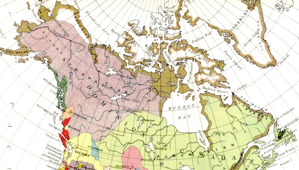 Plate VI.—Linguistic stocks of indians north of Mexico.
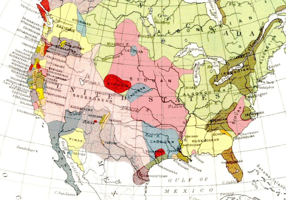 Plate VI.—Linguistic stocks of indians north of Mexico. (Continued.)
The dress of the Innuits in former days, in common with all the Eskimo tribes, consisted of skins, and in special cases of the intestines of seals. The characteristic garment is the parkie or overshirt, not open in front, however, provided with a hood and made of caribou skin tanned with the hair on. Those worn by men have a different cut than those intended for women. In recent years, and perhaps before the coming of white men, the skins for the manufacture of parkies were derived largely by trade from the people owning domesticated reindeer in Asia. The margin of the hood is commonly made of wolf skins, the long hair of which, blowing across the face, affords much protection. Trousers and boots made of the skin of the hair-seal or moccasins shaped from the skin of the leg of a caribou completed the dress. Mats of grass are worn in the boots or moccasins during cold weather. At the present time the summer clothing of the natives throughout Alaska is generally of cloth obtained from white traders, but nothing brought from more civilized countries can replace the parkies, fur trousers, skin boots, and waterproof shirts or kamlaykas. These articles, except the last mentioned, are largely used by white men, especially if making winter journeys.
The boats in use among the Innuits are still the kayak and the oomiak, for which civilized man can offer no adequate substitute. The well-known kayak, made of a light framework of wood, tied with thongs, over which is tightly stretched a dressed sealskin covering, leaving only one or two circular openings for the occupant, is in use from Greenland all about the arctic coast of America to Asia. Different 371 shapes pertain to different tribes. In recent years, as a result of outside influence, openings for three occupants are sometimes made, the size of the boat also being increased. To one familiar with boat and canoe travel these light skin craft, with their water-tight decks, seem the perfection of boat construction. The occupant lashes the skirt of his kamlayka about the raised rim of the opening in which he sits and the boat is thus rendered impervious to water from whatever direction. The greatest danger is that the parchment-like covering may be ruptured, as by the cutting edge of thin ice. To ordinary storms, however, they are more safe than even the deservedly celebrated "whale-boat" of the white man. The oomiak, or woman's boat, also made of dressed skin stretched over a frame, is much larger than the kayak, has a flat bottom, is without deck covering, and designed for the use of many occupants. As is well known, boats of each of these types are propelled by means of paddles. Both the kayak and oomiak are still in every-day use, and it is to be hoped the boats of the white man will never wholly replace them.
The changes in house-building and dress referred to, which have come from contact with white men, are outward signs of a great modification in the lives of the Innuits, which began in the early days of Russian occupation and has continued with increasing importance to the present time. The natives are quick to imitate the customs of the strangers who have visited them, and but for the restraint that the climatic conditions have put upon them and the high price in furs demanded by traders for imported goods the changes thus produced would be far more marked than is now the case. To some extent the food of the natives has been modified, flour being in demand, but, with minor exceptions, the principal articles consumed are still such as are obtained by hunting and fishing.
The greatest change that has taken place in the condition of the Alaskan Innuits, and one which, perhaps, culminated at the time of the recent "gold excitement" on the Yukon and at Cape Nome, is in relation to the introduction of intoxicating liquors and of certain contagious diseases. These 372 scourges, coming from the south, have been almost as great a blight among the native peoples as would be the sweeping southward of a wave of arctic temperature to the vegetation of tropical lands. The curse of contact, resulting when a civilized race invades a land inhabited by childlike aborigines, as has been seen in many parts of the world, has overtaken the Innuits in common with nearly all other tribes in Alaska, and decadence and the prolongation of a miserable existence, unless cut short by extermination through starvation, is all that seemingly can be hoped for.
The fur-bearing animals of Alaska have been greatly reduced in numbers during the last twenty-five years: the caribou and the moose have, to a marked degree, been killed or driven to remote regions; the larger whales, on account of overcapture by American whalers, have become scarce; the sea-lion and the walrus are nearly extinct; the fur-seal, of more importance to the Aleutians than the Innuits, is rapidly approaching extinction. Thus in many ways the food supply is greatly decreased. Recourse to agriculture is impossible. The one redeeming feature of the white man's aggression is the introduction of the domesticated reindeer from Asia and Lapland. With reindeer, the salmon, not as yet depleted in the streams emptying into Bering Sea, the white whale, the hair-seal, not as yet of commercial value, the countless birds of summer, the berries of the tundra, etc., the Innuits can survive, maintain their manhood, and become useful to civilization in certain ways if the curse of drink and the spread of imported diseases could be stopped. Such a change, however, for various reasons, is not to be hoped for. It may perhaps be said that the influence of missionaries, and, what is vastly more important, the work of the school-teacher, has opened to these children of the cold northern land a way to civilization, but the results up to the present time are not reassuring.
The census of 1890 showed that the Innuits of Alaska numbered 13,045. In the census of 1900 a separate enumeration of Eskimos and Indians was not made.
The dismal picture I have been compelled to sketch of the present condition and future prospects of the Innuits 373 of Alaska, in order to indicate their status at the opening of the twentieth century, applies also with variations in detail and some hopeful signs to a large majority of the other aboriginal tribes of North America.
The Aleutians.—The aboriginal inhabitants of the Aleutian Islands are termed Aleuts or Aleutians, a word of obscure and perhaps foreign derivation. As stated above, they belong to the Eskimo family, but are more widely separated from the parent stock than any other of its constituent tribes. Evidence advanced by W. H. Dall tends to show that they are of American continental origin. At the time of the first coming of the Russians, about 1750, they were at war with the Kaniagmuts, who inhabited the greater part of the Alaskan peninsula and were the nearest tribe of the Innuits.
When discovered by the Russians the Aleuts were an active, sprightly people, fond of the dance and of festivities. They are of lighter colour, but not perhaps in general more nearly white than the full-blooded Innuits. At present it is difficult to find even a single representative of unmixed descent, Russian occupation having stamped out or greatly modified nearly every native characteristic both of body and mind. They were originally a robust people, of about the average height found in civilized countries, with coarse black hair and scanty beards. Their island life, where no large game invited inland journeys, made them emphatically "canoe people." The habit of sitting in their kayaks and using the muscles of the upper portion of the body in paddling, throwing the spear, etc., while the lower portion of the body received but little exercise, led to a fine chest development and to undersized and comparatively weak legs. The women, to whom the use of the kayak was not intrusted, were better proportioned than the men, and many of them are pleasing in appearance. As stated by Dall, they were less determined than their neighbours on the mainland, the Kaniagmuts, but were by no means devoid of courage. Their mode of worship partook more of the character of a religion than that of any other of the Eskimo tribes in their native condition. 374
From what can be learned of the Aleuts in their uncontaminated native state, they seem to have been the most intelligent of all the Eskimo tribes and the one which gave the greatest promise, if treated humanely, of advancement when civilization was introduced. Less than a century of contact with Russian invaders, however, led to a depth of degradation that is only paralleled and possibly not exceeded by the shameful results of the Spanish invasion among the aborigines of the West Indies. One of the darkest chapters in American history, fortunately for the credit of Europeans now largely lost, is that containing an account of the brutal treatment the Aleuts received at the hands of the Russians. The childlike natives became worse than slaves. The debauchery of their oppressors was shameful. As stated by Dall, "the Aleuts were subjected to the most horrible outrages. The names of Glottoff and Solóvioff (two Russian explorers, 1764-'65) make them shudder to this day. Thousands perished under sword and fire. Long after those enormities were checked the Russians considered the Aleuts as beasts rather than men," etc. Their numbers, estimated at 10,000 in 1799, were, according to a Russian census, reduced to 5,238 in 1808, and, as stated by Dall, numbered not more than 1,500 in 1870. The census of 1890 gives it as 967.
The incentive to Russian oppression was the greed for furs and the lust of rude men at a distance from all centres of control. The Aleutian Islands and neighbouring waters is the home of the sea-otter, which is clothed with the most beautiful of all furs. Near at hand are the Pribilof Islands, to which the fur-seal formerly resorted each summer in countless numbers, and during its migrations traversed the passes separating the islands of the Aleutian chain, where they were easily taken; the commercial value of their skins previous to about 1867, however, was small. In addition, the land-otter and several species of foxes also inhabited the same region. These allurements tempted the Russians, and besides the Aleutian Islands, with their sheltered harbours, furnished favourable stations from which to extend the fur trade into the still greater region to the eastward, 375 and at an early date in the foreign occupation of Alaska became a basis for supplies.
The entire fur trade in Russian America was placed by charter in the hands of the Russian-American Fur Company in 1799, which, like the Hudson's Bay Company, had territorial jurisdiction as well as trade monopoly. This powerful company maintained its existence under various renewals of its charter until the purchase of Alaska by the United States in 1867. The authority conferred on the Russian company gave it exclusive right to purchase furs from the natives, and thus to dictate prices. This system was fraught with evil to the natives, and their extinction would no doubt have resulted had it not been for the influence of missionaries of the Russian-Greek Church, among whom the name of Veniaminoff will ever be held in blessed memory. In a measure the gross oppression of the Russians brought its own punishment to the offenders. The decrease in the number of the Aleutians meant a decline in the number of pelts secured. To insure the gathering of the highly prized furs the native hunters must be maintained. The later days of Russian occupation were characterized by more humane treatment of the natives, schools were established among them, liquors withheld, and their rapid decline checked. When Alaska was purchased by the United States the Russian-American Fur Company was supplanted by the Alaskan Commercial Company, to whom a lease of the Pribilof Islands was granted. In this lease provision was made for the support and education of the Aleutians on the Pribilof Islands. As the chief and almost the sole employment open to the Aleutians during the past thirty years has been the taking of sealskins on these islands, this wise provision had a beneficent influence on the entire tribe. How faithfully the Alaskan Commercial Company carried out its contract has been seriously questioned, but it is, nevertheless, a fact that the Aleutians have fared better under American than under Russian rule. A gradual adverse change in their condition has come about, however, owing to the decrease and threatened extinction of the sea-otter, and the great decline in the number of the fur-seals owing to the attacks made 376 on them during their annual migrations, which amounts to commercial extinction. The lucrative industries of the natives have thus practically disappeared, and there is nothing to take their place. The surviving members are objects of charity, but as yet the United States Government has made no adequate provision for their support. One method of ameliorating the existing adverse conditions that is practicable is the introduction of domesticated reindeer; another, not so easy to accomplish, is the suppression of the liquor traffic.
The aborigines of the New World to the southward of the narrow strip of arctic coast-land inhabited by the Eskimo are designated by the term Indian, as already explained. There is no sharp line of demarcation between the Indians of North and South America, one shading into the other, but only those of the northern continent are here considered.
In many scientific treatises, as well as in books of travel and general literature, the Indians are frequently referred to as "red men," and the term "copper coloured" commonly applied to them. To the writer each of these expressions seems infelicitous. It is true that throughout America the Indians have a reddish undertone in their colour, but in numerous tribes it is not pronounced. As to copper colour, the meaning of the term is vague. What is copper colour? Presumably the colour of the pure metal when unoxidized. No such colour is more than suggested even by the aborigines having the lightest skins in the members of the many tribes that have come under the writer's notice. A more correct term—but this is a matter of opinion, in which differences are permissible—would be brown, of which many shades occur, ranging from light cinnamon colour to dark chocolate, and even nearly black. There is no recognisable connection between variations in colour and climatic conditions. The faces, hands, and other freely exposed portions of their bodies are darker than the parts usually covered with clothing, and frequently suggest the appearance of bronze statutes 377 not fully darkened by exposure to the weather. In colour they more nearly approach that of the Polynesians than any other peoples, but in general are of a darker hue. The members of the various Indian tribes, although presenting a wide range of differences, have many physiological and mental resemblances, which, like their languages, serve to set them apart from all other peoples. A composite picture of their persons would show a man sinewy rather than heavy in build, but there are many exceptions; of average stature, 5 feet 8 or 10 inches, but there are tribes whose average is more, and others in which it is less; dark brown, with a reddish undertone, in colour; deep-set, black, and in general small eyes, their alignment straight; the nose prominent and frequently well shaped; mouth large, with strong, frequently perfect teeth; lower jaw massive; and face beardless or nearly so, and the hair of the scalp long, coarse, and black. In order to make such a sketch realistic, the bronze-like athletic figure must be clothed in a blanket worn with the grace of a Roman toga or wrapped in a robe of bison-skin; the feet encased in moccasins of tanned deerskin, and usually decorated with beads or variously coloured porcupine-quills; the face striped, dotted, or blotched with various colours; the coarse hair falling like a thatch to the shoulder, or braided, and in certain tribes shaved or plucked, except only the traditional scalp-lock, and decorated with feathers, most frequently of the eagle; necklaces, rings in the ears, amulets, etc., made of the claws of the bear, shells, beads, quills, etc., bespeak various tribes; the primitive weapons were the hatchet-like tomahawk, the bow and arrow, and the spear. The Indian has been idealized in the writings of poets and novelists, but occasionally, even at the present day, one meets with an approach to the ideal. Judged by the standards of civilization, as he is seen to-day on numerous reservations and about the streets of towns, he is a lazy, dirty vagabond. A far more favourable and agreeable picture is presented, especially in the eastern portion of Canada and adjacent States to the south and in the Indian Territory, where the blessings of civilization have been accepted and the once roaming savage has become a tiller of the soil, an owner of 378 cattle and sheep, and lives in a comfortable house supplied with furniture such as white men use.
While a racial likeness impossible to conceal unites all of the various tribes, no single picture or generalized description, however carefully prepared, can convey to one unfamiliar with the Indian an accurate idea of his personal appearance. A typical example from one tribe when critically studied is found to differ widely from an equally representative example of another tribe, not only in speech, dress, methods of wearing the hair, ornaments, etc., but also in physique and in mental traits.
In temperament the Indian is usually described as being moody, reserved, wary, grave, and his face expressionless, the current of his thoughts being unrevealed in his proud, indifferent bearing. In his own mind he seems to consider himself superior to all other beings, and to regard them with contemptuous indifference. All this is true enough as seen by a stranger, but in his home life, and not infrequently when in the presence of trusted white men, the mask of indifference is laid aside and the laugh and jest indulged in. The extreme of assumed indifference is exhibited, as has been well attested by many witnesses, when death by torture is inflicted on a captive, as, for example, burning alive, when no outward sign is permitted to reveal his intense suffering.
The Indian is a hunter and fisherman both from inheritance and necessity. From his mode of life his sense of sight and of hearing have become wonderfully acute. His skill in following a trail is proverbial. When living near the sea or by the side of streams and lakes he is as much at home in a canoe as his relative of the plains in post-Columbian days when seated on his hardy pony. In current literature, however, all of these traits, as in the case of the personality of the Indian, have been fused into one ideal. It is true that the Indian hunter is more skilled in following a trail, in interpreting the signs and sounds in the forest, in shooting the foaming rapids in his frail canoe, etc., than the average white man to whom such pursuits are incidental or newly acquired; but many white men, and particularly those who have in a measure degenerated and 379 assumed the Indian mode of life, are his equal, if not his superior, in all that pertains to woodcraft.
In mental qualities the Indian is the inferior of the Caucasian and the Asiatic, but is the superior of the negro. The ability to advance is not absent, and capacity to reach a certain grade in civilization is general, but beyond the acquirement of indifferent skill in the arts, literature, etc., but few have passed. The mental quality of perseverance under adverse conditions and of continuous application has not been granted him.
These children of the forests and plains, easily pleased and as easily angered; kind to their children and friends, but cruelly revengeful when enraged; treasuring a kindness, but never forgetting an injury; without rigid self-control, as is sadly illustrated by their inordinate passion for liquor when once a taste for it is acquired, are plastic organisms, which reflect the conditions under which they have developed. These untutored barbarians, descendants from ancestors who brought little with them save the stone axe and the stone spear, but of necessity originated all their arts and institutions without contact with other peoples, and were exposed to a wide range of climatic and other physical conditions for many centuries, present a most instructive subject for the study of the geographer and others who are interested in the relation of man to his environment.
Resources.—To the Indian in pre-Columbian days no ships from overseas brought supplies, and as the various tribes were frequently at war with their neighbours, trade relations were greatly restricted. Intertribal barter was carried on, however, and the capture of supplies and utensils of various sorts by one tribe from another favoured their dispersion. Although such articles as the native copper of the Lake Superior region, the red pipe-stone (catlinite) of Minnesota, and obsidian from various places found its way to remote localities, each tribe had essentially to supply its wants from the natural resources of its own domain. The range in raw materials, to borrow a modern commercial term, that the Indian's intellectual development permitted him to utilize is indicated in the following table: 380
| Used for food. | Animal | Mammals, birds, reptiles, fishes, crustaceans, insects, and at times human flesh. |
| Vegetable |
Wild—Roots, bulbs, seeds, fruits, nuts, bark, berries,
sap. Cultivated—maize, cacao, melons, squashes, tomatoes, sweet potatoes, potatoes, pineapple, (tobacco). |
|
| Mineral | Salt, (earth in certain instances). | |
| Used for clothing. | Animal | Skins, sinews, tendons, hair, wool, feathers, and cochineal for dyes. |
| Vegetable |
Wild—bark, fibres, roots, dyes, gums. Cultivated—Cotton, aloe (?) |
|
| Mineral | Dyes, such as ochres and cinnabar, charcoal. | |
| Used in the construction of houses. | Animal | Skins, sinew, etc. |
| Vegetable | Logs, bark, seeds; grass, roots, etc., for mats. | |
| Mineral | Stone, adobe, sods, earth, selenite (caves). | |
| Used in making boats. | Animal | Skins, sinew; oil in paint; quills, shells, etc., for decoration. |
| Vegetable | Tree trunks, bark, seeds, pitch. | |
| Mineral | Asphaltum; metallic oxides, etc., for paint. | |
| Used in making utensils and weapons. | Animal | Bones, horns, skins, scales, teeth, shells. |
| Vegetable | Wood, bark, nuts, leaves, fibre, dyes, pitch. | |
| Mineral | Soapstone for pots, pipes, etc.; obsidian, flint, etc., for spear and arrow points, knives, scrapers, etc.; various hard stones and pebbles for axes, mortars, pestles, etc.; copper for axes, knives, etc.; mineral dyes; gold and silver. | |
| Used as personal ornaments and in the decoration of houses, boats, etc. | Animal | Skins, hair, fur, bones, hoofs, claws, teeth, ivory, oil in paints; shells, coral, pearls, feathers, quills, scales, etc. |
| Vegetable | Seeds; fibres for mats, basket-work, etc. | |
| Mineral | Stone (turquoise, emerald, jasper, mica, catlinite, etc.), clay, gold, silver, meteoric iron; and various metallic oxides, cinnabar, etc., for paints. |
In these several ways, and yet others, as in their games, medical practice, elaborate religious ceremonials, mortuary customs, modes of travel, etc., the aborigines utilized a wide range of materials supplied by nature, and supplemented them by horticulture, and to an exceedingly limited extent by domesticating animals. The degree to which they utilized the natural supplies was much less in certain directions than became possible to civilized people, but several sources of raw materials prized by them have not been called upon by white men, and are now in greater or less measure abandoned by 381 the natives themselves. The vast mineral wealth of the continent was almost entirely unavailing to the aborigines, except so far as native metals were discovered; while several articles, such as the camass, the seeds of grasses, insects, etc., for food and material, used for implements, as obsidian for arrow points, spears, and knives, catlinite and other stones for pipes, porcupine-quills for decoration, etc., are of small value to Europeans. While civilized man has become more and more independent of climatic and other natural conditions, largely through the aid of commerce, the aborigines were much less resistant and were forced to adjust themselves to their environment, and like other plastic organisms, were modified by it.
The Natural Food Supply.—The food of the Indians was mainly the flesh of mammals, birds, and fishes. The smaller deer of various species inhabited the entire continent from the subarctic forest to Panama. The range of the bears was equally extensive, but in certain instances, on account of superstitious fear, were not customarily used for food. The almost universal source of food supply furnished by the smaller deer was supplemented at the far north by the Barren Ground caribou, succeeded southward by the woodland caribou; overlapping the range of the latter and extending farther south was the moose; this, in turn, was supplemented and exceeded in southern range by the Wapiti (elk); more restricted was the range of the mountain-sheep and mountain-goat, each inhabiting the Pacific mountains; on the Great plains roamed the bison and the antelope, the former extending from the central Atlantic seaboard to the Snake River plains, and the latter from the subarctic forest to Mexico. The mammalian food supply was most abundant in the temperate belt, and while decreasing northward, declined more rapidly towards the south. The food supply furnished by fishes was plentiful wherever water was present, and in superabundance in tidal rivers and estuaries both on the Atlantic and Pacific coasts; but these resources fluctuated in a conspicuous way with seasonal changes, owing especially to the annual migrations of the shad and salmon. Supplementing the highly desirable fish-food on the ocean 382 shores were the molluscs, and especially the oyster and the clam. The rivers, particularly of the Mississippi Basin, supplied fresh-water "clams" (Unios), and the saline and alkaline lakes of the arid region, inclusive of Mexico, teemed with the larvæ of insects, which were utilized for food. In the Atlantic and Mississippi region, south of the Great Lakes and extending to Central America, lived the wild turkey; the forests of the Atlantic and Pacific coasts, the vast prairies, and the no less extensive sage-brush plains to the westward were inhabited by various species of grouse; the land east of the Pacific mountains, from the Gulf of Mexico far northward, was darkened by immense flights of pigeons; the water from the far south to the far north, throughout the breadth of the continent, were visited by large numbers of swans, geese, ducks, and other water birds. In a conspicuous way the feathered hosts, valuable for food, were migratory, thus again introducing a variable quantity into the lives of the aborigines.
The vegetable food of the Indian tribes that did not practise horticulture varied from locality to locality, and in the temperate and more northern regions fluctuated through a wide range with seasonal changes. Berries were abundant in certain regions and at certain seasons. The raspberry, blackberry, huckleberry, strawberry, etc., of many varieties, grew wild in the eastern Mississippi and Atlantic coast regions. The huckleberry extended from the northern Atlantic coast regions westward across the continent on the southern border of the subarctic forest, and reached central Alaska. On the coast of British Columbia and Alaska to Mount St. Elias, salmon-berries, wild currants, huckleberries, and strawberries flourished with marvellous luxuriance and of large size. Wild cherries were abundant on the Atlantic coast and extended to the Pacific mountains. Certain small plums of value for food occurred widely in what is now the United States. The papaw and persimmon thrived in the southern portion of the Atlantic coast region. The fruits of the cacti yielded refreshment in the southwestern States and in Mexico. Throughout all the hardwood forests of the Mississippi Valley and the region south of the St. Lawrence 383 a large variety of nut-bearing trees, such as the walnut, hickory, chestnut, beechnut, oak, etc., were in great abundance and furnished a large annual food supply. In the northern portion of this region grew the maple, the saccharine sap of which was utilized by the Indians for making sugar. In the Pacific mountains south of Canada grew the piñon, perhaps of all the trees of the continent the species that yielded the greatest food supply to the Indians. In this same region, particularly to the northward, grew the small lily-like plant having a blue flower, known as the camass, the bulbs of which are highly nutritious. Both the piñon and the camass are largely utilized even at the present day for food by the Indians. In Mexico, Central America, and the West Indies a large number of tropical fruits, bulbs, nuts, etc., abound, which are suitable for food, and, as we have more or less direct evidence, were utilized by the Indians of that region in prehistoric times. The period of harvest at the south is less sharply defined than in temperate latitudes and the natural food supply subject to less seasonal fluctuations.
The Indians so long as they did not engage in agriculture—there being an absence of anything that could be termed commerce, and even the transfer of food and other supplies by barter being restricted—were obliged to move from place to place, in order to avail themselves of the abundance furnished in certain localities and at certain seasons. This is well illustrated at the present day. With the coming of the salmon in the rivers of the northwest Pacific coast region the Indian feasts by the river-side; when the berries ripen in the valleys of the Cascade Mountains he is there, together with the bears, to profit by the bounties of nature; in Nevada he still makes journeys to the piñon groves in October; and in the subarctic forest he accompanies the migration of the caribou. In former days he followed the movements of the herds of bison on the Great plateaus. In these and many other ways the food supply of the Indian tended to establish nomadic customs, and as each source of fuel and other supplies demanded different methods of capturing animals or different utensils for gathering 384 seeds, etc., variations in culture development was a necessary result. The duty of replenishing the general stores was shared by all, but there was no definite organization for this purpose, and certainly nothing worth the name of business management. As the adage is, "What is every one's business is no one's business," and for this reason the Indian, as a rule, failed to lay aside a sufficient supply of food for winter use, and in consequence frequently went hungry and not infrequently died of starvation.
The scarcity of the spontaneous food supply at certain seasons or during exceptional years, and the recurrence of cold or rainy seasons, necessitating shelter, would naturally lead the Indian to develop in two important directions, namely, agriculture and architecture. As is well known, promising advances had been made in each of these arts, when indigenous development was checked and to a great extent killed by the appearance on the scene and subsequent encroachments of peoples from over the sea.
Horticulture.—Concerning the art of cultivating plants for food, clothing, utensils, etc., practised by the Indians before the coming of Europeans, it is difficult to obtain accurate information. The writings of Spanish and other explorers who first visited various tribes have been diligently searched in this connection by students of American history, and although much that is instructive has been discovered, many questions remain unanswered.
The principal regions where cultivation of the soil was practised in pre-Columbian times are situated in the United States south of the St. Lawrence and east of the Mississippi Valley, and inclusive of the lands bordering the Great Lakes on the south; also much of New Mexico, Arizona, Mexico, Central America, and the West Indies. In the eastern portion of what is now the United States localities naturally devoid of trees were cultivated by the Indians, and partial clearings were made in the vast forest by deadening the trees, probably by girdling or cutting the bark entirely around their trunks with stone axes, and leaving them standing. A similar process was employed by white settlers in later years, and is practised even at the present day. In these 385 partial clearings, from which the underbrush was no doubt burned, gardens of maize, melons, pumpkins, beans, gourds, sunflowers, potatoes, tobacco, and perhaps other plants were grown without irrigation. Garden-beds, as they are termed, are still to be seen in the forests of Michigan, which, as indicated by the trees growing on them, are older than the time white men began the cultivation of the soil of that region. In the arid southwestern portion of the continent and in Central America gardens were cultivated with the aid of irrigation, and what has been described as a high degree of skill in horticulture attained. The chief products of these gardens were maize, cotton, tobacco, beans, melons, cacao, bananas, and the red pepper. Possibly vanilla, tomatoes, and pumpkins were also grown. The aloe was extensively utilized in the south, but whether definitely cultivated or not seems uncertain.
The cultivation of fruit-trees other than the cacao, which furnishes the seeds from which chocolate is made, does not seem to have been carried on, although certain writers imply that native trees were tended and given greater facility for growth by removing adjacent plants. It is stated by some authors that in the region to the eastward of the Mississippi the Chickasaw plum is now found growing in clearings that were abandoned by the Indians and not elsewhere, and the inference is that it was formerly cultivated. Asa Gray mentions, however, that this species is probably not indigenous.
Of domesticated mammals none are known to have been possessed by the Indians except the dog, which it is presumed was derived from one or more species of the native wolf, and was used to carry or draw burdens, served also for food, and furnished skins for clothing and hair for weaving cloth. The turkey was domesticated by the Aztecs and the village Indians of the New Mexico region; among the latter, even at the present day, eagles are confined in cages and plucked for feathers. There is seemingly no doubt but that in pre-Columbian, as in recent years, the young of wild animals were captured by the Indians and reared as pets, which in times of necessity probably served for food; but there are no records of definite attempts to domesticate the 386 bison, mountain-sheep, mountain-goat, or the peccary of the Gulf coast and Central America. In the attractive accounts that have appeared in recent years concerning the grandeur of the Aztecs mention is made of extensive menageries, but even the most poetic of historians has not assigned to the tribes of that confederation flocks and herds. The llama and the paco or alpaca, although reared extensively by the Incas of Peru, are not certainly known to have been introduced into North America.
To the eastward of the Mississippi, where numerous earthworks bear testimony of an early settlement by aborigines, heavy forests, the severity of the winter climate, and wide variations in summer rains combined to make the natural conditions to a marked degree adverse to aboriginal development. In Central America, and the West Indies generally, the exuberance of vegetable growth is such as almost to defy the clearing of land by people provided only with stone or copper utensils. Between these two regions, in the southwestern portion of the continent, are the arid lands, where, when once the idea of irrigation was embraced, the conditions favouring a sedentary life, with agriculture as a basis, are far more auspicious than elsewhere. The land is there treeless, the indigenous plants are easily killed by fire and by irrigation, the soil is rich, intense sunshine favours plant growth, and the gathering of harvests is not delayed or the efforts of industry rendered abortive by rain. Of all portions of the continent, this is the one where resistance to human development is least, providing man's ideas are sufficiently advanced to permit him to grasp and put in practise the art of irrigation. It is reasonable to suppose that the Indian there first began to build permanent homes and to cultivate the soil. This hypothesis is sustained in part by historical evidence, and in part by the ruins of ancient villages or communal houses, irrigation, ditches, etc. From this centre it may be presumed, in the absence of definite proof, that the art of horticulture spread to Central America and the Mississippi Valley.
In spite of the glowing accounts given by certain historians concerning the high degree of skill in agriculture 387 attained by the aborigines of Mexico and Central America, and the extent of their plantations, a conservative balancing of the evidence indicates that they never advanced beyond the stage of gardening, and that field agriculture, the cultivation of orchards, and the domestication of mammals was practically unknown to them.
Houses.—The houses of the primitive Indians, owing to the various stages in culture attained by different tribes and differences in climatic conditions, showed a wide range in material used and in the results obtained. The shelters of the wandering tribes and of the village Indians during their journeys were usually some form of tent, either composed wholly of boughs or of a framework of sticks over which skins were spread and secured by thongs. The typical wigwam consisted of a number of poles from 15 to 18 feet long, lashed together at the top and arranged in a circle some 10 feet in diameter at the base, on which a covering of skins, bark, or mats was spread, leaving an opening at the top for the escape of smoke from a small fire placed on the ground within. At the top a wing-like extension of the covering was frequently provided which could be adjusted to the direction of the wind. An opening on one side, protected by a curtain of skin, or closed by drawing the covering together, served as a door. A modification of this genuine Indian lodge, or tepee, in which cotton cloth is substituted for the primitive covering, may be seen over a wide extent of the country to the west of the Mississippi at the present day (Fig. 36).
A step higher than the usually circular lodge of boughs, etc., in use principally among the Indians to the west of the Mississippi, was furnished by the bark houses of the northeastern tribes, as those of New York, in which a rectangular frame of poles with an arched or triangular roof was covered with bark, usually of the elm, tied to the inner frame and held also by an external frame of poles, the two frames being lashed firmly together. This, the celebrated "long house" of the Iroquois, like most Indian houses, was designed to accommodate a number of families, and may be said to have consisted of several houses placed end to end 388 with a common passageway running through them. Fires were lighted in this passageway, one for each family, and the smoke allowed to escape through openings in the roof. One of these bark houses is described by an early traveller as being 80 feet long, 17 feet wide, and with a common passageway 6 feet wide running through its length, on each side of which were apartments 5 feet square. Smaller houses, usually for the use of a few families, were also built. The larger ones, as was common in many Indian villages, were occupied both as dwellings and for general assemblies. These houses were grouped in villages, about which palisades, consisting of poles planted in the ground, were frequently built, and in at least one instance a ditch filled with water was used on the outside of the palisade to increase their security against attack.
The feature of special interest concerning the houses of the American aborigines, inclusive of the Eskimos, is that they were usually occupied by a number of families. This communal idea runs through all the indigenous American architecture. As remarked by Lewis H. Morgan, one of the most judicious students of American ethnology, "the house for a single family was exceptional throughout aboriginal America, while the house large enough to accommodate several families was the rule. Moreover, they were occupied as joint tenement-houses. There was also a tendency to form these households on the principle of gentile kin, the mothers with their children being of the same gens or clan."
The idea of the joint tenement-house, as has been clearly shown by Morgan, illustrated by the bark cabins of the Iroquois, finds its most striking expression in the communal houses, or pueblos, of the village Indians of New Mexico and Arizona, and in the abandoned stone houses of Central America. In the arid southwestern portion of the continent certain tribes, termed the Pueblo Indians, are still living in the villages they occupied when first visited by Spanish explorers (1640). On account of their exclusiveness and the isolation of their villages in an immense desert region they have been but slightly modified, so far as their home life is 389 concerned, even at the present day, by contact with white men. The hot desert has shielded these people in much the same manner that the frozen tundra has served to preserve the purity of the Eskimo.
The homes of Pueblo Indians, as described by Morgan, are immense tenement-houses, built of stone and adobe, frequently occupying several acres of ground, and from 1 to 6 or 7 stories high. The number of inhabitants at Zuñi, one of the most typical of these pueblo towns, is stated to have been 1,500 in 1851, but to have previously included some 5,000 souls. The adobe, of which the houses are largely constructed, is the soil of the region, which when mixed with water and allowed to dry becomes sufficiently hard to retain indefinitely in an arid climate the form given to it. The soil is formed into bricks, and also used as a mortar to unite rough stones. Although much stone was used in the construction of the pueblos, it was roughly dressed by hammering, or not changed at all from its natural condition, and regularly cut and carved stones do not occur in the buildings. The pueblos were built in successive terraces, usually either in a semicircle or on three sides of a rectangle, the open side being protected by a wall. Irregular forms are also known, the general plan being adapted to the natural condition of the site chosen. In certain instances the structures were placed on elevations where a high degree of safety was insured, but others are on the open plain and even at the base of a commanding eminence, and near enough to be reached by arrows shot from a bow. Protection against enemies was increased by an absence of openings in the exterior walls, except at a considerable height above the ground; ingress and communication from terrace to terrace being by means of ladders, which were drawn up or their steps removed in times of danger. The roofs of the pueblos, as may be seen at Zuñi at the present day, are flat and consist of poles covered with adobe.
The controlling ideas in the construction of the pueblos seems to have been communal residence and defence. The houses are at the same time tenements and fortresses. A characteristic feature of these, as of practically all Indian 390 villages, is the presence of one or more assembly rooms, and of open courts or plazas, where the people gathered for council, worship, amusement, etc.
When white men first visited the Pueblo Indians they cultivated gardens with the aid of irrigation in which maize, mostly of a blue colour, was the principal crop, and had domesticated the turkey; earthen vessels of large size, frequently elaborately and pleasingly decorated, were manufactured; cotton fabrics were woven of spun threads, and the men were armed with bows and arrows and shields; clothing was made of dressed deerskins, buffalo-robes, and cotton cloth usually dyed dark blue. The descriptions of the Pueblo Indians given by the first visitors from civilized peoples would, to a great extent, apply to them at the present day, although in reality their lives have been profoundly modified and their indigenous development checked.
Throughout a wide extent of the arid southwest the ruins of ancient pueblos, irrigation canals, remnants of pottery, the latter frequently marking village sites on isolated eminences, bear witness of a formerly widely spread people. This evidence shows also that the ancestors of the present tribes have inhabited the same territory for a great length of time. In this same general region are found the houses of the cliff-dwellers, who excavated rooms in the faces of precipices, frequently high above their bases and only accessible by means of holes, serving as steps, cut in the rock, or with the aid of ladders. In many instances these ancient cliff-dwellers, of which no certain descendants remain, took advantage of natural caverns, or of overhanging ledges, which were closed by means of walls of rough stone and adobe.
 Fig. 37.—Panorama of Uxmal, Yucatan.
The pueblo dwellings, built largely of adobe, are stated by ethnologists to have extended southward into Mexico, and illustrate the nature of the houses in which the Aztecs lived, but the highest type of aboriginal architecture in America is furnished by the dwellings and so-called temples, palaces, etc., still standing in Yucatan and other portions of Central America. In these ruins we have abundant example of buildings made of cut stone, laid in regular and even 392 courses, united with mortar composed of burned lime and sand, and elaborately sculptured in bas-relief and in the round, or covered with designs moulded in stucco. In size and proportions these unique structures are impressive. The so-called Governor's Palace at Uxmal, Yucatan, is 320 feet long, 40 feet wide, and 25 to 26 feet high, and surmounts an artificially constructed platform of earth 35 feet high and 393 approximately 550 feet square. This platform is terraced and provided with broad flights of stone steps (Fig. 37). These dimensions will serve to render more instructive the accompanying sketch of the principal ruins at Uxmal by W. H. Holmes.
Mere size and their great number are not the significant features of these ruins. They are well built, of cut stone, and most elaborately decorated, as may be seen by the accompanying reproduction of a photograph of a typical example. In reference to the skill displayed by the unknown architects and builders, Holmes, one of the most recent as well as the most critical of Central American travellers, remarks as follows:
"The stone used is the pale-yellowish and reddish-gray, obscurely marbled limestone of the locality.... The facings and ornaments are all cut and sculptured with a masterly handling not surpassed where chisels, picks, and hammers of iron and steel are used, and the faces and contact margins are hewn with perfect precision. Though the finish of the surfaces was often secured by means of abrasion or grinding, picking or pecking were the main agents employed, and the indents of the tools are often apparent and wonderfully fresh-looking. The stones were set in mortar, although in many cases the joints are so perfect that the mortar does not appear on the surface."
The extensive ruins of Uxmal, although only a part of the treasures concealed in the forests of Central America, express with an eloquence not as yet fully appreciated the advanced stage of culture and refinement attained in America from the growth of indigenous ideas. Some of the special features illustrated by them from which the degree of mental development of their builders can be judged is the presence of the wedge-shaped but not of the true arch. The character of the simplest and perhaps the first style of arch constructed by the awakening peoples in many lands are shown in the accompanying sketches, borrowed from Holmes's most instructive report. Columns, both square and round, were used, and statues both in bas-relief and in the round are common. The designs, whether of animals, grotesque 394 monsters, feathers, or plants, are in strong relief, either cut in stone or moulded in stucco. These designs are not confined to single stones, but embrace several blocks, and together with the diaper fretwork extend the entire length of even the larger structures. Accompanying the well-wrought figures of men, and at times forming separate inscriptions, are many hieroglyphics, the meanings of which are still unknown. All or nearly all of the structures stand on artificial platforms, which are terraced. A terraced pyramid, with a broad flight of steps on one or more sides, surmounted by a well-proportioned rectangular building, faced with cut stone, highly decorated, and with a flat roof, are the larger features of the Maya ruins.
 Fig. 39.—Sculptured Façade of Governor's Palace, Uxmal,
Yucatan.
Fig. 39.—Sculptured Façade of Governor's Palace, Uxmal,
Yucatan.All of this and more, as can be read in the elaborately illustrated books of Stephens, Holmes, and others, shows that the Maya people, at the time they were crushed by the more than cruel Spanish invasion, had reached a stage in their development but little short of true civilization.
Ethnological Studies.—The native dress of the Indians, their boats, ornaments, and still more their customs, systems of government, religions, myths, traditions, etc., offer attractive subjects for study, which are being earnestly pursued by many students at the present time. The closing decade of the nineteenth century witnessed a true awakening 395 of the white people of America to an interest in the many relics of ancient earthworks, buildings, utensils, etc., found throughout the continent, and a healthy growth of an earnest desire to record all that can be learned concerning the representatives still remaining of the vanished peoples to whom they pertain.
In the van of this important work is the Bureau of Ethnology of the Smithsonian Institution. Important work has also been carried on by the Peabody Museum of Archæology, situated at Cambridge, and more recently has been taken up in an energetic manner by the American Museum in New York and the Field Columbian Museum at Chicago. The National Museum of Mexico has assembled rich stores of archæological and ethnological material pertaining to the native races of Mexico, and the Mexican Government is doing much to preserve the priceless prehistoric monuments of the republic from vandalism. There are also many private antiquarian collections and many individual students who are doing good work along their chosen historic, linguistic, and other branches of research. One phase of this work, particularly in reference to ancient earthworks, buildings, and also the observations of early travellers, missionaries, explorers, etc., is the removal of the incrustation of romance, and in part of fable, that has been formed about them. As shown by W. H. Holmes, in reference to many reputed finds of the relics of men in various glacial and other deposits; by W. H. Henshaw, in respect to certain animal carvings; by Cyrus Thomas, in the case of the earthwork of the eastern part of the United States; by L. H. Morgan, in connection with the history of the Mexican and Central American aborigines and other similar examples, imagination has only too frequently taken the place of critical study and hasty generalizations have been given publicity. It is perhaps not too strong a statement to say that the fascinating histories pertaining to Mexico and Central America, written by Irving, Prescott, and Bancroft, need to be thoroughly revised and rewritten from the standpoint of the scientific ethnologist. This clearing of the field of an underbrush of fancy is as necessary as the work of the axe or 396machete in removing the vegetable growths that conceal many of the records of America's history.
The Contact of the Aborigines with Foreign Peoples.—The chief interest of the ethnologist concerning the American aborigines relates to their condition before the introduction of European ideas and customs. This external influence has been far-reaching and cumulative in its effects, and to-day there is not a tribe in North America that stands where it would have stood but for its coming. Among some of the Eskimo tribes, and in the case also of certain Indian communities in central Alaska and northern Canada, there have been but slight modifications even in dress, utensils, etc., by reason of contact with the white man. The Pueblo Indians have been resistant to change, but although still grinding their blue corn in primitive stone hand-mills, and dressed nearly as the first Spanish visitors found their ancestors in the same villages, there has been a slowly progressing revolution in the undercurrent of their thought, ideas, religion, customs, etc. Whether this change is for the better or the worse depends on the point of view. In attempting to judge of it from the Indian's side, the only possible conclusion seems to be that the coming of the white man has been a curse.
The reception of Europeans by the Indian, although in many instances kindly, has, in the main, been but an outward show of friendship, concealing suspicion, fear, and jealousy. That this distrust was well founded is abundantly proved by history. Since the slaughter and enslavement of the aborigines of the West Indies and of the southern portion of the continent by Spaniards, through all the bloody conflicts of the English and French with the Indians of the Atlantic and Mississippi regions, to near the close of the nineteenth century, almost constant war, marauding, murder, rapine, and jealousy have accompanied the contact of the aborigines and the whites. Although the Indians succeeded in retarding the spread of civilization, they were not strong enough to permanently check it. In the United States and Canada they have been, to a great extent, dispossessed of their hunting-grounds by so-called treaties, or by formal purchase, 397 and placed on reservations. In Mexico the struggle is still in active progress, but there and in Central America and the West Indies the contact of the two races has in part assumed a different phase, and one less visibly detrimental to the Indian. In the countries now held by people of Spanish descent, and in fact throughout Latin America, as it is termed, amalgamation has, to a great extent, caused the disappearance of the Indian race in its purity. North of the indefinite boundary where the Spanish language is largely spoken much less admixture of the two races has occurred than farther south, and the half-breed is classed as an Indian. While to the north of Mexico it is possible to trace the post-Columbian histories of the Indian tribes with an approach to completeness and to state their present census, and note the results of the attempts that have been made to civilize them, to the south of the Mexican boundary such a task is seemingly hopeless.
In Alaska the Indians still roam at large with no other restraint than that arising from the adjustment reached through intertribal relations, with slight modifications due to the widely scattered settlements of white men. No attempt has been made by the United States Government to place them on reservations, and this will probably not occur, as the white man does not wish their lands for agricultural purposes. Displacement by contact seems to express the change now in progress.
In Canada the present condition of the Indians varies with locality. In the southeastern part, including the maritime provinces, they have been greatly changed from their native condition, and to a large extent gathered on reservations or have settled on land of their own and become self-sustaining. In the Labrador region and throughout the Rocky Mountains they still roam at will, and depend mainly on hunting and fishing for a livelihood. On the Pacific coast, the Haidas, etc., of British Columbia—and the same is true of their neighbours, the Tlingits of southeastern Alaska—have become interested as labourers in the commercial fisheries, principally the salmon industry.
The Canadian Government has purchased extensive 398 tracts of land from the Indians, and the purchase money, together with the returns from the sale of relinquished lands, etc., amounting in 1900 to $3,893,623, is held in trust for their benefit. The interest on this sum, together with appropriations made by the Government for the support, education, etc., of the Indians, amounted during the year 1900 to $1,309,127. The total—in part estimated—Indian population of Canada is about 99,000, and those classed as resident Indians number 77,450. The last-named during the year 1900 cultivated 108,850 acres of land; owned 83,019 head of cattle, horses, sheep, etc.; cut 68,395 tons of hay; gathered 471,596 bushels of potatoes and other root crops, besides an output of $1,639,398 worth of fish, furs, etc. During the same year 9,634 Indian children attended industrial schools. This is certainly a creditable report and one encouraging to the hope that all the Indians in Canada will in the course of a few generations become civilized, in spite of the fact that the Indians outside of the reservations and beyond the limits of the treaty lands still roam at large and to a great extent are in a deplorable condition.
In the treatment of the aborigines within her borders Canada has to a marked degree been both humane and just. Her policy in this connection is largely an inheritance from that of the Hudson's Bay Company, whose success in trade depended on maintaining friendly relations with the native peoples. The work of the factors of "the Great Company" scattered throughout Canada and carried on continuously for more than two centuries did much to prepare the aborigines for civil government. Owing largely, also, to the efficiency of the mounted police of Canada much less trouble has been experienced in the management of the Indians of that country than has been the case in the adjacent portion of the United States. In any comparison, however, of the relation of the Canadian and United States governments to the aborigines within their respective borders account needs to be taken of the widely different conditions on the opposite sides of the boundary line between them. Not only are the Indians of Canada about one-third as numerous as in the United States, while the area of each country is about the 399 same, but owing to a less dense white population to the north of the international boundary, far less demand has there arisen for their lands for agricultural, mining, and other purposes than in the United States.
The Indian problem within the United States has been a most serious one, and is still a severe tax on the nation. The union of the colonies and the final separation from the mother country left the United States with an immense western frontier, extending in an irregular way from north to south through the trackless forests of the Mississippi Valley. As the nation grew in strength this frontier was pressed farther and farther westward, while settlements established on the Pacific coast presented a frontier to the eastward. These two inundations of civilization, crude, but virile and aggressive, approached each other and entered the passes in the mountains separating them. Between the two were the hunting-grounds of the Indians, but the advance of the whites was irregular and the outposts of civilization were in the Indian country. In 1867 the buildings of the first of the transcontinental railroads divided the region roamed over by savage tribes. Railroads continued to be built, and presently there was no frontier. In a later stage in this process of subduing a continent it became imperative that the more hostile and treacherous Indian tribes should be either exterminated or segregated and confined to definite regions, where they could be under military surveillance. Many treaties were made between the United States and the Indians, and by this means and by force the original occupants of the land were placed on reservations. The aim of the Government, it must be conceded, has during the past fifty years or more been humane, but in many instances treaties have been unfulfilled, and individuals in authority have proved incompetent, unfaithful, and dishonest. In judging of the dealings of the white man with the Indian, it must be remembered that the problem was highly complex and in certain ways of such a nature that no result just to each party was practicable. On one hand, the rights of the Indian to the land they inherited from their ancestors was to be recognised, but a larger 400 interest, the march of civilization, had also to be encouraged. The good of humanity demanded that the barbarian, roaming over broad lands of which he made no use except for hunting, should give place to more enlightened people, who wished to cultivate the soil and make it support thousands of individuals, where before only a few hundred could find sustenance. The history pertaining to so many countries, where civilized peoples have displaced races in the lower stages of culture, was here repeated. The main issue was the same, only the details differ. In the struggle between the white and the red man it became evident that the latter must yield, assume habits of industry, and earn his bread by the sweat of his brow or be exterminated. It may be said that neither of these seemingly inevitable results has occurred; the Indian has not been exterminated, and possibly not seriously reduced in numbers, and to a great extent is not self-supporting. It is believed, however, that this is but a transient stage, resulting from the reservation system. In a large number of instances the lands formerly occupied by the Indians have been purchased from them by the Government and thrown open to settlement by white people. The money due for these purchases has in several instances been paid to the Indians, either as tribes or individually, while in other cases it is still held in trust by the Government, and the interest on it used for the benefit of the original occupants of the land.
The United States Government by treaty with certain of the tribes, as the Sioux, for example, has agreed to pay definite annuities and issue to each individual a certain amount of clothing and food each year. Other tribes placed on reservations were also granted clothing and food sufficient to keep them from want, although no agreement to that effect was entered into, the theory of the Government being that the Indians deprived of their hunting-grounds should receive aid until they could adopt the ways of civilized men sufficiently to be self-supporting. The number of Indians assisted in this way each year during the past decade has been about 85,000. The food issued, usually twice a month, consists of meat, either beef or its equivalent 401 in bacon, flour, coffee, and sugar. The ration supplied each individual is sufficient to maintain a person, or at least keep him from starving, but is not intended to meet all his wants. The desire on the part of the Government that want should compel the Indian to work, has been still further pressed by a gradual decrease in the ration issued in certain instances where definite agreement has not been made and where a tendency to self-support is manifest. In general, however, this assistance, instead of stimulating industry, and, as would seem natural, gradually leading the recipient to desire and obtain more and more of the comforts and luxuries that may be had as a reward of exertion, served but to enhance his inherited aversion to all forms of labour. The issuing of rations even to the extent of insuring the Indian against starvation has to a great extent removed the incentive to industry, and the Indian, being an Indian, has remained thriftless and indifferent. The reservation system, so far as attaining the main aim in view, namely, the civilizing of the Indian and encouraging him to work, has, to a great extent, been a failure.
In addition to the issuing of food and clothing, the Government, with the view of extending still further encouragement, has in a large number of instances provided the Indians with tools, horses, agricultural implements, etc., and aided in irrigation and other schemes tending to the improvement of the lands comprised in reservations.
Besides the direct material aid just referred to, schools have been established, and an earnest and widely extended effort made to educate the Indians and make them worthy of citizenship. The result of this effort, while highly encouraging in many individual instances, has on the whole fallen far short of what was expected in view of the large expenditures incurred. The sum thus employed during the past thirty-three years is about $240,000,000. The total appropriation made by the Government for the care and education of the Indians, inclusive of the aborigines of Alaska, for the fiscal year ending June 30, 1901, was over $9,000,000. Of this sum, over one-third was expended in the maintenance of schools. In addition to this provision there are a number 402 of mission and other schools, supported mainly by religious or benevolent organizations, and certain public schools not receiving aid from the General Government which were wholly or in part for the benefit of Indian pupils.
In the case of the larger of the Government Indian schools the Indian children are removed from their homes and placed in institutions where they live for a period of four years under military discipline. In these schools literary is subordinate to industrial training. The majority of the schools are equipped with shops for shoe- and harness-making, carpentry, blacksmithing, wagon-making, etc., and in several instances the girls are taught cooking and house-work. The largest of these schools is situated at Carlisle, Pennsylvania, at which the average attendance during the year 1900 was 961. The extent to which education is spreading through the Indian tribes and its rate of increase are indicated by the fact that the attendance on the Government schools has increased from 3,598 in 1877 to 21,566 in 1900.
While the benefits received by the Indians through the issuing of clothing, rations, and by education has been great and the seed for future progress sown broadcast, the results, so far as lifting the recipients into an atmosphere of refinement and civilization and making them self-supporting are concerned, are far from encouraging. The Indians in general are still wards of the Government and not worthy of citizenship.
The aim of the Government is not only to educate the Indians, but to induce them to adopt the ways of industrious and progressive white men, build homes on land ceded to them and which they may hold as individuals, thus breaking up their long-established practise of communal or tribe ownership, and finally become citizens of the republic. To this end land has been divided among the heads of families of several tribes and titles in severalty granted, with restrictions in most, if not all instances, in reference to the sale of the land within a certain period. In many instances this plan has been productive of good results, and the Indians have become industrious and to a large extent citizens. The 403 numerous successes that have followed the allotment of land in severalty, accompanied as it is with responsibilities and the necessity of self-support, is encouraging and leads to the hope that in the course of a few generations all the Indians will have passed from the condition of barbarism to one of civilization.
In Mexico since 1824 the Indians have been on the same political basis as the whites, although to a great extent they have failed to profit by their advantages, and so far as legal restrictions are concerned are eligible to any office of the republic. The brightest example of the wisdom of this policy is furnished by the fact that in at least one instance a man of pure Aztec blood has occupied the highest office in the gift of the people. In general, and in fact almost universally, the position of the Indian in Mexico is that of a farm labourer, but although nominally free, owing to a prevalent system of debt, he is really held in vassalage by the owners of the large plantations or haciendas. In many ways his condition is but little better than that of a slave. Unlike the roaming tribes of the more northern portion of the continent, where the food supply fluctuates greatly with the seasons, the natives of Mexico early became sedentary, and, owing no doubt in part to the density of the population, became horticulturists, and have continued to cultivate the soil to the present day. They are now essentially agriculturists, wedded to their place of birth, and not only do not desire change, but repel by passive resistance the invasion of civilization and the use of new and improved tools and machinery. They are non-progressive, and on account of their great numbers, constituting about 38 per cent of the entire population, serve to retard advancement in a manner that is highly detrimental to the enlightened and progressive members of the ruling class. Education in nearly all parts of the republic is compulsory and the schools free. With both political and educational advantages, however, but indifferent progress towards civilization has been made.
The present condition of the Indians throughout Central America is similar to that of the descendants of the Aztecs and other tribes in Mexico both politically and socially. 404 They are a disheartened race, living in a region where exuberant nature supplies their small wants with but little exertion on their part, and incentives to activity either of body or mind are, to a great extent, lacking.
In the West Indies the native Caribs were nearly exterminated by the Spaniards early in their occupation of the islands, their places as labourers being supplied by the importation of negro slaves, and at the present time but few, if any, Indians of pure blood are to be found. Throughout Mexico, Central America, and the West Indies amalgamation of the Indian with both Europeans and negroes has taken place, and a mixed race, consisting of a large percentage of the total population, has resulted. In Mexico these mestizos, as they are termed, number about 5,000,000, or about two-fifths of the entire population. In the Central American republics the supplanting of the aboriginal race by the same process is thought to have progressed at about the same rate as in Mexico.
To the student of geography a comparison of the state of the aborigines of North America before peoples from other lands came among them, with reference to the influence of environment, is full of significance. The highest degree of culture and the greatest advance towards refinement was in Mexico and Central America, where a uniform climate prevails and bodily wants are few and easily supplied. It was there that skill in architecture reached its highest development, and what is worthy the name of art, and we may almost say letters, but in truth picture-writing, reached a high degree of advancement.
This marked progress in a tropical country beyond what was attained by the Indian tribes in the temperate and cold portions of the continent seems to be an exception to the general rule that intellectual progress is stimulated by changeable climatic conditions, and reaches the highest development in cold, temperate climates. Apparently the degree of stimulation needed for the Caucasian and the Indian differs, and the latter thrives best where the obstacles to be overcome are least. This is in harmony with the oft-repeated statement that the Indian is but a child. The struggle 405 which would discourage the boy is but zest to the man. Among the Indians themselves, however, we find an exception to the rule suggested in the fact that the Iroquois or the Six Nations of New York, in their tribal organization and alliances of offence and defence probably surpassed even the Aztecs and Mayas. In physical strength and endurance, and in mental powers, so far as government and oratory are concerned, the Iroquois probably surpassed all other Indians; but in architecture, art, picture-writing, etc., they were far the inferiors of the Mexican and Central American Indians. Thus, intellectual strength and vigour seem to have been most markedly a product of the colder and more changeable climate, while the highest attainment in architecture, etc., was reached at the south.
It is in the temperate region also that the best results have been reached in attempting to civilize the Indians. This, however, cannot be claimed as a result of climate simply, since the aid that has been extended to them in Canada and the United States is far different from the influence exerted on their relatives at the south by men of Spanish blood. The results of the efforts of Canada and the United States to civilize the Indian and make him worthy of citizenship, although costly and slow in reaching the desired end, are full of promise. By the methods referred to in the last few pages a strong effort is being made to counteract the harsh treatment the Indians received during the earlier years of French and English aggression, and to give them a fair chance to advance. One important result of the present firm control is the total cessation of intertribal warfare. Seemingly the aborigines throughout North America, with the exception—and it is hoped this is but temporary—of the Alaskan Eskimos and the still uncared-for Indian tribes of Alaska and Canada, should increase in numbers as well as in enlightenment. In reference to numbers, the enumerations that have been made in recent years, although not exact, seem to indicate a diminution in the rate of decrease, if not a positive advance. In the case of most of the Indian tribes north of Mexico the change from a free life, passed to a large extent in tents or temporary homes, to an inactive, 406 sedentary existence, mostly on reservations, and the influences of house-life without a knowledge of sanitary conditions was a most severe one. The adverse results of this change, it is probable, are not yet past, but the rate of decrease in numbers resulting from it appears to be diminishing. Aside from the comparative suddenness with which the Indian has been forced to change his ways of thinking and living, it must be confessed that there is something inherent in his mental qualities that makes him unduly resistant to progress. As a race it is not to be hoped that he can ever be placed on really equal terms with the white man.
The total aboriginal population of North America in 1900, as nearly as it is now practicable to ascertain, is shown in the following table:
| Eskimos. | Canada, Arctic coast | 1,000 | |
| Newfoundland (Labrador coast) | 800 | ||
| United States, Alaska (1890) | 14,000 | ||
| ———— | |||
| Total Eskimo population, about | 15,800 | ||
|
|
|||
| Indians. | Canada | 99,010 | |
| United States, exclusive of Alaska | 270,544 | ||
| United States Alaska | 15,500 | ||
| Mexico (1895) | 5,000,000 | ||
| Central America (largely estimated) | 1,600,000 | ||
| ———— | |||
| Total Indian population, about | 6,985,054 | ||
| ======== | |||
| Total aboriginal population, about | 7,000,800 |
In this enumeration no account is taken of the Indians of the West Indies, for the reason, so far as can be learned, that there are few, if any, of pure blood remaining.
Vast stores of information concerning the aborigines of America have been published by the Bureau of American Ethnology, Smithsonian Institution, Washington, D. C.; the Peabody Museum of Archæology, Cambridge, Mass.; the American Museum of Natural History, New York, N. Y.; the Field Columbian Museum, Chicago, Ill.; and in the American Archæologist, a monthly magazine now printed by Putnam's Sons, New York. 407
Readily accessible books relating to the Eskimos of Alaska are:
The condition of the Indians in the United States during the past half century is recorded in the annual reports on Indian affairs published by the Department of the Interior, Washington, D. C. Similar information concerning the natives of Canada may be found in the reports on Indian affairs issued by the Canadian Government at Ottawa.
Of the numerous books on ethnology in which the relation of the aborigines of America to other peoples is discussed, perhaps the most useful to the general reader is A. H. Keane's Man Past and Present, printed at the University Press, Cambridge, England.
Of the many attractive books of travel in which the Indians of Mexico and Central America and the ruins, etc., of the same region are described, the most readily accessible are: John L. Stephens's Incidents of Travel in Yucatan, 2 vols., and his Incidents of Travel in Central America, Chiapas, and Yucatan, 2 vols., published by Harper & Brothers, New York, 1867-'68; and W. H. Holmes's Archæological Studies among the Ancient Cities of Mexico, published by the Field Columbian Museum, Chicago, 1897.
Among the prominent facts dealt with in the study of political geography and of history are the territorial limits of nations. For this reason the characteristics of boundaries are of fundamental importance, and a classification of them is convenient, if not essential.
The boundaries between nations, states, provinces, etc., established in various ways, may be classified, at least provisionally, 409 in six groups. We may term these groups coast boundaries, astronomical boundaries, water boundaries, mountain boundaries, divide boundaries, and arbitrary boundaries.
Coast Boundaries.—The junction of the sea and land on the borders of continents and islands furnishes natural and sharply defined lines, which are clearly the most desirable of any of the various classes of boundaries for defining political limits. By international consent the jurisdiction of a country bordering on the "high seas" is a line one marine league seaward from the margin of the land, and following its meanders. As an international dividing line the one-league limit seldom, if ever, becomes important, since the nice adjustment of the width of an arm of the sea necessary for such a purpose rarely occurs. When an extension of the ocean's waters intervening between two nations is less than two marine leagues wide the boundary between them commonly follows its medial line, and has all the essential features of a water boundary, described below.
Astronomical Boundaries.—The shape of the earth and its motions in reference to the sun are such that certain imaginary lines on its surface may be located with precision by astronomers, and if the monuments or other marks employed to show the positions of such lines are removed they can be accurately relocated. The lines referred to are principally parallels of latitude and meridians of longitude, and boundaries, so far as they coincide with these lines, may for convenience be classed as astronomical boundaries.
Examples of the class of boundaries here indicated are furnished by the one defining the east border of the main body of Alaska, which, as defined in a treaty made in 1825 between Great Britain and Russia, is the one hundred and forty-first meridian west of Greenwich; and by the boundary between Canada and the continental portion of the United States from near the Lake of the Woods westward to the coast of the continent, which, as finally decided in a treaty between Great Britain and the United States in 1846, is the forty-ninth parallel of north latitude. The boundaries of a number of the States of the United States and of several of 410 the provinces of Canada are either wholly or in part parallels of latitude or meridians of longitude, and furnish good examples of what are here termed astronomical boundaries.
The most conspicuous advantages of astronomical boundaries are that they may be accurately described without a knowledge of the country through which they pass. They can be located with precision and their courses accurately marked by monuments. For these reasons astronomical boundaries, when clearly defined in treaties between nations or in laws concerning the territorial limits of states or provinces, leave no room for contention as to their positions.
The leading objections to the use of astronomical boundaries, particularly as international dividing lines, are: The temptation they offer to diplomats and others, who may be interested in the speedy conclusion of a treaty, to make hasty divisions of territory without knowing its resources or commercial and other possibilities. Then, too, such boundaries cross the land without reference to its topography, and have no essential relations to the courses of streams or the directions of coast-lines, etc. They may divide a fruitful valley in a most arbitrary and inconvenient manner between two nations with widely different laws and customs, or cross a navigable river at several localities, and intersect a coast or lake shore so as to initiate complex conditions in respect to harbours, navigation, customs duties, etc. In these and still other ways boundaries coinciding with lines of latitude and longitude are apt to bring about detrimental commercial and other relations between adjacent nations, states, and provinces. A region which is an industrial unit—as the gold fields of the Klondike district, the iron-bearing tracts to the west of Lake Superior, the wheat-lands of the Red River Valley, the forested lands of the northwest coast, etc.—when divided between two or more countries with different laws is deprived of the advantages that should follow from the natural course of industrial development, and one part or the other suffers in consequence.
Again, until an astronomical boundary is surveyed and 411 marked on the ground by skilled geodesists, it cannot be located even approximately by miners, trappers, foresters, and others, and many difficulties are apt to arise in this connection.
Although an astronomical boundary once decided on and formally recorded in a treaty leaves no excuse for national quarrels as to its position, it is evident that its far-reaching and perhaps highly complex influences on the development of neighbouring peoples are likely to be such that the natural resources, conditions affecting transportation, etc., of the region through which it passes should be thoroughly understood before a final decision is reached.
Water Boundaries.—In numerous instances the medial line or one shore of a stream, lake, estuary, strait, or other water body not recognised as a part of the "high seas" has been selected to serve as a fence between nations and states; collectively, such boundaries, typically represented by a river without islands, flowing between well-defined and permanent banks, may conveniently be termed water boundaries. In general, when a stream, lake, etc., is a national or state boundary, its medial line, or the centre of the deepest channel when there is more than one, is defined as the precise line of demarcation.
The leading features of water boundaries are illustrated by a portion of the line separating the United States from Canada, which traverses the middle of the St. Lawrence River, and divides medially several of the Great Lakes and their connecting streams. The south boundary of the United States is also in part a water boundary, and is defined by treaty as "the middle line of the Rio Grande, or its deepest channel where there is more than one."
In certain instances, when a river, lake, bay, etc., separates two political organizations, one shore or the other may be defined by treaty or by law as the actual line of separation, and even complex relations may exist, in reference to jurisdiction over the dividing waters. The water boundary between New York and New Jersey, for example, is, in part, the middle line of the Hudson and of New York Bay, etc., with several qualifications, including exclusive jurisdiction 412 by New York over all the waters of the Hudson to the west of Manhattan Island to the low-water line on the New Jersey shore, subject, however, to certain rights of property and of jurisdiction of the State of New Jersey, etc. The waters of Delaware River are, by agreement between New Jersey and Pennsylvania, a common highway, over which each State "shall enjoy and exercise a concurrent jurisdiction within and upon the water, and not upon the dry land between the shores of said river"; the islands in the river being specifically assigned to the one or the other State.
The advantages of a water boundary are suggested by the fact that in most instances they may be easily located, even by persons inexperienced in the method of surveying. Coinciding, as they generally do, with definite geographical divisions, they do not lead in a conspicuous manner to complications in the industrial development of the countries or States separated by them.
The difficulties to which water boundaries may give rise are indicated by the fact that streams, more particularly than the other water bodies in question, frequently divide so as to inclose islands, and in certain instances on nearing the sea send off, perhaps, several distributaries, which discharge through independent mouths. When a stream divides so as to inclose an island, even if the main or the deepest channel is specified by treaty or by law as the one chosen as a boundary, the question as to which of two channels is really the larger or the deeper may not permit of definite answer. Streams are subject to many changes, and what is the main channel one year may become of secondary rank the next year, or a river, as not infrequently happens, may shift its course bodily, and thus furnish grounds for contention as to the ownership of the territory transferred from one of its banks to the other. The distributaries of streams, or the separate channels into which they divide on deltas, etc., are also subject to conspicuous and sometimes sudden changes. Who could decide, for instance, which is the main channel of such rivers as the Mississippi, the Nile, or the Ganges, in the delta portions of their courses; or if a choice seemed practicable, is there any assurance that the distributary largest 413 to-day will maintain its supremacy for a decade to come, or even be in existence a century hence?
The controversies that may arise in reference to which of two channels in a designated water body is the main one, are illustrated by the well-known "San Juan episode," which came near bringing on hostilities between Great Britain and the United States in reference to the ownership of certain islands in the Strait of Georgia; the immediate subject of contention being whether "the channel which separates the continent from Vancouvers Island," as the statement reads in the Webster-Ashburton treaty, 1846, passes to the east or to the west of the San Juan Islands. The Emperor of Germany, as is well known, acting as arbitrator, decided that the islands belong to the United States. Thus, in 1872, a series of disputes as to the Canadian-United-States boundary, which had been carried on for ninety years, was closed.
While water boundaries, and especially rivers, in certain instances, have furnished almost ideal dividing lines between nations, in other instances they have proved to be objectionable. The difference lies in the nature of the streams themselves, and illustrates the fact that, with water boundaries as with other classes of dividing lines between nations, a critical knowledge of the geography of the region through which they pass is a prerequisite of treaty making, if subsequent boundary disputes are to be avoided.
Mountain Boundaries.—The crests of mountain ranges, or mountain chains, are sometimes specified in treaties as defining territorial limits. The ideal mountain range is one having a generally straight alignment and a continuous and sharply defined crest, but in nature this ideal is seldom attained. Modern geographical studies have shown that many so-called mountains, which from a distance appear to be well-defined uplifts with sharp crest-lines, are in reality broad plateaus or great domes, deeply dissected by stream erosion. In such instances it is frequently difficult to decide where the crest of the range is located. Indeed, as is not infrequently the case, there is no definite and tangible crest-line. Although it is sometimes assumed that the crest-line coincides with the water-parting, or the divide, between the head 414 branches of streams flowing in opposite directions from a mountain-like uplift, it is well known that a mountain range, even when bold and sharply defined, may not be a divide for the principal streams of the region where it is situated. An illustration in point is furnished by the Appalachian Mountains, through which the Susquehanna, Delaware, and other important rivers rising in the plateau to the west flow transversely in deep valleys and empty into the Atlantic.
The recent controversy between Argentina and Chile was due to an assumption in a treaty between them that the crest-line of the southern Andes coincides with the water-parting between the streams flowing to the Atlantic and those discharging into the Pacific. Post-treaty surveys, as they may suggestively be termed, have shown that in the portion of the Andes in question streams rising well to the east of the mountains flow westward through them in deep transverse cañons, and that there is a wide discrepancy between the continental water-parting and the topographic crest-line of the continent.
A mountain boundary, if defined as the line along which the upward slopes on the opposite sides of a prominent uplift meet in its summit portion, would in most instances be irregular and perhaps conspicuously intricate, for the reason that mountain crests are modified and shaped by erosion and migrate in one direction or another according to the strength and other qualifying conditions of the opposite-flowing streams. Then, too, an uplift which seems to a casual observer to be a single mountain range, may in reality be highly complex, and no continuous crest-line be discoverable. In short, the sweeping statements sometimes embodied in treaties, to the effect that the line of demarcation between contiguous countries shall be the crest-line of a certain indicated mountain range are fraught with uncertainties and difficulties, which are likely to prove a source of discontent and costly arbitration, or even lead to war.
Divide Boundaries.—A boundary which is defined as following a specified water-parting or divide, from which streams flow in opposite directions, would in most instances be easily traceable on the ground even by persons unskilled 415 in the art of surveying, and for this and other reasons has much to commend it; yet, without an accurate knowledge, and most of all an accurate topographic map of the region through which such a boundary is to pass, its selection on general principles, however nicely worded, is open to dangers of the same nature as those pertaining to a similar choice of a mountain boundary.
In arid regions broad plateaus may form divides, and even an approximate location of the line of water-parting, if one exists, be a matter of difficulty and uncertainty. Then, too, the process of head-water corrasion pertaining to essentially all streams, and of stream capture, or the acquiring by one stream, through the process of stream development, of the territory formerly drained by its neighbour, leads to a migration and sometimes a sudden and perhaps extensive shifting of a water-parting.
Examples of divide boundaries are furnished by the one separating Idaho and Montana, which in part coincides with the continental divide, and serves its purpose well; but the satisfaction it has given is to be qualified by the fact that, for the most part, it is situated in a rugged region, where there is but slight probability of the property interests of the communities parted by it coming into direct contact.
Boundaries which are made to coincide with the courses of rivers, with the crest-lines of mountains, or with water-partings, have certain commendable features in common; they are easily located, readily defined by natural features of the earth's surface, and in general do not require to be accurately surveyed and marked by monuments before they serve their purpose as international or interstate fences.
Arbitrary Boundaries.—A class of boundaries not otherwise readily definable may be conveniently designated as arbitrary boundaries, since, as a rule, they are not described in terms such as pertain to astronomical boundaries, and bear no necessary relation to topographic or other features of the regions they traverse. Like astronomical boundaries, the ones here considered are imaginary lines, and, in part, might with propriety be included in that class, since they are capable of being located by astronomical methods; but they 416 serve our purpose better if considered in a group by themselves. The class of boundaries here referred to includes straight lines connecting two points; lines defined as running in a given direction (azimuth) and for certain distances; arcs of circles; tangents to circles, etc. In brief, arbitrary boundaries may be defined as straight or curved lines or combinations of such lines, and are similar to the lines employed by surveyors in marking the boundaries of a farm, locating a railroad, etc.
An example of what is meant by an arbitrary boundary is furnished by the line separating Delaware from Pennsylvania, which is an arc of a circle 12 miles in radius, with the steeple of the old court-house in Newcastle, Delaware, as a centre. Again, in the establishment of the District of Columbia, a rectangle 10 miles square was chosen and marked on the ground by means of monuments as the site of the capital of the United States. Another illustration is furnished by the eastern boundary of California, as defined in its constitution. This boundary runs from the intersection of 120 degrees of west longitude with the thirty-ninth degree of north latitude in a straight line in a southeasterly direction to the River Colorado, at a point where it intersects the thirty-fifth degree of north latitude.
Boundaries of the nature just cited can only be recognised when actually marked on the ground, and except in the case of straight lines, not of great length, or small geometrical figures, are difficult of precise location, even by skilled surveyors. Should the monuments used to define their positions be destroyed, their replacement is an arduous task.
An interesting example of a change from an astronomical to an arbitrary boundary is furnished by the line of demarcation between Texas and New Mexico, which in part, as originally defined by law, was the one hundred and third meridian of west longitude, but owing to errors in the first survey was wrongly marked on the ground by monuments. The monuments, however, having been accepted as indicating the position of the true line of division, became points in an arbitrary boundary. Other similar examples of the acceptance 417 of an arbitrary in place of an astronomical boundary are not uncommon.
Impracticable Boundaries.—There are certain dividing lines which are defined in treaties, decrees, etc., as running parallel to some natural feature, as a coast or a river, and at a given distance from it, that might with propriety be classed as arbitrary boundaries, since no effort is made to adjust them to the natural conditions of the immediate territory they traverse; but, for the purpose of expressing a still greater weakness inherent in them, they are here specially designated as impracticable boundaries. This, as is to be hoped, temporary class of boundaries includes the proposed lines of demarcation sometimes inserted in treaties, etc., which it is impossible, or at least impracticable, without great and for the most part useless expense of time and money, to mark on the ground, and thus seek to make serviceable.
In this connection reference may be made to the boundary between southeastern Alaska and Canada, which, as stated in the treaty between Great Britain and Russia previously referred to, in the absence of a mountain range parallel with the coast and not over 10 marine leagues inland—and as subsequent explorations and surveys have shown such is the case—"shall be formed by a line parallel to the windings of the coast, and which shall never exceed the distance of 10 marine leagues therefrom." The region through which the line described would pass, if surveyed, was almost entirely unknown at the time the treaty referred to was made, but, as has since been discovered, it is exceedingly rugged, and contains many mountains ranging from 10,000 to 18,000 feet high, besides a multitude of glaciers and many extensive fields of perpetual snow. To survey and mark on the ground the boundary indicated in the treaty would be what may be justly termed an impossible task; and, besides, if the line as defined by treaty should be established, it would be intricate, and much less serviceable as a national fence than any one of several possible boundaries that could have been chosen, with essentially the same end in view, at the time the original treaty was entered into, had a geographer been 418 employed to make even a hasty reconnaissance of the region in question.
 PLATE VIII.—Characteristic vegetation.
Another example of a boundary being defined as running parallel to and at a specified distance from an irregular geographical feature is furnished by a part of the boundary between Massachusetts and New Hampshire, which is a line parallel to the Merrimac River, and distant from it 3 miles on the north. In this case, although the distance of the line designated from the one to which it is to be drawn parallel is but 3 miles, and the country between only mildly undulating or hilly, the boundary as now marked on the ground and accepted as an interstate boundary is but a rude approximation to the one originally defined.
These examples, and others that might with propriety be classified as impracticable boundaries, illustrate again the desirability of accurate geographical knowledge, and still more of an adequate appreciation of the difficulties and limitations met with by the surveyor, on the part of those who attend to the real-estate business of nations.
The line of separation between Canada and the United States, as defined by the Treaty of Ghent, 1814, and after several subsequent adjustments, was determined as indicated roughly on the accompanying map. Throughout the greater part of its eastern half it is a river boundary, and in its western half an astronomical boundary.
In 1876 the English Government granted Newfoundland jurisdiction over Labrador, and in letters patent defined that dependency as "all the coast of Labrador, from the entrance of Hudson Straits to a line to be drawn due north and south from Ause Sableu on the said coast to the fifty-second degree of north latitude, and all the islands adjacent to that part of the said coast of Labrador." This line is still unsurveyed. From the fifty-second parallel to the Strait of Belle Isle, a distance of about 40 miles, the boundary is a north-and-south line situated about 7 miles west of the fifty-seventh meridian, as is indicated on the best maps available.
The southern boundary of the United States, as finally determined in 1853 by treaty with Mexico, is, beginning 419 at the east, a river boundary for some 900 miles, namely, the middle of the Rio Grande, or its deepest channel, when there is more than one, to where the river crosses the parallel of latitude 31° 47'; continuing westward, the line is in part an astronomical and in part an arbitrary boundary to the Pacific.
The nature of the boundaries separating the several provinces of Canada, the various States of the United States and of Mexico, the republics of Central America, etc., are indicated approximately on the accompanying map. These lines when studied on larger-scale maps on which the drainage and relief are also shown reveal many features of interest.
The political subdivisions of North America in 1900 are too well known to require specific description at this time. The long-continued struggles and rivalries that have led to the present subdivision of territory pertain to history, and although full of interest from the point of view of the geographer, cannot be discussed in the present treatise. Among the conspicuous events that might be shown by a series of political maps is the contraction and final disappearance of Spanish and French dominion from the continental mainland. The broad, indefinite territory once belonging to Spain, which in the sixteenth century seemed destined to expand still more and possibly embrace the whole of the two Americas, has been diminished from time to time, until as a result of the recent Spanish-American War her flag no longer waves over any portion of the New World. The French territory, once embracing a large portion of what is now Canada and the United States, is at present represented by the islands Martinique and Guadeloupe with its dependencies, in the West Indies, and the islands Miquelon and St. Pierre, adjacent to the south coast of Newfoundland; in all, comprising about 1,161 square miles. The French have, in addition, certain treaty rights pertaining to fisheries on the northern and western shores of Newfoundland.
Between the two forms of government, monarchical and 420 republican, North America is somewhat equally divided, so far as extent of territory is concerned (Plate VII), but not as respects population. The people under republican organization far outnumber those still acknowledging allegiance to hereditary rulers. The countries self-governed, or forming parts of American republics, embraced in 1900 all of the continental mainland south of the United-States-Canadian boundary, together with Alaska, Cuba, San Domingo and Haiti, and Porto Rico. The provinces, islands, etc., still controlled by European powers are Canada, Newfoundland, Bermuda, and all of the West Indies except the islands just referred to, which are more definitely designated in the table on page 424. The population of the American republics is in the neighbourhood of 97,000,000, and of the European dependencies somewhat less than 7,000,000. A republican form of government, more or less definitely foreshadowed by the tribal confederations of the aborigines, the most conspicuous example of which is furnished by the Iroquois or "Six Nations," has thus become the characteristic feature of the political organizations of North America; the same is true also of South America. The New World is thus conspicuously republican, in distinction from the Old World, which is characteristically monarchical.
The immigration to North America since its discovery by Columbus has been from all the nations of the Old World, but most largely from Europe. Negroes were brought as slaves, and their descendants, now free, form a large percentage of the population, especially in the southeastern part of the United States and the West Indies. Chinese, since about 1870, have arrived in large numbers, but their immigration to the United States is now restricted. Of the nations of Europe, the strongest influx has come from Great Britain, France, Germany, Spain, and Italy. To a marked degree this westward migration has been along parallels of latitude, but the migratory streams on reaching North America subdivided into many distributaries, and a mingling of nationalities on a vast scale has resulted. This amalgamation has been so great and so long-continued that several new and somewhat strongly individualized nationalities 421 have arisen, the most instructive being in the temperate portion of the continent.
The dominant language, as in the case of political control, has been inherited from Great Britain. English is the universal language to the northward of Mexico and on certain of the West Indian islands. To the south of the United-States-Mexican boundary, but beginning in the southwestern portion of the United States, and including also the greater part of the population of the West Indies, Spanish is the current language, except among the uncivilized aborigines. French is commonly spoken by many thousands of people in the province of Quebec, Canada, and in certain of the West Indies.
The ideal nation, from the point of view of the geographer, is one so situated that it is self-sustaining—that is, contains within its own domain all the conditions necessary for its life and growth. It should have favourable climatic conditions, agricultural land, forests, mines, fisheries, etc. More than this, even if all material wants are supplied from within its own border, intellectual desires demand outside stimuli. The ideal nation should therefore touch the ocean, in order to have avenues for travel open to its people. I am well aware that a more commanding, or, perhaps better, a more modern view, would show that improved methods of transportation have made the whole world commercially one; but invisible tariff walls still separate peoples and wars break lines of communication.
It might be expected that in the New World, conditions being also new and room for development abundant, civilized nations would have adjusted their boundaries so as to make an ideal subdivision of territory in accord with natural conditions. A study of the boundaries separating the nations of North America, however, fails to furnish evidence of such an adjustment. On the contrary, even between the most highly civilized countries, in which the people speak the same language, the dividing lines are entirely arbitrary, so far as relation to soil, climate, mineral and timber resources, fisheries, etc., are concerned. The line separating Alaska and Canada is mainly a meridian of longitude, which 422 passes through a rich mining district. The southern boundary of Canada is for the most part a parallel of latitude dividing agricultural, mining, and timber lands. The material advancement of the inhabitants on the opposite sides of these unnatural dividing lines is retarded by them and the progress of civilization delayed. The same is true of the invisible wall separating the United States from Mexico, and the various partitions intersecting Central America. There has evidently been but little, if any, tendency to draw the boundaries referred to in conformity with natural conditions. What, then, is the force which sets nature at naught? The reply is not obscure. In one word, it is greed. "To have and to hold" is the unwritten motto of republics as well as of monarchies.
The absurdity of disregarding geographical relations, and in consequence checking national development, and leading to stagnation and to material and intellectual decline, is sadly illustrated by the subdivision of the West Indies. In an admirable account of the Caribbean region by R. T. Hill, in which its present commercial depression is described and the reasons for it judiciously analyzed, occurs the following passage relative to the case in point:
"A greater drawback to the West Indies than the one-sided agriculture—the raising of sugar-cane—is their political condition. Their distribution among too many nationalities necessitates the support of expensive and useless administrations, and prevents federation of interests and the development of trade among themselves and with the United States, the nearest and largest natural consumer of their products. Very ridiculous some of these political conditions seem. The island of St. Martin, not as large as an average county in the United States, is divided into two principalities, the French and the Dutch, each of which maintains an administrative force as large as that of the State of Texas. Then, as we sail down the eastern islands, hardly a score in number, and within sight of one another, aggregating in area less than our little State of Delaware, about 2,000 square miles, we find five foreign and no less than a dozen distinct colonial governments, each responsible to Europe, with no 423 shadow of federation between them, or even cooperation of any kind—a condition not only pitiable, but absurd. Why should Dominica, whose people are French in language and institutions, be sandwiched in between Martinique and Guadeloupe, and within easy sight of both, yet so cut off from them by quarantine and tariff laws that it is commercially nearer England, some 3,000 miles distant, than to its neighbours?"
The conditions necessary for an ideal, self-contained government were briefly referred to above. In North America, perhaps, several such eligible sites for a definite number of people might be chosen, but in no case without the drawing of unnatural boundaries. The continent, as is shown by its geology and geography, is a unit, and the most typical of comparable size of any on the earth. These same conditions point to a single political unit. Arguing from geographical relations simply, and not considering the racial differences and local self-interests, the one boundary in North America should be the shore boundary, except at the 30-mile-wide Isthmus of Panama. To the geographer North America presents an example of a region containing within itself essentially all of the elements necessary to a high industrial, social, educational, and ethical development of its inhabitants. The industrial needs are met by a range of products, whether of soils, mines, forests, or fisheries, as varied or nearly so as is presented by the entire earth. Although the continent is broadest at the far north, where climatic extremes prohibit a dense population, yet in the temperate region, or between the mean annual isotherms of 45 and 75, a space of some 1,200 miles in latitude, it is from 2,500 to 4,000 miles wide. In this temperate region there is at present greater commercial and mental activity than elsewhere on the continent, and it is here that the dominant power of the future will be located. Supplementing the agriculture, manufactures, etc., of the temperate belt are the vast forested and fur-bearing regions on the north and the exuberant tropical countries on the south. Each of these three great regions are parts of a whole and mutually supplement each other. 424
The distribution of the population of North America, in respect to political subdivisions during the year 1900, is indicated, as nearly as it has been found practicable to ascertain it, in the following table:
| Government. | Area in square miles. | Population. |
| American Governments | ||
| United States (inclusive of Alaska and Porto Rico)[7] | 3,626,533 | 76,265,469 |
| Mexico | 767,005 | 13,570,545 |
| Guatemala[8] | 63,400 | 1,574,338 |
| Salvador[9] | 7,225 | 803,534 |
| Nicaragua | 49,200 | 420,000 |
| Honduras[10] | 45,250 | 407,000 |
| Costa Rica[11] | 23,000 | 310,000 |
| Panama (Department of Colombia) | 32,380 | 290,000 |
| San Domingo[13] | 20,596 | 1,244,650 |
| Haiti[13] | 9,242 | 500,000 |
| Cuba | 44,000 | 1,572,797 |
| ———— | ———— | |
| Total for American governments | 4,687,831 | 96,958,333 |
| Possessions still held by European Governments | ||
| United Kingdom of Great Britain and Ireland:[12] | ||
| Canada | 3,653,946 | 4,846,377 |
| Newfoundland and Labrador | 49,734 | 201,934 |
| Bermuda | 19 | 15,013 |
| West Indies (Bahamas, Jamaica, etc.) | 12,059 | 1,357,254 |
| British Honduras | 7,562 | 31,471 |
| ———— | ———— | |
| Total for the United Kingdom | 3,723,320 | 6,452,049 |
| France: | ||
| Miquelon and St. Pierre | 93 | 6,250 |
| West Indies (Guadeloupe, Martinique, etc.) | 1,068 | 354,790 |
| ———— | ———— | |
| Total for France | 1,161 | 361,040 |
| Denmark: | ||
| West Indies (St. Thomas, St. John, and St. Croix) | 149 | 35,900 |
| Holland: | ||
| West Indies (St. Martin in part, St. Eustace, and Saba) | 29 | 7,236 |
| ———— | ———— | |
| Total for European governments | 3,724,659 | 6,856,225 |
| ======== | ======== | |
| Total for North America | 8,412,490 | 103,814,558 |
Transcriber's Note: Blank pages have been deleted. Some illustrations have
been moved. We have rendered consistent on a per-word-pair basis the
hyphenation or spacing of such pairs when repeated in the same grammatical
context. Detected publisher's errors were corrected as listed below:

 Page          Correction

   5    both calcareous and silicious[siliceous]
  12    Carribbean[Caribbean]
  18    Gulf of Mexico and the Carribean[Caribbean] region:
  60    Taking the better-known[better known] portions of North America
  72    and are hard and resistent[resistant]
 103    "Land oh[ho]!" is no more thrilling
 105    where preciptation[precipitation] is abundant
 126    Bamf[Banff], Lake Louise, Glacier House,
 131    related to this phase of volcanism[vulcanism] is the
 139    in Nevada and southestern[southeastern] California
 150    hard rocks thus exposed [were] rounded
 176    to take a more criticial[critical] view
 179    wind blows with remarkable unformity[uniformity]
 203    are cultivated with moderate successs[success].
 263    the terra calente[caliente] of Mexico
 271    from civilization is[are] great
 281    skunks belong to the family Mustalidæ[Mustelidæ]
 290    and the pecular[peculiar] hoazin, represented
 363    the plating[plaiting] of baskets and the art
 430    Sub-soil[Subsoil], in Alaska, 68.
 431    Mephities[Mephitis] mephitica, 280.
 431    Micquelon[Miquelon], retained by France, 419.
 433    St. Francois[François] Mountains, Mo., height of,
 433    Solóvieff[Solóvioff], I. M., reference to, 374
 433    St. Helena[Helens], Mt., Wash., height of, 156.
 434    Wapati[Wapiti], brief account of, 270-271.
End of the Project Gutenberg EBook of North America, by Israel C. Russell

*** END OF THIS PROJECT GUTENBERG EBOOK NORTH AMERICA ***

***** This file should be named 36024-h.htm or 36024-h.zip *****
This and all associated files of various formats will be found in:
        http://www.gutenberg.org/3/6/0/2/36024/

Produced by Juliet Sutherland, Henry Gardiner and the
Online Distributed Proofreading Team at http://www.pgdp.net


Updated editions will replace the previous one--the old editions
will be renamed.

Creating the works from public domain print editions means that no
one owns a United States copyright in these works, so the Foundation
(and you!) can copy and distribute it in the United States without
permission and without paying copyright royalties.  Special rules,
set forth in the General Terms of Use part of this license, apply to
copying and distributing Project Gutenberg-tm electronic works to
protect the PROJECT GUTENBERG-tm concept and trademark.  Project
Gutenberg is a registered trademark, and may not be used if you
charge for the eBooks, unless you receive specific permission.  If you
do not charge anything for copies of this eBook, complying with the
rules is very easy.  You may use this eBook for nearly any purpose
such as creation of derivative works, reports, performances and
research.  They may be modified and printed and given away--you may do
practically ANYTHING with public domain eBooks.  Redistribution is
subject to the trademark license, especially commercial
redistribution.


*** START: FULL LICENSE ***

THE FULL PROJECT GUTENBERG LICENSE
PLEASE READ THIS BEFORE YOU DISTRIBUTE OR USE THIS WORK

To protect the Project Gutenberg-tm mission of promoting the free
distribution of electronic works, by using or distributing this work
(or any other work associated in any way with the phrase "Project
Gutenberg"), you agree to comply with all the terms of the Full Project
Gutenberg-tm License (available with this file or online at
http://gutenberg.org/license).


Section 1.  General Terms of Use and Redistributing Project Gutenberg-tm
electronic works

1.A.  By reading or using any part of this Project Gutenberg-tm
electronic work, you indicate that you have read, understand, agree to
and accept all the terms of this license and intellectual property
(trademark/copyright) agreement.  If you do not agree to abide by all
the terms of this agreement, you must cease using and return or destroy
all copies of Project Gutenberg-tm electronic works in your possession.
If you paid a fee for obtaining a copy of or access to a Project
Gutenberg-tm electronic work and you do not agree to be bound by the
terms of this agreement, you may obtain a refund from the person or
entity to whom you paid the fee as set forth in paragraph 1.E.8.

1.B.  "Project Gutenberg" is a registered trademark.  It may only be
used on or associated in any way with an electronic work by people who
agree to be bound by the terms of this agreement.  There are a few
things that you can do with most Project Gutenberg-tm electronic works
even without complying with the full terms of this agreement.  See
paragraph 1.C below.  There are a lot of things you can do with Project
Gutenberg-tm electronic works if you follow the terms of this agreement
and help preserve free future access to Project Gutenberg-tm electronic
works.  See paragraph 1.E below.

1.C.  The Project Gutenberg Literary Archive Foundation ("the Foundation"
or PGLAF), owns a compilation copyright in the collection of Project
Gutenberg-tm electronic works.  Nearly all the individual works in the
collection are in the public domain in the United States.  If an
individual work is in the public domain in the United States and you are
located in the United States, we do not claim a right to prevent you from
copying, distributing, performing, displaying or creating derivative
works based on the work as long as all references to Project Gutenberg
are removed.  Of course, we hope that you will support the Project
Gutenberg-tm mission of promoting free access to electronic works by
freely sharing Project Gutenberg-tm works in compliance with the terms of
this agreement for keeping the Project Gutenberg-tm name associated with
the work.  You can easily comply with the terms of this agreement by
keeping this work in the same format with its attached full Project
Gutenberg-tm License when you share it without charge with others.

1.D.  The copyright laws of the place where you are located also govern
what you can do with this work.  Copyright laws in most countries are in
a constant state of change.  If you are outside the United States, check
the laws of your country in addition to the terms of this agreement
before downloading, copying, displaying, performing, distributing or
creating derivative works based on this work or any other Project
Gutenberg-tm work.  The Foundation makes no representations concerning
the copyright status of any work in any country outside the United
States.

1.E.  Unless you have removed all references to Project Gutenberg:

1.E.1.  The following sentence, with active links to, or other immediate
access to, the full Project Gutenberg-tm License must appear prominently
whenever any copy of a Project Gutenberg-tm work (any work on which the
phrase "Project Gutenberg" appears, or with which the phrase "Project
Gutenberg" is associated) is accessed, displayed, performed, viewed,
copied or distributed:

This eBook is for the use of anyone anywhere at no cost and with
almost no restrictions whatsoever.  You may copy it, give it away or
re-use it under the terms of the Project Gutenberg License included
with this eBook or online at www.gutenberg.org

1.E.2.  If an individual Project Gutenberg-tm electronic work is derived
from the public domain (does not contain a notice indicating that it is
posted with permission of the copyright holder), the work can be copied
and distributed to anyone in the United States without paying any fees
or charges.  If you are redistributing or providing access to a work
with the phrase "Project Gutenberg" associated with or appearing on the
work, you must comply either with the requirements of paragraphs 1.E.1
through 1.E.7 or obtain permission for the use of the work and the
Project Gutenberg-tm trademark as set forth in paragraphs 1.E.8 or
1.E.9.

1.E.3.  If an individual Project Gutenberg-tm electronic work is posted
with the permission of the copyright holder, your use and distribution
must comply with both paragraphs 1.E.1 through 1.E.7 and any additional
terms imposed by the copyright holder.  Additional terms will be linked
to the Project Gutenberg-tm License for all works posted with the
permission of the copyright holder found at the beginning of this work.

1.E.4.  Do not unlink or detach or remove the full Project Gutenberg-tm
License terms from this work, or any files containing a part of this
work or any other work associated with Project Gutenberg-tm.

1.E.5.  Do not copy, display, perform, distribute or redistribute this
electronic work, or any part of this electronic work, without
prominently displaying the sentence set forth in paragraph 1.E.1 with
active links or immediate access to the full terms of the Project
Gutenberg-tm License.

1.E.6.  You may convert to and distribute this work in any binary,
compressed, marked up, nonproprietary or proprietary form, including any
word processing or hypertext form.  However, if you provide access to or
distribute copies of a Project Gutenberg-tm work in a format other than
"Plain Vanilla ASCII" or other format used in the official version
posted on the official Project Gutenberg-tm web site (www.gutenberg.org),
you must, at no additional cost, fee or expense to the user, provide a
copy, a means of exporting a copy, or a means of obtaining a copy upon
request, of the work in its original "Plain Vanilla ASCII" or other
form.  Any alternate format must include the full Project Gutenberg-tm
License as specified in paragraph 1.E.1.

1.E.7.  Do not charge a fee for access to, viewing, displaying,
performing, copying or distributing any Project Gutenberg-tm works
unless you comply with paragraph 1.E.8 or 1.E.9.

1.E.8.  You may charge a reasonable fee for copies of or providing
access to or distributing Project Gutenberg-tm electronic works provided
that

- You pay a royalty fee of 20% of the gross profits you derive from
     the use of Project Gutenberg-tm works calculated using the method
     you already use to calculate your applicable taxes.  The fee is
     owed to the owner of the Project Gutenberg-tm trademark, but he
     has agreed to donate royalties under this paragraph to the
     Project Gutenberg Literary Archive Foundation.  Royalty payments
     must be paid within 60 days following each date on which you
     prepare (or are legally required to prepare) your periodic tax
     returns.  Royalty payments should be clearly marked as such and
     sent to the Project Gutenberg Literary Archive Foundation at the
     address specified in Section 4, "Information about donations to
     the Project Gutenberg Literary Archive Foundation."

- You provide a full refund of any money paid by a user who notifies
     you in writing (or by e-mail) within 30 days of receipt that s/he
     does not agree to the terms of the full Project Gutenberg-tm
     License.  You must require such a user to return or
     destroy all copies of the works possessed in a physical medium
     and discontinue all use of and all access to other copies of
     Project Gutenberg-tm works.

- You provide, in accordance with paragraph 1.F.3, a full refund of any
     money paid for a work or a replacement copy, if a defect in the
     electronic work is discovered and reported to you within 90 days
     of receipt of the work.

- You comply with all other terms of this agreement for free
     distribution of Project Gutenberg-tm works.

1.E.9.  If you wish to charge a fee or distribute a Project Gutenberg-tm
electronic work or group of works on different terms than are set
forth in this agreement, you must obtain permission in writing from
both the Project Gutenberg Literary Archive Foundation and Michael
Hart, the owner of the Project Gutenberg-tm trademark.  Contact the
Foundation as set forth in Section 3 below.

1.F.

1.F.1.  Project Gutenberg volunteers and employees expend considerable
effort to identify, do copyright research on, transcribe and proofread
public domain works in creating the Project Gutenberg-tm
collection.  Despite these efforts, Project Gutenberg-tm electronic
works, and the medium on which they may be stored, may contain
"Defects," such as, but not limited to, incomplete, inaccurate or
corrupt data, transcription errors, a copyright or other intellectual
property infringement, a defective or damaged disk or other medium, a
computer virus, or computer codes that damage or cannot be read by
your equipment.

1.F.2.  LIMITED WARRANTY, DISCLAIMER OF DAMAGES - Except for the "Right
of Replacement or Refund" described in paragraph 1.F.3, the Project
Gutenberg Literary Archive Foundation, the owner of the Project
Gutenberg-tm trademark, and any other party distributing a Project
Gutenberg-tm electronic work under this agreement, disclaim all
liability to you for damages, costs and expenses, including legal
fees.  YOU AGREE THAT YOU HAVE NO REMEDIES FOR NEGLIGENCE, STRICT
LIABILITY, BREACH OF WARRANTY OR BREACH OF CONTRACT EXCEPT THOSE
PROVIDED IN PARAGRAPH F3.  YOU AGREE THAT THE FOUNDATION, THE
TRADEMARK OWNER, AND ANY DISTRIBUTOR UNDER THIS AGREEMENT WILL NOT BE
LIABLE TO YOU FOR ACTUAL, DIRECT, INDIRECT, CONSEQUENTIAL, PUNITIVE OR
INCIDENTAL DAMAGES EVEN IF YOU GIVE NOTICE OF THE POSSIBILITY OF SUCH
DAMAGE.

1.F.3.  LIMITED RIGHT OF REPLACEMENT OR REFUND - If you discover a
defect in this electronic work within 90 days of receiving it, you can
receive a refund of the money (if any) you paid for it by sending a
written explanation to the person you received the work from.  If you
received the work on a physical medium, you must return the medium with
your written explanation.  The person or entity that provided you with
the defective work may elect to provide a replacement copy in lieu of a
refund.  If you received the work electronically, the person or entity
providing it to you may choose to give you a second opportunity to
receive the work electronically in lieu of a refund.  If the second copy
is also defective, you may demand a refund in writing without further
opportunities to fix the problem.

1.F.4.  Except for the limited right of replacement or refund set forth
in paragraph 1.F.3, this work is provided to you 'AS-IS' WITH NO OTHER
WARRANTIES OF ANY KIND, EXPRESS OR IMPLIED, INCLUDING BUT NOT LIMITED TO
WARRANTIES OF MERCHANTIBILITY OR FITNESS FOR ANY PURPOSE.

1.F.5.  Some states do not allow disclaimers of certain implied
warranties or the exclusion or limitation of certain types of damages.
If any disclaimer or limitation set forth in this agreement violates the
law of the state applicable to this agreement, the agreement shall be
interpreted to make the maximum disclaimer or limitation permitted by
the applicable state law.  The invalidity or unenforceability of any
provision of this agreement shall not void the remaining provisions.

1.F.6.  INDEMNITY - You agree to indemnify and hold the Foundation, the
trademark owner, any agent or employee of the Foundation, anyone
providing copies of Project Gutenberg-tm electronic works in accordance
with this agreement, and any volunteers associated with the production,
promotion and distribution of Project Gutenberg-tm electronic works,
harmless from all liability, costs and expenses, including legal fees,
that arise directly or indirectly from any of the following which you do
or cause to occur: (a) distribution of this or any Project Gutenberg-tm
work, (b) alteration, modification, or additions or deletions to any
Project Gutenberg-tm work, and (c) any Defect you cause.


Section  2.  Information about the Mission of Project Gutenberg-tm

Project Gutenberg-tm is synonymous with the free distribution of
electronic works in formats readable by the widest variety of computers
including obsolete, old, middle-aged and new computers.  It exists
because of the efforts of hundreds of volunteers and donations from
people in all walks of life.

Volunteers and financial support to provide volunteers with the
assistance they need, are critical to reaching Project Gutenberg-tm's
goals and ensuring that the Project Gutenberg-tm collection will
remain freely available for generations to come.  In 2001, the Project
Gutenberg Literary Archive Foundation was created to provide a secure
and permanent future for Project Gutenberg-tm and future generations.
To learn more about the Project Gutenberg Literary Archive Foundation
and how your efforts and donations can help, see Sections 3 and 4
and the Foundation web page at http://www.pglaf.org.


Section 3.  Information about the Project Gutenberg Literary Archive
Foundation

The Project Gutenberg Literary Archive Foundation is a non profit
501(c)(3) educational corporation organized under the laws of the
state of Mississippi and granted tax exempt status by the Internal
Revenue Service.  The Foundation's EIN or federal tax identification
number is 64-6221541.  Its 501(c)(3) letter is posted at
http://pglaf.org/fundraising.  Contributions to the Project Gutenberg
Literary Archive Foundation are tax deductible to the full extent
permitted by U.S. federal laws and your state's laws.

The Foundation's principal office is located at 4557 Melan Dr. S.
Fairbanks, AK, 99712., but its volunteers and employees are scattered
throughout numerous locations.  Its business office is located at
809 North 1500 West, Salt Lake City, UT 84116, (801) 596-1887, email
business@pglaf.org.  Email contact links and up to date contact
information can be found at the Foundation's web site and official
page at http://pglaf.org

For additional contact information:
     Dr. Gregory B. Newby
     Chief Executive and Director
     gbnewby@pglaf.org


Section 4.  Information about Donations to the Project Gutenberg
Literary Archive Foundation

Project Gutenberg-tm depends upon and cannot survive without wide
spread public support and donations to carry out its mission of
increasing the number of public domain and licensed works that can be
freely distributed in machine readable form accessible by the widest
array of equipment including outdated equipment.  Many small donations
($1 to $5,000) are particularly important to maintaining tax exempt
status with the IRS.

The Foundation is committed to complying with the laws regulating
charities and charitable donations in all 50 states of the United
States.  Compliance requirements are not uniform and it takes a
considerable effort, much paperwork and many fees to meet and keep up
with these requirements.  We do not solicit donations in locations
where we have not received written confirmation of compliance.  To
SEND DONATIONS or determine the status of compliance for any
particular state visit http://pglaf.org

While we cannot and do not solicit contributions from states where we
have not met the solicitation requirements, we know of no prohibition
against accepting unsolicited donations from donors in such states who
approach us with offers to donate.

International donations are gratefully accepted, but we cannot make
any statements concerning tax treatment of donations received from
outside the United States.  U.S. laws alone swamp our small staff.

Please check the Project Gutenberg Web pages for current donation
methods and addresses.  Donations are accepted in a number of other
ways including checks, online payments and credit card donations.
To donate, please visit: http://pglaf.org/donate


Section 5.  General Information About Project Gutenberg-tm electronic
works.

Professor Michael S. Hart is the originator of the Project Gutenberg-tm
concept of a library of electronic works that could be freely shared
with anyone.  For thirty years, he produced and distributed Project
Gutenberg-tm eBooks with only a loose network of volunteer support.


Project Gutenberg-tm eBooks are often created from several printed
editions, all of which are confirmed as Public Domain in the U.S.
unless a copyright notice is included.  Thus, we do not necessarily
keep eBooks in compliance with any particular paper edition.


Most people start at our Web site which has the main PG search facility:

     http://www.gutenberg.org

This Web site includes information about Project Gutenberg-tm,
including how to make donations to the Project Gutenberg Literary
Archive Foundation, how to help produce our new eBooks, and how to
subscribe to our email newsletter to hear about new eBooks.