Project Gutenberg's Peculiarities of American Cities, by Willard Glazier

This eBook is for the use of anyone anywhere at no cost and with
almost no restrictions whatsoever.  You may copy it, give it away or
re-use it under the terms of the Project Gutenberg License included
with this eBook or online at www.gutenberg.org


Title: Peculiarities of American Cities

Author: Willard Glazier

Release Date: March 14, 2011 [EBook #35575]

Language: English

Character set encoding: ISO-8859-1

*** START OF THIS PROJECT GUTENBERG EBOOK PECULIARITIES OF AMERICAN CITIES ***


Produced by Chris Curnow, Louise Hope and the Online
Distributed Proofreading Team at http://www.pgdp.net (This
file was produced from images generously made available
by The Internet Archive/American Libraries.)
AUTHOR OF "SOLDIERS OF THE SADDLE," "CAPTURE, PRISON-PEN
AND ESCAPE," "BATTLES FOR THE UNION," "HEROES OF THREE
WARS," "DOWN THE GREAT RIVER," ETC., ETC.
Entered according to Act of Congress, in the year 1883, by
WILLARD GLAZIER,
In the Office of the Librarian of Congress, at Washington, D. C.
WHO IS NEAREST AND DEAREST;
WHOSE HEART HAS ENCOURAGED;
WHOSE HAND HAS CONTRIBUTED TO THE
ILLUSTRATION AND EMBELLISHMENT
OF ALL MY LITERARY WORK,
This Volume
IS LOVINGLY INSCRIBED
BY
THE AUTHOR.
[i]
It has occurred to the author very often that a volume presenting the peculiar features, favorite resorts and distinguishing characteristics, of the leading cities of America, would prove of interest to thousands who could, at best, see them only in imagination, and to others, who, having visited them, would like to compare notes with one who has made their PECULIARITIES a study for many years.
A residence in more than a hundred cities, including nearly all that are introduced in this work, leads me to feel that I shall succeed in my purpose of giving to the public a book, without the necessity of marching in slow and solemn procession before my readers a monumental array of time-honored statistics; on the contrary, it will be my aim, in the following pages, to talk of cities as I have seen and found them in my walks, from day to day, with but slight reference to their origin and past history.
22 Jay Street,
Albany, September 24, 1883.
[ii]
[iii]
| Portrait of the Author (Steel) | Frontispiece. |
| PAGE | |
| State Street and Capitol, Albany, N. Y. | 34 |
| Boston, as Viewed from the Bay | 38 |
| Soldiers' Monument at Buffalo, N. Y. | 62 |
| View of Baltimore, from Federal Hill | 92 |
| View of the Battery, Charleston, South Carolina | 108 |
| Garden at Mount Pleasant, opposite Charleston, S. C. | 112 |
| Custom House, Charleston, South Carolina | 116 |
| Magnolia Cemetery, Charleston, South Carolina | 120 |
| Public Square and Perry Monument, Cleveland, Ohio | 150 |
| Euclid Avenue, Cleveland, Ohio | 156 |
| Bird's-eye View of Chicago, from the Lake Side | 160 |
| Burning of Chicago, the World's Greatest Conflagration | 164 |
| Grand Pacific Hotel, Chicago | 170 |
| Woodward Avenue, Detroit, Michigan | 192 |
| Harrisburg and Bridges over the Susquehanna | 200 |
| Jackson Square and Old Cathedral, New Orleans | 274 |
| Mardi Gras Festival, New Orleans | 278 |
| Bird's-eye View of New York | 296 |
| New York and Brooklyn Bridge | 318 |
| Pittsburg and its Rivers | 336 |
| Night Scene in Market Square, Portland, Maine | 360 |
| Old Independence Hall, Philadelphia | 370 |
| Masonic Temple, Philadelphia | 378 |
| Girard Avenue Bridge, Fairmount Park, Philadelphia | 394 |
| View of Providence, Rhode Island, from Prospect Terrace | 400 |
| Tabernacle and Temple, Salt Lake City | 440 |
| Seal Rocks from the Cliff House, near San Francisco | 462 |
| Levee and Great Bridge at St. Louis | 492 |
| Shaw's Garden at St. Louis, Missouri | 502 |
| University of Toronto, Canada | 524 |
| East Front of Capitol at Washington | 538 |
| State, War and Navy Departments, Washington, D. C. | 546 |
[iv]
[v]
From Boston to Albany.—Worcester and Pittsfield.—The Empire State and its Capital.—Old Associations.—State Street.—Sketch of Early History.—Killian Van Rensselaer.—Dutch Emigration.—Old Fort Orange.—City Heights.—The Lumber District.—Van Rensselaer Homestead.—The New Capitol.—Military Bureau.—War Relics.—Letter of General Dix.—Ellsworth and Lincoln Memorials.—Geological Rooms.—The Cathedral.—Dudley Observatory.—Street Marketing.—Troy and Cohoes.—Stove Works.—Paper Boats.—Grand Army Rooms.—Down the Hudson. 25-37
Geographical Location of Boston.—Ancient Names.—Etymology of the Word Massachusetts.—Changes in the Peninsula.—Noted Points of Interest.—Boston Common.—Old Elm.—Duel Under its Branches.—Soldiers' Monument.—Fragmentary History.—Courtship on the Common.—Faneuil Hall and Market.—Old State House.—King's Chapel.—Brattle Square Church.—New State House.—New Post Office.—Old South Church.—Birthplace of Franklin.—"News Letter."—City Hall.—Custom House.—Providence Railroad Station.—Places of General Interest. 38-56
The Niagara Frontier.—Unfortunate Fate of the Eries.—The Battle of Doom.—Times of 1812.—Burning of Buffalo.—Early Names.—Origin of Present Name.—Growth and Population.—Railway Lines.—Queen of the Great Lakes.—Fort Porter and Fort Erie.—International Bridge.—Iron Manufacture.—Danger of the Niagara.—Forest Lawn Cemetery.—Decoration Day.—The Spaulding Monument.—Parks and Boulevard.—Delaware Avenue.—On the Terrace.—Elevator District.—Church and Schools.—Grosvenor Library.—Historical Rooms.—Journalism.—Public Buildings.—City Hall.—Dog-carts and their Attendants. 57-71
[vi]
Brooklyn a Suburb of New York.—A City of Homes.—Public Buildings.—Churches.—Henry Ward Beecher.—Thomas De Witt Talmage.—Theodore L. Cuyler, D.D.—Justin D. Fulton, D.D.—R. S. Storrs, D.D.—Navy Yard.—Atlantic Dock.—Washington Park.—Prospect Park.—Greenwood Cemetery.—Evergreen and Cyprus Hills Cemeteries.—Coney Island.—Rockaway.—Staten Island.—Glen Island.—Future of Brooklyn. 72-84
Position of Baltimore.—Streets.—Cathedral and Churches.—Public Buildings.—Educational Institutions.—Art Collections.—Charitable Institutions.—Monuments.—Railway Tunnels.—Parks and Cemeteries.—Druid Hill Park.—Commerce and Manufactures.—Foundation of the City.—Early History.—Bonaparte-Patterson Marriage.—Storming of Baltimore in 1814.—Maryland at the Breaking-out of the Rebellion.—Assault on Sixth Massachusetts Regiment, in April, 1861.—Subsequent Events during the War.—Baltimore Proves Herself Loyal.—Re-union of Grand Army of the Republic in Baltimore, September, 1882.—Old Differences Forgotten and Fraternal Relations Established. 85-106
First Visit to Charleston.—Jail Yard.—Bombardment of the City.—Roper Hospital.—Charleston During the War.—Secession of South Carolina.—Attack and Surrender of Fort Sumter.—Blockade of the Harbor.—Great Fire of 1861.—Capitulation in 1865.—First Settlement of the City.—Battles of the Revolution.—Nullification Act.—John C. Calhoun.—Population of the City.—Commerce and Manufactures.—Charleston Harbor.—"American Venice."—Battery.—Streets, Public Buildings and Churches.—Scenery about Charleston.—Railways and Steamship Lines.—An Ancient Church.—Magnolia Cemetery.—Drives near the City.—Charleston Purified by Fire. 107-120
Founding of Cincinnati.—Rapid Increase of Population.—Character of its Early Settlers.—Pro-slavery Sympathies.—During [vii] the Rebellion.—Description of the City.—Smoke and Soot—Suburbs.—"Fifth Avenue" of Cincinnati.—Streets, Public Buildings, Private Art Galleries, Hotels, Churches and Educational Institutions.—"Over the Rhine."—Hebrew Population.—Liberal Religious Sentiment.—Commerce and Manufacturing Interests.—Stock Yards and Pork-packing Establishments.—Wine Making.—Covington and Newport Suspension Bridge.—High Water.—Spring Grove Cemetery. 121-139
The "Western Reserve."—Character of Early Settlers.—Fairport.—Richmond.—Early History of Cleveland.—Indians.—Opening of Ohio and Portsmouth Canal.—Commerce in 1845.—Cleveland in 1850.—First Railroad.—Manufacturing Interests.—Cuyahoga "Flats" at Night.—The "Forest City."—Streets and Avenues.—Monumental Park.—Public Buildings and Churches.—Union Depot.—Water Rents.—Educational Institutions.—Rocky River.—Approach to the City.—Freshet of 1883.—Funeral of President Garfield.—Lake Side Cemetery.—Site of the Garfield Monument. 140-156
Topographical Situation of Chicago.—Meaning of the Name.—Early History.—Massacre at Fort Dearborn.—Last of the Red Men.—The Great Land Bubble.—Rapid Increase in Population and Business.—The Canal.—First Railroad.—Status of the City in 1871.—The Great Fire.—Its Origin, Progress and Extent.—Heartrending Scenes.—Estimated Total Loss.—Help from all Quarters.—Work of Reconstruction.—Second Fire.—Its Public Buildings, Educational and Charitable Institutions, Streets and Parks.—Its Waterworks.—Its Stock Yards.—Its Suburbs.—Future of the City. 157-175
Location of Cheyenne.—Founding of the City.—Lawlessness.—Vigilance Committee.—Woman Suffrage.—Rapid Increase of Population and Business.—A Reaction.—Stock Raising.—Irrigation.—Mineral Resources.—Present Prospects. 176-181
Detroit and Her Avenues of Approach.—Competing Lines.—London in Canada.—The Strait and the Ferry.—Music on the [viii] Waters.—The Home of the Algonquins.—Teusha-grondie.—Wa-we-aw-to-nong.—Fort Ponchartrain and the Early French Settlers.—The Red Cross of St. George.—Conspiracy of Pontiac.—Battle of Bloody Run.—The Long Siege.—Detroit's First American Flag.—Old Landmarks.—The Pontiac Tree.—Devastation by Fire.—Site of the Modern City.—New City Hall.—Public Library.—Mexican Antiquities. 182-193
Decoration Day in Pennsylvania.—Lake Erie.—Natural Advantages of Erie.—Her Harbor, Commerce and Manufactures.—Streets and Public Buildings.—Soldiers' Monument.—Erie Cemetery.—East and West Parks.—Perry's Victory. 194-198
A Historic Tree.—John Harris' Wild Adventure with the Indians.—Harris Park.—History of Harrisburg.—Situation and Surroundings.—State House.—State Library.—A Historic Flag.—View from State House Dome.—Capitol Park.—Monument to Soldiers of Mexican War.—Monument to Soldiers of Late War.—Public Buildings.—Front Street.—Bridges over the Susquehanna.—Mt. Kalmia Cemetery.—Present Advantages and Future Prospects of Harrisburg. 199-206
The City of Publishers.—Its Geographical Location.—The New State House.—Mark Twain and the "None Such."—The "Heathen Chinee."—Wadsworth Atheneum.—Charter Oak.—George H. Clark's Poem.—Putnam's Hotel.—Asylum for Deaf Mutes.—The Sign Language.—A Fragment of Witchcraftism.—Hartford Courant.—The Connecticut. 207-215
First Visit to Lancaster.—Eastern Pennsylvania.—Conestoga River.—Early History of Lancaster.—Early Dutch Settlers.—Manufactures.—Public Buildings.—Whit-Monday.—Home of three Noted Persons.—James Buchanan, his Life and Death.—Thaddeus Stevens and his Burial Place.—General Reynolds and his Death.—"Cemetery City." 216-221
[ix]
Rapid Development of the Northwest.—The "West" Forty Years Ago.—Milwaukee and its Commerce and Manufactures.—Grain Elevators.—Harbor.—Divisions of the City.—Public Buildings.—Northwestern National Asylum for Disabled Soldiers.—German Population.—Influence and Results of German Immigration.—Bank Riot in 1862.—Ancient Tumuli.—Mound Builders.—Mounds Near Milwaukee.—Significance of Same.—Early Traders.—Foundation of the City in 1835.—Excelling Chicago in 1870.—Population and Commerce in 1880. 222-235
Thousand Islands.—Long Sault Rapids.—Lachine Rapids.—Victoria Bridge—Mont Rèal.—Early History of Montreal.—Its Shipping Interests.—Quays.—Manufactures.—Population.—Roman Catholic Supremacy.—Churches.—Nunneries.—Hospitals, Colleges.—Streets.—Public Buildings.—Victoria Skating Rink.—Sleighing.—Early Disasters.—Points of Interest.—The "Canucks." 236-247
From New York to Newark.—Two Hundred Years Ago.—The Pioneers.—Public Parks.—City of Churches.—The Canal.—Sailing Up-Hill.—An Old Graveyard.—New Amsterdam and New Netherlands.—The Dutch and English.—Adventurers from New England.—The Indians.—Rate of Population.—Manufactures.—Rank as a City. 248-255
The City of Elms.—First Impressions.—A New England Sunday.—A Sail on the Harbor.—Oyster Beds.—East Rock.—The Lonely Denizen of the Bluff.—Romance of John Turner.—West Rock.—The Judges' Cave.—Its Historical Association.—Escape of the Judges.—Monument on the City Green.—Yale College.—Its Stormy Infancy.—Battle on the Weathersfield Road.—Harvard, the Fruit of the Struggle. 256-263
Locality of New Orleans.—The Mississippi.—The Old and the [x] New.—Ceded to Spain.—Creole Part in the American Revolution. Retransferred to France.—Purchased by the United States.—Creole Discontent.—Battle of New Orleans.—Increase of Population.—The Levee.—Shipping.—Public Buildings, Churches, Hospitals, Hotels and Places of Amusement.—Streets.—Suburbs.—Public Squares and Parks.—Places of Historic Interest.—Cemeteries.—French Market.—Mardi-gras.—Climate and Productions.—New Orleans during the Rebellion.—Chief Cotton Mart of the World.—Exports.—Imports.—Future Prosperity of the City. 264-280
Early History of New York.—During the Revolution.—Evacuation Day.—Bowling Green.—Wall Street.—Stock Exchange.—Jacob Little.—Daniel Drew.—Jay Cooke.—Rufus Hatch.—The Vanderbilts.—Jay Gould.—Trinity Church.—John Jacob Astor.—Post-Office.—City Hall and Court House.—James Gordon Bennett.—Printing House Square.—Horace Greeley.—Broadway.—Union Square.—Washington Square.—Fifth Avenue.—Madison Square.—Cathedral.—Murray Hill.—Second Avenue.—Booth's Theatre and Grand Opera House.—The Bowery.—Peter Cooper.—Fourth Avenue.—Park Avenue.—Five Points and its Vicinity.—Chinese Quarter.—Tombs.—Central Park.—Water Front.—Blackwell's Island.—Hell Gate.—Suspension Bridge.—Opening Day.—Tragedy of Decoration Day.—New York of the Present and Future. 281-318
Arrival in Omaha.—The Missouri River.—Position and Appearance of the City.—Public Buildings.—History.—Land Speculation.—Panic of 1857.—Discovery of Gold in Colorado.—"Pike's Peak or Bust."—Sudden Revival of Business.—First Railroad.—Union Pacific Railroad.—Population.—Commercial and Manufacturing Interests.—Bridge over the Missouri.—Union Pacific Depot—Prospects for the Future. 319-325
Ottawa, the Seat of the Canadian Government.—History.—Population.—Geographical Position.—Scenery.—Chaudière Falls.—Rideau Falls.—Ottawa River.—Lumber Business.—Manufactures.—Steamboat [xi] and Railway Communications.—Moore's Canadian Boat Song.—Description of the City.—Churches, Nunneries, and Charitable Institutions.—Government Buildings.—Rideau Hall.—Princess Louise and Marquis of Lorne.—Ottawa's Proud Boast. 326-331
Pittsburg at Night.—A Pittsburg Fog.—Smoke.—Description of the City.—The Oil Business.—Ohio River.—Public Buildings, Educational and Charitable Institutions.—Glass Industry.—Iron Foundries.—Fort Pitt Works—Casting a Monster Gun.—American Iron Works.—Nail Works.—A City of Workers.—A True Democracy.—Wages.—Character of Workmen.—Value of Organization.—Knights of Labor.—Opposed to Strikes.—True Relations of Capital and Labor.—Railroad Strike of 1877.—Allegheny City.—Population of Pittsburg.—Early History.—Braddock's Defeat.—Old Battle Ground.—Historic Relics.—The Past and the Present. 332-347
The Coast of Maine.—Early Settlements in Portland.—Troubles with the Indians.—Destruction of the Town in 1690.—Destroyed Again in 1703.—Subsequent Settlement and Growth.—During the Revolution.—First Newspaper.—Portland Harbor.—Commercial Facilities and Progress.—During the Rebellion.—Great Fire of 1866.—Reconstruction.—Position of the City.—Streets.—Munjoy Hill.—Maine General Hospital.—Eastern and Western Promenades.—Longfellow's House.—Birthplace of the Poet.—Market Square and Hall.—First Unitarian Church.—Lincoln Park.—Eastern Cemetery.—Deering's Woods.—Commercial Street.—Old-time Mansion.—Case's Bay and Islands.—Cushing's Island.—Peak's Island.—Ling Island.—Little Chebague Island.—Harpswell. 348-365
Early History.—William Penn.—The Revolution.—Declaration of Independence.—First Railroad.—Riots.—Streets and Houses.—Relics of the Past.—Independence Hall.—Carpenters' Hall.—Blue Anchor.—Letitia Court.—Christ Church.—Old Swedes' Church.—Benjamin Franklin.—Libraries.—Old Quaker Almshouse.—Old Houses in Germantown.—Manufactures.—Theatres.—Churches—Scientific [xii] Institutions.—Newspapers.—Medical Colleges.—Schools.—Public Buildings.—Penitentiary.—River Front.—Fairmount Park.—Zoölogical Gardens.—Cemeteries.—Centennial Exhibition.—Bi-Centennial.—Past, Present and Future of the City. 366-398
Origin of the City.—Roger Williams.—Geographical Location and Importance.—Topography of Providence.—The Cove.—Railroad Connections.—Brown University.—Patriotism of Rhode Island.—Soldiers' Monument.—The Roger Williams Park.—Narragansett Bay.—Suburban Villages.—Points of Interest.—Butter Exchange.—Lamplighting on a New Plan.—Jewelry Manufactories. 399-404
Appearance of Quebec.—Gibraltar of America.—Fortifications and Walls.—The Walled City.—Churches, Nunneries and Hospitals.—Views from the Cliff.—Upper Town.—Lower Town.—Manufactures.—Public Buildings.—Plains of Abraham.—Falls of Montmorenci.—Sledding on the "Cone."—History of Quebec.—Capture of the City by the British.—Death of Generals Wolfe and Montcalm.—Disaster under General Murray.—Ceding of Canada, by France, to England.—Attack by American Forces under Montgomery and Arnold.—Death of Montgomery.—Capital of Lower Canada and of the Province of Quebec. 405-414
Geographical Position and History of Reading.—Manufacturing Interests.—Population, Streets, Churches and Public Buildings.—Boating on the Schuylkill.—White Spot and the View from its Summit.—Other Pleasure Resorts.—Decoration Day.—Wealth Created by Industry. 415-420
Arrival in Richmond.—Libby Prison.—Situation of the City.—Historical Associations.—Early Settlement.—Attacked by British Forces in the Revolution.—Monumental Church.—St. John's Church.—State Capital.—Passage of the Ordinance of Secession.—Richmond the Capital of the Confederate States.—Military Expeditions against the City.—Evacuation of Petersburg.—Surrender of the City.—Visit of President Lincoln.—Historical [xiii] Places.—Statues.—Rapid Recuperation After the War.—Manufacturing and Commercial Interests.—Streets and Public Buildings.—Population and Future Prospects. 421-432
Early History of Saint Paul.—Founding of the City.—Public Buildings.—Roman Catholics.—Places of Resort.—Falls of Minnehaha.—Carver's Cave.—Fountain Cave.—Commercial Interests.—Present and Future Prospects. 433-487
CHAPTER XXXII.—SALT LAKE CITY.
The Mormons.—Pilgrimage Across the Continent.—Site of Salt Lake City.—A People of Workers.—Spread of Mormons through other Territories.—City of the Saints.—Streets.—Fruit and Shade Trees.—Irrigation.—The Tabernacle.—Residences of the late Brigham Young.—Museum.—Public Buildings.—Warm and Hot Springs.—Number and Character of Population.—Barter System before Completion of Railroad.—Mormons and Gentiles.—Present Advantages and Future Prospects of Salt Lake City. 438-447
CHAPTER XXXIII.—SAN FRANCISCO.
San Francisco.—The Golden State.—San Francisco Bay.—Golden Gate.—Conquest of California by Fremont, 1848.—Discovery of Gold.—Rush to the Mines, 1849.—"Forty-niners."—Great Rise in Provisions and Wages.—Miners Homeward Bound.—Dissipation and Vice in the City.—Vigilance Committee.—Great Influx of Miners in 1850.—Immense Gold Yield.—Climate.—Earthquakes.—Productions.—Irrigation.—Streets and Buildings.—Churches.—Lone Mountain Cemetery.—Cliff House.—Seal Rock.—Theatres.—Chinese Quarter.—Chinese Theatres.—Joss Houses.—Emigration Companies.—The Chinese Question.—Cheap Labor.—"The Chinese Must Go."—Present Population and Commerce of San Francisco.—Exports.—Manufactures.—Cosmopolitan Nature of Inhabitants. 448-472
First Visit to Savannah.—Camp Davidson.—The City During the War.—An Escaped Prisoner.—Recapture and Final Escape.—A "City of Refuge."—Savannah by Night.—Position of the [xiv] City.—Streets and Public Squares.—Forsyth Park.—Monuments.—Commerce.—View from the Wharves.—Railroads.—Founding of the City.—Revolutionary History.—Death of Pulaski.—Secession.—Approach of Sherman.—Investment of the City by Union Troops.—Recuperation After the War.—Climate.—Colored Population.—Bonaventure, Thunderbolt, and Other Suburban Resorts. 473-486
Valley of the Connecticut.—Location of Springfield.—The United States Armory.—Springfield Library.—Origin of the Present Library System.—The Wayland Celebration.—Settlement of Springfield.—Indian Hostilities.—Days of Witchcraft.—Trial of Hugh Parsons.—Hope Daggett.—Springfield "Republican." 487-491
Approach to St. Louis.—Bridge Over the Mississippi.—View of the City.—Material Resources of Missouri.—Early History of St. Louis.—Increase of Population.—Manufacturing and Commercial Interests.—Locality.—Description of St. Louis in 1842.—Resemblance to Philadelphia.—Public Buildings.—Streets.—Parks.—Fair Week.—Educational and Charitable Institutions.—Hotels.—Mississippi River.—St. Louis During the Rebellion.—Peculiar Characteristics.—The Future of the City. 492-510
Glimpses on the Rail.—Schenectady.—Valley of the Mohawk.—"Lover's Leap."—Rome and its Doctor.—Oneida Stone.—The Lo Race.—Oneida Community.—The City of Salt.—The Six Nations.—The Onondagas.—Traditions of Red Americans.—Hiawatha.—Sacrifice of White Dogs.—Ceremonies.—The Lost Tribes of Israel.—Witches and Wizards.—A Jules Verne Story.—The Salt Wells of Salina.—Lake Onondaga.—Indian Knowledge of Salt Wells.—"Over the Hills and Far Away."—A Castle.—Steam Canal Boats.—Adieux.—Westward Ho! 511-521
Situation of Toronto.—The Bay.—History.—Rebellion of 1837.—Fenian [xv] Invasion of 1866.—Population.—General Appearance.—Sleighing.—Streets.—Railways.—Commerce.—Manufactures.—Schools and Colleges.—Queen Park.—Churches.—Benevolent Institutions.—Halls and Other Public Buildings.—Hotels.—Newspapers.—General Characteristics and Progress. 522-527
Situation of the National Capital.—Site Selected by Washington.—Statues of General Andrew Jackson, Scott, McPherson, Rawlins.—Lincoln Emancipation Group.—Navy Yard Bridge.—Capitol Building.—The White House.—Department of State, War and Navy.—The Treasury Department.—Patent Office.—Post Office Department.—Agricultural Building.—Army Medical Museum.—Government Printing Office.—United States Barracks.—Smithsonian Institute.—National Museum.—The Washington Monument.—Corcoran Art Gallery.—National Medical College.—Deaf and Dumb Asylum.—Increase of Population.—Washington's Future Greatness. 528-558
[xvi]
From Boston to Albany.—Worcester and Pittsfield.—The Empire State and its Capital.—Old Associations.—State Street.—Sketch of Early History.—Killian Van Rensselaer.—Dutch Emigration.—Old Fort Orange.—City Heights.—The Lumber District.—Van Rensselaer Homestead.—The New Capitol.—Military Bureau.—War Relics.—Letter of General Dix.—Ellsworth and Lincoln Memorials.—Geological Rooms.—The Cathedral.—Dudley Observatory.—Street Marketing.—Troy and Cohoes.—Stove Works.—Paper Boats.—Grand Army Rooms.—Down the Hudson.
An exceedingly cold day was February fourth, 1875, the day which marked our journey from Boston to Albany. My inclination to step outside our car and tip my hat to the various familiar places along the route was suddenly checked by a gust of cutting, freezing, zero-stinging air. A ride of between one and two hours brought us to Worcester, a stirring town of about forty thousand inhabitants. Worcester is noted principally for its cotton factories, and as a political center in Eastern Massachusetts.
Springfield, Westfield and Pittsfield follow in succession along the route, in central and Western Massachusetts, the first of which has been made the subject of a special chapter in this book. The last I remember chiefly as the place where, in the summer of 1866, I took my first steps in a new enterprise. Pittsfield has large cotton mills, is a summer resort, and is the nearest point, by rail, to the Shaker community at Lebanon, five[Pg 26] miles distant. At Westfield the Mount Holyoke Railroad joins the main line, and semi-annually conveys the daughters of the land to the famous Holyoke Female Seminary.
Leaving Pittsfield we soon reached the State line between New York and Massachusetts. I sometimes think that after a residence in almost every State of the Union, I ought to feel no greater attraction for my native State than any other, yet I cannot repress a sentiment of stronger affection for good, grand old New York than any other in the united sisterhood. The Empire State has indeed a charm for me, and a congenial breeze, I imagine, always awaits me at its boundary.
A ride of another hour brings to view the church spires of Albany, and with them a long line of thrilling memories come rushing, like many waters, to my mind. Here, in 1859, I entered the State Normal School; here I resolved to enter the army; and here the first edition of my first book was published, in the autumn of 1865. The work, therefore, of presenting this chapter upon the peculiar features of the Capital City of New York, may be regarded as one of the most agreeable duties I have to perform in the preparation of these pages.
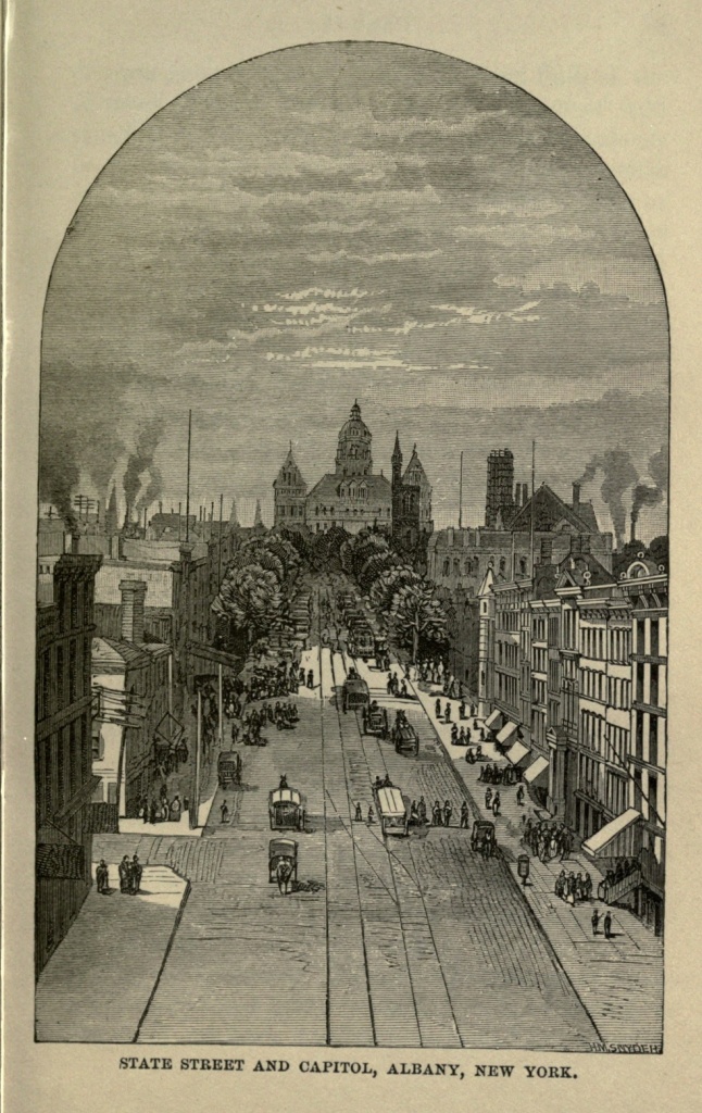
The traveler now entering Albany from the east crosses the Hudson on a beautiful iron railroad bridge, which, in the steady march of improvements, has succeeded the old-time ferry boat. He is landed at the commodious stone building of the New York Central and Hudson River Railroad, which is conveniently sandwiched between the Delavan House and Stanwix Hall, two large, well known and well conducted hotels.[Pg 27]
My first night in a city and a hotel was spent here, at the old Adams House, located at that time on Broadway just opposite the Delavan. I was awakened in the morning by the roll and rattle of vehicles, and the usual din and confusion of a city street. The contrast to my quiet home in the Valley of the St. Lawrence was so marked, I can never forget the impression I then received, and as I walked up State street toward the old Capitol, I almost fancied that such a street might be a fit road to Paradise. Albany was the gate through which I entered the world, and to my boyish vision the view it disclosed was very wide, and the grand possibilities that lay in the dim distance seemed manifold. It is the oldest city, save Jamestown, Va., in the Union, having been settled in the very babyhood of the seventeenth century, somewhere about 1612 or 1614. It was originally, until the year 1661, only a trading post on the frontier, the entire region of country to the westward being unexplored and unknown, except as the "far west." The red warriors of the Mohegans, Senecas, Mohawks and the remaining bands of the "Six Nations" held undisputed possession of the soil, and kindled their council fires and danced their "corn dances" in peace, unmolested as yet by the aggressive pale-faces.
The baptismal name of the embryo city of Albany was Scho-negh-ta-da, an Indian word meaning "over the plains." The name was afterwards transferred to the outlying suburban town now known as Schenectady. An immense tract of land bordering the Hudson for twenty-four miles, and reaching back from the river three times that distance, included Albany within its jurisdiction, and was originally owned by a rich[Pg 28] Dutch merchant, one Killian Van Rensselaer, from Amsterdam. The land was purchased from the Indians for the merest trifle, after the usual fashion of white cupidity when dealing with Indian generosity and ignorance. Emigrants were sent over from the old country to people this wide domain, and thus the first white colony was established, which subsequently grew into sufficient importance to become the Capital city of the Empire State.
Before the purchase of Killian Van Rensselaer, a fort was built somewhere on what is now known as Broadway, and was named Fort Orange, in honor of the Prince of Orange, who was at that time patroon of New Netherlands, as New York was at first called. Old Fort Orange afterwards went by various names, among which were Rensselaerwyck, Beaverwyck and Williamstadt. In 1664 the sovereignty of the tract passed into the hands of the English, and was named Albany, in compliment to the Duke of Albany. In 1686 the young city aspired to a city charter, and its first mayor, Peter Schuyler, was then elected. In 1807 it became the Capital of the State. As an item of interest, it may be mentioned that the first vessel which ascended the river as far as Albany was the yacht Half Moon, Captain Hendrick Hudson commanding.
Albany, like ancient Rome, sits upon her many hills, and the views obtained from the city heights are beautiful in the extreme. The Helderbergs and the Catskill ranges loom blue and beautiful towards the south, Troy and the Green Mountains of Vermont can be seen from the north, while beyond the river, Bath-on-the-Hudson and the misty hill tops further away, rim the[Pg 29] horizon's distant verge. The city has a large trade in lumber, and that portion of it which is known as the "lumber district" is devoted almost exclusively to this branch. One may walk, of a summer's day, along the smooth and winding road between the river and the canal, for two miles or more, and encounter nothing save the tasteful cottage-like offices, done in Gothic architecture, of the merchant princes in this trade, sandwiched between huge piles of lumber, rising white and high in the sun, and giving out resinous, piney odors. Not far from this vicinity stands the old Van Rensselaer homestead, guarded by a few primeval forest trees that have survived the wreck of time and still keep their ancient watch and ward. The old house, I have been told, is now deserted of all save an elderly lady, one of the last of the descendants of the long and ancient line of Van Rensselaer. Numerous points of interest dot the city in all directions, from limit to limit, and claim the attention of the stranger. Among the most prominent of these is, of course, the new Capitol building now in process of construction at the head of State street. A very pretty model of the structure is on exhibition in a small wooden building standing at the entrance to the grounds, which gives, I should judge, a clever idea of what the future monumental pile is to be like. Its height is very imposing, and the tall towers and minarets which rise from its roof will give it an appearance of still greater grandeur. It is built of granite quarried from Maine and New Hampshire, and is in the form of a parallelogram, enclosing an open court. Had I a sufficient knowledge of architecture to enable me to talk of orders, of pilasters, columns, entablatures and[Pg 30] façades, I might perhaps give my readers a clearer idea of the magnificence of this new structure, which will stand without a rival, in this country at least, and may even dare to compete with some of the marvellous splendors of the old world.
The Old Capitol and the State Library stand just in front of the new building, and obscure the view from the foot of State street. The Senate and Assembly chambers in the old building have an antiquated air, with their straight-backed chairs upholstered in green and red, and the rough stairways leading to the cupola, through an unfurnished attic, are suggestive of accident. In this cupola, once upon a time, in the year 1832, a certain Mr. Weaver, tired of life and its turmoil, swung himself out of it on a rope. So the cupola has its bit of romance. In this neighborhood, on State street, above the Library, is located the Bureau of Military Statistics, which is well worth a visit from every New Yorker who takes a pride in the military glory of his native State. One is greeted at the entrance with a host of mementos of our recent civil war, which bring back a flood of patriotic memories. Here is a collection of nine hundred battle flags, all belonging to the State, most of them torn and tattered in hard service, and inscribed with the names of historic fields into which they went fresh and bright, and out of which they came smoked and begrimed, and torn with the conflict of battle. Here are old canteens which have furnished solace to true comrades on many occasions of mutual hardship. Here, too, is the Lincoln collection, with its sad reminders of the nation's loved and murdered President; and in a corner of the same room the Ellsworth[Pg 31] collection is displayed from a glass case. His gun and the Zouave suit worn by him at the time of his death hang side by side, and there, too, is the flag which, with impetuous bravery, he tore down from the top of the Marshall House at Alexandria, Virginia. In the same case hangs the picture of his avenger, Captain Brownell, and the rifle with which he shot Jackson. In another part of the room may be seen the original letter of Governor, then Secretary, Dix, which afterwards became so famous, and which created, in a great measure, the wave of popularity that carried him into the gubernatorial chair.
The letter reads as follows:—
"Tell Lieutenant Caldwell to arrest Captain Breshwood, assume command of the cutter, and obey the order I gave through you. If Captain Breshwood, after arrest, undertakes to interfere with the command of the cutter, tell Lieutenant Caldwell to consider him as a mutineer and treat him accordingly. If any one attempts to haul down the American flag, shoot him on the spot.
The captured office chairs used by Jeff. Davis, in Richmond, the lock from John Brown's prison door at Harper's Ferry, pieces of plate from the monitors off Charleston, torpedoes from James River, the bell of the old guard-house at Fort Fisher, captured slave chains, miniature pontoon bridges, draft boxes and captured Rebel shoes, may be mentioned as a few among the many curiosities of this military bureau. Here, too,[Pg 32] may be seen the pardon, from Lincoln, for Roswell Mclntire, taken from his dead body at the battle of Five Forks; and near by hangs the picture of Sergeant Amos Humiston, of the 154th New York Regiment, who was identified by means of the picture of his three children, found clasped in his hand as he lay dead on the field of Gettysburg. In this room, also, is the Jamestown, New York, flag, made by the ladies of that place in six hours after the attack on Sumter, and which was displayed from the office of the Jamestown Journal. Mr. Daly, the polite janitor of the building, is always happy to receive visitors, and will show them every courtesy.
The Geological Rooms, on State street, are also well worthy the time and attention of the visitor. Large collections of the various kinds of rock which underlie the soil of our country are here on exhibition, as, also, the coral formations and geological curiosities of all ages. In an upper room towers the mammoth Cohoes mastodon, whose skeleton reaches from floor to ceiling. This monster of a former age was accidentally discovered at that place by parties who were excavating for a building. In these rooms, also, there are huge jaws of whales, which enable one to better understand the disposition of the Bible whales, and how easy it must have been for them to gulp down two or three Jonahs, if one little Jonah should fail to appease the delicate appetite of such sportive fishes. I couldn't help thinking of the lost races that must have peopled the earth when this old world was young—when these fossils were undergoing formation, and these mastodons made the ground tremble beneath their tread.[Pg 33]
Where are these peoples now, and where their unrevealed histories? Shall we never know more of them than Runic stones and mysterious mounds can unfold? These reminders of the things that once had an existence but have now vanished from the face of the earth, and well nigh from the memory of men—these things are full of suggestion, to say the least, and are quite apt to correct any undue vanity which may take possession of us, or any large idea of future fame. We may, perhaps, create a ripple in the surface of remembrance which marks the place where our human existence went out, and which, at the furthest, may last a few hundred years. But who can hope for more than that, or hoping, can reasonably expect to find the wish realized? "There are more things in heaven and earth, Horatio, than are dreamt of in our philosophy."
The Cathedral of the Immaculate Conception, on Eagle street, is one of the finest church structures in Albany. It is built of brown freestone, in the Gothic style of architecture, and its two towers are each two hundred-and-eighty feet in height. Its cost was six hundred thousand dollars. The interior decorations are beautiful, and the rich stained glass windows are the gifts of sister societies. On Easter mornings the Cathedral is sure to be crowded by people of all sects and creeds, brought there to witness the joyous Easter services which terminate the long fast of Lent.
About a mile and a half from the city, on Patroon's Hill, is situated the Dudley Observatory, where on clear summer nights Albanians come to gaze at the stars and the moon, through the large Observatory refractor.[Pg 34] The structure is built in the form of a cross, eighty-six feet long and seventy feet deep.
One of the first peculiarities which attracts the attention of the non-resident of Albany is the appearance of the business portion of State street, in the forenoon, from eight o'clock until twelve. Any time between these hours the street, from the lower end of Capitol Park down to Pearl street, is transformed into a vast market-place. Meat-wagons, vegetable carts, restaurants on wheels, and all sorts of huckstering establishments, are backed up to the sidewalk, on either side, blocking the way and so filling the wide avenue that there is barely room for the street-car in its passage up and down the hill. The descendants of Killian Van Rensselaer and the aristocratic Ten Eycks and Van Woerts, of Albany, should exhibit enterprise enough, I think, to erect a city market and spare State street this spectacle.
The manufacturing interest of Albany consists largely of stove works, in which department it competes with its near neighbor, Troy. This flourishing city, of about forty-eight thousand souls, is seven miles distant from Albany, up the river, and is in manifold communication with it by railroads on both sides of the Hudson, as well as by street railway. Steam cars run between Albany and Troy half hourly, during the day and far into the night, and one always encounters a stream of people between these two places, whose current sets both ways, at all times and seasons. Troy is at the head of navigation on the Hudson and communicates by street car with Cohoes, Lansingburg and Waterford. Cohoes is a place [Pg 35] of great natural beauty, and the Cataract Falls of the Mohawk River at that place add an element of wild grandeur to the scenery. One of the large, rocky islands in the river, known as Simmons' Island, is a popular resort for picnic excursions, and is a delightful place in summer, with its groves of forest trees, and the pleasant noise of waters around its base. The place seems haunted by an atmosphere of Indian legend, and one could well imagine the departed warriors of the lost tribes of the Mohawk treading these wild forest paths, and making eloquent "talks" before their red brothers gathered around the council fire.
The Mohawk and Hudson rivers unite at Troy, and seek a common passage to the sea. Mrs. Willard's Seminary for young ladies is located in this city, and is a standard institution of learning. Many of the streets of Troy are remarkably clean and finely shaded, and handsome residences and business blocks adorn them. The city is also a headquarters for Spiritualism in this section of the country. The Spiritualistic Society has, I am told, a flourishing, progressive Lyceum, which supersedes, with them, the orthodox Sunday school, and the exercises, consisting in part of marches and recitations, are conducted in a spirited and interesting manner.
Foundries for hollow-ware and stoves constitute the leading branch of manufacture in the city of Troy. To one not familiar with the process by which iron is shaped into the various articles of common use among us, a visit to the foundries of Troy or Albany would be full of interest and instruction. Piles of yellow sand are lying in the long buildings used as foundries, while on either side the room workmen are busily engaged fashioning the[Pg 36] wet sand into moulds for the reception of the melted iron. Originally the sand is of a bright yellow color, but it soon becomes a dingy brown, by repeated use in cooling the liquid metal.
Each moulder has his "floor," or special amount of room allotted him for work, and here, during the forenoon, and up to three or four o'clock in the afternoon, he is very busy indeed, preparing for the "pouring" operation. Pig iron, thrown into a huge cauldron or boiler, and melted to a white heat, is then poured, from a kettle lined with clay, into the sand-moulds, and in a remarkably short space of time the greenish-white liquid which you saw flowing into a tiny, black aperture is shaken out of the sand by the workmen, having been transformed into portions of stoves. These go to the polishing room, and thence to the finishing apartment, where the detached pieces are hammered together, with deafening noise.
Troy rejoices also in a paper boat manufactory—the boats being made especially for racing and feats of skill. They find sale principally in foreign markets, and at stated seasons divide the attention of the English with the "Derby." The boats are made of layers of brown paper put together with shellac.
There is a large society of Grand Army men in Albany, one Post numbering five or six hundred members. Their rooms are tastefully decorated, and hung with patriotic pictures, which make the blood thrill anew, as in the days of '61. A miniature fort occupies the centre of the room, and emblematic cannon and crossed swords are to be seen in conspicuous places.
A trip down the Hudson, in summer, from Albany to New York, is said to afford some of the finest scenery[Pg 37] in the world, not excepting the famous sail on the castled Rhine; and the large river boats which leave Albany wharf daily, for our American London, are, indeed, floating palaces. The capital city of the Empire State is not, therefore, without its attractions, despite the fact that it was settled by the Dutch, and that a sort of Rip Van Winkle sleep seems, at times, to have fastened itself upon the drowsy spirit of Albanian enterprise.
Geographical Location of Boston.—Ancient Names.—Etymology of the Word Massachusetts.—Changes in the Peninsula.—Noted Points of Interest.—Boston Common.—Old Elm.—Duel Under its Branches.—Soldiers' Monument.—Fragmentary History.—Courtship on the Common.—Faneuil Hall and Market.—Old State House.—King's Chapel.—Brattle Square Church.—New State House.—New Post Office.—Old South Church.—Birthplace of Franklin.—"News Letter."—City Hall.—Custom House.—Providence Railroad Station.—Places of General Interest.
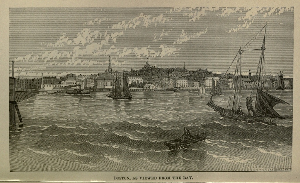
Boston sits like a queen at the head of her harbor on the Massachusetts coast, and wears her crown of past and present glory with an easy and self-satisfied grace. Her commercial importance is large; her ships float on many seas; and she rejoices now in the same uncompromising spirit of independence which controlled the actions of the celebrated "Tea Party" in the pioneer days of '76. Her safe harbor is one of the best on the Atlantic seaboard, and is dotted with over a hundred islands. On some of these, garrisoned forts look grimly seaward.
Boston is built on a peninsula about four miles in circumference, and to this fact may be attributed the origin of her first name, Shawmutt, that word signifying in the Indian vocabulary a peninsula. Its second name, Tremount, took its rise from the three peaks of Beacon Hill, prominently seen from Charlestown by the first settlers there. Many of the colonists were from old Boston, in Lincolnshire, England, and on the seventh of September, 1630, this name supplanted the first two.
In this connection may be given the etymology of the word Massachusetts, which is somewhat curious. It is said that the red Sachem who governed in this part of the country had his seat on a hill about two leagues south of Boston. It lay in the shape of an Indian arrow's head, which in their language was called Mos. Wetuset, pronounced Wechuset, was also their name for a hill, and the Sachem's seat was therefore named Mosentuset, which a slight variation changed into the name afterwards received by the colony. Boston, as the centre of this colony, began from the first to assume the importance of the first city of New England. Its history belongs not only to itself, but to the country at large, as the pioneer city in the grand struggle for constitutional and political liberty. A large majority of the old landmarks which connected it with the stormy days of the past, and stood as monuments of its primeval history, are now obliterated by time and the steady march of improvements. The face of the country is changed. The three peaks of Beacon Hill, which once lifted themselves to the height of a hundred and thirty feet above the sea, are now cut down into insignificant knolls. The waters of the "black bay" which swelled around its base have receded to give place to the encroachments of the city. Made lands, laid out in streets and set thick with dwellings, supplant the mud flats formerly covered by the tide. Thousands of acres which were once the bed of the harbor are now densely populated.
The house on Harrison avenue where the writer is at present domiciled is located on the spot which once was occupied by one of the best wharves in the city. The largest ocean craft moored to this wharf, on account of the great depth of water flowing around it.[Pg 40] The land has steadily encroached on the water, until the peninsula that was is a peninsula no longer, and its former geographical outlines have dropped out of sight in the whirl and rush of the populous and growing city. A few old landmarks of the past, however, still remain, linking the now and the then, and among the most prominent of these are Faneuil Hall, the Old South Church, which was founded in 1660, King's Chapel, the Old Granary Burying-ground, Brattle Square Church, quite recently demolished, the old State House, and Boston Common. The Common antedates nearly all other special features of the city, and is the pride of Bostonians. Here juvenile Boston comes in winter to enjoy the exciting exercise of "coasting," and woe to the unwary foot passenger who may chance to collide with the long sleds full of noisy boys which shoot like black streaks from the head of Beacon street Mall, down the diagonal length of the Common, to the junction of Boylston and Tremont streets. This winter (1874-5), owing to several unfortunate accidents to passers-by across the snowy roads of the coasters, elevated bridges have been erected, to meet the wants of the people without interfering with the rights of the boys. The Common was originally a fifty-acre lot belonging to a Mr. Blackstone. This was in 1633. It was designed as a cow pasture and training ground, and was sold to the people of Boston the next year, 1634, for thirty pounds. The city was taxed for this purpose to the amount of not less than five shillings for each inhabitant. Mr. Blackstone afterwards removed to Cumberland, Rhode Island, where he died, in the spring of 1675. It is said that John Hancock's cows were pastured on the Common in the days of the Revolution. On the tenth of May,[Pg 41] 1830, the city authorities forbade the use of the Common for cows, at which time it was inclosed by a two-rail fence. The handsome iron paling which now surrounds the historic area has long since taken the place of the ancient fence.
Perhaps the most noticeable, certainly the most famous object on Boston Common, is the Great Tree, or Old Elm, which stands in a hollow of rich soil near a permanent pond of water, not far from the centre of the enclosure. It is of unknown age. It was probably over a hundred years old in 1722. Governor Winthrop came to Boston in 1630, but before that period the tree probably had its existence. It antedates the arrival of the first settlers, and it seems not unlikely that the Indian Shawmutt smoked the pipe of peace under its pendent branches. In 1844 its height was given at seventy-two and a half feet—girth, one foot above the ground, twenty-two and a half feet. The storms of over two centuries have vented their fury upon it and destroyed its graceful outlines. But in its age and decrepitude it has been tenderly nursed and partially rejuvenated. Broken limbs, torn off by violent gales, have been replaced by means of iron clamps, and such skill as tree doctors may use. In the last century a hollow orifice in its trunk was covered with canvas and its edges protected by a mixture of clay and other substances. Later, in 1854, Mr. J. V. C. Smith, Mayor of the city, placed around it an iron fence bearing the following inscription:—
"This tree has been standing here for an unknown period. It is believed to have existed before the settlement of Boston, being full-grown in 1722. Exhibited[Pg 42] marks of old age in 1792, and was nearly destroyed by a storm in 1832. Protected by an iron inclosure in 1854."
What a long array of exciting events has this tree witnessed! In the stirring days of the Revolution the British army was encamped around it. In 1812 the patriot army occupied the same place, in protecting the town against the invasion of a foreign foe. Tumultuous crowds have here assembled on election and Independence days, and its sturdy branches have faced alike the anger of the elements and the wrath of man. Public executions have taken place under its shadow, and witches have dangled from its branches in death's last agonies. Here, in 1740, Rev. George Whitfield preached his farewell sermon to an audience of thirty thousand people; and here, also, at an earlier date, old Matoonas, of the Nipmuck tribe, was shot to death by the dusky warriors of Sagamore John, on a charge of committing the first murder in Massachusetts Colony. An incident of still more romantic interest belongs to the history of the Old Elm. On July third, 1728, this spot was the scene of a mortal combat between two young men belonging to the upper circle of Boston society. The cause of dispute was the possession of an unknown fair one. The names of the young men were Benjamin Woodbridge and Henry Phillips, both about twenty years old. The time was evening, the weapons rapiers, and Woodbridge was fatally dispatched by a thrust from the rapier of his antagonist. Phillips fled to a British ship of war lying in the harbor, and was borne by fair breezes to English shores. He did not long survive his opponent, however, dying, it is said, of despair, shortly after his arrival in England.[Pg 43]
Frog Pond, or Fountain Pond, near the Old Elm, has been transformed from a low, marshy spot of stagnant water, to the clear sheet which is now the delight of the boys. October twenty-fifth, 1848, the water from Cochituate Lake was introduced through this pond, and in honor of the occasion a large procession marched through the principal streets of the city to the Common. Addresses, hymns, prayers, and songs, were the order of the day, and when the pure water of the lake leaped through the fountain gate, the ringing of bells and boom of cannon attested the joy of the people.
Near the Old Elm and the Frog Pond, on Flagstaff Hill, the corner-stone of a Soldiers' Monument was laid, September eighteenth, 1871. Some idea of the style of the monument may be gathered from the following description:—"Upon a granite platform will rest the plinth, in the form of a Greek cross, with four panels, in which will be inserted bas-reliefs representing the Sanitary Commission, the Navy, the Departure for the War and the Return. At each of the four corners will be a statue, of heroic size, representing Peace, History, the Army, and the Navy. The die upon the plinth will also be richly sculptured, and upon it, surrounding the shaft in alto-relievo, will be four allegorical figures representing the North, South, East and West. The shaft is to be an elegant Doric column, the whole to be surmounted by a colossal statue of America resting on a hemisphere, guarded by four figures of the American eagle, with outspread wings. 'America' will hold in her left hand the national standard, and in her right she will support a sheathed sword, and wreaths for the victors. The extreme height of the monument will be ninety feet. The artist is Martin Millmore, of Boston."[Pg 44]
In the year 1668, a certain Mr. Dunton visited Boston, and wrote the following letter to his friends in England. It will serve to show the custom of Bostonians on training day, and recall some of the scenes which transpired over two hundred years ago on the historic Common. "It is a custom here," he says, "for all that can bear arms to go out on a training day. I thought a pike was best for a young soldier, so I carried a pike; 'twas the first time I ever was in arms. Having come into the field, the Captain called us into line to go to prayer, and then prayed himself, and when the exercise was done the Captain likewise concluded with a prayer. Solemn prayer upon a field, on training day, I never knew but in New England, where it seems it is a common custom. About three o'clock, our exercises and prayers being over, we had a very noble dinner, to which all the clergymen were invited."
In 1640, Arthur Perry was Town Drummer for all public purposes. There being no meeting-house bell in town, he called the congregation together with his drum. "He joined the Ancient and Honorable Artillery Company in that capacity, for which yearly service he received five pounds. The second additional musical instrument was a clarionet, performed on by a tall, strapping fellow with but one eye, who headed the Ancient and Honorable a few strides." The first band of music used in Boston was in 1790, at the funeral of Colonel Joseph Jackson. Yearly, for a period of between two and three hundred years, this military company has appeared on the Common, to be received by the Governor of the State, with his aides, who appointed the new commissions for the year to come and received those for the year just past. Their anniversary occurs on the first Monday in June.[Pg 45]
The Brewer Fountain, the Deer Park and the Tremont and Beacon Street Malls complete the list of conspicuous attractions on the Common. The Beacon Street Mall is perhaps the finest, being heavily shaded by thickly-set rows of American elms. A particular portion of this mall is described as the scene of at least one courtship, and how many more may have transpired in the neighborhood history or tradition tells us not!
The "Autocrat of the Breakfast-table" loved the schoolmistress who partook of her daily food at the same board with himself and listened quietly to his wise morning talks, with only an occasional sensible reply. The schoolmistress returned his passion, but the young Autocrat, uncertain of his fate, rashly determined that if she said him "nay" to this most important question of his life, he would take passage in the next steamer bound for Liverpool, and never look upon her face again. The fateful hour which was to decide his fate approached, and the Autocrat proposed a walk. They took the direction of the Beacon Street Mall, and what happened next his own charming pen-picture best describes:
"It was on the Common that we were walking. The mall or boulevard of our Common, you know, has various branches leading from it in different directions. One of these runs down from opposite Joy street, southward, across the length of the whole Common, to Boylston street. We called it the long path, and were fond of it.
"I felt very weak indeed (though of a tolerably robust habit) as we came opposite the head of this path on that morning. I think I tried to speak twice without making myself distinctly audible. At last I got out the question:—'Will you take the long path with me?'[Pg 46]
"'Certainly,' said the schoolmistress, 'with much pleasure.'
"'Think,' I said, 'before you answer; if you take the long path with me now, I shall interpret it that we are to part no more!' The schoolmistress stepped back with a sudden movement, as if an arrow had struck her.
"One of the long, granite blocks used as seats was hard by, the one you may still see close by the Ginko tree. 'Pray, sit down,' I said.
"'No, no,' she answered softly, 'I will walk the long path with you.'"
Propositions to convert the Common into public thoroughfares have ever met with stout resistance from "we the people"—the Commoners of Boston—and only this winter a meeting was held in Faneuil Hall for the purpose of protesting against this causeless desecration. The occasion of the meeting was a clique movement to have a street-car track run through the sacred ground. One of the speakers—a workingman—waxed eloquent on the theme of the "poor man's park, where in summer a soiled son of labor might buy a cent apple and lounge at his ease under the shady trees."
In 1734, by vote of the town, a South End and North End Market were established. Before this the people were supplied with meats and vegetables at their own doors. In 1740, Peter Faneuil offered to build a market-house at his own expense, and present it to the town. His proposition was carried by seven majority. Faneuil Hall, the "Cradle of Liberty," was first built two stories high, forty feet wide, and one hundred feet in length. It was nearly destroyed by fire in 1761, and in 1805 it was enlarged to eighty feet in width and twenty feet greater elevation. "The Hall is never let for[Pg 47] money," but is at the disposal of the people whenever a sufficient number of persons, complying with certain regulations, ask to have it opened. The city charter of Boston contains a provision forbidding the sale or lease of this Hall. For a period of over eighty years—from the time of its erection until 1822—all town meetings were held within its walls. It is "peculiarly fitted for popular assemblies, possessing admirable acoustic properties."
The capacity of the Hall is increased by the absence of all seats on the floor—the gallery only being provided with these conveniences. Portraits cover the walls. Healy's picture of Webster replying to Hayne hangs in heavy gilt, back of the rostrum. Paintings of the two Adamses, of General Warren and Commodore Preble, of Edward Everett and Governor Andrew, adorn other portions of the Hall. Nor are Washington and Lincoln forgotten. The pictured faces of these noble patriots of the past seem to shed a mysterious influence around, and silently plead the cause of right and of justice. The words which echoed from this rostrum in the days before the Revolution still ring down from the past, touching the present with a living power whenever liberty needs a champion or the people an advocate.
Faneuil Hall Market, or Quincy Market, as it is popularly called, grew out of a recommendation by Mayor Quincy, in 1823. Two years later the corner-stone was laid, and in 1827 the building was completed. It is five hundred and thirty-five feet long, fifty feet wide, and two stories high. Its site was reclaimed from the tide waters, and one hundred and fifty thousand dollars were expended in its erection.[Pg 48]
The capital for its construction was managed in such a judicious way that not only the market was built, but six new streets were opened and a seventh enlarged, without a cent of city tax or a dollar's increase of the city's debt.
The Old State House was located on the site of the first public market, at the head or western end of State street. It was commenced with a bequest of five hundred pounds from Robert Keayne, the first commander of the "Ancient and Honorable Artillery Company." It was known as the Town House, and was erected about the year 1670. The present Old State House was built in 1748, on the same site. Its vicinity is historic. The square in State street below the Old State House, was the scene of the Boston massacre, March fifth, 1770. "The funeral of the victims of the massacre was attended by an immense concourse of people from all parts of New England." About the same year also, in front of this Town House, occurred the famous battle of the broom, between a fencing master just arrived from England and Goff, the regicide. This English fencer erected an elevated platform in front of the Town House and paraded, sword in hand, for three days, challenging all America for a trial of his skill. At this time three of the judges who signed the death warrant for beheading Charles the First, of England, had escaped to Boston, and were concealed by the people of Massachusetts and Connecticut. Their names were Goff, Whalley and Dixwell, for whom, dead or alive, Parliament offered one hundred pounds each. The fencing master made such a stir about his skill that Goff, hearing of it at his place of concealment in the woods of Hadley, came to Boston and confronted the wordy hero.[Pg 49] His sword was a birch broom, his shield a white oak cheese slung from his arm in a napkin. After he had soaked his broom in a mud-puddle he mounted the platform for battle. The fencing master ordered him off, but Goff stood his ground and neatly parried the first thrust of the braggart. The battle then commenced in earnest, and the cheese three times received the sword of the fencing master. Before it could be withdrawn, Goff each time daubed the face of his antagonist with the muddy broom, amid the huzzas of the crowd which had gathered from all quarters to witness the contest. At the third lunge into the huge cheese the swordsman threw aside his small blade, and, unsheathing a broadsword, rushed furiously upon Goff.
"Stop, sir!" exclaimed Goff; "hitherto, you see, I have only played with you, and have not attempted to hurt you, but if you come at me with the broadsword, know that I will certainly take your life!"
"Who can you be?" replied the other; "you are either Goff, Whalley or the devil, for there was no other man in England could beat me!"
Goff immediately retired, amid the plaudits of the crowd, and the subdued fencing master slunk away with chagrin.
The interior arrangement of the Old State House has been entirely remodeled, and is now used exclusively for business.
King's Chapel, at the corner of Tremont and School streets, is another noteworthy point of interest. The corner-stone was laid in 1750, and four years were occupied in its construction, the stone for the building material being imported. Its church-yard was Boston's first burial-ground, and some of the tombstones date[Pg 50] back as far as 1658. Mr. Isaac Johnson, one of the founders of Boston, is said to have here found his last resting place. John Winthrop, his son and grandson—all governors of Connecticut, lay in the same family tomb in this yard. Four pastors of the "First Church of Christ in Boston" are also buried here. The body of General Joseph Warren was placed in King's Chapel before it was re-interred at Cambridge, and "dust to dust" has been pronounced over many other distinguished men at this stone church. The edifice is constructed in a peculiar way, with Doric columns of gray stone, and is sure to attract the attention of the stranger. It was the first Episcopal, as well as the first Unitarian church in Boston, and its pulpit is now the exponent of Unitarian doctrine, added to the Church of England service.
Going down Washington street towards Charlestown, we come to the famous Brattle Square, and its church, which once consecrated the spot. Here Edward Everett preached to his listening flock, and here, on July thirtieth, 1871, Dr. S. K. Lothrop pronounced the last sermon within its walls. Its ancient bell has ceased to ring, and the old-fashioned pulpit echoes no more to the tread of distinguished men.
The first Brattle Square Church was built in 1699. It was torn down in 1772, and the next year rebuilt on the same site, the dedication taking place July twenty-fifth.
On the night of March sixteenth, 1776, the British under Lord Howe were encamped in this neighborhood, some of the regiments using Brattle Square Church as a barrack. A cannon ball, fired from Cambridge, where the American army was then stationed, struck the church, and was afterwards built into the wall of the historic edifice, above the porch. On the next night[Pg 51] ten thousand of Lord Howe's troops embarked from Boston. In 1871 the building was sold by the society, and a handsome granite block now takes its place.
The new State House on Beacon street is one of the most prominent geographical points in all Boston, and the view from its cupola is second only to that obtained from the glorious height of Bunker Hill monument. Its gilded dome is a conspicuous object far and near, and glitters in the sunlight like veritable gold. The land on which the State House stands was bought by the town from Governor Hancock's heirs, and given to the State. The corner-stone was laid July fourth, 1793, the ceremony being conducted by the Freemasons, Paul Revere, as Grand Master, at their head. The massive stone was drawn to its place by fifteen white horses, that being the number then of the States in the Union. Ex-Governor Samuel Adams delivered the address. The Legislature first convened in the new State House in January, 1798. In 1852 it was greatly enlarged, and in 1867 the interior was entirely remodeled. Chantry's statue of Washington, the statues of Webster and Mann, busts of Adams, Lincoln and Sumner, and that beautiful piece of art in marble, the full-length statue of Governor Andrew, in the Doric Hall—all attract the attention of the visitor. In this rotunda there are also copies of the tombstones of the Washington family of Brington Parish, England, presented by Charles Sumner, and the torn and soiled battle-flags of Massachusetts regiments, hanging in glass cases. In the Hall of Representatives and the Senate Chamber, relics of the past are scattered about, and the walls are adorned with portraits of distinguished men. The eastern wing of the State House is occupied with the State Library[Pg 52] Large numbers of visitors yearly throng the building and climb the circular stairways for the fine view of Boston to be obtained from the cupola.
The new Post Office is accounted one of the finest public buildings in New England. It has a frontage on Devonshire street, of over two hundred feet and occupies the entire square between Milk and Water streets. It was several years in building, being occupied this winter for the first time since the great fire. Its cost was something like three millions of dollars. Its style of architecture is grand in the extreme. Groups of statuary ornament the central projections of the building, and orders of pilasters, columns, entablatures and balustrades add to it their elegant finish. Its roof is an elaboration of the Louvre and Mansard styles, and the interior arrangement cannot be surpassed for beauty or convenience. It has three street façades, from one of which a broad staircase leads to the four upper stories. On these floors are located important public offices. The Post Office corridor is twelve feet in height and extends across two sides of the immense building. At the time of the great fire of 1872 this structure was receiving its roof, and became a barrier against the onward sweep of the flames. The massive granite walls were cracked and split, but they effectually stopped the work of the fire fiend.
In the heart of the city, at the corner of Milk and Washington streets, stands one of the most famous buildings in Boston, and perhaps the most celebrated house of religious worship in the United States. It was founded in 1669, and received the name of the Old South Church. The first building was made of cedar, and stood for sixty years. In 1729 it was taken down, and the present building erected on the same spot. The[Pg 53] interior arrangement is described as having been exceedingly quaint, with its pulpit sounding board, its high, square pews, and double tier of galleries. During the Revolution it was frequently used for public meetings, and Faneuil Hall assemblies adjourned to the Old South whenever the size of the crowd demanded it. Here the celebrated "Tea Party" held their meetings, and discussed the measures which resulted in consigning the British tea, together with the hated tax, to the bottom of Boston Harbor. Here Joseph Warren delivered his famous oration on the Boston Massacre, drawing tears from the eyes of even the British soldiery, sent there to intimidate him. In 1775 the edifice was occupied by the British as a place for cavalry drill, and a grog-shop was established in one of the galleries. In 1782 the building was put in repair, and has stood without further change until the present time, nearly a hundred years. In 1872 it was occupied as a Post Office, and has only been vacated this winter. Its day of religious service is doubtless over. It will probably be used for business purposes, but never again as a society sanctuary.
Opposite the south front of the Old South Church, on Milk street, stood the house in which Benjamin Franklin was born. Here, on the seventeenth of January, 1706, the great philosopher was ushered into existence, and on the same day was christened at the Old South. When he was ten years old, he worked with his father in a candle manufactory, on the corner of Union and Hanover streets, at the sign of the Blue Bell. He was afterwards printer's devil for his brother James, and at eighteen established the fourth newspaper printed in this country. It was entitled "The New England Courant."
The first newspaper of Boston was also the first in the[Pg 54] colonies, and was printed on a half sheet of Pot paper, in small pica. It was entitled "The Boston News Letter. Published, by authority, from Monday, April seventeenth, to Monday, April twenty-fourth, 1704." John Campbell, a Scotchman and bookseller, was proprietor.
Now the Boston press stands in the front rank of the world's journalism, and is commodiously accommodated; as the elegant buildings of the Transcript, Globe, Journal, Herald and other papers, testify. The Advertiser is the oldest daily paper in the city.
It is impossible to properly describe Boston within the limits of so short a chapter, and only a glance at a few other points of interest will therefore be given.
The City Hall, on School street, is on the site of the house of Isaac Johnson, who lived here in 1630, and who has been styled the founder of Boston. The corner-stone of the new building was laid December twenty-second, 1672. It is of Concord granite, and is in the finest style of modern architecture. Here, under the arching roof of the French dome, the fire-alarm telegraph centres, and the sentinel who stands guard at this important point never leaves his post, night or day. The mysterious signal, though touched in the city's remotest rim, is instantly obeyed, and in less time than it takes to tell it the brave firemen are rushing to the rescue. A fine bronze statue of Benjamin Franklin stands in the inclosure in front of the building.
The Custom House, on State street, is built of granite, even to the roof. It is constructed in the form of a Greek cross, and is surrounded by thirty-two granite columns, a little over five feet in diameter. The site was reclaimed from the tide waters, and the massive building[Pg 55] rests upon about three thousand piles. Over a million dollars were expended in its erection.
The Old Granary Burying-ground, once a part of the Common, received its name from a public granary which formerly stood within its limits. Some of the most distinguished dust in history is consigned to its keeping. Paul Revere, Peter Faneuil, Samuel Adams, John Hancock, the victims of the Boston Massacre, the parents of Franklin, the first Mayor of Boston, and a long list of other names famed in their day and ours, lie buried within this ancient ground. Near by, between the Common and the Granary Cemetery, stands the celebrated Park Street Church, of which W. H. H. Murray, the brilliant writer and preacher, was, until lately, the pastor. It used to be known as "brimstone corner." This winter we attended Park Street Church on the same day with the brunette monarch, Kalakaua and suite.
One of the most commodious and elegant stations in New England, or this country, is that of the Boston and Providence Railroad. It is about eight hundred feet in length, and is built of brick, with two shades of sandstone. The track house is seven hundred feet long, covering five tracks, and has a span of one hundred and twenty-five feet. Its cost is somewhere in the neighborhood of six hundred thousand dollars. The interior arrangement is quite novel in style. The waiting-rooms open out of an immense central apartment with a balcony reaching around the entire inner circumference. Theatre tickets, flower and cigar stands, a billiard room and a barber shop, are some of the special features of the station. Refreshment rooms and dressing rooms, in oak and crimson, are also an integral part of the building.[Pg 56]
Hundreds of interesting places in this singular and devious city of Boston must go unnoticed in these pages. The beautiful Tremont Temple and its Sunday temperance lectures; Music Hall, with its big organ of six thousand pipes, through one of which Henry Ward Beecher is said to have crawled, before its erection; the Parker House, one of the crack hotels of the city; the Revere House, where all the distinguished people stop, with its special suite of rooms upholstered in blue satin, where King Kalakaua smoked his cigars in peace; the beneficent Public Library; the Boston Athenæum, home of art; the Boston Theatre, the new and elegant Globe Theatre, and the suburban limits, including Charlestown and famous Bunker Hill, Cambridge and Harvard University, Mt. Auburn, Dorchester Heights, Roxbury and East Boston, which was formerly known as Noddle's Island, and where now the Cunard line of steamers arrive and depart—all these tempt my pen to linger within their charmed localities. But it is a temptation to be resisted. When, after many weeks' sojourn in the intellectual "Hub," I was at last seated in the outward bound train, ticketed for the west, a regret, born of pleasant associations and a taste of Boston atmosphere, took possession of me. The farewells I uttered held an undertone of pain. But the train sped onward, unheeding, and the city of the harbor seemed to dissolve and disappear in the smoke of her thousand chimneys, like a dream of the night.
The Niagara Frontier.—Unfortunate Fate of the Eries.—The Battle of Doom.—Times of 1812.—Burning of Buffalo.—Early Names.—Origin of Present Name.—Growth and Population.—Railway Lines.—Queen of the Great Lakes.—Fort Porter and Fort Erie.—International Bridge.—Iron Manufacture.—Danger of the Niagara.—Forest Lawn Cemetery.—Decoration Day.—The Spaulding Monument.—Parks and Boulevard.—Delaware Avenue.—On the Terrace.—Elevator District.—Church and Schools.—Grosvenor Library.—Historical Rooms.—Journalism.—Public Buildings.—City Hall.—Dog-carts and their Attendants.
Buffalo is a kind of half-way house between the East and the West—if anything may be called west this side of the Mississippi River—and it partakes of the characteristics of both sections. It was once the chief trading post on the Niagara frontier, and its vicinity has been the scene of many a hotly contested battle between dusky races now forever lost to this part of the world, and almost forgotten of history. Long ago, the Eries, or the Cat Nation, lived on the southern shores of the same lake whose waters now lap the wharves of Buffalo. They left it the heritage of their name, and that is all.
The race, in its lack of calculation, did not greatly differ from many isolated instances of the paler race of mankind around us now; for it died of a too o'erreaching ambition. Jealous of the distant fame of the Five Nations, the Eries set out to surprise and conquer them in deadly battle, and themselves met the fate they had meant for the Iroquois. They were exterminated; and[Pg 58] few returned to the squaws in their lonely wigwams, to tell the tale of doom.
The noble race of Senecas succeeded the Cat Nation on the shores of Lake Erie, and after them, from across the great seas, came the dominant, pushing, civilizing Anglo-Saxons.
When the war of 1812 broke out, Buffalo was an exceedingly infant city, and did not promise well at all. Nobody would have then predicted her importance of to-day. Later, in 1813, the battle of Black Rock was fought, and while a few old soldiers made a determined stand against the onset of the solid British phalanx, most of the raw recruits fled down Niagara street in a regular Bull Run panic, chased by the pursuing foe. The village was then fired by the enemy, and every building except one was burned to the ground. The description of the suffering and flight of women and children, during that harrowing time, draws largely on the sympathies of the reader, and sounds strangely similar to the newspaper accounts of the burning of Western and Pennsylvania towns, of more recent occurrence.
But, though Buffalo was destroyed by fire, it shortly evinced all the power of the fabled phœnix, and rose from its ashes to a grander future than its early settlers ever dreamed of prophesying for it. The young city, however, suffered in its first days from a multiplicity of names, struggling under no less than three. The Indians named it Te-osah-wa, or "Place of Basswood;" the Holland Land Company dragged the Dutch name of New Amsterdam across the ocean and endeavored to drop it at the foot of Lake Erie; and finally, it took its present name of Buffalo, from the frequent visits of the[Pg 59] American Bison to a salt spring which welled up about three miles out of the village, on Buffalo creek.
I think Buffalonians have reason to be grateful that the last name proved more tenacious than the other two. Think of the "Queen City" of the most Eastern West being overshadowed by the tiled-roof name of New Amsterdam!
It was not until 1822, on the completion of the Erie Canal, that Buffalo began the rapid advance towards prosperity that now marks its growth, the muster-roll of its population, at this writing, numbering the round figures of one hundred and sixty-one thousand. It now rejoices in business streets three and four miles long—full-fledged two-thirds of the distance, and the remainder embryonic. The harbor-front, facing the ship canal and the Lake, bristles with the tall tops of huge grain elevators—a whole village of them. A network of railroad lines, and the commerce of the great Lakes, have combined to build up and carry on a vast business at this point, and to make it a station of much importance between the East and the West. The rails of the New York Central, the Great Western, the Lake Shore, and the Buffalo and Philadelphia roads, besides many other lines, all centre here, carrying their tide of human freight, mainly westward, and transporting the cereals of the great grain regions in exchange for the manufactured products of less favored localities. When the representative of New York or New England wishes to go west, he finds his most direct route by rail, via Buffalo; or, if he desires a most charming water trip, he embarks, also via Buffalo, on one of the handsome propellers which ply the Lakes between this city and Chicago, and steaming down the length of Lake Erie,[Pg 60] up through the narrower St. Clair and the broad Huron, he passes the wooded shores of Mackinac's beautiful island, surmounted by its old fort, and entering Lake Michigan, in due time is landed on the breezy Milwaukee banks, or is set down within that maelstrom of business, named Chicago. Indeed, after Chicago, Buffalo is the ranking city of the Lakes, and is said to cover more territory than almost any city in the country outside the great metropolis—the distance, from limit to limit, averaging seven and eight miles. Its suburban drives and places of summer resort, owing to the superior water localities of this region, are much out of the usual line. Niagara River, famous the world over, allures the daring boatman from Fort Porter onward, and the wonderful Falls themselves are only eighteen miles beyond that. Fort Porter, about two miles out from the heart of the city, is located just at the point where Niagara River leaves the lake in its mad race to the Falls. Here the banks are high and command a wide water prospect. Away to the westward the blue lake and the blue sky seem to meet and blend together as one; and in the opposite direction the rushing river spreads out like another lake, towards Squaw Island and Black Rock. One or more companies of United States Regulars are stationed here, and the barracks and officers' quarters surround a square inclosure, which is used as a parade ground. Graveled walks are laid out around it, and a grassy foot-path leads from the soldiers' quarters to the site of the old Fort on the brow of a gentle elevation just beyond. The Fort was built for frontier defence, in 1812, and the interior, now grass-grown and unused, is so deep that the roof of the stone structure, once appropriated as a magazine, is nearly on[Pg 61] a level with the high ground at your feet. During our last war the building was occupied as a place of confinement for Rebel prisoners. It is now in a state of advanced collapse, and the battered walls and open windows expose to view the ruin within. A small, square outhouse, near one of the embrasures higher up, which was used for firing hot shot, is still intact. Field pieces, pointing grimly towards the Lake, and little heaps of cannon balls lying near, bring freshly to mind the nation's last war days, when "the winding rivers ran red" with the mingled blood of comrade and foe. The sunset gun boomed over the waters while we lingered at the old Fort, and the fading glow of day bridged the river with arches of crimson and gold.
Diagonally opposite from this point, one looks across into the Queen's dominions, where lies the little village of Fort Erie, historic as the place from which the British crossed to our shores on the night preceding the burning of Buffalo.
At Black Rock, about two miles below Fort Porter, the great International Railroad Bridge, a mile in length, spans the mighty river, having superseded the old-time ferry. This bridge is the connecting link on the Grand Trunk Road, between Canada and the States.
Near its terminus, on the American side, are located the immense malleable iron works of Pratt & Letchworth, said to be the largest manufactory of the kind in the world. Their goods certainly find a world-wide market, taking in New England and the Pacific coast, Mexico, England and Australia. A pretty picture of the country seat of Mr. Letchworth, at Portage, New York, may be seen at the Historical Rooms. It is named[Pg 62] Glen Iris, and is surrounded by handsome grounds, groves and fountains.
Boating on the Niagara is much in vogue here, notwithstanding the rapid current and the dreadful certainty of the Falls in case of accident. The keeper of a boat house at Black Rock, opposite Squaw Island, told me that the proportion of accidents on the river was frightfully large—far greater than ever got into the public prints.
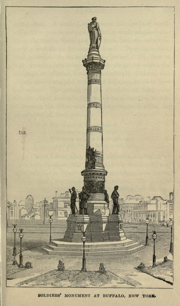
Forest Lawn Cemetery—Buffalo's city of the dead—is one of the loveliest burial places between Brooklyn and Chicago. It is picturesque with hill and dale and grove, not to mention a large artificial lake lapped in one of its grassy hollows, and a winding, wide and rocky-bedded creek running through it. The name of the creek is spelled S-c-a-j-a-q-u-a-d-a and pronounced Kon-joc'-e-ta. The Pratt monument, in a remote portion of the grounds, is perhaps the handsomest in the cemetery. It looks like a gothic gateway with fluted pillars of Italian marbles. A sculptured image of a child of one of the Fargos—of the famous Wells, Fargo & Co.—rests under a glass case on the lap of earth which marks her grave. The head is peculiarly noble, reminding one of that of the Belvidere Apollo. It is said to be a truthful likeness. Decoration Day at Forest Lawn was a picture long to be remembered. On a little knoll under the trees at the entrance to the grounds the military and civic processions assembled to listen to the eloquent words of Rev. Mr. Barrett, of Rochester. When the brief address was concluded, and the band music and singing were over, we followed the committees of decoration to the scattered graves of the patriot dead, and witnessed the strewing of flowers upon their [Pg 63] sacred dust. A hushed circle above the mound of earth, a few fitly-spoken words from one of their number who knew the soldier-hero, and the floral tributes were tenderly placed above the sleeper's head. Thus, oh heroes, shall your memory be kept forever green! The flowers were wrought into every symbolic shape by which the language of affection could be translated. Crowns, and crosses, and stars, and anchors of hope, spoke their love and solace. The graves of the Confederate dead were also decorated, and side by side, under a common mantle of flowers, the Blue and the Gray received alike the benediction of the hour.
At Forest Lawn, also, on the historic seventeenth of June—the Bunker Hill Centennial—a monument was dedicated to the memory of nine Spauldings who fought at that battle, one hundred years before. The granite cenotaph was erected by E. G. Spaulding, of Buffalo, descended from the same blood with the heroic nine. The names of the list inscribed on the Western front of the monument were headed by that of his grandfather, Levi Spaulding, who was captain of the ninth company, third regiment, under Colonel Reed, of the New Hampshire troops, engaged on that day.
Speeches reviving Revolutionary memories, and fresh descriptions of the Bunker Hill contest, were in order.[Pg 64] There was a semi-military procession, and the interest felt in the occasion was general. A grand reception at Mr. Spaulding's residence in the evening, concluded the patriotic anniversary.
The large park adjoining Forest Lawn is plentiful in attractions, including the delights of boating on the Konjoceta and loitering in the shadowy coolness of the primeval woods. In addition to these, Buffalo is completing a grand boulevard system which encircles half the City, beginning at what is called the Front, in the neighborhood of Fort Porter, and making the circuit of the outskirts through Bidwell and Lincoln and Humboldt parkways to the intersection of Genesee street with the Parade, on the opposite arc of the circle. One is sure to find cool breezes along this drive, though the day be the hottest of the season. Indeed, the summer heats are, at all times, shorn of their fervor in this Queen City of the Lakes, and its climatic advantages are, therefore, superior.
Delaware Avenue is the leading street of Buffalo for private residences, and here much of the aristocracy do congregate. It is about three miles long, and double rows of shade trees line either side. Fast driving on this avenue is licensed by city authority, and racing down its gentle incline is much in vogue. In winter, when sleighing is good, this is carried to greater excess, and the snowy road is black with flying vehicles. Main street, the principal business thoroughfare of the city, at least for retail trade, is wide, well paved and straight, and is built up with substantial business blocks. Its sister thoroughfare on the east, Washington street, towards the lower end as it approaches the lake, degenerates into manufacturing, and the buzz of machinery and[Pg 65] incessant din of hammers break in on the maiden meditations of the passive sight-seer.
As one approaches the Terrace, which is an elbow of blocks at one end and a diagonal at the other, one is confronted by a confusion of cross streets, which look as if they had been gotten up expressly to demoralize one's points of compass. They all look out on Buffalo harbor and the sea-wall beyond. Ohio street, following the bend of the harbor, is the great elevator district of the greatest grain mart in the world. Here, when business is at high tide, between two and three million bushels of grain per day are transferred by these giant monsters with high heads. The business places of this department of Buffalo enterprise are located principally on Central Wharf, in this vicinity, which fronts the harbor and which is crowded with offices two tiers deep.
Along the wharf the very air is charged with bustle and activity. Vessels of all descriptions are arriving and departing at all hours, and the commerce of the great lakes pours its flood tide into Buffalo through this gateway.
As for churches and schools, the city overflows with them. It is sprinkled in all directions with handsome religious edifices, like interrogation points, in stone and brick, asking the questions of a higher life. And there are thirty-six public schools, besides the State Normal, the Central, and the Buffalo Female Academy. This last is under the able guidance of Dr. Chester. But even these do not complete the list, as I understand there are numerous other private institutions of learning.
In one of the triangular pieces of ground where the three streets of Niagara, Erie and Church make their entrance into Main street, stands the picturesque struc[Pg 66]ture of St. Paul's Episcopal Cathedral. It is built of brown stone, and the creeping ivy nearly covers one end of it, from the crosses and minarets at the pinnacle to the trailing vines on the ground. The gray, gothic edifice of St. Joseph's Romish Cathedral, fronting on Franklin street, is also very large, and the interior is rich in architectural design.
As for the immeasurable realm of books, Buffalo furnishes her children access to this, through her libraries. Chiefest among them is the Grosvenor, which has a bit of history all by itself. It was founded by a retired merchant of New York, who had lived in Buffalo during the earliest infancy of the city, and whose property had been destroyed when the then frontier village was fired by the British and Indians, in retaliation for the burning of Newark. This generous gentleman also left thirty thousand dollars to found a reference library for the High School of New York City. His will provided a legacy of ten thousand for Buffalo, to be applied towards a fire-proof building for a library, and the sum of thirty thousand, the interest of which was to be used for the purchase of books. The building fund having been on interest ever since, now amounts to twenty-eight thousand, and in addition the city has donated what is known as the Mohawk street property, used at present for police purposes, which will sell for an amount sufficiently large, together with the deposit already on hand, to erect a handsome building. The library is now located over the Buffalo Savings Bank, facing a pleasant little park between Washington and Main streets.
In 1870 the interest had more than doubled the donation, and the Trustees then commenced the work of making the library a living institution. After a great[Pg 67] deal of trouble, they at last secured the services of Alexander J. Sheldon, who was willing, without any certain compensation, to undertake the task of organizing and superintending the library. Mr. Sheldon, who is an expert in books, is native to the city, and from boyhood has been connected with this line of business. The first year of his hard labor at the Grosvenor was rewarded by the large sum of five hundred dollars! It was well for the institution, however, that Mr. Sheldon was not dependent on his salary for support. He entered into the work with an enthusiasm which surmounted all difficulties, and which has brought the library to its present state of progress, making it a credit to the city of Buffalo.
The large reading room is neatly fitted up with black walnut cases, nine feet in length, and eight feet high, opening on both sides, and capable of holding eight or nine hundred average volumes. There are about thirty of these cases in the room, with reading tables and easy chairs interspersed between them. The style of alcove and arrangement, which was also Mr. Sheldon's suggestion, produces a very handsome effect. The cases stand on black walnut platforms six inches in height, and are surmounted by a pretty cornice. The shelves are interchangeable, and are of such moderate height that the necessity for step-ladders is entirely avoided. There are also dummy volumes, made to resemble books and properly titled, which, if their mission is to deceive the uninitiated, certainly accomplish that task. The number of volumes has now accumulated to about eighteen thousand, and includes the choicest works in art, science, literature and the professions. The fiction department comprehends all the recognized standard works, but the mass of worthless novels, which pass current in some of[Pg 68] our circulating libraries, is unhesitatingly excluded. The bindings are nearly all morocco, with gilt or marbled tops, and the back of each book, as it is added to the library, is given a coat of white shellac varnish, which prevents it, in a great degree, from fading, and renders it easy of renovation.
The small ante-room which is used by the librarian and committeemen contains several hundred volumes on bibliography, which is a very important feature of such an institution. The rooms in summer are breezy, from the lake winds, and in winter are heated by steam radiators. A heavy cocoa matting deadens all sound on the floors, and absolute quiet is thus secured. Thanks to the efforts of Mr. Sheldon, the Grosvenor is undoubtedly the best library for a student west of the Hudson.
The Historical Rooms deserve notice as one of the salient points of Buffalo, and though the Society is young and not by any means wealthy, yet it is fairly started on its road to distinction. It was founded in 1862, and subsists principally by donations, as it is yet too poor to make purchases of books or relics. The Rooms are located at the corner of Main and Court streets, nearly opposite the ancient site of the old Eagle Tavern. A picture of this hotel as it looked fifty years ago may be seen among their collection. A huge gilt eagle surmounted the main entrance, and an enclosed porch, or what looks like it, at one end of the building, bore the inscription "Coach Office," in large letters over the doorway. Here also is the noble looking portrait of Red Jacket, the great Seneca Chief, together with the grand-daughter of Red Jacket's second wife—Nancy Stevenson—taken at sixteen. This bright-eyed, brown maiden married an Indian named Hiram Dennis, and[Pg 69] was still living in 1872. Belts of wampum, war hatchets and pipes of peace, besides numerous pictures, in oil, of celebrated red warriors, are among the Indian mementoes connected with Buffalo's early history. The war of 1812 also contributes its scattered waifs to keep alive the memory of that time. The sword of Major-General Brown, worn at the battle of Sackett's Harbor, and a piece of timber from Perry's ship, on which is traced the legend "We have met the enemy and they are ours," are among the heirlooms of history. Here, too, is a Mexican lance from the field of Monterey, and the clarionette used in Buffalo's first band of music, whose strains helped swell the chorus during the triumphal march of Lafayette through her streets in 1824. A representation of the first boat on the Erie Canal, named "Chief Engineer of Rome," looks quaint enough. The walls of the large apartment devoted to historical collections are covered with pictures of Buffalo's prominent men, and at one end of the room hangs a handsome portrait of Millard Fillmore, set in heavy gilt. Their list of books and directories is also quite large. The story of a city's growth is always one of deep interest, and the generations of future years will, no doubt, be grateful for these landmarks of their early history.
Journalism in Buffalo rides on the top wave, and her leading papers have achieved an enviable fame. Eight dailies swell the list, four of which are German, besides ten weeklies and seven monthly papers. The history of the Commercial Advertiser dates back to October, 1811. It was issued at that time, under the name of the Buffalo Gazette, by the Salisbury brothers, from Canandaigua. With the exception of a paper at Batavia, begun in 1807, the Gazette was the only paper pub[Pg 70]lished at that time in Western New York. It afterwards changed its name to the Buffalo Patriot, and since 1836 it has been issued as the Daily Commercial Advertiser. The Courier and Commercial are the ranking papers of the city, in point of influence.
Buffalo doesn't seem to be ambitious of display in her public buildings, judging from the quality of those already on hand. The new City Hall, however, is a noble exception to the general rule. It is built of Maine granite, in the form of a double Roman cross, and the tower, which is two hundred and forty-five feet high, is surmounted by four pieces of statuary. Its estimated cost is over two millions of dollars.
St. James' Hall and the Academy of Music are the chief places of amusement in the city, the latter place being conducted by the Meech brothers, two young gentlemen of acknowledged ability. Many noted stars of the stage whose names have blazed forth in histrionic glory have here made their first conquests, before applauding audiences. The stock company is unusually good, Ben Rogers, stage manager and first comedian, being a host in himself.
The fire department of the city is said to be exceedingly efficient, and the police system has gained a reputation for thorough work which ought to be the terror of the criminal class. It embraces a body of mounted police, a corps of detectives and of patrolmen, besides the regular force stationed at the harbor.
Among the minor peculiarities of Buffalo may be mentioned the superabundance of dog carts to be seen in her streets; not the conventional kind that goes rolling down Fifth Avenue, among the bewildering array of splendid equipages—coupes, landaus, landau[Pg 71]lets, drags and what not—that daily make their way to Central Park; not any of these; but the original dog cart, with the dog attached. He is to be seen in all the varieties of the species, from a muddy yellow to the fierce-looking mastiff. He is usually harnessed in company with a collapsed old woman or a cadaverous looking little boy, and he carries all kinds of mixed freight, from an ash barrel to a load of sticks. The undercurrent of Buffalo society does not seem to look upon the dog in a purely ornamental light.
This chapter on a place so fertile in suggestion might be prolonged indefinitely; but we are gazing westward, along a line of cities whose terminus does not end until it reaches the Golden Gate and the most famous centre of population on the Pacific coast. Our steps are bent toward that far-off goal, and we must say good-bye to the ancient land of the Eries and the former haunts of the buffalo.
Brooklyn a Suburb of New York.—A City of Homes.—Public Buildings.—Churches.—Henry Ward Beecher.—Thomas De Witt Talmage.—Theodore L. Cuyler, D.D.—Justin D. Fulton, D.D.—R. S. Storrs, D.D.—Navy Yard.—Atlantic Dock.—Washington Park.—Prospect Park.—Greenwood Cemetery.—Evergreen and Cyprus Hills Cemeteries.—Coney Island.—Rockaway.—Staten Island.—Glen Island.—Future of Brooklyn.
New York holds such supremacy over the other cities of the United States that she almost overshadows Brooklyn, which lies so near her as to be separated only by the narrow channel of the East River. Yet Brooklyn in any other locality would be a city of the first importance, ranking, as she does, the third in the Union as to size and population, and numbering not less than six hundred thousand inhabitants. Practically New York and Brooklyn are but one city, with identical commercial interests, and a great deal else in common. Many of the most prominent business men of the former city find their homes in the latter; and by means of the numerous ferries and the great Suspension Bridge there is a constant interchange of people between them. The time may come when they will be united under one municipal government; though, no doubt, many of the older residents of Brooklyn, who have helped to build her up to her present extent and prosperity, would object to losing her name and identity. But should such a union ever take place, there will be at once created, next to London, the largest city of the[Pg 73] world, with a population of not less than two millions of people.
Brooklyn is situated on the west end of Long Island, and overlooks both the East River and the Bay. It extends nearly eight miles from north to south, and is about four miles from east to west. Its business is not so extended or so important as that of New York, nor, as a rule, are its business edifices so imposing, though some of them present a very fine appearance. It is, in fact, a great suburb of the metropolitan city, composed more largely of dwellings than of commercial houses. Its business men, each morning, make an exodus across the East River to Wall street, or Broadway, or other streets of New York, and then return at night. It is, in fact, a great city of homes, all of them comfortable and many of them elegant. There is no squalor, such as is found in Mott or Baxter streets and the Five Points and their neighborhood, in its sister city. Handsome mansions, tasteful cottages and plain but neat rows of dwellings are found everywhere, and the streets are beautifully shaded by avenues of trees.
The public buildings of Brooklyn worthy of notice are few, compared to those of New York. Fulton street is its principal thoroughfare, and contains occasional handsome edifices. The City Hall, on an open square at the junction of Fulton court and Joraleman street, is a fine, white marble building, in Ionic style, with six columns supporting the roof of the portico. It is surmounted by a tower one hundred and fifty-three feet in height. Just back of this, to the southeast, and facing toward Fulton street, is the County Court House, with a white marble front, a Corinthian portico, and an iron dome one hundred and four feet high. Beside the[Pg 74] Court House, to the westward, stands the Municipal Building, also of marble, four stories in height, with a mansard roof, and a tower at each corner. The Post Office is in Washington street, north of the City Hall. The Long Island Historical Society has a fine edifice at the corner of Clinton and Pierrepont streets, and possesses a large library and collection of curiosities. The Academy of Design, on Montague street, has a handsome exterior; opposite is the Mercantile Library, a striking Gothic structure, containing two reading rooms and a library of forty-eight thousand volumes. The building of the Young Men's Christian Association is on Fulton street, at the corner of Gallatin Place, and contains a library and free reading room. The Penitentiary is an immense stone structure on Nostrand avenue, near the city limits. The County Jail, in Raymond street, is constructed of red sandstone, in castellated Gothic style. The Long Island College Hospital is an imposing building, surrounded by extensive grounds, on Henry street near Pacific.
Brooklyn is, preëminently, the City of Churches, of which she is said to contain not less than one hundred. She has secured the services of the most eminent clergymen in the country, and thousands of people each year make a pilgrimage thither, for the sole purpose of listening to some one or other of those whom they have long admired and appreciated at a distance. Most prominent among all these clergymen is Henry Ward Beecher, who has been the pastor of Plymouth Church ever since its organization in 1847. Mr. Beecher came of a noted family, his father, Rev. Lyman Beecher, being one of the theological lights of his day and generation, while his brothers and sisters have all distin[Pg 75]guished themselves in some way. The author of "Uncle Tom's Cabin" was his sister, Mrs. Harriet Beecher Stowe, while all of his brothers are, like himself, in the ministry.
Mr. Beecher's popularity has been unparalleled. Besides the hundreds who listen to him every Sunday, each sermon is reported in full and read by thousands of people throughout the country. He has been a leader of liberal thought in the Protestant churches; and it is largely due to his bold and advanced utterances that the church in which he holds communion has taken a long step ahead of the position which it occupied early in the present century.
Plymouth Church is a plain edifice, in Orange street, near Hicks. It has a large seating capacity, yet every Sunday it is filled. A goodly proportion of the audience is composed of strangers, who are not permitted to take seats until the pewholders are provided for. These visitors stand in long rows at each of the doors, the rows sometimes extending out upon the sidewalk, waiting their turns to be seated. Ten minutes before the hour of service they are conducted to seats, and the pewholders who come after that time must take their chances with the rest. On pleasant Sundays every seat is occupied, and the aisles and vestibules are crowded.
Mr. Beecher occupies no pulpit, in the strict sense of the word. In front of the organ and choir is a platform, upon which are three chairs and three small tables, or stands. On one of the latter is a Bible, and on the others a profusion of flowers. One realizes in this church the grandeur of congregational singing, which is led here by a choir of one hundred voices, and accompanied by a magnificent organ. When the entire congregation join[Pg 76] in some familiar hymn, the singing is exceedingly impressive. Mr. Beecher, albeit his reputation is that of a sensational preacher, makes little attempt at sensationalism in his manner of delivery. He reads well and speaks well, with a clear, distinct enunciation, which is heard in every part of his church. He talks directly to his point, using plain but forcible language, his sermons sparkling with original thought and brilliant language, all based upon a foundation of plain, practical common sense. He has great dramatic power, yet manifests it in so unstudied a manner that it is never offensive. He imitates the voice and manner of the man of whom he is speaking; the maudlin condition of the drunkard, the whine of the beggar, the sanctimoniousness of the hypocrite; and keeps his audience interested and on the alert. The Friday evening lectures are also features of this church, and are conducted without formality, yet in a decorous manner.
The Brooklyn preacher who is a rival of Beecher, in the popular estimation, is Thomas De Witt Talmage, whose church is in Schermerhorn street, and known as the Tabernacle. It is built in Gothic style, semi-circular in form, like an opera house, and is capable of seating 5,000 persons. It is the largest Protestant place of worship in the United States, yet every Sunday it is filled nearly, if not quite, to its utmost capacity.
Talmage was born at Bound Brook, New Jersey, in 1832. After graduating at the Theological Seminary, at New Brunswick, he preached in Belleville, New Jersey; Syracuse, New York; and Philadelphia, until 1869, when he came to Brooklyn to be pastor of the Central Presbyterian Church. Within a year he had become the acknowledged rival of Beecher. His church[Pg 77] was crowded, and in 1870 a large amphitheatre, called the Brooklyn Tabernacle, capable of seating four thousand persons, was built. This building was destroyed by fire in 1872, and while it was being rebuilt in its present size and form, Talmage preached in the Academy of Music, to immense crowds. The great organ used in the Boston Coliseum, during the Musical Peace Jubilee, accompanies the singing at the Tabernacle, which is principally congregational, though a choir of four male singers give one or more voluntaries. The singing was led by Arbuckle, the celebrated cornetist, but he died in May, 1883, and was buried on the day of the opening of the Suspension Bridge.
In 1879, Talmage visited Great Britain, and made a most successful lecture tour, receiving from five to six hundred dollars for each lecture, and netting about fifty thousand dollars for the tour. In this country he has not been so popular as a lecturer as Beecher. He is a tall, angular man, with dark hair, red whiskers, light complexion, large mouth and blue eyes. His pulpit is merely a platform, about thirty feet in length, built in front of the organ, between the pipes and the performer; and back and forth on this he paces while delivering his sermon, frequently making forcible gestures, which have caused him to be caricatured as a contortionist or gymnast. He is fluent in his style, with much originality of expression, yet with a certain drawl in the middle of his sentences, and snarl at their end, which renders his elocution not entirely pleasing. He carries his audience with him through the heights and depths of his oratory, now provoking to smiles, again affecting to tears.
Theodore L. Cuyler, D.D., has been pastor of the[Pg 78] Lafayette Avenue Presbyterian Church since 1860. He was born at Aurora, New York, on January tenth, 1822, and preached in Market street church, in New York City, from 1853 to 1860. The church edifice where he now ministers is one of the most spacious and complete, in all its arrangements, in either New York or Brooklyn, having seats for two thousand people, while the Sabbath-school hall will accommodate one thousand.
Dr. Cuyler, during the thirty-seven years of his ministry, has delivered five thousand three hundred and forty discourses, and a multitude of platform addresses. He has received four thousand and forty-one persons into church membership, of whom about one-half have been on confession of faith. He has published several volumes and over two thousand articles in the leading religious newspapers. The present membership of the Lafayette Avenue Church is nineteen hundred and twenty persons. His congregations are very large on every Sunday, and he is an untiring pastor, especially zealous for temperance. He preaches the old orthodox gospel, with no "modern improvements." His discourses are able and eloquent, while his chief aim in the pulpit is to reach the heart.
Justin D. Fulton, D.D., is still another eminent clergyman of Brooklyn. He was born in 1828, in Sherburne, Madison County, New York, and literally worked his way through college and to the ministry. He began his public life in St. Louis, where he was engaged as editor of the Gospel Banner. Preaching in the Tabernacle Baptist Church of that city, he delivered the first Free-state sermon ever heard in St. Louis. He also put his anti-slavery sentiments into his paper, and was shortly deposed from his position as editor because[Pg 79] he would not believe slavery to be right and defend it. From St. Louis he went to Sandusky, Ohio, preaching there a short period; and from thence, in 1859, to Albany, New York, where he became pastor of the Tabernacle Church. In 1863 he received a call from the Tremont Temple Church of Boston, and labored with that church for ten years, increasing its membership from fifty to one thousand. In 1873, he became pastor of the Hanson Place Church, of Brooklyn, leaving it, however, in 1875, to organize the Centennial Baptist Church, in the same city. His popularity as a preacher became so great that it was presently found necessary to seek a larger place of worship. Therefore, in 1879, the Rink was purchased, for much less than its original cost, and was consecrated as a People's Church. The Rink is an immense edifice, capable of seating nearly six thousand persons.
Dr. Fulton is an able writer, having published a number of volumes, the most prominent among which is "The Roman Catholic Element in America." In the old days of slavery he was a most able and eloquent anti-slavery advocate, and as such created strong prejudice against himself in certain quarters. He preached the funeral sermon of Colonel Ellsworth, in Tweddle Hall, Albany, in which he said that the war must go on until the musket should be put in the hands of the black man, and he was permitted to prove his manhood on the battle field. This drew down upon him the denunciation of the conservative press; but he was appointed Chaplain of Governor Morgan's staff, and served in hospital and camp. He is no less famous as an advocate of temperance, and devotes much of his energies to work in this field.[Pg 80]
In person, Dr. Fulton is tall, stout, finely formed, with black whiskers and moustache, and a somewhat bald forehead. His manner in the pulpit is full of earnestness and impetuosity. He sometimes overwhelms his audience with a whirlwind of words. He has strong magnetic and nervous power, while he impresses his listeners with his sincerity and candor. He makes frequent and expressive gestures, and combines in his oratory the carefulness of art with the fire of genius. In belief he is thoroughly orthodox, having no leanings toward the so-called "liberality" of many popular clergymen.
R. S. Storrs, D.D., is pastor of the Church of the Pilgrims, at the corner of Remsen and Henry streets. He is one of the most noted clergymen of the city, and was selected to assist in the opening of the New York and Brooklyn Suspension Bridge, making one of the addresses of the occasion.
The Unitarian Church of the Saviour, at the corner of Pierrepont street and Monroe Place, is an elaborate Gothic edifice, as is also St. Ann's Episcopal Church, at the corner of Clinton and Livingston streets. The Roman Catholic Church of St. Charles Borromeo, in Sidney Place, is famous for its music. The Dutch Reformed Church, in Pierrepont street, is of brown stone, in the richest Corinthian style, and the interior elaborately finished.
The United States Navy Yard is one of the features of Brooklyn, and is the chief naval station of the country. It is on the south shore of Wallabout Bay, and contains forty-five acres. The yard is inclosed by a high brick wall, and contains numerous foundries, workshops and storehouses. Vessels of every kind used[Pg 81] by the navy may be seen at almost any time at the yard, and it has also a large and varied collection of trophies taken in war and relics of earlier times, which prove of interest to the visitor.
At the other extremity of Brooklyn, a mile below South Ferry, is the Atlantic Dock, which covers an area of forty-two and one-half acres, and deserves special attention. It is surrounded by piers of solid granite, upon which are spacious warehouses.
In the heart of the city, a little south of the Navy Yard, between Myrtle and DeKalb avenues, is Washington Park, or old Fort Greene. It is on an elevated plateau, contains thirty acres, and commands extensive views. Its name of Fort Greene dates back to the time of the Revolution, when it was the seat of extensive fortifications.
The special pride of Brooklyn is Prospect Park, one of the finest in America, where art and the landscape gardener have assisted rather than thwarted nature in her efforts to produce beauty. It is situated on an elevated ridge on the southeastern borders of the city, and from certain localities commands broad views of Brooklyn, New York, the inner and outer harbor, and the Jersey shore. It contains five hundred and fifty acres, which embrace broad, green lawns, grassy slopes, groves, wooded hills, beautiful with ferns and wild flowers, lakes and rocky dells. It contains eight miles of drives, four miles of bridle paths, and eleven miles of walks. At the main entrance, on Flatbush avenue, is a large, circular open place known as the Plaza, paved with stone and bordered by grassy mounds. A fountain of novel design furnishes the welcome sound of splashing, trickling water, and not far distant from it is a[Pg 82] bronze statue of President Lincoln. Within the Park, on an eminence overlooking the cottages and dell, is a monument, erected in 1877, to the memory of John Howard Payne, author of "Home, Sweet Home."
On Gowanus Heights, overlooking Gowanus Bay, in the southern portion of Brooklyn, is situated Greenwood Cemetery, one of the most beautiful "cities of the dead" in the world. It was laid out in 1842, and contains over five hundred acres. At least two hundred thousand interments have been made in it. It is a perfect wilderness of beauty. The surface of the ground is uneven, and hills and valleys, grassy slopes, beautiful little lakes with fountains playing in their midst, overshadowing trees, a profusion of brilliant flowers, and the white or gray gleam of a thousand monuments, varied and beautiful in design, all unite in forming an exquisite spot for the resting place of the dead, which is a fitting embodiment and expression of the loving remembrance in which they continue to be held by the living. Among the many elegant and expensive monuments which this cemetery contains, not one will attract more attention for its beauty and elaborateness than that erected to Charlotte Canda, a young French girl, whose fortune was expended in the marble pile above her grave. The main entrance to Greenwood, near Fifth Avenue and Twenty-third street, has a magnificent gateway in the pointed Gothic style, and opens upon a most enchanting landscape. On an elevation to the right of this entrance, within this cemetery, is obtained an extensive view of Brooklyn and the bay. The cemetery contains nineteen miles of carriage roads, and seventeen miles of footpaths.
Four miles to the eastward of Greenwood are the[Pg 83] cemeteries of the Evergreen and Cypress Hills, both beautiful spots, and the latter especially celebrated as containing the grave of a large number of soldiers of the late war.
Radiating from Brooklyn, in almost every direction, are routes leading to some of the most frequented pleasure resorts of the country. On the southern coast of Long Island, just east of the Narrows, is Coney Island, four and a half miles long, with a firm, gently-sloping beach. The island is divided into four distinct places of resort: Coney Island Point, or Morton's, at the west end, the oldest of the four; West Brighton Beach, or Cable's, where there is an iron pier one thousand feet long, extending out into the ocean, and an observatory three hundred feet high; Brighton Beach, connecting with West Brighton by a wide drive and promenade, known as the Concourse; and Manhattan Beach, the most fashionable resort on the island. At the latter place are two vast hotels, and an amphitheatre, with three thousand five hundred seats, upon the beach, for the accommodation of those who wish to watch the bathers.
Rockaway Beach is to the westward of Coney Island, and is about four miles long, with surf bathing on one side and still bathing on the other. A colossal tubular iron pier, twelve hundred feet long, extends out into the ocean, affording a landing for steamboats.
Staten Island, the western boundary of the Narrows, is a sort of earthly paradise, which separates the Lower Bay from the Upper. It is a beautiful island, having an area of nearly sixty square miles, and rising boldly from the waters of the bays. It commands extensive views over harbor and ocean, and is a favorite summer home or place of temporary resort.[Pg 84]
Along the shores of the Sound are many places for summer rest and recreation. Glen Island, lying in the East River, is a famous and attractive picnicing spot for both New Yorkers and Brooklynites.
Brooklyn is a beautiful and an extensive city, a fitting suburb of the metropolis. The additional facilities for transit between the two cities afforded by the completion of the Suspension Bridge will tend to her material advantage, drawing thither a still larger class of people to make their homes in its quiet suburban streets and avenues, out of the noise and whirl of the great city. Her prosperity must keep pace with that of her elder sister, and so close is the bond of common interest between them, that whatever benefits one must benefit the other.
Position of Baltimore.—Streets.—Cathedral and Churches.—Public Buildings.—Educational Institutions.—Art Collections.—Charitable Institutions.—Monuments.—Railway Tunnels.—Parks and Cemeteries.—Druid Hill Park.—Commerce and Manufactures.—Foundation of the City.—Early History.—Bonaparte-Patterson Marriage.—Storming of Baltimore in 1814.—Maryland at the Breaking-out of the Rebellion.—Assault on Sixth Massachusetts Regiment, in April, 1861.—Subsequent Events during the War.—Baltimore Proves Herself Loyal.—Re-union of Grand Army of the Republic in Baltimore, September, 1882.—Old Differences Forgotten and Fraternal Relations Established.
The first in commercial and manufacturing importance of all southern cities is Baltimore, situated on the north branch of the Patapsco River, fourteen miles from its entrance into the Chesapeake Bay, and one hundred and ninety-eight miles from the Atlantic. It embraces an area of nearly twelve square miles, about one-half of which is built up solidly with residences and business houses. The city is divided into East and West Baltimore, by Jones' Falls, a small stream running nearly north and south, and spanned by numerous bridges. The northwest branch of the Patapsco also runs up into the heart of the city, forming a basin, into which small vessels can enter. The outer harbor, or main branch of the Patapsco, is accessible to the largest ships. The harbor is a safe and capacious one, capable of furnishing anchorage to a thousand vessels. At the point of the peninsula separating the two branches[Pg 86] of the river is situated Fort McHenry, which defends the entrance, and which was unsuccessfully bombarded by the British fleet in the War of 1812.
The general appearance of the city is striking and picturesque. It is regularly laid out, the streets for the most part crossing one another at right angles, but there is sufficient diversity to prevent sameness. Thus while the main part of the city is laid out with streets running north and south, crossed by others running east and west, large sections show streets running diagonally to the points of the compass. The surface of the ground upon which the city is built is undulating, and its streets are moderately wide. Baltimore street, running east and west, is the main business thoroughfare, containing the principal retail stores and hotels. North Charles street is the most fashionable promenade, while Mount Vernon Place, and the vicinity of the Monument and Broadway are favorite resorts.
The city abounds in handsome edifices. A generation ago, the Catholic Cathedral, at the corner of Mulberry and Cathedral streets—a large granite edifice in the form of a cross, one hundred and ninety feet long, one hundred and seventy-seven feet at the arms of the cross, and surmounted by a dome one hundred and twenty-seven feet high—was the especial pride and boast of Baltimoreans. At its west end are two tall towers with Saracenic cupolas, resembling the minarets of a Mohammedan mosque. It contains one of the largest organs in America, and two valuable paintings, "The Descent from the Cross," the gift of Louis XVI, and "St. Louis burying his officers and soldiers slain before Tunis," presented by Charles X, of France. Now other buildings are found equally as magnificent. The Roman[Pg 87] Catholic churches of St. Alphonsus, at the corner of Saratoga and Park Streets, and of St. Vincent de Paul, in North Front Street, are fine in architectural design and interior decorations. The Unitarian Church, at the corner of North Charles and Franklin streets, is a handsome edifice, faced by a colonnade composed of four Tuscan columns and two pilasters, which form arcades, and containing five bronze entrance doors. Grace Church, Episcopal, at the corner of Monument and Park streets, and Emmanuel Church, also Episcopal, at the corner of Reed and Cathedral streets, are handsome gothic structures, the former of red and the latter of gray sandstone. Christ's and St. Peter's Episcopal churches, the one at the corner of St. Paul and Chase streets, and the other at the corner of Druid Hill avenue and Lanvale street, are both of marble. The Eutaw Place Baptist Church, at the corner of Eutaw and Dolphin streets, has a beautiful marble spire one hundred and eighty-six feet high. The First Presbyterian Church, at the corner of Park and Madison streets, has a spire two hundred and sixty-eight feet high, with side towers, respectively seventy-eight and one hundred and twenty-eight feet in height, and is the most elaborate specimen of Lancet-Gothic architecture in the country. The Westminster, at the corner of Green and Fayette streets, contains the grave and monument of Edgar Allan Poe. Mount Vernon Church, which fronts Washington Monument, at the corner of Charles and Monument streets, and is in the most aristocratic residence quarter of Baltimore, is built of green serpentine stone, with buff Ohio and red Connecticut sandstone, and has eighteen polished columns of Aberdeen granite. The Hebrew Synagogue, in Lloyd street near Baltimore street, is a large and handsome edifice.[Pg 88]
The City Hall, filling the entire square bounded by Holliday, Lexington, North and Fayette streets, built of marble, in the Renaissance style, was completed in 1875, and is one of the finest municipal edifices in the United States. It is four stories in height, with a French roof, and an iron dome two hundred and sixty feet high, with a balcony elevated two hundred and fifty feet above the sidewalk, from which a magnificent view of the city may be obtained. The Masonic Temple, in Charles street, near Saratoga, is a handsome building, completed in 1870, at a cost of $200,000. The Exchange, in Gay street, between Second and Lombard streets, is an extensive structure, surmounted by an immense dome, one hundred and fifteen feet high, and fifty-three feet in diameter, which overarches a spacious and brilliantly frescoed rotunda. Six Ionic columns, the shafts of which are single blocks of Italian marble, form colonnades on the east and west sides. It contains the United States Custom House, Post Office, Merchants' Bank, and a fine, large reading-room. The Corn and Flour Exchange, the Rialto Building, Odd Fellows' Hall, Y. M. C. A. Building, are all modern and elegant structures. The Merchant's Shot Tower, which stands at the corner of Front and Fayette streets, is two hundred and sixteen feet high, and from sixty to twenty feet in diameter, and is one of the landmarks of the city. One million, one hundred thousand bricks were used in its construction.
Peabody Institute faces Washington monument, on the south, and was founded and endowed by George Peabody, the eminent American-born London banker, for the diffusion of knowledge among the people. It contains a free library of fifty-eight thousand volumes, a conservatory[Pg 89] of music, lecture hall, and a Department of Art, which includes art collections and an art school. The Athenæum, at the corner of Saratoga and St. Paul streets, contains the Merchants' Library, with twenty-six thousand volumes, the Baltimore Library, with fifteen thousand volumes, and the collections of the Maryland Historical Society, comprising a library of ten thousand volumes, numerous historical relics, and fine pictures and statuary. The Johns Hopkins University, which was endowed with over three millions of dollars, by Johns Hopkins, a wealthy citizen of Baltimore, who died in 1873, has a temporary location at the corner of Howard street and Druid Hill avenue, but will probably be permanently located at Clifton, two miles from the city on the Harford road. The Johns Hopkins Hospital, to be connected with the Medical Department of the Johns Hopkins University, and endowed with over two millions of dollars by the same generous testator, is in process of construction at the corner of Broadway and Monument street, and will be the finest building of its kind in America. The Maryland Institute is a vast structure at the corner of Baltimore and Harrison streets, and is designed for the promotion of the mechanical arts. The main hall is two hundred and fifty feet long, and in it is held an annual exhibition of the products of American mechanical industry. It contains a library of fourteen thousand volumes, a lecture room, and a school of design. The first floor is used as a market. The Academy of Science, in Mulberry street, opposite Cathedral street, has a fine museum of natural history, embracing a rich collection of birds and minerals, and including a complete representation of the flora and fauna of Maryland.[Pg 90]
Not only is Baltimore noted for free educational institutions, but for her art collections as well. Annual exhibitions of American paintings are held in the Athenæum, and the Academy of Art and Science contains a fine collection of paintings, engravings and casts. The private art gallery of William T. Walters, of No. 65 Mount Vernon Place, is one of the finest in America.
There are numerous charitable institutions in the city, prominent among which are the Hospital for the Insane, in East Monument street; Institution for the Instruction of the Blind, in North avenue near Charles street; State Insane Asylum, a massive pile of granite buildings, near Catonsville, six miles from the city; Bay View Asylum, an almshouse, on a commanding eminence near the outskirts of the city, on the Philadelphia road; Mount Hope Hospital, conducted by the Sisters of Charity, on North avenue, corner of Bolton street; Episcopal Church Home, in Broadway near Baltimore street; Sheppard Asylum for the Insane, founded by Moses Sheppard, a wealthy Quaker, situated on a commanding site near Towsontown, seven miles from the city, and Mount Hope Retreat for the insane and sick, four miles from the city, on the Reistertown road.
But her monuments are the special pride of Baltimore, and from them she derives her name of "The Monumental City." Chief among them is Washington Monument, whose construction was authorized by the Legislature in 1809, the land being donated for the purpose by Colonel John Eager Howard. The site is one hundred feet above tide-water, in Mount Vernon Place, at the intersection of Monument and Washington streets. It is a Doric shaft rising one hundred and seventy-six and one-half feet, from a base fifty feet[Pg 91] square by thirty-five feet in height, and is surmounted by a colossal figure of Washington, fifteen feet high, the whole rising more than three hundred feet above the level of the river. It is built of brick, cased with white marble, and cost $200,000. From the balcony at the head of the shaft, reached by a winding stairs within, a most extensive view of the city, harbor and surrounding country may be obtained. Battle Monument stands in Battle Square, at the intersection of Calvert and Fayette streets, and is commemorative of those who fell defending the city when it was attacked by the British in 1814. A square base, twenty feet high, with a pedestal ornamented at four corners by a sculptured griffin, has on each front an Egyptian door, on which are appropriate inscriptions and basso relievo decorations illustrating certain incidents in the battle. A fascial column eighteen feet in height rises above the base, surrounded by bands on which are inscribed the names of those who fell. The column is surmounted by a female figure in marble, emblematic of the city of Baltimore. The Poe Monument, raised in memory of Baltimore's poet, Edgar Allan Poe, stands in the churchyard of Westminster Presbyterian Church, at the corner of Green and Fayette streets. The Wildey Monument has a plain marble pediment and shaft, surmounted by a group representing Charity protecting orphans, and has been raised in honor of Thomas Wildey, the founder of the order of Odd Fellows in the United States. It is on Broadway near Baltimore street. The Wells and McComas Monument, at the corner of Gay and Monument streets, perpetuates the memory of two boys bearing those names, who shot General Ross, the British Commander, on September twelfth, 1814.[Pg 92]
The railway tunnels, by which the railroads on the north side of the city are connected with tide water at Canton, are among the wonders of Baltimore. That of the Baltimore and Potomac Road is second in length only to the Hoosac Tunnel, in America, it being 6969 feet long, while the Union tunnel is half the length. They were completed in 1873, at a cost of four million, five hundred thousand dollars. Previous to their construction, passengers and freight were transferred through the city by means of horses and mules attached to the cars.
Federal Hill is a commanding eminence on the south side of the river basin, and from it extensive views are obtained of the city and harbor. It was occupied by Union troops during the civil war, and now contains a United States Signal Station. It has been purchased by the city for a park. Greenmount Cemetery, in the northern part of the city, and Loudon Park Cemetery, both have imposing entrances and contain handsome monuments. Patterson Park, at the east end of Baltimore street, contains seventy acres handsomely laid out, and commanding extensive views.
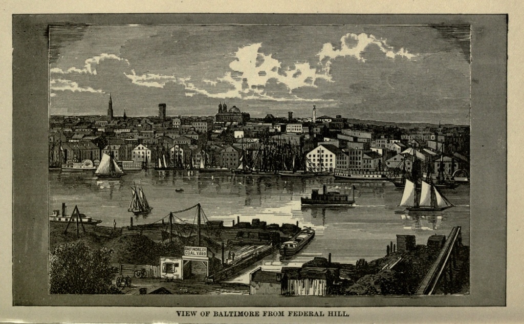
The people of the present day can scarcely comprehend the grand scale on which landscape gardening was attempted a hundred or more years ago. The landed gentry, themselves or their fathers immigrants from England, considered a well-kept park, like those of the immense English estates, an essential to an American one. To this day may be seen traces of their efforts in this direction, in stately avenues of venerable trees, which the iconoclastic hand of modern progress has considerately spared. In some rare instances whole estates have remained untouched, and have become public property, and their beauties thus perpetuated. Bonaventure Cemetery, [Pg 93] near Savannah, is a notable instance of this, where a magnificently planned Southern plantation has been transferred from private to public hands, and its valuable trees remain, though the hand of art, in attempting to improve, has rather marred the majestic beauty of the place. Lemon Hill, the nucleus of Fairmount Park, in Philadelphia, was, in revolutionary times, the estate of Robert Morris, and though the landscape gardener has been almost ruthless in his improvements (?), he has been considerate enough to spare some of the century-old trees. To the same private enterprise, love of the picturesque and appreciation of beauty, Baltimore is indebted for Druid Hill Park, in the northern suburbs of the city. Colonel Nicholas Rogers, a soldier of the Revolution and a gentleman of taste and leisure, when the war was over, retired to his country residence, a little distance from Baltimore, then a city of some ten thousand inhabitants, and devoted the remainder of his life to improving and adorning its extensive grounds. He seemed a thorough master of landscape gardening, and all his plans were most carefully matured, so that the trees are most artistically grouped and alternated with lawns; dense masses of foliage are broken into by bays and avenues, and beautiful vistas secured in various directions. Also in the selection of his trees a careful consideration was had of their autumn foliage, so that fine contrasts of color should be produced at that season of the year. The result of all this care and labor was one of the most charming and enchanting private parks which the country afforded. It contained an area of nearly five hundred acres.
When Colonel Rogers died, his son, Lloyd N. Rogers, who seemed to have inherited only in part the[Pg 94] tastes of his father, devoted himself solely to the cultivation of fruit, doing nothing to add to or preserve the beauty of his domain, but, on the other hand, allowing it to fall into neglect and decay. However, the harm that he wrought was only negative, for he did nothing to mar it, and preserved, with jealous care, the grand old trees which his father had planted, and with unremitting vigilance warded off interlopers and depredators. The estate was secluded from the outside world by fringes of woodland, and though the city had gradually crept to within a quarter of a mile, few people knew anything of its beauties. When, therefore, the Commission appointed to select the site for a new park decided upon Druid Hill as the most available for that purpose, it was absolutely necessary to detail its advantages. Mr. Rogers reluctantly consented to accept one thousand dollars an acre for his estate, and it became city property. Subsequently, other small pieces of adjoining property were bought, and Druid Lake and grounds were finally added, and the people of Baltimore found themselves in the possession of a park embracing an area of six hundred and eighty acres, which needed not to be created, but only to be improved, to be one of the most beautiful in the country.
There has been but little attempt at architectural decoration. A costly and imposing gateway, a Moorish music stand, bright with many colors, a boat-house crowning a little island in a miniature lake, a pretty bridge and a Moorish arch thrown across a ravine, a few handsome fountains, and, finally, the old mansion, renovated and enlarged, standing out against the densely-wooded hill from which the park takes its name—these are about all which have been attempted in that line. The surface[Pg 95] of the Park is gently undulating, with occasional bold eminences from which fine views may be obtained of the city and surrounding country. Its special attractions are its secluded walks, well-kept drives and tree-arched bridle-paths, its smooth, velvety turf, and the venerable beauty of its trees, which are the oldest of those of any park in the country. Its glades and dells have been left as nature made them, having been spared the artificial touches of the landscape gardener; and its little trickling springs and cool, secluded brooks, have a sylvan, rustic beauty which is surpassingly delightful.
The future care and improvement of the Park are well provided for. About the time that it became a matter of public interest, the charter for the first line of street passenger railways was granted, and this charter stipulated that one-fifth of the gross receipts of the road, or one cent for each passenger carried, should be paid to the city, to constitute a Park Fund. This amount, small at first, but gradually increasing until it now amounts to more than a hundred thousand dollars annually, was devoted first to paying the interest on the Park bonds, and finally to the preservation and improvement of the Park. The Park Commissioners, who receive no pay for their services, have most judiciously administered the fund entrusted to their care.
The foreign and coasting trade of Baltimore are both extensive. Two lines of steamships leave the port weekly for Europe, and she commands a large share of the trade of the West and Northwest. Her shipments to Europe are principally grain, tobacco, cotton, petroleum and provisions. The city contains rolling mills, iron works, nail factories, locomotive works, cotton factories and other industrial establishments, num[Pg 96]bering more than two thousand in all. The rich copper ores of Lake Superior are chiefly worked here, and nearly four thousand tons of refined copper are produced annually. The smelting works in Canton, a southern suburb of the city, employ one thousand men. There are also extensive flouring mills, while oysters, fruit and vegetables, to the value of five million dollars, are canned annually. Five hundred thousand hides are also annually made into leather and sent to New England. Baltimore oysters are renowned as being among the best the Atlantic seaboard produces, and no one should think of visiting the city without testing them. The Chesapeake oyster beds are apparently exhaustless, and supply plants for beds all along the coast.
Although the first settlements in Maryland were made early in the seventeenth century, the present site of Baltimore was not chosen until 1729, and in 1745 the town was named Baltimore, in honor of Lord Baltimore, a Catholic, to whom the patent of the province of Maryland had been originally made out. In 1782 the first regular communication with Philadelphia, by means of a line of stage coaches, was established, and Baltimore was chartered as a city in 1787, having at that time a population of twenty thousand, which, by 1850, had increased to nearly two hundred thousand; and, according to the census of 1880, the population was 332,190 inhabitants. In 1780 the city became a port of entry, and in 1782 the first pavement was laid in Baltimore street.
In 1803 Baltimore became the scene of a romance which is even yet remembered with interest. Jerome Bonaparte, the youngest brother of Napoleon, born in Ajaccio, November fifteenth, 1784, found himself, in[Pg 97] the year just mentioned, while cruising off the West Indies, on account of the war between France and England, compelled to take refuge in New York. Being introduced into the best society of that and neighboring cities, he made the acquaintance of Miss Elizabeth Patterson, daughter of a merchant of Baltimore. The manner of their introduction was peculiar. In a crowded saloon the button of young Bonaparte's coat caught in the dress of a young lady, and as it took a little time to disengage it, the future King of Westphalia had opportunity to see that the lady was young, surpassingly beautiful and charming. This interview, by some who knew the lady and who were acquainted with her ambition, thought to be not entirely accidental, resulted, on the twenty-seventh of December of the same year, in a marriage between the two, the bridegroom being but nineteen years of age. Being summoned back to France by his Imperial brother, he was quickly followed by his young wife, who, however, was not permitted to land in France, and retired to England, where she shortly afterwards gave birth to a son, whom she named Jerome, after his father. Napoleon annulled the marriage, on the ground that it had been made contrary to French law, which stipulates that the consent of parents must be gained in order to legalize a marriage. Jerome was compelled, after he succeeded to the Westphalian crown, to marry Sophia Dorothea, daughter of King Frederick I, of Wurtemburg. Madame Patterson, as she was called to the day of her death, though she maintained her title to the name of Bonaparte, having an utter scorn for America and its democratic institutions, spent much of her life in Europe, where at first her beauty, and to the last her wit and charming manners[Pg 98], secured her admission to the most exclusive salons, and a sort of acknowledgment of her claims. She never saw her husband again, save on one occasion, when she came face to face with him in a European picture-gallery.
Madame Patterson's aristocratic prejudices were greatly shocked when her son married a most estimable American lady, the mother's ambition seeking for him an alliance among the royal or at least noble families of the Old World. During the reign of Napoleon III, the Pope recognized the first marriage of Jerome Bonaparte, and the Emperor, who had taken offence at his cousin, the son of Jerome by his princess wife, also legitimatized the son, and took him into his service. Madame Patterson lived to be nearly a hundred years old, having spent her last days in her native city, and dying but a few years ago. Her son Jerome survived her not many years, leaving two sons, who are known as the Patterson-Bonapartes.
In December, 1814, Baltimore was made the object of attack by the British forces, then at war with the United States. On the eleventh of that month the fleet reached the mouth of the Patapsco, and on the next day six thousand men landed at North Point, and proceeded, under command of General Ross, toward the city. An army of over three thousand men met them and kept them in check, in order to gain time to put the forts and batteries of Baltimore in proper condition for defence. A battle was fought, and the Americans defeated, with considerable loss. Among the killed and wounded, which numbered one hundred and three, were many of the most prominent citizens of Baltimore. The next morning the British advanced to the entrenchments[Pg 99] about two miles from the city, and at the same time a vigorous attack was made by the fleet, upon Fort McHenry, at the entrance of the harbor. The fort was vigorously bombarded during the next twenty-four hours, but without visible effect. The troops which had landed, after hovering at a respectful distance from the city, until the evening of the thirtieth, then retired to their shipping, and set sail down the river, leaving behind them their commander, General Ross, who had been killed in the battle of the twelfth. It was during the siege of Baltimore, while the British fleet lay off Fort McHenry, and the bombs were raining upon it, that Philip Barton Key wrote the "Star Spangled Banner."
From 1814 to 1861, nearly half a century, Baltimore had nothing to do but develop her resources and extend her commerce, which she did so well and so thoroughly, that in 1860 her inhabitants numbered more than 212,000, and she stood in the front rank as a manufacturing and commercial town.
At the inauguration of President Lincoln, in 1861, the sentiments of the people assimilated rather with those of Virginia and the South, than with those of Pennsylvania and the North. Had it not, by its geographical position, been so completely in the power of the Federal government, Maryland would probably have seceded with Virginia. Great excitement was aroused by the attack on Fort Sumter, and the State was with difficulty made to retain her old position in the Union. The only line of railway from the north and east to Washington passed through Baltimore, and when, on the fifteenth of April, the President made his call for seventy-five thousand men, it was necessary that, in reaching the seat of[Pg 100] war, they should pass through that city. Apprehensions were felt that they might be disturbed, but the Marshal of Police, on the eighteenth of April, maintained perfect order in the city, and summarily quieted all attempts at riot. He also received from the State Rights Association a most solemn pledge that the Federal troops should not be interfered with. The Mayor issued a proclamation invoking all good citizens to uphold and maintain the peace and good order of the city.
On the nineteenth, the Sixth Massachusetts Regiment, the first to respond to the President's call, arrived, by the Philadelphia and Baltimore Railroad. A crowd of two or three thousand persons had gathered at the depot early in the day, to witness their arrival. Soon after eleven o'clock in the morning twenty-nine cars arrived from Philadelphia, filled with soldiers. Horses were attached to the cars, which were driven along Pratt street to the Camden station. The multitude hooted and yelled after the first six cars, but did not otherwise molest them. The horses becoming frightened by the uproar, were detached from the seventh car, which moved without their aid nearly to Gay street, where a body of laborers were removing the cobblestones from the bed of the street, in order to repair it. Some thirty or forty men had followed the car to this point, cheering for President Davis and the Southern Confederacy, and applying contemptuous and insulting epithets to the troops. The latter received these taunts in perfect silence; and when the horses were again attached, and the car commenced moving off, a proposition was made to stone it. Almost instantly, acting on the suggestion, nearly every window was smashed by projectiles snatched from the street. The eighth car was treated in a like manner.[Pg 101] The ninth car was suffered to pass unmolested, as it was apparently empty. When the tenth car approached, after an ineffectual attempt to tear up the track, it was heaped with paving stones, and a cartload of sand dumped upon them, and four or five large anchors, dragged from the sidewalk, completed the barricade. Progress was impossible, and the car returned to the President Street Depot.
Two-thirds of the cars still remained, filled with troops, besides others loaded with ammunition and baggage. Mayor Brown hastened to the depot, in order to prevent any disturbance. The troops were ordered to leave the cars and form into line. While forming they were surrounded by a dense mass of people, who impeded their march, threw great quantities of stones, and knocked down and severely injured two soldiers.
Marching through the city, from the President Street Depot to the Pratt Street Bridge, they were pursued by the excited crowd, who continued to throw stones, and even fired muskets at them. When they reached Gay street, where the track had been torn up, they were again violently assaulted by a fresh mob, and a number knocked down and wounded. At the corner of South and Pratt streets a man fired a pistol into the ranks of the military, when those in the rear ranks immediately wheeled and fired upon their assailants, wounding several. The guns of the wounded soldiers were seized, and fired upon the ranks, killing two soldiers. Reaching Calvert street, the troops succeeded in checking their pursuers by a rapid fire, and were not again seriously molested until they reached Howard street, where still another mob had assembled.
The police did their utmost to protect the troops from[Pg 102] assault, but were pressed back by the excited crowd. The soldiers left the Camden station about half-past twelve o'clock, and a body of infantry, about one hundred and fifty strong, from one of the Northern States, which had arrived meantime, next attracted the malevolence of the crowd. The excitement was now intense. A man displayed the flag of the Confederate States, and a general panic ensued. As many as twenty shots were fired, happily without injury to any one, and cobblestones fell like hail. At last the soldiers gained refuge in the cars. Other troops, by order of Governor Hicks, were sent back to the borders of the State, and the military was called out and quiet restored, by evening. Nine citizens of Baltimore had been killed, and many wounded; while twenty-five wounded Massachusetts troops were sent to the Washington Hospital, and their dead numbered two.
Thus Baltimore shares with Charleston the doubtful honor of being first in the great civil war which devastated the country and sent desolation to many thousand homes, both north and south. Charleston fired the first gun, and Baltimore shed the first blood.
During the succeeding night, a report reaching the city that more Northern troops were on their way southward, the bridge at Canton, the two bridges between Cockeysville and Ashland, also the bridges over Little Gunpowder and Bush rivers were destroyed, by order of the authorities of Baltimore. Upon a representation of the matter to President Lincoln, he ordered that "no more troops should be brought through Baltimore, if, in a military point of view, and without interruption or opposition, they can be marched around Baltimore." The transmission of mails, and removal[Pg 103] of provisions from the city, were suspended, by the order of the Mayor and Board of Police. Four car-loads of military stores and equipments, sufficient to furnish a thousand men, belonging to the Government, were thus detained. On the twenty-fourth of the month the city had the appearance of a military camp. Twenty-five thousand volunteers had enlisted, and four hundred picked men left the city for the Relay House, on the Baltimore and Ohio Road, for the purpose of seizing and protecting that point, in order to cut off communications with Washington by that route.
For a week an unparalleled excitement prevailed in Baltimore, which was succeeded by a counter-revolution, when the volunteer militia were dismissed, and a large number of troops landed at Fort McHenry and shipped for Washington, from Locust Point. On the fifth of May General Butler removed a portion of his troops to Baltimore, and they were permitted to enter and remain in the city without disturbance. As they proceeded on their way to Federal Hill, they were even greeted with cheers, while ladies at windows and doors waved their handkerchiefs and applauded. On the sixteenth of May the passenger trains between Baltimore and Washington resumed their regular trips. On the twenty-seventh of June, Marshal of Police Kane was arrested and escorted to Fort McHenry, on the charge of being at the head of an unlawful combination of men organized for resistance to the laws of the United States and the State of Maryland. On the first of July the Commissioners of Police were arrested, for having acted unlawfully. On the sixteenth of July General Dix was put in command of the troops stationed at Baltimore, and the city thenceforth remained tranquil. At the fall[Pg 104] elections a full vote was cast, which resulted in the Union candidates receiving a very large majority. At the meeting of the Legislature, it appropriated seven thousand dollars for the relief of the families of the Massachusetts troops killed and wounded at Baltimore on April nineteenth.
On June thirtieth, 1863, Major General Schenck, in command at Baltimore, put that city and Maryland under martial law. The value of merchandise exported that year from Baltimore was $8,054,112, and her imports during the same time were $4,098,189, showing that although on the borderland of strife, her commerce was in an exceedingly healthy condition. During July a number of her citizens were arrested, on a charge of being disloyal to the government. On the Fourth of July all citizens were required by the Commander to show their colors, from ten o'clock A.M. to six o'clock, P.M.; an absence of the national flag being considered tantamount to a confession of disloyalty. In 1864 the State adopted a new Constitution, which conferred freedom upon the slaves within her borders, and in November a Freedman's Bureau was established by Major General Wallace, having its headquarters at Baltimore.
The following year saw the close of the war, and Baltimore, which had not suffered like her sister cities at the South, her port being free from blockade, but had rather witnessed increased prosperity arising from the demands of the war, continued her prosperous career. Although many violent disunionists had found their homes within the city, the popular sentiment had grown strongly in favor of the North, and Baltimore had come to see that she had little to lose and much to gain by the reestablishment of the Union.[Pg 105]
The bitterness of the old war times has passed away, and, as if to emphasize this fact, the Grand Army of the Republic was invited to hold a reunion in Baltimore in September, 1882. Accepting the invitation, her citizens vied with each other in honoring the veterans of the war, and made their visit a regular ovation. Of the Sixth Massachusetts Regiment, who had passed through Baltimore on that fateful day in April, twenty-one years before, and who suffered from the fury of an ungoverned mob, only one member attended the reunion, Captain C. P. Lord, a resident of Vineland, New Jersey. He was lionized on every hand.
This Grand Army reunion had many pleasant and amusing features. Here men met each other again who had last parted on the battlefield or in a Southern prison. Here the dead seemed to come to life, and the lost were found. Many officers and soldiers of the Confederate army were also present, and it was as satisfactory as curious, as more than once happened during this occasion, to have two men meet and clasp hands in a cordial greeting, as one of them said to the other, "The last time we met I tried to put a bullet hole through you on a battlefield;" or, "I took you prisoner when I saw you last;" or, "This empty sleeve, or these crutches, I must thank you for."
The gathering was one which will long be remembered by Union and Confederate soldiers, and by the citizens of Baltimore as well. It was the inauguration of an era of good feeling between the North and the South. All personal and sectional enmity had died out, and this gathering joined those who had represented, on one side the North and on the other the South, in that great intestine struggle which is now so long past, and[Pg 106] the terror of which, thank God, is being gradually obliterated by time from our memories, in new fraternal bonds, which are a good augury for the preservation of our Union. When soldiers who suffered so much at each other's hands, who were stirred by all the evil passions which war develops, and who bore the brunt of the conflict, offering all, if need be, as a sacrifice on the altar of the cause they had espoused, can so forget the past, and shaking hands over the chasm which divided them, look forward to a happy and concordant future, surely civilians should be willing to bury the hatred and prejudice which has so embittered the past, and live only for a common country, made of many parts whose interests are identical.
First Visit to Charleston.—Jail Yard.—Bombardment of the City.—Roper Hospital.—Charleston During the War.—Secession of South Carolina.—Attack and Surrender of Fort Sumter.—Blockade of the Harbor.—Great Fire of 1861.—Capitulation in 1865.—First Settlement of the City.—Battles of the Revolution.—Nullification Act.—John C. Calhoun.—Population of the City.—Commerce and Manufactures.—Charleston Harbor.—"American Venice."—Battery.—Streets, Public Buildings and Churches.—Scenery about Charleston.—Railways and Steamship Lines.—An Ancient Church.—Magnolia Cemetery.—Drives near the City.—Charleston Purified by Fire.
My first introduction to the city of Charleston can scarcely be said to have been under propitious circumstances. True, a retinue of troops conducted my companions and myself, with military pomp, to our quarters in the city. But these quarters, instead of being any one of its fine hotels, were none other than the Charleston Jail Yard, for the year was 1864, and we were prisoners of war.
After a varied experience of prison life at Richmond, Danville, Macon and Savannah, I had been sent, with a number of others, to Charleston, South Carolina, to be placed under the fire of our batteries, which were then bombarding the city. We had received more humane treatment at Savannah than at any previous place of detention; therefore it was with a sinking of the heart that we found ourselves, when we arrived at our destination, thrown into the jail yard at Charleston, which was the grand receptacle of all Union prisoners in that city.[Pg 108] The jail was a large octagonal building, four stories high, surmounted by a lofty tower. A workhouse and a gallows also occupied the yard. The jail building was for the accommodation of criminals, military prisoners, and Federal and Rebel deserters, all of whom at least had the advantage of shelter from sun and storm. The war prisoners were permitted the use of the yard only, which was in the most filthy condition conceivable, having been long used as a prison-pen, without receiving any cleaning or purification whatever. The only shelter afforded us were the remnants of a few tents, which had been cut to pieces, more or less, by former prisoners, to make themselves clothing.
This jail yard was in the southeastern portion of the city, and apparently directly under the fire of our batteries on Morris Island. But though the shells came screaming over our heads, and proved a subject of interest, discussion, and even mathematical calculation among the prisoners, who were thankful for anything which should take their minds, even momentarily, from the misery which they endured, so carefully were they aimed, not to do us mischief, that though they exploded all about us—in front, behind, and on either side—not one of them fell within the prison enclosure. The scene at night was of peculiar beauty. These messengers of death presented the spectacle of magnificent fireworks, and every explosion sounded as the voice of a friend to us, assuring us that the great Northern army was still exerting itself to crush out the rebellion and open our prison doors and set us free.
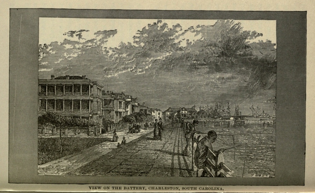
Reaching Charleston and its jail yard September twelfth, 1864, on the twenty-ninth I was transferred to the Roper Hospital, having given my parole that I [Pg 109] would not attempt to escape. The quarters here were so much more comfortable that it was almost like a transition from hell to heaven. Leaving behind me the filthiness of the jail yard, and my bed there on the chill, bare ground, where I had protection against neither heat nor cold, storm nor sunshine, to be permitted the freedom of the beautiful garden of the hospital, and to sleep even upon the hard floor of the piazza, were luxuries before unenjoyed in my experience of southern prisons. And here the Sisters of Charity, those angels among women, did what they could to alleviate the sufferings of the sick, and to add to the comfort of us all. Their ministrations were bestowed indiscriminately on Rebels and Federals, with a charity as broad and boundless as true religion.
On October fifth we were ordered to leave Charleston, and were sent, in the foulest of cattle cars, to Columbia, the Capital of the State. We left Charleston without a regret. It was the breeding place of the rankest treason, the cradle of the Rebellion, and the scene of untold cruelties to Union prisoners. At the time of our brief visit to the city, it was undergoing all the horrors of an actual siege. About one-third of its territory had been destroyed by fire during the early part of the war, caused by shells thrown from the Union batteries on Morris Island. This portion of the city was deserted by all its inhabitants save the negroes, who, during every brief cessation in the bombardment, flocked in and took possession, rent free, to scatter as quickly when one or more of them had been killed by the sudden appearance and explosion of shells in this quarter. The balance of the city was forsaken by non-combatants, and the blockade had put an end to all her commerce. The quiet[Pg 110] industries of peace had given place to all the turmoil of war. Her streets were filled with military, while the boom of the distant batteries, the whiz of the flying shells, and the noise of their explosion, were daily and familiar sounds.
During the four years of the war, Charleston was one of the chief points of Federal attack, though it remained in possession of the Confederate forces until the beginning of 1865. These were four terrible years to the city. Yet her sufferings she had brought upon herself. The first open and public movement in favor of the dissolution of the Union was made in that city. South Carolina was the first to call a State convention, and to secede from the Union. This convention was held at Columbia, the Capital of the State, but was adjourned to Charleston, where the Ordinance of Secession was unanimously passed on the twentieth of December, 1860. Fort Sumter, which was one of the largest forts in Charleston, a massive fortress of solid masonry, standing on an island commanding the principal entrance, at the mouth of Charleston Harbor, was in command of Major Robert Anderson, with a garrison of eighty men. On the twenty-seventh of December he ran up the stars and stripes. Governor Pickens immediately demanded a surrender of the fort, which was promptly refused. Early on Friday morning, April twelfth, 1861, the initial gun of the terrible four years' war was fired by the Rebel forces from the howitzer battery on James Island, west of Sumter. Fort Moultrie, on Sullivan Island, on the northeast, the gun battery at Cumming's Point, the northwest extremity of Morris Island, and other batteries and fortifications which the Confederates had seized and appropriated to their own use, all fol[Pg 111]lowed in a deadly rain of shells upon Sumter. The firing was kept up for thirty-five hours, and Sumter made a vigorous defence, until the quarters were entirely burned, the main gates destroyed by fire, the supplies exhausted, and the magazine surrounded by flames, when Major Anderson accepted the terms of capitulation offered by General Beauregard.
Upon the surrender of the Fort, which was received as a good omen by the South, troops began to pour into the city, so that by the sixteenth of the same month as many as ten thousand had arrived. The blockade of the port was commenced on the tenth of May, and continued until the close of the war. In the latter part of 1861 an attempt was made by the Federal government to seal up the channel of the harbor with sunken ships, to prevent the egress of privateers. On the twenty-first of December seventeen vessels were sunk, in three or four rows, across the channel. But this attempt at blockade proved a failure. The current washed some of them away, and many passages in a water front of six miles were left unobserved, and more vessels ran the blockade and reached the city, than at any other southern port.
On the tenth of December, 1861, a fire broke out in the city, which destroyed nearly all its public buildings, banks and insurance offices, and several churches, besides many dwellings, reducing thousands to homelessness and the extremity of want. The loss occasioned by this conflagration was estimated at ten millions of dollars.
In 1863, the women, children and other non-combatants were ordered out of the city, and free transportation, food and lodgings were furnished those unable to pay for them. Morris Island had been captured by the[Pg 112] Federal Army, who used it as a point of attack against Sumter and the city. Its shells had wrought destruction in all parts of the city, especially in its lower portions. On February seventeenth, 1865, Charleston, which had withstood all attacks from the seaward, capitulated to the Union forces, Columbia having been captured by Sherman.
The history of Charleston goes back to earliest colonial times. In 1671 a few persons located themselves on Ashley River, at Old Charleston. But in 1680 this settlement was abandoned, and the foundations of the present city laid, several miles nearer the sea. The whole country, up to 1671, between the thirtieth and thirty-sixth parallel of latitude, was called Carolina, having received the name in honor of Charles IX, of France. In that year the division was made between the Northern and Southern provinces. In 1685 the young settlement received a considerable influx of French Huguenot refugees.
During the early part of the eighteenth century the war of Queen Anne against France and Spain greatly disturbed the young colony; and a little later the Indians threatened its existence. All the inhabitants of the region took refuge at Charleston, which was vigorously defended.
In 1700, the same year that Kidd was captured and taken to England, no less then seven pirates were secured, and executed at Charleston. Subsequently others shared the same fate.
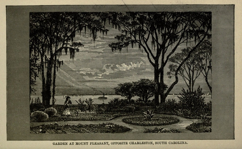
South Carolina was among the foremost of the American colonies to strike for independence. On the twenty-eighth of June, 1776, Charleston was attacked by the British, an attempt being made to destroy the [Pg 113] military works on Sullivan's Island. But Colonel Moultrie, in honor of whom the fort was subsequently named, made a gallant defence and repulsed them. In 1779 they made a second attack upon the city, this time approaching it by land, but were again compelled to retreat. Sir Henry Clinton, with seven or eight thousand men, opened his batteries upon Charleston on the second of April, 1780. Fort Moultrie, on Sullivan's Island, was compelled to surrender on the fourteenth, and the city yielded on May eleventh. The British retained possession of the city until the close of the war.
Charleston took a prominent part in the passage of the nullification act by the State, which maintained that any one of the States might set aside or nullify any act of Congress which it deemed unconstitutional or oppressive. The occasion of this nullification act was the Tariff Laws of 1828, which were not considered favorable to the Southern States. A convention of the State declared them null and void, and made preparations to resist their execution. John C. Calhoun, who was at that time Vice-President under Andrew Jackson, resigned his office, became a leader in the nullification movement, and was the father of the doctrine of State Sovereignty, the legitimate outcome of the principles of which was the late attempt to dissolve the Union.
The population of Charleston in 1800 was 18,711; in 1850, 42,985 inhabitants; in 1860, 40,519; in 1870, 48,956; and in 1880, 50,000 inhabitants. It has not made so rapid a growth as other cities, even in the South, but is, nevertheless, a prosperous town, with large commercial, and since the war, large manufacturing interests. It is one of the chief shipping ports for cotton, and also[Pg 114] exports rice, lumber, naval stores and fertilizers. Immense beds of marl were discovered in the vicinity of the city in 1868, and now the manufacture of fertilizers from marl and phosphate is one of its principal industries. There are also flour and rice mills, carriage and wagon factories and machine shops. The city is learning that the surest foundation stone for its future prosperity is its manufacturing interests; and, probably, the political battle of 1861, could it be fought over again to-day, in that city, would find the nullifiers largely in the minority. The city which was so marred and blemished during its long state of siege, has been rebuilt, and all traces of the fratricidal conflict removed; and though Charleston would not be true to her traditions if she did not still cherish a strong Southern sentiment, the years which have passed since the cessation of hostilities have done much toward softening the asperities of feeling on both sides.
As a seaboard city, Charleston is most favorably situated. It has an excellent harbor, seven miles in length, with an average width of two miles, landlocked on all sides, except an entrance about a mile in width. This entrance is blocked by a bar, which, however, serves both as a bulwark and a breakwater. Of its two passages, its best gives twenty-two feet in depth at flood tide, and sixteen feet at ebb.
The harbor of Charleston is impregnable, as the Union troops learned to their cost during the late war. Standing directly in the channel are forts Ripley and Sumter. On a point extending out into the strait, between the two, is Fort Johnson. Directly in front of the city, one mile distant from it, is Castle Pinckney, covering the crest of a mud shoal, and facing the[Pg 115] entrance. Sullivan's Island, a long, low, gray stretch of an island, dotted here and there by clumps of palmettoes, lies on the north of the entrance of the harbor, with Fort Moultrie on its extreme southern point, as a doorkeeper to the harbor. On the southern side is Morris Island, long, low and gray also, with tufts of pines instead of palmettoes, and with batteries at intervals along its whole sea front, Fort Wagner standing near its northern end. Sullivan's Island, the scene of fierce conflict during the Revolution, and later, during the Rebellion, is to-day the Long Branch or Coney Island of South Carolina, containing many beautiful cottages and fine drives, and furnishing good sea bathing. The village occupies the point extending into the harbor.
As one approaches Charleston from the sea, the name which has been applied to it, of the "American Venice," seems not inappropriate. The shores are low, and the city seems to rise out of the water. It is built something after the manner of New York, on a long and narrow peninsula, formed by the Cooper and Ashley rivers, which unite in front of the city. It has, like New York, its Battery, occupying the extreme point of the peninsula, its outlook commanding the entire harbor, bristling with fortifications, so harmless in time of peace, so terrible in war. The Battery contains plots of thin clover, neatly fenced and shelled promenades, a long, solid stone quay, which forms the finest sea-walk in the United States, and has a background of the finest residences in the city, three storied, and faced with verandahs. The dwelling-houses throughout the city are mostly of brick or wood, and have large open grounds around them, ornamented with trees, shrubbery, vines and flowers. The city is[Pg 116] laid out with tolerable regularity, the streets generally crossing each other at right angles. King street, running north and south, is the fashionable promenade, containing the leading retail stores. Meeting street, nearly parallel with King, contains the jobbing and wholesale stores. Broad street, the banks, brokers' and insurance offices. Meeting street, below Broad, Rutledge street, and the west end of Wentworth street, contain fine private residences.
The City Hall, an imposing building, standing in an open square, the Court House, the Police Headquarters, and the venerable St. Michael's Church (Episcopal), all stand at the intersection of Broad and Meeting streets. St. Michael's was built in 1752, after designs by a pupil of Sir Christopher Wren. The view from the belfry is very fine, embracing the far stretch of sea and shore, the shipping, fortresses of the harbor, and near at hand buildings as ancient as the church itself. It is the church of the poem—a favorite with elocutionists—"How he saved St. Michael." Says the poem, in one of its stanzas, its spire rose
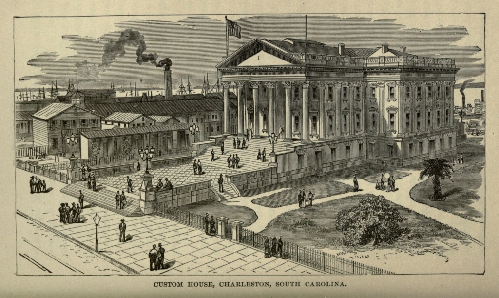
Next in interest among the churches of Charleston is St. Philip's Episcopal Church, in Church street, near Queen. The building itself is not so venerable as St. Michael's, though its church establishment is older. The view from the steeple is fine; but its chief interest centres in the churchyard, where lie some of South Carolina's most illustrious dead. In one portion of the churchyard is the tomb of John C. Calhoun, consisting [Pg 117] of a plain granite slab, supported by brick walls, and bearing the simple inscription "Calhoun." The ruins of St. Finbar's Cathedral (Roman Catholic) stand at the corner of Broad and Friend streets. The building, which was one of the costliest edifices of Charleston, was destroyed by the great fire of 1861, and the walls, turrets and niches still standing are exceedingly picturesque. Other handsome church edifices abound. The old Huguenot Church, at the corner of Church and Queen streets has its walls lined with quaint and elegant mural entablatures.
The Post Office, at the foot of Broad street, is a venerable structure, dating back to the colonial period, the original material for its construction having being brought from England in 1761. It received considerable damage during the war, but has since been renovated.
The new United States Custom House, which, when completed, will be the finest edifice in the city, is of white marble, in very elegant Corinthian style, and is situated south of the market wharf, on Cooper River.
The old Orphan House of Charleston is one of the most famous institutions in the country. It stands in spacious grounds between Calhoun and Vanderbuist streets, and a statue of William Pitt, erected during the Revolution, stands in the centre of the grounds. John Charles Fremont, the conqueror of California, and once a candidate for the Presidency, and C.C. Memminger, Secretary of the Treasury of the Confederate States, were both educated here. The Charleston Library, at the corner of Broad and Church streets, founded in 1748, and the College of Charleston, located in the square bounded by George, Green, College and St.[Pg 118] Philip streets, and founded in 1788, are both spacious and commodious buildings.
One of the most characteristic sights of Charleston is to be seen between six and nine o'clock in the morning, in and about market Hall, in Meeting street, near the Bay. The Hall is a fine building in temple form, with a lofty portico in front, and a row of long, low sheds in the rear.
There is nothing picturesque in the country around about Charleston. On the contrary, it is low, flat and uninteresting. Looking across the Ashley River, which is more than a quarter of a mile wide here, there is on the opposite side a long, low line of nearly dead level, with occasional sparse pine forests, interspersed with fields of open sand. There are no palmettoes, but here and there are gigantic oaks, hung with pendants of gray Spanish moss, and occasional green spikes of the Spanish bayonet. The view across the Cooper is very similar. Large extents of country in the neighborhood of Charleston, especially that lying along the streams, and stretching for many miles inland, are low and swampy. The region is sparsely settled, and furnishes no thriving agricultural or manufacturing population, which, seeking a market or a port for its productions, and wanting supplies in return, helps to build up the city. Several railways connecting with the North, West and South centre here; and she is also connected, by means of steamship lines, with the principal Atlantic seaports and some European ones. She is also the centre of a great lumber region, and annually exports many million feet of lumber.
There are few points of interest about the city. Besides Sullivan's Island, Mount Pleasant, on the northern[Pg 119] shore of the harbor, so named, probably, because the land is sufficiently high to escape being a swamp, is a favorite picnic resort. The antiquarian will find interest in the old Church of St. James, about fifteen miles from Charleston, on Goose Creek. It is secluded in the very heart of the pine forest, entirely isolated from habitations, and is approached by a road scarcely more than a bridle-path. The church was built in 1711, and the royal arms of England, which are emblazoned over the pulpit, saved it from destruction during the Revolutionary War. On the walls and altars are tablets in memory of the early members of the organization, one dated 1711, and another 1717. The pews are square and high, the pulpit or reading desk exceedingly small, and the floor is of stone. On the other side of the road, a short distance from this church, is a farm known as The Oaks, approached by a magnificent avenue, a quarter of a mile in length, of those trees, believed to be nearly two hundred years old. They are exceedingly large, and form a continuous archway over the road, their branches festooned with long fringes of gray moss, which soften and conceal the ravages of age.
Magnolia Cemetery lies just outside the city, on its northern boundary. It is beautified by live oaks and magnolias, and contains, among other fine monuments, those of Colonel William Washington, of Revolutionary fame, Hugh Legaré and Dr. Gilmore Simms, the novelist. The roads leading out of the city by the Cooper and Ashley rivers afford attractive drives. What the scenery lacks in grandeur and picturesqueness is made up in beauty by the abundance of lovely foliage, composed of pines, oaks, magnolias, myrtles and jasmines, exhibiting a tropical luxuriance.[Pg 120]
On the twenty-seventh of April, 1838, Charleston was visited by a fire which proved exceedingly disastrous. Nearly one-half the city was swept by the flames, which raged for twenty-eight hours, and were finally averted only by the blowing up of buildings in their path. There were 1158 buildings destroyed, involving a loss of three millions of dollars. The most shocking feature of the catastrophe was that, in the carelessness of handling the gunpowder in blowing up these buildings, four of the most prominent citizens were killed, and several others injured. The fire of 1861 exceeded this in destructiveness, and to it were added the terrific effects of a four years' besiegement. So that it can be truly said that Charleston has been purified by fire. She is to-day fully recovered from the effects, and as prosperous as her geographical position will permit.
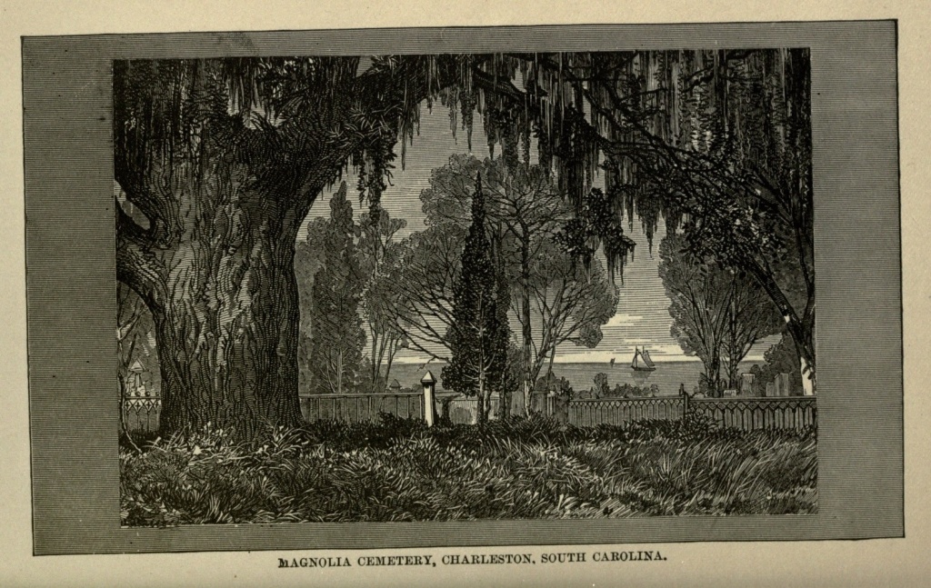
Founding of Cincinnati.—Rapid Increase of Population.—Character of its Early Settlers.—Pro-slavery Sympathies.—During the Rebellion.—Description of the City.—Smoke and Soot.—Suburbs.—"Fifth Avenue" of Cincinnati.—Streets, Public Buildings, Private Art Galleries, Hotels, Churches and Educational Institutions.—"Over the Rhine."—Hebrew Population.—Liberal Religious Sentiment.—Commerce and Manufacturing Interests.—Stock Yards and Pork-packing Establishments.—Wine Making.—Covington and Newport Suspension Bridge.—High Water.—Spring Grove Cemetery.
Cincinnati, whether we consider what its past history has been, or whether we regard it as it is to-day, is probably the most matter-of-fact and prosaic of all our western cities. A generation ago it derived its chief importance from the pork-packing business, in which, though it once stood at the head, it is now completely distanced by Chicago. Its extensive factories and foundries give it material wealth, while its geographical situation guarantees its commercial importance. Unlike most of the towns and cities of this western world, no interesting historical associations cling around its site. The Indians seem to have been troublesome and treacherous here, as elsewhere; but the records tell no stories of famous wars, terrible massacres, or hairbreadth escapes. In all the uninteresting accumulation of dry facts and statistics regarding the founding and subsequent growth of the city, there is just one exceptional romance.[Pg 122]
In early times three settlements were made along the banks of the Ohio River, on what is now the southern boundary of the State of Ohio. The first was at Columbia, at the mouth of the Little Miami River, in November, 1788, on ten thousand acres, purchased by Major Benjamin Stites, from Judge Symmes. The second settlement was commenced but a month later, on the north bank of the Ohio River, opposite the mouth of the Licking River, Matthias Denman, of New Jersey, being the leading spirit in the new undertaking, he having purchased about eight hundred acres, also from Judge Symmes, for an equivalent of fifteen pence an acre. Judge Symmes himself directed the third settlement, which was founded in February, 1789, and gave it the name of North Bend, from the fact that it was the most northern bend of the Ohio River, below the mouth of the great Kanawha.
A spirit of rivalry existed between these three settlements, which lay but a few miles apart. Each one regarded itself as the future great city of the west. In the beginning, Columbia took the lead; but North Bend presently gained the advantage, as the troops detailed by General Harmer for the protection of the settlers in the Miami Valley landed there, through the influence of Judge Symmes. This detachment soon took its departure for Louisville, and was succeeded by another, under Ensign Luce, who was at liberty to select the spot, for the erection of a substantial block-house, which seemed to him best calculated to afford protection to the Miami settlers. He put up temporary quarters at North Bend, sufficient for the security of his troops, and began to look for a suitable site on which to build the block-house. While he was leisurely[Pg 123] pursuing this occupation, he was attracted by a pair of beautiful black eyes, whose owner was apparently not indifferent to his attentions. This woman was the wife of one of the settlers at the Bend, who, when he perceived the condition of affairs, thought best to remove her out of danger, and at once proceeded to take up his residence at Cincinnati. The gallant commander, still ostensibly engaged in locating his block-house, felt immediately impelled to go to Cincinnati, on a tour of inspection. He was forcibly struck by the superior advantages offered by that town, over all other points on the river, for a military station. In spite of remonstrance from the Judge, the troops were, accordingly, removed, and the erection of a block-house commenced at once. The settlers at the Bend, who at that time outnumbered those of the more favored place, finding their protection gone, gave up their land and followed the soldiers, and ere long the town was almost deserted. In the course of the ensuing summer, Major Doughty arrived at Cincinnati, with troops from Fort Harmer, and established Fort Washington, which was made the most important and extensive military station in the northwest territory. North Bend still continued its existence as a town, and was finally honored by becoming the home of General Wm. H. Harrison, ninth President of the United States, and there still rest his mortal remains. Farms now occupy the place where Columbia once stood.
The unsettled condition of the frontier prevented Cincinnati from making a rapid growth in its early years. In 1800, twelve years after the first colonist landed on the shore of the Ohio opposite the Licking River, there were but 750 inhabitants. In 1814 the[Pg 124] town was incorporated as a city. In 1820 its inhabitants numbered 9,602, and in 1830, 16,230. About this time the Miami Canal was built, running through the western portion of the State of Ohio, and connecting Cincinnati with Lake Erie at Toledo. This gave an impetus to trade, and during the next ten years the population increased nearly three hundred per cent., numbering in 1840, 46,382 inhabitants. In 1850 it had again more than doubled, amounting to 115,436. In 1860 the number was 161,044; in 1870, 216,239; while according to the United States census returns of 1880 the population in that year was 255,708.
The career of Cincinnati will not compare in brilliancy with that of Chicago. It has not displayed the same energy and activity. Outwardly, it has not made the most of its superior natural advantages, and intellectually, although it boasts some of the most readable and successful newspapers in the country, it has fallen behind other cities. Settled originally by emigrants from Pennsylvania and New Jersey, descendants of Germans, Swedes and Danes, its inhabitants were plodders rather than pushers. They lacked the practical and mental activity of New Englanders and New Yorkers. By habits of industry and economy they were sure to accumulate wealth; but they cared little for outward display, and less for educational and intellectual advancement. The churches met better support than the schools, "book learning" being held in small estimation by this stolid yet thrifty race. They patterned their city after Philadelphia, the most magnificent city their eyes had ever beheld, and anything more splendid than which their imaginations were powerless to depict; called their streets Walnut,[Pg 125] Spruce and Vine, and felt that they should be commended for having built them up with a view to substantiality rather than to display.
Yankee capital and enterprise, in the course of time, found their way to Cincinnati, to build up its factories and stimulate public improvements. But, on the line between freedom and slavery, its population largely southern by immigration or descent, and by sympathy, Cincinnati up to the time of the war was more a southern than a northern city. Her leading families were connected by marriage with Kentucky, Virginia and Maryland; many of her leading men had immigrated from those States; and her aristocracy scorned the northern element which had helped to build up the city, and repudiated all its tendencies.
Public sentiment had been, from its earliest history, intensely pro-slavery. In 1836 a mob broke into and destroyed the office of the Philanthropist, an anti-slavery paper, published by James G. Birney, scattered the type, and threw the press into the river, having previously resolved that no "abolition paper" should be either "published or distributed" in the town. In 1841 the office of the same paper was again raided and destroyed, and a frenzied mob, numbering at one time as many as fifteen hundred men, engaged in a riot against the negro residents in the city, until, to secure their safety, it was found necessary to incarcerate the latter, to the number of 250 to 300, in the county jail. Houses were broken into and furniture destroyed, several persons killed, and twenty or thirty more or less seriously wounded. Yet at this very period, Salmon Portland Chase, the future statesman and financier, but then an obscure young lawyer, was living in[Pg 126] Cincinnati, and was already planning the beginnings of that Liberty party which, after many vicissitudes, and under a different name, finally accomplished the abolition of slavery; and in this same city, but ten years later, Mrs. Harriet Beecher Stowe wrote "Uncle Tom's Cabin."
When the war began, Cincinnati found itself in an anomalous position. Geographically it was on the side of the north, while to a large extent its social and business relations allied it with the south. Many of the leading families furnished adherents to the southern cause; but the masses of the people, notably the Germans, who had already become an important factor in its population, were stirred by the spirit of patriotism, and casting aside once for all their conservatism, they identified themselves with the cause of the Union. Trade was greatly disturbed. The old profitable relations with the south were broken up for the time being, but Cincinnati did not find herself a loser. Army contractors made fortunes, and the business of supplying gunboats, military stores and provisions to the army gave employment to immense numbers, and stimulated all branches of trade. From this period Cincinnati dates her new life. Heretofore she had stagnated in all but a business sense. With the steady increase of her population came a new element. Southern supineness and Middle State stolidity were aroused and shaken out of themselves, when slavery no longer exerted its baleful influence over the country and the city. Fresh life was infused into her people, and the war marked the dawn of a new era for the city, an era in which public spirit took a prominent place.
The name, Cincinnati, was bestowed upon the city at its foundation, as tradition has it, by General St. Clair,[Pg 127] who called it after the society of that name, of which himself and General Hamilton were both members. The county was subsequently named in honor of General Hamilton. The young town barely escaped the name of Losantiville, a word of original etymology, compounded by a pedantic schoolmaster, who, wishing to indicate the position of the future city as opposite the mouth of the Licking River, united os, mouth, anti, against or opposite to, and ville, as meaning city, prefacing the whole with L, the initial letter of Licking; hence "Losantiville." But the name, although accepted for several months, was not permanently adopted.
Cincinnati is nearly in the centre of the great valley of the Ohio, being only fifty-eight miles nearer Cairo, at its junction with the Mississippi, than to its head waters at Pittsburg. It occupies the half circle formed by an outward curve of the river, which bends continually in one direction or another. The plateau upon which the business part of the city is built is sixty feet above the low-water mark of the river. Back of this is a terrace some fifty feet higher yet, graded to an easy slope, the whole shut in by an amphitheatre of what appears to be hills, though when one mounts to their summits he finds himself on an undulating table-land, four or five hundred feet above the river, which extends backward into the country. The river flows through a wide and deep ravine, which the raging floods have, in the long ages since they began their course, cut for themselves, through an elevated region of country. In the remote west these ravines, chiseled through the solid rocks, are bordered by steep precipices; on the Ohio the yielding soil has been washed away in a gradual slope, leaving the graceful outlines of hills.[Pg 128]
The city proper is occupied by stores, offices, public buildings, factories, foundries, and the dwelling houses of the poorer and middle classes, over all which hangs a pall of smoke, caused by the bituminous coal used as fuel in the city. Cleanliness in either person or in dress is almost an impossibility. Hands and faces become grimy, and clean collars and light-hued garments are perceptibly coated with a thin layer of soot. Clothes hung out in the weekly wash acquire a permanent yellow hue which no bleaching can remove. The smoke of hundreds of factories, locomotives and steamboats arises and unites to form this dismal pall, which obscures the sunlight, and gives a sickly cast to the moonbeams.
But beyond the city, on the magnificent amphitheatre of hills which encircle it, are half a dozen beautiful suburbs, where the homes of Cincinnati's merchant princes and millionaires are found, as elegant as wealth combined with art can make them, surrounded by enchanting scenery, and commanding extensive views over the city and surrounding country. Cincinnati has no Fifth Avenue like New York, but it has its Mount Auburn, its Walnut Hills, its Price's Hill, its Clifton and its Avondale, which are as much superior to Fifth Avenue as the country is superior to the city, and as space is preferable to narrowness. As far as the eye can reach, on these billowed outlines of hills and valleys, elegant cottages, tasteful villas, and substantial mansions, surrounded by a paradise of grass, gardens, lawns, and tree-shaded roads, are clustered. Each little suburb has its own corporation, and its own municipal government, while even its mayor and aldermen may do daily business in the large city below it.
In the city itself Pearl street is noted for its wholesale[Pg 129] trade, and for the uniform elegance of its buildings. Third street, between Main and Vine, contains the banking, brokering, and insurance offices. Fourth street is the fashionable promenade and business street. Freeman street, in the neighborhood of Lincoln Park, is also a favorite promenade. Both the East and West Ends contain many fine residences. Along Front street, at the foot of Main, is the public landing, an open space one thousand feet long and four hundred and twenty-five feet wide. The city has a frontage of ten miles on the river, and extends back three miles.
The United States Government building, occupying the square bounded by Main and Walnut, and Fifth and Sixth streets, and accommodating the Custom House, Post Office, and United States Courts; the County Court House, in Main street, near Canal street; the City buildings occupying an entire square on Plum street, between Eighth and Ninth; the Chamber of Commerce, on Fourth street between Main and Walnut; and the Masonic Temple, at the corner of Third and Walnut streets, are among the most imposing buildings of the city. The Exposition buildings, in Elm street, fronting Washington Park, cover three and one-half acres of ground, and have seven acres of space for exhibiting. The Exhibition opens annually, during the first week in September, and closes the first week in October. The Springer Music Hall will seat 5,000 persons, and contains one of the largest organs in the world, having more pipes, but fewer speaking stops, than the famous Boston organ. Pike's Opera House, in Fourth street, between Vine and Walnut, is a very handsome building. Cincinnati is noted for its appreciation and encouragement of fine music. The Emery Arcade, said to be the largest[Pg 130] in America, extends from Vine to Race street, between Fourth and Fifth. The roof is of glass, and in it are shops of various kinds, and the Hotel Emery.
The late Henry Probasco, on Clifton Heights, and Joseph Longworth, on Walnut Hills, each had very fine private art galleries, to which visitors were courteously admitted, and the city itself occupies a high standard in art matters. The Tyler-Davidson fountain, in Fifth street, between Vine and Walnut, the gift of Mr. Probasco, exhibits a series of basins, one above another, the shaft ornamented by figures, and the whole surmounted by a gigantic female figure, from whose outstretched hands the water rains down in fine spray. The fountain was cast in Munich, and cost nearly $200,000.
The Burnet House has been, for more than a quarter of a century, the principal hotel in Cincinnati. The Grand Hotel is newer and more elegant. The Gibson House is large and centrally located. There are various opera houses, theatres, variety and concert halls, a gymnasium, a Floating Bath, and Zoölogical Gardens, with a collection of birds and animals, among the best in the country.
St. Peter's Cathedral (Roman Catholic), in Plum street, between Seventh and Eighth, is the finest religious edifice in the city. Its altar of Carrara marble was carved in Genoa, and its altar-piece, "St. Peter Delivered," by Murillo, a work of art of world-wide reputation. Many of the Protestant churches are elegant, and some of them actually magnificent. The Hebrew Synagogue on Plum street, opposite the Cathedral, and the Hebrew Temple, at the corner of Eighth and Mound streets, both handsome edifices, one[Pg 131] in Moorish and the other in Gothic style, have each of them brilliant interiors.
Among the educational institutions of Cincinnati are the University of Cincinnati, having in connection with it a School of Design and a Law School, St. Xavier's College (Jesuit); Wesleyan Female College; Seminary of Mount St. Mary's, a famous Roman Catholic College; Lane Theological Seminary, of which Dr. Lyman Beecher was once president, and where Henry Ward Beecher once studied theology for three years; several medical colleges, and scientific, classical and mechanical institutes.
A number of parks surround the city, furnishing fine pleasure grounds, and containing magnificent views of the river and its shores.
More than a third of the residents of Cincinnati are of German birth or descent. Besides being scattered all through the city, they also occupy a quarter exclusively their own, on the north of the Miami Canal, which they have named "the Rhine." "Over the Rhine," one seems to have left America entirely, and to have entered, as by magic, the Fatherland. The German tongue is the only one spoken, and all signs and placards are in German. There are German schools, churches and places of amusement. The beer gardens will especially recall Germany to the mind of the tourist. The Grand Arbeiter and Turner Halls are distinctive features of this quarter of the city, and specially worthy of a visit.
The Jews also constitute a proportion of the inhabitants, respectable both as to numbers and character; and, what is worthy of remark, there is an unwonted harmony between Christians and Hebrews, so that an exchange[Pg 132] of pulpits between them has been among the actual facts of the past. Dr. Max Lilienthal, one of the most eloquent and learned rabbis of the country, presides over one of the Jewish congregations, and has preached to Christian audiences; and Mr. Mayo, the Unitarian clergyman, has spoken by invitation in the synagogues. The Jews of the city are noted for their intelligence, public spirit and liberality, and are represented in the municipal government, and on the boards of public and charitable institutions. Quite as worthy of note is the fact that the Young Men's Christian Association of Cincinnati is not influenced by that spirit of narrow bigotry which in certain other cities of the Union excludes Unitarians from fellowship.
The venerable Archbishop Purcell, who for half a century had been at the head of the Roman Catholic Church in this diocese, was a man of genial manners, sincerely beloved by all. But the closing days of his life were sadly clouded by a gigantic financial failure, amounting to several millions of dollars, with which he was connected. As heavily as the blow has fallen upon many of his flock, the only blame they impute to the dead prelate is that of most faulty judgment and general incapacity in financial affairs. The most singular part of it all was that the difficulties should have remained so long undiscovered, until such an immense amount of property was involved.
Cincinnati's commerce is very extended, and so are her manufacturing interests. Steamboats from all points on the Mississippi and the Ohio lay up at her levee, which extends five or six miles around the bank of the river in front of the city. The traveler may take his ticket for St. Paul, New Orleans, Pittsburg,[Pg 133] high up the Red River, or any intervening point. The staple article of trade is pork, though she exports wine, flour, iron, machinery, whisky, paper and books. In addition to the water ways, a large number of railways, connecting the city with every section of the country, centres here.
The stock yards of Cincinnati are on an extended scale, though not equaling those of Chicago. The Union Railroad's Stock Yards, comprising fifty acres on Spring Grove avenue, have accommodations for 25,000 hogs, 10,000 sheep, and 5,000 cattle. In the pork packing establishments, thousands of hogs from the farms of Ohio, Indiana, and Kentucky, are slaughtered daily. In a single establishment fifty men will slaughter and dispose of 1,500 hogs a day. Each man has his own special line of work, the labor being divided among pen-men, knockers-down, stickers, scalders, bristle-snatchers, scrapers, shavers, hangers or "gamble-men," gutters, hose-boys, slide-boys, splitters, cutters with their attendants, weighers, cleavers, knife-men, ham-trimmers, shoulder-trimmers, packers, salters, weighers and branders, lard-men, bookkeepers, porters and laborers, of whom fifty will unitedly dispose of a hog once in every twenty seconds. The old saying is that it takes nine tailors to make a man, but it takes fifty men, belonging to all the professions named above, to make one complete butcher. The work is accomplished so rapidly that the creature has no time to realize what has happened to him, before the different portions of his dissected body are slipping down wooden pipes, each to its appropriate apartment below, to be finally disposed of.
Nowhere east of the Rocky Mountains are grapes cultivated to such an extent, and such quantities of[Pg 134] wine manufactured, as on the southern slopes of the hills which hem in the city of Cincinnati. This business is mostly engaged in by Germans, who make excellent wine, which has acquired a world-wide celebrity. But the grape-rot, which has especially affected the Catawbas, from which the best wine is produced, has of late years rather checked the industry. Some of the wine cellars of Cincinnati are famous, not only for the quantity of native wine which they contain, but for its quality as well.
Looking across the river, which at low water is, perhaps, a third of a mile wide, to the Kentucky side, one sees, on the right bank of the Licking River, the city of Covington, a mass of black factories and tall chimneys, from which dense smoke is always ascending, and spreading out over the valley. On the left or opposite bank of the Licking is Newport, the two towns connected by a suspension bridge. Covington is also connected with Cincinnati by a suspension bridge, 1,057 feet long from tower to tower, its entire length 2,252 feet, and elevated by two iron cables above the river, at low water, one hundred feet. Its weight is 600 tons, but it is estimated that it will sustain a weight of 16,000 tons, and is one of the finest structures of its kind in the world. This bridge was nine years in construction, and cost nearly two millions of dollars. There are also two pier railroad bridges across the Ohio at Cincinnati.
Along the summit of the steep levee, close to the line of stores, there is a row of massive posts, three feet thick and twenty feet high, and forty or fifty feet above the usual low water mark. The stranger will be puzzled to imagine their use. But let him visit the[Pg 135] city during the spring freshet, and he will speedily discover their purpose. The swelling of the river at that period brings the steamboats face to face with the warehouses on the levee, and they are secured to these huge posts by means of strong cables, to prevent them being swept down the stream by the mighty rush of waters. The usual difference between the high and low water mark of the Ohio River at Cincinnati is about forty feet, though a flood has been known to mark a much higher figure than that. When this occurs, which it does once or twice in a generation, the overflowing water carries desolation to all the lower parts of the city. The ground floors of houses are submerged, cellars filled, merchandise damaged or destroyed. People betake themselves to the upper stories, and make their way about the streets in boats.
The latest and most disastrous flood on record was that of 1883, when, on February fifteenth, the river indicated sixty-six feet and four inches above low water mark. Furious rain storms throughout the Ohio Valley had swollen all the streams to an unprecedented height, and caused terrible disaster to all the towns and cities on the shores of the Ohio River. For seven miles along the water front of Cincinnati the water overflowed valuable property, reaching from two to eight blocks into the city, so that the great suspension bridge, entrance to which is from the top of the decline, could not be reached except in boats. A thousand firms were washed out. In Mill Creek Valley are the large manufacturing establishments, which employ over thirty thousand men, women, and children, and these were all cut off by water. Twelve wards in the city, and seven townships in the country, were more or less affected by[Pg 136] the flood. The entire population of the flooded city districts is nearly 130,000, and one quarter of these, exclusive of business interests, were sufferers by the flood, their houses being either under water or totally destroyed. The waterworks were stopped, and the city was left in darkness by the submergence of the gasworks.
On Tuesday, February thirteenth, although the flood had not yet reached its height, the freight depot of the Cincinnati Southern Railroad was undermined by the bursting of a culvert under it, and fell into the surrounding water, carrying with it, to certain death, several people. More than twenty railroad tracks were submerged, some of them to a depth of twelve feet, so that nearly all communication was cut off. Policemen patrolled the streets in boats. The churches were thrown open to receive the homeless, and nearly every organization in the city, from the Chamber of Commerce to the ladies' sewing societies, entered upon the work of relieving the sufferers. Contributions poured in most liberally from abroad, the Free Masons of Cleveland alone shipping twelve large boats, with a generous supply of stores. Before relief could come to them, many persons suffered severely, from both cold and hunger. They were rescued from their flooded homes by the aid of skiffs, some of them with barely enough clothing to conceal their nakedness.
It is estimated that eight square miles of Cincinnati were under water, five of which were in the Mill Creek Valley. Provisions became scarce, and commanded high prices. Newport, on the Kentucky shore, was in even a more deplorable condition than Cincinnati. Supplies became entirely exhausted, and on the night of[Pg 137] the fourteenth, fifteen thousand people there were without fuel or provisions.
On the sixteenth of February the waters had begun to subside, and gradually regained their normal level, making more apparent, as the flood decreased, the ruin and desolation which had attended it. A vast deposit of mud was left upon the streets, many premises had been undermined by the sucking currents, malaria haunted the wet cellars, the destruction of merchandise was found to be very heavy indeed, while thousands of men were compelled to remain out of employment until the factories and mills could be put in working condition. The great flood of 1883 will long be remembered by the citizens of Cincinnati.
The breaking up of the ice in the river, in the spring, is also a time of great peril to property. There is usually more or less rise in the river at that period, with a swifter current, and the floating blocks sometimes drag boats away from their moorings, and crush them to either partial or utter destruction. The Ohio River, known to the French as La Belle Riviere, so called because of its high and picturesque banks, is, like the Mississippi, a capricious stream, and neither life nor property is always safe upon its bosom or along its shores.
The pride of Cincinnati is Spring Grove Cemetery, five miles northwest of the city, which is one of the most beautiful in the West. It is in the valley of Mill Creek, and is approached by a handsome avenue, one hundred feet wide. It contains six hundred acres, well wooded, and so laid out as to present the appearance of a park. The boundaries of the lots are indicated by sunken stone posts at each corner, there being neither railing, fence, nor hedge within the cemetery, to define these lots. The[Pg 138] graves are leveled off, even with the ground, and the monuments are remarkable, for their variety and good taste. The Dexter mausoleum, which represents a Gothic chapel, will attract special attention; while one of the principal objects in the cemetery is the bronze statue of a soldier, cast in Munich, and erected in 1864, to the memory of the Ohio volunteer soldiers who died during the War.
In spite of many changes for the better since the war, Cincinnati still retains her distinctive character. She has taken long strides in the direction of intellectual development, and has now numerous and extensive public libraries, of which any city might be proud. The theatres and other places of amusement, which, not long since, were represented by shaky buildings, third-rate talent and a general dearth of attractions, and patronized more largely by the river men than by any other single class, have risen to take rank among the best in the country. But she is still a city noted for her wealth; for her solid business enterprises and scrupulous honesty, rather than for that spirit of speculation in which, in other cities, fortunes are quickly made, and even more quickly lost. Her prosperity has a solid foundation in her factories, her foundries, her mills and engine shops. A man, to be successful in Cincinnati, must know how to make and to do, as well as how to buy and sell. Men have risen from the humblest ranks by dint of industry and energy alone, while they were yet young, to be the masters of princely fortunes. Even a newspaper publisher in that city, a few years since, estimated his property at five millions of dollars, an instance which, probably, has not a parallel in the civilized world. Nicholas Longworth died worth twelve millions of[Pg 139] dollars, and her living millionaires are to be counted by hundreds.
Cincinnati stands in the front rank of the manufacturing cities of America, and the secret of her financial success is that she has made what the people of Ohio and other States needed and were sure to buy. Receiving their products in return, and turning these to account, her merchants have made a double profit. As long as the Ohio River sweeps by the city's front, and as long as the smoke of her factories and her foundries ascends to heaven and obscures the fair face thereof, and corn, transformed into pork, is sent away in such quantities to the Eastern cities and to Europe; so long as the cotton of the South, the hay of the blue grass region, and the grain of the North and West, find a market on her shores, her prosperity is secure; and the Queen City of the West, as she proudly styles herself, will go on increasing in population and in prosperity.
The "Western Reserve."—Character of Early Settlers.—Fairport.—Richmond.—Early History of Cleveland.—Indians.—Opening of Ohio and Portsmouth Canal.—Commerce in 1845.—Cleveland in 1850—First Railroad.—Manufacturing Interests.—Cuyahoga "Flats" at Night.—The "Forest City."—Streets and Avenues.—Monumental Park.—Public Buildings and Churches.—Union Depot.—Water Rents.—Educational Institutions.—Rocky River.—Approach to the City.—Freshet of 1883.—Funeral of President Garfield.—Lake Side Cemetery.—Site of the Garfield Monument.
In early colonial times, out of utter ignorance of the boundless territory extending westward, the first American Colonies were chartered by the Kings of England with permission to extend westward indefinitely. After the close of the Revolutionary War, while negotiations were in progress in regard to the final treaty of peace with the United States, which was ultimately signed at Paris on November thirtieth, 1782, Mr. Oswald, the British Commissioner, proposed the Ohio River as the western boundary of the young nation, and had it not been for the firmness and persistence of John Adams, one of the American Commissioners, who insisted upon the right of the United Colonies to the territory as far westward as the Mississippi, it is probable that the rich section of country between these two rivers would still have formed a portion of the British dominions, or have been the source of subsequent contention and expense. When the Colonies had[Pg 141] become independent States, many of them claimed the right of soil and jurisdiction over large portions of western unappropriated land originally embraced in their charters. Congress urged upon these States to cede these lands to the general government, for the benefit of all. They all yielded to this request, except Connecticut, who retained a small tract of land in the northeastern portion of the present State of Ohio, which was subsequently divided up five counties in length along the lake, with an average width of two counties. The lower boundary of this tract of land was 40° 22´ north latitude, and it extended from the Pennsylvania line on the east, one hundred and twenty miles westward, to a line running north and south, a little west of the present location of Sandusky City. This tract of land was called the "Western Reserve of Connecticut."
In 1801 Connecticut ceded all her jurisdictional claims over the territory, but it continues to be known, to this day, as the "Connecticut Reserve," the "Western Reserve," or simply as the "Reserve." This "Western Reserve" is like a little piece of New England in a mosaic, representing many sections and many peoples. It is a peculiarity of the Anglo-Saxon race, that in emigrating it usually moves along parallels of latitude, and rarely diverges much either northward or southward. We find to the eastward of Ohio, Connecticut, and Rhode Island, New York, New Jersey, and Pennsylvania, Maryland, Delaware and Virginia, and all of these States have contributed to her population. Thus, below the Reserve, the people are largely from Pennsylvania; still further south, from Maryland and Virginia; and the lower section of the State is allied[Pg 142] more by kindred and sympathy with the South than with the North. But on the Western Reserve, the cosmopolitan character of the inhabitants is at once lost. It is New England in descent and ideas. The little white meeting house, and the little red school house not far off, both as bare and homely as a stern Puritan race could conceive of, were everywhere met in the early days of its settlement, after the log cabin epoch had passed away. Massachusetts, Connecticut and Vermont furnished the principal immigrants, and they built their neat and thrifty little New England towns over again, and maintained their New England sturdiness and simplicity.
The inhabitants of the Reserve have been, and are still, noted for their thrift, their intelligence and their superior culture. That section has furnished many distinguished public men, and one President, to the country. It was, in the old slavery days, spoken of contemptuously as "the hotbed of abolitionism," and gave both Giddings and Wade to fight the battle against Southern dominion in the United States Congress. Here Garfield was born, and here he is buried. Howells, the novelist, was a native of the Reserve, and passed his life until early manhood in its northeasternmost county.
The northern shores of the Reserve are washed by Lake Erie, one of the shallowest, most treacherous and least picturesque of the chain of lakes which form our northern boundary. It embraces the "Great Divide" between the north and the south, its waters flowing to the sea by both the St. Lawrence and the Mississippi. Summit and Portage counties, by their names, indicate the locality of this Divide.[Pg 143]
Very early in the present century, the sturdy New England pioneers, looking for a suitable harbor upon the lake, discovered the mouth of Grand River, about thirty-five miles northeast of the Cuyahoga River; and in 1803, two miles up this river, the first warehouse on the lake was built.
In 1812 the town of Fairport, at the mouth of this river, was laid out, and was destined by its founders to be the future great lake city of Ohio. It had one of the best harbors on the lake, if not the best, well defended from storms, and easy of access, so that vessels entered it without difficulty when they could not make other ports. The water was deep enough for any large craft, and in the course of time the government expended a considerable sum of money in improving the harbor. A line of boats was speedily established between Fairport and Buffalo, which in those railroadless days were liberally patronized. Nearly all the lake steamers bound for other ports stopped there, and its business constantly increased. A lighthouse was built, and its future prosperity seemed assured.
During the great period of land speculation, between 1830 and 1840, the town of Richmond was laid out on the opposite bank of the Grand River, by wealthy eastern capitalists, who established their homes there, and transported to the infant city the wealth, magnificence and luxurious social customs of the east. During their brief reign, they gave entertainments such as were not equaled in that section of the country for many long years afterwards. A large village was built and a steamboat was owned there.
Meantime, a little town had been growing up on the banks of the Cuyahoga. The first permanent settlement[Pg 144] had been made as early as 1796, and named Cleveland, in honor of General Moses Cleveland, of Canterbury, Connecticut. At that period the nearest white settlement was Conneaut, on the east, and another at the mouth of the River Raisin, to the west. Immigration at that period did not march steadily westward, each new settlement being in close proximity to an older one, but it took sudden jumps over wide extents of territory, so that for many years isolated families or small neighborhoods were far apart. Each little settlement had to be sufficient unto itself, since, to reach any other involved a long, difficult and often dangerous journey. Up to nearly 1800 each house in Cleveland had its own hand grist-mill standing in the chimney-corner, in which the flour or meal for the family consumption was slowly and laboriously ground each day. In the spring of 1799 Wheeler W. Williams and Major Wyatt erected the first grist and saw mill on the Reserve, at Newburg, a few miles above the mouth of the Cuyahoga.
The first ball ever given in Cleveland was on the Fourth of July, 1801, in a log cabin, the company numbering thirty, of both sexes. The first militia muster was held at Doane's Corners, on the sixteenth of June, 1806. The spot is now incorporated in the city of Cleveland. Never before had been so many whites collected together in this region as on this occasion, which was one of general excitement. The militia consisted of about fifty privates, with the usual complement of officers, but a surveying party and a number of strangers were present and added to the spectators.
In the beginning of the century the Indians were in the habit of meeting every autumn, at Cleveland, piling[Pg 145] their canoes up at the mouth of the Cuyahoga, and scattering into the interior of the country, which constituted their great winter hunting ground. In the spring they returned, disposed of their furs, and entering their canoes, departed up the lake for their villages, in the region of Sandusky and Maumee, where they raised their crops of corn and potatoes. Many local names are of Indian origin; Cuyahoga means "crooked river." Geauga, the name of an adjoining county, signifies "raccoon." Their encampment on going and returning was usually on the west bank of the river, and in their drinking bouts, in which they occasionally indulged, they were sometimes quarrelsome and dangerous, but do not seem, on the whole, to have given the settlers much trouble. On the twenty-sixth of June, 1812, an Indian named McMic was hanged for murder, on the public square of Cleveland. There were fears that the Indians would rally to his rescue, and a large number of citizens from Cuyahoga and adjoining counties, armed themselves and attended the execution, prepared for any outbreak. The Indians remained peaceable, but the prisoner, at the last moment, refused to ascend the scaffold. Finally, his scruples were overcome by a pint of whisky, which he swallowed with satisfaction before yielding to the inevitable.
In 1813 Cleveland became a depot for supplies and troops during the war, and a permanent garrison was established here, a small stockade having been erected on the lake bank, at the foot of Ontario street. The return of peace was celebrated in true American style. The cannon which was fired in honor of the occasion was supplied with powder by one Uncle Abram, who carried an open pail of the explosive material on his arm. An[Pg 146]other citizen bore a lighted stick with which to touch off the gun. In the excitement, the latter swung his stick in the air; a spark fell into Uncle Abram's powder, and that worthy, whether from astonishment or some other cause, suddenly sprang twenty feet into the air, his ascent being accompanied by a deafening report. When he came down again, his clothing was singed off, and he vociferously protested that he was dead. But the multitude refused to take his word for it, and it was not a great while before he had completely recovered from the accident.
The Ohio Canal, which connects Lake Erie at this point with the Ohio River at Portsmouth, was completed in 1834, and from that date her prosperity seems to have been established. She was incorporated a city in 1836. About this time the great western land bubble burst, and with it the hopes of Fairport and Richmond. The latter city speedily disappeared from the face of the earth, and its name from the map. Its houses were taken up bodily and removed to adjacent towns. Boats still continued to stop at Fairport, but they began to stop more frequently at Cleveland, and while the business of the former point was at a standstill, that of the latter continued to increase. In 1840 its population was over 6,000, and its supremacy fairly established. In 1850 Fairport was still a little hamlet, the boats passing her far out in the lake without giving her so much as a nod of recognition; while the wharves of Cleveland were lined with shipping, and her population did not fall far short of 20,000.
Besides the Cleveland and Portsmouth Canal, which opened up a line of traffic with the south and southwest, communication was also had with the East, by means of[Pg 147] canal to Pittsburg and to New York, and the lakes were a highway, not only to the East but to the North and West. Cleveland became the great mart of the grain-growing country. Its harbor was extended and improved by the erection of piers each side of the mouth of the river, two hundred feet apart, and extending out several hundred feet into the lake, furnishing effective break-waters, and ample room for the loading and unloading of vessels. A lighthouse was erected at the end of each pier, and one already stood upon the cliff.
In 1845 the number of vessels which arrived by lake was 2,136; and of these 927 were steamers. The tonnage then owned at that port amounted to 13,493, and the number of vessels of all kinds eighty-five. The total value of exports and imports by the lake for that year was over $9,000,000. Cleveland occupied a small region on the cliff at the mouth of the Cuyahoga. Ontario street was filled with boarding-houses and private residences. Euclid avenue and Prospect street extended for a few squares, and were then lost in the country. The flats through which the river wound its devious way were occupied as pastures for the cows of persons living in the heart of the city. The business portion of the town was contained, for the most part, in the two squares on Superior street, west of Ontario. Ohio City was a separate corporation, a straggling, dilapidated town, looking like a country village, on the western bank of the Cuyahoga, connected with Cleveland by means of drawbridges.
In the fall of 1852 the first whistle of the locomotive was heard down by the river side, in the city of Cleveland. It started the city into new life, and woke all the farmers within the sound of its hoarse screech into[Pg 148] renewed energy. That fall and winter there was a butter famine in all that region. The market being opened to New York, butter went suddenly up from eight and ten cents a pound, to twelve, sixteen, and then to twenty cents. Buyers could afford to pay no such fancy price for an article which might be dispensed with; and producers were equally unwilling to put upon their own tables anything which would yield them such a handsome profit on selling. And so many families, not only of mechanics, but of farmers as well, went without butter that winter; the latter happy in receiving, first twenty, then twenty-two, and finally twenty-five cents per pound for the products of their dairies.
This first railroad gave the city a fresh start, and presently others found their terminus here. Population and business have both steadily increased since then, until in 1880 the former was 160,142, and its commerce immense, especially with Canada and the mining regions of Lake Superior. Since 1860 the city has rapidly developed in the direction of manufacturing industries. The headquarters of the giant monopoly, known as the Standard Oil Company, Cleveland is the first city of the world in the production of refined petroleum. The old pasture grounds of the cows of 1850 are now completely occupied by oil refineries and manufacturing establishments; and the river, which but a generation ago flowed peaceful and placid through green fields, is now almost choked with barges, tugs and immense rafts. Looking down upon the Cuyahoga Flats, from the heights of what was once Ohio City, but is now known as the West Side of Cleveland itself, the view, though far from beautiful, is a very interesting one. There are copper smelting, iron rolling, and iron[Pg 149] manufacturing works, lumber yards, paper mills, breweries, flour mills, nail works, pork-packing establishments, and the multitudinous industries of a great manufacturing city, which depends upon these industries largely for its prosperity. The scene at night, from this same elevated position, is picturesque in the extreme. The whole valley shows a black background, lit up with a thousand points of light from factories, foundries and steamboats, which are multiplied into two thousand as they are reflected in the waters of the Cuyahoga, which looks like a silver ribbon flowing through the blackness.
Cleveland is acknowledged to be the most beautiful city of the many which are found upon the shores of the great lakes. It stands on a high bluff overlooking Lake Erie. It is laid out, for the most part, with parallel streets, crossed by others at right angles; and even in the heart of the city nearly every house has its little side and front yard filled with shrubbery and shaded by trees, a large majority of the latter being elms. The great number of these trees fairly entitle Cleveland to be known as the "Forest City." The streets are very wide, and the principal ones are paved.
The main business thoroughfare and fashionable promenade is Superior street, which is one hundred and thirty-two feet wide, and lined with handsome hotels and retail stores. From the foot of this street, and on a level with it, was completed, in 1878, a great stone viaduct, connecting the East Side with the West Side, reaching the latter at the junction of Pearl and Detroit streets. This roadway is 3,211 feet long, and cost $2,200,000. Some years before a bridge had been constructed in the same locality, at a sufficient elevation[Pg 150] to permit the passage under it of various craft; but even at this height there was quite a descent to reach it, and an equal ascent on leaving it on the other side. The drawbridge near the mouth of the river was totally inadequate to meet the needs of business, and was often open for long periods of time while vessels were passing through.
Ontario, Bank, Water, Mervin and River streets and Euclid avenue are other important business streets on the East Side. Detroit, Pearl and Lorain are the principal thoroughfares on the West Side.
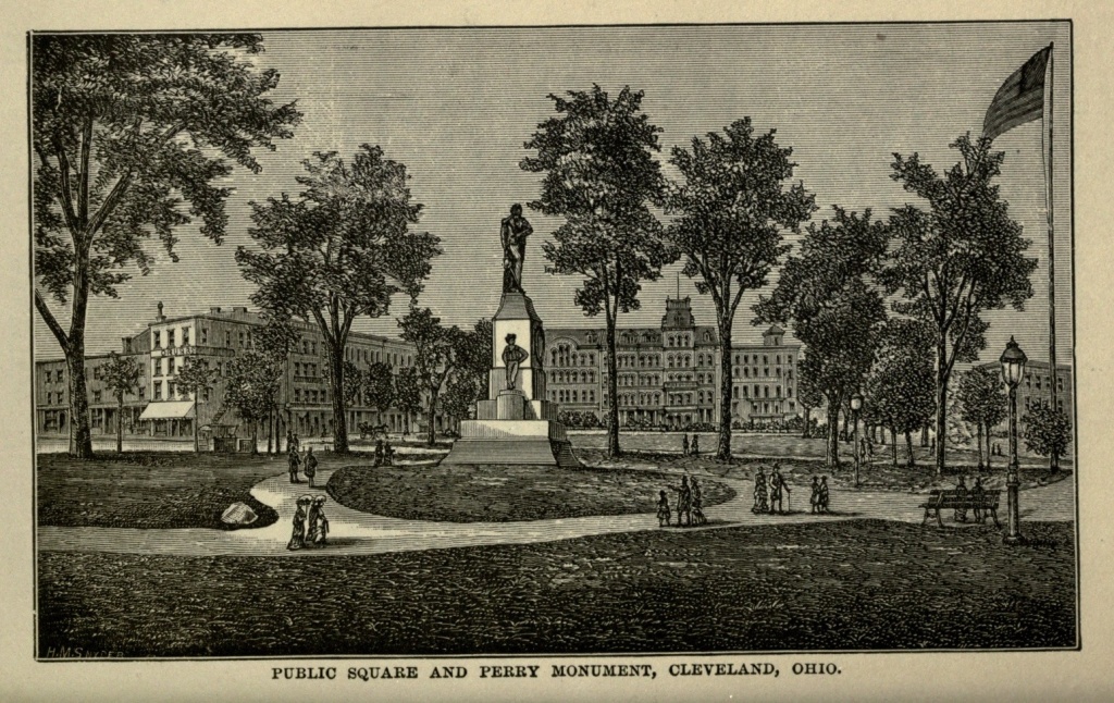
Monument Park is a square ten acres in extent, in the centre of the city, crossed by Superior and Ontario streets. It is divided by these streets into four sections and is shaded by fine trees. In the southeast section stands a monument to Commodore Perry, the hero of the battle of Lake Erie, erected in 1860, at a cost of $8,000. It contains a colossal statue of the Commodore, in Italian marble, standing on a pedestal of Rhode Island granite, the entire monument being about twenty feet in height. In front of the pedestal is a marble medallion, representing Perry in a small boat passing from the Lawrence to the Niagara, in the heat of battle. In the southwest corner of the Park is a pool and cascade, and in the northwest a handsome fountain. In this park was erected the large catafalque under which the casket containing the remains of the late President Garfield was laid in state until and during the grand public funeral, after which it was taken to the cemetery. This park is surrounded by very handsome churches and public buildings, among which latter are the Custom House, Post Office, Federal Courts, County Court House and City Hall, all magnificent edifices. [Pg 151] Case Hall, near the park, contains a concert hall capable of seating fifteen hundred persons, a library, reading room, and the rooms of the Cleveland Library Association. The Opera House, a new and handsome building, is on Euclid avenue. There are, besides, an Academy of Music and the Globe Theatre and several minor theatres.
The business portion of Euclid avenue extends from the Park to Erie street, beyond which it is lined with handsome residences, elegant cottages and superb villas, the grounds around each being more and more extensive as it approaches the country. It is one of the finest avenues in the world, and is not less than ten miles in length, embracing during its course several suburbs which a generation since were remote from the city, and are now considerably surprised to find themselves brought so near it. Euclid avenue crosses the other streets diagonally, and was evidently one of the original roads leading into the city before it attained its present dimensions. The majority of the streets are parallel with the lake front, which pursues a course from the northeast to the southwest. But Euclid avenue runs directly eastward for about three miles, to Doane's Corners, one of the historic spots in the neighborhood of Cleveland, and then turns to the northeast, following nearly parallel to the course of the lake. Prospect street runs parallel to Euclid avenue, and is only second to it in the beauty and elegance of its residences. St. Clair street is also a favorite suburban avenue, extending parallel to the lake, a little distance from it, far out into the country, and containing many handsome residences.
Newburg, once three miles from the city, and the site of the first saw and grist mill on the Reserve, is now[Pg 152] included as a suburb of Cleveland, and contains extensive iron manufactories.
The Union Depot, erected in 1866, is one of the finest and largest in the country. It is built on the shore of the lake, below the bluff, and near the mouth of the Cuyahoga. Streets more or less steeply graded furnish access to it for carriages and vehicles of all descriptions, while a long flight of massive stone steps conduct the pedestrian directly to the summit of the cliff, where horse-cars, leading by various routes to all quarters of the city, are waiting for him. All the railroads leading out of the city centre here. In the keystone over the main entrance of the depot is a bas relief portrait of Mr. Amasa Stone, under whose supervision it was built. Similar portraits of Grant and Lincoln are found upon keystones at either end of the building.
The waterworks stand near the lake, west of the river, and by means of a tunnel extending some six thousand feet out under the lake, pure water, forced by two powerful engines into a large reservoir upon the cliff, is supplied to the entire city. This reservoir is a popular resort for pleasure seekers, and furnishes a fine view of the city, lake and surrounding country.
Cleveland enjoys superior educational facilities. Her schools are not excelled by any in the country, and she has, besides, several large libraries. The Western Reserve College, until recently located at Hudson, a small village about twenty miles to the southeast, has been, within the last few years, removed to this city. The Medical College, a branch of the Western Reserve College, founded in 1843, occupies an imposing building at the corner of Erie and St. Clair streets. Near this college, on the shore of the lake, stands the extensive[Pg 153] United States Marine Hospital, surrounded by grounds nine acres in extent, beautifully laid out and well kept.
There are a number of parks and gardens in the suburbs of Cleveland, one of the most extensive having been a donation to the city by Mr. Wade, one of her millionaires. The favorite drive, however, next to the avenue, is across the Cuyahoga and seven miles westward to Rocky River, which flows into the lake through a narrow gorge between perpendicular cliffs which project themselves boldly into the lake. Here a park has been laid out, and all that art can do has been done to add to the natural beauties of the place. From this point a distant view of the city may be obtained, its spires pointing to the sky out of a billow of green. To the west is Black River Point, with its rocky promontories, and on the north stretches out an unbroken expanse of water, with here and there the long black trail of a steamer floating in the air, its wake like a white line upon the water; or white specks of sails dotting the horizon. The coast between Cleveland and Rocky River is high and precipitous, the emerging streams rushing into the lake by means of rapids and waterfalls. On this inhospitable coast, which affords no landing for even a small boat, more than one frail bark came to grief in the early days of the white man's possession of the land, and nearly all its living freight found a watery grave. In 1806 a man by the name of Hunter, his wife and child, a colored man named Ben, and a small colored boy, were driven by a squall upon these rocks. They climbed up as far as possible, the surge constantly beating over them, and finally they died, one after the other, from exposure and hunger, and after five days only the man Ben was rescued alive. A similar[Pg 154] occurrence transpired the following spring. Of the eighteen deaths which took place at Cleveland during the first twelve years after its settlement, eleven were caused by drowning.
Twenty or thirty years ago nothing more desolate or devoid of beauty can be imagined than was the lake and river approach to Cleveland. The cars ran along the foot of the cliff, while the space between the tracks and the table land upon which the city is built was given up to rubbish and neglect. Little huts, the size of organ boxes, were perched here and there, swarming with dirty, half-clad children and untidy women, and festooned with clothes-lines, from which dangled a motley array of garments. Blackness, dirt and decay were visible everywhere; and the vestibule of the most beautiful city in America presented to the visitor the opposite extreme of repulsiveness. But now all this is changed; one enters the Forest City through a continuous park. Coming from the east, the waves of the beautiful inland sea almost wash the tracks. On the left the steep slope is covered by green grass, shrubbery and trees, the line broken here and there, perhaps, by private grounds no less beautiful, while the United States Marine Hospital crowns the cliff, at Erie street, with its ample and well-kept grounds. Reaching the depot the traveler at once ascends the cliff, and avoids the necessary ugliness of the immense railroad yard, with its gridiron of tracks. Even the river, once so unsightly, presents to view the ceaseless movements of multifarious business, all of which indicate the prosperity and thriving industry of the city.
It is a peculiarity of western cities that they give so much thought and spend so much money in public[Pg 155] improvements, and especially those which are merely decorative. Cleveland is in no wise behind the rest. No city in the east, though many of them boast extensive and expensive public parks, bestows so much thought, labor and money, to make her general appearance beautiful and attractive to the stranger. If first impressions count for much, as it is said they do, then Cleveland has proved herself wise. She possesses many natural advantages of position. She is not in a slough, like Chicago, being built on a gravelly plain about one hundred feet above the lake. Nor is she subject to inundation, like Cincinnati, most of her business sites and residences being far above the water. The Cuyahoga River sometimes, however, does damage to the manufacturing establishments along its shores. In February, 1883, a freshet occurred, which raised the river ten feet above its ordinary level, and flooded all its valley. Enormous quantities of lumber and shingles were washed from the lumber yards. The Valley Railroad was several feet under water; paper mills, furnaces and other property submerged nearly to the top of the first story. The Infirmary Farm, further up the river, was under water, and the damage of the flood was estimated at not less than a million dollars. The water was higher than at any period since 1859, when a similar disaster occurred.
All eyes were turned towards Cleveland, when, in September, 1881, a mournful cortege proceeded thither, accompanying the remains of the murdered Chief Magistrate. A mighty concourse of people assembled in the park to assist at the last sad rites, and then the funeral procession passed out the beautiful Euclid avenue to Lake View Cemetery, where the casket was[Pg 156] deposited in a vault prepared for it, and was guarded by soldiers night and day; and there, on a spot overlooking the lake, and surrounded by a lovely country, varied by hill and dale, cultivated farms and elegant suburban residences, all that is mortal of James Abram Garfield has found its last resting-place, while his memory lives in fifty millions of hearts, and his fame is immortal. The youngest son of his mother, and she a widow, reared in poverty and obscurity, by dint of his unswerving integrity and overmastering intellect, he rose to occupy the highest position which man can accord to his fellow man, that of being the chosen head of a free, intelligent and powerful people. Cut off as he was, in the prime of his life, a nation mourned her dead, and Lake View Cemetery is to-day a spot of national interest. It is five miles from the city, contains three hundred acres, and lies two hundred and fifty feet above the level of the lake. It commands extensive views, and though opened as late as 1870, is already very beautiful. It was here that Garfield expressed his desire to be buried. Here, on a knoll commanding one of the finest views the cemetery affords, his tomb will be eventually constructed, and a monument reared to him, as a mark of the nation's appreciation of his character and sorrow at his untimely death.
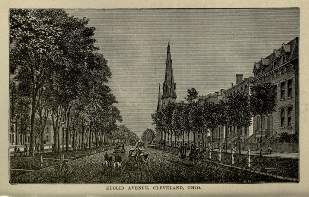
Topographical Situation of Chicago.—Meaning of the Name.—Early History.—Massacre at Fort Dearborn.—Last of the Red Men.—The Great Land Bubble.—Rapid Increase in Population and Business.—The Canal.—First Railroad.—Status of the City in 1871.—The Great Fire.—Its Origin, Progress and Extent.—Heartrending Scenes.—Estimated Total Loss.—Help from all Quarters.—Work of Reconstruction.—Second Fire.—Its Public Buildings, Educational and Charitable Institutions, Streets and Parks.—Its Waterworks.—Its Stock Yards.—Its Suburbs.—Future of the City.
"See two things in the United States, if nothing else—see Niagara and Chicago," said Richard Cobden, the English statesman, to Goldwin Smith, on the eve of the departure of the latter to America. And truly, if one would obtain a proper sense of America's wonders and achievements, then Niagara and Chicago may be accepted as respectively the highest types of each. Niagara remains the same yesterday, to-day and forever. But if it were a desirable thing to see Chicago at the time of the visit referred to, how much more so is it to-day, when, Phœnix-like, she has arisen from her own ashes, turning that which seemed an overwhelming disaster into positive blessing; drawing her fire-singed robes proudly about her, crowning herself with the diadem of her own matchless achievements, and sitting beside her inland sea, the queenliest city of them all.
Situated upon a flat and relatively low tract of country, Chicago is yet upon one of the highest plane[Pg 158] elevations of our continent. Lake Michigan represents the headwaters of the great chain of American lakes, through which, in connection with the St. Lawrence, much of the rainfall of that city finds its way to the Atlantic; while through the canal to the Illinois River, its sewage is borne to the Gulf of Mexico. Perhaps no more hopeless site could have been selected for a city than that seemed half a century ago. A bayou or arm of the lake penetrated the land for half a mile or more, but a sand-bar across its mouth prevented the ingress of all but the smallest craft. This bayou, called by courtesy the Chicago River, separated into two branches, the course of one of which was in a northerly direction, and of the other in a southerly one. The land was barely on a level with the lake, and at portions of the year was a vast morass, some parts of it being entirely under water. Teams struggled helplessly through the black ooze of its prairies, and a carriage would sink three or four feet in mud and mire within two miles of where the court house now stands. Sometimes in this slough a board would be set up, with a rude inscription: "No bottom here." But American enterprise has found a bottom and reared a city, the history of whose seemingly magical building almost rivals the tales of the Arabian Nights.
Chicago is an Indian word, signifying the widely-varying titles of a king or deity, and a skunk or wild onion. In its early history, while drainage it had none, and its water supply was mere surface water, foul with all the accumulated impurities of the soil, and while from the lagoon, which lay stagnant for twelve or fifteen miles, a horrible, sickening stench constantly arose, the latter appellations seemed singularly appropriate, and[Pg 159] no doubt originated in these conditions. But since the city has been purified by fire, and its sanitary conditions made such as they should be, it has earned its right to the nobler titles.
The first white visitors to the site of Chicago were Joliet and Marquette, who arrived in August, 1673. The year following his first visit Pere Marquette returned and erected a rude church. Later the French seem to have built a fort on the spot, but no traces of it now remain. Very early in the nineteenth century John Kinzie, an Indian trader, and agent of the American Fur Company, having traded with the Indians at this point for some time, probably influenced the government to build a fort here. Accordingly, in 1804, Fort Dearborn was built and garrisoned with about fifty men and three pieces of artillery. Mr. Kinzie removed his family to the place the same year.
In 1812, Fort Dearborn was the scene of a bloody Indian massacre. Captain Hull, then in command of the fort, having placed too great confidence in the professions of fidelity of the Pottawatomie tribe, and trusting to an escort of that tribe to convey the soldiers and inhabitants of the fort to Fort Wayne, saw his entire party either killed or taken prisoners, and found himself a prisoner. The fort stood at the head of Michigan avenue, below its intersection with Lake street. Abandoned and destroyed at this period, it was rebuilt in 1816, and finally demolished in 1856.
For four years the place was deserted by the whites, and even the fur traders did not care to visit it. In 1818 two families had established themselves upon the spot. In 1820 some dozen houses represented the future city, and in 1827 a government agent reported the[Pg 160] place as a collection of pens and kennels, inhabited by squatters, "a miserable race of men, hardly equal to the Indians." The population numbered seventy in 1830. In 1832 there were six hundred people in the miserable little town. In September, 1833, the United States purchased of the Indians 20,000,000 acres of land in the northwest, the latter pledging themselves to remove twenty days' journey west of the Mississippi. Seven thousand redskins attended the making of this treaty, which was ratified by the chiefs in a large tent on the bank of the river. A year later four thousand Indians returned to receive an annuity of $30,000 worth of goods. The distribution of these goods was the occasion of, first, a fierce scramble, followed by a bloody fight, in which several Indians were killed and others wounded; the scene closing by a wild debauch, so that on the following morning few of the recipients were any better off for the property which had been given them. Similar scenes, with similar results, were enacted in 1835. But that was the last Chicago saw of the red men. In September, a train of forty wagons, each drawn by four oxen, conveyed away on their far westward march the children and effects of the Pottawatomies, while the squaws and braves walked beside them. It took them twenty days to reach the Mississippi, and twenty days longer it took them to attain a point which can now be reached from Chicago in fifteen hours.
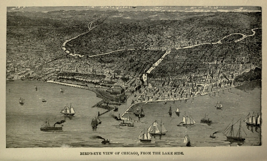
In 1827, Major Long, a government agent sent to visit the place, spoke of the site as "affording no inducements to the settler, the whole amount of trade on the lake not exceeding the cargoes of five or six schooners, even at the time when the garrison received its supplies from the Mackinac." In 1833 the tide of [Pg 161] immigration began. At the end of that year there were fifty families floundering in the Chicago mud. In 1834 there were nearly two thousand inhabitants of the town, and at the close of 1835 more than three thousand. In 1835-6 Chicago became the headquarters of a great land speculation. Multitudes of towns sprang up in every direction, on paper. The country was wild with excitement. Even eastern capitalists were seized with the mania, and fortunes were made and lost in this wild gambling in prospective cities. The bubble shortly burst, resulting in great business depression. The State was bankrupt, and Chicago languished. But not for long. Turning from the frenzy of speculation, its inhabitants wisely gave their attention to developing legitimate business interests. The United States had, in 1833, spent $30,000 in dredging out the Chicago River, and in the spring of 1834 a most timely freshet had swept away the bar at the mouth of the river, making it accessible for the largest craft. In 1838 a venturesome trader shipped from that port seventy-eight bushels of wheat. In 1839 four thousand bushels were sent. In 1842 the amount of wheat exported arose all at once from forty thousand bushels to nearly six hundred thousand bushels. In 1839 three thousand cattle were driven across the prairies, and sent to the eastern market; and every year thereafter showed a surprising increase. Yet with all this accumulating commerce, the streets of the city were still quagmires, and many a farmer came to grief with his load of grain within what is now city limits. Before there was a railroad begun or a canal finished, Chicago exported two and a quarter millions of bushels of grain in a year, and sent back on the wagons which brought it loads of merchandise.[Pg 162]
The Illinois River is connected with the Chicago River, and through that to Lake Michigan, by a canal which enters it at La Salle, ninety-six miles from Chicago. This canal was begun in 1836 and completed in 1848. It gave a fresh impetus to the youthful western town, and established its future prosperity. Connected as it already was with the east by the magnificent lake and river system of our northern borders, this canal opened up communication with the south and west, and made Chicago the portal, so to speak, between the different sections of our country.
In 1849 the first railroad had approached within ten miles of the city. In 1852 direct communication with the east was gained by the completion of the Michigan Central and Michigan Southern railroads, while more than one western railroad was projected, and some of them were in actual progress of construction. To-day, Illinois and its adjoining States are literally gridironed with iron roads, nearly all of which centre at Chicago. In 1857 there were living beside the still stagnant waters of the Chicago River one hundred thousand people.
In 1871 Chicago was the fourth city of the country, claiming a population of 334,000 persons. By a chef d'ouvre of engineering, the waters of the river had been turned backward, and made to carry away its sewage to fertilize the shores of the Illinois and the Mississippi. The streets had been drained, hollow places filled up, and their grade had been gradually raised, until it stood twelve feet higher than at first. Some of the buildings were raised at once to the latest established grade, and others remained as they had been built. The consequence was that the plank sidewalks became a series of[Pg 163] stairs, adapting themselves to the buildings which they fronted. The principal streets were paved with stone or with the Nicholson pavement. The triple river was spanned by no less than seventeen drawbridges, while two tunnels afforded uninterrupted travel between the opposite sides. Efficient waterworks had been constructed to provide pure water for the use of the city. The total trade for the year previous to the great fire was estimated at $400,000,000. Its grain trade had reached such enormous proportions that seventeen large elevators, with an aggregate capacity of 11,580,000 bushels were required for its accommodation. Eighteen banks were in operation, with an aggregate capital of $10,000,000 and with nearly $17,000,000 of deposits. The city was beginning to give its attention largely to manufactures, and its lumber trade had grown into something almost fabulous. Miles of lumber yards extended along one of the forks of the river, and its harbor was sometimes choked with arriving lumber vessels. In a single day, three or four years before the fire, a favorable wind blew into port no less than two hundred and eighteen vessels loaded with lumber. One hundred passenger and one hundred and twenty freight trains arrived and departed daily; and seventy-five vessels unloaded and loaded at her wharves every twenty-four hours.
Chicago Redivivus should bear upon her shield a cow rampant. On the evening of the eighth of October, 1871, Mrs. Scully's cow kicked herself into history, and Chicago into ruin and desolation. Chicago is divided by the river and its branches into three different sections, known as the north, south and west sides. The principal business portion of the city is on the south[Pg 164] side, and along the margins of the lake and streams. The "burnt district," which even yet the Chicagoan will outline to the visitor with peculiar pride, was confined almost wholly to the south and north sides.
On the evening of October seventh a planing mill had caught fire on the west side, and the conflagration had spread over a territory embracing about twenty acres, destroying a million dollars' worth of property. This fire, terrible as it seemed, probably saved the west side from destruction on that fatal night of the eighth, imposing as it did a broad banner of desolation, when the flames essayed to leap across the river.
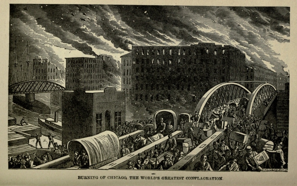
At about nine o'clock in the evening of Sunday, October eighth, 1871, a cow kicked over a lantern among loose, dry hay, in a stable at or near the corner of Jefferson and DeKoven streets, on the west side. There had been no rain of any consequence for fourteen weeks, and roofs and wooden buildings were as dry as tinder. There was a strong wind blowing from the southwest, and before the engines could reach the spot, half a dozen adjoining buildings were wrapped in flames. The buildings of that quarter were mostly of wood, and there were several lumber yards along the margin of the river. The flames swept through these with resistless fury, and then made a bold and sudden leap across the river into the very heart of the business portion of the south side. Many of the buildings here also were of wood, while the wooden sidewalks, and wooden block pavements, the latter filled with an inflammable composition, seemed constructed especially to aid and hasten the work of the flames. The fire marched steadily toward the north and east, [Pg 165] destroying everything in its course. Even fireproof buildings seemed to melt down as it touched them.
The wind increased to a gale, and all night long the fire wrought its terrible will, like a devouring demon; and at sunrise it had already leaped the narrow barrier of the river, and was devastating the northern side, sweeping away block after block of the wooden structures which occupied to a large extent that quarter of the city. The flames seized upon the shipping in the river, and when it left it only blackened hulls remained. The water supply, upon which the city had founded hopes in case of such extremity, failed. The walls of the buildings, weakened by the overpowering heat, had fallen in upon the engines, and hope was quenched in that quarter.
The flames spread southward as far as Taylor street, and to the northward they only paused when, at Fullerton avenue, the broad prairie lay before them, and there was nothing more to burn. The track of the fire was nearly five miles in length, running north and south, and averaged a mile in width. It continued from nine o'clock on Sunday night until daybreak Tuesday morning, and then nothing was left of all the business portion of Chicago, save a vast blackened field on which the flames still smouldered, with piles of rubbish, formed by fallen buildings, and here and there portions of walls still standing. Every bank, insurance office, hotel, theatre, railroad depot, law office, newspaper office, most of the churches, all but one of the wholesale stores, and many of the warehouses and retail stores, six elevators, fifty vessels, and sixteen thousand dwellings, including many elegant mansions, besides numberless humble homes, were destroyed; two hundred persons[Pg 166] killed, and a hundred thousand people suddenly found themselves homeless and penniless, without food to eat or clothes to wear.
The scenes accompanying the fire were terrible and heart-rending. They were a mingling of the horrible and grotesque, the tragic and the ridiculous, such as was probably never witnessed before on so grand a scale, and we trust will never be repeated; and over it all the smoke hung like a pall, stifling and blinding, and the flames cast a baleful glare, which lit up the scene and made it seem like a literal inferno.
The fire spread with a rapidity which baffled all attempts to check it. Many made a feeble effort to save their household goods, an effort which was too often futile, while others barely escaped with their lives, clad only in their scant night garments. The streets were filled with a frantic multitude; vehicles of every description, laden with movable property; men, women and children, some of them burdened with their belongings, and others nearly naked, forgetful of all but the terrible danger of the hour, all wild with the insanity born of fear, and all fleeing from the pursuing demon which pressed on behind them, and whose hot breath scorched their garments and singed their hair. Many took refuge in the river or the lake; but the hissing flames stooped down and licked the water, and the poor victims were made to feel the tortures of a double death. Very few of these escaped with their lives.
The progress of the flames was so swift that many were overwhelmed by the crumbling walls of their houses or workshops before they had time to escape, and found in them a fiery tomb. Others were suffocated by the smoke. Children were separated from[Pg 167] parents, and young and old sought safety wherever they could find it, and a mad panic reigned everywhere. Many saloons were thrown open, and whisky flowed freely, and the turbulent riot of drunkenness was added, to increase the confusion and despair of the dreadful night. Sneak thieves and larger depredators found spoil on every hand. In this terrible calamity each one seemed to throw off his mask, and become what he really was—the brave man, the noble gentleman, the selfish coward, the bully or the thief.
A single leaf of a quarto Bible, charred around its edges, was all that was left of the immense stock of the Western News Company. It contained the first chapter of the Lamentations of Jeremiah, which begins with the following words: "How doth the city sit solitary that was full of people! how is she become as a widow! she that was great among the nations, and princess among the provinces, how is she become tributary! She weepeth sore in the night, and her tears are on her cheeks: among all her lovers she hath none to comfort her."
The amount lost by the insurance companies, American and foreign, by the Chicago fire, was $88,634,133. More than 2,200 acres were swept by the flames in the space of thirty hours. The value of buildings alone consumed was estimated at $75,000,000, while their contents were at least as much more. The total loss probably was not much less than $200,000,000.
No sooner had the news of the dreadful calamity gone abroad to the world, than the spirit of generosity prompted efficient aid from all quarters. St. Louis, Milwaukee, Cincinnati, Cleveland, New York, Boston, Philadelphia, Pittsburg, Montreal, cities and towns in[Pg 168] the north, south, east and west, sent generous, and some of them princely, donations. Even China forwarded $1,290. By December first the public cash donations had reached $2,508,000. The naked were clothed, the hungry fed, the homeless housed in at least temporary quarters, and Chicago set herself to the task of reconstruction.
The smouldering ruins were yet glowing with heat, and the smoke was still ascending here and there, when, on Wednesday morning, the work of regeneration began. Within a month, five or six thousand temporary tenements had been erected. Meantime the foundations for the permanent structures were being laid, on a scale far surpassing those of the past. In a year not a trace of the fire remained.
Nearly three years later, on July fourteenth, 1874, another great fire swept over the devoted city, destroying eighteen blocks, or sixty acres, in the heart of the city, and about $4,000,000 worth of property. Over six hundred houses were consumed, but by far the larger number were mere wooden shanties.
To-day Chicago counts her great fire as one of her chief blessings. The city is entirely rebuilt, but not with rickety wooden structures, the previous plenitude of which had rendered her so easy a prey to the devouring element. Solid, substantial, handsome, and in many instances magnificent, the stranger can scarcely realize that these blocks of buildings are not the growth of a century, or of a generation even, but have sprung from the ground almost in a night. The new Chicago is surpassingly beautiful and grand. The visitor will walk through squares and squares of streets, each teeming with life and commercial activity, and bearing no trace,[Pg 169] save in increased elegance, of the disaster of little more than a decade ago; and is forced to the conclusion that, for courage and enterprise, Chicago has proved herself unsurpassed by any city in the world.
Chicago has a water frontage of thirty-eight miles, of which twenty-four are improved, without including the lake front, where an outer harbor is in process of construction. The rivers are now spanned by thirty-five drawbridges, while a tunnel, 1,608 feet long, with a descent of forty-five feet, connects the south and west sides of Washington street, and another tunnel, with a total length of 1,854 feet, connects the north and south sides on the line of La Salle street.
State street, on the south side, is the Broadway of Chicago. Randolph street is famous for its magnificent buildings, among which are the city and the county halls. Washington street is one of the fashionable promenades, lined with retail stores, though Dearborn street closely rivals it. The United States Custom House and Post Office, a magnificent structure, costing upward of $5,000,000, occupies the square bounded by Clark, Adams, Jackson and Dearborn streets. The Chamber of Commerce, a spacious and imposing building, with elaborate interior decorations, is at the corner of Washington and La Salle streets, opposite City Hall Square. Its ceiling is frescoed with allegorical pictures representing the trade of the city, the great fire and the rebuilding. The Union Depot, in Van Buren street, at the head of La Salle, is among the finest buildings of the city. The Exposition Building is a vast ornate structure of iron and glass, occupying the lake front, extending from Monroe to Jackson street, and with a front of eight hundred feet on Michigan avenue. The centre of[Pg 170] the edifice is surmounted by a dome one hundred and sixty feet high and sixty feet in diameter. Annual expositions of the art and industry of the city are held here every autumn.
Among the hotels of Chicago the Palmer House takes the lead. This house was destroyed by the fire, but has been rebuilt with a magnitude and elaborateness far exceeding its former self, and constituting it one of the finest, if not the finest, in the world. It is entirely fireproof, being constructed only of incombustible materials, brick, stone, iron, marble and cement. It has three fronts, on State and Monroe streets and Wabash avenue, and the building and furnishing cost $3,500,000. It is kept on both the American and European plans, and continually accommodates from six hundred to one thousand guests. The Grand Pacific Hotel is but little inferior to the Palmer House. It occupies half the block bounded by Jackson, Clark, Adams and La Salle streets. The Sherman and Tremont Houses are fine hotels and centrally located.
There are about three hundred churches in Chicago, including those untouched by fire and those which have been since rebuilt. The great Tabernacle, on Monroe street, where Messrs. Moody and Sankey held their meetings, is used for sacred concerts and other religious gatherings, and will seat ten thousand persons.
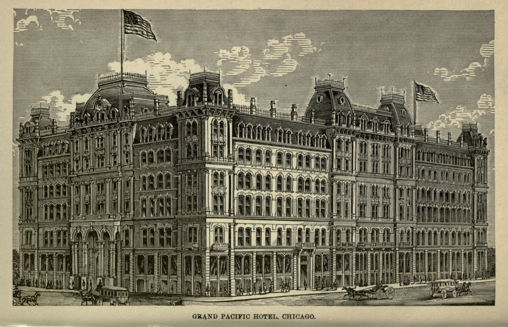
In literary and educational institutions Chicago holds a foremost place. Its common schools are among the best in the country, with large, handsome, convenient and well-ventilated buildings. The University of Chicago, founded by the late Stephen A. Douglas, occupies a beautiful site overlooking the lake, and boasts the largest telescope in America. It has a Public [Pg 171] Library containing 60,000 volumes. The Academy of Sciences lost a valuable collection of 38,000 specimens in the fire, but has erected a new building and is slowly gathering a new museum and library. There are three Theological Seminaries, and three Medical Colleges, three hospitals, and a large number of charitable institutions within the city. The fire department is most efficiently organized, and its annual expenses are scarcely less than $1,000,000.
Chicago has the most extensive system of parks and boulevards of any city in the United States. Lincoln Park, lying upon the lake to the northward, contains 310 acres, and served, during the great fire, as a place of refuge for thousands of people driven thither by the raging element. The Lake Shore Drive, the great north side boulevard, extends from Pine street to Lake View, and is one of the finest drives in the world. Humboldt Park, Central Park and Douglas Park extend along the western boundaries of the city, are large, contain lakes, ponds, walks, drives, fountains and statuary, and are connected with each other by wide and elaborately ornamented boulevards. The great South Parks are approached on the north by Drexel and Grant Boulevards. Drexel Boulevard is devoted exclusively to pleasure, all traffic over it being forbidden. The most southerly of the two south parks extends upwards of a mile and a half along the shore of the lake. Union Park is located in the very centre of the residence portion of the west side.
Whatever Chicago accomplishes is on so gigantic a scale that strangers almost hold their breath in astonishment. Among the titanic achievements of this youthful giant are the waterworks, which supply pure[Pg 172] drinking water to its six hundred thousand population. The water supply is by means of a tunnel sent out under Lake Michigan for a distance of two miles, the water being forced by numerous engines into an immense standpipe, 154 feet high. The works are situated at the foot of Chicago avenue. In tunneling under the lake, excavations went on simultaneously at the land end and two miles out in the lake; and so accurate were the calculations that when the two tunnels met in the centre, they were found to be but seven and one-half inches out of the line, and there was a variation of but three inches in the horizontal measurements. This tunnel, which is made of iron, protected by heavy masonry, is large enough for a canoe to pass through it when it is but partially filled with water, it being nine feet in diameter. The exit at the lake end of the tunnel is protected by a breakwater, and securely anchored to its place by means of heavy stones. Storms never affect it, save sometimes to produce a light tremor; and even large fields of ice, which grate by it with a fearful, crunching noise, have thus far failed to shake its foundations.
Chicago ships a considerable portion of her grain in the shape of flour, there being extensive flouring mills in the city. The present annual export of flour is probably not less than 3,000,000 barrels. Chicagoans have also found it possible to pack fifteen or twenty bushels of corn in a single barrel. "The corn crop," remarks Mr. Ruggles, "is condensed and reduced in bulk by feeding it into an animal form, more portable. The hog eats the corn, and Europe eats the hog. Corn thus becomes incarnate, for what is a hog but fifteen or twenty bushels of corn on four legs?" The business of pork-packing[Pg 173] has attained enormous proportions in Chicago. It has entirely superseded Cincinnati, the former "Porkopolis," in this branch of trade. Cincinnati, Louisville, St. Louis, Indianapolis and Milwaukee do not together furnish a total number of head slaughtered equal to that of Chicago.
The stock yards, just outside the city limits on the southwest, are the largest in the world. They cover hundreds of acres, and constitute what has been styled "The Great Bovine City of the World." This bovine city is regularly laid out in streets and alleys crossing each other at right angles. The principal street is called Broadway, and it is a mile long and seventy-five feet wide. On either side are the cattle pens, and it is divided by a light fence into three paths, so that herds of cattle can pass one another without wrangling, and leave an unobstructed road for the drovers. These yards are connected with all the railroads in the west centering in Chicago. The company have twenty-five miles of track. A cattle train stops along the street of pens; the side of each car is removed, and the living freight pass over a declining bridge into clean, planked inclosures, where food and water is quickly furnished them. A large and comfortable hotel furnishes accommodation for their owners; there is a Cattle Exchange, a spacious and elegant edifice; a bank solely for the cattle-men's use; and a telegraph office, which reports the price of beef, pork and mutton from all parts of the world. The present capacity of the yards is 25,000 head of cattle, 100,000 hogs, 22,000 sheep, and 1,200 horses. A town of five thousand inhabitants has grown up in the immediate vicinity of these stock yards.
In some of the yards not less than five hundred beeves[Pg 174] are slaughtered daily. Much of this beef is sent in refrigerator cars to the Atlantic cities, while enormous quantities are cooked and packed in cans and sent all over the world.
Suburban towns have spread out from Chicago, in every direction, over the prairie. South Chicago, one of the principal of these, is twelve miles to the southward, at the mouth of the Calumet river, and has a large amount of capital invested in iron and steel works. The sloughy morasses which still exist between the parent city and its thrifty offshoots are fast being filled up, and bridged over with pavements, so that the mud, which a generation ago was the chief distinguishing feature of Chicago and its vicinity, but which is now confined to outlying sections, will soon be a thing of the past. Chicago is itself extending rapidly in all directions, and numberless suburban streets are lined with pretty cottages, whose rural surroundings have given to the city its appropriate name of "The Garden City."
Taking its past as a criterion, who shall dare to predict the future of Chicago? It has by no means come to a stand-still, but is to-day increasing its population, developing its resources, and extending its commercial enterprises to a degree that is scarcely credible, save as one is faced by actual facts and figures. These miles of streets, filled with the incessant roar of business; these lofty temples, magnificent warehouses and elegant residences; these public institutions of learning; this gigantic commerce, this high degree of civilization; all of which have been attained by older cities after a prolonged struggle with adversity, are here the creations and accumulations of less than two[Pg 175] generations. Up the Chicago River, where considerably less than a century ago the Indian paddled his solitary canoe, and John Jacob Astor annually sent his single small schooner to bring provisions to the garrison and to take away his furs, there swarms a fleet of vessels of all descriptions, bringing goods from, and sending them to, every quarter of the world. Where, no later than 1834, a grand wolf hunt was held, and one bear and forty wolf scalps were the trophies of the day, the bears of the Stock Exchange alone rage and howl, and the only wolves are human ones. Chicago is a great and a magnificent city, embodying more perfectly than any other in the world the possibilities of accomplishment of the Anglo-Saxon race, given its best conditions of freedom, independence and intelligence.
Location of Cheyenne.—Founding of the City.—Lawlessness.—Vigilance Committee.—Woman Suffrage.—Rapid Increase of Population and Business.—A Reaction.—Stock Raising.—Irrigation.—Mineral Resources.—Present Prospects.
Cheyenne is the half-way house, on the Union Pacific Railroad, between the civilization of the East and that of the West. It is situated on Crow Creek, a branch of the South Platte River, just at the foot of the Rocky Mountains. A few miles away to the westward the ascent of the Black Hills begins, the road ascending over the rugged granite hills, and winding in and out of miles of snow sheds. It is five hundred and sixteen miles from Omaha, and has an elevation of more than six thousand feet above the sea, being one thousand more than Denver, and with an atmosphere proportionately rarer and dryer.
The city is a child of the Pacific Railroad, being, during the building of that road, its winter terminus. When it was found that Cheyenne was probably to become an important railroad point, there was a grand influx of roughs, of all classes and of both sexes, to the spot. Habitations sprang up as if by magic, and were of the rudest construction, some of them being mere dug-outs in the sand hills. Town lots ran up to fabulous prices. The first city government was organized in August, 1867, and the first newspaper, the Cheyenne Leader, published on the nineteenth day of the following[Pg 177] month. On the thirtieth of November, 1867, the track layers reached the city limits, and were greeted by music and a grand demonstration on the part of the people. The first passenger train arrived the next day.
In the winter of 1868 Cheyenne contained not less than six thousand inhabitants. Lawlessness was the order of the day, and gambling, drinking and shooting were the favorite recreations. Knock-downs and robberies were matters of course, and murders of too frequent occurrence to cause special excitement. During these early days of its history the young city acquired two names, both of which were exceedingly suggestive, not to say appropriate. Its rapid growth fastened upon it the name of "Magic City of the Plains;" the desperate character of its inhabitants, that of "Hell on Wheels."
When the city was but six months old, the patience of the order-loving people was tried beyond endurance. A Vigilance Committee was formed, and justice came swift and sure, without the intervening and delaying processes of the law. Its first public demonstration occurred in the following manner. Three men had been arrested on January tenth, 1868, charged with stealing $900, and put under bonds to appear at court. On the morning of the day after their arrest they were found on Eddy street, walking abreast and tied together, with a placard attached to them, bearing the following inscription, in conspicuous lettering: "$900 stole; $500 returned; thieves, F. S. Clair, W. Grier, E. D. Brownville. City authorities, please not interfere until 10 o'clock A. M. Next case goes up a tree. Beware of Vigilance Committee." During that year no less than twelve desperadoes were hung and shot, and five sent to the penitentiary, through the agency of the Vigilance[Pg 178] Committee. The condition of affairs was at once materially improved.
In 1871 the Territorial Legislature passed a bill giving universal suffrage, without distinction of sex. The ladies at once made use of their newly-acquired political right, with an earnestness and universality entirely unexpected by those who had conferred its exercise upon them. In their capacity as grand jurors, they closed every gambling saloon and brothel in the city, put restrictions upon the liquor traffic, brought criminals to justice who had heretofore defied the law, and, in brief, made a clean sweep of the city, raising its social and moral standard. Women of all classes voted, and, strange to say, even the worst women voted for law and order. Political parties found it necessary to put up men with a good moral record, as well as those politically sound, for the women would not vote for a bad man. All classes recognized the good results of woman suffrage, and all opposition to it was speedily overcome.
Cheyenne is now one of the best governed and most orderly cities in the country; and every Governor of the Territory, whatever his political complexion, has given his unqualified testimony in favor of women at the polls. Women not only deposit their ballots unmolested, but are treated with the utmost courtesy, and the polling places are made comfortable, and even elegant, for their reception. It is no uncommon thing for husband and wife to vote opposing tickets, but no divisions or even disturbances in families have resulted, thus far.
On the first of July, 1867, there was but one house in Cheyenne, standing on what is now Eddy[Pg 179] street, between Sixteenth and Seventeenth streets, built of logs, smoothly plastered outside and in, and owned by Judge J. R. Whitehead. Six months thereafter there were no less than three thousand houses in the city. The first lots were offered for sale in July, 1867, at one hundred and fifty dollars. Thirty days afterward they sold at one thousand dollars each, and in two or three months later for two thousand five hundred and three thousand dollars. Stores were erected with marvelous rapidity, in its early history, a good-sized and comparatively substantial warehouse being put up in forty-eight hours. The business of the first six months was enormous, single houses making sales of from ten thousand to thirty thousand dollars per month. In two months after the Post-Office was established, it averaged twenty-six hundred letters a day.
As the railroad progressed westward across the mountains, and finally reached the Pacific, Cheyenne suffered a reaction from its sudden and wonderful prosperity. The road took much of its business with it, and the town fell dead. But the discovery of gold in the Black Hills gave a fresh impetus to its business interests. It is also located in the midst of a great stock-raising region, and is surrounded by ranches of stock-men engaged in raising cattle, horses and sheep for market. The cattle and horses find sustenance the year round in the native grasses, and Cheyenne is the natural centre and trading post of these ranch-men. Each year the business increases, and the shipments from the city become larger. Wool is becoming an important export, being produced in great quantities on the large sheep farms.
The railroad has constructed extensive machine and[Pg 180] repair shops at Cheyenne, which furnish employment for a large number of workmen. The rickety structures of its early days are fast giving place to substantial brick buildings. There is a fine Court House and Jail, a City Hall, Opera House, and several Public School buildings. In proportion to its population, Cheyenne has now more substantial and handsome business houses than any other western city.
Stock raising is the only agricultural pursuit for which Wyoming is adapted. The soil about Cheyenne is barren, and in no way suited for farming purposes. The rainfall during the year is very slight, and it has been found necessary to resort to irrigation. Therefore, ditches run through the streets, supplying water for the gardens throughout the city, and, by means of this irrigation, what was once a desert is becoming green with trees and shrubbery.
The mineral resources of Wyoming are very rich. Silver and gold are both found in the ranges of hills and mountains to the north and west. Moss agates, opals, topaz, garnets, amethysts, onyx and jasper have all been found in the immediate neighborhood of Cheyenne, and some of the specimens are exceedingly beautiful.
The high elevation of the city gives it a delightful climate. The winters are mild, and the summers free from excessive heat.
Cheyenne has a special niche in my memory, since, in making my horseback journey from the Atlantic to the Pacific, in 1876, it was the last place at which I dined before entering the Black Hills and falling into the hands of the treacherous Arrapahoes.
The rapid growth which Cheyenne made at the[Pg 181] beginning of her existence, and the feverish activity of her business enterprises, have given place long since to a slower but more healthy life and development. Her trade interests are being placed on a firmer foundation, and when the resources of the surrounding country are utilized to the fullest advantage of the city, its prosperity will be assured.
Detroit and Her Avenues of Approach.—Competing Lines.—London in Canada.—The Strait and the Ferry.—Music on the Waters.—The Home of the Algonquins.—Teusha-grondie.—Wa-we-aw-to-nong.—Fort Ponchartrain and the Early French Settlers.—The Red Cross of St. George.—Conspiracy of Pontiac.—Battle of Bloody Run.—The Long Siege.—Detroit's First American Flag.—Old Landmarks.—The Pontiac Tree.—Devastation by Fire.—Site of the Modern City.—New City Hall.—Public Library.—Mexican Antiquities.
Four lines of railway leading westward from Niagara, place Buffalo and Detroit en rapport with each other, through their connecting steel rails, and compete for the patronage of the traveler. In addition to this, there are not less than two lines by water, thus affording the tourist—if he develops a desire to tempt the waves of Old Erie—ample scope for his choice. The Lake Shore route takes one through a continuous succession of ever-changing landscapes on the southern shore of Lake Erie, and skirts the two great States of Ohio and Pennsylvania before reaching Michigan. It is, perhaps, the preferable route by rail, looking at it from a purely æsthetic standpoint. The Great Western Road crosses, at Suspension Bridge, the famous chasm cut by Niagara, in its recession from Ontario, and gives a faint conception, as seen in the distance, of the glorious Falls themselves. The roar and rush of water—at the rate of twenty-five million[Pg 183] tons per minute—is borne down the deeply-cut channel, and clouds of spray are visible from the car windows. Below the bridge the swift drifts and eddies can be seen foaming on their way to the whirlpool, a mile and a half further down. This route also takes the traveler through London, Canada, a quaint old English town of twenty thousand inhabitants, on the Thames River. The place is brimming over with localities the names of which, carried in the affections of her settlers across the ocean, serve as reminders of the old London left forever behind them on Britannia's Isle. Blackfriar's Bridge and Westminster Bridge both cross the new Thames, and Kensington and Covent Garden market belong also to the transplanted nomenclature. On Saturdays the great square in the heart of the town is filled with marketers and hucksters of all descriptions, and every kind of merchandise, from a feather bed to a table knife, is there bought and sold. Squaws and Indians and quaintly dressed women commingle with the crowd and sell their various wares. The scene is very picturesque, and wears an atmosphere of being a hundred years old.
The Grand Trunk Road—the most northerly of the three routes leading through Canada—has nothing except its easy-going time to recommend it to favor. The traveler on this road stands a fair chance of missing his connecting links in the great railway chain which interthreads the continent east and west, or of being delayed for hours at a time by running off the rails. The Canada Southern is a newly completed road, and is said to be the most direct and shortest of all the competing lines. This route follows the windings of the northern shore of Lake Erie, just opposite from the Lake[Pg 184] Shore Road on the southern side, and the shifting landscapes are perhaps quite as full of natural beauty.
Detroit, the fair "City of the Strait," spreads itself along the river front for miles, and the approach from Windsor, on the opposite shore, is suggestive of the pictured lagoons of Venice, Queen of the Adriatic. The Detroit River, or strait, is one of the most beautiful water avenues west of the Hudson. It is from half a mile to a mile wide, is always of a clear green color, and is never troubled by sand bars or anything which might affect its navigation. It has an average depth of twenty-five feet at the wharves and perhaps forty or fifty feet in the centre of the river bed. No floods disturb its calm flow or change the pervading green of its waters. It is, with reason, the pride of the city, and the ferry boats of the several lines plying between Detroit and Windsor are of the most attractive type. In summer a corps of musicians are engaged for the regular trips, and are considered as indispensable to the boat's outfit as the captain or pilot. Their syren strains entice the lounger at the wharf, and he may ride all day, if he chooses, for the sum of ten cents. Whole families spend the day on the river, in this way, taking their dinner in baskets, as they would go to a picnic. The people of Detroit, perhaps, inherit the pleasure-loving characteristics of their French ancestors, or at least they do not seem to have their minds exclusively concentrated on the struggle after the almighty dollar.
Detroit, as the principal mart of the Peninsular State—the nucleus which gradually crystallized into the heart of Michigan—has an early history of thrilling interest; the site of the present populous city of a hundred and twenty thousand souls was long ago, in the shadowy[Pg 185] years of its Indian lore, the home of a dusky tribe of the Algonquin family—a race which was once as populous and widespread as the waves of the ocean.
In 1610 the first white man who set foot on these wild and unexplored shores found it occupied by the clustered wigwams of a peaceful Indian village named Teushagrondie.
Another of its ancient names was "Wa-we-aw-to-nong," meaning round by, in allusion to its circuitous way of approach.
In 1679, the Griffin, under La Salle—the first vessel that ever sailed these inland seas—anchored off the group of islands at the entrance to Detroit River. Peaceful Indian tribes were scattered along the banks, and the white man was received with friendly overtures.
In 1701, La Motte Cadillac founded Detroit. He erected a military fort on the site of the future city, which he named after his French patron, Pontchartrain. It was surrounded by a strong stockade of wooden pickets, with bastions at each angle. A few log huts[Pg 186] with thatched roofs of straw and grass were built within the enclosure, and as the number of settlers increased the stockade was enlarged, until it included about a hundred houses closely crowded together. The streets were very narrow, with the exception of a wide carriage road or boulevard which encircled the town just within the palisades. The object of the establishment of this military post was to aid in securing to the French the large fur trade of the northwest, and it was also a point from whence the early Jesuit fathers extended their missionary labors.
The little military colony was the centre of the settlement, and the Canadian dwellings were scattered up and down the banks above and below the fort for miles. The river almost washed the foot of the stockade—Woodbridge street being at that time the margin of the water—and three large Indian villages were within the limits of the settlement. Below the fort were the lodges of the Pottawattomies, on the eastern shore dwelt the Wyandots, and higher up Pontiac and the Ottawas had pitched their wigwams.
Fort Pontchartrain remained in the possession of the French until 1760, when, by the fall of Quebec, it fell into the hands of the British, and was surrendered to Major Robert Rogers on the twelfth of September. The Red Cross of St. George now supplanted the Fleur-de-lis of France, and the change to British rule was ill relished by the surrounding Indian tribes, who had been the firm friends and allies of the French. The well known Pontiac conspiracy grew out of this change of administration, and a general massacre of the whites was determined upon. Pontiac, chief of the Ottawas, was the leading spirit of the bloody plot, and so well[Pg 187] laid were his plans that ten out of the thirteen posts which were simultaneously attacked fell before their savage onsets. The post at Detroit, at that time under command of Major Gladwyn, was only saved through the timely betrayal of Pontiac's plot, by Catherine, a beautiful Ojibway girl, who dwelt in the village of the Pottawattomies, and who had become much attached to Major Gladwyn, of the Fort. The day before the intended massacre she brought him a pair of moccasins which she had made for him, and then revealed the intended surprise of Pontiac. The garrison and occupants of the fort were supported by two small vessels, the Beaver and the Gladwyn, which lay anchored in the river.
On the morning of May sixth, 1763, a large flotilla of birch canoes, filled with warriors lying flat on their faces, crossed the river above the Port, landing just beyond the banks of Bloody Run, or Parent's Creek, as it was then called. About ten o'clock, sixty chiefs, with Pontiac at their head, marched to the Port and demanded admittance. It was granted, but all preparation was made on the part of Gladwyn to repel the first sign of treachery. Every soldier was armed to the teeth, and the eagle eye of Gladwyn watched every movement of Pontiac, as that brave made a speech of mock friendship. When the savages discovered the failure of their plans, their disappointed rage knew no bounds, and after passing out of the gates of the Fort, their mad thirst for blood was only glutted by massacres of isolated families, and the tomahawk and scalping knife sealed the doom of many an unhappy victim who that day crossed the path of Pontiac's warriors.[Pg 188]
From this hour Detroit was in a state of siege, and for eleven long months the siege continued. Bravely the little band at the Fort held out until reinforcements arrived—Captain Dalzell, with a force of three hundred regulars, coming to their aid. A few days afterwards—at two o'clock on the morning of July thirty-first—an attack was made on the Indians, who were stationed along the banks of Parent's Creek, about a mile and a half from the Fort. The troops neared the narrow, wooden bridge which spanned the creek, when suddenly, in the gloom of night, the Indian war-whoop burst on their ears, and a blaze of leaden death followed. Captain Dalzell rushed to the front across the bridge, leading his men forward, but their foes were not to be seen.
Bewildered in the gloom, the English troops were obliged to fall back to the fort and wait for daylight before renewing the attack. Hundreds of Indians lay in ambuscade along the river, whither the soldiers were obliged to pass on their way to the Fort, and the creek ran red with their blood. The waters of the little stream, after this crimson baptism, were re-christened with the name of Bloody Run. The survivors entered the Fort next morning with a loss of seventy killed and forty wounded.
During the war of the Revolution, Detroit was subjected to greater annoyance from Indian tribes than before, but this was the only way in which the war affected it. Through the treaty of Greenville, made by General Wayne with the red men, in August, 1795, Detroit and all the region of the northwest became the property of the United States, and in 1796 Captain Porter, from General Wayne's army, took possession of[Pg 189] the post, and flung to the breeze the first American banner that ever floated over the soil of the Peninsular State.
"Pontiac's Grate" was the eastern entrance to the town, and occupies the site of the old United States Court House. In 1763, a rude chapel stood on the north side of St. Ann street—nearly in the middle of the present Jefferson avenue—while opposite was a large military garden, in the centre of which stood a block house, where all the councils with the Indians were held. These were the only public buildings in the town.
The "Pontiac Tree," behind which many a soldier took shelter on the night of the bloody battle at Parent's Creek, and whose bark is fabled to have been thickly pierced with bullets, stood as an old landmark for years, on the site of the ancient field of conflict, and many a stirring legend is told of it.
On June eleventh, 1805—just five months after Michigan was organized as a territory—Detroit was laid in ruins by a wholesale conflagration, which left only two houses unharmed. An act of Congress was passed for her relief, and thus, through baptisms of fire and blood, and through tribulation, has she arisen to her present proud estate. The stranger landing on these shores now is struck with the handsome general appearance of the city—its clean, wide streets, varying in width from fifty to two hundred feet—its elegant business blocks and pervading air of enterprise. The ground on which the city stands rises gradually from the river to an elevation of thirty or forty feet, thus affording both a commanding prospect and excellent drainage. Detroit is an authorized port of entry, and is[Pg 190] about seven miles distant from Lake St. Clair and eighteen miles from Lake Erie. Ship and boat building has been an extensive branch of business here, and in 1859 there were nine steam saw mills located in the city, sawing forty million feet of lumber annually. There are also works for smelting copper ore two miles below the city, or rather within that suburban portion of the city known as Hamtramck.
Among the first objects of interest which attract the stranger's attention are the new City Hall and the Soldiers' Monument. The City Hall, fronting on one side of the square known as the Campus Martius, is a structure of which any city in the land might be proud. It is built of Cleveland sandstone, and faces on four streets,—being two hundred feet long on Woodward avenue and Griswold street, with a width of ninety feet on Fort street and Michigan avenue.
It is built in the style of the Italian renaissance, with Mansard roof and a tower rising from the centre of the building, adorned at its four corners with colossal figures fourteen feet high, representing "Justice," "Industry," "Arts," and "Commerce." Its height from the ground to the top of the tower is a hundred and eighty feet, and the three ample stories above the basement furnish accommodation to the city and county offices, in addition to the Circuit and Recorder's Courts. The walls are frescoed, the floors laid in mosaics of colored marbles, and the Council Chamber and other public rooms are furnished with black walnut chairs and desks, and paneled in oak. With these exceptions, there is no woodwork about the immense building. Everything, from basement to dome, is brick and iron and stone. Even the floors are built in delicate arches[Pg 191] of brick and iron, and iron staircases follow the windings of the tower to its dizzy top. It is reckoned fireproof. The exterior is curiously carved, and two large fountains adorn the inclosing grounds. The estimated cost of the building is about six hundred thousand dollars.
From the airy outlook of the City Hall Tower, Detroit appears like a vast wheel, many of whose streets diverge like spokes from this common centre, reaching outward until they touch, or seem to touch, the wooded rim of the distant horizon. The hub of this immense wheel is the triangular open space called the Campus Martius, and the Soldiers' Monument, occupying the centre of the Campus Martius, is also the centre of this imaginary hub. Michigan avenue—one of the long arms of the wheel—loses itself in the western distance, and is called the Chicago road. Woodward avenue leads into the interior, toward Pontiac, and Gratiot avenue goes in the direction of Port Huron. Fort street, in yet another direction, guides the eye to Fort Wayne and the steeples of Sandwich, four miles away. Toward the southern or river side of the city, the resemblance to the wheel is nearly lost, and one sees nothing but compact squares of blocks, cut by streets crossing each other at right angles and running parallel and perpendicular to the river. Between the Campus Martius and Grand Circus Park there are half a dozen or more short streets, which form a group by themselves, and break in somewhat on the symmetry of the larger wheel, without destroying it. This point gives the best view of Detroit to be obtained anywhere about the city.
The Soldiers' Monument is a handsome granite structure, fifty-five feet in height, the material of which[Pg 192] was quarried from the granite beds of Westerly, Rhode Island, and modeled into shape under the superintending genius of Randolph Rogers, of Rome, Italy. It is surmounted by a massive allegorical statue, in bronze, of Michigan, and figures of the soldier and sailor, in the same material, adorn the four projections of the monument; while bronze eagles with spread wings are perched on smaller pedestals in the intermediate spaces. Large medallions, also in bronze, with the busts of Grant, Lincoln, Sherman and Farragut, in low relief, cover the four sides of the main shaft, and higher up the following inscription is imprinted against the white background of granite:—
"Erected by the people of Michigan
in honor of the martyrs who fell
and the heroes who fought
in defence of Liberty and Union."
The bronzes and ornaments were imported from the celebrated foundry at Munich, Bavaria, and the cost of the monument—donated exclusively by private subscription—amounted to fifty-eight thousand dollars. The unveiling of the statue took place April ninth, 1872.
Another feature of the city is the Public Library, founded in March, 1865, and at present occupying the old Capitol, until the new and elegant Library building now in process of construction is completed.
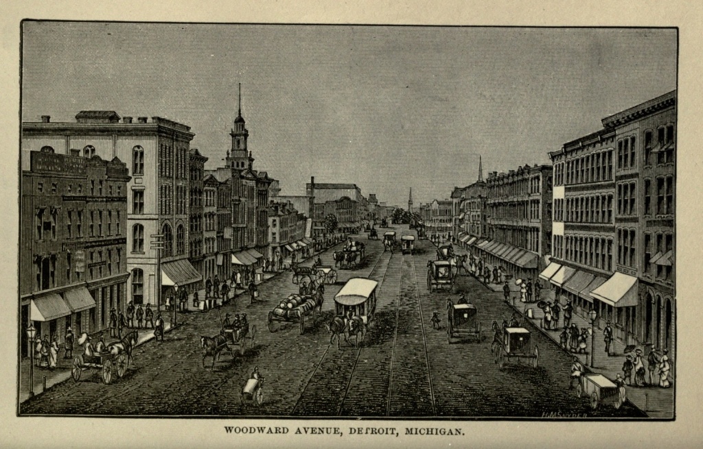
Beginning entirely without funds, ten years ago, it can now exhibit a muster roll of twenty-five thousand volumes, and is fairly started on the high road to fortune. There is a kind of poetic justice in the fact that its principal source of revenue accrues from county fines and penalties. Here is a knotty question for the [Pg 193] divinity doctors, for in this case, at least, good is born of evil. The library is under the control of the Board of Education, and was given an existence from the State constitution. Some very rare volumes of Mexican antiquities have recently been purchased from England by the School Board and added to the library, at a cost of four hundred dollars. They contain a pictorial and hieroglyphic history of the Aztec races occupying Mexico when Cortes came over from a foreign shore with his Spanish galleons. The earliest date goes back to 1324, and the strange figures in the centre of the page are surrounded by devices indicating cycles of thirteen years, four of which made a great cycle, or a period of fifty-two years. The deeds of the Aztec king, Tenuch, and his successors, are here recorded, and through the efforts of an English nobleman who devoted his life to these researches, we have the translation rendered for us.
The city has a scientific association, two years old, and also a Historical Society, in which her citizens manifest considerable pride.
Detroit has been called, with reason, one of the most beautiful cities of the West. Transformed from the ancient Teushagrondie into the present populous "City of the Strait," she sits like a happy princess, serene, on the banks of her broad river, guarding the gates of St. Clair. Backed by a State whose resources are second to none in the Union, emerging from an early history of bloody struggle and battle, rising like the fabled Phœnix, from the ashes of an apparent ruin, contributing her best blood and treasure to the war for liberty and union, she may well be proud of her past record, her present progress, her advancement toward a high civilization and her assured position.
Decoration Day in Pennsylvania.—Lake Erie.—Natural Advantages of Erie.—Her Harbor, Commerce, and Manufactures.—Streets and Public Buildings.—Soldiers' Monument.—Erie Cemetery.—East and West Parks.—Perry's Victory.
I took my fourth ride from Buffalo westward, on the Lake Shore Road, on the afternoon of May twenty-ninth, 1875, the day set apart that year by the patriotic citizens of Pennsylvania, for the decoration of her soldiers' graves. Passing the State line or boundary between New York and Pennsylvania, a little beyond Dunkirk, an unusually large assemblage of citizens and soldiers, with bouquets and a great profusion of flowers, at nearly every station, betokened the earnest patriotism of the old Keystone State. Pennsylvania will never be behind her sister States in doing honor to the brave men who gave up their lives while fighting her battles; and the demonstrations of each Decoration Day are evidences that she will not soon forget their deeds, or their claim upon her deepest gratitude.
A beautiful sight opens to the view of the tourist as he turns his eye toward the broad, blue expanse of the lake, which may be seen at intervals from the car windows, from Buffalo to Toledo. The mind is quite naturally occupied with grand commercial schemes, on viewing such wonderful facilities for the promotion of enterprise. We have here, in Lake Erie, the connecting link in a chain of fresh-water oceans, which stretch from[Pg 195] the Atlantic, westward, almost to the Rocky Mountains. Our internal prosperity is largely due to this great chain of lakes, which secure and facilitate cheap transportation, and have made possible the great inland cities, the pride of our Middle States.
Erie is an intermediate point between Buffalo and Cleveland, and having a most excellent harbor, would seem destined to take rank among the first cities of America. But by that inscrutable law which, seemingly beyond reason, governs and controls the foundation and growth of cities and towns, natural advantages do not always seem to count; and as a large fish swallows a smaller one, so has Erie been dwarfed by her older rivals, who, getting an earlier foothold upon the shore of the lake, have absorbed its trade, and continued to maintain the advantage they at first secured. An increase of commerce on Lake Erie will undoubtedly throw a share to the city of Erie, and thus she may eventually succeed in occupying the position to which her harbor and railroads entitle her.
Erie is on the lake, about midway of the brief stretch of shore which the narrow section of Western Pennsylvania, jutting up between New York and Ohio, secures to that State. It is her only lake town of any importance, is a port of entry, and has a population of nearly thirty thousand inhabitants. The harbor is the largest and best on Lake Erie. It is about four miles in length, one mile in width, and in depth varying from nine to twenty-five feet, thus permitting access to the largest lake vessels. It is formed by an island four miles in length, which lies in front of the city, and which, from its name of Presque Isle, indicates that within the memory of man it has been a peninsula. The bay is[Pg 196] known as Presque Isle Bay. It is protected by a breakwater, and three lighthouses guard the entrance. Several large docks, furnished with railroad tracks, permit the transfer of merchandise to take place directly between the vessels and the cars. The terminus of the Philadelphia and Erie Railroad, and connected by the Lake Shore Railroad with all important points in the east and west, the city is fast developing into a strong commercial centre. A canal connecting with Beaver River, a tributary of the Ohio, facilitates commerce in the western section of Pennsylvania, and furnishes extensive water-power, of which various kinds of mills avail themselves. These mills and the many factories and foundries of the city—for Erie is a manufacturing town of considerable importance—produce iron ware, cars, machinery, organs, furniture, brass, leather, boots and shoes, and send them, by the various methods of transportation, to markets in the States and Canada. The great forest and mining regions of Pennsylvania find, at Erie, an outlet for their lumber, coal and iron ore; while the numerous productive farms which lie in the vicinity of the lake send quantities of grain to be shipped at this port.
The city is built upon an elevated bluff, commanding an extensive view of the lake. It is regularly laid out, with broad streets crossing each other at right angles, and its general appearance is prosperous and pleasing. In the centre of the city are the Parks, two finely shaded inclosures, intersected by State street, and surrounded by handsome buildings. A Soldiers' Monument stands in one of them, erected to commemorate the memory of the brave men who fell in the War of the Rebellion. It is surmounted by two bronze statues of heroic size. There[Pg 197] are also two handsome fountains within the Park inclosure. Near by is the classic structure used as a Court House. The Custom House is erected in a substantial style, near the shores of the lake. A new Opera House is also one of the features of the city. The Union Depot is an immense building, nearly five hundred feet in length, in the Romanesque style, two stories in height and surmounted by a cupola forty feet high. State street is the principal business thoroughfare.
The Erie Cemetery, on the south side, is one of the most beautiful in the country. It is on a bluff overlooking the city and the lake, and comprises seventy-five acres, in which tree-shaded walks, elegant drives, velvet turf, running water, masses of shrubbery and brilliant flowers, together with the plain white headstones and the elaborate monuments which mark the resting-places of the dead, are united in a harmonious effect, which is most satisfactory to the beholder. Erie is very proud of this cemetery, and spares no pains to perfect it, while every year adds to its beauty.
East and West Parks lie, as their names indicate, in opposite directions within the city, and are beautiful breathing places where its citizens resort for rest and recreation. Art has joined with nature in rendering these places attractive, and their trees, shrubbery, lawns, walks and drives, and general picturesqueness, combine to make them very charming spots.
Erie has historical associations which render her of interest to one who would gather facts concerning his country. Lake Erie was the scene of a naval engagement between the British and Americans, on September tenth, 1813, in which the latter were victorious. Commodore Perry, in command of the American fleet,[Pg 198] sailed from this port on the memorable day, and when the engagement was concluded, brought thither his prizes. Several of his ships sunk in Lawrence Bay, and in fair weather the hull of the Niagara is still visible.
The development of Western Pennsylvania is contributing more and more, as the years go by, to the prosperity of Erie. Her exceptionally fine harbor is already beginning to be recognized by commerce, and though the city may never rival Cleveland or Buffalo, the time may come when Erie will take rank as only second to them on Lake Erie, in commercial importance.
A Historic Tree.—John Harris' Wild Adventure with the Indians.—Harris Park.—History of Harrisburg.—Situation and Surroundings.—State House.—State Library.—A Historic Flag.—View from State House Dome.—Capitol Park.—Monument to Soldiers of Mexican War.—Monument to Soldiers of Late War.—Public Buildings.—Front Street.—Bridges over the Susquehanna.—Mt. Kalmia Cemetery.—Present Advantages and Future Prospects of Harrisburg.
A century and a half ago, John Harris, seeking traffic with the red men of the Susquehanna, built a rude hut, dug a well, and thereby began a work which, taken up by his son, led to the founding of the Capital City of Pennsylvania, a city destined to take rank among the first of a great State. The stump of an old tree, in a beautiful little park which skirts the Susquehanna, on a line parallel with Front street, marks the scene of an early adventure of Harris with the Indians, and tells the stranger of his birth and death. About 1718 or 1719, Harris, who had settled at this point on the Susquehanna, as a trader, was visited by a predatory band of Indians returning from the "Patowmark," who made an exchange of goods with him, for rum. Becoming drunken and riotous, he finally refused them any more liquor, when they seized him and bound him to a tree, dancing around their captive, until he thought his last day had come. His negro servant, however, summoned some friendly Shawnees from the opposite side of the river, who, after a slight[Pg 200] struggle with the drunken Indians, rescued Harris from his bonds and probably from a death by torture. The stump referred to is that of the historical tree, which was a gigantic mulberry, eleven feet seven inches in circumference. Here also is the grave of Harris, which is surrounded by a strong iron fence, and a young mulberry tree has been planted, by one of his descendants, to take the place of the one whose trunk alone stands as a monument of the past.
During the summer months this romantic spot is the favorite resort of the boys and girls of the neighborhood, and whenever the weather is favorable, a large troop of juveniles may be seen spinning their tops, rolling their hoops and playing at croquet on the lawn. What a contrast is here unfolded to the imagination, as we stand at the grave of the venerable pioneer, and contemplate the wonderful change that has characterized the progress of events during the past hundred years. But little more than a century ago there was a solitary trader with his family upon the borders of a great river in the wilderness. His goods were brought on a pack-horse, and his ferry was a row boat. To-day a thriving, beautiful city takes the place of the log cabin; children sport where once the treacherous Indian sought the life of the hardy frontiersman; the river is spanned by wonderful bridges; and a hundred railroad trains pass through its streets in the course of twenty-four hours.
Harrisburg was laid out by John Harris, Jr., the son of the pioneer, in 1785; it was incorporated as a borough in 1791; became the State Capital in 1812; and received a city charter in 1860. Its population in 1880 numbered more than thirty thousand persons.
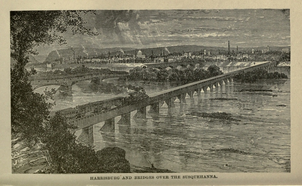
Harrisburg is most picturesquely situated, on the [Pg 201] Susquehanna River, at the eastern gateway of the Alleghenies. The river is here a mile wide, shallow at most seasons of the year, but capable of becoming a turbulent torrent, carrying destruction along its banks. On the opposite side of the river to the south are the Conestoga Hills; while to the northward are the bold and craggy outlines of the Kittatinny or Blue Mountains. But five miles away is the gap in these mountains through which the Susquehanna forces its way, and the summits of these sentinels are plainly visible. Although on the very threshold of the mountainous region of Pennsylvania, the pastoral beauty of landscape which characterizes eastern Pennsylvania creeps up to meet the ruggedness which predominates beyond; and the two are here blended with most charming results; the softness of the one half veiling the ruggedness of the other; while the picturesqueness of each is heightened by contrast.
The handsomest and most noticeable building of Harrisburg is the State House, which is conspicuously placed on an eminence near the centre of the city. It is T-shaped, having a front of one hundred and eighty feet by eighty in depth, and with an extension of one hundred and five feet by fifty-four feet. It is built of brick, and is three stories high, including the basement. A large circular portico, sustained by six Ionic columns, fronts the main entrance. The building is surmounted by a dome, reaching an altitude of one hundred and eight feet. A State Library, with accommodation for one hundred thousand volumes, and possessing at the present time thirty thousand volumes, is one of the features of the Capitol. This library contains a number of portraits, curiosities and art treasures, prominent[Pg 202] among which are two small portraits of Columbus and Americus Vespucius, the work of a celebrated Florentine artist; a picture of the event already narrated in the life of John Harris; and a reflecting telescope, purchased by Benjamin Franklin, and through which was taken the first observation in the western hemisphere, of the transit of Venus.
In the Flag Room of the State House, where are preserved the Pennsylvania State flags used by the different regimental organizations in the war for the Union, is a flag captured by the Confederates at Gettysburg, and afterwards recaptured in the baggage of Jefferson Davis. We find the following brief account of the capture of this flag in the "Harrisburg Visitors' Guide," prepared by Mr. J. R. Orwig, Assistant State Librarian, to whom we are indebted for favors in our literary work. "It was on the evening of the first day; all the color guard were killed, the last being Corporal Joseph Gutelius, of Mifflinburg, Union County. When surrounded, and almost alone, he was commanded to surrender the flag. His mute reply was to enfold it in his arms, and he was instantly shot dead through its silken folds." He lies buried at Gettysburg.
The view from the State House dome is exceptionally grand. I stood on that eminence one bright morning, during the early part of my sojourn at Harrisburg, in the spring of 1877. To eastward is a picturesque, rolling country, varied by hill and dale, field and woodland, with villages or isolated farmhouses nestling here and there in their midst, the brilliant green tint of the foreground melting imperceptibly away into the soft purple haze of the far distance. In front of the city to the westward lies the broad river, gleaming like a[Pg 203] ribbon of silver in the sunlight, dotted with emerald islands, and winding away to the southeast, between sloping banks and rocky crags, until it at last loses itself in the misty horizon. To the northward is distinctly seen the gap in the mountains through which the river approaches the city. The bold and abrupt outlines of the mountains are plainly traced, and the scenery in this region is exceptionally grand. Immediately surrounding the State House is the city, spread out with its labyrinth of streets, its factories and furnaces, its stately public buildings, and its elegant private residences, presenting a panorama fair to look upon, and evidencing the prosperity and industry of its people. To obtain a view from this dome is well worth a visit to Harrisburg.
The State House is surrounded by Capitol Park, embracing thirteen acres, and inclosed by an iron fence. These grounds gently slope from the centre, and are ornamented with stately trees, beautiful shrubbery and flowers and closely-shorn greensward. The site was set apart for its present purpose before Harrisburg was a city, by John Harris, its public-spirited founder. Fine views are obtained from it of the suburb of East Harrisburg and the Reservoir, Mt. Kalmia Cemetery, the tower of the new State Arsenal, and the dome of the State Insane Asylum. The prominent feature of this park, next to the State House, is, however, the beautiful monument erected to the memory of the soldiers who fell in the Mexican War. It is one hundred and five feet high, with a sub-base of granite, a base proper, with buttresses at each corner surmounted by eagles, and a Corinthian column of Maryland marble, surmounted by a statue of Victory, the latter executed at[Pg 204] Rome, of fine Italian marble. The sides of the base are paneled, and contain the names of the different battles of the Mexican War. The monument is surrounded by an inclosure constructed of muskets used by the United States soldiers in Mexico. In front of the monument are a number of guns, trophies of the Mexican war, and several others presented by General Lafayette.
Another monument, at the intersection of State and Second streets, is in its design purely antique, being founded on the proportions of the pair of obelisks at the gate of Memphis, and of that which stands in the Place Vendome at Paris. It contains the following inscription: "To the Soldiers of Dauphin County, who gave their lives for the life of the Union, in the war for the suppression of the Rebellion, 1861-5. Erected by their fellow-citizens, 1869."
In East Harrisburg, or "Allison's Hill," as it is called, will be seen Brant's private residence, built in the style of the Elizabethan period, the massive stone Catholic Convent, and St. Genevieve's Academy. On State street is Grace M. E. Church, one of the most costly and beautiful churches in the State. Not far away is St. Patrick's Pro-Cathedral. The State Lunatic Asylum is a vast and imposing edifice, a mile and a half north of the city.
Front street, which overlooks the river, is the favorite promenade of the city. Here may be seen the broad river, with its craft and numerous islands, the villages on the opposite shore, and the delightful landscape beyond. Here the citizens often congregate on fine evenings, to watch the sunset views, which are especially fine from this point. On the ridge opposite, is Fort Washington[Pg 205] and the line of defenses erected in 1863, in expectation of an invasion of the Southern army. Front street is by far the finest street in the city, containing the most imposing residences, being bordered by trees, and forming a most attractive drive. From State street to Paxton, it presents an almost unbroken range of palatial buildings of brick, stone, marble or granite. On this street is found the residence of the Governor, presented to the State by the citizens of Harrisburg, in 1864, as the Executive Mansion. A more desirable location for a residence can scarcely be imagined than that of Hon. J. D. Cameron, on the southeast corner of State and Front streets, overlooking the Susquehanna. Near the corner of Front street and Washington avenue is the old "Harris Mansion," originally erected in 1766, by John Harris, and remaining in the Harris family until 1840, but now the home of Hon. Simon Cameron.
The Market street bridge spans the river, resting midway on Forster's Island, the western end being an ancient structure, dating back to 1812, while the eastern end, having once been destroyed by flood, and once by fire, was rebuilt in modern style in 1866. The second bridge across the river is at the head of Mulberry street, but it is used for trains alone. This bridge is also divided by Forster's Island. It has once been destroyed by fire, and was entirely remodeled in 1856.
Mt. Kalmia Cemetery is a charming resting-place of the dead, on the heights overlooking the city. Its natural beauties are many, and they have been enhanced by art. It is reached from East State street.
Harrisburg has extensive iron manufactories, and is the centre of six important railways. More than one[Pg 206] hundred passenger trains arrive and depart daily, and few cities have a greater number of transient visitors. It is one of the most prosperous cities of the Commonwealth; situated in a fertile valley, in view of some of the grandest scenery in America, with railroads, canals and macadamized roads, diverging in all directions, and connecting it with every section of the country; with important business interests, and an intelligent, industrious and prosperous population; the political centre of one of the chief States of the Union; it has much to congratulate itself upon in the present, and more to hope for from the future. Another decade will see vastly increased business interests, and a population nearly if not quite double that of to-day.
The City of Publishers.—Its Geographical Location.—The New State House.—Mark Twain and the "None Such."—The "Heathen Chinee."—Wadsworth Atheneum.—Charter Oak.—George H. Clark's Poem.—Putnam's Hotel.—Asylum for Deaf Mutes.—The Sign Language.—A Fragment of Witchcraftism.—Hartford Courant.—The Connecticut River.
Having decided to pitch our tents in Hartford, we moved from New Haven by rail, on the afternoon of September eighth, 1874. A hot, dusty day it was, indeed, with mercury at ninety-two in the shade, and dust enough to enable passengers of the rollicking order to inscribe monograms on the backs of their unsuspecting neighbors.
The distance, according to recent time tables, is one dollar, or an hour and fifteen minutes. The scenery encountered on this route is less varied than that from New York to New Haven, and yet there is much to interest the careful observer. The only town of any importance between these rival cities is Meriden, an enterprising city of twenty thousand souls, standing midway between them.
Hartford, the capital of nutmegdom, is the second city of Connecticut, having, as shown by the last census, a population of thirty-seven thousand. Pleasantly situated on the Connecticut River, and enjoying now the advantage of exclusive legislation for the State, Hartford is destined to become one of the most important cities of New England.[Pg 208]
Authors, artists and publishers have ever found Hartford a fruitful field for the development of brains and enterprise. It is, perhaps, not exaggeration to say that in no other city of the United States of the same size is there so large a proportion of the population devoted to literature. The American and Hartford Publishing Companies, the firms of Burr, Scranton, Worthington, Dustin, Gilman and Company, and many others of less note, are located here.
The new State House, now in process of erection, is destined to be one of the finest buildings in the country. The site commands a view of the city and its surroundings for many miles. Among the objects of interest to be found here are the residence of "Mark Twain" and the State Insane Asylum. "Mark's" house is at the end of Farmington avenue, on a little eminence, at the foot of which flows a nameless stream.
Its style of construction is so unlike the average house that it has won for itself the characteristic title of "The None Such."
It is still in the hands of the architect, and will probably not be ready for occupancy before November. If this building is not regarded as a marvel, then I will confess that, after nearly twenty years of travel, I have yet to learn the meaning of that term as applied to architecture. The plat of ground on which the house and adjacent buildings stand was selected and purchased by Mrs. "Twain"—so said the gentlemanly architect who replied to our inquiries. As the genial "Mark" desires the maximum quantity of light, his apartments are so arranged as to give him the sun all day. The bricks of the outer walls of the house are painted in three colors, making the general effect decidedly fantastic.[Pg 209]
Taking it all in all, I have nowhere seen a more curious study in architecture, and hope, for the satisfaction of its eccentric owner, that it will quite meet his expectations.
The Celestials, or representatives from China, are now so often seen, from California eastward to New England, that they have ceased to be considered objects of special interest in any part of the United States. I have met them more or less in my journeyings during the last two years, and have often wondered if others see their strange characteristics from the same standpoint that I do. To me, Ah Sin is ingenious, enterprising, economical, and the essence of quiet good humor.
Opposite my quarters here in Hartford are two of these odd-looking Chinamen, whom I will, for convenience, name Ching Wing Shing and Chang Boomerang.
My rooms being directly opposite the store of Boomerang and Company, an excellent opportunity is afforded me for witnessing their varied devices to invite trade and entertain their customers. Although only tea and coffee are advertised, Chang's store will be found, on close inspection, to strongly resemble the "Old Curiosity Shop," described by Dickens, there being a small assortment of everything in their line, from tea and coffee to watermelons.
Chang and Ching invariably wear a smile upon their "childlike and bland" features. School children passing that way seem to take pleasure in teasing these mild-mannered China merchants, and unfortunate indeed is the firm of Boomerang and Company, if their backs are turned on their youthful tormenters; for these mischievous urchins seem to think it no crime to pilfer anything owned or presided over by their pig-tailed[Pg 210] neighbors. Should Chang or Ching discover their sportive enemies gliding away with the tempting fruits of their stands, it is useless to pursue, for a troop of juvenile confederates will rush into the store the moment it is vacated and help themselves to whatever may please their fancy.
While taking a stroll down Main street the other day my attention was arrested by a three-story brownstone building, standing on the east side and back some distance from the street. I had only to glance at the large, bold lettering across its front to be told that it was the Wadsworth Atheneum. Deciding to take a look at the interior of this receptacle of antiquities, I soon made the acquaintance of W. J. Fletcher, the gentlemanly assistant librarian of the Watkins Library, who seemed to take an especial pleasure in showing me everything of interest, and who spared no pains in explaining everything about which I had a question to ask.
There were so many curiosities of ancient as well as modern pattern, that it would be impossible to notice all in a work of this magnitude, and hence I shall content myself with presenting a few subjects which, to me at least, were of striking interest. Stepping into the Historical Rooms my attention was first called to the stump of the famous Charter Oak, which will ever form an interesting chapter in Connecticut history. A very comfortable seat or arm-chair has been moulded from this aged relic, and while sitting within its venerable arms, I copied the following poem by George H. Clark, the manuscript of which is framed and hung[Pg 211] up over the chair. I cannot endorse the sentiment of the poet, but will record his lines.
Dear Sir:—You seem to take so much interest in my lines on the destruction of the old oak, that I have thought you might be pleased with a copy in the author's handwriting, and accordingly inclose one. Yours,
It appears to me that no more sensible thing could have been done after the tree fell to the ground, August twenty-first, 1859, than to preserve it here, where it will outlive, by centuries, its rapid decay in an open field, exposed to sun and storm. Thousands may now see the famous oak that otherwise might never know its location or history. It stood on the grounds formerly owned by Samuel Wordsworth, near Charter Oak Avenue, and its top having been blown down and broken during a violent storm, it was afterwards dug up and taken to the Historical Rooms of the Wadsworth Atheneum.
After occupying two hours in looking through the Historical Department, we came to a corner of the room devoted to an exhibition of the relics identified with the history of General Israel Putnam, the Revolutionary patriot, who was commander-in-chief of the American forces engaged at the battle of Bunker Hill.
Connecticut takes a lively interest in anything that pertains to her favorite hero, and we were engaged not less than half an hour in an examination of the various articles impersonating "Old Put." Most Americans are familiar with the story of his early life and adven[Pg 213]tures, but I think few are aware of the fact that at one time he was a country landlord. Here at the Atheneum they have the very sign-board that attracted the traveler to "Putnam's Hotel." A life-size portrait of the gallant General Wolfe, who was slain while leading his army against Quebec, is painted on the board, which is three feet long by two and a half wide. Imagine now, the hero of a hundred battles and adventures, performing the duties of "mine host"—at once hostler, bartender and perhaps table girl in the dining room.
The character of the man who had the ability to rise from the position of an humble farmer and inn-keeper to that of Senior Major-General of the United States armies, is an index to the character of the American people. Often on the battle-field were the titled nobility of Great Britain compelled to fly before the crushing blows of this sturdy yeoman, who, leaving his plow in the furrow, rushed to the field of danger and glory. Casting aside the habiliments of the farmer, he buckled on his armor and dared to lead where the bravest dared to follow. Israel Putman
"Sleeps the sleep that knows not breaking,"
but his glorious deeds will never be forgotten while the blessings of liberty are appreciated by the descendants of that galaxy of devoted patriots who rallied around the standard of George Washington.
The Deaf and Dumb Institute, situated on Asylum Hill, is the oldest institution of the kind in the United States, having been established in 1817, by Rev. F. H. Gallaudet, a noble and generous philanthropist, who devoted his life and fortune to the elevation and enlightenment of the afflicted. A monument recently erected to his memory, in front of the Institute, attests the regard[Pg 214] in which he is still held by those who revere him as their benefactor.
It was my pleasure, while in Hartford, to attend a lecture in the sign language, by Professor D. E. Bartlett, who is reputed to be the oldest teacher living, and who commenced work at this institute forty years ago. I shall never forget my emotions as I eagerly watched sign and gesture, and at the same time noted its effect upon the features of each face in his attentive audience. What a noble mission, to thus lead these children of silence from the prison darkness of ignorance into the beautiful light of knowledge? May those who devote their lives to such a cause reap the rich reward which their benevolence deserves!
In 1652 Hartford had the honor of executing the first witch ever heard of in America. Her name was Mrs. Greensmith. She was accused in the indictment of practicing evil things on the body of Ann Cole, which did not appear to be true; but a certain Rev. Mr. Stone and other ministers swore that Greensmith had confessed to them that the devil possessed her, and the righteous court hung her on their indictment.
What would that court have done with the spiritual manifestations rife in these parts to-day? It is a bitter sarcasm on our Plymouth Rock progenitors that, having fled from the old country on account of religious persecution, they should inaugurate their freedom to worship God on the shores of the new world by hanging witches!
The leading paper of the city is the Hartford Courant, which is ably edited by General Joseph R. Hawley, and is a powerful political organ throughout New England. General Hawley distinguished himself during the late[Pg 215] war as a brave officer, entering the army as captain and rising to the rank of brigadier general. The Courant, like its soldier-editor, may always be found fighting in the van.
The Connecticut River at Hartford is about a quarter of a mile wide, and sweeps onward in a swift current, through sinuous banks, until it mingles with the waters of the Sound at Saybrook. The valley through which this river seeks a passage to the sea is one of the loveliest to be found anywhere, and gazing down upon it from the surrounding heights, as it lies veiled in blue distance, is like looking upon a dream of Arcadia.
First Visit to Lancaster.—Eastern Pennsylvania.—Conestoga River.—Early History of Lancaster.—Early Dutch Settlers.—Manufactures.—Public Buildings.—Whit-Monday.—Home of three Noted Persons.—James Buchanan, his Life and Death.—Thaddeus Stevens and his Burial Place.—General Reynolds and his Death.—"Cemetery City."
My first visit to Lancaster was made on a bright morning in the early part of April, 1877. We rode out of the West Philadelphia Depot in the eight o'clock accommodation, which we were told would make sixty-five stops in a short journey of seventy-three miles. I did not count the stations, but should have no hesitancy in fully indorsing my informant. The frequency of the halts gave us an excellent opportunity to explore the surrounding country, and reminded one of street-car experiences in metropolitan cities, where one is brought to a stand at every crossing. Eastern Pennsylvania is beyond question the finest section of the State; and the tourist who sojourns at Bryn Mawr, Downingtown, Bird-in-Hand, and many of their sister villages, will see abundant evidences of the wealth and prosperity of an industrious people. The country is sufficiently rolling to be picturesque, without any of the ruggedness which characterizes the central and western portions of the State. Sometimes from the car windows the roofs and spires of several villages may be seen in different directions, while substantial farmhouses with their commodious out-buildings, are on[Pg 217] every hand. The land is brought to a high state of cultivation, and the entire region seems almost like an extensive park.
Lancaster, the county-seat of Lancaster County, Pennsylvania, is situated on the Conestoga River, seventy-three miles from Philadelphia. This river, which is a tributary of the Susquehanna, is made navigable by nine locks and slack-water pools, from Lancaster to its mouth at Safe Harbor, eighteen miles distant. Considerable trade is brought to the city by its means; while Tidewater Canal opens up navigable communication to Baltimore, by way of Port Deposit. Lancaster was, from 1799 to 1812, the seat of the State government; it was incorporated in 1818, and was at one time the principal inland town of Pennsylvania. The oldest turnpike in the United States terminates at Lancaster, connecting that city with Philadelphia. It has now something more than twenty-five thousand inhabitants, largely descended from the early Dutch settlers, whose names are still borne, and whose language, corrupted into "Pennsylvania Dutch," is still a most familiar one in that region.
The city is principally a manufacturing one, producing locomotives, axes, carriages and cotton goods, and being particularly celebrated for its rifles. It has many fine buildings, both public and private. The Court House and County Prison will both attract attention, the former being in the Corinthian and the latter in the Norman style of architecture. Fulton Hall, near the Market-place, is a large edifice used for public assemblies. Franklin and Marshall College, organized in 1853 by the union of Marshall College with the old Franklin College, founded in 1787, is found on James[Pg 218] street, and possesses a library of thirteen thousand volumes. It has a large number of both daily and weekly newspapers, and not less than fifteen churches.
Whit-Monday is by far the greatest social holiday with the Germans of Lancaster city and county, and, as such, is the scene of general festivities among the city folk and a large influx of country visitors. On the return of this day in Lancaster, the venders of beer, peanuts, colored lemonade and pop-corn are stationed at every corner, and are unusually clamorous and busy. The pic-nics, shows and flying horses are well patronized; but I am told that the scene in the public square is not so animated as in former days, when soap venders and the razor strop man monopolized the attention of the rustic lads and lasses. Public ceremonies have no apparent place in the observance of this anniversary.
Lancaster is noted for having been the residence of three persons who have played an important part in the affairs of the nation: James Buchanan, our fifteenth President; Hon. Thaddeus Stevens, the champion of the slave; and General Reynolds, the gallant soldier, who fell at Gettysburg. These all sleep their last sleep within the city limits. James Buchanan, though born in Franklin County, Pennsylvania, made his home at Lancaster during all the years of his statesmanship, finding at Wheatland, his country residence, in the vicinity of the city, relaxation from the cares of public life. Born in 1791, in 1814 he was elected a member of the Pennsylvania House of Representatives. In 1820 he was elected Congressman, holding that position until 1831, when he was appointed ambassador to Russia. In 1834 he was made Senator; in 1845 Secretary of State under President Polk, and Ambas[Pg 219]sador to England in 1854. In 1856 he was elected President of the United States, the close of his administration being signalized by the secession of South Carolina, and the incipient steps of the Rebellion. He died at his home at Wheatland, in Lancaster, on June first, 1868.
The remains of Thaddeus Stevens, for so many years one of the most fearless champions of the anti-slavery cause in Congress, lie buried in "Schreiner's Cemetery," in a quiet and retired corner at the side furthest from its entrance on West Chestnut street. An exceedingly plain stone, with a simple but expressive inscription, tells the stranger the date of his birth and death, and the reasons which led him to request that his remains should be laid in this, the most unpretentious cemetery I have ever seen within the limits of any city. The word Stevens is clearly cut in large letters on the west end of the stone. On the opposite end I noticed a gilt star. On the north side is the following inscription:—
"Thaddeus Stevens,
Born at Danville, Caledonia Co., Vermont,
April 4th, 1792.
Died at Washington, D. C,
August 11th, 1868."
On the south side of the monument are found these words:—
[Pg 220]General Reynolds was among the first to fall at the battle of Gettysburg. On the evening of June thirtieth, 1863, while commanding the First, Third and Eleventh Corps of the Army of the Potomac, he encamped near the village of Emmetsburg, Maryland. He was ordered by General Meade to move early in the morning, with his First and Third Corps, in the direction of Gettysburg. The Third Cavalry Division, under General John Buford, was attacked on Wednesday morning, on the Chambersburg pike, about two miles west of the village, by the vanguard of the Rebel army, which, however, were driven back upon their reserves, but advanced again and, with greatly augmented numbers, drove the Union troops before them. General Wadsworth, hearing the sound of the conflict, came up with his men and seized the range of hills in the direction of Chambersburg, overlooking the battle ground from the northwest. While Wadsworth was getting into position, Reynolds rode forward, unattended, to gain an idea of the position and numbers of the enemy. He discovered a heavy force not far distant, in a grove, and, while reconnoitring through his field-glass, one of the enemy's sharpshooters took aim at him, with fatal effect. He fell to the ground, never to rise again. He was a brave and dauntless soldier, who had already won such distinction on the battlefield that few were entrusted with as heavy responsibilities as he. Had his life been prolonged, no doubt he would have been promoted still higher, and his name might have been written among those of the successful generals of the war. His ashes repose at Lancaster, where due honor is done them.
Lancaster might not inappropriately be called the Cemetery City, for every principal street seems to lead[Pg 221] to a cemetery. Here, in these cities of the dead, lie those who have passed away for many generations back. Numerous venerable stones record, in Dutch, the names and virtues of Herrs and Fraus who lived and died in the last century, while more modern tombstones and monuments are erected over the later dead. Few places are more interesting to one who would study a people and their history, than an old graveyard; and few cities furnish the visitor more numerous or better opportunities than Lancaster.
Rapid Development of the Northwest.—The "West" Forty Years Ago.—Milwaukee and its Commerce and Manufactures.—Grain Elevators.—Harbor.—Divisions of the City.—Public Buildings.—Northwestern National Asylum for Disabled Soldiers.—German Population.—Influence and Results of German Immigration.—Bank Riot in 1862.—Ancient Tumuli.—Mound Builders.—Mounds Near Milwaukee.—Significance of Same.—Early Traders.—Foundation of the City in 1835.—Excelling Chicago in 1870.—Population and Commerce in 1880.
There is no more astonishing fact connected with the history of our country than the rapid settlement of the Northwest, the development of its vast agricultural and mineral resources, and the almost magical growth of towns and cities along the margins of its lakes and rivers. A person who has not passed middle age can remember when the "West" indicated Indiana and Illinois, which were reached by the emigrant after many days of weary travel in his own rude-covered wagon, and before starting on his journey to which he bade kindred and friends a solemn adieu, scarcely hoping to meet them again in this world. Then the present great trade centres of the west were mere villages, with ambitious aspirations, it is true, but contending for a successful future against fearful odds. A man who has reached threescore and ten can remember when most of these towns and cities had no existence save as Indian trading posts, and when most of the country west of the Mississippi was as yet unexplored and regarded either as[Pg 223] a desert waste or a howling wilderness. Only the brave Jesuit missionaries had at that period dared the perils of something even more dangerous than a frontier life, and established missions throughout the Northwest, on the sites of what are to-day thriving towns.
But the genius and daring of the Anglo-Saxon race have changed all this. Civilization has impressed itself so deeply on our Northwestern territory, that were it, by any unfortunate contingency, destroyed or removed to-day, it would take longer time to obliterate its footprints than it has required to make them.
Among the cities of the West remarkable for rapid growth, Milwaukee, on the western bank of Lake Michigan, is especially prominent. First settled in 1835, and not chartered as a city until 1846, she has made such rapid strides in both population and commerce, that in 1880 her inhabitants numbered 115,578, and in 1870 she claimed the rank of the fourth city in the Union in marine commerce, a rank which she has since lost, not by any backward steps on her own part, but because of the sudden and astonishing development of other cities.
A rival of Chicago, Milwaukee shares with that city the commerce of the lakes, and is connected by steamboats with many points on the opposite side of Lake Michigan and with more distant ports. She is the lake terminus of a large number of railroads which drain an agricultural region of great extent and fertility; while her nearness to the copper mines of Lake Superior and the inexhaustible iron mines distant but from forty to fifty miles to the northward, contribute to make her a manufacturing centre. A single establishment for the manufacture of railroad iron was established, at a cost of[Pg 224] a million of dollars. She has other iron works, and manufactures machinery, agricultural implements, car wheels and steam boilers, large quantities of tobacco and cigars; furnishes the Northwest with furniture, and has extensive pork packing establishments, while the products of her flouring mills and lager beer breweries find markets in every quarter of the United States, and have a reputation all their own. The rolling mill of the North Chicago Rolling Mill Company is one of the most extensive in the West.
As a grain depot, Milwaukee takes high rank. There are six immense elevators within the limits of the city, with a united capacity of 3,450,000 bushels; the largest one, the grain elevator of the Milwaukee and St. Paul Railroad, being one of the largest on the continent, and having a storage capacity of 1,500,000 bushels. The flour mills of E. Sanderson & Company have a daily capacity of one thousand barrels of flour.
The harbor of Milwaukee is the best on the south or west shore of Lake Michigan. It is formed by the mouth of the Milwaukee River, and the largest lake boat can ascend it for two miles, to the heart of the city, at which point the Menomonee River unites with the Milwaukee. The course of the Milwaukee River is nearly due south, while that of the Menomonee is nearly due west; and by these two rivers and their united stream after their junction, the city is divided into three very nearly equal districts, which are severally known as the East, being that portion of the city between the Milwaukee River and Lake Michigan; the West, that portion included between the two rivers; and the South, or the territory south of them both. The city embraces an area of seventeen square miles, and is laid out with the regularity char[Pg 225]acteristic of western cities. The business quarter lies in a sort of hollow in the neighborhood of the two rivers, whose shores are lined with wharves. The East and West portions of the city are chiefly occupied by residences, the former being upon a high bluff, overlooking the lake, and the latter upon a still higher bluff west of the river.
Milwaukee is known as the "Cream City of the Lakes," this name being derived from the cream-colored brick of which many of the buildings are constructed. It gives to the streets a peculiarly light and cheerful aspect. The whole architectural appearance of the city is one of primness rather than of grandeur, which might not inappropriately suggest for it the name of the "Quaker City of the West." The residence streets are shaded by avenues of trees, which add to the cheerful beauty of the town. The principal hotels and retail stores are found upon East Water street, Wisconsin street and Second avenue, which are all three wide and handsome thoroughfares. The United States Custom House stands on the corner of Wisconsin and Milwaukee streets, and is the finest public building in the city. It is of Athens stone, and contains the Post Office and United States Courts. The County Court House is also a striking edifice. The Opera House, used for theatrical purposes, is worthy of mention; while the Academy of Music, which was erected in 1864, by the German Musical Society, at a cost of $65,000, has an elegant auditorium, seating two thousand three hundred persons. The Roman Catholic Cathedral of St. John, and the new Baptist Church, are fine church edifices, but the finest which the city contains is the Immanual Presbyterian Church. A Free Public Library possesses a collection of[Pg 226] fourteen thousand volumes, and a well-supplied reading room. Several banking houses have imposing buildings. The most prominent among the educational institutions of the city is the Milwaukee Female College, which was finished in 1873. There are three Orphan Asylums, a Home for the Friendless, and two Hospitals. One of the chief points of interest to the visitor is the Northwestern National Asylum for disabled soldiers, which furnishes excellent accommodation for from seven hundred to eight hundred inmates. It is an immense brick edifice, located three miles from the city, in the midst of grounds four hundred and twenty-five acres in extent, more than half of which is under cultivation, and the remainder laid out as a park. The institution has a reading room, and a library of two thousand five hundred volumes, for the use and benefit of its patriot guests.
No one who visits Milwaukee can fail to be struck with the semi-foreign appearance of the city. Breweries are multiplied throughout its streets, lager beer saloons abound, beer gardens, with their flowers and music and cleanly arbor-shaded tables, attract the tired and thirsty in various quarters. German music halls, gasthausen, and restaurants are found everywhere, and German signs are manifest over many doors. One hears German spoken upon the streets quite as often as English, and Teuton influence upon the political and social life of the city is everywhere seen and felt. Germans constitute nearly one-half the entire population of Milwaukee, and have impressed their character upon the people and the city itself in other ways than socially. Steady-going plodders, with their love for music and flowers, they have yet no keen taste for display, and every time choose the substantial rather than the ornamental. Milwaukee is a[Pg 227] sort of rendezvous for the Scandinavian emigrants, who are pouring in like a mighty tide to fill up the States of Wisconsin and Minnesota. Danes and Swedes, and especially Norwegians, stop here, and it may be, linger for a longer or shorter period, before they strike out into the, to them, unknown country which is to be their future home. Domestic service is largely supplied by the Norwegians, who prove themselves honest, industrious and capable.
This mighty influx of the Germanic and Scandinavian races into our Northwest is certain to produce a permanent impression upon the social condition of those States. Yet our system of government is adapted to the successful management of such immigration. It cannot, perhaps, do so much with the immigrants themselves. Many of them intelligent, but more of them ignorant and stupid, they remain foreign in their habits and ideas to the end of their lives. But it makes citizens of their sons, trains them up with an understanding of democratic institutions, gives them an education, for the most part, forces them to acquire our language, and instead of making them a separate class, recognizes them as an undivided part of the whole population. In brief, it Americanizes them, and though habits and traits of character and race still cling to them in some degree, their original nationality is soon lost in the great cosmopolitan tide of civilized humanity which swells and surges around them. Different races intermarry and blend, and form a composite of personnel and character which is fast becoming individualized and recognized as the type of the true American. After a few generations but little remains save the patronymic[Pg 228] to remind the descendants of these immigrants of their original descent.
Wherever the German race has settled it has taken substantial prosperity with it. The members of that race have proved themselves honest, industrious, and preëminently loyal. To the "Dutch" St. Louis owed her own modified loyalty during the late civil war. The German element of Cincinnati also turned the tide of popular sentiment in favor of the North, and secured for that city, during war times, an immunity from disturbance, and a prosperity unexampled during her previous history. They bring with them not only thrift, but an appreciation for the refining arts which is not found in any other class of immigrants. The German quarter of a city may nearly always be discovered by the abundance of flowers in windows and balconies, and growing thriftily in secluded courts. The German better appreciates his beer when sipped in the midst of natural beauties, and to the sound of music. To this music-loving characteristic of her German population Milwaukee owes her finest music hall, the Academy of Music already described. They are not quick of thought, but even their stolidity, when it is offset and modified by the almost supernatural sharpness and quickness of wit of other nationalities which also look to America as a refuge from oppression, produces a useful counter-balance, and the offspring of the two will be apt to possess stability of character with intellectual alertness. The Germans have their faults, undoubtedly, but they are less obnoxious than those of some other classes of immigrants, and when modified often become virtues.
Milwaukee, since her existence as a city, has had a[Pg 229] comparatively uneventful history. She has not been ravaged by flood, like Cincinnati, nor by fire, like Chicago, nor by pestilence, like Memphis, nor by famine, like many cities in the old world. She has moved on in the even tenor of her way, increasing her commerce and adding to her industries, perfecting her school system and enlarging her own domain. The only disturbance which is recorded against her in the chronicles of her existence, occurred in June, 1862, when there was a riot, in consequence of the rejection, by the bankers of Milwaukee, of the notes of most of the banks of the State. The banks of Wisconsin being governed, at that time, by a free banking law, modeled, in a great measure, after that of New York, had purchased largely the bonds of different Southern States, and deposited them with the State Comptroller as a security for their issues, the bonds of said States usually being lower than those of the Northern States. When the Southern States withdrew from the Union there was, in consequence, a rapid reduction of the value of these securities, and an equally rapid depreciation of the value of the bank notes based upon them. Their issues were finally curtailed, occasioning severe loss and great bitterness of feeling on the part of those who held them. The riot consequent on this state of affairs resulted in a considerable destruction of property, though no lives were lost. It was finally quelled by the State authorities.
Of the original inhabitants of Wisconsin, we have no knowledge whatever. The only traces they have left of their existence are numerous ancient mounds or tumuli, which are scattered at various points all over the State. Their antiquity is attested by the fact that trees of four hundred years' growth are found standing upon them.[Pg 230] Discoveries in the Lake Superior copper regions, of mines which had once been worked, over which trees of a like age were growing, seem to indicate that the same people raised the mounds and worked the mines. In all probability their antiquity extends further backward than this. The Indians, improperly called the aborigines, have no traditions concerning the construction of these mounds, which are evidently none of their handiwork, but belong to a race which has been supplanted and disappeared from the globe. The similarity of these mounds to those discovered in Central America leads to the conclusion that they were both the work of one and the same race; but whether they were constructed as tombs or as places for altars, there is a division of opinion. Those in Central America were evidently once surmounted by temples or places of worship and sacrifice.
These mounds vary in size, shape and height. At Prairie du Chien one of the largest of these tumuli was leveled to furnish a site for Fort Crawford. It was circular in form, having a base of some two hundred feet, and was twenty feet high. The circular form is the most common in those mounds, although there are many different shapes. Some appear like wells, inclosing an open space; others like breastworks with angles; still others have a space through them, as if they formed a sort of gateway. On the dividing ridge between the Mississippi and Wisconsin rivers mounds are found in the form of birds with their wings and tails spread; of deer, rabbits and other animals. One even bears a marked resemblance to an elephant. There are also a few mounds representing a man lying on his face. They are three or four feet high at the highest points, rounding over the sides.[Pg 231]
One of the most singular characteristics of these mounds is that they seem invariably to be composed of earth brought from a greater or less distance. The surface of the surrounding ground usually comes up to the base of the mound in a smooth level, when it does not already possess a natural elevation; but there is no evidence of the ground anywhere in the neighborhood having been disturbed to furnish the earth for their construction. In some instances the soil of these tumuli is of an actually different character, the like of which has not been discovered within several miles of the mounds.
These antiquities constitute the only mementos and annals transmitted to us, of the mysterious race which once peopled our western territory, and extended as far east as the shores of the Ohio, as far north as the great lakes, and westward and southward to Central America. It seems a pity that no systematic effort has been made to perpetuate them, if not for the benefit of future generations whose interest and curiosity should be excited at beholding them, at least out of a consideration for the unknown race whose work they are, and as enduring monuments to whose numbers and industry they have remained up to the present time, when all else has perished. The plow, the hoe and the spade, those iconoclastic weapons of civilization, are fast effacing them from the surface of the country. When the plow once breaks the sod which has covered them and preserved their form, the wind and rain each lend speedy assistance to the work of destruction, and but a few years will elapse before most of them will have disappeared altogether, and the places which have known them for untold centuries will know them no more forever.
It is a fact worthy of mention that these mounds[Pg 232] have most frequently been found on sites selected for modern towns and cities, as though ancients and moderns alike had instinctively chosen for their abiding places those localities most favored by nature for the uses of man. Numerous earthworks about Milwaukee attest the favor in which the locality of that city was held by this pre-historic race. These works extend from Kinnickinnic Creek, near the "Indian Fields," where they are most abundant, to a point six miles above the city. They occupy high grounds near but not in immediate proximity to the lake and streams, and are most varied in their form, while many are of large extent. They are chiefly from one hundred to four hundred feet in diameter, and represent turtles, lizards, birds, the otter and buffalo, while a number have the form of a war club. Occasionally, a mound is elevated so as to overlook or command many others, as though it was a sort of high or superior altar for the observance of religious or sacrificial rites. Milwaukee is to be commended for her failure to manifest that spirit of modern vandalism which, in other sections, has sacrificed the relics of a by-gone age and people to the fancied utility of civilization. The Forest Home Cemetery incloses a number of these mounds, and so they are preserved for the benefit of the antiquary and curiosity seeker. We trust she will continue to cherish sacredly these few monuments left as the sole legacy of the ancient inhabitants of the West.
The early Indian name of the river upon which the city of Milwaukee now stands was Mellcoki. So says one tradition. Another gives the name as Man-a-wau-kee, from the name of a valuable medicinal root known as Man-wau; hence, the land or place of the[Pg 233] Man-wau. Still another gives the Indian name as Me-ne-wau-kee—-a rich or beautiful land. The Indians had a village on the site of the present city. The Milwaukee tribe were troublesome and difficult to manage. About the first trader who ventured to establish a post among them was Alexander Laframboise, who came from Mackinaw and located on the spot previous to or about 1785. This trading post, having been mismanaged, was discontinued about 1800, and another soon took its place. A succession of trading posts and fur stations followed, until about 1818, when Solomon Juneau, a Frenchman, established himself there permanently, with a little colony of half-breeds, who built themselves log cabins on the banks of the stream, two miles from the lake, near the junction of the Menomonee. Below them, on the river flats, where now extend the business streets of the city, the low marshy ground was overgrown by tall reeds and rushes, while away back from the river stretched the boundless prairie. The place was known, thenceforth, as Juneau's Settlement. This settlement gradually attracted, first, other traders, and finally immigrants. In 1825 it was still nothing more than a trading station, but ten years later it had become a settlement and called itself a town, taking the name of Milwaukee, from the river upon which it was built.
Chicago had already begun her marvelous growth, and was at that very time extending herself to extraordinary dimensions—on paper. The little town of Milwaukee had then no thought of rivalry, but was content to plod along for eleven years more before it received its city charter. By 1850 its growth had been[Pg 234] remarkable, and it numbered more than twenty thousand inhabitants. In 1860 it had more than doubled this population, recording over forty-five thousand inhabitants, and in 1870 it had almost doubled again, the census reporting more than seventy-one thousand persons for that year. In the same year Milwaukee received 18,466,167 bushels of wheat, actually exceeding Chicago by about a million of bushels. The shipments of wheat the same year were 16,027,780 bushels, and of flour 1,225,340 barrels. Her exports for that year also included butter, hops, lumber, wool and shingles, of all which commodities she shipped immense quantities. From 1870 to 1880 the increase of population and commerce was equally astonishing, while her manufactures had grown in like proportion.
The vast lumber regions to the northwest help to build up her business; new towns which spring up throughout the State become tributary to her; and the farms which are multiplying in that fertile region send a share of their products to find a gateway through her to the eastern markets and to Europe. She divides with Chicago the trade which, by means of the great lakes and the great railway trunk lines, is busy going to and fro in the land, from east to west and from west to east. When the Northern Pacific Railway furnishes a continuous route of travel and freight between Lake Superior and the Northern Pacific States, the business of Milwaukee will be naturally augmented. But her future prosperity depends largely upon the prosperity of the agricultural population which surrounds her, which fills her elevators and warehouses, and furnishes freight for her boats with its products, and has[Pg 235] need of her manufactures in return. And thus we see illustrated the fundamental principle of political economy, that that which concerns one must concern all; that one class or section of people cannot suffer without affecting in some degree all classes and sections. All are interdependent, and all must stand or fall together.
Thousand Islands.—Long Sault Rapids.—Lachine Rapids.—Victoria Bridge.—Mont Rèal.—Early History of Montreal.—Its Shipping Interests.—Quays.—Manufactures.—Population.—Roman Catholic Supremacy.—Churches.—Nunneries.—Hospitals.—Colleges.—Streets.—Public Buildings.—Victoria Skating Rink.—Sleighing.—Early Disasters.—Points of Interest.—The "Canucks."
The traveler who visits Montreal should, if possible, make his approach to that city by a descent of the St. Lawrence River, that he may become acquainted with some of the most beautiful scenery in America. Leaving Kingston, at the outlet of Lake Ontario, he will wind his way through the mazes of the Thousand Islands, which will seem to him as if belonging to an enchanted country. These islands, situated at the head of the St. Lawrence, extend down the river for a distance of thirty miles, and are innumerable and of every size and shape. Wolf Island, about fifteen miles in length, is the largest; while some of the smallest seem like mere flower-pots rising out of the water, with but a single plant. They are most picturesque in appearance, their rocky foundations being veiled and softened by the trees and shrubbery which cover them. In past ages mythology would have made these islands the sacred abodes of the gods, and peopled their woods and dells with nymphs and fauns, while the intervening channels would have been presided over by naiads. A little more than a generation ago, a single inhabitant, a[Pg 237] freebooter, who levied toll upon the passers up and down the river, and who concealed his ill-gotten booty in his numerous lurking-places in the islands, turned this terrestrial paradise into a pirate's den. To-day the Thousand Islands have become famous summer resorts for the denizens of our northern cities; and large and small are studded with attractive cottages and imposing villas; while nature, already so beautiful in its wild state, has been trained into the tamer beauty of modern landscape gardening.
Beyond the islands the majestic St. Lawrence rolls on until it reaches the rapids, celebrated in song by Thomas Moore. Here the river narrows, and the current rushes impetuously over and between the rocks which jut from its bottom; while the pilot, with watchfulness and skill, guides the boat through the treacherous channel, and lands her safely in the smoother waters beyond. These rapids are known as the Long Sault Rapids, and are nine miles in length. A raft will drift this whole distance in forty minutes. The passage of boats down these rapids was considered impossible until 1840, when the famous Indian pilot, Teronhiahéré, after watching the course of rafts down the stream, attempted it, and discovered a safe channel for steamboats. Many of the pilots are still Indians, who exhibit great skill and courage in the undertaking. There has never yet been a fatal accident in shooting these rapids. The Cornwall Canal, eleven miles long, permits vessels to go around the rapids in ascending the river.
The Lachine Rapids, nine miles above Montreal, although the shortest, are the most dangerous. It is easy enough to descend these rapids, if one is not particular as to results; but it is difficult enough to[Pg 238] descend them safely. The faint-hearted had better commit themselves to the more placid waters of the canal, or take to the railroad. But to the brave traveler there is a certain exhilaration in thus toying with and conquering danger. The rapids fairly passed, one can distinguish the long line and graceful archways of the Victoria Bridge, and the towers and spires of Montreal.
Montreal is on an island thirty-two miles in length, and with a width at its widest of ten miles. It is at the junction of the St. Lawrence and Ottawa, both of them noble rivers, and is connected with the mainland by two bridges, one of them spanning the Ottawa by a series of immense arches; and the other, the Victoria bridge, thrown across the St. Lawrence. The length of the latter bridge is nearly two miles. It rests upon twenty-three piers and two abutments of solid masonry, the central span being three hundred and thirty feet long. Its total cost was about $6,300,000. It was formally opened to the public by the Prince of Wales, on the occasion of his visit to America during the summer of 1860. The railway track runs through an iron tube, twenty-two feet high and sixteen feet wide. The river rolls nearly a hundred feet below, in summer a sweeping flood, and in winter a sort of glacier, the ice masses piled and heaped upon one another, as they have been upheaved or hurled in the contentions between the current and the frost-king.
The city of Montreal is distinctly outlined against Mount Royal or Mont Rèal, which rises back of it, its edifices showing dark and gray, except where the sun catches its numerous tin roofs, making them glitter like burnished steel. It takes its name from Mont Rèal, the[Pg 239] mountain already referred to, which closes it in on one side, and rises seven hundred and fifty feet above the river. Its eastern suburb, still known as Hochelaga, was the site of an Indian village when it was discovered, in 1535, by Jacques Cartier, and this explorer it was who gave the name to the mountain. In 1642, just one hundred and fifty years after the discovery of America, it was settled by the French, retaining its Indian name for a century later, when that appellation was replaced by the French one of "Ville Marie." In 1761 the city came into the possession of the British, and received its present name. In 1775 it was captured by the Americans under General Montgomery, and held by them until the following summer.
Montreal was, under both French and British rule, an outpost of Quebec until 1832, when it became a separate port. The shallower parts of the river being deepened above Quebec, Montreal became accessible to boats drawing from nineteen to twenty-two feet of water. It is now the chief shipping port of Canada. It is five hundred miles from the sea, and ninety miles above tidewater; and being at the head of ship navigation of the St. Lawrence, and at the foot of the great chain of inland lakes, rivers and canals which connect it with the very centre of the American continent, its commerce is very important. At the confluence of the Ottawa with the St. Lawrence, it is also the outlet of a vast lumber country. It feels, however, the serious disadvantage of being, for five months in the year, blockaded, and made, to all intents and purposes, an inland city, by the closing of navigation during the winter. Then, by means of the Grand Trunk and other railways, it becomes tributary to Portland, Maine, and finds, at that[Pg 240] city, a port for its commerce. Its two miles of quays, including the locks and stone-cut wharves of the Lachine Canal, all built of solid limestone, would do credit to any city in the world; while a broad wall or esplanade extends between these quays and the houses which overlook the river. Montreal takes a front rank in its manufacturing interests, which embrace all kinds of agricultural and mechanical implements, steam engines, printing types, India-rubber shoes, paper, furniture, woolens, cordage and flour. In 1874 its exports were valued at over twenty-two millions of dollars.
The population of Montreal in 1779 was only about seven thousand inhabitants. In 1861 it had increased to 70,323; and in 1871 the census returns made the population 115,926. Of these inhabitants, probably more than one-half are Roman Catholics, representing a great variety of nationalities, among which, however, French Canadians and Irish predominate. The Catholics were, at first, under French dominion, in exclusive possession of the city, and the different religious societies gained vast wealth. Ever since Canada has passed into the hands of England they still hold their own, and exercise an influence over the people, and display a magnificence in their edifices and appointments, unknown in other sections of America.
No city of the same size in the United States has such splendid churches. The Roman Catholic Cathedral of Notre Dame, fronting on the Place d'Armes, is the largest on the continent. It is two hundred and forty-one feet in length, by one hundred and thirty-five feet in width, and is capable of seating more than ten thousand persons. It is a massive structure, built of stone, in the Gothic style with a tower at each corner,[Pg 241] and one in the middle of each flank, numbering six in all. The towers on the main front are two hundred and twelve feet high, and furnish to visitors a magnificent view of the city. In one of these towers is a fine chime of bells, the largest of which, the "Gros Bourdon," weighs twenty-nine thousand four hundred pounds. But as large as is this cathedral, it will be surpassed in size by the Cathedral of St. Peter, now in process of erection at the corner of Dorchester and Cemetery streets, and built after the general plan of St. Peter's at Rome. This cathedral will be three hundred feet long by two hundred and twenty-five feet wide at the transepts, and will be surmounted by five domes, the largest of which will be two hundred and fifty feet in height, supported on four piers and thirty-two Corinthian columns. The vestibule alone will be two hundred feet long by thirty feet wide, and will be fronted by a portico, surmounted by colossal statues of the Apostles. It will, when completed, be by far the finest and largest church edifice in America. St Patrick's Church at the west end of Lagauchère street, is noticeable for its handsome Gothic windows of stained glass, and will seat five thousand persons. The Church of the Gesü, in Blewry street, has the finest interior in the city, the vast nave, seventy-five feet in height, being bordered by rich composite columns, and the walls and ceilings beautifully frescoed.
The Roman Catholic churches undoubtedly exceed in size and number those of the Protestants, though some of the latter are worthy of note. Christ Church Cathedral—Episcopal, in St. Catherine street, is the most perfect specimen of English Gothic architecture in America. It is built of rough Montreal stone, with[Pg 242] Caen stone facings, cruciform, and surmounted by a spire two hundred and twenty-four feet high. St. Andrew's Church—Presbyterian, in Radegonde street, is a fine specimen of Gothic architecture, being an imitation, on a reduced scale, of Salisbury Cathedral. Zion Church—Independent, in Radegonde street, near Victoria Square, was the scene of the riot and loss of life on the occasion of Gavazzi's lecture in 1852.
Like Quebec, Montreal is famous for its nunneries. The Gray Nunnery, founded in 1692, for the care of lunatics and children, is situated in Dorchester street. This nunnery owns Nun's Island, in Lake St. Louis, above Montreal, once an Indian burial ground, but now in a high state of cultivation. In Notre Dame street, near the Place d'Armes, is the Black or Congregational Nunnery, which dates from 1659, and is devoted to the education of girls. At Hochelaga is the Convent of the Holy Name of Mary. The Hôtel Dieu, founded in 1644, for the cure of the sick, and St. Patrick's Hospital, are both under the charge of the Sisters of St. Joseph. The Christian Brothers have control of numerous schools, and render material aid to morality and religion. The Seminary of St. Sulspice is a large and stately building, devoted to the education of Catholic priests. Nuns and priests are familiar objects upon the streets, and not always a welcome sight to the Protestant eye; nevertheless, the good works in which they engage are numerous and not to be undervalued.
The number of hospitals, scientific institutions, libraries, reading-rooms, schools and universities of Montreal is remarkable. Many of them are under Catholic control, and all are worthy of a highly[Pg 243] civilized and prosperous community. First among the educational institutions of the city is McGill College, founded by a bequest of the Hon. James McGill, in 1811, and erected into a university, by royal charter, in 1821. It is beautifully situated at the base of Mount Royal, and, besides a large corps of able professors, possesses one of the finest museums in the country.
Montreal is a beautiful city. Its public buildings are constructed of solid stone, in which a handsome limestone, found in the neighborhood, predominates. Its churches, banks, hospitals and colleges are all edifices of which to be proud. Its private dwellings are, a majority of them, substantially built, while many of the roofs, cupolas and spires are covered with metal, which, seen at a distance, glitters in the sun. The most elegant private residences are found upon the slope of Mont Rèal, surrounded by ample grounds containing fine lawns, trees and shrubbery. From these hillside residences the scenery is most lovely, looking over a panorama of city, river and country, with the blue tops of the mountain ranges of New York, Vermont and New Hampshire plainly perceptible on clear days.
St. Paul street is the chief commercial thoroughfare, and extends nearly parallel to the river, but a square or two back from it, the whole length of the city. Commissioner street faces the quays and monopolizes much of the wholesale trade. McGill, St. James and Notre Dame are also important business streets. Great St. James and Notre Dame streets are the fashionable promenades, while Catherine, Dorchester and Sherbrook streets contain the finest private residences. At the intersection of McGill and St. James streets, in a small public square,[Pg 244] called Victoria Square, is a fountain and a bronze statue of Queen Victoria. A number of fine buildings surround this square, prominent among which are the Albert buildings and the beautiful Gothic structure of the Young Men's Christian Association.
Bontecour's Market, a spacious stone edifice in the Doric style, is one of the handsomest buildings in the city. It fronts the river at the corner of St. Paul and Water streets, is three stories high, surmounted by a dome, from which the view is exceptionally fine. The new City Hall, at the head of Jacques Cartier Square, containing the offices of the various civil and corporate functionaries, is an elegant structure, spacious and perfect in all its appointments. The Court House, in Notre Dame street, is three hundred feet long by one hundred and twenty-five feet wide, in the Doric style, and erected at a cost of over three hundred thousand dollars. It includes a law library of six thousand volumes. Back of it is the Champs de Mars, a fine military parade ground. The Custom House is between St. Paul street and the river, on the site of an old market-place, and is a massive structure with a fine tower. The Post Office is an elegant building near the Place d'Armes, in great St. James street. In the Place d'Armes, is the Bank of Montreal and the City Bank, Masonic Hall, the headquarters of the Masons of Canada, and several other of the principal banks of the city. Mechanics' Institute, in great St. James street, though plain externally, has an elaborately decorated lecture room. The principal hotels are the Windsor, in Dorchester street, one of the finest of its kind in America; the St. Lawrence, in Great St. James street; the Ottawa House, corner of St. James and Notre Dame streets;[Pg 245] Montreal House, in Custom House Square; the Richelieu Hotel, and the Albion.
One of the principal points of attraction in both winter and summer is the Victoria Skating Rink, in Dominion Square. This extensive building is used during the milder months of the year for horticultural shows, concerts and miscellaneous gatherings. In the winter the doors of this place are thronged with a crowd of sleighs and sleigh drivers, while inside, skaters and spectators form a living, moving panorama, pleasant to look upon. The place is lighted by gas, and men and women, old and young, with a plentiful sprinkling of children, on skates, are practicing all sorts of gyrations. The ladies are prettily and appropriately dressed in skating costumes, and some of them are proficient in the art of skating. The spectators sit or stand on a raised ledge around the ice parallelogram, while the skaters dart off, singly or in pairs, executing quadrilles, waltzes, curves, straight lines, letters, labyrinths, and every conceivable figure. Now and then some one comes to grief in the surging, moving throng; but is quickly on his or her feet again, the ice and water shaken off, and the zigzag resumed. Children skate; boys and girls; ladies and gentlemen, and even dignified military officers. Some skate well, some medium, some shockingly ill; but all skate, or essay to do so. It is the grand Montrealese pastime, and though the ice is sloppy, and the air chill and heavy with moisture, everybody has a good time.
There is one other amusement of the public, and that is sleighing. The winter in the latitude of Montreal is long and cold, and sometimes the snow falls to a depth of several feet, lying upon the ground for months.[Pg 246] When winter settles down upon the city, the river freezes over, leaving the island an island no longer, but making it part and parcel of the surrounding continent. Then the people wrap themselves in furs and betake themselves to their sleighs, and glide swiftly along the well-beaten roads, between the white drifts. Vehicles of every description, from the most elegant appointed sleigh down to the rough box sled, are seen upon the road, and the jingle of bells is everywhere heard, as the sledges follow, pass and repass one another on the snowy track. Ladies closely wrapped in furs and veils, and their cavaliers in fur caps with flaps brought closely around ears and chin, alike bid defiance to the temperature, which is not infrequently in the neighborhood of zero; and the blood seems to course more quickly for the keenness of the atmosphere.
During its long history, Montreal has had disasters as well as successes. Something over a hundred years after its founding as a French colony it was nearly destroyed by fire, and a little later it became a favorite point of attack during the two American wars. But to-day it is the most thriving city of the British provinces. It has pushed its railway communications with great energy, and so long as peace is maintained between Canada and the United States it will continue to prosper. In the event of war, the city lies in an exposed position, and during the winter its only outlet, by rail to Portland, would be cut off.
The Nelson Monument in Jacques Cartier Square, and near it the old Government House, will prove objects of interest to the visitor, though the former is in somewhat of a dilapidated condition. The city is supplied with water by works which are situated a mile or[Pg 247] so above it, in the midst of beautiful scenery. Mount Royal Cemetery is two miles from the city, on the northern slope of the mountain. One of the most beautiful views in the neighborhood of Montreal is the famous around the mountain drive, nine miles in length, and passing by Mount Royal Park.
First settled by the French, their descendants, the French Canadians, form a considerable proportion of the population of Montreal. But whatever they may have been in the past, they have degenerated into an illiterate, unenterprising people. The English, Irish and Scotch, who during the past century have been emigrating to Canada in such numbers, have monopolized most of the business, and have rescued Montreal, as well as Lower Canada generally, from a stagnation which was sure to creep upon it if left in the hands of the descendants of the early French settlers. Arcadian innocence and simplicity have developed, or rather degenerated, into indolence, stolidity and ignorance. The priests do the thinking for these people, who, apparently have few ambitions in life beyond meeting its daily wants. Thus, though the streets of Montreal still bear the old names, and though its architecture still retains much of the quaintness which it early assumed, the business is largely in the hands of the Anglo-Saxons and Celts, who are its later settlers; and English pluck, Irish industry, Scotch thrift and American push, are all brought into marked contrast with the sluggishness and lethargy of the "Canucks." The names over the principal business houses are either English, Scotch or Irish; and the sympathies of the intelligent people are entirely in harmony with the government under which they live.
From New York to Newark.—Two Hundred Years Ago.—The Pioneers.—Public Parks.—City of Churches.—The Canal.—Sailing Up-Hill.—An Old Graveyard.—New Amsterdam and New Netherlands.—The Dutch and English.—Adventurers from New England.—The Indians.—Rate of Population.—Manufactures.—Rank as a City.
Nine miles, in a westerly direction, from New York, on a lovely morning in the early autumn of 1880, by the comfortable cars of that most perfect of all railways, the "Pennsylvania," brought our little party to Newark, which I had often heard spoken of as the leading commercial and manufacturing city of New Jersey.
Situated in the northeastern corner of the State, on the west bank of the Passaic, three miles from its entrance into Newark Bay—the city of Newark occupies the most delightful spot in a State famed for its beauty. In our short journey from New York we passed over broad, level meadows, bearing some resemblance to a western prairie. The Passaic and the Hackensack rivers traverse these prairie-like meadows, while rising abruptly in the distance you behold the historic Bergen Heights.
Disembarking at the conveniently located Market Street Depot, we sought and found a temporary home, and then lost no time in gratifying our native curiosity, by exploring the city and learning something of its origin and history.[Pg 249]
Newark is over two hundred years old, and yet is regularly laid out; its wide and well paved streets are adorned and shaded with grand old elms—some of them coeval with the founding of the city. Its chief business thoroughfare, Broad street, running north and south, through the central part of the city, has many fine business blocks, and a finer avenue cannot be found than the south end of Broad street, lined with wide-spreading elms, and extending, apparently, into infinitude. One peculiarity that absorbed my attention, was the vast number of manufacturing establishments here, located, for the most part, outside of the central streets, and these are doubtless the source of her prosperity.
About two hundred years ago Newark was an obscure hamlet of some sixty odd settlers. Since that time it has grown into a city of one hundred and thirty thousand inhabitants. The handful of original settlers were, for the most part, upright, earnest and sturdy mechanics, of Anglo-Saxon blood, and they laid the foundation of what is now one of the most important cities of the Union, ranking, indeed, among the foremost of the world's industrial bee-hives—a monster workshop, whose skilled labor cannot well be surpassed anywhere. They called their village after the old English town of Newark-on-Trent; and Newark-on Passaic has now grown into a city ten times greater than its ancient namesake.
The public parks possess a startling interest to the stranger visiting Newark for the first time. Seldom have I found so many, and of such extent, in a city that measures only five miles long, by five broad. Possessed of such breathing places, a town must of necessity be healthy, and I accordingly found this strongly indicated[Pg 250] in the faces of all I met, more especially of the blooming young maidens and their mammas. We are told that when the first settlers purchased the site of Newark and its surrounding lands, of the native Indians, and laid out their embryo city, they wisely reserved certain tracts for public purposes, and that most of these still exist as ornaments of the city. Besides those set apart for churches and graveyards, the principal reservations were the "Training-place," the "Market-place," and the "Watering-place." The Training-place is now Military Park, on the east side of Broad street, near its centre; and the Market-place is now Washington Park. These and several others in various parts of this favored city, form delightful retreats from the sun's rays—shaded by majestic elms—a veritable rus in urbe. The suburbs also are passing beautiful, extending to Orange on the west, and to within a mile of Elizabeth on the south—both busy towns.
Like Brooklyn, Newark may be called a city of churches, and its enlightened and industrious citizens are a church-going people. The Reformed Dutch Church dates from 1663; and the First Presbyterian from 1667. These were the parent churches, and their progeny are manifold and prosperous, as noted in the exceptionally high standard of morality that generally characterizes the peaceful workers in this hive of industry.
I was especially struck with the canal which flows under Broad street, and the ingenuity displayed in surmounting a hill that crosses it, by the barges navigating its waters. Here it may be almost said that among their numberless other inventions, the inhabitants of Newark have discovered the art of sailing[Pg 251] up a hill! Instead of a lock, by which similar difficulties of inland navigation are usually overcome, the barges are drawn in a cradle up an inclined plane, by means of a stationary steam engine placed at the top of the hill, where the canal recommences, and the barges are re-launched to continue their course westward.
In my rambles down Broad street, on its well-paved sidewalk, flanked by flourishing stores, in which every commodity, from a five hundred dollar chronometer down to a ten cent pair of men's socks, is presented for sale, I stopped at an arched gateway on my right, my attention being arrested by a patch of green sward behind it. The gate stood invitingly open, and passing through, I found myself in a venerable and disused graveyard.
"This is the oldest of the city graveyards," said an elderly gentleman, to whom I addressed myself for information, "and is of the same age as the city itself. It is the resting-place of many of the original inhabitants. The first church of Newark stood here, and around, you will observe, are tombs, bearing dates of two centuries ago." Such, I found, on investigation, to be the case. These old stones—most of their inscriptions now undecipherable,—were erected to commemorate the dead colonists' names and virtues, more than one hundred years before Washington was born, or they had dreamed of casting off the authority of mother England. I reflected: what was Newark like in those far-away days, two hundred years ago? How did she compare with Newark in the year of grace 1880?
In 1608 Henry Hudson descended the noble river which bears his name, and the settlement of New Amsterdam by the Hollanders soon followed. Next, New[Pg 252] Netherlands was added to the territory of the Dutchmen, then a great maritime people. Down to the beginning of the seventeenth century the colonization of New Netherlands, on the western banks of the Hudson, had made but little progress. It was all a wilderness, peopled only by Indians. The white man had scarcely penetrated its fertile valleys. The story is told, however, that some of Hudson's hardy crew had sailed in their boats through the Kill-von-Kule, at the north of what is now Staten Island, and passed northward into the Passaic River. The enterprising Dutch traders were no doubt fully cognizant of the boundless possibilities of the country, whose fairest spot was destined to form the site of the city of Newark.
But these Dutchmen were only lawless adventurers. By right of discovery, a priority of title to all the lands in North America was claimed by England, who declared war upon Holland and all her reputed possessions. New Amsterdam and the province of New Netherlands were among the first to succumb, and in 1664 England obtained complete command of the Atlantic coast. New Amsterdam then became New York, in honor of the Duke of York, brother of King Charles II; and New Netherlands became New Jersey, in compliment to the Countess of Jersey, a court favorite. To this conquest by England we owe our English tongue, for had the Hollanders vanquished the English, and retained possession, we should doubtless all be speaking "low Dutch" to-day, instead of English. But this is a digression.
Colonization rapidly followed when the phlegmatic Dutchmen were turned out, and the first English governor of the province of New Jersey inaugurated a very[Pg 253] liberal form of government. This induced many adventurers from New England to unite their fortunes with the colonists of New Jersey. Under the leadership of the enterprising Captain Treat, these New Englanders proceeded to select a site for their new town. They soon found a spot exactly suited to their wishes; a fertile soil, beautiful woodlands, and a navigable stream; while away to the eastward was a wide and sheltered bay.
In May, 1666, about thirty families, John Treat being their captain, laid the foundation of Newark. A conference was held with the Indians, which resulted satisfactorily to all. They transferred the land to the white men, and received in payment for what now constitutes the county of Essex, "Fifty double-hands of powder, one hundred bars of lead, twenty axes, twenty coats, ten guns, twenty pistols, ten kettles, ten swords, four blankets, four barrels of beer, two pairs of breeches, fifty knives, twenty hoes, eight hundred and fifty fathoms of wampum, two ankers of liquor, or something equivalent; and three troopers' coats, with the ornaments thereon."
A few years later a second purchase was made, by which the limits of the city they were building were extended westward to the top of Orange Hill, the equivalent being "two guns, three coats and thirteen cans of rum."
For many years, Newark grew and prospered. In 1681 she was the "most compact town in the province, with a population of 500." In 1713 Queen Anne granted a charter of incorporation, thus making the township of Newark a body politic, which continued in force until the Revolution. With the successful[Pg 254] close of the war, Newark entered on a new and prosperous era, and the population increased very largely. In 1795 bridges were built over the Passaic and the Hackensack. In 1810 the population is given as 6,000, and in 1830 it had increased to 11,000. From this date its rate of progress has been very rapid, and at the present time Newark ranks as the thirteenth city of the Union in population.
I cannot conclude this chapter without a few words on the manufactures of Newark. The early settlers were, as we have said, in the main, mechanics and artisans, and from this circumstance the growth of the city lay in the direction of manufactures. Newark, to-day, is among the foremost cities of the Union in intelligent industry. So early as 1676 efforts were made to promote the introduction of manufactures. The nearness of the city to New York, the chief market in the Union, with shipping facilities to every quarter of the globe; with the great iron and coal fields easy of access, and a thrifty and industrious people, Newark drew to her mills and factories abundant capital and skilled workmen. She has contributed more useful inventions to industrial progress than any other American city. The Newark Industrial Exposition was originated in 1872, for the purpose of holding an annual exhibition of her local manufactures. The enterprise met with signal success. We have counted no less than four hundred distinct manufactories in operation in this extraordinary city, a list of which would occupy too much of our space. Hardware, tools, machinery, jewelry, leather, hats, and trunks seem to predominate. Of the last-named indispensable article, Newark has the most extensive manufactory in the world, 7,000 trunks per week,[Pg 255] or about 365,000 yearly being produced here. It is said that in the manufacture of the best steam fire-engines, Newark ranks first. The number of persons finding employment in the factories is about 25,000, and the amount of wages paid weekly averages $250,000, or about $13,000,000 per year. The annual value of the productions of all her manufactories amounts to about $60,000,000.
Thus it is seen that Newark has developed into one of the principal producing cities of the United States, the value of her diversified manufactured products making her, in this respect, the third, if not the second city of the Union.
The City of Elms.—First Impressions.—A New England Sunday.—A Sail on the Harbor.—Oyster Beds.—East Rock.—The Lonely Denizen of the Bluff.—Romance of John Turner.—West Rock.—The Judges' Cave.—Its Historical Association.—Escape of the Judges.—Monument on the City Green.—Yale College.—Its Stormy Infancy.—Battle on the Weathersfield Road.—Harvard, the Fruit of the Struggle.
Leaving New York by the New York, New Haven and Hartford Railroad, we found ourselves, at the end of a three hours' ride, in New Haven, the beautiful "City of Elms."
Everything here bears the impress of New England, with the special peculiarities of Connecticut, land of smart sayings and of the proverbial wooden nutmegs and oak hams. Stepping from the cars, my ears were first saluted by the salutations of two genial Yankees, one of whom, I inferred from the conversation, had just arrived from Bridgeport, and the other at the depot had awaited his coming. Compliments were passed by the latter, who saluted his friend with—
"Well, old boy, where have you been all summer? I see you have got your dust full of eyes."
The reply to this salute was in entire harmony with the interrogation, and both walked away from the station, amusing each other with odd maxims and witty retorts.
It being our intention to remain several weeks in New Haven, we decided to take up our abode at a[Pg 257] private house, and with this object in view we started in pursuit of suitable accommodations. It was soon discovered that in the matter of board we were competing with "Old Yale," students always being preferred, owing to the prospect of permanency.
A reconnoissance of several hours, during which we saw more stately elms than I ever expect to see again in so short a period, brought us to 66 Chapel street, where we were pleasantly lodged, with an excellent table, and favored with a Yankee landlord from the classic banks of the Rhine.
Universal quiet on the streets, and an inexhaustible supply of brown bread and beans at the breakfast table, was an unmistakable evidence that we had reached a New England Sunday. After breakfast, the weather being fine, I was invited to accompany some young gentlemen in a sail down the harbor. Being uncertain as to the propriety of such a proceeding on the seventh day, I was promptly assured that the Blue Laws of Connecticut would not be outraged in case I had taken a generous ration of brown bread and beans before starting.
A ride of half an hour, with but little wind in our sails, carried us down through the oyster beds, to a point nearly opposite the lighthouse at the mouth of the harbor. A novel sight, in my judgment, is a multitude of oyster plantations staked out in such a manner as to show the proprietor of each particular section his exact limit or boundary.
To those of my readers who are familiar with hop-growing regions, I would say that an oyster farm is not unlike a hop field which seems to have been suddenly inundated by water, leaving only the tops of the poles[Pg 258] above the surface. Oyster raising is one of the leading features of New Haven enterprise, and the Fair Haven oysters, in particular, are regarded among the best that are cultivated on the Atlantic coast. On our return trip up the harbor the tide was going out, and as the water was extremely shallow in many places, and also very clear, we could see oysters and their less palatable neighbors, clams, in great abundance. I was strongly tempted to make substantial preparation for an oyster dinner, but on being informed that such a course would be equivalent to staking out claims in a strange water-melon patch, I concluded to desist, and contented myself with seeing more oysters in half an hour than I had seen in all my life before.
One of the famous places of resort in the neighborhood of New Haven is East Rock, an abrupt pile of red-brown trap rock, lifting itself up from the plain to a height of four hundred feet. The summit of this monumental pile spreads out in a wide plateau of twenty-five or thirty acres, sloping gradually back towards the meadow lands which border the winding Quinnipiac River. It is owned and occupied by a somewhat eccentric individual, rejoicing in the name of Milton Stuart, who related to me the story of his life in this strange locality since taking up his abode here, some twenty years ago. On being told that I would commit to paper some account of my wanderings about New Haven, he seemed to take an especial pleasure in showing me his grounds and telling me everything of interest concerning them.
With ready courtesy he pointed out a heap of stones[Pg 259] on the western slope of the bluff, which he said was all that remained of a hut formerly occupied by one John Turner, who made a hermit of himself on this rock, years ago, all because the lady of his love refused to become Mrs. Turner. He met her while teaching in the South—so the story ran—and all his energies seemed to be paralyzed by her refusal to listen to his suit. He came to East Rock and built this wretched hovel of stone, where he lived in solitude, and where one morning in that long ago, he was found dead on the floor of his hovel. How many romances like this lie about us unseen, under the every-day occurrences of life!
is a continuation of the precipitous bluff of which East Rock is one extremity, and is about a mile further up the valley. It is not so high nor so imposing as East Rock, and the view from its wooded top fades into tameness beside the remote ocean distance and the flash of city spires to be seen from East Rock. But it makes up in historical interest what it may lack in other attractions; for here, about a quarter of a mile from its southernmost point, is located the "Judge's Cave," famous as the hiding-place of the regicides who tried and sentenced King Charles the First, in the seventeenth century.
On the restoration of Charles II to the throne of his father, three of the high court which had condemned the first Charles wisely left England for the shores of the New World. Their names were Goffe, Whalley and Dixwell. Whalley was a lieutenant-general, Dixwell was a colonel, and Goffe a major-general. These noted army officers arrived at Boston, from England, July[Pg 260] twenty-seventh, 1660, and first made their home in Cambridge. Finding that place unsafe, they afterwards went to New Haven.
The next year news came from England that thirty-nine of the regicide judges were condemned, and ten already executed, as traitors. An order from the king was sent to the Colonial governors of Massachusetts and Connecticut, for the arrest of the judges. They were thus compelled to fly for their lives, and sought refuge in the cave on West Rock, which afterwards bore their name. Here they lived concealed for some time, being supplied with food by Richard Sperry, who lived about a mile west of the cave. The food was tied up in a cloth and laid on a stump near by, from which the judges could take it unobserved.
One night they beheld the blazing eyes of a catamount or panther, peering in upon them at their cave, and were so frightened that they fled in haste to the house of Mr. Sperry, and could not again be induced to return. Several large boulders, from twenty to thirty feet in height, thrown together, doubtless, by some volcanic convulsions, unite to form the cave.
Dixwell afterwards lived in New Haven, under an assumed name, and the graves of all three may now be seen, at one side of Centre Church, on the City Green.
The following inscription is on a marble slab over the ashes of Dixwell, erected by his descendants in 1849:—
"Here rests the remains of John Dixwell, Esq., of the Priory of Folkestone, in the county of Kent, England. Of a family long prominent in Kent and Warwickshire, and himself possessing large estates and much influence in his county, he espoused the popular cause in the revolution of 1640. Between 1640 and 1660 he was Colonel in the Army, an active member of four parliaments, and[Pg 261] thrice in the Council of State; and one of the High Court which tried and condemned King Charles the First. At the restoration of the monarchy he was compelled to leave his country, and after a brief residence in Germany, came to New Haven, and here lived in seclusion, but enjoying the esteem and friendship of its most worthy citizens, till his death in 1688-9."
The little brown headstone which first marked his resting place bore only his initials and the date of his death:—
"J. D. Esq.
Deceased March Ye 18th in Ye 82D Year of his age 1688/9."
That was all—his name being suppressed, at his request.
The headstones of Goffe and Whalley are marked in the same obscure way.
Yale College adds largely to the importance of New Haven, and the elegant new College buildings now in process of erection, built of brown freestone, cannot well be surpassed in style of architecture. "Old Yale" was originally a small school, established in Saybrook by Rev. Thomas Peters, who lived at that place, and who bequeathed his library to the school at his death. It soon acquired the title of the "Illustrious School," and about the year 1700 was given a charter of incorporation from the General Assembly, making it a college.
It was named Yale, after its greatest benefactor, who was at that time governor of one of the West India islands. The historian, Dr. Samuel Peters, who wrote nearly a hundred years ago, said that Greek, Latin, Geography, History and Logic were well taught in this seminary, but it suffered for want of tutors in the Hebrew, French and Spanish languages. He remarks, incidentally, that "oratory, music and politeness are equally neglected here and in the Colony." The[Pg 262] students, numbering at that time one hundred and eighty, were allowed two hours' play with the foot ball every day, and were seated at four tables in the large dining room. This ancient historian says the college was built of wood, was one hundred and sixty feet long and three stories high, besides garrets. In 1754 another building, of brick, one hundred feet long, with double rooms and a double front, was added. About 1760 a chapel and library were erected, which was described as being "very elegant." The "elegant" structure of a hundred years ago will soon be discarded for the new one of brown freestone.
In the year 1717 the seminary was removed from Saybrook to New Haven, but it had a hard time in getting there. A vote was passed to remove the college from Saybrook, because, as the historian says, Saybrook was suspected of being too much in sympathy with the Church of England and not sufficiently alienated from the mother country. But there was a division in the vote, the Hartford ballot being in favor of removing the college to Weathersfield, while the New Haven party declared in behalf of their own city. A small battle grew out of this split between the Weathersfield and New Haven factions. Hartford, in order to carry its vote into execution, prepared teams, boats and a mob, and privately set off for Saybrook, seizing upon the college apparatus, library and students, which they carried to Weathersfield.
This redoubled the jealousy of the "saints" at New Haven, who thereupon determined to fulfill their vote, and accordingly, having collected a mob, they set out for Weathersfield, where they seized by surprise the students and library. On the road to New Haven they[Pg 263] were overtaken by the Hartford faction, who, after an inglorious battle, were obliged to retire with only part of the library and part of the students. From this affair sprang the two colleges, Yale and Harvard.
The Massachusetts Bay people acted the part of peacemakers, and settled the difficulty between these two hostile factions, which resulted finally in placing the college at New Haven. So it seems our Puritan ancestors had their little disputations then, much as our Alabama and Arkansas brothers do now.
What a flaming head-line that college battle doubtless furnished the bulletin boards and colonial press of 1717! Imagine a column beginning with this:—
Sharp Fight on the Weathersfield Road!
Large Captures of Students!
New Haven Victorious!
But out of revenge for the victory, the sons of Hartford were not sent to Yale College to be educated. No, rather than go to Yale they went much further away, at greater expense, and where fewer educational advantages could be obtained. What were such disadvantages, however, compared to the satisfaction of standing by their party and ignoring the New Haven vote?
But old Yale grew and flourished, despite the stormy days of its childhood, and has now a world-wide reputation. Many distinguished men of letters call her "Alma Mater," and in all their wanderings carry her memory green in their hearts.
Locality of New Orleans.—The Mississippi.—The Old and the New.—Ceded to Spain.—Creole Part in the American Revolution.—Retransferred to France.—Purchased by the United States.—Creole Discontent.—Battle of New Orleans.—Increase of Population.—The Levee.—Shipping.—Public Buildings, Churches, Hospitals, Hotels and Places of Amusement.—Streets.—Suburbs.—Public Squares and Parks.—Places of Historic Interest.—Cemeteries.—French Market.—Mardi-gras.—Climate and Productions.—New Orleans during the Rebellion.—Chief Cotton Mart of the World.—Exports.—Imports.—Future Prosperity of the City.
As the traveler proceeds down the Mississippi, from its source to its mouth, a unique phenomenon strikes his attention. The river seems to grow higher as he descends. The bluffs, which on one side or the other rise prominently along its banks in its upper waters, grow less bold, and finally disappear as he progresses southward. And if it should be the season of high water, he will find himself, as he nears New Orleans, gliding down a river which is higher than its bordering land, and which is restrained in its penchant for destruction, by massive dykes, or levees, as they are termed in this section.
New Orleans, the commercial metropolis of Louisiana, known as the "Crescent City," is situated on the eastern, or, more correctly speaking, the northern bank of the Mississippi River, which here, after running northward several miles, takes a turn to the eastward. Originally built in the form of a crescent, around this bend in the[Pg 265] river, it has at the present time extended itself so far up stream that its shore line is now more in the shape of a letter S. It is one hundred and twelve miles from the mouth of the Mississippi, 1,200 miles south of St. Louis, and 1,438 miles southwest of Washington. The city limits embrace an area of nearly 150 square miles, but the city proper is a little more than twelve miles long and three miles wide. It is built on alluvial soil, the ground falling off toward Lake Pontchartrain, which is five miles distant to the northward, so that portions of the city are four feet lower than the high water level of the river. The city is protected from inundation by a levee, twenty-six miles in length, fifteen feet wide and fourteen feet high. The streets are drained into canals, from which the water is raised by means of steam pumps, with a daily capacity of 42,000,000 gallons, which elevates it sufficiently to carry it off to Lake Pontchartrain.
The geological history of this section of the country is extremely interesting. The whole region south of New Orleans is made land, having been brought down from the Rocky Mountains and the western plains, by that tireless builder, the Mississippi, which has heaped it up, grain by grain, probably changing the entire course of its lower waters in doing so, filling up old channels and wearing itself new ones, until it finally extends its delta, like an outstretched hand, far out into the waters of the Gulf of Mexico. The river has a history and a romance, all its own, beginning with the time when French and Spanish, alike, were searching for the "Hidden River"—that mysterious stream which, according to Indian tradition, "flowed to the land from which the sweet winds of the southwest brought them health[Pg 266] and happiness, and where there was neither snow nor ice," and which was known by so many different names—and ending with the construction of the gigantic jetties, which have given depth and permanence to the channels of its delta.
The visitor finds the city very unlike northern towns with which he has been familiar. To the Creole quarter especially there is a foreign look, which is intensified by the frequent sound of foreign speech. It is as if one had stepped into some old-world town, and left America, with its newness and its harshness of speech, far behind. But it is not so far away, either. It is only around the corner, or, at best, a few squares off. New Orleans of the nineteenth century jostles New Orleans of the eighteenth on every hand. It has seized upon the old streets, with their quaint French and Spanish names, and carried them to an extent never dreamed of by those who originally planned them. It has reared modern structures beside those hoary with age, and set down the post common school building and the heretical Protestant church beside the venerable convent and the solemn cathedral.
The main streets describe a curve, running parallel to the river, and present an unbroken line from the upper to the lower limits of the city, a distance of about twelve miles. The cross streets run for the most part at right angles from the Mississippi River, with greater regularity than might be expected from the curved outline of the river banks. Many of the streets are well paved, and some of them are shelled; but many are unpaved, and, from the nature of the soil, exceedingly muddy in wet weather, and intolerably dusty in dry. The city is surrounded by cypress swamps, and[Pg 267] its locality and environments render it very unhealthy, especially during the summer season. Yet, notwithstanding its insalubrity, it is constantly increasing in population and business importance. Certain sanitary precautions, adopted in later years, have somewhat improved its condition.
New Orleans has a history extending further back than that of most southern towns. While others were making their first feeble struggles for existence with their treacherous foes, the red-skins, New Orleans was stirred by discontent and insurrection. In 1690, d'Iberville, in the name of France, founded the province of Louisiana, and Old Biloxi, at the mouth of the Lost River, as the Mississippi was still termed, was made the capital. The choice of site proved a disastrous one, and the seat of government was moved to New Biloxi, further up the river. Meantime, Bienville, his younger brother, laid out a little parallelogram of streets and ditches on a crescent-shaped shore of the river, in the midst of cypress swamps and willow jungles. A colony of fifty persons, many of them galley slaves, formed this new settlement. Houses were built, a fort added, and the little town received its present name, in honor of the Regent of France, the Duke of Orleans. In the same year John Law sent eight hundred men from La Rochelle. They had no sooner landed than they scattered to the four winds, a number of Germans among them alone remaining in or near the promised city. Amid many discouragements the town prospered, and when, one after another, three cargoes of women were sent out from the old country, to furnish wives for the new settlers, their content was complete. Thus many of the proudest aristocrats of[Pg 268] New Orleans trace their descent from these "Filles de Casette," as they were called, each one being endowed with a small chest of property.
Here the French Creoles were born, and lived a wild, unrestrained life, valorous but uneducated, and became such men and women as one would expect to find in a military outpost so far from the civilized world. For sixty-three years the little colony struggled for life, enduring floods and famines, and the terrors of Indian warfare, when, in 1762, the province of Louisiana was transferred by an unprincipled king to Spain. The news did not reach the remote American settlement until 1764. It was hardly to be expected that a colony so separated by time and distance from the mother country should be intensely loyal, but the people felt themselves to be French and French only, and they resented this unwitting transfer of their allegiance as an unendurable grievance.
The Spanish Governor, Ulloa, did not land in New Orleans until two years later; and though he showed himself to be a man of great discretion, and inclined to adopt a conciliatory policy, the people made the little town so hot for him, that in two more years he was glad to return to Spain. They sent a memorial after him, which, being a most unique document, is worth recording, in substance. Says a recent historian, Mr. George W. Cable:—
"It enumerated real wrongs, for which France and Spain, but not Ulloa, were to blame. Again, with these it mingled such charges against the banished Governor as—that he had a chapel in his own house; that he absented himself from the French churches; that he inclosed a fourth of the public common to pasture his[Pg 269] private horses; that he sent to Havana for a wet nurse; that he ordered the abandonment of a brick-yard near the town, on account of its pools of putrid water; that he removed leprous children from the town to the inhospitable settlement at the mouth of the river; that he forbade the public whipping of slaves in the town; that masters had to go six miles to get a negro flogged; that he had landed in New Orleans during a thunder and rain storm, and under other ill omens; that he claimed to be king of the colony; that he offended the people with evidences of sordid avarice; and that he added to these crimes—as the text has it—'many others, equally just and terrible!'"
In 1769 the colony was in open revolt, and was considering the project of forming a republic. But the arrival of a Spanish fleet of twenty-four sail checked their aspirations towards independence, and paralyzed their efforts, and they yielded without a struggle.
In 1768 New Orleans was a town of 3,200 persons, a third of whom were black slaves. After the establishment of Spanish rule, although the population was thoroughly Creole, and opposed to the presence of English traders, the government at first winked at their appearance, and finally openly tolerated them, so that English boats supplied the planters with goods and slaves, and English warehouses moored upon the river opposite the town disposed of merchandise.
In 1776, at the breaking out of the American Revolution, the Creole and Anglo-American came into active relations with each other, a relation which has since qualified every public question in Louisiana. The British traders were suddenly cut off from communication, and French merchants commanded the trade of[Pg 270] the Mississippi. Americans followed close after the French, and the tide of immigration became Anglo-Saxon. France was openly supporting the American colonies in their rebellion against England, and in 1779 Spain declared war against Great Britain, so that the sympathies of the Creoles were led, by every tie, to the rebels. Galvez, then Governor of Louisiana, and also son of the Viceroy of Mexico, a young man, brave, talented and sagacious, who had adopted a most liberal policy in his administration, discovered that the British were planning the surprise of New Orleans. Making hasty but efficient preparations, with a little army of 1,430 men, and with a miniature gun fleet of but ten guns, he marched, on the twenty-second of August, 1779, against the British forts on the Mississippi. On the seventh of September, Fort Bute, on Bayou Manchac, yielded to the first assault of the Creole Militia. The Fort of Baton Rouge was garrisoned by five hundred men with thirteen heavy guns. On the twenty-first of September, after an engagement of ten hours, Galvez reached the fort. Its capitulation included the surrender of Fort Panmure, a place which, by its position, would have been very difficult of assault. In the Mississippi and Manchac, four English schooners, a brig and two cutters were captured. On the fourteenth of the following March, Galvez, with an army of two thousand men, having set sail down the Mississippi, captured Fort Charlotte, on the Mobile River. On the eighth of May, 1781, Pensacola, with a garrison of eight hundred men, and the whole of West Florida, surrendered to Galvez. One of the rewards bestowed upon her Governor for his valorous achievements was the Captain-generalship of Louisiana and West Florida.[Pg 271] He never returned to New Orleans, however, and four years later succeeded his father as Viceroy of Mexico. Thus, while Andrew Jackson was yet a child, New Orleans was defended from British conquest by this gallant Spanish soldier.
In 1803 Louisiana was transferred to France by Spain, and great was the rejoicing of the Creole colonists, who, during the forty years of their Spanish domination, had never forgotten their French origin. But their joy was quickly turned to bitterness by the news which speedily followed, that Louisiana had been sold, by Napoleon I, to the United States. The younger generation, and those who had a clear apprehension of all in the way of prosperity which this change might mean to them, were quickly reconciled, and set about the business of life with renewed interest. But to the French Creoles, as a class, who, during their long alienation had still at heart been thoroughly French, to become a part of a republic, and that republic English in its origin, was intensely distasteful. This was the deluge indeed, which Providence had not kindly stayed until after their time. They withdrew into a little community of their own, and refused companionship with such as sacrificed their caste by accepting the situation, and adapting themselves to it. But in spite of these disaffected persons, the prosperity of the city dated from that time. Its population increased, and its commerce made its first small beginnings.
New Orleans was incorporated as a city in 1804, having then a population of about 8,000 inhabitants. In 1812 the first steamboat was put upon the Mississippi, though it was not until several years later that, after a period of experiment and disaster, success was attained with[Pg 272] them. Yet without steamboats the development of the great Mississippi Valley, and the creation of the extended cities upon its banks, would have been well-nigh impossible. Its winding course, its swift current, its shifting channel, and the snags which line its bottom, make navigation by other craft than steamboats well-nigh impossible. Canoes, batteaux and flat-boats might make the voyage down the river with tolerable speed and safety, but to return against the current was a difficult thing to do; and a trip from St. Louis or Louisville to New Orleans and return required months. Where, then, would have been the mighty commerce of the West, but for the timely invention of the steam engine, and its application to water craft?
On January eighth, 1815, New Orleans was successfully defended against the British by General Jackson, who threw up a strong line of defences around the city, protected by batteries, and who, with a force of scarcely six thousand men, defeated fifteen thousand British, under Sir Edward Packenham, the enemy sustaining a loss of seven hundred killed, fourteen hundred wounded, and five hundred taken prisoners, while the American loss was but seven men killed and six wounded. The old battle field is still retained as a historic spot. It is four and one-half miles south of Canal street, washed by the waters of the Mississippi, and extends backward about a mile, to the cedar swamps. A marble monument, seventy feet in height, and yet unfinished, commemorative of the victory, overlooks the ground. In the southwest corner of the field is a national cemetery.
The old city bears the impress of the two nations to which it at different times belonged. Many of the[Pg 273] streets still retain the old French and Spanish names, as, for instance, Tchapitoulas, Baronne, Perdido, Toulouse, Bourbon and Burgundy streets. There are still, here and there, the old houses, sandwiched in between those of a later generation—quaint, dilapidated, and picturesque. Sometimes they are rickety, wooden structures, with overhanging porticoes, and with windows and doors all out of perpendicular, and ready to crumble to ruin with age. Others are massive stone or brick structures, with great arched doorways, and paved floors, worn by the feet of many generations, dilapidated and heavy, and possessing no beauty save that which is lent them by time.
The city is made up of strange compounds, which even yet, after the lapse of more than three-quarters of a century since it became an American city, do not perfectly assimilate. Spanish, French, Italians, Mexicans and Indians, Creoles, West Indians, Negroes and Mulattoes of every shade, from shiny black to a faint creamy hue, Southerners who have forgotten their foreign blood, Northerners, Westerners, Germans, Irish and Scandinavians, all come together here, and jostle one another in the busy pursuits of life. The levee at New Orleans represents all spoken languages; and the popular levee clerk must have a knowledge of multitudinous tongues, which would have secured him a high and authoritative position at Babel. The Romish devotee, the mild-faced "sister," in her ugly black habiliments and picturesque head-gear, the disciple of Confucius, the descendant of the New England Puritan, the dusky savage, who still looks to the Great Spirit as the giver of all life and light, the modern skeptic, and the black devotee of Voodoo, all meet and pass and repass each[Pg 274] other. All nationalities, all religions, all civilizations, meet and mingle to make up this city, which, upholding the cross to indicate its religion, still, in its municipal character, accepts the Mohammedan symbol of the crescent. Added to the throng which comes and goes upon the levee, merchants, clerks, hotel runners, hackmen, stevedores, and river men of all grades, keep up a general motion and excitement, while piled upon the platforms which serve as a connecting link between the water-craft and the shore, are packages of merchandise in every conceivable shape, cotton bales seeming to be most numerous.
Along the river front are congregated hundreds of steamers, and thousands of nondescript boats, among them numerous barges and flat-boats, thickly interspersed with ships of the largest size, from whose masts float the colors of every nation in the civilized world. New Orleans is emphatically a commercial town, depending in only a small degree, for her success, upon manufactures.
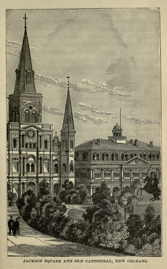
New Orleans is not a handsome city, architecturally speaking, though it has a number of fine buildings. Its situation is such that it could never become imposing, under the most favorable circumstances. The Custom House, a magnificent structure, built of Quincy granite, is, next to the Capitol at Washington, the largest building in the United States. It occupies an entire square, its main front being on Canal street, the broadest and handsomest thoroughfare in the city. The Post Office occupies its basement, and is one of the most commodious in the country. The State House is located on St. Louis street, between Royal and Chartres streets, and was known, until 1874, as the St. Louis Hotel. The old [Pg 275] dining hall is one of the most beautiful rooms in the country, and the great inner circle of the dome is richly frescoed, with allegorical scenes and busts of eminent Americans. The United States Branch Mint, at the corner of Esplanade and Decatur streets, is an imposing building, in the Ionian style. The City Hall, at the intersection of St. Charles and Lafayette streets, is the most artistic of the public buildings of the city. It is of white marble, in the Ionic style, with a wide and high flight of granite steps, leading to a beautiful portico. The old Roman Catholic Cathedral of St. Louis is the most interesting church edifice in New Orleans. It stands in Chartres street, on the east side of Jackson Square. The foundations were laid in 1793, and the building completed in 1794, by Don Andre Almonaster, perpetual regidor of the province. It was altered and enlarged in 1850. The paintings in the roof of the building are by Canova and Rossi. The old Ursuline Convent, in Conde street, a quaint and venerable building, erected in 1787, during the reign of Carlos III, by Don Andre Almonaster, is one of the most interesting relics of the early Church history of New Orleans. It is now occupied as a residence by the Bishop.
The Charity Hospital, on Common street, was founded in 1784, has stood on its present site since 1832, and is one of the most famous institutions of the kind in the country. Roman Catholic churches, schools, hospitals and asylums abound, some of them dating back for nearly or quite a century.
The St. Charles Hotel is one of the institutions of New Orleans, and one of the largest and finest hotels in the United States. It occupies half a square, and is bounded by St. Charles, Gravior and Common streets. The city[Pg 276] has a French opera house, an academy of music, and several theatres and halls. Like those of St. Louis, its inhabitants are passionately fond of gayety, and places of amusement are well patronized. Sunday, as in all Catholic cities, is devoted to recreation, and the inhabitants, in their holiday garments, give themselves up to enjoyment. Theatres, concert rooms and beer gardens are filled with pleasure-seekers.
Canal street, the main business thoroughfare and promenade of New Orleans, is nearly two hundred feet wide, and has a grass plot twenty-five feet wide, in the centre, bordered on each side by trees. Claiborne, Rampart, St. Charles and Esplanade streets are similarly embellished. They all contain many fine stores and handsome residences. Royal, Rampart and Esplanade streets are the principal promenades of the French quarter. The favorite drives are out the Shell Road to Lake Pontchartrain, and out a similar road to Carrollton. The lake is about five miles north of the city, forty miles long and twenty-four wide, and is famous for its fish and game. Cypress swamps, the trees covered with the long, gray Spanish moss peculiar to the latitude, lie between the lake and the city, and render the drive in that direction an interesting one.
Carrollton, in the north suburbs, has many fine public gardens and private residences. On the opposite shore of the river is Algiers, where there are extensive dry docks and ship-yards. A little further up the river, on the same side, is Gretna, where, during Spanish rule, lay moored two large floating English warehouses, fitted up with counters and shelves, and stocked with assorted merchandise.
New Orleans has a few small, tastefully laid out[Pg 277] squares, among which are Jackson, Lafayette, Douglass, Annunciation and Tivoli Circle. The City Park, near the northeast boundary, contains one hundred and fifty acres, which are tastefully laid out, but which is little frequented. Jackson Square has a historic interest, it having been the old Place d'Armes of colonial times. It was here that Ulloa landed in that ill-omened thunder storm, and here that public meetings were held and the colony's small armies gathered together. The inclosure, though small, is adorned with beautiful trees and shrubbery, and shell-strewn paths, and in the centre stands Mills' equestrian statue of General Jackson.
The city is not without other objects of historic interest. During the Indian wars barracks arose on either side of the Place d'Armes, and in 1758 other barracks were added, a part of whose ruin still stands, in the neighborhood of Barracks street. Then there is the battle field, already referred to, and many buildings belonging to a past century, some of which have distinctive historic associations. Near Jackson Square is the site of the oldest Capuchin Monastery in the United States. Sailing down the Mississippi, the voyager will reach a portion of the stream which flows almost directly south. Here is a point in the river which bears the name, to this day, of the English Turn. Up the mouth of the Mississippi sailed one day, in the seventeenth century, a proud English vessel, bent on exploration and acquisition of territory to England. Threading for a hundred miles the comparatively direct course of the stream, it had then made two abrupt right-angled turns, when, coming around a third point, in advance of it, it saw a French ship, armed and equipped, and bearing down stream under full sail.[Pg 278] The English ship was given to understand that the Mississippi was "no thoroughfare" for boats of its nationality, and commanded to turn and retrace its course, which it reluctantly, but no less surely did. Hence the name "English Turn."
The Cemeteries of New Orleans are most peculiar in their arrangement and modes of interment. The ground is filled with water up to within two or three feet of the surface, and the tombs are all above ground. A great majority of them are also placed one above another. Each "oven," as it is called, is just large enough to admit a coffin, and is hermetically sealed when the funeral rites are over. A marble tablet is usually placed upon the brick opening. Some of the structures are, however, costly and beautiful, being made of marble, granite or iron. There are thirty-three cemeteries in and near the city, and of these the Cypress Grove and Greenwood are best worth visiting.
The most picturesque and characteristic feature of New Orleans is the French Market, on the Levee, near Jackson Square. The gathering begins at break of day on week-days and a little later on Sunday morning, and comprises people of every nationality represented in the city. French is the prevailing language, but it will be heard in every variety, from the pure Parisian to the childish jargon of the negroes.
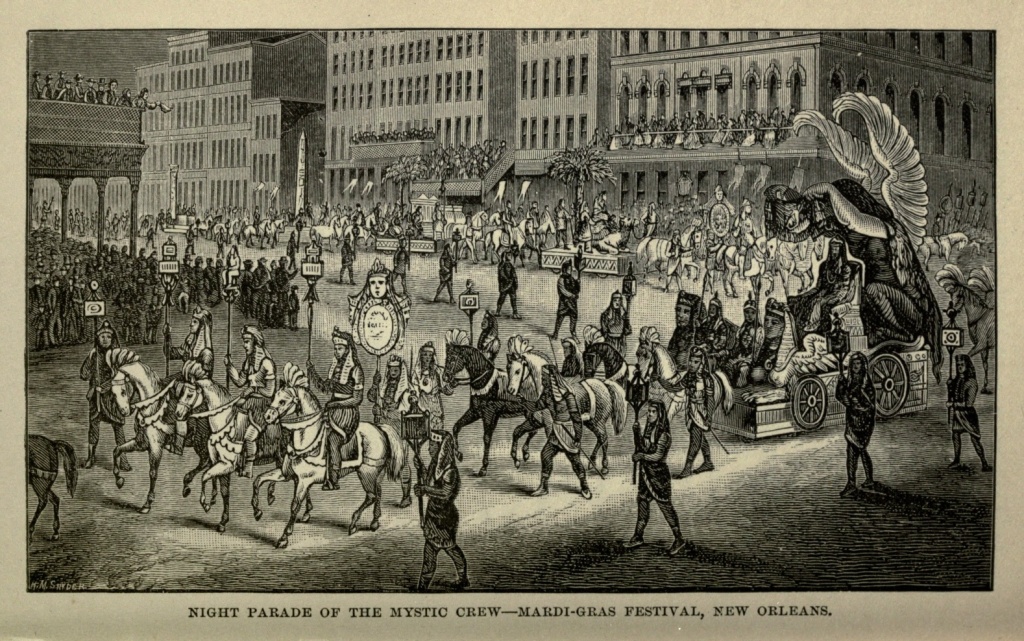
Mardi-Gras, or Shrove Tuesday, is observed in New Orleans by peculiar rites and ceremonies. Rex, King of the Carnival, takes possession of the city, and passes through the streets, accompanied by a large retinue, his staff and courtiers robed in Oriental splendor. The city gives itself up to mirth and gayety, with an abandon only paralleled by that witnessed in Italy on the same [Pg 279] occasion; and the day is concluded by receptions, tableaux and balls.
New Orleans boasts a semi-tropical climate, being situated in latitude 29° 58´ north. The summers are oppressively hot, but the winters are mild and pleasant, with just sufficient frost to kill any germs of disease engendered by her unhealthful situation. Semi-tropical fruits, such as the orange, banana, fig and pine-apple, grow readily in her gardens, where are also cultivated many of the productions of the temperate zone. The neighboring country is clothed with a rich and luxuriant semi-tropical vegetation, and forests of perennial green, in which the cypress and live-oak predominate.
New Orleans had a population, in 1820, of 27,000. In 1850 it had increased to 116,375, and in 1860 to 168,675. In common with other cities of the South, New Orleans suffered in her business interests severely during the war of the Rebellion. Louisiana having seceded from the Union in 1861, New Orleans was closely blockaded by the Federal fleet, and on April twenty-fourth, 1862, the defences near the mouth of the river were forced by Commodore Farragut, in command of an expedition of gunboats. On the surrender of the city General B. F. Butler was appointed its military Governor, and held possession of it until the close of the war. Its commerce was entirely destroyed during that period, its business interests crushed, and many of its leading men impoverished, and, in addition, the State was disturbed by intestine troubles, which kept affairs in an unsettled condition. New Orleans did not rally as quickly as St. Louis from the effects of the war. Nevertheless, in 1870 its population had increased to 191,418, and in 1874 the value of its exports, including[Pg 280] rice, flour, pork, tobacco, sugar, etc., but excepting cotton, were estimated at $93,715,710. Its imports the same year were valued at more than $14,000,000. It is the chief cotton mart of the world, and its wharves are lined with ships which bear this commodity to every quarter of the globe. In the amount and value of its exports, it ranks second only to New York, though its imports are not in the same proportion, which always speaks well for the business prosperity of a city. The census of 1880 gave it a population of 216,140, showing that its progress still continues. No longer cursed by the presence of the "peculiar institution," its former slave marts turned into commercial depots or abolished altogether, and its population numbering to a greater degree every year the industrious class, New Orleans will do more in the future than maintain her present prosperity; she will build up new industries, and originate new schemes of advancement; so that she is certain to continue her present supremacy over her sister cities in the South.
Early History of New York.—During the Revolution.—Evacuation Day.—Bowling Green.—Wall Street.—Stock Exchange.—Jacob Little.—Daniel Drew.—Jay Cooke.—Rufus Hatch.—The Vanderbilts.—Jay Gould.—Trinity Church.—John Jacob Astor.—Post-Office.—City Hall and Court House.—James Gordon Bennett.—Printing House Square.—Horace Greeley.—Broadway.—Union Square.—Washington Square.—Fifth Avenue.—Madison Square.—Cathedral.—Murray Hill.—Second Avenue.—Booth's Theatre and Grand Opera House.—The Bowery.—Peter Cooper.—Fourth Avenue.—Park Avenue.—Five Points and its Vicinity.—Chinese Quarter.—Tombs.—Central Park.—Water Front.—Blackwell's Island.—Hell Gate.—Suspension Bridge.—Opening Day.—Tragedy of Decoration Day.—New York of the Present and Future.
Less than three hundred years ago the narrow strip of territory now occupied by what its wide-awake and self-asserting citizens delight to term "The Metropolis of the New World," was a broken and rugged wilderness, which the foot of white man had never trod, not, at least, within the memory of its then oldest inhabitants, a few half-naked savages of the Manhattan tribe, from whom the island derives its name of Manhattan. In 1609 Henry Hudson, an English navigator in the service of the Dutch East India Company, landed near the present site of the Battery, securing, by right of discovery, the territory to the States of the Netherlands. Dutch traders soon followed, and in 1614 a small fort and four houses were erected in the neighborhood of what is now Bowling Green. The infant metropolis[Pg 282] was christened New Amsterdam, and Peter Minuits sent out, in 1626, as its first Governor. He purchased the island from its native owners, for goods, about twenty-four dollars in value. Minuits was recalled in 1631, his successors being Wonter Von Twiller, 1633; William Krift, 1638; and Peter Stuyvesant, 1647. In 1644 a fence was built nearly along the line of what is now Wall street, and in 1653 palisades and breastworks, protected by a ditch, were added along this line. These palisades remained in existence until near the beginning of the present century.
Peter Stuyvesant was the last of the Dutch Governors. In 1664 Charles II, of England, gave the territory to his brother James, Duke of York, and an expedition was sent out under the command of Colonel Richard Nicholls, to take possession of it. The fort was easily captured, and the name of the settlement changed to New York. In 1673 the town was recaptured by the Dutch, who again changed its name to New Orange; but the following year it was restored to the English by treaty.
In 1689 Jacob Leister instituted an insurrection against the unpopular administration of Nicholls, which he easily overthrew, and strengthened the fort by a battery of six guns outside its walls. This was the origin of the "Battery." In 1691 he was arrested and convicted on a charge of treason and murder, condemned to death, and executed.
Negro slavery was introduced into New York at an early period, and in the year 1741 the alleged discovery of a plot of the slaves to burn the city and murder the whites resulted in twenty negroes being hanged, a lesser number being burned at the stake, and seventy-five being transported.[Pg 283]
From the very first the mass of citizens of New York took an active part in the struggle for independence. In 1765 the "Sons of Liberty" were organized to resist the Stamp Act; in 1770 a meeting of three thousand citizens resolved not to submit to this oppression; and in 1773 a Vigilance Committee was formed to resist the landing of the tea, by whom, in the following year, a tea-laden vessel was sent back to England, while eighteen chests of tea were thrown overboard from another. On the eighteenth of September, 1776, as a result of the disastrous defeat of the American troops, under General Washington, on Long Island, New York fell into the hands of the British, who held it until the twenty-sixth of November, 1783, when they evacuated it. The day is still annually celebrated, under the name of "Evacuation Day."
From 1784 to 1797 New York was the Capital of the State, and from 1785 to 1790 the seat of government of the United States. The adoption of the National Constitution was celebrated in grand style in 1788; and on April thirtieth, 1789, Washington was inaugurated at the City Hall, as the first President of the United States.
In 1791 the city was visited by yellow fever. In 1795 and 1798 it reappeared, with added violence, over two thousand persons falling victims to it during the latter year. It made visits at intervals until 1805, after which it did not reappear until 1819. It came again in 1822 and 1823, occasioning considerable alarm, but since then its visits in an epidemic form have ceased.
In 1820 the surveying and laying out of Manhattan Island north of Houston street, after ten years of labor, was completed. The opening of the Erie Canal, in 1825, gave the city a fresh impetus on the road to prosperity.[Pg 284] The first steam ferry between New York and Jersey City was started in 1812. In 1825 the city was first lighted by gas; while the great Croton Aqueduct, through which it receives its immense water supply, was not completed until 1842.
In December, 1835, the most disastrous fire ever known in the city destroyed over $18,000,000 worth of property. In July, 1845, a second conflagration consumed property to the amount of $5,000,000. Both these great fires were in the very heart of the business portion of the city.
In July, 1853, an industrial exhibition was opened, with striking ceremonies, in a so-called Crystal Palace, on Reservoir Square. This building, in the form of a Greek cross, was made almost wholly of iron and glass, being three hundred and sixty-five feet in length each way, with a dome one hundred and twenty-three feet high. The flooring covered nearly six acres of ground. This structure was destroyed by fire in 1858.
New York has been the scene of several sanguinary riots within the past half century. In 1849, when Macready, the English tragedian, attempted to play a second engagement at the Astor Place Opera House, the friends of Forrest attacked the building, resulting in calling out of the military, the killing of thirty-two persons, and wounding of thirty-six others. In July, 1863, a mob, made up of the poorer classes of the population, rose in fierce opposition to the draft rendered necessary by the requisition for troops by the general government. For several days this mob was in practical possession of the city, and it was dispersed only by a free use of military force. This mob resulted in the death of one thousand persons, and the destruction of[Pg 285] $1,500,000 worth of property. In 1871 a collision occurred between a procession of Irish Orangemen, who were commemorating the Battle of the Boyne, and their Catholic fellow-countrymen, during which sixty-two persons lost their lives.
The summer of 1871 was made memorable by the discovery that the most stupendous frauds upon the public treasury had been carried on for several years, by certain city officials, some of whom had been extraordinarily popular. A mass meeting, called at Cooper Institute on the fourth of September, appointed a committee of seventy-six to take measures for securing better government for the city. The elections in November following resulted in a complete sweeping out of the obnoxious officials, many of whom were subsequently prosecuted, convicted and imprisoned, or obliged to fly the country.
New York City, the greater portion of which lies on Manhattan Island, is situated at the mouth of the Hudson River, some eighteen miles from the Atlantic Ocean. Its extreme length north from the Battery is sixteen miles, while the average breadth of the island is one and three-fifths of a mile. The city has an area of about 27,000 acres, of which 14,000 are on Manhattan Island, and about 12,000 on the main land; while the remainder is in the East River and the Bay, and includes Ward's, Blackwell's, Randall's, Governor's Ellis', and Bedloe's Islands. It is bounded on the north by the town of Yonkers; on the east by the Bronx and East Rivers; on the south by the Bay; and on the west by the Hudson River. Manhattan Island is separated on the north, from the main land, by Spuyten Duyvel Creek and Harlem River, both names recalling the Dutch origin of the city.[Pg 286]
The more ancient portion of New York, from Fourteenth street to the Battery, is laid out somewhat irregularly. As far north as Central Park, five miles from the Battery, it is quite compactly built. Various localities in the more northern and less densely built-up part of the island are known by different names; as Yorkville, near Eighty-sixth street; and Harlem, in the vicinity of One-hundred-and-twenty-fifth street, on the eastern side; and Bloomingdale and Manhattanville, opposite them, on the western. North of Manhattanville, near One-hundred-and-fiftieth street, is Carmansville, and a mile and a half further north are Washington Heights; while Inwood lies at the extreme northwestern point of the island. All these are places of interest, and offer numerous attractions to the visitor.
That part of New York lying on the mainland, comprising the twenty-third and twenty-fourth wards, was added to it in 1874, and contains many thriving towns and villages. Prominent among them is Morrisania, with avenues running north and south, and streets crossing them at right angles, and numbered in continuation of those of Manhattan Island. Numerous other towns, with a host of beautiful country residences, are scattered over the high and rolling land of which this late addition to the area of the city is composed; but with the exception of Morrisania it has not yet been regularly laid out for building purposes. The whole country in this section of the city, with a romantic natural beauty, to which wealth and artistic taste have largely contributed, is a perfect paradise of picturesqueness.
The foreigner who visits New York usually approaches it from the lower bay, through the "Narrows,"[Pg 287] a strait lying between Staten Island on the left and Long Island on the right. From the heights of the former, a beautiful island, rising green and bold from the water's edge, frown the massive battlements of Fort Wadsworth and Fort Tompkins; while on the latter is Fort Hamilton; and in the midst of the water, gloomy and barren, is Fort Lafayette, famous as a political prison during the late war. New York Bay is one of the most beautiful, if not the most beautiful, in the world. Staten Island rises abruptly on one shore, with hills and valleys, green fields and trees, villages and villas; and on the other shore are the wood-crowned bluffs of Long Island. Within the bay Ellis' Island is near the Jersey shore; Bedloe's Island is not far from its centre, and is the selected site of the colossal statue of Liberty which France has presented to New York; while Governor's Island, the largest of the three, lies to the right, between New York and Brooklyn. Each island is fortified, the latter containing Castle William and old Fort Columbus.
The bay is dotted with the shipping of every nation. Ocean steamers are setting out on their long journeys, or just returning from foreign shores. The finest steamboats and ferry boats in the world dart hither and thither, like water spiders on the surface of a glassy pool. Tugs, oyster boats, and sailing vessels of every size and description, are all represented. It is a moving panorama of water craft. As the city is approached, gradually, from the distant haze which broods over it, is evolved the forms of towers, spires, and roofs, and all its varied and picturesque outlines. The city presents a beautiful view from the bay. It rises gradually from the water's edge, some portions of it to a considerable eleva[Pg 288]tion. A prominent feature in its outline is the graceful, tapering spire of Trinity Church, while higher still rises the clock-tower of the Tribune building. Other towers, spires and domes, break the monotony of roofs and walls. Approaching the mouth of the East River, the most striking objects are the massive towers of the Suspension Bridge, one on either shore, while between them is the bridge, swung upon what seem at a distance like the merest cobwebs.
At the extreme southern end of Manhattan Island is the Battery, already referred to, a park of several acres, protected by a granite sea wall. It presents a beautiful stretch of green turf, fine trees and wide pathways. On its southwest border is Castle Garden, a circular brick structure, which has a history of its own. It was originally constructed for a fort, and was afterwards converted into a summer garden. A great ball, to Marquis Lafayette, was given in it in 1824; and General Jackson in 1832, and President Tyler in 1843, held public receptions there. Then it was turned into a concert hall, and is chiefly famous, as such, as being the place where Jenny Lind made her first appearance in America. It is now an emigrant depot, and on days of the arrival of emigrant ships, it is very entertaining to watch the troops of emigrants, with their quaint gait, unfamiliar language, and strange, un-American faces, passing out of its portals, and making their first entrance into their new life on the western continent.
Just east of the Battery is Whitehall, the terminus of numerous omnibus and car lines, and the location of the Staten Island, South and Hamilton ferries. There, too, is the depot of the elevated railways, which extend in four lines, two on the eastern side and two on the[Pg 289] western, the entire length of the city. The Corn Exchange, an imposing building, is at the upper end of Whitehall. At the junction of Whitehall with Broadway is a pretty, old-fashioned square, shaded with trees, and surrounded by an iron fence, called Bowling Green. This was the aristocratic quarter of the city in its early days. No. 1 Broadway, known as the "old Kennedy House," was built in 1760, and has been, successively, the residence and headquarters of Lords Conwallis and Howe, General Sir Henry Clinton and General Washington, while Talleyrand lived there during his stay in America. Benedict Arnold concocted his treasonable projects at No. 5 Broadway. At No. 11 General Gates had his headquarters. A few of the old buildings still remain, but they have many of them already given way to more modern and more pretentious structures. The posts of the iron fence around Bowling Green were once surmounted by balls, but they were knocked off and used for cannon balls during the Revolution. An equestrian statue of King George III, which once ornamented the Square, was melted up during the same period, and furnished material for forty-two thousand bullets.
The stranger in New York sometimes wonders why its principal business street is called Broadway, since there are many others which are quite as broad, some of them even broader. But if he will visit the extreme southern portion of the city, he will quickly comprehend. The old streets are narrow, being scarcely more than mere alleys, with pavements barely broad enough for two to walk abreast, so that Broadway, when originally laid out, seemed a magnificent thoroughfare.
As already described, Wall street formed the northern[Pg 290] boundary of the young colonial city. In that early day, as now, wealth and fashion sought to avoid the more plebeian business streets, and so withdrew to the neighborhood of this northern boundary, and established, first their residences, and then their commercial houses. Wall street then became what it has since remained, the monetary centre of the city, only that now it is more than that; it is the great monetary centre of the entire country. On it and the blocks leading from it, all embraced in comparatively a few acres, are probably stored more gold and silver than in all the rest of the United States put together, while the business interests represented extend to every section, not only of the continent, but of the world.
Nowhere else in America are there such and so many magnificent buildings as in this section of the city. The streets are narrow, and overshadowed as they are by edifices six or more stories in height, seem to be dwarfed into mere alley-ways. Nearly every building is worthy of being called a temple or a palace. White marble and brown stone, with every style of architecture, abound. The United States Sub-Treasury Building, at the corner of Wall and Nassau streets, is a stately white marble structure in the Doric style, occupying the site of the old Federal Hall, in which Washington delivered his first inaugural address. Opposite is the white marble palace, in the style of the Renaissance, known as the Drexel Building. A little further down the street, at the corner of William, is the United States Custom House, formerly the Merchants' Exchange, built of granite. It has a portico supported by twelve massive columns, and its rotunda in the interior is supported by eight columns of Italian marble, the Corinthian capitals of which were[Pg 291] carved in Italy. Opposite this building is the handsome structure of the Bank of New York. Banks, and bankers' and brokers' offices fill the street, and are crowded into the side streets.
On Broad street, a short distance below Wall, is the Stock Exchange, a handsome, but not large building, which in point of interest towers over all others in the locality. Here are daily exacted the comedies and tragedies of financial life, and here fortunes are made and fortunes lost by that system of gigantic gambling which has come to be known as "dealing in stocks." The operations of the Stock Exchange and Gold Room concern the whole country, both financially and industrially. Here is the true governmental centre, rather than at Washington. Wall and Broad streets dictate to Congress what the laws of the country concerning finance shall be, and Congress obeys. The Bankers' Association holds the menace over the government that if their interests are not consulted, they will bring ruin upon the country; and it is in their power to execute the threat. This power was illustrated on the twenty-fourth of. September, 1869, a day memorable as Black Friday in the history of Wall street. By a small but strong combination of bears, gold was made to fall in seventeen minutes, from 1.60 to 1.30, after a sale of $50,000,000 had been effected, and thousands of men, from the Atlantic to the Pacific, were ruined. Money was locked up, and could not be obtained even at a premium of one hundred per cent. This was the forerunner of the panic which came four years later, in 1873. Then the Union Trust Company failed, carrying with it Jay Cooke, Fisk and Hatch, Henry Clews, Howe and Macy, and other houses. For the first time during its existence the Stock[Pg 292] Exchange was closed. Without its closing, not a merchant or banker could have survived. With its doors shut no contract could be completed nor stocks transferred, and it gave people time, which was absolutely needed, to do what they could; or else universal and overwhelming ruin would have swept over the country. As it was, not less than twenty thousand firms went under, and the stringency of the times was felt throughout the nation, depressing business and checking industry, until Congress took measures for its relief.
The names of Jacob Little, Leonard W. Jerome, Daniel Drew, Jay Cooke, Augustus Schell, Rufus Hatch, James Fisk, Jr., Jay Gould, Commodore Vanderbilt, Wm. H. Vanderbilt, and others, are permanently associated with Wall street. Jacob Little was known as the "Great Bear of Wall street." He originated the daring, dashing style of business in stocks, and was always identified with the bears. Meeting many reverses, he died at last, comparatively poor, the Southern Rebellion having swept away his little remaining fortune.
Leonard W. Jerome was at one time financially the rival of Vanderbilt and Drew, with a fortune estimated at from six to ten millions. He assumed an unequaled style of magnificence in living; but reverses came, and his splendid property on Madison Square, including residence, costly stables and private theatre, passed into the hands of the Union League Club, and was occupied by them until they went to their new quarters in Fifth Avenue. He himself is now forgotten, although a man scarcely past the prime of life; but his name is perpetuated in the Jerome Race Course.
Daniel Drew came to New York a poor boy, and, by persistent industry and business capacity, worked his[Pg 293] way up to the highest round of the commercial ladder. In 1838 Drew put an opposition boat upon the Hudson, with fare at one dollar to Albany; and shortly afterward established the People's Line, which has been so successful. The panic of 1873 affected him seriously, but he staved off failure until 1875. He died in 1879, leaving next to nothing of the millions he had made during his lifetime. St. Paul's Church, in Fourth avenue; the Methodist Church at Carmel, Putnam County, New York, his native place; and Drew Theological Seminary, are monuments of his munificence while money was at his command.
Jay Cooke, having been already tolerably successful in business, amassed his millions by negotiating the war loan. He was regarded as one of the most prominent and safe financiers in the country; but in 1873 his failure was complete, and he has not since been heard of in financial circles.
Rufus Hatch is one of the successful stock operators of New York. Beginning life with nothing, and meeting reverses as well as successes, he is now known as one of the boldest and most gigantic of street operators.
The name of James Fisk, Jr., is associated with that of the Erie Railroad. He commenced life as a peddler. In 1868 he was appointed Comptroller of the Erie Road, and immediately set about building up the fortunes of that corporation. He appeared on Wall street as an assistant of Daniel Drew; made himself master of the Narragansett Steamship Company, and changed the condition of its affairs from disaster to success. He was one of the conspirators on Black Friday of 1869. He purchased the Opera House and the Fifth Avenue Theatre, finding them both good investments. He[Pg 294] was shot by Edward S. Stokes, both himself and Stokes having become entangled with a woman named Helen Josephine Mansfield. After his death his supposed great private fortune dwindled into a comparatively small amount.
Commodore Vanderbilt also started in life a penniless boy, and became, eventually, the great King of Wall street. He built up the Harlem River Railroad, originated gigantic enterprises; sent a line of steamships across the ocean; gained control of the Hudson River Railroad and other roads; and died in 1877, worth not far from $100,000,000, the bulk of which he left to his eldest son, William H. Vanderbilt. The Vanderbilt name has lost none of its lustre in the hands of the second generation. In less than ten years, after a career of unequaled brilliancy in the financial world, William H. Vanderbilt retired, with a fortune probably double that of his father.
Jay Gould also achieved success from small beginnings. He was in company with Fisk in the control of the Erie Railroad, and an associate in bringing about the disasters of Black Friday. Soon after the death of Greeley he secured a controlling interest in the New York Tribune. He is still a power in Wall street, and a great railroad magnate.
Broad street still has historical associations clinging about it. At the corner of Broad and Pearl streets is the famous De Lancy House, built early in the last century by Stephen De Lancy, a Huguenot refugee from Normandy. In this house, on the evening of November twenty-fifth, 1783, Washington and his staff, with Governor Clinton, celebrated the evacuation of the city by the British troops, and a few days later[Pg 295] Washington bade his officers farewell, before departing for Annapolis to resign his commission. The house, having passed through successive stages of degeneration, had at one time sunk so low as to have become a German tenement house, with a lager beer saloon on the third floor. It has recently been renovated, and has again put on an air of respectability. It still bears upon it the words: "Washington's Headquarters." All about it are, here and there, the relics of the past, in the shape of houses which once were homes of the gentility, in colonial times.
Pearl street is said to have been originally a cow-path, and it is certainly crooked enough to justify such an origin. It is the locality of the Cotton Exchange and the cotton brokers.
On Broadway, at the head of Wall street, is Trinity Church, whose spire was, until a recent period, the highest in the city, being two hundred and eighty-four feet in height. In the early days, when the aristocracy were seeking the select neighborhood of Wall street, this church corporation established itself upon the utmost northern confines of the city. Its original edifice was destroyed by fire, and the present one was erected in 1846. It is of brown stone, in pure gothic architecture, and one of the most beautiful in New York. In the rich carving of the exterior numerous birds have built their nests. It has stained glass windows, and the finest chime of bells in America. Within the church is a costly reredos in memory of John Jacob Astor. A venerable graveyard lies to its north, where repose the remains of Alexander Hamilton, Captain Lawrence, of the Chesapeake, Robert Fulton, and the unfortunate Charlotte Temple. Some of the headstones, brown and[Pg 296] crumbling with age, and bearing grotesque carved effigies of angels, date back for more than a century. In the northeast corner is a stately monument erected to the memory of the patriots who died in British prisons in New York during the Revolution. Trinity Parish is the oldest in the city, and fabulously wealthy, the corporation having been granted, by Queen Anne, in 1705, a large tract of land west of Broadway, extending as far north as Christopher street, known as the "Queen's Farm." The land, at that time remote from the city, now embraces some of its most valuable business portions. It is all leased of Trinity Church by the occupants, and the church, when the leases expire, becomes possessed of the buildings and improvements upon the ground, and is thus constantly augmenting its wealth. The claims of the Jans Anneke heirs involve this vast estate. It has three chapels, one of which, St. Paul's, is a few blocks above, on the corner of Broadway and Vesey streets, and is surrounded by a graveyard almost as ancient as that of Trinity.
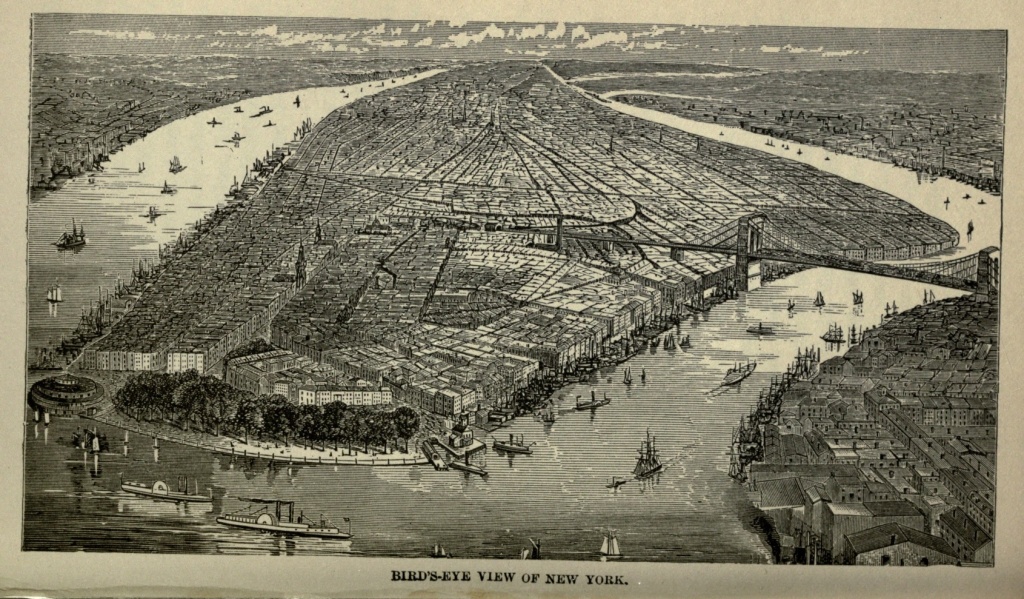
At the northwest corner of Vesey street and Broadway is the Astor House, which, when it was built, something more than a generation ago, was a marvel of size and splendor, though it is now thrown in the shade by more modern structures. John Jacob Astor, its builder, was born near Heidelberg, in Germany, in 1765, and came penniless to the new world, to seek his fortune. After serving as a clerk, he then engaged in a small way in the fur business, which eventually grew to the proportions of the American Fur Company, and brought to its founder a large fortune, though no one outside his family ever knew its exact amount. He settled most of his affairs before his death, selling the Astor House [Pg 297] to his son William, for the consideration of one dollar. Much of his property was in real estate, which constantly increased in value. He died in 1848, and his senior son being an imbecile, William B. Astor, the younger brother, inherited most of his father's fortune. The son became vastly richer than his father, dying in 1875, leaving behind him a fortune of $50,000,000, which was mostly bequeathed to his eldest son, John Jacob, who is now the head of the house.
The Post Office stands opposite the Astor House, on the east side of Broadway, at the southern extremity of City Hall Park. It is a massive structure, of Doric and Renaissance architecture, four stories in height, beside a Mansard roof, costing $7,000,000.
Half a century ago the City Hall Park was the chief park of New York, and the elegance and aristocracy of the city gathered around it. The City Hall stands in the park, and back of it is the new Court House, still unfinished, a massive edifice in Corinthian style, which, when completed, will have a dome two hundred and ten feet above the sidewalk.
On the western side of Broadway, opposite St. Paul's, is the splendid building of the New York Herald. The Herald is the representative newspaper of New York, and is probably the most enterprising sheet in the world. James Gordon Bennett, its founder, was born in Scotland in 1795, and came to America in 1819. After various literary ventures, he decided to establish a paper which should embody his ideal of a metropolitan journal. On the sixth of May, 1855, the first number of the New York Herald was issued, being then a small penny sheet. Mr. Bennett was editor, reporter and correspondent. He was his own compositor and errand boy,[Pg 298] mailed his papers and kept his accounts. His rule, from the very first, was never to run a dollar in debt. He succeeded in establishing a paper which has no parallel in history, while, since his death, his son's enterprise has still further increased its scope and popularity. Young Bennett, the present proprietor of the Herald, named after his father, was trained especially for the duties which were to devolve upon him. He is thoroughly at home in French, German, Italian and Scotch. He is a skilled engineer, and can run either the engines or presses of his establishment. He is a practical printer, and can also telegraph with skill and accuracy. He gives strict personal supervision to the affairs of his immense establishment, which yields him a yearly income equaling that of a merchant prince.
Extending from the Herald Building northward, on the eastern side of City Hall Park, is what is known as Printing House Square, including the offices of the principal daily and weekly papers. The magnificent granite structure of the Staats Zeitung faces this square on the north. The immense Tribune Building, nine stories high, with its tall clock tower, flanks it on the east, on Nassau street. The Sun modestly nestles in the shadow of the Tribune. The Times Building is found on Park Row, where also is the World office. Truth lurks in a basement on Nassau street. But a square or two below is the Evening Post Building, where the venerable poet Bryant labored at his editorial duties for so many years. A statue of Franklin occupies a small open triangular space in the midst of the square.
Horace Greeley's name is inseparably associated with that of the Tribune, which he founded. Honest and single-minded, he wielded a mighty influence, and his[Pg 299] paper was a great political power in the country. He often made enemies by his honesty and straight-forwardness; but both enemies and friends respected him. In 1872 the Liberal Republican and Democratic parties nominated him as their choice for President. Believing that he could rally around him men of all parties who desired to see reform in political methods, he accepted the nomination; and was attacked so bitterly by those whom he had supposed to be his friends, and met such overwhelming defeat in the contest, that, taken with the death of his wife within a week of the election, he was crushed completely, his reason left him, and before the end of a month he died a broken-hearted man.
North of the City Hall Park, on the corner of Chambers street, is the old wholesale house of A. T. Stewart, now devoted to other purposes, and having two stories added to its top. Here, a generation ago, the belles of New York City came to do their shopping, it having been originally built for the retail trade, as a few years later they flocked to the new retail store on Broadway, between Ninth and Tenth. The name of A. T. Stewart is no longer heard in New York, save in connection with the past. It was a power in its day and generation. Few men had more to do with Wall street than Stewart, and his mercantile business was carried on in the Wall street style. He "cornered" goods, "sold short," "loaded the market," and "bought long." Having emigrated from the north of Ireland, he first opened business in a small way, himself and wife living in one room over their store. Beginning at the very lowest round of the ladder, he worked with the fixed resolution of becoming the first merchant in the land.[Pg 300] He always lived within his income, and never bought a dollar's worth of merchandise that he could not pay cash for. In the days of his prosperity he built for himself and wife a marble palace, at the corner of Fifth avenue and Thirty-fourth street, the most finely-finished and elegantly-furnished residence in the country. He died in 1876, worth, probably, $50,000,000. The theft of his remains from the graveyard of St. Mark's Church, at Ninth street and Second avenue, was the nine days' wonder of the time; and the vault prepared for their reception, in the fine Cathedral at Garden City, Long Island, remains empty.
Broadway, almost from the Battery, is bordered by magnificent structures. The lower end of this thoroughfare is devoted principally to insurance, bankers' and brokers', railway and other offices, and to the wholesale trade. Above Canal street the retail stores begin to appear at intervals, and as one approaches Ninth street ladies multiply on the western pavement. From Ninth street up, the retail trade monopolizes the street, and on pleasant afternoons the pavement is filled with elegantly dressed ladies who are out shopping. At Tenth street Broadway makes a bend to the westward, and on the eastern side of the way, facing obliquely down the thoroughfare, is Grace Church and parsonage, both elegant structures. Grace Church is a fashionable place of worship, and the scene of the most exclusive weddings and funerals of the city.
Union Square is reached at Fourteenth street. It is oval in form, with beautiful green turf, trees and walks, and contains a fine fountain in the centre, a colossal bronze statue of Washington on a granite pedestal, and statues of Hamilton and Lafayette. Along its northern[Pg 301] end is a wide plaza for military parades and popular assemblies. Union Square was once a fashionable residence quarter, but it is now occupied almost wholly by business. At Twenty-third street, Broadway runs diagonally across Fifth avenue, touching the southwestern corner of Madison Square—not so very long since the most genteel locality in New York, but now, like Union Square, becoming occupied by hotels and business houses.
Fifth Avenue, the most splendid avenue in America, makes a beginning at Washington Square, a lovely public park embowered in trees, which was once Potters' Field, the pauper burying ground, and where one hundred thousand bodies lie buried. New York University and Dr. Hutton's Church face the square on the east. The southern side is given up to business, but the north and west are still occupied by handsome private residences. Fifth Avenue is a continuous line of palatial hotels, gorgeous club-houses, brownstone mansions and magnificent churches. No plebeian horse cars are permitted to disturb its well-bred quiet, and the rumble of elegant equipages is alone heard upon its Belgian pavement.
Business is already invading the lower portion of the avenue, piano warehouses being especially prominent. On Madison Square are the Fifth Avenue Hotel and the Hoffman House. Opposite the latter house is a monument erected to General Worth, a hero of the Mexican war. Delmonico's and the Café Brunswick, rival restaurants, occupy opposite corners of Twenty-sixth street. The Stevens House is an elegant family hotel on Fifth Avenue and Twenty-seventh street, running to Broadway. At Twenty-ninth street is the[Pg 302] Congregational Church, a stately granite edifice; and on the same street, just east of the Avenue, is the Church of the Transfiguration, popularly known as "the little church around the corner," a name bestowed on it by a neighboring clergyman, who, refusing to bury an actor from his own church, referred the applicant to this. At the corner of Thirty-fourth street is the Stewart marble palace already referred to. From Forty-first to Forty-second streets is the distributing reservoir of the Croton Water-works, with walls of massive masonry in the Egyptian style. The Crystal Palace of 1853 occupied this square. The Avenue has at this place ascended to a considerable elevation, and the locality, embracing several streets and avenues, is known as Murray Hill, the most wealthy and exclusive quarter of the city. At Forty-third street is the Jewish Temple Emanuel, the finest specimen of Moorish architecture in the country.
Occupying the block between Fiftieth and Fifty-first streets is the Roman Catholic Cathedral of St. Patrick, commenced in 1858, and with the towers still incomplete. It is of white marble, in decorated Gothic style; and the largest and handsomest church in the country. It is elaborately carved, the numerous rose windows seeming almost like lace work. When completed it will have two spires, ornamented with buttresses, niches with statues, and pinnacles, and three hundred and twenty-eight feet in height. The interior is as beautiful as a dream. It is entirely of white marble. Massive pillars with elaborately carved capitals support the arched roof, while the light is softened and subdued by beautiful stained-glass windows. The building is in such perfect proportion that one does not realize its[Pg 303] immense size until he descries the priest at the altar, so far away as to seem a mere child.
But eight squares away is Central Park, the great breathing-place of the city. Looking back, down the Avenue, from the entrance to the Park, there is seen a forest of spires rising from magnificent churches which we have had no space to mention, and blocks upon blocks of palatial residences, the homes of the millionaires of the city. The eastern side of Fifth Avenue, facing the Park for a number of blocks, is occupied by elegant private residences.
Madison Avenue starts from Madison Square, running through to Forty-second street. It, with parallel avenues and places, shares the prestige of Fifth Avenue, as being the aristocratic quarter of the city.
Fourteenth street, once a fashionable thoroughfare, is now fast being occupied by large retail stores.
The avenues, commencing at First, and numbering as high as Eleventh, run north and south, parallel to Fifth Avenue, already described. They are supplemented on the eastern side, at the widest part of the island, by avenues A, B, C, and D. Most of these avenues commence on the eastern side at Houston street, the northern boundary of the city in the early part of the present century. On the western side, with the exception of Fifth and Sixth, they commence but little below Fourteenth street. They are mostly devoted to retail trade, and, on seeing their miles of stores, one wonders where, even in a great city like New York, all the people come from who support them.
Second Avenue is almost the only exception among the avenues. Early in the century it was what Fifth Avenue has become to-day, the fashionable residence[Pg 304] avenue; and even yet some of the old Knickerbocker families cling to it, living in their roomy, old-fashioned houses, and maintaining an exclusive society, while they look down with disdain upon the parvenues of Fifth avenue. Stuyvesant Square, intersected by Second avenue, and bounded on the east by Livingston Place, and on the west by Rutherford Place, is one of the quarters of the ancient régime. Here still live the Rutherfords and the Stuyvesants. Here is the residence of Hamilton Fish and William M. Evarts. St. George Church, with the largest seating capacity of any church in the city, faces this square.
Booth's Theatre is on the corner of Sixth avenue and Twenty-third street. It is the most magnificent place of amusement in America; built in the Renaissance style, with a Mansard roof. Opposite is the Masonic Temple, in Ionic and Doric architecture. At the corner of Eighth avenue and Twenty-third street is the Grand Opera House, once owned by James Fisk, Jr.
New York is at once spendthrift and parsimonious in the naming of her streets. Thus, she sometimes repeats a name more than once, and again, bestows two or three names upon the same street. There is a Broadway, an East Broadway, a West Broadway, and a Broad street. There is Greenwich avenue and Greenwich street. There are two Pearl streets. There is a Park avenue, a Park street, a Park row, and a Park place. On the other hand, Chatham becomes East Broadway east of Bowery; Dey street is transformed into John street east of Broadway; Cortlandt becomes Maiden Lane at the same dividing line; and other streets are in like manner metamorphosed. Fourth Avenue, beginning at the Battery as Pearl street, changes[Pg 305] to the Bowery at Franklin Square. At Eighth street, without any change in its direction, it becomes Fourth Avenue; from Thirty-fourth to Forty-second streets it is Park Avenue, and then relapses into Fourth Avenue again. This is one of the most interesting avenues in the city; as Pearl street, its windings and its business occupations have been referred to.
Bowery has a character all its own. It takes its name from Peter Stuyvesant's "Bowerie Farm," through which it passes. In it is probably represented every civilized nation on the globe. It is unqualifiedly a democratic street. While Fifth Avenue represents one extreme of city life, the Bowery represents the other. Here are the streets and shops of the working classes, consisting of dry and fancy goods, cigar shops, lager beer saloons, shoe stores, confectionery stores, pawnbrokers' shops, and ready-made clothing, plentifully besprinkled with variety and concert saloons and beer gardens. There are no elegant store fronts or marble stores here. The buildings are plain brick edifices, three or four stories in height, the upper stories occupied by the families of the merchants, or as tenement houses. The Germans visit the beer gardens with their wives and families, to listen to what is sometimes excellent music, and to drink beer. The concert saloons are, some of them, the resorts of the lowest of both sexes. Near Canal street is the site of the old Bowery Theatre, which, having been thrice destroyed by fire, has been thrice rebuilt, the last time, quite recently, and is now known as Thalia Theatre. A generation and a half ago the gamins of New York reigned supreme in the pit. Now that they have been relegated to the gallery, they still criticise the performance with the frankness and[Pg 306] originality of expression characteristic of the "Bowery boys" of old. One should visit the Bowery at night, when the workmen and shop girls, having finished their daily labor, are out for recreation and amusement. Then he will gain an idea of one phase of city life and people which he would not obtain otherwise.
At Seventh street, where Third avenue branches off, looking down the Bowery, and occupying the entire block to Eighth street, is Cooper Institute, containing a free library, free reading-room, free schools of art, telegraphy and science, and a hall and lecture room. Peter Cooper was one of the representative men of New York. Acquiring a large fortune by strictly honorable methods, he devoted a generous portion of it to charitable objects, and this Institute is one of the lasting monuments of his generosity. He was a true philanthropist, a man of broad thought and kindly impulses, whose name was honored by all classes of the community. He died in April, 1883, at a ripe old age.
Occupying the block between Third Avenue and the Bowery, which is now dignified by the name of Fourth avenue, is the Bible House, the largest structure of its kind in the world, except that of London. Here the Bible is printed in almost every known language, and here are congregated the offices of the various religious societies of the city and country. The Young Men's Christian Association and Academy of Design occupy opposite corners at Twenty-third street, on the west side of the avenue. The exterior of the latter is copied from a famous palace in Venice, and it is peculiar as well as beautiful in its appearance. From Thirty-second to Thirty-third streets is the immense structure intended by A. T. Stewart as the crowning charitable object of[Pg 307] his life, to be, perhaps, in some sort, an atonement for injustice of which he may have been guilty toward the working classes. It was designed as a hotel for working women, but in its very plan indicated how little its founder understood the nature or needs of that class. At its completion, after his death, it did not take many weeks to demonstrate that working women preferred a place more home-like, and fettered by less restrictions than this palace-prison; and so the edifice was turned into an ordinary hotel.
Park avenue commences at Thirty-fourth street, being built over the track of the Fourth avenue car line. In the centre of this avenue, over the tunnels, are little spaces inclosed by iron fences, and containing a profusion of shrubbery and flowers. The avenue abounds in elegant churches and equally fine residences. At Forty-second street is the Grand Central Depot, seven hundred feet in length, its exterior imposing, and with corner and central towers surmounted by domes. At Sixty-ninth street, between Fourth and Lexington avenues, is the new Normal College, an ecclesiastical-looking building, the most complete of its kind in America.
Retracing our steps to near the foot of Bowery, we come to Chatham street, where the Jews reign supreme, and which is the vestibule of the worst quarter of the city. Passing along a pavement festooned with cheap, ready-made clothing, one comes to Baxter street, and from thence to the Five Points, once the most infamous locality of New York. Here, a generation ago, a respectable man took his life in his hands, who attempted to pass through this quarter, even in broad daylight. It was the abode of thieves, burglars, garot[Pg 308]ters, murderers and prostitutes. Hundreds of families were huddled together in tumble-down tenement houses, living in such filth and with such an utter lack of decency as is scarcely to be credited. But home missionaries visited the quarter, established mission-schools and a house of industry, tore down the disgraceful tenement-houses and built better ones in their place; and to-day the old Bowery, Cow Bay and Murderers' Alley are known only in name. The Five Points is at the crossing of Baxter, Worth and Parker streets, and is really five points no longer, the carrying through of Worth street to the Bowery, forming an additional point. The locality is still dreadful enough, with all its improvements. Drunken men, depraved women, and swarms of half-clad children fill the neighborhood, and even the "improved tenement houses," as viewed from the outside, seem but sorry abodes for human beings. This is the heart of a wretched quarter, which extends westward to Broadway, and almost indefinitely in other directions. Mott, Mulberry, Baxter, Centre, Elm and Crosby streets are all densely populated, containing numberless tenement houses. It is possible to walk through some of these streets and never hear a word of English. Mulberry and Crosby streets are especially the homes of Italians, who on Sunday mornings pour out of the tenements upon the pavement and street below in such throngs that a stranger can scarcely elbow his way through. The Chinese have taken possession of the lower part of Mott street, and established laundries, groceries, tea-houses, lodging-houses, and opium-smoking dens. The latter are already attracting the attention of the public, and a feeble effort has been made by the city government to put a check upon their evil in[Pg 309]fluence. These streets are a festering sore in the very heart of the city, and require attention.
The Tombs, the city prison, famous in the criminal history of New York, is located in the midst of this quarter, on Centre street, occupying an entire block. It is a gloomy building, constructed of granite, in imitation of an Egyptian temple. Within these forbidding walls is the Tombs Police Court, where, early each morning, petty cases are disposed of by the magistrate upon the bench; and here prisoners are kept awaiting trial. Eleven cells of special strength and security are for murderers awaiting trial or punishment. There is also a special department for women. In the inner quadrangle of the building murderers are made to suffer the utmost penalty of the law, and the last act of many a tragedy which has excited and horrified the public has been performed here.
It will be a relief to turn from the gloom and wretchedness of the Tombs to the sunshine and freedom of New York's great breathing place. Central Park contains eight hundred and forty-three acres, and embraces an area extending from Fifth to Eighth avenues, and from Fifty-ninth to One-hundred-and-tenth streets. Originally, it was a desolate stretch of country in the suburbs of the city, varied by rocks and marshes, and dotted by the hovels of Irish and Dutch squatters, its most picturesque features being their goats, which picked up a scant living among the rubbish with which it was covered. Its whole extent is now covered with a heavy sod, planted with trees and shrubbery, and furnishes many miles of drives and walks. Every day in the year it has numerous visitors, but on Sunday, one must fairly elbow one's way through the crowds. In the[Pg 310] southeast corner are the Zoölogical Gardens and the old State Arsenal; the Metropolitan Museum of Art, recently opened, is north of Belvidere, on the east side of the Park. The Egyptian Obelisk stands on an eminence west of the museum. Winding paths conduct the visitor to the Mall, a stately avenue shaded by double rows of elms, and ornamented at intervals with bronze statues of celebrated American and European statesmen and poets; also a number of groups which are especially fine. The Terrace is at the northern terminus of the Mall, and leads by a flight of broad, stone stairs to Central Lake, the prettiest body of water in the Park, dotted by gondolas. A fountain, with immense granite basins, and a colossal statue of the Angel of Bethesda, stands between the terrace and the lake. Beyond the lake is the Ramble, consisting of winding, shaded paths, and covering thirty-six acres of sloping hills. From the tower at Belvidere, a magnificent piece of architecture, in the Norman style, may be obtained a fine bird's-eye view of the Park. Just above Belvidere are the two reservoirs of the water works, extending as far north as Ninety-sixth street. Beyond that the Park is less embellished by art, and is richer in natural beauties. From the eminence upon which stands the old Block House, on the northern border of the Park, a magnificent and extensive view may be obtained of the hills which bound in the landscape, and including High Bridge.
One should visit the water front of New York, which circles the city on three sides, to gain an idea of its immense commerce. A river wall of solid masonry has been commenced, which, when completed, will make the American metropolis equal to London and Liver[Pg 311]pool in this respect. A perfect forest of masts lines the wharves, representing every kind of craft, and almost every nation that sails the seas. Twice a week European steamships leave from the foot of Canal street; while from various points along the wharves, indicated by handsome ferry or shipping houses, boats go and come, to and from every port on the river or on the Atlantic coast. At Desbrosses and Cortlandt streets ferries connect with Jersey City. South, Wall and Fulton ferries give access to Brooklyn; while other ferries convey passengers to other points on the rivers and bay.
Passing up the East River, with the ship-thronged wharves and docks of New York on one hand, and the Brooklyn Navy Yard on the other, the visitor soon obtains a view of Blackwell's, Ward's and Randall's islands. Blackwell's Island is at the foot of Forty-sixth street, and is one hundred and twenty acres in extent. Upon it are located the Almshouse, Female Lunatic Asylum, Penitentiary, Work House, Blind Asylum, Charity, Smallpox and Typhus Fever hospitals. These buildings are all constructed of granite, quarried from the island by convicts. They are plain but substantial in appearance.
Leaving Blackwell's Island, the boat passes cautiously through the swirling waters of Hell Gate, once the terror of all sailors, but now robbed of most of its horrors. It was originally a collection of rocks in mid channel, which, as the tides swept in and out, caused the waters to rush in a succession of whirlpools and rapids. But a few years ago United States engineers undertook and accomplished a gigantic excavation, directly under these threatening rocks and reefs. When it was completed a[Pg 312] grand explosion, effected by means of connecting wires, blew up these dangerous obstructions, and left a comparatively clear and safe channel for vessels. The few remaining rocks which this explosion failed to disturb are being removed, and with its dangers, much of the romantic interest which attached to Hell Gate will pass away.
Ward's Island, embracing two hundred acres, and containing the Male Lunatic Asylum, the Emigrant Hospital, and the Inebriate Asylum, divides the Harlem from the East River. Randall's Island is separated from Ward's Island by a narrow channel, and is the last of the group. It contains the Idiot Asylum, the House of Refuge, the Infant Hospital, Nurseries, and other charities provided by the city for destitute children.
The visitor in New York should, if possible, make an excursion to High Bridge, a magnificent structure by which the Croton Aqueduct is carried across Harlem River. It is built of granite, and spans the entire width of valley and river, from cliff to cliff. It is composed of eight arches, each with a span of eighty feet, and with an elevation of a hundred feet clear from the surface of the river. The water is led over the bridge, a distance of fourteen hundred and fifty feet, in immense iron pipes, six feet in diameter. Above these pipes is a pathway for pedestrians. At One-hundred-and-sixty-ninth street, a little below the High Bridge, is the site of the elegant mansion of Colonel Roger Morris, and the head-quarters of General Washington during active operations in this portion of the island. The situation is one of picturesque and historic interest.
Rising grandly above all the shipping of the East River, on both its sides, are the massive towers of the Suspension Bridge, connecting the sister cities of New[Pg 313] York and Brooklyn. Ponderous cables swing in a single grand sweep from tower to tower, supporting the bridge in its place. It does not seem very much elevated above the river, and you feel that a certain majestic sailing vessel which is bearing down upon it will bring the top of her masts in contact with it. But she sails proudly beneath the structure, never bowing her head, and there is plenty of room and to spare; for the bridge is one hundred and thirty-five feet above high water mark. The distance from tower to tower is one thousand five hundred and ninety-five feet, while the entire length of the bridge, from Park Place to its terminus, on the heights in Brooklyn, is six thousand feet, or a little more than a mile. Its width is eighty-five feet, affording space for two railways, besides two double carriageways, and one foot-path. It was commenced in 1871, and cost $15,000,000. Its formal opening took place on May twenty-fourth, 1883. The day was a rarely beautiful one, and was observed as a general holiday by the people of both cities. President Arthur and his Cabinet, the governors of New York, New Jersey, and Rhode Island, with many other distinguished persons, were among the guests, while the honors of the occasion were done by the Mayors of New York and Brooklyn. Every street in the neighborhood of the bridge was packed with a dense throng of spectators, while windows, balconies and roofs were filled with curious sight seers.
Shortly after noon the procession moved down Broadway, and a little after one o'clock the President and other distinguished guests entered the gateway of the bridge, preceded by the Seventh Regiment, the procession headed by a company of mounted policemen, while Cappa's band played "Hail to the Chief." When the[Pg 314] party reached the New York tower, they were met by President Kingsley of the bridge trustees, and there were introductions and welcomes, and the march was resumed. At the Brooklyn tower Mayor Low met the President, and the Seventy-third Regiment presented arms. In announcement of the fact that the bridge was crossed, cannons thundered forth salutes, the steam whistles of vessels and factories screamed, bells rang, and deafening cheers went up from the watching multitude. The further ceremonies of the day took place in a pavilion on the Brooklyn end, when Mr. William E. Kingsley, the President of the Bridge Association, Mayor Low, of Brooklyn, Mayor Edson of New York, Hon. Abram S. Hewitt and Rev. B. S. Storrs, made able addresses. A reception was tendered in the evening, at the Academy of Music, by the City of Brooklyn, to the President and the Governor of the State, previous to which there was a fine display of fireworks from the bridge.
During all the excitement of the day, while cannon thundered and the multitude cheered, an invalid sat alone in his house on Columbia Heights, and regarded from afar the completion of his toil of years. John A. Roebling, the elder of the two Roeblings, first conceived and planned the bridge which connects New York and Brooklyn. He had built the chief suspension bridges in the country, and to him was intrusted the task of putting his own plans into tangible form. While testing and perfecting his surveys, his foot was crushed between the planking of a pier; lockjaw supervened, and the man who had designed the bridge lost his life in its service. He was succeeded by his son, Colonel Washington A. Roebling, who was equally qualified for the[Pg 315] undertaking. He labored with zeal, giving personal superintendence to his workmen, until in the caissons he contracted a mysterious disease, which had proved fatal to several men in his employ. From that period he was confined to his home, a hopeless invalid, his intellect apparently quickened as his physical system was enfeebled. He has never seen the structure, save as it stands from a distance; but from his sick-room he has directed and watched over the progress of the enterprise, his active assistant being his wife, of whom Mayor Edson, in his address on the occasion, spoke in the following terms: "With this bridge will ever be coupled the thought of one, through the subtle alembic of whose brain, and by whose facile fingers, communication was maintained between the directing power of its construction and the obedient agencies of its execution. It is thus an everlasting monument to the self-sacrificing devotion of woman." After the conclusion of the address, the President and his Cabinet, the Governor, and hundreds of others, paid their respects to Colonel Roebling, and did honor to the man the completion of whose work they were celebrating. After it was over Roebling replied, to the suggestion that he must be happy, "I am satisfied."
The great bridge was opened to the public at midnight, and the waiting throng, which even at that hour numbered about twenty thousand persons, were permitted to enter the gates and cross the structure. A representative of the New York Herald was the first to pay the toll of one cent demanded, and the first to begin the passage across. With the completion of this bridge the continent is entirely spanned, and one may visit, dry[Pg 316] shod and without the use of ferry boats, every city from the Atlantic to the Golden Gate.
But the great bridge was not to be consecrated to the use of the public without a baptism of blood. On Decoration Day, which occurred the seventh day after the opening of the bridge, there was a grand military parade in New York, reviewed by President Arthur from a stand in Madison Square, and impressive ceremonies at the various cemeteries in Brooklyn. From early morning a steady stream of pedestrians poured each way, across the bridge. About four o'clock in the afternoon there came a lock in the crowd, just at the top of the stairs on the New York side, leading down to the concrete roadway Men, women and children were wedged together in a jam, created by the fearful pressure of two opposing crowds, extending to either end of the bridge. Some one stumbled and fell on the stairs. The terrible pressure prevented him or her from rising, and others fell over the obstacle thus placed in the pathway. Those immediately behind were hopelessly forced on over them. A panic ensued. Women screamed and wrung their hands; children cried and called pitifully for "help!" Men shouted themselves hoarse, swore and fought. A hundred hats and bonnets were afterwards found upon the spot, trampled into shapelessness. Clothes were torn off, and many emerged from the crush in only their undergarments. Parents held their children aloft to keep them from being trampled upon. Hundreds of men climbed with difficulty on the beams running over the railroads, and dropping down were caught by those in the carriage-way beneath. A number of women also escaped in that manner.[Pg 317]
At last, after almost superhuman efforts, the crowd was pressed back sufficiently to gather up the prostrate bodies, which were taken to the roadway below, and ranged along the wall, waiting for ambulances to convey them away. Twelve persons were found dead, some of them bruised, discolored, and covered with blood, and others apparently suffocated to death. The list of injured was very much larger—how much will probably never be known, since many, assisted by their friends, returned to their homes without reporting their hurts. The dead and wounded were most of them conveyed to the City Hall Police Station, and were there claimed by their friends; and the day which had begun so joyously ended in gloom.
New York is one of the most wonderful products of our wonderful western civilization. It is itself a world in epitome. Thoroughly cosmopolitan in its character, almost every nationality is represented within its boundaries, and almost every tongue spoken. It is the great monetary, scientific, artistic and intellectual centre of the western world. Containing much that is evil, it also abounds with more that is good. It is well governed. Its sanitary arrangements are such as to make it peculiarly free from epidemic diseases. The record of its crimes is undoubtedly a long one; but when the number of its inhabitants is considered, it will be found to show an average comparing favorably with other cities. Thousands of happy homes are found throughout its length and breadth. Hundreds of good and charitable enterprises are originated and fostered within its limits, and grow, some of them, to gigantic proportions, reaching out strong arms to the uttermost confines of the country and even of the world, comforting the afflicted,[Pg 318] lifting up the degraded, and shedding the light of truth in dark places. It is already a great city, a wonderful city. But what it is to-day is only the beginning of what those who live fifty years hence will behold it. There is still space upon Manhattan Island for twice or thrice its present population and business; and the no distant future will undoubtedly see this space fully occupied, while it is among the possibilities that New York will become, in point of inhabitants and commercial interests, the first city in the world.
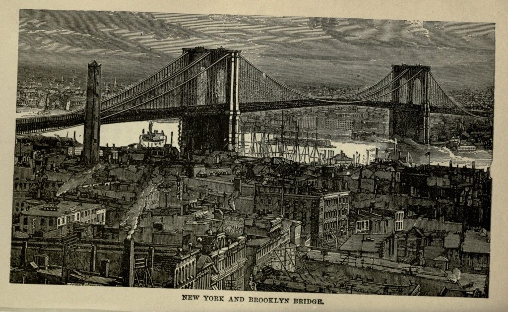
Arrival in Omaha.—The Missouri River.—Position and Appearance of the City.—Public Buildings.—History.—Land Speculation.—Panic of 1857.—Discovery of Gold in Colorado.—"Pike's Peak or Bust."—Sudden Revival of Business.—First Railroad.—Union Pacific Railroad.—Population.—Commercial and Manufacturing Interests.—Bridge over the Missouri.—Union Pacific Depot.—Prospects for the Future.
On the afternoon of October twenty-first, 1876, I sat in the saddle upon the eastern bank of the Missouri River, opposite Omaha, Nebraska, having that day accomplished a horseback journey of twenty-two miles, on my way from the Atlantic to the Pacific. Paul Revere, the faithful horse who had borne me all the way from Boston, declined entering the ferry boat, it being his firm conviction that rivers should either be crossed by bridges or forded. At last, being gently coerced, the horse reluctantly consented, and the muddy current of the river was soon crossed. At three o'clock I entered the city of Omaha, the half-way house across the continent, it having been a little more than five months since I dashed out of the surf, my horse's hoofs wet and dripping with the brine of the Atlantic.
Omaha lies on the eastern boundary of Nebraska, opposite Council Bluffs, on the western bank of the Missouri River, a turbulent stream, which is never satisfied with its position, but is constantly shifting and changing, and making for itself new channels. A bottom land about three miles wide stretches out between Omaha[Pg 320] and Council Bluffs, and through this the Missouri rolls, a swift, muddy stream, slowly but surely carrying the Rocky Mountains down to the Mississippi, which, in its turn, deposits them in the Gulf of Mexico, and helps to extend our Gulf coast. The Missouri vibrates like a pendulum, from one side of this bottom land to the other; now being near one city, and then near the other. At the period of my visit its current washed the front of Omaha, leaving Council Bluffs some distance off on the opposite side; but it was already beginning its backward swing. Thus the boundary line between Nebraska and Iowa is being continually shifted, and one State is augmented in territory at the expense of the other.
Omaha is built in part upon the low bottom lands which border the river, and which may at any time be menaced by the swollen and angry stream, unless precautions are taken, in the building of high and substantial stone levees along the river front. The town lies also in part upon the table lands beyond, and is extending to the bluffs which rise still further away. Its business is chiefly confined to the lower portion, where magnificent blocks attest the prosperity of the city. Streets of substantial dwellings, and numerous most elegant private residences, with large and handsomely ornamented grounds, are discovered as one passes through the city. A striking edifice, of Cincinnati freestone, four stories high, is occupied as a Post Office and Court House. Its High School building is one of the finest in the country. When the State Government was, in 1866, removed from Omaha to Lincoln, the Legislature donated the Square and Capitol Building at the former place for High School purposes. The old Capitol was demolished, and a magnificent school building[Pg 321] erected on its site, at a cost of $250,000, while other fine school edifices, aggregating in cost about $150,000 more, were erected in other sections of the city. The High School building is on the summit of a hill, overlooking a large extent of country, and has a spire one hundred and eighty-five feet high. The Depot of the Union Pacific Railroad is also a noteworthy edifice.
Omaha was first laid out in 1853, and thus named, after a now nearly extinct tribe of Indians. The first house was built, and the first ferry established in that year; and a year later the first brick-kiln was burned, and the first newspaper—the Omaha Arrow—established. Where Turner Hall now stands, in 1854 was dug the first grave, for an old squaw of the Omaha tribe who had been left by her kindred to die. Whittier's description of the growth of western cities seems particularly applicable to Omaha:—
The first Legislature of Nebraska convened in Omaha in the winter of 1854-5; and in 1856 the Capital was definitely located in that city, and the erection of the capitol building commenced. For a year or two there was a great land-boom, and city property and "corner lots" were held at fabulous prices. But in 1857 a crash came, and for a time the infant town was prostrated. However, in 1859 the discovery of gold in Colorado gave it a fresh impetus. The miners who marched in a perpetual caravan across the plains, in white-topped wagons, marked "Pike's Peak or bust," made Omaha their final starting-point, taking in at that place supplies for[Pg 322] their long journey. Two years previous all who could get away from the apparently doomed town had gone to other sections, to begin anew the fight for fortune. Only those remained who were too poor to go, but these were now in luck. Fortune came to them, instead of their being compelled to undertake an ignis fatuus chase after her. At that time the business men of the city laid the foundations of their wealth and prosperity.
In 1857 the town was incorporated as a city; but up to 1867 its only means of communication with the east was by stage-coach, across Iowa, and by steamers on the Missouri, which latter ceased running in winter. In 1865 the population of the town was but four thousand five hundred persons. In 1867 the first train of cars arrived in the city, on the Chicago and Northwestern Railroad. It was not long before other railroads, one after another, made it their western terminus, and its prosperity was established. Then came the Union Pacific Railroad, which started on its long journey across the plains and mountains from this point. The trade to the Pacific coast thus necessarily passed through Omaha, which became a gateway on the route, while many travelers and emigrants paused to breathe and rest before proceeding further, and to take in large quantities of supplies. In 1875 its population had increased to twenty thousand inhabitants, and in 1880 had run up to thirty thousand.
Strange as it may seem, the building of the Union Pacific Railroad has diminished rather than increased the local trade of the city. In overland times single houses sometimes traded as much as three million dollars' worth in a year; but the railroad has so dispersed and distributed business, that now none reach even half that[Pg 323] amount. The city, however, does an immense manufacturing business. Within its limits is located the largest smelting works in America, employing nearly two hundred men, and doing an annual business of probably not less than five millions of dollars. One distillery alone, in 1875, the year previous to my visit, paid the government a tax of $316,000; while there are extensive breweries, linseed-oil works, steam-engine works, and pork-packing establishments. The engine shops, car-works and foundry of the Union Pacific Road occupy, with the round-house, about thirty acres of land, on the bottom adjoining the table land upon which the city is built. Over one million dollars is paid out annually in these establishments, for manual labor alone, without including payments for merchandise and supplies. A notable industry is the manufacture of brick, over five millions being turned out annually from the four brick-yards of Omaha. The city is also the headquarters of the Army of the Platte, which annually distributes nearly a million of dollars.
The first postmaster of Omaha used his hat for a post office, and carried around the mail matter in that receptacle wherever he went, delivering it by chance to its owners. Twenty years later the city possessed the finest government building west of the Mississippi, while the post office receipts are to-day upwards of a million dollars annually. Hides, buffalo robes, and furs, to the value of one hundred and fifty thousand dollars, are annually collected and shipped from Omaha; while two hundred and fifty thousand dollars is the extent in a single year of the sewing machine business. The Pacific Railroad ships from Omaha vast quantities of grain to the Salt Lake Valley, and brings back in[Pg 324] return supplies of Utah fruit, fresh and dried. The first shipment of fruit, made in 1871, amounted to three hundred pounds. In four years the quantity had increased to nine hundred thousand pounds, and is still greater to-day. The Grand Central Hotel was the finest hotel between Chicago and San Francisco, having been erected in 1873, at a cost of three hundred thousand dollars; but it was destroyed by fire in 1878.
The visitor to Omaha will probably reach that city by means of the great bridge across the Missouri River. This bridge is two thousand seven hundred and fifty feet long, with eleven spans, each span two hundred and fifty feet in width, and elevated fifty feet above high water mark. One stone masonry abutment, and eleven piers, each with two cast iron columns, support this bridge. Its construction was commenced in February, 1869, and completed in 1872, during most of which time not less than five hundred men were employed upon it. Each column was sunk in the bed of the river until a solid foundation was reached. One column penetrated the earth eighty-two feet below low water, before it rested on the bed-rock. The approach to the bridge from the Council Bluffs side is by means of a gradually ascending embankment, one mile and a half in length. This bridge was constructed at a cost of two million six hundred and fifty thousand dollars, and brings an annual revenue of about four hundred thousand dollars. It is now, by act of Congress, considered a part of the Union Pacific Railroad, making the eastern terminus of that road really at Council Bluffs. Its total length, including its necessary approaches by embankment on the eastern shore, and by lengthy tressel-work on the western shore is nine thousand nine hundred and fifty feet, or nearly two miles.[Pg 325]
The old depot grounds of the Union Pacific Railroad were on the bank of the river, directly under the present bridge. In order to complete the connection between the bridge and the road, a branch line, seven thousand feet in length, was laid down directly through the city, and a new, spacious and most commodious depot constructed, on higher ground. And from this depot the westward-bound traveler takes his departure for that western empire toward the setting sun, and may, perhaps, continue his journey until he has reached and passed the Golden Gate, and only the solemn immensity of the ocean lies before him.
Situated midway of the American continent, on a navigable river, which drains the northwest, and opens communication with the east and south; a prominent point on the great road which clasps a continent and unites the Atlantic with the Pacific; and at the same time a terminus for lesser roads which open up to it the trade and commerce of the interior; and on the borders of two states rich in agricultural and mineral wealth, and settled by a thrifty, intelligent and enterprising people; Omaha can scarcely fail to become the greatest city west of St. Louis. Founded but a generation ago, its business is already stupendous, though it is really but a beginning of what it promises to be in the future. As Iowa, Nebraska, and the States and Territories still further to the northwest, become more thickly settled, with their resources developed, it will form their natural commercial centre, to which they will look for supplies, and where they will find a market or a port for their produce and manufactures. With such an outlook, who will dare to limit Omaha's possibilities in the future, or say that any flight of the imagination really exceeds what the actuality may prove?
Ottawa, the seat of the Canadian Government.—History.—Population.—Geographical Position.—Scenery.—Chaudière Falls.—Rideau Falls.—Ottawa River.—Lumber Business.—Manufactures.—Steamboat and Railway Communications.—Moore's Canadian Boat Song.—Description of the City.—Churches, Nunneries, and Charitable Institutions.—Government Buildings.—Rideau Hall.—Princess Louise and Marquis of Lorne.—Ottawa's Proud Boast.
Ottawa was, in 1858, selected by Queen Victoria as the seat of the Canadian Government. When, in 1867, the British North American Possessions were reconstructed into the Dominion of Canada, Ottawa continued to be the Capital city. It was originally called Bytown, after Colonel By, of the Royal Engineers, who was, in 1827, commissioned to construct the Rideau Canal, and who laid out the town. In 1854 it was incorporated as a city, and its name changed to Ottawa, from the river upon which it stands. Since that time it has increased rapidly in population and importance, and has at the present time not far from twenty-five thousand inhabitants. It is situated on the south bank of the Ottawa River, at the mouth of the Rideau, one hundred and twenty-six miles above Montreal. The scenery around it is most magnificent, and is scarcely surpassed by any in Canada. At the west end of the city the Ottawa rushes, in a magnificent cataract, over a ragged ledge, two hundred feet wide and forty feet high, in what is known as the Chaudière Falls. Chaudière signifies[Pg 327] caldron, and in the seething caldron of waters at the base of the falls a sounding line three hundred feet in length has not touched bottom. Immediately below the falls is a suspension bridge, from which a most satisfactory view can be obtained. At the northeast end of the city the Rideau tumbles, in two cataracts, into the Ottawa. These cataracts are very picturesque, but are exceeded in grandeur by the Chaudière. The Des Chênes Rapids, having a fall of nine feet, are found about eight miles above Ottawa.
The Ottawa River is, next to the St. Lawrence, the largest stream in Canada. Rising in the range of mountains which forms the watershed between Hudson Bay and the great lakes, it runs in a southeasterly direction for about six hundred miles before it empties into the St. Lawrence. It has two mouths, which form the island upon which Montreal is situated. The entire region drained by it and its tributaries measures eighty thousand square miles. These tributaries and the Ottawa itself form highways for, probably, the largest lumber trade in the world. The clearing of great tracts of country by the lumbermen has opened the way for agriculturists; and numerous thriving settlements are found upon and near their banks, all of which look to Ottawa as their business centre. As these settlements increase in number and size, the prosperity of Ottawa will multiply in proportion. The navigation of the river has been much improved by engineering, especially for the transportation of lumber, dams and slides having been constructed for its passage over rapids and falls.
This immense supply of lumber is, much of it, arrested at Ottawa, where the almost unequaled water power is utilized in saw-mills, which furnish the city its principal[Pg 328] employment, and from which issue yearly almost incredible quantities of sawed lumber. There are also flour mills, and manufactories of iron castings, mill machinery, and agricultural implements, which give it commercial importance, and a sound basis of prosperity.
Ottawa is connected by steamer with Montreal, and by the Rideau Canal with Lake Ontario at Kingston, while the Grand Trunk Railway sends a branch line from Prescott. The Ottawa River is navigable for one hundred and eighty-eight miles above the city, by steamers of the Union Navigation Company, but there are numerous portages around falls and rapids. The last stopping place of the steamer is Mattawa, a remote port of the Hudson Bay Company. Beyond that outpost of civilization there is nothing but unexplored and unbroken wilderness. Moore's Canadian boat song makes mention of the Ottawa River:—
Ottawa is divided into Upper and Lower Town by the Rideau Canal, which contains eight massive locks within the city limits, and is crossed by two bridges, one of stone and iron, and the other of stone alone. The streets of the city are wide and regular. Sparks street is the fashionable promenade, containing the principal retail stores. Sussex is also a prominent business street. The principal hotels are the Russell House, near the Parliament Buildings; Windsor House, in the Upper Town; and the Albion, on Court House Square.
The most prominent church edifice in the city is the Roman Catholic Cathedral of Notre Dame, which is of[Pg 329] stone, with double spires two hundred feet in height. The interior is very fine, and contains as an altar piece Murillo's "Flight into Egypt." St. Patrick's, Roman Catholic, and St. Andrew's, Presbyterian, are also striking churches. At the corner of Bolton and Sussex streets is the imposing stone building of the Grey Nunnery, while the group of buildings belonging to the Black Nunnery is to the eastward of Cartier Square. There are, besides, in the city, two convents, two hospitals, three orphan asylums, and a Magdalen asylum, all under the control of the Roman Catholics. The Ottawa University is also a Roman Catholic institution, and has a large building in Wilbrod street. The Ladies' College, in Albert street, is a Protestant school.
But all these structures sink into insignificance when compared to the Government Buildings, which constitute the most prominent feature of the city of Ottawa. They are situated on an eminence known as Barrack Hill, which rises one hundred and fifty feet above the river, and were erected at a cost of about four millions of dollars. They form three sides of a vast quadrangle, which occupies nearly four acres. The Parliament House is on the south side or front of the quadrangle, and is four hundred and seventy-two feet long, and the same number of feet deep, from the front of the main tower, to the rear of the library. The Departmental Buildings run north from this main structure, forming the east and west sides of the quadrangle. The eastern side is five hundred and eighteen feet long, by two hundred and fifty-three feet deep, and the western side is two hundred and eleven feet long, by two hundred and seventy-seven feet deep. These latter buildings contain the various government bureaus, in the west[Pg 330] block being also found the model room of the Patent Office, and the Post Office. The entire structure is of cream-colored sandstone, with arches and doors of red Potsdam sandstone, and the external ornamental work of this sandstone. Its architecture is in the Italian-Gothic style. Green and purple slates cover the roof, and the pinnacles are ornamented with elaborate iron trellis work. The columns and arches of the legislative chambers are of marble. These chambers are capacious and richly finished, and have stained glass windows. The Chamber of Commons is reached by an entrance to the left of the main entrance, under the central tower, and the marble of its columns and arches is beautiful. The Senate Hall, which is entered from the right of the main entrance, contains the vice-regal canopy and throne, and a portrait of Queen Victoria. There are also full-length portraits, by Sir Joshua Reynolds, of George III, and Queen Charlotte. The Library is a circular structure, on the north front of the Parliament House, with a dome ninety feet high, and contains about forty thousand volumes. A massive stone wall incloses the fourth side of the quadrangle, and the inclosure is laid out with tree-shaded walks.
Rideau Hall, the official residence of the Governor General, is in New Edinburgh, a suburban town on the opposite side of the Rideau River, connected with Ottawa by a bridge. Rideau Hall has been for several years past the home of the Marquis of Lorne, Governor General of the Dominion of Canada, and the Princess Louise, fourth daughter of Queen Victoria. The love which the Canadians bear their Queen was most loyally manifested on the arrival of the Governor General and the Princess, his wife. Every honor was shown the[Pg 331] Marquis which was due his official and hereditary rank; but the most extravagant marks of affection and veneration were lavished upon the Princess, who was regarded as a representative of her mother. Whenever she proceeded through the Dominion, her progress was a triumphal procession. The people crowded to catch but a glimpse of her face, or to hear the tones of her voice. She is described as an extremely affable lady, the beauty of Her Majesty's family, caring less for the traditions and observances of royalty than her imperial mother, with great native shrewdness and marked ability as an artist. She has traveled extensively throughout the dominion of Canada, having reached its extreme western limit, and crossed the United States from the Atlantic to the Pacific. It is said she does not greatly admire Canada, and proposes to spend as little time at Ottawa as possible, regarding the somewhat primitive society there as almost semi-barbaric. But when she returns permanently to the island of her birth she will go with greatly enlarged views, and a knowledge of the world, and especially of the people of the new world, which ought to constitute her an efficient counsellor in affairs of state.
The Marquis of Lorne, Governor General of Canada, is described as an extremely handsome gentleman of the Scotch type, with large literary attainments, and with a desire to conciliate the people over whom he has been sent to rule. For many generations to come it will undoubtedly be Ottawa's highest boast that it has numbered among its citizens the son of one of the proudest nobles of the British realm, and a princess of the blood.
Pittsburg at Night.—A Pittsburg Fog.—Smoke.—Description of the City.—The Oil Business.—Ohio River.—Public Buildings, Educational and Charitable Institutions.—Glass Industry.—Iron Foundries.—Fort Pitt Works.—Casting a Monster Gun.—American Iron Works.—Nail Works.—A City of Workers.—A True Democracy.—Wages.—Character of Workmen.—Value of Organization.—Knights of Labor.—Opposed to Strikes.—True Relations of Capital and Labor.—Railroad Strike of 1877.—Allegheny City.—Population of Pittsburg.—Early History—Braddock's Defeat.—Old Battle Ground.—Historic Relics.—The Past and the Present.
By all means make your first approach to Pittsburg in the night time, and you will behold a spectacle which has not a parallel on this continent. Darkness gives the city and its surroundings a picturesqueness which they wholly lack by daylight. It lies low down in a hollow of encompassing hills, gleaming with a thousand points of light, which are reflected from the rivers, whose waters glimmer, it may be, in the faint moonlight, and catch and reflect the shadows as well. Around the city's edge, and on the sides of the hills which encircle it like a gloomy amphitheatre, their outlines rising dark against the sky, through numberless apertures, fiery lights stream forth, looking angrily and fiercely up toward the heavens, while over all these settles a heavy pall of smoke. It is as though one had reached the outer edge of the infernal regions, and saw before him the great furnace of Pandemonium with all the lids lifted. The scene is so strange and weird that it will[Pg 333] live in the memory forever. One pictures, as he beholds it, the tortured spirits writhing in agony, their sinewy limbs convulsed, and the very air oppressive with pain and rage.
But the scene is illusive. This is the domain of Vulcan, not of Pluto. Here, in this gigantic workshop, in the midst of the materials of his labor, the god of fire, having left his ancient home on Olympus, and established himself in this newer world, stretches himself beside his forge, and sleeps the peaceful sleep which is the reward of honest industry. Right at his doorway are mountains of coal to keep a perpetual fire upon his altar; within the reach of his outstretched grasp are rivers of coal oil; and a little further away great stores of iron for him to forge and weld, and shape into a thousand forms; and at his feet is the shining river, an impetuous Mercury, ever ready to do his bidding. Grecian mythology never conceived of an abode so fitting for the son of Zeus as that which he has selected for himself on this western hemisphere. And his ancient tasks were child's play compared with the mighty ones he has undertaken to-day.
Failing a night approach, the traveler should reach the Iron City on a dismal day in autumn, when the air is heavy with moisture, and the very atmosphere looks dark. All romance has disappeared. In this nineteenth century the gods of mythology find no place in daylight. There is only a very busy city shrouded in gloom. The buildings, whatever their original material and color, are smoked to a uniform, dirty drab; the smoke sinks, and mingling with the moisture in the air, becomes of a consistency which may almost be felt as well as seen. Under a drab sky a drab twilight hangs over the town,[Pg 334] and the gas-lights, which are left burning at mid-day, shine out of the murkiness with a dull, reddish glare. Then is Pittsburg herself. Such days as these are her especial boast, and in their frequency and dismalness, in all the world she has no rival.
In truth, Pittsburg is a smoky, dismal city, at her best. At her worst, nothing darker, dingier or more dispiriting can be imagined. The city is in the heart of the soft coal region; and the smoke from her dwellings, stores, factories, foundries and steamboats, uniting, settles in a cloud over the narrow valley in which she is built, until the very sun looks coppery through the sooty haze. According to a circular of the Pittsburg Board of Trade, about twenty per cent., or one-fifth, of all the coal used in the factories and dwellings of the city escapes into the air in the form of smoke, being the finer and lighter particles of carbon of the coal, which, set free by fire, escapes unconsumed with the gases. The consequences of several thousand bushels of coal in the air at one and the same time may be imagined. But her inhabitants do not seem to mind it; and the doctors hold that this smoke, from the carbon, sulphur and iodine contained in it, is highly favorable to lung and cutaneous diseases, and is the sure death of malaria and its attendant fevers. And certainly, whatever the cause may be, Pittsburg is one of the healthiest cities in the United States. Her inhabitants are all too busy to reflect upon the inconvenience or uncomeliness of this smoke. Work is the object of life with them. It occupies them from morning until night, from the cradle to the grave, only on Sundays, when, for the most part, the furnaces are idle, and the forges are silent. For Pittsburg, settled by Irish-Scotch Presbyterians,[Pg 335] is a great Sunday-keeping day. Save on this day her business men do not stop for rest or recreation, nor do they "retire" from business. They die with the harness on, and die, perhaps, all the sooner for having worn it so continuously and so long.
Pittsburg is not a beautiful city. That stands to reason, with the heavy pall of smoke which constantly overhangs her. But she lacks beauty in other respects. She is substantially and compactly built, and contains some handsome edifices; but she lacks the architectural magnificence of some of her sister cities; while her suburbs present all that is unsightly and forbidding in appearance, the original beauties of nature having been ruthlessly sacrificed to utility.
Pittsburg is situated in western Pennsylvania, in a narrow valley at the confluence of the Allegheny and Monongahela rivers, and at the head of the Ohio, and is surrounded by hills rising to the height of four or five hundred feet. These hills once possessed rounded outlines, with sufficient exceptional abruptness to lend them variety and picturesqueness. But they have been leveled down, cut into, sliced off, and ruthlessly marred and mutilated, until not a trace of their original outlines remain. Great black coal cars crawl up and down their sides, and plunge into unexpected and mysterious openings, their sudden disappearance lending, even in daylight, an air of mystery and diablerie to the region. Railroad tracks gridiron the ground everywhere, debris of all sorts lies in heaps, and is scattered over the earth, and huts and hovels are perched here and there, in every available spot. There is no verdure—nothing but mud and coal, the one yellow the other black. And on the edge of the city are the unpicturesque outlines of fac[Pg 336]tories and foundries, their tall chimneys belching forth columns of inky blackness, which roll and whirl in fantastic shapes, and finally lose themselves in the general murkiness above.
The tranquil Monongahela comes up from the south, alive with barges and tug boats; while the swifter current of the Allegheny bears from the oil regions, at the north, slight-built barges with their freights of crude petroleum. Oil is not infrequently poured upon the troubled waters, when one of these barges sinks, and its freight, liberated from the open tanks, refuses to sink with it, and spreads itself out on the surface of the stream.
The oil fever was sorely felt in Pittsburg, and it was a form of malaria against which the smoke-laden atmosphere was no protection. During the early years of the great oil speculation the city was in a perpetual state of excitement. Men talked oil upon the streets, in the cars and counting-houses, and no doubt thought of oil in church. Wells and barrels of petroleum, and shares of oil stock were the things most often mentioned. And though that was nearly twenty years ago, and the oil speculation has settled into a safe and legitimate pursuit, Pittsburg is still the greatest oil mart in the world. By the means of Oil Creek and the Allegheny, the oil which is to supply all markets is first shipped to Pittsburg, passes through the refineries there, and is then exported.
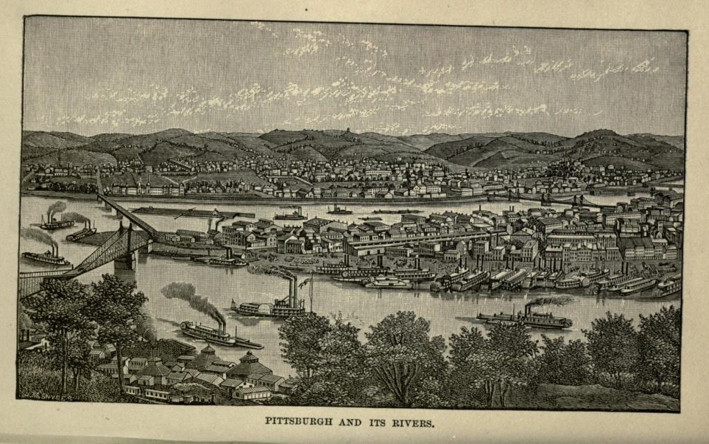
The Ohio River makes its beginning here, and in all but the season of low water the wharves of the city are lined with boats, barges and tugs, destined for every mentionable point on the Ohio and Mississippi rivers. The Ohio River is here, as all along its course, an uncertain [Pg 337] and capricious stream. Sometimes, in spring, or early summer, it creeps up its banks and looks menacingly at the city. At other times it seems to become weary of bearing the boats, heavily laden with merchandise, to their destined ports, and so takes a nap, as it were. The last time we beheld this water-course its bed was lying nearly bare and dry, while a small, sluggish creek, a few feet, or at most, a few yards wide, crept along the bottom, small barges being towed down stream by horses, which waded in the water. The giant was resting.
The public buildings and churches of Pittsburg are, some of them, of fine appearance, while the Mercantile Library is an institution to be proud of, being both handsome and spacious, and containing a fine library and well-supplied reading room. The city boasts of universities, colleges, hospitals, and asylums, and the Convent of the Sisters of Mercy is the oldest house of the order in America. There are also two theatres, an Opera House, an Academy of Music, and several public halls.
But it is not any of these which has made the city what she is, or to which she will point with the greatest pride. The crowning glory of Pittsburg is her monster iron and glass works. One-half the glass produced in all the United States comes from Pittsburg. This important business was first established here in 1787, by Albert Gallatin, and it has increased since then to giant proportions. Probably, not less than one hundred millions of bottles and vials are annually produced here, besides large quantities of window glass. The best wine bottles in America are made here, though they are inferior to those of French manufacture. A great number[Pg 338] of flint-glass works turn out the best flint glass produced in the country.
In addition to these glass works—which, though they employ thousands of workmen, represent but a fraction of the city's industries—there are rolling mills, foundries, potteries, oil refineries, and factories of machinery. All these works are rendered possible by the coal which abounds in measureless quantities in the immediate neighborhood of the city. All the hills which rise from the river back of Pittsburg have a thick stratum of bituminous coal running through them, which can be mined without shafts, or any of the usual accessories of mining. All that is to be done is to shovel the coal out of the hill-side, convey it in cars or by means of an inclined plane to the factory or foundry door, and dump it, ready for use. In fact, these hills are but immense coal cellars, ready filled for the convenience of the Pittsburg manufacturers. True, in shoveling the coal out of the hill-side, the excavations finally become galleries, running one, two or three miles directly into the earth. But there is neither ascent nor descent; no lowering of miners or mules in great buckets down a deep and narrow shaft, no elevating of coal through the same means. It is all like a great cellar, divided into rooms, the ceilings supported by arches of the coal itself. Each miner works a separate room, and when the room is finished, and that part of the mine exhausted the arches are knocked away, pillars of large upright logs substituted, the coal removed, and the hill left to settle gradually down, until the logs are crushed and flattened.
The "Great Pittsburg Coal Seam" is from four to twelve feet thick, about three hundred feet above the water's edge, and about one hundred feet from the[Pg 339] average summit of the hills. It is bituminous coal which has been pressed solid by the great mass of earth above it. The thicker the mass and the greater the pressure, the better the coal. It has been estimated as covering eight and a half millions of acres, and that it would take the entire product of the gold mines of California for one thousand years to buy this one seam. When we remember the numerous other coal mines, anthracite as well as bituminous, found within the limits of the State of Pennsylvania, we are fairly stupefied in trying to comprehend the mineral wealth of that State.
The coal mined in the rooms in these long galleries is conveyed in a mule-drawn car to the mouth of the gallery, and if to be used by the foundries at the foot of the hill, is simply sent to its destination down an inclined plane. Probably not less than ten thousand men are employed in these coal mines in and near Pittsburg, adding a population not far from fifty thousand to that region. Pittsburg herself consumes one-third of the coal produced, and a large proportion of the rest is shipped down the Ohio and Mississippi rivers, some of it as far as New Orleans.
The monster iron works of Pittsburg consume large quantities of this coal, and it is the abundance and convenience of the latter material which have made the former possible. No other city begins to compare with Pittsburg in the number and variety of her factories. Down by the banks of the swift-flowing Allegheny most of the great foundries are to be discovered. The Fort Pitt Works are on a gigantic scale. Here are cast those monsters of artillery known as the twenty-inch gun. Not by any means a gun twenty inches in length, but a gun with a bore twenty inches in diameter, so accurate[Pg 340] that it does not vary one-hundredth part of an inch from the true line in its whole length. The ball for this gun weighs one thousand and eighty pounds, and costs a hundred and sixty-five dollars. The gun itself weighs sixty tons, and costs fifty thousand dollars, and yet one of these giants is cast every day, and the operation is performed with the utmost composure and absence of confusion. The mould is an enormous structure of iron and sand, weighing forty tons, and to adjust this properly is the most difficult and delicate work in the foundry. When it is all ready, three streams of molten iron, from as many furnaces, flow through curved troughs and pour their fiery cataracts into the mould. These streams run for twenty minutes, and then, the mould being full, the furnaces from which they flow are closed with a piece of clay. Left to itself, the gun would be thirty days in cooling, but this process is expedited to eighteen days, by means of cold water constantly flowing in and out of the bore. While it is still hot, the great gun is lifted out of the pit, swung across the foundry to the turning shop, the end shaven off, the outside turned smooth, and the inside hollowed out, with an almost miraculous precision. The weight of the gun is thus reduced twenty tons.
The American Iron Works employ two thousand five hundred hands, and cover seventeen acres. They have a coal mine at their back door, and an iron mine on Lake Superior, and they make any and every difficult iron thing the country requires. Nothing is too ponderous, nothing too delicate and exact, to be produced. The nail works of the city are well worth seeing. In them a thousand nails a minute are manufactured, each nail being headed by a blow on cold iron. The noise arising[Pg 341] from this work can only be described as deafening. In one nail factory two hundred different kinds of nails, tacks and brads are manufactured. The productions of these different factories and foundries amount in the aggregate to an almost incredible number and value, and embrace everything made of iron which can be used by man.
George F. Thurston, writing of Pittsburg, says, it has "thirty-five miles of factories in daily operation, twisted up into a compact tangle; all belching forth smoke; all glowing with fire; all swarming with workmen; all echoing with the clank of machinery. Actual measurement shows that there are, in the limits of what is known as Pittsburg, nearly thirty-five miles of manufactories of iron, of steel, of cotton, and of brass alone, not mentioning manufactories of other materials. In a distance of thirty-five and one-half miles of streets, there are four hundred and seventy-eight manufactories of iron, steel, cotton, brass, oil, glass, copper and wood, occupying less than four hundred feet each; for a measurement of the ground shows that these factories are so contiguous in their positions upon the various streets of the city, that if placed in a continuous row, they would reach thirty-five miles, and each factory have less than the average front stated. This is "manufacturing Pittsburg." In four years the sale and consumption of pig iron alone was one-fourth the whole immense production of the United States; and through the Ohio and Mississippi rivers and their tributaries, its people control the shipment of goods, without breaking bulk, over twelve thousand miles of water transportation, and are thus enabled to deliver the products of their thrift in nearly four hundred counties in the territory of fifteen[Pg 342] States. There is no city of its size in the country which has so large a banking capital as Pittsburg. The Bank of Pittsburg, it is said, is the only bank in the Union that never suspended specie payments.
Pittsburg is a city of workers. From the proprietors of these extensive works, down to the youngest apprentices, all are busy; and perhaps the higher up in the scale the harder the work and the greater the worry. A man who carries upon his shoulders the responsibility of an establishment whose business amounts to millions of dollars in a year; who must oversee all departments of labor; accurately adjust the buying of the crude materials and the scale of wages on the one hand, with the price of the manufactured article on the other, so that the profit shall be on the right side; and who at the same time shall keep himself posted as to all which bears any relation to his business, has no time for leisure or social pleasures, and must even stint his hours of necessary rest.
Pittsburg illustrates more clearly than any other city in America the outcome of democratic institutions. There are no classes here except the industrious classes; and no ranks in society save those which have been created by industry. The mammoth establishments, some of them perhaps in the hands of the grandsons of their founders, have grown from small beginnings, fostered in their growth by industry and thrift. The great proprietor of to-day, it may have been, was the "boss" of yesterday, and the journeyman of a few years ago, having ascended the ladder from the lowest round of apprenticeship. Industry and sobriety are the main aids to success.
The wages paid are good, for the most part, varying[Pg 343] according to the quality of the employment, some of them being exceedingly liberal. The character of the workmen is gradually improving, though it has not yet reached the standard which it should attain. Many are intelligent, devoting their spare time to self-improvement, and especially to a comprehension of the relations of capital and labor, which so intimately concern them, and which they, more than any other class of citizens, except employers, need to understand, in order that they may not only maintain their own rights, but may avoid encroaching on the rights of others.
Too many workmen, however, have no comprehension of the dignity of their own position. They live only for present enjoyment, spend their money foolishly, not to say wickedly, and on every holiday give themselves up to that curse of the workingman—strong drink. While this class is such a considerable one, the entire ranks of working men must be the sufferers. And while ignorance as well as vice has been so prevalent among them, it is not to be wondered at that they have been constantly undervalued, and almost as constantly oppressed.
The prosperity of the country depends upon the prosperity of the masses. With all the money in the hands of a few, there are only the personal wants of a few to be supplied. With wages high, work is more plentiful, and everybody prospers. The gains of a large manufacturing establishment, divided, by means of fair profit and just wages, between employers and employed, instead of being hoarded up by one man, make one hundred persons to eat where there would otherwise be but one; one hundred people to buy the productions of the looms and forges of the country, instead of only one; one[Pg 344] hundred people, each having a little which they spend at home, instead of one man, who hoards his wealth, or takes it to Europe to dispose of it. It means all the difference between good and bad times, between a prosperous country, where all are comfortable and happy, and a country of a few millionaires and many paupers.
No description of Pittsburg would be complete without a reference to the Knights of Labor, which has taken the place of the old trades unions and guilds. While the latter were in existence, that city was often the scene of violent and disastrous strikes. The great railroad strike of 1877, in which a number of lives were lost, and millions of dollars' worth of property destroyed, culminated at Pittsburg, and for days the city was stricken with panic. The cause of this strike was the decision of the railroad corporation to reduce to one dollar a day the wages of a certain class of its employees, which were already too low. The cause of these strikers was just, but their methods were reprehensible. The institution and spread of the Knights of Labor has rendered such another strike an impossibility, as that Order, which has a large membership among the workmen of Pittsburg, aims to settle, as far as possible, the difficulties between employers and employees by arbitration; and its spread will, we trust, if it does not pass under the control of demagogues, eventually result in a better understanding between capital and labor, and in a recognition of the fact that their real interests are identical.
Pittsburg has no park or public pleasure ground. Its people are too busy to think about such things, or to use them if it had them. On Saturday nights its theatres and variety halls are crowded, to listen to entertain[Pg 345]ments which are not always of the best. When its people wish to visit a public park, they must cross to Allegheny City, on the west bank of the Allegheny River, where there is a park embracing a hundred acres, containing a monument to Humboldt, and ornamented with small lakes. The Soldiers' Monument, erected to the memory of four thousand men of Allegheny County who lost their lives in the war of the Rebellion, is also in this latter city, on a lofty hill near the river, in the eastern part of the city. Many of the handsome residences of Pittsburg's merchants and manufacturers are to be seen in this city, which is also famous for its manufacturing interests, and is connected with Pittsburg by five bridges. Birmingham is a flourishing suburb on the opposite bank of the Monongahela River, containing important glass and iron manufactories.
The present population of Pittsburg is 156,381 inhabitants. The first settlement upon the site of the city was in 1754, when a French trading post was established and named Fort Duquesne. On July ninth, 1755, General Braddock, in command of two thousand British troops, accompanied by Colonel Washington with eight hundred Virginians, marched toward Fort Duquesne with the intention of capturing it. When within a few miles of the fort, they were surprised by a large party of French and Indians in ambush, and Braddock, who angrily disregarded Washington's advice, saw his troops slaughtered by an invisible enemy. The English and colonists lost seven hundred and seventy-seven men, killed and wounded, while the enemy's loss was scarcely fifty. Braddock himself was mortally wounded, and died upon the battle field, and in order that his remains might not be disturbed, Washington[Pg 346] buried him in the road, and ordered the wagons in their retreat to drive over his grave. Washington himself escaped unhurt, though he had two horses shot under him, and had four bullets sent through his clothes. An Indian who was engaged in this battle afterwards said that he had seventeen fair fires at Washington during the engagement, but was unable to wound him.
In 1758, Fort Duquesne was abandoned by the French, and immediately occupied by the English, who changed its name to Fort Pitt, in honor of William Pitt. As a town its settlement dates from 1765. In 1804 it was incorporated as a borough, and in 1816 chartered as a city. Its population in 1840, was a little more than 20,000. In 1845 a great part of the city was destroyed by fire, but was quickly rebuilt, its prosperity remaining unchecked.
A little less than ten miles from Pittsburg is the village called Braddock's Field, which, in the names of its streets, perpetuates the old historic associations. The ancient Indian trail which led to the river is still preserved, and the two shallow ravines in which the French and Indians lay concealed when they surprised Braddock's troops are still there, though denuded of the dense growth of hazel bushes which at that period served the purpose of an ambush. From an old oak in this neighborhood many bullets have been pried out by persevering relic hunters; while in the adjacent gardens the annual spring plowing invariably turns up mementoes of that historic event, in the shape of bullets, arrow heads, and even bayonets. A sword with a name engraved upon it has also been found.
The Pennsylvania Railroad now crosses the location of the thickest of the fight, and at the time of its con[Pg 347]struction a considerable number of human bones were dug up and reinterred, the place of the later interment being surrounded by a rough fence of common rails. Children now play where once the forces of their nation engaged in deadly warfare. The hillside, which was then pierced by bullets, is now perforated near its summit by large openings, through which emerge car-loads of coal. Thus the present and the past strike hands across the century, and modern civilization, with its implements of industry and its appliances of commerce, supersedes and obliterates the traces of savagery, and of the deadly enmity of man toward man. The sword is turned into the plowshare, and peace triumphs over bloodshed.
The Coast of Maine.—Early Settlements in Portland.—Troubles with the Indians.—Destruction of the Town in 1690.—Destroyed Again in 1703.—Subsequent Settlement and Growth.—During the Revolution.—First Newspaper.—Portland Harbor.—Commercial Facilities and Progress.—During the Rebellion.—Great Fire of 1866.—Reconstruction.—Position of the city.—Streets.—Munjoy Hill.—Maine General Hospital.—Eastern and Western Promenades.—Longfellow's House.—Birthplace of the Poet.—Market Square and Hall.—First Unitarian Church.—Lincoln Park.—Eastern Cemetery.—Deering's Woods.—Commercial Street.—Old-time Mansion.—Case's Bay and Islands.—Cushing's Island.—Peak's Island.—Long Island.—Little Chebague Island.—Harpswell.
The hungry ocean has gnawed and ravaged the New England coast, until along almost its entire length it is worn into ragged edges, forming islands, capes, promontories, bold headlands, peninsulas, bays, inlets and coves. In this coast are united the grand, the picturesque and the beautiful. Soft masses of foliage are in close juxtaposition with rugged rocks and dashing surf. Violet turf sweeps down to meet the sands washed up by the sea. Bays cut deeply into the land, forming safe harbors, and emerald islands innumerable dot their surface.
In 1632 George Cleve and Richard Tucker landed on the beach of a peninsula, jutting out into a broad and deep bay, and sheltered from the ocean by a promontory at the south, now known as Cape Elizabeth, and by a guard of islands which clasped hands around it. Here[Pg 349] Cleve built, of logs, the first house on the site of what is now the city of Portland. After a time other colonists came, devoting themselves to fishing and buying furs of the Indians. When the people of this distant colony wanted to go to Boston, they rode horseback along the beach, which formed the original highway. The settlement was first known as Casco, but its name was changed to Falmouth in 1668, though a portion of it, where Portland now stands, continued to be known as Casco Rock. In 1675 there were but forty families in the town, and the Rock was still almost covered by a dense forest. In that year the Indians, who had long borne grievous wrongs at the hands of the settlers with patient endurance, arose, under King Philip, to avenge them. The inhabitants of Falmouth were either killed or carried into captivity, and the little town was wiped out of existence.
Three years later Fort Royal, the largest fortification on the coast, was erected on a rocky eminence, near the present foot of India street, where the round-house of the Grand Trunk Railway now stands, and settlers began to return. A party of French Huguenots settled there, mills were set up, roads cut into the forest, and trade established between Falmouth and Massachusetts towns. The little settlement existed under varying fortunes until 1690, when the French and Indians, after a few days' siege, captured the fort, destroyed the town, and carried the commanding officer and his garrison captives to Quebec. The war continued until 1698, during which time the place was only known as "deserted Casco." In 1703 the war broke out again, and what few inhabitants had straggled back were killed, and the place remained desolate until 1715, when the[Pg 350] re-settlement began. Three years later twenty families had banded themselves together for mutual defence, clustering about the foot of India street, and eastward along the beach. The second meeting-house of the town was erected at the corner of India and Middle streets, where Rev. Thomas Smith, in 1727, commenced his ministry, which extended over a period of sixty-eight years.
The town was incorporated in 1718, and at that time the Neck above Clay Cove was all forest and swamp. A brook flowed into the Cove, crossed by bridges at Fore and Middle streets. The old bridge at Middle street remained until early in the present century. The trails stretching out into the forest gradually grew into streets, and the three principal ones were named Fore, Middle and Back streets. The name of the latter was, late in the century, changed to Congress street.
After a period of sixty years of steady growth, the town had extended only as far westward as Centre street, and the upper portion of the Neck was still covered with woods. The Indians gave the town little trouble after 1725, having made peace in that year, and gradually dwindled away, and emigrated to Canada. In 1755 it was no longer a frontier post. Its population had increased to nearly 3,000 inhabitants, commerce had been established, and the town was a most peaceful and a prosperous one. At the commencement of the Revolution 2,555 tons of shipping were owned in Falmouth.
When the colonies began to resist the encroachments of England, Falmouth took a prominent and patriotic stand. In October, 1775, Captain Henry Mowatt, with a fleet of five vessels, opened his batteries on the town, and, firing the houses, laid it in ashes. Over four[Pg 351] hundred buildings were destroyed, leaving only one hundred standing. The place was again deserted, the people seeking safety in the interior.
On January first, the Falmouth Gazette and Weekly Advertiser, the first newspaper of the town, was published by Benjamin Titcomb and Thomas B. Waite. In 1786 the town was divided, the Neck receiving the name of Portland, having at that time a population of about two thousand. In 1793 wharves were extended into the harbor. In 1806, its commercial business and general prosperity were unexampled in New England. The duties collected at the Custom House reached, in that year, $342,809, having increased from $8,109 in 1790. But in 1807, the embargo which followed the non-intercourse policy of 1806 resulted in the suspension of commerce and the temporary ruin of the shipping interests. Commercial houses were prostrated, and great distress prevailed. The harbor was empty, and grass grew upon the wharves. In the war of 1812 privateers were fitted out here, some of which damaged the enemy, while others were captured. After the peace of 1815 commerce revived but slowly, and the population as slowly increased.
In March, 1820, Maine was separated from Massachusetts, and admitted into the Union as a State; and Portland became its capital. In 1832 the capital was removed to Augusta. In 1828 the first steamboat anchored in the harbor of Portland, having arrived from New York to run as a passenger boat between Portland and Boston. The Portland Steam Packet Company was organized in 1844, and has continued in successful operation ever since.
Portland has one of the deepest and best harbors in[Pg 352] the world, with a depth of forty feet at low tide. Its surroundings are exceptionally favorable for a commercial city, and were it not for its geographical location, it being so far north of the great areas of population, it would undoubtedly have gained a prominence over most of the Atlantic cities. But Boston and New York drew all but the provincial trade and commerce, and with a sparsely settled country at its back, there was little to build up Portland and give it great prosperity. In 1850 the Cumberland and Oxford Canal, connecting the waters of Sebago Lake with Portland Harbor, was completed. This was not a great enterprise, certainly, as compared with modern undertakings; but the Portlanders thought a good deal of it at the time. Between 1840 and 1846, the city endured another season of depression. Railroads had given to Boston much of the business that had formerly found a natural outlet through Portland; but in the latter year a railroad was planned to Canada, which, when completed, in 1853, brought it into connection with the cities of the British provinces, and with the vast grain-growing regions of the west. A winter line of steamers to Liverpool followed, and the rapidly increasing commerce of the city soon resulted in the construction of a wide business avenue, extending a mile in length, along the whole water front of the city. This new street was called Commercial, and became the locality of heavy wholesale trade. Closely following, came the opening up of railroads to all sections of the State, and the establishment of steamboat lines along the coast, as far as the Lower Provinces. Trade that had hitherto gone to Boston was thus reclaimed, new manufacturing establishments sprung up, and an era of prosperity seemed fairly inaugurated.[Pg 353]
Portland manifested her patriotism during the war of the Rebellion, contributing 5,000 men to the army, of whom four hundred and twenty-one returned. In June, 1863, the United States Revenue cutter, Caleb Cushing, having been captured by Rebels, and pursued by the officials of the city, and becoming becalmed near the Green Islands, was blown up by her captors, the latter taking to the boats, only to be captured and sent to Fort Preble as prisoners of war.
On the fourth of July, 1866, a fire-cracker, carelessly thrown in a boat builder's shop, on Commercial, near the foot of High street, resulted in a fire which laid in ruins more than half the city of Portland. The fire commenced about five o'clock in the afternoon. The sparks soon communicated with Brown's Sugar House, and thence, spreading out like a fan, swept diagonally across the city, destroying everything in its track, until a space one and one-half miles long, by one and one-fourth miles broad, was so completely devastated that only a forest of tottering walls and blackened chimneys remained, and it was difficult to trace even the streets. The fire was fanned into such a fury by a gale which was blowing at the time, that the efforts of the firemen were without avail, and the work of destruction was only stayed when, as a last resort, buildings in its path were blown up before the flames had reached them. The entire business portion, embracing one-half the city, was destroyed. Every bank and newspaper office, every lawyer's office, many stores, churches, public buildings and private residences were swept away. Fireproof structures, which were hastily filled with valuables, in the belief that they would withstand the flames, crumbled to the earth, as though melted by the intense[Pg 354] heat. Only one building on Middle street stood unscathed, though the flames swept around it in a fiery sea. The fire did not burn itself out until early in the morning of the following day, when it paused at the foot of Mountjoy Hill. When morning came, the inhabitants looked with terror and dismay upon fifteen hundred buildings in ashes, fifty-eight streets and courts desolated, ten thousand people homeless, and $10,000,000 worth of property destroyed.
The work of succor and reconstruction immediately began. The churches were thrown open to shelter the homeless; Mountjoy Hill was speedily transformed into a village of tents; barracks were built; contributions of food, clothing and money poured in from near and far; the old streets were widened and straightened, and new ones opened; and before the year had closed many substantial buildings and blocks had been completed, and others were in process of erection. The new Portland has arisen from the ruins of the old, more stately, more beautiful and more substantial than before; and after the lapse of so many years, the evil which the fire wrought is forgotten, and only the good is manifest. Railroads have since been built, and travel and commerce is each year increasing. The population of Portland in 1880 was 33,810.
The approach to Portland is more beautiful, even, than that to New York. The city is built upon a small peninsula rising out of Casco Bay, to a mean central elevation of more than one hundred feet. This peninsula projects from the main land in a northeast direction, and is about three miles long, by an average breadth of three-fourths of a mile. An arm of the Bay, called Fore River, divides it on the south from Cape Elizabeth,[Pg 355] and forms an inner harbor of more than six hundred acres in extent, and with an average depth, at high water, of thirty feet. Vessels of the largest size can anchor in the main harbor, in forty feet of water at low tide. The waters of the Back Cove separate it on the north from the shores of Deering, and form another inner basin, of large extent and considerable depth.
At the northeasternmost extremity of the Neck, Munjoy Hill rises to a height of one hundred and sixty-one feet, and commands a beautiful view of the city, bay, adjacent islands and the ocean beyond. At the southwestern extremity is Bramhall's Hill, rising to one hundred and seventy-five feet and commanding city, bay, forests, fields, villages and mountains. The land sinks somewhat between these two elevations, but its lowest point still rises fifty-seven feet above high tide. The elevation of its site, and the beauty of its scenery and surroundings, are fast attracting the attention of tourists, and drawing to the city hosts of summer visitors.
The peninsula is covered with a network of streets and lanes, containing an aggregate length of fifty miles, while it has thirty wharves to accommodate the commerce of the port. Congress street, the main thoroughfare of the city, is three miles in length, and extends from Bramhall to Munjoy. Running parallel to it for a part of its length, on the southern slope, are Middle street, a business street, devoted principally to the wholesale and retail trade; Fore street, the ancient water street of the city, but now devoted to miscellaneous trade; and Commercial street, which commands the harbor, and is principally devoted to large wholesale business. At the west end there are other streets between[Pg 356] Congress and Commercial, including Spring, Danforth and York. Cumberland, Oxford, supplemented on its western end by Portland, Lincoln, along the shore of Back Cove, also supplemented on its western end by Kennebec street, are on the northern slope of Congress street. The cross streets are numerous. India street, at the eastern end, was the early site of population and business; Franklin and Beal streets are the only ones running straight across the peninsula, from water to water; Exchange street, devoted to banks, brokers' offices and insurance agencies, and High and State streets, occupied by private residences, are the principal ones. There is partially completed around the entire city a Marginal Way, one hundred feet in width, and nearly five miles in length.
Munjoy Hill is a suburb, which is almost a distinct village, being occupied by residences of the middle class, who have their own schools, churches, and places of business. From its summit, at early morning, one may see the sun rising out of the ocean, in the midst of emerald islands. On this hill, in 1690, Lieutenant Thaddeus Clark, with thirteen men, was shot by Indians in ambush, the hill being then covered with forest. On the same hill, in 1717, Lieutenant-Governor Dammer made a treaty with the Indians, which secured a peace for many years; and in 1775 Colonel Thompson captured Captain Mowatt, in revenge for which the latter subsequently burned the city. In 1808 the third and last execution for murder took place here; and in 1866 here arose the village of tents after the great conflagration. The Observatory, built in 1807, is upon Munjoy, having been erected for the purpose of signaling shipping approaching the harbor. It is eighty-two feet high, and from it[Pg 357] one can obtain the best view of the city and its surroundings. Casco Bay lies to the northeast, dotted with islands. To the eastward, four miles distant, beyond its barrier of islands, the Atlantic keeps up the never-ending music of its waves. To the southward is the city, with the harbor and the shipping beyond. Far away to the northeast is Mount Washington, faintly outlined upon the horizon, prominent in the distant range of mountains. Adjoining the Observatory is the Congress street Methodist Episcopal Church, a beautiful edifice, its slender, graceful spire being a most conspicuous object from the harbor and the sea, and rising to the greatest height of any in the city.
The western end, including Bramhall Hill, is the fashionable quarter; and having been spared in the conflagration of 1866, many ancient mansions remain, surrounded by newer and more elegant residences. The houses are in the midst of well-kept lawns and gardens, and the streets are shaded by stately elms, some of them of venerable age. The views through these avenues of trees, through some of the streets leading down to the water, are delightful beyond description, the overarching foliage framing in glimpses of water, fields, distant hills and blue sky. At evening, from Bramhall's Hill, one looks over a beautiful and varied landscape, brightened by the glow of sunset on the western sky. The Maine General Hospital stands on Bramhall Hill, an imposing edifice, and one of the most prominent features of the city.
The Western Promenade, a wide avenue planted with rows of trees, runs along the brow of Bramhall's Hill. The hill is named after George Bramhall, who in 1680 bought a tract of four hundred acres, and made himself[Pg 358] a home in the wilderness. Nine years later he was killed at the foot of the hill, in a fight with the Indians. From the summit of the hill may be seen the waters of Fore River on the one hand, and of Back Cove on the other. Beyond is a wide stretch of field and forest, broken by villages and farmhouses, with the spires of Gorham in view, and far away, behind them, Ossipee Mountain, fifty-five miles distant, in New Hampshire. To the east is the church of Standish, Maine, and Chocorue Peak rising behind it; Mount Carrigain, sixty-three miles away, the line of the Saddleback in Sebago, and far beyond, the sun-capped summits of the White Mountains.
The Eastern Promenade is on Munjoy's Hill, and commands views equally beautiful.
The Preble House is in Congress street, shaded by four magnificent elms, which have survived from the days of the Preble Mansion. Next to it, sitting back from the street, and also shaded by elms, is the first brick house built in Portland. It was begun in 1785, by General Peleg Wadsworth, and finished the following year, by his son-in-law, Stephen Longfellow. It is known as the Longfellow House, but it is not the place where the poet was born. He lived here in his youth, and frequently visited the house in later days; and it is still in the possession of his family. But Henry Wadsworth Longfellow first saw the light on February twenty-seventh, 1807, in an old-fashioned wooden house, at the corner of Fore and Hancock streets. The sea at that period flowed up to the road opposite the house, which commanded a fine view of the harbor. New-made land crowds it further away, and the trains of the Grand Trunk Railway run where the tide once ebbed and[Pg 359] flowed. Not far off is the site of the first house ever built in Portland, by George Cleves, in 1632.
Nathaniel P. Willis was also born in Portland, but a little more than a month earlier than Longfellow. Both his father and his grandfather had been publishers, the latter having been apprenticed in the same printing office with Benjamin Franklin. Sarah Payson Willis, subsequently Mrs. James Parton, still better known as Fanny Fern, a sister of the poet, was also a native of Portland. John Neal, born in Portland August twenty-fifth, 1793, was a man well known as a poet, novelist and journalist. Seba Smith, author of the Jack Downing Papers, Mrs. E. Oakes Smith, Mrs. Elizabeth Oakes Allen, Nathaniel Deering, Rev. Elijah Kellogg, Mrs. Ann S. Stephens, Mrs. Margaret J. M. Sweat, and other well-known authors, have been either natives of or residents in Portland. General Neal Dow, who served in the late war, and so famous as an advocate of prohibition, finds his home in Portland, at the corner of Congress and Dow streets. William Pitt Fessenden, late Senator and Secretary of the Treasury, claimed Portland as his home.
Market Square is in the heart of the city, surrounded by stores, hotels, halls, and places of amusement. Military Hall stands almost in-the centre of the square, and was built in 1825, as a town hall and market place. The building contains a history in itself. Here, before the city charter was obtained, in 1832, town meetings were held, and subsequently it was the headquarters of the city government. Military companies had and still have their armories here; and it has been the place of many exciting political meetings. In it Garrison uttered his anathemas against slavery, and Stephen A. Foster was assaulted by a brutal pro-slavery mob. Sumner, Fes[Pg 360]senden, and other great orators, have poured forth their eloquence within its hall, and parties have been made and unmade. On holidays Market Square is crowded with an animated throng, and at night, when peddlers and mountebanks take their stands and display their wares by the light of flaming torches, the scene is especially picturesque.
On Congress street, not far from Market Square, is the First Parish (Unitarian) Church, which was rebuilt in 1825, on the site which the old church had occupied since 1740. This church is remarkable for its long pastorates, there having been but four pastors from 1727 to 1864, a period of one hundred and thirty-seven years. The present pastor is the Rev. Dr. Thomas Hill, ex-President of Harvard College.
Lincoln Park is a public square, bounded by Congress, Franklin, Federal and Pearl streets. It contains a little less than two and one-half acres, in the middle of which is a fountain. This park is in the centre of the district swept by the conflagration of 1866, and looking on every side, not a building meets the eye which was erected previous to that year.
The largest and most costly church in Portland is the Cathedral of the Immaculate Conception, fronting on Cumberland street. It is one hundred and ninety-six feet in length, by one hundred in width, with a spire rising in the air two hundred and thirty-six feet. It is of brick, and is imposing only on account of its size. Its interior, however, is finished and decorated in a style surpassed by few churches in the country.
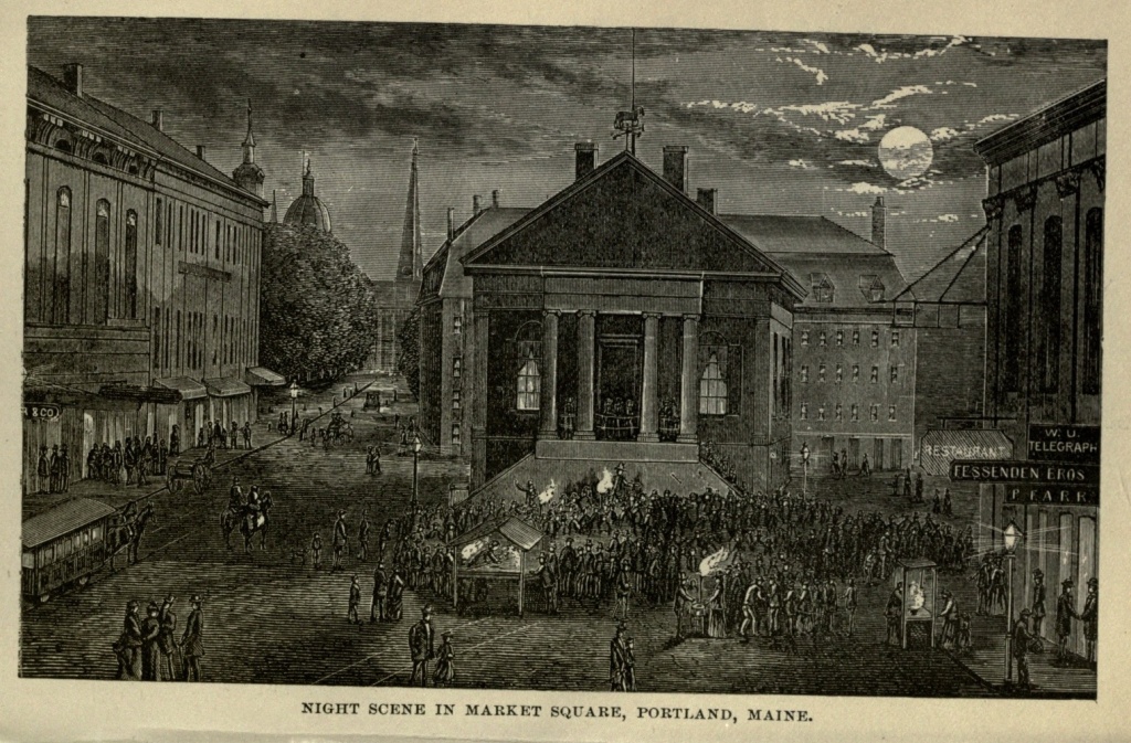
The Eastern Cemetery, on Congress street, is the oldest graveyard in Portland. For two hundred years it was the common burial ground of the settlement, and [Pg 361] here, probably, all the early colonists sleep their last sleep, though their graves are forgotten. The oldest tombstone which the yard seems to contain is that of Mrs. Mary Green, who died in 1717. On the opposite side of the yard, near Mountford street, are the monuments erected to the memory of William Burroughs, of the United States Brig Enterprise, and Samuel Blythe, of His Majesty's Brig Boxer, who fought and died together, on September fifth, 1813, and were buried here. Lieut. Kerwin Waters, of the Enterprise, wounded in the same action, lies beside them. Of him Longfellow sung:—
There is a white marble monument to Commodore Preble, and the death of Lieutenant Henry Wadsworth, uncle of the poet Longfellow, who fell before Tripoli in 1804, is also commemorated here.
Congress Square, at the junction of Fore street, has an elevated position, and is surrounded by churches of various denominations. From Congress street, near its junction with Mellen street, the visitor can look off to Deering's Woods, which rise on the borders of a creek, running in from Back Cove. This tract of woodland has come into possession of the city, and will be preserved as a park. Longfellow sings of
Again:—
[Pg 362]The reservoir of the Portland Water Works is at the junction of Bramhall and Brackett streets. It has an area of 100,000 square feet, with a capacity of 12,000,000 gallons, and is supplied with water from Lake Sebago, seventeen miles distant.
The extensive premises of the Grand Trunk Railway lie at the foot of India street, where are wharves for the great freight business between Canada and Europe, and whence the Dominion and Beaver Line of steamships, every fortnight, from November to May, send ships to Liverpool. The scene during the winter season is a busy one, and the amount of freight handled and shipped is immense. Then begins Commercial street, the modern business avenue of the city, which runs its whole water front, with a railroad track in the middle of it. On this street is the old family mansion of the widow of Brigadier Preble, built in 1786, on the site of his father's house, destroyed by fire in 1775. It then occupied a beautiful and retired locality, looking out upon the harbor, and surrounded by ample grounds. But now it is strangely out of keeping with its neighbors. Opposite it now stands the grain elevator of the Grand Trunk Railway, having been built in 1875, with a capacity of 200,000 bushels. All around are wholesale shipping and commission houses, and wharves for ocean steamships extend up and down the shore.
When Captain John Smith, famous in the early history of Virginia, and the first tourist who ever visited Maine, made his famous summer trip thither, in 1614, he described the place as follows:—"Westward of Kennebec is the country of Ancocisco, in the bottom of a deep bay full of many great isles, which divide it into many great harbors." Ancocisco was very soon abbreviated to Casco, and the bay is still filled with many[Pg 363] great isles. Casco Bay, extending from Cape Elizabeth, on the west, to Cape Small Point, on the east, a distance of about eighteen miles, with a width of, perhaps, twelve miles, contains more islands than any other body of water of like extent in the whole United States. It is a popular belief that these islands number three hundred and sixty-five—one for every day in the year; but a regard for truth compels us to state, that of the named and unnamed islands and islets, there are only one hundred and twenty-two, while a few insignificant rocks and reefs would not swell the number to one hundred and forty. These islands are divided into three ranges, the Inner, Middle and Outer. The Inner range contains twenty islands; the Middle range, twenty-four; and the Outer range, seventy-eight. Besides these islands, the shore is very much broken, and extends out into the bay in picturesque points or fringes, the creeks, inlets and tidal rivers extending far inland. In this bay was discovered, by a mariner named Joselyn, in 1639, a triton or merman, and the first sea serpent of the coast. Seals breed and sport on a ledge in the inner bay, off the shore of Falmouth, and its waters abound with edible fish and sea-fowl.
Ferry boats convey an endless stream of pleasure-seekers to the different islands, during the summer season. Cushing's Island lies at the mouth of Portland Harbor, forming one shore of the ship channel. Its southern shore presents a rocky and precipitous front, culminating in a bold bluff nearly one hundred and fifty feet high, known as White Head. The island looks out upon the harbor from smiling fields and low, tree-bordered beaches. It furnishes good opportunities for fishing and bathing, and is fast becoming a popular[Pg 364] summer resort. It is five miles in circumference, and commands magnificent sea views.
Peak's Island is separated from Cushing's Island by White Head Passage, and with the latter forms an effectual barrier to the ocean. Like it, it presents a bold front to the sea, and smiles upon the bay. It is about a mile and a half long, by a mile and a quarter wide, and rises gradually to a central elevation of, perhaps, one hundred feet, commanding extensive views of the ocean and harbor, and of the mountains, eighty miles away. It is one of the most beautiful of all the islands of Casco Bay, and has a resident population of three hundred and seventy persons, who are largely descendants of the first settlers.
Long Island lies northeast of Peak's Island, and is separated from it by Hussey's Sound. It has an area of three hundred and twelve acres, presenting a long, ragged line of shore to the sea. Its population was, in 1880, two hundred and fifty-two, the men being engaged in fishing and farming.
Little Chebague lies inside of Long Island, and is connected with Great Chebague by a sand bar, dry at low water. A hotel and several summer cottages stand upon the island, and it is an attractive place.
Harpswell is a long peninsula, about fourteen miles down the bay, and is much resorted to by picnic parties. To the eastward lies Bailey's Island, one of the most beautiful of the bay, and to the northward is Orr's Island, the scene of Harriet Beecher Stowe's novel, "The Pearl of Orr's Island." Rising between Bailey's Island and Small Point Harbor is the Elm Island of Rev. Elijah Kellogg's stories. Whittier has written a poem entitled "The Dead Ship of Harpswell," in which[Pg 365] he describes a spectre ship which never reaches the land, and is a sure omen of death:—
Early History.—William Penn.—The Revolution.—Declaration of Independence.—First Railroad.—Riots—Streets and Houses.—Relics of the Past.—Independence Hall.—Carpenters' Hall.—Blue Anchor.—Letitia Court.—Christ Church.—Old Swedes' Church.—Benjamin Franklin.—Libraries.—Old Quaker Almshouse.—Old Houses in Germantown.—Manufactures.—Theatres.—Churches.—Scientific Institutions.—Newspapers.—Medical Colleges.—Schools.—Public Buildings.—Penitentiary.—River Front.—Fairmount Park.—Zoölogical Gardens.—Cemeteries.—Centennial Exhibition.—Bi-Centennial.—Past, Present and Future of the City.
In the year 1610, Lord Thomas de la War, on his voyage from England to Virginia, entered what is now Delaware Bay, and discovered the river flowing into it, to which he also gave his name. The Dutch made a prior claim to the discovery of the land which bordered this river, and retained possession for a time. But there were difficulties in maintaining their settlements, and in 1638 the Swedes sent out a colony from Stockholm, and established a footing on the west bank of the river, afterwards known as Pennsylvania. The Dutch at New York, however, would not submit to this arrangement, and under Peter Stuyvesant, Governor of Manhattan, demanded the surrender of their fort—now called Trinity Fort—which was yielded. The Dutch authority lasted for a short time only. In 1664 the English captured Manhattan and expelled the Dutch, and in the same year an expedition under Sir Robert[Pg 367] Carr came to the Delaware, fired two broadsides into Trinity Fort, landed storming parties, assaulted the fort, killed three Dutchmen, wounded ten, and in triumph raised the flag of England, which was thereafter supreme on the Delaware for nine years.
In 1672 the Dutch tried their strength again, and summoned the English fort at Staten Island to surrender. This summons was complied with, and the English of New York swore allegiance to the Prince of Orange. The people upon the banks of the Delaware soon accommodated themselves to the change of masters, and welcomed the Dutch. But this was their last appearance upon the Delaware. In the next year, 1673, their settlements in America were all ceded, through the fortune of war, to Great Britain, and this territory once more passed under the English flag.
About this time the name of William Penn enters into American history. The British Government being largely indebted to his father, Admiral William Penn, the son found little difficulty in obtaining a grant for a large tract of land in America, upon which to found a colony. This was in 1681. He immediately sent out to his wooded possessions, which he named Pennsylvania, his cousin, Captain William Markham, who had been a soldier, with a commission to be Deputy Governor, and with instructions to inform the European inhabitants already settled there of the change in government, promising them liberal laws. Markham was also to convey a message of peace to the Indians, in the name of their new "proprietor." He was soon followed by three commissioners, who had power to settle the colony, and among other things, to layout a principal city, to be the capital of the province, which William Penn, who[Pg 368] was a member of the Society of Friends, directed should be called Philadelphia—a Greek compound signifying "brotherly love." He himself arrived on the great territory of which he was sole proprietor in 1682, and found the plans of the city and province to his satisfaction. He at once convened an Assembly, and the three counties of Philadelphia, Bucks, and Chester were created, and proper laws passed for their government.
In less than two years, however, Penn was obliged to return to England, and shortly after, in 1692, the British Government took possession of the colony, and placed it under the jurisdiction of the Governor of New York. But in 1694, the government was restored to Penn, and Markham was again made Lieutenant-Governor. Penn, himself, did not return to America until 1699. He found his capital very considerably improved. Instead of the wilderness he had left, fifteen years before, there were streets, houses, elegant stores, warehouses, and shipping on the river. The population was estimated at four thousand five hundred persons. His visit was, however, brief. In 1701, he set sail again for England, intending to return in a few months, but this intention was never carried out. In 1708, his pecuniary embarrassments were so great, that he was arrested for debt in London, and thrown into the Fleet Prison, where he continued for nine years. In 1712 his health and mind gave way, and during six years he lingered as an imbecile, childish and gentle in his manners, the sad wreck of a strong mind. He died in July, 1718.
The government of Pennsylvania was administered for a time by his widow, and subsequently went into the hands of his children and their descendants, as proprietors. They usually delegated the administration to[Pg 369] lieutenant-governors, though they sometimes exercised their authority in person, until the American Revolution put an end to all the colonial governments.
The history of Philadelphia during the period of the Revolution is largely connected with that of the whole country. At a large meeting held in the State House in Philadelphia, in April, 1768, it was resolved to cease all importations from the mother country, in consequence of the exorbitant taxes levied upon them. In 1773, the British East India Company being determined to export tea to America, a second meeting was called at the State House, at which it was patriotically resolved that "Parliament had no right to tax the Americans, without their consent," and that "any one who would receive or sell the tea sent out to America would be denounced as an enemy to his country."
The ship Polly, Captain Ryers, was to bring the tea to Philadelphia. Handbills, purporting to be issued by the "committee for tarring and feathering," were printed and distributed among the citizens. They were addressed to the Delaware pilots and to Captain Ryers himself, warning the former of the danger they would incur if they piloted the tea ship up the river, whilst Captain Ryers was threatened with the application of tar and feathers if he attempted to land the tea.
Christmas Day, 1773, the Polly arrived. A committee of citizens went on board, told Captain Ryers the danger he was in, and requested him to accompany them to the State House. Here the largest meeting was assembled that had ever been held in the city. This meeting resolved that the tea on board the Polly should not be landed, and that it should be carried back to England immediately. The captain signified his wil[Pg 370]lingness to comply with the resolution, and in two hours after, the Polly, with her freight of tea, hoisted sail and went down the river.
In September, 1774, the first Congress, composed of delegates from eleven Colonies, met at Carpenters' Hall, on Chestnut street, Philadelphia, to consider the condition of the Colonies, in their relation to the mother country. This Congress resolved that all importations from Great Britain or her dependencies should cease. Committees of "inspection and observation," were appointed, which exercised absolute authority to punish all persons infringing the order of Congress.
On April twenty-fourth, 1775, news of the battles of Concord and Lexington reached the city. A meeting was immediately called, by sound of gong and bell, at the State House. Eight thousand persons assembled, who resolved that they would "associate together, to defend with arms their property, liberty and lives." Troops were at once raised, forts and batteries built on the Delaware, floating batteries, gunboats and ships-of-war constructed, with all the speed possible, and chevaux de frize sunk in the river, to prevent the passage of British ships. In May, 1776, the English Frigate Roebuck, and Sloop-of-war Liverpool, attempting to force their way up the river, the Americans opened fire on them, and a regular naval action took place. The British managed to escape, and retired to their cruising ground, at the entrance of the bay.
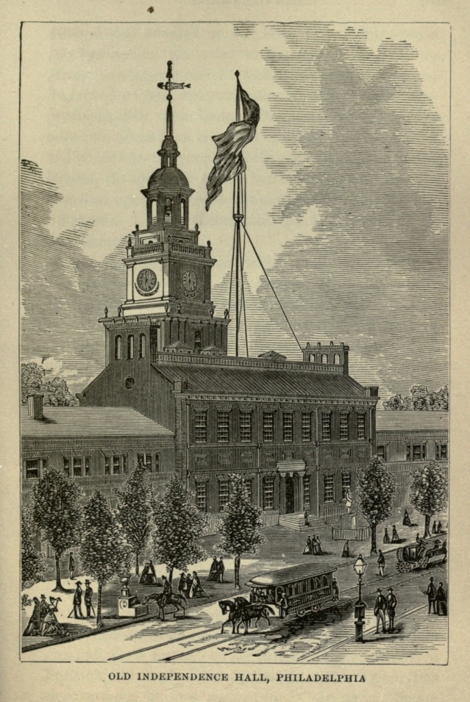
On July second, 1776, Congress, sitting at the State House, resolved in favor of the severance of all connection between the American Colonies and Great Britain, and independence of that power. On July third and fourth, the form of the declaration of independence was [Pg 371] debated, and adopted on the latter day. July eighth, the Declaration was read to the people in the State House yard, and received with acclamations, and evidences of a stern determination to defend their independence with their lives. The King's Arms were at once torn down from the court room in the State House, and burned by the people. Bells were rung and bonfires lighted, the old State House bell fulfilling the command inscribed upon it, when it was cast, twenty years before: "Proclaim Liberty throughout the land, unto all the inhabitants thereof."
In September, 1777, the British army, under General Lord Howe, entered Philadelphia. October fourth, Washington attacked it at Germantown, and although he did not win a victory, compelled the British commander to respect him. The English remained in possession of the city, but the Americans held the country around. The Philadelphians having closed the Delaware by the chevaux de frize, the royal army was in effect hemmed in and cut off from communication with the British fleet, which had entered the Delaware, but was prevented from approaching the city by the American forts and batteries. It had brought but a moderate supply of stores, and as these diminished, the troops suffered from scarcity of food.
On November twenty-sixth, British frigates and transports arrived at the wharves of the city, to the great joy of the royal troops and of the inhabitants, provisions having become very scarce and famine threatened. Beef sold at five dollars a pound, and potatoes at four dollars a bushel, hard money. The British army remained in Philadelphia until June eighteenth, 1778, about nine months from its first occupation of the city. During[Pg 372] that time the officers gave themselves up to enjoyment. They amused themselves with the theatre, with balls, parties, cock-fights and gambling: and a grand fête was celebrated in honor of their commander, Lord Howe. This fête, in the style of a tournament of chivalry, took place in the lower part of the city, and while it was in progress the Americans in considerable force made an attack upon the lines north of the city, set fire to the abattis, and brought out the entire body of the royal troops to repel the attack.
Upon the evacuation of the city, in June, General Benedict Arnold was immediately sent with a small force to occupy it. He remained in military command for several months. It was discovered by many that he had become largely involved in certain speculating transactions, and the shame of the discovery stimulated the traitorous intentions which finally carried him over to the British army.
After the inauguration of Washington as President of the new republic, it was determined by Congress that Philadelphia should be the seat of the United States government for the ensuing ten years, after which it should be removed to Washington City. The scheme of the Federal Constitution was framed and adopted in September, 1787, by the Convention sitting at the State House, with George Washington as President. The final adoption of the Constitution of the United States of America was celebrated in Philadelphia on the Fourth of July, 1788 by a magnificent procession.
The principal officers of Congress removed their residences to Philadelphia in the latter part of 1790. At that period Washington lived in Market street near Sixth, in a plain two-story brick house, which had been[Pg 373] the residence of Lord Howe during the British occupation of the city. The locality is now occupied, if I mistake not, by the mammoth clothing house of Wanamaker & Brown. John Adams, Vice-President, lived in the Hamilton mansion at Bush Hill; and Thomas Jefferson, Secretary of State, at 174 Market street, between Fourth and Fifth, on the south side. Congress assembled for the transaction of business on State House Square.
During the stay of the Federal government in Philadelphia, Washington and Adams were inaugurated as President and Vice President (March fourth, 1797), in the chamber of the House of Representatives.
In 1793, 1797, and 1798, a fearful epidemic of the yellow fever, visited Philadelphia and created great alarm, the mortality being dreadful.
The removal of the Federal government to Washington, in 1800, deprived Philadelphia of the prominence she had enjoyed as the Capital of the nation. In the year 1808 steamboats began to ply regularly on the Delaware River. During the war which commenced in 1812 between the United States and Great Britain, Philadelphia maintained her loyalty, and fulfilled her duty to the country. Several volunteer companies were formed, and there was an engagement in July, 1813, between British war vessels and the United States gunboat flotilla on the Delaware, in which the Philadelphians proved themselves brave and patriotic.
The first railroad, running from Philadelphia to Germantown, was built in 1832. The Pennsylvania Railroad was projected in 1845, and chartered in the following year.
In 1834 a spirit of riot and disorder which passed[Pg 374] over the United States, reached Philadelphia, and led to disturbances between whites and blacks. The houses of colored people were broken into, a meeting-house torn down, and many other outrages committed. Again, in 1835 attacks were made on the blacks, and houses burned. In 1838 all friends of the abolition of slavery were violently attacked, and much damage done to property in the city.
But the most terrible riots which Philadelphia has known occurred in 1844. A meeting of the Native American party was attacked and dispersed. The "Natives" rallied to a market house on Washington street, where they were again attacked, and fire-arms used on both sides. Houses were broken into and set on fire. The Roman Catholic churches of Saint Michael and Saint Augustine, and a female Catholic seminary, were burned, and many buildings sacked and destroyed. All the Catholic churches were in great danger of sharing the same fate. A large number of persons were killed on both sides. On July fourth, of the same year, the Native Americans had a very large and showy procession through the streets of the city. On Sunday, July seventh, the church of Saint Philip de Neri, in Southwark, was broken into by the mob. In clearing the streets, the soldiers and the people came into collision. The former fired into the crowd, and several persons were killed, and others wounded. This occurrence caused intense excitement. The soldiers were attacked with cannon and with musketry, and they responded with artillery and with musketry. The rioters had four pieces, which were worked by sailors. The battle continued during the night of the seventh and the morning of the eighth of July. Two soldiers were[Pg 375] killed, and several wounded. Of the citizens seven were killed, and many wounded. This was the most sanguinary riot, and the last of any importance, which ever occurred in Philadelphia.
Philadelphia possesses many characteristic features which distinguish her from her sister cities. The visitor will be at first struck by the extreme regularity of the streets, and the look of primness which invests them. They are laid out at right angles, the only notable exceptions being those roads, now dignified by the name of avenues, which usually led from the infant city into the then adjacent country. These avenues, of which Passyunk, Germantown and Ridge are the principal ones, are irregular in their course, but take a generally diagonal direction; the first southwest, and the other two northwest. The houses are mostly of brick, with white marble facings and steps, and white wooden shutters to the first story. The streets running east and west, from the Delaware to the Schuylkill, are, in the original city, with few exceptions named after trees. Thus Cedar, Pine, Spruce, Locust, Walnut, Chestnut, Filbert, Mulberry, Cherry, Sassafras and Vine. Cedar became South street, and Sassafras and Mulberry became Race and Arch, the latter so named because in the early days of the city Front street spanned it by an arch. Callowhill street was originally Gallowhill street, the word indicating its derivation. The houses on these streets are numbered from the Delaware, beginning a new hundred with every street. Thus all houses between Front and Second streets are numbered in the first hundred, and at Second street a new hundred begins; the even numbers being on the southern side, and the odd ones on the northern side of the street. The streets run[Pg 376]ning parallel to the river are numbered from the river, beginning with Front, then Second, Third, and so on, until the furthest western limit of the city is reached. Market street, originally called High street, runs between Chestnut and Filbert, dividing the city into north and south. The houses on the streets crossing Market begin their numbers at that street, running both north and south, each street representing an additional hundred. With this naming of streets and numbering of houses, no stranger can ever lose himself in Philadelphia. The name and number of street and house will always tell him just where he is. Thus if he finds himself at 836 North Sixth street, he knows he is eight squares north of Market street, and six squares west of the Delaware River.
The original city was bounded by the Delaware River on the east, and the Schuylkill on the west, and extended north and south half a mile on either side of Market street. Even before the present century it had outgrown its original limits in a northerly and southerly direction, and a number of suburbs had sprung up around it, each of which had its own corporation. The names of these suburbs were, most of them, borrowed from London. Southwark faced the river to the south; Moyamensing was just west of Southwark; Spring Garden, Kensington, Northern Liberties, Germantown, Roxborough, and Frankford were on the north, and West Philadelphia west of the Schuylkill. In 1854 these suburbs, so long divided from the "city" merely by geographical lines, were incorporated with it; and the City of Philadelphia was made to embrace the entire county of Philadelphia—a territory twenty-three miles long, with an area of nearly one hundred and thirty square miles. It thus[Pg 377] became in size the largest city in the country, while it stands only second in population.
The old city was laid out with great economy as to space, the streets being as narrow as though land were really scarce in the new country when it was planned. Market street extends from the Delaware westward—a broad, handsome avenue, occupied principally by wholesale stores. It is indebted, both for its name and width, to the market houses, which from an early date to as late as 1860, if not later, occupied the centre of the street; long, low, unsightly structures, thronged early in the morning, and especially on market days, with buyers and sellers, while market wagons lined the sides of the street. The same kind of structures still occupy certain localities of Second, Callowhill, Spring Garden and Bainbridge streets. But those in Market street have disappeared, and substantial and handsome market buildings have been erected on or near the street, instead of in its centre.
A century ago the business of Philadelphia was confined principally to Front street, from Walnut to Arch. Now Second street presents the most extended length of retail stores in the country, and business has spread both north and south almost indefinitely, and is fast creeping westward. Market street presents a double line of business houses, from river to river. Chestnut, the fashionable promenade and locality of the finest hotels and retail stores, is invaded by business beyond Broad, and Arch street beyond Tenth; while Eighth street, even more than Chestnut the resort of shoppers, is, for many squares, built up by large and handsome retail stores. Broad street, lying between Thirteenth and Fifteenth, is the handsomest avenue in Philadel[Pg 378]phia. It is fifteen miles in length, and one hundred and thirteen feet in width, and contains many of the finest public buildings and private residences in the city. Ridgway Library, the Deaf and Dumb Asylum, Horticultural Hall, Academy of Music, Broad Street Theatre, Union League Club House, Masonic Temple, Academy of Fine Arts, besides some of the most elegant religious edifices, are located on this street.
At the intersection of Broad and Market, where were once four little squares left in the original plan of the city, and known as Penn Square, are being constructed the vast Public Buildings of the city. They are of white marble, four hundred and eighty-six and one-half feet long by four hundred and seventy feet wide, and four stories high, covering an area of four and one-half acres, not including a large court in the centre. The central tower will, when completed, be four hundred and fifty feet high, and the total cost of the buildings over ten millions of dollars. This building presents a most imposing appearance, whether viewed from Market or Broad streets. The Masonic Temple, just to the north, is one of the handsomest of its kind in America. It is a solid granite structure, in the Norman style, most elaborately ornamented, and with a tower two hundred and thirty feet high. Its interior is finished in a costly manner, and after the several styles of architecture. The Academy of Music is one of the largest opera houses in America, being capable of seating three thousand persons.
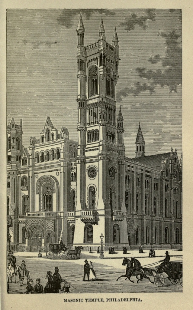
Third street is the banking and financial centre of Philadelphia; on Walnut street are found the greatest proportion of insurance offices; South street is the cheap retail street, and is crowded with shoppers, especially [Pg 379] on market days, and the Jews reign here supreme. Bainbridge street (once Shippen) east of Broad represents the squalor and crime of the city. "Old clo'" and second-hand stores of all descriptions alternate with low drinking places, and occupy forlorn and tumble-down tenements. All races and colors, and both sexes mingle here, and the man who sighs for missionary work need go no further than this quarter.
Chestnut street is, next to Broad, the handsomest in the city. The buildings are all of comparatively recent construction, and are many of them handsome and costly. On Market street the past century still manifests itself in quaint houses of two or three stories in height, sometimes built of alternate black and red bricks, and occasionally with queer dormer windows, wedged in between more stately and more modern neighbors. It will be some time before the street becomes thoroughly modernized, and we can scarcely wish that it may become so, for the city would thus lose much of its quaint interest.
One of the characteristics of Philadelphia which strikes the traveler is that it wears an old-time air, far more so than Boston or New York. Boston cannot straighten her originally crooked streets, but her thought and spirit are entirely of the nineteenth century. New York is intensely modern, the few relics of the past which still remain contrasting and emphasizing still more strongly the life and bustle and business of to-day. Philadelphia is a quiet city. Its people do not rush hither and thither, as though but one day remained in which to accomplish a life work. They take time to walk, to eat, to sleep, and to attend to their business. In brief, they take life far more easily and slowly than[Pg 380] their metropolitan neighbors. They do not enter into wild speculative schemes; they have no such Stock Exchange, where bulls and bears roar and paw the ground, or where they may make or lose fortunes in less time than it takes to eat one's dinner. They are a steady, plodding people, accumulating handsome fortunes in solid, legitimate ways. There is little of the rustle and roar of the elder city; save for the continual ring and rattle of the street cars, which cross the city in every direction, many of its quarters are as quiet as a country village. Its early Quaker settlers have stamped it with the quiet and placidity which is the leading trait of their sect; and though the Quaker garb is seen less and less often upon the streets, the early stamp seems to have been indelible.
Philadelphia retains more of the old customs, old houses, and, perhaps, old laws, than any other city in the country. The Quaker City lawyer carries his brief in a green bag, as the benches of the Inner Temple used to do in Penn's time. The baker cuts a tally before the door each morning, just as the old English baker used to do three centuries ago. After a death has occurred in it, a house is put into mourning, having the shutters bowed and tied with black ribbon, not to be opened for at least a year. There are laws (seldom executed, it is true, but still upon the statute-books), against profanity and Sabbath-breaking, and even regulating the dress of women.
Some of the streets of Philadelphia bear strongly the marks of the past. Those, especially, near the river, which were built up in the early days, have not yet been entirely renovated; while some ancient buildings of historic interest have been preserved with jealous care.[Pg 381] First and foremost among the latter is Independence Hall, occupying the square upon Chestnut street between Fifth and Sixth streets—no doubt, considered an imposing edifice at the time of its erection, but now overshadowed by the business palaces which surround it. It was here that the second Colonial Congress met; here that the Declaration of Independence was adopted; and here that the United States Congress assembled, until the seat of the General Government was removed to Washington, in 1800. In Congress Hall, in the second story of this building, Washington delivered his Farewell Address. The building is now preserved with great care. The hall where the Declaration of Independence was signed is decorated with portraits of the signers, and contains, among other objects of interest, as before stated, the bell which pealed out freedom to all.
Next in historic importance is Carpenters' Hall, between Third and Fourth streets. The first Continental Congress met here, and here the first words pointing toward a collision with the mother country were spoken in Philadelphia.
When William Penn made his first visit to Philadelphia, on October twenty-fourth, 1682, he set foot upon his new possessions at the Blue Anchor Landing, at the mouth of Dock Creek, in the vicinity of what is now the corner of Front and Dock streets. Here stood the Blue Anchor Inn, the first house built within the ancient limits of the city. Then, and long afterwards, Dock Creek was a considerable stream, running through the heart of the town. But, in course of time, the water became offensive, from the drainage of the city, and it was finally arched over, and turned into a sewer. The winding of Dock street is accounted for by the fact that[Pg 382] it follows the former course of the creek. Sloops once anchored and discharged their cargoes where now stands Girard Bank, on Third street, below Chestnut.
Between Chestnut and Market streets, Second and Front, is found Letitia street, where long stood the first brick house built in the Province, erected for the use of Penn himself, and named after his daughter Letitia. He directed that it should "be pitched in the middle of the platt of the town, facing the harbor." The bricks, wooden carvings and other materials, were imported from England. At the time of its construction a forest swept down to the river in front, forming a natural park, where deer ranged at will. Letitia House became a lager beer saloon, the front painted with foaming pots of beer. But business interests claimed the site and the old house was removed and carefully re-erected in Fairmount Park.
The old Slate Roof House, long one of the ancient landmarks, on Second street below Chestnut, the residence of William Penn on his second visit to this country, during which visit John, his only "American" son was born, and where other noted persons lived and died, or at least visited, was removed in 1867, to make room for the Commercial Exchange.
Not far off, on Second street, north of Market, is Christ's Church, occupying the site of the first church erected by the followers of Penn. The present edifice was begun in 1727. Washington's coach and four used to draw up proudly before it each Sabbath, and himself and Lady Washington, Lord Howe, Cornwallis, Benedict Arnold, Andre, Benjamin Franklin, De Chastellux, the Madisons, the Lees, Patrick Henry and others whose names have become incorporated in[Pg 383] American history, have worshiped here. In the aisles are buried various persons, great men in their day, but forgotten now. The chime of bells in the lofty tower is the oldest in America, and were cast in London. This chime joined the State House bell on that memorable Fourth of July, when the latter proclaimed liberty throughout the land. Just opposite this church is a small street, opening into Second street, its eastern end closed by a tall block of warehouses. This street contained Stephen Girard's stores and houses.
The great elm tree, at Kensington, under which Penn made his famous treaty with the Indians, remained until 1800, when it was blown down. An insignificant stone now marks the spot, being inclosed by a fence, and surrounded by stone and lumber yards. An elm overshadows it—possibly, a lineal descendant of the historic tree.
There is an older religious edifice in Philadelphia than Christ's Church. It is the old Swedes' Church, erected in 1697, not far from Front and Christian streets, by early Swedish missionaries. Though insignificant, compared with modern churches, it was regarded as a magnificent structure by the Quakers, Swedes and Indians, who first beheld it. The inside carvings, bell and communion service, were a gift of the Swedish king. In the graveyard which surrounds it are found the dead of nearly two centuries ago, some of the slate-stones over the older graves having been imported from the mother country. Here sleeps Sven Schute and his descendants, once, under Swedish dominion, lords of all the land on which Philadelphia now stands. None of his name now lives. Here lie buried, forgotten, Bengtossens, Peterssens, and Bonds. Wilson, the ornithologist, was[Pg 384] a frequent attendant at this church, early in the present century, and he lies in the church yard, having been buried there by his own request, as it was "a silent, shady place, where the birds would be apt to come and sing over his grave." The English sparrows have built their nests above it.
An ancient house possessing special historic interest stands on Front street, a few doors above Dock. It is built of glazed black bricks, with a hipped roof, and, though it was a place of note in its day, occupied by one generation after another of the ruling Quakers, it has now degenerated into a workingmen's coffee-house. To it the Friends conducted Franklin on his return from England. War was not yet declared, but there were mutterings in the distance; all awaited Franklin's counsels, sitting silently, as is their wont, waiting for the spirit to move to utterance, when Franklin stood up and cried out: "To arms, my friends, to arms!"
Franklin has left many associations in the city of his adoption. As a boy of seventeen he trudged up High, now Market street, munching one roll, with another under his arm, friendless and unknown. Even his future wife smiled in ridicule as he passed by. To-day statues are erected to his memory, and institutions named after him. The Philadelphia Library, the oldest and richest in the city, claims him as one of its original founders. In 1729, the Junto, a little association of tradesmen of which Franklin was a member, used to meet in the chamber of a little house in Pewter-platter alley, to exchange their books. Franklin suggested that there should be a small annual subscription, in order to increase the stock. To-day the library contains many thousand volumes, with many rare and[Pg 385] valuable manuscripts and pamphlets. This library contains Penn's desk and clock, John Penn's cabinet, and a colossal bust of Minerva which overlooked the deliberations of the Continental Congress. In an old graveyard at the corner of Fifth and Arch, a section of iron railing in the stone wall which surrounds it permits the passer to view the plain marble slab which covers the remains of Franklin and his wife.
Speaking of libraries, the Apprentices' Library, on the opposite corner of Fifth and Arch, overlooks Franklin's grave. It was established by the Quakers, and dates back to 1783. The apprentice system has died out, and the library is almost forgotten.
As late as 1876, stood the old Quaker Almshouse, on Willings alley, between Third and Fourth streets, of which Longfellow gives this description in his poem, "Evangeline:"—
Here Evangeline came when the pestilence fell on the city, when—
And here Evangeline found Gabriel. The ancient building is now leveled, and only the poem remains.
Germantown, now incorporated in Philadelphia, is rich in historic associations. Stenton, a country seat[Pg 386] near Germantown, was for generations the centre of the social life of the Quakers. It was built in 1731, by James Logan, and was finished with secret passages and underground ways, to be used in case of attack by Indians and others. The Chew House at Germantown was, during the Revolution, used by Colonel Musgrove and six companies, for a long time. The old Johnson House had its hall door, which is still preserved, riddled by cannon. In many private lawns and gardens of that suburb royalists and rebels sleep peacefully side by side. A house, now quaint in its antiquity, at the intersection of Main street and West Walnut lane, was used during the Revolution as a hospital and amputating room. The old Wistar House, built in 1744, played a part in the events of the last century, and contains furniture which once belonged to Franklin and Count Zinzendorf. There is a room filled with relics of early times.
In 1755 the corner stone of Pennsylvania Hospital was laid. This corner stone having been recently uncovered, in making alterations to the building, the following inscription, of which Franklin was the author, was discovered: "In the Year of Christ, MDCCLV, George the Second happily reigning (for he sought the happiness of his people)—Philadelphia flourishing (for its inhabitants were public spirited)—This Building, By the Bounty of the Government, and of many private persons, was piously founded For the Relief of the Sick and Miserable. May the God of Mercies Bless the undertaking!"
A noticeable and commendable feature of Philadelphia is its many workingmen's homes. In New York the middle classes, whose incomes are but moderate, are[Pg 387] compelled to seek residences in cheap flats and tenement houses, or else go into the country, at the daily expense of car or ferry rides. But in Philadelphia flats are unknown, and tenement life—several families crowded under a single roof—confined almost entirely to the more wretched quarters of the city. There are streets upon streets of comfortable and neat dwellings, marble-faced and marble-stepped, with their prim white shutters, two or three stories in height, and containing from six to nine rooms, with all the conveniences of gas, bath-room and water, which are either rented at moderate rates or owned outright by single families, who may possibly rent out a room or two to lodgers. Philadelphia may have less elegant public and business edifices than New York, but her dwelling houses stand as far more desirable monuments to the prosperity of a people than the splendor united with the squalor of the metropolis.
The manufactures of Philadelphia furnish the foundation of her prosperity. Her iron foundries produce more than one-third of the manufactured iron of the country, and number among them some of the largest in America. The Port Richmond Iron Works of I. P. Morris & Company cover, with their various buildings, five acres of ground. The Baldwin Locomotive Works, on Broad street, founded in 1831, employ a large force of men. It takes eighteen hundred men one day to complete and make ready for service a single locomotive; yet these works turn out three hundred locomotives a year. Some of the largest men-of-war in the world have also been built at the navy yards in Philadelphia and League Island. Among them is the old Pennsylvania, of one hundred and twenty guns. Besides her iron works there are many mills and facto[Pg 388]ries. Miles of carpet, of superior quality, are woven every day, besides immense quantities of other woolen and cotton goods and shoes. Her retail stores, taken as a whole, will not compare in size and elegance with those of New York, though there are two or three exceptions to this rule.
The headquarters of the Pennsylvania Railroad is at Philadelphia, and there is a grand depot on Broad street, near Market, which is palatial in its appointments.
Of her places of amusement, the Academy of Music ranks first in size. There are numerous theatres, among which the Walnut Street Theatre is the oldest, and the Arch Street Theatre the most elegantly finished and furnished, and the best managed. With these and other places of amusement, are associated the names of all the prominent musicians, actors and actresses of the past and present. The Academy of Music was not built when Jenny Lind visited this country, but it was ready for occupancy only a few years later; and has witnessed the triumphs of many a prima donna, now forgotten by the public, which then worshiped her. Forrest began his theatrical career in Philadelphia; and the names of noted tragedians and comedians who have come and gone upon her boards are legion.
Of churches Philadelphia has many, and beautiful ones. On three corners of Broad and Arch streets tall and slender spires point heavenward, rising from three of the most costly churches in the city. Surpassing them all, however, is the Roman Catholic Cathedral of Saint Peter and Saint Paul, on Logan Square. It is of red sandstone, in the Corinthian style, and is surmounted by a dome two hundred and ten feet high.[Pg 389] The interior is cruciform and richly frescoed. The altar piece is by Brumidi.
Also, fronting on Logan Square, at the corner of Nineteenth and Race streets, is the Academy of Natural Sciences, containing a library of twenty-six thousand volumes, and most extensive, valuable and interesting collections in zoölogy, ornithology, geology, mineralogy, conchology, ethnology, archæology and botany. The museum contains over two hundred and fifty thousand specimens, and Agassiz pronounced it one of the finest natural science collections in the world. It also contains a perfect skeleton of a whale, a complete ancient saurian, twenty-five feet long, and the fossil remains of a second saurian so much larger than the first that it fed upon it.
Franklin Institute is devoted to science and the mechanical arts, and contains a library of fifteen thousand volumes. The Mercantile Library occupies a stately edifice, on Tenth street below Market, and contains over fifty thousand volumes, exclusive of periodicals and papers. On an average, five hundred books are loaned daily, from this institution.
The newspapers of Philadelphia rank second only to those of New York. The Ledger has a magnificent building at the corner of Sixth and Chestnut, complete in all its appointments, from engine rooms, in the basement, to type-setting rooms in the top story. The Times building, at the corner of Eighth and Chestnut, is also very fine. The Public Record building, newly finished, on Chestnut street above Ninth, near the new Post Office, surpasses all others. It represents the profits of a daily penny paper, giving news in a condensed form, to meet the wants of a working and busy public.[Pg 390]
Philadelphia once represented the literary centre of the country. It took the lead in periodic literature half a century ago, and claimed, as residents, some of the most brilliant novelists, essayists and poets of the day. But the glory of that age has departed. The Continent, a weekly magazine, sought to revive the prestige of the city, but soon removed to New York, where it died.
The Medical Colleges of Philadelphia have long stood in the front rank, and have attracted students from all parts of the country. A Woman's Medical College is in successful operation, with a fine hospital connected with it.
Philadelphia has an educational system embracing schools of different grades, and a High School. But it pays its teachers less salaries than most of the other cities, and the standard of the schools is not so high as it should be, in consequence. Girard College should not be overlooked, while speaking of educational institutions. Architecturally, it is a magnificent marble building, in Grecian style. It is located near the Schuylkill River, on Girard avenue. When Girard selected the location for his proposed college, it was so far out in the country, that he never thought the city would creep up to it. But to-day the college is inclosed by it, and its high stone walls block many a street, to the inconvenience of the people of the neighborhood. It was established for the practical education of orphan boys, and one of the provisions of its founder—himself a free thinker—was, that no religious instruction should be imparted to the pupils, and no clergyman be permitted to enter its doors; a provision which is widely interpreted, to the effect that no sectarian bias is given in the college.[Pg 391]
The United States Mint, located on Chestnut street, above Thirteenth, is copied from a Grecian temple at Athens. It contains a very valuable collection of coins, embracing those of almost every period of the world and every nation. The Custom House is an imitation of the Pantheon at Athens. The new Post Office is on Ninth street, extending from Chestnut to Market. It is a spacious granite structure, in the Renaissance style, four stories in height, with an iron dome, and when completed will cost about four millions of dollars.
On the opposite corner from the Post Office is the Continentel Hotel, a spacious structure which, when erected, was the largest of its kind in the country. It is now exceeded in size by several other hotels in other cities, but it is noted for the elegance and excellence of the entertainment it offers its guests. Girard Hotel is immediately opposite, and ranks second only to the Continental.
The Eastern Penitentiary is on Fairmount avenue, on what was once known as Cherry Hill. In it is practiced the plan of solitary confinement for prisoners. When Dickens paid his first visit to America, more than forty years ago, he visited this prison, and was so moved to pity by the solitude of its inmates, that he wrote a touching account of one of the prisoners, in whom he was especially interested. But this very prisoner, when he was set at liberty, soon committed another crime which sent him back to his silent and solitary cell, and every subsequent release was followed by a subsequent crime and subsequent imprisonment. Finally, when Dickens had been in his grave for years, the old man, still hale and hearty, but bearing the marks of age, was once more set free. Attention was attracted to him by the[Pg 392] newspapers, as having been the prison hero of Dickens. The public became interested in him, and an effort was made to place him beyond the temptation of crime, so that he might go down to his grave a free man. But before many months had elapsed, life in the outer world became irksome to him, and he returned, by his well-beaten path, back to the penitentiary. He was very proud of the notice which Dickens had bestowed upon him, and it seemed to more than compensate for the loss of his liberty.
When Penn visited Philadelphia, in its infant days, he wished to preserve the bluff overlooking the Delaware, to be forever used as a public park and promenade. But the traffic of Front street now rattles where he would have had green trees and grass. Philadelphia has no pleasant outlook upon the river, to correspond with the Battery of New York. The wharves are lined with craft of every description, and the flags of many nations are to be seen in her harbor; but commerce creeps down to the very shores, and Delaware avenue, which faces the river, is dirty and crowded with traffic. Seen from the river the city makes a pleasing outline against the sky, with its many spires and domes. Smith's Island and Windmill Island lie opposite the city, a short distance away, and Camden is on the New Jersey shore. Ferry boats continually ply across the Delaware, carrying to and fro the travelers of a continent.
Philadelphia is not without its public breathing places, where the residents of its narrow streets may enjoy fine trees and green grass. When the city was first planned, four squares, of about seven acres each, were reserved in its four quarters, two each side of Market street, and are now known as Washington, Franklin, Logan and Rit[Pg 393]tenhouse Squares. Washington Square is at Sixth and Walnut, and was once a Potters' Field. Many soldiers, victims of the smallpox and camp fever, were buried there during the Revolution. Franklin Square, at Sixth and Race was also once a burying, ground. A fountain now occupies its centre. At Eighteenth and Race is Logan Square, where in 1864 was held the great Sanitary Fair. The entire square was roofed over and boarded up, the trunks of the trees standing as pillars in the aisles of the large building. Its companion, Rittenhouse Square, at Eighteenth and Walnut streets, is the centre of the aristocratic quarter of the city. It is surrounded by most elegant mansions and costly churches. Independence Square lies back of Independence Hall.
There are a few other smaller and newer squares scattered throughout the city, but its great pride is Fairmount Park, which is unsurpassed in its natural advantages by any park in the world. This park contains nearly three thousand acres, embracing eleven miles in length along the Schuylkill and Wissahickon rivers. The nucleus of this park was the waterworks and reservoir, the former situated on the Schuylkill, in the northwestern part of the city, and the latter on a natural elevation close by, from which the entire park takes its name, while a small tract of land between the two was included in the original park. There was added the beautiful estate of Lemon Hill, once the country seat of Robert Morris, with the strip along the Schuylkill which led to it. In course of time Egglesfield, Belmont, Lansdowne and George's Hill, on the opposite side of the river, were added, either by gift or purchase, and eventually the tract of land on the eastern bank, extending from Lemon Hill to the Wissahickon, and along both[Pg 394] banks of the latter as far as Chestnut Hill. This park, besides the beautiful river and romantic stream which it incloses, includes hills and valleys, charming ravines and picturesque rocks.
While the city has gained much, the true lover of nature has lost something, by the conversion of this tract of land into a park. While it was still private property, nature was at her loveliest. Wild flowers blossomed in the dells, and little streams gurgled and tumbled over stones down the ravines, while vines and foliage softened the rugged outlines of the rocky hillsides. But the landscape gardener has been there. The dells are converted into gentle slopes; the wild flowers and ferns which beautified them have given place to green sward; one of the prettiest of the brooks has been converted into a sewer and covered over. The Wissahickon, once the most delightful of wild and wayward streams, is now, for a considerable part of its way, imprisoned between banks as straight and unpicturesque as those of a canal. The pretty country lanes have been obliterated, and the trees which overshadowed them have disappeared. Primness and stableness is now the rule. Art has sought to improve nature, and has almost obliterated it, instead. Yet even the landscape gardener cannot succeed in making the Schuylkill entirely unattractive; and velvet turf and trees waving in the wind, even though the latter be pruned into a tiresome regularity, are always more grateful than the cobble stones and brick pavements of the city streets, and thousands every day seek rest or recreation at Fairmount.
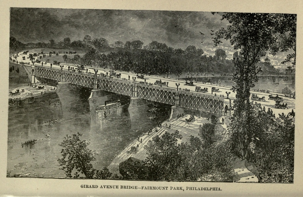
Belmont Mansion is now a restaurant. Solitude, a villa built in 1785 by John Penn, grandson of William Penn, and the cottage of Tom Moore, not far from [Pg 395] Belmont where he spent some months during his visit to America, are among the attractions of the park.
The Zoölogical Gardens are included in the park, and are situated on the western bank of the Schuylkill, opposite Lemon Hill. Here is found the finest collection of European and American animals in America, and the daily concourse of visitors is very great. The several bridges which span the Schuylkill are very picturesque. In the winter, when the river at Fairmount, above the dam, is frozen over, the ice is covered with skaters, and the bank is thronged with spectators.
Laurel Hill, one of the most beautiful cemeteries of the country, adjoins Fairmount Park, and is inclosed by it, seeming to make it a part of the park. Mount Vernon Cemetery is nearly opposite Woodlands, in West Philadelphia, and contains the Drexel Mausoleum, the costliest in America.
Fairmount was the site of the Centennial Exhibition in 1876, and numerous and costly buildings were erected there. Of these many were removed at once at the close of the Exhibition. The main building, a mammoth structure, covering eleven acres, was retained for several years for a permanent exhibition building, but was removed in 1883. Memorial Hall, erected by the State, at a cost of $1,500,000, standing on an elevated terrace between George's Hill and the river, and used as an art gallery during the Exhibition, still remains, and is designed for a permanent art and industrial collection. North of Memorial Hall stands the Horticultural Building, a picturesque structure, in the Mooresque style. It is a conservatory, filled with tropical and other plants, and is surrounded by thirty-five acres devoted to horticultural purposes.[Pg 396]
In October, 1882, Philadelphia celebrated her Bi-centennial, and commemorated the landing of Penn, who first stepped upon her shores two hundred years before. This Bi-centennial lasted for three days, which were celebrated, the first as "Landing Day," the second as "Trades' Day," and the third as "Festival Day." On the first day, October twenty-fourth, the State House bell rang two hundred times, and the chimes of the churches were rung. The ship Welcome, which two hundred years before had conveyed Penn to our shores, made a second arrival, and a mimic Penn again visited the Blue Anchor, still standing to receive him, held treaty with the Indians, and then paraded through the city, followed by a large and brilliant procession, which presented the harmless anachronism of the Proprietor of two hundred years ago hob-nobbing with the city officials and others of the nineteenth century. On the second day the different trades and manufacturing interests made a great display. In the evening Pennsylvania history was represented by ten tableaux; eleven tableaux presented the illustrious women of history; and ten tableaux gave the principal scenes in the Romayana, the great poem of India. The display of this night pageant was gorgeous and beautiful beyond anything ever before seen in this country. On the third day the morning was devoted to a parade of Knights Templar, and the evening to a reception at the Academy of Music and Horticultural Hall. A musical festival was held during the day; also a naval regatta upon the Schuylkill, a bicycle meet at Fairmount, and archery contests at Agricultural Hall. During the entire three days Philadelphia held holiday. Her streets and pavements were crowded with throngs of people from the country, and elevated seats along[Pg 397] the principal streets were constantly filled, at high prices.
If William Penn could really, in person, have stepped upon the scene, and beheld the city of his planning as it is to-day, he would undoubtedly be astonished beyond expression. In magnitude it must exceed his wildest dreams; in commercial and manufacturing enterprises its progress reads like some fable of the east. He would look almost in vain for his country residence upon the Delaware, once surrounded by noble forests, and we fear he would scorn the Blue Anchor and all its present associations. Time works wonders. Nearly a million people now find their homes where, in 1683, one year after Penn's arrival, there were but one hundred houses. In 1684 the population of Philadelphia was estimated at 2,500. In 1800 it had increased to 41,220. In 1850 it was 121,376. From this period to 1860, its growth was almost marvelous, at the latter period its inhabitants numbering 565,529. The census of 1880 gave it a population of 846,984.
The residents of Philadelphia include every nationality and class of people. The Quakers are in a small minority, though they have done much to mould the character of the city. Irish and Germans predominate among foreigners. Italians, French, Spanish, and Chinese are not so numerous as in New York. The society of the Quaker City bears the reputation of great exclusiveness. While culture will admit to the charmed circle in Boston, and money buys a ready passport to social recognition in New York, in Philadelphia the door is closed to all pretensions except those of family. Boston asks "How much do you know?" New York,[Pg 398] "How much are you worth?" but in Philadelphia the question is, "Who was your grandfather?"
Philadelphia ranks fourth in commerce among the cities of the Union. As a manufacturing city it occupies the very front rank. With the inexhaustible coal and iron fields of Pennsylvania at its back, her manufacturing interests are certain to grow in extent and importance, maintaining the ascendency they have already gained. Its prosperity has a firm basis. Like all large cities, there is squalor, misery and crime within its borders; but the proportion is smaller than in some other cities, and the aggregate amount of domestic content, owing to its many comfortable homes, much greater. Thus Philadelphia offers an example, in more than one direction, which might be emulated by her sister cities. What she will have become when her tri-centennial comes around, who shall dare to predict?
Origin of the City.—Roger Williams.—Geographical Location and Importance.—Topography of Providence.—The Cove.—Railroad Connections.—Brown University.—Patriotism of Rhode Island.—Soldiers' Monument.—The Roger Williams Park.—Narragansett Bay.—Suburban Villages.—Points of Interest.—Butter Exchange.—Lamplighting on a New Plan.—Jewelry Manufactories.
In the year 1630, Roger Williams, a clergyman, persecuted and banished from Massachusetts on account of his peculiar religious views, came to Rhode Island and laid the foundation of a city, naming it Providence, in gratitude for his deliverance from persecution. This renowned pioneer not only laid the corner stone of a great and growing city, but ineffaceably stamped his character upon all her institutions, public and private.
Providence is the second city of New England in respect to wealth and population. It is pleasantly located at the head of Narragansett Bay, thirty-five miles from the ocean. Its commercial advantages are unsurpassed, and as a manufacturing town it ranks among the first in the Atlantic States. The city is divided into two unequal portions by a narrow arm of the Bay, which terminates near the geographical centre of the town, in a beautiful elliptical sheet of water, about one mile in circumference, called the cove, or basin. This basin is inclosed by a handsome granite wall, capped by a sub[Pg 400]stantial and ornamental iron fence, and is surrounded by a green about eighty feet in width, filled with a variety of beautiful and thrifty shade trees.
The eastern portion of the city rises from the water, in some places gradually, in others quite abruptly, to the height of more than two hundred feet. This elevated land is occupied by elegant private mansions surrounded with numerous shade trees and ornamental gardens, making one of the most delightful and desirable places for residence to be found in any city.
The western portion of the city rises very gradually until it reaches an elevation of about seventy-five feet, when it spreads out into a level plain, extending a considerable distance to the southwest. The northern portion, recently annexed to the city, is more sparsely populated, and portions of it are quite rural in appearance and abounding in hills, numerous springs and small streams of water.
Providence is about forty-three miles from Boston, the same distance from Worcester, ninety miles from Hartford, fifty miles from Stonington, and twenty miles from Fall River, with each of which places it is connected by numerous daily trains. It also has railroad connections with New Bedford and southern Massachusetts, with Fitchburg, and thence with Vermont and New Hampshire. There is now in process of construction another route to Northern Connecticut, Springfield and the west. It is also closely connected with Newport, and other places on Narragansett Bay, by steamboats.
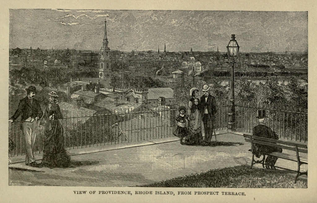
Brown University is one of the distinguishing features of Providence, and, as an institution of learning, stands in the front rank of American colleges. Founded [Pg 401] more than one hundred years since, this college has come down from the past, hand in hand with Yale and Harvard. Among the renowned graduates of Brown University may be mentioned Charles Sumner, the great statesman, the devoted patriot, the champion of the negro, whose fame and good works will live while freedom is the heritage of the American people.
President Wayland, of this institution, was the originator of the public Library System of New England—a system whose wonderful power for good is markedly on the increase.
During the war no State of the whole sisterhood evinced more patriotism than little Rhode Island, and Providence was largely represented in the Union army. A Soldiers' Monument stands in the triangular space near the Boston and Providence Railroad Depot, inscribed with the names of Rhode Island soldiers who were killed in battle. The Monument is surmounted by a statue in bronze of the Goddess of Liberty, and in niches of the granite pillar below this figure each arm of the service is represented by soldiers in bronze. The work is finely executed, and it is one of the first objects which attracts the attention of the stranger. The Artilleryman stands behind his cannon in grim silence; representatives of the infantry, the cavalry and the marine arms o£ the service are his coadjutors, and the entire group is sternly suggestive of war's sad havoc.
About a mile and a half from the heart of the city, along a beautiful McAdamized road leading to Pawtuxet, is situated the Roger Williams Park, a tract of land containing about thirteen hundred acres, which was bequeathed to the city by a descendant of Roger Williams, in consideration of five hundred dollars, to be[Pg 402] raised by the Providence people, for the erection of a monument to the city's illustrious founder. The sum to be appropriated for that purpose was equivalent to twenty-six hundred dollars at the present time.
The embryo park is yet a wilderness, unreclaimed, and primeval forest-trees fill the wide enclosure. The ground is undulating with hill and dale, and pleasant driveways under the dark pines and hemlocks are already laid out.
The memory of Roger Williams is held in great veneration by the citizens of Providence, and he is ranked with William Penn in the category of noble pioneers. Plenty of eulogistic essays and poems have been written concerning him, and his great love of liberty, exemplified in his life, is a matter of history. The following fragment of verse, by Francis Whipple, one of Rhode Island's poets, places the memory of the two heroes side by side:—
Many of the suburbs of Providence are of some note as places of summer resort. The coast scenery along Narragansett Bay is full of charming water-pictures, and numerous rocky islands may be seen, on which are erected little white cottages, for summer occupation. The islands are sometimes connected with the shore by foot-bridges, but often the only means of communication with land is by boat.
Nayatt Point, six miles distant from Providence by rail, is, as its name implies, a jutting point of land,[Pg 403] reaching out into the bay, where beautiful drives along the beach and through the neighboring groves, added to the salt sea air, are the chief summer attractions. Rocky Point, directly opposite Nayatt, is famous for its clam bakes, and on moonlight nights in summer, excursion parties from Nayatt, Barrington or Warren, glide over the smooth waters of the bay to this lovely spot. The red glow of Rocky Point Light can be seen through the night, for miles and miles along the coast and down the bay.
Westminster street is the principal avenue of Providence, and is handsomely built up with substantial and elegant business blocks. A very large hostelry, to be called the Narragansett Hotel, is in process of erection at the corner of Dorrance and Broad streets. Just back of this building, the new Providence Opera House, a structure of recent date, furnished with all the modern appliances for the stage, opens its doors to lovers of the histrionic art. The What-Cheer building, the Arcade, and the Butler Exchange are all well known business centres. The last named place owes its existence to a clause in a Scotchman's will. A large inheritance was left to a gentleman in Providence, with a stipulation that a certain amount of its yearly income should be used in the erection of public buildings in the city. The Butler Exchange is one of the children of this proviso.
A recent improvement in Providence is that of lighting the city lamps by means of electricity. Only one person is required to light the streets of the entire city. A single turn of the screw which commands the network of wires leading to the lamp posts, sets every gas jet, far and near, aflame, in one instantaneous blaze. It is a[Pg 404] marvelous advance on the old way of doing things, and will greatly lessen the expenditures of the city.
Providence is justly celebrated for its manufacture of jewelry. The largest establishments of the kind in New England are in operation here, and the work turned out is of the most skillful pattern. A visit to the lapidary establishments is full of interest. A shining array of precious stones, from the white brilliance of the diamond, to the mottled moss agate, greets the bewildered gaze, and skillful workmen are deftly transforming them into the beautiful gems which shine in the jeweler's window.
Appearance of Quebec.—Gibraltar of America.—Fortifications and Walls.—The Walled City.—Churches, Nunneries and Hospitals.—Views from the Cliff.—Upper Town.—Lower Town.—Manufactures.—Public Buildings.—Plains of Abraham.—Falls of Montmorenci.—Sledding on the "Cone."—History of Quebec.—Capture of the City by the British.—Death of Generals Wolfe and Montcalm.—Disaster under General Murray.—Ceding of Canada, by France, to England.—Attack by American Forces under Montgomery and Arnold.—Death of Montgomery.—Capital of Lower Canada and of the Province of Quebec.
Of all the cities and towns on the American continent, not one wears such an Old-World expression as Quebec. Not even St. Augustine, in Florida, with its narrow streets, and quaint, overhanging balconies, so takes the traveler back to a past age, as that fortified city on the lower St. Lawrence. It is not French in any modern sense. But the city and its inhabitants belong to a France now passed away, the France of St. Louis, the fleur-de-lis, and a dominant priesthood. An offshoot from such a France, now blotted out and forgotten in the crowding of events during the last century, it has remained oblivious of all the changes in the parent country, and not even British rule, and the infusion of Anglo-Saxon and Celtic blood have been able to more than partially obliterate its early characteristics.
Quebec is situated at the confluence of the St. Charles River with the St. Lawrence, on the northern side of a point of land which projects between these two rivers.[Pg 406] This point ends in an abrupt headland, three hundred and thirty-three feet above the level of the river; and its precipitous sides, crowned with an almost impregnable fortress, have won for it the name of the "Gibraltar of America." The most elevated part of this promontory is called Cape Diamond, since at one time numerous quartz crystals were found there; and upon this is placed the citadel, occupying forty acres. From the citadel a line of wall runs towards the St. Charles River, until it reaches the brow of the bluff. Continuing around this bluff towards the St. Lawrence, it finally completes a circle of nearly three miles in circumference, by again connecting with the citadel. This encircling wall originally had five gates, but four of these were removed some time ago. They are now being replaced by more ornamental ones. The old St. Louis Gate, opening upon the street of that name, is being replaced by the Kent Gate, in honor of Queen Victoria's father, who spent the summer of 1791 near Quebec. Dufferin Gate is being erected on St. Patrick street; Palace and Hope gates are to be replaced by castellated gates; while a light iron bridge is to occupy the site of the Prescott Gate.
The old city is contained within this walled inclosure, and here, in the narrow, tortuous, mediæval streets, are the stately churches, venerable convents, and other edifices, many of them dating back to the period of the French occupation of the city. The houses are tall, with narrow windows and irregular gables, two or three stories high, and roofed, like the public buildings, with shining tin. A very large part of the city within the walls is, however, taken up with the buildings and grounds of the great religious corporations. Monks,[Pg 407] priests, and nuns, seemingly belonging to another age and another civilization than our own, are jostled in the street by officers whose dress and manners are those of the nineteenth century. French is quite as frequently heard as English; and everywhere the old and the new, the past century and the present, seem inextricably mingled. The past has, however, set its ineffaceable stamp upon the city and its people. There is none of the hurry and push of most American cities, seen even, to a degree, in Montreal. To-day seems long enough for its duties and its pleasures, and to-morrow is left to take care of itself. Even the public buildings have the stamp of antiquity upon them, and are, in consequence, interesting, though few of them are architecturally beautiful.
The churches of Quebec have none of the grandeur of those of Montreal. Most prominent among them is the Anglican Cathedral, a plain, gray stone edifice in St. Ann street. The Basilica of Quebec, formerly the Cathedral, is capable of seating four thousand persons, and with a plain exterior, contains some invaluable art treasures in the form of original paintings by Vandyke, Caracci, Halle and others. The remains of Champlain, the founder and first governor of Quebec, lie within the Basilica. The Ursuline Convent is in Garden street, north of Market Square, and is composed of a group of buildings surrounded by beautiful grounds. It was founded in 1639, originally for the education of Indian girls, and is now devoted to the education of girls of the white race. The remains of Montcalm are buried within the convent grounds, in an excavation made by the bursting of a shell, during the engagement in which he lost his life. The Gray Nunnery, the Black Nunnery, and Hôtel Dieu with its[Pg 408] convent and hospital, under the charge of the Sisters of the Sacred Blood, of Dieppe, are among the Roman Catholic religious institutions of the city. In the hospital of the Hôtel Dieu ten thousand patients are gratuitously cared for annually.
Durham Terrace lies along the edge of the cliff overlooking the St. Lawrence. It occupies the site of the old chateau of St. Louis, built by Champlain in 1620, and destroyed by fire in 1834. The outlook from this terrace is one of the finest in the world; though the view from the Grand Battery is conceded to be even finer. Looking down from an elevation of nearly three hundred and fifty feet, the lower town, the majestic St. Lawrence and the smaller stream of St. Charles rolling away in the distance, and a vast stretch of country varied by hills and plains, woodlands and mountains, are spread out before the spectator, making one of the most beautiful pictures of which it is possible to conceive.
The walled city, with the suburbs of St. Louis and St. John between the walls to the eastward, and the Plains of Abraham to the westward, is known as the upper town. The lower town is reached from the upper by the Côte de la Montagne, or Mountain street, a very steep and winding street, and lies below the cliff, principally to the northward, though it encircles the base of the promontory. Here, in the lower town, is the business portion of the city, with all its modern additions. The narrow strand between the cliff and the rivers is occupied by breweries, distilleries, manufactories, and numerous ship-yards; while the many coves of the St. Lawrence, from Champlain street to Cape Rouge, are filled with acres of vast lumber rafts. Quebec is one of the greatest lumber and timber[Pg 409] markets in America, supplying all the seaboard cities of the United States. It also builds many ships, and produces sawed lumber, boots and shoes, furniture, iron ware and machinery.
The Custom House occupies the extreme point between the St. Lawrence and St. Charles rivers. It is Doric in architecture, surmounted by a dome, and has a columned façade reached by an imposing flight of steps. The Marine Hospital, built in imitation of the Temple of the Muses on the banks of the Ilissus, is situated near the St. Charles River. The Marine and Emigrants' Hospital is not far away. The General Hospital, an immense cluster of buildings further up the river, was founded in 1693, and is in charge of the nuns of St. Augustine.
The Plains of Abraham, lying back of Quebec, near the St. Lawrence, and the scene of the famous encounter between the forces of Wolfe and Montcalm, are fast being encroached upon by suburban residences, large conventual establishments, and churches. The Martello towers are four circular stone structures, erected upon the Plains to defend the approaches of the city. On the plains, near the St. Foye road, is a monument composed of a handsome iron column, surmounted by a bronze statue of Bellona, presented by Prince Napoleon, and erected in 1854, to commemorate the victory won by the Chevalier de Lèris over General Murray, in 1760. The Mount Hermon Cemetery, beautifully laid out on the edge of the precipice which overhangs the St. Lawrence, lies about three miles out, on the St. Louis road.
It is imperative upon the stranger, in Quebec, to visit the Falls of Montmorenci, eight miles distant, and[Pg 410] among the most beautiful in America. A volume of water fifty feet wide makes a leap of two hundred and fifty feet, down a sheer rock face, into a boiling and turbulent basin. During the winter the spray which is continually flying from this cataract congeals and falls like snow, until it builds up an eminence which is known as the Cone. This Cone, in favorable seasons, sometimes reaches an altitude of one hundred and twenty feet. To visit the Falls in sleighs, over the frozen river, and to ride down the Cone on hand-sleds, or "toboggins," as they are locally called, is considered the very climax of enjoyment by the inhabitants of Quebec. The Cone is in the form of a sugar loaf, quite as white and almost as firm. Up its steep sides the pleasure seekers toil with their sleds, and then glide from the top, impelled by the steepness alone, rushing down the slope with fearful velocity, and sometimes out on the ice of the river for hundreds of yards, until the force is spent. The interior of the Cone is not unfrequently hollowed out in the shape of a room, and a bar is set up, for the benefit of thirsty pleasure seekers.
About a mile above Montmorenci Falls are the Natural Steps, a series of ledges cut in the limestone rock by the action of the river, each step about a foot in height, and as regular in its formation as though it was the work of man.
There are points of interest nearer Quebec, among which are the Isle of Orleans, a beautiful and romantic place, laid out with charming drives, and reached by ferry; Château Bigot, an antique and massive ruin, standing at the foot of the Charlesbourg mountain; and still further away, Lorette, an ancient village of the Huron Indians.[Pg 411]
Quebec, the oldest city in British America, was settled in 1608, the spot having been visited by Cartier, in 1534. Its history is an exceedingly interesting and varied one. Twenty-one years after its founding it was seized by the British, who did not restore it to France until 1632. In 1690 and in 1711 the British made unsuccessful maritime assaults upon it It continued to be the centre of French trade and civilization, and of the Roman Catholic missions in North America, until, in 1759, it fell into the hands of the British. The Fleur-de-lis fluttered from the citadel of Quebec for two hundred and twenty years, with the exception of the three years from 1629 to 1632, when Sir David Kirke placed the fortification in the hands of England.
In 1759, during the Seven Years' War, the English, under General Wolfe, attacked the city and bombarded it. An attempt had been previously made to land British troops at Montmorenci, which had been frustrated by Montcalm, resulting in a loss of five hundred men. But on the occasion of the present attack Wolfe had conceived the idea of landing his troops above the town. He pushed his fleet stealthily up the river, under the brow of the frowning precipice and beneath the very shadow of the fortifications. Passing above the city, he effected a landing where the acclivity was a little less steep than at other places, and the troops dragged themselves up, and actually brought with them several pieces of ordnance. All this was under cover of night; and when day dawned the British army with its artillery was found in line of battle on the Plains of Abraham. Wolfe had eight thousand men, while the French troops numbered ten thousand. Montcalm believed he could easily drive the British into the river or[Pg 412] compel them to surrender, and so threw the whole force of his attack upon the English right, which rested on the river. But in the French army were only five battalions of French soldiers, the balance being Indians and Canadians. The French right, composed of these undisciplined troops, was easily routed and the French left was ultimately broken. Five days later the British were in complete possession of Quebec. But before this victory was fairly assured to the English troops, both the French and English armies had lost their commanders.
The spot where Wolfe fell in the memorable battle of September thirteenth, 1759, is marked by an unpretending column. A monument was shipped from Paris, to commemorate the death of Montcalm, but it never reached Quebec, the vessel which conveyed it having been lost at sea. A lengthy inscription upon this monument, after giving the Marquis de Montcalm's name and many titles, and depicting in glowing words his character and his brilliant achievements as a soldier, says: "Having with various artifices long baffled a great enemy, headed by an expert and intrepid commander, and a fleet furnished with all warlike stores, compelled at length to an engagement, he fell—in the first rank—in the first onset, warm with those hopes of religion which he had always cherished, to the inexpressible loss of his own army, and not without the regret of the enemy's, September fourteenth, 1759, of his age forty-eight. His weeping countrymen deposited the remains of their excellent General in a grave which a fallen bomb in bursting had excavated for him, recommending them to the generous faith of their enemies." Whether the "generous faith" of their friends was[Pg 413] equally to be trusted each one must judge for himself; for in the chapel of the Ursuline Convent of Quebec, among the curiosities exhibited to the visitor, is the skull of the Marquis de Montcalm.
In April, of the following year, the British very nearly lost what Wolfe had gained for them. General Murray went out to the Plains of Abraham, with three thousand men, to meet the French, under Chevalier de Lèris, losing no less than one thousand men, and all his guns, which numbered twenty, and being compelled to retreat within the walls. The arrival of a British squadron brought him timely relief, and compelled the French to retreat, with the loss of all their artillery. The treaty of peace made between Louis Fifteenth and England, in 1763, ceded the whole of the French Canadian possessions to the British. In December, 1775, during the war of the Revolution, a small American force, under General Montgomery, made an attack upon the fortress, but was repulsed with the loss of their commander and seven hundred men. Arnold preceded Montgomery, making an astonishing march, and enduring untold perils, by the Kennebec and Chaudière. Following the course pursued by Wolfe, he placed his troops upon the Plains of Abraham; but when Montgomery joined him, from Montreal, it was found they had no heavy artillery, and the only alternatives were, to retreat, or to carry the place by storm. Deciding on the latter course, two columns, headed by Arnold and Montgomery, rushed forward. The latter carried the intrenchment, and was proceeding toward a second work, when he and the officers who followed him were swept down before a gun loaded with grape. Arnold was[Pg 414] carried from the field, wounded, and the attempt on Quebec was a most disastrous failure.
Quebec remained the chief city of Canada until the western settlements were erected into a separate Province, as Canada West, when it became the Capital of Canada East. In 1867, the British North American Provinces were united, in the Dominion of Canada. Canada East, or Lower Canada, as a Province, took the name of the city, and the city of Quebec became the Capital of the Province. The population of Quebec was, in 1871, 58,699, of whom a large proportion are descendants of the early French settlers, though many English, Scotch and Irish, have domiciled themselves within it, and form, really, its most enterprising and energetic citizens.
Geographical Position and History of Reading.—Manufacturing Interests.—Population, Streets, Churches and Public Buildings.—Boating on the Schuylkill.—White Spot and the View from its Summit.—Other Pleasure Resorts.—Decoration Day.—Wealth Created by Industry.
Reading, the seat of Justice of Berks County, Pennsylvania, is beautifully situated near the junction of the Tulpehocken with the Schuylkill River, and is midway between Philadelphia and Harrisburg, on the Philadelphia and Reading Railroad. It was named after the ancient borough of Reading, a prominent market town of Berkshire, England, which it is said to resemble in some of its geographical surroundings. Attention was first called to Reading in the fall of 1748, by the agents of Richard and Thomas Penn, who represented it as "a new town with great natural advantages, and destined to become a prosperous place." It was incorporated as a borough in 1783, and as a city in 1847. The original settlers were principally Germans, who gave character to the town, both in language and customs. For many years the German tongue was almost exclusively spoken, and it is still used in social intercourse and religious worship by more than one-half the present population.
The manufacturing interests of Reading are second to no city of like population in the United States; while it is the third city in Pennsylvania in its manufactures,[Pg 416] Pittsburg and Philadelphia alone exceeding it. Among these manufactures the working of iron holds the first rank. Much of the ore is obtained from Penn's Mountain, on the east of the town. Rolling mills, machine shops, car shops, furnaces, foundries, cotton mills and hat factories, from their number and extent, establish beyond question the claim of Reading to be considered one of the first manufacturing towns of America. The shops of the Philadelphia and Reading Railroad alone employ two thousand men. From an early hour in the morning the eastern bank of the Schuylkill rings out the discordant music of numberless factories, betokening the enterprise of her productive industries.
Reading has, at the present time, a population numbering not far from fifty thousand. It is delightfully situated on an elevated and ascending plain, which rises to the eastward into Penn's Mountain, and to the southward into the Neversink Mountain. The city is abundantly supplied with pure water, by streams flowing from these mountains. It is surrounded by a rich farming country, which looks to it for supplies. The streets cross each other at right angles, and the chief hotels and stores are built around Penn's Square, which occupies the centre of the city. It contains thirty-one churches, most prominent among which is Trinity, German Lutheran, an antique building with a spire two hundred and ten feet in height. Christ Church, Episcopal, is a handsome Gothic edifice of more recent date, and with a spire nearly as high. The Grand Opera House and Mishler's Academy of Music furnish amusements for the pleasure-seekers of the city.
The Schuylkill River is one of the most charmingly picturesque in America. Taking its rise among the rocky[Pg 417] heights of the Blue Ridge, when it reaches Reading it has left all the ruggedness of the mountain region behind, and flows between gently sloping banks, which, though sometimes rising in the background to considerable elevations, never lose their softness of outline and their pastoral beauty. One evening we strolled down to this river, and took a most delightful boat ride from the Lancaster bridge to the dam opposite the White House and Neversink. Two boats were placed at the disposal of our party. It was a lovely May evening, the air soft and warm, yet with all the freshness of spring. We glided down the stream, the trees upon the banks overhanging the water, and catching reflections of themselves in its depths. Our downward progress was easy and pleasant. The current aided our efforts, while the tranquil waters, rippled only by a passing boat, offered no resistance to us in our course. When we turned and headed up stream, we found it quite another matter. Then we had to bring all our energies and wills to aid us in the labor of rowing. This is something that a man is apt to discover many times in his life, that, in both material and moral matters, it is easier to float with the current than to make headway against it.
A call from Mr. W. H. Zeller, of the Reading Eagle, paid me early one day, before the sun was up, was an indication that that gentleman was ready to pilot me to "White Spot," the famous resort of Reading. Starting as soon as possible, we walked up Franklin street, crossed Perkiomen avenue, and took a "bee line" for our destination. Up and up and up we walked, ran and jumped, over gulches and stones, and from log to log, halting occasionally for breath, and to discuss the city and[Pg 418] landscape at our feet. It was but half-past five o'clock when we reached the goal of our walk. Taking in a view from its elevated heights, I felt that my visit to Reading would have given me a very indefinite idea of its natural beauties, had I not seen it from this point. White Spot is upon Penn's Mountain, one thousand feet above the river. I would but mislead the imagination of the reader, were I to attempt to convey a faithful impression of the magnificent panorama which, for a while, almost bewildered me. But let him imagine, if he can, a vast girdle of far-off, misty, blue hills, faintly defined by the horizon; against them to the north and west jut rows of towering but withal gently sloping mountains, purple, black, or darkly blue, just as each drifting cloud shadows them; within these encircling hills and mountains scatter the loveliest landscape features of which the human mind can conceive; green meadows, wooded hills, enchanting groves, dotted here and there with the most charming irregularity; farmhouses and farms, in themselves a little Arcadia; roads diverging from a common centre, and winding about until in the distance they look like the tiny trail which a child's stick makes in the sand; a clear, silvery river, looking in the sunshine like liquid light, reproducing on its mirrored surface the wonderful beauty which clothes either bank, studded with green isles that "blossom as the rose," spanned by splendid bridges as delicate in their appearance as lace work or filigree, yet supporting thousands of tons daily; in the heart of all a city, whose factories, furnaces, churches, majestic public buildings, handsome private residences, and attractive suburbs betoken prosperity, intelligence, culture, wealth and constant improvement; over the whole throw that[Pg 419] peculiar couleur de rose with which the heart in its happiest moments paints all it loves, and he will have a faint conception of the aspect of Reading and its surroundings as seen from White Spot.
After resting on the summit, and taking in, to the full, this magnificent view, we returned to the city by the way of Mineral Spring, another delightful resort, which lies surrounded by charming natural beauties, about a mile and a half east of Reading. White House Hotel, a mile and a half to the southeast, on the Neversink Mountain, three hundred feet above the river, is still another favorite visiting place, from which a fine view of the city and surrounding country may be obtained, though not equal to that of White Spot.
I was particularly fortunate in finding myself still in Reading on Decoration Day, that day which has become a national holiday, and is universally observed throughout the northern States. The occurrence of this anniversary is hailed by the "Boys in Blue" as affording a blessed opportunity for doing honor to their dead comrades, and renewing their devotion to the flag which they followed through a four years' war for the preservation of the Union. Reading manifested her patriotism by a parade of all her civic and military organizations, and by invitation I was permitted to participate in the decoration exercises, at the Charles Evans Cemetery. The people of Reading are truly loyal, as industrious and order-loving people are sure to be. The perpetuation of the Union means to them the protection of their homes and the encouragement of their industries.
Although the manufacturing interests of Philadelphia and Pittsburg are exceedingly large—those of the[Pg 420] latter without parallel on the continent, if, in the world—a visit to Reading is, nevertheless, desirable, for one who would gain a comprehensive idea of the industries of Pennsylvania. The city is not a large one, but it is almost wholly a city of workers. With the great coal and iron regions of the State at its back, their products brought to it by river, railroad and canal, its manufacturing enterprises are multiplied in numbers, and are almost Cyclopean in their proportions. Here the brawn of the country, with giant strength united with surprising skill, hammers and fashions the various devices of an advanced civilization, which its brain has already imagined and planned. Here wealth is created by the sturdy strokes of industry, and the permanent prosperity of the State secured.
Arrival in Richmond.—Libby Prison.—Situation of the City.—Historical Associations.—Early Settlement.—Attacked by British Forces in the Revolution.—Monumental Church.—St. John's Church.—State Capital.—Passage of the Ordinance of Secession.—Richmond the Capital of the Confederate States.—Military Expeditions against the City.—Evacuation of Petersburg.—Surrender of the City.—Visit of President Lincoln.—Historical Places.—Statues.—Rapid Recuperation After the War.—Manufacturing and Commercial Interests.—Streets and Public Buildings.—Population and Future Prospects.
On the morning of October twenty-third, 1863, a large company of Union prisoners, including the author, made an entry into Richmond, which was the reverse of triumphant, we having been, four days before, made prisoners of war in the cavalry fight at New Baltimore, in Northern Virginia. A brief stay in Warrenton jail, a forced march on a hot day, for a distance of thirty miles, to Culpepper, and then a transfer by march and rail, landed us at last at Libby Prison, Richmond. The "chivalry" and the descendants of the F. F. V's did not impress us very favorably, as we marched from the depot, through some of the principal streets, to the James River. Contemptuous epithets were bestowed freely upon us, while the female portion of the community was even more bitter in its expressions of hatred, and a troop of boys followed in our rear, hooting and yelling like young demoniacs.
Libby Prison was situated at the corner of Fourteenth[Pg 422] and Cary streets, and was an old, dilapidated three-story brick structure, which still bore upon its northwest corner the sign "Libby & Son, Ship Chandlers and Grocers." The windows were small and protected by iron bars. The story of my stay in this prison-house I have recorded in "Capture, Prison-Pen and Escape." It was my abiding place until the seventh of the following May, when, in a filthy, rough box-car, a number of prisoners, including myself, were shipped to Danville. It is needless to say that my prolonged stay in Richmond did not materially alter or improve my impressions in regard to the city. True, our view of the city from our prison windows was limited, but memories only of suffering, privation and unnecessary barbarity, prompted by the cruel nature of those who had us in charge, are associated with it. The city was at that time the heart and centre of the then Southern Confederacy, the seat of the Rebel government, the rendezvous of troops, and the hatching place of treason and rebellion.
Yet one who views Richmond at the present day, unbiased by the untoward circumstances which threw their baleful influence over us, will see much to admire in and about the city. It is situated on the north bank of the James River, about one hundred miles by water from Chesapeake Bay, and the same distance a little west of south of Washington. It is built upon several eminences, the principal ones being Shockoe and Richmond hills, separated by Shockoe Creek. Like so many other Southern cities, its residences are surrounded by gardens, in which are grass plots, shrubbery and flowers; and in the business quarter are many substantial edifices.
The Richmond of to-day is very different from the Richmond of war times. The loyal city has been[Pg 423] literally reconstructed upon the ruins of the rebellious one. There are few cities around which so many historical associations cluster, as around Richmond. It is on the site of a settlement made as early as 1611, by Sir Thomas Dale, and in honor of Prince Henry called Henrico, from which the county afterwards took its name. An early historical account says it contained three streets of framed houses, a church, storehouses and warehouses. It was protected by ditches and palisades, and no less than five rude forts. Two miles below the city a settlement had been made two years previously. In 1644-5 the Assembly of Virginia ordered a fort to be erected at the falls of the James River, to be called "Forte Charles." In 1676 war was declared against the Indians, and bloody encounters took place between the aborigines and their white neighbors. Bloody Run, near Richmond, is so named, according to tradition, on account of a sanguinary battle which one Bacon had there with the Indians; though it is stated on other authority that its name originated from the battle in which Hill was defeated and Totopotomoi slain.
In 1677 certain privileges were granted Captain William Byrd, upon the condition that he should settle fifty able-bodied and well armed men in the vicinity of the Falls, to act as a protection to the frontier against the Indians. Richmond was established by law as a town in May, 1742, in the reign of George II, on land belonging to Colonel William Byrd, who died two years later. The present Exchange Hotel is near the locality of a warehouse owned by that gentleman. In 1779 the capital of the State was removed to Richmond, from Williamsburg, the latter, its former capital, being in too assailable a position. In 1781 the traitor Arnold[Pg 424] invested the city with a British force. As soon as he arrived he sent a force, under Colonel Simcoe, to destroy the cannon foundry above the town. After burning some public and private buildings, and a large quantity of tobacco, the British forces left Richmond, encamping for one night at Four Mile Creek. The village at that time contained not more than eighteen hundred inhabitants, one-half of whom were slaves. In 1789 it contained about three hundred houses. At that period all the principal merchants were Scotch and Scotch-Irish. Paulding describes the inhabitants as "a race of most ancient and respectable planters, having estates in the country, who chose it for their residence, for the sake of social enjoyments. They formed a society now seldom to be met with in any of our cities. A society of people not exclusively monopolized by money-making pursuits, but of liberal education, liberal habits of thinking and acting; and possessing both leisure and inclination to cultivate those feelings and pursue those objects which exalt our nature rather than increase our fortune." In 1788, a convention met in the city, to ratify the Federal Constitution.
At the corner of Broad and Thirteenth streets stands the Monumental Church, in commemoration of a terrible calamity which once befell the city. On the twenty-sixth of December, 1811, a play entitled "The Bleeding Nun" was being performed in the little theatre of the city, and proved such a great attraction that the house was crowded, not less than six hundred people being present on the eventful night. Just before the conclusion of the play the scenery caught fire, and in a few minutes the whole building was wrapped in flames. The fire falling from the ceiling upon the performers[Pg 425] was the first notification the audience had of what was transpiring. A scene of the wildest confusion ensued. There was but one door through which the entire audience, composed of men, women and children, could make its exit. The fire flashed from one portion of the interior to another, catching on the garments of the frantic people. All pressed in a wild panic toward the door. People jumped and were pushed out of the windows. Many were rescued with their clothing literally burned off from them, and no less than sixty-nine persons perished in the flames, among them George W. Smith, Governor of the State, and many other prominent men and women. A great funeral was held in the Baptist meeting-house, and the entire population of the city attended, as mourners. The remains of the unfortunates were interred beneath a mural tablet which is now in the vestibule of the church that was subsequently erected on the site of the theatre.
St. John's Church, on Church Hill, at the corner of Broad and Twenty-fourth streets, dates back to ante-Revolutionary times, and in it was held, in 1775, the Virginia Convention, in which Patrick Henry made his famous speech, containing the words "Give me liberty or give me death!" It was subsequently the place of meeting of the Convention which, in 1788, ratified the Federal Constitution. Among the members of this Convention were James Madison, John Marshall, James Monroe, Patrick Henry, George Nicholas, George Mason, Edmund Randolph, Pendleton and Wythe. Rarely has any occasion in a single State presented such a list of illustrious names as we find here. This church is a plain, unpretending edifice, built in the style of a century ago, to which has been added a modern spire.[Pg 426]
The State Capitol stands on the summit of Shockoe Hill, in the centre of a park of eight acres. It is of Graeco-Composite style of architecture, with a portico of Ionic columns, planned after that of the Maison cassée at Nismes, in France, the plan being furnished by Thomas Jefferson. Beneath a lofty dome in the centre of the building is Houdon's celebrated statue of Washington, of marble, life size, representing him clad in the uniform of a revolutionary general. Near by, in a niche in the wall, is a marble bust of Lafayette. This building has been the scene of many noted political gatherings. In it, on January seventh, 1861, was read Governor Letcher's message to the Legislature, in which he declared it was "monstrous to see a government like ours destroyed merely because men cannot agree about a domestic institution." Nevertheless, on the seventeenth of the same month, the Capitol Building witnessed the unanimous passage of the following resolution:—
"Resolved, That if all efforts to reconcile the unhappy differences between sections of our country shall prove abortive, then every consideration of honor and interest demands that Virginia shall unite her destinies with her sister slaveholding States."
And on the thirteenth of February, the same edifice saw a State Convention meet within its walls; on the sixteenth of April, Governor Letcher refused the requisition of the Secretary of War for troops to assist in putting down the Rebellion in South Carolina; and the next day the Ordinance of Secession was passed, two months having been given to an active discussion of its expediency, pro and con. The Confederate flag, with eight stars, was raised from the dome of the Capitol, and the Custom House, which stands on Main street, between[Pg 427] Tenth and Eleventh, had the gilt sign on its portico, "United States Court," removed. A citizen writing from Richmond, on April twenty-fifth, says: "Our beautiful city presents the appearance of an armed camp. Where all these soldiers come from, in such a state of preparation, I cannot imagine. Every train pours in its multitude of volunteers, but I am not as much surprised at the number as at the apparent discipline of the country companies. * * But the war spirit is not confined to the men nor to the white population. The ladies are not only preparing comforts for the soldiers, but arming and practicing themselves. Companies of boys, also, from ten to fourteen years of age, fully armed and well drilled, are preparing for the fray. In Petersburg, three hundred free negroes offered their services, either to fight under white officers, or to ditch and dig, or any kind of labor. An equal number in this city and across the river, in Chesterfield, have volunteered in like manner."
A resolution was passed by the Convention inviting the Southern Confederacy to make Richmond the seat of government. The Ordinance of Secession having been submitted to the people, the vote in the city stood twenty-four hundred in favor and twenty-four against, being less than half the vote polled at the Presidential election in November previous. Richmond became a general rendezvous for troops.
The Confederate Congress met in Richmond, in the hall of the House of Delegates, on the twentieth of July, 1861, and the seat of government continued there until the taking of the city marked the fall of the Confederacy. A school-house in the vicinity of the rear of Monumental Church, was at that time known as[Pg 428] Brockenburg House, and was the residence of Jefferson Davis, president of the Southern Confederacy. Two tobacco warehouses, under their former titles of Libby & Son and Castle Thunder, together with Belle Isle, were military prisons during the war, and in the former of these, as already narrated, the writer was confined for several months.
About the middle of May, 1862, the Federal forces having passed Yorktown and Williamsburg, began to move directly upon Richmond. Consternation seized the city, all who could get away packed up everything and fled southward. Even President Davis took his family and hastened to North Carolina. It was resolved to destroy the city by conflagration as soon as the Union troops reached it. The Federal army was, however, compelled to abandon the Peninsula, and Richmond was safe for the time being. On February twenty-ninth, 1864, General Kilpatrick, with his division of cavalry, commenced his march upon the city, and came within six miles, when he was compelled to withdraw to Mechanicsburg. The next day he made a second attempt, advancing by the Westham or river road, but was confronted by superior forces, and again compelled to fall back, and shortly after he returned down the Peninsula.
From the beginning of the war Richmond had been the objective point of a series of formidable expeditions for its capture, under Generals McDowell, McClellan, Burnside, Hooker, Meade and Grant. The strong earthworks which were drawn around the city for its protection still remain as mementoes of the great struggle. On July thirtieth, 1864, the Union forces advanced as far as Petersburg, and after destroying one[Pg 429] fort, were repulsed. It was not until April second, 1865, that the Rebel forces were obliged to surrender that outpost, and on the following day, General Weitzel, with his troops, entered the city of Richmond.
President Davis was attending church at St. Paul's Episcopal Church, at the corner of Grace and Ninth streets, when a messenger brought him a dispatch from General Lee, announcing that Petersburg was about to be evacuated. The officers of the Southern Confederacy stood not on the order of their going, but went at once. Jefferson Davis took his family and left the city immediately. The Rebel authorities took with them what stores and treasures they could convey away, burned what they had to leave behind, and set fire to the warehouses, public buildings, and bridges across the James River. The flames communicated to adjacent structures, and it was thought the entire city would be destroyed. A large portion of its business section was thus laid waste; the number of buildings destroyed being estimated at one thousand, and the entire loss at eight millions of dollars.
On the fourth of April, President Lincoln reached Richmond, and entered the house which had but two days before been occupied by Jefferson Davis, but which was now the headquarters of General Weitzel. He came unattended, and walked up from the river into the city, without parade, as any ordinary citizen might have done. The news of his presence soon spread, and the colored people flocked around him, with strong demonstrations of joy. "God bless you, Massa Linkum!" was heard on every hand, while the tears rolled down the cheeks of some, and others danced for joy. And here, perhaps all unconsciously, the second father of his[Pg 430] country emulated the first. It is told of Washington, that, a colored man having bowed to him, he returned the bow with stately courtesy. Being remonstrated with for bowing to a colored person, he replied that he did not wish to be outdone in politeness by a negro. At Richmond a colored man bowed to Lincoln, with the salutation, "May de good Lord bless you, President Linkum!" Lincoln returned the bow with cordiality, evidently, like Washington, determined not to be outdone in politeness by a negro. But that bow not only indicated the noble nature of the man who recognized a humanity broader than a color line, and over whom already hung the dark shadow of martyrdom; but it also was a foretoken of the Fourteenth Amendment to the Constitution and the Civil Rights act, which so quickly followed the quelling of the Rebellion.
In the soldiers' section of the Hollywood Cemetery, in the western limits of the city, overlooking the James River, are the graves of hundreds of Confederate dead, from the midst of which rises a monumental pyramid of rough stone. In the same cemetery, on a hill at its southern extremity, a monument marks the resting-place of President Monroe. General J. E. B. Stuart, commander of Lee's cavalry, is also buried here.
The Tredegar Iron Works, which are still in active operation, and whose buildings cover thirteen acres of ground, were the great cannon manufactory of the Confederacy. Several battle fields and national cemeteries are within a few hours' drive of the city. The old African Church, a long, low building in Branch street, near Monumental Church, is famous as a place of political meetings, both before and during the war.[Pg 431]
Crawford's equestrian statue of Washington, in the esplanade leading from the Governor's house to the Capitol Square, will recall the early days of the Republic. The statue is of bronze, representing a horse and rider of colossal size, the horse thrown back partly upon its haunches, on a massive granite pedestal, and around it are grouped bronze figures of Patrick Henry, Thomas Jefferson, John Marshall, George Mason, Thomas Nelson, and Andrew Lewis, all illustrious sons of Virginia. In the Capitol Square, north of the Capitol Building, is Foley's statue of General "Stonewall" Jackson, of heroic size, on a granite pedestal, and near it a life-size marble statue of Henry Clay. In the State Library, which contains forty thousand volumes, are many historical portraits.
Richmond has rapidly recuperated since the war. Her streets have been rebuilt, and, in common with many other Southern cities, she has, since the abolition of slavery, and the consequent elevation of labor and attraction of Northern enterprise and capital, developed many industrial interests. The Gallego and Haxall flour mills are among the largest in the world. It has a large number of cotton, and a still larger number of tobacco factories; and contains also forges, furnaces, paper mills, and machine shops. Its chief exports are, however, tobacco and flour. Richmond owes its present flourishing condition to its river facilities, and the immense water power supplied by the falls. It is alike the manufacturing and the commercial metropolis of the State. Vessels drawing ten feet of water can come within a mile of the centre of the city, those drawing fifteen feet, to three miles below. A canal around the falls gives river navigation two hundred miles further into the[Pg 432] interior. Steamboat lines connect it with the principal Atlantic cities, and railroads and canals open up communication with the North, South, and West.
The city is regularly laid out, the streets crossing each other at right angles. Those parallel with the river are named alphabetically, A street being on the river. The cross streets are named numerically. The principal thoroughfare is Main or E street, which is the centre of business. The fashionable quarter is on Shockoe Hill, in the western part of the city, where are also the chief public edifices. The Penitentiary is in the western suburbs facing the river, and is a massive structure three hundred feet long and one hundred and ten feet deep. The Almshouse is one of the finest buildings in the city. There are a large number of churches, thirteen colleges, and an orphan asylum. Five bridges across the James River connect it with Spring Hill and Manchester, the latter a pretty town containing two cotton mills.
The population of Richmond, by the census of 1880, was 63,803, which showed an increase of more than ten thousand persons in ten years. Unlike Charleston, S. C., it is surrounded by a populous rural region, whose products find a market here, and whose population look largely to the city for their supplies. It will never attain the commercial consequence of Savannah or of Norfolk, but as the centre of the tobacco region, and the seat of large manufacturing interests, it will always possess a certain importance and prosperity.
Early History of Saint Paul.—Founding of the City.—Public Buildings.—Roman Catholics.—Places of Resort.—Falls of Minnehaha.—Carver's Cave.—Fountain Cave.—Commercial Interests.—Present and Future Prospects.
The first white man who ever visited the locality where Saint Paul now stands, was Father Hennepin, who made a voyage of discovery up the Mississippi, above the Falls of Saint Anthony, in 1680. But for more than a century and a half after his visit the entire section of country remained practically in the possession of the Indians. Eighty-six years afterwards Jonathan Carver made a treaty with the Dakotas, and in 1837 the United States made a treaty with the Sioux, throwing the land open to settlement.
The first building in Saint Paul was erected in 1838, but for a number of years afterwards it remained merely an Indian trading-post. In 1841 a mission was established on the spot by the Jesuits, and a log chapel dedicated to Saint Paul, from which the city afterwards took its name.
The land upon which Saint Paul is built was purchased in 1849, at the government price of one dollar and twenty-five cents an acre. The same year the town was made the capital of the State, while it was yet a hamlet of a few log huts. Four years later it had nearly four thousand inhabitants, with handsome public buildings, good hotels, stores, mills, factories, and other[Pg 434] constituents of a prosperous town. In 1846 the town had but ten inhabitants. In 1856 it had ten thousand. Steamers were coming and going; loads of immigrants were arriving; drays and teams were driving hither and thither; carpenters and masons were hard at work; yet could not put up houses fast enough; shops and dwellings were starting out of the ground, as if by magic. In 1880 the population had increased to fifty thousand, and was steadily and rapidly multiplying.
Saint Paul originally occupied the western bank of the Mississippi, but has now extended to the eastern bank as well. It is divided into a lower and upper town, the former lying on the low shore between the bluff and the river, and containing the wholesale houses, shipping houses and factories. The latter occupies no less than four plateaus rising one above another, in a semicircle around the bend of the river, the first plateau being nearly a hundred feet in height. Here are the retail stores, public buildings, churches and private residences. The streets in the central portions of the city cross one another at right angles, but become irregular as they approach the boundaries. They are graded and paved and lighted by gas. Two bridges connect the opposite shores of the river, and horse cars traverse all sections of the city. Its general appearance is pleasing in the extreme. Many of the houses are built of blue limestone, which is found underlying one of the terraces in great quantities.
The State Capitol building is now in process of construction, and will, when completed, be a very handsome edifice, occupying an entire square. The United States Custom House, an opera house, a large number of[Pg 435] handsome churches, and several public school buildings are among the objects worthy of note in the city.
Although Saint Paul is settled largely by people from New England and New York State, the Roman Catholics still hold an important place in the city. The first to take possession of the spot, they will be the last to relax their hold. They have a number of large and handsomely finished church edifices, and have established an orphan asylum. There is also a Protestant orphan asylum, and three free hospitals.
The city boasts an Academy of Sciences, which has a very full museum, a Historical Society and a Library Association, each of the latter having fine libraries.
Saint Paul is in the midst of a charming and romantic country, and the throngs of people who seek a transient home within its borders during the heat of summer find abundance of delightful drives and places for picnics and excursions. White Bear Lake and Bald Eagle Lake, but a short distance away by rail, furnish boating, fishing and bathing for pleasure seekers, as well as most enchanting scenery for the lovers of nature. The city park is but two miles away, on the shores of Lake Como, and is also an attractive place.
All lovers of the romantic should thank Longfellow that by means of his exquisite poem of Hiawatha he has rescued the beautiful Falls of Minnehaha, meaning in the Dakota language "laughing water," from being known as Brown's Falls, a name which some utilitarian egotist had bestowed upon it. From a high bank, covered with shrubbery, the clear, silvery stream makes a sudden leap of about fifty feet into the chasm beneath. A veil of mist rises before the falls, and the sun shining upon it spans the cataract with a rainbow.[Pg 436]
On the eastern side of the city, in Dayton Bluff, near the river, is Carver's Cave, so named after Jonathan Carver, already referred to, who, in this cave, in May, 1767, made his treaty with the Indians, by which he secured a large tract of land. The cave contains a lake large enough to have a boat upon it.
Two miles above Saint Paul, on a beautiful clear stream that flows into the Mississippi, is Fountain Cave, a most wonderful and interesting production of nature. It seems to have been formed by the action of the stream which finds an outlet through it. It has an arched entrance with a vaulted roof, the entrance being twenty feet in height by twenty-five in width, while roof, sides and floor are of pure white sandstone. This cave contains a number of chambers, the largest being one hundred feet in length by twenty-five feet in width, and twenty feet in height. The cave has been penetrated for a thousand feet or more, and still has unexplored recesses.
Saint Paul stands at the head of navigation of the Mississippi River, the Falls and Rapids of Saint Anthony, a short distance above, effectually barring the further upward progress of craft from below, though above the falls small steamboats thread the waters of the youthful Mississippi to the furthest outposts of civilization. At this point the immense grain fields of the northwest find an outlet for their annual products, and to this point comes the merchandise which must supply the needs of an already large and constantly increasing agricultural, mining and lumbering population. Numerous railroads connect it, not only with the great trade centres of the east and south, but with a hundred thriving towns and villages in Minnesota and Wisconsin, who[Pg 437] look to it for supplies; and when the Northern Pacific is completed, the entire northwest will be brought into communication with Saint Paul, and as the Mississippi will share with the lakes the transportation of produce, manufactures and ores of an inexhaustible but now scarcely populated region, Saint Paul will derive immense advantages from this gigantic enterprise.
Saint Paul is already a town of the greatest importance on the Upper Mississippi. Her streets teem with business, and boats of all descriptions lie at her wharves. Already a populous city, what she is to-day is but the beginning of what the future will behold her. A generation hence she will count her inhabitants by hundreds where now she counts them by tens; her business will have increased in like proportion; and in the no distant future she will be known as the great metropolis of the Northwest.
The Mormons.—Pilgrimage Across the Continent.—Site of Salt Lake City.—A People of Workers.—Spread of Mormons through other Territories.—City of the Saints.—Streets.—Fruit and Shade Trees.—Irrigation.—The Tabernacle.—Residences of the late Brigham Young.—Museum.—Public Buildings.—Warm and Hot Springs.—Number and Character of Population.—Barter System before Completion of Railroad.—Mormons and Gentiles.—Present Advantages and Future Prospects of Salt Lake City.
Of all the cities which have sprung into being and grown and prospered, since the discovery of the American continent, there is not one with which is associated so much interest, and which attracts such universal curiosity as Salt Lake City. From the time of the so-called discovery of the Book of Mormon, in 1827, by Joseph Smith, through all the wanderings of the adherents of Mormonism, beginning with the organization of the "Church of Jesus Christ of Latter Day Saints," in Manchester, New York, including its removal to Kirtland, Ohio, and the establishment of a branch church in Jackson County, Missouri; its transplanting to Nauvoo, Illinois; the temporary sojourn of its adherents in Iowa; and the final exodus, in 1847, over the then almost unknown and unexplored plains and mountains of the great west, until they reached the Land of Promise, lying between the Wasatch Range and the Sierra Nevadas, and there settled themselves permanently, to build up literally a "Kingdom of Christ upon the earth," the Mormons have been in more senses than one a peculiar people.[Pg 439] They have been unpleasantly peculiar in their advocacy and practice of polygamy, and during their early sojourn at Salt Lake, in their defiance of the United States Government. In some other respects they have challenged the admiration of the world, and have set patterns in industry, and in a system of government, which seems to consider the well-being of all, both of which might be imitated to advantage by the "Gentiles" who affect to despise them.
After a weary pilgrimage through a wilderness far greater than that traversed by the Israelites in days of old, the Mormons found their Canaan in an immense valley, from four thousand to six thousand feet above the level of the sea, and walled in by mountain ranges which seemed to furnish natural barriers against the incroachments of an antagonistic civilization. This valley, the geologist said, was the bottom of a great, pre-historic sea, which by some mighty convulsion of nature had been lifted up from its original level, and its outlet cut off, and, like the Caspian Sea and others, was left to shrink by evaporation. In the deepest depression of this valley still remained all that was left of this ancient inland ocean, reduced now to seventy-five miles in length and thirty in breadth, with an average depth of but eight feet. Still holding in solution a large proportion of the salts of the greater sea, its waters form one of the purest and most concentrated brines in the world, containing twenty-two per cent of chloride of sodium, slightly mixed with other salts. All through the valley of the Great Salt Lake there are salt and alkaline deposits, evidencing the former presence of water. The valley seemed barren and uninviting; yet in it, as offering a refuge from the persecutions which they had[Pg 440] suffered in the east, the Mormons decided to establish their church and build their homes. They found the soil, barren as it looked, would grow grass, grain and fruits; and though the climate is changeable, the winter cold, with deep snows, and the heat of summer intense, they had faith to believe that they could endure whatever natural disadvantages they could not overcome, and that they should in time receive the reward of their piety and industry.
Their chief town and ecclesiastical capital was located on the eastern bank of the river Jordan, between Lake Utah, a beautiful body of fresh water lying to the southward, and Great Salt Lake, lying twenty miles to the northward. The new settlement was eleven hundred miles west of the Mississippi, and six hundred and fifty miles east-northeast of the then scarcely heard of city of San Francisco. Its site extended close up to the base of the great mountains on the north, while to the southward its view spread over more than a hundred miles of plain, with a range of rugged mountain peaks, snow-capped and bold, lying beyond. A grander outlook could scarcely be imagined.
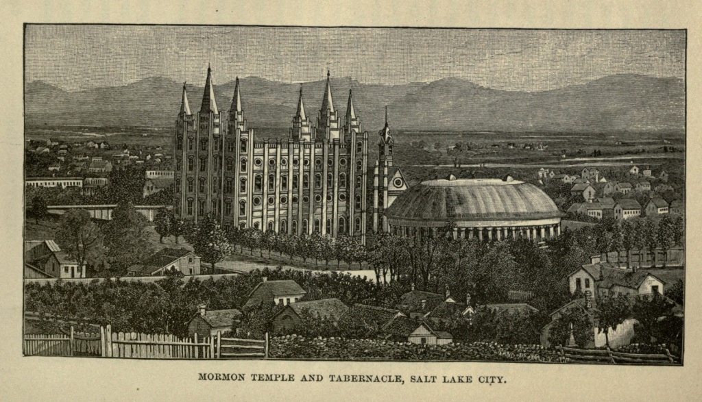
In the laying out of the city the fact was kept in view that it was for a people of workers, each one of whom must be self-sustaining. In truth, the great success of these people is due to the fact that no class of drones has been recognized and provided for. All, from the highest to the lowest, were expected to work, church officials as well as laymen; and prosperity has attended industry, as it always does. The wilderness and solitary place were glad for them, and the desert was made to rejoice and blossom as the rose; and a mighty nation within a nation has been built up in the valley of Utah, [Pg 441] protected by its mountain fastnesses. The Mormons have become a strong and prosperous people, and have not only possessed themselves of Utah, but have sent out colonies to Colorado, Nevada, New Mexico, Wyoming, Idaho and Arizona, which have prospered and increased, until they now practically control those Territories.
It is not my province to speak of the Mormons from either a religious or political standpoint. Their material prosperity one cannot fail to see, and a truthful historian must note it. The "City of the Saints," as Salt Lake City is sometimes called, is doubly interesting, from its history and from its peculiar features, so unlike those of any other city. The streets are one hundred and twenty-eight feet wide, crossing each other at right angles, an eighth of a mile apart, each square thus formed containing ten acres. Each square is divided into eight lots, measuring ten by twenty rods, and containing one-fourth of an acre. Several of the squares in the business quarter of the town have been cut across since the original laying out, forming cross streets. The streets are lined with trees, while streams of running water course down each side of every street, being brought from the neighboring mountains, ten thousand feet high, furnishing a pure water supply, and irrigating the gardens. Almost every lot has an orchard of pear, apple, plum, apricot, and peach trees, and Utah furnishes large quantities of fresh and dried fruit for the eastern markets. Apricots, which in the east are almost unknown, sometimes grow as large as eastern peaches, from six to eight inches in circumference. Locust, maple and box-elder are the favorite shade trees, and these grow luxuriantly. When, however, their roots[Pg 442] strike soil from which the alkali has not yet been washed, their leaves turn from a dark green to a sickly yellow. But irrigation washes out this alkali, and the trouble from it grows less every year.
Salt Lake City is divided into twenty wards, nearly every one of which has a square. Every ward has its master, who superintends the public improvements, and sees that every man does his share without shirking. The houses are generally of adobe (sun-dried bricks), though a few of the newer business blocks are handsome and commodious stone structures. Most of the dwelling houses are small, and but a single story in height, having separate entrances when there is more than one wife in the family. The city is not an imposing one. The wide streets, large grounds around each dwelling, and low, small houses, give it more the appearance of an overgrown village than that of a city. Nevertheless, it cannot be denied that the plan upon which it is built secures to its inhabitants the maximum of comfort, health and cleanliness. There are no narrow and stifling streets, overshadowed by tall buildings; no dirty alleys; no immense crime and pestilence-breeding tenement houses. Each little dwelling has its garden and orchard, securing to each family the blessings of fresh vegetables and fruit, and making each in a measure self-dependent. The air is pure, blowing down the valley from the mountain heights; and no foul vapors from half protected sewers or reeking courts poison it.
The chief business thoroughfares are Main and Temple streets. The former is entirely devoted to trade, while church edifices are found in the latter. The Tabernacle is, of course, the most prominent object which meets the eye of the traveler as he arrives in Salt Lake City,[Pg 443] standing out, as it does, in all its huge proportions, surrounded by the tiny homes of the people. It is on Temple street, in the heart of the city, and is entirely without architectural beauty, its predominant features being its hugeness and its ugliness. It is an enormous wooden structure, oval in form, with an immense dome-like roof, supported by forty-six sandstone pillars. It will seat fifteen thousand persons, and is used for the services of the church, lectures and public gatherings. It contains one of the largest organs in America. It is inclosed within a high wall, and a little to the east of it, within the same inclosure, are the foundations of a new temple, estimated to cost ten millions of dollars, but which will not probably be finished for many years to come. An inferior adobe building, also within the walls, is the celebrated Endowment House, where are performed those sacred and mysterious rites of the Mormon Church which no Gentile may look upon, and where the Saints are sealed to their polygamous wives.
On South Temple street, east of the Tabernacle, is the group of buildings known as Brigham Block, inclosed, like the former, by a high stone wall, and comprising the Tithing House, the Beehive House, the Lion House, the office of the Deseret News, and various other offices and buildings. The Beehive House and the Lion House constituted the residences of the late Brigham Young and eighteen or twenty of his wives. A handsome structure nearly opposite, the most pretentious structure in Salt Lake City, and known as Amelia Palace, was built by Brigham Young, for his favorite wife, Amelia. The theatre is a large building with a gloomy exterior, but handsomely fitted up inside. It is a favorite resort of the Saints, who make it a source of[Pg 444] innocent recreation, and entertain no prejudices against it, permitting their wives and children to appear upon its boards. One of the daughters of Brigham Young was at one time an actress at this theatre.
On South Temple street, opposite the Tabernacle, is the Museum, containing interesting products of Mormon industry; specimens of ores from the mines of Utah, and precious stones from the desert; a fair representation of the fauna of the Territory; relics of the mound builders; articles of Indian use and manufacture, and other curiosities, which the visitor may behold on the payment of a small admission fee. The City Hall, which is at the present time used by the Territorial Government, is a handsome building, erected at a cost of sixty thousand dollars. In its rear is the city prison. A co-operative store in successful operation will be found occupying a handsome building on East Temple street. The Deseret National Bank, at the corner of East Temple and South First streets, is also a fine building. The two principal hotels of Salt Lake City are the Walker House, on Main street, and the Townsend House, at the corner of West Temple and South Second streets. With all its quaintness and want of resemblance to other cities, it has adopted the system of horse cars, which run on the principal streets, and make all parts of the city accessible.
About one mile distant from the city are the Warm Springs, issuing from the limestone rock at the foot of the mountains. The water of these springs contains lime, magnesia, iron, soda, chlorine, and sulphuric acid, and their temperature is lukewarm. A bath in them is delightful, and beneficial, if not prolonged. Private bathing apartments are fitted up for the use of bathers. A mile further north are the Hot Springs, also strongly[Pg 445] sulphurous, and with a temperature of over 200°. Eggs may be boiled in these springs in three minutes, ready for the table. The water from these springs forms a beautiful lake, called Hot Spring Lake, which practically destroys all agriculture and vegetation for hundreds of yards within the vicinity. Strange as it may seem, the hot water does not prevent the existence of some kinds of excellent fish, among which have been seen some very fine, large trout.
The population of Salt Lake City is something over twenty thousand persons, of whom about one-third are Gentiles and apostate Mormons. This population is made up of all nationalities, apostles and missionaries being continually sent out to nearly every part of the civilized world, to make proselytes, and bring them to the fold. These converts to the faith are usually from the lower classes, ignorant and superstitious; and as a consequence the intellectual and social standards of Salt Lake City are not high. But with their new faith these people acquire habits of industry, if they never possessed them before; and the conditions of the city are favorable for growth in certain directions. Their children are educated and brought up to a higher position than that occupied by their parents; so that whatever may be our opinion as to the advantages or disadvantages, from a religious point of view, in their conversion to the Mormon faith, materially, intellectually and socially they have many of them undoubtedly made a change for the better. They are taken away from the stationary conditions of life in the old world, and transplanted into a new and growing country, where there is plenty of room and incentive for progress and expansion. Though the first generation do not always avail themselves of this[Pg 446] room, nor even the second, to its fullest extent, ultimately these people will come to compare favorably with other classes of American citizens.
The completion of the Union Pacific Railroad, although it deprived the Mormons of that isolation which they sought, has been of vast benefit to them in material ways. It is said that when the city was first settled the whole community could not have raised one thousand dollars in cash. And up to the completion of the railroad nine-tenths of the business of the Mormon people was conducted on a system of barter. A writer thus facetiously describes the condition of things at that period: "A farmer wishes to purchase a pair of shoes for his wife. He consults the shoemaker, who avers his willingness to furnish the same for one load of wood. He has no wood, but sells a calf for a quantity of adobes, the adobes for an order on the merchant, payable in goods, and the goods and the order for a load of wood, and straightway the matron is shod. Seven watermelons purchased the price of a ticket of admission to the theatre. He paid for the tuition of his children seventy-five cabbages per quarter. The dressmaker received for her services four squashes per day. He settled his church dues in sorghum molasses. Two loads of pumpkins paid his annual subscription to the newspaper. He bought a 'Treatise on Celestial Marriage' for a load of gravel, and a bottle of soothing syrup for the baby with a bushel of string beans."
There are not the most harmonious relations existing between the Mormon and Gentile people of Salt Lake City. Each regards the other with suspicion. The former look upon the latter as hostile to their faith, and determined to destroy it. The Gentiles regard certain[Pg 447] practices of the Mormons with abhorrence, and themselves as at heart rebellious to the government to which they have been compelled to submit. The leading papers of the two factions are very hostile, and keep alive the feeling of antagonism.
Lying between two prominent mountain chains, the chief city in a vast valley which the enterprise of man has demonstrated to be fertile; furnishing a depot of supplies, and a mart and shipping place for produce and manufactures; Salt Lake City is destined to become an important point in the western section of our country. Her future is assured, even though the people who founded her, together with the faith to which they cling, should disappear from the face of the earth, and be forgotten, like the lost tribes of Israel, which they believe themselves to represent. Essentially American in all her features—since no city of the Old World, either ancient or modern, furnishes a prototype—and in her very plan including certain sure elements of success, as our Western States and Territories become filled up with a thriving and industrious people, she will find herself the natural centre of a vast agricultural and mining population, and continue to increase in importance and prosperity.
San Francisco.—The Golden State.—San Francisco Bay.—Golden Gate.—Conquest of California by Fremont, 1848.—Discovery of Gold.—Rush to the Mines, 1849.—"Forty-niners."—Great Rise in Provisions and Wages.—Miners Homeward Bound.—Dissipation and Vice in the City.—Vigilance Committee.—Great Influx of Miners in 1850.—Immense Gold Yield.—Climate.—Earthquakes.—Productions.—Irrigation.—Streets and Buildings.—Churches.—Lone Mountain Cemetery.—Cliff House.—Seal Rock.—Theatres.—Chinese Quarter.—Chinese Theatres.—Joss Houses.—Emigration Companies.—The Chinese Question.—Cheap Labor.—"The Chinese Must Go."—Present Population and Commerce of San Francisco.—Exports.—Manufactures.—Cosmopolitan Spirit of Inhabitants.
San Francisco is situated on the best harbor which our Pacific Coast affords, a little below the 38th parallel of latitude, and about a degree further south than St. Louis, Cincinnati and Washington. It is the western terminus of the Central Pacific Railroad, American gateway to Asia and the far East.
As the traveler proceeds thitherward from the Valley of the Mississippi, on descending the western slopes of the Sierras, he finds himself fairly within the Golden State; and in more senses than one does California deserve that name. If it be the summer season the very air seems filled with a golden haze. In leaving the mountains all freshness is left behind. Trees and fields are yellow with drouth, which lasts from April to November. Dense clouds of dust fill the air and settle upon everything. Whole regions, by the means of[Pg 449] extensive and destructive mining operations, have been denuded of all verdure, and lie bare and unsightly, waiting until the slow processes of time, or the more expeditious hand of man, shall reclaim them. But mines have now given place to vast grain and cattle farms or ranches; and great fields of golden grain and the cattle on a thousand hills are on either side of the track. If it be later or earlier in the year there is a wealth of bloom such as is never dreamed of in the East. The ground, sometimes, as far as the eye can reach, is brilliant with color, a golden yellow the predominating hue. In the rainy season the Sacramento valley, the occasional victim of prolonged drouth, is sometimes visited by a freshet, which carries destruction with it; a mountain torrent, taking its rise near the base of Mt. Shasta, and fed by the snows of the Sierras, it is fitful in its demeanor. It finds its outlet through San Francisco Bay and the Golden Gate to the Pacific.
San Francisco is on a peninsula which extends between the bay of that name and the ocean. Its site is nothing more than a collection of sand hills, which, before the building of the city, were continually changing their positions. The peninsula is thirty miles long and six wide, across the city, which stands on the eastern or inner slope.
San Francisco Bay is unsurpassed in the world, except by Puget Sound, in Washington Territory, for size, depth, ease of entrance and security. The entrance to the bay is through a passage five miles in length and about two in width, with its shallowest depth about thirty feet at low tide. Rocks rise almost perpendicularly on the northern side of the entrance, to a height of three thousand feet. A lighthouse is placed on one of[Pg 450] these, at Point Bonita. Fort Point, a fortress built on solid rock, commands the entrance from the south, and beyond it, until San Francisco is reached, are a series of sand dunes, some of them white and drifting and others showing green with the scant grass growing upon them. The entrance to the bay is called the Golden Gate, a name applied with singular appropriateness, since through its portals have passed continuous streams of gold since the discovery of the latter in 1848. Strangely enough, the name was given before the gold discovery, though at how early a date there seems no means of knowing. As far as can be ascertained, it first appears in Fremont's "Geographical Memoir of California," published in 1847. Six miles eastward from its entrance the bay turns southward for a distance of thirty miles, forming a narrow peninsula between it and the ocean, on the northeastern extremity of which the city is built. It also extends northward to San Puebla Bay, which latter extending eastward, connects by means of a narrow strait with Suisun Bay, into which the Sacramento River discharges its volume of water. These three bays furnish ample and safe harborage for all the merchant fleets of the world.
San Francisco Bay is about forty miles in length, its widest point being twelve miles. At Oakland, directly east of San Francisco, it is eight miles in width. Alcatraz Island, in the centre of the channel, six miles from the Golden Gate, is a solid rock rising threateningly above the water, and bristling with heavy artillery. It is sixteen hundred feet in length, and four hundred and fifty feet in width. Angel Island is directly north of Alcatraz, and four miles from San Francisco, contains eight hundred acres, and is also fortified. Midway[Pg 451] between San Francisco and Oakland is Yerba Buena, or Goat Island, which, too, is held as a United States military station. Red Rock, Bird Rock, the Two Sisters, and other small islands dot the bay.
In 1775 the first ship passed the portals of the Golden Gate, and made its way into the Bay of San Francisco. This ship was the San Carlos, commanded by Caspar De Portala, a Franciscan monk and Spanish Governor of Lower California, who set out on a voyage of discovery and exploration. The same man had six years previously visited the sand hills of the present site of San Francisco, being the first white man to set his foot upon them. Portala named the harbor San Francisco, after the founder of his monastic order, St. Francis. A mission was founded there six years later, on the twenty-seventh of June, by Friars Francisco Paloa and Bonito Cambou, under the direction of Father Junipero Serra, who had been commissioned by Father Portala as president of all the missions in Upper California. This was the sixth mission established in California, and up to the year 1800 the Fathers labored with great zeal and industry, had established eighteen missions, converted six hundred and forty-seven savages, and acquired a vast property in lands, cattle, horses, sheep and grain. Presidios or military stations were established for the protection of these missions, and the Indians readily submitted themselves to the Fathers, and acquired the arts of civilization.
The Franciscan friars continued complete sovereigns of the land during the first quarter of the present century, and increased in worldly goods. Mexico became a republic in 1824, and in 1826 considerably curtailed their privileges. In 1845 their property was finally confiscated and the missions broken up. The[Pg 452] priests returned to Spain; the Indians to their savagery; and only the crumbling walls of their adobe houses, and their decaying orchards and vineyards, remained to tell the tale of the past history of California. From that period until 1847 California was a bone of contention between Mexico and the United States, her territory overrun by troops of both nations. On the sixteenth of January, 1847, the Spanish forces capitulated to Fremont, and peace was established.
With the exception of the Mission Dolores, there was no settlement at San Francisco until 1835, when a tent was erected. A small frame house was built the following year, and on the fifteenth of April, 1838, the first white child was born. The population of San Francisco, then known as Yerba Buena, in 1842 was one hundred and ninety-six persons. In 1847 it had increased to four hundred and fifty-one persons, including whites, Indians, negroes and Sandwich Islanders. In March, 1848, the city contained two hundred houses, and eight hundred and fifty inhabitants. In November of the same year, the first steamer, a small boat from Sitka, made a trial trip around the bay. In this year the first public school and the first Protestant church were established.
This year marked the great era in the history of San Francisco. In the fall of 1847, Captain John A. Sutter, a Swiss by birth, who had resided in California since 1839, began erecting a saw mill at a place called Colorna, on the American River, a confluent of the Sacramento, about fifty miles east of the city of that name. James W. Marshall, who had taken the contract for erecting the mill, was at work with his men cutting and widening the tail-race when, on January eighteenth, 1848, he observed some particles of a yellow, glittering substance. In[Pg 453] February specimens of these findings were taken to San Francisco, and pronounced to be gold. The truth being soon confirmed, the rush for the gold fields commenced. People in all sections of California and Oregon forsook their occupations, and set out for the mines. The news spread, increasing as it went; until the reports grew fabulous. Many of the earliest miners acquired fortunes quickly, and as quickly dissipated them. The journal of Rev. Walter Colton, at that time Alcalde of Monterey, contains the following paragraph, under date of August twelfth, 1848:—
"My man Bob, who is of Irish extraction, and who had been in the mines about two months, returned to Monterey about four weeks since, bringing with him over two thousand dollars, as the proceeds of his labor. Bob, while in my employ, required me to pay him every Saturday night in gold, which he put into a little leather bag and sewed into the lining of his coat, after taking out just twelve and a half cents, his weekly allowance for tobacco. But now he took rooms and began to branch out; he had the best horses, the richest viands, and the choicest wines in the place. He never drank himself but it filled him with delight to brim the sparkling goblet for others. I met Bob to-day, and asked him how he got on. 'Oh, very well,' he replied, 'but I am off again for the mines.' 'How is that, Bob? you brought down with you over two thousand dollars; I hope you have not spent all that; you used to be very saving; twelve and a half cents a week for tobacco, and the rest you sewed into the lining of your coat.' 'Oh, yes,' replied Bob, 'and I have got that money yet. I worked hard for it, and the devil can't get it away. But the two[Pg 454] thousand dollars came aisily, by good luck, and has gone as aisily as it came!'"
Reports of the new El Dorado reached the States, and during 1849, from Maine to Louisiana came the gold seekers. From every country in Europe, from Australia and from China, additions were made to the throng of pilgrims, who, by the Isthmus, around the Horn, across the seas, and by the terrible journey overland, all rushed pell mell up the Sacramento, stopping at San Francisco only long enough to find some means of conveyance. We have no space to tell the story of that time. Men came and went. Some made fortunes. Others returned poorer than they came. Many who attempted the overland route left their bones bleaching on the plains. Some went back to their homes, and others remained to become permanent citizens of California. What the F. F. V.s are to Virginia, and the Pilgrim Fathers to Massachusetts, the "Forty-niners," a large number of whom still survive, will be, in the future, to California.
During 1848 ten million dollars' worth of gold had been gathered on the Yuba, American and Feather rivers. The city of San Francisco had, in January, 1849, two thousand inhabitants, and these were in a hurry to be off to the mines as soon as the rainy season was over. Ships began to arrive from all quarters, and July of that year found the flags of every nation floating in the bay. Five hundred square-rigged vessels lay in the harbor, and everybody was scrambling for the mines. These multitudes of people, though they thought only of gold, yet had to be fed, clothed and housed after a fashion. There were no supplies adequate to the demand, and provisions went up to fabulous prices. Apples sold for from $1 to $5 apiece, and eggs at the same rates.[Pg 455] Laborers demanded from $20 to $30 for a day's work, and were scarcely to be had at those figures. The miners probably averaged $25 a day at the mines, though some were making their hundreds. But at the exorbitant prices to be paid for everything, few were able to lay up much money.
Late in the year of 1849 the reaction came. The steamers were filled with downcast miners, thankful that they had enough left to take themselves home. Others having acquired something, stopped at San Francisco, and plunged into the worst forms of dissipation. The city during this and the following year held a carnival of vice and crime. Women there were few or none, save of the worst character, and gambling dens, dance houses, and drinking hells flourished on every street. In 1850 a Vigilance Committee was organized by the better class of citizens, which soon exercised a wholesome restraint upon the criminal classes. In the same year California was admitted to the Union without the preliminary of a Territorial Government, and San Francisco was chartered as a city. Courts were established, and the lawless community came under the dominion of law and order.
By this time the great haste which seized everybody in his eagerness to obtain gold and return home to enjoy it, had somewhat subsided. Men began to realize that there were other means of making money besides digging for it. Gardens were planted and orchards set out, and it was discovered that the apparently barren soil of the State would yield with a fruitfulness unparalleled in the East. San Francisco began to be more than a canvass city. Mud flats were filled in and sand hills leveled, houses, hotels and stores erected, and a wild speculation began in city property. Lots which a few[Pg 456] days before had been purchased for two or three thousand dollars, were held at fifty thousand dollars. A canvas tent, fifteen by twenty feet, near the plaza, rented for forty thousand dollars per annum. The Parker House, a two-story frame building on Kearney street, also near the plaza, brought a yearly rent of one hundred and twenty thousand dollars. Board in a hotel or a tent was eight dollars per day, and provisions were proportionately high. To build a brick house cost a dollar for each brick used. Twenty-seven thousand people arrived in San Francisco, by sea or land, during 1850. In 1853 thirty-four thousand gold seekers returned home, the yield of gold that year having been $65,000,000, the largest annual yield of the State. The imports of San Francisco in the same year were over $45,000,000. As early as this period it was the third city in tonnage entrances in the United States, New York and New Orleans alone exceeding it. In 1856 the bad state of public affairs again necessitated the interference of a Vigilance Committee, but since that time the city has been orderly.
The site of San Francisco was fixed by chance. More desirable places might have been selected, but the influx of miners dropped upon the first spot convenient for them to land, from which to start post-haste to the mines, and that spot is indicated by the present city. Owing to its location its climate is not in all respects desirable. The general climate of the coast is tempered, both in summer and winter, by a warm ocean current, which, flowing northward along the coast of China and Siberia, takes a turn to the south when it reaches Alaska, and washes the western coast of the continent of America. It is so warm that it produces a marked[Pg 457] effect upon this coast, just as the Gulf Stream tempers the climate of the British Islands. But it has been sensibly cooled by its proximity to Arctic seas, and so sends cool breezes to fan the land during the heat of summer. These summer sea breezes rushing through the narrow opening of the Golden Gate become almost gales, and bring both cold and fog with them. The air of winter is mild and spring-like. This is the rainy season, but it does not rain continuously. It is the season of verdure and growth, and frosts are both slight and infrequent in the latitude of San Francisco. Not a drop of rain falls during the summer. The mornings are warm and sometimes almost sultry; but about ten o'clock the sea breeze springs up, growing more violent as the day advances, and frequently bringing a chilly fog with it, so that by evening men are glad to wrap themselves in overcoats, and women put on their cloaks and furs. The sand, which is still heaped in dunes to the westward of the city, and lies upon its vacant lots, is lifted and whirled through the air, falling almost like sleet, and stinging the faces of pedestrians.
Thunder storms are of rare occurrence at San Francisco, but earthquakes are exceedingly frequent. Probably not a year elapses in which slight shocks are not felt in the State. Sometimes these shocks extend over vast areas, and at other times are merely local. On October twenty-first, 1868, a severe earthquake occurred at San Francisco, swaying buildings and throwing down numbers in process of erection. The houses of the city are mostly built with a view to these disturbances of nature. The dwelling houses are seldom more than two and one-half stories in height, while the blocks of the[Pg 458] business streets do not display the altitude of structures in the eastern cities.
The climate is so mild and so favorable that the productions of California embrace those of both temperate and semi-tropical latitudes. The sand hills of San Francisco were found, with the help of irrigation to produce plentifully of both fruits and flowers, and the suburbs of the city display many greenhouse plants growing in the open air. Roses bloom every month in the year, and strawberries ripen from February to December. In San Francisco the mean temperature in January is 49° and in June 56°. The average temperature of the year is 54°.
The California market, between Kearney and Montgomery streets, extending through from Pine to California streets, displays all the fruits, vegetables and grains of the northern States, raised in the immediate neighborhood of the city, while oranges, lemons and pomegranates are sent from further south. The tenderer varieties of grapes flourish in the open air, and the State produces raisins which command a price but little below those of Europe. The thrift of the fruit trees of California is most remarkable. Most trees begin bearing on the second year from the slip or graft, and produce abundantly at three or four years of age. Their growth and the size of their productions are unequaled on the continent. The above mentioned market is one of the sights of the city, and should not be missed by the visitor.
Irrigation has been found necessary to render the sand hills about San Francisco productive, and windmills have become familiar objects in the landscape, their long arms revolving in the ocean breeze, while little[Pg 459] streams of water trickling here and there vivify the earth. As a result, though trees are scarce, what few there are being mostly stunted live oaks, whose long roots extend down deep into the soil, there are flowers everywhere. On one side of a fence will be a sand-bank, white with shifting sand, on the other, flourishing in the same kind of soil, will be an al fresco conservatory, brilliant with color and luxuriant in foliage.
Montgomery street is the leading thoroughfare, broad and lined with handsome buildings. Toward the north it climbs a hill so steep that carriages cannot ascend it, and pedestrians make their way up by means of a flight of steps. From this elevation a fine view is obtained of the city and bay. Kearney and Market streets are also fashionable promenades, containing many of the retail stores. The principal banks and business offices are found on California street, and the handsomest private residences are on Van Ness avenue, Taylor, Bush, Sutter, Leavenworth and Folsom streets, Clay street Hill and Pine street Hill. The city extends far beyond its original limits, having encroached upon the bay. Solid blocks now stand where, in 1849, big ships rode at anchor. It is laid out with regularity, most of its streets being at right angles with one another. The business streets are generally paved with Belgian blocks or cobble stones, and most of the residence streets are planked. The city does not present the handsome and showy architecture of many cities of the east, though here and there are fine edifices. It is yet too new, and too hurriedly built, to have acquired the substantiality and grandeur of older cities. Between fine brick or stone structures several stories high are sandwiched insignificant wooden houses of only two stories, the relics of a past which is[Pg 460] yet exceedingly near the present. The public buildings, especially those belonging to the United States, are fine.
The City Hall will, when finished, be surpassed by few structures in the country. The Palace Hotel, at the corner of Market and New Montgomery streets, is a vast building, erected and furnished at a cost of $3,250,000. It is entered by a grand court-yard surrounded by colonnades, and from its roof a birds-eye view of the whole city can be obtained. Baldwin's Hotel, at the corner of Marshall and Powell streets, is another palatial structure, costing a quarter of a million more, for building, decorating and furnishing, than the Palace Hotel. The Grand Hotel, Occidental, Lick House, Russ House and Cosmopolitan are all established and popular hotels.
The largest and finest church edifice on the Pacific Coast is that of St. Ignatius, Roman Catholic, in McAlister street. The finest interior is that of St. Patrick's, also Roman Catholic, in Mission street between Third and Fourth. The First Unitarian church, in Geary street, is one of the finest churches in the city, remarkable for the purity of its architectural design and the elegance of its finish. The Chinese Mission House, at the corner of Stockton and Sacramento streets, will prove interesting to strangers. The Roman Catholics, who number among their adherents all the Spanish citizens, make no concealment of their intention to gain a majority of the population. But though they are a power in the community, and have many churches, the different Protestant sects are largely represented. Indeed, San Francisco is thoroughly tolerant in matters of religion. Not only do Catholics and Protestants find their own appropriate places of worship, but the Jews[Pg 461] have two Synagogues, and the Chinese Buddhists three Temples or Joss Houses.
There is but one road leading out of the city, but within the city limits there are many modes of conveyance. Cars propelled by endless wire cables, which move along the streets without the assistance of either horse or steam power, intersect the city in every direction. Omnibuses run out on the Point Lobos road to the Cliff House; and he who has not ridden or driven thither and watched the seals on Seal Rock, has not seen all of San Francisco. This is the one excursion of the city; its one pet dissipation. Everybody goes to the Cliff. A drive of five or six miles, on a good road, over and through intervening sand hills, brings the visitor to the Cliff House. This road leads by Laurel Hill, or as it was formerly called, Lone Mountain Cemetery, two and one-half miles west of the city, within whose inclosure a conical hill rises to a considerable height above the surrounding level country. On its summit is a large wooden cross, a prominent landmark, and within the cemetery are several fine monuments, conspicuously that of Senator Broderick, and a miniature Pantheon, marking the resting place of the Ralston family. The Lone Mountain possesses an unrivaled outlook over city, bay, ocean and coast range.
The Cliff House is a large, low building, set on the edge of a cliff rising abruptly from the ocean, and facing west; and from it you have a grand view of the Golden Gate, while oceanward you strain your eyes to catch some glimpse of China or Japan, which lie so far away in front of you. But you see instead, if the day be clear, the faint but bold outlines of the Farallon Islands,[Pg 462] and the white sails of vessels passing in and out of the Golden Gate.
Late in the year of 1876 I completed my horseback journey across the continent, dashing with my horse into the surf to the westward of the Cliff House. A long and wearisome, but at the same time interesting and reasonably exciting ride, was at an end, and after viewing San Francisco, I was free to enjoy those luxuries of modern civilization, the railway cars, on my homeward route.
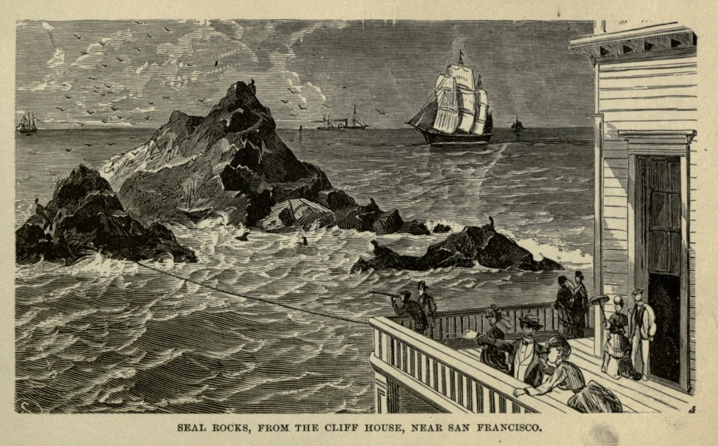
The Farallones de los Frayles are six islets lifting up their jagged peaks in picturesque masses out in the ocean, twenty-three and one-half miles westward of the Golden Gate. The largest Farallon extends for nearly a mile east and west, and is three hundred and forty feet high. On its highest summit the government has placed a lighthouse, and there the light-keepers live, sometimes cut off for weeks from the shore, surrounded by barrenness and desolation, but within sight of the busy life which ebbs and flows through the narrow strait which leads to San Francisco. These islands are composed of broken and water-worn rocks, forming numerous sharp peaks, and containing many caves. One of these caves has been utilized as a fog-trumpet, or whistle, blown by the force of the waves. The mouth-piece of a trumpet has been fixed against the aperture of the rock, and the waves dashing against it with force enough to crush a ship to pieces, blows the whistle. This fog whistle ceases entirely at low water, and its loudness at all times depends upon the force of the waves. The Farallones are the homes of innumerable sea birds, gulls, mures, shags and sea-parrots, the eggs of the first two being regularly collected by eggers, who make a profitable business [Pg 463] of gathering them at certain seasons of the year. In 1853 one thousand dozen of these eggs, the result of a three days' trip, were sold at a dollar a dozen. Gathering the eggs is difficult and not unattended by danger, as precipices must be scaled, and the birds sometimes show themselves formidable enemies. The larger island is also populated by immense numbers of rabbits, all descended from a few pairs brought there many years ago. Occasionally these creatures, becoming too numerous for the resources of the island, die by hundreds, of starvation. Though their progenitors were white, they have reverted to the original color of the wild race. The cliffs of these islands are alive with seals, or sea-lions, as they are called, which congregate upon their sunny slopes, play, bark, fight and roar. Some of them are as large as an ox and seemingly as clumsy; but they disport themselves in the surf, which is strong enough to dash them in pieces, with the utmost ease, allowing the waves to send them almost against the rocks, and then by a sudden, dextrous movement, gliding out of danger.
The Cliff House has also its sea-lions, on Seal Rock, not far from the hotel, and the visitors are never tired of watching them as they wriggle over the rocks, barking so noisily as to be heard above the breakers. Formerly numbers of them were shot by wanton sportsmen, but they are now protected by law. "Ben. Butler" and "General Grant" are two seals of unusual size, which appear to hold the remainder of the seal colony in subjection. If two begin to fight and squabble about a position which each wants, either "Ben" or the "General" quickly settles the dispute by flopping the malcontents overboard. The higher these creatures can[Pg 464] wriggle up the rocks the happier they appear to be; and when a huge beast has attained a solitary peak, by dint of much squirming, he manifests his satisfaction by raising his small pointed head and complacently looking about him. As soon as another spies him, and can reach the spot, a squabble ensues, howls are heard, teeth enter into the contest, the stronger secures the eminence, and the weaker is ignominiously sent to the humbler and lower regions.
An early drive to and a breakfast at the Cliff House, with a return to the city before the sea-breeze begins, is the favorite excursion of the San Franciscan. The road passes beyond this hotel to a broad, beautiful beach, on which, at low tide, one can drive to the Ocean House, at its extreme end, and then return to the city by the old Mission grounds, which still lie in its southwestern limits. The Mission building is of adobe, of the old Spanish style, built in 1778. Adjoining it is the cemetery, with its fantastic monuments, and paths worn by the feet of the Mission fathers and their dusky penitents.
The largest and finest theatre of the city, and one of the finest in the United States, is the Grand Opera House, at the corner of Mission and Third streets. Four other theatres and an Academy of Music, furnish amusements to the residents of the city. Woodward's Gardens, on Mission street between Thirteenth and Fourteenth streets, contains a museum, an art galley, and a menagerie. There are also two Chinese theatres, one at 618 Jackson street, and the other at 625½ Jackson street.
The Chinese Quarter of San Francisco, which has become famous the world over, occupies portions of Sacramento, Commercial, Dupont, Pacific and Jackson streets. It is a locality which no stranger should fail to[Pg 465] see. Here he steps at once into the Celestial Empire. Chinamen throng the streets, dressed in their semi-American, semi-Asiatic costumes, the pig-tail usually depending behind, though sometimes it is rolled up, out of sight, under the hat. The harsh gutturals of the Chinese language, nearly every word ending in ng, are heard on every hand, mingled with the grotesque pigeon English. The signs exhibit Chinese characters, and the stores and bazaars are filled with Chinese merchandise.
Women are scarce in this quarter, and only of the courtezan class; but here and there one meets you, dressed usually in Chinese gown and trowsers, with hair arranged in the indescribable Chinese chignon, and carrying a fan—for all the world as though she had stepped off a fan or a saucer—and not more immodest in demeanor than the same class in our eastern cities. There are few or no Chinese wives in San Francisco. Chinese immigration takes the form of an immense bow, beginning at China, stretching to the Pacific coast of America, and retiring again to its starting point; for every Chinaman expects to return to his native land, either alive or dead. He does not take root in American soil. He comes here to make a little money, leaving his family behind him, and, satisfied with a very modest competence, returns as he came. If he dies here, his bones are carried back, that they may find a resting-place with those of his ancestors. Therefore the women imported are for the basest purposes.
But to return to this Chinese Quarter. Here is the old St. Giles of London, the old Five Points of New York magnified and intensified. Here congregate the roughest and rudest elements, and here stand, shamelessly revealed, crime and bestiality too vile to name. In one cellar[Pg 466] is a gambling-hell, for John Chinaman's besetting weakness is his love of gambling. The mode of gambling is very simple, involving no skill, and the stakes are small; but many a Celestial loses there, at night, his earnings of the day. Near by is an opium cellar, fitted up with benches or shelves, on each of which will be found a couple of Chinamen lying, with a wooden box for a pillow. While one is preparing his opium and smoking, the other is enjoying its full effects, in a half stupor. The Chinese tenement houses are crowded and filthy beyond description, and the breeding places of disease and crime. They are scattered thickly throughout the quarter. Their theatres, of which there are two, already referred to, have only male performers, who personate both sexes, and give what seems to be passable acting, accompanied by the clash and clang of cymbals, the beating of gongs, the sounding of trumpets, and other disagreeable noises regarded by the Chinese as music. The entire audience are smoking, either tobacco or opium.
The Joss houses, or temples of the Chinese, are more in the nature of club houses and employment bureaus, than of religious houses. The first floor contains the business room, smoking or lounging room, dining room, kitchen, and other offices, which are used by the Emigration Company to which the building belongs. The second floor contains a moderate-sized hall, devoted to religious rites. Its walls are decorated with moral maxims from Confucius and other writers, in which the devotees are exhorted to fidelity, integrity, and the other virtues. The Joss or Josh is an image of a Chinaman, before whom the Chinese residents of San Francisco are expected to come once a year and burn slips of paper. Praying is also done, but as this is by means of putting printed[Pg 467] prayers into a machine run by clockwork, there is no great exhaustion among the worshipers.
The Chinese have no Sunday, and are ready to work every day of the week, if they can get paid for it. Their only holiday is at New Year, which occurs with them usually in February, but is a movable feast, when they require an entire week to settle their affairs, square up their religious and secular accounts, and make a new start in life. The Chinese have one saving virtue. They pay their debts on every New Year's day. If they have not enough to settle all claims against them they hand over their assets to their creditors, old scores are wiped out, and they commence anew.
The six Chinese Emigration Companies, each representing a Chinese province, manage the affairs of the immigrants with a precision, minuteness and care which is unparalleled by any organization of western civilization. Before the passage of the anti-Chinese law, when a ship came into port laden with Chinamen, the agents of the different companies boarded it, and each took the names of those belonging to his province. They provided lodgings and food for the new comers, and as quickly as possible secured them employment; lent them money to go to any distant point; cared for them if they were sick and friendless, and, finally, sent home the bones of those who died on American shores. These companies settle all disputes between the Chinese, and when a Chinamen wishes to return home, they examine his accounts, and oblige him to pay his just debts before leaving. The means for doing all this are obtained in the shape of voluntary contributions from the immigrants. These companies do not act as employment bureaus, for these are separate and thoroughly organized institutions.[Pg 468] These latter farm out the work of any number of hands, at the price agreed upon, furnishing a foreman, with whom all negotiations are transacted, who, perhaps, is the only one speaking English, and who is responsible for all the work.
The English spoken by the Chinese is known as "pigeon English," "pigeon" being the nearest approach which a Chinamen can make to saying "business."
Most English words are more or less distorted. L is always used by them for r, mi for I, and the words abound in terminal ee's.
The Chinese problem is one which is agitating the country and giving a coloring to its politics. The Pacific States seem, by a large majority of their population, to regard the presence of the Mongolian among them as an unmitigated evil, to be no longer tolerated. Eastern capitalists have hailed their coming as inaugurating the era of cheap labor and increased fortunes for themselves. Hence the discussion and the disturbances. A lady who had made her home in San Francisco for several years past, says, in a letter to the writer of this article, "A person not living in California can form no conception of the curse which the Chinese are to this section of the world."
Yet without them some of the great enterprises of the Pacific coast, notably the Central Pacific Railroad, would have remained long unfinished; and they came also to furnish manual labor at a time when it was scarce and difficult to obtain at any price. The Chinaman is a strange compound of virtue and vice, cleanliness and filth, frugality and recklessness, simplicity and cunning. He is scrupulously clean as to his person, indulging in frequent baths; yet he will live contentedly with the[Pg 469] most wretched surroundings, and inhale an air vitiated by an aggregation of breaths and stenches of all kinds. He is a faithful worker and a wonderful imitator. He cannot do the full work of a white man, but he labors steadily and unceasingly. He takes no time for drunken sprees, but he is an inveterate opium smoker, and sometimes deliberately sacrifices his life in the enjoyment of the drug. He is frugal to the last degree, but will waste his daily earnings in the gambling hell and policy shop. Scrupulously honest, he is yet the victim of the vilest vices which are engrafting themselves upon our western coast. Living upon one-third of what will keep a white man, and working for one-half the wages the latter demands, he is destroying the labor market of that quarter of our country, reducing its working classes to his own level, in which in the future the latter, too, will be forced to be contented on a diet of "rice and rats," and to forego all educational advantages for their children, becoming, like the Chinese themselves, mere working machines; or else enter into a conflict of labor against labor, race against race.
The latter alternative seems inevitable, and it has already begun. China, with her crowded population, could easily spare a hundred million people and be the better for it. Those one hundred million Chinamen, if welcomed to our shores, would speedily swamp our western civilization. They might not become the controlling power—the Anglo-Saxon is always sure to remain that—but as hewers of wood and drawers of water, as builders of our railroads, hands upon our farms, workers in our factories, and cooks and chambermaids in our houses, a like number of American men and women would be displaced, and wages quickly[Pg 470] reduced to an Asiatic level; and such a time of distress as this country never saw would dawn upon us.
There seems to be no assimilation between the Caucasian and the Mongolian on the Pacific slope. In the East an Irish girl recently married a Chinaman; but in San Francisco, though every other race under the sun has united in marriage, the Chinaman is avoided as a pariah. White and yellow races may meet and fraternize in business, in pleasure, and even in crime; but in marriage never. Chinamen rank among the most respected merchants of San Francisco, and these receive exceptional respect as individuals; but between the two races as races a great gulf is fixed. The Chinese immigrant takes no interest in American affairs. His world is on the other side of the Pacific. And the American people return the compliment by taking no interest in him. It is undeniable that, by a certain class of San Francisco citizens, popularly known as Hoodlums, the treatment of the Chinese population has been shameful in the extreme. A Chinaman has no rights which a white man is bound to respect. Insult, contumely, abuse, cruelty and injustice he has been forced to bear at the hands of the rougher classes, without hope of redress. He has been kicked, and cheated, and plundered, and not a voice has been raised in his behalf; but if he has been guilty of the slightest peccadillo, how quickly has he been made to feel the heavy hand of justice!
It seems a pity that before the cry was raised with such overwhelming force, "The Chinese must go!" some little effort had not been made to adapt them to Western civilization. They are quick to take ideas concerning their labor; why not in other things? We have received and adopted the ignorant, vicious hordes[Pg 471] from foreign lands to the east of us, and are fast metamorphosing them into intelligent, useful citizens. We are even trying our hand upon the negro, as a late atonement for all the wrong we have done him. But the Indian and the Chinaman seem to be without the pale of our mercy and our Christianity. It might not have been possible, but still the experiment was worth the trying, of attempting to lift them up industrially, educationally and morally, to a level with our own better classes, instead of permitting them to drag us down. Returning to their own country, and carrying back with them our Western civilization, as a little leaven, they might have leavened the whole lump. It is too late for that now, and the mandate has gone forth: "The Chinese must go!" Considering all things as they are, rather than as they might have been, it is undoubtedly better so, and the only salvation of our Pacific States.
San Francisco had, in 1880, a population of 232,956. The commerce is very large, and must every year increase as the West is built up. The chief articles of export are the precious metals, breadstuffs, wines and wool. She has important manufactures, embracing watches, carriages, boots and shoes, furniture, iron and brass works, silver ware, silk and woolen. California seems peculiarly adapted to the silk industry, and her silk manufactures will probably assume marked importance in the future. The wonderful climate and unequaled productiveness are constantly attracting immigration, and the Pacific Central, which spans the continent, has vastly improved on the old methods of travel by caravan across the plains and over the mountains.
The population of San Francisco is cosmopolitan to the last degree, and embraces natives of every clime and[Pg 472] nearly every nation on the globe. Yet in spite of this strange agglomeration she is intensely Yankee in her go-ahead-ativeness, with Anglo-Saxon alertness intensified. In fact, as San Francisco is on the utmost limits of the West, beyond which there is nothing but a vast expanse of water until we begin again at the East, so she represents the superlative of Anglo-Saxon enterprise and American civilization, and looks to a future which shall far outstrip her past.
First Visit to Savannah.—Camp Davidson.—The City During the War.—An Escaped Prisoner.—Recapture and Final Escape.—A "City of Refuge."—Savannah by Night.—Position of the City.—Streets and Public Squares.—Forsyth Park.—Monuments.—Commerce.—View from the Wharves.—Railroads.—Founding of the City.—Revolutionary History.—Death of Pulaski.—Secession.—Approach of Sherman.—Investment of the City by Union Troops.—Recuperation After the War.—Climate.—Colored Population.—Bonaventure, Thunderbolt, and Other Suburban Resorts.
My first visit to Savannah was made on the twenty-ninth of July, 1864, when I was brought there as a prisoner of war. I found the city with its business enterprises in a state of stagnation, and the streets thronged with soldiers in Confederate uniforms. About four thousand troops were doing garrison duty in the city, which was thronged with refugees, and the entire population was suffering from a paralysis of all industrial enterprises, and from the interruption of its commerce by the Federal blockade at the mouth of the river. Camp Davidson, where we were confined, was in the eastern part of the city, near the Marine Hospital, with Pulaski's Monument in full view, to the westward.
The camp was surrounded by a stockade and deadline, and the principal amusement and occupation of the prisoners was the digging of a tunnel which was to conduct them to liberty beyond the second line of sentinels, without the stockade. But our little camp, like[Pg 474] Chicago, had a cow for an evil genius. This luckless creature broke through the tunnel, as it was nearing completion, and suddenly ended it and our hopes together.
The nearest Union forces were at Pulaski, at the mouth of the Savannah River, and Savannah was one of the most important military posts of the Confederate army. Our treatment at Camp Davidson was exceptionally kind and considerate, and the ladies of the city, in giving suitable interment to the remains of a Union officer who had died in the camp, proved themselves to be possessed of generous hearts. Therefore it was with regret that we received the order to leave Savannah for Charleston.
I next visited Savannah a few months later, when the war was drawing to a close, after General Sherman and his army had made their successful entrance into the town. On the sixteenth of December, myself and a companion found ourselves twenty miles from Savannah, after having been many weeks fugitives from "Camp Sorghum," the prison-pen at Columbia, South Carolina. We were on the Savannah River Road, over which Kilpatrick's Cavalry and the Fourteenth Army Corps had passed only a week before. Emboldened by our successes and hairbreadth escapes of three weeks, when we at last felt that deliverance was close at hand, we pursued our way, only to fall suddenly into the hands of the enemy. Hope deferred maketh the heart sick. But who shall describe the terrible sinking of the heart—the worse than sickness—when hope is thus suddenly crushed and turned to certain despair? Our second captivity was not, however, of long duration. Death was preferable to bondage under such masters. Taking our lives in our hands, a second escape was effected, and on December twenty-third, but two days after Sherman's occupancy of the[Pg 475] city, Savannah proved itself, indeed, a city of refuge. Union troops welcomed us with open arms, and we were soon despatched northward.
The traveler who visits Savannah to-day will view it under very different auspices. The white wings of peace have brooded over it for more than half a generation, loyalty has taken the place of treason in the hearts of her people, and prosperity is visible on her streets and wharves. Let him, if he can, approach the city from the sea, and by night. Fort Pulaski stands like a sentinel guarding the entrance to the harbor, the lighthouse upon the point keeping a bright eye out to seaward. As he glides up the river, which winds in countless lagoons around low sea islands covered with salt marshes, at last he will see in the distance the lights of the city set on a hill, and of the shipping at her feet. A distant city is always beautiful at night, though it may be hideous by daylight. Night veils all its ugliness in charitable shadows; it reveals hitherto unseen beauties of outline, crowns it with a tiara of sparkling gems, and enwraps the whole scene in an air of romance and mystery which is charming to the person of poetic nature. But whether seen by night or day, Savannah is indeed a beautiful city, probably the most beautiful in all the Southern States.
The Savannah River winds around Hutchinson Island, and the city is built in the form of an elongated crescent, about three miles in length, on its southern shore. It is on a bluff about forty feet above the stream, this bluff being about a mile wide at its eastern end, and broadening as it extends westward. Surrounding it are the low lands occupied by market gardens, for Savannah is a great place for market gardeners, and helps to supply the northern market in early spring.[Pg 476]
The streets of Savannah are laid out east and west, nearly parallel to the river, with others crossing them at right angles, north and south. They are wide, and everywhere shaded with trees, many of the latter being live oaks, most magnificent specimens of which are found in the city. Orange trees also abound, with their fragrant blossoms and golden fruit, stately palmettoes, magnolias and oleander, rich in bloom, bays and cape myrtles.
The streets running north and south are of very nearly uniform width, every alternate street passing on either side of a public square, which is bounded on the north and south by narrow streets running east and west, and intersected in the centre by a wide street taking the same direction. These public squares, twenty-four in number, and containing from one and a half to three acres, are a marked feature of the city. They are placed at regular intervals, as already described, are handsomely inclosed, laid out with walks, shaded with evergreen and ornamental trees, and in the spring and summer months are green with grass. In a number of these are monuments, while others contain fountains or statuary. These squares or plazas are surrounded with fine residences, each having its own little yard, beautiful with flowers, vines, shrubbery and trees. In these premises roses thrive and bloom with a luxuriance unknown in the North, and the stately Camelia Japonica, the empress among flowers, grows here to a height of twelve or fifteen feet, and blossoms in midwinter. Savannah, the most beautiful city of the South, if not in the United States, is more like the wealthy suburb of some large city, than like a city itself. It is embowered in trees, which are green the whole year around; and shares with Cleveland, its northern rival in beauty, the soubriquet of the "Forest City."[Pg 477]
Forsyth Park, originally laid out in the southern suburb of the city, is now the centre of a populous quarter, abounding in handsome edifices. Many of the original trees, the beautiful southern pines, are left standing in this park, and other trees and shrubbery added. Sphynxes guard the Bull street entrance, and in the centre of the old park, which was ten acres in extent, is a handsome fountain, modeled after that in the Place de la Concorde, in Paris. This fountain is surrounded by a profusion of flowers, while shelled walks furnish pathways through the park. It has recently been increased in dimensions to thirty acres; in the centre of the new or western portion stands a stately monument in honor of the Confederate dead.
Pulaski Monument stands in Monterey Square, the first plaza to the northward of Forsyth Park. The steps of the monument are of granite, and the shaft of fine white marble, fifty-five feet high, surmounted by a statue of Liberty holding the national banner. This monument covers the spot where, in 1779, Count Pulaski fell, during an attack upon the city, while it was occupied by the British. In Johnson Square, the first square south of the river intersected by Bull street, is a fine Druidical pile, erected to the memory of General Greene and Count Pulaski. The corner-stone of this obelisk was laid in 1825, by Lafayette, during his visit to America.
Savannah was founded in 1733, by General James Oglethorpe, whose plan has been followed in its subsequent erection. Upon each of the twenty-four squares were originally left four large lots, known as "trust lots," two on the east and two on the west. We are told by Mr. Francis Moore, who wrote in 1736, that "the use[Pg 478] of this is, in case a war should happen, the villages without may have places in town to bring their cattle and families into for refuge; and for that purpose there is a square left in every ward, big enough for the outwards to encamp in." These lots are now occupied by handsome churches, conspicuous public buildings, and palatial private residences, thus securing to all the squares a uniform elegance which they might otherwise have lacked.
Bay street is the great commercial street of the city. It is an esplanade, two hundred feet wide, upon the brow of the cliff overlooking the river. Its southern side is lined with handsome stores and offices. At the corner of Bay and Bull streets is the Custom House, with the Post Office in the basement. Its northern side is occupied by the upper stories of warehouses, which are built at the foot of the steep cliff fronting the river. These upper stories are connected with the bluff by means of wooden platforms, which form a sort of sidewalk, spanning a narrow and steep roadway, which leads at intervals, by a series of turns, down to the wharves below. Long flights of steps accommodate pedestrians in the same descent. The warehouses just spoken of are four or five stories high on their river fronts, and but one or two on the Bay.
One should walk along the quay below the city to gain a true idea of the extent of its commerce. Here, in close proximity to the wharves, are located the cotton presses and rice mills. Here everything is dirty and dismal, evidently speaking of better days. The beauty of the city is all above. The buildings are some of them substantially built of brick, but begin to show the ravages of time. There is an old archway, which[Pg 479] once had pretensions of its own, but the wall has fallen away, and it is now an entrance to nowhere. Yet in spite of this general dilapidation, there is all the bustle and activity of a full commercial life. The wharves are piled with cotton bales, which have found a temporary landing here, awaiting shipment to the North, or perhaps across the sea. For Savannah is the second cotton port in the United States. But cotton is not its only export. It is the great shipping depot for Southern produce bound for Northern markets. Some sheds are filled with barrels of rosin, while great quantities of rosin litter the ground. From others turpentine in great quantities is shipped to various ports. The lumber trade of the city is immense, the pine forests of Georgia furnishing an apparently inexhaustible supply. The city is also in the centre of the rice-growing region, and sends its rice to feed the North. Steamships from all the Atlantic ports lie along its wharves, while those of foreign nations are by no means scarce. Vessels of too large a draft to lie alongside the wharves discharge and load their freight three miles below the city.
The view from the river front is over the river itself, filled with craft of all sorts, from the tiny ferry boat up to the immense ocean steamer, across to Hutchinson's Island and the Carolina shore. The island, which is two miles long by one wide, has upon it numerous lumber yards and a large dry dock. Rice was formerly cultivated upon it, but is now forbidden by law, because of its unhealthfulness. The river is about seven hundred and twenty feet wide in front of the city, with a depth of water at the wharves varying from thirteen to twenty-one feet. The portion of South Carolina visible is low and flat, dotted here and there with palmetto trees.[Pg 480] There is little of the picturesque about this river view except the busy life, which keeps in constant motion.
Savannah has extensive railroad connection with all parts of the United States. She has direct communication by rail with Vicksburg on the Mississippi. She also offers an outlet, by means of railroads, for the products of Georgia, Florida, and portions of Alabama and Tennessee. She has unbroken railroad connection with Memphis, Mobile, Cincinnati, Louisville, and the principal commercial cities of the West and North. Her water communication is established with all the great Northern and Southern seaboard cities. Her harbor is one of the best and safest on the South Atlantic coast, and she is the natural eastern terminus of the Southern Pacific Railroad, being almost on the same parallel of latitude with San Diego, its western terminus.
The corporate limits of Savannah extend backward from the river about one and one-half miles, and embrace a total area of three and one-half square miles, but additions are fast being made to the southward, which will, in time, greatly extend its area, and add to the population, which, in 1880, was 30,681.
Savannah's history goes back to the early days of the colonies. Its site marks the first settlement in Georgia. General Oglethorpe, with a hundred and fourteen men, women and children, having landed at Charleston, in January, 1733, sailed from that port with a plentiful supply of provisions and a small body of troops for their protection, and landed on Yamacraw Bluff, on the Savannah River, eighteen miles from its mouth. On the bluff General Oglethorpe laid out a town and called it Savannah, and by the ninth of February the colony commenced the erection of buildings. The colony sur[Pg 481]vived various haps and mishaps until 1776, when, in the War of the Revolution, the British attacked the city, but were repulsed. On December twenty-ninth, 1778, they made a second attack, surprised the American forces, who attempted to fly, but were mostly killed or captured. On the morning of October fourth, 1779, the American and French troops made a direct assault upon Savannah, attempting to take it from the British, but were obliged to retire with heavy loss. Count Pulaski, a Polish nobleman, who had been expatriated for participating in the carrying off of King Stanislaus from his capital, was wounded in this battle, and soon afterwards died. Pulaski Monument, as already stated, was erected on the spot where he fell.
Savannah received its city charter in 1788. In 1850 it had a little more than fifteen thousand inhabitants, and in 1860, 22,292. When Secession cast its shadow upon the sunny South, it fell like a pall upon Savannah, no less than upon the other Southern cities. All her business was suspended, and grass grew in her streets. On the northeast corner of Bull and Broughton streets stands the building known as Masonic Hall, where, on January twenty-first, 1861, the Ordinance of Secession was passed. On the sixteenth of March the State Convention assembled in Savannah, adopted the Constitution of the Confederate States of America, Georgia being the second State to adopt this Constitution without submitting it to the people. The mouth of the river was blockaded by United States gunboats, and all commerce prevented. On April fifteenth, 1862, Fort Pulaski was captured by the Federal troops, and great excitement prevailed in the city. Women and[Pg 482] children left their homes, and property and furniture were sent into the interior.
During the following years a number of unsuccessful attempts were made by the Union naval forces to capture the city. In December, 1864, Sherman was making his famous march to the sea, and was steadily drawing nearer the city, while southern chivalry fled before him, and the now emancipated slaves gathered and rolled in his rear like a sable cloud. On the twentieth, heavy siege guns were put in position by his forces between Kingsbridge and the city; and General Hardee, suddenly awakened to a sense of the danger which menaced them, set his troops hurriedly to work to destroy the navy yard and government property; while the ironclads, the "Savannah" and "Georgia," were making a furious fire on the Federal left, the garrison, under cover of darkness and confusion, were being transported on the first stage of their journey to Charleston. Before leaving, they blew up the iron clads and the fortifications below the city. On the twenty-first, General Sherman received a formal surrender from the municipal authorities. On the following day, the twenty-second, he sent a dispatch to the President, presenting him, "as a Christmas gift, the city of Savannah." On December twenty-eighth, 1864, Masonic Hall, already historical, witnessed a gathering of loyal citizens celebrating the triumph of the Union army. Sherman, when he entered the city, encamped his forces on the still vacant "trust lots." This triumphant conclusion of Sherman's march from Atlanta broke the backbone of the Confederacy, and was the prelude to the downfall of Richmond and the surrender of Lee's army.[Pg 483]
Prosperity eventually followed in the wake of peace. The blockade lifted, the deserted wharves were soon filled with the shipping of all nations. Her silent and empty streets grew noisy and populous with the rush of business, and Savannah is now one of the most prosperous of our Southern cities. Her architecture is not striking for either its beauty or its grandeur; nevertheless she has many fine public and private buildings. The City Exchange is one of the former, and it also possesses a historical interest, General Sherman having reviewed his troops in front of it in his investment of the city. From its tower the best view of the city and neighborhood may be obtained. The Court House, the United States and Police Barracks, Artillery Armory, Jail, Chatham Academy and St. Andrews' Hall, are all conspicuous buildings. The Georgia Historical Society has a large and beautiful hall, with a fine library and interesting relics. St. John's and Christ's Episcopal churches, the Independent Presbyterian Church, and the Roman Catholic Cathedral, are all striking edifices. Trinity Church, in Johnson Square, is near the spot where John Wesley delivered his famous sermons. Wesley visited Savannah in its early days, having been invited thither by Oglethorpe. At Bethesda, about ten miles from the city, where the Union Farm School is now located, was the site of the Orphan House established in 1740 by Whitefield, Wesley's contemporary and companion.
The benevolent, literary and educational institutions of Savannah are numerous and well sustained, some of them being among the oldest in the country. The Union Society, for the support of orphan boys, and the Female Society, for orphan girls, were founded in 1750.[Pg 484]
Savannah is situated just above the 32d parallel of latitude, and possesses a mean temperature of 66° Fahr. Being within the influence of the Gulf Stream it enjoys all the mildness of the tropics in winter, while the summers are less oppressive than at New York or Washington. It is a favorite resort for northern invalids, being comparatively free from malarious fevers and pulmonary diseases.
Colored people abound in Savannah, constituting about three-eighths of the entire population. They do most of the menial work of the city, being laborers, waiters in the hotels and public houses, and stevedores upon the wharves. It is astonishing to see the number of colored men it takes to load and set afloat a steamship; and one of the last sights which meets the eye of the traveler and lingers in his memory, as he leaves the city by means of the river, is the long row of upturned black faces, most of them beaming with good humor and jollity, on the wharf, as the vessel casts off her lines and turns her head down stream.
Savannah possesses certain famous suburban attractions, without seeing which the traveler can scarcely say he has seen the city. In a bend of the Warsaw River, a short distance from its junction with the Savannah, and about four miles from the city, is the famous Bonaventure Cemetery. A hundred years ago this was the country seat of a wealthy English gentleman, who, upon the marriage of his daughter, made her a wedding present of the estate. The grounds were laid out in wide avenues, and shaded by live oaks, and the initials of the young bride and her husband were outlined with trees. In course of time the property was converted into a cemetery, and for many years has been devoted to that purpose.[Pg 485] It is filled with monuments to the dead, some of them bearing historic names. Meantime the live oaks have grown to enormous dimensions, their gigantic branches meeting and interlacing overhead, forming immense arches, like those of the gothic aisles of some great cathedral, under and through which are visible bright vistas of the river and the sea islands lying beyond. The branches are fringed with pendants of the gray Spanish moss, yards in length, which sway softly in the breeze, and by their sombre color add to the solemnity of the scene. The steamers on the Sea Island route to Fernandina, Florida, pass Bonaventure, and afford glimpses of white monuments through the avenues of trees. Bonaventure is a favorite drive from the city, and is also reached by the horse cars.
Thunderbolt, so named, tradition tells us, because a thunderbolt once fell there, is a short distance from Bonaventure, down the Warsaw River, and is a popular drive and summer resort. A spring of water flows from the spot where the lightning is supposed to have entered the ground. Jasper's Spring is two and one-half miles west of the city, and is the scene of the exploit of Sergeant Jasper, who at the time of the Revolution succeeded, with only one companion, in releasing a party of American prisoners from a British guard of eight men. Another fashionable drive is to White Bluff, ten miles distant from the city. The latter, with Beaulieu, Montgomery and the Isle of Hope, furnish salt water bathing and delightful sea breezes for the summer visitors.
There is but one line of horse cars in the city, running on South Broad street, and then out the Thunderbolt road to Thunderbolt, Bonaventure, and the other suburban resorts. This company, we are told, has been so[Pg 486] reckless in regard to the limitations of its charter, that the municipal government refuses to charter a second road. If our Northern cities were as scrupulous, we wonder where their many horse railroads would be!
Since the war Northern men and Northern capital have helped to build up the various interests of Savannah. Planing mills, foundries, flouring and grist mills, have been established, furnishing employment to a considerable number of workingmen. Old channels of commerce have been extended, and new ones opened; and the natural advantage of her position, added to the public spirit which her citizens manifest in the accomplishment of great enterprises of internal improvement, give a guarantee of increased prosperity in the future.
Valley of the Connecticut.—Location of Springfield.—The United States Armory.—Springfield Library.—Origin of the Present Library System.—The Wayland Celebration.—Settlement of Springfield.—Indian Hostilities.—Days of Witchcraft.—Trial of Hugh Parsons.—Hope Daggett.—Springfield "Republican."
A journey up the Valley of the Connecticut at this season of the year is a positive luxury to the tourist or professional traveler. It is a broad, beautiful road, winding through hill and dale, with grand old forests and mountains in the background, their foliage tipped with variegated colors by the fingers of Autumn, as an artist would put a finishing touch to his landscape.
A ride of twenty-five miles northward from Hartford brought us to Springfield, the most enterprising and important town in Western Massachusetts. The United States Armory, located here, gives to the city a national consequence. No city in the Union did more to crush out the Rebellion than Springfield, through her Armory. Two or three thousand men were kept constantly employed here during the war, turning out the various arms used in the Federal service. The force now employed is considerably less than in war times. All hands are engaged just now upon the Springfield rifled musket, which has recently been adopted by the Government. The military precision with which every detail is attended to is the admiration of all who are shown through the Armory.[Pg 488]
A visit to the City Library, on State street, cannot fail to interest every person who feels a pride in the public institutions of New England. A fine, large, brick and stone building, with plain exterior and artistically finished interior, is the Springfield Public Library. Over forty thousand volumes cover its shelves, and are so systematically arranged that the librarian or his assistants can produce at once any work named in the catalogue. The oblong reading room is furnished with black walnut tables; and winding staircases, painted in blue and gold, lead from the columned alcoves to the galleries above.
The library owns some very old and valuable books of engravings. A room on the first floor is devoted to stuffed birds, geological specimens, preserved snakes, and a wonderful assortment of curious relics obtained from all parts of the world. Icelandic snow shoes and Hindoo gods occupy places on the same shelf, in peaceful proximity, and catamounts, paralyzed in the act of springing, glare at you harmlessly behind their glass cases. Patriotic mementoes are not wanting, as the bullet-riddled battle-flags of Massachusetts regiments will testify.
The free public library system is distinctively a New England institution, and wields a mighty influence for good. It was originated in 1847, by Rev. Francis Wayland, President of Brown University, Providence, Rhode Island. On Commencement day of that year Mr. Wayland expressed a wish to help the inhabitants of the town of Wayland, Massachusetts, to a public library, and tendered a donation of five hundred dollars to the town for that purpose, upon the condition that another five hundred should be added by the town. The required fund was quickly raised, by subscription,[Pg 489] and President Wayland immediately placed his donation in the hands of one of their prominent citizens, Judge Mellen. This was the beginning of the movement which resulted in the "Library Act," of May, 1851, in the State of Massachusetts.
The people of Wayland bought their library and provided a room in the "Town House" for its safe keeping. A librarian was chosen, whose salary was paid by the town, and the institution made its first delivery of books August seventh, 1850. Rev. John B. Wright was a member of the Massachusetts Legislature, from Wayland, during the session of 1851, and through his agency the Act "to authorize cities and towns to establish and maintain public libraries" was passed. A "Library Celebration" took place in Wayland, August twenty-sixth, 1851, and was a most interesting affair. Thus it came to pass that through the practical working of this man's idea public libraries were established, not only all over the State of Massachusetts, but throughout New England.
Springfield was founded in 1636 by William Pyncheon, who with seven other men settled here, with their families, on May fourteenth of that year. They were bound together by mutual contract, with the design of having their colony consist of forty families. There was an especial provision that the number should never exceed fifty.
The early prosperity of Springfield was considerably retarded by Indian hostilities.
In October, 1675, the brown warriors of King Phillip made a descent upon the place, burning twenty-nine houses and killing three citizens—one of them a woman. The timely arrival of Major Pyncheon, Major Treat and Captain Appleton, with their troops, prevented[Pg 490] further destruction and repulsed the attack of the Indians. Springfield was also the scene of operations during the troubles of 1786-87. At that time, General Shepperd was posted here, for the defence of the Armory.
Thus, through much tribulation, has the thriving town attained its present prosperity.
In its infant days, Springfield cherished a strong belief in witchcraft, as the following incident will testify: In the same year that Hartford set such a bad example to her northern neighbor on the Connecticut, by hanging Mrs. Greensmith, Springfield, not to be outdone, preferred a charge of witchcraft against one Hugh Parsons—a very handsome and pleasing young man, it seems, with whom all the women fell in love. Of course, this was not to be tolerated by the male population of the place, who hated him, as a natural consequence; and, accordingly, the handsomest man in Springfield was indicted and tried, on the grave accusation of being in league with the powers of evil. It is not surprising that the jury found him guilty. But, through some influence not explained, the judge, Mr. Pyncheon, stayed proceedings in his behalf until the matter could be laid before the General Court, in Boston. There the decision of the Springfield jury was reversed, and Mr. Parsons set at liberty. Whether after this his dangerous attractions were duly husbanded, or whether he went on, as of old, winning such wholesale admiration, we are not informed.
One of the sensations of the hour during my sojourn in Springfield, was an encounter between the State Street Baptist Church and Hope Daggett, one of its members. The disaffected sister had at sundry times and in divers manners made herself so obnoxious to the congregation,[Pg 491] by her strong-minded peculiarities, that an officer was called upon the scene and requested to eject by force, if necessary, the eccentric and uncompromising Hope. Officer Maxwell, suiting the action to the word, seized the unruly sister, and without stopping to consider the sudden fame which this act would launch upon him, thrust her into the street, amid the cheers and taunts of friends and enemies. Now it was the peculiar misfortune of Miss Daggett to have a wooden leg, and on the day following this tragic affair the press of Springfield was devoted to various accounts of the engagement, in which Maxwell and the wooden leg figured alternately.
I cannot leave Springfield without some mention of its leading paper, the Springfield Republican, which for many years has been one of the solid papers of the Bay State, and a representative organ in politics and literature. Its editor, Samuel Bowles, is an energetic business manager and a stirring politician, who has fought his way up from obscurity to a position in the front rank of American journalism.
Approach to St. Louis.—Bridge Over the Mississippi.—View of the City.—Material Resources of Missouri.—Early History of St. Louis.—Increase of Population.—Manufacturing and Commercial Interests.—Locality.—Description of St. Louis in 1842.—Resemblance to Philadelphia.—Public Buildings.—Streets.—Parks.—Fair Week.—Educational and Charitable Institutions.—Hotels.—Mississippi River.—St. Louis During the Rebellion.—Peculiar Characteristics.—The Future of the City.
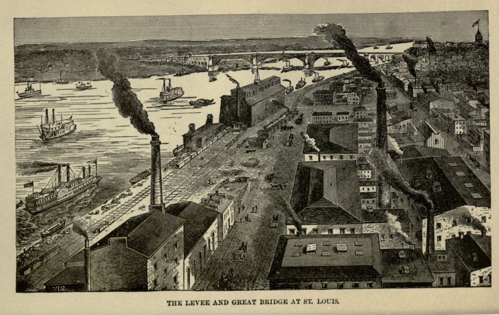
The visitor to St. Louis, if from the east, will probably make his approach over the great bridge which spans the Mississippi. This bridge, designed by Captain Eads, and begun in 1867, was completed in 1874, and is one of the greatest triumphs of American engineering. It consists of three spans, resting on four piers. The central span is 520 feet in width, and the side ones 500 feet each. They have a rise of sixty feet, sufficient to permit the passage of steamers under them, even at high water. The piers are sunk through the sand to the bed-rock, a distance of from ninety to one hundred and twenty feet, the work having been accomplished by means of iron wrought caissons and atmospheric pressure. Each span consists of four ribbed arches, made of cast steel. The bridge is two stories high, the lower story containing a double car track, and the upper one two horse-car tracks, two carriageways and two foot-ways. Reaching the St. Louis shore, the car and road ways pass over a viaduct of five arches, of twenty-seven feet span each, to Washington [Pg 493] avenue, where the railway tracks run into a tunnel 4,800 feet long, terminating near Eleventh street. Bridge and tunnel together cost eleven millions of dollars.
This wonderful structure, which has few if any equals upon the continent, will impress the traveler with the commercial magnitude and enterprise of the great western city to which it forms the eastern portal. Looking from the car window he will see, first, the Mississippi, which, if at the period of low water, disappoints him with its apparent insignificance; but which, if it be at the time of its annual flood, has crept, on the St. Louis side, nearly to the top of the steep levee, and has filled up the broad valley miles away on the hither side, a rushing, turbulent river, turbid with the yellow waters of the Missouri, which, emptying into it twenty miles above, have scarcely, at this point, perfectly mingled with the clearer Mississippi. He will see next the river front of St. Louis—a continuous line of steamboats, towboats and barges, without a sail or mast among them; the levee rising in a steep acclivity twenty feet above the river's edge; and multitudinous mules, with their colored drivers, toiling laboriously, and by the aid of much whipping and swearing, up or down the steep bank, carrying the merchandise which has just been landed, or is destined to be loaded in some vessel's hold. Beyond the river rises the city, terrace above terrace, its outlines bristling with spires, and prominent above all, the dome of the Court House.
St. Louis is situated in the very heart of the great Mississippi Valley, and a large share of its rich agricultural products and mineral stores are constantly poured into her lap. Pilot Knob and Iron Mountain, both[Pg 494] containing inexhaustible supplies of the useful ore, are not far distant. The lead districts of Missouri include more than 6,000 square miles. In fifteen counties there is copper. In short, within one hundred miles of St. Louis, gold, iron, lead, zinc, copper, tin, silver, platina, nickel, emery, cobalt, coal, limestone, granite, pipe-clay, fire-clay, marble, metallic paints and salt are found, in quantities which will repay working. In the State there are twenty millions acres of good farming lands; five millions of acres are among the best in the world for grapes; and eight millions are particularly suited to the raising of hemp. There is, besides, a sufficiency of timber land. With all these resources from which to draw, it would be surprising if St. Louis did not become a leading city in the West. Situated, as she is, on the Mississippi River, about midway between its source and its mouth, the junction of the Missouri twenty miles above, and that of the Ohio about one hundred and seventy-five miles below, and being the river terminus of a complicated system of western railways, the towns and cities, and even the small hamlets of the north, south and west, and to a limited extent of the east also, all pay her tribute. As Chicago is the gateway to the East, by means of the great chain of lakes and rivers at whose head she sits, so St. Louis holds open the door to the South and the East as well, through the Mississippi and the Ohio rivers.
In many respects the business rival of Chicago to-day, it has a history reaching half a century further back. While Chicago was still a howling wilderness, its only inhabitants the warlike Pottawatomies, who sometimes encamped upon the shores of its lake and river, St. Louis had a local habitation and a name. On February[Pg 495] fifteenth, 1764, Pierre Laclede Siguest, an enterprising Frenchman, established at this point a depot for the furs of the vast region watered by the Mississippi and Missouri, and gave it the name of St. Louis. This was done by permission of the Governor General of Louisiana, which was then a French province. In the course of the year cabins were built, a little corn planted and the Indians placated. The Frenchmen seemed to have gotten along with the Indians tolerably well in those days. They had no hesitation in marrying squaws, even though they already possessed one lawful wife; they were good tempered and merry, and attempted no conversion of the Indians with a Bible in one hand and a sword in the other. So the two races got along nicely together.
The peace of 1763 gave the country east of the Mississippi to the English, and the Frenchmen who had settled upon the Illinois made haste to remove to St. Louis, to avoid living under the rule of their "natural enemy." This was scarcely accomplished when the more terrible news reached them that Louis XV had ceded his possessions west of the Mississippi to Spain. For the next thirty years the town was a Spanish outpost of Louisiana, in which province no one not a Catholic could own land.
To go to New Orleans and return was a voyage of ten months; but in that early day, and under such surprising difficulties, St. Louis began its commercial career. It exported furs, lead and salt, and imported the few necessaries required by the settlers, and beads, tomahawks, and other articles demanded by the Indians in exchange for furs. In 1799 the inhabitants numbered 925, a falling off of 272 from the previous year.[Pg 496] In 1804, St. Louis passed to the United States, together with the whole country west of the Mississippi. In 1811 the population had increased to 1400, and there were two schools in the town, one French and one English. In 1812 the portion of the territory lying north of the thirty-fifth degree of latitude was organized as Missouri Territory. In 1813 the first brick house was erected in St. Louis. In 1820 its population was 4,928. In 1822 it was incorporated as a city.
After the cession of Louisiana to the United States, the law forbidding Protestant worship, and requiring owners of land to profess the Catholic faith, was repealed, and men American born but of English descent began to pour into the town. In 1808 a newspaper was established, and in 1811 many of the old French names of the streets were changed to English ones. In 1812 the lead mines began to be worked to better advantage, on a larger scale, and agriculture assumed increasing importance. In 1815 the first steamboat made its appearance.
In 1820 St. Louis cast its vote for slavery, and settled the question for Missouri. The population then was 4,928, which in 1830 had increased to 5,852; 924 additional inhabitants in ten years! From 1830 to 1860 its population trebled every ten years, the census returns of the latter year giving it 160,773. In 1870 it had nearly doubled again, the number being 310,864 inhabitants. According to the United States Census report of 1880, the population was 350,522, which made St. Louis the sixth city in the Union. Since that time it has been rapidly on the increase.
St. Louis is among the first of our cities in the manufacture of flour, and is a rival of Cincinnati in the pork-packing business. It has extensive lumber mills,[Pg 497] linseed-oil factories, provision-packing houses, manufactures large quantities of hemp, whisky and tobacco, has vast iron factories and machine shops, breweries, lead and paint works. In brief, it takes a rank second only to New York and Philadelphia in its manufactures, to which its prosperity is largely due. In 1874 the products of that year were valued at nearly $240,000,000, while it furnished employment to about 50,000 workmen. Great as are Chicago's manufacturing interests, St. Louis excels her in this respect, while she rivals the former city in her commercial interests. The natural commercial entreport of the Mississippi Valley, the commerce of St. Louis is immense. It receives and exports to the north, east and south, breadstuffs, live stock, provisions, cotton, lead, hay, salt, wool, hides and pelts, lumber and tobacco.
St. Louis is perched high above the river, so that she is beyond the reach of all save the highest floods of that most capricious stream. She is built on three terraces, the first twenty, the second one hundred and fifty, and the third two hundred feet above low-water mark. The second terrace begins at Twenty-fifth street, and the third at Côte Brillante, four miles west of the river. The surface here spreads out into a broad, beautiful plain. The highest hill in the neighborhood of the city was the lofty mound on the bank of the river, a relic of prehistoric times, and from which St. Louis derived its name of the "Mound City." Greatly to the regret of antiquarians a supposed necessity existed for the removal of this mound, and now no trace of it is left.
In 1842 Charles Dickens published his American Notes, in which is found the following description of St. Louis:[Pg 498]
"In the old French portion of the town the thoroughfares are narrow and crooked, and some of the houses are very quaint and picturesque, being built of wood, with tumble-down galleries before the windows, approachable by stairs, or rather ladders, from the street. There are queer little barber shops and drinking houses, too, in this quarter; and abundance of crazy old tenements, with blinking casements, such as may be seen in Flanders. Some of these ancient habitations, with high garret gable windows perking into the roofs, have a kind of French spring about them; and, being lopsided with age, appear to hold their heads askew, besides, as if they were grimacing in astonishment at the American improvements."
There is nothing of this now seen in St. Louis, except in the narrower streets along the river, which remain a lasting relic of the ancient city. Yankee enterprise has obliterated, in the appearance of the city at least, all trace of its French and Spanish origin. The work of renovation must have commenced soon after Dickens' visit, for Lady Emeline Wortley, visiting St. Louis in 1849, describes it as follows:—
"Merrily were huge houses going up in all directions. From our hotel windows we had a long view of gigantic and gigantically-growing-up dwellings, that seemed every morning to be about a story higher than we left them on the preceding night; as if they had slept, during the night, on guano, like the small boy in the American tale, who reposed on a field covered by it, and whose father, on seeking him the following day, found a gawky gentleman of eight feet high, bearing a strong resemblance to a Patagonian walking stick."
If Chicago is a western reproduction of New York, [Pg 499] with its characteristic alertness preternaturally developed, St. Louis takes Philadelphia for her prototype. The merchants and statesmen plodding wearily across the continent during the latter part of the last century and early in this, found Philadelphia the chief city of the country, and went home with their minds filled with the distinguishing features of that city. These they reproduced, as far as was practicable, in their own young and growing town. They laid it out with regularity, the streets near the river, which describes a slight curve, running parallel to it. Further back, they describe straight lines, while the streets running from east to west are, for the most part, at right angles with those they cross. Imitating Philadelphia, the streets are named numerically from the river. Those crossing them have arbitrary names given them, while many Philadelphia nomenclatures, such as Market, Chestnut, Pine, Spruce, Poplar, Walnut and Vine, are repeated. The houses are also numbered in Philadelphia fashion, the streets parallel with the river being numbered north and south from Market street, and those running east and west taking their numbers from the river. In numbering, each street passes on to a new hundred; thus No. 318 is the ninth house above Third street on one side of the way.
Not only in these superficial matters is Philadelphia imitated, but the resemblance is preserved in more substantial particulars. Many of the buildings are large, old-fashioned, square mansions, built of brick with white marble trimmings. There is less attempt at architectural display than in Chicago, apparently the main thought of the builders being to obtain substantiality. Yet there are many handsome buildings, both public and private.[Pg 500] One of the finest structures of its kind in the United States is the Court House, occupying the square bounded by Fourth, Fifth, Chestnut and Market streets. It is in the form of a Greek cross, of Grecian architecture, built of Genevieve limestone, and is surmounted by a lofty iron dome, from the cupola of which it is possible to obtain an extensive view of the city and its surroundings. The building cost $1,200,000. The fronts are adorned with beautiful porticoes. The Four Courts, in Clark avenue, between Eleventh and Twelfth streets, is a handsome and spacious building, constructed of limestone, at a cost of $1,000,000. A semi-circular iron jail is in its rear, so constructed that all its cells are under the observation of a single watchman. A Custom House and Post Office has recently been erected, at the corner of Olive and Eighth streets. It is of Maine granite, with rose-colored granite trimmings, three stories in height, with a French roof and Louvre dome, and occupies an entire square. The cost of the structure was $5,000,000.
The Chamber of Commerce is the great commercial mart of the city, the heart of enormous business interests, whose arteries sometimes pulsate with feverish heat, and whose transactions affect business affairs to the furthest extent of the country. The edifice is the handsomest of its kind in America. It is five stories high, wholly built of gray limestone, and cost $800,000. The main hall of the Exchange is two hundred feet long, one hundred wide, and seventy high. In the gallery surrounding it strangers can at any time witness the proceedings on the floor, and watch how fortunes are made and unmade.
The most imposing and ornate building of the city,[Pg 501] architecturally speaking, is the Columbia Life Insurance building, which is of rose-colored granite, in the Renaissance style, four stories high, with a massive stone cornice representing mythological figures. The roof is reached by an elevator, and affords a fine view.
The city abounds in handsome churches. Most prominent among them all is Christ Church (Episcopal) at the corner of Thirteenth and Locust streets. It is in the cathedral gothic style, with stained-glass windows and lofty nave. The Catholic Cathedral, on Walnut street, between Second and Third streets, is an imposing structure with a front of polished freestone faced by a Doric portico. The Church of the Messiah (Unitarian), at the corner of Olive and Ninth streets, is a handsome gothic structure. The Jewish Temple, at the corner of Seventeenth and Pine streets, is one of the finest religious edifices in the city. There are many others which will challenge the visitor's attention and admiration as he passes through the streets of the city.
The wholesale business of St. Louis is confined to Front, Second, Third and Main streets. Front street is one hundred feet wide, and extends along the levee, being lined with massive stores and warehouses. Fourth street contains the leading retail stores, and on every pleasant day it is filled with handsome equipages, while on its sidewalks are found the fashion and beauty of the city. Washington avenue is one of the widest and most elegant avenues in St. Louis, and west of Twenty-seventh street contains many beautiful residences. Pine, Olive and Locust streets, Chouteau avenue and Lucas Place, are also famed for their fine residences. Lindell or Grant avenue, running north and south, on the western boundary of the city, and slightly bending toward[Pg 502] the river, is its longest street, being twelve miles in length.
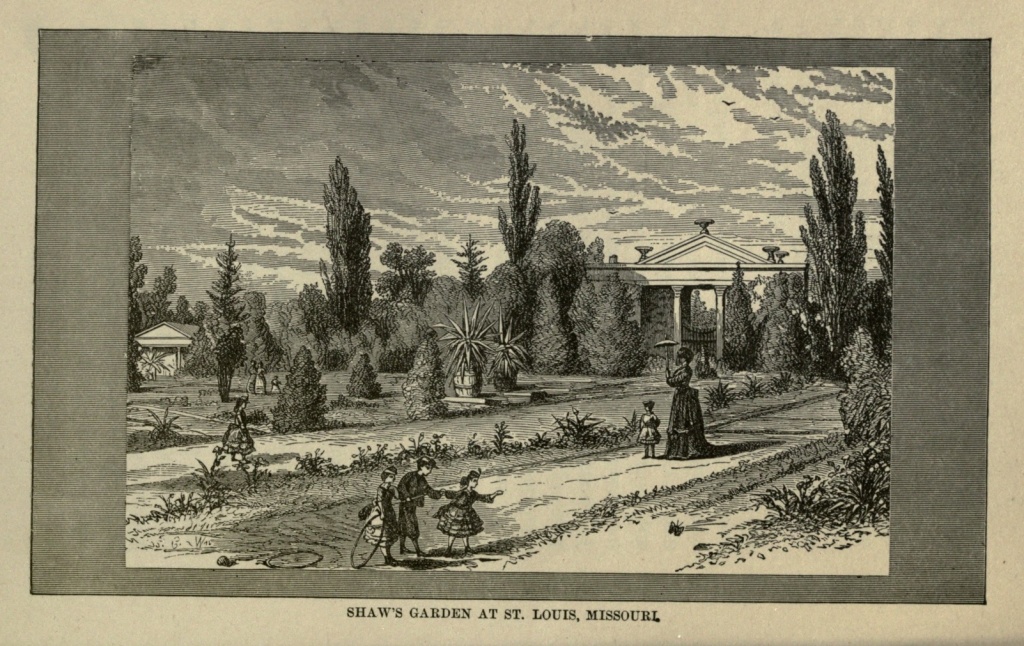
The corporate limits of St. Louis extend eleven miles along the river, and about three miles inland. The densely built portion of the city is about six miles in length by two in width. Its public parks are one of its striking features. They embrace an aggregate of about 2,000 acres. The most beautiful is Lafayette Park, lying between Park and Lafayette, Mississippi and Missouri avenues. In it are a bronze statue of Thomas H. Benton, by Harriet Hosmer, and a bronze statue of Washington. It is for pedestrians only, is elaborately laid out and ornamented, and is surrounded by magnificent residences. Missouri Park is a pretty little park at the foot of Lucas Place, containing a handsome fountain. St. Louis Place, Hyde Park and Washington Square are all attractive places of resort. Northern Park, on the bluffs to the north of the city, is noted for its fine trees, and contains 180 acres. Forest Park is the great park of the city. It lies four miles west of the Court House, and contains 1350 acres. The Des Pares runs through it, and the native forest trees are still standing. With great natural advantages, it requires only time and art to number it among the handsomest parks in the country. Tower Grove Park, in the southwest part of the city, contains 227 acres, offers delightful drives among green lawns and charmingly arranged shrubbery.
Adjoining this park is Shaw's Garden, which contains 109 acres. It possesses a peculiar interest, from the manner in which it is arranged. It is divided into three sections, the first being the Herbaceous and Flower Garden, embracing ten acres, and including every flower which can be grown in the latitude of St. Louis, besides[Pg 503] several greenhouses containing thousands of exotic and tropical plants. The second section, called the Fruticetum, comprises six acres devoted to fruit of all kinds. The Arboretum, or third section, includes twenty-five acres, and contains all kinds of ornamental and fruit trees. The Labyrinth is an intricate, hedge-bordered pathway, leading to a summer-house in the centre. There are also a museum and botanical library. This garden is entirely the result of private taste and enterprise, having been planned and executed by Henry Shaw, who has thrown it open to the public, and intends it as a gift to the city.
Bellefontaine Cemetery is the most beautiful in the West. It is situated in the northern part of the city, about four and one-half miles from the Court House, and embraces 350 acres. It contains a number of fine monuments, while the trees and shrubbery are most tastefully arranged. Calvary Cemetery, north and not far distant, is nearly as large and quite as beautiful. Here, in these quiet cities of the dead, far from the bustle of the great town, the men and women of this western metropolis, whose lives were passed in turmoil and activity, find at last that rest which must come to all.
The people of St. Louis are supplied with water from the river, the waterworks being situated at Bissell's Point, three and one-half miles north of the court house. Two pumping engines, each with a daily capacity of 17,000,000 gallons, furnish an ample supply for all the needs of the great city.
Fair week, which is usually the first week in October, is the great holiday and gala season of St. Louis. The writer of this article was once so fortunate as to visit the city early in this week. Every train of cars on the[Pg 504] many lines which centre at St. Louis, and every steamboat which came from up or down the river, brought its living freight of men and women, who were out for a week's holiday, and, it may have been, paying their annual visit to the greatest city west of the Mississippi. The country roads leading to town were black with vehicles of all descriptions, and laden with men and merchandise. The laborers and mules upon the levee were busier than ever, receiving and transporting the articles to be exhibited and sold. Every hotel was crowded, and the surplus overflowed into boarding and lodging houses, so that their keepers undoubtedly reaped a golden harvest for that one week, at least. The streets were thronged with an immense and motley multitude: business men, on the alert to extend their trade and add to their gains; working women, who found an opportunity for a brief holiday; ladies of fashion who viewed the scene resting at their ease in their carriages; farmers from the rural districts, looking uncomfortable yet complaisant in their Sunday suits, and trying to take in all there was to see and understand; their wives, old-fashioned and countrified in their dress, and with a tired look upon their faces, which this week given up to idleness and sight-seeing could not quite dispel; sporting men, easily recognizable by their flashy dress and "horsey" talk; gamblers and blacklegs by the score, whose appearance and manners were too excessively gentlemanly to pass as quite genuine, and whose gains during the week were probably larger and more certain than those of any other class; western men, with their patois, borrowed apparently from the slang of every nation on the globe; Southerners, with their long hair, slouched hats and broad accent; river hands, whose most[Pg 505] noticeable accomplishments seemed to be disposing of tobacco and inventing new oaths; negroes, whose facile natures entered heartily into the occasion, and on whose sleek, shining countenances the spirit of contentment was plainly visible; eastern men, with the Yankee intonation; Germans, in great numbers, patronizingly endorsing their adopted country, and selling lager beer with stolid content; Irishmen, whose preference was whisky, and who were ever ready for fun or a fight; beggars, plying their vocation with an extra whine, adopted to conceal an unwonted tendency to cheerfulness; magnates, who looked pompous and conscious of their own importance, but who were jostled and pushed with the democratic disregard for rank and station which characterizes an American crowd.
Probably in no city in the Union would one find quite so cosmopolitan a multitude, representing all sections and all nationalities so impartially. In the business and populous centre of our country, here came all classes and peoples who had been born under, or had sought the protection of, our flag, to worship one week at the shrines of Ceres and Pomona.
The fair grounds of the St. Louis Agricultural and Mechanical Association are three miles northwest of the Court House, and embrace eighty-five acres handsomely laid out and containing extensive buildings. The Amphitheatre will seat 40,000 persons. The street cars leading to these grounds were at all times filled with people, and in addition there was a constant procession of carriages, wagons and carts, going and returning. Within the enclosure the dense throng surged and swayed like a human whirlpool. The displays in the agricultural and mechanical departments were something astonishing;[Pg 506] for where in the world is there such grain grown and in such quantities, as in the Mississippi and Missouri valleys? Where are there such fat oxen, such sleek, self-satisfied cows, with such capacity for rich milk? Horses, hogs and sheep were all of the best, and indicated that the West is very far advanced in scientific stock raising. The farm implements displayed all sorts of contrivances for lightening and hastening the farmer's toil. It needed but a glance to show that farming in this region was no single-man, one-horse affair.
In art the East as yet excels the West; for in the scramble after material gain the artistic nature has not been greatly cultivated, and its expressions are, for the most part, crude. But they give promise of future excellence. St. Louis has no picture gallery worthy the name, but excells in scientific and educational institutions.
The Mercantile Library, at the corner of Fifth and Locust streets, contains 50,000 volumes, and its hall is decorated by paintings, coins and statuary, among which latter may be mentioned Miss Hosmer's life-size statue of Beatrice Cenci and Œnone; a bronze copy of the Venus de Medici, a sculptured slab from the ruins of Nineveh, and marble busts of Thomas H. Benton and Robert Burns. The library with its reading room is free to strangers.
Besides the library there is a public school library of 38,000 volumes; an Academy of Science, founded in 1856, with a large museum and a library of 3,000 volumes; and a Historical Society, founded in 1865, with a valuable historical collection. Washington University, organized in 1853, embraces the whole range of university studies except theology. With it is connected the Mary Institute, for the education of women, the Poly[Pg 507]technic School, and the Law School. The public school system of St. Louis is one of the best in the country, and its school-houses are commendably fine. The Roman Catholic College of the Christian Brothers has about four hundred students, and a library of 10,000 volumes. Concordia College (German Lutheran), established in 1839, has a library of 4,500 volumes. Besides the numerous public schools, the Roman Catholics, who embrace a majority of the inhabitants, have about one hundred parochial, private and conventual schools. They have also a number of convents, charitable homes, asylums and hospitals.
The hotels, chief amongst which are the new Southern Hotel, Lindell House, Planters' Hotel, Laclede Hotel and Barnum's Hotel, will compare favorably, in point of attendance, comfort and elegance, with any in the country. Horse cars traverse the city in every direction, rendering all points easily accessible, and carriages are in waiting at the depots and steamboat landings. Ferries ply continually to East St. Louis, on the Illinois shore, from the foot of Carr street, north of the bridge, and from the foot of Spruce street, south of it, the two points of departure being about a mile apart.
So long as the Mississippi River washes the levee in front of the city, the citizens of St. Louis are in little danger of long remaining dull, for want of excitement. That river, one of the uneasiest of water courses, constantly furnishes fresh themes of interest, and even of anxiety. It has a singular penchant for a frequent change of channels, and occasionally threatens to desert to Illinois and leave St. Louis an inland town, with its high levee a sort of rampart to receive the mocking assaults of Chicago. Then, every spring, there is the[Pg 508] annual freshet, which, once in ten or fifteen years, creeps up over the top of the levee, and finds its way into cellars and first floors of stores and warehouses. Occasionally there is a severe winter, when ice is formed upon the river as far south even as St. Louis; and when it breaks up in the spring, mischief is sure to ensue. A hundred steamboats are in winter quarters along the levee, their noses in the sand, and their hulls extending riverward, fixed in the ice. At last the great mass of congealed water, extending up the river hundreds of miles, begins to move down stream. The motion is at first scarcely perceptible; but, suddenly, the ice cracks and breaks, and fragments begin to glide swiftly with the current of the river. The various masses create conflicting currents, and, presently, the surface of the stream is like a whirlpool. Some boats are crushed like egg shells between the floes; cables snap, and others are drawn out into the midst of the whirling waters and are fortunate indeed if they are not overwhelmed or forced upon the ice. Meantime, consternation reigns upon the levee. The multitudes are powerless to prevent, yet make frantic and futile efforts while they watch, the disaster. At the breaking up of the ice in 1866, seventeen steamboats were crushed and sunk in a few minutes. Then there are other river disasters; steamboats burned; others struck on snags and sunk; and now and then a boiler explosion makes up the tale of horrors and prevents the Mississippi from ever becoming monotonous or uninteresting.
St. Louis was most unfavorably affected by the war, and made to expiate her political sin of 1820. On the border land between the North and the South, the conflict was carried on in her very midst. Sectional strife[Pg 509] was most bitter and keen. There was no neutrality, and there could be none. All were either for or against; families were divided in deadly strife; and while the city suffered to a terrible degree from this condition of affairs, in back counties whole sections were depopulated. The population being largely southern, either by birth or descent, its sympathies were with the South. The class truly loyal was the Germans, who numbered about 60,000 of the population, and who were characterized by the Secessionists as the "D—— Dutch." The blockade of the river reduced the whole business of the city to about a third of its former amount. Yet, when the war was ended, St. Louis was quick to recover her prostrated energies. In 1866, and but two years after the war, the city did more business than in any preceding year; and, relieved from the incubus of slavery, which had retarded its progress, it aroused itself to new life.
With the Quaker-like simplicity of its outward appearance, its absence of business rush, and its general tranquillity, St. Louis' resemblance to the Quaker City ceases. It is a town of composite character, but from its earliest existence has been under Roman Catholic domination. Even now the Roman Catholic element predominates in its population. And its French and Spanish founders, though their quaint buildings are torn down and replaced by more modern ones, and their very streets re-named, have left their impress upon the city. Its many places of amusement, compared to its population, its general gayety, its stores closed by sunset in winter, and before sunset in summer, its billiard rooms open on Sunday, and its ball-playing on the same day, all give indication of its being the home of a people whose ancestors had no New England prejudices against[Pg 510] worldly amusements, and in favor of sobriety, decorum, industry, and the observance of the Sabbath.
St. Louis presents a pleasing contrast to many other western cities. Its prosperity is substantial—not a sham. The capital which has paid for these costly places of business and elegant residences, and is invested in these gigantic enterprises, has been created out of the immense material wealth of the State—not borrowed on a factitious credit. Its merchants do not make princely fortunes in a day, but what they acquire they keep. With so satisfactory a past, the errors of its youth atoned for, the future of St. Louis cannot fail to be a brilliant one.
Glimpses on the Rail.—Schenectady.—Valley of the Mohawk.—"Lover's Leap."—Rome and its Doctor.—Oneida Stone—-The Lo Race.—Oneida Community.—The City of Salt.—The Six Nations.—The Onondagas.—Traditions of Red Americans.—Hiawatha.—Sacrifice of White Dogs.—Ceremonies.—The Lost Tribes of Israel.—Witches and Wizards.—A Jules Verne Story.—The Salt Wells of Salina.—Lake Onondaga.—Indian Knowledge of Salt Wells.—"Over the Hills and Far Away."—A Castle.—Steam Canal Boats.—Adieux.—Westward Ho!
The distance from Albany to Syracuse by rail, on the line of the New York Central, is about one hundred and forty-two miles, or reckoned by language on the dial, between six and seven hours.
Schenectady, the first stopping point on the route outward, was once hovered under the motherly wings of Albany—her lawful progeny. The embryo city, however, had aspirations of her own, and set up in the world for herself. She now rejoices in a population of about twenty-five thousand, and has separated herself from the maternal skirt by seventeen miles of intervening country. Union College, the alma mater of many of the sons of New York and her sister States, is located at this point.
The route from Albany to the junction of the Watertown and Ogdensburg Road, at Rome, takes us through the Valley of the Mohawk—one of the loveliest valleys in the State. At Little Falls the scenery is wild and rugged, and looking out from the car window to the[Pg 512] opposite hillside, where the waters break into foam over the rocks, set in a dark framework of pines, the imaginative traveler conjectures at once that this must be the scene of the "Lover's Leap"—a bit of romance rife in this region. But the Mohawk rushes on, unmindful of those legendary lovers; the heartless conductor, who cares nothing about dreams, shouts "all aboard!" from the platform, and the screech of the engine whistle echoes down the valley, as the train is once more in motion.
At Utica we make a longer stop. This point is the largest place between Albany and Syracuse, and is as handsome a city as sits on the banks of the Mohawk. The Black River Railroad joins the main line of the New York Central here, and it is also the location of the State Lunatic Asylum.
Rome comes next in order, in importance and population, and is the last place of any note on the road to Syracuse. It is a stirring little city of about ten or eleven thousand inhabitants, and at least some of its citizens have mastered the art of advertising, if one may judge from the pamphlets which flood the arriving and departing trains. We are repeatedly made aware of the fact that one of the dwellers in Rome is a doctor, and that he doats on curing—not corns, but cancers.
The Midland Road from Oswego, and the Watertown Road—those connecting arterial threads from Lake Ontario and Northern New York—unite with the main artery, the Central, here, and the flow of human freight down these channels is continuous and unceasing.
The second station from Rome, on the road to Syracuse, is Oneida—so named from the tribe of red men who, less than a century ago, occupied this particular[Pg 513] region. A tradition once existed among the Oneidas that they were a branch of the Onondagas, to whom they were allied by relationship and language. Long ago they lived on the southern shore of Oneida Lake, near the mouth of the creek, but afterwards their habitation was made higher up the valley. The famous "Oneota" or Oneida Stone became their talisman and the centre of their attractions. Many of their tribe were distinguished as orators and statesmen.
The Oneida "Community" live about two miles back from the station, and, notwithstanding their peculiar religious belief and social practices, they have achieved a reputation for quiet thrift, industry and harmony, which their more Puritanic neighbors would do well to emulate.
But, at last, our train enters the outskirts of Syracuse, and penetrating the heart of the city, rumbles inside the gates of the New York Central Station at this place. Outside, all is hurry and bustle, and confusion, as we descend the steps and elbow our way through the crowd, to run the gauntlet of hack drivers and baggage expressmen, with their plated caps and deafening calls.
Syracuse is sometimes known as the Central City, on account of its location near the geographical centre of New York. It was first settled in 1787, and did not pass the limits of a small village until the completion of the Erie canal, in 1825. Two canals and three or four lines of railway now centre here, and contribute to the growth of this enterprising city. The region surrounding Syracuse is rife with the romantic history of that once powerful Indian Confederacy known as the Six Nations, now fast fading from the memory of men. The site of their ancient Council House was on Onon[Pg 514]daga Creek, a few miles distant from the city, and is still held sacred to their traditions by the remnant of the lost tribes now occupying the Indian reservation. The Onondagas became the leading nation of the Confederacy. No business of importance, touching the Six Nations, was transacted, except at Onondaga. They held the key of the great Council House; they kept the sacred council fire ever burning. From what portion of the country they emigrated before occupying this region is unknown, but there is a very early tradition among them that, many hundred moons ago, their forefathers came from the North, having inhabited a territory along the northern banks of the St. Lawrence. After a lapse of time there was an exodus of the powerful tribe to the hills and hollows of Onondaga.
The River God of this nation was named Hiawatha—which meant "very wise." He always embarked in a white canoe, which was carefully guarded in a lodge especially set apart for that purpose. Their favorite equipments were white. White plumes, from the heron, were worn in their head-bands when they went on the war path; white dogs were sacrificed. The yearly sacrifice of the dogs, among the Onondagas, was a ceremony of great importance with the tribe, and occurred at one of the five stated festivals of the Six Nations. On the great sacrificial day it was the habit of the people to assemble at the Council House in large numbers. Early in the morning, immense fires were built, guns were discharged, and loud hallooing increased the noise. Half a cord of wood, arranged in alternate layers, was placed near the Council House, by a select committee of managers, for the sacrificial offering. The two officiating priests for the occasion, as well as the high priest, were[Pg 515] dressed in long, loose robes of white. At about nine o'clock in the morning the two priests appear. The white dogs following them are painted with red figures, and adorned with belts of wampum, feathers and ribbons. The dogs are then lassooed and suffocated, amid yells and the firing of guns. After some intervening ceremonies, the details of which are too long for recital here, a procession is formed, led by the priests in white, followed by the managers, bearing the dogs on their shoulders. A chant is sung as the procession marches around the burning pile three successive times; the dogs are then laid at the feet of the officiating priest, a prayer is offered to the Great Spirit and the high priest, lifting the dogs, casts them into the fire. After this, baskets of herbs and tobacco are thrown, at intervals, into the fire, as propitiating sacrifices.
Their idea of these sacrifices was, that the sins of the people were, in some mysterious manner, transferred yearly to the two priests in white, who, in turn, conveyed them to the dogs. Thus the burnt offering expiated the sins of the people for a year.
These ideas and customs are so singularly similar to the ancient Jewish religious rites as to suggest a possible origin from the same source. The mystical council fire of the Six Nations, which was kept always burning by the Onondagas, who had charge of it, and which, if extinguished, was supposed to prophesy the destruction of the nation, may have a deeper meaning than that attached to it by the chiefs themselves. It may possibly point to a common parentage with the ever-burning flame in the Vestal Temple at Rome, whose eclipse endangered the safety of the city. Another point of resemblance may be noted. Time, which is reckoned[Pg 516] among the Red men by moons, also suggests the Jewish year, which began with the new moon, and was reckoned by lunar months.
The Six Nations had a firm belief in witches and wizards, and executed them, on the discovery of their supposed witchcraft, with a zeal and spirit worthy of our early Christian fathers. One old Indian used to relate a story something on the Jules Verne order. He said that, as he stepped out of his cabin one evening, he sank down deep into an immense and brilliantly-lighted cavern, full of flaming torches. Hundreds of witches and wizards were there congregated, who immediately ejected him. Early next morning he laid the matter before the assembled chiefs at the Council House, who asked him whether he could recognize any whom he saw? The sagacious Red man thought he could, and singled out many through the village, male and female, who were doomed to an untimely execution, on the evidence of this person's word.
The Senacas, another numerous and powerful nation of the Confederacy, were always noted for the talent and eloquence of their orators and statesmen. Corn Planter, Red Jacket, and other celebrities, came of this tribe.
Syracuse is celebrated for its salt, the country over; and the most singular thing about it is that the salt wells surround a body of fresh water. This sheet of water bears the name of Onondaga Lake, and is six miles long by one mile wide. It is about a mile and a half from the heart of the city. A stratum of marl, from three to twelve feet thick, underlaid by marly clay, separates the salt springs from the fresh waters of the lake. The wells vary in depth, from two hundred to[Pg 517] three hundred feet, and the brine is forced from them, by pumps, into large reservoirs, which supply the evaporating works. The salt is separated from the water partly by solar evaporation and partly by boiling. The reservoirs for the solar salt evaporation cover about seven hundred acres of land. The brine is boiled in large iron kettles, holding about a hundred gallons, which are placed in blocks of brick work, in one or two long rows, the whole length of the block. It takes about thirty-three and a fourth gallons of brine to make a bushel of salt, which will average from fifty to fifty-six pounds in weight.
These salt wells were known to the Indians at a very early period—Onondaga salt being in common use among the Delawares in 1770, by whom it was brought to Quebec for sale.
Le Moyne, a Jesuit missionary, who had lived among the Hurons, and who first came to Onondaga in 1653, with a party of Huron and Onondaga chiefs, is supposed to be the first white man who personally knew about the springs, though Father Lallemant had previously written of them. In a letter which Colonel Comfort Tyler wrote to Dr. Jeremiah Van Rensselaer, in 1822, the first manufacture of salt at this place by the whites, in 1788, is described. He says: "In the month of May, 1788, the family, wanting salt, obtained about a pound from the Indians, which they had made from the waters of the springs upon the shore of the lake. The Indians offered to discover the water to us. Accordingly, I went with an Indian guide to the lake, taking along an iron kettle of fifteen gallons capacity. This he placed in his canoe and steered out of the mouth of Onondaga Creek, easterly, into a pass since called Mud[Pg 518] Creek. After passing over the marsh, then covered with about three feet of water, and steering toward the bluff of hard land (now that part of Syracuse known as Salina), he fastened his canoe, pointed to a hole, apparently artificial, and said: "There is the salt!"
Salina, or the first ward, as it is frequently spoken of, lies partly upon the shores of this lovely lake of Onondaga, and enjoys the advantages of a close proximity to the saline atmosphere of the wells. The drives in the vicinity of the lake and about the neighboring localities afford an ever-shifting panorama of beautiful views, with glimpses of the blue Onondaga at all points. On a breezy day, in the early part of May, 1875, when the air was soft with hints of coming summer, and the violets along the river banks were just putting on their hoods of blue, I took one of those long and delightful drives which so exhilarates the blood and gives a kind of champagne sparkle to the mind. If there are any known remedial agents which can possibly be an improvement on pure air and sunshine, will you tell us what they are, Dr. Dio Lewis? My companion was keen-witted and full of jollity; we had a spirited animal, and miles upon miles of space quickly vanished behind us, as we sped onward over the smooth roadway. The hills seemed to open wide their portals and close again as we passed; the valleys allured us with their romantic, winding roads, and Lake Onondaga, viewed from all points of the compass, tossed itself into a multitude of little waves which sparkled in the sunshine like a thousand diamonds. The sky, changeful as April, alternated between floating fields of atmospheric blue and pillars of gray cloud. As we rounded the last curve of the lake, the tall chimneys and long, low[Pg 519] buildings of the salt works at Salina came into view, forming a more conspicuous than elegant feature of the landscape.
The principal street for retail business in Syracuse is named Salina, and it always wears an air of brisk trade and enterprise. The large dry goods houses of McCarthy and of Milton Price are located on this street. Some of the public edifices are built of Onondaga limestone, quarried a few miles out of the city. It makes very handsome building material, as the Court House and other structures will testify. The ranking hotels of Syracuse are the Vanderbilt and Globe, though the Remington, Syracuse and Empire Hotels are well-kept and well-conducted houses.
The Erie Canal runs through the heart of the city, and the bridges over it are arranged with draws. The first steam canal boat I ever saw lay moored at this place, at the corner of Water and Clinton streets. It was gay with new paint and floating pennons, and created quite a sensation on its first trip out. It belonged to Greenway, the great ale man, and was named after his daughter.
The High School, on West Genesee street, has a delightful location on the banks of Onondaga Creek, and combines with its other advantages that of a public library. It has a free reading room, thrown open to the city at large, and a choice collection of many thousand volumes adorn its shelves. Sitting at the open window and listening to the noisy waters of the creek as it flows past, intermingled with an occasional bird carol overhead, I could almost imagine myself out in the heart of the country, away from the struggling masses of the crowded marts, in their mad race after wealth—with[Pg 520] nothing more inharmonious around me than the bird orchestra of some imaginary June sky, the low sweep of waters and the sound of the summer wind among the pines.
Syracuse rates herself sixty thousand strong, and I am unable to say whether the hard figures will bear her out in this assertion. Perhaps, however, a small margin of egotism ought to be subtracted from our estimate of ourselves, especially when "ourselves" means a city.
James street is decidedly the handsomest thoroughfare in Syracuse. It is wide, well paved, and two miles or more in length. On it are congregated, with a few exceptions, the finest residences of the city. These are surrounded, for the most part, by spacious grounds, and some of them by groves of primeval forest growths. The street is an inclined plane on one side, with a gentle declivity on the other. From its top, quite an extensive prospect opens to the view, taking in most of the city of salt, and its enclosing amphitheatre of hills. Looking down the street, and over across the valley, the gray turrets of Yates' Castle can be seen, nearly hidden by its surrounding trees.
"A castle?" I hear my imaginary reader question. "Yes," I answer, a castle,—the real, genuine, article—towers, turrets, gate-keeper's lodge and all; nothing lacking but moat and drawbridge, to transport one to the times of tournament and troubadours—of knight-errantry and fair ladies riding to the chase with hawk and hound.
A Latin motto, on the coat of arms adorning the arched gateway, points to an ancestry of noble blood. But, alas for greatness! not even the lodge-keeper's family knew the meaning of the Latin inscription. We[Pg 521] learned, however, that the armorial emblems were of English origin, and belonged, possibly, to the times of the royal Georges. The grounds about the castle are quite in keeping with the building itself. Winding roads, rustic bridges, statuary, summer-houses and fountains, fitly environ this antique pile.
Just opposite this place, on the hill-top, stands the Syracuse University—its white walls outlined in bold relief against the sky. It is a Methodist institution, and its chief office is to prepare young men for the ministry, and teach the youthful idea how to shoot, in accordance with modern theology. The location is breezy enough, and high enough, to satisfy almost any one's aspirations, and, if height has anything to do with ideas, the thoughts of these young students ought to be well-nigh heavenly.
But, at last, we are compelled to say good-bye to Syracuse, and all its pleasant associations, to say nothing of its salt. Westward the star of Empire takes its way, and we have engaged a seat on the same train. It is with real regret that we part company with these cities of our beloved New York—Syracuse not the least among them. But the arrival of the midnight "Lightning Express" for Rochester cuts short our musings, and we are soon whirling away in the darkness, leaving the country of the Onondagas far behind us, slumbering in the arms of night.
Situation of Toronto.—The Bay.—History.—Rebellion of 1837.—Fenian Invasion of 1866.—Population.—General Appearance.—Sleighing.—Streets.—Railways.—Commerce.—Manufactures.—Schools and Colleges.—Queen's Park.—Churches.—Benevolent Institutions.—Halls and Other Public Buildings.—Hotels.—Newspapers.—General Characteristics and Progress.
Toronto, the capital of the Province of Ontario, is situated on the northern shore of Lake Ontario, on a beautiful and nearly circular bay, about five miles in length, formed by a long, narrow, curved tongue of land, extending out into the lake in a southwest direction. This harbor is capable of receiving the largest vessels upon the lake, and is defended at its entrance by a fort upon the extreme end of the peninsula, which is called Gibraltar Point. This fort was thoroughly repaired in 1864, and mounted with the most efficient modern ordnance.
Toronto was founded in 1794, by Governor Simcoe, who gave it the name of York. In 1813, it was twice captured by the Americans, who burned the public buildings and destroyed the fortifications. It was incorporated as a city in 1834, when its name was changed to Toronto, an Indian word, signifying "The place of meeting." It was the headquarters of the Rebellion in 1837, when Sir Francis Head, then Governor of Upper Canada, dissolved the House, for having stopped the supplies, as a retaliatory measure upon his refusal to grant an elective legislative council. Sir Francis had sent[Pg 523] away from Upper Canada the whole of the Queen's army, but putting himself at the head of the militia, he succeeded in suppressing the insurrection. The city also suffered severely from the fire of 1849. It has no manufactures of any importance, but, like most of Western Canada, is chiefly dependent upon agriculture.
The growth of Toronto has been more rapid than that of any other city in Canada. Though of such recent origin compared with many Canadian towns, it is now second only to Montreal in size and population, the former having increased from twelve hundred in 1837 to upwards of eighty thousand at the present time. The site of the city is low, the surrounding country being level, but free from swamp and perfectly dry. The ground rises gently from the shores of the lake. The scenery in the vicinity is tame and comparatively monotonous, though not unpleasing. The city lies along the shores of the lake for something over two miles, and extends inward about a mile and a half.
As one approaches Toronto its outlines appear picturesque, being varied and broken by an unusual number of handsome spires. The traveler will be pleasantly surprised, as he enters the city, at the extent and excellence of its public edifices, the number of its churches, and its general handsome and well-to-do aspect. Many of the houses and business structures are built of light-colored brick, having a soft and cheerful appearance. The streets are laid out regularly, crossing each other at right angles, and, as a general thing, are well paved. In the winter time they are filled with sleighs, and the air is alive with the music of sleigh-bells. These sleighs are, some of them, most elegant in form and finish, and provided with most costly furs. Every boy has his[Pg 524] hand-sled or "toboggan." At the same season of the year skating upon the bay is a favorite amusement. King and Yonge streets are the leading thoroughfares and fashionable promenades, being lined with handsome retail stores which would do credit to any city in America. Other important business streets are Front, Queen, York, Wellington and Bay.
Five railways centre at Toronto, connecting it with every section of Canada, the West and the South. The principal of these are the Grand Trunk and Great Western railways, which connect the city by through lines with the East and West. While navigation is open magnificent steamers connect it with all points on the lake, and carry on an extensive commerce. It imports large quantities of lumber, both manufactured and unmanufactured; wheat and other grain, soap, salt and glue; while foundries, distilleries, breweries, tanneries, rope-walks, paper and flour mills, furnish products which reach markets throughout the Provinces and States.
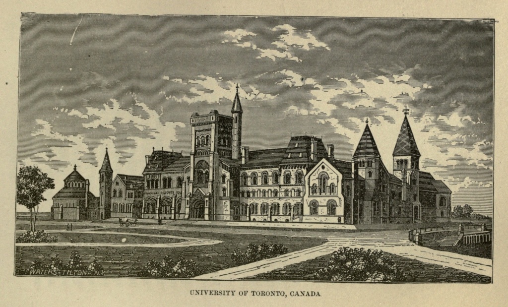
Toronto is the centre of the Canadian school system, and its educational institutions are numerous and of the highest order. It has Normal and Model schools, in the first of which teachers exclusively are trained. These schools, with the Educational Museum, built in the plain Italian style, are picturesquely grouped in park-like grounds, on Church street. The Museum contains a collection of curiosities, and a number of good paintings and casts. The University of Toronto exhibits the finest buildings in the city, and the finest of their kind in America. They stand in a large park, approached by College avenue, half a mile in length, and shaded by double rows of trees. The buildings, which [Pg 525] are of Norman architecture, of gray rubble stone, trimmed with Ohio and Caen stone, form the sides of a large quadrangle. It was founded in 1843; possesses a library of twenty thousand volumes, and a fine museum of natural history, and has attached to it an observatory. Knox College, Presbyterian, is situated a short distance north of the University, and is a large building, in the Collegiate-Gothic style. Trinity College, in Queen street west, overlooks the bay, and is an extensive and picturesque structure, turreted and gabled, and surrounded by extensive grounds. Upper Canada College is found in King street near John.
Adjoining the University grounds is Queen's Park, embracing the most elevated quarter of the city, and including fifty acres, handsomely laid out. In this park a brownstone shaft, surmounted by a colossal statue of Britannia, perpetuates the memory of the Canadians who fell in repelling the Fenian invasion in 1866. This park is from one hundred to two hundred feet above the level of the lake, and is surrounded by handsome public buildings and private residences.
The Episcopal Cathedral of St. James, at the corner of King and Church streets, is a spacious edifice, in the early English style, with lofty tower and spire, and elaborate open roof. It was built in 1852, and is surrounded by well shaded grounds. The Roman Catholic Cathedral of St. Michael, fronting on Bond street, is a large, decorated Gothic structure, with stained windows, and a spire two hundred and fifty feet high. The Wesleyan Methodist Church, in McGill street, is the finest church of that denomination in America. Its massive tower is surmounted by graceful pinnacles, and its interior is tastefully and richly decorated. Knox's[Pg 526] Church has a beautiful spire. One of the finest church edifices in the Dominion is the Jarvis street Baptist Church, in the decorated Gothic style. St. Andrews Presbyterian is a massive stone structure, which dates back to the Norman style of architecture.
Toronto contains many benevolent institutions, hospitals and asylums. Prominent among them is the Provincial Lunatic Asylum, a large and handsome building, situated west of the city, and surrounded by two hundred acres of handsomely ornamented grounds. The General Hospital is a fine structure, east of the city, in Don street, near Sumach.
The Normal School Building, with its beautifully laid out grounds, is one of the most attractive spots in the city, and the building is said to be the largest of the kind in America. There is very little fine scenery in the environs.
One of the most strikingly beautiful buildings of Toronto is Osgood Hall, in Queen street, an imposing structure, of elegant Ionic architecture, the seat of the Superior Law Courts of Upper Canada, and containing an extensive law library. St. Lawrence Hall, in King street, is a stately structure, in the Italian style, surmounted by a dome, containing a public hall and reading-room. Masonic Hall, an attractive stone building, is in Toronto street. The city contains two Opera Houses: the Grand, capable of seating two thousand persons, and the Royal, with accommodations for about fifteen hundred persons. The Post Office, a handsome stone building, stands near the head of Toronto street. The Custom House is of cut stone, of imposing proportions, extending from Front street to the Esplanade. The City Hall stands in Front street near the[Pg 527] Lake Shore, in the midst of an open square, and is an unpretentious structure, in the Italian style. Near by is the extensive Lawrence Market. The Court House is in Church street.
Of the hotels, the Rossin House, corner of King and York streets; Queen's Hotel, in Front street; the American House, in Yonge street; and the Revere House, in King street, are the most noteworthy.
Toronto takes a front rank in literature, a large number of newspapers and periodicals, daily, weekly, and monthly, being issued from its presses. It is unlike, in many respects, its sister cities of Lower Canada. It has more of a nineteenth century air, and more of American and less of European characteristics, than Montreal and Quebec. The French Canadians form a smaller proportion of its inhabitants. The people in the streets are well dressed and comfortable looking, stout and sturdy, though not so tall, on an average, as the people of New York. An educated population is growing up, and Toronto already ranks well, in general intelligence and public enterprise, with other cities of like magnitude in the States while it outranks all others on Canadian soil.
Situation of the National Capital.—Site Selected by Washington.—Statues of General Andrew Jackson, Scott, McPherson, Rawlins.—Lincoln Emancipation Group.—Navy Yard Bridge.—Capitol Building.—The White House.—Department of State, War and Navy.—The Treasury Department.—Patent Office.—Post Office Department.—Agricultural Building.—Army Medical Museum.—Government Printing Office.—United States Barracks.—Smithsonian Institute.—National Museum.—The Washington Monument.—Corcoran Art Gallery.—National Medical College.—Deaf and Dumb Asylum.—Increase of Population.—Washington's Future Greatness.
Washington, the Capital of the United States of America, is situated in the District of Columbia, on the left bank of the Potomac, between the Anacostia or eastern branch of that river, and about one hundred and eighty-five miles from the mouth of Chesapeake Bay. At an early period, indeed, before the clamor of war had fairly ceased, or the proud standard of England had been driven from its shores, the necessity of a territory which should be under the exclusive jurisdiction of Congress had engaged the attention of the founders of the new Republic. The possession of such a territory formed an important feature in the debates upon the framing of the Constitution, and it was only forty-eight days after the last act of ratification that the Capital City was, by solemn enactment of Congress, located on the eastern shore of the beautiful Potomac.[Pg 529]
The site of the Capital was selected by General Washington, the beloved first President of the Republic, and covers an undulating tract on the east bank of the river. From the rugged elevations on the borders of Rock Creek, a crescent-shaped ridge crosses the northern portion of the city, which is abruptly sundered, as it were, to admit the passage of a small stream called the Tiber. From this point the ridge ascends, gradually expanding into the extensive plateau of Capitol Hill, overlooking the Anacostia on the east. Within this encircling ridge the surface declines, in gentle slopes and terraces, down to the banks of the Potomac. From the lower falls of the river at Georgetown, beyond the outlying spurs of the Blue Ridge, a chain of low wooded hills extend across the north, which, continuing along the opposite shores of the Anacostia and Potomac, emerge again in the hills on the Virginia side of that river, presenting the appearance of a vast amphitheatre, in the centre of which stands the Capitol.
The mean altitude of the city is about forty feet above the ordinary low tide of the Potomac; the soil on which it is built is generally a yellowish-clay intermixed with gravel. In making excavations for wells and cisterns, near New Jersey avenue, trees were found, in a good state of preservation, at a depth of from six to forty-eight feet below the surface.
The Tiber, a little stream, with its tributaries, passes through the city. Tradition affirms that this stream received its name more than a century before Washington city was founded, in the belief and with the prediction that there would arise on its banks, in the future, a Capital destined to rival in magnificent grandeur that which crowned the banks of its great historic namesake.[Pg 530] The streams forming this river have their source among the hills to the east, and enter the city in several directions, the principal branch winding off to the southwest, around the base of Capitol Hill, across Pennsylvania avenue, to the Botanical Gardens. Originally its course continued along the Mall and emptied into the Potomac immediately west of the Washington Monument, but subsequently it was diverted into the canal, the filling up of which caused still other changes. The Tiber and its tributaries were utilized by diverting them into the sewerage system of the central and southern portions of the city; consequently, although the stream traverses one of the most populous sections, its course is not visible, the current flowing beneath heavy brick arches upon which buildings have been erected, and avenues, streets and parks laid out. In primitive days the banks of the Tiber were covered with heavy forests, while shad, herring and other fish, in their season, were taken from its waters, under the very shadow of the hill upon which the Capitol now stands.
There is no city in the Union which presents to the thoughtful and truly patriotic American so many objects of interest as does the city of Washington. First of all, this feeling is intensified by the fact of its having been located and founded by the great, immortal Pater Patriæ whose illustrious name it has the honor of bearing. A plan of the city was prepared in 1791, by Peter L'Enfant, a French engineer of fine education and decided genius, who had served in the Continental army with such distinction as to attract the attention of General Washington. He was assisted in the work by the advice and suggestions of Thomas Jefferson, who, while diplomatic representative of the United States,[Pg 531] had studied the plans of the principal cities visited in Europe, with a view to the future wants of his country, and was prepared, by the aid of his personal knowledge of their details, to contribute valuable information and suggestions.
It is evident that the predominating object in designing a plan for the city, was first to secure the most eligible situations for the different public buildings, and to arrange the squares and areas so that the most extended views might be obtained from every direction. The amplest arrangements were also made by the founders of Washington for its rapid growth and expansion, while they evidently designed and anticipated its being magnificently built up and embellished. The indifference of the Government and people has permitted these suggestions to remain too long unheeded; yet it is consoling to those possessing an intelligent patriotism and proud love of country, to know that the neglected condition of the Capital of the United States for nearly three-fourths of a century was not the result of any defect in the design originated by its noble founders.
Any one who has visited the royal residence of the kings of France, will immediately recognize the resemblance between the plans of Le Notre for Versailles, and L'Enfant for Washington City. The grand avenues, de Sceaux and St. Cloud, diverging from the Cour Royal, are reproduced in Pennsylvania and Maryland avenues, radiating from the east front of the Capitol. Its broad thoroughfares are among the principal attractions of Washington, and are the finest possessed by any city in the world. The avenues, twenty-one in number, radiate from principal centres and connect different parts of the city; the original number was thirteen, named for the[Pg 532] States constituting the Union at the time the Capital was laid out. The first in importance is Pennsylvania avenue; its width varies from one hundred and sixty to one hundred and eighty feet; its length is four and one-half miles, traversing the finest business portion of the city, as well as being the most popular and fashionable thoroughfare for driving. The War and Treasury departments, Washington Circle, and the President's House, are each located on this superb street, which, winding up and around Capitol Hill, finds its terminus on the banks of the Anacostia.
The spaces at the intersection of the more important avenues form what are called Circles. Washington Circle, at the intersection of Pennsylvania and New Hampshire avenues, contains the equestrian statue of General Washington, which was ordered by Congress, and cannon donated for the purpose, in 1853. The great hero is represented at the crisis of the battle of Princeton; the horse seems shrinking from the storm of shot and shell and the fiery conflict confronting him; his rider exhibits that calm equanimity of bearing so eminently his characteristic. This statue was executed by Clark Mills, at a cost of fifty thousand dollars.
At the western base of Capitol Hill stands the naval monument, termed in the resolutions of Congress, the "Monument of Peace." It was designed by Admiral Porter, and erected by subscriptions started by him among the officers, midshipmen and men of his fleet, immediately after the fall of Fort Fisher. The height of this monument is forty-four feet; it is built of Carrara marble and cost $44,000. The surmounting figures represent History recording the woes narrated by America, who holds a tablet in her hand on which is inscribed:[Pg 533] They died that their country might live. This monument is exceedingly well executed, and was considered, in Rome, one of the finest ever sent to America.
Lafayette Square, comprising seven acres lying north of the President's House, is beautifully laid out with rustic seats, graveled walks, and adorned with a rare variety of trees and shrubbery. In the centre of this square stands an equestrian statue of General Andrew Jackson, by Clark Mills, originally contracted for by the friends and admirers of the General composing the Jackson Monument Association, who subscribed twelve thousand dollars towards its erection. Congress afterward granted them the brass guns and mortars captured by General Jackson at Pensacola. In 1850 an additional donation of guns was made; in 1852 another appropriation sufficient to complete the work was granted, and Congress assumed possession of the monument. The figure of the horse is weighted and poised without the aid of rods, as in the celebrated statues of Peter the Great, at St. Petersburg, and Charles I., at London. This was the first application of the principle, and resulted in the production of one of the most graceful and astonishingly beautiful works of its kind in existence. The statue is of colossal size, weighing fifteen tons, and was erected at a cost of $50,000.
Scott Square, lying north of the White House, contains a bronze statue of General Winfield Scott, made of cannon captured by the General during his Mexican campaign, and donated by Congress in 1867. The work was executed by Brown, of New York; with the pedestal, it is twenty-nine feet high, and cost $20,000. The General is represented in full uniform, mounted on his war-horse, surveying the field of battle.[Pg 534]
The Circle of Victory, at the intersection of Massachusetts and Vermont avenues, contains a bronze equestrian statue of General George H. Thomas, of the Army of the Cumberland. The statue confronts the South, in the direction of the General's native hills of Virginia. On the site of this monument a salute of eight hundred guns was fired in commemoration of the capture of Petersburg and Richmond on the third of April, 1865; and, a few days later, five hundred guns were fired from the same spot in honor of General Lee's surrender and the fall of the Southern Confederacy.
On East Capitol street, at a distance of about one mile from the Capitol, is a square comprising six and a half acres, beautifully laid out and adorned with trees, shrubbery and walks. In this enclosure a bronze group called Emancipation has been erected; Abraham Lincoln is represented holding in his right hand the proclamation which gave freedom to the negroes of the South. A slave kneels at his feet, with manacles broken, and in the act of rising as they fall from his hands. This monument is said to have been built exclusively of funds contributed by the negroes liberated by Lincoln's proclamation of January first, 1863. The first contribution of five hundred dollars was made, it is stated, by Charlotte Scott, formerly a slave in Virginia, out of her first earnings as a freed-woman, and consecrated by her, on hearing of President Lincoln's death, to aid in building a monument to his memory. The interesting memorial was unveiled with appropriate ceremonies, on the anniversary of his assassination, April fourteenth, 1876, the President and his Cabinet, foreign ministers, and a vast concourse of white and colored citizens being present. Including the pedestal of Virginia granite, the structure[Pg 535] is twenty-two feet in height, and cost $20,000. It was in this square, now called Lincoln Square, that, according to the founder's original plan of embellishment, a grand Historic Column was to have been erected, to serve as an itinerary column, from which all geographical distances within the boundaries of the United States should be calculated.
McPherson Square, on Vermont avenue, contains a bronze equestrian statue of General James Birdseye McPherson, who was killed near Atlanta, at the head of the Army of the Tennessee, in 1864. He is represented in full uniform, with field-glasses in hand, surveying the battle-ground. A vault was constructed beneath the statue, for the purpose of receiving his body, but the devoted opposition of the people prevented its removal from his native place.
Farragut and Rawlins squares contain respectively colossal, but not equestrian statues of Admiral Farragut and General Rawlins.
Mount Vernon Place, at the intersection of New York and Massachusetts avenues, is handsomely laid out and planted with trees; in the centre, occupying an elevated circular space, is a superb fountain of bronze.
There are numerous smaller spaces at the intersection of various streets and avenues, called triangular reservations, all of which are highly adorned with trees, shrubs and beautiful small fountains.
The Government Propagating Gardens cover an area of eighty acres on the banks of the Potomac, south of Washington's Monument. The Botanical Garden, an instructive place of public resort, lies at the foot of Capitol Hill, between Pennsylvania and Maryland avenues. North of the Conservatory is found the Bartholdi[Pg 536] Fountain, which is supplied with water from the aqueduct, its highest stream reaching an altitude of sixty-five feet. This fountain is the work of Frederic Augustus Bartholdi, a French sculptor and pupil of Scheffer. It will be remembered by all who visited the National Centennial Exposition at Philadelphia, where it was exhibited, and afterward purchased by Congress for the inadequate sum of six thousand dollars. The lower basin is twenty-six feet in diameter, and from its centre rises a pedestal bearing aquatic monsters and fishes spouting water; three female caryatides, eleven feet high, support a basin thirteen feet in diameter; a smaller basin above this is upheld by three infant Tritons, the whole being surmounted by a mural crown. Twelve lamps, arranged around the lower basin, and lighted by electricity, give the most beautiful effects of light and water. On the plaza in front of the Treasury Department, is another fine fountain, in the form of an immense granite urn, the tassa of which measures sixteen feet in diameter.
Immediately in front of Washington city the Potomac expands into a broad, lake-like body of water, a mile and a quarter wide and at least eighteen feet deep. The Anacostia River, at its mouth, is almost the same width and fully as deep. Improving the navigation of the Potomac and the construction of a canal to the head waters of the Ohio River, were enterprises that began with the founding of the National Capital.
In 1872, Congress appointed a board of officers with a view to the improvement of the channel of the river and water fronts of Washington and Georgetown, for commercial purposes, as well as the reclamation of the malaria-infected marshes opposite the city. These improvements will necessitate the rebuilding of Long[Pg 537] Bridge for railroad and ordinary traveling purposes, and reclaim more than a thousand acres of valuable land. It is proposed to remove the National Observatory and use the earth for filling up the marshes.
The Navy Yard Bridge crosses the Anacostia River, at the foot of Eleventh street, having supplanted the wooden structure built in 1819, over which Booth made his escape after the assassination of Lincoln.
The various buildings occupied by the Executive and Legislative branches of the Government are worthy of especial notice. The Capitol is considered one of the largest and finest edifices of the kind in the world, and in point of durability of structure and costliness of material, it certainly has no superior. It stands on the west side of Capitol Hill, very near the centre of the city, and one mile distant from the Potomac River. The main or central building is three hundred and fifty two feet in length, with two wings or extensions, each having a front of one hundred and forty-three feet on the east and west, and a depth of two hundred and thirty-nine feet along the north and south façades, exclusive of the porticoes. The entire length of this great edifice is seven hundred and fifty feet; its greatest depth three hundred and twenty-four feet; the ground plan covering three and a half acres.
The central and original Capitol building is of freestone, taken from the Government quarries at Aquia Creek, forty miles below the city, which were purchased for that purpose, by the Commissioners, in 1791. This building is now painted white, to correspond with the extensions, columns and porticoes of white marble. From the centre rises the great dome, designed by Walter, to replace the original one removed in 1856, after the ad[Pg 538]ditions to the building had rendered it out of proportion. The apex is surmounted by a lantern fifty feet high, surrounded by a peristyle, and crowned by the bronze statue of Freedom executed by Crawford in 1865. The height from the base line to the crest of this statue is three hundred and eight feet, making the dome of the Capitol rank fifth in height with the greatest structures of the kind in Europe.
The great dome is visible from every elevated point in the District for miles around, and from its windows, as far as the eye can reach, is extended a panorama of wooded hills, beautiful valleys, with the majestic cloud-capped spurs of the Blue Ridge raising their lofty heads in the distance. The eastern façade of the building looks out upon the extended plain of Capitol Hill, with its background of green hills reaching far beyond the Anacostia. On the north a broad valley extends, until it unites with the encircling hills of the city; on the south the majestic Potomac and Anacostia rivers are seen to meet and mingle their placid waters; while from the west are beheld the lawns and groves of the Botanic Garden, the Mall, and handsome grounds of the President's house, with Georgetown Heights and the glittering domes of the Observatory in the distance.
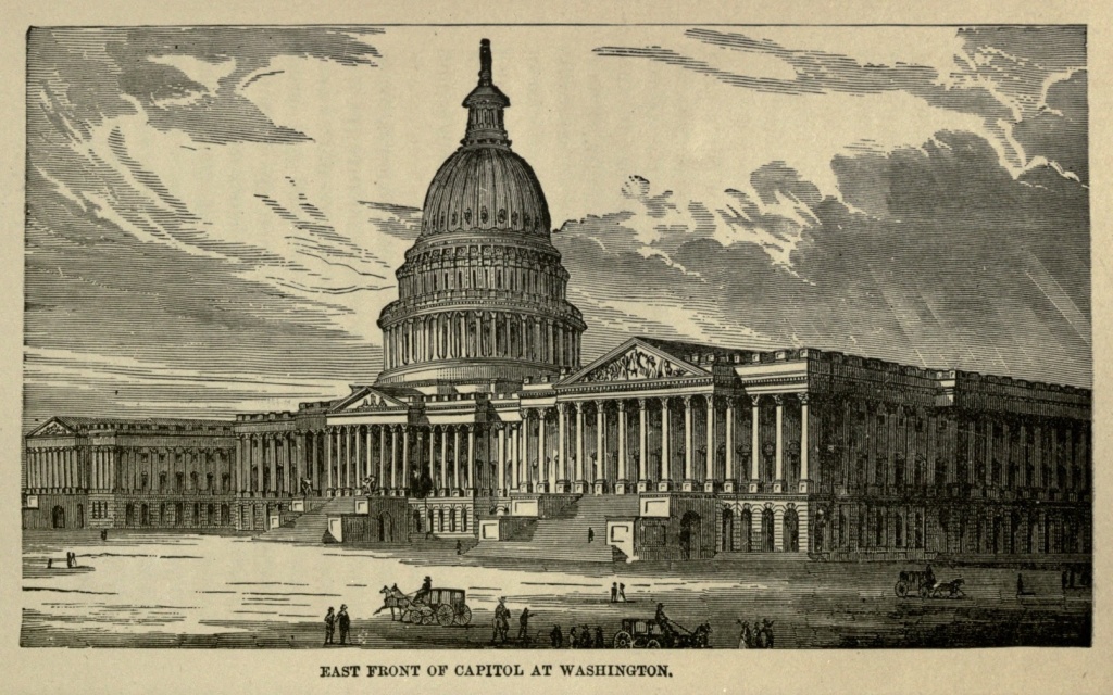
The main entrance, from the grand portico into the rotunda is filled by the celebrated bronze door modeled by Rogers, in Rome, 1858, and cast in bronze at Munich, by Miller, in 1860. On the panels of this door are portrayed, in alto relievo, the principal events in the life of Christopher Columbus, and the discovery of America. The key of the arch is adorned with a fine head of the great navigator; in the four corners of the casing are statuettes, representing Asia, Africa, Europe and America, [Pg 539] with a border in relief of ancient armor, banners and heraldic designs emblematic of navigation and conquest. Bordering each leaf on the door are statuettes, sixteen in number, of his patrons and contemporaries; the nine panels bear alto relievo illustrations of the principal events in his life; while between the panels are a series of heads, representing the historians of the great discoverer and his followers. Altogether, this justly celebrated bronze door, besides being wonderful as a work of art, constitutes in itself a small volume of the most interesting and important events belonging to the history of our country.
The rotunda into which the door leads is embellished with eight large historical paintings, by different artists. Four of these were executed by Trumbell, who served as aid-de-camp to Washington in 1775, and reproduced in his figures the likenesses of the actors in the scenes portrayed. In arranging the characters for the "Declaration of Independence," in which the Congress of 1776 is represented in the act of signing that great instrument of American liberty, the artist conferred with Jefferson, the Author of the Declaration, and John Adams, both of whom were present and signers. The individual costumes, the furniture, and the hall itself, are represented with scrupulous fidelity, all of which tends to increase the interest inspired by this painting.
The National Library was founded by act of Congress in 1800, and the following year, after the report of John Randolph, of Roanoke, had been submitted, setting forth the necessity for further legislation on the subject, a second act was passed, which placed it on a permanent basis. The number of volumes first contained in the library was three thousand, but appropriations were[Pg 540] annually made by Congress to increase the number. In 1814 the Capitol was burned by the British, and the library destroyed; a few months later, Thomas Jefferson offered the Government his private collection of 6,700 volumes, among which were many rare and valuable works obtained in Europe, and these were purchased for the sum of $23,950. In 1866 the Smithsonian Library, containing forty thousand volumes, was added, and a year later, the Peter Force collection was purchased by Congress, for $100,000; constant additions have increased the number, until the library now contains nearly four hundred thousand bound volumes, and one hundred thousand pamphlets. It is enriched also by journals, manuscripts, and maps relating to the history and topography of the country; in respect to the latter, being only approached by the library in the British Museum. The Library halls occupy the principal floor of the entire west projection of the Capitol.
In the Vice President's Room hangs the original painting of Washington, taken from life by Rembrandt Peale, and purchased by the Government in 1832, for the sum of two thousand dollars.
The Senate Reception Room is a beautiful and brilliant apartment, about sixty feet in length, with its vaulted and arched ceiling, divided into four sections, adorned with allegorical frescoes of Prudence, Justice, Temperance and Strength, executed by Brumidi, in 1856. The ceiling is heavily gilded throughout; the walls finished in stucco and gilt, with a base of Scagliola, imitating the marbles of Potomac and Tennessee. A finely executed fresco, in oil, by Brumidi, adorns the south wall, representing Washington in consultation with Jefferson and Hamilton, his Secretaries of State and Treasury.[Pg 541]
The President's Boom is an equally magnificent apartment, with groined arches embellished with numerous allegorical figures in fresco, the decoration, by Brumidi, being, in general design, the same as in the private audience chamber of the Vatican at Rome. The work throughout is very fine, being richly decorated with arabesques on a groundwork of gilt; the luxurious furniture of the apartment is entirely in keeping with this high order of artistic finish.
The old Hall of the House of Representatives is a magnificent apartment, designed and planned after the theatre at Athens, with fourteen Corinthian columns of variegated marble, forming a circular colonnade on the north. The bases of these columns are of freestone, the capitals of Carrara marble, designed and executed in Italy, after those in the temple of Jupiter Stator, at Rome; the paneled dome overhead is similar to that of the Pantheon. This venerable apartment was occupied by the House of Representatives for thirty-two years; its atmosphere must, in consequence, ever continue redolent with historic associations. On its walls, in the old days, hung the full-length portraits of Washington and Lafayette, presented by the latter on his last visit to this country; and the exact spot is pointed out where stood the desk of the venerable Ex-President, John Quincy Adams, when that aged patriot and senator was stricken by death. When, on the completion of the new, the old Hall was abandoned, in 1857, it was set apart, by Congress, as a National Statuary Gallery, and the President authorized to invite the different States to contribute statues, in bronze or marble, of such among their distinguished citizens as they might especially desire to honor, the number being limited to two from[Pg 542] each State. These contributions have been coming in slowly from year to year, besides which, many valuable statues and paintings have been purchased and added, by the Government.
The new Hall of Representatives is said to be the finest in the world; its length being one hundred and thirty-nine feet, width ninety-three, and height thirty-six feet, while the galleries will seat twenty-five hundred persons. The ceiling is of cast-iron, with panels gilded and filled with stained-glass centres, on which are represented the coat-of-arms of each of the different States. The walls are adorned with valuable historical paintings and frescoes.
The Supreme Court Room, formerly the old United States Senate Chamber, is a semicircular apartment, seventy-five feet in diameter; its height and greatest width being forty-five feet. The ceiling is formed by a flattened dome, ornamented with square caissons in stucco, with apertures for the admission of light. Supporting a gallery back of the Judges' seats extends a row of Ionic columns of Potomac marble, with capitals of white Italian marble, modeled after those in the Temple of Minerva. Along the western wall are marble brackets, each supporting the bust of a deceased Chief Justice.
When occupied by the Senate, the Hall contained desks for sixty-four Senators. It was in this chamber that the Nation's purest and most profound statesmen assembled, and the great "Immortal Trio," Clay, Webster and Calhoun, made those wonderful forensic efforts which gave their names forever to fame and the admiration of posterity.
The New Senate Chamber, first occupied in 1859, is a magnificent apartment, belonging to the new extension[Pg 543] of the Capitol, one hundred and thirteen feet in length by eighty feet in width, and thirty-six feet high. The Senators' desks are constructed of mahogany, and arranged in concentric semicircles around the apartment. The galleries rise and recede in tiers to the corridors of the second floor, and are capable of seating twelve thousand people.
Immense iron girders and transverse pieces compose the ceiling, forming deep panels, each glazed with a symbolic centre piece; the walls are richly painted, the doors elaborately finished with bronze ornaments. From the lobby we pass into the Senate Retiring Room, handsomely furnished, and said to be the finest apartment of the kind in the world. The ceiling is composed of massive blocks of polished white marble, which form deep panels, resting upon four Corinthian columns, also of white Italian marble. Highly polished Tennessee marble lines the entire walls, in the panels of which are placed immense plate glass mirrors, enhancing the brilliancy and already striking effect of the whole.
The limits of this chapter will not admit of further description of the numerous apartments gorgeously furnished; the palatial corridors beautifully designed; magnificent vestibules with fluted columns of marble; richly gilt paneled ceilings and tinted walls; grand stairways of marble and bronze, with the statues, busts, paintings and bronzes, which enrich the Capitol, many of them being masterpieces of art, and none devoid of merit. A detailed account of all would fill a small volume; we are compelled, therefore, to reluctantly leave the subject, and proceed to the description of the Public Buildings.
The President's House is situated in the western part[Pg 544] of the city, distant one and a half miles from the Capitol. A premium of five hundred dollars was awarded James Hoban, architect, of South Carolina, for the plan, and the corner stone laid, with Masonic honors, October thirteenth, 1792. John Adams was the first presidential occupant; he took possession during the month of November, 1800, after the Government offices had been removed to Washington. This building was burned by the British in 1814; the following year Congress authorized its restoration, committing the work to the original architect, Hoban, by whom it was completed in 1826, in all its details. It is built of freestone, one hundred and seventy feet in length, eighty-six in width, with grand porticoes on the north and south fronts, supported by Ionic columns. The main entrance is on the north, by a spacious vestibule handsomely frescoed. The Blue Room, in which the President receives, on both public and private occasions, is an oval-shaped apartment, finished in blue and gilt, with draperies and furniture of blue damask. Communicating with this is a second parlor called the Green Room, from the prevailing color of the furniture and hangings. In this apartment are found the portraits of Presidents Madison, Monroe, Harrison and Taylor. The East Room, which closes the suite, is a truly royal apartment, magnificently decorated in a style purely Grecian, the ceiling frescoed in oil, mantles of exquisite wood carving, immense mirrors in magnificent frames, with the richest furniture, and window drapery of the costliest lace and damask. A full length portrait of Washington adorns this apartment, purchased by Congress in 1803. When the Capitol was burned, in 1814, this painting was rescued from destruction by Mrs. Madison, who had it removed from the[Pg 545] frame and carried to a place of safety. A portrait of Martha, the wife of Washington, also hangs in this room, painted by Andrews in 1878.
The numerous other apartments in the President's House exhibit the same lavish style of adorning, the furniture being constantly changed and renewed; but the vandal spirit of change has not, as yet, dared to lay its sacrilegious hand upon or to alter the construction of the house, which remains the same as when, almost a century ago, it was first occupied by the elder President Adams. It is not difficult, therefore, to evoke the spirit of the past while standing among these ancient apartments, halls and corridors, and behold in fancy the long line of true statesmen, incorruptible patriots and noble men, who have successively lived and moved among them, in the early days of the Republic. And it is to be devoutly hoped that the vanity and caprice of the rulers who, in these later years, are being cast into high places, will not prevail in the effort to have this venerable home of the Presidents, hallowed by the memories of the nation's past, cast aside, and another building, modern and meaningless, substituted in its stead.
Immediately west of the President's House stands the Department of State, War and Navy, a vast and imposing structure in the Doric style, combining the massive proportions of the ancient with the elegance of modern architecture. The Diplomatic Reception Room is a magnificent apartment, decorated and furnished in the most sumptuous manner, with ebonized woods and gold brocade, after the Germanized Egyptian style. The portraits of Daniel Webster and Lord Ashburton, by Healy (purchased by Congress from the widow of Fletcher Webster, 1879), adorn the walls,[Pg 546] and over the mantels are busts, in bronze, of Washington and Lafayette. In the Diplomatic Ante-room is seen a full-length portrait of the Bey of Tunis, sent by special envoy in 1865, with a letter of condolence to the Government, on the death of Lincoln. Above this apartment is the library, containing a valuable collection of works on diplomacy, and many objects of interest, including the original draft of the Declaration of Independence, with the desk on which it was written, presented to the Government by the heirs of James Coolidge, of Massachusetts, to whom it was presented by Thomas Jefferson. The original document, signed, is also here, together with the sword of Washington, purchased by Congress in 1880, and his commission as Commander-in-Chief; the staff of Franklin; original drafts of the laws of the United States, the Federal Constitution, and other valuable and interesting historic documents, from the foundation of the Government. The entire building contains one hundred and fifty apartments, and cost five million dollars.
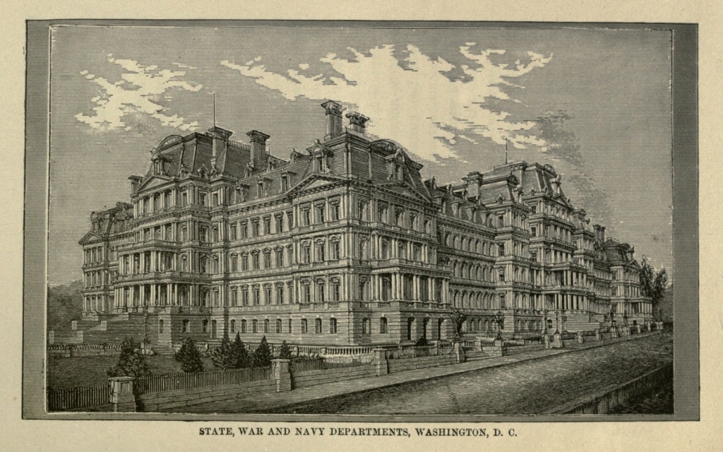
The Treasury Department is situated east of the President's House; it presents a most classic appearance, with its three stories in the pure Ionic style of architecture, upon a basement of rustic work, surmounted by an attic and balustrade. It has four fronts and principal entrances; the western front, consisting of a colonnade, after the style of the temple of Minerva, at Athens, is three hundred and thirty-six feet long, with thirty Ionic columns, and recessed porticoes on either end. This building contains the vaults in which the current funds and National Bank bonds of the Government are kept. The Secretary's office is a beautiful apartment, on the second floor. The walls [Pg 547] being formed of various kinds of highly polished marble. This building contains two hundred apartments, exclusive of the basement and attic, and cost six million dollars.
The Bureau of Engraving and Printing, a branch of the Treasury Department, occupies a separate building, recently erected, at a cost of three hundred thousand dollars. It is a handsome structure, of pressed brick, in the Romanesque style, is entirely fireproof, and situated between the Agricultural Department and the Washington Monument.
The Patent Office, an immense building covering two squares, or two and three-fourths acres of ground (which in the original plan of the city had been set apart for the erection of a National Mausoleum, or church), is in the Doric style of architecture, after the Parthenon at Athens, and impresses all who behold it with the grandeur of its proportions. The Museum of Models, a collection of inventions, both native and foreign, patented by the Government, occupies the four immense halls on the second floor, and contains upwards of one hundred and fifty-five thousand models, which have accumulated since the fire of 1836. In December, of that year, the old building was destroyed, containing four thousand models, the accumulation of half a century. But for this calamity, the progress of mechanical arts in the United States could be traced back to the foundation of the Government. The south Hall of the Museum is a magnificent apartment, two hundred and forty-two feet long, sixty-three feet wide, and thirty feet high, decorated in the Pompeiian style, the entire structure of the room being in solid masonry. Among the historical relics contained here, are the uniform[Pg 548] of Washington, worn at the time he resigned his commission, and his sword, secretary, compass, and sleeping tent, with camp utensils for cooking, etc. The number and variety of models contained in these four large halls are almost bewildering, and afford material for hours of study. The cost of this immense structure was two million, seven hundred thousand, but the entire sum has been principally liquidated by the surplus funds received, which annually amount to at least two hundred thousand dollars.
The General Post Office building is immediately opposite the Patent Office; it is a most imposing edifice, constructed of white marble, from the quarries of New York, and was built—the portion fronting on E street—in 1839. The northern half of the square was afterward purchased by the Government, and the extension begun in 1855; the building, as now completed, being three hundred feet in length, by two hundred and four in depth, with a large courtyard in the centre, entered on the west front by a carriage way, where the mails are received and sent out. Above the basement, on every side of this noble structure, arise monolithic columns and pilasters, surmounted by handsomely wrought capitals, upon which rests a paneled cornice. The main entrance is adorned with Doric columns, and the ceiling, walls and floor finished with white marble. In the office of the Postmaster-General is a fine collection of photographs and crayons of those who have filled this position since the appointment of Samuel Osgood, by Washington, in 1789. The cost of this building was one million seven hundred thousand dollars.
The Agricultural Building is a large and handsome structure, built of pressed brick, in the renaissance[Pg 549] style of architecture, with trimmings of brown stone. Immediately in front of the house is a flower garden, beautifully laid out, and planted with an almost countless variety of flowers; the remaining grounds adjacent to the building have been laid out as an arboreture, with walks and drives winding through forests of trees and shrubs, all of which have been planted according to the strictest botanical rules. The experimental grounds, occupying ten acres in the rear of the house, contain artificial lakes, rivers and swamps, for the cultivation of water and marsh plants. The building is handsomely finished and the various apartments and offices elegantly furnished, including a handsome library, thoroughly equipped laboratory, and an Agricultural Museum, which occupies the main building, and is replete with objects of interest and beauty too numerous to admit of description. The Plant Houses are immense conservatories, in which the fruits and flowers of every clime and country may be found growing. The main structure is three hundred and twenty feet long, by thirty wide, with a projecting wing giving one hundred and fifty feet additional. On the north bank of the Potomac is the Naval Observatory, one of the principal astronomical establishments in the world. The Observatory was founded in 1842, the location being selected by President Tyler. The site had been called "University Square," from the fact that it had been the cherished intention of Washington, from the foundation of the city, to urge the erection upon this spot of a National University. The central building of the Observatory was completed in 1844—a two-story building, with wings, and surmounted by a dome. The great telescope, purchased in 1873, cost forty-seven thousand dollars,[Pg 550] and is the most powerful instrument in the world, the refracting glass being twenty-six inches; the focal length thirty-two and a half feet. The library contains six thousand volumes, a number of them very rare, dating back to 1482.
The Army Medical Museum was formerly Ford's Theatre, in which President Lincoln was assassinated on the fourteenth of April, 1865. The building was purchased a year later, by Congress, remodeled and converted to its present use. No trace has been left to indicate the exact location of the murder. The Chemical Laboratory, on the first floor, was the restaurant in which Booth took his last drink; among the relics and curiosities is a portion of the vertebrae taken from the neck of the assassin. The first floor is occupied by the record and pension division of the Surgeon General's office, and upon the registers are inscribed the names of three hundred thousand of the dead. The Museum is on the third floor, and contains about sixteen thousand medical, surgical, and anatomical specimens.
The Government Printing Office is a large four-story building, in which the printing of the two Houses of Congress and other Departments is done. In 1794 an appropriation of ten thousand dollars was made, and sufficed, for "firewood, stationery and printing; the amount required at the present time to meet the expenses of this department is two million five hundred thousand dollars per annum, showing the rapid advance of the country, in extent, population, and the prodigality of its representatives as well.
The United States Barracks, formerly the Arsenal, is situated at the extreme southern point of the city. A Government Penitentiary was erected on the grounds in[Pg 551] 1826; in one of the lower cells was buried the body of Booth, and afterward those of the other conspirators. The Penitentiary was taken down in 1869, at which time the family of Booth was permitted to remove his body to Baltimore, where it was interred in the family burial lot at Druid Hill, the grave remaining unmarked. In front of the old buildings, the grounds, since the war, have been beautifully laid out, and contain a number of cannon captured by the Government forces in different conflicts. There is a brass gun with a ball shot into its muzzle at the battle of Gettysburg, and two captured Blakely guns, one of which bears the inscription: "Presented to the Sovereign State of South Carolina, by one of her citizens residing abroad, in commemoration of the twentieth of December, 1860." There are also British, French, and Mexican cannon, captured from those nations, some of them dated as far back as 1756.
On the Anacostia, three-fourths of a mile from the Capitol, is the Navy Yard, formally established by act of Congress in 1804, and in those early days standing unrivaled, as it sent out such famous vessels as the Wasp, Argus, and Viper; and frigates, carrying 44 guns each, were built in its shops. But the gradual filling up of the channel in which ships of the line formerly anchored, and the increased facilities of other later established stations, have deprived the old yard of its importance as a naval constructing port, although it is still one of the most important for the manufacture of supplies. The Marine Barracks, organized in 1798, are but a short distance from the Navy Yard gate; the building is seven hundred feet in length, with accommodations for two hundred men. The Barracks were burned by the British in 1814, but were at once rebuilt.[Pg 552]
The Smithsonian Institute, by name, is generally familiar, while comparatively few are acquainted with its origin, the design of its founder, his antecedents or history, all of which are peculiarly interesting, and deserving of a more extended notice than our sketch will permit. James Smithson was an Englishman, the son of the first Duke of Northumberland, and a grand nephew, on his mother's side, of Charles, the proud Duke of Somerset. Whether or not any secret romance was connected with his life, we are not informed; all that is known is, that he devoted himself to literature and science, was never married, and died at Genoa, Italy, in 1828, bequeathing his fortune to his nephew, Henry James Hungerford, during life; at his death to become the property of the United States; in the language of the will, "To found, at Washington, under the name of the Smithsonian Institute, an establishment for the increase and diffusion of knowledge among men." The Government accepted the bequest, which was at its disposal as early as 1836, and the original fund, of upwards of five hundred and fifteen thousand dollars, was deposited in the Treasury. A little more than ten years later the Smithsonian Institute was organized, a board of Regents appointed, and the corner-stone laid, with masonic ceremonies, May the first, 1847. The building was completed in 1856, the accrued interest being mere than sufficient to cover all the expenses of its erection, and leaving a permanent fund of six hundred and fifty thousand dollars in the Treasury for its future maintenance. In less than a year after the close of the war the main building was partially destroyed by fire, together with the papers and reports of the Institute, and the personal effects of its founder. It was immediately[Pg 553] restored, however; but the Library, comprising a large collection of valuable scientific works, was removed to the Capitol. It would seem that this immense building, so generously endowed, could, and should, be made to advance "the increase and diffusion of knowledge among men," in a more direct and individual manner, by being devoted to educational purposes. But further than its use in conducting exchanges between the Government and scientific bodies at home and abroad, and the care of the National Museum, the Smithsonian Institute has contributed nothing toward "the advancement of knowledge among men," and those, generally, of the country whom it was especially intended to benefit.
The National Museum, completed in 1879, is situated a very short distance east of the Institute, and covers nearly two and a half acres of ground. It is a handsome structure, of the modernized Romanesque style of architecture; having four entrances and eight lofty towers; the principal entrance being approached by granite steps, thirty-seven feet wide, to a richly tiled platform. Above the inscription plate on the globe of the nave, is an allegorical group representing Columbia as the patroness of Science and Industry. The whole is surmounted by a dome; the windows filled with double glass imported from Belgium; in fine, the entire building is externally and internally complete, being finished and furnished in the most costly and elegant manner. The large collections of the Museum in the Smithsonian Institute, are to be divided; objects of purely natural history being alone kept in the Institute, the second floor of which will be devoted to archæology, including the antiquities of the "Stone Age."
South of the President's House, and but a short dis[Pg 554]tance from the stone which marks the centre of the District stands the National Monument to the Father of his Country, designed by Mills. It was completed on Saturday, December sixth, 1884, by the setting of its marble cap-stone. The idea of this National Monument took definite shape in 1833, when the Washington National Monument Association was organized, composed of some of the most distinguished men of the country. The design was to build it by means of popular subscriptions, of individual sums, not to exceed one dollar each. In 1847 the collections amounted to $87,000, and with this sum it was determined to begin the work. On the Fourth of July, 1848 the corner stone of the monument was laid; in 1854, the funds of the National Monument Association were exhausted. The structure had then reached a height of one hundred and seventy feet, and during the succeeding twenty-four years only four feet were added to its altitude. August twenty-second, 1876, Congress passed an Act, creating a commission for its completion, and made the necessary appropriation, which was to be continued annually. Before resuming work on the monument, it was deemed best to strengthen the foundation by placing under the shaft an additional mass of concrete, one hundred and twenty-three feet, three inches beyond the old foundation. The weight of the mass then worked under was 32,176 tons. The total pressure on the foundation as it now stands is 80,378 tons.
The monument is a marble obelisk, the marble having been brought from the quarries of the Beaver Dam Marble Company, Baltimore County, Maryland. The shaft, from the floor, is 555 feet, 4 inches high, being thirty feet, five inches higher than the spires of the great[Pg 555] cathedral of Cologne. The present foundation is thirty-six feet, eight inches deep, making an aggregate height, from the bed of the foundation, of 592 feet, the loftiest work of ancient or modern times. The walls of the obelisk, at its base, are over fifteen feet thick, and at the 500 feet mark, where the pyramidal top begins, eighteen inches thick. The total cost of the monument has been $1,130,000. Within the obelisk is an elevator and a stairway. On the latter there are nine hundred steps, and about twenty minutes are required to make the descent.
The Corcoran Art Gallery is one of the most interesting and valued institutions belonging to the National Capitol, and the last that our limits will permit being described at length. The building stands on the corner of Pennsylvania avenue and Seventeenth street, and is constructed of brick, in the Renaissance style of architecture, finished with freestone ornaments and a variety of beautiful carving. On the avenue front are four statues, in Carrara marble, executed by Ezekiel, in Rome, of Phidias, Raphael, Michael Angelo, and Albert Durer, representing respectively, sculpture, painting, architecture and engraving. In the vestibules and corridors are casts of ancient bas reliefs, with numerous antique busts and statues in marble. The Hall of Bronzes contains a very large and interesting collection of bronzes, armor, ceramic ware, etc. The Hall of Antique Sculpture, almost one hundred feet in length, contains casts of the most celebrated specimens of ancient sculpture. The Main Picture Gallery is also nearly one hundred feet long and fifty feet wide, with a collection of paintings ranking among the first of this[Pg 556] country, and more than one hundred and fifteen in number. The Octagon Chamber contains the original Greek Slave, by Powers. In the East Gallery is displayed a valuable collection of portraits of distinguished Americans, painted by the best native artists; in the West Gallery, is a large number of paintings, historical, landscape and other subjects.
The Corcoran Art Gallery was presented to the city and country by W. W. Corcoran, Esq., in 1869. This magnificent gift, including the donor's private collection of paintings and statuary, cost three hundred and fifty thousand dollars, to which he added an endowment fund of nine hundred thousand dollars more. Mr. Corcoran has also erected and elegantly furnished, a large and beautiful building, called the Louise Home, at a cost of two hundred thousand dollars, with an endowment fund of two hundred and fifty thousand dollars. The Home, the only institution of its kind in the entire country, is an asylum for ladies of education and refinement who have been reduced in fortune. The house is furnished in a style of subdued elegance, with every luxury and convenience to be found in the best appointed private residence; while the ladies are waited upon and treated with the same attention and respect as if they were each paying an extravagant rate of board. There are ample accommodations for fifty-five ladies, who must have reached the age of fifty-years, as a general rule, and who make their application for admission in writing. There is no charge for admission, nor expense of any kind, nor limit to the time of remaining at the Louise Home. This beautiful institution, in which charity is bestowed in so refined and delicate, yet magnificent a manner, has been erected and endowed by the[Pg 557] Founder in memoriam of a beloved wife and only daughter and child. It is but due to this great philanthropist, to mention here, that in addition to his gifts named above, the National Medical College, of Columbian University, was his gift, in 1864, and cost forty thousand dollars. The original grounds of Oak Hill Cemetery, comprising ten acres, were also donated by him, together with an endowment fund of one hundred and twenty thousand dollars; the grounds were incorporated by Congress in 1840. It were fortunate for mankind if the number of such benefactors were greater, and the wisdom displayed by Mr. Corcoran oftener imitated by the rich, who, if they give, permit their good deeds only "to live after them," instead of planning, and directing with their own hands, the schemes of benevolence they desire to inaugurate for the benefit of their unfortunate fellow beings.
There are many places of historical interest that might be described, as well as numerous Halls, Colleges, Hospitals, etc., but the limits of this paper will not permit. We shall only refer to the Government Hospital for the Insane, situated at the junction of the Potomac and Anacostia rivers, and one of the finest and largest institutions of the kind in the world. It is seven hundred and fifty feet in length by two hundred deep, containing five hundred single rooms, and accommodations for more than nine hundred patients. The Deaf and Dumb Asylum and College are also conspicuous among the Public Institutions, built in the pointed Gothic style, and costing the Government $350,000.
During the late war Washington was converted into a vast fortress, and made the base of operations for the entire forces of the Union. The hills surrounding it were covered with the camps of soldiers, while its vast streets [Pg 558] and avenues hourly echoed the tread of moving troops, and the heavy crushing roll of artillery. At the close of the contest the city was found to have risen high upon the wave of revolution; a new element had been infused into its population, and the march of improvement had begun. In ten years the number of inhabitants had increased fifty thousand. With the continuance of peace, and the spirit of improvement and progress remaining unchecked, it may reasonably be predicted and confidently anticipated, that the close of the Nineteenth Century will find the Capital City of this great Republic approaching in splendor and importance the realization of the proudest hope and dream of magnificence ever cherished in the hearts of its worthy founders, and in itself a monument worthy of the immortal name of Washington.
"Peculiarities of American Cities" is the title of the latest work of Captain Willard Glazier, whose numerous books show great versatility and vivacity. The work before us contains sketches of thirty-nine of the principal cities of the United States and Canada. It is replete with interest. The pages are not filled with a mass of dry statistics or mere description, but record the personal observations of the author, detailed in an easy, familiar style.
The "Peculiarities of American Cities" contains a chatty description of the leading American and Canadian cities. A bright, descriptive style gives piquancy to the work, which is a gazetteer without seeming to be so. The Canadian cities described are Montreal, Toronto, and Quebec, and the accounts given of them are accurate. This being so of our own land, the probability is strong that the accounts given of the American cities are so too.
Captain Willard Glazier, whose war stories have proved so attractive, has turned his attention to another field, and proved that he can write entertainingly while imparting information to his readers of permanent reference value. His new book is entitled "Peculiarities of American Cities," and embodies the results of his personal observations and studies in the leading towns of the country. There are thirty-nine chapters, and each one is devoted to a different city, and may be said to be complete in itself. The classification is alphabetical, beginning with Albany and ending with Washington. The descriptive work has been well and faithfully done, and the prominent features of each city have received especial attention. This is the special point of the work—to show the distinct peculiarities and characteristics of our cities—and the charm lies in the fact that every city is treated in accordance with its local color, instead of in a stereotyped manner, as is usually the case. The book is a valuable one, and should be perused and studied by old and young.
Under the title of "Peculiarities of American Cities," Captain Willard Glazier, the author of half a dozen successful volumes, has lately produced a very attractive book of nearly six hundred pages. It is written in a graceful style, as one would describe a trip through the country from East to West, including visits to the chief cities, and touching upon their most notable characteristics. The author gives his readers the salient and significant points, as they strike an observing man and a skilled writer, and in this he has been very successful.
Captain Glazier is a noted American traveler. His canoe trip down the Mississippi and his extended horseback tour through the States made him quite famous at the time. The volume before us presents the peculiar features, favorite resorts, and distinguishing characteristics of the leading cities of America, including Canada. The author launches into his subject with directness, treating them with perspicuity and in an easy, flowing, graphic style, presenting a series of most admirable pen pictures. The book is practically invaluable in households where there are children and youth.
In this work Captain Glazier has entered upon a new field in literature, and his researches are at once unique and interesting. The first chapter opens with a visit to Albany, the quaint old Dutch city of the Hudson, and here at the outset the author discovers "peculiarities" without limit. Boston is next taken up, and then follow in succession thirty-seven of the leading cities of the United States and Canada. The book is a compendium of historical facts concerning the cities referred to which are not given in any other work with which we are acquainted, making this volume a valuable addition to any library.
"Peculiarities of American Cities" is a handsome and attractive volume, descriptive of the characteristics of many of the cities of North America, by one who seems to be thoroughly familiar with the subject, and who has developed an aptness in grasping the peculiarities of modern city life, as well as the power to graphically portray them. To those who may never be able to visit the places described, as well as to those who have seen them, the pen pictures will be both interesting and entertaining. The author gives his readers the salient and significant points as they strike an observant critic and a fascinating writer.
"Peculiarities of American Cities" is a work that will give to the person who has only money to stay at home an intelligent idea of how the great cities of the country look, and what their people do to gain a livelihood, and what objects of interest there are to be seen. Through the medium of this work one can wander through the streets of far-off places; he can watch the rush of the multitude and hear the roar of the industries that help to make our country the great land that it is. He can gaze upon the palaces of the rich or hurry through scenes where poverty is most pitiful and vice most hideous. It is a work that ought to be in every house.
One of the most entertaining books is "Peculiarities of American Cities" by Captain Willard Glazier, whose pen has enraptured thousands by descriptions of battle scenes and heroic adventures. The book is almost a necessity, as it familiarizes one with scenes in travel and history. The author has the faculty of making his readers see what he has seen and feel the impressions which he has felt in the view. The style is easy and flowing, not complicated and wearisome, The great cities are described in a way which makes the reader familiar with them—their history, society, manners, customs, and everything relating to their past, present, and future. The book will be a companion of many a leisure hour.
The books written by Captain Willard Glazier have had a very wide, almost a phenomenal circulation; in myriads of volumes they have been distributed throughout the country. From the time when a very young man, and just after the war, in which he served, Captain Glazier published his first book, they have, until the one just out, been all founded on and descriptive of events and scenes of the Revolution and the Rebellion. Now, however, he has turned from the beaten path and taken an altogether different topic, as is clearly explained in the title of his new work, "Peculiarities of American Cities." There are thirty-nine chapters, in which as many different cities have their noteworthy characteristics set forth in a pleasing and very interesting style, with handsome illustrations.
"Peculiarities of American Cities" is a work by Captain Willard Glazier, who has earned some fame as a writer of books describing the incidents of the War of the Rebellion. The present work is a compilation of facts concerning thirty-nine of the principal cities of the continent, including Toronto, Quebec, and Montreal, and the information the work contains is brought down to recent date. The history, growth in commerce, progress in art and science, and architectural and physical characteristics of each city are treated of in a very interesting way. Few people who have traveled at all but have visited one or more of these cities, and will read the work with pleasure. Others will find it intensely interesting because it gives them in detail much they have often wanted to know of the cities of America.
The author talks of cities as he has seen them; describing their appearance, their public resorts, and the peculiarities which characterize them and their people. He leads the reader through the streets, into the public parks, museums, libraries, art galleries, churches, theatres, etc.; tells him of great business schemes, marts, and manufactories; sails to suburban pleasure resorts; describes the many avocations and ways of picking up a living which are peculiar to large cities and the phases of character in men and women which are to be found where men most do congregate. The book will prove to be an interesting and instructive one to those who have not seen the cities it describes, and interesting to those who have traveled as a review and comparison of views from an experienced traveler and chronicler.
"Peculiarities of American Cities" contains brief studies of the history, general features, and leading enterprises of thirty-nine cities of the United States and Canada. The author states in the preface that he has been a resident of one hundred cities, and feels qualified to write largely from personal observation and comparison. It is not a dry compendium of facts, but is enlivened by picturesque legends, striking incidents, and racy anecdotes. Though the author has attempted no exhaustive description of these prominent centres of interest, he has shown taste and judgment in selecting the things one would most like to know, and skill in weaving the facts into an entertaining form.
This is the fifth of a readable series of popular books by the soldier-author, Captain Willard Glazier. Many readers have become familiar with "Soldiers of the Saddle," "Capture, Prison-pen, and Escape," "Battles for the Union," and "Heroes of Three Wars," and they will welcome the volume under notice as one of the most attractive of the list. Captain Glazier does not compile—he writes what he has seen. He has a trained eye, a facile pen, and a power of graphic description. "American Cities" is a work devoted to a pen-portraiture of thirty-nine cities, and those who have not or cannot visit these cities have in this book an easy and most fascinating way of acquainting themselves with their distinguishing characteristics. All readers ought to know something of our American cities, each of which has features peculiar to itself.
"Peculiarities of American Cities" is the title of a new book by Captain Willard Glazier, author of "Soldiers of the Saddle," "Battles for the Union," and several other popular works. In its pages the favorite resorts, peculiar features, and distinguishing characteristics of the leading cities of America are described. Dry statistics are avoided, the facts which the general reader most desires being given in the style of graphic description for which the author is noted. The book not only contains a great deal of information in regard to America's principal cities as they exist to-day, but many important events in local history are cleverly worked in. The Herald feels safe in commending this book as both instructive and entertaining. It will be read with interest by those who have "been there," and seen for themselves, as well as by those who can at most see only in imagination the places treated.
This book occupies a niche in the literature of the country peculiar to itself. It describes thirty-nine cities of America, including all the largest cities and some others which, though not quite so large, are rapidly growing, and seem destined to occupy positions of importance. Still other sketches possess peculiar interest for their historical associations. Of the latter class are the stories of Savannah, Charleston, and Richmond. It is said that Americans too often rush off to Europe without knowing that America possesses a Niagara Palls, Yosemite Valley, and Yellowstone National Park. The same may be said of our reading. Many books descriptive of European cities and places of interest are widely circulated and read. And if they are reliable they should be read. But America might, with profit, be studied more. This book offers a splendid opportunity to learn something of our American cities.
The reader will find a great abundance of useful information contained in a small compass and very pleasantly imparted in Captain Glazier's "Peculiarities of American Cities." Those who have little time to gather their information from more extended sources will find this a valuable work that will supply a vacant place in their library. It is certainly a book very much in advance of the volumes of like import that from time to time our people have been solicited to buy.
Captain Glazier's style is particularly attractive, and the discursive, anecdotal way in which the author carries his readers over the continent, from one city to another, is charmingly interesting. He lands his reader, by the easiest method, in a city; and when he has got him there, strives to interest and make him happy by causing him to glean amusement and instruction from all he sees. Every page of the book is teeming with interest and information. Persons are made conversant with the chief characteristics and history of cities they may never hope to visit. The book has apparently been written principally for the purpose of presenting the truth about the various chief centres of trade in the country, and the writer has adopted a pleasant conversational style, more likely to leave the impression desired than all the histories and arid guide-books ever published. It is a delightful book, full of happy things.
"Peculiarities of American Cities," by Willard Glazier, will be found disappointing to those who look for an ordinary re-hash of musty data about leading cities, as, aside from the numerous illustrations, which are far above the average book illustrations in accuracy, the work will be found to contain pleasantly written chapters on the industrial and social features of New York, Pittsburgh, Washington, Montreal, Portland, Savannah, Boston, Albany, Quebec, Omaha, Chicago, Buffalo, St. Louis, Hartford, Cleveland, Richmond, Providence, Baltimore, New Orleans, San Francisco, Cincinnati, Philadelphia, etc. The chapter on Pittsburgh embraces a summing up of its features as an iron, glass, and oil centre, while the descriptions of our people and the labor organizations, banking, and business interests are well-timed and as comprehensive as the limits of the work will permit. It will make a valuable addition to any library.
The author gives his views concerning the history, character, or "peculiarities" of some forty prominent American cities. The subject is an interesting one, familiarizing the reader with what belongs particularly to his own country. Persons may visit a place frequently, yet know nothing in regard to its history or the events connected with it which make the same memorable. Such matters have been carefully collected by the author and properly arranged into a systematic narrative. The chapters are exceedingly entertaining aside from the information they convey. The author has the ability to present what he wishes to communicate in an admirable way, and is tedious in nothing he has written. We know of no work on this subject from which so much that is valuable can be obtained in so concise a form. It is a book that will never weary or lose in interest, and can be placed in the library among the valuable works.
"Peculiarities of American Cities" is a book rather unique in character, and may be said to occupy a place somewhere between the regular guide-book and the volume of travels. As people who stay at home are not generally given to reading guide-books, and as volumes of travel embracing the same route as that gone over by our author are not common, "Peculiarities of American Cities" fills a niche that has hitherto been vacant, and meets a want not before satisfied. The writer takes up the most important cities of the United States and Canada in alphabetical order, beginning with Albany and ending with Washington, and gives a more or less extended description of each, commencing usually with a slight historical outline, particularly where it would be of general interest, as in the case of Boston, but devoting the greater part of his space to the treatment of their present condition. The natural advantages of each place are considered, its commerce and manufactures discussed, its public parks and buildings described, and illustrations of a number of the latter given.
To become well acquainted with the principal cities of the Union is not a matter of secondary importance, but should be one of the first duties of an American citizen. It is at once a source of pleasure and profit to know the points of interest in the various places; to be able to give an account of the commercial transactions, the people and customs; and, in fact, to know about other communities what you find it necessary to learn of your own. To the great majority of Americans the opportunity is not given of personally becoming acquainted with the various cities of import, and the only way we have of knowing the peculiarities of our sister cities is by the few scraps we read now and then in the newspapers. The want of some method by which to instruct the people in this matter has long been manifest, but what to do has often been asked and remained unanswered. Educators recommend the compilation of statistics of the various places, and many plans were suggested by which a knowledge of the subject could be diffused among the masses. It has finally been solved by Captain Willard Glazier, of whom the country has heard in civil and military life on many former occasions. Captain Glazier has traveled over the entire continent since the late war, and has become well acquainted with the principal cities, and the thought struck him to write a book on the points of interest he has visited in the various places. For a number of years he has been at the work, and finally gives to the public his latest literary effort, which he has appropriately entitled "Peculiarities of American Cities." The book is just what is needed in every public and private library in the country, and will awaken a deep interest in the citizens of each city on which the work treats. The public cannot fail to be interested in the work, for it treats on a live subject, and, furthermore, the author's style is far too pleasing to permit of any lack of interest. Captain Glazier is the author of a number of books, all of which have become popular, and we predict for this, his latest effort, the success which it merits.
| I. | Soldiers of the Saddle. |
| II. | Capture, Prison-Pen and Escape. |
| III. | Battles for the Union. |
| IV. | Heroes of Three Wars. |
| V. | Peculiarities of American Cities. |
| VI. | Down the Great River. |
Captain Glazier's works are growing more and more popular every day. Their delineations of social, military and frontier life , constantly varying scenes, and deeply interesting stories, combine to place their writer in the front rank of American authors.
PERSONS DESIRING AGENCIES FOR ANY OF CAPTAIN GLAZIER'S BOOKS SHOULD ADDRESS
1. Images have been moved from the middle of a paragraph to the closest paragraph break.
2. Obvious punctuation errors have been corrected.
3. The following typographical errors have been corrected:
"Bath-on-the Hudson" corrected to "Bath-on-the-Hudson" (page 28)
"facades" corrected to "façades" (page 30)
"scarely" corrected to "scarcely" (page 168)
"Real" corrected to "Rèal" (page 236)
"Situate" corrected to "Situated" (page 248)
"condemed" corrected to "condemned" (page 261)
"transferrred" corrected to "transferred" (page 261)
"pedestrains" corrected to "pedestrians" (page 312)
"possesesion" corrected to "possession" (page 358)
"establisment" corrected to "establishment" (page 438)
"granduer" corrected to "grandeur" (page 459)
"ignominously" corrected to "ignominiously" (page 464)
"excelence" corrected to "excellence" (page 523)
4. Other than the corrections listed above, printer's inconsistencies in spelling, hyphenation, and ligature usage have been retained.
End of the Project Gutenberg EBook of Peculiarities of American Cities, by
Willard Glazier

*** END OF THIS PROJECT GUTENBERG EBOOK PECULIARITIES OF AMERICAN CITIES ***

***** This file should be named 35575-h.htm or 35575-h.zip *****
This and all associated files of various formats will be found in:
        http://www.gutenberg.org/3/5/5/7/35575/

Produced by Chris Curnow, Louise Hope and the Online
Distributed Proofreading Team at http://www.pgdp.net (This
file was produced from images generously made available
by The Internet Archive/American Libraries.)


Updated editions will replace the previous one--the old editions
will be renamed.

Creating the works from public domain print editions means that no
one owns a United States copyright in these works, so the Foundation
(and you!) can copy and distribute it in the United States without
permission and without paying copyright royalties.  Special rules,
set forth in the General Terms of Use part of this license, apply to
copying and distributing Project Gutenberg-tm electronic works to
protect the PROJECT GUTENBERG-tm concept and trademark.  Project
Gutenberg is a registered trademark, and may not be used if you
charge for the eBooks, unless you receive specific permission.  If you
do not charge anything for copies of this eBook, complying with the
rules is very easy.  You may use this eBook for nearly any purpose
such as creation of derivative works, reports, performances and
research.  They may be modified and printed and given away--you may do
practically ANYTHING with public domain eBooks.  Redistribution is
subject to the trademark license, especially commercial
redistribution.


*** START: FULL LICENSE ***

THE FULL PROJECT GUTENBERG LICENSE
PLEASE READ THIS BEFORE YOU DISTRIBUTE OR USE THIS WORK

To protect the Project Gutenberg-tm mission of promoting the free
distribution of electronic works, by using or distributing this work
(or any other work associated in any way with the phrase "Project
Gutenberg"), you agree to comply with all the terms of the Full Project
Gutenberg-tm License (available with this file or online at
http://gutenberg.org/license).


Section 1.  General Terms of Use and Redistributing Project Gutenberg-tm
electronic works

1.A.  By reading or using any part of this Project Gutenberg-tm
electronic work, you indicate that you have read, understand, agree to
and accept all the terms of this license and intellectual property
(trademark/copyright) agreement.  If you do not agree to abide by all
the terms of this agreement, you must cease using and return or destroy
all copies of Project Gutenberg-tm electronic works in your possession.
If you paid a fee for obtaining a copy of or access to a Project
Gutenberg-tm electronic work and you do not agree to be bound by the
terms of this agreement, you may obtain a refund from the person or
entity to whom you paid the fee as set forth in paragraph 1.E.8.

1.B.  "Project Gutenberg" is a registered trademark.  It may only be
used on or associated in any way with an electronic work by people who
agree to be bound by the terms of this agreement.  There are a few
things that you can do with most Project Gutenberg-tm electronic works
even without complying with the full terms of this agreement.  See
paragraph 1.C below.  There are a lot of things you can do with Project
Gutenberg-tm electronic works if you follow the terms of this agreement
and help preserve free future access to Project Gutenberg-tm electronic
works.  See paragraph 1.E below.

1.C.  The Project Gutenberg Literary Archive Foundation ("the Foundation"
or PGLAF), owns a compilation copyright in the collection of Project
Gutenberg-tm electronic works.  Nearly all the individual works in the
collection are in the public domain in the United States.  If an
individual work is in the public domain in the United States and you are
located in the United States, we do not claim a right to prevent you from
copying, distributing, performing, displaying or creating derivative
works based on the work as long as all references to Project Gutenberg
are removed.  Of course, we hope that you will support the Project
Gutenberg-tm mission of promoting free access to electronic works by
freely sharing Project Gutenberg-tm works in compliance with the terms of
this agreement for keeping the Project Gutenberg-tm name associated with
the work.  You can easily comply with the terms of this agreement by
keeping this work in the same format with its attached full Project
Gutenberg-tm License when you share it without charge with others.

1.D.  The copyright laws of the place where you are located also govern
what you can do with this work.  Copyright laws in most countries are in
a constant state of change.  If you are outside the United States, check
the laws of your country in addition to the terms of this agreement
before downloading, copying, displaying, performing, distributing or
creating derivative works based on this work or any other Project
Gutenberg-tm work.  The Foundation makes no representations concerning
the copyright status of any work in any country outside the United
States.

1.E.  Unless you have removed all references to Project Gutenberg:

1.E.1.  The following sentence, with active links to, or other immediate
access to, the full Project Gutenberg-tm License must appear prominently
whenever any copy of a Project Gutenberg-tm work (any work on which the
phrase "Project Gutenberg" appears, or with which the phrase "Project
Gutenberg" is associated) is accessed, displayed, performed, viewed,
copied or distributed:

This eBook is for the use of anyone anywhere at no cost and with
almost no restrictions whatsoever.  You may copy it, give it away or
re-use it under the terms of the Project Gutenberg License included
with this eBook or online at www.gutenberg.org

1.E.2.  If an individual Project Gutenberg-tm electronic work is derived
from the public domain (does not contain a notice indicating that it is
posted with permission of the copyright holder), the work can be copied
and distributed to anyone in the United States without paying any fees
or charges.  If you are redistributing or providing access to a work
with the phrase "Project Gutenberg" associated with or appearing on the
work, you must comply either with the requirements of paragraphs 1.E.1
through 1.E.7 or obtain permission for the use of the work and the
Project Gutenberg-tm trademark as set forth in paragraphs 1.E.8 or
1.E.9.

1.E.3.  If an individual Project Gutenberg-tm electronic work is posted
with the permission of the copyright holder, your use and distribution
must comply with both paragraphs 1.E.1 through 1.E.7 and any additional
terms imposed by the copyright holder.  Additional terms will be linked
to the Project Gutenberg-tm License for all works posted with the
permission of the copyright holder found at the beginning of this work.

1.E.4.  Do not unlink or detach or remove the full Project Gutenberg-tm
License terms from this work, or any files containing a part of this
work or any other work associated with Project Gutenberg-tm.

1.E.5.  Do not copy, display, perform, distribute or redistribute this
electronic work, or any part of this electronic work, without
prominently displaying the sentence set forth in paragraph 1.E.1 with
active links or immediate access to the full terms of the Project
Gutenberg-tm License.

1.E.6.  You may convert to and distribute this work in any binary,
compressed, marked up, nonproprietary or proprietary form, including any
word processing or hypertext form.  However, if you provide access to or
distribute copies of a Project Gutenberg-tm work in a format other than
"Plain Vanilla ASCII" or other format used in the official version
posted on the official Project Gutenberg-tm web site (www.gutenberg.org),
you must, at no additional cost, fee or expense to the user, provide a
copy, a means of exporting a copy, or a means of obtaining a copy upon
request, of the work in its original "Plain Vanilla ASCII" or other
form.  Any alternate format must include the full Project Gutenberg-tm
License as specified in paragraph 1.E.1.

1.E.7.  Do not charge a fee for access to, viewing, displaying,
performing, copying or distributing any Project Gutenberg-tm works
unless you comply with paragraph 1.E.8 or 1.E.9.

1.E.8.  You may charge a reasonable fee for copies of or providing
access to or distributing Project Gutenberg-tm electronic works provided
that

- You pay a royalty fee of 20% of the gross profits you derive from
     the use of Project Gutenberg-tm works calculated using the method
     you already use to calculate your applicable taxes.  The fee is
     owed to the owner of the Project Gutenberg-tm trademark, but he
     has agreed to donate royalties under this paragraph to the
     Project Gutenberg Literary Archive Foundation.  Royalty payments
     must be paid within 60 days following each date on which you
     prepare (or are legally required to prepare) your periodic tax
     returns.  Royalty payments should be clearly marked as such and
     sent to the Project Gutenberg Literary Archive Foundation at the
     address specified in Section 4, "Information about donations to
     the Project Gutenberg Literary Archive Foundation."

- You provide a full refund of any money paid by a user who notifies
     you in writing (or by e-mail) within 30 days of receipt that s/he
     does not agree to the terms of the full Project Gutenberg-tm
     License.  You must require such a user to return or
     destroy all copies of the works possessed in a physical medium
     and discontinue all use of and all access to other copies of
     Project Gutenberg-tm works.

- You provide, in accordance with paragraph 1.F.3, a full refund of any
     money paid for a work or a replacement copy, if a defect in the
     electronic work is discovered and reported to you within 90 days
     of receipt of the work.

- You comply with all other terms of this agreement for free
     distribution of Project Gutenberg-tm works.

1.E.9.  If you wish to charge a fee or distribute a Project Gutenberg-tm
electronic work or group of works on different terms than are set
forth in this agreement, you must obtain permission in writing from
both the Project Gutenberg Literary Archive Foundation and Michael
Hart, the owner of the Project Gutenberg-tm trademark.  Contact the
Foundation as set forth in Section 3 below.

1.F.

1.F.1.  Project Gutenberg volunteers and employees expend considerable
effort to identify, do copyright research on, transcribe and proofread
public domain works in creating the Project Gutenberg-tm
collection.  Despite these efforts, Project Gutenberg-tm electronic
works, and the medium on which they may be stored, may contain
"Defects," such as, but not limited to, incomplete, inaccurate or
corrupt data, transcription errors, a copyright or other intellectual
property infringement, a defective or damaged disk or other medium, a
computer virus, or computer codes that damage or cannot be read by
your equipment.

1.F.2.  LIMITED WARRANTY, DISCLAIMER OF DAMAGES - Except for the "Right
of Replacement or Refund" described in paragraph 1.F.3, the Project
Gutenberg Literary Archive Foundation, the owner of the Project
Gutenberg-tm trademark, and any other party distributing a Project
Gutenberg-tm electronic work under this agreement, disclaim all
liability to you for damages, costs and expenses, including legal
fees.  YOU AGREE THAT YOU HAVE NO REMEDIES FOR NEGLIGENCE, STRICT
LIABILITY, BREACH OF WARRANTY OR BREACH OF CONTRACT EXCEPT THOSE
PROVIDED IN PARAGRAPH 1.F.3.  YOU AGREE THAT THE FOUNDATION, THE
TRADEMARK OWNER, AND ANY DISTRIBUTOR UNDER THIS AGREEMENT WILL NOT BE
LIABLE TO YOU FOR ACTUAL, DIRECT, INDIRECT, CONSEQUENTIAL, PUNITIVE OR
INCIDENTAL DAMAGES EVEN IF YOU GIVE NOTICE OF THE POSSIBILITY OF SUCH
DAMAGE.

1.F.3.  LIMITED RIGHT OF REPLACEMENT OR REFUND - If you discover a
defect in this electronic work within 90 days of receiving it, you can
receive a refund of the money (if any) you paid for it by sending a
written explanation to the person you received the work from.  If you
received the work on a physical medium, you must return the medium with
your written explanation.  The person or entity that provided you with
the defective work may elect to provide a replacement copy in lieu of a
refund.  If you received the work electronically, the person or entity
providing it to you may choose to give you a second opportunity to
receive the work electronically in lieu of a refund.  If the second copy
is also defective, you may demand a refund in writing without further
opportunities to fix the problem.

1.F.4.  Except for the limited right of replacement or refund set forth
in paragraph 1.F.3, this work is provided to you 'AS-IS' WITH NO OTHER
WARRANTIES OF ANY KIND, EXPRESS OR IMPLIED, INCLUDING BUT NOT LIMITED TO
WARRANTIES OF MERCHANTIBILITY OR FITNESS FOR ANY PURPOSE.

1.F.5.  Some states do not allow disclaimers of certain implied
warranties or the exclusion or limitation of certain types of damages.
If any disclaimer or limitation set forth in this agreement violates the
law of the state applicable to this agreement, the agreement shall be
interpreted to make the maximum disclaimer or limitation permitted by
the applicable state law.  The invalidity or unenforceability of any
provision of this agreement shall not void the remaining provisions.

1.F.6.  INDEMNITY - You agree to indemnify and hold the Foundation, the
trademark owner, any agent or employee of the Foundation, anyone
providing copies of Project Gutenberg-tm electronic works in accordance
with this agreement, and any volunteers associated with the production,
promotion and distribution of Project Gutenberg-tm electronic works,
harmless from all liability, costs and expenses, including legal fees,
that arise directly or indirectly from any of the following which you do
or cause to occur: (a) distribution of this or any Project Gutenberg-tm
work, (b) alteration, modification, or additions or deletions to any
Project Gutenberg-tm work, and (c) any Defect you cause.


Section  2.  Information about the Mission of Project Gutenberg-tm

Project Gutenberg-tm is synonymous with the free distribution of
electronic works in formats readable by the widest variety of computers
including obsolete, old, middle-aged and new computers.  It exists
because of the efforts of hundreds of volunteers and donations from
people in all walks of life.

Volunteers and financial support to provide volunteers with the
assistance they need, are critical to reaching Project Gutenberg-tm's
goals and ensuring that the Project Gutenberg-tm collection will
remain freely available for generations to come.  In 2001, the Project
Gutenberg Literary Archive Foundation was created to provide a secure
and permanent future for Project Gutenberg-tm and future generations.
To learn more about the Project Gutenberg Literary Archive Foundation
and how your efforts and donations can help, see Sections 3 and 4
and the Foundation web page at http://www.pglaf.org.


Section 3.  Information about the Project Gutenberg Literary Archive
Foundation

The Project Gutenberg Literary Archive Foundation is a non profit
501(c)(3) educational corporation organized under the laws of the
state of Mississippi and granted tax exempt status by the Internal
Revenue Service.  The Foundation's EIN or federal tax identification
number is 64-6221541.  Its 501(c)(3) letter is posted at
http://pglaf.org/fundraising.  Contributions to the Project Gutenberg
Literary Archive Foundation are tax deductible to the full extent
permitted by U.S. federal laws and your state's laws.

The Foundation's principal office is located at 4557 Melan Dr. S.
Fairbanks, AK, 99712., but its volunteers and employees are scattered
throughout numerous locations.  Its business office is located at
809 North 1500 West, Salt Lake City, UT 84116, (801) 596-1887, email
business@pglaf.org.  Email contact links and up to date contact
information can be found at the Foundation's web site and official
page at http://pglaf.org

For additional contact information:
     Dr. Gregory B. Newby
     Chief Executive and Director
     gbnewby@pglaf.org


Section 4.  Information about Donations to the Project Gutenberg
Literary Archive Foundation

Project Gutenberg-tm depends upon and cannot survive without wide
spread public support and donations to carry out its mission of
increasing the number of public domain and licensed works that can be
freely distributed in machine readable form accessible by the widest
array of equipment including outdated equipment.  Many small donations
($1 to $5,000) are particularly important to maintaining tax exempt
status with the IRS.

The Foundation is committed to complying with the laws regulating
charities and charitable donations in all 50 states of the United
States.  Compliance requirements are not uniform and it takes a
considerable effort, much paperwork and many fees to meet and keep up
with these requirements.  We do not solicit donations in locations
where we have not received written confirmation of compliance.  To
SEND DONATIONS or determine the status of compliance for any
particular state visit http://pglaf.org

While we cannot and do not solicit contributions from states where we
have not met the solicitation requirements, we know of no prohibition
against accepting unsolicited donations from donors in such states who
approach us with offers to donate.

International donations are gratefully accepted, but we cannot make
any statements concerning tax treatment of donations received from
outside the United States.  U.S. laws alone swamp our small staff.

Please check the Project Gutenberg Web pages for current donation
methods and addresses.  Donations are accepted in a number of other
ways including checks, online payments and credit card donations.
To donate, please visit: http://pglaf.org/donate


Section 5.  General Information About Project Gutenberg-tm electronic
works.

Professor Michael S. Hart is the originator of the Project Gutenberg-tm
concept of a library of electronic works that could be freely shared
with anyone.  For thirty years, he produced and distributed Project
Gutenberg-tm eBooks with only a loose network of volunteer support.


Project Gutenberg-tm eBooks are often created from several printed
editions, all of which are confirmed as Public Domain in the U.S.
unless a copyright notice is included.  Thus, we do not necessarily
keep eBooks in compliance with any particular paper edition.


Most people start at our Web site which has the main PG search facility:

     http://www.gutenberg.org

This Web site includes information about Project Gutenberg-tm,
including how to make donations to the Project Gutenberg Literary
Archive Foundation, how to help produce our new eBooks, and how to
subscribe to our email newsletter to hear about new eBooks.