The Heliotype Printing Co. 220 Devonshire St. Boston.ToC
This eBook is for the use of anyone anywhere at no cost and with
almost no restrictions whatsoever.  You may copy it, give it away or
re-use it under the terms of the Project Gutenberg License included
with this eBook or online at www.gutenberg.org
Title: The Journal of Lieut. John L. Hardenbergh of the Second New York Continental Regiment from May 1 to October 3, 1779, in General Sullivan's Campaign Against the Western Indians
With an Introduction, Copious Historical Notes, and Maps of the Battle-field of Newtown and Groveland Ambuscade
Author: John Leonard Hardenbergh
Editor: John S. Clark
Release Date: June 7, 2010 [eBook #32733]
Language: English
Character set encoding: ISO-8859-1
***START OF THE PROJECT GUTENBERG EBOOK THE JOURNAL OF LIEUT. JOHN L. HARDENBERGH OF THE SECOND NEW YORK CONTINENTAL REGIMENT FROM MAY 1 TO OCTOBER 3, 1779, IN GENERAL SULLIVAN'S CAMPAIGN AGAINST THE WESTERN INDIANS***
| Note: | Images of the original pages are available through Internet Archive/American Libraries. See http://www.archive.org/details/journaloflieutjo00hardrich |
Transcriber's Note:
Inconsistent hyphenation and archaic spellings in the original document have been preserved.
Obvious typographical errors have been corrected. For a complete list, please see the end of this document.
Click on the images to see a larger version.
This work includes parts of journals of Maj. Erkuries Beatty, Thomas Grant, George Grant, and Col. Henry Dearborn.
| Pages. | |
| Biographical, | 7 to 19 |
| Introduction to Journals, | 20 to 22 |
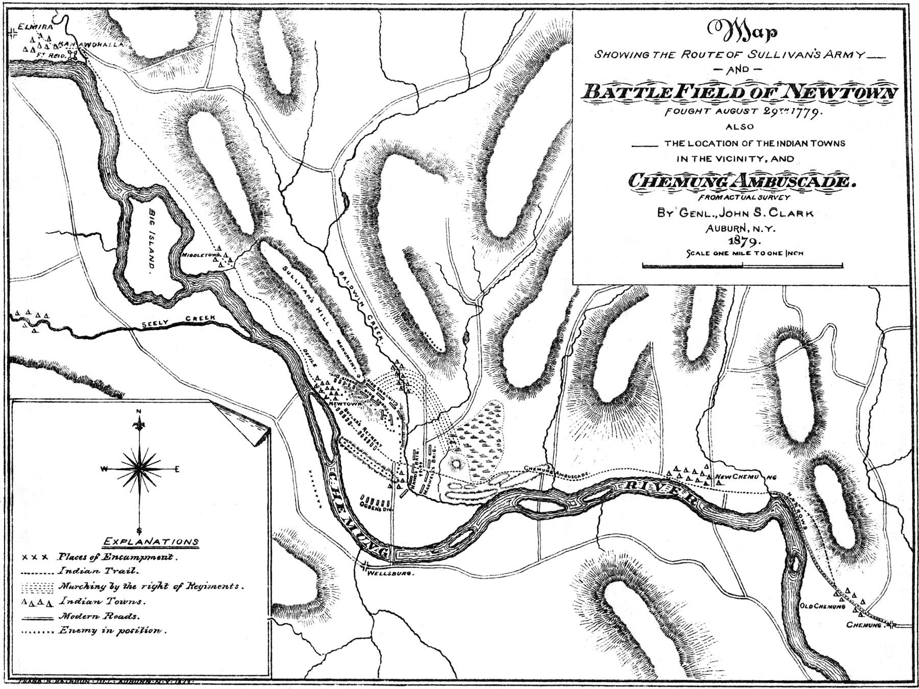
| Battle of Newtown, Map, | 44 to — |
| Hardenbergh's Journal and Notes, | 23 to 59 |
| General James Clinton's March, | 60 to — |
| Beatty's Journal and Notes, | 61 to 68 |
| Groveland Ambuscade, Map, | 50 to — |
| Expedition against the Cayugas, | 69 to 70 |
| Thomas Grant's Journal and Notes, | 70 to 73 |
| George Grant's Journal and Notes, | 73 to 75 |
| Colonel Dearborn's March, | 76 to 77 |
| Dearborn's Journal and Notes, | 77 to 81 |
| Indian Towns Destroyed, | 82 to 87 |
| List of Journals and Narratives, | 88 to 94 |
John Leonard Hardenbergh, the author of the following Journal, was a native of Rosendale, Ulster County, in the Province of New York, born in the year 1748. He was the son of Leonard and Rachel Hardenbergh, and the youngest of seven children. The family name is one of the oldest in the State, and is prominent both in its colonial and revolutionary annals. As early as 1644, Arnoldus van Hardenbergh a "free merchant" emigrated from Holland to New Amsterdam "with a cargo of wares for sale in the colony." He was soon after selected as one of the original Nine Men of New Netherland, and served in this board from 1647 to 1650.[1] He was followed in, or about, the year 1652, by his brother Johannes van Hardenbergh, also a merchant from Amsterdam, who at this date was purchaser of "a house, lot and garden" on Manhattan Island. (Calendar, Hist. MSS. in [8]office of the Secretary of State, Albany, Part I, vol. iii).
The branch of the family that was subsequently settled at Rosendale, is traced to the year 1706, when Johannes Hardenbergh, with six others, obtained from the crown of Great Britain a grant of land which comprised, as computed at the time, 1,500,000 acres, located in Northern Ulster, then including a portion of the present county of Sullivan,—the western boundary extending to, or near the head of, the Delaware river. The terminal syllable of the name, bergh, indicates that the earlier ancestors in Holland were from the hills; and it was quite natural that their descendants should have found permanent location in the hilly districts of Shendaken and Shawangunk, stretching westward from the valley of the Hudson; neither is it surprising that they should have loved freedom and have given their best efforts for its establishment in their adopted land.
At the outbreak of the Revolution, Col. Johannes Hardenbergh, Jr. was placed at the head of the Committee of Safety for Ulster County—Kingston, its chief town, being at the time the seat of the New York Provincial Congress of which he was also a member. He had ranked as Colonel in the English colonial service, and been active in military affairs as early as 1748, when Sir William Johnson was in command of the New York troops for the defence of the frontier against the French and Indians. He was also given command by the Provincial Congress of one of the earliest regiments raised for the immediate defence of the Hudson above the Highlands, at the opening of the war of Independence, and from his experience and position was enabled to render distinguished service at that critical period. In 1786, three years after the return of peace, he removed from his farm in Rosendale to New Brunswick, N.J., to spend the remnant of his days with his son, Rev. Dr. Jacob R. Hardenbergh, the first President of Rutger's College.
[9]Leonard Hardenbergh, a younger brother of Col. Johannes, Jr., and the father of the subject of this sketch, died July 7, 1776, only three days after the adoption of the Declaration of Independence, and as his neighbors of the hardy yeomanry of Ulster, were leaving their harvests ungathered and marching to the defence of Fort Montgomery, one of the principal fortifications guarding the passes of the Hudson. In the official returns for the same month (July) the name of John L. Hardenbergh appears as First Lieutenant in the Second New York Militia under command of Col. Morris Graham, and assigned to the Brigade of Gen. George Clinton, who had remained in the Continental Congress to vote for the Declaration, when he hastened home to his command. Having served several months in this regiment raised under special call, Hardenbergh was commissioned Nov. 21, 1776, First Lieutenant in the Second New York Continental Regiment, under Col. Rudolphus Ritzema,[2] who was superseded Nov. 30, 1776, by the appointment of Col. Philip Van Courtlandt, a gallant officer and a personal friend of Washington whose confidence he shared to an unusual degree.[3] The regiment had the previous month been in the battle of White Plains, under Lieutenant-Col. Weissenfels, where it did some hard fighting; and was ordered by Washington to Fishkill for the winter, to be recruited and disciplined, and thus ready for active service in the Spring. But few [10]enlistments, however, were obtained, though several recruiting parties were sent out for the purpose; and in the Spring of 1777, it was ordered to Peekskill, a point for the collection of military stores, and where at this time large quantities had been gathered under protection of General McDougall's brigade. Soon after, a fleet of ten British ships or transports appeared in Peekskill Bay, and landed a force of five hundred men with four pieces of artillery, which compelled Gen. McDougall, who had scarcely half that number of troops, to retreat to Gallows Hill, about ten miles in the rear, leaving what stores could not be removed, in the hands of the enemy, who remained in possession of the town until McDougall was reinforced, when they retired to their ships and returned to New York.
After several weeks of hard and perilous service, Col. Van Courtlandt with his regiment, was ordered to Albany and thence to the relief of Fort Stanwix, then besieged by Colonel St. Leger with a party of Indians; but on information that the enemy had retired, he joined General Poor, then on the advance to Stillwater, to whose brigade the regiment became attached, and thus made a part of General Arnold's command, forming a portion of the left wing in the first battle of Stillwater, which was fought on the 19th of September. The loss of killed and wounded of the Second New York was two out of eleven, which was a larger proportion than of any other regiment engaged, the next largest being that of Col. Cilley's First New Hampshire, which was one out of seven, all of General Poor's Brigade.[4] At the second battle, which occurred on the 7th of October, the regiment sustained its reputation for determined bravery and hard fighting, and thus bore an honorable part in the most important engagement, thus far, of the war, the results of which changed the whole aspect of the American cause.
[11]After the battle of Stillwater, which compelled the surrender of Burgoyne, and rendered fruitless the previous successes of the enemy along the Hudson, the regiment returned to Fishkill, and soon joined the army under Washington, then confronted by the British forces under General Howe, in the vicinity of Philadelphia. It shared the privations and sufferings of the terrible winter encampment at Valley Forge, (1777-8) the march to which of the half naked, half-starved, shoeless army might be tracked in blood through the December snows. It appears from an orderly book[5] found among the papers of Colonel, afterwards Gen. Henry Dearborn, also in the Sullivan expedition, that at Valley Forge, Hardenbergh was Lieutenant and Adjutant of his regiment and often served as Adjutant of the Day at Head Quarters. The whole encampment consisted of about eleven thousand troops; and when it was broken up the following Spring, upwards of three thousand men unfit for duty were left behind, under charge of Colonel Van Courtlandt, while his regiment proceeded with the main army, and participated in the battle of Monmouth, June 28, 1778, winning commendation for bravery and good behavior in that hotly contested engagement.
While at camp with the main army at White Plains the same season, the Second New York Regiment was sent to guard the frontiers in Ulster County against the depredations of the Indians under Brant, who had already destroyed several houses and murdered men, women and children. It remained in the neighborhood of Laghawack, on this duty, during the winter of 1778-79; and in the Spring while on the march to surprise Brant stationed on the Delaware with about one hundred and fifty Indians, an express from General Washington overtook the regiment with orders to proceed to Fort Penn, there to await orders from General Sullivan. It is at [12]this point that the Journal of Lieutenant Hardenbergh, herewith published, dates.
On its return from the Expedition, the regiment proceeded to Easton, Pennsylvania, and from thence to Morristown, N.J., where it was hutted for the winter. In the spring of 1780 it was sent to Fort Edward for temporary service, and in June proceeded to West Point, and in expectation of an attack from the enemy, was posted on the mountain west of Fort Putnam. This proved, however, to be a feint to cover an invasion of the Jerseys. During the treason of Arnold the regiment was at Tappan, whither Andre was taken after his capture, and where he was tried and executed.
From the autumn of 1776 to the winter of 1780, Lieutenant Hardenbergh was identified with the Second New York, sharing its fortunes, and participating in the important battles in which it was engaged, when the five New York regiments were consolidated into two, in which arrangement he fell into that class of officers who were retained in service but not attached to any battalion. But in July 1782 he was made Captain of Levies under Lieut. Col. Weissenfels, in which capacity he continued for the remainder of the war.
In the summer of 1781, he is accredited in the chronicles of the time, with a daring exploit, which indicates the kind of service in which he was engaged after he ceased to be attached to the Second New York. A body of three hundred Indians and ninety Tories under Captain Cauldwell, an officer in Butler's Rangers, appeared on the frontier of Ulster County, in the neighborhood of Warwasing, having passed unobserved the stockade forts at the north of Lackawaxen and Neversink, expecting to surprise the settlements and repeat the scenes of massacre which had desolated other regions in the vicinity. Captain Hardenbergh, at the time, was stationed with a guard of nine[6] men, near the house of J.G. [13]Hardenbergh,[7] and at a point some three miles distant from a small fortress at Warwasing. As the enemy passed the fort just before the break of day they were fired upon by the sentinel. The report alarmed Captain Hardenbergh, who with his little band proceeded immediately in direction of the sound, and on his way met the enemy directing their course toward the settlement, which is now called Rochester. Nothing daunted he gave them battle; but being closely pressed he soon discovered that his retreat was cut off by a party of Indians who had gained his rear. In this dilemma the Captain resorted to stratagem which admirably answered the purpose. It was as yet barely light, and turning aside in the woods with the little company, to conceal the smallness of his force, he took off his hat and huzzaed with all his might, at the same time advancing toward a small stone house near by, and in face of the Indians, who supposing that the troops were coming up from Pinebush, took the alarm and skulked off in every direction. But no sooner had Hardenbergh and his company reached the house, when the Indians discovering the ruse, poured a shower of bullets after them just as they were safely within the door. Here they found six militia men besides, making sixteen in all, and being well armed, made all preparations to hold their position against the invaders. With an ax they broke a series of loop-holes in the rear of the house and through the sides of the steep roof, thus commanding its approaches on all sides. The enemy advanced several times to carry the house by assault, [14]but as some of their number were doomed to fall at every onset, they as often gave way, and at length were compelled to relinquish the attack, leaving thirteen dead upon the field. In the meanwhile the firing had aroused the neighborhood, and Col. Henry Pawling with a detachment of State Levies, stationed about six miles from the scene of action, hastened forward, but arrived too late to have a brush with the enemy, and only in season to capture a straggler, who had lingered for fruit, near an apple orchard. Cauldwell was in full retreat, and though pursued by Colonel Pawling with his regiment of Levies and Colonel Cantine with a regiment of State Militia, for some days, finally escaped. The enemy, however, suffered severely and besides losing a number of men, were so near starvation that they were obliged to eat their dogs before they reached Niagara, the point from which they had started on their errand of pillage and murder. This was the last attempt of the kind made upon the frontier settlements, which had suffered so severely from repeated invasions of Indians and Tories during the Revolution. It was designed to be a finishing blow upon that region, and as we have seen, it was largely due to the bravery and military tact of Captain Hardenbergh that the stroke was averted.[8]
At the close of the war, during the entire period of which he had been in active service, he returned to his native place, to share the fruits of Independence with peace, which he had done so much to secure. He had justly acquired the reputation of a brave and skillful officer, and his name still appears on the Roll of Honor in the cabinet of Revolutionary memorials kept at Washington's Head-Quarters at Newburgh. He was for a time on Washington's staff; and his whole record is that of a devoted patriot and a faithful [15]soldier, at a time when the country needed every heart and hand for its defence.
In 1789, the Indian titles to most of the lands in the State of New York, having been extinguished, the Legislature provided for the survey of a certain portion of these lands, already set apart for the soldiers of the State, who had served in the war of the Revolution. This tract embracing 1,680,000 acres, and denominated the Military Tract, included the present counties of Onondaga, Cayuga, Seneca and Cortland, also the larger part of Tompkins with portions of Oswego and Wayne. It was surveyed into twenty-eight townships, containing each one hundred lots of six hundred acres. Each private soldier and non-commissioned officer had one lot assigned him. The officers received larger shares in proportion to their rank. Colonel Hardenbergh was appointed on this survey, in immediate association with Moses Dewitt, brother of Simeon Dewitt, at the time Surveyor-General of the State, and was occupied in this work during the years 1789-90. His field books, neatly kept and carefully preserved, are now in possession of the Cayuga County Historical Society, one of several valuable donations from the family to the Society's archives. The lands which fell to him on the assignment of military bounties, were located in Onondaga, disposing of which, he purchased lot Forty-Seven, within the present limits of Auburn, from Ogden and Josiah Hoffman, and originally patented to Captain Thomas Doughty also of the Second New York. The deed bears date Feb. 16, 1792, and the consideration was one hundred and eighty pounds N.Y. currency. Colonel Hardenbergh was familiar as a surveyor with its comparative advantages, for a settlement, and especially with its superior water power, and had already indicated the lot on his map of survey as a "good mill site." He came on to his lands the same year (1792) bringing with him several negro slaves, and built a bark [16]shelter near the site of the present Hardenbergh mansion, and on the spot where the City Hall now stands. He made a visit in the fall or winter of that year, to Rosendale and was united in marriage to Mary Bevier, also of one of the most substantial and prominent families of that part of the State, and soon after returned to make further preparations for a permanent home. This year also he received a commission as Major in the Battalion of Herkimer County, having previously been appointed a Captain in a Battalion for Montgomery, which until 1791 included the counties of Herkimer and Tioga. He was also appointed, in 1793, by Governor George Clinton, his old Brigade commander on the Hudson in the beginning of the war, an Associate Justice for Herkimer County, and designated the same year as one of the three Commissioners to lay out and construct the Genesee Turnpike. His last military promotion was that of Lieutenant Colonel of a regiment of Militia in Onondaga County, in April, 1796, by Governor John Jay, and gave him the title of Colonel, by which he is most commonly known in the early annals of Auburn.
In 1794 he had completed a saw and grist mill, on the Owasco Outlet, near where the Stone Mill now stands, opposite the junction of Genesee and Market Streets, thus forming the nucleus of a settlement known as Hardenbergh's Corners until 1805, when it took the name of Auburn.
The death of his wife occurred in the Spring, a little more than a year after their marriage, leaving an infant daughter, and before his arrangements were complete for bringing them to their new home in the wilderness.
In 1795 a colony of ten families from Gettysburgh, Pa., made a settlement about three miles up the Owasco Lake, and at once organized a Reformed Protestant Dutch Church, which subsequently took corporate form and title, Sept. 23, 1796, at a meeting held at the house of Colonel [17]Hardenbergh, who identified himself with this society in the faith and order of which he had been educated. His copy of the New Testament with the Psalms in a single volume, and in the Dutch language, is still preserved; and bearing on the fly-leaf, under his own signature, the same date with that of his first army commission, it shows the signs of ordinary use not only, but the unmistakable marks of the exposure and hardships incident to a soldier's life.
His second marriage, in 1796, was with Martina, daughter of Rœliff Brinkerhoff, one of the first deacons of the Owasco church, and the names of his two children by this marriage, Maria and John Herring, appear on the baptismal register of that church for the years 1798 and 1800. The only son, John H. Hardenbergh, was in subsequent years one of Auburn's most prominent and public spirited citizens. As the heir to the landed estate of his father, originally covering a large section of the territory now occupied by the city, his wise and generous policy toward purchasers of lots and tenants, contributed much to its growth and prosperity. The lot, in the centre of the city, on which stands the First Presbyterian church, one of the most substantial and elegant structures of the kind in the State, if not in the country, was his gift, before he had become of age; as were also eight acres of land comprised in the spacious grounds occupied by the Auburn Theological Seminary. These and similar deeds of generous foresight, together with an amiable character and a blameless Christian life, preserve in esteem and honor the name so closely identified with the origin of our favored city.
Colonel Hardenbergh died after a brief illness, on the 25th of April, 1806, in the 59th year of his age, and was buried with military honors in the North Street Cemetery. The Rev. David Higgins, then pastor of the Congregational Church of Aurelius, and the founder of the First Presbyterian Church of Auburn, preached the funeral sermon from [18]the Epistle to the Philippians, iii; 20, 21: For our conversation is in heaven; from whence also we look for the Saviour, the Lord Jesus Christ, who shall change our vile body that it may be fashioned like unto his glorious body according to the working whereby he is able even to subdue all things unto himself. The horse bearing the sword and uniform of the deceased officer, was led by Harry Freeman, one of the Colonel's slaves to whom he had given his freedom. A long procession of military and citizens followed the remains to the grave. The whole scene was imposing, as a sincere tribute of the respect and esteem cherished for the man who had braved the perils of the then recent struggle for national independence, and with generous hand had laid the foundations, in the wilderness, of a well-ordered community. He had passed thirty years of his life as a soldier, a surveyor, and a pioneer settler, and had occupied the most responsible trusts in the rising settlement which owed to him its origin. He was moreover a great favorite with his fellow pioneers, and with all who were seeking new homes in the immediate vicinity, ambitious rather for the thrift of the place than for personal gains, or the promotion of selfish ends—forward and generous in all plans to establish religion, education, justice and good order, with whatever tended to the permanent prosperity and true character of the infant settlement. He was not always careful of his own interests, and was sometimes imposed upon by those in whom he confided as if they were as trustworthy as himself. If a neighbor wanted a bushel or two of grain, he might be trusted to measure it himself and render his own account. In this way and in others characteristic of him, he doubtless now and then lost pecuniarily, but they gave him a strong hold upon the better and larger class of his co-pioneers, and a leading influence at this forming period in our history. Indeed, Auburn owes very much to the spirit, foresight and enterprise of its founder.
[19]In person, Colonel Hardenbergh was tall, of swarthy complexion, robust frame, and is said to have been a most commanding figure on horseback, in his regimentals, on military occasions. He took an active part in the politics of the day, and was decided and open in the expression of his opinions. He was a warm friend and ardent supporter of Governor George Clinton, under whom he had served in the first year of the war, and whose confidence he largely shared in the distribution of military promotions and civil appointments. A sturdy patriot, a brave soldier, a civilian, honored and trusted in public station and in private life, he has fairly won the gratitude with which communities are wont to remember their founders.
[1] The original Nine Men were selected by the Director-General from eighteen delegates chosen by the people, and composed of merchants, burghers and farmers. Six of the nine retired annually and their places were filled by appointment from twelve of the "most notable citizens." Their powers were advisory and limited, as they were only to give advice on such propositions as the Director or his council might submit to them. The object of establishing such a Board, and as rehearsed in the colonial charter, was: "That the colony, and principally New Amsterdam, our capital, might continue to increase in good order, justice, police, population, prosperity and mutual harmony; and be provided with strong fortifications, a church, a school, trading places, harbor, and similar highly necessary public edifices and improvements; that the honor of God and the welfare of our dear Fatherland to the best advantage of the Company and the prosperity of our good citizens be promoted; and that the pure reformed religion as it is here in the churches of the Netherlands may be inculcated and preserved." For further account of the Nine Men and the part taken by Arnoldus van Hardenbergh in the affairs of the colony, see Col. Hist. N.Y.I, 258, 261, 270, 305, 310, 318, 324.
[2] Col. Ritzema was a Hollander by birth, and educated as a soldier in the Prussian army. Being refused the advancement to which he deemed himself entitled, he left the American service, but not before he was suspected of disaffection, if not of treachery. During the battle of White Plains, where his regiment was engaged, he was some four or five miles away, and was shortly after displaced from his command. He subsequently joined the British army.
[3] Col. Van Courtlandt gives the following account of the manner of his appointment: "This commission was sent by General Washington, by express, and was of his own direction, having been furnished with blanks from Congress signed by John Hancock, President, for him to fill up as he thought proper, appointing me Colonel of the Second New York Regiment, dated November 30, 1776." Autobiography, &c. The Magazine of American History for May, 1878.
[4] Autobiography of General Van Courtlandt.
[5] Mss. in possession of Mr. John H. Osborne, of Auburn, N.Y.
[6] Some accounts make the number even less.
[7] This house was pillaged about the same time, and large quantities of clothing and vegetables taken by the Indians. One Indian, a chief, emerged from the scene of plunder, mounted on a horse taken from the stable, profusely arrayed in stolen apparel, with silver bands about his arms and a bunch of some forty silver broaches hanging about his person. He was discovered by some soldiers who were on the alert to get a shot at the invaders as they were leaving the place, when one levelled his rifle at him and fired. He was seen to lay over on his horse, but turning into the woods, disappeared. Some time after, his body was found near the place where he was shot with his plunder still about him. Narrative of Massacres and Depredations in Wawarsing, &c., &c., Rondout, 1846.
[8] Stone's Life of Brant. Narrative of Massacres and Depredations in Wawarsing, &c., &c., Rondout, 1846.
The following is printed from the original manuscript, in possession of the family, in the hand-writing of Lieutenant Hardenbergh, undoubtedly an original journal made by him during the campaign of General Sullivan against the Indians.
The route covered by the Journal, begins at Wawarsing, in Ulster County, New York, passing south-westerly along the Mine road and Delaware river to Stroudsburg, Penn.; thence westerly over the mountains, by the Sullivan road to Wilkesbarre; thence up the Susquehanna river to Tioga Point near present Athens, where General Clinton's brigade on August 22d, joined the main army; thence up the Chemung river to present Elmira, and northerly to Havana; thence along the east shore of Seneca lake to present Geneva, and by way of Canandaigua, Honeoye, and Conesus to the Genesee river near present Cuylerville, in Livingston county, where was found the great Seneca town of Chenandoanes, or Genesee Castle, the most westerly point reached by the expedition.
The return was over nearly the same route to Easton, and thence up the Delaware to Morristown, N.J., where the regiment went into winter quarters.
In addition to Lieutenant Hardenbergh's journal, will be found that part of the journal of Major Erkuries Beatty, which relates to the march of General Clinton's brigade from [21]the valley of the Mohawk, down the Susquehanna river to join General Sullivan at Tioga Point.
On the return march, Sept. 20th, when the army reached Kanadasega, an Indian town near present Geneva, Lieutenant Colonel William Butler commanding the Fourth Pennsylvania regiment, was detached with six hundred men, with orders to proceed around the north end of Cayuga lake, and devastate the Indian settlements on the east side. Thomas Grant accompanied this detachment; that portion of his journal which relates to the operations of this force, is also presented.
On the next day, September 21st, Lieutenant-Colonel Henry Dearborn commanding the third New Hampshire regiment, with two hundred and fifty men, was detached to proceed along the west shore of Cayuga lake to complete the destruction in that quarter. That part of Colonel Dearborn's journal describing his operations on this march, also appears. The journals of Lieutenant Hardenbergh, Major Beatty and Colonel Dearborn, have not hitherto appeared in print.
Notes have been added mostly from cotemporary writers illustrating the text, and giving descriptions of events and places mentioned, also introducing, at the proper place, descriptions of important matters referred to and described in other journals, but not appearing in any of the preceding.
Especial attention has been given to the descriptions of Indian towns, and it is confidently believed, that here for the first time, can be found, at least, an approximation to a complete list, and the exact location of the entire number destroyed. The descriptions in nearly all cases are from personal knowledge obtained by actual survey; the evidences of aboriginal occupation being plainly apparent.
The maps and descriptions of the battle field of Newtown, and of the Groveland ambuscade, it is believed will be an important addition to the literature of the campaign, and a [22]valuable aid to those engaged in its study; and will present a more correct description of these important matters than has hitherto appeared in print. The conclusions reached, are the result of a most patient examination of all authorities accessible, and will be likely to stand the test of the most intelligent and critical scrutiny. The list of journals and narratives relating to this campaign, though not as perfect as might be desired, will be found useful to those who wish to obtain authentic sources of information, and undoubtedly, many will be surprised to learn that so much original material is in existence and accessible.
The text of the several journals, has been followed literally, from the original manuscript when possible. Proper names, especially those of Indian towns, even in the same manuscript, are often found with material variations in spelling, and in many instances, different authors give entirely different names for the same place; in other cases wrong names are applied, and frequently are transposed. The great Seneca town, on the Genesee river, is honored with several distinct names, one of which has seventy variations in spelling; and Appletown has three distinct locations, several miles distant from each other. Care has been taken, to avoid confusion as much as possible, by explanations in the notes, and in the use of names most in accord with those in modern use.
Saturday, May ye first.—Drew out of our Winter Quarters at Wawasink[9] and encamped in a field near Jacobus Brown's at that place.
Sunday, May 2nd.—Laid still in camp.
Monday 3d.—Drew provisions and prepared for a march.
Tuesday, 4th.—Struck our tents. Loaded our baggage in order to proceed on our march for Weyoming, but being alarmed by an express that the savages were murdering the inhabitants at Fantine Kille,[10] about five miles in our front, [24]Coll. Cortlandt marched to their assistance, but before we arrived at the place they were gone. At 4 in the afternoon returned to Wawasink and remained in houses.[11]
Wednesday, 5th.—Remained in the Quarters of yesterday.
Thursday, 6th.[12]—At 7 in the morning loaded baggage, marched to Lurenkill[13] and halted at Broadhead's[14] for refreshment about two hours, and marched for Mamacotting,[15] where we arrived at 7 o'clock at night.
[25]Friday, 7th.—At 4 struck tents, marched at 5, halted at Bashesland[16] for refreshment for about two hours, proceeded on our march. Crossed Denanasink[17] Creek at Dewitt's[18] and arrived at Major Decker's, crossed the creek with wagons and encamped in the field near Decker's house.
Saturday, May 8th.—Drew provisions; marched at about 11 o'clock and encamped at Haurnanack.[19]
Sunday, 9th.—Discharged four wagons which we had taken from Wawasink; loaded our provisions on board the canoes, sent them down the Delaware. At 8 o'clock in the morning began our march; marched to Esquire Vancamp's;[20] the weather very hot, we rested ourselves and marched for Decker's Ferry[21] on Delaware, where we arrived at sundown and encamped.
Monday, 10th.—Laid still for refreshment and washing.
Tuesday, 11th.—Struck tents and marched at 7 in the morning; got over the ferry, proceeded on our march; rested [26]for refreshments, at Smithfield at or near Depew's,[22] at 5 P.M.; marched for Fort Penn where we arrived at dusk of the evening.
May 12th and 13th.—Laid still at Fort Penn[23] on account of rainy weather.
Friday, May 14th, 1779.—The weather clear, we received orders to march at 1 o'clock in the afternoon. Struck tents, marched for Learn's;[24] marched about five miles and encamped in the wood.
Saturday, 15th.—About 7 in the morning struck tents and marched to Learn's; pitched camp, and proceeded with a party to mend the road to Weyoming.[25]
[27]Sunday, 16th.—Our camp remained, and were joined by Coll. Spencer's[26] regiment; we continued making the road. At night seven men deserted from our regiment.[27]
Monday, 17th.—Decamped from Learn's about 7 in the morning, and encamped at about 7 o'clock in the afternoon, just on the west side of a small creek called White Oak Run.[28]
Tuesday, 18th.—Our camp remained; we continued working on the road; I was ordered to remain in camp with the guard.
Wednesday, 19th.—Last night about 11 o'clock, an alarm happened by the firing of one of the sentinels, but soon found it to be false alarm.[29] The weather being wet, we remained in camp all day.
[28]Thursday, 20th.—Rainy weather with some thunder; we remained in camp.
Friday, 21st.—Foggy, rainy weather with thunder and lightning; remained in camp. This day Ensign Swartwout[30] arrived in camp from the State of New York, brought news that the Indians were lurking about Rochester and Wawasink; and the inhabitants chiefly moved off their families.
Saturday, 22nd.—The weather continued rainy. Remained in camp. At sunset the weather cleared off.
Sunday, 23d.—The morning fair and clear. Received orders to march. At 8 o'clock the General beat; struck tents, proceeded on our march till over a creek in the Great [29]Swamp[31] called Tackhanack, the road very bad, the baggage could not come up; went back and mended the road and encamped where the baggage was. In the evening, Sergeant Jonas Brown[32] with five men, was sent off to Weyoming with letters from General Sullivan to General Hand.[33]
Monday, 24th.—About 9 o'clock in the morning struck camp, marched across the Tackhanack[34] and encamped on a hight, about half a mile from the creek, but continued making the road which was very bad about that place.
[30]Tuesday, 25th.—Left our camp standing, and continued making the road; built a bridge and causeway at Tobehanna[35] of one hundred and fifteen paces in length. The creek is considerable large and abounds with trout.[36] Some good land along the creek; the road very difficult to make.
Wednesday, 26th.—Laid still in camp on purpose to refresh the men, and washing. Sergeant Brown returned from Weyoming.
Thursday, 27th.—Went out to work.
Friday, 28th.—Finished the bridge across the Tobehanna and returned to camp.
Saturday, 29th.—John Curry and Michael Sellers were tried at the drum-head, for stealing rum from the commissary,[37] found guilty, and sentenced to receive, Curry seventy-five lashes, and Sellers fifty, which was directly put in execution. Our camp remained; we continued work on the road. After we returned from fatigue, Gen. Sullivan and Col. Hoopes[38] arrived in our camp.
Sunday, 30th.—In the morning Gen. Sullivan and Col. Hoopes returned to Easton. At 7 o'clock in the morning struck tents, the regiment marched to Locust Hill and [31]encamped there;[39] myself was ordered to remain with the Commissary stores which could not move with the baggage for want of teams.
Monday, 31st.—The Coll. sent the wagons back to fetch the stores. We loaded them on the wagons and proceeded to Camp and arrived there at 2 o'clock in the afternoon. The troops worked on the road.
Tuesday, June 1st.—Worked on the road. The Camp remained on Locust Hill.
Wednesday, June 2d.—Lt. Weissenfels[40] of our regiment was sent to Weyoming as an escort to guard a number of pack horses. The troops continued working the road. I was ordered on court martial, of which Captain Graham was President.
Thursday, June 3d.—The troops did not work for want of provision.
Friday, June 4th.—The camp remained on Locust Hill. Captain Graham, myself, and two other officers were ordered to inspect pork which was chiefly Condemned on account of its being Spoiled.[41] On the 3d of June, John Ten Eyck, [32]soldier in Captain French's company of light infantry was drowned in the Lehi by accident.
Saturday, 5th.—The regiment was ordered on fatigue with three days provisions, that night lay out in the woods.
Sunday 6th.—I was relieved by Lt. Fairlie[42] and went to Camp, this day we worked through the great Swamp.
Monday, 7th June.—At about 8 in the morning decamped from Locust Hill, crossed the Lehi and encamped on the side of a Swamp called the Shades of Death,[43] about six miles from Locust Hill.
Tuesday, 8th June.—About 2 o'clock in the afternoon, struck our tents, marched through the Shades of Death, and encamped at night about one mile from the Shades.
Wednesday, 9th.—The Camp remained.
Thursday 10th.—The Camp remained. The troops worked on the road.
Friday, 11th.—The regiment decamped and marched within seven miles from Weyoming. Capt. Wright and I remained behind to guard the Commissary Stores.
Saturday, 12th.—The guard and Commissary Stores came up to Camp.
Sunday, 13th.—Laid still.
[33]Monday, 14th.—At six o'clock the General beat, struck tents and marched to Weyoming[44] and arrived there at about 12, and pitched Camp.
June 15th and 16th.—Laid still.
Thursday, 17th.—Moved the camp about four miles up the River, to a placed called Jacob's Plains.[45]
18th and 19th.—Laid still.
Sunday, June 20th.—I was ordered to go down the River Sisquehannah with a party in boats[46] under the command of [34]Captain Graham. Left Weyoming about 7 o'clock in the morning and arrived with the boats at Fort Jenkins[47] at sunset and stayed that night.
Monday, 21st.—Left Fort Jenkins in the morning, proceeded down the River and arrived at Northumberland town,[48] dined there, and proceeded to Sunbury and arrived there at 7 o'clock at night.
Tuesday, 22nd.—Laid still at Sunbury and loaded the boats with flour and beef.
Wednesday, 23d.—At 9 o'clock in the morning left Sunbury, proceeded up the River about eight miles.
Thursday, 24th.—Proceeded up the River till night and lodged on board the boat. In the night lost my hat.
Friday, 25th.—Proceeded up the River as far as Fort Jenkins and lodged there.[49]
Saturday, 26th.—Left Fort Jenkins and arrived at the falls.[50] Got half the boats up the falls, which were drawn up by ropes.
[35]Sunday, 27th.—Got up the rest of the boats, and proceeded up the River and halted along shore over night. Coll. Ogden's regiment from Jersey was sent down as a guard to us from Weyoming.
Monday, 28th.—At Revelle beat proceeded up the River to the upper falls. Got all the boats up, (one of which overset in going up) and arrived at Shawny flats about 4 miles from Weyoming.
Tuesday, 29th.—Left Shawny flats in the morning and arrived at Weyoming[51] about 7 o'clock in the morning, unloaded the boats and went up to camp in the afternoon to Jacob's Plains.
Wednesday, 30th June.—The regiment was mustered in camp at Jacob's Plains. While I was out on my voyage down the river, Gen. Sullivan arrived at Weyoming with troops to be employed on the expedition.[52]
[36]Thursday, July 1.—Laid still.
Friday, July 2d; Saturday, July 3d.—Remained at Jacob's Plains.
Sunday, July ye 4th.—Decamped from Jacob's Plains, crossed the river Sisquehannah and encamped on the west side the River, near forty fort[53] on a fine plain called Abraham's Plains.
Monday, 5th July.—Went out on a scouting party in order to hunt. Went up the River as far as Laghawanny Creek and returned at sunset. Met with no success.
During our stay at Weyoming we had nothing to do but to keep guard, and disciplining our troops; only a few that were employed in boating to carry provisions[54] up the River from Sunbury to Weyoming.
(From July 5th to July 31st no entry was made in the Journal).
Saturday, the 31st of July.—About 3 o'clock in the afternoon we left Weyoming on our expedition. Our baggage being carried on pack horses, the provisions and artillery in boats, we marched as far as Lackawannick,[55] ten miles from Weyoming, and encamped.[56]
[37]Sunday, Aug. first.—At 1 o'clock in the afternoon struck our tents and marched 7 miles to a place called Quialutimack.[57] The road was very difficult, the baggage did not arrive till towards day.
Monday, August ye 2d.—Laid still at Quialutimack.
Tuesday, Aug. 3d.—At 7 o'clock in the morning struck our camp, loaded our baggage, proceeded on our march and encamped at night in the wood.
Wednesday, Aug. 4th.—At 7 o'clock in the morning the General beat, struck our tents, proceeded on our march and encamped at night at Venderlips[58] Plantation. This day's march was very fatiguing. Our regiment was on the Rear Guard, the road very mountainous and difficult. We had the care of all the pack horses and cattle, which was very troublesome.
Thursday, Aug. 5th.—About 10 o'clock decamped, proceeded on our march and arrived at Wyalusing[59] and encamped there.
[38]Friday, Aug. 6th.—Laid still at Wyalusing for refreshment.
Saturday, Aug. 7th.—Laid still on account of rainy weather.
Sunday, August 8th.[60]—At six o'clock in the morning struck camp, moved from Wyalusing and encamped at evening at a place called Standing Stone.[61]
Monday, Aug. 9th.—At six o'clock in the morning struck our tents, proceeded on our march and arrived at Sheshehung flats[62] and encamped there.
Tuesday, Aug. 10th.—Laid still at the Flats.
Wednesday, Aug. 11th.—At 6 o'clock in the morning struck tent, marched at 7 o'clock for Tyuga.[63] Our regiment [39]and the 2d New Jersey regiment was ordered to cross the River at our encampment and proceed up the River on the opposite side, to take possession of the ground at Tyuga to cover the fording place for the army and horses to cross the River, arrived at Tyuga about 11 o'clock in the morning.[64] At night Gen. Sullivan sent off a small scout[65] to discover Shemung[66] (of one Captain and seven men,) which lay about twelve miles up the Tiyuga branch.
Aug. 12.—The scout returned with news that the enemy seemed to be in great confusion and seemed to be moving [40]off. The Gen'l left a guard at Tiyuga sufficient to guard the camp and marched with the rest of the army under cover of the night for Shemung, marched all night, the weather very dark, and nothing but an Indian path through the wood made it difficult.[67]
Friday, Aug. 13th.—About six o'clock in the morning we arrived at Shemung and found the enemy had left the town. On our approach we burnt the town, destroyed the corn, &c., and returned to Tiyuga. A small party of the Indians who had concealed themselves in the wood, fired on a small party of Gen'll Hand's Brigade, killed six men and wounded two without loss on their side.[68] A party of Gen'l Poor's Brigade was destroying corn, were fired upon by the enemy, killed one and wounded one.
Saturday, Aug. 14th.—Laid at Tiyuga waiting for the arrival of Gen'l Clinton's Brigade, who came down the Susquehanna from the Mohawk River. A large detachment from the army was ordered up to join him.[69] The remainder of [41]the army were employed in building a garrison at Tiyuga.[70] On the 22nd day of Aug't we were joined by Gen'l Clinton's Brigade.
Monday, Aug't 23d.—Laid still. Capt. Kimble of Col. Cilley's Regiment, Gen'l Poor's Brigade, was killed in his tent by accident with a gun being snapped by a soldier.
[42]Tuesday, 24th Aug't.—The disposition was made and everything got in readiness for marching. The army encamped that evening agreeable to the order of march,[71] myself being drafted on the right flank, which was commanded by Col. Dubois.
Wednesday, 25th.—Laid still not being able to get ready to march on account of our pack horses.
Thursday, 26th.—Struck tents at 1 o'clock and marched about 3 miles up the Tiyuga Branch and encamped.
Friday, Aug't 27.—At 8 o'clock in the morning the Gen'l beat, struck tents at 9 o'clock marched off and encamped that night about 3 miles below Shemung by a large cornfield.[72]
Saturday, Aug't 28th.—At 3 o'clock in the afternoon marched as far as Shemung and encamped.[73]
Sunday, 29th Aug't.—At 8 o'clock in the morning the signal for march was given. We marched about 4 miles when our Light corps fell in with the enemy on the opposite side of a defile with some slight works thrown up in their front. The light troops exchanged some shots with them and amused them whilst Gen's Clinton's and Poor's Brigades with the right flank were ordered to file off by the right and gain the enemy's rear, which to effect, we had to ascend a very steep hill which the enemy had possessed themselves of. Whilst we were gaining the rear, Col. [43]Proctor with the artillery kept up a brisk fire on their works. On our ascending the hill they began to attack us. Our men undauntedly pushed on and gained the hill. The enemy went off in confusion, left their dead on the ground.[74]—About sunset we encamped on the enemy's ground.[75] We had one major, one Capt. and one Lt. wounded. The Capt. and Lieut. died of their wounds, also a few men wounded.[76]
[44]Aug't 30.—Remained on the ground of yesterday. The greatest part of the army were employed in destroying corn which was in great abundance.
[45]Tuesday, 31st Aug't.[77]—At 9 o'clock in the morning marched off; marched ten miles above Newtown and [46]encamped on a large pine plain, forming a square with our camp to secure our pack horses and cattle.
Wednesday, Sept. 1st.—The signal gun fired at 8 o'clock in the morning. We marched at half past nine, marched about 6 miles through a flat level road at the end of which we entered a dark pine swamp, which continued four miles with almost impassable hills and valleys and arrived at 11 o'clock at night at Catharine's town.[78]
[47]Thursday, 2d.—Laid still. Our line of march being confused by the badness of the road the day before.
Friday, Sept 3d.—The signal gun fired at 7 o'clock, the army marched off at 8 o'clock, marched about twelve miles and encamped in the wood on the east side of the Seneca Lake.[79] The land good and well timbered.
Saturday, ye 4th Sept.—The Gen'l beat at 9 o'clock in the morning. The army marched at 10 o'clock, marched 4 miles and halted.[80]
Sunday ye 5th.—The Gen'l beat at half past 9 o'clock, the army marched at 10 o'clock and encamped in a town called Candaya,[81] or Appletown.
Monday, Sept 6th.—At two o'clock in the afternoon left Appletown and marched about three miles and encamped in the wood.[82]
[48]Tuesday ye 7th.—At 8 o'clock in the morning struck tents, marched off and crossed the outlet of the Ceneca Lake, where we expected to meet some opposition, but the enemy had left the town. We entered it, found a white child[83] in the town, supposed to be about 4 years old, it was supposed they had taken away from the frontiers, where they had destroyed and burnt. The Ceneca Lake is supposed to be thirty-six miles in length from south to north. The land along the east side appears to be a rich soil and well timbered. At the north end is the outlet which is a continual stream and considerable large. About three miles and a half from the outlet is the town Cannadasago or Ceneca Castle.[84]
Wednesday ye 8th Sept.—Laid still at Cannadasago.
Thursday ye 9th.—Marched from Cannadasago about 8 miles and encamped in the wood.[85]
Friday 10th.—At 7 o'clock marched off about 7 miles and crossed the outlet of a small lake, a few miles from which stood a Town called Canandagui,[86] about 15-½ miles from [49]Ceneca Castle, which we entered, and encamped at 3 o'clock, about a mile north of the town in a large cornfield.
Saturday ye 11th Sept.—Struck our tents at 9 o'clock and marched about 9 miles through an open country, halted at 11 o'clock for refreshment, moved at one o'clock, and arrived at a small town called Honyuga.[87] At this town we left a small garrison of one Capt., one Lieut. and fifty men, exclusive of invalids, with some flour, horses and cattle.
Sunday 12th.—Left Haunyuga at 12 o'clock, marched about 11 miles and encamped in the wood.[88]
Monday, 13th.—At five o'clock in the morning marched about two miles to a small town called Adjutoa,[89] from this [50]place the Gen'l sent out a scout of one Sub. and 19 men to reconnoitre a town that was in front. On his return he was attacked by about 100 Indians and were all killed but 2 men who had the good fortune to make their escape.[90] The [51]army remained in town till about 12 o'clock. Some were [52]employed in destroying corn and some in building a bridge (across a mirey swamp and creek) for the artillery to pass. While we were so employed the surveyor[91] had advanced a little in front of the advanced guard, was fired upon by the Indians and had one of his party wounded.[92] At 12 o'clock we left the town, and arrived at a town called Cassawauloughly[93] 7 miles from Adjutoa, which we entered at sunset.[94]
[53]Tuesday, 14th Sept.—At one o'clock left the town crossed the Chenesee flats and forded the River which was about four feet deep and about thirty yards wide and arrived at the capital town of the Chinisees, called the Chinisee Castle.[95] We entered the town about 6 o'clock, found Lieut. Boyd and one soldier[96] whom they had murdered in an inhuman manner. Said Boyd was one of the party that was sent to reconnoitre a town as is mentioned before. The Chinisee Castle consisted of about one hundred commodius dwelling houses compactly built and pleasantly situated.
Wednesday, 15th Sept.—The whole army[97] (except the [54]guards to which I belonged) were employed in destroying corn from 6 o'clock in the morning till two in the afternoon. In the meantime a white woman[98] with a small child came to us who had been taken prisoner at Weyoming. At about 3 o'clock in the afternoon, we set the town on fire, marched off, re-crossed the River and encamped after sunset on the Chinicee flats.
Thursday, 16th Sept.—Decamped at 11 o'clock, marched six miles and encamped at the town of Adjutoa at half past five P.M.
Friday 17th.—Decamped at 6 o'clock, marched off and arrived at the town of Haunyuga at one o'clock P.M.
Saturday, 18th Sept.—At 5 o'clock in the morning marched, at 7 o'clock crossed the outlet of a Lake at Cannandagui,[99] and encamped at sunset on the east side of the outlet.
Sunday 19.—At seven o'clock in the morning struck tents, marched at 8 o'clock and arrived at sunset at Canadasago.[100]
Monday, 20th Sept.—At two P.M. struck tents, marched off at 3 o'clock from Canadasago, crossed the outlet of [55]Ceneca Lake and encamped at sunset near the lake.[101] Previous to our march from Canadasago Col. Butler of the 4th Pennsylvania Regiment was sent with a detachment to the Kiyuga[102] Lake to destroy some Indian settlements that were there. Col. Gansevort sent with one hundred men to fort Stanwix[103] in order to send down some baggage which was left on the Mohawk River by troops that had been stationed there the preceding year.
Tuesday, 28th.—Struck tents at 8 o'clock, marched at 9, left Candaya[104] or Appletown about two miles in the rear, and encamped in the wood, along the east side of the Ceneca Lake, about 4 o'clock in the afternoon.
Wednesday 22d.—At 6 o'clock the Gen'l beat; marched at 8, halted at one o'clock, about one hour for refreshments, and encamped at sunset along the east side Ceneca Lake.
Thursday, 23d Sept.—Marched at 8 o'clock, left French Catharine about 3 miles in the rear, and encamped at sunset.[105]
Friday, 24th.—About 6 o'clock in the morning the Gen'l beat, marched at 8 o'clock and arrived at the forks of the Tiyuga or Newton. At this place there was a post established by order of General Sullivan, and provision for the army at their return.[106]
[56]Saturday, 25th Sept.—Laid still. An ox and 5 gallons of rum was given to the officers of each Brigade.[107] A fu-de-joy was held in consequence of the arrival of the news of Spain declaring us Independent[108] with 13 rounds of cannon was discharged, followed by two round of musketry interspersed with cannon. The evening was celebrated in our camp with much joy and gladness.[109]
Sunday 26th.—Laid still.
Monday, 27th Sept.—A detachment under the command * * * was sent out and returned at night.[110]
Tuesday 28th.—A detachment under the command of Col. Cortlandt was sent up the Tiyuga[111] branch on purpose to destroy some corn. Col. Butler with his detachment joined us. The invalids were sent to Tiyuga in boats.
Wednesday, 29th Sept.—The Gen'l beat at 8 o'clock in the morning, marched at 9 o'clock and encamped in the afternoon three miles below Shemung.
Thursday 30th.—At nine o'clock in the morning marched off and arrived at Tiyuga at 5 o'clock in the afternoon. At our arrival we were saluted with a discharge of 13 cannon from the Garrison, and an elegant dinner was prepared for the officers.
Friday, Oct. 1, 1779.—Laid still at Tiyuga.[112]
Saturday 2d.—Laid still. Orders were given to load the [57]boat with stores, artillery, &c., and to demolish the fort[113] the next day.
Sunday, ye 3d Oct.—Agreeable to the orders of the preceding day the boats were loaded, the fort demolished and every thing got in readiness to march the next morning.
Monday, 4th Oct.—At 7 o'clock in the morning the Gen'l beat, struck our tents, the army marched at nine from Tiyuga. The boats with the stores, artillery and sick set off at the same time, and encamped at evening at Wysaukin creek.
Tuesday, the 5th Oct.—The main part of the army embarked on board the boats, the best were mounted on horses, left Wysaukin about 7 o'clock in the morning and arrived at Vanderlips'[114] farm, and stayed at night.
Wednesday ye 6th Oct.—At 6 o'clock in the morning set off and arrived at sunset at Lechawauny[115] about 10 miles from Weyoming.
Thursday, 7th Oct.—At 9 o'clock in the morning left Lechawauny and arrived at Weyoming[116] about 1 o'clock in the afternoon.
Friday, Oct. ye 8th.—Laid still.
Saturday, ye 9th.—Remained at Weyoming, but received orders to march at 6 o'clock the next morning.
Sunday, Oct. 10th.—At 6 o'clock next morning were ordered to march, but on account of our pack horses being strayed we did not march till 2 o'clock in the morning, when we left Weyoming and arrived at Bullock's[117] at dark.
[58]Monday, 11th Oct.—At 9 o'clock in the morning decamped from Bullock's and encamped about two miles through the Shades of Death.[118]
Tuesday, 12th Oct.—At 7 in the morning proceeded on our march. The after part of the day rainy and windy weather, we arrived at White Oak Run[119] at evening and encamped.
Wednesday 13th.—Decamped from White Oak Run at 8 o'clock in the morning and arrived at Brinker's Mills[120] and encamped.
Thursday 14th.—Decamped from Brinker's Mills, marched from thence, and arrived within 11 miles from Easton and encamped[121] on the side of the road in a wood.
Friday, 15th Oct.—Decamped at 7 o'clock, marched for Easton[122] and arrived there about 2 o'clock in the afternoon.
Saturday 16th.—Laid still.
Sunday 17th.—Laid still.
Monday, 18th Oct.—Capt. Bevier and myself set out from Easton at 11 o'clock for Marbletown,[123] traveled about twenty miles and put up at the Widow Sweezer's.
Tuesday, 19th Oct.—At half past 7 o'clock in the morning, traveled about 27 miles and put up at Cary's Tavern.
[59]Wednesday 20th.—At 7 o'clock A.M., left Cary's, dined at Bard's in Warick,[124] set out from thence and put up at Bruster's Tavern about 11 miles from New Windsor.[125]
Thursday, 21st.—Left Bruster's at 8 o'clock in the morning and arrived at Newburgh, at 2 o'clock in the afternoon.
Friday 22nd.—Set out from Newburgh at 8 o'clock in the morning and arrived at the Poltz[126] and staid that night.
Saturday, 23d Oct.—At three o'clock in the afternoon set out and arrived home the same night.
From the 23d Oct., 1779, I remained home till the 9th of Dec., when I set out to join the Reg't, which I did on the 15th, and found them employed in building huts for winter quarters, about 3 miles from Morristown.
(The Hardenbergh Journal here closes. The Nukerck Journal continues the history of the regiment for the year 1780 and until the five regiments were consolidated near the close of that year.)
[9] Wawarsing—An Indian word, said to signify "a black bird's nest," the name of a town and village in south-west part of Ulster County, N.Y., containing a post village of same name, located on Rondout Creek on the line of the Delaware and Hudson Canal. The surface of the town is mostly mountainous uplands, intersected by deep valleys. The Shawangunk Mountains extend along the east border, and spurs of the Catskills occupy the central and west parts, the highest peaks being from 2,000 to 3,000 feet above tide. The eastern and north-western parts are rocky and precipitous, and unfit for cultivation. There was a stone fort in the village on the site of B.C. Hornbeck's house. On Aug. 12, 1781, a large party of tories and Indians under one Caldwell, appeared in the town with a design of falling upon Napanock, but being informed that the place was defended by cannon they came to Wawarsing before the inhabitants were up in the morning. Two men and a young woman discovered the enemy before they reached the fort, and the young woman succeeded in closing the door just in time to prevent it from being burst open by the savages. Finding further attack to be dangerous they dispersed and burned and plundered the out settlements, and next day withdrew laden with spoils. Several lives were lost on both sides and much property destroyed.—The Indians—or Narratives of Massacres and Depredations on the frontiers of Wawarsink and Vicinity, p. 21.
[10] Fantine Kill, a settlement, on a stream of that name, about a mile from the present village of Ellenville, in the town of Wawarsing, Ulster County. The attack was made at day-break by a party of thirty or forty Indians under Brant, who came by the way of the Indian trail to Grahamsville, and from thence through the woods to the settlement. Widow Isaac Bevier and two sons were killed, also the entire family of Michael Socks, consisting of the father, mother, two sons who were young men, two children, and one or two others. They attacked the house of Jesse Bevier, but the inmates being good marksmen and having plenty of ammunition succeeded in defending themselves until Col. Van Cortlandt came to their relief.
"As I was about marching from my encampment, having called in my guard, I discovered smokes rising from the village about six miles south, and a lad sent from its vicinity informed me that the Indians were there burning and destroying. It was occasioned by two of my men deserting in the mountains, when I received the order to return; for they went to Brant and informed him that I was ordered away, and he expected that I was gone. * * * On my approach Brant ran off. He had about one hundred and fifty Indians, and as I approached him, he being on a hill, and seeing me leaning against a pine tree waiting for the closing up of my men, ordered a rifle Indian to kill me, but he overshot me, the ball passing three inches over my head."—Col. Van Cortlandt's manuscript statement, 1825.
"General, while you were standing by a large tree during that battle, how near to your head did a bullet come, which struck a little above you?"
The General paused for a moment, and replied—"About two inches above my hat."
Brant then related the circumstances. "I had remarked your activity in the battle," said he, "and calling one of my best marksmen, pointed you out and directed him to bring you down. He fired and I saw you dodge your head at the instant I supposed the ball would strike. But as you did not fall, I told my warrior that he had just missed you, and lodged the ball in the tree." Conversation between Brant and General Van Cortlandt—Stone's life of Brant, II., 460, incorrectly located at the battle of Newtown.
[11] "Col. Cantine commanding a regiment of militia arrived during the day. I then pursued but could not overtake him, as he ran through a large swamp beyond the hill; and Col. Cantine being also in pursuit, I returned, not having any prospect of overtaking him."—Col. Van Cortlandt's statement, 1825.
[12] "The second day after, pursued my march to Fort Penn as ordered by the commander-in-chief, and there received General Sullivan's orders to make a road through the wilderness."—Col. Van Cortlandt's statement, 1825.
[13] The present name of a stream flowing south-easterly two miles south of Ellenville.
[14] On the Lurenkill two miles south of Ellenville.
[15] Present Wurtzboro in town of Mamacating on Sauthier's Map of 1779, said to have been named in honor of an Indian chief, is about fourteen miles south-west of Wawarsing. A block house was here occupied during the revolution.
[16] West Brookville, formerly called Bashusville, near the southern line of town of Mamakating in Sullivan County. So called from a squaw named Bashe, who lived on the bank of the creek. The first house built was of stone and used as a fort.
[17] Mahackamack or Neversink River, the crossing appears to have been near Cuddebackville in the town of Deer Park.
[18] DeWitt—A brother of Mrs. James Clinton, the mother of DeWitt Clinton; where he is said to have been born, March 2, 1769, while Mrs. Clinton was on a visit with her brother. General James Clinton in 1763 raised and commanded a corps of two hundred men, called the Guards of the Frontier. This position called Fort De Witt was one of the posts occupied. Other accounts say he was born at the homestead of the Clinton family at Little Britain.
[19] Now Port Jervis, formerly called Mohockamack Fork, at the junction of the Neversink and Delaware Rivers. The route taken appears to have been over the "old mine road" as it was called, constructed by the early Dutch settlers of Esopus to reach a copper mine in Walpack Township, Warren Co., N.J. It follows the Mamakating Valley, the first north of the Shawangunk mountains, and continues in that of the Mahackamack branch of the Delaware river, and penetrates the Minnisinks east of that river. The mine was about three miles north-west from Nicholas Depew's house.
[20] John Adams, while attending Congress during its session at Philadelphia, as late as 1800, passed over this same "Mine Road" as the most eligible route from Boston to that city. He was accustomed to lodge at Squire Van Campen's in the Jersey Minnisinks.
[21] Decker's Ferry at Flatbrookville, about thirteen miles from Fort Penn at Stroudsburg.
[22] Samuel Depew's, in the town of Smithfield, Monroe Co., Pa., on the west side of the Delaware, three miles above the Water Gap, where he settled prior to 1730. He was one of the Walloons who came to New York about 1697. Rev. H.M. Muhlenberg, who lodged at his house in 1750, states he had been Justice of the Peace, was a prominent man in Smithfield, and at that time advanced in life. The river is fordable at the head of Depew's Island, a little above the house. The old homestead is still in the Depew family; Nicholas, one of Samuel's sons, is well known in provincial history between 1750 and 1770. On the Pennsylvania side of the river on Depew's land, stood the Smithfield or old Shawne church, removed about 1854.
[23] Ft. Penn, at Stroudsburg, Monroe County, Pa., built in 1763, on the site previously occupied by Ft. Hamilton, built in 1755.
[24] Larned's log tavern, north-west of Stroudsburg, twenty-eight miles from Easton. The main army encamped here June 19th, at camp called Pocono Point. This was the last house on the road between Easton and Wyoming. On the 3d of July, 1781, Mr. Larned was shot and scalped near his house, as also was his son George. Another son, John, shot one of the Indians who was left on the spot where he fell. The Indians carried off George Larned's wife, and an infant four months old, but not wishing to be encumbered with the child, dashed out its brains.
[25] The 2d New York Regiment, Col. Van Cortlandt, and Col. Spencer's N.J. Regiment were ordered to precede the army and construct a road over the mountains to Wyoming. They followed the well known Indian trails mainly, one of which led from Easton by way of the Wind Gap, directly north, along the high lands between the Delaware and Susquehanna rivers, to New York State line near Oghquaga; the other leaving Fort Penn at Stroudsburg, passed through the townships of Pocono, Tunkhanna, Tobyhanna, Buck, Bear Creek, to Wyoming. Much of this road is still in use and is known as the "old Sullivan road." At Easton Gen. Sullivan published the following order:
Head-Quarters, Easton, May 31, 1779.
* * * The commander-in-chief returns his most sincere thanks to Colonels Cortlandt and Spencer, and to the officers and soldiers under their command for their unparalleled exertions in clearing and repairing the road to Wyoming. He cannot help promising himself success in an expedition, in which he is to be honored with the command of troops who give such pleasing evidence of their zeal for the service, and manifest so strong a desire to advance with expedition against the inhuman murderers of their friends and countrymen. * * * *
Order Book Lieu.-Col. George C. Barber, of 3d N.J. Regt.,
Adjutant Gen'l of the Western Army.
[26] Col. Oliver Spencer, Commanding the Independent regiment, 5th Continental of New Jersey.
[27] General Sullivan reached Wyoming with the main body of the army June 23d; the following appeared in orders on the 25th:
Head-quarters, Wyoming, June 25, 1779.
* * * At a general court martial held on the eighth instant, whereof Major Fish was president, Oliver Arnold of the 2nd New York regiment, was tried for desertion, found guilty, and sentenced to be shot to death; the General approves the sentence and orders it to be executed at the head of the regiment to-morrow afternoon at six o'clock. Edward Tyler of the same regiment tried by the same court for desertion, found guilty and sentenced to run the guantelope through Cortlandt's, Spencer's and Cilley's regiments, with a centinel at his breast to regulate his pace; the General approves the sentence and orders it executed to-morrow afternoon at five o'clock. John Stevens of the same regiment, tried for desertion, found guilty and sentenced to receive one hundred lashes; the General approves the sentence and orders it executed at the head of the regiment, to-morrow afternoon at six o'clock. * * *
Order Book, Lieu.-Col. George C. Barber,
Adjutant Gen'l of the Western Army.
[28] Near the west line of Pocono Township, also called Rum bridge.
[29] There were three paths leading eastward from Wyoming; the southern, called the "warriors' path," by way of Fort Allen and along the Lehigh to the Delaware Water Gap at Easton; the northern, by way of the Lackawana at Capouse Meadows, through Cobb's Gap and the Lackawaxen, to the Delaware and Hudson; the middle one, along which this military road was constructed, led through the Wind Gap to Easton. The massacre of Wyoming in 1778 had filled the forests along this central trail with hundreds of helpless fugitives; some estimate the number about two thousand, mostly women and children; many sunk under the tomahawk, others died of excitement, fatigue, hunger and exposure; many were lost and perished in the woods, while hundreds were never seen or heard of after their precipitate flight. At this time small parties of Indians still hovered around Wyoming. They watched the passes, and occasionally exhibited extraordinary instances of courage and audacity. Major Powell, with two hundred men of a regiment that had suffered severely at the battle of Germantown, having been ordered to Wyoming, arrived at Bear Creek about ten miles from that point, on the 19th of April. Deeming themselves out of danger from a surprise by the Indians, officers and men arrayed themselves in their best apparel, burnished their arms and put everything in shape for a respectable appearance on entering the Valley. According to the fashion of the day the officers donned their ruffles, powdered their hair, and with enlivening strains of music, advanced toward their destination. The advance guard reported having seen some deer, and Captain Davis, Lieutenant Jones and others, started in pursuit; near the summit of the second mountain by the Laurel Run, and about four miles from the fort, a fire was opened upon them by the Indians in ambush. Davis, Jones, Corporal Butler and three soldiers were killed and scalped. Chaplain Rogers says: "Scalped, tomahawked and speared by the savages, fifteen or twenty in number; two boards are fixed at the spot where Davis and Jones fell, with their names on each. Jones's being besmeared with his own blood. In passing this melancholy vale, an unusual gloom appeared on the countenances of both officers and men without distinction, and from the eyes of many, as by a sudden impulse, drops the sympathizing tear. Colonel Proctor, out of respect to the deceased, ordered the music to play the tune of Roslin Castle, the soft and moving notes of which, together with what so forcibly struck the eye, tended greatly to fill our breasts with pity, and to renew our grief for our worthy departed friends and brethren." The bodies of the two officers were exhumed a few weeks after this and re-interred at Wilkesbarre, with military and masonic honors by the officers of Sullivan's army.
[30] Barnardus Swartwout, an Ensign in first company of Col. Van Cortlandt's regiment.
[31] "Monday, June 21, 1779.—This day we marched through the Great Swamp, and Bear Swamp. The Great Swamp, which is eleven or twelve miles through, contains what is called on our maps "shades of death," by reason of its darkness; both swamps contain trees of amazing height, viz., hemlock, birch, pine, sugar maple, ash, locust, etc. The roads in some places are tolerable, but in other places exceeding bad, by reason of which, and a long though necessary march, three of our wagons and the carriages of two field pieces were broken down. This day we proceeded twenty miles and encamped late in the evening at a spot which the commander named Camp Fatigue. The troops were tired and hungry. The road through the Swamps is entirely new, being fitted for the passage of our wagons by Colonels Cortlandt and Spencer at the instance of the commander-in-chief; the way to Wyoming, being before only a blind, narrow path. The new road does its projectors great credit, and must in a future day be of essential service to the inhabitants of Wyoming and Easton. In the Great Swamp is Locust Hill, where we discovered evident marks of a destroyed Indian village. Tobyhanna and Middle creeks empty into the Tunkhanunk; the Tunkhanunk empties into the head branch of the Lehigh, which at Easton, empties into the Delaware. The Moosick mountain, through a gap of which we passed in the Great Swamp, is the dividing ridge which separates the Delaware from the Susquehanna."—[Rev. William Rogers' Journal.]
[32] Sergeant Jonas Brown, of Captain Charles Graham's Co., Second New York, returned as dead by Lieut. Conolly, in 1785, drew lot twenty-three, of the military tract in Homer, containing six hundred acres.
[33] Brigadier General Edward Hand, the youngest brigadier of the expedition. Born in Ireland the last day of 1744, was an ensign in the British army, served two years with his regiment in America, then resigned and settled in Pennsylvania. At the beginning of the Revolution he entered the continental service as Lieutenant-Colonel, was made Colonel of a rifle corps in 1776, was in the battles of Long Island and Trenton, and in the summer of 1777 was in command at Pittsburg. Washington placed great confidence in his judgment and consulted him freely as to the feasibility of this campaign. In 1780 he succeeded Scammel as Adjutant General of the army and held the position until the close of the war. He was a lover of fine horses and an excellent horseman. He died in Lancaster, Pa., Sept. 3, 1802.
[34] Tunkhanna, from Tankhanne, i.e., the small stream, is a tributary of the Tobyhanna, which it enters at the west corner of Tunkhanna township. The smallest of two confluents or sources of a river is always called Tankhanne by the Delawares.
[35] Tobyhanna, corrupted from Topi-hanne, signifying alder stream, i.e., a stream whose banks are fringed with alders; is a tributary of the Lehigh, which it enters from the south-east at Stoddartsville.
[36] The camp of the two regiments on White Oak Run, or Rum Bridge as called in some journals, was the same place where the main army encamped June, 19th, and "called Chowder Camp from the commander-in-chief dining this day on chowder made of trout."
[37] "One quart of whiskey to be issued this evening to each officer, and a half pint to each non-commissioned officer and soldier on the detachment command by General Poor. * * * The officers are to see respectively that water be immediately mixed with the soldier's whiskey," General orders, Aug. 15, at Tioga.
[38] Major Adam Hoops, third A.D.C. to General Sullivan. He was in the army throughout the Revolution, and at one period belonged to the staff of Washington. He was connected with the earliest surveys of Western New York. In 1804, he in company with Ebenezer F. Norton, purchased most of the township of Olean and laid out the village of Hamilton, the original name of present village of Olean. He was a bachelor and died in Westchester, Pa.
[39] Dr. Jabez Campfield of Col. Spencer's Regiment, joined his regiment while they were in camp at Tunkhanna on the 26th of May, where he says they continued until the 30th, "when we marched to Locust Hill. All this way the land very indifferent and rough, the timber mostly pitch pine and hemlock, some white pine, also birch, mirtle, and some beach, elm and spruce. This hill is covered with small locust trees. While the detachment remained at Locust Hill, the First New Hampshire Regiment joined us, but at the same time a detachment under Colonel Smith were sent to Wyoming so that we gained very little by the Hampshire men coming up."
William Barton's Journal under date of June 11th says: * * * "Locust Hill so called, on account of being entirely timbered with it for twenty-three miles. We all proceeded on our journey again until we fell in with a detachment composed of several regiments which had been cutting a road through from Larnard's to Wyoming, as there never was any before only an old Indian path."
[40] Lieutenant Charles F. Weissenfels of 3d company, 2nd regiment, served during the war.
[41] On the 21st of July, General Sullivan writes to Congress from Easton, after complaining of the delays of the quarter-master and commissary departments in forwarding supplies, he speaks as follows in regard to the quality: * * * "My duty to the public, and regard to my own reputation, compel me to state the reasons why this army has been so long delayed here, without advancing into the enemy's country. * * * The inspector is now on the ground, by order of the Board of War, inspecting the provisions; and his regard to the truth must oblige him on his return to report that, of the salted meat on hand, there is not a single pound fit to be eaten, even at this day, though every measure has been taken to preserve it that possibly could be devised. * * * About one hundred and fifty cattle sent to Sunbury were left there, being too poor to walk, and many of them unable to stand."
[42] Lieut. James Fairlie, of Capt. Fowler's company, 2nd regiment, after the consolidation of the five New York regiments in 1780. He drew military lots Nos. seventy-three Cato, and sixty-five Brutus.
[43] Shades of Death, supposed by many to have derived the name from the sufferings of those who escaped from the massacre of Wyoming, but this is evidently an error, as the name was attached to the locality and appeared on the maps, long previous to 1778.
[44] Wyoming.
"On Susquehanna's side, fair Wyoming!
Delightful Wyoming!"—Campbell.
The Delaware name given to a valley on the Susquehanna river, of three to four miles in width, by about sixteen in length, extending from the mountain range above the Lackawana, where the river wends its way through a gorge a thousand feet deep, south-westerly to where the river again finds its way through a range equally lofty and precipitous. This was the Schahentoa or Schahen-dowane of the Iroquois, signifying great plains, as does also the Delaware name of Wyoming. From its earliest known history, this valley has been a favorite place of Indian residence, and was the probable seat of an Iroquois tribe, called Schahentoar-ronons by Brebeuf in 1635, whom he describes as allies of the Hurons, and speaking their language. In 1614, three Dutchmen in the employ of the Directors of New Netherland, accompanied a party of Mahican Indians from near Fort Orange, in a war expedition against the Carantouannais, a powerful Iroquois tribe, whose main village containing more than eight hundred warriors, was located on the so-called "Spanish Hill" near Waverly, N.Y. These Dutchmen were captured by the Carantouannais, and were the first white men these Indians had ever seen; believing them to be French, who were allies of their friends the Hurons, they treated them kindly, and conducted them down the Susquehanna to this point, and thence by way of the Lehigh river, to the Delaware, where they were ransomed by Capt. Hendricksen, "giving for them kittles, beads and merchandise." In the map made by the Captain from information furnished by these Dutchmen, he indicated four towns on the west side of the river, at this point, and designated the tribe as Minquas, this being the general name applied by the Dutch to all the Iroquois tribes south of the Five Nations, and west of New Netherland, several of which are known to have been in existence at that early date, but which appear to have been entirely overlooked by the scholars of the country.
[45] Jacob's Plains.—A plateau on the east side of the river, above present Wilkesbarre in the town of Plains. Abraham's Plains are on the west side of the river. "June 17.—Decamped at 10 o'clock. The three regiments marched up to Jacob's Plains, encamped near the bank of the river on the east shore, about four miles above the garrison."—Nathaniel Webb's Journal.
[46] "July 20.—Three hundred boats arrived with provisions from Sunbury.
July 21.—Eight hundred head of cattle, five hundred horses, five hundred wagons arrived.
July 24.—Two hundred boats arrived, with stores, at which time thirty cannon were fired from the park."—Nathaniel Webb's Journal.
[47] Fort Jenkins,—near Centreville, Columbia County, half way between Wyoming and Sunbury, built in 1777. There was another Fort Jenkins on the west side of the river a mile above Fort Wintermoot, built in 1776 under the supervision of the Jenkins and Harding families. This was captured and destroyed in 1778 in the Wyoming massacre.
[48] Northumberland,—at the junction of the west, and main branches of the Susquehanna, above Sunbury, sixty-five miles from Wilkesbarre.
[49] During the absence of Lieut. Hardenbergh down the river a party visited the battleground. "The place where the battle was fought may with propriety be called 'a place of skulls,' as the bodies of the slain were not buried, their bones were scattered in every direction all around; a great number of which for a few days past having been picked up, were decently interred by our people. We passed a grave where seventy-five skeletons were buried; also a spot where fourteen wretched creatures, who, having surrendered upon being promised mercy, were nevertheless made immediately to sit down in a ring, and after the savages had worked themselves up to the extreme of fury in their usual manner, by dancing, singing, halloaing, &c., they proceeded deliberately to tomahawk the poor fellows one after another. Fifteen surrendered and composed the ring; upon the Indians beginning their work of cruelty, one of them providentially escaped, who reported the matter to Col. Butler, who upon his return to Wyoming, went to the spot and found the bones of the fourteen lying as human bodies in an exact circle."—Rev. William Rogers' Journal.
[50] Nescopec Falls—at present Nescopec in County of Luzerne.
[51] "Wyoming is situated on the east side of the east branch of the Susquehanna, the town consisting of about seventy houses, chiefly log buildings; besides these buildings there are sundry larger ones which were erected by the army for the purpose of receiving stores, &c., a large bake and smoke houses. There is likewise a small fort erected in the town, with a strong abbata around it, and a small redoubt to shelter the inhabitants in case of an alarm. This fort is garrisoned by 100 men, draughted from the western army, and put under the command of Col. Zebulon Butler. I cannot omit taking notice of the poor inhabitants of the town; two thirds of them are widows and orphans, who, by the vile hands of the savages, have not only deprived them of tender husbands, some indulgent parents, and others of affectionate friends and acquaintances, besides robbed and plundered of all their furniture and clothing. In short, they are left totally dependent on the public, and are become absolute objects of charity."—Hubley's Journal.
[52] The army when concentrated at Wyoming was organized as follows:
New Jersey Brigade, Brig. Gen'l William Maxwell com'd.
1st N.J., Col. Matthias Ogden.
2d, N.J., Col. Israel Shreve.
3d, N.J., Col. Elias Dayton.
5th, N.J., Col. Oliver Spencer's Independent Regiment, also fragments of Forsman's and Sheldon's regiments merged into Spencer's.
New Hampshire Brigade—Brig. Gen'l Enoch Poor, com'd.
1st N.H., Col. Joseph Cilley.
2d N.H., Lieut. Col. George Reid.
3d N.H., Lieut. Col. Henry Dearborn.
2d N.Y., Col. Philip Van Cortlandt.
Brigade of Light Troops, Gen'l Edward Hand, com'd.
11th Pa., Lieut. Col. Adam Hubley.
German Regiment, Maj. Daniel Burkhardt.
Independent Wyoming Company, Capt. Simon Spalding.
Wyoming Militia, Capt. John Franklin.
Schott's Rifle Corps, under Capt. Selin.
[53] Forty Fort—On the right bank of the Susquehanna between Pittston and Wilkesbarre, built in 1770 by the company of emigrants from Connecticut, forty in number.
[54] Gen. Hand, and other officers were engaged for six weeks in collecting supplies, which General Sullivan expected would be in Wyoming on his arrival. Four hundred and fifty boatmen were enlisted and large parties of soldiers were detailed for this service.
[55] Lackawanna River, flowing into the Susquehanna from the north-east, called by the Delawares, Lechau-Hanneck, signifying the forks of a river or stream, and by the Iroquois Hazirok; an Indian town called Adjouquay existed at an early date on the east side, on present site of Pittston.
[56] Falling Springs.—A short distance above Campbell's ledge, a beautiful cascade comes rushing down from the mountain called Falling Springs. It proceeds from several never-failing springs on the summit. Hubley says, "to attempt a description of it would be almost presumption. Let this short account thereof suffice. The first or upper fall thereof is nearly ninety feet perpendicular, pouring from a solid rock, ushering forth a most beautiful echo, and is received by a cleft of rocks, considerably more projected than the former, from whence it rolls gradually and falls into the Susquehanna."
[57] Quailutimack, seven miles from Lackawanna, signifying "we came unawares upon them." A place between the steep mountain and the river, said to have been the place of an Indian battle. The camp was on a "spot of ground situated on the river open and clear, containing about twelve hundred acres, soil very rich, timber fine, grass in abundance, and contains several springs."—Hubley's Journal.
[58] Van der Lippe's.—Now Black Walnut in the town of Meshoppen, Wyoming County. So called from a tory of that name, who was the first settler, above the Lackawanna, who previous to this time had abandoned the valley, and afterward died in Canada. During this day's march the army passed over Indian Hill, where Col. Hartley had a battle with the Indians the previous year.
[59] Wyalusing. At present Wyalusing in Bradford County.—"Passing up the river we came to a place called by the Indians Gohontoto. Here they tell us was in early times an Indian town, traces of which are still noticeable, e.g., corn pits, &c., inhabited by a distinct nation (neither Aquinoschioni, i.e., Iroquois, nor Delawares) who spoke a peculiar language and were called Tehotitachsae; against these the Five Nations warred, and rooted them out. The Cayugas for a time held a number of them, but the nation and their language are now exterminated and extinct. This war, said the Indian, fell in the time when the Indians fought in battle with bows and arrows before they had guns and rifles."—Cammerhoff & Zeisberger's Journal, 1750. This was also the seat of the Moravian mission of Friedenshtuten, established in 1765, abandoned in 1772. This was about a mile below Wyalusing Creek, on the farms now occupied by G.H. Wells and J.B. Stafford. Rogers devotes several pages to a description of this town.
[60] Newtychanning.—This day Col. Proctor destroyed the first Indian town, named Newtychanning, containing about twenty houses, located on the west side of the Susquehanna, on the north side of Sugar Creek near North Towanda. Sullivan says it contained twenty-two houses; Canfield, that it was built the preceding year and contained from fifteen to twenty houses. This was near the site of Oscalui, of a previous date, and the same site called Ogehage, on Captain Hendricksen's map of 1616, and was then one of the towns of the Carantouannais, an Iroquois tribe destroyed or driven out by the Five Nations previous to 1650.
[61] Standing Stone.—A large and long rock, on the west side of the river, said to have been detached from its bed on the mountain and taking a downward course, displacing all obstacles, took a final leap from the top of the precipice, and landed in a vertical position in the water near the shore, and remains a standing stone. The main army encamped directly opposite this, on Standing Stone flats; Hand's brigade on Wysox creek three miles above.
[62] Sheshequin Flats.—On site of present Sheshequin in Bradford County, on the opposite side of the river on site of present Ulster, was the Indian village of Sheshequin, six miles below Tioga. Cash's creek divided the town into two parts, the north side being heathen, those on the south Moravian Christians. About 1772 the latter removed six miles north and founded a new town, afterward known as Queen Esther's Town. Sheshequin was destroyed by Col. Hartley in 1778.
[63] Tioga, the name given by the Iroquois to the wedge of land lying between the Chemung river and north branch of the Susquehanna; from Teyaogen, an interval, or anything between two other things [Bruyas, Agniers Racines]. Teiohogen, the forks of a river (Gallatin's vocabulary 387). This has from time immemorial been one of the most important strategical points of the country of the Five Nations. Zeisberger passed through here in 1750 and says that "at Tioga or the gate, Six Nations Indians were stationed for the purpose of ascertaining the character of all persons who crossed over into their country, and that whoever entered their territory by any other way than through the gate, or by way of the Mohawk, was suspected by them of evil purpose and treated as a spy or enemy." An Indian town of Tioga near the point, destroyed by Col. Hartley in 1778.
The earliest known account of the place is found in Champlain, who sent out one of his interpreters, named Stephen Brulé, in 1615, to arrange with the Carantouannais for a force of five hundred warriors, to co-operate with him in an attack on the Onondaga stronghold, then located on the town of Fenner, Madison Co., N.Y. Brulé with a small party of Hurons passed through the country of the Five Nations, to the great town of Carantouan, containing more than eight hundred warriors, then located on the so-called Spanish Hill near Waverly. Brulé returned to Carantouan after the expedition, and the next year, 1616, went down the Susquehanna to the sea "where he found many nations that are powerful and warlike."
The three Dutchmen mentioned in note 44 passed down the Susquehanna Branch and were probably the first white men who ever saw that river; Brulé, the first that ever saw the Chemung.
[64] Break-Neck Hill.—The army passed this day Break-Neck Hill, nearly opposite North Towanda. "This mountain derives its name from the great height of the difficult and narrow passage not more than a foot wide, and remarkable precipice which is immediately perpendicular, and not less than one hundred and eighty feet deep. One mis-step must inevitably carry you from top to bottom without the least hope or chance of recovery."—Hubley's Journal.
"This day marched on the side of a mountain about three hundred feet from the bottom in a narrow path, where if we were to step one foot to our left we would be gone, and on our right the mountain was about four hundred feet high. N.B.—Three cows fell down and broke every bone in their bodies."—Shute's Journal.
[65] Capt. Cummings of the 3d N.J., Lieut. Jenkins, Capt. Franklin and five others.
[66] Chemung—An Indian town of fifty or sixty houses, occupied in 1779, located on the left bank of the Chemung river, three miles above the present village of Chemung, in Chemung County, destroyed by Gen. Sullivan Aug. 13th, 1779.
Old Chemung.—an Indian town partially abandoned in 1779, located on the left bank of the Chemung river, half a mile above the present village of Chemung, in Chemung County. A few houses burned Aug. 13th, 1779.
[67] This night's march was very tedious. The path followed the north bank of the Chemung, passing the first narrows, near present Waverly, and the second along the steep hill-sides and precipices west of present Chemung. At these points there was scarcely room for two to walk abreast, and a single mis-step would insure a landing on the rocks a hundred feet below. It was daylight when the troops reached the second narrows, but a dense fog prevailed, under the cover of which they advanced, and found the town abandoned.
[68] Chemung Ambuscade.—On the failure to surprise the Indians in their village, General Hand pursued them up the river. About a mile above New Chemung, the trail passed obliquely over a hill known locally as the Hog Back, near the present residence of Doctor Everett, about two and a half miles below the monument on Sullivan Hill. Col. Hubley's regiment was in front, with Capt. Bush's company of forty men on the right acting as flankers, with the two Independent Companies in the rear. The head of the column appears to have been somewhat in advance of the flankers and when near the summit of the hill, received a fire from the enemy in ambush, at short range. Six were killed and nine wounded, among the latter Capt. Franklin, Capt. Carbury and Adjutant Huston, all of Col. Hubley's regiment. The enemy at once retreated to the thicket north of the hill.
[69] The following extract from the Journal of Major Norris, describes the march of this detachment up the north side of the Susquehanna from Tioga to Union in the town of Union, Broome County, where they met General Clinton's brigade. For the march of Clinton down the Susquehanna see Beatty's Journal:
"Aug. 15th.—Nine Hundred chosen men under the Command of Brig. Gen'l Poor are ordered to march Tomorrow morning up the Susquehanna, to meet Gen'l Clinton, who is on his march to join Sullivan's Army with his Brigade and is in some Danger of being Attacked by the Enemy before he can form a Junction with our Main Army; This afternoon a Small Party of Indian's fired on some of our Men who were without the Guards after some Horse's, and Cattle, Killd and Sculped one man and Wounded another, a Party was sent out in pursuit of them but Could not come up with them—
16th General Poor March'd with his Detachment at 10 o'clock A.M. proceeded in two Collam's up the Suscuhannah River Over very rough Ground we Incampt Near the Ruins of an old town Call'd Macktowanuck the Land near the River is very Good—
17th We marchd Early this Morning Proceed 12 Miles to Owagea an Indian Town which was Deserted last Spring, after Planting, About the town is many Fruit Trees and many Plants, and Herbs, that are Common in our part of the Country; Hear is a Learge body of clear Intivale Covered with Grass, Our March to day Very Survear and Fatigueing Esspecelly for the Left Collm (to which I belong) as we had to pass Several Steap Hills, and Morasses—
18th We March'd Early this Morning proceeded 14 miles to Choconant the Remains of a Learge Indian Town which has been likewise Abandoned this Summer, here we found Plenty of Cucombar's, Squashes, Turnips &c. We found About twenty Houses, Which we burnt our Days March has been More Survear than Yesterday, as we had bad Hills and Swamps, one swamp of about two miles so Covered with Large Pines, Standing and lying which appeared as tho' Several Haricanes had been busy among since which a Tremendius Groath of Bushes About twenty feet high has sprung up so very thick as to Render the passing through them impractible by any troops but such as Nothing but Death can stop—at sunset we were Very agreeably alarm'd by the Report of a Cannon up the River Which was supposed to be General Clintons Evening Gun—
19th Our Troops were put in Motion very early this Morning after Marching about one Mile Gen'l Poor Received an Exspress from General Clinton Informing him that the Latter exspected to be hear by 10 o'clock A.M. this day in Consiquence of which we Return'd to our Old Incampment where General Clinton, Joined us at 10 o'Clock with two Thousand Men—Including Officers, Boatsman &c. he has two Hundred and Eight Beautoes with Provisions Ammunition &c. after Mutual Congratulations and Complements the whole Proceeded down the River to Owagea and Incampt this Evening, the town of Owegea was made a burnfire of to Grace our Meating * * * * *"
[70] Fort Sullivan—near the centre of the present village of Athens, where the two rivers approach near each other. It was about one hundred yards square, with a strong block house at each angle, two opposite ones resting on the banks of the rivers, and the two others about midway between. The curtains were made by setting logs endwise in the ground, the whole being surrounded by a ditch, making a work of ample strength. Col. Shreve was left in command with a garrison of two hundred and fifty men beside the invalids, with two pieces of artillery.
[71] The order of march was arranged to form a hollow square, General Hand's Brigade in front; General Poor's on the right; General Maxwell's on the left; and General Clinton's in the rear. Within the square was Col. Proctor's artillery, and eight lines of led pack horses, and the beef cattle. On the right of General Poor was a flanking division, and flank guard, of two hundred and fifty men under Col. Dubois; and a like flanking division and guard, on the left of Maxwell, under command of Col. Ogden. A strong advance guard of light infantry covered the front.
[72] Encamped on the site of Old Chemung, burned Aug. 13th. See note 66.
[73] Encamped on the flats, near New Chemung, see note 66. The army passed a very difficult defile, known as the "Narrows" west of present Chemung; the artillery forded the river twice.
[74] Four towns were destroyed in the vicinity of the battle field, viz.:
1st. Newtown, an Indian village of about twenty houses, occupied in 1779, located on the left bank of the Chemung river about five miles below Elmira, and a mile above the fortified position between Baldwin's creek and the river. It gave the name to the battle fought near it Aug. 29, 1779.
2d. A small village north east of the battle field of Newtown on both sides of Baldwin's creek, of twenty to thirty houses which had never been occupied, and were supposed to have been built for storing the crops grown in the vicinity. This was located at the point where Gen. Poor commenced the ascent of the hill; and was destroyed by Clinton's brigade.
3d. A small village near the angle in the works of the enemy on Baldwin's creek, the timbers of which were used by them in the construction of the fortifications. One house in front of their works was occupied by the enemy as a block house during the engagement.
4th. "Monday, Aug. 30. * * * Went up the river about two miles, then took up a long branch of the river (which runs near S.W.) one mile, burnt five houses and destroyed all the corn in our way."—Beatty's Journal.
[75] The Battle of Newtown was fought on Sunday, Aug. 29, 1779, near the Indian village of the same name, on the left bank of the Chemung river six miles south east of Elmira. The enemy's force of British regulars, two battalions of Royal Greens, and Tories, were led by Colonel John Butler, with Captains Walter N. Butler and Macdonald as subordinates; the Indians by the great Mohawk Captain Thayendanegea, alias Joseph Brant, Butler being in chief command. The design of the enemy appears to have been primarily, an ambuscade. They had artfully concealed their works, and posted their forces in positions to attack simultaneously, both flanks, front, and rear; the position naturally strong, was admirably adapted to their purposes. From Elmira, extending south easterly for several miles, is a mountainous ridge, running parallel with the river, something over six hundred feet in height near the Indian village, but gradually melting away to the level of the plain where it terminates about a mile below; on this south eastern slope was the battle of Newtown. To the north and east of this ridge is a similar one, which also terminates near the battle field, and between them is a considerable stream, which, running nearly parallel with the river in its general course, enters the Chemung a mile and a quarter below. The river here sweeps around in a graceful curve, making a full semi-circle, enclosing several hundred acres of rich bottom lands, on which were the Indian cornfields; the Wellsburg north and south road dividing it into two nearly equal parts. Rising abruptly from this plain is a sharp, narrow ridge, known locally as the Hog Back, this extends from the river across the plain nearly to the creek, a distance of about a third of a mile. The crest of this ridge was occupied by the enemy in force, protected by rude log breast works and rifle pits, which extended to the eastern extremity, and from thence turning north, connected with the steep banks of the creek above. The lines to be defended were these two sides of a triangle, their right resting on the river, their left on the mountain, the path of the army passing between the two lines, along which was also the enemy's line of retreat. From the angle in the works a thin line extended to the mountain, on which was a body of the enemy and also another small body on the mountain to the east. The results at Chemung a few days previous, led the enemy to hope that a like blunder might be repeated, and that Wyoming and Minnisinks were to be re-enacted. Presuming that the army, after crossing the creek, would follow the Indian trail without discovering their works, they flattered themselves that an unexpected fire on the exposed flanks would create great confusion, which if augmented by simultaneous attacks in front and rear by the forces in that quarter, might result in a panic, and a possible stampede of the pack horses and cattle, which would be quite as disastrous as the defeat of the army. But three companies of Morgan's riflemen, the pride of Washington, were in the advance; these veterans of a hundred battles were in no way inferior to the enemy in Indian craft; the works and position of the enemy were discovered when afar off, and this ingenious device of drawing our forces into an ambuscade was frustrated. The ambuscade failing, the alternative was presented of forcing a direct attack in front, under great disadvantage, or of a flanking movement, over very difficult ground, where nearly the entire force of the enemy could be brought to bear on the attacking force at any point on interior lines, possibly in time to repulse one division of the army before the other could come to its relief. The attack in front was invited by repeated sorties of a body of about four hundred of the enemy, who would deliver their fire, and immediately retreat to their works. After three hours of skirmishing, deliberation, and reconnoitering, General Sullivan determined to divide his force, turn the enemy's left, and attack simultaneously in front and flank.
The artillery was posted on a rising ground, three hundred yards from the enemy, in position to enfilade the main line of their works, and sweep the ground in the rear, Gen. Hand was to support the artillery, the left flanking division to threaten the enemy's right, and Gen. Maxwell's brigade to be held in reserve. Gen. Poor's brigade of four regiments, the right flanking division, and the three companies of riflemen, were to make a circuit of about two miles and turn the enemy's left and attack in flank and rear, to be supported by General Clinton's brigade of four regiments following as a second line. One hour was allowed for this movement, at the expiration of which, the artillery was to open, to be followed by a general assault of the two divisions. Poor almost immediately after commencing his march, found himself involved in a thicket of underbrush, almost impenetrable, but after great difficulty reached the foot of the hill on which the enemy was posted, just at the moment the artillery fire commenced. Forming his line of battle with Lieut. Col. Reid's 2d N.H. on the extreme left, next to him Lieut. Col. Dearborn's 2d N.H., then Alden's 6th Mass., and Col. Cilley's 1st N.H. on the extreme right. To the right of the brigade was the right flanking division of two hundred and fifty men under Col. Dubois, the whole preceded by three companies of riflemen under Maj. Parr. General Clinton's brigade formed line of battle with Col. Gansevoort's 3d N.Y. on the left, next Dubois 5th N.Y., then Livingston's 4th N.Y., with Van Courtlandt's 2d N.Y. on the extreme right, following in the rear of the first line. Poor when about half way up the hill encountered the enemy, but not in sufficient force to materially check the advance of the flanking division, or the regiments on his right; on reaching the summit of the hill, these rapidly pushed forward to seize the defile near the river, a short distance above Newtown, which was the only avenue of escape for the enemy. Almost at the commencement of the cannonade, the main force of the enemy adroitly abandoned their works without being discovered, and precipitated themselves on Col. Reid's regiment in greatly superior numbers. They swarmed about him in a semi-circle, and for a few moments made the forest ring with their exultant shouts, but for a few minutes only; for Col. Dearborn having reached the summit of the hill, and missing Col. Reid on his left, on his own responsibility, faced his regiment to the rear and moved to his assistance. At the same moment the two regiments on the left of Clinton's brigade by a left oblique movement, came up from the rear to Reid's support, and the enemy soon found themselves dangerously threatened. The conflict was short, sharp and decisive, and the war whoop soon gave place to the retreat halloo. Poor with the remainder of his brigade, followed by the two regiments on the right of Clinton, had pushed rapidly for the defile. In the meantime Hand had advanced in front, and the left flanking division under Col. Ogden had worked its way along the river on the enemy's flank, when, the enemy admirably commanded, and wisely discreet, sounded the signal for retreat just in time to escape. A British account says: "In this action Col. Butler and all his people was surrounded, and very near being taken prisoners. On the same day a few miles from this he attempted again to stop them, but in vain. The Colonel lost four rangers killed, two taken prisoners and seven wounded." Twelve Indians were found dead on the field, the number of wounded unknown. The enemy were pursued for two or three miles above Newtown by the light troops, where Salmon says they made another stand, which appears to be confirmed by the account above quoted, but no details are given, and the matter is not alluded to in Gen. Sullivan's official report. The loss in killed according to the Indian official account, found four days after, near Catharine's town is as follows: "Sept. 3d.—This day found a tree marked 1779, Thandagana, the English of which is Brant, 12 men marked on it with arrows pierced through them, signifying the number they had lost in the action of the 29th ultimo. A small tree was twisted round like a rope and bent down which signified that if we drove and distressed them, yet we would not conquer them."
[76] The loss of our army is variously given in different accounts of the action. Major Livermore (Journal Aug. 29) says that "but four or five" were killed and three officers and about "thirty others" were wounded. Lieut. Barton (Journal) that two or three of ours were killed and "thirty-four or five wounded." Gen. Sullivan, in a despatch written the next day after the fight, makes the entire loss three killed and thirty nine wounded.
[77] During the march this day two towns were burned, viz.:
Middletown.—A small Indian town mentioned in several Journals as lying between Newtown and Kanawlohalla, on the north side of the river, consisting of eight houses, destroyed Aug. 31 by the army while on the march.
Kanawlohalla.—Signifying a head on a pole, located on the present site of Elmira, destroyed by Sullivan's army Aug. 31. In some Journals this town is called Newtown, and the one near the battle field Lower Newtown, but a majority designate it by its Indian name, which, according to Mr. Maxwell should be spelled Canaweola, as pronounced by Red Jacket, and who also gave the signification, and the legend connected with it.
Col. Dayton with the 3d N.J. regiment and a detachment of riflemen were detached here and sent up the river in pursuit of the enemy, whom the advanced guard saw escaping in their canoes. He failed to overtake them, but found an Indian village at or near present Big Flats, which he destroyed. He encamped here for the night and rejoined the main army the next morning, by a march north-east through the valley, where the main body were encamped near present Horse Heads.
[78] Catharine's Town—She-o-qua-ga.—An Indian village located on the high ground a little south of the present village of Havana. The town was on both sides of the inlet and about three miles from the head of the lake. This was the residence of the famous Catharine Montour, by many writers incorrectly confounded with Madame Montour, and by others with Queen Esther, of Wyoming notoriety.
Madame Montour, a noted personage in the Colonial history of Pennsylvania, resided at one time at the present site of Montoursville, in Pennsylvania, on the west branch of the Susquehanna, afterwards on an island near Shamokin; and about 1749, when very aged and blind, removed to the vicinity of Lake Erie, where she probably died previous to 1752. She had several sons and one daughter, all distinguished characters in Pennsylvania annals.
Queen Esther, notorious as the "fiend of Wyoming," "who followed in the train of the victorious army, ransacking the heaps of slain, and with arms covered with gore barbarously murdering the wounded who in vain supplicated for their lives." She was living at Sheshequin six miles below Tioga point in 1772, and removed about that date six miles north, and founded a new town, afterward known as Queen Esther's town; this was afterward destroyed by Col. Hartley in 1778, when she probably removed to Chemung. She had a sister Mary, and one son, who lost his life a short time previous to the massacre of Wyoming, which was probably the exciting cause of her fury at that place. She afterward settled on the point south of Union Springs, in Cayuga County, and died there of old age.
Catharine Montour was young enough to be the grand daughter of Madame Montour. At the time of Sullivan's campaign and for some years previous she had resided at her village near present Havana. She had two sons, Roland and John, and a daughter Belle. Her sons were conspicuous characters at Cherry Valley, Wyoming and in Sullivan's campaign, where John was wounded in the battle of Newtown. Roland married the daughter of Siangorochti, the chief sachem of the Senecas; both sons were known as captains in the many Indian raids against the border settlements. Catharine's reputed husband was Edward Pollard, a sutler at Fort Niagara, who was also the father of the famous Seneca warrior, Captain Pollard, by another Indian wife. There was at this time another Capt. John Montour near Fort Pitt, who accompanied Colonel Brodhead in his expedition up the Allegany, who was loyal to the American cause throughout the war. In this expedition of Col. Brodhead, the husband of Belle Montour was killed.
[79] Peach Orchard, a small Indian town, was destroyed here, August 3d, on the point, called Apple-tree town in Nukerck's Journal. Jenkins says "the army encamped about 4 in the afternoon near a small Indian settlement," &c.
[80] Condawhaw.—An Indian town occupied in 1779, located on the east side of Seneca Lake on the present site of North Hector, was so called in 1778 by Luke Swetland, who passed through it while on his way to Kendaia. It was burned by the army Sept. 4, 1779. It is called Apple Town in William Barton's Journal.
[81] Kendaia, a town containing about twenty houses, located on lot 79 Romulus, on the east side of Seneca lake, on land now owned by Edward Van Vliet. It was about half a mile from the lake, on both sides of a small stream. Luke Swetland resided here for a year as a prisoner, until rescued by the army. Several journals give interesting accounts of this town, and especially of the Indian tombs, which appear to have been arranged with more than ordinary care. It was the custom on the death of distinguished personages to paint on their monumental posts a record of important events relating to the history of the deceased person. The fact that these tombs were different in construction and style of ornamentation from others, suggests the idea that they were a remnant of some subjugated tribe, differing in mode of burial from the Iroquois. A noted Seneca warrior named Kendaia was conspicuous at the siege of Ft. Niagara in 1759.
[82] Lieut. Hardenbergh mentions the fact of being "drafted on the right flank, which was commanded by Col. Dubois." He was probably one of the one hundred men drafted from the line, as part of the right flanking division, and consequently would be on the extreme right of the army while en route. The centre line of the army was the regular Indian trail, which was opened to a sufficient width for the passage of the artillery. Along Seneca Lake, the present lake road follows substantially on the line of the trail.
At this point, Beatty says "we encamped close along the edge of the lake, and opposite to us on the west side of the lake, we could perceive a small Indian town." See note 84, Gothseungquean.
[83] This child was tenderly cared for, adopted by Capt. Machin, an officer in the artillery, and christened Thomas Machin. After the return of the army it was placed in a family near Kingston, N.Y., where it died some two years after of small pox. No clue was ever obtained as to its parentage.
[84] Kanadaseaga, the grand village, so called from being the residence of the chief sachem of the Senecas, located one and a half miles north-west of present village of Geneva on both sides of Kanadaseaga Creek. This was the capital of the Seneca nation and contained about sixty well built houses. A stockade fort was built here in 1756 by Sir William Johnson, the remains of which were in existence in 1779 Rev. Samuel Kirkland was a missionary here in 1764-6. Was destroyed Sept. 9.
Butler's Buildings.—A small village called Butler's Buildings was found on the shore of the lake, near present canal bridge, in the village of Geneva.
Gothseungquean, also called Shenanwaga and many other dialectical variations, an important town, was also destroyed Sept. 8, by a detachment of riflemen under Major Parr. The name is perpetuated in Kershong creek, on which it was situated, on Seneca lake, seven miles south of Geneva. It contained twenty houses.
[85] From Kanadaseaga the route was first south west for about two miles to the line of the present turnpike, and thence nearly due west along the line of the turnpike to Canandaigua lake. Beatty mentions an ancient stockade fort between Kanadaseaga and Canandaigua. This was on Flint creek on lot 92 in N.W. corner of the town of Seneca. The encampment was on Flint creek.
[86] Kanandaigua, an Indian town of twenty-three large houses mostly framed, located about a mile from the lake shore, in west part of present village of Canandaigua. The corn fields, which were very extensive, were located on the ridge north of the town. The usual variety and quantity of fruit trees were found here, all of which were destroyed. From Kanandaigua the route of the army was nearly south west, substantially on the line of the present road through Bristol to the foot of Honeoye Lake, a distance of sixteen miles, to the next village of Hanneyaye.
[87] Hanneyaye, an Indian town occupied in 1779, located at the foot of Honeoye lake, about half a mile east of the outlet, and south of Mill creek. It contained about twenty houses, one of which was occupied as a fort under command of Capt. Cummings of the 2nd N.J. regiment. Beatty gives the following description of the work which he says was occupied by three hundred men in all: "They was encamped round the house where we had left our stores, and the camp was abbateed in, and round the house they had made a small Fort of kegs, and bags of flour, and had three pieces of artillery in it, and the house they had made full of loop holes, so as to fight out of it in case of necessity, and upon the whole I think they was very safe."
[88] On leaving Hanneyaye the army forded the outlet near the lake, and taking a west course, nearly on the line of the present east and west road leading west from present village of Honeoye, to the summit of the dividing ridge, and thence in a south west course, crossing the outlet of Hemlock lake at its foot, and continuing over the hill on same course to present Foot's corners, in the town of Conesus, where the army encamped on level ground two miles north of the Indian town Adjutoa or Kanaghsaws.
[89] Kanaghsaws, or Adjutoa according to some Journals, an Indian town of 18 houses, located about a mile north west of Conesus Centre, on the north and south road that passes through the McMillen farm. Between the town and the lake on Henderson's flats were the cornfields. The village appears to have occupied the grounds in the vicinity of the McMillen residence, and extended north across the creek, and southward to the plateau now covered by an orchard which was probably an ancient palisaded site of the town. The main body of the army encamped on the night of the 12th nearly two miles north on the flats, south-west of Foot's corners. A local tradition exists that Hand with the light troops followed the road through Union Corners and encamped on the L.B. Richardson farm, south west of Conesus Centre at the False Faces, but nothing of the kind is found in any of the journals, and is probably incorrect. George Grant says a fine stream of water ran through the town, and that "Captain Sunfish, a negro, resided here, a very bold, enterprising fellow, who commanded the town." Several Journals mention the fact that Big Tree, a noted Indian warrior, also made this his home. President Dwight describes him as a man of lofty character and dignified deportment, and that he had strenuously urged his countrymen to observe strict neutrality, but without success. The chieftain stood on an elevated spot and saw his own possessions destroyed. "You see how the Americans treat their friends," said some of those around him, favorable to Great Britain. "What I see," calmly replied the chief, "is only the common fortune of war. It cannot be supposed that the Americans can distinguish my property from yours, who are their enemies." The army was engaged until near noon in destroying the crops and re-building the bridge which had been destroyed by the enemy.
[90] Groveland Ambuscade.—This, one of the most important matters connected with Sullivan's campaign, has, for a hundred years, remained a stumbling block and mystery to historians. This has arisen in part from erroneous views as to the location of Gathtsegwarohare and the trails, but mainly from the mistaken idea that Boyd's party was the force against which the efforts of the enemy were originally directed, rather than that it was a formidable attempt to ambuscade the main army.
From Kanaghsaws the trail led south westerly across the low grounds following the line of the present road near the inlet, and crossing it at, or very near the site of the present bridge, about three-fourths of a mile from the head of the lake. North of the bridge, the banks of the inlet are low and marshy, in many places impassable for infantry, and at all points impassable for artillery and pack horses; while south of the bridge, is a wet swamp almost impenetrable from the thick growth of underbrush, west of the lake and Inlet is a steep hillside, the face of which, cut up by numerous ravines, is so steep that with considerable difficulty an army could march directly up it. The trail after leaving the bridge probably continued south westerly up the hill obliquely, nearly on the line of the present highway to the summit of the bluff, and thence turning northwest followed along the heads of the ravines for a mile and thence directly west to Gathtsegwarohare. Directly west of the bridge, between two very deep ravines, is a space nearly half a mile in width, which continues up the hill on very favorable ground for the advance of the army. It appears to be the only point where it could advance in the order of march laid down, which would require a space of nearly a half a mile in width for the several columns.
After the battle of Newtown, Butler and Brant with their demoralized forces, sullenly retired, powerless to prevent the advance of the devastating army. Butler had reached the last Indian village of Canawaugas, located on the west side of the Genesee, twelve miles north of the Great Genesee Castle. Here he received re-inforcements of regulars from Niagara, and determined to make one more effort against the invaders. Gathering all his available forces of regulars, tories, and Indians, he left Canawaugas on the morning of the 12th of September, and probably reached the position on the hill west of Kanaghsaws, on the evening of the same day. Here they posted themselves north of the trail, at the heads of the ravines about three-fourths of a mile west of the bridge, and a mile and a half from Kanaghsaws. This was a most admirable position for an ambuscade, and in many essential particulars of topography and fact, bears a striking resemblance to the fatal ground where Braddock so ingloriously sacrificed his army; and had Sullivan advanced in the same blundering manner, he too, might have met with an equally disastrous defeat. The plan appears to have been, to attack a portion of the army after it had crossed the bridge, or to ambuscade the head of the column while ascending the hill; but whatever may have been the original design, it was completely frustrated by the fortunate movements of the unfortunate Boyd. It will be remembered that the army went into camp on the flats near Foot's Corners two miles north of the village of Kanaghsaws. Boyd and his party left camp at 11 o'clock at night, passed through the abandoned Kanaghsaws, and from thence pursued the direct trail which led south westerly up the hill to Gathtsegwarohare. In the darkness of the night, he passed Butler's right flank, neither party being conscious of the presence of the other, and reached Gathtsegwarohare, which the inhabitants had abandoned early in the morning, without encountering any difficulty. On the morning of the 13th Sullivan advanced to Kanaghsaws, and finding that the enemy had destroyed the bridge over the inlet, he detailed a portion of the army to aid the pioneers in its re-construction, and to repair the roadway over the low grounds leading to it. All of this was directly under the eye of Butler, who, according to a British account, "lay undiscovered though only a musket shot from the rebels, and even within sight." On reaching the town Boyd halted his forces at the suburbs, himself and one of his men reconnoitered the place, then rejoined the party and concealed themselves in the woods near the town. He sent back two of his men to report to General Sullivan, and awaited the light of the day whose morning was just breaking. These two men got through safely and reported. About daybreak four Indians were seen to enter the town by Boyd, one of whom was killed, another wounded, the rest escaped. Boyd then immediately set out to return, expecting to meet the army on the march, and when about half way, despatched two more men to inform the general of his intention to remain "on the path" and await the coming of the army. These men soon encountered five Indians, and returned; the entire party then resumed the march, following and firing on the retreating Indians, who lured them directly into the lines of the enemy. Colonel Butler hearing the firing on his right and rear imagined he was discovered, and that instead of ambuscading the rebels, he was himself to be surprised by this unexpected attack in the rear. No evidence whatever has appeared to confirm the conjecture, that Boyd's presence was either known or suspected in that quarter, by Butler, or any portion of his force, until discovered by the five retreating Indians, and to them, only by accident; but when discovered with true aboriginal cunning they allured their unsuspecting victims to the fatal embrace of the enemy, who came there to surprise an army, but were prevented by the blundering of a scout.
A few of Boyd's party who were acting as flankers escaped, five or six fell near the trail and were found when the army advanced, the remainder retreated a short distance north to a clump of trees, where their bodies were found all near together, and where all the bodies were buried on the return march of the army on the 16th. During the construction of the bridge a guard had been established west of the inlet, and Captain Lodge with his party engaged in making their surveys, had advanced some distance up the hill; the bridge was about completed when the fugitive flankers came rushing down the hill pursued by small parties of the enemy. Hand's brigade immediately advanced up the hill to the position occupied by the enemy in the morning, where he found the packs of the enemy in the position they had left a few minutes previous. He remained here in line of battle until the army had crossed, and formed for the advance up the hill.
[91] Capt. Benjamin Lodge, with a party of assistants accompanied the army and with chain and compass surveyed the entire route of the army from Easton to the great Genesee town. On the return march he accompanied Col. Butler's expedition through the Cayuga country.
[92] Corporal Calhawn, a volunteer, died the next day.
[93] Gathtsegwarohare, so called by Nukerck; Gaghegwalahale by Dearborn; Cassawauloughly by Hardenburgh, was seven miles directly west of Kanaghsaws, on the east side of Canaseraga creek about two miles above its confluence with the Genesee river. Here is a beautiful plateau of about six acres, admirably adapted for an Indian town, at present occupied by the house and surrounding grounds of the widely known "Hermitage," the ancestral home of the Carolls. The town contained twenty-five houses, mostly new, and appears to have been located on both sides of the stream north of the Caroll mansion. The tribe residing here called Squa-tche-gas by Sullivan; by the Onondagas Tchoueragak, signifying wild cats; by Cusic Squakihows, and by others Kah-kwas, were the same that afterward settled at Squakie-Hill, to whom was reserved the two square miles in the Big Tree Treaty of 1797. They were a remnant of one of the tribes of the historic Eries, who occupied the territory to the south and east of Lake Erie whose blood, language, and league did not differ materially from the Iroquois Five Nations. After a terrible conflict, and many bloody battles the Eries were finally overthrown about the year 1655, and a remnant incorporated with the league. They were permitted to live by themselves, to have a separate council fire and keep up a show of tribal rites, but were really vassals to do the bidding of their masters. Boyd and his party reached this town about at the break of day on the morning of the 13th, and found it abandoned. He sent two of his men to report to Gen. Sullivan and concealed his force in the adjacent woods. Soon after four Indians on horseback entered the town, one of whom, Sah-nah-dah-yah, was killed and scalped by Murphy, when Boyd set out for camp. As Sullivan approached the town about dark on the 13th, he found the enemy, both Indians and rangers drawn up in battle array apparently intending to dispute the further advance of the army; but as the advancing columns assumed their positions in line of battle, and the flanking divisions moved to the right and left, threatening their lines of retreat, a few shots from the howitzers caused them to abandon their position, and retreat across the Canaseraga. The army were engaged until noon of the 14th in destroying the cornfields which were very extensive in the vicinity of the town.
[94] Chenussio.—This town, though not in existence at the time of Sullivan's campaign, is intimately connected with its history. It was located on the site of ancient Williamsburg, near the confluence of the Canaseraga and the Genesee, on the east side of the latter river. It appears on the Guy Johnson map of 1771 as Chenussio, on the Pouchot map of 1758 as Connecchio, in both cases at the point described and where Mary Jennison's narrative says it was in her day. In 1750 it was visited by Cammerhoff and Zeisberger, two Moravian missionaries, who called it Connesschio and describe it as then containing forty houses. All of these names are dialectical and orthographical variations of the modern word Genesee, signifying the beautiful valley. Gaustarax, a celebrated Seneca Chief, was for many years a leading spirit of this town, and during the French and Indian war, being thoroughly in the interests of the French, it required all the diplomatic ability of Sir William Johnson, and the influence of the other nations of the league, to neutralize his efforts. It was in existence as early as 1750, and as late as 1770, but in 1768 it had ceased to be the western door, which honor was then held by the great town of Chenandoanes, on the west side of the river. At the time of Sullivan's campaign it had ceased to exist or had dwindled into an insignificance unworthy of mention.
This was the town that Boyd was sent to reconnoitre, and which Major Norris says the General expected to find on the east side of the river and two miles north of Gathtsegwarohare. This is the town also, that writers confound with the great town west of the river, and which so perplexed General Sullivan in his examination of the maps.
[95] Genesee Castle.—This was the great village of the Senecas, the western door of the Long House, located between Cuylerville and the west bank of the Genesee river, in the town of Leicester, Livingston County. It appears on Evans' map as Chenandoanes in 1776, is mentioned as early as 1754 as Chenandanah, and is often called Little Beard's town. Sullivan's official report says: "The Castle consisted of 128 houses mostly large and elegant. The place was beautifully situated, almost encircled with a cleared flat, which extended for a number of miles, where the most extensive fields of corn were waving, and every kind of vegetable that can be conceived."
[96] This soldier was named Parker, who with Lieut. Boyd were made prisoners. They were carried to Little Beard's Town, where Boyd after being tortured in a most cruel manner was beheaded. Parker was beheaded without being tortured. The remains of Boyd and Parker were removed to Mount Hope Cemetery in August, 1842.
[97] Several writers claim that Canawaugas, on the west side, and Ohadi and Big Tree on the east side of Genesee river were destroyed in this campaign. No reliable authority has been furnished in support of the theory. Sullivan says distinctly that he went no farther than the great town, beyond which, as he was informed, there was no settlement, and no villages are mentioned in any account as existing on the east side of the river, nor is mention made of any portion of the army being on that side,—on the contrary, several mention the fact, that all the army were engaged in the destruction of the town, and cornfields, which, when completed at 2 o'clock on the afternoon of the 15th, the whole army came to an about face, and returned on the same route and in same order in which they advanced. Butler left Canawaugas on the morning of the 15th for Niagara.
[98] Nathan Davis in his account, before referred to, mentions the incident with additional particulars. Her story was that at the time she and her little boy were taken prisoners, her husband was killed by the savages; that she had lived with the Indians some two years, and when the army entered the town, the day before, the Indians were in such haste to get out it that she could not follow them and finally lost herself in the woods, and thinking it might be Butler's camp she had ventured to show herself. She was taken to the General's Quarters and well provided for. During the march the woman and her boy were furnished with a horse. On the third day of the march the child was taken sick and shortly after died. The boy was wrapped in an old blanket and hastily buried. The scene is described as exceedingly touching. She afterward married Roswell Franklin, the first settler of Cayuga County.
[99] Present Canandaigua Lake in Ontario county, see note 86.
[100] See note 84 for description of this town.
[101] This encampment was on Rose Hill in the town of Fayette.
[102] Lieut. Col. William Butler. See Thomas Grant's account of the march of this detachment.
[103] No account has been found of the exact route taken by this detachment. It is supposed they followed the regular Indian trail, the line of which was afterward substantially adopted for the Seneca Turnpike, which passed through Auburn and Onondaga Hill to Fort Stanwix on the Mohawk, on the site of present Rome in Oneida County. On the way the party passed through the Oneida and Tuscarora towns, where every mark of hospitality and friendship was shown the party. They reached Fort Stanwix on the 25th.
[104] Kendaia. See note No. 81 for description of this town.
[105] "We lost in this place more than a hundred horses, and it has been called, I suppose, the valley of Horse Heads to this day."—Nathan Davis' Statement.
[106] During the absence of the army Col. Reid had constructed a palisaded work at the junction of Newtown creek and the Chemung just below Sullivan's Mills in Elmira, called in some accounts Fort Reid.
[107] There were five brigades.
[108] At the same time news was received of "the generous proceedings of Congress in augmenting the subsistence of the officers and men."
[109] Thirteen appropriate toasts were drunk. The last was follows: "May the enemies of America be metamorphosed into pack horses and sent on a western expedition against the Indians."—Lossing's Field Book Rev., I, 278, note.
[110] "Sept. 27.—A large fatigue party was sent up the river nine miles, where they loaded nine boats with corn and other vegetables and brought them down. This evening Mr. Lodge and five men from Col. Butler came and informed us that the Col. was about 10 miles from camp."—Jenkins' Journal.
[111] Col. VanCortlandt says he went above Painted Post.
[112] Tioga Point, below present Athens. See note 63.
[113] Fort Sullivan, built on the narrow isthmus between the two rivers in present village of Athens. See note 70.
[114] Van der Lippes. See note 58.
[115] Lackawanna. See Note 55. The site of Coxton, ten miles from Wyoming at the upper end of the valley.
[116] Wyoming, fort and village on the east side of the Susquehanna below present Wilkesbarre. See note 44.
[117] Bullock's, deserted house, seven miles from Wyoming at the Great Meadows, and fifty-eight miles from Easton,—called also Sullivan's camp, from his encamping there June 22. Nathan Bullock resided here at the time of the Wyoming massacre. He had two sons, Amos and Asa, one of whom was a lawyer, both killed in the battle. The father was captured and carried to Canada in 1780.
[118] Shades of Death, so called from being a dense forest. Several places in Pennsylvania bore the same name. See note 31.
[119] White Oak Run, or Rum Bridge, 33 miles from Easton. See note 36.
[120] Brinker's Mills, or Sullivan's Stores, so called "on account of a large house built here, and a quantity of provisions being stored therein for the use of the forces under Major General Sullivan's command."—Rogers' Journal. Captain Patterson was in command; 19 miles from Easton in present town of Hamilton, Monroe county.
[121] Encamped near Heller's Tavern at the foot of Blue Mountain, at present Hellerville in town of Plainfield, Northampton county, 12 miles from Easton.
[122] "Easton consists of about 150 houses. There are but three elegant buildings in it, and about as many inhabitants that are any ways agreeable. Take them in general they are a very inhospitable set—all High Dutch and Jews."—Shute's Journal.
[123] Marbletown, a town in Ulster Co., N.Y., west of the Hudson. They appear to have taken the road through Warren and Sussex counties, N.J.
[124] Warwick on Wawayanda creek in south west part of Orange county.
[125] New Windsor on the Hudson, in Orange county.
[126] New Paltz, a post village, on the Wallkill in Ulster County, N.Y.
General James Clinton was born in Orange County, New York, August 9th, 1736. He was third son of Colonel Charles Clinton, brother of Governor George Clinton, and father of Governor DeWitt Clinton, of New York. During the French and English war, in 1756, he distinguished himself at the capture of Fort Frontenac, where he was a Captain under Bradstreet. Seven years later he commanded the regiments raised to protect the frontiers of Orange and Ulster counties against Indian incursions. In 1775, with the rank of Colonel, he accompanied the chivalric Montgomery to Quebec. He was appointed a brigadier, August 9th, 1776, and commanded Fort Clinton when it was attacked in October, 1777, by Sir Henry Clinton; his brother, George Clinton, at same time being in command of Fort Montgomery. After a gallant defense against superior numbers, the forts were carried by storm, Gen. Clinton being the last man to leave the works. He was stationed at West Point during the greater part of 1778. In 1779 he commanded the brigade of New York troops under General Sullivan. With a force of 1600 men he ascended the Mohawk to Canajoharie, and thence across to Otsego lake. Here he collected a large number of batteaux, and erecting a dam at the foot of the lake, raised the water several feet. By tearing away the dam, an artificial flood was made, on which the batteaux floated to the place of meeting at Tioga, the army marching alongside by land. The Journals of Lieut. Van Hovenbergh and Major Beatty give an account of this march.
Major Erkuries Beatty, was born October 9, 1759, son of Rev. Charles Beatty, who came to America from Ireland in 1729. He was an apprentice in Elizabethtown, N.J., at the beginning of the revolution, and served with the Jersey troops; was at Long Island Aug. 9, 1776, under General Sterling, and served as a sergeant at White Plains, Oct 28. He was commissioned an Ensign in the 4th Penn. regiment, with rank from Jan. 3, 1777; was promoted to Lieutenant May 2, and was engaged in the battle of Brandywine, Sept. 11th of same year. He was badly wounded at Germantown, but rejoined his regiment at Valley Forge in January, 1778. He was at Monmouth June 28 of that year, and shortly after accompanied his regiment to Schoharie, N.Y. He was with Col. Van Schaick in his expedition against the Onondagas in June, 1779, and with his regiment accompanied Gen. Clinton down the Susquehanna to participate in Sullivan's campaign, during which he wrote a Journal covering the period from June 11 to Oct. 22 of that year, of which the following is a part, the original of which is now in the archives of the New York Historical Society, to whose courtesy we are indebted for permission to make a copy. He was at the surrender of Cornwallis Oct. 19, was mustered out of service Nov. 3, 1783, and died at Princeton, N.J., Feb. 23, 1823.
Monday, Aug. 9.—Agreeable to yesterday's order the Gen'l beat at 6 o'clock, the troops marched about 8, excepting 3 Men which was to remain in each boat to take them down the River. The Infantry march in front which I now belong to, and the Remainder of Battalions next, marched [62]on 16 miles within 5 miles of Yorkham's[127] where we encamped on a small improvement called Burrows'[128] farm where there was a great many Rattlesnakes and very large, there was one killed with 15 rattles on.
Tuesday 10.—Rained, a little last night and this day till 10 o'clock—marched off the ground at 3 o'clock and went 5 miles to Yorkham's where we encamped, the men in the Boats encamped on the farm which lies on the East side of the River and the Remainder on the other side opposite, went on guard to-night.
Wednesday 11.—Marched off this morning at Sunrise and proceeded on 14 miles down the River where we encamped on a small farm, passed several farms to-day with very poor houses on them and some none, the Riflemen in front saw fresh Indian tracks to-day on the Path and found a * * * at one of their * * * To-day we crossed a large creek called Otego, and passed several Indian encampments, where they had encamped when they were going to destroy Cherry Valley or returning, likewise we passed one of their encampments yesterday, we encamped to-night at Ogden's farm and very bad encamping ground.
Thursday 12.—Marched off this morning 7 o'clock, had the advanced Guard to-day, proceeded down the West side of the River as usual, 12 Miles came to a small Scotch settlement called Albout[129] on the other side of the River 5 miles from Unadilla which we burnt, but the people had gone to the Enemy this last Spring, went on to Unadilla, crossed the River to the East side and encamped, the River was about middle deep when we waded it. This settlement was [63]destroyed by our detachment last fall excepting one house which belonged to one Glasford who went to the enemy this Spring, his house was immediately burnt when we came on the ground to-day. We passed several old Indians encamp'ts where they encamped when they destroyed Cherry Valley, the road middling hilly.
Friday 13th.—This morning very foggy and a great deal of dew. Marched off at 6 o'clock, went 2 miles, waded the River about 3 foot deep, proceeded on to Conihunto[130] a small Indian village that was, but was Destroyed by our Detachment last fall, its 14 miles from Unadilla.[131] A little below this town there is 3 or 4 Islands in the River where the Indians raised their corn. On one of those Islands our troops encamped with the boats and cattle, the light Infantry went 2 miles from Conihunto where they encamped a little after 3 o'clock in the woods. Middle good Road to-day.
Saturday 14th.—Marched this morning at 8 o'clock, very hilly road for the Right flank, arrived at the fording 2 miles from Onoquaga[132] about 2 o'clock which is 8 from where we started, the ford being too deep to wade, crossed in our Boats to the East Side, went over a high hill and got to Onoquaga at 3 o'clock where we encamped on very pretty ground. This town was one of the neatest of the Indian towns on the Susquehanna, it was built on each side of the River with good [64]log houses with stone chimneys and glass windows, it likewise had a church and burying ground and a great number of apple-trees, and we likewise saw the Ruins of an Old Fort which formerly was here many years ago. The Indians abandoned this town last fall when they heard of our detachment coming to destroy it, they had but just left it when we came in it, but we did not catch any of them, but burnt their town to ashes, and the detachment returned. This evening we fired an evening gun.
Sunday 15th.—Very heavy dew this morning, went on Guard, the Army Remain at Onoquago to-day quiet, no news stirring as I hear of particular.
Monday 16th.—This morning a very heavy dew and fog, which is very customary in this country, was relieved of my Guard and the day proved exceedingly warm, a heavy shower of rain this afternoon, at 12 o'clock Major Church with the 4th P. Regt. went out 5 or 6 Miles to meet 4 or 500 Militia[133] who we expected to join us here, but he returned in the evening and saw nothing of them.
Tuesday 17th.—Marched off from Onoquaga this morning 8 o'clock, proceeded down the river 3 miles to one of the Tuscarora towns, which was burnt by one of our Detachments last fall, here waded the river about 4 feet deep to the west side, went on one Mile when we came to another of the Tuscarora towns called Shawhiangto[134] consisting of 10 or 12 houses which we burnt, then marched on over a very barren mountainous country 10 or 12 Miles, came to a Tuscarora settlement called Ingaren[135] consisting of 5 or 6 houses, but [65]a good deal scattered, encamped at the lower end of the settlement after burning the houses, here they had planted a good deal of corn, potatoes, &c., which we destroyed, a few yards in front of our comp'ys encamping ground there was a tanfat farm with several Hides at a tannery which the soldiers got, and close by it they discovered in a little hole, a man which was laid there and a little dirt thrown over him just to cover him. We had his head uncovered, but he was too putrified, we could not discover whether he was a white man or Indian but supposed to be a white man, as there was a Scotch Bonnet found near him. Marched to-day 15 miles.
Wednesday 18th.—Marched off from Ingaren 7 o'clock through a very fine rich country very well timbered but poorly watered, scarce any; arrived at Chinango River at 4 o'clock where we forded it about 4 feet deep, and almost as wide as the Susquehanna but not so deep, as soon as we got over we halted and Major Parr with 100 men went up the River to destroy the Chinango town[136] which lay 4 miles up the River, but when we came there, we found the town was burnt, which consisted of about 20 houses. It seems when the Indians evacuated it last winter they destroyed it, therefore we Returned and found the army encamped 2 Mile below the Chinango River. Marched to-day 22 miles, and burnt several Indian houses on the road. This evening came up the River 2 Runners who informed us that Gen'l Poor with 1000 Men was within 9 miles of us coming to meet us and that Genl. Sullivan lay at the mouth of the Tyoga and that he had sent part of his army up to Shamong which they had destroyed, and had returned to Gen'l Sullivan with the loss of 9 men killed and some more wounded, [66]which was in small skirmishing. The Indians had taken off all their [property] from Shamong, except a few cattle which our people got.
Thursday 19th.—Marched this morning 7 o'clock, went 2 Miles where we burnt 7 or 8 houses on the East side of the River, 4 miles further at the Chuggnuts[137] we fell in with Gen'l Poor's army who was ready to march, they had burnt this settlement which lies on the East side of the River about 20 houses, made no halt here but went on 4 mile, Gen'l Clinton's army in front and Gen'l Poor's in the rear. Came to a middling large Creek where we made a halt for one hour, then marched on 12 Miles without halting and arrived at Owego[138] about sundown after a very fatiguing march of 22 Miles. This afternoon fell a small shower of Rain.
Friday 20th.—Rained a little last night, and successively all this day therefore did not move, went a party down to Owego town which lies one mile lower down and burnt it, consisted of about 20 houses.
Saturday 21.—Clear weather this morning but a very heavy fog, marched a little after 7 o'clock, forded Owego creek which is about * * * one third of the Susquehanna, at this place it was about three feet deep and about 50 yards wide—Went thro. the * * * of Owego town, crossed a pretty large brook, went 12 miles, halted at a small brook one hour for refreshment. Proceed on 3 Miles further when we [67]encamped at 4 o'clock opposite Fitzgerald's farm[139] in the woods, it is a very fine farm but no house on it, nor any body living on it. On this ground where we encamped Mr. Sawyers a man who was made prisoner by Indians, along with his Neighbor Mr. Cowley who both lived on the head of the Delaware, after the Indians having them so far on their Journey, they rose in the Night killed the Indians which was 3 or 4 and made their escape, we saw the * * * of the Indians * * * when we came on the ground. To-day we met with a bad accident, two of our Boats of Ammunition overset in the River and Damaged a good many boxes of cartridges and a few casks of powder, to-night went on Guard.
[68]Sunday 22d.—Marched off this morning 7 o'clock, proceeded on, we crossed two middling large brooks. Arrived at Tyoga 11 o'clock, where we found Genl. Hand's Brigade encamped one Mile above the mouth of the Tyoga where they was building 4 Block houses, the other troops was encamped over the point which was Gen'ls Poor's and Maxwell's Brigades, we encamped on the Right of the whole. On our coming into camp we was saluted by 13 Pieces of cannon which was Returned by our two little pieces on the River. We found Gen'l Hand's Brigade under arms with a Band of Music which played Beautiful as we passed by them, We encamped on a very * * * pretty piece of ground and spent the Remainder of the day in seeing our friends in the different Regiments, likewise when we arrived here our Infantry was disbanded and ordered to join their respective Regts. Very heavy shower of rain this afternoon. Marched 7 miles to-day.
[127] Joachim Van Valkenberg, afterwards killed in battle near Lake Utsayunthe in 1781.
[128] Van Hovenberg's Journal says Burris Farms.
[129] Albout.—A Scotch, tory settlement on the east side of the Unadilla river, five miles above Unadilla, was burned Aug. 12, 1779, by Clinton's detachment. Most of the Scotch Settlers went to Canada at the beginning of the difficulties; those who remained were more in sympathy with the British than with the Americans.
[130] Conihunto, called Gunnagunter by Van Hovenberg, an Indian town 14 miles below Unadilla, destroyed by Col. William Butler in 1778. It appears to have been on the west side of the river.
[131] Unadilla, an Indian town at the junction of the Unadilla with the Susquehanna, destroyed by Col. William Butler in 1778. "Returning to Unadilla, that settlement, on both sides of the river was burned, as also a grist-mill and saw-mill, the only ones in the Susquehanna Valley."—Letter of Col. William Butler.
[132] Onoquaga, an Indian town on both sides of the Susquehanna river, eight miles below Conihunto near present Ouaquaga in the town of Colesville, Broome Co. When destroyed by Col. Butler in 1778 he mentions a lower or Tuscarora town three miles below, this would be near present Windsor. The old fort mentioned is probably one built for the Indians by Sir William Johnson in 1756. Rev. Gideon Hawley was a missionary here at an early date.
[133] Col. Pawling, commanding a regiment of New York levies, was to meet Clinton at this point, but arriving after the army had passed, they returned to Wawarsing.
[134] Shawhiangto, a small Tuscarora town four miles below Onoquago, burned by General Clinton August 17, 1779; it contained ten or twelve houses, located on the west side of the river, near present Windsor in Broome County.
[135] Ingaren, a small Tuscarora town, at or near Great Bend in Susquehanna county, Penn. It was called Tuscarora by Van Hovenberg, and described as being sixteen miles from the camp, four miles below Chenango river; and twelve miles by land and twenty by water, from Onoquaga, where the army encamped on the 16th. Was destroyed by General Clinton, August 17, 1779.
[136] Chenango, also called Otsiningo, an important Indian town located four miles north of Binghamton on the Chenango river, in present town of Chenango, near the present village of the same name. The twenty-two miles travel mentioned, evidently includes the march up the Chenango to this town, and from thence to the camp. Van Hovenberg estimates the day's march of the army at 16 miles. Many writers incorrectly locate this town at Binghamton.
[137] Choconut, or Chugnutt, an important Indian town of fifty or sixty houses, mostly on the south side of the Susquehanna at the mouth of Big Choconut creek, on the site of the present village of Vestal, in town of Vestal, Broome county. Burned Aug. 19, 1779, by Gen. Poor's detachment which encamped on the north side of the river near present Union where the two detachments united. Gen. Clinton's camp the same night, was six miles distant up the river.
[138] Owagea, an Indian town of about twenty houses. Occupied in 1779, located on Owego creek about a mile from the Susquehanna near the present village of Owego in Tioga County. Gen. Poor's detachment encamped Aug. 17th on the site of present village, where was a small Indian Hamlet. Owagea was burned Aug. 19.
[139] Manckatawangum, or Red Bank, here called Fitzgerald's Farm, appears to have been on the south side of the Susquehanna, in the town of Nichols, nearly opposite the village of Barton. Major Norris' Journal, in going up, says on the 16th the detachment "encamped near the ruins of an old town called Macktowanuck" (see p. 41); Lieut. Jenkins' Journal; says "10 miles from Tioga at a place called Manckatawangum or Red Bank," and mentions encamping at same point on the return march. A table of distances in Canfield's Journal says "from the mouth of the Tioga (Chemung) to Mackatowando 10 miles." This would locate the Indian town at or near present Barton. On the Tioga county map, Mohontowonga Farm appears on the south side of the river opposite Barton, and an island in the river named Mohontowango.
Early in the spring of 1779, two men named Sawyer and Cowley were captured near Harpersfield, by four Schoharie Indians, named Han Yerry, Seth's Henry, Adam and Nicholas. One of the captives was an Irishman, the other a Scotchman. They were refugees from Harpersfield, who had sought safety in Schoharie at the beginning of the difficulties. The prisoners could not speak Dutch, which the Indians understood, nor could the Indians understand English. When captured, they claimed by signs to be friends of the King, and were not only willing, but anxious to accompany their captors. The prisoners set off with such apparent willingness on the journey, that the Indians did not think it necessary to bind them, but permitted them to procure wood and water. They had been captives eleven days without finding a favorable opportunity for escape, but on arriving at a deserted hut at this point, the captives were sent to cut wood a few rods distant, using for this purpose an ax belonging to one of the prisoners. On such occasions, usually one cut and the other carried to the camp fire; but this time, while Cowley was chopping, and Sawyer waiting for an armful, the latter took from his pocket a newspaper, and pretended to read its contents to his fellow, but really proposed a plan for regaining their liberty. After procuring a sufficient quantity of wood, and partaking of a scanty supper, they laid down for the night as usual, a prisoner between two Indians. When the Indians were sound asleep, the prisoners arose, secured the guns, shaking the priming from them, Sawyer securing the tomahawk of Han Yerry, and Cowley the ax. At a given signal, the blows descended, and the weapons sank deep into the brain of their victims, but unfortunately, Sawyer in attempting to free his weapon from the skull, drew the handle from its socket. These two Indians were killed, but the noise awoke the others, who instantly sprung to their feet; as Seth's Henry arose, he received a blow partially warded off by his right arm, but his shoulder was laid open and he fell back stunned; the fourth, as he was about to escape, received a heavy blow in the back from the ax; he fled to a swamp near by and died. On returning to the hut and consulting as to what course they should pursue, Seth's Henry, who had recovered, but feigned death, again sprang to his feet, caught his rifle and snapped it at one of the prisoners, ran out of the hut and disappeared. The two friends primed the remaining guns and kept vigilant watch until daylight to guard against surprise. They set out in the morning to return, but did not dare to pursue the route they came, very properly supposing there were more of the enemy in the vicinity, to whom the surviving Indian would communicate the fate of his comrades. They re-crossed the river in a bark canoe which they had used the preceding afternoon, and then directed their course for the frontier settlements. On the first night, Cowley, carried away by the excitement was deranged for hours, and his companion was fearful that his raving would betray them, but reason returned with daylight. As they had feared, a party of Indians was soon in hot pursuit—from a hill they saw ten or a dozen in the valley below; but they concealed themselves beneath a sheltering rock, and remained there one night and two days. When there an Indian dog came up to them, but after smelling for some time, went away without barking. On the third night they saw the enemy's fires literally all around them. They suffered much from exposure to the weather, and still more from hunger, but finally arrived at a frontier settlement in Pennsylvania, and afterward returned to Schoharie, where they were welcomed as though risen from the dead. Sawyer is said to have died many years after in Williamstown, Mass., and Cowley in Albany.—Symm's Schoharie, 291, 2, 3.
On the return march, when the army reached Kanadaseaga on September 20, Lieutenant Colonel Butler commanding the Fourth Pennsylvania regiment was detached with six hundred men, with orders to proceed around the north end of Cayuga lake, and devastate the country of the Cayugas on the east side of the lake. At the same time a force under Lieutenant Colonel Henry Dearborn was ordered to move along the west side, the two detachments to unite at the head of the lake and from thence to join the main army at Catharinestown.
William Butler was the second of five brothers, all of whom served with distinction in the Revolution and the succeeding wars. Their names were Richard, William, Thomas, Percival and Edward. Thomas, the third brother, is said to have been born in Pennsylvania in 1754, and Richard the elder in Ireland, so that William was either born in America, or came here from Ireland when very young. He was commissioned Lieutenant Colonel October 25, 1776, on the organization of the Fourth Pennsylvania Regiment. Immediately after the battle of Monmouth, in which he bore an important part, his regiment and six companies of Morgan's riflemen were sent to Schoharie County, New York, where he was actively engaged in protecting the frontier settlements from the marauding parties of tories and Indians. [70]After the Wyoming massacre in 1778, as a part of the aggressive policy determined on by Washington, he marched to the Delaware, and descended that stream for two days, and from thence moved across the country to the Susquehanna at Unadilla in pursuit of the enemy, who fled at his approach. From here he moved down to Onoquaga, which was a well built town, with many good farm houses in the vicinity belonging to the tories, located on both sides of the river. He destroyed Onoquaga, and a Tuscarora town lower down, Conihunto eight miles above, and Unadilla, with the grist and saw mill there, the only ones in the valley, and forced the enemy to remove westward to the Chemung where they were found by Sullivan the next year. He was in garrison in the Middle fort of Schoharie during the winter, and in August, 1779, accompanied Clinton down the Susquehanna to Tioga point where he was transferred to General Hand's Brigade August 23d of that year. This was the Colonel Butler to whom General Sullivan entrusted the responsible duties of conducting this important expedition, second only in importance to that of the main army. Two journals give an account of Colonel Butler's march, viz., Thomas Grant, who appears to have been one of the surveying party under Captain Lodge, and George Grant, Sergeant Major of the Third New Jersey regiment, the latter evidently copied from some other journal.
Sept. 20.—This day a detachment of six hundred men with a sufficiency of officers under the command of Col. Wm. Butler were sent into the Cayuga country, with which detachment I was ordered. They marched from Cannadesago at 3 o'clock P.M. Marched this day 8 miles to an Indian [71]town by the name of Scawyace[140] where about 8 acres of corn was destroyed.
Sept 21.—The detachment marched this morning at 7 o'clock A.M. 16-½ miles to a small Indian settlement[141] 1-½ miles short of Cayuga Castle, where we encamped for the night. At 8-½ miles crossed the outlet of Cayuga, which in breadth was about 70 perches, and more than middle deep to the men. Near the outlet we destroyed two Indian houses. The name of the place Choharo[142] and destroyed on the lake in different places * * * houses and * * * acres of corn, but saw no enemy. The general course since we crossed the outlet, nearly south, the road not more than half a mile from the lake at furthest, the land middling.
Sept. 22, 1779.—Marched this day at 6 o'clock A.M. 2 miles to the Cayuga Castle,[143] an Indian town of that name containing in number about 15 very large square log houses. I think the building superior to any yet have seen. [Here] cattle were killed and three days beef issued to the troops. [72]The fatigue parties were sent to destroy the corn to the amount of about 110 acres, though not all destroyed this day. Two other towns were discovered, one 23-½ miles from the Seneca Lake, which we called Upper Cayuga,[144] containing 14 large houses, the other about two miles east of the Castle which we called Cayuga,[145] containing 13 houses. The troops were all employed this day in destroying corn till after dark. We found at this town apples, peaches, potatoes, turnips, onions, pumpkins, squashes, and vegetables of various kinds and great plenty.
Sept. 23, 1779.—This day the troops were employed till 3 o'clock P.M. in finishing the destruction of the corn and burning the aforementioned towns within. Marched 5 miles to an Indian town by the name of Chandot[146] or Peach Town, remarkable for a large Peach orchard containing * * * hundred fine thriving peach trees, likewise * * * acres of corn. This town contained about 12 or 14 houses chiefly old buildings. Part of the corn was destroyed this evening.
Sept. 24, 1779.—This morning the troops were employed in finishing the destruction of the corn and peach trees. At 10 o'clock A.M. fire was set to this town and the detachment went off the ground. Marched this day 16-½ miles and encamped on a pleasant hill[147] near a fine creek about one hour after dark. The land we passed this day well timbered, and the soil very good, but very scarce of water. 9 miles from Chondote we crossed a stream of water which fell over [73]rocks 80 feet perpendicular. 3 miles from [this] we crossed a second stream[148] which fell about 50 feet perpendicular, which empty themselves into Cayuga lake. Saw no enemy this day. The general course S. 30° E.
Sept. 25, 1779.—Marched this morning about 6 o'clock and encamped at an Indian town 3-½ miles above Cayuga Lake. The town appeared to be just consumed, supposed to be burnt by a detachment from Gen'l Sullivan's army.[149] The town was situated on a rising ground in a large, beautiful valley. The soil equal to or rather superior to any in the country, through which runs several fine streams of water, the first a creek about 4 poles wide, which falls from the mountain on the east side of the valley about 120 feet perpendicular into which creek three other fine streams empty, the second creek is the principal supply of the Cayuga Lake navigable for large canoes or boats to the town.
Sept. 20, 1779.—I return to the 20th to follow Col. Butler, who left us at Kanadasago, and proceeded along the outlet of Seneca Lake for 8 miles and halted at Schoyerre, formerly destroyed by Col. Harper.
Sept. 21.—Early this morning a party of 200 men under the command of Maj. Scott was despatched to destroy corn, &c., the remainder with Col. Butler, proceeded on forward. Seven miles of the road was very bad, the land poor and barren, and no water. They then entered on an excellent swamp which produces fine timber, the soil exceeding rich [74]and fertile. This extends for 4 miles, when they reached Caiuga Lake. This they crossed at a place wading it to their breasts in water, where they halted waiting for Maj. Scott and his party. As soon as they had joined, they proceeded along the side of the lake side, the land excellent, the timber large and the country level and well watered. Came to a habitation within one mile of Caiuga town and encamped 18 miles from Scoyerre.
Sept. 22.—Marched to Caiuga[150] one mile distant. This town is large and commodius, consisting of 50 houses mostly well built. The party went immediately to destroying corn, &c., with which this place abounds, but the water very bad and scarce. Here was found some salt of the Indians making from the Salt Springs[151] which are in this country. Found several muskets here, branded with the brand of the United States; also a few Regimental coats, blue, faced with white.
Sept. 23.—The most part of the day taken up in destroying scattering towns, corn, &c., within 2 or 3 miles all around this town. About 4 o'clock marched for another town[152] distant 4 miles but could not learn any name for it, and here halted for the night.
Sept. 24.—This morning went to destroying corn, beans, and orchards. Destroyed about 1500 Peach Trees, besides apple trees and other fruit trees. This town consisted of 13 [75]houses. Then marched for 18 miles, the first 12 the land exceeding good, the other six not extraordinary.
Sept. 25.—Marched for 10-½ miles the road mostly bad, having to ascend and descend extreme steep and difficult mountains, then through thick and difficult swamps. Passed the end of Caiuga Lake and halted at De-ho-riss-kana-dia[153] which they found burnt and the corn partly destroyed. Here was found the Rev. Dr. Kirkland's horse, supposed to be left here by the party who destroyed the corn, &c.
Sept. 26.—Marched for 8-½ miles through the Great Swamp.
Sept. 27.—Marched for 17 miles, 15 of which was through the above swamp. Most part of the way, they had to steer by the sun, there not being the least semblance of a road or path. A man of this party died suddenly.
Sept. 28.—Marched for one mile and crossed the outlet (inlet) of Caiuga Lake, and came upon ground occupied by the army on the night of the 31st of August, from there to Kanawaholee,[154] where they joined the main body of Sullivan's army.
[140] Scawyace or Long Falls, an important Indian town of eighteen houses, located on the north bank of Seneca river at present site of Waterloo, in Seneca County. It was partially destroyed on August 8, during the advance of the army by a party of volunteers under Colonel Harper. George Grant mentions the fact of "several fish ponds abounding opposite the town." These were circular enclosures of stone from thirty to forty feet in diameter, built up on the rocky bed of the stream, where the water was neither very deep or rapid, so constructed as to permit the water to pass through, but to retain the fish.
[141] Gewauga, a small hamlet on the present site of Union Springs in the town of Springport, on the east side of Cayuga lake.
[142] Choharo.—This was the Tichero or St. Stephen of the Jesuit Relations, said to signify the place of rushes, located at the foot of Cayuga lake on the east side, at the exact point where the bridge of the Middle Turnpike left the east shore. The trail across the marsh followed the north bank of an ancient channel of the Seneca river, which at an early day took that course. The turnpike afterward followed substantially the line of the trail and crossed the present line of the Cayuga and Seneca canal three times between Mud Lock and the old Demont tavern on the opposite side of the marsh. The salt springs mentioned by Father Raffeix in 1672, were on the west side of the marsh about half a mile north of the N.Y.C. Rail Road bridge, and on the bank of the ancient river channel.
[143] Cayuga Castle, an Indian town containing fifteen very large houses of squared logs, located on the south line of the town of Springport in Cayuga County, on the north bank of Great Gully brook, and from one to two miles from the lake.
[144] Upper Cayuga, an Indian town of fourteen very large houses located near the north line of the town of Ledyard in Cayuga County, on the south bank of Great Gully brook, and as appears on the map, between one and two miles from the lake.
[145] East Cayuga, or Old Town, contained thirteen houses located in the south-east corner of the town of Springport, as indicated on the map, from three to four miles from the lake. A site in the south-west corner of Fleming was a site of this town at about this date.
[146] Chonodote, so named on Capt. Lodge's map, an Indian town of fourteen houses, on the site of present Aurora in Cayuga County; according to George Grant's journal it contained fifteen hundred peach trees.
[147] On the hill north of Ludlowville.
[148] The first of these falls was probably on Mill Creek, two and a half miles south-west of Northville; the second near Lake Ridge in the town of Lansing.
[149] Coreorgonel was burned by the detachment under Colonel Dearborn. See his account September 24, and note 161.
[150] Goi-o-gouen, of the Jesuit Relations, and site of the Mission of St. Joseph, called also Cayuga Castle, and the same described as three towns by Thomas Grant under the names of Cayuga Castle, fifteen houses; upper Cayuga, containing fourteen houses; and Cayuga, containing thirteen houses. The houses were very much scattered, and on both sides of Great Gully brook on the south line of the town of Springport in Cayuga County. Greenhalgh, an English trader, passed through the Cayuga country in 1677, and found them there occupying "three towns about a mile distant from each other; they are not stockaded. They do consist in all of about one hundred houses and intend next Spring to build all their houses together and stockade them. They have abundance of corn, and lie within two or three miles of lake Tichero."
[151] These salt springs were located on the opposite side of the river from Choharo, see note 142. Luke Swetland, a prisoner in 1778, made salt at these springs, which he says was of excellent quality.
[152] Chonodote. See note 146.
[153] Coreorgonel, two miles south of Ithaca, destroyed by the detachment under Col. Dearborn on the 24th. See note 161.
[154] Kanawlohalla, on the site of present Elmira. See note 77.
On the return march, after crossing the outlet of Seneca Lake east of Kanadaseaga, the army encamped on the high ground at Rose Hill, near the east shore of the lake. Here Lieutenant Colonel Henry Dearborn commanding the Third New Hampshire regiment, was detached with two hundred men and ordered to march along the west shore of Cayuga lake to co-operate with Colonel Butler in devastating the country of the Cayugas.
Colonel Dearborn was born in Hampton, N.H., in March, 1751. He was a captain at Bunker Hill, and accompanied Arnold in the march through the woods against Quebec, in which expedition he was captured. He was exchanged in 1777, and soon after was appointed Major of Scammel's regiment. At Saratoga he commanded a separate battalion under General Gates, and was afterwards at Monmouth, where he distinguished himself and the regiment by a gallant charge. In 1779 Colonel Scammel was acting as Adjutant General of the army, leaving Lieut. Colonel Dearborn in command of the regiment during Sullivan's campaign. He was at the siege of Yorktown in 1781, and afterward on garrison duty at Saratoga and West Point until 1784. He served two terms in Congress, was for eight years secretary of war under Jefferson, and in the war of 1812 was senior Major General of the army. In 1822 he was minister to Portugal, from whence he returned after two years' service, and died in Roxbury, Mass., June 6, 1829. After his death, his son, Henry [77]Alexander Scammel Dearborn, collected and arranged the valuable papers of his father, transcribed the journals, which extended through the entire period of the revolution, and added important historical sketches, the whole making forty-five large volumes handsomely bound in morocco, the exterior approximating in elegance to the inestimable value of the material within. On the death of the son, all of these, excepting seven volumes, were taken apart, and the contents, made up of valuable autograph letters of the revolutionary period, scattered to the four winds by a sale at public auction. The original manuscript Journal of Sullivan's campaign fell into the hands of Dr. John H.S. Fogg, of Boston. The manuscript Orderly Book of Valley Forge, was purchased by John H. Osborne, Esq., of Auburn. The seven volumes, containing no autographs, were reserved at the sale and remain intact In one of these is the Journal kept during Sullivan's campaign, as transcribed by the son, of which the following is an extract:
Sept. 21.—I was ordered with 200 men to proceed to the west side of the Cayuga Lake, from thence down the side of the lake to the south end, to burn and destroy such houses and corn as might be found and to intercept the Cayugas if they attempted to escape Col. Butler. At 8 o'clock I marched, proceeded an east course about 8 miles and found 3 wigwams in the woods[155] with some small patches of corn, squashes, water-melons and cucumbers and 15 horses which we could not take. Destroyed this village, proceeded 4 miles to the lake where we found a very pretty town of 10 [78]houses[156] and a considerable quantity of corn, all which we burnt. We discovered another small town about a mile above this, we likewise destroyed. This place is called Skannautenate.[157] After destroying this town I marched on one mile, and came to a new town[158] consisting of 9 houses which we destroyed, and proceeded one mile and found one large house which we set fire to, and marched 2 miles and encamped. The land we marched over this day is exceeding fine.
Sept. 22.—I marched ½ an hour before sunrise, proceeded 5 miles and came to the ruins of a town which a part of our army burnt when it was advancing who missed their way and happened to fall in with it, ½ a mile distant found a large field of corn and 3 houses. We gathered the corn and burnt it in the houses. This town is called Swahyawana.[159] Moved on 5 miles and came to a wigwam with 3 squaws and one young Indian who was a cripple. I took 2 of the squaws who were about 40 years of age and marched on 3 miles and found 1 hut and a field of corn which was burnt. Went 4 miles further and encamped.
Sept. 23.—Marched at sunrise, proceeded without any path or track, or any person who was ever in this part of the [79]country before to guide us, and the land so horribly rough and brushy that it was difficult to advance, however with great labor and difficulty we proceeded 8 miles to the end of a long cape[160] which I expected was the end of the lake. We then marched off 2 or 3 miles from the lake, and went by a point of compass 8 miles to the end of the lake and encamped. This lake is 40 miles in length and from 2 to 5 miles in width, and runs nearly No. and So. parallel to the Seneca lake which is from 8 to 10 miles distant.
Sept. 24.—Marched at sunrise, proceeded 3 miles on the high land and came to an old path which led us to 2 huts and some cornfields, which we burnt. I then sent several parties in different directions to look for a large town that I had been informed was not many miles from the end of the lake. The parties found 10 or 12 scattering houses and a number of large cornfields on and near the stream that falls into the lake. After burning several fields of corn and houses they discovered the town, 3 miles from the lake, on the above mentioned stream, which contained 25 houses and is called Coreorgonel[161] and is the capital of a small nation or [80]tribe. My party was employed from 9 till sunset in destroying the town and corn. I expected to have met Col. Butler with his party at this town.
Sept. 25.—Marched at sunrise for Catherine's Town, where I was ordered to join the main army. Proceeded a due west [81]course over a very rough, mountainous country 18 miles, and at 4 o'clock reached the town, but the army was gone forward. Advanced 6 miles in what is called the Bear Swamp and encamped.
Sept. 26.—Marched at sunrise and at 12 o'clock joined the main army at Kanawalahola which is 4 miles from where we fought the enemy on the 29th of August. The army had a day of rejoicing here in consequence from the news of Spain.
Sept. 27.—Some detachments were sent up the Teago river to destroy such houses and corn fields as they might find.
Sept. 28.—The same parties that were sent out yesterday were sent again further up the river to destroy a Tory settlement which was discovered yesterday, and a large detachment was sent off to complete the destruction of the corn, &c., at and about New Town. At 12 o'clock Col. Butler and his party arrived in Camp. In their route round the lake they destroyed several towns and a vast quantity of corn.
[155] This hamlet appears to have been located on the farm of Thomas Shankwiller, near the south-east corner of lot 15 in the town of Fayette, Seneca County, probably on Sucker brook.
[156] A town of ten houses, located on the west bank of Cayuga lake at the north-east corner of the town of Fayette, in Seneca County, about a mile and a half from present Canoga village. Destroyed Sept. 21, 1779.
[157] Skannayutenate, a small village located about forty rods from the shore of the lake, on the south bank of Canoga creek, about half a mile north-east of present Canoga village. On the north bank of the creek, between the site of the old Indian town and the north and south road passing through Canoga, is said to be the birth-place of the renowned Seneca orator, Sagoyewatha or Red Jacket. Destroyed Sept. 21, 1779.
[158] Newtown—An Indian village of nine houses, located on the west bank of Cayuga lake, on the Disinger farm, a mile south of present Canoga village, and directly opposite the village of Union Springs on the east side of the lake. Destroyed Sept. 21, 1779.
[159] Swahyawana, was on the farm of Edward R. Dean, in the north-east corner of the town of Romulus, in Seneca county, on the north bank of Sinclair Hollow creek, near the shore of the lake, and almost exactly opposite the important town of Chonodote, on the east side, at site of present Aurora. Was burned September 6, by a party that wandered from the track of the main army when they passed up on the east side of the lake.
[160] Taghanic Point, formerly known as Goodwin's Point. The bank of the lake both north and south of this, is very much cut up with ravines, and the lake shore is too rocky and precipitous for an Indian path. For several miles the trail was back two miles from the lake, along the heads of the ravines, probably passing through Hayt's corners and Ovid Centre. From this high ground the lake appears to end at Taghanic Point.
[161] Coreorgonel, called De-ho-riss-kanadia by George Grant, was located on the west side of Cayuga inlet, about three miles from the end of the lake, and two miles south of Ithaca. The main village was on a high ground south of the school-house on the farm of James Fleming, nearly opposite Buttermilk Falls. Several skeletons have been exhumed here within a few years, and the usual variety of relics found, such as hatchets, wampum, beads, &c. A solitary apple-tree still remains, a fit memento to represent the race by which it was planted. When first known to the whites there were five boles starting from the ground, but these are now reduced to two, and are probably shoots from the original tree cut down or girdled by Dearborn. The town was destroyed September 24, 1779. At this time it contained twenty-five houses, besides ten or twelve scattered between the main village and the lake. Colonel Butler after passing up on the east side of Cayuga Lake halted here on the 25th, and found Rev. Dr. Kirkland's horse in the vicinity of the smoking ruins.
A peculiar interest is attached to this locality and village, from the fact that here the representatives of a once powerful people, sought to preserve for a brief period, the last remaining spark of a council fire that from time immemorial had burned brilliantly in the presence of assembled nations, numbering their warriors by thousands. They were called by the Iroquois Toderichroones, one of the tribes known to the English as Catawbas, sometimes called Saponies. They formerly resided between the Potomac and Roanoke rivers, east of the Alleghanies. A most inveterate hostile feeling existed between them and the Iroquois, which reached back to near the middle of the seventeenth century. A peace was arranged as early as 1685, through negotiations with the government of Virginia, and again what was expected to be a "lasting peace" and firm alliance, was concluded in 1714, but in the night after the close of the council, the Iroquois deputies, while reposing in fancied security were treacherously murdered while asleep. This aroused the Iroquois to vengeance, and the war was renewed with unexampled ferocity, with a determination to totally extirpate the base, faithless and treacherous people. In 1717 through the intercession of Governor Hunter, at the request of Governor Spottswood of Virginia, a truce was arranged, and in 1722 delegates from the Five Nations met Governor Spottswood at Albany to conclude what was to be an "everlasting peace," in which the Iroquois bound themselves not to cross the Potomac or go over the Alleghanies, without a passport from the Governor of New York, Governor Spottswood engaging that the tribes in his locality should not pass to the north or west of same lines. The tribes mentioned by the Governor were the "Nottoways, Meherins, Nansemonds, Pamunkeys, Chicohominys, and the Christanna Indians whom you call Toderichroones," and others—in all, ten nations. This council was conducted with great formality, and valuable presents were presented, among which were a "fine coronet" and a "gold horse shoe" with an inscription. In 1738 they were again at war, and in 1742 at peace. In 1731 Governor Clinton says "the Governor of South Carolina sent six chiefs of the Catawbas, to make peace with the Five Nations," and says that "they had been at war as long as any one in this country can remember." In 1753 Sir William Johnson mentions the fact that the Cayugas "are about to strengthen their castle by taking in the Tedarighroones." In the same year they are mentioned as attending a conference at Mt. Johnson and are described as "one of the nine confederate nations." The town is indicated at the head of Cayuga lake on the Guy Johnson map of 1771, in the same position where it was found by Colonel Dearborn in 1779, under the name of Todevighrono, the name of the people. In 1750 Zeisberger, the Moravian missionary, passed through this valley while on his way to visit the Cayugas, but makes no mention of an Indian village in the vicinity. Undoubtedly they settled there in the summer of 1753. Their cleared fields were found on the present site of Ithaca on the first settlement of the country by the whites and were the first lands occupied in the county. The town is indicated but not named on the map of Mr. Lodge, the surveyor who accompanied Colonel Butler's detachment. To stand on the identical spot from which this people sunk into oblivion, appeared like standing on the grave of a nation. Their history, the beginning of which extends far back into the unknown and unattainable, ends where that of civilization begins, and adds another name to the long list of extinguished nationalities that preceded us in sovereignty. Here their council fire, fanned by the last expiring breath of a once brave and numerous people, was extinguished forever.
1. Newtychanning, an Indian town of about 20 houses, located on the west side of the Susquehanna, near North Towanda, Bradford County, Pa. Destroyed by Col. Proctor, Aug. 8, 1779. See note 60.
2. Old Chemung, an Indian town partially abandoned, located on the north bank of Chemung river, half a mile above present Chemung village. Destroyed Aug. 13, 1779. See note 66.
3. New Chemung, an Indian town of fifty or sixty houses, located on the left bank of the Chemung river, three miles above the present village of Chemung, in Chemung County. Destroyed Aug. 13, 1779. See note 66.
4. Newtown, an Indian town of about 20 houses, located on the north bank of Chemung river, five miles below Elmira. It gave the name to the battle fought near it Aug. 29, 1779. Destroyed August 31, 1779. See note 74.
5. A village of 20 to 30 new houses, located on both sides of Baldwin's creek, about a mile and a half from Chemung river, at the exact point where Gen. Poor commenced the ascent of the hill. Destroyed Aug. 29, 1779. See note 74.
6. A small village on Baldwin's creek, near the works of the enemy, at Newtown, the timbers of which were used in the construction of the fortifications. See note 74.
[83]7. A small village on Seely creek, near present Southport, south of Elmira. Destroyed Aug. 30, 1779. See note 74.
8. Albout, a Scotch, tory settlement on the east side the Unadilla, about five miles above Unadilla. Burned August 12, 1779, by Gen. Clinton. See note 129.
9. Shawhiangto, a small Tuscarora town, four miles below Onoquago, of ten or twelve houses, located on the west side of the Susquehanna, near present Windsor, in Broome County. Burned August 17, 1779, by Gen. Clinton. See note 134.
10. Ingaren, a Tuscarora town of five or six houses, sometimes called Tuscarora, at Great Bend, Susquehanna county, Penn. Destroyed Aug. 17, 1779, by Gen. Clinton. See note 135.
11. Otsiningo or Chenango, an important Indian town abandoned and destroyed by the Indians in the winter of 1778-9, located four miles north of Binghamton in Broome County. See note 136.
12. Choconut, or Chugnutt, an important Indian town of fifty or sixty houses mostly on the south side of the Susquehanna river, at the mouth of Big Choconut creek, in Broome County. Destroyed by Gen. Poor Aug. 19, 1779. See note 137.
13. Owagea, an Indian town of about twenty houses, on Owego creek, about a mile from the Susquehanna river, in the north part of present Owego,—was a small hamlet, also near the river. Destroyed August 19, 1779. See note 138.
14. Manckatawangum, or Red Bank,—an Indian town on the south side of the Susquehanna river, nearly opposite the present village of Barton, in Tioga county,—near Fitzgerald's Farm, according to Beatty. See note 139.
[84]General Sullivan under date of Aug. 30th, says: "The number of Indian towns destroyed since the commencement of the expedition, including those burnt by General Clinton previous to the junction, is, I think, fourteen, some of them considerable, others inconsiderable."
15. Middletown, an Indian hamlet of eight houses, located on the north bank of Chemung river, between Newtown and present Elmira. Destroyed Aug. 31, 1779. See note 77.
16. Kanawlohalla or Canaweola, on the site of present Elmira in Chemung county. George Grant says it contained twenty houses. This was the site of Fort Reid. Destroyed while the army was on the march, August 31, 1779. See note 77.
17. Big Flats, on the north bank of Chemung river, eight miles above present Elmira. An early French map calls a village at this point Runonvea, Destroyed by a detachment under Col. Dayton Aug. 31, 1779. See note 77.
18. Sheoquaga or Catharine's Town, an Indian village of thirty houses, located on the site of present Havana in Schuyler County. Destroyed Sept. 2, 1779. See note 78.
19. Peach Orchard, an Indian town of an unknown name on the site of present Peach Orchard, ten miles north of Havana, on east shore of Seneca lake. Destroyed Sept. 3, 1779. See note 79.
20. Condawhaw, a small Indian town on the east shore of Seneca lake, at present site of North Hector, so called by Luke Swetland in 1778. Destroyed Sept. 4, 1779. See note 80.
21. Kendaia, or Appletown, located on lot 79, Romulus, on the east side of Seneca lake. It contained about twenty houses. Destroyed Sept. 6, 1779. See note 81.
[85]22. Butler's Buildings, so called, consisting of a few buildings, located near present canal bridge in the village of Geneva. Destroyed while on the march Sept. 7, 1779. See note 84.
23. Kanadaseaga, the grand village, and capital of the Senecas, located one and a half miles north-west of present Geneva. It contained about sixty well built houses. Destroyed Sept. 9, 1779. See note 84.
24. Gothseungquean or Shenanwaga, a village of twenty houses located on both sides of Kershong creek, near the west shore of Seneca lake, seven miles south of Geneva. Destroyed by a detachment under Major Parr, Sept. 8, 1779. See note 84.
25. Kanandaigua, an Indian town of twenty-three houses, located about a mile from the lake, in west part of present village of Canandaigua. Destroyed Sept. 10, 1779. See note 86.
26. Hanneyaye, an Indian town of twenty houses, located at foot of Honeoye lake, east of the outlet. One house was occupied as a fort by Capt. Cummings. Destroyed Sept. 11, 1779. See note 87.
27. Kanaghsaws, also called Adjutoa, an Indian town of eighteen houses located three-fourths of a mile south-east of the head of Conesus lake on the farm of Dr. McMillen. Destroyed September 13, 1779. See note 89.
28. Gathtsegwarohare or Cassawauloughly, an important Indian town of twenty-five houses, located on the east side of Canaseraga creek, about two miles from its confluence with the Genesee, at the "Hermitage," formerly owned by Judge Caroll. Destroyed Sept. 14, 1779. See note 93.
29. Chenandoanes or Great Genesee Castle, sometimes called Little Beard's Town,—contained one hundred and [86]twenty-eight houses, located on the west side of Genesee river, mostly on the north side of Beard's creek, north-east of Cuylerville. Destroyed Sept. 15, 1779. See note 95.
30. Scawyace, or Long Falls, an important Indian town on the north bank of the Seneca river on present site of Waterloo, in Seneca County,—was partially destroyed by a volunteer force under Col. Harper, Sept. 8, 1779,—destruction completed Sept. 21, by Major Scott, of Colonel Butler's detachment. See note 140.
31. Choharo, a hamlet of two houses at the foot of Cayuga lake, where Colonel Butler's detachment forded the river. This was the ancient Tichero of the Jesuit Relations. Destroyed Sept. 21, by Colonel Butler. See note 142.
32. Gewauga, a small hamlet located on the east side of Cayuga lake, on the site of present Union Springs in Cayuga County. Destroyed Sept. 22, 1779. See note 141.
33. Goiogouen, of the Jesuit Relations, made up of three separate towns, viz:
(1). Cayuga Castle, containing fifteen very large houses built of squared logs, located near the south line of the town of Springport in Cayuga County, on the north bank of Great Gully Brook, from one to two miles from the lake. See note 143.
(2). East Cayuga, Old Town, containing thirteen houses, located in the south-east corner of the town of Springport, from three to four miles from Cayuga lake. A site in the south-west corner of Fleming, was probably a site of this clan. Destroyed Sept. 22. See note 145.
(3). Upper Cayuga, containing fourteen large houses, located near the north line of the town of Ledyard in Cayuga County, on the south bank of Great Gully Brook, from one to two miles from Cayuga Lake. Destroyed Sept. 22. See note 144.
George Grant describes the three preceding towns as one town containing fifty houses, with many scattering towns within two or three miles. Gen. Sullivan's official report says that "Colonel Butler destroyed five principal towns and a number of scattering houses,—the whole making about one hundred in number." Capt. Lodge's Map designates three towns by name.
34. Chonodote or Peach Tree Town, also called Chandot, a town containing fourteen houses, located on the site of [87]present Aurora, in Cayuga County. This town contained 1500 peach trees. Destroyed Sept. 24th by the detachment under Col. William Butler. See note 146.
35. A small hamlet of three houses, on the Shankwiller farm, in town of Fayette, Seneca County, four miles from Cayuga lake. Destroyed by Colonel Dearborn Sept. 21. See note 155.
36. A small town of ten buildings on the west shore of Cayuga lake, one mile north of Canoga Creek. Destroyed by Col. Dearborn's detachment Sept. 21, 1779. See note 156.
37. Skannayutenate, an Indian village of ten houses, located on the south bank of Canoga creek, on the west shore of Cayuga lake, a half mile north-east of Canoga village in Seneca County. Destroyed by Lieut. Col. Dearborn Sept. 21, 1779. See note 157.
38. Newtown, an Indian village of nine houses, located one mile south-east of village of Canoga, on the west shore of Cayuga lake, a mile south of Skannayutenate. Destroyed Sept. 21, 1779 by Lieut. Col. Dearborn. See note 158.
39. Swahyawana, an Indian town located on the west shore of Cayuga lake, on the farm of Edward R. Dean, in the north-east corner of the town of Romulus in Seneca County. Destroyed Sept. 22, 1779, by Lieut. Col. Henry Dearborn. See note 159.
40. Coreorgonel, an important Indian town of twenty-five houses, located on the west side of Cayuga inlet, about two miles south of Ithaca, and three miles from the head of Cayuga lake. It appears as Todevighrono, the name of the tribe on the Gay Johnson Map of 1771. Destroyed by the detachment under Lieut. Col. Dearborn Sept. 24, 1779. See note 161.
The following Journals are those of officers actively engaged in Sullivan's campaign:
I.—Anonymous. From June 18 to Sept. 13, 1779. Printed in Hill's New Hampshire Patriot, at Portsmouth, September 16, 1843. An imperfect copy of Norris' Journal, with several omissions, and many important errors.
II.—Barton, William, Lieutenant in the Jersey Brigade. From June 8 to October 9, 1779. Published in the Transactions of the New Jersey Historical Society, Vol. II, 1846-7, p. 22.
III.—Beatty, Erkuries, Lieutenant in the Fourth Pennsylvania Regiment. From June 11 to October 22, 1779, in Sullivan's Campaign. Also from April 6 to April 29 of same year in the campaign against the Onondagas. The original manuscript in the Archives of the New York Historical Society. Has never been published.
IV.—Blake, Thomas, Lieutenant in Second New Hampshire Regiment. From May 19 to October 15, 1779. Published in Ridder's History of the First New Hampshire Regiment.
V.—Campfield, Jabez, Surgeon in Spencer's Fifth New Jersey Regiment. From May 23 to October 2, 1779. Published in the Proceedings of the New Jersey Historical Society 1873, pp. 115 to 136, from the original presented to the Society by Edmund D. Halsey.
[89]VI.—Dearborn, Henry, Lieutenant Colonel commanding the Third New Hampshire Regiment. From June 16 to October 15, 1779; transcribed from the original by his son, General Henry A.S. Dearborn. This copy in charge of Colonel C.G. Thornton, of Madison, Wisconsin, executor of the Dearborn estate. The original manuscript of Henry Dearborn is in the hands of John S. Fogg, Esq., of Boston, Mass.
VII.—Elmer, Ebenezer, Surgeon in Second New Jersey Regiment. From June 18 to August 14, 1779. The original manuscript in the Archives of the New Jersey Historical Society. Extracts were published in the Transactions of the Society in 1846-7.
VIII.—Fellows, Moses, Sergeant in the Third New Hampshire Regiment. From July 22 to September 20, 1779. The original in possession of A. Tiffany Norton, Esq., of Lima, N.Y.
IX.—Gookin, Daniel, Ensign in Second New Hampshire Regiment. From May 4 to September 5, 1779. Published in the New England Hist. and Gen'l Register for January, 1862.
X.—Grant, George, Sergeant Major in the Third New Jersey Regiment. From May 17 to November 3, 1779. Published in Hazard's Register (Pa.) Vol. 14, pp. 72-76.
XI.—Grant, Thomas, appears from the Journal to have been one of the surveying party under Captain Lodge, who accompanied the army from Easton and with chain and compass, surveyed the entire route to the Genesee river. From July 31 to September 25, 1779. Published in the Historical Magazine for August and September, 1862.
XII.—Hardenbergh, John L., Lieutenant in Colonel Van Cortlandt's Second New York Regiment. From May 1 to October 23, 1779. The original manuscript in [90]possession of the Hardenbergh family in Auburn. Published by the Cayuga County Historical Society, 1879.
XIII.—Hubley, Adam, Colonel of the Eleventh Pennsylvania Regiment. From July 31 to October 7, 1779. Published in Miner's History of Wyoming. Appendix, 1845. The original contained several illustrations, and maps of encampments, not in the published copy.
XIV.—Jenkins, John, Lieutenant and guide in the expedition. From June 5, 1778, to March 17, 1781. The original manuscript in the hands of his grandson, Hon. Steuben Jenkins, of Wyoming, Pa. It has never been published.
XV.—Livermore, Daniel, Captain in the Third New Hampshire Regiment. From May 17 to December 7, 1779. Published in the New Hampshire Historical Collections, Vol. VI, pp. 308-335.
XVI.—Machin, Thomas, Captain in Col. John Lamb's Second Regiment (N.Y.) Artillery. From April 19 to 23, 1779, in Colonel Van Schaick's expedition against the Onondagas. Published in the Magazine of American History, November, 1879. Communicated by F.H. Roof.
XVII.—Nukerck, Charles, Lieutenant and Captain in Colonel Van Cortlandt's Second New York Regiment. From May 1, 1779, to December 11, 1780. Captain (afterward Colonel) Nukerck was born in Hurley, Ulster County, New York. In 1776 he was serving as Second Lieutenant in Colonel Ritzema's 3d New York Regiment, organized to garrison the forts southward of Crown Point. Under the call of September 16, 1776, he entered the Second New York Regiment to serve during the war, and continued with that regiment as Lieutenant and Captain until the consolidation of the five New York regiments into two in December, 1780, [91]when he was assigned to the class of deranged officers, and continued in service to the close of the war. He afterward settled at Palatine Church, in the Mohawk Valley, where he died greatly respected in November, 1822.
This Journal has had a somewhat interesting history. A portion of it appeared in 1831 in Campbell's Annals of Tryon County, as "extracts from the manuscript Journal of an officer," but without giving the author's name. Extracts have also appeared from time to time in the writings of the late Thomas Maxwell of Elmira, as the Journal of Colonel Gansevoort. In Colonel Stone's Life of Brant, 1838, Introduction p. xxiii, he says "the author has likewise been favored with the manuscript diary of the venerable Captain Theodosius Fowler of this city, who was an active officer during the whole campaign. In addition to the valuable memoranda contained in this diary, Capt. Fowler has preserved a drawing of the Order of March * * * and a plan of the great battle fought at Newtown, both of which drawings have been engraved, and will be found in the Appendix." In the body of the work he incorporates the text as found in Campbell's Annals, including several interpolations from Seaver's Life of Mary Jemison, which appear in the Annals as quoted, but in Colonel Stone's work as part of the original Journal. At page 18, Vol. II. appears the "Order of March" and "Order of Battle," the latter having no reference whatever to the battle of Newtown, it being nothing more than the general order of battle prescribed at the beginning of the campaign. After the death of Colonel Stone, the original manuscript fell into the hands of that distinguished scholar, Dr. Lyman C. Draper, Secretary of Wisconsin Historical Society, who purchased it at the sale in a bound volume of manuscripts. In June, 1879, he placed it in my hands for examination and directed my attention to the fact, of its unquestionable identity with the many fragments ascribed to Captain Fowler and others. The Journal is substantially a history of the movements of the Second regiment from the date of the first entry to the time of the consolidation in 1780, when it closes. It contains abundant evidence to warrant the conclusion that it must have been written by an officer of that regiment. This appears effectually to dispose of the claims of the supposed authorship of Captain Fowler, as he was made Captain of the First New York June 21, 1778, and continued in service with that regiment until the consolidation 1780, when he was assigned to the new New York Second, and continued in that position to the close of the war. It is highly probable that Captain Fowler was on duty with his regiment, which remained to guard the Mohawk Valley during Sullivan's campaign, and consequently could not have participated in the westward march, and if the author of a Journal it certainly cannot be the one in question, which beyond any doubt was written by an officer actively engaged in the main expedition. A careful examination of the manuscript disclosed the fact that unmistakably it is the hand writing of Captain Nukerck, and presumably his Journal. On being advised of this fact Dr. Draper addressed a note to Mrs. Miller, of Englewood, N.J., a granddaughter of Captain Nukerck, who answered "that she remembered distinctly, that her father loaned to Mr. Campbell the Diary of her grandfather relating to Sullivan's Campaign, and that afterward it was loaned to an agent of Colonel Stone, who failed to return it." The manuscript is in an excellent state of preservation, every word from beginning to end being plain and distinct, especially the proper names. It contains several maps indicating the line of march and encampments, and at the end a single leaf is missing, probably the order of march and order of battle, mentioned by Colonel Stone.
[92]XVIII.—Norris, James, Captain in the Third New Hampshire Regiment. From June 18 to October 25, 1779. Original manuscript in the Archives of the Buffalo Historical Society, N.Y. Published in July, 1879, Vol. I, No. 7, of the Publications of that Society, by Bigelow Brothers, Buffalo, N.Y.
XIX.—Rogers, William, D.D., Chaplain in Hand's Brigade. From June 15 to August 29, 1779. Published with notes and Biography, No. 7 of the Rhode Island Historical Tracts by Sidney S. Rider, Providence, R.I., 1879.
XX.—Rogers, William, Quartermaster Sergeant in Malcom's N.Y. Regiment in 1777, but in 1779 appears to have belonged to the Second New York. From April 5 to September 14, 1779, contains names of places, dates, and distances. The original manuscript in the hands of B.L. Rogers, Newark, N.J.
XXI.—Shute, Samuel Moore, Lieutenant in Second New Jersey Regiment. From May 29 to November 9, 1779. The original manuscript in possession of William Shute, of Doylestown, Pa.
XXII.—Van Hovenberg, Rudolph, Lieutenant in Colonel Du Bois' Fifth New York Regiment. From June 16, 1779, to November 24, 1780. He accompanied General Clinton down the Susquehanna. Has never been published.
XXIII.—Webb, Nathaniel, an officer in the Second New York Regiment. His son, Dr. Ezekiel Webb, had the original in September, 1855, at which time a part was published in the Elmira Daily Republican.
[The following Journals were once in existence, but diligent inquiry has failed to bring them to light:]
XXIV.—Dean, Judge James, the well known interpreter, and first Judge of Herkimer County, N.Y.
[93]XXV.—Pierce, William, Captain in Colonel Harrison's Regiment of artillery, First A.D.C. to General Sullivan.
XXVI.—Hoops, Adam, Major, Third A.D.C. to General Sullivan. "The facts concerning Van Campen and Boyd are taken from a part of a copy of my journal which had been copied from that of Major William Pierce."—Letter Sept. 18, 1841, p. 180 Sullivan's Campaign.
XXVII.—Prince, Kimball, Sergeant Major in the Artillery. His diary was in possession of his son Frederick Prince as late as 1822, but was then stolen from a trunk during the ravages of the yellow fever in New York City.
XXVIII.—Newman —— Referred to in Miner's History of Wyoming. Supposed to have been destroyed by fire in the office of the Record of the Times at Wilkesbarre, Pa., April 9, 1869.
[The following narratives have been written by parties actively engaged in the campaign. Some are valuable, others are untrustworthy, and well calculated to mislead:]
XXIX.—Davis, Nathan. Private in the First New Hampshire Regiment. Published in the Historical Magazine, April, 1868, p. 198.
XXX.—Gano, Rev. John, Chaplain in Clinton's Brigade. Published in the Historical Magazine, November, 1861, p. 330.
XXXI.—Salmon, John. Published in Seaver's Life of Mary Jemison.
XXXII.—Van Campen, Moses. Appears in a memorial to Congress for a pension.
XXXIII.—Van Cortlandt, Philip, Colonel commanding Second New York Regiment. Autobiography written [94]in 1825. Published in full in Magazine of American History, May, 1878.
XXXIV.—Maxwell, Major. Published in Vol. VII of the Historical Collections of the Essex Institute, p. 97.
XXXV.—Lodge, Capt. Benjamin was in charge of a party that accompanied the army from Easton, and with compass and chain surveyed the entire route to the Genesee river. On the return march, commencing at Kanadaseaga, the party accompanied Colonel Butler and made a like survey along the east side of Cayuga Lake, connecting with the main line near present Horseheads. But one section of the map has been found, and that was among the papers of Captain Machin, an artillery officer. The original is now in the hands of J.R. Symms, Esq., of Fort Plain, N.Y. Several parties have photographic copies. This section extends north of Tioga Point and west as far as Kanadaseaga.
In addition to the preceding, is the correspondence and instructions of General Washington; General Sullivan's Official Reports; many valuable letters from General James Clinton; and undoubtedly many journals will be added to those already known, now that the attention of the public has been directed to the revolutionary period, and especially to the Campaign of 1779.
Typographical errors corrected in text:
***END OF THE PROJECT GUTENBERG EBOOK THE JOURNAL OF LIEUT. JOHN L. HARDENBERGH OF THE SECOND NEW YORK CONTINENTAL REGIMENT FROM MAY 1 TO OCTOBER 3, 1779, IN GENERAL SULLIVAN'S CAMPAIGN AGAINST THE WESTERN INDIANS***
******* This file should be named 32733-h.txt or 32733-h.zip *******
This and all associated files of various formats will be found in:
http://www.gutenberg.org/3/2/7/3/32733
Updated editions will replace the previous one--the old editions will be renamed.
Creating the works from public domain print editions means that no one owns a United States copyright in these works, so the Foundation (and you!) can copy and distribute it in the United States without permission and without paying copyright royalties. Special rules, set forth in the General Terms of Use part of this license, apply to copying and distributing Project Gutenberg-tm electronic works to protect the PROJECT GUTENBERG-tm concept and trademark. Project Gutenberg is a registered trademark, and may not be used if you charge for the eBooks, unless you receive specific permission. If you do not charge anything for copies of this eBook, complying with the rules is very easy. You may use this eBook for nearly any purpose such as creation of derivative works, reports, performances and research. They may be modified and printed and given away--you may do practically ANYTHING with public domain eBooks. Redistribution is subject to the trademark license, especially commercial redistribution.
*** START: FULL LICENSE ***

THE FULL PROJECT GUTENBERG LICENSE
PLEASE READ THIS BEFORE YOU DISTRIBUTE OR USE THIS WORK

To protect the Project Gutenberg-tm mission of promoting the free
distribution of electronic works, by using or distributing this work
(or any other work associated in any way with the phrase "Project
Gutenberg"), you agree to comply with all the terms of the Full Project
Gutenberg-tm License (available with this file or online at
http://www.gutenberg.org/license).


Section 1.  General Terms of Use and Redistributing Project Gutenberg-tm
electronic works

1.A.  By reading or using any part of this Project Gutenberg-tm
electronic work, you indicate that you have read, understand, agree to
and accept all the terms of this license and intellectual property
(trademark/copyright) agreement.  If you do not agree to abide by all
the terms of this agreement, you must cease using and return or destroy
all copies of Project Gutenberg-tm electronic works in your possession.
If you paid a fee for obtaining a copy of or access to a Project
Gutenberg-tm electronic work and you do not agree to be bound by the
terms of this agreement, you may obtain a refund from the person or
entity to whom you paid the fee as set forth in paragraph 1.E.8.

1.B.  "Project Gutenberg" is a registered trademark.  It may only be
used on or associated in any way with an electronic work by people who
agree to be bound by the terms of this agreement.  There are a few
things that you can do with most Project Gutenberg-tm electronic works
even without complying with the full terms of this agreement.  See
paragraph 1.C below.  There are a lot of things you can do with Project
Gutenberg-tm electronic works if you follow the terms of this agreement
and help preserve free future access to Project Gutenberg-tm electronic
works.  See paragraph 1.E below.

1.C.  The Project Gutenberg Literary Archive Foundation ("the Foundation"
or PGLAF), owns a compilation copyright in the collection of Project
Gutenberg-tm electronic works.  Nearly all the individual works in the
collection are in the public domain in the United States.  If an
individual work is in the public domain in the United States and you are
located in the United States, we do not claim a right to prevent you from
copying, distributing, performing, displaying or creating derivative
works based on the work as long as all references to Project Gutenberg
are removed.  Of course, we hope that you will support the Project
Gutenberg-tm mission of promoting free access to electronic works by
freely sharing Project Gutenberg-tm works in compliance with the terms of
this agreement for keeping the Project Gutenberg-tm name associated with
the work.  You can easily comply with the terms of this agreement by
keeping this work in the same format with its attached full Project
Gutenberg-tm License when you share it without charge with others.

1.D.  The copyright laws of the place where you are located also govern
what you can do with this work.  Copyright laws in most countries are in
a constant state of change.  If you are outside the United States, check
the laws of your country in addition to the terms of this agreement
before downloading, copying, displaying, performing, distributing or
creating derivative works based on this work or any other Project
Gutenberg-tm work.  The Foundation makes no representations concerning
the copyright status of any work in any country outside the United
States.

1.E.  Unless you have removed all references to Project Gutenberg:

1.E.1.  The following sentence, with active links to, or other immediate
access to, the full Project Gutenberg-tm License must appear prominently
whenever any copy of a Project Gutenberg-tm work (any work on which the
phrase "Project Gutenberg" appears, or with which the phrase "Project
Gutenberg" is associated) is accessed, displayed, performed, viewed,
copied or distributed:

This eBook is for the use of anyone anywhere at no cost and with
almost no restrictions whatsoever.  You may copy it, give it away or
re-use it under the terms of the Project Gutenberg License included
with this eBook or online at www.gutenberg.org

1.E.2.  If an individual Project Gutenberg-tm electronic work is derived
from the public domain (does not contain a notice indicating that it is
posted with permission of the copyright holder), the work can be copied
and distributed to anyone in the United States without paying any fees
or charges.  If you are redistributing or providing access to a work
with the phrase "Project Gutenberg" associated with or appearing on the
work, you must comply either with the requirements of paragraphs 1.E.1
through 1.E.7 or obtain permission for the use of the work and the
Project Gutenberg-tm trademark as set forth in paragraphs 1.E.8 or
1.E.9.

1.E.3.  If an individual Project Gutenberg-tm electronic work is posted
with the permission of the copyright holder, your use and distribution
must comply with both paragraphs 1.E.1 through 1.E.7 and any additional
terms imposed by the copyright holder.  Additional terms will be linked
to the Project Gutenberg-tm License for all works posted with the
permission of the copyright holder found at the beginning of this work.

1.E.4.  Do not unlink or detach or remove the full Project Gutenberg-tm
License terms from this work, or any files containing a part of this
work or any other work associated with Project Gutenberg-tm.

1.E.5.  Do not copy, display, perform, distribute or redistribute this
electronic work, or any part of this electronic work, without
prominently displaying the sentence set forth in paragraph 1.E.1 with
active links or immediate access to the full terms of the Project
Gutenberg-tm License.

1.E.6.  You may convert to and distribute this work in any binary,
compressed, marked up, nonproprietary or proprietary form, including any
word processing or hypertext form.  However, if you provide access to or
distribute copies of a Project Gutenberg-tm work in a format other than
"Plain Vanilla ASCII" or other format used in the official version
posted on the official Project Gutenberg-tm web site (www.gutenberg.org),
you must, at no additional cost, fee or expense to the user, provide a
copy, a means of exporting a copy, or a means of obtaining a copy upon
request, of the work in its original "Plain Vanilla ASCII" or other
form.  Any alternate format must include the full Project Gutenberg-tm
License as specified in paragraph 1.E.1.

1.E.7.  Do not charge a fee for access to, viewing, displaying,
performing, copying or distributing any Project Gutenberg-tm works
unless you comply with paragraph 1.E.8 or 1.E.9.

1.E.8.  You may charge a reasonable fee for copies of or providing
access to or distributing Project Gutenberg-tm electronic works provided
that

- You pay a royalty fee of 20% of the gross profits you derive from
     the use of Project Gutenberg-tm works calculated using the method
     you already use to calculate your applicable taxes.  The fee is
     owed to the owner of the Project Gutenberg-tm trademark, but he
     has agreed to donate royalties under this paragraph to the
     Project Gutenberg Literary Archive Foundation.  Royalty payments
     must be paid within 60 days following each date on which you
     prepare (or are legally required to prepare) your periodic tax
     returns.  Royalty payments should be clearly marked as such and
     sent to the Project Gutenberg Literary Archive Foundation at the
     address specified in Section 4, "Information about donations to
     the Project Gutenberg Literary Archive Foundation."

- You provide a full refund of any money paid by a user who notifies
     you in writing (or by e-mail) within 30 days of receipt that s/he
     does not agree to the terms of the full Project Gutenberg-tm
     License.  You must require such a user to return or
     destroy all copies of the works possessed in a physical medium
     and discontinue all use of and all access to other copies of
     Project Gutenberg-tm works.

- You provide, in accordance with paragraph 1.F.3, a full refund of any
     money paid for a work or a replacement copy, if a defect in the
     electronic work is discovered and reported to you within 90 days
     of receipt of the work.

- You comply with all other terms of this agreement for free
     distribution of Project Gutenberg-tm works.

1.E.9.  If you wish to charge a fee or distribute a Project Gutenberg-tm
electronic work or group of works on different terms than are set
forth in this agreement, you must obtain permission in writing from
both the Project Gutenberg Literary Archive Foundation and Michael
Hart, the owner of the Project Gutenberg-tm trademark.  Contact the
Foundation as set forth in Section 3 below.

1.F.

1.F.1.  Project Gutenberg volunteers and employees expend considerable
effort to identify, do copyright research on, transcribe and proofread
public domain works in creating the Project Gutenberg-tm
collection.  Despite these efforts, Project Gutenberg-tm electronic
works, and the medium on which they may be stored, may contain
"Defects," such as, but not limited to, incomplete, inaccurate or
corrupt data, transcription errors, a copyright or other intellectual
property infringement, a defective or damaged disk or other medium, a
computer virus, or computer codes that damage or cannot be read by
your equipment.

1.F.2.  LIMITED WARRANTY, DISCLAIMER OF DAMAGES - Except for the "Right
of Replacement or Refund" described in paragraph 1.F.3, the Project
Gutenberg Literary Archive Foundation, the owner of the Project
Gutenberg-tm trademark, and any other party distributing a Project
Gutenberg-tm electronic work under this agreement, disclaim all
liability to you for damages, costs and expenses, including legal
fees.  YOU AGREE THAT YOU HAVE NO REMEDIES FOR NEGLIGENCE, STRICT
LIABILITY, BREACH OF WARRANTY OR BREACH OF CONTRACT EXCEPT THOSE
PROVIDED IN PARAGRAPH F3.  YOU AGREE THAT THE FOUNDATION, THE
TRADEMARK OWNER, AND ANY DISTRIBUTOR UNDER THIS AGREEMENT WILL NOT BE
LIABLE TO YOU FOR ACTUAL, DIRECT, INDIRECT, CONSEQUENTIAL, PUNITIVE OR
INCIDENTAL DAMAGES EVEN IF YOU GIVE NOTICE OF THE POSSIBILITY OF SUCH
DAMAGE.

1.F.3.  LIMITED RIGHT OF REPLACEMENT OR REFUND - If you discover a
defect in this electronic work within 90 days of receiving it, you can
receive a refund of the money (if any) you paid for it by sending a
written explanation to the person you received the work from.  If you
received the work on a physical medium, you must return the medium with
your written explanation.  The person or entity that provided you with
the defective work may elect to provide a replacement copy in lieu of a
refund.  If you received the work electronically, the person or entity
providing it to you may choose to give you a second opportunity to
receive the work electronically in lieu of a refund.  If the second copy
is also defective, you may demand a refund in writing without further
opportunities to fix the problem.

1.F.4.  Except for the limited right of replacement or refund set forth
in paragraph 1.F.3, this work is provided to you 'AS-IS,' WITH NO OTHER
WARRANTIES OF ANY KIND, EXPRESS OR IMPLIED, INCLUDING BUT NOT LIMITED TO
WARRANTIES OF MERCHANTIBILITY OR FITNESS FOR ANY PURPOSE.

1.F.5.  Some states do not allow disclaimers of certain implied
warranties or the exclusion or limitation of certain types of damages.
If any disclaimer or limitation set forth in this agreement violates the
law of the state applicable to this agreement, the agreement shall be
interpreted to make the maximum disclaimer or limitation permitted by
the applicable state law.  The invalidity or unenforceability of any
provision of this agreement shall not void the remaining provisions.

1.F.6.  INDEMNITY - You agree to indemnify and hold the Foundation, the
trademark owner, any agent or employee of the Foundation, anyone
providing copies of Project Gutenberg-tm electronic works in accordance
with this agreement, and any volunteers associated with the production,
promotion and distribution of Project Gutenberg-tm electronic works,
harmless from all liability, costs and expenses, including legal fees,
that arise directly or indirectly from any of the following which you do
or cause to occur: (a) distribution of this or any Project Gutenberg-tm
work, (b) alteration, modification, or additions or deletions to any
Project Gutenberg-tm work, and (c) any Defect you cause.


Section  2.  Information about the Mission of Project Gutenberg-tm

Project Gutenberg-tm is synonymous with the free distribution of
electronic works in formats readable by the widest variety of computers
including obsolete, old, middle-aged and new computers.  It exists
because of the efforts of hundreds of volunteers and donations from
people in all walks of life.

Volunteers and financial support to provide volunteers with the
assistance they need are critical to reaching Project Gutenberg-tm's
goals and ensuring that the Project Gutenberg-tm collection will
remain freely available for generations to come.  In 2001, the Project
Gutenberg Literary Archive Foundation was created to provide a secure
and permanent future for Project Gutenberg-tm and future generations.
To learn more about the Project Gutenberg Literary Archive Foundation
and how your efforts and donations can help, see Sections 3 and 4
and the Foundation web page at http://www.gutenberg.org/fundraising/pglaf.


Section 3.  Information about the Project Gutenberg Literary Archive
Foundation

The Project Gutenberg Literary Archive Foundation is a non profit
501(c)(3) educational corporation organized under the laws of the
state of Mississippi and granted tax exempt status by the Internal
Revenue Service.  The Foundation's EIN or federal tax identification
number is 64-6221541.  Contributions to the Project Gutenberg
Literary Archive Foundation are tax deductible to the full extent
permitted by U.S. federal laws and your state's laws.

The Foundation's principal office is located at 4557 Melan Dr. S.
Fairbanks, AK, 99712., but its volunteers and employees are scattered
throughout numerous locations.  Its business office is located at
809 North 1500 West, Salt Lake City, UT 84116, (801) 596-1887, email
business@pglaf.org.  Email contact links and up to date contact
information can be found at the Foundation's web site and official
page at http://www.gutenberg.org/about/contact

For additional contact information:
     Dr. Gregory B. Newby
     Chief Executive and Director
     gbnewby@pglaf.org

Section 4.  Information about Donations to the Project Gutenberg
Literary Archive Foundation

Project Gutenberg-tm depends upon and cannot survive without wide
spread public support and donations to carry out its mission of
increasing the number of public domain and licensed works that can be
freely distributed in machine readable form accessible by the widest
array of equipment including outdated equipment.  Many small donations
($1 to $5,000) are particularly important to maintaining tax exempt
status with the IRS.

The Foundation is committed to complying with the laws regulating
charities and charitable donations in all 50 states of the United
States.  Compliance requirements are not uniform and it takes a
considerable effort, much paperwork and many fees to meet and keep up
with these requirements.  We do not solicit donations in locations
where we have not received written confirmation of compliance.  To
SEND DONATIONS or determine the status of compliance for any
particular state visit http://www.gutenberg.org/fundraising/pglaf

While we cannot and do not solicit contributions from states where we
have not met the solicitation requirements, we know of no prohibition
against accepting unsolicited donations from donors in such states who
approach us with offers to donate.

International donations are gratefully accepted, but we cannot make
any statements concerning tax treatment of donations received from
outside the United States.  U.S. laws alone swamp our small staff.

Please check the Project Gutenberg Web pages for current donation
methods and addresses.  Donations are accepted in a number of other
ways including checks, online payments and credit card donations.
To donate, please visit: http://www.gutenberg.org/fundraising/donate


Section 5.  General Information About Project Gutenberg-tm electronic
works.

Professor Michael S. Hart is the originator of the Project Gutenberg-tm
concept of a library of electronic works that could be freely shared
with anyone.  For thirty years, he produced and distributed Project
Gutenberg-tm eBooks with only a loose network of volunteer support.

Project Gutenberg-tm eBooks are often created from several printed
editions, all of which are confirmed as Public Domain in the U.S.
unless a copyright notice is included.  Thus, we do not necessarily
keep eBooks in compliance with any particular paper edition.

Each eBook is in a subdirectory of the same number as the eBook's
eBook number, often in several formats including plain vanilla ASCII,
compressed (zipped), HTML and others.

Corrected EDITIONS of our eBooks replace the old file and take over
the old filename and etext number.  The replaced older file is renamed.
VERSIONS based on separate sources are treated as new eBooks receiving
new filenames and etext numbers.

Most people start at our Web site which has the main PG search facility:

http://www.gutenberg.org

This Web site includes information about Project Gutenberg-tm,
including how to make donations to the Project Gutenberg Literary
Archive Foundation, how to help produce our new eBooks, and how to
subscribe to our email newsletter to hear about new eBooks.

EBooks posted prior to November 2003, with eBook numbers BELOW #10000,
are filed in directories based on their release date.  If you want to
download any of these eBooks directly, rather than using the regular
search system you may utilize the following addresses and just
download by the etext year.

http://www.gutenberg.org/dirs/etext06/

    (Or /etext 05, 04, 03, 02, 01, 00, 99,
     98, 97, 96, 95, 94, 93, 92, 92, 91 or 90)

EBooks posted since November 2003, with etext numbers OVER #10000, are
filed in a different way.  The year of a release date is no longer part
of the directory path.  The path is based on the etext number (which is
identical to the filename).  The path to the file is made up of single
digits corresponding to all but the last digit in the filename.  For
example an eBook of filename 10234 would be found at:

http://www.gutenberg.org/dirs/1/0/2/3/10234

or filename 24689 would be found at:
http://www.gutenberg.org/dirs/2/4/6/8/24689

An alternative method of locating eBooks:
http://www.gutenberg.org/dirs/GUTINDEX.ALL

*** END: FULL LICENSE ***
