Project Gutenberg's The Passaic Flood of 1903, by Marshall Ora Leighton

This eBook is for the use of anyone anywhere at no cost and with
almost no restrictions whatsoever.  You may copy it, give it away or
re-use it under the terms of the Project Gutenberg License included
with this eBook or online at www.gutenberg.org


Title: The Passaic Flood of 1903

Author: Marshall Ora Leighton

Release Date: November 20, 2006 [EBook #19878]

Language: English

Character set encoding: ISO-8859-1

*** START OF THIS PROJECT GUTENBERG EBOOK THE PASSAIC FLOOD OF 1903 ***


Produced by Chuck Greif, Mark C. Orton, Linda McKeown and
the Online Distributed Proofreading Team at
http://www.pgdp.net
| Transcriber's note: A larger view of the photos may be seen by clicking on the image. |
| Water-Supply and Irrigation Paper No. 92 | Series M, General Hydrographic Investigations, 8 |
DEPARTMENT OF THE INTERIOR
UNITED STATES GEOLOGICAL SURVEY
CHARLES D. WALCOTT, Director
BY
MARSHALL ORA LEIGHTON
WASHINGTON
GOVERNMENT PRINTING OFFICE
1904
|
ILLUSTRATIONS. |
| Page. | |
| Letter of transmittal | 7 |
| Introduction | 9 |
| Precipitation | 11 |
| Descent of flood | 14 |
| Highland tributaries and Central Basin | 14 |
| Flood at Macopin dam | 15 |
| Flood at Beattie's dam, Little Falls | 16 |
| Flood flow over Dundee dam | 17 |
| Damages | 23 |
| General statements | 23 |
| Highland tributaries | 23 |
| Ramapo River | 23 |
| Pequanac and Wanaque rivers | 24 |
| Central Basin | 25 |
| Lower Valley | 25 |
| Paterson | 26 |
| Passaic and vicinity | 27 |
| Preventive measures | 28 |
| General discussion | 28 |
| Lower valley improvements | 29 |
| Flood catchment | 31 |
| Pompton reservoir | 31 |
| Ramapo system | 33 |
| Wanaque system | 34 |
| Midvale reservoir | 34 |
| Ringwood reservoir | 35 |
| West Brook reservoir | 35 |
| Pequanac system | 35 |
| Newfoundland reservoir | 36 |
| Stickle Pond reservoir | 36 |
| Rockaway system | 37 |
| Powerville reservoir | 37 |
| Longwood Valley reservoir | 37 |
| Splitrock Pond | 38 |
| Upper Passaic Basin | 38 |
| Millington reservoir | 38 |
| Saddle River | 39 |
| Summary of flood-catchments projects | 40 |
| Preferable reservoir sites | 40 |
| General conclusions | 44 |
| Index | 47 |
| Publications Of United States Geological Survey. |
| Page. | ||
| PLATE I. | A, Beattie's dam, Little Falls, N. J., in flood; B, Flood-water lines in residence district, Paterson, N. J. | |
| II. | A, Pompton Lakes dam and water front of Ludlum Steel and Iron Company; B, Dry bed of Pompton Lake | |
| III. | Flood district of Paterson, N. J. | |
| IV. | A, Washout at Spruce street, Paterson, N. J.; B, River street, Paterson, N. J., after flood | |
| V. | A, Effects of flood in mill district, Paterson, N. J.; B, The wreck of a hotel in Paterson, N. J. | |
| VI. | A, Devastation in Hebrew quarter, Paterson, N. J.; B, A common example of flood damage | |
| VII. | A, Inundated lands at Passaic, N. J.; B, Undamaged bridge across Passaic River after partial subsidence of flood | |
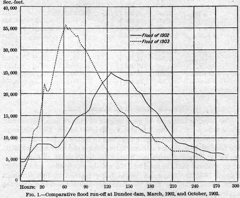
| Fig. 1. | Comparative flood run-off at Dundee dam, March, 1902, and October, 1903 | |
| 2. | Diagram of flood flow at Dundee dam, flood of 1903 |
Department of the Interior,
United States Geological Survey,
Hydrographic Branch,
Washington, D. C., December 4, 1903.
Sir: I have the honor to transmit herewith a manuscript entitled, "Passaic Flood of 1903," prepared by Marshall Ora Leighton, and to request that it be published as one of the series of Water-Supply and Irrigation Papers.
This paper is a continuation of Water-Supply and Irrigation Paper No. 88, by George B. Hollister and Mr. Leighton, and describes the flood of October, 1903, which was higher and far more disastrous than the flood of 1902. The occurrence of two great floods in the same basin during so short a period makes the subject worthy of attention, especially as the district is, from a manufacturing and commercial standpoint, one of the most important along the Atlantic coast.
Very respectfully,
F. H. Newell,
Chief Engineer.
Hon. Charles D. Walcott
Director United States Geological Survey.
By Marshall O. Leighton.
INTRODUCTION.
In the following pages is given a brief history of the disastrous flood which occurred in the Passaic River Basin in October, 1903. In the report by George Buell Hollister and the writer, entitled "The Passaic Flood of 1902," and published by the United States Geological Survey as Water-Supply and Irrigation Paper No. 88, are discussed the principal physiographic features of the drainage basin and their general relations to the stream flow. This report will not repeat this information, and the discussion will be confined to the flood itself. References to local features will be made without explanation, the presumption being that this publication shall accompany the earlier one and be, as it is, a continuation of it. In the present report more attention is given to an estimate of damages than in the earlier work, and remedies by which devastation may be avoided are briefly considered.
Passaic River overflowed its banks on October 8, 1903, and remained in flood until October 19. Between these dates there occurred the greatest and most destructive flood ever known along this stream. Ordinarily the channel of the lower Passaic at full bank carries about 12,000 cubic feet of water per second, but at the height of this flood it carried about 35,700 cubic feet per second.
The flood period for the entire stream can not be exactly stated, as the overflow did not occur at the same time in different parts of the basin. For example, the gage-height records at Dundee dam show that the flood began to rise on October 8 at 6.30 a. m., and reached a maximum of 9-1/2 inches over the dam crest at 9 p. m. on October 10. Similarly, on Beattie's dam at Little Falls the flood began to rise at midnight on October 7, and reached its maximum at 2 p. m. on October 10, or about thirty-eight hours after the initial rise, the height of the water being 1.29 inches over the crest of the dam.
The flood rose on the highland tributaries as follows: On Ramapo River the flood crest passed Hillborn at about 10 a. m. on October 9[Pg 10] and reached Pompton, at the mouth of the river, shortly after noon of the same day.
The highest reading recorded on the Geological Survey gage at the feeder of Morris Canal, in Pompton Plains, was 14.3 feet, at about 6 o'clock on the morning of October 10. As this gage is read only once daily it is probable that this reading does not represent the height of the flood crest. Evidence shows that it passed this point on the previous day. Records of the Newark water department show that the flood on Pequanac River began to rise at Macopin dam on October 8 at noon, and rose rapidly to the maximum of 6,000 cubic feet per second at 4 p. m. on October 10.
No records are available with reference to the rise of flood on Wanaque River.
Observations made on Pompton Plains on the morning of the 11th show that Pompton River was well within its banks at that time; therefore the Ramapo, Wanaque, and Pequanac must have discharged their flood waters some time previous to this hour. The fact is important when considered in connection with the height of water in the main stream at that period. This observation was made only eighteen hours after the maximum height over Beattie's dam at Little Falls, and twelve hours after the flood crest passed Dundee dam. The conditions here outlined illustrate the rapidity with which flood waters are discharged from the Pompton drainage area, and the deterring effect of Great Piece Meadows upon the flood.
The rise of the flood on Rockaway River at Old Boonton was almost coincident with that on Pequanac River at Macopin dam. The maximum flow occurred fourteen hours later than the maximum on the Ramapo at Pompton.
The flood crest did not reach Chatham on upper Passaic River until the morning of October 11, or about twenty-four hours later than the flood heights in Pompton and Rockaway rivers, and about twelve hours later than the maximum over Dundee dam.
Adequate reasons for these differences in flood periods between neighboring points are abundant. They are apparent after a review of the physiographic conditions described in Water-Supply Paper No. 88.
The flood of 1903 was the immediate result of an enormous rainfall, and not, as is often the case in north temperate latitudes, the combined effect of rainfall and the rapid melting of accumulated snows. The records of weather-observation stations in northern New Jersey and New York fail to show, throughout their entire observation periods, as great an amount of precipitation in so short a period. The storm which was the immediate cause of the flood occurred principally between October 8 and 11. During that interval rain fell to an average depth of 11.74 inches over the Passaic Basin.[Pg 11]
The Passaic Basin is fairly well supplied with storage facilities, which, under ordinary circumstances, would temper the severity of floods by holding back a large amount of water. In this case no such effect was produced, as the reservoirs, lakes, and ponds on the drainage area were filled, or practically so, at the beginning of the storm, and there was consequently no available space in which to hold back even an appreciable part of the run-off water. Over some of the dams in the highland region a comparatively small amount of water was being discharged at the beginning of the storm. Therefore, while these storage basins may have had a certain deterring effect upon the rate of flood accumulation, they could not, in the end, assist materially in preventing damages in the lower part of the drainage area.
PRECIPITATION.
The precipitation records for June, July, August, and September are given below:
Precipitation, in inches, in Passaic Valley and vicinity, June to September, 1903.
| June. | July. | August. | September. | |||||
| Normal. | Observed. | Normal. | Observed. | Normal. | Observed. | Normal. | Observed. | |
| Highland region: | ||||||||
| Dover | 3.29 | 15.02 | 5.54 | 5.47 | 5.08 | 9.04 | 4.02 | 3.39 |
| Chester | 3.48 | 12.80 | 6.42 | 7.59 | 5.16 | 9.35 | 4.60 | ...... |
| Charlotteburg | 3.52 | 9.45 | 5.54 | 3.97 | 4.98 | 7.78 | 4.80 | 3.29 |
| Ringwood | ...... | 10.13 | ...... | 3.08 | ...... | 6.17 | ...... | 3.06 |
| Red Sandstone plain: | ||||||||
| Paterson | 4.31 | 11.17 | 5.32 | 5.40 | 4.31 | 10.89 | 4.86 | 2.88 |
| Hanover | 3.32 | ...... | 5.23 | 5.40 | 5.20 | 9.40 | 4.52 | ...... |
| River Vale | 3.17 | 10.62 | 4.87 | 3.41 | 4.17 | ...... | 3.61 | 2.90 |
| Essex Fells | 3.08 | ...... | 7.03 | ...... | 5.95 | ...... | 3.67 | 1.80 |
| Newark | 3.60 | 11.51 | 4.48 | 4.27 | 4.75 | 14.54 | 3.83 | 4.56 |
| South Orange | 3.57 | 9.28 | 5.43 | 4.22 | 5.05 | 13.75 | 4.04 | 3.80 |
| New York City | 3.13 | 7.42 | 4.26 | 3.23 | 4.70 | 5.96 | 3.72 | 2.60 |
| Plainfield | 3.62 | 10.14 | 5.86 | 4.70 | 4.37 | 6.87 | 4.42 | 7.10 |
| Elizabeth | 3.68 | 8.76 | 5.74 | 4.31 | 4.26 | 7.15 | 4.14 | 4.38 |
An examination of the above table shows that throughout the summer of 1903 the precipitation was considerably above normal. The records for June and August indicate extremely wet months, and the July figures are slightly above while the September figures are somewhat below normal. The important fact shown by this table is[Pg 12] that disastrous floods may occur after long periods of abundant rains. It has been observed that heavy precipitation may be expected after protracted periods of drought. Such a belief is not altogether fanciful. In the northeastern part of this country the total amount of precipitation is approximately uniform from year to year. The variations, comparatively speaking, are not very wide, and we are therefore led to expect that there are in operation influences which serve to compensate for excesses or deficiencies in our annual rainfall. Therefore after the abundant precipitation of the summer of 1903, an observer might have had some measure of justification in predicting a normally or abnormally dry fall. In view of the actual events the fact must be emphasized that in adopting measures to prevent floods the margin of safety must be extremely wide. The extraordinary rainfall of those three October days can not with assurance be accepted as the maximum.
Precipitation, in inches, in Passaic Valley and vicinity, October 7 to 11, 1903.
| From | To | ||||
| Station. | Day. | Hour. | Day. | Hour. | Amount. |
| Highland region: | |||||
| Dover | 7 | ..... | 11 | 9 p.m. | 10.13 |
| Little Falls | 7 | 4 a.m. | 11 | 7 a.m. | 14.13 |
| Charlotteburg | 7 | ..... | 10 | ..... | 12.67 |
| Ringwood | 8 | 11 a.m. | 9 | 8 p.m. | 10.63 |
| Red Sandstone plain: | |||||
| Paterson | 7 | 5 a.m. | 9 | 3.45 p.m. | 15.04 |
| River Vale | 8 | 8 a.m. | 11 | 6 p.m. | 12.55 |
| Essex Fells | 8 | ..... | 9 | 4 p.m. | 10.66 |
| Newark | 8 | 8.30 a.m. | 11 | 5 a.m. | 12.09 |
| South Orange | 8 | 6 a.m. | 10 | Night | 10.48 |
The extremely rapid rate of precipitation during the crucial part of the storm is shown by the recording gages placed at observation stations in Newark and New York City.[Pg 13]
Hourly records of precipitation at New York observation station, October 8 and 9, 1903.
| Inches. | Inches. | ||||
| Oct. 8, | 9 to 10 a. m. | 0.08 | Oct. 9, | 1 to 2 a. m. | 0.25 |
| 10 to 11 a. m. | .02 | 2 to 3 a. m. | .75 | ||
| 11 to 12 m. | .32 | 3 to 4 a. m. | .34 | ||
| 12 m. to 1 p. m. | .10 | 4 to 5 a. m. | .46 | ||
| 1 to 2 p. m. | .05 | 5 to 6 a. m. | .41 | ||
| 2 to 3 p. m. | .06 | 6 to 7 a. m. | .29 | ||
| 3 to 4 p. m. | .34 | 7 to 8 a. m. | .51 | ||
| 4 to 5 p. m. | .01 | 8 to 9 a. m. | 1.38 | ||
| 5 to 6 p. m. | .10 | 9 to 10 a. m. | 1.04 | ||
| 6 to 7 p. m. | .02 | 10 to 11 a. m. | .08 | ||
| 7 to 8 p. m. | .93 | 11 to 12 m. | .23 | ||
| 8 to 9 p. m. | .32 | 12 m. to 1 p. m. | .24 | ||
| 9 to 10 p. m. | .24 | 1 to 2 p. m. | .31 | ||
| 10 to 11 p. m. | .27 | 2 to 3 p. m. | .32 | ||
| 11 to 12 p. m. | .26 | 3 to 4 p. m. | .01 | ||
| 9, 12 to 1 a. m. | .30 | Total | 6.92 |
Hourly record of precipitation at Newark observation station, October 8-11, 1903.
| Inches. | Inches. | ||||
| Oct. 8, | 8.25 to 9 a. m. | 0.05 | Oct. 9, | 7 to 8 a. m. | 0.29 |
| 9 to 10 a. m. | .04 | 8 to 9 a. m. | .69 | ||
| 10 to 11 a. m. | .00 | 9 to 10 a. m. | .69 | ||
| 11 to 12 m. | .00 | 10 to 11 a. m. | .39 | ||
| 12 m. to 1 p. m. | .14 | 11 to 12m. | .20 | ||
| 1 to 2 p. m. | .72 | 12m. to 1 p. m. | .39 | ||
| 2 to 3 p. m. | .49 | 1 to 2 p. m. | .28 | ||
| 3 to 4 p. m. | .11 | 2 to 3 p. m. | .34 | ||
| 4 to 5 p. m. | 1.05 | 3 to 3.25 p. m. | .13 | ||
| 5 to 6 p. m. | .45 | 11.50 to 11.55 p. m. | .01 | ||
| 6 to 7 p. m. | 1.20 | 10, 3 to 4 a. m. | .02 | ||
| 7 to 8 p. m. | .60 | 7 to 8 p. m. | .07 | ||
| 8 to 9 p. m. | .24 | 8 to 9 p. m. | .09 | ||
| 9 to 10 p. m. | .24 | 9 to 10 p. m. | .02 | ||
| 10 to 11 p. m. | .13 | 10 to 11 p. m. | .04 | ||
| 11 to 12 p. m. | .17 | 11 to 12 p. m. | .04 | ||
| 9, 12 to 1 a. m. | .29 | 11, 12 to 1 a. m. | .06 | ||
| 1 to 2 a. m. | .33 | 1 to 2 a. m. | .09 | ||
| 2 to 3 a. m. | .62 | 2 to 3 a. m. | .03 | ||
| 3 to 4 a. m. | .29 | 3 to 4 a. m. | .05 | ||
| 4 to 5 a. m. | .35 | 4 to 5 a. m. | .01 | ||
| 5 to 6 a. m. | .26 | Total | 11.83 | ||
| 6 to 7 a. m. | .13 |
From the above tables it may be seen that the maximum rate of precipitation per hour was 1.38 inches at New York and 1.2 inches at Newark. Comparison of the tables on pages 11 and 12 gives an excellent idea of the intensity of the storm. The amount of water falling in a single storm is nearly equal to the total for June, a month of unusual precipitation.
The average of the total amounts of precipitation recorded at the various stations in the Passaic area is 11.74 inches. These totals are fairly uniform, none of them varying widely from the average. Therefore the figure 11.74 represents a conservative mean for a calculation of total amount of water over the drainage area. Assuming this as the correct depth, the amount of water which fell on each square mile of the Passaic drainage area during the storm was 27,273,000 cubic feet, or for the whole Passaic drainage area over 27,000,000,000 cubic feet, weighing about 852,000,000 tons. This amount of water would, if properly stored, fill a lake with twenty times the capacity of Greenwood Lake, would cover Central Park in New York City, which has an area of about 1.5 square miles, to a height of 645 feet, and, at the present rate of water consumption in the city of Newark, N. J., would supply the city with water for twenty years.
DESCENT OF FLOOD.
HIGHLAND TRIBUTARIES AND CENTRAL BASIN.
A description of the descent of flood waters from the highland tributaries into the Central Basin has been given in Water-Supply Paper No. 88. It has been shown that the lands of the Central Basin are covered even in ordinary freshets, and that in the event of a great flood the waters merely rise higher, being, for the greater extent, almost quiescent, and beyond the flooding of houses and barns and the destruction of crops, little damage is done. In other words, the flood along this portion is not torrential in character.
During the flood of 1903 the water fell so quickly all over this basin, and was collected so rapidly by the small tributaries, that a lake was formed at once which served as a cushion against which the raging torrent of the highland tributaries spent itself without doing extraordinary damage in that immediate region. Bridges which might have been lost in a smaller flood like that of 1902 were actually standing in slack water by the time the mountain torrents appeared in force. These streams caused much destruction higher up in the mountains, but in the Central Basin their energy became potential—a gathering of forces to be loosed upon the lower valley. A discussion of the effects of this will be taken up under the heading "Damages."
In Water-Supply Paper No. 88 is given the proportion of flood waters[Pg 15] contributed to the Central Basin by each of the tributaries. These figures were computed from the results of gagings maintained for a period sufficient to afford this information within a reasonable approximation. In the case of the storm which resulted in the flood of 1903 it is probable that data referred to can not be safely applied.
The flood of 1902 was the result of abundant rains following upon and melting a heavy snow. Weather Bureau records show that neither the depth of the snow nor the amount of subsequent rainfall was uniform, or even approximately so, over the Passaic drainage area. Indeed, so marked was the variation that it was believed that the mean rainfall for all the observation stations on the basin did not bear sufficient relation to observed run-off to allow of any reliable deductions. In the case of the October storm, however, the distribution of rainfall was more nearly uniform, and the run-off from the highland tributaries into the Central Basin must have been proportionately different in amount from that indicated in the upland tributary tables in the report of the previous flood. The data given for the 1902 flood can not, therefore, in the case of the highland tributaries, be applied to the conditions which obtained in the flood of 1903.
FLOOD AT MACOPIN DAM.
Mr. Morris R. Sherrerd, engineer of the Newark city water board, has furnished flow computations over Macopin intake dam, which is the head of the Newark pipe line. As about 73 per cent of the Pequanac drainage area lies above this intake, the table on page 16 shows roughly an equivalent percentage of the flow contributed by Pequanac River to the Central Basin of the Passaic. In consulting this table it should be borne in mind that the entire run-off of the drainage area above Macopin is about 25,000,000 gallons per day more than the amounts presented in this table. All reservoirs and ponds connected with the conservancy system of the Newark water supply were filled except that at Oakridge, which was about 1.5 feet below the crest of the spillway.
Flow of Pequanac River over Macopin dam, October 7-24, 1903.
[From Newark water department.]
| Cubic feet. | ||
| Oct. 8, | 6 a. m. to 12 m. | 240,600 |
| 12m. to 4 p. m. | 347,600 | |
| 4 to 6 p. m. | 842,200 | |
| 8-9, | 6 p. m. to 6 a. m. | 40,110,000 |
| 9, | 6 a. m. to 12 m. | 51,870,000 |
| 12m. to 1 p. m. | 15,100,000 | |
| 1 to 5 p. m. | 62,430,000 | |
| 5 to 10 p. m. | 89,040,000 | |
| 10 to 11 p. m. | 19,520,000 | |
| 9-10, | 10 p. m. to 8 a. m. | 201,350,000 |
| 10, | 8 a. m. to 12 m. | 75,670,000 |
| 12 m. to 6 p. m. | 103,650,000 | |
| 6 to 12 p. m. | 73,530,000 | |
| 11, | 12 to 6 a. m. | 56,820,000 |
| 6 a. m. to 12m. | 41,440,000 | |
| 12 m. to 6 p. m. | 32,755,000 | |
| 6 to 12 p. m. | 25,665,000 | |
| 12, | 12 to 6 a. m. | 23,800,000 |
| 6 a. m. to 12m. | 20,725,000 | |
| 12 m. to 6 p. m. | 18,450,000 | |
| 6 to 12 p. m. | 15,105,000 | |
| 13, | 12 to 6 a. m. | 13,370,000 |
| 6 a. m. to 12 m. | 11,890,000 | |
| 12 m. to 6 p. m. | 11,230,000 | |
| 6 to 12 p. m. | 11,230,000 | |
| 14, | 12 to 6 a. m. | 9,626,000 |
| 6 a. m. to 12 m. | 8,690,000 | |
| 12 m. to 6 p. m. | 8,022,000 | |
| 6 to 12 p. m. | 7,353,000 | |
| 15, | 12 to 6 a. m. | 6,952,000 |
| 6 a. m. to 6 p. m. | 12,700,000 | |
| 15-16, | 6 p. m. to 6 a. m. | 10,965,000 |
| 16, | 6 a. m. to 6 p. m. | 10,025,000 |
| 16-17, | 6 p. m. to 6 a. m. | 9,091,000 |
| 17, | 6 a. m. to 6 p. m. | 8,690,000 |
| 17-18, | 6 p. m. to 6 a. m. | 9,893,000 |
| 18, | 6 a. m. to 6 p. m. | 10,565,000 |
| 18-19, | 6 p. m. to 6 a. m. | 8,690,000 |
| 19, | 6 a. m. to 6 p. m. | 6,952,000 |
| 19-20, | 6 p. m. to 6 a. m. | 6,150,000 |
| 20, | 6 a. m. to 6 p. m. | 5,882,000 |
| 20-21, | 6 p. m. to 6 a. m. | 5,749,000 |
| 21, | 6 a. m. to 6 p. m. | 5,481,000 |
| 21-22, | 6 p. m. to 6 a. m. | 5,214,000 |
| 22, | 6 a. m. to 6 p. m. | 4,144,000 |
| 22-23, | 6 p. m. to 6 a. m. | 3,677,000 |
| 23, | 6 a. m. to 6 p. m. | 3,877,000 |
| 23-24, | 6 p. m. to 6 a. m. | 5,749,000 |
| 24, | 6 a. m. to 6 p. m. | 5,615,000 |
FLOOD AT BEATTIE'S DAM, LITTLE FALLS.
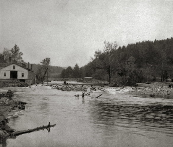
The flow over Beattie's dam at Little Falls, has been calculated according to coefficients used for the same dam in Water-Supply Paper No. 88. Recorded gage heights show that over the main dam there was a maximum depth of 11.12 feet, which continued from 2 to 8 p. m., on October 10, representing a maximum flow of 31,675 cubic feet per second. (See Pl. I, A.) In the following table is set forth the flow of the river over Beattie's dam during the flood, and for purposes of comparison, the figures for the flood period of March, 1902. It should be borne in mind in consulting this table, that in the case of the flood of 1903 exact dates and hours are given, while the figures for the 1902 flood represent flow determinations at six-hour intervals, beginning with the initial rise of that flood.
| U. S. GEOLOGICAL SURVEY | WATER-SUPPLY PAPER NO. 92 PL. I |

A. BEATTIE'S DAM, LITTLE FALLS, N. J., IN FLOOD.

B. FLOOD-WATER LINES IN RESIDENCE DISTRICT, PATERSON, N. J.
Flood flow over Beattie's dam during floods of 1902 and 1903.
| Date and hour. | 1903. | 1902.[A] | |
| Sec.-feet. | Sec.-feet. | ||
| Oct. 8, | 12 p.m | 1,645 | 490 |
| 9, | 6 a.m. | 4,235 | 700 |
| 12 m. | 8,560 | 1,350 | |
| 6 p.m. | 15,755 | 2,120 | |
| 12 p.m. | 23,927 | 3,540 | |
| 10, | 6 a.m. | 28,370 | 4,250 |
| 12 m. | 31,305 | 4,600 | |
| 6 p.m. | 31,675 | 5,000 | |
| 12 p.m. | 30,770 | 6,500 | |
| 11, | 6 a.m. | 29,840 | 7,600 |
| 12 m. | 28,950 | 8,250 | |
| 6 p.m. | 26,960 | 9,000 | |
| 12 p.m. | 25,530 | 10,200 | |
| 12, | 6 a.m. | 24,435 | 11,450 |
| 12 m. | 22,625 | 14,700 | |
| 6 p.m. | 20,810 | 18,150 | |
| 12 p.m. | 18,655 | 20,650 | |
| 13, | 6 a.m. | 17,930 | 22,200 |
| 12 m. | 16,190 | 22,700 | |
| 6 p.m. | 14,900 | 23,400 | |
| 12 p.m. | 13,615 | 23,300 | |
| 14, | 6 a.m. | 12,340 | 22,950 |
| 12 m. | 11,740 | 22,650 | |
| 6 p.m. | 10,975 | 22,350 | |
| 12 p.m. | 9,820 | 22,100 | |
| 15, | 6 a.m. | 9,180 | 21,150 |
| 12 m. | 8,330 | 19,900 | |
| 6 p.m. | 7,700 | 18,900 | |
| 12 p.m. | 7,005 | 17,350 | |
| 16, | 6 a.m. | 6,695 | 15,750 |
| 12 m. | 5,920 | 13,900 | |
| 6 p.m. | 5,620 | 13,300 | |
| 12 p.m. | 5,360 | 11,800 | |
| 17, | 6 a.m. | 4,855 | 10,650 |
| Below full bank | 8,900 | ||
| Do...... | 8,500 | ||
| Do...... | 8,100 | ||
| Do...... | 8,200 | ||
| Do...... | 7,000 | ||
| Do...... | 6,250 | ||
| Do...... | 5,900 | ||
| Do...... | 5,300 | ||
| Do...... | 5,200 | ||
| Do...... | 4,900 | ||
FLOOD FLOW OVER DUNDEE DAM.
The flood, as indicated by gage heights at Dundee dam, lasted from about 6.30 p. m. October 8 to about midnight October 18. Although the maximum recorded gage height was 19 inches higher than during the flood of 1902, the actual time during which the river was out of its banks was forty-five hours less than at the earlier flood. Examination of fig. 1 shows that the flood of 1903 was decidedly more intense than that of 1902, the maximum height being reached in 1903 in about sixty hours, while in 1902 the maximum was not reached until the expiration of about one hundred and twenty hours.
At Dundee dam the familiar break in the progress of the flood took place about thirty-five hours after the initial rise. It occurred before the time of the maximum gage height at the mouth of Pompton River, and there is nothing to indicate that it was caused, as has been claimed, by slack water from the Pompton flood being forced back into Great Piece Meadows. There is no doubt that a part of the Pompton flood was so diverted, but there was maintained throughout at Little Falls a steady pressure, which constantly increased to maximum. This flood check, at Dundee dam was observed in 1902, but it could not be shown to arise from the frequently mentioned phenomena at the mouth of Pompton River. It is important to prove or disprove this hypothesis.[Pg 18] If it were found to be true, it could be advantageously taken into consideration in connection with measures for the prevention of flood damages. As the Pompton had no such effect upon the flood flow at Dundee dam in two consecutive historic floods, the writer is inclined to believe that the idea is entirely erroneous.
Fig. 1.—Comparative flood run-off at Dundee dam, March, 1902, and October, 1903.
Since the flow curves in fig. 1 were drawn it has been found by careful observation that the depressions which occur in the rise of every flood over Dundee dam are probably due to the carrying away of the flashboards which are placed upon the dam crest in times of low water. A review of the gage heights recorded by floods for several years past shows that the break occurs when the height of water over the dam crest reaches from 40 to 60 inches. The flashboards used upon this dam are usually 18 inches wide, and as they are supported by iron rods, which are of approximately the same strength and are placed upon the dam by one crew of workmen, it may be safely assumed that they are of approximately equal stability and might be expected to fail almost simultaneously along the length of the dam crest. So sudden a decrease in the effectual height of the dam must lower the water on the dam crest markedly, and as every other probable cause has been eliminated in the case of the recent flood, the explanation of the check in the progress of floods over this dam may be safety accepted as due to carrying away of flashboards. This effect should be apparent in the gage-height records only.
In the flow diagrams (figs. 1 and 2) the effect would not be the same, but the curve would rise more sharply. Similarly, the measurements at the beginning are not correct, as they are calculated according to gage heights measured from the stone crest of the dam. Therefore, a true flood curve at this point would be much flatter at the beginning and rise sharply at a period coincident with the carrying away of the flashboards.
An important difference between the two floods is that the earlier continued longer, but the later one was much higher. The flood of 1902 was caused by the turning of an equivalent of approximately 6 inches of precipitation into the main channel during a period of six days. In the deluge of 1903 there fell 11.74 inches of rain, the greater part of which was precipitated in 36 hours. Thus it is seen that there was in the flood of 1903 a larger rainfall during a much shorter period than in the flood of 1902. Computation shows that the total run-off from the drainage area above Dundee dam during the earlier flood was 13,379,000,000 cubic feet, and that on account of the frozen condition of the ground at that time this amount of water represented practically all of the precipitation. During the flood of 1903 there was a total run-off for the same area of 14,772,000,000 cubic feet, which represents about 66 per cent of the observed precipitation. According to these figures the total amount of run-off in the 1903 flood was only 10 per cent greater than that in 1902, while the actual flood height during the 1903 flood was 27 per cent higher than during the flood of 1902. The above comparison shows, in a striking manner, the effect of the condition of the surface. In the case of the later flood we had, as has been stated in previous pages, an area which had been well watered during the previous summer, and the observed ground-water levels were fairly high. There was, however, sufficient storage capacity in the basin to retain about 34 per cent of the precipitation occurring between October 7 and 11. This water must have been largely absorbed by the earth. The general relations of the floods of 1903 and 1902 can therefore be briefly stated as follows:
General relations of floods of 1903 and 1902.
| Average precipitation. | Duration of precipitation. | Maximum flood flow. | Total run-off. | Run-off. | Duration of flood at dundee dam. | |
| Inches. | Days. | Sec.-feet. | Cubic feet. | Per cent. | Hours. | |
| 1902..... | 6 | 6 | 24,800 | 13,379,000,000 | 100[B] | 270 |
| 1903..... | 11.74 | 3 | 35,700 | 14,772,000,000 | 66 | 225 |
In the following table and fig. 2 are recorded gage heights taken at hourly intervals during the crucial part of the flood and the amount of water expressed in cubic feet per second flowing over the crest of the dam at each gage height.
Fig. 2.—Diagram of flood flow at Dundee dam, flood of 1903.
Flow of Passaic River at Dundee dam, 1903.
| Date and hour. | Gage. | Flow. | |
| Feet. | Sec.-feet. | ||
| Oct. 8. | 6.30 a. m. | 0.66 | 780 |
| 1 p. m. | 1.50 | 3,175 | |
| 6.30 p. m. | 2.17 | 5,500 | |
| 8 p. m. | 2.59 | 7,300 | |
| 10 p. m. | 3.00 | 9,125 | |
| 11 p. m. | 3.33 | 10,700 | |
| 12 p. m. | 3.50 | 11,525 | |
| 9, | 1 a. m. | 3.50 | 11,550 |
| 2.30 a. m. | 3.59 | 11,950 | |
| 4 a. m. | 3.50 | 11,525 | |
| 6 a. m. | 3.66 | 12,300 | |
| 8.30 a. m. | 3.75 | 12,775 | |
| 9.40 a. m. | 4.00 | 14,075 | |
| 10.55 a. m. | 4.66 | 17,650 | |
| 12 m. | 4.75 | 18,200 | |
| 1 p. m. | 5.25 | 21,050 | |
| 2 p. m. | 5.37 | 21,750 | |
| 3 p. m. | 5.45 | 22,250 | |
| 3.45 p. m. | 5.37 | 21,750 | |
| 4.25 p. m. | 5.29 | 21,300 | |
| 5 p. m. | 5.23 | 20,950 | |
| 5.45 p. m. | 5.19 | 20,700 | |
| 6.30 p. m. | 5.17 | 20,600 | |
| 7 p. m. | 5.11 | 20,250 | |
| 8 p. m. | 5.13 | 20,350 | |
| 9 p. m. | 5.17 | 20,600 | |
| 10 p. m. | 5.21 | 20,750 | |
| 11 p. m. | 5.27 | 21,150 | |
| 12 p. m. | 5.4 | 21,950 | |
| 10, | 1 a. m. | 5.5 | 22,500 |
| 2 a. m. | 5.66 | 23,500 | |
| 3 a. m. | 5.73 | 23,900 | |
| 4 a. m. | 5.91 | 25,050 | |
| 5 a. m. | 6.00 | 25,650 | |
| 6 a. m. | 6.2 | 26,900 | |
| 7 a. m. | 6.33 | 27,700 | |
| 8 a. m. | 6.4 | 28,150 | |
| 9 a. m. | 6.6 | 29,400 | |
| 10 a. m. | 6.83 | 30,750 | |
| 11 a. m. | 6.89 | 31,250 | |
| 11.35 a. m. | 6.97 | 31,750 | |
| 12 m. | 6.93 | 31,450 | |
| 1 p. m. | 6.95 | 31,650 | |
| 2 p. m. | 7.13 | 32,800 | |
| 3 p. m. | 7.19 | 33,150 | |
| 4 p. m. | 7.25 | 33,500 | |
| 5 p. m. | 7.39 | 34,450 | |
| 6 p. m. | 7.39 | 34,450 | |
| 7 p. m. | 7.40 | 34,500 | |
| 8 p. m. | 7.54 | 35,350 | |
| 9 p. m. | 7.62 | 35,800 | |
| 10 p. m. | 7.60 | 35,700 | |
| 11 p. m. | 7.57 | 35,500 | |
| 12 p. m. | 7.43 | 34,650 | |
| 11, | 1 a. m. | 7.47 | 34,950 |
| 2 a. m. | 7.5 | 35,100 | |
| 3 a. m. | 7.42 | 34,700 | |
| 4 a. m. | 7.3 | 34,450 | |
| 5 a. m. | 7.3 | 34,150 | |
| 6 a. m. | 7.3 | 34,150 | |
| 7 a. m. | 7.37 | 34,300 | |
| 8 a. m. | 7.33 | 34,100 | |
| 9 a. m. | 7.31 | 33,900 | |
| 10 a. m. | 7.23 | 33,450 | |
| 11 a. m. | 7.25 | 32,525 | |
| 12 m. | 7.18 | 33,100 | |
| 1 p. m. | 7.18 | 33,100 | |
| 2 p. m. | 7.17 | 33,300 | |
| 3 p. m. | 7.08 | 32,450 | |
| 4 p. m. | 7.00 | 31,950 | |
| 5 p. m. | 6.96 | 31,700 | |
| 6 p. m. | 6.89 | 31,250 | |
| 7 p. m. | 6.86 | 31,050 | |
| 8 p. m. | 6.83 | 30,850 | |
| 9 p. m. | 6.79 | 30,600 | |
| 10 p. m. | 6.81 | 30,700 | |
| 11 p. m. | 6.73 | 30,200 | |
| 12 p. m. | 6.71 | 30,100 | |
| 12, | 1 a. m. | 6.63 | 29,600 |
| 2 a. m. | 6.59 | 29,350 | |
| 3 a. m. | 6.55 | 29,100 | |
| 4 a. m. | 6.51 | 28,800 | |
| [Pg 22] | 5 a. m. | 6.42 | 28,250 |
| 6 a. m. | 6.42 | 28,250 | |
| 7 a. m. | 6.39 | 28,100 | |
| 8 a. m. | 6.39 | 28,100 | |
| 9 a. m. | 6.25 | 27,200 | |
| 10 a. m. | 6.21 | 26,950 | |
| 11 a. m. | 6.17 | 26,700 | |
| 12 m. | 6.05 | 26,100 | |
| 1 p. m. | 6.06 | 26,050 | |
| 2 p. m | 5.93 | 25,200 | |
| 3 p. m. | 5.89 | 24,950 | |
| 4 p. m. | 5.87 | 24,800 | |
| 5 p. m. | 5.79 | 24,300 | |
| 6 p. m | 5.77 | 24,150 | |
| 7 p. m. | 5.75 | 24,250 | |
| 8 p. m. | 5.73 | 23,950 | |
| 9 p. m | 5.63 | 23,300 | |
| 10 p. m. | 5.59 | 23,100 | |
| 11 p. m. | 5.54 | 22,750 | |
| 12 p. m. | 5.49 | 22,450 | |
| 13, | 1 a. m. | 5.44 | 22,200 |
| 2 a. m. | 5.39 | 21,000 | |
| 3 a. m. | 5.35 | 21,650 | |
| 4 a. m. | 5.30 | 21,350 | |
| 5 a. m. | 5.24 | 21,000 | |
| 6 a. m. | 5.21 | 20,850 | |
| 7 a. m. | 5.16 | 20,525 | |
| 8 a. m. | 5.13 | 20,350 | |
| 9 a. m. | 5.08 | 20,100 | |
| 10 a. m. | 5.04 | 19,800 | |
| 11 a. m. | 5.00 | 19,560 | |
| 12 m. | 4.94 | 19,200 | |
| 1 p. m. | 4.89 | 18,900 | |
| 2 p. m. | 4.85 | 18,700 | |
| 3 p. m. | 4.84 | 18,650 | |
| 4 p. m. | 4.75 | 18,200 | |
| 5 p. m. | 4.71 | 17,900 | |
| 6 p. m. | 4.66 | 17,650 | |
| 7 p. m. | 4.64 | 17,550 | |
| 8 p. m. | 4.59 | 17,250 | |
| 9 p. m. | 4.54 | 17,000 | |
| 10 p. m. | 4.51 | 16,750 | |
| 11 p. m. | 4.49 | 16,700 | |
| 12 p. m. | 4.37 | 16,000 | |
| 14, | 1 a. m. | 4.37 | 16,000 |
| 2 a. m. | 4.35 | 15,925 | |
| 3 a. m. | 4.35 | 15,925 | |
| 4 a. m. | 4.33 | 15,800 | |
| 5 a. m. | 4.34 | 15,850 | |
| 6 a. m. | 4.31 | 15,700 | |
| 7 a. m. | 4.27 | 15,500 | |
| 8 a. m. | 4.25 | 15,300 | |
| 9 a. m. | 4.17 | 14,900 | |
| 10 a. m. | 4.08 | 14,500 | |
| 11 a. m. | 4.05 | 14,325 | |
| 12 m. | 4.02 | 14,150 | |
| 1 p. m. | 4.02 | 14,150 | |
| 2 p. m. | 4.01 | 14,100 | |
| 3 p. m. | 3.97 | 13,900 | |
| 4 p. m. | 3.94 | 13,750 | |
| 5 p. m. | 3.85 | 13,300 | |
| 6 p. m. | 3.75 | 12,775 | |
| 7 p. m. | 3.75 | 12,775 | |
| 9 p. m. | 3.71 | 12,550 | |
| 12 p. m. | 3.66 | 12,300 | |
| 15, | 6.30 a. m. | 3.50 | 11,525 |
| 1 p. m. | 3.41 | 11,050 | |
| 6.30 p. m. | 3.41 | 11,050 | |
| 16, | 6.30 a. m. | 3.00 | 9,125 |
| 1 p. m. | 3.00 | 9,125 | |
| 6.30 p. m. | 2.91 | 8,700 | |
| 17, | 6.30 a. m. | 2.5 | 6,900 |
| 1 p. m. | 2.5 | 6,900 | |
| 6.30 p. m. | 2.5 | 6,900 | |
| 18, | 6.30 a. m. | 2.5 | 6,900 |
| 1 p.m. | 2.41 | 6,500 | |
| 6.30 p. m. | 2.33 | 6,200 | |
| 19, | 6.30 a. m. | 2 | 4,900 |
| 1 p. m. | 2 | 4,900 | |
| 6.30 p. m. | 2 | 4,900 | |
GENERAL STATEMENTS.
Estimates of flood damages are always approximations only. It is possible to determine with a fair degree of assurance the cost of replacing structures which have been carried away, to estimate the value of goods destroyed—especially if they be commodities stored in shops or warehouses—to calculate the amount of operatives' wages lost, and in the case of general mercantile business to estimate the damages incurred through consequent reduction of trade. Destruction by flood, however vast, is incomplete. It differs materially from destruction by fire, for often destructible property is of value after floods have passed. Buildings which are inundated still retain value, and many kinds of merchandise are not totally destroyed. Therefore when the amount of damages is calculated there is always to be taken into consideration the fact that a part of the material which has been flooded can be reclaimed, and retains some proportion, at least, of the value which it had previously possessed. Furthermore, damages by flood enter into practically every detail of social and business affairs. There are losses which are severe to one or more persons, and which can not be appreciated except by those whom the floods have actually overtaken. Therefore estimations of flood damages can be only approximate, and while a measure of accuracy may be reached with respect to a part of the losses, there remains a necessity for approximation which can not be classed with carefully computed damages along other lines.
HIGHLAND TRIBUTARIES.
Along the three northern tributaries, the Ramapo, Wanaque, and Pequanac, and at their confluence with the Pompton, the destruction by flood waters was far greater than along the Rockaway, Whippany, and upper Passaic, or in that area described as the Central Basin. In the drainage areas of the three tributaries last mentioned the waters were higher than in the flood of 1902, but the general effects were of the same nature, and consisted principally of flooded lands, houses, and washouts. There were few radical cases of complete destruction like those which marked the course of the flood in the northern tributaries. The principal interest is therefore confined to the Pompton and the three highland tributaries which discharge into it.
Ramapo River.—The greatest destruction was along the Ramapo. It is the largest of the upland branches, and was therefore the heaviest contributor to the main stream. Throughout the flood period the stream was especially violent, causing great apprehension in the lower valley.
The destruction along several stretches of the valley was almost complete. Nearly all the dams failed, and every bridge across the river, with one exception, was carried away. Some small villages were swept bare, and the damages to realty value and personal property were excessive.
It was only by strenuous measures that the dam impounding the waters of Tuxedo Lake was saved. If this had failed the destruction along the entire course of the river, even to the cities in the lower valley, would have been enormously increased.
The dam at Cranberry Pond, in Arden, failed in the early part of the storm, the flood waters disabling the Tuxedo electric-light plant and inundating the Italian settlements along the river below. The failure of the dam conserving the waters of Nigger Pond, which lies at the head of a small tributary emptying into the Ramapo below Tuxedo, resulted in the inundation of Ramapo village. The village of Sloatsburg was practically obliterated.
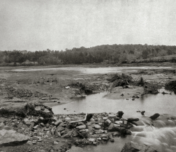
The damage at Pompton Lakes was especially severe. During the early part of the flood the timber dam of the Ludlum Steel and Iron Company, which raised the water to a height of 27 feet, and afforded 7.04 horsepower per foot fall, was carried away with a part of the headrace. (See Pl. II, A.) This sudden emptying of Pompton Lake, an expanse of 196 acres (see Pl. II, B), was extremely destructive to Pompton Plains, and the destruction of the dams above on Ramapo River, which followed some time after the bursting of the lower dam, refilled Pompton Lake above its former level, and caused greater damage than that which resulted from the failure of Pompton dam itself. The large iron bridge just below the dam was carried away, with the stores of the Ludlum Steel and Iron Company. The river front along this company's property was destroyed, along with coal docks at the head of Morris Canal feeder. The channel of the river below the dam is filled with débris, which will raise the height of the water in the tailrace, and unless it is cleared will diminish the available power at the iron works. It has been authoritatively announced, however, that the power facilities will not be restored, as the Ludlum Steel and Iron Company is preparing to use steam power exclusively.
Pequanac and Wanaque rivers.—Along Pequanac River the principal damage consisted of washed-out roads and destroyed bridges. The large ponded area in this basin was practically full at the time of the flood, and, as measurements at Macopin dam show, the run-off per square mile was extremely large. In the Wanaque drainage area the storage facilities afforded at Greenwood Lake were probably useful in holding back a part of the water for a brief period, but the damages along the stream are comparable to those of the Pequanac.
The effect of the flow from these two streams, added to that of the Ramapo, was particularly disastrous over the Pompton Plains. Three
| U. S. GEOLOGICAL SURVEY | WATER-SUPPLY PAPER NO. 92 PL. II |
A. POMPTON LAKES DAM AND WATER FRONT OF LUDLUM STEEL AND IRON COMPANY.
B. DRY BED OF POMPTON LAKE.
| U. S. GEOLOGICAL SURVEY | WATER-SUPPLY PAPER NO. 92 PL. III |
FLOOD DISTRICT OF PATERSON, N. J.
bridges at Pompton station, over Wanaque and Pequanac rivers, were carried away, and in the end one bridge only remained over Pompton River, that at Pequanac station. In all about 100 houses were inundated on Pompton Plains, and the damage to roads and culverts was particularly severe.
The total loss in the drainage area of Pompton River was $350,000.
CENTRAL BASIN.
Over the Central Basin there was the usual impounding of flood waters, but the effects were not materially different from those described in the report on the flood of 1902. The damage along this basin from floods of this character is accumulative by reason of the fact that the presence of water over the land for so long a period kills the desirable feed grasses and fosters in their place the coarse meadow grass. This effect has been observed for some years, particularly since the flood of 1896. It is estimated that over the Central Basin the damage to crops and arable land alone arising from the floods of 1902 and 1903 amounts to $300,000. A statement of the damage arising from the later flood can not separately be made, as its effect upon the fertility of the meadow lands can not be determined without the experience of a planting season.
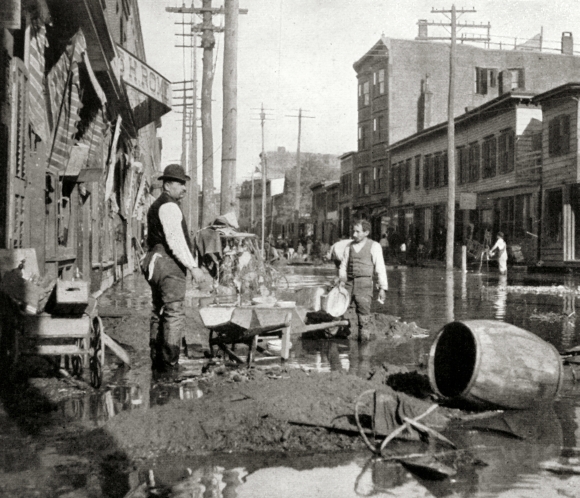
LOWER VALLEY.
The flow of the stream through the constricted channel at Little Falls and on to Great Falls at Paterson is given in the weir measurements on page 17. It was attended by comparatively large damages, the features of which were not materially different from those described in the previous report. The pumping station of the East Jersey Water Company, situated just below Little Falls dam, did not suffer as severely as during the previous flood, by reason of the fact that extensive and effective barricades were placed so as to keep a large part of the water away from the pumps. This was not accomplished in the flood of 1902. The total damage in this district amounted to nearly $200,000.
The channel contours were changed somewhat in this portion of the stream. In the river at the pumping station of the East Jersey Water Company there was completed a somewhat interesting cycle of changes, described in the following extract of a letter from Mr. G. Waldo Smith, chief engineer for the New York aqueduct commissioners, and formerly engineer and superintendent of the East Jersey Water Company:
"No better illustration of the old adage, 'The river claims its own,' could be given than that offered by the action of Passaic River at Little Falls, New Jersey, at the point where the works of the East Jersey Water Company have been constructed. These works[Pg 26] were built between 1897 and 1900. In the course of the work the river channel for a distance of several thousand feet down stream from the power house was drained and improved, so that the head on the wheels at the ordinary stage of the river was increased about 6 feet. From the time this improvement was completed to March, 1902, through the action of the ordinary flow of water and moderate floods, this head had been reduced about one-third. The great freshet of March, 1902, cut off about another third, and the recent flood has completed the cycle and entirely wiped out the benefit due to the river improvement, and the water at the pumping station stands now at almost precisely the same level that it stood before any improvements were undertaken. New bars were formed in approximately the same location as they existed before, and, so far as possible, except for the changed conditions brought about by the building of the power station, the condition of the river is not dissimilar to that existing when the work was commenced.
"In this connection it might be well to state that a New Jersey drainage commission, in blasting out a channel below the Little Falls dam some years ago, dumped a considerable portion of the excavation in the deep water under the Morris Canal viaduct.
"The action of the two great floods, March, 1902, and October, 1903, has washed a large part of this material out of this deep hole and piled it up in the river about 300 feet below where the river widens, and reduces the force of the current.
"I have made no estimate of the amount of material deposited in the river, but offhand should say that it would be at least 100,000 yards."
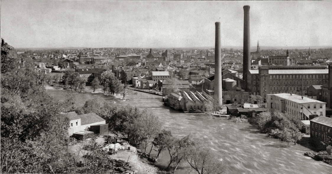
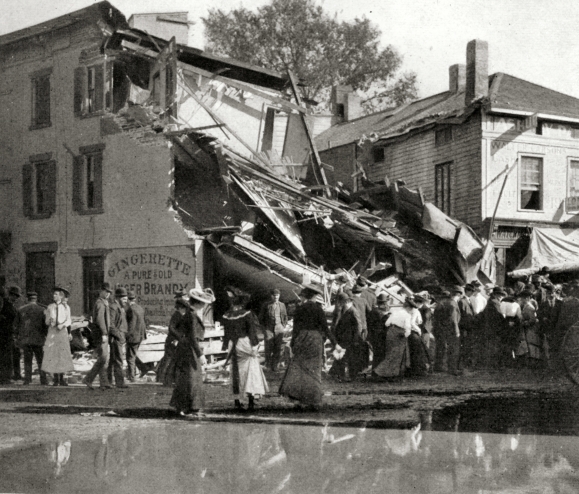
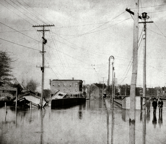
Paterson.—The flood district in the city of Paterson (see Pl. III) comprised 196 acres and involved the temporary obstruction of 10.3 miles of streets. Along the streets close to the river banks the height of water was 12 feet, sufficient to inundate the first floors of all the buildings (see Pl. I, B), and in some cases to reach to the second floor. During this flood period householders who remained at their homes were compelled to use boats, while in the more exposed places the danger was too great to admit of remaining, and at one time 1,200 persons were housed and fed in the National Guard armory at Paterson.
The bridges crossing Passaic River in Passaic, Essex, and Bergen counties were almost completely destroyed, and the damage amounted to $654,811. Within the limits of Paterson, below Great Falls, all of the highway bridges except two were either severely damaged or completely carried away. West street bridge, the first below the falls, was a Melan concrete, steel-arch structure, built in 1897, and costing $65,000. It was composed of three spans, each about 90 feet long. The flood practically split two spans longitudinally, the upstream side of each, equal to about one-third of the width of the bridge, being carried away.
| U. S. GEOLOGICAL SURVEY | WATER-SUPPLY PAPER NO. 92 PL. IV |

A. WASHOUT AT SPRUCE STREET, PATERSON, N. J.

B. RIVER STREET, PATERSON, N. J., AFTER FLOOD.
| U. S. GEOLOGICAL SURVEY | WATER-SUPPLY PAPER NO. 92 PL. V |

A. EFFECTS OF FLOOD IN MILL DISTRICT, PATERSON, N. J.
B. THE WRECK OF A HOTEL IN PATERSON, N. J.
This structure was built to conform to the established grades of streets on both sides of the river and was completely inundated, forming a barrier for floating débris and practically making a dam in the river. Main street bridge is a 3-span, steel-arch structure, which was completely covered during the flood, but was only slightly injured. Arch street bridge, built in 1902 to take the place of a structure carried away by the March flood, was a concrete-arch bridge of three spans. It was undermined at the north pier and collapsed, being practically destroyed. The original cost of this bridge was $34,000. Its piers presented a serious obstruction to the flow of the stream, especially as the channel is very narrow at this point. In addition to this, the bridge was of low grade and admirably adapted for deterring flood flow. Below Arch street bridge all the other structures crossing the Passaic were of iron and were carried away, with the exception of Sixth avenue and Wesel bridges. Those destroyed were designated as follows: Straight street, Hillman street, Moffat, Wagaraw, Fifth avenue, East Thirty-third street, and Broadway bridges. All these structures were built too low, and were inundated during the early stages of the flood.
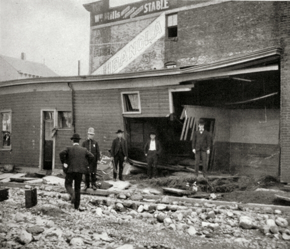
The damage to real property, stock, and household goods in the city of Paterson amounted, according to certified returns, to about $2,700,000. It is impossible to secure correct figures, because merchants and manufacturers refuse to give details of losses, fearing that the publication thereof would affect their credit. General ideas concerning the destruction by the flood can be gathered from Pls. I, B, III, IV, V, and VI.
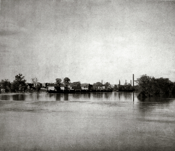
Passaic and vicinity.—Below the city of Paterson destruction was as complete as in Paterson, although the damage was not as great because the improvements were not as valuable. Damage to property, exclusive of public works, in this region, amounted to about $1,250,000. This estimate does not take into consideration losses by manufacturers arising from destruction of raw materials or finished products. The flood was about 4-1/2 feet higher than that of 1902. (See Pl. VII, A.)
On the right bank of Passaic River, in the city of Passaic, the damage was severe, especially to manufacturing plants. In addition to the flood in the Passaic itself, the bursting of Morris Canal, a few miles east of Passaic, flooded Wesel Brook, which in Passaic is used as the tail-race of the Dundee Power Company. The capacity of Wesel Brook channel is limited, and the extraordinary amount of water which was turned into it carried away all culverts and bridges from Richfield to Passaic.
Below Passaic, along the river front of Essex County, the damages to bridges amounted to $50,000. (See Pl. VII, B.) The loss due to washouts in roads throughout the county amounted to $15,000. The[Pg 28] effects of the flood were apparent along the entire length of the river and into Newark Bay. The damage from inundation in Newark and vicinity amounted to $753,199.
The figures above given with reference to damage along Passaic River are uncommonly accurate, being for the most part the result of a house-to-house canvass by the northern New Jersey flood commission. As has been stated above, tradesmen are reluctant to give full details with reference to their losses through fear of injured credit. Roughly estimating the damage as a whole, and taking into consideration factors which were given to the writer confidentially, the damage throughout the drainage area from this flood will amount to not less than $7,000,000.
GENERAL DISCUSSION.
In the consideration of means of preventing damages by floods every plan proposed falls under one of two general heads—the storage of flood waters or an increase in the capacity of the streams.
The first plan involves the construction at selected localities of reservoirs of sufficient size to hold all or a greater part of the waters which run over the surface during and after storms. This plan is not practicable except where valleys or plains are inclosed by high ridges and these ridges approach sufficiently near each other to admit of the economical construction of a bank or dam across the gorge or bed of the stream which flows through, so that the inclosure will be complete and form a water-tight basin. Where such a reservoir exists the water can be held back and gradually let down through properly provided gates so that the channel will not be flooded.
For flood purposes alone it would be necessary to provide reservoirs of sufficient capacity to contain the run-off waters resulting from the largest storms. With such provisions it would be necessary to entirely empty the reservoir as soon as possible after a storm had passed and leave its full capacity available for the next storm. It is therefore better, wherever possible, to provide a reservoir capacity considerably larger than that represented by the run-off from the heaviest storms, so that water may be stored for use as power or domestic supply. With such provision it is necessary merely to draw from the reservoir water to a depth equivalent to the stream run-off in the drainage area above.
The second plan for prevention of flood damages involves provisions for letting the flood water out rapidly by removing obstructions to its flow by straightening and deepening the channels and providing long embankments, dikes, or levees which rise above the ordinary river level to a height exceeding that of the stream during its highest floods. This plan is most generally followed in the case of large rivers like
| U. S. GEOLOGICAL SURVEY | WATER-SUPPLY PAPER NO. 92 PL. VI |
A. DEVASTATION IN HEBREW QUARTER, PATERSON, N. J.
B. A COMMON EXAMPLE OF FLOOD DAMAGE.
| U. S. GEOLOGICAL SURVEY | WATER-SUPPLY PAPER NO. 92 PL. VII |
A. INUNDATED LANDS AT PASSAIC, N. J.
B. UNDAMAGED BRIDGE ACROSS PASSAIC RIVER AFTER PARTIAL SUBSIDENCE OF FLOOD.
the Mississippi, where the contributing area is enormous and the conservation of the waters would be impracticable even if the nature of the country would admit of the construction of reservoirs. In Switzerland, where the torrents occasioned by the rapidly melting snows are especially destructive, the flood waters are confined by a series of parallel dikes on each side of the river, which have the effect of dividing the flow into several parallel streams. As the main river channel fills and overflows the inner dikes, the overflow water collects into the first series of parallel channels, and when a height is reached at which the second dikes are overflowed the water collects into the third, and so on. This gives an enormous carrying capacity, the limit of which is approached slowly, and therefore abundant opportunity is afforded for preparation upon the part of the riparian owner.
The drainage basin of Passaic River is admirably adapted to the development of the conservation system. At its headwaters in the mountains of northern New Jersey are numerous sites for reservoirs. The comparatively limited area draining into Passaic River makes such a scheme relatively inexpensive. On the other hand there is abundant opportunity for effective work in removing obstructions and straightening and deepening the channel of the lower river. So that, all things considered, the prevention of flood damages in the Passaic Basin can be best accomplished by a combination of the two general methods above outlined.
LOWER VALLEY IMPROVEMENTS.
The channel of Passaic River below Great Falls, at Paterson, is of limited capacity. To anyone making an inspection, especially within the city of Paterson, it is readily apparent that the river bed has for years been considered a legitimate field for encroachment. Owners of lands fronting on the river have increased their holdings by filling in beyond the channel line. Buildings have been erected upon these tracts and the builders have not hesitated to extend retaining walls still farther into the river bed. Refuse from the city's streets, light and unstable in character, has been freely deposited upon the bank to be carried out into the river. Thus the channel has been constricted laterally, the bottom raised, and there is left for the flood waters no alternative than that of extending themselves in the upward direction. It would seem that this, at least, should have been unobstructed. Such, however, is not the case.
The bridges across the Passaic have apparently been erected without reference to channel capacity. The authorities have evidently considered it more important to retain established approach levels than to provide proper capacity for river water. As an example the following instance may be cited: During the flood of 1902 a steel truss bridge across the river in Paterson was carried away. The point of[Pg 30] crossing was one of the narrowest places in the stream and it should have been clear to everyone that the space beneath the bridge was not large enough to carry flood waters. It should have been apparent that a new bridge, if erected at that point, must be higher than the old one, to be thoroughly safe. Notwithstanding, the new bridge was erected at the level of the old one, and in addition to this, it was a concrete arch structure, and the great piers and low arch springs reduced the former channel capacity about 15 per cent. This new bridge, as might be expected, collapsed during the October flood.
Along the entire course of the stream in the lower valley we find a continuation of instances of unreasonable encroachment and ill-considered bridge engineering, and there is opportunity for relieving a large part of the purely local obstructions by straightening the channel at chosen points.
Although this matter has not been thoroughly investigated it is readily apparent to one traversing the river bank that considerable relief may be secured in this manner. Damage, however, can not be prevented by this means alone. It would, of course, be possible to erect high and resistant levees along the entire course of the river, but this would be extremely expensive and would destroy the water front for commercial purposes. In fact, such a plan is quite visionary. At the present time there are no obstructions in lower Passaic River the removal of which would give relief in the event of floods like those of 1902 and 1903. When one considers the amount of water which was carried into the lower valley, the heights which it reached, and the area which it inundated, the futility of any local improvement except levee construction is emphasized. The present channel of the river will not carry without damage the amount of water recently thrown into it, and while it is important to provide regulations which will in the future prevent encroachment, and which will correct the evils now present along the channel, these measures can not, operating of themselves, give relief from flood devastation. Immunity from flood destruction in the Passaic must come, if it ever comes, from the construction of flood-catchment reservoirs in the uplands.
It is not necessary to spend any great amount of time in determining the cause of floods upon the Passaic. A review of the flood history of this river shows that in every case floods arise from extraordinary precipitation. High waters occur through the melting of snows and during periods of abundant rain. The heavy floods which have been regarded as extraordinary are clearly the result of unusual conditions of precipitation. The river carries the usual flood waters, and no damage is done until the water poured into it is far beyond its carrying capacity. Therefore the provisions which are made for preventing damage by floods must, if they be effective, be designed to meet extraordinary conditions, and means which would prove effectual in[Pg 31] ordinary cases will not stand the test. In order to appreciate the extent of the flood in the lower valley it is necessary to visit the flooded area and observe the points of flood height. Unless one does this he will be very readily deceived when he considers means of flood prevention.
FLOOD CATCHMENT.
Among the highland tributaries of Passaic River there are three principal areas where storage reservoirs for flood catchment may be placed: (1) The Ramapo, Wanaque, and Pequanac drainage basins, from which the waters are carried into the central basin by Pompton River; (2) the Rockaway drainage basin, and (3) the upper Passaic drainage basin. The remaining principal tributary of Passaic River, the Whippany, is not well provided with storage reservoir sites. The combined capacity of catchment reservoirs which could be constructed in these drainage areas is considerably more than the volume of the heaviest known rainfall, that of October 8-11, 1903.
In the description of reservoir possibilities in the following pages the data with reference to many of the basins are computed from planimeter and other measurements, the United States Geological Survey topographic maps being used as a base. The measurements are therefore not of refined accuracy but suffice for the purpose in view—that of showing flood catchment possibilities.
POMPTON RESERVOIR.
There are in the Pompton system several sites on Ramapo, Wanaque, and Pequanac rivers which, if utilized, would afford sufficient storage for flood catchment purposes, but the entire flow of the river system may be conserved in what has been described as the Pompton reservoir. This project was first presented by Mr. C. C. Vermeule in the year 1884, the details being described at some length in the Engineering News, of April 12 of that year, pages 169-171. In this article Mr. Vermeule presented the possibilities of Pompton reservoir for use as an additional water supply for the city of New York, at the time when the Quaker Bridge reservoir on the Croton watershed was being considered. A few pertinent quotations from this article may be of interest:
This basin, subdivided by minor ridges which cross it, furnishes several admirable sites for large storage reservoirs, with catchments from 50 to 400 square miles in area, lying above on the primitive rock of the Highlands. About 6 miles of the northeastern end of the basin is cut off by Hook Mountain, a small ridge of trap which crosses it from east to west, inclosing a basin 21 square miles in area, known as Pompton Plains, having its outlet at Mountain View, 5 miles west of Paterson, at a pass in Hook Mountain, through which the Pompton River flows to join the Passaic, 2 miles below. This pass is the gateway by which the Delaware, Lackawanna and Western Railroad, the New York and Greenwood Lake Railway, and the Morris Canal enter the plains. The basin is also crossed near its head, above Pompton, by the New York, Susquehanna and Western Railroad. [Pg 32] Pg032
The Pompton River has a drainage area above Mountain View of 420 square miles. It is formed near the head of the basin by the confluence of the Pequanac from the northwest, the Wanaque from the north, and the Ramapo from the northeast. * * *
The entire flow from this watershed may be stored by building a dam across the gap at Mountain View and converting Pompton Plains into a great lake covering an area of 21 square miles. The elevation of the river at the gap is 168 feet. The slopes in the basin being gentle up to an elevation of 220 feet and abrupt beyond it, it will be advisable to take this as the minimum or low-water level of our reservoir. It is generally estimated that 25 per cent of the volume of the mean annual rain on a given catchment is sufficient reservoir capacity to fully utilize the flood flows. We have long series of observations of rainfall at three points, which may be taken to fairly represent the Passaic catchment. At Newark the mean annual rainfall is 46.2 inches, at Paterson, 50 inches, and at Lake Hopatcong, 42. The last being on the Highlands, like most of our watersheds, is perhaps the safest to use. Now, 25 per cent of 42.5 inches, 10.62 inches, which, on 420 square miles, give a volume of 10,362,000,000 cubic feet, the necessary capacity of reservoir.
By raising our reservoir to 240 feet when full we secure a capacity of 10,493,000,000 cubic feet, or ample to utilize the heaviest floods of the watershed. This gives a beautiful sheet of water 21.1 square miles in area, with bold, rocky shores, and a depth at dam of 72 feet. We secure the above capacity by uncovering but 22 per cent of the reservoir bottom; and, as we shall presently see, we shall rarely need more than half this storage, and probably not oftener than once in ten years will we expose over 10 per cent of the area. By building side dams to keep certain flats always flowed this may be reduced to 5 per cent; and this area will be pretty evenly distributed around 36 miles of uninhabited shore line, leaving the reservoir open to no valid sanitary objections. On the contrary, by relieving the remainder of the Passaic Basin of the flood waters of the Pompton, which now flow large areas of flat land during wet seasons, the sanitary condition of the valley would be much improved.
In constructing this reservoir Mr. Vermeule stated that the following work would be necessary:
The removal of the Delaware, Lackawanna and Western Railroad from the basin by changing the alignment for 6 miles. It may be done without increase of length or detriment to the alignment.
Three and one-fourth miles of the Morris Canal must be rebuilt. No engineering difficulties are involved.
Of the New York and Greenwood Lake Railway, 9 miles would have to be rebuilt.
The New York, Susquehanna and Western Railroad would be slightly shifted or raised for 3-3/4 miles.
A dam 2,400 feet long and 80 feet in height, with tunnels, wasteweir, and accessory works would be required at Mountain View. The situation is such that an ample wasteweir may be built at a low-side dam on the solid rock of Hook Mountain remote from the dam, and outlets may be had by tunneling the same ridge. Hence the dam may be a plain, heavy earthen embankment; built, of course, with every precaution but subject to less than the usual dangers of such works. However, a masonry dam might readily be substituted.
There would be 14,000 acres of arable land, swamps, and rough mountain land flowed.
The works are estimated to cost as follows:
| Railroad and canal diversions | $505,000 |
| Dam and accessory works | 1,162,000 |
| Land damages | 1,400,000 |
| Total | 3,067,000 |
[Pg 33] A recomputation of the drainage area above Mountain View, made by the northern New Jersey flood commission, shows that it is 380 square miles in extent. It was decided by this commission that the construction of this reservoir would be the most approved method of preventing disastrous floods in the lower valley of the Passaic. By raising a dam to a height of 202 feet above tide, 8 inches of water on the drainage area above might be held back, which, it was believed, would be a sufficient maximum for flood catchment. With this amount of storage the estimates of the flood commission showed that the remainder of the drainage area would not turn a sufficient amount of water into the lower valley channel to cause flood damages.
It was also demonstrated by the flood commission that by increasing the height of the dam an opportunity would be afforded for conserving water, and at the maximum height of 220 feet above tide sufficient storage capacity would be available to provide 5,000 horsepower at Little Falls, Great Falls, and Dundee dam throughout all dry seasons. The value of such a storage reservoir for municipal water-supply purposes is self-evident.
The cost of Mountain View reservoir would be about $3,340,000. Developed for flood catchment with the spillway of the dam at 202 feet above sea level the area of the reservoir would be 13.4 square miles, and the storage capacity 7,200,000,000 cubic feet.
RAMAPO SYSTEM.
Along the Ramapo Valley there are alternative propositions, one of which involves the construction of a dam below Darlington and another across the head of Pompton Lake.
In either case the water might be raised to the 300-foot contour, and if the dam across Pompton Lake were constructed a continuous lake would be formed extending 10-1/2 miles to Hillburn, N. Y. The improvement in either case would be positive, for as the country surrounding is hilly or mountainous it affords excellent opportunity for the location of summer homes and parks, the lake being a potent factor in beautifying the situation and increasing the value of the surrounding region. There are, nevertheless, several things to be taken into consideration, the most important of which are the improvements which have been made by wealthy residents along the valley where it has already been developed as a summer resort.
By the construction of a dam at Darlington 1,100 feet long and 70 feet high, the water would be raised to the 300-foot contour. The reservoir would have a water area of 2,064 acres, and the approximate storage capacity of 2,325,000,000 cubic feet.
A dam across the head of Pompton Lake 2,850 feet long and 100 feet high would raise the surface of the proposed lake to the 300-foot contour. This reservoir would have an area of 6.19 square miles and[Pg 34] a capacity of 6,300,000,000 cubic feet, equal to 17.5 inches run-off from the drainage area. Here the measure of safety is wide, and if there were drawn from the lake an amount of water equal to 12 inches on the drainage area there would still be 5.5 inches which could be used for compensating purposes.
The construction of either one of the above-described reservoirs would involve interstate complications, as the 300-foot contour in Ramapo Valley includes a considerable part of the State of New York. This obstacle was deemed insurmountable by the northern New Jersey flood commission, and that commission directed studies to a reservoir which at the time of maximum flood would not back water into New York State to a greater height than it already rises during such floods. The following description is taken from the report of the engineering committee of the flood commission:
An admirable dam site is offered on Ramapo River about 2 miles above Oakland village. The drainage area tributary to this point is about 140 square miles in extent, the country for the most part being quick-spilling and upland. By constructing there a dam 700 feet long and 65 feet high a reservoir with a water surface of 2.8 square miles would be afforded, the flow-line elevation being 280 feet above tide. The capacity of such a reservoir would be 1,768,000,000 cubic feet, equal to about 5.5 inches on the drainage area.
WANAQUE SYSTEM.
Near the headwaters of Wanaque River is Greenwood Lake, a large body of water described in Water-Supply Paper No. 88. Its value as a flood catchment basin is somewhat uncertain, as it is used as a storage feeder for Morris Canal. The surface level of this lake is controlled by gates, which naturally are operated by the canal authorities for the benefit of the canal. Therefore it is the object to store as great a volume of water as possible, and the water falls below the dam crest at the outlet of the lake only when the dam opens in dry seasons and makes it necessary. Under such conditions there is no certainty that storage capacity will be available during the time of a great storm, and in fact Greenwood Lake has been overflowing at the commencement of the storms which caused both of the recent floods.
In view of the condition expressed above it will be necessary in providing for flood catchment in the Wanaque drainage area to omit entirely from consideration the possibility of assistance from Greenwood Lake. Below this point in the basin are several sites at which could be raised dams, which would effectually retain a large proportion at least of storm run-off. They may be described as follows:
Midvale reservoir.—By building a dam 60 feet high and 1,200 feet long across Wanaque River near Midvale, a reservoir would be formed which would have a water surface of 2.1 square miles and a capacity of 1,491,000,000 cubic feet. The drainage area above this site is 83 square miles, and the storage capacity would therefore be equal to about 7.7[Pg 35] inches on the drainage area. The construction of this project would involve the relocation of about 4-1/2 miles of the New York and Greenwood Lake Railroad; the damages apart from this would be nominal, the cost of the entire reservoir construction being about $1,000,000.
Ringwood reservoir.—Ringwood Creek runs through a gorge about 1 mile above its confluence with the Wanaque. Above this is a well-defined basin. A dam about 70 feet high and 585 feet long would create a lake having an area of 520 acres, the surface of which would be 380 feet above sea level. The drainage area tributary to this point has an area of about 20 square miles, and as the proposed reservoir would have a capacity of 915,800,000 cubic feet, there could be conserved a run-off of 20 inches. Allowing for a flood run-off of 12 inches there would still be available for compensating purposes 8 inches on the basin, equal to 373,550,000 cubic feet. The construction of this reservoir would involve the relocation of about 2 miles of the Ringwood branch of the New York and Greenwood Lake Railroad, and the condemnation of comparatively valuable improvements in the proposed basin.
West Brook reservoir.—The drainage from 5.7 square miles might be conserved by the erection of a dam on West Brook, a tributary of Wanaque River, which enters it from the west. There is an available site at which a dam 280 feet high might be erected. At this elevation the length along the top would be about 1,150 feet and about 2,330,000,000 cubic feet of water would be impounded. Little benefit would be derived from such a reservoir, as the limited drainage area affords a comparatively small proportion of flood run-off that might be well cared for at a lower point. For compensating purposes, however, a reservoir might be constructed here, the capacity of which could be adjusted to the actual demands. If the dam were raised to a height of about 280 feet from the base the storage afforded would be equal to 176 inches on the watershed, or about four average years of precipitation, which is far beyond all probable storage necessities. The maximum available storage capacity is given in this case merely to show possibilities.
PEQUANAC SYSTEM.
There are few available reservoir sites of large size along the lower reaches of Pequanac River. In the upper basin, however, there is a sufficient available storage capacity to afford almost complete control of destructive floods from that part of the drainage area. Large tracts are already reserved by the city of Newark for collection of municipal supply, and the storage capacity developed is sufficient to serve the city throughout the driest seasons. The total capacity of Clinton, Oakridge, and Canistear reservoirs is about 1,155,000,000 cubic feet. These basins are not available for flood catchment, as the water is used for city purposes and an endeavor is made to have in storage at all[Pg 36] times the largest possible amount. The condition is exactly similar to that described in the case of Greenwood Lake. In considering the means for the construction of flood-catchment reservoirs in Pequanac Basin there must be taken into account the conservation and delivery of the Newark supply. The adjustments with reference to the amount of water available at Macopin intake would have to be met, and if the system were interfered with compensation therefore would be taken into consideration.
Newfoundland reservoir.—Pequanac River passes through a deep gorge between Copperas and Kanouse mountains, just below the village of Newfoundland. This point has been considered an excellent site for the construction of a dam, and in the installation of the present water-supply system of Newark it is proposed that the entire valley in which Newfoundland is situated be overflowed. The site is one of the most advantageous known for the creation of a flood-catchment basin. If a dam 50 feet high were erected across this gorge, a lake would be formed which would have a surface area of 3.15 square miles and a capacity of 3,267,200,000 cubic feet, equal to a storage of about 30.5 inches on the 46.12 square miles of contributing drainage area. This would afford complete protection in case of a sudden run-off of 12 inches, would provide for the supply of the city of Newark without greatly disturbing the present storage system of that city, and would still yield a large amount of water for compensating purposes in dry seasons.
The construction of Newfoundland reservoir would be very expensive, as it would involve the flooding of Newfoundland Village, in which there is considerable improved property. About 3 miles of the track of the New York, Susquehanna and Western Railroad would be submerged, as well as a considerable mileage of macadamized highways. On the whole, however, the Newfoundland reservoir project is the most favorable which can be found on the Pequanac Basin. There are above this point numerous reservoir sites, but their combined capacity would not be equal to that of the proposed Newfoundland reservoir, and the construction would be probably quite as expensive.
Stickle Pond reservoir.—Below Newfoundland there are few available places at which water could be stored. Stickle Pond is probably the best adapted of any of those available. If a dam 1,050 feet long and 80 feet high were erected across the river about 1 mile below the present outlet of Stickle Pond, a lake would be formed having a surface area of 422 acres and a storage capacity of about 800,000,000 cubic feet. The drainage area above this dam would be approximately 4 square miles. This is a comparatively small amount of storage, yet it would provide for all flood catchment in that comparatively limited area and would be of assistance at times in compensating the dry flow of the Pequanac.[Pg 37]
ROCKAWAY SYSTEM.
Rockaway River offers a greater number of available reservoir sites than either of the other highland tributaries of the Passaic. Some of the reservoirs which could be constructed could be used solely as catchment areas to hold back flood waters, while the capacity of others would be so much greater than any single flood run-off that they might serve also as compensating reservoirs. A large dam is now in process of erection at Old Boonton, conserving a considerable amount for the water for the municipal supply of Jersey City. This reservoir can not be depended upon as a flood-catchment area, as it will be the aim of those in authority to maintain the water in it as high as possible.
Powerville reservoir.—A short distance above Boonton the erection of a comparatively small dam would flood a large, irregular, flat basin having an area of a little more than 4-1/2 square miles and extending up the Rockaway Valley to Rockaway Village, up Beaver Brook to Beech Glen, and north and south for considerable distances. The probable capacity of this reservoir has been estimated, and it is fairly certain that it is considerably more than would be sufficient for flood catchment. Its construction would, moreover, improve the entire valley and be of advantage to many interests.
The northern New Jersey flood commission has selected for investigation a reservoir site on Rockaway River at Powerville. By the erection of a dam across the stream at this point, 28 feet in height and 470 feet long, a reservoir 4.6 square miles in area, with a capacity of 1,565,000,000 cubic feet, would be afforded. The drainage area above this point is 114 square miles. The cost of such a reservoir is estimated at $600,000.
North from Powerville, near the confines of the proposed Powerville reservoir, there is an available reservoir site along Stony Brook. By the erection of a dam 1,100 feet long and 120 feet high a lake would be formed 645 acres in extent, which would serve as a flood-catchment basin and a compensating reservoir. This reservoir would hold approximately 850,000,000 cubic feet. The construction of a reservoir at this place offers no engineering difficulties, and the project may be regarded as extremely favorable.
Dixons Pond, west of Rockaway Valley and northwest of Powerville, is a small sheet of water which lies in a valley which might be flooded to a greater height. By the erection of a dam 450 feet long and 30 feet high a lake of 136 acres would be created, which would form a part of the flood catchment and compensating service.
Longwood Valley reservoir.—A large storage basin is afforded in Longwood Valley which, if developed to its full extent, would extend from a point about a mile below Lower Longwood 7 miles up the headwaters and reach to about 1-1/2 miles above Petersburg. An alternative proposition is afforded which involves the submerging of less than half this area.[Pg 38]
A dam 800 feet long and 55 feet high might be erected across a gorge about 1 mile south of Petersburg. There would be formed a lake of about 1.247 square miles, or 800 acres in extent. The hamlet of Petersburg would be submerged, but the damages from the destruction of improved property would not be very great, as the improvements and the land are not especially valuable. This reservoir would have a capacity of about 964,000,000 cubic feet and the surface would be at a height of 800 feet above sea level.
The alternative plan, that of using a longer stretch of the valley for reservoir purposes, would involve the construction about 1 mile below Lower Longwood of a dam 1,300 feet long and 110 feet high. The reservoir thus formed would be 1,900 acres in extent and contain approximately 3,447,000,000 cubic feet. The drainage area above this dam is limited, and if the reservoir were drawn down to an amount equivalent to 15 inches upon the drainage area there would still remain an enormous amount of water which could be used in a compensatory way to tide over dry seasons.
Splitrock Pond.—By erecting a dam 550 feet long and 30 feet high across a gorge at the outlet of Splitrock Pond, a lake could be formed having an area of 625 acres and adding to the present storage capacity of the lake an amount approximately equal to 475,000,000 cubic feet, equivalent to 38.75 inches on the drainage area.
Thus it is seen that if this reservoir were drawn down an amount equivalent to 15 inches on the drainage area, which would without doubt give sufficient protection from all floods, there would still remain a storage capacity of 23.75 inches for compensating purposes in addition to the amount now available in Splitrock Pond. This project is one of the most attractive in the Rockaway Basin, as the damages which would be caused by flooding would be, comparatively speaking, nil. The property is, however, now owned by the East Jersey Water Company, and is prized highly as a reservoir site by that corporation.
UPPER PASSAIC BASIN.
Millington reservoir.—There is an area of swamp land, comprising a part of the drainage area of upper Passaic River above Millington, which is known as Great Passaic Swamp. It is bounded on the south by a long, narrow trap ridge known as Long Hill, the summit of which ranges from 400 to 500 feet in elevation, or roughly 200 feet above the border of this swamp. To the northwest the land rises gradually toward Trowbridge Mountains, while to the northeast is the terminal moraine. The outlet of Passaic River at Millington is by a narrow gorge, which offers natural facilities for the erection of a dam.
The whole situation is exceptionally good, and the surface of a reservoir might be fixed at any elevation between 240 and 300 feet above sea level. With the surface of the reservoir at 300 feet a dam 1,600 feet long and 90 feet high would be required. This lake would[Pg 39] have an area of 28.46 square miles. The drainage area above Millington has, however, an area of only 53.6 square miles, and the proposed reservoir would therefore cover more than half of this. Therefore the conservation of so large a quantity of water would not be necessary nor advisable, unless the beautifying of the surrounding country were an object to be taken into consideration, which might be profitable.
A better project, however, would be to construct a dam at Millington 900 feet long and 50 feet high, the crest being about 260 feet above sea level. There would be formed a lake with an area of 19.41 square miles, and a capacity of 1,477,600,000 cubic feet, equal to 9.864 feet on the drainage area. This project is too great for the necessities here presented, and would not be wisely considered unless it were found advantageous to improve the country generally as a place of suburban residence. The land which would be flooded with the reservoir crest at 260 feet is of a wet, swampy character, and its value for agricultural purposes is somewhat doubtful. Such construction would involve the flooding of 13 miles of road, which, however, would not involve a great loss of invested capital, as the roads generally are of a poor character.
A second alternative would involve the construction of a dam across the Millington gorge, 550 feet long and 30 feet high, raising the water to 240 feet above sea level and creating a lake of 14.40 square miles. This would conserve 4,026,000,000 cubic feet, equal to 2.69 feet on the drainage area. This would be ample for flood purposes and would still afford a large impounded area, as the drawing off of an amount equal to 10 or even 15 inches on the watershed would not reduce the size of the lake to any great extent.
The whole project here presented involves few difficulties, and as the drainage area above is of small extent, the mere question of conserving the flood waters could be met without great difficulty. The natural advantages, however, are so great and the land included within Great Passaic Swamp is of so little value that the surrounding country would be improved and beautified by the construction of such a reservoir. The opportunity for varying the character of the reservoir to meet the ideas of those interested seems unexampled, and as a whole it presents an extremely interesting field which may be profitably exploited.
SADDLE RIVER.
This stream has been described in the report on the flood of 1902, already referred to. It contributes a large amount of water to the main artery of the Passaic below Dundee dam, and as the river channel at that point is overburdened under the present conditions because of lack of slope and numerous catchments, together with what is known as the Wallington Bend, it increases very materially the damage caused by floods.[Pg 40]
The most effectual remedy in the case of Saddle River floods is that of construction of flood catchments. No studies have been made of the situation in the Saddle River drainage area, but a superficial inspection of the basin shows that opportunities for the construction of flood-catchment reservoirs are not numerous.
SUMMARY OF FLOOD-CATCHMENT PROJECTS.
By following the plans described in the preceding pages absolute flood catchments may be provided above Little Falls on the Passaic Basin for 551.7 square miles, leaving only 221.2 square miles from which flood run-off would flow immediately. The accomplishment of this would involve the construction of Pompton reservoir, which would withhold all flood waters from the northern tributaries. It would leave unprovided for 20.2 square miles on the Rockaway, 71.7 square miles on the Whippany, 46.2 square miles on the upper Passaic, and 83.7 square miles tributary to the Central Basin and not included above.
Leaving Pompton reservoir out of consideration, and conserving flood run-off on the Ramapo, Wanaque, and Pequanac rivers, there would be absolute flood catchment up to a 12-inch run-off over 494.8 square miles above Little Falls. This would leave 278.1 square miles unprovided for, the run-off from which would not overburden the channel in the lower valley, provided, of course, that channel were improved to a maximum carrying capacity.
PREFERABLE RESERVOIR SITES.
The following table and discussion of preferable sites for flood prevention are taken from the report of the engineering committee of the northern New Jersey flood commission:
Table showing detailed facts regarding possible reservoir sites on Passaic drainage basin.
| Reservoir. | Area of watershed. | Area of reservoir. | Height of dam. | Length of dam. | Elevation of flow line. | Storage, watershed. | Storage capacity. | Total cost. |
| Sq. mi. | Sq. mi. | Feet. | Feet. | Feet. | Inches. | Million c.f. | ||
| Ramapo | 140 | 2.8 | 65 | 1,700 | 280 | 5.5 | 1,768 | $900,000 |
| Wanaque | 83 | 2.1 | 60 | 1,200 | 275 | 7.7 | 1,491 | 1,000,000 |
| Newfoundland | 52 | 1.8 | 40 | 430 | 780 | 8 | 966 | 1,800,000 |
| Rockaway | 114 | 4.6 | 28 | 470 | 520 | 6 | 1,565 | 600,000 |
| Millington | 56 | 15.8 | 25 | 220 | 245 | 31 | 4,060 | 370,000 |
| Great Piece | 773 | 37 | 21 | 1,500 | 178.5 | [C]9 | 8,950 | 2,625,000 |
| Mountain View | 380 | 13.4 | 42 | 2,150 | 202 | 8 | 7,200 | 3,340,000 |
| Do..... | 380 | 13.9 | 44 | 2,380 | 204 | 9 | 7,900 | 3,460,000 |
| Do..... | 380 | 14.3 | 46 | 2,470 | 206 | 10 | 8,700 | 3,590,000 |
| Do..... | 380 | 17.4 | 60 | 3,000 | 220 | 17 | 15,000 | 5,260,000 |
With the exception of the Millington reservoir site where the cost of the dam is a small factor, the elevation of flow line in the various reservoirs which determines the capacity was fixed so as to afford an approximate storage equal to a run-off of about 8 inches from the drainage area above each dam site. This amount is somewhat in excess of the run-off for the flood of October, 1903. It was found impracticable on the Rockaway reservoir site to provide for a storage greater than 6 inches. On the Wanaque the amount which can be stored falls slightly under 8 inches, while on the Ramapo it is possible to obtain only 5-1/2 inches, by reason of the fact that with a greater storage capacity the slack water would reach into New York State. The economical height for a dam at the lower end of the Great Piece Meadow, if such dam is provided with fixed discharge openings which will carry a maximum outflow of 12,000 cubic feet per second, will provide a reservoir which will dispose of a run-off of 9 inches on the drainage area above.
The following combinations of reservoir sites, with their respective drainage areas, proportional storage, and estimated costs, give the facts necessary for final deductions:
| Site. | Drainage area. | Water collected. | Equivalent area retarded. | Cost. |
| Square miles. | Inches. | Square miles. | ||
| Ramapo | 140 | 5.5 | 96.25 | $900,000 |
| Wanaque | 83 | 7.7 | 80 | 1,000,000 |
| Pequanac | 52 | 8 | 52 | 1,800,000 |
| Rockaway | 114 | 6 | 85.5 | 600,000 |
| Total | 389 | ..... | 313.75 | 4,300,000 |
| Ramapo | 140 | 5.5 | 96.25 | 900,000 |
| Wanaque | 83 | 7.7 | 80 | 1,000,000 |
| Rockaway | 114 | 6 | 85.5 | 600,000 |
| Millington | 56 | 31 | 56 | 370,000 |
| Total | 393 | ..... | 317.75 | 3,870,000 |
| Great Piece | 773 | 4.5 | 435 | 2,625,000 |
| Mountain View | 380 | 8 | 380 | 3,340,000 |
The necessity to retard the flow of or provide storage for approximately 380 square miles of highland drainage area has been determined after careful study, and there has been deduced an amount which may safely be expected to represent the maximum for the highest floods. When the highland tributaries are sufficiently checked the natural storage on Great Piece Meadow in its effect upon flood control becomes more apparent. Our investigations show that the holding back of the flood flow—that is, 8 inches run-off on approximately 380 square miles of flashy drainage area above Great Piece Meadow—is necessary to reduce the discharge in the river through the city of Paterson to 14,000 cubic feet per second for a flood similar to that of 1903.
From the foregoing table, in which different reservoir projects are compared, it is seen that only the reservoirs designated as Great Piece and Mountain View will fulfill the requirements within a reasonable limit of cost. It is also shown that a combination of any other available sites would involve the expenditure of more money for their construction and the control of less tributary drainage area than is fulfilled by the demands of the Passaic drainage basin. We are therefore brought to[Pg 42] the conclusion that only two of the projects above set forth will be effective. First, the construction of a regulating dam on the main stream above Little Falls, which we have called the "Great Piece" Meadow Reservoir, and second, the building of a dam at Mountain View across Pompton River. The relative cost of these reservoirs, constructed for flood control exclusively, is $2,625,000 for that on Great Piece Meadow and $3,340,000 for the Mountain View site. Details of these estimates are as follows:
Estimate of cost of Great Piece Reservoir, dam at Little Falls.
[Elevation of flow line, 178.5 feet. Storage and disposal of 9 inches collected.[D]]
| Earth excavation, 17,600 cubic yards, at 35 cents | $6,160 |
| Rock excavation, 8,800 cubic yards, at $2 | 17,600 |
| Rubble masonry, 29,100 cubic yards, at $5 | 145,500 |
| Ashlar masonry, 1,800 cubic yards, at $12 | 21,600 |
| Facework of rubble masonry, 2,850 square yards, at $1.50 | 4,275 |
| Concrete masonry, 250 cubic yards, at $6 | 1,500 |
| Slope paving, 300 cubic yards, at $2 | 600 |
| 60-inch cast-iron pipe in place, 360 tons, at $35 | 12,600 |
| Relocation of railroads, Erie, 5 miles, at $20,000; Delaware, Lackawanna
and Western, 4.5 miles, at $40,000 | 280,000 |
| Relocation of highways | 170,000 |
| Real estate: | |
| Above Mountain View | 500,000 |
| Additional for village of Singac | 100,000 |
| 22,000 acres, at $50 | 1,100,000 |
| 2,360,000 | |
| Add for engineering and contingencies | 240,000 |
| 2,600,000 | |
| Protection of pipe lines, Newark and Jersey City | 25,000 |
| 2,625,000 |
The effectiveness of a reservoir built upon the lines proposed in the case of Great Piece Meadow depends upon the adjustment of outflow so that the channel below will not be overborne, while at the same time sufficient storage capacity is afforded to hold temporarily the water which enters above the dam in amount greater than the carrying capacity of the outflow apertures. The dam across Passaic River above Little Falls would be provided with apertures which would discharge 12,000 cubic feet per second under the maximum head in the storage basin. As the flood rises these apertures would discharge a constantly increasing amount of water to the maximum, and for a considerable time thereafter the maximum would be maintained, the discharge decreasing after the flood according to the height of water remaining in the reservoir.
Estimated cost of Mountain View Reservoir.
[Elevation of flow line, 202 feet. Storage of 8 inches on watershed.]
| Earth excavation: | |
| Stripping dam base, 83,500 cubic yards, at $0.30 | $25,050 |
| Core wall trench, 24,900 cubic yards, at $1 | 24,900 |
| Rock excavation, 10,100 cubic yards, at $2 | 20,200 |
| Rock fill in dam, 197,000 cubic yards, at $1.25 | 246,250 |
| Rubble masonry, 23,200 cubic yards, at $5 | 116,000 |
| Concrete, 30,000 cubic yards, at $6 | 180,000 |
| Gate chambers and tunnels | 65,000 |
| Reconstruction of highways | 142,400 |
| Reconstruction of railroads | 815,000 |
| Real estate | 1,360,000 |
| 94,800 | |
| Engineering and contingencies | 325,200 |
| 3,320,000 | |
| Protection of Newark pipe line | 20,000 |
| Total cost | 3,340,000 |
| [Same for elevation of flow line, 204 feet. Storage of 9 inches on watershed.] | |
| Earth excavation: | |
| Stripping dam base, 85,200 cubic yards, at $0.30 | $25,560 |
| Core wall trench, 26,000 cubic yards, at $1 | 26,000 |
| Rock excavation, 10,600 cubic yards, at $2 | 21,200 |
| Rock fill in dam, 214,000 cubic yards, at $1.25 | 267,500 |
| Rubble masonry, 24,500 cubic yards, at $5 | 122,500 |
| Concrete, 30,500 cubic yards, at $6 | 183,000 |
| Gate chambers and tunnels | 65,000 |
| Reconstruction of highways | 142,400 |
| Reconstruction of railroads | 815,000 |
| Real estate | 1,435,000 |
| 3,103,160 | |
| Engineering and contingencies | 336,840 |
| 3,440,000 | |
| Protection of Newark pipe line | 20,000 |
| Total cost | 3,460,000 |
The final recommendation of the committee involves the consideration of two projects for flood storage, one on Great Piece Meadow and the other above Mountain View on the Pompton. In making such recommendations the committee is of the opinion that it must take into account matters of engineering policy with regard to future needs and contingencies, as well as the bare necessities of the present.
If there were none other than the single problem of prevention the committee would advise the construction of the reservoir on Great Piece Meadow by reason of its smaller probable cost and its equal efficiency. It is plain, however, that there are many important features of public policy involved in the subject at hand. Population in the valley of the Passaic is developing so rapidly that in only a few years the present sources of water supply will be inadequate. The whole subject of water supply for northern New Jersey demands immediate consideration, and it would not be wise to take up the matter of prevention of flood damage in the Passaic without[Pg 44] basing the value of every project upon its adaptability for use in future water-supply needs.
By expending $2,600,000 a great reservoir could be constructed upon Great Piece Meadow which could not be adapted for any purposes except to regulate floods; it would stand in season and out of season a huge feature of the valley and entirely useless and inoperative save on the occasion of high water. However great might be the needs of the inhabitants of the Passaic Valley for a conserved water supply, the construction on the meadows, representing an enormous expenditure, would furnish no solution of the problem. It would admit of no enlargement for water-supply storage and would be available for no purpose except flood regulation.
When we consider the Mountain View project, however, we find that as a measure for the prevention of flood damages it fulfills all the requirements and provides in addition all the possibilities and advantages demanded inevitably in the near future. The Mountain View site is an ideal one for the reservoir, and its initial development for flood catchment does not involve the expenditure of a dollar that would be lost in the development of the basin to greater capacities for water supply. From its lowest level, at 202 feet above tide, to its maximum capacity, at a level of 220, there would be no depreciation. Every dollar spent in the initial construction would be effective in the maximum development.
The probable cost of Mountain View reservoir, estimated at $3,340,000, exceeds that of Great Piece by $700,000. It is realized that to many persons this margin may seem very wide. Let us consider briefly just what it really represents.
Suppose, for example, that the Great Piece project is constructed at a cost of $2,600,000. After the elapse of a few years it will be necessary to provide additional storage in the Passaic highlands for water supply or the maintenance of water power. The Mountain View reservoir, or its equivalent in capacity and cost, will then be necessary. The situation will then be as follows: By constructing the Great Piece reservoir in preference to the Mountain View for flood catchment, $700,000 would be saved. We can consider that this amount might be expended to pay a part of the cost of additional conservation above referred to. If, on the other hand, Mountain View had been constructed, there would have been paid on the final cost of conservance the sum of $3,340,000, which, as stated in previous pages, would also have effected flood relief. There would then be the difference between $2,600,000 and $700,000, or $1,900,000, which represents the actual loss which would accrue by reason of the construction of Great Piece reservoir.
The engineering committee, after presenting the merits of both Great Piece Meadow and Mountain View projects, therefore recommends the adoption of the latter in spite of its greater cost, because it is believed that in the end the construction of the Great Piece project would involve an expenditure not warranted by public economy or general expediency.
1. Great floods in the Passaic Basin arise only after a specially violent precipitation.
2. Under present conditions floods may be expected at frequent intervals.
3. A part of the damage along the lower valley is the result of encroachments on the part of individuals and public and private corporations.
4. The channel in the lower valley may be improved at certain points by straightening it and judiciously making cut-offs.[Pg 45]
5. Without the construction of numerous levees the lower valley channel can not be made to carry great flood waters without damage.
6. Immunity from floods can be effected only by the construction of catchment reservoirs in the highlands or levees in the lowlands.
7. Levee construction would involve more damage than is now caused by floods, and the cost thereof would be prohibitive.
8. Flood catchment reservoirs may be constructed economically and provide storage to compensate for the dry-season flow, thereby maintaining water power at Paterson, Passaic, and other points, and providing for municipal water supply in the future.[Pg 46]
Arch street bridge, Paterson, destruction of; 27
Beattie's dam, flood flow at; 16-17
flood period at; 9
view of; 16
Bridges, destruction of; 26-27
Capacity of streams, increase in; 28
Central Basin, damage in; 24
flood in, descent of; 14-15
Charlotteburg, rainfall at;11, 12
Chatham, flood period at; 10
Chester, rainfall at; 11
Cranberry Pond, dam at, failure of; 24
Damages, discussion of; 23-28
Darlington, reservoir site at; 33
Dixons Pond, reservoir site at; 37
Dover, rainfall at; 11, 12
Drought, relation of rainfall to; 12
Dundee dam, flood flow over; 17-22
flood flow over, diagram showing; 20
flood period at; 9
floods at, comparison of, figure showing; 18
East Jersey Water Company, damage at pumping station of; 25-26
Elizabeth, rainfall at; 11
Essex Fells, rainfall at; 11, 12
Flood, descent of; 14-22
period of; 9-10
prevention of; 28-44
Flood damage, plates showing; 26, 28
Floods, general conclusions concerning; 44-45
Great Passaic Swamp, reservoir site at; 38-39
Great Piece reservoir, cost of, estimate of; 42
Greenwood Lake, use of; 34
Hanover, rainfall at; 11
Hebrew quarter, Paterson, devastation in, plate showing; 28
Highland tributaries, damages along; 23-25
descent of flood in; 14-15
Hotel, wreck of, plate showing; 26
Little Falls, dam at, view of; 16
damage at; 25-26
flood flow at; 16-17
flood period at; 9
rainfall at; 12
Longwood Valley, reservoir site in; 37
Lower Longwood, reservoir site near; 38
Lower Valley, damage in; 25-28
improvements in, discussion of; 29-31
Ludlum Steel and Iron Company, water front of; 24
Macopin dam, flood flow at; 15-16
flood period at; 10
Main street bridge, Paterson, destruction of; 27
Midvale, proposed reservoir near; 34
Mill district, Paterson, effects of flood in, plate showing; 26
Millington, reservoir site near; 38-39, 40
Mountain View, reservoir site at; 31-33, 40
Mountain View reservoir, cost of, estimate of; 43
New York City, rainfall at; 11, 13
Newark, rainfall at; 11, 12, 13
Newark water department, information furnished by; 16
Newell, F. H., letter of transmittal by; 7
Newfoundland, reservoir site near; 36, 40
Nigger Pond, dam at, failure of; 24
Oakland, reservoir site near; 34
Obstructions to flow of Passaic River, discussion of; 29-30
Old Boonton, flood period at; 10
Passaic, damage at; 27-28
inundated lands at, plate showing; 28
Passaic Basin, reservoir sites in upper; 38-39
storage facilities in, effect of; 11
Passaic River, bridge over, plate showing; 28
flood flow of; 17-22
diagram showing; 20
flood period on; 10
floods on, comparison of, diagram showing; 18
flow of, obstructions to; 29-30
Passaic Valley, rainfall in; 11, 12
Paterson, damage at; 26-27
flood district of, plate showing; 24
flood-water lines in residence district of, plate showing; 16
Hebrew quarter in, devastation in, plate showing; 28
mill district, effects of flood in, plate showing; 26
rainfall at; 11, 12
residence district, flood-water lines in, plate showing; 16
views in; 16, 24, 26, 28
Pequanac Basin, reservoir sites in; 35-36, 40, 41
Pequanac River, damage along; 24
flood flow of; 16
flood period on; 10
Petersburg, reservoir site near; 37
Plainfield, rainfall at; 11
Pompton Lake, dry bed of, plate showing; 24
reservoir site at; 33-35
Pompton Lakes, damage at; 24
Pompton Lakes dam, plate showing; 24
Pompton Plains, damage at; 24
highest water at; 10
[Pg 48]
Pompton reservoir, discussion of; 31-33
Powerville, reservoir site near; 37
Precipitation, amount of; 11-14
Prevention of floods, discussion of; 28-45
Rainfall, amount of; 11-14
relation of drought to; 12
Ramapo River, damages along; 23-24
flood on, time of; 9
Ramapo Valley, reservoir sites in; 33-34, 40, 41
Reservoir sites, comparison of; 40-44
Reservoirs for preventing floods, discussion of; 28, 31-40
Residence district, Paterson, flood-water lines in, plate showing; 16
Ringwood, rainfall at; 11, 12
Ringwood Creek, reservoir site on; 35
River street, Paterson, view of; 26
River Vale, rainfall at; 11, 12
Rockaway Basin, reservoir sites on; 37-38, 40, 41
Rockaway River, flood period on; 10
Saddle River, reservoir sites on; 39-40
Sherrerd, M. R., aid by; 15
Smith, G. W., quoted on changes in channel at Little Falls; 25
South Orange, rainfall at; 11, 12
Splitrock Pond, reservoir site on; 38
Spruce street, Paterson, washout at, plate showing; 26
Stickle Pond, proposed reservoir at; 36
Stony Brook, reservoir site on; 37
Storage reservoirs for preventing floods, discussion of; 28, 31-40
Streams, capacity of, increase in; 28
Vermeule, C. C., quoted on Pompton reservoir; 31-32
Wanaque Basin, reservoir sites in; 34-35, 40, 41
West Street Bridge, Paterson, destruction of; 26
West Brook, reservoir site on; 35
The publications of the United States Geological Survey consist of (1) Annual Reports; (2) Monographs; (3) Professional Papers; (4) Bulletins; (5) Mineral Resources; (6) Water-Supply and Irrigation Papers; (7) Topographic Atlas of United States, folios and separate sheets thereof; (8) Geologic Atlas of United States, folios thereof. The classes numbered 2, 7, and 8 are sold at cost of publication; the others are distributed free. A circular giving complete lists may be had on application.
The Bulletins, Professional Papers, and Water-Supply Papers treat of a variety of subjects, and the total number issued is large. They have therefore been classified into the following series: A, Economic geology; B, Descriptive geology; C, Systematic geology and paleontology; D, Petrography and mineralogy; E, Chemistry and physics; F, Geography; G, Miscellaneous; H, Forestry; I, Irrigation; J, Water storage; K, Pumping water; L, Quality of water; M, General hydrographic investigations; N, Water power; O, Underground waters; P, Hydrographic progress reports. The following Water-Supply Papers are out of stock, and can no longer be supplied: Nos. 1-14, 19, 20, 22, 29-33, 46, 57-64. Complete lists of series I to P follow. (WS=Water-Supply Paper; B=Bulletin; PP=Professional Paper.)
Series I—Irrigation.
WS 2. Irrigation near Phoenix, Ariz., by A. P. Davis. 1897. 98 pp., 31 pls. and maps.
WS 5. Irrigation practice on the Great Plains, by E. B. Cowgill. 1897. 39 pp., 11 pls.
WS 9. Irrigation near Greeley, Colo., by David Boyd. 1897. 90 pp., 21 pls.
WS 10. Irrigation in Mesilla Valley, New Mexico, by F. C. Barker. 1898. 51 pp., 11 pls.
WS 13. Irrigation systems in Texas, by W. F. Hutson. 1898. 68 pp., 10 pls.
WS 17. Irrigation near Bakersfield, Cal., by C. E. Grunsky. 1898. 96 pp., 16 pls.
WS 18. Irrigation near Fresno, Cal., by C. E. Grunsky. 1898. 94 pp., 14 pls.
WS 19. Irrigation near Merced, Cal., by C. E. Grunsky. 1899. 59 pp., 11 pls.
WS 23. Water-right problems of Bighorn Mountains, by Elwood Mead. 1899. 62 pp., 7 pls.
WS 32. Water resources of Porto Rico, by H. M. Wilson. 1899. 48 pp., 17 pls. and maps.
WS 43. Conveyance of water in irrigation canals, flumes, and pipes, by Samuel Fortier. 1901. 86 pp., 15 pls.
WS 70. Geology and water resources of the Patrick and Goshen Hole quadrangles, Wyoming, by G. I. Adams. 1902. 50 pp., 11 pls.
WS 71. Irrigation systems of Texas, by T. U. Taylor. 1902. 137 pp., 9 pls.
WS 74. Water resources of the State of Colorado, by A. L. Fellows. 1902. 151 pp., 14 pls.
WS 87. Irrigation in India (second edition), by H. M. Wilson. 1903. 238 pp., 27 pls.
The following papers also relate especially to irrigation: Irrigation in India, by H. M. Wilson, in Twelfth Annual, Pt. II; two papers on irrigation engineering, by H. M. Wilson, in Thirteenth Annual, Pt. III.
Series J—Water Storage.
WS 33. Storage of water on Gila River, Arizona, by J. B. Lippincott. 1900. 98 pp., 33 pls.
WS 40. The Austin dam, by Thomas U. Taylor. 1900. 51 pp., 16 pls.
WS 45. Water storage on Cache Creek, California, by A. E. Chandler. 1901. 48 pp., 10 pls.
WS 46. Physical characteristics of Kern River, California, by F. H. Olmsted, and Reconnaissance of Yuba River, California, by Marsden Manson. 1901. 57 pp., 8 pls.
WS 58. Storage of water on Kings River, California, by J. B. Lippincott. 1902. 100 pp., 32 pls.
WS 68. Water storage in Truckee Basin, California-Nevada, by L. H. Taylor. 1902. 90 pp., 8 pls.
WS 73. Water storage on Salt River, Arizona, by A. P. Davis. 1902. 54 pp., 25 pls.
WS 86. Storage reservoirs of Stony Creek, California, by Burt Cole. 1903. 62 pp., 16 pls.
WS 89. Water resources of Salinas Valley, California, by Homer Hamlin. 1903.—pp., 12 pls.
The following paper also should be noted under this heading: Reservoirs for irrigation, by J. D. Schuyler, in Eighteenth Annual, Pt. IV.
Series K—pumping Water.
WS 1. Pumping water for irrigation, by Herbert M. Wilson. 1896. 57 pp., 9 pls.
WS 8. Windmills for irrigation, by E. C. Murphy. 1897. 49 pp., 8 pls.
WS 14. Tests of pumps and water lifts used in irrigation, by O. P. Hood. 1898. 91 pp., 1 pl.
WS 20. Experiments with windmills, by T. O. Perry. 1899. 97 pp., 12 pls.
WS 29. Wells and windmills in Nebraska, by E. H. Barbour. 1899. 85 pp., 27 pls.
WS 41. The windmill; its efficiency and economic use, Pt. I, by E. C. Murphy. 1901. 72 pp., 14 pls.
WS 42. The windmill, Pt. II (continuation of No. 41). 1901. 73-147 pp., 15-16 pls.
WS 91. Natural features and economic development of Sandusky, Maumee, Muskingum, and Miami drainage areas in Ohio, by B. H. Flynn and M. S. Flynn. 1904.—pp.
Series L—Quality of Water.
WS 3. Sewage irrigation, by G. W. Rafter. 1897. 100 pp., 4 pls.
WS 22. Sewage irrigation, Pt. II, by G. W. Rafter. 1899. 100 pp., 7 pls.
WS 72. Sewage pollution near New York City, by M. O. Leighton. 1902. 75 pp., 8 pls.
WS 76. Flow of rivers near New York City, by H. A. Pressey. 1903. 108 pp., 13 pls.
WS 79. Normal and polluted waters in northeastern United States, by M. O. Leighton. 1903. 192 pp., 15 pls.
Series M—General Hydrographic Investigations.
WS 56. Methods of stream measurement. 1901. 51 pp., 12 pls.
WS 64. Accuracy of stream measurements, by E. C. Murphy. 1902. 99 pp., 4 pls.
WS 76. Observations on the flow of rivers in the vicinity of New York City, by H. A. Pressey. 1902. 108 pp., 13 pls.
WS 80. The relation of rainfall to run-off, by G. W. Rafter. 1903. 104 pp.
WS 81. California hydrography, by J. B. Lippincott. 1903. 488 pp., 1 pl.
WS 88. The Passaic flood of 1902, by G. B. Hollister and M. O. Leighton. 1903. 56 pp., 15 pls.
WS 91. Natural features and economic development of the Sandusky, Maumee, Muskingum, and Miami drainage areas in Ohio, by B. H. Flynn and M. S. Flynn. 1904.—pp.
WS 92. The Passaic flood of 1903, by M. O. Leighton. 1904.—pp., 7 pls.
Series N—Water Power.
WS 24. Water resources of State of New York, Pt. I, by G. W. Rafter. 1899. 92 pp., 13 pls.
WS 25. Water resources of State of New York, Pt. II, by G. W. Rafter. 1899. 100-200 pp., 12 pls.
WS 44. Profiles of rivers, by Henry Gannett. 1901. 100 pp., 11 pls.
WS 62. Hydrography of the Southern Appalachian Mountain region, Pt. I, by H. A. Pressey. 1902. 95 pp., 25 pls.
WS 63. Hydrography of the Southern Appalachian Mountain region, Pt. II, by H. A. Pressey. 1902. 96-190 pp., 26-44 pls.
WS 69. Water powers of the State of Maine, by H. A. Pressey. 1902. 124 pp., 14 pls.
Series O—Underground Waters.
WS 4. A reconnaissance in southeastern Washington, by I. C. Russell. 1897. 96 pp., 7 pls.
WS 6. Underground waters of southwestern Kansas, by Erasmus Haworth. 1897. 65 pp., 12 pls.
WS 7. Seepage waters of northern Utah, by Samuel Fortier. 1897. 50 pp., 3 pls.
WS 12. Underground waters of southeastern Nebraska, by N. H. Darton. 1898. 56 pp., 21 pls.
WS 21. Wells of northern Indiana, by Frank Leverett. 1899. 82 pp., 2 pls.
WS 26. Wells of southern Indiana (continuation of No. 21), by Frank Leverett. 1899. 64 pp.
WS 30. Water resources of the lower peninsula of Michigan, by A. C. Lane. 1899. 97 pp., 7 pls.
WS 31. Lower Michigan mineral waters, by A. C. Lane. 1899. 97 pp., 4 pls.
WS 34. Geology and water resources of a portion of southeastern South Dakota, by J. E. Todd. 1900. 34 pp., 19 pls.
WS 53. Geology and water resources of Nez Perces County, Idaho, Pt. I, by I. C. Russell. 1901. 86 pp., 10 pls.
WS 54. Geology and water resources of Nez Perces County, Idaho, Pt. II, by I. C. Russell. 1901. 87-141 pp.
WS 55. Geology and water resources of a portion of Yakima County, Wash., by G. O. Smith. 1901. 68 pp., 7 pls.
WS 57. Preliminary list of deep borings in the United States, Pt. I, by N. H. Darton. 1902. 60 pp.
WS 59. Development and application of water in southern California, Pt. I, by J. B. Lippincott. 1902. 95 pp., 11 pls.
WS 60. Development and application of water in southern California, Pt. II, by J. B. Lippincott. 1902. 96-140 pp.
WS 61. Preliminary list of deep borings in the United States, Pt. II, by N. H. Darton. 1902. 67 pp.
WS 67. The motions of underground waters, by C. S. Slichter. 1902. 106 pp., 8 pls.
B 199. Geology and water resources of the Snake River Plains of Idaho, by I. C. Russell. 1902. 192 pp., 25 pls.
WS 77. Water resources of Molokai, Hawaiian Islands, by Waldemar Lindgren. 1903. 62 pp., 4 pls.
WS 78. Preliminary report on artesian basins in southwestern Idaho and southeastern Oregon, by I. C. Russell. 1903. 52 pp., 2 pls.
PP 17. Preliminary report on the geology and water resources of Nebraska west of the one hundred and third meridian, by N. H. Darton. 1903. 69 pp., 43 pls.
WS 90. Geology and water resources of a part of the lower James River Valley, South Dakota, by J. E. Todd and C. M. Hall. 1904.—pp., 23 pls.
The following papers also relate to this subject: Underground waters of Arkansas Valley in eastern Colorado, by G. K. Gilbert, in Seventeenth Annual, Pt. II; Preliminary report on artesian waters of a portion of the Dakotas, by N. H. Darton, in Seventeenth Annual, Pt. II; Water resources of Illinois, by Frank Leverett, in Seventeenth Annual, Pt. II; Water resources of Indiana and Ohio, by Frank Leverett, in Eighteenth Annual, Pt. IV; New developments in well boring and irrigation in eastern South Dakota, by N. H. Darton, in Eighteenth Annual, Pt. IV; Rock waters of Ohio, by Edward Orton, in Nineteenth Annual, Pt. IV; Artesian well prospects in Atlantic Coastal Plain region, by N. H. Darton, Bulletin No. 138.
Series P—Hydrographic Progress Reports.
Progress reports may be found in the following publications: For 1888-89, Tenth Annual, Pt. II; for 1889-90, Eleventh Annual, Pt. II; for 1890-91, Twelfth Annual, Pt. II; for 1891-92, Thirteenth Annual, Pt. III; for 1893-94, Bulletin No. 131; for 1895, Bulletin No. 140; for 1896, Eighteenth Annual, Pt. IV, WS 11; for 1897, Nineteenth Annual, Pt. IV, WS 15, 16; for 1898, Twentieth Annual, Pt. IV, WS 27, 28; for 1899, Twenty-first Annual, Pt. IV, WS 35-39; for 1900, Twenty-second Annual, Pt. IV, WS 47-52; for 1901, WS 65, 66, 76; for 1902, WS 82-85.
Correspondence should be addressed to
The Director,
United States Geological Survey,
Washington, D. C.
[A] At six-hour intervals.
[B] Approximately
[C] Including water discharged through fixed openings, in a flood similar to that of October, 1903. Maximum discharge, 12,000 cubic feet per second.
[D] Includes water discharged through fixed openings for a flood similar to that of October, 1903. Maximum flow, 12,000 cubic feet per second.
End of Project Gutenberg's The Passaic Flood of 1903, by Marshall Ora Leighton

*** END OF THIS PROJECT GUTENBERG EBOOK THE PASSAIC FLOOD OF 1903 ***

***** This file should be named 19878-h.htm or 19878-h.zip *****
This and all associated files of various formats will be found in:
        http://www.gutenberg.org/1/9/8/7/19878/

Produced by Chuck Greif, Mark C. Orton, Linda McKeown and
the Online Distributed Proofreading Team at
http://www.pgdp.net


Updated editions will replace the previous one--the old editions
will be renamed.

Creating the works from public domain print editions means that no
one owns a United States copyright in these works, so the Foundation
(and you!) can copy and distribute it in the United States without
permission and without paying copyright royalties.  Special rules,
set forth in the General Terms of Use part of this license, apply to
copying and distributing Project Gutenberg-tm electronic works to
protect the PROJECT GUTENBERG-tm concept and trademark.  Project
Gutenberg is a registered trademark, and may not be used if you
charge for the eBooks, unless you receive specific permission.  If you
do not charge anything for copies of this eBook, complying with the
rules is very easy.  You may use this eBook for nearly any purpose
such as creation of derivative works, reports, performances and
research.  They may be modified and printed and given away--you may do
practically ANYTHING with public domain eBooks.  Redistribution is
subject to the trademark license, especially commercial
redistribution.


*** START: FULL LICENSE ***

THE FULL PROJECT GUTENBERG LICENSE
PLEASE READ THIS BEFORE YOU DISTRIBUTE OR USE THIS WORK

To protect the Project Gutenberg-tm mission of promoting the free
distribution of electronic works, by using or distributing this work
(or any other work associated in any way with the phrase "Project
Gutenberg"), you agree to comply with all the terms of the Full Project
Gutenberg-tm License (available with this file or online at
http://gutenberg.org/license).


Section 1.  General Terms of Use and Redistributing Project Gutenberg-tm
electronic works

1.A.  By reading or using any part of this Project Gutenberg-tm
electronic work, you indicate that you have read, understand, agree to
and accept all the terms of this license and intellectual property
(trademark/copyright) agreement.  If you do not agree to abide by all
the terms of this agreement, you must cease using and return or destroy
all copies of Project Gutenberg-tm electronic works in your possession.
If you paid a fee for obtaining a copy of or access to a Project
Gutenberg-tm electronic work and you do not agree to be bound by the
terms of this agreement, you may obtain a refund from the person or
entity to whom you paid the fee as set forth in paragraph 1.E.8.

1.B.  "Project Gutenberg" is a registered trademark.  It may only be
used on or associated in any way with an electronic work by people who
agree to be bound by the terms of this agreement.  There are a few
things that you can do with most Project Gutenberg-tm electronic works
even without complying with the full terms of this agreement.  See
paragraph 1.C below.  There are a lot of things you can do with Project
Gutenberg-tm electronic works if you follow the terms of this agreement
and help preserve free future access to Project Gutenberg-tm electronic
works.  See paragraph 1.E below.

1.C.  The Project Gutenberg Literary Archive Foundation ("the Foundation"
or PGLAF), owns a compilation copyright in the collection of Project
Gutenberg-tm electronic works.  Nearly all the individual works in the
collection are in the public domain in the United States.  If an
individual work is in the public domain in the United States and you are
located in the United States, we do not claim a right to prevent you from
copying, distributing, performing, displaying or creating derivative
works based on the work as long as all references to Project Gutenberg
are removed.  Of course, we hope that you will support the Project
Gutenberg-tm mission of promoting free access to electronic works by
freely sharing Project Gutenberg-tm works in compliance with the terms of
this agreement for keeping the Project Gutenberg-tm name associated with
the work.  You can easily comply with the terms of this agreement by
keeping this work in the same format with its attached full Project
Gutenberg-tm License when you share it without charge with others.

1.D.  The copyright laws of the place where you are located also govern
what you can do with this work.  Copyright laws in most countries are in
a constant state of change.  If you are outside the United States, check
the laws of your country in addition to the terms of this agreement
before downloading, copying, displaying, performing, distributing or
creating derivative works based on this work or any other Project
Gutenberg-tm work.  The Foundation makes no representations concerning
the copyright status of any work in any country outside the United
States.

1.E.  Unless you have removed all references to Project Gutenberg:

1.E.1.  The following sentence, with active links to, or other immediate
access to, the full Project Gutenberg-tm License must appear prominently
whenever any copy of a Project Gutenberg-tm work (any work on which the
phrase "Project Gutenberg" appears, or with which the phrase "Project
Gutenberg" is associated) is accessed, displayed, performed, viewed,
copied or distributed:

This eBook is for the use of anyone anywhere at no cost and with
almost no restrictions whatsoever.  You may copy it, give it away or
re-use it under the terms of the Project Gutenberg License included
with this eBook or online at www.gutenberg.org

1.E.2.  If an individual Project Gutenberg-tm electronic work is derived
from the public domain (does not contain a notice indicating that it is
posted with permission of the copyright holder), the work can be copied
and distributed to anyone in the United States without paying any fees
or charges.  If you are redistributing or providing access to a work
with the phrase "Project Gutenberg" associated with or appearing on the
work, you must comply either with the requirements of paragraphs 1.E.1
through 1.E.7 or obtain permission for the use of the work and the
Project Gutenberg-tm trademark as set forth in paragraphs 1.E.8 or
1.E.9.

1.E.3.  If an individual Project Gutenberg-tm electronic work is posted
with the permission of the copyright holder, your use and distribution
must comply with both paragraphs 1.E.1 through 1.E.7 and any additional
terms imposed by the copyright holder.  Additional terms will be linked
to the Project Gutenberg-tm License for all works posted with the
permission of the copyright holder found at the beginning of this work.

1.E.4.  Do not unlink or detach or remove the full Project Gutenberg-tm
License terms from this work, or any files containing a part of this
work or any other work associated with Project Gutenberg-tm.

1.E.5.  Do not copy, display, perform, distribute or redistribute this
electronic work, or any part of this electronic work, without
prominently displaying the sentence set forth in paragraph 1.E.1 with
active links or immediate access to the full terms of the Project
Gutenberg-tm License.

1.E.6.  You may convert to and distribute this work in any binary,
compressed, marked up, nonproprietary or proprietary form, including any
word processing or hypertext form.  However, if you provide access to or
distribute copies of a Project Gutenberg-tm work in a format other than
"Plain Vanilla ASCII" or other format used in the official version
posted on the official Project Gutenberg-tm web site (www.gutenberg.org),
you must, at no additional cost, fee or expense to the user, provide a
copy, a means of exporting a copy, or a means of obtaining a copy upon
request, of the work in its original "Plain Vanilla ASCII" or other
form.  Any alternate format must include the full Project Gutenberg-tm
License as specified in paragraph 1.E.1.

1.E.7.  Do not charge a fee for access to, viewing, displaying,
performing, copying or distributing any Project Gutenberg-tm works
unless you comply with paragraph 1.E.8 or 1.E.9.

1.E.8.  You may charge a reasonable fee for copies of or providing
access to or distributing Project Gutenberg-tm electronic works provided
that

- You pay a royalty fee of 20% of the gross profits you derive from
     the use of Project Gutenberg-tm works calculated using the method
     you already use to calculate your applicable taxes.  The fee is
     owed to the owner of the Project Gutenberg-tm trademark, but he
     has agreed to donate royalties under this paragraph to the
     Project Gutenberg Literary Archive Foundation.  Royalty payments
     must be paid within 60 days following each date on which you
     prepare (or are legally required to prepare) your periodic tax
     returns.  Royalty payments should be clearly marked as such and
     sent to the Project Gutenberg Literary Archive Foundation at the
     address specified in Section 4, "Information about donations to
     the Project Gutenberg Literary Archive Foundation."

- You provide a full refund of any money paid by a user who notifies
     you in writing (or by e-mail) within 30 days of receipt that s/he
     does not agree to the terms of the full Project Gutenberg-tm
     License.  You must require such a user to return or
     destroy all copies of the works possessed in a physical medium
     and discontinue all use of and all access to other copies of
     Project Gutenberg-tm works.

- You provide, in accordance with paragraph 1.F.3, a full refund of any
     money paid for a work or a replacement copy, if a defect in the
     electronic work is discovered and reported to you within 90 days
     of receipt of the work.

- You comply with all other terms of this agreement for free
     distribution of Project Gutenberg-tm works.

1.E.9.  If you wish to charge a fee or distribute a Project Gutenberg-tm
electronic work or group of works on different terms than are set
forth in this agreement, you must obtain permission in writing from
both the Project Gutenberg Literary Archive Foundation and Michael
Hart, the owner of the Project Gutenberg-tm trademark.  Contact the
Foundation as set forth in Section 3 below.

1.F.

1.F.1.  Project Gutenberg volunteers and employees expend considerable
effort to identify, do copyright research on, transcribe and proofread
public domain works in creating the Project Gutenberg-tm
collection.  Despite these efforts, Project Gutenberg-tm electronic
works, and the medium on which they may be stored, may contain
"Defects," such as, but not limited to, incomplete, inaccurate or
corrupt data, transcription errors, a copyright or other intellectual
property infringement, a defective or damaged disk or other medium, a
computer virus, or computer codes that damage or cannot be read by
your equipment.

1.F.2.  LIMITED WARRANTY, DISCLAIMER OF DAMAGES - Except for the "Right
of Replacement or Refund" described in paragraph 1.F.3, the Project
Gutenberg Literary Archive Foundation, the owner of the Project
Gutenberg-tm trademark, and any other party distributing a Project
Gutenberg-tm electronic work under this agreement, disclaim all
liability to you for damages, costs and expenses, including legal
fees.  YOU AGREE THAT YOU HAVE NO REMEDIES FOR NEGLIGENCE, STRICT
LIABILITY, BREACH OF WARRANTY OR BREACH OF CONTRACT EXCEPT THOSE
PROVIDED IN PARAGRAPH F3.  YOU AGREE THAT THE FOUNDATION, THE
TRADEMARK OWNER, AND ANY DISTRIBUTOR UNDER THIS AGREEMENT WILL NOT BE
LIABLE TO YOU FOR ACTUAL, DIRECT, INDIRECT, CONSEQUENTIAL, PUNITIVE OR
INCIDENTAL DAMAGES EVEN IF YOU GIVE NOTICE OF THE POSSIBILITY OF SUCH
DAMAGE.

1.F.3.  LIMITED RIGHT OF REPLACEMENT OR REFUND - If you discover a
defect in this electronic work within 90 days of receiving it, you can
receive a refund of the money (if any) you paid for it by sending a
written explanation to the person you received the work from.  If you
received the work on a physical medium, you must return the medium with
your written explanation.  The person or entity that provided you with
the defective work may elect to provide a replacement copy in lieu of a
refund.  If you received the work electronically, the person or entity
providing it to you may choose to give you a second opportunity to
receive the work electronically in lieu of a refund.  If the second copy
is also defective, you may demand a refund in writing without further
opportunities to fix the problem.

1.F.4.  Except for the limited right of replacement or refund set forth
in paragraph 1.F.3, this work is provided to you 'AS-IS' WITH NO OTHER
WARRANTIES OF ANY KIND, EXPRESS OR IMPLIED, INCLUDING BUT NOT LIMITED TO
WARRANTIES OF MERCHANTIBILITY OR FITNESS FOR ANY PURPOSE.

1.F.5.  Some states do not allow disclaimers of certain implied
warranties or the exclusion or limitation of certain types of damages.
If any disclaimer or limitation set forth in this agreement violates the
law of the state applicable to this agreement, the agreement shall be
interpreted to make the maximum disclaimer or limitation permitted by
the applicable state law.  The invalidity or unenforceability of any
provision of this agreement shall not void the remaining provisions.

1.F.6.  INDEMNITY - You agree to indemnify and hold the Foundation, the
trademark owner, any agent or employee of the Foundation, anyone
providing copies of Project Gutenberg-tm electronic works in accordance
with this agreement, and any volunteers associated with the production,
promotion and distribution of Project Gutenberg-tm electronic works,
harmless from all liability, costs and expenses, including legal fees,
that arise directly or indirectly from any of the following which you do
or cause to occur: (a) distribution of this or any Project Gutenberg-tm
work, (b) alteration, modification, or additions or deletions to any
Project Gutenberg-tm work, and (c) any Defect you cause.


Section  2.  Information about the Mission of Project Gutenberg-tm

Project Gutenberg-tm is synonymous with the free distribution of
electronic works in formats readable by the widest variety of computers
including obsolete, old, middle-aged and new computers.  It exists
because of the efforts of hundreds of volunteers and donations from
people in all walks of life.

Volunteers and financial support to provide volunteers with the
assistance they need, is critical to reaching Project Gutenberg-tm's
goals and ensuring that the Project Gutenberg-tm collection will
remain freely available for generations to come.  In 2001, the Project
Gutenberg Literary Archive Foundation was created to provide a secure
and permanent future for Project Gutenberg-tm and future generations.
To learn more about the Project Gutenberg Literary Archive Foundation
and how your efforts and donations can help, see Sections 3 and 4
and the Foundation web page at http://www.pglaf.org.


Section 3.  Information about the Project Gutenberg Literary Archive
Foundation

The Project Gutenberg Literary Archive Foundation is a non profit
501(c)(3) educational corporation organized under the laws of the
state of Mississippi and granted tax exempt status by the Internal
Revenue Service.  The Foundation's EIN or federal tax identification
number is 64-6221541.  Its 501(c)(3) letter is posted at
http://pglaf.org/fundraising.  Contributions to the Project Gutenberg
Literary Archive Foundation are tax deductible to the full extent
permitted by U.S. federal laws and your state's laws.

The Foundation's principal office is located at 4557 Melan Dr. S.
Fairbanks, AK, 99712., but its volunteers and employees are scattered
throughout numerous locations.  Its business office is located at
809 North 1500 West, Salt Lake City, UT 84116, (801) 596-1887, email
business@pglaf.org.  Email contact links and up to date contact
information can be found at the Foundation's web site and official
page at http://pglaf.org

For additional contact information:
     Dr. Gregory B. Newby
     Chief Executive and Director
     gbnewby@pglaf.org


Section 4.  Information about Donations to the Project Gutenberg
Literary Archive Foundation

Project Gutenberg-tm depends upon and cannot survive without wide
spread public support and donations to carry out its mission of
increasing the number of public domain and licensed works that can be
freely distributed in machine readable form accessible by the widest
array of equipment including outdated equipment.  Many small donations
($1 to $5,000) are particularly important to maintaining tax exempt
status with the IRS.

The Foundation is committed to complying with the laws regulating
charities and charitable donations in all 50 states of the United
States.  Compliance requirements are not uniform and it takes a
considerable effort, much paperwork and many fees to meet and keep up
with these requirements.  We do not solicit donations in locations
where we have not received written confirmation of compliance.  To
SEND DONATIONS or determine the status of compliance for any
particular state visit http://pglaf.org

While we cannot and do not solicit contributions from states where we
have not met the solicitation requirements, we know of no prohibition
against accepting unsolicited donations from donors in such states who
approach us with offers to donate.

International donations are gratefully accepted, but we cannot make
any statements concerning tax treatment of donations received from
outside the United States.  U.S. laws alone swamp our small staff.

Please check the Project Gutenberg Web pages for current donation
methods and addresses.  Donations are accepted in a number of other
ways including checks, online payments and credit card donations.
To donate, please visit: http://pglaf.org/donate


Section 5.  General Information About Project Gutenberg-tm electronic
works.

Professor Michael S. Hart is the originator of the Project Gutenberg-tm
concept of a library of electronic works that could be freely shared
with anyone.  For thirty years, he produced and distributed Project
Gutenberg-tm eBooks with only a loose network of volunteer support.


Project Gutenberg-tm eBooks are often created from several printed
editions, all of which are confirmed as Public Domain in the U.S.
unless a copyright notice is included.  Thus, we do not necessarily
keep eBooks in compliance with any particular paper edition.


Most people start at our Web site which has the main PG search facility:

     http://www.gutenberg.org

This Web site includes information about Project Gutenberg-tm,
including how to make donations to the Project Gutenberg Literary
Archive Foundation, how to help produce our new eBooks, and how to
subscribe to our email newsletter to hear about new eBooks.