George Collingridge
The Project Gutenberg EBook of The First Discovery of Australia and New
Guinea, by George Collingridge

This eBook is for the use of anyone anywhere at no cost and with
almost no restrictions whatsoever.  You may copy it, give it away or
re-use it under the terms of the Project Gutenberg License included
with this eBook or online at www.gutenberg.org


Title: The First Discovery of Australia and New Guinea
       Being The Narrative of Portuguese and Spanish Discoveries
              in the Australasian Regions, between the Years 1492-1606,
              with Descriptions of their Old Charts.

Author: George Collingridge

Release Date: November 7, 2005 [EBook #17022]

Language: English

Character set encoding: ISO-8859-1

*** START OF THIS PROJECT GUTENBERG EBOOK DISCOVERY OF AUSTRALIA ***


Produced by Col Choat
George Collingridge
I. In Quest of the Spice Islands
II. Voyages to the Spice Islands and Discovery
of Papua
III. The Spice Islands in Ribero's Map
IV. Villalobos' Expedition and Further
Discoveries in Papua
V. The First Map of New Guinea
VI. Jave-la-Grande, The First Map of
Australia
VII. Pierre Desceliers' Map
VIII. Desliens' Map
IX. Mendana and Sarmiento Discover the
Solomons
X. Mendana in Search of the Solomon Islands. An
Early Map of the Solomons
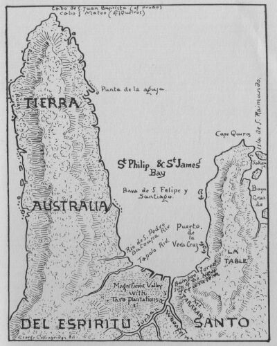
XI. Queiroz's Voyage. A Spanish Map of the Bay
of St. Philip and St. James, in Espiritu-Santo Island (New
Hebrides)
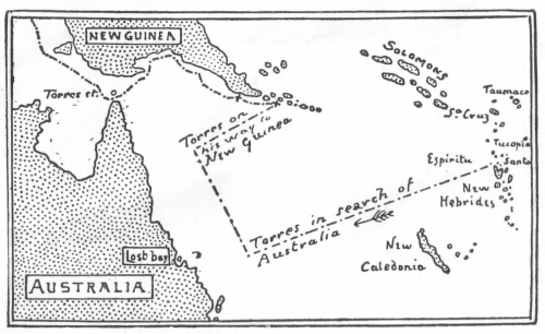
XII. Torres' Discoveries
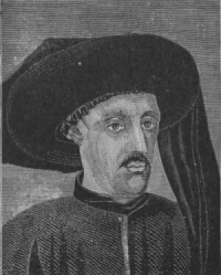
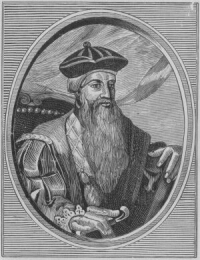
1. Prince Henry the Navigator
2. Statue of Prince Henry
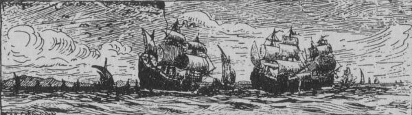
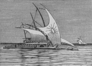
3. Portuguese Fleet
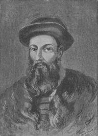
4. Magellan
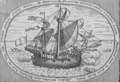
5. The Victoria
6. The Trinidad in a Squall
7. Flying Fish (From an Old Map)
8. Sebastian del Cano
9. Scene in the Spice Islands
10. Tidor Volcano, seen from Ternate
11. The Cassowary
12. Spanish Ships
13. Nutmegs and Cloves, from an Old
Chart
14. Banda Volcano
15. Diego do Couto's Pig
16. Malay Press
17. Spanish Ships
18. Guinea Fowl
19. Scene in New Guinea
20. Spanish Caravels
21. The Great Albuquerque
22. Bamboos
23. Guanaco
24. Marco Polo
25. Ant Hills
26. Mendana's Fleet
27. Crescent-shaped canoes
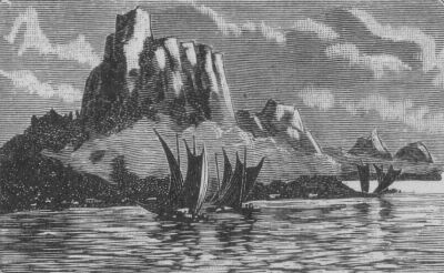
28. Scene in the Solomon Islands
29. Tinacula Volcano, from Santa Cruz
30. Queiroz's Fleet
31. An Atoll Reef
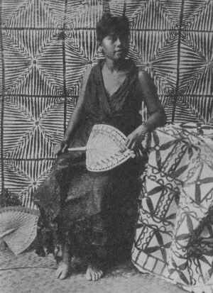
32. Type of Island Woman
33. War Drums
34. Scene in the Solomon Islands
1. Portuguese Hemisphere
2. Spanish Hemisphere
3. Timor, from an Old Chart
4. Australia and Jave-la-Grande
compared
5. Santa Ysabel Island
6. Guadalcanal Island
7. Santa Cruz Island
8. The Earliest Map of the Solomon
Islands
9. Queiroz's Track
10. Tierra Australia del Espiritu
Santo
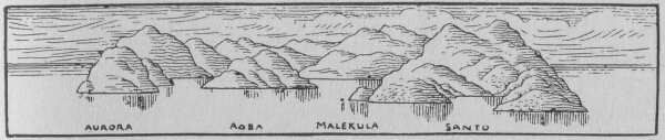
11. New Hebrides
12. The Big Bay of Santo
13. New Holland
14. Torres' Track
1. The Earliest Drawing of a
Wallaby
2. The Spice Islands, from Ribero's
Official Map of the World
3. Nova Guinea--The First Map of New
Guinea
4. Jave-la-Grande--The First Map of
Australia
5. Don Diego de Prado's Map of the Bay of
St Philip and St James in Espiritu Santo
6. Don Diego de Prado's Map of the Islands
at the South-east end of New Guinea
7. Pierre Desceliers' Map of
Australia
8. Desliens' Map of Australia
9. Moresby's Map of the Islands at the
South-east end of New Guinea
10. The Great Bay of St Lawrence
11. Bay of St Peter of Arlanza
Of the many books which have been published on subjects relating to Australia and Australian History, I am not aware of any, since my late friend, Mr. R. H. Major's introduction to his valuable work, "Early Voyages to Terra Australis," which has attempted a systematic investigation into the earliest discoveries of the great Southern Island-Continent, and the first faint indications of knowledge that such a land existed. Mr. Major's work was published in 1859, at a time when the materials for such an enquiry were much smaller than at present. The means of reproducing and distributing copies of the many ancient maps which are scattered among the various libraries of Europe were then very imperfect, and the science of Comparative Cartography, of which the importance is now well recognised, was in its infancy. For these reasons his discussion, useful though it still is, cannot be regarded as abreast of modern opportunities. It is, indeed, after the lapse of more than a third of a century, somewhat out of date. Having, therefore, been led to give close attention during several years to the whole subject, I have thought the time ripe for the present work.
The distance from the great centres and stores of knowledge at which I have been compelled to labour will excuse to the candid critic the errors which will no doubt be discovered; yet I feel some confidence that these will prove to be omissions rather than positive mistakes. No pains have been spared in investigating the full body of documents now available.
Though unable to examine personally some manuscripts of interest and value, I believe I can truly say that I have read every book and examined every map of real importance to the question which has been produced in English, French, Spanish, Portuguese, Italian and Dutch. I have corresponded also largely during the past four years with many of the most eminent members of the Geographical Societies of London, Paris, Madrid, Lisbon, Rome, Amsterdam and Neuchatel. To these gentlemen I am deeply indebted for searches which they have made for me in the libraries and museums within their reach, for much information readily and kindly afforded, and for the interest and sympathy which they had at all times manifested in my labours. My thanks are due also to the gentlemen in charge of the Sydney Free Public Library who kindly enriched their collection with many rare, and very useful volumes of permanent importance which I was unable to procure myself, and who aided my researches by every means in their power.
I cannot hope that in a subject so vast and interesting, I shall be found to have said the last word, yet I trust that my book may prove to be of value, both in itself, and as directing the attention of others to a field which should be mainly explored by residents of Australia. Such as it is, I now send it forth, with the natural solicitude of a parent, and commend it to the indulgence of the reader, and the kindly justice of the critic.
GEORGE COLLINGRIDGE,
"Jave-la-Grande,"
Hornsby Junction,
July, 1895.
Ten years ago, Mr. George Collingridge published "The Discovery of Australia."--a large quarto volume, bulky, erudite and expensive. It took its place as a valuable contribution to the literature of the country, and remains the world-accepted authority on the important and interesting subject with which it deals. But it was in nowise suited to the general reader--being designed more for the scholar than for the person who desired to conveniently possess himself of authentic information relating to the earliest annals of Australian discovery.
To meet the requirements of the general reader, and to serve as a text book of Australian History, the present publication has been issued as a handy compendium of the original volume.
From this book, all controversial matter has been omitted as irrelevant to a work intended as a handbook for either scholar or student.
The valuable facsimiles of rare and ancient maps have been retained, many illustrations have been included in the text, and the story of the explorers has been dealt with at greater length by the author, whose patient antiquarian research, his knowledge of European and Oriental Languages, and his opportunities as a member of several Geographical Societies, have given him unusual facilities for the compilation of a work which may confidently be expected to find its way into every scholastic, public and private library in the Commonwealth.
THE PUBLISHERS.
The discovery of a continental island like Australia was not a deed that could be performed in a day. Many years passed away, and many voyages to these shores of ours were undertaken by the leading maritime nations of Europe, before the problematic and mysterious TERRA AUSTRALIS INCOGNITA of the ancients became known, even in a summary way, and its insularity and separation from other lands positively established.
We must not be astonished, therefore, at the strange discrepancies that occur in early charts and narratives, for it took time to realize how different portions of our coast lines, which had been sighted from time to time might be connected, and how the gaps might be filled in by fresh discoveries and approximate surveys.
The question as to who first sighted Australia, and placed on record such discovery, either in the shape of map or narrative, will, in all probability, ever remain a mystery.
However, that such a record was made appears evident when we consider certain early charts, follow carefully the testimony which the evolution of Australian cartography affords, and take cognisance of various descriptive passages to be found in old authors.
These passages will be given here in connection with the old charts, and followed up by the narratives of voyages in search of the "Great South Land."
The numerous maps and illustrations have been carefully selected; they will greatly help the student towards understanding these first pages of the history of Australia.
GEORGE COLLINGRIDGE.
Prince Henry the Navigator
"And the New South rose with her forehead bare--
Her forehead hare to meet the smiling sun--
Australia in her golden panoply;
And far off Empires see her work begun,
And her large hope has compassed every sea."
--SIR GILBERT PARKER.
What was the relative position of European nations in the arena of maritime discovery at the beginning of the sixteenth century?
Portugal was then mistress of the sea.
Spain, too, indulging in an awakening yawn, was clutching with her outstretched hands at the shadowy treasure-islands of an unfinished dream.
England had not yet launched her navy; Holland had not built hers.
Portugal had already buried a king--the great grandson of Edward III. of England--whose enterprise had won for him the name of Henry the Navigator.
Portuguese Hemisphere and Spanish Hemisphere
Slowly and sadly--slowly always, sadly often--his vessels had crept down the west coast of Africa; little by little one captain had overstepped the distance traversed by his predecessor, until at last in 1497 a successful voyager actually rounded the Cape.
Portuguese Fleet
Then Portugal, clear of the long wall that had fenced her in on one side for so many thousands of miles, trod the vast expanse of waters to the east, and soon began to plant her flag in various ports of the Indian Ocean. [See Portuguese flags on Desliens' Map.]
Pushing on further east in search of the Spice Islands, she found Sumatra, Borneo, the Celebes, Java, Timor, Ceram, the Aru Islands and Gilolo; she had reached the famous and much coveted Moluccas, or Spice Islands, and set to work building forts and establishing trading stations in the same way as England is doing nowadays in South Africa and elsewhere.*
[* In a chart of the East Indian Archipelago, drawn probably during the first Portuguese voyages to the Spice Islands (1511-1513), the island of Gilolo is called Papoia. Many of the islands situated on the west and north-west coast of New Guinea became known to the Portuguese at an early date, and were named collectively OS PAPUAS. The name was subsequently given to the western parts of New Guinea. Menezes, a Portuguese navigator, is said to have been driven by a storm to some of these islands, where he remained awaiting the monsoonal change.]
Meanwhile the Spaniards, after the discovery of America by Columbus, were pursuing their navigations and explorations westward with the same object in view, and it soon dawned upon them that a vast ocean separated them from the islands discovered by the Portuguese.
Magellan was then sent out in search of a westerly passage; he reached the regions where the Portuguese had established themselves, and disputes arose as to the limits of the Portuguese and Spanish boundaries.
Pope Alexander VI. had generously bestowed one-half of the undiscovered world upon the Spanish, and the other half upon the Portuguese, charging each nation with the conversion of the heathen within its prospective domains.
Merely as a fact this is interesting enough, but viewed in the light of subsequent events it assumes a specific importance.
The actual size of the earth was not known at the time, and this division of Pope Alexander's, measured from the other side of the world, resulted in an overlapping and duplicate charting of the Portuguese and Spanish boundaries in the longitudes of the Spice Islands,* an overlapping due, no doubt, principally to the desire of each contending party to include the Spice Islands within its own hemisphere, but also to the fact that the point of departure which had been fixed in the vicinity of the Azores, was subsequently removed westward as far as the mouth of the Amazons.
If Portugal and Spain had remained to the present day in possession of their respective hemispheres, the first arrangement would have given Australia and New Guinea to Portugal; whereas the second arrangement would have limited her possessions at the longitude that separates Western Australia from her sister States to the east, which States would have fallen to the lot of Spain. Strange to say, this line of demarcation still separates Western Australia from South Australia so that those two States derive their boundary demarcation from Pope Alexander's line. A few years after the discovery of the New World the Spanish Government found it necessary, in order to regulate her navigations, and ascertain what new discoveries were being made, to order the creation of an official map of the world, in the composition of which the skill and knowledge of all her pilots and captains were sought. Curiously enough, as it may appear, there is an open sea where the Australian continent should be marked on this official map.
Majellan
Are we to infer that no land had been sighted in that region?
Such a conclusion may be correct, but we must bear in mind that prior to the year 1529, when this map was made,* the Spaniards had sailed along 250 leagues of the northern shores of an island which they called the Island of Gold, afterwards named New Guinea, and yet there are no signs of that discovery to be found on the Spanish official map. It is evident, therefore, that this part of the world could not have been charted up to date. This is not extraordinary, for it was not uncommon in those days, nor was it deemed strange that many years should elapse before the results of an expedition could be known at head-quarters. In order to realise the nature of the delays and difficulties to be encountered, nay, the disasters and sufferings to be endured and the determination required for the distant voyages of the period, we have but to recall the fate of Magellan's and Loaysa's expeditions.
[* See the Ribero Map.]
The Victoria
Those navigators were sent out in search of a western passage to the Spice Islands, and with the object of determining their situation.
Of the five vessels which composed Magellan's squadron, one alone, the Victoria, performed the voyage round the world.
The S. Antonio deserted in the Straits which received Magellan's name, seventy odd of the crew returning to Spain with her.
The Santiago was lost on the coast of Patagonia.
The Concepcion, becoming unfit for navigation, was abandoned and burnt off the island of Bohol, in the St. Lazarus Group, afterwards called the Philippines.
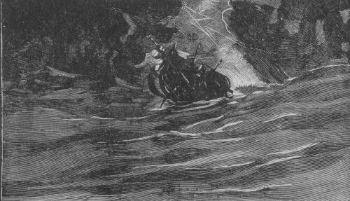
The Trinidad was lost in a heavy squall in Ternate Roads, and all hands made prisoners by the Portuguese. Many of them died, and, years after, only four of the survivors reached their native shores.
The Trinidad in a Squall
The Victoria, after an absence of three years all but twelve days, returned to Spain with thirty-one survivors out of a total crew of two hundred and eighty. The remaining one hundred and sixty or seventy had perished. It is true that some of those shared the fate of Magellan, and were killed in the war undertaken in the Philippines to help their allies.
The fate of Loaysa's armada was still more disastrous. A short description of it will be given in the next chapter.
Notwithstanding all these drawbacks, the period was one of great maritime activity, and many unauthorised and clandestine voyages were also performed, in the course of which Australia may have been discovered, for the western and eastern coasts were charted before the year 1530, as we shall see by and by.
Flying Fish (From an Old Map)
Sebastian del Cano
Whilst the Portuguese and Spaniards were fighting for the possession of the "Spicery," as they sometimes called the Moluccas, the old dispute about the line of demarcation was resumed in Spain and Portugal. It was referred to a convocation of learned geographers and pilots, held at Badajoz, on the shores of the Guadiana.
Those learned men talked and argued, and their animated discussions extended over many months; but no decision was arrived at.
Sebastian del Cano, who had been appointed commander after Magellan's death at the Philippines, and had returned to Spain with the remnant of the expedition, had been called upon to report his views at the meetings, but he, also, had not been able to prove under what longitude the Spice Islands were situated; and now another fleet was ordered to be fitted out to make further investigations.
It was entrusted to Garcia Jofre de Loaysa, with del Cano as pilot-major, and other survivors of Magellan's armada.
They sailed from Coruna in July, 1525, with an armament of seven ships. Every precaution was taken to ensure the success of the voyage, but the expedition proved a most disastrous one notwithstanding. During a fearful storm del Cano's vessel was wrecked at the entrance to Magellan's Straits, and the captain-general was separated from the fleet.
Francisco de Hoces, who commanded one of the ships, is reported to have been driven by the same storm to 55 deg. of south latitude, where he sighted the group of islands which became known at a later date under the name of South Georgia and South Sandwich Islands.
It was April before the rest of the fleet entered Magellan's Straits, and the passage was tedious and dismal, several of the sailors dying from the extreme cold. At last, on the 25th of May, 1526, they entered the Pacific Ocean, where they were met by another storm, which dispersed the fleet right and left.
On this occasion an extraordinary piece of good luck befel one of the small vessels of the fleet--a pinnace or row boat, of the kind called pataca, in command of Joam de Resaga, who steered it along the coast of Peru, unknown at the time, and reached New Spain, where they gave an account to the famous conquerer of Mexico, Fernand Cortez, telling him that Loaysa was on his way to the islands of cloves.*
[* It is strange that this voyage, along the coasts of an hitherto unexplored country, preceding as it did, not only the conquest of Peru by Pizarro, but even the arrival of that conquistadore in the South Pacific Ocean, should have remained unknown by Prescott and all other historians of the conquest of the Land of the Incas.]
The remnant of the fleet steered a north-westerly course when once in the Pacific Ocean.
They were in a sore plight. Both commanders were sick, and, nearing the Line, on the 30th of July, Loaysa died. Four days after, Sebastian del Cano, who had escaped and weathered so many storms and dangers, expired also, leaving the command of the expedition to Alonzo de Salazar.
Salazar steered for the Ladrones. On the 4th of September he arrived at that group, where he met Gonzalo de Vigo, one of the seamen of the Trinidad.
From the Ladrones the expedition sailed for the Philippines, and on the way Alonzo de Salazar, the third commander, died.
Martin de Iniquez was now appointed to the command, and it was November before they came to anchor at Zamofo, a port in an island belonging to the King of Tidor, who had become their ally during their previous voyage.
Disputes immediately arose between the Spaniards and the Portuguese commander settled at Ternate. A war ensued, which lasted for several years, with various degrees of success and activity, the people of Tidor supporting the Spaniards and those of Ternate the Portuguese settlers.
Galvano, the Portuguese historian of the Moluccas, and a resident there for many years, informs us that only one vessel of Loaysa's fleet reached the Spice Islands. The fourth commander, Martin de Iniquez, died some time after, poisoned, it is said, and the command of the remnant of the expedition was entrusted to Hernando de la Torre. But the only vessel left was found to be so much damaged in repeated actions with the Portuguese that it had become unfit for the homeward voyage.
About this time, 1527, Fernand Cortez, the conqueror of Mexico, sent from New Spain his kinsman, Alvaro de Saavedra, in search of Loaysa's expedition.
Saavedra set out from the Pacific coast with three armed vessels and one hundred and ten men.
Two of the vessels were almost immediately separated from the commander, and their destiny remains a mystery to the present day.
Saavedra, however, in command of the Santiago pursued his course alone and reached the Spice Islands, after a voyage of a little over two months.
His countrymen were delighted to see him, but remembering their own sad experiences, would hardly credit that he had come from New Spain in so short a time.
He was immediately attacked by the Portuguese, and various engagements took place in which he was supported by the survivors of Loaysa's armada, who had now built a brigantine out of the planks of their famous fleet of seven vessels.
Meanwhile Saavedra, during the intervals of peace, did not neglect to load up his good ship with spices, and, in the beginning of June, 1528, he set sail for New Spain. The prevailing winds that had favored his outward passage were now against him. He tried to avoid them by taking a southerly course, and, in doing so, he fell in with the northern coast of New Guinea, the shores of which, as I have intimated, he followed for no less than 250 leagues.
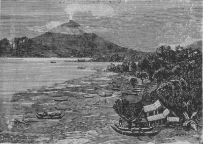
Scene from the Spice Islands.
The Spaniards found traces of gold all along this part of the country, and Saavedra named the island Isla del Oro, the Island of Gold; but his description of the natives, whom he found to be black, with short crisped hair or wool, similar to those of the coast of Guinea in Africa, gave rise, no doubt, to the alteration in the name, for at a later date the island became known as Nova Guinea, or New Guinea.
Upon leaving the shores of New Guinea, Saavedra hoped to be able to reach New Spain, but the head winds which still prevailed compelled him to return to the Spice Islands.
The following year, in May, 1529, in another attempt to reach New Spain, he again coasted along the northern shores of New Guinea; he then sailed to the north-east, as in his previous voyage, and discovered some islands which he called Los Pintados, from the natives being painted or tattooed.
The people were fierce and warlike, and from a canoe boldly attacked the ships with showers of stones thrown from slings.
To the north-east of Los Pintados several low inhabited islands or atolls were discovered, and named Los Buenos Jardines, "The Good Gardens."
Saavedra cast anchor here, and the natives came to the shore, waving a flag of peace; they were light-complexioned and tattooed. The females were beautiful, with agreeable features and long black hair; they wore dresses of fine matting. When the Spaniards landed, they were met by men and women in procession, with tambourines and festal songs. These islands abounded in cocoanuts and other vegetable productions.
From the Good Gardens Islands they set out again towards New Spain.
On the 9th of October, 1529, Saavedra died; and the next in command, vainly attempting to make headway in an easterly direction, returned once more to the Spice Islands.
The remnant of Saavedra's expedition reached Spain, by way of the Cape of Good Hope and Lisbon, seven years later, in 1536.
According to Galvano, the Portuguese historian, Saavedra's discoveries in 1529 were more extensive than in 1528. He says the Spaniards coasted along the country of the Papuas for five hundred leagues, and found the coast clean and of good anchorage.
The year that witnessed the return from the Spice Islands of the survivors of Saavedra's expedition, 1536, witnessed also the sailing of another fleet sent out from New Spain by Fernand Cortez to discover in the same waters.
It consisted of two ships commanded by Grijalva and Alvarado.
The account of this voyage of discovery is very vague, and the various writers on the subject do not entirely agree. This is due, perhaps, to the fact that Alvarado abandoned the enterprise from the start, and went to the conquest of Quito, in Peru, leaving the sole command to Grijalva.
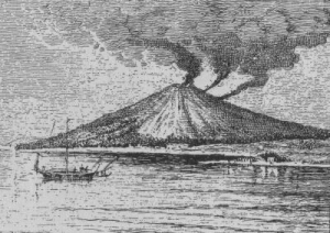
Tidor Volcano, seen from Ternate.
It appears certain, however, that Grijalva visited many islands on the north coast of New Guinea, and one, in particular, called Isla de los Crespos, Island of the Frizzly Heads, at the entrance of Geelvinck Bay, near which a mutiny occurred, and Grijalva was murdered by his revolted crew.
His ship was wrecked, and the expedition came to an end, a few of the survivors reaching the Spice Islands in 1539.
Most of the names given during the course of the exploration are difficult to locate.
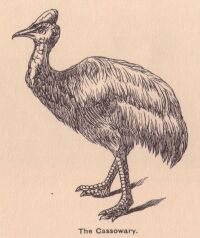
Besides the various place-names mentioned by Galvano, Ostrich Point, the Struis Hoek of later Dutch charts, is, perhaps, a reminiscence of this untimely voyage.
A casoar, or cassowary, would, of course, be called an ostrich, and here we have for the first time in history a picturesque description of that Australasian bird.
Galvano's translator says: "There is heere a bird as bigge as a crane, and bigger; he flieth not, nor hath any wings wherewith to flee; he runneth on the ground like a deere. Of their small feathers they do make haire for their idols."
The Cassowary
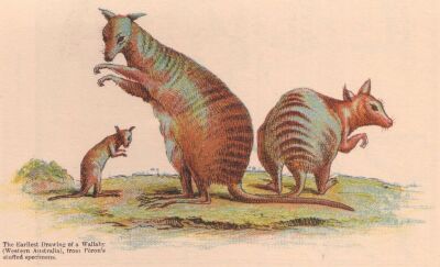
The Earliest Drawing of a Wallaby (Western Australia) from Péron's stuffed specimens.
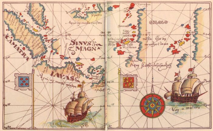
The Spice Islands, from Ribero's Official Map of the World. (Portugese and Spanish hemispheres)
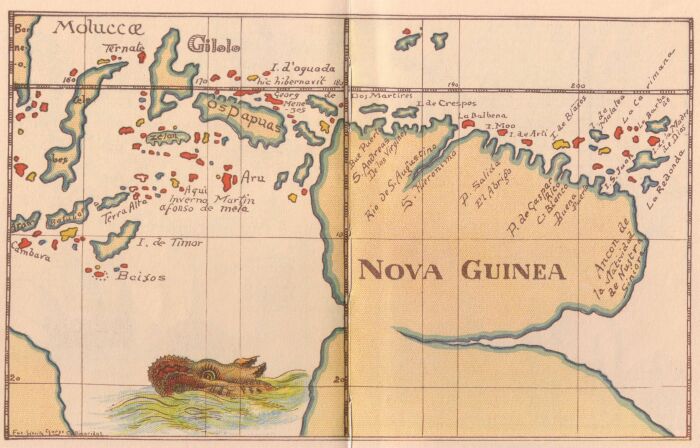
Nova Guinea--The First Map of New Guinea 1600. (Portugese and Spanish hemispheres)
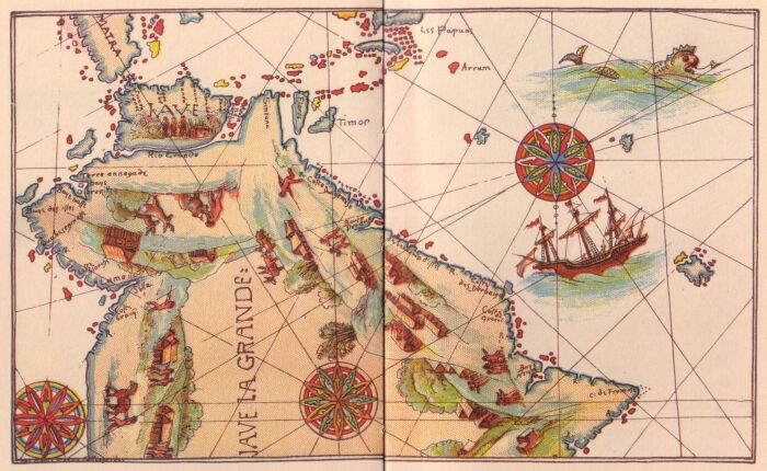
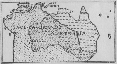
Jave-la-Grande--The First Map of Australia, known also as the "Dauphin Chart--1530-36. (Portugese and Spanish hemispheres)
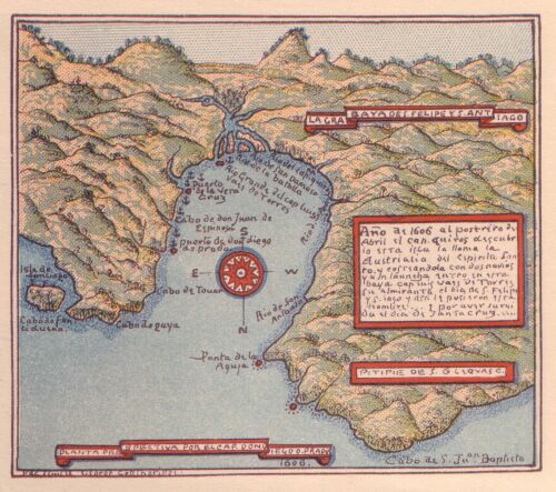
Don Diego de Prado's Map of the Bay of St Philip and St James in Espiritu Santo (New Hebrides).
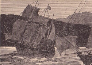
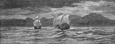
Spanish Ships
I must now say a few words about the official map of the world, alluded to on page 16. It is by Ribero, and will be found on pages 28 and 29. The date of this map is 1529.
The portion reproduced shows the Spice Islands, and a glance at this part of the world brings vividly to our minds the intense desire of each contending party to possess a region that yielded the wealth that is here described.
The map is Spanish, and Spain has allotted to herself the lion's share, planting her flag in the midst of "Spice and everything nice" (see Spanish hemisphere), and relegating the Portuguese flag to the Straits of Sunda (see Portuguese hemisphere). For thousands of miles around, ships--the seas are dotted with specimens similar to the two included within our small area--fleets of them, converge towards, or sail away from these spice-bearing islands. Every quaint old craft, whether light caravel or crazy galleon, is underwritten with the legend, Vengo de Maluco, I come from the Moluccas, or, Vay a Maluco, I go to the Moluccas, as though that region were the only one on the face of the globe worthy of consideration. And all that "Province of Maluco" bears inscriptions denoting the particular product for which each island is celebrated.
These are:--
Timor, for Sandal-wood; Java, for Benzoin;* Borneo and Celebes,
for Camphor; Amboyna, for Mace and Nutmegs; and last, not least,
Gilolo, for Cloves.
[* Benzoin, a fragrant gum-resin obtained from Styrax Benzoin, used in pharmacy, and as incense.]
Let us now consider some other features of this map. The overlapping of territorial boundaries to which I have alluded, is apparent here in the repetition of the western coast line of Gilolo.
It will be seen that the Spanish map claims Gilolo and the other Spice Islands, such as Ternate, Tidor, Batchian, etc., since they are set down, in the western half of the world.
This is wrong, for those islands virtually fell within the Portuguese sphere. I have purposely drawn your attention to these deceptions and distortions on this Spanish map because on the first map of Australia, which we shall consider by and by, we shall see that the Portuguese made use of similar methods which they, of course, turned to their own advantage.
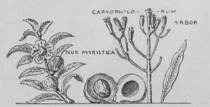
Nutmegs and Cloves, from an Old Chart
For instance, they blocked the sea-way to the south of Java, and, in other ways, restricted the approach to the Spice Islands to channels over which they had control. Observe that the smaller islands of the East Indian Archipelago, from Java to Flores, are not charted, although they were well-known at the time. There must have been a reason for this, for these missing islands are precisely those which we shall find grafted on to the Australian continent (Jave-la-Grande) in the charts that we are coming to.
Observe also that the south coast of Java is not marked. The reason for this is obvious, the south coast was not known. Java, indeed, was believed to be connected with the Great Southern Continent, and was called Java Major, to distinguish it from Sumatra, which was named Java Minor.
Banda Volcano
In proof of the Portuguese belief concerning the connection and size of Java, I quote here what Camoëns, their immortal poet, says:--
"Olha a Sunda* tao larger, que huma banda[* Another name for Java.]
Esconde pare o Sul difficultuoso."
Os Lusiadas.
Java behold, so large that one vast end
It, covers towards the South tempestuous.
Diego do Couto's Pig
Towards the year 1570, however, practical Portuguese seamen had become aware of a more accurate shape for Java, and Diego do Couto, the Portuguese historian, describes its shape in the following manner:--
"The figure of the island of Java resembles a pig couched on its fore legs, with its snout to the Channel of Balabero,* and its hind legs towards the mouth of the Straits of Sunda, which is much frequented by our ships. The southern coast, [pig's back] is not frequented by us, and its bays and ports are not known; but the northern coast [pig's stomach] is much frequented, and has many good ports."
[* Modern Straits of Bali.]
Malay Press
After various treaties, signed at Segovia, Seville and Zaragoza, the King of Spain renounced at last, his claim to the Spice Islands, for the sum of 350,000 ducats.
But this agreement did not interfere with other possessions of the Spanish crown, nor did it prevent the Spaniards from making fresh conquests within the limits which had been allotted to them.
Meanwhile the Portuguese were more active in their explorations.
Making the Spice Islands the centre of their enterprise, under the guidance and governorship of Galvano, the "Apostle and historian of the Moluccas," they sent their caravels in every direction, equipping also native junks and proas for purposes of trade and discovery. From Japan in the north, to Timor in the south, and from Java in the west, to the Carolines and Ladrones in the east, they penetrated everywhere.
The Spaniards on their side continued to lay claim to the islands of the archipelago of St. Lazarus, discovered by Magellan, and, after Villalobos expedition, called the Philippine Islands, in honour of Phillip II. of Spain.
These islands, situated outside the Spanish sphere, had fallen under Portuguese sway by treaties with the native kings, and by conquests made after the death of Magellan.
Of these events the Spanish government knew but little, but Magellan's initiatory work and conquests were not to be abandoned, and Don Antonio de Mendoza, the Viceroy of New Spain, was ordered to equip and send out a colonising expedition without delay.
It was entrusted to Ruy Lopez de Villalobos, and set sail from New Spain on the 1st of November, 1542.
Timor, from an Old Chart
The Armada was composed of six ships and four or five hundred soldiers. On their way from the west coast of North America to the Philippines, they discovered many islands in the North Pacific Ocean; among others the Hawaiian Group, visited many years after by Cook, and named by him the Sandwich Islands.
In 1543 one of the ships belonging to the fleet, the San Juan, commanded by Bernardo della Torre, with Gaspar Rico as first pilot, made an attempt to return to New Spain.
But in their numerous efforts to reach America from the Great Asiatic Archipelagoes, the Spaniards had not yet found out the proper season nor latitude to sail in, and through their want of knowledge concerning the periodicity of the winds in those regions, they met with many disappointments and mishaps.
In Bernardo della Torres' attempt, many islands were discovered, and, after sailing seven hundred leagues in their estimation, the wind failing, they were compelled to return to the Philippines.
Meanwhile the attempt at colonisation had been a failure and the fleet had sailed away and reached the Moluccas, to which islands della Torre repaired.
In the year 1545 the San Juan was despatched again.
She was now commanded by Inigo Ortiz de Retez, Gaspar Rico being still the pilot. They sailed from Tidor in the Moluccas, in the beginning of the year, and made extensive discoveries on the north coast of Os Papuas, or Papua, which discoveries will be seen on the old Spanish chart in the next chapter.
Spanish Ships
One of the three great Papuan rivers, the river now called the Amberno, was discovered and was named the S. Augustino, and formal possession was taken in the name of the King of Spain.
Guinea Fowl
Had the Portuguese and Spanish known the map of New Guinea as we know it nowadays they would, no doubt, have described it as a Guinea fowl, Bird of Paradise or some such creature, as delineated above, in the same way as they described Java and other islands in these seas.*
[* Celebes was likened to a spider, Ceram to a caterpillar, etc., etc.]
The map of Nova Guinea, shows, however, that their ideas were like all original ideas concerning shapes of countries--imperfect.
Nevertheless, some of the principal features of the Portuguese and Spanish discoveries in Papuas and New Guinea, up to the year 1545, are clearly discernible.*
[* The original Portuguese and Spanish documents that were used in the compilation of this map have been lost or have not yet come to light. Our copy dates from the year 1600.]
It will be noticed that Gilolo is now placed in its correct position, twenty degrees to the west of where it was placed before in Ribero's map.
It is now in the Portuguese sphere where it should be.
The Portuguese discoveries in New Guinea occupy what might be described as the fowl's head and neck. They come under the name of OS PAPUAS, and the islands where Menezes is said to have sojourned--hic hibernavit Georg de Menezes--in the year 1526.
The three nameless large islands, between Os Papuas and Nova Guinea represent, no doubt, the Misory Islands and Jobi of modern charts.
The Aru Islands are also charted, and the Tenimber or Timor Laut group is indicated (although it bears no name) as having been the sojourn of Martin Alfonso de Melo,* a Portuguese navigator, whose name has not been otherwise recorded, as far as I know, in the history of maritime discovery in these parts.
[* Martin afonso de mela, on the chart.]
Scene in New Guinea
SPANISH SPHERE.
The Spanish portion commemorates the expedition of Inigo Ortiz de Retez with Gaspar Rico, in the San Juan, in the year 1545; some of the names being the Rio de S. Augustino; the island of Ortiz, I de Arti; the port of Gaspar Rico and the I. S. Juan, named after their little ship; the cape named Ancon de la Natividad de Nustra Siniora, being the term of their voyage which, according to Juan Gaetan, one of Villalobos' pilots, who wrote a description of it, extended to six or seven degrees of south latitude, must represent the modern Cape King William, or thereabouts.
Spanish Caravels
The maps that I am going to describe in this chapter are beautiful specimens of medieval work; they are, however, somewhat startling, for they reveal, in a most unexpected and sudden manner, nearly the whole of the coasts of Australia discovered, yet, without any narrative of voyage to prepare us for the fact.
They stand alone, therefore, as the most important documents hitherto come to light bearing on the early discovery and mapping of Australia.
They belong to a type of manuscript Lusitano-French, or Lusitano-Spanish planispheres, which is represented by several specimens, all of which are copies from a prototype which has either been destroyed or has not yet been found.
As the original model, or prototype, is of a date anterior to 1536, they may be considered collectively notwithstanding the apparent later date of some of them.*
[* Desliens' bears the date 1566; see pages 70-71.]
The Australian portion, or Jave-la-Grande, of the oldest one, given here first, is taken from a large chart of the world, on a plane scale, painted on vellum, 8ft. 2in. by 3ft. 10in., highly ornamented with figures, etc., and with the names in French.
At the upper corner, on the left hand, is a shield of the arms of France, with the collar of St. Michael; and on the right, another shield of France and Dauphiny, quarterly. It was probably executed in the time of Francis I. of France, for his son, the Dauphin, afterwards Henry II.; hence, this chart has sometimes been called the "Dauphin Chart."*
[* Another of these planispheres, belonging to the same French School of Cartography, was presented to Henry II. of France. About that time a movement was set on foot for the colonisation of the Great Southern Continent, or Jave-la-Grande. The promotors failed in their endeavours, and one of them went to England with the hopes of better success; he also failed in his efforts, and the great colonising scheme was abandoned.]
The Great Albuquerque
This chart formerly belonged to Edward Harley, Earl of Oxford and one of the principal Lords of the Admiralty, after whose death it was taken away by one of his servants. It. was subsequently purchased by Sir Joseph Banks, Bart., and presented by him to the British Museum in 1790.
Copies of this and other maps of the same category, have been made for the Sydney, Melbourne and Adelaide Free Public Libraries, at considerable expense. This was a wise step on the part of our governments, for the strongest evidence of early discovery as yet brought to light is shown in the draughting of these old charts of Australia.
Unfortunately, as I have said, they are all mere copies of copies, the first of which were more or less altered in outline and corrupted in nomenclature, from a prototype which has not yet been found.
But, if the internal evidence of these odd charts clearly shows the original or originals to have been Portuguese or Spanish, one point of the question will be settled, and the Portuguese and Spanish will undoubtedly be entitled to the claim and honor of having discovered Australia.
As to the matter of date, that is of less importance, and can be fixed approximately, for the discovery must have taken place at some period between the arrival of the Portuguese and Spanish in these seas and the draughting of the earliest known chart, that is between the years 1511 and 1536, a period of 25 years.*
[* When the Portuguese reached India and the East Indian Archipelago (1511) they were the masters in those seas, and became the possessors of many charts used by Javanese, Malay, Chinese, and Arabian sailors.
The great Albuquerque refers to a large chart of this description, which was afterwards lost at sea, but of which copies had been made by the pilot Rodriguez. It showed all the coasts and islands from China, the Spice Islands, and Java, to the Cape of Good Hope and Brazil. It is difficult to believe that the Javanese, Malays, Chinese, or Arabs had any knowledge of Brazil in South America, although the Malays and Arabs had rounded the Cape of Good Hope, coming from the east side, of course. I am inclined to think that the term Brazil mentioned by Albuquerque refers to Australia, which had been called Brasilie Regio from an early date--a date prior to the discovery of Brazil in the year 1500. See, on this subject, my paper in the proceedings of the Royal Geographical Society of Australasia under the heading "Is Australia the Baptismal Font of Brazil?" Vol. VI., No. 1, Sydney, N.S.W.]
But, after all, until the very date of the expedition which resulted in the first discovery can be ascertained, the question of nationality of the first discoverers is a much more interesting one.
Having no other documentary evidence except these old charts, the first conclusion drawn was that as they are all written in French, the French were the discoverers in spite of the fact that no French claim had been made.
The late R. H. Major, the author of "Early Voyages to. Australia," having thoroughly considered the possibility of a French claim, came to the conclusion that such a claim was untenable. Being somewhat shaken, however, in his first belief of a Portuguese discovery, he was led to adopt a Provençal theory to explain certain words which on these old Gallicized charts, were neither Portuguese nor French. The whole subject was in this state of incertitude and confusion, when, a few years ago, having occasion to examine minutely these old documents, I discovered on the oldest of them a phrase in Portuguese, which, curiously enough, had escaped the notice of all the learned critics who had made a special study of this early specimen of cartography.
The phrase I had discovered, "Anda ne barcha," or "No boats go here," situated as it is in the Gulf of Carpentaria, had, in my mind, a very great significance, since it not only proves the Portuguese origin of the chart, but also the genuineness of the discovery made in that as it showed that the discoverers were fully aware of the shallowness of the water off this part of the coast of Australia.
It must be admitted however, that on the original chart the nautical phrase "Anda ne barcha," may refer to the difficulty of navigating the strait between Java and Bali, or the one between Bali and Lomboc.
When I say that this phrase proves the Portuguese origin of the chart, I do not mean to convey the idea that I accepted it, there and then, as a proof of Portuguese origin, but I rather took it as a clue, for the meaning of those words had evidently not been understood by the copyist, since he had left them in their original form, instead of translating them into French, and had mistaken them for the names of two islands.
This clue led me to make a special study of every word on the chart that had proved so interesting, the result being that I came to the conclusion that the western coasts of Australia had been chartered by the Portuguese, whereas the eastern coasts, which fell within the hemisphere allotted to the Spaniards, had been discovered and charted by them.
If we take for granted--and I think we may--that these charts are unquestionably of Portuguese and Spanish origin, the next point of importance that calls for our attention relates to the peculiar configuration, or, to be more precise, the strange distortion which all these specimens have undergone. This distortion is so great that one might fail to recognise Australia within the coast line set down, were it not for the general fitness of the terms used as descriptive of this coast line, terms which have been handed down to us in the course of the geographical evolution, and some of which are recorded in the very maps we use every day.
Australia and Jave-la-Grande compared
Moreover, we have the equally important fact that within the latitudes and longitudes charted, Australia does actually hold its place in the vast ocean around. See map of Australia and Jave-la-Grande compared, given here.
We must make great allowance for the measurement of longitudes as computed in the days when the first circumnavigators were called upon to determine whether the Moluccas fell within the Spanish or the Portuguese territory, for, after their return, the matter was as unsettled as ever.
Albeit, the errors of these charts are far more suggestive of deliberate distortion than, of inaccurate charting.
In describing Ribero's chart, I made some remark about Spanish distortions. I come now to the Portuguese ones, which refer to this subject.
For instance, the Portuguese, who were the first to make discoveries in these seas, must have been perfectly aware that the coasts they had charted lay more to the east, and if they dragged them out of position and placed them under Java as shown in these maps, it was in order to secure to themselves the lion's share, for their line of demarcation, as fixed by Pope Alexander, did not extend much beyond the east coast of Timor.*
[* A contemporaneous Spanish pilot named Juan Gaetan, of whom we have already heard in connection with the Spanish voyages on the north coast of New Guinea [see pages 25, 26, 28], and who aboard Portuguese ships navigated all the seas to the north of Australia, has put the following remarks on record with reference to Portuguese charts.
He says: "I saw and knew all their charts. They were all cunningly falsified, with longitudes and latitudes distorted, and land-features drawn in at places and stretched out at others to suit their purposes, etc., etc., and when they found out that I understood their little pranks they made strenuous efforts to get me to enlist in their service, and made me advantageous offers, which, however, I scorned to accept."--In Ramusio.]
They could not have believed that Timor was situated to the east of the peninsula, now known as York Peninsula, and clearly shown in these charts, nor that there was not an open sea to the south of Java since the first circumnavigators, returning to Spain from Timor, with the last ship of Magellan's fleet, sailed through it. (See track of their ship on map of Timor, p. 40.)
But the secret was so well kept, that seventy-eight years after Magellan's voyage round the world, Java and Australia were still believed to be one and the same continent by certain otherwise well-informed navigators, as will be seen by Linschoten's "Discours of Voyages into ye East and West Indies," published in London, in the year 1598, in which the following description, from Portuguese sources, occurs:
"South, south-east, right over against the last point or corner of the Isle of Sumatra, on the south, side of the equinoctial line, lyeth the island called JAUA MAIOR, or Great Java, where there is a strait or narrow passage, called the strait of Sunda, of a place so called, lying not far from thence within the Isle of Java. The island beginneth under 7 degrees on the south side, and runneth east and by south 150 miles long; but touching the breadth it is not found, because as yet it is not discovered, nor by the inhabitants themselves well known."
"Some think it to be firme land* and parcel of the countrie called TERRA INCOGNITA, which, being so, should reach from that place to the Cape de Bova Sperace [Cape of Good Hope]; but as [?] it is not certainly known, and, therefore, it is accounted an island."
[* The term implies continental land]
The above passage [shows?] that the author was uncertain as to whether Australia, which he calls the Great Java, was connected or not with ANTARCTICA, which he terms TERRA INCOGNITA; and his hesitation may be readily understood when we consider that some maps of the period disconnected Java-la-Grande from the TERRE AUSTRALLE INCOGNEUE; whereas others connected it with Kerguelen and Tierra del Fuego.
Bamboos
THE ILLUMINATIONS.
I shall say a few words now about the illuminations. They form a conspicuous feature in these old maps, and lend a great charm to such productions of a bygone age; it would be a useless task, however, to seek in these quaint devices a strict pourtrayal of the scenes appertaining to the countries they might be supposed to illustrate; to do so would be to forget their chief purpose, the decorative. But, allowing for the liberty usually granted to the artist, nay, often exacted by him, the scenes depicted are not borrowed from the realms of "Idealism" to the extent that has been supposed by certain commentators.
The kangaroo is not represented; no, nor the gum-tree either, perhaps! But that clump of bamboos* on the top of a hill is not a volcano in full eruption, as a learned critic once ventured to assert.
[* Bamboos are plentiful on the north-western coasts of Australia, planted, no doubt, by Malay fishermen in search of trepang, who from time immemorial frequented those shores.]
We see, on these charts, fairly correct presentments of that animal seen for the first time by the Spaniards in the straits to which Magellan gave his name, and described by the Italian narrator, Pigafetta, who accompanied the first circumnavigators.
Pigafetta says:--
"This animal has the head and ears of a mule, the body of a
camel, the legs of a stag, and the tail of a horse, and like this
animal it neighs."
Guanaco
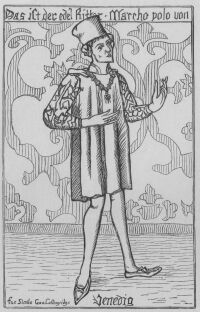
The animal thus described by Pigafetta is the Guanaco, Camelus huanacus, and it is not astonishing to find it represented on the Australian continent, for we know* that this continent was supposed to be connected with Tierra del Fuego and was sometimes called Magellanica, in consequence. In the chart that I am describing, Australia is called Jave-la-Grande--La Grande Jave would have been the proper French construction; but the term Jave-la-Grande is merely the translation of Java Maior, the Portuguese for Marco Polo's Java Major.
[* See remark above.]
Marco Polo
The great Venetian traveller, Marco Polo, described Java from hearsay as being the largest island in the world, and the Portuguese finding this to be incorrect, as far as their knowledge of Java proper was concerned, but finding nevertheless, this "largest island in the world" to the south-east of Java, in fact, approximately in the longitudes and latitudes described by Polo; the Portuguese, I say, did the best thing they could both for Marco Polo's sake and their own, when they marked it on their charts where it was said to be, and with the name given to it by Polo, for he calls it Java Major to distinguish it from Sumatra, which island he named Java Minor.
The channel or river, marked between Java and Australia, is evidently a concession due to the fact that a passage was known to exist. This channel, which is left white in the chart I am describing, is painted over in the specimen dated 1550 [see map pp. 68-69], as though it were blocked, and two men are represented with pick and shovel as in the act of cutting it open.
Curiously enough, in both maps, the upper silhouette of the landscape in this part defines the real south shore of Java.
On the continental part, the Australian Alps, the range of hills on the western and north-western coast, and the great sandy interior of Australia, are also roughly sketched in. Was it all guess-work?
PLACE-NAMES.
It will not be necessary, I think, to give an elaborate description of the place-names that occur on this map; those who wish to know more about them may consult my larger work on "The Discovery of Australia."
We need not dwell either on those that are inscribed along the northern shores of Java, well-known to the Portuguese twenty years at least before these maps were made.
The southern shores of Java are joined to Australia, or, at least, only separated from it by a fictitious river named Rio Grande, the Great River, which follows the sleek curve of the "pig's back" described by D. do Couto, the Portuguese historian.
In the Portuguese sphere some of the more salient features of the coast lines bear the following names:-- Terre ennegade. Ennegade has no possible meaning in French.
It is a corruption of Terra Anegada which means submerged land, or land over which the high tides flow considerably. It refers to a long stretch of shore at the entrance to King Sounds, where the tides cover immense tracts of country, and which has, in consequence, been called Shoal Bay. Baye Bresille; Brazil Bay, corresponds with King Sound.
The islands on the western coast, known as Houtman's Abrolhos,* and those near Sharks' Bay, are all charted with the reefs that surround them, although they bear no names on this map.
[* Abrolhos is a Portuguese word applied to reefs; literally, it means "open your eyes."]
Lower down, there is a strange name, that has led to some stranger mistakes; it is LAMA, or LAME DE SYLLA, written HAME DE SILLE on another of these maps. It is a curious jumble that I have not been able to decipher; it occurs close to the mouth of the Swan River of modern charts.
Later French and Dutch map-makers took it for the name of an island in that locality.
Now, in those days, navigators and geographers were constantly in search of certain more or less fictitious islands, among which, the "Island of Men" and the "Island of Women," had been sought for in vain.
Could this be one of the lost islands? The old-fashioned letter s, resembling an f, made Hame de sille look like Hame de fille, and a French geographer jumped at the conclusion that the word was fille, and that he had found the long lost island.
He called it accordingly I. des Filles,* Island of Girls. The Dutch translated the name on their charts where a Meisje Eylandt may be seen; but, instead of the girls that they expected to see the island peopled with, they found it overrun by beautiful creatures, it is true, but, alas! of the small wallaby kind, peculiar to the outlying islands of Western Australia.
[* See Vangondy's map of Australia (1756).]
It goes without saying that they did not know of the term wallaby, and taking those pretty creatures for overgrown rats, they called the island Rat Island or Rat's Nest, and Rottnest is the Dutch form thereof, preserved to this day.
Let us now turn to the eastern shores of Australia, for we need not trouble about the southern shores as they are connected with the Antarctic continent.
We notice first, Simbana, one of the original names of the island of Sumbawa.
You will remember that there are several islands left out in Ribero's map [see pp. 28-29]. Now the principal one between Java and Timor is Sumbawa, and, strangely enough, we find that island grafted on here, and thus forming the northernmost part of York Peninsula, with Timor to the east of it in its actual position with reference to Sumbawa and smaller islands around, although out of place with reference to Australia. We next come to Coste Dangereuse, Dangerous Coast. It is situated in the locality of the Great Barrier Reef, not far from the spot where, nearly three hundred years later, Lieutenant Cook, in the Endeavour, was almost wrecked. The name speaks for itself; it appears along a coast lined with reefs, clearly shown on this map. Baye Perdue, Lost Bay, a broad bay with an island in mid-channel, the modern Broad Sound and Long Island. This name suggests a double voyage, a bay that was once discovered and could not be found again.*
[* Many years ago an old cannon, supposed to be of Spanish origin, was dug out of the sand a little to the south of Broad Sound, and near Port Curtis. It may be connected with this Lost Bay.]
R. de beaucoup d'isles; the letter R, in Spanish, meant either river or coast. This appellation refers to the locality of the Burnett river, where the coast is lined with numerous islands. The term may, therefore, mean either "coast of many islands," or "river of many islands." Coste des Herbaiges, Coast of Pastures; it has been suggested that this name gave rise to the term Botany Bay, chosen by Sir Joseph Banks,* instead of Stingeray Bay, given by Cook. The locality, however, corresponds to a stretch of coast further north than Botany Bay. [* It will be remembered that this chart once belonged to Sir Joseph Banks. See above.]
This is a map of the same type as the one I have just described. It forms part of another large manuscript planisphere, draughted and illuminated by Pierre Desceliers, a priest of Argues near Hâvres, and it bears in bold characters an inscription to that effect with the date 1550.
At first sight the most, remarkable feature of this map is the display of descriptive matter contained in cartouches spread here and there between the illuminations. These, however, do not refer to Australia but are descriptive of such countries as Java, Sumatra, Pegu, Malacca, Ceylon, the Andaman Islands, etc.
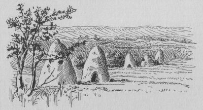
Ant Hills
The only illustrations which might be supposed to appertain to Australia are those not alluded to in the French text, a fact which suggests that the other, extraneous matter, has been interpolated.
The illustrations, not alluded to in the French text, may, therefore, have belonged to the prototypic map, such are the representations of trees, rough guniah-looking dwellings, guanacos, and those strange, huts on the western coast, which may have been inspired by some freak of nature as seen by Dampier on the same coast some hundred and thirty odd years after these charts were painted. Dampier says: "There were several things like haycocks standing in the Savannah, which at a distance we thought were houses, looking just like the Hottentots' houses at the Cape of Good Hope; but we found them to be so many rocks."
Dampier and his companions may have mistaken some anthills for rocks. Péron the French explorer describes some huge dome-shaped ant-hills seen on this coast, and Captain Pelsart, wrecked in 1629, also describes some ant-hills seen by him and his companions when in search of water on this same coast in latitude 22 degrees south.
In 1818, Allan Cunningham, when on the west coast of Australia, at the Bay of Rest, took occasion to measure one of these gigantic ant-hills of that coast. He found it to be eight feet in height, and twenty-six in girth.
Pelsart's account runs thus: "On the 16th of June, in the morning, they returned on shore in hopes of getting more water, but were disappointed; and having no time to observe the country it gave them no great hopes of better success, even if they had travelled further within land, which appeared a thirsty, barren plain, covered with ant-hills, so high that they looked afar off like the huts of negroes..."
Dampier in his second voyage to this coast in the year 1699, but more than one-hundred miles further south, describes again some of these evidently very remarkable features of the western coast of Australia. He says: "Here are a great many rocks in the large savannah we were in, which are five or six feet high and round at the top like a haycock, very remarkable; some red and some white." But Flinders, when on this coast, actually came across native huts similar to those depicted on P. Desceliers' chart of Australia.
His is another planisphere, of the same school of map-makers.
I give it here in its entirety, in order to show how the Australian portion stands, in all these maps, with reference to other countries.
It will be observed that, for accuracy, Australia compares favorably with, for instance, North America, named on this map, La Nouvelle France.
Besides its beautiful execution there is nothing to call for special notice unless it be that three Portuguese flags are shown as flying over Australian shores, a sure sign of annexation. The map-maker's name, Nicolas Desliens, date 1566, and Dieppe, the place where the map was made, are marked on a scroll right across the fictitious portion of Java-la-Grande.
In this short chapter, before leaving the subject of the old manuscript maps of Australia, and devoting the remaining pages of my book to actual voyages of discovery, I shall refer once more to the importance of the Lusitano-Spanish planispheres of the Dieppese school of cartography* because most of those documents, becoming the property of French map-makers, were used in various endeavours which were made to induce European sovereigns to colonize the Great South Land.
[*Most of these maps were made at Dieppe; all of them were made in the north of France.]
In the preceding pages I have only described the most important of these manuscript charts. The following is the list in chronological order of all the specimens known to exist:--
1. The Dauphin Chart         1530-36
2. N. Valiard's (so-called)  1539-49
3. Jean Roze's               1542
4. The Henri II. (of France) 1546
5. P. Desceliers'            1550
6. G. Le Testu's             1555
7. Desliens'                 1566
With the hope of making fresh discoveries and in pursuance of their object to establish a trade between the Spice Islands and their newly acquired colonies on the western shores of America, the Spaniards continued to send out expeditions whenever an opportunity offered.
Ever widening their sphere of action, they now looked forward to the southern regions of the Pacific Ocean as the land of promise, the El Dorado of their dreams; Saavedra's Isla de Oro and Retez's and Gaspar Rico's discoveries were not to be forgotten either.
It is in those regions that the legends and traditions of the times placed the islands from which King Solomon derived the gold and other treasures that served for the decoration of the temple of Jerusalem.
These legends, founded partly on historical events, and partly coupled with traditions handed down in the Royal Incarial families of Peru, seem to have given a powerful stimulus to Spanish enterprise in the South Pacific Ocean.
The hopes they gave rise to were, in addition, strengthened by the desire to discover the Great Southern Continent in a more effectual way than had hitherto been done: these prospects originated all the expeditions which, leaving the shores of South America, followed one after another in the same wake. The Spaniards were now firmly established in Peru and it came to pass that a certain Pedro Sarmiento de Gamboa, a Spanish officer of unusual erudition in maritime and other matters, having collected and translated many historical documents, or guipus,* relating to the Incas, became aware that one of them, their wisest and greatest monarch, named Tupac Yupanqui, had made an extensive voyage by sea towards the setting sun, which lasted over twelve months, bringing back much treasure from the countries he had visited. During the course of this voyage Tupac had discovered two large islands, named Nina-Chumpi and Hahua-Chumpi, or Fire-Island and Outer-Island.
* The ancient Peruvians had a curious method of keeping tally of events. They had no alphabet, and instead of writing they made use of strings of various make, colour, and length, and, with the addition of knots, more or less complicated, were able to place on record any important event.
Sarmiento believed that he had obtained valuable information from the Incas and their guipus relative to these islands, which were also believed to be the outposts of a southern continent, and he thought that he could fix their position approximately.
In consequence, in the year 1567, he made a proposal for the re-discovery by the Spaniards of these distant lands. In one of his memorials to Philip II, he represented that he knew of many islands in the South Sea which were undiscovered by Europeans until his time, offering to undertake an expedition for their re-discovery with the approval of the Governor of Peru, who was then Lope Garcia de Castro.
Mendana's Fleet
Garcia de Castro willingly accepted Sarmiento's offer, and not only helped him in every way that lay in his power, but also offered him the sole command of the fleet. But, Sarmiento insisted that it should be entrusted to Alvaro de Mendana, a young nephew of Garcia de Castro.
This was probably a mistake on the part of Sarmiento, and was, no doubt, the cause of the failure of the expedition, and we may also attribute to his refusal of the sole command, the fact that his name has hitherto remained ignored not only in connection with this initiatory voyage, but also in connection with the further voyages of Mendana, Queiroz and Torres.
Sarmiento, however, stipulated that he should have the conduct of the discovery and navigation, and that no course should be altered without his consent.
The two ships of the expedition sailed from Callao, the port of Lima, in Peru, on the day of the feast of Santa Ysabel, the 19th of November, 1567, and Santa Ysabel became the patroness saint of the expedition.
Sarmiento intended to steer W.S.W. until he reached the tropic of Capricorn,* and this direction was kept until the 28th of November.
[* Sarmiento, and after him Torres, both endeavoured to keep in the latitude of the tropic of Capricorn. In the charts of the period a port or bay was marked on the coast of Java-Major in that latitude. See "Baye Perdue," in the Lusitano-Spanish charts.]
On that day the chief pilot, Hernando Gallego, altered the course without Sarmiento's permission, and in defiance of the instructions, being supported by Mendana in so doing.
So it happened that, notwithstanding Sarmiento's protests and constant remonstrances, Gallego and Mendana, persisted in this more northerly course for forty days, evidently with the intention of making for the better known seas that surround the Caroline and Philippine Islands.
Sarmiento constantly urged that the islands and continent that he was in search of were more to the south.
However, no land being sighted after many days, Mendana became alarmed and requested Sarmiento to resume charge of the navigation.
He did so, and ordered the course to be shaped W.S.W., announcing at the same time that land would be sighted on the next day, and this proved correct.
An island was discovered which received the name of Nombre-de-Jesus. It has been identified with Nukufetau, in the Ellice group.
They had been sixty-two days at sea and were sadly in want of a change of diet. Seventeen days later, they sighted the small islands and rocks which they called Baixos de la Candelaria, Candlemas Reefs; these have been identified with Lord Howe Islands, lately ceded to England by Germany.
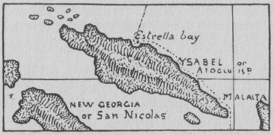
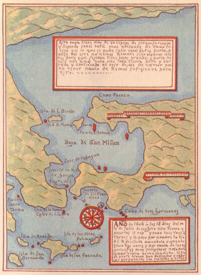
On the 7th of February, they reached at last a large island called Atoglu by the natives. The Spaniards gave to it the name of the patroness saint of the voyage, Santa Ysabel.
Natives came off in crescent-shaped canoes to meet them.
They found a bay on the northern coast, and having noticed the planet Venus at 10 o'clock in the morning, they called this bay the Baya de la Estrella, the Bay of the Star, a name which has been restored to it in recent years.
Crescent-shaped canoes
They began at once to build a brigantine which had been taken out in pieces; in fifty-four days it was put together with the help of fresh timber obtained on the island.
Sarmiento then conducted a reconnoitering expedition inland, but met with hostility from the natives.
In the meanwhile, Gallego and Ortega, the camp-master, examined the coast on board the brigantine and discovered several other islands.*
[* Very little gold, if any, was found in the Solomon group.]
An expedition in search of the Great Southern Continent, or Java Maior, was also projected with the brigantine, but soon abandoned, as they found the little ship unsuitable for open sea work.
All the islands discovered were supposed to belong to the outlying islands situated to the east of New Guinea, and the inference, as we know, was not, far from the truth; it led, however, to a curious mistake, which I shall explain when describing the earliest map of the Solomon Islands, towards the end of next chapter.
Santa Ysabel Island
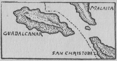
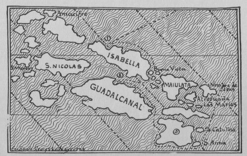
In May, the expedition left Santa Ysabel, and after sighting many more islands of the group, they cast anchor off the coast of a large island which Gallego named Guadalcanal, after his own native place near Seville.
On the 19th and 22nd, Sarmiento and Mendana, accompanied by Ortega, made excursions into the interior, ascending a high mountain and enjoying a magnificent panorama. Afterwards a boat's crew was massacred by the natives, and Sarmiento was obliged to make severe reprisals.
Guadalcanal Island
In August, the expedition removed to another island which was named San Christobal, where they remained for forty days, refitting and taking in supplies, and here the brigantine, which had done such good service in exploring the shallow coasts, was abandoned.
Sarmiento now desired to return by way of the islands discovered by the Inca Tupac Yupanqui, and submitted a report to that effect on September the 4th, 1568.
But Mendana insisted upon steering east, and notwithstanding the remonstrances of many, he shaped a course for New Spain.
On the 23rd of January, 1569, they reached the port of Santiago de Colima, refitted at Realejo, and returned to Callao on September 2, after an absence of 19 months.
During the voyage there had been many disagreements, and Mendana intended to bring charges against Sarmiento when he arrived at Lima.
As little justice could be expected from the uncle in adjudicating on his nephew's conduct, Sarmiento considered it to be the wisest course to leave the ship at Realejo, and wait at Guatemala until Lope Garcia de Castro should be relieved of his command.
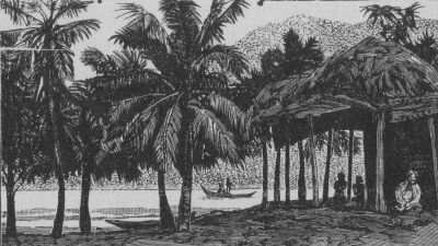
Scene in the Solomon Islands
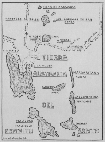
Twenty-six years had elapsed since the Sarmiento-Mendana voyage, and now Mendana was sent out again with instructions to found a colony at the island of San Christobal, in the Solomon Group; and from thence to make another attempt to discover the Great Southern Continent, the Java Maior, that formed such a conspicuous feature on the maps of the period, and was beginning to attract the attention of other countries besides Spain.
Mendana's fleet was composed of three large vessels and a frigate.
Pedro Fernandez de Queiroz was his captain and chief pilot; the other officers were Lope de Vega, Felipe Corzo, and Alenzo de Leyva.
As it was intended to settle a colony, many took their wives with them, and amongst these were: Da. Isabel de Barreto, Mendana's wife, and Da. Mariana de Castro, the wife of Lope de Vega.
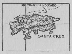
Santa Cruz Island
They set sail from Callao on the 9th of April, 1595, and, after discovering the Marquesas, and a few smaller islands, they sighted land on September the 7th, which Mendana believed, at first, to be the Solomons, of which he was in quest.
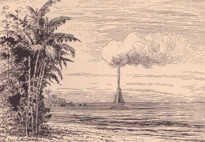
They soon found out their mistake, and named the island Santa Cruz. To the northward of this island was seen a most remarkable volcano in full eruption.* The frigate was ordered to sail round it to search for Lope de Vega's ship, which had parted company some time previously.
[* Tinacula Volcano, in eruption at the present day.]
Tinacula Volcano, from Santa Cruz
Don Diego de Prado's Map of the Islands at the South-east end of New Guinea
Pierre Desceliers' Map of Australia
Desliens' Map of Australia
Moresby's Map of the Islands at the South-east end of New Guinea
The Great Bay of St Lawrence (Orangerie Bay of modern charts).
Bay of St Peter of Arlanza (Modern Triton Bay), Dutch New Guinea
They thought that she might have passed to the north, but the hopes of seeing her again were very faint.
Mendana continued near the north coast of Santa Cruz, searching for a port, and was rejoined there by the frigate, which returned without any tidings of Lope de Vega and his ship.
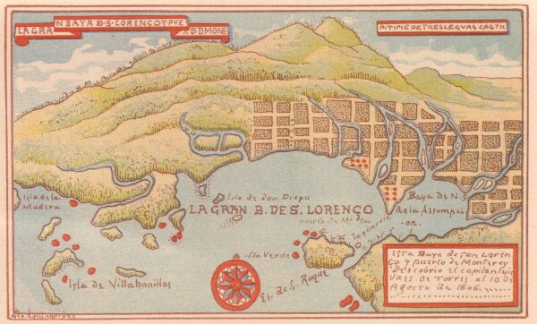
At last a port was discovered where the ships anchored in smooth water, close to the shore.
On the 21st of September, they found a better port, which Mendana named La Graciosa, for it was very beautiful, larger and more commodious than the one where they were first anchored. A river of moderate size and a copious stream of very clear water gushing from beneath some rocks was found in proximity to the anchorage. Here an attempt at colonisation was made, but what with the hostility of the natives, sickness, and a mutinous spirit, the young colony did not progress favorably. To make matters worse, Mendana himself fell ill and died, and the grand scheme which, under favourable circumstances, might have resulted in the foundation of a Spanish Australian Empire, was, perforce, abandoned for the while. The remnant of this disastrous expedition, having repaired to the Philippine Islands, returned to New Spain in the year 1596.
AN EARLY MAP OF THE SOLOMONS ISLANDS.
The discovery of true Solomon Islands was soon forgotten and Mendana's vague notions about them led historians and geographers astray as to their position and size.*
[* In a map of the South Sea, Mar del Zur, published towards the year 1650, the Solomon Islands are represented as extending in a sweeping curve, resembling their natural trend it is true, but the position is from the locality of New Caledonia and New Zealand, right across the Pacific Ocean to the south of Cape Horn. In that distance 40 islands are represented, of an average size equal to the two large islands of New Zealand, truly a magnificent mistake!]
In the few old maps that exist, it is difficult to determine precisely in what measure the members of the expedition are responsible for the charting; some of it is certainly the guesswork of geographers, based, it must be acknowledged, on the best information then available, for we must bear in mind that the accounts of Mendana's expedition were only known from a few extracts, the actual narratives being lost at the time these charts were draughted. Now that some of those narratives have been found, it is easy to identify the present day Solomon Islands with the group discovered by the Spaniards; most of the latitudes in the old chart that I give here, agree with those given by Herrera, the Spanish historian, which shows that if they have been thrown out of position, as they are on some old charts, it is through the fault of the map-makers.
The Earliest Map of the Solomon Islands
The map given here is by Mazza, an Italian geographer of distinction; it is the earliest one that I have been able to procure, the earliest known to exist, the date being between 1583 and 1589.
I have marked on it the probable track of the ships; the first bay where they anchored, and which was called Baya de la Estrella, is marked by No. 1. The second anchorage, on the coast of Guadalcanal, marked No. 2, was named Puerto de la Cruz; and the locality where the third sojourn was made, and where the brigantine was abandoned, is marked by the No. 3.
The island thus marked, bears no name on the map; it is the southernmost large island, however, and corresponds therefore with San Christobal, where the third and last sojourn was made, and where, at a later period, a colony was to have been founded.
The island bearing the name Nombre de Jesus, is misnamed, evidently as the result of interference on the part of the cartographer, for, according to the narrative, it lies at many days' sail from the first land sighted in the Solomon Group, and has been identified, as I have said before, with Nukufetau in the Ellice Group.
Other mistakes of the map-maker are, Amacifre instead of Arecifes reefs; and Maiulata for Malaita. Malaita, however, is a mistake of the Spaniards, for the natives call their island Mala and ita means "here"; as one might say, "here is Mala."
The curious mistake alluded to on page 63 is this:
In most of the old maps that were made prior to the identification of Sarmiento's and Mendana's discoveries, the Solomon Islands were placed much too close to New Guinea, occupying, in fact, the position of New Britain and New Ireland. This was owing to the belief on the part of the Spaniards, that they had reached the region where their predecessors, Saavedra, Retez and Gaspar Rico, had made their discoveries: so that, New Britain, New Ireland, and all the other islands, of the Bismark Archipelago were once believed to be the Solomon and Guadalcanal the extreme east end of New Guinea.
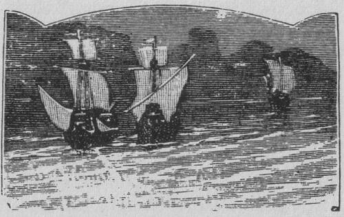
Queiroz's Fleet
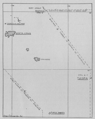
We come now to the most important expedition that ever set out in search of Australia. We have reached the year 1605, in the month of December, of which Queiroz, this time the commander of another Spanish fleet, set sail from the coast of Peru with the object of renewing the attempt at settlement in the island of Santa Cruz, and from thence to search, for the "continent towards the south," which he believed to be "spacious, populous and fertile."
The intentions of navigators and the instructions given to them are seldom thoroughly carried out. We shall see, in this case, that Queiroz failed to reach Santa Cruz in the same way as Mendana had failed to reach the Solomans; although they both sailed almost within sight of the islands they were looking for.
THE VOYAGE.
According to Gonzales de Leza, the pilot of the expedition, the name of the Capitana, or Queiroz's ship, was the San Pedro y San Pablo; the Almiranta, named the San Pedro was commanded by Luis Vaes de Torres; the brigantine or Zabra, was named the Tres Reyes, and was commanded by Pedro Bernal Cermeno.
With variable winds, the three ships that composed the fleet sailed towards the west till the 26th of January, 1606, when, in the afternoon, they sighted a small island. No anchorage could be found and it was thought that it could not be inhabited, so they passed it. Continuing on a westerly course three days later, they came in sight of another island of larger dimensions; here, also, finding no convenient landing place, they passed on.
The sky now became obscured, and, as they proceeded, rain set in, followed by thunder and lightning; then a fearful tempest threatened their destruction.
Presently, however, the storm abated, and through a rift in the clouds they perceived land and made for it.
They found it to be an island about thirty leagues in circumference, apparently an atoll, for it was described as having "a lagoon inside," and was surrounded by a coral reef. Here they wanted to get wood and water, but finding no entrance or bay they had to abandon their attempt.
They continued their course, and the next day, 5th of February, they came in sight of four other islands of the same description, and all equally inaccessible.
An Atoll Reef
They passed them, keeping on a westerly and north westerly course, passing several other islands, all unfavourable to their purpose.
At last being in 18° 40' south, they passed the day with some rain, and the next day, 10th of February, from the topmast head a sailor cried out, "Land-a-head."
It is strange how all the early navigators, Magellan, Sarmiento, Mendana, Queiroz and many others, always managed to steer clear of the larger islands that spread like a net across the South Pacific Ocean, and either found an open sea, or hit upon some insignificant atoll.
From a careful study of the various narratives of this voyage it is evident that Queiroz had just sailed an the outskirts of the Tuamotu or Low Archipelago, and was now nearing Tahiti, which island however, he never set foot on.*
[* Many writers have erroneously identified Queiroz's "Conversion de San Pablo," Torqamada's "Sagitaria," with Tahiti. Sagitaria is Makatea or Aurocra Island of the modern chart, and Conversion de San Pablo is Anaa, or Chain Island, about 200 miles east of Tahiti, in the same latitude.]
At the announcement of "Land-a-head" their joy was great, for in several places they saw columns of smoke arising, which was a clear sign of inhabitants, whence they concluded that all their sufferings were at an end.
They bore down to the land on the northern side; but finding no harbour, the Capitana endeavoured to beat up against the wind and pass along the island again, but in vain.
Queiroz then detached the smallest vessel, or brigantine, to look for a port, while the two other vessels lay alongside of each other in sight of the land.
The brigantine cast anchor near the coast, "in ten fathoms, stones and coral."
The commander then gave orders to man the armed boats, and then made to shore. As they approached the land the Spaniards saw about a hundred natives inviting them, by signs of friendship, to land and go to them, but it was not practicable to make good their landing, the waves broke with such fury upon the rocks, that all their efforts proved ineffectual.
The enterprise was abandoned with the more regret, as the fleet began to be in want of fresh water, and they had come to the sad conclusion that they had nothing to do but to return, when a young sailor, full of fire and courage, braving the danger, and generously devoting himself for the honor of the expedition, and the preservation of his companions, stripped off his clothes, threw himself into the sea, and swam to the rocks.
The natives, struck by this act of courage, went into the water to his assistance, took him in their arms, embraced him affectionately, and received him with all manners of caresses, which his gratitude abundantly returned.
His example was soon imitated by several Spaniards, who passed the breakers, and were received by the islanders with the same testimonies of sensibility and affection. These brave savages were all armed: some carried lances of twenty-five or thirty palms in length; some a sort of sabres, and others stone-headed clubs; all these weapons were of wood.
These islanders were tall, with dark brown skins and bodies well proportioned; their habitations were scattered irregularly on the sea-shore, among palms and other trees which abounded in the island. On the fruits of these, together with the produce of their fishing, the inhabitants subsisted.
When night came on the Spaniards swam back to their boats; some natives followed them, and were treated with those marks of friendship which their generosity deserved: presents were also added; but they could not ever be prevailed upon to go on board the brigantine; instead of that they plunged into the water in order to return to shore.
During the night the vessels drifted considerably, and at eleven in the morning had lost eight leagues, but were still within sight of land; they were now in hopes of being able to get water there. They sent out the boats to seek for a river; and as the appearance of the shore gave no promise of anchorage, the vessels lay-to alongside of each other as before.
The waves broke upon the coast with such violence, that it was impossible to attempt making the rock without risking the loss of boats and men; the sailors, therefore, threw themselves into the water, and by dint of industry and efforts, were enabled to raise their boats, and fix them on some rocks which were dry at low tide.
Having thus secured their boats, the Spaniards visited two small plantations of palms, cocoanut and other useful trees which were near the place where they had landed; but all their endeavours to discover fresh water were fruitless.
They came at length to a small opening where the soil was moist; here they dug wells, but the water proved brackish. Their trouble was a little recompensed by the ease with which they procured an ample provision of cocoa and other nuts. With these they allayed their hunger and their thirst at pleasure; and every man loaded himself with as many as he could carry for his comrades who remained on board the ships.
To regain the place where they had landed they walked about half a league, and in the passage had the water up to their knees, because the sea, flowing full in, with great impetuosity, had risen above the rocks surrounding the island and overflowed the shore.
Fortunately, when they least expected it, they discovered a passage between the rocks; there they got into the boats and brought them so near to land, that they could all embark with ease and return to their vessels.
The ships stood off all night; and the following day, the 12th of February, they coasted along the island to the N.W. point., the latitude of which they determined by an observation of the sun to be 17° 40' S. This island they called Conversion de San Pablo. It is Anaa, or Chain Island, about 200 miles east of Tahiti, in the same latitude.
Departing from Conversion de San Pablo, and continuing his route in a N. westerly direction, Queiroz discovered the islands following:--
La Fugitiva, two days and a half from Conversion de San Pablo. Seen to the N.E., but, as the fleet was too much to leeward, they did not attempt to touch there.
La Isla del Peregrino, a day's sail further. They left this also to windward, and proceeded to the W. On February the 21st, land was seen a-head; the brigantine was detached to reconnoitre this new island more closely, and anchored on the coast in a bad harbour, where the ships could not lie with safety.
Isla de San Bernardo, which was the name given to this island, was found to be very flat, with a lagoon in its centre, and thirty miles in circumference.
The boats were sent out in hopes of getting water; but they searched in vain for it, and only met with great quantities of cocoanuts. The fish, which abounded on the coasts, and the birds, which were also very numerous, suffered themselves to be caught by hand.
Type of Island Woman
It was supposed to be inhabited; its latitude, by observation, was about 10½° S. From this island they proceeded all night under very little sail, because the wind blew fresh in their stern, and the great number of birds that passed them proved that land was near.
On the 2nd of March, land was discovered to the W. It was an island six leagues round, which offered but a bad anchorage. The boats landed with difficulty, and one of them was actually overset in one of their visits and the crew nearly drowned among the breakers.
This natural obstacle was probably not the most obstinate that existed there; they found the island inhabited by a warlike people, that opposed them in every enterprise.
In different skirmishes, several natives were killed, and some of the Spaniards wounded, so that after some unsuccessful attempts to get water they were obliged to abandon the place.
They speak particularly with enthusiasm of the beauty and studied dress of the women, who, according to their accounts, surpassed the fairest Spanish ladies, both in grace and beauty.
This island was called Isla de la Gente Hermosa, Island of the Handsome People. I have been able to obtain a photograph of one of the descendants of the native women so much admired by the Spaniards, and you may judge for yourselves whether they were right in their appreciation.
The design of Queiroz was to reach Santa Cruz without delay, and with this object in view he directed his course westward, for in these latitudes they expected to come in sight of the lofty volcano, Tinacula, which would enable them to identify Santa Cruz.
After many days' navigation, they discovered, from the mast-head of the Capitana, a high and black-looking island, having the appearance of a volcano and lying W.N.W. They could not reach it for several days; after which they soon perceived that it was not Tivacula, as they had at first thought, for they had to pass among several small islands in order to get near it, and they well remembered that Tinacula stood alone in its awful and solemn grandeur.
The small islands that surrounded the larger one that they had taken for a volcano were most of them on the western side, but far enough from the larger one to leave a channel capable of receiving ships. Torres, the second in command, was sent to reconnoitre this island.
(I shall give his description in Chapter XII.)
In this harbour the fleet anchored in twenty-five fathoms. At no great distance, and within the reefs that surrounded these islands, a smaller island was observed, not more than five or six feet above the level of the water. It was formed of stones and coral, and seemed to be the work of man. They counted there seventy houses, which were covered with palm leaves, and hung with mats within.
The islanders gave them to understand that it was a retreat for them, for the sake of security and defence, when the inhabitants of the neighbouring islands came to attack their possessions; and that they, in their turn, invaded their neighbours in strong and large canoes, in which they could with safety commit themselves to the open sea. They also informed them that towards the south there were very extensive lands, and one in particular called Mallicolo.*
[* This indication of lands to the south, named Mallicolo, may have meant either Vanikoro (where La Perouse was wrecked after leaving Botany Bay), or Mallicolo (sometimes called Malekula), to the south of Santo, in the New Hebrides group.]
The Spaniards had, therefore, sufficient information that there were many more islands in the neighbourhood of that on which they had landed, and this knowledge led Queiroz to abandon, for the while, the idea of making for Santa Cruz. The natives called their island TAUMACO; it abounded with bananas, cocoanut trees and palms; it produced also sugar canes, and many kinds of nutritious roots.
The fleet here obtained, without difficulty, refreshments, wood, and water, of which it stood in great need. The Spaniards lived on good terms with the natives, who were eager to procure them all the assistance that their island afforded; nor was peace infringed till the very moment of their departure.
Thinking that it would be of service in the remainder of the voyage, to have some natives on board, who might act as guides or interpreters, the Spaniards seized four, whom they carried on board by force. Their chief was soon informed of it, and came to demand them in the most earnest manner; but, seeing the need in which they would be of interpreters should they land as they hoped on the Great Southern Continent, the chief, whose name was Tomai, was informed that they could not be returned, and war was instantly declared.
Queiroz's Track
A fleet of canoes came out to attack the Spanish ships, which their fire arms quickly dispersed, and would totally have destroyed, had not these brave islanders, with all their courage, been sensible of their inferiority. Thus the thunder of European artillery made good the right of the Spaniards; but force by no means gives a sanction to base treachery.
THE FLEET LEAVES TAUMACO.
Queiroz quitted this island of Taumaco on the 18th of April, and, giving up his project of settlement at Santa Cruz, sailed towards the south in search of the land of Mallicolo and other lands indicated by the chiefs of Taumaco.
On the 21st, in the evening, they discovered land in the S.E. They manoeuvred cautiously all night. They then sailed along the northern shores of what proved to be a small island. The captain of the Almiranta, Luis Vaez de Torres, went in a canoe to examine it.
He could not find an anchorage for the fleet; but he went near enough to the land to converse with the natives, who offered him a present of nuts, and a piece of stuff made of palm leaves woven together.
He learned from them that their island was caged TUCOPIA*; and they made him understand by signs that, if he sailed southwards, he would meet with extensive countries, where the inhabitants were fairer than those he had yet seen. As this island afforded no shelter from the wind, they did not remain there. In coasting along it, they perceived that it produced many fruit trees, of which they saw several plantations. They say that "It lies in latitude 12° S."
[* The first island arrived at by the Spaniards bearing a native name preserved to this day, and that can, therefore, be positively identified, with reference to this voyage.]
QUEIROZ'S REGION OF ESPIRITU SANTO.
As we are coming now to islands which I have positively identified,* it will be well to follow the itinerary on the maps given here.
[* See Portuguese, Spanish, and Victorian Geographical Societies' Journals. 1903-1904.]
The fleet proceeded southwards, with variable winds, till the 25th of April, when, at day-break, a very high land was seen in the latitude of 14½° (Bougainville's "Pic de l'Etoile," the "Star Island" or Merlav, of modern charts.) They named it San Marcos.
From San Marcos they went on a S.W. course, with men at the mast-head; and at 10 in the forenoon, at a distance of 12 leagues to the S.E., a land of many mountains and plains was sighted, the end of which could not be seen throughout the day. Queiroz gave it the name of Margaritana. It is the island of the New Hebrides group which Bougainville named Aurora.
About 20 leagues to the west, an island was seen that looked so beautiful that they determined to go to it. About a third of the way they saw another island, 3 leagues off. It was flat, with a hill that looked like a rock in the distance. Two canoes under sail came from it, from which they knew that it was inhabited.
On account of its thick woods and pleasant appearance, the name of Vergel, or Flower-Garden, was given to it. There was little wind, and, owing to the necessary caution in navigating among unknown islands, they hove-to during the night.
To the north of Vergel island, which is the Merig Island of modern charts, they saw another large island running N.E. and S.W., and the peaks of its numerous mountains gave the captain a strong desire to go and see it; but he gave it up, owing to other things that occurred. Its latitude they found to be 13°, and they named it Las Lagrimas da San Pedro. The Tears of St. Peter.
To the N.W. another island was seen, with a circumference of 60 leagues. It had two high and sloping hills, one at each end. The rest was flat and of very pleasant appearance, alike from its shape and numerous trees. Its latitude they found to be less than 14°. They named it Portales de Belen.
Upon nearing the island to the westward of San Marcos, they saw columns of smoke arising in all directions, and at night many fires. In the centre it was rather high, and thence its slopes extended in all directions to the sea, so that its form was a massive round with only the parts towards the south, broken with ravines.
There were many palm trees, plantains, verdure, abundant water, and the land was thickly inhabited. The circumference was about 50 leagues, though some gave it much more and thought that it would support about 200,000 inhabitants. Its latitude was 14° 30'. Owing to its great beauty, it was named Virgen Maria; it is the modern Gaua, in the Banks' group.
Four canoes with unarmed natives came to the Almiranta, and made signs to offer to take him into port. Seeing that the Spaniards did not wish it, they made presents of cocoanuts and other fruits. Having received a good return, they went back to their island. As the disposition of the natives seemed to be good, the captain sent a party in the launch and one boat, to examine the coast and find a port. The party was under the command of Pedro Lopez de Soto. They found to the S. and S.E. clean bottom at 20 fathoms or less, where the ships might have anchored if the weather to be experienced had been known. They saw a great number of people on the island, who came out to see and call to them. They followed the boat without passing certain boundaries, and by this they supposed that there were partitions of property between the people not on good terms.
Among them there were two distinct colours. While the natives were looking at each other and talking by signs, a man rushed down from behind some rocks. He was well made, of a clear mulatto colour, the hairs of his beard and head brown and crisp, and rather long. He was robust and vigorous. With a jump he got into the boat, and, according to the signs he made, he appeared to ask: "Where do you come from? What do you want? What do you seek?" Assuming that these were the questions asked, some of the Spaniards said, "We come from the east, we are Christians, we seek you, and we want you to be ours."
Tierra Australia del Espiritu Santo
He showed himself to be so bold, that the Spaniards understood that he wanted to make them believe that to him they were a small affair. He presently was undeceived, for he was seized and brought to the ship, where he came on board so fearlessly that the Spaniards had to confess that he was no coward.
The captain embraced him, and asked about the land by signs, of which he appeared to give extensive information. He pointed to several places on the horizon, counted on his fingers several times, and ended by pronouncing several words in Spanish, thereby showing that he had come in contact with earlier Spanish navigators in those seas. The Spaniards say that it was "very pleasant to hear him, to see how lively he was, how vigorous and agreeable in his manner; having a bright look for all, including those who importuned him with a desire for information."
The night having come on, the launch arrived, and the pilot of her told Queiroz that they were bringing a native prisoner, secured by a hatchway chain. Soon after, however, the prisoner broke his chain; and, taking part of it and the padlock with him on one foot, he jumped overboard.
Queiroz heard this with great regret, fearing that the man had been drowned. To make sure of their first prisoner, he ordered him to be given his supper and to be put in the stocks, but on a bed where he could sleep. He also ordered that the ships should go in search of the one that had escaped.
Going in search at 10 at night, the look-out man heard a voice from the water, and made out the place where the native, being tired out, was struggling with death.
To the cries of the swimmer carne answer from the prisoner, in such doleful tunes that it caused grief to all to see the one and hear the other. The swimmer was got on board, to the joy of himself and the crew, and to their surprise that he could have sustained such a weight on his foot for four hours.
The padlock and chain were at once taken off, and he was given his supper, with wine to drink, and then put in the stocks, that he might not try it on again. There both remained all night, talking sadly and in confusion. At dawn, the captain, pretending that he quarrelled with all for putting them in the stocks, let them out. He then ordered the barber to shave off their beards and hair, except one tuft on the side of their heads. He also ordered their finger-nails and toe-nails to be cut with scissors, the uses of which they admired. Queiroz caused them to be dressed in silk of divers colours, gave them hats with plumes, tinsel, and other ornaments, knives, and a mirror, into which they looked with caution.
This done, the captain had them put into the boat, and told Sojo to take them on shore, coasting along to the end of the island, to see what there was beyond. The natives came, and the fear being passed, they sang their happy and unhoped-for fate. Arrived at the beach, they were told to jump out, which they could hardly believe.
Finally, they jumped overboard, where there were many natives; among them a woman with a child in her arms, who received the two with great joy. It appeared that she was the wife of the first native, and that he was a chief, for all respected and obeyed his orders. They seemed to be contented and gave each other many embraces, with gentle murmurings. The chief, pointing with his finger, seemed to be saying that the Spaniards were a good people. Many came to where the boat was, and they showed such confidence, that when one of the Spaniards asked the mother for her baby, she gave it. Seeing that it was passed from one to another, to be seen and embraced, the natives were well pleased. In fine, a good understanding was established.
The swimmer ran away, and presently came back with a pig on his shoulders, which he offered to his new friends. The chief gave them another, and a bunch of curious plantains, their shape being like that of moderate-sized egg-plants without points, the pulp orange colour, sweet and tender. The other natives emulously presented cocoanuts, sweet canes, and other fruits, and water in joints of cane four palmos long, and one thick. Pointing to the ships, they seemed to say that they should anchor there, that they might give them all they had in the island. The Spaniards took their leave and went on to the point, where they saw the coast of the island trending north, and the other of Belen at a distance of 4 leagues to the N.W. Satisfied with their view, they returned to the ship.
All the natives of this island were not equally well disposed towards the Spaniards, for the boatswain's mate of the Almiranta was wounded in one cheek by an arrow: certain natives being envious of the friendship of the others, or being enraged because, when they called to the Spaniards, they did not care to stop and speak with them, shot off arrows, and had an answer from muskets. The wound of the boatswain's mate healed quickly, and they knew thereby that the arrows were not poisoned. More mischief would have been done if their friend the swimmer had not come running, shouting, and making signs for the boat to keep away--"a great proof of gratitude," says the Spanish narrator.
New Hebrides
Towards the end of April, one Melchor de los Reyes was looking out at the mast-head, when, at three in the afternoon, he saw at a distance of 12 leagues to the S.W. and S., more or less, an extensive land. For this, and because the eye could not turn to a point that was not all land, the day was the most joyful and the most celebrated day of the whole voyage.
They went towards the land, and next day found themselves near a coast running to the west. The name of Cardona * was given to this land in memory of the Duke of Sesa, who had taken a deep interest in the voyage, as well at Rome as at the Court of Spain, and because the captain felt very grateful.
[* The name of the Duke of Sesa was Don Antonio de Cardona, Y Cordova. On a visit to Rome, as a pilgrim, Queiroz was well received by Cardona, who was the ambassador from Spain at that Court. The land which Queiroz, named Cardona was Aoba Island of the modern chart.]
When they set out for the said land there was seen, far away to the S.E., a massive and very lofty chain of mountains, covered with thick masses of white clouds, in the middle and on the heights, while the bases were clear.
It seemed from aloft that the coasts of these two lands approached to form one. The captain gave the name of La Clementina to this range of mountains. It seemed to be in about 17°. (The lofty range that crowns Pentecost Island).
Having come nearer to the land, an opening was seen in it, and, as it appeared to be a port, Queiroz sent an officer in a boat, with soldiers and rowers, to examine it. In the afternoon this officer returned, reporting that the opening formed a narrow island 6 leagues long, running N. and S., rather high, inhabited, and well wooded; and where it was found to be sheltered to the E. and N.E., there was bottom at 30 fathoms, and a strong current. The captain gave it the name of San Raimundo. (It is the Isla de Santiago of de Prado's chart.) See p. 34.
Coasting along this island to the W., there came out on the beach many tawny men, very tall, with bows in their hands, calling loudly to the Spaniards.
As the new-comers would not approach, they threw a great bundle of capon's feathers into the sea, intending with that, and by sending out boys, to induce the Spaniards to come within shot of their arrows.
Then they shot off volleys from their bows which the Spaniards returned with muskets. Further on they saw many natives of fine make and good colour, and away to the S. and S.E. three and four ranges of very high mountains (Malicolo and Ambrym), which seemed to join on to the other ranges that had been seen to the S.E.
With such good news that the land was inhabited, they sailed onwards on a western course; and at a distance of 6 leagues, on the 1st of May, 1606, they entered a great bay, where they passed the night.
Next day, the captain sent the admiral* away in a boat to look for a port.
[* The Spanish term applied to the second in command.]
Two canoes came out to the ships with men in them, having their bows ready. They stopped for an interval and rowed for another. They spoke loudly, and looked at the newcomers and at the shore, showing themselves to be troubled. Those in the launch fired off a piece to astonish them, which it did, for they took to flight, rowing as hard as they could.
Torres, the admiral, returned in the afternoon very well satisfied, and those who accompanied him were equally pleased, and could not hold back the joyful news that they had found a good port; for this is what they had hitherto failed to find, though they had sought for one with anxious wishes to succeed. Without a port, the discovery, they knew, would be of little importance.
Next day, being the 3rd of May, the three vessels anchored in the port with great joy, giving many thanks to God. Natives were seen passing along the beach.
The captain, with the boats, went to look at them, with the desire to take some of them and send them back clothed and kindly treated, so that in this and other ways friendship might be established. He did all he could to induce them to get into the boats. They did the same to get the Spaniards to land, and as the latter would not, the natives flung certain fruits into the water, which the men in the boats collected, and with which they returned to the ships.
The day after, the captain ordered the admiral to go on shore with a party of soldiers, and try by all possible means to catch some natives, so as to establish peace and friendship, based on the good work they intended to do for them.
The party ran the boat high up on the beach, and quickly formed in a squadron, for the natives were coming, and it was not known with what object. Being near, they made signs and spoke, but were not understood. The Spaniards called to them in return; then the natives drew a line on the ground and seemed to say that the new-comers were not to pass beyond it. They could not understand one another, and there seems to have been a want of management and discipline. Natives were seen in the woods, and to frighten them some muskets were fired into the air. A soldier who had lost patience, or who had forgotten his orders, fired low and killed a native. The others, with loud cries, fled. A Moor, who was the drummer in the Spanish corps, cut off the head and one foot of the dead native, and hung the body on the branch of a tree, without being seen to do it by those on the beach.
It then happened that three native chiefs came to where the Spaniards were, who, instead of showing them kindness, and taking them on board, showed them the headless body of their comrade, pretending that this cruelty was a means of making peace.
The chiefs, showing great sorrow, went back to where their people were, and shortly afterwards sounded their instruments, that is, their war drums, with great force and noise, which was heard on the hills among the trees.
Then from many directions they began shooting arrows and darts, and throwing stones, while the Spaniards fired on them, turning on one side or the other.
Queiroz saw all this from the ship where he was, with great regret to find peace turned into war. It appeared to him best to land more men in the direction taken by a number of natives, who were trying to surround the Spaniards. The supporting party got into such conflict with the enemy that the captain was obliged to fire two pieces. The balls, tearing the branches of the trees, passed over the natives; but, after this, and the resistance made by the soldiers, the enemy retired.
At the same time, the natives who were on the beach moved forward, brandishing their clubs, and with arrows fitted to their bows--and darts poised to throw, menacing with loud shouts. Then a tall old native advanced making a sound on a shell with great force. He seemed to be the same chief who had spoken to the soldiers, and they understood him to say that his people would defend their country against those who came to it killing their inhabitants. Eight of the musketeers were in ambush, and one of them, unfortunately, as he afterwards stated, killed this chief, and presently the rest desisted.
The Big Bay of Santo
Three or four raised their dead on their shoulders with great celerity, and went inland, leaving the neighbouring villages deserted. The narrator here remarks: "Such was the end of the peace that the captain hoped for and sought for, the means of discovering the grandeur of the land, and all was contained in it."
Shortly after Queiroz went on shore again and instituted an order of knights of the Holy Ghost, with a badge, or insignia, in the shape of a cross of a blue colour, to be worn on the breast.
Towards evening of the same day all three vessels displayed many lights, and they sent off many rockets and fire-wheels. All the artillery was fired off; and when the natives heard the noise and the echoes resounding over hills and valleys, thy raised great shouts.
The Spaniards sounded drums, rang the bells, had music and dancing, and had other forms of rejoicing, in which the men showed great pleasure...
Next morning it was not quite dawn when the camp-master and ministers, taking with them an armed party in the two boats, went on shore. They landed near the launch with four small pieces of artillery to be used in a fort in case of necessity. Within, the monks arranged a clean and well-ordered altar under a canopy. This was the first church, and was named by the captain "Our Lady of Loreto."
Everything having been arranged as well as the tine would allow, it was reported to the captain, who left the ship with the rest of the people. All the three companies were drawn up in good order on the beach...
The Royal Ensign, Lucas de Queiroz (Queiroz's nephew), came forth with the standard in his hands.
The banners, which were fluttering and brightening the whole scene, received their tribute from discharges of muskets and arquebuses. Presently, the captain came out and went down on his knees, saying: "To God alone be the honour and glory." Then, putting his hand on the ground, he kissed it, and said: "O Land sought for so long, intended to be found by many, and so desired by me!" Then formal possession was taken under six different headings, the last being: "Possession in the name of His Majesty,"--which read as follows:--
"Finally, I take possession of this bay, named the Bay of St. Philip and St. James, and of its port named Santa Cruz, and of the site on which is to be founded the City of New Jerusalem, in latitude 15° 10', and of all the lands which I sighted and am going to sight, and of all this region of the south as far as the Pole, which, from this time shall be called AUSTRALIA DEL ESPIRITU SANTO, with all its dependencies and belongings; and this for ever, and so long as right exists, in the name of the king, Don Philip, third of that name, king of Spain, and of the eastern and western Indies, my king and natural lord, whose is the cost and expense of this fleet, and from whose will and power came its mission, with the government, spiritual and temporal, of these lands and people, in whose royal name are displayed these his three banners, and I hereby hoist the royal standard."...
Then followed masses and various other ceremonies, including the creation of a municipality and the elections of officers thereto.
After which Queiroz ordered Torres to take an armed party, and penetrate further into the interior...They saw more and better farms and villages than before, and at one village they found the natives much occupied with their dances. When they saw the Spaniards approaching, they began a flight to the mountains, leaving strewn about, as they fled, bows, arrows, and darts. The people of the party found two roast pigs, and all their other food, which they eat at their ease. They carried off twelve live pigs, eight hens and chickens, and they saw a tree which astonished them, for its trunk could not have been encircled by fifteen or twenty men; so they returned to the ships. Queiroz, on the last day of Easter, taking with him such an escort as seemed necessary, went to an adjacent farm of the natives and sowed a quantity of maize, cotton, anions, melons, pumpkins, beans, pulse, and other seeds of Spain; and returned to the ships laden with many roots and fish caught on the beach. Next day Queiroz sent the master of the camp, with thirty soldiers, to reconnoitre a certain height, where they found a large and pleasant valley, with villages. When the inhabitants saw them coming, many assembled together in arms. They caught there three boys, the oldest being about seven years of age, and twenty pigs. With these they began to retreat, and the natives, with vigour and bravery, attacked their vanguard, centre and rearguard, shooting many arrows. The chiefs came to the encounter, and by their charges forced the Spaniards to lose the ground they were gaining. Arrived at a certain pass, they found the rocks occupied by many natives, who were animated by the desire to do them as much harm as possible. Here was the hardest fight, their arrows and stones hurled down from the heights causing great damage to the party.
War Drums
When the captain heard the noise of the muskets and the shouting, he ordered three guns to be fired off, to frighten the natives and encourage his people, and the better to effect this at the port, those in the ships and on the beach were sent to support the retreating party in great haste. The forces having united, they came to the ships, saving the spoils, and all well.
Shortly after, the master of the camp was sent to examine the mouth of the river, which is in the middle of the bay, with the launch, a boat, and a party of men. He tried the depth at the mouth, and found that there was no bottom, with the length of an oar and his own arm. He went further up in the beat, and the view of the river gave much pleasure to those who were with him, as well for its size and the clearness of the water, as for its gentle current and the beauty of the trees on its banks.
The launch passed further up, and they landed on the bank and went inland. They found a small village of four streets, and an open space at the most elevated part. All round there were many farms, surrounded by palings. Two spies were posted, who warned the natives, and they all fled. The Spaniards found in their houses several kinds of fish, roasted and wrapped in plantain leaves, and a quantity of raw mussel in baskets, as well as fruits and flowers hung on poles. Near, there was a burial place. They also found a flute and certain small things worked out of pieces of marble and jasper. As they heard drums and shells sounding, and a great murmuring noise, understanding that it came from a large number of people, they retreated, followed by the natives, who did not dare to attack them. Finally, they got to the launch in peace, and returned to the ships.
On many other occasions they went to fish and to seek for things very necessary for the requirements of the ships, returning well content with the excellence of the land. Encounters with the natives were not wanting, and it is believed that some of the natives were killed by the Spaniards, although the latter denied it, when suspected and accused of the deed.
After the celebration of the Festival of Corpus Christi, Queiroz announced his intention of visiting the "lands to windward." At which Torres asked, "in his name and those of the crew, that another day might be allowed for the people to catch fish," and the historian says that "it happened that they fished in a certain place whence they brought to the ship a quantity of paryos, which are considered poisonous, like those in Havana and other ports. As many as ate them were attacked by nausea, vomiting, and feverish symptoms."*
[* The ill-effects of the poisonous fish of Santo.]
SPANISH DESCRIPTION OF THE BIG BAY OF SANTO.
This bay, to which the captain gave the name of St. Philip and St. James, because it was discovered on their day, is 1700 leagues from Lima, from Acapulco 1300, from Manila in the Philippines 1100 leagues.
Its entrance is to the N.W., in 15° S., and the port is in 15° 10' S. The bay has a circuit of 20 leagues at the entrance 4 leagues across. The variation of the compass is 7° N.E.
The land which forms, the bay runs directly N. on the E. side, with sloping heights and peopled valleys well covered with trees. This side ends at the mouth of the bay with a height rising to a peak, and the coast runs E. and then S.E., but we could not see how it ends.
The other land to the W. runs nearly N.W., and to the point is 11 leagues in length, consisting of a range of hills of moderate height, which the sun bathes when it rises and where there are patches without trees, covered with dried up grass.
Here are ravines and streams, some falling from the heights to the skirts of the hills, where many palm groves and villages were seen. From the point on this side the coast turns to the W.
The front of the bay, which is to the S., is 3 leagues long, and forms a beach. In the middle there is a river which was judged to be the size of the Guadalquivir at Seville. At its mouth the depth is 2 and more fathoms; so that boats, and even frigates could enter. It received the name of the 'Jordan.' On its right is seen the Southern Cross in the heavens, which makes the spot noteworthy.
To the eastward, at the corner of this bay, there is another moderate-sized river called 'Salvador,' into which the boats entered at their pleasure to get water.
The waters of both rivers are sweet, pleasant, and fresh. The one is distant from the other a league and a half, consisting of a beach of black gravel, with small heavy stones, excellent for ballast for a ship.
Between the said two rivers is the port. The bottom is clean, consisting of black sand, and here a great number of Ships would have room up to 40½ brazos.
It is not known whether there are worms.*
[* Teredo Navalis.]
As the beach is not bare nor driven up, and the herbs are green near the water, it was assumed that it was not beaten by the seas; and as the trees are straight and their branches unbroken, it was judged that there were no great storms. The port was named 'Vera Cruz,' because we anchored there on that day.
In the whole bay we did not see a bank, rock, or reef; but it is so deep that there is no anchorage except at the above port. It is better to approach near the river Salvador, and there is another moderate port which is distant 2 leagues from this on the N. to S. coast.
All the said beach is bordered by a dense mass of great trees, with paths leading from them to the shore. It seemed to serve as a wall, the better to carry on defensive or offensive operations against other natives coming to make war. All the rest is a level plain, with hills on either side. Those on the W. side run southward, becoming more elevated and more massive as their distances increase. As for the plain, we have not seen where it ends. The earth is black, rich, and in large particles. It is cleared of wild trees to make room for fruit trees, crops, and gardens surrounded by railings. There are many houses scattered about, and whenever a view could be obtained, many fires and columns of smoke were discerned, witnesses of a large population.
The natives generally seen here are corpulent, not quite black nor mulatto. Their hair is frizzled. They have good eyes. They cover their parts with certain cloths they weave. They are clean, fond of festivities and dancing to the sound of flute and drums made of a hollow piece of wood. They use shells also for musical instruments, and in their dances make great shouting at the advances, balances, and retreats. They were not known to use the herb.*
[* Betel.]
Their arms are heavy wooden clubs, and bows of the same, arrows of reed with wooden points, hardened in the fire, darts with pieces of bone enclosed.
Their interments are covered. We saw some enclosed burial grounds with oratories and carved figures, to which they make offerings. It is, to all appearance, a courageous and sociable people, but without care for the ills of their neighbours; for they saw some fighting with us without coming to help them.
The houses are of wood, covered with palm-leaves, with two sloping sides to the roof, and with a certain kind of outhouse, where they keep their food. All their things are kept very clean.
They also have flower-pots with small trees of an unknown kind. The leaves are very soft, and of a yellow-reddish colour.
The bread they use is mainly of roots, whose young shoots climb on poles, which are put near them for that purpose.* The rind is grey, the pulp murrey colour, yellow, or reddish; some much larger than others. There are some a yard and a half in thickness, also two kinds; one almost round, and the size of two fists, more or less. Their taste resembles the potatoes of Peru. The inside of the other root is white, its form and size that of a cob of maize when stripped. All these kinds have a pulp without fibres, loose, soft, and pleasant to the taste. These roots are bread made without trouble, there being nothing to do but to take them out of the earth, and eat them, roast or boiled. They are very good cooked in pots. Our people ate a great deal; and, being of a pleasant taste and satisfying, they left off the ship's biscuit for them. These roots last so long without getting bad, that on reaching Acapulco those that were left were quite good.
[* The Kumara, or sweet potato, and yams.]
Their meat consists of a great quantity of tame pigs, some reddish, others black, white, or speckled. We saw tusks 1¼ palmos in length, and a porker was killed weighing 200 lbs. The natives roast them on hearths, wrapped up in plantain leaves. It is a clean way, which gives the meat a good colour, and none of the substance is lost.
There are many fowls like those of Europe. They use capons. There are many wild pigeons, doves, ducks, and birds like partridges, with very fine plumage. One was found in a lasso, with which the natives catch them. There are many swallows; we saw a macaw and flocks of paraquets; and we heard, when on board at early dawn, a sweet harmony from thousands of different birds, apparently buntings, blackbirds, nightingales, and others. The mornings and afternoons were enjoyable from the pleasant odours emitted from the trees and many kinds of flowers, together with the sweet basil. A bee was also seen, and harvest flies were heard buzzing.
The fish are skate, sole, pollack, red mullet, shad, eels, pargos, sardines, and others; for which natives fish with a three-pronged dart, with thread of a fibrous plant, with nets in a bow shape, and at night with a light. Our people fished with hooks and with nets for the most part. In swampy parts of the beach shrimps and mussels were seen.
Their fruits are large, and they have many cocoanuts, so that they were not understood to put much store by them. But from these palms they make wine, vinegar, honey, and whey to give to the sick. They eat the small palms raw and cooked. The cocoanuts, when green, serve as cardos and for cream. Ripe, they are nourishment as food and drink by land and sea.
When old, they yield oil for lighting, and a curative balsam. The shells are good for cups and bottles. The fibres furnish tow for caulking a ship; and to make cables, ropes, and ordinary string, the best for an arquebus. Of the leaves they make sails for their canoes, and fine mats with which they cover their houses, built with trunks of the trees, which are straight and high. From the wood they get planks, also lances and other weapons, and many things for ordinary use, all very durable. From the grease they get the yalagala, used instead of tar.
In fine, it is a tree without necessity for cultivation, and bearing all the year round.
There are three kinds of plantains: one, the best I have seen, pleasant to smell, tender and sweet.
There are many Obos, which is a fruit nearly the size and taste of a peach, on whose leaves may be reared silkworms, as is done in other parts.
There is a great abundance of a fruit which grows on tall trees, with large serrated leaves. They are the size of ordinary melons, their shape nearly round, the skin delicate, the surface crossed into four parts, the pulp between yellow and white, with seven or eight pips. When ripe it is very sweet, when green, it is eaten boiled or roasted. It is much eaten, and is found wholesome. The natives use it as ordinary food. There are two kinds of almonds: one with as much kernel as four nuts lengthways, the other in the shape of a triangle; its kernel is larger than three large ones of ours, and of an excellent taste.
There is a kind of nut, hard outside, and the inside in one piece without a division, almost like a chestnut; the taste nearly the same as the nuts of Europe.
Oranges grow without being planted. With some the rind is very thick, with others delicate. The natives do not eat them. Some of our people said there were lemons.
There are many, and very large, sweet canes; red and green, very long, with jointed parts. Sugar might be made from them.
Many and large trees, bearing a kind of nut, grew on the forest-covered slopes near the port. They brought these nuts on board as green as they were on the branches. Their leaves are not all green on one side, and on the other they turn to a yellowish grey. Their length is a geme,* more or less, and in the widest part three fingers. The nut contains two skins, between which grows what they call mace, like a small nut. Its colour is orange. The nut is rather large, and there are those who say that this is the best kind. The natives make no use of it, and our people used to eat it green, and put it into the pots, and used the mace for saffron.
[* The space between the end of the thumb and the end of the forefinger, both stretched out.]
On the beach a fruit was found like a pine apple. There were other fruits, like figs, filberts, and albaricoques,* which were eaten. Others were seen, but it was not known what fruits they were, nor what others grew in that land. To give a. complete account of them and other things, it is necessary to be a year in the country, and to travel over much ground.
[* Apricots.]
As regards vegetables, I* only knew amaranth, purslane, and calabashes.
[* It is Belmonte, Queiroz's secretary, who is describing the bay and its products.--G. C.]
The natives make from a black clay some very well-worked pots, large and small, as well as pans and porringers in the shape of small boats.*
[* I have seen some of these in the Noumea Museum.-G.C.]
It was supposed that they made some beverage, because in the pots and in cavities were found certain sour fruits.
It appeared to us that we saw there quarries of good marble*; I say good, because several things were seen that were made of it and of jasper. There were also seen ebony and large mother-o'-pearl shells; also some moderate-sized looms. In one house a heap of heavy black stones was seen, which afterwards proved to be metal from whence silver could be extracted. Two of our people said they had seen the footprints of a large animal.
[* Coral cliffs.]
The climate appeared to be very healthy, both from the rigour and size of the natives, as because none of our men became ill all the time we were there, nor felt any discomfort, nor tired from work. They had not to keep from drinking while fasting, not at unusual times, nor when sweating, nor from being wet with salt or fresh water, nor from eating whatever grew in the country, nor from being out in the evening under the moon, nor the sun, which was not very burning at noon, and at midnight we were glad of a blanket. The land is shown to be healthy, from the natives living in houses on terraces, and having so much wood, and because so many old people were seen. We heard few claps of thunder, and had little rain. As the river flowed with clear water, it was understood that the rains were over.
It is to be noted that we had not seen cactus nor sandy wastes, nor were the trees thorny, while many of the wild trees yielded good fruit. It is also to be noted that we did not see snow on the mountains, nor were there any mosquitos or ants in the land, which are very harmful, both in houses and fields.
There were no poisonous lizards either in the woods or the cultivated ground, nor alligators in the rivers. Fish and flesh keep good for salting during two or more days. The land is so pleasant, so covered with trees; there are so many kinds of birds, that owing to this and other good signs, the climate may be considered to be clement and that it preserves its natural order. Of what happens in the mountains we cannot speak until we have been there. As no very large canoes were seen, with so large a population, and such fine trees, but only some small ones, and the mountain ranges being so very high to W. and E., and to the S., and the river Jordan being so large, with great trees torn up and brought down at its mouth, we came to the conclusion that the land must be extensive, and yielding abundantly; and that consequently the people were indolent, and have no need to seek other lands.
I am able to say with good reason, that a land more delightful, healthy and fertile; a site better supplied with quarries, timber, clay for tiles, bricks for founding a great city on the sea, with a port and a good river on a plain; with level lands near the hills, ridges, and ravines; nor better adapted to raise plants and all that Europe and the Indies produce, could not be found. No port could be found more agreeable, nor better supplied with all necessaries, without any drawbacks; nor with such advantages for dockyards in which to build ships; nor forests more abundant in suitable timber good for buttock timbers, houses, compass timbers, beams, planks, masts and yards. Nor is there any other land that could sustain so many strangers so pleasantly, if what has been written is well considered. Nor does any other land have what this land has close by, at hand, and in sight of its port; for quite near there are seven islands,* with coasts extending for 200 leagues, apparently with the same advantages, and which have so many, and such good signs, that they may be sought for and found without shoals or other obstacles; while nearly half-way there are other known islands,** with inhabitants and ports where anchorages may be found. I have never seen, anywhere where I have been, nor have heard of such advantages...
[* Vanua Lava, Gaua, Aurora, Aoba, Pentecost, Ambryna, and Malekula.]
[** Gente hermosa, etc.]
As it was arranged that the ships should leave the port, understanding that the sickness was not very bad, they made sail on the 28th of May. In the afternoon the sick were so helpless that the captain ordered the pilots to keep the ships within the mouth of the bay until the condition of the people was seen next day. They were all in such a state that the captain gave orders for the ships to return to port where, the wind being fair, they were easily anchored. Then steps were taken to take care of the sick, and they all got well in a short tune.
On the day after they anchored a number of natives were seen on the beach, playing on their shells. To find out what it was about, the captain ordered the master of the camp to go with a party of men in the two boats to learn what they wanted. When the Spaniards were near them, they vainly shot off their arrows to the sound of their instruments. From the boats four musket-shots were fired in the air, and they returned to the ships.
Soon afterwards the captain ordered them to return to the shore, taking the three boys, that the natives might see them, and be assured that no harm had been done to them, the fear of which was supposed to be the cause of all this disturbance. When they arrived, the boys called to their fathers, who, though they heard them, did not know their sons by the voices or by sight, because they were dressed in silk. The boats came nearer, that they might get a better view; and, when the boys were known, two natives waded into the water up to their breasts, showing by this, and by their joy during all the time the sweet discourse lasted, that they were the fathers of the boys.
The natives were given to understand that the muskets were fired because they fired the arrows. To this they answered that it was not them, but others of a different tribe; and that, as they were friends, they should be given the three boys. They said they would bring fowls, pigs, and fruit, and present them. They were told by pointing to the sun, that they were to return at noon. They went away, and the boats went back to the ships. At the time arranged the natives sounded two shells, and the boats went back with the three boys, whose fathers, when they saw and spoke to them, did not show less joy than at the first interview. They gave the Spaniards a pig, and asked for the boys. They said that they would bring many on the next day, which, accordingly they did, sounding the shells.
The boats again went to the shore, taking a he- and a she-goat, to leave there to breed; also taking the boys as a decoy to induce the natives to come, so as to take them to the ships, and let them return. They found two pigs on the beach; and, when they were delivered up, the Spaniards gave the goats in exchange, which the natives looked at cautiously, with much talking among themselves.
The fathers begged for their sons; and, because their demand was not granted, they said they would bring more pigs, and that the Spaniards were to come back for them when they gave the signal. In the afternoon the same signal was made, and the boats returned to the shore. But they only saw the goats tied up, and two natives near them, who said that they would go to seek for others, as they did not want the goats. Thinking that this looked bad, a careful observation was made, and many natives were seen among the trees with bows and arrows. Understanding that this was a plan for seizing some of the men, or for some other had object, the muskets were fired off, and the natives hastily fled with loud shouts.
The Spaniards recovered the goats and returned to the ships.
Queiroz, seeing that the natives of that bay continued to be hostile, owing to the bad treatment they had received, resolved to proceed south to get a nearer view of the great and high chain of mountains in that direction; desiring by the sight of them to reanimate all his companions; because, as he said, "in the event of his death, he felt sure they would continue the work with ardour until it was finished." He left the bay with the three vessels on Thursday, the 8th of June, in the afternoon. They met with contrary winds and decided to return to port. All night they were beating on different tacks at the mouth of the bay. At dawn the Almiranta was 3 leagues to windward, and at three in the afternoon she and the launch were near the port...The force of the wind was increasing, and the night was near, owing to which the pilot* ordered that if they could not reach the port, they were to anchor wherever it was possible. The night came on very dark. The Almiranta and the launch appeared to have anchored.
[* Gonzalez de Leza.]
They saw the lanterns lighted, to give the Capitana leading marks, as she was also going to anchor. Soundings were taken, and they found 30 fathoms, not being an arquebus shot from the port. The wind came down in a gust over the land. Sails were taken in, and the ship was only under a fore course, falling off a little. The chief pilot, exaggerating very much the importance of being unable to find bottom, together with the darkness of the night, the strong wind, the numerous lights he saw without being able to judge with certainty which were those of the two ships, said to the captain that he was unable to reach the port.
The captain commended his zeal and vigilance. There was one who said, and made it clearly to be understood, that more diligence might easily have been shown to anchor or to remain without leaving the bay; and that, with only the sprit sail braced up, she might have run for shelter under the cape to windward. It was also said that they went to sleep. In the morning the captain asked the pilot what was the position of the ship. He replied that she was to leeward of the cape; and the captain told him to make sail that she might not make leeway. The pilot answered that the sea was too high and against them, and that the bows driving into the water would cause her timbers to open, though he would do his best. The narrator here remarks "that this was a great misfortune, owing to the captain being disabled by illness on this and other occasions when the pilots wasted time, obliging him to believe what they said, to take what they gave, measured out as they pleased." Finally, during this and the two following days, attempts were made to enter the bay. The other vessels did not come out, the wind did not go down; while, owing to the force of this wind the ship, having little sail on, and her head E.N.E., lost ground to such an extent that they found themselves 20 leagues to leeward of the port, all looking at those high mountains with sorrow at not being able to get near them.
The island of Virgen Maria was so hidden by mist that they could never get a sight of it. They saw the other island of Belen*, and passed near another, 7 leagues long. It consisted of a very high hill, almost like the first. It received the name of Pilar de Zaragoza. It is the Ureparapara of modern charts. Many growing crops, palms, and other trees, and columns of smoke were seen on it. It was about 30 leagues to the N.W. of the bay; but there were no soundings and no port.
[* Vanua Lava, in the Banks group.]
They diligently sought its shelter, but were obliged to give it up owing to the wind and current; and on the next day they found themselves at sea, out of sight of land.
Queiroz made an attempt to reach Santa Cruz where, in case of separation, the fleet was to rendezvous in Graciosa Bay. He failed to reach that island and sailed for Acapulco, which he sighted on the 3rd of October, 1606, and thence overland he reached Mexico with a small escort on his way back to Spain, where he arrived destitute.
New Holland
On his return to Spain, Queiroz reported to the king the discovery of the Australian continent. Thus it came to pass, in after years, that Australia was represented as shown in the accompanying map, and not until the French navigator Bougainville, and after him our immortal Cook, re-discovered the New Hebrides, was the illusion concerning Queiroz's discovery of Australia thoroughly dispelled.
In a work published in Paris, in 1756, the same year, therefore, as the map by Vaugondy, given here, De Brosses, the author of a work on Australian Discovery, describing New Holland, the name then given to Australia, says:--
"On the eastern coast is the Terre du St. Esprit (the Land of the Holy Ghost), discovered by Queiroz."
SPANISH MAP OF THE BAY OF ST. PHILIP AND ST. JAMES IN ESPIRITU SANTO ISLAND (NEW HEBRIDES).
The map given here was drafted by Don Diego de Prado, the cartographer of Queiroz' fleet. When compared with a modern map (see pp. 97-114), it will be seen how correct it is. The Spaniards approached their anchoring ground from the north and the perspective elevations of the hilly country is given as seen from the decks of their ships, a common practice in those days, but one, which in this case, necessitated placing the south on top; for purposes of comparison, it will be necessary, therefore, to reverse the map, mentally or otherwise.
The original map, which is of a much larger size, bears an inscription in Spanish (for want of space incomplete in my copy), referring to the discovery, date of taking possession, latitude, etc. It draws attention to the anchors marked in the bay and says that in those places the ships cast anchor. It will be noticed that no less than nine of these anchorages are marked, and that most of them are in the port of Vera Cruz. The inscription says also that the Capitana left them on the 11th of June.
It has often been said that Queiroz's port of Vera Cruz is not to be found in the big bay of St. Philip and St. James, that the water is too shallow in the locality where the port was said to be. This objection, however, may be overcome.
When amongst the islands of the group, a couple of years ago, a friend of mine, a French geologist of note, informed me that he had found numerous signs of upheaval in the corner of the bay, where, precisely, the port of Vera Cruz is marked on D. Diego de Prado's chart. This, coupled with what Queiroz says about "great trees torn up and brought down" by the rivers, accounts, no doubt, for what appears to be incorrect in the Spanish chart if compared with modern features.
TORRES' DISCOVERIES.
I shall give here Torres' account from that portion of it that has come to be intimately connected with Australian discovery.
As there was a misunderstanding, to say the least of it, between Queiroz, the Portuguese, and his lieutenant Torres, the proud Spaniard, the second in command during the voyage we have just read about, it will be just as well to hear both sides of the question, and thus be able to form a more correct opinion of what really happened on the occasion of the last of Spain's great navigators' memorable voyage towards the Great South Land.
Torres, in a letter to the king of Spain says:
About sixty leagues before reaching Santa Cruz, we found a small island of 6 leagues, very high, and all around it very good soundings; and other small islands near it, under shelter of which the ships anchored.*
[* The island mentioned here was TAUMACO, which has been identified as one of the large islands of the Duff group, not far from Santa Cruz.]
I went with the two boats and fifty men to reconnoitre the people of this island; and at a distance of a musket shot from the island, we found a town surrounded with a wall, and only one entrance without a gate.
Being near with the two boats, with an intention of investing them, as they did not by signs choose peace, at length their chief came into the water up to his neck, with a staff in his hand, and without fear came directly to the boats; where he was very well received, and by signs which we very well understood, he told me that his people were in great terror of the muskets,* and, therefore, he entreated us not to land, and said that they would bring water and wood if we gave them vessels. I told him that it was necessary to remain five days on shore to refresh. Seeing he could not do more with me he quieted his people, who were very uneasy and turbulent, and so it happened that no hostility was committed on either side.
[* Some of them had, no doubt, a lively remembrance of the effect of Spanish fire arms, having been at Santa Cruz, eleven years before, when Mendana's fleet anchored in Graciosa Bay.]
We went into the fort very safely; and, having halted, I made them give up their arms, and made them bring from their houses their effects, which were not of any value, and go with them to the island to other towns.
They thanked me very much; the chief always continued with me. They then told me that TAUMACO was the name of their island.
All came to me to make peace, and the chiefs assisted me, making their people get water and wood, and carry it on board the ship. In this we spent six days.
The people of this island are of agreeable conversation, understanding us very well, desirous of learning our language and to teach us theirs.
They are great cruisers; they have much beard; they are great archers and hurlers of darts; the vessels in which they sail are large, and can go a great way. They informed us of more than forty islands, great and small, all peopled, naming them, and telling us they were at war with many of them. They also gave us intelligence of Santa Cruz Island, and of what happened when Mendana was there.
The people of this island are of ordinary stature. They have amongst them people white and red, some in color like those of the Indies, others woolly-headed, blacks and mulattoes. Slavery is in use amongst them. Their food is yams, fish, cocoanuts, and they have pigs and fowls. The name of the chief is Tomai.
QUEIROZ AND TORRES LEAVE TAUMACO FOR THE SOUTH.
We departed from Taumaco with four natives of the place, whom we took, at which they were not much pleased; and as we here got wood and water, there was no necessity for us to go to Santa Cruz Island; which is, in this parallel* sixty leagues further on.
[* It is not exactly in the same parallel.]
So we sailed from hence, steering S.S.E. to 12° 30' S. latitude, where we found an island like that of Taumaco, and with the same kind of people, named Tucopia. There is only one small anchoring place; and passing in the offing, a small canoe with only two men came to me to make peace, and presented me with some bark of a tree, which appeared like a very fine handkerchief, four yards long and three palms wide; on this I parted from them.
From hence we steered south. We had a hard gale of wind from the north, which obliged us to lie to for two days: at the end of that time it was thought, as it was winter, that we could not exceed the latitude of 14° S., in which we were, though my opinion was always directly contrary, thinking we should search for the islands named by the chiefs of Taumaco.
Wherefore, sailing from this place we steered west, and in one day's sail we discovered a volcano, very high and large [Star, or Merlav Island], above three leagues in circuit, full of trees, and of black people with much beard.
To the westward, and in sight of this volcano, was an island not very high, and pleasant in appearance. There are few anchoring places, and those very close to the shore; it was very full of black people.
Here we caught two in some canoes, whom we clothed and gave presents to, and the next day we put them ashore. In return for this they shot a flight of arrows at a Spaniard, though in truth it was not in the same port, but about a musket shot further on. They are, however, a people that never miss an opportunity of doing mischief.
In sight of this island and around it are many islands, very high and large, and to the southward one so large* that we stood for it, naming the island where our man was wounded, Santa, Maria.
[* This "one so large." is Espiritu Santo; Torres, evidently, did not share Queiroz's belief, but took it for what it was, an island. See for corroboration what he says further on, 8 paragraphs below.]
Sailing thence to the southward towards the large island we discovered a very large bay, well peopled, and very fertile in yams and fruits, pigs and fowls.
They are all black people and naked. They fought with bows, darts and clubs. They did not choose to have peace with us, though we frequently spoke to them and made presents; and they never, with their good will, let us set foot on shore.
This bay is very refreshing, and in it fall many and large rivers. It is in 15° 45' S., latitude and in circuit it is twenty-five leagues. We named it the bay of San Felipe and Santiago, and the land del Espiritu Santo.
There we remained fifty days; we took possession in the Name of Your Majesty.
From within this bay, and from the most sheltered part of it, the Capitana departed at one hour past midnight, without any notice given to us, and without making any signal. This happened the 11th of June, and although the next morning we went out to seek for them, and made all proper efforts, it was not possible for us to find them, for they did not sail on the proper course, nor with good intention.
So I was obliged to return to the bay, to see if by chance they had returned thither. And on the same account we remained in this bay fifteen days, at the end of which we took Your Majesty's orders,* and held a consultation with the officers of the Brigantine.
[* The orders included instructions to sail as far as the 21st parallel; also to rendezvous at Graciosa bay, which order Torres appears to have disobeyed.]
It was determined that we should fulfil them, although contrary to the inclination of many, I may say of the greater part; but my condition was different from that of Captain Pedro Fernandez de Queiroz.*
[* Torres insinuates here that Queiroz was overruled by his crew.]
TORRES LEAVES SANTO.
At length we sailed from this bay, in conformity to the order, although with intention to sail round this island,* but the season and strong currents would not allow of this, although I ran along a great part of it. In what I saw there are very large mountains. It has many ports, though soma of them are small. All of it is well watered with rivers.
[* Again, Torres states that Espiritu Santo is an Island, see 8 paragraphs previous.]
Torres' Track
We had at this time nothing but bread and water. It was the depth of winter, and I had sea, wind, and ill will of my crew against me. All this did not prevent me from reaching the latitude mentioned (21° S.), which I passed by one degree, and would have gone further if the weather had permitted,* for the ship was good. It was proper to act in this manner, for these are not voyages performed every day, nor could Your Majesty otherwise be properly informed.
[* When Torres says, he "would have gone further," etc., he evidently thought he was not far from the Australian Continent; a few days' sail, three at the most, would have brought him to Cape Capricorne, on the coast of Queensland, a little to the south of the "Lost Bay" that was marked on some of the maps of the period.]
Going in the said latitude on a S.W. course, we had no signs of land that way.
From hence I stood back to the N.W. till 11° 30' S. latitude; there we fell in with the beginning of New Guinea, the coast of which runs W. by N. and E. by S.
I could not weather the E. point, so I coasted along to the westward on the south side.
I may here interrupt Torres' description in order to point out the various discoveries which he made along the southern shores of New Guinea during the course of his voyage to Manila in which he passed through the straits that bear his name.
The recovery of some ancient manuscript charts and other documents throws considerable light on this perilous and interesting voyage.*
[* The charts in question were pillaged from the Spanish archives during the wars of Napoleon I., and taken to Paris. There, buried away and uncatalogued, they were found, some years ago, by a friend of mine, who caused them to be returned to their original owners and acquainted me with their existence, thus enabling me to get copies of them which were first published to the English speaking world in my work on "The Discovery of Australia," in the year 1894.]
There lies at the eastern extremity of New Guinea a group of beautiful islands supposed to have been first sighted in the year 1873 by the leader of an English expedition, bent on discovery. Captain John Moresby, of H.M.S. Basilisk, the leader in question, in the account of his discoveries in New Guinea, published in 1876, says:
"I trust that the work done by H.M.S. Basilisk, in waters hitherto untracted, on shores hitherto untrodden, and among races hitherto unknown by Europeans will be held to call for some account."
Now, by comparing the Spanish map given here, with Moresby's it will be seen how Moresby's work, on this point of the coast, had been forestalled by Torres.
The features and place-names in the Spanish chart will reveal some of the most important of Torres' discoveries at the south-east end of New Guinea, where the Spanish navigator made his first stay in order to refresh the crews of the Almiranta and Brigantine.
From a description on this chart we learn that during five days and nights the Spaniards stood in sight of those tantalizing verdant shores, unable to effect a landing, threading their way through perilous reefs and over dangerous shoals.
Then, at last, they rounded, no doubt, the cape which Torres called Cabo de tres hermanas, or Cape of the Three Sisters, passed the next point marked (A) on the map, near the east point of the compass, and came to anchor in a little bay which was called Puerto de San Francisco.
It is situated near the south-east entrance to Rocky Pass, between Basilisk and Hayter Islands, and formed, in all probability, during their sojourn in these parts, the centre of their various excursions to the islands and bays around.
Its name, San Francisco, gives us the date of Torres' landing (14th of July, 1606), for it was customary in those days to name discoveries after the saints of the calendar; but the feast of St. Bonaventure occurs also on July the 14th, so that name was likewise made use of, and given to the whole territory discovered.
Contrary to Torres', Moresby's approach, in the year 1873, was from the N.E. where the mainland of New Guinea was supposed to extend beyond Hayter, Basilisk and Moresby's Islands.
The English captain had already cut off Moresby's Island, left his good ship Basilisk at anchor in the strait thus discovered (Fortescue Strait), and--the numerous reefs rendering navigation impossible for his ship--taken to his boats, the galley and cutter.
Moresby and party then rounded the northern shores of what they thought might prove to be the "beginning of New Guinea," when, suddenly, a bay seemed to open towards the south.
Moresby entered it, and, by the merest chance, hit upon the identical narrow passage which Torres, 267 years previously, had discovered from the south side and named Boca de la Batalla, Mouth of the Battle; having, no doubt, had an encounter there with the natives.
Moresby called that mouth Rocky Pass, and grew enthusiastic at the discovery, and at having "separated another island from New Guinea."
He was anxious to find if Rocky Pass would afford a passage for his ship, and spent the remainder of the day in examining it; but a rocky ledge, which ran across, barred it to the ship, and made it dangerous even for boats at the strength of the tide.
Moresby's experiences help to show the difficulties that the Spaniards had to deal with, and also that Torres must have been compelled to leave his two ships at anchor somewhere to the south of the Baya de San Milian; San Francisco Bay, for instance; and use the only rowing boat he had for his excursions.
In this he explored the bay formed by the horse-shoe-shape of Basilisk Island, named it the Baya de San Milian (modern Jenkins Bay), and penetrated to the largest bay to be found among all the islands he had discovered in this region--that is Milne Bay. He says: "We went a long way out from Cabo Fresco [modern Challis Head of Moresby's chart], which is as far as we could go towards the east in a boat."
Other nautical remarks which I translate from the old Spanish text of the chart are: "Towards the E. [N.E.] we did not see the end of the land, but we could judge from the various small islands that the channels were wide; towards the west there are no channels, only land and continuous lofty ridges, 'Tierra alta y cerrada' (evidently the Mount Owen Stanly ranges in the distance). We steered in that direction, but had to give up further progress after a while owing to the inadequacy of our boat."
These and other notes on the Spanish chart correspond exactly with what Moresby says of Milne Bay; and the dimensions given to that bay by de Prado, the cartographer of the expedition (40 leagues in circumference), may be considered as a fairly correct estimate.
On the 18th of July, Torres and his party having concluded their running survey of Basilisk Island, landed and took possession in the name of the king of Spain, naming as I have said, the whole territory the TIERRA DE SAN BUENAVENTURA.
A careful examination which I have made of a much distorted copy of a general map of New Guinea, made by Torres' cartographer, shows that Torres' Tierra de san Buenaventura (Basilisk Island), is one of several islands off the south-eastern extremity of New Guinea; and, by coupling this fact with what Torres says of his inability to navigate the bay (Milne Bay), and proceed east of Cabo Fresco (Challis Head), although he noticed wide channels in that direction, we may infer that the reefs and coral patches (not contrary winds as generally believed) compelled him to seek the southwest passage to Manila.*
[* Torres evidently did not discover the passage, discovered by Moresby and named by him China Strait, otherwise he might have been able to take the northern course.]
This becomes still more evident when we consider that Moresby also was unable to take his ship through to the northern shores.
From these regions Torres sailed to Orangerie Bay of modern charts, which he discovered on the 10th of August, 1606, and named in consequence, THE GREAT BAY OF ST. LAWRENCE.*
[* On the same day, one hundred years before, the Portuguese had discovered Madagascar, which they called the Island of St. Lawrence.]
Here, another lengthy stay was made and an extensive survey, comprising the laying out of a township, as may be seen by the accompanying map.
Then the little squadron went right up into the Gulf of Papua and down again as far as 11° S. latitude.
Not, therefore, through Torres Strait, so called, did Torres pass, but through Endeavour Strait, which has been named after Captain Cook's ship, the Endeavour.
Sailing along the shores of the islands to the north of Australia, between Cape York and Prince of Wales Island, Torres regained the coast of New Guinea and put in at the bay of St. Peter of Arlanza (modern Triton Bay), in order to refresh his crews.
There he took possession on the 18th of October, 1606, and, after a lengthy sojourn, sailed away to the Philippine Islands.
He had discovered Australia without being aware of the fact, and had completed the Spanish circumnavigation of New Guinea.
1492. Discovery of America, by C. Columbus. Marco Polo's. "Java-Major" appears on Martin Behaim's globe.
1497. Cape of Good Hope rounded by the Portuguese.
1502. Second Portuguese fleet sails for India.
1503. Third Portuguese fleet sails for India.
1504. Three Great Portuguese fleets dispatched to. India.
1511. The Spice Islands discovered by the Portuguese.
1519-22. Magellan's Expedition Round the World, sent out, from Spain. Sebastian del Cano, in the Victoria, puts in at Timor.
1525. Garcia Jofre de Loaysa, with Sabastian del Cano, sets sail for the Spice Islands, via the Straits of Magellan.
1527. Fernand Cortez sends his kinsman, Saavedra, in search of Loaysa's expedition.
1529. Saavedra discovers the Northern Shores of New Guinea.
1530-36. Copies of early Portuguese charts of Australia made in France.
1536. Remnant of Saavedra's Expedition reaches Lisbon. Grijalva's Expedition sent out by F. Cortez, to the Spice Islands.
1539. A few survivors of Grijalva's Expedition reach the Spice Islands.
1542. Ruy Lopes de Villalobos sets sail for the Philippines.
1545. Ortiz de Retez and Gaspar Rico make discoveries on Northern Shores of New Guinea.
1567. Samiento and Mendana sail from Peru in search of Western Islands, and Continental Land; they discover the Solomon Islands.
1569. Sarmiento and Mendana return to America.
1595. Mendana and Pedro Fernandez de Queiroz set sail from Peru in search of the Solomon Islands; they fail in their attempt, and reach the island of Santa Cruz, to the West of the Solomons, where they attempt a settlement.
1596. The remnant of Mendana's expedition reach New Spain.
1605-6. De Queiroz sets sail from Peru, with the object of renewing the attempt at settlement in the island of Santa Cruz, and from thence to search for the Great Australian Continent. He fails to reach Santa Cruz, and puts in at the New Hebrides.
1606. Torres sails towards Australia from the New Hebrides, passes through the straits that bear his name, and discovers Australia, without, apparently, being aware of the fact.
Scene in the Solomon Islands
End of the Project Gutenberg EBook of The First Discovery of Australia and
New Guinea, by George Collingridge

*** END OF THIS PROJECT GUTENBERG EBOOK DISCOVERY OF AUSTRALIA ***

***** This file should be named 17022-h.htm or 17022-h.zip *****
This and all associated files of various formats will be found in:
        https://www.gutenberg.org/1/7/0/2/17022/

Produced by Col Choat

Updated editions will replace the previous one--the old editions
will be renamed.

Creating the works from public domain print editions means that no
one owns a United States copyright in these works, so the Foundation
(and you!) can copy and distribute it in the United States without
permission and without paying copyright royalties.  Special rules,
set forth in the General Terms of Use part of this license, apply to
copying and distributing Project Gutenberg-tm electronic works to
protect the PROJECT GUTENBERG-tm concept and trademark.  Project
Gutenberg is a registered trademark, and may not be used if you
charge for the eBooks, unless you receive specific permission.  If you
do not charge anything for copies of this eBook, complying with the
rules is very easy.  You may use this eBook for nearly any purpose
such as creation of derivative works, reports, performances and
research.  They may be modified and printed and given away--you may do
practically ANYTHING with public domain eBooks.  Redistribution is
subject to the trademark license, especially commercial
redistribution.


*** START: FULL LICENSE ***

THE FULL PROJECT GUTENBERG LICENSE
PLEASE READ THIS BEFORE YOU DISTRIBUTE OR USE THIS WORK

To protect the Project Gutenberg-tm mission of promoting the free
distribution of electronic works, by using or distributing this work
(or any other work associated in any way with the phrase "Project
Gutenberg"), you agree to comply with all the terms of the Full Project
Gutenberg-tm License (available with this file or online at
https://gutenberg.org/license).


Section 1.  General Terms of Use and Redistributing Project Gutenberg-tm
electronic works

1.A.  By reading or using any part of this Project Gutenberg-tm
electronic work, you indicate that you have read, understand, agree to
and accept all the terms of this license and intellectual property
(trademark/copyright) agreement.  If you do not agree to abide by all
the terms of this agreement, you must cease using and return or destroy
all copies of Project Gutenberg-tm electronic works in your possession.
If you paid a fee for obtaining a copy of or access to a Project
Gutenberg-tm electronic work and you do not agree to be bound by the
terms of this agreement, you may obtain a refund from the person or
entity to whom you paid the fee as set forth in paragraph 1.E.8.

1.B.  "Project Gutenberg" is a registered trademark.  It may only be
used on or associated in any way with an electronic work by people who
agree to be bound by the terms of this agreement.  There are a few
things that you can do with most Project Gutenberg-tm electronic works
even without complying with the full terms of this agreement.  See
paragraph 1.C below.  There are a lot of things you can do with Project
Gutenberg-tm electronic works if you follow the terms of this agreement
and help preserve free future access to Project Gutenberg-tm electronic
works.  See paragraph 1.E below.

1.C.  The Project Gutenberg Literary Archive Foundation ("the Foundation"
or PGLAF), owns a compilation copyright in the collection of Project
Gutenberg-tm electronic works.  Nearly all the individual works in the
collection are in the public domain in the United States.  If an
individual work is in the public domain in the United States and you are
located in the United States, we do not claim a right to prevent you from
copying, distributing, performing, displaying or creating derivative
works based on the work as long as all references to Project Gutenberg
are removed.  Of course, we hope that you will support the Project
Gutenberg-tm mission of promoting free access to electronic works by
freely sharing Project Gutenberg-tm works in compliance with the terms of
this agreement for keeping the Project Gutenberg-tm name associated with
the work.  You can easily comply with the terms of this agreement by
keeping this work in the same format with its attached full Project
Gutenberg-tm License when you share it without charge with others.

1.D.  The copyright laws of the place where you are located also govern
what you can do with this work.  Copyright laws in most countries are in
a constant state of change.  If you are outside the United States, check
the laws of your country in addition to the terms of this agreement
before downloading, copying, displaying, performing, distributing or
creating derivative works based on this work or any other Project
Gutenberg-tm work.  The Foundation makes no representations concerning
the copyright status of any work in any country outside the United
States.

1.E.  Unless you have removed all references to Project Gutenberg:

1.E.1.  The following sentence, with active links to, or other immediate
access to, the full Project Gutenberg-tm License must appear prominently
whenever any copy of a Project Gutenberg-tm work (any work on which the
phrase "Project Gutenberg" appears, or with which the phrase "Project
Gutenberg" is associated) is accessed, displayed, performed, viewed,
copied or distributed:

This eBook is for the use of anyone anywhere at no cost and with
almost no restrictions whatsoever.  You may copy it, give it away or
re-use it under the terms of the Project Gutenberg License included
with this eBook or online at www.gutenberg.org

1.E.2.  If an individual Project Gutenberg-tm electronic work is derived
from the public domain (does not contain a notice indicating that it is
posted with permission of the copyright holder), the work can be copied
and distributed to anyone in the United States without paying any fees
or charges.  If you are redistributing or providing access to a work
with the phrase "Project Gutenberg" associated with or appearing on the
work, you must comply either with the requirements of paragraphs 1.E.1
through 1.E.7 or obtain permission for the use of the work and the
Project Gutenberg-tm trademark as set forth in paragraphs 1.E.8 or
1.E.9.

1.E.3.  If an individual Project Gutenberg-tm electronic work is posted
with the permission of the copyright holder, your use and distribution
must comply with both paragraphs 1.E.1 through 1.E.7 and any additional
terms imposed by the copyright holder.  Additional terms will be linked
to the Project Gutenberg-tm License for all works posted with the
permission of the copyright holder found at the beginning of this work.

1.E.4.  Do not unlink or detach or remove the full Project Gutenberg-tm
License terms from this work, or any files containing a part of this
work or any other work associated with Project Gutenberg-tm.

1.E.5.  Do not copy, display, perform, distribute or redistribute this
electronic work, or any part of this electronic work, without
prominently displaying the sentence set forth in paragraph 1.E.1 with
active links or immediate access to the full terms of the Project
Gutenberg-tm License.

1.E.6.  You may convert to and distribute this work in any binary,
compressed, marked up, nonproprietary or proprietary form, including any
word processing or hypertext form.  However, if you provide access to or
distribute copies of a Project Gutenberg-tm work in a format other than
"Plain Vanilla ASCII" or other format used in the official version
posted on the official Project Gutenberg-tm web site (www.gutenberg.org),
you must, at no additional cost, fee or expense to the user, provide a
copy, a means of exporting a copy, or a means of obtaining a copy upon
request, of the work in its original "Plain Vanilla ASCII" or other
form.  Any alternate format must include the full Project Gutenberg-tm
License as specified in paragraph 1.E.1.

1.E.7.  Do not charge a fee for access to, viewing, displaying,
performing, copying or distributing any Project Gutenberg-tm works
unless you comply with paragraph 1.E.8 or 1.E.9.

1.E.8.  You may charge a reasonable fee for copies of or providing
access to or distributing Project Gutenberg-tm electronic works provided
that

- You pay a royalty fee of 20% of the gross profits you derive from
     the use of Project Gutenberg-tm works calculated using the method
     you already use to calculate your applicable taxes.  The fee is
     owed to the owner of the Project Gutenberg-tm trademark, but he
     has agreed to donate royalties under this paragraph to the
     Project Gutenberg Literary Archive Foundation.  Royalty payments
     must be paid within 60 days following each date on which you
     prepare (or are legally required to prepare) your periodic tax
     returns.  Royalty payments should be clearly marked as such and
     sent to the Project Gutenberg Literary Archive Foundation at the
     address specified in Section 4, "Information about donations to
     the Project Gutenberg Literary Archive Foundation."

- You provide a full refund of any money paid by a user who notifies
     you in writing (or by e-mail) within 30 days of receipt that s/he
     does not agree to the terms of the full Project Gutenberg-tm
     License.  You must require such a user to return or
     destroy all copies of the works possessed in a physical medium
     and discontinue all use of and all access to other copies of
     Project Gutenberg-tm works.

- You provide, in accordance with paragraph 1.F.3, a full refund of any
     money paid for a work or a replacement copy, if a defect in the
     electronic work is discovered and reported to you within 90 days
     of receipt of the work.

- You comply with all other terms of this agreement for free
     distribution of Project Gutenberg-tm works.

1.E.9.  If you wish to charge a fee or distribute a Project Gutenberg-tm
electronic work or group of works on different terms than are set
forth in this agreement, you must obtain permission in writing from
both the Project Gutenberg Literary Archive Foundation and Michael
Hart, the owner of the Project Gutenberg-tm trademark.  Contact the
Foundation as set forth in Section 3 below.

1.F.

1.F.1.  Project Gutenberg volunteers and employees expend considerable
effort to identify, do copyright research on, transcribe and proofread
public domain works in creating the Project Gutenberg-tm
collection.  Despite these efforts, Project Gutenberg-tm electronic
works, and the medium on which they may be stored, may contain
"Defects," such as, but not limited to, incomplete, inaccurate or
corrupt data, transcription errors, a copyright or other intellectual
property infringement, a defective or damaged disk or other medium, a
computer virus, or computer codes that damage or cannot be read by
your equipment.

1.F.2.  LIMITED WARRANTY, DISCLAIMER OF DAMAGES - Except for the "Right
of Replacement or Refund" described in paragraph 1.F.3, the Project
Gutenberg Literary Archive Foundation, the owner of the Project
Gutenberg-tm trademark, and any other party distributing a Project
Gutenberg-tm electronic work under this agreement, disclaim all
liability to you for damages, costs and expenses, including legal
fees.  YOU AGREE THAT YOU HAVE NO REMEDIES FOR NEGLIGENCE, STRICT
LIABILITY, BREACH OF WARRANTY OR BREACH OF CONTRACT EXCEPT THOSE
PROVIDED IN PARAGRAPH F3.  YOU AGREE THAT THE FOUNDATION, THE
TRADEMARK OWNER, AND ANY DISTRIBUTOR UNDER THIS AGREEMENT WILL NOT BE
LIABLE TO YOU FOR ACTUAL, DIRECT, INDIRECT, CONSEQUENTIAL, PUNITIVE OR
INCIDENTAL DAMAGES EVEN IF YOU GIVE NOTICE OF THE POSSIBILITY OF SUCH
DAMAGE.

1.F.3.  LIMITED RIGHT OF REPLACEMENT OR REFUND - If you discover a
defect in this electronic work within 90 days of receiving it, you can
receive a refund of the money (if any) you paid for it by sending a
written explanation to the person you received the work from.  If you
received the work on a physical medium, you must return the medium with
your written explanation.  The person or entity that provided you with
the defective work may elect to provide a replacement copy in lieu of a
refund.  If you received the work electronically, the person or entity
providing it to you may choose to give you a second opportunity to
receive the work electronically in lieu of a refund.  If the second copy
is also defective, you may demand a refund in writing without further
opportunities to fix the problem.

1.F.4.  Except for the limited right of replacement or refund set forth
in paragraph 1.F.3, this work is provided to you 'AS-IS' WITH NO OTHER
WARRANTIES OF ANY KIND, EXPRESS OR IMPLIED, INCLUDING BUT NOT LIMITED TO
WARRANTIES OF MERCHANTIBILITY OR FITNESS FOR ANY PURPOSE.

1.F.5.  Some states do not allow disclaimers of certain implied
warranties or the exclusion or limitation of certain types of damages.
If any disclaimer or limitation set forth in this agreement violates the
law of the state applicable to this agreement, the agreement shall be
interpreted to make the maximum disclaimer or limitation permitted by
the applicable state law.  The invalidity or unenforceability of any
provision of this agreement shall not void the remaining provisions.

1.F.6.  INDEMNITY - You agree to indemnify and hold the Foundation, the
trademark owner, any agent or employee of the Foundation, anyone
providing copies of Project Gutenberg-tm electronic works in accordance
with this agreement, and any volunteers associated with the production,
promotion and distribution of Project Gutenberg-tm electronic works,
harmless from all liability, costs and expenses, including legal fees,
that arise directly or indirectly from any of the following which you do
or cause to occur: (a) distribution of this or any Project Gutenberg-tm
work, (b) alteration, modification, or additions or deletions to any
Project Gutenberg-tm work, and (c) any Defect you cause.


Section  2.  Information about the Mission of Project Gutenberg-tm

Project Gutenberg-tm is synonymous with the free distribution of
electronic works in formats readable by the widest variety of computers
including obsolete, old, middle-aged and new computers.  It exists
because of the efforts of hundreds of volunteers and donations from
people in all walks of life.

Volunteers and financial support to provide volunteers with the
assistance they need, is critical to reaching Project Gutenberg-tm's
goals and ensuring that the Project Gutenberg-tm collection will
remain freely available for generations to come.  In 2001, the Project
Gutenberg Literary Archive Foundation was created to provide a secure
and permanent future for Project Gutenberg-tm and future generations.
To learn more about the Project Gutenberg Literary Archive Foundation
and how your efforts and donations can help, see Sections 3 and 4
and the Foundation web page at https://www.pglaf.org.


Section 3.  Information about the Project Gutenberg Literary Archive
Foundation

The Project Gutenberg Literary Archive Foundation is a non profit
501(c)(3) educational corporation organized under the laws of the
state of Mississippi and granted tax exempt status by the Internal
Revenue Service.  The Foundation's EIN or federal tax identification
number is 64-6221541.  Its 501(c)(3) letter is posted at
https://pglaf.org/fundraising.  Contributions to the Project Gutenberg
Literary Archive Foundation are tax deductible to the full extent
permitted by U.S. federal laws and your state's laws.

The Foundation's principal office is located at 4557 Melan Dr. S.
Fairbanks, AK, 99712., but its volunteers and employees are scattered
throughout numerous locations.  Its business office is located at
809 North 1500 West, Salt Lake City, UT 84116, (801) 596-1887, email
business@pglaf.org.  Email contact links and up to date contact
information can be found at the Foundation's web site and official
page at https://pglaf.org

For additional contact information:
     Dr. Gregory B. Newby
     Chief Executive and Director
     gbnewby@pglaf.org


Section 4.  Information about Donations to the Project Gutenberg
Literary Archive Foundation

Project Gutenberg-tm depends upon and cannot survive without wide
spread public support and donations to carry out its mission of
increasing the number of public domain and licensed works that can be
freely distributed in machine readable form accessible by the widest
array of equipment including outdated equipment.  Many small donations
($1 to $5,000) are particularly important to maintaining tax exempt
status with the IRS.

The Foundation is committed to complying with the laws regulating
charities and charitable donations in all 50 states of the United
States.  Compliance requirements are not uniform and it takes a
considerable effort, much paperwork and many fees to meet and keep up
with these requirements.  We do not solicit donations in locations
where we have not received written confirmation of compliance.  To
SEND DONATIONS or determine the status of compliance for any
particular state visit https://pglaf.org

While we cannot and do not solicit contributions from states where we
have not met the solicitation requirements, we know of no prohibition
against accepting unsolicited donations from donors in such states who
approach us with offers to donate.

International donations are gratefully accepted, but we cannot make
any statements concerning tax treatment of donations received from
outside the United States.  U.S. laws alone swamp our small staff.

Please check the Project Gutenberg Web pages for current donation
methods and addresses.  Donations are accepted in a number of other
ways including including checks, online payments and credit card
donations.  To donate, please visit: https://pglaf.org/donate


Section 5.  General Information About Project Gutenberg-tm electronic
works.

Professor Michael S. Hart was the originator of the Project Gutenberg-tm
concept of a library of electronic works that could be freely shared
with anyone.  For thirty years, he produced and distributed Project
Gutenberg-tm eBooks with only a loose network of volunteer support.


Project Gutenberg-tm eBooks are often created from several printed
editions, all of which are confirmed as Public Domain in the U.S.
unless a copyright notice is included.  Thus, we do not necessarily
keep eBooks in compliance with any particular paper edition.


Most people start at our Web site which has the main PG search facility:

     https://www.gutenberg.org

This Web site includes information about Project Gutenberg-tm,
including how to make donations to the Project Gutenberg Literary
Archive Foundation, how to help produce our new eBooks, and how to
subscribe to our email newsletter to hear about new eBooks.