Project Gutenberg's Discoveries in Australia, Volume 1., by J Lort Stokes

This eBook is for the use of anyone anywhere at no cost and with
almost no restrictions whatsoever.  You may copy it, give it away or
re-use it under the terms of the Project Gutenberg License included
with this eBook or online at www.gutenberg.org


Title: Discoveries in Australia, Volume 1.
       With An Account Of The Coasts And Rivers Explored And Surveyed During
       The Voyage Of H.M.S. Beagle, In The Years 1837-38-39-40-41-42-43.
       By Command Of The Lords Commissioners Of The Admiralty. Also A Narrative
       Of Captain Owen Stanley's Visits To The Islands In The Arafura Sea.


Author: J Lort Stokes

Release Date: April 23, 2004 [EBook #12115]

Language: English

Character set encoding: ISO-8859-1

*** START OF THIS PROJECT GUTENBERG EBOOK AUSTRALIA, VOL. 1 ***


Produced by Sue Asscher
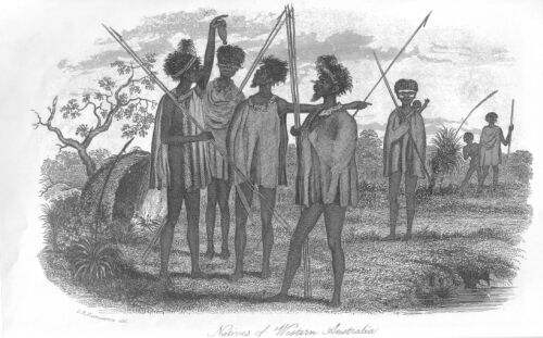
NATIVES OF WESTERN AUSTRALIA.
I.R. Fitzmaurice del.
I cannot allow these volumes to go before the public, without expressing my thanks to the following gentlemen for assistance, afforded to me in the course of the composition of this work: To Captain Beaufort, R.N., F.R.S., Hydrographer to the Admiralty, for his kindness in furnishing me with some of the accompanying charts; to Sir John Richardson, F.R.S; J.E. Gray, Esquire, F.R.S.; E. Doubleday, Esquire, F.L.S., and A. White, Esquire, M.E.S., for their valuable contributions on Natural History, to be found in the Appendix; to J. Gould, Esquire, F.R.S., for a list of birds collected during the voyage of the Beagle; to Lieutenants Gore and Fitzmaurice, for many of the sketches which illustrate the work; and to B. Bynoe, Esquire, F.R.C.S., for several interesting papers which will be found dispersed in the following pages.
Captain Owen Stanley, R.N., F.R.S., also merits my warmest thanks, for the important addition to the work of his visits to the Islands in the Arafura Sea.
I have to explain, that when the name Australasia is used in the following pages, it is intended to include Tasmania (Van Diemen's Land) and all the islands in the vicinity of the Australian continent.
All bearings and courses, unless it is specified to the contrary, are magnetic, according to the variation during the period of the Beagle's voyage.
The longitudes are generally given from meridians in Australia, as I much question whether any portion of the continent is accurately determined with reference to Greenwich. Sydney, Port Essington, and Swan River, have been the meridians selected; and the respective positions of those places, within a minute of the truth, I consider to be as follows:
Swan River (Scott's Jetty, Fremantle) 115 degrees 47 minutes East.
Port Essington (Government house) 132 degrees 13 minutes East.
Sydney (Fort Macquarie) 151 degrees 16 minutes East.
Objects of the Voyage.
The Beagle commissioned.
Her former career.
Her first Commander.
Instructions from the Admiralty and the Hydrographer.
Officers and Crew.
Arrival at Plymouth.
Embark Lieutenants Grey and Lushington's Exploring Party.
Chronometric Departure.
Farewell glance at Plymouth.
Death of King William the Fourth.
Sail from Plymouth.
The Eight Stones.
Peak of Tenerife.
Approach to Santa Cruz.
La Cueva de Los Guanches.
Trade with Mogadore.
Intercourse between Mogadore and Mombas.
Reason to regret Mombas having been given up.
Sail from Tenerife.
Search for rocks near the equator.
Arrival at San Salvador.
Appearance of Bahia.
State of the Country.
Slave Trade.
And results of Slavery.
Extension of the Slave Trade on the eastern coast of Africa.
Moral condition of the Negroes.
Middy's Grave.
Departure from Bahia.
Mr. "Very Well Dice".
A gale.
Anchor in Simon's Bay.
H.M.S. Thalia.
Captain Harris, and his Adventures in Southern Africa.
Proceedings of the Land Party.
Leave Simon's Bay.
An overloaded ship.
Heavy weather and wet decks.
Island of Amsterdam.
Its true longitude.
St. Paul's.
Water.
Westerly variation.
Rottnest Island.
Gage's Road.
Swan River Settlement.
Fremantle.
An inland lake.
Plans for the future.
Illness of Captain Wickham.
Tidal Phenomena.
Perth.
Approach to it.
Narrow escape of the first settlers.
The Darling Range.
Abundant Harvest.
Singular flight of strange birds.
Curious Cliff near Swan River.
Bald Head.
Mr. Darwin's Theory.
The Natives.
Miago.
Anecdotes of Natives.
Their Superstitions.
Barbarous traditions, their uses and their lessons.
Sail from Gage's Road.
Search for a bank.
Currents and soundings.
Houtman's Abrolhos.
Fruitless search for Ritchie's Reef.
Indications of a squall.
Deep sea soundings.
Atmospheric Temperature.
Fish.
A squall.
Anchor off the mouth of Roebuck Bay.
A heavy squall.
Driven from our anchorage.
Cape Villaret.
Anchor in Roebuck Bay.
Excursion on shore.
Visit from the Natives.
Mr. Bynoe's account of them.
A stranger among them.
Captain Grey's account of an almost white race in Australia.
Birds, Snakes, and Turtle.
Move the Ship.
Miago, and the Black Fellows.
The wicked men of the North.
Clouds of Magellan.
Face of the Country.
Natives.
Heat and Sickness.
Miago on shore.
Mr. Usborne wounded.
Failure in Roebuck Bay.
Native notions.
Departure from Roebuck Bay.
Appearance of the Country.
Progress to the northward.
Hills and Cliffs.
French Names and French Navigators.
Tasman, and his account of the Natives.
Hazeygaeys and Assagais.
His Authenticity as an Historian.
Description of the Natives.
Marks and mutilations.
Phrenological Development.
Moral condition.
Proas, Canoes, and Rafts.
Another squall.
Anchor in Beagle Bay.
Face of the Country.
Palm Trees.
Dew.
Hauling the Seine.
A meeting with Natives.
Eastern Salutation.
Miago's conduct towards, and opinion of, his countrymen.
Mutilation of the Hand.
Native smokes seen.
Move further to the North-East.
Point Emeriau.
Cape Leveque.
Point Swan.
Tide-races.
Search for water.
Encountered by Natives.
Return to the Ship.
The attempt renewed.
Conduct of the Natives.
Effect of a Congreve Rocket after dark.
A successful haul.
More Natives.
Miago's Heroism.
The plague of Flies.
Dampier's description of it.
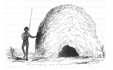
Native Habitations.
Underweigh.
Wind and weather.
Tidal Phenomenon.
Natural History.
Singular Kangaroo.
Bustard.
Cinnamon Kangaroo.
Quails.
Goanas and Lizards.
Ant Hills.
Fishing over the side.
A day in the Bush.
A flood of fire.
Soil and Productions.
White Ibis.
Curious Tree.
Rain water.
Geology of the Cliffs.
Weigh, and graze a Rock, or Touch and go.
The Twins.
Sunday Strait.
Roe's Group.
Miago and his friends.
A black dog.
A day of rest.
Native raft.
Captain King and the Bathurst.
A gale.
Point Cunningham.
Successful search for water.
Native estimation of this fluid.
Discovery of a Skeleton.
And its removal.
The grey Ibis.
Our parting legacy.
Survey the Coast to Point Cunningham.
Move the Ship.
Mosquitoes.
Southern View of King's Sound.
Singular vitreous Formation.
Move to the south of Point Cunningham.
Captain King's limit.
Termination of Cliffy Range.
Disaster Bay.
An Exploring Party leave in the boats.
The shore.
A freshwater lake.
Valentine Island.
Native Fire and Food.
A heavy squall.
The wild Oat.
Indications of a River.
Point Torment.
Gouty-stem Tree and Fruit.
Limits of its growth.
Another squall.
Water nearly fresh alongside.
The Fitzroy River.
Tide Bore and dangerous position of the Yawl.
Ascent of the Fitzroy.
Appearance of the adjacent land.
Return on foot.
Perilous situation and providential escape.
Survey the western shore.
Return to the Ship.
Sporting, Quail and Emus.
Natives.
Ship moved to Point Torment.
Examination of the Fitzroy River.
Excursion into the interior.
Alarm of the Natives.
Ascent of the River.
Sufferings from Mosquitoes.
Red Sandstone.
Natives again surprised.
Appearance of the Country.
Impediments in the River.
Return of the boats.
An Alligator.
Stokes' Bay.
Narrow escape of an Officer.
Change of Landscape.
Pheasant-Cuckoos.
A new Vine.
Compass Hill.
Port Usborne.
Explore the eastern shore of King's Sound.
Cone Bay.
Native Fires.
Whirlpool Channel.
Group of Islands.
Sterile aspect of the Coast.
Visited by a Native.
Bathurst Island.
Native Hut and Raft.
Return to Port Usborne.
Native Spears.
Cascade Bay.
Result of Explorations in King's Sound.
Interview with Natives.
Coral Reefs.
Discover Beagle Bank.
Arrival at Port George the Fourth.
Examination of Collier Bay in the boats.
Brecknock Harbour.
The Slate Islands.
Freshwater Cove.
An Eagle shot.
Its singular nest.
Rock Kangaroos.
A Conflagration.
Sandstone Ridges.
Doubtful Bay.
Mouth of the Glenelg.
Remarkable Tree.
Fertile Country near Brecknock Harbour.
Return to the Ship.
Meet with Lieutenant Grey.
His sufferings and discoveries.
Visit the Encampment.
Timor Ponies.
Embarkation of Lieutenant Grey's Party.
Sail from Port George the Fourth.
Remarks on position of Tryal Rock.
Anecdotes of Miago.
Arrival at Swan River.
Directions for entering Owen's Anchorage.
Miago's reception by his countrymen.
Whale Fishery.
Strange ideas entertained by Natives respecting the first Settlers.
Neglected state of the Colony.
Test security of Owen's Anchorage.
Weather.
Celebration of the Anniversary of the Colony.
Friendly meeting between different Tribes.
Native beggars.
Personal vanity of a Native.
Visit York.
Description of Country.
Site of York.
Scenery in its neighbourhood.
Disappointment experienced.
Sail from Swan River.
Hospitality of Colonists during our stay.
Aurora Australis.
Gale off Cape Leeuwen.
Stormy passage.
Ship on a lee shore.
South-west Cape of Tasmania.
Bruny Island Lighthouse.
Arrive at Hobart.
Mount Wellington.
Kangaroo Hunt.
White Kangaroo.
Civility from the Governor.
Travertine Limestone.
Leave Hobart.
Singular Current.
Appearance of Land in the neighbourhood of Sydney.
Position of Lighthouse.
Entrance and first view of Port Jackson.
Scenery on passing up the Harbour.
Meet the Expedition bound to Port Essington.
Apparent increase of Sydney.
Cause of Decline.
Expedition sails for Port Essington.
Illawarra.
Botany Bay.
La Perouse's Monument.
Aborigines.
Meet Captain King.
Appearance of Land near Sydney.
Leave Sydney.
Enter Bass Strait.
Island at Eastern entrance.
Wilson's Promontory.
Cape Shanck.
Enter Port Phillip.
Tide-race.
Commence Surveying Operations.
First Settlement.
Escaped Convict.
His residence with the Natives.
Sail for King Island.
Examine Coast to Cape Otway.
King Island.
Meet Sealers on New Year Islands.
Franklin Road.
Solitary Residence of Captain Smith.
Soil.
Advantageous position for a Penal Settlement.
Leafless appearance of Trees.
Examine West Coast.
Fitzmaurice Bay.
Stokes' Point.
Seal Bay.
Geological Formation.
Examine Coast to Sea Elephant Rock.
Brig Rock.
Cross the Strait to Hunter Island.
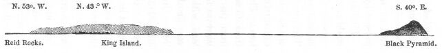
Strong Tide near Reid's Rocks.
Three Hummock Island.
Rats.
The Black Pyramid.
Point Woolnorth.
Raised Beach.
Coast to Circular Head.
Headquarters of the Agricultural Company.
Capture of a Native.
Mouth of the Tamar River.
Return to Port Phillip.
West Channel.
Yarra-yarra River.
Melbourne.
Custom of Natives.
Manna.
Visit Geelong.
Station Peak.
Aboriginal Names.
South Channel.
Examine Western Port.
Adventure with a Snake.
Black Swans.
Cape Patterson.
Deep Soundings.
Revisit King and Hunter Islands.
Fire.
Circular Head.
Gales of Wind.
Reid's Rocks.
Sea Elephant Rock.
Wild Dogs.
Navarin and Harbinger Reefs.
Arrive at Port Phillip.
Sail for Sydney.
Pigeon House.
Drought.
Mr. Usborne leaves.
Leave Sydney.
Gale and Current.
Port Stephens.
Tahlee.
River Karuah.
Stroud.
Wild Cattle.
Incivility of a Settler.
River Allyn.
Mr. Boydell.
Cultivation of Tobacco.
A clearing Lease.
William River.
Crossing the Karuah at Night.
Sail from Port Stephens.
Breaksea Spit.
Discover a Bank.
Cape Capricorn.
Northumberland Isles.
Sandalwood.
Cape Upstart.
Discover a River.
Raised Beach.
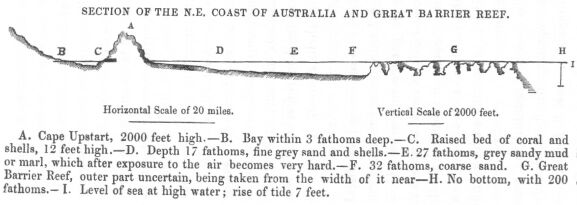
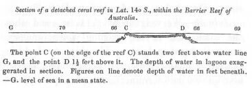
Section of Barrier Reef.
Natives.
Plants and Animals.
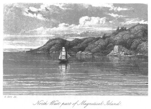
Magnetical Island.
Halifax Bay.
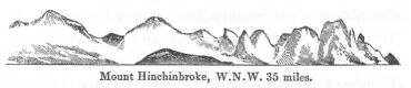
Height of Cordillera.
Fitzroy Island.
Hope Island.
Verifying Captain King's Original Chart.
Cape Bedford.
New Geological Feature.
Lizard Island.
Captain Cook.
Barrier and Reefs within.
Howick Group.
Noble Island.
Cape Melville.
Reef near Cape Flinders.
Princess Charlotte's Bay.
Section of a detached Reef.
Tide at Claremont Isles.
Restoration Island.
Islands fronting Cape Grenville.
Boydan Island.
Correct Chart.
Tides.
Cairncross Island.
Escape River.
Correct position of Reefs.
York Isles.
Tides.
Torres Strait.
Endeavour Strait.
Booby Island.
Remarks on Barrier and its contiguous Islands and Reefs.
Cape Croker and reef off it.
Discover error in longitude of Cape.
Reefs at the mouth of Port Essington.
Arrive at the latter.
Port Essington.
Bearings from shoals in the Harbour.
Appearance of the Settlement.
Meet Captain Stanley.
Church.
Point Record.
Prospects of the Settlement.
Buffaloes escape.
Fence across neck of Peninsula.
Lieutenant P.B. Stewart explores the Country.
Natives.
Uses of Sand.
Tumuli-building Birds.
Beautiful Opossum.
Wild Bees.
Escape from an Alligator.
Result of Astronomical Observations.
Geological Formation.
Raffles Bay.
Leave Port Essington.
Popham Bay.
Detect error in position of Port Essington.
Melville Island.
Discover a Reef in Clarence Strait.
Cape Hotham.
Native Huts and Clothing.
Geological Formation.
Discover the Adelaide River.
Interview with Natives.
Attempt to come on board.
Messrs. Fitzmaurice and Keys nearly speared.
Exploration of the Adelaide.
Its capabilities.
Wood-ducks.
Vampires.
Another party ascends the Adelaide.
Meet Natives.
Canoes.
Alligator.
Visit Melville Island.
Green Ants.
Thoughts of taking ship up Adelaide abandoned.
Tides in Dundas Strait.
Return to Port Essington.
Theatricals.
H.M.S. Pelorus arrives with Provisions.
Further remarks on the Colony.
Leave Port Essington.
Reach Timor Laut.
Meet Proas.
Chief Lomba.
Traces of the Crew of the Charles Eaton.
Their account of the wreck and sojourn on the Island.
Captain King's account of the Rescue of the Survivors.
Boy Ireland's relation of the sufferings and massacre of the Crew.
Appearance of the shores of Timor Laut.
Description of the Inhabitants.
Dress.
Leprosy.
Canoes.
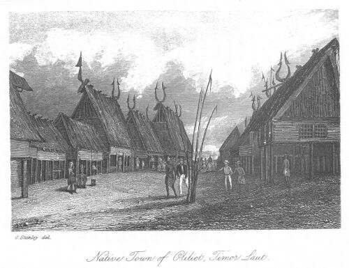
Village of Oliliet.
Curious Houses.
Remarkable Ornaments.
Visit the Oran Kaya.
Burial Islet.
Supplies obtained.
Gunpowder in request as Barter.
Proceed to the Arru Islands.
Dobbo Harbour.
Trade.
Present to Chief.
Birds of Paradise.
Chinaming Junks' bottoms.
Character of Natives.
Some of them profess Christianity.
Visit the Ki Islands.
Village of Ki Illi.
How protected.
Place of Worship.
Pottery.
Timber.
Boat-building.
Cultivation of the eastern Ki.
No anchorage off it.
Visit Ki Doulan.
Antique Appearance of.
Luxuriant Vegetation.
Employment of Natives.
Defences of the place.
Carvings on gateway.
Civility of Chief.
His Dress.
Population of the Ki Group.
Their Religion.
Trade.
Place of Interment.
Agility of Australian Native.
Supplies.
Anchorage off Ki Doulan.
Island of Vordate.
Visit from Chief.
Excitement of Natives.
Their Arms and Ornaments.
Carved Horns on Houses.
Alarm of the Oran Kaya.
Punishment of the Natives of Laarat by the Dutch.
Revisit Oliliet.
Discover that Mr. Watson had rescued the European Boy.
Return to Port Essington.
Mr. Watson's Proceedings at Timor Laut.
List of Birds, collected by the Officers of H.M.S. Beagle.
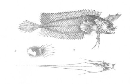
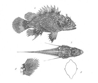
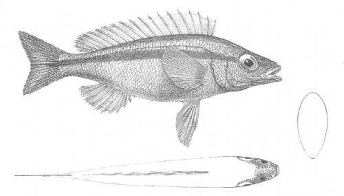
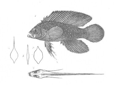
Descriptions of Six Fish. By Sir John Richardson. M.D., F.R.S. etc.
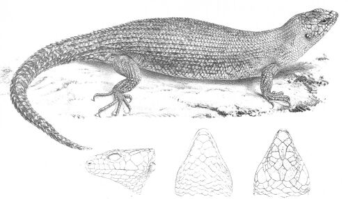
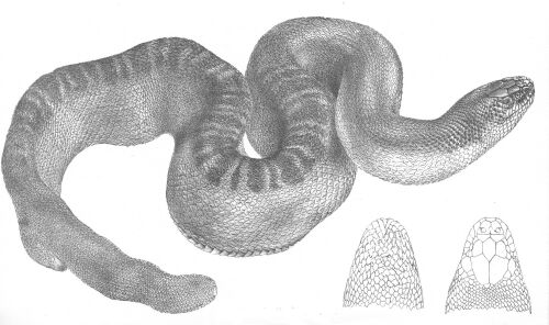
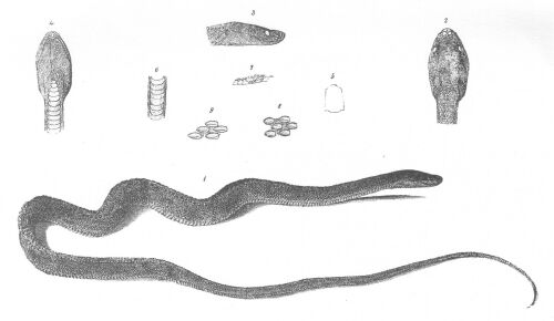
Descriptions of some New Australian Reptiles. By J.E. Gray, Esquire F.R.S. etc.
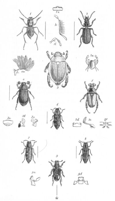
Descriptions of new or unfigured Species of Coleoptera from Australia. By Adam White, Esquire M.E.S.
Descriptions of some new or imperfectly characterized Lepidoptera from Australia. By E. Doubleday, Esquire F.L.S.
NATIVES OF WESTERN AUSTRALIA.
I.R. Fitzmaurice del.
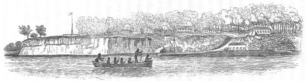
SOUTH BRANCH OF THE ALBERT RIVER.
KILEYS OF KING SOUND AND SWAN RIVER.
SPEARS OF KING SOUND AND SWAN RIVER.
REID'S ROCKS, KING ISLAND AND THE BLACK PYRAMID.
SECTION OF THE NORTH-EAST COAST OF AUSTRALIA, AND GREAT BARRIER REEF.
NORTH-WEST PART OF MAGNETIC ISLAND.
SECTION OF A DETACHED CORAL REEF.
RUSH SHOULDER-COVERING OF NATIVES.
SOUTH BRANCH OF THE ALBERT RIVER.
G. GORE del. London, Published by T. & W. Boone, 1846.
Objects of the Voyage.
The Beagle commissioned.
Her former career.
Her first Commander.
Instructions from the Admiralty and the Hydrographer.
Officers and Crew.
Arrival at Plymouth.
Embark Lieutenants Grey and Lushington's Exploring Party.
Chronometric Departure.
Farewell glance at Plymouth.
Death of King William the Fourth.
For more than half a century, the connection between Great Britain and her Australian possessions has been one of growing interest; and men of the highest eminence have foreseen and foretold the ultimate importance of that vast continent, over which, within the memory of living man, the roving savage held precarious though unquestioned empire.
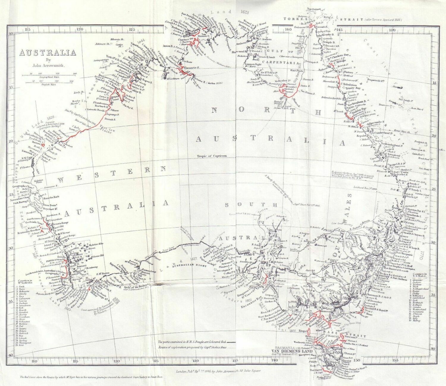
Of the Australian shores, the North-western was the least known, and became, towards the close of the year 1836, a subject of much geographical speculation. Former navigators were almost unanimous in believing that the deep bays known to indent a large portion of this coast, received the waters of extensive rivers, the discovery of which would not only open a route to the interior, but afford facilities for colonizing a part of Australia, so near our East Indian territories, as to render its occupation an object of evident importance.
His Majesty's Government therefore determined to send out an expedition to explore and survey such portions of the Australian coasts as were wholly or in part unknown to Captains Flinders and King.
H.M. SLOOP BEAGLE.
For this service H.M. Sloop Beagle was commissioned at Woolwich, in the second week of February 1837 by Commander Wickham, who had already twice accompanied her in her wanderings over the least known and most boisterous waters of the globe; first, in her sister ship of discovery, the Adventure, Captain King, and afterwards as first lieutenant of the sloop now entrusted to his command. Under Captain Wickham some of the most important objects of the voyage were achieved, but in consequence of his retirement in March 1841, owing to ill health, the command of the Beagle was entrusted to the author of the following pages; and as, by a singular combination of circumstances, no less than three long and hazardous voyages of discovery have been successfully completed in this vessel, some account of her here may not be wholly uninteresting. The reader will be surprised to learn that she belongs to that much-abused class, the 10-gun brigs--COFFINS, as they are not infrequently designated in the service; notwithstanding which, she has proved herself, under every possible variety of trial, in all kinds of weather, an excellent sea boat. She was built at Woolwich in 1819, and her first exploit was the novel and unprecedented one of passing through old London bridge (the first rigged man-of-war that had ever floated so high upon the waters of the Thames) in order to salute at the coronation of King George the Fourth.
VOYAGES OF THE BEAGLE.
Towards the close of the year 1825 she was first commissioned by Commander Pringle Stokes,* as second officer of the expedition which sailed from Plymouth on the 22nd of May, 1826, under the command of Captain Phillip Parker King; an account of which voyage, published by Captain R. Fitzroy, who ultimately succeeded to the vacancy occasioned by the lamented death of Captain Stokes, and who subsequently commanded the Beagle during her second solitary, but most interesting expedition--has added to the well-earned reputation of the seaman, the more enduring laurels which literature and science can alone supply.
(*Footnote. Not related to the author.)
DEATH OF CAPTAIN STOKES.
Though painful recollections surround the subject, it would be hardly possible to offer an account of the earlier history of the Beagle, and yet make no allusion to the fate of her first commander, in whom the service lost, upon the testimony of one well qualified to judge, "an active, intelligent, and most energetic officer:" and well has it been remarked by the same high authority, "that those who have been exposed to one of such trials as his, upon an unknown lee shore, during the worst description of weather, will understand and appreciate some of those feelings which wrought too powerfully upon his excitable mind." The constant and pressing cares connected with his responsible commanded--the hardships and the dangers to which his crew were of necessity exposed during the survey of Tierra del Fuego--and in some degree the awful gloom which rests forever on that storm-swept coast--finally destroyed the equilibrium of a mind distracted with anxiety and shattered by disease.
Perhaps no circumstance could prove more strongly the peculiar difficulties connected with a service of this nature, nor could any more clearly testify that in this melancholy instance every thought of self-preservation was absorbed by a zeal to promote the objects of the expedition, which neither danger, disappointment, anxiety, nor disease could render less earnest, or less vigilant, even to the last!
The two vessels returned to England in October, 1830, when the Adventure was paid off at Woolwich, and the Beagle at Plymouth; she was recommissioned by Captain Fitzroy--to whose delightful narrative allusion has been already made--on the 4th July, 1831,* and continued under his command till her return to Woolwich in November, 1836; where, after undergoing some slight repairs, she was a third time put in commission for the purposes of discovery, under Commander Wickham, her former first lieutenant; and shortly afterwards commenced that third voyage, of the toils and successes of which, as an humble contribution to the stores of geographical knowledge, I have attempted in the following pages to convey as faithful and complete an account as the circumstances under which the materials have been prepared will allow. Nor will the subject less interest myself, when I call to mind, that for eighteen years the Beagle has been to me a home upon the wave--that my first cruise as a Middy was made in her; that serving in her alone I have passed through every grade in my profession to the rank I have now the honour to hold--that in her I have known the excitements of imminent danger, and the delights of long anticipated success; and that with her perils and her name are connected those recollections of early and familiar friendship, to which even memory herself fails to do full justice!
(*Footnote. The Beagle was stripped to her timbers, and rebuilt under this able officer's own inspection: and among other improvements, she had the lightning conductors of the well-known Snow Harris, Esquire, F.R.S. fitted to her masts; a circumstance to which she has more than once been indebted for her safety.)
ADMIRALTY INSTRUCTIONS.
The following instructions were received by Captain Wickham, previous to our departure from Woolwich, and under them I subsequently acted.
BY THE COMMISSIONERS FOR EXECUTING THE OFFICE OF LORD HIGH ADMIRAL OF THE UNITED KINGDOM OF GREAT BRITAIN AND IRELAND, ETC.
Whereas his Majesty's surveying vessel, Beagle, under your command, has been fitted out for the purpose of exploring certain parts of the north-west coast of New Holland, and of surveying the best channels in the straits of Bass and Torres, you are hereby required and directed, as soon as she shall be in all respects ready, to repair to Plymouth Sound, in order to obtain a chronometric departure from the west end of the breakwater, and then to proceed, with all convenient expedition, to Santa Cruz, in Tenerife.
In the voyage there, you are to endeavour to pass over the reputed site of the Eight Stones, within the limits pointed out by our Hydrographer; but keeping a strict lookout for any appearance of discoloured water, and getting a few deep casts of the lead.
At Tenerife you are to remain three days, for the purpose of rating the chronometers, when you are to make the best of your way to Bahia, in order to replenish your water, and from thence to Simon's Bay, at the Cape of Good Hope; where, having without loss of time obtained the necessary refreshments, you will proceed direct to Swan River; but as the severe gales which are sometimes felt at that settlement may not have entirely ceased, you will approach that coast with due caution.
At Swan River, you are to land Lieutenants Grey and Lushington, as well as to refit and water with all convenient despatch; and you are then to proceed immediately to the north-west coast of New Holland, making the coast in the vicinity of Dampier Land. The leading objects of your examination there will be, the extent of the two deep inlets connected with Roebuck Bay and Cygnet Bay, where the strength and elevation of the tides have led to the supposition that Dampier Land is an island, and that the above openings unite in the mouth of a river, or that they branch off from a wide and deep gulf. Moderate and regular soundings extend far out from Cape Villaret: you will, therefore, in the first instance, make that headland; and, keeping along the southern shore of Roebuck Bay, penetrate at once as far as the Beagle and her boats can find sufficient depth of water; but you must, however, take care not too precipitately to commit His Majesty's ship among these rapid tides, nor to entangle her among the numerous rocks with which all this part of the coast seems to abound; but by a cautious advance of your boats, for the double purpose of feeling your way, and at the same time of surveying, you will establish her in a judicious series of stations, equally beneficial to the progress of the survey, and to the support of your detached people.
Prince Regent River appears to have been fully examined by Captain King up to its freshwater rapids, but as the adjacent ridges of rocky land which were seen on both sides of Collier Bay, were only laid down from their distant appearance, it is probable that they will resolve themselves into a collection of islands in the rear of Dampier Land; and it is possible that they may form avenues to some wide expanse of water, or to the mouth of some large river, the discovery of which would be highly interesting.
As this question, whether there are or are not any rivers of magnitude on the western coast is one of the principal objects of the expedition, you will leave no likely opening unexplored, nor desist from its examination till fully satisfied; but as no estimate can be formed of the time required for its solution, so no period can be here assigned at which you shall abandon it in order to obtain refreshments; when that necessity is felt, it must be left to your own judgment, whether to have recourse to the town Balli, in the strait of Allas, or to the Dutch settlement of Coepang, or even to the Arrou Islands, which have been described as places well adapted for that purpose; but on these points you will take pains to acquire all the information which can be obtained from the residents at Swan River.
Another circumstance which prevents any precise instructions being given to you on this head, is the uncertainty that prevails here respecting the weather which you may at that period find in those latitudes, and which it is possible may be such as if not altogether to prevent the execution of these orders, may at least cause them to be ineffectually performed, or perhaps lead to a waste of time, which might be better employed on other parts of the coast. If such should eventually be the case, it would be prudent not to attempt this intricate part of the coast during the prevalence of the north-west monsoon, but to employ it in completing the examination of Shark Bay and of Exmouth Gulf, as well as of other unexplored intervals of coast up to the 122nd degree of longitude; or, with a view to the proximity of one of the above-mentioned places of refreshment, it might, perhaps, be advisable, if compelled to quit the vicinity of Dampier Land, to devote that part of the season to a more careful investigation of the low shores of the gulf of Carpentaria, where it has been surmised, though very loosely, that rivers of some capacity will be found.
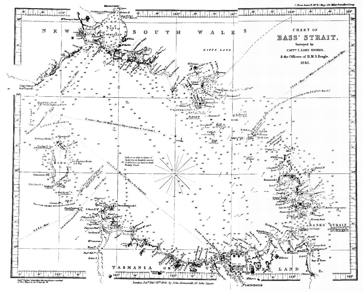
The above objects having been accomplished (in whatever order you may find suitable to the service) you will return to the southern settlements for refreshments; and then proceed, during the summer months of fine weather and long days, to Bass Strait, in which so many fatal accidents have recently occurred, and of which you are to make a correct and effectual survey.
But previous to your undertaking that survey, as it has been represented to us that it would be very desirable for the perfection of the Tidal theory, that an accurate register of the times and heights of high and low-water should be kept for some time in Bass Strait, you will (if practicable) establish a party for that purpose on King Island, and you are to cause the above particulars of the Tides there to be unintermittently and minutely observed, and registered in the blank forms which will be supplied to you by our Hydrographer. If, however, circumstances should render this measure unadvisable at that island, you will either choose some less objectionable station, where the average tide in the Strait may be fairly registered; or, if you can employ no permanent party on this service, you will be the more exact in ascertaining the above particulars at every one of your stations; and in all parts of this Strait you will carefully note the set and strength of the stream at the intermediate hours between high and low-water, and also the time at which the stream turns in the offing.
The survey of Bass Strait should include, first, a verification of the two shores by which it is formed; secondly, such a systematic representation of the depth and quality of the bottom as will ensure to any vessel, which chooses to sound by night or day, a correct knowledge of her position; and, thirdly, a careful examination of the passages on either side of King Island, as well as through the chains of rocks and islands which stretch across from Wilson's Promontory to Cape Portland. This survey will, of course, comprehend the approach to Port Dalrymple, but the interior details of that extensive harbour may be left to the officers employed by the Lieutenant-Governor of Van Diemen's Land, provided you can ascertain that it is his intention to employ them there within any reasonable time.
The number of vessels which are now in the habit of passing through Bass Strait, and the doubts which have recently been expressed, not only of the just position of the dangers it is known to contain, but of the existence of others, show the necessity of this survey being executed with that care and fidelity which will give confidence to all future navigators; and may, therefore, be more extensive in its limits, and occupy a larger portion of your time than is at present contemplated. You must exercise your own judgment as to the fittest period at which you should either repair to Sydney to refit, or adjourn to Port Dalrymple to receive occasional supplies. Whenever this branch of the service shall be completed, you are forthwith by a safe conveyance to transmit a copy of it to our Secretary, that no time may be lost in publishing it for the general benefit.
At Sydney you will find the stores which we have ordered to be deposited there for your use, and having carefully rated your chronometers, and taken a fresh departure from the Observatory near that port, and having re-equipped His Majesty's ship, and fully completed her provisions, you will proceed by the inner route to Torres Strait, where the most arduous of your duties are yet to be performed. The numerous reefs which block up that Strait; the difficulty of entering its intricate channels; the discordant result of the many partial surveys which have from time to time been made there, and the rapidly increasing commerce of which it has become the thoroughfare, call for a full and satisfactory examination of the whole space between Cape York and the southern shore of New Guinea, and to this important service, therefore, you will devote the remaining period for which your supplies will last.
In this latter survey you will cautiously proceed from the known to the unknown; you will verify the safety of Endeavour Strait, and furnish sufficient remarks for avoiding its dangers; you will examine the three groups called York, Prince of Wales, and Banks, Islands; you will establish the facilities or determine the dangers of passing through those groups, and by a well-considered combination of all those results, you will clearly state the comparative advantages of the different channels, and finally determine on the best course for vessels to pursue which shall be going in either direction, or in opposite seasons. Though with this part of your operations Cook's Bank, Aurora Reef, and the other shoals in the vicinity will necessarily be connected, yet you are not to extend them to the 143rd degree of longitude, as the examination of the great field to the eastward of that meridian must be left to some future survey which shall include the barrier reefs and their ramified openings from the Pacific Ocean. You are, on the contrary, to proceed, if practicable, but most cautiously, in examining the complicated archipelago of rocks and islands which line the northern side of Torres Strait, till, at length, reaching New Guinea, you will there ascertain the general character of that part of its shore, whether it be high and continuous, or broken into smaller islands with available channels between them, as has been asserted; or whether, from being guarded by the innumerable reefs and dangers which are marked in the charts, it must remain altogether sealed to the navigator. The nature of the country, as well as of its products, will also be inquiries of considerable interest; and you will, perhaps, be able to learn whether the Dutch have made any progress in forming settlements along its shores; and if so, you will take especial care not to come into collision with any of their authorities.
Throughout the whole of this extensive region, you will bear in mind the mischievous disposition of the natives; and while you strictly practice that dignified forbearance and benevolence which tend to impress far higher respect for our power than the exercise of mere force, you will also be sedulously on your guard against every surprise; and though your boats should always be completely armed, you will carefully avoid any conflict where the ignorant or misguided natives may presume on your pacific appearance, or on the disparity of your numbers.
You will then turn to the westward, and pursue this part of the survey, so as to determine the breadth of the foul ground off the coast of New Guinea, and the continuity or interrupted form of that coast; and you will establish certain positions on the mainland (if the adjacent sea be navigable, and if not on the several advancing islands) which may serve as useful land-falls for vessels coming from the Indian Seas, or for points of departure for those who have passed through any of these straits. You will thus continue a general examination of this hitherto unexplored coast as far as Cape Valsche, which is now said to be only the terminating point of a chain of large islands, and then across to the Arrou Islands, which are supposed to be remarkably fertile, to abound with resources and refreshments, and to be peopled by a harmless and industrious race, but which do not appear to have been visited by any of His Majesty's ships.
The length of time which may be required for the due execution of all the foregoing objects cannot be foreseen. It may exceed that for which your supplies are calculated, or, on the other hand, a less degree of the supposed complexity in the ground you will have traversed, along with the energy and diligence with which we rely on you for conducting these important services, may enable you to complete them within that period. In this latter case you will return to the Northern coast of New Holland, and selecting such parts of it as may afford useful harbours of retreat, or which may appear to comprise the mouths of any streams of magnitude, you will employ your spare time in such discoveries as may more or less tend to the general object of the expedition.
Before your departure from Sydney you will have learnt that His Majesty's Government has established a new settlement at Port Essington, or somewhere on the North coast of New Holland; and before you finally abandon that district you will visit this new colony, and contribute by every means in your power to its resources and its stability.
We have not, in the concluding part of these Orders, pointed out the places or the periods at which you are to replenish your provisions, because the latter must depend on various circumstances which cannot be foreseen, and the former may be safely left to your own decision and prudence; but when you have been three years on your ground, unless some very important result were to promise itself from an extension of that period, you will proceed to the Island of Mauritius, in order to complete your stock of water and provisions, and then, touching at either side of the Cape of Good Hope, according to the season, and afterwards at Ascension, you will make the best of your way to Spithead, and report your arrival to our Secretary.
Directions will be forwarded to the commanders-in-chief at the Cape of Good Hope and in the East Indies, and to the governors or lieutenant-governors of the several settlements at which you have been ordered to call, to assist and further your enterprise as far as their means will admit: and you will lose no opportunity, at those several places, of informing our Secretary of the general outline of your proceedings, and of transmitting traces of the surveys which you may have effected, together with copies of your tide and other observations. You will likewise, by every safe opportunity, communicate to our Hydrographer detailed accounts of all your proceedings which relate to the surveys; and you will strictly comply with the enclosed instructions, which have been drawn up by him under our directions, as well as all those which he may, from time to time, forward by our command.
Given under our hands, the 8th of June, 1837.
Signed,
Charles Adam.
George Elliott.
To J.C. Wickham, Esquire.
Commander of His Majesty's surveying vessel Beagle, at Woolwich.
By command of their Lordships.
Signed,
John Barrow.
Nor should the valuable instructions of Captain Beaufort, Hydrographer to the Admiralty, be forgotten; such extracts as may probably prove of interest to the general reader are here subjoined.
EXTRACTS FROM HYDROGRAPHER'S INSTRUCTIONS.
The general objects of the expedition which has been placed under your command, having been set forth in their Lordship's orders, it becomes my duty to enter somewhat more specifically into the nature and details of the service which you are to perform. Their Lordships having expressed the fullest reliance on your zeal and talents, and having cautiously and wisely abstained from fettering you in that division and disposition of your time which the periodic changes of the seasons or the necessities of the vessel may require, it would ill become me to enter too minutely into any of those arrangements which have been so flatteringly left to your discretion; yet, in order to assist you with the results of that experience which has been derived from the many surveys carried on under the direction of the Admiralty, and to ensure that uniform consistency of method in your varied labours, which will so greatly enhance their value, I will briefly touch on some of the most important subjects, and repeat those instructions which their Lordships have in every former case ratified, and which it is therefore expected you will bear in mind during the whole progress of your survey.
The first point to which your orders advert, after quitting England, is the Eight Stones, where you will probably add one to the many testimonies which have been already collected of their non-existence, at least in the place assigned to them in the old charts; but, before we venture to expunge them, it becomes a serious duty to traverse their position in every possible direction. Should the weather be favourable, it would be desirable, while crossing their parallel, to obtain one very deep cast of the lead, and should that succeed in reaching the bottom, the sacrifice of a few days will be well bestowed in endeavouring to trace a further portion of the bank. A small chart, showing the tracks of various ships across this place, is hereto annexed, and as the meridian of 16 degrees 22 minutes nearly bisects the two adjacent courses, you are recommended to cross their parallel in that longitude.
From the Canary Islands to the coast of Brazil, and indeed throughout every part of your voyage, you should endeavour to pass over the places of all the reported Vigias which lie near your course, either outward or homeward. You will perceive a multitude of them carelessly marked on every chart, but of some you will find a circumstantial description in that useful publication, the Nautical Magazine, and a day devoted to the search of any, which will not withdraw you too far from your due course, will be well employed.
The rocks off Cape Leeuwin, some near King George Sound, the dangerous patch off Kangaroo Island, and many others, of which accounts are given in the above work, ought, if possible, to be examined, as more immediately appertaining to your own field. Whenever found, the depth, nature, and limits of the banks on which they stand, should be determined, as they might prove to be of sufficient extent to give warning to the danger, and then a direct course should be immediately made by the Beagle to the nearest land, where a convenient place should be selected, and its position carefully ascertained.
At Swan River you will have previously learnt from Lieutenant Roe, the Surveyor-General, whether the above-mentioned rocks off Kangaroo Island, have been again seen, or their position altered, since Captain Brockman's first description, so as to save your time in the search.
You will no doubt obtain from that intelligent officer, Lieutenant Roe, much important information respecting the north-west coast, as well as all the detached intelligence, which during his long residence there he must have collected, relating to every part of the shores of New Holland. From him, also, you will acquire many useful hints about the places in the Indian Sea where refreshments may be obtained, as well as some insight into the disposition of the authorities and the inhabitants whom you will meet there, and he will probably be able to give you a clear account of the duration of the monsoons and their accompanying weather.
If at Port Dalrymple it should so happen that you can wait on Sir John Franklin, it is probable that he will detach Lieutenant Burnett to cooperate with you in the survey of Bass Strait, and it is certain that the Governor will do everything in his power to assist your labours. At Sydney you will have the advantage of seeing Captain P.P. King, whose long experience of all those coasts, as well as of the seasons, and of the manner of dealing with the inhabitants, will be of the utmost use to you; and whose zeal for the King's service, and whose love of science, will lead him to do everything possible to promote your views. If Mr. Cunningham, the Government Botanist, be there, he also will, I am convinced, eagerly communicate to you and your officers everything which may be serviceable in the pursuits connected with Natural History.
At Swan River, at Port Dalrymple, and at Sydney, it may, perhaps, be possible for you to hire, at a low rate, some person acquainted with the dialects of the natives, which you are subsequently to visit, and with whom it will be so essential to be on friendly terms. Such a person will greatly assist in that object; but you will keep him on board no longer than absolutely necessary, and you will take care to provide for his return if the Beagle should not be able to carry him back.
GENERAL INFORMATION.
In such an extensive and distant survey, numerous subjects of inquiry, though not strictly nautical, will suggest themselves to your active mind; and though, from your transient stay at any other place, you will often experience the mortification of leaving them incomplete, yet that should not discourage you in the collection of every useful fact within your reach. Your example in this respect will stimulate the efforts of the younger officers under your command, and through them may even have a beneficial influence on the future character of the navy.
It has been suggested by some geologists, that the coral insect, instead of raising its superstructure directly from the bottom of the sea, works only on the summits of submarine mountains, which have been projected upwards by volcanic action. They account, therefore, for the basin-like form so generally observed in coral islands, by supposing that they exist on the circular lip of extinct volcanic craters; and as much of your work will lie among islands and cays of coral formation, you should collect every fact which can throw any light on the subject.
Hitherto it has been made a part of the duty of all the surveying vessels to keep an exact register of the height of the barometer, at its two maxima of 9, and its two minima of 3 o'clock, as well as that of the thermometer at the above periods, and at its own day and night maximum and minimum, as well as the continual comparative temperature of the sea and air. This was done with the view of assisting to provide authentic data, collected from all parts of the world, and ready for the use of future labourers, whenever some accidental discovery, or the direction of some powerful mind, should happily rescue that science from its present neglected state. But those hours of entry greatly interfere with the employments of such officers as are capable of registering those instruments with the precision and delicacy which alone can render meteorologic data useful, and their future utility is at present so uncertain, that it does not appear necessary that you should do more than record, twice a day, the height of the former, as well as the extremes of the thermometer, unless, from some unforeseen cause, you should be long detained in any one port, when a system of these observations might then be advantageously undertaken. There are, however, some occasional observations, which cannot fail of being extensively useful in future investigations:
1. During the approach of the periodic changes of wind and weather, and then the hygrometer, also, should find a place in the journal.
2. The mean temperature of the sea at the equator, or, perhaps, under a vertical sun. These observations should be repeated whenever the ship is in either of those situations, as well in the Atlantic as in the Pacific; they should be made far away from the influence of the land, and at certain constant depths, suppose fifty and ten fathoms, and at the surface also; and this last ought to be again observed at the corresponding hour of the night.
3. A collection of good observations, systematically continued, for the purpose of connecting the isothermal lines of the globe, and made, as above, at certain uniform depths.
4. Some very interesting facts might result from the comparison of the direct heat of the solar rays in high and low latitudes. The two thermometers for this purpose should be precisely similar in every respect; the ball of the one should be covered with white kerseymere, and of the other with black kerseymere, and they should be suspended far out of the reach of any reflected heat from the ship, and also at the same elevation above the surface of the water; the observations should be made out of sight of land, in a variety of latitudes, and at different hours of the day, and every pains taken to render them all strictly similar and comparative.
5. All your meteorologic instruments should be carefully compared throughout a large extent of the scales, and tabulated for the purpose of applying the requisite corrections when necessary, and one or more of them should be compared with the standard instruments at the Royal Society or Royal Observatory on your return home.
6. All observations which involve the comparison of minute differences should be the mean result of at least three readings, and should be as much as possible the province of the same individual observer.
7. In some of those singularly heavy showers which occur in crossing the Equator, and also at the changes of the Monsoon, attempts should be made to measure the quantity of rain that falls in a given time. A very rude instrument, if properly placed, will answer this purpose, merely a wide superficial basin to receive the rain, and to deliver it into a pipe, whose diameter, compared with that of the mouth of the basin, will show the number of inches, etc. that have fallen on an exaggerated scale.
8. It is unnecessary to call your attention to the necessity of recording every circumstance connected with that highly interesting phenomenon, the Aurora Australis, such as the angular bearing and elevation of the point of coruscation; the bearing also of the principal luminous arches, etc.
9. It has been asserted that lunar and solar halos are not always exactly circular, and a general order might, therefore, be given to the officer of the watch, to measure their vertical and horizontal diameters whenever they occur, day or night.
Large collections of natural history cannot be expected, nor any connected account of the structure or geological arrangements of the great islands which you are to coast; nor, indeed, would minute inquiries on these subjects be at all consistent with the true objects of the survey. But, to an observant eye, some facts will unavoidably present themselves, which will be well worth recording, and the medical officers will, no doubt, be anxious to contribute their share to the scientific character of the survey.
I have now exhausted every subject to which it can be necessary to call the attention of an officer of your long experience; and I have, therefore, only further to express my conviction, that if Providence permits you to retain your wonted health and activity, you will pursue the great objects of this expedition with all the energy in your power, and with all the perseverance consistent with a due regard to the safety of His Majesty's Ship, and to the comfort of your officers and crew.
Given, etc. this 8th of June, 1837.
F. Beaufort,
Hydrographer.
OFFICERS AND CREW.
The crew embarked in the Beagle in this her third voyage, consisted of:
John Clements Wickham, Commander and Surveyor.
James B. Emery, Lieutenant.
Henry Eden, Lieutenant.
John Lort Stokes, Lieutenant and Assistant Surveyor.
Alexander B. Usborne, Master.
Benjamin Bynoe, Surgeon.
Thomas Tait, Assistant Surgeon.
John E. Dring, Clerk in charge.
Benjamin F. Helpman, Mate.
Auchmuty T. Freeze, Mate.
Thomas T. Birch, Mate.
L.R. Fitzmaurice, Mate.*
William Tarrant, Master's Assistant.
Charles Keys,** Clerk.
Thomas Sorrell, Boatswain.
John Weeks, Carpenter.
A corporal of marines and seven privates, with forty seamen and boys.
(*Footnote. This officer I afterwards appointed to the assistant surveyorship (vacated upon my succeeding Captain Wickham) on account of the active part he had taken in the surveying duties: an appointment most handsomely confirmed by Captain Beaufort.)
(**Footnote. Mr. Keys was always a volunteer for boat work, and is entitled to honourable mention as being, even where all were zealous, of great value upon more than one occasion.)
During our six years' voyage the following changes occurred:
Mr. Usborne invalided, in consequence of his wound, in May 1839; Mr. Birch exchanged, in August 1839, with Mr. Pasco, into the Britomart; Mr. Freeze exchanged, in September 1839, with Mr. Forsyth,* into the Pelorus; in February 1840, Mr. Helpman joined the colonial service in Western Australia; Mr. C.J. Parker was appointed, in December 1840, to Mr. Usborne's vacancy, superseding Mr. Tarrant, who had been doing Master's duty since Mr. Usborne left; Lieutenants Emery and Eden returned to England in March 1841. Late in the same month Commander Wickham invalided, when the writer of this narrative was appointed to the vacant command, by Commander Owen Stanley, H.M.S. Britomart, senior officer present, an appointment subsequently confirmed by the Lords of the Admiralty. In April 1841, Lieutenant Graham Gore succeeded Lieutenant Emery.** Commander Wickham, myself, Mr. Bynoe, the Boatswain, and two marines, had served in both the previous voyages of the Beagle.
(*Footnote. From this officer's previous knowledge of the duties of surveying, having sailed in the Beagle on her former voyage, he proved a very valuable addition to our party.)
(**Footnote. Lieutenant Gore had been appointed to H.M.S. Herald and came down from India, expecting to join her at Sydney: on his arrival, he found she had left the station; and though he might have spent some months among his friends there, he in the most spirited manner, at once volunteered to join the Beagle, and proved himself throughout the remainder of the voyage of the greatest value, both to the service, and the friend who here seeks to do justice to his worth. This deserving officer would seem to have an hereditary taste for the duties of a voyage of surveying and discovery, his grandfather having accompanied the renowned circumnavigator, Cook, and his father, the unfortunate Bligh. Besides Lieutenant Gore's valuable services in H.M.S. Beagle, he was 1st Lieutenant of H.M.S. Volage, during the early part of the Chinese war, and present at the capture of Aden: he served under Captain Sir George Back in the Polar expedition, and on board H.M.S. Albion at the battle of Navarin.)
DEPARTURE FROM WOOLWICH.
On the 9th of June we left Woolwich, in tow of H.M. Steamer Boxer, furnished with every comfort and necessary (by the Lords of the Admiralty) which our own experience, or the kind interest of Captain Beaufort could suggest. It had been determined by the Government--the plan having been suggested by Lieutenant Grey to Lord Glenelg, then Secretary of State for the Colonies--that, simultaneously with the survey of the seaboard of the great continent of Australia, under Captain Wickham, a party should be employed in inland researches, in order more particularly to solve the problem of the existence of a great river, or water inlet, supposed, upon the authority of Captains King and Dampier, to open out at some point on its western or north-western side, then but partially and imperfectly surveyed.
LIEUTENANTS GREY AND LUSHINGTON'S PARTY.
This expedition was now entrusted to the command of Lieutenant Grey--since Governor of South Australia--who was accompanied by Lieutenant, now Captain Lushington; Mr. Walker, Surgeon, and Corporals Coles and Auger, of the Royal Sappers and Miners, who had volunteered their services: they were to take passage in the Beagle, and to proceed either to the Cape of Good Hope or Swan River, as Lieutenant Grey might ultimately determine. It was arranged that they should join us at Plymouth, and on our arrival there on the 20th of June--having called at Portsmouth on our way--we found them anxiously expecting us.
Here we were busily occupied for some days in rating the chronometers, and testing the various magnetic instruments: we also during this time swung the ship to try the local attraction, which neither here, nor in any subsequent experiments, exceeded one degree. As the ship lay in the Sound our observations were made on a stone in the breakwater marked 230/1, from whence we took our chronometric departure; it is about one-third of the length from the east end, and had been used for similar purposes by Captains King and Fitzroy. We considered it to be west of Greenwich, 0 hours 16 minutes 33 seconds 4t.
FAREWELL GLANCE AT PLYMOUTH.
Hardly anyone can visit Plymouth Sound without being at once struck with the singular beauty of the surrounding scenery; nor shall I easily forget the mingled feelings of admiration and regret with which my eye dwelt upon the quiet spot the evening before bidding it a long, long farewell. The sea had sunk to sleep, and not a single breath disturbed its glassy surface: the silent waters--and yet how eloquently that silence spoke to the heart--glided swiftly past; into the still air rose the unbroken column of the thin and distant smoke; through long vistas of far-off trees, which art and nature had combined to group, the magnificent building at Mount Edgcumbe, but veiled, to increase its beauty: scenery varying from the soft luxury of the park, to the rude freedom of the wild mountain's side, by turns solicited the eye; and as I leant against a shattered rock, filled with all those nameless feelings which such an hour was so well fitted to call forth, I felt notwithstanding all the temptations of promised adventure, the full bitterness of the price we pay for its excitements!
DEATH OF WILLIAM THE FOURTH.
On the evening of the 21st of June, we received the melancholy intelligence of the death of our late most gracious Sovereign, King William the Fourth. To all classes of his subjects his mild and paternal government has endeared his memory; and none however they may differ with him, or with each other, upon that great political revolution which will render the name and reign of the Fourth William, no less remarkable than that of the Third, will refuse the tribute of their sincerest respect for qualities that adorned the sovereign while they exalted the man. By the naval service, in which he had spent the early part of his life, his name will long be remembered with affection; he never lost sight of its interests; and warmly supported its several institutions and charities, long after he had been called by Providence to the Throne of his Fathers. We bore the first intelligence of his fate, and the account of the accession of our present most gracious Queen, to every port at which we touched up to the period of our reaching Swan River.
Sail from Plymouth.
The Eight Stones.
Peak of Tenerife.
Approach to Santa Cruz.
La Cueva de Los Guanches.
Trade with Mogadore.
Intercourse between Mogadore and Mombas.
Reason to regret Mombas having been given up.
Sail from Tenerife.
Search for rocks near the equator.
Arrival at San Salvador.
Appearance of Bahia.
State of the Country.
Slave Trade.
And results of Slavery.
Extension of the Slave Trade on the eastern coast of Africa.
Moral condition of the Negroes.
Middy's Grave.
Departure from Bahia.
Mr. "Very Well Dice".
The morning of the 5th July saw us running out of Plymouth Sound with a light northerly wind, and hazy weather: soon after we were outside we spoke H.M.S. Princess Charlotte, bearing the flag of Admiral Sir R. Stopford, and as she was bound down channel we kept together for the next three days: she had old shipmates on board, and was not the less an object of interest on that account. Nothing worthy of particular notice occurred during the run to Santa Cruz in Tenerife, which we made on the 18th of July; having in obedience to our instructions passed over the presumed site of The Eight Stones, thus adding another though almost needless testimony to their non-existence, at least in the place assigned them in the old charts.
In passing the gut of Gibraltar we remarked the current setting us into it: this I have before noticed in outward voyages: in the homeward, one is generally too far to the westward to feel its effects. A small schooner sailed for England on the 20th, and most of us took the opportunity of sending letters by her. I learnt from the master of her that a timber ship had been recently picked up near the island, having been dismasted in a gale off the banks of Newfoundland; she was 105 days drifting here.
PEAK OF TENERIFE.
We were not so fortunate on this occasion as to obtain a distant sea view of the far-famed peak of Tenerife. There are few natural objects of greater interest when so beheld. Rising at a distance of some 40 leagues in dim and awful solitude from the bosom of the seemingly boundless waves that guard its base, it rests at first upon the blue outline of the horizon like a conically shaped cloud: hour after hour as you approach the island it seems to grow upon the sight, until at length its broad reflection darkens the surrounding waters. I can imagine nothing better calculated than an appearance of this kind to satisfy a beholder of the spherical figure of the earth, and it would seem almost incredible that early navigators should have failed to find conviction in the unvarying testimonies of their own experience, which an approach to every shore afforded.
In approaching the anchorage of Santa Cruz, vessels should close with the shore, and get into soundings before--as is the general custom--arriving abreast of the town, where from the steepness of the bank, and its proximity to the shore, they are obliged to anchor suddenly, a practice never desirable, and to vessels short handed, always inconvenient: besides calms sometimes prevail in the offing, which would prevent a vessel reaching the anchorage at all.
LA CUEVA DE LOS GUANCHES.
Lieutenant Grey was most indefatigable in collecting information during the short period of our stay at the island, as an examination of his interesting work will at once satisfy the reader: he explored a cave three miles to the north-east of Santa Cruz, known by tradition as La Cueva de los Guanches, and reputed to be a burying-place of the aboriginal inhabitants of the island: it was full of bones, and from the specimens he brought away, and also from his description of all that he examined, they appear to have belonged to a small-limbed race of men.
Besides the wine trade, a considerable traffic is carried on with the Moors upon the opposite coast, who exchange gums and sometimes ivory for cotton and calico prints, and occasionally tobacco.
TRADE WITH MOGADORE.
The chief port for this trade is Mogadore, from whence ships not unfrequently sail direct to Liverpool.
A singular circumstance was mentioned to me by our first Lieutenant Mr. Emery, as tending to prove the existence of commercial intercourse between the various tribes in the interior, and the inhabitants of the coast at Mogadore on the north-west coast of Africa, and Mombas on the south-east. In the year 1830, certain English goods were recognized in the hands of the Moors at Mogadore which had been sold two years previously to the natives at Mombas. The great extent of territory passed over within these dates, renders this fact somewhat extraordinary; and it affords a reason for regretting that we did not keep possession of Mombas, which would ere this have enabled us to penetrate into the interior of Africa: we abandoned it, at the very time when the tribes in the interior were beginning to find out the value of our manufactures, especially calicoes and cottons.
From the best information that Lieutenant Emery had obtained among the natives, it seems certain that a very large lake exists in the interior, its banks thickly studded with buildings, and lying nearly due west from Mombas.
It was Lieutenant Emery's intention to have visited this lake had he remained longer at Mombas; the Sultan's son was to have accompanied him, an advantage which, coupled with his own knowledge of the country and its customs, together with his great popularity among the natives, must have ensured him success. It is to be feared, that so favourable an opportunity for clearing up the doubts and darkness which at present beset geographers in attempting to delineate this unknown land, will not soon again present itself.
SAIL FROM TENERIFE.
Having completed the necessary magnetic observations, and rated the chronometers, we sailed from Tenerife, on the evening of the 23rd. It should be noticed that the results obtained from our observations for the dip of the needle, differed very materially from those given by former observers: the experiments made by Lieutenant Grey in different parts of the island, satisfied us that the variation could not be imputed to merely local causes.
As in obedience to our instructions we had to examine and determine the hitherto doubtful position of certain rocks near the Equator, about the meridian of 20 degrees West longitude, we were obliged to take a course that carried us far to the eastward of the Cape de Verd Islands; for this reason we had the North-East trade wind very light; we finally lost it on the 30th, in latitude 13 degrees 0 minutes North, and longitude 14 degrees 40 minutes West; it had been for the two previous days scarcely perceptible.
The South-East trade reached us on the 8th of August, latitude 3 degrees 30 minutes North longitude 17 degrees 40 minutes West, and on the morning of the 10th we crossed the Equator in longitude 22 degrees 0 minutes West: when sundry of our crew and passengers underwent the usual ceremonies in honour of old Father Neptune. A close and careful search within the limits specified in our instructions justified us in certifying the non-existence of the rocks therein alluded to: but before we presume to pass any censure upon those who preceded us in the honours of maritime discovery, and the labours of maritime survey, it will be proper to bear in mind the ceaseless changes to which the earth's surface is subject, and that, though our knowledge is but limited of the phenomena connected with subterranean and volcanic agency, still, in the sudden upheaval and subsidence of Sabrina and Graham Islands, we have sufficient evidence of their vast disturbing power, to warrant the supposition that such might have been the case with the rocks for which our search proved fruitless. Nor are these the only causes that may be assigned to reconcile the conflicting testimonies of various Navigators upon the existence of such dangers; the origin of which may be ascribed to drift timber--reflected light discolouring the sea, and causing the appearance of broken water--or to the floating carcass of a whale, by which I have myself been more than once deceived.
ARRIVAL AT SAN SALVADOR.
A succession of winds between South-South-East and South-East, with the aid of a strong westerly current, soon brought us near the Brazils. We made the land on the morning of the 17th, about 15 miles to the north-east of Bahia, and in the afternoon anchored off the town of San Salvador.
Though this was neither my first nor second visit to Bahia, I was still not indifferent to the magnificent or rather luxuriant tropical scenery which it presents. A bank of such verdure as these sun-lit climes alone supply, rose precipitously from the dark blue water, dotted with the white and gleaming walls of houses and convents half hidden in woods of every tint of green; while here and there the lofty spires of some Christian temple pointed to a yet fairer world, invisible to mortal eye, and suggested even to the least thoughtful, that glorious as is this lower earth, framed by Heaven's beneficence for man's enjoyment, still it is not that home to which the hand of revelation directs the aspirations of our frail humanity.
STATE OF THE COUNTRY AT BAHIA.
I had last seen Bahia in August, 1836, on the homeward voyage of the Beagle; and it was then in anything but a satisfactory condition; the white population divided among themselves, and the slaves concerting by one bloody and desperate blow to achieve their freedom. It did not appear to have improved during the intervening period: a revolutionary movement was still contemplated by the more liberal section of the Brazilians, though at the very period they thus judiciously selected for squabbling with one another, they were living in hourly expectation of a rising, en masse, of the blacks. That such an insurrection must sooner or later take place--and take place with all the most fearful circumstances of long delayed and complete revenge--no unprejudiced observer can doubt.
SLAVE TRADE.
That selfish and short-sighted policy which is almost invariably allied with despotism, has led to such constant additions by importation to the number of the slave population, that it now exceeds the white in the ratio of ten to one, while individually the slaves are both physically and in natural capacity more than equal to their sensual and degenerate masters. Bahia and its neighbourhood have a bad eminence in the annals of the Brazilian slave-trade. Upwards of fifty, some accounts say eighty cargoes, had been landed there since the Beagle's last visit: nor is the circumstance to be wondered at when we bear in mind, that the price of a slave then varied from 90 to 100 pounds, and this in a country not abounding in money.
The declining trade, the internal disorganization, and the rapidly augmenting slave population of Bahia, all tend to prove that the system of slavery which the Brazilians consider essential to the welfare of their country, operates directly against her real interests. The wonderful resources of the Brazils will, however, never be fully developed until the Brazilians resolve to adopt the line of policy suggested in Captain Fitzroy's interesting remarks upon this subject. To encourage an industrious native population on the one hand, and on the other to declare the slave-trade piratical, are the first necessary steps in that march of improvement, by which this tottering empire may yet be preserved from premature decay.
RESULTS OF SLAVERY.
It would, however, be a vain imagination, to suppose that this wiser and more humane determination will be spontaneously adopted by those most implicated in this debasing and demoralizing traffic. Indeed it appears from the best information obtained on the subject, that since the vigilance of our cruizers has comparatively put a stop to the trade on the west coast of Africa--where it has received a great discouragement--it has been greatly extended on the east. Could it but have been foreseen by our Government that their efforts upon the west coast, would in proportion as they were successful, only tend to drive the traders in human flesh to the eastward, it is probable that Mombas would have still been retained under our dominion; for such a possession would have enabled us to exercise an effectual control in that quarter: as it is, it gives additional reason to regret that the place was ever abandoned. The horrors of the passage--horrors which no imagination can heighten, no pen adequately portray--are by this alteration in the chief seat of the accursed trade most fearfully augmented. The poor victims of cruelty and fraud and avarice, in their most repulsive forms, are packed away between decks scarcely three feet high, in small vessels of 30 or 40 tons, and thus situated have to encounter the cold and stormy passage round the Cape: the average mortality is of course most frightful, but the smallness of the vessels employed decreases the risk of the speculators in human flesh, who consider themselves amply repaid, if they save one living cargo out of every five embarked!
MORAL CONDITION OF THE NEGROES.
In the meantime cargoes of slaves are almost weekly landed in the neighbourhood of Bahia: the thousand evils of the vile system are each day increasing, and with a rapid but unregarded footstep the fearful hour steals on, when a terrible reckoning of unrestrained revenge will repay all the accumulated wrongs of the past, and write in characters of blood an awful warning for the future!
So far as we could learn, no attempts are made by the masters to introduce the blessings of Christianity among those whom they deprive of temporal freedom. The slave is treated as a valuable animal and nothing more: the claims of his kindred humanity so far forgotten as they relate to his first unalienable right of personal freedom, are not likely to be remembered in his favour, in what concerns his coheritage in the sublime sacrifice of atonement once freely offered for us all! He toils through long and weary years, cheered by no other hope than the far distant and oft delusive expectation that a dearly purchased freedom--if for freedom's blessings any price can be too costly--will enable him to look once more upon the land of his nativity; and then close his eyes, surrounded by the loved few whom the ties of kindred endear even to his rude nature.
It would swell this portion of the work to an unreasonable extent, to give any lengthened details of the working of a system, about which among my readers no two opinions can exist. Let it suffice to say, that the Europeans are generally better and less exacting masters than the Brazilians. Among the latter it is a common practice to send so many slaves each day to earn a certain fixed sum by carrying burdens, pulling in boats, or other laborious employment; and those who return at night without the sum thus arbitrarily assessed as the value of their day's work, are severely flogged for their presumed idleness.
MIDDY'S GRAVE.
During our brief stay at Bahia I paid a visit to the grave of poor young Musters, a little Middy in the Beagle during our last voyage, who died here on the 19th May, 1832, from the effects of a fever caught while away on an excursion up the river Macacu. He was a son of Lord Byron's Mary, and a great favourite with all on board. Poor boy! no stone marks his lonely resting place upon a foreign shore, but the long grass waves over his humble grave, and the tall palm tree bends to the melancholy wind that sighs above it. As I paid his memory the tribute due to his many virtues and his early death, I breathed a prayer that the still and placid beauty of the spot where his mortal remains return to their kindred dust, may typify the tranquil happiness of that world of spirits with which his own is now united!
MR. "VERY WELL DICE."
On the afternoon of Friday the 25th, we left the magnificent bay of Bahia, and after obtaining an offing, stood away to the southward and eastward. I was much amused by a story of Grey's a day or two after we sailed: it seems he had mistaken the Quartermaster's usual call in conning the ship of "Very well, dice" (a corruption of "very well, thus") for a complimentary notice of the man at the helm; and anxious to know the individual who so distinguished himself, had two or three times gone on deck to see "Mr. Very well Dice:" finding a different helmsman each time, completely confounded him; and when I explained the matter, he joined me in a hearty laugh at the mistake!
A gale.
Anchor in Simon's Bay.
H.M.S. Thalia.
Captain Harris, and his Adventures in Southern Africa.
Proceedings of the Land Party.
Leave Simon's Bay.
An overloaded ship.
Heavy weather and wet decks.
Island of Amsterdam.
Its true longitude.
St. Paul's.
Water.
Westerly variation.
Rottnest Island.
Gage's Road.
Swan River Settlement.
Fremantle.
An inland lake.
Plans for the future.
Illness of Captain Wickham.
Tidal Phenomena.
Perth.
Approach to it.
Narrow escape of the first settlers.
The Darling Range.
Abundant Harvest.
Singular flight of strange birds.
Curious Cliff near Swan River.
Bald Head.
Mr. Darwin's Theory.
The Natives.
Miago.
Anecdotes of Natives.
Their Superstitions.
Barbarous traditions, their uses and their lessons.
We had, upon the whole, a favourable passage across to the Cape; but on the 17th of September, when distant from it about 500 miles, we encountered a moderate gale from the north. As this was the first heavy weather we had experienced since our departure from England, I was curious to see what effect such a strange scene would have on our passengers. Wrapt in mute astonishment, they stood gazing with admiration and awe on the huge waves as they rolled past, occasionally immersing our little vessel in their white crests--and listening, with emotions not wholly devoid of fear, to the wild screams of the seabirds as they skimmed o'er the steep acclivities of these moving masses. The landsmen were evidently deeply impressed with the grandeur of a storm at sea; nor can the hardiest seaman look with unconcern on such an exhibition of the majesty of Him, whose will the winds and waves obey. Not more poetically beautiful than literally true are the words of the Psalmist, so appropriately introduced into the Form of Prayers at Sea--"They that go down to the sea in ships, and occupy their business in great waters: these men see the works of the Lord, and his wonders in the deep: for at his word the stormy wind ariseth, which lifteth up the waves thereof." My own experience has over and over again satisfied me, that, mingled with many a dim superstition, a deep religious sentiment--a conviction of the might and mercy of Heaven--often rests on the heart of the most reckless seaman, himself all unconscious of its existence, yet strangely influenced by its operations!
ANCHOR AT SIMON'S BAY.
We sighted land on the evening of the 20th of September, rounded the Cape the next morning, and in the afternoon anchored in Simon's Bay. We found here H.M.S. Thalia, bearing the flag of Admiral Sir Patrick Campbell, Commander-in-chief of the Cape station: and during our subsequent stay received every attention which kindness and courtesy could suggest, from himself and his officers.
We were glad to ascertain that our chronometers had been performing admirably. They gave the longitude of Simon's Bay, within a few seconds of our homeward determination during the last voyage. Mr. Maclear, of the Royal Observatory, and Captain Wauchope, of the flagship, had been measuring the difference of longitude between Simon's Bay dockyard and Cape Town Observatory, by flashing lights upon the summit of a mountain midway between those two places. Their trials gave a greater difference, by a half second, between the two meridians, than we had obtained on a former visit by carrying chronometers to and fro. The results stand as follow:
Mr. Maclear and Captain Wauchope: 11.5 seconds South.
H.M. Sloop Beagle: 11.0 seconds South.
ADVENTURES OF CAPTAIN HARRIS.
We found at the Cape the renowned Captain Harris, H.E.I. Company's Bombay Engineers, who had just returned from his sporting expedition into the interior of Southern Africa, having made his way through every obstacle, from the frontier of the Cape Colony, through the territories of the chief Moselekatse, to the Tropic of Capricorn. With his spirit-stirring accounts of hunting adventure and savage manners we were all most highly gratified. What he had seen, where he had been, and what he had performed "by flood and field," have since been told to the world by himself, and therefore need not be repeated here: but it would be unpardonable not to do justice to his energy, his perseverance, and his success. He had collected quite a museum of the Natural History of the wild beasts against whom his crusade had been directed; while his collection of drawings, both as regarded the animals delineated, and the appearance of the country in which they were found, was really most beautiful: and many a pleasant hour was spent in viewing the various specimens and illustrations, each one of which testified the intrepidity and skill of himself or his no less adventurous companion, William Richardson, Esquire, B.C.S. It will readily be believed that these two gentlemen were then, themselves, the great Lions of that part of Africa.
SAIL FOR SWAN RIVER.
Having completed our observations, and crammed every available square inch of the Beagle with various stores--a proceeding rendered absolutely necessary by the unsatisfactory accounts we received of the state of affairs at Swan River--we sailed for that place on the morning of the 12th of October.
It should be mentioned, that Lieutenant Grey, hearing it would be impossible for him to obtain a suitable vessel at Swan River, hired a small schooner from this port, and sailed, with his party, for Hanover Bay, on the north-west coast of Australia, the day after our departure. His subsequent perils, wanderings, and adventures having been fully described in his own published account, I need do no more here than allude to them.
We encountered a good deal of heavy weather, shifting winds, and consequently irregular seas, during our run to Swan River; and owing to the deep state of our loaded little vessel, her decks were almost constantly flooded. For many days we had never less than an inch and a half of water on them all over; and this extra weight, in our already overburdened craft, did not, of course, add to her liveliness; however, she struggled on.
ISLAND OF AMSTERDAM.
And on the 1st of November bore us in sight of the Island of Amsterdam, and in the afternoon passed to the southward of it, sufficiently near to determine its position. The summit of the Island, which has rather a peaked appearance, we found to be 2,760 feet high, in latitude 38 degrees 53 minutes South, longitude 77 degrees 37 minutes East of Greenwich. It is singular that though this Island, which is almost a finger-post for ships bound from the Cape either to New Holland or India, has been so long known to all navigators of these seas, its true longitude should have been till now unascertained. The western side presented the appearance of a broken-down crater, nor indeed can there be any reason to doubt its volcanic origin. Light brown was the pervading colour upon the sides of the island, and appeared to be caused by stunted bushes and grass. The southern island, St. Paul's, affords a good anchorage in 21 fathoms, about midway on its eastern side, latitude 38 degrees 42 minutes, and is in every way preferable to the spot chosen for that purpose by Vlaming in 1764, on the south-east side of Amsterdam, where landing is never very easy, and generally quite impracticable.
ST. PAUL'S.
The well ascertained fact, that water is found in abundance at St. Paul's, leads to a very fair inference, that in this humid atmosphere, and with a much greater elevation, the same essential commodity may be met with at Amsterdam; but certainly at St. Paul's, and most probably at Amsterdam, the rugged nature of the travelling over these volcanic islands, would render useless any attempt to water a ship.
The following table, though it may not possess much interest for the general reader, will not be without its value in the eyes of my nautical brethren: it shows the increase of variation since 1747:
COLUMN 1: SOURCE. COLUMN 2: DATE A.D. COLUMN 3: WESTERLY VARIATION.
From Horsburg's Directory : 1747 : 17 1/2. From Horsburg's Directory : 1764 : 18 3/4. From Horsburg's Directory : 1793: 20. H.M.S. Beagle : 1837 : 21.
As these islands lie in the same meridian, the longitude given above of Amsterdam, will equally apply to St. Paul's: they are admirably situated for connecting the meridians of Africa and Australia. We lost sight of Amsterdam towards evening, and flattered ourselves that we were also leaving the bad weather behind. The sky more settled; the sea less high; and the barometer rising: such indications, however, cannot be implicitly trusted in this boisterous climate; and shortly after dark, having shipped a very heavy sea, we rounded too for the night. The constant set of the huge following seas, carried our little vessel much faster to the eastward than could be easily credited, till proved by actual observation. During the last three or four days, we had run upwards of 195 miles daily by the observations, being from twenty to thirty more each day than appeared from the reckoning.
ROTTNEST ISLAND.
We made Rottnest Island on the morning of Wednesday, November 15th; and in the afternoon of the same day, anchored in Gage's Road, Swan River. Our position at midnight, the night before, made us about 30 miles from the mainland, when we had the wind from the eastward, getting round again towards noon to south and by west. This may be some guide to the limit of the land wind, and as such I record the fact. During the three days previous to our making the land, we experienced a northerly current of one knot per hour. We tried during the same period for soundings, with nearly 200 fathoms, but in vain.
We passed along the north shore of Rottnest at the distance of a mile and a half, closing with it as we got to the eastward, where it is not so rocky. The north shore should not be approached within a mile. As we were opening out the bay on the north-east end of the island, we passed over a rocky patch, with, from appearance, not more than three fathoms on it, it is small, and we had 14 fathoms close to it. This patch is about one mile North by West from the north-west point of the bay. Off this point is a low rocky islet; and when on the shoal, we could just make out the white sandy beach in the bay open between it and the point. The western points of the island are all shut in by the north point; therefore, keeping them open, will always enable the navigator to give this dangerous rock* a wide berth.
(*Footnote. Now called Roe's Patch.)
SWAN RIVER SETTLEMENT.
The Swan River Settlement, which is a portion of the colony of Western Australia, was founded in August 1829, under the auspices of the Colonial Office, Captain Stirling being the first Lieutenant-Governor.
FREMANTLE.
Fremantle, at the entrance of Swan River, is the sea port; and Perth, situate about nine miles inland, the seat of Government: Guildford and York are the other chief places in the colony.
There is nothing very particularly inviting in the first appearance of Western Australia; dull-green-looking downs, backed by a slightly undulating range of hills, rising to nearly 2,000 feet high, are the chief natural features of the prospect. Fremantle, of which it was wittily said by the quartermaster of one of His Majesty's ships who visited the place, "You might run it through an hourglass in a day," is but a collection of low white houses scattered over the scarce whiter sand. The only conspicuous landmark visible in approaching the anchorage is the Jail: rather a singular pharos for a settlement in Australia, which boasts its uncontaminated state. This building I afterwards induced the Governor to have white-washed, and it now forms an excellent mark to point out the river, as well as the town.*
(*Footnote. A large patch of white sand, on the coast, about three miles to the northward of Swan River, also serves as a landmark.)
Shortly after our arrival, I was introduced to the Governor, Sir James Stirling; he, and all those here best qualified to judge, joined in regretting that Lieutenant Grey had not decided to come on with us. The accounts we heard of the country and the natives gave us every reason to entertain but slender hopes of his success.
AN INLAND LAKE.
Sir James and Mr. Roe, the Surveyor-General, appeared to coincide with the general opinion that a large inland lake will ultimately be discovered. They had questioned many of the natives about it, who all asserted its existence, and pointed in a south-easterly direction to indicate its position. Their notions of distance are, to say the least, exceedingly rude; with them everything is "far away, far away." The size of this water the natives describe by saying, that if a boy commenced walking round it, by the time he finished his task he would have become an old man! After all may not this be the great Australian Bight that these natives have heard of, for none we met in Western Australia pretended to have seen it? They derive their information from the eastern tribes, and under such circumstances it must at least be considered extremely vague.*
(*Footnote. This much-talked-of lake, which it was the assumed labour of a life to circumambulate, was discovered in January 1843, by Messrs. Landor and Lefroy, who found it about 100 miles South-South-East from Beverley. It is quite salt, called Dambeling, and about fifteen miles long by seven and a half broad!)
The Surveyor-General had lately returned from an exploring journey to the eastward of the capital, and reported that there existed no reasonable probability of extending the colony in that direction: he strongly recommended us to proceed at once to the north-west coast, and return again to Swan River to recruit; saying that we should find the heat there too great to remain for a longer period. This course Captain Wickham, after due deliberation, resolved to adopt, and accordingly all the stores, not absolutely required, were forthwith landed, and the ship made in every respect as airy as possible. The 25th November was fixed for our departure, when most unfortunately Captain Wickham, while on his way to Perth, was attacked with a severe dysentery, and continued so ill that he could not be brought to the ship till the end of December. The most that could be effected was done to improve this unavoidable delay; and our tidal observations, before commenced, were more diligently pursued. We found the greatest rise only thirty-one inches, and here, as elsewhere on the Australian coast, we observed the remarkable phenomenon of only one tide in the twenty-four hours! Surveying operations were also entered on, connecting Rottnest Island with the mainland; the dangers which surround it, as well as those which lie between its shores and the coast, were discovered and laid down: this survey, of great importance to the interests of shipping in these waters, was ultimately completed on our subsequent visits to Swan River.
That arid appearance which first meets the settler on his arrival, and to which allusion has already been made, cannot but prove disheartening to him: particularly if, as is generally the case, his own sanguine expectations of a second Paradise have been heightened by the interested descriptions of land jobbers and emigration agents.
APPROACH TO PERTH.
However, when he ascends the river towards the capital, this feeling of despondency will gradually wear away; its various windings bring, to his eager and anxious eye, many a bright patch of park-like woodland; while the river, expanding as he proceeds, till the beautiful estuary of Melville water opens out before him, becomes really a magnificent feature in the landscape; and the boats, passing and repassing upon its smooth and glassy bosom, give the animation of industry, and suggest all the cheerful anticipations of ultimate success to the resolute adventurer. From about the centre of this lake-like piece of water, the eye first rests upon the capital of Western Australia, a large straggling village, partly concealed by the abrupt termination of a woody ridge, and standing upon a picturesque slope on the right bank of the river, thirteen miles from its mouth. The distant range of the Darling mountains supplies a splendid background to the picture, and the refreshing seabreeze which curls the surface of Melville water every afternoon, adds to the health, no less than comfort, of the inhabitants. The former inconvenience, caused by the shoal approach, and which rendered landing at low-water a most uncomfortable operation, has now been remedied by the construction of a jetty.
Like all the Australian rivers with which we are yet acquainted, the Swan is subject to sudden and tremendous floods, which inundate the corn lands in its vicinity, and sweep away all opposing obstacles with irresistible impetuosity.
NARROW ESCAPE OF THE FIRST SETTLERS.
The first settlers had a most providential escape from a calamity of this kind: they had originally selected for the site of their new city, a low-lying piece of land, which, during the first winter after their arrival, was visited with one of these strange and unexplained invasions from the swelling stream: had the deluge been delayed for another year, these luckless inhabitants of a new world would have shared the fate of those to whom Noah preached in vain; but, warned in time, they chose some safer spot, from whence, in future, they and their descendants may safely contemplate the awful grandeur of similar occurrences, and thankfully profit by the fertility and abundance which succeed to such wholesale irrigation. During this, our first visit, I had no opportunity of penetrating into the country further than the Darling range: in journeying thither, we passed through Guildford, a township on the banks of the Swan, about seven miles north-east from Perth, and four from the foot of the mountains. It stands upon a high part of the alluvial flat fringing the river, and which extends from half to one mile from it on either side. The rich quality of the soil may be imagined from the fact, that, in 1843, after thirteen years of successive cropping, it produced a more abundant harvest than it had done at first, without any artificial aid from manures.
SINGULAR FLIGHT OF STRANGE BIRDS.
A singular flight of strange birds, was noticed at Guildford about the year 1833, during the time when the corn was green: they arrived in an innumerable host, and were so tame as to be easily taken by hand. In general appearance they resembled the land-rail, but were larger, and quite as heavy on the wing. They disappeared in the same mysterious manner as they arrived, and have never since repeated their visit. Were these birds visitors from the interior, or had they just arrived at the end of a migratory journey from some distant country? It is to be regretted that no specimen of them was to be obtained, as it might have helped to clear an interesting subject from doubt.
THE DARLING RANGE.
The change in ascending this range, from the alluvium near its base, to the primitive formation of which it is itself composed, is very remarkable. Shells still common on the adjacent coasts were met with 14 feet below the surface, near the foot of the range, by one of the colonists when sinking a well. In the same locality deposits of sand may be seen, having that particular wavy appearance which is always noticed upon the sea beach. These appearances, as well as the general aspect of the adjacent country, seem to justify the conclusion I arrived at while on the spot, that the land which now intervenes between the mountains and the shore, is a comparatively recent conquest from the sea. The character of this land may be thus described: The first three miles from the coast is occupied with ridges of hills, from 100 to 200 feet high, of calcareous limestone formation, cropping out in such innumerable points and odd shapes as to be almost impassable. Some of these lumps resemble a large barnacle; both lumps and points are covered with long, coarse grass, and thus concealed, become a great hindrance to the pedestrian, who is constantly wounded by them. To these ridges succeed sandy forest land and low hills, except on the banks of the rivulets, where a belt of alluvial soil is to be found. The Darling range traverses the whole of Western Australia in a direction, generally speaking, north and south. It appears to subside towards the north, and its greatest elevation is nearly 2,000 feet. The cliffs of the coast at the mouth of Swan River, have a most singular appearance, as though covered with thousands of roots, twisted together into a species of network.
A SINGULAR CLIFF.
A similar curiosity is to be seen on Bald Head, in King George's Sound, so often alluded to by former navigators, and by them mistaken either for coral, or petrified trees standing where they originally grew. Bald Head was visited by Mr. Darwin, in company with Captain Fitzroy, in February 1836, and his opinions upon the agencies of formation, so exactly coincide with those to which I attribute the appearances at Arthur's Head, that I cannot do better than borrow his words. He says--page 537, volume 3, "According to our views, the rock was formed by the wind heaping up calcareous sand, during which process, branches and roots of trees, and land-shells were enclosed, the mass being afterwards consolidated by the percolation of rain water. When the wood had decayed, lime was washed into the cylindrical cavities, and became hard, sometimes even like that in a stalactite. The weather is now wearing away the softer rock, and in consequence the casts of roots and branches project above the surface: their resemblance to the stumps of a dead shrubbery was so exact, that, before touching them, we were sometimes at a loss to know which were composed of wood, and which of calcareous matter."*
(*Footnote. For more exact details the reader should consult Mr. Darwin's volume on Volcanic Islands.)
THE NATIVES.
We were much struck during our stay by the contrast between the natives here, and those we had seen on the Beagle's former voyage at King George's Sound. The comparison was wholly in favour of those living within the influence of their civilized fellow-men: a fact which may surprise some of my readers, but for which, notwithstanding, I am quite prepared to vouch. A better quality, and more certain supply of food, are the causes to which this superiority ought to be attributed: they are indeed exceedingly fond of wheaten bread, and work hard for the settlers, in cutting wood and carrying water, in order to obtain it. Individually they appear peaceable, inoffensive, and well-disposed, and, under proper management, make very good servants; but when they congregate together for any length of time, they are too apt to relapse into the vices of savage life. Among the many useful hints, for which we were indebted to Mr. Roe, was that of taking a native with us to the northward; and, accordingly, after some trouble, we shipped an intelligent young man, named Miago; he proved, in some respects, exceedingly useful, and made an excellent gun-room waiter. We noticed that, like most of the natives, he was deeply scarred, and I learned from him that this is done to recommend them to the notice of the ladies. Like all savages, they are treacherous--for uncivilized man has no abstract respect for truth, and consequently deceit, whether spoken or acted, seems no baseness in his eyes.
ANECDOTES OF THE NATIVES.
I heard an anecdote at Perth that bears upon this subject: A native of the name of Tonquin asked a settler, who lived some distance in the interior, permission to spend the night in his kitchen, of which that evening another native was also an inmate. It seems that some hate, either personal, or the consequences of a quarrel between their different tribes, existed in the mind of Tonquin towards his hapless fellow lodger; and in the night he speared him through the heart, AND THEN VERY QUIETLY LAID DOWN TO SLEEP! Of course in the morning no little stir took place. Tonquin was accused, but stoutly denied the charge. So satisfied, however, was the owner of the house of the guilt of the real culprit, that had he not made his escape, he would have been executed red hand--as the border wardens used to say--by the man, the sanctity of whose roof-tree he had thus profaned. Tonquin afterwards declared that he NEVER SLEPT FOR NEARLY A FORTNIGHT, being dogged from place to place by the footsteps of the avengers of blood. He escaped, however, with his life, though worn almost to a shadow by constant anxiety. When I saw him some years afterwards, I thought him the finest looking native I had ever seen, but he was apparently, as those who knew him best reported him to be, insane. If not the memory of his crime, and the consequent remorse which it entailed upon him, perhaps the fugitive life he was compelled to lead in order to avoid the wrath of human retribution, had been used to make manifest the anger of Heaven for this breach of one of those first great laws of human society, which are almost as much instincts of our nature as revelations from the Creator to the creatures of his will!
SUPERSTITIONS.
The natives have a superstitious horror of approaching the graves of the dead, of whom they never like to speak, and when induced to do so, always whisper. A settler, residing in a dangerous part of the colony, had two soldiers stationed with him as a guard: upon one occasion five natives rushed in at a moment when the soldiers were unprepared for their reception, and a terrible struggle ensued: the soldiers, however, managed, while on the ground, to shoot two of them, and bayonetted the remaining three. The five were afterwards buried before the door, nor could a more perfect safeguard have been devised; no thought even of revenge for their comrades would afterwards induce any of the tribe to pass that fearful boundary.
Their most curious superstition, however, remains to be recorded; it is the opinion they confidently entertain, and which seems universally diffused among them, that the white people are their former fellow countrymen, who in such altered guise revisit the world after death. Miago assured me that this was the current opinion, and my own personal observation subsequently confirmed his statement. At Perth, one of the settlers, from his presumed likeness to a defunct member of the tribe of the Murray River, was visited by his supposed kindred twice every year, though in so doing they passed through sixty miles of what was not unfrequently an enemy's country.
Their religious opinions, so far as I have been able to obtain any information on the subject, are exceedingly vague and indefinite. That they do not regard the grave as man's final resting place, may, however, be fairly concluded, from the superstition I have just alluded to, and that they believe in invisible and superior powers--objects of dread and fear, rather than veneration or love--has been testified in Captain Grey's most interesting chapter upon Native Customs, and confirmed by my own experience.
THE EVIL SPIRIT.
I used sometimes to question Miago upon this point, and from him I learned their belief in the existence of an evil spirit, haunting dark caverns, wells, and places of mystery and gloom, and called Jinga. I heard from a settler that upon one occasion, a native travelling with him, refused to go to the well at night from fear of this malevolent being; supposed to keep an especial guardianship over fresh water, and to be most terrible and most potent in the hours of darkness. Miago had never seen this object of his fears, but upon the authority of the elders of his tribe, he described its visible presence as that of a huge many-folded serpent; and in the night, when the tall forest trees moaned and creaked in the fitful wind, he would shrink terrified by the solemn and mysterious sounds, which then do predispose the mind to superstitious fears, and tell how, at such a time, his countrymen kindle a fire to avert the actual presence of the evil spirit, and wait around it--chanting their uncouth and rhythmical incantations--with fear and trembling, for the coming dawn.
I have preserved these anecdotes here, because I can vouch for their authenticity, and though individually unimportant, they may serve to throw additional light upon the manners, customs, and traditions of the Aborigines of Australia; but to all really interested in the subject, I would recommend a perusal of Captain Grey's second volume. I have as yet neither space nor materials to attempt any detailed account of the customs, superstitions, or condition of this strange people; but it would be impossible to pass them by quite unnoticed: nor can the voyager, whose chief object is to make their native land a field for the exertions of British enterprise, be wholly indifferent to the manner in which our dominion may affect them. The history of almost every colony, founded by European energy, has been one fearful catalogue of crime; and though by the side of the Spanish, Dutch, and Portuguese, English adventurers seem gentle and benevolent, still cruelty and oppression have too often disgraced our name and faith.
FUTURE PROSPECTS.
Thank Heaven, with many a doubt as to the time that must elapse ere that glad day shall come, I can look onward with confidence to a period--I trust not far remote--when throughout the length and breadth of Australia, Christian civilization shall attest that the claims upon England's benevolence have been nobly acknowledged!
Sail from Gage's Road.
Search for a bank.
Currents and soundings.
Houtman's Abrolhos.
Fruitless search for Ritchie's Reef.
Indications of a squall.
Deep sea soundings.
Atmospheric Temperature.
Fish.
A squall.
Anchor off the mouth of Roebuck Bay.
A heavy squall.
Driven from our anchorage.
Cape Villaret.
Anchor in Roebuck Bay.
Excursion on shore.
Visit from the Natives.
Mr. Bynoe's account of them.
A stranger among them.
Captain Grey's account of an almost white race in Australia.
Birds, Snakes, and Turtle.
Move the Ship.
Miago, and the Black Fellows.
The wicked men of the North.
Clouds of Magellan.
Face of the Country.
Natives.
Heat and Sickness.
Miago on shore.
Mr. Usborne wounded.
Failure in Roebuck Bay.
Native notions.
CURRENTS AND SOUNDINGS.
The solemnities of Christmas, and the festal celebration of the New Year, beneath a cloudless sky, and with the thermometer at 90, concluded our first visit to Swan River. We left our anchorage in Gage's Road on Thursday, January 4th, devoting several hours to sounding between Rottnest and the main. We bore away at 4 P.M. to search for a bank said to exist about fifteen miles north from the middle of Rottnest Island, having from twenty to twenty-two fathoms over it. Near the position assigned we certainly shoaled our water from twenty-eight to twenty-four fathoms, but no other indication of a bank was to be found.
Satisfied that we had now no further reason for delay, we kept away North-West with a fresh southerly wind, and the glad omen of a brilliant sunset.
January 5.
We were rather surprised to find by our observation at noon, no indication of a northerly current, though yesterday when becalmed between Rottnest and the main we were drifted to the northward at the rate of nearly two knots per hour. We sounded regularly every four hours, but found no bottom at 200 fathoms: the wind during the morning was light from South-South-West but during the night we had it fresh from South-East.
January 6.
We passed, at midnight, within 60 miles of the position assigned in the chart to the low coral group known as Houtman's Abrolhos,* and again sounded unsuccessfully with 200 fathoms.
(*Footnote. Subsequent observations placed these islands 30 miles more to the eastward than the position there assigned them. Our track, therefore, was really 90 miles from them.)
We continued steering a northerly course up to the 9th, keeping within from 60 to 80 miles distance of the coast, and repeating our deep-sea soundings every six hours without success.
INDICATIONS OF A SQUALL.
The wind during each day was moderate from the South-South-West and South by West, freshening during the night from South, and South by East; a heavy swell was its constant companion, and the barometer fell to 29.75. On the morning of the 9th, being in the parallel of North-west Cape, our course was altered to North-East by East; it blew hard during the night, and we had a disagreeable sea; but, as usual, it moderated again towards the morning.
We had shaped a course to make a reef in latitude 20 degrees 17 minutes, and named after its discoverer, Lieutenant Ritchie, R.N.; but owing to its being situated, as we afterwards found, half a degree to the eastward of its assigned position in the charts, we did not see it.
At 4 A.M., and with 195 fathoms, we reached a bottom of sand, broken shells, and coral, being then about 80 miles North-North-East from Tremouille Island, the nearest land. Steering East by North 1/2 North for 31 miles, brought us to our noon position in latitude 19 degrees 20 minutes South, longitude 116 degrees 16 minutes East, and into a depth of 120 fathoms, with the same kind of bottoms. South-South-West, 17 miles from our morning position, Captain King had 83 and 85 fathoms; from this we may suppose the edge of the bank of soundings, extending off this part of the coast, to be very steep. These soundings, together with those of Captain King, as above, may give some idea of the nature and extent of this bank, which seems to be a continuation of the flat extending North-North-East 40 miles, connecting Barrow and Tremouille Islands with the main: its outer edge being kept heaped up thus steeply by the constant action of the current sweeping round the North-west Cape.
DEEP SEA SOUNDINGS.
We continued steering East and by North 1/2 North, and at sunset, 14 miles from our noon position, the water had deepened to 145 fathoms, bottom a fine white sand and powdered shells. Before we were 50 miles from our noon position, we could find no bottom with 200 fathoms.
January 12.
We made but slow progress during the night, and felt delay the more tedious from the eager anxiety with which we desired sight of the land where our duties were to begin in earnest. We were not successful with our soundings till 6 P.M., when we had the same kind of bottom as before described, with 117 fathoms: 15 miles East by North 1/2 North from our noon position, which was 220 miles West by South from Roebuck Bay: 30 miles in the same direction from our noon position, we shoaled our water to 85 fathoms, the ground retaining the same distinctive character. We had the wind from South-West to South-East during the afternoon, but at 6 P.M. it chopped round to North-North-West, when, too, for the first time, we perceived lightning to the South-East--Barometer 29.92; thermometer 85.
January 13.
The preceding indications of the coming squall, which had given us full time for preparation, were realized about one o'clock this morning, when it reached us, though only moderately, from South-East. It was preceded by the rise and rapid advance of a black cloud in that quarter, just as Captain King has described.
ATMOSPHERIC TEMPERATURE.
At noon we were in latitude 18 degrees 26 minutes South, longitude 119 degrees 18 minutes East, and in soundings of 75 fathoms, fine white sand, broken shells, and fragments of dead coral. There was only a slight variation in the atmospheric temperature of two degrees during the twenty-four hours, the highest in the day being 85, and the lowest at night 83. The water was very smooth, but as night approached it thundered and lightened heavily and vividly, and most of us noticed and suffered from a particularly oppressive and overpowering state of the atmosphere, which the heat indicated by the thermometer was by no means sufficiently intense to account for.
January 14.
During the last twenty-four hours we had made but 51 miles progress in the direction of Roebuck Bay; our noon observations placed us in latitude 18 degrees 25 minutes South, longitude 120 degrees 13 minutes East, being about 80 miles from the nearest land. We obtained soundings at 72 fathoms, yellow sand and broken shells. During the afternoon, it being nearly a calm, we found ourselves surrounded by quantities of fish, about the size of the mackerel, and apparently in pursuit of a number of small and almost transparent members of the finny tribe, not larger than the minnow.
We sounded at sunset, and found bottom at 52 fathoms, which shoaled by half-past ten to 39. The circumstance, however, occasioned no surprise, as we had run South-South-East 25 miles, in a direct line for that low portion of the coast from which the flat we were running over extends.
The first part of the night we had the wind at North-North-East, the breeze steady, and the water as smooth as glass; but as the watch wore on, quick flashes of forked lightning, and the suspicious appearance of gathering clouds in the South-East, gave warning of the unwelcome approach of a heavy squall.
HEAVY SQUALL.
At eleven we lay becalmed for ten minutes between two contending winds; that from the South, however, presently prevailed, and shifting to the South-East, blew hard: meantime, a dark mass of clouds in the East-South-East appeared suddenly to assume the form of a deep-caverned archway, and moved rapidly towards us; in a few minutes, the ship was heeling majestically to the passing gust, the lightning flashed vividly and rapidly around us, alternately concealing and revealing the troubled surface of the foam-covered sea, while the thunder rolled heavily over our heads.
The squall was heavy while it lasted, commencing at East-South-East and ending at East-North-East. It was accompanied by heavy rain. Towards the end of the middle watch, the weather began to assume a more settled appearance, and we had a moderate breeze from the north; but between five and six o'clock A.M., it shifted suddenly by the West to South-South-East, and became light. We sounded repeatedly during the night in from 32 to 35 fathoms, the same kind of bottom as before; which we found agree very well with those reported in the account of the French expedition under Captain Baudin.
From the specimens of the squalls we experienced the last two nights, and which appear to be pretty regular in their visitation, I am inclined to believe they do not extend any considerable distance from the land. They give the seaman ample warning of their approach; yet, since they always come on in the night, when their violence cannot be properly estimated, the ship's head should (if circumstances permit) be kept to the westward (West-North-West) until the short-lived fury of the storm has exhausted itself.
January 15.
We progressed with light and variable airs through the day, gradually shoaling our water till nine P.M., when the anchor was dropped in 14 fathoms, having previously passed over a rocky ledge of apparently coral formation, in 13 1/2 fathoms. The land over the south point of Roebuck Bay bore East-South-East, about 17 miles distant; but we did not see it till the following morning.
DRIVEN FROM THE ANCHORAGE.
The evening wore a threatening aspect, though not apparently so much to be dreaded as that of yesterday; however, we were disagreeably out in our anticipations, for about three o'clock A.M. (January 16) a heavy squall burst on us, veering from East-South-East to East-North-East, broke our best bower anchor, and drove us half a mile out to sea, when the remaining fluke hooked a rock and brought us up. It rained and blew till daylight, then we were again favoured with fine weather, and light westerly winds. The land was now in sight, Cape Villaret being the most northerly point, and bearing East-South-East some 16 or 17 miles. The hillock upon this cape, and two other hummocks, lying to the southward, formed the only prominent features of the low land in sight.
CAPE VILLARET.
At this anchorage the flood-tide set East and by North, from one to one and a half knots per hour. Before weighing I procured a specimen of live coral from the depth of 11 fathoms.
Light airs, and the aid of the flood-tide, carried us into the centre of Roebuck Bay, where we came to an anchor in 7 fathoms, Cape Villaret bearing South by West 1/2 West about 10 miles. The fall of the tide here was no less than 18 feet.
As we closed with the land, I had a good opportunity of speculating upon its appearance, and the probability of our investigation confirming or contradicting the opinion entertained by Captains King and Dampier, that a channel would be found to connect Roebuck Bay with an opening behind Buccaneers Archipelago, thus making Dampier's Land an island. I confess, my own impressions at first sight differed from that of those high authorities, nor did a nearer examination shake my opinion. Cape Villaret, a short ridge lying East and West, and about 150 feet high, was still the most remarkable object; the sand on its side having a curious red appearance. From the masthead the land was not visible to the eastward for the space of one point of the compass; yet its level character, and the shoalness of the water, led alike to the opinion that no such communication as supposed would be found to exist.
January 17.
Collecting materials for the chart was the chief occupation of the day. Mr. Usborne discovered a high-water inlet in the south shore of the bay, five miles east of Cape Villaret, having a dry bank of sand before it at low-water.
VISIT FROM THE NATIVES.
While the party were on shore, they were visited by six of the natives, a larger race of men than those on the south coast, naked, with the exception of a grass mat round the waist, and the hair straight and tied up behind, seemingly ignorant of the use of the throwing stick, but carrying spears ill-shapen and unbarbed. One of them had a kiley, or boomerang, and each carried a rude hatchet of stone. None of them had suffered the loss of the front tooth, which, with some tribes, is a distinction of manhood. When asked by signs for fresh water, of which our party saw no traces, they pointed to the South-East; a circumstance which I record, as it may possibly be of some service to future explorers. As the boat was leaving, one of them, supposing, I presume, that they were out of our reach, and might therefore attack us with impunity, threw a stone at the boat, which luckily did no harm, though hurled with great dexterity and force. Upon this, a pistol was discharged over their heads, when they retired with far greater rapidity than they had advanced.
AN ALMOST WHITE RACE.
Mr. Usborne mentions, in an account of this interview (published in the Nautical Magazine for 1840, page 576) that one of the party differed in several physical characteristics from the rest. After describing them in general terms as being from five feet six, to five feet nine inches tall, broad shoulders, long and slight legs, large heads, and overhanging brows--he continues, "There was an exception in the youngest, who appeared of an entirely different race: his skin was a copper colour, while the others were black; his head was not so large, and more rounded; the overhanging brow was lost; the shoulders more of a European turn; and the body and legs much better proportioned; in fact, he might be considered a well-made man, at our standard of figure." A similar instance of meeting with one of a tribe, not apparently belonging to the same subdivision of the human family as those by whom he was surrounded, is recorded by Captain Grey, who speaks indeed of the existence of a distinct race, totally different (i.e. from the other aborigines) and almost white. I cannot say that I have myself encountered any of these almost white men, whose existence, as a distinct race, Captain Grey appears to have rather hastily admitted; such variation in form and colour as Mr. Usborne alludes to, may, however, be accounted for by the intercourse which the natives on the north coast hold from time to time with the Malays.
Several very large black martins, with white or grey heads, were hovering over the ship this morning; and many flights of small white tern, and a bird, commonly called the razor-bill, passed and re-passed the ship every morning and evening, flying from the bay to seaward, and returning at sunset. Two water snakes were shot alongside the ship during the day; the largest measured four feet, and was of a dirty yellow colour. A good-sized fish was taken from the stomach of one of them. Their fangs were particularly long, and very much flattened, having no cutting edge whatever.
Some turtle also passed the ship to-day, and a day or two afterwards we were fortunate enough to shoot one which weighed 160 pounds: he had ample justice done to his merits. It was high-water at 1.50 P.M., and the stream changed at the same time, a circumstance conclusively demonstrating that we were not anchored in a strait.
January 18.
We got underweigh in the morning, but from the shallowness of the water anchored within a mile east of our former position.
THE NATIVE MIAGO.
The native Miago, who had accompanied us from Swan River, was most earnest in his inquiries about the savages, as soon as he understood that some of them had been seen. He appeared delighted that these blackfellows, as he calls them, have no throwing sticks; for though at times exceedingly valiant in conversation, and very anxious to kill one of the men, and carry off one of their gins, or wives--the great end, aim, and ambition of all Australian force or policy--he yet evidently holds these northmen in great dread. They are, according to his account, "Bad men--eat men--Perth men tell me so: Perth men say, Miago, you go on shore very little, plenty Quibra men* go, you go." These instructions appear to have been very carefully pressed upon him by his associates, and certainly they had succeeded in inspiring him with the utmost dread of this division of his fellow countrymen, which all his boasting about killing some of them and taking one of their women as proof of his prowess, back to Perth, failed to concern.
(*Footnote. i.e. Men of the ship.)
CLOUDS OF MAGELLAN.
He gave me this evening a new reason to account for the appearance of the two small clouds called after the celebrated Magellan, in the following words: "You see," said he, pointing up to the sky, "little smoke." I assented at once; for certainly the clouds have very much the appearance of that to which he compared them: he then continued: "Perth man tell me, long, long time back, he make fire, smoke go far away up, far away, stop and never go away more." Miago evidently believed that his friend at Perth had really lighted the fire, the smoke of which had thus gone up "far away, far away," to "stop and never go away more." I can easily enough comprehend why the assertion might be made, and possibly without any intention to deceive upon the part of the asserter, who may first have seen the clouds after watching the ascent of his own fire smoke through the still air, in the same direction; but that it should be implicitly believed, as it evidently was by Miago, upon the mere word of his fellow countryman, did, I own, astonish me; and seems to indicate that, in their social intercourse with each other, they may have more regard for truth than I was at first inclined to give them credit for.
USELESS BAY.
Mr. Usborne was away to-day in one of the boats, seeking a berth for the ship higher up the bay: upon his return he reported that he had been over the banks before mentioned, upon which he found the water very shoal: the face of the country he described as exceedingly low, with mud lumps not unlike ant-hills,* scattered here and there over the face of it, and several clusters of small trees. Natives also had been seen, though no opportunity of approaching them had occurred, as the moment their restless eyes, or quick ears, detected our approach, they most rapidly retreated.
(*Footnote. Subsequent experience literally verified this opinion.)
HEAT AND SICKNESS.
January 19.
Two boats were despatched this morning, under Mr. Usborne's command, to examine the eastern part of what I think may be named very properly Useless Bay. This would have been my duty, had I not unfortunately been taken ill in the evening of the preceding day: the symptoms were violent headache, and a disordered state of the stomach, caused, the surgeon says, by the oppressive and overpowering heat which we have experienced for the last few days, and the general effects of which seem more distressing to the ship's company than is often experienced under a higher range of the thermometer; the deprivation of all power, or energy, is one of its most unpleasant consequences. I am inclined to think that one reason for its great and wearying effect upon most of us--indeed, more or less, all are suffering from it--is that there is hardly any variation in temperature during the whole twenty-four hours: it sometimes does not amount to more than two or three degrees. Captain Wickham and the surgeon visited an inlet near the ship to-day, which had indeed been looked into, but not explored before. They proceeded to the south-west for about three miles, through a very tortuous channel, dry in many parts at low-water, thickly studded with mangrove bushes, over and through which the tide made its way at high-water, giving to that part of the country the appearance of an extensive morass. A slightly elevated table-topped range of land was seen from time to time, some eight or nine miles to the south-east, but in its highest elevation did not reach 200 feet. The apparent width of the inlet in no way diminished so far as the exploring party examined it; and this fact, coupled with the general character of the country hereabouts, induces me to suppose that the periodical return of the spring tide, floods the greater part of the coast between the sea shore and the base of the range I have alluded to. Vampires of a very large kind were here met with, the furthest south we had seen them.
MIAGO ON SHORE.
Miago had accompanied this party on shore, though he evidently showed no great devotion to the deed. They said he watched everything, aye, every bush, with the most scrutinizing gaze: his head appeared to turn upon a pivot, so constantly was it in motion, with all that restless watchfulness for which the savage is ever remarkable. The heat to-day either exceeded an average, or else perhaps, as an invalid, I noticed it more closely:
On shore, it was 98 degrees in the shade. On board, it was 90 degrees in the shade. Pulling off in the boats 118. During the day, it fluctuated, between 88 and 94.
A breeze from seaward blew the greater part of each night from West-South-West, hauling round to south in the morning.
January 20.
Our noon observation to-day enabled us to fix the latitude of Cape Villaret 18 degrees 18 minutes 50 seconds, which precisely agrees with that assigned to it by Captain King.
MR. USBORNE WOUNDED.
In the afternoon the boats returned with Mr. Usborne, who had been unfortunately very severely wounded by the accidental discharge of a musket. It appeared that after a careful examination of the bay, which ended as I had anticipated, in proving that no opening to the interior would be found in it, the party were returning to the boats, when, from the accidental explosion of a musket in the hand of one of the party, a ball entered Mr. Usborne's right side, near the spine, between the lower rib and hip bone, making an exit in a line with the navel. This truly unfortunate circumstance--which for some weeks deprived the expedition of the services of a most valuable officer--occurred about 10 o'clock A.M., but the time and trouble of carrying the sufferer through the mud to the boats, and then pulling some 15 miles, made it near 6 o'clock before he was on board and under the charge of Mr. Bynoe: we were all shocked to see our companion lifted apparently lifeless into the vessel he had so recently quitted full of health, and animated by an anxious desire to do all in his power to conduce to the general success; but were ere long assured by Mr. Bynoe, whose personal or professional merits need no eulogium from me--and who immediately and most carefully attended our wounded messmate--that the best results might be reasonably hoped for: a prediction shortly afterwards happily verified. At the time this unlucky accident occurred, some twenty natives rushed from the concealment whence they had been doubtless watching all the proceedings of the party, as though they designed to bear a part in what probably seemed to them, as poor Usborne went down, an approaching fray: however, the sight of the two boats in the distance, which upon deploying they had full in view, deterred them from acting upon any hostile intentions, supposing such to have existed in their minds.
LOADED PISTOLS LEFT BEHIND.
The accident, however, and their sudden appearance, could only serve additionally to flurry the little party who had to convey their disabled officer to a place of safety, and Mr. Helpman, who may well be pardoned the want of his usual self-possession at such a moment, left behind a pair of loaded pistols. They would puzzle the savages greatly of course, but I hope no ill consequences ensued: if they began pulling them about, or put them in the fire, the better to separate the wood and iron, two or three poor wretches might be killed or maimed for life, and their first recollections of the Quibra men, as Miago calls us, would naturally be anything but favourable.
Thus disastrously terminated our examination of Roebuck Bay, in which the cheering reports of former navigators, no less than the tenor of our hydrographical instructions had induced us to anticipate the discovery of some great water-communication with the interior of this vast Continent. A most thorough and careful search--in which everyone seemed animated by one common and universal sentiment, prompting all to a zealous discharge of duty--had clearly demonstrated that the hoped-for river must be sought elsewhere: and that very fact which at first seemed to lessen the probabilities of ultimate success, served rather to inspire than to daunt; since while it could not shake our reliance upon the opinions of those best qualified to decide, that such a river must ultimately be discovered, it only narrowed the ground upon which energy, knowledge, and perseverance had yet to undergo their probation, ere they enjoyed their reward!
THE BOYL-YAS.
Our intercourse with the natives had been necessarily of the most limited character, hardly amounting to anything beyond indulging them with the sight of a new people, whose very existence, notwithstanding the apathetic indifference with which they regarded us, must have appeared a prodigy. What tradition may serve to hand down the memory of our visit to the third generation, should no newer arrival correct its gathering errors, and again restore some vestige of the truth, it is hardly possible to imagine; but should any misfortune follow their possession of Mr. Helpman's pistols, that in particular will be narrated as the motive for the visit of those white men who came flying upon the water, and left some of the secret fire upon the peaceful coast: and when again the white sails of the explorer glisten in the distant horizon, all the imaginary terrors of the Boyl-yas,* will be invoked to avert the coming of those who bring with them the unspeakable blessings of Christian civilization.
(*Footnote. The natives in the neighbourhood of Swan River give this name to their Sorcerers.)
Departure from Roebuck Bay.
Appearance of the Country.
Progress to the northward.
Hills and Cliffs.
French Names and French Navigators.
Tasman, and his account of the Natives.
Hazeygaeys and Assagais.
His Authenticity as an Historian.
Description of the Natives.
Marks and mutilations.
Phrenological Development.
Moral condition.
Proas, Canoes, and Rafts.
Another squall.
Anchor in Beagle Bay.
Face of the Country.
Palm Trees.
Dew.
Hauling the Seine.
A meeting with Natives.
Eastern Salutation.
Miago's conduct towards, and opinion of, his countrymen.
Mutilation of the Hand.
Native smokes seen.
Move further to the North-East.
Point Emeriau.
Cape Leveque.
Point Swan.
Tide-races.
Search for water.
Encountered by Natives.
Return to the Ship.
The attempt renewed.
Conduct of the Natives.
Effect of a Congreve Rocket after dark.
A successful haul.
More Natives.
Miago's Heroism.
The plague of Flies.
Dampier's description of it.
Native Habitations.
Underweigh.
Wind and weather.
Tidal Phenomenon.
Natural History.
Singular Kangaroo.
Bustard.
Cinnamon Kangaroo.
Quails.
Goanas and Lizards.
Ant Hills.
Fishing over the side.
A day in the Bush.
A flood of fire.
Soil and Productions.
White Ibis.
Curious Tree.
Rain water.
Geology of the Cliffs.
Weigh, and graze a Rock, or Touch and go.
The Twins.
Sunday Strait.
Roe's Group.
Miago and his friends.
A black dog.
A day of rest.
Native raft.
Captain King and the Bathurst.
A gale.
Point Cunningham.
Successful search for water.
Native estimation of this fluid.
Discovery of a Skeleton.
And its removal.
The grey Ibis.
Our parting legacy.
DEPARTURE FROM ROEBUCK BAY.
January 22, 1838.
Satisfied that no inland communication could be expected from Roebuck Bay, we weighed in the early part of the morning, and stood away to the northward.
APPEARANCE OF THE COUNTRY.
Roebuck Bay, so named to commemorate the name of Dampier's ship, is about sixteen miles across: the southern shores are low, and extensive sandbanks and mud flats are bared at low-water. Near the North-East point of the bottom of this bay, is a curious range of low cliffs, from twenty to thirty feet high, and strongly tinged with red, in such a manner as to suggest that they must be highly impregnated with oxide of iron. In the neighbourhood of these cliffs the country had a more fertile, or rather a less desolate appearance, stretching out into extensive plains, lightly timbered with various trees of the genus Eucalypti, while, on the south shore of the bay, the mangroves were numerous.
Towards the afternoon we discovered a small inlet, being then about 30 miles from our former anchorage in Roebuck Bay. We steered directly for it, and when within half a mile of its mouth, we had, at high-water, six fathoms. From the masthead I could trace distinctly the course of this inlet, which at this state of the tide appeared to be of great extent; but the bar which locked its mouth, and over which the sea was breaking very heavily, rendered it impossible to take a boat across without evident risk, by which no real good would be obtained, as the rise and fall of the tide, eighteen feet, on this low coast, was more than sufficient to account for the imposing, though deceptive appearance of this opening. From the main-top-gallant yard I was enabled to take an almost bird's-eye view of the level country stretched apparently at my feet. The shore, like the south side of Roebuck Bay, was fringed with mangroves, while to the North-North-East lay an extensive plain, over which the water seemed, at certain seasons of the year, to flow. The country around, for miles, wore the appearance of an interminable and boundless plain, with an almost imperceptible landward elevation, and thickly wooded with stunted trees.
In sailing along this part of the coast we found several inaccuracies in Captain King's chart, doubtless owing to the distant view with which he was compelled to content himself, and to the unfavourable state of the weather against which he had to contend. I was on deck nearly, indeed, the whole of the night, baffled by flying clouds in my attempts to fix our latitude by the stars: at length, however, I succeeded in ascertaining it to be 17 degrees 40 minutes South.
January 23.
The morning was fine, but the wind we had experienced the preceding night caused a rather heavy swell, which rendered the attempt to enter this inlet an impracticable task; however, it was tried. We found between the ship and the shore six, four, and two fathoms, but as the mouth of the inlet was filled with breakers, apparently on a bar extending out half a mile, I was fully convinced that further perseverance would only amount to waste of time and needless risk, and therefore, after taking a few angles to fix the position of the boat, we returned on board. It appeared at low-water to be nearly dry, and then only amounted to a collection of mud and sandbanks. The examination quite satisfied me that it partook of the same character as the one already spoken of as seen yesterday, and that they are alike useless.
We were soon underway, and standing towards, or rather along, the shore; and as the day advanced, the wind drew more to the westward, a common occurrence, enabling us to lay along the shore, North 1/2 East. By four P.M., we were within two miles of it, in nine fathoms.
The coast here is fronted with a range of sandhills, some of which are topped with verdure: several low black rocky points extend for some distance from the flat sandy beach into the sea. I have no hesitation in saying, that this is a kind of black sandstone, often found at the bases of most cliffy points, and probably coloured by the chemical action of the saltwater. The sandhills, which form the coastline, do not appear to extend more than a mile inland. Beyond, the country appeared to subside into the same dull level which is the characteristic feature of what we have yet seen of this coast, thickly studded with timber of a much finer growth than the stunted productions of Roebuck Bay. Behind the cliffy parts of the coast the land assumed a more fertile appearance; and this seemed an almost invariable law in the natural history of this new world.
PROGRESS TO THE NORTHWARD.
Five miles to the northward of Point Coulomb, we passed a reef, lying a mile from the shore, with seven fathoms one mile seaward of it. The land now trended to the eastward, and formed a large bay, the south point of which we rounded at half past four P.M. The mangroves grew right down to the water's edge, and the spring tides appear to inundate the country to a very considerable extent, the land here being lower than any we had yet seen. We anchored, at half past eight, in six and a half fathoms, and I ran below to find how our wounded messmate had borne the day.
From my usual post, the masthead, I traced the shore from point to point of Carnot Bay, so named after the celebrated French consul and engineer. A very low sandy point bore North 67 degrees, East 6 miles. Sandbanks and breakers completely fortified its shores, and effectually forbid all approach, except under the most favourable circumstances.
LAND DISCOVERED BY TASMAN.
The several French names with which Commodore Baudin has distinguished leading portions of this coast, of course, professional courtesy will willingly respect; it is, however, only right to mention, that while he contented himself with so distant a view of this part of Australia as to be sometimes completely mistaken in the most important particulars, to the celebrated Abel Tasman belongs the merit of having previously landed upon its shores in that very bay, which now bears the name of the great republican.
DESCRIPTION OF THE NATIVES.
Tasman describes the natives as being quite naked, black in colour, and having curly hair, "malicious and cruel," using for arms bows and arrows, hazeygaeys* and kalawaeys. They came, upon one occasion, fifty in number, to attack a party of the Dutch, who had landed, but took fright at the sight and sound of firearms. "Their proas," he adds, "are made of the bark of trees, and they use no houses."
(*Footnote. Hazeygaeys are synonymous with assagais, the name for the short African spear, used by the tribes between Port Natal and the Cape, and which is generally supposed to be the native term for the weapon. Captain Harris, however, states that this supposition is incorrect; and, certainly, its appearance and termination here incline me to join him in suspecting it of a Dutch origin.)
Such is the account of this distinguished and trustworthy discoverer, upon whose veracity I should be the last to attempt to affix suspicion: his very simplicity of detail, and the entire absence of rhetorical artifice, would convey sufficient internal evidence of his truth, had not the subsequent progress of Australian discovery served to confirm all the material facts of his narrative. I may, however, remark, that the natives seen upon this coast during our cruise, within the limits of Roebuck Bay to the south, and Port George the Fourth to the north, an extent of more than 200 miles, with the exception that I shall presently notice, agreed in having a common character of form, feature, hair, and physiognomy, which I may thus describe. The average height of the males may be taken to be from five feet five inches to five feet nine inches, though, upon one occasion, I saw one who exceeded this height by an inch. They are almost black--in fact, for ordinary description, that word, unqualified by the adverb, serves the purpose best. Their limbs are spare and light, but the muscle is finely developed in the superior joint of the arm, which is probably owing to their constant use of it in throwing the spear. Some tribes are entirely naked, while others wear girdles of skin and leaves, hardly sufficient, however, to serve any purpose of decency, much less of comfort.
PHRENOLOGICAL DEVELOPMENT.
Their hair is always dark, sometimes straight and sometimes curled, and not unfrequently tied up behind; but we saw no instance of a negro, or woolly, head among them. They wear the beard upon the chin, but not upon the upper lip, and allow it to grow to such a length as enables them to champ and chew it when excited by rage; an action which they accompany with spitting it out against the object of their indignation or contempt. They have very overhanging brows, and retreating foreheads, large noses, full lips, and wide mouths: in some cases they want the two foreteeth in the upper jaw, and while, in any one tribe in which the custom prevails, it seems to be unanimous, it does not appear to be, by any means, universally diffused along the whole north-western coast. The unfavourable impression produced by the prevailing character of their physiognomy, is confirmed, if their phrenological conformation is taken into consideration; and certainly, if the principles of that science are admitted to be true, these savages are woefully deficient in all the qualities which contribute to man's moral supremacy. Let me, in justice, add, that while we found them ignorant and incurious to the last degree, they were generally suspicious rather than treacherous, and not insensible to such acts of kindness as they could comprehend.
Upon all this extent of coast, we saw no single instance of the use, or even existence, of any proa, or canoe; and my own opinion, strengthened by personal experience, and enforced by the authority of the most recent navigators, is, that the canoe is not used upon the north-west coast. The negative evidence, at least, is strongly in favour of this presumption; for, while we saw the canoe in use in Clarence Strait--the western boundary of the northern coast--we saw nothing but the raft to the south of that point. I cannot, therefore, avoid the conclusion, that, misled by the similarity of external appearance, Tasman mistook the raft of unbarked timber for a bark canoe, such as he may have seen upon other parts of the coast.
We had a return of the same kind of squall from the eastward, as we had experienced before our arrival in Roebuck Bay, and from which, since that time till now, we had luckily managed to escape.
January 24.
We were again at work by daylight, but were delayed, getting clear of the foul ground, lying off Cape Baskerville, on which we twice shoaled the water to three and five fathoms, five and seven miles West and by South from that headland.
BEAGLE BAY.
The land over it rises to an elevation of nearly 200 feet, and then again becomes low and sandy, opening out a bay, which from appearance promised, and wherein we afterwards found, good anchorage: it was named Beagle Bay, and may serve hereafter to remind the seamen who benefit by the survey in which that vessel bore so conspicuous a part, of the amount of his obligations to the Government that sent her forth, the skill and energy that directed her course, and the patient discipline by which, during her long period of active service, so much was done for the extension of our maritime knowledge. In the bight formed between this bay and Cape Baskerville we passed two high-water inlets; the mouths of both were fronted with rocky ledges. We anchored here, soon after midday, and had every reason to be satisfied with our berth. Beagle Bay is about three miles broad and seven deep; the country around is low and open, and traces of water deposit were visible in several spots to indicate its dangerous proximity to the sea. The smaller shrubs of the country were common; and the mangroves flourished in great abundance on the beach, and along the little creeks that diverge from it. Some large anthills, and very small palm trees, not six feet in height, were noticed for the first time so far south. During the night the wind veered round to South-West, and blew quite fresh, a circumstance which made us additionally prize our good anchorage here. We had, however, no squall, nor any dew, which I should mention falls most copiously upon certain nights, without any apparent indication; to these dews, the vegetation of this country, so far as we can judge, seems to owe its principal nourishment and support.
VISITED BY NATIVES.
January 25.
The forenoon was devoted to the examination of this excellent anchorage, and a party was also despatched to haul the seine. On landing they were met by a party of natives, who saluted them in a manner which strikingly resembled the eastern mode. They had no weapon, save one kiley or boomerang, and bowed down until they almost kissed the water.
CONDUCT OF MIAGO.
Their speech was shrill and quick, perfectly unintelligible to our friend Miago, who seemed greatly in fear of them: they seemed astonished to find one apparently of their own clime, complexion, and degree in company with the white strangers, who must have seemed to them a different race of beings; nor was their wonder at all abated when Miago threw open his shirt, and showed them his breast curiously scarred after their fashion--for this custom of cutting stripes upon the body, as other savages tattoo it, by way of ornament, seems universally to prevail throughout Australia--as a convincing evidence that he, though now the associate of the white man, belonged to the same country as themselves. When Miago had, in some degree, recovered from his alarm--and their want of all weapons no doubt tended to reassure him more than anything else, he very sagaciously addressed them in English; shaking hands and saying, "How do you do?" and then began to imitate their various actions, and mimic their language, and so perfectly did he succeed that one of our party could not be persuaded but that he really understood them; though for this suspicion I am convinced there was in truth no foundation. In general appearance this tribe differed but little from those we had previously seen. They wore their hair straight, and tied behind in a rude semblance of the modern queue; their beards were long, and two or three among them were daubed with a kind of black ochre. All of them had lost one of the front teeth, and several one finger joint;* in this particular they differed from the natives seen in Roebuck Bay, amongst whom the practice of this mutilation did not prevail. They were, I think, travelling to the southward, at the time they fell in with us, for they had no females among the party, by whom they are usually at other times accompanied. The circumstance of their being unarmed may seem to militate against the supposition that they were travelling, but it is to be borne in mind that these people universally consider the absence of offensive weapons as the surest test of peaceful intentions, and would therefore, if they desired to maintain a friendly footing with the newcomers, most probably deposit their arms in some place of concealment before they made themselves visible.
(*Footnote. A similar custom was noticed by Captain Cook at the Sandwich Islands, where it was regarded as a propitiatory sacrifice to the Eatooa, to avert his anger; and not to express, as the same mutilation does in the Friendly Islands, grief for the loss of a friend.)
NATIVE SMOKES.
The coast seems pretty thickly populated between Roebuck and Beagle Bays; as the smoke from native fires was constantly to be seen, but in all cases these signs of human existence were confined to the neighbourhood of the sea. The fishing proved unsuccessful, so we were fain to content ourselves without the promised addition to our evening meal. We found the tide rise here 18 feet.
In the afternoon we reached another anchorage, some ten miles further to the North-East. The coast along which we sailed within the distance of two miles, was chiefly remarkable for its tall, dark-looking cliffs, with here and there a small sandy bay intervening. We anchored under Point Emeriau, so named by Captain Baudin, by whom it was mistaken for an island; its tall, white cliffs, springing from and guarded by a base and ledges of black rock, and tinged with red towards their summits, render it a point not easily to be mistaken or forgotten by any who have once seen it. Beyond this the coast curved away to the eastward, forming a bight about eleven miles in length.
January 26.
Leaving our anchorage at daylight, we passed the north point of the bight just mentioned soon after noon; it is a low black rugged cliffy point, called Borda by the French, having a much more weather-beaten appearance than would have been anticipated in this latitude. Behind it the country rose obliquely, the horizon terminating in an inconsiderable, undulatory, and well-wooded elevation.
CAPE LEVEQUE.
We passed another bight in the afternoon, the shores of which were low and rocky, with a mangrove creek in its depth: from this bight the coast becomes almost straight, the line being hardly broken by rocky points and shallow sandy bays, to Cape Leveque, on the North-East side of which we found an indifferent anchorage just before sunset. Cape Leveque is a red cliffy point some sixty feet in height, with an islet of the same character lying close off it. The latter bore from our anchorage in 5 fathoms, South 56 degrees West 2 miles, and 4 1/2 West 20 degrees South from the entrance point of the inviting opening, we were now about to explore, with an interest rather stimulated than decreased by the want of success that attended our examination of Roebuck Bay.
POINT SWAN.
This point was named by Captain King, Point Swan, in honour of Captain Swan of the Cygnet, under whom Dampier first discovered it; and was an appropriate tribute of respect and admiration, from one distinguished no less than Dampier himself, by the possession of those qualities of firmness, patience, judgment and perseverance, which make up the character of the scientific and adventurous navigator, to him by whom he had been preceded in Australian discovery. The country between Point Swan and Cape Leveque has a very sandy and barren aspect; the hillocks near the latter partook of its prevailing red colour.
TIDE-RACES.
January 27.
We proceeded this morning in the direction of Point Swan, and remarked, as we approached it, the heavy tide-race which used Captain King so roughly, and which subsequent surveying operations enabled us to account for, from great irregularity in the bottom, changing almost at once from 40 to 17 fathoms. We waited, having no wish to experience the full effect of the current, for slack water, and thus passed round it quietly enough; we anchored in a small bight, South 20 degrees West 1 1/2 miles from Point Swan, in seven fathoms, which, as we rightly conjectured, would leave us in three, at low-water.*
(*Footnote. The following is Captain King's graphic account of his encounter with this race: "On my way towards Point Swan, we saw from the masthead a line of strong tide ripplings, extending from the Point in a North-West by West direction, within which we at first attempted to pass; but finding they were connected to the Point, hauled up to steer through them where they seemed to be the least dangerous. As we approached, the noise was terrific; and although we were not more than two minutes amongst the breakers, yet the shocks of the sea were so violent, as to make us fearful for the safety of our masts. A smaller vessel would perhaps have been swamped; for although the sea was in other parts quite smooth, and the wind light, yet the water broke over the bows, and strained the brig considerably.")
As we had now arrived at the point from which we anticipated carrying on our most important operations, it became of paramount interest to know whether we could rely for that indispensable article, fresh water, upon the resources of the wild and barbarous shores. The vast extent of country; the delightful verdure which clothed great portions of it; nay, even the evidences of a people living upon its shores, would, under any other circumstances, and on any other coast, have been deemed conclusively to decide this point in the affirmative: but the voyager knows, from the best authority, that upon the coasts, and within the heart of Australia, nature seems to delight in contradiction, and that she is more than usually capricious with respect to the supply of what is ordinarily her most common, as it is ever one of her most precious gifts. A few wretched mud-holes might serve for a time to content the savages trained to privation from their earliest infancy, but for ourselves it was clear, either that a reasonable supply of fresh water must be found here, or we must not calculate upon remaining beyond the time which would leave us sufficient to proceed to Hanover Bay, where this most needful commodity was, upon the authority of Captain King, to be found.
SEARCH FOR WATER.
No sooner, therefore, was the Beagle properly secured in her new berth, than a party was despatched in the boats to commence a search for water, and to fix upon a spot for carrying on the necessary observations: scarcely, however, had we pushed off from alongside, before the white ensign at our main warned us that the natives were in sight from the ship,* and, on turning our eyes to the shore, we beheld it thronged with savages: the rapidity of whose movements, as they shouted in apparent defiance, brandishing their spears, and whirling their arms round and round with windmill-like velocity, as though to threaten our advance, rendered it impossible to estimate their number with any confidence, but they were evidently in considerable force. However, we pulled to the shore, a measure against which the valiant Miago stoutly protested, and landed in a position not directly commanded by the natives. They made no attempt to prevent us, but anxious to avoid hostilities--in every event almost equally deplorable--we deferred any distant search for water; and having fixed on a spot for our temporary observatory, returned to the ship.
(*Footnote. This signal was always made when natives were seen from the ship, if any parties were away.)
January 27.
A strong party was sent on shore, early this morning, with the necessary tools for digging a well, should the search for water upon the surface prove abortive. It was at once found that this operation ought forthwith to be commenced, and accordingly a promising spot was selected in a valley not half a mile from the sea. The natives mustered again in force upon the heights, and seemed to watch our proceedings with the greatest interest: we saw nothing of them the following day, but on the third they seemed so much emboldened by our inoffensive proceedings, that they approached so near as to keep the party pretty much upon the alert.
FIRE A CONGREVE ROCKET.
It was, therefore, determined, lest familiarity should breed contempt, to give them a hint of our superiority without inflicting any injury upon their persons or property; and, accordingly, shortly after dark we fired a Congreve rocket from the ship, and in a direction immediately over their presumed position: this had the desired effect, and our well-digging operations, though ultimately unsuccessful, proceeded without further annoyance.
CONDUCT OF THE NATIVES.
Two or three days afterwards a small party came down upon the beach while we were hauling the seine; and tempted by the offer of some fish--for an Australian savage is easily won by him who comes with things that do show so fair as delicacies in the gastronomic department--they approached us, and were very friendly in their manner, though they cunningly contrived always to keep the upper or inland side of the beach. We made them some presents of beads, etc. from the stores supplied by the Admiralty for that purpose, but they received them with an indifference almost amounting to apathy. They very closely examined the heroic Miago, who submitted to be handled by these much-dreaded Northern men with a very rueful countenance, and afterwards construed the way in which one of them had gently stroked his beard, into an attempt to take him by the throat and strangle him! an injury and indignity which, when safe on board, he resented by repeated threats, uttered in a sort of wild chant, of spearing their thighs, backs, loins, and, indeed, each individual portion of the frame.
PLAGUE OF FLIES.
Their habit of keeping the eyes almost closed, and the head thrown back, in order to avoid the plague of flies, under which this country seems to suffer, adds to the unpleasant expression of their countenance, and quite justifies the correctness of Dampier's account: "Their eyelids are always half-closed, to keep the flies out of their eyes, they being so troublesome here, that no fanning will keep them from coming to one's face; and without the assistance of both hands to keep them off, they will creep into one's nostrils, and mouth too, if the lips are not shut very close; so that from their infancy, being thus annoyed with these insects, they do never open their eyes as do other people, and therefore they cannot see far unless they hold up their heads, as if they were looking at somewhat over them." We found constant occasion, when on shore, to complain of this fly nuisance; and when combined with their allies, the mosquitoes, no human endurance could, with any patience, submit to the trial. The flies are at you all day, crawling into your eyes, up your nostrils, and down your throat, with the most irresistible perseverance; and no sooner do they, from sheer exhaustion, or the loss of daylight, give up the attack, than they are relieved by the musquitos, who completely exhaust the patience which their predecessors have so severely tried. It may seem absurd to my readers to dwell upon such a subject; but those, who, like myself, have been half-blinded, and to boot, almost stung to death, will not wonder, that even at this distance of time and place, I recur with disgust to the recollection.
The natives, in all parts of the continent alike, seem to possess very primitive notions upon the subject of habitation; their most comfortable wigwams hardly deserve the name: not even in the neighbourhood of English settlements are they beginning in any degree to imitate our European notions of comfort. Among these northern people, the only approach to anything like protection from the skiey influences that I could discover, was a slight rudely thatched covering, placed on four upright poles, between three and four feet high.
NATIVE HABITATION.
Another, of a much superior description, which I visited on the western shore of King's Sound, will be found delineated in that part of my journal to which the narrative belongs.
WIND AND WEATHER.
February 10.
We remained at this anchorage until the 10th of February, in consequence of a continuance of bad weather; indeed, the rain during the three first days of that month was at times of the most monsoon-like character, while the wind, constantly blowing very fresh, kept veering from North-West to South-West. Every now and then, by way of agreeable variety, a heavy squall would take us from South-South-West, though more commonly from West-South-West. The only certainty that we could calculate upon, was, that at North-North-West the wind would remain when it got there, stationary for a few hours. The thunder and lightning, the former loud and with a long reverberating peal, and the latter of the most intensely vivid kind, were constantly roaring and flashing over our heads; and, with the stormy echoes which the rolling deep around woke on these unknown and inhospitable shores, completed a scene that I shall never cease to remember, as I never then beheld it without mingled emotions of apprehension and delight. The rain, however, certainly befriended us in more ways than one: it cooled the atmosphere, which would else have been insufferably hot, diminished for a time the number and virulence of our winged tormentors, and recruited our stock of fresh water; for, though ultimately we were not obliged to have recourse to it as a beverage, it did exceedingly well for washing purposes. We had also, during this time, one most successful haul with the seine, which amply supplied us with fresh fish for that and the two following days; the greater part were a kind of large mullet, the largest weighed six pounds five ounces, and measured twenty-five inches in length.
TIDAL PHENOMENON.
On the same day we remarked, owing to the North-West wind, a singular phenomenon in the tides here. From half-ebb to high-water the stream wholly ceased, and the water being heaped up in the bay by the force of the wind, fell only sixteen, instead of twenty-four feet.
Several sporting excursions were made during this period, but with comparatively little success. It is not a country naturally very abundant in game of any kind, except kangaroos, which are numerous, but so harassed by the natives as to be of course extremely shy of the approach of man.
SINGULAR KANGAROO.
However, Mr. Bynoe succeeded in shooting one which possessed the singular appendage of a nail, like that on a man's little finger, attached to the tail.
SINGULAR TAIL OF KANGAROO.
I regret that we had no subsequent opportunity to decide whether this was one of a new species of the Macropodidae family, or a mere lusus naturae. The dimensions and height of this singular animal were as follows:*
Length of body from tip of nose: 22 inches. Length of tail from stump to tip: 24 1/2 inches. Weight: 13 pounds.
(*Footnote. This animal has been classed by Mr. Gould as Macropus unguifer, and is now deposited in the British Museum. One precisely similar was afterwards killed on the east coast of the gulf of Carpentaria.)
We also saw some very large red or cinnamon-coloured kangaroos, but never got near enough to secure one; they were apparently identical with a new race, of which I afterwards procured a specimen at Barrow's Island.*
(*Footnote. Osphranter isabellinus. Gould.)
One day, when I had penetrated some considerable distance into the bush, farther indeed than any of our party had strayed before, I saw a large bustard, but was unable to get a shot at him; his anxious and acute gaze had detected me, at the same moment that I had discovered him, and he was off. I thought at the time that he bore a strong resemblance to the wild turkey of the colonists in the southern parts of the continent. We were lucky enough to shoot several quails of apparently quite a new species. In one particular they differed from the members of the genus Coturnis, in having no hind toe. Goannas and lizards were plentiful in this neighbourhood, and some of the latter in particular were most brilliant in colour: they ran down the tall trees, in which they seem to pass a great portion of their lives, at our approach, with a most marvellous rapidity, and darting along the ground, were soon in safety.
ANTHILLS.
But what, perhaps, most attracted our attention, was the very surprising size of the anthills, or nests. I measured one, the height of which was 13 feet, and width at the base 7 feet; from whence it tapered gradually to the apex. They are composed of a pale red earth; but how it is sufficiently tempered, I am unable to state; certain is it, that it has almost the consistence of mortar, and will bear the tread of a man upon the top.
FISH.
The fishing over the ship's side was not less successful than hauling the seine; though quite a different kind of fish was taken to reward the labour of the saltwater Waltonians, who devoted themselves to it. They generally secured (at slack water) a large fish, in shape like a bream, and with long projecting teeth.
February 6.
We made up a party on the 6th for the purpose of penetrating a little way into the interior, and got seven miles from the sea in a South by West direction. Everything wore a green and most delightful appearance; but the reader must bear in mind, how vegetation had just been forced by heavy rains upon a light, heated soil, and also recollect that to one who has been pent up for some time on board ship a very barren prospect may seem delightful.
NATIVE FIRES.
The country was more open in character than I had before noticed it, and the numerous traces of native fires which we found in the course of the excursion, seemed readily to account for this: indeed during dry seasons it not unfrequently happens, that an immense tract of land is desolated with fire, communicated, either by the design or carelessness of the natives, to the dry herbage on the surface. The moment the flame has been kindled it only waits for the first breath of air to spread it far and wide: then on the wings of the wind, the fiery tempest streams over the hillsides and through the vast plains and prairies: bushwood and herbage--the dry grass--the tall reed--the twining parasite--or the giant of the forest, charred and blackened, but still proudly erect--alike attest and bewail the conquering fire's onward march; and the bleak desert, silent, waste, and lifeless, which it leaves behind seems forever doomed to desolation: vain fear! the rain descends once more upon the dry and thirsty soil, and from that very hour which seemed the date of cureless ruin, Nature puts forth her wondrous power with increased effort, and again her green and flower-embroidered mantle decks the earth with a new beauty!
SOIL AND PRODUCTIONS.
The soil of the extensive plain over which we journeyed this day, was light and sandy in character, but the large amount of vegetable matter which it contains, and the effect of the late rains, which had penetrated some 24 or 30 inches into it, made us perhaps somewhat overvalue its real merits. This plain rose gradually before us until it reached an elevation of 180 feet above the level of the sea, and was covered with a long, thin grass, through which the startled kangaroo made off every now and then at a killing pace.
The face of the country was well but not too closely covered with specimens of the red and white gum, and paperbark tree, and several others. The timber was but small, the diameter of the largest, a red gum, 18 inches.
Ever and anon the sparkling brilliant lizards darted down from their resting places among the boughs, so rapid in their fearful escape, that they caught the eye more like a flash of momentary light, than living, moving forms. We flushed in the course of the day a white bird, or at least nearly so, with a black ring round the neck, and a bill crooked like the ibis, which bird indeed, except in colour, it more resembles than any I have ever seen.*
(*Footnote. Since ascertained to be an Ibis--the Threskiornis strictipennis.)
Among the trees seen in the course of this ramble, I had almost forgotten to mention one which struck me more than any other from its resemblance to a kind of cotton tree, used by the natives of the South Sea islands in building their canoes.
February 7.
The day following we secured several boat-loads of rainwater, deposited in the holes of the rocks, near our temporary observatory, and were the better pleased with our success, as our well-digging had proved unsuccessful.
GEOLOGY OF THE CLIFFS.
There was something particularly striking in the geological formation of the cliffs that form the western side of this bay: and which rise from 70 to 90 feet in height, their bases apparently resting amid huge and irregular masses of the same white sandstone as that which forms the cliffs themselves, and from which this massive debris, strewn in all conceivable irregularity and confusion around, appears to have been violently separated by some great internal convulsion.
Some of these great masses, both of the living cliff and ruined blocks beneath, are strangely pierced with a vein or tube of vitreous matter, not less in some instances than 18 inches in diameter. In every place the spot at which this tube entered the rock was indicated by a considerable extent of glazed or smelted surface; but I am not sufficiently versed in the science of geology to offer any specific theory to account for the appearances I have described: the cliffs were rent and cracked in a thousand different ways, and taking into consideration their strange and wrecked appearance, together with the fact that lightning is known to vitrify sand, may we not thus get a clue to the real agency by which these results have been produced?*
(*Footnote. Since this was written, I have consulted my friend, Mr. Darwin, who has kindly examined a specimen I brought away. He pronounces it "a superficial highly ferrugineous sandstone, with concretionary veins and aggregations." The reader should, however, consult Mr. Darwin's work on the Geology of Volcanic Islands page 143.)
WEIGH AND GRAZE ON A ROCK.
February 10.
The weather was thick and gloomy, and it rained fast; but, having completed our survey and observations, and the wind being favourable, it was resolved to get underweigh without further loss of time.
In the very act of weighing, the ship's keel grazed a sunken rock, of the existence of which, though we had sounded the bay, we had been, till that moment, in ignorance! He only who has felt the almost animated shudder that runs through the seemingly doomed ship at that fearful moment, can understand with what gratitude we hailed our escape from the treacherous foe.
In passing out, we named two low small rocky islands, lying north of Point Swan, and hitherto unhonoured with any particular denomination, the Twins. It should be noted, that the tide did not begin to make to the southward till 8 hours 15 minutes A.M., being full half an hour after low-water by the shore. We passed through several tide races; not, however, feeling their full force, owing to our encountering them at the time of slack water. In every case our soundings indicated great irregularity of bottom, the cause to which I have already assigned these impediments to in-shore navigation.
SUNDAY STRAIT.
We found a temporary anchorage the same morning, on the east side of the large group forming the eastern side of Sunday Strait; so named by Captain King, who was drifted in and out of it on that day, August 19th, 1821, amid an accumulation of perils that will long render the first navigation of this dangerous Archipelago a memorable event in the annals of nautical hardihood.
ROE'S GROUP.
This group we called after Lieutenant Roe, R.N., Surveyor-General of Western Australia, who had accompanied Captain King in that perilous voyage, and whose valuable information had enabled us to escape so many of the dangers to which our predecessors had been exposed.
ROCKS ON ROE'S GROUP.
Nothing could exceed the desolate appearance of the land near which we were now lying: rocks, of a primitive character, massed together in all the variety of an irregularity, that rather reminded the beholder of Nature's ruin than her grandeur, rose, drear and desolate, above the surrounding waters; no trees shaded their riven sides, but the water-loving mangrove clothed the base of this sterile island, and a coarse, wiry grass was thinly spread over its sides.
MIAGO AND HIS FRIENDS.
Soon after we had anchored, some natives were observed by Miago watching us from the shore; and shortly afterwards a party landed, to attempt communicating with them, and to get the necessary observations for the survey. In the first object they failed altogether; for these blackfellows, as that gallant hero called them, retired to the heights, and, while closely watching every movement, refused to trust themselves within our reach. The smallness of their number, and their want of arms, quite elevated the courage of Miago, who loudly vaunted his intention of monopolizing a northern gin, in order to astonish his friends upon our return to the south: stealing away the ladies being, as I have before remarked, the crowning and most honourable achievement of which man, in the eyes of these savages, is capable. I ought not to omit remarking here, that the natives seen to-day were accompanied by a black dog; the only instance in which, before or since, we observed the existence of a dog of that colour in this vast country. Captain King mentions that he saw one in this neighbourhood during his visit in 1821.
DAY OF REST.
The following day was Sunday, and, there being no absolute necessity to shift our berth, we remained at anchor; marking the character of this sacred festival, by giving it up to the crew, for healthful rest and harmless recreation--after morning prayers had been performed--as much as the needful discipline, upon a proper observance of which the efficiency of a ship's company entirely depends, would allow. This practice, constantly observed throughout our long voyage, was always attended with the best results.
Some rather small pigeons,* of a dark brown colour, marked with a white patch on the wings, were seen, and some specimens shot. They made a whirring sound in flight, like the partridge, and appeared to haunt the rocks; a habit which all subsequent observation confirmed.
(*Footnote. Petrophila albipennis. Gould.)
February 12.
Soon after daylight we left this anchorage, whose exact position I mention, as it may be of use to some future voyager in these seas. The eastern of the three islands north of Roe's group was just open of the north point of the bight in which we lay, and a small rocky islet close to the shore bore South-South-West one mile; we had five fathoms at low-water in the bight, and twelve immediately outside.
After making a stretch to the southward for about five miles, in soundings varying from 20 to 25 fathoms, we again closed with the shore, and anchored in five fathoms, on the south side of Roe's group, three miles from our former anchorage. A party landed in the afternoon to procure the requisite observations: the country was not quite so sterile, nor its face of so rugged a character.
NATIVE RAFT.
We found nothing worth particular attention, except a native raft, the first we had yet seen. It was formed of nine small poles pegged together, and measured ten feet in length by four in breadth; the greatest diameter of the largest pole was three inches. All the poles were of the palm tree, a wood so light, that one man could carry the whole affair with the greatest ease. By it there was a very rude double-bladed paddle.
NATIVE RAFT.
From a distant station I looked upon the dangerous and rapid current, which divides two rocky islands, and the perils of which are fearfully increased by the presence of an insulated rock in its centre, past which (its fury only heightened by the opposition) the torrent hurries with accelerated force.
CAPTAIN KING AND THE BATHURST.
It was by this fearful passage that Captain King entered this part of the Sound, drifting towards apparently instant destruction, without a breath of wind to afford him even a chance of steering between the various perils that environed his devoted ship. As the Bathurst swept past the neighbouring shores--covered with the strange forms of the howling savages who seemed to anticipate her destruction, and absolutely within the range of their spears--drifting with literally giddy rapidity towards the fatal rocks, what varied thoughts must have flashed, crowding an age within an hour, upon the mind of her commander? It seemed that all evidence of what his own perseverance, the devotion of his officers, and the gallantry of his crew, had accomplished for the honour of their common country, would in a few brief moments be the prey of the rapid, the spoil of the deep; and yet, while many a heart sent up its voiceless prayer to HIM, whose arm is not shortened that it cannot save, believing that prayer to be their last--not a cheek blanched--not an eye quailed! But the loving-kindness of omnipotent mercy rested even upon that solitary ship, and within a few yards of the fatal rock, one momentary breath of wind, proved HIS providential care, for those from whom all hope had fled! I shuddered as the events Captain King has recorded, rose up in palpable distinctness to my view, and afterwards, in memory of that day, called the channel Escape--to the sound itself we gave the name of King's, in the full confidence that all for whom the remembrance of skill and constancy and courage have a charm, will unite in thinking that the career of such a man should not be without a lasting and appropriate monument!
February 13.
It blew a violent gale the whole of this day from West-South-West, coming on quite unexpectedly, for neither the state nor appearance of the atmosphere gave us the least indication of its approach. Exposed on a lee-shore, it may be imagined that we were by no means displeased to see it as rapidly and inexplicably depart, as it had suddenly and mysteriously appeared.
POINT CUNNINGHAM.
February 14.
Leaving this anchorage we found another in a bay on the mainland, 12 miles South from Point Swan, and 11 North-West from a remarkable headland named by Captain King, Point Cunningham, in honour of that distinguished botanist, whose zealous exertions have added so much to the Flora of Australia. I well remember when we were preparing to sail from Sydney, in May 1839, the scientific veteran seemed to enter with the utmost interest into all the details of the coming adventure. And even, though the natural force of that frame which had so often set danger at defiance, while engaged in the ennobling pursuits to which his honourable career had been devoted, was too palpably failing the mind whose dictates it had so long obeyed; the fire of the spirit that had burned throughout so brightly, seemed to leap up in yet more glowing flame, ere quenched forever by the ashes of the grave! alas! within the brief period of two months, the world had closed upon him for ever!
SUCCESSFUL SEARCH FOR WATER.
A point, fronting a small islet, almost joined to it at low-water, was selected as a fitting spot for the commencement of our well-digging operations, which we hoped to bring to a more successful termination than our former attempt at Point Swan. After sinking to a depth of eight feet our anticipations were fully justified, the water flowing in through the sides in great abundance. It was quite fresh, and in every way most acceptable to us all; but tinged as it was with the red colour of the surrounding soil, we could at once perceive that it was only surface water. As we watched it filling our neatly excavated well, we found no great difficulty in understanding why, in this continent, a native speaks of any very favoured district, as "Very fine country--much plenty water--fine country;" thus comprehending in the certain supply of that one necessary of life, the chief, nay almost the sole condition essential to a happy land.
SKELETON POINT.
We named this Skeleton Point from our finding here the remains of a native, placed in a semi-recumbent position under a wide spreading gum tree, enveloped, or more properly, shrouded, in the bark of the papyrus. All the bones were closely packed together, the larger being placed outside, and the general mass surmounted by the head, resting on its base, the fleshless, eyeless skull grinning horribly over the right side. Some of the natives arrived shortly after we had discovered this curious specimen of their mode of sepulture; but although they entertain peculiar opinions upon the especial sanctity of the house appointed for all living--a sanctity we certainly were not altogether justified in disregarding--they made no offer of remonstrance at the removal of the mortal remains of their dead brother. Whether here, as in the neighbourhood of Fremantle, they regarded us as near kindred of their own under a new guise, and so perhaps might suppose that we took away the dry bones in order to rebuild the frame of which they before formed the support, and to clothe the hideous nakedness of death with the white man's flesh; or whether, deeming us indeed profane violators of that last resting-place of suffering humanity, which it seems an almost instinctive feeling to regard with reverence, they left the office of retribution either to the spirit of the departed, or the more potent boyl-yas--to be found upon the testimony of Miago in the wicked north--I know not; certain it is that under the superintendence of Mr. Bynoe the removal was effected, and that the skeleton itself, presented by that officer to Captain Grey, was by him bestowed upon the Royal College of Surgeons, in whose museum it is now to be found.
Among the ornithological specimens obtained here was one of the curlew tribe, greatly resembling an ibis, and remarkable for its size. It measured from the extremity of the bill to the tip of the toe 27 1/2 inches, and weighed 1 pound 14 1/2 ounces. The colour, with the exception of the belly and legs, which were of a dirty white slightly mottled, very much resembled that of the common English wild duck.
KILEYS.
KILEYS OF KING SOUND AND SWAN RIVER.
One of the natives seen to-day had with him a kiley, so different in shape to any we had previously seen that I preserved a sketch of it. All the party wore their hair tied up behind, and each had suffered the loss of one of the front teeth in the upper jaw: and some had endured an extraordinary mutilation; apparently in exaggeration of an ancient Jewish rite. In general appearance they resembled the natives previously seen at Point Swan.
OUR PARTING LEGACY.
They appeared to luxuriate in the water we had found, wondered at the size of our well, and expressed the greatest admiration of our skill in thus procuring this needful article; and I do not doubt but that long after every other recollection of our visit shall have passed away, this beneficial memorial of it will perpetuate the visit of H.M.S. Beagle, to this part of the great continent of Australia.
Survey the Coast to Point Cunningham.
Move the Ship.
Mosquitoes.
Southern View of King's Sound.
Singular vitreous Formation.
Move to the south of Point Cunningham.
Captain King's limit.
Termination of Cliffy Range.
Disaster Bay.
An Exploring Party leave in the boats.
The shore.
A freshwater lake.
Valentine Island.
Native Fire and Food.
A heavy squall.
The wild Oat.
Indications of a River.
Point Torment.
Gouty-stem Tree and Fruit.
Limits of its growth.
Another squall.
Water nearly fresh alongside.
The Fitzroy River.
Tide Bore and dangerous position of the Yawl.
Ascent of the Fitzroy.
Appearance of the adjacent land.
Return on foot.
Perilous situation and providential escape.
Survey the western shore.
Return to the Ship.
Sporting, Quail and Emus.
Natives.
Ship moved to Point Torment.
February 21, 1838.
We remained at this sheltered anchorage until the 21st, by which time the coast, so far as Point Cunningham, had been carefully examined. We found it everywhere indented with deep bays, in each of which good anchorage was to be found. The water's edge was in almost every place fringed with the closely twining mangrove trees, behind which the country gradually rose to an average level of about 200 feet, being thickly covered with the various sorts of Eucalypti, for which all the explored portions of this continent are more or less remarkable.
In the afternoon of the 21st, we moved into a bay North-West of Point Cunningham, and anchored in 8 fathoms (low-water) about a mile North-West from that point; having passed over a bank of 5 or 6 fathoms, with 12 on its outer, and 10 on its inner side, and lying 2 1/4 miles north from Point Cunningham.
MOSQUITOES.
I spent the early part of this night on shore, a circumstance of which the tormenting mosquitoes took every possible advantage; finally driving me from their territory with every indignity, and in a state of mind anything but placid. The poet doubtless spoke from experience when he asserted:
--there was never yet philosopher That could endure the toothache patiently.
And even could such a prodigy of patient endurance be found, I am sure it would fail him when exposed to the ceaseless persecution of these inexorable assailants.
February 22.
The greater part of to-day was spent in making a more minute examination of the bay, the shoal discovered yesterday rendering a more careful search necessary. From the summit of Point Cunningham, I had a fine view of the opposite shore of the sound; very broken and rugged it appeared to be. To the South-East and south I could see no land; a circumstance which raised my hopes of finding in that direction the long and anxiously expected river, which the geological formation of the country, and all the recorded experience of discovery, alike warranted us in anticipating. The point upon which I stood was a steep and cliffy rock facing the sea, connected with the mainland by a low and narrow neck of land, but almost insulated at high-water during the spring tides. A singular cliff, projecting on its South-East side, is called by Captain King, Carlisle Head; but we searched in vain for the fresh water, which that distinguished navigator speaks of, as having been found there by him in 1819.
SINGULAR VITREOUS FORMATION.
We remarked here, certain vitreous formations, in all, except form, identical with those already described as having been seen at Point Swan. These were small balls lying loose on the sandy beach, at the bottom of the cliff; they were highly glazed upon the surface, hollow inside, and varying in size from a musket, to a tennis ball.*
(*Footnote. Vide Mr. Darwin on "superficial ferrugineous beds" Geology of Volcanic Islands page 143.)
February 23.
We weighed early in the morning, and rounded Point Cunningham; anchoring again at 10 o'clock A.M., 8 miles north of it, in 7 fathoms (low-water); West by North, one mile from where we lay, a red cliffy head, called by Captain King, in memory of the difficulties which ultimately compelled him to leave this interesting coast, Foul Point, marks the limit of his survey of this part of the northern shore of Australia, and terminates the range of cliffs,* which, up to this point, forms nature's barrier against the sea. Beyond it, the coast assumes a low and treacherous character, and subsides into a deep bay, called by Captain King, not without reason, Disaster Bay.
(*Footnote. The cliffs at Foul Point and Point Cunningham unite the sandstone and argillaceous formation.)
From the masthead, from whence I hoped to get a wide view of the unknown waters we were about to explore, I could just see Valentine Island, bearing South-South-East about 17 miles. Its lofty extremities alone being visible, it had the appearance of two islands.
Here, then, a really most interesting--nay, a most exciting--portion of the duties of the survey were to commence in earnest; and it was reserved for us to take up the thread of discovery reluctantly abandoned by our enterprising and scientific predecessor, at the moment when the prize was almost within his grasp.
EXPLORING PARTY IN BOATS.
It was forthwith determined, that Captain Wickham and Mr. Fitzmaurice should collect the necessary materials for completing the survey, and preparing the chart of the bay in the immediate neighbourhood of the ship; while to myself the whale boat and yawl were to be entrusted; nor can I describe with what delight, all minor annoyances forgotten, I prepared to enter upon the exciting task of exploring waters unfurrowed by any preceding keel; and shores, on which the advancing step of civilization had not yet thrown the shadows of her advent, nor the voice of that Christianity, which walks by her side through the uttermost parts of the earth, summoned the wilderness and the desert to hail the approaching hour, in the fulness of which all the earth shall be blessed!
Soon after dark we were visited by a squall from the eastward, longer in duration, and heavier than any we had before experienced. From our exposed situation--no land intervening for 30 miles--it raised a good deal of sea: the wind remained fresh at the east during the greater part of the night.
February 24.
The morning broke, dark, gloomy, and threatening; but, as the day advanced, it gradually assumed its usual bright and brilliant character; and at seven A.M. we started, Mr. Helpman having the whaleboat, while Mr. Tarrant accompanied me in the yawl. We crossed Disaster Bay in four and five fathoms, steering in the direction of Valentine Island, and inside a long sandy spit, partly dry at low-water, and extending two-thirds of the way across.
FRESHWATER LAKE.
While waiting for the tide to rise, in order to cross this natural breakwater, we landed, and struggled for a good mile through a mixture of deep mud and sand, drifted, at the coastline, into hills of from twenty-five to thirty feet high, and bound together by a long coarse grass; immediately beyond which we came upon a small lake of fresh water, where all the luxuriant growth of tropical vegetation was starting into life, and presenting an almost miraculous contrast to the barren sterility, that stamped an aspect of changeless desolation upon the rest of this inhospitable shore. Indeed, so far as our experience extended, upon the coasts, and within the interior of this in many respects extraordinary continent, the want of water appears to be the chief drawback to the fertility otherwise to be anticipated from its geographical position: at the same time, it is quite impossible to blind oneself to the fact, that further researches on the one hand, and the application of the great discoveries in hydraulics, of which recent years have been so fruitful, on the other, may, and probably will, spread the vernal bloom of cultivation over wastes, now condemned to prolonged and arbitrary periods of drought.
This spot, which long arrested my attention, and upon which I gazed with the selfish feeling of delight inspired by the thought that thereon never before had rested the curious eye of any restless and indefatigable wanderer from the west, is distant about 500 yards North-North-West, from a solitary patch of low red cliffs, the first of this formation that present themselves south of Foul Point.
VALENTINE ISLAND.
Extensive flats fronting the coast to the southward, almost connect it at low-water with Valentine Island, which we reached at two P.M., just on the top of high-water, and shortly afterwards grounded the boats in a small bay to the westward. The greatest extent of Valentine Island is three-quarters of a mile in an East by South direction: either extremity is formed by high cliffs, a low valley intervening.
NATIVE FIRE AND FOOD.
On landing we found a fire still burning, near the beach, and beside it a bundle of the bark of the papyrus tree, in which were carefully packed a quantity of ground nuts, they were each about three-quarters of an inch long, and in shape not unlike a kidney potato;* it seemed clear, judging from the native value of the commodities thus rashly abandoned, that our arrival had rather taken by surprise these untutored children of the wilderness: we saw nothing of them till we had reembarked, when (four or five only in number) they returned to the beach; and we could perceive that our foot tracks, upon which they appeared to hold an animated debate, had, to say the least, mightily puzzled them. I ascended the highest point of the island in the afternoon, and from thence looked over several miles of densely wooded country, but offering no appearance of land to the eastward of South-South-East. We gazed with indescribable delight upon the wide expanse of open water which lay before us in that direction, and already anticipated the discovery of some vast inlet, terminating in the mouth of a magnificent river, upon the exploration of which our imagination was already busily engaged; nor for the moment did the thought, or rather the recollection of the fact, that Captain King had seen land (by refraction) in that quarter, serve to damp our ardour. When it made its way, and perseveringly insisted upon engaging a certain share of my attention, its presence only added an additional motive to my previous determination to set the question at rest by personal examination, and in the interim, to look immediately before sunrise (when the atmosphere within the tropics is always clear) for the very sight I should have been most disappointed to have beheld. During the afternoon I shot over the island, and enjoyed some very fair sport; especially with the pheasant-cuckoo,** and quail, large and small, which were numerous: several birds not unlike the so-called crow of the Swan River colonists were seen. We found no fresh water, but in addition to the abundance of game, the presence of the natives, proves the island to be not wholly destitute of this first requisite of life. The thermometer at 3 P.M., was 100 degrees in the shade, while the unnatural calm that reigned around gave the experienced seaman plain warning of some disturbance at hand.
(*Footnote. This esculent appeared to resemble the warran, or yam, used for food by the native inhabitants north of Swan River.)
(**Footnote. Centropus phasianellus. Gould.)
A HEAVY SQUALL.
Just before sunset these anxious anticipations proved correct: a mass of broad edged white clouds rose rapidly in the east, and spread over the till then unbroken blue of the vast vault above; among or rather behind the interstices of these clouds, the lightning quivered and flashed fearfully and fitfully, gleaming with a terrible distinctness in the fading light of expiring day! Anon, darker and more ominous clouds succeeded to the first, and quickly uniting seemed to span all heaven with a frowning arch, that came rapidly onwards upon the wings of the now-rising tempest. It was some time ere its approach either attracted the attention or disturbed the boisterous mirth of the boats' crews, who, with the enviable philosophy of their class, were gaily laughing over the incidents of the day. I had just secured a good latitude by Canopus, when the squall burst upon us from East-South-East, it blew very hard indeed for about an hour, veering round to, and terminating at, North-East, and then all was calm again; partaking of the general characteristics of previous visitations of the same kind, to which we have been subject since our arrival upon this coast, it lasted for a much less time, as hitherto their average duration had been about three hours. It brought the thermometer down to 80 degrees. All was quiet by midnight, and undisturbed by the past we finished the night in peace. Daybreak found us at the eastern end of the island, from which point we observed a low strip of land bearing east about 16 miles distant; a fact which re-establishes Captain King's authority, against Mr. Earle's contradiction.* This confirmation of that distinguished and able navigator, in some degree reconciled me to the unpropitious discovery, that the shores of this great sheet of water were visibly beginning to contract.
(*Footnote. Vide Earle's Eastern Seas page 451.)
WILD OAT.
During our walk we noticed the wild oat in great abundance. This valuable species of corn is then indigenous to this part of the world. Ere long, perhaps, the time will arrive when upon the coast, where now in native negligence it springs and dies, it may spread the white and glistening garment of cultivation--testify the existence--and promote the comfort of social life. The same seed was found near Hanover Bay, by Lieutenants Grey and Lushington, and throve exceedingly well in the soft and luxurious climate of the ever-verdant Mauritius. Leaving some presents in a conspicuous situation for the present rightful possessors of the island, whose temporary shelter we had obtained, we hastened back to the boats, and stood away to the eastward for the low land seen from the island, and crossed various narrow sandy ridges, nearly dry at low-water, and generally trending North and South, showing the direction of the stream by which they were formed, and at distances of 5, 7, 9, and 12 miles, in an East by South direction from Valentine Island; the soundings between them averaged from 7 to 9 fathoms. A favouring breeze from the south helped us halfway across to the point, from whence I hoped and believed we should hereafter date the first great event of the voyage; and then dying away, compelled us to take to the oars, with the thermometer at 110 degrees in the shade.
INDICATIONS OF A RIVER.
As we proceeded, several circumstances concurred to satisfy me that we were at length really approaching the mouth of a considerable river; large trees drifted past us with the ebbing tide, while each cast of the lead proved that we were gradually, though nearing the land, deepening the water.
POINT TORMENT.
Fortune too seemed now resolved to favour us, the deep channel most opportunely lying along the eastern shore, which we reached soon after noon, and landed on the only beach of sand hereabouts left uncovered at high-water. Here, for better security against the squalls we had experienced for the last two nights, we hauled up the boats. A name was soon found for our new territory, upon which we with rueful unanimity conferred that of Point Torment, from the incessant and vindictive attacks of swarms of mosquitoes, by whom it had evidently been resolved to give the newcomers a warm welcome. The greater part of Point Torment is deeply intersected with deep narrow creeks, and is almost entirely flooded at high-water: it extends low and swampy for nearly three miles in breadth, and then rises gradually, the slope being well wooded with the white Eucalypti. Here also I remarked the gouty-stem tree, figured by Captain Grey, and described by Captain King, as of the Nat. Ord. Capparides, and thought to be a Capparis; it also bears a resemblance to the Adansonia described in Captain Tuckey's Congo. This was but a small specimen in fruit, of which the following brief description may convey a tolerably clear idea. In shape it something resembled the coconut, with a gourd-like outside, of a brown and yellow colour. Its length was five inches, and diameter three. The shell was exceedingly thin, and when opened it was found to be full of seeds, imbedded in a whitish pulp, and of a not ungrateful taste.
This place, latitude 17 degrees 5 minutes South, may be considered the limit of its growth in that direction, and the Victoria River, of which I shall have occasion to speak hereafter, in latitude 14 degrees 55 minutes, the northern boundary of its indigenous empire.
We saw no traces of inhabitants, not even the thin rising smoke, which so often greeted our eyes near the coast we had recently surveyed. I climbed the highest tree we could find, and from the elevation it afforded looked southwards over a wide prospect of nothing but mangroves and mudbanks; still interesting from the fact that upon them the wondering gaze of the curious European had never yet been bent!
THE MOSQUITOES.
Procuring the necessary observations completed the duties of the day; but, alas! the sleep all could have enjoyed so much after our work, was rendered impossible by the swarms of mosquitoes, who at sunset relieved those of their tribe upon whom the day duty had devolved, and commenced a most unsparing attack upon us: all devices to escape them were tried in vain, and some of the men were really half mad with the insufferable annoyance: at last, about eight o'clock, when all patience seemed exhausted, a welcome peal of thunder, and bright flashes of lightning announced the expected and much desired squall. It served to blow away some of our persecutors; but our rest was of very short duration, and I was at length compelled to order the people to take to the boats, fairly driven from the shore by our diminutive but invincible assailants. The tide set past the boats at the rate of four knots per hour, and it fell 33 feet, being 6 feet more than we had as yet found it. The only rock seen here was a block, visible at low-water; it was a conglomerate, and the most southerly formation of the kind we met with.
THE FLOOD-TIDE.
February 26.
The daylight found us all anxiously speculating upon the probable results to be accomplished before the darkness once more closed in upon us, but the morning being perfectly calm, we were compelled to wait till the flood-tide made: this soon took us past an island four miles from the eastern shore, seen the evening before, and which now proved to be a narrow strip, covered with the never-failing mangrove; and having two smaller islands, nearly identical in character, lying two miles south of it. We passed them at noon, and saw the land to the westward, our position being then 20 miles south of Point Torment. The water had shoaled in several places during the passage to less than a fathom (low-water); but the tide hemmed in by the contraction of this great inlet (the left shore of which gradually trending to the eastward, here approached to within six miles of the opposite coast) still hurried us on with a rapidity agreeable enough but not quite free from danger, towards what appeared to be the mouth of a large river. If our exultation had been great in the morning, when such success as this was only half anticipated, what was it at that exciting moment when the eventful hour which should give us the triumph of such a discovery as that we now fairly anticipated, seemed within our grasp? I cannot answer for others, but for myself I had never known a sensation of greater delight. Doubt, disappointment, difficulty, and danger; all, all were unheeded or forgotten in the one proud thought that for us was reserved an enterprise the ultimate results of which might in some future year affect the interests of a great portion of the world! Presently, as if to recall to their routine of duty, these upward-springing thoughts, the boats were found to be rapidly carried by the stream towards an extensive flat, which appeared to extend right across the opening towards which all eyes had been turned with so much eagerness, and over which the tide was boiling and whirling with great force. To attempt to cross would have been madness; there was nothing, therefore, to be done but patiently await the rising of the tide.
ESCAPE POINT.
The nearest land, a mangrove point bearing South-South-East one mile, we afterwards named Escape Point, in grateful memory of the providential escapes we experienced in its vicinity. Where the boats were anchored we had nearly five feet at low-water, and the tide ran past them at the rate of five miles an hour. As soon as possible we again started, in a south by west direction, and proceeded for about five miles, when the boats were anchored, near the western shore, which we proposed to visit at low-water. From the yawl's masthead I traced the shore all round, except to the south-east, where I could see an opening about a mile wide. The western land was slightly elevated, perhaps to 70 feet, and clothed with rather large trees, while to the eastward the land appeared very low. As the tide ebbed, we found, to our disappointment and mortification, that the flat over which we reckoned to secure a passage to the mainland, never became quite dry (the tide here falling only 18 feet) while from its soft and treacherous character, it was impossible to cross it on foot.
MOUTH OF THE FITZROY.
All doubt about our being in the mouth of a river was put an end to by finding that, during the last of the ebb, the water was nearly fresh. This discovery was hailed by us all with a pleasure which persons only familiar with the well-watered and verdant fields of England cannot fully comprehend.
Our success afforded me a welcome opportunity of testifying to Captain Fitzroy my grateful recollection of his personal kindness; and I determined, with Captain Wickham's permission, to call this new river after his name, thus perpetuating, by the most durable of monuments, the services and the career of one, in whom, with rare and enviable prodigality, are mingled the daring of the seaman, the accomplishments of the student, and the graces of the Christian--of whose calm fortitude in the hour of impending danger, or whose habitual carefulness for the interests of all under his command, if I forbear to speak, I am silent because, while I recognise their existence, and perceive how much they exalt the character they adorn, I feel, too, that they have elevated it above, either the need, or the reach of any eulogy within my power to offer!
I felt pretty confident that the first rush of the tide upon its reflux would be violent, and had made preparation accordingly. In the first watch these anticipations were realized, and I was roused from a momentary doze by a loud roaring, which I at once recognized to be the voice of thunder, heralding the advancing tide.
TIDE-BORE.
The night was pitch dark, and though I instinctively turned my eyes towards the offing, I could see nothing, but as each anxious moment passed away, the fearful voice of the waters sounded nearer and nearer, and within less time than I have occupied in the narration, the full force of the rush of tide coming on like a wall, several feet high, and bringing our anchor away with it, was upon us. The cable thus slackened, the yawl sheered, and was thrown violently upon her broadside in the midst of it, and had it not been for the shores lashed to each mast, she must inevitably have capsized. The whaleboat fared better; being lighter she was the sooner afloat, and besides her buoyant bow was the better able to receive and resist the shock. When the tide slacked we returned to the deep water off Escape Point, and spent the remainder of the night in quiet, I would fain hope, so far as most of us were concerned, not without a thankful remembrance of Him, whose merciful providence had been so recently manifested in our behalf!
ASCENT OF THE FITZROY.
February 27.
Leaving Mr. Tarrant in charge of the yawl, I proceeded with Mr. Helpman to trace the river, immediately after daylight. Against the last of the ebb tide, and with the thermometer at 80 degrees, we contrived to reach a spot two miles beyond Point Escape before noon. From Point Escape upwards, there appeared to be, at low-water, no regular channel; the bed of the river assumed the aspect of an extensive flat of mud, intersected with small rivulets or streams that served to drain it. No signs of human habitation were seen along its banks, which divided by numerous small creeks, and thickly fringed with the unfailing mangrove, stretched away in level and drear monotony, only broken towards the west by land of inconsiderable elevation. The circling flight of the ever-wary curlew, and the shrill cry of the plover, now first disturbed in their accustomed territory, alone vouched for the presence of animal life in that vast solitude, the effect of which they heightened, rather than removed!
RETURN ON FOOT.
Finding the further ascent almost if not altogether impracticable at the present state of the tide, I ordered the boat back to Point Escape, and landed, accompanied by Mr. Helpman, and a seaman, intending to return on foot.
PERILOUS SITUATION.
The shore was a soft mud, in which the small mangroves had found a most congenial soil: while our journey every now and then, arrested by the intervention of one or other of the numerous little creeks of which I have before spoken, promised to prove a more fatiguing, if not more hazardous affair, than we had originally contemplated.
We managed at first, by ascending their banks for a short distance from the river, to jump across these opposing creeks, but as the tide rose, they filled and widened in proportion, and each moment increased the difficulties of our position, now heightened by the untoward discovery that William Ask, the seaman who had accompanied us, was unable to swim!
Time and tide, however, wait for no man, and the rapidly rising waters had flooded the whole of the low land which formed this bank of the river, so that we were compelled to wade, feeling with a stick for the edges of the creeks in our route, over each of which Mr. Helpman and myself had alternately to swim in order to pass the arms undamaged; and then Ask, making the best jump that he could muster for the occasion, was dragged ashore on the opposite side. At length we reached a creek, the breadth of which rendered this mode of proceeding no longer practicable, and we were compelled to stop, being fortunately very near the point where I had directed the boat to meet us. Our situation was now anything but pleasant, the water being already above our knees, and the tide having still several hours to rise; while the mangrove trees by which we were surrounded, were all too slender to afford the least support.
In this state of affairs, leaving Mr. Helpman with Ask--who had secured a piece of drift timber as a last resource--I made my way to the edge of the shore, only to find that the boat, unable to stem the current, had anchored some distance above us! Mr. Helpman and myself might have reached her by swimming; but even could I have easily reconciled myself to part with our arms and instruments, at any rate to abandon poor Ask in the dilemma into which I had brought him was not to be thought of. By repeated discharges of my gun I at last succeeded in attracting the attention of the boat's crew, who made an immediate and desperate effort to come to our assistance: while their strength lasted they just contrived to hold their own against the tide, then, drifting astern, were again compelled to anchor. The attempt was renewed, when an equally desperate struggle was followed by just as fruitless a result: the force of the stream was clearly more than they could overcome, and an intervening bank precluded any attempt to creep up to us along the shore.
Most anxiously did I watch the water as it changed its upward level almost with the rapidity of an inch a minute, being in doubt whether it would rise above our heads, ere it afforded a sufficient depth to carry the boat over the intervening bank, and bring us the only assistance that would afford a chance for our lives. I breathed a short, but most fervent prayer to Him, in whose hands are the issues of life and death, and turned back to cheer my comrades with the chance of rescue.
AND PROVIDENTIAL ESCAPE.
Nor shall I ever forget the expression of thankfulness and gratitude which lit up the face of poor Ask, as the whispers of hope were confirmed by the welcome advance of the whaleboat's bows through the almost submerged mangroves, just as the water had topped our shoulders; and, therefore, barely in time to confirm upon this locality its former title of Point Escape!
We now pulled down to this last-named point, and waited for the tide to fall, in order to obtain the necessary observations for determining its position: those for latitude, taken in the early part of the night, gave a result (worked on the spot) of 17 degrees 24 1/2 minutes South; being an increase in latitude of 35 miles from the present position of the Beagle.
Having now but two days' provisions remaining, I determined on completing the survey of the western shore, south of Valentine Island, and then to return and report our discovery, knowing that Captain Wickham would do all in his power to prosecute it to the utmost.
RETURN TO THE SHIP.
March 3.
These plans were accordingly carried into effect, and we returned to the ship on the morning of the 3rd of March. We found all well on board, with the exception of poor Mr. Usborne, whom we were delighted to see so far recovered. One sentiment of satisfaction pervaded the whole ship's company, when informed of our success; and, as I had anticipated, Captain Wickham at once determined upon further exploring our new discovery in lighter boats, first placing the ship as near the mouth of it as practicable. During the squall, on the first night of our absence, the ship parted her cable, and was nearly on the rocks.
Our sportsmen had been actively and successfully employed during our absence, having shot a great number of quail; they had seen two emus, and Messrs. Bynoe and Dring had obtained several specimens of rare birds, all of which are now figured by Mr. Gould in his Birds of Australia. A few natives had also been seen, but they were too wary to permit any intercourse with them.
March 4.
This was Sunday, and no imperative necessity hindered our making it a day of rest. Various necessary observations occupied the greater part of Monday; and, on the day following, the ship was moved, under my guidance, to an anchorage, in 5 fathoms (low-water) 2 1/2 miles west from Point Torment.
Examination of the Fitzroy River.
Excursion into the interior.
Alarm of the Natives.
Ascent of the River.
Sufferings from Mosquitoes.
Red Sandstone.
Natives again surprised.
Appearance of the Country.
Impediments in the River.
Return of the boats.
An Alligator.
Stokes' Bay.
Narrow escape of an Officer.
Change of Landscape.
Pheasant-Cuckoos.
A new Vine.
Compass Hill.
Port Usborne.
Explore the eastern shore of King's Sound.
Cone Bay.
Native Fires.
Whirlpool Channel.
Group of Islands.
Sterile aspect of the Coast.
Visited by a Native.
Bathurst Island.
Native Hut and Raft.
Return to Port Usborne.
Native Spears.
Cascade Bay.
Result of Explorations in King's Sound.
Interview with Natives.
Coral Reefs.
Discover Beagle Bank.
Arrival at Port George the Fourth.
Examination of Collier Bay in the boats.
Brecknock Harbour.
The Slate Islands.
Freshwater Cove.
An Eagle shot.
Its singular nest.
Rock Kangaroos.
A Conflagration.
Sandstone Ridges.
Doubtful Bay.
Mouth of the Glenelg.
Remarkable Tree.
Fertile Country near Brecknock Harbour.
Return to the Ship.
Meet with Lieutenant Grey.
His sufferings and discoveries.
Visit the Encampment.
Timor Ponies.
Embarkation of Lieutenant Grey's Party.
Sail from Port George the Fourth.
Remarks on position of Tryal Rock.
Anecdotes of Miago.
Arrival at Swan River.
Directions for entering Owen's Anchorage.
March 7, 1838.
We spent the morning in making the necessary preparations, and in the afternoon started to resume our examination of Fitzroy River. Captain Wickham and Lieutenant Eden in the gig, and myself, accompanied by Mr. Tarrant, in one of the whaleboats; we reached the mangrove isles at sunset, and spent the night between them and the eastern shore. On the 8th the tide suited us but badly, and we were only able to proceed about four miles beyond Escape Point, where we secured the boats in a creek out of the influence of the tide. We found much less water off Escape Point than on our former visit.
EXCURSION INTO THE INTERIOR.
In the evening we made an excursion into the interior. It was one vast unbroken level, covered with a strong and wiry grass, intersected with numerous watercourses, which the tide filled at high-water, there were also indications of more important, but less regular, visits from the sea. Here and there a solitary tree assisted us in estimating the distance we had walked. We saw two emus in this plain, which appeared also a favourite resort of quail and a bronze-winged pigeon. We could not get within shot of the wary emus, but the quail and pigeons afforded us good sport, notwithstanding the ceaseless attacks of the mosquitoes, which swarmed in the long grass, and defied anything less impenetrable than Mackintosh leggings, encumbrances not desirable for a pedestrian with the thermometer at 87 degrees, particularly when worn over a pair of Flushing trousers. Thus defended, I could, in some degree, defy these tormenting assailants, and at night, under the additional security afforded by a large painted coat, contrived to secure two or three hours of unbroken rest--a luxury few of my companions enjoyed.
It was with much disappointment that we found the channel occupied, at low-water, by a mere rivulet, draining the extensive mud flats then left uncovered. Hope, however, though somewhat sobered, was not altogether destroyed by this malapropos discovery, and we still looked forward with an interest but little abated, to the results of a complete survey of our new discovery.
March 9.
We moved on when the tide served, keeping close to the eastern bank of the river, where there appeared at low-water, the largest stream, then barely two feet deep. Following the sinuosity of the shore, our general direction was south, and after we had thus proceeded two miles, we found the width of the river suddenly contract from three miles to one. The banks were low and covered with a coarse grass.
NATIVES.
Here we saw three natives, stretching their long spare bodies over the bank, watching the leading boat with the fixed gaze of apparent terror and anxiety. Sso rivetted was their attention, that they allowed my boat to approach unnoticed within a very short distance of them; but when they suddenly caught sight of it, they gave a yell of mingled astonishment and alarm, and flinging themselves back into the long grass, were almost instantly out of sight. They were evidently greatly alarmed, and as Miago, whose presence might have given them confidence, was not with us, it seemed hopeless to attempt any communication with them, much as we should have liked to convince them, that these strange white creatures were of a race of beings formed like themselves, though even of our existence they could have had no previous idea.
EXPLORATION OF THE RIVER.
Six miles from our last night's bivouac, still keeping our southerly direction, brought us to some low, grassy islets, extending almost across the river, and leaving only confined and shallow channels; through one of which we had, at half tide, some difficulty in finding a passage for the boats. The river now widened out a little, and we found the deep water near the western bank, the appearance of the country remaining unaltered. We landed to pass the night at a rocky point on the east side of the river, one mile south from the most western islet of the chain just described as almost preventing our ascent. The depth of the river at this point was about twelve feet at low-water; and its breadth some four or five hundred yards. We found the water fresh at all times of tide, which here rose only eight feet; being ten feet less than its greatest rise eight miles nearer the mouth, where the time of high-water at the full and change of the moon occurs at 4 hours 10 minutes P.M.
This was the first rock formation we had noticed since leaving Point Torment, a distance of nearly thirty miles; it was a very fine-grained red sandstone, darkened and rendered heavy by the presence of ferruginous particles. The appearance of the country now began to improve, the eastern bank was thickly wooded, and a mile higher up, the western appeared clothed in verdure. I noticed here the same kind of tree, seen for the first time behind our last night's bivouac; it was small and shrubby-looking, with a rough bark, not unlike that of the common elm, and its little pointed leaf, of a deep, dark green, contrasted with the evergreen Eucalypti by which it was surrounded, reminded me of the various tints that give the charm of constant variety to our English woods, and lend to each succeeding season a distinctive and characteristic beauty.*
(*Footnote. The diameter of the largest tree of this kind was only eight inches: it was exceedingly hard, and of a very dark red colour, except a white rim about an inch in thickness. This wood worked and looked the best, in a table I had made out of various specimens of woods collected on the North-west coast of Australia.)
SUFFERINGS FROM MOSQUITOES.
I must be pardoned for again alluding to our old enemies the mosquitoes, but the reception they gave us this night is too deeply engraven on my memory to be ever quite forgotten.
NIGHT OF TORMENT.
They swarmed around us, and by the light of the fire, the blanket bags in which the men sought to protect themselves, seemed literally black with their crawling and stinging persecutors. Woe to the unhappy wretch who had left unclosed the least hole in his bag; the persevering mosquitoes surely found it out, and as surely drove the luckless occupant out of his retreat. I noticed one man dressed as if in the frozen north, hold his bag over the fire till it was quite full of smoke, and then get into it, a companion securing the mouth over his head at the apparent risk of suffocation; he obtained three hours of what he gratefully termed comfortable sleep, but when he emerged from his shelter, where he had been stewed up with the thermometer at 87 degrees, his appearance may be easily imagined.
Our hands were in constant requisition to keep the tormentors from the face and ears, which often received a hearty whack, aimed in the fruitless irritation of the moment at our assailants, and which sometimes ended in adding headache to the list of annoyances. Strike as you please, the ceaseless humming of the invincible mosquito close to your ear seems to mock his unhappy victim!
One poor fellow, whose patience was quite exhausted, fairly jumped into the river to escape further persecution.
We had the wind from South-West to South-East during the afternoon, but at 6 P.M. it veered round to North-North-West.
While getting the observations for time and latitude, some of us were compelled to remain quiet, an opportunity our tiny assailants instantly availed themselves of, covering our faces and hands. To listen quietly to their hum, and feel their long stings darting into your flesh, might put the patience of Job himself to a severe trial.
ASCENT OF THE FITZROY.
March 10.
After such a night of torment, we hailed the morning with delight; and having partaken of an early breakfast, proceeded on our interesting discovery. The first reach took us more than a mile, in a South-West by West direction, the width of it being towards the latter end nearly a quarter of a mile; the deepest water (from seven to eight feet) was on the west side, and a dry flat of sand fronted the other for some distance. The course of the river now changed, first to South-East then round to West-North-West enclosing a mile of ground. We had great difficulty, owing to the water being very shoal, in getting our boats through the next reach, which was rather more than a mile in a West by South direction. After threading our way through three more reaches, trending South-South-West--South-West, and South and from half to one mile in length, the shades of evening and fatigue attending a long and unsatisfactory day's work, warned us that it was time to seek a resting-place for the night, although we had but little hopes of obtaining any. We had made good but six miles during the day in a general South-West by West direction. Our progress being delayed by the difficulty we had in getting the boats over the shallows, and by a current running at the rate of from one to two miles an hour.
The depth of the river varied during the day from one to fourteen feet, and its width from three to five hundred yards. In the deep reaches were the wrecks of large trees, rearing their decayed heads, in evidence of the resistless fury of the torrent that had torn them from their roots, during some vast inundation, traces of which still remain on the banks, many feet above the present level of the river.
The general aspect of the country had improved, and the eastern bank reached an elevation of 20 feet; it was covered with long, green grass, and thickly wooded with a luxuriant growth of the white eucalyptus, while the almost total absence of every appearance of animal life, impressed an air of solemn tranquillity upon the whole scene. Perhaps it was from there being little to admire in the surrounding scenery that we were so much struck with the beauty of the western sky, as its gilded clouds marked the departure of the great ruler of the day. It was scarcely possible to behold a more splendid sunset; but with us, after another sleepless night, his rise, as he tinged the eastern sky, was hailed with even greater delight.
March 11.
At daylight I climbed the highest tree I could find on the eastern bank of the river, in order to get a peep at the surrounding country. The prospect, however, was but limited. The landscape presented to my view, was an almost uninterrupted level; open woodlands, with here and there a few grassy spots, were its prevailing features. I could see nothing of the river itself beyond the reach in which the boats were lying; its upper extremity bore South by West and was about half a mile from our halting place. I made a discovery in climbing this tree, which I hoped to make available in our farther ascent of the Fitzroy, should we be so fortunate as to accomplish its further exploration, or in any similar circumstances during our examination of these untrodden wilds. It was this, and I mention it, as the hint may be useful to others: I found our enemies the mosquitoes did not resort to the higher portions of the tree, and that by climbing some thirty feet from the ground, a night's repose, or at least a night undisturbed by their attacks might be obtained.
Hastening back to the boats, we pushed on, but were some time getting to the end of the reach, the shallowness of the water rendering our advance difficult and tedious; entering at length the next, which trended South-West for about half a mile, the river gradually widened out until it attained a breadth of about half that space. An extensive flat of sand fronted the eastern bank, which was very low, and though now dry, bore undoubted marks of being not unfrequently visited by floods. The western bank of the next reach was low and broken, evidently forming a group of low grassy islands when the river is in a higher state.
Some yellow sandstone cliffs, from ten to sixteen feet in height, formed the opposite bank of this reach, which extended barely a quarter of a mile, in from a South by East to a South by West direction; and varied in width from one to two hundred yards. We now entered a lake-like reach of the river, trending south for a mile and a quarter, having a breadth of about a hundred yards, and a depth in many places of twelve feet; being twice that which we had usually found in any of the lower reaches, with scarcely any stream. Soon after entering this remarkable sheet of water, we noticed a rock formation in its western banks; this we found to be a coarse-grained red sandstone, with fragments of quartz, and extended for nearly a quarter of a mile along the edge of the water. Over many parts of it was a coating of a dark and metallic appearance, about three inches thick; and the surface in places presented a glazed or smelted appearance. Mr. Darwin, in his work upon volcanic islands, page 143, alludes to this formation, under the head of "Superficial ferruginous beds," and thus concludes his observations: "The origin of these superficial beds, though sufficiently obscure, seems to be due to alluvial action on detritus abounding with iron."
As we proceeded along this canal, for such was the appearance of the reach we were now ascending, we surprised a small party of natives. They were at the water's edge, beneath a high mound of loose white sand, over which the children were some time in making their escape, struggling and screaming with anxiety and fear, as they half buried themselves beneath its treacherous surface; and sometimes, after almost gaining the summit, sliding back again to the base. All parental care seemed for the moment lost in the overwhelming sense of present danger, caused by the strange and unknown spectacle thus suddenly presented to the gaze of these poor savages. Our white faces, curious garments, moving boats, the regular motions and unaccustomed sounds of our heavy oars, must indeed have filled them with amazement. I have since frequently remarked, that our oars created more wonder, or alarm, among the various tribes who first learnt through us the existence of their white brethren, than almost any other instrument of which they could at all understand the use; perhaps, as they propel their frail rafts with a spear, they jumped to the conclusion, that our oars were also immense spears, which, being their chief weapons, must have given us a formidable appearance. We noticed, among the trees on the banks of this natural canal, two varieties of the palm; both kinds had been observed by Mr. Brown in the Gulf of Carpentaria, during Captain Flinders' voyage.
At the end of this reach, which extended for a mile and a half in a South-East by South direction, the river was scarcely 50 yards wide, and the depth had decreased from 12 to 6 feet; the current, scarcely perceptible in the deep water, now ran with a velocity of from one to two miles per hour. Here, therefore, the Fitzroy may be said to assume all the more distinctive features of an Australian river: deep reaches, connected by shallows, and probably forming, during the droughts which characterize Australia, an unlinked chain of ponds or lagoons; and in places, leaving no other indication of its former existence than the water-worn banks and deep holes, thirsty and desolate as a desert plain. At this point, the river divided into two branches, one having an East-South-East, and the other a South-South-East direction. Anxious to determine, which, as the larger, best deserved our exploration, we landed at a high grassy point on the west bank. From the top of the highest tree in the neighbourhood, I commanded an extensive view of the wide and far-spread landscape then first submitted to the scrutiny of a European. Varied and undefined are the thoughts called forth at such a moment; the past, the present, and the future, at once occupy, and almost confound the imagination. New feelings accompany new perceptions; and gazing for the first time upon a vast and unknown land, the mind, restless and active, as the roving life by which it is informed, expands for the reception of the crowding fancies, called into life as by the wand of the magician.
After yielding for a while to the influence of the scene, I was glad to perceive the greater magnitude of the southerly branch of the river, which offered the most direct line into the interior. I could trace each stream for nearly three miles, but that which trended to the east was a mere rivulet. Both flowed through a perfectly level country. Seven miles was about as far as the eye could reach over this wearisome-looking level. To the westward the country was open; the trees were small, and in clumps, with green grassy patches between; but in other directions, it was densely wooded, and on the eastern bank the trees were large. In the branches of the one I ascended, rushes, deposited by the current, were found 20 feet above the present level of the stream. This part of the country is therefore sometimes visited by heavy floods; they do not, however, seem to depend immediately upon the quantity of rain, for while the whole face of the landscape indicated large and recent supplies, the river appeared little, if at all, affected by them.
Having determined to follow the larger branch of the Fitzroy, we continued on our course, and found that beyond this point the river again widened to nearly 200 yards; but that a chain of small islets, extending from bank to bank, nearly stopped our proceeding further. This obstacle was, however, overcome after some difficulty; and still proceeding upwards another mile, we came to a narrow rapid and shallow reach, which brought us into another still and deep, about 100 yards wide, and bounded by high grassy banks. Through this we pursued our way right merrily, indulging in the golden anticipation that the Fitzroy would yet convey our boats some distance into the interior of that vast and unknown continent, with the present condition and future destiny of which our thoughts were so often busy.
IMPEDIMENTS IN THE RIVER.
Scarcely, however, had we made good another mile, when we found ourselves entangled among a cluster of small islets, and sunken trees, which almost wholly choked up the channel. The river thus pent up, ran through the small openings in this barrier with great velocity; while above, it had again assumed the deep still character which I have before had occasion to describe.
We had partly overcome this impediment, when Captain Wickham decided upon giving up the attempt, and ordered the boats to return, considering the evident risks too great to justify further perseverance. We therefore gave up the exploration of the Fitzroy, in latitude 17 degrees 44 minutes South, longitude 124 degrees 34 minutes East, having traced its course for 22 miles in a general South-South-West direction, and having penetrated 90 miles from the coastline, towards the centre of Australia, from which we were still distant 600 miles. My view from the treetop extended about four miles beyond the furthest point we had reached on the river, it had been our good fortune to add to the geography of Australia. Its banks here were 20 feet high, and covered with grass; partially broken or washed down, they disclosed to view a rich alluvial soil, nearly two feet deep.
The trees we found most common during our expedition into this portion of the new lands of Australia, consisted chiefly of two species of palm, and three of the eucalypti, stunted banksia, acacia, and the singular tree before mentioned. The birds we saw were wholly those belonging to the land, and were chiefly black and white cockatoos, and a variety of finches. We neither saw nor caught any fish, and the absence of waterfowl led us to suppose they were scarce.
RETURN OF THE BOATS.
All the excitement and interest we had enjoyed in exploring the Fitzroy thus far, now left us, and our return was comparatively tedious and monotonous work.
March 12.
We, however, managed to reach our last night's bivouac by dark; and towards the close of the next day we got as far down as the outer grassy islet in the entrance of the river. The night was stormy, but the wind and rain together kept away the mosquitoes, and enabled us to obtain a little most welcome rest. This change in the weather was sudden. Hitherto we had been singularly fortunate, each succeeding night, and returning morn being, in cleanness and beauty, only a repetition of its predecessor.
March 13.
The morning was again fine, and the bright sky was not disfigured by the least trace of the dark clouds that had so lately overspread it. The tide fortunately favoured our making an early start. On passing Escape Point, so named, as the reader may recollect, in grateful remembrance of the providential escape a small party of us experienced there, we saw an alligator slide his unwieldy carcass from the soft mud-bank, upon which he had been lazily reclining, into one of the creeks we had so much difficulty in crossing. We could not but feel grateful that even the existence of these monster reptiles in this river was then unknown to us, as the bare thought of a visit from one of them would have added to the unpleasantness of our position, while the actual presence of so wholesale a gastronomer would perhaps have given another and less auspicious name to Escape Point.
A creek, ten miles from Point Torment, afforded us shelter for the night, which was again wet and squally.
March 14.
At daybreak the blue vault above was still disfigured by dark inky blotches of clouds. We reached the ship before breakfast, and found that Mr. Helpman and Mr. Keys had ascertained that the opening on the north-east side of Point Torment was a great bay, extending ten miles in a south-easterly direction, with a width of the same distance: its shores throughout were fringed with mangroves, through which the tide found its way, inundating many miles of the interior at high-water.
STOKES'S BAY.
In the north and south corners of the depths of this bay they found an inlet, each being about three miles deep; narrow, sandy ridges, almost dry at low-water, trending to the North-West, and separated by channels from three to four fathoms, occupied the greater portion of this extensive bay, which Captain Wickham, out of compliment, named after myself.
Point Torment afforded a very fair field for the exertions of our collectors in Natural History. Without wishing to bore my readers with another long mosquito story, I think the following may be interesting.
AN OFFICER ENTANGLED IN MANGROVES.
One of the officers on a shooting excursion lost his way and got entangled in a mangrove forest, where the ground being a soft mud, travelling became very laborious, particularly in a temperature of 85 degrees and without water; fatigue hastened by thirst, at length quite knocked up my shipmate, who threw himself exhausted on the ground. In vain did he seek for a little rest, for no sooner was he quiet than swarms of mosquitoes assailed him, and forced him again on his legs; unwelcome as these tormenting visitors generally are, they were probably in this case the means of saving my friend's life, as goaded on by their unceasing attacks, to exertions otherwise out of the question, he eventually reached assistance, and was brought on board in a most helpless condition.
The tide here was two hours later than at Foul Point: the greatest rise noticed in the ship was thirty feet, which was seven feet less than we had found it in the yawl.
We had several heavy squalls from eastward this afternoon, and during the early part of the night, with rain and thunder.
March 15.
The morning broke dull and gloomy, with a light breeze from the eastward. There were altogether evident symptoms of a decided and immediate change in the weather. The survey of the south-eastern portion of the sound being now complete, the ship was taken over to the high rocky land lying north 20 miles from Point Torment. We crossed the flat extending four miles North-West from that point, in from two to three fathoms at low-water; the soundings afterwards varied from nine to eleven fathoms with a soft, muddy sand bottom. We anchored in seven fathoms low-water, one mile and a half South-South-West from the southern of two small rocky islets, lying 16 miles north from Point Torment and three from the rocky shore behind them; a sandbank, dry at low-water, extended from these islets to within half a mile of the ship.
CHANGE OF LANDSCAPE.
Our eyes were now relieved by a pleasing change of landscape; the land had wholly changed in character from that of which we had seen so much and grown so weary. It no longer stretched away in an illimitable and boundless plain, but rising abruptly from the water's edge, attained an elevation of 700 feet. The highest part of this range (afterwards named Compass Hill) bore North by West distant four and a quarter miles. We were all of course exceedingly anxious to visit this new land; but the weather, strange to say, put our patience to a trial of four days, during which it equalled in severity any we had experienced under Swan Point. It commenced with dark masses of clouds rising in the east, which were soon followed by a fresh breeze from the South-East with heavy rain, gradually freshening as it came round to the westward, blowing hardest between West-South-West and West-North-West. The barometer being out of order we were unable to observe how this unusual change would have affected that instrument; the thermometer, however, fell to 76 degrees, an alteration of temperature which, combined with the dampness of the atmosphere, exposed us to the novel sensation of cold. We noticed the time of high-water was about fifteen minutes earlier than at Point Torment, the flood-stream setting East-South-East and the ebb west. The former at a rate of two miles, and the latter one mile per hour.
March 21.
At length the wished for change arrived, and we again beheld this morning the deep pure blue of a southern sky. We were all eager to commence our exploration, and Mr. Usborne, ever anxious to be actively employed, was so far recovered that he induced the surgeon, though reluctantly, to allow him to again share in the duties of the survey. He was accordingly despatched to look for a berth for the ship further to the North-West, while Captain Wickham and myself went towards Compass Hill. We were accompanied by Mr. Bynoe, who, during our excursion, was fortunate enough to add several rare birds to his collection.
EXPLORATION OF THE BAY.
We landed in a small sandy bay at the western end of a growth of mangroves, fringing the shore behind the islands. The sandbank fronting them we found to extend to the bay we landed in; to the westward of it there was deep water close to the shore. Wood and water might easily be obtained in this bay, a circumstance that may give it value in the eyes of future navigators, as it did in ours.
Before ascending the hill we crossed a flat clothed with rich grass, out of which we flushed several Pheasant-cuckoos.* We found one of their nests on the ground containing four eggs, in size and colour they resembled the domestic pigeon. The nimble manner in which these birds hop along the branches of trees, with their long tails whisking behind, give them, at the first glance, more the appearance of monkeys than birds.
(*Footnote. Centropus Phasianellus.)
A NEW VINE.
We found here the gouty-stem tree of large size, bearing fruit; and also a vine, which, from all the information I have since been able to collect, appears to be quite a new specimen;* it bore a small but well-tasted black berry, similar in shape and general appearance to the grape sometimes seen climbing over the cottage doors in England. Each fruit contained three large seeds, in shape and size resembling the coffee berry. It was growing in a light sandy soil, and the temperature to which it was exposed varies from 76 to 110 degrees. It is a matter of great regret that I was not able to introduce this new species of vine into England; the seeds and specimens of it having been unfortunately destroyed by mice and insects. I was, however, more fortunate at Sydney and Swan River.
(*Footnote. From the description I gave of this vine to Sir W. Hooker he thought it quite new.)
COMPASS HILL.
We at length gained the top of Compass Hill, which we found to be a slight mound on a platform of coarse sandstone formation, with fragments of quartz; the sandstone was tinged with red, and appeared to be crumbling away; a straggling growth of white eucalypti covered the crest of this height, which rather spoilt the view we had promised ourselves; however, by climbing several of them, I managed to see all round.
West, six and a half miles, there was a snug cove fronted by a small island, from whence the coast appeared to take a more northerly direction. The extremes of a large sheet of water bore North by West and West by North, which we afterwards found to be connected with the above-mentioned cove. A succession of heights, similar to the one we were on, bounded our view between North and North-East. Twenty-one miles, in a South-East by East direction, were some detached, round hills, apparently the termination of the high land on which we stood; these appeared to rise out of a plain of such an extent, in a South-East and easterly direction, that I conceived it possible it may have extended to the rear of Collier Bay, which damped the interest we had previously looked forward to, in the exploration of that part of the coast, as it tended materially to weaken the probability of finding any large opening there. In crossing one of the valleys in our descent to the boats, Mr. Bynoe wounded a large kangaroo; we gave chase; but notwithstanding all our efforts, and at the expense of many a bruise, stumbling over the rugged ground, the prize, almost within our grasp, escaped, and, to add to our misfortune, one of the small compasses was found missing, the strap that suspended it having given way; from this accident the hill received its name.
PORT USBORNE.
On our return to the ship, we found Mr. Usborne had discovered good anchorage in the cove we had seen from the hill, which in commemoration of his providential recovery was called after him Port Usborne.
March 22.
It was a clear and beautiful morning, and the sun as it rose shed a glittering stream of light over the placid waters of the bay, now slightly rippled by an easterly air. All were early and busily engaged in moving the ship into Port Usborne. On our way we crossed the inner edge of a bank seen from Compass Hill, in three fathoms: Helpman's south islet bore at the time east three and a half miles; after crossing this bank, the least water we had was ten fathoms; this depth we found in passing on the eastern side of the small, low island fronting Port Usborne. A solitary overspreading tree, and a white patch on its eastern extremity renders this island conspicuous, and is of this importance, that it guides a stranger to the only safe anchorage among the islands on the eastern shore of King's Sound. As a further guide to Port Usborne it is situated at the southern extremity of all these islands, and where the coast suddenly trends away to the eastward.
We were delighted to find ourselves in an anchorage almost surrounded by land, and although the rugged sandstone ridges, with their dark, mysterious, and densely-wooded valleys, did not give the shore a very inviting appearance, still the very wildness of the scenery contrasted pleasingly in our remembrance with the monotonous level of the country about Point Torment, and on the banks of the Fitzroy. Our present position had also its practical advantages, being well adapted for carrying on the essential duties of the survey, for which service the boats were prepared in the course of the afternoon.
This snug little port we found to be three-quarters of a mile broad and one deep, and varying in depth from seven to fifteen fathoms: it faces west, the entrance points lying nearly north and south of each other, and affords an abundant supply of wood and water. We saw no traces of inhabitants; not even the curling smoke that had so often indicated their presence, greeted the eye; all was silent, and the feelings of utter loneliness were only dispelled by the mournful screams of the curlew, and occasional howl of the wild dog, as the deepening shadows of night closed in.
March 23.
The boats were manned early, and we left the ship with the best wishes of the anxious group who watched our departure, and speculated with eager anticipation upon the probable result of our enterprise.
EASTERN SHORE OF KING'S SOUND.
Mr. Usborne proceeded in one boat to examine a group of islands, lying six miles North-West from our anchorage; Mr. Tarrant and myself in the other, to explore the eastern shore of King's Sound. It was thus again our good fortune to enjoy the exciting pleasure of anticipated discovery; perchance again to wander over the face of a country, now the desert heritage of the solitary savage, but fated, we hope, to become the abode of plenty, and the land of peace.
After passing the extreme North-West point of the mainland, seen from the ship, we discovered a deep bay, which once reached, would afford safe anchorage for a fleet. Near its northern point a large stream of water fell into the sea in glittering cascades; off this a ship may anchor in twelve fathoms within a quarter of a mile; close to the west is a small sandy beach. Promising to refresh ourselves at this inviting stream, we continued our course to the northward. After passing a deep narrow channel, trending North-West by West we met the first rush of the northerly, or ebb stream, which, running at the rate of six or seven knots, swept us through a very small, dangerous opening, between some rocky islets and the main. A small bay fortunately afforded us the means of avoiding a treacherous ledge of sunken rocks, which had the boat touched, at the almost giddy rapidity we were hurried along, our destruction must have been inevitable. Landing to cook our dinners, I went to the top of the highest neighbouring hill, to obtain a round of angles: our journey was a perfect scramble, the face of the country being intersected by deep ravines, and covered with huge blocks of coarse sandstone; over these we observed several of the rock-kangaroo, bounding with their long, bushy tails swinging high in the air as if in defiance of pursuit. The view of the archipelago, from this position, fully satisfied me, that without incurring great risk, it would be impossible for a ship to thread her way through the numerous islands, independent of shoals, tide-races, and shifting winds, which form the ordinary perils of such navigation. I reckoned more than eighty islands in this portion of the archipelago alone.
CONE BAY.
After dinner we proceeded, steering North-North-East, and crossed two deep bays, the first 3 and the second 4 1/2 miles wide, both affording good anchorage, but utterly useless from the barrier of reefs and islets extending across their mouths. These bays and the ranges of hills we passed, trended East-South-East. To the second and deepest we gave the name of Cone Bay, from a singular hill of that form on its eastern shore.
The eastern entrance of a small tortuous channel afforded us a resting place for the night, having made good 17 miles in a North-North-East direction from the ship. The observations were made for latitude on the south point, and gave a result of 16 degrees 24 1/2 minutes South. It was nearly dark when we anchored, and therefore our intended attempt to gain the summit of the neighbouring heights, was necessarily postponed till this morning.
March 24.
When the first rays of the sun saw us struggling over the huge masses of rock of which they are composed. The view itself differed but little from that obtained yesterday, except that the islands are yet more numerous, the mainland more frequently indented with bays varying from two to five miles in width, and invariably trending in the same East-South-East direction. The long and narrow islands which these bays contained generally subsided to the South-South-West. I was fully occupied in sketching the surrounding objects from this station, till the tide had risen sufficient for us to pass the channel. After a late breakfast we again bore away to the North-East under a double-reefed sail, as the sky wore a threatening appearance. After clearing the channel we crossed a bay about two miles wide and four deep, thickly studded with small islands. At noon being near the north point of it, I landed in order to secure a latitude, and at the same time a round of angles. Having the flood tide against us, we had only made five miles in a North by East direction from last night's bivouac.
NATIVE FIRES.
Here for the first time since leaving the Fitzroy we saw native fires. One of them was upon an island eight or nine miles from the main, between which, however, a chain of smaller ones formed links of communication. These signs of inhabitants gave us hopes of finding some improvement from the almost utter sterility that had hitherto prevailed among these scattered islands. We had as yet seen no traces of either canoes or rafts, and therefore were not a little curious to see what mode of conveyance the natives of these parts used. We soon again moved onwards in a north by east direction, across another large bay, which, similar to the last, contained many islets. It was with great reluctance we pursued this northerly course, as I hoped ere this to have found an opening leading to the coast near Collier Bay; but the result of this day's progress fully satisfied me of the improbability of any such existing.
REMARKABLE HEADLAND.
The north point of this bay forms a most remarkable headland, rising abruptly from the water to an elevation of 400 feet. Its cliffy face presented a grey and aged appearance, which together with the strange column-shaped rocks, scattered over its level summit, gave it the appearance of an ancient turreted fortress. Here I first noticed a change in the strata; hitherto it had been invariably west-north-west, while from this point, as far as our subsequent experience enabled us to decide, it was west. I may be pardoned for noticing by way of a momentary digression that all the rocks hitherto seen on this part of the coast precisely resemble the group forming the western side of Sunday Strait; the inclination and direction of the strata are identical; while an examination of all the high rocky portions of this archipelago will satisfy the geologist that they belong to the same age of the world. The history of these coral reefs and islands, which have already attained something like a majority (if I may use the expression) may be read, at least it is apparently clearly written in the rising banks around, which are just struggling with the tide before they lift themselves forever beyond its reach. As they rise, the mangrove, the pioneer of such fertility as the sea deposits, hastens to maturity, clothing them with its mantle of never-fading green, and thus bestowing on these barren reefs the presence of vegetable life.
WHIRLPOOL CHANNEL.
Our course now lay along the western foot of the curious headland just described, a rapid tide soon hurried us past its frowning shadows into a very winding channel scarcely half a mile wide, and more than 20 fathoms deep; in this we experienced violent whirlpools, the first of which, from want of experience, handled us very roughly, suddenly wrenching the oars out of the men's hands, and whirling the boat round with alarming rapidity; after several round turns of this kind we shot out of the channel (which from the above circumstance we called Whirlpool Channel) into a bay about three miles wide, trending east; at the head of it were some snug coves, the shores of which were clothed with long rich grass and clumps of palm trees, thus realizing the hopes we had entertained of finding a more fertile country on first observing signs of inhabitants. We would fain have occupied one of these beautiful coves for the night, but as there was still two hours' daylight, we pushed on across the bay for a group of islands three miles further in a north-north-east direction. We obtained snug quarters for the night in a little sandy cove, between the largest of this small cluster of isles which we found to differ totally in shape and character from any yet seen; they trended North-North-West in narrow ridges, and were of a grey slate formation, their eastern sides formed steep precipices, while the western subsided to the water in rich grassy slopes, leaving quite a serrated ridge on their summits.
BATHURST ISLAND.
We managed to reach the most elevated part of the highest island, by crawling along its ridge on our hands and knees. From this station I recognized the islands to the North-West to be those forming the eastern shore of Sunday Strait, and from the westerly trend of some larger ones bearing North-East about eight miles, I rightly supposed them to be the same Captain King had laid down off that part of the coast, where it trends away to the eastward into Collier Bay; the largest of these I in consequence named Bathurst Island, after his vessel. We were glad to find the islands becoming less numerous, and a prospect of at last making our way to the eastward. We just finished our observations, as the sun's bright orb touched the distant horizon, and ere we reached the boat, the last vestige of day had taken its silent flight. Our present position in this network of islands, will be better described by giving it in latitude and longitude, which we found to be 16 degrees 12 minutes South and 123 degrees 32 minutes East. We had as usual a fine night with a light East-South-East breeze, which had succeeded a strong one from South-East during the day.
March 25.
Daylight found us running before a fresh breeze from the South-East in a North-North-East direction; crossing the mouths of small bays, four miles brought us to the North-West extreme of the mainland, the shores of which we followed for two miles in a East-North-East and one in an East half South direction, when we came to a small sandy bay where we landed to search in a promising ravine for water; this we had the good fortune to find almost immediately; whilst the breakers were filling, Mr. Tarrant and myself ascended a hill near, for a few angles.
APPEARANCE OF THE COUNTRY.
The country again presented a barren appearance, large masses of coarse sandstone lay scattered over the face of it; a wiry grass, with a few stunted gum-trees growing in the ravines, were all the vegetation this point boasted of, and from what we saw of the interior, it appeared scarcely more inviting. The sterility however which apparently prevailed over this part of Australia, could not obliterate those feelings of deep interest, which must pervade everyone, as the eye wanders for the first time over a country hitherto unknown.
VISITED BY A NATIVE.
We had just completed our surveying operations, when two of the boat's crew came to report a visit from one of the natives, and concluding others were at hand, hastened up to strengthen our party; they said their sable visitor came to them without any enticing, no offers of red or blue handkerchiefs, or some gaudy bauble that seldom fails to catch the eye of a savage--and without the slightest indication of fear. We hurried down to see this marvellously confiding native, who we found coming up the hill; he met us with all the confidence of an old acquaintance. His first act of civility, was to show Mr. Tarrant and myself an easy road to the beach; and I shall never forget as he preceded us, or rather walked by our side, yielding the path, with natural politeness, to those he seemed to regard as his guests, how wonderful was the agility he displayed in passing over the rocks; sometimes coming down the face of one almost precipitous, without the least apparent effort. When I pointed to the fresh water, he said slowly and distinctly, "Yampee, Yampee." In height he was about 5 feet 8 inches, his hair bore no symptoms of being tied up behind (a custom we always before noticed) his teeth were also perfect, and though his brow had the distinctive peculiarity of the people of this continent, his forehead was remarkably high, his perception was very quick, his utterance gentle and slow, both in articulation and by signs (not flinging his arms about in the windmill-like fashion customary with those we had before seen) his manner of conversation afforded a most pleasing contrast to that of the natives hitherto seen, and altogether I was exceedingly prepossessed in his favour. We very much regretted that we were not better provided with presents for him: particularly as it seldom happened that I was without a supply, for such occasions; in this case, however, all I could give him consisted of a few beads, and some biscuit which he devoured most readily. Nor ought the perfect confidence this man manifested, in thus trusting himself alone and unarmed, among such extraordinary strangers, to be passed over unnoticed: it commanded respect from us all. His conduct too was in the same spirit when we parted from him, though then I admit it almost as much disappointed as astonished me: when the boat left the shore, he turned to ascend the beach, and without once looking back, walked as unconcernedly and listlessly away, as though such things were to him everyday sights.
NATIVE HABITS.
This want of curiosity is a very singular and I believe an almost distinctive feature in the character of the native Australian. Among all other savages of whom I have read, or among whom I have had any opportunity of judging for myself, except the inhabitants of Tierra del Fuego, a perpetual and never satisfied curiosity seems to be the leading habit of their minds: here, however, wonder is rarely expressed, curiosity seldom apparent--yet their indifference is not stupidity, or their simplicity cunning.
BATHURST ISLAND.
We had now been sufficiently long in Australia to know the value of a stream of water, and therefore always felt the necessity of particularizing the locality of any we had the good fortune to find; from this one the extremes of Bathurst Island bore North-West and North-East. We now pulled for the opening on the east side of Bathurst Island, but finding the flood-tide setting so strong through it from the northward, I found it would be a waste of time to contend with it, and therefore proceeded to a hill on the east end of Bathurst Island. A large flock of white cockatoos screamed violently, as if wishing to dispute our landing, and it was not till their numbers had been thinned, of which our evening meal felt the benefit, that we could get any peace. We reached the summit of the island by following up a ravine, which formed the only break in the cliffs that faced the South-East side of the island. There was a thick growth of red gums and the papyrus, on its sides, and near the summit we found rocks containing iron; a vein of the same vitrified matter I have described as seen at Swan Point, separated it from the prevailing rock of the island, which was composed of sandstone and fragments of quartz. The rocks containing metal had a strange appearance, being heaped together in the form of a whirlpool; the ground beneath appeared quite hollow. Our view was very commanding, and fully repaid us for the scramble up; there was a clear sea to the North-East, and bearing East-South-East were some small islands, which I afterwards found to be situated near the depth of Collier Bay. The Macleay Isles of Captain King bore North-North-East about six miles: between the latter and a group farther west, there was a clear wide channel, which appeared to lead between the island we were on and the next to the westward. As this was the first part of the coast, since leaving Port Usborne, that a sailing vessel could approach without great risk, we proceeded to examine that channel more minutely, and were sorry to find the extensive coral reefs which fronted the islands, left a space of only half a mile between; a black pointed rock ten feet above high-water, marks the edge of the western reef, where it is covered by the tide; keeping this close on the starboard hand, will conduct a ship into good anchorage in 13 and 15 fathoms. The rise and fall of the tide at this place, we found to be 22 feet.
NATIVE HABITATIONS.
As we required another station on the west end of Bathurst Island, I arranged that we should pass the night in a small cove near its south-eastern extreme; here we found several native habitations of a totally different and very superior description to any we had hitherto seen in any part of Australia; they bore a marked resemblance to those I had seen on the South-East coast of Tierra del Fuego, which was so striking as to be remarked even by some of the boat's crew, who had belonged to the Beagle in her wanderings on that stormy coast.
SUBSTANTIAL NATIVE HUT.
Stout poles from 14 to 16 feet high formed the framework of these snug huts--for so indeed they deserve to be termed--these were brought together conically at the roof; a stout thatching of dried grass completely excluded both wind and rain, and seemed to bespeak the existence of a climate at times much more severe than a latitude of 16 degrees 6 minutes south, would lead one to anticipate. The remains of small fires, a well greased bark pillow, a head ornament of seabird's feathers, together with several other trifling articles, strewn upon the floors of these wigwams, proved that they had been very recently inhabited.
NATIVE RAFT.
But perhaps the most interesting discovery in this bay, was a native raft, which we found near the beach, in such a position as must have required the exertions of several men to have placed it there; being heavier than either of our boats.
In the construction of this raft, almost everything had been left to nature. It was framed of the dead trunk of a mangrove tree, with three distinct stems growing from one root, about 18 feet long, and 4 1/2 broad. The roots at one end closely entwined, as is the habit of the tree, formed a sufficient bulwark at the stem, while an elbow in the centre of the trunk, served the same purpose at the stern: a platform of small poles, well covered with dried grass, gave a sufficient flooring to this rude specimen of a raft. I could not survey it without allowing my thoughts to carry me away in pleasing reflections upon the gradual progress of human ingenuity by the advance of which, the same intellect that first contents itself with the mere floating of the single tree, at length shapes a forest into timbers and launches the floating fortress in triumph on the deep!
RETURN TO PORT USBORNE.
We were now about 40 miles in a direct line from Port Usborne, and perhaps 70 by the winding course we were obliged to follow; only two days' provisions remained, and as we were still deficient of material for the chart of this archipelago, I was reluctantly obliged to abandon the idea of attempting to reach Collier Bay. The mainland we had explored, since leaving Port Usborne, may be described as forming eight bays, varying in depth from three to eight miles, and in width from two to five; their general trend is East-South-East; many islets skirt their shores, and almost more than can be counted fill their mouths.
March 26.
With the first grey of the morning we left Bathurst Island, on our return to the southward. Whilst passing inside the cluster of isles of slate formation, we heard a "halloa," and on looking in the direction from whence it proceeded, a native was observed on a raft: the boat's course was immediately altered so as to cut him off should he attempt to escape, but to my great surprise he paddled towards us with all possible haste.
THE NATIVE YAMPEE.
He was soon alongside, and with great satisfaction we at once recognized our strange friend of yesterday, who amongst the boat's crew, went by the sobriquet of Yampee. He again made use of the word Yampee according to our orthography, and after repeating it several times, I offered him some water, which he very eagerly accepted, twice emptying a canister that had originally held 4 pounds of preserved meat; this afforded me additional proof of Yampee being the word the natives of these parts use for water. At Swan River, the native name for water is gab-by, which differs so much as to lead us to suppose the dialect of the two places is quite distinct. This supposition is also borne out by the fact, that Miago, the native of Swan River we had on board, could never understand the language spoken by his countrymen, on the western shore of King's Sound. We found our new acquaintance as yesterday, perfectly naked, the raft he was on was in every respect similar to that previously seen upon Roe's Group, with this slight exception, that between each pole several small pieces of wood were inserted so as to make the flooring of the raft almost smooth. Into the large end of the centre, and largest pole, six long pegs were driven, forming a kind of basket in which were secured his means for procuring fire; they consisted of two pieces of white flint, and some tinder rudely manufactured from the inner bark of the papyrus tree. He used in paddling a short spear, sharp at each end, and struck the water alternately on either side; in this primitive manner he contrived to make way with a rapidity that astonished us all. He had two spears on the raft, besides the one he used for paddling; one of them was about 12 feet long, also pointed at each end, though not barbed; and a small stick, similar to that used by other natives for throwing at birds, and small animals. As well as we could understand by his signs, it appeared that he had been anxiously waiting our arrival, and had pushed off from the main to intercept the boat, on our leaving Bathurst Island. We threw him a line, and he immediately comprehended our intention, and its use, by at once making fast to the raft; an instance of confident reliance upon our good intentions, which reflected much credit upon the unsuspicious openness of his own character, and which I should have exceedingly regretted by any act of ours to abuse.
PARTING WITH THE NATIVE.
Had not the distance and our scant supply of food, rendered such a step imprudent, I should have been very glad to have towed him to the ship. I really believe he would have trusted himself with us, for that or a much longer distance; but this could not be, and therefore, after endeavouring to make him understand that we should sleep some distance to the south, where there was a larger boat, alluding to the ship, we filled his basket with bread, gave him as much water as he could drink, and bidding him farewell, reluctantly cut him adrift: I shall not soon forget the sorrowful expression of his countenance, when this apparently inhospitable act was performed; it did not seem however to quench his regard for his new friends, for so long as we could see him he was hard at work paddling in our wake. I noticed that the beads given him yesterday were gone; this fact, coupled with the smokes seen during the day, satisfied me that he had friends in the neighbourhood, to whom I hoped he would report favourably of his new acquaintances; we had certainly endeavoured to obtain his goodwill. Simple-hearted, trusting savage, farewell!
NATIVE SPEARS.
The woodcut represents the difference between the spear used by the natives of this district and those of Swan River.
SPEARS OF KING SOUND AND SWAN RIVER.
We soon reached Whirlpool Channel, through which the tide again hurried and whirled us with almost frightful rapidity; we were in one part of it shot down a fall of several feet, the boat's bow being fairly buried in the boiling current. Emerging from this channel the hoary face of the remarkable headland already described, burst on our view; and as it was necessary if possible to reach its summit, we landed in a small bay, near the southern extremity.
By following a winding ravine we gained the crest of this singular platform, which we found formed of a fine-grained sandstone, with some beautiful specimens of crystallised quartz on its higher parts, over which was a slight sprinkling of vegetation, consisting of a few small gumtrees and patches of coarse grass. The weather was unusually cloudy, with squalls from the North-East; towards the evening it was fine with a moderate breeze from East-South-East. As it was late when we reached the boat, we spent the night where we landed.
March 27.
We were early on the move pursuing our southerly course, the morning being rather gloomy with a fresh North-East wind, which raised a good deal of sea in the mouths of the larger bays. As the day closed we reached a cove half a mile north of Tide-Race Point, where we passed the night.
March 28.
This morning the thermometer was down to 72 degrees at daylight, which gave us the novel sensation of cold. It was late in the forenoon before the violent ripplings at Tide-Race Point had subsided sufficiently to allow of our passing it. The rate of the current at this point appeared at times scarcely less than eight knots per hour, and traversing a rocky ledge, extending to some islands, and nearly dry at low-water, rendered it almost impassable, except when nearly high tide.
CASCADE BAY.
In the afternoon we reached the cascade discovered on our way to the northward, and from which the bay within which it is received its name. We spent an hour or two luxuriating in the thorough enjoyment of a treat so rare, as this beautiful stream must be considered in North-western Australia. In the evening we continued our return to Port Usborne, by a channel leading from the bottom of Cascade Bay into the large sheet of water first seen from Compass Hill; our progress was arrested at its inner entrance by the violence with which the tide rushed through, and we were therefore obliged to pass another night in the boats.
RETURN OF THE BOATS.
March 29.
We reached the ship this morning, entering Port Usborne by a narrow rocky channel, on its North-West shore; on the precipitous sides in this passage we noticed several of the Rock Kangaroo.
We found that Mr. Usborne had returned three days before us: from his account of the islands he had visited, they appear to have the same sterile character as most of those we had seen; in other respects, his trip was void of interest, beyond that of surveying. During the absence of the boats, tidal and magnetic observations had been made, some specimens in Natural History had been collected, and all that could in any way add to the interest of the expedition, had been as well attended to as the means placed at our disposal would allow.
We closed at Port Usborne our explorations in King's Sound, the result of which enabled us to fill up the gap long existing in the charts of the North-west coast of Australia, and which had for years been the theme of much ingenious geographical speculation. The result of our labours, if it had been less brilliant than eager anticipation at the onset led us to hope for, had nevertheless been on the whole satisfactory. The river Fitzroy, although not of the magnitude that we hoped to find, was still an undoubtedly valuable acquisition to our stock of geographical knowledge, and offered a way of access into the interior, of which we had availed ourselves to the extent of 90 miles, and which subsequent explorers might yet further improve: while in many minor yet important matters, much had been done, and much seen, to more than compensate for the disappointments and annoyances inseparable from the pursuits of the adventurer.
LEAVING PORT USBORNE.
March 30.
The morning was unusually stormy, dark clouds rested upon the adjacent high land, while others no less portentous hurried past us on the wings of the tempest. Soon after breakfast, we bade adieu to the wild scenery of Port Usborne, and stood across the Sound, for our old anchorage on the north side of Point Cunningham, distant one and twenty miles. In the mouth of the harbour we passed over a coral knoll, having five fathoms on it. We did not, however, reach our destination till nearly 6 P.M., having been taken some distance up the Sound, by the flood-tide. Our soundings in crossing varied from fifteen to twenty fathoms, chiefly over rocky ground. It rained almost all the day, and we had several sudden shifts of wind, from South-East to North-West. Our first view of the western shore of the Sound was singular; Point Cunningham, and Carlisle Head, appeared like two high square-looking islands. We anchored soon after high-water, which appeared to be about a quarter of an hour earlier than at Port Usborne. We remained at this anchorage till the 3rd of April, during which time several unsuccessful hauls were made with the seine, but some additions were made to the collection of Natural History, particularly in the ornithological branch. It is not a little remarkable, that fish should be so scarce on this part of the coast, a fact also noticed by Captain King.
INTERVIEW WITH NATIVES.
April 1.
This morning five natives made their appearance on the beach. Captain Wickham and myself went on shore, in order if possible to induce them to visit the ship: on landing he recognised them for old acquaintances, and I gave the eldest of the party, a handkerchief upon which he seemed to have set his affections; however when he understood our wish for the company of himself and friends on board, he was with difficulty induced to retain it. None but those who have made the experiment, are aware of what has to be overcome before any sort of intercourse can be carried on by signs; or how often, among the most intelligent, the greatest mistakes must of necessity occur. I have since thought, remembering what passed during this interview, that while we were making signs to them that on board they would find something to eat, each man's fears suggested the probability of a certain convocation, not where he eats, but where he is eaten, and induced him to decline standing treat upon the occasion.
The singular manner these men had also of holding the face turned upwards, in order to escape the plague of flies, fully confirmed the truth of old Dampier's account of the manners of these people when he first discovered this part of the world. The eldest was the spokesman, or rather the signsman of the party, and this is always the custom, so far as we have had an opportunity of judging. The word they make use of in bowing (which they did quite in an Eastern style) appeared to be irru irru: their breasts were scarred with deep horizontal cuts, such as we had previously noticed on the natives in Roebuck Bay. I was so much struck with the resemblance between these people and the natives of Tierra del Fuego, that I have been tempted to believe that the stream of population flowed thitherward from the continent of America.
I ought to mention that when Captain Wickham and myself left the ship, in the hope of inducing the natives to return with us, Miago, hearing of the expected visit, immediately went below, and dressed himself to the best possible advantage. No sooner did the boat come alongside, than he appeared at the gangway, inquiring with the utmost possible dignity, "where blackfellas?" and was evidently and deeply mortified that he had no opportunity of astonishing the natives.
There has been a marked change in the weather, since the sun crossed the equator: we have had no repetitions of the easterly squalls, before so prevalent, and the winds have been almost regular in the following order. From 3 P.M. to 1 A.M. a light breeze from South-South-West which freshening alters to South-East where it remains till 8 A.M., from that hour gradually decreasing, and at the same time changing to North-East and North. The thermometer, for some days past has ranged from 72 to 89 degrees; a temperature which we thought a few months ago intolerable, was now quite agreeable.
We looked forward with the utmost anxiety to the result of our arrival at Port George the Fourth, as there, or at least in that neighbourhood, we hoped to hear some tidings of our friends Grey and Lushington, who, when we separated from them at the Cape, intended to land in Hanover Bay, establish a depot for stores, and from thence penetrate if possible into the interior.
THEIR PEACEABLE DISPOSITION.
I had no fear on the subject of any hostility from the natives, for in our own experience, we had as yet always found them inoffensive and peaceable; while should they prove otherwise, I was satisfied that a very slight acquaintance with the effects of gunpowder would be quite sufficient to quell their warlike propensities, but I did fear that they had chosen a very unfavourable point for debarkation, and that many causes would combine to arrest their progress into the interior. How unhappily my anticipations were verified, will be seen hereafter.
Early on the morning of the 3rd, we left our anchorage under Point Cunningham, and by two o'clock P.M., had worked through Sunday Strait, where we encountered its usual heavy tide-races. At four o'clock in the afternoon, Caffarelli Island bore East-South-East, 9 miles distant: and about six, the wind, which through the day had been light and variable quite deserted us, when to avoid drifting back into the strait we anchored in 29 fathoms; Caffarelli Island bearing South-South-East 5 miles. The tide here appeared to be one hour earlier than in Sunday Strait: the flood set in a south-easterly, and the ebb in an opposite direction, at the rate of from half to one mile per hour.
The 24th saw us again underweigh, by the light of the stars, but the wind being variable and against us, we did not get beyond Adele Island, where we anchored in 14 fathoms: the nearest part of it bearing North 75 degrees East 3 miles.
ADELE ISLAND.
Brue Reef was seen in the course of the day, and appeared to be correctly laid down by Captain King: there appeared, however, some discrepancy in the position of Adele Island, the southern extremity of which we found to be in latitude 15 degrees 32 minutes 30 seconds South, which is one mile and a half to the southward of the place assigned to it in his chart. The sea was breaking heavily on the reef, which fronts the island for a distance of two miles. The island itself is low, desolate and barren. We noticed there was scarcely any set of tide at this anchorage. During the day's progress we found several coral ledges, in from 11 to 13 fathoms, and trending North-East by East, and with from 25 to 35 fathoms between them. The specimens of this beautiful submarine production brought up by the lead, were of the most delicate kind, nor on any occasion did the lead present any appearance to indicate that it had fallen among a coarser sort. One beautiful fragment was obtained in Sunday Strait in 30 fathoms, a depth at which living coral is rarely found.
BEAGLE BANK.
April 5.
Daylight on the 5th found us standing to the eastward--East-North-East--with a light northerly wind, in soundings ranging from 14 to 40 fathoms, and over a bottom of white and brown sand in the deep, and coral rock in the shoal water. In the afternoon we had the good fortune to discover one of the reefs, which render the navigation of this part of the coast rather hazardous. The position of this danger, is however well marked by a bank of very white sand and dead coral, from which the reef extends two miles and a half, in a North-North-West and one mile in a South-South-East direction; and which rising some 15 feet above the mean level of the blue surrounding water, became a conspicuous object from our deck, even at the distance of six miles. We gave our discovery the name of Beagle Bank, as another memorial of the useful services in which our little vessel had been so frequently engaged, and our observations enabled us to fix the centre of it in latitude 15 degrees 20 minutes South, longitude 123 degrees 36 minutes East.
SHOAL SOUNDINGS.
We anchored in the evening in 16 fathoms, the bank distant 3 1/2 miles in a South by East direction: half a mile nearer to it, we found only 4 fathoms. The tide rose at this anchorage 12 feet. The flood stream began by setting to the South-South-West, and ended at South-east by East. The ebb set West by North, and the utmost strength of stream never exceeded one mile per hour.
It was high-water at 10 o'clock P.M., and the stream changed at the same time. The tide was therefore two hours later here than in the entrance to King's Sound, from which it would appear that the tidal wave approaches this coast from the West-South-West.
April 6.
We made slight progress towards Port George the Fourth, during the forenoon; the water deepening to 20 and 30 fathoms, soon after we had weighed. We espied a ridge extending to the South-east from Beagle Bank, which supplies another fact in support of the opinion I have before advanced, and which gives a north-westerly trend to these ledges. The wind failing, and the ebb-tide drifting us again to the westward, in sight of Beagle Bank, the anchor was dropped 4 1/2 miles East by North of it, and in a depth of 12 fathoms, to which we had suddenly shoaled from 29, this position marked the limit of shoal soundings in an East by North direction from Beagle Bank. Between sunset and midnight we were able to make 17 miles, in an East by North direction, when a contrary tide, and an accompanying calm, compelled us to anchor in 31 fathoms: the soundings during the run had varied from 35 to 39 fathoms: the bottom, latterly a soft mud, of a dirty grey colour. A twilight star placed our position 17 miles west of Red Island, which corresponded with the bearings at daylight.
April 7.
The wind being still very light, we were compelled to wait for the flood-tide, which did not favour us till a quarter past six in the morning. The last direction of the ebb stream was north. It was nearly dark before we reached our anchorage, in 18 fathoms, one mile from Point Adieu: on our way material was secured for laying down the sea-face of the Champagny Islands. Red Island brought to our recollection Captain Heywood, by whom this part of the Australian continent had been seen, and of whose earlier career a notice will be found in Sir John Barrow's interesting narrative of the Mutiny of the Bounty.
TRAFALGAR AND WATERLOO.
The soundings during the entire day, ranged from 27 to 30 fathoms, and the character of the bottom was similar to that last described. Our observations for latitude did not verify our position by the chart, though all its bearings and distances appeared relatively correct. The discrepancy may perhaps be ascribed to the effect of refraction, as we were prevented by the land from observing on both horizons. The most remarkable objects in this neighbourhood, were two hills, named by Captain King, Mount Trafalgar, and Mount Waterloo, to record in one hemisphere, two memorable events, not likely to be easily forgotten in the other: although assuredly the time will come when the peaceful triumphs of science and civilization, of which these names are here enduring witnesses, will be far more highly valued, and far more truly honoured! Mount Trafalgar made its first appearance in the form of a huge quoin or wedge, resting longitudinally upon the horizon, with its point towards the south-east.
Among other memoranda for the improvement of the chart of this coast, it should be noted that the reef extending to the North-West from Jackson's peaked Island, appears to join the small islands lying near it in that direction, and to which, from their colour, we gave the name of The Brown Islands.
THE BROWN ISLANDS.
As there was every probability of the ship being detained in this neighbourhood for some days, searching for traces of Lieutenants Grey and Lushington's party, and as the examination of Collier Bay, where we still hoped to find an opening leading into the interior, would prevent the necessity of our return to this part of the coast, I applied to Captain Wickham, for permission to proceed with the two whaleboats on that service. A wound on the foot had in some degree unfitted me for any very active duty, but I felt satisfied that the opportunity--perhaps the last I might have--ought not to be undervalued or neglected.
BRECKNOCK HARBOUR.
April 8.
By daylight on the 8th, the boats had left the ship, and were standing to the southward among the islands. Our party consisted of Mr. Helpman, Mr. Fitzmaurice and myself. Passing through the eastern part of Port George the Fourth, we entered Roger Strait, which led into a large sheet of water, forming a beautiful harbour; we landed to obtain a better view of it, on a small island at the southern entrance of this strait. This islet looked truly inviting, being clothed with long rich grass, which to our cost we found concealed boulders of granite; this was the first time we met with this primitive rock, and from the colour of the surrounding heights it was evident we were in an old red sandstone region. Strange to say the attraction on this island rendered our compasses quite useless; we noticed on its North-West side a portion of the wreck of a small vessel. There was a small mangrove inlet in the South-East corner of this harbour, over which the land was low, forming a gap in the neighbouring heights. We now pushed on for an island lying in the entrance of the harbour, bearing West by North 6 miles; our soundings in passing over this part (of what we afterwards called Brecknock Harbour, as Captain King had named the entrance of it Camden Sound, from a distant view he had of it) gave a depth of 7 fathoms, over an even muddy bottom; but towards and in the entrance it increased to 13 fathoms.
ENTRANCE ISLE.
The island we now landed on, we called from its situation, Entrance Island. From a high part overlooking its steep southern side we had a very commanding view. The centre of a string of small islets bore north one mile; there extended 2 miles in a west direction, from the north point of the harbour; both these and Entrance Isle escaped Captain King's notice, owing to the distant view he had of this part of the coast. A point bearing South-West distant 3 miles, was the extreme of the mainland that we could see in the direction we were going. We found the sandstone of this Island not of the same ancient red colour as that on the shore fronting it. One boat was employed in the meantime sounding the entrance of the harbour, which we found to be 2 miles across, and from 9 to 15 fathoms deep; the mouth of it faces the West-North-West, Entrance Isle lying half a mile outside its points, with a clear channel nearly a mile wide, on either side of it.
About a quarter of a mile off the main, and fronting the south side of this island, there is a singular needle-shaped rock, 20 feet high, marking the outer extreme of a coral ledge, which is covered at high-water. As it now blew a fresh breeze from seaward, and the afternoon was far advanced, we spent the remainder of the day in a further examination of the entrance. We were much pleased with the result of our evening's work, finding the approach to this fine harbour quite free from danger, and capable of admitting vessels of any size; there were no reefs or islets seaward of it to add to the anxiety of the navigator, or lessen the value of our discovery; the importance of which will be greatly enhanced, should Lieutenants Grey and Lushington have the good fortune to discover any land fit for colonization in its neighbourhood. Our labours here closed with observations for a boat rate, for the chronometers and latitude, the latter being 15 degrees 27 1/4 minutes South on a sandy beach at the eastern side of Entrance Isle.
SLATE ISLANDS.
April 9.
We rounded the extreme point to the South-West seen from Entrance Isle at sunrise; the rocks on this point were arranged quite in the form of a fort, from whence it received the name of Battery Point; another group of islands now came in view, bearing from Battery Point South-West by South about 4 miles; these we named Slate Islands, from their singular formation. They extended one mile North-West from a point of land; between them and Battery Point, the coast fell back forming two bays, crossing the mouths of which we had 13 fathoms. On passing Slate Islands, we saw a headland, named by Captain King Point Hall, bearing South by West 1/2 West distant 8 miles. It has a high peaked and isolated appearance, being separated from the contiguous high land by a low neck. We passed a bay 2 miles wide on its north-eastern, and a snug cove on its south-eastern side. It was past noon and we were glad to see the stagnant calm, that had for hours reigned around, dispelled by the seabreeze which now darkened the horizon. Our course, during the afternoon was South by East along a low rocky coast, but as we had to contend with a three-knot tide, we did not get farther than a small sandy cove, bearing South by East 9 miles from Point Hall, by the close of the day, which was the only spot we had seen the whole of the afternoon capable of affording shelter for the boats.
FRESHWATER COVE.
We were agreeably surprised to find a stream of water running into the head of this cove, as the parched appearance of the low hills over it did not lead us to expect such good luck, in remembrance of which we called it Freshwater Cove. Landing, I hastened to the south point of the cove, to secure the necessary data for the chart, before the surrounding objects were veiled in darkness. We again appeared to be in a sterile white sandstone region, where, with the exception of a few land birds, there was a total absence of animal life, and almost that of the vegetable, for even the gumtrees common in this part, were not to be seen. Our view to the southward was very limited, embracing only the Montgomery Islands of Captain King; they consist of six small rocky islets resting on an extensive coral flat, that we afterwards observed to be dry at low-water, and which extended to a large low sandy island, lying six miles west from them; the latter was not seen by Captain King, in his distant view of this neighbourhood. The eastern and largest of the Montgomery Isles stands on the extreme of the coral flat; we found it to be 70 feet high, and bore South-West by South 7 miles from this point of Freshwater Cove. The latitude we obtained in the course of the night gave a result of 15 degrees 49 minutes south.
April 10.
At daylight we continued pursuing our South by East course, following the same kind of low straight rocky shore, as that of yesterday afternoon. We passed inside a reef fronting the shore from a mile south of Freshwater Cove; this passage was about half a mile wide and from 7 to 12 fathoms deep. Having the flood-tide in our favour, we proceeded rapidly, and at the end of four miles, found the trend of the coast suddenly changed to East-North-East for two miles, when it again took a southerly direction, forming a chain of high rocky islets. Deferring our examination of the main, lying about a mile in the rear of these islets, we kept on our South by East course, in the direction of some very high land now seen for the first time. Three miles further brought us to a small rocky islet, where we landed for a set of angles.
Our hopes were considerably raised on reaching the top of this islet, by finding that we looked in vain for land towards the head of Collier Bay; the high land to the southward proved to be the south point of a large bay, having on its northern side similar high ranges.
LIZARDS.
This island was overrun with a great variety of lizards, in consequence of which we named it Lizard Island. During our stay here, two birds,* rare on this part of the coast, were shot; they were of a smaller kind than any I had before seen, and differed from them in plumage, being without the white collar round the neck. Leaving Lizard Island, we continued our southerly route, and ere long saw more land ahead, lying like a blue cloud on the horizon. Ten miles brought us abreast of the high land we had first seen, and six more to the southern point of a bay, lying on its south-western side, where the duties of the survey again obliged us to land. We considered ourselves now entering once more on the new lands of Australia, as Captain King could scarcely have had even a distant glimpse of this part; his extreme southern position being abreast of Freshwater Cove, from whence he describes the view of the coast as follows. "The land to the southward trended deeply in, and appeared to me much broken in its character." We therefore naturally looked on everything here with a greater degree of interest, and with the view of affording time to examine the country, and determine the position of this point by observation, I arranged to pass the night in its vicinity.
(*Footnote. Haematopus picatus, described in the Appendix to Captain King's work on Australia.)
HEAD OF COLLIER BAY.
The view from this station, blighted our hopes of finding an opening leading into the interior from Collier Bay, for we could trace the land all round the head of it, forming high ranges without a single break. This malapropos discovery, materially diminished the pleasure we had before experienced, on first seeing a new part of the continent. About twenty miles west from where we stood, were a group of islands, which I was able to identify as those seen from Bathurst Island, near the eastern entrance point of King's Sound; they appeared to extend about ten miles in a northerly direction, from the western point of Collier Bay.
AN EAGLE SHOT.
Whilst using the theodolite, we came within the searching glance of a hungry eagle, which soaring over our heads for some time, at length swooped within range of our guns, when he paid for his curiosity with the loss of his life. This was the only rapacious bird we saw in Collier Bay, and appears to be of the species Falco leucogaster Latham.* On examination, the stomach contained fish and part of a small snake, and from what I have since observed this bird frequents the sea coast. Their nests are very large, built on bare spots in the shape of a pyramid; some of them measuring three feet in diameter, and six high. To convey a better idea of the size and exposed situation of the nests of these birds, I may state that on low parts of the coast, they were often used as surveying marks. This projection, which we called Eagle Point, is of a siliceous sandstone formation, intersected by nearly vertical veins of quartz, and forms a spur thrown off from a high range four miles to the south-eastward. We did not find any water in the few miles of country traversed in the course of the afternoon, yet everything wore a rich green appearance, and the scenery in some of the dells we crossed, was very picturesque, and quite alive with birds and insects; flights of many-coloured parakeets swept by with a rapidity that resembled the rushing sound of a passing gust of wind. Among the trees, I noticed for the first time the Banksia, common in Western Australia; Mr. Cunningham, the botanist who accompanied Captain King, did not consider its indigenous empire extended to the North-West coast. Of the other kinds, and which complete all the variety we observed on this part of the continent, were the mimosa, acacia, papyrus, and two sorts of Eucalyptus; there were also several plants of the order Leguminosae.
(*Footnote. Figured in Mr. Gould's work on the Birds of Australia as Ichthyiaetus leucogaster.)
THE SEABREEZE.
We had a breeze throughout the entire day, from North-East till 1 o'clock, then West-North-West till near midnight; this westerly or seabreeze, reached us within ten minutes of the time it did yesterday, a regularity we found to prevail the few days we spent on this part of the coast. The tide (being near the spring) fell in the night 36 feet, leaving the greater part of the bay dry at low-water. Our observations for latitude placed Eagle Point in 16 degrees 10 1/4 minutes south.
April 11.
We left with the first streak of dawn, and pursued our course to the southward, passing inside a small reef lying half a mile west from Eagle Point. The eastern shore now took a South by West direction, forming shallow bights, flanked by hills of moderate elevation; our next station was an islet at the head of Collier Bay, bearing South-South-West 1/2 West 15 miles from Eagle Point: it was in the mouth of a shoal bay about three miles deep in a West-South-West direction, the shores of which were lined with mangroves and overlooked by a high rocky ridge. The width of Collier Bay, at its entrance 20 miles, was here only six.
NARROW INLET.
The western shore ran in a North-West by West direction, a straight rocky coast, over which rose abruptly a range of barren heights. The tide stream gradually weakened as we approached the head of the bay, where it scarcely exceeded half a knot, and the soundings decreased to seven fathoms, with a kind of muddy sand bottom; but the clearness of the water, and the equal duration of the flood and ebb streams, afforded the most conclusive evidence of the small opening we now discovered in the South-East corner of the bay being nothing more than an inlet. It bore from this islet East-South-East four miles, yet as a drowning man catches at a straw, so did we at this inlet, and were soon in the entrance, which we found to be half a mile wide, with a very strong tide rushing out. After some difficulty we landed on a high rocky island in the mouth of it, the summit of which afforded us a good view of the inlet, which within the entrance widened out and was about two miles deep. A point prevented our seeing the eastern extreme, which Mr. Helpman was sent to examine; he found it extended two miles in an East-North-East direction, and like the other parts of it, to be lined with a scanty growth of mangroves, and flanked by high rocky land. The shape of this inlet resembles that of a bottle with a broad base, and being subject to a tidal change of level of 36 feet, it is easy to imagine with what violence such a body of water must rush through the narrow entrance to keep on a level with the slow-moving waters of the bay outside. The cause of this great rise of tide in the head of Collier Bay, may be attributed to there being no escape for the vast body of water flowing into it. The land over the depth of this inlet which I have before spoken of, as being barren rocky heights, bounded our view to the southward; it bore South-South-East three miles, and lies in latitude 16 degrees 25 minutes South and longitude 124 degrees 25 minutes East being the farthest point we determined towards the centre of the continent. The extreme position reached in that direction by Lieutenant Lushington of Lieutenant Grey's expedition, bears from this point, North 64 degrees East fifty miles. Thus terminated our explorations in Collier Bay, and although we had not the good fortune to find it the outlet of some large opening leading into the interior, still we succeeded in setting at rest the speculation, such a deep indentation of the coastline had hitherto afforded, and increased our geographical knowledge of this part of the continent 35 miles.
RETURN OF THE BOATS.
In the afternoon we commenced our return to Port George the Fourth, from which we were then distant about 80 miles; after delaying to examine two islands lying North by East four miles from the inlet, of slate formation, we reached a narrow point six miles further down the bay, in time to save a true bearing from the sun's amplitude. We were surprised to find this point also composed of the same kind of grey slate. The islands we examined differed from those of the same formation in King's Sound, having steep precipitous sides to the North-West instead of to the South-East. As it was by this time nightfall we did not proceed farther.
April 12.
Towards the morning there was a South-East breeze which brought the thermometer down to 76 degrees; it generally ranged between 80 and 96 degrees.
RAFT POINT.
The large bay discovered on our way to the southward now became the point of interest, and as daylight closed in the boats were secured in a small sandy cove, just within its southern point, where there were several native rafts, constructed precisely in the same manner as those seen in King's Sound, from which circumstance we called the place Raft Point. Immediately over it was the high land first seen in coming down the bay; huge masses were rent from its lofty frowning crags, on which the rays of the setting sun produced the most grotesque figures. A beautiful stream of water fell into the sea, in leaping cascades, half a mile inside the cove. Several rock kangaroos were seen on the heights; and after securing observations with some early stars, for latitude, which placed Raft Point in 16 degrees 4 minutes South, we tried an experiment to get a shot at the kangaroos, by setting fire to the grass and small wood growing at the base, and in the interstices of the rocks.
A CONFLAGRATION.
This part of the country being very dry, a fire was soon kindled, and in a few minutes the cliffs resounded with the noise of the flames, as they darted fiercely upwards, revealing their riven sides, and occasionally bursting out behind large masses of strange figured rocks to the no slight risk of our sportsmen, who were perched upon them. Seabirds, frightened from their resting places, screamed fearfully, and the dismal howl of the wild dog, equally alarmed, sometimes fell on the ear amidst the roaring of the dangerous element, which in the intense darkness of the night we could not but admire. Whilst gazing on this wild scene, I could not help speculating on the probable cause the natives would assign for this great conflagration; the bright glare of which must have extended over several miles of country, perhaps alarming and doubtless causing deep consultation amongst the wise men of their tribes. It may also have taxed their power of invention, as they never use large fires in the night, except in wild stormy weather, when the creaking trees, and moaning wind, give them a dread of a visit from the Evil Spirit.
April 13.
Being anxious to examine the range over the cove, I desired Mr. Helpman to explore the North-East corner of this large bay, and the main lying behind the islands, fronting the coast to the northward of it. We accordingly moved off on our several occupations at an early hour. After much difficulty Mr. Fitzmaurice and myself found ourselves on a tableland of sandstone formation, elevated by measurement 900 feet above the sea level, and by far the highest land yet noticed on this part of the continent; the prospect here was very cheerless; similar but lower ranges met the eye in every direction towards the interior, those overlooking the eastern shore of the bay, were from 6 to 700 feet high. There appeared to be a large island in its North-East corner, which fell back about 10 miles, and like many other parts of it was lined with a growth of mangroves. A string of smaller islands extended three miles from the north point, leaving an entrance only two miles wide. A sandstone ridge similar to that on which we stood, rose abruptly from the north point, but of less elevation. I was not a little surprised to find that Lieutenant Grey had seen land from 2 to 3000 feet high, only about 30 miles from the height on which we stood, but as he had not the means of measuring these great elevations, and as Captain King, who was within 20 miles of the high land alluded to, does not notice it, yet mentions some hills from 3 to 400 feet high, 15 miles further to the North-East, I am induced to believe that Lieutenant Grey may have over-estimated the height of the land he saw.*
(*Footnote. Mounts Trafalgar and Waterloo, which are not nine hundred feet high, are the first points of the continent that meet the eye from seaward.)
DOUBTFUL BAY.
From subsequent information, I called this Doubtful Bay; the tide ran into it at the rate of from 1 to 3 knots, but the clear appearance of the water, and entire absence of driftwood, afforded strong grounds for supposing that it did not receive the waters of any river. Leaving Raft Point, we crossed over to the islands on the opposite side, for a few angles on their southern extreme, and afterwards made the best of our way to Freshwater Cove. The day had, however, closed in long before arriving there, and in the extreme darkness of the night the Cove was difficult to find. Indeed my companions could not believe we were there until one of the men returned with a keg of water from the stream in the head of it.
MR. HELPMAN'S REPORT.
Mr. Helpman joined us at sunset, and gave the following report of his proceedings: "On leaving the cove at Raft Point, we passed along the south shore for two miles, and landed on a point that afforded a most commanding view of the bay, and the openings in its North-East corner, which appeared to be formed by a large island lying near the shore. This supposition afterwards proved to be correct, on landing at a point fronting its western extreme, from whence I was enabled to trace the shore round the North-East corner of the bay, till I identified it as the same we had seen on the eastern side of the island from the station just left. From the still and discoloured state of the water, I felt satisfied there was no opening in the North-East corner of this bay. I am, however, willing to admit it may have been more satisfactory to others if there had been sufficient time at my disposal to have actually gone round the island. We now hastened off to examine the mainland, lying behind a chain of islands to the northward, where we also failed to discover an opening."
MOUTH OF THE GLENELG.
As this account of Mr. Helpman's coincided with the opinion I had formed of the other parts of the coast, I was induced at that time to come to the conclusion that the river Glenelg which I found Lieutenants Grey and Lushington had discovered, on my return to the ship, did not communicate with the sea in this neighbourhood, as Lieutenant Grey had supposed, but took a South-West direction, flanking Collier Bay, and terminating in the mangrove openings on the eastern shore of Stokes' Bay in King's Sound. My opinion was strengthened by Lieutenant Lushington having seen from his furthest position (which has already been given) a very high bluff point to the southward, distant 6 or 7 miles, and a line of cliffs under which he conceived that an opening of the sea or a river may run. Further experience has convinced me of the great difficulty attending the discovery of the mouths of rivers in Australia, and as Mr. Helpman did not actually visit the North-East corner of Doubtful Bay (named in consequence) I am inclined to believe there is a possibility of the mouth of the Glenelg still being found there.
April 14.
We were on our way to Point Hall before the eastern hills had received their golden hue from the rays of the rising sun, and landed to ascend the summit of that headland from the bay, on its South-East side, which proved to be a safe anchorage, except with South-West winds, having a small islet in its centre. We ascended the height on the lee side, and as the sun was now approaching the zenith the heat became very oppressive; but the air was quite perfumed with the rich fragrance of different gums. This warm aromatic odour we always experienced in a slighter degree on first landing in North-western Australia.
REMARKABLE TREE.
I noticed a tree quite new to me, it was of stunted growth, bearing a fruit resembling a small russet apple, which hung in clusters at the extremity of small branches; the skin was rough, covering a pulp that had an acid flavour, inside of which was a large stone, and I observed a white fluid exuded from the branches when broken. Although this was almost a solitary tree, I have since learnt it grows in the southern parts of the continent. As the woodcut and description given in page 82, Volume 1 of Sir Thomas Mitchell's work on Australia, is almost identical with this fruit, it must be indigenous to a great extent of country, since Sir Thomas Mitchell found it in latitude 29 degrees 50 minutes South whilst by us it was discovered in 15 degrees 40 minutes South. We did not observe any other change in the vegetation on this point; of birds we saw but few, chiefly parrots, some of which we shot. A coast range of brown grassy hills prevented our seeing anything of the interior. To seaward there was neither islet nor reef to interrupt the blue surface of water that bounded our view in the far north-west.
Descending we embarked from a cove on the North-East side, where the boats had been ordered to meet us; between this and one on the opposite side there was only a narrow neck of low land. It is singular that we should not have seen any natives, or even traces of them anywhere excepting at Raft Point, during the whole of this cruise.
THE SLATE ISLES.
Pursuing our northerly course, we reached a small group of islands, named from their formation, Slate Isles. Finding that all the material required here for the chart could not be collected this evening, I desired Mr. Helpman to go on to Brecknock harbour, to sound and examine its southern shore the next morning, whilst Mr. Fitzmaurice and myself remained to complete the survey hereabouts.
April 15.
We were on the top of the northern Slate Island early; a small islet with a reef off its northern extreme, bore north a mile and a half, and a low sandy isle, West 1/4 North about 15 miles; this was a most unwelcome discovery, as it lay in the track of vessels approaching Brecknock Harbour, and which Captain King must have passed very close to in the night without being aware of it. We were fortunate in being able to intersect our lines to the extremes of all the islands forming the north side of Camden Sound from this station, which rendered it one of great importance. Of the interior we saw even less than from Point Hall, and the prospect if possible was more cheerless.
Our again meeting rocks of transition origin, led us to infer that the soil in the neighbourhood was of a better quality, as the decomposition of rocks of this class furnishes a much more fertile soil than sandstone of recent formation.
Leaving the Slate Islands, we reached Entrance Isle, in Brecknock Harbour, in time to secure observations for the rates of the chronometers, which we found had been performing admirably; they placed the sandy bay on the east side of Entrance Isle, in longitude 124 degrees 30 minutes East; the latitude as before given, 15 degrees 27 1/4 minutes South.
FERTILE COUNTRY.
At this place Mr. Helpman rejoined us, having completed the examination of the south shore of the harbour; from a high hill over it he discovered some fine country, bearing East-South-East about eight miles. In speaking of it, he says, "I was invited to the top of this hill by the certainty of a good view of the interior over the low land forming the south-eastern shore of the harbour, and most amply was I repaid for the toil of ascending it, by feasting my eyes on a most luxuriant well-watered country, lying at the eastern foot of a remarkable peak, visible from Port George the Fourth. To the North-East there lay a range of hills,* apparently of no great elevation.
(*Footnote. Macdonald Range of Lieutenant Grey, considered by him 1400 feet high.)
BRECKNOCK HARBOUR.
Part of this rich land extended to within five miles of the south-eastern part of Brecknock Harbour." The proximity of such fertile land to this fine port was of great importance, and induced us to consider it a great addition to our discoveries in north-western Australia. Under this impression, I trust the following brief description of it may not be without its value in the eyes of some of my readers. Brecknock Harbour is six miles deep, extending gradually from a width of one and three quarter miles at the entrance to five at the head, and has a depth of water varying from five to seven fathoms, with a soft muddy bottom. The few observations on the tides our short visit afforded, make the time of high-water, on full and change day, about half an hour before noon, when the rise is nearly thirty feet, and the strength of stream in the entrance nearly two knots.
LIEUTENANT GREY.
April 16.
Although very anxious to learn if they had in the ship heard anything of Lieutenant Grey's party, still I did not like to break through my usual rule of indulging in a thorough cleansing of men and boats, before making our appearance on board, we therefore did not make an early start. In clearing Roger Strait, we heard the cry of a native, who was seen with the aid of a spy-glass, perched on a distant cliff, watching our movements. I scarcely believed it possible to have heard his shrill voice so far. We reached the ship, lying in Port George the Fourth, early in the afternoon, and found on board a most welcome addition to our little party, in the person of Lieutenant Grey. I met him again, with feelings of the greatest satisfaction; for though none were, perhaps, fully aware of it, a feeling of despondency as to the fate of himself and his companions, had more than once occurred to me, which each day's delay much increased, and which this agreeable rencounter at once effectually removed. Poor fellow! gaunt misery had worn him to the bone; and I believe, that in any other part of the world, not myself alone, but Lieutenant Grey's most intimate friends, would have stared at him without the least approach to recognition. Badly wounded, and half starved, he did, indeed, present a melancholy contrast to the vigorous and determined enthusiast we had parted from a few months before at the Cape, to whom danger seemed to have a charm, distinct from success.
No sooner had we ascertained the safety of the rest of the party, than, as might be supposed, we fell into a long and animated conversation upon the success of the expedition. They had discovered a river, called by them the Glenelg, and a tract of fine country, which, from Lieutenant Grey's description, I instantly recognised as being the same Mr. Helpman had seen from Brecknock Harbour.
A spot, sixty miles in a South-South-East direction from Hanover Bay, indicates their furthest distance towards the interior. The rugged nature of the country in the neighbourhood of this coast, and its vast distance from the interior, from whence it is further removed than any other part of the continent, justify the expression of an opinion that this was an ill-chosen spot for the debarkation of an expedition for inland research; though unquestionably its proximity to our East Indian possessions, would make it, if suitable in other respects, a most valuable spot for colonization. I shall always regret that Lieutenant Grey and his companions had not the advantage of starting from the Fitzroy, or exploring yet further the unknown course of the Victoria, by which I am now convinced, a most successful attempt to reach the interior might be made.
Alas! while we cannot but regret the prodigal sacrifices of health and energy made to acquire such a limited knowledge of a part of the continent, hitherto utterly unknown, we must not forget to do justice to the perseverance which opposing obstacles could defeat, but not daunt; and in what it did accomplish, furnished additional motives to renewed exertion, and useful suggestions by which more fortunate followers may reap the success deserved by, though denied, to the first adventurers.
The worn and haggard aspect of Lieutenant Grey and all his companions, spoke of itself how severe had been the hardships they were called on to endure: I need not say that their wants were relieved with the utmost eagerness of frank hospitality, and that their tales of hair-breadth escapes and moving accidents awoke all ears, and stirred in every heart. To meet with a countryman in a foreign land, is of itself generally an agreeable incident: the tones of one's native language, or the reminiscences of one's earlier and happier years, which such a meeting recalls, are sure to bestow upon it a pleasure of its own. What was it then to meet a former fellow voyager, and a friend? To meet him after almost despairing of his safety? and to meet him fresh from a perilous and partially successful attempt to penetrate into the same unknown and mysterious country, a further and more perfect acquaintance with which was a prime object of my own personal ambition, no less than of public duty with all engaged in our present adventure? Those who have known the communion of sentiment and interest, which it is the tendency of one common purpose to create among all by whom that purpose is shared, can most readily and most perfectly understand with what deep and mutual interest Lieutenant Grey and myself heard and recounted all that each had done since our parting at the Cape.
Several anecdotes of his adventures confirmed my own experience, and add weight to the opinions I have before expressed. From his description of the tribes his party had encountered, he must have been among a people more advanced in civilization than any we had hitherto seen upon this coast. He found several curious figures,* images, and drawings, generally in colours, upon the sides of caves in the sandstone rock, which, notwithstanding their rude style, yet evince a greater degree of advancement and intelligence than we have been able to find any traces of: at the same time it must be remembered that no certain date absolutely connects these works with the present generation: the dryness of the natural walls upon which they are executed, and the absence of any atmospheric moisture may have, and may yet preserve them for an indefinite period, and their history read aright, may testify not the present condition of the Australian School of Design, but the perfection which it had formerly attained.
(*Footnote. Illustrated in Lieutenant Grey's first Volume.)
LIGHT-COLOURED NATIVES.
Lieutenant Grey too, like ourselves, had seen certain individuals in company with the natives much lighter in colour, and widely differing in figure and physiognomy from the savages by whom they were surrounded; and was inclined to believe that they are descended from Dutch sailors, who at different times, suffering shipwreck upon the coast, have intermarried with its native inhabitants: but as no authentic records can be produced to prove that this portion of the coast was ever visited by Dutch navigators at all, I am still more disposed to believe that these lighter coloured people are Malays, captured from the Trepang fishers, or perhaps voluntarily associating with the Australian, as we know that the Australian not unfrequently abandons his country, and his mode of life, to visit the Indian Archipelago with them.
Before pursuing any further the train of speculation in which my thoughts naturally enough arranged themselves, owing to this meeting with Lieutenant Grey, it may be as well to advert to the circumstances under which he and his party were found by Captain Wickham. It seems that on moving into Port George the Fourth, the ship's guns were fired in order to apprize the wanderers, if within hearing, that friends and aid were at hand. These signals were heard on board the Lynher, and were at once rightly understood to denote the presence of the Beagle. At that time, however, the master of the Lynher--the schooner which Lieutenant Grey had chartered at the Cape, was himself in no small perplexity as to the fate of those he had transported to this lonely coast; and was now growing exceedingly anxious at their non-appearance.
The next morning, the 9th, Captain Wickham started in the yawl for Hanover Bay, in order to prosecute the search at the point where he knew Lieutenant Grey's depot was to be established, and on rounding the headland the first welcome object that met his eye was the schooner at anchor. Captain Wickham learnt from Mr. Browse the master, that the period for which the schooner was chartered having expired, he was only waiting the return of the expedition from motives of humanity. The further care of Lieutenant Grey and his comrades was at once undertaken by Captain Wickham, by whom it was determined, owing to the shortness of provisions on board the Beagle, to proceed to Timor on the return of the boats, in the hope of being able to revictual there, leaving some conspicuous record of his recent visit, with hidden letters declaratory of his proceedings, and promising his speedy return. A party was immediately despatched on shore, and upon the face of the sandstone cliff they painted in characters of gigantic proportion, Beagle Observatory. Letters South-East 52 paces. Of necessity compelled to wait for the boats, Captain Wickham returned to the Beagle.
CAPTAIN WICKHAM'S MEETING WITH LIEUTENANT GREY.
On the morning of the 15th, Lieutenant Grey, accompanied by two of his party, made his appearance upon the shores of Hanover Bay, after a twelve weeks wander in the interior; during which, great hardships, fatigue, and peril had been undergone, and much curious and valuable information collected. Hearing of the proximity of the Beagle, he lost not a moment, but hastened to assure Captain Wickham that the whole party was safe, and spent the evening of the 15th--that previous to my return--among those who sympathized with his sufferings, and heartily welcomed him once more on board. After the first greetings had been exchanged between us, Lieutenant Grey professed the utmost anxiety to hear whether, during our late excursion in the boats, we had discovered the mouth of the Glenelg, the river first seen by him on the 2nd of March. I was of course compelled to inform him that we had found no trace of any river, although the coast from Port George the Fourth to the bottom of Collier Bay, an extent of nearly one hundred miles, had been examined, and with the exception I have already noticed, too closely to admit of mistake.
AN EVENING WITH LIEUTENANT GREY.
The next afternoon I followed Lieutenant Grey round to Hanover Bay, distant twelve miles from the Beagle's anchorage. On the passage I noticed that the remarkable bluff, spoken of by Captain King, had been omitted in the charts, and a low rocky point marked in its place. It was after sunset when we reached the schooner in Hanover Bay; the greater part of the night was devoted to an examination of Lieutenant Grey's plans of his expedition, and the drawings with which various events in it had been illustrated. All these were executed with a finished carefulness one could not have expected to find in works carried on in the bush, and under such varied circumstances of distraction and anxiety as had followed Lieutenant Grey's footsteps: though terribly worn and ill, our opportune arrival, and the feeling that he was among those who could appreciate his exertions, seemed already to operate in his recovery. Upon an old and tattered chart, that had indeed done the state some service, we attempted to settle the probable course of the Glenelg, the knotty question held us for some hours in hot debate; but as in a previous paragraph, I have rendered my more deliberate opinions, I need not here recount the varied topics discussed during that memorable evening: but it may be readily imagined with how swift a flight one hour followed another, while I listened with eager impatience to Lieutenant Grey's account of a country and people till now unknown even to English enterprise. He appears to have seen the same kind of grape-like fruit* that we observed in King's Sound.
(*Footnote. Grey's Australia Volume 1 page 211.)
THE ENCAMPMENT.
I took the boat in the afternoon at high-water to proceed to the encampment, which we were then able to approach within a quarter of a mile. It was situated in the depth of a creek, into which a clear and sparkling stream of fresh water poured its abundance: the shore was formed of enormous granite boulders, which rendered it hardly accessible except at high-water; and the red sandstone platform which is here the nature of the coast, was abruptly intersected by one of those singular valleys which give so marked and so distinctive a characteristic to Australian geology. The separated cliffs approach to within about a quarter of a mile of each other, and then--still preserving their precipitous form--recede some three miles inland, in a southerly direction, and there rejoining, make any passage from Walker's Valley* to the interior a barely practicable feat.
(*Footnote. So named by Lieutenant Grey to commemorate the services rendered by the surgeon of his party in finding a road from it to the interjacent country.)
TIMOR PONIES.
The encampment consisted of a few roofless huts, placed irregularly upon a carpet of rich grass, whereon six Timor ponies were recruiting after the fatigues of a journey in which they appeared to have borne their full share of privation and danger. Their marketable value was indeed but small, and Lieutenant Grey had, therefore, determined to leave them behind in the unrestrained enjoyment of their natural freedom.
My visit was made after the encampment had been finally abandoned, and the thought that a little spot once tenanted by civilized man was about to be yielded to that dreary solitude from which for a while he had rescued it, made the pilgrimage a melancholy one. The scene itself was in strict keeping with such thoughts--the rugged and lofty cliffs which frown down upon the valley--the flitting shadows of the watchful eagles soaring far over my head--and the hoarse murmurs of the tide among the rocky masses on the beach--ail heightened the effects of a picture engraven on my memory too deeply for time itself to efface.
While the men were preparing for embarkation I strolled with Lieutenant Lushington up the valley, a little beyond the late encampment: the Timor ponies were busily engaged upon the fresh grass; near the banks of a beautiful pool in which we both enjoyed a freshwater bath, I noticed a small coconut tree, and some other plants, which he and his companions had benevolently endeavoured to naturalize here: they seemed healthy enough, but I should fear the rank luxuriance of surrounding and indigenous vegetation will render the ultimate well-doing of the strangers exceedingly doubtful. Assisted by our boats the whole party embarked in the early part of the afternoon, and appeared highly delighted to find themselves again on board the schooner. I was much impressed with the emphatic manner in which Lieutenant Lushington bid the shore a hearty farewell. The same evening the Lynher was moved round to Port George the Fourth--thus affording us an opportunity of welcoming all our former fellow-voyagers once more on board the Beagle; where we spent one of those delightful evenings, known only to those who have been long separated from the rest of the world.
LEAVE PORT GEORGE THE FOURTH.
On the 9th we left Port George the Fourth on our return to Swan River, in company with the Lynher, in which Lieutenant Grey and his party had arranged to proceed to the Mauritius. A finer port than this, in some respects, can hardly be imagined. Like Hanover Bay, over which, however, it possesses the advantage of an easier access from the sea, it affords safe anchorage, abundance of fresh water, plenty of fuel, and a fine beach for the seine: but the numerous islands and reefs which skirt this coast greatly reduce the value of both these harbours. The Master of the Lynher told me of certain tidal phenomena remarked by him during his protracted visit to Hanover Bay: he had noticed that the highest tides always occurred on the fourth day after the full or change of the moon, and that they then attained a maximum height of twenty-five feet; while during the neaps the difference between high and low-water sometimes did not exceed twenty-four inches!
During the short time that we were in this neighbourhood, the prevailing winds were from South-East and to East from after midnight till noon, and from West to North until midnight. Our progress through the day was but slow; the wind light and most provokingly foul at West-North-West.
ISOLATED ROCK.
While standing towards a small island bearing North and by West five and a half miles from Point Adieu, we discovered a single rock with apparently deep water all around it, and just awash at low-water. It bore North-West and by West three-quarters of a mile from this island, which resembles Red Island, and Captain King's group of the Rocky Islands, in that calcined-like appearance which has by turns given them red and brown for a distinct appellation. In the afternoon we saw the sandbank laid down in Captain King's chart; it appeared a white rocky islet. The night was spent beating to the westward, between it and Red Island, against a light breeze.
April 20.
At daylight, whilst standing to the South-West the water shoaled rapidly though regularly from 20 to 6 fathoms, we then tacked, Red Island bearing South-East one mile and a quarter; in standing out (north) the water deepened suddenly and almost immediately to 15 fathoms. I imagine this shoal to be a continuation of one laid down by Captain King, extending two miles south from Red Island: passing the latter on our way to Port George the Fourth we had 28 to 30 fathoms, two and a half miles from its North-West side.
April 21.
We continued to make but little progress to the westward, scarcely averaging more than a mile per hour: the soundings indicating that we were still on the coral ledge that skirts the whole of this coast, northward of Cape Leveque; on the raised parts of which are numerous reefs of an irregular size and almost invariably trending from West to North-West. The number of these low coral reefs already known, and the probable number of those yet undiscovered, make this rather a dangerous sea, and must have a tendency to lessen the value of the North-West coast of Australia for purposes of forming settlements. In the afternoon we saw again the reef discovered and named after the Beagle. Steering West-North-West we passed four miles from its northern side in soundings varying from 41 to 47 fathoms.
REMARKABLE RIPPLINGS.
April 23.
Towards the close of this day we passed through a line of very remarkable ripplings, extending in a north and south direction, which we knew indicated some great inequality in the bottom, but whether from deep to shoal water was a matter of some anxiety; therefore, with leadsmen in the chains and the men at their stations for working ship, we glided into this streak of agitated water, where plunging once or twice she again passed into the silent deep. We sounded ineffectually with 86 fathoms in the ripplings; for some time before the soundings had been regular 52 and 55 fathoms fine sand, and four miles beyond it we had 146 fathoms, but did not succeed afterwards in reaching the bottom with 200 fathoms. This line of disturbed water, therefore, marks the edge of the bank of soundings fronting this part of the coast, from which the nearest point, Cape Leveque, bore South-East 195 miles.
PART FROM THE LYNHER.
The Lynher having to pursue a more westerly course, we were of necessity, though reluctantly, obliged to part company this evening: the few evenings we passed together at sea were rendered very pleasant and amusing by the crews singing to each other as the vessels, side by side, slipped stealthily through the moonlit waters.
April 24.
Still pursuing a West-South-West course, at the slow rate of forty miles daily, our position at noon was latitude 15 degrees 40 minutes South longitude 120 degrees 41 minutes East. During the day we passed within fifteen miles of the Lively's reef, and from the numbers of terns and other small seabirds, seen for the last three days, there can be little doubt of its whereabouts being known, and that during that time we had been in the neighbourhood of other reefs still undiscovered.
April 27.
We experienced the long rolling swell of the Southern Ocean, which, as well as our reckoning, informed us we were rounding North-West Cape; at the same time we began to feel a steady breeze from the South-East and the northerly current which there prevails. As we were now approaching the usual track of vessels bound from Australia to India, we were not unprepared for the somewhat unusual sight of a strange sail: an object always of some little interest, but which becomes quite an event to those whose duty leads them into the less frequented portions of the deep.
THE TRYAL ROCKS.
The increasing trade now carried on between Sydney and the gorgeous East, has converted the dividing sea into a beaten track; and as no further evidence has been brought forward to confirm the reported existence of the Tryal Rocks, asserted to lie directly in the course steered by vessels making this passage, I cannot but adhere to Captain King's opinion, that Tremouille Island and its outlying reefs, situated in the same latitude as that in which the Tryal Rocks are supposed to lie, have originated the mistake;* one, be it observed, of longitude, in which particular the accounts of earlier navigators must always be received with caution.
(*Footnote. Subsequent explorations have proved this to be the case.)
ANECDOTES OF MIAGO.
While our return to Swan River was thus baffled and delayed by the long and almost unbroken continuance of foul winds, it afforded some diversion to watch the countenance and conduct of Miago, who was as anxious as anyone on board for the sight of his native land. He would stand gazing steadily and in silence over the sea, and then sometimes, perceiving that I watched him, say to me, "Miago sing, by and by northern men wind jump up:" then would he station himself for hours at the lee-gangway, and chant to some imaginary deity an incantation or prayer to change the opposing wind. I could never rightly learn to whom this rude melody was addressed; for if anyone approached him near enough to overhear the words, he became at once silent; but there was a mournful and pathetic air running through the strain, that rendered it by no means unpleasing; though doubtless it owed much of its effect to the concomitant circumstances. The rude savage--separated from all his former companions, made at once an intimate and familiar witness of some of the wonders of civilization, carried by his new comrades to their very country, and brought face to face with his traditionary foes, the dreaded northern men, and now returning to recount to his yet ruder brethren the wonders he had witnessed--could not fail to interest the least imaginative.
Yet Miago had a decided and most inexplicable advantage over all on board, and that in a matter especially relating to the science of navigation: he could indicate at once and correctly the exact direction of our wished-for harbour, when neither sun nor stars were shining to assist him. He was tried frequently, and under very varying circumstances, but strange as it may seem, he was invariably right. This faculty--though somewhat analogous to one I have heard ascribed to the natives of North America--had very much surprised me when exercised on shore, but at sea, out of the sight of land, it seemed beyond belief, as assuredly it is beyond explanation: but I have sometimes thought that some such power must have been possessed by those adventurous seamen who, long before the discovery of the compass, ventured upon distant and hazardous voyages.
I used sometimes, as we approached the land of his nativity, to question him upon the account he intended to give his friends of the scenes he had witnessed, and I was quite astonished at the accuracy with which he remembered the various places we had visited during the voyage: he seemed to have carried the ship's track in his memory with the most careful accuracy. His description of the ship's sailing and anchoring were most amusing: he used to say, "Ship walk--walk--all night--hard walk--then by and by, anchor tumble down." His manner of describing his interviews with the "wicked northern men," was most graphic. His countenance and figure became at once instinct with animation and energy, and no doubt he was then influenced by feelings of baffled hatred and revenge, from having failed in his much-vaunted determination to carry off in triumph one of their gins. I would sometimes amuse myself by asking him how he was to excuse himself to his friends for having failed in the premised exploit, but the subject was evidently a very unpleasant one, and he was always anxious to escape from it.
In spite of all Miago's evocations for a change of wind we did not see Rottnest Island before the morning of the 25th. The ship's track on the chart after passing the North-West Cape, resembled the figure seven, the tail pointing towards the north. We passed along the south side of Rottnest, and by keeping its south-western extreme shut in with the south point, cleared the northern end of the foul ground extending North-North-West from a cluster of high rocks called the Stragglers.
RETURN TO SWAN RIVER.
As Gage Road was not considered safe at this time of the year, the ship was taken into Owen's anchorage under the guidance of Mr. Usborne. We first steered for the Mew Stone, bearing south, until the leading marks could be made out; they are the western of two flat rocks lying close off the west side of Carnac Island and a large white sand patch on the north side of Garden Island. The rock must be kept its own breadth open to the eastward of the highest part of the patch; these marks lead over a sort of bar or ridge of sand in 3 and 3 1/2 fathoms; when the water deepened to 5 and 7 fathoms, the course was then changed to East-South-East for a patch of low cliffs about two miles south of Fremantle, which brought us up to Owen's anchorage in 7 and 8 fathoms, passing between Success and Palmelia Banks.
Thus concluded our first cruise on this almost hitherto unknown part of the continent; and looking at its results we had every reason to feel satisfied, having appended 300 miles of new land to our geographical store, and succeeded in an object of paramount interest in this country, the discovery of a river. Besides the nautical information obtained, some additions were made to the secondary objects of the voyage, by increasing our knowledge of the natural history and indigenous productions of North-western Australia.
CHANGES OF TEMPERATURE.
During the period of our visit we had a temperature varying from 76 to 125 degrees; the weather generally fine, with moderate south-easterly winds, and occasionally heavy squalls from the eastward, excepting in the month of February and part of March, when we experienced heavy falls of rain, accompanied by fresh westerly winds. But as these changes have already been noticed in the diary, it is needless to enter into further detail about them here.
Miago's reception by his countrymen.
Whale Fishery.
Strange ideas entertained by Natives respecting the first Settlers.
Neglected state of the Colony.
Test security of Owen's Anchorage.
Weather.
Celebration of the Anniversary of the Colony.
Friendly meeting between different Tribes.
Native beggars.
Personal vanity of a Native.
Visit York.
Description of Country.
Site of York.
Scenery in its neighbourhood.
Disappointment experienced.
Sail from Swan River.
Hospitality of Colonists during our stay.
Aurora Australis.
Gale off Cape Leeuwen.
Stormy passage.
Ship on a lee shore.
South-west Cape of Tasmania.
Bruny Island Lighthouse.
Arrive at Hobart.
Mount Wellington.
Kangaroo Hunt.
White Kangaroo.
Civility from the Governor.
Travertine Limestone.
Leave Hobart.
Singular Current.
Appearance of Land in the neighbourhood of Sydney.
Position of Lighthouse.
Entrance and first view of Port Jackson.
Scenery on passing up the Harbour.
Meet the Expedition bound to Port Essington.
Apparent increase of Sydney.
Cause of Decline.
Expedition sails for Port Essington.
Illawarra.
Botany Bay.
La Perouse's Monument.
Aborigines.
Meet Captain King.
Appearance of Land near Sydney.
MIAGO'S RECEPTION BY HIS COUNTRYMEN.
We were considerably amused with the consequential air Miago assumed towards his countrymen on our arrival, which afforded us a not uninstructive instance of the prevalence of the ordinary infirmities of our common human nature, whether of pride or vanity, universally to be met with both in the civilised man and the uncultivated savage. He declared that he would not land until they first came off to wait on him. Decorated with an old full-dress Lieutenant's coat, white trousers, and a cap with a tall feather, he looked upon himself as a most exalted personage, and for the whole of the first day remained on board, impatiently, but in vain prying into each boat that left the shore for the dusky forms of some of his quondam friends. His pride however could not long withstand the desire of display; yielding to the impulse of vanity, he, early the following morning, took his departure from the ship. Those who witnessed the meeting described it as cool on both sides, arising on the part of his friends from jealousy; they perhaps judging from the nature of his costume, that he had abandoned his bush life. Be that as it may, the reception tended greatly to lower the pride of our hero; who through generosity (expending all his money to purchase them bread) or from a fear of being treacherously speared, soon convinced his former associates how desirous he was of regaining their confidence. He did not, however, participate in the revelry then going on amongst the natives at Fremantle, where, at this period of the year, they assemble in great numbers to feast on the whales that are brought in by the boats of a whaling establishment--which I cannot allude to without expressing an opinion that this fishery, if properly managed and free from American encroachments, would become one of the most important branches of industry.
During the time that Miago was on board we took great pains to wean him from his natural propensity for the savage life by instilling such information as his untutored mind was capable of receiving, and from his often-expressed resolutions we were led to hope a cure had been effected; great was our disappointment then on finding that in less than a fortnight after our arrival, he had resumed his original wildness, and was again to be numbered amongst the native inhabitants of the bush. To us he had been the source of great mirth, by the absurd anecdotes he sometimes related about his countrymen. His account of their conjectures respecting the arrival of the first settlers may amuse the reader; he said, "the ships were supposed to be trees, and the cattle large dogs (the only animal besides the kangaroo known to them) whose size and horns excited such alarm, that one which strayed into the bush being met by a party of natives made them climb up the nearest trees in the greatest terror."
STATE OF THE COLONY.
It may give some definite idea of the neglected state of this infant colony, to mention that during the entire period of our absence--a space of six months--there had been but one arrival there, and that not from England. The solitary visitor was H.M.S. Pelorus from the Indian station. The want of communication with the mother country was beginning to be felt severely, and in matters of graver moment than mere news. Many necessary articles of home manufacture or importation, scarcely valued till wanted, were now becoming almost unattainable: one familiar instance will illustrate at once how this state of things presses upon the comfort of the colonists; the price of yellow soap had risen to four shillings per pound!
OWEN'S ANCHORAGE.
The usual winter anchorage in Cockburn Sound, being seven miles from the town of Fremantle, the colonists were naturally very anxious to see tested the equal security of one which we had chosen within half that distance. The point was fairly tried, and very satisfactorily determined during the heavy weather which we experienced on the 31st of March, and 11th of June, which did not raise more sea than a boat at anchor could have ridden out with safety. These gales lasted about forty-eight hours each, commencing at North by West and gradually blowing themselves out at West-South-West. In each instance a heavy bank of clouds in the north-west gave us a day's notice of their approach. The indications of the barometer were less decisive; its maximum was 29.3.
The weather in the interval between these gales was wet and unsettled; but afterwards, until our departure, it continued remarkably fine with an average temperature of 60 degrees.
The winds at this season prevail from the land, the seabreezes being both light and very irregular.
ANNIVERSARY OF THE COLONY.
We were just in time to share in the annual festivities with which the inhabitants celebrate the formation of the colony. Horseracing, and many other old English sports showed that the colonists still retain the tastes and habits of home. Some of the aborigines took part in the amusements of the day with evident enjoyment: and we were surprised to find that in throwing the spear they were excelled by an English competitor. We hardly know how to reconcile this fact with our own favourite theories upon the perfection of the savage in the few exercises of skill to which he devotes his attention, and were obliged to take refuge in the inadequate suggestion that the wild man requires a greater degree of excitement than his more civilised competitor, to bring out, or call into action, all the resources of his art. Among the natives assembled were a small party from King George's Sound: they had come to Perth, bearing despatches from that place. The good understanding which appeared to exist between them and their fellow-countrymen in this district, led me to believe that by bringing different tribes more frequently together, under similar happy auspices to those which convened the meeting of to-day, much might be done to qualify the eager and deadly hatred in which they are too prone to indulge.
The natives in the town of Perth are most notorious beggars: the softer sex ply this easy craft even more indefatigably than the men. Their flattering solicitations and undeniable importunity seldom altogether fail of success, and "quibra (i.e. ship) man," after the assurance that he is a "very pretty gentleman," must perforce yield to the solicitation "tickpence give it um me."
There was one amongst them, who from some accident had lost several of his toes. When in conversation, if he fancied any person was observing his foot, he would immediately endeavour to conceal the part that was thus disfigured by burying it in the sand. Another instance, exemplifying how prevalent is the frailty of vanity in the heart of man in his primitive condition.
VISIT YORK.
As a little time was required to give the ship a slight refit and the crew some relaxation, it afforded an opportunity of visiting York, situated about sixty miles east from Perth, and at that extremity of the colony. Accordingly, one murky afternoon a small party of us were wending our way over the Darling Range. Long after dark the welcome bark of dogs rang through the forest in the still dark night, assuring us that shelter was at hand, and we soon found ourselves before a large fire in the only house on the road, enjoying, after a dreary wet ride, the usual fare at that time at the out-stations--fried pork and kangaroo. About this tenement was the only spot of land along the whole line of road that could at all lay claim to anything like fertility; at which I was the more surprised, as our route intercepted the direction in which patches of good land are generally found in this part of the continent. The soil of this little piece was of a rich black mould and well watered by a neighbouring spring. Our road lay in some places over tracts of loose white sand, and in others round and over low ironstone hills. Descending from one of these heights to a rich narrow flat, the presence of three or four houses informed us we were within the township of York. The position of the level it occupies forms the western bank of the river Avon, which is now and has been for some time past nothing more than a chain of waterholes. In this neighbourhood the hills lie detached from one another in irregular directions, and are composed of granite; from the summit of one on the western side of the town we looked over a vast expanse of undulating forest land, densely wooded, with scarcely a grassy patch to break the monotony of the view. To give an idea of the personal labour early settlers are obliged to undergo, I may mention that we found Mr. Bland, the most wealthy colonist in Western Australia, engaged in holding the plough. I was disappointed in my visit to this part of the country as it did not leave a favourable impression of its fertility--still it afforded me an opportunity of judging by comparison of the quality of the soils in Western Australia and on the banks of the Fitzroy, and I was happy to find I had not overrated the latter.
The odium of a recent murder in the vicinity committed by natives had led to their absenting themselves just now from York, but a few of their numbers too young for suspicion were employed in the capacity of servants and appeared sharp and intelligent lads.
SAIL FROM SWAN RIVER.
On the 20th of June we took leave of our friends in Western Australia, proceeding out of Owen's anchorage by a passage recommended by the Harbour-Master, in which we found half a fathom less water than the one through which we entered. During our stay there, nothing could exceed the kindness with which we were welcomed, and we experienced that proverbial hospitality of colonists which in this instance we shall ever remember with feelings of the most sincere and heart-felt pleasure.
It may appear out of place inserting it here but on our first arrival at Swan River in November last, we saw the Aurora Australis very bright.
At midnight of the 23rd of June we passed Cape Leeuwin, the south-western extremity of the continent; named by the first discoverer in 1622, Landt van de Leeuwin or the land of Lions. The wind which had increased since the morning to a fresh gale from the northward, now suddenly veered round to the westward, accompanied with rain and causing a high cross-sea.
GALE OFF CAPE LEEUWIN.
These sudden shifts of wind frequently raise a very dangerous sea off Cape Leeuwin.* This made the third gale we had experienced since the 30th of May, and is recorded here from its commencing at North-East instead of at north, the usual point at which gales in these regions begin. During the stormy weather which prevailed throughout the passage, we were unceasingly attended by those majestic birds and monarchs of the ocean--the White Albatross (Diomedia exulans) which with steadily expanded wings sailed gracefully over the surface of the restless main in solemn silence, like spectres of the deep; their calm and easy flight coursing each wave in its hurried career seemed to mock the unsteady motion of our little vessel as she alternately traversed the deep hollows and lofty summits of the high-crested seas.
(*Footnote. In a gale off this Cape in 1836, H.M.S. Zebra was compelled to throw her guns overboard.)
July 6.
It was our intention to have passed through Bass Strait, but finding we were unable to weather King Island bore up on the 6th for Hobart. On the evening of the same day we were by a sudden change of the wind placed in one of those perilous situations in which both a good ship and sound gear are so much required; the wind, which had been northerly throughout the day, about 8 P.M. veered round to west, blowing a heavy gale with a high sea; and since we had now run about halfway along Van Diemen's Land, left us with an extensive and dangerous shore under our lee. Through the dismal gloom of the night, during which there was incessant rain with a succession of heavy squalls, the angry voice of nature seemed indeed to be raised in menace against us, and it was not until the close of the next day that a slight abatement of the weather relieved our anxiety for the safety of the ship. During the night the wind backed round to the North-West and the sky became once more partially clear. Early on the morning of the 8th we descried the south-western extremity of the land of Van Diemen, discovered in 1633 by the celebrated Dutch Navigator, Abel Tasman, and so named by him after the Governor of Batavia, under whose authority the voyage thus crowned with success had been performed.
TASMANIA.
To this portion of Australasia I shall systematically apply the name of Tasmania, in honour of that adventurous seaman who first added it to the list of European discoveries. The same principle appears to have been recently acted upon by the Government in creating the Bishopric of Tasmania, and I may therefore plead high authority to sanction such innovation:* higher perhaps than will be required by him who calls to mind that hitherto the navigator who added this island, and the scarcely less important ones of New Zealand to the empire of science, has been left without a memorial, the most befitting and the most lasting that universal gratitude can consecrate to individual desert. The insular character of Tasmania was not fully ascertained till the year 1798, when the intrepid Bass, then surgeon of H.M.S. Reliance, while on a whaleboat cruise from Sydney, discovered the strait which bears his name.
(*Footnote. Mr. Greenough, late President of the Geological Society, in his anniversary address to that body on the 24th of May, 1841, remarks that, "It is much to be regretted that Government has not recognised Tasmania as the name of that island, improperly denominated Van Diemen's Land. The occurrence of a second Van Diemen's Land on the northern coast of Australia occasions confusion; and since Tasman, not Van Diemen, was the first discoverer of the island, it would be but just that whatever honour the name confers should be given to the former navigator." Journal of the Royal Geographical Society of London volume 11 1841 part 1.)
SOUTH-WEST CAPE.
Towards 10 A.M. steering East by South before a long rolling sea, we passed about six miles from the South-west Cape of Tasmania. There was no opportunity at the time of determining exactly the amount of error in the position assigned to it in the present charts, but we were satisfied that it was placed at least five miles too far south. The Maatzuyker Isles, a group a few miles to the south-east of this cape, are also incorrectly laid down. The view of this headland was of a very impressive and remarkable character, and to add to the usual effect of its lonely and solitary grandeur, a heavy sea still vexed and swelling from the turbulence of the recent gale, was breaking in monotonous regularity against its white and aged face; rising a thousand feet precipitously above the level of the sea, and terminating in a peak, rendered yet more conspicuous by a deep gap behind it.
The adjacent coast had a singularly wild, bare, and storm-beaten appearance. We beheld the rugged and treeless sides of barren hills; and here and there, where vegetation struggled with sterility, its stunted growth and northern inclination caused by the prevailing winds testified to an ungenial clime; high, bare-faced peaks appeared occasionally through the thick clouds that girdled them, and the whole coastline forcibly reminded us of the dreary shores of Tierra del Fuego.
BRUNY ISLAND LIGHTHOUSE.
On opening d'Entrecasteaux Channel, we observed a splendid lighthouse erected by Sir John Franklin, on the South-West extremity of Bruny Island, and which serves to guide entering vessels clear of the shoals in the mouth of that channel, formerly fatal to so many a luckless voyager, wrecked within sight of the hoped-for shore, upon which he might never set his foot. The situation of the lighthouse appears admirably chosen, and it may readily be seen in the daytime, a wide gap being cut in the woodland behind it. In alluding to the great improvement in the navigation of d'Entrecasteaux Channel, by the erection of the lighthouse on Bruny Island, it must be remembered that we are indebted to the indefatigable exertions of Lieutenant Burnett, R.N., who had been appointed Marine Surveyor to the colony by the Admiralty, for a knowledge of the exact position of its dangers. In prosecuting this service, I grieve to say, his life was lost, by the upsetting of a boat in one of those sudden gusts of wind which sweep down the steep valleys on the sides of that channel. This sudden termination of Lieutenant Burnett's labours has been deplored alike by the colony, and by the profession of which he was so bright an ornament.
We entered Storm Bay after dark against a strong North-West wind, which quite vindicated the title of the bay to the name it bears, and so much delayed our progress, that it was morning before we were abreast of the Iron Pot lighthouse at the entrance of the Derwent River, and after dark before we reached Sullivan's cove, Hobart.
Although the passage up the river was tedious and annoying from the adverse and squally wind that prevailed throughout the day, we were almost repaid for the delay by the scenery each tack brought to our view, and to which the remembered aspect of the shores we had so recently quitted, seemed by contrast to add a yet more delightful verdure.
As we proceeded, we noticed since our last visit, several bare patches in the woodlands, where the axe and the brand of the enterprising colonists had prepared the way for that cultivation under the influence of which the landscape wore in places an almost English aspect. This fancied resemblance--inspiring by turns delightful anticipation and fond regret--was heightened by the occasional addition of many pretty little cottages scattered along the sloping banks of the river, and adding to the luxuriant appearance of the country, the peaceful grace and sanctity of home.
July 19.
We were detained at Hobart till the 19th, the bad state of the weather rendering it impossible to complete the requisite observations for rating chronometers, etc.
MOUNT WELLINGTON.
We had two or three snowstorms during the time, but even in fine weather the proximity of Mount Wellington, towering above Hobart, and throwing its strange square-headed shadow across the still waters of Sullivan's cove, must always render Fort Mulgrave an unfavourable spot for observations, from its arresting the progress of each passing cloud. The pleasure of our return was very much enhanced by the kind hospitality with which we were received by the inhabitants, and the officers of Her Majesty's 21st regiment. From Sir John Franklin the Governor, we experienced all the attention and courtesy--all the frank and generous hospitality which it was in his power to bestow. Had we been without the claims of previous acquaintance to have recommended us to his best offices, the fact that our voyage was intended to advance the cause of science, would have been quite sufficient to interest in our welfare, one who has achieved a reputation as enduring as it is honourable, amid the perils and trials connected with an Arctic campaign of discovery.
The unfavourable state of the weather also prevented us from visiting and enjoying the alpine scenery in the neighbourhood of Hobart.
KANGAROO HUNT.
We did, however, get a few miles from the town upon one occasion, when the fox-hounds of a gentleman, Mr. Gregson, who will be long remembered in the colony for his pedestrian and equestrian performances--met in the neighbourhood to hunt the kangaroo. A thoroughly English appreciation of all that promised sport, led a large party of us to join the meet, at a place called the Neck. The turnout was by no means despicable: the hounds were well bred, though rather small--perhaps an advantage in the sort of country over which their work lies. A tolerable muster of red coats gave life and animation to the scene, and forcibly reminded us of a coverside at home.
The hounds found a large kangaroo almost immediately upon throwing off, and went away with him in good earnest. There was a burning scent, and from the nature of the country, over which we went for some distance without a check, the riding was really desperate. The country was thickly wooded, with open spaces here and there, in which fallen trees lay half hidden by long grass. Riding to the hounds was therefore as necessary as dangerous, for once out of sight it was almost impossible to overtake or fall in with them. Most of the field rode boldly and well, yet I remarked one or two casualties: early in the run, a gentleman was swept off his horse by the projecting branch of a tree, under which he was going at a reckless pace, and another had his hat perforated immediately above the crown of his head. Yet notwithstanding the annoyance of ferrying our horses across the Derwent, we returned to Hobart, very much pleased with the day's sport.*
(*Footnote. In the first volume of the Tasmanian Journal, will be found an animated description of Kangaroo-hunting with these hounds, by the Honourable H. Elliot, who mentions that on one occasion a large kangaroo gave them a run of eighteen miles.)
WHITE KANGAROO.
In a gentleman's house there, I saw for the first time, a specimen of an Albino or white variety of kangaroo, Halmaturus bennettii.* Another object that interested me greatly was a quarry of travertine limestone, in the neighbourhood of Hobart, where I saw the impression** of leaves of plants, not in existence at present, and of a few shells of ancient species.
(*Footnote. One of this rare kind, was presented by Sir John Franklin to her Majesty, in whose menagerie at Windsor it died, and was sent afterwards to the British Museum, where it now may be seen.)
(**Footnote. Drawings of these impressions, together with the shells will be found in Count Strzelecki's scientific work.)
SAIL FROM HOBART.
We sailed from Hobart on the 19th of July and carried a strong fair wind to within a few days' sail of Sydney, when we experienced a current that set us 40 miles South-East in 24 hours; this was the more extraordinary as we did not feel it before, and scarcely afterwards; and our course being parallel to the shore, was not likely to have brought us suddenly within the influence of the currents said to prevail along the coast. The ship's position was 40 miles east of Jervis Bay when we first met it.
July 24.
This morning the clearness of the atmosphere enabled us at an elevation of 50 feet, to distinguish the light near the entrance of Sydney Harbour, while at a distance of thirty miles from it. Its site has been admirably chosen for indicating the position of the port from a distance at sea, but it has been placed too far from the entrance to be of much service to vessels when close in shore.* The low land in the vicinity of Sydney and Botany Bay, presents a striking contrast with the coast of the Illawarra district, a little further southwards; where the sea washes the base of a lofty range of hills, which sweeping round some distance in the rear of the two former places, leaves an extensive tract of low country between them and the sea. Upon the summit of these hills there rest almost invariably huge clouds, which serve even through the gloom of the darkest night, to assure the anxious navigator of his position.
(*Footnote. Some years since a ship with convicts was driven at night by a South-East gale, close in with the light, and was obliged to run for the harbour, but being then without anything to guide her into the entrance, was wrecked on the south point. The loss of life was dreadful. The light lately erected near the Sow and Pigs reef, has in some measure remedied the evil here pointed out: but being too far within, and on the south side of the entrance, it is not made out till, with southerly winds, a ship has approached dangerously close to the North Head.)
APPROACH TO SYDNEY.
On approaching Sydney, a stranger cannot fail of being delighted with his first glance at the noble estuary which spreads before and around him. After sailing along a coastline of cliffs some 200 feet in height, and in general effect and outline not unlike those of Dover, he observes an apparent breach in the sea-wall, forming two abrupt headlands, and ere he has time to speculate upon the cause of that fancied ruin, his ship glides between the wave-worn cliffs into the magnificent harbour of Port Jackson. The view which solicits the eye of the sea-wearied voyager as he proceeds up the harbour, is indeed well calculated to excite a feeling of mingled admiration and delight--the security and capacity of the port--its many snug coves and quiet islets with their sloping shores, sleeping upon the silver tide--pretty white cottages and many English-looking villas peeping out here and there from their surrounding shrubberies, and the whole canopied by a sky of ethereal blue, present a picture which must at once enchant the most fastidious observer.
We found lying in the famous cove of Sydney, H.M.S. Alligator and Britomart, commanded by Captain Sir Gordon Bremer, and Lieutenant (now Captain) Owen Stanley, going to form a settlement at Port Essington on the North coast; an expedition of much interest, particularly to us, from having some old shipmates engaged in it.
CONTRAST WITH SOUTH AMERICA.
On first arriving at Sydney from South America, I was much struck with the strange contrast its extensive and at the same time youthful appearance presented to the decrepit and decaying aspect of the cities on that continent. We had then been visiting colonies and settlements founded centuries ago, by a nation at that time almost supreme in European influence, and planted with every circumstance of apparent advantage upon the shores of a fertile and luxurious continent given by the immortal Genoese to the crown of Spain. We had found them distracted by internal commotions, disgraced by ignorance, debased by superstition, and defiled by slavery.
COLONISATION.
In Sydney we beheld with wonder what scarce half a century had sufficed to effect; for where almost within the memory of man the savage ranged the desert wastes and trackless forests, a noble city has sprung as though by magic from the ground, which will ever serve both as a monument of English enterprise, and as a beacon from whence the light of Christian civilisation shall spread through the dark and gloomy recesses of ignorance and guilt. The true history of our Australian possessions; the causes which have led to their settlement; the means by which they have been established; the circumstances by which they have been influenced; and the rapid, nay, unexampled prosperity to which they have attained; present some of the most curious and most important laws of colonisation to our notice. Without attempting so far to deviate from my present purpose as to enter here on a deduction from the data to which I have alluded, it cannot be denied that, in the words of an eloquent writer in Blackwood, "a great experiment in the faculty of renovation in the human character, has found its field in the solitudes of this vast continent: that the experiment has succeeded to a most unexampled and unexpected degree: and that the question is now finally decided between severity and discipline." What else remains, what great designs and unfathomed purposes, are yet reserved to grace this distant theatre, I pause not now to guess. The boldest conjecture would probably fall very far short of the truth. It is sufficient for us to know that Providence has entrusted to England a new empire in the Southern seas. Nor can we doubt that there as elsewhere throughout the various regions of the habitable globe, the same indomitable spirit which has achieved so many successes, will accompany those whom heaven has appointed as pioneers, in that march of moral regeneration and sound improvement long promised to the repentant children of earth.
QUARANTINE ESTABLISHMENT.
We were sorry to find that it had been necessary to form a quarantine establishment in the North Harbour, in consequence of the diseases brought to the country by emigrant ships. A number of tombstones, whitening the side of a hill, mark the locality, and afford a melancholy evidence of the short sojourn in the land of promise which has been vouchsafed to some.
EXPEDITION TO PORT ESSINGTON.
It not being the favourable season for commencing operations in Bass Strait, we remained at Sydney until November, and embraced the opportunity of clearing out the ship. Our stay was undiversified with incidents, and it may as well therefore be briefly passed over. Among the few occurrences worth mentioning, was the departure of the expedition sent out to form a settlement at Port Essington on the northern coast. Its object was simply military occupation, it having been deemed advisable about that time to assert practically the supremacy of Great Britain over the Continent by occupying some of its most prominent points; but as soon as its destination became known in the colony, several persons came forward as volunteer-settlers, and expressed the greatest anxiety to be allowed to accompany the expedition. Their views extended to the establishment of a trade with the islands in the Arafura sea; and certainly they would have been far more likely to draw forth the resources of the country, than a garrison, whose supplies are brought to them from a distance, whose presence holds out no inducement to traders, and who are not impelled by any anxiety for their own support to discover the riches of the soil. For these reasons the determination of Government not to throw open the lands, and their refusal to hold out the promise of protection to the individuals who expressed a desire to accompany the expedition, are greatly to be regretted. In a vast continent like Australia, so remarkably destitute of fixed inhabitants, it would seem that every encouragement should be afforded to persons desirous of locating themselves on unoccupied tracts. There is a great difference besides, between giving rise to delusive hopes--inducing people as it were under false pretences to repair to new settlements--and checking the spirit of colonisation when it manifests itself. Every young establishment must go through a certain process. It is necessary that some should pioneer the way for others; and endure hardships the beneficial results of which may be enjoyed only by their successors. Had advantage been taken of the enterprising spirit that prevailed at the time of which I speak, the germs of a fresh settlement would have been deposited at Port Essington, which must ultimately have risen into importance. A great stream of emigration was pouring into the south-eastern portion of Australia, and it would have been wise to open a channel by which some portion of it might have been drawn off to the northern coast. But such were not the views entertained by the authorities concerning this matter. They seemed apprehensive of incurring the blame of encouraging the speculating mania which raged so extensively at Sydney, and which has reacted with so pernicious an effect upon the colony.* the expedition accordingly retained its purely military character. However, I may add, that the Bishop of Australia attended to the spiritual wants of the settlement by sending with it a church in frame.
(*Footnote. On our arrival at Sydney in 1838, we found speculation at its height: land-jobbers were carrying on a reckless and most gainful trade, utterly regardless of that revulsion they were doomed soon to experience. Town allotments that cost originally but 50 pounds were in some instances sold, three months afterwards, for ten times that sum. Yet amid all this appearance of excessive and unnatural prosperity there were not wanting those who foresaw and foretold an approaching change. To the withdrawal of the convicts, solely at the expressed wish of some of the most wealthy colonists, has been traced much of the decline that followed; and the more recent pages in the history of Sydney will fully bear out the opinions expressed by Captain Fitzroy when he visited it in 1836: he says, "It is difficult to believe that Sydney will continue to flourish in proportion to its rise. It has sprung into existence too suddenly. Convicts have forced its growth, even as a hot bed forces plants, and premature decay may be expected from such early maturity.")
BOTANY BAY.
During our stay at Sydney we paid a visit to Botany Bay, which from the circumstance of its being the point first touched at by Captain Cook, naturally possesses the greatest interest of any place in the neighbourhood. Our way thither lay over a sandy plain, into which the coast range of low hills subsides. There is little or no verdure to relieve the eye, which encounters aridity wherever it turns; and the sand being rendered loose by frequent traffic, the foot sinks at every step, so that the journey is disagreeable to both man and beast. These inconveniences, however, were soon forgotten on our arrival at our destination, amidst the feelings excited and the associations raised by the objects that presented themselves.
MONUMENT TO LA PEROUSE.
Within the entrance of the bay, on the northern side, stands a monument* erected to the memory of La Perouse, that being the last spot at which the distinguished navigator was heard of, from 1788, until 1826, when the Chevalier Dillon was furnished with a clue to his melancholy fate by finding the handle of a French sword fastened to another blade in the possession of a native of Tucopia, one of the Polynesian group. By this means he was enabled to trace him to the island of Mannicolo, on the reefs fronting which his ship was lost.
MONUMENT TO LA PEROUSE.
(*Footnote. On the eastern side is engraven: A la Memoire de Monsieur de la Perouse. Cette terre qu'il visita en MDCCLXXXVIII. est la derniere d'ou il a fait parvenir de ses nouvelles.
Also: Erige au nom de la France par les soins de MM. de Bougainville et Du Campier, commandant la fregate La Thetis, et la corvette L'Esperance, en relache au Port Jackson, en MDCCCXXV.
On the western side: This place, visited by Monsieur de la Perouse in the year MDCCLXXXVIII, is the last whence any accounts of him have been received.
Also: Erected in the name of France by MM. de Bougainville and du Campier, commanding the frigate the Thetis and the corvette the Hope, lying in Port Jackson, A.D. MDCCCXXV.
On the north: Le fondement pose en 1825; eleve en 1828.
On the south: Foundation laid in 1825, completed 1828.)
Close by, on the same point, stands the tomb of a French Catholic priest, named Le Receveur, who accompanied La Perouse, as naturalist, in his circumnavigation of the globe, and died at this great distance from his native land. A large stump of a tree rising near, "marks out the sad spot" where lie mouldering the bones of the wanderer in search of materials to enrich the stores of science. No doubt many a hope of future fame expired in that man's breast as he sank into his last sleep in a foreign clime, far from his home and friends and relations, such as his order allowed him to possess. The applause of the world, which doubtless he fancied would have greeted his labours at the end of his perilous journey, he was now robbed of; and he must have felt that few would ever recollect his name, save the rare voyager who, like myself, having encountered the same dangers that he had braved, should chance to read his short history on the narrow page of stone that rests above his grave.
CAPE SOLANDER.
Another object of greater interest to the Englishman is observable on Cape Solander, the opposite point of the bay. It is a plate set in the rock, recording the first visit of the immortal Cook, to whose enterprise the colonists are indebted for the land that yields them their riches, and which must now be invested in their eyes with all the sanctity of home. Surely it would become them to evince a more filial reverence for the man who must be regarded as in some respects the father of the colony. Let us hope that they will one day raise a monument to his memory, which to be worthy of him must be worthy of themselves--something to point out to future generations the spot at which the first white man's foot touched the shore, and where civilisation was first brought in contact with the new continent.
ILLAWARRA.
But though Botany Bay is interesting from the associations connected with it--I am quite serious, though the expression may raise a smile on some of my readers' lips--the tract of country best worth seeing in the neighbourhood of Sydney, is Illawarra, commonly called the Garden of New South Wales. By a change in the formation from sandstone to trap, a soil this here produced capable of supporting a vegetation equal in luxuriance to any within the tropics. In the deep valleys that intersect the country, the tree-fern attains a great stature, and throwing out its rich spreading fronds on all sides forms a canopy that perfectly excludes the piercing rays of even an Australian sun. It is impossible to describe the feelings of surprise and pleasure that are excited in the mind of the traveller as he descends into any one of these delightful dells: the contrast in the vegetable kingdom strikes him at once; he gazes around on the rich masses of verdure with astonishment, and strongly impressed with the idea that enchantment has been at work, involuntarily rubs his eyes and exclaims, "Am I in Australia or in the Brazils?"
ABORIGINES.
Few only of the aborigines of the neighbourhood of Sydney are now to be seen, and these are generally in an intoxicated state. Like most savage tribes they are passionately addicted to spiritous liquors, and seek to obtain it by any means in their power. Out of a sugar bag, with a little water, they manage to extract a liquor sufficient to make half a dozen of them tipsy; and in this condition, as I have observed, they most frequently presented themselves to my view. They are in every respect a weak, degraded, miserable race, and are anything but a favourable specimen of the benefits produced by intercourse with polished nations on an uncivilised people. However, the natives of Australia vary as strangely as its soil; the members of the tribes that dwell about Shoalhaven and the small southern ports, and come up in coasting vessels, are good-looking, useful fellows, and may hereafter be made much of. I noticed also, in my circumnavigation of the continent, a remarkable diversity in the character of the natives, some being most kindly disposed, while others manifested the greatest hostility and aversion. My whole experience teaches me that these were not accidental differences, but that there is a marked contrast in the dispositions of the various tribes, for which I will not attempt to account. I leave in the hands of ethnologists to determine whether we are to seek the cause in minute variations of climate or in other circumstances, physical or historical. This I can say, that great pains were formerly taken to civilize the natives of Sydney, gardens were given them, and numerous attempts made to inculcate habits of order, and communicate a knowledge of European arts; but no advantageous results ensued, and it was at length deemed impossible not only to improve them, but even to prevent their deterioration. I cannot determine whether this evinces a natural inaptitude in the savage to learn, or too great impatience in the teachers to witness the fruits of their labours, and a proneness to be discouraged by difficulties.
"IS THIS GRASS?"
In the journal of my residence at Sydney I find as the result of one day's experience, the following laconic and somewhat enigmatical memorandum: "Is this grass?" The question implies a doubt, which it would not be easy for any person unacquainted with the circumstances of time and place, to solve: but the reader, when he has seen the explanation, will understand why very pleasing associations are connected with this brief note. I was going down to the jetty late one evening, when I met a party just landed, evidently complete strangers in this quarter of the world. Their wandering and unsteady glances would have convinced me of this fact, had their whole appearance left any doubt about the matter: among them were some ladies, one of whom suddenly detached herself from her companions, and directed as it were by instinct through the gloom, hastened towards a few sods of turf, pressed them exaltingly with her foot, and exclaimed in a light, joyous, happy voice--through which other emotions than that of mere gladness struggled--"Is this grass?" The words were nothing. They might have been uttered in a thousand different tones and have not fixed themselves on my memory; but as they fell in accents of delight and gratitude from the lips of the speaker, they told a whole story, and revealed an entire world of feeling. Never shall I forget the simple expression of this newcomer, whose emotions on first feeling the solid earth beneath her tread, and touching a remembrance of the land she had left in quest of another home, will be incomprehensible to no one who has crossed the ocean.
CAPTAIN KING.
We met several persons at Sydney from whom we received valuable information, and particularly Captain King, who, as the reader may recollect, commanded the first expedition on which the Beagle was employed. His great scientific attainments must ever attach respect to his name, and his explorations on the Australian coast, previous to the survey in which we were engaged, together with his father's services as Governor of New South Wales, give him and his children a lasting claim upon the country. The information he furnished on this and subsequent occasions was extremely valuable.
RISING OF THE AUSTRALIAN CONTINENT.
An observation of his gave rise in my mind to very curious conjectures; he told me that where he used formerly to anchor the vessel he commanded in the head of Sydney cove, there was now scarcely sufficient water to float even a boat. As the deposits of the small stream that flows into it could not have produced this change, I was led to examine the shore of the harbour, when I found what seemed to me to be the marks of the sea higher than its present level; this, coupled with the decrease in the soundings we found in Darling Harbour, leads to the legitimate inference that this part of the continent is rising; and my reader will recollect that it is a prevalent theory that the whole of the vast plains of Australasia have but recently emerged from the sea.
Leave Sydney.
Enter Bass Strait.
Island at Eastern entrance.
Wilson's Promontory.
Cape Shanck.
Enter Port Phillip.
Tide-race.
Commence Surveying Operations.
First Settlement.
Escaped Convict.
His residence with the Natives.
Sail for King Island.
Examine Coast to Cape Otway.
King Island.
Meet Sealers on New Year Islands.
Franklin Road.
Solitary Residence of Captain Smith.
Soil.
Advantageous position for a Penal Settlement.
Leafless appearance of Trees.
Examine West Coast.
Fitzmaurice Bay.
Stokes' Point.
Seal Bay.
Geological Formation.
Examine Coast to Sea Elephant Rock.
Brig Rock.
Cross the Strait to Hunter Island.
Strong Tide near Reid's Rocks.
Three Hummock Island.
Rats.
The Black Pyramid.
Point Woolnorth.
Raised Beach.
Coast to Circular Head.
Headquarters of the Agricultural Company.
Capture of a Native.
Mouth of the Tamar River.
Return to Port Phillip.
West Channel.
Yarra-yarra River.
Melbourne.
Custom of Natives.
Manna.
Visit Geelong.
Station Peak.
Aboriginal Names.
South Channel.
Examine Western Port.
Adventure with a Snake.
Black Swans.
Cape Patterson.
Deep Soundings.
Revisit King and Hunter Islands.
Fire.
Circular Head.
Gales of Wind.
Reid's Rocks.
Sea Elephant Rock.
Wild Dogs.
Navarin and Harbinger Reefs.
Arrive at Port Phillip.
Sail for Sydney.
Pigeon House.
Drought.
Mr. Usborne leaves.
Before quitting Sydney I must express my gratitude for the hospitality we experienced during our stay, which prepared us with greater cheerfulness to encounter the difficulties we might expect to meet with in the boisterous waters that rolled between the then imperfectly known shores, and islands of Bass Strait. It was not until the 11th of November that we bade adieu to our friends, and sailed to commence our contemplated operations. On the 14th we passed the rocky islands (Kent's Group) at the eastern entrance of the Strait, their barren and bleak appearance bespoke the constant gales that swept over them, checking every tendency to vegetation. As we approached them the soundings decreased to 28 fathoms, the observation of which fact apprises vessels coming from the eastward in thick weather, of their proximity. After leaving these islands we progressed but slowly, and the passage through the Strait promised to be tedious: yet, as the wind was fair and the weather fine, we had no reason to complain, considering moreover the remarkably mild reception we met with in the Funnel, the name commonly and most appropriately given by the colonists to Bass Strait, from the constant strong winds that sweep through it.
WILSON'S PROMONTORY.
On the 17th we passed Wilson's Promontory, the southern extremity of Australia, connected with the main by a low sandy isthmus, only left dry it is probable of late years. It is a very mountainous tract, rearing its many peaks in solemn grandeur from the waves and burying their summits* at most seasons of the year, in a canopy of grey mist. On some occasions, however, the bold outline of the mountains is relieved against a clear sky, and their loftiest points catch the first rays of the morning sun, as it rises from the eastern ocean. Many small islands are dispersed over the sea in front of this promontory, and partake of its character, being apparently the tops of mountains thrusting themselves up from the deep, and suggesting the belief that new countries are about to be disclosed. Passing Port Western, generally called Western Port, a high mound on the south-eastern extremity of Grant Island was the most conspicuous object. The next remarkable feature in the coast is Cape Shanck, a projection at the western end of a long line of cliffs. Lying close off it is a rock, named, from its exact resemblance, Pulpit Rock.
(*Footnote. Nearly 3000 feet high.)
PORT PHILLIP.
In a small bay on the east side of this headland we caught a glimpse of some rich valleys; but from thence for a distance of 16 miles, the coast retains a barren sandy character to Port Phillip, which we reached on the afternoon of the 18th. We scarcely found any ripplings in the entrance, an occurrence of extreme rarity; for it will readily be imagined that a body of water required to fill a bay thirty miles deep and twenty broad, passing through an entrance one mile and a half in width, must rush with great violence; and when we take into account the extreme unevenness of the bottom (soundings varying from 40 to 25 and even 9 fathoms) no surprise can be felt that such a stream, particularly when opposed to a strong wind, should raise a dangerous sea. The force of it may be conjectured from a fact of which I was myself witness. Standing on one of the entrance points, I saw a schooner trying to get in with all sails set before a fresh breeze, and yet she was carried out by the current. Another observation is also recorded for the guidance of the stranger passing into the port. When in the middle of the entrance, a low clump of dark bushes breaking the line of white sand beach beyond Shortlands Bluff, was just seen clear of the latter.
The first appearance of Port Phillip is very striking, and the effect of the view is enhanced by the contrast with the turbulent waves without and in the entrance. As soon as these have been passed, a broad expanse of placid water displays itself on every side; and one might almost fancy oneself in a small sea. But the presence of a distant highland forming a bluff in the North-East soon dispels this idea. Besides this bluff (called by the natives Dandonong) Arthur's Seat, and Station Peak are the principal features that catch the eye of the stranger. The latter, called Youang by the natives, is one of a small group of lofty peaks rising abruptly out of a low plain on the western shore of the bay; whilst Arthur's Seat towers over the eastern shore, and forms the northern extremity of a range subsiding gradually to the coast at Cape Shanck.
Anchoring close to the southern shore, about three miles within the entrance, we set to work in good earnest with our surveying operations--in the first place selecting a conspicuous spot for observation, from which all the meridians of our work in the western part of the Strait were to be measured. For the sake of my nautical readers I may mention that the western extreme of the cliffy patches on the south shore of the bay, marks the place chosen. The nature of our employment confining us to the neighbourhood of the entrance, we had no opportunity of visiting the town of Melbourne, situated near the northern side of the bay. This capital of Australia Felix had for a long time been known to some squatters from Tasmania; but to Sir Thomas Mitchell the inhabitants must ever feel grateful for revealing to the world at large the fertility of the districts in its neighbourhood. It is not a little singular that the attempt to form a settlement at this place in 1826 should have failed. A fort was built and abandoned, and of the party of convicts who accompanied the expedition, two escaped and joined the natives, by whom one was murdered, whilst the other, contriving by some means to ingratiate himself with them, remained in their company until 1835, when he was discovered by the settlers from Tasmania. During the eleven years he had passed in the bush, without coming in contact with any other European, he had entirely forgotten his own language, and had degenerated into a perfect savage. His intellect, if he ever possessed much, had almost entirely deserted him; and nothing of any value could be gleaned from him respecting the history and manners of the tribe with whom he had so long dwelt. He received his pardon and went to Hobart, but such was the indolence he had contracted that nothing could be made of him.
The southern shore of Port Phillip is a singular long narrow tongue of land, running out from the foot of the range of which Arthur's Seat is the most conspicuous point. I infer from the limestone prevailing in it, and containing shells of recent species, that it was once much beneath its present level; in fact, that it stops up what was formerly a broad mouth of the bay, leaving only the present narrow entrance at the western extremity. Over its surface are scattered hills from one to two hundred feet in height, in the valleys between which was found some light sandy soil supporting at this time rich grass, and at various places a thin growth of Banksia, Eucalypti, and Casuarina, all stunted and showing symptoms of having been roughly used by the south wind. Near the spot we had chosen for the centre of our observations was a well of inferior water, and we did not find any better in the neighbourhood. The point in question therefore will never be very eligible as a settlement. The kangaroos are numerous and large, and the finest snappers I have ever heard of are caught off this point, weighing sometimes as much as thirty pounds. Our fishing experiments, however, were not very productive, being principally sharks; thirteen young ones were found in a single female of this species.
SAIL FOR KING ISLAND.
Bad weather prolonged our stay until the 26th of November. We had been chiefly occupied in determining the position of the mouths of the various channels intersecting the banks, that extend across the entire bay, three miles within the entrance. The most available passages appeared to be those lying on the south and west shores, particularly the former for vessels of great draught; but we did not conclude the examination of them at this time, sailing on the morning of the 26th to survey the coast to the westward. The first thirteen miles, trending West by South was of a low sandy character, what seemed to be a fertile country stretching behind it. Two features on this line are worthy of notice--Point Flinders, resembling an island from seaward, on account of the low land in its rear; and the mouth of the river Barwon, navigable for boats entering in very fine weather. On its northern bank, eight miles from the sea is the site of the town of Geelong. Passing this the nature of the country begins to change, and high grassy downs with rare patches of woodland present themselves, which in their turn give place, as we approach Cape Otway, to a steep rocky coast, with densely wooded land rising abruptly over it.
CAPE OTWAY.
The above-mentioned Cape is the northern point of the western extremity of Bass Strait, and is swept by all the winds that blow into that end of the Funnel. The pernicious effect of these is evident in the stunted appearance of the trees in its neighbourhood. It is a bold projection in latitude 38 degrees 51 minutes, and appears to be the South-West extremity of a ridge of granite gradually rising from it in a North-East direction. About half a mile off it, lies a small detached reef.
Having thus coasted the northern side of the Strait, we proceeded to cross over to Tasmania to examine the southern side. About halfway is King Island, extending in a north and south direction, thirty-five miles, and in an east and west thirteen. It lies right across the entrance of the Strait, about forty miles from either shore, and from its isolated position is well adapted for a penal settlement.
The more northern channel of the two formed by this island is the safer, and the water deepens from 47 to 65 fathoms as you approach it from the continent. Its outline is not remarkable, the most conspicuous point being a round hill 600 feet high over the northern point called Cape Wickham. We anchored in a bay on the North-West side, under New Year Island, which affords shelter for a few vessels from all winds. There is a narrow passage between the two, but none between them and the southern point of the bay, which is open to the north-west. On the summit of one of these islands boulders of granite are strewed, and they exhibit a very remarkable white appearance from seaward when the sun has passed his meridian.
A SEALER'S FAMILY.
A sealer had established himself on the north island with two wives, natives of Tasmania. They were clothed in very comfortable greatcoats made of kangaroo skins, and seemed quite contented with their condition. Their offspring appeared sharp and intelligent. In another part of my work I shall touch more fully on the history of these sealers, who style themselves Residents of the islands. They further distinguish their classes by the names of Eastern and Western Straits-men, according to the position of the islands they inhabit.
The sealers on New Year Island had a large whaleboat, which I was somewhat puzzled to know how they managed, there being but one man among them. He informed me, however, that his wives, the two native women, assisted him to work the boat, which had been well prepared for the rough weather they have to encounter in Bass Strait by a canvas half-deck, which, lacing in the centre, could be rolled up on the gunwale in fine weather.
THE MUTTON BIRD.
The principal occupation of these people during this month of the year is taking the Sooty Petrel, called by the colonists the Mutton Bird, from a fancied resemblance to the taste of that meat. It is at the present month that they resort to the island for the purpose of incubation. They constitute the chief sustenance of the sealers, who cure them for use and sale: their feathers also form a considerable article of trade. Many parts of the island were perfectly honeycombed with their burrows, which greatly impede the progress of the pedestrian, and are in some cases dangerous from snakes lying in them. The sealers told me that they had lost a cat which died within an hour after the bite of one of these reptiles. We here found cabbages and water, and the people informed us that it was always their custom to plant a few vegetables on the islands they frequented.
From the top of this island we had a good view of the Harbinger reefs, so-called from a convict ship of that name which was lost upon them and all hands perished. I was glad to find they were only two detached rocks lying three miles and a half from the shore, instead of, as reported, one continued reef lying six or seven miles from the land. They bore north six miles from our position.
CAPTAIN SMITH.
The sealers informed us that a house which we descried in the bay, was occupied by a gentleman who had met with a reverse of fortune. We accordingly paid him a visit next morning, and found that he was a Captain Smith with whom the world had gone wrong, and who had accordingly fled as far as possible from the society of civilised man and taken up his residence on the shores of King Island with his family. He had given the name of Port Franklin to the bay, which we changed to Franklin Road, from its not being worthy of the title of a Port. He was led to choose his position from its being in the neighbourhood of the only secure anchorage from all winds, and near the best soil he had found after traversing the whole of the island. According to his account it was totally unfit for rearing sheep on a large scale; the bushes and grass being so full of burrs that the wool was completely spoiled. The soil was everywhere very inferior, and a few patches only of clean land was to be found, the principal part being overrun with dense scrub and impervious thickets. There were few elevations on the island, and those not of any great magnitude, the loftiest point being scarcely seven hundred feet. The formation of the neighbourhood of Captain Smith's house was granite: water abounds.
WEST SIDE OF KING ISLAND.
The house in which this modern Robinson Crusoe dwelt was what is called a Slab Hut, formed of rough boards and thatched with grass. He had a garden in which grew some cabbages and a few other vegetables; but he complained sorely of blight from the west winds. There are three varieties of kangaroos on the island, and plenty of wildfowl on some of the lagoons; so that supplies are abundant: but the few sheep he possessed were rendered of little value from the burrs I have before mentioned. I could not help pitying the condition of this gentleman and his interesting family--a wife and daughter and three or four fine boys. They had retained a few of the tastes and habits of civilized life, and I observed a good library with a flute and music in the Slab Hut. It was with great pleasure that I afterwards learned that Captain Smith's prospects had brightened. He is now, I believe, a comfortable settler on the eastern side of Tasmania.
On the 29th we passed down the western shore of King Island, finding the coast to be low, treacherous and rocky. We discovered some outlying rocks a mile and half from shore, and about eleven miles south from New Year Island. The most remarkable circumstance we noticed in this part of our cruise, was the leafless appearance of the trees on the higher parts of the island. It seemed as though a hurricane had stripped them of their verdure. They reminded me strongly of a wintry day in the north.
About eight miles from the extremity of the island we discovered a bay affording good anchorage in east winds. It was afterwards called Fitzmaurice Bay. From its neighbourhood a long dark line of black cliffs stretches southward until within about three miles of the point, when the ground sinks suddenly, whence vessels are apt to be misled and to fancy that the island ends there, whilst in reality it stretches out into a low dangerous rocky point, named after the writer, for about three miles more.
SEAL BAY.
Rounding this we anchored on the eastern side of it in Seal Bay--a wild anchorage, the swell constantly rolling in with too much surf to allow of our commencing a series of tidal observations. This bay, in the mouth of which lies a small cluster of rocks, is separated from the one on the opposite side, by a strip of low sandy land, which, as I have said, may easily be overlooked by vessels coming from the westward. A ship indeed has been lost from fancying that the sea was clear south of the black cliffs that skirt the shore down from Fitzmaurice Bay. The Wallaby are numerous on this part of the island. Mr. Bynoe shot one (Halmaturus bellidereii) out of whose pouch he took a young one which he kept on board and tamed. It subsequently became a great pet with us all.
I noticed here a trappean dyke, but the general formation of this end of King Island exactly corresponded with that about Captain Smith's house, which shows that it is a continuous ridge of granite. The south-eastern shore is rather steep, and the ground which rises abruptly over it is almost denuded of wood.
Leaving Seal Bay--from the south point of which we saw the principal dangers at this extremity of Bass Strait, Reid's rocks bearing East by South 1/4 South 12 miles--we coasted round the eastern shore and anchored off a sandy bay about the centre of the island. The only remarkable object was a rock, lying one mile from the shore and five from Seal Bay, on which we bestowed a name suggested by its form, Brig Rock. Off the north point of the bay in which we anchored lies a white rock or islet called Sea Elephant Rock, with a reef a mile off its north point. Opposite this is a small inlet fed by the drainage of some lagoons or swamps behind the bay. Northward the character of the coast, as far as we could see, changes considerably, being lower, with a continued line of sandy shore.
A breeze from the eastward prevented our completing the survey of the northern side of the island; but one important result we had arrived at, namely, that safe anchorage may be obtained in west winds within a moderate distance of this part of the shore in less than fifteen fathoms.
CROSS THE STRAIT.
We now crossed over to the group of islands fronting the north-western point of Tasmania, and confining the southern side of the mouth of the Strait. The tide setting to the South-West at the rate of three knots an hour* brought us within five miles of Reid's rocks. Passing at that distance from their eastern side we had 28 and 30 fathoms sand and rock: and the greatest depth we found in crossing was 37 fathoms towards the south side of the Strait.
(*Footnote. This set of the tide being rather across the channel renders the passage between King Island and Reid's rocks by no means recommendable. Captain King on returning to New South Wales, used this passage and was very nearly wrecked; the set of the tides at that time not being known. It appears they saw the south point of King Island just at dark, and shaped a course well wide of Reid's rocks; they found themselves, however, drifted by the tide close on them. We made the time of high-water at the full and change of the moon in this entrance of the Strait to be half an hour before noon; but the western stream began three hours and a half before, and the eastern again precedes low-water by the same amount of time.)
A SECURE ANCHORAGE.
Early on the morning of December 3rd, we reached a secure anchorage between Three Hummock Island, and Hunter, formerly called Barren Island; and we had every reason to be thankful at finding ourselves in such a snug berth, for during our stay, we experienced gales from east and west, with such sudden changes that no ship could have saved herself. This made us sensible how necessary it was to choose anchorages sheltered from both winds. Our surveying operations were sadly delayed by this boisterous weather.
Three Hummock Island receives its name from three peaks rising on its eastern side. The south rises abruptly from the water and forms a singular sugarloaf 790 feet high. It is composed of granite, boulders of which front many of the points, forming strange figures. The whole of the island is clothed with an almost impervious scrub, which growing laterally forms a perfect network, so that it is impossible to traverse it. Mr. Bynoe procured few specimens of birds in consequence. The woodcutters one day cut a small brown opossum in half: it seemed to be a very rare if not a new animal; but unfortunately the head part could not be found. Small brown rats were very numerous, they had rather short tails with long hind feet, and sat up like kangaroos.
The trees on this island are small and stunted, being chiefly Banksia and Eucalypti. Water is plentiful. We supplied the ship from wells dug on the north point of a sandy bay on the South-East side of the island.*
(*Footnote. The reef that so nearly sealed the Mermaid's fate with Captain King, we found to lie half a mile north-west from the north-east end of Three Hummock Island.)
BARREN ISLAND.
Hunter Island well deserves its former name of Barren, for it is perfectly treeless; a green kind of scrub overruns its surface, which at its highest point is three hundred feet above the level of the sea. In form it is like a closed hand with the fore-finger extended, pointing north. The inclination of its strata differs, dipping to the sea on both sides, east and west. These at first sight appeared to be of the same kind of sandstone that we had seen so much of on the North-West coast, but on closer inspection I found they were raised beaches; the prevailing mass of the island was a granitoid rock.
THE BLACK PYRAMID.
From stations on Hunter Island we were enabled to determine the positions of the numerous dangers fronting its west or seaward side, and also that of a dark mass of rock, 250 feet high, appropriately named the Black Pyramid, lying 16 miles West by North from the centre of the island, and in latitude 40 degrees 28 minutes South which places it nearly five miles south of its position in the old charts. It is quite a finger-post to this entrance of the Strait, and all ships should pass close to it. When I looked at these islands and rocks I could not help thinking of poor Captain Flinders and his enterprising companion Mr. Bass, the discoverers of the north-western part of Tasmania. What a thrill of excitement must have shot through their frames when on rounding Hunter Island, in the little Norfolk cutter, they first felt the long swell of the ocean and became convinced of the insular character of Tasmania! This discovery must have amply repaid them for all their toils and privations. Nothing indeed is so calculated to fill the heart of the navigator with pride, as the consciousness that he has widened the sphere of geographical science, and added new seas and new lands to the known world.
The south end of Hunter Island is about three miles from a point of the mainland, called Woolnorth; but from the rocks and inlets that encumber the passage and the rapid rush of the tide it is only navigable for small vessels with great caution. Point Woolnorth is a rather low sloping point composed of the same rock as Hunter Island. Ten miles south of it a raised beach again occurs 100 feet above the level of the sea. Behind Point Woolnorth the country swells into hills nearly six hundred feet high. Three miles from its extreme is an out-station of the Van Diemen's Land Agricultural Company, of which I shall say more anon. Some forty persons are here located under the care of a German, who amused himself by making a large collection of insects, which he has since taken to Germany. The soil on this extremity of Tasmania is most productive; but much labour is required in clearing for the purposes of cultivation. From thence to Circular Head, bearing East 1/2 South 26 miles, the shore is low and sinuous, forming three shallow bights.
WALKER ISLAND.
Walker and Robbins islands, which lie together in the shape of an equilateral triangle, with sides of nine miles, front the coast about midway, and leave only a narrow boat-channel between them and the main.
On Walker Island our boats met the wives of some sealers whose husbands had gone to King Island on a sealing excursion. They were clothed like those on New Year Island. One was half European and half Tasmanian, and by no means ill-looking; she spoke very good English and appeared to take more care of her person than her two companions, who were aborigines of pure blood. A few wild flowers were tastefully entwined with her hair, which was dressed with some pretensions to elegance. They had a pack of dogs along with them, and depended in a great measure for their maintenance on the Wallaby they killed. The skin also of these animals constitutes to them an important article of trade.
It was the 15th before we had completed for the present our survey of this part, owing as I have before observed, to the constant bad weather, which was doubly felt by the boats in which all the materials for the chart of this neighbourhood were collected.
CIRCULAR HEAD.
We now examined the coast to Circular Head, under the north side of which we anchored in 7 fathoms on the morning of the 18th, after spending a day under the South-East corner off Robbins Island, where we found good anchorage in westerly winds. Making too free with the shore with a low sun ahead, we grounded for a short time on a shingle spit extending off the low point North-West from Circular Head. Three quarters of a mile East-North-East from this point is a dangerous rocky ledge just awash, on which several vessels have run. By keeping the bluff extreme of Circular Head open it may always be avoided.
The latter is a singular cliffy mass of trappean rock, rising abruptly from the water till its flattened crest reaches an elevation of 490 feet.
CIRCULAR HEAD.
South-South-East Six Miles.
This strange projection stands on the eastern side of a small peninsula. On the parts broken off where it joins the sandy bay on the north side, we found the compass perfectly useless, from the increased quantity of magnetic iron ore they contain.
It is on this point that the headquarters of the Van Diemen's Land Agricultural Company are established under the charge of a Mr. Curr, whose house with its extensive out-buildings and park, occupying some rising ground on the northern part of the point, greets the eye of the stranger, to whom the reflection is forcibly suggested by the sight, that the natural graces of the scene, must soon yield to the restraining regularity with which man marks his conquests from the wilderness. The name of this faint memento of home was, we were informed, Hyfield; a straggling village occupies a flat to the left, and in the bay on the south side of the head, which is the general anchorage, is a store with a substantial jetty.
English grasses have been sown at this establishment with great success, one acre of ground now feeding four sheep, instead of as before, four acres being required for one; the improvement in the grass was also made evident by the excellent condition in which all the stock appeared to be.
HYFIELD.
The garden at Hyfield was quite in keeping with the other parts of the establishment, and it was not a little pleasing to observe a number of English fruit trees. I was told, however, that they suffered exceedingly from blight which was brought by the west winds. In one corner that at first escaped my curiosity, so completely had it been shut out from the gaze of all by a winding bowery walk, I found in a sort of alcove, the tomb of a child; upon it lay a fresh bouquet of flowers, revealing that the dead was not forgotten by those who were left behind. It was easy to divine, and I afterwards learned this to be the case, that it was the mother, Mrs. Curr, who came every morning to pay this tribute of affection to the departed. A weeping willow drooped its supple branches over the tomb; some honey-suckle and sweet-briar surrounded it, loading the air with their rich fragrance; not even the chirping of a bird disturbed the solemn silence that reigned around; everything seemed to conspire to suggest holy and melancholy thoughts, and I lingered awhile to indulge in them; but perceiving by the few footmarks that I was an intruder, hastened to retire, by no means sorry, however, to have discovered this evidence of the enduring love a mother bears her offspring.
In the Park at Hyfield were some fallow deer, imported from England, and seeming to thrive exceedingly well. There were also two emus, the sight of which reminded me of a very curious observation I had before made, and the truth of which again struck me forcibly, namely, that the face of the Emu bears a most remarkable likeness to that of the aborigines of New South Wales. Had there been any intimacy between the native and the Emu, I might have been disposed to resort to this circumstance as an explanation; for some maintain that the human countenance partakes of the expression and even of the form of whatever, whether man or beast, it is in the habit of associating with.
SURREY HILLS.
The Company have another station about sixty miles South-East from Circular Head, at the Surrey hills, from whence the road to Launceston is good and wide. But between it and Circular Head there are several rivers to ford, and the country is not only very hilly, but densely wooded with enormous trees, some of which I was informed were 30 feet in circumference. This causes great difficulty in clearing the land. They accomplish about fifty acres every year. The establishment consists of one hundred persons, many of whom are convicts. They are kept in excellent order; and their being strictly forbidden the use of spirits no doubt contributes materially to prevent their giving trouble. I could not help thinking that the Company conducted its operations on too extensive a scale to render their undertaking profitable. The high pay of their officers, and the difficulties encountered in clearing the land, are in themselves considerable drawbacks; especially when we consider, that after all the pains bestowed, the soil acquired for the purposes of cultivation is often of very inferior quality.
The soil on the peninsula, of which Circular Head forms the most remarkable feature, is generally speaking of a poor light character, and not well watered. The country lying immediately behind it is low and cut up with branches from a large estuary.
My esteemed friend, Count Strzelecki, traversed the country between Circular Head and Point Woolnorth (North-West extreme of Tasmania) and describes it as presenting "eight rivers as difficult to cross as the Scamander, with deep gullies and rocky ridges, and marshes more difficult to overcome than either ridges or rivers."
MINERAL WATERS.
We learned there were some mineral waters about fifteen miles to the westward of Circular Head. The ingredients they contain, and their medicinal properties, were discovered by Count Strzelecki, who in speaking of them, says, "I have endeavoured to ascertain both--the latter on my own constitution, and the former by chemical analysis. They belong to a class of carbonated waters." From his examination he concludes, "that they are aperient and tonic, and sufficiently disgusting to the palate to pass for highly medicinal."
Whilst here, I was informed that a small party of natives were still at large, though seldom seen, keeping in the remotest recesses of the woods. They thus succeeded in avoiding for some years their enemy the white man. Indeed it was only when pressed by hunger that these aboriginal possessors of the soil ventured to emerge from their hiding-places, and rob some of the Company's out-stations of flour. By these means, however, it was that a knowledge was obtained of their existence. For, though they managed so secretly, that it was some time before they were found out, a shepherd at an out-station, began at last frequently to miss flour and tobacco* in a very mysterious manner. He determined accordingly to watch, but was for a long time unsuccessful. At length he saw a native woman steal into the hut, when he drew the door to by a line which communicated with his place of concealment. Of the treatment this poor woman received from the hands of her captor I shall treat hereafter. After being kept a prisoner some time, she was sent to Flinders Island; but it was long before the discovery was made that she had any companions. I was informed that the shepherd who took her, afterwards lost his life by the spear of a native, probably impelled by revenge.
(*Footnote. The fondness exhibited by the aborigines who inhabit the southern parts of Australia for smoking is extraordinary.)
SAIL FOR THE RIVER TAMAR.
We completed our operations on the evening of the day on which we arrived, namely, December 18th, and left for the Tamar river, in order to measure a meridian distance. Passing six miles from Rocky Cape, we had 28 fathoms; and steering east, the depth gradually increased to 42 fathoms, with a soft muddy bottom, being then twenty miles North-West by West from Port Dalrymple, the mouth of the Tamar.
The 19th was one of the few fine days it was our good fortune to meet with, and we enjoyed a splendid view of the Alpine features of Tasmania. Towering peaks connected sometimes by high tablelands, glittered in the sun as if capped with snow.*
(*Footnote. Near Hobart, in February 1836, I saw snow on the side of a mountain.)
PORT DALRYMPLE.
Early in the afternoon, the lighthouse on Low Head appeared like a white speck resting on the blue horizon; and by evening we found ourselves at anchor just within the reefs fronting the west entrance point of Port Dalrymple. The first appearance of the Tamar river is not very inviting to the seaman. A rapid stream, thrown out of its course, hemmed in by numerous reefs, and passing over a bottom so uneven as to cause a change in the soundings from 12 to 26, and then 18 fathoms, with a ripple or line of broken water across the mouth renders it impossible in strong North-West winds for a stranger to detect the channels, and raises so much sea that the pilots cannot reach the vessels that arrive off the mouth.
As the Beagle passed through the west channel, the shear or first beacon on the west reefs was on with a round-topped hill some distance up the river. Although there is very apparent difficulty in navigating the Tamar, still the first glance shows it to be a stream of importance. Its valley, although not wide, may be traced for miles abruptly separating the ranges of hills. We can easily imagine, therefore, the joy experienced by Captain Flinders on first discovering it in 1798, and thus bestowing a solid and lasting benefit on the future Tasmanian colonists. This is not, however, the only portion of Australasia whose inhabitants are indebted for the riches they are reaping from the soil, to the enterprising spirit of Captain Flinders.
George Town is a straggling village lying two miles within the entrance of the Tamar; in its neighbourhood were found greenstone, basalt, and trappean rocks. Launceston, the northern capital of Tasmania, lies thirty miles up the river, or rather at the confluence of the two streams called the North and South Esk, which form it.
SIR JOHN FRANKLIN.
We found that the Governor was attending not only to the present but the future welfare of the colonists, by examining into the most eligible spots for erecting lighthouses at the eastern entrance of Bass Strait, fronting the North-East extreme of Tasmania, the numerous dangers besetting which have been fatal to several vessels. These buildings will be lasting records of the benefits the colony derived from Sir John Franklin's government.
As we subsequently visited the Tamar, it is needless to give here the little information we gathered during our brief stay. Our observations were made on the south point of Lagoon Bay, where we found a whaleboat belonging to a party of sealers just arrived with birds' feathers and skins for the Launceston market. They had left their wives and families, including their dogs, on the islands they inhabit.
RETURN TO PORT PHILLIP.
On the morning of the 22nd, we were again out of the Tamar, and making the best of our way to Port Phillip for a meridian distance. There was little tide noticed in the middle of the Strait; the greatest depth we found was 47 fathoms, 68 miles North-West from the Tamar, where the nature of the bottom was a grey muddy sand or marl.
At noon on the 23rd, we entered Port Phillip, and ran up through the West Channel in three and three and a half fathoms.
Point Lonsdale, the west entrance point, being kept open of Shortland bluff--a cliffy projection about two miles within it--leads into the entrance; and a clump of trees on the northern slope of Indented Head, was just over a solitary patch of low red cliffs, as we cleared the northern mouth of the channel. From thence to Hobson's Bay, where we anchored at 3 P.M., the course is North by West 22 miles across a splendid sheet of water, of which the depth is 11 and 13 fathoms.
William Town, the seaport town of Australia Felix, named after his Majesty King William IV., stands on a very low piece of land forming the southern shore of Hobson's Bay, called Point Gellibrand, after a gentleman from Hobart, one of the first who brought stock to Port Phillip. He was lost in the bush in a very mysterious manner in 1834. No trace of him or his horse was found till 1842, when some of the natives showed where his mouldering bones lay. The point that bears his name scarcely projects sufficiently to afford large ships shelter from south winds in Hobson's Bay. In the North-West corner of the latter is the mouth of the Yarra-yarra river; but although only one mile and a half from the general anchorage, it is very difficult to be made out. The following anecdote will illustrate the difficulty of detecting the mouths of rivers in Australia. Soon after we anchored in Hobson's Bay, a small schooner passed, going to Melbourne. Several of the officers were at the time standing on the poop, and each selected a spot at which the schooner was to enter the river; and although, as I have before stated, we were only one mile and a half from it, none of us was right. A single tall bushy-topped tree, about a mile inland, rose over the schooner as she left the waters of Hobson's Bay.
William Town consisted, at that time, of only a few houses. One disadvantage under which this place labours is badness of water, while the country around it is a dead level, with clumps of very open woodland. The formation is whinstone, but the soil's fertile quality shows an absence of sandstone.
RIVER YARRA-YARRA.
Proceeding up the Yarra-yarra, we found that about two miles from the mouth, the river divides, one branch continuing in a northerly direction, and the other, a narrow sluggish stream, turning suddenly off to the eastward. The banks are so densely wooded, that it is seldom if ever that its surface is ruffled by a breeze.
MELBOURNE.
The township of Melbourne on its north bank, five miles from the river's mouth, we found a very bustling place. Nearly two thousand persons had already congregated there, and more were arriving every day, so that great speculation was going on in land. We were delighted with the park-like appearance of the country, and the rich quality of the soil. This was the most fertile district we had seen in all Australia; and I believe everyone allows that such is the case. Its reputation indeed was at one time so great, that it became the point of attraction for all settlers from the mother country, where at one time the rage for Port Phillip became such, that there existed scarcely a village in which some of the inhabitants, collecting their little all, did not set out for this land of promise, with the hope of rapidly making a fortune and returning to end their days in comfort at home. Everyone I think must leave with such hopes; for who can deliberately gather up his goods and go into a far country with the settled intention of never returning?
A rocky ledge extends across the river fronting the town, upon which the plan had been formed of erecting a dam for the purpose of keeping the water fresh; whereas now the river is salt above the town, and the well water is not particularly good. The Yarra-yarra is not navigable even for boats many miles beyond Melbourne, on account of the numerous falls. Some of the reaches above the town are very picturesque--still glassy sheets of water stretch between steep banks clothed with rich vegetation down to the very edge of the stream--the branches of the trees droop over the smooth surface, and are vividly reflected; and substance is so perfectly blended with shadow, that it is impossible to detect where they unite.
At the western extremity of Melbourne is a low round hill, fifty-seven feet above the level of the sea by our observations, and about thirty above the town. There are now none of the aborigines in the neighbourhood of Melbourne; but I learned that some of their old men remember the time when the site of the town was under water, in consequence of one of those sudden inundations that happen in Australia, and are so much in keeping with the other strange things that occur there.
SINGULAR CUSTOM.
Having alluded to the natives, I may here mention a singular custom that came under notice some time after, at the Protectorate in the valley of the Loddon, in the vicinity of Melbourne. Several women were observed having their faces completely concealed by their opossum-skin mantles. Not satisfied with this moreover, in passing a party of men, they moved in a sidelong manner, so as to render it impossible, even if the covering came to be displaced, that their faces should be seen. In the evening at the Corobbery, these persons, three in number, were seated in the circle of women, so as to have their backs turned to the dancers or actors, their faces still being wholly concealed. They remained seated, motionless, taking no part in the singing or the gestures of encouragement indulged in by the other women. It was subsequently explained by a protector, that these were women who had daughters betrothed to the men of their tribe, and that during the period of betrothment the mothers are always thus rigidly veiled.
Near Mount Macedon, thirty miles North-West from Melbourne, there has been discovered, I was informed, a quarry of marble of a very fine quality; and in the same neighbourhood is an extinct crater. The formation at and in the immediate vicinity of Melbourne, is of tertiary deposits associated with arenaceous older rocks.
We returned to the ships by a short route leading direct from Melbourne to the northern shore of Hobson's Bay. During the walk I was much struck with the great risk that people run in selecting land from a map of this country, half of our road lying over a rich loam, and the other half over soft sand. The trees swarmed with large locusts (the cicada) quite deafening us with their shrill buzzing noise.
MANNA.
We found the branches of these trees and the ground underneath strewed over with a white substance resembling small flakes of snow, called by the colonists manna. I am aware that an erroneous idea exists that this matter is deposited by the locusts; but in fact it is an exudation from the Eucalyptus; and although I saw it beneath another kind of tree, it must have been carried there by the wind. A different sort, of a pale yellow colour, is found on a smaller species of Eucalyptus growing on highlands, and is much sought after for food by the natives, who sometimes scrape from the tree as much as a pound in a quarter of an hour. It has the taste of a delicious sweetmeat, with an almond flavour, and is so luscious that much cannot be eaten of it. This is well worthy of attention from our confectioners at home, and it may hereafter form an article of commerce, although from what has fallen under my own observation, and from what I have learnt from Mr. Eyre and others, I should say it is not of frequent occurrence. The first kind, being found strewed underneath the tree probably exudes from the leaf, whilst the second oozes from the stem. The wood of the latter is much used for fuel by the natives, especially in night-fishing, and burns brightly, without smoke, diffusing also a delicious aromatic smell.
HOBSON'S BAY.
On Christmas day, which we spent in Hobson's Bay, we experienced one of those hot winds which occasionally occur coming off the land. During its prevalence, everything assumes a strange appearance--objects are seen with difficulty, and acquire a tremulous motion like that which is imparted to everything seen through the air escaping from an over-heated stove. The thermometer on a wall under the glare of the sun, stood at 135 degrees.
We surveyed Hobson's Bay during our stay, and connected it by triangulation with Melbourne. Our observations were made at the inner end of a small jetty. The mouth of the Yarra-yarra is closed up by a bar, which from its soft muddy nature may be easily removed. The deepest water we found on it at high tide was nine feet.
CORIO HARBOUR.
Having completed our operations, we next morning, January 1st, 1839, departed for Corio Harbour, situated at the head of a deep inlet midway on the western shore of Port Phillip. We found our progress impeded as we beat up it by a long spit, extending two thirds of the way across from a low projecting point lying midway on the north shore. On the opposite side, the land is of moderate elevation, and has in many places a most inviting rich park-like appearance, swelling on all sides into grassy downs, with patches of open woodland interspersed. In the afternoon we anchored in three fathoms, about a quarter of a mile from the south point of Corio Harbour. This is a level expanse of land named Point Henry, from which a long spit extends, leaving only a shoal channel between it and the northern shore. Thus, though the harbour has apparently a broad open mouth, it is impossible for a large vessel to enter it.
January 2.
After breakfast a party of us went to visit Captain Fyans, the police magistrate of the district, for the purpose of arranging a trip to Station Peak. We landed on the South-West corner of Corio Harbour, where we found four fathoms close to the beach, immediately over which is the north end of the township of Geelong. A kind of store and two other wooden buildings pointed out its locality. Captain Fyans was living in a log-hut on the banks of the Marabul River. Our road thither lay west about three miles across a woody down.
RIVER BARWON.
The Marabul runs to the southward, and joins the Barwon flowing from the west; after which the united streams take a south-easterly direction. The course of the latter I was anxious to trace, having seen its mouth in passing along the coast west from Port Phillip. Very opportunely I met with Mr. Smith, belonging to the colonial surveying department, who being employed in the neighbourhood, took me to a commanding station on some low hills about three miles to the south, called by the natives Barabul. We crossed the Barwon running to the south-east at the foot of them, near where it fell some height over a rocky shelf forming a pretty waterfall. Turning to the left from this roar of water, you find the stream meandering silently between rich grassy flats. On one of these Mr. Smith's tents were pitched, overlooked by a craggy height on the opposite side of the river; and the blue stream of smoke that arose from the fire of his party, helped to impart life and beauty to the scene. From the Barabul hills I almost traced the Barwon to its confluence with the sea. Five miles to the south-east from where we stood it communicated with a large lagoon; after leaving which, I was informed there was only a depth of three feet, and a width of one eighth of a mile. It is not, however, this alone that renders the Barwon useless for water-carriage to the town of Geelong; for the exposed situation of its mouth almost always prevents boats from entering.
The singular sloping treeless sides of the Barabul hills, and the declivities of the valley of the Marabul river, bear a striking resemblance to many parts of Eastern Patagonia. They appear as if they had just emerged from the sea, which had as it were scooped out their hollows and smoothed their sides. A remarkable high round hill, perfectly bare of trees, and called by the natives Moriac, bore West 1/2 South six miles from where we stood. On our return we met some of the natives; they were the first I had seen of the aborigines of this part of the continent, and were certainly a finer race than the people on the western coasts. They complained of the white men bringing animals into their country that scare away the kangaroo, and destroy the roots which at certain seasons of the year form part of their sustenance. This, Mr. Smith told me, was a very general complaint.
I spent a very pleasant evening at Captain Fyans' comfortable quarters, in the course of which arrangements were made for next day's journey to Station Peak, Mr. Smith kindly offering to lend me a horse and to accompany me.
STATION PEAK.
January 3.
We started for Station Peak very early. The morning air had a delightfully bracing effect; and the grass glittered with a copious fall of dew. The first five miles of road lay over a high down, with pretty patches of woodland interspersed; and the remaining ten over a low plain that stretches to the foot of the peak. Six miles from the latter we crossed a hollow where I noticed some calcareous matter, in which were included shells of recent species, evidently showing that an upheaval had taken place in this part of the continent. We saw on the plain several large bustards resembling a light brown domestic turkey.
Leaving our horses at the foot of the peak, we ascended it by a sloping ridge on the south-east face. Huge blocks of granite--some poised on a point as if the slightest touch would send them rolling and thundering to the plains below--covered the sides and summits of this and the smaller peak, to the north of which are several others scattered over about a mile of ground.
On reaching the summit, I hastened to a pile of stones which Captain Flinders had erected to commemorate his visit; but, alas, the bottle and paper left by him were gone, and I have not since been able to learn who it was that took away this interesting and valuable record.
VIEW FROM STATION PEAK.
The view commanded all points of the splendid sheet of water called Port Phillip, which stretched away its shining expanse seemingly almost from our very feet; whilst north-east two long wavy lines of trees showed the course of the Little and Weariby rivers meandering through the plain.
The natives call this cluster of peaks Ude (great) Youang, and the other West-North-West seven miles, Anuke (little) Youang. Another solitary high round hill, fifteen miles further nearly, in the same direction, is called Bununyong.
We have thus five native names of places in the immediate neighbourhood of Port Phillip, having the termination ng, and we may perhaps add another, the Barwon being probably Barwong. At King George's Sound in Western Australia, the names end in up, and again to the eastward, near Gipps' Land, the final letter is n. These observations may probably assist in directing the attention of philologists to the subject of the distribution of the Australian dialects or languages.
Ude Youang, or as Captain Flinders named it, Station Peak, is a granite mass elevated 1370 feet above the sea. At Geelong there is some confusion in the formation. The rocks, however, that prevail are trappean.
FOSSIL SHELLS.
In digging a well there, a fossil cowrie (Cypraea eximia) of an extinct species was once found at the depth of sixty feet. Another specimen of the same shell was dug up at Franklin village near Launceston, from a hundred and forty feet below the surface of the soil. Count Strzelecki gives a figure of it in his interesting work.
Mr. Ronald Gunn, in his observations on the flora of Geelong, observes that out of a hundred species of plants collected indiscriminately, sixty-seven were also to be found in Tasmania, leaving only thirty-three to indicate the peculiarities of the Geelong vegetation.
Some of the officers of the Beagle exhibited at this place symptoms of being infected with the land-speculating mania we had witnessed at Melbourne, by bidding for some of the allotments of the township of Geelong, which were just then selling. One that was bought for 80 pounds might have been sold a year afterwards for 700 pounds. I mention this fact that the reader may see what a ruinous system was then in vogue.
ARTHUR'S SEAT.
On the morning of January 5, we left Geelong, touched at Hobson's Bay for a chronometric departure, and proceeded to sea by the south channel. Arthur's Seat is a good guide for its entrance from Hobson's Bay, the channel passing close under the foot of it. The eastern extremity of the northern banks, we found very difficult to make out, from the water being but slightly discoloured on it. It is, moreover, on account of its steepness, dangerous to approach. From this eastern corner of the bank, Arthur's Seat bears South 50 1/2 degrees West and a solitary patch of cliff, westward of the latter, South 68 degrees East.
In consequence of bad weather it was three days before we passed through the channel, which, we were pleased to find navigable for line of battle ships. A West 3/4 North course led through, and the least water was five fathoms on a bar at the eastern entrance, where the width is only three-tenths of a mile, whilst in the western it is one mile, with a depth of seventeen fathoms. When in the latter we saw Flinders Point between Lonsdale and Nepean Points, and as we came down the channel, the last two points were just open of each other.
PORT WESTERN.
Leaving Port Phillip, we surveyed the coast to the eastward, and anchored in the entrance of Port Western, after dark on the 10th. Next morning we examined the south-west part of Grant island, and moved the ship to a more secure anchorage off its North-East point. Port Western is formed between Grant and French islands in rather a remarkable manner: two great bays lie one within the other, the inner being nearly filled up by French island, whilst the outer is sheltered by Grant Island, stretching across it almost from point to point, and leaving a wide ship-channel on its western side, whilst on the eastern the passage is narrow and fit only for boats and small vessels.
Gales between North-West and South-West detained us here until the 19th. We found water by digging on the North-East extreme of Grant Island, which at high tide is a low sandy islet. On first landing there, we found in a clump of bushes a kangaroo, very dark-coloured, indeed almost black. His retreat being cut off he took to the water, and before a boat could reach him, sank. This not only disappointed but surprised us; for in Tasmania a kangaroo has been known to swim nearly two miles. Black swans were very numerous, and it being the moulting season, were easily run down by the boats. Their outstretched necks and the quick flap of their wings as they moved along, reminded us forcibly of a steamboat. At this season of the year when the swans cannot fly, a great act of cruelty is practised on them by those who reside on the Islands in Bass Strait, and of whom I have before spoken as sealers: they take them in large numbers and place them in confinement, without anything to eat, in fact almost starve them to death, in order that the down may not be injured by the fat which generally covers their bodies.
Scarcely any traces are now to be found of the old settlement on a cliffy point of the eastern shore of the harbour. The rapid growth of indigenous vegetation has completely concealed all signs of human industry, and the few settlers in the neighbourhood have helped themselves to the bricks to build their own homes.
We noticed, however, one or two remaining indications of the fact that a settlement had formerly existed on that spot, among others an old flagstaff still erect, on a bluff near the North-East end of Grant Island. A very large domestic cat, also, was seen on the South-East point, doubtless another relic of the first settlers.
The rocks chiefly to be met with at Port Western are analogous to those of the Carboniferous series. Over its eastern shore rises a range of woody hills to the height of between five and seven hundred feet, stretching away in a North-East direction. This harbour presents one very curious feature, namely, a sort of canal or gut in the mud flats that front the eastern side of Grant Island. Its depth varies from six to seven fathoms, whilst the width is half a mile. The most remarkable object, however, is the helmet-shaped headland, rising abruptly from the sea to the height of 480 feet, and forming the South-East extreme of Grant Island. It is the more conspicuous from the circumstance that all the rest of the island is covered with low hills, clothed in an almost impervious scrub. The land at the head of the inner of the two bays I have alluded to in describing Port Western, partakes of the same character, and is intersected by a number of creeks. This greatly increases the difficulty of the overland communication between Port Phillip and the available land on Port Western, travellers being compelled to take a very circuitous road in order to avoid this almost impassable tract, and reach the banks of Bass river, where the best soil is found, and which has been named after the enterprising man whose memory must for ever remain intimately connected with this part of the world.
SNAKE ADVENTURE.
A few rare insects were collected by Mr. Emery, whose adventures with snakes bear a great resemblance to some of Waterton's. He was walking out once on Grant Island, when his attention was attracted by the pitiful cries of a bird in a tree close at hand. He soon discovered that a snake* was in the act of robbing the nest, whilst the mother fluttering round, was endeavouring to scare away the spoiler. Mr. Emery immediately climbed up, and with a courage which few other men would have exhibited, seized the reptile by the back of the neck and killed it. We found that it had already swallowed one of the young ones, which had so extended the skin, and made so large a lump, that we were quite puzzled to know how it could have been got down.
(*Footnote. Lieutenant Emery has this snake still in his possession, stuffed in a masterly style, and set up with the bird in its mouth.)
CAPABILITIES OF PORT WESTERN.
We were astonished to find the tide here nearly an hour later than at Port Phillip, and higher by six feet. The cause of this peculiarity is no doubt to be attributed to the fact of the tides at Port Western being influenced by the easterly flood-stream. The bad weather we experienced during our stay enabled us to judge of the capabilities of the Port, which we were glad to find the finest we had yet seen in Bass Strait, not so much, however, from its size, for above Grant Island the extent of deep water is limited, as from the great facility of access.
On the 19th we left Port Western, passing out by keeping an isolated piece of tableland, called Tortoise Head, on the South-East extremity of French Island, open of the North-East point of Grant Island. The only danger is a sandbank, lying in the centre of the channel, four miles within the entrance. It may always be avoided by keeping a cable's length from the eastern shore.
The western half of the south side of Grant Island, is a line of cliffs, from one to three hundred feet in height. A remarkable pyramidal rock marks the point where this terminates, after which a long range of low hills, covered with scrub, stretches to Cape Wollami, the helmet-shaped headland before-mentioned. A light North-East wind rendered our progress slow towards Cape Patterson, we reaching it by daylight of the 20th. It is a low point, covered with scattered sand hillocks; a few rocky patches here and there front its sand beach.
Finding from the succession of dense fogs that we could not prosecute an easterly examination of the coast, we returned towards Port Phillip, and experienced some unusual swells off Port Western.
EXTRAORDINARY SOUNDINGS.
The soundings were in general tolerably regular; but in the same neighbourhood we had some extraordinary ones--SEVENTY FATHOMS, on a gravelly bottom. This was nearly one third of the way across from Grant Island to Cape Shanck, seven miles from the latter. The same strange depth was likewise found three miles south from Cape Wollami, with the same kind of gravel bottom, or a very fine kind of shingle. It was a single cast of the lead. On either side in this last case were 39 and 33 fathoms fine sand and shells. Had it not been for the change in the quality of the bottom, I should have doubted so great a depth, which is the more remarkable from its being the greatest within the Strait.
The next day towards evening we again anchored in Hobson's Bay, where we stayed till the 23rd. This time in getting out of Port Phillip through the southern channel, we met with an accident. I have before mentioned the difficulty of seeing the eastern part of the north bank, which, on this occasion, combined with the dazzling effect of the sun's rays ahead, was the cause of our grounding for a short time near the inner entrance. It was, therefore, noon next day before we were again outside, when we steered across for the north end of King Island.
January 26.
In passing Franklin Road the next morning, we saw a cutter at anchor, doubtless the colonial vessel which is occasionally allowed to visit Captain Smith, and afford him supplies. We passed down four miles from the western side of King Island, carrying an outer line of soundings, varying from 40 to 50 fathoms; and in the evening anchored in Fitzmaurice Bay.
BELL ROCK.
Next morning we proceeded in search of Bell Rock,* lying in the middle of the south entrance of Bass Strait, eight miles South from the northern and largest of Reid's Rocks; but there being only a light air stirring from the westward, we were almost wholly at the mercy of the tide, which carried us midway between its assigned position and the last-mentioned dangers. We passed near several small eddies and slight whirlpools, in which no bottom was found in the boats with 25 fathoms. The North-West extremity of Reid's Rock might with propriety be described as a small islet, it being a dark mass some half a mile long, and rising 25 feet out of the water. The French charts exhibit some sunken rocks to the north of this; but, if they really exist, of which there is great doubt, we saw nothing of them. I may here mention, that great circumspection should be used by vessels in the neighbourhood of Reid's Rocks, as the soundings do not indicate their approach, and as the tide runs among them with great rapidity.
REID'S ROCKS, KING ISLAND AND THE BLACK PYRAMID.
(*Footnote. A rock was seen in H.M.S. Conway five miles West-South-West from Bell Rock.)
BLACK PYRAMID.
Between them and the Black Pyramid we had 35 and 32 fathoms.
We passed the night standing to and fro close to the Pyramid, which I have before described as a dark rocky lump 240 feet high. Its western side is a sombre storm-beaten cliff, whilst to the east it slopes away almost to the water's edge. A few patches of coarse grass may be seen on some sheltered spots. Sealers, I am informed, have landed upon it on certain rare occasions of fine weather, and have been repaid for their daring by capturing a few fur-seals from the rookery that there exists. The Black Pyramid from some points of view, greatly resembles Curtis Island, near the eastern entrance of the Strait. A mile and a half from its eastern side, there was only 24 fathoms, which was the least water we were in during the night.
January 27.
We found ourselves at daylight in 35 fathoms, two miles South-West from the Pyramid, when we stood away East-South-East, to sound and have a seaward view of the entrance between Hunter Island and Point Woolnorth. This examination confirmed our former opinion that no ship-channel existed there. But even if there had been one, the passage is so strewed with rocks and disturbed by such heavy tide ripples, that it wears a most dangerous appearance from the offing.
Rounding the south side of the south Black Rock, we went between it and Steep Island in 19 fathoms. From thence we steered between the north Black Rock and the west point of Hunter Island in 24 fathoms, having 15 fathoms midway between.
ALBATROSS ISLAND.
Continuing our northern course, we passed a mile from the west side of Albatross Island, in 30 and 33 fathoms. It is a dark cliffy isle, the summit of which although 125 feet high, appears to be sometimes washed by the sea. There are one or two finger-shaped points of rock at the south end; and a singular split in the entire island may be seen on the bearing of North 75 degrees East. The wind had now increased to a gale from the westward, and we were obliged to seek shelter under Hunter Island.
January 28.
In the morning the breeze was moderate from North-East, to which quarter it had changed suddenly during the night, veering round from west by the north. By noon it had shifted to East-North-East and had increased to a gale. At 8 P.M. it blew a strong gale with gusts from that quarter. The barometer had now just begun to fall, and was at 29.9. During the day it had been steady at 30.02. This gale lasted, blowing with the same violence (latterly from East) until 1 P.M. the next day, when after a calm of about a quarter of an hour the wind changed suddenly to North with rain, thunder, and vivid lightning, and by 4 P.M. had veered to west and increased once more to a strong gale with heavy squalls. The barometer at the same time began to rise; it had been stationary at 29.6 since the morning.
It was the evening of the 31st before this gale blew over, after veering to the South-West. The barometer at the time was at 29.9, having risen to that height in the morning. The rotatory character of this storm, which resembled those we had experienced on our former visit, induces me to enter thus into details respecting it. These observations, too, may evince more plainly, the necessity of an anchorage at this time of the year being sheltered from both east and west winds.
FIRE ON THREE HUMMOCK ISLAND.
The fire that had been accidentally kindled on Three Hummock Island, when we were last there, was still burning. This conflagration had almost been fatal to Mr. Bynoe, who was out in the scrubs when it burst forth, having with great difficulty forced his way among them in search of specimens for his collection of birds. His attention was suddenly roused by the roaring of the flames as they swept down the sides of the hills, wrapping them in a sheet of fire. The predicament in which he was placed was a most critical one, as he hardly knew which way to turn to avoid the pressing danger. Even when, fortunately, he had taken the right direction, it was with the greatest exertion that he burst through the matted thicket and reached the water's edge before the fire.
Our fishermen were very successful with the hook and line, taking near the rocks great numbers of fish, some of which were a species of rock cod. Alongside the ship we only caught sharks, one of which contained thirty-six young ones.
Although the barometer remained stationery at 29.9 the weather continued so boisterous, and westerly squalls followed each other in such rapid succession, that it was the 3rd of February, before we could commence work in earnest. On that day the ship was moved to near the south end of Hunter Island, where we found a nice quiet anchorage with scarcely any tide off a long sandy beach.
LEAVE FOR CIRCULAR HEAD.
By the 6th we completed what remained to be done of the survey of this part, and proceeded to collect the necessary soundings between Three Hummock Island, and Circular Head, anchoring under the latter the same evening. Here we met Mr. Curr, the Company's Superintendent, who was absent during our first visit. From him we experienced so great hospitality, that our stay appeared shorter than it really was. On the morning of the 9th we again left. It was our intention to have stood over midway across the Strait in search of some islands reported by the French to be thereabouts, though all the local information we could gain on the subject tended to induce a disbelief of their existence.
HEAVY GALE.
But the sky assuming a threatening aspect, and the wind increasing from the westward, we sought shelter under the South-East end of Robbin Island. And it was well we did so; for during the following two days, it blew the heaviest gale we had yet met with in the Strait. A succession of violent gusts from the west, with loud thunder, vivid lightning, and much rain, constantly reminded us of the wisdom of our cautious proceeding. At Port Phillip this same storm was felt very severely. Such was its strength and violence, that many houses were unroofed, and other damage done to a large amount. It passed over both Melbourne and Geelong, darkening the air with the clouds of dust it bore along with it, and filling the minds of the inhabitants with the greatest terror and apprehension. They called it a tornado; and it appeared to have quite the rotatory character of a hurricane.
February 11.
We left this anchorage, and passed three miles from the North-East side of Three Hummock Island where we found only six fathoms, apparently on a bank thrown up by the tide sweeping round its sides. From thence we steered across the Strait to Sea Elephant Rock on the eastern shore of King Island. We saw nothing of the islands laid down by the French, thirteen leagues east of it, and it was my firm belief that they had no existence. Subsequent observation has confirmed this belief. We however found the shoal water supposed to exist thereabouts.
The northern termination of the highland over the south-eastern part of the island which marks Sea Elephant Bay was very apparent as we approached. In the evening we anchored in seven fathoms on the north side of Sea Elephant Rock, which we visited the following morning. It is nearly a mile in circumference, and 120 feet high, clothed with a coarse wiry grass. A small vessel if properly moored might find shelter under it from easterly gales. We were surprised to find the time of high-water here nearly two hours earlier than at Three Hummock Island; the flood-stream came from the southward.
WILD DOGS.
Of the number of wild dogs that we had heard of as being on this island, we saw only two. From the bones we found of others it is more than probable that they live upon each other at the seasons of the year when the mutton birds having departed; they would otherwise have to depend solely for subsistence on the few shellfish adhering to the rocks. This reminded me of what I once witnessed on an island off the eastern coast of Patagonia. Several herds of deer had once existed upon it; but some persons having turned a number of dogs loose, the original inhabitants were soon destroyed, and the newcomers afterwards devoured each other, so that when I saw them, but a small remnant remained. The dogs on Sea Elephant Rock, which were left by sealers, had grown so wild that they would not allow us to approach them. I saw here some small penguins, a bird we rarely met with in the Strait.
This part of King Island is clothed with thick scrubs, among which we saw numerous tracks of kangaroos, a certain sign that it is not much frequented by civilized or uncivilized man. Leaving this anchorage we examined the eastern shore of the island which we found, as I have before described, to be low and sandy. Passing along two miles from it, we had a depth of from 8 to 12 and 15 fathoms. As we approached the northern end, the character of the coast changed, it being formed by rocky points with small sand bays intervening. The reef laid down by the French, two miles from the North-East extremity of the island, we found to be only half a mile South-South-West from it, one of the many errors we discovered in the French chart of the strait. It is a small ugly ledge quite beneath the water, and from the absence of rocky points on the low sandy shore it fronts, is quite unlooked for.
NAVARIN AND HARBINGER ROCKS.
The next day, February 13th, we examined the dangers fronting the north side of the island, consisting of Navarin and Harbinger Rocks, neither of which we found so formidable or so far from the shore as had been reported. The former lies only a mile and a half off the north end, and although we did not pass between it and the shore, there is little doubt that a passage exists. We passed between the Harbinger rocks in 27 fathoms; this great depth in their immediate vicinity, gives no warning of their proximity in the night or during thick weather.
COMPLETE THE SURVEY OF PORT PHILLIP.
As it was now necessary for us to think of preparing for our return to the North coast, the proper season for passing through Torres Strait also approaching, and the increasing importance of Port Phillip, rendering it desirable to complete our survey of its entrance before our departure; we consequently proceeded thither. We found even soundings of 53 fathoms extend twenty miles North by East from Harbinger Reef, but from thence northwards, the depths gradually decreased. Calms and light winds rendered the passage across very tedious. We spent one night at anchor in 31 fathoms near the entrance, about six miles south from Point Flinders, where the tide scarcely ran a knot an hour; the flood-stream set North-East. With these operations closed our work in Bass Strait, for the present. We had completed the western entrance from Port Western on the north shore and Circular Head on the south. The weather had prevented our doing more, and obtaining as many soundings as we could have wished. It had been unusually boisterous and unsettled, much more so than the winter generally is. From all I could learn such a season had not been experienced in the memory of the oldest inhabitants.
March 1.
Bidding adieu to our hospitable friends, we left Port Phillip, and having spent a night at Port Western, stood out from it next morning, and passed over in 12 and 15 fathoms, the patch of discoloured water discovered by Flinders, two miles south of the remarkable round islet, that lies off the western extreme of Grant Island. Pursuing our course to the eastward, we were detained by contrary winds for some time among the islands at the eastern entrance of the Strait. All these we found to be considerably out in position, showing the necessity of an accurate survey. We were exceedingly delighted when on the 5th we were enabled fairly to turn our back on Bass Strait, that region of storms, which stretched behind us as we receded like a black mass resting on the horizon. A strong south-wester soon carried us far away from it in the direction we had been so long endeavouring to pursue.
At noon on the 8th, we were close in with the land in the neighbourhood of Jervis Bay. A long line of cliffs fronts the shore; but the highlands recede as in the neighbourhood of Sydney, leaving a low tract of country between them and the sea.
PIGEON HOUSE.
To the South-West of this bay, we had an excellent view of that singular landmark, which Captain Cook, with his usual felicity in the choice of names, called the Pigeon House. It was just open of the south end of some tablelands, and resembled a cupola superimposed upon a large dome.
Next day in the forenoon, we again arrived at Sydney; where we remained from March 10th to May 21st, employing the time in completing our charts, sending home tracings of them, and preparing for our cruise on the Northern coast. I was glad to find the return meridian distance between Port Phillip and Sydney agree with the going one, placing the jetty at William's Town 6 degrees 19 minutes 14 seconds west of Fort Macquarie.
DROUGHT AT SYDNEY.
Everything was still suffering from one of those fearful droughts that occasionally visit this colony, but are as yet unknown in Western Australia, where the seasons are certain, although available land is scarce. An idea may be formed of the nature of this visitation, when I say, that for some time previous to our former departure from Sydney, during the whole of our absence, and for several months subsequent to our return, not a drop of rain fell. The consequence of this was, that the whole country was dried up, and the dust lay on the roads, especially towards Parramatta, at least a foot thick. Whoever attempted to travel, therefore, seemed, if the wind blew, as though he had been passing through a mill. It will readily be imagined that so long a succession of dry seasons, did prodigious injury to the stock, and utterly ruined the wheat crops. To add to the distress then occasioned, the people of Tasmania seizing on the opportunity, raised the price of grain, expecting to make a large profit. But their avidity in this instance over-reached itself. Instead of sending to them for corn, the people of Sydney despatched vessels to South America, and as the early cargoes that arrived sold to advantage, a great deal of money was embarked in the speculation. Soon, however, the natural consequence ensued. The market became glutted, cargo after cargo came in, the purchasers held back, prices fell, and in many instances the importers were glad to dispose of their wheat at a rate far inferior to what it had been shipped at. I have no doubt that the financial derangement caused by so large an amount of bullion going out of the country (for all these cargoes were bought with ready money) had much to do with the subsequent depression.
I may here take an opportunity of remarking that, as a general rule, it is the labouring classes that thrive best at Sydney. They can in tolerably prosperous times, earn sufficient in three or four days, to support themselves throughout the week. During the remainder of the time, the sober and industrious man employs himself in building a house; but I am sorry to say that the generality repair to the vast number of public houses that swarm on every side, and get drunk. This is evident from the annual revenue derived from rum, which in 1839 was 190,000 pounds, amounting to more than seven gallons for every individual in the colony.
MR. USBORNE LEAVES.
It caused us extreme regret that before our departure from Sydney, we were deprived of Mr. Usborne's valuable services. He was compelled to return home in consequence of the dreadful wound he had received from a musket ball, which, as has already been related, passed through his body. In him the expedition sustained a great loss; his presence and society were missed by all; and his departure was generally felt. It may easily be conceived indeed that the separation from a friend and messmate under such circumstances, must have cast for a time a shade of sadness over our minds. Mr. Usborne took charge of the charts which we sent to England on this occasion.
MR. CUNNINGHAM.
I cannot leave Sydney without alluding to our meeting with Mr. Cunningham, the Botanist, whose death I have already mentioned, as having taken place two months after our departure from Sydney. Though worn out by disease, and evidently on the brink of the grave, the fire of enthusiasm kindled in his frame, and his eyes glistened as he talked of our projected enterprise; and it was with difficulty that he could be dissuaded from accompanying us. His name, which will be remembered by his friends on account of his many amiable qualities, will not be forgotten by posterity; for it has become associated with the lands he explored, as well as with the natural productions he described. The presence and attention of his valued friend Captain P.P. King, contributed to soothe his last moments.
Leave Sydney.
Gale and Current.
Port Stephens.
Tahlee.
River Karuah.
Stroud.
Wild Cattle.
Incivility of a Settler.
River Allyn.
Mr. Boydell.
Cultivation of Tobacco.
A clearing Lease.
William River.
Crossing the Karuah at Night.
Sail from Port Stephens.
Breaksea Spit.
Discover a Bank.
Cape Capricorn.
Northumberland Isles.
Sandalwood.
Cape Upstart.
Discover a River.
Raised Beach.
Section of Barrier Reef.
Natives.
Plants and Animals.
Magnetical Island.
Halifax Bay.
Height of Cordillera.
Fitzroy Island.
Hope Island.
Verifying Captain King's Original Chart.
Cape Bedford.
New Geological Feature.
Lizard Island.
Captain Cook.
Barrier and Reefs within.
Howick Group.
Noble Island.
Cape Melville.
Reef near Cape Flinders.
Princess Charlotte's Bay.
Section of a detached Reef.
Tide at Claremont Isles.
Restoration Island.
Islands fronting Cape Grenville.
Boydan Island.
Correct Chart.
Tides.
Cairncross Island.
Escape River.
Correct position of Reefs.
York Isles.
Tides.
Torres Strait.
Endeavour Strait.
Booby Island.
Remarks on Barrier and its contiguous Islands and Reefs.
Cape Croker and reef off it.
Discover error in longitude of Cape.
Reefs at the mouth of Port Essington.
Arrive at the latter.
May 22.
We again bade adieu to our friends at Sydney, and sailed to explore the north-western part of the continent, which from the number of openings still unexamined, possessed the interest that invariably attaches to whatever is unknown. We submitted, accordingly, with impatience to the delay caused by light north-westerly winds, and a southerly current of nearly a knot per hour, which prevented us from reaching the parallel of Port Macquarie before the 29th; when about forty miles from it we experienced a gale,* from North-East and East-North-East, that lasted till the evening of the next day, when we found ourselves about 140 miles South-East of Port Stephens. During this gale the southerly current increased its velocity to two miles an hour, and its strength appeared to be about seventy miles from the land. This delay rendered it necessary to obtain a fresh chronometric departure, and as the winds prevented our returning to Port Jackson, we proceeded to Port Stephens, where we anchored, June 5th. We found the Admiralty chart of the coast in the neighbourhood very defective, some islands being completely omitted, whilst others were much misplaced.
(*Footnote. This gale was from South-East at Sydney, and the most severe they had experienced for many years; it blew many vessels adrift and did other damage.)
REMARKABLE HEADLANDS. PORT STEPHENS.
I have before spoken of the change in the features of this portion of the eastern coast. Here a number of conical hills, from four to six hundred feet in height, suddenly presented themselves to our view, two of them, very remarkable headlands, and preserving the aboriginal names of Yacaba and Tomare, constitute the entrance points of Port Stephens. The sea-face of Tomare is a high line of cliffs, from which projects a sand-spit, leaving only a narrow entrance. When in this I noticed that a round hill at the south end of a distant range, was over the opening between the first island and the northern shore of the harbour. Within the entrance are extensive sandbanks, leaving between them and the south shore a narrow, and in some parts deep, channel, subject to a rapid stream of tide. Port Stephens may be considered a large estuary, about fifteen miles in length, contracted near the centre to a width of about a mile, which is further lessened by the presence of a woody islet, the same I have before alluded to. Nearly two miles within this narrow the Beagle anchored off the settlement of the Australian Agricultural Company, a straggling village called Carrington, on the western shore of the harbour.
TAHLEE.
On the side of a hill, half a mile to the westward, is the residence of the superintendent, a situation which, to enhance the pleasure of our visit, was held by Captain P.P. King, R.N. Tahlee, the name of this spot, surpassed in beauty all I have ever seen in Australia. It stands on the crest of a steep grassy slope, over which are scattered numerous small bushy lemon trees, the deep verdure of their foliage, interspersed with golden fruit, contrasting charmingly with the light green carpet from which they spring. At the foot of this declivity, a screen of trees rising to a considerable height, almost shuts out the view of the water, though breaks here and there allow small patches to be seen, athwart which a native canoe occasionally glides to and from the fishing grounds. These fairy boats, stealing along the water on a fine calm morning, greatly enhance the beauty of the scene. They belong to a party of natives who have taken up their quarters near Tahlee, and who, though by no means a fine race, have always been well disposed towards Europeans. Unfortunately they are much addicted to the use of ardent spirits, having acquired the habit from the whalers who frequent the place. A young woman and her husband form part of the domestic establishment at Tahlee.
We were as much delighted as surprised with the richness of the vegetation, when compared with its dry parched appearance at Sydney--another of the striking contrasts characteristic of Australia.
At Captain King's table I tasted the wonga-wonga pigeon; it is the largest of any of the Australian kinds, and the flesh is very white and rich. It is a difficult bird to shoot, as it always keeps in the thickest foliage, and is strong and quick on the wing.
Through the kindness of the same friend I was also enabled to enjoy a ride into the country, during the interval between the observations for rating the chronometers.
RIVER KARUAH.
I had to ascend the Karuah river, flowing into the north-west corner of Port Stephens, for twelve miles, to a place called Boorral, the furthest point at which it is navigable, and where all goods are landed for the Company's stations up the country. Mr. Ebsworth the treasurer of the Company resides there in a charming cottage, almost covered with roses and honeysuckle, and commanding two picturesque reaches of the Karuah.
About two miles within the entrance, the river winds between high and steep banks, densely covered with creepers, acacias, and other vegetation of a tropical character, all quite matted together, and hanging in festoons, the ends of which are immersed in the water.
Mr. White, who had charge of the Company's stock, met me at Boorral, with horses, and we were not long in reaching Stroud, about seven miles higher up on the eastern bank of the river. It is the head-quarters of the Company, and has quite the appearance of a truly English village, each cottage having its neat little garden. I was very much pleased with the whole arrangement of the place, as I strolled through it in the evening, and was delighted to find the inhabitants of a remote part of Australia, retaining such vivid recollection of tastes so characteristic of Englishmen. Several experiments had been tried in clearing the land in the neighbourhood of Stroud, one of which was by what they call ringing the trees; that is to say, they cut off a large circular band of bark, which, destroying the trees, renders them easier to be felled. But the danger of this practice was, that in stormy weather they were blown down, thereby endangering the lives of persons or stock passing. In the thickets near Stroud, great numbers of the Lyre Bird are found. They receive their names from the shape of their tails, which one could hardly suppose so small a bird, having no other beauty, could possess.
TRIP UP THE COUNTRY.
At Mr. White's hospitable cottage, I met two gentlemen on their way to the Hunter river, and as fortunately the route I proposed taking, lay in that direction, we started together early the next morning. Crossing the Karuah, our road for some distance lay over a rugged country, along a winding path between very steep hills. Six miles West-South-West from Stroud, we passed through a range trending North-West from two to three thousand feet high, the debris from which enrich the flats of the Karuah on its eastern, and the Williams river on its western side. Our guide amused me by pointing to some of the steep parts of the range which he had galloped down, while hunting wild cattle, the most useful and exciting sport known in Australia--useful, inasmuch as it prevents the wild cattle from coming down to the plains and enticing away the tame herds; and exciting, from the rough nature of the country, in which the sport is pursued.
WILD CATTLE.
The wild cattle invariably keep on high ranges, and from their acuteness of smell, are difficult to get at, and it is only to leeward that one can approach them. The bulls being the leaders of the herds are always singled out, and after a desperate and trying gallop over a rugged country, the huntsman finds himself going stride for stride alongside one of these Kings of the Forest, and wondering how an animal so ungainly in his gait, can get over the country at such a pace. Jumping over fallen trees, and dodging round others, he at last finds himself on a clear spot, when drawing a pistol from his holster, and riding up so as almost to touch the animal's side, he lodges a well directed ball just behind the fore shoulder. This is the most critical moment. Great command of your horse is required, for the bull, if not mortally wounded, turns suddenly half mad with rage on his pursuer, and puts his nerves and judgment to a severe test.
On these occasions almost incredible feats of horsemanship are performed; and nearly precipitous slopes are descended. I have seen similar exploits nowhere but in Chile, where horses are ridden down the sides of frightful ravines on their haunches at half speed for bets; but in that country the severity of the bit gives the rider a power over his steed unknown elsewhere.
INCIVILITY OF A SETTLER.
We crossed the Williams river, about fifteen miles South-West from Stroud, and after nearly another hour's ride came to a place called Wallaroba. I was here doomed to experience the only instance of incivility I ever found in Australia. It was late in the afternoon of a cold blustering day, and having breakfasted early, we were prompted to test the hospitality of a Mr. Chapman, whose station we were passing. It was the only one we had seen during the day, and knowing the possibility of our being mistaken for bush-rangers,* we turned back our rough coats, and rode up to the house as smart as we could make ourselves. We met the owner standing in the gateway of the garden fronting the house, which he nearly filled; but although presenting a John Bull's exterior, there was a great deficiency of the national character within. After introducing ourselves we asked for a little milk, but were refused on the plea that there was none at the station. Our surly informant added, that we should find a comfortable inn eight miles farther on. First looking at the number of fine milch cows that were grazing near, and then at the speaker, we turned and left him in silent disgust.
(*Footnote. Escaped convicts, who live by plundering the settlers, taking also their lives if any resistance is offered. I remember on one occasion, a party of gentlemen had their horses taken from them: one of them was of great value, and the owner thought he would try an experiment to recover him, by saying in a jocular manner, that he would tie a card with his address round the animal's neck, in order that when done with they might know where to return him. Strange to say his experiment succeeded, as the horse was sent back a short time afterwards.)
We passed the night at the inn to which we had been directed, and next morning I separated from my companions, our roads being different. There had been a hoar frost during the night, and the morning was delightfully bracing. About ten miles in a North-West direction, brought me to the end of my journey at Cam yr Allyn, the residence of Mr. Boydell. A few miles from this place, I passed the house of a Mr. Townsend, the road close to which was literally through a garden of roses, which in the freshness of the morning, diffused a delicious fragrance.
Mr. Boydell's residence is on a rich spot of ground, on the banks of the Allyn river, which runs among the spurs of a range of hills, trending North-North-West, and distant about six miles to the eastward, where it attains an elevation of three or four thousand feet.
SAGACITY OF THE HORSE.
The country in the neighbourhood is very hilly, and intersected by deep narrow valleys or ravines. I was very much amused by the sagacity displayed by the horses in crossing these. They make a point, as soon as they get near the bottom on one side, of dashing down at a most tremendous pace, in order to gain an impetus that shall carry them up the opposite acclivity. The first time the animal I rode exhibited this instance of forethought, I imagined he was about to run away with me; for suddenly, without giving the least warning, he made a rush in a downward direction and was across the valley before I could look round.
All the hills in this part of the country, showed singular sloping sides to the South-West, whilst on the opposite, they were almost perpendicular; old red sandstone is generally found on their sides, and granite on their summit. On the Allyn, I noticed the same kind of rich limestone, that I found on the west bank of the Karuah, two miles within the entrance. These two spots are about thirty miles apart. The rocks in the valley of the Karuah belong to the transition series, and on the shore of Port Stephens, they consist of porphyry, basalt, and greenstone.
An instance here came under my own observation of the beneficial results which sometimes arise from the punishment of transportation; knowing the difficulty of getting good servants, I was curious to learn how Mr. Boydell had procured his excellent butler, and on inquiry was surprised to learn that he had been sent out for robbing Madame Vestris of her jewels.
CULTIVATION OF TOBACCO.
Mr. Boydell was cultivating tobacco to some considerable extent, with the hope of being able to supply the colony; others who speculated on a larger scale were ruined; for it soon turned out that it was impossible to compete in cheapness with American tobacco. This was in consequence of the extensive establishment required on the estate--the large drying sheds that had to be erected, the number of coopers necessary, and the general high price of labour.
Mr. Boydell was also cultivating the vine, of which he made a light kind of wine, a very excellent species of hock. The Messrs. McArthurs have been at great expense in promoting this branch of cultivation, and are entitled to their share of credit. But to Mr. Bushby the colony owes the first introduction of the grape, which will hereafter prove of inestimable benefit, from the great commerce to which it must give rise. I may here mention that the same gentleman has deserved highly of his fellow-colonists, by having been the means of bringing good water from some distance into Sydney. The importance of this to the town was very apparent even to us transient visitors, from the crowd of water carts we constantly saw during the severe drought, patiently waiting their turn to fill from the pump in Hyde Park.
I was fortunate enough to find two gentlemen to return with as companions, from Cam yr Allyn, which we left early, under the guidance of a native, mounted on one of Mr. Boydell's horses. We were to have made a short cut by crossing the hilly country; but after going some distance we found our guide at fault, and he very innocently acknowledged himself to be, as he termed it, "murry stupid." It was a long time, he said, since he had travelled that way. Having however provided myself with a sketch of the country and a compass, I was enabled to conduct the party out of this dilemma.
A CLEARING LEASE.
On reaching the banks of William river, we inquired our way at a cottage, whose occupants, I found, held a small piece of land on what is called a clearing lease--that is to say, they were allowed to retain possession of it for so many years, for the labour of clearing the land. Many an industrious poor man is raised to opulence by this means, a pair of oxen being all that is necessary to set them going. With them they drag away the fallen timber, and afterwards plough the land. It is astonishing to see what work oxen will do; they drag drays over almost incredible steeps, not quartering them as horses do, but going straight up, be the hills ever so steep.
We learnt here that the township of Dungog, through which our road to Stroud lay, was close by. We should readily know it, we were informed, by the lock-up, a place of confinement for misbehavers, and generally the first building in Australian towns. The particular erection alluded to, seemed to be well known in the neighbourhood. As we crossed the William river I was much struck with the richness of the flats on its banks.
CROSSING THE KARUAH.
In fording the Karuah, just before reaching Stroud, the effect was singular and startling. The thick foliage arching over the river, quite shut out the little light the stars afforded, and as we had to descend into it, down a very steep bank, it was like plunging into a dark bottomless pit; the noise of the stream over the stones alone told us we should find a footing below. Into this gloomy cave our party one by one descended, the foremost calling out when he had reached the bottom, that the way was clear, and hastening across to prevent the horseman who followed from being carried by the impetus into contact with him. Waiting my turn upon the verge of the bank, I contemplated with pleasure the heavy masses of the forest stretching like dark shadows behind me, and on the other side, the long winding line of verdure at my feet, from beneath which rose the splashing, rippling, gushing sound of the stream, whilst overhead, the vault of heaven was thick inlaid with patterns of bright gold. But the plunge of my companion's horse in the water, and his voice calling out that all was right, soon drew me away, and in another moment I was fording in utter darkness the rapid though shallow stream of the Karuah.
We passed the night at Stroud, and next morning started for Port Stephens. There having been some delay in getting my horse, I was obliged to push over the first seven miles in little more than a quarter of an hour, the postman having waited for me over his time.
PORT STEPHENS.
On the 15th, the requisite observations were obtained for rating the chronometers, which we found had altered their rates in a most singular manner; so much so, that in spite of the short interval that had elapsed since our departure from Sydney, we found the resulting meridian distance between that place and Port Stephens, to be very defective. This fact illustrates the unaccountable changes that sometimes occur in the rates of chronometers, and the necessity of repeated measures of difference of longitude to arrive at the truth.
On the morning of the 16th we again sailed for the North coast with a fine southerly wind.
June 19.
At noon, when in 30 fathoms, with coarse sand bottom, we saw Indian Head, bearing North-North-West 10 miles, it is a dark cliffy point; but there is another more remarkable in the shape of a quoin, three or four miles to the northward. At 8 P.M., we were in the same depth, Sandy Cape, so named by Cook for its being a low point streaked with patches of white sand, bearing West-South-West eight miles. As it was now blowing very hard from East-South-East, with constant squalls and thick rainy weather, the ship was brought to the wind under snug sail, for the night.
June 20.
At daylight we were in 18 fathoms, the outer elbow of Breaksea Spit, bearing South-East by South three miles.
LARGE SHARK.
It was when anchored under this Spit that in H.M.S. Britomart, a monstrous shark was caught, about twenty feet long, in which were found the bones of some very large animal, possibly those of a bullock, that had been carried out to sea by some current. Steering North-North-West we deepened the water in eight miles to 32 fathoms, and after rounding the northern extremity of Breaksea Spit, which appeared to be formed of a few detached breakers, steered West by North for Bustard Bay. In 28 fathoms, with fine sand, we passed three miles south of Lady Elliott's Island, a small level spot about seventy feet high, fringed with a coral reef, particularly to the South-East, and forming the south eastern isle of Bunker's Group. It was first seen at the distance of seven miles from the Beagle's poop, the height of the eye being fifteen feet, and at that number of miles east of it we had thirty fathoms. The weather was still very hazy, but the wind had subsided to a light breeze from East-North-East. After passing Breaksea Spit, a westerly current was felt of nearly a knot an hour, which was also found to be the case in June, 1841.
June 21.
The morning was bright and sunny, a happy change after several days of thick, rainy, and boisterous weather. The remarkable features in this part of the coast, consisting of Round Hill,* Peaked Hill, and Mount Larcom, stood out in bold relief against the pure blue of an Australian sky.
(*Footnote. This hill was seen 35 miles from the Beagle's poop, and is a good guide for Bustard Bay. Peaked Hill we found to be 2000 feet high, and Mount Larcom 1800. They form admirable points for fixing the position of the groups of isles fronting this part of the coast.)
CORAL BANK.
In the evening steering North-West by West we passed over a coral bank three miles wide, the least water on which was nine fathoms. From this depth we procured a specimen of living coral. This bank was again crossed in June, 1841, a mile and a half further to the South-West, when the depth was only seven fathoms. It lies eight miles South-South-West from a low islet, four miles from which in a West-South-West direction is a coral patch, nearly dry. This islet, in latitude 23 degrees 34 minutes South to which we gave the name of Mast Head, forms the south-western of a group fronting Cape Capricorn. The latter has a hump on its extreme, resembling a haycock, and by our observations* is in latitude 23 degrees 30 minutes 30 seconds South, which is two miles south of its position in the chart. As we were detained by light winds in the neighbourhood, I had more than one opportunity of detecting this error. By midnight we were about 18 miles North by West from Cape Capricorn, when we felt a swell from the eastward, which assured me there was an opening in the reefs on the north side of the group of islets fronting the Cape.
(*Footnote. Hummock Island is alike in error with Cape Capricorn, but all the distant points agree with the Beagle's observation.)
FLAT ISLAND.
June 22.
There was a light air from South-West till near noon, then one from seaward which freshened and became in the afternoon steady at South-East, a quarter it afterwards prevailed from. We were at the time passing about three miles from Flat Island, in 27 fathoms, an increase in the soundings we had but just got into. We were glad to find the ship's position, fixed by points both far and near, agree with the observations, a fact I can only account for here, from the circumstance, that Flinders laid down the coast about Port Bowen by observations on shore, whereas that in the neighbourhood of Cape Capricorn, was from those made with the sea-horizon which he found differ very materially.
During the day we added to the chart the position of two peaks, 1900 feet high, lying about 20 miles South-West by West from Cape Manifold, and forming the northern end of a high rocky range. A current was also noticed setting north a mile an hour. The entrance of Port Bowen bore West-South-West 15 miles at midnight, when the depth was 30 fathoms.
NORTHUMBERLAND ISLES.
June 22.
From thence we steered to pass between Number 1 and Number 2 of the Northumberland Isles, in order that we might lay down their outlines correctly, and also determine the positions of some small islets lying on the South-West side of Number 1. The most remarkable land in sight in the morning was Mount Westall, named by Flinders after the talented artist who accompanied him, and which forms the highest part of the eastern shore of Shoalwater Bay. The soundings during the night were very regular, only varying from 30 to 33 fathoms with a soft muddy bottom, mixed occasionally with which the lead brought up small stones. The summit of Number 1 of the Northumberland Isles forms a remarkable peak 720 feet high; a sandy bay on the west side promised good anchorage, and on its south-east and northern sides were some high detached rocks. The heights of the other parts of the group vary from two to six hundred feet. The crests of the western isles are covered with pine trees, which give them a curious jagged appearance. In the afternoon we passed in 34 fathoms four miles from the eastern side of the Percy Isles, which enabled us to add their eastern extremity in the chart. The mainland falling so much back soon after passing Port Bowen, we could form no idea of its character, but certainly what we had seen did not leave a favourable impression of its apparent fertility.
SANDALWOOD.
Captains Flinders and King, having given a description of the Percy Isles, it will not be necessary for me to say anything about them, further than that they are composed of a trap-like compound with an aspect of serpentine, and that either on them or the Northumberland Isles, sandalwood has been found of late, and taken by a Tasmanian vessel to the China market. Just before dark, the soundings decreased to 29 fathoms, Pine Peak of Percy Group, bearing South-West 10 miles. Our course was now shaped for Cape Gloucester, the extreme of the Cumberland Isles; and about this time we felt the flood-tide setting South-West by West nearly a knot an hour, a sure indication of there being openings in the barriers in that direction. The great distance at which this part of it lies from the islands will render its examination a difficult and hazardous undertaking. The night was anything but favourable for sailing among islands, being very hazy, with passing rain squalls. At midnight we passed nearly two miles from the North-East side of k of the Cumberland Group, in 27 fathoms, in which depth we continued till getting abreast of Pentecost Island, the next evening, the 24th, when it increased to 35 fathoms, but still on the same kind of green sandy mud bottom. At 10 P.M. we passed about seven miles from Cape Gloucester, which at that part was nearly 1600 feet high. Yet the night was so hazy, that it was only visible at intervals. Here we noticed many ripplings which we afterwards found indicated a North-North-West current of a knot and a half an hour, caused no doubt by the proximity of a part of the barrier, the distance between it and Cape Gloucester being only 13 miles. I may here observe that the barometer was very high with these fresh South-East winds and hazy weather, and rather low during the light North-West winds we experienced in the neighbourhood of Cape Capricorn.
CAPE UPSTART.
June 25.
At daylight the Beagle was a few miles east of Cape Upstart, in 17 fathoms, having passed two miles from the north side of Holborn Island, in 28 fathoms. The above headland received its name from Captain Cook, and peculiarly deserves it, appearing in fact from the lowness of the land behind, actually to start up out of the water.
Chronometers being chiefly affected by changes of temperature, it was necessary to ascertain the rates of those in the Beagle again before reaching Port Essington, for a correct measurement of the difference of meridians between that place and Port Stephens. The bay on the west side of Cape Upstart had been recommended by Captain King for that purpose, as he had considered it likely to be the mouth of an opening. This conjecture the low land in the head of the bay, together with a singular break in the distant hills seemed fully to justify. We accordingly entered the bay and anchored half a mile within the North-East point. This took us till the afternoon to reach, in consequence of our having a light land breeze until 3 P.M. when it became steady from North-East, drawing round to south, after sunset, and veering to South-West again in the morning. This alternation of land and seabreezes continued during our stay, for three or four successive days.
In the evening we landed and ascended the North-East extremity of the Cape, from whence we saw at once that hopes of discovering any opening were delusive, the low shores of the Bay could be traced all round, except in the North-West corner, where a point shut out our view.
EXPLORATION OF A RIVER.
On sweeping the western shore with a spyglass, I discovered the mouth of a river about a mile to the north of a hillock marked in Captain King's chart. This river was made the object of an exploring party, and next day Captain Wickham and Lieutenant Eden, went on that interesting service. It has two entrances, both very shallow, and is of little importance, being on a lee shore and fronted by a bar, which seems to break at all times of the tide. However, as there is such very safe anchorage near, the discovery may hereafter prove of some value. Captain Wickham found it fresh ten miles from the entrance, but at that point it is nearly lost in the sands, and so very shallow that the natives have a fishing weir across it. The land, which appears to be much cut up with creeks, is very flat on both sides, and is subject to inundations. This was evident from the signs of drift, to the height of six feet, on the trees that grew along the banks, themselves not more than a couple of yards above high-water mark.
The exploring party saw a few natives, but they were too shy to communicate. One was discovered on a long flat, crawling on his hands and knees, to catch a glimpse of the strange intruders, and looking more like a great insect than a man. In the distance up the river a good many smokes appeared; but I doubt whether this may be considered as denoting a densely populated country, as fires are kindled by the Australian natives, both as signals and for the purposes of hunting.
GEOLOGICAL QUERIES.
Previous to my departure from England, I had the pleasure of hearing a valuable paper by my friend Mr. Darwin, on the formation of coral islands,* read at the Geological Society; my attention being thus awakened to the subject, the interest of this important paper was to me greatly enhanced by a series of queries, kindly furnished by Mr. Darwin, and drawn up with a view to confirm or invalidate his views, his purpose being to elicit truth from a combination of well attested facts, and by inducing the research of others to further the objects of science.
Among these queries was the following: "Are there masses of coral or beds of shells some yards above high water mark, on the coast fronting the barrier reef?"
(*Footnote. See also the Hydrographer's Instructions supra.)
RAISED BEACHES.
Captain King, in answer to the above states, that some of the islands within the reef have beaches of broken coral; and, as an instance, he refers to Fitzroy island.
I will, myself, here adduce what may be deemed an important fact; and which, if allowed its due weight, will go far to weaken the arguments brought forward in favour of the subsidence of the North-East coast of Australia. I found a flat nearly a quarter of a mile broad, in a quiet sheltered cove, within the cape, thickly strewed with dead coral and shells, forming, in fact, a perfect bed of them--a raised beach of twelve feet above high-water mark. On the sandy beach fronting it, also a few feet above high-water mark, was a concretion of sand and dead coral, forming a mass about fifty yards long. Fronting this, for about the width of one hundred and fifty feet, was a wall of coral with two feet water on it; and immediately outside, five fathoms, with a fine sandy bottom, slightly sloping off. The annexed woodcut will better explain what we have here endeavoured to bring before the reader.
SECTION OF THE COAST.
This small coral-strewed flat where our observations were made, and the results of which are as follows; latitude 19 degrees 42 3/4 minutes South; longitude 15 degrees 36 1/2 minutes East of Port Essington, is surrounded by an amphitheatre of hills. Had it been on the seaward side of the Cape, I might have been readier to imagine that it could have been thrown up by the sea in its ordinary action, or when suddenly disturbed by an earthquake wave; but as the contrary is the case, it seemed impossible to come to any other conclusion, than that an upheaval had taken place. The whole of Cape Upstart is a granite mass, and its crests are covered with boulders, some of which have rolled down and form rather conspicuous objects on the shores and points of the bay.
SECTION OF THE NORTH-EAST COAST OF AUSTRALIA, AND GREAT BARRIER REEF.
PUMICE STONE.
Near the North-West extremity of the Cape just at high-water mark, I noticed some pumice stones, small and not having the appearance of belonging to a recent eruption, which seems to agree with the opinion expressed by the Reverend W.G. Clarke in the Tasmanian Journal. He considers, and I think justly, that its origin may be in the Solomon, New Caledonia, or some other of the volcanic islands to the east of Australia, from whence it drifted, as it has been found on all parts of the coast, to the southern portion of which it has doubtless been carried by the current. Captain Wickham did not remark any above the entrance of the river he explored, on the western side of the bay, which bears out the opinion I have above expressed. A curious fact, mentioned by Mr. Clarke is, that one piece, perfectly water-worn, was found upon a high mountain, full twenty-five miles inland from the mouth of Clarence River. Was this carried thither by one of the natives, or does it indicate that pumice drifted to this part of the continent at a time when, if ever, it was on a level with the ocean? I further remarked in this place, many of the land shells common to this and other parts of the coast.
There was great difficulty in attaining the loftiest point of the Cape, which I found to be two thousand feet high. From thence our party commanded a view of the whole of the bay, and discovered that we were, strictly speaking, standing upon an island, a small creek winding round the southern foot of the high land, and connecting the bays on the eastern and western side of Cape Upstart.
The break in the hills seen by Captain King, and supposed to indicate an opening, has been already alluded to. On reaching the summit I found that this was merely a valley, containing the head of the plain which stretched from the shores of the bay. On its southern side rose Mount Abbott; but one of the most remarkable features on the coast is Mount Elliott, lying about forty-five miles West and by North from our position. It is a long level hill, with a peak at its northern extremity. All those in the neighbourhood, as far as I could judge with the spyglass, seemed to be of the same formation with Cape Upstart.
We found this a convenient stopping-place for vessels making the inner passage, wood and water being easily procured. The latter is found in a considerable reservoir fed by two streams from the high land of the Cape, lying a mile within the mouth of the bay. From appearances, I should say it would yield an abundant supply at any season of the year.
NATIVES SURPRISED.
There were a few natives loitering about on Cape Upstart when we arrived; and I think we should have communicated with them had it not been for the fright into which they were accidentally thrown. A boat's crew on landing surprised a small party, which instantly dispersed in various directions. A lad, however, instead of escaping with the rest, stowed himself away in a crack between two boulders of granite. Every endeavour was made to get him to come out of his hidingplace; biscuit was offered him, but he snapped savagely with his teeth at the hand that held it. Finding all attempts fruitless he was left; and no doubt, the account he gave his comrades of us, while under the influence of fright, was sufficiently terrible to take them all away from the neighbourhood. These natives used nets similar to those I had seen on the North-West coast, and in their make, resembling, in a remarkable manner, the ones employed by Europeans.
PLANTS AND ANIMALS.
In the valley, just within Cape Upstart, a few palms and a species of cotton were growing; and in other places, the never-failing Eucalyptus, of small growth. Certain bulbs* were also found, apparently of the same species as those on the Percy Isles; several of which we removed and presented to the Botanical Garden at Sydney, where we afterwards had the gratification of seeing them in a flourishing state.
(*Footnote. Crinum angustifolium. They belong to the Narcissus, but are in themselves a new order of plant.)
A few quails were shot of the same large kind as that found on all other parts of the continent, also one or two pheasant cuckoos.* They did not differ from those we killed on the North-West coast, although nearly five degrees further south. A very large pigeon was also shot, resembling in colour the common blue rock, but without a bronze mark. We had not seen this species before; it was a very wary bird, and was found in the rocks.
(*Footnote. Centropus phasianellus. Gould.)
NEW KANGAROO.
But the greatest prize our sportsmen shot was a specimen of a small female kangaroo, of a new kind.*
(*Footnote. Deposited in the British Museum, and figured as Petrogale inanata, by Mr. Gould, who being misinformed, has described it as inhabiting the north coast of Australia.)
It measured as follows, just after it was killed: Length of body from tip of nose, 18 inches; length of tail from stump to tip, 19 inches; weight 8 1/2 pounds. Its colour was a slate or light grey on the back, and dirty yellow or light brown on the belly; extreme half of tail black, with hair gradually increasing in length, from the centre to the tip and terminating in a tuft. On the back of the hind legs the hair is longer than on any other part of the body. The nails on the hind feet were short, covered with long hair, and did not project over the pulpy part of the foot, which is well cushioned and rough, giving a firm hold to projecting rocks. The head was small, and sharp towards the muzzle; the ears were short and slightly rounded, the eyes black, and the forearms very short. In this animal the pouch was very superficial. It inhabits the most rugged summits, taking refuge in the clefts of the rocks.
June 30.
In the afternoon we left the anchorage we had been the first to occupy, and standing out of the bay, were much struck by the rugged outline Cape Upstart presents. The huge boulders scattered over the crest of the hills, give it the appearance of a vast mass of ruins, the clear atmosphere bringing it out in bold relief against the sky. We stood over North-West for the opposite shore, and closing to within three miles of the land changed our course and ran along the singular low point forming the coastline to the North-West of Cape Upstart; and by 9 P.M. rounded its northern extreme called Cape Bowling Green, at a distance of six miles, in 17 fathoms, steering then to pass about four miles outside the Palm Isles. During the whole night our soundings only varied from 17 to 19 fathoms.
MAGNETICAL ISLAND.
The weather was gloomy with passing showers of rain and a moderate South-South-East breeze; but all was bright again by daylight (July 1st) when Magnetical Island bore South 9 degrees West, and the south and largest of the Palm Isles North 81 degrees West, which, corresponding with the log, showed there had been no current during the night. Magnetical Island was so named by Cook, because he fancied it affected the Endeavour's compass in passing it. There is good anchorage on the west side, where it is densely covered with trees, amidst which a few straggling pines reared their lofty and angular-shaped heads, giving by their variety a picturesque appearance to the scene.* We passed the Palm Islands early in the forenoon. The largest we found to be 750 feet high, with a remarkable white rock off its South-East extreme.
(*Footnote. See the view annexed.)
NORTH-WEST PART OF MAGNETIC ISLAND.
G. Gore del.
London, Published by T. & W. Boone, 1846.
THE CORDILLERA.
Behind these isles we saw numerous blue streaks of smoke from the fires of the natives, indicating the state of population on the slope of that lofty range of hills, which may be called the Cordillera of Eastern Australia, and which at this point, tower to a great height, overlooking the coast.* We were abreast about noon of its most remarkable feature, Mount Hinchinbrook, in latitude 18 degrees 22 minutes South, rising to the height, according to our observations, of 3500 feet.
(*Footnote. The proximity of this high land to the coast, may account for the gloomy weather of the previous night.)
MOUNT HINCHINBROOK.
West-North-West 35 Miles.
Although a number of fires being once seen is not always a sign in Australia of a densely populated part of the country, yet when they are constantly visible, as in this part of the continent, it is fair to infer, that the inhabitants are numerous, and the soil fertile. I might further remark, that Captain King found the natives well disposed; and at Goold Island, in this neighbourhood, they even came on board his vessel uninvited, an evidence of friendship and confidence, rarely characterizing a race of beings so wary as are generally the inhabitants of Australia.
It is not a little singular that the altitude of Mount Hinchinbrook should be identical with what Strzelecki considers the mean height of the Cordillera, which he traced continually on foot, from 31 to 44 degrees South latitude giving to the highest point, 6500 feet in latitude 36 degrees 20 minutes South, the name of Mount Kosciusko, for reasons most admirably and feelingly expressed, and which we therefore, in justice to his patriotic sentiments, give below in his own words.* It will thus be seen that there is a northerly dip in the cordillera of 3000 feet in 18 degrees of latitude.
(*Footnote. "The particular configuration of this eminence struck me so forcibly, by the similarity it bears to a tumulus elevated in Krakow, over the tomb of the patriot Kosciusko, that although in a foreign country, on foreign ground, but amongst a free people, who appreciate freedom and its votaries, I could not refrain from giving it the name of Mount Kosciusko.")
The great height of this range, and the extreme abruptness of its eastern face, where no waters are thrown off, renders it more than probable that on the western side there is land of great fertility. Whatever waters originate on its summit and slopes, must flow towards the interior, and there give rise to rivers emptying themselves into the Gulf of Carpentaria, or by first forming lagoons, feed streams of some magnitude even, during their overflow.
HALIFAX BAY.
It is the general opinion of every voyager who has sailed along the coast of Halifax Bay, that it is the most interesting portion of the north-east side of the continent; as, combining the several facts which we have above given, we have every reason to believe that the discovery of fertile and therefore valuable land, will one day reward the labours of the explorer.
Nothing was seen by us of the San Antonio reef, laid down in the charts as fronting the Palm Isles; but this was subsequently accounted for by Captain Stanley, who found that it was sixteen miles north of its supposed position, being in latitude 18 degrees 17 minutes South, and twenty-four miles distant from the nearest land, Hillock Point.
This fact is the more satisfactory and important that, from its present position, as laid down in the chart, being supposed to be near the Palm Islands, it was apt to create an unpleasant state of anxiety in the mind of those navigating these waters during thick weather or at night.
From noon we steered North-North-West, and at 6 P.M. Dunk Island bore South-West eight miles distant; our soundings varying, during that period, from thirteen to fifteen fathoms. During the day we had several opportunities of satisfactorily testing the accuracy of Captain King's chart. While passing Barnard's Group, soon after dark, we found a current setting West-North-West nearly a mile an hour, a rate at which it kept during the whole night, but in a North-North-West direction. During the day we had a light breeze from South-South-East, which shifted to West-South-West during the night. Numerous native fires were observed burning on the shore during the first watch, at the foot of the Bellenden Ker hills, remarkable mountains of considerable altitude.
FITZROY ISLAND.
July 2.
Soon after midnight we were abreast of Frankland Group, and at 7 A.M. passed three miles to the eastward of Fitzroy Island, where our soundings increased to seventeen fathoms, with a current running upwards of a mile an hour to the North-West, an increased velocity, which may be accounted for by the proximity of the reefs to a projection of the coast forming Cape Grafton. I must not, however, pass an island which like Fitzroy, carried in its name a pleasing association to many on board the Beagle, without a word of notice, particularly as its features are in themselves sufficiently remarkable, having a singular peaked summit 550 feet high, near the north-east end. On the western side is a little cove where Captain King found snug anchorage.
REEF NEAR LOW ISLES.
Passing midway between Green Island, which is about twenty feet high, encircled with a coral reef, and Cape Grafton, we steered North-West 1/2 North for a shoal on which Her Majesty's Ship Imogene grounded; and at noon, were exactly on the spot, in latitude 16 degrees 24 1/4 minutes South by observations and bearings of the land, Low Isles being West-North-West four miles. Here we found sixteen fathoms, not having had less than seventeen since the morning. There was no appearance of any such reef nearer than that laid down by Lieutenant Roe, bearing east from the above-mentioned Low Isles and under which Her Majesty's Ship Tamar anchored. It must therefore have been on the North-West part of this reef that the Imogene struck, and the south part must be the reef laid down in the chart as having been seen by her to the southward, which accounts for our not seeing it from the Beagle. We passed through several patches of discoloured water, caused by washings from reefs to windward, which are very deceptive. At sunset the anchor was dropped in thirteen fathoms, for the first time since leaving Port Stephens. The south point of Weary Bay bore West-North-West three miles, and Cape Tribulation South by East six miles. Near the middle of the former, I noticed a patch of discoloured water, which has since been found by a merchant vessel to be a shoal.
HOPE ISLANDS.
The land over the latter place is very high, presenting several singular peaks, one more prominent than the rest, in the shape of a finger. That over Trinity Bay, which we were the greater part of the day crossing, is also of great altitude. In its south corner we noticed the river-like opening spoken of by Captain King, lying in the rear of some remarkable peaks. We had been informed by him, that the greater part of the coast between Weary Bay and Endeavour River, including the Hope Islands, had been altered from his original survey, a tracing of which he had furnished us with previous to leaving Sydney. The few bearings we obtained while at anchor, induced us to consider it correct, a fact we further proved during the early part of the next day's run, as the course steered from our anchorage North by West 1/2 West, carried us a little more than a mile west of the Hope Islands. Had their assigned position in the chart been correct, our course would have led us right over the western isle. On detecting this error, we found it necessary to re-survey this part of the coast, and it affords me much pleasure, after so doing, to be able to bear testimony to the extreme correctness of Captain King's original chart above alluded to. Soon after passing the Hope Islands, we saw the reef where Cook's vessel had so miraculous an escape, after grinding on the rocks for 23 hours, as graphically described in his voyages. It is called Endeavour Reef, from this circumstance.
CAPE BEDFORD.
Continuing on the same course, we passed three miles from Cape Bedford, at 4 P.M. This is one of the most remarkable features on the coast, being a bluff detached piece of tableland, surmounted by a singular low line of cliffs, reminding me forcibly of the lava-capped hills on the river Santa Cruz, in eastern Patagonia. As far as I could judge, by the aid of a good glass, it seemed to be composed of a mixture of red sand and ironstone, of a very deep red hue, bearing a great similarity to the country on the North-West coast, in latitude 15 1/4 degrees South.
Leaving Cape Bedford, we went in search of a shoal laid down by H.M.S. Victor, as lying two miles to the West-South-West of Three Isles. Both Captain King and Lieutenant Roe had expressed a doubt of its existence in the position marked, a doubt which our researches fully justified; and therefore, as it at present stands, it should be expunged from the chart. From thence we steered north for Lizard Island, the remarkable peak on which soon rose in sight; this course took us within three miles of Cape Flattery, where a couple of peaks, with a slope between them, render it a conspicuous headland.
About seven miles west from thence, there is a strange alteration in the appearance of the country, changing from moderately high conical-shaped hills, to lofty table ranges about 500, or 600 feet in height, trending about South-West and by West.
LIZARD ISLAND.
Having still a little moonlight, we were enabled to keep underweigh part of the night, and during the first watch came to in 13 fathoms, in a bay on the west side of Lizard Island, the extremes bearing from South 1/2 East to East-North-East. During the day we experienced a northerly current, varying from three quarters to half an knot an hour.
July 3.
We remained at this anchorage, until the following morning, for the purpose of determining the position of the island, and of visiting the peak, which we found to be nearly twelve hundred feet high. I ascended by a slope rising from the shore of the small bay where our observations were taken, and which may be easily distinguished, from being the second from the north point of the island. Their result was to place it in latitude 14 degrees 40 3/4 minutes South longitude 13 degrees 17 3/4 minutes East of Port Essington. Variation by the mean of five or six needles was 7 3/4 degrees East being half a degree more than it was at Cape Upstart. Other magnetic observations were also made, consisting of those for the dip and intensity.
In a valley to the left of the slope by which we ascended the peak, were noticed several very remarkable, low and spreading trees, with a dark green foliage, and leaves large, ovate, and obtuse. The branches, from which, when broken, a milky juice exuded, were thick and glossy, of an ash colour; at their extremity they were thin, with long pendulous stems, supporting a bell-shaped flower, of a rich crimson hue; these hung in great profusion, and contrasting with the surrounding dark green verdure, presented a very beautiful and striking appearance. The diameter of the trunk of the largest tree was 20 inches, and the height 25 feet. Lieutenant Emery painted a most faithful representation of one of them, by means of which we found on our arrival at Port Essington, that neither the professional nor amateur botanists, had any knowledge of it. To them and to ourselves it was alike perfectly new.
CAPTAIN COOK.
On the preceding evening I had refreshed my memory by reading Cook's account of his visit to the same spot, and was thus able minutely to follow in the footsteps of the immortal navigator. There is an inexpressible charm in thus treading in the track of the mighty dead, and my feelings on attaining the summit of the peak, where the foot of the white man, had perhaps but once before rested, will easily be understood. Below to the eastward stretched a vast expanse of water, broken at the distance of about eight miles, by a long narrow line of detached reefs, on which there ran a white crest of foaming breakers, marking the outer edge of the Great Barrier, a name which few seamen could hear with indifference when in its vicinity. If I felt emotions of delight, on first perceiving the extent of a danger so justly dreaded, how much stronger must have been the feelings of Captain Cook, when from the same spot years before, he saw by a gap in the line of broken water, there was a chance of his once more gaining the open sea, after being confined to the eastern shores of the Australian continent, for a distance of 750 miles.
Though the dangers of this inner channel had proved so nearly fatal to his ship, the truth of the homely adage, which describes all as happening for the best, was here fully borne out, as the very fact of his position enabled Captain Cook to make considerable discoveries along the coast--just as by the mishap on Endeavour Reef, the presence of a river was made apparent, and some slight knowledge of the aborigines obtained, as well as numerous facts illustrative of the natural and vegetable productions of the locality.
PROVIDENCE CHANNEL.
Little did he think at that time, however, when standing on the summit of the peak, that he was about as it were to thread the eye of a needle, by passing through another break, in a manner which can only be designated as providential. This gap in the great reef is now known as Providence Channel, a name which must ever remind us of Him, who in moments when our lives hang as by a thread, is ever watchful, and spares us in the exercise of his inscrutable will.
Carried back to times past, we stood upon the summit of the height, dwelling in thought upon the adventurous career of the great navigator, when suddenly, as if by magic, the whole scene below and around was obscured, and we found ourselves wrapped in a dense cloud of vapour, which came sweeping across the island, drenching us to the skin, with a rapidity which spoke volumes for the penetrating character of an Australian fog. Cold and shivering we hailed the temporary re-appearance of the sun with delight, and our clothes were dried almost as speedily as they had been wetted. Our satisfaction was however but of short duration, as the same agreeable operation, of alternate drenching and drying, occurred several times during our stay on the Peak.
BARRIER REEF.
The opening through which Captain Cook passed out to sea, bore about North by East 9 miles, the outer line of the Barrier Reef, curving from thence to the North-West, and following the trend of the land. When this singular wall of coral, the most extensive perhaps in the world, is surveyed, it will I think be found to follow the direction of the coast it fronts with such exactness, as to leave little doubt that the vast base on which rests the work of the reef-building Polypifers, was, contrary to the opinion which I am aware prevails, upheaved at the same time with the neighbouring coast of the Australian continent, which it follows for a space of upwards of a hundred miles.
CORAL REEFS.
From the elevation on which I stood, I had an excellent view of some reefs within the Barrier; whether they encircled an islet, or were wholly beneath the water, their form was circular, although from the ship, and indeed anywhere, viewed from a less height, they appeared oval-shaped. This detection of my own previously erroneous impressions, seemed to account for the recurrence in charts of elongated-shaped reefs, others having doubtless fallen into the same error. It is very remarkable that on the South-East or windward side of these coral reefs, the circle is of a compact and perfect form, as if to resist the action of the waves, while on the opposite side they were jagged and broken.*
(*Footnote. In the Pacific the islets are generally on the weather side of the lagoon reefs.)
The South-West side of the peak rises perpendicularly from a grassy flat, which stretches across that part of the island, separating two bays, the beaches of which with the rest on the island are composed of granulated quartz, and coarse shingle. A stream of water, rising in the peak, runs through the green, while a few low gumtrees grow in small detached clumps; a ship may therefore procure both water and fuel; finding this to be the case, and as it was a convenient stopping place, we made a plan of the island, connecting it with those in the immediate neighbourhood. It is the more advantageous as an anchorage, in that it can be reached during the night, whereas this could not be done in the inner channel near Turtle Islands, it lying so much to the westward, and being more intricate. Indeed it is not prudent to approach these isles even in the afternoon, from the number of reefs, and the difficulty in seeing them with the sun ahead.
Mr. Bynoe was not fortunate enough to add to his collection of birds; those he observed being only doves and parrots, besides a flycatcher common to parts of the coast, and often before met with by us.
A couple of vampires of the larger and darker species were also seen, and numerous land shells (Helix) similar to those on Cape Upstart; found near the roots of trees, buried in the decayed vegetation. Two old coconuts and large quantities of pumicestone were picked up on the south-east side of the island. The prevailing character of the rocks was granitic, out of which some beautiful specimens of hornblende were procured. The entire island was fringed with a narrow strip of coral, but I noticed none of it above high-water mark.
HOWICK GROUP.
July 4.
We took our departure at an early hour, and after running round to sketch the north-east side of the island, stood to the westward for Howick Group. The weather being thick we did not discover the somewhat remarkable peak on Number 1, until we were close to it. Our progress was accelerated by a current running half a knot an hour, and finding the passage between Number 1 and 2 of Howick Group, much impeded by rocks, we hauled up between 2 and 3 isles, and on keeping away again West-North-West for Point Barrow, found ourselves close to a reef, almost dry, and extending nearly a mile further off the North-East side of Coles Island, than is laid down in the chart; thus contracting the channel between it and Number 4 island, to a space of not more than two miles. When the course was shaped for Point Barrow, Noble Island, a very remarkable pyramidal-shaped rocky height, was a point on the port bow. Its singular appearance makes it conspicuous amid the recollections of this part of the coast.
We now once more approached to within a distance of seven miles of the mainland, which presented to our view a low sandy shore, with a few remarkable hummocks rising over it, and somewhat high, broken, rocky land immediately behind.
CAPE MELVILLE.
Passing Point Barrow we anchored near the north end of a large reef, Cape Melville bearing West-North-West ten miles. Here we felt a swell rolling in from seaward, and during the day there had been a current in our favour, of about a mile an hour. From the haze on the horizon, noticed from this anchorage, as well as on passing Cape Melville, I believe the outer edge of the Barrier Reef to be not more than four or five leagues distant from the land.
Our attention had been previously directed by Captain King and others, to the singular appearance of the rocks on Cape Melville; indeed no one can pass this remarkable projection without being struck by the strange manner in which piles of reddish-coloured stones are scattered about in the utmost confusion, and in every possible direction over this high ridge. I much regretted that on passing next morning there was no opportunity of landing to see the nature of this confused mass; judging, however, from the result of my examination of a similar appearance presented by Depuch Island on the north-west coast, I believe this point to be of volcanic origin.
CAPE FLINDERS.
Between the rocks off Cape Melville, and a reef encircling two small islets, the channel is not more than a mile in width: indeed, I consider passing this point and Cape Flinders the most intricate part of the inner route. After rounding the rocks off the former we steered for the latter Cape, keeping it a little on the port bow; this course led us on reef a, lying midway between the Cape and a low island to the North-East. When on the southern extremity Cape Flinders bore South 70 degrees West 3 miles, and Clack Island North 39 degrees West. The latter is a remarkable cliffy lump, interesting from the circumstance of Mr. Cunningham having found native drawings in its caves.
After clearing this danger, and passing the Cape, we steered across Princess Charlotte Bay, keeping wide to the southward of the reefs fronting it, in order that we might the more easily distinguish them; the sun at that time of the day being in the direction of the ship's head. The soundings gradually decreased with a soft muddy bottom, as we approached the eastern shores of the bay; which is so large and free from shoals, that a vessel not wishing to anchor might pass the night standing off and on with perfect safety. There is over the head of this bay a remarkable level-topped hill, called by Captain Cook, Janes' tableland; rendered the more conspicuous from the low nature of the surrounding country.
SECTION OF CORAL REEF.
In the evening we anchored a mile from the South-West side of a small detached reef, marked F in the chart, and distant 22 miles from Cape Flinders; the solitary position of this reef, it being four miles from the inner edge of the Great Barrier, and nine from the nearest part of the main, gave us a good opportunity of making a section, with a view of illustrating the progressive structure of coral edifices, in the still waters within the barrier reef; we accordingly visited the spot in the evening, and being an interesting object, we give a drawing of the section.
SECTION OF A DETACHED CORAL REEF IN LATITUDE 14 DEGREES SOUTH, WITHIN THE BARRIER REEF OF AUSTRALIA.
It proved a good specimen of the circular or lagoon reef. One young mangrove was growing on the elevated part marked C in the woodcut. The rim which rose on all sides was quite black, but white when broken; the highest part being about three feet above the water. The nature of the bottom within the reef was a white sand mixed with small pieces of dead coral: without, we found on either side soft green sandy mud with shells, the inclination of the bottom on which the reef rests, being only one degree, we may fairly infer it to be superimposed on a most extensive basis.
CLAREMONT ISLES.
July 7.
To-day being Sunday we did not proceed further than Number 4 of the Claremont Isles, a low rocky group encircled by coral reefs, to give the ship's company a run on shore during the afternoon; in order to remind them of its being a day of rest appointed by the Lord. When we anchored, we found, contrary to the usual north-westerly tendency of the current, a tide setting South-South-West three quarters of a knot an hour, this lasted for a space of four hours, when it changed, and ran North-North-West from half to three quarters of a knot during the remainder of our stay. The wind was moderate from East-South-East.
July 8.
We weighed at 6 A.M., and about the same hour in the evening again anchored under Restoration Island. The ship's track during the day followed the trend of the land, keeping about seven miles from it, except when opposite Cape Direction, where we were about half that distance from the shore. We found little to add to Captain King's chart, with the exception of some reefs lying about ten miles east from the above-mentioned headland.
CORDILLERA.
The coast here again attained a moderate height, and a round hill ten miles south of Cape Direction, reached the height of 1250 feet; its latitude being 13 degrees South is nearly five degrees and a half north of where the Cordillera is 3500 feet high, and 23 1/2 degrees of where it attains its greatest elevation, that of 6500 feet; a fact which will at once demonstrate the northerly tendency in the dip of the chain of hills. This degree is further illustrated by the height of Pudding-pan Hill in 11 degrees 19 minutes South being only 384 feet. From the data given, despite the limited number of our facts, it will be seen that the dip becomes gradually more rapid as you advance to the northward.
South-East from Cape Sidmouth the passage was much contracted by a covered rock in the very centre of the channel; this may be avoided by keeping close to the West side of island Number 6. Restoration is a lofty rocky lump, terminating in a peak 360 feet high. A smaller islet of the same character lies about half a mile off its South-East side; there is also a remarkable peak on the shore, four miles to the southward. This part of the coast is thus rendered very conspicuous from seaward, and may be discerned outside the Barrier reefs. Restoration Island is a point of some interest from having been first visited in 1789 by Captain Bligh, during his extraordinary and unparalleled voyage in the Bounty launch, from the Society Islands. The dangers and perils undergone by this undaunted voyager, and our consciousness of the joy which the sight of land must have brought to his heart, gave much zest to our feelings with regard to the locality. There is always an interest in connection with scenes associated with a name such as that of Bligh, but to us the interest was double; it was the sympathy of seamen with a brother sailor's misfortunes.
RESTORATION ISLAND.
As Captain King had not examined this interesting spot, we thought his chart would be greatly improved by our passing a day in the place; this was the more necessary as we found it to be a snug anchorage and convenient place for ships passing. The name of Restoration Island was given it by Bligh, from the circumstance of his having made it upon the anniversary of the recall of Charles II. to the throne of England.
July 9.
The surveying operations necessary to perfect the chart of this neighbourhood, afforded ample employment during the day. The weather being dull, with passing rain, and squalls, the view I had anticipated enjoying from the summit of the island was quite destroyed. Like Cape Upstart and Lizard Island it is a granite mass. Dead coral was found on the western side, ten feet above high-water mark, a fact which in some measure supports what I have stated in connection with the raised beach on Cape Upstart. A low sandy tongue of land forms the South-West extreme, leaving a narrow passage between it and the main. This flat is covered with brushwood, gumtrees, and a few palms. The observations were made on this point, and the results were as follow: latitude 12 degrees 37 minutes 30 seconds South, longitude 11 degrees 16 3/4 minutes East of Port Essington.
July 10.
The morning broke with the same dull, gloomy weather, the wind fresh at South-East and continued thus during the day, slightly diversified by a few passing rain squalls. Soon after daylight we were again on our passage, the cloudy weather enabling us to make out the Eastern reefs, which at high-water are covered, and consequently difficult to be seen in that direction in the morning. They front Quoin and Forbes Islands, remarkable rocky lumps, more so, however, from the extreme lowness of those in their vicinity, than from their own magnitude. The latter was found to be 340 feet high. A North-West by North course from Restoration brought us to Piper Islands. The soundings were from 11 to 13 fathoms, with a greater proportion of sand in the quality of the bottom than had been before noticed.
SIR EVERARD HOME'S ISLANDS.
Passing between them and reefs H and I also between Young Island (an elevated reef, with one small mangrove growing on the highest part) and reef M, we hauled up North-East by North round the north end of the latter, to weather Sir Everard Home's Islands, a low group connected by shoal water and extending about four miles from Cape Grenville. We passed midway between them and Haggerston's Islands, a square lump 240 feet high.
COCKBURN ISLANDS.
Sir Charles Hardy's and the Cockburn Isles are also conspicuous objects in this neighbourhood, particularly the former, which is visible from outside the Barrier, and thus forms a leading mark for ships making their way through these reefs.
In the evening the anchor was dropped about a mile from the north side of the Bird Isles in ten fathoms, a sudden degree from fifteen, just before standing in West-South-West to the anchorage. Five miles South-East by East from these isles, we passed close to the position of a patch of shoal water, according to the chart: its presence, however, was not detected, the depth at the time being nineteen fathoms. The only additions made to the chart during the day were a few soundings, besides increasing the number and altering the position of Cockburn Islands, with the reefs fronting them. The number of these isles is thus increased from two to four; they are square rocky lumps, the largest being three hundred feet high. The current during the day set steadily North-West almost a mile an hour. On anchoring we found it setting West-North-West at the same rate. At midnight it changed its direction to East-South-East from a quarter to half a knot an hour. The time of high-water being about 6 A.M., it is evident the flood-stream came here from South or South-East. The islands passed during the day, were of a small lagoon character and the reefs oval-shaped, with an elevated patch of dead coral at their north extreme, which had the appearance, at a distance, of sand. The mainland had much changed in outline, having subsided into a wearisome series of undulating hills, varying from five to seven hundred feet in height. The coast was, therefore, utterly void of any feature of interest, after passing Fair Cape.
July 11.
At daylight we were again underway and steered North by East for the purpose of ascertaining if there were any reefs to the eastward of u and v. When Number 1 of a group next south of Cairncross bore North 43 degrees West four and a half miles the course was changed to West-North-West to pass between the reef fronting its south side and reef w where we had a depth of 20 fathoms; both of these we found it necessary to enlarge on the chart. At the time of altering the course, the ship was West-North-West two miles from the position of an island according to chart; but as we did not see it, and as Captain King has not laid it down upon his own authority, we may safely conclude that it either does not exist, or that it is much out of position.
BOYDAN ISLAND.
Rounding the reef off its south extremity, we anchored in 18 fathoms, one mile South 65 degrees West from the centre of the island before mentioned--Number 1 of the group South of Cairncross--shortly before noon. This Captain King supposes to be Boydan, that on which the crew of the Charles Eaton were massacred. It was therefore determined that the remainder of the day should be spent in examining the place, with a view to ascertain the correctness of this supposition. The melancholy interest of the search was to me greatly enhanced, from having seen at Sydney young D'Oyly, one of the survivors of this ill-fated party, and son of an Indian officer returning from furlough. Being an infant, his helplessness excited the sympathies of an Indian woman, who snatched him from the arms of his murdered mother, and sheltered him within her own. Nor did her kindness stop here, the never-failing maternal solicitude of the sex, inducing her to protect and console the child.
EXAMINATION OF BOYDAN ISLAND.
We had just read Captain P.P. King's interesting pamphlet in relation to this sad event, detailing with minuteness all the circumstances of the tragedy, and with our minds so recently imbued with the horrors it inspired, naturally advanced to the search with zeal and activity; anxious, if possible, to place the locality of its occurrence beyond a doubt. The isle was easily traversed, being of small extent, not more, indeed, than a mile in circumference. We crossed it accordingly in every direction, and discovered the remains of native fires, near which great quantities of turtle bones, and some coconut shells were scattered about. It was remarkable that wherever boughs were cut, an axe or some other sharp instrument had been used. A topmast with the lower cap attached to it, was found on the South-East side of the island, which we afterwards discovered to be a portion of the brig William, wrecked on the outer barrier three months before.
Captain King drew his conclusions relative to this island from the circumstance of young Ireland's stating, that on their way to it in the canoe, after leaving the raft, they first passed three islands on the right northward, and one on the left southward.
CORRECT CHART.
From the bearings, however, and from our run on the following morning we found it necessary to correct the chart, thus decreasing the number of islands. We found that marked 5, to have no existence, and 6, far too much to the westward, while 8 and 10 were placed to the eastward of their true position. These errors occasionally occur where they are numerous, much alike, and are passed quickly. The change in the number and position of the islands is in some measure hostile to the views of Captain King, and I am further inclined, from these corrections, to draw the conclusion that Number 4 of the group is Boydan island, a name given by the Murray islanders, to the spot rendered notorious by the cold-blooded massacre we have already alluded to, and which will be described more in detail in Captain Stanley's highly interesting narrative, further on in the present work.
On examining the reef fronting the island, which is a more perfect specimen of a lagoon than any we had yet seen, we found that the outer edge consisted of a wall higher than any of the parts within, rising at low-water, to an elevation of ten feet, while inside, pools or holes existed, three or four feet deep, containing live coral, sponges, sea-eggs, and trepang. Scattered about on different parts of the reef were many Chama gigas, not, however, so large as those I had formerly seen at Keeling or Cocos Islands, in the Indian Ocean, weighing 220 pounds.
Singular to say, at 3 P.M., I observed the latitude by a meridian altitude of Venus, although a bright sunny day. The result agreed with Captain King's chart, placing the centre of the island in latitude 11 degrees 28 minutes South.
TIDAL OBSERVATIONS.
We experienced more tide here than at any anchorage we had yet occupied during the passage. From 1 to 5 P.M., it set half an knot an hour to the southward, then changed to North-West by North, increasing its rate to one knot by 10 o'clock, and decreasing it to a quarter of a knot by 2 A.M., when it again set to the South-South-West. The stream thus appears to set nine hours North-West by North and three South-South-West. The short duration of the latter, which is the ebb, is caused by the northerly direction of the prevailing current. This also was the only spot where our fishermen had any success; in a few hours several dozen of a species of small red bream being caught.
Three or four ships passing together would find a secure berth about two miles North-North-East of where the Beagle anchored, where the depth is moderate, with good holding ground. It has great advantage in this particular over Cairncross, where but one vessel could lie snug, and still greater over Turtle Island, more exposed even than the former with a strong tide, and where vessels ride very uneasily. Moreover the supposed Boydan, or Number 1 isle, can be left a full hour before daylight, there being nothing in the way to impede a ship's progress for some miles. Those who are not desirous of passing the reefs off Wednesday and Hammond Islands, late in the day, with the sun in an unfavourable position, can find a convenient stopping place in Blackwood Bay under the largest York isle, or under the Cape of that name.
CAIRNCROSS ISLAND.
July 12.
We left at an early hour, steering North-North-West 1/2 West for Cairncross Island, which we passed at a distance of half a mile from the eastern side in 16 fathoms. Its height is seventy-five feet to the tops of the trees, which, according to Mr. Bynoe, who subsequently visited it in the month of September, are dwarf gums. The tea-tree of the colonists is also found here, in addition to some small bushes. This island is the resort of a large bright cream-coloured pigeon (Carpophaga leucomela) the ends of the wings being tipped with black, or very dark blue. Mr. Bynoe found the island quite alive with them; flocks of about twenty or thirty flying continually to and from the main. They not only resort but breed there, as he found several old nests. As this bird was not met with in the Beagle on the western coast, we may fairly conclude it only inhabits the eastern and northern; the furthest south it was seen by the officers of H.M.S. Britomart was latitude 20 degrees. In addition to these, Mr. Bynoe saw the holes of some small burrowing animals, which are doubtless rats. On a sandy spit, close to the bushes or scrub, he saw a native encampment of a semicircular form, enclosing an area of about ten yards. The occupants had but recently left it, as a fire was found burning, and the impression of their feet still fresh in the sand. It appears that at this season of the year, being the favourable monsoon for ships passing through the Barrier reefs on their voyage to India, the islands to the southward are much frequented by the natives of Murray and others of the northern isles, waiting, like wreckers of old, the untoward loss of some ill-fated ship, when their canoes appear as if by magic, hastening to the doomed vessel; just as in the Pampas of South America, no sooner has the sportsman brought down a deer than the air is filled with myriads of vultures winging their way towards the carcass, though a few minutes before not a feather was stirring. The long-sightedness of these Indians resembles that of the carrion bird itself,* while their rapacity and recklessness of blood is fully equal to that of the lower animal.
(*Footnote. As some of our readers may imagine that vultures and birds of prey are attracted to the carcasses of animals by smell, I may state that an experiment was tried with a condor in South America; being hoodwinked, he passed unnoticed a large piece of beef, but as soon as the bandage was removed, he rushed eagerly towards and devoured it.)
PUDDING-PAN HILL.
We left our readers at Cairncross Island, and now return to our narrative by describing the neighbouring coast. The most remarkable feature on this part of the mainland, generally speaking a dull monotonous level, is a hill bearing over the extremity of the reef fronting the south side of Cairncross, South 45 degrees West, to which Captain Bligh has given the quaint name of Pudding-Pan Hill. It received this appellation from a resemblance to an inverted pudding dish, commonly used by sailors, and is 354 feet high. The coast about ten miles to the northward projects a mile and a half further eastward than is marked in the chart. This error did not however appear to be so great south of Escape River, where the character of the coast is low and cliffy, separated by small sandy bays; instead of a continued line of cliffs as at present represented.
ESCAPE RIVER.
At noon we were in the parallel of the south point of Escape River, in latitude 10 degrees 58 minutes South, observations and bearings both agreeing. This river receives its name in record of one of those narrow escapes to which surveying vessels are subject, Captain King having been nearly wrecked in the Mermaid. Attempting to enter the river he found it not to be navigable, a reef extending across its mouth, on which his vessel struck very heavily.
CORRECT POSITION OF REEFS.
Avoiding Captain King's track, we passed to the eastward of reef x, being thus afforded a better opportunity of determining its position than he had. This we did by transit bearings with different points, which placed it nearly two miles South by East of the spot assigned it on the charts.*
(*Footnote. On mentioning this afterwards to Captain P.P. King, he told me his survey of that part of the coast had never given him satisfaction; for there the monsoon blows fresh, and his small vessel was hurried past without his being able to land in search of better data for the chart. The reader must not, from these corrections (few, when we consider the extent of the survey) be led to imagine that our object is to pick out errors in the surveys of others; but from being in a larger and better appointed vessel, our opportunities of examination were necessarily greater than those afforded to Captain King, who was always most anxious to detect errors in his own charts. Without dwelling on the fact that the result of our examination afforded us the satisfaction of restoring parts of the chart, before erroneously corrected, to his original construction, we would venture to hope that, while desirous as much as possible to perfect our knowledge of the coast, we were in no manner actuated by that spirit of fault-finding, so pithily described by Liebeg, when he says that it is "startling to reflect that all the time and energy of a multitude of persons of genius, talent, and knowledge is expended in endeavours to demonstrate each others' errors.")
This error we found to extend also to reefs y and z. X is one of the oval-shaped reefs, with the singular white patch of dead coral on its northern extremity which I have before spoken of. Z is similarly marked, and dries at last quarter ebb, while the South-East part of y is never covered, a few mangroves growing on it. When abreast of x, we saw from deck the curious flat-topped hill on the largest York island, Mount Adolphus, and when over the centre of reef z, it bore North 23 1/2 degrees West. We now steered to the westward between reefs, x and y, and afterwards North-North-West for Mount Adolphus. Between the Brothers and Albany Islands the depth was 10 fathoms; these are both black rocky lumps, particularly the latter, the outer being a mere pointed rock. Altogether they assume a sterile and dreary appearance, in excellent keeping with the inhospitable character of the adjoining coast. Several shoals and much shoal water were noticed in Newcastle Bay.
BLACKWOOD BAY.
At 4 P.M., we anchored in Blackwood Bay, in a depth of 10 fathoms. Point Dicky bearing South half a mile, and Mount Adolphus North-East. In the evening a plan was made of this very convenient stopping place for ships, and all the angles taken to the North-West extremity of the group, place them a mile and a half to the eastward of their position in the chart. Observations were also obtained near Point Dicky, which we found to be in latitude 10 degrees 38 3/4 minutes South and longitude 10 degrees 28 minutes East of Port Essington. The North-West extremity of the singular flat-topped hill being 1 minute 05 seconds North, and 45 seconds East of this spot. The first question interesting to ships is the supply of wood and water; the latter we had no time to look for, but of the former there was an abundance, though from the shore being fronted by extensive coral flats, it is difficult to be attained.
The appearance of the island is similar to that of the Albany cluster, it having the same rocky, bleak, and almost wild look; from which I conclude they are of the same formation, which in general terms we may call porphyritic. Parts of the island appeared to be intersected by a growth of mangroves.
There appeared great irregularity in the tides at this anchorage, as if there were a meeting of various streams. At 5 P.M. it was setting South-West about an hour, and continued to run in that direction until 8 hours 30 minutes, gradually decreasing its rate. It then took a North and by East direction with the same velocity, until half an hour after midnight, when it again changed back to South-South-West, a course it pursued during the remainder of our stay. By the rise of the water on the shore it would appear that the flood came from the westward.
TORRES STRAIT.
On reaching York Island we considered ourselves within the Strait, which took its name from the Spanish navigator Torres, who sailed in 1605, second in command under Pedro Fernandes de Quiros, from Callao in Peru, with the object of discovering the Tierra Austral, then supposed to be a continent occupying a considerable portion of the southern hemisphere, lying westward of America. Torres passed through this strait in 1606, but despite the great importance of the discovery, its existence remained unknown until 1762, from the jealousy of the Spanish monarchy, which kept the reports of its navigators a secret from the world. At the time in question, however, Manila fell into our hands, and in the archives of that colony, a duplicate copy of Torres's letter to the king of Spain was found by the hydrographer, Mr. Dalrymple. The passage was now made known, and in tardy justice to the discoverer it received the appellation of Torres Strait; a tribute to the reputation of man, the greatest perhaps which could be bestowed, since no more sure road to immortality can be pointed out, than giving a name to the great and imperishable works of the Creator's hand. It was not however until 1770, that the world received full confirmation of this great acquisition to our geographical knowledge; the immortal Cook then passing through and settling the question of its existence. This being the high road between our growing Eastern and Australian possessions, the reader will at once see the importance which must ever attach to the discovery, and will the more readily comprehend our enlarging in some degree upon the circumstance.
July 13.
There had been noticed last evening a slight rippling outside the bay, and on leaving this morning we found it to be a ridge about two cables width, the least water on it being three fathoms. From the shoalest part, Mount Adolphus bore North 56 degrees East, and Point Dicky South 26 degrees East. It appeared by the ripples continuing towards the north-west of York Island, that this rocky ledge extended in that direction. Vessels entering Blackwood Bay may always avoid this shoal, by keeping close to Point Dicky, or by steering for Mount Adolphus, when it bears North-East 1/2 North.
Being desirous to know if there were a practicable channel through Endeavour Strait, by which the inconvenience before alluded to, of passing the reef fronting Hammond's Island late in the afternoon, might be avoided, we proceeded in that direction, passing along the north-eastern extreme of the continent, and between the Possession Islands we entered Endeavour Strait. This termination of the shores of Australia, being level and of moderate elevation, presents nothing remarkable, save a peak over Cape York and fronting the Possession Isles.
COOK'S ISLAND.
It has an inhospitable appearance, being apparently similar in formation with York Isles, and subsides rapidly to the South-West forming the south side of Endeavour Strait, where it scarcely reaches an elevation of fifty feet: contrasting forcibly with the high rocky land of the opposite side of the Strait, formed by the largest of the Prince of Wales Islands; upon which former navigators not having bestowed a name, we conferred that of the immortal navigator. Not but that the Strait known by the name of his ship, is quite sufficient to recall the mind of posterity to his perils and dangers in these seas; but that we his humble followers in the great cause of discovery might add our mite to the wreath of glory which must ever encircle the name of Captain Cook.
On the North-East extremity of this island is a remarkable peak, in the shape of a horn, called by him Horn Hill. Captain King having only passed between the eastern of the Possession Isles, little was known of the western shores. A few angles and bearings were accordingly taken, as we passed between them to assist in remedying this deficiency.
ENDEAVOUR STRAIT.
There was no impediment to our passage through the Strait, until we got abreast of Wallis Isles, Cape Cornwall bearing East by North 1/2 North; when the water shoaled to four fathoms and a half. Finding by hauling up on either tack, that we were on a ridge extending from the Cape, we ran to the westward, until we could cross it, which we did in three and a half fathoms, North Wallis Island bearing South-West five miles.
BOOBY ISLAND.
I saw at the time from the masthead, a blue streak of water to the southward, still affording hopes of there being a deep outlet to Endeavour Strait; but as the day was far advanced, with a fresh breeze from East-South-East, it was not deemed prudent to get the ship entangled in shoal water; therefore, after crossing the ridge extending off Cape Cornwall we steered North-West 1/2 West for Booby Island, in regular soundings of six and seven fathoms, and late in the afternoon anchored nearly a mile from its western side, a flagstaff bearing South 65 degrees East. This we found on landing had been erected in 1835 by Captain Hobson,* of H.M.S. Rattlesnake, who at the same time placed in a large box, made for the purpose, a book with printed forms, which every ship passing filled up, with the addition of such remarks as were thought of consequence. Over this box in large letters were painted the words Post Office, a name by which Booby Island must be quite familiar to all who have navigated these seas; ships being here in the habit of leaving letters for transmission by any vessel proceeding in the required directions. I noticed a similar practice prevailing among the whalers at the Galapagos Islands in the Pacific. We are indebted for the book to the public spiritedness of an Indian army officer. The beneficial results of the plan were experienced by ourselves, as here we first heard of the Port Essington expedition, having passed eight months previously; also of the schooner Essington, that left Sydney in advance of the expedition for that place, having succeeded in determining the fact of the non-existence of the other young D'Oyly, one of the passengers of the ill-fated Charles Eaton. This result of the enterprising merchant-man's researches, fully bears out the fact mentioned by Captain King, on the authority of the Darnley islanders, that he shared the fate of his parents, being devoured by their savage captors. All the ships which have recorded their passage in the book, appeared to have entered the Barrier between the latitude of 11 degrees 30 minutes and 12 degrees 10 minutes; generally about 11 degrees 50 minutes reaching Sir Charles Hardy's Island the same day. They all spoke of a strong northerly current outside the reef, in some instances of nearly three knots. The time occupied in making the passage from Sydney by the outer route, varied from fourteen to twenty days, it being certainly shorter than the inner, though attended with much greater risks. One objection made against the latter is the necessity of anchoring every evening, somewhat laborious work to the crews of merchant ships; this might be obviated in some measure by using a light anchor, which could be done with perfect safety in the still waters within the reefs. We found two barques at anchor, which had arrived on the preceding day. In accordance with a practice very generally observed, they were giving themselves a short period of repose and relaxation after the anxieties and danger of the outer passage; which, short as it is, has doubtless sprinkled grey hairs over many a seaman's head.
(*Footnote. Afterwards Governor of New Zealand.)
ITS DESCRIPTION.
Although Booby Island is a mere rock, from the various associations connected with it, being during one half of the year the constant resort of Europeans, it becomes at once a place of interest, and imperatively demands some notice at our hands. It is a quarter of a mile in diameter, flat, and about thirty feet high, the summit being bare porphyry rock. A valley intersects the north-west side of the island, in which a few creepers, some brushwood, and two or three trees of tolerable size, with a peculiar broad green leaf, bearing a great resemblance to that of the wild almond of the West Indies, were seen, giving shelter to some pigeons and quails, in which latter the island abounds, even more than in the bird which gives its name to the locality. Still, however, from the white colour of the top of the island, produced by the boobies, it is clearly one of their temporary haunts; and indeed, subsequently, in the month of September, their season of incubation, Mr. Bynoe saw them there in great abundance. The contrary was the case with the quail, which, by that time, had completely deserted the island. Turtle were once found on this isle, but they are now never taken. A few of the stones mentioned by Captain King are still to be seen on the summit.
REMARKS ON THE CORAL REEFS OF AUSTRALIA.
This being a point at which ships correct or test the going of their chronometers, it was necessary to obtain observations for longitude. The spot chosen for the purpose was the landing-place near the South-West corner of the islet, and which we found to be 9 degrees 45 minutes East of Port Essington.
Our opportunities of examination with regard to the inner edge of the Great Barrier, and its contiguous islands and reefs, terminating at Booby Island; it may not be deemed irrelevant to hazard a few remarks in recapitulation. In the first place there was a very perceptible increase in the elevation of the reefs and of those islands resting on similar constructions, as we advanced to the northward. Cairncross Island, in latitude 11 1/4 degrees South, composed of heaped up consolidated fragments, attains an elevation of 17 feet; but its trees rise to a height of 75 feet, whilst to the southward, in latitude 13 1/2 degrees South the islands were partially flooded by a tide, rising only about six feet. The reefs are all either circular or oval-shaped, with a rim rising round them. The description of that fronting the isle we visited for Boydan will illustrate their general character. Their northern ends are the highest, and are almost invariably marked by a heap of dead coral and shells, which as we have mentioned, in one or two instances, from its white appearance has often been taken for sand.
The remarkable breaks in this singularly great extent of coral reefs, known as the Barrier of Australia, being in direction varying from West to West-North-West generally speaking North-West, leads me to believe that the upheaval by which the base of this huge coral building was formed, partakes of the general north-westerly direction, in which a large portion of the eastern world apparently emerged from the water. A glance at the map of that portion of the globe, will strengthen this hypothesis, placing as it does this singular fact at once before the reader's mind. Starting with the stupendous heights of the Himalaya mountains, and proceeding thence to several groups of the Polynesian islands, New Caledonia, and others, this remarkable similarity in the trend of these portions of the earth is plainly distinguishable. It would appear, therefore, from the general north-westerly tendency of these upheavals, that the cavernous hollows beneath the crust of the earth, within whose bosom originated these remarkable convulsions, have a strong inclination in one direction, a circumstance in connection with the earth's history of great and curious interest. With this general statement of facts, which we note for the benefit of scientific men, and in illustration of the singular changes which are taking place on the surface of the globe, we return to our narrative, from which we have wandered at some considerable length.
As the duration of our cruise on the north-west and most interesting portions of the coast, depended in a great measure on the supply of provisions to be obtained at Port Essington, we were naturally anxious to satisfy ourselves upon the point, and accordingly spent but a few hours at Booby Island, taking our departure at 8 P.M. on the day of our arrival.
PROCEED TO PORT ESSINGTON.
Proceeding towards Port Essington, we experienced a constant current setting between North-West and West, from half to three quarters of a knot an hour, except when crossing the mouth of the Gulf of Carpentaria, when from the indraught its direction was changed to West-South-West. The winds were as Captain King has described them, veering from South-South-East in the morning, to East in the evening, and blowing fresh towards the middle of the day.
Beyond this nothing occurred worthy of remark, until the morning of the 17th, when soon after daylight we found ourselves steering rather within a large patch of discoloured water, extending off Cape Croker, the North-East extreme of the Coburg Peninsula, a low point with a slight hummock on it; on the north side of this peninsula is situated Port Essington, thirty miles to the westward of the Cape.
CAPE CROKER REEF.
The light-coloured water off the latter, we knew indicated the reef discovered by the brig Tigris, belonging to the Indian navy, which in company with the New South Wales colonial schooner, Isabella, was returning from rescuing the survivors of the Charles Eaton, from the natives of Murray Island. When half a mile from the North-East side, in 22 fathoms rocky bottom, Cape Croker, bearing South 29 degrees East six miles; we steered out, keeping at the same distance round this patch of light water in twenty and twenty-one fathoms, seven or eight miles from the Cape, which bore when over what appeared the shoalest part, South 42 degrees East.
This conclusion I afterwards found, on meeting Captain Stanley, to be correct, as that bearing led over the part of the reef he struck on in H.M.S. Britomart. But being on the inner part he was distant only three miles from Cape Croker, whilst the outer edge of the reef I believe to be seven miles from it on the same bearing. In hauling up to the southward, round the North-West extreme of the discoloured water, the soundings were as follows, 17, 12, and 19 fathoms, with rocky bottom. The Cape bore when in the least depth South 58 degrees East nine miles.
We were fortunate in having such good means of determining the longitude of Cape Croker, by observation of a twilight star when in the meridian, and others with the sun soon afterwards. These both agreeing, place the Cape 27 1/4 miles east of Port Essington, instead of 20, as it is laid down in the chart. This discovery is of vital importance to ships proceeding to Port Essington; we were therefore glad of so good an opportunity for rectifying the error.
PORT ESSINGTON.
Expectation was on tip-toe as we were fast approaching Port Essington, feeling naturally anxious to see what progress had been made at the new settlement, and to learn the fate of the expedition. There was, however, nothing striking in the first appearance of the land, a low woody shore; the most remarkable object being a sandy islet, with a tree in its centre, about a mile east of Point Smith, the eastern point of Port Essington: Vashon Head forming the western.
As we drew near, a boat came alongside belonging to H.M.S. Britomart. From Mr. Pascoe we heard that the Alligator had just sailed for Sydney, leaving the former to await her return at Port Essington. The people forming the settlement had been very healthy, bearing out Dr. Wilson's account of Raffles Bay; and had found the natives exceedingly well disposed. For this advantage we are indebted to the excellent judgment displayed by the unfortunate* Captain Barker, late Commandant of Raffles Bay, he having during his stay in that place, treated them with kindness, to which they were fairly entitled from men so far their superiors in knowledge and power, and who were moreover intruders upon their soil. Had this noble conduct of Captain Barker been more universally accepted as an example, the results would, we doubt not, have been equally satisfactory elsewhere.
(*Footnote. This expression may to some of our readers require explanation, and we therefore quote a brief extract from Dr. Wilson's voyage round the world, page 284. "In obedience to orders from the Colonial Government, he was examining the coast in the vicinity of Encounter Bay, principally with the view of ascertaining whether any available communication existed between the river Murray (lately discovered by Captain Sturt) and the Sea. While in the execution of this duty, he was barbarously murdered by the natives, and his body thrown into the sea." In Sturt's two Expeditions volume 2 page 239, a detailed narrative of this tragedy is given.)
WRECK OF THE ORONTES.
We also heard with much regret,* of the wreck of the Orontes, which accompanied the expedition from Sydney. She left the settlement, with the intention of proceeding to some port in the East Indies; and when just clearing the harbour struck on a reef, knocking a hole in her bows. She filled so rapidly that they had barely time to reach the shore under Vashon Head, ere she sank. The reef, which now bears her name, is according to Mr. Tyers' plan, received from Mr. Pascoe, a mile in extent east and west, and half a mile north and south; while the nearest part of it is distant from Vashon Head and Point Smith very nearly five miles. From its extremes the following are the bearings; from the western, Vashon Head South 49 degrees West, Point Smith South 55 degrees East: and from the eastern the same points bear South 60 degrees West and South 48 degrees East.
(*Footnote. The loss of a ship is always looked upon as a most untoward event, on the occasion of a new settlement being formed, and is ever forcibly imprinted upon the memory of all ship-masters. This was felt to a most serious extent at Swan River; and many masters of vessels in speaking of Port Essington, have at once expressed their fear of proceeding thither, deterred by the loss of the Orontes.)
ORONTES REEF.
The least depth on the Orontes reef is about a fathom, but the generally discoloured state of the water, renders it impossible to determine its exact position, and thus greatly increases the injury done by its presence to the mouth of the harbour. The same difficulty prevents the end of the reef fronting Point Smith from being made out. After rounding the latter, we hauled to the wind, South-West by South up Port Essington.
Port Essington.
Bearings from shoals in the Harbour.
Appearance of the Settlement.
Meet Captain Stanley.
Church.
Point Record.
Prospects of the Settlement.
Buffaloes escape.
Fence across neck of Peninsula.
Lieutenant P.B. Stewart explores the Country.
Natives.
Uses of Sand.
Tumuli-building Birds.
Beautiful Opossum.
Wild Bees.
Escape from an Alligator.
Result of Astronomical Observations.
Geological Formation.
Raffles Bay.
Leave Port Essington.
Popham Bay.
Detect error in position of Port Essington.
Melville Island.
Discover a Reef in Clarence Strait.
Cape Hotham.
Native Huts and Clothing.
Geological Formation.
Discover the Adelaide River.
Interview with Natives.
Attempt to come on board.
Messrs. Fitzmaurice and Keys nearly speared.
Exploration of the Adelaide.
Its capabilities.
Wood-ducks.
Vampires.
Another party ascends the Adelaide.
Meet Natives.
Canoes.
Alligator.
Visit Melville Island.
Green Ants.
Thoughts of taking ship up Adelaide abandoned.
Tides in Dundas Strait.
Return to Port Essington.
Theatricals.
H.M.S. Pelorus arrives with Provisions.
Further remarks on the Colony.
PORT ESSINGTON.
The expanse of water presented to our view in standing up Port Essington, quite delighted us. It is in truth a magnificent harbour, and well worthy of having on its shores the capital of Northern Australia, destined, doubtless, from its proximity to India, and our other fast-increasing eastern possessions, to become not only a great commercial resort, but a valuable naval post in time of war. Many circumstances combine to render it a desirable station. Its great size, having an extent sufficient to hold the largest fleet, is in itself of vast importance, while, as a shelter for distressed vessels, or the surviving crews of wrecks, it cannot be too highly rated: the more so that excellent wood for repairing ships grows in the neighbourhood, especially teak and oak, specimens of which with others, Captain Laws forwarded, in 1828, to one of the dockyards in England.
As we advanced the shores of the harbour contracted, and at the distance of thirteen miles from the entrance are only one mile apart; scarcely half, however, of this space is navigable, from a bank extending off the west side, which is a rocky head called Spear Point, from the circumstance of Captain King having been there nearly speared by the natives. The bearings for clearing the extremes of this reef are as follows. For the south-eastern, Adam Head South 20 degrees West, for the eastern, Middle Head South 18 degrees West, and for the north-eastern, Oyster Head North 47 degrees West. This great decrease in the breadth of the passage, necessarily gives the tide at this spot great rapidity, by which a channel, thirteen fathoms deep, has been formed close to the eastern shore, a low sandy tongue of land called Point Record. This name was given to it on the occasion of Port Essington and the contiguous country, being taken possession of by Sir Gordon Bremer when on his way to settle Melville Island, in 1824. A bottle containing an account of their proceedings was buried, and hence the name. The same cause which influences the tides, has rendered the sides of the narrow channel very steep, and a vessel standing towards the bank fronting Spear Point, should, accordingly, tack when the water shoals to nine fathoms, as the soundings in approaching that part fronting Port Record are 12, 9, 7, and 2 fathoms.
Beyond these points, the harbour again widens and forms a large basin nearly five miles in extent; but from a broad point projecting two miles from the south-east side, the inner harbour is proportionably decreased in size. From the extreme of this cliffy point, called by Captain King, from its position, Middle Head, a narrow bank extends some distance in the direction of Point Record, forming the only danger in this part of the harbour.
BEARINGS FOR THE HARBOUR.
From its outer edge, Point Record bears north, and the North-East part of Middle Head, South 76 degrees East. These and other bearings recently given, will perhaps be considered of little value by the general reader, but as they were required to take the Beagle into Port Essington, they will be found useful to others for the same purpose.
APPEARANCE OF THE SETTLEMENT.
The narrow entrance to the inner harbour, may by some be considered a drawback, but on the other hand, it must be borne in mind, that what is an impediment to navigation, is also a safeguard against attack. Moreover, from this want of breadth in the harbour, a fort on Point Record, which is commanded by no height, would perfectly protect it.
It was from this confined portion that our anxious desire to catch a glimpse of the new settlement was at length gratified; and we were somewhat surprised, considering the recent date of its formation, to discover the presence of so many buildings as were scattered over the top of a cliffy point on the south-west part of the harbour, called Adam Head, at the base of which was a long jetty.
Clearing the bank off Spear Point, we ran up and anchored near H.M.S. Britomart, lying off the settlement, early in the afternoon. The sight of another vessel is ever cheering to the hearts of those who have been, as it were, for a time, cut off from the world;* nor was our arrival, bringing, as we did, news and letters, any less welcome; though after a long interval the receipt of a letter, perhaps bearing an ill omen in the very colour of its wax, is very far from generating unmixed emotions of pleasure. So much may occur in the brief space of a few months, that a seal must ever be broken with feelings of great anxiety.
(*Footnote. I well remember the sensations I experienced on first seeing a sail after an interval of nine months, and that wholly spent on the storm-beaten shores of South-western Tierra Del Fuego. J.L.S.)
PORT ESSINGTON.
We too had our share of news to be made acquainted with. Captain Stanley had been on a most interesting cruise to the Arru Islands, the deeply interesting narrative of which expedition the reader will peruse, we are sure, with unqualified satisfaction, in a later section of the present work. This meeting gave me real pleasure, though with regret I saw that he had been much harassed. Lieutenant P.B. Stewart,* of the Alligator, had also made a journey over the Peninsula, to which I shall presently further allude.
(*Footnote. Since promoted for services in China; he also served in the Beagle during her last expedition.)
We were of course extremely anxious to visit the settlement. Landing at the jetty, which we found a very creditable piece of workmanship erected under the direction of Lieutenant P.B. Stewart, we ascended the cliff, and on gaining the summit, found ourselves on a small piece of tableland partially cleared. Seen through the trees, the dwellings of the settlers had an air of neatness, pleasing to the eye. Among the other buildings in progress was the church, which, planted as it was on the northern shores of the Australian continent, was expected to form a nucleus from which offshoots might by degrees draw within its influence the islands in the Arafura Sea, and thus widely spread the pure blessings of Christianity. It is highly characteristic of our countrymen, that where with other nations, the tavern, the theatre, the dancing-house, are among the earliest buildings in a new settlement, with us everywhere the church is first thought of. In few corners of the world, where English influence has extended itself, is this otherwise than true, and it is a highly enviable distinction. It seems, indeed, that wherever the flag of Britain floats, there is made known the Word of God in its purity; and as an empire has been vouchsafed us on which the sun never sets, the extent of our influence for good in this respect is incalculable. We may venture to express our sincere hope, that our country will ever continue to enjoy this noble supremacy.
At the south-east extremity of the settlement, raised on piles, was the Government-house, fronted on the harbour side by a small battery. Behind the table-plain, the land, producing very coarse grass, falls away to the south-west, and some clear patches which from lying in a low situation, are flooded during the rains, form tolerable soil. Generally speaking, however, there is a great deficiency of land fit for cultivation. On some of the best spots lying to the southward and westward, gardens have been commenced with some success.
Before proceeding further with our journal of events at Port Essington, it may be proper to introduce some brief account of the state and prospects of the settlement at that place. The reader will remember an allusion in a previous chapter to the departure from Sydney of the expedition despatched for the purpose of forming it, as well as some remarks on the policy of giving it a purely military character. That expedition reached its destination on October 27, 1838, having taken formal possession on the way, of Cape York and the adjacent territory. Sir Gordon Bremer's first care was to select a site for the proposed township; and after due deliberation, a spot was fixed on which was thought to combine all desirable advantages: as good soil, the neighbourhood of fresh water, and easy approach from the ships in port. In the selection of the spot to be occupied by a settlement, the capabilities of the soil must ever be the first consideration; still, however, there will always exist an objection on the ground of its great distance of 16 miles from the mouth of the harbour. A similar disadvantage in the Falkland Islands, proved of great detriment to the settlement in Berkeley Sound.
The site of Victoria, for such was the name bestowed, in honour of her Majesty, on the new settlement, is raised in the loftiest part about fifty feet above high-water level. Upon it the plans of a number of cottages and gardens were rapidly marked out; and it was not long before this hitherto desolate spot presented the appearance of a large straggling village. A pier was speedily run out into the sea; and a good road cut to it. The church, also, which I have before mentioned, was soon to be distinguished, rising above the Government cottage and officers' quarters; while in order to ensure an ample supply of water, deep wells were sunk on the tableland within the settlement, which fully answered expectation, the water proving good and abundant.
Not long after the arrival of the expedition, M. Dumont D'Urville, with the Astrolabe and Zelie, arrived in Raffles Bay, and it was popularly believed that they had entertained some intentions of forestalling our settlement. At any rate, the question whether foreign powers were entitled to take possession of points on the coast of Australia was much debated at the time. However this may be, and with whatever feelings the respective Governments of France and England may have regarded each other at the time, the officers of the two nations seemed to vie in courtesy. A boat was despatched from Victoria to invite them to enter the harbour, and the greatest harmony prevailed during their stay.
On the 28th of March, six Malay proas came in and were soon followed by others, their owners soliciting permission to erect their establishments for curing trepang under the protection of the British flag. This being granted, they made choice of a spot on the beach, and a little subsidiary settlement soon sprung up. Being now for the first time secure from the attacks of the natives, whose hostility had until then forced every other man of them to keep under arms whilst the rest worked, they expected to pursue their occupation with far greater advantage to themselves. Originally hopes were entertained that a very large population of Malays, and even Chinese would speedily collect at Port Essington: but from some defect in the colonial regulations their immigration was for a time checked. At length, however, a remedy has been applied, and facility given for the introduction of settlers from the Indian Archipelago and the Celestial Empire.
The great difficulty that this small settlement has had to contend with from the beginning, is the climate; which, though not absolutely pernicious in itself, is unsuited to European constitutions. The settlers have been attacked at various times by fever, and have experienced a large comparative mortality; but hopes are entertained that by proper regulations, especially if temperate habits could be introduced, this may be avoided.
The capabilities of the soil, though it has by some been pronounced totally unfit for agricultural purposes, are still supposed by others to be great, and it is believed that if colonists, capable of working in the climate, could be induced to repair to Port Essington, rice, cotton, indigo, etc. might be raised, of the finest quality, and in great abundance.
The livestock at the settlements, consisted, by the last accounts, of an English cow and a bull, two Indian heifers and two cows, above fifty goats, six working oxen, thirty buffaloes, six pigs, a few fowls, five ponies, and thirty half-greyhounds for catching kangaroos. Some of these were private, others public property. Several cattle have been lost, on hearing which, a plan that had before suggested itself, recurred vividly to my mind. I once thought the herds of buffalo and other animals might be prevented from straying, by a fence run across the Peninsula, between Mount Norris Bay, and the north-east corner of Van Diemen's Gulf. The width is only three miles, and the rude Micmac Indians of Newfoundland, have carried fences for a similar purpose many times that extent. The necessity of so doing became more apparent each time I visited the place, especially when I heard of herds of buffaloes being seen upon the main. Another advantage which occurred to me in connection with this subject, was, that it would have rendered an out-station necessary, and have thus led to a further communication with the natives, which would ultimately tend to increase our knowledge of them and the interior; this after our subsequent discovery of Adelaide river became of still greater moment. The existence of the out-station would also form a change for the settlers, and journeys thither would remove the dreary inactivity of a new settlement at certain periods. The absence of this fence may account for Captain Grey's party having seen signs of buffalo on the mainland; he discovered the tracks of a cloven-footed animal, which one of his men who had been much in South Africa, at once recognised as the spur of a buffalo. But one advantage can arise from the want of this precaution. Some of the finest lands in the neighbourhood of Sydney, now called Cow Pastures, were discovered, by finding them to be the constant haunt of wild cattle; a similar accident might prove equally advantageous in the neighbourhood of Port Essington.
To return, however, to the period of the establishment of the colony: it was of course deemed desirable to take an early opportunity of exploring Cobourg Peninsula, on which Victoria is situated; and accordingly on May 1st, Lieutenant P.B. Stewart, with several well-armed companions, started on an exploring expedition. They carried water and a week's provisions on two ponies, but did not encumber themselves with a tent; sheltering themselves at night from the dew in little huts made of branches. On the second day they crossed several running streams, with extensive grassy patches, and came to a halt during the sultry part of the day on the banks of a river or chain of pools. Here grew many fine cedar-trees, of a light colour and close-grained, while thick woods of the mangrove appeared on all sides: these much impeded their advance, and prevented them from making any great progress. However, they crossed to the eastern side of the Peninsula, where they found a rich and beautiful country, in some parts reminding them of the rich South American forest, rather than the dreary sameness of an Australian wood. Numerous tracks of the buffalo seemed to testify to the excellence of the pasture. Several evidences, also, of the presence of natives were from time to time discovered, and at length a small party met them and exhibited a very friendly spirit. They acted as guides to the explorers, showing them where water could be found, giving every information in their power, and supplying them with crabs; but of course they did not fail to ask for bread, of which as much as could be spared was given them. On May 8th, they conducted Lieutenant Stewart's party back to Middle Head, and he expresses great surprise at the precision with which they found their way in the bush without having any apparent means to guide them. I have before alluded to this instinctive power of the aborigines of Australia.
Lieutenant Stewart gives as the general result of his observations, extending over about seventy or eighty miles, that there is abundance of fresh water on the Peninsula; that the South side is by far the finest and best watered country; that the trees are there free from the white ant; and that in a large tract of country, the cabbage-palm abounds. He also observes, that as much of the south coast as he saw, has a coral reef extending about a mile from the beach; and that the rise and fall of the tide is much greater than at Port Essington.
The natives were found by the settlers, as we have already stated, very friendly, and their assistance proved valuable: they brought in the head of the palm-cabbage, which makes an excellent vegetable, though to procure it, the tree is cut down and destroyed: they also supplied the party with wild honey. One of the Raffles Bay tribe instantly made himself known on the arrival of the Expedition in the Bay; he was called by the name of Alligator, on account of his huge teeth, though his proper appellation was Marambari.
From Lieutenant Vallach* of H.M.S. Britomart, I received much valuable information respecting the natives, whom I find to be divided in three distinct classes, which do not intermarry. The first is known as Maudrojilly, the second as Mamburgy, the third as Mandrouilly. They are very particular about the distinction of classes, but we could never discover which was the superior and which the inferior class, though it is supposed by most of those who have inquired into the subject, that the Madrojilly, or first class, head the others in war, and govern the affairs of the tribe.
(*Footnote. Lieutenant Vallach died at Moulmain in 1841.)
These aborigines were certainly a fine race, differing in some matters from the other natives of Australia; their hair was neither curly nor straight, but crisp. The custom of extracting a front tooth prevails among them, while the nasal cartilage here as elsewhere was perforated. I noticed in particular that they did not make use of the boomerang, or kiley, but of the throwing stick or womera, of a larger kind, however, than any I have observed elsewhere; the head of their spears was made of stone. They have a smaller kind, chiefly used to kill birds and other animals at a considerable distance. They have also large heavy clubs, while the natives on the South coast carry only the short throwing stick.* They go wholly naked, except when entering the settlements, on which occasions they wear a few leaves. Their canoes were chiefly obtained from the Malays.
(*Footnote. We refer our readers to Mr. Eyre's work, where these and other weapons are figured.)
I here saw the only musical instrument I ever remarked among the natives of Australia. It is a piece of bamboo thinned from the inside, through which they blow with their noses. It is from two to three feet long, is called ebroo, and produces a kind of droning noise. It is generally made use of at corrobories or dances, some of which express feats of hunting and war, while others are very indecent, and reminded us of similar exhibitions in the East. It was generally remarked that the old clothes given to these savages disappeared in a most mysterious manner. They were understood to be sold to the natives inhabiting the loftier parts of the interior, but of this I entertain very considerable doubt. Sand, in which the Australian continent abounds, is like everything else proceeding from the hand of the Creator, not without its uses. On cold nights the natives make up for their total want of covering, by burying themselves in it, and nothing can be more irresistibly comic than to see these black lumps sticking out of the earth, like so many enchanted unfortunates in an eastern romance. It moreover has other uses, forming a substitute for soap;* and when cooking turtle it is mixed with earth and sprinkled over the meat, as we should pepper.
(*Footnote. Their general habits are cleanly.)
One discovery which was made through the medium of the natives, was that the large tumuli noticed by Captain King and others, and supposed to be raised by the inhabitants, are the works of a bird; some of them are thirty feet long and about five feet high; they are always built near thick bushes in which they can take shelter, at the least alarm. The edifice is erected with the feet, which are remarkable both for size and strength, and a peculiar power of grasping; they are yellow while the body is brown. Nothing can be more curious than to see them hopping towards these piles on one foot, the other being filled with materials for building. Though much smaller in shape, in manner they much resemble moor-fowl. The use made of the mound is to contain eggs, which are deposited in layers, and are then hatched by the heat generated in part from decomposition. The instant that the shell bursts, the young bird comes forth strong and large, and runs without the slightest care being taken of it by the parent. Of the number of eggs laid by each bird, seldom more than two are hatched. It is singular that these mounds are found away from the earth and shells of which they are composed. It seems difficult to credit that a bird so small could raise a structure so large. The largest we ever saw was about eight feet high, on one of the Possession Islands in Endeavour Strait.
The name given to the bird by Mr. Gould is Megapodius tumulus, and it will be unnecessary to enter upon any further details concerning it, as he has described it most interestingly in his work on the birds of Australia.
Great numbers of kangaroos were also found here, which at the period of our arrival the settlers were just getting into the way of killing. There are three varieties, of which the largest weighs about 160 pounds. I must further allude to a most beautiful little opossum which inhabits these parts. It is about half the size of a full-grown rat, and designated as Belideus ariel. Its colour and fur greatly resemble the chinchilla, and I have little doubt that the skin is valuable and might be made an article of trade. This animal has a membrane between the fore and hind paws, which aids it to some extent when leaping from bough to bough. It is a great enemy to the wild bee, devouring them and their nests; the bees the natives discover by tapping the tree and listening for a buzzing from within. Those we saw, amounting to nearly a hundred, were about the size of a fly, of a dusky black colour, and strange to say, were hovering round an empty tar-barrel. They have been unsuccessfully tried in hives at Sydney.
Alligators abound, and one of the marines had a very narrow escape from them. It appears that one of these monsters who had come out of the water in the night, in search of food, found him sleeping in his hammock, which he had very injudiciously hung up near the water. The alligator made a snap at his prize; but startled at this frightful interruption of his slumbers, the man dexterously extricated himself out of his blanket, which the unwieldy brute, doubtless enraged at his disappointment, carried off in triumph. For some time this story was not believed, but when afterwards the huge reptile, on a similar excursion, was shot, a portion of the blanket was found in his stomach with the paw of a favourite spaniel, taken when swimming off the pier head.
Extensive hauls of fish were made on Point Record, amongst which one species, there called salmon, was most excellent eating.
It is unnecessary for a transient visitor to enlarge upon the birds of Port Essington, as in Mr. Gould's work we have the result of the labours of an individual who spent months collecting in the neighbourhood.
The spot selected for our observations was Government House, where nearly a hundred observations with the sun and stars were made for latitude, the mean result being 11 degrees 22 minutes 21 seconds South, which strange to say, was nearly 15 seconds greater than Captain Stanley and Mr. Tyers' determination: this difference to me was quite unaccountable, as the instruments used in the Beagle were before and subsequently, satisfactorily tested at well determined places. The longitude being affected by the doubtful meridian distance between Sydney and Port Stephens, we can only give an approximate result; and therefore for the sake of the longitudes of those places referred to the meridian of Port Essington, we consider it 132 degrees 12 minutes East of Greenwich.
From the quantity of iron in the rocks at Victoria, it was impossible to get any satisfactory observation for the variation of the compass. Those obtained varied from 3/4 to 2 1/2 degrees east.
We found that Mr. Tyers had made about seven months' observations on the tides, which gave a very irregular rise and fall, varying from two to thirteen feet. The time of high-water being half past three, at the full and change. Oxide of iron is found in some places in large quantities, and is used by the natives to adorn themselves when dancing. This it is which gives to the coast the peculiar red hue noticed between Cape Croker and Port Essington. Many of the cliffs were composed of a light-coloured marl; but the formation is chiefly old arenaceous rocks. Two of the highest and most remarkable hills on the Peninsula, known as Mounts Bedwell and Rose, have singular flat tops, bearing some resemblance to the curious appearance of Cape Bedford. I am inclined to believe this formation to be floetz trappe. Their elevation is about four hundred feet, being twice the general height of the Peninsula.
RAFFLES BAY.
The temperature during our stay averaged 82 degrees while land and sea breezes prevailed. We should not omit to mention, that Lieutenant Stewart, when visiting Raffles Bay in order to invite the French officers as above alluded to, found that a deep inlet intervening, formed a good harbour, to which he gave the name of Port Bremer. Of the old settlement nothing remained, save the graves of those whose labours had tended to render this part of Australia another outlet for the surplus population of the mother country, extending at the same time the blessings of civilization. The rapid growth of rank vegetation had swept all else away, and there in solemn solitude, upon that still and silent shore, mouldered the bones of the original colonists of Raffles Bay, whose praiseworthy efforts were rendered futile, by the unfavourable reports forwarded to Government; reports we cannot think entirely free from prejudice, when we know from Captain Law's account, that one of the Commandants declared that he felt disposed to sell out of the army in preference to going there.* One thus prepared to dislike the place, could scarcely be expected to take an interest in the country, or endeavour fully to develop its resources.
(*Footnote. See Wilson's Voyage round the World page 153.)
We cannot avoid expressing our regret at the abandonment of the settlement in Raffles Bay, after it had gone on so far successfully under Captain Barker's excellent management. In mentioning his kindness to the natives, to whose goodwill we must always owe much, we have already given one of the causes which assisted in fostering the undertaking. Nothing could be more unwise than the hostility shown to the natives by the first settlers, as from them we must always calculate on learning much that is useful and valuable, with regard to the productions of the country; a knowledge which would otherwise consume much time to acquire. This was not the only matter, however, in which he showed his superior good sense and judgment. His enticing the people of Macassar to come and locate there, was another instance of his foresight, which would have led in time to very favourable results. He was soon, however, compelled to retract his invitation, writing from Coepang to the Dutch Governor of Macassar, in order to stop the immigration, which otherwise would have been considerable. With all these several elements of success, we should doubtless, but for the abandonment, have now had a flourishing settlement in Northern Australia. The causes which led to its breaking up, are thus succinctly given by Dr. Wilson. "The alleged causes were: first, the unhealthiness of the climate; secondly, the hostility of the natives; and thirdly, the non-visitation of the Malays."
These he clearly proved, as we have subsequently done, to be without much foundation; but we ourselves do not so much deplore the leaving of Raffles Bay, perhaps an ill-chosen site, but rather that the settlement was not removed instead of being given up. When the anxieties and difficulties which universally accompany the formation of a new settlement are reflected on, the regret we have already expressed will be more easily understood. When Port Essington was located, all these had to be suffered over again; whereas had the station at Raffles Bay, been transferred thither at once, it would have been now at a very high pitch of perfection. Besides, however small the spot on which the English flag waves constantly, it will always prove a check on the marauding propensities of the neighbouring islanders, and thus add materially to the general welfare and civilization of such portions of the globe as fall within the influence of the respected locality.*
(*Footnote. In further proof of the prospects of success, which were open to the new settlement under its able Commandant, we give the following extract from Dr. Wilson's journal, when at Coepang, in company with Captain Barker, after their final departure from Raffles Bay. "We were informed by the master of the Mercus, that many Chinese were about to emigrate from Java to Raffles Bay, having recently learned that they would be permitted to do so. The total abandonment of the North coast of New Holland caused much regret to the mercantile people here, as they had anticipated great advantages from a commercial intercourse.' Wilson's Narrative page 179.)
LEAVE PORT ESSINGTON.
July 24.
Finding that we could not procure a supply of provisions from the settlement, our stay was necessarily, though reluctantly, of short duration, and on the morning of the 24th, we were accordingly running out of Port Essington. After rounding Vashon Head, we steered to the westward, along the northern side of the Peninsula, and early in the afternoon anchored in Popham Bay, one point of which is formed by the North-West extreme of the Peninsula, a low projection with one tall mangrove growing on the point, and fronted by an extensive coral reef, past which a two-knot tide sweeps into the gulf of Van Diemen. On the eastern side of this projection is a snug boat or small-craft harbour, much frequented by the Malays, who call it Blue-mud Bay. It may be recognized by a little island lying off its mouth.
Our attention having been directed towards the openings on the coast opposite Melville Island, we proceeded towards the first, lying on the south side of Clarence Strait. It was further important to ascertain, if that strait was navigable, and also to examine the south-eastern side of Melville Island.
BIRD ISLAND.
Finding the western shore of Cobourg Peninsula placed too far from Port Essington on the chart, it was determined to commence the survey at Popham Bay, choosing for the observation spot a small bank of sand and dead coral lying in its centre, and bearing East 1/2 South 1/4 of a mile from where we anchored in nine fathoms. We named this Bird Island, from finding it almost covered with terns and gulls. The latitude of it according to our observations was 11 degrees 15 1/2 minutes South and longitude West of Port Essington 22 1/2 miles, being 4 1/2 less than is given in Captain King's chart, the North-West extreme of the Peninsula being there placed too far from Port Essington, and the North-East point, Cape Croker, too near, it would appear that the discrepancy was chiefly in the position of Port Essington, with respect to the northern extremes of the Peninsula, as Captain King and ourselves only now differ two miles in the distance between Cape Croker and Popham Bay, ours being the greater. The evening was calm as usual, while midnight brought with it a fresh South-East wind. During the night the temperature was as low as 73 degrees.
July 25.
On leaving at daylight we crossed over to examine the western shores of Dundas Strait, formed by the eastern side of Melville Island; Captain King having passed it in the night. As we stood close along it into the gulf, we found the soundings very irregular. Six miles North 40 degrees East from Cape Keith, we passed over two patches of only three or four fathoms; these we could not see from the general disturbed and discoloured state of the water, it blowing fresh from South-East. We found the nature of this part of Melville Island to be low rocky points, separating sandy bays. One of the few remarkable features on it, is a round hill 320 feet high, five miles North-West from Cape Keith.
CLARENCE STRAIT.
Passing the latter, we crossed over to the opposite eastern entrance point of Clarence Strait, Cape Hotham, discovering on our way thither a reef nearly awash, about two miles in extent, bearing South 25 degrees West fifteen miles from Cape Keith, and North 10 degrees East fourteen miles from Cape Hotham. The deepest water we found while crossing was 22 fathoms, five miles north of the latter, the general depth being 13 and 15 fathoms. The wind failing in the afternoon, it was evening when we reached our anchorage in nine fathoms, Cape Hotham bearing South 43 West, two miles and a half, and close to the edge of a large shoal which we subsequently found to extend a mile and a half north, and six miles east from the Cape. Here we found the tides set West by South and East-North-East from half a knot to two knots, the westerly stream beginning nearly three hours after high-water, a peculiarity generally occurring in straits.
July 26.
After one of those soft and lovely evenings so common to this part of Australia, with a gentle breeze and cloudless sky, we were surprised to find that the morning opened dreary and gloomy. There was a very fresh South-South-East wind with heavy masses of clouds; the breeze continued until noon, when as usual it subsided. We moved the ship a few miles down the opening in the south side of the strait, and in the afternoon a party went on shore near Cape Hotham. We found the country very poor and sandy, and elevated about fifteen feet above high-water mark. Despite this, the white gum-trees appear to thrive, growing in great abundance, about thirty or forty feet high; there were also others of a different kind, besides a few palms. The rocks were red sand and ironstone blended together. In some places I noticed it had the same glazed and vitrified appearance, as before remarked by me at King's Sound, on the North-West coast.
Mr. Bynoe, who was of the party, added to his collection of birds, a kingfisher, and a specimen of a glossy species about the size and colour of an English blackbird; others were seen and killed, but all common to other parts; the most rare of the latter was the large cream-coloured pigeon I have alluded to, some few pages back.
NATIVE COMPANION.
The white ibis with a black neck, plentiful in King's Sound, and a large bird, a species of crane, were also seen. The latter was of a French grey hue, with the exception of the head, which was black and of the shape of a bittern, commonly known among the colonists by the name of native companion. It is difficult to imagine how this name could have originated, as there is no instance of the natives making a pet of anything, except the wild dog of the country, and of that only, it is probable, from its utility in procuring them food. On visiting this place a few days afterwards, to repeat the observations for the errors of the chronometers, we saw a few natives, but they avoided an interview, disappearing when we landed. They made the same motions with their arms, throwing them open, and bowing as the natives in King's Sound did. The few huts I fell in with, reminded me of one I had seen near the North-West part of King's Sound, a representation of which will be found in the portion of the work descriptive of that locality.
Those on Cape Hotham, to enter more into particulars, did not exceed five feet in height, nor were they so substantially built; they were, however, well thatched with the same kind of coarse grass. The entrances were carefully closed, except in one instance, when the aperture was so small that it was with difficulty I could crawl in; when I had entered there was nothing to gratify my curiosity.
NATIVE CLOTHING.
Hanging on trees round these habitations, were specimens of an article of clothing, never before seen among the Aborigines of Australia, for which reason I have been induced to give the woodcut of one.* It is a kind of covering for the shoulders, a species of cape, made from coarse grass.
RUSH SHOULDER-COVERING OF NATIVES.
(*Footnote. I have since heard from Mr. Earl, that the women in the South-East part of Van Diemen's Gulf, occasionally wear a covering round their waist, somewhat similar to the representation given.)
Baskets were also left hanging on the trees, bespeaking the honesty of the inhabitants of this part of the country.
The land near the huts was turned up in search of roots, and close by were some large clubs. The thermometer fell in the night to 67 degrees, producing the novel though pleasant sensation of cold.
July 27.
Although apparently we could trace the land, near the head of the opening or bay, still the great set of tide in that direction, left hopes of its being the mouth of a river. We have already alluded to the difficulty of detecting the mouth of Australian streams, and the doubts thus engendered occasioned the greater anxiety.
Impatient to learn the truth, Mr. Fitzmaurice was despatched to examine the head of the bay, whilst the ship was moved towards it, anchoring again one mile North-West from a very remarkable patch of low red cliffs (which from startling circumstances, hereafter to be related, were called Escape Cliffs) and only two cables length distant from the coral ledge, by which this and the shores around were fronted.
VISIT THE SHORE.
Here another party visited the shore, and those whose occupation did not render their presence necessary near the water, strolled into the country, penetrating about four or five miles inland, but they were rewarded by the sight of no novelty, or even variety in the scenery, beyond what was presented to our view on the visit to Cape Hotham, which it will readily be allowed was little enough. Indeed it will in general be found, that in Australia, a change of formation is necessary to produce any of the scenery, which otherwise exhibits a most monotonous sameness.
A coarse kind of ironstone gravel was (if I may use the term) scattered over the face of the country; some of it had a glazed appearance on the surface, being hollow within, and about the size of a musket ball. Properly speaking they are composed of a ferruginous sandstone, but they have been already more fully alluded to when first met with at Point Cunningham, near King's Sound, on the North-West coast. The general formation is the same as at Cape Hotham, itself almost identical with the rocks at Port Essington. A few traces of small kangaroos were seen; but not a bird or any other living thing two miles from the beach. This peculiarity the reader will remember was also noticed in the neighbourhood of King's Sound.
DISCOVERY OF ADELAIDE RIVER.
On returning to the ship we found that Mr. Fitzmaurice had arrived, bringing the expected, and very gratifying intelligence, that a large river with two branches, running South-East and South, with a depth of four fathoms, emptied itself into the head of the bay. The joy a discovery of this nature imparts to the explorer, when examining a country so proverbially destitute of rivers as Australia, is much more easily imagined than described. It formed a species of oasis amid the ordinary routine of surveying, rousing our energies, and giving universal delight. The castle-builders were immediately at work, with expectations beyond the pale of reason.
EXPLORING PARTY.
An exploring party, however, was at once formed, consisting of Captain Wickham, Lieutenant Emery, and Mr. Helpman, who--the next day being Sunday--did not leave before the morning of the 29th, with two boats and four days' provisions.
Many were the anxious and envious looks bestowed on the party as they left the ship on the deeply interesting service of exploring the new river. So strong and native is man's desire for the unknown, that his feelings are never more tried than when on the brink of a discovery, while those who are in presence of the novelty, and cannot enjoy the satisfaction of tasting that pleasure, must ever experience somewhat acute emotions of regret.
There was no difficulty in finding a name for a river which fell into Clarence Strait; it was at once, therefore, honoured with that of Adelaide, after her most gracious Majesty the Queen Dowager. The bay that receives its waters was called after Vice-Admiral Sir Charles Adam. The remaining part of the south side of Clarence Strait, together with the islands in the western entrance of it, gave ample, though not such interesting employment as the exploration of the Adelaide, to those who were left behind. Several unsuccessful hauls were made with the seine, fish in Adam Bay being very scarce.
NATIVE FAMILY.
Near Escape Cliffs I met a small family of natives, consisting of an elderly man, his wife, and four children; by degrees, advancing alone, I contrived to get near enough to make the woman a present of a handkerchief, in return for which she gave me a large leaf of the cabbage palm, that was slung across her back. I at length drew all the family around me, the eldest child, a youth of about 15, being the most timid. He had a small piece of wood two feet long, sticking through the cartilage of his nose. His teeth and those of the other children were quite perfect, but in the father and mother two of the upper front ones were gone, as we before noticed was the case with the natives at Port Essington, where this ceremony is performed after marriage. The hair of these people was neither curly nor straight, but what I have before called crisp, being of that wavy nature sometimes noticed in Europeans.
They had with them three small-sized dogs of a light brown colour, of which they appeared very fond, and I could not induce them to part with them.
The old man's spear was not barbed, and the womera or throwing stick of the same long narrow shape as at Port Essington. The woman had also the same bottle-shaped basket slung over her neck, as before remarked, and containing white and red earths for painting their bodies.
CURIOSITY AND FEAR.
These people exhibited more curiosity than I had before noticed in the Aborigines, as I was able to induce them to visit the whaleboat that was on shore close by. Here, as in other places, the size of the oars first astonished them, and next the largeness of the boat itself. The exclamations of surprise given vent to by the old man as he gazed on the workmanship of his civilized brethren, were amusing; suddenly a loud shout would burst from his lips, and then a low whistle. I watched the rapid change of countenance in this wild savage with interest; all his motions were full of matter for observation. The mixed curiosity and dread depicted in his dusky face, the feeling of secret alarm at this first rencontre with a white man intruding in his native wilds, which he must have experienced, added much to the zest of the scene. I, however, at length almost persuaded the old man to accompany me on board; he even put one foot in the boat for the purpose, when seeing the depth of the interior, he recoiled with a slight shudder, as if from immersion in cold water. He was now overwhelmed by the woman and elder child with entreaties not to take such a rash step, and their rude eloquence succeeded.
It was amusing to see the struggle between fear and curiosity plainly depicted in the man's face, as he stood with one foot on the boat, and the other on the shore, hearkening but too credulously to the picture of danger, forcibly drawn by his friends, while curiosity, with almost equal strength, was urging him to dare the perils of the white man's boat.
A desire to be better acquainted with the strangers who had come to the shores of his native land in a large bird--such being their strange idea of a ship, the sails forming the wings--no doubt materially influenced him; but the eloquence of his relatives prevailed over all; and this interesting interview terminated by our leaving the shore without our sable friend, who, however, promised to visit the ship in an old bark canoe, about 20 feet long, that was lying on the beach near at hand. This promise was faithfully kept, for the same evening, a canoe was seen paddling off, containing two young natives in addition to the old man. They stopped at some distance from the ship, moving round to view her on all sides.
ATTEMPT TO ENTICE NATIVES ON BOARD.
Fearing at last that their courage had failed, and that they would not come on board, the dinghy, our smallest boat, was sent towards them, there being only a boy besides myself in it.
I had hoped that thus they would not be frightened, but they instantly began to move towards the shore, and it required some manoeuvring to get near them; succeeding at length, however, I found my acquaintance of the morning anxious to go to the ship, a measure the other two did not at all approve of, as they kept edging away towards the land, whilst I gave the old man the presents I had brought him. At one time the dinghy got between the canoe and the shore, when instantly a gleam of terror flashed across the faces of the young men. One of them was a large square-headed fellow of ferocious aspect, whose countenance was lit up by a look of fierce revenge, as the canoe made towards the land, after I had ceased my endeavours to entice them on board.
Whatever these people may have imagined to be our motive in wishing them to visit the ship, I little thought that my pressing them would have so nearly led to fatal results. I shall proceed to explain this remark by relating the startling circumstances from which Escape Cliffs received their name.
NARROW ESCAPE OF MR. FITZMAURICE.
A few days after my interview in the dinghy with the natives, Mr. Fitzmaurice went ashore to compare the compasses. From the quantity of iron contained in the rocks, it was necessary to select a spot free from their influence. A sandy beach at the foot of Escape Cliffs was accordingly chosen. The observations had been commenced, and were about half completed, when on the summit of the cliffs, which rose about twenty feet above their heads, suddenly appeared a large party of natives with poised and quivering spears, as if about immediately to deliver them. Stamping on the ground, and shaking their heads to and fro, they threw out their long shaggy locks in a circle, whilst their glaring eyes flashed with fury as they champed and spit out the ends of their long beards.* They were evidently in earnest, and bent on mischief.
(*Footnote. A custom with Australian natives when in a state of violent excitement.)
DANCING FOR LIFE.
It was, therefore, not a little surprising to behold this paroxysm of rage evaporate before the happy presence of mind displayed by Mr. Fitzmaurice, in immediately beginning to dance and shout, though in momentary expectation of being pierced by a dozen spears. In this he was imitated by Mr. Keys, who was assisting in the observations, and who at the moment was a little distance off, and might have escaped. Without, however, thinking of himself, he very nobly joined his companion in amusing the natives; and they succeeded in diverting them from their evident evil designs, until a boat landing in a bay near drew off their attention. The foremost of this party was recognised to be the ill-looking fellow, who left me in the canoe with a revengeful scowl upon his face.
Messrs. Fitzmaurice and Keys had firearms lying on the ground within reach of their hands; the instant, however, they ceased dancing, and attempted to touch them, a dozen spears were pointed at their breasts. Their lives hung upon a thread, and their escape must be regarded as truly wonderful, and only to be attributed to the happy readiness with which they adapted themselves to the perils of their situation. This was the last we saw of the natives in Adam Bay, and the meeting is likely to be long remembered by some, and not without pleasant recollections; for although, at the time, it was justly looked upon as a very serious affair, it afterwards proved a great source of mirth. No one could recall to mind, without laughing, the ludicrous figure necessarily cut by our shipmates, when to amuse the natives, they figured on the light fantastic toe; and the readers, who look at the plate representing this really serious affair,* will behold two men literally dancing for their lives.
(*Footnote. See above.)
RETURN OF THE BOATS.
August 2.
This morning the boats returned; they had gone up the Adelaide in a general southerly direction, nearly 80 miles: the windings of the river, which were very great in some places, forming the shape of the letter S. It became at this distance very narrow, and was divided into two branches, one taking a southerly direction, the other an easterly; the latter was too narrow for the boat's oars, while the former was blocked up by fallen trees lying across it. As in addition to the difficulties just mentioned, only one day's provision remained in the boats, the further exploration of the Adelaide was necessarily, though reluctantly, abandoned.
BANKS OF THE ADELAIDE.
For thirty miles of the upper part of the river the water was fresh; while the banks, excepting near the point of separation, were low, being not more than five feet above the present level of the river, a circumstance very favourable for irrigation, and the cultivation of rice. Fifteen miles from the mouth they were fringed by the growth of mangroves; and higher up many of the points were thickly wooded, while on either side stretched a vast extent of prairie country, dotted here and there with islands of timber, which served to break the native monotony of the scene. Somewhat less than halfway up, rose on both banks a thick jungle of bamboo, which, in places where the water was always fresh, attained the gigantic height of from 60 to 80 feet. Between 20 and 70 miles from the mouth the soil is a good light-coloured mould; above this, commencing where the bank of the river is marked by a coarse red gritty sandstone projection, the aspect of the country changes from that of low plains to a slightly wooded and gently undulating surface, in some places stony. This character continued to the furthest point reached in the boats, in latitude 12 degrees 57 minutes South, and longitude 131 degrees 19 minutes East.
When they had penetrated thus far into the new lands of Australia, the explorers returned, having experienced those sensations of delightful excitement, to which we have before alluded, and which naturally called forth strong emotions of regret in those who were denied a participation in the feverish enjoyment of discovery.
From the highest tree at Captain Wickham's furthest point, the appearance of the country was, as far as the eye could reach, one wearisome level, broken to the southward, at a distance of ten miles, by a rocky mound about 150 feet high.
UPPER PART OF THE RIVER.
The river, which for some distance had not been fifty yards wide, with a rocky bed in places, and banks from six to twenty feet high, was subject at this point to a tidal change of level of about three feet, but there was no perceptible stream, and the water which a few miles lower down had been muddy, was here quite clear. Small bamboos and other drift were observed in the branches of the trees eight or ten feet above the water, showing the height which the river attains at some seasons of the year. By the hollows on many of the plains, water appeared to have lain some time, and doubtless parts of this low land were periodically overflowed.
On the point dividing the upper branches of the river some coarse sand was washed up, which on examination was found to be of a granitic character, clearly showing the primary formation of the country through which the Adelaide flowed. The only rocks noticed in the parts traversed by the boats were, as I have before said, of red porous sandstone. The smoke of several large fires was observed up the country, but none of the natives were seen.
MONKEY-BIRDS.
Towards the upper part of the river they noticed a strange bird, very much like a guineafowl in size and manner of running along the ground. The colour was speckled white and brown. This, doubtless, from Mr. Bynoe's description of one he wounded on the coast in the neighbourhood of the Adelaide, must have been the Leipoa ocellata of Gould, one of the mound or tumuli-building birds, first seen in Western Australia by Mr. George Moore, and afterwards on the North-west coast, and in South Australia by Captain Grey. Although known to range over a large expanse of the continent, this was the first time it was discovered in Northern Australia.
In the reaches where the bamboo grew, flights of large vampires (resembling the Pteropus rubricollis of Geoff.) were met with: they kept continually flying to and fro close over the boats as they passed up, making a screeching disagreeable noise, which, however, was far less unpleasant than the mildewy odour with which they filled the air, calling to mind the exclamation placed by our immortal bard in the mouth of Trinculo. The heavy flap of the leathern wings of these monkey-birds, as the men called them, was singular, while sometimes a flight would darken the verdure of a bamboo, which, yielding to their weight, bent low, as if before a passing gust of wind. To fix themselves appeared always a difficult, and was certainly a noisy operation, each apparently striving to alight upon the same spot. They first cling to the bamboo by means of the long claw, or hook attached to the outer edge of the wing, and then gradually settle themselves.
The river swarmed with alligators. Fish also abounded; and in the salt water, a kind commonly known in the river Plate by the name of Cat-fish, is plentiful. One that we caught was of the enormous weight of twenty pounds. A large kind of dark bream of excellent flavour was taken in fresh water.
WOOD-DUCKS.
Many of the reaches also swarmed with wildfowl, consisting almost wholly of ducks, which, from a habit of perching on the trees, have received the name of wood-ducks. They were very different and far superior in plumage to those found on the south-eastern parts of the continent, and as they have not yet been numbered among the Australian birds so vividly described by Mr. Gould, we may venture to be somewhat minute in describing them.
They are inferior in size to the common European wild duck, but are marked in much the same manner on the breast. The back is a dark brown, while the wings, still darker, are slightly bronzed at the tips. Their singularly long legs are of a pale flesh colour, while the web on the foot is very much arched near the toes, giving greater pliability to the foot and a power of grasping, which enables them to perch on trees. The head and bill, the latter of a pale ash colour, are both large. When on the wing they make a peculiar though pleasing whistling sound, that can be heard at a great distance,* and which changes as they alight, into a sort of chatter. Their perching on trees is performed in a very clumsy manner, swinging and pitching to and fro. We subsequently often found them on the rivers on the North coast, but not within some miles of their mouths or near their upper waters, from which it would appear that they inhabit certain reaches of the rivers only: we never found them in swamps. The farthest south they were afterwards met with, was on the Albert River in the Gulf of Carpentaria, in latitude 18 degrees South, which gives them a range of six and a half degrees of latitude over the northern part of the continent. Their nests never came under our notice, and consequently we are not aware either of the size or colour of their eggs; neither did we see any young birds during the period of our observation, ranging from July to November only.**
(*Footnote. Mr. Eyre has since informed me that there is a whistling-duck, something similar, on the Murray River, but is not aware that it has the peculiar habit of perching on trees.)
(**Footnote. Mr. Gould, who had previously described this bird (Leptotarais Eytoni) being desirous of figuring it in his splendid work, has been furnished with this account.)
EXPLORATION OF THE SOUTHERN BRANCH OF THE ADELAIDE.
August 4.
The southern arm of the Adelaide River, and about fifteen miles near the mouth of the other branch, still remaining to be explored, I started on this interesting service the day of the return of Captain Wickham, August 4th. We soon found that the one we ascended promised nothing, from there being no tidal stream of any consequence; still we hoped to trace its rejunction with the main branch, but after proceeding in a general South by West direction five miles, and East-South-East the same distance, it became so narrow that the mangroves on each side entirely blocked up the passage, and stopped the boat's progress. I here again felt the inconvenience of our not being furnished with one of the pendulum horizons, invented by Captain Becher, R.N.* It being high-water, and as the shore was lined with an impenetrable growth of mangroves, we were unable to land. In vain did I try, by cutting down some of them, to find a rest for the artificial horizon on one of the stumps; they were so connected with each other beneath the water, by a perfect network of roots, that although several of the surrounding trees were felled, a tremulous motion was still conveyed from a distance, and I consequently lost the observation for latitude.
(*Footnote. I strongly recommend this ingenious invention to every seaman. In foggy weather it will save hours of anxiety, and may often prevent the horrors of shipwreck.)
The saltwater arm of the Adelaide we found had another branch, which took us eight miles in a South-West direction, terminating like the other, and at low-water being a mere ditch. There was nothing picturesque in following the windings of these creeks or inlets; a tall growth of mangroves with their stems immersed, rendering the view limited and wearisome. We, however, were urged on by hope, being in momentary expectation that each turn would bring some change, while to add to the zest of our proceedings we felt ourselves to be the first Europeans who had traversed these parts.
Now and then the deep stillness of nature would be broken by the mournful cry of a curlew, disturbed by the splash of the oars, while sometimes a heavy flapping of wings was heard amid the mangroves, and out would start suddenly three or four white ibises with black necks, giving utterance to a peculiar cry, which faintly resembles that of the male guinea fowl. All else was deep unbroken silence.
By evening we had again reached the entrance of the river, where we passed the night, during which there was a very heavy dew.
August 5.
The lower part of the Adelaide having been already explored, prevented us from experiencing that depth of interest which we should otherwise have felt; still we were destined to enjoy our share of pleasurable sensations, as on the result of our examination depended the important fact of whether the river was navigable for large vessels. We therefore started to settle this momentous question, even before the eastern sky was tinted with orange from the rising of the sun, which in these latitudes gives no glimmering twilight: day fading and appearing instantaneously, the rapidity of the change presenting a remarkable effect.
EXTENSIVE REACHES.
Passing a narrow part, formed by two low red cliffy projections, we entered a wide reach that had an extensive flat of 2 and 2 1/2 fathoms water on the south side. The next was similarly circumstanced, the shoal water of the same depth, being, however, on the west side. Still in both there was a 3-fathom channel at low-water, and in the reaches above, seven in number, trending in a general South-South-East direction, about twice that depth. This imparted to our discoveries the stamp of utility, and as Captain Wickham found it navigable for thirty miles higher up where the water is fresh, we may pronounce the Adelaide the deepest river in Australia.
MEET A CANOE.
Proceeding upwards, we met a party of natives about seven miles from the mouth, in a very pretty bark canoe, fifteen feet long, and about two deep. The bark was sewn together with much neatness, and it was altogether the most artistic piece of workmanship I had seen among the Aborigines of Australia. It was the last of that description we met with in this direction, for we did not find canoes in use with the natives to the westward of Clarence Strait, but only rafts, a fact alluded to in an earlier portion of the work.
ALARM OF THE NATIVES.
Two young men only were in the craft, which ran close in under the mangroves, through which we could see other natives passing. By proceeding cautiously and slowly, I got pretty close to them. They were evidently afraid that if they left it we should take their boat, and this gave them courage to face the strange white men. Terror, however, was marked in their countenances, and one of the two leaped on shore, as we approached, in a state of great excitement, jumping and flinging his arms about violently; whilst sometimes he would dip up a handful of water and squirt it out with great force from the corners of his mouth. The size of the boat appeared, as usual, to astonish the lad who remained in the canoe. He appeared less frightened than the other, and I induced him to accept a few presents from the end of a long stick. Though they had a deficiency in the upper front teeth, they had not disfigured any other part of their bodies. The stature of the two young men was small, perhaps 5 feet 7 inches, but those behind the mangroves were much taller. Alligators being so very numerous I was surprised to notice what little dread the natives appeared to have of them, dancing and wading about in the water near the bank, as if they and the animal had entered into a treaty of amity.
Their alarm appearing to have worn off, we continued our journey, but by hoisting the sail, the good effect was in a great measure counterbalanced, as the sight of it called forth a yell from the whole of them, which catching the echoes, reverberated from side to side, and resounded in our ears for some time afterwards. Proceeding, we gained the end of the twelfth reach early in the afternoon, when we obtained observations for longitude, that being the highest part of the river not surveyed, and distant about fifteen miles from the mouth; we had also just reached the portion frequented by the peculiar whistling wild duck, of which we bagged about twenty, forming an agreeable addition to our evening and next day meals. After concluding the observations, we examined the country for some distance; a level tract met the eye wherever it wandered, broken here and there by patches of low trees. The plains were thinly dotted with a coarse wiry grass. In places near hollows, where water had collected, the soil, which was a dark kind of clayey mould, cracked and curled up with the heat. A few shells were found scattered over the plains, of the kind so common on the north-east coast (Helix).
The tedious uniformity and sameness in the banks of the Adelaide, thus far, may be illustrated by the fact, that to know the boat's position on returning, it was necessary to have the sketch of the river constantly before our eyes, and to reckon each reach as we passed.
ALLIGATORS.
Taking the return tide, we passed the night in the fourth reach; very stringent orders were given to the watch to keep a sharp lookout for alligators, as a great many had been seen during the day, while we knew that on the previous night a monster of this description had attempted to get into one of the boats. We had fired at several, but with one exception had done no mischief. To be roused by the noise of the boat's keel or side grating harshly against the scaly back of an alligator, is far from being a pleasant occurrence, and on such occasions I generally found myself clutching a pistol, always kept near me, for the purpose of executing judgment upon the very first flat head that showed his nose above the gunwale. Entertaining very vivid recollections of our experience on Fitzroy River, on the first start of the boats great preparations were made against the mosquitoes; to our agreeable surprise, however, we experienced but slight annoyance from them. The exemption, however, was fully made up by the swarms of flies which infest the Adelaide, and during mealtimes availed themselves of the opportunity of popping into our mouths.
There had been a fresh North-East wind the latter part of the day, which dying away was succeeded by a calm and cloudless night with a heavy dew. The thermometer was down to 77 degrees, and in the day varied from 87 to 92.
RETURN OF THE BOATS.
August 6.
We got on board in the forenoon, when the result of our examination was heard with a satisfaction not easily expressed, but which may be readily imagined. We felt that we had discovered a river navigable for vessels of four and five hundred tons, for about fifty miles, and into fresh water, a thing hitherto unknown in Australia. We may then with justice congratulate ourselves on the importance of the discovery of the Adelaide.
ADAM BAY.
The bay into which it flows, named after Sir Charles Adam, is six miles deep and ten broad at the entrance, where there are 9 fathoms. The shores gradually approach each other, and at the head, where it receives the waters of the Adelaide, the width is only one mile.
The mouth of the river is fronted with shoals that extend out five miles; the channel between them is narrow, 3 and 4 fathoms deep, and lies on the western side of the bay. A guide for the mouth of it is the east entrance point of the river, bearing South 40 degrees East.
The generally discoloured state of the water prevents the shoals from being seen, as well as the coral reefs extending from half to three quarters of a mile off the east side of the bay, where there is excellent anchorage. Sea and land breezes prevailed; the former blowing from the North-West which gave it the advantage of being of easy access either from the westward through Clarence Strait, or from the eastward through that of Dundas. The spring tides sometimes rise 18 feet, when the time of high-water is six o'clock. The stream set North-East and North-West from half to one knot, changing to the latter direction two and a half hours after high-water. Our observations place Escape Cliffs (too remarkable and conspicuous to be overlooked, and which ships should anchor abreast of) in latitude 12 degrees 8 1/2 minutes South and longitude 0 degrees 15 minutes West of Port Essington. The variation of the compass was 2 degrees easterly. I was able at this anchorage, by a bearing of a distant point, to ascertain the local attraction in the ship, which in no instance exceeded 1 degree, being the amount we had found at Plymouth, previous to our departure from England. Our deeply interesting researches on the south side of Clarence Strait, leading to so important a discovery, were now concluded.
EXAMINE MELVILLE ISLAND.
The success which had rewarded our efforts, made us wish to cling to the spot, and it was therefore almost with regret that we found ourselves leaving to examine the southern shores of Melville Island, where we anchored two miles from the beach, and fifteen within the west entrance of the strait. A quarter of a mile off the sandy flat, extending some distance from the shore, there was one fathom of water, being a very gradual decrease from six where the ship lay.
The necessary angles and bearings for the survey, were taken from the top of some cliffs sixty feet high, composed of a red sand and ironstone, and a white kind of marl or pipe clay. The shore trended nearly South-West and North-East. Six miles in the former direction is an inlet which Mr. Fitzmaurice has visited from the Vernon Isles, and another much smaller, about a third of the intervening distance from where we stood. The high land which was almost level, lay about three miles in our rear, following the trend of the shore. Two peaks rising in hollows on it attained an elevation of 260 and 290 feet. There were no rocky points visible at low-water--a clean sandy beach, which appeared, strange to say, to have been washed occasionally by a heavy surf, forming the coastline. A singular clump of Casuarina was close to the westward of the cliffs, and its dark naked aspect contrasted with the stunted gumtrees and scattered palms, sparingly sprinkled over this sterile tract of country. With the exception of a few seabirds, there was nothing living stirring to change the opinion we have just expressed of this part of Melville Island. Our visit, however, was not to be forgotten in an instant, although no very pleasing recollections were connected with it.
GREEN ANTS.
Whilst taking a few angles near the cliffs, we suddenly experienced a series of severe bites or nippings in several parts of our body, and looking round to discover whence arose this unexpected attack, found ourselves under a tree covered with large green ants. Their bites were exceedingly painful, and it was only by beating and tearing off our clothes that we could rid ourselves of these unwelcome visitors. From a distance our appearance must have been sufficiently amusing. One moment soberly intent upon our duties, and the next jumping like madmen, and hastily stripping off our garments. The name of Ant Cliffs records our visit to the south shores of Melville Island. The tide on this side of the strait ran nearly two knots an hour, following the direction of the shore; the time of high-water being a quarter of an hour earlier than in Adam Bay.
August 15.
Recrossed Clarence Strait to obtain observations for rating the chronometers, and examine the extensive shoal off Cape Hotham. On anchoring near its edge, a patch with only five feet was discovered close to the ship; the muddy and restless state of the water, caused by a meeting of the tides, setting out of Van Diemen's Gulf and Adam Bay, renders it necessary to approach Cape Hotham from the northward, with caution. However, the unusually great depth, for this strait, of twenty fathoms, will give warning of a ship's proximity to this danger, the limits of which have been given on the occasion of our first visit to Cape Hotham.
WANT OF WATER.
Our stock of water being now much reduced, it was necessary before proceeding further, that we should procure a supply. As it was a matter of no certainty that we should find sufficient on the coast to the westward, it was at first suggested that we should take the ship up the Adelaide and fill the tanks from alongside. This would have been a grand feat, having never before been accomplished in any river in Australia. Indeed it was the only one on the whole continent, which could carry up a vessel of the Beagle's draught into fresh water. An idea, the realization of which would so completely crown our exploration with success, naturally gave rise to a great degree of enthusiasm and excitement. Soon, however, more sober thoughts prevailed, when we reflected on the time this proceeding would consume, on account of the tortuous* course of the river: time which we could, with our scanty stock of provisions, ill spare. At Port Essington it was possible we should be able to get a supply of both, as a ship might have arrived during our absence. Moreover it was highly important, that we should make known without delay, the discovery of a river of such magnitude as the Adelaide, distant only seventy miles from the settlement.
(*Footnote. Nothing shows the flat nature of a country more than the tortuous course of a stream passing through it. It is a want of change in the level, which causes a river to twist and wind about in search, as it were, of the weakest spot for its exit.)
RETURN TOWARDS PORT ESSINGTON.
It was then finally resolved that we should return to Port Essington, and in the forenoon of the 17th, the Beagle was drifting along the western shore of Dundas Strait, out of Van Diemen's Gulf. The day happening, very remarkably for the locality at this season, to be calm throughout, the anchor was dropped at sunset in 22 fathoms; Cape Fleming the North-East point of Melville Island, bearing North-West 1/2 West eight miles. A deep sandy bay bore South-West five miles, which promised good anchorage. The appearance of the north-east part of Melville Island was still very triste, presenting to the eye nothing save patches of mangroves, behind which rose a range of ill-defined hills, 300 feet in elevation.
(*Footnote. The tide out of Van Diemen's Gulf takes a North-West direction, until coming in contact with Cape Keith, it branches off along the east and south side of Melville Island.)
We anchored to prevent being taken back through Dundas Strait by the return tide, which from 5 P.M., to midnight, set South-East by South from two to three knots an hour. High-water at Popham Bay on the east side of the Strait being at a quarter past eleven, we may conclude the North-West stream began at this anchorage three quarters of an hour after high-water. Weighing as soon as the tide made out of the strait, although there was still no wind, we were rather surprised at daylight to find how little the ship had drifted to the North-North-West. The only reason I can give in explanation is that the ebb or North-West stream out of the gulf joins with, and is thrown out of its course by the easterly or ebb stream setting past Cape Fleming.
ARRIVAL AT THE PORT.
A breeze springing up late in the morning, we beat along the north side of the Cobourg Peninsula, entering Port Essington at dusk. In working round Vashon Head, we found the water shoal very rapidly to 12, 9, and 7 fathoms on approaching it; on the bearing South 30 degrees West. This head is fronted by a reef of some extent, which similar to the other at the entrance of Port Essington, cannot be distinguished, owing to the muddy colour of the water; it is therefore necessary that the lead should be kept constantly going when in its vicinity. When daylight broke, we found no fresh arrival to greet our anxious gaze, the Britomart being still the only guardian of the port. Her solitary aspect at once destroyed our hopes of supplies, and on reaching the settlement our fears proved to have too much foundation. Hope, however, is the last feeling which leaves the human breast, and in this instance did not desert us; as there was still a chance of a vessel arriving, while we were engaged in watering the ship.
VICTORIA THEATRE.
The news of our discovery of the Adelaide was hailed with infinite satisfaction, and the numerous speculations and ideas on the subject which were at once afloat, afforded an agreeable variety to the monotony of existence in the settlement, where however at the moment of our arrival an unusual degree of excitement prevailed through the activity of Captain Stanley.
THEATRICAL AMUSEMENTS.
Ever anxious to provide for the amusement of others, he had been for some time engaged in getting up a play, which was now nearly ready to be performed. Its name I regret to have forgotten; it was however nothing very deep, and was selected from a volume that had already performed a voyage to the North Pole. This adventurous playbook, which had certainly done its duty, was originally picked up by its owner on Tower-hill. The scenery was painted by Captain Stanley with earths of the country, who also was stage manager and general planner of the whole. The wives of some of the garrison supplied female costumes, while a large workshop was converted into a theatre. At length, after the difficulties usually attendant on private theatricals, everything was in readiness for the first performance of the drama in Northern Australia. Tickets were issued, of which I have one before me, a small piece of card containing the words "Victoria Theatre, Port Essington, August 24th, 1839." In after years this will be looked upon as a curious relic in connection with the history of this part of the continent. As if to cause the first performance of a play at Victoria, to take place under smiling auspices, such as the occasion properly called for, H.M.S. Pelorus arrived with supplies and letters from Sydney. The previous growing dearth of provisions had rendered it somewhat difficult to secure a very happily disposed audience, an empty stomach being apt to provoke fault finding: but the arrival of a ship on the very play day caused a crowded and delighted attendance. Everything went off smoothly, and with hearty peals of laughter. All the characters being supported by men, the female personages of the drama presented a most grotesque appearance; moreover the act drop being an old ensign, the ladies could be seen through it, regaling themselves, during these intervals, with a pipe. The whole affair gave infinite satisfaction, while ours was greatly enhanced, and our minds prepared for any duty, by the timely arrival of supplies and letters, of both of which we fortunately received our share.
Our departure from Port Essington, was not therefore hurried; and I had some slight opportunity of adding to my knowledge, with regard to the capabilities of the place, which were found to grow upon acquaintance. The fact of its being well fitted for the growth of cotton was in particular a great additional recommendation. The sallow appearance of the settlers clearly demonstrated the temperature to be high, though apparently there was no diminution in physical strength. It should however be remembered that up to this time they had not had the same nourishment as those who appeared amongst them as transient visitors, with ruddy faces. The warmth of the climate in itself conduces to intemperance, which to Europeans is ever fatal.
The Pelorus brought orders for the Britomart to proceed to Sydney.
PASSAGE THROUGH TORRES STRAIT.
Captain Stanley was anxious--with the westerly monsoon--to have attempted the passage through Torres Strait, instead of going round the west coast, as such a course might have led to some discoveries in that neighbourhood; a result always in such a service of the utmost importance.
It is however to be regretted that the senior officer did not approve of this plan, as the passage has only once been made from the westward by Captain Lihou, R.N., who having experienced some difficulties reported unfavourably of it. The importance of an intimate acquaintance with this route will be better appreciated, when we reflect that ultimately through this passage will the great traffic be carried on between our East Indian and Australian possessions.
During our visit to Port Essington, some of the changes among our officers, mentioned in the beginning of the work, took place. Mr. Forsyth joined us from the Pelorus, and, from his knowledge of surveying, was a valuable addition to our party.
SKETCH OF VICTORIA.
Having said so much in relation to Port Essington on our former visit, and wishing to create among our readers an interest in the locality, we give a slight sketch of the appearance of the settlement from the anchorage, which will be more effective than our most elaborate description of it.
VICTORIA FROM THE ANCHORAGE.
EVIL EXAMPLE OF CONVICTS.
Before taking leave of this new colony, we must at once express a hope that it will not be made a Penal settlement; not that we doubt the wonderful degree in which the convict system has hastened the prosperity of our possessions on the south-eastern part of the continent; but from the proximity of northern Australia to the islands in the Arafura sea--the waters separating them being often navigable for boats--the natives would be contaminated and vitiated, their women corrupted, and the badly disposed among the islanders rendered worse; and instead of our advent bringing with it the light of the gospel, and the real and substantial blessings of civilization, we should enjoy the unenviable privilege of still further degenerating the savage. The evil thus caused in New Zealand has been incalculable; to the bad example of convicts we owe much of the ills which have there arisen; the fine fearless bearing of the wild man, has been partially exchanged for the low cunning, acquired from the runaway felon; who reckless of his own life can have no regard for that of others. The worst crimes of the dregs of a civilized population have been introduced; and many of those wretched beings, who might otherwise have been reclaimed from the rude vices of savage life, have, through the white man's instrumentality, perished in sin.*
(*Footnote. I knew an instance of a convict, who when dying actually picked a man's pocket. The ruling passion, strong in death, was here painfully exemplified. J.L.S.)
The number of Malay proas that visit this part of the continent, would also furnish facilities for the escape of convicts from the neighbourhood of Port Essington.
We shall now fulfil our promise to the reader, of laying before him Captain Stanley's interesting cruise to the islands we have just alluded to, which will occupy the remaining portion of the present volume.
Leave Port Essington.
Reach Timor Laut.
Meet Proas.
Chief Lomba.
Traces of the Crew of the Charles Eaton.
Their account of the wreck and sojourn on the Island.
Captain King's account of the Rescue of the Survivors.
Boy Ireland's relation of the sufferings and massacre of the Crew.
Appearance of the shores of Timor Laut.
Description of the Inhabitants.
Dress.
Leprosy.
Canoes.
Village of Oliliet.
Curious Houses.
Remarkable Ornaments.
Visit the Oran Kaya.
Burial Islet.
Supplies obtained.
Gunpowder in request as Barter.
Proceed to the Arru Islands.
Dobbo Harbour.
Trade.
Present to Chief.
Birds of Paradise.
Chinaming Junks' bottoms.
Character of Natives.
Some of them profess Christianity.
Visit the Ki Islands.
Village of Ki Illi.
How protected.
Place of Worship.
Pottery.
Timber.
Boat-building.
Cultivation of the eastern Ki.
No anchorage off it.
Visit Ki Doulan.
Antique Appearance of.
Luxuriant Vegetation.
Employment of Natives.
Defences of the place.
Carvings on gateway.
Civility of Chief.
His Dress.
Population of the Ki Group.
Their Religion.
Trade.
Place of Interment.
Agility of Australian Native.
Supplies.
Anchorage off Ki Doulan.
Island of Vordate.
Visit from Chief.
Excitement of Natives.
Their Arms and Ornaments.
Carved Horns on Houses.
Alarm of the Oran Kaya.
Punishment of the Natives of Laarat by the Dutch.
Revisit Oliliet.
Discover that Mr. Watson had rescued the European Boy.
Return to Port Essington.
Mr. Watson's Proceedings at Timor Laut.
In pursuance of orders from Sir G. Bremer, C.B. we sailed from Port Essington on the 18th March, 1839, having on board, Captain Kuper (then 1st Lieutenant of H.M.S. Alligator) and one of the Australian natives, who was induced to accompany us, partly by his own curiosity, and partly by liberal promises and plenty to eat. He was known at the settlement by the name of Jack White, and from his great good humour and intelligence, was a favourite with everyone. I hoped by keeping him on board for some time, away from his tribe, to wean him in some degree from his savage habits; and that by being able to communicate with him with greater facility, we might learn more of the manners and customs of his countrymen, than we had yet been able to do; in addition to which we anticipated no small amusement from witnessing his astonishment at seeing countries and people so different from his own.
Light airs prevented our clearing the harbour till the morning of the 19th, and at 3 P.M. on the 20th, we made the land of Timor Laut; but from our ignorance of the coast, we were obliged to keep under easy sail during the night, which was squally with heavy rain.
TIMOR LAUT PROAS.
At daylight on the 21st, we made all sail to the northward, and about 10, observed two large proas, with Dutch colours flying, standing out from the land under sail; they were full of men, and for some time appeared to be in great doubt, whether they should come near us or not, as they shortened sail and consulted together several times; at last, however, they came under our stern, which was the only way in which they could approach, as their long outriggers, projecting 10 or 12 feet on each side of their narrow canoes, prevented them from coming close alongside.
As soon as they got hold of the rope we gave them, they hauled close up, and a little thin shrivelled old man came scrambling over the taffrail: he was dressed in a long black serge coat, check shirt, and black trousers, and as soon as he had regained his breath, after the violent exertions he had made, presented me with a neat little basket containing some papers which he seemed very anxious I should examine. I took them up, rather to please him, than with any expectation of being able to understand them, but to my surprise and great interest, found carefully rolled up in several envelopes, two pieces of lead pencil, part of the leaf of a Norie's Navigation Tables, and some scraps of paper, on which, written in pencil, was a rough journal of the proceedings of the men who left the ill-fated Charles Eaton (soon after she was wrecked in Torres Strait) in one of her cutters, in which they reached this island, and after remaining for thirteen months got to Amboyna in a trading proa, and thence to Batavia, where they gave the following account of their misfortunes to the Resident, Mr. D.W. Pietermaat.
WRECK OF THE CHARLES EATON.
The Charles Eaton sailed from Sydney on the 26th July, 1834, and on the 15th of August, about 10 o'clock in the forenoon, during a fresh full sail breeze, the vessel struck on a reef called the Detached Reef, situated at the entrance of Torres Strait.
PROCEEDINGS OF THE CREW.
During the preceding night the Captain, as a measure of prudence, had ordered the first reef to be taken in the topsails, in order not to enter the passage before daylight.
The ship struck on the reef so violently, that both keel and rudder were instantly knocked off and carried away, and the Captain declared the vessel to be totally lost; at the same time giving orders to get the boats ready and furnished with provisions, in order to endeavour to reach the island of Timor.
At the time the vessel was wrecked, she had four boats, the longboat, two cutters, and a dinghy or small jolly boat. In the largest cutter, W. Grindall, Laurent Constantine, and George Pigot, left the wreck, and Richard Quin, and James Wright, joined them the next morning by swimming across a bar or reef at the risk of their lives.
The other boats were knocked to pieces and lost, by the vessel falling over on her side, and they were unable to save any more of the passengers or crew, as it was impossible to pull the boat up against the strong current; and none of them would venture amidst the heavy breakers to reach the boat by swimming. They were unable to state what became of the Captain, passengers, and rest of the crew; but at the time Richard Quin and James Wright left the wreck, all the passengers and crew were alive on the forecastle of the vessel, with the exception of one sailor named James Price, who was drowned by the smallest of the cutters swamping at the time she was lowered.
The passengers on board at the time the vessel was wrecked, were Captain D'Oyly of the Bengal Artillery, his wife, and two sons, George and William; an English gentleman named Armstrong; and a Bengalese native servant.
NAMES OF THE CREW.
The ship's crew consisted of twenty-four persons: J.G. Moore, master; J. Clare, chief mate; W. Mayer, second mate; G. Pigott, third mate; J. Grant, surgeon; L. Constantine, carpenter; W. Montgomery, steward; W. Perry, J.P. Ching, midshipmen; R. Quin, A. Quail, W. Moore, C. Robinson, J. Caen, W. Hill, J. Berry, R. Lounce, W. Jeffrey, J. Wright, W. Gumble, J. Miller, and W. Williams, seamen; J. Ireland and J. Sexton, boys.
The five seamen in the cutter, not seeing any possibility of saving more of the ship's company, and the next morning not perceiving a single person on the wreck, concluded that these unhappy persons had been washed off by the increasing swell of the sea during the night. On Sunday morning, August 17th, they left the wreck, and steered as westerly a course as possible by the sun and stars--they had no compass--in order to reach the Dutch settlement of Coupang in the island of Timor. The whole of their provisions consisted of 30 pounds of bread, one ham, and a keg containing about four gallons of water; which had been placed in the boat before she was lowered.
THE CUTTER REACHES TIMOR LAUT.
After driving about for fifteen days on the ocean, they descried land which they took to be Timor; they went on shore and procured some water and coconuts; but afterwards pursuing their course along the coast, they were attacked by a number of native proas, and being warn out with fatigue, and without any arms to defend themselves, they were forced to surrender. The natives upset the boat, and stripped them of all their clothes, after which they were brought on shore, where the natives at first seemed inclined to kill them, but through the intercession of two chiefs, named Pabok and Lomba, their lives were spared.
They afterwards learnt, that they were at the native village of Oliliet, in the island of Timor Laut; part of their clothes were given back to them, and they were well treated, without being compelled by the natives to perform any labour; their sustenance consisted of Indian corn, yams, a little rice and some fish, but the quantities given them were only just sufficient to keep them alive.
During their abode in this island, they learnt that in one of the neighbouring settlements called Laouran, at that period at war with the one in which they lived, there was another European, formerly belonging to an English brig, that had been wrecked seven years ago, and of whose crew he, and a boy since dead, had alone been spared by their savage captors.
After remaining more than thirteen months at Oliliet, a trading proa arrived from Amboyna, in which they received permission to depart, promising to return soon in an English ship, with arms and ammunition to assist the chiefs in defeating their enemies. In this proa, after a passage of five days, they arrived at Amboyna, on the 7th of October, 1835.
IRELAND'S ACCOUNT OF THE FATE OF THE CREW.
Of the melancholy fate of those who remained on the wreck, the boy Ireland gave the following account, which was published at Sydney by Captain P.P. King, R.N. Ireland and the younger D'Oyly, were rescued from the savages by Captain C.M. Lewis, of the Colonial schooner, Isabella, who was sent to look for them in consequence of Captain Carr of the ship Mangles* having reported that he had seen two white persons among the natives of Murray's Island, but had been unable to induce the natives to give them up.
(*Footnote. I afterwards met Captain Carr in the Mangles; he expressed great regret that so much blame should have been attached to him for not bringing away the children. His account differed very much from young Ireland's, and it is but justice to him to state that it was owing to his report that the vessels were sent in search of Ireland and young D'Oyly. J.L.S.)
The Charles Eaton left Sydney on the 29th of July, 1834, bound to Canton, by way of Torres Strait; and experienced a series of fine weather and favourable winds until she approached the Barrier Reef, when the weather became thick and rainy.
The master was provided with Captain Ashmore's chart, guided by which he boldly steered for the reefs. Unfortunately, however, for him the weather was so clouded on approaching the Barriers, that he could obtain no observation for the latitude, and yet it would appear that the ship was in a very favourable position.
About ten o'clock in the morning the reefs were suddenly perceived right ahead, upon which the ship was hove up in the wind and both anchors let go, and the cables paid out to the end; but as the depth was probably unfathomable they had no effect, for she drifted on the reef and fell over on her beam ends. The chief mate then cut her masts away, but the bottom was soon bilged, and everything destroyed by the water, which broke over the decks, and the ship became a perfect wreck. Happily the upper part of the vessel kept together, on which the crew and passengers collected. Soon after she struck, a vessel was observed three or four miles to windward, high and dry upon the reefs, with her masts standing, and royal yards across, and sails set, in which position she must have been left by her crew.*
(*Footnote. The Flora, Sheriff, master.)
During the confusion that existed, one of the quarter-boats was lowered, but immediately swamped, by which one man, named Price, was drowned. Soon afterwards, three of the crew, namely G. Pigott, the third mate; L. Constantine, the carpenter; and W. Gumble, one of the seamen, put sails, provisions, and water, and arms, and all the carpenter's tools, into the other quarter-boat, and lowered her down; and kept near the wreck during the day and following night. The next day R. Quin and J. Wright, two seamen, joined them, after which they refused to take any more; although six of the crew made their way over the reef the next morning, and wished to be taken on board. The boat, however, bore away, and was seen no more.
The master then, assisted by those who remained, attempted to make a raft, which was not completed before the expiration of seven days. During this interval they had managed to distil the contents of a cask and some bottles of water from the sea, by the aid of the ship's coppers, and a leaden pipe from the quarter gallery cistern, the whole of which they placed on the raft with a basket containing beer, and a cask of pork. Whilst they were on the wreck they were upon a daily allowance of two wine glasses of distilled water, and a few pieces of damaged biscuit.
As soon as the raft was completed, they got upon it, but finding that it was not buoyant enough to hold them, they threw over the water the pork and beer. Still it did not support their weight, so the greater number returned on board; leaving Mr. Moore the master, Mr. Grant the surgeon, Captain and Mrs. D'Oyly, and their two children, their nurse, a native of India, and Mr. Armstrong, passengers; also two seamen, named Lounce and Berry, who determined to remain upon it all night. In the morning, however, it was found that the rope by which the raft had been made fast to the stern of the wreck had been cut, and nothing was seen of their companions. It is probable that the uncomfortable situation in which they found themselves, up to their waists in water, and the sea constantly breaching over them, induced the master to cut the rope and trust to Providence to guide himself and the passengers to some place of safety.
Those that remained then made another raft of the vessel's topmasts lashed together with coir rope, and made a sail out of some cloth which formed a part of her cargo. It took seven days before it was completed, when they launched off and bid adieu to the ill-fated vessel, which was probably soon broken up, for at high-water the sea breached over her.
The vessel that was seen with her masts standing, was too far to windward for them to reach, for even the boat could not make way against the wind and current. Upon casting off, they set their sail and steered before the wind, but the raft was so heavy and deep that very little progress was made. She drifted rather than sailed, and probably did not go more than a mile or one mile and a half an hour. After some time they came to a reef upon which they remained for the night, and the next morning proceeded before the wind, but saw no more reefs.
After being two days and nights upon the raft, up to their waists in water, and partaken of very little food, they passed an island, and then saw several more ahead. Soon afterwards a canoe was perceived paddling towards them, containing ten or twelve Indians, who as they approached stood up and extended their arms to show they had no weapons and were inclined to be friendly. On reaching the raft the Indians got upon it, and conducted themselves very peaceably; and after a short time proposed that they should leave the raft and go into the canoe, which they at first hesitated to do, until Thomas Ching, a midshipman, said he would go, as he should then have a better chance of getting to England, upon which they all consented, and embarked in the canoe. Before they left, the Indians searched the raft very narrowly for iron implements, but only found a few hoops which they collected and took with them. They left the raft about four o'clock in the afternoon, and in less than an hour were landed on an island which they subsequently found was called Boydan, and which is probably that on the chart called Number 1, to the eastward of Hannibal Island.*
(*Footnote. On their way to it the canoe passed, first, three islands on the right (northward) and one on the left (southward). The mainland was also distinguished from Boydan Island, and appeared to be about twelve or fourteen miles off, which agrees very well with the island it is supposed to be.)
Upon disembarking, the natives accompanied them round the island in search of food and water, but they were so exhausted by fatigue and hunger, that they could scarcely crawl. Upon their return to the place where they landed, they threw themselves on the ground in despair; as it was evident from the ferocious bearing and conduct of the savages, who stood around their party grinning and laughing in the most hideous manner, that they were exulting in the anticipation of their murderous intentions. In this dreadful state of suspense, Mr. Clare, the first officer, addressing his companions, recommended them to be resigned to their fate; and read to them, in a most impressive manner, several prayers from a book which he had brought with him from the wreck; after which, commending themselves to the protection of the Almighty, they laid down, and worn out by severe exhaustion, were soon asleep; but it was to them the sleep of death; for no sooner had they composed themselves than, as Ireland describes, he was roused by a shout and noise, and upon looking up saw the Indians murdering his companions by dashing their brains out with clubs. The first that was killed was poor Ching, and after him his companion Perry, and then Mr. Mayer, the second officer: after which the confusion became so great, that Ireland could not distinguish what passed. The last however, that met his fate was Mr. Clare, who in the attempt to make his escape to the canoe, was overtaken by his pursuers, and immediately despatched by a blow on the head.
Ireland and another boy named Sexton, were now left awaiting their fate: the former, the narrator of this melancholy tale, thus describes his deliverance:
An Indian came to me with a carving knife to cut my throat, but as he was about to do it, having seized hold of me, I grasped the blade of the knife in my right hand and held it fast, struggling for my life. The Indian then threw me down, and placing his knee on my breast tried to wrench the knife out of my hand, but I still retained it, although one of my fingers was cut through to the bone. At last I succeeded in getting uppermost, when I let him go and ran into the sea, and swam out; but being much exhausted, and the only chance of my life was to return to the shore, I landed again fully expecting to be knocked on the head. The same Indian then came up with an infuriated gesture, and shot me in the right breast with an arrow; and then in a most unaccountable manner suddenly became quite calm, and led or dragged me to a little distance, and offered me some fish and water, which I was unable to partake of.
Whilst struggling with the Indian, I observed Sexton, who was held by another, bite a piece of his arm out, but after that knew nothing of him, until I found his life had been spared in a manner similar to my own.*
(*Footnote. Upon interrogating Ireland to obtain some explanation of the reason their lives were spared, he says, that he has frequently seen the Indians recover themselves in a moment from a violent paroxysm of fury; and he attributes their safety to a circumstance of this nature. P.P.K.)
At a short distance off, making the most hideous yells, the other savages were dancing round a large fire, before which were placed in a row the heads of their victims; whilst their decapitated bodies were washing in the surf on the beach, from which they soon disappeared, having been probably washed away by the tide. Sexton and I were then placed in charge of two natives, who covered us with the sail of the canoe, a sort of mat, but paid no attention to my wound, which had been bleeding profusely.
The next day the Indians collected all the heads; and, embarking, removed to another island where the women lived, which they called Pullan. On landing there, Ireland saw two of Captain D'Oyly's children, and the ship's dog, called Portland; the elder (George) D'Oyly, told him that the first raft had landed on the island, and that all the passengers, excepting himself and his brother, had been instantly murdered; that his mother was killed by a blow with a club, and that his little brother was in her arms at the time, but was saved by one of the women, who afterwards took care of him. The child was seen by Ireland, when they landed, in the woman's arms, crying very much. He also saw some pieces of the ship's cabin doors, attached as ornaments to the heads of their canoes, which they appeared to prize very much, and other relics, among which were the heads of the passengers and crew, of the first raft; those of Mrs. D'Oyly and Captain Moore being plainly distinguishable; the former by the hair, the latter by the features. The heads were suspended by a rope to a pole that was stuck up near the huts of the women; round which they danced every night and morning, accompanying their infuriated gestures with the most horrid yells.
The number of Indians collected amounted to about sixty; they were merely residing on the island during the fishing season; for their home, as it afterwards turned out; was at a considerable distance off. Their principal subsistence was turtle and small fish, which they caught with hook and line, and shellfish which abound on the reefs. The island also produces a small fruit like a plum with a stone in it, probably a species of Eugenia. The fish were broiled over the ashes of a fire, or boiled in the basin of a large volute (Voluta ethiopica) which being rather a scarce shell is of great value to them.
The island of Pullan is covered with low trees and underwood, and the soil is sandy. In the centre of it is a spring, which supplied the whole party with sufficient water for their consumption; and, as Ireland says, they used a great deal, it must at least have yielded fifteen or twenty gallons a day, for the hole was always full. Upon a voyage they carry their water in bamboo joints, and coconut shells, as do the Malays.
After remaining here two months, the Indians separated. One party taking Ireland and the infant D'Oyly with them, embarked in a canoe, and after half a day's sail reached another islet to the northward, where they remained a day and a night, on a sandy beach; and the next morning proceeded and reached another island similar to Pullan, low and bushy, where they remained a fortnight. They then proceeded to the northward, calling on their way at different islands, and remaining as long as they supplied food, until they reached one,* where they remained a month, and then they went on a visit to Darnley's Island, which they called Aroob, where for the first time, Ireland says, he met with kind treatment.
(*Footnote. Probably one of the group of the northward of Halfway Island, near Aureed, named by Mr. Lewis, Sir Richard Bourke's Group.)
After a fortnight they again embarked and returned by the way they came, to an island they called Sir-reb,* situated near Aureed, where their voyage ended, and they remained until purchased by Duppar, the Murray Islander; who, it appears, upon hearing that there were two white boys in captivity, at Aureed, embarked in a canoe with his wife Pamoy, and went for the express purpose of obtaining them, taking for the purpose of barter some fruit. The price of their ransom was a branch of bananas, for each. They returned by way of Darnley's Island, where they stopped a few days, and then reached Murray's Island, where they remained ever since, and were most kindly treated. Duppar gave little D'Oyly to a native named Oby to take care of; a charge of which he faithfully acquitted himself, and both Oby and his adopted child soon became very fond of each other; for as the child was a mere infant, he soon forgot his mother, and naturally attached himself to his nurse. When at Aureed the Indians had named Ireland, Wak; and little D'Oyly, they called Uass; names which they retained at Murray's Island, and by which they are doubtless now known all over the archipelago.
(*Footnote. Sir-reb, according to Ireland's information is Marsden Island. P.P.K.)
Ireland lived in the same hut with Duppar and his family; his employment was to cultivate a plantation of yams, and during the season to assist in taking turtle and shellfish. On one occasion he accompanied them on an excursion towards New Guinea, where they went for the purpose of barter and trade; which they frequently did, to obtain bows and arrows, canoes and feathers, for which they give in return shells;* and which from their scarcity, the New Guinea people prize very much, but as Duppar was fearful that the New Guinea people would steal or murder him, he was left at Darnley's Island, in charge of Agge, an Indian, until their return. Duppar and his friends, however, were not long away; for having stopped at an island, Jarmuth (Campbell's Island) to pass the night, one of the islanders attempted to take away by force from one of the visitors, his moco moco (a sort of bandage worn round the calves of the legs, made of the bark of bamboo) upon which a quarrel ensued, in which the Murray Islanders used their bows and arrows, and wounded several, one being shot through the body. The Jarmuth people then retreated to their huts, and the others embarked; but instead of going to New Guinea, returned to Darnley's Island, where in a few days they received a message from Jarmuth, offering peace; which, however, they would not accept; nor did they afterwards make friends.
(*Footnote. Ireland describes the shell to be a cone, and recognized it among the plates in the Encyclopedie Methodique, as the Conusmille punctatus.)
Ireland's account of the visit of the Mangles, is so different from what Captain Carr describes, that the discrepancy must be received with much caution.
He states that Captain Carr's object seemed to be entirely that of trading for tortoise-shell; he was alongside the Mangles, and not at a considerable distance off; he was so near as to ask one of the people on the poop to throw him a rope, to get fast to the vessel, which was done, but owing to the sea running high he was obliged to let it go; upon which he asked for a boat to be lowered for him to get on board, which was also done, and he should have made his escape, had not one stood up in the bow with a naked cutlass and the others flourished their weapons over their heads; which frightened the Indians so much that they pulled away on shore, followed by the boat for a little distance, and there concealed him. Ireland declares, that he did not say, that the natives would not give him up.
When under the Mangles' stern one of the crew offered him some tobacco which he declined. Had Captain Carr offered an axe for him, he would have been given up immediately as well as little D'Oyly, who was on the beach, in the arms of one of the natives. The natives knew that Ireland was anxious to be taken away, and were averse to his going off to the vessel, saying, "You shall not go there to be killed;" but as he hoped to make his escape he persisted, and the result was a bitter disappointment to him.
Such is the succinct narrative, of which old Lomba offered me the first rude materials.
THE CHIEF LOMBA.
As soon as I had read the papers contained in the basket, I endeavoured, by the help of the Malay dictionary, to gain some more information from the old man, and after some time succeeded in making out that he was the chief Lomba, mentioned by the seamen in their narrative; which was confirmed by finding that the shirt he wore was marked with the name of the unfortunate midshipman, J.P. Ching, who so early fell a victim to the murderous savages on the reef. From our ignorance of the language I was unable to gain any information of the European boy, said to be still on the island. Lomba pointed out the village he came from, prettily situated on the crest of a well-wooded hill, and gave me to understand that I should there find the other chief, Pabok, who was too old and infirm to come down. Upon which I determined to remain for the night, in order to visit the village, in hopes of getting some more information, and also to make Pabok a present, which he well deserved for his good services.
The gig was accordingly sent inshore to sound, and soon made the signal of having found an anchorage, upon which we stood in, greatly to the delight of the natives, who, as they were not armed, were allowed to come on board, where they behaved very well. Some went aloft with great activity to assist in furling sails, and two came aft to the wheel, the use of which they seemed to understand perfectly.
At one o'clock we anchored in 11 fathoms sand and coral, three quarters of a mile from the shore; and as soon as the ship was secured, a party of us landed, accompanied by the old chief, and followed by most of the natives in their canoes.
APPEARANCE OF THE SHORES.
On landing, the contrast to the Australian shores we had so recently sailed from, was very striking. We left a land covered with the monotonous interminable forest of the eucalyptus or gumtree, which, from the peculiar structure of its leaf, affords but little shelter from the tropical sun. Shores fringed with impenetrable mangroves; a soil producing scarcely any indigenous vegetable, either in the shape of root or fruit fit for food. The natives black, naked, lowest in the scale of civilized life; their dwellings, if such they can be called, formed by spreading the bark rudely torn from the tree, over a few twigs placed in the ground, under which they creep for shelter; dependent almost entirely on the success of the chase for their daily food, not having arrived at the first and simplest form of cultivation, and in like manner destitute of all trace of religion, except the faint symptom of belief in an evil spirit.
We landed on a beach, along which a luxuriant grove of coconut trees extended for more than a mile, under the shade of which were sheds neatly constructed of bamboo and thatched with palm leaves, for the reception of their canoes. To our right a hill rose to a height of about 400 feet, covered with brilliant and varied vegetation so luxuriant as entirely to conceal the village built on its summit. The natives who thronged the beach were of a light tawny colour, mostly fine, athletic men, with an intelligent expression of countenance.
DRESS OF THE NATIVES.
Their dress consisted of a cloth round the waist reaching to the knee, which in some instances was neatly ornamented with small white shells; their arms and ankles were loaded with rings formed of ebony, ivory, and coloured glass, some of the former bore evident marks of having been turned in a lathe. The lobes of their ears were perforated with large holes, from which enormous earrings of ivory and ebony, in the shape of padlocks, were suspended, sometimes as many as three from one ear. A few of the natives had gold earrings of considerable size but rude workmanship. The boys and younger men had their hair cut short, and their heads smeared over with a preparation of lime, which bleaches the naturally black hair to a flaxen colour; as soon as this is effected, the hair is allowed to grow to a considerable length, and in due time presents a piebald appearance, the ends retaining the flaxen colour while the roots are black. When grown to a sufficient length it is wound gracefully round the head and fastened by a comb of sandalwood or tortoise-shell; some specimens of which were very large, and of such superior manufacture as to indicate an intercourse with much more civilized nations.
LEPROSY.
The natives appeared to be healthy with the exception of a sort of leprosy, from which many of them were suffering. It gave them a most disgusting appearance, but did not appear to cause any inconvenience, nor were they avoided by the rest of their companions, as if the disease had been contagious. On our first landing, very few of the natives had any arms, but they afterwards brought down some bows and arrows, some of which were four or five feet long, neatly headed with iron. We also saw a few iron-headed spears, a few cresses, and some hatchets of a very rude construction.
CANOES.
Their canoes, about thirty of which were hauled upon the beach, were from twenty-five to thirty feet long, and very narrow, with outriggers projecting ten or twelve feet from each side, and supporting a piece of buoyant wood to give stability. They carried one large mat-sail, but did not appear to sail fast.
As soon as we had satisfied our curiosity on the beach, old Lomba led the way to the village on the crest of the hill. The ascent commenced close to the landing place by a flight of steps rudely formed by logs of wood laid across a narrow path cut in the hillside, which brought us to within forty or fifty feet of the summit. After which we had to climb two ladders, made of hard red wood richly carved, placed almost perpendicularly against the cliff. In a recess under the upper step we noticed four small idols that bore a strong resemblance to those of the South Sea islanders.
VILLAGE OF OLILIET.
After reaching the top of the ladder we passed through a gateway, evidently intended for defence, and then found ourselves in the village of Oliliet, built on a level space of considerable extent, accessible only from seaward by the path we had ascended, which the removal of the ladders would render impracticable, and on the land side protected by a wall, beyond which the jungle appeared to be very dense.
NATIVE TOWN OF OLILIET, TIMOR LAUT.
O. Stanley del.
London, Published by T. & W. Boone, 1846.
The houses, all raised on piles six or eight feet above the ground, could only be entered by means of a ladder leading through a trapdoor in the floor. The roofs neatly thatched with palm leaves, and formed with a very steep pitch projected considerably beyond the low side-walls, and surmounted at the gables by large wooden horns,* richly carved, from which long strings of shells hung down to the ground, giving the village a most picturesque appearance.
(*Footnote. See the view annexed.)
The houses were arranged with considerable regularity, so as to form one wide street of considerable extent, from which narrow alleys branched on each side.
Our conductor led us to the Oran Kaya, whom we found seated in front of a small house in the widest part of the street, opposite to which there was a circular space marked out by a row of stones placed on the ground, and which appeared to be set aside for religious purposes, as they seemed unwilling we should set foot within it. Here the natives soon afterwards assembled in considerable numbers, and were for some time engaged in serious discussion.
ORAN KAYA AND PABOK.
The Oran Kaya, who was an elderly man, received us very civilly, and invited us to sit down beside him. Soon afterwards Pabok came up. He was very old, had lost the sight of one eye, and wore an old straw hat of European manufacture, decorated with stripes of red and blue cloth sewn round it. I tried in vain to get more information from him about the European boy; and on pressing him to come down to the boat to receive a present, he made signs he was too old to do so.
After remaining a short time in the village, during which one of our party caught a transient glimpse of some of the women, we returned to the beach; where we found that the natives had brought a plentiful supply of coconuts, and they promised to bring some other supplies off in the morning.
DEPARTURE FROM OLILIET.
At sunset the natives all went quietly away, and we returned on board, passing on our way some small rocky islands which appeared to be used as burial places, and emitted an intolerable stench; the bodies were placed in rude wooden boxes, open at the top and quite exposed to the air, from one small rock not large enough to hold a body, there was a long bamboo erected, from which a human hand, blackened by exposure to the sun, was suspended.
On the 22nd, soon after daylight, the natives came off, bringing with them Indian corn and coconuts, in such quantities that they sold the latter for a couple of pins each. They also brought yams, bananas, fowls, chilies, etc. but they did not seem inclined to part with them for anything we could offer, except gunpowder, which I would not allow to be given as barter.
At nine, finding we could get no more information from them, we weighed; the natives all left us very quietly as soon as the capstan was manned, and by signs appeared to wish us to revisit them. During the whole time they were on board, they behaved perfectly well, and did not make any attempt at stealing, though they must have seen many things most valuable to them, which they might easily have taken.
From what we saw of Oliliet, it does not appear to be a place from which any quantity of sea stock can be procured, for although they had plenty of pigs and fowls in the village, they did not seem at all inclined to part with them. Water may be procured on the beach, but a merchant vessel should be very cautious in sending her boats for it, as the crew being necessarily divided, would easily fall victims to any treacherous attack on the part of the natives; and from all we subsequently learnt of them from the traders we met at Arru, they are not always to be trusted.
After clearing the bay we stood to the northward, along the east coast of Timor Laut, which is formed by a range of hills wooded to the very summit, and indented by deep bays which would afford anchorage during the North-West monsoon, were it not for a coral reef that appears to extend along the coast, at a distance of two to three miles from the shore. During the day we passed six villages, all built like Oliliet on cliffs overhanging the sea, and protected on the land side by dense jungle, through which it would be difficult to penetrate.
ARRU ISLANDS.
At sunset, we passed a small detached coral reef, and then steered for the Arru Islands, in the hope of being able to gain some information from the traders who frequent them, for the purpose of procuring the birds of Paradise, trepang, pearls, etc. which are found in their vicinity.
During our passage across, we had very irregular soundings, and at daylight on the 24th of March, saw the Arru Islands; all the islands of this group, which extends from North to South about 100 miles, and the eastern limits of which are but imperfectly known, are very low and swampy, but from being well-wooded, have the appearance of being much higher than they really are: many of the trees that we saw attained a height of ninety feet, before they began to branch out.
DOBBO HARBOUR.
We stood along the islands to the northward all day, with very light winds, and on the 25th were off the entrance of Dobbo harbour, situated between the two islands, Wamma and Wokan. As there were several square-rigged vessels in the harbour, we tacked and made signal for a pilot, and were soon afterwards boarded by the master of one of the vessels, who to our great delight hailed us in very good English. Under his pilotage we ran in and anchored off a low sandy point, on which the traders establish themselves during their stay, by building very neat bamboo houses thatched with the palm leaf. Several hundred people, including some Dutchmen from Macassar, and Chinamen, remain throughout the year. The house of Messrs. Klaper and Nitzk, cost above 300 pounds and contained goods to the amount of ten times that sum and upwards. The trade with these islands appears to be carried on in the following manner. Towards the end of the North-West monsoon, the trading vessels from Java and Macassar, having laid in their stock for barter, come over to Dobbo, generally touching at the Ki Islands to procure boats, which are there built in great numbers. On arriving they make the chief of the island (who carries a silver-headed stick, with the Dutch arms engraved upon it, as an emblem of his authority) a present, which he considers to be his due, consisting generally of arrack and tobacco. The large boats they have brought from the Ki Islands having been thatched over, and fitted with mat sails are then despatched through the various channels leading to the eastward, under the charge of a Chinaman, to trade for trepang, pearls, pearl oyster-shells, edible birds-nests, and birds of Paradise, in return for which they give chiefly knives, arrack, tobacco, coloured cottons, brass wire, ornaments for the arms, etc.
These boats return to their vessels as soon as they have procured a cargo, of which the pearls form the most valuable portion. The trepang obtained here is only considered as third-rate; that from the Tenimber group second, and from Australia first-rate.
BIRDS OF PARADISE.
The birds of Paradise, which are brought from the east side of the island, appeared to be plentiful; they are shot by the natives (from whom the traders purchase them for one rupee each) with blunt arrows, which stun them without injuring the plumage, and are then skinned and dried. The natives describe them as keeping together in flocks, headed by one, they call the Rajah bird, whose motions they follow.*
(*Footnote. This is also mentioned by Pennant in his work on the Malayan Archipelago, published in 1800.)
During the absence of the trading boats, the rest of the crews are employed making chinam of lime, from the coral which abounds on the beach, which fetches a good price at Banda, where fuel is expensive.
As soon as the South-East monsoon is fairly set in, the junks are hauled up on the western side of the sandy spit at high-water spring tides, a sort of dam is then built round them, with bamboos, and a kind of mat the Malays call kadgang, banked up with sand; from this the water is bailed out by hand, so as to form a dry dock in which they clean and coat the bottom with chinam which lasts till the next season.
The cargo, as it is brought in by the different trading boats, is carefully dried and stowed away in the different storehouses on the point.
CHARACTER OF THE NATIVES.
Of the natives of the islands we had not on this occasion an opportunity of seeing much, but the traders on the whole gave them a good character for honesty, and described them as a harmless race very much scattered. They used formerly to bring their articles of barter to Dobbo, but discontinued it within the last few years, in consequence of having been ill-used by the Bughis. Many of them profess Christianity, having been converted by Dutch Missionaries sent from Amboyna.
THE KI ISLANDS.
Having completed our survey of the harbour and obtained such supplies as we could, which, from the traders only bringing with them enough for their own consumption, did not amount to much, we sailed for the Ki Islands; a group sixty miles to the eastward of Arru, consisting of two large islands called the greater and lesser Ki, and a number of small islands lying to the westward of the latter.
The great Ki is about sixty miles long, high, and mountainous; the lesser Ki and the small islands are low, few parts of the group attaining an elevation of more than fifty feet.
Owing to the light airs and unsettled weather attendant on the change of the monsoon, it was not till the 3rd that we arrived off the village of Ki Illi, situated on the north-east end of the great Ki, and finding no anchorage, the brig stood on and off, while we landed in the boats at the village which is built close down on the beach and surrounded by a wall, but not so strongly protected by its position as the villages in Timor Laut. The houses, like those at Oliliet, were raised on piles above the ground, but were not surmounted by the carved gables which seem to be peculiar to the Tenimber group.
In the centre of the village we noticed a large building, evidently a place of worship, surrounded by a grass plot, on which a number of stones were ranged in a circle with some taller ones in the middle. Ki Illi is celebrated for its manufacture of pottery, of which we saw many specimens, formed with great taste, of a coarse porous material, which being unglazed is well adapted for cooling by evaporation, in the manner so much used in the east.
BOAT-BUILDING AT KI ILLI.
We had also an opportunity of seeing the boats, which are built in great numbers from the excellent timber with which all the islands of this group abound. They are much used by the traders frequenting the Arru Islands, and were highly spoken of for their durability and speed. The boats we saw, though they varied considerably in size, were all built on the same plan, having a considerable beam, a clean entrance and run, a flat floor, and the stem and stern post projecting considerably above the gunwales. They were all built of planks cut out of solid timber to the form required, dowelled together by wooden pegs, as a cooper fastens the head of a cask, and the whole afterwards strengthened by timbers, lashed with split rattan to solid cleats left for the purpose in each plank, during the process of hewing it into shape.
Four of the smallest of these boats were purchased for the use of the colony, for about 2 1/2 dollars each, and were found to answer very well.
After leaving Ki Illi we sailed to the southward, along the eastern side of the great Ki, which is well wooded to the summit of the hills, and cleared away for cultivation in many places. There is no anchorage off this side of the island, which is so steep to, that on one occasion we could get no bottom with ninety fathoms, two ships' lengths from the beach.
At daylight on the 5th we entered the strait between the greater and lesser Ki, the shores on both sides of which are lined with small patches of cultivation. During the day we observed several small detached reefs, and at sunset anchored on a reef, extending from the north end of the lesser Ki, in thirteen fathoms.
KI DOULAN.
April 6.
After breakfast, I started with some of the officers to visit Ki Doulan, the principal village in the lesser Ki, and sent another boat to sound towards a small island to the westward. After leaving the brig we passed a luxuriant grove of coconut trees, extending along the beach, under the shade of which we saw several villages, where the natives were busily employed building boats.
A pull of three miles brought us to the town of Ki Doulan, situated near the beach, and surrounded by a stone wall, which had every appearance of antiquity. On the sea side, where the wall was in its best state of preservation, there were three gates leading towards the beach, but accessible only by means of ladders four or five feet high, which could easily be removed in case of attack. The stones forming the sides of the central gateway were ornamented by rude bas-reliefs, representing figures on horseback; and the gate itself, formed of hard wood, and strong enough to keep out any party not provided with artillery, was richly carved.
NATIVES OF KI DOULAN.
Within the walls there was a considerable space in which the houses were built without any regularity, resembling those at Oliliet, with the exception of the carved horns at the gable. We visited the chief's, and found it tolerably clean: it consisted of one storey only; the high-pitched roof being used as a storeroom, to the rafters of which all sorts of miscellaneous articles were suspended. The chief himself, who was an old man, dressed in the black serge denoting his rank, was very civil, and offered us arrack and cocoa nuts. The natives of this group differ considerably from those of Arru, and more resemble those of Timor Laut, but are not so much inclined to treachery. The population is said to amount to 8 or 10,000.
Christianity has not made the same progress here as at Arru, and many of the natives profess the Mahometan faith, to which they have been converted by the Mahometans of Ceram, who have several priests in the islands.
They pay great attention to cultivation, and produce considerable quantities of coconut oil of a superior quality. Tortoise-shell is also found, but their chief source of trade consists in the number of boats and proas, of various sizes, they build of the timber which abounds in both islands. Outside the walls we noticed several burial places; and in a small shed, not very highly ornamented, was a rude figure of a man, nearly the size of life, holding a spear in his hand; and near this shed was a building resembling the one at Ki Illi, but much smaller, and very much out of repair. On the beach two Macassar proas were hauled up to repair, and their crews had erected houses, similar to those at Arru, for the purpose of carrying on their trade. The boats, of which the natives had great numbers in every stage of construction, were more highly finished than those at Ki Illi, but of the same form.
On returning on board, Mr. Hill, who had been away sounding, reported a clear channel to the westward. In the evening we again landed at a small village near the ship, beautifully situated in a most luxuriant grove of coconut trees, and surrounded by a jungle, too dense to penetrate, except where a path had been cleared. Many of the trees were very fine.
AGILITY OF JACK WHITE.
We were all much amused and surprised at the extraordinary activity our Australian native, Jack White, displayed in ascending the coconut trees, which he did with as much ease as any of us could have mounted a ladder, and when near the top of one of the highest, finding the sleeves of his frock and the legs of his trousers in the way, he held on with one arm and leg, while he rolled his trousers up above the knee, and then with both legs, while he rolled his sleeves above his elbows. His delight at the coconuts, which were quite new to him, was very great.
Although we were not very successful in obtaining supplies on this occasion, we found on a subsequent visit, when our stay was longer, that they could be obtained at a very moderate price; firewood and water may also be obtained without difficulty.
Off the town of Ki Doulan the water is too deep for a ship to anchor, but the shoal which projects from the point of the island three miles north of the town affords good anchorage in both monsoons.
There seem to be clear passages between all the islands in this group, though contracted in places by reefs, which, from the clearness of the water, can be distinctly seen from the masthead.
ISLAND OF VORDATE.
On the morning of the 6th we got underweigh, and passing to the westward of the Ki group, saw the Nusa Tello Islands indistinctly through the haze to the westward of us. At dawn on the 7th we made the high land of Vordate, but light winds prevented our making much progress till the evening, when a light air carried us along the land, and soon after sunset we anchored in twenty fathoms off a small village. Daylight on the 8th did not impress us with a favourable idea of our anchorage, for it appeared we had entered by a narrow and deep channel between two reefs upon which there was not more than 4 1/2 fathoms.
At 8 a chief came off from the village in a large canoe pulled by about a dozen men, with a tom-tom beating in the bow. He was very anxious to get some arrack, and promised plenty of supplies.
After breakfast we landed, and were saluted by one gun from a proa hauled up on the beach. Our arrival had evidently caused much excitement among the natives, who came down in great numbers, and formed a semicircle round the boat. They were nearly all armed with cresses and steel-headed spears. Several of them wore a sort of breastplate made of hide, and their heads were ornamented with a profusion of richly coloured feathers and long horn-like projections formed of white calico; long necklaces of shells hung down to their waists, and all had their hair dyed in the same way as at Oliliet. Here we again noticed the carved horns surmounting the gables of the houses.
THE ORAN KAYA.
Soon after we landed, the Oran Kaya made his appearance, and seemed to be in a great state of alarm. As soon as he got within the circle of his countrymen he commenced a series of most profound salaams, bending his head down till he touched my feet. By way of reassuring him, I presented him with a fine gaudy red shawl, which for a time had the desired effect; and he then produced a document in Dutch, signed by Lieutenant Kolff, which appeared to be a certificate of good conduct. By means of the vocabulary and dictionary I tried to make them understand that we only wanted some pigs, vegetables and poultry, for which we had brought money to pay or goods to exchange. These he promised to procure for us, and to send them on board, earnestly making signs all the time that we should go away as soon as possible.
ALARM OF THE NATIVES.
Finding the natives still coming down to the beach in great numbers, and that all were in a highly excited state, we merely gratified our curiosity on the beach, without attempting to go into their village, and returned on board.
We subsequently found out that the natives had some reason to be alarmed at our appearance, as they had been recently visited by a frigate, sent by the Dutch government to punish the inhabitants of the neighbouring island Laarat for the murder of Captain Harris, and part of the crew of the English bark Alexander, on which occasion she destroyed the village and took away several of the natives, who were supposed to have been implicated in the business, prisoners to Amboyna.
After about an hour, during which the natives remained in a compact group on the beach, evidently in deep consultation, the same chief who visited us in the morning came off again, bringing with him the promised supplies, consisting only of a billy-goat and a small pig. We tried some time in vain to convince him we had no hostile intentions, and as the weather was too unsettled to remain in so insecure an anchorage, we weighed, and made sail for Oliliet, passing close along the island of Vordate, which is moderately high, luxuriantly wooded, very well cultivated, and apparently densely inhabited. It is separated from Laarat by a narrow strait, which, from the way the sea broke across it, appeared to be quite shoal.
RETURN TO OLILIET.
April 11.
At 10 A.M. we were off Laouran, but finding the swell, occasioned by the strong breezes experienced yesterday, was breaking too heavily on the reef skirting the bay for a boat to land, we stood on for Oliliet, and on rounding the point fired a gun and hove to. Two canoes soon after left the beach, and from the number of articles of European manufacture with which they were decorated, we soon saw that some vessel must have visited the place since our departure; and on the chief coming on board he handed me some papers, from which I ascertained that Mr. Watson, commanding the Essington schooner, had visited the place during our absence; and by having a person on board who could communicate with the natives, he had succeeded by threats and promises held out to the chiefs in getting the European boy given up to him. The boy had nearly forgotten his English at first, but Mr. Watson afterwards made out that he belonged to the Stedcombe schooner, the crew of which were all murdered by the natives while engaged in watering their vessel. He had been ten years on the island, during which time he had been well treated by his captors.
The brig was obliged to stand off and on, as there is no anchorage off Oliliet during the south-east monsoon, which had now set in; but two boats were sent on shore to obtain supplies.
CONDUCT OF THE NATIVES.
They were well received by the natives, and again visited the village, where they were surprised to find that all the women came out to see them. All, both young and old, were dressed in a dark coloured wrapper, which reached from the waist to the knees, and on their ankles they wore a profusion of bright brass ornaments. The boats were not very successful in procuring stock, but the chiefs promised an abundant supply in the morning, which I determined to wait for, and accordingly worked to windward under easy sail during the night, but found at daylight that we had been sent so far to the southward by a current, that it was 10 A.M. before we were again near enough to send the boats in.
On landing they found all their chiefs, and a considerable number of the natives waiting on the beach with vegetables, etc. for sale. But they had hardly commenced their barter, when a powerful looking man, armed with a large iron-headed spear, in a state of intoxication, came rushing down from the village; he made directly for the crowd upon the beach, apparently with the intention of attacking our party; but the natives immediately closed upon him, and after some trouble disarmed him; after which he continued to rush about the crowd in a violent state of excitement, running against any of our party he could see, and making urgent signs to them to leave the shore.
At the same time the noise and confusion on the beach was so great, that the officer in charge of the party prepared to return on board at once, in order to avoid any collision with the natives. As soon as the chiefs became aware of his intention, they were most anxious he should remain, and made every profession of friendship to induce him to do so; but he had heard so much of their treachery from the traders at Arru that he resisted their entreaties, and returned on board at half-past eleven.
ARRIVE AT PORT ESSINGTON.
As soon as the boats were hoisted up, we made sail for Port Essington, and anchored there on the 15th of April.
It was our intention to have concluded this volume with Captain Stanley's narrative, but as the following account of the daring manner in which Mr. Watson rescued the English boy from the savages of Timor Laut, has fallen into our hands, and as doubtless it was the cause of the strange and suspicious reception the Britomart's boats met with on their second visit to Oliliet, we here lay it before our readers:
MR. WATSON'S PROCEEDINGS AT TIMOR LAUT.
Mr. Watson had not been off the island long before his vessel, the schooner Essington, was surrounded by eleven armed canoes, for the purpose of attack. The chief wished Mr. Watson to go in and anchor, which he refused, but showed him that he was ready for defence in case of any outrage on their part. The chief, thinking he could entrap him, made signs of friendship, and Mr. Watson allowed him and his crew to come on board. The chief then said that a white man was on shore, and wished the master to go and fetch him off, which was refused. Mr. Watson then laid out an immense quantity of merchandise, which he said he would give for the white man, and desired the chief to send his canoe ashore to fetch him; stating, however, that he would retain him on board till the white man came, and also, that if he was not immediately brought, he would either hang or shoot the chief, and he had rope prepared for the purpose, as also a gun. This manoeuvre had the desired effect on the chief, who immediately despatched his canoe to the shore. For three days and nights Mr. Watson was compelled to cruise off the island, the natives still refusing to bring off Forbes. Towards the close of the third day they brought off the boy, but would not put him on board until Mr. Watson placed the rope round the chief's neck, when they came alongside; and as the crew of the Essington were hoisting Forbes up the side of the vessel, the chief jumped overboard into his canoe. Mr. Watson made the chief come on board again, and told him that although he had deceived and wished to entrap him, yet he would show that the white men were as good as their word; and not only gave the chief the promised wares, but also distributed some to each of the other ten canoes. This line of conduct had a very good effect on the natives, who after receiving the goods expressed great joy, and as they were leaving kept up a constant cheer. Forbes at first appeared in a savage state, but after a short time, stated the following particulars relative to the loss of the Stedcombe, and the massacre of the crew: The Stedcombe, Mr. Barns, master, arrived off the coast in the year 1823. Mr. Barns* having left her in charge of the mate, he and two or three others went ashore at Melville Island.
(*Footnote. When at Sydney, in 1838, I met Mr. Barns, who corroborated Forbes's account. J.L.S.)
The mate ran her into Timor Laut, and anchored; he then went ashore with the crew, leaving the steward, Forbes, and another boy, on board. After they had been ashore a short time, Forbes looked through a telescope to see what they were about, when he saw that the whole of the crew were being massacred by the natives. He immediately communicated that fact to the steward, and advised him to unshackle the anchor, and run out to sea, as the wind was from the land. The steward told him to go about his business, and when he got on deck he found the vessel surrounded with canoes. The natives came on board and murdered the steward; Forbes and the other boy got up the rigging, and in consequence of their expertness the natives were unable to catch them, but at last made signs for them to come down, and they would not hurt them. They availed themselves of the only chance left them of saving their lives, and surrendered. They were immediately bound, and taken on shore; a rope was fastened to the ship, her cable slipped, and the natives hauled her ashore, where she soon became a wreck. Forbes states that several Dutchmen had called at the island, to whom he appealed for rescue, but they all refused to interfere; and latterly, whenever any vessel hove in sight, he was always bound hand and foot, so that he should have no chance of escape. Both himself and the other boy had been made slaves to the tribes; his companion died about three years since. The poor fellow is still in a very bad state of health; the sinews of his legs are very much contracted, and he has a great number of ulcers all over his legs and body. Fortunately for Forbes, Mr. Watson had a surgeon on board the Essington, who immediately put him under a course of medicine, which, without doubt, saved his life; for, from the emaciated state in which he was received on board, it was impossible, without medical aid, that he could have survived much longer. Too much Fraise cannot be awarded to Mr. Watson for his exertions in rescuing this lad.
IchthyiAetus leucogaster.
Ieracidea berigora.
Astur approximans, Vig. and Horsf.
Collocalia arborea.
Podargus humeralis, Vig. and Horsf.
Podargus phalaenoides, Gould.
Eurostopodus guttatus.
Merops ornatus, Lath.
Dacelo Leachii.
Dacelo cervina, Gould.
Halcyon macleayii, Jard. and Selb.
Alcyone azurea.
Dicrurus bracteatus, Gould.
Colluricincla cinerea, Gould.
Pachycephala gutturalis.
Pachycephala melanura, Gould.
Pachycephala pectoralis, Vig. and Horsf.
Pachycephala lanoides, Gould.
Artamus sordidus.
Cracticus destructor.
Cracticus argenteus.
Grallina Australis.
Graucalus melanops.
Graucalus albiventris.
Pitta Iris, Gould.
Oriolus viridis.
Cinclosoma punctatum, Vig. and Horsf.
Malurus Lamberti, Vig. and Horsf.
Malurus melanocephalus, Vig. and Horsf.
Malurus splendens.
Malurus brownii, Vig. and Horsf.
Stipiturus malachurus.
Cysticola exilis ?
Ephthianura albifrons.
Sericornis frontalis.
Anthus pallescens.
Cincloramphus cruralis.
Mirafra ? ---- ?
Petroica multicolor.
Zosterops luteus.
Pardalotus punctatus.
Pardalotus uropygialis, Gould.
Dicaeum hirundinaceum.
Amadina Lathami.
Amadina gouldiae, Gould.
Estrelda oculea.
Estrelda phaeton.
Estrelda annulosa, Gould.
Estrelda temporalis.
Donacola pectoralis, Gould.
Donacola flaviprymna, Gould.
Emblema picta, Gould.
Poephila acuticauda, Gould.
Rhipidura albiscapa, Gould.
Rhipidura isura, Gould.
Rhipidura motacilloides.
Seisura volitans.
Piezorhynchus nitidus, Gould.
Myiagra platyrostris.
Gerygone ---- (like G. albogularis).
Chlamydera nuchalis.
Cacatua galerita, Vieill.
Cacatua eos.
Calyptorhynchus macrorhynchus, Gould.
Platycercus brownii.
Melopsittacus undulatus.
Nymphicus novae-hollandiae.
Pezoporus formosus.
Trichoglossus swainsonii, Jard. and Selb.
Trichoglossus rubritorquis, Vig. and Horsf.
Trichoglossus versicolor, Vig.
Climacteris melanura, Gould.
Sittella leucoptera, Gould.
Chalcites lucidus.
Eudynamys orientalis.
Centropus phasianus.
Meliphaga novae-hollandiae, Vig. and Horsf.
Glyciphila ocularis, Gould.
Glyciphila fasciata, Gould.
Ptilotis versicolor, Gould.
Ptilotis flavescens, Gould.
Ptilotis flava, Gould.
Ptilotis chrysotis.
Entomophila albogularis, Gould.
Entomophila rufogularis, Gould.
Acanthogenys rufogularis, Gould.
Tropidorhynchus citreogularis, Gould.
Tropidorhynchus argenticeps, Gould.
Acanthorhynchus superciliosus, Gould.
Myzomela sanguineolenta.
Myzomela erythrocephala, Gould.
Myzomela pectoralis, Gould.
Myzomela obscura, Gould.
Entomyza albipennis.
Myzantha lutea, Gould.
Ptilinopus superbus.
Leucosarcia picata.
Phaps chalcoptera.
Phaps elegans.
Geophaps smithii.
Geophaps plumifera, Gould.
Petrophassa albipennis, Gould.
Geopelia cuneata.
Geopelia placida, Gould.
Carpophaga luctuosa.
Macropygia phasianella.
Oedicnemus grallarius.
Haematopus fuliginosus, Gould.
Haematopus longirostris.
Turnix melanotus, Gould.
Turnix castanotus, Gould.
Turnix varius.
Turnix velox, Gould.
Turnix pyrrhothorax, Gould.
Synoicus australis.
Synoicus ? chinensis.
Ardea novae-holiandiae, Lath.
Nycticorax caledonicus, Less.
Falcinellus igneus.
Numenius australasianus, Gould.
Recurvirostra rubricollis, Temm.
Strepsilas collaris, Linn.
Pelidna australis.
Tribonyx ventralis.
Rallus philippensis.
Eulabeornis castaneoventris.
Cygnus atratus.
Leptotarsis eytoni.
Dendrocygna arcuata.
Nettapus pulchellus, Gould.
Tadorna radjah.
Casarca tadornoides.
Biziura lobata.
Bernicla jubata.
Anas novae-hollandiae.
Spatula rhynchotis.
Malacorhynchus membranaceus.
Podiceps poliocephalus, Jard. and Selb.
Phalacrocorax carboides, Gould.
Phalacrocorax melanoleucus, Vieill.
Balistes phaleratus. RICHARDSON.
CH. SPEC. B. cauda tot aculeolis quot squamis armata; gena tota squamulis stipatis aspera, nec lines laevibus decursa; squamis majoribus rotuntdatis post aperturam branchiorum; fascia frontali et mtacula caudae nigris: fascia nigra laterali ab oculo ad caudam extensa, cumque pari suo ter trans dorsum conjugata.
RADII. D. 3-1 : 25; A. 1 : 23; C. 12; P. 14.
FISHES. PLATE 1. Figures 4, 5.
FISHES. PLATE 1. FIGURES 4, 5.
Balistes phaleratus.
Drawn on Stone by W. Mitchell. Hullmandel & Walton Lithographers.
Profile oval, with a somewhat convex nape, and the face descending in a very slightly concave line. The mouth is on a level with the middle height of the body, and forms the obtuse end of the oval. The white teeth have their points ranged evenly, the eye is high up but does not touch the profile, and the two contiguous openings of the nostrils are immediately before it. The gill opening inclines obliquely forward as it descends, touches the middle line of height at its lower end, and its length is equal to a fifth of the altitude of the body. The scales anterior to the pectorals and gill openings are closer and finer than on the hinder parts of the fish. On the body each scale is roughened by vertical rows of blunt points, which become more acute towards the hinder part of the flanks, and on the tail one of the points of each scale rises into a minute spine curved towards the caudal fin. In the narrowest part of the tail there are not above three or four of these spines in a vertical row, but there are ten or more between the posterior parts of the dorsal and anal. Immediately behind the gill openings there are three roundish scales larger than the others. The scales of the cheeks are studded with points, which are more minute and rounded than the others, and there are no smooth intervening lines, such as exist on the cheeks of some other species. The dorsal spine is rather short, thickish, and not acute. It is strongly roughened by five or six rows of short bluntish and truncated teeth. The soft dorsal and anal commence with a simple flexible ray which is not jointed. The other rays have each from four to six rough points near their bases. The rays of the caudal are alternate. The ventral spine is short and blunt, and is armed with short divaricated teeth, some of which are forked. The roughness runs forward on the chine or ventral line, until it passes gradually into the ordinary scales of the head. The dewlap is very slightly extensible, and but little developed. It is supported by six thread-like rays, which are all divided to the base.
A black band crosses the forehead from eye to eye. The upper half of the eye is bordered with black. The first dorsal exclusive of its last ray is of the same hue; a black band descends from it, and two from the second dorsal, which meet in a stripe that extends from the eye to the tail, the whole bearing some resemblance to the traces of a coach-horse. There is also a black mark on the upper surface of the tail, and a minute brownish speck on each scale, which specks form very faint rows on the cheeks and belly. The ground tint is pale or whitish, with some duskiness on the face, as if it had been coloured when recent. Length, 2 1/4 inches. Height of body, 1 1/8 inch.
HABITAT. The western coasts of Australia.
Cristiceps axillaris. RICHARDSON.
CH. SPEC. C. pinnis intaminatis; macula argentata post os maxillare, altera in summa gena pone oculum et tertia majori in axilla pectorali; linea laterali argenteo-punctata.
RADII. B.6; D. 3 : --28 : 7; A. 2 : 25; C. 11; P. 11; V.1 : 2.
FISHES. PLATE 1. Figures 1, 2, 3.
FISHES. PLATE 1. FIGURES 1, 2, 3.
Cristiceps axillaris.
Drawn on Stone by W. Mitchell. Hullmandel & Walton Lithographers.
This singularly delicate and clear-looking fish has, after long immersion in spirits, a pale flesh colour, with transparent and spotless fins. A bright silvery streak descends from the angle of the preorbitar to the corner of the mouth, where it dilates a little. A speck of the same colour exists within the upper limb of the preoperculum, and immediately behind the pectoral fin there is a large oblong one. The little tubes forming the lateral line are also silvery. It is with much doubt that I name this species as distinct from the C. australis of the Histoire des Poissons, but there some points in M. Valenciennes' description of that fish which I cannot reconcile with the specimen now under consideration. And first, with respect to scales, M. Valenciennes states that he could detect none in australis, but in axillaris there are minute round scales, lying rather wide of each other, each having central umbo and lines radiating from it to the circumference. These scales are not easily seen while the skin continues moist, but become apparent as it dries, and are most numerous towards the tail. The head of axillaris is scaleless, and a row of pores runs along the lower jaw, up the preoperculum, and along the temporal groove. The eye is also encircled by similar pores. The muscular fibres shine through the delicate skin as in australis, and the teeth on the jaws and vomer appear to be similar. On comparing the specimen of axillaris with the figure of australis in the Histoire des Poissons, the second dorsal does not appear undulated as in the latter, but the spinous rays increase gradually in height from the first, and the anterior dorsal is proportionally higher; the distance also between the ventrals and anus is considerably less in proportion to the length of the head, which is contained four times and a half in the total length of the fish, while the height of the body is contained five times. The proportions of australis are stated differently. Length of specimen, 3.42 inches.
HABITAT. King George's Sound (Benj. Bynoe, Esquire Surgeon of the Beagle).
Since the above notice was drawn up I have examined a cristiceps upwards of six inches long, which was sent from Botany Bay by Sir Everard Home to the College of Surgeons. This does not clear up the doubt respecting the identity of australis and cristiceps. It has completely lost its colours, and shows neither the greenish bands of australis, nor the silvery marks of axillaris, it has, however, the form of the fins of the latter, with the number of rays exactly as in australis, a space between the ventrals and anus equal to the length of the head, scales on the body, as in axillaris, and similar pores on the head. Better materials are required to enable us to decide whether axillaris be a nominal species or not.
Scorpaena stokesii. RICHARDSON.
RADII. D. 12 : 9; A. 3 : 5; C. 13 6/6; P. 17; V. 1 : 5.
FISHES. PLATE 2. Figures 6, 7, 8, and 9, natural size.
FISHES. PLATE 2. FIGURES 6, 7, 8, 9. Natural size.
Scorpaena stokesii.
Drawn on Stone by W. Mitchell. Hullmandel & Walton Lithographers.
The Scorpaenae have so strong a generic resemblance among themselves that it is difficult to detect the distinctive characters of the species, especially as the colours of the recent fish speedily fade when macerated in spirits, or when the mucous integument decays or is injured. We have received but a single example of the subject of this article, which is named in honour of the able commander of the Beagle.
The species bears a near resemblance to the Scorpaena militaris, but differs from it in having no spinous point terminating the intra orbitar ridges, and in the distribution of the scales on the cheek and gill cover. The spinous points on the head approach very near to those of bufo and porcus. The inferior preorbitar tooth is acutely spinous, and points directly downwards; the two anterior ones are inconspicuous, and not very acute, and the smaller upper posterior one observed in most Scorpaenae is obsolete, or, at least, completely hidden by the integuments. The nasal spines are, as usual, small, simple, and acute. The three supra orbitar teeth are smaller than in militaris, and the middle one reclines so as to be concealed by the integument instead of standing boldly up. The two low ridges between the orbits do not end in spinous points. The lateral ridges continued from the orbits over the supra scapulars, and the temporal ridges which are parallel to them, but run farther back, contain each four teeth. The infra-orbitar ridge is slightly uneven anteriorly, and two reclining teeth may be made out at its posterior end. The preoperculum is curved in the segment of a circle, and has a short spine, with a smaller one on its base, opposite to the abutment of the infra-orbitar ridge. Beneath this spine there are four angular points on the edge of the bone. The opercular spines are as usual two in number, being the tips of two low even divergent ridges, with a curved notch in the edges of the bone between them. The coracoid bone is notched above the pectoral fin, the notch being terminated below by a spine, and above by an acute corner. There are no scales between the cranial ridges on the top of the head, nor in the concave inter-orbital space. A single row of five or six scales traverses the cheek below the infra-orbitar ridge. The temples before the upper limb of the preoperculum are densely scaly, as is also the gill flap above the upper opercular ridge. The acute membranous lobe which fills the notch between the two opercular spines is likewise scaly, and there are a few scales about the origin of the ridges, but the space between the ridges, the sub-operculum, and the inter-operculum, are naked.
There is a short fringed superciliary cirrhus, and some slender filaments from other parts of the head, as shown in the figure, also lax skinny tips on the inferior points of the preorbitar and preoperculum, but the condition of the specimen does not admit of other cirrhi being properly made out if such actually existed. In the axilla of the pectoral there are four or five pale round spots. The figure, which is of the natural size, represents the markings which remain after long maceration in weak spirit. If there be a black mark in the first dorsal, as in the militaris, it is effaced in our specimen. Length, 2.4 inches.
HABITAT. The coasts of Australia.
Smaris porosus. RICHARDSON.
CH. SPEC. Smaris rostro porosissimo; fascia obscura e rostro per oculum recte ad caudam tracta; fascia altera in summo dorso.
RADII. B. 6; D. 10 : 9; A. 3 : 7; C. 15 5/5; V. 1 : 5.
FISHES. PLATE 3.
FISHES. PLATE 3.
Smaris porosus.
Drawn on Stone by W. Mitchell. Hullmandel & Walton Lithographers.
This Smaris has fewer dorsal rays than any species described in the Histoire des Poissons, and a shorter body than the Mediterranean vulgaris. Its shape is fusiform, the greatest height, which is at the ventrals, and which exceeds twice the thickness, being contained exactly four times in the total length, caudal included. The thickness at the gill cover is greater than that of the body, which lessens very gradually to the end of the tail. The snout is transversely obtuse, but is rather acute in profile. A cross section of the body at the ventrals is ovate, approaching to an oval, the obtuse end being upwards. In profile the curve of the belly is rather greater than that of the back, and the face slopes downwards to the mouth, nearly in a straight line.
The head forms rather less than a quarter of the whole length. The eye is large, and approaches near the profile without trenching on it. The mouth is scarcely cleft so far back as the nostrils. The intermaxillaries are moderately protractile, and curve a little downwards.
The teeth are disposed on the jaws in rather broad villiform bands, the individual teeth being setaceous and erect. They become a little taller nearer the outside, and the outer terminal cross row, composed of three on each side of the symphysis, may be termed small canines. On the lower jaw the villiform teeth in front are more uniformly small, and there is an acute row of subulate teeth, which are tallest in the middle of the limbs of the jaw, beyond which, towards the corners of the mouth, there is an even row of very small teeth. At the end of the jaw there is a small canine on each side exterior to all the others.
The fore edge of the preorbitar is slightly curved in form of the italic f, the lower corner curving forward abruptly, so as to produce a notch, which is filled up by the extremity of the retracted maxillary. The whole end of the snout, back to the eyes, including the disk of the preorbitar, is minutely porous, and a row of large pores borders the upper half of the orbit.
The jaws, the uneven lobate disk of the preoperculum and the branchiostegous membrane are naked, the rest of them being scaly. The scales of the cheek are disposed in six concentric curves, the same arrangement extending to the gill-cover, but less conspicuously. A small flat spinous point projects beyond the scales of the operculum, which has a very narrow membranous edging. The scales are ciliated. The caudal is slightly notched at the end, its basal half is scaly, as is also the base of the pectorals; the rest of the fins are scaleless. The dorsal is nearly even, its height being, however, rather greatest at the fourth or fifth spine. Its end is rounded.
A dark stripe, commencing at the top of the snout, runs through the eye straight to the tail, and a fainter one occupies the summit of the back to the end of the dorsal. The curve of the lateral line rises above the lower stripe anteriorly, but coincides with it beyond the posterior end of the dorsal. The rest of the fish is silvery, and the fins are not marked. These colours are described from a specimen preserved in spirits. Length, 5 inches.
HABITAT. King George's Sound. (Bynoe).
Chelmon marginalis. RICHARDSON.
Chelmon marginalis, Richardson, Annals and Mag. of Nat. Hist. 10, page 28, September 1842.
RADII. D.9 : 31; A. 3-2l; C. 17 3/3; P. 16; V. 1 : 5.
FISHES. PLATE 4.
FISHES. PLATE 4.
Chelmon marginalis.
Drawn on Stone by W. Mitchell. Hullmandel & Walton Lithographers.
This fish is described in the Annals of Natural History from a dried specimen brought from Port Essington by Mr. Gilbert. It has very much the form of Chelmon rostratus, but wants the eye-like spot on the dorsal. Several examples in spirits were brought by the officers of the Beagle from the north-west coast of Australia, all of which show a broad band passing between the dorsal and anal fins, which was not visible in the dried specimen. This band is bounded anteriorly by one, and posteriorly by two whitish lines. In the Annals the anal fin is described as being more angular than the dorsal, but in the specimens in spirits the reverse appears to be the case. This variation depends on the degree or expansion of the fins, and both may be much rounded by pulling the rays apart. The exact distribution of the bands may be clearly made out from the figure, which is very correct. The rays of the fins probably vary in number in different individuals, and our careful enumeration of those specimens kept in spirits, as recorded above, gives two or three soft rays more in the dorsal and anal, than we were able to detect in the dried skin. Length, 5 1/4 inches.
HABITAT. Northern and north-western coasts of Australia.
ASSICULUS.
CH. GEN. Corpus compressissimum, assulaeforme: caput crassius, minus altum, declive. Os parvum. Maxilla inferior porifera, ore clauso ascendens, hinc, ore hiante, ultra maxillam speriorem modice protractam extensa.
Preoperculum margine integro nec spinifero, disco arcto, inaequali, esquamoso, genam squamosam postice et infra cingens. Operculum tridentatum: Suboperculum crenatum; utrumque et interoperculum latiusculum squamis satis magnis tecta. Dentes villiformes, minuti cum dente canino in media utroque latere maxillae inferioris et trans apicem utriusque maxillae dentibus quatuor (vel sex) fortioribus, altioribus, in serie exteriori ordinatis. Dentes vomeris et palati acuti, stipati minuti. Dentes pharyngei, acerosi inequales, acuti.
Membrana branchialis radiis sex sustentata, interoperculis liberis, accumbentibus tecta.
Squamae satis magnae, nitidae ciliatae. Linea lateralis antice abrupte ascendens, dein dorso parallela et approximata, postice diffracta infraque per mediam caudam cursum resumens.
Pinnae magnae esquamosae. Pinna dorsi anique radiis tribus, spinosis, ceteris articulatis. Pinnae ventrales sub pectorales offixae, propter tenuitatem ventris invicem approximatae.
The strong resemblance which the subject of this article bears to the Pseudochromis olivaceus of Dr. Ruppell (Neue Worlbethiere, page 8, taf. 2, figure 3) induced me at first sight to refer it to the same genus, but on examination I found that very material alterations would require to be made in the generic characters assigned to Pseudochromis,* to enable them to apply to our fish.
(*Footnote. M. Swainson, considering this name as very objectionable, has proposed Labristoma instead. Both names are founded on the resemblance which the fish bears to another genus, in whole or in part, and the objection which has been made to the one is equally valid against the other.)
The above character has therefore been drawn up, and ichthyologists may consider Assiculus, either as a proper generic form, or as merely a subgenus or subdivision of Pseudochromis, with an extended character, according to their different views of arrangement. The last named genus, as described and restricted by Dr. Ruppell, from whom all our knowledge of it is derived, has the jaw teeth disposed in a single row, and the minute palatine teeth of a sphaeroidal form. The operculum has its angle prolonged, and is not toothed, nor is the suboperculum crenated; and a considerable number of the rays of the dorsal fin, succeeding to the three spinous ones, are simple but flexible, the posterior ones only being articulated and divided in the usual manner. Linnaeus has briefly characterized two fish (Labrus ferrugineus, Bl. Schn. page 251, and Labrus marginalis, Id. page 263) which most probably belong, either to Pseudochromis or Assiculus, and which are to be placed, M. Valenciennes thinks, near Malacanthus, among the Labridae. Now, this family, according to M. Agassiz, is essentially cycloid in the structure of its scales, although there is a slight departure from the rigid characters of the order in the serrated preopercular of Crenilabrus, Ctenolabrus, and some others, and in the spine bearing operculum of Malacanthus. The latter genus is, moreover, described by M. Agassiz as possessing scales with toothed edges, and rough to the touch when the finger is drawn forwards. It has the simple intestinal canal without caeca, which is proper to the Labridae. The intestine of Pseudochromis is similarly formed, the stomach being continuous with the rest of the alimentary canal, and not distinguished by any cul de sac. Having but one specimen of Assiculus for examination, I have not been able to submit it to dissection to see whether the structure of its intestines be the same or not, but both it and Pseudochromis differ very widely from the labroid type in their scales, possessing the peculiar firm, shining, strongly ciliated structure, which we observe in Glyphisodon and its allies, and in the lateral line being interrupted in a precisely similar manner. Chromis and Plesiops have already been removed by M. Valenciennes from the Labridae to the Glyphisodontidae, and it is with them that we feel inclined to range Assiculus and Pseudochromis, notwithstanding the discrepancies in the form of the intestinal canal. We can, however, trace a gradation in the variation of form. The normal number of caeca in the Glyphysodontidae is three. In Chromis there are generally two small ones, while the Bolti of the Nile, or the Chromis niloticus of Cuvier, has no pyloric caecum, but a large cul de sac to the stomach. Malacanthus is widely separated from the Glyphisodontidae by its continuous lateral line. Since these remarks were written I have seen Muller's paper, entitled, Beitrage zur Kentniss der naturlichen Familien der Fische, in which the Chromidae are indicated as a distinct family from the Glyphisodontidae, which latter he names Labroidei stenoidei; and Pseudochromis, it is stated, belongs to neither of these families, because it has twofold pharyngeals with a division between them. Dr. Muller promises a separate article on Pseudochromis, which I have not yet seen.
Assiculus punctatus.
RADII. BR. 6; D. 3 : 23; A. 3 : 12; C. 21; P. 18: V. 1, 5.
FISHES. PLATE 2. Figures 1, 2, 3, 4, and 5.
FISHES. PLATE 2. FIGURES 1, 2, 3, 4, 5.
Assiculus punctatus.
Drawn on Stone by W. Mitchell. Hullmandel & Walton Lithographers.
This fish is as thin in the body as a lath, whence the generic name. Its greatest width is at the cheek, as shown by the section figure 3, where the transverse diameter is about half the height. Figure 4 shows the section at the gill cover, and third dorsal spine, where the thickness is less; and figure 5, represents a section behind the ventrals, where the thickness is little more than a tithe of the height, and it gradually decreases to the caudal fin. The oblong profile is highest at the third dorsal spine, whence it descends with a slightly convex curve to the mouth, which is low down--the under jaw when extended, being nearly on a line with the belly. The height of the tail between the vertical fins is equal to half the greatest height of the body. The dorsal and ventral lines are both acute, especially the former, and the medial line of the nape continues acute to the orbits.
The length of the head, measured from the upper jaw, is contained four times and a half in the total length of the fish. The large round eye, situated near the upper profile, fills more than a quarter of this length. The orbit is surrounded by a ring of muciferous canals, with open orifices, which are the only exterior vestiges of the suborbitar chain. The small mouth descends obliquely and scarcely reaches back to the orbit. The intermaxillaries are moderately protractile, but the lower jaw, when depressed, projects still further forward. The maxillary widens towards its lower end, which curves a little forwards. Three pores exist on each limb of the lower jaw.
The teeth of the upper jaw present a fine, but rather uneven and broad cardiform surface at the symphysis, which narrows to a single row towards the corner of the mouth, where they are a little longer and more subulate. Four canine teeth stand across the end of the jaw anterior to the dental plate, the intermediate ones being shorter than the outer ones. The dentition of the under jaw differs in the dental band being narrower, and in there being a conspicuous canine in the middle of each limb of the jaw. There are also six canines standing across the extreme tips of the jaw, opposed to the upper ones. Most of the teeth are slightly curved backwards. The chevron of the vomer projects from the roof of the mouth, and its surface is armed by minute teeth in about three or four densely crowded rows. The palatine teeth are still more minute, and the band is four or five deep. The teeth, when examined with a lens, appear to be very acute and in nowise spherical. The pharyngeal teeth are subulate and acute, and of unequal heights. There seems to be only one inferior pharyngeal bone below; but without dissection this could not be clearly made out. The outer branchial rakers are long.
The narrow, slightly pitted, scaleless disk of the preoperculum bounds the scaly cheek behind and below, and has an entire edge with neither spine nor acute angle at the bend. The other pieces of the gill cover are closely covered with scales, only a little smaller than those of the body. The pretty wide thin inter-operculum lays freely over the gill membranes, and covers them when shut up. The sub-operculum is minutely crenulated on the edge, and has a small sub-membranous tip, which projects a little beyond the three opercular teeth. A small curved notch marks the separation between the interoperculum and sub-operculum.
The scales extend on the crown of the head to the middle of the orbits. The snout, lips, jaws, the place at the corner of the mouth over which the maxillary glides and the gill membrane are scaleless. The scales of the body are very regularly disposed, showing rhomboidal disks when in situ, with strongly ciliated edges. The lateral line ascends at its commencement and bends rather suddenly under the first soft dorsal ray to run near and parallel to the ridge of the back. It terminates beneath the sixth ray from the end of the fin, but recommences on the fourth scale beneath, and runs in the middle height of the tail to the base of the caudal. Two or three of the scales before its recommencement, have a minute pit in the middle of their disks, as is not unusual with the Glyphisodons. The first part of the lateral line forms an almost continuous tubular ridge traced on thirty-eight scales of the second row from the summit of the back; the posterior part traverses six or seven scales. There are twelve or thirteen scales in a vertical row on the side of the body.
The anus, situated a short way before the anal fin, has a very small aperture.
There are no scales on the fin membranes. The three dorsal spines are short, graduated, moderately stout, and pungent. The twenty-three soft rays are all distinctly articulated, and more or less branched. The last ray is divided to the base, and is graduated with the two preceding ones, giving a rounded form to the posterior tip of the fin. The specimen had the anterior part of the fin frayed a little, so that it is probable that the soft rays are higher and less distinctly branched than the artist has represented them to be in copying the example placed before him. The ventrals are in a line with the tip of the gill cover and first soft dorsal ray, and from the extreme narrowness of the pelvis are close to each other. They are tapering, pointed, and overlap the beginning of the anal, which, though it have fewer rays than the dorsal, is similar in structure. The pectoral and caudal are much rounded, especially the latter. There is a greater space between the anal and caudal than between the dorsal and the same fin. In the caudal there are twenty rays, including two very short ones above, and the same number below.
The general colour of the specimen, which has been long in spirits, is shining yellowish-brown with several round dots of azure-blue scattered over the body. The cheek is crossed obliquely by a row of three spots. The figure errs in representing the spots as dispersed over the cheek; they are in fact ranged in a row. Length, 2 1/2 inches.
HABITAT. Coast of Australia.
Haslar Hospital, 28th October, 1845.
Fam. SAURIDAE.
SILUBOSAURUS, Gray.
Head subquadrangular, raised in front, head-shields flat, thin, rather rugose. Nasal shields ovate, triangular, rather anterior, with a groove behind the nostril. Rostral shields triangular, erect. Supranasal none; internasal broad; frontonasal large, contiguous; frontal and interparietal small, frontoparietal and parietal moderate; eyebrow shields, 4-4. Temples scaly, no shields between the orbit and labial plates. Eyes rather small, lower lid opatic, covered with scales. Ears oblong, with a large scale in front. Body fusiform, roundish thick; scales of the back, broad, lozenge-shaped, keeled; keels ending in a dagger point; largest on the hinder parts of the throat and belly; transverse, ovate, 6-sided. Limbs four, strong. Toes elongate, compressed, unequal, clawed; tail short, conical, tapering, depressed; with rings of large, broad, lozenge-shaped, dagger-pointed, spinose scales, with a central series of very broad 6-sided smooth scales beneath.
This genus is intermediate between Cyclodus and Egernia, but quite distinct from both. It differs from Tachydosaurus and Cyclodus in having slender elongated toes like Egernia, in the scales being keeled, and in there being no series of large plates beneath the orbit, and it is easily known from Egernia by the tail being depressed and broad, instead of conical and round. Like all the genera above named, it appears to be peculiar to Australia.
The Silubosaure. Silubosaurus stokesii.
REPTILES. PLATE 1.
Olive brown, varied with black and large white spots; shields of the head white, black-edged.
Inhabits Australia.
EGERNIA, Gray.
REPTILES. PLATE 1.
Silubosaurus stokesii.
Day & Haghe, Lithographers to the Queen.
Head quadrangular, rather tapering in front. Head shields convex, rugose. Nasal shields ovate-triangular, rather anterior, approximate; supranasal none; rostral triangular, erect; internasal lozenge-shaped, as long as broad; frontonasal rhombic, lateral, separate; frontal and interparietal moderate, elongate; frontoparietals 2, rather diverging, contiguous in front; parietal moderate, half ovate. Temple shielded. Orbit without any scales between it and the labial shields. Ears oblong, with 4 small scales in front. Body fusiform. Scales of the back, sides, and upper part of the limbs broad, 6-sided, with a large central keel ending in a spine, larger on the loins, those of the nape 3- or 5-grooved, of the throat and belly thin, broad, ovate, 6-sided. Legs 4, strong. Toes elongate, compressed, unequal, clawed. Tail as long as the body, round, tapering, with 6 series of broad 6-sided, keeled, strongly-spined scales, with a series of broad 6-sided smooth scales.
Cunningham's Egernia. Egernia cunninghami.
Tiliqua cunninghami. Gray, Proceedings of the Zoological Society 1832 to 1840.
REPTILES. PLATE 2.
Olive, white spotted head, brown chin, and beneath white; ears with 3 or 4 pointed scales in front.
Inhabits Australia.
Fam. AGAMIDAE.
CHELOSANIA, Gray.
REPTILES. PLATE 2.
Egernia cunninghami.
Day & Haghe, Lithographers to the Queen.
Head large, covered with small rather unequal not imbricate scales. sides of the face rounded, without any large scales upon the edge of the eyebrows. Parotids swollen, unarmed. Nostrils lateral, medial. Throat lax, with a slight cross fold behind. The sides of the neck unarmed. Nape and back with a crest of low angular distant scales. Body compressed, with rings of rather small rhombic keeled rough uniform scales placed in cross rings; of the belly rather larger, obliquely keeled; of the limbs larger. Tail elongated, tapering, rather compressed, with keeled scales, those of the under sides rather truncated, the keel of the scales of the end forming ridges, the upper surface slightly keeled, subdentated. Toes 5-5, moderate, unequal. Femoral and preanal pores none.
The Chelosania. Chelosania brunnea.
Pale brown, rather paler beneath.
Inhabits West Australia.
GINDALIA, Gray.
Head moderate, subquadrangular, covered with regular keeled scales, of the occiput rather smaller. Face-ridge rather angular, edged with small scales. Parotids rather swollen, with a ridge of rather larger conical scales over the ears above. Nostrils lateral, medial. Throat rather lax, with a cross fold behind. Nape and back rounded, not crested. Scales of the back equal, rhombic, keeled, placed in longitudinal series; on the sides smaller, but with the keels forming rather ascending ridges; of the belly similar, in longitudinal series, with the keels sharp and rather produced at the tip. The tail round, tapering, with imbricate rhombic seales, with the keels forming longitudinal ridges. Femoral and preanal pores none. Toes 5-5, unequal.
GINDALIA, Gray.
The Gindalia. Gindalia bennettii.
Pale brown, rather paler beneath; the scales of the back small, sharply keeled, forming longitudinal ridges, which converge together just at the base of the tail towards the two upper ridges formed by the keels of the scales of the tail; of the limbs rather larger.
Inhabits North-West coast of Australia.
GRAMMATOPHORA.
The Crested Grammatophore. Grammatophora cristata.
Olive; head black varied, beneath pale; throat, chest and under side of the thighs black; tail black-ringed; scales rather irregular, with a central and two lateral series of compressed keeled scales; nape with a crest of compressed elevated distant scales; sides of the neck with scattered single elongated conical spines; tail tapering, with uniform keeled scales, keeled above, rather dilated at the base, with indistinct cross series of rather larger scales.
Inhabits West Australia.
The Netted Grammatophore. Grammatophora reticulata.
Grammatophora decresii, Gray, Grey's Trav. Austr. 2, not Dum. et Bib.
Black, yellow-spotted and varied, beneath grey, vermiclated with blackish; tail black-ringed; back and nape with a central series of larger keeled scales, with distant cross series of similar scales; sides of the nape and parotids with series of rather larger keeled scales; scales of the back small, subequal; tail tapering, with regular nearly equal keeled scales, and 1 or 2 cross bands of larger scales at the base.
Inhabits West Australia.
The Yellow-spotted Grammatophore. Grammatophora ornata.
Black; the back with a series of large yellow spots, smaller on the sides; the tail and limbs yellow-banded, beneath yellow; the throat black-dotted; chest blackish; nape with a slight scaly crest; ears with a few tubercular scales in front; neck with 3 or 4 groups of short tubercular scales on each side; the scales small, ovate, imbricate, keeled, of the middle of the back rather larger, and with a few rather larger (white) ones scattered on the sides; nostril near the front edge of the orbit.
Inhabits West Australia.
Family HYBRIDAE.
Stokes' Sea Serpent. Hydrus stokesii.
REPTILES. PLATE 3.
Grey; white beneath; scales of the back, broad, ovate, cordate, keeled; of the sides larger, and of the belly largest, all keeled; of the two central series of the belly rather larger, more acute and smooth. Labial shields, 5, 1, 5, high band-like; the 4 and 5 the highest. 1, cheek scale; 1, anterior, and 3, posterior ocular, the lower hinder largest; the hinder labial shields behind the eye small, the hinder one smallest.
Inhabits Australian Seas.
This species is the giant of the genus, being very many times larger than the Hydrus major of Shaw (Pelamis shawi, Messem.) from the coast of India. The body is as thick as a man's thigh, and it must have been a most powerful and dangerous enemy to any person in the water.
GONIONOTUS, Gray.
REPTILES. PLATE 3.
Hydrus stokesii.
Day & Haghe, Lithographers to the Queen.
Head ovate, depressed, covered with small rather acute scales, with 2 small frontal plates just over the rostral in front; rostral small, triangular, concave in the centre. Nostrils large, rather anterior, in the middle of a rather large plate, with a slight slit to the hinder edge; labial scales rather larger; the lower ones with a concavity in the middle of each scale. Eyes convex, rather large, pupil oblong; throat with small acute scales. Body elongate, compressed, subpentangular; back covered with very small semicircular scales, with a row of larger ovate keeled scales on each side, and 2 or 3 rows of similar larger keeled scales over the vertebral line; the sides covered with moderate ovate keeled scales, rather larger beneath the belly, covered with a series of transverse rounded plates. Tail elongate, rather compressed, subpentangular, tapering, like the back above, and with a single series of rounded transverse plates beneath.
Gonionotus plumbeus.
REPTILES. PLATE 4.
Bluish-grey, belly and beneath white. Length of body 9, of tail 4, total 13 inches.
Inhabits --
This animal is at once known from all the other Homalopsina, by the three keels on the back, by having only a single series of plates beneath, and in the lower labial shields being pitted.
Family CROCODILIDAE.
The MUGGAR or GOA.
Crocodilus palustris, Lesson Belanger, Vog. 305. Gray Cat. Reptiles British Museum 62. Crocodilus vulgaris, Dum. and Bibr. Erp. Gen. n. 108. Crocodilus biporcatus, Cuv. Oss. Foss. tome 5 plate 1, figure 4. Skull. Crocodilus biporcatus raninus, Muller.
Inhabits Victoria River.
Captain Stokes has furnished me with the following note on this species.
"Length in feet inches: of Alligator: 15 0. From base of head to extremity of nose: 2 2. Across the base of head: 2 0. Iength of lower jaw: 2 0.
Teeth in both jaws vary in size, and are variously disposed, as will be seen in the sketch.
In upper jaw on each side of maxillary bone: 18 2 incisors.
In lower jaw on each side of maxillary bone: 15 2 incisors.
REPTILES. PLATE 4.
Gonionotus plumbeus.
W. Wing Litho. C. Hullmandel's Patent.
The largest teeth are 1 1/2 inch in length. The two lower incisors are stronger and longer than the upper, and project through two holes in front part of upper jaw. Breadth across the animal from extreme of one fore foot, across the shoulders, to the other side, 5 feet 2 inches. The fore feet have each five perfect toes, the three inner or first, have long horny nails, slightly curved, the two outer toes have no nails, nor are they webbed. The third and fourth toes are deeply webbed, allowing a wide space between them, which is apparent, even in their passive state. The hind feet are twice the size and breadth of the fore, with four long toes, the two first are webbed as far as the first joint, and the other are strongly webbed to the apex of last joint; the last or outer toe has no nail. From the apex of tail, a central highly notched ridge runs up about midway of it, and there splitting into two branches, passes up on each side of the spine over the back, as far up as the shoulders, gradually diminishing in height to the termination. A central ridge runs down from the nape of the neck, over the spinous processes of the vertebrae (being firmly attached to them by strong ligaments) as far down as the sacrum, diminishing to its termination likewise."
The eggs are oblong, 3 inches and 3 lines long, and 2 inches 8 lines in diameter.
The skull of this specimen, which was presented to the British Museum by Captain Stokes, has exactly the same form and proportions as that of the crocodiles called Goa and Muggar on the Indian continent, and is quite distinct in the characters from the Egyptian species.
A number of large stones, about the size (the largest) of a man's fist, were found in the stomach.
Messrs. Dumeril and Bibron deny that any species of crocodile is found in Australia. See Erpet. Gen. 1 1836, 45.
INSECTS. PLATE 1.
Megacephala australasiae, Hope, Proceedings of the Entomological Society, November 1, 1841, Annals and Magazine of Natural History, 9, 425.
STOKES, INSECTS. PLATE 1, FIGURE 1.
Habitat: North-West Australia.
Aenigma cyanipenne, Hope; variety with the whole of the thorax punctulated.
INSECTS. PLATE 1, FIGURE 2.
The specimen figured, in other respects seems to me to agree with the species above-mentioned, described briefly by the Reverend F. Hope in the Proceedings of the Entomological Society for November 1, 1841.
Biphyllocera kirbyana, White, App. to Grey's Australia, 2 462.
STOKES, INSECTS. PLATE 1, FIGURE 4.
Habitat: Australia.
In figure 4a are well seen the beautifully pectinated lamellae of the antennae in this genus.
The species is of a pitchy brown, beneath it is yellowish and hairy; the margin of the thorax is yellowish, its disk has many short rust-coloured hairs, the elytra have 9 longitudinal impressed lines, the spaces between transversely striolated and somewhat scaled.
Calloodes grayianus, White, Annals and Magazine of Natural History, January 1845.
STOKES, INSECTS. PLATE 1, FIGURE 3.
Head green, punctured, head shield yellowish, sides rounded, somewhat straight in front, under side of head bronzy ferruginous. Thorax narrow, the sides slightly rounded so as to be almost continuous with the lateral line of the elytra; behind it projects in the middle, and is notched over the scutellum: of a lively glossy green, the sides broadly margined with yellow. Elytra much depressed, especially on the sides and behind, having a wide but shallow sinus on the sides; surface punctured, the punctures generally running in striae, some of the rows placed in slightly grooved lines: lively glossy green, sides broadly margined with yellow. Legs and underside ferruginous, bases of abdominal segments green, as are the tips of the femora and all the tarsi: front edge of tibiae of fore-legs without teeth, hind tibiae moderate.
Habitat: New Holland, North-West Coast.
Cetonia (Diaphonia) notabilis.
INSECTS. PLATE 1, FIGURE 5.
Head for the most part yellow, the yellow extending in a point to beyond a line drawn between the eyes, behind deep black, margin somewhat thickened, brownish, four small obscure spots in front; antennae and palpi brown. Thorax, with many scattered punctures, yellow, with a large black mark occupying the greater part of the upper surface, narrowed and notched in front, sinuated slightly on the sides, and with two notches in the middle behind. Elytra with many punctures arranged indistinctly in lines, brownish yellow, the suture, tip and extreme edge of each elytron narrowly margined with brown; scutellum yellowish, black at the base and tip. Abdomen beneath yellow, each segment margined with brown, the pygidium yellow, with two largish oblique black spots. Legs black, posterior femora edged in front with yellow. Length 9 lines.
Habitat: New Holland.
This species seems to be allied to Schizorhina succinea Hope. Transactions of the Entomological Society, 3 281.*
(*Footnote. I may here mention, that in the collection of the British Museum there is a female of the Diaphonia frontalis, in colour closely resembling the male; and that the D. cunninghami of G.R. Gray, regarded by both Burmeister and Schaum as the female of D. frontalis, is decidedly a distinct species; it was described and figured by M.M. Gory and Percheron, from a female specimen now in the British Museum.)
Stigmodera elegantula.
INSECTS. PLATE 1, FIGURE 6.
Head cleft between the eyes; Prothorax above and beneath vermilion, with a greenish black spot in the middle, and two small black dots, one on each side. Elytra with four double rows of impressed punctures, united at the end. Apex with two sharp points, the outer the longest, a notch between them; the elytra are vermilion, the base has a narrow transverse green band, an angular dark green spot before the middle, with two deep notches in front, and rounded behind, behind this and connected with it by a narrow sutural line of the same colour, is a fascia running quite across the angle in the middle of each elytron, and dilated on the suture, the tip of each elytron is broadly pointed with the same dark green; meso- and metathorax beneath, dark green, as are the legs. Abdomen vermilion.
Length about 6 lines.
Habitat: North-West Coast of New Holland.
This species comes near Conognatha concinnata Hope. Proceedings of the Entomological Society Annals of Natural History 11 318.
Stigmodera saundersii. Hope Transactions of the Entomological Society 4 213.
STOKES, INSECTS. PLATE 1, FIGURE 8.
Black, with a bluish green hue. Head in front bronzed, deeply punctured. Thorax deeply punctured, with three deep black longitudinal lines above, the middle one broadest: Elytra orange red, with four keels and two rows of deep punctures between each; edge slightly serrated; end of each tapering so as to leave a notch when both are closed; tip broadly black, inclined to green in some lights; a large roundish black patch common to both elytra on the middle, base narrowly edged with black, the shoulders with a black lineolet and a small round black spot across the suture; legs and under parts of a deep bluish black, with a slight tinge of green.
Habitat: Van Diemen's Land.
Stigmodera erythrura.
INSECTS. PLATE 1, FIGURE 7.
Head greenish yellow, deeply punctured, a black band, sinuated in front between the eyes, on the back part of the head. Thorax above black, sides and a narrow line down the middle yellow. Elytra gradually tapering to the end, black with the margin at the base yellow, and a somewhat broader line of the same colour near the suture; on each elytron are three yellow spots, the middle one largest and tipped with red on the outside. Legs and under side greenish yellow; three last segments of abdomen beneath of a rust colour with four longitudinal rows of yellow spots.
Length about 6 lines.
Habitat: New Holland (Swan River).
Clerus ? obesus.
INSECTS. PLATE 1, FIGURE 9.
Head brassy brown; thorax brownish yellow, glossy; elytra with more than the basal half deep blue, with regular deeply pitted punctures, close to each other, an elevated knob at the base in the middle, the apical portion smooth purplish black, the smooth place on the suture running into the pitted part, between the two are four short transverse lines of whitish hairs, two on each elytron; near the tip are two oblique patches of white hairs: head finely punctulate, covered with short hairs. Thorax as it were two lobed behind, an angular depression in the middle, and somewhat narrowed in front; legs deep blue with whitish hairs. Length 5 lines.
Habitat: New Holland.
This curious species bears the above name of Mr. Newman, in the collection of the British Museum, I cannot find his description of it, and not having seen Spinola's work, cannot refer it to its particular genus.
SITARIDA, White.
Head broader than long, swollen behind the eyes; antennae 11-jointed, first joint the longest, bent and gradually thickened towards the tip, second joint thin and cup-shaped, half the depth of third joint which is squarish, fourth joint oblong, dilated anteriorly at the ends, and larger than second and third together, fifth to the tenth joints somewhat lamellate, nearly as long as the other four joints; eyes narrow and notched, the part of the head within the notch prominent; palpi thick, terminal joint oblong. Thorax narrowed in front, rounded on the sides and somewhat truncated behind; scutellum triangular, with a notched projection at the base; elytra very short, one-third the length of the body, wide at the base, narrowed at the tip; legs heteromerous, rather short, all the thighs compressed, claws simple.
This genus, which at first sight looks like a Meloe, is closely allied to Sitaris.
INSECTS. PLATE 2.
Sitarida hopei.
INSECTS. PLATE 2, FIGURE 2.
Black; elytra slightly pitchy; head and thorax thickly punctured; thorax with a cruciform impression on the disk; elytra with three keels meeting before they reach the apex, the intermediate spaces and the apex irregularly punctate.
Length 1 inch 5 lines.
Habitat: New Holland.
PALAESTRIDA, White.
Head as long as broad; antennae with all the joints flattened, serrated on each side; 11-jointed, third to 9th joints widest. Thorax as wide as the head, narrowed in front; sides somewhat angular truncated behind, surface irregular; scutellum large, triangular. Elytra longer than the abdomen, sides parallel, ends rounded. Legs heteromerous, four claws to each tarsus, two of them larger than the others, and minutely serrulate on the inside.
Palaestrida bicolor.
INSECTS. PLATE 2, FIGURE 1.
Head, thorax, scutellum, body and legs, entirely black. Elytra light orange with three slight keels, the outer somewhat forked. Head coarsely punctured. Thorax with scattered punctures, and three or four depressions on the upper part.
Length 6 and 7 lines.
Habitat: New Holland.
This new genus comes near Palaestra laporte (Anim. Artic. 2 250) and Tmesidera westwood (in Guerin's Mag. de Zool. 1841, plate 85.)
Tranes vigorsii (Hope) Schoenh. Curc. 7 2, 130.
STOKES, INSECTS. PLATE 2, FIGURE 3.
Cinnamon brown, the sides of the thorax with yellowish brown hairs, and patches in the striae of the same coloured hairs. Sides of the body beneath covered with yellowish hairs. Thorax very minutely punctured. glossy, with a very short deepish groove in the middle behind.
Length 9 to 11 lines.
Habitat: New Holland.
CYCLODERA, White.
Antennae as long as the body, 11-jointed, first joint thick knobbed, second very small, terminal longer than third, pointed with a blunt tooth beyond the middle. Thorax globular, wider than the body.
Cyclodera quadrinotata.
INSECTS. PLATE 2, FIGURE 6.
Head, antennae, thorax, body and legs, black. Elytra yellowish red, tip and a large oblong spot on each black, the spot not reaching either margin of the elytron; under side of abdomen covered with silky hairs. The head is coarsely punctured, the thorax minutely chagrined with a deep indented spot on each side behind the middle. Elytra finely chagrined, with faint indications of two or three longitudinal lines on each.
Length 7 1/2 lines.
Habitat: New Holland, North-West Coast.
This well marked species seems to be allied to the genera Arhopalus and Hesperophanes.
Clytus (Obrida) fascialis.
INSECTS. PLATE 2, FIGURE 4.
Head black, punctured; antennae black, seventh and eighth joints yellowish. Thorax black, punctured and hairy, a short narrow smooth line on the back behind. Elytra purplish violet, with three longitudinal keeled lines not extending to the tip, coarsely punctured, except on the lines which are smooth: two first pairs of legs red, tips and bases of the joints darkish; tarsi with brownish hairs, posterior legs deep black; tibiae with longish hairs.
Length 4 lines.
Habitat: New Holland.
Callipyrga turrita. Nemman, Entomologist, 413.
STOKES' INSECTS. PLATE 2, FIGURE 5.
Habitat: New Holland, near Sydney.
The figure of this beautiful longicorn beetle, is drawn from the original specimen described by Mr. Newman; it is now in the collection of the British Museum.
Microtragus senex.
INSECTS. PLATE 2, FIGURE 7.
Head ashy, antennae brown. Thorax brownish black, punctured and hirsute, a thick blunt spine from the middle on each side. Elytra at the base in the middle with a blunt slightly hooked spine, they have two prominent keels, the external the longest, the surface is deeply punctured, in some parts almost pitted, grey, a black line on sides and extending over the back, so as to form an oblong black spot from the middle to near the base, a dagger-shaped spot on the suture behind, and a few black spots on the elevated line. Abdomen beneath greyish. Legs grey, with short blackish bristles, tarsi narrow not dilated.
Length about 7 lines.
Habitat: New Holland.
This curiously marked longicorn comes near Ceraegidion boisduval.
Paropsis scutifera.
INSECTS. PLATE 2, FIGURE 8.
Yellow; head vermilion, with two long black spots between and behind the eyes. Elytra yellow with a large squarish spot common to both, outwardly bounded by a dark line, except in front where the yellow of the general surface runs into the square. The ground of the spot is red, with a yellow line near the suture on each side; elytra at the base narrowly edged with black. Antennae, legs, and underside yellow.
Length 2 1/4 lines.
Habitat: New Holland.
Chrysomela (Australica ?) strigipennis.
INSECTS. PLATE 2, FIGURE 4.
Brown with a greenish metallic hue. Thorax and elytra margined with obscure yellow, thorax with the anterior angles yellow, a few irregular punctures in the middle, and the posterior parts thickly dotted with impressed points; elytra with seven irregular lines of impressed dots, towards the tip they are irregularly dispersed, there are a few irregular yellow streaks near the margins of the elytra; under side blackish brown, tibiae and tarsi yellowish.
Length about 4 1/4 lines.
Habitat: New Holland.
This differs from Australica in having the thorax narrower, and the antennae longer and less thickened at the end.
INSECTS. PLATE 3.
LIST OF FIGURES ON INSECTS PLATE 3.
Figure 1. 2. Euschemon rafflesia (MacLeay).
a. b. Head of Euschemon rafflesia (MacLeay).
c.* Base of wings of Euschemon rafflesia (MacLeay) to show the bristle and retinaculum.
d. Anterior wings of Euschemon rafflesia (MacLeay).
Figure 3. Glaucopis ganymede, Doubleday.
Figure 4. Agarista leonora, Doubleday.
e. Anterior wing of Agarista leonora, Doubleday.
Figure 5. Synemon sophia (White).
Figure 6. Synemon theresa, Doubleday.
Figure 7. Synemon mopsa, Doubleday.
f. Palpus of Synemon.
g. Head and antennae of Synemon (Syn. Sophia.)
h. Head and antennae of Synemon.
i. k. Head of Synemon.
l. Base of wings of Synemon, to show the bristle and retinaculum in the male.
m. Base of wings of Synemon, to show the bristle and retinaculum in the female.
n. Anterior wing of Synemon.(*Footnote. The retinaculum is not correctly represented in this figure, it arises from the anterior side of the sub-costal nervure. The neuration of Synemon is not quite correctly given at figure n. These errors were in consequence of my absence from town when the details on this plate were drawn.)
Genus EUSCHEMON, Doubleday.
Maxillae moderately long.
Labial Palpi of moderate length, basal joint very short, compressed, curved, clothed with scales and long hairs, second joint about four times as long as the first, subcylindric, clothed with long scales, third joint clothed with small scales, short, elongate-oval, slenderer than the second, the scales of which almost conceal it.
Antennae elongate, with a fusiform club much hooked at the extremity.
Eyes large, forehead broad.
Anterior wings triangular, the outer and inner margins nearly equal, about two-thirds the length of the anterior. Costal nervure two-thirds the entire length of the wing; subcostal nervule slightly deflected towards the end of the cell, throwing off its first nervule at about one-third of its length, the second about the middle of its course, the space between the origins of the second and third nervules not as long as that between the first and second, the fourth arising just before the end of the cell: upper discocellular nervule very short, the second discoidal equidistant from the first discoidal and the third median nervule, the disco-cellular nervules almost atrophied; median nervule throwing off its first nervule not far from the base, the third nervule a little bent where the discocellular joins it, radial nervure running nearly parallel with the inner margin throughout its whole length, reaching the outer margin a little above the anal angle. Posterior wings broad, semi-ovate, costal nervure long, sub-costal terminating in only two nervules, discoidal nervule nearly atrophied; discocellular the same, united with the third median nervule; cell rather large. Base of these wings in the male with a strong bristle passing behind a strong corneous retinaculum, which arises from the anterior side of the sub-costal nervure.
Legs rather long; anterior tibiae with a curved spine on the inside, covered by the long scales of the tibiae, anterior tarsi twice the length of the tibiae, basal joint longer than the rest combined, second and third equal; the two combined equal to about two-thirds the length of the first, fourth and fifth very short, together about equal to the third. Second pair with the tibiae about two-thirds as long as the tarsi, with numerous minute spines along their sides and two stout ones at the apex; joints of the tarsi having about the same relative proportions as in the anterior pair. Posterior tibiae and tarsi nearly as in the second pair. Claws of all the tarsi stout, simple.
Euschemon rafflesia.
Hesp. rafflesia, McLeay, Appendix to King's Survey of Australia, 463.
Anterior wings black above, with a transverse macular sulphur-coloured band beyond the middle, and a submarginal one, broadest towards the apex, composed of greenish atoms. Posterior wings with a large oval sulphur-coloured spot in the cell, separated only by the median nervure from a smaller one on the abdominal margin near the base, and followed by a sub-trigonate one divided into three parts by the median nervules. Below, the markings are nearly as above, with the addition of a greenish line along the costa of the anterior wings, bending downwards at its termination. Posterior wings encircled by a marginal band of the same greenish colour.
Head black, orbits of the eyes and a line across the vertex white. Palpi bright crimson except the last joint which is black. Antennae black. Thorax black. Abdomen above black, the base and the edges of four of the segments whitish, last segment bright crimson; below, whitish at the base, crimson beyond the middle.
Exp. alar. 2 un. 9 lin.
Habitat: New Holland.
Genus SYNEMON, Doubleday.
Head round, eyes large, forehead broad.
Maxillae rather long.
Labial palpi short, clothed with dense long scales, first joint short, second more than double the length of the first, tapering towards its extremity, third joint about equal in length to the second, sub cylindric, tapering towards the apex. Antennae with a stout, short club, more or less mucronate at the apex, the mucro mostly if not always with a tuft of scales at the point, the club sometimes appearing compressed (perhaps from desiccation).
Thorax stout, anterior wings triangular, the costal nervure terminating about the middle of the costa, the sub-costal terminating in five nervules of which the first and second one are thrown off before the disco-cellular nervule, the third almost immediately beyond it, the fourth rather further from the third than this is from the second; discoidal nervules almost atrophied at their origin, the first connected with the subcostal nervure, the latter with the third median nervule by a very short discocellular; the discoidal nervule itself almost atrophied, running nearly parallel with and immediately above the median; third median nervule much bent at its origin. Posterior wings sub-ovate, costal nervure long, sub-costal terminating only in two nervules, upper discocellular nervule wanting, discoidal nervure distinct and simple throughout its whole course to the outer margin, with a slight bend at its junction with the short disco-cellular which connects it with the median nervule: bristle in the male simple, retained by a corneous retinaculum arising from the posterior side of the sub-costal nervure, compound in the female, retained by a bunch of scales arising from the anterior side of the median nervure.
Anterior legs short, tibiae with a strong sharp spine about the middle, the first joint of the tarsi about the same length as the tibiae, the four remaining ones equal in length to the first: second pair with the tibiae about two-thirds as long as the tarsi, bi-spinose at the extremity, first joint of the tarsi nearly equal to all the rest: posterior legs with the tibiae about two-thirds the length of the tarsi, bispinose at the apex and furnished also with two spines beyond the middle, first joint of the tarsi longer than the rest combined. Claws of all the feet simple, tarsi spiny.
Abdomen cylindrical, arched in the male, tufted at its extremity, in the female tapering to a point.
There seems to be a slight difference in the structure of the antennae in this genus, in the first species the club is rounder and less mucronate than in the two following ones, it seems also destitute of the tuft of scales at the point.
SYNEMON SOPHIA.
Hesperia ? sophia, White, Appendix to Grey's Narrative, volume 2, page 474, figure 7.
Anterior wings of the male brown, clouded with grey and fuscous-brown, a dark cloud near the base, another at the end of the discoidal cell followed by a white dot, the nervures greyish white. Posterior wings black, the base with an oval yellow spot, a macular yellow band beyond the middle, followed by a series of yellow spots. Cilia yellowish towards the anal angle.
Head greyish, antennae black varied with white. Thorax grey. Abdomen black at the base, whitish beyond.
Female with the anterior wings nearly black, clouded with light bluish grey scales, on the margin arranged into a band divided by a series of black spots; extremity of the cell with a white dot; beyond the cell a short macular band commencing on the costa. Posterior wings black, with a large orange spot near the base, followed by a broad abbreviated, transverse band, commencing on the abdominal margin and succeeded by a large rounded spot of the same colour; between these and the outer margin a series of three or four orange spots.
Head dark grey, palpi nearly white, antennae black, ringed with white. Abdomen pale fulvous.
Exp. alar. 1 un. 10 lines.
Habitat: New Holland.
This fine species was first described by Mr. White in the Appendix to Captain Grey's Narrative. He then expressed the opinion that it was nearly allied to Castnia and Coronis. The generic characters given above will fully justify this view. In fact we can only regard it as the Australian representative of Castnia.
The under surface of this species is beautifully varied with black and orange, but I may refer for a more detailed account to the work above mentioned.
Synemon theresa.
Anterior wings above greyish, the disc varied with longitudinal pale and fuscous dashes, beyond the middle the pale dashes almost form a transverse band, followed by a series of dark spots, margin brown slightly varied with white; cilia grey. Posterior wings fulvous-brown at the base, marked with a clear fulvous spot, beyond this, fulvous with a transverse macular band, the margin itself black; cilia grey. Below, the anterior wings orange, with the outer margin narrowly black, before the apex are three or four black spots. Posterior wings greyish in the male, in the female nearly as above, but paler.
Head, thorax, and abdomen grey above, whitish below; antennae black, ringed with white.
The posterior wings of the male are of a somewhat castaneous hue above, and less clearly marked than those of the female.
Exp. alar. 1 un. 6 lin.
Synemon mopsa.
Anterior wings pale fuscous or brownish, with two white dashes at the base, the discoidal cell with a white spot, beyond the cell a transverse macular white band, in which are a series of fuscous spots; the margin slightly shaded with pale grey. Posterior wings light chestnut brown, with some fuscescent clouds, towards the outer margin. Below, light brown, the anterior wings rather fulvescent, all with some darker clouds.
Head, thorax, and abdomen grey above, beneath paler: antennae black, ringed with white.
Exp. alar. 1 un. 3 lin.
Habitat: New Holland.
Agarista leonora.
All the wings purplish black, anterior with a short bluish white striga close to the base, followed at a short distance by a second curved one, united to the former by a vitta of the same colour, extending along the radial nervure; towards the extremity of the discoidal cell is a white spot, followed by three smaller, not always well defined ones, on the costa below and a little beyond which are four generally more distinct ones, of which the third from the costa is largest, these are followed by a slightly flexuous and bluish white macular striga, beyond which is a series of from three to five spots of the same colour. Near the anal angle is a round bluish spot, preceded, in part surrounded by a semicircle of the same colour, between which and the second transverse striga is an irregular spot, also bluish. Posterior wings with a macular band, not extending to the anterior margin. Cilia of all the wings white, spotted except at the apex of the anterior with black. Below, purplish black, the base of all the wings slightly marked with bluish, the anterior with a distinct white spot near the extremity of the discoidal cell, and a macular white band beyond the middle, beyond which near the costa is a bluish spot; posterior wings with a band corresponding to that above, connected with outer margin by a less distinct bluish white band.
Head yellow-white, forehead and vertex black, antenna black.
Thorax black, with two transverse lines anteriorly and the sides posteriorly yellowish, legs black, spotted with white, densely clothed with fulvous hairs at the base of the coxae. Abdomen black, last segment bright fulvous.
Female with markings rather more blue than in the male.
Exp. alar. 1 un. 9 lin.
Habitat: New Holland.
Glaucopis ganymede.
All the wings black, the anterior with a small diaphanous spot near the base, below the median nervure; a larger one before the middle extending from the sub-costal to the radial nervure, divided by the median nervure into two unequal portions, the extremity of the cell marked by a crescent-shaped, metallic blue spot, beyond which are two diaphanous spots, one placed just below the origin of the second sub-costal nervule, the other much larger, divided by the last median nervule. Posterior wings with a white, partly diaphanous spot, close to the base, and a transverse diaphanous band a little beyond the middle.
Head black, face and orbits of the eyes white, antennae and palpi black. Thorax black, legs black except the coxae which are white. Abdomen crimson, the first and second segments both above and below, the third above, of a sooty black, fourth, fifth, sixth, and seventh margined with black above, anteriorly, eighth entirely crimson.
Female wanting the small spot near the base of the anterior wings, the third segment of the abdomen slightly bronzed, coxae black.
Exp. alar. 2 unc. 6 lin.
Habitat: New Holland.
END OF VOLUME 1.
End of the Project Gutenberg EBook of Discoveries in Australia, Volume 1.
by J Lort Stokes

*** END OF THIS PROJECT GUTENBERG EBOOK AUSTRALIA, VOL. 1 ***

***** This file should be named 12115-h.htm or 12115-h.zip *****
This and all associated files of various formats will be found in:
        https://www.gutenberg.org/1/2/1/1/12115/

Produced by Sue Asscher

Updated editions will replace the previous one--the old editions
will be renamed.

Creating the works from public domain print editions means that no
one owns a United States copyright in these works, so the Foundation
(and you!) can copy and distribute it in the United States without
permission and without paying copyright royalties.  Special rules,
set forth in the General Terms of Use part of this license, apply to
copying and distributing Project Gutenberg-tm electronic works to
protect the PROJECT GUTENBERG-tm concept and trademark.  Project
Gutenberg is a registered trademark, and may not be used if you
charge for the eBooks, unless you receive specific permission.  If you
do not charge anything for copies of this eBook, complying with the
rules is very easy.  You may use this eBook for nearly any purpose
such as creation of derivative works, reports, performances and
research.  They may be modified and printed and given away--you may do
practically ANYTHING with public domain eBooks.  Redistribution is
subject to the trademark license, especially commercial
redistribution.


*** START: FULL LICENSE ***

THE FULL PROJECT GUTENBERG LICENSE
PLEASE READ THIS BEFORE YOU DISTRIBUTE OR USE THIS WORK

To protect the Project Gutenberg-tm mission of promoting the free
distribution of electronic works, by using or distributing this work
(or any other work associated in any way with the phrase "Project
Gutenberg"), you agree to comply with all the terms of the Full Project
Gutenberg-tm License (available with this file or online at
https://gutenberg.org/license).


Section 1.  General Terms of Use and Redistributing Project Gutenberg-tm
electronic works

1.A.  By reading or using any part of this Project Gutenberg-tm
electronic work, you indicate that you have read, understand, agree to
and accept all the terms of this license and intellectual property
(trademark/copyright) agreement.  If you do not agree to abide by all
the terms of this agreement, you must cease using and return or destroy
all copies of Project Gutenberg-tm electronic works in your possession.
If you paid a fee for obtaining a copy of or access to a Project
Gutenberg-tm electronic work and you do not agree to be bound by the
terms of this agreement, you may obtain a refund from the person or
entity to whom you paid the fee as set forth in paragraph 1.E.8.

1.B.  "Project Gutenberg" is a registered trademark.  It may only be
used on or associated in any way with an electronic work by people who
agree to be bound by the terms of this agreement.  There are a few
things that you can do with most Project Gutenberg-tm electronic works
even without complying with the full terms of this agreement.  See
paragraph 1.C below.  There are a lot of things you can do with Project
Gutenberg-tm electronic works if you follow the terms of this agreement
and help preserve free future access to Project Gutenberg-tm electronic
works.  See paragraph 1.E below.

1.C.  The Project Gutenberg Literary Archive Foundation ("the Foundation"
or PGLAF), owns a compilation copyright in the collection of Project
Gutenberg-tm electronic works.  Nearly all the individual works in the
collection are in the public domain in the United States.  If an
individual work is in the public domain in the United States and you are
located in the United States, we do not claim a right to prevent you from
copying, distributing, performing, displaying or creating derivative
works based on the work as long as all references to Project Gutenberg
are removed.  Of course, we hope that you will support the Project
Gutenberg-tm mission of promoting free access to electronic works by
freely sharing Project Gutenberg-tm works in compliance with the terms of
this agreement for keeping the Project Gutenberg-tm name associated with
the work.  You can easily comply with the terms of this agreement by
keeping this work in the same format with its attached full Project
Gutenberg-tm License when you share it without charge with others.

1.D.  The copyright laws of the place where you are located also govern
what you can do with this work.  Copyright laws in most countries are in
a constant state of change.  If you are outside the United States, check
the laws of your country in addition to the terms of this agreement
before downloading, copying, displaying, performing, distributing or
creating derivative works based on this work or any other Project
Gutenberg-tm work.  The Foundation makes no representations concerning
the copyright status of any work in any country outside the United
States.

1.E.  Unless you have removed all references to Project Gutenberg:

1.E.1.  The following sentence, with active links to, or other immediate
access to, the full Project Gutenberg-tm License must appear prominently
whenever any copy of a Project Gutenberg-tm work (any work on which the
phrase "Project Gutenberg" appears, or with which the phrase "Project
Gutenberg" is associated) is accessed, displayed, performed, viewed,
copied or distributed:

This eBook is for the use of anyone anywhere at no cost and with
almost no restrictions whatsoever.  You may copy it, give it away or
re-use it under the terms of the Project Gutenberg License included
with this eBook or online at www.gutenberg.org

1.E.2.  If an individual Project Gutenberg-tm electronic work is derived
from the public domain (does not contain a notice indicating that it is
posted with permission of the copyright holder), the work can be copied
and distributed to anyone in the United States without paying any fees
or charges.  If you are redistributing or providing access to a work
with the phrase "Project Gutenberg" associated with or appearing on the
work, you must comply either with the requirements of paragraphs 1.E.1
through 1.E.7 or obtain permission for the use of the work and the
Project Gutenberg-tm trademark as set forth in paragraphs 1.E.8 or
1.E.9.

1.E.3.  If an individual Project Gutenberg-tm electronic work is posted
with the permission of the copyright holder, your use and distribution
must comply with both paragraphs 1.E.1 through 1.E.7 and any additional
terms imposed by the copyright holder.  Additional terms will be linked
to the Project Gutenberg-tm License for all works posted with the
permission of the copyright holder found at the beginning of this work.

1.E.4.  Do not unlink or detach or remove the full Project Gutenberg-tm
License terms from this work, or any files containing a part of this
work or any other work associated with Project Gutenberg-tm.

1.E.5.  Do not copy, display, perform, distribute or redistribute this
electronic work, or any part of this electronic work, without
prominently displaying the sentence set forth in paragraph 1.E.1 with
active links or immediate access to the full terms of the Project
Gutenberg-tm License.

1.E.6.  You may convert to and distribute this work in any binary,
compressed, marked up, nonproprietary or proprietary form, including any
word processing or hypertext form.  However, if you provide access to or
distribute copies of a Project Gutenberg-tm work in a format other than
"Plain Vanilla ASCII" or other format used in the official version
posted on the official Project Gutenberg-tm web site (www.gutenberg.org),
you must, at no additional cost, fee or expense to the user, provide a
copy, a means of exporting a copy, or a means of obtaining a copy upon
request, of the work in its original "Plain Vanilla ASCII" or other
form.  Any alternate format must include the full Project Gutenberg-tm
License as specified in paragraph 1.E.1.

1.E.7.  Do not charge a fee for access to, viewing, displaying,
performing, copying or distributing any Project Gutenberg-tm works
unless you comply with paragraph 1.E.8 or 1.E.9.

1.E.8.  You may charge a reasonable fee for copies of or providing
access to or distributing Project Gutenberg-tm electronic works provided
that

- You pay a royalty fee of 20% of the gross profits you derive from
     the use of Project Gutenberg-tm works calculated using the method
     you already use to calculate your applicable taxes.  The fee is
     owed to the owner of the Project Gutenberg-tm trademark, but he
     has agreed to donate royalties under this paragraph to the
     Project Gutenberg Literary Archive Foundation.  Royalty payments
     must be paid within 60 days following each date on which you
     prepare (or are legally required to prepare) your periodic tax
     returns.  Royalty payments should be clearly marked as such and
     sent to the Project Gutenberg Literary Archive Foundation at the
     address specified in Section 4, "Information about donations to
     the Project Gutenberg Literary Archive Foundation."

- You provide a full refund of any money paid by a user who notifies
     you in writing (or by e-mail) within 30 days of receipt that s/he
     does not agree to the terms of the full Project Gutenberg-tm
     License.  You must require such a user to return or
     destroy all copies of the works possessed in a physical medium
     and discontinue all use of and all access to other copies of
     Project Gutenberg-tm works.

- You provide, in accordance with paragraph 1.F.3, a full refund of any
     money paid for a work or a replacement copy, if a defect in the
     electronic work is discovered and reported to you within 90 days
     of receipt of the work.

- You comply with all other terms of this agreement for free
     distribution of Project Gutenberg-tm works.

1.E.9.  If you wish to charge a fee or distribute a Project Gutenberg-tm
electronic work or group of works on different terms than are set
forth in this agreement, you must obtain permission in writing from
both the Project Gutenberg Literary Archive Foundation and Michael
Hart, the owner of the Project Gutenberg-tm trademark.  Contact the
Foundation as set forth in Section 3 below.

1.F.

1.F.1.  Project Gutenberg volunteers and employees expend considerable
effort to identify, do copyright research on, transcribe and proofread
public domain works in creating the Project Gutenberg-tm
collection.  Despite these efforts, Project Gutenberg-tm electronic
works, and the medium on which they may be stored, may contain
"Defects," such as, but not limited to, incomplete, inaccurate or
corrupt data, transcription errors, a copyright or other intellectual
property infringement, a defective or damaged disk or other medium, a
computer virus, or computer codes that damage or cannot be read by
your equipment.

1.F.2.  LIMITED WARRANTY, DISCLAIMER OF DAMAGES - Except for the "Right
of Replacement or Refund" described in paragraph 1.F.3, the Project
Gutenberg Literary Archive Foundation, the owner of the Project
Gutenberg-tm trademark, and any other party distributing a Project
Gutenberg-tm electronic work under this agreement, disclaim all
liability to you for damages, costs and expenses, including legal
fees.  YOU AGREE THAT YOU HAVE NO REMEDIES FOR NEGLIGENCE, STRICT
LIABILITY, BREACH OF WARRANTY OR BREACH OF CONTRACT EXCEPT THOSE
PROVIDED IN PARAGRAPH F3.  YOU AGREE THAT THE FOUNDATION, THE
TRADEMARK OWNER, AND ANY DISTRIBUTOR UNDER THIS AGREEMENT WILL NOT BE
LIABLE TO YOU FOR ACTUAL, DIRECT, INDIRECT, CONSEQUENTIAL, PUNITIVE OR
INCIDENTAL DAMAGES EVEN IF YOU GIVE NOTICE OF THE POSSIBILITY OF SUCH
DAMAGE.

1.F.3.  LIMITED RIGHT OF REPLACEMENT OR REFUND - If you discover a
defect in this electronic work within 90 days of receiving it, you can
receive a refund of the money (if any) you paid for it by sending a
written explanation to the person you received the work from.  If you
received the work on a physical medium, you must return the medium with
your written explanation.  The person or entity that provided you with
the defective work may elect to provide a replacement copy in lieu of a
refund.  If you received the work electronically, the person or entity
providing it to you may choose to give you a second opportunity to
receive the work electronically in lieu of a refund.  If the second copy
is also defective, you may demand a refund in writing without further
opportunities to fix the problem.

1.F.4.  Except for the limited right of replacement or refund set forth
in paragraph 1.F.3, this work is provided to you 'AS-IS' WITH NO OTHER
WARRANTIES OF ANY KIND, EXPRESS OR IMPLIED, INCLUDING BUT NOT LIMITED TO
WARRANTIES OF MERCHANTIBILITY OR FITNESS FOR ANY PURPOSE.

1.F.5.  Some states do not allow disclaimers of certain implied
warranties or the exclusion or limitation of certain types of damages.
If any disclaimer or limitation set forth in this agreement violates the
law of the state applicable to this agreement, the agreement shall be
interpreted to make the maximum disclaimer or limitation permitted by
the applicable state law.  The invalidity or unenforceability of any
provision of this agreement shall not void the remaining provisions.

1.F.6.  INDEMNITY - You agree to indemnify and hold the Foundation, the
trademark owner, any agent or employee of the Foundation, anyone
providing copies of Project Gutenberg-tm electronic works in accordance
with this agreement, and any volunteers associated with the production,
promotion and distribution of Project Gutenberg-tm electronic works,
harmless from all liability, costs and expenses, including legal fees,
that arise directly or indirectly from any of the following which you do
or cause to occur: (a) distribution of this or any Project Gutenberg-tm
work, (b) alteration, modification, or additions or deletions to any
Project Gutenberg-tm work, and (c) any Defect you cause.


Section  2.  Information about the Mission of Project Gutenberg-tm

Project Gutenberg-tm is synonymous with the free distribution of
electronic works in formats readable by the widest variety of computers
including obsolete, old, middle-aged and new computers.  It exists
because of the efforts of hundreds of volunteers and donations from
people in all walks of life.

Volunteers and financial support to provide volunteers with the
assistance they need, is critical to reaching Project Gutenberg-tm's
goals and ensuring that the Project Gutenberg-tm collection will
remain freely available for generations to come.  In 2001, the Project
Gutenberg Literary Archive Foundation was created to provide a secure
and permanent future for Project Gutenberg-tm and future generations.
To learn more about the Project Gutenberg Literary Archive Foundation
and how your efforts and donations can help, see Sections 3 and 4
and the Foundation web page at https://www.pglaf.org.


Section 3.  Information about the Project Gutenberg Literary Archive
Foundation

The Project Gutenberg Literary Archive Foundation is a non profit
501(c)(3) educational corporation organized under the laws of the
state of Mississippi and granted tax exempt status by the Internal
Revenue Service.  The Foundation's EIN or federal tax identification
number is 64-6221541.  Its 501(c)(3) letter is posted at
https://pglaf.org/fundraising.  Contributions to the Project Gutenberg
Literary Archive Foundation are tax deductible to the full extent
permitted by U.S. federal laws and your state's laws.

The Foundation's principal office is located at 4557 Melan Dr. S.
Fairbanks, AK, 99712., but its volunteers and employees are scattered
throughout numerous locations.  Its business office is located at
809 North 1500 West, Salt Lake City, UT 84116, (801) 596-1887, email
business@pglaf.org.  Email contact links and up to date contact
information can be found at the Foundation's web site and official
page at https://pglaf.org

For additional contact information:
     Dr. Gregory B. Newby
     Chief Executive and Director
     gbnewby@pglaf.org

Section 4.  Information about Donations to the Project Gutenberg
Literary Archive Foundation

Project Gutenberg-tm depends upon and cannot survive without wide
spread public support and donations to carry out its mission of
increasing the number of public domain and licensed works that can be
freely distributed in machine readable form accessible by the widest
array of equipment including outdated equipment.  Many small donations
($1 to $5,000) are particularly important to maintaining tax exempt
status with the IRS.

The Foundation is committed to complying with the laws regulating
charities and charitable donations in all 50 states of the United
States.  Compliance requirements are not uniform and it takes a
considerable effort, much paperwork and many fees to meet and keep up
with these requirements.  We do not solicit donations in locations
where we have not received written confirmation of compliance.  To
SEND DONATIONS or determine the status of compliance for any
particular state visit https://pglaf.org

While we cannot and do not solicit contributions from states where we
have not met the solicitation requirements, we know of no prohibition
against accepting unsolicited donations from donors in such states who
approach us with offers to donate.

International donations are gratefully accepted, but we cannot make
any statements concerning tax treatment of donations received from
outside the United States.  U.S. laws alone swamp our small staff.

Please check the Project Gutenberg Web pages for current donation
methods and addresses.  Donations are accepted in a number of other
ways including including checks, online payments and credit card
donations.  To donate, please visit: https://pglaf.org/donate


Section 5.  General Information About Project Gutenberg-tm electronic
works.

Professor Michael S. Hart was the originator of the Project Gutenberg-tm
concept of a library of electronic works that could be freely shared
with anyone.  For thirty years, he produced and distributed Project
Gutenberg-tm eBooks with only a loose network of volunteer support.

Project Gutenberg-tm eBooks are often created from several printed
editions, all of which are confirmed as Public Domain in the U.S.
unless a copyright notice is included.  Thus, we do not necessarily
keep eBooks in compliance with any particular paper edition.

Each eBook is in a subdirectory of the same number as the eBook's
eBook number, often in several formats including plain vanilla ASCII,
compressed (zipped), HTML and others.

Corrected EDITIONS of our eBooks replace the old file and take over
the old filename and etext number.  The replaced older file is renamed.
VERSIONS based on separate sources are treated as new eBooks receiving
new filenames and etext numbers.

Most people start at our Web site which has the main PG search facility:

     https://www.gutenberg.org

This Web site includes information about Project Gutenberg-tm,
including how to make donations to the Project Gutenberg Literary
Archive Foundation, how to help produce our new eBooks, and how to
subscribe to our email newsletter to hear about new eBooks.

EBooks posted prior to November 2003, with eBook numbers BELOW #10000,
are filed in directories based on their release date.  If you want to
download any of these eBooks directly, rather than using the regular
search system you may utilize the following addresses and just
download by the etext year.

     https://www.gutenberg.org/etext06

    (Or /etext 05, 04, 03, 02, 01, 00, 99,
     98, 97, 96, 95, 94, 93, 92, 92, 91 or 90)

EBooks posted since November 2003, with etext numbers OVER #10000, are
filed in a different way.  The year of a release date is no longer part
of the directory path.  The path is based on the etext number (which is
identical to the filename).  The path to the file is made up of single
digits corresponding to all but the last digit in the filename.  For
example an eBook of filename 10234 would be found at:

     https://www.gutenberg.org/1/0/2/3/10234

or filename 24689 would be found at:
     https://www.gutenberg.org/2/4/6/8/24689

An alternative method of locating eBooks:
     https://www.gutenberg.org/GUTINDEX.ALL