WOODCUT 1: NATIVES OF HANOVER BAY ON A RAFT.
WOODCUT 1: NATIVES OF HANOVER BAY ON A RAFT.
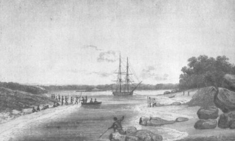
ENTRANCE OF OYSTER HARBOUR, KING GEORGE THE THIRD'S
SOUND.
Interview with the Natives.
From a sketch by P.P. King. Published in May 1825 by John Murray,
London.
Survey upon the mermaid.
Purchase another vessel.
New establishment.
Departure on the fourth voyage, accompanied by a merchant-ship
bound through Torres Strait.
Discovery of an addition to the crew.
Pass round Breaksea Spit, and steer up the East Coast.
Transactions at Percy Island.
Enormous sting-rays.
Pine-trees serviceable for masts.
Joined by a merchant brig.
Anchor under Cape Grafton, Hope Islands, and Lizard Island.
Natives at Lizard Island.
Cape Flinders.
Visit the Frederick's wreck.
Surprised by natives.
Mr. Cunningham's description of the drawings of the natives in a
cavern on Clack's Island.
Anchor in Margaret Bay, and under Cairncross Island.
Accident, and loss of anchors.
Pass through Torres Strait, and visit Goulburn Island.
Affair with the natives.
The Dick parts company.
Passage from Cape Van Diemen to Careening Bay.
Not finding water, visit Prince Regent's River, and procure it
from the Cascade.
Farther examination of the river.
Amphibious mud-fish.
Anchor in Halfway Bay, and explore Munster Water and Hanover Bay
in a boat.
Visit Hanover Bay, and procure water and fish.
Interview with natives.
The surgeon speared.
Retaliate upon them, and capture their rafts and weapons.
Description of their implements.
Port George the Fourth.
Islands to the westward.
Red Island of Captain Heywood.
Strong tides.
Camden Bay.
Buccaneer's Archipelago.
Cygnet Bay.
Dangerous situation of the brig.
High and rapid tides.
Cape Leveque.
Examination of the coast to Cape Latouche Treville.
Remarkable effect of mirage.
Leave the coast for Mauritius.
Voyage thither.
Arrival at Port Louis.
Refit.
Some account of the island.
Departure from Port Louis.
Voyage to the South-west Coast of New Holland.
Anchor in King George the Third's Sound.
Occurrences there.
Visited by the Natives.
Our intercourse with them.
Descriptions of their weapons and other implements.
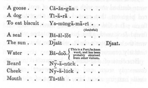
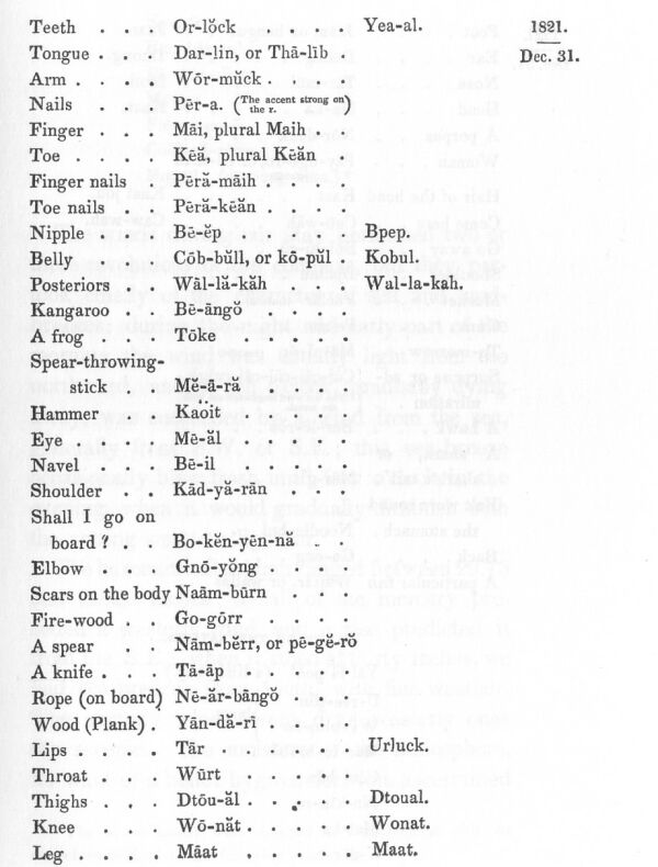
Vocabulary of their language.
Meteorological and other observations.
Edible plants.
Testaceous productions.
Leave King George the Third's Sound, and commence the survey
of the West Coast at Rottnest Island.
Another remarkable effect of mirage.
Anchor under, and land upon Rottnest Island.
Break an anchor.
Examine the coast to the northward.
Cape Leschenault.
Lancelin Island.
Jurien Bay.
Houtman's Abrolhos.
Moresby's Flat-topped Range.
Red Point.
Anchor in Dirk Hartog's Road, at the entrance of Shark's Bay.
Occurrences there.
Examination of the coast to the North-west Cape.
Barrow Island.
Heavy gale off the Montebello Isles.
Rowley's Shoals.
Cape Leveque.
Dangerous situation of the brig among the islands of Buccaneer's
Archipelago.
Examination and description of Cygnet Bay.
Lose an anchor, and leave the coast.
Adele Island.
Return to Port Jackson.
The Bathurst sails for England.
Remarks upon some errors in the hydrography of the south coast of
Van Diemen's Land.
King George the Third's Sound.
Passage to the Cape of Good Hope.
Cross the Atlantic, and arrive at Plymouth Sound.
Observations upon the voyages, and conclusion.
SECTION 1.
Of the winds and currents, and description of the ports, islands, and coast between Port Jackson and Breaksea Spit.
SECTION 2.
Description of the winds and weather, and of the ports, islands, and coast between Breaksea Spit and Cape York.
SECTION 3.
Description of the winds and weather, and of the ports and coast between Wessel's Islands and Clarence Strait.
SECTION 4.
Of the nature of the winds and the description of the coast between Clarence Strait and the North-west Cape.
SECTION 5.
Of the winds and weather, and description of the Western Coast between the North-west Cape and Cape Leeuwin.
SECTION 6.
Of the winds and weather upon the South Coast. Directions for King George the Third's Sound, and hydrographical remarks relating to Bass Strait.
SECTION 7.
Description of the shoals and reefs in the neighbourhood of the coasts of Australia.
SECTION 8.
Directions for the passage within the reefs through Torres Strait.
SECTION 9.
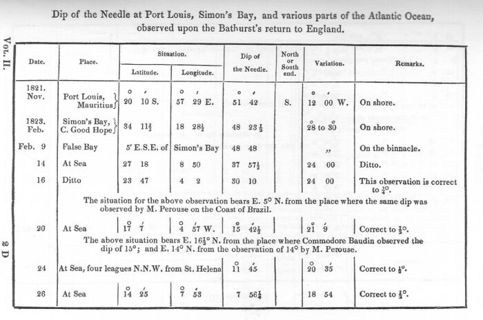
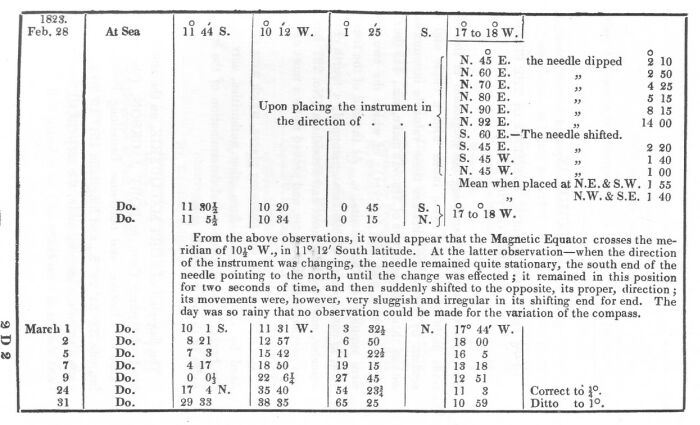
Dip of the magnetic needle.
SECTION 10.
Upon the geographical positions of the fixed points of the survey.
Containing a list and description of the subjects of natural history collected during Captain King's survey of the Intertropical and Western Coasts of Australia.
Geology.
Language of the Natives.
WOODCUT 1: NATIVES OF HANOVER BAY ON A RAFT.
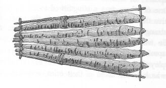
WOODCUT 2: RAFT OF THE NATIVES OF HANOVER BAY.
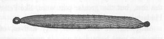
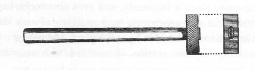
WOODCUT 5: WEAPONS AND IMPLEMENTS OF THE NATIVES OF KING GEORGE THE THIRD'S SOUND: KAOIT OR HAMMER.
WOODCUT 6: WEAPONS AND IMPLEMENTS OF THE NATIVES OF KING GEORGE THE THIRD'S SOUND: TAAP OR KNIFE.
MAP OF THE CHAINS OF ISLANDS ON THE NORTH-WEST COAST OF CARPENTARIA
SKETCH 5: HAMMER FOR COLLECTING GEOLOGICAL SPECIMENS.
SKETCH 6: SMALL HAMMER FOR TRIMMING GEOLOGICAL SPECIMENS.
SKETCH 7: SMALL STONE-CUTTER'S CHISEL.
TABLE C.
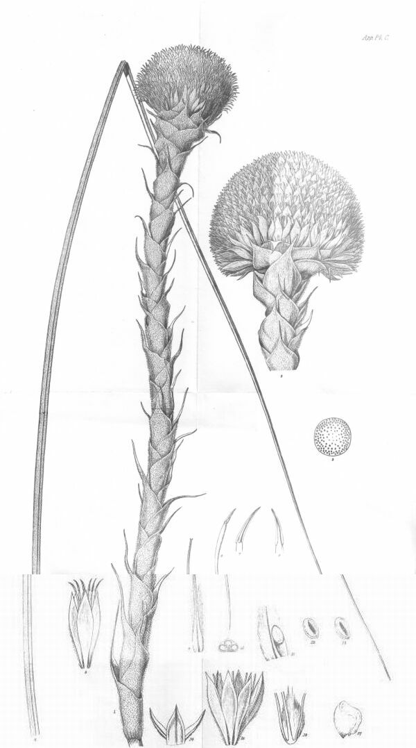
Kingia Australis.
Curtis, Id et sculp.
Published by John Murray, Albemarle Street.
Survey upon the mermaid.
Purchase another vessel.
New establishment.
Departure on the fourth voyage, accompanied by a merchant-ship bound through Torres Strait.
Discovery of an addition to the crew.
Pass round Breaksea Spit, and steer up the East Coast.
Transactions at Percy Island.
Enormous sting-rays.
Pine-trees serviceable for masts.
Joined by a merchant brig.
Anchor under Cape Grafton, Hope Islands, and Lizard Island.
Natives at Lizard Island.
Cape Flinders.
Visit the Frederick's wreck.
Surprised by natives.
Mr. Cunningham's description of the drawings of the natives in a cavern on Clack's Island.
Anchor in Margaret Bay, and under Cairncross Island.
Accident, and loss of anchors.
Pass through Torres Strait, and visit Goulburn Island.
Affair with the natives.
The Dick parts company.
1820. December 6.
As soon as the opportunity offered after our arrival, the cutter was laid on shore upon the beach of Sydney Cove, and surveyed by the master and the carpenter of H.M. Store-Ship Dromedary, which ship was preparing for her return to England with a cargo of New Zealand spars. Upon stripping the copper off the bottom, the tide flowed into her, and proved that to the copper sheathing alone we were indebted for our safe return. The iron spikes that fastened her were entirely decayed, and a considerable repair was recommended by the surveying officers. Upon my communicating the result of their report to His Excellency, Governor Macquarie, he agreed with me in thinking that, as her repairs would take up so much time, it would be better to purchase another vessel, and as a brig was then in the harbour, that appeared to be every way suited for my purpose, she was examined by my order by Mr. Mart, the Dromedary's carpenter, who reported so favourably of her, that, by the governor's permission, she was purchased and fitted for the voyage. She was built of teak, of one hundred and seventy tons burden, and had lately received a very considerable repair at Calcutta; so that, excepting a few trifling defects and alterations, she was quite fit for sea. Her name was altered at the suggestion of Governor Macquarie to that of the Bathurst.
By this change we gained a great addition to our comforts; and, besides increasing the number of our crew, were much better off in regard to boats; for we now possessed a long-boat, large enough to carry out and weigh an anchor, or save the crew if any accident should happen to the vessel; a resource which we did not possess in the Mermaid.
A further addition was made to our party by the appointment of Mr. Perceval Baskerville, one of the Dromedary's midshipman; but Mr. Hunter the surgeon, who had volunteered his services in the Mermaid during the last voyage, was superseded by Mr. A. Montgomery, who had lately arrived in charge of a convict ship.
Our establishment now consisted of the following officers and men:
Lieutenant and Commander: Phillip Parker King.
Surgeon: Andrew Montgomery.
Master's Mates (Assistant Surveyors):
Frederick Bedwell.
John S. Roe.
Midshipman: Perceval Baskerville.
Botanical Collector: Allan Cunningham.
Steward.
Boatswain's Mate.
Carpenter's Mate.
Sail Maker.
Cook.
Seamen: 16.
Boys: 5.
Total: 32.
1821. May 26.
After experiencing many tedious and unexpected delays in equipping the Bathurst, notwithstanding our wants were few, and the greater part of our repairs were effected by our own people, we were not completed for sea until the 26th of May, when we sailed from Port Jackson upon our fourth and last voyage to the north coast, accompanied by the merchant-ship Dick (the same vessel in which we had originally embarked from England): she was bound to Batavia, and being ready for sailing at the time of our departure, requested permission to accompany us through Torres Strait, which, since it would rather prove an assistance to us than cause any delay in our proceedings, was acceded to on my part with much satisfaction. In the mean time the Mermaid, our late vessel, had been thoroughly repaired, fresh fastened with copper spikes, and fitted out; and, before we sailed, had been sent to sea to carry the first establishment to Port Macquarie, on which service she had been wrecked. She was, however, afterwards got off the rocks and repaired, and is now a very serviceable vessel in the colony.
Boongaree, the native who had formerly accompanied us, volunteered his services whilst the vessel was preparing for the voyage, which I gladly accepted; but when the day of departure drew nigh, he kept aloof; and the morning that we sailed, his place was filled by another volunteer, Bundell; who proved not only to be a more active seaman, but was of much greater service to us, than his countryman Boongaree had been. This addition made our number thirty-three.
May 30.
Three days after we left the port, a discovery was made of another addition to the number of the crew. Upon opening the hold, which had been locked ever since the day before we sailed, a young girl, not more than fourteen years of age, was found concealed among the casks, where she had secreted herself in order to accompany the boatswain to sea: upon being brought on deck, she was in a most pitiable plight, for her dress and appearance were so filthy, from four days' close confinement in a dark hold, and from having been dreadfully seasick the whole time, that her acquaintances, of which she had many on board, could scarcely recognise her. Upon being interrogated, she declared she had, unknown to all on board, concealed herself in the hold the day before the vessel sailed; and that her swain knew nothing of the step she had taken. As it was now inconvenient to return to put her on shore, and as the man consented to share his ration with her, she was allowed to remain; but in a very short time heartily repented of her imprudence, and would gladly have been re-landed, had it been possible.
1821. June 4.
Between the 30th and the 4th of June we had a series of gales of wind, which enabled us to prove the capabilities of our new ship; and it was very satisfactory to find that she was weatherly, tight, and dry, three very essential qualities for a surveying vessel.
June 5.
On the afternoon of the 5th we passed round the north end of Breaksea Spit, and crossed Hervey's Bay; in the night, when the brig ought to have been many miles from the shore, we found ourselves unexpectedly close to some land; but it was not until the day broke that we knew the full extent of the danger we had encountered: the land we had seen proved to be the round head of Bustard Bay, which, as the wind was blowing directly upon it, we were fortunate in having room to clear. The Dick was apprized by us of the danger in time, and succeeded in clearing the land by tacking to the southward.
June 6.
At noon we were passing the small woody isle that was seen by Captain Flinders, and farther on we discovered two other isles of a similar character: they were seen from the masthead to the north-east; and a fourth was seen by the Dick. After this we had a few days of fine weather, which, as dysentery had already made its appearance amongst us, was most welcome, and tended materially to check the progress of so alarming a complaint.
June 8.
On the 8th we entered among the Northumberland Islands.
June 10.
But, from light northerly winds, did not reach an anchorage under Percy Island, Number 2, until the morning of the 10th. Our situation was between the Pine Islets and the basin, in ten fathoms, near a run of water, which fell from the rocks into the sea at about a quarter of a mile to the northward of the sandy beach: from this stream we filled our casks. Water was also found in many other parts, but all the runs appeared to be of temporary duration.
June 11.
This island, like Number 1, which we visited in 1819, appears to be principally of quartzose formation. The soil is sandy, and affords but little nourishment to the stunted trees with which it is furnished. In the more barren and rocky parts the pine was abundant, but not growing to any great size: the Dick's people cut down and embarked several logs; on examination they were thought to be useless; but, from subsequent experience, they proved to be far from deserving such contempt, for during the voyage we made two pole-top gallant-masts of it; which, although very full of knots, were as tough as any spar I ever saw; and carried a press of sail longer than would be trusted on many masts. These trees are very abundant on the Cumberland and Northumberland Islands, but do not attain any large size; being seldom higher than fifty or sixty feet, or of a greater diameter than from twelve to eighteen inches.
Among the variety of birds, several black cockatoos and the pheasant cuckoo were seen. The beaches were frequented by gulls, terns, and oyster-catchers; and an egret was noticed of a slate-coloured plumage, with a small ruff upon its head.
The seine was hauled upon the beach; but the only fish caught were two very large sting-rays; one of which measured twelve feet across: as it was too unwieldy to take on board, we had no means of weighing it; but the liver nearly filled a small pork barrel.* It is very probable that our bad success may be attributed to the presence of these fish, for on board the Dick several snappers were caught with the hook and line.
(*Footnote. Captain Cook describes some fish, probably of the same species, found at Botany Bay, weighing each three hundred and thirty-six pounds (Hawkesworth volume 3 page 100); from which circumstance, as it is not generally known, the name of Sting-ray Bay was given to that harbour; it is so-called in the charts of the Endeavour's voyage, in the Hydrographical Office at the Admiralty, as well as in Sir Joseph Banks' copy of the Endeavour's journal, and in Dr. Solander's manuscript journal, both of which are in the possession of my friend Robert Brown, Esquire. The name by which it is now known appears to have been given subsequently, on account of the variety and beauty of its botanical productions.)
In the evening the wind set in from South by East, with rain, and cloudy, thick weather: in striking the royal masts, a serious defect was discovered in our fore-top-mast; the upper part being found rotten for twelve feet below the head; and the top-gallant-mast was also found to be sprung in the wake of the cap.
June 12.
So that we were compelled to remain all the next day at the anchorage to shift them. This detention was very vexatious, for we were not only losing a fair wind, but lying in a very exposed situation.
During the preceding night a brig anchored half a mile to the southward of us: she proved to be the San Antonio; she left Port Jackson four days after us, and was bound on a trading speculation to the Moluccas and Singapore. In the forenoon I visited the master, Mr. Hemmans, and offered him my guidance up the coast, if he would wait until we had shifted our defective masts; but he declined it as he was anxious to get on without delay; and, having Captain Flinders' charts, intended to run "DAY AND NIGHT THROUGH THE REEFS;" he told me that he had anchored here with the intention of watering and cutting some pine spars, but that not finding the latter worth the trouble, he was then getting underweigh to proceed. When I went away, he accompanied me to look over my plan of the passage; after which he returned to his vessel, which soon afterwards steered past us on her way to the northward. Mr. Hemmans told me that he had anchored under Keppel Islands, where he had a friendly communication with the natives, who used nets, which he thought were of European construction; but from his description, they are similar to what have been before seen on the coast, and are constructed by the natives themselves.
June 13.
At eight o'clock the next morning we got underweigh; but the Dick in weighing her anchor found both flukes broken off.
June 14.
The next day, we rounded the north extremity of the Cumberland Islands.
June 15.
And at four o'clock a.m. the 15th, were abreast of Cape Gloucester.
Thick cloudy weather with rain and a fresh breeze from the southward, variable between South-South-East and South-South-West, now set in, and was unfavourable for our seeing the coast as we passed it: Cape Bowling Green was not seen, but the gradual decrease of soundings from eighteen to fourteen fathoms, and the subsequent increase of depth, indicated our having passed this low and dangerous projection.
June 16.
At daylight of the 16th, we passed outside the Palm Islands at the distance of five miles.
The weather continued so thick and rainy, that Mount Hinchinbrook was quite concealed from our view; but a partial glimpse of the land enabled me to distinguish Point Hillock, and afterwards to see Cape Sandwich, Goold Island, and the group of the Family Isles.
June 17.
In passing the largest Frankland Island, the San Antonio was seen lying at anchor near it, with her fore topsail loose, firing guns: seeing this, we hauled to the wind, and made sail to beat up towards her, under the idea of her being in distress; but as we approached, we observed a boat alongside, and her top-gallant yards across, which were proofs that she was not in such immediate danger, as to require our beating up, with the risk of losing some of our spars, for the Dick had already sprung her jib-boom; we, therefore, hove the vessels to, and soon afterwards the San Antonio joined and passed under our stern, when Mr. Hemmans informed me that the guns he had fired were intended as signals to his boat, and that they were not meant for us. He had been aground, he said, on a reef near the Palm Islands, but had received no damage: light, however, as he pretended to make of this accident, it was a sufficient lesson for him, and we soon found he had profited by it, for instead of preceding us, he quietly fell into our wake, a station which he never afterwards left, until all danger was over, and we had passed through Torres Strait.
I had now determined upon taking up an anchorage round Cape Grafton during the continuance of the bad weather, and for that purpose steered through the strait that separates the cape from Fitzroy Island; and anchored in six fathoms mud, at about half a mile from its northern extremity.
It is little remarkable that the day on which we anchored should be the anniversary of the discovery of the bay; for Captain Cook anchored here on the eve of Trinity Sunday, fifty-one years before, and named the bay between Capes Grafton and Tribulation, in reverence of the following day. In passing between Cape Grafton and Fitzroy Island, eight or ten natives were observed seated on the rocks at the south end of the beach: one of them waved his spear to us as we passed, but the distance was too great to take any notice of him.
In the afternoon we landed upon the small island in the bay, and found it to be separated from the mainland by a very shoal channel, through which our boat had some difficulty in passing; the island is small, and formed of loose fragments of granite, over which the decomposed vegetable matter had formed a soil, which, although shallow, was sufficient to nourish some luxuriant grass (panicum) and a robust species of eucalyptus: among these large flights of cockatoos and parroquets were hovering, but they were very shy, and did not allow us to approach them: a small dove, common to other parts of the coast, was killed. A native was seen walking along a sandy beach behind the island, but proceeded without noticing our boat, which was at that time passing.
June 18.
The following day the weather was so clear that, in the early part of the morning, we distinctly saw the summit of the land at the back of Cape Tribulation, bearing North 43 degrees West (magnetic); it must have been fifty-five or sixty miles off; the fall of the land towards the extremity of the cape was also seen, bearing North 35 degrees 50 minutes West fifty-six miles.
In the afternoon I went on shore near the north extremity of the Cape, to procure some bearings; after which we strolled about, and found a temporary stream of water falling into the sea. In walking past a grove of pandanus trees, which grew near the water, we disturbed a prodigious quantity of bronze-winged butterflies, reminding us, in point of number, of the Euploea hamata, at Cape Cleveland in 1819. It proved to be a variety of the Urania orontes (Godart) of Amboyna and the other Indian Islands. Mr. Cunningham took advantage of the Dick's boat going to the bottom of the bay, to cut grass: near their landing-place he found some natives' huts; some of which were of more substantial construction than usual, and were thatched with palm leaves: inside of one he found a fishing rod, and a line, five or six fathoms long, furnished with a hook made from a shell, like the hooks of the South Sea Islanders: he also found a small basket, made from the leaf of a palm-tree, lying near the remains of their fireplaces, which were strewed with broken exuviae of their shell-fish repasts.
A canoe twelve feet long, similar to the one described at Blomfield's Rivulet (volume 1) was also seen; and, like it, was not more than nine inches wide at the bilge. A small kangaroo was seen by Mr. Cunningham feeding upon the grass, but fled the moment that it saw him approaching.
Nothing more was seen of the natives, nor were any heard, or suspected of being near us; had there been any number the party would have been placed in an awkward situation, for upon landing, they all incautiously, and very imprudently, separated, to amuse themselves as they were inclined, without regarding the situation of the boat, which was soon left dry by the ebbing tide; and it was eight o'clock at night before they succeeded in launching her. Immediately after its return, for which we had been waiting four hours, we got underweigh, and were only just in time to save the breeze, which carried us out into the offing: after a short calm, the wind gradually freshened from South-South-West, and we steered on under easy sail towards Cape Tribulation.
June 19.
On passing the cape two reefs were seen to seaward, which had previously escaped our notice.
In the afternoon we anchored in ten fathoms, at about half a mile from the north-west end of the reef that stretches for two miles to the northward of the south-westernmost Hope Island; and, as it was low water and the reef uncovered, we walked across it. It is formed principally of coral, on the surface of which we found the gray trepang; a small Chama gigas, a cypraea, a pretty azure-coloured species of asteria, and a few bivalve shells. The few birds that frequented the reef were very shy, and flew away at our approach: they were principally pelicans and terns.
June 20.
After weighing the next morning, we steered North 1/2 West, a course farther to seaward than we had previously taken, in order to see the reefs more distinctly, and to prove the width and extent of this part of the channel; but the sun was shining in the direction of our course, and the shadows of the clouds upon the water were at times so deceptious that, whilst they often caused appearances of reefs where none existed, they concealed others that, for the same reason, were not seen until we were close to them. Having now the charge of two merchant-vessels, it was necessary to proceed with caution, and therefore we steered nearly over our last year's track, but notwithstanding, we now discovered several new reefs, and informed ourselves of the extent and shape of others which had escaped our previous observation.
As we were rounding the two islands that lie close to the south side of Lizard Island, a native was seen in a canoe, paddling towards another who was sitting on the rocks watching our movements; and, as we hauled round the south point of the bay, two others were observed walking towards the beach; upon seeing us they stopped short and retreated up the hill; but, after we anchored and sent a boat on shore, which was accompanied by one from the Dick, they advanced, and without much hesitation, came forward and communicated with our party. They carried spears with them, and each of our gentlemen had their fowling-pieces: the appearance of Bundell, who on these occasions always took his clothes off, perhaps gave them greater confidence. After some vociferous and unintelligible parley, one of our gentlemen, in order to give them further cause for the surprise which they had already manifested to a great extent, unadvisedly fired his fowling-piece; upon which, as might be expected, they became distrustful and frightened, and, fixing their spears in their throwing sticks, walked backwards at a quick pace, and withdrew altogether towards the hills.
Lizard Island, and the Direction Isles to the south-westward, are of very different character to the other islands which front this coast, being high, rising to peaks, and of granitic formation. Captain Cook, in his description of Lizard Island, mentions it as being a good place to refresh at, on account of its supplying both wood and water; but, at the same time we were there, the latter was not found, although the rain had been lately falling in great quantity; with the former, however, it is well supplied. This island, from its connection with Captain Cook's misfortunes during his perilous navigation within the reefs, will always be an interesting feature in the history of the discovery and examination of this coast, and deserves a more appropriate appellation.
June 21.
Leaving Lizard Island the following morning, we directed our course for Cape Flinders, over our last year's track. Upon passing Port Ninian, the sea was observed to break heavily upon the Barrier Reefs, which in this part approach nearer to the mainland than at any other. As we doubled Cape Melville, the wind, as usual, freshened up to a strong breeze, and carried us rapidly across Bathurst Bay: to the westward of the cape several natives were observed walking upon the beach.
In passing round Cape Flinders, there appeared to be a considerable diminution in the remains of the Frederick's wreck. No vestige was left of her stern or forecastle, both of which were before so very conspicuous. At half-past five o'clock we anchored with our companions near the usual place.
June 22.
The following morning, at daybreak, a party of men went to the wreck to collect the spars and planks that had escaped the mischievous fires of the natives; and at five o'clock I joined them with the master of the Dick and Mr. Roe, ordering Mr. Bedwell to relieve the shore party with some fresh hands at eight o'clock. When the time arrived, supposing that the relief-party had nearly reached the shore, I sent the people over the hill, in order to be ready when the boat arrived to go on board; and in the meantime amused myself in wandering about the reef near the wreck, where Mr. Roe was also employed. Mr. Harrison (the master of the Dick) was at the further end of the beach with his fowling piece, with two of his boat's crew picking up shells: when suddenly they were surprised by hearing a loud shout, and seeing several spears strike the rocks about them: upon looking round, Mr. Harrison found that a party of natives were advancing upon him with their spears poised; upon which he presented his gun at the foremost, but, from his having waded about in the water, the powder had got damp and would not go off. Immediately that I heard the shout of the natives, and saw Mr. Harrison retreating from the Indians, who were in close pursuit, I hastened to his assistance, and came up in time to prevent them from doing any mischief; and, by occasionally levelling my gun, kept them at bay whilst we retreated towards the wreck, from which we were about half a mile distant. By this time Mr. Roe, who had also heard the noise, joined; but, as he had not a gun, the only assistance he brought was an addition to our number. Among the four foremost of the natives was a mischievous boy, who, being emboldened by our not firing, and showing an anxiety to get away from them, fixed his spear and aimed it at me; upon which I fired my gun, but, as it was only loaded with small shot, it had no effect at the distance he was from me; the noise, however, arrested their pursuit for a moment; and by the time they recovered their surprise, I had reloaded with ball, but to my great mortification, upon presenting the gun to deter the boy from throwing his spear again, it missed fire: the weapon, which at first was aimed at me, was then thrown at one of the Dick's men, and, piercing his hat, which he was carrying at his breast, fortunately, full of shells, only slightly wounded one of his fingers. The man, who to all appearance was dangerously wounded, for the spear stuck in the hat and hung suspended in the air, drew it out, and, throwing it on the ground with the greatest composure, continued to retreat. The natives then finding we were not intimidated or hurt by the spears, began to make friendly gestures, which we, of course, returned, but still continued to walk away with our faces turned towards them.
We were now only four in number (for I had despatched one of the Dick's people to recall our boat, and to order the crew over to our assistance) and being without any means, or show of defence, it required much caution and management on our part to prevent their throwing any more spears; for they were now within a few yards of us: their ferocity, however, began to diminish, as their attention was taken by our clothes and a silk handkerchief which Mr. Roe held out to them: they were about ten in number, of whom five or six were armed with spears. Our only safety now was in letting them approach, and amusing them by a display of our silk handkerchiefs and other parts of our dress, and making all the grimaces and monkey-like gestures we could think of.
Among the natives was a young woman, whom they repeatedly offered to us by using the most significant signs; which she also endeavoured to strengthen by appropriate gestures on her part; but our inclinations were not consonant with the opportunity so pressingly, but so suspiciously, offered. After our declining this honour, they occasionally laid their hands upon our clothes to detain us, but it did not require much force to make them quit their hold. One of the men having seized my gun, I drew it out of his hand rather roughly; but, accompanied at the same moment with the friendly gesture of patting his breast, the recovery was happily effected without exciting his anger.
In this manner, and with great fatigue, we continued our retreat across the reef, and reached the wreck without any signs of our people coming to our assistance; when the natives found we intended to walk round the point, they divided, and gave their spears to a party that went over the hills, as it were, to cut us off; but in this intention, if they entertained it, they were disappointed, for our boat was there, and the crew all embarked, ready to shove off, little expecting ever to see us again. The idea of being thus easily deserted by our people was for a moment mortifying, but I ordered some of the crew on shore, and by our numbers kept the natives amused on the beach, while Mr. Harrison shoved off in his gig to give the alarm, and to order some muskets to be sent for our protection: by the time, however, that Mr. Bedwell arrived, we had succeeded in making friends with the natives; who, upon perceiving that we had now in our turn the superiority, began to draw away, and appeared to be as anxious to get rid of us as we had been, half an hour before, to escape from them; but we accompanied them halfway across the reef, watching an opportunity to seize the boy who had wounded the Dick's man, whom I intended to keep a prisoner while we were here, and then to dismiss him with presents, to show that we were not inimical to them, although angry at being so treacherously attacked. My intention, however, was probably suspected, for they avoided our approaching sufficiently near them to effect my purpose with the certainty of success, I therefore called our people away to resume their work at the wreck, and, after leaving orders with Mr. Bedwell not to fire but in self-defence, and if an opportunity offered, to seize the boy, went on board with the party to breakfast. I had not, however, left the shore long before hostilities again commenced, and several shots were mischievously fired at the natives by some of the Dick's and San Antonio's people, who, being advanced, had very improperly endeavoured to cut off three of them, upon which one of the natives poised his spear with a threat of throwing it, when several muskets were fired at these miserable wretches, who, fortunately for them, got clear off; although one of them by his limping appeared to have been struck in the leg.
After this we saw nothing more of them for the day. Mr. Bedwell was employed with his party at the wreck, whilst Mr. Cunningham traversed the hills in the vicinity, for it was not safe to trust himself at any distance from our people, since the natives would not have failed, had they met with an opportunity, to punish us for our broken faith.
June 23.
The following day, on the return of our people from the wreck, they reported that the natives had shown themselves on the opposite side of the bay; I therefore went to the shore with Mr. Harrison, to endeavour to make peace, but saw no signs of them, excepting a smoke on the next island, to which they had probably retired. On the following day they were again seen, and fired upon by the boat's crew of the Dick.
All these events gave me much concern, not only because the natives may be induced to attack and take revenge upon strangers who may subsequently pass this way, but also because they must have imbibed a very poor idea of the effect of our arms, when so many muskets were fired without doing them any mischief: and, but for the sake of humanity, I could almost have wished that one had been killed.
The day after we arrived here, a boat from the San Antonio conveyed Mr. Montgomery and Mr. Cunningham to Clack's Island. The reef abounded with shells, of which they brought back a large collection, but not in any great variety; an indifferent cypraea was the most common; but there were also some volutae and other shells, besides trepang and asteriae, in abundance. Mr. Cunningham observed a singularly curious cavern upon the rock, of which he gave me a description in the following account of the island:
"The south and south-eastern extremes of Clack's Island presented a steep, rocky bluff, thinly covered with small trees. I ascended the steep head, which rose to an elevation of a hundred and eighty feet above the sea. I found simply the plants of the main, namely, Mimusops parvifolia, Br.; Hoya nivea, Cunningham manuscript; Acacia plectocarpa, Cunningham manuscript; Chionanthus axillaris, Br.; Notelaea punctata, Br.; some alyxiae, and the small orange-fruited ficus, which grew in the thickets, and, by insinuating its roots in the interstices of the rocks, clothed a great portion of the inaccessible front of the island.
"The remarkable structure of the geological feature of this islet led me to examine the south-east part, which was the most exposed to the weather, and where the disposition of the strata was of course more plainly developed. The base is a coarse, granular, siliceous sandstone, in which large pebbles of quartz and jasper are embedded: this stratum continues for sixteen to twenty feet above the water: for the next ten feet there is a horizontal stratum of black schistose rock, which was of so soft a consistence, that the weather had excavated several tiers of galleries; upon the roof and sides of which some curious drawings were observed, which deserve to be particularly described: they were executed upon a ground of red ochre (rubbed on the black schistus) and were delineated by dots of a white argillaceous earth, which had been worked up into a paste. They represented tolerable figures of sharks, porpoises, turtles, lizards (of which I saw several small ones among the rocks) trepang, star-fish, clubs, canoes, water-gourds, and some quadrupeds, which were probably intended to represent kangaroos and dogs. The figures, besides being outlined by the dots, were decorated all over with the same pigment in dotted transverse belts. Tracing a gallery round to windward, it brought me to a commodious cave, or recess, overhung by a portion of the schistus, sufficiently large to shelter twenty natives, whose recent fireplaces appeared on the projecting area of the cave.
"Many turtles' heads were placed on the shelfs or niches of the excavation, amply demonstrative of the luxurious and profuse mode of life these outcasts of society had, at a period rather recently, followed. The roof and sides of this snug retreat were also entirely covered with the uncouth figures I have already described.
"As this is the first specimen of Australian taste in the fine arts that we have detected in these voyages, it became me to make a particular observation thereon: Captain Flinders had discovered figures on Chasm Island, in the Gulf of Carpentaria, formed with a burnt stick; but this performance, exceeding a hundred and fifty figures, which must have occupied much time, appears at least to be one step nearer refinement than those simply executed with a piece of charred wood. Immediately above this schistose stratum is a superincumbent mass of sandstone, which appeared to form the upper stratum of the island." (Cunningham manuscript.)*
(*Footnote. Similar representations were found by Mr. White, carved on stone in the neighbourhood of Port Jackson. White's Journal quarto page 141.)
June 25.
Having procured all the spars and planks from the wreck that could be useful to us, we made preparations to sail, and at daylight, the 25th, got underweigh with my two companions, and resumed our course to the northward, over that of last year, excepting that we steered inside of Pelican Island, and to leeward of Island 4. We passed several large sting-rays asleep on the surface of the sea, which our people ineffectually endeavoured to harpoon. On the former island large flights of pelicans were seen, and upon the sandbank, to the southward of it, there was a flock of two or three hundred young birds.
The breeze not being sufficient to carry us to Night Island before dark, the anchor was dropped in eleven fathoms muddy bottom, two miles to the eastward of Island 8. The Dick and San Antonio anchored close to us. During the night we had a fresh breeze from South-East by East, and, not having any island or reef to shelter us from the swell, we were obliged to drop a second anchor to retain our position. The San Antonio drove for some distance, but the Dick rode through the night without driving, although she had but forty fathoms of cable out.
June 26.
On weighing the next morning, we made sail to the North by West, but, from the compass-box not being quite straight in the binnacle, we made a North by West 1/2 West course, which was not discovered until we had nearly paid dear for our neglect; for we passed close to a rock which I intended to have gone at least a mile to windward of. It was seen just in time to put the helm a-lee, or we should have run upon it.
The weather was now so thick that we could not see a mile around us; we were therefore obliged to follow our former courses, to avoid the risk of running over a strange track in such unfavourable weather. At sunset we anchored under the lee of Piper's Islets.
June 27.
The next day we anchored under Sunday Island in Margaret Bay, at about half a mile from the sandy beach, on its north-west side.
Here we were detained by bad weather until the 30th.
June 30.
When, with some slight appearance of improvement, and tired of losing so much time, we weighed and proceeded on our course. After passing the Bird Isles, thick weather again set in, with constant rain, and a strong breeze from South-East. Upon reaching Cairncross Island, under which it was my intention to anchor, the sails were reduced; and, as we were in the act of letting go the anchor, Mr. Roe, who was at the masthead holding thoughtlessly by the fore-topmast staysail-halyards, whilst the sail was being hauled down, was precipitated from a height of fifty feet, and fell senseless on the deck. We were now close to the reef; and, in the hurry and confusion attending the accident, and the Dick at the same time luffing up under our stern, the anchor was dropped, without my ascertaining the quality of the bottom, which was afterwards found to be of a very questionable nature.
The Dick, having dropped her anchor within forty yards of us, was lying so close as to prevent our veering more cable than sixty fathoms, but as we appeared to ride tolerably easy with a sheer to starboard, while the Dick rode on the opposite sheer, we remained as we were: to prevent accident, the yards were braced so that we should cast clear of the Dick if we parted, a precaution which was most happily taken.
As soon as the distressing accident that had occurred was known on board the Dick, Dr. Armstrong, a surgeon of the navy and a passenger in that ship, hastened on board to assist Mr. Montgomery in dressing Mr. Roe's hurt, which I found, to my inexpressible satisfaction, was not so grievous as might have been expected: his fall was, most providentially, broken twice; first by the spritsail brace, and secondly by some planks from the Frederick's wreck, which had fortunately been placed across the forecastle bulwark over the cat-heads: his head struck the edge of the plank and broke his fall, but it cut a very deep wound over the right temple. This unfortunate event threatened to deprive me of his very valuable assistance for some time, a loss I could but very ill spare, particularly when upon the point of returning to the examination of so intricate a coast as that part where we last left off.
At six o'clock in the evening the flood-tide began to set to leeward, and as night approached the appearance of the weather became very threatening, accompanied by a descent of the mercury; this gave me a very unfavourable idea of our situation: the wind was blowing clear of the reef, and raised a heavy sea; and the Dick was so close to us that we dared not veer cable, for fear of getting on board of her, which must have happened if either ship should break her sheer.
At half-past ten o'clock, during a very heavy squall, the cable parted, but from the precaution above-mentioned, the brig happily drifted with her head to starboard, and passed clear both of the Dick and San Antonio; the chain-cabled anchor was then dropped, and veered to ninety fathoms, which brought her up in fifteen fathoms, mud; in which birth she appeared to ride much easier than before. I was now very anxious about the lost anchor; and, having expressed a wish to inform Mr. Harrison of our situation, and to request him to recover our anchor in the morning if the weather would permit, Mr. Bedwell volunteered to go on board her; which, although a service of danger, was, if possible to be effected, absolutely necessary. The boat was lowered, and they shoved off, but as the crew were unable to pull it ahead, I called her on board again, which was most fortunate; for shortly afterwards the chain-cable parted also, and the brig drove with her head towards the shore.
1821. July 1.
We had now the prospect of being obliged to keep under sail during the remainder of the night. An attempt was made to veer, in order that, by laying to with her head off shore, we might have time to recover the cable, without endangering the security of the vessel; but, from the weight of the chain at the bow, this manoeuvre could not be effected; fearing, therefore, to drift any more to the westward, in which direction we were making rapid way, I was under the necessity of slipping the chain, by which we lost one hundred fathoms of cable, which we could but badly spare: being now freed from the impediment, the brig's head was placed off shore; and after making sail, we fired several muskets and showed lights, as signals to the Dick, who, it afterwards appeared, kept a light up for our guidance; but the weather was so squally and thick, with almost constant rain, that it was not seen by us. It was half-past twelve o'clock when we made sail to the North-East by East, deepening from fourteen to sixteen fathoms, and when the hillocky summit of Cairncross Island bore South by West, beyond which bearing we did not know how far we could proceed with safety; we tacked to the South-South-West, and proceeded in that direction until the island bore South, when we were in fourteen fathoms. Having thus ascertained the depth of this space, which was about three miles in extent, it was occupied during the remainder of the night; which, being very dark and squally, was passed by us in the greatest anxiety. At day-dawn we were joined by our companions, and, as it was not possible from the state of the weather to regain the anchors we had lost, made sail towards Turtle Island, on our way to which we passed Escape River: both of these places reminded us of former perils, but the recollection of our providential preservation on those occasions, as well as on many others during our former voyages, increased the grateful feelings which we now felt for our safety and protection during the last night, the anxieties and circumstances of which can never be obliterated from our minds.
Our course was directed entirely by the chart I had previously formed; for the weather was so thick that for the greater part of the way no land could be seen to guide us: by noon we had passed between Cape York and Mount Adolphus, and in a short time rounded the north end of Wednesday Island, and were steering between it and the North-West Reef.
After passing the rock off Hammond's Island, we steered West by South 1/2 South, but were obliged to haul up South-West by West to pass to the southward of a small shoal, some part of which was uncovered (the time of tide being nearly low water, spring tide): this shoal lies in a North 50 degrees West direction, from the low rocky ledge off the north end of Good's Island, and is distant from it about a mile and a half. The Dick being a little to leeward of our track, had four fathoms; but the least we had was five and three-quarters. This reef is not noticed in Captain Flinders' chart: at high water, or even at half ebb, it is very dangerous, from its lying in the direct track; but, by hauling over to the south shore, may be easily avoided.
At four o'clock we passed Booby Island, and steered West by South across the Gulf of Carpentaria.
July 3.
Between Booby Island and Cape Wessel, which we passed in sight of on the 3rd, we had thick gloomy weather, with the wind between South and East-South-East; and, after rounding the Cape had some heavy rain, in which the mercury, having previously fallen to 29.91, rose to 29.95 inches. Lightning from the east and west accompanied the rain, but the wind was steady, and did not freshen or lull during the showers.
July 5.
On the 5th, at daylight, Goulburn Islands were seen, and at nine o'clock we passed through the strait that divides them; our track being half a mile more to the northward than that of last year, we had more regular soundings.
As soon as we anchored in South-West Bay, I sent on shore to examine our former watering-place, but found that the stream had failed. The parched up appearance of the island showed that the last had been an unusually dry season; every place that, even in the month of August, six weeks later, had before yielded large quantities, as well as the lagoon behind the beach, which, from the nature of the plants growing in it, was conjectured to be a never-failing supply, was now dried up.
July 6 to 8.
The next morning the brig's boat went over to Sims Island with Mr. Cunningham, and there found a small quantity of water, sufficient, according to Mr. Hemmans' report, for all our wants. The next morning (7th) he moved the San Antonio over to the island, and anchoring her off the sandy beach, landed his people to dig holes. In the afternoon he sent me a specimen of what had been collected; but it was so brackish that I gave up all idea of shipping any: he had improvidently dug large holes, into which all the water good and bad had drained, and thereby the good was spoiled. The following morning he sent another specimen, which, notwithstanding it was considerably better, was still too bad to tempt me to embark any. During the San Antonio's stay at Sims Island, our gentleman paid it a visit: its vegetation appeared to have suffered as much from want of rain as Goulburn Island. "The venerable tournefortia (Tournefortia argentea. Lin.) however, appeared as an exception: this tree, which grows on the centre of the beach, where it is remarkably conspicuous, appeared to have resisted the dry state of the season; it was in full leaf, and covered with a profusion of flowers, which attracted a variety of insects, particularly of the genera apis, vespa, and sphex; and among them a beautiful green-coloured chrysis." (Cunningham manuscripts.)
During the two last days, our people were employed cutting wood; no natives had made their appearance, although recent tracks on the sand showed they were not far off; but on the evening of the 7th, the surgeon, accompanied by Dr. Armstrong of the Dick, landed in that vessel's gig, and, whilst amusing themselves among the trees, and the boat's crew incautiously wandering away from the boat, the natives came down, and would have carried off all the boat's furniture, and everything in her, had they not been disturbed by the return of one of the sailors with a musket. They succeeded however, in making a prize of a new boat-cloak, and the boat-hook, and one of them had nearly succeeded in carrying off an oar, but upon being fired at, dropped his booty and scampered off. This trifling loss was deservedly sustained by our gentlemen, for they were well aware how suddenly the natives have always appeared, and how mischievously they had on those occasions conducted themselves: they were also cautioned, when they went on shore to be upon their guard, and it was fortunate for them that nothing more serious occurred.
July 8.
At daylight, the 8th, the San Antonio rejoined us from Sims Island, and at eleven o'clock we left the bay, and passed to the eastward of New Year's Island: the Dick and ourselves then steered to the westward along the coast, while the San Antonio steered a north-west course, and parted company.
July 9.
The following day, being in sight of the land of Cape Van Diemen, and having sent our letters on board the Dick for conveyance to England, we parted company by an interchange of three cheers; and it was not without a considerable degree of regret that we took this leave of our friends; for it is but due to Mr. Harrison to say that we received very great assistance from him on several occasions: he offered us his stream anchor to replace in some degree our loss, although he had himself only one left; it was, however, much too small for our purpose.
By this opportunity I wrote to the Secretary of the Admiralty, and the Under Secretary of State for the Colonies, and communicating to them a brief account of our voyage up the east coast, acquainted them of my intention of employing the fine-weather months of July and August upon the north-west coast, and then of going to Mauritius, to replace our anchors and cable, previous to our examination of the west coast.
Passage from Cape Van Diemen to Careening Bay.
Not finding water, visit Prince Regent's River, and procure it from the Cascade.
Farther examination of the river.
Amphibious mud-fish.
Anchor in Halfway Bay, and explore Munster Water and Hanover Bay in a boat.
Visit Hanover Bay, and procure water and fish.
Interview with natives.
The surgeon speared.
Retaliate upon them, and capture their rafts and weapons.
Description of their implements.
Port George the Fourth.
Islands to the westward.
Red Island of Captain Heywood.
Strong tides.
Camden Bay.
Buccaneer's Archipelago.
Cygnet Bay.
Dangerous situation of the brig.
High and rapid tides.
Cape Leveque.
Examination of the coast to Cape Latouche Treville.
Remarkable effect of mirage.
Leave the coast for Mauritius.
Voyage thither.
Arrival at Port Louis.
Refit.
Some account of the island.
1821. July 9.
Our course was held to the south-west towards Cape Londonderry; on which, with a fresh South-East wind, we proceeded with rapidity.
July 12.
On the morning of the 12th, Eclipse Hill and Sir Graham Moore's Islands were seen, and in the afternoon we passed Troughton Island; at sunset, Point Hillock bore South thirteen miles, whence we steered to the West-North-West and North-West, and rounded the north end of the long reef, to the westward of Cape Bougainville.
July 13.
The next morning, at daylight, Cassini Island was seen bearing South by West; here we were detained for two days by light baffling winds and calms.
July 14.
During the night of the 14th, the wind was light from the westward, and we stood off and on to the north of Cassini Island.
July 15.
At half-past one o'clock a.m., having sounded in thirty-three fathoms, we shoaled suddenly to fourteen, when the vessel's head was put to the southward, but the breeze was so very light, that she had hardly steerage way: by the light of the moon a line of breakers was seen two miles off, under our lee: we had now shoaled to nine fathoms on a rocky bottom, but its great irregularity prevented our dropping the anchor until the last minute, since it would have been to the certain loss of the only one we had. In order, therefore, to save it, if possible, the boat was lowered, and sent to sound between the vessel and the breakers. Finding we made no progress off the reef by standing to the southward, we tacked; and, a light breeze springing up from the westward, we drew off the bank on a north-west course, and in the space of a mile and a half deepened the water gradually to thirty fathoms.
July 16.
The next morning, at a quarter past eight o'clock, the breakers were again seen; they were found to be 24 minutes 44 seconds West of Troughton Island. The wind was too light to allow of our approaching, we therefore tacked off to the westward, and soon lost sight of them; at noon we were in latitude 13 degrees 26 minutes 26 seconds. The breakers from the masthead, bearing south-east, distant eight or nine miles.
During the ensuing night, having a fresh breeze, we stood first to the westward, and afterwards to the south-east.
July 17.
At seven o'clock the next morning no land was in sight, but breakers were seen extending from South by West to South-West by South, about five miles off; and two miles beyond them was another line of breakers, bearing from South-South-West to South-West by West. As we steered obliquely towards them, they were noticed to extend still farther to the eastward, but apparently in detached patches; our soundings, as we stood on, shoaled to fifteen fathoms; and we were shortly within half a mile of an appearance of shoal-water, in thirteen fathoms on a rocky bottom. The wind now began to lessen; and, for fear of being becalmed, I was anxious to get an offing. By our observations, we found the breakers this morning were connected with those passed yesterday, and are a part of Baudin's Holothurie Banks. The French charts of this part are very vague and incorrect; for our situation at noon upon their plan (with respect to the position of Cassini Island) was in the centre of their reefs.
At noon we were in 13 degrees 38 minutes South, when a freshening breeze from South-East enabled us to make progress to the southward. At two o'clock some of the Montalivet Islands were seen; and before three o'clock, an island was seen bearing South, which proved, as we stood towards it, to be the northernmost of a group lying off the north-west end of Bigge's Island; they were seen last year from Cape Pond, and also from the summit of the hills over Careening Bay.
July 19 to 21.
At daylight (19th) having laid to all night, this group was about six leagues off, bearing from South 35 1/2 to 49 degrees East, but a continuation of calms and light winds detained us in sight of them until the 21st.
This group consists of eight or nine islands, and appears to be those called by the French the Maret Isles; they are from one quarter to a mile and a half in extent, and are rocky and flat-topped; the shores are composed of steep, rocky cliffs. They are fronted on the west side by a rocky reef extending in a North-North-East and South-South-West direction.
During the calm weather, in the vicinity of this group, we had seen many fish and sea-snakes; one of the latter was shot and preserved; its length was four feet four inches; the head very small; it had neither fins nor gills, and respired like land-snakes; on each scale was a rough ridge: it did not appear to be venomous. A shark was also taken, eleven feet long; and many curious specimens of crustacea and medusa were obtained by the towing-net. Some of the latter were so diaphanous as to be perfectly invisible when immersed in the water. Among the former were a species of phyllosoma, and the Alima hyalina of Leach.*
(*Footnote. Cancer vitreus. Banks and Solander manuscripts. Lin. Gmel. tome 1 page 2991. Astacus vitreus. Fabr. Syst. ent. page 417 n. 8.)
At daylight we were about four leagues to the West-North-West of Captain Baudin's Colbert Island; at the back of which were seen some patches of the Coronation Islands. The night was passed at anchor off the northernmost Coronation Island.
July 23.
And the following afternoon we anchored at about half a mile from the sandy beach of Careening Bay.
As soon as the vessel was secured, we visited the shore, and recognised the site of our last year's encampment, which had suffered no alteration, except what had been occasioned by a rapid vegetation: a sterculia, the stem of which had served as one of the props of our mess-tent, and to which we had nailed a sheet of copper with an inscription, was considerably grown; and the gum had oozed out in such profusion where the nails had pierced the bark that it had forced one corner of the copper off.
The large gouty-stemmed tree on which the Mermaid's name had been carved in deep indented characters remained without any alteration, and seemed likely to bear the marks of our visit longer than any other memento we had left.
The sensations experienced at revisiting a place which had so seasonably afforded us a friendly shelter and such unlooked-for convenience for our purposes, can only be estimated by those who have experienced them; and it is only to strangers to such feelings that it will appear ridiculous to say, that even the nail to which our thermometer had been suspended, was the subject of pleasurable recognition.
We then bent our steps to the water-gully, but, to our mortification, it was quite dried up, and exhibited no vestige of its having contained any for some time. From the more luxuriant and verdant appearance of the trees and grass than the country hereabout assumed last year, when the water was abundant, we had felt assured of finding it and therefore our disappointment was the greater.
July 24.
After another unsuccessful search in the bight, to the eastward of Careening Bay, in which we fruitlessly examined a gully that Mr. Cunningham informed me had last year produced a considerable stream, we gave up all hopes of success here, and directed our attention to the cascade of Prince Regent's River; which we entered the next afternoon, with the wind and tide in our favour, and at sunset reached an anchorage at the bottom of St. George's Basin, a mile and a half to the northward of the islet that lies off the inner entrance of the river, in seven fathoms muddy sand.
July 26.
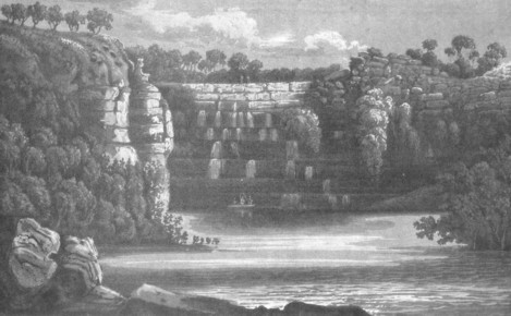
The following morning at half-past four o'clock Mr. Montgomery accompanied me in the whale-boat to visit the cascade; we reached it at nine o'clock and found the water, to our inexpressible satisfaction, falling abundantly.
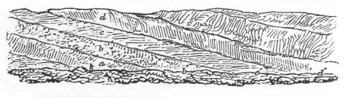
While the boat's crew rested and filled their baricas, I ascended the rocks over which the water was falling and was surprised to find its height had been so underrated when we passed by it last year: it was then thought to be about forty feet, but I now found it could not be less than one hundred and fifty. The rock, a fine-grained siliceous sandstone, is disposed in horizontal strata, from six to twelve feet thick, each of which projects about three feet from that above it, and forms a continuity of steps to the summit, which we found some difficulty in climbing; but where the distance between the ledges was great we assisted our ascent by tufts of grass firmly rooted in the luxuriant moss that grew abundantly about the water-courses. On reaching the summit, I found that the fall was supplied from a stream winding through rugged chasms and thickly-matted clusters of plants and trees, among which the pandanus bore a conspicuous appearance and gave a picturesque richness to the place. While admiring the wildness of the scene, Mr. Montgomery joined me; we did not however succeed in following the stream for more than a hundred yards, for at that distance its windings were so confused among rocks and spinifex that we could not trace its source. After collecting for Mr. Cunningham, who was confined on board by sickness, a few specimens of those plants which, to me, appeared the most novel, we commenced our descent, and reached the bottom in safety; by which time the tide was ebbing so rapidly that we set off immediately on our return with a view of arriving on board by low-water, in order that no time might be lost in sending the boats up with our empty water-casks.
During our absence Mr. Roe, who was fast recovering from the effects of his fall, had obtained the sun's meridional altitude upon the islet at the entrance of the river, which gave 15 degrees 25 minutes 46 seconds for its latitude, differing from the plan of last year by only fifteen seconds.
VIEW OF THE CASCADE IN PRINCE REGENT'S RIVER.
From a sketch by P.P. King. Published in May 1825 by John Murray,
London.
July 27.
The following day the boats were despatched up the river, but as the ebb-tide ran until after four o'clock it was late at night before they reached the cascade, having experienced some delay by running upon the sandbanks, which, above Alligator Island, are very numerous and form a narrow winding channel of not more than twelve feet deep; these banks are dry at low-water, and are composed of a yellow quartzose sand. At midnight, as soon as the launch and cutter were loaded, for it did not take more than half an hour to fill the casks, I despatched them to the vessel with orders to return the following night for another load, and in the meantime I purposed continuing the examination of the river, of which we knew nothing beyond a few miles above the cascade.
July 28.
We were, however, unable to set out until half flood the next morning, on account of the shoalness of the channel.
For ten miles we found little or no variation either in its character or course: its windings were only just sufficient to intercept a clear view; for so direct was its course, that from this part the high round hill near the entrance was seen midway between the hills that form the banks of the river.
Proceeding a little way farther, we were suddenly whirled into a rapid amongst large stones, in the midst of which, as the stream was running at the rate of five or six knots, the grapnel was instantly dropped, which had the effect of reversing the boat's head. After this the grapnel was weighed, and by very great exertions we extricated ourselves from the rapid, and then landed at a hundred yards below the fall, on the east bank, where the mangroves were so thick that it was with difficulty we penetrated through them: having succeeded, we walked to the bank near the rapid, and found that it was occasioned by the tide falling over a barrier of rocks, which probably at low-water confines the fresh water above this place; a few minutes afterwards it was high-water, and the tide suddenly ceased to run; when the water became quite smooth and motionless.
A fresh-water rivulet, at that time the mere drainings of what occasionally is a torrent, joined the main river, just above the rapid, by a trickling stream; and made us the more desirous of extending our knowledge of this extraordinary river: we therefore re-embarked, and, passing the rapid, pulled up the river against the tide for a mile farther, where it was suddenly terminated by a beautiful fresh-water rivulet, whose clear, transparent stream was so great a contrast to the thick, muddied water we had so long been pulling through that it was a most gratifying sight, and amply repaid us for all our fatigue and exertions. The fresh water was separated from the salt tide by a gentle fall over rounded stones; but as the boat was unable to pass over them, we had only time to fill our water-vessels, in order to be certain of returning over the first rapid, before the strength of the stream rendered it dangerous to pass. The bed of the river at this second fall appeared to be about two hundred and fifty yards in breadth: its farther course was lost sight of by a sharp turn, first to the North-East, and then to the South-East, between high and rocky hills.
Large groves of pandanus and hibiscus and a variety of other plants were growing in great luxuriance upon the banks, but unhappily the sterile and rocky appearance of the country was some alloy to the satisfaction we felt at the first sight of the fresh water; as we did not, however, expect to find a good country, the pleasure was not much diminished, and we set off on our return, perfectly satisfied with the success of our labours: we were at this time about fifty miles from the sea.
The ebb-tide had fallen for an hour when we passed the first falls, but there was no appearance of that violence which we witnessed in the morning; probably because the stream had not reached its strength.
An alligator was seen on our return, swimming within two yards of the boat, and a musket, charged with a ball and buck-shot, was uselessly fired at it. The appearance of these animals in the water is very deceptious; they lie quite motionless, and resemble a branch of a tree floating with the tide; the snout, the eye, and some of the ridges of the back and tail being the only parts that are seen. The animal that we fired at was noticed for some time, but considered to be only a dead branch, although we were looking out for alligators, and approached within six yards of it before we found out our mistake: the length of this animal was from twelve to fifteen feet; I do not think that we have ever seen one more than twenty feet long.
We reached the cascade by four o'clock and remained there until our boats arrived for a second cargo of water, which was at midnight; as soon as the casks were filled, we set off on our return, but did not reach the brig until eight o'clock in the morning.
July 29.
The fatigue and exposure which attended our watering at this place were so great that I was obliged to give up the idea of completing it now. We had obtained, by the two trips, enough to last until the end of October, which, with the chance of finding more upon other parts of the coast, was sufficient for our intended mode of proceeding. The boats were therefore hoisted in, and preparations made to leave the anchorage.
The river appears to abound with fish, particularly with mullet; and porpoises were observed as high as the first falls, a distance of fifty miles from the sea. A curious species of mud-fish (chironectes sp. Cuvier) was noticed, of amphibious nature, and something similar to what we have frequently before seen; these were, however, much larger, being about nine inches long. At low water the mud-banks near the cascade that were exposed by the falling tide were covered with these fish, sporting about, and running at each other with open mouths; but as we approached, they so instantaneously buried themselves in the soft mud that their disappearance seemed the effect of magic: upon our retiring and attentively watching the spot, these curious animals would re-appear as suddenly as they had before vanished. We fired at several, but so sudden were their motions that they generally escaped; two or three only were procured, which appeared from their lying on the mud in an inactive state to have been asleep; they are furnished with very strong pectoral and ventral fins with which and with the anal fin, when required, they make a hole, into which they drop. When sporting on the mud, the pectoral fins are used like legs, upon which they move very quickly; but nothing can exceed the instantaneous movement by which they disappear. Those that were shot were taken on board, but on account of the extreme heat of the weather they had become so putrefied as to be totally unfit for preservation.
July 30.
The next day, the 30th, was spent in examining some bights in the narrow part of the channel near Gap Island, so named from a remarkable division in its centre, through which the high-tide flows, and gives it the appearance of being two islands. It was on this occasion that we explored Halfway Bay, where we were fortunate in finding good anchorage, and in which we also discovered a strait, that on a subsequent examination was found to communicate with Munster Water, and to insulate the land that forms the north-west shore of the bay: this island was called after the late Right Honourable Charles Greville, whose name has also been given to a family of plants (grevillea) that bears a prominent rank in the botany of this country. The strait, in which the tide was running at the rate of six or seven knots, was not more than one hundred and fifty yards wide; but in one part it was contracted to a much narrower compass, by a bed of rocks that nearly extended across the strait, and which must originally have communicated with the opposite shore.
We landed under the flat-topped hill, at the south end of Greville Island, among the mangroves which skirt the shore, and walked a few hundred yards round the point, to examine the course of the strait; but the way was so rugged, and we had so little time to spare, that we soon re-embarked and returned into Halfway Bay. The geological character of the island is a red-coloured, coarse-granular, siliceous sandstone, disposed in horizontal strata, and intersected by veins of crystallised quartz. The surface is covered by a shallow, reddish-coloured soil, producing a variety of shrubs and plants.
After this we crossed the river, and examined the two bays opposite to Gap Island, but found them so shoal and overrun with mangroves that no landing could be effected in any part. In both bays there is anchorage between the heads; but all the inner part is very shoal, and perhaps at low water there is not more than nine feet water within the heads. In the mid-stream of the river the bottom is deep, and is formed entirely of shells over which, on account of its being very narrow, the tide runs with great strength; and from the irregularity of the bottom forms numerous eddies and whirlpools, in which a boat is quite unmanageable.
During our absence, Mr. Bedwell examined our former watering-place, at the back of St. Andrew's Island, and on his return landed upon the sandy beach of a bay on the south-west side of the basin, but was unsuccessful in his search for water at both places.
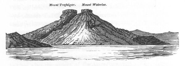
The sea breeze freshened towards sunset, and fanned up the fires that had been burning for the last three days in several places upon the low land, and on the sides of the hills to the westward of Mount Trafalgar; before night they had all joined, and, spreading over the tops of the hills for a space of three miles, produced a singularly grand and magnificent effect.
1821. August 1.
At half past five o'clock the next morning we were under sail but, the breeze being light, had only time to reach the anchorage under Greville Island in Halfway Bay, before the tide turned against us. It was purposed to remain only during the flood; but, on examination, the place was found to be so well adapted for the purpose of procuring some lunar distances with the sun, to correspond with those taken last year at Careening Bay, that we determined upon seizing the opportunity; and as wood was abundant on the island and growing close to the shores, a party was formed to complete our holds with fuel, whilst Mr. Roe assisted me in taking observations upon a convenient station on the north point of the bay within Lammas Island, a small rocky islet covered with shrubs, and separated from the easternmost point of Greville Island by a very shoal and rocky channel.
During these occupations we examined Munster Water: on our way to it we landed on the reef off the east end of the Midway Isles, which was found to be more extensive than had been suspected, and to embrace the group of small rocks, which at high-water only just show their summits above the water; at high-tide there is at least fifteen feet water over it, but being low-water when we landed, the reef was dry. Upon it we found several varieties of coral, particularly Explanaria mesenterina, Lam.; Caryophylla fastigata, Lam.; and Porites subdigitata, Lam.: the only shell that we observed upon the reef was a Delphinula laciniata, Lam. (Turbo delphinus, Linn.). After obtaining bearings from its extremity, as also from the summit of the outer dry rock, we landed upon a small verdant-looking grassy mound, the northernmost islet of the group; but we found the verdure of its appearance was caused only by the abundance of the spinifex, through which we had, as usual, much difficulty in travelling. After procuring some bearings from its summit we re-embarked and pulled up Munster Water, supposing that it was connected with the strait at the back of Greville Island; but as the tide then flowing was running in a contrary direction to what was expected from the hypothesis we had formed, we began to suspect some other communication with the sea, and in this we were not deceived; for a narrow but a very deep strait opened suddenly to our view, at the bottom of the Water, through which some of the islands in the offing were recognised. In pulling through we had kept close to the south shore, that we might not miss the communication with Hanover Bay, but notwithstanding all our care we passed by without noticing it, on account of the deceptious appearance of the land; indeed the strait which we discovered leading to sea was not seen until we were within two hundred yards of it, and would also have escaped our observation had not the channel been so direct that the sea horizon was exposed to our view. At the bottom of this arm are two deep bays which were partially but sufficiently examined. In most parts of Munster Water there is good anchorage amongst several small rocky islands, on one of which we landed, and climbed its summit, but saw nothing to repay us for the trouble or the danger of the ascent: the surface was composed entirely of loose blocks of sandstone, which, when trod upon, would crumble away or roll down the nearly perpendicular face of the rock; and it was only by grasping the branches of the acacias and other trees that were firmly rooted in the interstices of the less-decomposed rocks that we were saved from being precipitated with them. On our return we passed through the channel on the west side of the Midway Isles which we found to be very deep and the stream very strong.
August 4.
The next day we pulled through the strait that insulates Greville Island, and found that it communicated with Munster Water at a part where we had yesterday concluded it likely to exist, and had in consequence steered towards it; but as we proceeded the probability became less and less, and we gave up the search when we were within three hundred yards of being actually in it.
We then pulled up Munster Water and afterwards through the strait to sea; and, landing on some dry rocks on a reef which projects off the west head of the strait, found that we were at the entrance of the bight, which was last year named Hanover Bay: after taking a set of bearings, we re-embarked and proceeded to the bottom of the bay which terminated in a shoal basin.
On our return we entered an opening in the rocky cliff which bore the appearance of being the outlet of a torrent stream; being low-water, there was not in many parts sufficient depth to float the boat; but after pulling up for half a mile, a muddy channel was found, which, at the end of another half mile, was terminated by a bed of rocks over which the tide flows at high-water. The ravine is formed by steep precipitous rocks which are at least two hundred and fifty feet high; it appeared to extend to a considerable distance, and as the farther progress of the boat was prevented by the stones and want of water, Bundell and two of the boat's crew were despatched to examine a place farther on, where, from the green appearance of the trees, it was thought not unlikely that there might be a fresh stream. In this they were not disappointed, for after much delay and trouble, from the difficulty of passing over the rocks, they returned with two baricas full of fresh water, which they found in holes of considerable size.
In pulling up the river, an alligator was seen crawling slowly over the mud banks, but took to the water before we came near it and did not afterwards reappear. Many kangaroo-rats and small kangaroos were seen skipping about the rocks, but they were very shy, and fled the moment they saw us.
Hanover Bay thus proving to afford good anchorage and an opportunity of increasing our stock of water, as well as presenting a sandy beach on which we could haul the seine, it was determined that we should visit it as soon as the brig could be moved out of Prince Regent's River.
On our return, which was over the same ground as we had passed in the morning, we landed near two or three gullies on the inner side of the island, which forms the eastern boundary of Munster Water, but were unsuccessful in all our searches after fresh water.
August 6.
At daylight on the 6th we got underweigh to a light air of wind from the southward, to leave Prince Regent's River; but notwithstanding the vessel was under all sail she was very nearly thrown upon Lammas Island by the tide, which was setting with great strength through the shoal passage between it and Sight Point: as we passed without it we were not more than five yards from the rocks. The wind then fell to a dead calm and the brig was perfectly immovable in the water; but, drifted by the tide and whirled round by the eddies, we were fast approaching the body of the largest Midway Island, with a very great uncertainty on which side of it the tide would drift us: when we were about three hundred yards from the island the direction of the stream changed and carried us round its south-east side, at about two hundred yards from the shore, but close to the low rocks off its east end, on which we landed two days since. We were under great anxiety for fear of being driven over the reef, on which there could not have been sufficient water to have floated us; but our fears of that danger were soon over for the tide swept us rapidly round it. At this moment a light air sprang up which lasted only five minutes, but it was sufficient to carry us past the junction of the Rothsay and Munster Waters with the main stream. The vessel was at times unmanageable from the violent whirlpools through which we passed, and was more than once whirled completely round upon her keel; but our former experience of a similar event prepared us to expect it, and the yards were as quickly braced round.
Having passed all the dangers, the ebb-tide very soon carried us out of the river into Hanover Bay. In passing the easternmost of the outer isles, the shrill voices of natives were heard calling to us, and Bundell returned their shout, but it was some time before we could discern them on account of the very rugged nature of the island: at last three Indians were observed standing upon the rocks near the summit of the island but, as the tide was running out with great strength, we were soon out of hearing.
Soon after one o'clock the brig was anchored at about half a mile off the sandy beach in Hanover Bay, in eight fathoms (half flood) muddy bottom. The boats were immediately hoisted out and sent up the river, but the tide was ebbing and the difficulty of filling the casks so great that, after great labour, we only procured a puncheon of water. The launch was moored without the rocky bed of the river, while the jolly-boat conveyed the baricas to her as they were filled, but even the latter could not get within three hundred yards of the water, so that the people had to carry the baricas over the rugged bed of the river for that distance, which made the work laborious and slow; still however it was much less distressing than the fatigue of watering from the cascade in Prince Regent's River. At night a successful haul of the seine supplied our people with abundance of fish, among which were mullets weighing from three to five pounds; cavallos, whitings, silver fish, breams, and two species of guard-fish.
August 7.
While our people were employed the next morning in washing the decks, they heard at a distance the voices of natives; at eight o'clock they were again heard and at ten o'clock they were close by; shortly afterwards three, of whom one was a woman, were seen standing on the rocks waving their arms. Being curious to communicate with the inhabitants of this part of the coast, since we had not seen any between this and Vansittart Bay, a party consisting of the surgeon, Mr. Bedwell, Mr. Baskerville, and myself, went on shore to the place where the natives were seated waiting for us. Bundell, who generally accompanied us on these occasions divested of his clothes, stood up in the bow of the boat, and, as we approached the shore, made signs of friendship, which the natives returned, and appeared quite unconcerned at our approach. On landing we climbed the rocks on which the two men were standing, when we found that the woman had walked away: upon our approach they retired a few paces and evidently eyed us in a distrustful manner; but, as they had dropped their spears, and repeated the sign of peace that we had made to them, we did not hesitate to walk towards them unarmed, desiring the boat's crew to be prepared with the muskets, if called. When we joined them they had their spears poised ready to throw, but on our presenting them with some of the fish that we had caught the preceding evening they dropped their spears and immediately returned us something in exchange; one gave a belt, made of opossum fur, to Bundell; and the other, the tallest of the two, gave me a club that he carried in his hand, a short stick about eighteen inches long, pointed at both ends. This exchange of presents appeared to establish a mutual confidence between us, and, to strengthen it, I presented my friend with a clasped knife, after showing him its use, the possession of which appeared to give him great pleasure.
By this time Mr. Montgomery and Mr. Bedwell joined us; the latter gentleman was unarmed, but the former had a pistol concealed under his coat and carried a fish which he held out for them to take; but, as they would not approach us nearer than two or three yards, he threw it towards them, when the shortest native picked it up. Upon this accession to our numbers they began to talk to each other, and at the same time picked up their spears; but as the latter appeared only to be a cautionary movement we did not anticipate their mischievous intentions. I then, with a view to amuse them, made signs to my friend for the knife, which he put into my hands without showing the least reluctance, upon which he was again instructed how to open and shut it; but as this, instead of pacifying, only served to increase their anger, the knife was thrown at his feet, which he instantly picked up, and then both retired a few paces in a very suspicious manner.
We were at this time about three or four yards from the natives, who were talking to each other in a most animated way, and evidently intent upon some object; and, as it appeared probable that, if we remained any longer, a rupture would ensue, it was proposed that our party should retire to the boat, under the idea that they would follow us down; no sooner, however, had we waved to them our farewell, and turned our backs to descend the rocks, than they unexpectedly, and in the most treacherous manner, threw their spears; one of which, striking a rock, broke and fell harmless to the ground, but the other, which was thrown by the tallest man, wounded Mr. Montgomery in the back; the natives then, without waiting to throw their second spears, made off, closely pursued by Bundell, who had armed himself with the broken spear; but they were out of sight in a moment, and, by the time that the muskets were brought to our assistance, were doubtless out of gun-shot. A pursuit was, however, commenced, but our progress was so much impeded by the rugged and rocky nature of the ground and by the abundance and intricate growth of the shrubs and trees that we very soon desisted, and returned to the boat, to which Mr. Montgomery had been in the meantime carried, complaining of great weakness from loss of blood.
WEAPONS ETC. OF THE NATIVES OF HANOVER BAY.
1. Stone Spear Head (Full size.) From a Drawing by F. Chantrey,
Esquire, F.R.S.
2. Section of a Stone Spear Head (Full size.) From a Drawing by
F. Chantrey, Esquire, F.R.S.
3. Spear armed with the Stone head.
4. Throwing-stick.
5. Hatchet.
Published in May 1825 by John Murray, London.
Upon examining Mr. Montgomery's wound, which unfortunately was in such a part of his body that he could not himself inspect it, it appeared that the spear had penetrated about three inches; and, from the quantity of extravasated blood, great fears were entertained that he had received a very serious internal injury. The wound, from which he was suffering very great pain, was dressed according to his instructions, but it was several days before he considered himself out of danger.
August 8.
The next morning at eleven o'clock a native was seen on a float, or catamaran, paddling round the west point of the strait, and another man, a woman, and a child, were observed on the rocks, who, in less than a quarter of an hour, came down to the spot where we met them yesterday, and began to wave and call to us. An opportunity now offered of punishing these wretches for their treacherous conduct, and of disappointing them in their present plans, for they were evidently intent upon some mischief. Mr. Bedwell was therefore despatched to secure their catamaran, which was hauled up on a sandy beach near the outer point, whilst another boat was sent towards the natives: when the latter arrived near the shore, they were sitting on the rock and inviting us to land; but it was necessary to convince them that we were not so defenceless as they imagined, and, as soon as we were sufficiently near, several muskets were fired over their heads: one of them fell down behind a rock, but the other made off. The native who had fallen was wounded in the shoulder, and was recognised to be the man that speared Mr. Montgomery; he made several attempts to get away, but every time his head appeared above the rock which concealed him from us, a pistol or a musket was fired to prevent his escape; at last, however, he sprang up, and, leaping upon the rock with a violent effort, was instantaneously out of sight.
As soon as he was gone we pulled round to the sandy bay where the natives had landed and overtook Mr. Bedwell, who was passing by the place. Upon the beach we found two catamarans, or floats, on each of which a large bundle of spears was tied with ligatures of bark; and on searching about the grass we soon found and secured all their riches, consisting of water-baskets, tomahawks, spears, throwing-sticks, fire-sticks, fishing-lines, and thirty-six spears; some of the latter were of large size, and very roughly made, and one was headed with a piece of stone curiously pointed and worked. This last spear is propelled by a throwing-stick, which was also found lying by it. After launching the catamarans and securing everything found upon them, they were towed round by the boats to where we had fired upon the natives, whilst a party walked over land to examine the place. On the way several spears were discovered placed ready for use on their retreat to the beach, where, from the quantity collected, they evidently intended to make a stand; supposing no doubt from our appearance yesterday that we were defenceless, and would therefore fall an easy prey. On reaching the rock, behind which the native fell, it was found covered with blood; and Bundell, who probably did the deed, said the wound was on his shoulder. We traced their retreat by the blood for half a mile to the border of a mangrove inlet, which they had evidently crossed, for the marks of their feet were perceived imprinted in the mud. We then gave up the pursuit, and went on board.
Upon examining the baskets, among other things a piece of iron hoop was found fixed in a wooden handle, which it seemed they had used for the purpose of digging up roots. This hoop must have been left by us last year at Careening Bay. But what chiefly attracted our attention was a small bundle of bark, tied up with more than usual care; upon opening it we found it contained several spear-heads, most ingeniously and curiously made of stone; they were about six inches in length, and were terminated by a very sharp point; both edges were serrated in a most surprising way; the serratures were evidently made by a sharp stroke with some instrument, but it was effected without leaving the least mark of the blow: the stone was covered with red pigment, and appeared to be a flinty slate. These spear-heads were ready for fixing, and the careful manner in which they were preserved plainly showed their value, for each was separated by strips of bark, and the sharp edges protected by a covering of fur. A wound with such a spear must be mortal; and it was very fortunate for Mr. Montgomery that his was not inflicted with one of these truly formidable weapons. Their hatchets were also made of the same stone, the edges of which are ground so sharp that a few blows serve to chop off the branch of a tree.
The catamarans consisted of five mangrove stems lashed together to a frame of smaller wood, as in Woodcut 2: they are bouyant enough to carry two natives, besides their spears and baskets. A representation of this mode of conveyance is also given in the title page of this volume
WOODCUT 2: RAFT OF THE NATIVES OF HANOVER BAY.
These natives were more robust-looking men than any we had before seen; the tallest must have been at least six feet two inches high; their bodies were scarred all over; their teeth perfect, and they were quite naked. The shorter native had his hair collected into a knob at the top of his head, which gave him a ferocious appearance. The punishment they so justly received will make them respect in future the formidable nature of our arms.
At night we hauled the seine, and procured about four dozen fish, principally mullet. An armed party was stationed above the beach to prevent any attack from the natives, but they did not show themselves.
August 9.
On the following day we again heard them shouting and hallooing but it was some time before we could observe their situation; at last five were discovered by the aid of a telescope, seated on the summit of a hill behind the beach, occupied in making spears; at a little distance were two others, one of whom was distinguished to be the native that had escaped unwounded; the other, a stranger, was chopping a branch off a tree, which he was seen to trim and scrape into a rough spear. During the time they were thus employed, they frequently hallooed to us; no notice was however taken of their cries, although the temptation was very great of firing a shot over their heads to show them that they were still within our reach. As soon as they had finished their work and had made about a dozen spears, they all got up and walked away.
After they disappeared behind the hill it was thought not unlikely that they would attack our people at the watering-place; the party were therefore sent away in the afternoon well armed, but the natives did not make their appearance, and the boats returned at sunset without having been disturbed. The tide was so trifling and the difficulty of loading the boat so great that only ninety gallons of water were procured; and as we were not likely to make quicker progress unless we waited for the spring-tides, we gave up all idea of completing our water, and made preparations to leave the bay.
August 10.
On the following day (10th) as there was no wind all the morning, I sent for another turn of water but only obtained enough for one day's issue; for the tide did not rise more than four feet. In the meantime I visited the extreme point on the west side of the bay, and examined in my way some openings in the land that, from their appearance, promised to afford water: as it was low tide I could not enter them, for they were blocked up by banks of sand and rocks; but on my return the tide was higher, and I pulled about one mile up the northernmost inlet, where I was again stopped by the shoalness of the water. All these places must afford abundance of fresh water during the rainy season, and perhaps are seldom without; and, as this was a year of unusual drought, it is not improbable that the river in which we watered generally afforded a very considerable stream; if so, from its proximity to the anchorage, the bay is of great importance, and is an excellent place for refreshment: turtle might be procured at the islands in its vicinity, and abundance of very fine fish at the sandy beach: the anchorage is safe in all parts, being protected from the sea by the islands in the offing, which front the bay. There is also abundance of wood that may be cut close to the waterside.
Ships detained during the westerly monsoon, as far to leeward as the meridian of 125 degrees, would find an advantage in putting into Hanover Bay, and remaining there until the wind should veer round: by which they would avoid the necessity of beating to windward, over such dangerous ground as extends between this part to Timor; and, by being to the southward, out of the strength of the westerly winds, at the latter end of February and beginning of March, when southerly and south-east winds prevail on the coast, they might much earlier effect their passage to the westward.
The beach of Hanover Bay is situated in latitude 15 degrees 18 minutes 21 seconds, and 13 minutes 40 seconds West of our observatory at Careening Bay, which makes its longitude 124 degrees 47 minutes 5 seconds East of Greenwich.
August 11.
The next morning (11th) we left Hanover Bay and steered out at the distance of a mile and a half from the western shore. After passing round the western head, we entered a deep opening, and, running into it for some distance between a rocky shore on either side, came into an extensive basin, in the centre of which was a high island which we saw at a distance last year, and then called the Lump, from its shape. As a set of bearings from this island was desirable, the vessel was anchored abreast of it at about a mile and a half from the shore; having landed upon it in time to observe the sun's meridional altitude in the artificial horizon, we ascended its summit and obtained the desired bearings; we also discovered Freycinet's Island on the horizon, bearing North 13 degrees 42 minutes West; this island was distinguished easily by its form, which is that of an inverted basin. A large island lies in the centre of the entrance of the port, by which two channels are formed; the westernmost has several patches of rocks in it, but the eastern one, which we used, appeared to be clear and free from danger, excepting a rocky shelf projecting from the eastern shore for not more than three quarters of a mile. In the afternoon we examined the former, and from a summit at the south-west end of the island in the entrance obtained another set of bearings. Afterwards we sounded its channel, and found a deep passage, but too narrow and intricate to be preferred to the eastern channel.
Whilst one boat was thus employed, Mr. Baskerville went to examine an opening at the bottom of the port, which he reported to be a strait, trending round to the South-West for six miles, beyond which his view was intercepted by the next projecting point. The strait, which he called after Captain R.H. Rogers, R.N., is sprinkled with many islands and dry reefs of great extent.
August 12.
On the 12th I was occupied in laying down the plan of this place, which, on account of the day, was honoured with the name of our most gracious king, Port George the Fourth.
August 13.
The next day we sailed out by the eastern channel, but having to beat against the wind, made no further progress than an anchorage off Point Adieu, which was the last land seen by us in the Mermaid; it is the north end of the land that forms the west side of Port George the Fourth, which was afterwards called Augustus Island: to the westward of the point there appeared to be many islands and much broken land. I sent Mr. Roe to Point Adieu to get some bearings from the summit of the hill, and in the meantime Mr. Baskerville sounded the channel between the point and the islands; which he found to be deep and clear; Mr. Roe's report, however, of the appearance of the inner part among the islands was not so favourable, for it is studded over with numerous extensive reefs, which, being low water, were exposed to view. Mr. Roe saw a tolerably broad separation between two islands to the south-west, but more to the westward the islands were so numerous that very little information as to their shape or number could be obtained.
August 14.
At daylight the following morning we weighed, and with a moderate land-breeze from South-East, steered to the North-West, and passed round the islands. Very far to the northward on the sea horizon we saw a sandbank, surrounded with heavy breakers; and more to the westward was an island, which was at first supposed to be one of the Champagny Isles of Captain Baudin, but which I afterwards satisfied myself was Captain Heywood's Red Island: it is rocky and of small extent and apparently quite barren. We were soon afterwards abreast of a strait leading between some rocky islands to the southward; which, as it appeared to be free from danger, we purposed to steer through. The brig entered it at noon, when it was high-water, and as she advanced and reached the narrow part, the ebb-tide was setting so strong against us that, although we were sailing five knots by the log, we were losing ground; we continued however to persevere for three hours and a half, and had run nearly twenty miles by the log without gaining an inch; the breeze then died away, and not being able to stem the tide, we steered back for anchorage, but it was dark and late before a favourable bottom was found so that we lost all the progress that we had gained since noon.
August 15.
The next morning, after taking angles from the sun's rising amplitude, we got underweigh and stood towards the strait to make another attempt to pass through it. The view that was obtained yesterday evening from the masthead before we put about to look for anchorage, induced us to suppose that many reefs existed in the neighbourhood of its south entrance, for one of very extensive size was observed dry, lying off the south-west end of the island that bounds the west side of the strait. The north end of that island also appeared to be fronted by many shoals, which either embrace Red Island and extend to the northward, or else the channels are narrow and deep. The flowing tide, now in our favour, carried us quickly forward: as we passed on we heard the voices of natives and soon afterwards perceived two standing on a hill; our course was, however, so rapid that we were soon out of sight of them; their fires were seen yesterday but then they did not make their appearance.
The flood-tide, running to the South-West through the strait, meeting the ebb flowing North-East into the deep bay to the South-East, formed many strong ripplings, which to a stranger would have been a frightful vortex to have entered, and although we had lately been accustomed to such appearances, yet we did not encounter them without some fear. After clearing them we sounded on a muddy bottom; upon which, as the weather was so thick and hazy as to conceal the land from our view, we anchored in seventeen fathoms muddy sand, at six miles from the strait.
In the afternoon the weather cleared a little, but it was still too thick for us to be underweigh, so that we remained all the evening, which was profitably spent in bringing up the chart; a little before sunset the weather cleared and afforded a good view of the land, which to the South-East is composed principally of islands, but so numerous that the mainland could not be distinguished beyond them; a point, afterwards called Point Hall, round which the land trended to the southward, bore from the anchorage South 19 degrees East.
The direction of the tides, the flood setting South-South-East, and the ebb North-North-West and North-West, induced me to suppose that the opening to the eastward of the bay we were at anchor in, which was called Camden, in compliment to the noble Marquess, was not only connected with Rogers Strait, but was also the outlet of another considerable river or bay.
At the anchorage the flood did not run at a greater rate than a mile and a half an hour, but it ebbed two miles, and fell thirty-seven feet, which is the greatest rise and fall we had yet found; it is probable, from the intricate nature of the coast, that these high tides are common to all this neighbourhood.
August 16.
At five o'clock on the morning of the 16th after a fine night the wind sprung up from the East-South-East and blew fresh; but misty weather immediately after sunrise enveloped us, and clouded our view. The breeze was too fresh for us to continue at anchor, we therefore got underweigh, and made sail by the wind; but upon standing across the channel and finding that the flood-tide set to the South-West, we bore away, and, passing round Point Hall, steered to the southward towards some low islands that were just visible through the haze, and which, being disposed in a group, were named after Mr. Andrew Montgomery, the surgeon of the Bathurst.
At noon our latitude observed to the South was 15 degrees 44 minutes 16 seconds. The land was visible from the deck as far as South 30 degrees West, but from the masthead at one o'clock it was seen as far as South 50 degrees West, and a long low island, the westernmost of Montgomery Isles, bore from South-West by West to South-West by South. The group besides this contained six other isles, which are all low and rocky and crowned with bushes: as we approached them the water shoaled to ten fathoms rocky ground; which on being reduced to the depth of low water, would not be more than five and perhaps only four fathoms. Between Point Hall and these islands the ground was also rocky, and, as the group appeared to be connected by reefs, we steered off to pass round them; the wind, however, changing to the westward, detained us all the evening near them.
The land to the southward trended deeply in and appeared to be much broken in its character and very uninviting to us who had only one anchor to depend upon. This bight was named, at Mr. Montgomery's request, in compliment to the late Captain Sir George Collier, Bart., K.C.B., R.N. During the greater part of the night the wind was light, and by the bearings of a fire on the land we were making but little drift.
August 17.
At sunrise we were near two low islands, bearing South 12 degrees 22 minutes West, and South 20 degrees West, from which very extensive reefs were seen extending between the bearings of South and South-West by West. They were called Cockells Isles. We passed round their north end over a bottom of hard sand, mixed with shells, stones, and coral; in doing which we found an irregular depth, but as the water did not shoal to less than twelve fathoms our course was not altered. Soon after the sun appeared above the horizon the distant land was again enveloped in mist. At eight o'clock we ventured to steer more southerly, but continued to sound over a rocky bottom until ten o'clock, when the islands bore South-East; we then steered South-West through a muddy channel with the flood tide in our favour, towards some land that, as the mist partially cleared off, became visible as far as South-West 1/2 West; some islands were also seen bearing South-South-East; and at noon, being in latitude 15 degrees 50 minutes 39 seconds, we found ourselves off a bay, the east head of which was formed by several islands. The land at the back appeared to be of tolerable height but its outline was so level, that it did not present any prominent feature sufficiently defined to take a bearing of more than once; its coast appeared to be fronted by several rocky islands and to be very much intersected to the westward; either by straits or considerable openings.
The continued hazy state of the weather prevented our ascertaining the particular feature of the country; it seemed to be rocky and very bare of vegetation; but they were some parts, particularly on one of the islands to the eastward at the entrance of Collier's Bay, where a few good-sized trees were growing over a sandy beach.
The ebb tide after noon was against us, and the wind being light, we were making no progress. As sunset approached, we began to look for anchorage; but the suspicious nature of the bottom and the great depth of the water prevented our being successful until some time after dark; the anchor was at last dropped in twenty-eight fathoms, on a bottom of sandy mud, with the ebb-tide setting to the North-West, at the rate nearly of two knots.
Several whales of that species called by whalers fin-backs were playing about us all day, and during the morning two or three were seen near the vessel lashing the water with their enormous fins and tails, and leaping at intervals out of the sea, which foamed around them for a considerable distance.
After anchoring the wind was variable and light from the western quarter but during the night there was a heavy swell. The flood-tide, which commenced at nine o'clock, when the depth was twenty-eight fathoms, gradually ran stronger until midnight, when its rate was two miles per hour: high-water took place at 3 hours 15 minutes a.m., or at twelve minutes before the moon passed her meridian; the rise being thirty-six feet.
August 18.
We were underweigh before six o'clock the next morning, and after steering by the wind for a short time towards the southward (on which course the tide being against us we were making no progress) bore up with the intention of hauling round the point to leeward for anchorage, whence we might examine the place by the means of our boats, and wait for more favourable weather; but upon reaching within half a mile of the point we found that a shoal communication extended across to a string of islands projecting several miles to sea in a West-North-West direction: in mid channel the sea was breaking, and from the colour of the water it is more than probable that a reef of rocks stretches the whole distance across the strait; but this appearance, from the experience we afterwards had of the navigation of this part, might have been produced by tide ripplings, occasioned by the rapidity of the stream, and by its being contracted in its passage through so narrow a pass; it was however too doubtful and dangerous to attempt without having some resource to fly to in the event of accident.
Being thus disappointed, we were under the necessity of steering round the above-mentioned range of islands, and at nine o'clock were two miles North-East by East from the small island 18, when our latitude by observation was 15 degrees 57 minutes 56 seconds; the depth being thirty-seven fathoms, and the bottom of coral mixed with sand, mud, and shells.
To the westward and in a parallel direction with this line of islands was another range, towards which we steered; at sunset we hauled to the wind for the night, off the northernmost island which afterwards proved to be the Caffarelli Island of Captain Baudin. Between these two ranges of islands we only obtained one cast of the lead which gave us thirty-three fathoms on a coral bottom. Upon referring to the French charts of this part of the coast it appeared that we were in the vicinity of a reef (Brue Reef) under which the French ships had anchored; and, as the night was passed under sail, we were not a little anxious, fearing lest there might be others in its neighbourhood.
August 19.
At daybreak Caffarelli Island bore South-South-East; and shortly afterwards we had the satisfaction of seeing Brue Reef; it appeared to be partly dry but of small extent.
We passed within half a mile of the dry rock that lies a mile and a half from the west end of Caffarelli Island and afterwards endeavoured to steer between the range of islands, of which Caffarelli is the northernmost, and a group of rocky isles, marked 33; but finding we could not succeed from the scanty direction of the wind, then blowing a fresh breeze from South-East, we bore up round the west side of the latter and then steered by the wind towards a group of which the island 40 is the principal. On approaching 40 there appeared to be a channel round its south-end; but afterwards observing the sea breaking in the direction of our course, we tacked off to pass round the west extremity of the group, towards two small low islands, 50 and 51, that were seen in the distance bearing about South 84 degrees West. The tide, having been before in our favour, was now against us, and, setting with great strength, drove us near the rocks that front the islands to the northward of Island 40; the wind was however sufficiently strong to enable us to clear the dangerous situation we found ourselves in, but soon afterwards it fell to a light air and we were carried by the tide rapidly towards the low rocky extremity of the islets, which we were nearly thrown upon, when a breeze suddenly sprung up again from the South-East and enabled us to clear this impending danger. We were now drifting to the South by East through a wide channel, sounding in between fifty and sixty fathoms, rocky bottom. Had the evening been less advanced and the wind favourable, we could have run through, and taken our chance of finding either anchorage or an open sea; and although this would certainly have been hazarding a great risk, yet it was of very little consequence in what part of the archipelago we spent the night, as the spots which we might consider to be the most dangerous might possibly be the least so. We had however no choice; we were perfectly at the mercy of the tide, and had only to await patiently its ebbing to drift us out as it carried us in.
By our calculations high-water should have taken place at a quarter past four o'clock; every minute therefore after that time was passed by us most anxiously. Every now and then we were in the midst of the most violent ripplings and whirlpools, which sometimes whirled the vessel round and round, to the danger of our masts. Five o'clock at last arrived and the tide-eddies ceased, but the stream continued to run until a quarter of an hour afterwards, when at last the brig began to drift out slowly. To add now to the dilemma and the danger we were in a breeze sprung up against us: had it continued calm we should have been drifted back through the deepest part of the channel, over the same ground that the flood had carried us in: we however made sail and beat out, and before dark had made considerable progress; we then lost sight of the land until eleven o'clock when some was seen to the eastward: at half-past eleven we had a dead calm; and, to increase our anxiety, the tide had begun to flow and to drift us towards the land, which was then ascertained to be the group 33, on whose shores the sea was distinctly heard to break. As midnight approached the noise became still more and more plain; but the moon at that time rose and showed that our position was very much more favourable than we had conjectured; for, by bearings of Caffarelli Island and the body of 33 group, I found we were at least two or three miles from the shore of the latter.
August 20.
A few minutes after midnight we were relieved from our fears by the sudden springing up of a fresh breeze from South-West, and in a moment found ourselves comparatively out of danger.
At daylight we were eight miles to the north-east of Caffarelli Island; whence we steered to the South-West by West and South-South-West. Brue Reef was seen as we passed by it. At noon our latitude was 16 degrees 14 minutes 1 second, Cape Leveque bearing South.
From noon until one o'clock we were steering South-South-West, but made no progress, on account of an adverse tide which occasionally formed such strong eddies and ripplings that we were several times obliged to steer off to get without their influence. The land of Cape Leveque is low, and presents a sandy beach lined by a rocky reef, extending off the shore for a mile, on many parts of which the sea was breaking heavily: the land was clothed with a small brush wood, but altogether the coast presented a very unproductive appearance, and reminded us of the triste and arid character of the North-West Cape.
On laying down upon the chart the plan of this part, I found Cape Leveque to be the point which Dampier anchored under when on his buccaneering voyage in the Cygnet in 1688. He says: "We fell in with the land of New Holland in 16 degrees 50 minutes, we ran in close by it, and finding no convenient anchoring, because it lies open to the North-West, we ran along shore to the eastward, steering North-East by East, for so the land lies. We steered thus about two leagues, and then came to a point of land, from whence the land trends east and southerly for ten or twelve leagues; but how, afterwards, I know not. About three leagues to the eastward of this point there is a pretty deep bay with abundance of islands in it, and a very good place to anchor in or to hale ashore. About a league to the eastward of that point we anchored in twenty-nine fathom, good hard sand and clean ground." He then proceeds to say: "This part of it (the coast) that we saw is all low, even land, with sandy banks against the sea, only the points are rocky, and so are some of the islands in the bay."*
(*Footnote. Dampier volume 1 page 462.)
From this description I have little hesitation in settling Cape Leveque to be the point he passed round. In commemoration, therefore, of his visit, the name of Buccaneer's Archipelago was given to the cluster of isles that fronts Cygnet Bay, which was so-called after the name of the ship in which he sailed. The point within Cape Leveque was named Point Swan after the Captain of the ship; and to a remarkable lump in the centre of the Archipelago the name of Dampier's Monument was assigned. During the last four days we have laid down upwards of eighty islands upon the chart, and from the appearance of the land it is not improbable but that there may be as many more behind them.
Had we even recognised the bay above alluded to by Dampier before we passed round Cape Leveque, we could not have anchored in it for the wind was blowing strong from the northward, and a heavy swell was rolling, which would have placed us in rather a dangerous situation, besides its being exposed to easterly winds, which for the last two or three days had blown very strong. During the time we had been among these islands, we had not met with a single spot that we could have anchored upon without the almost certain loss of our anchor; and the weather had been so very thick and hazy that only the land in the vicinity of the vessel's situation could be at all distinguished; and these disadvantages, added to the great strength of the wind and the rapidity of the tides, had materially prevented us from making ourselves better acquainted with the place. It is remarkable that as soon as we passed round the Champagny Isles, hazy weather commenced, and continued without intermission until we were to the westward of Cape Leveque. The French complain of the same thing; and they were so deceived by it that, in their first voyage, they laid down Adele Island as a part of the main, when it is only a sandy island about two or three miles long. No natives were seen on any of the islands but there were many large smokes on the horizon at the back of Cygnet Bay.
We were now beginning to feel the effects of this fatiguing duty. One-fourth of the people who kept watch were ill with bilious or feverish attacks, and we had never been altogether free from sickness since our arrival upon the coast. Mr. Montgomery's wound was, however, happily quite healed, and Mr. Roe had also returned to his duty; but Mr. Cunningham, who had been confined to the vessel since the day we arrived in Careening Bay, was still upon the sick list. Our passage up the east coast, the fatigues of watering and wooding at Prince Regent's River, and our constant harassing employment during the examination of the coast between Hanover Bay and Cape Leveque, had produced their bad effects upon the constitutions of our people. Every means were taken to prevent sickness: preserved meats were issued two days in the week in lieu of salt provisions; and this diet, with the usual proportions of lemon-juice and sugar, proved so good an anti-scorbutic that, with a few trifling exceptions, no case of scurvy occurred. Our dry provisions had suffered much from rats and cockroaches; but this was not the only way these vermin annoyed us, for, on opening a keg of musket ball cartridges, we found, out of 750 rounds, more than half the number quite destroyed, and the remainder so injured as to be quite useless.
August 21.
The following day we made very little progress, from light winds in the morning and a dead calm the whole of the evening. At sunset we anchored at about four miles from the shore, in seventeen fathoms sandy ground.
During the afternoon we were surrounded by an immense number of whales, leaping out of the water and thrashing the sea with their fins; the noise of which, from the calmness and perfect stillness of the air, was as loud as the report of a volley of musketry. Some remorae were also swimming about the vessel the whole day, and a snake about four feet long, of a yellowish brown colour, rose up alongside, but instantly dived upon seeing the vessel.
August 22.
High-water took place the next morning at twenty-six minutes after six o'clock, at which time we got underweigh with a moderate land-breeze from South-South-East, and steered to the southward along the shore. At noon we were in latitude 16 degrees 30 minutes 19 seconds, Cape Borda bearing South 42 1/2 degrees East. Soon after noon the sea-breeze sprung up from the northward and, veering to North-West, carried us to the southward along the coast which is low and sandy. At three o'clock we were abreast of a point which was conjectured to be the land laid down by the French as Emeriau Island; the name has therefore been retained, with the alteration only of Point for Island. To the eastward of Cape Borda the coast falls back and forms a bay, the bottom of which was visible from our masthead and appeared to be composed of sand-downs. From Point Emeriau the coast trends to the south-west, and preserves the same sandy character. At five o'clock Lacepede Islands, which were seen by Captain Baudin, were in sight to the westward; and at sunset we anchored in eight fathoms, at about three leagues within them. These islands are three in number, and appear to be solely inhabited by boobies and other sea-fowl: they are low and sandy and all slightly crowned with a few shrubby bushes; the reef that encompasses them seemed to be of great extent.
August 23.
The next day we were steering along the shore, and passed a sandy projection which was named Cape Baskerville, after one of the midshipman of the Bathurst. To the southward of Cape Baskerville the coast trends in, and forms Carnot Bay; it then takes a southerly direction. It is here that Tasman landed, according to the following extract from Dalrymple's Papua: "In Hollandia Nova, in 17 degrees 12 minutes South (Longitude 121 degrees, or 122 degrees East) Tasman found a naked, black people, with curly hair, malicious and cruel; using for arms, bows and arrows, hazeygaeys and kalawaeys. They once came to the number of fifty, double armed, dividing themselves into two parties, intending to have surprised the Dutch, who had landed twenty-five men; but the firing of guns frightened them so, that they fled. Their proas are made of the bark of trees; their coast is dangerous; there are few vegetables; the people use no houses."
At noon our latitude was 17 degrees 13 minutes 29 seconds. At four o'clock we were abreast of Captain Baudin's Point Coulomb, which M. De Freycinet describes to be the projection at which the Red Cliffs commence. The interior is here higher than to the northward, and gradually rises, at the distance of eight miles from the shore, to wooded hills, and bears a more pleasing and verdant appearance than we have seen for some time past; but the coast still retains the same sandy and uninviting character. During the afternoon we had but a light sea-breeze from the westward; and at sunset the anchor was dropped in thirteen fathoms fine soft sand, at about six miles from the shore. Large flocks of boobies flew over the vessel at sunset, directing their course towards the reefs of Lacepede Islands, and in the direction of the Whale Bank, which, according to the French chart of this part, lies in the offing to the westward. As no island was noticed by us in the position assigned to Captain Baudin's Carnot Island, the bay to the southward of Cape Baskerville has received that name. The smokes of fires have been noticed at intervals of every four or five miles along the shore, from which it may be inferred that this part of the coast is very populous. Captain Dampier saw forty Indians together, on one of the rocky islands to the eastward of Cape Leveque, and, in his quaint style, gives the subjoined interesting account of them:
"The inhabitants of this country are the miserablest people in the world. The Hodmadods of Monomatapa, though a nasty people, yet for wealth are gentlemen to these; who have no houses, and skin garments, sheep, poultry, and fruits of the earth, ostrich eggs, etc., as the Hodmadods have: and setting aside their human shape, they differ but little from brutes. They are tall, straight-bodied, and thin, with small, long limbs. They have great heads, round foreheads, and great brows. Their eye-lids are always half closed, to keep the flies out of their eyes; they being so troublesome here, that no fanning will keep them from coming to one's face; and without the assistance of both hands to keep them off, they will creep into one's nostrils, and mouth too, if the lips are not shut very close; so that from their infancy, being thus annoyed with these insects, they do never open their eyes as other people; and therefore they cannot see far, unless they hold up their heads, as if they were looking at somewhat over them.
"They have great bottle-noses, pretty full lips, and wide mouths. The two fore-teeth of their upper jaw are wanting in all of them, men and women, old and young; whether they draw them out, I know not: neither have they any beards. They are long-visaged, and of a very unpleasant aspect, having no one graceful feature in their faces. Their hair is black, short and curled, like that of the negroes; and not long and lank like the common Indians. The colour of their skins, both of their faces and the rest of their body, is coal-black, like that of the negroes of Guinea.*
(*Footnote. The natives of Hanover Bay, with whom we communicated, were not deprived of their front teeth, and wore their beards long; they also differed from the above description in having their hair long and curly. Dampier may have been deceived in this respect, and from the use that they make of their hair, by twisting it up into a substitute for thread, they had probably cut it off close, which would give them the appearance of having woolly hair like the negro.)
"They have no sort of clothes, but a piece of the rind of a tree tied like a girdle about their waists, and a handful of long grass, or three or four small green boughs full of leaves, thrust under their girdle, to cover their nakedness.
"They have no houses, but lie in the open air without any covering; the earth being their bed, and the heaven their canopy. Whether they cohabit one man to one woman, or promiscuously, I know not; but they do live in companies, twenty or thirty men, women, and children together. Their only food is a small sort of fish, which they get by making weirs of stone across little coves or branches of the sea; every tide bringing in the small fish, the there leaving them for a prey to these people, who constantly attend there to search for them at low water. This small fry I take to be the top of their fishery: they have no instruments to catch great fish, should they come; and such seldom stay to be left behind at low water: nor could we catch any fish with our hooks and lines all the while we lay there. In other places at low water they seek for cockles, mussels, and periwinkles. Of these shell-fish there are fewer still; so that their chief dependence is upon what the sea leaves in their wares; which, be it much or little, they gather up, and march to the places of their abode. There the old people that are not able to stir abroad by reason of their age, and the tender infants, wait their return; and what Providence has bestowed on them, they presently broil on the coals, and eat it in common. Sometimes they get as many fish as makes them a plentiful banquet; and at other times they scarce get every one a taste; but be it little or much that they get, every one has his part, as well the young and tender, the old and feeble, who are not able to go abroad, as the strong and lusty. When they have eaten they lie down till the next low water, and then all that are able march out, be it night or day, rain or shine, 'tis all one; they must attend the weirs, or else they must fast; for the earth affords them no food at all. There is neither herb, root, pulse, nor any sort of grain for them to eat, that we saw; nor any sort of bird or beast that they can catch, having no instruments wherewithal to do so.
"I did not perceive that they did worship anything. These poor creatures have a sort of weapon to defend their weir, or fight with their enemies, if they have any that will interfere with their poor fishery. They did at first endeavour with their weapons to frighten us, who, lying ashore, deterred them from one of their fishing-places. Some of them had wooden swords, others had a sort of lances. The sword is a piece of wood shaped somewhat like a cutlass.* The lance is a long straight pole, sharp at one end, and hardened afterwards by heat. I saw no iron, nor any sort of metal; therefore it is probable they use stone hatchets, as some Indians in America do, described in Chapter 4.
(*Footnote. Probably a boomerang. See volume 1.)
"How they get their fire I know not; but probably as Indians do, out of wood. I have seen the Indians of Bon-Airy do it, and have myself tried the experiment. They take a flat piece of wood that is pretty soft, and make a small dent in one side of it, then they take another hard, round stick, about the bigness of one's little finger, and sharpened at one end like a pencil, they put that sharp end in the hole or dent of the flat soft piece, and then rubbing or twirling the hard piece between the palm of their hands, they drill the soft piece till it smokes, and at last takes fire.
"These people speak somewhat through the throat; but we could not understand one word that they said. We anchored, as I said before, January the 5th, and seeing men walking on the shore, we presently sent a canoe to get some acquaintance with them; for we were in hopes to get some provision among them. But the inhabitants, seeing our boat coming, run away and hid themselves. We searched afterwards three days in hopes to find their houses, but found none; yet we saw many places where they had made fires. At last, being out of hopes to find their habitations, we searched no farther; but left a great many toys ashore, in such places where we thought they would come. In all our search we found no water, but old wells on the sandy bays.
"At last we went over to the islands, and there we found a great many of the natives; I do believe there were forty on one island, men, women, and children. The men on our first coming ashore, threatened us with their lances and swords; but they were frightened by firing one gun, which we fired purposely to scare them. The island was so small that they could not hide themselves; but they were much disordered at our landing, especially the women and children; for we went directly to their camp. The lustiest of the women snatching up their infants ran away howling, and the little children run after squeaking and bawling; but the men stood still. Some of the women, and such people as could not go from us, lay still by a fire, making a doleful noise, as if we had been coming to devour them: but when they saw we did not intend to harm them, they were pretty quiet, and the rest that fled from us at our first coming, returned again. This their place of dwelling was only a fire, with a few boughs before it, set up on the side the winds was of.
"After we had been here a little while, the men began to be familiar, and we clothed some of them, designing to have some service of them for it; for we found some wells of water here, and intended to carry two or three barrels of it aboard. But it being somewhat troublesome to carry to the canoes, we thought to have made these men to have carried it for us, and therefore we gave them some old clothes; to one an old pair of breeches, to another a ragged shirt, to the third a jacket that was scarce worth owning; which yet would have been very acceptable at some places where we had been, and so we thought they might have been with these people. We put them on them, thinking that this finery would have brought them to work heartily for us; and our water being filled in small long barrels, about six gallons in each, which were made purposely to carry water in, we brought these our new servants to the wells, and put a barrel on each of their shoulders for them to carry to the canoe. But all the signs we could make were to no purpose, for they stood like statues, without motion, but grinned like so many monkeys, staring one upon another; for these poor creatures seem not accustomed to carry burdens; and I believe that one of our ship-boys of ten years old would carry as much as one of them. So we were forced to carry our water ourselves, and they very fairly put the clothes off again, and laid them down, as if clothes were only to work in. I did not perceive that they had any great liking to them at first, neither did they seem to admire anything that we had.
"At another time our canoe being among these islands seeking for game, espied a drove of these men swimming from one island to another; for they have no boats, canoes, or bark-logs. They took four of them, and brought them aboard; two of them were middle-aged, the other two were young men about eighteen or twenty years old. To these we gave boiled rice, and with it turtle and manatee boiled. They did greedily devour what we gave them, but took no notice of the ship, or any thing in it, and when they were set on land again, they ran away as fast as they could. At our first coming, before we were acquainted with them, or they with us, a company of them who lived on the main, came just against our ship, and standing on a pretty high bank, threatened us with their swords and lances, by shaking them at us: at last the captain ordered the drum to be beaten, which was done of a sudden with much vigour, purposely to scare the poor creatures. They hearing the noise, ran away as fast as they could drive; and when they ran away in haste, they would cry gurry, gurry, speaking deep in the throat. Those inhabitants also that live on the main would always run away from us; yet we took several of them. For, as I have already observed, they had such bad eyes, that they could not see us till we came close to them. We did always give them victuals, and let them go again, but the islanders, after our first time of being among them, did not stir for us."*
(*Footnote. Dampier volume 1 page 464 et seq.)
At this anchorage we perceived very little rise and fall of tide, and the flood and ebb both set to the northward, this was also the case at our anchorage within the Lacepede Islands. At four o'clock the next morning a strong south-easterly breeze sprang up, and moderated again before we weighed; but no sooner were we under sail than it freshened again, and, at half-past five o'clock, blew so strong as to oblige our double reefing the topsails, which had not been done for many weeks before. At noon the wind fell, and was very calm, at which time our latitude observed was 17 degrees 36 minutes 38 seconds. The highest part of the land bore North 70 1/2 degrees East, south of which a sandy point, supposed to be Captain Baudin's Cape Boileau, bore South 87 degrees East; and a smoke, a little to the northward of the masthead extreme, bearing South 42 degrees East must be upon the land in the neighbourhood of Cape Latreille.
Soon after noon the breeze veered round by South to West-South-West, and enabled us to make some progress; at sunset we again anchored in thirteen fathoms, soft sand, at six miles from a sandy projection of the main, which we afterwards found to be the land called by Captain Baudin, Gantheaume Island; the name has therefore been given to the point, for there was no appearance of its being insulated. It bears a truly desolate appearance, being nothing but ridges of bare white sand, scantily crowned with a few shrubby bushes.
Behind Point Gantheaume the land appeared to be formed by downs of very white sand; and between this point and Cape Boileau is a bay, which at first, from the direction of the flood stream at the anchorage, was conjectured to be an inlet; but as the tide afterwards set to the Northward and North-East, it was concluded to be occasioned by the stream sweeping round the shores of the bay: according to the depth alongside there was a rise of ten feet; after high-water the ebb set between North 1/2 West and North-North-East, at the rate of a quarter to three quarters of a knot.
During the whole day the horizon was occupied by haze, and produced a very remarkable effect upon the land, which was so raised above the horizon by refraction that many distant objects became visible that could not otherwise have been seen. This mirage had been frequently observed by us on various parts of the coast, but never produced so extraordinary an effect as on the present occasion. The coastline appeared to be formed of high chalky cliffs, crowned by a narrow band of woody hillocks; and the land of Cape Villaret was so elevated as to be distinctly seen at the distance of forty miles, whereas two days afterwards, the weather being clear, it was not visible above the horizon for more than five leagues. This state of the atmosphere caused a rapid evaporation during the day, and as the evening approached a very copious dew commenced falling, which by sunset was precipitated like a shower of rain.
The next morning the land was again enveloped in haze, but at seven o'clock it cleared off a little, and the coast was observed to trend round Point Gantheaume to the south-east, but as we had last evening seen it as far to the westward as South-West by South, we steered in the latter direction under the idea of there being no opening to the southward of the point, since the flood-tide flowed from it instead of towards it, as it naturally would have done had there been any inlet of consequence thereabout.
As usual, we had been surrounded by whales, and large flights of boobies; one of the latter lighted upon the deck this afternoon, and was easily taken; it seemed to be the same bird (Pelecanus fiber) that frequents the reefs upon the north and north-eastern coasts. Between sunrise and midday our progress was much retarded by light south-easterly winds. At noon we were in 17 degrees 51 minutes 45 seconds South: after which the sea-breeze set in from South-South-West and South-West, and we steered to the southward. The land was now visible considerably to the southward of Point Gantheaume, but of a very low and sandy character; and as we proceeded it came in sight to the South-South-West. At sunset we anchored about five or six miles to the north of Captain Baudin's Cape Villaret; the extreme, which was in sight a little without it, was doubtless his Cape Latouche-Treville. From Cape Villaret the land trended to the East-North-East, and was seen very nearly to join the shore at the back of Point Gantheaume.
The dew was precipitated as copiously this evening as the last, and the sun set in a very dense bank; but the night was throughout fine. We now began to experience a more considerable set of tide than we had found since rounding Cape Leveque, for the rate was as much as a knot and a half; but as the tides were neaped it only rose nine feet.
At an anchorage near this spot, in the year 1699, Captain Dampier remarks that the tide rose and fell five fathoms, and ran so strong that his nun-buoy would not watch: but the French expedition, at an anchorage a little to the southward, found the flood-tide to set South-South-East and to rise only nine feet, the moon being then three days past her full. All these particulars have been mentioned, since it is from the nature of the tides that Captain Dampier formed his hypothesis of the existence of either a strait or an opening between this and the Rosemary Islands; but from our experience it would appear more probable that these great tides are occasioned by the numerous inlets that intersect the coast between this and Cape Voltaire; a further examination, however, can only prove the real cause.
August 26.
At daylight (26th) we weighed with a light breeze from South-West, but soon afterwards falling calm, and the tide drifting us to the South-East the anchor was again dropped: ten minutes afterwards a land breeze from East-South-East sprung up, to which we again weighed, but no sooner were we under sail than we were enveloped in a thick mist that blew off the land, where it had been collecting for the last two days. At eleven o'clock the fog cleared away to seaward, but the land was screened from our view until noon, when a sea breeze from west gradually dispersed the fog, and the hillocky summit of Cape Latouche-Treville was seen, bearing South 17 degrees West. At half-past twelve two rocky lumps on the land to the westward of Cape Villaret were seen, and very soon afterwards the hill on the cape made its appearance. Between Capes Villaret and Latouche-Treville is a bay formed by very low sandy land, slightly clothed with a stunted vegetation. The wind was now unfavourable for our approaching the land, and after standing off to sea and then towards the shore we anchored in thirteen fathoms coarse sand.
At this anchorage we found a still greater difference in the tides than was experienced the night preceding; the flood set South-East by East and East-South-East; and the ebb from North-North-East round to West-North-West; the rise was sixteen feet and a half, from which it would appear probable that there must be some reason for so great an indraught of water into the bight between Cape Villaret and Point Gantheaume, which I have named Roebuck Bay, after the ship that Captain Dampier commanded when he visited this part of the coast.
As the wind now blew constantly from the South-West, or from some southern direction, and caused our progress to be very slow and tedious; and as the shore for some distance to the southward of Cape Latouche-Treville had been partly seen by the French, I resolved upon leaving the coast. Our water was also nearly expended, and our provisions, generally, were in a very bad state; besides which the want of a second anchor was so much felt that we dared not venture into any difficulty where the appearance of the place invited a particular investigation, on account of the exposed nature of the coast, and the strength of the tides, which were now near the springs: upon every consideration, therefore, it was not deemed prudent to rely any longer upon the good fortune that had hitherto so often attended us in our difficulties.
August 27.
Accordingly after weighing, we steered off by the wind, and directed our course for Mauritius.
1821. September 22.
On the 22nd September at daylight after a passage of twenty-five days we saw Roderigues, five or six leagues to the northward. In the evening a fresh gale sprung up from the southward and we experienced very bad weather: at noon of the 24th by our calculation we were seventy-three miles due East from the north end of Mauritius and, having the day before experienced a westerly current of one mile per hour, we brought to at sunset for the night, from the fear of getting too near the shore.
September 25.
At daylight the following morning, being by the reckoning only thirty-four miles to the eastward of the north end of the island, we bore up for it; but the land, being enveloped in clouds, was not seen until noon; we then found ourselves off the south-east end, instead of the north point; having been set to the southward since yesterday noon at the rate of three quarters of a mile an hour: in consequence of which we determined upon going round the south side, and bore up for that purpose; upon approaching the land we found another current setting us to the north.
September 26.
The next morning at nine o'clock we passed round the Morne Brabant, the south-west point of the island, but it was four o'clock before we reached our anchorage (at a cable's length within the flag beacon at the entrance of Port Louis) in fifteen fathoms mud; we were then visited by the Health Officer, and afterwards by a boat from H.M. Ship Menai, which was at anchor in the port.
September 27.
But as it was too late that evening to enter the brig was not moved until the following morning, when she was warped in and moored head and stern within the harbour.
My wants were immediately made known to Captain Moresby, C.B. (of H.M. Ship Menai) who directed the necessary repairs to be performed by the carpenters of his ship; those articles which could not be supplied from the Menai's stores were advertised for in the Mauritius Gazette, when the most reasonable tenders were accepted.
As many of the carpenters and caulkers of the Menai as could be spared from their other occupations were daily employed upon our repairs; but from her being put into quarantine and other unforeseen delays they were not completed for nearly a month: our sails were repaired by the Menai's sailmakers; and, as all our running rigging was condemned and we had very little spare rope on board, her rope-makers made sufficient for our wants. The greater part of our bread, being found in a damaged state from leaks, was surveyed and condemned.
Captain Flinders' account of Mauritius appears to have been drawn up with much correctness and judgment, and is, even at the present day, so descriptive of the island as to be considered, both by the English and French residents of Port Louis, as the best that has yet been given to the world. Many alterations and considerable improvements have however taken place since his departure, and among the latter the improved system of the culture of the sugar cane, and the introduction of modern machinery into their mills, may be particularly mentioned. These have been effected entirely by the political changes that have, since Captain Flinders' captivity, taken place in the government of the island; and by the example and exertions of the English, who possess very large plantations, and indeed may be considered now as the principal proprietors of the land.
(*Footnote. It afforded me very great pleasure to hear the high terms in which my late friend and predecessor Captain Flinders was spoken of by the inhabitants of this island, and their general regret at his infamous detention. His friend M. Pitot had lately died, but I met many French gentlemen who were acquainted with him. General Decaen, the governor, was so much disliked by the inhabitants that Captain Flinders gained many friends at his expense who would not otherwise have troubled themselves about him; and this circumstance probably went far towards increasing the severity of the treatment he so unjustly received. An anecdote of him was related to me by a resident of Port Louis, which, as it redounds to his honour, I cannot lose the gratification of recording.
When Captain Flinders was at the house of Madame d'Arifat in the district of Plains Wilhelms, in which he was latterly permitted to reside upon his parole, an opportunity of escaping from the island was offered to him by the commander of a ship bound to India: it was urged to him by his friends that, from the tyrannical treatment he had received and the unjustifiable detention he was enduring, no parole to such a man as General Decaen ought to be thought binding or prevent him from regaining his liberty and embracing any opportunity of returning to his friends and country. The escape was well planned, and no chance of discovery likely to happen: the ship sailed from Port Louis, and at night, bringing to on the leeward side of the island abreast of Captain Flinders' residence, sent a boat to the appointed spot which was six miles only from Madame d'Arifat's house; but after waiting until near daylight without the captain making his appearance the boat returned to the vessel, which was obliged to pursue her voyage to prevent suspicion.
It is almost needless to add that Captain Flinders did not think it consistent with his feelings to take advantage of the opportunity, nor to effect his escape from imprisonment by a conduct so disgraceful to the character of a British officer and to the honourable profession to which he belonged.)
For some years past coffee has entirely failed upon the island and cotton is seldom seen growing. The principal attention of the habitans appeared to be given to the cultivation of the sugar cane and maize, both of which had begun to produce an abundant return to the planters; the manihot is also generally cultivated: but the dreadful effects of the hurricanes to which this island is exposed render property of so precarious and doubtful a tenure that nothing is secure until the season for these destructive visitations is over; they last from the beginning of December to the end of April and generally occur about the full of the moon, being invariably preceded by an unsteady motion of the mercury in the barometer. They are not always so violent as to be termed hurricanes: the last experienced before our visit was merely a coup de vent, by which very little damage was sustained.*
(*Footnote. In the month of January, 1824 this unfortunate island was again visited and laid waste by a tremendous hurricane that did very considerable damage, and has in a great measure destroyed the prosperous state which the island was beginning to arrive at from the previous long absence of this dreadful visitation.)
The town of Port Louis which is at the north-west, or leeward, side of the island, is built at the extremity of an amphitheatre of low land, backed in by a high and precipitous range, upon which Peter Botte and the Pouce are conspicuous features. The streets are laid out at rightangles, the principal of which lead from the Chaussee to the Champ de Mars, a plot of grassy land about half a mile square that intervenes between the town and the hills. This is the promenade, the drive, the racecourse, and, in fact, the principal resort for the inhabitants. It is skirted by houses and gardens and is a valuable acquisition to the town. The Chaussee and other streets are well furnished with useful shops of which those of the Tinman, the Druggist, and the Conservateur et Patissier, are the most numerous.
The houses, generally of wood, are irregularly built, and far from being elegant in their appearance; those however that have been lately constructed by our countrymen have already given the place an appearance of solidity that it could not boast of before, and several substantial stone dwellings and stones have lately been erected. The roads for seven or eight miles out of the town, leading to Pamplemousses, to Plains Wilhelms and to Moca districts, are very good and are kept in repair partly by Malabar convicts from India; but travelling beyond that distance is performed in palanquins which four bearers will carry, at a steady pace, at the rate of six miles per hour.
At the time of our visit there were few fruits ripe; but when we were about to sail the mango of delicious flavour began to be common; besides which there were coconuts, guavas, papaws, grapes, the letchy (or let-chis, a Chinese fruit) and some indifferent pineapples. The ship's company were supplied daily with fresh beef and vegetables. The latter were procured in abundance at the bazaar and were exceedingly fine, particularly carrots and cabbages of an unusually large size and fine flavour. Bullocks are imported into the island from Madagascar, in which trade there are two vessels constantly engaged during the fine season.
Horses are very scarce; they are imported from the Cape of Good Hope and fetch a high price: a cargo of a hundred and seventy-seven mules arrived from Buenos Ayres while we were at Port Louis, which, on being sold by auction, averaged each one hundred and eighty dollars. To encourage the importation of these useful animals a premium of five dollars is offered by the government for every mule that is brought alive to the island.
The circulating medium was principally of paper but bore a very great depreciation; the premium upon bills of exchange upon Europe, at the time of our departure, was as much as 66 to 76 per cent, and upon silver coin there was a depreciation of 45 per cent.
On the voyage to this place three charts of the north-west coast were reduced and copied by Mr. Roe and were forwarded to the Admiralty by H.M. Sloop Cygnet, together with a brief account of our voyage from the time that we parted company with the Dick, off Cape Van Diemen.
No observations were taken at this place excepting for ascertaining the rates of the chronometers, and for the variation and dip of the magnetic needle: the former being 12 degrees 31 minutes West, and the latter 51 degrees 42 minutes 1 second. The situation of the observatory has been long since fixed by the Abbe de la Caille in 20 degrees 10 minutes South latitude, and 57 degrees 29 minutes East longitude.
I cannot conclude this very brief account of our visit to Mauritius without expressing my acknowledgments for the civilities and hospitality we received from our countrymen at Port Louis, particularly from His Excellency Sir Robert T. Farquhar, Bart., who so long and ably presided as Governor of the Island; and for the valuable assistance rendered me in our re-equipment by Captain Fairfax Moresby, C.B., of H.M. Ship Menai, for which the expedition I had the honour to command is under more than a common professional obligation.
Departure from Port Louis.
Voyage to the South-west Coast of New Holland.
Anchor in King George the Third's Sound.
Occurrences there.
Visited by the Natives.
Our intercourse with them.
Descriptions of their weapons and other implements.
Vocabulary of their language.
Meteorological and other observations.
Edible plants.
Testaceous productions.
1821. November 10.
On the 10th November we were ready for sea.
November 15.
But, from various delays, did not quit the port until the 15th. At midnight we passed round the Morne Brabant, and the next evening at sunset saw the high land of Bourbon: for the first two days we had south-east winds and upon reaching the parallel of 25 degrees, the winds became light and baffling with calms.
November 21.
But as we advanced more to the southward they gradually veered to east and north-east, and afterwards to north-west, with very fine weather.
November 28.
We did not get out of the influence of these variable winds until the 28th when we were at noon in latitude 32 degrees 47 minutes and longitude 65 degrees 5 minutes; after which we encountered westerly winds and rough weather. On the whole we had a very quick passage to the coast of New Holland; and for the last week were expedited by a strong westerly gale without encountering any accident or the occurrence of any circumstance worth recording.
1821. December 23.
On the 23rd December at daylight the land about Cape Chatham was in sight, and a course was directed to the eastward for King George's Sound; where it was my intention to complete our wood and water previous to commencing the examination of the west coast. At four o'clock in the afternoon we hauled round Bald Head and, entering the Sound, soon afterwards anchored at one mile from the entrance of Princess Royal Harbour.
December 24.
Having at our former visit re-fitted at Oyster Harbour, I wished on this occasion to try Princess Royal Harbour; but as I was both unacquainted with its entrance, as well as its convenience for our purposes, excepting from Captain Flinders' account, I hoisted the boat out early the next morning, to make the necessary examination before the sea-breeze commenced. Whilst the boat was preparing a distant shouting was heard, and upon our looking attentively towards the entrance several Indians were seen sitting on the rocks on the north head hallooing and waving to us, but no further notice than a return of their call was taken until after breakfast, when we pulled towards them in the whale-boat. As we drew near the shore they came down to receive us and appeared from their gestures to invite our landing; but in this they were disappointed, for, after a little vociferation and gesture on both sides, we pulled into the harbour, whilst they walked along the beach abreast the boat. As the motions of every one of them were attentively watched it was evident that they were not armed; each wore a kangaroo-skin cloak over his left shoulder that covered the back and breast but left the right arm exposed. Upon reaching the spot which Captain Flinders occupied in the Investigator I found that the brig could not anchor near enough to the shore to carry on our different operations without being impeded by the natives, even though they should be amicably disposed. Our plan was therefore altered and, as the anchorage formerly occupied by the Mermaid in the entrance of Oyster Harbour would be on all accounts more convenient for our purposes, I determined upon going thither.
By this time the natives had reached that part of the beach where the boat was lying, and were wading through the water towards us; but as we had no wish at present to communicate with them, for fear that, by refusing anything we had in the boat, for which their importunity would perhaps be very great, a quarrel might be occasioned, we pulled off into deeper water where we remained for five minutes parleying with them, during which they plainly expressed their disappointment and mortification at our want of confidence. Upon making signs for fresh water, which they instantly understood, they called out to us "badoo, badoo," and pointed to a part of the bay where Captain Flinders has marked a rivulet. Badoo, in the Port Jackson language, means water; it was thought probable that they must have obtained it from some late visitors; and in this opinion we were confirmed, for the word kangaroo was also familiar to them.*
(*Footnote. The San Antonio, merchant brig, the vessel that joined our company during our passage up the east coast, visited this port in December 1820 and communicated with the natives; it is therefore probable that the above words were obtained from that vessel's crew.)
Upon our return towards the entrance the natives walked upon the beach abreast the boat, and kept with her until we pulled out of the entrance, when they resumed their former station upon the rocks and we returned on board.
Upon reaching the brig, the anchor was weighed, and with a fresh sea-breeze from South-East we soon reached Oyster Harbour, but in crossing the bar the vessel took the ground in eleven and a half feet water, and it was some time before we succeeded in heaving her over, and reaching the anchorage we had occupied at our last visit. Whilst warping in, the natives, who had followed the vessel along the sandy beach that separates the two harbours, were amusing themselves near us in striking fish with a single barbed spear, in which sport they appeared to be tolerably successful. As soon as we passed the bar three other natives made their appearance on the east side, who, upon the boat going to that shore to lay out the kedges, took their seats in it as unceremoniously as a passenger would in a ferry-boat; and upon its returning to the brig, came on board, and remained with us all the afternoon, much amused with everything they saw, and totally free from timidity or distrust. Each of our visitors was covered with a mantle of kangaroo-skin, but these were laid aside upon their being clothed with other garments, with the novelty of which they appeared greatly diverted. The natives on the opposite shore seeing that their companions were admitted, were loudly vociferous in their request to be sent for also; but unfortunately for them it was the lee shore, so that no boat went near them; and as we did not wish to be impeded by having so many on the deck at one time, their request was not acceded to and by degrees they separated and retired in different directions.
As soon as the brig was secured two of our visitors went ashore, evidently charged with some message from the other native, but as he voluntarily remained on board nothing hostile was suspected; we therefore landed and dug a hole three feet deep among the grass about two yards above the highest tide-mark, for water; but it was found to be so highly coloured and muddy as it flowed in, that other holes were dug in the sand nearer the edge of the tide-mark, where it was also produced, and proved to be of a much better taste, as well as clearer, from being filtered through the sand.
On examining the place of our former encampment, it was so much altered from the rapid growth of vegetation that we could scarcely recognise its situation. The stem of the casuarina on which the Mermaid's name and the date of our visit had been carved was almost destroyed by fire; and the inscription in consequence so nearly obliterated that the figures 1818, and two or three letters alone remained visible. There was not the least trace of our garden, for the space which it formerly occupied was covered by three or four feet of additional soil, formed of sand and decayed vegetable matter and clothed with a thicket of fine plants in full flower, that would be much prized in any other place than where they were. The initials of the names of some of our people were still very perfect upon the stem of a large Banksia grandis which, from being covered with its superb flowers, bore a magnificent and striking appearance.
After an absence of an hour our two friends returned, when it appeared that they had been at their toilet, for their noses and faces had evidently been fresh smeared over with red ochre, which they pointed out to us as a great ornament; affording another proof that vanity is inherent in human nature and not merely the consequence of civilisation. They had however put off the garments with which we had clothed them and resumed their mantles.
Each brought a lighted fire-stick in his hand, intending, as we supposed, to make a fire, and to pass the night near the vessel, in order to watch our intentions and movements.
On returning on board we desired the native who had remained behind to go ashore to his companions, but it was with great reluctance that he was persuaded to leave us. Whilst on board, our people had fed him plentifully with biscuit, yams, pudding, tea, and grog, of which he ate and drank as if he was half famished, and after being crammed with this strange mixture and very patiently submitting his beard to the operation of shaving, he was clothed with a shirt and a pair of trousers, and christened Jack, by which name he was afterwards always called, and to which he readily answered. As soon as he reached the shore, his companions came to meet him to hear an account of what had transpired during their absence, as well as to examine his new habiliments which, as may be conceived, had effected a very considerable alteration in his appearance, and at the same time that the change created much admiration on the part of his companions, it raised him very considerably in his own estimation. It was however a substitution that did not improve his appearance; in fact he cut but a sorry figure in our eyes, in his chequered shirt and tarry trousers, when standing amongst his companions, with their long beards and kangaroo-skin mantles thrown carelessly over their shoulders.
Upon being accosted by his companions Jack was either sullen with them or angry with us for sending him on shore, for without deigning to reply to their questions he separated himself from them, and after watching us in silence for some time, walked quietly and slowly away, followed at a distance by his friends who were lost in wonder at what could have happened to their sulky companion. The grog that he had been drinking had probably taken effect upon his head and, although the quantity was very trifling, he might have been a little stupefied.
December 25.
At daylight the following morning the natives had again collected on both sides, and upon the jolly-boat's landing the people to examine the wells Jack, having quite recovered his good humour, got into the boat and came on board. The natives on the opposite side were vociferous to visit us, and were holding long conversations with Jack, who explained everything to them in a song, to which they would frequently exclaim in full chorus the words "Cai, cai, cai, cai, caigh" which they always repeated when anything was shown that excited their surprise. Finding we had no intention of sending a boat for them they amused themselves in fishing. Two of them were watching a small seal that, having been left by the tide on the bank, was endeavouring to waddle towards the deep water; at last one of the natives, fixing his spear in its throwing-stick, advanced very cautiously and, when within ten or twelve yards, lanced it, and pierced the animal through the neck, when the other instantly ran up and stuck his spear into it also, and then beating it about the head with a small hammer very soon despatched it.
This event collected the whole tribe to the spot, who assisted in landing their prize and washing the sand off the body; they then carried the animal to their fire at the edge of the grass and began to devour it even before it was dead. Curiosity induced Mr. Cunningham and myself to view this barbarous feast and we landed about ten minutes after it had commenced. The moment the boat touched the sand the natives, springing up and throwing their spears away into the bushes, ran down towards us; and before we could land had all seated themselves in the boat ready to go on board, but they were obliged to wait whilst we landed to witness their savage feast. On going to the place we found an old man seated over the remains of the carcass, two-thirds of which had already disappeared; he was holding a long strip of the raw flesh in his left hand, and tearing it off the body with a sort of knife; a boy was also feasting with him and both were too intent upon their breakfast to notice us or to be the least disconcerted at our looking on. We however were very soon satisfied and walked away perfectly disgusted with the sight of so horrible a repast, and the intolerable stench occasioned by the effluvia that arose from the dying animal, combined with that of the bodies of the natives who had daubed themselves from head to foot with a pigment made of a red ochreous earth mixed up with seal-oil.
We then conveyed the natives, who had been waiting with great patience in the boat for our return, to the vessel, and permitted them to go on board. Whilst they remained with us Mr. Baskerville took a man from each mess to the oyster-bank; here he was joined by an Indian carrying some spears and a throwing-stick, but on Mr. Baskerville's calling for a musket that was in the boat (to the use of which they were not strangers) he laid aside his spears, which probably were only carried for the purpose of striking fish, and assisted our people in collecting the oysters. As soon as they had procured a sufficient quantity they returned on board when, as it was breakfast time, our visitors were sent onshore, highly pleased with their reception and with the biscuit and pudding which the people had given them to eat. They were very attentive to the mixture of a pudding, and a few small dumplings were made and given to them, which they put on the bars of the fireplace but, being too impatient to wait until they were baked, ate them in a doughy state with much relish.
Three new faces appeared on the east side, who were brought on board after breakfast, and permitted to remain until dinner-time: one of them, an old man, was very attentive to the sailmaker's cutting out a boat's sail, and at his request was presented with all the strips that were of no use. When it was completed a small piece of canvas was missing, upon which the old man, being suspected of having secreted it, was slightly examined, but nothing was found upon him; after this, while the people were looking about the deck, the old rogue assisted in the search and appeared quite anxious to find it; he however very soon walked away towards another part of the deck and interested himself in other things. This conduct appeared so suspicious that I sent the sailmaker to examine the old man more closely, when the lost piece was found concealed under his left arm, which was covered by the cloak he wore of kangaroo-skin. This circumstance afforded me a good opportunity of showing them our displeasure at so flagrant a breach of the confidence we had reposed in them; I therefore went up to him and, assuming as ferocious a look as I could, shook him violently by the shoulders. At first he laughed but afterwards, when he found I was in earnest, became much alarmed: upon which his two companions, who were both boys, wanted to go onshore; this however was not permitted until I had made peace with the old man, and put them all in good humour by feeding them heartily upon biscuit. The two boys were soon satisfied; but the old man appeared ashamed and conscious of his guilt; and although he was frequently afterwards with us, yet he always hung down his head and sneaked into the background.
During the day the people were employed about the rigging, and in the evening before sunset the natives were again admitted on board for half an hour. In the afternoon Mr. Montgomery went to Green Island and shot a few parrakeets and waterbirds, some of which he gave to the natives after explaining how they had been killed, which of course produced great applause. December 26.
The next day was employed in wooding and watering, in which the natives, particularly our friend Jack, assisted. We had this day twenty-one natives about us and among them were five strangers. They were not permitted to come on board until four o'clock in the afternoon, excepting Jack, who was privileged to come and go as he liked, which, since it did not appear to create any jealousy among his companions, enabled us to detain him as a hostage for Mr. Cunningham's safety, who was busily engaged in adding to his collections from the country in the vicinity of the vessel.
In the evening Jack climbed the rigging as high as the top masthead, much to the amusement of his companions but to the mortification of Bundell who had never taken courage to mount so high.
The waterholes yielded about a ton of water a day; but a stream was found in the sandy bay to the eastward of the entrance, running over the beach, which we used when the holes were emptied of their contents; the latter were however preferred, since our people worked at them under an immediate protection from the vessel's deck. Near the stream we found some felled trees and the staves of a cask.*
(*Footnote. At this place the San Antonio merchant brig wooded and watered in 1820.)
December 27 to 28.
Our watering continued to proceed without molestation from the natives; the number of whom had increased to twenty-nine, besides some whom we had before seen that were now absent. During the afternoon of the 28th the wind freshened from south-west and blew so strong as to cause a considerable swell where we were lying; but towards sunset the breeze moderated and the natives were again admitted on board; there were, however, only eleven, for the rest, having worn out their patience, had walked away.
They were now quite tractable and never persisted in doing anything against our wishes. The words "by and by" were so often used by us in answer to their cau-wah, or "come here," that their meaning was perfectly understood and always satisfied the natives, since we made it a strict rule never to disappoint them of anything that was promised, an attention to which is of the utmost importance in communicating with savages. Every evening that they visited us they received something, but as a biscuit was the most valuable present that could be made, each native was always presented with one upon his leaving the vessel; during the day they were busily occupied in manufacturing spears, knives, and hammers, for the evening's barter; and when they came in the morning they generally brought a large collection, which their wives had probably made in their absence.
December 29.
On the 29th we had completed our holds with wood and water and prepared to leave the harbour. In the morning there was thirteen feet water at the buoy which had been moored on the deepest part of the bar, the depth of which, during the two preceding days, had been frequently sounded.
In the evening we were visited by twenty-four natives among whom was our friend Jack. When they found us preparing to go away they expressed great sorrow at our departure, particularly Jack, who was more than usually entertaining but kept, as he always did, at a distance from his companions and treated them with the greatest disdain. When the time came to send them on shore he endeavoured to avoid accompanying them and as usual was the last to go into the boat; instead however of following them, he went into a boat on the opposite side of the brig that was preparing to go for a load of water, evidently expecting to be allowed to return in her.
This friendly Indian had become a great favourite with us all and was allowed to visit us whenever he chose and to do as he pleased; he always wore the shirt that had been given to him on the first day and endeavoured to imitate everything that our people were employed upon; particularly the carpenter and the sailmaker at their work: he was the only native who did not manufacture spears for barter, for he was evidently convinced of the superiority of our weapons and laughed heartily whenever a bad and carelessly-made spear was offered to us for sale: for the natives, finding we took everything, were not very particular in the form or manufacturer of the articles they brought to us. He was certainly the most intelligent native of the whole tribe and if we had remained longer would have afforded us much information of this part of the country; for we were becoming more and more intelligible to each other every day: he frequently accompanied Mr. Cunningham in his walks and not only assisted him in carrying his plants but occasionally added to the specimens he was collecting.
December 30.
The next morning (30th) the anchors were weighed and the warps laid out, but from various delays we did not reach a birth sufficiently near the bar to make sail from, until the water had fallen too much to allow our passing it: the brig was therefore moored in the stream of the tide.
At eight o'clock the natives came down as usual and were much disappointed in finding the brig moved from her former place. After the vessel was secured the launch and jolly-boat were sent to the watering-place in the outer bay, where the eastern party were assembled with a bundle of spears, throwing-sticks, and knives, for barter. Upon the return of the boats our friend Jack came on board and appeared altogether so attached to us that some thoughts were entertained of taking him on our voyage up the west coast if he was inclined to go. As he did not want for intelligence there was not much difficulty in making him understand by signs that he might go with us, to which he appeared to assent without the least hesitation, but that it might be satisfactorily ascertained whether he really wished to go it was intimated to him that he should tell his companions of this new arrangement. Mr. Bedwell accordingly took him on shore, and purchased all the spears the natives had brought down, that, in case they should feel angry at his leaving them, they might have no weapons to do any mischief with.
When Jack landed he instantly informed his companions of his intended departure and pointed to the sea, to show whither he was going, but his friends received the intelligence with the most careless indifference, their attention being entirely engrossed with the barter that was going on. After the spears were purchased Mr. Bedwell got into the boat followed by Jack, who seated himself in his place with apparent satisfaction.
While Mr. Bedwell was purchasing the spears and other weapons Jack brought him a throwing-stick that he had previously concealed behind a bush and sold it to him for a biscuit; but after he had embarked and the boat was leaving the shore he threw it among his companions, thereby affording us a most satisfactory proof of the sincerity of his intentions.
About an hour after he had returned and I had determined upon taking him, the breeze freshened and raised a short swell which, causing a slight motion, affected our friend's head so much that he came to me and, touching his tongue and pointing to the shore, intimated his wish to speak to the natives. He was therefore immediately landed and Mr. Baskerville, after purchasing some spears and waiting a few minutes, prepared to return on board: upon getting into the boat he looked at our volunteer but Jack, having had a taste of sea-sickness, shook his head and hung back; he was therefore left on shore. Upon the boat's leaving the beach the natives dispersed for the night but Jack, as usual, was perceived to separate himself from his companions and to walk away without exchanging a word with them.
December 31.
The weather at daylight the next morning (31st) was too unsettled and the breeze too strong from the westward to think of moving from the anchorage. Jack and another native were down on the rocks at an early hour, hallooing and waving to us, and at eight o'clock some natives appeared on the opposite shore with spears and knives to barter, but we had no communication with them.
During our visit we have obtained from these people about one hundred spears, thirty throwing-sticks, forty hammers, one hundred and fifty knives, and a few hand-clubs, the value of each being at from half to one-eighth of a biscuit. We saw no fizgig, shield, nor boomerang; it is probable that they may have such weapons but did not produce them from a dislike at parting with them; but the knives, spears, and hammers which did not require much labour to manufacture were always ready for barter, particularly the first, but the greater part were, like Peter Pindar's razors, only made for sale.
Altogether we saw about forty natives of whom ten were boys: they were in most respects similar to their neighbours, having the same long curly hair and slight figure; they did not appear to be a navigating tribe, for we saw no canoes, nor did we observe any trees in the woods with the bark stripped, of which material they are usually made; and, from the timid manner they approached the water, it is more than probable that they are not much accustomed even to swimming. Captain Flinders is mistaken in stating that the natives of this place do not use the throwing-stick; but it is probable they did not produce those instruments to him, for fear of being deprived of them, for it required much persuasion on our part to prevail upon them to let us have any; they were much more ingeniously formed than others that we had previously seen, and different also, in having a small sharp-edged shell, or piece of quartz, fixed in a gummy knob at the handle, for the purpose of scraping the points of the spears: the shaft is broad, smooth and flat. Some of these throwing-sticks, or mearas, were three inches broad and two feet six inches long. See Woodcut 3.
WOODCUT 3: WEAPONS AND IMPLEMENTS OF THE NATIVES OF KING GEORGE THE THIRD'S SOUND: MEARA OR THROWING-STICK.
The spears are very slender, and are made from a species of leptospermum that grows abundantly in swampy places; they are from nine to ten feet long and barbed with a piece of hard wood, fastened on by a ligature of bark gummed over; we saw none that were not barbed, or had not a hole at the end to receive the hooked point of the meara. Woodcut 4 shows the method by which this weapon is propelled.
WOODCUT 4: WEAPONS AND IMPLEMENTS OF THE NATIVES OF KING GEORGE THE THIRD'S SOUND: METHOD OF PROPULSION OF SPEAR BY A MEARA OR THROWING-STICK.
The hammer, or kaoit, appears to be used only for the purpose of breaking open shellfish, and killing seals and other animals by striking them on the head; for it has no sharpened edge to be used as a chopping or cutting instrument; the handle is from twelve to fifteen inches long, having one end scraped to a sharp point, and on each side at the other end two pieces of hard stone fixed and cemented by a mass of gum, which, when dry, is almost as hard as the stone itself; the hammer is about one pound weight. See Woodcut 5.
WOODCUT 5: WEAPONS AND IMPLEMENTS OF THE NATIVES OF KING GEORGE THE THIRD'S SOUND: KAOIT OR HAMMER.
The knife, or taap, is perhaps the rudest instrument of the sort that ever was made; the handle is about twelve inches long, scraped to a point like the hammer, and has, at the other end, three or four splinters of sharp-edged quartz stuck on in a row with gum, thus forming a sort of ragged instrument. See Woodcut 6. It is thus used: after they have put within their teeth a sufficient mouthful of seal's flesh, the remainder is held in their left hand, and, with the taap in the other, they saw through, and separate the flesh.* Every native carries one or more of these knives in his belt besides the hammer which is also an indispensable instrument with them.
WOODCUT 6: WEAPONS AND IMPLEMENTS OF THE NATIVES OF KING
GEORGE THE THIRD'S SOUND: TAAP OR KNIFE.
CHART OF PORT COCKBURN AT MELVILLE ISLAND.
Plan of Port Cockburn, between Bathurst and Melville Islands.
From a survey made by Lieutenant J.S. ROE in October
1824.
(*Footnote. A very good idea may be obtained of the manner in which these taaps are used, by referring to Captain Lyon's drawing of the Esquimaux sledges at page 290 of Parry's Second Voyage: the natives of King George's Sound however hold the knife underhanded, and cut upwards.)
We did not perceive that these people acknowledged any chief or superior among them; the two parties that collected daily on the opposite sides of the harbour evidently belonged to the same tribe for they occasionally mixed with each other. Their habitations were probably scattered about in different parts for when the natives went away for the night they separated into several groups, not more than three or four going together, and these generally returned in company the next morning by the same path which they had taken when they left us: they also arrived at different times and some evidently came from a distance greater than others, for they were later in arriving and always took their leave at an earlier hour.
With the exception of one or two petty thefts besides the one above-mentioned of which serious notice was taken, and an attempt to steal a hat from one of the boys when he was by himself on the Oyster Bank, our communication with these people was carried on in the most friendly manner. Mr. Cunningham was, to their knowledge, on shore every day attended only by his servant, but none, excepting Jack, followed him after they had ascertained the intention of his walk, and observed the care that he took to avoid going near their habitations, for which they evinced a great dislike; one of their encampments was about a mile and a half off but, curious as we naturally were to witness their mode of living and to see the females and children of their tribe, we never succeeded in persuading them to allow us to gratify our curiosity. On one occasion it was necessary to lay a kedge anchor out in the direction of their dwelling-place, and upon the boat's crew landing and carrying it along the beach, the natives followed and intimated by signs that we should not go that way; as soon however as the anchor was fixed and they understood our intention, they assisted the people in carrying the hawser to make fast to it.
They were well-acquainted with the effects of a musket, although not the least alarmed at having one fired off near them. Everything they saw excited their admiration, particularly the carpenter's tools and our clothes; but what appeared to surprise them above all other things was the effect produced upon the flesh by a burning-glass, and of its causing the explosion of a train of gunpowder. They perfectly understood that it was from the sun that the fire was produced, for on one occasion when Jack requested me to show it to two or three strangers whom he had brought to visit us I explained to him that it could not be done while the sun was clouded; he then waited patiently for five minutes until the sunshine reappeared, when he instantly reminded me of the removal of the obstacle. He was a good deal surprised at my collecting the rays of the sun upon my own hand, supposing that I was callous to the pain, from which he had himself before shrunk; but as I held the glass within the focus distance, no painful sensation was produced; after which he presented me his own arm, and allowed me to burn it as long as I chose to hold the glass, without flinching in the least, which, with greater reason, equally astonished us in our turn.
They were all furnished, as has been before mentioned, with a cloak of kangaroo-skin, which is always taken off and spread under them when they lie down. Their hair was dressed in different ways; sometimes it was clotted with red pigment and seal oil, clubbed up behind, and bound round with a fillet of opossum-fur, spun into a long string, in which parrot-feathers, escalop shells, and other ornaments being fixed in different fanciful ways, gave the wearer a warlike appearance.
Their faces and sometimes their whole bodies were daubed over with a mixture of seal oil and red pigment that caused a most disgusting effluvia; but the only colouring matter that our friend Jack used, after his acquaintance with us, was the carpenter's chalk, which he thought particularly ornamental.
Bracelets of dog-tails or kangaroo-skin were commonly worn and one had several escalop shells hanging about him, the noise of which, as they jingled together, he probably thought musical.
The noodle-bul or belt in which they carry their hammer and knife is manufactured from the fur of the opossum spun into a small yarn like worsted; it is tightly bound at least three or four hundred times round the stomach; very few however possessed this ornament; and it is not improbable that the natives who had their hair clubbed, those that wore belts, and the one who was ornamented with shells, held some particular offices in the tribe, which it would be difficult for strangers to discover.
During our communication with these people the following vocabulary of their language was obtained, of which some of the words are compared with those recorded by Captain Flinders: these last are inserted in the third column.
(*Footnote. The above names were obtained at a subsequent visit on our return to England the following year.)
The winds during our stay performed two or three revolutions of the compass but they partook chiefly of the character of sea and land-breezes: during the night and early part of the morning the wind was usually light from the northward and at ten o'clock, gradually dying away, was succeeded by a wind from the sea, generally from South-West or South-East; this sea-breeze occasionally blew fresh until four o'clock in the evening when it would gradually diminish with the setting sun to a light air.
The barometrical column ranged between 29.75 and 30.22 inches; a fall of the mercury preceded a westerly wind, and a rise predicted it from the South-East: when it stood at thirty inches we had sea-breezes from south with fine weather. The easterly winds were dry; westerly ones the reverse. The moisture of the atmosphere, for want of a better hygrometer, was ascertained with tolerable precision by the state of a small piece of sea-weed, the weight of which varied according to the dryness or moisture of the atmosphere between one and three scruples. I found it on all occasions extremely sensible, and very often to predict a change of wind much sooner than the barometer.
Fahrenheit's thermometer ranged between 64 and 74 degrees, but the usual extremes were between 66 and 70 degrees.
1822. January 1.
During the day of the 1st of January the depth of the bar was frequently sounded but as there was not more than ten feet and a half water upon it we were necessarily detained at the anchorage.
January 2.
On the following morning also at four o'clock the depth was the same; but at ten o'clock the water rose suddenly eighteen inches, upon which the anchors were lifted and the brig warped over the bar to an anchorage in three and a half fathoms off the outer watering-place, to await a favourable opportunity of going over to Seal Island; near which it was intended to anchor in order to refit the rigging and otherwise prepare the vessel for our voyage up the west coast.
In the afternoon we procured a load of water and permitted the natives, thirteen of whom were assembled, to pay us another visit. On their coming on board it was noticed that many of them belonged to the tribe that lived on the opposite shore, but how they had crossed over was not satisfactorily ascertained. Their wonder on this their last visit was much raised by our firing off a nine-pounder loaded with shot, the splash of which in the water caused the greatest astonishment, and one of them was extremely vehement and noisy in explaining it to his companions. Upon repeating this exhibition they paid particular attention to the operation of loading the gun, and expressed the greatest surprise at the weight of the ball, upon which, after they had all severally examined it, they held a long and wordy argument as to what it possibly could be. At the splash of the ball, for which they were all looking out, they expressed their delight by shouting in full chorus the words Cai, cai, cai, cai, caigh. After this they were sent on shore.
January 3.
At daybreak the next morning an opportunity offered to cross the sound, and by eight o'clock the brig was anchored under Seal Island; upon which we commenced the repair of the rigging, and in the course of the day shifted the main topmast. We had left the anchorage on the other side of the sound too early for our friends the natives, who had promised last evening to bring us a hawk's nest that was built upon a rock near the watering-place; at ten o'clock a very large fire was perceived close to the nest; it was no doubt kindled by them, and meant to show that they were not inattentive to their promise.
January 4.
The following day some natives were seen about a mile off upon the beach but did not come near the vessel. Mr. Cunningham botanised upon the summit of Bald Head. Of this excursion he gave me the following account: "Upon reaching the summit of the ridge, and clearing a rocky gully which intersected our track, we instantly entered an elevated valley of pure white sand, bounded on either side by ridges forty feet high, that were in themselves totally bare, excepting on the tops, where a thin clothing of shrubs was remarked; the whole surface reflected a heat scarcely supportable, and the air was so stagnant as scarcely to be respired, although we were at a considerable elevation, and in the vicinity of a constant current of pure atmospheric air on the ridge. After traversing the whole length of this sandy vale, which is one-third of a mile in extent, in our route towards Bald Head, with scarcely a plant to attract our attention, we perceived at its extremity some remarkably fine specimens of Candollea cuneiformis, Labil., which had, in spite of the poverty and looseness of the drifting sand, risen to large spreading trees, sixteen feet high, of robust growth and habit; they were at this time covered with flowers and ripe fruit; but so painful was it to the eyes and senses to remain for a moment stationary in this heated valley, that whilst I gathered a quantity of the seeds of this truly rich plant, my servant was obliged to hurry away to a cooler air on the ridge, which we had again nearly reached; and but for this fine plant, and the no less conspicuous blue-flowered Scaevola nitida, Br. The whole scene would have deeply impressed us with all the horrors that such extremes of aridity are naturally calculated to excite.
"Upon again reaching the ridge, whose moderated temperature required our care to avoid suffering from the sudden transition, we came to the granite, on whose bare surface I found a prostrate specimen of baeckea, remarkable for the regularity of its decussate leaves, which I have designated in my list as Baeckea saxicola. Continuing to the extremity of the ridge, I was much surprised to find we had already attained the highest point of the range, and to observe another expanse, or extensive cavity, of bare white sand below us, to the South-East, the termination of which we afterwards found to be the Bald Head, of Captain Vancouver. This part is of remarkable appearance from seaward, having on either side of its bare sandy summit a contrasting brushy vegetation: from the sea however a very small part only of its extensive surface of sand can be perceived, the greater part being only observable from the commanding hillocks we had with much exertion arrived at. A calcareous rock (affording evidently a very considerable portion of pure lime) was seen in a decomposing state piercing the sandy surface of all parts of the ridge about Bald Head which, however, is itself a pure granite; the dense low brushy wood in its vicinity is chiefly composed of the delicate baeckea."*
(*Footnote. Cunningham manuscripts.)
In the evening we visited Seal Island, and killed five seals for the sake of their skins, which were serviceable for the rigging; the boat's crew also found some penguins (Aptenodytes minor) and a nest of iguanas. The bottle deposited here at our last visit in 1818 was found suspended where it had been left and brought on board, when another memorandum was enclosed in it, containing a notification of our present visit, of the friendly and communicative disposition of the natives, and a copy of the vocabulary of their language.
January 5.
On the 5th in the afternoon on our return to the vessel, after visiting the shore and landing upon the flat rock, which is merely a bare mass of granite, of about thirty yards in diameter, some natives were heard calling to us, and upon our pulling to the part whence the sound came, we found two men and a boy. After some time they were discovered to be three of our Oyster-Harbour friends, and therefore we made no hesitation of communicating with them, and of taking them on board, where they were regaled upon the flesh of the seals we had killed at the island.
Notwithstanding the friendly disposition of the inhabitants of this sound, I felt it necessary to act very cautiously in our communication with them, in order to avoid any misunderstanding. And that this might not even be accidentally done, I requested Mr. Cunningham to confine his walks to the vicinity of the vessel, and particularly to avoid any route that would take him towards their encampment. He was therefore prevented from visiting many parts near which he had promised himself much amusement and information in botanizing, particularly the neighbourhood of Bayonet Head, and the distant parts of Oyster Harbour. At our former visit to this place he had searched in vain for that curious little plant Cephalotus follicularis, Br.,* but on this occasion he was more fortunate, for he found it in the greatest profusion in the vicinity of the stream that empties itself over the beach of the outer bay where we watered. Of this he says: "The plants of cephalotus were all in a very weak state, and none in any stage of fructification: the ascidia, or pitchers, which are inserted on strong foot-stalks, and intermixed about the root with the leaves, all contained a quantity of discoloured water, and, in some, the drowned bodies of ants and other small insects. Whether this fluid can be considered a secretion of the plant, as appears really to be the fact with reference to the nepenthes, or pitcher-plant of India,** deposited by it through its vessels into the pitchers; or even a secretion of the ascidia themselves; or whether it is not simply rainwater lodged in these reservoirs, as a provision from which the plant might derive support in seasons of protracted drought, when those marshy lands (in which this vegetable is alone to be found) are partially dried of the moisture that is indispensable to its existence, may perhaps be presumed by the following observations. The opercula, shaped like some species of oyster, or escalop-shells, I found in some pitchers to be very closely shut upon their orifices, although their cavities, upon examination, contained but very little water, and the state of the weather was exceedingly cloudy, and at intervals showery; if, therefore, the appendages are really cisterns, to receive an elemental fluid for the nourishment of the plant in times of drought, it is natural to suppose that this circumstance would operate upon the ramified vessels of the lids, so as to draw them up, and allow the rain to replenish the pitchers. Mr. Brown also, who had an opportunity in 1801 of examining plants fully grown, supposes it probable that the vertical or horizontal positions in which the opercula were remarked, are determined by the state of the atmosphere, at the same time that he thinks it possible that the fluid may be a secretion of the plant. The several dead insects that were observed within the vases of cephalotus were very possibly deposited there by an insect of prey, since I detected a slender-bodied fly (ichneumon) within a closed pitcher, having evidently forced its passage under the lid to the interior, where an abundant store of putrescent insects were collected. Whilst, therefore, these pitchers are answering the double purpose, of being a reservoir to retain a fluid, however produced, for the nourishment of the plant in the exigency of a dry season, as also a repository of food for rapacious insects, as in sarracenia, or the American pitcher-plant; it is also probable that the air, disengaged by these drowned ants, may be important and beneficial to the life of the Australian plant, as Sir James E. Smith has suggested, in respect to the last-mentioned genus, wild in the swamp of Georgia and Carolina.
(*Footnote. Flinders volume 1 page 64 and Brown's General Remarks in Flinders volume 2 page 601 et seq.)
(**Footnote. Smith's Introduction to Botany page 150.)
"I spent much time in a fruitless search for flowering specimens of cephalotus; all the plants were very small and weak, and showed no disposition to produce flowers at the season, and none had more than three or four ascidia."*
(*Footnote. Cunningham manuscripts.)
The only edible plants that Mr. Cunningham found were a creeping parsley (Apium prostratum, Labil.) and a species of orach (Atriplex halimus, Brown) the latter was used by us every day, boiled with salt provisions, and proved a tolerable substitute for spinach or greens. During our visit we caught but very few fish, and only a few oysters were obtained, on account of the banks being seldom uncovered, and the presence of the natives which prevented my trusting the people out of my sight for fear of a quarrel. Shellfish of other sorts were obtained at Mistaken Island in abundance, of which the most common were a patella and an haliotis; the inhabitant of the former made a coarse, although a savoury dish. There were also varieties of the following genera: namely, lepas, chiton, cardium, pinna, nerita, two or three species of ostrea, a small mytilus, and a small buccinum of great beauty; that covered the rocks and at low water might be collected in abundance.
Leave King George the Third's Sound, and commence the survey of the West Coast at Rottnest Island.
Another remarkable effect of mirage.
Anchor under, and land upon Rottnest Island.
Break an anchor.
Examine the coast to the northward.
Cape Leschenault.
Lancelin Island.
Jurien Bay.
Houtman's Abrolhos.
Moresby's Flat-topped Range.
Red Point.
Anchor in Dirk Hartog's Road, at the entrance of Shark's Bay.
Occurrences there.
Examination of the coast to the North-west Cape.
Barrow Island.
Heavy gale off the Montebello Isles.
Rowley's Shoals.
Cape Leveque.
Dangerous situation of the brig among the islands of Buccaneer's Archipelago.
Examination and description of Cygnet Bay.
Lose an anchor, and leave the coast.
Adele Island.
Return to Port Jackson.
1822. January 6.
We sailed from King George's Sound on the 6th.
January 8.
But from south-westerly winds, were no further advanced by the 8th than the meridian of Cape Chatham. After which, entering a current setting at one mile an hour to the westward, the brig made considerable progress.
January 10.
At daylight, 10th, Cape Leeuwin came in sight from the masthead, and at eight o'clock was seen from the deck at the distance of ten leagues, bearing North 42 degrees East by compass.
At this, the south-westernmost extremity of New Holland, Captain Flinders commenced his examination of the south coast, but saw no part to the northward. The French expedition under Captain Baudin were upon this part at two different periods of their voyage, and it appears from an examination of their tracks that the coast between Capes Leeuwin and Peron, the latter of which is about five leagues to the southward of the entrance of Swan River, has been sufficiently examined by them. They landed in several parts of Geographe Bay which affords a shelter from southerly winds but is so exposed to those between North and West-North-West that the French ships ran great danger of being shipwrecked during a gale from that quarter.
The coast is sandy, and from M. Peron's description, barren and unprofitable. With the exception of the Recif du Naturaliste which lies about five leagues to the north of the Cape of that name there seems to be no danger in the vicinity of the bay. The small inlet of Port Leschenault is only the embouchure of a salt-marsh; it is scarcely attainable even by boats; for there appears to be only three feet water on the bar, and over and within it not more than fifteen feet. The French found no fresh water in any part of Geographe Bay. From Port Leschenault to Cape Peron the coast is low and sandy but inland it is of a moderate height and appears to be furnished with a slight vegetation. The French ships sailed along this coast at the distance of four or five miles from the beach, and the report made by them is sufficiently in detail for all the purposes of navigation.
Upon these considerations it was not deemed necessary that we should examine this part again, and therefore sailed at a distance from the land to ensure a quicker passage to Cape Peron, in order to explore the bay behind the Isles of Louis Napoleon. Swan River and Rottnest Island had been already carefully examined by the French; but from the latter island to the North-west Cape, with the exception of Shark's Bay, they saw very little of the coast, and have given its outline principally from Van Keulen.*
(*Footnote. Freycinet page 441.)
At noon on the 10th our latitude was 34 degrees 16 minutes 14 seconds, and a large bare, sandy patch upon the land, the Tache Blanche remarquable of Captain Baudin, bore North 77 degrees East (magnetic). At six o'clock in the evening we passed Cape Naturaliste, having experienced a strong current setting North 11 degrees West, at nearly two miles per hour; hence we steered to the northward, but it was dark when we passed near the position assigned to the Recif Naturaliste: after steering on for three hours longer we edged in for the land and at ten o'clock hauled to the wind for the night.
January 11.
The next day at noon we were in latitude 32 degrees 36 minutes 2 seconds, having the land about Cape Peron in sight from the masthead, bearing East by South 1/2 South; but during the day the wind was so light that we had not approached it within four leagues by sunset.
At this time the coast was visible as far as Cape Bouvard between which and Cape Peron it is low and sandy, but the hills appeared to be tolerably well wooded, and of a moderate height. Buache Island was visible as well as the small rocky islet between it and Cape Peron. The former is low and sandy, and its outline of hummocky shape; and to the eastward was some distant land trending towards the assigned entrance of Swan River. To the northward of Buache Island a small lump was seen on the horizon, which perhaps might have been Berthollet Island, but it was very indistinct. The sun set in a dense bank and the moment it disappeared a very copious dew began to fall.
January 12.
The next morning at daylight the land to the southward of Cape Peron was ten miles off, but at half-past nine o'clock we were between Capes Peron and Bouvard, and about five miles from the shore, which from the former extended in a North-East by North direction, still low and sandy.
At noon the latitude was observed to be 32 degrees 30 minutes 42 seconds, but by the land it was only 32 degrees 23 minutes 30 seconds, a difference of 7 minutes 12 seconds. This error was occasioned by the haze which concealed the true horizon, and caused an appearance of land all round us, on which rocks, sandy beaches, and trees were so plainly formed that the officer of the watch actually reported two islands on the western horizon. This was the most remarkable instance of mirage that we ever witnessed; the haze had only commenced a few minutes before noon, whilst the observation for the latitude was in the act of being taken; and immediately after I was employed upon the chart for half an hour, puzzling myself in attempting to reconcile the observed latitude with the bearings of the land. This curious phenomenon was also witnessed by the French in Geographe Bay. During the time this magical appearance continued, we had very light airs from the southward: the barometrical column fell to 29.76 inches, but the hygrometer indicated an extraordinary dryness of the air. At sunset the haze cleared away, when Rottnest Island was seen, bearing between North 10 degrees and 32 degrees East (magnetic); a breeze then freshened from West-South-West but gradually veered round to the southward; and at nine o'clock was very light from South-East.
January 13.
During the night we made short tacks. At four o'clock in the morning (13th) the latitude by the moon's meridional altitude was 32 degrees 16 minutes 17 seconds, and soon afterwards Rottnest was in sight in the North-North-East. At six o'clock the sky was clouded, and the weather threatened to be bad; the mercury fell to 29.69 inches, upon which all sail was made off the land, as appearances indicated a westerly gale: but after an interval of two hours, during which we had a fresh breeze from North-West by West, the weather cleared up and we steered towards Rottnest Island.
January 14.
The next morning the brig was anchored off the north-east end of the island in thirteen fathoms gravelly sand; and in the afternoon I went on shore in a bay on the east or leeward side, where we found the water smooth and the landing more practicable than upon the north side where a tremendous surf was rolling in upon the beach. We disturbed a great many seals but only killed three; and were much disappointed in finding that these animals were not of the fur species, as in M. de Freycinet's account of the island they are said to be; they were evidently the same description as those noticed at King George's Sound. The traces of a small kangaroo were everywhere abundant but the animals were not seen. We walked to the easternmost of the lakes which the French named Etangs Duvaildaily and which M. de Freycinet remarks as being surrounded by an extensive beach, composed entirely of bivalve shells, a species of cardium: the quantity was indeed extraordinary. The banks were frequented by gulls and sandpipers, of which many were shot. The water was found to be perfectly salt and from the circumstance of its rising and falling with the tide it must have some communication with the sea. The rocks of the island are principally calcareous and in a very advanced state of decomposition. The beaches were covered with dead shells of the genera buccinum, bulla, murex, trochus, and haliotis; but we found none with the living animal in them. Of the feathered tribe a hawk and a pigeon were the only land-birds seen; but boobies, terns, and sandpipers were very numerous about the shores. Mr. Cunningham was fully employed during the short time that we were on shore, and excepting the pleasing interest created in our minds by landing on an island which has been so seldom before seen, and which from Vlaming's account bears a prominent place in the history of this part of the coast, he was the only one of the party that derived any advantage from our visit. Of the productions of this island he makes the following brief remarks: "It is surprising that an island, situated at so short a distance from the south-west coast, should bear so small a feature of the characteristic vegetation of King George's Sound as not to furnish a plant of its several genera of Proteaceae or Mimoseae, and but a solitary plant of Leguminosae. It would therefore seem that these families are confined to the shores of the main, particularly about King George's Sound, where we have just left them in the greatest luxuriance and profusion. Among the botanical productions of this island there is no plant of so striking a feature as the callitris, a tree of about twenty-five feet high, with a short stem of three feet in diameter; it much resembles the Pinus cedrus, or cedar of Lebanon, in its robust horizontal growth; it is found abundantly over the island, and within a few yards of the sea-beach. The island is formed by a succession of small hills and intervening valleys; and although the soil is very poor, being principally a mixture of quartzose sand and a large proportion of marine exuviae, yet this tree grows to a considerable size, but covering the surface of the island, gives it a monotonous appearance which is however occasionally relieved by a spreading undescribed species of melaleuca (allied to Melaleuca armillaris, Smith) and the more elegant pittosporum, an arborescent species, also undescribed. In fact, these three trees constitute the timber of the island. The ground is in some parts profusely clothed with Spinifex hirsutus, Labil., in which I detected a new species of xerotes, a round bushy plant growing in large bodies.
"No fresh water has ever been discovered upon this island: indeed the loose filtering nature of the soil is not tenacious enough to retain that element at the surface. The woods are abundantly stocked with a small species of kangaroo of which we saw only the traces; nor did we see the animal, on account of whose numbers and resemblance to a rat the island received its name from Vlaming in 1619. M. Peron says that it forms a new genus, and of a very remarkable character.* Rottnest Island does not appear ever to have been inhabited or even visited by the natives from the main; probably on account of the stormy nature of the weather, and the prevalence of westerly winds, which would be quite sufficient to deter them from venturing to sea in such fragile vessels as they possess."**
(*Footnote. Peron volume 1 page 189.)
(**Footnote. Cunningham manuscripts.)
January 15.
On our return to the brig, we passed over a clear sandy bottom that would have afforded better anchorage than where we had brought up; for the vessel was not only exposed to a considerable swell but the ground was so foul that in weighing the anchor the following morning one of the flukes hooked a rock and broke off, besides which the cable was much rubbed.
As Swan River had been very minutely examined in Baudin's voyage by MM. Heirisson and Baily, the former an enseigne de vaisseau, the latter a mineralogist, an account of which is fully detailed in De Freycinet's and Peron's respective accounts of that voyage,* without their finding anything of sufficient importance to induce me to risk leaving the brig at anchor off Rottnest Island for so long a time as it would necessarily take to add to the knowledge of it that we already possess, I did not think it advisable to delay for such a purpose, and therefore as soon as we were underweigh steered for the mainland and continued to run northerly along the shore at the distance of six miles from it. At noon our latitude was 31 degrees 37 minutes 32 seconds. The coast is formed by sandy hillocks, or dunes, of from one hundred to one hundred and fifty feet high, here and there sprinkled with shrubs, but in many parts quite bare: behind this frontier a second range of hills was occasionally seen on which the trees appeared to be of moderate size: the shore is rocky for two miles off and in many parts the sea broke. At half-past three o'clock we were abreast of a low, sandy projection, supposed to be Captain Baudin's Cape Leschenault. The appearance of the coast to the northward on this cape differed from what we passed in the morning, in that the coast hillocks are more bare of vegetation; there appeared to be several ridges behind the coast dunes, but they were all equally unproductive of vegetation. Lancelin Island was not distinctly made out but the two small rocky lumps on the bare sandhills that M. De Freycinet mentions, were seen and thought to be very remarkable. At seven o'clock, having reached in my plan the latitude 31 degrees 0 minutes 30 seconds, and longitude 115 degrees 0 minutes 0 seconds, we hauled off shore for the night.
January 16.
And at six o'clock a.m. stood towards the land again. At half-past ten o'clock we were so near to it as to see the beach: at noon the latitude was observed to be 30 degrees 52 minutes 13 seconds, its longitude being 114 degrees 56 minutes 45 seconds, at which time we were on the parallel of the two rocky lumps seen the last evening. Hence we steered north on a parallel direction with the coast and ran forty-five miles, passing the different projections of the beach at the distance of four or five miles, and sounding in between nineteen and twenty-five fathoms. At four o'clock we were abreast of a bare sandy point which appeared to be the north head of Jurien Bay, in which two rocky islets were seen, fronted by reefs, on which the sea in many parts was breaking violently. To the southward of the point the coast hills are rather high and principally formed of very white sand, bearing a strong resemblance, from the absence of vegetables, to hills covered with snow. Here and there however a few shrubs partially concealed the sand, and gave a variety to the scene which was dismally triste. The country to the northward bears a different character; the shore is very low and sandy and continues so for some distance in the interior towards the base of a range of tolerably-elevated hills, on which the French have placed three remarkable pitons, but these, perhaps from our being too close in shore, we did not discover.
(*Footnote. See De Freycinet page 175 et seq and Peron volume 1 page 178 et seq.)
This range extends in a North by West and South by East direction, and appears to be rocky. In the middle ground some trees were noticed and vegetation appeared to be more abundant than in the space between the bare sandy point and Cape Leschenault. In Jurien Bay towards its south part near the shore is a small hillock, on which some trees of a moderate size were seen; they are thus noticed because the existence of trees hereabout is so rare as to be deserving of record. No native fires were seen between this part and Rottnest Island, nor was there any other indication of the coast being inhabited; it is however likely to be as populous as any other part, for the hills in the interior, which we occasionally got a glimpse of, seemed to be wooded, and would therefore furnish subsistence to natives from hunting, even if the seashore failed in supplying them with fish. Between the bare sandy point and Island Point there is a deep bay, the shores of which are fronted by a reef partly dry, extending from the shore two miles.
At seven o'clock we were about a mile and a half from a reef that nearly crossed our course; and as it was time to haul off for the night we shortened sail and brought to the wind, then blowing a strong squally breeze from south; but notwithstanding this succession of bad weather, the mercury in the barometer had ranged steadily between 29.90 and 29.92 inches.
January 17.
At daybreak we steered in for the land but ran twenty-two miles before it was seen. At nine o'clock it bore between North-East and South-East, and at a quarter after nine heavy breakers were seen in the South-East at the distance of five miles. The weather was now fine and the wind South-South-East, but still blew strong; the horizon was so enveloped by haze that the land, although not more than seven miles from our track, was very indistinctly seen: it seemed to be formed of sandhills, from one hundred to one hundred and fifty feet high, slightly studded with a scrubby vegetation; in the interior we perceived a range of hills of tabular form which are probably very high. At ten o'clock we passed another patch of breakers at the distance of about a mile and a half; but these appeared to have no connexion with those seen at nine o'clock. Our soundings were between fifteen and seventeen fathoms, and our distance from the beach from six to seven miles. At noon the wind veered back to South-South-West and blew hard: we were at this time in 29 degrees 5 minutes 1 second South and by chronometers in 114 degrees 40 minutes 30 seconds East; by which we found that a current had set us during the last twenty-four hours to the North-North-West at one mile per hour. At half-past twelve o'clock more breakers were seen bearing North-West 1/2 North, when we hauled off West-North-West in order to ascertain the distance between the land and the Abrolhos bank which, in Van Keulen's chart, is placed abreast of this part of the coast.
At half-past four o'clock the masthead man was cautioned to look out for breakers and in less than half an hour afterwards he reported some bearing North-West by North. On going to the masthead I saw them distinctly for they were not more than four miles off, and on looking round the horizon towards the westward, distinctly saw the island of Frederick Houtman's Abrolhos, which for some time the masthead man persisted was only the shadow of the clouds; but a small hummock being soon afterwards descried upon the summit of the largest, confirmed my conjectures. The group appeared to consist of three islands, all low and of small size. Beyond and around them the sea was smooth and to the southward another patch of breakers was observed. Preparations were now made to tack off, but I had scarcely reached the deck when the lookout man reported rocks under our lee bow, upon which the helm was immediately put up; and when the vessel's head was round upon the opposite tack the following bearings were taken:
Island of the Abrolhos: eight miles off, between West and South 75 degrees West.
Breakers: four miles off, North-North-West North.
Another patch: seven miles off, South-West.
And the small rock patch, half a mile off, West.
This last I did not see myself but two men perceived it distinctly from the masthead, and it is from their accounts that I am induced to give it a place upon the chart. The position of the vessel when we saw the breakers was in latitude 28 degrees 53 minutes and in longitude 114 degrees 2 minutes, and from the short interval between our obtaining sights for the chronometer and the meridional observation at noon, the position may be considered to be tolerably correct. After taking the bearings and before sail was made we sounded in twenty-five fathoms, fine shelly sand; but as we stood to the eastward the water gradually deepened to twenty-nine and thirty fathoms.
January 18.
The next morning at daylight the land was out of sight but at five o'clock was distinguished, forming a range of flat-topped land, probably about one thousand feet high. At the northern end of the range were four or five hills standing apart from each other, of which, in the view we then had of them, the northernmost was flat-topped, and the others peaked; at the south end of the range were three other distinct hills, the centre being peaked and the other two flat-topped. Near the centre of the main range was another summit that was remarkable for its form.
This range was seen by Captain Hamelin of the Naturaliste, and is thus noticed by M. De Freycinet in his account of the voyage. "Entre les paralleles de 29 degres et 28 degres 20 minutes, la terre est tres haute; on y remarque deux montagnes bien reconnoisables par leur forme qui approche de celle de la Grange, sur la cote de Saint-Domingue, ou de la Montagne de la Table au Cap de Bonne-Esperance; une autre ressemble un peu au Pouce, de l'Ile-de-France. La terre est aride, bordee de falaises rougeatres; on y voit peu de sable comparativement aux terres plus au sud."*
(*Footnote. De Freycinet page 181.)
We sought in vain for the resemblance to the Pouce, but as all the hills were flat-topped of course they were similar to the Table Land of the Cape of Good Hope, but probably inferior to it in point of height.
This range I called after Captain Moresby, R.N. C.B., in grateful recognition of the prompt assistance rendered by him to the wants and repairs of our vessel, during her late visit to Mauritius. The summit in the centre was called Mount Fairfax; the group of hills at the north end were named Menai Hills, and the three at the south end of the range were distinguished by the name of Wizard Hills; Mount Fairfax is in latitude 28 degrees 45 minutes 20 seconds, longitude 114 degrees 38 minutes 45 seconds. The shore in front of these hills is sandy and there was an appearance of two openings in the beach that were probably the outlets of mountain-streams. The country also appeared much better wooded than in other parts, and as large smokes were seen in the valleys the place most likely at the time of our passing frequented by natives.
Hence the coast trends to the North-West by North towards a patch of bare sand, which is remarkable because the coast is not so sandy as it is more to the south. At ten o'clock a very thick haze spread over the land and so enveloped it that nothing could be distinguished. At noon, the brig being in 28 degrees 25 minutes 42 seconds South, and 114 degrees 7 minutes 0 seconds East, the haze partially cleared away and showed that the coast had changed its character, being now steep, and in some parts cliffy, but still occasionally studded with spots of bare sand. In the interior a rocky, flat-topped hill was seen; it is probably the Mount Naturaliste of the French. The coast trends here in a North by West direction.
The passage or channel between the Abrolhos Bank and the coast has been distinguished by the name of Vlaming's ship, The Geelvink, since she was the first vessel that passed them (Anno 1697). Captain Hamelin in the Naturaliste also passed within them, imagining that he perceived them to the eastward, but what he saw must have been the summit of Moresby's Flat-topped Range.*
(*Footnote. So M. De Freycinet also thinks, for he says: "quelques personnes n'osent assurer que nous ayons vu les Abrolhos; d'autres, et je suis de ce nombre, peusent que ce que nous avons pris pour ce groupe d'iles est une portion du Continent." Freycinet page 180.)
The soundings of the coast upon our track between Rottnest Island and the Abrolhos have been gradually of a gravelly nature, mixed sometimes with shelly sand, and were generally coarser as we approached the shore. In some parts, particularly near Cape Naturaliste and Rottnest Island, the bottom appeared to be a bed of small water-worn quartzose pebbles not larger than a pin's head. Off Moresby's Flat-topped Range the bottom is of a soft dark-gray-coloured sand of a very fine quality that would afford good anchorage was it not for the constant swell that pervades this stormy coast; the water was however much smoother than in other parts, which might have been occasioned either by the Abrolhos bank's breaking the sea, or from the temporary cessation of the wind, for it was comparatively light to what it had been since our leaving Rottnest Island.
A large patch of bare sand terminates the sandy shores of this coast in latitude 27 degrees 55 minutes. A steep cliff then commences and extends for eight miles to the Red Point of Vlaming; behind which is a bight, called by the French Gantheaume Bay; in the south part of which there appeared a small opening. This bay did not seem to be so well calculated for taking shelter in from southerly gales, as Van Keulen's chart indicates; since it is exposed to winds from South-West by South, from which quarter it must frequently blow. The country appeared very rocky; the slight vegetation covering its surface gave it a greenish hue, but no trees were seen near the shore which is fronted by a sandy beach; the depth of the bight is probably five or six miles. The cliffs of Red Point partake of a reddish tinge and appear to be disposed nearly in horizontal strata. In the centre and about halfway between the base and summit of the cliffs is a remarkable block of stone, of very white colour, that at a distance appeared to be either a fort or house: some black marks on its face took our attention and resembled characters of a very large size, as if they had been painted for the purpose of attracting the attention of vessels passing by; but a closer examination with the telescope prove them to be only the shadows of the projecting parts of the surface.
At half-past seven o'clock we hauled off for the night and, standing off and on, sounded in between thirty-three and thirty-five fathoms.
January 19.
At daylight the next morning the land bore from East to East-South-East but the morning and forenoon were so hazy that it was very indistinctly seen; at noon a partial clearing away of the haze exposed to our view a long range of high and precipitous cliffs, the base of which was washed by the sea, breaking upon it with a tremendous roar, and heard distinctly by us. The wind falling in the afternoon induced me to stand off shore, when we soon lost sight of the land. At noon we were in latitude 27 degrees 5 minutes 18 seconds. At one o'clock the depth was forty-five fathoms fine gray sand. No land was seen during the rest of the day; for although the sky was beautifully clear and serene, the atmosphere for fifteen degrees above the horizon was enveloped in a thick hazy mist that caused an extraordinary dampness in the air, and from the unfavourable state of the weather we did not attempt to make it again.
January 20.
The next morning we saw that part of Dirk Hartog's Island which lies in 25 degrees 56 minutes, and when we had reached within four miles of the shore steered to the northward parallel to the beach, but the haze was still so great as to render the land very indistinct. We saw enough of it however to be convinced of its perfect sterility. The coast is lined with a barrier of rocks on which the sea was breaking high with a roar that was heard on board although our distance from the shore was at least three miles.
The warmth of the weather now began rapidly to increase; the thermometer at noon ranged as high as 79 degrees.
At one o'clock Cape Inscription, the north-westernmost point of Dirk Hartog's Island, was distinguished and the sea-breeze veered as far as South-West by West, which was two points more westerly than we had hitherto had it. At two o'clock the brig passed round the cape and, as there was an appearance of good shelter in the bay to the eastward of it, we hauled in and at half-past three o'clock anchored in twelve fathoms fine gravelly soft sand; the west point of Dirk Hartog's Island (Cape Inscription) bearing North 82 degrees West, and the low sandy point that forms its north-east end South 53 degrees West, at a mile and a half from the shore.
As we hauled round the cape and were passing under the lee of the land the breeze became so suddenly heated, by its blowing over the arid and parched surface of the coast, that my seaweed hygrometer, which had been quite damp since we left Rottnest Island, was in ten minutes so dried as to be covered with crystals of salt; and in this state it continued during our stay.
Upon rounding the cape two posts were descried upon its summit, which we conjectured to be those on which the French had affixed a record of their visit, as well as the more ancient one of the Dutch navigators, Dirk Hartog and Vlaming; for they were very conspicuously placed and appeared to be in good preservation.
We had not anchored five minutes before the vessel was surrounded by sharks, which at once impressed us with the propriety of Dampier's nomenclature. One that was caught measured eleven feet in length but the greater number were not more than three or four feet long. They were very voracious and scared away large quantities of fish, of which, however, our people during the evening caught a good supply.
January 21.
The following morning we landed at the Cape and with eager steps ascended the rocky face of the hill to examine the interesting memorials that were affixed to the post; but found to our great mortification that they had been removed; the only vestige that remained was the nails by which they had been secured. One of the posts was about two feet high and evidently made of the wood of the callitris, that grows upon Rottnest Island; it appeared to have been broken down; the other was still erect and seemed to have been either the heel of a ship's royal-mast or part of a studding-sail boom; upon one side of it a flag had been fastened by nails. A careful search was made all round but, as no signs of the Dutch plate or of the more recent French inscription were seen, it was conjectured that they had been removed by the natives; but since our return to England I have learnt that they are preserved in the Museum of the Institute at Paris, where they had been deposited by M. De Freycinet upon his return from his late voyage round the world. After this disappointment we returned to the sea-beach, whilst Mr. Cunningham botanised along the summit of the ridge; and before he rejoined us we had been fortunate enough to find two very fine turtles, and a large quantity of turtle-eggs. The animals had been left by the tide in holes of the rocks, from which we had some difficulty in extricating them. During our absence from the vessel our people had been very successful with the hook and line, having caught about five or six dozen snappers, besides some of the genus tetradon.
This seasonable supply and the probability of our procuring more turtles from the beach induced me to remain here a few days to perform some trifling repairs that could not be effected at sea. We were also prevented from moving, from the unfavourable state of the weather; for it was blowing a gale of wind all the time we remained; but as our people were living upon fresh food the time was not considered as lost.
January 22.
The next morning fifty turtles were turned, but as we could not convey them all on board forty were left on shore upon their backs for the night: upon landing the next morning they were all found dead, having killed themselves by their exertions to escape, and from their exposure to the heat of the sun which was so great during the day that I did not send any of the people on shore. We found, however, no difficulty in procuring more, some of which weighed four hundredweight.
The shore of this bay is fronted by a rocky reef covered with shell-fish, of which the principal sorts were species of trochus, chama, conus, voluta, cypraea, buccinum, ostrea, mytilus, and patella; among the latter was the large one of King George's Sound. Upon the beaches to windward of the cape we found varieties of sponge and coral; and beche de mer were observed in the crevices of the rocks but were neither large nor plentiful. Mr. Cunningham saw two land snakes, one of which was about four feet in length; the colour of its back was black and the belly yellow; the only quadruped seen was a small opossum. A seal of the hair species, like those of Rottnest Island, was seen on the rocks, probably of the same description that Dampier found in the maw of the shark;* and also what was found by the French on Faure Island, which M. Peron supposed to be an herbivorous animal and described as a dugong.**
(*Footnote. Dampier volume 3 page 87.)
(**Footnote. Peron volume 2 page 227 et seq and De Freycinet page 201.)
January 24.
On the 24th Mr. Roe visited the Cape to fix on the post a memorial of our visit; an inscription was carved upon a small piece of wood in the back of which was deposited another memorandum written upon vellum; the wood was of the size of the sheave-hole of the larger post, into which it was fixed, and near it Mr. Roe piled up a heap of stones. After this was accomplished the party walked for some distance along the beach to the south-west of the cape, where they found the remains of two or three whales that had been lately wrecked; a small piece of putrefied flesh was also seen, about two or three feet long, one side of which was covered with red hair, it was however too far gone to ascertain to what animal it belonged.
On examining into the state of our dry provisions it was mortifying to find that the rats and cockroaches had destroyed an incredible quantity, particularly of our biscuit and flour. In one of the casks of the latter more than two-thirds of its contents was deficient. The biscuit was completely drilled through and the greater part would not have been thought fit to eat if we had possessed any of a better quality; I still however hoped to have a sufficiency on board to complete the survey of the north-west coast before our return to Port Jackson, which I now found would of necessity be at least four or five weeks before the time I had fixed upon when we left the Mauritius. As it would take up a great portion of the time we had now left to make a more extensive examination of Shark's Bay than what the French have already performed, and would entirely prevent my going upon the north-west coast again; it was determined that we should not delay here, but pass on and resume our examination of the coast at Cape Cuvier, the northern head of the bay. The only part of Shark's Bay that seems to be at all interesting, and to require further examination, is the eastern side of the bay immediately opposite to the Islands of Dorre and Bernier; but from the very intricate and shoal nature of its approach it is very doubtful whether even a sight of the land in that direction could be procured.
The rocks of Dirk Hartog's Island are of a very remarkable formation, consisting of a congeries of quartzose sand, united in small circular kernels by a calcareous cement in which some shells were found embedded. The geological character of this rock is more fully treated upon in the Appendix by my friend Dr. Fitton.
"Upon the summit of the cliffs there are a few low shrubs, at this time much parched up, but among them Mr. Cunningham found a tolerably rich harvest. In his collection were the following plants, which were originally brought to Europe by Dampier; namely, Trichinium incanum, Br.; Diplolaena dampieri, Desf.; solanum, a thorny ferruginous species without fructification (Solanum dampieri ?) Dampiera incana, Br.; and a cordate melaleuca, figured by Dampier*: a beautiful loranthus (teretifolius, Cunningham) grew on the branches of an undescribed acacia (Acacia ligulata, Cunningham manuscript):"..."many were the wrecks of most interesting plants, and especially those of soft herbaceous duration, which had some time since fallen a sacrifice to the apparent long-protracted drought of the season; but it was impossible, amidst the sad languor of vegetation, not to admire the luxuriant and healthy habit of an undescribed species of pittosporum (oleifolium, Cunningham manuscript) which formed a small robust tree, ten feet high, laden with ripe fruit. We could perceive no traces either of remains of fires, or otherwise of natives, in the whole length of our walk along the edge of the cliffs or the plains, but we saw two snakes of very distinct kinds, each exceeding five feet in length; the one black with a yellow belly, the other green and black, but they quickly escaped into holes, leaving a serpentine impression of their bodies upon the sand. These marks were seen and remarked near the edge of all the holes, which were very numerous upon the surface of the island, before I discovered that they were the tracks of reptiles, from which it may be inferred that these animals are very abundant. The only bird seen was a solitary species of loxia, but upon a steep ledge of rocks I observed one of those nests of which frequent mention has been already made: I examined and found it built upon the pinnacle of some large rocks, very strongly constructed of long sticks; it was about five feet high and exceeded four feet in diameter, with a very slight cavity above; and seemed to have been very recently inhabited. The rocks that formed its base were ornamented with a prostrate capparis, or calyptranthus (Calyptranthus orbicularis, Cunningham manuscript) which afforded me good flowering specimens. In my walk I started a small black kangaroo: it was feeding upon the seeds of a small acacia and, upon perceiving my approach, fled across the down without reaching a single bush or rock large enough to conceal itself as far as the eye could discern it, so bare and destitute of vegetation are these arid, sandy plains."* The heat of the weather was so great as not to allow of any communication with the shore, excepting between daybreak and eight o'clock. Mr. Cunningham's visits were therefore necessarily much confined: this precaution I found it absolutely requisite to take to prevent the people from being exposed to the very great heat of the sun, which on shore must have been at least twenty degrees more powerful than on board, where the thermometer ranged between 71 1/2 degrees at midnight, and 85 and 87 degrees at noon. The barometer ranged between 29.76 and 29.99 inches, and stood highest when the wind was to the eastward of south, with which winds the horizon was much clearer, and the air consequently drier than when the wind blew from the sea.
(*Footnote. Cunningham manuscript.)
As an anchorage during the summer months Dirk Hartog's Road has everything to recommend it, excepting the total absence of fresh water which, according to the French, was not found in any part of Shark's Bay; the anchorage is secure and the bottom clear of rocks. There is also an abundance of fish and turtle, and of the latter a ship might embark forty or fifty every day, for they are very sluggish and make no effort to escape, perhaps from knowing the impossibility of their scrambling over the rocky barrier that fronts the shore, and dries at half ebb. Of fish we caught only two kinds; the snapper, a species of sparus, called by the French the rouge bossu, and a tetradon which our people could not be persuaded to eat, although the French lived chiefly upon it. There are some species of this genus that are poisonous but many are of delicious flavour: it is described by M. Lacepede in a paper in the Annal. du Museum d'Histoire Naturelle (tome 4 page 203) as le Tetrodon argente (Tetrodon argenteus).
January 26.
On the 26th we sailed and passed outside of Dorre and Bernier's Islands; nothing was seen of the reef that lies in mid-channel on the south side of Dorre Island: a rippling was noticed by Mr. Roe in an East by South direction from the masthead at twenty minutes before one o'clock but, if the position assigned to it by the French is correct, we had passed it long before that time. At six o'clock Kok's Island, the small rocky islet that lies off the north end of Bernier's Island, bore North 83 degrees East, distant seven miles.
January 27.
The following morning at daylight the land was seen in the North-East and at half-past eight o'clock we resumed our course and passed Cape Cuvier, a reddish-coloured rocky bluff that presents a precipitous face to the sea. The coast thence takes a North by East direction; it is low and sandy and fronted by a sandy beach, occasionally interrupted by projecting rocky points; those parts where patches of bare sand were noticed are marked upon the chart.
At one o'clock we were near a low sandy projection round which the coast extends to the East-North-East and forms a shallow bay. This projection was called after Sir Robert Townsend Farquhar, Bart., the late Governor of the Mauritius.
Farther on, in latitude 23 degrees 10 minutes 30 seconds, is a projection which, at Mr. Cunningham's request, was called after Mr. William Anderson of the apothecaries' garden at Chelsea. The coast to the northward of Point Anderson is higher than to the southward and falls back to the North-East, but was very imperfectly seen on account of the thick haze that enveloped it. At a quarter before seven o'clock we hauled to the wind for the night with a fresh gale from the southward.
January 28.
The next morning was cloudy and the horizon tolerably clear; but towards noon a light haze began to spread, which by sunset was so thick as entirely to conceal the land. The mercury fell as low as 29.76 inches and, although the thermometer was at 79 degrees and the sun powerful, yet the atmosphere was so charged with moisture that the decks and everything out of the immediate influence of the sun were quite damp. This extraordinary and constant humidity appeared only to occupy the atmosphere for the sky was always beautifully clear and serene.
During the night the gale blew strong from the southward with a high topping sea from the South-West; and being occupied in shifting the main topsail which had split during the night, we stood off until three o'clock before we tacked towards the shore.
January 29.
At eight o'clock being in latitude 22 degrees 19 minutes 23 seconds, the land was visible from North-East to South 35 degrees East at the distance of five or six leagues: by its outline which, from the glare of the sun was the only part at all discernible, it seemed to be of moderate height, very level, and offering no particular mark that could be set with any chance of recognition to obtain a cross bearing. As there is every reason to believe that this part of the coast is what was taken by former navigators for Cloates Island,* I have named the southernmost point of the high land Point Cloates.
(*Footnote. See volume 1.)
At noon we were in latitude 21 degrees 57 minutes 5 seconds, having experienced a current of twenty-three miles to the north since yesterday at noon. The northern extreme, Vlaming's Head, bore North-East by East 1/2 East and the south extreme South 7 degrees West; and in the bearing of between South 32 degrees to 82 degrees East the land is higher than in other parts and declines very gradually towards the extreme.
As the brig approached the land breakers were seen to extend the whole length of the shore, which is fronted by a sandy beach: the land is of moderate height but the summit is rather more rugged than that to the southward where the outline is perfectly level. At half-past three o'clock Vlaming Head bore south six miles and three quarters off: at four o'clock the latitude, by the moon's meridional altitude, was found to be 21 degrees 38 minutes 27 seconds, at which time sights were taken for the chronometer, which made the longitude of the head 114 degrees 2 minutes 16 seconds: the situation assigned to it on our first voyage was 114 degrees 1 minute 47 seconds; the mean of the two, 114 degrees 2 minutes 2 seconds, may therefore be considered its true situation.
From the above observation for the latitude of the North-West Cape agreeing nearly with those of our former voyage, I was induced to think that there might be some land more to the northward that the French saw and took for the cape; for they have placed it in 21 degrees 37 minutes 7 seconds South, which is nearly 10 minutes too northerly. Captain Horsburgh, in the supplement to his Directory, notices some islands seen by the San Antonio in 1818, called Piddington's Islands, that are said to lie in the latitude of 21 degrees 36 minutes, but after steering seventeen miles to the North-East from the above situation, without seeing anything like land, there remained no doubt in my mind that the French must have been deceived and that Piddington's Islands are some of the low, sandy islets to the eastward of Muiron Island.
January 30.
Having steered through the night on a north-east course, Barrow's Island came in sight the next morning, when it was about five leagues off; at eight o'clock it bore between South 27 East and North 87 degrees East. From noon to three p.m. we had calm, dull, and cloudy weather; and although the thermometer did not range higher than 87 degrees, the heat was extremely oppressive, and occasioned the death of three of our turtles. At three o'clock a breeze springing up from the westward enabled us to steer to the northward round the Montebello Islands, in doing which we saw nothing of Hermite Island, which the French have laid down as the westernmost island of that group. There is certainly no land to the westward of Trimouille Island; and the error can only be accounted for by Captain Baudin's having seen the latter at two different periods; indeed this conjecture is in some measure proved, since there is a considerable reef running off the north-west end of that island, which in the French chart is attached to Hermite Island; this reef might not have been seen by him at his first visit, and when he made the land again and observed the reef he must have concluded it to have been a second island.
After steering a north course until seven o'clock and deepening the water to sixty-five fathoms, we gradually hauled round the north end of the Montebello Isles; and at eleven p.m. steered East; but at two o'clock, having decreased the depth from seventy-two to forty-one fathoms, we steered off to the northward until daylight, and then to the East-South-East, in order to anchor in the Mermaid's Strait to the eastward of Malus Island, to take some stones on board as ballast, for the brig was so very light and leewardly that it would have been running a great risk to approach the land, as she then was. But in this we were disappointed, for after an interval of close sultry weather, and a severe thunderstorm, a gale of wind set in from the South-West, during which the barometer fell as low as 29.36 inches. The gale then veered gradually round to the North-West, and obliged us to make sail off the coast, and by the time it moderated we were so far to leeward of Dampier's Archipelago that I was constrained to alter my plan and give up the idea of taking ballast on board. I therefore determined upon making Rowley's Shoals, for the purpose of fixing their position with greater correctness, and examining the extent of the bight round Cape Leveque, which we were obliged to leave unexplored during the earlier part of this voyage.
1822. February 4.
The first of these objects was effected on the 4th; on which day we passed round the south end of the Imperieuse (the westernmost) Shoal; which we now found to extend nearly four miles more to the southward than had been suspected in 1818, at which period we steered round its north end.
A large patch of dry rocks was also seen on the north-east end of the reef about ten miles from the vessel's track, and Mr. Roe, from the masthead, thought that the east side of the shoal did not appear to be so steep as the western side.
From noon we steered east to make the shoal seen by the Good Hope, but having sailed in that direction as far as latitude 17 degrees 42 minutes 51 seconds and longitude 119 degrees 32 minutes 4 seconds, without seeing any signs of it for ten miles on either side of our course, we hauled to the wind for the night and sounded in one hundred and forty-five fathoms speckled sand and broken shells.
February 5.
At seven o'clock the following morning we were steering east when broken water was reported bearing from East to East-South-East, but it turned out to be a rippling which we passed through. These ripplings have been frequently noticed in the vicinity of the reefs, but we have been very little affected by the tides by which they must be occasioned. At noon we were by observation in 17 degrees 43 minutes 41 seconds and longitude 119 degrees 41 minutes 52 seconds, when we sounded in one hundred and twenty fathoms, speckled sand mixed with broken shells and stones; and at twenty miles farther to the eastward sounded again on the same depth.
February 6.
At eight o'clock the next morning, having steered through the night North-East by East, we were in ninety fathoms, sand, broken shells, and large stones.
February 8.
On the morning of the 8th the land was seen in the South-East and soon afterwards the brig passed round Cape Leveque at the distance of a mile and a half. On our way towards Point Swan we saw from the masthead a line of strong tide-ripplings, extending from the point in a North-West by West direction; within which we at first attempted to pass but, finding that they were connected to the point, hauled up to steer through them where they seemed to be the least dangerous. As we approached the noise was terrific and, although we were not more than two minutes amongst the breakers, yet the shocks of the sea were so violent as to make me fear for the safety of our masts. A smaller vessel would perhaps have been swamped; for although the sea was in other parts quite smooth and the wind light, yet the water broke over the bows and strained the brig considerably.
We then steered between Point Swan and two rocky islands lying five miles from the shore over a space which, at our last visit, appeared to be occupied by an extensive reef, but we were then probably deceived by tide-ripplings.
It was my intention to have brought up under the lee of the point, where Dampier describes his having anchored in twenty-nine fathoms clear sandy ground; but upon rounding the projection, the wind suddenly fell and, after a light squall from South-West we had a dead calm; the depth was thirty fathoms coral bottom and therefore not safe to anchor upon; this was unfortunate for the sudden defection of the wind prevented our hauling into the bay out of the tide, which was evidently running with considerable rapidity and drifting us, without our having the means of preventing it, towards a cluster of small rocks and islands through which we could not discover any outlet, and which were so crowded that in the dangerous predicament in which we found ourselves placed they bore a truly awful and terrific appearance. At this time I was at my usual post, the masthead, directing the steerage of the vessel; but as the brig was drifting forward by a rapid sluice of tide towards some low rocks, about a quarter of a mile off, that were not more than two feet above the water's edge, and upon which it appeared almost inevitable that we must strike, I descended to the deck, under the certain conviction that we could not escape the dangers that were strewed across our path unless a breeze should spring up, of which there was not the slightest appearance or probability.
Happily however the stream of the tide swept us past the rocks without accident and, after carrying us about half a mile farther, changed its direction to south-east and drifted us towards a narrow strait separating two rocky islands, in the centre of which was a large insulated rock that seemed to divide the stream. The boat was now hoisted out and sent ahead to tow, but we could not succeed in getting the vessel's head round. As she approached the strait the channel became much narrower, and several islands were passed at not more than thirty yards from her course. The voices of natives were now heard and soon afterwards some were seen on either side of the strait, hallooing and waving their arms; we were so near to one party that they might have thrown their spears on board; they had a dog with them which Mr. Cunningham remarked to be black. By this time we were flying past the shore with such velocity that it made us quite giddy; and our situation was too awful to give us time to observe the motions of the Indians; for we were entering the narrowest part of the strait, and the next moment were close to the rock which it appeared to be almost impossible to avoid; and it was more than probable that the stream it divided would carry us broadside upon it, when the consequences would have been truly dreadful; the current, or sluice, was setting past the rock at the rate of eight or nine knots, and the water being confined by its intervention fell at least six or seven feet; at the moment, however, when we were upon the point of being dashed to pieces, a sudden breeze providentially sprung up and, filling our sails, impelled the vessel forward for three or four yards: this was enough, but only just sufficient, for the rudder was not more than six yards from the rock. No sooner had we passed this frightful danger than the breeze fell again and was succeeded by a dead calm; the tide however continued to carry us on with a gradually decreasing strength until one o'clock, when we felt very little effect from it.
From the spot we had now reached the coast from Cape Leveque appeared to trend to the southward but was not visible beyond the bearing of South-West; there was however some land more to the southward that had the appearance of being an island; it was afterwards found to be a projection, forming the east head of a bay, and was subsequently called after my friend Mr. Cunningham, to whose indefatigable zeal the scientific world is considerably indebted for the very extensive and valuable botanical collection that has been formed upon this voyage.
We had a dead calm until high-water during which, as the brig continued to drive with the tide to the southward in from twenty to twenty-four fathoms, over a rocky bottom, I was undetermined what course to pursue in order to preserve the situation which we had so unexpectedly reached, and to prevent the ebb-tide from carrying us back through the strait: the bare idea of this impending danger reconciled me to determine upon sacrificing an anchor, for, from the nature of the bottom, it seemed next to impossible that we could recover it, if once dropped. Just, however, as the tide was beginning to turn, a breeze sprang up from the westward and at once put an end to our fears and anxieties; all sail was made towards Point Cunningham beyond which no land was visible; but the tide being adverse and the evening near at hand, we anchored in the bight to the north-west of the Point which bore South 32 1/2 degrees East seven miles and a half.
February 9.
The next day I remained at the anchorage and despatched Mr. Roe to examine the coast round Point Cunningham; Mr. Baskerville in the meantime sounded about the bay between the brig and the western shore and found very good anchorage in all parts: at about one mile to the westward of our situation the bottom was of mud, and the depth nine and ten fathoms: the land appeared a good deal broken, like islands, but from the vessel the coast seemed to be formed by a continuity of deep bays that may perhaps afford good anchorage. On one of the sandy beaches at the back of the bay near Park Hillock, so-called from its green appearance and being studded with trees, eight or ten natives were observed walking along the beach close to the low water mark, probably in search of shell-fish; some of them were children, and perhaps the others were women, except two or three who carried spears; a dog was trotting along the beach behind them.
After dark, according to a preconcerted plan, port fires were burnt every half hour for Mr. Roe's guidance, and before midnight the boat came alongside. Mr. Roe informed me that there was good anchorage round the point; and where he landed at Point Cunningham there was plenty of fresh water; but he saw nothing like land to the South-East; the coast trended from Point Cunningham to the south, and was of low wooded sandy land. The heat was excessive; the thermometer at noon, out of the influence of the sun, stood at 120 degrees, and when they landed at Point Cunningham Mr. Roe thought the heat was increased at least 10 degrees. At this place he obtained an indifferent meridian altitude which placed it in 16 degrees 40 minutes 18 seconds South.
In the meantime Mr. Cunningham, who had accompanied him, botanised with success. The traces of natives, dogs, turtle-bones, and broken shells, were found strewed about; and several fireplaces were noticed that had very recently been used; a fresh-water stream was running down the rocks into the sea, and at the back of the beach was a hollow, full of sweet water. Near the fireplaces Mr. Roe picked up some stones that had been chipped probably in the manufacture of their hatchets.
The soil was of a red-coloured earth of a very sandy nature; and the rocks were two sorts of sandstone, one of a deep red colour, the other whitish, and harder. After leaving Point Cunningham they pulled round the rocks, which extended for some distance off the point, and then entered a bay, all over which they found good anchorage; a low distant point formed the south extreme, but it was too late to reach it and at high-water they landed at a bright red, cliffy point.
At half-past five o'clock they re-embarked on their return and, although the tide was in their favour, were six hours before they reached the vessel; from which Mr. Roe calculated the distance to be nearly twenty miles, and by the survey subsequently made it was found to be seventeen.
February 11.
We did not leave this anchorage until the 11th and then had some difficulty in doing it, on account of the shoalness of the water upon the sandbank that fronts the bay; indeed we were obliged to anchor until the tide rose high enough to permit our crossing it. At two o'clock we again got underweigh and crossed the bank, when the wind falling calm we anchored with Point Cunningham bearing South 17 degrees East three and a half miles.
February 12.
The following morning I sent Mr. Roe to the point to take some bearings; the boat left the brig at half-past three o'clock but did not succeed in reaching the land before the sun rose; at which time the horizon, from being clearer, would have presented a more distinct view of distant objects. The group of islands to the eastward was observed to extend no farther to the southward than the bearing of North 88 degrees East, and beyond this was an open, boundless sea. The station whence this bearing was taken was on the north-west trend of the point.
On their first landing Mr. Roe and Mr. Baskerville, with one of the boat's crew, ascended the summit and, whilst employed in looking round, heard the voices of natives among the trees about thirty yards off; but as they could not see them they very properly descended, and carried on their operations in the vicinity of the boat; they were onshore for two or three hours afterwards, but the natives did not make their appearance. The foot-marks of men and boys were evident on the sand below the high-water mark, and the remains of fireplaces, and where the natives had been manufacturing spears, were of recent date. The gentlemen brought off a few shells and some insects, among which was a beautiful sphynx; besides which one of the boat's crew caught a species of vampyrus, apparently similar to the flying fox of Port Jackson. Of shells there was not a great variety; a chama (Tridacna gigas, Lam.) a pinna, and the trochus (caerulescens) of Dirk Hartog's Island; but at one of the fireplaces they found a very large voluta that seemed to have served the purpose of a water-vessel; it was fifteen inches long and ten inches in diameter.
The shores appear to abound with shellfish, although Dampier thought that shells hereabouts were scarce. We could easily have completed our water at this point, but from the place appearing to be populous and, as the vessel could not be anchored sufficiently near the shore to have protected the boat's crews, it was feared that our work might be impeded by the natives.
The boat returned at ten o'clock while we were getting underweigh; but the wind being at South-East it was one o'clock before we weathered Point Cunningham, when the tide was urging us forward rapidly. In steering round the point we found ourselves passing through some light coloured water and, before we could extricate the brig, were in three and a half fathoms; the anchor was immediately dropped underfoot and, with the assistance of the sails, which were kept full, the vessel was retained whilst the whale-boat was veered astern, and ascertained that the shoalest part had been already passed; therefore the anchor was again weighed, and eventually dropped in the bay to the south of Point Cunningham in fourteen fathoms and three quarters, fine speckled sand and stones.
In the direction of North 63 degrees West and at a mile and a half from the anchorage was a remarkable flat-topped hill which was called at Mr. Cunningham's wish, Carlisle Head, and the bay in which we anchored, Goodenough Bay, in compliment to the Right Reverend the Lord Bishop of Carlisle. At this part Mr. Cunningham found a new species of velleia (of the natural order Goodenoviae).
We were now suffering much from the extreme heat and closeness of the weather; the thermometer ranged night and day between 85 and 89 degrees, and when the breeze was light or the weather calm the air was insufferably hot and close, and affected us all very much, but happily without any very serious consequences.
In the evening four natives armed with spears were seen sitting in the shade upon the sandy beach under Carlisle Head, attentively watching us; but upon being joined by three others, who came towards them from Point Cunningham, got up and walked away. We have yet to learn how far these people may be confided in, for we were not at a very great distance from Hanover Bay where we so nearly paid dear for trusting ourselves amongst them unarmed.
February 13.
We remained at the anchorage in Goodenough Bay until the following morning, when we weighed to a very light breeze from south-east, the only direction from which we experienced any wind; the breeze generally blew strong at night, whilst during the day it was light, or nearly calm; so that during the night we were very insecurely placed if the anchorage was at all suspicious, and in the day were either delayed very much or entirely prevented from weighing.
Thus it was with us on this day; soon after we weighed it fell calm and the tide, drifting us rapidly to the southward over rocky ground, carried us close to a reef of dry rocks to the northward of Foul Point without our being able to avoid it. At a little before five o'clock the flood-tide was nearly expended and obliged us to drop the chain-cabled anchor at the distance of three miles from Foul Point, upon a bottom of rotten yellow-coloured rock that crumbled away upon being touched, but from the noise that the chain made in dragging over the ground there was reason to apprehend it was very rocky; and consequently great fears were entertained for the safety of our anchor.
Our situation was in the outer part of a bay, the southern head of which bore South 22 degrees East, and which, from the loss and perplexity we met with in it, was afterwards called Disaster Bay, and its south extreme, off which is a small rocky island, was named Repulse Point.
During the afternoon we had another instance of mirage which proved useful so far that it indicated to us the trend of the land to the south-eastward, in which direction nothing had previously been seen; it appeared to be very low and level, and similar to the character of the coast on the southward of Cape Leveque. At sunset when the haze cleared off and the appearance of the land gradually sank below the horizon we were instantly relieved from the oppressive heat we had experienced during the day, for the thermometer had indicated a temperature of 91 degrees and, when exposed to the influence of the sun, rose to 120 degrees.
Three natives were noticed as we passed along the shore; they were walking upon a sandy beach abreast of us but very soon disappeared among the trees and bushes which here grow close down to the waterside; they were armed with spears and appeared to be watching our movements; for they moved along in the direction of our course and did not afterwards make their appearance during the evening.
February 14.
The next morning whilst the ebb-tide lasted we had a light breeze but, at noon, as the weather was calm and the brig could not be got underweigh, either with safety or utility, the boats were despatched in different directions to improve our knowledge of the place.
At low water a considerable sandbank was exposed to our view, that had not previously been seen; it fronts the bay and is dry at low tide for some extent, it is also shoal some distance to the northward, as our boat had only four feet in passing over it. In the afternoon, as there was every appearance of fine weather and no likelihood of a breeze, Mr. Baskerville and Mr. Cunningham set off in a boat to visit Repulse Point, in order to make what observations they could upon the further trend of the land; but no sooner had they left the vessel than a breeze sprung up and freshened to a gale in which our cable parted; and as there was no chance of dropping another anchor with a prospect of recovering it, we were obliged to return to our former anchorage in Goodenough Bay; but, owing to the tide being contrary, the brig did not reach it until nearly sunset. Our alarm and anxieties were now raised to a great pitch for the safety of Mr. Baskerville and his companions: signals of recall had been hoisted and several guns fired before the cable parted, but the boat was too far off to notice either: as soon as it was dark signal guns were fired and port fires burnt every ten minutes to guide its return.
Happily these signals at last had the desired effect, for at ten o'clock the boat came alongside. Mr. Baskerville had failed in reaching Repulse Point but obtained some useful information as to the trend of the land round the point, which still appeared to extend to the southward; they had not been able to land, but had encountered much danger from the small size of the boat, which shipped a great deal of water, so that by the time it arrived they were completely drenched with the spray of the sea. They had only observed our signals for a few minutes before their arrival; for the flashes of the guns and the lights of the port-fires were so confused with lightning and the fires of the natives on the shore that they could not be distinguished from each other. Soon after they arrived on board heavy rain commenced, and fell during the greater part of the night.
February 15.
The ensuing day the weather was still squally and unsettled. In the afternoon the launch and another boat were sent in search of our lost anchor but returned at night without success; for the tide was so strong that the buoy did not watch. The next morning it was again intended to resume the search, but the weather clouded in and threatened to be so bad that all further attempts were abandoned.
This succession of bad weather, and our having only one anchor left, made me feel the necessity of leaving this part, and giving up for the present the examination of this interesting place; and as we wanted both wood and water, which we had found no opportunity of obtaining here on account of the tempestuous state of the weather, it was purposed we should go to Port George the Fourth, which place would afford both security for the vessel and facility for procuring these articles. This delay might also be made serviceable by employing a part of the crew at the same time in the boats in examining the islands in Rogers Strait, and tracing the continuation of the mainland behind the islands that form the south-east coast of Camden Bay, of which we knew nothing. After doing this I hoped to be able to continue the examination of the deep bay behind Montgomery's Islands, and connect that part with the gulf or strait behind the Buccaneer's Archipelago in which we now were; but our loss of anchors made all this very dangerous and, indeed, nothing could be done without very fine weather, of which there was at present unfortunately no appearance.
But a greater and more serious hindrance was that our provisions were very much reduced in quantity, and that we had not more than enough to last, upon a full allowance, for the voyage to Port Jackson; the hope however of procuring more information of this part of the coast was so inviting that I did not despair of effecting something in a fortnight worth the delay. We had dry provisions and water on board for about ten weeks, so that with fine weather we could have retarded our departure for ten or twelve days without much risk.
February 16.
Our quitting this place being determined upon we did not lose any time; but from various delays of calm weather and adverse tides could not succeed in getting out to sea until the 18th.
It was impossible to go out by the dangerous channel through which we entered; but as Sunday Strait, through which the brig had been drifted before we went to Mauritius, appeared free from danger, we directed our course to it.
February 17.
And, after being underweigh all the night near its inner entrance, during which we had once nearly struck on a reef of rocks, found ourselves at daylight drifting through it with a rapid ebb-tide without a breath of wind. The tide however lasted long enough to carry us out, and when the flood commenced, which would have drifted us back again, a fresh breeze sprang up from the westward and very soon carried us clear of the influence of the tide.
With respect to the opening we had now left there were many conflicting opinions among us, but I have every reason to think that the land from Cape Leveque to Point Gantheaume is an island and that there is also a communication between Cygnet and Collier's Bays, behind the islands of the Archipelago, where it is also probable there is an opening trending to the south-east. The great rise and fall of the tides in the neighbourhood of Point Gantheaume gives a plausibility to this opinion; and the only thing that I know against it is the trifling depth of the water between that point and Cape Villaret. This however may be caused by the numerous banks and channels existing there, and which, of themselves alone, are indicative of the opening being something more than a mere bay.
As sunset approached the eastern horizon was as usual in commotion; heavy dense clouds were collected, from which we had thunder and lightning. At seven o'clock the appearance was more threatening and, as a squall was evidently approaching, the sails were taken in and preparation made to meet it: soon after eight o'clock it passed rapidly over and brought a strong gust of wind, before which we were obliged to scud. After blowing most tempestuously for an hour the wind moderated, and the night passed without any repetition of it; we had however run five miles to leeward: had we been obliged to do this last night when underway in Cygnet Bay, or been drifted back this evening by the ebb-tide, we should have been very dangerously placed, from being surrounded by islands and blinded by the darkness of the night. Whilst this squall lasted the barometer was in no way affected, but the thermometer fell two degrees, having stood all the afternoon at 89 3/4 degrees.
February 18.
During the remainder of the night we stood off and on and experienced a current setting in the direction of North 52 degrees West one mile per hour. At eight o'clock the next morning (18th) Adele Island was seen; and in the afternoon we passed at a mile and a half from the western side of the reef which surrounds it. This island is low and sandy and covered with small bushes; it is about two or three miles in length; a dry sand extends for five miles from its south end, and as far as one mile from its north-west point; but the covered part of the reef is more extensive, and appeared rocky. At the distance of three miles and a half, in a north-west direction from its north end, are two dry sandbanks which are probably covered at high-water. Light-coloured water extended for three miles to the westward and for fourteen miles to the north-west; but the water is probably deep enough over it for any vessel to pass: we steered over the tail within the coloured water, but had no bottom with forty-five fathoms. In many parts near the island the rocks must be very little below the surface of the water, for the sea occasionally broke upon them.
We then steered to the East and East-North-East and at night made short trips on either tack. The weather was extremely sultry during the afternoon, the thermometer being at 89 degrees, and when exposed to the sun the mercury rose to 125 degrees. Towards sunset large flights of boobies, terns, and other sea-birds passed by, flying towards the islands. One or two stopped to notice us and flew round the brig several times.
February 19.
The night was fine with light south-west winds; but we had lightning in the North-East, from which quarter at daylight the weather clouded in; and, from the increasing dampness of the atmosphere, indicated rain.
At noon we were in 15 degrees 12 minutes 15 seconds South and 7 minutes 1 second east of the anchorage in Cygnet Bay. The wind was from the southward with dull cloudy weather. Large flights of birds were about the vessel, preying upon small fish swimming among the seaweed, of which we passed a great quantity. As the evening approached the weather clouded in and threatened us with another squall from the eastward. The thermometer stood at 88 degrees, and the barometer at 29.81 inches: half an hour before sunset the clouds, which had collected in the eastern horizon, began to thicken and approach us with loud thunder and vivid lightning: all the sails, except the topsails which were lowered, were furled just in time to avoid any bad effects from the squall, which commenced with a strong gust from East-South-East and East; it lasted about an hour, during the latter part of which we had very heavy rain. At eight o'clock the wind fell to a calm and was afterwards baffling and light from north to east and south-east.
February 20.
At daylight (20th) the morning was dull and cloudy: a bank of heavy threatening clouds, rising from the eastward, induced my steering to the westward to await the issue of this weather, so unfavourable for our doing any good upon the coast, as well as increasing the danger of navigating among reefs and islands where the tides were so strong. The next morning at daylight we had a squall with rain and wind from the eastward after which a fresh breeze set in from the same quarter: as this weather appeared likely to last I very unwillingly determined upon leaving the coast and returning immediately to Port Jackson.
February 21 to 24.
From the 21st until the 24th we had moderate winds between north and south-east which gradually drew us out of the influence of the damp, unwholesome weather we so lately experienced. Our course was held to the northward of Rowley's Shoals which, upon passing, we found a strong current setting towards them at the rate of one mile an hour. This indraught increases the danger of navigating near this part but I do not recollect having experienced any when we passed them in June, 1818. The current, therefore, that we felt, may be only of temporary duration, and probably caused by the variable state of the wind.
1822. February 24 to March 3.
Between the 24th of February and the 3rd of March we had light and variable winds from all directions but, being more frequent from the eastward than from any other point of the compass, I became reconciled to the step I had taken of leaving the coast, since it would not have been possible to have reached Port George the Fourth to effect any good.
The thermometer now ranged between 87 and 89 degrees and the weather was consequently extremely oppressive and sultry.
March 3 to 11.
On the 3rd at noon we were in latitude 18 degrees 45 minutes 18 seconds and longitude 111 degrees 4 minutes 15 seconds when a breeze sprang up from the South-east and carried us within the influence of the trade, which blew steadily between South-South-east and South by East and advanced us on our passage but carried us considerably to the westward. On this course we were accompanied by immense shoals of albicores (Scomber thynnus, Linn.) but they were of small size; very few measured more than twenty inches in length, and the average weight about ten pounds: The meat was very good and tender and as a great number of the fish were caught, proved a grateful relief to our salt diet. The atmosphere was very damp and before the vessel entered the trade we had lightning every night, but it ceased the moment that we were within its limits. Tropic and other oceanic birds, some of a dark brown colour, hovered about us and were our daily companions, particularly the latter which preyed upon the small fish that were pursued by the albicores.
March 11 to 14.
From the 11th to the 14th the trade ceased and the interval was supplied by a northerly wind, veering round to west, which enabled us to make up for the ground we had lost by its having been so much from the southward. After this we had variable breezes between South and East-South-East but the current, which before had been setting us to the north-west, now set to the north-east; this change was probably occasioned by the south-westerly swell.
On the 14th we were in 27 degrees 49 minutes South, and 101 degrees 1 minute East. Some tropic birds were seen this morning but as yet neither albatrosses nor pintadoes had made their appearance. During the short cessation of the trade the atmosphere was very dry until the south-easterly winds returned, when it became more humid; but as we approached the southern limit of this South-East wind, which may be considered to bear more of the character of a periodical wind than the trade, the atmosphere became altogether drier; it carried us as far as 32 degrees 40 minutes South and 96 degrees 42 minutes West before it veered to the northward of east when, after a calm, we had north-easterly winds and fine weather of which we made good use.
The first albatross was seen in 31 1/4 degrees South and was flying about the brig at the same time with a tropic bird, which is a remarkable occurrence, for I never saw the latter bird before so far without the tropic; but here was one nearly five hundred miles to the southward of it, and at least three hundred leagues from the nearest land; an albatross (Diomedea exulans, Linn.) was shot, but did not measure more than nine feet nine inches across the tips of the wings.
February 25.
On the 25th of February we examined our water and found the casks so much damaged by rats that instead of having thirteen tons we had only nine on board, but as this was thought to be sufficient for our voyage the daily issue was not reduced.
March 28.
On the 28th of March however it was found necessary to make a considerable reduction in the allowance.
April 13.
On the 13th of April the north-west end of Van Diemen's Land came in sight but it was not until the 15th that we entered Bass Strait by the passage between King's and Hunter's Islands. Off Cape Howe we boarded a trading brig belonging to Port Jackson bound to Van Diemen's Land, from which we obtained pleasing and satisfactory news of our friends at Sydney, as also the gratifying intelligence of the promotion of myself to the rank of commander, and of Messrs. Bedwell and Roe to that of lieutenant. The promotion of the latter gentleman was under circumstances of the most flattering nature, and here not only offers a most satisfactory proof of the approbation bestowed by the Lords Commissioners of the Admiralty upon my zealous assistant, but precludes me from the otherwise pleasing task of giving my humble testimonial of his conduct and merits.
Between Cape Howe and Port Jackson we experienced much bad weather, which delayed our arrival so long that we had expended all our bread and were reduced to a very small proportion of water:
April 25.
We however succeeded in effecting our arrival at Sydney by the 25th, after an absence of 344 days.
The Bathurst sails for England.
Remarks upon some errors in the hydrography of the south coast of Van Diemen's Land.
King George the Third's Sound.
Passage to the Cape of Good Hope.
Cross the Atlantic, and arrive at Plymouth Sound.
Observations upon the voyages, and conclusion.
1822. April 25 to September 25.
Upon an examination of the brig's defects after our arrival at Port Jackson her stern and cut-water were found so defective as to require a considerable repair; but from the difficulty of procuring seasoned wood, so long a time elapsed before it was effected that we were not ready for sea until the beginning of September, when other delays of minor importance detained us until the 25th.
At Port Jackson I found orders from the Lords Commissioners of the Admiralty to return to England in the Bathurst when the survey should be completed; but as we were in want of many things that the colony could not furnish, and as we should be detained until the month of February before the monsoon would allow of our going upon the coast; it was deemed most advantageous for the public service to return without making another voyage. Accordingly on the 25th September we sailed from Sydney with the intention of proceeding to the north through Torres Strait, and calling at the Mauritius on our way; but no sooner had we put to sea than a hard gale set in from the north which induced me to bear up and either to go round Van Diemen's Land to the westward, if the wind should favour such a proceeding, or, by doubling the south end of New Zealand to make the eastern passage round Cape Horn.
1822. October 6.
Having reached the south-east end of Van Diemen's Land on the 6th of October, and a fresh north-easterly wind setting in at the same time, I determined upon adopting the first plan; and therefore proceeded round the south side of the island, in doing which I had the opportunity of verifying some observations formerly taken by which it appeared that the coast between Storm Bay and the South-west Cape was very erroneously laid down both by Captain Flinders and the French expeditions under d'Entrecasteaux and Baudin.
On my voyage to Macquarie Harbour in 1819 I found so many errors in the bearings that were taken as induced me to suspect an original error, and on this occasion a very considerable one was detected.
When Captain Flinders passed round Van Diemen's Land in the Norfolk he obtained a meridional supplementary altitude of the sun to the south, his vessel being under the land, which made the South-west Cape in 43 degrees 29 minutes South; but finding the next day that his instrument was 2 minutes 40 seconds in error to the north he assigned to the cape a position of 43 degrees 32 minutes. In the Introduction to his voyage* he makes some remarks in a note upon the positions assigned to it by Captains Cook and Furneaux; the latter officer placed it in 43 degrees 39 minutes, in which I also found it to be by its transient bearing from the South Cape. By a series of bearings carried along the coast its position is thirty-three miles West 3 degrees South true, from the South Cape.
(*Footnote. Flinders volume 1 Introduction page 179.)
All parts of the coast in this interval are proportionally in error as to latitude but tolerably well placed in reference to the coast. The subjoined are the positions now assigned to the following places, namely:
COLUMN 1: NAME OF PLACE.
COLUMN 2: LATITUDE.
COLUMN 3: LONGITUDE ACCORDING TO CAPTAIN FLINDERS'
SURVEY.
South Cape : 43 degrees 38 minutes : 146 degrees 56
minutes.
Mewstone : 43 degrees 46 minutes : 146 degrees 31 1/2
minutes.
South-west Cape : 43 degrees 39 minutes : 146 degrees 12
minutes.
I passed outside the Mewstone and took its bearing as it came on with the points of the land between the south-west and the south-east capes, by which I satisfied myself beyond a doubt of the correctness of my observations and of the error into which Captain Flinders had fallen, and which must either be attributed to the imperfection of his instrument or to his reading off the altitude 10 minutes in error; and as there is just that difference between it and the position assigned by Captain Furneaux, which is also confirmed by my observation, the probability is in favour of the last conjecture.
After leaving the coast of Van Diemen's Land we had much damp, unwholesome weather, and a succession of heavy westerly gales, in which the brig was occasionally much pressed.
1822. November 8-31.
And it was not until the 8th of November that we made Bald Island, which is to the eastward of King George's Sound. We were now much in need of a place to caulk the bends, as well as to repair some temporary damage to the rigging and complete our wood and water. I therefore seized the opportunity of our being near the sound and, steering into it, anchored off the sandy bay within Seal Island and immediately commenced operations. We were however much delayed by hard westerly gales, which not only prevented the carpenter's caulking, but also delayed our watering, since the boat could not pull to the shore; but as the anchorage was well sheltered we suffered no further inconvenience than the delay.
A few days after our arrival we were surprised by the appearance of a strange vessel beating into the sound; she proved to be an American schooner on a sealing voyage and was coming in for the purpose of careening and cleaning the vessel's bottom in Oyster Harbour. The natives also made their appearance and some of them being our old friends, immediately recognised us.
As there was no wood convenient to our anchorage I moved the vessel to the entrance of Princess Royal Harbour, near the northern head of which, at the south end of the long sandy beach, the trees were growing in abundance close to the beach: it was at this place also that Captain Flinders obtained his wood; and excepting the entrance of Oyster Harbour it is the most convenient place in the whole sound.
Whilst at this last anchorage we were visited by the natives, many of them strangers; they were accompanied by our old friend Coolbun, the native that, upon our former visit, was so noisy in explaining to his companions the effect of the shot that was fired. On one occasion, when they were on board, an immense shark was hooked, but broke the hook and escaped, which was a great disappointment to them, for they evidently anticipated a luxurious meal. After this they went on shore, when the breeze blew so fresh as to make some seasick, very much to the amusement of those who did not suffer, particularly one of the older men. On this occasion the names of several of the natives were obtained, which have been inserted with a few additional words at the end of the list obtained from them during our former visit.* Our friend Jack did not make his appearance, nor did the natives at all seem to understand for whom we were enquiring.
(*Footnote. See above.)
As soon as our wood was completed the brig was moved to an anchorage off the watering bay which proved a more convenient place than under Seal Island, as it was better sheltered and nearer to the watering-place. After riding out a heavy gale from the westward at single anchor without any accident and as soon as our water was completed, we again anchored for a day under Seal Island, but were obliged to make two attempts before we succeeded in getting out to sea.
Whilst at the anchorage off Princess Royal Harbour I went to Oyster Harbour to procure flowering specimens of a tree which had hitherto been a subject of much curiosity to botanists: at our former visits the season was too far advanced; and Mr. Brown was equally unfortunate. The plant resembles xanthorrhoea, both in its trunk and leaves, but bears its flower in a very different manner; for, instead of throwing out one long flower scape, it produces eighteen or twenty short stalks, each terminated by an oval head of flowers. I recollected having seen a large grove of these trees growing at a short distance from the outer beach on the east side of the entrance of the harbour; and on going there found the decayed flowers and seeds sufficiently perfect to throw a considerable light upon this singular plant;* several were procured and brought to England. A drawing of this tree is given in the view of King George's Sound in Captain Flinders' account of the Investigator's voyage.** In the list of the plants collected by me upon this occasion was a splendid species of anigosanthus, which proved to be quite new, and had escaped the observation both of Mr. Brown and of Mr. Cunningham. Living plants of various genera were also procured: among which were several of the remarkable Cephalotus follicularis (Brown) which however alone survived the voyage, and are now growing in the royal gardens at Kew.
(*Footnote. More perfect specimens were afterwards collected by Mr. Baxter, and sent, through Mr. Henchman his employer, to my friend Mr. Brown, the original discoverer of the tree in Captain Flinders' voyage, and the author of the paper in the appendix at the end of the volume relating to it.)
(**Footnote. Flinders volume 1 page 60.)
December 1 to February 9, 1823.
Having effected our departure from King George's Sound we proceeded on our way towards Simon's Bay at the Cape of Good Hope, which we reached on the 14th January after a passage of forty-six days without encountering a gale of wind or the occurrence of any event worth recording.
February 9 to April 23.
We left Simon's Bay on the 9th of February and, after touching at St. Helena and Ascension, crossed the line in 22 degrees 6 minutes West; and on the 7th of April made the Island of Flores, one of the Azores. On the same morning we fell in with two French men of war, a frigate and a corvette, who bore down but, upon showing our colours, hauled their wind and resumed their course without communicating with us. Between this and the Channel we were delayed by a succession of northerly winds. The Lizard Lights were made in the night of the 22nd of April and the following day we anchored in Plymouth Sound; after an absence of more than six years.
It may not be considered irrelevant here to make a few brief observations upon what has been effected by these voyages, and what yet remains to be done upon the northern coasts of Australia. Beginning with the north-eastern coast, I have been enabled to lay down a very safe and convenient track for vessels bound through Torres Strait, and to delineate the coastline between Cape Hillsborough, in 20 degrees 54 minutes South, and Cape York, the north extremity of New South Wales; a distance of six hundred and ninety miles. As my instructions did not authorise my delaying to examine any part of this coast I could not penetrate into the many numerous and extensive openings that presented themselves in this space; particularly in the neighbourhoods of Cape Gloucester, Upstart, and Cleveland; where the intersected and broken appearances of the hills at the back are matters of interesting enquiry and research.
My instructions at first confined me between Cape Arnhem and the North-west Cape, but were subsequently extended to the western coast. The examination of the northern and part of the north-western coasts, from Wessel Islands to Port George the Fourth, a distance of seven hundred and ninety miles, has been carefully made and, with a few exceptions, every opening has been explored. Those parts in this interval that yet require examination are some inlets on the south side of Clarence Strait, and one of more considerable size to the eastward of Cambridge Gulf, trending in to the south-east: otherways, the coast comprised within these limits has been sufficiently examined for all the purposes of navigation.
The coast also between the North-west Cape and Depuch Island, containing two hundred and twenty miles, has also been sufficiently explored; but between the latter island and Port George the Fourth, a distance of five hundred and ten miles, it yet remains almost unknown. The land that is laid down is nothing more than an archipelago of islands fronting the mainland, the situation of which is quite uncertain. Our examinations of these islands were carried on as far as Cape Villaret, but between that and Depuch Island the coast has only been seen by the French, who merely occasionally saw small detached portions of it. At present however this is conjecture; but the space is of considerable extent and, if there is an opening into the interior of New Holland, it is in the vicinity of this part. Off the Buccaneer's Archipelago the tides are strong and rise to the height of thirty-six feet. Whatever may exist behind these islands, which we were prevented by our poverty in anchors and other circumstances from exploring, there are certainly some openings of importance; and it is not at all improbable that there may be a communication at this part with the interior for a considerable distance from the coast.
The examination of the western coast was performed during an almost continued gale of wind, so that we had no opportunity of making any very careful observation upon its shores. There can however be very little more worth knowing of them, as I apprehend the difficulty of landing is too great ever to expect to gain much information; for it is only in Shark's Bay that a vessel can anchor with safety.
With respect to the subjects of natural history that have been procured upon the voyage, it is much to be lamented that the small size of the vessel and our constant professional duties prevented my extending them. Of quadrupeds we saw but few. Birds were very numerous but the operation of skinning and preserving them would have taken up more time than could be afforded. A few insects, some shells, and a small series of specimens of the geology of the parts we landed at were among the only things obtained, excepting the extensive and valuable collection of plants formed by Mr. Cunningham which are now in the possession of Mr. Aiton, of the Royal Gardens at Kew; for which establishment it would seem that they were solely procured. It was in fact the only department of natural history in which any pains were taken and for which every assistance was rendered. A small herbarium was however collected by me, containing nearly five hundred species: they are in the possession of my respected friend Aylmer B. Lambert, Esquire, whose scientific attainments in the field of botany are well and widely known. It is to be hoped however that the few subjects offered to the scientific world in the appendix, through the kindness of my friends, will not be thought uninteresting or unimportant; and that they will serve to show how very desirable it is to increase the comparatively slender knowledge that we possess of this extensive country, which in this respect might still with propriety retain its ancient name of Terra Australis INCOGNITA.
Whilst this sheet was going through the press accounts were received at the Admiralty from Captain J.G. Bremer, C.B. of H.M. Ship Tamar who was despatched by the government in the early part of last year (1824) to take possession of Arnhem's Land, upon the north coast of the continent, and to form an establishment upon the most eligible spot that could be found for a mercantile depot. Of the proceedings of this expedition the following particulars have been communicated to me by Lieutenant J.S. Roe, my former companion and assistant, who was appointed lieutenant of the Tamar upon her being destined for that service; and which, as the sequel of the voyage I have been describing, cannot be deemed irrelevant or uninteresting, since the place fixed upon by Captain Bremer was discovered during the early part of the said voyage.*
(*Footnote. See volume 1.)
The Tamar arrived at Port Jackson on the 28th of July, 1824; when every facility was rendered by the colonial government to further the object in view. The expedition sailed thence in less than a month with a detachment of the 3rd regiment and forty-five convicts, in addition to the party of Royal Marines that had been embarked before the Tamar left England. The establishment was placed under the command of Captain Barlow of the 3rd regiment. A merchant ship, the Countess of Harcourt, was taken up to convey the stores and provisions, and the Lady Nelson, colonial brig, was also placed at the disposal of the commandant.
Lieutenant Roe, in describing this voyage to me, writes: "We had a very favourable passage to the northward, and in less than three weeks cleared Torres Strait by the route you recommended to Captain Bremer, without encountering any accident. We nevertheless saw several shoals that, in our former voyages in the Mermaid and Bathurst, were not noticed; by reason of the greater altitude of the Tamar's masthead affording a much more extensive view on either side of our course." The particulars of these discoveries of Lieutenant Roe are given in the Appendix, under the description of the North-East Coast, in the order in which they occur.
Having cleared Torres Strait the Tamar anchored in Port Essington. Lieutenant Roe then says, "Having brought the ship to anchor off Table Point in Port Essington, all the boats were hoisted out and the marines landed, when, an union-jack being fixed upon a conspicuous tree near the extremity of the point, formal possession was taken of the north coast of Australia, between the meridians of 129 and 136 degrees East of Greenwich. The marines fired three volleys, and the Tamar a royal salute, upon the occasion.
"Our first object being to find water, parties were despatched in various directions for that purpose; but after traversing many miles of country, and coasting a great deal of the port, only one place was discovered (the low sandy east point of entrance to Inner Harbour) where any was to be procured, and it was then only obtained by digging deep holes in the sand. A large Malay encampment had recently removed from this spot, leaving their fireplaces and temporary couches, and large piles of firewood to season, in readiness for their next visit. No natives were seen, not even at our old place in Knockers Bay. The adjoining country was found to be very good forest land, well timbered, but parched with drought, which was by no means in favour of our views. Having buried a sealed bottle upon the sandy point, containing an account of our proceedings, we named it Point Record,* and sailed at the expiration of two days for Apsley Strait.
(*Footnote. Point Record is the low sandy point on the left of the picture in the view of Port Essington, volume 1.)
"Light winds retarded our arrival off Cape Van Diemen until the 24th, and it was not before the 26th that we brought up close to Luxmoore Head, in St. Asaph Bay. Possession was here taken in a similar manner and with the same forms as at Port Essington, and we commenced a strict search for water in every direction in the neighbourhood of the head, which appeared so desirable and commanding a position, that it was with great reluctance we eventually gave up all idea of settling there, on not finding fresh water in its neighbourhood.
"At the expiration of five or six days a small river and plenty of water was discovered on Melville Island abreast of Harris Island; and an eligible situation for the intended new settlement being discovered near it, the ships were removed thither on the 2nd of October, and parties landed to commence immediate operations with the axe and saw. The projection of land fixed upon for the site of a town, was named after the commandant (Captain Barlow). The cove in which the ships were at anchor was named King's Cove by Captain Bremer, after yourself, as the original discoverer of the strait; and that part of Apsley Strait, between Luxmoore Head and Harris Island,* received the name of Port Cockburn, in honour of Vice Admiral Sir George Cockburn, G.C.B., one of the Lords of the Admiralty.
(*Footnote. Harris Island was named by me after my friend John Harris, Esquire, formerly surgeon of the 102nd Regiment, who has served so long and so faithfully in various offices under the government of New South Wales.)
VIEW OF FORT DUNDAS, TAKEN FROM GARDEN POINT.
CHART OF PORT COCKBURN AT MELVILLE ISLAND.
Plan of Port Cockburn, between Bathurst and Melville Islands.
From a survey made by Lieutenant J.S. ROE in October 1824.
PLAN OF KING'S COVE.
"All disposable hands being employed on shore in clearing Point Barlow of wood and other impediments, we were speedily enabled to commence the erection of a fort, seventy-five yards in length by fifty wide; to be built of the trunks of the felled trees, and to be surrounded by a ditch ten feet wide and deep. On the memorable 21st of October, our quarter-deck guns were landed and mounted, the colours were hoisted for the first time, and the work was named Fort Dundas, under a royal salute from itself.
"From this time the place began to assume the appearance of a fortified village; quarters were constructed within the walls of the fort for the accommodation of the officers belonging to the establishment, and about thirty huts of various kinds were erected, and thatched with rushes for the soldiers and convicts. A deep well was sunk near the fort; a good substantial wharf ran out into the water; and, as soon as a commissariat storehouse was finished, all the provisions were landed from the Countess of Harcourt and secured there.
"The soil in the neighbourhood of the settlement being exceedingly good, gardens were cleared and laid out, and soon produced all kinds of vegetables. In our stock we were rather unfortunate, for of six sheep that were landed for the purpose of breeding, five died, supposed from the effect produced by eating some pernicious herb in the woods: pigs, ducks, and fowls seemed however in a fair way of doing well, and had increased considerably since they were landed; but great inconvenience was experienced for want of some horses or draught oxen, which would not only have materially expedited the work in hand, but would have spared the men much laborious fatigue and exposure to the effects of a vertical sun: all difficulties and obstacles were however met and overcome with the greatest zeal and perseverance, and the works proceeded with such spirit and alacrity, that we were enabled to sail for Bombay on the 13th of November, without exposing the new settlement either to the jealousy of the Malays, or the mischievous attack of the natives. No traces of the former people were observed at this place, nor any of the trepang that would be their sole inducement for visiting it. Not one native made his appearance before the early part of November when, as if by signal, a party of about eighteen on each shore communicated with us on the same day and were very friendly, although exceedingly suspicious and timid. They would not venture within the line of the outer hut and always came armed, but laid aside their spears and clubs whenever friendly signs were made. On the second day of their visit I was greatly astonished to see amongst them a young man of about twenty years of age, not darker in colour than a Chinese but with perfect Malay features and like all the rest entirely naked: he had daubed himself all over with soot and grease, to appear like the others, but the difference was plainly perceptible. On perceiving that he was the object of our conversation, a certain archness and lively expression came over his countenance, which a native Australian would have strained his features in vain to have produced. The natives appeared to be very fond of him. It seems probable that he must have been kidnapped when very young, or found while astray in the woods.*
(*Footnote. At our visit to this place in 1818 and during our communication with the natives a boy of the above description was noticed among them; he was brought down upon the shoulders of one of the Indians, in which position he is represented in the view. See volume 1.)
"These Indians made repeated signs for hatchets, which they called paaco-paaco, and although they had stolen two or three on their first appearance, it was considered desirable to gain their goodwill by giving them more, and three were accordingly presented to individuals among them who appeared to be in authority. They were of course much pleased, but the next day several axes, knives, and sickles were taken by force from men employed outside the settlement, upon which they were made to understand that until these articles were restored no more would be given. This arrangement being persevered in by us, they determined upon seizing these implements on every occasion that presented itself; so that it was found necessary to protect our working parties in the woods by a guard; the result of which was that the natives threw their spears whenever resistance was offered, and the guard was obliged to fire upon the aggressors.
"Open acts of hostility having now been committed, and the natives increasing daily in numbers to upwards of one hundred round the settlement, a good lookout was kept upon them; but not sufficiently to prevent about sixty of them surprising five of the marines in a swamp cutting rushes, and throwing their spears amongst them: their salute was immediately returned, and they disappeared without any damage having been done on either side; at the same minute however reports of musketry were heard at our watering-place and garden and proved to be in repelling an attack that about forty natives had made upon our jolly-boat watering and two men cutting grass. One of the natives was shot dead at ten yards' distance while in the act of throwing his spear; and our people thought that several others were wounded as they disappeared making most strange noises, and have not been near us since. One of the spears thrown upon the last occasion had sixteen barbs to it but, in general, they were merely scraped to a sharp point without even one barb, and were not thrown with anything like precision or good aim, which accounts for none of their weapons having taken effect, although discharged at our people at the distance only of a few yards."
Soon after this the Tamar left Fort Dundas for the India station and despatched the Countess of Harcourt upon her ulterior destination. The settlement was left in a very forward state and consisted altogether of one hundred and twenty-six individuals of whom there were 3 or 4 women and forty-five convicts; the remainder were composed of detachments of the 3rd regiment (the Buffs) and of the marines, the latter under the command of Lieutenant Williamson. The Lady Nelson was left with Commandant Barlow.
Such is the state of the settlement of Fort Dundas, which at some future time must become a place of considerable consequence in the eastern world. The soil and climate of Melville and Bathurst Islands are capable of growing all the valuable productions of the East, particularly spices, and many other equally important articles of trade: it is conveniently placed for the protection of ships passing to our Indian possessions from Port Jackson, and admirably situated for the purposes of mercantile speculation.
Such, then, are the first fruits of the voyages I have had the honour to direct. Much, however, of the coast yet remains to be examined; and although, for the general purposes of navigation, it has been quite sufficiently explored, yet there are many spaces upon the chart left blank that would be highly interesting to examine and really important to know. We have but a slight knowledge also of the natural history of the continent; slight however as it is, no country has ever produced a more extraordinary assemblage of indigenous productions; no country has proved richer than Australia in every branch of natural history; and it has besides, this advantage, that as the greater part is yet entirely unknown, so much the more does it excite the interest of the geographer and naturalist.
The examination of its vast interior can only be performed by degrees: want of navigable rivers will naturally impede such a task, but all these difficulties will be gradually overcome by the indefatigable zeal of our countrymen, of whose researches in all parts of the world the present times teem with such numerous examples.
Previously to entering into the detail of the following coast-directions, in which it has been attempted, for the sake of a more easy reference, to collect all the nautical information under one general head, it may be proper to premise that Captain Flinders, in the account of his voyage,* has given two very useful chapters upon the winds and weather that may be experienced upon the various coasts of this continent; as well as information respecting its general navigation and particular sailing-directions for the outer passage from Port Jackson through Torres Strait, by entering the reefs at Murray Island. From these chapters Captain Horsburgh has arranged, in his valuable work on the Hydrography etc. of the Indian Ocean, a set of sailing-directions and other nautical information** that will be found useful for the navigation of the southern and eastern coasts of this continent.
(*Footnote. Volume 1 book 1 chapter 11 and volume 2 book 2 chapter 11.)
(**Footnote. Horsburgh's Indian Directory volume 2 pages 493 and 515.)
OF THE WINDS AND CURRENTS, AND DESCRIPTION OF THE PORTS, ISLANDS, AND COAST BETWEEN PORT JACKSON AND BREAKSEA SPIT.
EAST COAST.
The south-east trade cannot be said to blow home upon that part of the coast of New South Wales, which lies between Breaksea Spit and Port Jackson, except during the summer months when winds from that quarter prevail and often blow very hard; they are then accompanied by heavy rains and very thick weather: generally however from October to April they assume the character of a sea-breeze and, excepting during their suspension by south-easterly or westerly gales, are very regular. In the month of December strong south-easterly gales are not uncommon; and in February and March they are very frequent.
In the month of December hot winds from the north-west will sometimes last for two or three days, and are almost always suddenly terminated by a gust of wind from the southward. The most prevailing winds, during all seasons, are from the south, and are probably oftener from the eastward of that point than from the westward. The current always sets to the southward, and has been found by us on several occasions to set the strongest during a South-East gale. The general course of the current is in the direction of the coast, but this is not constant; for, between Port Stevens and to the southward of Port Jackson, it sometimes sets in towards it. In a gale from the South-East in the month of December 1820, it must have been setting as much to the westward as South-West. This should be attended to, particularly in south-easterly gales, and an offing preserved to provide against the wind's veering to East-South-East and East by South, which is often the case; and then the current, setting upon the weather-bow, will place the vessel, in a dark night, in considerable danger. The rate of the current is generally about one mile per hour, but it sometimes though rarely runs at the rate of nearly three knots.
To the eastward in the space between New South Wales and New Caledonia the current sets to the North-West, which carries a great body of water into the bight between the former and New Guinea; but as Torres Strait offers but a very inconsiderable outlet the stream is turned, and sets to the southward until it gradually joins the easterly current which, from the prevalence of westerly winds, is constantly running between Van Diemen's Land and Cape Horn.
The tides in this interval are of little consequence and in few places rise higher than six feet at the springs, excepting where they are affected by local circumstances.
There are but few places of shelter upon the east coast between Port Jackson and Breaksea Spit: Captain Flinders points out Broken Bay, Port Hunter for small craft, Port Stephens, Shoal Bay for vessels not exceeding fifty tons, and Glass House (Moreton) Bay. There are however other anchorages that might be resorted to in the event of being thrown upon a lee shore, which are equally good with Port Hunter, Shoal Bay, and Glass House Bay.
There is an anchorage behind Black Head to the north of Point Stevens which Lieutenant Oxley discovered to be an island; Port Macquarie also affords shelter for small vessels; and on the north side of Smoky Cape there is good shelter from southerly or south-easterly winds: but the whole of these, excepting Broken Bay, are only attainable by small vessels. A large ship must keep an offing; and as the coast is not at all indented the wind must blow very hard, and the ship sail very badly, to be placed in danger. Wide Bay however is a very good port, and affords a safe and secure shelter; the anchorage being protected by a reef which fronts it.
PORT JACKSON.
The Lighthouse, or Macquarie Tower, is in latitude 33 degrees 51 minutes 11 seconds South and longitude 4 minutes 29.8 seconds east of Sir Thomas Brisbane's Observatory at Sydney, or 151 degrees 19 minutes 45 seconds East of Greenwich. It is a revolving light and may be seen at the distance of ten leagues. The Inner South Head bears from it North 20 degrees West* and is distant about two thousand five hundred yards. The North Head bears from the Inner South Head North 53 degrees East by compass, about two thousand four hundred and forty yards; and the narrowest part of the entrance, which is between the Inner North and South Heads, is a little more than eight hundred yards, so that there is abundance of room to work in should the wind blow out of the Port. On arriving off the lighthouse, steer in between the North and South Heads until you are past the line of bearing of the Outer North, and the Inner South Heads: then haul round the latter, but avoid a reef of rocks that extends for two hundred yards off the point, and steer for Middle Head, a projecting cliff at the bottom of the bay, until the harbour opens round the Inner South Head; you may then pass on either side of the Sow and Pigs; but the eastern channel, although the narrowest, is perhaps the best; but this, in a great measure, depends upon the direction of the wind. The eastern channel is the deepest. The Sow and Pigs, or Middle Ground, is the only danger in Port Jackson: it is a bank of sand and rocks, of about eight hundred yards in length, by about three hundred and fifty in breadth: its length being in the direction of the harbour; a very small portion of it is dry, and consists of a few rocks, upon which the sea almost always breaks; they are situated upon the outer end of the shoal, and are in the line of bearing of the Outer North and the Inner South Heads. The south-western tail of the bank is chiefly of sand, with rocks scattered about it; but, on the greater portion of it, there is twelve feet water; it gradually deepens to three and a quarter fathoms, which is beyond the rocky limits of the shoal. To sail through the Western Channel, which is from one-third to half a mile wide, steer towards George's Head, a high rocky head, about three quarters of a mile above Middle Head, keeping it in sight upon the larboard bow, and the sea horizon open between the points of entrance, until you are within the line of bearing between a small sandy beach on the western shore and Green Point; the latter is a grassy mound, the south head of Camp Cove. Then steer for George's Head, and gradually round it: when you have passed the line of bearing between it and Green Point, and opened the sandy beach of Watson's Bay, steer boldly up the harbour. In rounding Point Bradley, there is a rocky shelf that runs off the point for perhaps one hundred yards. Pass on either side of Pinch-gut Island, and, in hauling into Sydney Cove, avoid a rocky reef that extends off Point Bennelong for rather more than two hundred yards into the sea.
To sail through the Eastern Channel, or to the eastward of the Sow and Pigs, haul round the Inner South Head until the summit of the Inner North Head is in a line with the inner trend of the former, bearing by compass North 23 1/2 degrees East; then steer South-South-West until you have passed Green Point, when the course may be directed at pleasure up the harbour.
In turning to windward, go no nearer to the Sow and Pigs than three and a quarter fathoms, unless your vessel is small; nor within two hundred yards of the shore, for although it is bold in most parts close to, yet there are some few straggling rocks off the south point of Watson's Bay, and also some round Shark's Island. There is good anchorage in all parts of the harbour, when within Middle and the South Heads. There is also anchorage in North Harbour, but not to be recommended, for the swell sometimes rolls into the mouth of the harbour; no swell can, however, affect the anchorage between Middle Head and the Sow and Pigs.
SYDNEY COVE is nearly half a mile deep, and four hundred yards wide, and will contain more than twenty ships swinging at their moorings. The shores are bold to, and, excepting the rocky shoals that extend off Point Bennelong and Point Dawes, ships may approach very near.
On the eastern side of the cove is a convenient place for heaving down: it belongs to the government, but merchant ships may use it, by paying a small sum according to the length of time it is engaged. Wood and water are easily obtained from the north shore of the port; the former may be cut close to the beach; the latter is collected in tanks, and, excepting during a very dry season, is always abundant.
The tide rises occasionally at the springs as much as eight feet, but six feet is the general rise; it is high water at Sydney Cove at half past eight o'clock, but at the heads, it precedes this time by a quarter of an hour. The variation of the magnetic needle observed on shore by Lieutenant Roe:
at Sydney Cove in 1822, to be 8 degrees 42 minutes East,
at Garden Island 9 degrees 6 minutes East,
at Camp Cove 9 degrees 42 minutes East.
As all navigators are, or ought to be, supplied with Captain Horsburgh's Indian Directory, it has not been thought necessary to descant further upon the nature of the winds and currents of the east coast; since this subject has been so fully treated upon, in the above valuable book, in the section that commences at page 501.
Captain Horsburgh has also described the entrance of Botany Bay at page 502, and of Broken Bay, at page 505. According to Lieutenant Jeffreys, R.N., who commanded the hired armed transport Kangaroo, the latter harbour has a bar stretching across from the south to the north head, on which there is not less than five fathoms water.
PORT HUNTER is situated fifty-nine miles North 22 degrees East (true) from the entrance of Port Jackson. There is a lighthouse at its southern entrance, and pilots are established who come off to vessels that arrive. The entrance is round the Nobby (latitude 32 degrees 56 minutes, longitude 151 degrees 43 1/4 minutes) an insulated rock: and the passage is indicated by keeping two lights, that are placed at a distance from each other at the wharf, in a line: the anchorage is about two hundred yards from the wharf in three fathoms. The shoals on the west side are dangerous, and several vessels have been wrecked upon them in going in. The above information is from a plan drawn by Lieutenant Jeffreys, in the Hydrographical Office at the Admiralty: it was drawn in the year 1816; since which a portion of the labour of the convicts has been employed in building a breakwater, or pier, from the south entrance to the Nobby Rock, which will tend to direct the stream of tide through the channel, and also protect it from the surf and swell, which, during a south-east gale, must render the harbour of dangerous access. The town was formerly called King's Town, but it has since been changed to that of Newcastle, and the appellation of the Coal River has partly superseded the more legitimate name of Port Hunter.
PORT STEPHENS is easy to enter, but not to sail from, unless the wind is fair, on account of the shoals that are near its entrance. Point Stephens is in latitude 32 degrees 46 1/2 minutes, longitude 152 degrees 9 minutes 45 seconds.
BLACK HEAD is an island, behind which there is very good anchorage; the head is in latitude 32 degrees 38 minutes 20 seconds. Between Black Head, and the hills called the Brothers, are WALLIS' Lake, in latitude 32 degrees 11 minutes 50 seconds, HARRINGTON'S Lake, in 32 degrees 0 minutes, and FARQUHAR'S Lake, in latitude 31 degrees 54 minutes; they were discovered by Lieutenant Oxley on his return from his land journey in 1819; they have all shoal entrances, and are merely the outlets of extensive lagoons, which receive the streams from the hills, and occupy a considerable space between the coast and the mountains.
In latitude 31 degrees 47 minutes 50 seconds, and at the distance of two miles and a quarter from the shore, is a dangerous reef, on which the sea constantly breaks; it was named by Lieutenant Oxley, who discovered it, the MERMAID'S REEF; it is about a quarter of a mile in extent, and bears South 85 degrees East from the South Brother; a small detached portion of the reef is separated from the principal rock, within which there appeared to be a narrow navigable channel. A quarter of a mile without the latter we found sixteen fathoms water. Round the point under the North Brother Hill, is CAMDEN HAVEN, the particulars respecting its entrance (in latitude 31 degrees 41 minutes, longitude 152 degrees) are not yet known, but it is supposed to be very shoal.
PORT MACQUARIE is the embouchure or the River Hastings; its entrance is about two miles and two-thirds to the North-North-West of Tacking Point. It is a bar harbour, and, like Port Hunter, is of dangerous access, on account of the banks of sand that project from the low north sandy point of entrance, on which the sea breaks and forms sand rollers; these however serve to indicate the edge of the channel, which is about ninety yards wide. The south shore extends in a North-North-West direction from Tacking Point to Green Mound (a remarkable conical shaped hillock) whence the south shore of the entrance trends in nearly a west direction to the narrow entrance opposite Pelican Point.
Between Green Mound and the next projection the bar stretches across towards the sand rollers, and is about one hundred and twenty yards in extent.
The deepest channel over it is within thirty yards of two sunken rocks, the outermost of which bears from Green Mound North 45 degrees West (true) or North 55 degrees West, nine hundred yards. When Green Mound Point and the next point to the southward of it are in a line, you are within a few yards of the shoalest part of the bar. After passing the bar, there are from two to four fathoms water. Since the examination of this harbour, a penal settlement has been formed, and a pilot appointed to conduct vessels in and out. Off the entrance is a high rocky islet, the Nobby, within which the channel is shoal and dangerous to pass. There is good anchorage in four, five, or six fathoms, about half a mile outside of the bar, on a bank of sand, which gradually deepens for three miles to fourteen fathoms, upon any part of which a vessel may anchor to await high water.
Latitude of its entrance 31 degrees 25 minutes 32 seconds
South.
Longitude 152 degrees 57 minutes 25 seconds East.
Variation of the compass 10 degrees 11 minutes 0 seconds
East.
High water at full and change 8 hours 56 minutes.
Tide rises four to five feet.
The south-east trend of SMOKY CAPE is in latitude 30 degrees 55 minutes 40 seconds, longitude 153 degrees 4 minutes 30 seconds.
TRIAL BAY, so named by Lieutenant Oxley, who anchored in it on a second expedition to examine Port Macquarie previous to its being settled, is a convenient roadstead during southerly winds: it is situated on the north side of Smoky Cape, and affords an anchorage in three fathoms, protected from the sea as far as North-East by East. Fresh water may be procured from a stream that runs over the beach. Four miles to the north of Smoky Cape is an inlet having a bar harbour, on which there is but eight feet water.
SHOAL BAY is the next harbour to the northward: the following description of it is from Captain Flinders (Flinders' Terra Australis, Introduction, cxcv.)
"On the south side of the entrance, which is the deepest, there is ten feet at low water; and within side the depth is from two to four fathoms, in a channel near the south shore: the rest of the bar is mostly occupied by shoals, over which boats can scarcely pass when the tide is out. High water appeared to take place about seven hours after the moon's passage; at which time a ship not drawing more than fourteen feet might venture in, if severely pressed. Shoal Bay is difficult to be found except by its latitude, which is 29 degrees 26 1/2 minutes, but there is on the low land about four leagues to the southward, a small hill somewhat peaked, which may serve as a mark to vessels coming from that direction."
CAPE BYRON, in latitude 28 degrees 38 minutes 10 seconds, longitude 153 degrees 37 minutes 20 seconds. MOUNT WARNING is in latitude 28 degrees 24 minutes, longitude 153 degrees 12 minutes.
THE TWEED is a river communicating with the sea by a bar, on which there is twelve feet water, it is situated about a mile and a half to the north of a small island off Point Danger, which lies in latitude 28 degrees 8 minutes.
In latitude 28 degrees there is a communication with the inlet at the south side of Moreton Bay, insulating the land whose north extremity is Point Lookout. The entrance of this inlet is shoal and only passable for boats.
MORETON BAY.* In addition to the account of this bay by Captain Flinders,** Lieutenant Oxley has lately discovered the Brisbane, a very fine fresh water river that falls into it in 27 degrees 25 minutes latitude, abreast of the strait between Moreton Island and Point Lookout.
(*Footnote. This bay was originally called Glass House Bay, in allusion to the name given by Captain Cook to three remarkable glass house-looking hills near Pumice-stone River; but as Captain Cook bestowed the name of Moreton Bay upon the strait to the south of Moreton Island, that name has a prior claim, and is now generally adopted. A penal settlement has lately been formed at Red Cliff Point, which is situated a little to the north of the embouchure of the Brisbane River.)
(*Footnote. Flinders Introduction cxcvi.)
WIDE BAY, the entrance of which is in latitude 25 degrees 49 minutes, was examined by Mr. Edwardson, the master of one of the government colonial vessels; he found it to be a good port, having in its entrance a channel of not less than three fathoms deep; and to communicate with Hervey's Bay, thus making an island of the Great Sandy Peninsula.
INDIAN HEAD is in latitude 25 degrees 1 minute, and longitude 153 degrees 23 minutes.
DESCRIPTION OF THE WINDS AND WEATHER, AND OF THE PORTS, ISLANDS, AND COAST BETWEEN BREAKSEA SPIT AND CAPE YORK.
NORTH-EAST COAST.
The south-east trade is occasionally suspended near the shore by north-easterly winds during the months of June, July, and August, the only season that I have any experience of the winds and weather upon the north-east coast; the weather is generally thick and cloudy, and often accompanied with showers of rain, particularly during the two first months.
In the neighbourhood of Breaksea Spit in May, 1819, we experienced a fresh gale from the westward, after which it veered to south-east with thick rainy weather: and in the neighbourhood of Cape Capricorn, in June, 1821, we had a fresh gale from the north-east. Among the Northumberland Islands, we have experienced westerly winds, but they blew in light breezes with fine weather. Even as far as Cape Grafton the wind cannot be said to be steady. To the north of this point, however, the winds are always constant from the southward, and seldom or ever veer to the westward of south, or to the eastward of South-East by East; they generally are from South-South-East: fresh winds cause the weather to be hazy, and sometimes bring rain, which renders the navigation among the reefs in some degree dangerous. In my last voyage up the coast, on approaching Cape York, the weather was so thick that we could not see more than a quarter of a mile ahead; we, however, ran from reef to reef, and always saw them in sufficient time to alter the course if we were in error. In such a navigation cloudy dull weather is, however, rather an advantage than otherwise, because the reefs, from the absence of the glare of the sun, are more distinctly seen, particularly in the afternoon, when the sun is to the westward. Later in the season (August 1820) we had more settled weather, for the wind seldom veered to the southward of South-South-East, or eastward of East-South-East; and this weather accompanied us from Breaksea Spit, through Torres Strait.
The best time for passing up this coast is in April and the beginning of May, or between the middle of August and latter end of October; in the months of June and July, the passage is not apparently so safe, on account of the changeable weather that may be encountered, which to a stranger would create much anxiety, although no real danger. Strict attention to these directions and confidence in the chart, with a cautious lookout will, however, neutralize all the dangers that thick weather may produce in this navigation.
The tides and currents in this part are not of much consequence. The rise of tide is trifling, the flood-tide sets to the North-West, but at a very slow rate. In the neighbourhood of the reefs, the stream sometimes sets at the rate of a knot or in some cases at two knots, but for a small distance it is scarcely perceptible. There appeared rather to be a gentle drain of current to the North-West.
HERVEY'S BAY and BUSTARD BAY have been already described by Captains Cook and Flinders. We did not enter either, so that I have nothing to offer in addition to the valuable information of those navigators (Hawkesworth volume 3 page 113 and 117; and Flinders Introduction cci. and volume 2 page 9 et seq.)
LADY ELLIOT'S ISLAND is a low islet, covered with shrubs and trees, and surrounded by a coral reef, which extends for three-quarters of a mile from its north-east end; the island is not more than three-quarters of a mile long, and about a quarter of a mile broad; it is dangerous to approach at night, from being very low. It is situated thirty miles North 53 degrees West (magnetic) from the extremity of Breaksea Spit (as laid down in Captain Flinders' chart); its latitude is 24 degrees 6 minutes, and its longitude 152 degrees 45 minutes 15 seconds.
BUNKER'S GROUP consists of three islets; they are low and wooded like Lady Elliot's Island, and lie South-East and North-West from each other; the south-easternmost (or 1st) has a coral reef projecting for two miles and a half to the North-East: four miles and a half to the North-West of the north-westernmost (or 3rd islet) is a large shoal, which, from the heavy breakers upon it, is probably a part of the barrier or outer reefs. The centre island (or 2nd) of the group is in latitude 23 degrees 51 minutes 10 seconds, and longitude 152 degrees 19 minutes 5 seconds. Off the south-west end of the 2nd island is a small detached islet connected to it by a reef; and off the north-east end of the 3rd island is another islet, also connected by a coral reef.
The spaces between these islands, which are more than a league wide, are quite free from danger: we passed within a quarter of a mile of the south end of the reef off the 3rd island, without getting bottom with ten fathoms.
RODD'S BAY, a small harbour on the west side of the point to the northward of Bustard Bay, offers a good shelter for vessels of one hundred and fifty tons burden. The channel lies between two sandbanks, which communicate with either shore. In hauling round the point, steer for Middle Head, a projecting rocky point covered with trees, keeping the centre of it in the bearing of about South (magnetic); you will then carry first five, then six and seven fathoms: when you are abreast of the north low sandy point, you have passed the sandbank on the eastern side, the extremity of which bears from the point West 1/4 North about one mile: then haul in East by South, and anchor at about one-third of a mile from the low sandy point bearing North.
In hauling round this point, you must not shoalen your water, on the south side, to less than four fathoms, as the sandbank projects for a mile and a quarter from Middle Head. In the centre of the channel, between Sandy Point and Middle Head, and at about one third of a mile from the former, you will have seven, eight, and nine fathoms water, until it bears North by East when it shoals to five fathoms. The situation of the extremity of the low sandy point upon Captain Flinders' chart (East Coast sheet 3) is in latitude 23 degrees 59 minutes 45 seconds, and longitude 151 degrees 34 minutes 45 seconds. High water takes place at eight hours and a half after the moon's transit.
In standing into Rodd's Bay, the water does not shoalen until you are in a line with the north points of Facing Island and Bustard Bay.
There is a run of fresh water in the bay to the eastward of the low sandy point, but it was not thought to be a durable stream. Wood may be cut close to the beach, and embarked without impediment.
PORT BOWEN. Captain Flinders, in his account of this port, has merely confined himself to the anchorage under Entrance Island (latitude 22 degrees 29 minutes, longitude 150 degrees 45 minutes 30 seconds) which is, at best, but an exposed roadstead. The channel in, on the north side of the island, is free from danger, but, on the south side, between it and Cape Clinton, there is an extensive shoal on which the sea breaks heavily: it was not ascertained whether it is connected with the bank off the south end of the island, but there is every probability of it. The inlet round Cape Clinton affords good anchorage: but in the mid-channel the depth is as much as eighteen fathoms; the sands on the western side of the inlet are steep to, and should be avoided, for the tide sweeps upon them. The best anchorage is in the sandy bay round the inner trend of the cape (latitude 22 degrees 31 minutes 40 seconds, longitude 150 degrees 44 minutes) where both wood and water are convenient. In steering in from sea, haul round the cape, and pass about half to three-quarters of a mile to the north of the high round island, in seven fathoms, avoiding the sandbanks on either side. In passing the inner trend of the cape, the water will shoal to three and three-quarter fathoms, but do not approach too near the point. When you have opened the inlet, steer in, and, having passed the inner cape, haul in to a sandy bay on the eastern side, where you may anchor in eight or nine fathoms at pleasure.
The centre of the shoal in the middle of the port bears North 1/4 East by compass, from the high round island, and North by West 1/4 West when in a line with Entrance Island.
High water appears to take place half an hour later than at Entrance Island, or about 10 hours 40 minutes after the moon's southing (the moon's age being thirteen days). The tide did not rise more than six feet, but it wanted three days to the springs. Captain Flinders supposes the spring tides to rise not less than fifteen feet. The variation of the compass was 9 degrees 5 minutes East, off Cape Clinton, but at Entrance Island, according to Captain Flinders, it was 7 degrees 40 minutes East.
NORTHUMBERLAND ISLANDS. In the direction of North 8 degrees East (magnetic) and five miles and a half from the 3rd Island, is a low rock which, at high water, is very little above the surface of the sea; it is very dangerous because it is in the direct track of vessels steering towards the Percy Isles. It escaped the observation of Captain Flinders.
In the direction of South 42 degrees West (magnetic) and ten miles from the west end of Percy Island Number 1, are some rocks, but I am not aware whether they are covered: they were seen by Lieutenant Jefferies in 1815.
Another patch of dry rocks was seen by me from the summit of a hill at the west end of Percy Island Number 1, whence they bore South 60 degrees West (magnetic) and were supposed to be distant about eight or nine miles. The variation of the compass here is between 7 and 8 degrees East.
The PERCY ISLES have also been described by Captain Flinders; the bay at the west end of Number 1 is of very steep approach and not safe to anchor in, excepting during a south-east wind: the anchorage at Number 2, inside the Pine Islets, is bad, since the bottom is rocky; the ground is, however, clearer more to the southward; on the whole this anchorage is not insecure, since there is a safe passage out either on the north or south sides of the Pine Islets. Wood may be procured with facility, and water also, unless the streams fail in the dry season. Captain Flinders was at these islands at the latter end of September, and found it abundant. The flood-tide comes from the north-east; at the anchorage in the channel, between the pine islets and Number 2, the flood sets to the south, and the ebb to the north; the maximum rate was one and a quarter knot. High water occurred at the latter place two hours and a half before the moon's passage; but on the following day did not precede it more than one hour and a half. Captain Flinders mentions high water taking place on shore at eight hours after the moon's passage. (Vide Flinders volume 2 page 82.) The tide rose twelve feet when the moon was thirteen days old. The north-west end of Number 1 is in latitude 21 degrees 44 minutes 50 seconds, longitude 150 degrees 16 minutes 40 seconds; south-west end of Number 2 is in latitude 21 degrees 40 minutes 50 seconds, longitude 150 degrees 13 minutes.
In passing SHOAL POINT, in latitude 21 degrees 0 minutes 5 seconds, longitude 149 degrees 7 minutes 40 seconds, Captain Cook's ship got into shoal water, and at one time had as little as three fathoms (Hawkesworth volume 3 page 131); and the merchant ship Lady Elliot, in the year 1815, met with a sandbank extending from the island off the point in a north-east direction for ten miles, on one part of which she found only nine feet water.
The Mermaid passed the point at the distance of three miles, and, when the island bore South 68 degrees West, distant two miles and a half, had four and three-quarter fathoms, which was the least water that was found, but, being then high water, five or six feet, if not more, may be deducted, to reduce it to the proper low water sounding. There was no appearance of shoaler water near us, and it is probable that Captain Cook's and the Lady Elliot's tracks were farther off shore. The variation of the compass, six miles east of Point Slade, was 7 degrees 11 minutes East.
CAPE HILLSBOROUGH is a projection terminating in a bluff point in latitude 20 degrees 53 minutes 40 seconds, and longitude 149 degrees 0 minutes 15 seconds: being high land, it may be seen seven or eight leagues off. The variation here is 6 degrees 30 minutes East.
The CUMBERLAND ISLES extend between the parallels of 20 and 21 degrees 6 minutes, and consist generally of elevated, rocky islands; they are all abundantly wooded, particularly with pines, which grow to a larger size than at the Percy Isles. We did not land upon any of them; they appeared to be of bold approach, and not dangerous to navigate amongst; they are from six to eight hundred feet high, and some of the peaks on the northern island are much higher.
k l (latitude 21 degrees 5 minutes 40 seconds, longitude 149 degrees 54 minutes 25 seconds) is about three-quarters of a mile in diameter; it is of peaked shape; at three-quarters of a mile off its south-east end there is a dry rocky lump.
k (latitude 21 degrees 0 minutes, longitude 149 degrees 52 minutes 30 seconds) is nearly a mile and a quarter in diameter, and has a considerable reef stretching for more than a mile and a half off both its north-west and south-east ends; on the latter is a small rocky islet.
k 2 (in latitude 20 degrees 58 minutes, longitude 149 degrees 44 minutes 55 seconds) is of hummocky shape; it has also a reef off its south-east and north-west ends, stretching off at least a mile. On the south-east reef is a dry rocky islet.
THREE ROCKS, in latitude 20 degrees 56 1/4 minutes, are small islets of moderate height. All these islands are surrounded by deep water. The variation here is about 6 3/4 degrees East.
k 4, in latitude 20 degrees 53 minutes 10 seconds, and k 4 1/2, in latitude 20 degrees 58 minutes, and the two sandy islets to the westward of them, were seen only at a distance.
l, in latitude 20 degrees 51 minutes 10 seconds, l 1, in latitude 20 degrees 54 minutes 10 seconds, containing two islands, l 3, in latitude 20 degrees 44 minutes l5 seconds, and l 4, in latitude 20 degrees 45 minutes 30 seconds, are also high, but we were not nearer to them than six or seven miles; l 2, in latitude 20 degrees 45 minutes 40 seconds, longitude 149 degrees 33 minutes 55 seconds, is the island on which Captain Flinders landed, and describes in volume 2 page 94; he says, "This little island is of triangular shape, and each side of it is a mile long; it is surrounded by a coral reef. The time of high water took place ONE HOUR before the moon's passage, as it had done among the barrier reefs; from ten to fifteen feet seemed to be the rise by the shore, and the flood came from the northward." The variation near l 2 is 6 degrees 17 minutes East.
m is a high, bluff island, the peaked summit of which, in latitude 20 degrees 46 minutes 35 seconds and longitude 149 degrees 15 minutes 15 seconds, is eight hundred and seventy-four feet high: there are several islets off its south-east end, and one off its north-west end.
SIR JAMES SMITH'S GROUP consists of ten or twelve distinct islands, and perhaps as many more, for we were not within twelve miles of them. On the principal island is LINNE PEAK, in latitude 20 degrees 40 minutes 30 seconds, and longitude 149 degrees 9 minutes 10 seconds; it is seven or eight hundred feet high.
SHAW'S PEAK, in latitude 20 degrees 28 minutes, longitude 149 degrees 2 minutes 55 seconds, is on a larger island than any to the southward; it is sixteen hundred and one feet high. The group consists of several islands; it is separated from the next to the northward by a channel five miles wide. In the centre is PENTECOST ISLAND, a remarkable rock, rising abruptly out of the sea to the height of eleven hundred and forty feet. Its latitude is 20 degrees 23 minutes 10 seconds, and longitude 148 degrees 59 minutes 30 seconds.
The northern group of the Cumberland Islands are high, and appear to be better furnished with wood, and more fertile than the southern groups, particularly on their western sides.
The principal peak, in latitude 29 degrees 15 minutes 10 seconds and longitude 148 degrees 55 minutes, is fifteen hundred and eighty-four feet high, and is situated on the largest island, which is ten miles long, and from three to nine broad: it has several bays on either side, and off its south-eastern end are four small islands: beyond them is a range of rocky islets. The northernmost island of this range is the extremity of the Cumberland Islands, as well as the north-eastern limit of Whitsunday Passage; it forms a high, bluff point, in latitude 20 degrees 0 minutes, and longitude 148 degrees 50 minutes 30 seconds, and is of bold approach: on the western side of the island are some low islets.
REPULSE BAY is a deep bight: its shores are low, but the hills rise to a great height. The extremity of the bay was not distinctly traced, but it is probable, upon examining it, that a fresh-water rivulet may be found; and there may be a communication with Edgecumbe Bay.
The Repulse Isles are of small size; they are surrounded by rocks, which do not extend more than a quarter of a mile from them. The summit of the largest island is in latitude 20 degrees 37 minutes 5 seconds, and longitude 148 degrees 50 minutes 30 seconds. Variation 6 degrees 15 minutes East.
Between Capes Conway and Hillsborough the flood-tide comes from the north-eastward, but is very irregular in the direction of the stream. At an anchorage off the island near the latter cape the tide rose twelve feet, but close to the Repulse Isles, the rise was eighteen feet. At the former place, the moon being full, high water took place at about three-quarters past ten o'clock; by an observation the next day at the latter, it was a quarter of an hour later: the maximum rate was about one and a half knot.
WHITSUNDAY PASSAGE, formed by the northern group of the Cumberland Islands, is from three to six miles wide, and, with the exception of a small patch or rocks within a quarter of a mile from Cape Conway, and a sandbank (that is probably dry, or nearly so at low water) off Round Head, is free from danger. The shores appear to be bold to, and the depth, in the fairway, varies between twenty and thirty fathoms; the shoal off Round Head stretches in a North-North-West direction, but its extent was not ascertained.
In steering through the strait, particularly during the flood-tide, this shoal should be avoided by keeping well over to the east shore; for the tide there sets across the strait; it is about a mile and a half from Round Head, in which space the water is ten and fourteen fathoms deep.
Between Round Head (in latitude 20 degrees 28 minutes 30 seconds) and Cape Conway is a bay, where there appeared to be good anchorage out of the strength of the tides; and to the north of Round Head is another bay, the bottom of which is an isthmus of about a mile wide, separating it from an inlet to the westward of Cape Conway. This bay very probably affords good anchorage out of the strength of the tides.
CAPE CONWAY, in latitude 20 degrees 32 minutes, and longitude 148 degrees 54 minutes, is the western limit of the south entrance of Whitsunday Passage; it is a steep point, sloping off to the eastward: immediately on its north side is a small shingly beach, a few yards behind which there is a hollow, containing a large quantity of fresh water. At a short quarter of a mile from the point is a rocky shoal of small size, between which and the shore there is deep water.
PINE HEAD, in latitude 20 degrees 23 minutes, and longitude 148 degrees 51 minutes 40 seconds, is the south-east extremity of a small island that is separated from the main by a passage of about a mile wide, but we did not ascertain whether it is navigable. The head is a high, bluff point, clothed with pine-trees: near it the tide runs in strong eddies, and for that reason it ought not to be approached nearer than half a mile; it appeared to be bold to. There is a sandy bay on its south west side affording a good landing-place; the island is clothed with grass, and thickly wooded: we found no water. The variation was 5 degrees 35 minutes East.
PORT MOLLE, so named by Lieutenant Jeffreys, appeared to trend in for four or five miles: and, probably, to afford a convenient port, as it is well sheltered from the wind, and is protected from the north-east by a group of small islands, thickly wooded. Hence the land trends to the north-west towards Cape Gloucester; the shore was very indistinctly seen, but seemed to be very much indented, and to possess several bays, if not rivers; for the land at the back is very high, and must give rise to several mountain, if not navigable, streams.
MOUNT DRYANDER, whose summit is in latitude 20 degrees 14 minutes 10 seconds, and longitude 148 degrees 30 minutes 55 seconds, forms a small peak, and is visible from Repulse Bay, as well as from the northern extremity of the Cumberland Islands: it is four thousand five hundred and sixty-six feet high; and the hills around it are at least from seven hundred to a thousand feet in height.
The greater part of the water that collects from these hills probably empties itself into Repulse and Edgecumbe Bays, or it may be distributed in lagoons upon the low land that separates them.
At the back of Point Slade there is a high mountainous range extending without interruption to the westward of Mount Upstart. In latitude 21 degrees 1 1/2 minutes, and longitude 148 degrees 36 3/4 minutes is a high-rounded summit, which is visible at the distance of twenty leagues: between this range, which is at the distance of from five to seven leagues from the sea, and the coast, are several ridges gradually lowering in altitude as they approach the shore. In the neighbourhood of Repulse Bay, this mountainous range recedes, and has a considerable track of low land at its base, which is possibly a rich country: from the height of the hills, it must be well watered.
CAPE GLOUCESTER. The point of land that Captain Cook took originally for the cape, is an island of about five miles long and two broad, separated from the true Cape Gloucester by a strait, a mile and a half wide. The island is called Gloucester Island; its summit at the north end is in latitude 19 degrees 57 minutes 24 seconds, longitude 148 degrees 23 minutes 38 seconds: it is eighteen hundred and seventy-four feet high, and its summit is a ridge of peaks: its shores are rocky and steep; and, although the sides of the hills are wooded, yet it has a sombre and heavy appearance, and, at least, does not look fertile. The cape, in latitude 20 degrees 1 minute 50 seconds, and longitude 148 degrees 26 minutes 15 seconds, is the extremity of the mountainous range that extends off Mount Dryander. The variation observed off the island was 7 degrees 11 minutes East.
EDGECUMBE BAY is a deep indentation of the land, the shores of which are very low: its extent was not ascertained, but, by the bearings of some land at the bottom, it is seventeen miles deep; and its greatest breadth, at the mouth, is about fourteen miles. It affords excellent shelter; and between Middle Island (a small rocky islet of a mile and half in extent) and Gloucester Island there is good anchorage in seven fathoms muddy bottom, with protection from all winds. We did not examine the bay farther than passing round Middle Island in six, seven, and eight fathoms, mud. The western side is formed by low islands, that appeared to be swampy, but our distance was too great to form the most distant opinion of them: if the main is not swampy, it must be a rich and interesting country.
HOLBORNE ISLAND is a rocky island, visible about seven or eight leagues, and has three small islets near it: it is in latitude 19 degrees 41 minutes 5 seconds, and longitude 148 degrees 17 minutes 30 seconds.
CAPE UPSTART is the extremity of Mount Upstart, which is so high as to be visible for more than twenty leagues in clear weather: it rises abruptly from a low projection, and forms a long ridge of mountainous land; the north-east end of the summit is in latitude 19 degrees 41 minutes 50 seconds, and longitude 147 degrees 44 minutes 30 seconds. This point separates two deep bays, both of which were of very inviting appearance, on account of the high and broken character of the gullies on either side of Mount Abbott, and it was almost evident that they both terminate in a river. The hills of Mount Upstart are of primitive form, and were judged to be composed of granite. The variation observed off the point was 6 degrees 16 minutes East.
CAPE BOWLING-GREEN is very low, and projects for a considerable distance into the sea: its north-east extremity is in latitude 19 degrees 19 minutes 10 seconds, and longitude 147 degrees 23 minutes East; the mountainous ranges are at least thirty miles in the rear, and, were it not for Mounts Upstart and Eliot, both of which are very visible, and serve as an excellent guide, this part of the coast would be very dangerous to approach, particularly in the night, when these marks cannot be seen, when great attention must be paid to the lead. A ship passing this projection should not come into shoaler water than eleven fathoms; and, in directing a course from abreast of Mount Upstart, should be steered sufficiently to the northward to provide against the current which sets into the bay on the western side of the mount. On approaching the cape, if the soundings indicate a less depth than eleven fathoms, the vessel should be hauled more off, because she is then either a parallel with or to the southward of the cape.
CAPE CLEVELAND (latitude 19 degrees 10 minutes 10 seconds, longitude 146 degrees 57 minutes 56 seconds) like Mount Upstart, rises abruptly from a projection of low land, separating Cleveland Bay from a deep sinuosity that extends under the base of Mount Eliot, a high range with a rounded hill and a peak, the latter being at the south extremity of its summit. Mount Eliot may probably be seen at the distance of twenty-five leagues, if not farther; between it and the hills of Cape Cleveland the land is low, and is probably much intersected by water.
A reef extends from the extremity of Cape Cleveland for four miles to the eastward, but not at all to the northward, so that, with the point bearing to the southward of West 1/2 South a ship is safe: there is a breaker near the extremity of the reef, at about three miles from the point; to avoid which, keep the south end of Magnetical Island well open of the north extremity of the cape.
The peaked summit of MOUNT ELIOT is in latitude 19 degrees 33 minutes 10 seconds, and longitude 146 degrees 54 minutes 25 seconds.
CLEVELAND BAY affords good anchorage in all parts, in four, five, and six fathoms; a considerable flat extends for a mile from the shore on the western side of the cape, and is left dry at half ebb; it fronts a sandy beach that commences at a mile and a half to the south of the cape, and extends to the southward for nearly two miles; over this beach, two or three streams of fresh water communicate with the sea; they take their rise from the hills, and probably are seldom dry.
The most convenient watering-place is near the centre of the beach, a little to the northward of the highest hills. Wood for fuel is plentiful, and grows close to the beach, and may be embarked with facility; the best place is at the north end of the sandy beach, since the boat can be brought nearer to the shore to protect the wooding party.
HALIFAX BAY extends from Cape Cleveland to Point Hillock; it has several islands in it, and is fronted by the PALM ISLANDS, the summit of which is in latitude 18 degrees 43 minutes 5 seconds, longitude 146 degrees 35 minutes 15 seconds: this group consists of nineteen islands, one only of which is of large size, being eight miles long and three wide; it probably affords all the conveniences of a sheltered anchorage, and a good supply of wood and water.
In latitude 18 degrees 49 minutes, nine miles from the shore, and six miles within the island Number 2, is a coral reef, that shows at low water: it appeared to be about two miles long; between it and Number 2 is a wide channel with nine fathoms. The Lady Elliot, merchant ship, in 1815, struck upon a reef in 18 degrees 45 minutes, about four miles from the shore; of which we saw nothing; we anchored within four miles of its position, but, at daylight, when we got underweigh, it might have been covered by the tide.
In 18 degrees 32 minutes and 146 degrees 41 minutes is a reef, on which the San Antonio, merchant brig, struck: its position was not correctly ascertained, as the accident happened in the night.
POINT HILLOCK is in latitude 18 degrees 25 minutes, and longitude 146 degrees 20 minutes; it is a low point projecting to the eastward, under Mount Hinchinbrook.
CAPE SANDWICH is the north-east extremity of the sandy land that stretches to the northward from the base of Mount Hinchinbrook, which is so high as to be visible for eighteen leagues: the mount is topped with a craggy summit, seven miles in length from north to south.
There is a reef that extends for nearly a mile and a half off the cape, having a rocky islet at its extremity. The cape is in latitude 18 degrees 13 minutes 20 seconds, and longitude 146 degrees 16 minutes 40 seconds. The peak at the north end of Mount Hinchinbrook is in latitude 18 degrees 21 minutes 30 seconds, and longitude 146 degrees 15.
BROOKE'S ISLANDS lie four miles north from Cape Sandwich; they consist of three rocky islets, besides some of smaller size; the whole are surrounded by a coral reef.
From Cape Sandwich the land extends, low and sandy, in a North-West direction for five miles to a point, which is terminated by a hill. Between this and Goold Island there appears to be a navigable strait leading into Rockingham Bay.
GOOLD ISLAND, the summit of which, formed by a conical hill covered with wood, in latitude 18 degrees 9 minutes 35 seconds, and longitude 146 degrees 9 minutes, is about two miles long: the south-west point of the island is a long strip of low land, with a sandy beach; at the eastern end of which there is a run of water; and fuel may be cut close to the shore. High water takes place at full and change at three quarters past ten.
ROCKINGHAM BAY appears to be a spacious harbour. At the bottom there was an appearance of an opening that may probably communicate with an inlet on the south side of Point Hillock, and insulate the land of Mount Hinchinbrook. There is good anchorage in the bay in four and five fathoms mud, near Goold Island.
The natives are very friendly here, and will come off and visit the ship.
FAMILY ISLES consist of seven small rocky islets, covered with a stunted vegetation.
DUNK ISLAND is remarkable for having two peaks on its summit; the south-east summit is in latitude 17 degrees 58 minutes, and longitude 146 degrees 8 minutes 45 seconds. The variation observed in the offing to the North-East was 5 degrees 41 minutes East.
BARNARD ISLES form a group of small rocky islands extending in a straggling direction for six miles to the south of Double Point. Three miles to the south of the southernmost island, but nearer to the shore, is a reef of rocks which dry at low water.
From DOUBLE POINT (latitude of its summit 17 degrees 39 minutes 50 seconds) to CAPE GRAFTON, the coast is formed by a succession of sandy bays and projecting rocky points. In latitude 17 degrees 31 minutes, in the centre of a sandy bay, is a small opening like a rivulet; and, on the south side of Point Cooper is another; but neither appeared to be navigable for boats. Abreast of Frankland's Islands, and near the south end of a sandy bay of six miles in extent, there is another opening like a river, that, from the appearance of the land behind, which is low and of a verdant character, may be of considerable size. The high mountains to the southward, Bellenden Ker's Range, must give rise to a considerable stream; and it appears very probable that this may be one of the outlets, but the most considerable is, perhaps, that which falls into Trinity Bay round Cape Grafton.
FRANKLAND'S ISLANDS consist of several low islets one of which is detached and of higher character than the others, which are very low, and connected by a reef. The largest island may be seen five or six leagues off; it is in latitude 17 degrees 7 minutes 45 seconds.
The land between this and Cape Grafton is high, and towards the north has several remarkable peaks. The land of Cape Grafton may be readily known, when seen from the southward, by appearing like three lofty islands; the outermost is Fitzroy Island, but the others are hills upon the main. The easternmost of the latter, Cape Grafton, is conspicuous for having two small peaks, like notches, on the west extremity of its summit; it is joined to the westernmost by low land, which also separates the latter from the other hills behind it; and, as this low land is not seen at a distance, the hills assume the appearance of islands.
There is good anchorage in the strait between Cape Grafton and Fitzroy Island, but, with a northerly wind, the better anchorage would be on the south side of the cape. The former is exposed to all winds between North-West and North-East. In the former case the anchor may be dropped in nine fathoms, at a quarter to half a mile from the beach of the island. The north extremity of Cape Grafton is in latitude 16 degrees 51 minutes 20 seconds, longitude 145 degrees 53 minutes 5 seconds; the south-east extreme is in latitude 16 degrees 54 minutes 20 seconds, longitude 145 degrees 55 minutes 15 seconds.
FITZROY ISLAND affords both wood and water; it has a peaked summit. It affords anchorage in the bay on its western side, off a coral beach; the south-west end of which is in latitude 16 degrees 55 minutes 21 seconds, and longitude 145 degrees 56 minutes 21 seconds. Nine miles to the eastward of Fitzroy Island is a small bare sandy island; and, at about seven miles North-East by East from it, there was an appearance of extensive shoals. Variation 5 degrees 10 minutes East.
On the west side of CAPE GRAFTON is a bay, in the centre of which is an island. The bottom is very shoal, but good anchorage may be had with the cape bearing South-East Between CAPE GRAFTON and SNAPPER ISLAND, the centre of which is in latitude 16 degrees 17 minutes 35 seconds, and longitude 145 degrees 27 minutes 40 seconds, is TRINITY BAY; the shores of which were not very distinctly seen. At the south side, and about seven miles within the cape there is an opening that appeared to be extensive, and the mouth of a considerable stream, trending in between high ranges of land, in a direction towards Bellenden Ker's Range.
In latitude 16 degrees 23 1/2 minutes, and longitude 145 degrees 34 minutes is a group consisting of three coral islands; which, being very low, are dangerous to pass in the night.
The offing is said to be strewed with extensive reefs; we saw none beyond Green Island: those that are laid down on the chart are from Lieutenant Jeffrey's account.*
(*Footnote. Much shoal water was seen to the northward of Green Island from the Tamar's masthead. Roe manuscript.)
SNAPPER ISLAND lies off the point which forms the northern limit of Trinity Bay; it is small, and does not supply any water.*
(*Footnote. Ten or eleven miles South 80 degrees East from Snapper Island is the north-west end of a shoal, extending to the South 41 degrees East for sixteen or seventeen miles; the Tamar anchored under it. Roe manuscript.)
The land behind CAPE TRIBULATION may be seen at a greater distance than twenty leagues. It is here that the outer part of the barrier reefs approach the coast, and there is reason to believe that, in latitude 16 degrees 17 minutes 35 seconds, longitude 145 degrees 27 minutes 40 seconds, they are not more than twenty miles from it. The cape has a hillock at its extremity, and a small rocky islet close to the shore that renders it conspicuous: it is fourteen miles beyond Snapper Island. The shore appears to be bold to: at three miles off we had sixteen fathoms.
Ten miles further to the northward is BLOMFIELD'S RIVULET in Weary Bay: it is blocked up by a rocky bar, having only four feet water over it; the anchorage off it is too much exposed to be safe. The river runs up for four or five miles, having soundings within it from three to four fathoms, its entrance is in 15 degrees 55 minutes 50 seconds.
The coast then extends to the north to Endeavour River, and forms a few inconsiderable sinuosities; it is backed by high land, particularly abreast of the Hope Islands. These islands open of each other in a North 39 degrees East direction, and appear to be connected by a shoal; it is however very likely that a narrow passage may exist between them, but certainly not safe to sail through.
Here the number of the coral reefs begin to increase, and great attention must be paid in navigating amongst them; but, with a careful look out from the masthead, and a quick leadsman in the chains, no danger need be apprehended.
Between reef a and the shoal off the south-west Hope Island there is a passage two miles wide, with twelve fathoms: a is about half a mile in diameter, with a few rocks above water; its centre is in 15 degrees 43 minutes 20 seconds, two miles from the shore, and three miles North 55 degrees West from the south west Hope.
b is about a mile and a quarter long, and has a dry rock at its north end, the latitude of which is 15 degrees 39 minutes 20 seconds: it is divided from Endeavour Reef by a channel of nearly a mile wide, and fifteen fathoms deep: abreast of the south end of b, on the western edge of Endeavour Reef, there is a dry rock, in latitude 15 degrees 39 minutes 55 seconds.
ENDEAVOUR REEF is nine miles long; it lies in a North-West direction; the north end, in 15 degrees 39 minutes South, bears due from the North-east Hope.
c is covered, and not quite half a mile in length; its latitude is 15 degrees 32 minutes: it lies four miles from the shore.
d is rather larger, and has some dry rocks on its north end, in latitude 15 degrees 29 minutes 30 seconds. Between c and d and the shore the passage is from three to four miles wide, and in mid-channel the depth is seven and eight fathoms.
On the south side of Point Monkhouse there is a bay having a small opening at the bottom, but not deep enough for ships: it was this bay that Captain Cook first examined in search of a place to repair his ship.
On steering along the shore between Point Monkhouse and the entrance of Endeavour River, the bottom is of sand and of irregular depth. A spit of sand was passed over with only two and a half fathoms on it when the summit of Mount Cook bore South 66 degrees West (magnetic) and the outer extreme of Point Monkhouse South 18 degrees West (magnetic). One mile off shore the shoal soundings continued with two and a half fathoms until it bore South 59 degrees West (magnetic) when the depth was three, and three and a half fathoms.
ENDEAVOUR RIVER. The entrance of this river, in latitude 15 degrees 27 minutes 4 seconds, and longitude 145 degrees 10 minutes 49 seconds,* forms a very good port for small vessels; and, in a case of distress, might be useful for large ships, as it proved to our celebrated navigator Captain Cook, who, it is well known, repaired his ship there after having laid twenty-three hours upon a coral reef.
(*Footnote. The situation of the observatory at Endeavour River was found by lunar distances, taken during my visits to that place in 1819 and 1820, as follows:Latitude by meridional altitudes of the sun, taken in the artificial horizon, being the mean of twenty-seven observations: 15 degrees 27 minutes 4 seconds.
Longitude by twenty-five set of distances (sun West of first quarter of the moon) containing one hundred and seventeen sights, with the sextant: 144 degrees 52 minutes 16 seconds.
Longitude by thirty set of distances (sun East of first quarter of the moon) containing one hundred and fifty sights, with the sextant: 145 degrees 29 minutes 23 seconds.
Mean, of fifty-five sets: 145 degrees 10 minutes 49 seconds.)
The entrance is formed on the south side by a steep hill, covered with trees growing to the edge of its rocky shore. The north side of the entrance is a low sandy beach of two miles and a quarter in length: at its north end a range of hills rises abruptly, and extends for six or seven miles, when it again suddenly terminates, and is separated from the rocky projection of Cape Bedford by a low plain of sand.
The entrance of Endeavour River is defended by a bar, on which, at high water, there is about fourteen feet; but, at low water, not more than ten feet: the channel over the bar is close to the south side, for the sandbank extends from the low sandy north shore to within one hundred and forty yards of the south shore, and at three quarters ebb (spring tides) is dry.
In steering in for the mouth, upon bringing Point Monkhouse in a line with Point a (the north point of the bay under Mount Cook) you will be in three fathoms; steer in until the south extremity of the low north sandy point is opened of the trend round Point c, when you may haul a little more in, and when point d (which is a point where the mangroves commence) bears South 33 degrees West (magnetic) steer directly for it; this will carry you over the deepest part or the bar, which stretches off from point c in a North 75 degrees West (magnetic) direction; another mark is to keep the trend beyond d just in sight, but not open, or you will be too near the spit: the best way is, having opened it, haul in a little to the southward, and shut it in again: you may pass within ten yards of point d; and the best anchorage is just within it; the vessel may be secured head and stern to trees on the beach, with bow and stern anchors to steady her. No vessel of a greater draught than twelve feet should enter the harbour; and this vessel may even moor in four fathoms within her own length of the shore, with the outer trend just shut in by the mangrove point a. The watering-place is a stream that empties itself into the port through the mangroves, about two hundred yards to the south: and if this should fail, there is a good stream at the north end of the long north sandy beach. The latter, although very high coloured, is of wholesome quality; but in bad weather is inconvenient to be procured on account of the surf. Water for common purposes of cooking may be had on a sandy beach a little without the entrance, but it is of a mineral quality, and of brackish taste. It is high water at full and change at eight o'clock, and the tide rises from five to ten feet. The variation of the observatory was 5 degrees 14 minutes East.
CAPE BEDFORD (latitude 15 degrees 16 minutes 19 seconds, longitude 145 degrees 17 minutes 19 seconds) is high, and forms a steep slope to the sea: it appeared to be bold to.* Between it and Cape Flattery is a bay backed by low land, about five miles deep; but it is exposed to the wind, unless there is anchorage under the north-west end of Cape Bedford.
(*Footnote. Shoal water extends for nearly a mile round Cape Bedford. Roe manuscript.)
CAPE FLATTERY is eighteen miles north of Cape Bedford: its extremity is high and rocky, and forms two distinct hills. The summit of the cape is in latitude 14 degrees 52 minutes 30 seconds, and longitude 145 degrees 16 minutes 10 seconds.*
(*Footnote. There are some dangerous shoals to the eastward of Point Lookout, and to the northward of Cape Flattery, about two miles apart from each other, situated in what was considered to be the fair channel. Roe manuscript.)
Eleven miles beyond the cape, in a North 45 degrees West direction, is POINT LOOKOUT, forming a peaked hill at the extremity of a low sandy projection, whence the land trends West by North 1/2 North for twelve leagues to Cape Bowen.
e, a reef nearly three miles long and one broad: its north end is twelve miles nearly due East from the entrance of Endeavour River, in latitude 15 degrees 26 minutes 50 seconds, longitude 145 degrees 23 minutes 30 seconds.
TURTLE REEF was visited by Mr. Bedwell, it is covered at high water, excepting a small spot of sand, about the size of the boat, at its north end in latitude 15 degrees 23 minutes, longitude 145 degrees 22 minutes 50 seconds: its interior is occupied, like most others, by a shoal lagoon; it is entirely of coral, and has abundance of shellfish; it was here that Captain Cook procured turtle during his stay at Endeavour River, from the entrance of which it bears North 75 degrees East, and is distant eleven miles; its south end is separated from e by a channel of a mile wide.
THREE ISLES, in latitude 15 degrees 7 minutes 30 seconds, is a group of low coral islets covered with shrubs, and encircled by a reef, that is not quite two miles in diameter.
Two miles and three quarters to the North-West is a low wooded island, about a mile long, also surrounded by a reef; and four miles to the southward of it is a rocky islet.
REEF f is about four or five miles East-South-East from Three Isles; it appeared to be about three miles long: its western extreme is in latitude 15 degrees 10 minutes, and in longitude 145 degrees 26 minutes.
TWO ISLES are also low and wooded, and surrounded by a reef: the largest islet is in latitude 15 degrees 1 minute 20 seconds, and longitude 145 degrees 22 minutes 10 seconds.
REEF g appeared to be about a mile broad and two miles and a half long: its south end is in latitude 15 degrees 0 minutes 15 seconds, longitude 145 degrees 26 minutes 45 seconds.
REEF h is an extensive reef, having high breakers on its outer edge: it is more than four miles long, and separated from the north end of g by a channel a mile wide.
REEF i has several detached reefs about it, on the northernmost are two rocky islands, and to the southward, on a detached shoal, there is a bare sandy islet that is perhaps occasionally covered by the tide: its south-westernmost extremity and the summit of Lizard Island are in the line of bearing of North 5 degrees West (magnetic) its latitude is 14 degrees 53 minutes 40 seconds.
REEF k, in latitude 14 degrees 47 minutes, has a dry sand upon it: its sub-marine extent was not ascertained.
REEF l; the position of this reef is rather uncertain, near its western side is a dry key in latitude 14 degrees 47 minutes 30 seconds.
m is probably unconnected with the shoal off the south end of Eagle Island. In Captain Cook's rough chart there is twelve fathoms marked between two shoals which must mean the above.
EAGLE ISLAND is low and wooded, and situated at the north end of a considerable shoal; its latitude is 14 degrees 42 minutes 20 seconds, and longitude 145 degrees 18 minutes 30 seconds.
DIRECTION ISLANDS are two high rocky islands, so called by Captain Cook to direct ships to the opening in the reefs, through which he passed out to sea; they are high and of conical shape, and might be seen more than five or six leagues off was it not for the hazy weather that always exists in the neighbourhood of the reefs; the northernmost is in latitude 14 degrees 44 minutes 50 seconds, longitude 145 degrees 26 minutes 25 seconds: the southernmost is in latitude 14 degrees 50 minutes, longitude 145 degrees 26 minutes 45 seconds.
LIZARD ISLAND, about three miles long, is remarkable for its peaked summit, the latitude of which is 14 degrees 40 minutes 20 seconds, and longitude 145 degrees 23 minutes: on its south side is an extensive reef encompassing three islets, of which two are high and rocky: the best anchorage is on its western side under the summit; with the high northernmost of the Direction Islands in sight over the low land, bearing about South-East by compass: the depth is six and seven fathoms sandy bottom. The variation here is 5 degrees 2 minutes East.
TURTLE GROUP is four miles to the north of Point Lookout; the islets are encircled by a horse-shoe shaped coral reef, and consist of six islands, all low and bushy. These islands are not laid down with sufficient accuracy as to their relative positions.
n is a low wooded island about eleven miles west from Lizard Island; no reef was seen to project from it; it is in the meridian of the observatory of Endeavour River; and in latitude 14 degrees 40 minutes.
o is a small coral reef; it lies a mile and a half North 64 degrees West from the north end of n.
p is a coral reef, about a mile in extent, separated from o by a channel of a mile wide.
q, a reef, on which are two low wooded isles, apparently connected with a shoal extending from Point Lookout along the shore to the West-North-West; the isles are seven miles North 64 degrees West from Point Lookout.
COLES ISLANDS consist of four small bushy islets from a quarter to half a mile in extent; they are from four to six miles North-East from Point Murdoch. This group appeared to be merely the several dry parts of the shoal that extends from Point Lookout to Noble Island; between them and the latter island, are two patches of dry sandy keys, but it is probable that they may be covered by the tide. The continuation of the shoal between the islands and Point Lookout was not clearly ascertained.
At POINT MURDOCH, which has a peaked hill at its extremity, the hills again approach the coast; at Cape Bowen they project into the sea, and separate two bays, in each of which there is possibly a rivulet; that to the eastward of the cape trends in and forms a deep bight. On the western side of the hills of Cape Bowen there is a track of low land, separating them from another rocky range. The summit of the hill at Point Murdoch is in latitude 14 degrees 40 minutes, and longitude 144 degrees 46 minutes.
HOWICK'S GROUP consists of ten or eleven islands, of which Number 1, remarkable for a hillock at its south-east end, is in latitude 14 degrees 32 minutes 40 seconds, and longitude 144 degrees 55 minutes 20 seconds; it is nearly three miles long; the rest are all less than half a mile in extent, excepting the westernmost, Number 6, which is nearly a mile and a half in diameter.
The passage between 2 and 3 is safe, and has seven and eight fathoms: the north-west side of 3 is of rocky approach, but the opposite side of the strait is bold to; the anchorage is tolerably good. The Mermaid drove, but it was not considered to be caused by the nature of the bottom, which is of soft sand, and free from rocks.
The channel between 1 and 2 appeared to be very rocky, and shoal: between 1 and the reef r there is probably a clear channel of about a mile wide: the north-east end of 1 has a reef which extends off it for half a mile.
(*Footnote. Many shoals, partly dry, occupy the space to the northward and eastward of Howick's Group. Roe manuscript.)
All the islands are low and wooded, and surrounded by a coral reef of small extent.
4 has a small islet off its west end.
5, 8, and 9 did not appear to have any reefs projecting from them. 7 is probably two islands, with a reef extending for half a mile on its western side. 6 is of larger size than the generality of the low islands hereabout, Number 1 excepted: its centre is in latitude 14 degrees 28 minutes, and longitude 144 degrees 45 minutes. The position of Number 10 was not correctly ascertained.
The peak of CAPE BOWEN is in latitude 14 degrees 34 minutes, and longitude 144 degrees 35 minutes 40 seconds.
NOBLE ISLAND is a rock, having a sandy, or a coral beach at its north-west end; although small it is very conspicuous; and, when first seen from the southward, has the appearance of a rock with a double rounded top.
The REEFS s, t, and u are unconnected; the north end of s, lying six miles and a half due east from Point Barrow, was dry for a considerable extent; t, one mile to the north, was covered; but there is a dry sandy key on u, bearing from Point Barrow, North 32 degrees East, six miles: some rocks showed themselves above the water off its south end.
v and w may possibly be connected; the former was noticed to extend for three miles, and the latter for nearly ten miles; there was, however, a space of three miles between them, where a channel may possibly exist. The channels between t and u, and between v and w, appeared to be clear and deep.
The REEFS x, y, and Z, are probably parts of the barrier reefs, for the sea was breaking very heavily upon their outer edge; there were, however, considerable spaces where no breakers appeared, some of which, being three or four miles wide, may possibly be as many outlets to sea.
NINIAN BAY is a bight to the west of Point Barrow;* it is about three miles deep, and has a small opening at the bottom; in crossing it we had not more water than four fathoms, and within our course it appeared to be very shoal: there is doubtless a channel leading to the opening; but, to the name of harbour or port, it has not the slightest pretension: it was named Port Ninian by Lieutenant Jeffreys: off the north end of Point Barrow are two rocky islands.
(*Footnote. Off Point Barrow, the shoals lie from half to one mile nearer the shore, than they are laid down; and one mile and three quarters North 55 degrees East from the point are two small patches of coral, under water; they bear North-East and South-West from each other and are probably one tenth of a mile apart. Roe manuscript.)
Between Ninian Bay and Cape Melville the coast is high and rocky, but appeared to be fronted by a reef, which in some places extends for a mile and a half from the shore; in this interval there are two or three sandy beaches, but I doubt the practicability of landing upon them in a boat. The summit and sides of the hills that form the promontory, of which Cape Melville is the extreme, are of most remarkable appearance, being covered with heaps of rounded stones of very large size (volume 1.)
CAPE MELVILLE, sloping off into the sea to the north, terminates this remarkable promontory in latitude 14 degrees 9 minutes 30 seconds, and longitude 144 degrees 24 minutes 50 seconds: the coast trends round it to the South-South-West and South-West, and forms Bathurst Bay, which is nine miles and a half deep, and thirteen wide, the western side being formed by Flinders' Group. A reef extends for more than two miles off Cape Melville in a North West by North direction, on which some rounded stones, similar to those upon the land, are heaped up above the sea: there is also one of these heaps at the extremity of the reef, outside, and within a quarter of a mile of which we had fourteen fathoms water: there are two other similar heaps within the outer pile, and between them there are possibly clear passages, but they should not be attempted without great caution. It was remarked that the breeze always freshened on passing round this cape.
PIPON ISLANDS, two small islets, of which the easternmost is the largest, are in latitude 14 degrees 6 minutes 40 seconds, longitude 144 degrees 26 minutes 5 seconds; they are surrounded by a reef, lying two miles and a half from the cape; between them and the reef that extends from the cape, there is a safe and deep passage of more than a mile wide.
The south-east side of Bathurst Bay is shoal. At the bottom are two openings, with some projecting land between them, at the extremity of which there is a peak; these openings are doubtless rivulets of considerable size, and take their rise from the high land at the back of Cape Bowen.
FLINDERS' GROUP forms the west head of Bathurst Bay; they are high and rocky, and consist of four islands, two of which are three miles long. The peak of the largest island, in latitude 14 degrees 11 minutes 5 seconds, and longitude 144 degrees 12 minutes 5 seconds, is visible from a distance of twelve or thirteen leagues; and the higher parts of the islands may be seen generally at seven or eight leagues.
On the eastern side of the northernmost island there is a bay fronted by a coral reef, but it is too exposed to the prevailing winds to be safe. It is here that the Frederick (merchant ship) was wrecked in 1818.
CAPE FLINDERS, in latitude 14 degrees 8 minutes, longitude 144 degrees 10 minutes 20 seconds, is the north extremity of the island; it may be passed close to with twelve fathoms: the best anchorage is under the flat-topped hill, at a quarter of a mile from the shore, in ten fathoms mud. The variation is 5 degrees 20 minutes East. It is high water at full and change at a quarter past nine.
In the offing is a low wooded island of more than a mile in diameter.
CLACK'S ISLAND is a high rock, situated at the south-east end of reef b, in latitude 14 degrees 4 minutes 45 seconds, and longitude 144 degrees 11 minutes 45 seconds, and, being a bare black rock, with no apparent vegetation, is a conspicuous object: there is another rock on its north-east end. (See above.) The reef is of circular shape, and three miles in diameter.
The shoal marked a was not seen by us. H.M. sloop Satellite struck upon it in June, 1822, on her passage to India. The following marks for it were obligingly communicated to me by Captain M.J. Currie, of H.M. sloop Satellite, who sent a boat to examine it upon her second voyage the following year:
"In crossing the northern part of Bathurst Bay, and nearly in mid-channel, between Cape Flinders and the low wooded island, there is a small patch of sunken rocks, lying north and south, not more than a cable's length in extent, the least water being one fathom. The Satellite grounded on them in two fathoms, in June, 1822. I sent a boat to examine this shoal in making the same passage in August, 1823, and found it to be under the following bearings (by compass): namely, Cape Flinders, South-West by West 3/4 West; the high peak on the south-east part of Flinders' Group, South 1/4 West; the highest of Clack's Islands, North-West 1/2 West, and Cape Melville East 1/2 South. It is a dangerous shoal in running for Cape Flinders, but may be easily avoided by steering near the low wooded island, to the north-east of the cape, or by keeping the shore of Flinders' Group on board, which is perhaps preferable. The variation is 5 degrees 40 minutes East."*
(*Footnote. The shoal is in a line with, and half way between, the flat-topped hill on the north island of Flinders' Group, and the centre of the low wooded island, and is nearly joined to some shoal-water that extends for two miles from the latter island. Roe manuscript.)
PRINCESS CHARLOTTE'S BAY is an extensive bight in the coast, twenty-two miles deep, and thirty-one broad; its shores are low, and at the bottom in latitude 14 degrees 29 minutes there is a mangrove opening.
JANE'S TABLE LAND, in latitude 14 degrees 29 minutes 15 seconds and longitude 144 degrees 4 minutes 45 seconds, is a remarkable flat-topped hill at the bottom of the bay, rising abruptly from the surrounding low land: it is about five miles from the coast; its summit, by the angle it subtended, is about a mile in length. Excepting this hill, no other high land was seen at the bottom of the bay.
On the western side the land rises to a moderate height, and forms a bank of about ten miles in extent, but this was not visible for more than three or four leagues. To the north of this no part of the interior can be seen until in latitude 13 degrees 55 minutes, when the south end of a ridge of hills commences at about seven miles behind the beach, which it gradually approaches until it reaches the coast in 13 degrees 35 minutes, and is terminated by a round hill; the coast then extends with a low sandy beach for eleven miles to Cape Sidmouth.
c is a covered reef of coral, extending North-East by East and South-West by West for seventeen miles: its south-west end bears North 75 degrees West, twelve miles and a half, from Cape Flinders.
d, e, and f, are three coral banks, having dry sandy keys on each; they are of circular shape, and from a mile to a third of a mile in diameter: d is the largest, and bears nearly due-west from Cape Flinders, from which it is distant twelve miles and a half.
g and h are two coral reefs; but it was not ascertained whether they are connected to each other or not: they may also be joined to c, and indeed this supposition is very likely to be correct, for we found the water quite smooth, and little or no set of tide on passing them. On the southwest extremity of g, in latitude 14 degrees 1 minute 20 seconds, longitude 143 degrees 50 minutes, there is a dry sandy key, as there is also upon h, but on the latter there are also rocks, and the sand is dry for four or five miles along its north-west side: the south-west end of h is in latitude 13 degrees 59 minutes, longitude 143 degrees 49 minutes.
i is a circular coral reef, of a mile and a quarter in diameter, and has a dry sandy key at its north-west end; it is two miles North-North-West from the south-west end of h.
k is a small reef with a sandy key upon it, four miles to the east of Pelican Island.
PELICAN ISLAND is on the north-west side of a reef of more than a mile and a half long: it is very small, but remarkable for having two clumps of trees, which at a distance give it the appearance of being two small islets: it is low, and, like the other islands of its character, may be seen at ten miles from the deck: its latitude is 13 degrees 54 minutes 45 seconds, and longitude 143 degrees 46 minutes. (See volume 1.)
l is a long narrow coral reef, extending in a North-North-East direction: it is thirteen miles in extent, but generally not more than one-third of a mile wide: its greatest width is not more than a mile and a half: its south-west end is five miles and three-quarters north from Pelican Island.
m is an extensive coral reef, extending for fifteen miles in North East by North direction, parallel with l, from which it is separated by a channel of from one to two miles wide. At its south-west end, where there is an extensive dry sandy key, and some dry rocks, it is two miles wide: but towards its northern end it tapers away to the breadth of a quarter of a mile. The south trend of its south-west end lies seven miles North 44 degrees West from Pelican Island, and four miles from Island 2 of Claremont Isles.
n is another extensive reef, which may possibly be connected with m. At its westernmost end, about four miles North by East 1/2 East from the west end of m., is a dry sand of small extent.
It was considered probable that there was a safe passage between the reefs l and m. We steered so far as to see the termination of the latter, upon which the sea was breaking, which afforded a proof of its not being connected with the former, which also the dark colour of the water sufficiently indicated.
The Mermaid was nearly lost in attempting to cross the latter reef. (Volume 1.)
CLAREMONT ISLES consist of five small islets, numbered from 1 to 5; they are of coral formation, and are covered with small brushwood; they are from six to seven miles apart, excepting 4 and 5, which are separated by a channel only a mile and a half wide: off the east and south-east end of 5, a coral reef extends for a mile and a half to the eastward, having two dry rocks on its north-east end.
COLUMN 1: CLAREMONT ISLE.
COLUMN 2: LATITUDE IN DEGREES, MINUTES, SECONDS.
COLUMN 3: LONGITUDE IN DEGREES, MINUTES, SECONDS.
Number 1 : 13 56 20 : 143 40 30.
Number 2 : 13 51 30 : 143 37 30.
Number 3 : 13 46 45 : 143 33 20.
Number 4 : 13 40 00 : 143 36 20.
Reef o extends in an east and west direction for a mile and a half, and at a mile farther there is another reef, that may be connected to it; o has a dry sand near its western extremity, in latitude 13 degrees 34 minutes, and longitude 143 degrees 38 minutes 45 seconds.
Islet 6, in latitude 13 degrees 29 minutes, longitude 143 degrees 38 minutes 26 seconds, is a very small, low, woody islet, with a reef extending for three-quarters of a mile off its north and south ends.
A reef lies two miles and one-third North 72 1/2 degrees West from islet 6, and South 59 degrees East from the summit of Cape Sidmouth; this reef is not more than a quarter of a mile in extent, and has a rock in its centre, that is uncovered at half tide; it is a brown looking shoal, and therefore of dangerous approach.
Off ROUND HILL there is a sandbank covered by the sea; it lies about two miles from the shore, and about East-North-East from Round Hill summit.
q is a small, brown, rocky shoal, that is not visible until close to it; it bears South 60 degrees East, four miles from the extremity of Cape Sidmouth.
CAPE SIDMOUTH is rather an elevated point, having higher land behind it; and at about nine miles in the interior, to the West-North-West, there is a rounded summit: at the extremity of the cape there are two remarkable lumps on the land, in latitude 13 degrees 24 minutes 20 seconds, and longitude 143 degrees 30 minutes. The cape is fronted by several rocky shoals, and ought not to be approached within four miles.
r is a sandbank, on which we had two and a half fathoms; but from the nature of the other neighbouring reefs, s and t, it is perhaps rocky also, and may be connected with them. It lies four miles and a quarter North 32 degrees East from Cape Sidmouth, and West 1/2 North from islet 7.
6 1/2 and 7 are two bare sandy islets, situated at the north ends of reefs extending in a North-North-West direction; the reef off the islet 6 1/2 is four miles and a half in length, and that off 7 is two miles and a half long: 6 1/2 is in latitude 13 degrees 23 minutes 20 seconds, longitude 143 degrees 39 minutes 30 seconds; 7, in latitude 13 degrees 21 minutes 20 seconds, and longitude 143 degrees 36 minutes 10 seconds.
8 and 9 are two low, woody islets of about a mile and a quarter in diameter. Some shoal marks on the water were observed opposite these islands, but their existence was not ascertained. Both the islets are surrounded by coral reefs, of small extent.
NIGHT ISLAND, its north end in latitude 13 degrees 13 minutes 8 seconds, and longitude 143 degrees 28 minutes 40 seconds, is a low woody island, two miles long, but not more than half a mile wide; it is surrounded by a coral reef, that does not extend more than a quarter of a mile from its northern end. On the south side, and within it, the space seemed to be much occupied by reefs, but they were not distinctly made out, on account of the thickness of the weather. There was also the appearance of a covered shoal, bearing North 55 degrees East from the north end of the island, distant four miles.*
(*Footnote. Observed many shoals to the North-West of Night Island; one bore East-North-East, two miles and a half from its north point; we saw much shoal water to seaward. Roe manuscript.)
u and w are two reefs; the former, which was dry when we passed, lies six miles North 18 degrees West from the north end of Night Island; there is also a small rock detached from it, which is not visible until close to it.
v is a covered coral reef, of about a mile and a quarter in extent; its centre is in 13 degrees 1 minute latitude.
SHERRARD'S ISLETS are low and bushy, and surrounded by a rocky shoal extending for a mile to the South-East; the south-westernmost is in 12 degrees 58 minutes 10 seconds latitude, and 143 degrees 30 minutes 15 seconds longitude.
10 is a low wooded islet, in latitude 12 degrees 53 minutes 10 seconds, on a reef of small extent; abreast of it is a rocky islet, lying about a mile and a half south from CAPE DIRECTION; off its east end is a smaller rock.
The coast between Cape Sidmouth and Cape Direction is rather high, and the shore is formed by a sandy beach. Ten miles North-West from the former cape is an opening in the hills; the high land then continues to the northward to Cape Direction, which has a peak near its extremity, close off which are two small rocks, but the depth at a mile and a half off is thirteen fathoms. The peak is in latitude 12 degrees 51 minutes 55 seconds, and longitude 143 degrees 26 minutes 10 seconds.*
(*Footnote. Shoal water extends for about six miles round the north side of Cape Direction. Roe manuscript.)
x; the position of this reef was not precisely ascertained; it appeared to be about two miles to the North-North-West of the extremity of the cape.
y and z are two covered reefs, of not more than a mile in extent; they are separated from each other by a channel a mile wide; y is four miles and a half North 51 degrees East from Cape Direction.
a and b are also covered reefs; the former is a mile and a quarter in length; the latter extends for two miles in an east direction, and is a mile broad: a bears nearly east, nine miles, from a peaked hill on the shore, and is five miles to the south of Cape Weymouth.
LLOYD'S BAY was not examined; it appeared to have a considerable opening at its south-west end, where the land was very low; the hilly country to the south of Cape Direction also ceases, and there is a considerable space of low land between them and the south end of Cape Weymouth range.
CAPE WEYMOUTH is an elevated point, sloping off from a high summit; its extreme is in latitude 12 degrees 37 minutes 15 seconds, and longitude 143 degrees 20 minutes 35 seconds. RESTORATION ISLAND, off the cape, is high, and of conical shape; about a mile East-South-East from it is a small rocky islet. The coast then extends towards Bolt Head, and forms several sinuosities, one of which is WEYMOUTH BAY of Captain Cook; the shores of the bay were not well examined.*
(*Footnote. There is a dry sand four or five miles North-West from Cape Weymouth. Roe manuscript.)
FAIR CAPE, so named by Lieutenant Bligh, is a projection of high land, in latitude 12 degrees 25 minutes, longitude 143 degrees 11 minutes 15 seconds: it has a reef off it according to Lieutenant Jeffrey's account, but its situation does not appear to have been correctly ascertained: we did not see it.
BOLT HEAD is the north-west end of the high land at the south end of TEMPLE BAY. It is here that the high land terminates; the coast to the northward being very low and sandy; with the exception of CAPE GRENVILLE, which is the rocky projection that forms the north extremity of Temple Bay. A little to the south of the cape is INDIAN BAY of Lieutenant Bligh. The latitude of Cape Grenville's east trend is 11 degrees 57 minutes 30 seconds, its longitude 143 degrees 8 minutes.
c is a coral reef, with a dry sandy key at its northern end, in latitude 12 degrees 35 minutes 20 seconds, longitude 143 degrees 25 minutes 15 seconds; it is about two miles long.
d, a small oval-shaped reef in the channel between c and e: it is covered, and has perhaps twelve feet water over it.
e is an extensive coral reef, fourteen miles long, commencing in latitude 12 degrees 32 1/2 minutes, and extending to 12 degrees 24 minutes; and in longitude 143 degrees 16 minutes: it is entirely covered, except a few dry rocks at its north-west end: the south-eastern extremity of the reef is perhaps three or four miles wide, but its eastern termination was not clearly distinguished.
f is a small reef, about three miles South-West from QUOIN ISLAND, which is a small wedge-shaped rock: it is in the neighbourhood of this reef that the merchant ship, Morning Star, was lost. Quoin Island is in latitude 12 degrees 24 minutes, and longitude 143 degrees 23 minutes 50 seconds.
g is a coral reef, ten miles long, and from one to two broad; having a dry rock upon it (in latitude 12 degrees 18 minutes 20 seconds, and longitude 143 degrees 14 minutes 35 seconds) about three miles from its north end.
FORBES' ISLANDS are high and rocky, but appeared to be clothed with vegetation; the group occupies a space of about two miles. The summit of Forbes' Island is in latitude 12 degrees 16 minutes 35 seconds, and longitude 143 degrees 18 minutes 50 seconds.
h, a coral reef, with some dry rocks near its north end, is about one mile long, and separated from i by a narrow pass. The south end of h bears from the summit of Forbes' Island West 1/4 South seven miles.
i and k, coral reefs, lying North-West, having a very narrow channel between them; the former is covered, but the latter has a dry sandy key at its north-west end, in latitude 12 degrees 12 minutes 20 seconds, and longitude 143 degrees 10 minutes 5 seconds.
PIPER'S ISLETS are four low bushy islets upon two circular reefs, with a passage separating them of a quarter of a mile wide; the reefs have each two islets upon them, and a dry rocky key round their western edge: the centre of the narrowest part of the channel between them is twelve and a half fathoms deep, but abreast the south end of the south-easternmost shoal there is ten and a half fathoms.
l, a circular coral reef, a mile and a half in diameter, with a dry rock at its east end, in latitude 12 degrees 9 minutes 5 seconds, and longitude 143 degrees 11 minutes.
YOUNG ISLAND, a small islet on a coral reef of about half a mile in extent, in latitude 12 degrees 6 minutes 50 seconds, and longitude 143 degrees 7 minutes. (See volume 1.)
m, a coral reef, about two and a half miles long, having a dry rock at its north end; it bears South 40 degrees West, three miles from the summit of Haggerston's Island.
n, an extensive, irregular-shaped, coral reef, seven miles long, and from one to four broad; it is separated from o by a narrow tortuous channel, but not safe to pass through: both n and o are covered. There is a safe passage between these reefs and Haggerston's Island, of a mile and a half wide; but there is a small reef detached from the north-west end of n, which should be avoided, although there is probably sufficient depth of water over it for any ship: it was seen from the summit of the island, from whence another coral patch was observed at about one mile to the westward, of which we saw no signs.
p is a small reef, of about a mile and a quarter in extent; it was seen from the summit of Haggerston's Island, as was also another reef, seven miles South by East from it: the positions of these reefs are doubtful.
HAGGERSTON'S ISLAND is high and rocky; the summit is in latitude 12 degrees 1 minute 40 seconds, and longitude 143 degrees 12 minutes; it is situated at the South-South-West extremity of a coral reef, of nearly two miles in length; its northern side is furnished with some trees and a sandy beach. At the north end of the reef are two dry patches of sand and rocks. It is separated from the islands of Sir Everard Home's Group by a channel nearly three miles wide, quite free from danger; but in passing through it, the tide or current sets to the North-North-West, round the reef off Haggerston's Island. (See volume 1.)
SIR EVERARD HOME'S GROUP consists of six islands: the two south-westernmost are rocky, and one of them has two peaks upon it, which, from the southward, have the appearance of being upon the extremity of Cape Grenville: the south-easternmost has a hillock, or clump of trees, at its south-east extremity, in latitude 11 degrees 57 minutes 40 seconds, and longitude 143 degrees 11 minutes. The outer part of this group is bold to, and the islands may be approached, but the space within them appeared to be rocky: there is a passage between the group and Cape Grenville. The merchant ship Lady Elliot in passing through it, found overfalls with eighteen fathoms.
Round Cape Grenville is MARGARET BAY, fronted by SUNDAY ISLAND, elevated and rocky, but not so high as Haggerston's Island, with good anchorage under its lee.
q is a covered reef of about a mile in extent, in latitude 11 degrees 55 minutes, five or six miles to the East-North-East of Sir Everard Home's Group.
SIR CHARLES HARDY'S ISLANDS are high and rocky, and may be seen five or six leagues off; the summit is in latitude 11 degrees 53 minutes 20 seconds, and longitude 143 degrees 23 minutes 40 seconds.
r is a covered reef; and s, a reef, with a dry sandy key upon it.
COCKBURN ISLES are rocky, and may be seen four leagues off.*
(*Footnote. There is a dry sand bearing South-West by West 1/2 West, two miles and a half from the southernmost Cockburn Island, and there are many shoals of great extent to the northward of the group. Roe manuscript.)
t and u are two reefs that were seen at a distance, and appeared to be detached from each other.
BIRD ISLES (the Lagoon Islands of Lieutenant Bligh) consist of three low bushy islets encompassed by a reef: the islands are at the outer verge of the reef, and may be passed within a quarter of a mile; the north-east island is in latitude 11 degrees 44 minutes 15 seconds, and longitude 142 degrees 58 minutes 45 seconds.
McARTHUR'S ISLES consist of four low bushy islets, of which two are very small; they are encompassed by a reef of more than three miles long, and are separated from the Bird Isles by a channel three miles and a half wide.
HANNIBAL'S ISLES are three in number, low and covered with bushes, the easternmost is near the extremity of the reef encircling the whole, and is in latitude 11 degrees 34 minutes 15 seconds, and longitude 142 degrees 51 minutes 20 seconds.*
(*Footnote. There is a dry sand at one mile and three-quarters, and another at two miles and a half North-North-West from North Hannibal Island.)
v and w; these shoals are separated by a safe channel of a mile and a quarter wide; v is circular, and has a dry sand at its north-west edge, and a rocky key at its south-west end; the channel between it and Hannibal's Islands is two miles and a half wide: w is nearly four miles long, and is entirely covered; the course between them is west, but, by hauling close round the east end of v, a West by North 1/2 North course will carry a vessel a quarter of a mile to leeward of the west end of w; the north-west extreme of w is three miles and a quarter South 35 degrees West from Islet 1.
The islets 1 and 2 are contained in a triangular-shaped reef, of about a mile and three quarters in extent; they are covered with low trees. Islet 1 is in latitude 11 degrees 28 minutes 45 seconds. Number 3 is a sandy islet crowned with bushes at the north-west end of a coral reef of about a mile and a half in length. Between the two latter reefs there appeared to be a channel of a mile wide in the direction of about North-West. 4, 5, and 6, are sandy islets covered with bushes, on small detached reefs, with, apparently, a passage between each: 4 is in latitude 11 degrees 22 minutes 30 seconds. 7, a small bushy island,* is separated from CAIRNCROSS ISLAND by a channel two miles wide. The latter is a small woody island, situated at the north-west end of a coral reef, more than two miles long and one broad; the north-west point of the reef runs off with a sharp point for about a quarter of a mile from the islet. There is good anchorage under it, but the depth is fifteen fathoms, and the sea is rather heavy at times with the tide setting against the wind; the latitude of its centre is 11 degrees 33 minutes 30 seconds, and its longitude 142 degrees 50 minutes 35 seconds. (See volume 1 and above.)
(*Footnote. A rocky reef extends for two miles to the southward of islet 7. Roe manuscript.)
8, 9, and 10, are low, woody islets: 8 is five miles to the eastward of Cairncross Island; 9 and 10 are to the northward of 8.
11 is also low and woody, but its position was not clearly ascertained.
ORFORDNESS is a sandy projection of the coast under Pudding-pan Hill (of Bligh) the shape of which, being flat-topped, is very remarkable: the hill is in latitude 11 degrees 18 minutes 30 seconds, and longitude 142 degrees 43 minutes 35 seconds.
The country between Cape Grenville and Cape York is low and sandy, with but few sinuosities in its coast line: it is exposed to the trade wind, which often blows with great strength, from South-East and South-East by East.
ESCAPE RIVER, in 10 degrees 57 1/2 minutes, is an opening in the land of one mile in breadth, trending in for two or three miles, when it turns to the north, and is concealed from the view; the land on the north side of the entrance is probably an island, for an opening was observed in Newcastle Bay, trending to the south, which may communicate with the river. The entrance is defended by a bar, on which the Mermaid was nearly lost. (Volume 1.) The deepest channel may probably be near the south head, which is rocky. The banks on the south side are wooded, and present an inviting aspect.
NEWCASTLE BAY is nine miles in extent by six deep; its shores are low, and apparently of a sandy character; at the bottom there is a considerable opening bearing West 1/4 North eight miles and a half from Turtle Island.
Off the south head of the bay is TURTLE ISLAND, a small rocky islet on the east side of an extensive reef, in latitude 10 degrees 54 minutes, and longitude 142 degrees 38 minutes 40 seconds; it is separated by a channel three miles wide from reef x, which has a dry sand at its north end, in latitude 10 degrees 53 minutes, and longitude 142 degrees 42 minutes, it has also some dry rocks and a mangrove bush on the inner part of its south end.
Four miles to the north of x are two shoals y and Z, both of which are covered; y is two miles and a half long, and three miles and a quarter; neither of them appeared to be a mile in width; the north-west end of z, when in a line with Mount Adolphus, bears North 19 degrees West.
Off the north head of Newcastle Bay, which forms the south-east trend of the land of Cape York, is a group of high rocky islands, ALBANY ISLES; and immediately off the point is a reef, which extends for about a mile; half a mile without its edge, we had ten fathoms.
The islets 12, 13, and 15, were only seen at a distance.
THE BROTHERS, so called in Lieutenant Bligh's chart, are two high rocks upon a reef.
ALBANY ISLES contain six islands, of which one only is of large size; the easternmost has a small peak, and a reef extends for less than a quarter of a mile from it; the peak is in latitude 10 degrees 43 minutes 45 seconds, and longitude 142 degrees 35 minutes 5 seconds.
YORK ISLES is a group about seven miles from the mainland; the principal island, which is not more than two miles long, has a very conspicuous flat-topped hill upon it, MOUNT ADOLPHUS,* in latitude 10 degrees 38 minutes 20 seconds, and longitude 142 degrees 36 minutes 25 seconds. Off the south-east end of this island are two rocky islets, the southernmost of which is more than a mile distant; the northern group of the York Isles are laid down from Captain Flinders.
(*Footnote. There is a bay on the west side or Mount Adolphus, but it appeared shoal. Roe manuscript.)
CAPE YORK, the northernmost land of New South Wales, has a conical hill half a mile within its extremity, the situation of which is in 10 degrees 42 minutes 40 seconds South, and 142 degrees 28 minutes 50 seconds East of Greenwich. There is also an island close to the point with a conical hill upon it, which has perhaps been hitherto taken for the cape; from which it is separated by a shoal strait half a mile wide; the latitude of the summit is 10 degrees 41 minutes 35 seconds, and longitude 142 degrees 28 minutes 25 seconds. From this island a considerable shoal extends to the westward for six miles towards a peaked hill on the extremity of a point. In the centre of this shoal are some dry rocks.
At the distance of nearly five miles from the above island is the rocky islet a, in latitude 10 degrees 36 minutes 50 seconds, and longitude 142 degrees 27 minutes 45 seconds; it is of small size, and surrounded by deep water; and, being easily seen from the strait between Cape York and the York Isles, serves to direct the course.
POSSESSION ISLES consist of nine or ten islets, of which 2 and 7 only are of large size, and neither of these are two miles long; they are also higher than the others. Number 1 is a small conical hill; 2 is hummocky; 3, 4, and 6, are very small; 5 makes with a hollow in its centre, like the seat of a saddle. The passage between 2 and the small islets 3 and 4 is the best; there is six and seven fathoms water; but in passing this, it must be recollected that the tide sets towards the islands on the northern side.
ENDEAVOUR STRAIT is on the south side of Prince of Wales' Islands: a shoal extends from Cape Cornwall (latitude 10 degrees 45 minutes 45 seconds, longitude 142 degrees 8 minutes 35 seconds) to the westward, and is probably connected with a strip of sand that stretches from Wallis' Isles to Shoal Cape. We crossed it with the cape bearing about East, when the least depth was four fathoms; but on many parts there are not more than three fathoms. Variation 5 degrees 38 minutes West.
PRINCE OF WALES ISLANDS are much intersected by straits and openings, that are very little known; there was an appearance of a good port, a little to the South-West of HORNED HILL (latitude 10 degrees 36 minutes 35 seconds, longitude 142 degrees 15 minutes) which may probably communicate with Wolf's Bay; the strait to the south of Wednesday Island also offers a good port in the eastern entrance of some rocky islands and without them is the rock b, with some sunken dangers near it.
WEDNESDAY ISLAND; its north end, in latitude 10 degrees 30 minutes 10 seconds, and longitude 142 degrees 15 minutes, may be approached close, but a considerable shoal stretches off its western side, the greater part of which is dry.
Off HAMMOND'S ISLAND is a high, conspicuous rock, bearing West 3/4 South, and five miles and three-quarters from the north end of Wednesday Island. Captain Flinders passed through the strait separating Wednesday Island from Hammond's Islands, and had four, five, and six fathoms.
Abreast of the strait separating GOOD'S ISLAND from the latter is the reef c, on which are several dry rocks, but abreast of it, and one mile and one quarter from it, is the reef d,* which is generally covered; the latter bears South 75 degrees West three miles and a quarter from the rock off Hammond's Island, and about North 45 degrees West two and a quarter miles from the opening between Good and Hammond's Island; the marks for avoiding it are given in the sailing directions.
(*Footnote. d consists of three small detached patches, that extend farther off than is at first observed. There is also a narrow strip of rocks extending for a short distance off the north-east end of the reef off Hammond's Island. Roe manuscript.)Abreast of Wednesday, Hammond, and Good's Islands, is the NORTH-WEST REEF, an extensive coral bank, many parts of which are dry; it is ten or eleven miles long; the channel between it and the islands is from one mile and three-quarters to two miles and a quarter wide.
BOOBY ISLAND (latitude of its centre 10 degrees 36 minutes, longitude 141 degrees 52 minutes 50 seconds) is a small rocky islet of scarcely a third of a mile in diameter; its south-west end has a shoal projecting from it for half a mile, but its other sides are bold to. In a North 70 degrees East direction from it, at the distance of two miles and three-quarters, is a sandbank with three fathoms; it was discovered by the ships Claudine and Mary, on their passage through Torres Strait, when it was named LARPENT'S BANK.*
(*Footnote. It is near the west end of a shoal of five miles in length, extending in an east and west direction, a few feet only below the surface of the water. Roe manuscript.)
DESCRIPTION OF THE WINDS AND WEATHER, AND OF THE PORTS AND COAST BETWEEN WESSEL'S ISLANDS AND CLARENCE STRAIT.
In the sea that separates the land of New Guinea and the islands of Timor Laut and Arroo from the north coast of Australia, the winds are periodical, and are called the east and west monsoons, for such is their direction in the mid-sea. Near the Coast of New Holland the regularity of these winds is partly suspended by the rarefied state of the atmosphere; this produces land and sea-breezes, but the former are principally from the quarter from which the winds are blowing in the mid sea. The usual course of the winds near the coast in the months of April, May, and June, is as follows: after a calm night, the land-wind springs up at daylight from South or South-South-East; it then usually freshens, but, as the sun gets higher, and the land becomes heated, gradually decreases. At noon the sea-wind rushes in towards the land, and generally blows fresh from East; at sunset it veers to the North-East, and falls calm, which lasts the whole night, so that if a ship, making a course, does not keep at a moderate distance from the land, she is subject to delay; she would not, however, probably have so fresh a breeze in the day time. Later in the season of the easterly monsoon, in August, September, and October, calms are frequent, and the heat is sultry and oppressive; this weather sometimes lasts for a fortnight or three weeks at a time. The easterly monsoon commences about the 1st of April, with squally, rainy weather, but, in a week or ten days, settles to fine weather and steady winds in the offing, and regular land and sea breezes, as above described, near the coast. It ceases about the latter end of November or early part of December; the westerly monsoon may then be expected to blow strong, and perhaps with regularity. This is the rainy season, and is doubtless an unwholesome time; Captain Flinders' crew experienced much sickness in his examination of the Gulf of Carpentaria during this monsoon, but, when upon the western side of the gulf, he thought that the fine weather then experienced might be occasioned by the monsoon's blowing over the land. In January and February the monsoon is at its strength, but declines towards the end of the latter month, and in March becomes variable, with dark, cloudy, and unsettled weather; the wind is then generally from the South-West, but not at all regular.
The current sets with the wind, and seldom exceeds a knot or a knot and a half per hour; between Capes Wessel and Van Diemen it is not stronger, and its course in the easterly monsoon, when only we had any experience of it, was West: the strength is probably increased or diminished by the state of the wind.
The tides are of trifling consequence; the flood comes from the eastward, but rarely rises more than ten feet, or runs so much as a mile and a half per hour. High water takes place at full and change at Liverpool River, and Goulburn Island at six o'clock, at the entrance of the Alligator Rivers in Van Diemen's Gulf, at 8 hours 15 minutes, and at the south end of Apsley Strait at 3 hours 25 minutes.* The flood-tide comes from the eastward, excepting when its course is altered by local circumstances; the rise is not more than eleven feet at the springs.
(*Footnote. In St. Asaph's Bay, Lieutenant Roe found high-water take place at full and change at 5 hours 45 minutes; and in King's Cove at 5 hours 15 minutes; at the latter place it rose fourteen feet.)
The variation of the compass in this interval is scarcely affected by the ship's local attraction. Off Cape Wessel it is between 3 and 4 degrees East; at Liverpool River about 1 3/4 degrees East, at Goulburn Islands 2 degrees East, and off Cape Van Diemen, not more than 1 1/2 degrees East.
The dip of the south end of the needle at Goulburn Island was 27 degrees 32 1/2 minutes.
When the survey of the Gulf of Carpentaria was completed by Captain Flinders, his vessel proved to be so unfit for continuing the examination of the north coast, that it was found necessary to return to Port Jackson; and as he left it at the strait that separates Point Dale from Wessel's Islands, which is called in my chart BROWN'S STRAIT, he saw no part of the coast to the westward of that point, nor did he even see Cape Wessel, the extremity of the range of Wessel's Islands, which terminate in latitude 10 degrees 59 1/4 minutes, and longitude 135 degrees 46 minutes 30 seconds. The group consists of four islands, besides some of smaller size to the southward of the northernmost, and also a few on the eastern side of Brown's Strait; one of which is Cunningham's Island, of Captain Flinders. CUMBERLAND STRAIT is in latitude 11 degrees 25 minutes, longitude 135 degrees 31 minutes.
POINT DALE, unless it is upon an island, appears to be the east extremity of the north coast; its latitude is 11 degrees 36 minutes, longitude 135 degrees 9 minutes: there are several rocky islands of small size, lying off, encompassed by a reef, which extends for eight miles North-North-East 1/2 East from the point. In Brown's Strait the tide sets at the rate of three and a half and four miles per hour; the flood runs to the southward through the strait. To the westward of Point Dale the coast extends for about sixty miles to the south-west to Castlereagh Bay; in which space there are several openings in the beach, that are probably small rivers: one, ten miles to the South-West, may be a strait insulating Point Dale, and communicating with Arnhem Bay.
CASTLEREAGH BAY is forty miles wide, by about eighteen deep; it is fronted by a group of straggling islands of low coral formation, crowned with small trees and bushes: the centre of the northernmost islet is in latitude 11 degrees 41 minutes 50 seconds, longitude 134 degrees 10 minutes 5 seconds. To the eastward of Cape Stewart, the western head of the bay, the coast is very much indented, and probably contains several openings or rivulets, particularly two at the bottom of the bay. The beach is generally sandy, with rocky points, and the shore is wooded to the beach; the interior was in no part visible over the coast hills, which are very low and level. From the extremity of CAPE STEWART, which is in latitude 11 degrees 56 minutes, and longitude 133 degrees 48 minutes, a reef extends to the West by North 1/2 North for eight miles and a half; having, at a mile within the extremity, a low sandy key, with a small dry rock half a mile to the eastward. Every other part of the reef is covered.
To the westward of Cape Stewart is a sandy bay nearly eleven leagues in extent, but not more than seven deep; near its western end there is a small break in the beach, but it did not appear to be of any consequence.
The extreme point of this bight is the eastern head of LIVERPOOL RIVER, whose entrance is to the westward of Haul-round Islet; which, as well as Entrance Island, is connected to the above point by a shoal. Haul-round Islet is in latitude 11 degrees 54 minutes, and longitude 134 degrees 14 minutes; Entrance Island is in latitude 11 degrees 57 minutes, and longitude 134 degrees 14 minutes 50 seconds. The entrance is from one and a quarter to two miles wide. The reef extends for half a mile from Haul-round Islet, close without which the water is deep, the least depth in the entrance is five and three-quarter fathoms; and, in some parts there are thirteen and fourteen fathoms: at seven miles within Haul-round Islet, the depth decreases to four fathoms, and then gradually shoals to three; after which it varies in the channel of the river to between nine and twelve feet at low water. A bar crosses the river at the low mangrove island, over which there is not more than three feet at low water; but, as the tide rises more than eight feet at the springs, vessels drawing ten or eleven feet may proceed up the river.
The stream runs in a very tortuous course for upwards of forty miles, but as our examination was unassisted by bearings or observations, it is laid down from an eye sketch. POINT BRAITHWAITE, in latitude 11 degrees 45 minutes 50 seconds, and longitude 133 degrees 55 minutes 20 seconds, is twenty miles to the westward of Haul-round Islet; to the southward of it is Junction Bay, which was not examined. For the next thirty miles the coast is very much indented, and has some deep bays on either side of Point Barclay, as also one to the eastward of Point Turner, at the bottom of which an opening, a mile in width, is probably a river. Here also the feature of the coast is altered, being low and level to the eastward as far as Point Dale, without a hill or rising ground in the interior to relieve its monotonous appearance. At this place, however, a range of rocky hills, WELLINGTON RANGE, commences, of about twenty miles in extent: five miles behind it is the Tor (latitude 11 degrees 54 minutes, and longitude 133 degrees 10 minutes 20 seconds) a solitary pyramidal rock; and seven miles and a quarter West by South, from the latter is a peak-topped hill.
The two latter are apparently unconnected with the range, on which there are four remarkable ridges, of which the two westernmost are the most remarkable.
GOULBURN ISLANDS consist of two islands, each being about twenty miles in circumference; they are separated from each other by a rocky strait three miles wide, which in most parts is deep enough for a ship of any size to pass through; the latitude of the centre of this strait is 11 degrees 32 minutes. Macquarie Strait separates the southernmost from the main, and is nearly two miles across: the depth in mid-channel being eighteen fathoms: the latitude of Retaliation Point, which is on the northern side of the strait, is in 11 degrees 39 minutes.
SOUTH WEST BAY affords good anchorage in five and six fathoms at a mile from the shore, and vessels may anchor at a quarter of a mile off the beach in three fathoms muddy bottom. At the north end of the bay are the Bottle Rocks separated from the point by a channel two and a quarter fathoms deep. The Bottle Rock was one of our fixed points, and is placed in latitude 11 degrees 37 minutes 24 seconds, and longitude 133 degrees 19 minutes 40 seconds. The bay affords a convenient place for wooding and watering; the latter may be had during the early months of the dry season (as late as August) from a drain at the base of the Pipe Clay Cliffs at the north end of the bay. There are also some holes on Sims Island that contain water for a much later period. The holes have been made by the Malays for the purpose of collecting it.
MULLET BAY is on the west side of the north island, affording good anchorage in the easterly monsoon in six and seven fathoms mud, at a mile from the shore. The flood-tide here sets to the eastward, and it is high water at full and change in the strait at six o'clock; the rise of the tide is not more than five or six feet. The north-east point of North Goulburn Island is in latitude 11 degrees 26 minutes, longitude 133 degrees 26 minutes.
From Macquarie Strait the land trends to the westward, and north-westward to De Courcy Head, and forms but few sinuosities. POINT BROGDEN, in latitude 11 degrees 30 minutes, the only projection in this space, is remarkable for being higher than usual, and for having a range of cliffs to the southward of the point; with a solitary tree near its extremity, hence the land is rocky towards De Courcy Head, which is a cliffy projection in latitude 11 degrees 17 minutes 30 seconds; thence the shore continues rocky to Cape Cockburn, a low rocky point, with a conspicuous tree at its extremity. The point is wooded to within a short distance of the sea, as is generally the case with the shores of this coast. CAPE COCKBURN is in latitude 11 degrees 18 minutes, and longitude 132 degrees 53 minutes 5 seconds.
MOUNTNORRIS BAY extends between Cape Cockburn and Cape Croker, it is twenty-eight miles wide, and twenty-three deep. It contains several islands, and is also fronted by a group, of which New Year's Island, the latitude of whose centre is 10 degrees 55 minutes, and longitude 133 degrees 0 minutes 36 seconds, is the outermost; the others are named Oxley, Lawson, McCluer, Grant, Templer, and Cowlard. They are straggling, and have wide and apparently deep channels between them. Between New Year's and McCluer's Islands, the channel is nearly eight miles wide and eighteen and nineteen fathoms deep. A reef extends off the north-west end of the latter island for nearly three miles, and the ground is rocky and shoal for some distance off the north-east end of Oxley's Island. Grant's Island is higher than the others, which are merely small woody islets, the centre is in 11 degrees 10 minutes. At the north-east end of Mountnorris Bay is MALAY BAY which is four miles wide and six deep; it affords good anchorage in four and five fathoms in the centre: as it offered no other inducement, we did not land upon any part of it. Between Valentia Island and Point Annesley, the channel is more than a mile wide and four fathoms deep. VALENTIA ISLAND has a reef off its north point, and another off its south-east point, each about a mile in extent.
COPELAND ISLAND is small and wedge-shaped, its summit is in latitude 11 degrees 28 minutes, and longitude 132 degrees 43 minutes; four miles and a quarter West-North-West from it is a covered sandbank having nine feet water near its edge; it was not quite certain whether it was joined to the land or not, from which it is distant two miles and a half.
On the western side of the bay there is a strait two miles wide separating Croker's Island from the main; it is ten or eleven miles in length, and is navigable since the Malay fleet were observed to pass through it.
CROKER'S ISLAND is twenty-one miles and a quarter from north to south, and from two to five broad, its northern extremity is in 10 degrees 58 minutes 30 seconds latitude, and 132 degrees 34 minutes 10 seconds longitude; about three-quarters of a mile within it there is a remarkable rocky knob: its south extreme is in 11 degrees 19 1/4 minutes.
PALM BAY, on its western side, is an excellent anchorage in the easterly monsoon; it is four miles and a half wide, and nearly three deep. The shore is rocky for a mile off, and the south point has a rocky shoal projecting to the West-North-West for a mile and a quarter.
DARCH'S ISLAND is separated from Croker's Island by a navigable strait two miles wide; near the reef at the north-east end we had six fathoms, but in mid-channel the depth was as much as eleven fathoms. A considerable reef projects off the east end for more than a mile. The island is about two miles and three-quarters long, and is thickly wooded; its north point is in latitude 11 degrees 7 minutes 30 seconds.
RAFFLES BAY forms a good port during any season; it is seven miles deep, and from two to three broad: beyond High Point the depth is not more than three fathoms and a half. The anchorage is however quite safe.
The bay to the eastward of Point Smith, which has a reef extending from it for nearly a mile, has a shoal opening at its bottom of very little importance. At the north-east end of the bay, separated from the point by a channel a mile wide, and more than five fathoms deep, is a small sandy island, with a reef extending for a mile off its north end.
PORT ESSINGTON, the outer heads of which, Vashon Head and Point Smith, are seven miles apart, is an extensive port, thirteen miles and a quarter deep, and from five to three wide; independent of its Inner Harbour, which, with a navigable entrance of a mile wide, is five miles deep and four wide. The port is not only capacious, but has very few shoals or dangers in it.
On the western side, off Island Point, there are some rocks, and also a reef projects for a mile off the bluff point that forms the east head of Knocker's Bay. The western side of the entrance to Inner Harbour, is also rocky and shoal for two-thirds across, but near the opposite point* the depth is thirteen fathoms.
(*Footnote. This is Point Record of Captain Bremer, see above.)
On the eastern side of the port there is no danger beyond a quarter of a mile from the shore, excepting a reef of rocks, some of which are dry; this danger, when in a line with a remarkable cliff two miles and a quarter to the south of Table Point, bears East-South-East 1/2 East; close without them the depth is five fathoms.
The INNER HARBOUR is divided into two basins which extend in for two miles on either side of Middle Head, a cliffy projection, surrounded by a rocky shore for a quarter of a mile off. The anchorage between the entrance and Middle Head is in five and six fathoms mud, and in the centre of the western basin the depth is five fathoms mud. The shores are higher than usual, and are varied by sandy beaches and cliffs, some of white and others of a red colour. The western side of the port was not visited, and our tracks and examinations were made principally on the opposite shore. At the bottom of Knocker's Bay is a shoal mangrove opening, of no importance. See volume 1. POINT SMITH is in latitude 11 degrees 6 minutes 45 seconds, and longitude 132 degrees 12 minutes 30 seconds.
VASHON HEAD has a considerable shoal projecting from it, and extending into the bay to the westward which was called TREPANG BAY. This bay has an opening at the bottom, that appeared to be shoal. A small sandy island lies at the distance of a mile and three-quarters from the shore; the reef projects into the sea for nearly a mile farther, and apparently extends to the South-West to the north head of POPHAM BAY, which has a small opening at the bottom, but of shoal approach; good anchorage may be had in Popham Bay in five and six fathoms, a little within the heads, and as they bear North and South-South-West, it is well sheltered in the easterly monsoon. Hence to CAPE DON is three miles and a half. The latter cape is in latitude 11 degrees 19 minutes 30 seconds, and longitude 131 degrees 45 minutes 30 seconds.
VAN DIEMEN'S GULF is seventy miles deep, and more than forty broad. It has two outlets to sea; the one to the northward, DUNDAS STRAIT, is sixteen miles wide and very deep; the other, CLARENCE STRAIT, is seventeen miles wide, and communicates with the sea round the south sides of Melville and Bathurst Islands: it is probably not so safe as Dundas' Strait, on account of Vernon's Isles, which lie in mid channel, near its western end.
The north eastern side of Van Diemen's Gulf washes the south side of Coburg Peninsula. It has several bays, and, to the eastward of MOUNTS BEDWELL and Roe, the shore is fronted by SIR GEORGE HOPE'S ISLANDS, forming a channel or port within them twenty miles deep and from three to six broad; the entrance to it is round the north end of GREENHILL ISLAND, which is separated from the land of the peninsula, by a strait a mile and a half wide: the depth in mid-channel, for the shore on either side for half a mile is shoal and rocky, is eighteen fathoms, and within it the bottom is six, seven, and eight fathoms deep, and principally of mud. This strait is in latitude 11 degrees 35 minutes.
The eastern side has several openings in it, but the shores are very low, and of shoal approach. At its south-east end are the two (and probably three) Alligator Rivers; the westernmost (or centre) is fronted by FIELD ISLAND, the centre of which is in 12 degrees 6 minutes latitude, and 132 degrees 25 minutes 10 seconds longitude. These rivers have been described in the narrative. See volume 1. The bottom of the gulf is very low, and forms two bights, separated by a point that projects for seven or eight miles.
In the neighbourhood of the rivers the country is sprinkled with wooded hills, that extend in a straggling chain towards Wellington Range, of which they might be considered a part: but between the rivers and Clarence Strait the country is low and flat, and only protected from inroads of the sea by a barrier of sandhills, beyond which not a vestige of the interior could be seen.
CLARENCE STRAIT separates Bathurst and Melville Islands from the mainland: it is seventy-five miles long, and from seventeen to thirty-five wide. The narrowest part is at about its centre, between Cape Gambier and Cape Eldon, and in this space is a group of four low rocky islands, covered with mangroves (Vernon's Islands) from which considerable reefs extend towards either shore.
The best channel is probably on the northern side, near Cape Gambier, which is in latitude 11 degrees 56 minutes 20 seconds; and there also appeared to be a wide and safe channel on the south side; but the neighbourhood of Vernon's Islands is rocky. The flood-tide sets to the eastward into the gulf.
MELVILLE ISLAND is of considerable size, and forms the western side of Van Diemen's Gulf; its greatest length from Cape Van Diemen to Cape Keith being seventy-two miles, and its greatest breadth thirty-eight miles; its circumference is two hundred miles.
We did not land on any part of it, excepting in the entrance of Apsley Strait, at Luxmoore Head (latitude 11 degrees 21 minutes, longitude 130 degrees 22 minutes) from which we were driven by the natives. It appeared fertile and more elevated than the coast to the eastward, and to possess several good harbours, particularly Apsley Strait, besides several bays on its north coast; and from the appearance of the land on its east side, and the extent and abrupt shape of the hills, it is probable that there may be a port there also. BRENTON BAY is the mouth of a small inlet, which may probably prove to be a fresh-water stream; and the bottom of LETHBRIDGE BAY appeared likely to yield one also. The hills and coast are wooded to the brink of the cliffs and sandy beaches that vary the northern shores of Melville Island. The most unproductive part appeared to be the narrow strip that extends towards Cape Van Diemen. On either side of the point, near Karslake Island, is a bay, and at the bottom of each there is an opening in the land, like those of Brenton and Lethbridge Bays.
The western trend of CAPE VAN DIEMEN is in latitude 11 degrees 8 minutes 15 seconds, and longitude 130 degrees 20 minutes 30 seconds. The coast to the south-east of the cape is formed by a range of cliffs, extending uninterruptedly for seven miles, of a most remarkable white appearance, whiter even than the usual colour of the pipe-clay cliffs to the eastward. Cape Van Diemen is a low sandy point, with a shoal spit projecting from it for four miles, within half a mile of the extremity of which we had no bottom with ten fathoms: from this a very considerable shoal (MERMAID'S SHOAL) extends to the westward and south-westward for seventeen miles; and, curving round to PIPER'S HEAD, forms the northern limit of the entrance to Apsley Strait: its western edge is rather steep; we coasted along it, and had overfalls between ten and four fathoms near its edge. It is not only possible, but very likely, that there are channels through it, but the most direct channel is round its south side, across the bar, on which there is (at low water) five fathoms. To sail into APSLEY STRAIT by this channel, if coming from the westward, steer in on the parallel of 11 degrees 15 minutes, until the northern part of Bathurst Island is seen: when the western trend of the island bears South, you will be abreast of the west extremity of the shoal off Cape Van Diemen. Steering on, you will see Piper's Head, a cliffy point, forming the north entrance to the strait, which must be kept upon the bearing of East by North, until the low, sandy, south point of the strait's entrance* is in a line with the summit of LUXMOORE HEAD, a remarkable flat-topped hill on the eastern side of the strait, bearing South 59 degrees East. Then steer East by South, keeping the lead going, and hauling to the north if the soundings are less than seven fathoms, until the strait is opened bearing South-East by South, when you may haul in for Luxmoore Head, and anchor at will.
(*Footnote. Point Brace of Captain Bremer.)
The narrowest part of the strait is where the low, sandy extremity, Point Brace, bears South 40 degrees East; the channel then is from seventeen to eighteen fathoms deep, and shoals suddenly on its south, but gradually on its north side: it is about a mile and a half wide.
APSLEY STRAIT is forty miles long, and from one to three broad; the widest part being at the north end: the southern end, for five or six miles from the outlet, is very rocky; the south entrance is in latitude 11 degrees 45 minutes; the flood sets to the southward, and the ebb, from Van Diemen's Gulf out of Clarence Strait, runs through the strait to the north, which must cause many shoals off the south entrance; the depth is generally from ten to thirteen fathoms, but is very irregular towards the south end; at low water many parts are dry, which leave the channels very intricate. We passed over it at high water without knowing our danger, for the stream of the tide carried us through the deepest part of the channel.
BATHURST ISLAND is from thirty to thirty-three miles in extent, having a circumference of a hundred and twenty miles. GORDON BAY, on its western side, affords a good shelter in the easterly monsoon; it is ten miles wide, and six deep, and terminated by PORT HURD, the entrance to which is fronted by a bar, having twelve or fourteen feet on it at low water. Near the south-western head of the bay two projecting cliffy points (Twin Cliffs) terminate a sandy bay, from which wood and, probably, water may be obtained. PORT HURD, at the bottom of Gordon Bay, in latitude 11 degrees 39 minutes 30 seconds, is a mere salt-water inlet, running up in a South-East direction for eight miles; it then separates into two creeks that wind under each side of a wooded hill; the entrance is three-quarters of a mile wide, and formed by two low points. At the back of the port are some wooded hills; one of them, Mount Hurd, kept in the opening between the two points of entrance, is the mark for the deepest part of the bar. When within the entrance the port opens, and forms a basin two miles and a quarter broad, after which it narrows and runs up at from half to a quarter of a mile wide, with a channel four and five fathoms deep.
The country here is thickly wooded, but very low, excepting a few ranges of hills that may rise to the height of two hundred feet. The south side of Bathurst Island has no sinuosities.
Near CAPE FOURCROY the coast is formed by sandhills: but, for the next fifteen miles, it is low and backed by wooded hills.
OF THE NATURE OF THE WINDS AND THE DESCRIPTION OF THE COAST BETWEEN CLARENCE STRAIT AND THE NORTH-WEST CAPE.
NORTH-WEST COAST.
The nature of the winds upon the North-west Coast, that is, between Cape Van Diemen and the North-west Cape, differs very materially from the regularity of the monsoons in the sea that divides it from Timor and the islands to the northward; excepting in the narrower part between Cape Londonderry and the Sahul Bank, where, from the contracted nature of the sea, more regular winds may be expected. The easterly monsoon commences about the beginning of April, and in the months of May and June blows with great strength, and will be found more regular close to the projecting parts of the coast, but they then rather assume the character of a sea-breeze, for the nights are generally calm.
After the month of June the winds to the westward of Cape Londonderry are very irregular, and generally blow from the southward or south-west; they are however more constant to the westward of Buccaneer's Archipelago, where the seabreezes blow principally from the North-West along the land. At intervals, during the east monsoon, the wind blows strong from South-East, but only for a short time, perhaps only for a few hours. Ships may creep along the Coast of New Holland to the eastward during the easterly monsoon, when they could not make any progress in the mid sea, without being much delayed by calms. Towards the North-west Cape, neither the monsoon nor the South East trade are much experienced, the wind being generally from the South-West or North-West.
During the strength of the westerly monsoon, that is, in the months of December and January, the wind is regular between West-North-West and West-South-West, and, in the neighbourhood of the North-west Cape, sometimes blows hard; but even in these tropical regions, when the weather is very bad, the change is predicted by the barometer, which otherwise is scarcely affected.
In February, near the coast of New Holland, the monsoon is less constant, and the wind often blows off the land, so that a ship could make her westing, when, if more to the northward, it would be impossible for her to gain any ground. At the latter end of February the westerly winds die away, and are succeeded by light, baffling, easterly winds, with damp, unwholesome weather, and attended occasionally by heavy squalls of wind and rain.
If a ship is detained late in the easterly monsoon, and wishes to get to the westward, she will find the wind more regular and strong from the eastward in the neighbourhood of Timor, where the easterly monsoon lasts until the first or second week in November: in the months of September and October, to the southward of the parallel of 12 degrees, the winds are almost constant from South-West. The currents are stronger according to the regularity and strength of the wind, and generally set at the rate of one or one knot and a half. The tides in this part of the coast are noticed in the description of the places where they were observed. High water at full and change takes place at: The anchorage off Vansittart Bay at 9 hours 15 minutes.
In Montagu Sound at 12 hours 00 minutes.
In Careening Bay at 12 hours 00 minutes.
In Prince Regent's River at 12 hours 20 minutes.
The rise of the tide, to the westward of Cape Van Diemen, and particularly to the westward of Cape Bougainville, appeared gradually to increase: the greatest that we experienced was in the vicinity of Buccaneer's Archipelago; and at the anchorage in Camden Bay the tide rose thirty-seven feet; occasioned probably by the intersected nature of the coast.
The variation in this interval is almost too trifling to be noticed for the purposes of common navigation. Between Capes Londonderry and Van Diemen it varies between 1/4 and 1 degree East. Between the former and Careening Bay it was between 1 and 1 1/2 degrees East; at Careening Bay the mean of the observations gave 3/4 of a degree West; but to the westward of that, as far as Cape Villaret, the results of the observations varied between 1 degree East and 1 degree West. Near the North-west Cape, and to the eastward of it as far as Depuch Island, it is about two degrees Westerly.
On the south-side of Clarence Strait the land is low, like the coast to the eastward. PATERSON BAY appeared to be the mouth of a river, but it was not examined. The opening to the eastward of the projecting point that forms the eastern side of Paterson Bay, seemed to be a good port; and to have an inlet at its bottom trending to the South-East.
CAPE GROSE, in latitude 12 degrees 32 minutes 40 seconds, and longitude 131 degrees 26 minutes, is the western head of Paterson Bay: it is fronted by reefs that extend for a considerable distance into the sea; their extremity is nearly nine miles north from the cape.
Hence the coast extends low and sandy to POINT BLAZE, to the northward of which there is a bay: to the south the shore is wooded, and trends for eighteen miles to the north entrance of Anson Bay, which is formed by PERON ISLANDS; these are low and sandy; at the extremity of the northern island, there is a sandy peak in latitude 13 degrees 6 minutes 30 seconds, and longitude 131 degrees 1 minute 20 seconds: the south end is overrun with mangroves, and it appeared very doubtful whether a channel existed between it and the smaller island, which is entirely surrounded by mangroves. This entrance to the bay is very intricate, and useless, since that to the south of the islands is so much better. Anson's Bay affords good anchorage, and probably has a small rivulet at the bottom.
CAPE FORD, in latitude 13 degrees 24 minutes 35 seconds, longitude 130 degrees 52 minutes 20 seconds, has a reef projecting for three miles from it: hence the coast trends round to the southward for thirty miles to a bay, which also has a small opening at the bottom; five miles inland there is a range of hills, on which two, of flat-topped summits, are conspicuous; and, at a distance, assume the appearance of islands. They are the Barthelemy Hills.
A few miles to the westward is PORT KEATS. TREE POINT, in latitude 13 degrees 59 minutes 20 seconds, longitude 130 degrees 34 minutes, the eastern head of the port, is surrounded by a reef, which extends from it for more than three miles. The west side has also a reef, but of much more considerable size, stretching to the northward of Cape Hay for fifteen miles; near its extremity there is a patch of dry rocks, occupying an extent of two miles. The channel within the heads is from two to four miles wide, and has anchorage in it between six and seven fathoms, mud. The port gradually contracts as it approaches the narrow mouth of the inlet to a mile and a half; it then trends to the south for six miles, where it is divided into two arms, that run up for six or seven miles more to the foot of a range of wooded hills, one of which is MOUNT GOODWIN. The western side of the inlet is occupied by a bank of clay, that dries at low water. At about three miles within the narrow entrance on the western side, there is an inlet, and above this the anchorage is good, the bottom being of clay, in which is mixed a small ironstone pebble: between the inlet and the narrows, the bottom is deep and rocky.
Between Cape Hay, in latitude 14 degrees 1 minute 30 seconds, and longitude 130 degrees 27 minutes 30 seconds, and POINT PEARCE, in latitude 14 degrees 28 minutes 30 seconds, longitude 130 degrees 17 minutes 15 seconds, the coast is still low, and was only seen at a distance. Off the latter point there is a reef which does not extend to a greater distance than a mile and a half.
To the south of Point Pearce there is a very extensive opening, which bad weather and other circumstances did not allow of being examined. It is nearly thirty miles wide, and the depth across between eight fathoms and twenty. The south shore is lined by a considerable reef extending for seven miles from the beach. The land was very indistinctly seen at the back, but, in one part, there was a space of more than eighteen miles, in which nothing was visible. The strength of the tide, the bottom being sandy instead of mud, as in other parts of the neighbourhood, and the rocky overfalls on either side of the entrance bespeak this opening to be of considerable size and importance.
The shore to CAPE DOMETT was very indistinctly seen. It occupies an extent of forty-five miles, and is fronted by extensive reefs, which project for twenty-three miles; the north extremity of the shoal water is twenty-six miles, nearly due west from Cape Pearce. It terminates with a narrow point, and then trends in to the South-West towards the coast.
The Medusa Bank fronts the entrance of Cambridge Gulf; it projects from the coast, near Cape Domett, to the North-West for seventeen miles, and terminates with a narrow spit, thirteen miles north from Lacrosse Island, in latitude 14 degrees 30 1/2 minutes. Both these banks are of sand, and their edges are very steep to. They are covered with large quantities of mollusca, which are also abundant in the sea in their vicinity.
CAMBRIDGE GULF extends from Lacrosse Island in a South-South-Westerly direction for sixty-four miles. The entrance, between Cape Domett and Cape Dussejour, is twelve miles wide; but Lacrosse Island, under which there is good anchorage for vessels going in or out of the gulf, divides the entrance into two channels. The western entrance is about two miles and a half wide, and is deepest near the island: but, at a mile from the shore, we had no bottom with fourteen and seventeen fathoms. The reefs project from Cape Dussejour for nearly three miles. On the eastern side of Lacrosse Island, within half a mile of the point, we had seven fathoms, and there was every appearance of the channel being deep in the neighbourhood of Cape Domett. Shakspeare Hill, the situation of which is in latitude 14 degrees 47 minutes 55 seconds, and longitude 128 degrees 24 minutes, is a conspicuous object on this promontory: it is high and rocky, and, at a distance, has the appearance of being insulated, like Lacrosse Island.
Having entered the gulf, it trends to the South-South-West for twenty-three miles to Adolphus Island, where it is divided into two arms, of which the westernmost is the principal. At ten miles from Lacrosse Island, the channel is narrowed by shoals to a width of five miles, the shores being twelve miles apart. The land on the western side of the gulf is high and rocky; but the opposite shore is very low, and apparently marshy. The bottom is of sand, as are the banks on either side, and affords good anchorage: the tide stream runs with great strength in mid-channel, but is easily avoided by anchoring upon the weather shore near the edge of the bank.
The channels on either side of Adolphus Island are called the East and West Arms. The East Arm is from one to two miles and a half wide, and four or five fathoms deep. At ten miles it is joined by an arm that washes the south side of Adolphus Island, and the united streams trend together in a South-East direction, under the foot of Mount Connexion, for a considerable distance. This inlet was not examined. The West Arm extends down the west side of Adolphus Island for seven miles; it is then divided by a projecting point under View Hill; and, whilst one runs to the eastward and unites with the East Arm, the other continues to trend to the southward, and then opens out to an extensive basin eleven miles in length, and from four to six in breadth; and, at seven miles, gradually contracts as it winds under the base of the Bastion Hills: before, however, you arrive at the basin, the stream is divided by several islands and rocky islets, that narrow the channel in some parts to the width of half a mile, in which the depth is very great, and the tide runs with great strength.
At the entrance of the basin the high rocky character of the west shore is superseded by low mangrove banks, with here and there a detached hill rising from a plain of low marshy land, that, at the time of our visit, was covered with a salt incrustation, occasioned by the evaporation of the sea, which, apparently, had lately flooded the low lands to a great extent: some of these plains are seven and eight miles in diameter. The hills rise abruptly; those we examined are of sandstone formation. The basin is very shoal, but there is a narrow channel in the centre, with from five to nine fathoms water. The shore, opposite the Bastion Hills, is low, and the gulf trends gradually round to the South-West for five miles, when it is contracted into a narrow communication, called The Gut, leading to an interior shoal basin, strewed with low marshy islands, which the tide covers. This basin terminates to the southward in a narrow stream, winding under the base of Mount Cockburn; and there also appeared to be several others falling into the basin more to the westward. The water was salt at the extremity of our exploration. The Gut leading to it is two miles long, and not so much as a quarter of a mile wide: in some parts we had nineteen fathoms, but in others it was deeper; it runs through a chasm in the hills, which rise abruptly, and occasionally recede and form bights, in which, in the wet season, the rains form some very considerable mountain torrents. No fresh water was seen in any part of the gulf; but as it was near the end of the dry season when we were there, it might probably be found in a more advanced season in every part of the western side, where the land is high and the gullies numerous: there is, however, no durable freshwater stream without the Gut. An alligator was observed swimming about, but very few fish were noticed.
The coast extends from Cape Dussejour to Cape Londonderry, a distance of ninety-five miles, without an opening, and with but few sinuosities of any consequence. The coast is chiefly rocky, with here and there a few sandy beaches: but the shore generally is open and exposed: there are many parts, however, where a boat might land; particularly behind BUCKLE HEAD, and a little farther on at REVELEY ISLAND: at the latter place there is a gully in the hills, at the back of the bay, which may probably produce fresh water: this bay is near Captain Baudin's MOUNT CASUARINA, a flat-topped hill, that is conspicuous from the sea. The mount is only visible between the bearings of South and West-South-West, and may be seen at the distance of seven or eight leagues. It is situated at six miles from the shore, in latitude 14 degrees 23 minutes 15 seconds, and longitude 127 degrees 36 minutes 50 seconds.
The coast is here but slightly wooded, and sufficiently elevated to conceal the interior; no part of which, excepting Mount Casuarina, could be seen. It is fronted by rocks, but they do not appear to extend more than two miles from the shore. At CAPE RULHIERES, the coast trends more westerly. To the westward of this cape are two sandy bays, in which boats might effect a landing; but they are open and exposed to the northward. To the eastward of it there are some reefs which project for more than two miles from the shore; and, at the west head of the westernmost of the bays, is an island with a reef extending for nearly three miles from it: behind the island is another bay, that appeared to be fronted by the above reef. In the offing, and at the distance of six miles from the shore, is LESUEUR ISLAND; it is about two miles in circumference, and surrounded by a coral reef, that extends for one mile and a half from its north-east end. At this part the coast is more verdant in appearance than to the eastward of Cape Rulhieres, particularly for ten miles to the South-East of Cape Londonderry; in which space there are several sandy bays, with the shores wooded to the brink of the beach: at about five miles from the cape is a small boat harbour, at the back of which a gully in the hills appeared promising for the search for fresh water, more particularly on account of the verdant appearance of the trees near it.
CAPE LONDONDERRY is a low rocky point; it is easily recognised by the reef that extends from it, and the trend of the land, which takes from it a westerly direction; there are also two small sandy islets, Stewart's Islets, at a little more than two miles from it, encompassed by the reef. The cape is in 13 degrees 44 minutes South, and 126 degrees 53 minutes 50 seconds East.
The land then extends to the westward for nearly eleven miles, to CAPE TALBOT; it is fronted by the reef that commences at Cape Londonderry, and projects from the shore for nearly five miles, but to the eastward of the cape a ship may approach it within two miles.
To the south of Cape Talbot the land trends in and forms a bay twelve miles deep, and wide, that was not examined. It is fronted by SIR GRAHAM MOORE'S ISLANDS, one of which is eight miles long, and low, excepting at the east end, where there is a flat-topped hill; there is also another remarkable summit on a smaller island, to the north of the principal island.
At twenty miles West-South-West from Cape Talbot is the east entrance of VANSITTART BAY; it is formed between MARY ISLAND and the easternmost of the ECLIPSE ISLES (Long Island) but this space, which is nearly three miles wide, is much occupied by rocks, so that it is contracted to the width of little more than half a mile.
The channel to this is between two extensive reefs, the innermost of which commences at eight miles to the westward of Cape Talbot, and extends along Sir Graham Moore's Islands to Mary Island.
The outer reef commences at about twelve miles from the cape, and extends to the westward, embracing JONES' ISLAND (in latitude 13 degrees 44 minutes, and longitude 126 degrees 23 minutes) and the Eclipse Isles. The passage is from three and a half to five miles wide, and is deep and free from danger. The bottom is rocky until within five miles of the Eclipse Islands, when good anchorage may be obtained in five and six fathoms, upon a muddy bottom.
The entrance is between Middle Rock, and a patch of dry rocks to the eastward of Long Rocks, the distance across being about half a mile. In entering the bay by this channel, steer so as to pass round Middle Rock, and upon bringing the peaked summit of Jar Island, at the bottom of the port, between it and Long Rocks, bearing South 29 1/2 degrees West, steer directly for Jar Island, until you are abreast of Middle Rock, when you may haul close round it, with fourteen and sixteen fathoms: when you have passed the Long Rocks, a course may be directed at pleasure into the bay. There is also a deep passage to the westward of Middle Rock; but it is too narrow to be safe. The tide sets through the channels with great strength; with the flood-tide there is no danger, as the stream will carry a vessel through the deepest part; with the ebb-tide, however, it should not be attempted.
The western entrance to Vansittart Bay is between the land of CAPE BOUGAINVILLE and the Eclipse Islands: it is three miles and a half wide, and quite free from danger. The approach to it, between TROUGHTON ISLAND (latitude 13 degrees 44 minutes 10 seconds, longitude 126 degrees 11 minutes) and the reefs in the offing, is six miles wide, and probably quite safe. We did not ascertain the existence of a channel on the east side of the island, but it appeared to be free from danger, and, if so, would be the best approach. ECLIPSE HILL, being higher than the land near it, and conspicuous from its flat tabular shape, is a good mark for the port; it is in latitude 13 degrees 54 minutes 20 seconds and longitude 126 degrees 18 minutes 40 seconds.
Vansittart Bay is eighteen miles deep, and from five to ten broad; it offers excellent anchorage. The eastern shore is rocky, and should not be approached nearer than a mile; but the western shore is steep to, and may be passed very close: on this side the port there are many coves and bays fit for any purposes. The most secure anchorage is in the centre of the bay, where there is from seven to nine fathoms, mud, and the sea-breeze has free access: but, if a more sheltered place is required, such may be found at the south-east corner of the bottom of the bay in six and seven fathoms, mud. High water at full and change takes place in the eastern entrance, at a quarter past nine o'clock; the tide rises about six feet.
JAR ISLAND is surrounded by rocks, but to the eastward of it the channel is twelve fathoms deep. Its summit is in latitude 14 degrees 7 minutes 10 seconds, longitude 126 degrees 15 minutes 40 seconds.
The western side of Vansittart Bay is formed by a peninsula, the extremity of which is Cape Bougainville; the northern part of this land is fronted by a reef, that extends round it for three miles from the shore, but the western side appeared to be of bold approach. The reef commences at Cape Bougainville, and trends round to Point Gibson, where it terminates. This part of the coast is fronted by extensive reefs, which render the approach to it very dangerous: at sixteen miles to the northward of the cape there is a range, the HOLOTHURIA BANKS, that extend in an east and west direction for twenty-three miles; their north-east extent was not ascertained, but the western end, in latitude 13 degrees 32 minutes, and longitude 125 degrees 46 minutes 45 seconds, is narrow, and not more than five or six miles broad.
There is another range of reefs to the westward of the cape, that extends in a north and south direction for upwards of twenty miles; and about from three to five miles broad. The water breaks on many parts of it. Its north extremity, in latitude 13 degrees 41 1/2 minutes, is sixteen miles West 3/4 North from Troughton Island: in this space the sea is quite clear, and from sixteen to twenty fathoms deep. The narrowest part of the channel, between the reef and the peninsula, is at Point Gibson, where it is more than eight miles wide, and in mid-channel about twenty-three fathoms deep.
Between Cape Bougainville and Cape Voltaire is the ADMIRALTY GULF. It is twenty-nine miles wide and twenty-two deep, independent of Port Warrender. This gulf is thickly strewed with islands and reefs: a group off Cape Voltaire was seen by the French and named by them the INSTITUTE ISLANDS, the three principal of which, of flat-topped shape, are called Descartes, Fenelon, and Corneille; besides these the Montesquieu Group, and Pascal and Condillac Islands, were distinguished. On the eastern side of the gulf, near the shore, are OSBORN'S ISLANDS, which are high and rocky: the southernmost is remarkable for its steep, precipitous form, and for its resemblance to Mount Cockburn in Cambridge Gulf. There is also a conspicuous high bluff on the principal island, which appears to have been seen by the French.
In the offing is CASSINI ISLAND; it is rather low and level, and surrounded by cliffs and rocky shores: on the eastern side are four sandy beaches, which are very much frequented by turtle: a reef projects off its north end for a mile and a half. The anchorage is good near the island, but the water is very deep. The situation of its centre is in latitude 13 degrees 55 minutes 5 seconds, and longitude 125 degrees 42 minutes.
PORT WARRENDER is an excellent port, and affords good anchorage in the bay round Crystal Head, in which a vessel is quite land-locked; but equally secure anchorage may be had for five miles higher up the port, in from four to seven fathoms, mud. It extends for six miles farther, but the depth in some parts is not more than two fathoms.
At eleven miles from the entrance, the port is separated into two inlets, which wind under the base of a dividing range of high, steep, and wooded hills; these run up for five miles higher, when they become mere mangrove creeks. There is probably another inlet on the east side of Port Warrender which we did not examine, since it appeared to be less considerable in size, and important in appearance, than the arm which we had examined. CRYSTAL HEAD is in latitude 14 degrees 28 minutes, and longitude 125 degrees 55 minutes 30 seconds.
WALMESLY BAY appeared to be a good port also, but it is open to the eastward. We did not enter it.
CAPE VOLTAIRE is the extremity of a promontory, extending for more than twenty miles into the sea, and separating the Admiralty Gulf from Montagu Sound. There is a flat-topped hill near its extremity, in latitude 14 degrees 14 minutes 30 seconds, and longitude 125 degrees 40 minutes 12 seconds; and, at three miles more to the southward, a peaked hill; its shores on either side are rocky, and indented by bays. At one part the width across to Walmesly Bay cannot be more than a mile and a half.
The MONTALIVET ISLES, about six leagues from the main, consist of three rocky islands; they are visible for six or seven leagues from the deck: the north-easternmost is in latitude 14 degrees 13 minutes 40 seconds, longitude 125 degrees 19 minutes 30 seconds.
MONTAGU SOUND extends from Cape Voltaire to the north end of Bigge's Island, a distance of thirty-one miles, and is from eleven to twenty miles deep. It is fronted by a range of islands; the outer range, which is eight miles within the Montalivet Isles, was called PRUDHOE ISLANDS; besides which there were several scattered about the sound, and some of larger size near the main: of the latter are KATER'S and WOLLASTON'S. They are of a very rocky character, and furnished with but a poor and shallow soil, although the surface is thickly covered with small trees, growing most luxuriantly. WATER ISLAND, to the north-east, in latitude 14 degrees 21 minutes, and longitude 125 degrees 32 minutes 25 seconds, was visited by us, as was also CAPSTAN ISLAND, in the south-west corner of the sound. The latter island is in latitude 14 degrees 35 minutes 20 seconds, and longitude 125 degrees 16 minutes 20 seconds. They are both rocky, and destitute of any soil but what is formed by the decomposition of the vegetables that grow upon the island. The channels between them appeared to be clear and free from hidden danger. The depth among the islands is from ten to fifteen fathoms on a muddy bottom; but the anchorage is better between Kater Island and the promontory that separates it from Walmesly Bay, than any other part. It is a very fine port, particularly near the bottom, in SWIFT'S BAY, where the depth is from four to five fathoms at low water, It is high water at full and change in Swift's Bay at twelve o'clock, which is two hours and a quarter later than in Vansittart Bay: the tide rose eighteen feet, whereas in Port Warrender its rise was only six. The islands off the north-east end of Bigge's Island are more numerous than in other parts of the sound: they were only seen at a distance, and too numerous to give correct positions to. BIGGE'S ISLAND is fourteen miles long, and from six to seven broad; it is of moderate height, and rocky character: its south end appeared to be thickly wooded. A flat-topped hill near the shore of Scott's Strait is a remarkable object, and may be seen six or seven leagues off. It is in latitude 14 degrees 39 minutes 20 seconds, and longitude 125 degrees 10 minutes 20 seconds.
SCOTT'S STRAIT is a channel separating Bigge's Island from the main: it is thirteen miles long, and from three to one and a quarter broad. It is of irregular depth, and has some rocks in mid-channel, which are dry: the deepest channel is near the eastern shore, the depth being from ten to fourteen fathoms. The strait does not terminate until you are to the westward of Cape Pond, for there are several islets off the south end of Bigge's Island, and a considerable reef, through which, although there may be deep channels, yet they must be narrow. Off the north-west end of Bigge's Island are several rocky islets; the outer ones were seen by me in the Bathurst (see above): they are the MARET ISLES of Commodore Baudin; they consist of four or five principal islands, of about two miles in length, besides as many more of very small size off the south extremity of the group. The northern point of the northernmost island is in latitude 15 degrees 7 minutes 15 seconds, and longitude 124 degrees 56 minutes 40 seconds. The group is fronted on the north-west side by a considerable reef, extending North by East 1/2 East for seven miles; the outer edge being three miles and a half to the westward of the group.
YORK SOUND is fourteen miles wide and ten deep: it is contained between Cape Pond and the northern extreme of the Coronation Islands. It is spacious, but the bottom, in the middle, is rocky: there is, however, very good anchorage near the Coronation Islands; and there is also, possibly, as good on the eastern shore to the south of CAPE POND, which has a rocky island immediately off it, the situation of which is in latitude 14 degrees 43 minutes 20 seconds, and longitude 125 degrees 9 minutes 25 seconds.
At the bottom of York Sound is PRINCE FREDERIC'S HARBOUR, a fine spacious port, fourteen miles long, and from five to seven broad: it is terminated by two rivers, namely Hunter's and Roe's. It has several rocky islands on either shore; and, at the bottom, they are numerous. The tide here rises at the springs twenty-nine feet. The anchorage is not so good in the entrance of the port, but a good bottom may be found as soon as Hunter's River begins to open, and bears East 1/2 North, and when you are within a small island that is in the centre of the port; but an anchorage may very probably be obtained on the northern shore, or, indeed, any where out of the strength of the tides.
HUNTER'S RIVER runs up for about fourteen miles. It is about one mile and a half wide at the entrance, and preserves that width for more than four miles, when it suddenly contracts and becomes shoal, and very tortuous in its course, and winds through a narrow chasm in the rocks, which rise precipitously in some parts for at least two or three hundred feet. A vessel may anchor in seven fathoms near the end of the first reach; its course is to the East-North-East. There is a remarkable rock at the entrance, in latitude 15 degrees 1 minute 30 seconds, and longitude 125 degrees 24 minutes. ROE'S RIVER first trends for seventeen miles to the East by South, and then, taking a sudden turn to the south, runs up for thirteen miles more; after which it trends to the South-East, and was supposed to run up for at least ten miles farther. Its entrance for seven miles forms a very good harbour, being from two to six fathoms deep; but, in anchoring here, it must be recollected that the tide falls twenty-nine feet. This river, like Hunter's River, is bounded on either bank by precipitous hills, which, in many parts, are inaccessible.
Five miles to the westward of Cape Torrens is Point Hardy: off the latter is an islet; and three miles, North by East 1/2 East from it, is a reef, on which the sea breaks. This point is the east head of PORT NELSON, which extends to the southward from it for eight miles: its western side is formed by the Coronation Islands: its width is three miles, with good anchorage all over it. At the bottom is CAREENING BAY, where the Mermaid was repaired. The latitude of the beach in 15 degrees 6 minutes 18 seconds, and longitude 125 degrees 0 minutes 46 seconds.* Port Nelson communicates with the sea to the westward of the Coronation Islands, which may be considered a strait. At the south-west end of the southernmost island, where the strait is narrowest, and not more than one mile and a quarter wide, there is a patch of rocks in the centre, which always shows: the channel on the north side of these rocks is the best: the water is very deep, and the tide sets right through.
(*Footnote. The latitude of the observatory was taken every day during our stay, using the sea-horizon, but the effect of refraction was so great that the daily observations varied as much as 3 minutes 43 seconds.The mean of 15 meridional altitudes with the sextant made the latitude 15 degrees 6 minutes 22.5 seconds, and of fourteen observations with the circle 15 degrees 6 minutes 13.8 seconds. Mean for the latitude of the observatory 15 degrees 6 minutes 18 seconds South.
The longitude was deduced by the mean of the observations of our two visits; namely, in October, 1820, and August, 1821: the latter were taken at Sight Point, in Prince Regent's River, the difference of the meridians of the two places, by chronometers and survey, being 8 minutes 52.8 seconds.
1820. September 28 and 29. By twenty sets of lunar distances with the sun, containing one hundred sights with the sextant, the sun being to the east of the moon, the longitude is 125 degrees 11 minutes 24.3 seconds.
1821. August 2nd and 3rd. By seventeen sets of lunar distances with the sun, containing eighty-five sights with the sextant, the sun being to the west of the moon, the longitude of Sight Point, in Prince Regent's River, was found to be 124 degrees 41 minutes 15.3 seconds, or of Careening Bay 124 degrees 50 minutes 8.1 seconds.
The mean is the longitude of the observatory 125 degrees 0 minutes 46 seconds East.)
The CORONATION ISLANDS separate York Sound from Brunswick Bay, and are situated in front of Port Nelson. The group consists of seventeen or eighteen islands, besides numerous rocky islets. On the largest island are two remarkable peaks; the easternmost is in 14 degrees 59 minutes, and longitude 124 degrees 56 minutes 5 seconds. The island is eight miles long, and from four to two wide; the others are from three to one mile in length; they are covered with vegetation, and the larger islands are well clothed with trees. The great rise of the tide would render this part of the coast of importance, was it not for the wretched state of the country, and the unproductiveness of its soil, which are great drawbacks upon the advantage of the tide's unusual rise. It is high water at full and change in Port Nelson at twelve o'clock, as it is also in Montagu Sound.
Beyond the Coronation Islands there is a string of small, rocky islands extending for sixteen miles: the westernmost is Freycinet's Group; the principal island of which Captain De Freycinet has described as resembling an inverted bowl; and, from this description, we had no difficulty in finding it out; it is in latitude 15 degrees 0 minutes 30 seconds, and longitude 124 degrees 32 minutes 40 seconds. Among the other islands we distinguished the islets Colbert, Keraudren, and Buffon. On the last there is a small, grassy, peaked hillock, in latitude 14 degrees 55 minutes 25 seconds, and longitude 124 degrees 43 minutes 20 seconds.
We passed out to sea between Freycinet's Group and Keraudren; and within one mile and a half of the latter had eighteen fathoms: it appeared, from the colour of the water, to have a reef projecting to the westward.
BRUNSWICK BAY is at the back of these islands, and extends from CAPE BREWSTER, in latitude 15 degrees 6 minutes 10 seconds, and longitude 124 degrees 55 minutes 5 seconds, which terminates Port Nelson, to Point Adieu. It is an extensive bay or sound, and is about twenty miles in extent, with good anchorage all over it. The coast is here very much indented by rivers and bays; among which may be particularized Prince Regent's River, Hanover Bay, and Port George the Fourth.
PRINCE REGENT'S RIVER is, without exception, the most remarkable feature of the North-West Coast. In general the inlets of this coast form extensive ports at their entrance; and, when they begin to assume the character of a river, their course becomes tortuous, and very irregular; of which there cannot be a better instance than the neighbouring river, Roe's River. Prince Regent's River trends into the interior in a South-East by East direction for fifty-four miles. With scarcely a point to intercept the view, after being thirteen miles within it. The entrance is formed by Cape Wellington on the east, and High Bluff on the west, a width of eight miles, but is so much contracted by islands, that, in hauling round Cape Wellington, the width is suddenly reduced to little more than a mile: at the branching off of Rothsay Water, it is little more than half a mile, and also the same width at the entrance of St. George's Basin. In this space, however, it is in some parts a little wider, but in no part between projecting points is it more than one mile and a quarter. For the first nine miles the stream is narrowed by islands; beyond this, its boundaries are formed by the natural banks of the river. On the eastern side, within Cape Wellington, is a deep bay, but of shoal and rocky appearance. At six miles farther on are two inlets, ROTHSAY and MUNSTER WATERS, near which the tide forms rapid eddies and whirlpools, that render its approach dangerous. In mid-channel is a group of isles; and, off the easternmost, a reef projects to the eastward for more than half a mile, round which a vessel must pass; here the channel is not more than half a mile wide. Munster Water, on the western side, communicates with Hanover Bay by a narrow strait, with very good anchorage in it in four and five fathoms mud; it is, however, an inconvenient place to go to, if a vessel is bound any farther up the river. Rothsay Water is a very considerable arm; and was conjectured to communicate with Prince Frederic's Harbour, and, if so, would insulate the land between Capes Torrens and Wellington. We did not enter Rothsay Water; and the tides and whirlpools were too rapid and dangerous to trust our small boats without running a very great risk. At the entrance of this arm, on the south shore, there appeared to be a shoal-bank. Halfway Bay offers very good anchorage out of the strength of the tides, with abundance of room to get underweigh from. The northernmost point of the bay, SIGHT POINT, has a small islet off it (LAMMAS ISLET) where the observations were taken to fix the longitude of Careening Bay. (See above.) The two bays on the opposite, or north-east shore, are shoal, and not fit for any vessel drawing more than six or seven feet; and the shores are so lined with mangroves, as in most parts to defy all attempts at landing. After passing them, the shores approach each other within three-quarters of a mile, but the south-west shore is fronted by a rocky shoal, which narrows it to less than half a mile; here the tide runs very strong, and forms whirlpools. On passing the point, the river opens into a large, spacious reach, which was called ST. GEORGE'S BASIN; and two conspicuous islands in it were called ST. ANDREW and ST. PATRICK'S ISLANDS. At the north-east corner are two remarkable hills, MOUNTS TRAFALGAR and WATERLOO: the situation of the summit of the former is in latitude 15 degrees 16 minutes 35 seconds, and longitude 125 degrees 4 minutes. The basin is from eight to nine miles in diameter, but affords no safe anchorage until a vessel is above St. Patrick's Island. The northern side of the basin is shoaler, and has two small inlets, which trend in on either side of the mounts, and run in for upwards of five miles, but they are salt. At the south side of the basin there are two or three inlets of considerable size, that trend in towards a low country. At ten miles South-East by East from the narrow entrance to the basin the river again resumes its narrow channel, and runs up so perfectly straight for fourteen miles in a South-East by East course, that the hills, which rise precipitously on either bank, were lost in distance, and the river assumed the most exact appearance of being a strait; it was from one to one mile and a quarter wide, and generally of from four to eight fathoms deep on a bottom of yellow sand: the river then took a slight bend, and continued to run up for twelve or thirteen miles further, with a few slight curves, and gradually to decrease in width until terminated by a bar of rocks; which, when the tide rose high enough to fall over, was very dangerous to pass: here a considerable gully joins the main stream, and, being fresh water, was supposed to have the same source as Roe's River. The river trended up for about three or four miles farther, when it is entirely stopped by a rapid formed of stones, beyond which we did not persevere in tracing it; the tide did not reach above this, and the stream was perceived to continue and form a very beautiful fresh-water river, about two or three hundred yards wide. As our means did not allow of our persevering any further, we gave up our examination. At seventeen miles above St. George's Basin, on the south shore, we found a cascade of fresh water falling in a considerable quantity from the height of one hundred and forty feet; and this, in the rainy season, must be a very large fall, for its breadth is at least fifty yards. At the time of our visit it was near the end of the dry season: and even then there was a very considerable quantity falling. Several small inlets trended in on either side of the river above the basin, particularly one upon the north side, which, from the height of the hills under which it trended, would probably produce a freshwater stream. In 1821 the Bathurst watered from the cascade, but the fatigue was too great, and the heat too powerful, for the boats' crew had to pull nearly forty miles every trip. High water took place in St. George's Basin at twenty minutes after twelve o'clock: the tide rose twenty-four feet.
HANOVER BAY is a very convenient port, about five miles deep, but exposed from the North-North-West; the anchorage is, however, so good, that no danger need be apprehended. At the bottom of the bay there is a deep chasm in the land, yielding a fresh-water stream; beyond this the bay terminates in a shoal basin. In the offing are several rocky islets, particularly one, a high rock, which is very remarkable. A little to the north-east of the river is a sandy beach, the situation of which is in latitude 15 degrees 18 minutes 21 seconds, and longitude 124 degrees 46 minutes 50 seconds.
HIGH BLUFF, the extremity of the promontory separating Hanover Bay from Port George the Fourth, speaks for itself. It is in latitude 15 degrees 14 minutes 40 seconds, and longitude 124 degrees 41 minutes 35 seconds. Between High Bluff and Point Adieu, in latitude 15 degrees 14 minutes 10 seconds, and longitude 124 degrees 34 minutes 45 seconds, is PORT GEORGE THE FOURTH, having midway in its entrance a high island nearly two miles long; and to the southward, in the centre of the port, a high rocky islet, the LUMP, the summit of which is situated in latitude 15 degrees 18 minutes 30 seconds, and longitude 124 degrees 37 minutes 50 seconds. The western side of the port is an extensive island, AUGUSTUS ISLAND, eleven miles long; it is high and rocky, and has several bays on its eastern side. The port affords very good anchorage, particularly between Entrance Island and the Lump, in nine fathoms, mud; but there is also very good anchorage with the Lump bearing west, in ten fathoms, mud. Port George the Fourth terminates in a strait, ROGER'S STRAIT, communicating with Camden Bay. The best entrance to the port is on the eastern side of Entrance Island; for the opposite, although practicable and sufficiently deep for the largest ships, is narrow, and must be buoyed before it can be used.
POINT ADIEU is the last land seen by us in 1820: it is the north-east end of Augustus Island, and is a rocky, bluff point. In the offing, at the distance of three miles, there is a considerable range of reefs, that extend from the peaked island of Jackson's Isles; and more to the north-west is another group of rocky islands.
To the westward of Augustus Island is a range of islands extending for five leagues; on their north side they are fronted by considerable coral reefs, which at low water are dry; besides which there are several small islets that contract the channels, and render the navigation intricate and difficult. Between Augustus and Byam Martin's Islands there is an open strait, of one mile and a half wide; but, its communication with the sea to the north, appears to be little more than half a mile. BYAM MARTIN'S ISLAND is separated from a range of small islets, extending North-North-East by a strait; and these last are divided from the Champagny Isles by another strait, from twenty-eight to thirty fathoms deep, through which the tide runs with great force. Off the north end of Byam Martin's Island are several smaller islets and coral reefs; the latter extend from it for more than six miles: the north-westernmost of these islets is the land seen in 1801 by Captain Heywood, and was called by him Vulcan Point: RED ISLAND, which he also saw, is eight miles to the westward; it is in latitude 15 degrees 13 minutes 15 seconds, and longitude 124 degrees 15 minutes 45 seconds: between it and Champagny Isles the ebbing tide uncovered several extensive reefs. Ten miles North 26 degrees East from Red Island, and South 71 degrees West from Freycinet's Island, is a dry sandbank surrounded by a reef.
DEGERANDO ISLAND, so called by the French, is the southernmost of the CHAMPAGNY ISLES: considerable reefs extend off its south end, which are dry at low water; its centre is in latitude 15 degrees 20 minutes 45 seconds, and longitude 124 degrees 13 minutes 15 seconds.
CAMDEN BAY is formed between Byam Martin's Island and Pratt's Islands, and extends to the eastward to Roger's Strait; it is twelve miles deep and eight wide. Here the tide rose and fell thirty-seven feet and a half, the moon's age being nineteen days. High water took place thirteen minutes after the moon's transit.
Between Camden Bay and Point Swan, a distance of ninety miles, the mainland falls back, and forms a very considerable opening fronted by a multitude of islands, islets, and reefs, into which, from our loss of anchors; we were not able to penetrate. From Camden Bay the islands, for the coast seemed too irregular to be the mainland, extend in a range in a south direction for more than fifty-five miles, to where there appeared to be a deep opening, or strait, from three to five miles wide. An irregular line of coast then appeared to extend for seven leagues to the North-West, and afterwards to the westward for five or six leagues. To the westward of this, the land appeared to be less continuous, and to be formed by a mass of islands separated by deep and narrow straits, through some of which the tide was observed to rush with considerable strength, foaming and curling in its stream, as if it were rushing through a bed of rocks: this was particularly observed among the islands to the south of Macleay's Islands. After extending for thirty miles farther to the South-West, the land terminates evidently in islands, which then trend to the South-East; and to the westward they are separated from Cygnet Bay, and the land to the southward of it by a strait five or six leagues wide. The narrowest part of this strait is at Point Cunningham, where it is twelve miles wide; two-thirds over to the islands are two rocky islets, which bear due south from Sunday Strait.
MONTGOMERY ISLANDS, a group of seven islets on the eastern side of this extensive range of islands, which are named BUCCANEER'S ARCHIPELAGO, are low and of small extent, particularly the six easternmost, none of which are a mile long: the westernmost, which has an extensive reef stretching to the North-West, is more than three miles in diameter, and appears to be of different formation to the other, being low and flat, whilst the rest are scarcely better than a heap of stones, slightly clothed with vegetation. Between the easternmost islet and the land, there is a strait of a league in width. The tide prevented our trying its depth: a league and a half to the north-west, at high-water, we had irregular soundings between ten and sixteen fathoms, but six fathoms must be deducted from it to reduce it to the depth at low water.
Three leagues to the north-west of Montgomery's westernmost island are COCKELL'S ISLES, two in number, low and flat, but of small size. A reef extends for more than five miles to the westward, and it was not thought improbable that it might be connected with the reefs that extend to the westward of Montgomery Islands. The centre of the largest island is in 15 degrees 48 minutes South, and 124 degrees 4 minutes East. To the North-East of Cockell's Islands the flood-tide sets to the south; but to the westward with great strength to the South-East, and, at an anchorage ten miles to the eastward of Macleay Isles, the tide rose and fell thirty-six feet, the moon being twenty-one days old. Cockell's Islands are twenty miles from the land to the south; and in this interval, but within four leagues from the shore, are several small rocky islets, on one of which there is a remarkable lump; nearer the shore are two islands, which have a more fertile and verdant appearance than any other part near them: these form the western extremity of COLLIER'S BAY.
MACLEAY ISLES lie in a North by West direction, and are eight miles in extent; the principal and highest island is near the south end of the group; those to the northward are small and straggling. The centre of the highest is in latitude 15 degrees 57 minutes, and longitude 123 degrees 42 minutes.
CAFFARELLI ISLAND was seen by the French. Its summit is in latitude 16 degrees 2 minutes 25 seconds, and longitude 123 degrees 18 minutes 35 seconds. It is the north-westernmost of a range of islands, extending in the direction of North 60 degrees West; among which Cleft Island, so named from a remarkable cleft or chasm near its north end, and DAMPIER'S MONUMENT, are conspicuous: the latter is a high lump. This range is separated from one of a similar nature, and extending in a like direction to the eastward, by a strait from three to four miles wide, and from fifteen to twenty deep.
Fourteen miles North 68 degrees West from the summit of Caffarelli Island is BRUE REEF, a circular patch of rocks of about a mile in diameter; three miles to the north-east of which we had irregular soundings, between thirty-eight and forty-five fathoms on a rocky bottom. The reef is in 15 degrees 57 minutes South, and 123 degrees 4 minutes 45 seconds East.
Six miles south of Caffarelli Island, is a rocky island, surrounded by a reef; and eight miles farther are several small rocky islands, forming the north extremity of a range, which, extending to the South by East for ten miles, form the eastern side of Sunday Strait, which is the best, and in fact the only safe communication with the deep opening between Point Cunningham and the islands to the eastward. Between this strait and Point Swan, a distance of eleven miles, the space is occupied by a multitude of islands and islets, separated from each other by narrow and, probably, by deep channels, through which the tide rushes with frightful rapidity. Sunday Strait is more than four miles wide, and appears to be free from danger. The tide sets through it at the rate of four or five miles an hour, and forms strong ripplings, which would be, perhaps, dangerous for a boat to encounter. The vessel was whirled round several times in passing through it; but a boat, by being able to pull, might in a great measure avoid passing through them.
CYGNET BAY is formed between the islands and Point Cunningham; it is fronted by a bank, over which the least water that we found was two fathoms; within this bank there is good anchorage, and near the inlets at the bottom of the bay, there is a muddy bottom, with eight and nine fathoms mud.
POINT CUNNINGHAM projects slightly to the eastward; its easternmost extremity is in latitude 16 degrees 39 minutes 20 seconds and longitude 123 degrees 10 minutes; from the northward it has the appearance of being an island, as the land to the westward is rather lower: two miles and a half south of it is Carlisle Head, the north extremity of GOODENOUGH BAY.
The shore thence extends in a South-South-East direction for seventeen miles, in which space there is a shoal bay, beyond which we did not penetrate. Off the point is an islet, in latitude about 16 degrees 58 minutes, and to the south of it the land was seen trending to the South by East for four or five miles, when it was lost in distance. From this anchorage no land was distinctly seen to the eastward; between the bearings of East-North-East and South-South-East, a slight glimmering of land was raised above the horizon, by the effect of refraction; but this, as in a case that occurred before in a neighbouring part off Point Gantheaume, might be at least fifty miles off.
From all that is at present known of this remarkable opening, there is enough to excite the greatest interest; since, from the extent of the opening, the rapidity of the stream, and the great rise and fall of the tides, there must be a very extensive gulf or opening, totally different from everything that has been before seen.
There is also good reason to suspect that the land between Cape Leveque and Point Gantheaume is an island; and if so, the mouth of this opening is eight miles wide; besides, who is to say that the land even of Cape Villaret may not also be an island? The French expedition only saw small portions of the coast to the southward; but it does not appear probable that the opening extends to the southward of Cape Villaret. (See above.)
Thirty-three miles in a North 14 degrees West direction from the summit of Caffarelli Island is ADELE ISLAND. It is low, and merely covered with a few shrubs, and is about three miles from east to west, and from one to one and a half broad; its west end is in 15 degrees 30 minutes South, and 123 degrees 9 minutes 15 seconds East. At about a league North-West from its western end are two bare sandy islets, which were uncovered as we passed, but which as there was not the slightest appearance of vegetation upon it, may be covered at high water. On the western side of Adele Island, is an extensive patch of light-coloured water, in some parts of which the sea broke upon the rocks, which were only just below the surface. The light-coloured water extends for fourteen miles North West by West 1/2 West from Adele Island, but there is reason to think that the water is deep over the greater part of it; for we crossed over its tail, and sounded in forty-five fathoms without finding bottom, whilst in the darker-coloured water on either side of it, we had forty-two and forty-four fathoms.
POINT SWAN is the north-easternmost point of the land of Cape Leveque; it has an island close off its extremity, round which the tide rushes with great force, and forms a line of ripplings for ten miles to the West-North-West, through which, even in the Bathurst, we found it dangerous to pass. Five miles to the north-eastward of the point are two small rocky islets, two miles apart from each other.
CAPE LEVEQUE is low and rocky, with a small islet close to its extremity: its extreme is in latitude 16 degrees 21 minutes 50 seconds, and longitude 122 degrees 56 minutes 35 seconds. Between the cape and Point Swan, there is a sandy bay, fronted by a bed of rocks. It was in this bay that the Buccaneers anchored, which Dampier has so well described.
The coast between CAPES LEVEQUE and BORDA extending South 40 degrees West nineteen miles, is low and rocky, and the country sandy and unproductive. Between Cape Borda and Point Emeriau is a bay ten miles deep, backed by very low sandy land; and five miles further is another bay, that appeared to be very shoal: thence the coast extends to the South-West for twenty-three miles to CAPE BASKERVILLE; it is low and sandy, like that to the northward, but the interior is higher, and with some appearance of vegetation.
Thirteen miles from the shore are the LACEPEDE ISLANDS; they are three in number, and surrounded by a reef nine miles long by five wide. They lie in a North-West direction, and are two miles apart: the north-westernmost is in latitude 16 degrees 49 minutes 40 seconds, and longitude 122 degrees 7 minutes 20 seconds: they are low and slightly clothed with bushes, and seem to be little more than the dry parts of the reef, on which a soil has been accumulated, and in time produced vegetation. These islands appear to be the haunt of prodigious numbers of boobies. The variation is 0 degrees 12 minutes West.
In latitude 16 degrees 46 minutes, and longitude 121 degrees 50 minutes 30 seconds, the French have placed a reef, BANC DES BALEINES; which we did not approach near enough to see.
Between Capes Baskerville and Berthollet, is CARNOT BAY; it is six miles deep, and backed by low land. The bottom of the bay was not distinctly seen, but from the appearance of the land behind the beach, it is not improbable that there may be a rivulet falling into it.
At POINT COULOMB, in latitude 17 degrees 21 minutes, where there is a range of dark red cliffs, the coast commences to present a more verdant and pleasing appearance than to the north: the interior rises to an unusual height, and forms a round-backed hill, covered with trees: it reminded us of the appearance of the country of the north coast, and is so different from the rugged and barren character of the Islands of Buccaneer's Archipelago as to afford an additional ground for our conjecture of the insularity of this land. The red cliffs extend for four miles to the southward of Point Coulomb, and are then superseded by a low coast, composed alternately of rocky shores and sandy beaches.
CAPE BOILEAU is seventeen miles to the south of Point Coulomb; here the shore trends in and forms a bay fifteen miles wide and six deep: the south head is the land of Point Gantheaume, which is composed of sandhills very bare of vegetation, as was also the character of the interior. From Point Gantheaume, in latitude 17 degrees 53 minutes, the coast trends to the South-East for about fifteen miles, where it was lost to view in distance: the extreme was a low sandy point, and appeared to be the south extremity of the land. The space to the south of this, which appeared to be a strait, insulating the land to the north as far as Cape Leveque, is nine miles wide. The south shore trends to the westward to Cape Villaret, on which there is a remarkable hillock, in latitude 18 degrees 19 minutes 5 seconds, and longitude 122 degrees 3 minutes 45 seconds.
The space between the Cape and Point Gantheaume was called ROEBUCK BAY. It is here that Captain Dampier landed, in the year 1688.
Three miles to the south of the hillock on Cape Villaret, are two lumps, which at a distance appeared like rocks. Cape Latouche-Treville has a small hummock near its extremity, in latitude 18 degrees 29 minutes, and longitude 121 degrees 50 minutes 50 seconds; to the eastward of it, there is a shallow bay open to the northward.
The depth of water in the offing of Roebuck Bay, is between eight and twelve fathoms; the bottom is sandy, and there are in some parts sandbanks, on which the depth decreased three fathoms at one heave, but the least water was eight fathoms. The flood-tide sets to the eastward, towards the opening, and at an anchorage near Cape Latouche-Treville, the ebb ran to the North-East: but the tides were at the neaps, and did not rise more than sixteen feet. Captain Dampier, at the springs, found it flow thirty feet, which tends unquestionably to prove the opening behind Roebuck Bay to be considerable, even if it does not communicate with that behind the Buccaneer's Archipelago.
The interval between Cape Latouche-Treville and Depuch Island, was not seen by us. The following brief description of it is taken from M. De Freycinet's account of Commodore Baudin's voyage.
LAGRANGE BAY, to the east of Cape Bossut, is a bight, the bottom of which was not seen. CAPE BOSSUT is low and sandy, as well as the neighbouring land; and, with the exception of a small grove of trees a little to the north of Cape Duhamel, the country is sterile everywhere.
The CASUARINA REEF is a bank of sand and rocks, parts of which are dry, on which the sea occasionally breaks. The channel between it and the shore is narrow and shoal, the depth being two and a half fathoms. The dry part of the reef extends from east to west for about two miles.
Between CAPES DUHAMEL and MISSIESSY, the coast is sandy and sterile, with rocky projections: GEOFFROY and DESAULT BAYS are of the same character.
With the exception of two intervals, one of which is to the west of Cape Missiessy, and the other to the east of the Bancs des Planaires, the French saw the coast between Capes Missiessy and Keraudren, but at a great distance. It appeared low and sterile.
The BANCS DES PLANAIRES appeared to have a considerable longitudinal extent; it was not ascertained whether they joined the mainland: some parts seemed to be dry at low water.
There is a bank with only fourteen feet water over it, situated nearly North-East from Cape Keraudren in 19 degrees 41 minutes latitude.
North, a little westerly, from CAPE LARREY, between which and Cape Keraudren there is a bay with an island (POISSONNIER) in the entrance, is BEDOUT ISLAND. It is in latitude 19 degrees 29 minutes, longitude 116 degrees 32 minutes, East of Paris, or 118 degrees 52 minutes East of Greenwich. It is low and sandy.
The BANC DES AMPHINOMES is very extensive, and appeared to be connected with the main; it is composed of coral, rocks, and sand.
The coast to the South-West of Cape Larrey is, as well as the Cape itself, of a remarkable red colour. The country appeared to be sterile.
TURTLE ISLANDS, two in number, lie West-North-West from Cape Larrey: the south-westernmost is merely a flat sandy islet (PLATEAU DE SABLE) the other is surrounded by a reef of coral, upon which the sea breaks. The Casuarina (M. De Freycinet's vessel) had nine fathoms within half a mile of it; the reef appeared to be steep, and the island to afford a landing in fine weather.
The land is equally low and sandy as far as CAPE THOUIN and CAPE COSSIGNY.
The GEOGRAPHE REEFS extend for more than twelve miles, and perhaps are joined to the land. Their southern parts dry at low water. The Geographe sailed through them, so that it is probable they are detached in numerous reefs.
At FORESTIER ISLANDS we saw the coast again. The main is here very low, but from the shoalness of the water we were not able to penetrate behind Depuch Island. It is very uncertain whether the coastline that is laid down upon the chart is correct: it was scarcely visible from the deck, and was so low that it might have merely been the dry parts of extensive reefs. The high land retires for fifteen or twenty miles, and forms an amphitheatre or deep bay, with some hills of considerable elevation in the distance.
All the islands of this group are low and sandy, excepting DEPUCH, which is high, and of a very peculiar formation; it is described in the first volume.
We did not land upon it, but on its north-east side there appeared to be a bay, on which the French found a stream of water.
Between DEPUCH ISLAND and CAPE LAMBERT the coast is very shoal. Towards the latter the hills approach the sea, and the bottom is deeper. BEZOUT ISLAND is connected to the cape by a reef, on which there are several dry rocks; we passed close round its north-east edge, and had eleven fathoms.
To the westward of Cape Lambert, in latitude 20 degrees 24 minutes 30 seconds, and longitude 117 degrees 7 minutes, there are two deep openings, which appeared to be merely bays, but their bottom was not distinctly seen. On the top of the hill of the projecting point that separates them, there are three remarkable rocky summits. The next point has several round-backed hills upon it; it is the east head of NICKOL'S BAY, into which there may possibly fall one or more streams; its shores are low, and appeared to be lined with mangroves. Nickol's Bay affords good anchorage in six and seven fathoms, and is only exposed to the North-East. It is protected from westerly winds by high land: it is, however, rather exposed to the South-West winds, from the little elevation of the land in that direction; but if a vessel should drive, the passage between Bezout and Delambre Island is clear and, as far as we know, free from danger.
DELAMBRE ISLAND has very extensive reefs stretching to the northward, and also to the eastward, but on its western side did not appear to extend for more than half a mile: the hill at the north end of the island is in latitude 20 degrees 23 minutes 35 seconds, and longitude 117 degrees 1 minute 25 seconds; the passage between it and the reef off HAUY ISLAND, is about two miles and a half wide, and from nine to ten fathoms deep. The edge of the reef off the latter island is not well defined, for we passed several straggling rocks.
LEGENDRE ISLAND is the northernmost of Dampier's Archipelago: it is nine miles long, and from half to one and a half mile broad: near its south-east end, which is connected to HAUY ISLAND, there are several rocky islets, and near its extremity it has three remarkable hillocks; its North-West point is in latitude 20 degrees 18 minutes 45 seconds, and longitude 116 degrees 46 minutes; its north-east coast and north-west extremity are of bold approach: the latter has a reef that fronts its shores, extending for about a quarter of a mile into the sea; the ground under its lee is rocky, and not safe to anchor near. Our cable hooked a rock, fortunately however it was rotten, and broke away, so that the cable, being a chain was not damaged.
The islands of DAMPIER'S ARCHIPELAGO, are of high rocky character, and very different from either the coast or the islands in their vicinity. It consists of about twenty islands, besides smaller ones, scattered over a space of forty miles in extent: Delambre is the easternmost island, and a small sandy island to the South-West of Enderby Island is the westernmost.
GIDLEY ISLAND, and two others to the eastward, extend in a north and south direction; they are high and rocky. The west shore of Gidley Island appeared to be fronted by a continuous reef, on which some patches of dry rocks were observed. Gidley Island is separated from Legendre Island by a very shoal and rocky strait, apparently impassable for anything larger than boats. It has several small sandy islets scattered about it, and at low water the greater part is dry. There is doubtless a deep passage through, but it must be intricate and dangerous, and only to be attempted in a case of the most pressing emergency. On the island to the southward, are two sandy bays. The land to the southward is doubtless a part of the main: and is, like the other islands, high and rocky. It forms the eastern shore of MERMAID's STRAIT, which is an excellent port, affording safe and secure anchorage at all seasons.
The islands on the western side of the strait, are LEWIS and MALUS. The north-east point of the latter island, COURTENAY HEAD, is, without doubt, Captain Dampier's Bluff Head. It is a very remarkable point; its summit is in 20 degrees 29 minutes 5 seconds South, and 116 degrees 36 minutes 35 seconds East. On its west side is a sandy bay with good anchorage in four and five fathoms. Malus Island is separated from Lewis Island by a strait a mile wide; it is probably deep.
The north-east point of LEWIS ISLAND is a narrow projecting tongue of land, terminating in a high rocky lump; and to the southward of it, are two high rocky islets of similar appearance. There is also another, but of smaller size, off the south-east point of Malus Island. In the centre of Lewis Island there is a valley, that stretches across to the opposite sides of the island, forming a bay on either side.
To the south of Lewis Island is a group of islands, which, from the circumstance of our communicating with the natives, was called INTERCOURSE ISLANDS. They are all small. The largest has a remarkable summit upon it, in latitude 20 degrees 37 minutes 50 seconds, and longitude 116 degrees 36 minutes 45 seconds: it is from this Island that the natives drove us, and would not allow us to land.* The channel between them and Lewis Island is more than a mile wide, and is seven and eight fathoms deep.
(*Footnote. Vide volume 1.)
ENDERBY ISLAND is separated from Lewis Island by a channel one mile and a half wide, apparently clear and free from danger. Its south-west point is ROCKY HEAD, the summit of which was found to be in latitude 20 degrees 35 minutes 25 seconds, and longitude 116 degrees 23 minutes 5 seconds. To the north is GOODWYN ISLAND; and further north, and West-North-West from Malus Island, from which it is separated by a strait two miles and a half wide, is ROSEMARY ISLAND, which, when viewed from the North-North-East or South-South-West, has three hummocks bearing from each other West by North and East by South. The centre hummock is in latitude 20 degrees 27 minutes 30 seconds, and longitude 116 degrees 31 minutes. In the vicinity of Rosemary and Goodwyn Islands are several small rocky islands, particularly on the north-east side of the former; and at the distance of three miles, to the north of the centre of Malus Island, is a patch of flat rocks, which are those seen and noticed by Dampier (Dampier volume 3 page 81 table 4 Number 10) but from his vague account, it is not at all certain what island he saw; and, was it not for the peculiarity and remarkable appearance of Courtenay Head, it might have been any of the others. There is good anchorage in all parts about the Archipelago, particularly within Lewis Island, where the Intercourse Islands will shelter a ship from whatever point the wind may blow.
There is no wood of any size to be procured among the islands, which is a great drawback upon its utility as a port. In the rainy season water is doubtless abundant, but must be soon evaporated. We saw no rivulet or any fresh water, excepting a few gallons that were protected from the heat of the sun by being under the shade of a fig, but from the number of natives seen by us, it is probable that there must be a large quantity not far off. The natives of this part use logs to convey them from and to the islands. A small sandy island, with a reef extending for two miles from its north-west end, and one mile and a half from its south-east end, lies off the south-west end of Enderby Island, and would serve as a good protection from the sea in a South-West wind, for the anchorage on the south side of Enderby Island.
The mainland is high and rocky behind the islands, but at the bottom of the bay again assumes a low character: more to the westward, a range of hills rises abruptly and advances for fourteen miles in a North-West direction from the interior, and reaches the shores of the bay, when it extends for eleven miles to the westward, and is then terminated by a valley, or an opening of one mile and a half wide, that separates it from the rocky hills of CAPE PRESTON. The cape juts out into the sea, and is connected by reefs to some low sandy islands to the North-East; it is in latitude 20 degrees 49 minutes 45 seconds, and longitude 116 degrees 5 minutes. In the centre of the bay, at eight miles North 64 degrees East from the extremity of the cape, is a low, sandy islet, of about one-third of a mile in diameter; and behind it, near the shores of the bay, there appeared to be other islands of the same size and character, the particular form and situation of which could not be distinguished.
There is a small rocky islet off Cape Preston, and some to the South-South-West, in which direction the shore trends in and forms a bay, the shores of which were not seen.
From Cape Preston the coast assumes a very different character from that to the eastward, being less sinuous, very low, and either fronted by mangroves, or by a range of sandhills, both of which conceal the interior. The coast, at from three to seven miles, is fronted by a range of low, sandy islets, from one quarter to two-thirds of a mile in diameter: there are, however, two or three near Cape Preston of larger size, particularly one bearing South 66 degrees West, fifteen miles from the extremity of the cape, of rocky character, but very level, and apparently sterile; it is nearly circular, and about two miles in diameter. It is visible for about five leagues.
Thirty miles South-West by South from Cape Preston is a mangrove bight, with several openings communicating with a large lagoon, or body of water, at the base of a small range of hills. The bight is shoal and thickly studded with sandy islets. Hence the coast extends to the South-West by West, fronted by mangroves for about forty miles, and then for about sixteen miles South-West to the entrance of Curlew River.
Between Curlew River and Cape Preston, a space of eighty-five miles, there are not less than thirty sandy islets in sight from the coast, separated from each other by channels, generally navigable, between one to five miles wide. Good anchorage may be found among these islands, for the sea cannot fail of being smooth in the strongest winds. The depth among these islands is from four to six fathoms, and the bottom generally of gravel or sand.
CURLEW RIVER is defended by a shoal entrance, and is merely a creek running through a low country for three miles; its banks are overrun with mangroves, and it affords no inducement whatever for vessels to visit it. The country behind is low, and, at spring tides, or during the rainy season, is inundated.
The coast continues low and sandy to CAPE LOCKER, a distance of thirteen miles, and with the same barren character for twenty miles further, forming the east side of Exmouth Gulf. ROSILY, and THEVENARD ISLES are low and sandy; they were seen by us at a considerable distance.
BARROW'S ISLAND, of about forty miles in circumference, is of moderate height and level aspect, but of very sterile and barren appearance. A considerable reef extends towards the main from its south-east side, where there is also a small islet: on the north-east side are three islets; the two outermost of which are low and rocky. The west coast of Barrow's Island was seen by the French, who thought it was part of the main; they named its north-west end, CAPE DUPUY, and its south end, CAPE POIVRE. At ten miles South 25 degrees West from the last cape, the French charts have assigned a position to a reef: and four miles North 10 degrees East from Cape Dupuy is another. Neither were noticed by us, since we did not approach this part sufficiently near to see them if they do exist; of which, from the account of the French, there can be but little doubt.
LOWENDAL ISLAND and TRIMOUILLE ISLAND were seen by us, but not any vestige of HERMITE ISLAND, which the French have placed in their chart. From M. de Freycinet's account, the two latter islands were seen at different times; and since Trimouille Island has a reef extending for five miles from its north-western extremity, as Hermite Island is described to have, there seems to be good reason to suppose that there is but one; had there been two, we should have seen it on passing this part in 1822.*
(*Footnote. Vide volume 1.)
From the reasons mentioned in the narrative, there remains no doubt in my mind that Barrow's Island, and Lowendal and Trimouille Islands (which the French called the Montebello Islands) are the long lost TRYAL ROCKS. The latitude and description answer very exactly; the longitude alone raises the doubt, but the reckonings of former navigators cannot be depended upon, and errors of ten or twelve degrees of longitude were not rare, of which many proofs might be found, by comparing the situations of places formerly determined with their position on the charts of the present time. Many old navigators were not very particular; and never gave the error of their account upon arriving at their destined port, either from shame or from carelessness and indifference.
A reef of rocks is said to exist in latitude 20 degrees 17 minutes 40 seconds, and longitude 114 degrees 46 minutes 6 seconds. They were seen by Lieutenant Ritchie, R.N., in the command of a merchant brig, as appears by an account published in the Sydney Gazette.
EXMOUTH GULF terminates the North-west Coast of Australia; it is thirty-four miles wide at its entrance (between the North-west Cape and Cape Locker) and forty-five miles deep. Its eastern side is formed by a very low coast, the particulars of which were not distinguished, for it is lined by an intricate cluster of islands that we could not, having but one anchor, penetrate among. In the entrance is Muiron Island, and two others, h and i; and within the gulf they are too numerous to distinguish: all the outer ones have been assigned correct positions to, as have all between Exmouth Gulf and Dampier's Archipelago. The islets y and z are the outer ones of the group; between which and the western shore there is a space of fourteen miles in extent, quite free from danger, with regular soundings between nine and twelve fathoms on a sandy bottom. Under the western shore, which is the deepest, there are some bays which will afford anchorage; but the bottom is generally very rocky. In the neighbourhood of the Bay of Rest, the shore is more sinuous, and in the bay there is good anchorage in three and four fathoms, mud. Here the gulf is twelve miles across, and from three to six fathoms deep; but the eastern side is shoal and very low. The gulf then shoalens and narrows very much; and at fifteen miles farther terminates in an inlet, or, as has been subsequently conjectured, a strait communicating with the sea at the south end of the high land that forms the western side of the gulf, and which is doubtless the identical Cloates Island that has puzzled navigators for the last eighty years. It perfectly answers the descriptions that have been given; and the only thing against it is the longitude; but this, like that of the Tryal Rocks, is not to be attended to.
(*Footnote. Vide below.)
The south-west point of this land has been named Point Cloates until its insularity shall be determined, when, for the sake of Geography, the name of CLOATES ISLAND should be restored. At the bottom of the south-eastern side of Exmouth Gulf the land is so low and the islands so numerous, that it was in vain that we attempted to examine its shores, which was also rendered still more difficult and dangerous to persevere in doing, from our losses of anchors, and the strong winds which blew every night from the South-West.
The NORTH-WEST CAPE is a low, sandy point, projecting for full two miles to the East-North-East from the fall of the land, which was called VLAMING HEAD. There is a reef of small extent off the cape, but separated from it by a channel half a mile wide, and six fathoms deep; a sandy spit extends also from the cape for about a quarter of a mile.
The extremity of the North-West Cape is in latitude 21 degrees 47 minutes 40 seconds, and longitude 114 degrees 3 minutes 40 seconds; and Vlaming Head in latitude 21 degrees 48 minutes 40 seconds, and longitude 114 degrees 1 minute 40 seconds.
OF THE WINDS AND WEATHER, AND DESCRIPTION OF THE WESTERN COAST BETWEEN THE NORTH-WEST CAPE AND CAPE LEEUWIN.
NORTH-WEST COAST.
We did not obtain much experience of the winds upon this coast, having only been upon it during the months of January and February, when they prevailed between South-South-East and South-South-West, veering sometimes, though rarely, to South-West. In the winter season (June, July, and August) hard gales of wind have been experienced from the North-West, even as high as Shark's Bay; and at this season the coast ought not to be approached. The South-east Trade is suspended in the neighbourhood of the coast in the summer season, and the winds are almost constant from South-South-West.
Between the North-west Cape and POINT CLOATES, which is in 22 degrees 33 minutes 5 seconds South, a space of about fifty-two miles, the shore is defended by a reef of rocks, extending from three to five miles from it. The land is high and level, and of most sterile appearance: nearer the north end there is a low, sandy plain at the foot of the hills; but to the southward the coast appeared to be steep and precipitous. This is evidently the land that has been taken for Cloates Island; and, in fact, it is not at all unlikely to be an island, for, to the southward of the latter point, the shore trends in, and was so indistinctly seen, that it probably communicates with the bottom of Exmouth Gulf.* At latitude 23 degrees 10 minutes the coast slightly projects, and is fronted by a reef, on which the sea was breaking heavily.
(*Footnote. Vide volume 1.)
CAPE FARQUHAR, in latitude 23 degrees 35 minutes, and longitude 113 degrees 35 minutes 35 seconds, is a low, sandy point. To the northward of it the coast trends in and forms a bay, but not deep enough to offer shelter from the prevailing winds.
Between Cape Farquhar and Cape Cuvier the coast is low and sandy; the land has a level outline, and the shore is formed by a sandy beach, which did not appear to be fronted by rocks. The land of CAPE CUVIER is high, level, and rocky, and, rising abruptly from the sea, forms a bluff point, in latitude 24 degrees 0 minutes 30 seconds, and longitude 113 degrees 21 minutes 48 seconds. This promontory is the northern head of Shark's Bay. The land was not seen by us to the South-East, and is laid down, as is indeed the whole of Shark's Bay, from M. De Freycinet's chart, which was drawn from the survey made of it in Commodore Baudin's voyage.
The western coast of BERNIER and DORRE ISLANDS are bold to, and are composed of a high, precipitous cliff, with a level summit. The only irregularity upon them is a slight elevation on the south end of the latter. Off the north end of Bernier Island is the small islet called KOK'S. The channel between Bernier and Dorre is about a mile and a half wide, but is so blocked up by rocks as to be impassable.
DIRK HARTOG'S ISLAND extends from Cape Inscription, in latitude 25 degrees 28 minutes 20 seconds, to 26 degrees 6 minutes; it is here separated from Point Escarpee (Bluff Point) by a strait, which has a shoal communication with Shark's Bay. Dirk Hartog's Island is high, and of similar appearance to Bernier and Dorre; it is fronted by a line of breakers. DIRK HARTOG'S ROAD, at the north end of the island, is a commodious roadstead, sheltered from all winds to the southward of east and west; and, since they are the prevailing and almost constant winds of this part, may be considered a very secure anchorage. There is a reef extending off Cape Inscription for half a mile, which will also afford protection from the sea, even should the wind blow hard from the west. The beach of the bay is fronted by coral rocks, but affords easy landing in all parts, particularly at high water. This beach is covered with turtles' nests; and at daylight thirty to fifty might be turned and embarked without any difficulty or delay. The animals are easily taken, since the rocks prevent their escaping into the sea; and it is only at high water that they can return. M. De Freycinet says (page 189) that there is a passage between the reef, off the east point of the bay, and the shore with ten fathoms.
The following account of Shark's Bay is taken from M. De Freycinet's account (page 189 et seq.)
In the fairway of the entrance to Shark's Bay, between Dorre and Dirk Hartog's Islands, is DAMPIER'S REEF; it is two miles in extent from east to west, and about one mile wide. It has but two and a half and three fathoms water over it, and should be approached with care, on account of the swell. Proceeding southerly from Cape Levillain, which is the east head of Dirk Hartog's Road, at the distance of five or six miles is a cove (barachois) formed by reefs, where boats might obtain shelter. Hence to Quoin Point (Coin-de-Mire) the coast has no sinuosities. TETRODON BAY is seven miles wide and very shallow; it has two or three sandy islets in it, and can only be entered by small boats. Near Refuge Point is a safe and convenient creek. To the southward of this there are several shoal bays. To the eastward of Cape Ransonnet, which is peaked and of a moderate elevation, there are several little creeks well adapted for boats and, to the westward, a sandy plain extends to the south extremity of the island. That part of Shark's Bay, between Dirk Hartog's Island and Peron's Peninsula, is formed by Le Passage Epineux, Useless Harbour (Havre Inutile) and Henry Freycinet's Harbour: to the southward of the line of bearing between Quoin Point and Cape Lesueur, the sea is shoal and studded with banks, but to the north it is quite open.
The Passage Epineux, which separates Dirk Hartog's Island from the main, is about two miles wide; but the reefs and rocks, which protrude from either shore, reduce the passage to half that width. The depth upon the rocky bar which stretches across the entrance is six fathoms, but immediately without it the depth is twenty-two fathoms. M. De Freycinet says, that a ship upon a lee shore in the vicinity of Point Escarpee may enter this opening with confidence; she will find a good shelter and excellent anchorage in five and six fathoms fine sand. To enter it, pass in mid-channel, if anything, borrowing upon Point Escarpee, and steer for the Mondrain de Direction, and pass over the bar without fearing the breakers upon it, which are caused by the sudden decrease of depth, from twenty-two to six fathoms; after this the depth will continue without altering more than one fathom. The best anchorage is to the South-West of Cape Ransonnet, for within it the passage is blocked up by shoals, over which a boat cannot without difficulty pass.
USELESS HARBOUR is so shoal as to be, according to its name, quite unserviceable; since boats can with difficulty penetrate to the bottom, although its length is twenty-one miles: HENRY FREYCINET HARBOUR is twenty-two leagues long in a South-East direction; and from three to six leagues wide. Its entrance is blocked up by a bar; and, although the depth within is in some parts considerable, it is very doubtful whether ships can enter it. The shores are difficult to land upon, from the shoals extending so far off.
On the western side of this harbour there are several inlets and deep bays, but too shoal to be of any service. The eastern shore of the harbour is formed by PERON'S PENINSULA, which separates it from HAMELIN'S HARBOUR. It is sixteen leagues long and five leagues wide. DAMPIER'S BAY, at the north-west end, contains several sandy bays, where boats may almost always land. It is here that the French had their observatory.
From the northern point of the peninsula, Pointe des Hauts-Fonds, the reefs extend for three leagues to the North and North-North-West. They were then supposed to extend to the North-East.
The French only examined the western shores of Hamelin Harbour. The opposite coast was seen only at a distance, and the shoalness of the water prevented their boats from approaching it. M. De Freycinet says: "Ces terres, basses et steriles, ne contiennent aucune coupure; l'uniformite y est par-tout complete," page 194.
Although Hamelin Harbour is not so deep as that of Henry Freycinet, on the opposite side of Peron's Peninsula, it is nevertheless of larger size. The centre is much occupied by banks, which entirely surround FAURE ISLAND; the diameter of which is about two leagues.
Although many sandy beaches were seen at a distance upon the eastern shore of Shark's Bay, yet the boats of the French ships could not reach the shore on account of the reefs which front it. Here and there they distinguished red cliffs, and some signs of a scanty and burnt up vegetation.
Of the anchorages in Shark's Bay, the most convenient appears to be that in Dampier's Bay, at the north-west end of Peron's Peninsula, as well on account of the excellency of the holding-ground, as the facility of procuring fuel. The Naturaliste remained a long time at this anchorage, and never experienced any ill effect from the winds. The distance from the shore was six miles, and the depth six fathoms, fine sandy bottom. The sea was so clear, that the anchor was easily distinguished. The Naturaliste found only occasion to moor with a kedge, merely to keep the cable clear of the anchor. As the strongest winds were the South and East, the bower anchor was laid in the latter direction.
The above seems to be all that is worth taking from M. De Freycinet's account as regards the navigation of Shark's Bay. The coasts of the harbours of Henry Freycinet and Hamelin are much more detailed by him, and there is also much valuable information upon various heads, particularly as to meteorological observations, and the productions of the land and sea, and a curious example of the effect of a mirage; but as these subjects are irrelevant to the matter of this paper, they have been disregarded.
From POINT ESCARPEE to GANTHEAUME BAY, the coast is formed by a precipitous range of rocky cliffs, rising abruptly from the sea, to the height perhaps of three or four hundred feet. The coast is fringed with an uninterrupted line of breakers. The summit of the land is so level, and the coast so uniform, that no summits or points could be set with any chance of recognizing them. The depth at ten miles off the shore, was between fifty and seventy fathoms, decreasing to thirty-four in the neighbourhood of Gantheaume Bay.
GANTHEAUME BAY probably affords shelter on its south side from South-West winds: there was some appearance of an opening in it, but Vlaming, who sent a boat on shore here, has not mentioned it; and if there is one, it is of very small size, and unimportant. The shores of the bay are low and of sterile appearance.
RED POINT, a steep cliffy projection, is the north extremity of a range of reddish-coloured cliffs, of about two hundred feet high, that extends to the southward for eight miles, when a sandy shore commences and continues with little variation, except occasional rocky projections and sometimes rocky bays, as far as Cape Burney. The coast is moderately high, and, in the interior, some hills of an unusual height for this part of the coast are seen. MOUNT NATURALISTE is in latitude 28 degrees 18 minutes, and between the latitudes 28 degrees 25 minutes and 28 degrees 55 minutes, is MORESBY'S FLAT-TOPPED RANGE. It is terminated at the north end by three hills, called MENAI HILLS; and at the southern end, by the WIZARD HILLS. MOUNT FAIRFAX is in latitude 28 degrees 45 minutes 30 seconds, and longitude 114 degrees 38 minutes 45 seconds. The coast in front of this range is of pleasing and verdant appearance; two or three small openings in the sandy beach, with an evident separation in the hills behind, particularly one in latitude 28 degrees 36 minutes, bore indications of rivulets; and the smokes of natives' fires, and the more wooded character of the coast, showed that the country was evidently more fertile and productive than any other part between Cape Leeuwin and the North-west Cape. The bottom at from ten to twelve miles off, is from twenty to twenty-five fathoms deep, and composed of a fine sand, of a dark gray colour.
CAPE BURNEY is in latitude 28 degrees 56 minutes: four miles to the southward is a reef, apparently detached from the shore.
HOUTMAN'S ABROLHOS. The old Dutch charts give a very considerable extent to this reef; Van Keulen makes it cover a space of sea, forty-seven miles long, and twenty-five broad. We only saw the islands at the south end, with three detached reefs between them and the shore; one of which (the southernmost) may probably be the TURTLE DOVE. The islands lie West 4 degrees North true, forty-one miles from Cape Burney, but the channel (GEELVINK CHANNEL) between the shore and the reefs, is not more than twenty-six miles wide. The south-easternmost reef that we saw is about three miles long, and lies nearly ten miles South 55 degrees East from the islands; it appeared to be covered, but the sea was breaking high over it. In passing this part of the coast, Captain Hamelin, who commanded the Naturaliste under Commodore Baudin's orders, must have steered within the reefs, as the Geelvink (Vlaming's ship) did. The reef that is laid down upon the chart, in latitude 29 degrees 10 minutes is from Van Keulen. We did not see it. (See Horsburgh volume 1 page 98.)
From Cape Burney the coast is rather low and sandy; in 29 degrees 16 minutes is a reef; and seven miles more to the south is another; they lie from five to seven miles from the shore.
In latitude 29 degrees 6 minutes 30 seconds, there is a small peaked hillock; and in 29 degrees 17 minutes 50 seconds, a small sandy patch upon the land.
Between latitudes 29 degrees 25 minutes and 29 degrees 55 minutes, we did not see the coast, having passed it in the night. It is laid down from Van Keulen's chart. Hence to Island Point, which is low and rocky, the shore is lined with reefs, extending off shore for two to four miles. At the back of this, and at about eight miles from the coast, is a rocky range, of three leagues in length, on which are MOUNTS PERON and LESUEUR.
To the south of ISLAND POINT, are two bays fronted by reefs; the southernmost, JURIEN BAY, has three or more small islets in it. The coast to the south of the bay is sandy. In latitude 30 degrees 37 minutes, are three small rocky lumps, very remarkably placed; the middle one is in latitude 30 degrees 37 minutes 40 seconds: fourteen miles to the south of these are two others, the north-easternmost is in latitude 30 degrees 51 minutes 50 seconds, they are very conspicuously placed upon a ridge of bare white sand. Hence the coast winds to the South-South-East for eighty miles as far as the entrance of Swan River. The coast is low and slightly wooded, and lined with reefs, that in some places extend for two miles from the shore. Off CAPE LESCHENAULT (in latitude 31 degrees 21 minutes) is a reef, lying six miles and a half from the shore; it appeared to be connected with the rocks that line the coast.
The following account of SWAN RIVER is taken from Captain De Freycinet's account of Baudin's voyage (page 175 et seq).
"The mouth of Swan River is in latitude 32 degrees 4 minutes 31 seconds, and longitude 113 degrees 26 minutes 28 seconds East of Paris, or (115 degrees 46 minutes 43 seconds East of Greenwich). The channel is obstructed by a bar of rocks, which it is very difficult to pass over, and, indeed, impracticable if the wind blows from the sea. On entering, the passage is on the starboard side: it is narrow and shoal, and divided into two channels; in each of which there is from five to six feet of water; after passing this, there is seven and eight feet: the course must then be towards the west, to avoid two shoals, which are upon the right bank: after half a mile the navigation is free, and in mid-channel the depth is not less than seven, eight, and nine feet. The river then trends in a northerly direction for seven miles, without any sinuosity of consequence. On the eastern bank, are two shoals; the passage is then on the opposite side of the river, the depth of which is eight feet: beyond these banks the course of the river trends to the eastward towards a low point, upon which there is a solitary tree; an extensive bank fronts this point, and the channel continues on the western shore, ten feet deep. Here the river is a mile broad; it then increases its width, and forms spacious bays on either side, that were not examined. To the South-East is an opening, which may probably be an arm of the river; it was called MOREAU INLET; it was not examined. Opposite to it is a sharp point, fronted by a shoal, and the channel is on the eastern side of the river, with thirteen feet water. Here the river widens and forms a basin, two miles and a half wide: a little above this the river is blocked up by shoals and islets (HEIRISSON ISLES) between which the depth is not more than two or three feet, but afterwards deepens gradually from five to fifteen feet: the banks of the river are then not more than one-third of a mile wide, and then continue in a serpentine course, with a channel from seven to ten feet deep, and free from shoals, as far as the French boats examined it. The stream of the river ran very slowly, and winds through a valley, one side of which is abrupt and precipitous, and when it ceases to be so on one side, the heights immediately appear on the other."
In front of this river is a group of islands, of which two only are of large size, namely, ROTTNEST and BUACHE. We anchored on the north side of the former, but broke the fluke, from the rocky nature of the bottom. On the North-East side of the island, the anchorage is better, since it is more sheltered. Rottnest Island is five miles long: it was discovered by Vlaming in 1696. Its shores are very rocky and difficult to land upon, particularly those of its northern side, which is fronted by rocks. Off its north point there are some rocky islets, and on the north-east side a convenient landing place in a sandy bay, where boats may put ashore with great facility. The island is covered with a pine-like tree, which is very good for fire-wood, but no fresh water was found in any part; the French were equally unsuccessful in their search. The north-east point of Rottnest Island is in 31 degrees 59 minutes 30 seconds South, and 115 degrees 31 minutes 12 seconds East; and the variation 4 degrees 50 minutes West. BUACHE ISLAND, according to Captain De Freycinet's account (page 170) is equally difficult to land upon; it is well wooded, but destitute of fresh water.
To the south of CAPE PERON is a long range of sandy coast, for seventy miles, to GEOGRAPHE BAY, which is open and exposed to the northward and north-west; its western head is formed by Cape Naturaliste, a rocky point, in latitude 33 degrees 27 minutes 30 seconds, and longitude 114 degrees 57 minutes 53 seconds, beyond which the coast extends to the southward, without any bays to Cape Leeuwin. Off the cape is Naturaliste Reef, in latitude 33 degrees 12 minutes, and longitude 114 degrees 59 minutes 8 seconds; it was seen by the French expedition. The land is here of a moderate height, but of level aspect. There is a remarkable patch of bare sand, in latitude 34 degrees 12 minutes, and longitude 114 degrees 57 minutes. It is the Tache blanche remarquable of De Freycinet's chart. It lies about seven miles from the south extreme of the island.
OF THE WINDS AND WEATHER UPON THE SOUTH COAST. DIRECTIONS FOR KING GEORGE THE THIRD'S SOUND, AND HYDROGRAPHICAL REMARKS RELATING TO BASS STRAIT.
SOUTH COAST.
Between the meridians of Cape Leeuwin and Bass Strait, the weather is generally very unsettled and tempestuous; and, at certain seasons, very much against a ship making the western passage from Port Jackson, which is by passing through Bass Strait, and along the south coast; but it so happens that at the time when ships cannot proceed through Torres Strait, by reason of the Westerly Monsoon, namely, from the month of December to that of March, easterly winds prevail upon the south coast, and are more regular and strong in that space between the land and the parallel of Bass Strait.* I have been told that the south-westerly gales that sometimes occur during that season, seldom, if ever, blow home upon the coast; and that when they do reach the land, they partake more of the character of the sea breeze; be that as it may, a ship steering to the westward should keep to the north of 40 degrees, in order to benefit by the regularity of the wind, which to the south of that parallel generally blows from some western quarter. From April to October the westerly gales are very constant, and veer between South by West and North by East; but, in the months of June and July, seldom veer to the southward of South-West or northward of North-West; they are then accompanied by a deep and heavy sea. The wind, in the summer season, generally revolves with the sun, and, as the atmosphere becomes more dense, veers to the South-East, with fine weather.
(*Footnote. Horsburgh volume 2 page 506.)
The marine barometer is here of considerable importance, as its rise always precedes a south-east wind, and its fall a change from the North-West; it seldom, however, stands lower than twenty-nine and a half inches. The currents generally set to the north, and seldom run with any velocity either to the east or west. A ship steering along this coast to the eastward, bound to Port Jackson through Torres Strait, should steer upon the parallel of 41 degrees, to avoid being thrown into the bight to the west of Cape Northumberland, where with a South-East wind, that would otherwise be fair for carrying her through Bass Strait, she would be detained probably a week.
Upon making Van Diemen's Land, she is ready for either a northerly or a southerly wind; since, with the former, she can round Van Diemen's Land, without suffering much detention, or materially lengthening her voyage.
KING GEORGE THE THIRD'S SOUND was discovered by Captain Vancouver in the year 1791, on his celebrated voyage to the North-west Coast of America. It offers an excellent resort for vessels, and is convenient for all the purposes of refitting, wooding, and watering. The natives are friendly; the banks of Oyster Harbour afford a large abundance of oysters and other shell-fish, and the harbours and rivers are well-stocked with fish and birds.
There are many convenient anchorages in the sound; the best place for a large ship, when it is necessary to refit the rigging at the same time that she is completing her wood and water, is PRINCESS ROYAL HARBOUR; but for a small vessel, not drawing more than eleven feet, OYSTER HARBOUR is preferable, because she is secured to within one hundred yards of the shore, and therefore better situated for the protection of her people at their occupations from the natives, who are numerous, and will daily visit them. But, for a ship only wanting fuel and water, there is a sandy bay in the south-west corner of the sound, in which two or three streams of excellent water run into the sea over the sand, from which a ship might complete her hold in a day or two, by digging a well to collect it. Wood may also be procured at this place, but not of so large a size, or perhaps of so good a quality as at other parts. This bay is readily found, by its being the first to the westward of a rocky point, that projects from some remarkable bare sand hillocks, as also from its being the second sandy beach to the westward of the low flat rocky islet at the back of Seal Island.
The anchorage is good, being a bottom of sand and weeds, and is sufficiently protected from easterly winds by BREAKSEA and MICHAELMAS ISLANDS. The anchorage between SEAL ISLAND and the first sandy beach to the westward of BALD HEAD, with the low flat rocky islet bearing west, in six or seven fathoms sand and weeds, should be preferred during the summer months; for the easterly winds then prevail, and sometimes blow strong, even as late as March; the anchorage is landlocked, excepting in the direction of East by North, the only quarter to which it is exposed, and even in that direction the angle subtending the sea horizon is not greater than ten degrees of the circle, which is of insignificant consequence.
There is no water nearer to this anchorage than in the sandy bay above mentioned, but the distance is trifling for a ship that can send boats with men enough to protect themselves while employed in filling the casks, for notwithstanding the friendly communication we have had with the inhabitants of this sound, they are not to be trusted, unless their character is different from the rest of their countrymen that we have seen.
Water is procured at Princess Royal and Oyster Harbours by digging holes at the edge of the sand under the hills; but, at the latter place, the stream that we used outside the bar affords plenty, of excellent quality, without the trouble of digging.
Over the bar of Oyster Harbour there is not more than ten and a half feet at low water, and in the neaps twelve feet at high water; but it is likely that, at spring-tides, there may be fourteen feet, or perhaps more if the wind is blowing into the harbour; but during the springs high water always takes place at night, and it would not, therefore, be prudent to attempt to pass the bar at that time.
A vessel intending to go to Oyster Harbour should anchor off the sandy beach immediately to the eastward of the entrance, that is, between the breakers off the point and the bar, in three fathoms sand, bringing the summit of Green Island, in the harbour, on with the extremity of the bushes of the west point of entrance, and the highest part of Breaksea Island in a line with the outer point of the bay: a boat should then be sent to sound the bar. The mark for the deepest part is when the western summit of some flat-topped land, at the back of Oyster Harbour, is a little open of the rocks off the east side of the entrance.
After the bar is passed, the channel is deepest when the centre of the flat land is kept midway between the points of entrance, avoiding a spit of rocks that projects from the rocky point at the west end of the watering beach. The strongest winds are from the westward, and therefore bower anchors should be placed to the south-west and north-west: warps and the stream cable will be sufficient to secure her from easterly winds, as the hills rise immediately over the vessel on that shore. If the run of water outside the bar should fail, holes may be dug at the edge of the grass, about three feet deep, which will yield a sufficient quantity in two or three days for any vessel that can pass over it.
The flood-tide in the entrance generally ran sixteen hours, and ebbed eight hours. High water at full and change took place at 10 hours 10 minutes at night; but on the bar the rise and fall was very irregular, and a vessel going in should pay great attention to the depth, if her draught is more than ten feet, for it sometimes rises suddenly two feet. The spring-tides take place about the third or fourth day after new or full moon. The variation here is about 7 degrees East. The situation of Seal Island, from Captain Flinders' observations, is in latitude 35 degrees 4 minutes 55 seconds, and longitude 117 degrees 58 minutes 7 seconds.
A small island was reported in the Sydney Gazette to have been seen in latitude 36 degrees 27 minutes, and longitude 127 degrees 2 minutes East; but as the account says, that Kangaroo Island was seen the same day, which is not less than one hundred and fifty leagues from the above position, it appears too vague to be correct. (See Horsburgh Supp. page 32.)
BLACK PYRAMID, off the north-west end of Van Diemen's Land, in Bass Strait, is situated about 4 minutes too much to the southward on Captain Flinders' chart.
BELL'S ROCK. The following account of a rock, seen by Mr. Bell, the Commander of the ship Minerva, on her outward-bound passage to New South Wales, appeared in a Sydney (New South Wales) Gazette, of the 16th of December, 1824.
"On the 14th of November the Minerva very narrowly escaped striking on a rock, in the fairway of the west entrance to Bass Strait, on the south side of King's Island. Reid's rocks bearing North six miles, and the Black Pyramid East-South-East: from this situation the danger was about half a mile off (to the southward); but as the water broke only at intervals of three or four minutes, although the swell was very heavy, it is probable there may be sufficient depth of water to carry a ship over it. An indifferent observation made the latitude of the ship at the time 40 degrees 26 minutes."
In M. De Freycinet's chart of Bass Strait, some rocky islets are placed forty miles east of Sea-Elephant Bay. I did not succeed in finding them, although the Mermaid sailed close to their position. (See volume 1.)
The PYRAMID, at the east end of Bass Strait, is placed five miles too much to the northward: its true situation is in latitude 39 degrees 52 minutes 40 seconds, and longitude 147 degrees 11 minutes 30 seconds.
A reef of rocks were seen by Lieutenant John Lamb, R.N., off Cape Albany Otway. (See Horsburgh volume 2 page 499.)
There appears to be a considerable difference in the positions assigned to ALBATROSS ISLAND, by the French expedition and Captain Flinders; the former made the difference between the meridian of Albatross Island, and that of the rock in Sea-Elephant Bay, 24 minutes 45 seconds; whilst by the latter it is 32 minutes 30 seconds. But as Captain Flinders only saw the north end of KING'S ISLAND, the error seems to originate in his having laid down its eastern side from other authorities, for his difference of longitude between its north-west point and the centre of Albatross Island only differs 2 minutes 30 seconds from the French, who surveyed that island with great care.
Several sunken rocks have been discovered from time to time near the north end of GREAT ISLAND, so that ships, bound through Bass Strait to the eastward, should not pass within Craggy Island without using great caution. The best passage is on the south side of Kent's Group, between it and the rocky islet (WRIGHT'S ROCK) to the south-east.
In a line between the above rocky islet and Craggy Island, and about two miles from the former, is a reef with two small rocks upon it. (See Horsburgh Supp. page 32.)
There are some considerable errors in Captain Flinders' chart of Van Diemen's Land, with respect to the latitudes of the South-west Cape, the Mewstone, the South cape, and the land between them. The first is laid down 8 minutes too much to the North 30 degrees West (true) and the other places in proportion. The corrected situations are given in the second volume of this work.
DESCRIPTION OF THE SHOALS AND REEFS IN THE NEIGHBOURHOOD OF THE COASTS OF AUSTRALIA.
REEFS, EAST COAST.
ELIZABETH'S REEF (see Horsburgh's Supp. page 52) in latitude 30 degrees 5 minutes, and longitude 159 degrees, was discovered by the ships Claudine and Marquis of Hastings, on the 16th of May, 1820. Within two cables' length of the reef, they found fourteen fathoms; at a quarter of a mile off the depth was twenty-five fathoms, but beyond that the bottom was not reached. It is about three miles in circuit, with deep water in the centre: the edge is covered, but some straggling rocky lumps show at intervals above the surface of the water. The east side of the reef extends about North-North-East and South-South-West for one mile, but the greatest extent seemed to be West-North-West and East-South-East.
MIDDLETON'S SHOAL is in latitude 29 degrees 14 minutes, and longitude 158 degrees 53 minutes. (See Horsburgh volume 2 page 508.)
CATO'S BANK is in latitude 23 degrees 6 minutes, and longitude 155 degrees 23 minutes. (Flinders volume 2 page 298 and Horsburgh volume 2 page 509.)
WRECK REEF is in latitude 22 degrees 11 minutes 23 seconds, and longitude 155 degrees 18 minutes 50 seconds. (Flinders volume 2 page 330 and Horsburgh volume 2 page 509.)
CARNS, or MID-DAY REEF, was discovered by Mr. Carns, the master of the ship Neptune, on the 21st of June, 1818, having taken a departure the day before from Sandy Cape. It extends east and west for a considerable distance: the ship passed round the western extremity at two miles off, and found its bearing from Sandy Cape to be North 21 degrees East, one hundred and seventy-six miles, and to be in latitude 21 degrees 58 minutes, and longitude 154 degrees 20 minutes. Its eastern limit was not seen: it consists of a string of sandbanks and rocks, from five to twenty feet high, with passages between them. (Horsburgh Supp. page 35.)
SIR JAMES SAUMAREZ' SHOAL was seen by Mr. Lihou; it is in latitude 21 degrees 40 minutes, and longitude 153 degrees 46 minutes by chronometer, which was found correct on making Sandy Cape a day or two afterwards. There is reason to suppose that many other reefs exist to the North-West of this position.
KENN'S REEF, discovered by Mr. Alexander Kenn, Master of the ship William Shand, on her passage from Sydney to Batavia, extends in the direction of North West by North 1/2 North for ten miles, and is composed of sand and rocks, some of which, at the south end, were six or eight feet out of the water: it is six miles broad; the centre of the edge (? north) is in latitude 21 degrees 9 minutes, and longitude 155 degrees 49 minutes (by chronometer and lunars): it was found to bear South 67 degrees West, six miles from Bird Islet, of Wreck Reef.
BOOBY and BELLONA SHOALS. In the neighbourhood of these reefs, Lieutenant John Lamb, R.N., Commander of the ship Baring, was embarrassed for three days, in which interval he was sounding in between nineteen and forty-five fathoms, and frequently passed shoal parts, upon which the sea was breaking. The limits assigned by this officer to the extent of the rocky ground, are the parallels of 20 degrees 40 minutes, and 21 degrees 50 minutes, and the meridians of 158 degrees 15 minutes and 159 degrees 30 minutes. A sandy islet was also seen by him, surrounded by a chain of rocks in 21 degrees 24 1/2 minutes South, and 158 degrees 30 minutes East. The ship Minerva also struck soundings in eight fathoms, with the appearance of shoaler water to the South-West; this last danger is in a line between the two shoals in about longitude 159 degrees 20 minutes. (See Horsburgh Supp. page 35.)
BAMPTON'S SHOAL is laid down in the shape of a horse-shoe, of not less than forty-five miles in extent; on the north-east end are two islets with trees. The AVON ISLES are probably near its south-west extremity: they were seen by Mr. Sumner, Master of the ship Avon, September 18, 1823; and are described by him as being three-quarters of a mile in circumference, twenty feet high, and the sea between them twenty fathoms deep. At four miles North East by North from them the vessel sounded in twelve fathoms, and at the same time saw a reef ten or fifteen miles to the South-East, with deep water between it and the islets. A boat landed on the south-westernmost islet, and found it inhabited only by birds, but clothed with shrubs and wild grapes. By observation, these islands were found to lie in latitude 19 degrees 40 minutes, and longitude 158 degrees 6 minutes.
A reef is laid down in M. Krusenstern's Atlas of the Pacific Ocean (1824) in latitude 17 degrees, and longitude 156 degrees, and is there called MELLISH REEF.
A REEF was seen by the ship FREDERICK, the north-east extremity of which is laid down in latitude 20 degrees 44 minutes, and longitude 150 degrees 32 minutes; it is of semi-circular shape, and extends as far south as 21 degrees 2 minutes, and appears to be nearly twenty miles wide.
VINE'S HORSE-SHOE SHOAL; its northernmost end is in latitude 20 degrees 5 minutes, and longitude 151 degrees 50 minutes: it presents its convex, or outer edge, to the Southward, and extends as far as fifteen miles to the South and East.
DIANA'S BANK is placed in latitude 15 degrees 38 minutes, and longitude 150 degrees 28 minutes. (Horsburgh volume 2 page 509.)
BETWEEN the parallels of 16 degrees 50 minutes and 17 degrees 45 minutes, and the meridians of 150 degrees 30 minutes and 152 degrees 30 minutes, there are several very extensive reefs, various parts of which have been seen, according to the following accounts.
Lieutenant Vine saw a DRY BANK in latitude 17 degrees 46 minutes, and longitude 151 degrees 40 minutes. See the account of the shoal described by M. Tregrosse.
Mr. Brodie, Commander of the brig Alert, in October, 1817, saw A REEF extending for a considerable distance in a North-East and South-West direction. The Alert ran along the reef for twenty-five miles: about the centre Mr. Brodie saw two sand islets in latitude 17 degrees 2 minutes, and longitude 151 degrees 49 minutes.
LIHOU'S SHOAL, probably a part of the above reefs seen by Lieutenant Vine and from the Alert, lies in latitude 17 degrees 25 minutes, and longitude 151 degrees 45 minutes: it is forty-six miles in length, and lies North-North-East and South-South-West.
A very extensive RANGE OF SHOALS and ISLETS was seen by M. Tregrosse, of the French brig Les Trois Freres, in company with the brig Jessie, in 1821, according to the subjoined account.
On the 19th June, the two brigs in company fell in with a range of reefs, terminated to the eastward by two sandy islets, the easternmost of which is in 151 degrees 47 minutes (149 degrees 27 minutes East of Paris); the vessels hauled to the wind immediately, but finding they could not pass to windward, bore up, and ran along the shoal from eight a.m. to four p.m., at the distance of a league and a half. Altogether they counted seven islets, three of which were covered with shrubs, and the whole connected by a reef, on the edge of which the sea broke heavily: they were called GOVERNOR FARQUHAR'S GROUP: the westernmost islet is in 17 degrees 39 minutes, and 151 degrees 27 minutes (149 degrees 7 minutes East of Paris) and appeared to terminate the group. As it was near sunset, the vessels hauled to the wind for the night, and at daylight bore up on a north course: soon afterwards they saw an islet West-North-West; they, however, continued to steer North until eight o'clock, and then, having run nine miles, saw another island North-North-East. On attempting to steer between the isles, they were found to be connected, and having sounded in eleven fathoms, the vessels bore up, and steered between the westernmost islet and two extensive reefs, through a passage five or six miles wide, that appeared to be clear.
The westernmost islet is in 17 degrees 42 minutes South, and 150 degrees 43 minutes East (148 degrees 23 minutes East of Paris) and the westernmost reef, in 17 degrees 44 minutes South, and 150 degrees 32 minutes East (148 degrees 12 minutes East of Paris). A space of ten or twelve leagues between Governor Farquhar's Group and that seen the preceding day was passed in the night, and probably may contain other reefs. The last group was named TREGROSSE'S ISLETS.
NORTH COAST.
The ALERT struck on a shoal to the westward of Torres Strait in 1817; it seemed to be about two hundred fathoms in length, and about fifty yards broad: it is in latitude 9 degrees 52 minutes, and longitude 140 degrees 50 minutes.
In the vicinity of Cape Van Diemen there are many submarine coral banks, that are not yet shoal enough to be called reefs; that which Captain Flinders saw, and sounded upon in seven fathoms, lies in 9 degrees 56 minutes latitude, and 129 degrees 28 minutes longitude. The Alert also passed over a shoal patch with nine fathoms in 10 degrees 1 minute South, and 129 degrees 8 minutes East.
NORTH-WEST COAST.
SAHUL BANK is but very imperfectly known, and its extent by no means so large as is laid down upon the chart. In that interval, however, there are probably many reefs, which have been occasionally seen. Captain Heywood saw a dry part in latitude 11 degrees 35 minutes and longitude 124 degrees 10 minutes, and there are shoal soundings in crossing it on the following parts, namely:
COLUMN 1: SOUNDINGS OVER CORAL REEF IN FATHOMS.
COLUMN 2: LATITUDE.
COLUMN 3: LONGITUDE.
12 : 11 degrees 21 minutes : 125 degrees 23 minutes.
16 : 11 degrees 10 minutes : 125 degrees 27 minutes.
12 : 11 degrees 7 minutes : 125 degrees 30 minutes.
15 : 10 degrees 57 minutes : 125 degrees 34 minutes.
All of which are detached and separated by deep water. (See Horsburgh volume 1 page 103.)
CARTIER ISLAND, seen in 1800 by the ship Cartier, is a dry sand bank surrounded by a shoal extending for four miles to the northward. It is in 12 degrees 29 minutes South, and 123 degrees 56 minutes East, by chronometer.
Captain Heywood in 1801 saw the following reefs. The centre of one in latitude 12 degrees 48 minutes, and longitude 124 degrees 25 minutes; and the other in 13 degrees 29 minutes, and 124 degrees 5 minutes.
HIBERNIA SHOAL, seen by Mr. Samuel Ashmore, Commander of the ship Hibernia, consists of two small sandbanks in the centre of a shoal, four miles in extent, lying in an east and west direction. It is in latitude 11 degrees 56 minutes, and longitude 123 degrees 28 minutes, by chronometers.
Mr. Ashmore also saw another shoal in 1811, the particulars of which are detailed in the following letter.
"The north-east end of the shoal, fell in with on the 11th June, 1811, by a good noon observation, is in 12 degrees 11 minutes South, longitude by chronometer 122 degrees 58 minutes 30 seconds (allowing the south head of Port Jackson to be in 151 degrees 25 minutes 25 seconds). To the westward of the barrier of black rocks, that presented themselves to our view, were several sandbanks, the highest of which, on the east end, appeared to have some vegetation: the rocks in general were six or eight feet above the water and the surf broke violently on the North-East and South-East points in view. The shoal trends in a West by North direction for six or seven miles," It is distinguished on the chart by the name of ASHMORE'S SHOAL.
SCOTT'S REEF (see Horsburgh volume 1 page 102) was discovered by Captain Heywood, R.N., in 1811: the north-west end is in latitude 13 degrees 52 1/2, and longitude 121 degrees 59 minutes; thence it extends South 16 degrees East for eighteen or nineteen miles to the north-east point, in latitude 14 degrees 1 minute, and longitude 122 degrees 16 minutes; the south extent was not ascertained. It is ninety-seven miles due East from the situation assigned to Dampier's Rocks. The Cartier also struck upon a shoal hereabouts, and Captain Horsburgh seems to think that there is little doubt of Scott's Reef being the same that Dampier saw, as well as that on which the Cartier struck.
ROWLEY'S SHOALS consist of three separate reefs, the westernmost is the Imperieuse, the middle Clerke's, and the north-easternmost the Mermaid's. The Imperieuse is ten miles in length from north to south, and its greatest breadth five miles: it is surrounded by very deep water and near the eastern edge, in latitude 17 degrees 35 minutes, and longitude 118 degrees 51 minutes, are some dry rocks. Clerke's Shoal (south end in latitude 17 degrees 28 minutes, longitude 119 degrees 18 minutes) extends to the north-west, and probably joins the Minstrel's Shoal, which is described below, and, if this is the case, trends North-North-West 1/2 West for seventeen miles. The south end of Mermaid's Shoal is in 17 degrees 12 minutes South, and 119 degrees 35 minutes East, and extends to the northward for seven miles; but its termination in that direction was not seen. The edges of all these reefs are steep to; and no bottom was obtained with one hundred and eighty fathoms. Within the reefs, however, there is a bank of soundings of the depth of from one hundred and seventy to one hundred and twenty fathoms. (See Horsburgh volume 1 page 101.)
MINSTREL'S SHOAL (see Horsburgh's Supp. page 52) its north-east end is in 17 degrees 14 minutes South, and 118 degrees 57 minutes East, or 5 degrees 28 minutes East by chronometer, from the coast of New Holland in latitude 23 degrees 10 minutes South. The longitude of that part of the coast by my survey, is 113 degrees 42 minutes; this will make the Minstrel's Shoal in 119 degrees 10 minutes, which agrees very well with Clerke's Reef, the centre reef of Rowley's Shoals, of which it is certainly the north end; so Captain Horsburgh also supposes.
A ship called the LIVELY was wrecked on a coral reef in about 16 degrees 30 minutes South, and 119 degrees 35 minutes East.
RITCHIE'S REEF, or the Greyhound's Shoal. The situation of this reef is recorded by Captain Horsburgh (see Supp. page 38) to be in latitude 19 degrees 58 minutes, and longitude 114 degrees 40 1/4 minutes; but, by a letter published in the Sydney Gazette by Lieutenant Ritchie, R.N., the commander, it would appear to be in 20 degrees 17 minutes 40 seconds, longitude by lunars 114 degrees 46 minutes 6 seconds.
ROCK OFF VAN DIEMEN'S LAND.
The Russian ship RURICK, in 1822, saw a dry rock above water off the south-east coast of Van Diemen's Land, in latitude 44 degrees, and longitude 147 degrees 45 minutes.
A rock was also seen by the ship LORD SIDMOUTH in 1819, in latitude 43 degrees 48 minutes, and longitude 147 degrees 15 minutes.
DIRECTIONS FOR THE PASSAGE WITHIN THE REEFS THROUGH TORRES STRAIT.
INNER ROUTE.
The passage recommended by Captain Flinders for passing through Torres Strait us by entering the reefs at Murray's Island; by which route a two-days' passage will carry a ship past all danger: but, as the space between Wreck Reef and Murray's Island is strewed with dangers, many of which have been discovered since the publication of his charts, and of which the greater number have only been recently seen, it cannot be called a safe navigation. The dangers consist of low coral islands, surrounded by extensive reefs, upon which in long and dark nights a vessel is in momentary danger of striking; the result of which must be the certain destruction of the vessel, and the probable loss of the crew. The Inner Route was first pursued by Mr. Cripps in the brig Cyclops, bound from Port Jackson to Bengal, in 1812. It was subsequently followed by Lieutenant C. Jeffreys, R.N., in the command of the hired armed vessel Kangaroo, on her passage from Port Jackson to Ceylon, in 1815.* This officer drew a chart, with a track of his voyage up the coast; which, considering the shortness of his time, and other circumstances that prevented his obtaining the necessary data to lay down with accuracy so intricate and dangerous a passage, does him very great credit; he filled up the space between Endeavour River and Cape Direction, which Captain Cook did not see; the only part that had previously been left a blank upon the chart of New South Wales; his outline was found to be tolerably correct, and my alterations have only been caused by better opportunities, and by the greater detail of my operations. The general feature of the coast has scarcely required correction; the principal corrections have been in the number, size, and relative bearings of the coral reefs and islands that front it.
(*Footnote. Horsburgh's Indian Directory volume 2 page 514.)
In describing this route, the whole of the bearings are magnetic; and the courses are freed from the effect of tide or current, since they are only temporary, and often of trifling importance.*
(*Footnote. In following these directions, reference should be made to the description of the coast contained in this Appendix.)
DIRECTIONS.
Having hauled round Breaksea Spit (see Flinders' chart sheet 3) in the evening, it would perhaps be dangerous to steer on through the night; after running, therefore, to the West-North-West for five or six leagues, bring to until daylight: but, if the day is before you, the course from the extremity of the spit is West-North-West 1/4 West for about a hundred miles. You will then be about twenty miles from Cape Capricorn: on your way to which you should pass about three miles within Lady Elliot's Island, and also within the southernmost islet of Bunker's Group, by which you will see how the current has affected your course, and you can act accordingly: if it has set you to the northward, you may pass on either side of or through the islands without danger. After making Cape Capricorn, you may leave it at a convenient distance, and, directing your course about North West by North, pass either within or without the Peaked and Flat Islands off Port Bowen; then, steering for the Percy Group, pass between the 2nd and 3rd Northumberland Islands.
After passing the latter, avoid a low dangerous rock, that bears from it North 8 degrees East five miles and three-quarters, and from 1st Peak South 85 degrees West. To avoid this in the night, pass close round Number 3, when, its situation being known, you can easily avoid it.
The channel is safe on either side of the Percy Isles, but that to the westward of them, being better known, is therefore recommended as the safest. Then steer either over the Mermaid's or Bathurst's tracks, which will carry a ship round the projections of the coast as far as Cape Grafton, as far as which, if the weather is fine, there can be no danger of proceeding through the night; but it must be recollected, that at Cape Grafton the coral reefs approach the coast, and, consequently, great care must be used.
On reaching Fitzroy Island, round it at a mile off shore, and, when its north end bears West, steer North-West 1/2 North for thirty-five miles; you will then be a league to the South-East of a group of low isles; if it should be night when you pass them, come no nearer to them than fourteen fathoms. In steering this course, great care should be taken, not to go too much to the eastward to avoid the reef which the Tamar saw. (See above.)
If the moon is up the islets will be readily distinguished, but otherwise it would be more prudent to wait for daylight. This course will carry a ship over two of my tracks, and the soundings will be in seventeen, eighteen, and nineteen fathoms. From the low isles direct your course for the Hope Islands, which bear from the former North 18 degrees West thirty-eight miles, but the course had better be within that line, to avoid some reefs in latitude 15 degrees 51 minutes: pass, therefore, within five miles of Cape Tribulation, when a direct course may be steered either to the eastward or westward of the Hope Isles. The better route will be within the western Hope, and along its reef at the distance of three-quarters of a mile, by which you will avoid reef a. When you are abreast of its north end, steer North by West westerly for twenty-eight miles; this will carry you to Cape Bedford which you may round at from one to three or four miles. You will see in your way, at three miles and a half from the north end of the Hope Reef, reef b; and at fifteen miles from it you will be abreast of e; and five miles farther on you will pass Captain Cook's Turtle Reef, which has a dry sand at its north end. These three reefs will be to the eastward of your course.
The current sets to the North-West, so that your course must be directed accordingly. In coasting along the shore, you will discern the summits which are marked on the chart. The high conical hill, on the south side of the entrance of Endeavour River, is Mount Cook, bearings of which, crossed with the summit of Cape Bedford, or any of the particularized summits or points will give the vessel's place, by which the effects of the current, which is generally very slight, will be perceived: on one occasion we found a current in the space between the Endeavour Reef and Turtle Reef of two miles an hour to the North-West.
Being off Cape Bedford, and steering to the North 1/2 West, you will see the Three Isles ahead: steer between them and the low wooded island; and direct your course round Cape Flattery and Point Lookout, to anchor under the Turtle Group, unless you have time before dark to reach the islands 4, 5, or 6, of Howick's Group. Under which anchorage may be found. In rounding Point Lookout, do not come within two miles and a half of it, to avoid a reef that is on Captain Cook's chart, but which we did not see; it lies a mile and a half north from the peaked hill at the extremity of the point. You may pass without the Turtle Group, or you will find anchorage under Lizard Island, but this is not recommended, both because the wind is generally fresher as you increase your distance from the shore, and because it lengthens the distance.
From the Turtle Group steer North West by West 1/2 West until you see the hillock at the south-east end of Number 1 of Howick's Group: then pass inside and within a mile of 2 and 3, and between islet 4 and Cole's Islands, and inshore of 6 and the dry sands s, t, and u. The Mermaid's track will direct the course to Cape Melville. If the day is late when abreast of 6, of Howick's Group, anchorage had better be secured under it, as there is none to be recommended between it and Cape Flinders.
Upon rounding Cape Melville, the Islands of Flinders' Group will be seen; and as soon as you have passed round the stony reef that projects off the Cape (the extremity of which bears from it by compass North West by North, and from Pipon's Island South-West by West 1/4 West nearly) in doing which steer within the reef that surrounds Pipon Island, direct the course for the extremity of the islands, which is Cape Flinders; the course and distance being West 3/4 South nearly thirteen miles: on this a low woody island will be left on the starboard hand.
His Majesty's sloop Satellite, in 1822, grounded upon a small reef, bearing North by East (easterly) from the extremity of the cape, distant about two miles; but, as a ship may pass within a stone's throw of the cape, this danger may be easily avoided. The best anchorage here is under the flat-topped hill, at a third of a mile from the shore, in ten fathoms, muddy bottom. In hauling round the cape, avoid a shoal which extends for a short distance from the shore on its western side.
If the day is not far advanced, and you have time to run fifteen miles further, the ship may proceed to the reef d; but, indeed, anchorage may be obtained under any of the reefs or islets between this part and Cape Grenville, for the bottom is universally of mud; and by anchoring with the body of a reef, bearing South-East, the vessel is sufficiently sheltered from the sea, which is generally smooth.
On leaving Cape Flinders, steer West 3/4 North for about twenty-three miles, leaving the reefs c and g to seaward, and d, e, and f to the southward, of the course; then haul up about North-West 3/4 North, and steer within the reef l and Pelican Island, and to seaward of the Claremont Islands 1 and 2, which are low and woody.
When abreast of 2, the south-west end of the reef m will be seen, which should be passed at from one to two miles, and the course North by West 1/4 West will carry you to 4 and 5, which you may pass on either side of, the channel between them being quite safe. If you take the latter course, steer north, within the reef o, and then close within 6, to avoid the low rock that covers with the tide. Having passed this rock, steer for 7, and pass within one mile of it, to avoid the shoals that extend off Cape Sidmouth. Hence the course is North-North-West towards Night Island; and, when abreast of it, steer North 1/2 West until near the covered shoal v, when the course may be directed within Sherrard's Islets and reef 10 (on which there is a sandy islet covered with some bushes) and then steer round Cape Direction.
Hence the course North-North-West 1/4 West will carry you within the reefs y, z, a, b, and c, and without the rocky islet that lies off Restoration Island: continuing this course you will, at about five miles beyond the cape, see the long reef e; steer North-West parallel with its edge, which extends until you are abreast of Fair Cape, where it terminates with a very narrow point. Then steer North-West 1/2 North, and pass between the two easternmost Piper's Islands and the reefs h, i, and k; then pass on either side of l and m, inshore of Haggerston's Island, and round the outermost of Sir Everard Home's Group.
The anchorages between Cape Flinders and this are so numerous as not to require particular mention: the north-west end of every reef will afford shelter; but the anchor should not be dropped too near, because the tide sweeps round the edge with greater strength than it does at half a mile off, within which distance the bottom is generally deeper. If the day is advanced and the breeze fresh, Night Island should not be passed: because the anchorages between it and Piper's Islands are rather exposed; and a vessel getting underweigh from Night Island at daylight will easily reach Piper's Islands, or Margaret Bay, before dark.
The latter bay is round Cape Grenville; it is fronted by Sunday Island, which affords good shelter from the wind: it is a safe place to stop at.
In passing round Sir Everard Home's Islands, steer wide from them, to avoid the tide drifting you towards the group, for it sets to the North-West across the course. The course is then about North-West 1/4 West to the Bird Isles, and thence, to the reef v, about North West by North; the better and more direct plan is to pass within v and w (there is, however, a safe channel between them) and when abreast of the west end of the latter, the course to Cairncross Island is North by West 1/2 West, and the distance about eighteen miles.
There not being any very good anchorage between this and Cape York, it would be perhaps better to anchor under it for the night, in about fourteen or fifteen fathoms, mud, the island bearing South-East, but not nearer than half a mile, because, within that distance, the bottom is rocky.
Leaving Cairncross Island, steer North-North-West 1/4 West until Escape River is abreast of you, when look out for reef x: steer within it about North West by North, which will take you inside the covered reef z. Your course then must be round the Albany Islands, and hence North West by North for a, which is a rocky islet that may be seen from abreast the Albany Isles.
The passage through the Possession Isles and Endeavour Strait is not to be recommended for a large ship, on account of the shoal water that extends from Wallis' Isles towards Shoal Cape; but the route round the north end of Wednesday and Hammond's Islands is preferable. Upon passing reef a, Wednesday Island will be seen: in steering towards it, avoid standing too close to the rocky islet that is abreast of the strait between it and Horned Hill, as some sunken rocks stretch off it for about a quarter of a mile: steer round the north point of Wednesday Island at half a mile, and then West by South 1/4 South which will carry you to the northward of the rock off Hammond's Island. Having passed this rock, steer South-West by West; and when abreast of the south-west end of Hammond's Island, haul towards a reef, to the southward of the course, on which you will see some dry rocks, which you may pass within half a mile of: you will then avoid reef d, which is generally, if not always, covered: the fairway of this channel is seven and eight fathoms deep.
When the summit of Good's Island bears South-West by West, steer West by South southerly for Booby Island, by which you will avoid Larpent's bank, and when you have passed it, you are clear of the strait. Hence you may steer West 3/4 South through the night, on which course you will very gradually deepen your water.
TABLE: DIP OF THE MAGNETIC NEEDLE, OBSERVED DURING THE MERMAID'S AND BATHURST'S VOYAGES UPON THE COAST OF AUSTRALIA.
UPON THE GEOGRAPHICAL POSITIONS OF THE FIXED POINTS OF THE SURVEY.
The observations for determining the longitudes of the various parts of the coast were taken with a circle and a sextant by Troughton: besides these valuable instruments we had three chronometers of Arnold's make, namely, 413 (box) 2054 (pocket) and 394 (pocket); of which the two first were supplied by the Admiralty. At the end of the fourth year, in consequence of 394 having stopped, a fourth chronometer, made by Parkinson and Frodsham (Number 287 box) was purchased in the colony, and proved to be a most excellent watch.
The situations of the following places, which were either fixed by us or adapted from other authorities, served as the basis of the chronometrical determination of the longitudes of the intermediate parts.
The flagstaff of FORT MACQUARIE on the north-east head of Sydney Cove in PORT JACKSON (the Cattle Point of Flinders, and otherwise Bennelong Point) is in latitude 33 degrees 51 minutes 28 seconds South and longitude 151 degrees 15 minutes 26 East, being, according to the ensuing table, the mean of all the observations that have been taken.

PERCY ISLAND (Number 2). The longitude of the south-west end of this island is by Captain Flinders' observation in 150 degrees 13 minutes East. ENDEAVOUR RIVER. The observatory, which was placed within a few yards of the shore on the south side of the entrance (the summit of the highest bush near the extremity of the opposite sandy beach, bearing by compass West 3 degrees 40 minutes South) was found to be situated in latitude 15 degrees 27 minutes 4 seconds, and longitude 145 degrees 10 minutes 49 seconds. (See note, Appendix A.)
GOULBURN ISLANDS. The observations were taken upon Bottle Rock, the largest of two rocky islets at the north end of South-west Bay; but the results were so doubtful and unsatisfactory, that the longitude determined by the chronometers was preferred. The following are the observations that were taken to fix its situation, namely:
Latitude by fourteen meridional altitudes of the sun l. l. on the sea-horizon, taken in various parts of the bay, and reduced by survey to Bottle Rock 11 37 24.
The difference of longitude between Bottle Rock and Cassini Island by chronometers, taken in:
1819: 7 40 47.
1820: 7 40 00.
1821: 7 38 28.
Mean difference between Cassini Island and Bottle Rock: 7 39 45.
Longitude of Cassini Island from Careening Bay, by survey: 125 38 46.
Longitude of Bottle Rock, by chronometer, from Cassini Island: 133 18 31.
The mean of the results of the lunar distances that were taken during the years 1818 and 1819, gave for the longitude of the rock 133 degrees 31 minutes 58 seconds East. On our last voyage the mean of the Bathurst's and Dick's watches made it 133 degrees 19 minutes 40 seconds, which was finally adapted, since it accorded better with the chronometrical difference between its meridian and that of Cassini Island. I have never been able to account for this extraordinary disagreement between the results of the lunar distances and the chronometers, since the former were taken with the sun on both sides of the moon, and seemed to be very good.
CAREENING BAY. This place was fixed by a series of observations, in latitude 15 degrees 6 minutes 18 seconds South, and 125 degrees 0 minutes 46 seconds East. (See Appendix A. in a note.)
KING GEORGE THE THIRD'S SOUND. The longitude of this place was adapted from the observations and survey of Captain Flinders, as follows; namely:
The tent on the east shore of the entrance of Oyster Harbour. Latitude 35 degrees 0 minutes 17 seconds, and longitude 117 degrees 56 minutes 22 seconds.
The sandy beach under the low part of the land of Bald Head (the first sandy bay round the head) is in latitude 35 degrees 6 minutes, and longitude 117 degrees 58 minutes 6 seconds.
COEPANG, in the Island of Timor. The situation of the flag-staff of FORT CONCORDIA, where our chronometers were rated, is in latitude 10 degrees 9 minutes 6 seconds, and longitude 123 degrees 35 minutes 46 seconds, according to the observations of Captain Flinders.
CONTAINING A LIST AND DESCRIPTION OF THE SUBJECTS OF NATURAL HISTORY COLLECTED DURING CAPTAIN KING'S SURVEY OF THE INTERTROPICAL AND WESTERN COASTS OF AUSTRALIA.
Previously to the establishment of the British Colony at Port Jackson, in the year 1787, the shores of this extensive continent had been visited by very few navigators who have recorded any account of the productions of its Animal Kingdom. The first authentic report that we have, is that of Vlaming, who is celebrated as the first discoverer of that rara avis, the black swan: next to him followed Dampier, who has handed down to us in his intelligent, although quaint, style, the account of several of the productions of the North-western and Western Coasts; but the harvest was reserved for Banks and Solander, the companions of Cook, whose names are so well and widely known in the fields of science. These distinguished naturalists were the first collectors upon the Coast of New South Wales; and although their labours were not confined to any particular branch of Natural History, yet Botany appeared to be their chief object, of which the Banksian Herbarium yields ample proof.
Among the collectors of Natural History, in the neighbourhood of the colony, since the year 1787, may be recorded the names of White, Paterson, Collins, Brown, Caley, Lewin, Humphreys, and Jamison; and in this interval the coasts have been visited by two English and two French expeditions of discovery; namely, those commanded by Admiral D'Entrecasteaux, Captains Vancouver and Flinders, and Commodore Baudin. The first merely touched upon the south coast at the Recherche's Archipelago, and on the south shores of Van Diemen's Land; and the second only at King George the Third's Sound, near the South-west Cape; but these opportunities were sufficient to celebrate the names of Labillardiere and Menzies as Australian Botanists, notwithstanding they have been since eclipsed by the more extensive discoveries of Mr. Brown, whose collections of Natural History upon the voyage of Captain Flinders, and his pre-eminent qualifications, have justly raised him to the pinnacle of botanical science upon which he is so firmly and deservedly elevated.
Peron and Lesueur, in Baudin's voyage, extended their inquiries chiefly among the branches of zoological research; but in that expedition each department of Natural History had its separate collector, and the names of Leschenault de la Tour, Riedle, Depuch, and Bailly, will not be forgotten. Unfortunately, the Natural History of this voyage has never yet been given to the world, the death of M. Peron having put a stop to its publication; a few of the subjects, however, have been taken up by MM. Lacepede and Cuvier, and other French naturalists, in the form of monographs, in their various scientific journals; but the greater part is yet untouched, probably from the want of the valuable information which died with its collector. M. Peron, in his historical account of that expedition, notices a few subjects of zoology that were collected by him, but in so vague a manner, that it is with very great doubt that the specimens which we procured, and suspect to be his discoveries, can be compared with his descriptions. Of the Natural History collections of Captain Flinders and Mr. Brown, no account has been published, excepting the valuable botanical works of the latter gentleman.
With respect to the collection which has been formed upon this expedition, it is to be regretted that the gleanings of the Animal Kingdom, particularly of quadrupeds and birds, should have been so trifling in number; and that the students of Natural History should have suffered disappointment in what might, at first view, be fairly considered to have arisen from neglect and careless attention to the subject; but as the principal, and almost the only, object of the voyage was the survey of the coast, for which purpose a small vessel was justly considered the most advantageous, accommodation for a zoological collection was out of the question. The very few specimens that are now offered to the world were procured as leisure and opportunity offered; but many interesting and extremely curious subjects were in fact obliged to be left behind from want of room, and from our not possessing apparatus for collecting and preserving them.
A botanical collector for the Royal Garden, Mr. Allan Cunningham, was attached to the expedition; and this gentleman did not fail to make a very extensive and valuable collection in his department, the whole of which is preserved at Kew.
In making out the Appendix, every species brought home (excepting three or four fishes) has been mentioned, for the sake of furnishing materials for the students of Geographical Zoology. The distribution of animals is a branch of study that has been very much neglected, which is to be lamented, as it appears likely to offer a very great assistance to the systematic Physiologist; and for this reason the species found at the Isle of France have been added to the list.
For the catalogue and descriptions of the quadrupeds, reptiles, and shells, I am under obligation to Mr. J.E. Gray, of the British Museum. Mr. Vigors has kindly assisted me with the use of his collection, and his valuable advice with respect to the few specimens of birds that were preserved; and Mr. W.S. MacLeay has furnished me with a very valuable description of my entomological collection. I am also indebted to Mr. Cunningham for his remarks upon the botany of the country; to Mr. Brown, for his description of a new tree from King George the Third's Sound; and lastly to Dr. Fitton, for his kindness in drawing up for me a very interesting geological notice from the specimens that have been presented to the Geological Society of London, of which he is one of the most active and scientific members.
BY JOHN EDWARD GRAY, ESQUIRE, M.G.S., ETC.
1. Pteropus edwardsii, Desm. Mamm. 109.
Madagascar Bat, Edwards' Birds, t. 108.
Vespertilio vampyrus, Lin. Syst. Nat. 1 45.
Flying Fox, Colonists of Port Jackson.
This specimen, caught at Point Cunningham on the North-west Coast, appears to agree with Edwards' figure, and with the specimen preserved in the British Museum. There is also one in the collection of the Linnean Society from Port Jackson. Large flights of these animals were observed at Port Keats and in Cambridge Gulf, on the North-west Coast. This bat seems also to be very abundant on the Friendly Islands, for Forster describes having seen five hundred hanging upon one casuarina tree. Forster, page 187.
2. Canis australiae.
Canis familiaris australasiae, Desmarest, Mamm. 191.
Australasian Dog, or Dingo, Shaw's Zool. 1 278, t. 76.
This animal is common in the neighbourhood of Port Jackson, and dogs, to all appearance of the same species, are found on all parts of the coast. Captain King presented a living specimen to Sir Everard Home, Bart., who sent it to Exeter Change. In considering this species as distinct from the common dog, I am supported by the opinion of Mr. William MacLeay*. (See Linnean Transactions 13.) (*Footnote. No such opinon has been expressed by Mr. W. S. Macleay in the place alluded to.--P.P.K. [added in "errata"])
Captain King informs me that these dogs never bark, in which particular they agree with the Linnean account of the American dog; that, in their appearance and cunning disposition, they resemble the fox; and although occasionally domesticated in New South Wales, they never lose the sly habits peculiar to their breed, nor can be prevented from killing poultry or biting sheep.
This dog, however, seems to be quite a distinct species from that found in the South Sea Islands, which Forster describes as being "of a singular race: they mostly resemble the common cur, but have prodigious large heads, remarkably little eyes, prick ears, long hair, and a short bushy tail. They are chiefly fed with fruit at the Society Isles; but in the Low Isles and New Zealand, where they are the only domestic animals, they live upon fish. They are exceedingly stupid, and seldom or NEVER BARK, only howl now and then." Forster's Observations, page 189.
3. Otaria cinerea, Peron et Lesueur. Voyage aux Terres Austral. ij. 75.
The head of a species, agreeing with the short description of Peron, was brought home by the expedition, but that it is the one intended by these authors, there is great room to doubt. I am informed that specimens of Peron's animal are in the Paris Museum, but Desmarest and Frederic Cuvier, who have both lately written upon seals, have only copied the very short specific character given by Peron. The head of our specimen is gray, covered with rather short, rigid, hairs, and without any woolly fur. The ears are short, conical.
It is very distinct from the Otaria Falklandica of Desmarest (the Phoca falklandica* of Shaw) by the want of the woolly substance under the hair (called fur by the seal-fishers) and by the length of the ear, which in the latter species, described by Shaw, is long and awl-shaped.
(*Footnote. The specimen in the Museum, which I take for this species, was brought by Captain Peake from New South Shetland: it differs from Pennant's, and consequently from all succeeding descriptions that are taken from him, in having five instead of four claws and toes to the hind foot.)
Captain King in his manuscript observes, that this seal is found at Rottnest Island on the West Coast, and at King George the Third's Sound. It appeared also to be the same species that frequents Shark's Bay; and, if it is M. Peron's Otaria cinerea, it is also found as far to the eastward as Kangaroo Island.
The head is deposited in the Linnean Society's collection.
4. Petaurista sciurea, Desm. N. Dict. H.N. 25 403.
Didelphis sciurea, Shaw's Zool. 1 t. 113.
Sugar Squirrel, Colonists of Port Jackson.
A well preserved natural skeleton of this animal was brought home and deposited in the British Museum.
5. Acrobata pygmaea, Desm. Mamm. 270.
Didelphis pygmaea, Shaw's Gen. Zool. 1 t. 114.
Phalangista pygmaea, Geoffr. manuscripts.
Petaurus pygmaeus, Desm. N. Dict. H.N. 25 405.
Opossum Mouse, Colonists at Port Jackson.
This little animal, the smallest and most beautiful of the opossum tribe, is exceedingly numerous in the vicinity of Port Jackson. It was first described by Dr. Shaw in his Zoology of New Holland. There are several specimens in the Linnean Society's collection. The above is placed in the British Museum.
6. Delphinorhynchus pernettensis ?
Delphinus pernettensis, Blainville.
Delphinus delphis, var. Bonnaterre, Ency. Cetol. 21.
Dauphin, Pernetty, Voyage aux Isles Malouines, 99. t. 2. f.
1.
A head, apparently belonging to this species, was brought home and deposited in the collection of the British Museum. This animal is very common upon the northern coasts of New Holland.
Captain King, in his manuscript, remarks, that the coasts of New South Wales, and the north-western side of New Holland, abound in cetaceous animals. Upon the North-east Coast, within the reefs, the sea is crowded with Balaena physalis, Linn., or fin-backed whales, as they are called by the whalers, who pay little attention to them, on account of the danger of approaching them. His boats were sometimes placed in critical situations from these animals suddenly rising to the surface of the water close to them, and lashing the sea with their tremendous fins, and their occasionally leaping out of the water, and falling down with a crushing weight. Their colour is generally of a cinereous hue, but a few were noticed that were variegated black and white. The whales of the North-west Coast appeared to be of the same species, but of a darker colour. At one of the anchorages, near Cape Leveque (volume 2 page 91) the brig was for a whole night surrounded by these enormous fish, and the crew in momentary dread of their falling on board, the consequence of which would have been very disastrous. The noise of their fall in the water, on a calm night, was as loud as the report of a cannon.
THIS COLLECTION HAS BEEN PRESENTED TO THE LINNEAN SOCIETY, IN WHOSE CABINETS THEY ARE NUMBERED ACCORDING TO THE ORDER IN WHICH THEY ARE HERE INSERTED.
1. Halcyon sacra. Swainson.
Alcedo sacra, Ind. Orn. 1 250.
Sacred Kingfisher, Latham, 4 25.
This bird was taken at sea, in the neighbourhood of Cambridge Gulf, on the North-west Coast, having probably been blown off by a strong land wind.
2. Barita tibicen. Cuvier.
Coracias tibicen, Ind. Orn. sup. 27.
Piping roller, Latham, 3 86.
3. Barita varia. Cuvier.
Coracias varia, Ind. Orn. 1 173.
Pied roller, Latham, 3 86.
This appears to be a young specimen.
4. Centropus phasianus. Illiger.
Cuculus phasianus, Ind. Orn. Sup. 30.
Polophilus phasianus, Leach, Zool. Misc. plate 46.
Pheasant Cuckoo, Latham, 3 240.
This bird is found upon all parts of the coast of New South Wales north of Port Jackson, as well as upon the eastern part of the North-west Coast. Its habitat in Australia is known to extend as wide as twenty-four degrees of latitude, and twenty-six degrees of longitude. This specimen was taken at Endeavour River, on the East Coast. There is also another specimen of this bird in the Linnean Society's collection, that was taken in the neighbourhood of Port Jackson.
5. Meliphaga corniculata. Lewin.
Merops corniculata, Ind. Orn. 1 276.
Knob-fronted Honey-eater, Latham, 4 161.
This bird is found upon the whole extent of the Eastern Coast.
The next bird in the collection has been arranged by Dr. Latham in the Linnean genus Gracula, but appears to me to agree in no respect with that genus, as originally characterized by Linnaeus, much less with it as it has been modified by modern ornithologists. Whether we consider, according to M. Cuvier,* that the type of Gracula is the Paradisea tristis, Linn., or, according to M. Temminck, that it is the Gracula religiosa, Linn.,** in which latter opinion I feel rather disposed to acquiesce, my bird agrees with the group in none of its essential characters. In fact, the Linnean genus Oriolus is that to which it bears the closest resemblance in its general appearance; particularly by a similar disposition of its colours, and in the structure of its bill, wings, and legs. I would at once refer it to that genus, but that I have some reason to think that it belongs to the meliphagous birds, which are so abundant in New Holland, and which have been observed to assume the appearance of almost every group in the Insessores. Indeed, some birds of that country, which have been decided to be meliphagous, such as the Meliphaga cyanops, Lewin,*** [Graculine Honey-eater, Lath. Syn. 4 166. sp. Ed. 2da.] and others allied to it, and which differ little from the bird before us, have so many external relations with the Orioles, that they probably would be found to arrange themselves in the same family with them, were it not for the totally different structure of their tongue, and the consequent difference in their habits of life. Of the tongue, or mode of feeding of the bird at present before us, I can myself say nothing decisively, not having had leisure or opportunity, as I have already observed, of attending to the more interesting details of Natural History during the expedition. But general opinion places this bird among the groups that feed by suction; and as I have a second species hitherto undescribed, which is closely allied to it, I prefer forming both provisionally into a new genus, to referring them to one, from which, although they agree with it in external appearance, they may be totally remote, in consequence of their internal anatomy and habits of life. The error at least will not be so great, and may be easily retrieved. If the tongue of my birds be found to accord with that of the Orioles, and not of the Honey-suckers, my group of course must fall.
(*Footnote. Regne Anim. 1 360.)
(**Footnote. Analyse d'un Syst. Gen. d'Orn. page 52.)
(***Footnote. Birds of New Holland plate 4.)
(*Footnote. Mimetes, from Greek, imitator; [assuming the appearance of a different group.])
Rostrum forte, subarcuatum, subcultratum, mandibulis utrisque apice emarginatis; naribus basalibus, lateralibus, subovalibus, membrano partim tectis.
Lingua ad sugendum idonea ?
Alae mediocres, rotundatae; remige 1ma brevissima; 2da et 6ta aequalibus; 3tia et 4ta fere aequalibus; longissimis; 5ta his paulo breviori: remigum 3tiae ad 6tam inclusam pogoniis externis in medio gradatim productis.
Pedes subbreves; acrotarsiis scutellatis, scutis quinque; paratarsiis integris.
Cauda mediocris, fere aequalis.
6. VIRIDIS. M. olivaceo-viridis, subtus albidus nigro guttatim striatus; alis caudaque nigro-fuscis, illis albido-marginatis, hac apice albo.
Gracula viridis. Lath. Ind. Orn. supp. page 28.
Caput dorsumque olivaceo-viridia, plumis in medio longitudinaliter fusco-lineatis. Tectrices superiores nigro-fuscae, ad apicem albido-marginatae; inferiores albido nigroque variegatae. Remiges supra fuscae, ad marginem externum apicemque leviter albido-notatae; subtus pallide fuscae. Rectrices nigro-fuscae, subtus pallidiores, omnibus, duabus mediis exceptis, apice albo-maculatis. Rostrum flavum. Pedes nigri. Longitudo* corporis, 10 1/4; alae a carpo ad remigem 3tiam, 5 7/10; caudae, 4 4/5; tarsi, 17/20; rostri ad frontem, 1 2/10, ad rictum, 1 3/10.
(*Footnote. My measurement is in inches, and their component parts.)7. FLAVO-CINCTUS (n.s.) M. flavo-viridis, subtus pallidior, capite dorsoque fusco-lineatis, alis caudaque nigris viridi flavoque variegatis.
Capitis, gulae, dorsique plumae flavo-virides, in medio fusco-lineatae, hujus lineis latioribus. Tectrices superiores nigrae, apice flavo-marginatae, pteromatum margine flavo, alis clausis, fasciam conspicuam formante; inferiores flavee, ad basin nigro-notatae. Remiges supra nigrae, subtus fuscae; primariis anguste, secondariis late, apice flavo-marginatis; pogoniis externis anguste, internis late, flavo-marginatis. Rectrices supra nigrae flavo-viridi marginatae; subtus pallidiores, omnibus, duabus mediis exceptis, macula flava lata apicali notatis. Rostrum flavum, paulo altius, et magis carinatum, quam rostrum M. viridis. Pedes nigri.
The dimensions of this bird are nearly the same as those of M. viridis: the bill only slightly differing in being somewhat higher, and more carinated. The above descriptions will point out the specific differences between the two birds, which are strongly apparent, not merely by the M. flavo-cinctus being marked with yellow where the other bird is white, but by the general distribution of the colours. In this respect, M. flavo-cinctus resembles more closely the true Orioles, particularly in the yellow fascia which is formed on the wing, when closed by the junction of the apical spots on the quill coverts.
8. Rallus philippensis. Lin. Syst. 1 263.7. Ind. Orn. 756. Bris. 5 163. t. 14. f. 1. Plate Enl. 774.
This bird was found upon Booby Island, near Cape York (the north extremity of New South Wales) and agrees with a specimen already in the Linnean Society's collection, that was taken in the neighbourhood of Port Jackson. My bird, being of smaller size than most of those with which I have compared it, is probably a young specimen. The rufous band on the breast is narrower than is usual in the species, originating probably from the same circumstance: otherwise it agrees precisely.
Rallus philippensis was originally found in the Philippine Islands. It appears to have a very extensive range, as it inhabits lands both in the North and South Pacific, as well as in the Indian Ocean.
9. Haematopus picatus (n.s.)
H. ater; corpore subtus, fascia alarum, uropygio, caudaeque basi, albis; remigibus primoribus totis nigris.
Rostrum pedesque rubri; collum totum nigrum; tectrices inferiores primores fuscae, secondariae albae, ad carpum et ad marginem exteriorem nigro-variegatae; fascia alarum angusta; remiges primores supra nigrae, subtus fuscae; uropygium album parce nigro variegatum.
Longitudo corporis ab apice rostri ad apicem caadae, 22; alae a carpo ad remigem primam, 11; rosri, 3 3/10; tarsi, 2 3/10; caudae, 5.
Besides the common Oyster-Catcher of Europe, two species have lately been added to the genus, namely, H. palliatus, Temm., a native of Brazil, and H. niger, Cuv., from New Holland. The bird above described approaches more closely to the European species (H. ostralegus) than to the other two; but may be distinguished from it by the following characters, namely:
In its dimensions it exceeds the length of the European bird by six inches, and the other parts in proportion; it wants the white collar round the neck, which is a very distinctive character of H. ostralegus; the fascia on the wing is confined to the extremity of the secondary quill feathers alone, whilst in the other bird it extends to some of the wing coverts: the primary quill feathers also are entirely black; whereas the other has them partially variegated with white: the under wing coverts also differ, the primary ones being fuscous, and the outer secondary partially marked with black; whilst the whole of the under wing coverts in H. ostralegus are white. The uropygium also, which in the European bird is entirely white, is in our specimen partially variegated with black. The marginal webs of the toes are much more dilated. The whitish lunular mark under the eye of H. ostralegus, is entirely wanting in our species, of which the margin of the eye seems to be of a reddish tinge, of the same colour as the bill. This bird is common upon the shores of the continent generally; it is called by the colonists the Red Bill.
10. Aptenodytes minor. Gmel. Syst. 1 558.
The Little Penguin, Latham.
This bird is common in all parts of the Southern Ocean. The above specimen was found at King George the Third's Sound near the south-west extremity of New Holland. There are two specimens in the collection marked 9 a, and 9 b.
11. Tachypetes aquila. Vieillot.
Pelecanus Aquila, Gmel. Lin. 1 572.
Frigate Bird.
This specimen was obtained at Ascension, and is common in all parts of the Atlantic within or near the Tropic.
12. Sterna fuliginosa. Gmel. Lin. 1 605. Ind. Orn. 2 804.
Egg Bird, Forst. Voyage 1 115. Cook, Voyage 1 66, 275.
Noddy, Dampier, 3 pt. 1 99., table page 85. figure 5.
Hawkesworth's Coll. of Voyages, 3 652.
Sooty Tern, Gen. Syn. 6 352. Arc. Zool. 2 Number 447.
There are two specimens of this bird in the collection, marked 12 a, and 12 b.
13. Sterna pelecanoides (n.s.)
S. alba; capitis vertice nigro albo-variegato; dorso, alis, caudaque canis; remigibus fusco-atris, rhachibus albis.
Colli latera parce cano-maculata; tectrices secundariae primoribus obscuriores; remiges fusco-atrae, pogoniis internis fere ad apicem albo-marginatis; rectrices externae fuscae basi apiceque albis; rostrum subflavum; pedes nigri.
Longitudo corporis, 19 1/4; alae a carpo ad remigem primam, 13 1/2; caudae, 6 3/4; rostri, ad frontem, 2 1/3, ad rictum, 3 1/6; tarsi, 1 1/6.
The hallux, or hind toe, of this bird appears to be more closely united to the fore toes, and to be situated more in front than is usual among the Terns: it is also to be observed, that the side of the nail of the middle toe is considerably dilated, although not serrated, similar to what is observed among the Pelecanidae. These characters offer a corroboration of the affinity of the Sternae to the family of the Pelecanidae, and particularly to the genus Phaeton, which approaches the Terns more closely than any other group of that family, in the smaller size of the membrane that unites the toes (see Linnean Transactions 14 505). It may also be stated on the other hand, that the same membrane of the Sterna pelecanoides deviates from its own genus, and approaches the Pelecanidae, in its being more dilated than usual. The wings are longer than the tail for a considerable extent, by which our bird also evinces another character, in common with the long-winged Tachypetes, or Frigate bird.
14. Larus georgii (n.s.)
L. albus, dorso alisque nigris; rectricibus albis, fascia media atra.
Rostrum flavum, apice rubro; mandibulae inferioris gonide maxime angulata; remiges primores atrae, secundariae supra nigrae apice albo, infra albae; tectrices inferiores albae; pedes flavi.
Longitudo corporis, 28; alae, a carpo ad remigem primam 18 3/4; mandibulae, superioris ad frontem, 2 1/3, ad rictum, 3 1/6; tarsi, 2 11/12; caudae, 8 1/2.
This bird was found at King George the Third's Sound, on the South-west Coast, in the vicinity of Seal Island.
BY JOHN EDWARD GRAY, ESQUIRE, M.G.S.
Capite depresso; membrana tympani aperta.
Gula pennulis plicatis ornata.
Pedibus quatuor.
Digitis quinque, elongatis, simplicibus.
Cauda elongata, subcylindrica.
Animal scaly; the head depressed; the nostrils placed on the side, midway between the eyes and the end of the head; the drum of the ear naked; the front teeth conical, awl-shaped (eight in the upper, and four in the lower jaw); the hinder ones largest; the side or cheek teeth compressed, short, forming a single ridge, gradually longer behind; tongue short, fleshy, with an oval smooth disk at each side of the lower part of its front part; neck rather long, furnished on each side with a large plaited frill, supported above by a crescent-shaped cartilage arising from the upper hinder part of the ear, and, in the middle, by an elongation of the side fork of the bone of the tongue; body compressed; legs rather long, especially the hinder ones; destitute of femoral pores; feet four, with five toes, the first having two, the second three, the third four, the fourth five, and the little finger and toe three joints; claws compressed, hooked; tail long, nearly round, scaly.
This genus appears to be nearly allied to the Agamae, but differs from them in the peculiar frill that is appended to the neck.
1. Chlamydosaurus kingii (n.s.)
C. corpore luteo, nigro, variegato; squamis carinatis; pennula
antice serrata; cauda corpore duplo longiore.
Chlamydosaurus kingii, Gray manuscripts.
Icon. Table A. Natural size.
Inhabits Port Nelson, north-west coast of Australia.
The colour yellowish-brown variegated with black: the head depressed, with the sides erect, leaving a blunt ridge on the upper part, in which the eyes are placed: the ridge over the eyes covered with larger scales than those over the head; eyes rather small, with a fleshy ridge above them; eye-lids covered with minute, and surrounded by a delicate serrated ridge of small upright scales: the lips surrounded by a row of oblong, four-sided scales, arranged lengthways, the front scale of the upper lip being the largest: the chin covered with narrow mid-ribbed scales, with a five-sided one in the centre, and several of larger size just over the front of the fork of the lower jaw: nostrils, surrounded by rather a large orbicular scale, situated nearly mid-way between the eye and the end of the upper jaw, the tubes pointing forwards: the side of the face has a very obscure ridge extending from the angle of the mouth to the under part of the ear: neck covered with small scales: frill arising from the hinder part of the head, just over the front of the ears, and attached to the sides of the neck and extending down to the front part of the chest, supported above by a lunate cartilage arising from the hinder dorsal part of the ear, and in the centre by a bone, which extends about half its length: this bone appears to be an elongation of the side fork of the bone of the tongue, but it could not be determined with certainty without injuring the specimen; each frill has four plaits, which converge on the under part of the chin, and fold it up on the side, and a fifth where the two are united in the centre of the lower part of the neck; the front part of its upper edge is elegantly serrated, but the hinder or lower part is quite whole; the outer surface is covered with keeled scales, which are largest towards its centre; the inner surface is quite smooth. The scales of the back are oval, smoothish; those of the lower part of the body and upper part of the legs acutely mid-ribbed, and of the sides and joints of the limbs minute. The tail is twice as long as the body, roundish, covered with acutely mid-ribbed scales, which towards the end form six rows, so as to render it obscurely six-sided; the end is blunt: the toes long, very unequal, varying in joints, as stated in the generic character (which includes also the claw joint) compressed, scaly; the claws hooked, horn-coloured.
Length of the tail: 12 inches.
Length of the body: 5 inches.
Length of the head: 5 1/2 inches.
Breadth of the head over the eyes: 1 inch.
Length of the thigh: 1 9/10 inches.
Length of the foot and sole: 2 2/10 inches.
Length of the outer edge of the frill: 10 inches.
This interesting lizard was found by Mr. Allan Cunningham, who accompanied the expedition as His Majesty's Botanical Collector for Kew Gardens, on the branch of a tree in Careening Bay, at the bottom of Port Nelson. (See volume 1.) It was sent by him to Sir Everard Home, by whom it was deposited in the Museum of the College of Surgeons,* which precluded my examination of its internal structure.
(*Footnote. Upon application to the Board of Curators of the College, I was permitted to have a drawing made of this curious and unique specimen for the Appendix of my work. The plate was engraved by Mr. Curtis, from an exceedingly correct drawing made by my friend, Henry C. Field, Esquire. P.P.K.)
Respecting this remarkable Lizard, Mr. Cunningham's journal contains the following remarks. "I secured a lizard of extraordinary appearance, which had perched itself upon the stem of a small decayed tree. It had a curious crenated membrane like a ruff or tippet round its neck, covering its shoulders, and when expanded, which it was enabled to do by means of transverse slender cartilages, spreads five inches in the form of an open umbrella. I regret that my eagerness to secure so interesting an animal did not admit of sufficient time to allow the lizard to show by its alarm or irritability how far it depended upon, or what use it made of, this extraordinary membrane when its life was threatened. Its head was rather large, and eyes, whilst living, rather prominent; its tongue, although bifid, was short and thick, and appeared to be tubular." Cunningham manuscripts.
Captain King informs me, that the colour of the tongue and inside of the mouth was yellow.
2. Uaranus varius, Merrem.
Lacerta varia, White, Journal of a Voyage to New Holland, 253, t.
38. Shaw, Nat. Misc. t. 83.
Tupinambis variegatus, Daud. Rept. iij. 76.
Monitor bigarre, Cuv. Reg. Anim. ij. 24.
This species, better known to English Dealers under the name of The Lace Lizard, is peculiar in having the two series of the scales, placed on the upper part of the centre of the tail, raised into a biserrated ridge, and in the outer toe, or rather thumb, of the hinder-foot being long, and reaching to the penultimate distal joint of the first or longest toe; the claws are compressed, sharp.
Genus PHELSUMA. Gray.
Pedes quatuor, digitis fere aequalibus, totis lobatis, muticis; poris femoralibus distinctis.
Caput et truncus supra tesserulis minutis, infra squamis minimis, tecti.
This genus, which appears to be confined to the Isle of France, differs from the rest of the Geckonidae, by the toes being dilated the whole length, and entirely clawless, and covered beneath with transverse scales; by the thumb being very small and indistinct, and by the thighs being furnished with a series of minute pores.
3. Phelsuma ornata (n.s.).
P. supra plumbea macula, fasciaque rufa ornata, subtus
albida.
Icon. --
Inhabits Isle of France.
Head depressed, truncated in front, covered with minute ovate scales; the front of the upper part lead-coloured, with a rather broad red band a little before the eyes, and a white crescent-shaped spot on each side immediately behind it, and then some obscure red shades just behind that; the back lead-coloured and blue, with six longitudinal series of irregular-sized red spots; belly whitish; tail rather longer than the body. Body one inch and five-eighths, head half an inch, tail two inches and a half long.
This animal is very interesting, as being the second species of a genus recently established, which only consisted of P. cepedia, the Gecko cepedien of Peron; Cuv. Reg. Anim. 2 46. and 4 t. 5. f. 5.; which has somewhat the manner of colouring, but is very distinct from the Gecko ocellatus of Oppel.
Pedes quatuor pentadactyli, poris femoralibus nullis.
Caput scutatum; dentes in palato nulli.
Truncus regulariter squamosus.
This genus is distinguished from the true Skinks by the want of Palatine teeth, the shorter body, and the holes of the ears being furnished on their front part with a fringe. It differs from the succeeding Genus, Trachysaurus, in the head being covered with distinct flat plates, and the whole of the body with cut hexangular scales; the scales are harder than those of the true Skink, but not so distinctly bony as those of the Trachysaurus.
4. Tiliqua tuberculata. Gray.
Lacerta scincoides. Shaw, Nat. Misc.
Lacerta occidua. var. Shaw, Zool. iij. 289.
Scincus tuberculatus, Merrem. Syst. Amph. 73.
Scincoid, or Skink-formed Lizard, White, Journal 242.
Icon. White, l. c. t. 30. Shaw, N. M. t. 179; Zool. iij. t.
81.
This Lizard, which was first described in the excellent journal of Mr. White, does not appear to be uncommon on the coast of Australia, as there are several specimens both in the British Museum and in the collection of the Linnean Society, that were probably taken in the neighbourhood of the colony; the specimen before me was caught at Seal Island, in King George the Third's Sound.
The scales of the whole of the body are broad, hexangular, with five or six longitudinal, slightly-raised ridges, which gradually taper, and are lost just before they reach the margin. The legs are short, thick; the toes of the fore-feet are rather short, the outer reaching to the middle of the second, the second and third equal; the fourth reaching to the last joint of the third, and the little one to the second joint of the fourth finger. In the hind foot the first and third toe are nearly equal, and only half as long as the second; the fourth only half as long as the third; and the fifth about half the length of the fourth toe.
Pedes quatuor pentadactyli.
Caput sub-scutatum, dentes in palato nulli.
Truncus supra sqoamis crassis elongatis subspinosis, infra
hexagonis membranaceis imbricatis, tectus.
Cauda brevis, depressa.
This genus is at once distinguished from the former, and indeed from the whole of the Scincidae, by the large hard scales that cover the back of the body and head; which are formed of distinct triangular long plates, rough on the outside, and covered with a membranaceous skin. The body shields of the head pass gradually into the dorsal plates. The teeth short, thick, and conical; the palate toothless. The belly and lower surface of the tail are covered with large six-sided scales, like the other genera of the family. The head is rather large, triangular. The legs short, weak; the toes very short, covered only with as many scales as there are joints; the outer and innermost being about half as long as the three central toes, which are nearly of equal length; claws short, conical, channelled beneath. The tail short, depressed.
5. Trachysaurus rugosus (n.s.)
T. squamis dorsi rugosis, caudae subspinosis; cauda
brevissima.
The body nearly uniform, chestnut brown; the head depressed with the scales convex, and more nearly of an equal size than usual: those round the eyes and mouth large; the three anterior scales on the edge of the lower jaw larger than those which cover the lower surface of the head, body, and tail, which are uniform, distinct, large, and membranaceous: the scales of the back are nearly of equal size with those covering the commencement of the tail; they are furnished with a prominent midrib, and end in a point. The legs very short, compressed, covered with nearly smooth, rather thin, scales. The toes very short; claws rather thick, and short. The tail about half the length of the body.
Head, three inches long.
Body, seven inches.
Tail, four inches.
Only one specimen of this exceedingly interesting animal was brought home by Captain King, but the spirits in which it had been preserved had unfortunately evaporated, so that it was considerably injured; there is, however, a specimen, apparently of the same animal, in the collection of the Linnean Society, which wants the end of its tail.
The above specimen was found at King George the Third's Sound, and is preserved in the Museum.
6. Agama muricata. Daud.
Lacerta muricata, Shaw, in White's Journal of a Voyage to New
South Wales, 244.
Lacerta Agama, var. ? Shaw, Gen. Zool. iij. 211.
Muricated Lizard, Shaw.
Icon. Shaw, Gen. Zool. t. 65, and White's Journal t. 31. f.
2.
This lizard was first described in Mr. White's Journal, by the late Dr. Shaw, who paid particular attention to that class of animals; but he was afterwards inclined to consider it as only a variety of the common Lacerta agama, or American Galeote, from which, however, it is quite distinct.
It appears to be a young specimen, since its length is only seven inches, whilst that described by Dr. Shaw was more than a foot in length; and some have been caught even of a much larger size. The Doctor's figure is remarkably good, but rather more spinous than the specimen under examination, which is probably another proof of its youth. It was taken and preserved by Mr. James Hunter, R.N., who accompanied Captain King as surgeon during the Mermaid's third voyage, and has been presented by him to the British Museum.
7. Disteira doliata. Lacepede, Ann. de Museum, D'Hist. Nat. 4
199. 210.
Enhydris doliatus, Merrem, Syst. Amph. 140.
Icon. Lacep. Ann. Mus. 4 t. 57. f. 2.
The series of small hexagonal shields on the abdomen of this curious animal appears to be formed of two series of scales united laterally. The length of the specimen brought home by Captain King exceeds four feet. The figure by M. Lacepede seems to be too short, but his description agrees admirably with our specimen, which has been presented to the British Museum.
8. Leptophis* punctulatus (n.s.).
N. squamis laevibus apice uni-indentatis, spinae dorsalis
triangularibus; cauda quadrantali, tenui, squamis aequalibus.
(*Footnote. I have adopted Mr. Bell's manuscript name for this genus since his paper was read at the Zoological club of the Linnean Society, before the publication of my genera of Reptiles in the Annals of Philosophy, where I erroneously considered it as synonymous with Dr. Leach's genus Macrosoma instead of my Ahaetulla. J.E.G.)
Scales uniform, pale brown, with a minute black dot impressed on the apex: body slender, compressed: abdominal scutae rather broad. The series of scales on the side next to the ventral plates ovate and blunt; those on the sides narrow, linear, in five series; the series of scales along the centre of the back long, triangular. This arrangement of the scales gradually assumes a uniform appearance on the neck close to the head, where they are ovate. Head rather long with nine plates, frontal plate being divided; the snout very blunt, truncated; the upper central labial scale octangular, with a deep concavity on the labial margin; the anterior and posterior mental scales long. The tail one-fourth the length of the body, covered with uniform ovate quadrangular scales. Length, four feet.
This species appears to have a considerable affinity to the genus named Macrosoma by Dr. Leach, but not described by him, and is very much like Coluber decorus of Shaw. It belongs to the group called by English Zoologists, Whip Snakes.
The specimen above described was taken by Mr. James Hunter, at Careening Bay, on the north coast, and presented by him to the British Museum.
9. Leptophis spilotus.
Coluber spilotus, Lacepede, Ann. Mus. iv 209.
A specimen of this snake was brought home by Captain King, agreeing very well with the short description given by Lacepede, in his account of some new species of animals from New Holland. It has not been taken notice of in the modern works on Reptiles. It may, perhaps, be distinct from it; but upon considering that upwards of two hundred species of this genus have been already described, I thought it best not to increase the number without very good reason. This species forms a second section in the genus Leptophis, on account of the form of its scales, particularly those of the throat.
Captain King has informed me that turtles of two or three kinds are common on the coasts of Australia, particularly within the tropic; and Alligators were seen, in great abundance, in the rivers of the northern and north-western coasts, particularly in those that empty themselves into the bottom of Van Diemen's Gulf; but as no specimens of either of these animals were preserved, no further notice can be taken of them.*
(*Footnote. The turtle that frequents the North-east Coast, in the neighbourhood of Endeavour River, is a variety of the Testudo mydas. See Banks and Solander manuscripts.)
BY JOHN EDWARD GRAY, ESQUIRE, M.G.S.
1. Tetraodon argenteus. Lacepede, Ann. Mus. 4 203.
Icon. Ann. Mus. l.c. t. 58. f. 2.
2. Chironectes tuberosus, G. Cuvier, Mem. Mus. 3 432.
Icon. --
There are two other species of this genus in Captain King's collection, which appear to be new.
3. Balistes australis. Donovan. Naturalist. Repos. 26.
Icon. l.c.
4. Teuthis australis (n.s.).
T. fusca, fasciis sexta transversis nigro-fuscis, cauda
truncata.
Icon. --
Body brown, paler beneath, with six transverse blackish-brown bands; the first placed across the eye and front angle of the gill flap; the second obliquely across the pectoral fin, and the three next, nearly equidistant, straight across the body, the last band placed between the spine and the base of the rays of the tail; and with a black longitudinal line between the eyes. Teeth flat, rather broad, rounded at the end, and denticulated. The gills flat, unarmed; pectoral fin subacute, triangular; ventral fin triangular, supported by a very strong first ray; dorsal and anal fins rounded. Tail truncated, spine on the side of the tail very distinct, imbedded in a sheath. Pectoral fin, fifteen rays, first very short: Ventral fin, five rays, one very strong, short. Dorsal fin, thirty-one; anterior very strong, first short. Anal fin, twenty-three; two first very strong and short. Caudal fin, sixteen rays, divided.
Body 3; tail 1 1/4 inches long. Body 2 3/4 high; dorsal fin 3/4; pectoral fin 1 1/4 inches long.
This fish belongs to the Genus Acanthurus of Bloch, adopted by Shaw (Harpurus, of Forster) but as that genus is apparently formed from the type of Linnaeus' Genus, Teuthis, I have adopted the latter name for those Chetodons which have one spine on each side of the tail, and Acanthurus for those that have two. They are usually called Lancet-fish, from the curious structure of the sub-caudal spines.
Captain King has presented to the Museum seven or eight other sorts of fish, in spirits, and several interesting drawings, which I have not hitherto been enabled to find in any of the works on Ichthyology, but so little is known of the genera and species of this department of Natural History, that I am not inclined to describe them as new, for fear of increasing the confusion at present existing.
Among the unnamed fish, there is one exactly similar to a species found by my late friend Mr. Cranch, in the South Atlantic.
5. Squalus ocellatus. Gmelin, Syst. Nat. 1494.
Squalus oculatus. Banks and Solander, manuscripts.
6. Squalus glaucus.
Captain King observes, this fish is frequently found in the neighbourhood of the coast.
7. Squalus----.
Captain King in his manuscripts observes, that a species of shark
was observed commonly near the shores, having a short nose, with
a very capacious mouth; the body was of an ash grey colour,
marked with darker spots, of a round shape, and about two inches
in diameter. This shark was usually ten or eleven feet long.
1. Leodice gigantea. Savigny Syst. des Annel. page 49. Lam. 5
322.
Eunice gigantea, Cuv. Reg. Anim. 2 524.
Nereis aphroditois, Pall. Nov. Act. Petrop. 2 229. table 5.
figure 1.7.
Terebella aphroditois, Gmelin, Syst. Nat. 3114.
The specimen brought by Captain King is nearly five feet long, and was procured at the Isle of France.
CATALOGUE OF INSECTS, COLLECTED BY CAPTAIN KING, R.N.
BY WILLIAM SHARP MACLEAY, ESQUIRE, A.M., F.L.S.
The collection consists of one hundred and ninety-two species, of which one hundred and thirty belong to the class Mandibulata, fifty-eight to Haustellata, and four to the Arachnida. Eighty-one of the species are new, and the extent to which each order of winged insects has been collected, will be best understood from the following summary.
COLUMN 1: MANDIBULATA.
COLUMN 2: HAUSTELLATA.
108 Coleoptera : 40 Lepidoptera.
8 Orthoptera : 2 Homoptera.
5 Neuroptera : 8 Hemiptera.
9 Hymenoptera : 8 Diptera.
Total 188 Species.
This number is, of course, not sufficient to allow any general remarks to be founded on the collection, and the following Catalogue is, therefore, merely descriptive.
1. Panagaeus quadrimaculatus. Oliv. Enc. Meth. Hist. Nat.
Obs. There is a wretched figure of this insect given in the fourth volume of Cuvier's Regne Animal.
2. Paecilus kingii (n.s.) P. atronitidus, antennis tomentosis obscuris, basi et apice piceis, labri margine antico palpisque rufo-piceis, thorace linea media longitudinali vix marginem posticum attingente fossulaque utrinque postica, elytris striatis vix atro-aeneis tibiis ad apicem tarsisque atro-piceis.
3. Gyrinus rufipes. Fab. Syst. Eleuth. page 276. 13.
Obs. The description of this species, as given by Fabricius is very vague; but as it applies tolerably well to the insect collected by Captain King, I have not thought proper to give it a new name.
4. Silpha lacrymosa. Schreiber, in Linnean Transactions 6 194. t. 20, f. 5.
5. Creophilus erythrocephalus.
Staphylinus erythrocephalus. Fab. Syst. Eleuth. 2 593. 19.
6. Hister cyaneus. Fab. Syst. Eleuth. 1 page 88. 13.
7. Hister. speciosus. Dej. Cat. page 48.
8. Passalus polyphyllus (n.s.) P. ater depressiusculus, antennis sex-lamellatis, vertice tuberculis tribus, intermedio majore compressa linearum superiorem duarum elevatarum transversarum dissecante, thoracis lateribus rufo-ciliatis, elytrorum striis lateralibus punctatis.
9. Passalus edentulus (n.s.) P. ater convexiusculus antennis triphyllis, verticis cornu elevato incurva canaliculato apice emarginato, tuberculo utrinque acuto, elytrorllm striis subpunctatis, mandibulis concavis extus dentatis.
Obs. This insect is much less in size than the former, and is more convex.
10. Lamprima aenea. Horae Entom. 1 page 101. 3.
11. Dasygnathus dejeanii. Horae Entom. 1 page 141. 1.
12. Trox alternans (n.s.) T. capite antice linea angulati elevata marginato, thorace lineis quatuor mediis elevatis, exterioribus interruptis tuberculisque utrinque duobus inaequalibus, elytris tuberculis striatim dispositis, striis alternatim majoribus.
13. Melolontha festiva. Fab. Syst. Eleuth. 2 171. page 63.
Obs. This most beautiful insect ought to be considered as the type of a new genus near to Serica.
14. Diphucephala sericea. Kirby, in Linnean Transactions 12 page 463.
Obs. This genus I had named Agrostiphila in my manuscripts, but M. Dejean has since published it under the name of Diphucephala.
15. Diphucephala splendens (n.s.). D. viridis nitidissima antennis palpisque nigris, capite antice thoracisque lateribus subpunctatis, media canaliculato, elytris punctis rugosis seriatim dispositis, corpore subtus hirsutie incano.
An Melolontha colaspidoides, Schon. App. 101. ?
16. Cetonia variegata. Fab. Syst. Eleuth. 2 page 157. 112. C. luctuosa. Lat. in Cat. Mus. Gall.
Obs. This insect is an inhabitant of the Isle of France, and was probably collected by Captain King during his stay in that island.
17. Cetonia australasiae. Donov. Ins. of New Holland, table 1.
18. Cetonia dorsalis. Donov. Ins. of New Holland, table 1.
19. Anoplognathus viridiaeneus. Horae. Ent. 1 page 144. 1.
20. Anoplognathus viriditarsis. Leach. Zool. Miscel. 2 44.
21. Anoplognathus rugosus. Kirby, Linnean Transactions 12 405.
22. Anoplognathus inustus. Kirby, Linnean Transactions 12 405.
23. Repsimus aeneus. Melolontha aenea. Fab. Syst. Eleuth. 2 page 166. 30.
24. Repsimus dytiscoides. Horae. Entom. 1 page 144. 2.
25. Buprestis macularis. Buprestis macularia. Don. Ins. of New Holland, table 8.
26. Buprestis imperialis. Fab. Syst. Eleuth. 2 page 204. 98.
27. Buprestis suturalis. Don. Ins. of New Holland, table 8.
28. Buprestis variabilis. Don. Ins. of New Holland, table 7.
29. Buprestis kingii (n.s.) B. elytris striatis nigro-violaceis testaceo-quadrifasciatis haud bidentatis, thorace punctato nigro-aeneo lateribus testaceis.
Obs. This species comes perhaps too near to some of the darker varieties of B. variabilis, of the true appearance of which scarcely any idea can be formed from the figures of Donovan. Our insect bears a remarkable similarity to a Surinam Buprestis, with serrated elytra.
30. Buprestis bimaculata. Lin. Syst. Nat. 2 662. 16. Oliv. Ins. 2 32, table 12, figure 140.
Obs. This is an East Indian Insect; and, as Captain King collected a few species in the Isle of France, this is probably one of them.
31. Buprestis fissiceps. Kirby, in Linnean Transactions 12 page 458, table 23, figure 4.
32. Buprestis lapidosa (n.s.) B. cuprea scabrosa thorace lineis duabus parallelis longitudinalibus elevatis, elytris integris subacuminatis substriatis inter tuberculos punctatis, corpore subtus aeneo.
33. Elater xanthomus (n.s.) E. ater antennis apicem versus dilatatis serratis, thorace punctato canaliculato, elytris punctatis striatis pubescentibus basi late auratis dimidiatis.
Obs. This insect is about four lines long, and entirely black, except the upper half of the elytra.
34. Elater nigro-terminatus (n.s.) E. luteus cavite antennisque atris, thorace convexo macula longitudinali sub-acuminata a margine antico ultra medium attingente, elytris punctato~striatis apice late nigris, anoque nigro.
Obs. This insect is about the same length with the former, having its feet and underside entirely yellow, excepting the head and a black anal spot, something like the letter V.
35. Lycus serraticornis. Fab. Syst. Eleuth. volume 2 1ll. 6.
36. Lycus septemcavus (n.s.) L. ater thorace parabolico fossulis septem, quatuor anticis fere aequalibus, posticarum media angusta lanciformi, duabus lateralibus latis antice emarginatis. Scutello quadrato nigro; elytrls rubris marginatis lineis quatuor elevatis, interstitiis duplici serie punctorum transversorum crenatis.
37. Lycus rhipidium (n.s.) L. ater antennis fiabellatis; thorace angulis porrectis obtusis, fossulis septem, posticarum trium media longitudinali lanciformi; scutello quadrato nigro; elytris rubris marginatis lineis novem elevatis, quatuor alternatim majoribus, interstitiis crenatis.
38. Telephorus pulchellus (n.s.) T. capite thoraceque nigro-nitidis, hujus margine postico late rufo, elytris viridi-caeruleis tomentosis punctatis ad suturam marginatis, corpore pedibusque nigris abdomine subtus rufo.
39. Malachius verticalis, (n.s.) M. rufo-testaceus vertice antennisque apice nigro-nitidis, thorace testaceo. elytris fascia humerali mediaque violaceis, postpectore pedibus anoque nigris.
40. Clerus cruciatus (n.s.) C. testacea tomentosa, capite thoracis lateribus elytrorumque maculis duabus longitudinalibus, quarum postica latiori, nigris, elytris striato-punctatis apice rufescentibus, antennis piceis. pedibus palpisque pallidis.
41. Oedemera livida. Oliv. Ins. 50, table 1 figure 2.
Dryops livida. Fab. Syst. Eleuth. 2 68. 3.
42. Oedemera lineata. Oliv. Ins. 50, table 1 figure 4.
Dryops lineata. Fab. Syst. Eleuth. 2 68. 4.
Obs. I suspect this insect to be merely a variety of the former species.
43. Oedemera punctum (n.s.) Oe. flavo-nitida antennis obscuris, fronte puncto atro-nitido impresso, thorace lunula utrinque atro-nitida impresso, scutello flavo, elytris nigro-fuscis limbo et sutura testaceis, geniculis tibiis tarsisque nigris.
44. Lagria tomentosa. Fab. Syst. Eleuth. volume 2 page 70. 9.
45. Lagria rufescens. Dej. Cat. 72.
46. Cistela securigera (n.s.) C. subtus picea supra brunnea pubescens, antennis apice palporumque articulo ultimo securiformi nigris, elytris punctis crenatis striatis.
47. Amarygmus tristis.
Cnodulon triste. Fab. Syst. Eleuth. 2 page 13. 4.
Obs. The characters of this genus are given by Fabricius under the head of Cnodulon, but the true Cnodulon of M. Latreille is a native of St. Domingo, and a different genus of which the characters are to be found in the Genera Crustaceorum et Insectorum. The genus has, however, been of late more accurately investigated by Dalman, in his Analecta Entomologica, and he has given it the name of Amarygmus.
48. Amarygmus viridicollis (n.s.) A. convexiusculus capite thoraceque viridi-caeruleis, elytris cupreis striato-punctatis, corpore subtus chalybeo pedibusque nigris.
49. Amarygmus velutinus (n.s.) A. atro-nitidus glaberrimus labri margine rubro, elytris nigro-aeneis punctorum striis minutissimis.
Obs. This beautiful insect is one of the largest of a genus which contains a great number of species.
50. Adelium calosoioides. Kirby, in Linnean Transactions 12 page 420. 57. table 22. figure 2.
51. Adelium caraboides. Kirby, in Linnean Transactions 12 page 466. 17.
52. Phalidura mirabilis.
Curculio mirabilis. Kirby, in Linnean Transactions 12 469. 21.
table 23, figure 9.
Obs. The characters of this most singular genus Phalidura are chiefly to be found in the broken clavate antennae, short thick rustrum, connate elytra, and singular anal forceps of the male.
53. Phalidura kirbii (n.s.) P. nigro-fusca clypeo subfurcato utrinque canaliculato, thorace confertim noduloso, elytris lineis elevatis interstitiis crenatis lateribusque punctato-striatis.
54. Phalidura draco (n.s.) P. atrofusca vertice concavo cruce impresso, clypeo emarginato, thorace depresso utrinque dilatato dentato margine antico tuberculato tuberculourmque lineis quatuor duabus mediis longitudinalibus, elytris punctis elevatis scabrosis utrinque dentibus acutis seriatim armatis, lateribus seriatim nudulosis medioque linea tuberculorum sub-duplici instructo.
Obs. This and the following species are not true Phalidurae; at least neither appears to have the anal forceps, but as they come close in affinity to the genus Phalidura, I have not for the present ventured to give them a new generic name.
55. Phalidura marshami. Kirby, in Linnean Transactions 12 436. 77.
Obs. This insect appears to be a Chrysolopus in M. Dejean's Catalogue.
56. Hybauchenia nodulosa (n.s.) H. atra capite laevi vel punctis minutissimis impresso, clypeo canaliculato, thorace irregulariter noduloso, elytris sutura laeviori punctis que elevatis striatis striis duabus a sutura alternatim majoribus.
Obs. I regret that I am not able to give the detailed characters of this genus at present. I shall merely, therefore, say that it has the broken clavate antennae of Phalidura, only they are here longer than the head and thorax taken together. The body is very convex:, having the thorax as wide as the abdomen, subquadrate, with very convex sides. Abdomen joined to thorax by a distinct peduncle. Elytra very convex, with almost perpendicular sides. Feet long, with rather incrassated femora.
57. Chrysolopus spectabilis.
Curculio spectabilis. Fab. Syst. Eleuth. 2 537. 184.
58. Chrysolupus echidna (n.s.) C. atrofuscus vertice trilineato, thorace punctis scabro medio concavo subcarinato lineis utrinque elevatis, elytris crenatis seriebus spinarum duabus interiori anum versus abbreviata; spinis anticis depressis obtusis, posticis acutis. C. echidna. Dej. Cat. 88.
59. Chrysolopus tuberculatus (n.s.) C. fuscus vertice lineato, thorace punctis scabro medio canaliculato, elytris punctis seriatim impressis, tuberculorumque seriebus tribus minutis interiori abbreviata; tuberculo postico suturali maximo.
60. Chrysolopus quadridens.
Curculio 4-dens. Fab. Syst. Eleuth. 2 536. 175.
Obs. The three last species can scarcely be considered to belong to the same genus with C. spectabilis; but I follow M. Dejean until the whole family be more accurately investigated.
61. Gastrodus crenulatus.
Curculio crenulatus. Fab. Syst. Eleuth. 2 518. 64.
62. Gastrodus albolineatus (n.s.) G. niger thorace scabriusculo rugis transversis duabus lineaque laterali alba, elytris nigris striato-punctatis sutura striaque media elevatis laevibus linea laterali alba haud apicem attingente, apice rufescente albo-punctato.
63. Festus rubripes (n.s.) F. niger capite linea transversa constricto; vertice lineis quatuor elevatis clypeoque tribus, antennis piceis clava obscura, thorace punctis elevatis scabro: elytris punctis impressis striatis, punctis conspicuis argenteo-squamigeris pedibus rufis geniculis obscuris.
Obs. I am doubtful whether this insect truly belongs to Megerle's genus Festus. The antennae are much shorter than in Pachygaster.
64. Cenchroma lanuginosa. Dej. Cat. page 95.
65. Cenchroma obscura (n.s.) C. nigra squamis cinereis asperga clypeo lineis duabus mediis approximatis elevatis lateribus albis, thorace canaliculato, elytris punctis impressis striatis squamisque cinereis subaureis praesertim ad latera aspersis, corpore subtus ad latera pedibusque albo-squamosis.
66. Curculio cultratus. Fab. Syst. Eleuth. 2 586. 173.
Oliv. Ins. 83. figure 157.
Obs. This is a new genus of the Curculionidae, but as I am not able in this place to give the characters of it, I prefer to cite the insect under its Fabrician title.
67. Rhynchaenus cylindrirostris. Fab. Syst. Eleuth. 2 463.
125.
Oliv. Ins. 83, figure 128.
Obs. This insect is altogether as different from the true Rhynchaeni, as the preceding one is from the true Curculiones.
68. Rhynchaenus bidens. Fab. Syst. Eleuth. 2 457. 96.
Oliv. Ins. 83. figure 113.
Obs. This is also not a true Rhynchaenus, but is a very singular insect in appearance, as the acute spine, which rises from each elytron, appears to be its peculiar defence against entomological collectors.
69. Eurhinus scabrior. Kirby. in Linnean Transactions 12 page 428. 65.
70. Rhinotia haemoptera. Kirby, in Linnean Transactions 12 page 426.
71. Orthorhynchus suturalis (n.s.) O. nigro-fuscus punctis impressus vertice ad oculos albo-bilineato, thorace fossula postica media alba, elytris ad suturam linea pilis alba, corpore subtus lateribus albis.
72. Carpophagus banksiae (n.s.) C. nigro-fuscus pilis albis aspersus capite thoraceque punctatis linea media glabra divisis, scutello cinereo, elytris rugosis lineis quatuor subelevatis, corpore subtus pedibusque cinereo-sericeis.
Table B. figure 1.
Obs. This curious insect is said to be found on the Banksia, and would probably, with Linnaeus, have been a Bruchus. The following are the characters of this new genus.
CARPOPHAGUS (novum genus.)
Antennae ante oculos insertae filiformes articulo basilari crassiori, secundo subgloboso brevissimo, ultimo apice conico acuto,
Labrum semicirculare margine antico integro rotundato ciliato.
Mandibulae validae corneae arcuatae, intus apicem versus subsinuatae edentulae basin versus ciliatae vel submembranaceae.
Maxillae basi corneae processubus duobus membranaceis apicem versus instructae, lobo externo vel apicali ovali extus ciliato; interno tenuiori lanciformi apice acuto.
Palpi maxillares breves crassi vix ultra maxillarum apicem extensi, quadriarticulati articulo stipitali vix conspicuo secundo obconico tertio subgloboso breviori ultimo ovali obtuso.
Palpi labiales triarticulati articulo stipitali minimo, secundo obconico longiore, ultimo crassiori ovato, apice truncato.
Labium obcordatum basi corneum angustius apice membranaceum medio emarginatum ciliatum lobo utrinque rotundato.
Mentum semicirculare antice rotundatum medio emarginato sive edentulo.
Caput porrectum oculis prominulis thorace angustiua clypeo quadrato vertice inter oculos fossulis duabus antice convergentibus. Thorax haud marginatus lateribus haud rotundatis subcylindricus antice angustius, postice sublobatus. Scutellum tuberculare mucronatum. Abdomen thorace duplo latius. Elytra convexa humeris eminentibus postice divergentia rotundata. Pedes pentameri articulis tribus tarsorum primis ciliatis pulvillatis dilatatis, tertio bilobo, quarto brevissimo et quinto tenuibus obconicis, hoc biunguiculato. Femora postica valde incrassata intus unidentata; dente magno. Tibiae posticae compressae apice dilatatae.
73. Megamerus kingii (n.s.) M. nigro-fuscus labro palpisque piceis thorace vix punctato postice rugoso, elytris rugis vel punctis confluentibus substriatis fossula ad humeros profunda lineaque suturali impressis, corpore subtus pilis sub-sericeo pedibusque concoloribus.
Table B. figure 2.
Obs. This singular insect has an affinity to Sagra, but differs from that genus in having setiform antennae, porrect mandibles, and securiform palpi. Its habit is also totally different from that of a Sagra, and more like that of some of those insects which belong to the heterogeneous magazine called Prionus. It is, undoubtedly, the most singular and novel form in Captain King's collection, and forms a new genus, of which the characters are as follow.
MEGAMERUS (novum genus).
Antennae inter oculos insertae filiformes vel potius setaceae articulo basilari crassiori secundo subgloboso brevissimo apicali acuto.
Labrum transverso-quadratum antice submembranaceum tomentosum subemarginatum.
Mandibulae exertae porrectae supra convexiusculae lunulatae vel falciformes dorso subsinuatae apice vel extus oblique truncatae acutissimae.
Maxillae basi corneae processubus duobus submembranaceis apicem versus instructae, lobo externo vel apicali ovali extus ciliato, interno tenuiori apice subacuto margineque interno vix unidentato.
Palpi maxillares quadriarticulati, articulo stipitali minimo inconspicuo, secundo obconico longo duobus ultimis simul sumptis longitudine fere aequali, tertio obconico crassiori, ultimo securiformi compressa.
Palpi labiales triarticulati articulo stipitali minimo inconspicuo, secundo longo obconico setis quibusdam ad apicem instructo, tertio triangulari compresso vel securiformi.
Labium membranaceum cordatam antice bilobum, lobis elongatis ciliatis interno latere rectilineari extus ad apicem rotundatis.
Mentum semicirculare antice rotundatum margine antico emarginato. Caput porrectum oculis prominentibus thorace haud angustius. Thorax convexus antice posticeque marginatus lateribus rotundatis haud marginatis. Scutellum triangulare subacutum. Abdomen thorace fere duplo latius. Elytra humeris eminentibus marginatis, lateribus parallelis. Pedes pentameri articulis tribus tarsorom primis ciliatis pulvillatis dilatatis, penultimo bilobo, ultimo tenui biunguiculato. Femora postica valde incrassata intus unidentata. Tibiae posticae compressae apice dilatatae angulo externo acuto.
Obs. The structure of the tarsus in this genus, so near in affinity to Carpophagus and Sagra, has led me to investigate more minutely the tarsus in the tetramerous and trimerous insects of the French entomologists, and the result has been that the arrangement given in the third volume of M. Cuvier's Regne Animal, is discovered to be as erroneous in point of description, as it is inconsistent with natural affinities.
74. Prionus bidentatus. Don. Ins. of New Holland, table 6.
75. Prionus fasciatus. Don. Ins. of New Holland, table 6.
76. Prionus spinicollis (n.s.) P. piceus antennis filiformibus basi nigris articulo ultimo vix crassiore, capite fusco tomentoso, thorace nigro-fusco punctis scabroso, lateribus spinulosus, in medio postice carina laevi tuberculoque utrinque magno compressa scabro; scutello piceo nigro-marginato, elytris testaceis punctulatis substriatis apice unidentatis, pectoris lateribus rufo-tomentosis.
77. Distichocera maculicollis. Kirby, in Linnean Transactions 12.
78. Distichocera ? rubripennis (n.s.) D. rufo-testacea subtomentosa, capitis lateribus oreque nigris, vertice canaliculato, antennis nigris articulis vix biramosis ramis sinistris brevissimis, thorace atro vitta utrinque rufotestacea, scutello nigro, elytris rufo-testaceis tomentosis apice obtusis dehiscentibus, corpore cuneiformi subtus villo argenteo micante, abdomine utrinque nigro maculato, pedibus nigris.
Obs. This insect may be considered a Molorchus with elytra as long as its wings; and it, therefore, evidently connects this genus with Distichocera.
79. Clytus thoracicus. Don. Sys. of New Holland, table 5.
Obs. This insect leaves the typical form of Clytus, so much as to make me hesitate in placing it in the genus.
80. Callidium bajulus. Fab. Syst. Eleulh. 2 333. 2.
Obs. This insect answers perfectly well to the specific description as given by Fabricius, but is rather larger than the European insect, and has eight obsolete white spots disposed in two parallel bands on the back of the elytra.
81. Callidium erosum (n.s.) C. nigrum capite punctato, ore testaceo, antennis apice fuscis, thorace tomentoso punctato vel potius punctis confluentibus eroso disco rufo medio subtuberculato, elytris acuminatis apice deflexis lineis duabus elevatis interstitiis punctis confertissimis pulcherrime erosis sutura margineque rufis, corpore subtus pedibusque tomentosis.
Var. B. Major, cavite rufo antennis fuscis, elytris rufis litura inter lineas duas elevatas solum nigricante, pedibus nigropiceis.
82. Callidium solandri.
Lamia solandri. Oliv. Ins. 67. 133. Plate 16. figure 118.
Fab. Ent. Syst. 2. 292. 97.
Obs. I place Olivier's Synonym in this case first; because the Fabrician description is so erroneous, that did we not know the original insect in the Banksian Collection, there would be no possibility of making it out.
83. Stenochorus semipunctatus. Fab. Syst. Eleuth. 2 306, 8.
Obs. This and the three following species belong to the Stenochori Callidiiformes of Schonnher.
84. Stenochorus acanthocerus (n.s.) S. fusco-ferrugineus capite punctato, antennis rubris articulo tertio quarto quinto et sexto apice spinosis, ore rubro, maxillis elongatis apice ciliatis membranaceis, palpis securiformibus, thorace obscuro utrinque unispinoso margine antico tuberculisque dorsalibus utrinque duobus posticoque semicirculari rubris, scutello rubro; elytris rubris fasciis tribus nigris undatis, ad basin inter lineas elevatas subcrenatis apicemque versus punctatis apice bidentatis; corpore subtus nigro-nitido tomentoso pedibus rubris.
85. Stenochorus dorsalis (n.s.) S. fulvo-piceus capite angusto, labro palpisque testaceis, vertice canaliculato, thorace inaequaliter rugoso eminentia media ovali glabra tribusque aliis utrinque inconspicuis, elytris bidentatis lineis subelevatis interstitiisque punctatis macula media suturali testacea antice subemarginata, antennis subtus villosis articulis apice haud spinosis, corpore pedibusque piceis femoribus incrassatis.
86. Stenochorus tunicatus (n.s.) S. flavus antennarum articulis duobus primis nigris quinto apice septimo nonoque nigris, thorace subcylindrico utrinque unidentato supra quadrituberculato tuberculis anticis majoribus, elytris apice flavis unidentatis, parte basali ultra medium subviolaceo-flava linea obliqua terminata, corpore pedibusque flavo-testaceis.
87. Stenoderus abbreviatus. Dej. Cat. 112. Cerambyx abbreviatus. Fab. Syst. Eleuth. Leptura ceramboides. Kirby, in Linnean Transactions volume 12 page 472.
Obs. This is certainly Mr. Kirby's Leptura ceramboides, and perfectly agrees with the Fabrician description of the Cerambyx abbreviatus, except that no mention is there made of its mouth being yellow. Mr. Kirby says of this insect, "a habitu Lepturae omnino recedit Cerambycibus propior," and certainly were it allowable to judge entirely from habit, it would seem to connect those American Saperdae of Fabricius and Olivier which have bearded antennae, such as (S. plumigera, Oliv., barbicornis, Fab.) with some other family, perhaps the Oedemeridae. But, however this may be, the genus Stenoderus differs from the Cerambycidae, and agrees with the Lepturidae, inasmuch as it has the antennae inserted between the eyes.
88. Stenoderus concolor (n.s.) S. obscure testceus, antennis articulo basilari longo apice crassiori, capite thoraceque cylindrico constricto subrufis, elytris testaceis punctatis lineis quatuor elevatis.
89. Lamia vermicularis. Schon. in App. Syn. Ins. page 169,
234.
L. vermicularia. Don. Ins. Fab. 5.
90. Lamia rugicollis. Schon. in App. Syn. Ins. page 169, 234.
91. Lamia bidens. Fab. Syst. Eleuth. 2 304. 124.
92. Acanthocinus piliger (n.s.) A. antennis obscuris pilosis apicem versus cinereo-annulatis, capite cinereo vertice nigro bilineato, thorace obscuro cinereo inaequali postice subcanaliculato medio utrinque tuberculato, elytris obscuris fasciculis minutis nigris flavis cinereisque variegatis, fascia media cinerea undata cristaque tuberculata humeros versus.
93. Notoclea immaculata. Marsham, in Linnean Transactions 9 291, table 25. figure 4.
94. Notoclea variolosa. Marsham, in Linnean Transactions 9 285, table 24. figure 1.
95. Notoclea reticulata. Marsham, in Linnean Transactions 9 285, table 24. figure 2.
96. Notoclea 4-maculata. Marsham, in Linnean Transactions 9 287, table 24. figure 6.
Obs. I suspect that this insect is merely a variety of N. reticulata.
97. Notoclea atomaria. Marsham, in Linnean Transactions 9 286, table 24. figure 3.
98. Notoclea splendens (n.s.) N. splendidissime cuprea antennis piceis, scutello nigro, thorace postice elytrorum sutura maculisque duabus dorsalibus caeruleo-viridibus, elytris novem striis punctorum subtilissime impressis.
99. Notoclea testacea. Marsham, in Linnean Transactions 9 289. table 24. figure 10.
100. Notoclea 8-maculata. Marsham, in Linnean Transactions 9 294. table 25. figure 10.
101. Podontia nigrovaria (n.s.) P. rufa thorace punctis quatuor utrinque inter latus et fossulas anticas duas divergentes in lineam transversam dispositis, scutellu piceo, elytris testaceis nigro-variis striatis striis punctatis, corpore subtus pedibusque rufis, femoribus posticis valde incrassatis.
Obs. This insect bears a great affinity to Chrysomela 14-punctata, Fab., and other Asiatic insects of this type, which have been separated from Chrysomela by Dalman in his Ephemerides Entomologicae, under the name of Podontia.
102. Phyllocharis cyanicornis. Dalman. Ephem. Entom. 21. Chrysomela cyanicornis. Fab. Syst. Eleuth. 1 page 436. 85.
103. Phyllocharis klugii (n.s.) P. rufo-testacea antennis scutello pedibusque atro-cyaneis, capite puncto verticali, thorace macula posticali, elytris punctato-striatis maculis duabus anticis cruceque apicali atro-cyaneis, abdomine subtus atro-cyaneo limbo rufo.
Obs. This species comes very near to the Chrysomela cyanipes of Fabricius, and is probably only a variety of it.
104. Chrysomela 18-guttata. Fab. Syst. Eleuth. 1 439. 101.
Don. Ins. of New Holland, table 2.
105. Chrysomela curtisii. Kirby, in Linnean Transactions volume 12.
106. Cryptocephalus tricolor. Fab. Syst. Eleuth. 2 51. 55. Var. beta. Thoracis macula media nigra.
107. Cassida deusta. Fab. Syst. Eleuth. 1 396.44.
Oliv. Ins. 97. table 1 figure 17.
108. Coccinella kingii (n.s.) C. pallide testacea thorace medio maculis quinque nigris duabus anticis elongatia tribusque posticis rotundatis, elytris nigro-tripunctatis punctis humeralibus duobus alioque media marginali.
109. Blatta australis (n.s.) B. elongato-ovata, ferrugineo-fusca thorace suborbiculato-quadrato, marginibus laterali et posticali lunulisque utrinque duabus paulisper impressis, fascia ante marginem posticum nigrum lata alba transversa, et lineolis duabus longitudinalibus mediis rufis carinulam formantibus in furcam flavam ad marginem anticum desinentibus.
Obs. The elytra of the male are much longer than the abdomen.
110. Mantis quinquedens (n.s.) M. dilute-viridis thorace haud tripla longiore quam latiore, dorso parte antica, canaliculata excepta longitrorsum carinato, marginibus lateralibus denticulatis, elytris thorace duplo longioribus elongato-ovatis dilute viridibus margine externo maculaque media elevata flavescentibus; alis hyalinis dilute ferrugineis margine antico apiceque subfuscis; pedibus anticis coxis denticulatis margine interna piceo lineis quatuor albis elevatis transversis in dentes desinentibus.
111. Mantis darchii (n.s.) M. dilute viridis thorace quadruplo longiore quam latiore, dorso parte antica canaliculata excepta longitrorsum carinato, marginibus lateralibus postice haud denticulatis, elytris thorace haud duplo longioribus linearibus acuminatis antice viridibus margine flavescente postice subhyalinis subfuscis, nervo costam versus crassiore, aiis apice acuminatis margine antico dilute rufescente, medio nigro punctis hyalinis et parte postica fusca obscura vix maculata.
Mantis darchii. Captain P.P. King, manuscripts.
Obs. This insect has been named by Captain King after his friend Thomas Darch, Esquire, of the Admiralty.
112. Phasma titan (n.s) P. corpore decem unciarum longo, subcinereo-fusco lineari, thorace spinulis quibusdam raris acutis elytris longiore, his nigro-viridibus testaceo maculatis maculaque in marginis antici medio magna alba, alis membranaceis nigro-fuscis albo-maculatis, antice coriaceis ad basin rubris nigro-maculatis ad apicem nigro-viridibus testaceo maculatis, pedibus albo-cinereis coxis anticis trigonis angulo inferiori dentibus magnis rufis postico minoribus et superiori nullis.
Obs. This immense insect, which is nearly a foot long, is now for the first time described, although it seems to be not uncommon in New South Wales. Although much larger, it comes very near to the P. Gigas of Linnaeus and Stoll, and like it, belongs to Lichtenstein's division, thus characterized, "Alata elytris alisque in utroque sexu."
113. Phasma tiartum (n.s.) P. corpore fere quinque unciarum longo cuneiformi viridi, capite tiara acuminata spinulosa coronato, thorace antice angusto subdepresso spinuloso postice dilatato convexiori marginibus lateralibus denticulatis, abdomine antice cylindrico medio valde dilatato margine dentato et in processum segmentorum trium linearem desinente segmentis supra binis laminis dentatis in medio armatis, elytris viridibus subovatis minutis alarum rudimentis brevioribus; pedibus viridibus coxis triquetris, anticis angulo interiori tridentato, superiori denticulato processu ad apicem cristato, inferiori dilatato rotundato, quatuor posticis dilatatis ovatis margine denticulatis, femoribus anticis extus dilatatis rotundatis apicem versus subemarginatis, quatuor posticis triquetris angulis dentatis exteriori valde dilatato. Table B. figure 3 et 4.
Obs. I have been thus particular in the description of this rare insect, in order to afford as much information as possible to the naturalist, who may be inclined to investigate the natural arrangement of the Phasmina.
114. Locusta salicifolia (n.s.) L. viridis thorace supra plano lateribus perpendicularibus angulis flavescentibus, elytris alis brevioribus lanceolato-ovatis, costa flava punctis utrinque ad medium impressis alis hyalinis acuminatis apice viridibus.
Obs. This insect differs from the L. unicolor of Stoll, a Javanese insect, inasmuch as its thorax is not dentated, and is marked at the angles with yellow.
115. Gryllus pictus. Leach, Zool. Misc. 1 table 25.
116. Gryllus regulus (n.s.) G. ferrugineo-fuscus antennis filiformibus nigris, elytris obscure nebulosis, alis fusco-hyalinis, thoracis lateribus postice testaceis, corpore subtus rufo-testaceo, tibiis posticis testaceis spinis dorsalibus rufis apicibus nigris.
117. Libellula sanguinea (n.s.) L. tota sanguinea alis hyalinis stigmate fulvo nervisque sanguineis, posticis basi flavescentibus.
118. Libellula oculata. Fab. Ent. Syst. 2 376. 9.
119. Libellula stigmatizans. Fab. Ent. Syst. 2 375. 8.
120. Lestes belladonna (n.s.) L. supra viridis subtus albescens pedibus nigris, alis quatuor cultratis macula ad marginem apicalem alba.
121. Agrion kingii (n.s.) A. capite nigro, fronte corporeque subtus albidis, thorace abdomineque supra fuscis, segmentis abdominalibus nigro alboque annulatis, alis hyalinis stigmate fusco.
Order HYMENOPTERA.
122. Ophion luteum. Fab. Syst. Piez. 130. 1.
Obs. This seems, according to Fabricius, to be merely a variety of the common European insect.
123. Liris angulata. Fab. Syst. Piez. 230. 9.
124. Pompilus morio. Fab. Syst. Piez. 187. 1.
125. Pompilus collaris. Fab. Syst. Piez. 187. 2.
126. Alyson tomentosum (n.s.) A. nigro-pubescens abdominis segmentis apice argenteis, alis apice nigricantibus.
127. Thynnus variabilis. Leach, manuscripts.
Thynnus dentatus. Fab. Syst. Piez. 231. 1.
128. Eumenes campaniformis. Fab. Syst. Piez. 287. 10.
129. Eumenes apicalis (n.s.) E. flava thoracis spatio inter alas segmentique abdominalis secundi parte basali nigris, alis flavis apice fuscis.
130. Centris bombylans. Fab. Syst. Piez. 358. 19.
131. Papilio eurypilus. Linn. Syst. Nat. 2 page 754. 49. Godart. Enc. Meth. Hist. Nat. 9 45. 61.
Obs. Captain King found an insect on the north coast of New Holland, which, I think, can only be deemed a variety of P. eurypilus, a species hitherto recorded as inhabiting Java and Amboyna. This variety is distinguished from the euripilus of Godart by several minute differences.
132. Papilio macleayanus. Godart, Enc. Meth. Hist. Nat. 9 47. 65.
133. Papilio sthenelus (n.s.) P. alis nigris flavo-maculatis posticis dentatis fascia maculaque adjecta flavis, ocello anali rufo lunulae caeruleae submisso.
Obs. This species is in New Holland what demoleus is in Africa, and epius in India. It is even difficult to determine whether the three may not be varieties of one species. If varieties, however, they are certainly permanent according to the above localities, and this species may be easily distinguished from epius, which it most resembles, by the large yellow spot near the middle of the superior margin of the upper wing. This spot is divided into two in epius and demoleus. Moreover, the band of the lower wing in P. sthenelus is only attended with one small spot.
134. Papilio anactus (n.s.) P. alis nigro-fuscis, anticis griseo-maculatis, inferis dentatis fascia alba extus dentata lunula media nigra limbique nigri lunulis quinque caeruleis ocellis tot rufis submissis.
Obs. This fine species is of the middle size, and seems to have a relation both with P. epius and P. machaon. The vertex is orange-coloured, with a black line in the middle. The two upper wings are slightly dentated, the lower dentations being marked with white spots. There are three grey spots in the middle of the superior margin of the wing, of which the largest is the one nearest to the body; on the outside of these are two parallel rows of grey spots, the first range consisting of about nine oblong spots unequal in size, and the outer range of eight smaller, whitish, and round spots. The white band of the lower wings, which are not tailed, has a black crescent-like spot in the middle; and on the outside, two parallel rows of five spots, the one blue and the other red, The emarginations of these wings are fringed with white. The underside of this insect is like the upper, except that the colours are more pronounced, and that there are two round white spots on the outside of the white band of the lower wings.
135. Papillo cressida. Godart, Enc. Meth. Hist. Nat. 9. 76. 145.
136. Papilio harmonia. Don. Ins. of New Holland.
P. Harmonoides. Godart, Enc. Meth. Hist. Nat. 9 76. 146.
137. Pontia crokera (n.s.) P. alis integerrimis niveis anticis
apice punctoque nigris, posticis cinereo-submarginatis subtus
flavo-irroratis.
P. crokera. Captain P.P. King, manuscripts.
Obs. This insect is of Godart's fifth size, and comes very near to his Pieris nina. The wings are of a fine white colour, particularly the upper. These have their summit black, and a minute black point, near the middle. The under wings are without any spots, but are bordered behind by a cinereous thread. The underside of the upper wings have the costa and summit covered with spots and minute incontinuous lines of a yellowish colour. The underside of the lower wings are sulphureous, with very fine undulating or rather incontinuous lines of a yellowish colour.
The species has been named by Captain King, after John Wilson Croker, Esquire, M.P., and first secretary to the Admiralty.
138. Pieris niseia (n.s.) P. alis albis limbo late nigro; anticis macula media nigra limboque albo-trimaculato; posticis subtus nigro-venosis limbi maculis luteo-notatis.
Obs. This insect comes very near to the P. teutonia of Godart and Donovan, particularly in its underside. It is, however, smaller than that insect. The upper wings are white, with a posterior broad black subtriangular border, having two or three white spots at the apex. These wings have a black spot near their middle, which is also on the underside, but there communicates by a transverse, short, and rather curved, black band, with a black superior edging of the wing. In other respects the underside of the superior wings is like the upper, except perhaps that it is yellowish at the base. The lower wings have their upper side white, with a broad black border. Their underside is strongly veined with black, having the base and the middle of the outer row of white spots in the posterior margin of the wing yellowish.
139. Pieris scyllara (n.s.) P. alis integerrimis albis limbo exteriori utrinque nigro: anticis elongato-trigonis maculis apicalibus quatuor albis.
Obs. This species comes very near to P. lyncida of Godart. Its wings are white above. The upper ones have their costa blackish, and a triangular border at their extremity rather dentated on the inside. On this black border is a transverse row of four or five white spots, unequal in size. The lower wings have also a black border with one white spot, and which is simply crenated on the inside. The underside of the four wings scarcely differs from the upper, except that the black borders above mentioned are in general more pale, and those of the lower wings are broader than on the upper side.
140. Pieris nysa. Fab. Syst. Ent. 3 195. 606.
P. Eudora. Don. Ins. of New Holland.
P. Nysa. Godart, Enc. Meth. Hist. Nat. 9 152. 118.
P. Eudora. Godart, Enc. Meth. Hist. Nat. 9 152. 117 ?
Obs. On an inspection of the original Pieris nysa of Fab., in the Banksian cabinet, I find it to be the same with the P. eudora of Donovan, the only difference being that the under wings are less cinereous on the upper side, and the upper wings have more white at the extremity of the yellow spots at the base of their undersides. These minute differences appear to be sexual. At all events this is undoubtedly the P. eudora of Donovan, in his Insects of New Holland. M. Godart, however, most erroneously quotes another work of Donovan, namely, The Insects of India, and gives an erroneous description, apparently from confounding some Indian insect with the insect described by Donovan. Godart has also erroneously altered the Fabrician description of P. nysa, and thus added to the multitude of proofs which his laborious work affords, that the continental entomologists have no means of undertaking a complete description of species, without visiting the extensive collections of London.
141. Pieris nigrina. Godart, Enc. Meth. Hist. Nat. 9 149. 108.
142. Pieris aganippe. Godart, Enc. Meth. H. Nat. 9 153. 121.
143. Pibris smilax. Don. Ins. of New Holland.
P. Smilax. Godart, Enc. Meth. Hist. Nat. 9 136. 56.
Obs. As Godart here again cites Donovan's work on the Insects of India, instead of his Insects of New Holland, I am inclined to think that he never saw those works.
144. Pieris herla (n.s.) P. alis rotundatis integerrimis flavis, anticis apice fuscis, posticis margine nigro-sublineatis subtus testaceis atomis griseis aspersis.
Obs. This insect is larger than P. smilax, but resembles it extremely in its upper side. The underside, however, is different, as the extremity of the upper wings and the whole of the under wings are of a fawn colour. The underside of the lower wings is also sprinkled with some grey atoms, and marked obscurely with a fuscous band under two points.
145. Euplaea chrysippus. Godart, Enc. Meth. H.N. 9 187.88.
Obs. Captain King has brought a variety of this insect from New Holland, which only differs from the European specimen figured by Hubner, in the row of white points round the edge of the upper side of the lower wings being evanescent. This species is one of those which have a great range of distribution, being found in Naples, Egypt, Syria, India, Java, and New Holland.
146. Euplaea affinis. Godart. Enc. Meth. H. Nat. 9 182. 21.
147. Euplaea hamata (n.s.) E. abdomine supra nigro subtus fusco alis repandis SUPRA atris; omnibus utrinque ad extimum punctis ad basin maculis subbifidis virescenti-albis: subtus anticarum apice posticarumque pagina omni, olivaceo-fuscescentibus.
Obs. This insect comes so very near to the Euplaea limniace, of Godart and Cramer, which is common on the Coromandel Coast as well as in Java and Ceylon, that I can scarcely consider it as any thing but a variety of that species. It differs, however, in being constantly of a smaller size, in its abdomen being black, and in the exterior row of white spots on the under wings not extending much more than half way round the margin of these wings. Captain King found this insect in surprising numbers on various parts of the North-east Coast, particularly at Cape Cleveland. See volume 1.
148. Danais tulliola. Fab. Ent. Syst. 3 page 41. 123.
Obs. I reserve the generic name of Danais for such of M. Latreille's genus as have no pouches to the lower wings of their males; and to the remainder I give the Fabrician generic name of Euplaea.
149. Danais darchia, (n.s.) P. alis integris fuscis velutinis caeruleo-micantibus, omnibus supra fascia maculari intra punctorum seriem marginalem abbreviatam alba; anticis puncto albo costali. Danais Darchia. Captain P.P. King MSS.
Obs. This is exactly the size of D. eleusine, to which it appears to come very near. The upper side of the four wings is brownish-black, having towards the margin an arched band of violet-coloured white spots, of which the greatest is at the extremity of the wing. There is also on the superior margin, about the middle of the upper wing, a white point, and at its inferior angle a marginal series of a few white points. The upper side of the lower wings has an abbreviated series of marginal points on the outside of an arched series of violet-coloured whitish lunulae. The underside answers well to the description given by Godart of the underside of his Danais eunice, except that D. darchia has only one white point in the middle of the upper wing.
This species bas been named by Captain King after his friend Thomas Darch, Esquire, of the Admiralty.
150. Danais corinna (n.s.) P. alis integris fuscis velutinis caeruleo-micantibus, anticis punctis quatuor costalibus, maculis duabus angularibus et punctorum serie marginali albis, punctis extimum versus majoribus; alis posticis punctorum serie marginali et macularum longitudinalium fascia discoidali albis.
Obs. This species comes between the Danais cora of Godart and his D. coreta. The underside differs in having the marginal series of white points continued to the very tip of the upper wings, while they have three other points in the disc. There are also eight or nine similar white points between the base of the lower wings and the band of longitudinal spots.
151. Nymphalis lassinassa. Godart. Enc. Meth. 9 395. 155.
152. Vanessa itea. Godart. Enc. Meth. 9 321. 57.
153. Vanessa cardui, var. Godart. Enc. Meth. 9 323. 62.
154. Satyrus banksia. Godart. Enc. Meth. 9 477, 3.
155. Satyrus abeona. Godart. Enc. Meth. 9 497. 72.
156. Satyrus merope. Godart. Enc. Meth. 9 500. 80.
157. Satyrus archemor. Godart. Enc. Meth. 9 500. 81.
158. Argynnis niphe. Godart. Enc. Meth. 9 261. 17.
159. Argynnis tephnia. Godart. Enc. Meth. 9 262. 18.
160. Acrea andromacha. Fab. Ent. Syst. 3 182. 564.
A. entoria. Godart. Enc. Meth. 9.
Obs. The original insect of Fabricius is in the Banksian cabinet, and affords further cause of regret, that the article "Papillon," of the Encyclopedie Methodique, should have been undertaken by a person who had not studied the classical collections that exist out of Paris. M. Godart describes this insect as a new species, under the name of Entoria, and makes it an inhabitant of the West Coast of Africa.
161. Cethosia penthesilea. Godart. Enc. Meth. 9 248. 13.
Obs. This species bas hitherto been described only as a native of Java, but Captain King found several specimens of a variety of it on the North Coast of New Holland.
162. Hesperia rafflesia, (n.s.) H. atra alis integerrimis; anticis fascia maculari abbreviata sulphurea atomisque apicem versus subviridibus aspersis, posticis rotundatis fascia basali ovali sulphurea abbreviata, caudata corporis fascia media sulphurea ano palpisque vivide rufis.
Obs. This beautiful species I have named after Sir Stamford Raffles, to whose scientific ardour and indefatigable exertions in Java and Sumatra, every Naturalist must feel himself indebted.
The undersides of the wings are spotted like the upper, the only difference being, that round the whole disc of the four wings there runs a band of ashy-green atoms. The antennae and feet are black, and the breast whitish. The vivid colour of the yellow spots on the velvety black of the wings distinguish it at once from every known species.
163. Urania orontes. Godart. Enc. Meth. 9 710. 4. Var. alis atro-viridibus, anticis fasciis duabus posticis cupreo-viridibus, unica lata.
Obs. This beautiful variety of an insect hitherto described as peculiar to Java and Amboyna was found in immense numbers, flitting among a grove of Pandanus trees, growing on the banks of a stream near the extremity of Cape Grafton, upon the North-east Coast of New Holland. See volume 2.
164. Agarista agricola. Don. Ins. of New Holland.
Agarista picta. Leach, Zool. Misc. volume 1 table 15
-- Godart. Enc. Meth. 9 803. 2.
Obs. As Donovan described and figured this insect many years before Dr. Leach, his name has the right of priority.
165. Sphinx latreillii (n.s.) S. alis integris; superis griseo-flavescentibus atomis brunneis aspersis, punctis duobus nigris basalibus et fasciis quatuor obscuris subapicalibus, inferis griseo-nigrescentibus apicem versos subflavescentibus. Dielophila Latreillii. De Cerisy manuscripts.
Obs. The underside of the four wings is very pale, of a yellowish-gray colour, traversed by a line of blackish points, which indeed are dispersed very generally over the whole surface. The disk of the upper wings is rather blacker than the rest. The head and thorax are of the colour of the wings, their sides and the conical abdomen being rather lighter. The antennae are ciliated, whitish above, and brownish beneath.
166. Sphinx godarti (n.s.) S. abdomine griseo linea media longitudinali guttulisque lateralibus nigrescentibus, alis integris; superis griseo-nigrescentibus maculis irregularibus nigris punctoque medio albo, inferis griseo-flavescentibus fasciis tribus nigris. Dielophila Godarti. De Cerisy manuscripts.
Obs. All the wings are of a gray colour beneath, the fringe being alternately white and brown. The thorax is gray, with a narrow, tawny, transverse mark, a lateral white fascia, two black curved marks, and on the hinder part a black spot. The body beneath is of a whitish colour.
167. Macroglossum kingii (n.s.) M. capite thoraceque
viridibus, abdomine nigro flavoque variegato, alis integris
hyalinis subtus ad originem flavis, superis basin versus brunneis
pilis viridescentibus obtectis costa limboque posteriori
brunneis, inferis ad originem limbumque internum
brunneo-viridescentibus.
Macroglossum kingii. De Cerisy manuscripts.
Obs. The antennae of this beautiful species are black, very slender at the base, and thick towards the extremity. The palpi are greenish above and white beneath. The breast is white in the middle, and yellow at the sides. The two first segments of the abdomen are, on the upper side, gray in the middle, and yellow on the sides; the third segment is black, with a part of the anterior edge yellowish towards the side; the fourth segment is entirely black, having only a white fringe on its anterior edge; the fifth segment is of an orange yellow, with the middle black; the sixth segment is entirely yellow, and the whole abdomen is terminated by a pencil of hairs, which are yellow at their base, and black at the extremity. The thighs are whitish, with the tibiae and tarsi yellow.
168. Cossus nebulosus. Don. Insects of New Holland.
169. Euprepia crokeri (n.s.) E. alba antennis fuscis, cavite nigro bipunctato, thorace linea transversa miniata antice punctis quatuor et postice duodecim nigris, alis testaceo-fuscis, superis ad basin albis punctis axillaribus tribus atris maculisque duabus mediis hyalinis, abdomine supra miniato subtus albo lateribus duplici serie punctorum nigrorum notatis, pedibus chermesinis. Euprepia crokeri. Captain P.P. King manuscripts.
Obs. This lovely insect, of which two specimens were taken at sea, has been named by Captain King after John Wilson Croker, Esquire, M.P., and First Secretary of the Admiralty.
170. Noctua cyathina (n.s.) N. fusco-grisea subtus pallidior, alis superis linea transversa fusca sub-undata aliisque marginalibus obscuris fascia apicem versus fulva undata intus lineola fusca terminata, ad marginem externum dilatata, limbo punctorum serie vix marginato, subtus fascia alba, posteris supra apicem versus nigris fascia media maculisque tribus marginalibus albis, subtus macula marginali pallidiori margine nigro punctato.
171. Cicada australasiae. Don. Ins. of New Holland.
172. Cicada zonalis (n.s.) C. capite thoraceque flavis, hoc macularum fascia nigrarum punctisque posticis variegato, abdomine atro fascia antica rubra analibusque tribus albis, lamellis basalibus subviridibus, elytris hyalinis costis viridibus pedibusque testaceis.
173. Scutellera banksii. Don. Ins. of New Holland.
Obs. This insect varies so much in colour, that I almost think it to be the same species with the following S. cyanipes, Fab.
174. Scutellera cyanipes.
Tetyra cyanipes. Fab. Syst. Rhyng. 133. 23.
175. Scutellera imperialis.
Tetyra imperialis. Fab. Syst. Rhyng. 128. 1.
176. Scutellera corallifera (n.s.) S. supra cyanea linea verticali nigra thorace antice aurato, scutello ad basin macula transversa rubra, corpore subtus nigro-cyaneo pectoris lateribus auratis abdominis lateribus rubris anoque viridi, pedibus rubris tibiis tarsisque nigro-cyaneis.
177. Scutellera pagana.
Tetyra pagana. Fab. Syst. Rhyng. 134. 29.
178. Pentatoma caelebs.
Cimex caelebs. Fab. Ent. Syst. 4 111. 119.
179. Pentatoma elegans.
Cimex elegans. Don. Ins. of New Holland.
180. Lygaeus regalis (n.s.) L. capite rubro, antennis nigris, thorace flavo-marginato antice lineis alba nigraque transverse notato, scutello nigro, elytris flavis macula media parteque apicali membranacea nigris, corpore subtus fulvo lateribus albo-lineatis pedibus nigro-brunneis.
Order DIPTERA.
181. Stratiomys hunteri (n.s.) S. nigro-brunnea tomentosa, post-scutello flavo, abdomine supra nigro maculis utrinque basin versus duabus viridibus, subtus viridi, pedibus flavis. Stratiomys hunteri. Captain P.P. King manuscripts.
Obs. This insect has been named by Captain King after Mr. James Hunter, the surgeon of the Mermaid.
182. Asilus inglorius (n.s.) A. obscuro-luteus abdomine ad basin pilis flavis hirsuto, alis flavo-hyalinis apice obscurioribus, pedibus rufis geniculis tarsisque nigris.
183. Tabanus guttatus. Don. Ins. of New Holland.
184. Tabanus cinerescens (n.s.) T. cinereo-ferrugineus subtus albescens, alis hyalinis basin versus subluteis, abdomine linea media maculisque quatuor utrinque cinereis.
185. Pangonia roei. (n.s.) P. rostro brevi tota ferruginea
nitida, abdomine subtus testaceo alis fulvo-hyalinis apice
margineque exteriori saturatioribus fasciisque duabus mediis
obscuris marginalibus.
Pangonia roei. Captain P.P. King manuscripts.
Obs. This insect has been named after Lieutenant John S. Roe, R.N.; one of the assistant-surveyors of the expedition.
186. Anthrax prae-argentatus (n.s.) A. supra niger pilis flavescentibus tomentosus subtus albidus, ore albo, pedibus nigris, alis brunneo-hyalinis margine exteriori saturatioribus apice albis.
187. Anthrax bombyliformis (n.s.) A. nigro-bmnneus post-scutello ferrugineo, abdomine supra ad basin fulvo apice albo fasciaque media fusca, subtus albo pedibus atro-brunneis alis hyalinis basi margineque exteriori fuscis maculisque aliquot discoidalibus.
188. Musca splendida. Don. Ins. of New Holland.
Class ARACHNIDA.
189. Nephila cunninghamii (n.s.) N. thorace sericeo cinereo,
geniculis incrassatis pedibus nigro-fulvis, tibiarum primo et
postremo pari flavo-annulatis.
Nephila cunninghamii. Captain P.P. King manuscripts.
Named after Mr. Allan Cunningham, the botanist of the expedition.
Obs. The genus Nephila has been very properly separated from Epeira by Dr. Leach in the Zoological Miscellany.
190. Uloborus canus (n.s.) U. albescens thorace convexo, pedum pari secundo longiori, femoribus nigro-punctatis.
191. Linyphia deplanata (n.s.) L. rufo-testacea mandibulis pedibusque apicem versus nigris, thorace sub-circulari plano, pedum secundo pari longiori.
Obs. The principal difference of this spider from the genus Linyphia, as characterized by Latreille, consists in the circumstance of the two largest of the four middle eyes being the posterior ones. The palpi of the male are in this species each provided with a spiral screw resembling the tendril of a vine.
192. Thomisus morbillosus (n.s.) T. pedibus quatuor primis longioribus, cinereus thorace macula postica sublunari magna viridifusca, pedibus sub-geminatim fusco maculatis.
Anatifera sulcata. Gray, Ann. Phil. 1825.
Pentalasmis sulcata, Leach.
Montague, Test. Brit.
1. Echinus ovum ? Peron and Lesueur. Lam. Hist. 3 48.
This specimen, presented to the Museum, agrees very well with the short description given by Lamarck of this species.
2. Echinus variolaris. Lam. Hist. 3 47.
This specimen, agreeing very well with the description of one found by Peron, is very remarkable; and has the larger area agrulate and ornamented with two rows of white tubercles, nearly as large as those in the genus Cidaris; the pores in the upper part are not perforated, and are placed in segments of circles round small tubercles.
3. Echinometra lucunter.
Echinus lucunter. Gmel. Sys. Nat. 1 3176.
Icon. Ency. Method. t. 134. f. 3, 4, 7.
Physalia megalista ? Peron Voyage 1 Lam. Hist. 2 481.
Icon. Peron, Voyage Atlas, t. 29. f. 1.
No specimen of this animal was preserved, but Captain King observes, that the animal he caught, of which he made a drawing, differed from Lesueur's figure of P. megalista, in being of smaller size, and with fewer tints; the colour of the tentacula was a brighter purple tipped with yellow globules, and the crest of a greenish hue, but the general colour of the animal was purple. It measured from three-quarters to one inch in length. Captain King considered it to be a variety of P. megalista.
Porpita gigantea. Peron, Voyage 2. Lam. Hist. 2 485. Icon. Peron and Lesueur, Atlas, t. 31. f. 6.
A very beautiful and accurate drawing of this curious animal was made by Lieutenant Roe. M. Lesueur's figure is also very correctly drawn.
1. Tubipora musica. Gmel. Syst. Nat. 1 3753. Lam. Hist. 2
209.
Icon. Seba. Mus. 3 t. 110. f. 8, 9. Soland. and Ellis. t. 27.
According to Peron, the animals of this coral are furnished with green-fringed tentacula.
2. Pavonia lactuca, Lam. Hist. 2 239.
Madrepora lactuca, Pallas, Zooph. 289.
Icon. Soland, and Ellis, t. 44.
3. Explanaria mesenterina, Lam. Hist. il. 255.
Madrepora cinerascens, Soland. and Ellis.
Icon. Soland. and Ellis, Number 26. t. 43.
4. Agaricia ampliata, Lam. Hist. 2 243.
Madrepora ampliata, Soland. and Ellis, 157.
Icon. Soland. and Ellis, t. 41. f. 1, 2.
5. Fungia agariciformis, Lam. Hist. 2 236.
Madrepora fungites, Gmel. Syst. Nat. 1 3757.
Icon. Soland. and Ellis, page 149. t. 58. f. 5, 6.
6. Fungia limacina, Lam. Hist. 2 237.
Madrepora pileus, Gmel. Syst. Nat. 1 3758.
Icon. Soland. and Ellis, t. 45. Seba. Mus. 3 t. 111. f. 3, 5.
7. Fungia compressa, Lam. Hist. 2 235.
8. Caryophillia ? fastigiata, Lam. Hist. 2 228.
Madrepora fastigiata, Gmel. Syst. Nat. 1 3777.
Icon. Soland. and Ellis, t. 33. Esp. Suppl. t. 82.
9. Porites subdigitata, Lam. Hist. 2 271. Icon. --
10. Porites clavaria, Lam. Hist. 2 270.
Madrepora porites, Gmel. Syst. Nat. 1 3774.
Icon. Soland. and Ellis, t. 47. f. 1.
11. Astrea stellulata ? Lam. Hist. 2 261.
Madrepora stellulata, Soland. and Ellis, page 165.
Icon. Soland. and Ellis. t. 53. f. 3, 4.
Obs. The stars in this specimen are more numerous, and do not perforate.
12. Madrepora prolifera. Lam. Hist. 2 281.
Madrepora muricata, Gmel. Syst. 1 3775.
Icon. Soland. and Ellis, t. 57.
13. Madrepora abrotanoides, Lam. Hist. 2 280.
Madrepora muricata, Gmel. Sys. Nat. 1 3775.
Icon. Soland. and Ellis, t. 57.
14. Seriatopora subulata, Lam. Hist. 2 282.
Madrepora seriata, Pallas. Zooph. p 336.
Madrepora lineata, Esper. Suppl. 1 t. 19.
Icon. Soland. and Ellis, t. 31. f. 1. 2.
15. Madrepora laxa (?) Lam. Hist. 2 280.
16. Madrepora plantaginea (?) Lam. Hist. 2 279.
Icon. Esper. Suppl. 1 t. 54.
17. Madrepora corymbosa, Lam. Hist. 2 279.
18. Madrepora pocillifera, Lam. Hist. 2 280.
19. Gorgonia flabellum, Gmel. Syst. Nat. 1 3809.
Flabellum Veneris, Ellis, Corall. page 76.
Icon. Soland. and Ellis, t. 26. f. A.
20. Galaxaria cylindrica, Lamouroux.
Corallina cylindrica, Soland. and Ellis, 114.
Icon. Soland. and Ellis, t. 22. f. 4.
21. Spongia muricina (?) Lam. Hist. 2 369. Number 74.
Icon. Seba. Mus. 3 t. 97. f. 2.
22. Spongia perfoliata, Lam. Hist. 2 370. Number 78.
Icon. --
23. Spongia basta, Pallas. Zooph. 379. Lam. Hist. 2 371.
Number 82.
Icon. -- Esper. 2 t. 25.
24. Spongia alcicornis, Esper. Lam. Hist. 2 380. Number
l26.
Icon. -- Esper. 2 page 248. t. 28.
25. Spongia spiculifera ? Lam. Hist. 2 376. Number 106.
Icon. --
Three or four other species of Spongia were brought home, which I have not been able to identify with all of Lamarck's descriptions, or with any figures; but as this author has described many species from the collection of Peron and Lesueur, which have not hitherto been figured, I have not considered them as new, until I have had an opportunity of examining more New Holland species, and of seeing those described by Lamarck.
BY JOHN EDWARD GRAY, ESQUIRE, F.G.S.
1. Solenomya australis.
Solemya Australis, Lam. Hist. 5 489.
Mya marginipectinata, Peron and Lesueur
2. Mactra abbreviata ? Lam. Hist. 5 477. n. 20.
Icon. --
This collection contains a considerable number of specimens of a shell agreeing with the short specific character given by Lamarck of the above; but as it has not been figured, I have referred to it with a mark of doubt. The shells are rather solid, white, or white variegated with purple, with numerous concentric wrinkles, which are more distinct nearer the margin; the umbones, covered with a thin pale periostraca, nearly smooth and polished, with a small purple spot, the inside white, with the disk and posterior slope purple; the anterior and posterior slopes distinct, the lunule and escutcheon deeply and distinctly sulcated; length fourteen-tenths of an inch; height one inch
3. Mactra ovalina, Lam. Hist. 5 477
This shell is nearly of the same shape as the last, but the anterior slope is rounded and circumscribed, and the posterior only marked by a raised line in the periostraca. The shell is thin, white; with a pale brown and deeply grooved escutcheon
4. Solen truncatus, Wood. Conch.
Solen ceylonensis, Leach, Zool. Misc. 1 22. table 7.
Solen vagina, b. Lam. Hist. 5 451.
Icon. Wood. Conch. t. 26. f. 3. 4. Ency. Method. t. 222. f. 1
5. Cardium tenuicostatum, Lam. Hist. 6 5.
Icon. --
The shell when perfect is white, with rose-coloured umbones; the rose colour is often extended down the centre of the shell, forming concentric zones
6. Lucina divaricata, Lam. Hist. 5 541.
Tellina divaricata, Gmel. Sys. Nat. 1 3241.
Icon. Chemn. Conch. 6 134. t. 13. f. 129
7. Venerupis galactites, nob.
Venus galactites, Lam. Hist. 5 599.
Icon. --
The fact of Lamarck having placed in the genus Venus this shell, which a modern conchologist has considered as a variety of Venerupis perforans, shows the very great affinity that exists between those genera
8. Venus flammiculata ? Lam. Hist. 5 605.
Icon. --
This shell is pale yellowish, with irregular, large, distinct, concentric ridges, and distinctly radiated striae; the umbones smooth, polished, orange-yellow; the lozenge lanceolate, purple; the inside golden-yellow; the anterior and posterior dorsal margins purple
9. Venus tessellata (n.s.)
Testa ovato-oblonga, albida, lineis purpureis angulatis picta;
sulcis concentricis, ad latus posteriorem lamellatis; marginibus
integerrimis.
Icon. --
Shell ovate-oblong, white, polished, with rows of square purple spots, forming regular lines, with the points directed toward the back of the shell; covered with many distinct, nearly equal, concentric, smooth ridges; the front part of the ridges somewhat elevated, thin, hinder part distinctly lamellar and much elevated: the lunule subulate, lanceolate; the edge quite entire; umbones with a purple spot; inside white, except on the anterior and posterior dorsal edges, which are purple; length eight-tenths, height six-tenths of an inch
There are two other specimens of this shell in the Museum which do not agree with any that Lamarck describes; one of these being fourteen-tenths of an inch long, and one inch high, is double the size of Captain King's specimen; its habitation is not marked, but the other specimen is from Ceylon
10. Cytherea kingii (n.s.)
Testa ovato-cordata, tumida, albida, concentrice substriata,
radiata, radiis flavicantibus; lunula lanceolato-cordata; intus
albida
Shell ovate, heart-shaped, white or pale brown, with darker brown rays, each formed of several narrow lines, the umbones white, the edge quite entire; the lunule lanceolate heart-shaped, obscurely defined, the centre rather prominent; inside white, the hinge margin rather broad
This shell is very like Cytherea loeta, but differs from it in its markings, as well as its outline, which is more orbicular. The specimen given to the Museum by Captain King, is one inch long, and eight-tenths of an inch high; but there is another specimen in the collection, from the Tankerville cabinet (Number 288) which is twice that size
11. Cytherea gibba.
Cytherea gibbia, Lam. Hist. 5 577.
Icon. Chemn. 7 t. 39. f. 415. 416
12. Petricola rubra ? Cardium rubrum ? Montague
This shell agrees in general form, teeth, and colour, with the Cardium rubrum of Montagu, but it is larger. It was found imbedded in the seaweed and spongy-like substance that covers the Tridacna squamosa
13. Chama limbula, Lam. Hist. 6 95
This shell may, perhaps, be a variety of Chama gryphoides
14. Tridacna gigas, Lam. Hist. 6 pt. 1. 105.
Chama Gigas, Gmel. Syst. Nat. 1 3299.
Icon. Chemn. 7 t. 49. f. 495. Ency. Meth. plate 235. f. 1
15. Pectunculus radians ? Lam. Hist. 6 54
16. Arca scapha, Lam. Hist. 6 42.
Icon. Chemn. 7 201. t. 55. f. 548. Ency. Meth. plate 306. f. 1.
a, b
17. Mytilus erosus, Lam. Hist. 6 pt. 1 120
This shell was described by Lamarck from some New Holland specimens, that were probably collected by Peron in Baudin's voyage. It is remarkable for being very thick and solid, and of a fine dark colour, with only a narrow white band on the anterior basal edge. The edge is crenated, and the muscular impressions are very distinct, and raised above the surface, particularly that on the anterior valve, which is both pellucid and tubercular
18. Modiola (Tulipa ?) australis, Nob.
Modiola tulipa, var. 1. Lam. Hist. 6 pt. 1 111
This Australian species will most probably prove to be distinct from the American kind; but the specimen before me does not afford sufficient materials to separate it, since there is only one water-worn valve in the collection. It is not so distinctly rayed as M. tulipa, and the inside is entirely of a brilliant pearly purple, except near the anterior basal edge
19. Lithophagus caudatus, nob.
Modiola caudigera, Lam. Hist. 6 pt. 1 116.
Icon. Ency. Meth. plate 221. f. 8. a, b
20. Meleagrina albida, var. a. Lam. Hist. 6 pt. 1 152
This appears to be a distinct species from those found in the Gulf of Mexico and the West Indies, but the difference is not easy to describe. The specimens before me, which are small, differ materially from some of the same size among the American species. The outside is of a dull greenish-purple colour, with a few distant membranaceous laminae which are only slightly lobed, and not extended into long processes like those of Avicula radiata (Zool. Misc. 1. t. 43.) which is the young of the American kind. The internal pearly coat has a bright yellow tinge
21. Spondylus radians ? Lam. Hist. 6 pt. 1 192.
Icon. Chemn. Conch. 7 t. 45. f. 469. 470. Ency. Meth. plate 191.
f. 5.
22. Pecten maximus ? Lam. Hist. 6 pt. 1 163.
Ostrea maxima, Gmel. Syst. Nat. 1 3315.
Icon. Chemn. Conch. 7 t. 60. f. 585. Ency. Meth. plate 209. f. 1.
a, b.
The shell before me is probably distinct from the above species, but is too much worn down to be separated from it; in its present state it seems to agree tolerably well with the species to which it has been referred.
23. Pecten asperrimus, Lam. Hist. 6 pt. 1 174.
This beautiful species was originally found by MM. Peron and Lesueur on the coast of Van Diemen's Land.
24. Lima minuta (n.s.)
Testa ovato-oblonga valde tumida clausa radiatim costata, costis transverse costato-striatis, auriculis minutis, margine crenato.
This shell, which was brought up by the deep sea sounding-lead, being only one-sixth of an inch long, and one-fourth high, is the smallest species of the genus. It is white, ovate, oblong, turned and closed at the ends; the surface is deeply radiately ribbed; the ribs are concentrically rib-striated, which gives their sides a denticulated appearance; the edge is crenulated, and the umbones are acute, a small distance apart, and nearly in the centre of the hinge margin, which is straight.
25. Pinna dolabrata, Lam. Hist. 6 pt. 1 133.
Pinna bicolor, Chemn. Conch. Cab. t. 90. f. 234.
Icon. Chemn. 8 t. 90. f. 780 ?
The shell, figured by Chemnitz, appears to be a variety of this species with the anterior end uncurved, which has most probably been caused by some injury on the anterior basal edge.
The species is peculiar for its yellow pearly internal coat, and purplish rays.
26. Trochus caerulescens. Lam. Hist. 7 18.
Icon. Ency. Meth. plate 444. f. 2. a, b.
Inhab. South-west Coast.
Lamarck describes this shell from a specimen found by Peron.
27. Trochus noduliferus, Lam. Hist. 7 18.
28. Monodonta conica (n.s.)
Testa conica, acuta, imperforata, spiraliter striflto-costata,
rufa; costis subtuberculatis, albo-nigro-articulatis; apertura
sulcata.
Inhab. -- Mus. Brit.
Shell conical, axis longer than the diameter, the whorl flattened with six spiral raised substriae, which are transversely divided into blackish purple beads with white interspaces, the apex rather acute; the base, rather convex, axis imperforated; the aperture subquadrangular, inside furrowed; the base of the columella lip with a prominent tooth and distinct groove behind it, the upper part rugose; axis eight-twelfths, diameter six-twelfths of an inch. This shell does not appear to be uncommon on the coast of Australia.
29. Monodonta uranulata (n.s.)
Testa depresso-conica, umbilicata, purpurea, albomarmorata, spiraliter papillata; papillis quadri-seriatis, umbilico laevi; infima facie papillata, apertura sulcata.
Inhab. Mus. Brit.
Shell rather depressed, conical, purple variegated with white, generally concentrically wrinkled, and ornamented with granulated spiral ribs, the ribs of the upper part of the last, and of all the other whorls rather distant, and forming four series; those of the under part rather closer, and smaller. The axis unbilicated, smooth, the aperture roundish, the outer lips furrowed, the columella lip smooth with a groove at its base, axis four-twelfths, diameter five-twelfths of an inch.
30. Monodonta denticulata (n.s.)
Testa depresso-conica, umbilicata, rufa, nigro punctata,
spiraliter sulcata, subgranulata, umbilico extus crenato.
Inhab. -- Mus. Brit.
Shell depressed, conical, pale reddish, ornamented with rows of white and brown spots, spirally grooved, ribs slightly granulated; the sutures distinct, impressed, the lower part of the last whorl nearly smooth, the umbilicus white, smooth inside, the edge furnished with a series of granules. The mouth subquadrangular, outer lip crenulated at the edge, the columella lip smooth, with a large tooth at the inside, and a little roughness on the outer side; axis three-tenths, diameter five-twelfths of an inch.
31. Monodonta constricta, Lam. Hist. 7 36.
32. Monodonta rudis (n.s.)
Testa ovato-conica imperforata ulbido-purpurea rudis crassa, labro duplicato, extus albido viridi, intus subsulcato, albo.
Inhab. -- Mus. Brit.
Shell ovate, conical, imperfurated, rough, pearly, concentrically striated, whitish-brown; when worn or where eroded, purple; the whorls convex, suture distinct, sometimes occupying an impressed line on the lower whorl; the base rather convex, the aperture roundish, the axis (imperforate) covered with a white callus, which leaves a slight concavity over its end; the outer lip of three colours, the outer part purple or green and white, the middle pearly, and the inner opaque, white, and furrowed; the surface of the lower part of the last whorl is frequently worn away just opposite the mouth, so as to leave a purple spot.
33. Rissoa clathrata (n.s.)
Testa subglobosa, subimperforata, alba, solida, spiraliter et concentrice costata; apertura suborbiculari, sutura impressa.
Shell nearly globular, spire conical, upper whorls with three, lower with seven distinct, large, rather separate, much raised, spiral ribs, and numerous acute transverse ribs, which form an acute tubercle where it crosses the spiral ridges, the suture deeply impressed, very distinct, the aperture nearly orbicular, the outer lip denticulated on its outer edge, inner lip smooth, column without any perforation, only a slight linear cavity behind the inner lip, axis and diameter each one-sixth of an inch.
This shell is allied to Littorina muricata (Turbo muricata, Lin.) in its general form and the shape of its umbilicus, but is white and ribbed like Rissoa cimex (Turbo cimex, Lin.) R. calathriscus, the Turbo calathriscus of Montague.
34. Solarium biangulatum (n.s.)
Testa orbiculato-conica subdepressa albida spiraliter sub-striata rufo variegata, anfractibus biangulatis supra planis infra convexis, umbilico pervio edentulo.
Shell orbicular conical; spire rather depressed; whorls five spirally striated; upper part flattened, expanded, white with numerous diverging red cross lines; centre flat, nearly at right angles with the upper edge, white, with a convex thread-like rib round its base, which is distantly articulated; base of the whorls convex, red, punctured and variegated with white; axis conical, concave, white, smooth at the commencement; aperture subquadrangular; inside pearly, inner lip with an obscure tooth at the end of the umbilicus; axis one-fourth, diameter one-third, of an inch.
35. Turbo setosus, Gmel. Sys. Nat. 3594. Lam. Hist. 7 42.
Icon. Chemn. 5 t. 181. f. 1795, 1796.
36. Turbo torquatus, Gmel. 3597. Lam. Hist. 7 40.
Icon. Chemn. 10 293. figure 24. f. A. B.
37. Phasianella varia, Lam. Ency. Meth. plate 449. f. 1. a. b.
c.
Phasianella bulimoides, Lam. Hist. 7 52.
Buccinum Australe, Gmel. Syst. Nat. 1 3490.
Icon. Chemn. 9 t. 120. f. 1033, 1034.
38. Phasianella pulchra (n.s.)
Testa minuta oblique conica tenuis pellucida linea albida opaca et fasciis coccineis ornata, anfractibus valde convexis.
Shell minute, obliquely conical, thin, pellucid, variegated with spiral opaque white intercepted striae and several transverse scarlet bands formed of oblique lines; axis, imperforated, one-sixth, diameter one-eighth, of an inch.
This shell is somewhat like P. pullus, Turbo pullus of Montague, but the whorls are more convex, and it is rather differently marked.
39. Scalaria australis, Lam. Hist. 6 pt. 2. 228.
Icon. --
40. Scalaria tenuis (n.s.)
Testa conica umbillcata tenuis pellucida albida unifasciata, costis albis tenuibus ereberrimis parum elevatis laevibus, anfractibus contiguis.
Shell conical, thin, pellucid, whitish-brown, with a narrow central spiral brown band; whorls contiguous, convex, smooth, with numerous close oblique slightly raised, thin, simple-edged cross ribs; axis umbilicated; umbilicus narrow; mouth small, ovate, orbicular; axis three-eighths, diameter one-fourth of an inch.
This shell is most like Scalaria principalis, nob. Turbo principalis of Pallas, Chemn. 11 t. 195, f. 1876, 1877. The shell before me is most probably a young specimen.
41. Delphinula laciniata, Lam. Hist. 6 pt. 2. 230.
Turbo Delphinus, Gmel. Syst. Nat. 1 3599.
Icon. Lister. Conch. t. 608. f. 45.
This shell was found at low water upon the Coral Reefs, in the entrance of Prince Regent's River, on the North-west Coast.
42. Nerita atrata, Lam. Hist. 6 pt. 2. 191.
Icon. Chemn. Conch. 5 t. 190. f. 1954, 1955.
43. Nerita textilis, Gmelin. Syst. Nat. 3683.
Icon. Chemn. 5 190, f. 1944, 1945.
44. Natica mamilla, Lam. Hist. 6 pt. 2. 197.
Nerita mamilla, Gmel. Syst. Nat. 3672.
Icon. Lister Conch. t. 571. f. 22. Enc. Meth. plate 453. f. 5. a.
b.
45. Natica alba, n.
Icon. Chemn. 5 t. 189. f. 1922. 1923.
46. Natica conica, Lam. Hist. 6 pt. 2. 198.
Icon. Chemn. 5 t. 189. f. 1930. 1931.
47. Littorina australis (n.s.)
Testa ovata, conica fulva rudis spiraliter striata sulcata, spira acuta, fauce livida.
Shell ovate, conical, fulvous-brown, rough, with numerous impressed spiral lines; the spire acute, the whorls rather convex, last slightly angular, the columella lip purplish-brown; axis solid, with a lunate concavity behind the usual situation of the umbilicus.
48. Littorina unifasciata (n.s.)
Testa ovato-conica imperforata purpureo-albida laevigata,
anfractibus convexis ultimo subangulato, apertura purpurea
unifasciata.
Icon. --
Shell ovate conical, nearly smooth, with only a few concentric ridges, and distant, scarcely impressed, very narrow, grooves; white or purplish-white outside; the whorls rather convex, last one slightly angular in front; mouth ovate; throat purple or purplish-black with a distinct broad white spiral band just below the slight external keel; inner lip purple with a deep concavity behind it; spire acute half the length of the shell; axis 8/12, diameter 6/12, of an inch.
This shell has somewhat the shape of Littorina zigzag, the Trochus zigzag of Montague, but is all of one colour externally and has a much shorter spire.
49. Cerithium palustre, Brug. Dict. n. 19. Lam. Hist. 7
66.
Strombus palustris, Gmel. Syst. Nat. 3521. Number 38.
Icon. Lister. Conch. t. 836. f. 62. t. 837. f. 63. Seba, 3 t. 50.
f. 13. 14. 17-19. Martini Conch. 4 t. 156. f. 1472.
50. Cerithium ebeninum, Brug. Dict. n. 26. Lam. Hist. 7
67.
Icon. Chem. Conch. 10 t. 162. f. 1548, 1549. Ency. Meth. t. 442.
f. 1. a, b.
51. Cerithium morus, Lam. Hist. 7 75. not Brug.
Icon. Lister. t. 1024. f. 90 ?
52. Cerithium lima ? Lam. Hist. 7 77. Brug. Number 33.
A broken shell apparently of this species was brought home, but when a more perfect specimen is round, it may prove to be distinct from it.
53. Cerithium perversum ? Lam. Hist. 7 77.
54. Nassa fasciata, n.
Buccinum fasciatum, Lam. Hist. 7 271.
55. Nassa suturalis, n.
Buccinum suturale, Lam. Hist. 7 269 ?
56. Nassa mutabilis, n.
Buccinum mutabile, Gmel. Syst. Nat. 3481. Lam. Hist. 7 269.
Icon. List. t. 975. f. 30. Born. t. 9. f. 13. Chemn. Conch. 11 t.
188. f. 1810, 1811.
57. Nassa livida (n.s.)
Testa ovato-conica superne transverse plicata basi spiraliter
striata purpureo-livida obscure castaneo bifasciata, anfractibus
convexiusculis, sutura linea alba notata, labro extus marginato
intus sulcato.
Icon. --
Shell ovate conical, livid purplish-white, with one or two central, obscure brown, bands; upper whorls bluntly transversely plaited, the rest smooth, livid, except at the front part of the last, just over the groove, where it is spirally striated; the suture distinct (not channelled) marked by a white line; the inner lip distinct, raised, the outer thickened on the outer side, edge sharp, inside grooved; the throat fulvous-brown; axis one inch, diameter half an inch.
This shell belongs to the group of Nassa, but will perhaps form a distinct genus intermediate between it and Columbella, characterized by the narrow form of the mouth. It is most nearly allied to N. olivacea, n. (Bucc. olivaceum, Lam.) and N. canaliculata, n. (Bucc. canaliculatum, Lam.)
58. Clavatula striata (n.s.)
Testa ovato-lanceolata turrita albida regulariter spiraliter sulcato-striata transverse et interrupte costata, anfractuum margine superiore angulato subnodoso, cauda brevi, fauce sulcata.
Icon. --
Shell ovate turreted, whitish-brown, with eleven or twelve longitudinal interrupted ribs forming long tubercles on the centre of the whorls; the whorls with distant impressed spiral lines near the suture, with a rather flattened slightly nodulose band; the mouth rather more than one-third the length of the shell; outer lip thin inside, grooved; tail short, with a linear depression on its columella side; axis ten-twelfths, diameter four-twelfths of an inch.
59. Cassis achatina, var. Lam. Hist. 7 226.
A worn specimen, apparently a variety of this species. It is entirely smooth, polished, and has the last whorl near the spire slightly concave, edged with a scarcely raised rather nodulous line, the outer lip is very thick, grooved on its inner edge, and the columella is distinctly plaited.
It may perhaps prove to be a new kind; but the species of this genus are so exceedingly apt to vary, that I do not wish to increase the number of the already too much extended lists of Lamarck and others.
60. Cassis flammea. Lam. Hist. 7 220.
Cassidea flammea, Brug. Dict. n. 13.
Buccinum flammeum, Lin. Sys. Nat. 1199. Gmel. 3473.
Icon. Lister. t. 1004. f. 69. et t. 1005. f. 72. Martini Conch. 2
t. 34. f. 353. 354.
61. Dolium variegatum, Lam. Hist. 7 261.
Icon. --
62. Purpura haemastoma, Lam. Hist. 7 238.
Buccinum haemastoma, Lin. Syst. Nat. 1202. Gmel. 3483.
Icon. Lister. t. 988. f. 48. Martini Conch. 3 t. 101. f. 964,
965.
63. Murex adustus ? Lam. Hist. 7 162.
Icon. Seba. Mus. ili. t. 77. f. 9. 10. Martini Conch. 3 t. 105.
f. 990, 991.
This shell agrees very well with the description of Lamarck, except that the whole edge of the mouth is of a fine rose-red colour.
64. Tritonium tranquebaricum, n.
Triton tranquebaricum, Lam. Hist. 7 189.
Icon. Ency. Meth. t. 422. f. 6.
65. Tritonium australe, n.
Triton australe, Lam. Hist. 7 179.
Murex tritonium australe, Chemn. Conch. 11.
Icon. Chemn. 11 t. 194. f. 1867, 1868.
66. Ranella leucostoma, Lam. Hist. 7 150.
Icon. --
This shell is very like Triton scobinator, Lam.; and the varices, like it, neither form a complete series, nor are they alternate, so that it does not agree exactly with the characters of either genus.
67. Fusus verrucosus, n.
Murex verrucosus, Gmel. Syst. Nat. 3557.
Icon. Martini. 4 t. 146. f. 1349, 1356.
68. Conus achatinus, Brug. Dict. n. 66. Lam. Hist. 7 480.
Icon. Chemn. 10 t. 142. f. 1317. Ency. Method. t. 380. f. 6.
69. Conus puncturatus. Brug. Dict. n. 35. Lam. Hist. 1
460.
Icon. Ency. Meth. t. 322. f. 9.
70. Conus maurus (n.s.)
Testa turbinata coronata albida zonis duabus fuscis, spira
subdepressa mucronata, faute albida zonis duabus purpureis
notata.
Icon. --
Shell very plain, top-shaped, crowned, and whitish, with two brown bands; spire rather depressed; crowned, blunt; the epidermis pale greenish-brown; the inside white, with two broad blue bands, in the front of which is enclosed the canal; axis one and a half, diameter one inch.
71. Cypraea arabica, Gmel. Syst. Nat. 1 3398. Lam. Hist. 7
378. Gray, Zool. Journal 1 76.
Icon. Lister. Conch. t. 658. f. 3. Martini. 1 t. 31. f. 328.
Ency. Meth. t. 352 f. 1, 2.
72. Cypraea tigris, Gmel. Syst. Nat. 1 3408. Lam. Hist. 7 382.
Gray, Zool. Journal 1 367.
Icon. Lister. Conch. t. 682. f. 29. Martini 1 t. 24. f. 232-234.
Ency. Meth. t. 353. f. 3.
The shells of this species that are found on the North-east Coast of Australia are generally of a very pale colour, with only scattered markings.
73. Cypraea mauritiana, Gmel. Syst. Nat. 3407. Lam. Hist. 7
377. Gray, Zool. Jour. 1 79.
Icon. Lister. Conch. t. 703. f. 52. Martini 1 t. 30. f. 317-319.
Ency. Meth. t. 350. f. 2. a. b.
74. Cypraea lynx, Gmel. Syst. Nat. 3409. Lam. Hist. 7 388.
Oray, Zool. Journal 1 151.
Cypraea venelli, Gmel. 3402.
Cypraea squalina, Gmel. 3420.
Icon. Lister. Conch. t. 683. f. 30. Martini 1 t. 23. f. 230, 231.
Ency. Meth. t. 355. f. 8. a. b.
75. Cypraea annulus, Gmel. Syst. Nat. 3415. Lam. Hist. 7 402.
Gray, Zool. Journal 1 494.
Icon. Martini Conch. 1 t. 24. f. 239. 240. Ency. Meth. t. 356. f.
7.
76. Cypraea obvelata, Lam. Hist. 7 401. Gray, l.c. 1 493.
Icon. --
77. Cypraea moneta, Gmel. Syst. Nat. 3414. Lam. Hist. 7 401.
Gray, Zool. Journal 1 492.
Icon. Lister. Conch. t. 709. f. 59. Martini 1 t. 31. f. 337. 338.
Ency. Meth. t. 356. f. 3.
78. Cypraea errones. Lin. Syst. Nat. 1178. Gray, l.c. 1
385.
Cypraea erronea, Gmel. Syst. Nat. 3411.
Cyprrea olivacea, b. Lam. Hist. 7 392.
Icon. Pet. Gaz. t. 97. f. 21.
79. Cypraea caput serpentis. Lin. Syst. Nat. 1175. Gmel. 3406.
Lam. Hist. 7 385. Gray, Zool. Journal 1 495.
Icon. Lister. t. 702. f. 50. et t. 704. f. 52. Martini 1 t. 33.
f. 316. Ency. Meth. 354. f. 4.
80. Cypraea zigzag, Gmel. Syst. Nat. t. 3410. Lam. Hist. 7
394. Gray, Zool. Journal 1 373. Cypraea undata, Lam. Ann. Mus. n.
41.
Icon. Lister. Conch. t. 661. f. 5. Martini 1 t. 23. f. 224, 225.
Ency. Meth. t. 356. f. 8. a. b.
81. Cypraea helvola, Lin. Syst. Nat. 1130. Gmel. 3417. Lam.
Hist. 7 398.
Icon. Lister. Conch. t. 691. f. 38. Martini Conch. 1 t. 30. f.
326, 327. Ency. Meth. 356. f. 13.
82. Cypraea nucleus, Lin. Syst. Nat. 1 1181. Gmel. 3418. Lam.
Hist. 7 400. Gray, Zool. Journal 1 515.
Icon. Born. t. 8. f. 17. Ency. Meth. t. 355. f. 3.
83. Cypraea oniscus, Lam. Hist. 7 402.
Icon. Lister. Conch. t. 706. f. 55. Martini 1 t. 29. f. 306,
307.
84. Cypraea australis, Lam. Hist. 7 404.
Icon. --
85. Mitra tabanula ? Lam. Hist. 7 323. n. 79.
A single bleached specimen, agreeing with this description excepting in having five instead of three or four plaits on the columella, was brought up by the sounding line. The shell is longitudinally grooved, and very remarkable for being furnished with numerous, rather distant, smooth, narrow, raised spiral bands; having the inter-spaces finely spirally striated; the nucleus of the shell, like that of a voluta, is mammillary.
86. Mitra scutulata, Lam. Hist. 7 314.
Voluta scutulata sue discolor, Chemn. Conch. 10 Gmel. 3452.
Icon. Chemn. l.c. t. 151. f. 1428, 1429.
Lamarck never having seen this shell has described it on the authority of Chemnitz, whose figure agrees very well with the shell before me; excepting that the spots round the suture form nearly a continual band at a little distance from it; the outer lip is smooth and thin; the inside dull livid brown; the axis is fourteen-twelfths, the diameter seven-twelfths, of an inch.
87. Marginella minuta (n.s.)
Testa minuta ovata fusiformis alba polita, spira conoidea
obtusiuscula, labro inflexo, columella quadriplicata.
Icon. --
Shell ovate, fusiform, white, polished; spire conical, nearly as long as the aperture, rather blunt; outer lip somewhat inflexed; columella with four distinct plaits; axis three-twelfths, diameter two-twelfths of an inch.
88. Strombus plicatus, Lam. Hist. 7 210.
Strombus dentatus, Gmel. Syst. Nat. 3519.
Icon. Rumph. Mus. t. 37. f. T. Pet. Amb. t. 14. f. 21. Schroet.
Einl. in Conch. 1 t. 2. f. 12. Ency. Meth. t. 408. f. 2. a.
b.
89. Strombus urceus, Lin. Gmel. 3518.
Icon. Lister. Conch. t. 857. f. 13. Martini. Conch. 3 t. 78. f.
803-806.
90. Strombus australis (n.s.)
Testa ovato-oblonga tuberculata spiraliter sulcata albida
fusco-variegata, spira exserta, cauda recurva, labro incrassato
posterius lobo digiti-formi termitato intus (roseo ?)
sulcato.
Icon. -- ?
Shell ovate oblong, spiral, white, spotted and lined with pale, fulvous-brown; the spire exserted, conical, half as long as the shell; the whorls longitudinally ribbed with one more prominent than the rest, the one nearest the suture being acute and tuberculated; the canal recurved; the outer lip thickened, ending in a projecting lobe behind, and edged with two or three blunt tubercles; the throat rose-coloured, furrowed; the inner lip much thickened.
This shell is one of the five species which have been confounded with Strombus auris dianae; it is most like S. zelandiae, n. Chemn. 10 t. 156. f. 1485, 1486, in form and throat, but has the sculpture of S. adusta, n. Chemn. 10 t. 156. f. 1487, 1488; this last Lamarck considers as the true S. auris dianae, whilst Linnaeus unquestionably describes the shell figured by Martini, 7 t. 84. f. 840, and by Seba, 3 t, 61. f. 1, 2, which I have named S. lamarckii, from having considered it to be the young of a new species; it is figured by Martini, 7 t. 84. f. 338, 339, and by Seba, 3 t. 61. f. 5, 6, and is very nearly allied to S. bituberculatus of Lamarck.
91. Pterocera lambis, Lam. Hist. 7 196.
Strombus lambis, Gmel. Syst. Nat. 3508.
Icon. Lister. Conch. t. 866. f. 21. Martini, Conch. 3 t. 87. f.
858, 859.
This shell is very distinct from Strombus camelus of Chemn. 10 t. 155. f. 1478.
92. Bulla australis, Gray, Ann. of Philosophy, 9 n.s. 408.
Icon. --
This species is very distinct from Bulla striata, Lister. Conch. t. 714. f. 72. with which it has been generally confounded; it is of larger size and perfectly smooth.
93. Bulla hyalina (n.s.)
Testa ovata cylindrica imperforata tenuis hyalina albida
laevis concentrice subrugosa; apice incrassato.
Icon. --
The shell ovate, cylindrical, thin; hyaline white, smooth, very slightly concentrically rugose; the vertex thickened, not perforated; the aperture rather longer than the shell; the inner lip slightly reflexed; axis five-twelfths, diameter three-twelfths of an inch.
94. Cryptostoma haliotoideum (n.)
Sigaretus haliotoideus, Lam. Hist. 6 2. 208.
Icon. Martini. Conch. 1 t. 16. f. 151-154.
95. Hipponix listeri (n.)
Icon. Lister. t. 544. f. 29.
This shell is very nearly allied to Pileopis, but the animal is evidently not brachiopodous. It does not form (or at least not always) a shelly support, but corrodes the surface of the shell to which it is attached, so as to form a more flat attachment, and to leave a lunate convex rib instead of the lunate muscular impression which is observed on those specimens or individuals which have a shelly base.
96. Siphonaria radiata, Var. Gray, Phil. Mag. 1824. 275.
Siphonaria exigua, Sow. Gen.
Patella japonica, Donovan.
Icon. Donovan, Nat. Repos. t. 79.
97. Bulimus kingii, Gray, Ann. Phil., 9 n.s. 414.
Icon.
The shell ovate, white, with numerous dark-brown irregular concentric lines, smooth except near the suture where it is slightly wrinkled; whorls six, rather convex; aperture ovate, about half as long as the shell; peristome thin (perhaps not formed); perforation covered with a white even lip, surrounded by a dark edge; the throat chocolate-brown.
This shell is abundant on the hills of King George the Third's Sound, in the vicinity of Bald Head.
98. Cyclostoma australe (n.s.)
Testa orbiculata subtrochiformis profunde umbilicata albida
fasciis binis fuscis cincta, spira brevi acuta, anfractibus 5
convexis concentrice sulcatis.
Icon. --
Shell orbicular, nearly trochi-form, white with two pale-brown bands on each whorl; the one near the suture narrow, and the other, placed on the middle of the whorl, broad; whorls five; convex rounded, with numerous close concentric furrows; axis umbilicated; umbilicus rather narrow, deep; aperture rather more than one half the length of the shell; peristome (not formed ?) simple.
99. Chiton rugosus (n.s.)
Testa octovalvis glabra, valvis tuberculatis, ligamento glabro
laevi.
Icon. --
Shell with eight valves, bald; valves covered with numerous small tubercles both on the central and lateral area; marginal ligament smooth, bald.
100. Patella tramoserica, Chemn. 11 179.
Icon. Chemn. 11 t. 197. f. 1912, 1913.
101. Patella radiata, Chemn. 11 100.
Icon. Chemn. 11 t. 197. f. 1916, 1917.
When young, the form of this shell is more conical than in the figure above quoted, and the outer surface is finely radiately striated.
102. Patella neglecta (n.)
Patella melanogramma, Sowerby, not Gmel.
Icon. Sow. Gen. f.
When this shell is young, or when the older specimens have lived in deep water, where their surface has not been broken by the shingle, or corroded, or covered with coralloid incrustations, they are regularly radiately ribbed; the ribs are covered with narrow intermediate grooves, marked with a black spot on the internal edge of the shell, which is permanent through all the variations of the outer surface. The inside is pale purplish-brown, with a yellowish-white muscular impression. In the older specimens the central disk is often of a pure opaque-white, and the muscular impressions round the inner edge of the shell are both pellucid brownish-white; length four inches, breadth three, height two inches.
This shell is abundant on the rocky shores of King George the Third's Sound.
In the collection there is a worn specimen of another species of this genus; but from its bad state, and from the very great confusion in which the various species of Patella are involved, I do not venture to describe it as a new shell, although there has not been any hitherto described to which, in its present state, it can with any certainty be referred. It is conical, convex, with twenty-four or twenty-five distinct convex ribs alternately increasing in size; the grooves between the ribs are broad, with irregular, concentric, black-brown, raised lines, which appear to be caused by the wearing away of the other part of the dark outer coat; the inside is white with a brown disk, and the edge sinuated and furnished with grooves under the larger ribs.
103. Haliotis roei (n.s.)
Testa subrotunda convexiuscula rugosa et plicata spiraliter
sulcata intus argenteo et rubro margaritacea, spira
prominula.
Icon. --
Shell roundish, rather convex; the outside reddish or brownish, regular; closely but unequally spiral, ribbed, and irregularly and roughly concentrically striated and plaited; the row of perforations is rather prominent, and pierced with six or seven moderate-sized, slightly tubular, holes; the inside is iridescent, pearly, rather wavy, and exhibits two distinct whorls; the columella lip is short and flattened, outer lip rounded; the spire is convex, rather prominent, placed about one-third of the breadth of the shell from the outer lip, and consists of three whorls, which very rapidly enlarge.
This distinct shell, at the desire of Captain King, has been named after Lieutenant J.S. Roe, the assistant-surveyor of the expedition.
It is most nearly allied to H. australis, Chemn. 10 t. 166. f. 1604, but differs from it in being rounder and more distinctly ribbed.
104. Haliotis cunninghamii (n.s.)
Testa ovato-rotundata tenuis depressa rugoso-subplicata
spiraliter striata intus argenteo et rubro margaritacea, spira
prominula, foraminibus parvis.
Icon. --
Shell roundish-ovate, thin, depressed; the outer surface very slightly concentrically plaited and rough, and finely, regularly, spirally, striated; the row of perforations slightly elevated, pierced with eight or nine small slightly-tubular holes; the spire rather prominent, apex placed about one-fourth of the breadth of the shell from the sutural angle on the outer lip, consisting of four whorls which rapidly enlarge; the inside expanded out, disk nearly flat exhibiting one distinct whorl; the columella lip narrow, rather long, flattened; the outer lip thin, truncated; the nick of the imperfect perforation placed about one-third the length of the outer lip from the end of the columella lip: length six inches, breadth five.
This shell, at the wish of Captain King, has been named after Mr. Allan Cunningham, the botanical collector of the voyage.
This species, although nearly allied to Haliotis midae, is quite distinct from it.
105. Haliotis squamosa (n.s.)
Testa ovato-oblonga convexa rugoso-plicata aurantio-rubens
spiraliter costata, costis tuberculato-muncatis, fauce
margaritacea, spira retusa.
Icon.
Shell ovate-oblong, convex, externally transversely rugose, plaited and spirally ribbed; the ribs concentrically striated and furnished with numerous raised scale-like tubercles; the row of perforations scarcely round contains ten or twelve rather large holes; the spire slightly raised, very near the edge, consisting of two or three very rapidly-enlarging whorls; the inside concave, showing the external ribs, reddish pearly; the columella lip narrow, depressed, bent; the outer lip thin, strait, or cut out; the imperfect perforation about one-fifth the length of the outer lip from the end of the columella lip; length two, breadth one inch and a quarter.
This species is very distinct on account of its long form, and curved lower face, as well as its outer surface.
106. Haliotis marmorata, Lin. Sys. Nat. 1256.
Icon. Martini. 1 t. 14. f. 139.
107. Padollus rubicundus, De Montfort, Syst. 2 115.
Padollus scalaris, Leach, Zool. Misc. 1 66.
Haliotis tricostalis, Lam. Hist. 6 2. 218.
Icon. De Montf. 2 t. 114. Leach, l.c.
This specimen, which is the largest I ever saw, measures three inches and a half by two and a half. It was found upon Rottnest Island, on the West Coast.
108. Janthina fragilis, Lam. Syst. Anim.
Janthina communis, Lam. Hist. 6 2. 206.
Helix janthina, Lin. Sys. Nat. 1 1246.
Icon. Lister. t. 572. f. 24. Chemn, 5 t. 166. f. 1577, 1578.
Several specimens of this shell were taken by the towing-net in the Indian Ocean, on the passage from the Coast of New Holland to Mauritius.
109. Janthina exigua, Lam. Hist. 6 2. 206.
Two or three species of this shell were presented to the Museum by Mr. Hunter, the surgeon to the expedition; it is proved to be very distinct from J. fragilis, from the description of its float by Dr. Coates in the transactions of the Society of Natural Science of Philadelphia. See Annals of Philosophy for 1825, page 385.
110. Hyalaea tridentata, Lam. Hist. 6 1. 286.
Monooulus telemus ? Lin. Syst. Nat. 1 1059.
Anomia tridentata, Forsk. Faun. Arab. 124.
Icon. Forsk. Faun. t. 40. f. b. Chemn. 8 Vign. 13. Cuv. Ann. Mus.
4 t. 59. Anatomy.
111. Spirula fragilis, Lam. Syst. Anim. 102.
Spirula australis, Lam. Ency. Method. 465. f. 5. a. b.
Spirula peronii, Lam. Hist. 7 601.
Nautilus spirula, Lin. Syst. Nat. 1163.
Nautilus spicula, Gmel. 3371.
Icon. Lister Conch. t. 550. f.2. Martini. 1 Veg. 254. t. 20. f.
184, 185. Ency. Method. ut supra Animal.
Captain King brought home several minute species of Nautilus, which will be taken notice of at a future period, as they require particular examination and minute comparison with those found upon the coasts of Italy and other parts of Europe.
Note. Specimens of the shells in the above catalogue, to which the following numbers refer, have been presented to the British Museum, namely, 2, 5, 7, 8, 12, 13, 17, 20, 25, 28, 29, 31, 46, 48, 90, 91, 92, 94, 95, 96, 97, 98, 99, 102 and 103.
BY MR. ALLAN CUNNINGHAM,
COLLECTOR TO THE ROYAL GARDENS AT KEW.
It having been resolved by the British Government to employ a colonial vessel from the settlement of Port Jackson in New South Wales, for the purpose of exploring the whole of the North-western Coasts of New Holland, and that portion of the North Coast, not seen by that able navigator, the late Captain Flinders; a most favourable opportunity was thereby afforded for a partial examination of the plants of those unknown shores, with a view of adding to our progressively augmenting knowledge of the very interesting Flora of this southern continent.
Having materially profited by a twelvemonth's previous residence in New South Wales, acquainting myself with the characters (and principal peculiarities of structure) of many genera of plants absolutely proper to Terra Australis; and particularly in that period, throughout the progress of a long and very interesting journey in the interior, to the westward of Port Jackson, I was most happy and desirous to obey an instruction I received from the Right Honourable Sir Joseph Banks, on behalf of the Government, directing me to place myself under the orders of Captain P.P. King, to whom the execution of this important service had been intrusted, and to accompany him to those particular coasts, destined for his investigation, in order to form and prepare such collections of their vegetation, for the use of His Majesty's gardens at Kew, as circumstances, and the particular season of the year proper for visiting those shores, might afford me. My very limited knowledge of the plants of that continent, especially of genera, that form a striking feature in its Flora, was moreover essentially improved during our stay at King George's Sound on the South-west Coast, previous to our arrival upon the North-west Coast, at the commencement of the first voyage of His Majesty's cutter the Mermaid.
Although the reader may inform himself, from Captain King's relation of the several voyages, of the opportunities that were afforded me in forming my collections of plants, still it appears necessary, in this place, to take a general retrospective view of those parts of the coasts under examination, whereon my researches were made, adverting, at the same time, to the prevalent unfavourable seasons for flowering plants, during which it should seem the survey of the North-west Coast could alone be effected with safety.
During the progress of the survey of the southern extreme of the North-west Coast (at which part Captain King commenced his examinations, in 1818) I landed in Exmouth Gulf, then upon one of the islands of Dampier's Archipelago, at the Intercourse Islands, and on Malus Island; but the results of these several excursions (in some of which ample time was afforded me) did by no means answer my expectations; herbaceous plants being for the most part dead, and the few (hard woody) shrubs scarcely bearing fructification: disadvantages arising, in fact, from the extreme barrenness of the land, and more particularly from the prevalent droughts of the season, previous to the change of the monsoon, which soon afterwards took place, obliging us to quit the North-west Coast altogether; the remaining periods of the voyage being employed in the examination of certain parts of the North Coast.
We again reached the North-west Coast, in the month of September of the following year, resuming the survey at its northern extremity, under the most flattering views, and with a favourable season for the prosecution of that primary object of the voyage. Between the meridians of 125 and 129 degrees, on the parallel of 14 degrees, although a large proportion of the vegetation was for the most part destroyed by the long established droughts, the number of specimens of plants bearing fructification, gathered at Port Keats, Vansittart Bay, Port Warrender, and especially in Cambridge Gulf (where we spent ten days) was nevertheless considerable and highly interesting, belonging, however, almost wholly to established genera of which Grevillea and Acacia were the most striking. The breaking up of the monsoon at length again obliged Captain King to close his examination of the coast for that season, to which we, however, returned in September, 1820, continuing the survey westerly from the point at which we had left those shores the preceding year. I had very eligible opportunities of landing upon the shores of Montagu Sound, Capstan Island, Cape Pond, York Sound, especially at the head of Hunter's River, at Brunswick Bay, and in Careening Bay, Port Nelson; at which several parts the collections formed were very important, but not extensive.
Our encampment on the shore of the latter bay, during the repair of the vessel, enabled me to examine the country around, to the distance of four or five miles; but it being at the height of the dry season, comparatively few flowering plants were detected, and no herbaceous plants of importance. Our prolonged stay there also enabled me to form some idea of the Flora of its shores and neighbouring country, from which I gathered materials for comparison with the vegetation of Endeavour River, situated at the eastern extreme of its parallel on the opposite shore of the continent: the identity of certain species on either coast, together with the inference drawn therefrom, will appear stated, towards the close of this general notice. Very few new genera were the fruits of this third voyage, but many undescribed plants of old genera were discovered, and with those that are frequent on the North Coast, and tropical shores of New South Wales, some were remarked that were originally discovered on the South Coast. The period again arrived, that rendered it necessary to depart from the coast, independent of the leaky state of our vessel, which materially hastened our return to Port Jackson, when the cutter was considered wholly unfit for a fourth voyage, in which the complete survey of the north-west, and the examination of the line of west coasts were contemplated. To effect this important service, the colonial government purchased a brig, subsequently named the Bathurst, and I again accompanied Captain King from Port Jackson, in May, 1821, to those parts of the coasts then remaining unexplored, at which we arrived at the close of July. Our very limited stay on those shores, however, was at that season wherein all vegetation was suffering under the excess of drought; I had nevertheless the means afforded me of ascertaining the general identity of the plants of Prince Regent's River, Hanover Bay, and Port George the Fourth (portions of the coast explored in the voyage) and other parts in the vicinity, that were examined the preceding year, at a like season, but under circumstances much more favourable. Upon our return to the North-west Coast from the Mauritius, early in 1822, the only part visited was Cygnet Bay, situate about 2 1/2 degrees to the south-west of the last-mentioned sound, and it happening at a season when some rain had fallen, I met with several plants in an abundant flowering state, of species, however, in part originally discovered upon other coasts, and described by Mr. Brown, during the Investigator's voyage.
Of the West Coast (properly so denominated) which was seen during the Bathurst's voyage, very little can be said in reference to its vegetable productions, and most probably nothing can be here advanced, tending to augment our very scanty knowledge of its Flora, acquired in part long since, through the medium of the celebrated navigator, Dampier, but more especially by the botanists accompanying Captain Baudin's voyage. I had no opportunity of examining any part of the main, during our run northerly along its extensive shore, but I landed on Rottnest Island, and repeatedly visited the northern extremity of Dirk Hartog's Island, off Shark's Bay, where I gathered, under every discouragement of season, some of the most important portions of its rich vegetation; in many instances, however, in very imperfect conditions of fructification. Its general features led me decidedly to assimilate it to the striking character of the botany of the South Coast; a characteristic of which it is more than probable the mainland largely partakes, if we may draw an inference from its aspect at widely distant parts.
Upon those portions of the North Coast, which were chiefly surveyed during the Mermaid's first voyage, at a period immediately subsequent to the season of the rains, I had very favourable opportunities of increasing my collections upon the Goulburn Islands, Ports Essington and Raffles, Croker's Island, Mount-Norris Bay, and on the shores of Van Diemen's Gulf; and among many described species, discovered formerly in the great Gulf of Carpentaria, there were several most interesting new plants. With a view towards an entire completion of the survey of the several coasts of the continent, that part of New South Wales within the tropic, north of Cape Bedford, which was not seen by Captain Cook, entered into the plans of the Mermaid's second voyage; and it was highly gratifying to my feelings to reflect that it was reserved for me to complete several specimens discovered formerly in imperfect states by those eminent naturalists who accompanied the above great circumnavigator, in 1770, desiderata, that have been wanting ever since this period of their discovery; no mediums of communication with those particular parts of the coast having presented themselves.
The aggregate of the several collections that have been formed during the progress of the four voyages under the general circumstances above briefly referred to, and which, as constituting a small Herbarium, will be thus collectively spoken of in the following remarks, does not exceed one thousand three hundred species of Phaenogamous plants; of these five hundred and twenty are already described by authors, the other portion being in part unpublished species, previously discovered on other coasts of Terra Australis, and in part absolutely new, referable, however, mostly to well defined genera. Of Cryptogamous plants, there are but few species, and of these, or parasitical Orchideae, none have been detected in these voyages in addition to those already described: a circumstance, that with respect to the North-west Coast can reasonably be accounted for, from the non-existence of primary mountains, or land above very moderate elevation; by the absence of lofty dense forests (points of character necessary to that permanency of atmospheric moisture, which constitutes an essential requisite to the existence of almost the whole of these tribes): and the consequent general exposure to the sun of those arid shores.
Limited in number as the new species really are, they will nevertheless constitute, when added to the discoveries recently made, through the medium of expeditions to the interior, from the colony of Port Jackson, very important materials to carry on that Flora of Australia, so very ably commenced by Mr. Brown. Since that eminent botanist has already advanced much important matter in the valuable essay, published at the close of the account of Captain Flinders' voyage, respecting the relative proportions of the three grand divisions of plants in Australia, as far as they had been discovered at that period, and has, from very extensive materials, given us a comparative view of that portion of its Flora, and the vegetation of other countries; I shall now simply submit a few general remarks in this notice, on certain plants of established natural families, that have been discovered in the progress of these voyages; closing this paper with some observations, chiefly illustrative of the geographical diffusion of several Australian plants known to authors, whose localities have hitherto been exceedingly limited.
PALMAE. On considering the vast expanse of the continent of Terra Australis, and that great extent of coast which passes through climates favourable for the production of certain genera of this remarkable natural family, it is singular that so few of the order should have been discovered: a fact in the history of the Australian vegetation, which (upon contemplating the natural economy of many other genera of plants) can only be considered as accounted for, by the great tendency to drought of at least three-fifths of its shores.
To Corypha, Seaforthia, and Livistona, the only three genera that have been enumerated in the productions of the Australian Flora, may now be added Calamus; of which a species (discovered without fructification, by Sir Joseph Banks, during the celebrated voyage of Captain Cook) has at length been detected bearing fruit in the vicinity of Endeavour River. The existence of this palm, or rattan, on the East Coast, to which it is confined, seems almost to be limited to an area within the parallels of 15 and 17 degrees South; should, however, its range be more extensive, it is southerly one or two degrees, in which direction a remarkable primary granitic formation of the coast continues, throughout the whole neighbourhood of which is a peculiar density of dark moist forest, seemingly dependent on it, and evidently indispensable to the life of this species of Calamus; but at the termination of this geological structure, it most probably ceases to exist. A dioecious palm of low stature, and in habit similar to Seaforthia, was detected in the shaded forests investing the River Hastings, in latitude 31 degrees South, bearing male flowers; but as it may prove to be a dwarf state of a species of that genus, which has lately been observed, with all its tropical habits, in a higher latitude, it cannot now be recognised as a sixth individual of the family whose fructification has been seen.
Although this order has been observed to be sparingly scattered along the line of East Coast almost to the thirty-fifth degree of south latitude, its range on the opposite shores of the continent is very limited. Upon the North-west Coast, the genus Livistona alone has been remarked, in about latitude 15 degrees South; beyond which, throughout a very extensive line of depressed shore, towards the North-west Cape, no palms were seen. If the structure of a coast, and its natural disposition to produce either humidity or drought be consulted (a point, with respect to this order, as well as certain other tropical tribes, appearing very important) those portions of the western shores recently seen, indicate no one character that would justify the supposition of the existence of the Palmae in the corresponding extremes of the respective parallels that produce them on the opposite or East Coast. Another remark relative to the economy of this family is, that in New Holland it seems confined to the coasts, Corypha australis, so frequent in particular shaded situations in the neighbourhood of Port Jackson, having never been detected in the vicinity of, or upon the mountains, much less in the distant country to the westward of that extensive boundary.
ASPHODELEAE. Among the several described plants in the Herbarium, referred to this family, that were collected upon the East and South-west Coasts, are specimens in complete fructification of a remarkable plant of arborescent growth, having a caudex twenty feet high, and all the habits of Dracaena. It probably constitutes a new genus distinct from Cordyline of Commerson, to which, however, it appears closely allied; and has an extensive range on the East Coast, where, although it has for the most part been observed within the tropic, it extends nevertheless as far as latitude 31 degrees South. The only plants of Asphodeleae remarked on the north-western shores, were an imperfect Tricoryne, probably Tenella of Mr. Brown, discovered by that gentleman during the Investigator's voyage on the South Coast; and the intratropical Asparagus, which is frequent in latitude fifteen degrees South.
CONIFERAE. To the general observations already made on that part of Coniferae inhabiting the southern hemisphere, may be added some important facts, to be gathered from the plants in the Herbarium of the late voyages, that will afford a very correct view of the fructification of some doubtful genera, as well as their limits. Among these the fruit of Podocarpus aspleniifolia of M. Labillardiere, was observed, together with the female fructification of another tree (the Huon pine) found also at the southern extremes and western coast of Van Diemen's Land, which may prove to be a Dacrydium. Callitris, of which seven species are known, and principally found in the parallel of Port Jackson, has also been discovered upon the North-west Coast, in about latitude 15 degrees South; and another species, remarkable for its general robust habit, was observed at Rottnest Island, on the West Coast. A tree, most certainly of this family, and probably (from habit) a Podocarpus, has been seen upon the East Coast, within the tropic, but the absence of fructification prevented its genus being satisfactorily determined. With respect to the extent of the order in the Islands of New Zealand, some recent specimens gathered upon the northern, prove one of its pines to be a Podocarpus; and another, producing a cone, and solitary, alternate scattered elliptical leaves, shows its relation to Agathis of Salisbury, or Dammar pine of Amboina.
URTICEAE, whose mass appears also to be confined to equinoctial countries, may be considered very limited in those parts of Terra Australis lying within the tropic recently explored. Ficus is the most considerable genus of the order in that continent; and although chiefly found on the north and north-western shores, is also traced on the East Coast, almost to latitude 36 degrees South, where the trees attain an enormous size. About sixteen species are preserved in the collections of the late voyages; all small trees, and one half of which has been gathered on the North-west Coast.
A species of Morus, bearing small white fruit, was discovered upon the continent and islands of New South Wales within the tropic, where also a new genus of the order, with radiated leaves, has been traced as far as Endeavour River. Of the genus Urtica, whose numerous species can simply be considered as of herbaceous duration, although a few of tropical existence assume a fruticose habit, there is one plant in the vicinity of the Colony of Port Jackson, remarkable for its gigantic, arborescent growth; many specimens having been remarked from fifteen to twenty feet in height, of proportional robust habit, and of highly stimulating nature.
SANTALACEAE. Nearly three-fourths of the Australian portion of the order described, were formerly discovered in the parallel of Port Jackson, upon the shores of the South Coast, and in Van Diemen's Land. The genus Choretrum, however, heretofore limited to the southern extremes of the continent, approaches within about two degrees of the tropic on the West Coast, having been lately observed on Dirk Hartog's Island. It is rather remarkable that neither Leptomeria nor Choretrum form a part of the feature of the vegetation of the arid, depressed portions of the North-west Coast,* where several of the more harsh, rigid kinds of plants, of various genera, of the South Coast have been remarked. Those extensive shores (generally speaking) are not wanting in the order, for two species of the tropical genus Santalum, Exocarpus, and a globular-fruited Fusanus, were collected in and about the parallel of 15 degrees South.
(*Footnote. Towards the North-west Cape.)
PROTEACEAE. Since the publication of Mr. Brown's valuable dissertation on this very extensive natural family, in which were described all the species known at that period, a few important discoveries have been made in Terra Australis, particularly on the North-west Coast, where the order seems to be limited to Grevillea, Hakea, and Persoonia.
In the Herbarium formed during the late voyages, are specimens of thirteen species of intertropical Grevillea, in various stages of perfection; of these seven are described from specimens formerly gathered upon the East Coast, and in the Gulf of Carpentaria; the remaining six are, however, perfectly new, and will chiefly augment the last section of that genus, having hard (in some instances spherical) woody follicles, containing seeds orbicularly surrounded by a membranous wing, more or less dilated, and a deciduous style; characters that future botanists may deem sufficient to justify its separation from Grevillea. The range of this division, which has been named by Mr. Brown, Cycloptera, has been hitherto limited to the Gulf of Carpentaria, and the tropical shores of the East Coast. Of the genus Hakea, hitherto almost wholly excluded from the tropical parts of Australia, besides H. arborescens, the only species formerly observed within that circle, the Herbarium furnishes at least two plants, that have been recently discovered in about 22 degrees south latitude, the one being H. oleifolia of King George's Sound, whilst the other proves an entirely new species, belonging to the first section of the genus, having long filiform leaves, and ecalcarated capsules.
Upon the East Coast in latitude 14 degrees two shrubs were observed having all the habits of Hakea, of the South-west Coast, but being without fructification, their identity could not be satisfactorily determined.
Viewing the general distribution of Banksiae, it is a singular fact in the geographical history of this genus, that its species, which have been traced through almost every meridian of the South Coast, upon the islands in Bass Strait, in Van Diemen's Land, and widely scattered throughout the whole extent of New South Wales to the North Coast, at which extreme of the continent, B. dentata has been observed as far west as longitude 130 degrees East, should be wholly wanting on the line of North-west Coast. Why the links of this almost perfect chain should have been broken on the seashores appears unaccountable, since they are, by reason of their general sterility and exposure, extremely favourable to the growth of the greater portion of the order. Our limited knowledge of the West Coast (properly so called) does not afford us materials to hazard even a partial conclusion, relative to the existence of this family on its shores, excepting from the total absence of any one plant of Proteaceae at those parts of Rottnest and Dirk Hartog's Islands visited during the Bathurst's voyage; an inference may be drawn of the general paucity of any part of the order on the shores of the neighbouring main. Although no species have been found common to shores opposite to each other, in the higher latitudes, the identity of Grevillea mimosoides, Persoonia falcata, and Hakea arborescens, has been established upon the East Coast, and the north-western shores, in the parallel of about 15 degrees South: but whilst this geographical diffusion has been remarked in reference to those particular species, the range of Grevillea gibbosa, a plant discovered at Endeavour River by Sir Joseph Banks, is now tolerably well defined by observations made during the late voyages, from which it appears to be circumscribed to an area not exceeding one hundred and twenty miles on the East Coast. In the course of the progress of the land expedition above referred to, the discovery of another plant of this natural order by Mr. Fraser, occurred in New South Wales, in a tract of country west of the coastline, about the parallel of 31 degrees, where I am informed it is a timber-tree of very large dimensions; and seemingly it constitutes a new genus, nearly allied to Knightia of Mr. Brown, a native of New Zealand, as I judged from a casual view of some specimens.
LABIATAE and VERBENACEAE. The mass of these orders (which are admitted to be very nearly allied to each other) seems in Australia to exist on its eastern coast, within and beyond the tropic, and the species in the collection lately formed, are referred to ten established genera, of which (as belonging to Verbenaceae) Vitex and Premna are most remarkable on the North-western Coast.
Of Labiatae, a new species of Labillardiere's genus Prostranthera was discovered upon Dirk Hartog's Island, where, as also at Rottnest Island, Westringia was observed, of species, however, common to the South Coast.
BORAGINEAE. Some very important amendments, in reference to the limits of certain genera of the order have been proposed by Mr. Brown in his Prodromus, where the characters are remodelled to the exclusion of certain species previously referred to them by authors. Of Cordia (to which Varronia of Linne, and Cerdana of Ruiz and Pavon, have at length been united) only two species have been found in Terra Australis, of which one had been previously discovered in New Caledonia; and during the late voyages C. orientalis has been observed on the North-west Coast, where a third species of Tournefortia in complete fructification was discovered; and the Herbarium contains some species of that section of Heliotropium, having a simple straight spicated inflorescence, which were also found on those equinoctial parts of the continent.
BIGNONIACEAE. Almost ninety species of this beautiful order are described by authors, the greater part of which are at present incorporated among the genuine species of Bignonia of Linne; a genus that will hereafter be divided, according to the shape of the calyx, the number of fertile stamina, and more especially the form of the fruit (which in some species is an orbicular or elliptical capsule, varying in others to a long cylindrical figure, with seeds partly cuneated, or thickened at one extremity, and in others, a truly compressed Siliqua) together with the relative position of the dissepiment, in respect to the valves of the fruit.
The greater portion of Bignoniaceae appears to exist in the equinoctial parts of America; Some, however, are natives of India, and a few occur on the western coast of Africa, and Island of Madagascar, but in Terra Australis the order is reduced to four plants, of which one is a recent discovery, and may be referred to Spathodea. In that continent, the order exists only upon the North and East Coasts; it is not, however, entirely limited to the tropic, for Tecoma of Mr. Brown is also found in latitude 34 degrees South, on which parallel it has been traced at least three hundred and fifty miles in the interior to the westward of the colony of Port Jackson.
ASCLEPIADEAE and APOCINEAE. Nearly the whole of the plants in the recently formed herbarium, that belong to these natural families, have been described from specimens formerly discovered upon the East and North Coasts, several of which appear to give a partial character to the vegetation of some parts of its shores.
Hoya (hardly Asclepias carnosa of Linne) Cynanchum, Gymnema, Gymnanthus, Sarcostemma, and probably Secamone, as belonging to Asclepiadeae, and all the genera of Mr. Brown (Lyonsia excepted) referred to the latter order, exist on that extensive coast, where Balfouria and Alyxia have each an accession of species. Of Strychnos, which is also frequent, and probably produces its flowers during the rainy season (as has been remarked of this genus in other countries) specimens in that stage of its fructification are still a desideratum; all that is known respecting the plant being the form and size of its fruit, which in some species varies considerably.
GOODENOVIAE. The Herbarium contains very few specimens of this considerable Australian family, the greater mass existing in and to the southward of the parallel of Port Jackson. The order is reduced to Goodenia, Scaevola, Velleia, and the tropical Calogyne on the North-west Coast, and the few species of the two first genera prove to have been formerly discovered upon the South Coast during the voyage of Captain Flinders, of which one plant has alsa a much more extensive range than has been given it heretofore. It is Scaevola spinescens, which forms a portion of the harsh, rigid vegetables of Dirk Hartog's Island on the West Coast, and from that shore probably occupies a part of a very considerable extent of barren country in the interior, in a direction towards the East Coast, having been seen in abundance in the latitude of Port Jackson, so near that colony as the meridian of 146 degrees 30 minutes East. A new Velleia, discovered on the North-west Coast in latitude 16 degrees, augments that genus, belonging to the section with a pentaphyllous calyx.
RUBIACEAE. The existence of several plants of this extensive family in the intratropical parts of Terra Australis especially when aided by some individuals of almost wholly exotic tribes, that form a prominent feature in the Flora of other equinoctial countries, tend, in some measure, to diminish the peculiar character of the vegetation of Terra Australis on those shores, and thus it is a considerable assimilation to the Flora of a part of a neighbouring continent that has been traced. About thirty species are preserved in the collections of these voyages, for the most part belonging to genera existing in India, but more abundant in the tropical parts of South America.
Of these, Gardenia, Guettarda, Cephaelis, Coffea, Psychotria, and Morinda, are found on the East Coast; whilst, in corresponding parallels on the opposite, or north-western shores, the order, although not materially reduced, is limited to the two latter genera, with Rondeletia, Ixora, and Genipa.
It is worthy of remark, that the range of Psychotria, which has not been observed beyond the tropics in other countries, extends in New South Wales as far south as the latitude of 35 degrees; at the western extremity of which it does not appear to exist.
CAPRIFOLIAE, Juss. The situation of Loranthus and Visvum, in the system, appears to be undetermined by authors. M. Jussieu associated them with Rhizophora, in the second section of this order, from which Mr. Brown has separated this latter genus, and with two others found in Terra Australis, has constructed a distinct family, named Rhizophoreae; suggesting, at the same time, the analogy of Loranthus and Viscum to Santalaceae, and particularly to Proteaceae. The genus Loranthus, of which nearly the whole of its described species have been limited to the tropics, is, however, sparingly scattered on all the Coasts of Australia, where about eleven species have been recently observed, parasitical chiefly upon certain trees that constitute the mass of the forests of that vast continent; namely, Eucalyptus, Casuarina, Acacia, and Melaleuca.
A solitary and very remarkable deviation from the usual natural economy of Loranthus, is observed in a species (L. floribunda) described and figured by M. Labillardiere, which is found on the shores of King George's Sound, where, in no way recognising the dependent habits of its congeners, it rises from the soil to a tree fifteen feet high, being never remarked relying upon other vegetables for its subsistence. Viscum is found in the colony of Port Jackson, to which it is not confined, having been also gathered at Endeavour River, on the same coast, within the tropic. The southern range of the two genera seems to be nearly beyond the fortieth degree of latitude; but in the northern hemisphere, Loranthus exists in Siberia.
UMBELLIFERAE. The equinoctial portion of the Herbarium contains only three or four plants of this extensive European order, belonging to Hydrocotyle, Azorella of Cavanilles and Labillardiere (from which Trachymene of Rudge is probably not distinct) and a suffruticose plant referred to Cussonia, that have been collected upon the East Coast. Upon the north-western shores, Azorella was alone remarked, of which a species is very general upon its main and islands, and chiefly remarkable for its gigantic herbaceous growth.
MYRTACEAE. With respect to that portion of Myrtaceae, lately discovered upon the north-western shores of Australia, and which are alone worthy of remark here, it is to be observed, that, considering the many points of that coast visited during the progress of the relative voyages, the number of species observed are comparatively few, for, including Eucalyptus, it does not exceed sixteen plants. Of Eucalyptus itself, only seven species were detected on those shores, and these, for the most part, form small trees, more approaching the average dimensions of all their congeners in the colony of Port Jackson. Melaleuca is limited to three species, one of which was originally discovered by the celebrated navigator, Dampier, on the West Coast, where Beaufortia has been recently seen. Four species of Tristania, their related genus, were gathered in about latitude 15 degrees South, where also an Eugenia, bearing fruit, was observed; but of Leptospermum, or Baeckea, genera chiefly belonging to the higher latitudes of New Holland, no species appeared throughout the whole extent of coast examined.
RHAMNEAE and CELASTRINAE were formerly united among the Rhamni of Jussieu, but disposed in sections, differing from each other in the position of the stamina, with relation to the petals, and in the character of the fruit; which, when viewed with other important differences of fructification, induced Mr. Brown to modify and define them as distinct orders.
In the Herbarium of the voyages, there are a few plants belonging to Rhamnus, Ziziphus, Ceanothus, or Pomaderris, and Celastrus, but both families prove to be comparatively rare in the intratropical parts of Terra Australis, beyond which Cryptandra seems only to exist. Upon the north-western shores, a species of Ziziphus (common to the East and North Coasts) forms a tree of large dimensions, where also an undescribed Celastrus has been discovered. Since Pomaderris evidently increases from the verge of the tropic southerly towards the parallel of Port Jackson, where its maximum exists, and as it is frequent on the South Coast, it is highly probable the West Coast is not wanting of the genus, particularly as traces of it were found on Dirk Hartog's Island.
LEGUMINOSEAE. There are upwards of one hundred and forty species of this extensive natural class in the Herbarium recently formed, which bear a proportion to the aggregate of the entire collections of about one to nine.
Of the Australian portion of Mimoseae, which (having been met with upon all the coasts of the continent, and equally diffused in the interior) forms a leading characteristic of its vegetation, upwards of fifty species have been collected, in various stages of fructification; nearly the whole of which are unpublished plants. Several of those discovered on the north-western shores, and islands off the West Coast, being also extremely curious in their general form and habits; and the existence of a few appears limited to a solitary particular situation, and no one species was observed common to those parts, and the opposite or eastern shores of the continent.
The Papilionaceous division exceeds seventy species, two-thirds of which belong to established diadelphous genera, found chiefly within the tropic, where some, peculiar to Terra Australis, and heretofore limited to the more temperate regions, have been discovered. Thus Hovea and Bossiaea were detected in New South Wales, in latitude 20 and 22 degrees South, as well as on the North Coast; the latter genus being likewise found on the north-western shores, where also two species of Kennedia exist; and Templetonia, a genus nearly related to Bossiaea, originally discovered on the southern shores of Australia, is abundant on an island off the West Coast.
Upon the North-west Coast, particularly in the parallels of 14 and 15 degrees South, where an exotic feature (if the usual characteristic of the Flora of other countries might in this case be so termed) is as manifest, and is as strongly blended with the pure Australian character (Eucalyptus and Acacia) in its general vegetation, as on any other parts of those shores; Jacksonia and Gompholobium, genera of Papilionaceae, with distinct stamens, almost limited to the parallel of Port Jackson and the South Coast, were observed: Daviesia, almost wholly restricted to the higher Australian latitudes, has been remarked on the North Coast. Of Lomentaceae, Bauhinia, Caesalpinia, and the emigrant genus Guilandina, are all of intratropical existence in New South Wales, as also upon the North-west Coast; but Cassia, although it has an equal extensive range in the equinoctial parts of New Holland, has also been recently traced as far in the interior, on the parallel of Port Jackson, as the meridian of 146 degrees East.
EUPHORBIACEAE. The Herbarium contains thirty-three plants of this very numerous order, whose maximum seems decidedly to exist in India and equinoctial America. The whole of the Australian species are referable to established Linnean genera, of which Croton and Phyllanthus are most remarkable and numerous, existing on all the intratropical shores of Terra Australis, but by no means limited to them, both genera, together with Euphorbia and Jatropha, being found in the parallel of Port Jackson; and Croton exists likewise at the southern extreme of Van Diemen's Land, which is probably the limit of the genus on that hemisphere.
A Tragia (scarcely distinct from a species indigenous in India) is sparingly scattered on the East and North Coasts; and Acalypha has been remarked on these, as well as the north-western shores.
PITTOSPOREAE. Of this small family, whose characters and limits were first described by Mr. Brown, there are sixteen species in the Herbarium of these voyages, referable to Bursaria, Billardiera, Pittosporum, and two unpublished genera.
Billardiera, whose species are wholly volubilous, and which are not found north of the parallel of Port Jackson, is frequent on the South-west Coast, and has been recently remarked on the West Coast of Van Diemen's Land. Bursaria on the other hand, appearing limited to New South Wales, has been traced within the tropic to latitude 19 degrees South on those eastern shores, and although the genus Pittosporum is even more extensively diffused on that coast, it has not been met with upon the north-western shores, whilst the islands off the West Coast furnished me with two new species.
DIOSMEAE, although very frequent in the higher latitudes of Terra Australis, where they are so frequent as to give a peculiar character to their vegetable productions, is comparatively rare within the tropic; for upon the East Coast Eriostemon and Phebalium appear to be the only genera, the latter having been recently discovered, in about latitude 20 degrees South.
With some undescribed species of Boronia, a new genus allied to Eriostemon has been observed on the north-western shores, in the parallel of 15 degrees South, having a remarkable pinnatified fimbriated calyx.
Of the related family ZYGOPHYLLEAE (an order proposed by Mr. Brown to be separated from the Rutaceae of Jussieu) Tribulus is frequent on the tropical shores of New Holland, and a species of Zygophyllum, with linear conjugate leaves and tetrapterous fruit, was remarked upon an island off Shark's Bay, on the West Coast.
MELIACEAE. The several genera of this order, whose maximum is in the equinoctial parts of America, differ from each other in the form of the remarkable cylindrical nectarium, the situation or insertion of the antherae upon it, as well as the character of its almost wholly capsular fruit. This structure of nectarium is most striking in Turraea, of which a species was observed upon the East Coast, far within the tropic; where also, as well as on all the other equinoctial shores of the continent, Carapa, more remarkable on account of the valvular character of its capsules, and the magnitude and irregular figure of its nuts, is very general, and probably not distinct from the plant (C. moluccensis, Lam.) of Rumphius, who has given us a figure in his Herbarium Amboinense volume 3 table 61, 62.
SAPINDACEAE. Of the very few plants referred to the family in the Herbarium, two genera are only worthy of remark here, the one an Ornitrophe, found on the East Coast, in about latitude 35 degrees, as also within the tropic; and the other, which appears to belong to Stadmannia, was discovered upon the same coast, in latitude 31 degrees South, the type of the genus being the bois de fer of the French colonists, a timber tree indigenous at the Island of Mauritius.
MALVACEAE, Juss. Tiliaceae, Juss. Sterculiaceae, Vent. Buttnericeae, Brown. These several families, of which the first is by far the most extensive, have been viewed by Mr. Brown, as so many allied orders of one natural class, to which the general title of Malvaceae might be applied. About thirty-six species of these orders collectively, are preserved in the present Herbarium, referable at least to eleven genera, of which nine are most abundant in (and form a characteristic feature of) the botany of India, and the equinoctial parts of South America. Fourteen species of Hibiscus and Sida were observed on the intratropical Coasts of Australia, beyond which also, on the opposite shores of the continent, each genus has been remarked. One species of Bombax with polyandrous flowers, and subspherical obtusely pentagonal capsules, was discovered upon the East Coast, in about latitude 14 degrees South, and on nearly the western extreme of the same parallel, it appeared much more abundant. Of Sterculia which is scarcely to be found beyond the tropics in other countries, a species exists in New South Wales in the latitude of 34 degrees, on which parallel it is more frequent in the western interior, and in that direction it has been traced to the distance of three hundred miles from the sea-coast. The genus is also found on the North and North-west Coasts, where the species assume more particularly the habits of their congeners in India. Among the plants of this family in the Herbarium is a species of Helicteris (as the genus stands at present) which was observed on the North-west Coast bearing fruit, wanting the contortion that characterizes the genus.
This plant, together with three other described species, having straight capsules, may hereafter be separated from that Linnean genus, and constitute a new one of themselves. Grewia, Corchorus, Triumfetta, and Waltheria, have been observed upon the North-west Coast, where also Abroma, hitherto limited to the tropical parts of New South Wales, has been discovered bearing flowers and young fruit. One species of Commersonia was gathered at widely-different parts of the north-western shores, and Lasiopetalum, whose species are more general at both extremes of the parallel of the colony of Port Jackson, has been also seen just within the tropic on the East Coast, and at Dirk Hartog's Island, off Shark's Bay, on the opposite shore.
CAPPARIDES. At least ten species of Capparis have been discovered upon the coasts of Terra Australis, for the most part within the tropic, but of these the fructification of two are wanting. A few have been detected on the East Coast, but they are more frequent and various in their species upon the north-western shores of the continent. Within an area on this extensive coast, not exceeding four degrees of longitude, on the parallel of 15 degrees South, a tree of very remarkable growth and habit, has been traced, having all the external form and bulk of Adansonia of the western shores of Africa. At the respective period of visiting those parts of the North-west Coast, this gouty tree had previously cast its foliage of the preceding year, which is of quinary insertion, but it bore ripe fruit, which is a large elliptical pedicellated unilocalar capsule (a bacca corticosa) containing many seeds enveloped in a dry pithy substance. Its flowers, however, have never been discovered, but from the characters of the fruit, it was (upon discovery) referred to this natural family. M. Du Petit Thouars has formed a new genus of Capparis pauduriformis of Lamarck, a plant of the Island of Mauritius, which he has named Calyptranthus. It has one division of the calyx so formed, that by its arcuated concavity (before expansion) it conceals the whole flower, and the other portions of the calyx; and should this genus be adopted by future botanists, a second species has been recently discovered upon Dirk Hartog's Island, although of remarkably different habit.
Cleome has been observed only in the equinoctial parts of Australia, and like Capparis, several species exist on the North-west Coast, being limited to C. viscosa in New South Wales.
Drosera, which Jussieu associates with these genera is generally diffused, being found within the tropic, at Endeavour River, and on the North-west Coast; at Port Jackson, and at the southern extremes of Van Diemen's Land.
DILLENIACEAE. To that Australian portion of the order lately enumerated by M. Decandolle, the present Herbarium offers, in addition, only two species of the genus Hemistemma of M. Du Petit Thouars. The one discovered on the North-west Coast, and allied to H. angustifolium of Mr. Brown; the other proving also new, but approaching in character the doubtful species, H. leschenaultii of Decandolle, and was discovered upon Rottnest Island, off the western coast of the continent, and is the first certain species of the genus, that is not limited to a tropical existence.
In addition to what has been advanced in respect to certain natural orders that appear in the Herbarium, formed under the stated circumstances, a slight mention might be made of other detached genera, or families sparingly observed on these coasts, that were more particularly investigated during the progress of the late voyages; but as these several plants form portions of orders so extremely limited, and in themselves presenting nothing remarkable in their internal structure, or external habit, a few remarks on a general comparison of the vegetation of the North-west Coast, with the other shores of Terra Australis, will conclude this notice.
It is very necessary to premise, that the plants observed and collected upon the North-west Coast, during the late voyages, are not to be considered as even a distant approach to an entire Flora of that extensive line of shore; since the long-established droughts of the seasons (as already remarked) in which the greater part of that coast was visited, had wholly destroyed plants of annual duration, with most of the Gramineae, and had indeed generally affected the mass of its herbaceous vegetation. The collections, therefore, can simply be viewed as a gleaning, affording such general outlines of characteristic feature, as will enable the botanist to trace its affinity to the more minutely defined vegetation of the other equinoctial shores of the continent, as well as perceive its general, and, in some instances, almost total want of relation to the botany of other parts, in the more temperate or higher latitudes, where certain striking peculiarities of the Australian Flora more particularly exist.
Upon a general comparison of those collections that were thus formed on the North-west Coast, with the plants of the North and East Coasts, aided also by some few observations made during the voyages, it appears that (with the exception of Gompholobium, Boronia, Kennedia, and one or two unpublished species not referred to any family) the genera (of which several are proper to India) are the same, although the species are very distinct upon the several coasts.
Notwithstanding an identity of genera has been remarked upon their opposite shores, there are, nevertheless, certain others, frequent upon the East Coast, that appear wholly wanting on the north-western shores: of these, the existence of some, even in the tropical parts of New South Wales, seems governed by the primary formation of the coast, its mountainous structure, and consequent permanency of moisture in a greater or less degree; namely, almost all the genera of Filices, the parasitical Orchideae, Piper, Dracontium and Calladium (genera of Aroideae) Commelina and Aneilema, Calamus and Seaforthia, Hellenia a solitary Australian genus of Scitamineae, some genera of Rubiaceae, particularly Psychotria and Coffea, certain genera of Asphodeleae, as Cordyline, and a genus allied to it, whose fructification is at length obtained, a solitary plant of Melastomeae, and an individual Nymphea.
Other genera also, but little influenced by those local circumstances of situation on the East Coast, that are excluded from the opposite shores, are Leucopogon (the only equinoctial genus of Epacrideae observed during the late voyages) the families Bignoniaceae, Jasmineae, the genus Erythrina, and of Coniferae, Araucaria of Norfolk Island. This absence of several orders of plants on the north-western shores, existing in New South Wales, or opposite coast, as well as the consideration (at the same time) of the evident causes of such a disparity of species on the former coast, would suggest the opinion, that such plants alone of other parts of the continent are indigenous to the North-west Coast, as are capable of sustaining themselves in a soil subjected to seasons of protracted parching droughts. This may apply to some species upon that coast, but it cannot be reduced to a general conclusion; for, on the one hand, it is singular so few of the plants of the South and South-west Coasts, and particularly that none other of their genera of Proteaceae (than those already mentioned) found altogether in an arid soil, should have been discovered throughout any part of its extensive shore; whilst, on the other hand, at a peculiar structure of a small and limited portion of that coast, in the vicinity of York Sound, a sufficiency of shade was observed to be actually produced by the unusually broken character of the country, to favour the nourishment and growth of certain plants alone to be seen beneath the shade of dense forests. These species were Myristica insipida, discovered by Mr. Brown, on one of the Prince of Wales group of islands on the North Coast; Cryptocarya triplinervis, Brown; bearing ripe fruit, Abroma fastuosa; and an undescribed Eugenia.
Although the several genera of plants lately observed on the north-western shores are also frequent in other equinoctial parts of the continent, there is, among the many species which are absolutely proper to that coast, a Capparis of such extraordinary habit, as to form a feature in the landscape of a limited extent of its shores, in the enormous bulk of its stem and general ramification, bearing a striking analogy to the Adansonia of the west coast of Africa.
The results of such observations on the vegetation as could only be made in a general way, at parts approaching each extreme of the North-west Coast, show their little affinity to each other; for the northern extremity partakes more fully of that feature of the line of coast contiguous to it, which (as already remarked) extends along the north-western shores, declines materially at, and in the vicinity of their southern limits, where the characteristic vegetation of the south, and perhaps the west, coasts has more particularly been found. Besides Eucalyptus and Acacia, which are abundant on every shore, and generally diffused throughout those parts of the interior that have been penetrated, there is another genus almost equally dispersed, which is, however, on the North-west Coast reduced to three species. This is Dodonaea, whose maximum is certainly in New South Wales, within and beyond the tropic, upon the coast, and generally in the interior of the country, extending also to the southern extremity of Van Diemen's Land.
Our very limited knowledge of the Flora of this vast continent (excepting of a part east of longitude 144 degrees, and included between the parallels of 31 and 35 degrees in New South Wales) is entirely confined to the vegetation of its immediate shores, upon every distinct coast of which, landings, more or less frequent, and under various circumstances, have been effected; although of all, very considerable portions remain unexplored, and of the line of West Coast (properly so denominated) the shores of Shark's Bay, and some few parts south of it, have alone been scientifically investigated. The interior within the tropic remains entirely in obscurity; the continental defect of a want of large streams having a distant source, to aid a penetration to the internal parts of the country, together with other effectual obstacles, draw at present a veil, and forbid all research into its Natural History and character, which will not be removed for very considerable periods (perhaps ages) yet to come!
It was the general remark made during a former expedition in the interior of New South Wales, that no absolutely entire change takes place in the vegetation east of the meridian of the new settlement named Bathurst; but that the plants of the coast were more or less frequent at a hundred and fifty miles from the sea, although in a country estimated at about two thousand feet above its level. Having to this circumstance added a remarkable and obvious sameness (arising from an extensive dispersion) of a vein of vegetation in a large tract of country, it may be inquired, how far these facts might, when applied to other parallels, identify a certain portion of the Flora of the interior, and that of the sea-coast in the same latitude; or, in other terms, how far the botany of the coast indicates the general feature of the vegetation to a certain limit, in the interior on the same parallel? Favourable opportunities were afforded me, to compare the vegetation of opposite coasts within the tropic, at the eastern and western extremes of a particular parallel; and the results of such a comparison identified many species on the two coasts. I have annexed a list of those plants that are common to the North-west and East Coasts in and about the parallel of 15 degrees South, from a contemplation of which, together with the above remarks, and a further comparison of the species with those of the shores of the Gulf of Carpentaria, through which that degree of latitude passes, might not a general idea of some portion of the Flora of the expanse of intermediate interior (far beyond the reach of actual investigation) be presumed?
A few observations relative to the geographical range of certain genera and species, hitherto considerably circumscribed, will close this notice.
The genus Pandanus has ever been viewed by botanists as equinoctial; nor was it till recently ascertained satisfactorily, that one of its species (P. pedunculatus, Brown) exists on the shores of Port Macquarie in New South Wales, in latitude 31 degrees South: and I have been credibly informed, that the same plant is frequent in the vicinity of Port Stephens, which is at least a degree to the southward of the above parallel. The latitude of 32 degrees South may be considered the utmost extreme of ranges from the equator of the genus in Terra Australis, on the opposite shore of which, as also in all other countries, it has not been remarked beyond the tropics.
The palms of Terra Australis, which (as previously observed) are remarkably limited on the north-western shores, have a very considerable diffusion on the North and East Coasts, and have even a more general dispersion on the latter shores, than has been allowed them formerly. Seaforthia is frequent in dense forests on the East Coast, almost to latitude 35 degrees South, where it exhibits all the tropical habits assumed on the northern shores, although the difference of climate, and consequent temperature, are abundantly obvious. On the other hand, a palm of very robust growth, with large flabelliform fronds, and spinous foot-stalks, was remarked at the head of Liverpool River, in latitude 12 degrees South, on the North Coast; and although without fructification, no doubt existed of its being the Corypha australis, hitherto limited to the shores and vicinity of Port Jackson.
Araucaria excelsa. The Norfolk Island pine, which, without doubt, must have been particularly noticed by the celebrated circumnavigator Captain Cook, in 1770, on the discovery of New South Wales, although the circumstance of the very general existence of a pine upon the islands and main of that coast, north of the Percy Isles, does not appear to be mentioned in the accounts of that particular voyage, has a far more extensive range upon that shore than has been hitherto understood. During the Mermaid's voyages, Araucaria was observed in the vicinity of Mount Warning, in New South Wales, which lies in the parallel of Norfolk Island (29 degrees South); thence northerly it was very sparingly seen towards the tropic, within which, however, as far as latitude 14 degrees, it is very abundant, forming upon several islands the only timber. This is probably the nearest approach of the species to the equinoctial line; and although it occupies an area of nine hundred miles, it is very probably limited in Terra Australis to its immediate shores; and, as appears to be the case with Pandanus, exists only within the influence of the sea air.
Calladium macrorhizon, Willd., formerly observed by Sir Joseph Banks, at Endeavour River, on the East Coast, has been recently detected in moist woods, in the country off which the Five Islands are situate, extending on that shore to latitude 35 degrees South: and Schelhammera multiflora, Br., a delicate plant of Melanthaceae, discovered likewise at Endeavour River, abounds in shady forests, in latitude 31 degrees, upon the same extensive coast.
The following plants, formerly considered as indigenous only in Van Diemen's Land, have been recently ascertained to exist also in New South Wales, in or about the parallel of the colony of Port Jackson.
Croton viscosum, Labill., originally discovered on the South-west Coast, was seen in the interior, as far to the westward of the colony as longitude 146 degrees East.
Croton quadripartitum, Labill., was observed in longitude 148 degrees.
Goodia latifolia, Salisb., was remarked sparingly in the interior, in the meridian of 147 degrees 30 minutes East: and Daviesia latifolia of Mr. Brown is very frequent in societies upon plains at Bathurst, in longitude 149 degrees East, where also Eryngium vesiculosum, of Labillardiere, was observed.
Aster argophyllus and obovatus, Labill. These two species were described by Mons. Labillardiere, from specimens gathered in the southern extremes of the above island, and have been lately seen tolerably frequent in a remarkable tract of country, in latitude 34 degrees, on the limit of the colony, where the former assumes a robust, arborescent habit. Aster phlogopappus, of the same eminent author, was recently remarked upon the more elevated parts of the Blue Mountain Range, on the margin of a remarkable cataract.
Gleichenia Hermanni, Br.
Eriocaulon fistulosum, Br.
Philydrum lanuginosum, Gaertn.
Flagellaria indica, L.
Dioscorea bulbifera, L.
*? Pandanus pedunculatus, Br.
Cycas angulata, Br.
Santalum oblongatum, Br.
Exocarpus latifolia, Br.
Persoonia falcata, Br.
Grevillea mimosoides, Br.
Hakea arborescens, Br.
Buchnera ramosissima, Br.
Adenosma coerulea, Br.
Orthostemon erectum, Br.
Tabernaemontana orientalis, Br.
Carissa ovata, Br.
Strychnos lucida, Br.
Alyxia obtusifolia, Br.
Ipomoea longifiora, Br.
Ipomoea denticulata, Br.
Ipomoea maritima, Br.
Evolvulus villosus, R. et Pav.
Cuscuta carinata, Br.
Cordia orientalis, Br.
* Clerodendrum inerme, Br.
* Avicennia tomentosa, L.
Chionanthus axillaris, Br.
Olea paniculata, Br.
Maba laurina, Br.
Sersalisia obovata, Br.
Mimusops parvifolia, Br.
Terminalia, sp. allied to Catappa, Lam.
Cleome viscosa, L.
Capparis sepiaria, L.
Hibiscus tiliaceus, L.
Abroma fastuosa, Br.
Bombax australis.
Jacksonia thesioides.
Bauhiniae sp.
Caesalpiniae sp.
Cassia occidentalis, L.
Guilandina Bonduc, L.
Morinda citrifolia, L.
* Carapa moluccensis, Lam.
Zizyphus melastomoides.
* Bruguiera gymnorhiza, Lam.
Casuarina equisetifolia, Lam.
Should the botany of the shores of the Gulf of Carpentaria, in the vicinity of those parts, through which the above parallels pass, generally correspond (on comparison) with the above list, it is more than probable that these several species occupy portions of the intermediate interior bounded by the meridians of 125 and 145 degrees East; those plants excepted, having an asterisk prefixed to them, which as forming mangroves, or from other causes exist only on the sea shore.
Acrostichum alcicorne, Sw.
Polypodium acrostichoides, Sw.
Nephrodium exaltatum, Br.
Nephrodium unitum, Br.
Vittaria elongata, Sw.
Asplenium nidus, L.
Daval1ia flaccida, Br.
Gleichenia Hermanni, Br.
Flagellaria indica, L.
Dioscorea bulbifera, L.
Calladium ? macrorhizon, Willd.
Aristolochia indica, L.
Daphne indica, L.
Salicornia indica, Willd.
Deeringia celosioides, Br.
Plumbago zeylanica, L.
Dischidia nummularifolia, Br.
Acanthus ilicifolius, L.
Acanthus ebracteatus, L.
Ipomea Turpethum, Br.
Ipomea denticulata, Br.
Ipomea maritima, Br.
Evolvulus villosus, R. et Pav.
Trichodesma zeylanica, Br.
Tournefortia argentea, L.
Cordia orientalis, Br.
Plectranthus scutellarioides, Br.
Clerodendrum inerme, Br.
Vitex ovata, L.
Vitex trifolia, L.
Avicennia tomentosa, L.
Mimusops kauki, L.
Aegiceras fragrans, C. Koenig.
Scaevola koenigii, Vahl.
Cleome viscosa, L.
Capparis sepiaria, L. ?
Calophyllum inophyllum, L.
Morinda citrifolia, L.
Carapa moluccensis, Lam.
Sophora tomentosa, L.
Cassia occidentalis, L.
Guilandina bonduc, L.
Abrus precatorius, L.
? Acacia scandens, Willd. ?
Hibiscus tiliaceus, L.
Suriana maritima, Jacqu.
Pemphis acida, Forst.
Rhizophora mangle, L. ?
Bruguiera gymnorhiza, Lam.
Sonneratia acida, L.
Abroma fastuosa, Br.
Casuarina equisetifolia, Forst.
BY ROBERT BROWN, ESQUIRE, F.R.S.S.L. AND E. F.L.S.
(READ BEFORE THE LINNEAN SOCIETY OF LONDON, NOVEMBER 1 AND 15, 1825.)
In the Botanical Appendix to the Voyage to Terra Australis, I have mentioned a plant of very remarkable appearance, observed in the year 1801, near the shores of King George the Third's Sound, in Mr. Westall's view of which, published in Captain Flinders' Narrative, it is introduced.
The plant in question was then found with only the imperfect remains of fructification: I judged of its affinities, therefore, merely from its habit, and as in this respect it entirely agrees with Xanthorrhoea, included the short notice given of it in my remarks on Asphodeleae, to which that genus was referred.* Mr. Cunningham, the botanist attached to Captain King's voyages, who examined the plant in the same place of growth, in February, 1818, and in December, 1821, was not more fortunate than myself. Captain King, however, in his last visit to King George's Sound, in November, 1822, observed it with ripe seeds: and at length Mr. William Baxter, whose attention I had particularly directed to this plant, found it, on the shores of the same port in 1823, both in flower and fruit. To this zealous collector, and to his liberal employer, Mr. Henchman, I am indebted for complete specimens of its fructification, which enable me to establish it as a genus distinct from any yet described.
(*Footnote. Flinders Voyage volume 2 page 576.)
To this new genus I have given the name of my friend Captain King, who, during his important surveys of the Coasts of New Holland, formed valuable collections in several departments of Natural History, and on all occasions gave every assistance in his power to Mr. Cunningham, the indefatigable botanist who accompanied him. The name is also intended as a mark of respect to the memory of the late Captain Philip Gidley King, who, as Governor of New South Wales, materially forwarded the objects of Captain Flinders' voyage; and to whose friendship Mr. Ferdinand Bauer and myself were indebted for important assistance in our pursuits while we remained in that colony.
KINGIA.
ORD. NAT. Junceae prope Dasypogon, Calectasiam et Xerotem.
CHAR. GEN. Perianthium sexpartitum, regulare, glumaceum, persistens. Stamina sex, fera hypogyna: Antheris basi affixis. Ovarium triloculare, loculis monospermis; ovulis adscendentibus. Stylus 1. Stigma tridentatum. Pericarpium exsuccum, indehiscens, monospermum, perianthio scarioso cinctum.
Planta facie Xanthorrhoeae elatioris. Caudex arhorescens cicatricibus basibusve foliorum exasperatus? Folia caudicem terminantia confertissima longissima, figura et dispositione Xanthorrhoeae. Pedunculi numerosi foliis breviores, bracteis vaginantibus imbricatis tecti, floriferi terminales erecti, mox, caudice parum elongato foliisque novellis productis, laterales, et divaricati vel deflexi, terminati capitulo denso globoso floribus tribracteatis.
Kingia australis. Table C.
DESC. Caudex arborescens erectus simplicissimus cylindraceus, 6-18-pedes altus, crassitie femoris. Folia caudicem terminantia numerosissima patula, apicibus arcuato-recurvis, lorea, solida, ancipitia apice teretiusculo, novella undique tecta pilis adpressis strictis acutis laevibus, angulis lateralibus et ventrali retrorsum scabris. Pedunculi numerosi teretes 8-12-pollicares crassitie digiti, vaginis integris brevibus imbricatis hinc in foliolum subulatum productis tecti. Capitulum globosum, floridum magnitudine pruni minoris, fructiferum pomum parvum aequans. Flores undique dense imbricati, tribracteati, sessiles. Bractea exterior lanceolata breve acuminata planiuscula erecta, extus villosa intus glabra, post lapsum fructus persistens: duae laterales angusto-naviculares, acutissimae, carina lateribusque villosis, longitudine fere exterioris, simul cum perianthio fructifero, separatim tamen, dilabentibus. Perianthium sexpartitum regulare subaequale glumaceum: foliola lanceolata acutissima disco nervoso nervis immersis simplicissimis, antica et postica plana, lateralia complicata lateribus inaequalibus, omnia basi subangustata, extus longitudinaliter sed extra medium praecipue villosa, intus glaberrima, aestivatione imbricata. Stamina sex subaequalia, aestivatione stricta filamentis sensim elongantibus: Filamenta fere hypogyna ipsis basibus foliolorum perianthii quibus opposita leviter adhaerentia, filiformia glabra teretia: Antherae stantes, ante dehiscentiam lineares obtusae filamento paulo latiores, defloratae subulatae vix crassitie filamenti, loculis parallelo-contiguis connectivo dorsali angusto adnatis, axi ventrali longitudinaliter dehiscentibus, lobulis baseos brevibus acutis subadnatis: Pollen simplex breve ovale laeve. Pistillum: Ovarium sessile disco nullo squamulisve cinctum, lanceolatum trigono-anceps villosum, triloculare, loculis monospermis. Ovula erecta fundo anguli interioris loculi paulo supra basin suam inserta, obovata lenticulari-compressa, aptera: Testa in ipsa basi acutiuscula foramine minuto perforata: Membrana interna respectu testae inversa, hujusce nempe apici lata basi inserta, ovata apice angustato aperto foramen testae obturante: Nucleus cavitate membranae conformis, ejusdem basi insertus, caeterum liber, pulposus solidus, apice acutiusculo laevi aperturam membranae internae attingente. Stylus trigonus strictus, infra villosus, dimidio superiore glabro, altitudine staminum, iisdem paulo praecocior, exsertus nempe dum illa adhuc inclusa. Stigmata tria brevissima acuta denticuliformia. Pericarpium exsuccum, indehiscens, villosum, basi styli aristatum, perianthio scarioso et filamentis emarcidis cinctum, abortione monospermum. Semen turgidum obovatum retusum, integumento (testa) simplici membranaceo aqueo-pallido, bine (intus) fere a basi acutiuscula, raphe fusca verticem retusum attingente ibique in chalazam parvam concolorem ampliata. Albumen semini conforme dense carnosum album. Embryo monocotyledoneus, aqueo-pallidus subglobosus, extremitate inferiore (radiculari) acuta, in ipsa basi seminis situs, semi-immersus, nec albumine omnino inclusus.
Table C. figure 1. Kingiae australis pedunculus capitulo florido terminatus; figure 2, capitulum fructiferum; 3, sectio transversalis pedunculi: 4, folium: hae magnitudine naturali, sequentes omnes plus minus auctae sunt; 5, flos; 6, stamen; 7, anthera antice et, 8, eadem postice visa; 9, pistillum; 10, ovarii sectio transversalis; 11, ejusdem portio longitudinaliter secta exhibens ovulum adscendens cavitatem loculi replens; 12, ovulum ita longitudinaliter sectum ut membrana interna solummodo ejusque insertio in apice cavitatis testae visa sit; 13, ovuli sectio longitudinalis profundius ducta exhibens membranam internam et nucleum ex ejusdem basi ortum; 14, bracteae capituli fructiferi; 15, pericarpium perianthio filamentisque persistentibus cinctum; 16, pericarpium perianthio avulso filamentorum basibus relictis; 17, semen.
OBS. 1.
It remains to be ascertained, whether in this genus a resin is secreted by the bases of the lower leaves, as in Xanthorrhoea; and whether, which is probable, it agrees also in the internal structure of its stem with that genus. In Xanthorrhoea the direction of fibres or vessels of the caudex seems at first sight to resemble in some degree the dicotyledonous arrangement, but in reality much more nearly approaches to that of Dracaena draco, allowance being made for the greater number, and extreme narrowness of leaves, to which all the radiating vessels belong.*
(*Footnote. My knowledge of this remarkable structure of Xanthorrhoea is chiefly derived from specimens of the caudex of one of the larger species of the genus, brought from Port Jackson, and deposited in the collection at the Jardin du Roi of Paris by M. Gaudichaud, the very intelligent botanist who was attached to Captain De Freycinet's voyage.)
OBS. 2.
I have placed Kingia in the natural order Junceae along with Dasypogon, Calectasia and Xerotes, genera peculiar to New Holland, and of which the two former have hitherto been observed only, along with it, on the shores of King George's Sound.
The striking resemblance of Kingia, in caudex and leaves, to Xanthorrhoea, cannot fail to suggest its affinity to that genus also. Although this affinity is not confirmed by a minute comparison of the parts of fructification, a sufficient agreement is still manifest to strengthen the doubts formerly expressed of the importance of those characters, by which I attempted to define certain families of the great class Liliaceae.
In addition, however, to the difference in texture of the outer coat of the seed, and in those other points, on which I then chiefly depended in distinguishing Junceae from Asphodeleae, a more important character in Junceae exists in the position of the embryo, whose radicle points always to the base of the seed, the external umbilicus being placed in the axis of the inner or ventral surface, either immediately above the base as in Kingia, or towards the middle, as in Xerotes.
OBS. 3.
ON THE STRUCTURE OF THE UNIMPREGNATED OVULUM IN PHAENOGAMOUS PLANTS.
The description which I have given of the Ovulum of Kingia, though essentially different from the accounts hitherto published of that organ before fecundation, in reality agrees with its ordinary structure in Phaenogamous plants.
I shall endeavour to establish these two points; namely, the agreement of this description with the usual structure of the Ovulum, and its essential difference from the accounts of other observers, as briefly as possible at present; in tending hereafter to treat the subject at greater length, and also with other views.
I have formerly more than once* adverted to the structure of the Ovulum, chiefly as to the indications it affords, even before fecundation, of the place and direction of the future Embryo. These remarks, however, which were certainly very brief, seem entirely to have escaped the notice of those authors who have since written on the same subject.
(*Footnote. Flinders Voyage 2 page 601, and Linnean Society Transactions 12 page page 136.)
In the Botanical Appendix to the account of Captain Flinders' Voyage, published in 1814, the following description of the Ovulum of Cephalotus follicularis is given: Ovulum erectum, intra testam membranaceam continens sacculum pendulum, magnitudine cavitatis testae, and in reference to this description, I have in the same place remarked that, "from the structure of the Ovulum, even in the unimpregnated state, I entertain no doubt that the radicle of the Embryo points to the umbilicus."*
(*Footnote. Flinders Voyage loc. cit.)
My attention had been first directed to this subject in 1809, in consequence of the opinion I had then formed of the function of the Chalaza in seeds;* and sometime before the publication of the observation now quoted, I had ascertained that in Phaenogamous plants the unimpregnated Ovulum very generally consisted of two concentric membranes, or coats, enclosing a Nucleus of a pulpy cellular texture. I had observed also, that the inner coat had no connexion either with the outer or with the nucleus, except at its origin; and that with relation to the outer coat it was generally inverted, while it always agreed in direction with the nucleus. And, lastly, that at the apex of the nucleus the radicle of the future Embryo would constantly be found.
(*Footnote. Linnean Society Transactions 10 page 35.)
On these grounds my opinion respecting the Embryo of Cephalotus was formed. In describing the Ovulum in this genus, I employed, indeed, the less correct term sacculus, which, however, sufficiently expressed the appearance of the included body in the specimens examined, and served to denote my uncertainty in this case as to the presence of the inner membrane.
I was at that time also aware of the existence, in several plants, of a foramen in the coats of the Ovulum, always distinct from, and in some cases diametrically opposite to the external umbilicus, and which I had in no instance found cohering either directly with the parietes of the Ovarium, or with any process derived from them. But, as I was then unable to detect this foramen in many of the plants which I had examined, I did not attach sufficient importance to it; and in judging of the direction of the Embryo, entirely depended on ascertaining the apex of the nucleus, either directly by dissection, or indirectly from the vascular cord of the outer membrane: the termination of this cord affording a sure indication of the origin of the inner membrane, and consequently of the base of the nucleus, the position of whose apex is therefore readily determined.
In this state of my knowledge the subject was taken up in 1818, by my lamented friend the late Mr. Thomas Smith, who, eminently qualified for an investigation where minute accuracy and great experience in microscopical observation were necessary, succeeded in ascertaining the very general existence of the foramen in the membranes of the Ovulum. But as the foramina in these membranes invariably correspond both with each other and with the apex of the nucleus, a test of the direction of the future Embryo was consequently found nearly as universal, and more obvious than that which I had previously employed.
To determine in what degree this account of the vegetable Ovulum differs from those hitherto given, and in some measure, that its correctness may be judged of, I shall proceed to state the various observations that have been actually made, and the opinions that have been formed on the subject, as briefly as I am able, taking them in chronological order.
In 1672, Grew* describes in the outer coat of the seeds of many Leguminous plants a small foramen, placed opposite to the radicle of the Embryo, which, he adds, is "not a hole casually made, or by the breaking off of the stalk," but formed for purposes afterwards stated to be the aeration of the Embryo, and facilitating the passage of its radicle in germination. It appears that he did not consider this foramen in the testa as always present, the functions which he ascribes to it being performed in cases where it is not found, either, according to him, by the hilum itself, or in hard fruits, by an aperture in the stone or shell.
(*Footnote. Anatomy of Veget. begun page 3. Anatomy of Plants page 2.)
In another part of his work* he describes and figures, in the early state of the Ovulum, two coats, of which the outer is the testa; the other, his middle membrane, is evidently what I have termed nucleus, whose origin in the Ovulum of the Apricot he has distinctly represented and described.
(*Footnote. Anatomy of Plants page 210 table 80.)
Malpighi, in 1675,* gives the same account of the early state of the Ovulum; his secundinae externae being the testa, and his chorion the nucleus. He has not, however, distinguished, though he appears to have seen, the foramen of Grew, from the fenestra and fenestella, and these, to which he assigns the same functions, are merely his terms for the hilum.
(*Footnote. Anatome Plant. page 75 et 80.)
In 1694, Camerarius, in his admirable essay on the sexes of plants,* proposes, as queries merely, various modes in which either the entire grains of pollen, or their particles after bursting, may be supposed to reach and act upon the unimpregnated Ovula, which he had himself carefully observed. With his usual candour, however, he acknowledges his obligation on this subject to Malpighi, to whose more detailed account of them he refers.
(*Footnote. Rudolphi Jacobi Camerarii de sexu plantarum epistola page 8 46 et seq.)
Mr. Samuel Morland, in 1703,* in extending Leeuwenhoek's hypothesis of generation to plants, assumes the existence of an aperture in the Ovulum, through which it is impregnated. It appears, indeed, that he had not actually observed this aperture before fecundation, but inferred its existence generally and at that period, from having, as he says, "discovered in the seeds of beans, peas, and Phaseoli, just under one end of what we call the eye, a manifest perforation, which leads directly to the seminal plant," and by which he supposes the Embryo to have entered. This perforation is evidently the foramen discovered in the seeds of Leguminous plants by Grew, of whose observations respecting it he takes no notice, though he quotes him in another part of his subject.
(*Footnote. Philosophical Transactions volume 23 n. 287 page 1474.)
In 1704, Etienne Francois Geoffroy,* and in 1711, his brother Claude Joseph Geoffroy,** in support of the same hypothesis, state the general existence of an aperture in the unimpregnated vegetable Ovulum. It is not, however, probable that these authors had really seen this aperture in the early state of the Ovulum in any case, but rather that they had merely advanced from the observation of Grew, and the conjecture founded on it by Morland, whose hypothesis they adopt without acknowledgment, to the unqualified assertion of its existence, in all cases. For it is to be remarked, that they take no notice of what had previously been observed or asserted on the more important parts of their subject, while several passages are evidently copied, and the whole account of the original state and development of the Ovulum is literally translated from Camerarius' Essay. Nor does the younger Geoffroy mention the earlier publication of his brother, from which his own memoir is in great part manifestly derived.
(*Footnote. Quaestio Medica an Hominis primordia Vermis? in auctoris Tractatu de Materia Medica tome 1 page 123.)
(**Footnote. Mem. de l'Acad. des Sc. de Paris 1711 page 210.)
In 1718; Vaillant,* who rejects the vermicular hypothesis of generation, supposes the influence of the Pollen to consist in an aura, conveyed by the tracheae of the style to the ovula, which it enters, if I rightly understand him, by the funiculus umbilicalis: at the same time he seems to admit the existence of the aperture in the coat.
(*Footnote. Discours sur la Structure des Fleurs page 20.)
In 1745, Needham,* and in 1770, Gleichen,** adopt the hypothesis of Morland, somewhat modified, however, as they consider the particles in the grains of Pollen, not the grains themselves, to be the embryos, and that they enter the ovula by the umbilical cord.
(*Footnote. New Microscopical Discoveries page 60.)
(**Footnote. Observ. Microscop. page 45 et 61 paragraph 118.)
Adanson, in 1763,* states the Embryo to exist before fecundation, and that it receives its first excitement from a vapour or aura proceeding from the Pollen, conveyed to it through the tracheae of the style, and entering the Ovulum by the umbilical cord.
(*Footnote. Fam. des Plant. tom. 1 page 121.)
Spallanzani,* who appears to have carefully examined the unimpregnated Ovula of a considerable variety of plants, found it in general to be a homogeneous, spongy, or gelatinous body; but in two Cucurbitaceae to consist of a nucleus surrounded by three coats. Of these coats he rightly supposes the outermost to be merely the epidermis of the middle membrane or testa. Of the relative direction of the testa and inner coat in the two plants in question he takes no notice, nor does he in any case mention an aperture in the Ovulum.
(*Footnote. Fisica Anim. e Veget. tome 3 page 309 to 332.)
Gaertner, who, in the preface to his celebrated work, displays great erudition in every branch of his subject, can hardly, however, be considered an original observer in this part. He describes the unimpregnated Ovulum as a pulpy homogeneous globule, whose epidermis, then scarcely distinguishable, separates in a more advanced stage, and becomes the testa of the seed, the inner membrane of which is entirely the product of fecundation.* He asserts also that the Embryo constantly appears at that point of the ovulum where the ultimate branches of the umbilical vessels perforate the inner membrane; and therefore mistakes the apex for the base of the nucleus.
(*Footnote. Gaert. de Fruct. et Sem. 1 page 57, 59 et 61.)
In 1806 Mons. Turpin* published a memoir on the organ, by which the fecundating fluid is introduced into the vegetable ovulum. The substance of this memoir is, that in all Phaenogamous plants fecundation takes place through a cord or fasciculus of vessels entering the outer coat of the ovulum, at a point distinct from, but at the period of impregnation closely approximated to the umbilicus, and to the cicatrix of this cord, which itself is soon obliterated, he gives the name of Micropyle: that the ovulum has two coats, each having its proper umbilicus, or, as he terms it, omphalode; that these coats in general correspond in direction; that more rarely the inner membrane is, with relation to the outer, inverted; and that towards the origin of the inner membrane the radicle of the embryo uniformly points.
(*Footnote. Annal. du Mus. d'Hist. Nat. 7 page 199.)
It is singular that a botanist, so ingenious and experienced as M. Turpin, should, on this subject, instead of appealing in every case to the unimpregnated ovulum, have apparently contented himself with an examination of the ripe seed. Hence, however, he has formed an erroneous opinion of the nature and origin, and in some plants of the situation, of the micropyle itself, and hence also he has in all cases mistaken the apex for the base of the nucleus.
A minute examination of the early state of the ovulum does not seem to have entered into the plan of the late celebrated M. Richard, when in 1808 he published his valuable and original Analyse du Fruit. The ovulum has, according to him, but one covering, which in the ripe seed he calls episperm. He considers the centre of the hilum as the base, and the chalaza, where it exists, as the natural apex of the seed.
M. Mirbel, in 1815, though admitting the existence of the foramen or micropyle of the testa,* describes the ovulum as receiving by the hilum both nourishing and fecundating vessels,** and as consisting of a uniform parenchyma, in which the embryo appears at first a minute point, gradually converting more or less of the surrounding tissue into its own substance; the coats and albumen of the seed being formed of that portion which remains.***
(*Footnote. Elem. de Physiol. Veg. et de Bot. tome 1 page 49.)
(**Footnote. Id. tome 1 page 314.)
(***Footnote. Id. loc. cit.)
In the same year, M. Auguste de Saint Hilaire,* shows that the micropyle is not always approximated to the umbilicus; that in some plants it is situated at the opposite extremity of the ovulum, and that in all cases it corresponds with the radicle of the embryo. This excellent botanist, at the same time, adopts M. Turpin's opinion, that the micropyle is the cicatrix of a vascular cord, and even gives instances of its connexion with the parietes of the ovarium; mistaking, as I believe, contact, which in some plants unquestionably takes place, and in one family, namely, Plumbagineae, in a very remarkable manner, but only after a certain period, for original cohesion, or organic connexion, which I have not met with in any case.
(*Footnote. Mem. du Mus. d'Hist. Nat. 2 page 270 et seq.)
In 1815 also appeared the masterly dissertation of Professor Ludolf Christian Treviranus, on the development of the vegetable embryo,* in which he describes the ovulum before fecundation as having two coats: but of these, his inner coat is evidently the middle membrane of Grew, the chorion of Malpighi, or what I have termed nucleus.
(*Footnote. Entwick. des Embryo im Pflanzen-Ey.)
In 1822, Mons. Dutrochet, unacquainted, as it would seem, with the dissertation of Professor Treviranus, published his observations on the same subject.* In what regards the structure of the ovulum, he essentially agrees with that author, and has equally overlooked the inner membrane.
(*Footnote. Mem. du Mus. d'Hist. Nat. tome 8 page 241 et seq.)
It is remarkable that neither of these observers should have noticed the foramen in the testa. And as they do not even mention the well-known essays of MM. Turpin and Auguste de St. Hilaire on the micropyle, it may be presumed that they were not disposed to adopt the statements of these authors respecting it.
Professor Link, in his Philosophia Botanica, published in 1824, adopts the account given by Treviranus, of the coats of the ovulum before impregnation:* and of M. Turpin, as to the situation of the micropyle, and its being the cicatrix of a vascular cord. Yet he seems not to admit the function ascribed to it, and asserts that it is in many cases wanting.**
(*Footnote. Elem. Philos. Bot. page 338.)
(**Footnote. Id. page 340.)
The account which I have given of the structure of the vegetable ovulum, differs essentially from all those now quoted, and I am not acquainted with any other observations of importance respecting it.
Of the authors referred to, it may be remarked, that those who have most particularly attended to the ovulum externally, have not always examined it at a sufficiently early period, and have confined themselves to its surface: that those who have most minutely examined its internal structure, have trusted too much to sections merely, and have neglected its appearance externally: and that those who have not at all examined it in the early stage, have given the most correct account of its surface. This account was founded on a very limited observation of ripe seeds, generalized and extended to the unimpregnated ovulum, in connexion with an hypothesis then very commonly received: but this hypothesis being soon after abandoned, their statement respecting the ovulum was rejected along with it.
In the ovulum of Kingia, the inner membrane, with relation to the external umbilicus, is inverted; and this, as I have already observed, though in direct opposition to M. Turpin's account, is the usual structure of the organ. There are, however, several families in each of the two primary divisions of phaenogamous plants, in which the inner membrane, and consequently the nucleus, agrees in direction with the testa. In such cases the external umbilicus alone affords a certain indication of the position of the future embryo.
It is an obvious consequence of what has been already stated, that the radicle of the embryo can never point directly to the external umbilicus or hilum, though this is said to be generally the case by the most celebrated carpologists.
Another observation may be made, less obviously a consequence of the structure described, but equally at variance with many of the published accounts and figures of seeds, namely, that the radicle is never absolutely enclosed in the albumen; but, in the recent state, is either immediately in contact with the inner membrane of the seed, or this contact is established by means of a process generally very short, but sometimes of great length, and which indeed in all cases may be regarded as an elongation of its own substance. From this rule I have found one apparent deviation, but in a case altogether so peculiar, that it can hardly be considered as setting it aside.
It is necessary to observe, that I am acquainted with exceptions to the structure of the ovulum as I have here described it, In Compositae its coats seem to be imperforated, and hardly separable, either from each other or from the nucleus, in this family, therefore, the direction of the embryo can only be judged of from the vessels of the testa.* And in Lemna I have found an apparent inversion of the embryo with relation to the apex of the nucleus. In this genus, however, such other peculiarities of structure and economy exist, that, paradoxical as the assertion may seem, I consider the exception rather as confirming than lessening the importance of the character.
(*Footnote. Linnean Society Transactions 12 page 136.)
It may perhaps be unnecessary to remark, that the raphe, or vascular cord of the outer coat, almost universally belongs to that side of the ovulum which is next the placenta. But it is at least deserving of notice, that the very few apparent exceptions to this rule evidently tend to confirm it. The most remarkable of these exceptions occur in those species of Euonymus, which, contrary to the usual structure of the genus and family they belong to, have pendulous ovula; and, as I have long since noticed, in the perfect ovula only of Abelia.* In these, and in the other cases in which the raphe is on the outer side, or that most remote from the placenta, the ovula are in reality resupinate; an economy apparently essential to their development.
(*Footnote. Abel's China page 377.)
The distinct origins and different directions of the nourishing vessels and channel through which fecundation took place in the ovulum, may still be seen in many of those ripe seeds that are winged, and either present their margins to the placenta, as in Proteaceae, or have the plane of the wing at right angles to it, as in several Liliaceae. These organs are visible also in some of those seeds that have their testa produced at both ends beyond the inner membrane, as Nepenthes; a structure which proves the outer coat of scobiform seeds, as they are called, to be really testa, and not arillus, as it has often been termed.
The importance of distinguishing between the membranes of the unimpregnated ovulum and those of the ripe seed, must be sufficiently evident from what has been already stated. But this distinction has been necessarily neglected by two classes of observers. The first consisting of those, among whom are several of the most eminent carpologists, who have regarded the coats of the seed as products of fecundation. The second of those authors who, professing to give an account of the ovulum itself, have made their observations chiefly, or entirely, on the ripe seed, the coats of which they must consequently have supposed to be formed before impregnation.
The consideration of the arillus, which is of rare occurrence, is never complete, and whose development takes place chiefly after fecundation, might here, perhaps, be entirely omitted. It is, however, worthy of remark, that in the early stage of the ovulum, this envelope is in general hardly visible even in those cases where, as in Hibbertia volubilis, it attains the greatest size in the ripe seed; nor does it in any case, with which I am acquainted, cover the foramen of the testa until after fecundation.
The testa, or outer coat of the seed, is very generally formed by the outer membrane of the ovulum; and in most cases where the nucleus is inverted, which is the more usual structure, its origin may be satisfactorily determined; either by the hilum being more or less lateral, while the foramen is terminal; or more obviously, and with greater certainty where the raphe is visible, this vascular cord uniformly belonging to the outer membrane of the ovulum. The chalaza, properly so called, though merely the termination of the raphe, affords a less certain character, for in many plants it is hardly visible on the inner surface of the testa, but is intimately united with the areola of insertion of the inner membrane or of the nucleus, to one or other of which it then seems entirely to belong. In those cases where the testa agrees in direction with the nucleus, I am not acquainted with any character by which it can be absolutely distinguished from the inner membrane in the ripe seed; but as a few plants are already known, in which the outer membrane is originally incomplete, its entire absence, even before fecundation, is conceivable; and some possible cases of such a structure will be mentioned hereafter.
There are several cases known, some of which I have formerly noticed,* of the complete obliteration of the testa in the ripe seed; and on the other hand it appears to constitute the greater part of the substance of the bulb-like seeds of many Liliaceae, where it no doubt performs also the function of albumen, from which, however, it is readily distinguished by its vascularity.** But the most remarkable deviation from the usual structure and economy of the outer membrane of the ovulum, both in its earliest stage and in the ripe fruit, that I have yet met with, occurs in Banksia and Dryandra. In these two genera I have ascertained that the inner membrane of the ovulum, before fecundation, is entirely exposed, the outer membrane being even then open its whole length; and that the outer membranes of the two collateral ovula, which are originally distinct, cohere in a more advanced stage by their corresponding surfaces, and together constitute the anomalous dissepiment of the capsule; the inner membrane of the ovulum consequently forming the outer coat of the seed.
(*Footnote. Linnean Society Transactions 12 page 149.)
(**Footnote. Ibid.)
The inner membrane of the ovulum, however, in general appears to be of greater importance as connected with fecundation, than as affording protection to the nucleus at a more advanced period. For in many cases, before impregnation, its perforated apex projects beyond the aperture of the testa, and in some plants puts on the appearance of an obtuse, or even dilated stigma; while in the ripe seed it is often either entirely obliterated, or exists only as a thin film, which might readily be mistaken for the epidermis of a third membrane then frequently observable.
This third coat is formed by the proper membrane or cuticle of the Nucleus, from whose substance in the unimpregnated ovulum it is never, I believe, separable, and at that period is very rarely visible. In the ripe seed it is indistinguishable from the inner membrane only by its apex, which is never perforated, is generally acute and more deeply coloured, or even sphacelated.
The membrane of the nucleus usually constitutes the innermost coat of the seed. But in a few plants an additional coat, apparently originating in the inner membrane of Grew, the vesicula colliquamenti or amnios of Malpighi also exists.
In general the Amnios, after fecundation, gradually enlarges, till at length it displaces or absorbs the whole substance of the nucleus, containing in the ripe seed both the embryo and albumen, where the latter continues to exist. In such cases, however, its proper membrane is commonly obliterated, and its place supplied either by that of the nucleus, by the inner membrane of the ovulum, or, where both these are evanescent, by the testa itself.
In other cases the albumen is formed by a deposition of granular matter in the cells of the nucleus. In some of these cases the membrane of the amnios seems to be persistent, forming even in the ripe seed a proper coat for the embryo, the original attachment of whose radicle to the apex of this coat may also continue. This, at least, seems to me the most probable explanation of the structure of true Nymphaeaceae, namely, Nuphar, Nymphaea, Euryale, Hydropeltis, and Cabomba, notwithstanding their very remarkable germination, as observed and figured in Nymphaea and Nuphar by Tittmann.*
(*Footnote. Keimung der Pflanzen page 19 et 27 table 3 et 4.)
In support of this explanation, which differs from all those yet given, I may here advert to an observation published many years ago, though it seems to have escaped every author who has since written on the subject, namely, that before the maturity of the seed in Nymphaeaceae, the sacculus contains along with the embryo a (pulpy or semi-fluid) substance, which I then called Vitellus, applying at that time this name to every body interposed between the albumen and embryo.* The opinion receives some confirmation also from the existence of an extremely fine filament, hitherto overlooked, which, originating from the centre of the lower surface of the sacculus, and passing through the hollow axis of the Albumen, probably connects this coat of the Embryo in an early stage with the base of the nucleus.
(*Footnote. Prodr. Flor. Nov. Holl. 1 page 306.)
The same explanation of structure applies to the seeds of Piperaceae and Saururus; and other instances occur of the persistence either of the membrane or of the substance of the amnios in the ripe seed.
It may be concluded from the whole account which I have given of the structure of the ovulum, that the more important changes consequent to real, or even to spurious fecundation, must take place within the nucleus: and that the albumen, properly so called, may be formed either by a deposition or secretion of granular matter in the utriculi of the amnios, or in those of the nucleus itself, or lastly, that two substances having these distinct origins, and very different textures, may co-exist in the ripe seed, as is probably the case in Scitamineae.
On the subject of the ovulum, as contained in an ovarium, I shall at present make but one other remark, which forms a necessary introduction to the observations that follow.
ON THE STRUCTURE OF THE FEMALE FLOWER IN CYCADEAE AND CONIFERAE.
That the apex of the nucleus is the point of the ovulum where impregnation takes place, is at least highly probable, both from the constancy in the appearance of the embryo at that point, and from the very general inversion of the nucleus; for by this inversion its apex is brought nearly, or absolutely, into contact with that part of the parietes of the ovarium, by which the influence of the pollen may be supposed to be communicated. In several of those families of plants, however, in which the nucleus is not inverted, and the placentae are polyspermous, as Cistineae,* it is difficult to comprehend in what manner this influence can reach its apex externally, except on the supposition, not hastily to be admitted, of an impregnating aura filling the cavity of the ovarium; or by the complete separation of the fecundating tubes from the placentae, which, however, in such cases I have never been able to detect.
(*Footnote. This structure of ovulum, indicated by that of the seed, as characterizing and defining the limits of Cistineae (namely, Cistus, Helianthemum, Hudsonia and Lechea) I communicated to Dr. Hooker, by whom it is noticed in his Flora Scotica (page 284) published in 1821; where, however, an observation is added respecting Gaertner's description of Cistus and Helianthemum, for which I am not accountable.)
It would entirely remove the doubts that may exist respecting the point of impregnation, if cases could be produced where the ovarium was either altogether wanting, or so imperfectly formed, that the ovulum itself became directly exposed to the action of the pollen, or its fovilla; its apex, as well as the orifice of its immediate covering, being modified and developed to adapt them to this economy.
But such, I believe, is the real explanation of the structure of Cycadeae, of Coniferae, of Ephedra, and even of Gnetum, of which Thoa of Aublet is a species.
To this view the most formidable objection would be removed, were it admitted, in conformity with the preceding observations, that the apex of the nucleus, or supposed point of impregnation, has no organic connexion with the parietes of the ovarium. In support of it, also, as far as regards the direct action of the pollen on the ovulum, numerous instances of analogous economy in the animal kingdom may be adduced.
The similarity of the female flower in Cycadeae and Coniferae to the ovulum of other phaenogamous plants, as I have described it, is indeed sufficiently obvious to render the opinion here advanced not altogether improbable. But the proof of its correctness must chiefly rest on a resemblance, in every essential point, being established, between the inner body in the supposed female flower in these tribes, and the nucleus of the ovulum in ordinary structures; not only in the early stage, but also in the whole series of changes consequent to fecundation. Now as far as I have yet examined, there is nearly a complete agreement in all these respects. I am not entirely satisfied, however, with the observations I have hitherto been able to make on a subject naturally difficult, and to which I have not till lately attended with my present view.
The facts most likely to be produced as arguments against this view of the structure of Coniferae, are the unequal and apparently secreting surface of the apex of the supposed nucleus in most cases; its occasional projection beyond the orifice of the outer coat; its cohesion with that coat by a considerable portion of its surface, and the not unfrequent division of the orifice of the coat. Yet most of these peculiarities of structure might perhaps be adduced in support of the opinion advanced, being apparent adaptations to the supposed economy.
There is one fact that will hardly be brought forward as an objection, and which yet seems to me to present a difficulty, to this opinion; namely, the greater simplicity in Cycadeae, and in the principal part of Coniferae, of the supposed ovulum which consists of a nucleus and one coat only, compared with the organ as generally existing when enclosed in an ovarium. The want of uniformity in this respect may even be stated as another difficulty, for in some genera of Coniferae the ovulum appears to be complete.
In Ephedra, indeed, where the nucleus is provided with two envelopes, the outer may, perhaps, be supposed rather analogous to the calyx, or involucrum of the male flower, than as belonging to the ovulum; but in Gnetum, where three envelopes exist, two of these may, with great probability, be regarded as coats of the nucleus; while in Podocarpus and Dacrydium, the outer cupula, as I formerly termed it,* may also, perhaps, be viewed as the testa of the ovulum. To this view, as far as relates to Dacrydium, the longitudinal fissure of the outer coat in the early stage, and its state in the ripe fruit, in which it forms only a partial covering, may be objected.** But these objections are, in a great measure, removed by the analogous structure already described in Banksia and Dryandra.
(*Footnote. Flinders Voyage volume 2 page 573.)
(**Footnote. Id. loc. cit.)
The plurality of embryos sometimes occurring in Coniferae, and which, in Cycadeae, seems even to be the natural structure, may also, perhaps, be supposed to form an objection to the present opinion, though to me it appears rather an argument in its favour.
Upon the whole, the objections to which the view here taken of the structure of these two families is still liable, seem to me, as far as I am aware of them, much less important than those that may be brought against the other opinions that have been advanced, and still divide botanists on this subject.
According to the earliest of these opinions, the female flower of Cycadeae and Coniferae is a monospermous pistillum, having no proper floral envelope.
To this structure, however, Pinus itself was long considered by many botanists as presenting an exception.
Linnaeus has expressed himself so obscurely in the natural character which he has given of this genus, that I find it difficult to determine what his opinion of its structure really was. I am inclined, however, to believe it to have been much nearer the truth than is generally supposed; judging of it from a comparison of his essential with his artificial generic character, and from an observation recorded in his Praelectiones, published by Giseke.*
(*Footnote. Praelect. in Ord. Nat. page 589.)But the first clear account that I have met with, of the real structure of Pinus, as far as regards the direction, or base and apex of the female flowers, is given, in 1767, by Trew, who describes them in the following manner: "Singula semina vel potius germina stigmati tanquam organo feminino gaudent,"* and his figure of the female flower of the Larch, in which the stigmata project beyond the base of the scale, removes all doubt respecting his meaning.
(*Footnote. Nov. Act. Acad. Nat. Curios. 3 page 453 table 13 figure 23.)
In 1789, M. de Jussieu, in the character of his genus Abies,* gives a similar account of structure, though somewhat less clearly as well as less decidedly expressed. In the observations that follow, he suggests, as not improbable, a very different view, founded on the supposed analogy with Araucaria, whose structure was then misunderstood; namely, that the inner scale of the female amentum is a bilocular ovarium, of which the outer scale is the style. But this, according to Sir James Smith,** was also Linnaeus' opinion; and it is the view adopted in Mr. Lambert's splendid monograph of the genus published in 1803.
(*Footnote. Gen. Pl. page 414.)
(**Footnote. Rees Cyclop. art. Pinus.)
In the same year in which Mr. Lambert's work appeared, Schkuhr* describes, and very distinctly figures, the female flower of Pinus, exactly as it was understood by Trew, whose opinion was probably unknown to him.
(*Footnote. Botan. Handb. 3 page 276 table 308.)
In 1807, a memoir on this subject, by Mr. Salisbury, was published,* in which an account of structure is given, in no important particular different from that of Trew and Schkuhr, with whose observations he appears to have been unacquainted.
(*Footnote. Linnean Society Transactions 8 page 308.)
M. Mirbel, in 1809,* held the same opinion, both with respect to Pinus and to the whole natural family. But in 1812, in conjunction with M. Schoubert,** he proposed a very different view of the structure of Cycadeae and Coniferae, stating, that in their female flowers there is not only a minute cohering perianthium present, but an external additional envelope, to which he has given the name of cupula.
(*Footnote. Ann. du Mus. d'Hist. Nat. tome 15 page 473.)
(**Footnote. Nouv. Bulletin des Sc. tome 3 pages 73, 85 et 121.)
In 1814 I adopted this view, as far, at least, as regards the manner of impregnation, and stated some facts in support of it.* But on reconsidering the subject, in connexion with what I had ascertained respecting the vegetable ovulum, I soon after altogether abandoned this opinion, without, however, venturing explicitly to state that now advanced, and which had then suggested itself.**
(*Footnote. Flinders Voyage 2 572.)
(**Footnote. Tuckey Congo page 454 et Linnean Society Transactions volume 13 page 213.)
It is well known that the late M. Richard had prepared a very valuable memoir on these two families of plants; and he appears, from some observations lately published by his son, M. Achille Richard,* to have formed an opinion respecting their structure somewhat different from that of M. Mirbel, whose cupula is, according to him, the perianthium, more or less cohering with the included pistillum. He was probably led to this view, on ascertaining, which I had also done, that the common account of the structure of Ephedra was incorrect,** its supposed style being in reality the elongated tubular apex of a membranous envelope, and the included body being evidently analogous to that in other genera of Coniferae.
(*Footnote. Dict. Class. d' Hist. Nat. tome 4 page 395 et tome 5 page 216.)
(**Footnote. Dict. Class. d'Hist. Nat. tome 6 page 208.)
To the earliest of the opinions here quoted, that which considers the female flower of Coniferae and Cycadeae as a naked pistillum, there are two principal objections. The first of these arises from the perforation of the pistillum, and the exposure of that point of the ovulum where the embryo is formed to the direct action of the pollen; the second from the too great simplicity of structure of the supposed ovulum, which, I have shown, accords better with that of the nucleus as existing in ordinary cases.
To the opinions of MM. Richard and Mirbel, the first objection does not apply, but the second acquires such additional weight, as to render those opinions much less probable, it seems to me, than that which I have endeavoured to support.
In supposing the correctness of this opinion to be admitted, a question connected with it, and of some importance, would still remain, namely, whether in Cycadeae and Coniferae the ovula are produced on an ovarium of reduced functions and altered appearance, or on a rachis or receptacle. In other words, in employing the language of an hypothesis, which, with some alterations, I have elsewhere attempted to explain and defend, respecting the formation of the sexual organs in Phaenogamous plants,* whether the ovula in these two families originate in a modified leaf, or proceed directly from the stem.
(*Footnote. Linnean Society Transactions volume 13 page 211.)
Were I to adopt the former supposition, or that best agreeing with the hypothesis in question, I should certainly apply it, in the first place, to Cycas, in which the female spadix bears so striking a resemblance to a partially altered frond or leaf, producing marginal ovula in one part, and in another being divided into segments, in some cases nearly resembling those of the ordinary frond.
But the analogy of the female spadix of Cycas to that of Zamia is sufficiently obvious; and from the spadix of Zamia to the fruit-bearing squama of Coniferae, strictly so called, namely, of Agathis or Dammara, Cunninghamia, Pinus, and even Araucaria, the transition is not difficult. This view is applicable, though less manifestly, also to Cupressinae; and might even be extended to Podocarpus and Dacrydium. But the structure of these two genera admits likewise of another explanation, to which I have already adverted.
If, however, the ovula in Cycadeae and Coniferae be really produced on the surface of an ovarium, it might, perhaps, though not necessarily, be expected that their male flowers should differ from those of all other phaenogamous plants, and in this difference exhibit some analogy to the structure of the female flower. But in Cycadeae, at least, and especially in Zamia, the resemblance between the male and female spadices is so great, that if the female be analogous to an ovarium, the partial male spadix must be considered as a single anthera, producing on its surface either naked grains of pollen, or pollen subdivided into masses, each furnished with its proper membrane.
Both these views may at present, perhaps, appear equally paradoxical; yet the former was entertained by Linnaeus, who expresses himself on the subject in the following terms, Pulvis floridus in Cycade minime pro Antheris agnoscendus est sed pro nudo polline, quod unusquisque qui unquam pollen antherarum in plantis examinavit fatebitur.* That this opinion, so confidently held by Linnaeus, was never adopted by any other botanist, seems in part to have arisen from his having extended it to dorsiferous Ferns. Limited to Cycadeae, however, it does not appear to me so very improbable, as to deserve to be rejected without examination. It receives, at least, some support from the separation, in several cases, especially in the American Zamiae, of the grains into two distinct, and sometimes nearly marginal, masses, representing, as it may be supposed, the lobes of an anthera; and also from their approximation in definite numbers, generally in fours, analogous to the quaternary union of the grains of pollen, not unfrequent in the antherae of several other families of plants. The great size of the supposed grains of pollen, with the thickening and regular bursting of their membrane, may be said to be circumstances obviously connected with their production and persistence on the surface of an anthera, distant from the female flower; and with this economy, a corresponding enlargement of the contained particles or fovilla might also be expected. On examining these particles, however, I find them not only equal in size to the grains of pollen of many antherae, but, being elliptical and marked on one side with a longitudinal furrow, they have that form which is one of the most common in the simple pollen of phaenogamous plants. To suppose, therefore, merely on the grounds already stated, that these particles are analogous to the fovilla, and the containing organs to the grains of pollen in antherae of the usual structure, would be entirely gratuitous. It is, at the same time, deserving of remark, that were this view adopted on more satisfactory grounds, a corresponding development might then be said to exist in the essential parts of the male and female organs. The increased development in the ovulum would not consist so much in the unusual form and thickening of the coat, a part of secondary importance, and whose nature is disputed, as in the state of the nucleus of the seed, respecting which there is no difference of opinion; and where the plurality of embryos, or at least the existence and regular arrangement of the cells in which they are formed, is the uniform structure in the family.
(*Footnote. Mem. de l'Acad. des Scien. de Paris 1775 page 518.)
The second view suggested, in which the anthera in Cycadeae is considered as producing on its surface an indefinite number of pollen masses, each enclosed in its proper membrane, would derive its only support from a few remote analogies: as from those antherae, whose loculi are sub-divided into a definite, or more rarely an indefinite, number of cells, and especially from the structure of the stamina of Viscum album.
I may remark, that the opinion of M. Richard,* who considers these grains, or masses, as unilocular antherae, each of which constitutes a male flower, seems to be attended with nearly equal difficulties.
(*Footnote. Dict. Class. d'Hist. Nat. tome 5 page 216.)
The analogy between the male and female organs in Coniferae, the existence of an open ovarium being assumed, is at first sight more apparent than in Cycadeae. In Coniferae, however, the pollen is certainly not naked, but is enclosed in a membrane similar to the lobe of an ordinary anthera. And in those genera in which each squama of the amentum produces two marginal lobes only, as Pinus, Podocarpus, Dacrydium, Salisburia, and Phyllocladus, it nearly resembles the more general form of the antherae in other Phaenogamous plants. But the difficulty occurs in those genera which have an increased number of lobes on each squama, as Agathis and Araucaria, where their number is considerable and apparently indefinite, and more particularly still in Cunninghamia, or Belis,* in which the lobes, though only three in number, agree in this respect, as well as in insertion and direction, with the ovula. The supposition, that in such cases all the lobes of each squama are cells of one and the same anthera, receives but little support either from the origin and arrangement of the lobes themselves, or from the structure of other phaenogamous plants: the only cases of apparent, though doubtful, analogy that I can at present recollect occurring in Aphyteia, and perhaps in some Cucurbitaceae.
(*Footnote. In communicating specimens of this plant to the late M. Richard, for his intended monograph of Coniferae, I added some remarks on its structure, agreeing with those here made. I at the same time requested that, if he objected to Mr. Salisbury's Belis as liable to be confounded with Bellis, the genus might be named Cunninghamia, to commemorate the merits of Mr. James Cunningham, an excellent observer in his time, by whom this plant was discovered; and in honour of Mr. Allan Cunningham, the very deserving botanist who accompanied Mr. Oxley in his first expedition into the interior of New South Wales, and Captain King in all his voyages of survey of the Coasts of New Holland.)
That part of my subject, therefore, which relates to the analogy between the male and female flowers in Cycadeae and Coniferae, I consider the least satisfactory, both in regard to the immediate question of the existence of an anomalous ovarium in these families, and to the hypothesis repeatedly referred to, of the origin of the sexual organs of all phaenogamous plants.
In concluding this digression, I have to express my regret that it should have so far exceeded the limits proper for its introduction into the present work. In giving an account, however, of the genus of plants to which it is annexed, I had to describe a structure, of whose nature and importance it was necessary I should show myself aware; and circumstances have occurred while I was engaged in preparing this account, which determined me to enter much more fully into the subject than I had originally intended.
AN ACCOUNT OF SOME GEOLOGICAL SPECIMENS, COLLECTED BY CAPTAIN P.P. KING, IN HIS SURVEY OF THE COASTS OF AUSTRALIA, AND BY ROBERT BROWN, ESQUIRE, ON THE SHORES OF THE GULF OF CARPENTARIA, DURING THE VOYAGE OF CAPTAIN FLINDERS.
BY WILLIAM HENRY FITTON, M.D., F.R.S., V.P.G.S.
[READ BEFORE THE GEOLOGICAL SOCIETY OF LONDON, 4TH NOVEMBER, 1825.]
The following enumeration of specimens from the coasts of Australia, commences, with the survey of Captain King, on the eastern shore, about the latitude of twenty-two degrees, proceeding northward and westward: and as the shores of the Gulf of Carpentaria, previously surveyed by Captain Flinders, were passed over by Captain King, Mr. Brown, who accompanied the former, has been so good as to allow the specimens collected by himself in that part of New Holland, to supply the chasm which would otherwise have existed in the series. Part of the west and north-western coast, examined by Captain King, having been previously visited by the French voyagers, under Captain Baudin, I was desirous of obtaining such information as could be derived from the specimens collected during that expedition, and now remaining at Paris; although I was aware that the premature death of the principal mineralogist, and other unfavourable circumstances, had probably diminished their value:* But the collection from New Holland, at the school of Mines, with a list of which I have been favoured through the kindness of Mr. Brochant de Villiers, relates principally to Van Diemen's Land; and that of the Jardin du Roi, which Mr. Constant Prevost has obliged me with an account of, does not afford the information I had hoped for. I have availed myself of the notices relating to Physical Geography and Geology, which are dispersed through the published accounts of Captain Flinders',** and Baudin's Voyages;*** and these, with the collections above alluded to, form, I believe, the only sources of information at present existing in Europe, respecting the geological structure and productions of the north and western coasts of Australia.
(*Footnote. M. Depuch, the mineralogist, died during the progress of the voyage, in 1803; and, unfortunately, none of his manuscripts were preserved. M. Peron, the zoologist, after publishing, in 1807, the first volume of the account of the expedition, died in 1810, before the appearance of the second volume. Voyage etc. 1 page 417, 418; and 2 page 163.)
(**Footnote. A Voyage to Terra Australis, etc., in the years 1801, 1802, and 1803, by Matthew Flinders, Commander of the Investigator. Two volumes quarto with an atlas folio; London 1814.)
(***Footnote. Voyage de Decouverte aux Terres Australes etc. Tome 1 redige par M. F. Peron, naturaliste de l'Expedition, Paris 1807. Tome 2 redige par M. Peron et M. L. Freycinet 1816. A third volume of this work, under the title of Navigation et Geographie, was published by Capt. Freycinet in 1815. It contains a brief and clear account of the proceedings of the expedition; and affords some particulars connected with the physical geography of the places described, which are not to be found in the other volumes.)
In order to avoid the interruption which would be occasioned by detail, I shall prefix to the list of specimens in Captain King's and Mr. Brown's collections, a general sketch of the coast from whence they come, deduced, principally, from the large charts,* and from the narratives of Captains Flinders and King, with a summary of the geological information derived from the specimens. But I have thought it necessary to subjoin a more detailed list of the specimens themselves; on account of the great distance from each other of many of the places where they were found, and of the general interest attached to the productions of a country so very remote, of which the greater part is not likely to be often visited by geologists. The situation of such of the places mentioned, as are not to be found in the reduced chart annexed to the present publication, will be sufficiently indicated by the names of the adjacent places.
(*Footnote. These charts have been published by the Admiralty for general sale.)
GENERAL SKETCH OF THE COAST.
The North-eastern coast of New South Wales, from the latitude of about 28 degrees, has a direction from south-east to north-west; and ranges of mountains are visible from the sea, with little interruption, as far north as Cape Weymouth, between the latitude of 12 and 13 degrees. From within Cape Palmerston, west of the Northumberland Islands, near the point where Captain King began his surveys, a high and rocky range, of very irregular outline, and apparently composed of primitive rocks, is continued for more than one hundred and fifty miles, without any break; and after a remarkable opening, about the latitude of 21 degrees, is again resumed. Several of the summits, visible from the sea, in the front of this range, are of considerable elevation: Mount Dryander, on the promontory which terminates in Cape Gloucester, being more than four thousand five hundred feet high. Mount Eliot, with a peaked summit, a little to the south of Cape Cleveland, is visible at twenty-five leagues distance; and Mount Hinchinbrook, immediately upon the shore, south of Rockingham Bay, is more than two thousand feet high. From the south of Cape Grafton to Cape Tribulation, precipitous hills, bordered by low land, form the coast; but the latter Cape itself consists of a lofty group, with several peaks, the highest of which is visible from the sea at twenty leagues. The heights from thence towards the north decline gradually, as the mountainous ranges approach the shore, which they join at Cape Weymouth, about latitude 12 degrees; and from that point northward, to Cape York, the land in general is comparatively low, nor do any detached points of considerable elevation appear there. But about midway between Cape Grenville and Cape York, on the mainland south-west of Cairncross Island, a flat summit called Pudding-Pan Hill is conspicuous; and its shape, which differs from that of the hills on the east coast in general, remarkably resembles that of the mountains of the north and west coasts, to which names expressing their form have been applied.*
(*Footnote. Jane's Table-Land, south-east of Princess Charlotte's Bay (about latitude 14 degrees 30 minutes) and Mount Adolphus, in one of the islands (about latitude 10 degrees 40 minutes) off Cape York, have also flat summits. King manuscripts.)
The line of the coast above described retires at a point which corresponds with the decline of its level; and immediately on the north of Cape Melville is thrown back to the west; so that the high land about that Cape stands out like a shoulder, more than forty miles beyond the coastline between Princess Charlotte's Bay and the north-eastern point of Australia.
The land near Cape York is not more than four or five hundred feet high, and the islands off that point are nearly of the same elevation.
The bottom of several of the bays, on the eastern coast, not having been explored, it is still probable that rivers, or considerable mountain streams, may exist there.
Along this eastern line of shore, granite has been found throughout a space of nearly five hundred miles; at Cape Cleveland; Cape Grafton; Endeavour River; Lizard Island; and at Clack's Island, on the north-west of the rocky mass which forms Cape Melville. And rocks of the trap formation have been obtained in three detached points among the islands off the shore; in the Percy Isles, about latitude 21 degrees 40 minutes; Sunday Island, north of Cape Grenville, about latitude 12 degrees; and in Good's Island, on the north-west of Cape York, latitude 10 degrees 34 minutes.
The Gulf of Carpentaria having been fully examined by Captain Flinders, was not visited by Captain King; but the following account has been deduced from the voyage and charts of the former, combined with the specimens collected by Mr. Brown, who has also favoured me with an extract from the notes taken by himself on that part of the coast.
The land, on the east and south of the Gulf of Carpentaria, is so low, that for a space of nearly six hundred miles--from Endeavour Strait to a range of hills on the mainland, west of Wellesley Islands, at the bottom of the gulf--no part of the coast is higher than a ship's masthead.* Some of the land in Wellesley islands is higher than the main; but the largest island is, probably, not more than one hundred and fifty feet in height;** and low-wooded hills occur on the mainland, from thence to Sir Edward Pellew's group. The rock observed on the shore at Coen River, the only point on the eastern side of the Gulf where Captain Flinders landed, was calcareous sandstone of recent concretional formation.
(*Footnote. Flinders Charts Plate 14.)
(**Footnote. Flinders Volume 2 page 158.)
In Sweer's Island, one of Wellesley's Isles, a hill of about fifty or sixty feet in height was covered with a sandy calcareous stone, having the appearance of concretions rising irregularly about a foot above the general surface, without any distinct ramifications. The specimens from this place have evidently the structure of stalactites, which seem to have been formed in sand; and the reddish carbonate of lime, by which the sand has been agglutinated, is of the same character with that of the west coast, where a similar concreted limestone occurs in great abundance.
The western shore of the Gulf of Carpentaria is somewhat higher, and from Limmen's Bight to the latitude of Groote Eylandt, is lined by a range of low hills. On the north of the latter place, the coast becomes irregular and broken; the base of the country apparently consisting of primitive rocks, and the upper part of the hills of a reddish sandstone; some of the specimens of which are identical with that which occurs at Goulburn and Sims Islands on the north coast, and is very widely distributed on the north-west. The shore at the bottom of Melville Bay is stated by Captain Flinders to consist of low cliffs of pipe-clay, for a space of about eight miles in extent from east to west; and similar cliffs of pipe-clay are described as occurring at Goulburn Islands (see the plate, volume 1) and at Lethbridge Bay, on the north of Melville Island: both of which places are considerably to the west of the Gulf of Carpentaria.
Morgan's Island, a small islet in Blue-Mud Bay, on the north-west of Groote Eylandt, is composed of clink-stone; and other rocks of the trap-formation occur in several places on this coast.
The north of Blue-Mud Bay has furnished also specimens of ancient sandstone; with columnar rocks, probably of clink-stone. Round Hill, near Point Grindall, a promontory on the north of Morgan's Island, is composed, at the base, of granite; and Mount Caledon, on the west side of Caledon Bay, seems likewise to consist of that rock, as does also Melville Island. This part of the coast has afforded the ferruginous oxide of manganese: and brown hematite is found hereabouts in considerable quantity, on the shore at the base of the cliffs; forming the cement of a breccia, which contains fragments of sandstone, and in which the ferruginous matter appears to be of very recent production; resembling, perhaps, the hematite observed at Edinburgh by Professor Jameson, around cast-iron pipes which had lain for some time in sand.*
(*Footnote. Edinburgh Philosophical Journal, July 1825 page 193.)
The general range of the coast, it will be observed, from Limmen's Bight to Cape Arnhem, is from south-west to north-east; and three conspicuous ranges of islands on the north-western entrance of the Gulf of Carpentaria, the appearance of which is so remarkable as to have attracted the attention of Captain Flinders,* have the same general direction: a fact which is probably not unconnected with the general structure of the country. The prevailing rock in all these islands appears to be sandstone.
(Flinders Volume 2 page 158. See hereafter.)
The line of the main coast from Point Dale to the bottom of Castlereagh Bay, where Captain King's survey was resumed, has also a direction from south-west to north-east, parallel to that of the ranges of islands just mentioned. The low land near the north coast in Castlereagh Bay, and from thence to Goulburn Islands, is intersected by one of the few rivers yet discovered in this part of Australia, a tortuous and shallow stream, named Liverpool River, which has been traced inland to about forty miles from the coast, through a country not more than three feet in general elevation above high-water mark; the banks being low and muddy, and thickly wooded: And this description is applicable also to the Alligator Rivers on the south-east of Van Diemen's Gulf, and to the surrounding country. The outline of the Wellington Hills, however, on the mainland between the Liverpool and Alligator Rivers, is jagged and irregular; this range being thus remarkably contrasted with the flat summits which appear to be very numerous on the north-western coast.
The specimens from Goulburn Islands consist of reddish sandstone, not to be distinguished from that which occurs beneath the coal formation in England. On the west of these islands the coast is more broken, and the outline is irregular: but the elevation is inconsiderable; the general height in Cobourg Peninsula not being above one hundred and fifty feet above the sea, and that of the hills not more than from three to four hundred feet.
On this part of the coast, several hills are remarkable for the flatness of their tops; and the general outline of many of the islands, as seen on the horizon, is very striking and peculiar. Thus Mount Bedwell and Mount Roe, on the south of Cobourg Peninsula; Luxmoore Head, at the west end of Melville Island; the Barthelemy Hills, south of Cape Ford; Mount Goodwin, south of Port Keats; Mount Cockburn, and several of the hills adjacent to Cambridge Gulf, the names given to which during the progress of the survey sufficiently indicate their form, as House-roofed, Bastion, Flat-top, and Square-top Hills; Mount Casuarina, about forty miles north-west of Cambridge Gulf; a hill near Cape Voltaire; Steep-Head, Port Warrender; and several of the islands off that port, York Sound, and Prince Regent's River; Cape Cuvier, about latitude 24 degrees; and, still further south, the whole of Moresby's flat-topped Range, are all distinguished by their linear and nearly horizontal outlines: and except in a few instances, as Mount Cockburn, Steep-Head, Mounts Trafalgar and Waterloo (which look more like hills of floetz-trap) they have very much the aspect of the summits in the coal formation.*
(*Footnote. Captain King, however, has informed me, that in some of these cases, the shape of the hill is really that of a roof, or hayrick; the transverse section being angular, and the horizontal top an edge.)
Sketch 1 of some of the islands off Admiralty Gulf (looking southward from the north-east end of Cassini Island, about latitude 13 degrees 50 minutes, East longitude 125 degrees 50 minutes) has some resemblance to one of the views in Peron's Atlas (plate 6 figure 7): and the outline of the Iles Forbin (plate 8 figure 5, of the same series) also exhibits remarkably the peculiar form represented in several of Captain King's drawings (Sketch 2).
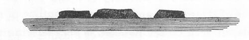

SKETCH 1: ISLANDS OFF ADMIRALTY GULF, LOOKING SOUTHWARD
FROM THE NORTH-EAST END OF CASSINI ISLAND.
Left to right: Corneille, Fenelon, Descartes, and Pascal Islands,
Hills on Cape Voltaire, Condillac Island, and East end of Cassini
Island (Peron's Atlas, plate 6, figure 7) and the outline of the
Iles Forbin (Peron's Atlas, plate 8, figure 5).
SKETCH 2: ISLANDS OFF ADMIRALTY GULF, LOOKING SOUTHWARD FROM THE
NORTH-EAST END OF CASSINI ISLAND. Left to right: Peak upon Cape
Voltaire and Condillac Island, bearing South, two miles distant.
Several drawings of Captain King.
SKETCH 3: TWO CONSPICUOUS HILLS NORTH-EAST OF PRINCE-REGENT'S RIVER. Left to right: Mount Trafalgar and Mount Waterloo.
The red colour of the cliffs on the north-west and west coasts, is also an appearance which is frequently noticed on the sketches taken by Captain King and his officers. This is conspicuous in the neighbourhood of Cape Croker; at Darch Island and Palm Bay; at Point Annesley and Point Coombe in Mountnorris Bay; in the land about Cape Van Diemen, and on the north-west of Bathurst Island. The cliffs on Roe's River (Prince Frederic's Harbour) as might have been expected from the specimens, are described as of a reddish colour; Cape Leveque is of the same hue; and the northern limit of Shark's Bay, Cape Cuvier of the French, latitude 24 degrees 13 minutes, which is like an enormous bastion, may be distinguished at a considerable distance by its full red colour.*
(*Footnote. Freycinet page 195.)
It is on the bank of the channel which separates Bathurst and Melville Islands, near the north-western extremity of New Holland, that a new colony has recently been established: (see Captain King's Narrative volume 2.) A permanent station under the superintendence of a British officer, in a country so very little known, and in a situation so remote from any other English settlement, affords an opportunity of collecting objects of natural history, and of illustrating various points of great interest to physical geography and meteorology, which it is to be hoped will not be neglected. And as a very instructive collection, for the general purposes of geology, can readily be obtained in such situations, by attending to a few precautions, I have thought that some brief directions on this subject would not be out of place in the present publication; and have subjoined them to the list of specimens at the close of this paper.*
(*Footnote. See hereafter.)
In the vicinity of Cambridge Gulf, Captain King states, the character of the country is entirely changed; and irregular ranges of detached rocky hills composed of sandstone, rising abruptly from extensive plains of low level land, supersede the low and woody coast, that occupies almost uninterruptedly the space between this inlet and Cape Wessel, a distance of more than six hundred miles. Cambridge Gulf, which is nothing more than a swampy arm of the sea, extends to about eighty miles inland, in a southern direction: and all the specimens from its vicinity precisely resemble the older sandstones of the confines of England and Wales.* The View (volume 1 plate) represents in the distance Mount Cockburn, at the head of Cambridge Gulf; the flat rocky top of which was supposed to consist of sandstone, but has also the aspect of the trap-formation. The strata in Lacrosse Island, at the entrance of the Gulf, rise toward the north-west, at an angle of about 30 degrees with the horizon: their direction consequently being from north-east to south-west.
(*Footnote. I use the term Old Red Sand Stone, in the acceptation of Messrs. Buckland and Conybeare, Observations on the South Western Coal District of England. Geological Transactions Second Series volume 1. Captain King's specimens from Lacrosse Island are not to be distinguished from the slaty strata of that formation, in the banks of the Avon, about two miles below Clifton.)
From hence to Cape Londonderry, towards the south, is an uniform coast of moderate elevation; and from that point to Cape Leveque, although the outline may be in a general view considered as ranging from north-east to south-west,* the coast is remarkably indented, and the adjoining sea irregularly studded with very numerous islands. The specimens from this tract consist almost entirely of sandstone, resembling that of Cambridge Gulf, Goulburn Island, and the Gulf of Carpentaria; with which the trap-formation appears to be associated.
(*Footnote. The large chart Sheet 5 best shows the general range of the shore, from the islands filling up the inlets.)
York Sound, one of the principal inlets on this part of the coast, is bounded by precipitous rocks, from one to two hundred feet in height; and some conical rocky peaks, which not improbably consist of quartz-rock, were noticed on the eastern side of the entrance. An unpublished sketch, by Captain King, shows that the banks of Hunter's River, one of the branches of York Sound, at seven or eight miles from its opening, are composed of sandstone, in beds of great regularity; and this place is also remarkable for a copious spring of fresh water, one of the rarest phenomena of these thirsty and inhospitable shores.*
(*Footnote. Narrative 1.)
The most considerable inlet, however, which has yet been discovered in this quarter of Australia, is Prince Regent's River, about thirty miles to the south-west of York Sound, the course of which is almost rectilinear for about fifty miles in a south-eastern direction; a fact which will probably be found to be connected with the geological structure of the country. The general character of the banks, which are lofty and abrupt, is precisely the same with that of the rivers falling into York Sound; and the level of the country does not appear to be higher in the interior than near the coast. The banks are from two to four hundred feet in height, and consist of close-grained siliceous sandstone, of a reddish hue;* and the view (Plate above) shows that the beds are nearly horizontal, and very regularly disposed; the cascade there represented being about one hundred and sixty feet in height, and the beds from six to twelve feet in thickness. Two conspicuous hills, which Captain King has named Mounts Trafalgar and Waterloo, on the north-east of Prince-Regent's River, not far from its entrance, are remarkable for cap-like summits, much resembling those which characterize the trap formation. (Sketch 3.)
(*Footnote. Narrative 1 and 2.)
The coast on the south of this remarkable river, to Cape Leveque, has not yet been thoroughly examined; but it appears from Captain King's Chart (Number 5) to be intersected by several inlets of considerable size, to trace which to their termination is still a point of great interest in the physical geography of New Holland. The space thus left to be explored, from the Champagny Isles to Cape Leveque, corresponds to more than one hundred miles in a direct line; within which extent nothing but islands and detached portions of land have yet been observed. One large inlet especially, on the south-east of Cape Leveque, appears to afford considerable promise of a river; and the rise of the tide within the Buccaneer's Archipelago, where there is another unexplored opening, is no less than thirty-seven feet.
The outline of the coast about Cape Leveque itself is low, waving, and rounded; and the hue for which the cliffs are remarkable in so many parts of the coast to the north, is also observable here, the colour of the rocks at Point Coulomb being of a deep red: but on the south of the high ground near that Point, the rugged stony cliffs are succeeded by a long tract, which to the French voyagers (for it was not examined by Captain King) appeared to consist of low and sandy land, fronted by extensive shoals. It has hitherto been seen, however, only at a distance; so that a space of more than three hundred miles, from Point Gantheaume nearly to Cape Lambert, still remains to be accurately surveyed.
Depuch Island, east of Dampier's Archipelago, about latitude 20 degrees 30 minutes, is described by the French naturalists as consisting in a great measure of columnar rocks, which they supposed to be VOLCANIC; and they found reason to believe that the adjoining continent was of the same materials.* It is not improbable, however, that this term was applied to columns belonging to the trap formation, since no burning mountain has been any where observed on the coast of New Holland: nor do the drawings of Depuch Island, made on board Captain King's vessel, give reason to suppose that it is at present eruptive. Captain King's specimens from Malus Island, in Dampier's Archipelago (sixty miles farther west) consist of greenstone and amygdaloid.
(*Footnote. Peron volume 1 page 130.)
The coast is again broken and rugged about Dampier's Archipelago, latitude 20 degrees 30 minutes; and on the south of Cape Preston, in latitude 21 degrees, is an opening of about fifteen miles in width, between rocky hills, which has not been explored. From thence to the bottom of Exmouth Gulf, more than one hundred and fifty miles, the coast is low and sandy, and does not exhibit any prominences. The west coast of Exmouth Gulf itself is formed by a promontory of level land, terminating in the North-west Cape; and from thence to the south-west, as far as Cape Cuvier, the general height of the coast is from four to five hundred feet; nor are any mountains visible over the coast range.
Several portions of the shore between Shark's Bay and Cape Naturaliste have been described in the account of Commodore Baudin's Expedition; but some parts still remain to be surveyed. From the specimens collected by Captain King and the French descriptions, it appears that the islands on the west of Shark's Bay abound in a concretional calcareous rock of very recent formation, similar to what is found on the shore in several other parts of New Holland, especially in the neighbourhood of King George's Sound; and which is abundant also on the coast of the West Indian Islands, and of the Mediterranean. Captain King's specimens of this production are from Dirk Hartog's and Rottnest Islands; and M. Peron states that the upper parts of Bernier and Dorre Islands are composed of a rock of the same nature. This part of the coast is covered in various places with extensive dunes of sand; but the nature of the base, on which both these and the calcareous formation repose, has not been ascertained.
The general direction of the rocky shore, from North-west Cape to Dirk Hartog's Island, is from the east of north to the west of south. On the south of the latter place the land turns towards the east. High, rocky and reddish cliffs have been seen indistinctly about latitude 27 degrees; and a coast of the same aspect has been surveyed, from Red Point, about latitude 28 degrees, for more than eighty miles to the south-west. The hills called Moresby's flat-topped Range, of which Mount Fairfax, latitude 28 degrees 45 minutes, is the highest point, occupy a space of more than fifty miles from north to south.
Rottnest Island and its vicinity, latitude 32 degrees, contains in abundance the calcareous concretions already mentioned; which seem there to consist in a great measure of the remains of recent shells, in considerable variety. The islands of this part of the shore have been described by MM. Peron and Freycinet;* and the coast to the south, down to Cape Leeuwin, the south-western extremity of New Holland, having been sufficiently examined by the French voyagers, was not surveyed by Captain King.
(*Footnote. Peron volume 2 page 168 etc.)
Swan River (Riviere des Cygnes) upon this part of the coast, latitude 31 degrees 25 minutes to 32 degrees, was examined by the French expedition, to the distance of about twenty leagues from its mouth; and found still to contain salt water. The rock in its neighbourhood consisted altogether of sandy and calcareous incrustations, in horizontal beds, enclosing, it is stated, shells, and the roots and even trunks of trees. Between this river and Cape Peron, a "great bay" was left unexplored.*
(*Footnote. Peron volume 1 page 179. Freycinet page 5. 170.)
The prominent mass of land, which stands out from the main, between Cape Naturaliste and Cape Leeuwin, and runs nearly on the meridian for more than fifty miles, seems to have a base of granite, which, at Cape Naturaliste, is said to be stratified.* The same rock also occurs, among Captain King's specimens, from Bald-head in King George's Sound; but nearly on the summit of that hill, which is about five hundred feet high, were Found the ramified calcareous concretions, erroneously considered as corals by Vancouver and others;** but which appear, from Captain King's specimens, to be nothing more than a variety of the recent limestone so abundant throughout these shores.
(*Footnote. Peron volume 1 page 69.)
(**Footnote. Vancouver 1 49. D'Entrecasteaux 2 175. Freycinet 105. Flinders 1 63. See the detailed descriptions hereafter; and Captain King's Narrative volume 1.)
The south coast, and the southern portion of the east coast of Australia, which were surveyed by Captain Flinders, are described in the account of his voyage, and do not come within the object of the present paper.
1. The rocks, of which specimens occur in the collections of Captain King and Mr. Brown, are the following:
Granite: Cape Cleveland; C. Grafton; Endeavour River; Lizard Island; Round Hill, near C. Grindall; Mount Caledon; Island near C. Arnhem; Melville Bay; Bald-head, King George's Sound.
Various Slaty Rocks:
Mica-State: Mallison's I.
Talc-State: Endeavour River.
Slaty Clay: Inglis' I., Clack I., Percy I.
Hornblende Rock ?: Pobassoo's Island; Halfway Bay, Prince
Regent's River.
Granular Quartz: Endeavour River; Montagu Sound, North-west
Coast.
Epidote: C. Clinton ?; Port Warrender; Careening Bay.
Quartzose Conglomerates, and ancient Sandstones: Rodd's Bay; Islands of the north and north-west coasts; Cambridge Gulf; York Sound; Prince Regent's River.
Pipe-clay: Melville Bay; Goulburn I.; Lethbridge Bay.
ROCKS OF THE TRAP FORMATION.
Serpentine: Port Macquarie; Percy Isles.
Sienite: Rodd's Bay.
Porphyry: C. Cleveland.
Porphyritic Conglomerate: C. Clinton, Percy I., Good's I.
Compact Felspar: Percy I., Repulse Bay, Sunday Island.
Greenstone: Vansittart Bay, Bat I., Careening Bay, Malus I.
Clinkstone: Morgan's I., Pobassoo's I.
Amygdaloid, with Chalcedony: Port Warrender; Half-way Bay; Bat Island; Malus I.
Wacke ?: Bat Island.
Recent calcareous Breccia: Sweer's Island, N. coast. Dirk Hartog's and Rottnest Islands, etc., West coast. King George's Sound, South coast.
The only information that has been published respecting the geology of New Holland, besides what is contained in the Voyages of Captain Flinders and Commodore Baudin, is a slight notice by Professor Buckland of some specimens collected during Mr. Oxley's Expedition to the River Macquarie,* in 1818; and a brief outline of a paper by the Reverend Archdeacon Scott, entitled A Sketch of the Geology of New South Wales and Van Diemen's Land, which has been read before the Geological Society.** On these authorities, the following may be added to the preceding list of rocks:
Limestone, resembling in the character of its organic remains the mountain limestone or England: Interior of New Holland, near the east coast; Van Diemen's Land (Buckland; Prevost manuscripts; Scott).
The Coal-formation: East coast of New Holland; Van Diemen's Land. (Buckland-Scott.)
Indications of the new red-Sandstone (Red-Marl) afforded by the occurrence of Salt: Van Diemen's Land. (Scott.)
Oolite: Van Diemen's Land. (Scott.)
(*Footnote. Geological Transactions volume 5 page 480.)
(**Footnote. Ann. of Phil. June 1824. I am informed that Mr. Von Buch also has published a paper on the rocks of New Holland; but have not been so fortunate as to meet with it.Since this paper has been at the press, a Report presented to the Academy of Sciences at Paris, on the Voyage of Discovery of M. Duperrey, performed during the years 1822 to 1825, has been published; from whence I have subjoined an extract, in order to complete the catalogue of the rocks of Australia, according to the present state of our information.
Les echantillons recueillis tant dans les contrees voisines du Port Jackson, que dans les Montagnes-Bleues, augmentent beaucoup nos connoissances sur ces parties de la Nouvelle Hollande. Les echantillons, au nombre de soixante-dix, nous offrent, 1. Les granites, les syenites-quartziferes, et les pegmatites (granites graphiques) qui cunstituent le second plan des Muntagnes-Bleues. 2. Les gres ferrugineux, et renfermant d'abondantes paillettes de fer oligiste, qui couvrent non seulement une vaste etendue de pays pres des cotes, mais encore le premier plan des Montagnes-Bleues; et 3. Le lignite stratiforme qu'on exploite au Mont-Yorck, a 1000 pieds au-dessus du niveau de la mer, et dont la presence ajoute aux motifs qui portent a penser que les gres ferrugineux de ces contrees appartiennent au systeme des terrains tertiaires.
Vingt-sept echantillons ramasses a la terre de Van Diemen, dans les environs du port Dalrymple, et pres du Cap Barren, indiquent, 1. Des terrains de pegmatite, et de serpentine. 2. Des terrains intermediaires coquilliers, formes du grauwacke-schistoide, et de pierre calcaire. 3. Des terrains tres-recens, composes d'argile sablonneuse et ferrugineuse, avec geodes de fer hydrate, et du bois fossile, a differens etats. On distingue en outre des belles topazes blanches ou bleuatres, parmi les galets quartzeux, qui ont ete recueillis au Cap Barren: Bulletin des Sciences Naturelles, Octobre 1825 page 189.)
2. The specimens of Captain King's and Mr. Brown's collections, without any exception, agree with those of the same denominations from other parts of the world; and the resemblance is, in some instances, very remarkable: The sandstones of the west and north-west of New Holland are so like those of the west of England, and of Wales, that the specimens from the two countries can scarcely be distinguished from each other; the arenaceous cement in the calcareous breccia of the west coast is precisely the same with that of Sicily; and the jasper, chalcedony, and green quartz approaching to heliotrope, from the entrance of Prince Regent's River, resemble those of the Tyrol, both in their characters and association. The Epidote of Port Warrender and Careening Bay, affords an additional proof of the general distribution of that mineral; which, though perhaps it may not constitute large masses, seems to be of more frequent occurrence as a component of rocks than has hitherto been supposed.* The mineral itself, both crystallized and compact, the latter in the form of veins traversing sienitic rocks, occurs, in Mr. Greenough's cabinet alone, from Malvern, North Wales, Ireland, France, and Upper Saxony. Mr. Koenig has found it extensively in the sienitic tract of Jersey;** where blocks of a pudding-stone, bearing some resemblance to the green breccia of Egypt, were found to be composed of compact epidote, including very large pebbles of a porphyritic rock, which itself contains a considerable proportion of this substance. And Mr. Greenough has recently received, among specimens sent home by Mr. J. Burton, junior, a mass of compact epidote, with quartz and felspar, from Dokhan, in the desert between the Red Sea and the Nile. When New Holland is added to these localities, it will appear that few minerals are more widely diffused.
(*Footnote. See Cleaveland's Mineralogy 1816 page 297 to 300.)
(**Footnote. Plee's Account of Jersey quarto Southampton 1817 page 231 to 276.)
3. The unpublished sketches, by Captain King and Mr. Roe, of the hills in sight during the progress of the survey of the Coasts of Australia, accord in a very striking manner with the geological character of the shore. Those from the east coast, where the rocks are primitive, representing strongly marked and irregular outlines of lofty mountains, and frequently, in the nearer ground, masses of strata highly inclined. The outlines on the contrary, on the north, north-west, and western shores, are most commonly uniform, rectilinear, the summits flat, and diversified only by occasional detached and conical peaks, none of which are very lofty.
4. No information has yet been obtained, from any of the collections, respecting the diluvial deposits of Australia: a class of phenomena which is of the highest interest, in an island of such vast extent, so very remote in situation, and of which the existing animals are so different from those of other parts of the globe. It is remarkable, also, that no limestone is among the specimens from the northern and western shores, except that of the recent breccia; and although negative conclusions are hazardous, it would seem probable, from this circumstance, that limestone cannot be very abundant or conspicuous at the places visited. No eruptive mountains, nor any traces of recent volcanic eruption, have yet been observed in any part of Australia.
5. The recent calcareous breccia, of which a detailed description will be found in the subjoined list of specimens, is one of the most remarkable productions of New Holland: It was found, during the expedition of Commodore Baudin, to exist throughout a space of no less than twenty-five degrees of latitude, and an equal extent of longitude, on the southern, west, and north-west coasts;* and from Mr. Brown's specimens it appears to occur also on the shores of the Gulf of Carpentaria. The full account which M. Peron has given of this formation, sufficiently shows its resemblance to the very recent limestone, full of marine shells, which abounds on the shores of the Mediterranean, the West India Islands, and in several other parts of the world: And it is a point of the greatest interest in geology, to determine, whether any distinct line can really be drawn, between those concretions, unquestionably of modern formation, which occur immediately upon the shore; and other calcareous accumulations, very nearly resembling them, if not identical, both in the fossils they contain, and in the characters of the cementing substances, that are found in several countries, at considerable heights above the sea.
(*Footnote. Voyage 2 page 168, 169 to 216 etc.)
Dr. Buckland has described a breccia of modern formation, which occurs upon the shore at Madagascar, and consists of a firmly-compacted cream-coloured stone, composed of granular fragments of shells, agglutinated by a calcareous cement.* The stone of Guadaloupe, containing the human skeletons, is likewise of the same nature; and its very recent production cannot be doubted, since it contains fragments of stone axes, and of pottery.** The cemented shells of Bermuda, described by Captain Vetch,*** which pass gradually into a compact limestone, differ only in colour from the Guadaloupe stone; and agree with it, and with the calcareous breccia of Dirk Hartog's Island, in the gradual melting down of the cement into the included portions, which is one of the most remarkable features of that rock.**** A calcareous compound, apparently of the same kind, has been recently mentioned, as of daily production in Anastasia Island, on the coast of East Florida;***** and will probably be found to be of very general occurrence in that quarter of the globe. And Captain Beaufort's account of the process by which the gravelly beach is cemented into stone, at Selinti, and several other places on the coast of Karamania, on the north-east of the Mediterranean,****** accords with M. Peron's description of the progress from the loose and moveable sands of the dunes to solid masses of rock.******* In the island of Rhodes, also, there are hills of pudding-stone, of the same character, considerably elevated above the sea. And Captain W.H. Smyth, the author of Travels in Sicily, and of the Survey of the Mediterranean recently published by the Admiralty, informs me, that he has seen these concretions in Calabria, and on the coasts of the Adriatic; but still more remarkably in the narrow strip of recent land (called the Placca) which connects Leucadia, one of the Ionian Islands, with the continent, and so much resembles a work of art, that it has been considered as a Roman fabric. The stone composing this isthmus is so compact, that the best mill-stones in the Ionian Islands are made from it; but it is in fact nothing more than gravel and sand cemented by calcareous matter, the accretion of which is supposed to be rapidly advancing at the present day.
(*Footnote. Geological Transactions volume 5 page 479.)
(**Footnote. Linnean Transactions 12 page 53 to 57.)
(***Footnote. Geological Transactions 2nd Series volume 1 page 172.)
(****Footnote. Koenig Philosophical Transactions 1814 page 107 etc.)
(*****Footnote. Bulletin des Sciences Nat. Mars 1825.)
(******Footnote. Beaufort's Description of the South Coast of Asia Minor etc. Second edition. London 1818: pages 180 to 184 etc. In the neighbourhood of Adalia the deposition of calcareous matter from the water is so copious that an old watercourse had actually crept upwards to a height of nearly three feet; and the rapidity of the deposition was such that some specimens were collected on the grass, where the stony crust was already formed, although the verdure of the leaf was as yet but imperfectly withered (page 114): a fact which renders less extraordinary M. Peron's statement that the excrements of kangaroos had been found concreted by calcareous matter. Peron volume 2 page 116.)
(*******Footnote. Voyage 2 116.)
The nearest approach to the concreted sand-rock of Australia, that I have seen, is in the specimens presented by Dr. Daubeny to the Bristol Institution, to accompany his excellent paper on the geology of Sicily;* which prove that the arenaceous breccia of New Holland is very like that which occupies a great part of the coast, almost entirely around that island. Some of Dr. Daubeny's specimens from Monte Calogero, above Sciacca, consist of a breccia, containing angular fragments of splintery limestone, united by a cement, composed of minute grains of quartzose-sand disseminated in a calcareous paste, resembling precisely that of the breccia of Dirk Hartog's Island: and a compound of this kind, replete with shells, not far, if at all, different from existing species, fills up the hollows in most of the older rocks of Sicily; and is described as occurring, in several places, at very considerable heights above the sea. Thus, near Palermo, it constitutes hills some hundred feet in height; near Girgenti, all the most elevated spots are crowned with a loose stratum of the same kind; and the heights near Castro Giovanni, said to be 2880 feet above the sea, are probably composed of it. But although the concretions of the interior in Sicily much resemble those of the shore, it is still doubtful whether the former be not of more ancient formation; and if they contain nummulites, they would probably be referred to the epoch of the beds within the Paris basin.
(*Footnote. Edinburgh Philosophical Journal 1825 pages 116, 117, 118, and 254 to 255.)
The looser breccia of Monte Pelegrino, in Sicily, is very like the less compacted fragments of shells from Bermuda, described by Captain Vetch, and already referred to:* and the rock in both these cases, nearly approaches to some of the coarser oolites of England.
(*Footnote. These specimens are in the Museum of the Geological Society.)
The resemblance pointed out by M. Prevost,* of the specimens of recent breccia from New Holland, in the museum at the Jardin du Roi, to those of St. Hospice near Nice, is confirmed by the detail given by Mr. Allan in his sketch of the geology of that neighbourhood;** in which the perfect preservation of the shells, and their near approach to those of the adjoining sea at the present day, are particularly mentioned; and it is inferred that the date of the deposit which affords them, is anterior to that of the conglomerate containing the bones of extinct quadrupeds, likewise found in that country. M. Brongniart also, who examined the place himself, mentions the recent accumulation which occurs at St. Hospice, about sixty feet above the present level of the sea, as containing marine shells in a scarcely fossil state (a peine fossiles) and he describes the mass in which they occur, as belonging to a formation still more recent than the upper marine beds of the environs of Paris.***
(*Footnote. Prevost manuscripts. See hereafter.)
(**Footnote. Transactions of the Royal Society of Edinburgh volume 8 1818 page 427 etc. See also the previous publications of M. Risso Journal des Mines tome 34 etc.)
(***Footnote. Brongniart in Cuvier Ossemens Fossiles; 2nd Edit. volume 2 page 427.)
The geological period indicated by these facts, being probably more recent than the tertiary beds containing nummulites, and generally than the Paris and London strata, accords with the date which has hitherto been assigned to the crag beds of Suffolk, Essex, and Norfolk:* but later observations render doubtful the opinion generally received respecting the age of these remarkable deposits, and a full and satisfactory account of them is still a desideratum in the geology of England. When, also, our imperfect acquaintance with the travertino of Italy, and other very modern limestones containing freshwater shells, is considered,** the continual deposition of which, at the present time, cannot be questioned (though probably the greater part of the masses which consist of them may belong to an era preceding the actual condition of the earth's surface) it would seem that the whole subject of these newer calcareous formations requires elucidation: and, if the inferences connected with them do not throw considerable doubt upon some opinions at present generally received, they show, at least, that a great deal more is to be learned respecting the operations and products of the most recent geological epochs, than is commonly supposed.
(*Footnote. Conybeare and Phillips Outlines etc. page 11, Geological Transactions 1 page 327 etc. Taylor in Geological Transactions 2nd series Volume 2 page 371. Mr. Taylor states the important fact that the remains of unknown animals are buried together with the shells in the crag of Suffolk; but does not mention the nature of these remains. Since these pages have been at the press, Mr. Warburton, by whom the coast of Essex and Norfolk has been examined with great accuracy, has informed me that the fossil bones of the crag are the same with those of the diluvial gravel, including the remains of the elephant, rhinoceros, stag, etc.)
(**Footnote. Some valuable observations on the formation of recent limestone, in beds of shelly marl at the bottom of lakes in Scotland, have been read before the Geological Society by Mr. Lyell, and will appear in the volume of the Transactions now in the press. See Annals of Philosophy 1825 page 310.)
Since it appears that the accretion of calcareous matter is continually going on at the present time, and has probably taken place at all times, the stone thus formed, independent of the organized bodies which it envelopes, will afford no criterion of its date, nor give any very certain clue to the revolutions which have subsequently acted upon it. But as MARINE shells are found in the cemented masses, at heights above the sea, to which no ordinary natural operations could have conveyed them, the elevation of these shells to their actual place (if not that of the rock in which they are agglutinated) must be referred to some other agency: while the perfect preservation of the shells, their great quantity, and the abundance of the same species in the same places, make it more probable that they lay originally in the situations where we now find them, than that they have been transported from any considerable distances, or elevated by any very turbulent operation. Captain de Freycinet, indeed, mentions that patellae, worn by attrition, and other recent shells, have been found on the west coast of New Holland, on the top of a wall of rocks an hundred feet above the sea, evidently brought up by the surge during violent storms;* but such shells are found in the breccia of Sicily, and in several other places, at heights too great, and their preservation is too perfect, to admit of this mode of conveyance; and to account for their existence in such situations, recourse must be had to more powerful means of transport.
(* Freycinet page 187. The presence of shells in such situations may often be ascribed to the birds, which feed on their inhabitants. At Madeira, where recent shells are found near the coast at a considerable height above the sea, the Gulls have been seen carrying up the living patellae, just taken from the rocks.)
The occurrence of corals, and marine shells of recent appearance, at considerable heights above the sea, on the coasts of New Holland, Timor, and several other islands of the south, was justly considered by M. Peron as demonstrating the former abode of the sea above the land; and very naturally suggested an inquiry, as to the nature of the revolutions to which this change of situation is to be ascribed.* From similar appearances at Pulo Nias, one of the islands off the western coast of Sumatra, Dr. Jack also was led to infer, that the surface of that island must at one time have been the bed of the ocean; and after stating, that by whatever means it obtained its present elevation, the transition must have been effected with little violence or disturbance to the marine productions at the surface,** he concludes, that the phenomena are in favour of a HEAVING UP OF THE LAND, BY A FORCE FROM BENEATH. The probable nature of this force is indicated most distinctly, if not demonstrated, by the phenomena which attended the memorable earthquake of Chili, in November, 1820,*** which was felt throughout a space of fifteen hundred miles from north to south. For it is stated upon the clearest evidence, that after formidable shocks of earthquake, repeated with little interruption during the whole night of the 19th of November (and the shocks were continued afterwards, at intervals, for several months) IT APPEARED, on the morning of the 20th, THAT THE WHOLE LINE OF COAST FROM NORTH TO SOUTH, TO A DISTANCE OF ABOUT ONE HUNDRED MILES, HAD BEEN RAISED ABOVE ITS FORMER LEVEL. The alteration of level at Valparaiso was about three feet; and some rocks were thus newly exposed, on which the fishermen collected the scallop-shell fish, which was not known to exist there before the earthquake. At Quintero the elevation was about four feet. "When I went," the narrator adds, "to examine the coast, although it was high-water, I found the ancient bed of the sea laid bare, and dry, with beds of oysters, mussels, and other shells adhering to the rocks on which they grew, the fish being all dead, and exhaling most offensive effluvia. And I found good reason to believe that the coast had been raised by earthquakes at former periods in a similar manner; several ancient lines of beach, consisting OF SHINGLE MIXED WITH SHELLS, extending, in a parallel direction to the shore, to the height of fifty feet above the sea." Such an accumulation of geological evidence, from different quarters and distinct classes of phenomena, concurs to demonstrate the existence of most powerful expansive forces within the earth, and to testify their agency in producing the actual condition of its surface, that the phenomena just now described are nothing more than what was to be expected from previous induction. These facts, however, not only place beyond dispute the existence of such forces, but show that, even in detail, their effects accord most satisfactorily with the predictions of theory. It is not, therefore, at all unreasonable to conceive, that, in other situations, phenomena of the same character have been produced by the same cause, though we may not at present be enabled to trace its connexion with the existing appearances so distinctly; and though the facts, when they occurred, may have been unnoticed, or may have taken place at periods beyond the reach of historical record, or even beyond the possibility of human testimony.
(*Footnote. Peron Voyage etc. volume 2 pages 165 to 183.)
(**Footnote. Geological Transactions Second Series volume 1 page 403, 404.)
(***Footnote. The statements here referred to, are those of Mrs. Graham, in a letter to Mr. Warburton, which has been published in the Geological Transactions Second Series volume 1 page 412, etc.; and the account is supported and illustrated by a valuable paper in the Journal of the Royal Institution for April 1824 volume 17 page 38 etc.) The writer of this latter article asserts that the whole country, from the foot of the Andes to far out at sea, was raised by the earthquake; the greatest rise being at the distance of about two miles from the shore. The rise upon the coast was from two to four feet: at the distance of a mile, inland, it must have been from five to six, or seven feet, pages 40, 45.)
M. Peron has attributed the great abundance of the modern breccia of New Holland to the large proportion of calcareous matter, principally in the form of comminuted shells, which is diffused through the siliceous sand of the shores in that country;* and as the temperature, especially of the summer, is very high on that part of the coast where this rock has been principally found, the increased solution of carbonate of lime by the percolating water, may possibly render its formation more abundant there, than in more temperate climates. But the true theory of these concretions, under any modification of temperature, is attended with considerable difficulty: and it is certain that the process is far from being confined to the warmer latitudes. Dr. Paris has given an account of a modern formation of sandstone on the northern coast of Cornwall;** where a large surface is covered with a calcareous sand, that becomes agglutinated into a stone, which he considers as analogous to the rocks of Guadaloupe; and of which the specimens that I have seen, resemble those presented by Captain Beaufort to the Geological Society, from the shore at Rhodes. Dr. Paris ascribes this concretion, not to the agency of the sea, nor to an excess of carbonic acid, but to the solution of carbonate of lime itself in water, and subsequent percolation through calcareous sand; the great hardness of the stone arising from the very sparing solubility of this carbonate, and the consequently very gradual formation of the deposit--Dr. MacCulloch describes calcareous concretions, found in banks of sand in Perthshire, which present a great variety of stalactitic forms, generally more or less complicated, and often exceedingly intricate and strange,*** and which appear to be analogous to those of King George's Sound and Sweer's Island: And he mentions, as not unfrequently occurring in sand, in different parts of England (the sand above the fossil bones of Norfolk is given as an example) long cylinders or tubes, composed of sand agglutinated by carbonate of lime, or calcareous stalactites entangling sand, which, like the concretions of Madeira, and those taken for corals at Bald-Head, have been ranked improperly, with organic remains.
(*Footnote. Peron Voyage etc. 2 page 116.)
(**Footnote. Transactions of the Geological Society of Cornwall volume 1 page 1 etc.)
(***Footnote. On an arenaceo-calcareous substance, etc. Quarterly Journal Royal Institution October 1823 volume 16 page 79 to 83.)
The stone which forms the fragments in the breccia of New Holland, is very nearly the same with that of the cement by which they are united, the difference consisting only in the greater proportion of sand which the fragments contain: and it would seem, that after the consolidation of the former, and while the deposition of similar calcareous matter was still in progress, the portions first consolidated must have been shattered by considerable violence. But, where no such fragments exist, the unequal diffusion of components at first uniformly mixed, and even the formation of nodules differing in proportions from the paste which surrounds them, may perhaps admit of explanation, by some process analogous to what takes place in the preparation of the compound of which the ordinary earthenware is manufactured; where, though the ingredients are divided by mechanical attrition only, a sort of chemical action produces, under certain circumstances, a new arrangement of the parts.* And this explanation may, probably, be extended to those nodular concretions, generally considered as contemporaneous with the paste in which they are enveloped, the distinction of which, from conglomerates of mechanical origin, forms, in many cases, a difficulty in geology. What the degree may be, of subdivision required to dispose the particles to act thus upon each other, or of fluidity to admit of their action, remains still to be determined.
(*Footnote. The clay and pulverized flints are combined for the use of the potter, by being first separately diffused in water to the consistence of thick cream, and when mixed in due proportion are reduced to a proper consistence by evaporation. During this process, if the evaporation be not rapid and immediate, or if the ingredients are left to act on each other, even for twenty-four hours, the flinty particles unite into sandy grains, and the mass becomes unfit for the purposes of the manufacturer. I am indebted for this interesting fact, which, I believe, is well known in some of the potteries, to my friend Mr. Arthur Aikin. And Mr. Herschel informs me, that a similar change takes place in recently precipitated carbonate of copper; which, if left long moist, concretes into hard gritty grains, of a green colour, much more difficultly soluble in ammonia than the original precipitate.)
6. As the superficial extent of Australia is more than three-fourths of that of Europe, and the interior may be regarded as unknown,* any theoretic inferences, from the slight geological information hitherto obtained respecting this great island, are very likely to be deceitful; but among the few facts already ascertained respecting the northern portion of it, there are some which appear to afford a glimpse of general structure.
Captain Flinders, in describing the position of the chains of islands on the north-west coast of Carpentaria, Wessel's, the English Company's, and Bromby's Islands, remarks, that he had "frequently observed a great similarity both in the ground plans, and the elevations of hills, and of islands, in the vicinity of each other, but did not recollect another instance of such a likeness in the arrangement of clusters of islands."* The appearances which called for this observation, from a voyager of so much sagacity and experience in physical geography, must probably have been very remarkable; and, combined with information derivable from the charts, and from the specimens for which we are indebted to Captain King and Mr. Brown, they would seem to point out the arrangement of the strata on the northern coasts of New Holland.
(*Footnote. The following are the proportions assigned by Captain de Freycinet to the principal divisions of the globe. Voyage aux Terres Australes page 107.COLUMN 1: DIVISION OF THE GLOBE.
COLUMN 2: AREA IN FRENCH LEAGUES SQUARE.
COLUMN 3: PROPORTION.Asia : 2,200,000 : 17.
America : 2,100,000 : 17.
Africa : 1,560,000 : 12.
Europe : 501,875 : 4.
Australia : 384,375 : 3.The most remote points from the coast of New South Wales, to which the late expeditions have penetrated (and the interior has never yet been examined in any other quarter) are not above 500 miles, in a direct line from the sea; the average width of the island from east to west being more than 2000 miles, and from north to south more than 1000 miles.)
(*Footnote. Flinders 5 2 page 246; and Charts, Plates 14 and 15. King's Charts, Plate 4.)
Of the three ranges which attracted Captain Flinders' notice (see the Map) the first on the south-east (3, 4, 5, 6, 7) is that which includes the Red Cliffs, Mallison's Island, a part of the coast of Arnhem's Land, from Cape Newbold to Cape Wilberforce, and Bromby's Isles; and its length, from the mainland (3) on the south-west of Mallison's Island, to Bromby's Isles (7) is more than fifty miles, in a direction nearly from south-west to north-east. The English Company's Islands (2, 2, 2, 2) at a distance of about four miles, are of equal extent; and the general trending of them all, Captain Flinders states (page 233) is nearly North-East by East, parallel with the line of the main coast, and with Bromby's Islands. Wessel's Islands (1, 1, 1, 1) the third or most northern chain, at fourteen miles from the second range, stretch out to more than eighty miles from the mainland, likewise in the same direction.
MAP OF THE CHAINS OF ISLANDS ON THE NORTH-WEST COAST OF CARPENTARIA
It is also stated by Captain Flinders, that three of the English Company's Islands which were examined, slope down nearly to the water on their west sides; but on the east, and more especially the south-east, they present steep cliffs; and the same conformation, he adds, seemed to prevail in the other islands.* If this structure occurred only in one or two instances, it might be considered as accidental; but as it obtains in so many cases, and is in harmony with the direction of the ranges, it is not improbably of still more extensive occurrence, and would intimate a general elevation of the strata towards the south-east.
(*Footnote. Flinders Volume 2 page 235.)
Now on examining the general map, it will be seen, that the lines of the coast on the mainland, west of the Gulf of Carpentaria, between Limmen's Bight and Cape Arnhem--from the bottom of Castlereagh Bay to Point Dale--less distinctly from Point Pearce, latitude 14 degrees 23 minutes, longitude 129 degrees 18 minutes, to the western extremity of Cobourg Peninsula, and from Point Coulomb, latitude 17 degrees 20 minutes, longitude 123 degrees 11 minutes, to Cape Londonderry, have nearly the same direction; the first line being about one hundred and eighty geographical miles, the second more than three hundred, and the last more than four hundred miles, in length.* And these lines, though broken by numerous irregularities, especially on the north-west coast, are yet sufficiently distinct to indicate a probable connexion with the geological structure of the country; since the coincidence of similar ranges of coast with the direction of the strata, is a fact of very frequent occurrence in other parts of the globe.** And it is observable that considerable uniformity exists in the specimens, from the different places in this quarter of New Holland which have been hitherto examined; sandstone, like that of the older formations of Europe occurring generally on the north and north-west coasts, and appearing to be extensively diffused on the north-west of the Gulf of Carpentaria, where it reposes upon primitive rocks.***
(*Footnote. It is deserving of notice, that the coast of Timor, the nearest land on the north-west, at the distance of about 300 miles, is also nearly straight, and parallel to the Coast of New Holland in this quarter: part of the mountainous range, of which that island consists, being probably more than 9000 feet high; and its length, from the north-eastern extremity to the South-West of the adjoining island of Rottee, about 300 miles. But, unfortunately for the hypothesis, a chain of islands immediately on the north of Timor, is continued nearly in a right line for more than 1200 miles (from Sermatta Island to the south-eastern extremity of Java) in a direction FROM EAST TO WEST. This chain, however, contains several volcanoes, including those of Sumbawa, the eruption of which, in 1815, was of extraordinary violence. See Royal Inst. Journal volume 1 1816 page 248 etc.At Lacrosse Island, in the mouth of Cambridge Gulf, on the north-west coast of New Holland, the beds rise to the North-West: their direction consequently is from South-West to North-East; and the rise towards the high land of Timor. The intervening sea is very shallow.)
(**Footnote. A remarkable case of this kind, which has not, I believe, been noticed, occurs in the Mediterranean; and is conspicuous in the new chart of that sea, by Captain W.H. Smyth. The eastern coast of Corsica and Sardinia, for a space of more than two hundred geographical miles being nearly rectilinear, in a direction from north to south; and, Captain Smyth has informed me, consisting almost entirely of granite, or, at least, of primitive rocks. The coast of Norway affords another instance of the same description; and the details of the ranges in the interior of England furnish several examples of the same kind, on a smaller scale.)
(***Footnote. The coastlines nearly at rightangles to those above-mentioned--from the South-East of the Gulf of Carpentaria to Limmen's Bight, from Cape Arnhem to Cape Croker, and from Cape Domett to Cape Londonderry--have also a certain degree of linearity; but much less remarkable, than those which run from South-West to North-East.)
The horn-like projection of the land, on the east of the Gulf of Carpentaria, is a very prominent feature in the general map of Australia, and may possibly have some connexion with the structure just pointed out. The western shore of this horn, from the bottom of the gulf to Endeavour Straits, being very low; while the land on the east coast rises in proceeding towards the south, and after passing Cape Weymouth, latitude 12 degrees 30 minutes, is in general mountainous and abrupt; and Captain King's specimens from the north-east coast show that granite is found in so many places along this line as to make it probable that primitive rocks may form the general basis of the country in that quarter; since a lofty chain of mountains is continued on the south of Cape Tribulation, not far from the shore, throughout a space of more than five hundred miles. It would carry this hypothesis too far to infer that these primitive ranges are connected with the mountains on the west of the English settlements near Port Jackson, etc., where Mr. Scott has described the coal-measures as occupying the coast from Port Stevens, about latitude 33 degrees to Cape Howe, latitude 37 degrees, and as succeeded, on the eastern ascent of the Blue Mountains, by sandstone, and this again by primitive strata:* But it may be noticed that Wilson's Promontory, the most southern point of New South Wales, and the principal islands in Bass Strait, contain granite; and that primitive rocks occur extensively in Van Diemen's Land.
(*Footnote. Annals of Philosophy June 1824.)
The uniformity of the coastlines is remarkable also in some other quarters of Australia; and their direction, as well as that of the principal openings, has a general tendency to a course from the west of south to the east of north. This, for example, is the general range of the south-east coast, from Cape Howe, about latitude 37 degrees, to Cape Byron, latitude 29 degrees, or even to Sandy Cape, latitude 25 degrees; and of the western coast, from the south of the islands which enclose Shark's Bay, latitude 26 degrees, to North-west Cape, about latitude 22 degrees. From Cape Hamelin, latitude 34 degrees 12 minutes, to Cape Naturaliste, latitude 33 degrees 26 minutes, the coast runs nearly on the meridian. The two great fissures of the south coast, Spencer's, and St. Vincent's Gulfs, as well as the great northern chasm of the Gulf of Carpentaria, have a corresponding direction; and Captain Flinders (Chart 4) represents a high ridge of rocky and barren mountains, on the east of Spencer's Gulf, as continued, nearly from north to south, through a space of more than one hundred geographical miles, between latitude 32 degrees 7 minutes and 34 degrees. Mount Brown, one of the summits of this ridge, about latitude 32 degrees 30 minutes, being visible at the distance of twenty leagues.
The tendency of all this evidence is somewhat in favour of a general parallelism in the range of the strata, and perhaps of the existence of primary ranges of mountains on the east of Australia in general, from the coast about Cape Weymouth* to the shore between Spencer's Gulf and Cape Howe. But it must not be forgotten, that the distance between these shores is more than a thousand miles in a direct line; about as far as from the west coast of Ireland to the Adriatic, or double the distance between the Baltic and the Mediterranean. If, however, future researches should confirm the indications above mentioned, a new case will be supplied in support of the principle long since advanced by Mr. Michell,** which appears (whatever theory be formed to explain it) to be established by geological observation in so many other parts of the world, that the outcrop of the inclined beds, throughout the stratified portion of the globe, is everywhere parallel to the longer ridges of mountains, towards which, also, the elevation of the strata is directed. But in the present state of our information respecting Australia, all such general views are so very little more than mere conjecture, that the desire to furnish ground for new inquiry, is, perhaps, the best excuse that can be offered for having proposed them.
(*Footnote. The possible correspondence of the great Australian Bight, the coast of which in general is of no great elevation, with the deeply-indented Gulf of Carpentaria, tending, as it were, to a division of this great island into two, accords with this hypothesis of mountain ranges: but the distance between these recesses, over the land at the nearest points, is not less than a thousand English miles. The granite, on the south coast, at Investigator's Islands, and westward, at Middle Island, Cape Le Grand, King George's Sound, and Cape Naturaliste, is very wide of the line above-mentioned, and nothing is yet known of its relations.)
(**Footnote. On the Cause of Earthquakes. Philosophical Transactions 1760 volume 51 page 566 to 585, 586.)
The specimens mentioned in the following list have been compared with some of those of England and other countries, principally in the cabinets of the Geological Society, and of Mr. Greenough; and with a collection from part of the confines of the primitive tracts of England and North Wales, formed by Mr. Arthur Aikin, and now in his own possession. Captain King's collection has been presented to the Geological Society; and duplicates of Mr. Brown's specimens are deposited in the British Museum.
RODD'S BAY, on the East Coast, discovered by Captain King, about sixty miles south of Cape Capricorn.* Reddish sandstone, of moderately-fine grain, resembling that which in England occurs in the coal formation, and beneath it (mill-stone grit). A sienitic compound, consisting of a large proportion of reddish felspar, with specks of a green substance, probably mica; resembling a rock from Shap in Cumberland.
(*Footnote. In Captain King's collection are also specimens found on the beach at Port Macquarie, and in the bed of the Hastings River, of common serpentine, and of botryoidal magnesite, from veins in serpentine. The magnesite agrees nearly with that of Baudissero, in Piedmont. (See Cleaveland's Mineralogy 1st edition page 345.)
CAPE CLINTON, between Rodd's Bay and the Percy Islands. Porphyritic conglomerate, with a base of decomposed felspar, enclosing grains of quartz and common felspar, and some fragments of what appears to be compact epidote; very nearly resembling specimens from the trap rocks* of the Wrekin and Breeden Hills in Shropshire. Reddish and yellowish sandy clay, coloured by oxide of iron, and used as pigments by the natives.
(*Footnote. By the terms Trap, and Trap-formation, which I am aware are extremely vague, I intend merely to signify a class of rocks, including several members, which differ from each other considerably in mineralogical character, but agree in some of their principal geological relations; and the origin of which very numerous phenomena concur in referring to some modification of volcanic agency. The term Greenstone also is of very loose application, and includes rocks that exhibit a wide range of characters; the predominant colour being some shade of green, the structure more or less crystalline, and the chief ingredients supposed to be hornblende and felspar, but the components, if they could be accurately determined, probably more numerous and varied, than systematic lists imply.)
PERCY ISLANDS, about one hundred and forty miles north of Cape Capricorn. Compact felspar of a flesh-red hue, enclosing a few small crystals of reddish felspar and of quartz. This specimen is marked "general character of the rocks at Percy Island," and very much resembles the compact felspar of the Pentland Hills near Edinburgh, and of Saxony. Coarse porphyritic conglomerate, of a reddish hue. Serpentine. A trap-like compound, with somewhat the aspect of serpentine, but yielding with difficulty to the knife. This specimen has, at first sight, the appearance of a conglomerate, made up of portions of different hues, purplish, brown, and green; but the coloured parts are not otherwise distinguishable in the fracture: It very strongly resembles a rock which occurs in the trap-formation, near Lyd-Hole, at Pont-y-Pool, in Shropshire. Slaty clay, with particles of mica, like that which frequently occurs immediately beneath beds of coal.
REPULSE ISLAND, in Repulse Bay, about one hundred and twenty miles north-west of the Percy Islands. Indistinct specimens, apparently consisting of decomposed compact felspar. A compound of quartz, mica, and felspar, having the appearance of re-composed granite.
CAPE CLEVELAND, about one hundred and twenty miles north of Repulse Island. Yellowish-grey granite, with brown mica; "from the summit of the hill." Reddish granite, of very fine grain; with the aspect of sandstone. Dark grey porphyritic hornstone, approaching to compact felspar, with imbedded crystals of felspar.
CAPE GRAFTON, about one hundred and eighty miles west of north from Cape Cleveland. Close-grained grey and yellowish-grey granite, with brown mica. A reddish granitic stone, composed of quartz, felspar, and tourmaline.
ENDEAVOUR RIVER, about one hundred miles west of north from Cape Grafton. Grey granite of several varieties; from a peaked hill under Mount Cook and its vicinity. Granular quartz-rock of several varieties: and indistinct specimens of a rock approaching to talc-slate.
LIZARD ISLAND, about fifty miles east of north from Endeavour River. Grey granite, consisting of brown and white mica, quartz, and a large proportion of felspar somewhat decomposed.
CLACK ISLAND, near Cape Flinders, on the north-west of Cape Melville, about ninety miles north-west of Lizard Island. Smoke-grey micaceous slaty-clay, much like certain beds of the old red sandstone, where it graduates into grey wacke. This specimen was taken from a horizontal bed about ten feet in thickness, reposing upon a mass of pudding-stone, which included large pebbles of quartz and jasper; and above it was a mass of sandstone, more than sixty feet thick. (Narrative volume 2.)
SUNDAY ISLAND, near Cape Grenville, about one hundred and seventy miles west of north from Cape Melville. Compact felspar, of a flesh-red colour; very nearly resembling that of the Percy Islands, above-mentioned.
GOOD'S ISLAND, one of the Prince of Wales group, about latitude 10 degrees, thirty-four miles north-west of Cape York. The specimens, in Mr. Brown's collection from this place, consist of coarse-slaty porphyritic conglomerate, with a base of greenish-grey compact felspar, containing crystals of reddish felspar and quartz. This rock has some resemblance to that of Clack Island above-mentioned.
SWEER'S ISLAND, south of Wellesley's group, at the bottom of the Gulf of Carpentaria. A stalactitic concretion of quartzose sand, and fine gravel, cemented by reddish carbonate of lime; apparently of the same nature with the stem-like concretions of King George's Sound: (See hereafter.) In this specimen the tubular cavity of the stalactite is still open.
The shore, in various parts of this island, was found to consist of red ferruginous matter (Bog-iron-ore ?) sometimes unmixed, but not unfrequently mingled with a sandy calcareous stone; and in some places rounded portions of the ferruginous matter were enveloped in a calcareous cement.
BENTINCK ISLAND, near Sweer's Island. A granular compound, like sandstone recomposed from the debris of granite. Brown hematite, enclosing quartzose sand.
PISONIA ISLAND, on the east of Mornington's Island, is composed of calcareous breccia and pudding-stone, which consist of a sandy calcareous cement, including water-worn portions of reddish ferruginous matter, with fragments of shells.
NORTH ISLAND, one of Sir Edward Pellew's group. Coarse siliceous sand, concreted by ferruginous matter; which, in some places, is in the state of brown hematite. Calcareous incrustations, including fragments of madrepores, and of shells, cemented by splintery carbonate of lime.
CAPE-MARIA ISLAND, in Limmen's Bight, was found by Mr. Brown to be composed principally of sandstone. The specimens from this place, however, consist of grey splintery hornstone, with traces of a slaty structure; and of yellowish-grey flint, approaching to chalcedony; with a coarse variety of cacholong, containing small nests of quartz crystals.
GROOTE EYLANDT is composed of sandstone, of which two different varieties occur among the specimens. A quartzose reddish sandstone, of moderately fine grain; and a coarse reddish compound, consisting almost exclusively of worn pebbles of quartz, some of which are more than half an inch in diameter, with a few rounded pebbles of chalcedony. The latter rock is nearly identical with that of Simms' Island, near Goulburn's Island on the north coast.
CHASM ISLAND, WINCHELSEA ISLAND, and BURNEY'S ISLAND, are of the same materials as Groote Eylandt: and sandstone was found also on the western shore of BLUE-MUD BAY.
On the shore of the mainland, opposite to Groote Eylandt, a little north of latitude 14 degrees, Mr. Brown observed the common sandy calcareous stone, projecting here and there in ragged fragments.
MORGAN'S ISLAND, in Blue-Mud Bay, north-west of Groote Eylandt, is composed principally of clink-stone, sometimes indistinctly columnar. But among the specimens are also a coarse conglomerate of a dull purplish colour, including pebbles of granular quartz and a fragment of a slaty rock like potstone: the hue and aspect of the compound being precisely those of the oldest sandstones. Reddish quartzose sandstone, of uniform and fine grain. A concretion of rounded quartz pebbles, cemented by ferruginous matter, apparently of recent formation.
ROUND HILL, near Cape Grindall, a prominence east of north from Blue-Mud Bay, was found by Captain Flinders to consist, at the upper part, of sandstone. The specimens of the rocks in its vicinity are, dark grey granite, somewhat approaching to gneiss, with a few specks of garnet; and a calcareous, probably concretional stone, enclosing the remains of shells, with cavities lined with crystals of calcareous spar.
MOUNT CALEDON, on the mainland, west of Caledon Bay, consists of grey granite, with dark brown mica in small quantity; and on the sides and top of the hill large loose blocks of that rock were observed, resting upon other blocks.
A small island, near Cape Arnhem, is also composed of granite, in which the felspar has a bluish hue.
Smaller of the MELVILLE ISLANDS, north-east of Melville Bay.* A botryoidal mass of ferruginous oxide of manganese, approaching to hematite; the fissures in some places occupied by carbonate of lime.
(*Footnote. The relative position of the islands and bays on this part of the coast is represented in the enlarged Map.)
MELVILLE BAY. Granite, composed of grey and somewhat bluish felspar, dark brown mica, and a little quartz; containing minute disseminated specks of molybdena, and indistinct crystals of pale red garnet.
RED CLIFFS, south-west of Arnhem Bay; on the line of the first chain of islands mentioned by Captain Flinders. (See the Map, figure 3.) Friable conglomerate, of a full brick-red colour, consisting of minute grains of quartz, with a large proportion of ochreous matter.
MALLISON'S ISLAND. (Map, figure 4.) The cliffs of this island are composed of a fissile primitive rock, on which sandstone reposes in regular beds. The specimen of the former resembles gneiss, or mica slate, near the contact with granite: the sandstone is thick-slaty, quartzose, of a reddish hue, with mica disseminated on the surfaces of the joints; and one face of the specimen is incrusted with quartz crystals, thinly coated with botryoidal hematite. Light grey quartzose sandstone of a fine grain, with a thin coating of brown hematite, was also found in this island: And a breccia, consisting of angular fragments of sandstone, cemented by thin, vein-like, coatings of dark brown hematite, was found there, in loose blocks at the bottom of perpendicular cliffs. The specimen of this breccia is attached to a plate of granular quartz, and may possibly have been part of a vein.
The shore of INGLIS' ISLAND, the largest of the ENGLISH COMPANY'S RANGE (2. 2. 2. in the Map) is formed of flat beds, of a slaty argillaceous rock, which breaks into rhomboidal fragments; but the specimen is indistinct. Ferruginous masses, probably consisting of brown hematite, come also from this island.
ASTELL'S ISLAND, north-east of Inglis' Isle. Very fine-grained greyish-white quartzose sandstone; identical with that of Mallison's Island, and very closely resembling some of the specimens from Prince Regent's and Hunter's Rivers.
Among the remaining islands of this range, BOSANQUET'S, COTTON'S, and POBASSOO's Isles, were found by Mr. Brown to consist, in a great measure, of sandstone, of the same character with the specimens above-mentioned.
POBASSOO'S ISLAND, a small islet south-east of Astell's Isle. Fine-grained, somewhat reddish, sandstone. Another specimen of sandstone is friable, of a light flesh-red colour, and apparently composed of the debris of granite. A crystalline rock, consisting of greenish-grey hornblende, with a very small proportion of felspar (Hornblende rock ?). Fragment, apparently from a columnar mass, of a stone intermediate between clink-stone and compact felspar.
Such of the English Company's Islands as were examined by Captain Flinders, are stated by him to consist, in the upper part, of a grit, or sandstone, of a close texture; the lower part being argillaceous, and stratified, and separating into pieces of a reddish colour, resembling flat tiles. The strata-dip to the west, at an angle of about 15 degrees.
South-west bay of GOULBURN'S SOUTH ISLAND, two hundred and fifty miles west of the Gulf of Carpentaria (Narrative 1). Coarse-grained reddish quartzose conglomerate and sandstone; resembling the older sandstones of England and Wales, and especially the mill-stone grit beneath the coal formation. Fine greyish-white pipe-clay; of which about thirty feet in thickness were visible, apparently above the sandstone last mentioned. Coarse-grained, ferruginous sandstone, containing fragments of quartz, from above the pipe-clay. The appearance of the cliff from which these specimens were taken, is represented in the view of the bay on the south of Goulburn Island (volume 1); and a distant head in the view consists of the same materials.
SIMMS ISLAND, on the west of Goulburn's south Island (Narrative 1) is composed of a reddish conglomerate, nearly identical with some of the specimens above-mentioned.
The western side of LETHBRIDGE BAY, on the north of MELVILLE ISLAND, consists of a range of cliffs like those at Goulburn's Island; the upper part being red, the lower white and composed of pipe-clay. The western extremity of BATHURST ISLAND, between CAPE HELVETIUS and CAPE FOURCROY, is also formed of cliffs of a very dark red colour.
LACROSSE ISLAND, at the mouth of CAMBRIDGE GULF, about one hundred miles from Port Keats. Reddish, very quartzose sandstone; from a stratum which dips to the south-east, at an angle of about ten or fifteen degrees. Micaceous and argillaceous fissile sandstone, of purplish and greenish hues, in patches, or occasionally intermixed; precisely resembling the rock of Brecon, in South Wales, and, generally, the old red sandstone of the vicinity of Bristol and the confines of England and Wales. Fine-grained thin-slaty sandstone, resembling certain beds of the coal formation, or of the millstone grit, is found in large masses, under an argillaceous cliff, on the north side of Lacrosse Island.
The specimens from the interior of Cambridge Gulf are from ADOLPHUS ISLAND, and consist of reddish and grey sandstone, more or less decomposed.
VANSITTART BAY, about one hundred and forty miles north-west of Cambridge Gulf. Reddish quartzose sandstone, or quartz-rock. Indistinct specimens of greenstone, with adhering quartz; apparently a primitive rock.
PORT WARRENDER, at the bottom of Admiralty Gulf, about forty miles south-west of Vansittart Bay (Narrative volume 1). Epidote and quartz, in small crystals confusedly interlaced; apparently from veins, or nests, but unaccompanied by any portion of the adjacent rock. The structure in one of these specimens approaches to the amygdaloidal. A compact greenish stone, with disseminated crystalline spots of epidote, and of quartz, and apparently consisting of an intimate mixture of those minerals, is also among the specimens from Port Warrender.
All these specimens are from detached water-worn masses at the foot of Crystal Head, on the south-west of the port. The summit of the head is flat and tabular, and the rocks in the vicinity are described by Captain King as consisting of siliceous sandstone. Chalcedony, apparently from amygdaloid of the trap formation, was also found at Port Warrender.
The epidote of this place is in general of a pale-greenish colour, but is mixed with, and sometimes appears to pass into, spots of a rich purplish-brown. The specimens resemble generally the epidote of Dauphiny and Siberia; but Mr. Levy, who has been so good as to examine them, informs me that the crystals exhibit some modifications not described either by Hauy, or by Mr. Haidinger in his paper on this mineral, and which are probably peculiar to this locality.
WATER ISLAND, on the west side of CAPE VOLTAIRE, at the south-west entrance of Port Warrender, is described (volume 1) as consisting of quartzose sandstone; as is also KATER ISLAND, in Montagu Sound. And the same rock appears to occur throughout the islands on this part of the coast. (Narrative 1.)
MONTAGU SOUND, about five-and-twenty miles south-west of ADMIRALTY GULF (Narrative 1). Greyish granular quartz; like that of the Lickey Hill, in Worcestershire. Fine-grained quartzose sandstone, of a purplish hue, resembling a rock on the banks of the Severn, near Bridgenorth. Grey and reddish sandstone; apparently composed of the debris of granite, and very nearly resembling that of Simms Island above-mentioned.
HUNTER'S RIVER, falling into YORK SOUND, on the north-east side. Somewhat coarse reddish-white sandstone; like that of the coal formation, and some varieties of millstone grit. Fine-grained, reddish-grey quartzose sandstone, having the appearance of stratification, and resembling the rocks of Cambridge Gulf.
ROE'S RIVER, at the eastern termination of York Sound (Narrative 1) runs between precipitous banks of sandstone, in nearly horizontal strata, which rise to the height of three hundred feet.
CAREENING BAY, between York Sound and Prince Regent's River (Narrative volume 1. See the plate volume 1). Crystalline epidote, and whitish quartz, apparently from a vein. Purplish-brown epidote, with small nests or concretions of green epidote and quartz; forming a sort of amygdaloid. Conglomerate, containing angular fragments of yellowish-grey quartz-rock, in a base of compact epidote. A nearly uniform greenish compound of epidote intimately mixed with quartz, also occurs at this place. Flat lamellar chalcedony. Very fine-grained reddish-grey quartzose sandstone, with traces of a slaty structure, resembling that of York Sound, and Cambridge Gulf, was found in the north-east end of this bay; and fine-grained greenstone, on the summit of the adjacent hills.
Several of these specimens are almost identical with those of Port Warrender; from which place Careening Bay is distant about sixty miles.
BAT ISLAND (Narrative volume 1) western entrance of Careening Bay. Quartz from thin veins, with particles of an adhering rock, probably chlorite-slate. Quartz, containing disseminated hematitic iron-ore and copper pyrites. Quartz crystals, with chalcedony, from nodules in amygdaloid. Quartz with specular iron ore. Greenstone, with chalcedony and copper pyrites. A decomposed stone, probably consisting of wacke. The specimens of trap-rocks from this place are from a cavern.
GREVILLE ISLAND, near the entrance of Prince Regent's River. Reddish, coarsely granular, siliceous sandstone; in horizontal strata, intersected by veins of crystallized quartz.*
(*Footnote. Narrative volume 2.)
HALF-WAY BAY, within Prince Regent's River on the west of the entrance, near Greville Island. Hornblende rock ? nearly agreeing with that of Pobassoo's Island, on the north-west of the Gulf of Carpentaria (see above). Calcedony, apparently from nodules in amygdaloid. Greenish quartz, approaching to heliotrope. Red, somewhat slaty jasper, mixed with quartz and chalcedony, and containing specular iron ore.
The specimens from this place much resemble some of those from Sotto i Sassi, in the Val di Fassa in the Tyrol, which I have seen in the collection of Mr. Herschel; and which consist of reddish jasper with chalcedony, and a greenish flinty stone, like heliotrope, the whole belonging to the trap-formation.
POINT CUNNINGHAM, east of south from Cape Leveque, and about one hundred and fifty miles south-west of Prince Regent's River. Very compact and fine-grained reddish granular quartz, with a glistening lustre, and flat conchoidal fracture. This stone, though so compact in the recent fracture, has distinct traces of stratification on the decomposed surface, which is of a dull reddish hue. Bright red ferruginous granular quartz (Eisen-kiesel ?) with a glistening lustre, and a somewhat porous texture. A specimen of the soil of the hills at Cygnet Bay, consists of very fine reddish-yellow quartzose sand. A large rounded pebble, consisting of ferruginous granular quartz, of a dark purplish-brown colour, and considerable density, was found here; near a fireplace of the natives, by whom it is used for making their hatchets; with a fragment of a calcareous incrustation, like that of the west coast hereafter mentioned.
The next specimens in Captain King's collection--a space of more than three hundred miles on this coast not having been examined by him--are from MALUS ISLAND, in Dampier's Archipelago (see Narrative volume 1) they consist of fine-grained greenstone, and what appears to be a basaltic rock, of amygdaloidal structure.
DIRK HARTOG'S ISLAND, west of Shark's Bay. A compound of rather fine-grained translucent quartzose sand, cemented by carbonate of lime, of various shades of reddish and yellowish grey. This stone has in some places the structure of a breccia; the angles of the imbedded fragments, which are from half an inch to two inches in diameter, being very distinct--but in other parts, the fracture exhibits the appearance of roundish nodules, composed of concentric shells--or bags as it were, of calcareous matter, which vary in colour, and are filled with a mixture of the same substance and quartzose sand: and the spaces between these nodules are likewise occupied by a similar compound.*
(*Footnote. The following description given by the French naturalists of the rocks at Bernier's Islands, was probably taken from a large suite of specimens; and M. Peron states (1 page 204) that it is strictly applicable to all the adjacent parts of the continent, and of the islands that were examined by the French voyagers:The cementing limestone in the rock of this island, is very like some of the more compact portions of the stone of Guadaloupe, which contains the human skeletons, the hardness and fracture being nearly the same in both. The chief difference of these rocks seems to arise from the nature of the cemented substances; which, in the Guadaloupe stone, being themselves calcareous, are incorporated, or melted as it were, into the cement, by insensible gradation;* while the quartzose sand, in that of Dirk Hartog's Island, is strongly contrasted with the calcareous matter that surrounds it.** But, wherever the imbedded fragments in the latter consist of limestone, their union with the cement is complete.Le sable du rivage (de l'ile Bernier) est quartzeux, mele d'une grande proportion de debris calcaires fortement attenues. La substance de l'ile meme se compose, dans ses couches inferieures, d'un gres calcaire coquillier, tantot blanchatre, tantot rougeatre, depose par couches horizontales, dont l'epaisseur varie de 2 a 8 decimetres (7 a 11 pouces) et qui toutes etant tres uniformes dans leur prolongement, pourroient offrir a la maconnerie des pierres de construction naturellement taillees.
Les coquilles incrustees dans ces massifs des roches sont presque toutes univalves; elles apartiennent plus particulierement au genre Natice de M. de Lamarck, et ont les plus grands rapports avec l'espece de Natice qui se trouve vivante au pied de ces rochers. Elles sont sans doute petrifiees depuis bien des siecles, car, outre qu'il est tres difficile de les retirer intactes du milieu de ces gres, tant leur adhesion avec eux est intime, on les observe encore a plus de 50 metres (150 pieds) au dessus du niveau actuel de la mer.
Quelque regularite que ces bancs puissent affecter dans leur disposition generale, ils ne sont cependant pas tous homogenes dans leur substance; il est sur-tout une variete de ces roches plus remarquable par sa structure. Ce sont des galets calcaires, agreges dans une terre sablonneuse ocracee, qui leur est tellement adherente, qu'on ne sauroit detruire cette espece de gangue sans les briser eux memes. Tous ces galets affectent la forme globlueuse, et se composent d'un grand nombre de zones concentriques, qui se developpent autour d'un noyau central d'un gres scintillant et brunatre. Ces diverses couches ont a peine quelques millimitres d'epaisseur, et affectent des nuances agreables, qui varient depuis le rouge-fonce jusqu'au jaune-clair. La disposition generale de cette breche lui donne donc quelques rapports grossiers avec le granit globuleux de l'ile de Corse; et, par ses couches rubanees, concentriques, elle a quelque chose de l'aspect des Agathes-Onyx...Les bancs de gres divers dont je viens de parler, constituent, a bien dire, la masse entiere du pays qui nous occupe, etc. (Volume 1 page 110. See also Freycinet page 187.)
(*Footnote. See Mr. Koenig's Paper. Philosophical Transactions volume 104 1814 page 107 etc.)
(**Footnote. Captain King informs me that the soundings in this part of the coast bring up a very fine quartzose-sand like that cemented in the breccia.)
ROTTNEST ISLAND, about four hundred and fifty miles south of Dirk Hartog's Island. Indistinct specimens containing numerous fragments of shells, in a calcareous cement; the substance of these shells has at first sight the appearance of chalcedony, and is harder than ordinary carbonate of lime.
The characters of the shells in Captain King's specimens from this place are indistinct; but the specimens at the Jardin du Roi, which, there is reason to suppose, have come from this part of the coast, contain shells of several species, belonging among others to the genera, corbula, chama, cardium, porcellanea, turbo, cerithium. M. Prevost, to whom I am indebted for this account, observes that notwithstanding the recent appearance of the shells, the beds which contain them are stated to occur at a considerable height above the sea: and he remarks that the aspect of the rock is very like that of the shelly deposits of St. Hospice, near Nice.
KING GEORGE'S SOUND, on the south coast, east of south from Cape Leeuwin. Beautifully white and fine quartzose sand, from the sea-beach. Yellowish grey granite, from Bald-head. Two varieties of a calcareous rock, of the same nature with that of Dirk Hartog's Island; consisting of particles of translucent quartzose sand, united by a cement of yellowish or cream-coloured carbonate of lime, which has a flat conchoidal and splintery fracture, and is so hard as to yield with difficulty to the knife. In this compound, there are not any distinct angular fragments, as in the stone of Dirk Hartog's Islands; but the calcareous matter is very unequally diffused.
A third form in which this recent calcareous matter appears, is that of irregular, somewhat tortuous, stem-like bodies, with a rugged sandy surface, and from half an inch to an inch in diameter; the cross fracture of which shows that they are composed of sand, cemented by carbonate of lime, either uniformly mixed throughout, or forming a crust around calcareous matter of a spongy texture; in which latter case they have some resemblance to the trunks or roots of trees. A mass, which seems to have been of this description, is stated to have come from a height of about two hundred and fifty feet above the sea, at Bald-head, on the South Coast of Australia. These specimens, however, do not really exhibit any traces of organic structure; and so nearly resemble the irregular stalactitical concretions produced by the passage of calcareous or ferruginous solutions through sand* that they are probably of the same origin; indeed the central cavity of the stalactite still remains open in some of the specimens of this kind from Sweer's Island in the Gulf of Carpentaria. The specimens from Madeira, presented to the Geological Society by Mr. Bowdich, and described in his notes on that island,** appear upon examination to be of the same character. But there is no reason to suppose that the trunks of trees, as well as other foreign substances, may not be thus incrusted, since various foreign bodies, even of artificial production, have been so found. Professor Buckland has mentioned a specimen of concreted limestone from St. Helena, which contains the recent shell of a bird's egg;*** and M. Peron states that, in the concretional limestone rock of the South Coast of New Holland, the trunks of trees occur, with the vegetable structure so distinct as to leave no doubt as to their nature.****
(*Footnote. Tubular concretions of ferruginous matter, irregularly ramifying through sand, like the roots of trees, are described by Captain Lyon as occurring in Africa. Lyon's Travels Appendix page 65.)
(**Footnote. Excursions in Madeira 1825 page 139, 140; and Bull. des Sciences Naturelles volume 4 page 322.)
(***Footnote. Geological Transactions volume 5 page 479.)
(****Footnote. Peron 2 page 75.)
It so often happens that specimens sent from distant places, by persons unpractised in geology, fail to give the instruction which is intended, from the want of attention to a few necessary precautions, that the following directions may perhaps be useful to some of those, into whose hands these pages are likely to fall. It will be sufficient to premise, that two of the principal objects of geological inquiry, are, to determine, first, the nature of the MATERIALS of which the earth is composed; and, secondly, the relative ORDER in which these materials are disposed with respect to each other.
1. Specimens of rocks ought not, in general, to be taken from loose pieces, but from large masses in their native place, or which have recently fallen from their natural situation.
2. The specimens should consist of the stone unchanged by exposure to the elements, which sometimes alter the characters to a considerable distance from the surface. Petrifactions, however, are often best distinguishable in masses somewhat decomposed; and are thus even rendered visible, in many cases, where no trace of any organized body can be discerned in the recent fracture.
3. The specimens ought not to be too small. A convenient size is about three inches square, and about three-quarters of an inch, or less, in thickness.
4. It seldom happens that large masses, even of the same kind of rock, are uniform throughout any considerable space; so that the general character is collected, by geologists who examine rocks in their native places, from the average of an extensive surface: a collection ought therefore to furnish specimens of the most characteristic varieties; and THE MOST SPLENDID SPECIMENS ARE, IN GENERAL, NOT THE MOST INSTRUCTIVE. Where several specimens are taken in the same place, a series of numbers should be added to the note of their locality.
5. One of the most advantageous situations for obtaining specimens, and examining the relations of rocks, is in the sections afforded by cliffs on the seashore; especially after recent falls of large masses. It commonly happens that the beds thus exposed are more or less inclined; and in this case, if any of them be inaccessible at a particular point, the decline of the strata will frequently enable the collector to supply himself with the specimens he wishes for, within a short distance. Thus, in Sketch 4, which may be supposed to represent a cliff of considerable height, the observer being situated at a, the beds b, c, d, though inaccessible at that place, may be examined with ease and security, where they successively come down to the shore, at b prime, c prime, and d prime.
SKETCH 4: CLIFF OF CONSIDERABLE HEIGHT, IN WHICH THE BEDS, THOUGH INACCESSIBLE AT THE TOP, MAY BE EXAMINED WITH EASE AND SECURITY, WHERE THEY COME DOWN TO THE SHORE.
6. To examine the interior of an unknown country, more skill and practice are required: the rocks being generally concealed by the soil, accumulations of sand, gravel, etc., and by the vegetation of the surface. But the strata are commonly disclosed in the sides of ravines, in the beds of rivers and mountain-streams; and these, especially where they cross the direction of the strata, and be made, by careful examination, to afford instructive sections.
7. Among the distinctive circumstances of the strata, the remains of organized bodies, shells, corals, and other zoophytes, the bones and teeth of animals, fossil wood, and the impressions of vegetable stems, roots, or leaves, etc., are of the greatest importance; affording generally the most marked characters of the strata in which they occur. These should, therefore, be particularly sought after, and their relative abundance or rarity in different situations noticed. The petrified bodies should, if possible, be kept united with portions of the rock or matrix in which they are found; and where they are numerous, in sand, clay, or any moist or friable matrix, it is in general better to retain a large portion of the whole mass, to be examined afterwards, than to attempt their separation at the time of collecting.
8. The loose materials which are found above the solid rocks, in the form of gravel, silt, rolled pebbles, etc., should be carefully distinguished from the solid strata upon which they repose. And the more ancient of these loose materials, found on the sides or summits of hills, etc., should be distinguished from the recent mud, sand, and gravel, brought down by land-floods, or rivers. The bones and teeth of animals are not unfrequently found in gravel of the former description; and the collection of these remains from distant quarters of the globe, is an object of the greatest interest to geology.
9. Besides a note of the locality, there ought, if possible, to accompany every specimen, a short notice of its geological circumstances; as:
Whether it be found in large shapeless masses, or in strata?
If in strata, what are the thickness, inclination to the horizon, and direction with respect to the compass, of the beds? [If these cannot be measured, an estimate should always be recorded, while the objects are in view.] Are they uniform in dip and direction? curved, or contorted? continuous, or interrupted by fissures or veins?
Is the whole cliff, or mass of strata in sight, of uniform composition? or does it consist of different kinds of stone?
If the strata be different, what is the order in which they are placed above each other successively?
10. A label, distinctly written, should accompany every specimen, stating its native place, its relative situation, etc., etc. And these labels should be connected with the specimens immediately, on the spot where they are found. This injunction may appear to be superfluous; but so much valuable information has been lost to geology from the neglect of it, that every observer of experience will acknowledge its necessity; and it is, perhaps, in practice one of the most difficult to adhere to.
11. A sketch of a coast or cliff, however slight, frequently conveys more information respecting the disposition and relations of rocks, than the longest memorandum. If numbers, denoting the situation of the specimens collected, be marked upon such sketches, much time may be saved at the moment of collecting. But in all such cases, the memorandum should be looked over soon afterwards, and labels distinctly explaining their situation, etc., be attached to the specimens themselves.
12. The specimens should be so packed, that the surfaces may be defended from exposure to air, moisture, and friction: for which purpose, if strong paper cannot be obtained, dry moss, or straw, or leaves, may be used with advantage. Where paper is used for wrapping the specimens, they are best secured by fastening the envelope with sealing-wax.
Lastly, The collector must not be discouraged, nor be prevented from collecting, by finding that the place which he may chance to visit in a remote situation, has not a striking appearance, or the rocks within his view a very interesting character; since it frequently, and even commonly, happens, that facts and specimens, in themselves of very little importance, become valuable by subsequent comparison; so that scarcely any observation, if recorded with accuracy, will be thrown away.
The Instruments required by the geological traveller will vary, according to the acquirements and specific objects of the individual. The most essential are:
The Hammer (Sketch 5); which, for general purposes, may be of the form here represented:
SKETCH 5: HAMMER FOR COLLECTING GEOLOGICAL SPECIMENS.
The head should be of steel well tempered, about 4 inches from the face to the edge, and 1 1/4 inch square in the middle; the face flat, and square, or nearly so; the edge placed in the direction of the handle. The orifice for the insertion of the handle oval, a very little wider on the outer side than within; its diameters, about 1 inch vertically, and 0.7 across; the centre somewhat more than 1 1/2 inch from the face. The handle should be of ash, or other tough wood; not less than 16 inches long; fitting tight into the head at its insertion, without a shoulder; and increasing a little in size towards the end remote from the head, to prevent its slipping. It should be fixed in the head by means of a thin, barbed iron wedge.
For trimming specimens, smaller hammers may be employed (Sketch 6): The form of the head, recommended for this purpose by Dr. MacCulloch,* is rectangular. The dimensions of the face may be 1 inch by 3/4; the height 2 1/4.
(*Footnote. On the forms of Mineralogical Hammers, Quarterly Journal Royal Institution volume 11 1821 page 1 etc.)
SKETCH 6: SMALL HAMMER FOR TRIMMING GEOLOGICAL SPECIMENS.
It will be expedient to have always some hammers, of different sizes, in reserve.
A small miner's pick is useful for cutting out, and splitting portions of slaty rocks; or for obtaining specimens of clays, etc.
A small stone-cutter's chisel. A chisel with a handle, of the form here represented, will often save the hand of an inexpert collector, and better enable him to direct his blow.
SKETCH 7: SMALL STONE-CUTTER'S CHISEL.
For packing the specimens. A stock of strong paper. Sealing-wax. Writing-paper, cut into labels. Thick gum-water, to cement the labels to the specimens.
For the Conveyance of specimens. A large bag of leather, with straps for the shoulders. Strong canvas bags, of smaller size, are very convenient for subdivision and arrangement. For the protection of crystals, or delicate petrifactions, etc., wool or cotton are necessary; and small wooden boxes (like those used for holding wafers) are sometimes required. For distant carriage, strong wooden boxes, casks, or baskets.
The following are either essential, or useful in various degrees, for obtaining and recording observations.
Pocket Memorandum-Books, of sufficient size to admit
sketches.
A Pocket Compass.
A Measuring-Tape, of fifty feet, or more.
A Telescope.
A Camera Lucida.
A Box of Colours.
The best maps should always be sought for: And, the true economy to the traveller being that which saves time, it is best to mark, or even colour the map, in the field. Notes inserted on imperfect maps, or deduced afterwards from memoranda, are less authentic; and the process is frequently neglected.
PORTABLE-BAROMETERS, with detached thermometers, are desirable; and the best instruments are ultimately the cheapest. But, unfortunately, barometers of every construction are very easily damaged or deranged. The accurate determination of heights, however, though very interesting to physical geography, is comparatively of little importance to the geologist.
If the collector be a surveyor, he will know best to what purpose a Pocket Sextant, or small Theodolite, is applicable: the measurement of distances, of heights, and of the inclination of strata, etc.
GENERAL SKETCH OF THE COAST.
GEOLOGICAL REMARKS.
1. List of Rocks.
2. Rocks identical with those of Europe.
3. Aspect of the Shores.
4. Information wanting respecting Diluvial deposits: no Specimens
of Limestone: no Volcanoes.
5. Recent calcareous breccia.
6. Range of the Coastlines.
DETAILED LIST OF SPECIMENS.
INSTRUCTIONS FOR COLLECTING GEOLOGICAL SPECIMENS.
COMPARATIVE TABLE OF THE LANGUAGES OF THE NATIVES, WITH SOME GENERAL REMARKS.
COLUMN 1: ENGLISH WORD.
COLUMN 2: CALEDON BAY, GULF OF CARPENTARIA. FROM CAPTAIN
FLINDERS.
COLUMN 3: ENDEAVOUR RIVER, NORTH-EAST COAST. PARTLY FROM CAPTAIN
COOK AND MR. FORSTER.
COLUMN 4: KING GEORGE THE THIRD'S SOUND, SOUTH-WEST COAST.
COLUMN 5: PORT JACKSON.
COLUMN 6: BURRAH BURRAH TRIBE. FROM MR. SCOTT.
COLUMN 7: LIMESTONE CREEK. FROM MR. OXLEY.
COLUMN 8: PORT MACQUARIE. FROM MR. HUNTER.
COLUMN 9: MACQUARIE HARBOUR, VAN DIEMEN'S LAND.
Eye : Ma-il : Me-ul : Me-al : Mi, or Me, Mego : Miki-laja : Milla : Me'-e : Nam'-mur-uck.
Nose : Ur-ro, or Hurro : Emer-da, or Poteer, Bon-joo (Cook) : Tarmul, Moil (Flinders) : Nogro : - : Mor-ro : Na'-ag : Me-oun.
Lips : Ta-a : Yem-be (Cook) : Tar : Willing : - : - : - : -.
Teeth : Lir-ra : Mol-ear : Orlock : Era, or Da-ra : Yerrah : Er-ra : Te'-lah : Kouk.
Tongue : Mat-ta : Unjar : Darlin, or Thalil : Tal-lang : - : - : Mal'-way : Mim.
Cheeks : Tac-cal : - : Ny-a-luck : Yarrin : - : - : - : -.
Chin : Na-ing : - : - : Wal-lo : - : - : - : -.
Ears : Pon-doo-roo, or Po-door-roo : Mil-kah, Melea (Cook) : Duong : Co-roo, Goray, or Benne : Binning-huiy : Wha-da :Mo'-ko : Goun-reek.
Hair of the head : Marra : Morye : Ka-at : Kewarra, Dewarra, or Gewarroo : Mundar : Bulla-ye-ga : Wo'l-lack : Pipe, or Bipipe.
Neck : Mo-i-ang : Doom-boo, Forster : - : Ganga, Cadlear, or Cadleang : - : Oro- : - : Treek, or Lan-gar-ree.
Breast : Gum-mur : Coy-or (Forster) : - : Nabung : - : Be-ning : Nam-bang : -.
Belly : Goor-ro : Melmal (Forster) : Cop-bull, or Kopul : Barrong, or Bende : Binda : Bur-bing : War'rah : -.
Arm : Wan-na, or War-na : Aco, or Acol : Wor-nuck : Tarrang : - : Bar-gar : Co-pah : Yir-ra-wig.
Hand : Gong : - : - : Tam-mir-ra : Morrewalla : - : - : -.
Fingers : Mingel : Mun-gal-bah : Mai (singular), Maih (plural) : Ber-ril-le : Maranga : Nar-ra : Mah-tra : War-ra-nook.
Elbow : Le-kal, or Le-kan : Ye-er-we : - : O-nur : - : - : - : Nam-me-rick.
Posteriors : Lam-me : Booca (Forster) : Wa'l-la-kah : Bo-ong, or Bayley : - : - : - : -.
Leg : Bacca : Peegoorga (Forster) : - : Dar-ra : - : - : Woo'lo-loo : -.
Foot : Locko, or Nocka : Edamal (feet) : Ja-an, or Bangul : Manoe : Janna : Dhee-nany : - : -.
Toe : Mangel-locko : Eb-e-rah : Kea (singular) Kean (plural) : - : - : - : Teel-nah : Pe-une.
Sun : Laran-gai, or Car-ran-ghie : Gallan (Forster) : Djaat : Goona, Coing, or Con-do-in : Bun-nail, or Mo-mat : - : Too-nigh, or Win-gin : -.
Water : Lucka, or Lucko : Poorai (Forster) : - : Ba-doo : Ajung- : - : Bah-do : -.
Stone : Punda : Wal-bah : - : Keba : Wy-juck : - : - : -.
Kangaroo : Loi-tyo : Men-u-ah, Kan-goo-roo (Cook) : Beango : Tungo, Patagorang, Bag-gar-ray, Wal-li-bah, Wal-lar-roo, Bou-rou, Barro-melon, Betong, Wy-rung, Pademalion : - : - : Womboy, Pool-cot (tame), Mah-koke (the Pademalion of Port Jackson) : Raguar.
Throwing-stick : Kail lepo : Melpairo, or Melpier (Forster) : Me-a-ra : Wo-me-rah : - : - : - : -.
Nipples (of a man) : - : Coy-o-ber-rah, Cayo (Cook) : Be-ep : Mou-tral : - : - : - : Nerrinook.
Dog : - : Cotta, or Kota : Tiara : Teingo, Dingo, Worregal : Med-di-gen, War-ri-gal : - : - : -.
Nails : - : Kolke : Pera : Currungal, or Car-rung-un : - : - : - : -.
Beard : - : Wol-lar : Nyanuck : Chinis, or Wallo : - : Anany : - : Ru-ing.
Mouth : - : - : Tatah : Karga : - : Chuang : Wel'-leck : -.
Fire : - : - : - : Gwee-yong, or Too-yong : Canby : Warrenur : Cor-yal : Lope.
Membrum virile : - : - : Yaw-de-wit : - : - : - : Cool-kah : Lune.
Head : - : Wageegee (Forster) : - : Cob-bra : Ulangar, or Nattang : Cah-brah : - : -.
The preceding brief collection, of words used by the natives in various parts of the Coasts of Australia and Van Diemen's Land, has been inserted to show the great dissimilarity that exists in the languages of the several tribes: and it may be remarked, that of thirty-three objects, one only, the Eye, is expressed by nearly the same term at each place. In this list, it is true, there is a striking resemblance between the terms used to signify the hair at Port Jackson, namely, dewarra, or kewarra, or gewarroo, and those which denote the same thing in the language of some of the islands of the Eastern Seas; such, for instance, as arouroo or hooroo-hooroo of the Society Islands; lo-ooroo of the Friendly Islands; hooroo of New Zealand; and, perhaps, oouho of the Marquesas:* but at New Caledonia, which is situated between these places and Port Jackson, the same thing is expressed by poon, a sound totally distinct. And to render the anomaly still more decisive, it is only necessary to remark, that, within two hundred miles of Port Jackson, the natives of three tribes, Port Macquarie. Burrah-Burrah, and Limestone Creek, signify the hair, by the words wollack, mundar, and bulla-ye-ga.
(*Footnote. Forster Observations page 283.)
The aboriginal connexion of Australia with other lands must be proved, as far as language is concerned, by a general resemblance of the words, and not merely by a few examples of coincidence, which can only be considered as accidental: and as our knowledge of the Australian languages, except in the vicinity of Port Jackson, does not yet exceed thirty or forty words, no comparison, derived from such limited information, can be employed with any certainty to determine the question. The connexion must be sought for, probably, where the continent, at its north-eastern extremity, most nearly approaches other lands; but even then the chain will remain imperfect until New Guinea and its neighbouring islands are explored, and correct and extensive vocabularies of their languages obtained. Forster,* who has paid considerable attention to this subject, and whose opinions are the more valuable from their being the result of personal observation, seems to be convinced that the New Hollanders are not an original race, but have derived their origin from New Guinea. It is therefore to be hoped, that this subject will not be forgotten by our trans-Atlantic and Australian colonists; more particularly by those of the new settlement on the north coast at Melville Island, who, from their vicinity to New Guinea, have the best opportunities of throwing light upon the question.
(*Footnote. Ibid.)
King George the Third's Sound is on the South-west Coast, 1660 miles from Port Jackson.
Caledon Bay is near the north-west extremity of the Gulf of Carpentaria, 1500 miles from Port Jackson.
Endeavour River, in latitude about 15 degrees South, is on the North-east Coast, about 1180 miles from Port Jackson.
Burrah-Burrah, about 90 miles in the interior, west of Port Jackson.
Limestone Creek, about 140 miles in the interior, west of Port Jackson.
Port Macquarie, on the East Coast, 168 miles north of Port Jackson.
Macquarie Harbour, on the West Coast of Van Diemen's Land.
Bruny Island, at the south-east extremity of Van Diemen's Land.
END OF VOLUME 2.
TABLE A.
Chlamydosaurus kingii.
The plate was engraved by Mr. Curtis, from an exceedingly correct
drawing made by Henry C. Field, Esquire. Fel. Coll. Surg.
Published by John Murray, Albemarle Street, March, 1826.
TABLE B.
Carpophagus banksiae.
Megamerus kingii.
Phasma tiaratum.
Drawn by Miss M.L. Field. J. Curtis sculp.
Published by John Murray, Albemarle Street, March, 1826.
TABLE C.
Kingia Australis.
Curtis, Id et sculp.
Published by John Murray, Albemarle Street.