This eBook is for the use of anyone anywhere at no cost and with
almost no restrictions whatsoever.  You may copy it, give it away or
re-use it under the terms of the Project Gutenberg License included
with this eBook or online at www.gutenberg.org
Title: Sequoia [California] National Park
Author: United States Department of the Interior
Release Date: September 20, 2011 [eBook #37483]
Language: English
Character set encoding: ISO-8859-1
***START OF THE PROJECT GUTENBERG EBOOK SEQUOIA [CALIFORNIA] NATIONAL PARK***
[CALIFORNIA]
National Park
United States Department of the Interior
Harold L. Ickes, Secretary
NATIONAL PARK SERVICE
Arno B. Cammerer, Director
UNITED STATES
GOVERNMENT PRINTING OFFICE
WASHINGTON: 1937
The Principal Attractions in the park which the visitor should see are as follows:
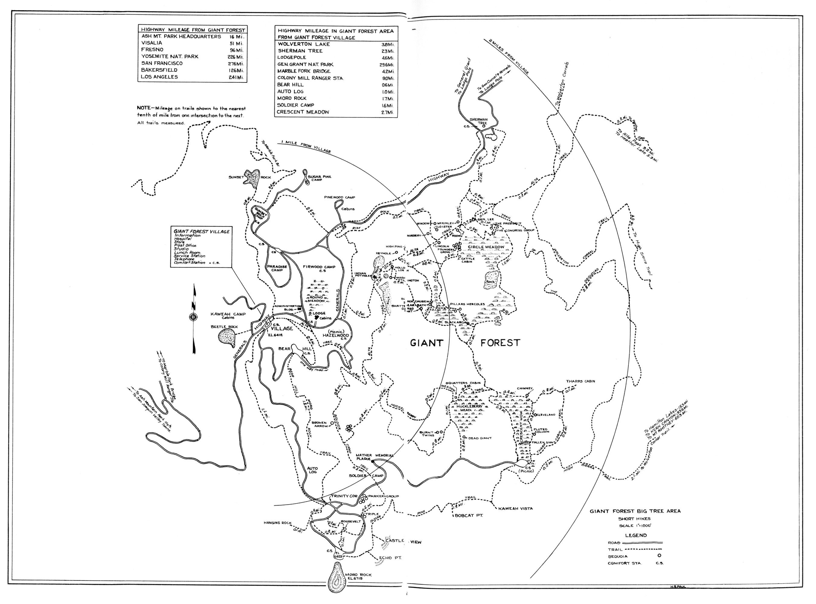
One-Day Stay.—Should include the Sherman Tree, Lodgepole Camp, Moro Rock, Parker Group, Crescent Meadow, and Tharp Cabin Log in the Giant Forest district. A drive out the Generals Highway to Lost Grove and General Grant National Park should be included.
Two-Day Stay.—In addition to the above should include the Alta Trail as far as McKinley Tree, Congress Group, and the High Sierra Trail to Eagle View.
Three-Day Stay.—Should include in addition, Tokopah Valley, Sugar Pine Trail to Kaweah Vista, and view of Marble Falls, from Admiration Point.
Four-Day to a Week Stay.—Will enable the visitor to see all of the foregoing attractions and to take the high mountain trips on High Sierra Trail to the cream of Sierra scenery at River Valley, Hamilton Lake, or Tamarack Lakes; to Twin Lakes, Alta Meadows and Peaks, Mount Silliman, Emerald and Heather Lakes, The Watchtower, Colony Mill, Little Baldy Fire Lookout, Admiration Point, and Marble Falls, with many other points.
Three-Week to a Month Stay.—Will permit a trail trip through wonderful country by the High Sierra Trail over Kaweah Gap to Big Arroyo, Kern Canyon, and Mount Whitney through the finest scenery of the Sierra Nevada. The Kern Canyon is a 25-mile valley with 3,000-foot walls, fine fishing, and lovely waterfalls.
It is no exaggeration to state that any length of time from 1 day to all summer may be profitably and enjoyably spent in the park. New beauties and natural wonders will be unfolded each day.
| 1858 | Giant Forest discovered by Hale Tharp, of Three Rivers, Calif., in September. |
| 1861 | First ascent of Moro Rock by Hale Tharp and George and John Swanson. |
| 1865 | Last of Potwisha Tribe of Indians left the park area. |
| 1873 | First ascent of Mount Whitney by A. H. Johnson, C. D. Begole, and John Lucas on August 18. |
| 1875 | Giant Forest first visited by John Muir. |
| 1879 | Sherman Tree discovered and named by James Wolverton, August 7. |
| 1881 | Samuel Pierpont Langley conducted researches in solar heat on summit of Mount Whitney. |
| 1881 | First ascent of Mount Kaweah, by J. W. A. Wright, F. H. Wales, and W. B. Wallace. |
| 1885 | Clough Cave discovered by William O. Clough, April 6. "Kaweah Colonists" filed on Giant Forest land, October. |
| 1886 | Giant Forest North Fork Road construction commenced by colony. |
| 1890 | Park created by act of Congress on September 25; second national park to be established. |
| 1891 | First administration of park by Capt. J. H. Dorst, Fourth United States Cavalry, and troop. Entered park June 7. |
| 1899 | First official survey of park by Isaac N. Chapman. Completed in 1900. |
| 1900 | First appropriation ever granted for park operations ($10,000). |
| 1902 | First transportation and camp operations permittee, Broder & Hopping. |
| 1903 | First road into Giant Forest completed August 15. |
| 1904 | First automobile entered Giant Forest, May 24. Mr. and Mrs. W. G. Luper, Vallejo, Calif. |
| 1905 | First white child born at Giant Forest (Forest Grunigen) August 31. |
| 1907 | First telephone line constructed, Three Rivers to Giant Forest, 33 miles. First post office established at Giant Forest. (Ranger.) |
| 1909 | Stone house on top of Mount Whitney built by Smithsonian Institution for solar heat observations. |
| 1914 | Walter Fry appointed first civilian superintendent. |
| 1919 | Exclusive jurisdiction over park ceded by California. |
| 1920 | Walter Fry appointed first U. S. Commissioner; Col. John R. White appointed superintendent. |
| 1926 | Park enlarged to include Kern district, increasing area from 252 to 604 square miles. |
| 1934 | Generals Highway opened to General Grant National Park. |
Briefed
Please Study the Regulations. Deliberate infractions may bring a penalty not to exceed $500 fine, or 6 months imprisonment, or both.
Suggestions, complaints, or comments regarding any phase of the park operation should be communicated immediately to the superintendent, or to any ranger or park officer, who will notify the superintendent.
Camps.—Camping is permitted only in numbered and designated camp sites. As far as possible, burn garbage in camp fire, and deposit empty cans and residue in garbage cans provided. Do not wash clothing or cooking utensils under hydrants, in streams, lakes, or otherwise pollute the water in the park. Observe quiet hours—at least from 10 p. m. until 6 a. m. Consider your neighbor.
Automobiles.—Cars must be equipped with good brakes, horns, and lights. Careful driving is required for the protection of yourself and others. Keep to the right of the road and avoid passing on curves. Speed limit signs are posted. Obey traffic rules and regulations. Permit fee is $1, allowing entrance to General Grant National Park also. Automobiles are not permitted in the park through the Ash Mountain or Lost Grove entrances after 9 p. m. or before 5 a. m., except Saturdays or days preceding holidays, when the closing hour for entry is 11 p. m.
Trash.—Deposit papers, lunch refuse, film carton, gum, or wrappers of any nature in receptacles provided.
Fires.—Light fires only in designated places. Extinguish completely before leaving camp even for temporary absence. Know your fire is out.
Smoking.—During the fire-hazard season, smoking while traveling on roads or trails is prohibited. Smoke only in camps and designated places. Be sure your smokes and matches are out before throwing away.
Trees, flowers, shrubs.—Do not pick flowers or write or carve your name on objects in the park. Down timber, except sequoia, may be used for firewood, unless posted not to be disturbed.
Animals and birds.—Do not kill, capture, or scare. The animals are your friends.
Dogs and cats.—Dogs and cats are prohibited on the park lands except upon written permission of the superintendent, secured upon entrance.
Fishing.—Get a State angling license. Apply to the nearest park ranger for the current year's fishing regulations. Avoid closed waters. Do not dig in the meadows for bait.
Park rangers.—The rangers are here to help and advise you, as well as to enforce regulations. When in doubt, ask a ranger.
Articles lost and found.—Should be reported to the ranger station at Giant Forest Village or at Ash Mountain. Persons should leave their names so that articles not claimed within 60 days may be returned to the finder.
Complete regulations may be seen at the office of the superintendent and at ranger stations.
National Park
OPEN ALL YEAR
—Kubla Khan.
The Sequoia National Park, which is located in eastern central California, was created by the act of September 25, 1890, and enlarged by act of July 3, 1926. Its area is now approximately 604 square miles. The park is situated on the western slopes of the Sierra Nevada and was established to preserve the groves and forests of California Big Trees (Sequoia gigantea).
It contains not only the largest and perhaps oldest trees in the world, but many other superb scenic attractions.
It is easily reached by train and auto stage or by private automobiles, is open the year round, and accommodations are available at all times.
The Sequoia National Park is open all year through the Ash Mountain entrance to Giant Forest. From May 25 to September 5 the Giant Forest Lodge, Kaweah Housekeeping Camp, Pinewood Automobile Camp, lunch-room, store, and service station are operated for the accommodation of visitors. From September 5 to May 25, the remainder of the year, the Giant Forest Winter Camp is available, providing American-plan and housekeeping accommodations in comfortable cabins. All year accommodations are provided as well for campers with their own equipment. From early May until snowfall (generally about the middle of November) the National Park Service maintains camps at Giant Forest with running water,[Pg 2] sanitary facilities, and garbage disposal. Campgrounds are also provided the year round at lower elevations, principally at Buckeye Flat, 2,800 feet, and Hospital Rock Camp, 2,700 feet. At all times of the year visitors camping at Hospital Rock can drive in and out of Giant Forest in an hour or two.
At Hospital Rock during the entire year lodging accommodations in cabins and in the auto camp are available. A general store, gasoline station, and lunch counter are operated here the year round, and photographic supplies may also be obtained. Particularly during the winter months, November to April, many find it most pleasant to avail themselves of the Hospital Rock accommodations and drive in and out of Giant Forest during the day.
The general headquarters for the Sequoia National Park is at Ash Mountain, on the Generals Highway. An information office is also maintained at Giant Forest.
Mail, telephone, and telegraph messages for the superintendent should be addressed to Sequoia National Park, Calif.; the representative of the National Park Service in charge is the superintendent, John R. White.
The United States Government has exclusive jurisdiction over the park (act of California Legislature, Apr. 15, 1919, and act of Congress, June 1920, 41 Stat. 731). Walter Fry is the United States commissioner for the park.
The Sequoia National Park is little more than an hour distant from points on the Golden State Highway (U S 99). The following table is accurate as to distances between points in California and the Sequoia National Park.
| City | Miles |
|---|---|
| Lemon Cove | 16.5 |
| Exeter | 28 |
| Visalia | 36 |
| Tulare | 46 |
| Porterville | 50 |
| Fresno (via Woodlake) | 75 |
| Bakersfield | 110 |
| General Grant National Park (via Generals Highway) | 47 |
| Yosemite National Park (via Merced) | 219 |
| Los Angeles | 220 |
| San Francisco | 253 |
Fresno, Visalia, and Exeter are the railway gateways to Sequoia and General Grant National Parks, served by the Southern Pacific Railway and the[Pg 3] Atchison, Topeka & Santa Fe. These cities are reached by an easy overnight journey from either Los Angeles or San Francisco. Pullman service is available daily to Fresno, and three times a week to Exeter and Visalia.
The standard tour of Sequoia and General Grant National Parks is, in one direction only, from Fresno, via Visalia and Exeter, to Giant Forest, Sequoia National Park, thence via the Generals Highway to General Grant National Park, returning direct to Fresno. A special service direct to General Grant National Park, returning by the same route, is available on advance reservation.
From June 10 to September 10, an auto stage of the Sequoia and General Grant National Parks Co. leaves Fresno daily at 8 a. m. for Giant Forest, Sequoia National Park, by way of Visalia and Exeter, arriving at Giant Forest about 12:15 p. m. From there the auto stage leaves about 1:45 p. m. for the return trip to Fresno, via General Grant National Park, over the spectacular new Generals Highway, arriving at Fresno 6:30 p. m. This circle tour service enables travelers to visit both parks easily.
From September 11 to June 9 "On Call" service by advance reservation is provided from Visalia and Exeter to Giant Forest, Sequoia National Park, and return over the same route, but no service is available to General Grant National Park during this period.
Special excursion fares are in effect on the railroads during the summer in connection with trips to Sequoia and General Grant National Parks. Detailed information about railroad service and rates may be obtained from local railroad ticket agents; the passenger traffic manager of the Southern Pacific Lines, San Francisco; the Atchison, Topeka & Santa Fe Railway, Chicago; or the Sequoia and General Grant National Parks Co., Sequoia National Park, Calif.
Sequoia and General Grant National Parks are easily reached from many points. Visitors find the various routes and methods of transportation equally comfortable and enjoyable.
Airplane service is available through a bi-daily service to Fresno by the United Air Lines, connecting with its transcontinental service at Oakland and that of T. W. A., Inc., and American Airlines at Los Angeles. Private planes may land at the Three Rivers airport, 6 miles from Ash Mountain.
From San Francisco the motor route to Sequoia National Park is by the Golden State Highway through San Joaquin Valley to Fresno and Visalia.[Pg 4] Visalia is the motorists' headquarters for the mountain trip and is a pleasant county seat of about 6,500 people, with excellent hotel and stores. Ash Mountain is 36 miles from Visalia by paved highway via either Lemon Cove or Woodlake. Giant Forest is 17 miles farther by excellent mountain road. The motor journey from Visalia to Giant Forest is easily made in 2 hours.
From Los Angeles the motorist has a choice of highway routes after leaving Bakersfield either via Tulare and Visalia or by Delano, Porterville, and Exeter. There are good accommodations in any of these towns.
Full information relative to the best routes, road conditions, etc., may be obtained from the California State Automobile Association, San Francisco; the National Automobile Club, San Francisco; the Automobile Club of Southern California, Los Angeles; and from branch offices of any automobile club in California. All automobile club offices post the latest bulletins from the superintendent's office.
An automobile license fee of $1 is required except on the Mineral King Road. It is payable at any of the entrance stations. The same license permits entrance to both Sequoia and General Grant National Parks, good for the entire calendar year.
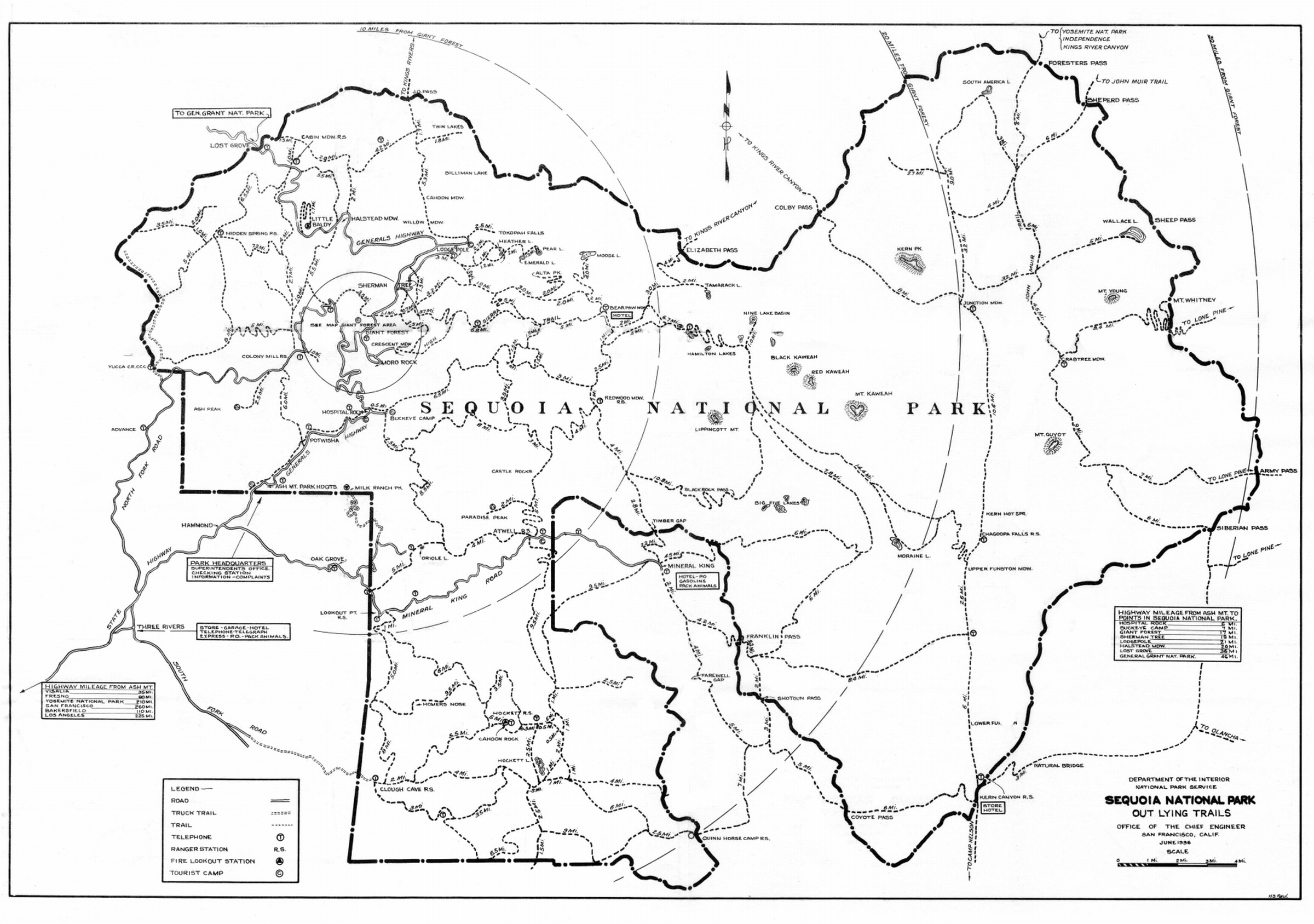
The Generals Highway, leading to Giant Forest by way of the Kaweah River, Middle Fork, is the main artery of travel in the park, connecting directly with the paved State highway at the park boundary and reached from all points north and south through the various towns of the San Joaquin Valley. The Generals Highway is a fine surfaced mountain road, wide and of easy grade, leading the visitor past Ash Mountain headquarters, Camps Potwisha and Hospital Rock, to Giant Forest, 17 miles from the entrance, and the heart of the present development among the Big Trees. From Giant Forest it continues on past the Sherman Tree to Lodgepole Camp (4 miles), crosses the Marble Fork, and, winding through mixed fir and pine forests, crossing streams and meadows with many a forest and mountain vista, leaves the park 11 miles farther on at the Lost Grove Ranger Station. For the convenience of motorists, water stations and telephones for emergency use will be found at intervals along the highway through the park. The highway continues on 15 miles farther through scenic country to General Grant National Park, where it connects with the State highway to either Visalia or Fresno. This makes possible a circle trip through both parks, via either the Ash Mountain entrance or the Lost Grove entrance and via either Visalia or Fresno. The Generals Highway[Pg 5] is open to Giant Forest, via the Ash Mountain entrance, all year except immediately after unusually severe storms in winter.
The Mineral King Road, leaving the State highway at Hammond, 5 miles above Three Rivers, and following the east fork of the Kaweah River, crosses the central part of the park, passing Atwell station and camp in a forest of Big Trees, and ends at the summer resort of Mineral King, in the national forest and game refuge beyond.
All signs in the parks are official. It is important and helpful to read them.
The motorist should observe the road signs, always have his car under full control, keep to the right, and sound horn when on curves that are blind.
Speed must not exceed 15 miles an hour on grades when rounding sharp curves. On straight open stretches the speed must not exceed 35 miles an hour. Speed limit signs inform the driver of maximum speeds allowed in the various areas. Careful driving is required at all times. Descend hills in gear, and drive more slowly downhill than uphill. These are scenic roads; take time to enjoy them.
Numerous trails cross the park boundary from all directions. The South Fork, or Hockett Trail, starts at the end of the South Fork Road 13 miles above Three Rivers at the Clough Cave entrance to the park. This is a main-traveled trail to southern points in the park—Garfield Grove, Kern Canyon, and Mount Whitney.
The south trail entrance is reached from the end of the automobile road at Camp Nelson, in the national forest east of Porterville; thence by trail to the Kern Canyon station at Golden Trout Creek. The Kern Canyon entrance is reached also by trail from Lone Pine and other Inyo County points via Cottonwood Pass on the main crest of the Sierra, somewhat south of the park line. The higher reaches of the Kern River within the park may be reached from this trail by a direct route crossing Siberian Pass on the park boundary, where this is defined by a secondary divide.
A foot-and-horse trail runs to the summit of Mount Whitney (14,494.7 feet) from the Owens Valley side. It connects with the main park and Kern watershed trail system at Crabtree Meadows on the west side of the crest. Here it is possible to go over the "top of the United States" and down the other side. Mount Whitney may therefore be reached from Lone Pine via Cottonwood Lakes and Army Pass, or direct via Lone Pine Creek from the[Pg 6] [Pg 7]east. It may be reached from the west by starting at Giant Forest, or Mineral King, or by way of Camp Nelson from the south. This latter trail is used particularly in the early spring and summer.
The Sequoia National Park contains many scenic features in addition to the Big Trees. The forests of sugar pine, yellow pine, fir, cedar, black oak, and other trees are the noblest of their kind. Upland meadows painted with flowers; many rushing rivers and creeks, as well as lakes well stocked with trout; glacier-hewn valleys; monolithic rocks, and snow-capped mountain peaks all contribute to furnish perfect conditions for enjoyment of outdoor life and the study of nature. Below are listed but a few of its scenic and other attractions.
Middle Fork and Hospital Rock.—The motorist first enters the park via Ash Mountain headquarters, and the road leads up the gorge of the Middle Fork of the Kaweah River.
Hospital Rock, tourist center and public campground, is 5 miles beyond Ash Mountain on the road to Giant Forest, at 2,700 feet elevation, and is an all-year-round center of park activities. The Buckeye store sells general supplies, photographs, films, curios, etc., and furnishes light meals and overnight accommodations.
At or near Hospital Rock are historical and scenic attractions of great interest. There are Indian pictographs, and a mammoth boulder marks the old headquarters of the Yokut Indians. Moro Rock towers 4,000 feet above. The Kaweah River gorge is full of pools, cataracts, and waterfalls. The fishing is excellent. Short-trail trips lead to the Giants Rock Pile, the Big Pool, Buckeye Flat, Red Rock Gorge, and other interesting walks. Deer are numerous and very tame in this vicinity.
A narrow 2-mile road above Hospital Rock leads to Moro Creek, where there is a public campground and point of departure for high mountain trail trips. Magnificent views of the Great Western Divide, with its 12,000- and 13,000-foot peaks, may be had from this road.
Buckeye Flat is a newly developed area on this road, half a mile above Hospital Rock. This is a delightful public campground, beside the rushing Middle Fork, with the usual accommodations. Though particularly beautiful in the spring, it is attractive throughout the year.
Paradise-Atwell Trail connects Atwell Mill Station on the East Fork with Hospital Rock on the Middle Fork of the Kaweah River. It joins the Atwell-Hockett Trail, permitting direct access to the Hockett Meadow country from the Middle Fork district.[Pg 8]
Continuing up the Middle Fork, under the shadow of the Great Western Divide, is Redwood Meadow with its interesting grove of Big Trees. To its left, at Bearpaw Meadow, a hikers' camp is maintained during the summer season. The camp is within easy walking distance of Giant Forest and is a convenient base for trips to Tamarack Lake, Hamilton Lake, or Kaweah Gap.
Giant Forest and surroundings.—On a plateau ranging in elevation from 5,500 to 8,000 feet and running back to mountains 11,000 feet high. In heart of park, including major woodland attractions, the Tokopah Valley, and several lakes.
East Fork or Atwell Mill region.—The Mineral King Road leads through this region to the resort of that name just outside the park at 7,800 feet elevation. At Atwell Mill are to be found the finest stands of young Sequoia in the park.
The Atwell-Hockett Trail.—This trail is built on the highest standards. It permits easy travel, whether on foot or horse, and provides a direct route from Atwell Mill into the Hockett Meadow country, famous for its miles of plateau and meadows. Beyond Hockett Meadow is the Quinn Ranger Station, also the fine Garfield Grove of Big Trees.
South Fork or Hockett Meadow region.—From Clough Cave Ranger Station, at 3,000 feet, through the Garfield Grove to the fine camping and fishing country at Hockett Meadows, 8,500 feet. Accessible by trail only.
Kern Canyon district.—This area of more than 300 square miles embraces the upper Kern River, its tributaries, and the Kern Canyon. It is a wild, immense country of forest, granite, lakes, and streams, varying in elevation from 14,494.7 at the summit of Mount Whitney to 6,400 feet at the Kern Canyon Ranger Station at the lower end of the canyon. Excellent camping and fishing country. Accessible only by trail.
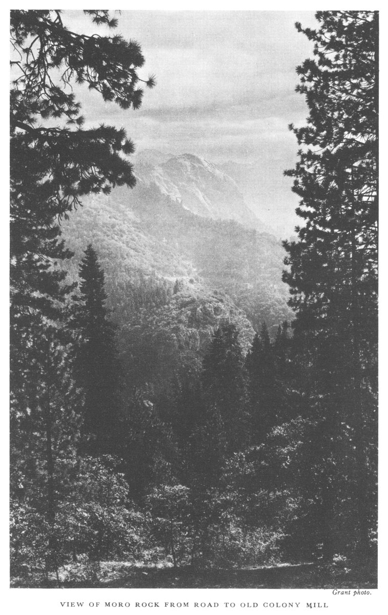
Two miles by road or trail from Giant Forest is Moro Rock, one of the great monoliths of the Sierra Nevada, others being El Capitan and Half Dome in the Yosemite, and Tehipite Dome in the Kings River Canyon.
Moro Rock is 6,719 feet above sea level and over 6,000 feet above the San Joaquin Valley. From the summit, which is easily reached by a rock and concrete stairway, to the silver streak of the Kaweah River at its base, is an almost sheer drop of 4,119 feet. The panorama of the Sierra Nevada, Alta Peak, the San Joaquin Valley, and the distant coast range is equal to that otherwise obtained only by long and expensive pack trips to the high mountains. Climbing Moro Rock is "mountaineering de luxe."[Pg 10]
Hanging Rock, Moro Vista, Profile View, Echo Point, and Kaweah Vista are viewpoints on the rocky escarpment of the Giant Forest Plateau near Moro Rock. Each offers some special view or attraction. Hanging Rock is a huge erratic boulder poised for a 3,000-foot drop to the yawning canyon beneath. Echo Point and Profile View disclose unexpected profiles of Moro Rock, and at the former a resonant echo reverberates from the painted cliff across the chasm.
Beetle and Sunset Rocks, a few hundred yards from Giant Forest camps, are bold granite promontories overlooking the valley and the Marble Canyon. They are favorite spots for picnic suppers and sunset views.
Lodgepole Campgrounds and Tokopah Valley are 4½ miles by road from Giant Forest. The former is the auto camp favored by those who want to live in an open pine forest and beside running water. The swimming pool here also attracts campers. Two miles above the campgrounds, by trail along the north bank of the Marble Fork, is Tokopah Valley, of cameolike beauty, hewn by glacial action from the ribs of the earth. It is a miniature Yosemite, a narrow valley with towering cliffs, waterfalls, talus, meadows, and moraine. It affords one of the favorite short hikes in the park.
Colony Mill and Admiration Point, a 9-mile side trip by road from Giant Forest, are often overlooked by visitors. The views from Colony Mill Ranger Station are superb, while the mile side trip by trail down to Admiration Point permits a view of the Marble Falls, a 2,000-foot cascade in seven distinct waterfalls.
Marble Fork Bridge, 4½ miles from Giant Forest, at an elevation of 5,000 feet, is favored by those who like to be near a stream and to fish. It may be reached by road or by the Sunset Trail. This is a favorite retreat with hikers as well as fishermen. The setting is beautiful and the views especially fine. A natural swimming pool adds to its attractiveness.
By parking at the Little Baldy Saddle on the Generals Highway a fine view may be had by hiking a mile and a quarter to the top of the dome. The panorama spread out is a reward worth twice the effort expended.
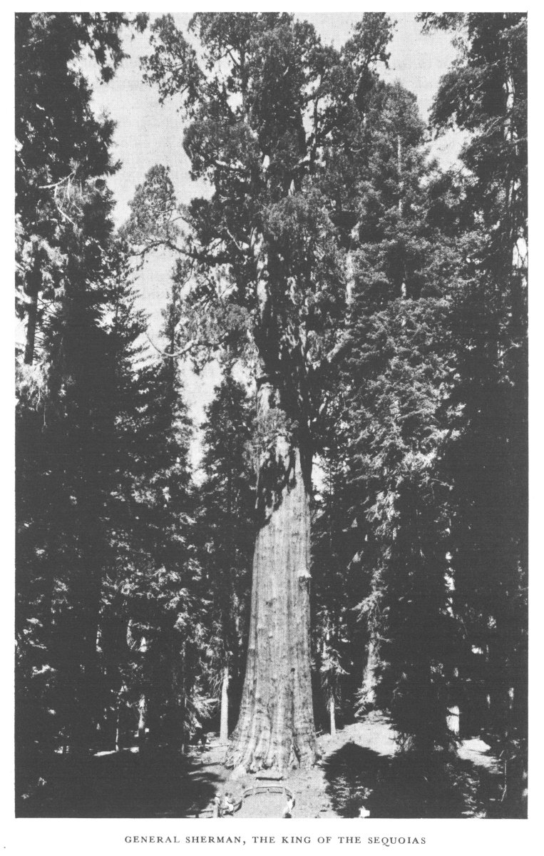
The Giant Forest is the name given the largest grove of sequoias, which is more than a grove. It is a Brobdingnagian forest. Here is found the General Sherman Tree, perhaps the oldest and largest living thing, 36.5 feet at its greatest diameter and 272.4 feet high. There are scores of trees almost as large as the General Sherman, hundreds over 10 feet in diameter, and many thousand from the seedling stage upward.
In his book, Our National Parks, John Muir says, "* * * I entered the sublime wilderness of the Kaweah Basin. This part of the Sequoia belt seemed to me the finest, and I then named it 'The Giant Forest.' It extends, a magnificent growth of giants grouped in pure temple groves, ranged in colonnades along the sides of meadows or scattered among the other trees, from the granite headlands overlooking the hot foothills and plains of the San Joaquin back to within a few miles of the old glacier fountains at an elevation of 5,000 to 8,400 feet above the sea."
Giant Forest is also the name of the village beneath the sequoias where the Giant Forest Lodge and the housekeeping and auto camps are situated. Its summer population is about 3,000.
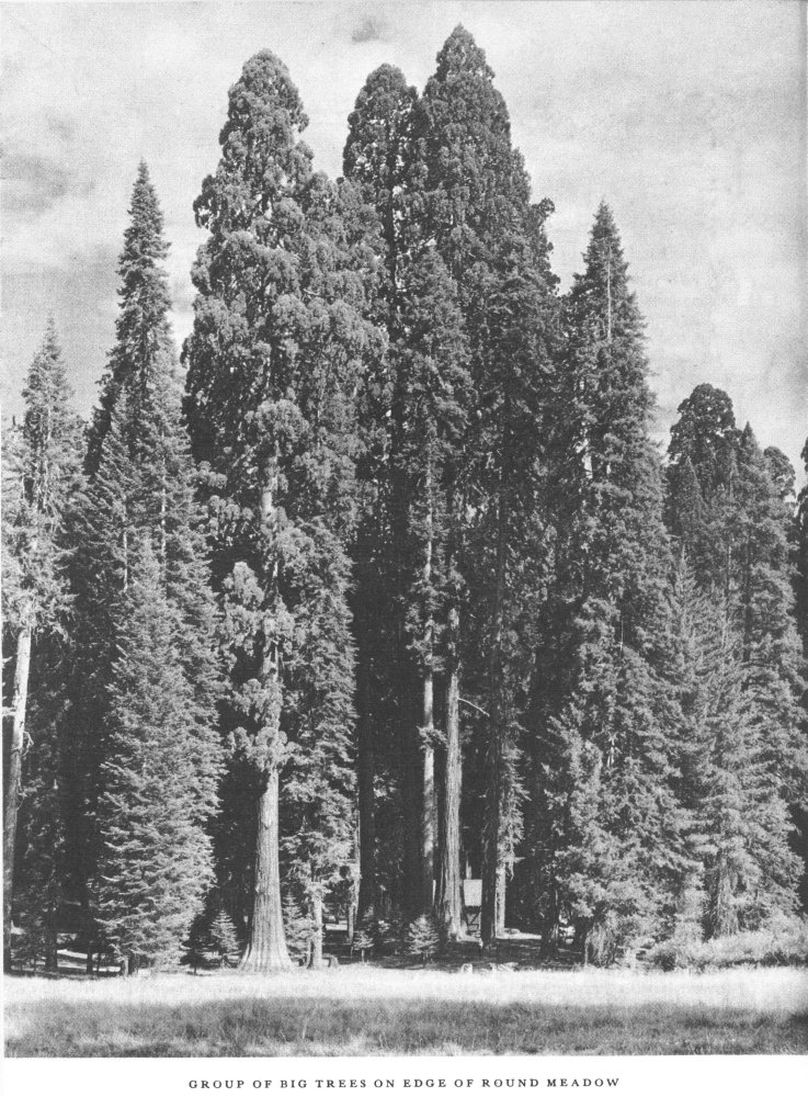
The beauty of the Giant Forest region is much enhanced by the many upland meadows, flower-strewn from the first blossoming of the amethystine cyclamen, or shooting stars in May, to the golden autumn glow of the goldenrod in September. The best-known meadows are Round, Circle, Crescent, and Log, all within 2 miles of Giant Forest Camp.
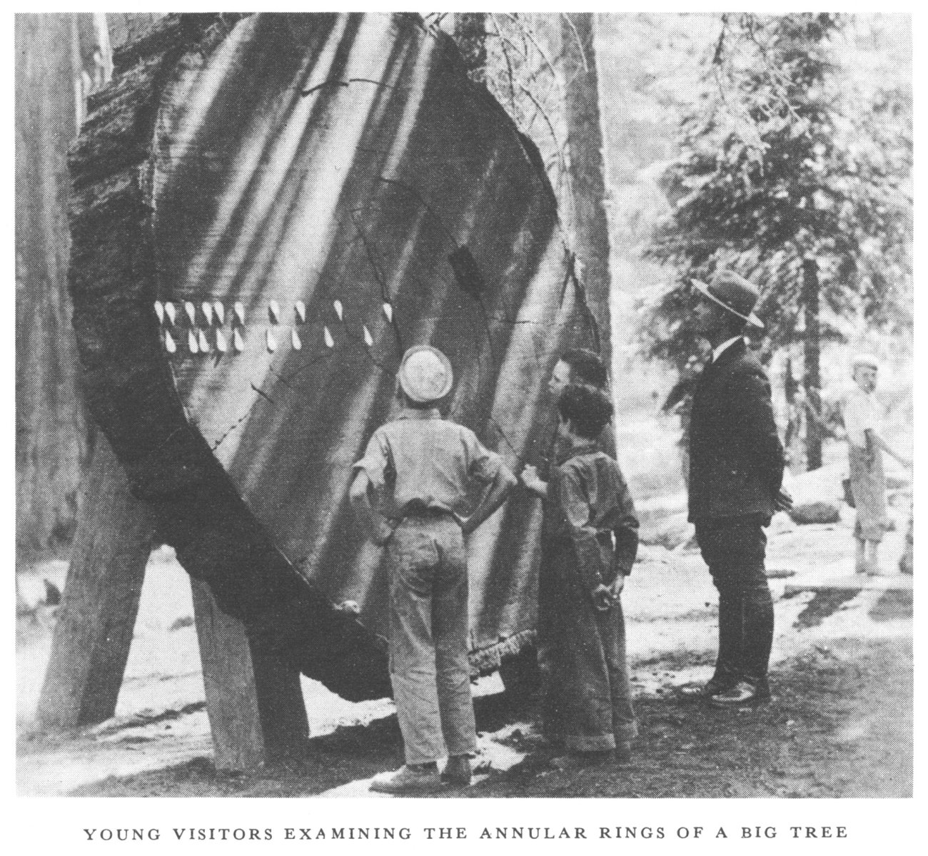
The California Big Trees must ever remain the supreme attraction of the park, although for many the mountain scenery and the fishing are added allurements. The Big Tree (Sequoia gigantea) is sometimes confused with the redwood (Sequoia sempervirens), the smaller species of Sequoia found only in[Pg 12] the Coast Range of California. While gigantea approaches 40 feet in base diameter, sempervirens rarely exceeds 20 feet. The wood is similar in color and texture, but the foliage is distinct, and the bark of the Big Tree is much thicker and of a rich red color, instead of a dull brown. The most distinctive characteristic is that the Big Tree is reproduced only from the seed while the redwood when cut down sprouts from the stump.
There are many world-famous Big Trees in the Sequoia National Park, of which the General Sherman is the largest and best known. But there are scores or hundreds unnamed and almost equal to the General Sherman in size and majesty.
In addition to those noted for their size, the National Park Service has named and signed many of singular form, burned by fire, struck by lightning, or fallen in strange fashion. The trees which should be seen by all visitors are:
The General Sherman Tree.—The largest, and perhaps the oldest living thing. Discovered by James Wolverton, a hunter and trapper, on August 7, 1879, at which time he named the tree in honor of General Sherman, under whom he had served during the Civil War as a first lieutenant in the Ninth Indiana Cavalry.
The age of the tree is unknown. It is estimated by those who have made a study of the subject as between 3,000 and 4,000 years. During this time it has withstood the ravages of countless fires, and, though greatly damaged, it has continued to flourish, and today produces thousands of cones bearing fertile seed from which many seedlings have been grown.
The results of the fire damage are seen in the great wounds at the base of the tree. Through repeated fires the sap-pumping system has been damaged, and portions of the top have died; only 40 percent of live wood is in contact with the ground. The Sequoia, however, has such recuperative power that in time these fire scars will be completely healed.
The dimensions of this tree are as follows:
| Feet | |
| Height above mean base | 272.4 |
| Base circumference | 101.6 |
| Greatest base diameter | 36.5 |
| Mean base diameter | 32.7 |
| Diameter 60 feet above ground | 17.5 |
| Diameter 120 feet above ground | 17.0 |
| Height of largest branch | 130.0 |
| Diameter of largest branch | 6.8 |
For years there have been rival claims by various localities for the honor of possessing the largest tree in the world. To settle these claims the California State Chamber of Commerce and Fresno County Chamber of Commerce conducted, in 1931, a tree-measuring expedition in Sequoia and General Grant National Parks and vicinity.[Pg 13]
The result of the work of several engineers gave the following comparative volumes of the trunks of the four largest trees measured, exclusive of limbs:
| Board feet | |
| General Sherman Tree | 600,120 |
| General Grant Tree | 542,784 |
| Boole Tree | 496,728 |
| Hart Tree | 410,952 |
The General Sherman Tree was shown to contain 57,336 board feet more in volume than its nearest competitor and the King of the Sequoias retained his crown.
The Chimney Trees.—There are two well-known Chimney Trees, one being on the east side of Sherman Creek close to the trail from Sherman Tree to Alta Peak, which is now the best preserved. The other Chimney Tree is at the northeast end of Crescent Meadow and was badly burned several years ago through the carelessness of somebody who left a campfire burning. The Chimney Tree near Sherman Camp is a remarkable example of vitality, as it is thrusting out new branches despite the fact that its vitals are eaten away by fire.
The Black Chamber.—This is probably the most notable example of vitality on the part of a Sequoia in the forest. About one-thirtieth of the bark remains, and the whole interior has been eaten away by fire; nevertheless, the tree still lives and thrusts out new branches each year. It is located along the Crescent Meadow Road.
OTHER FAMOUS TREES
Washington.—Very impressive as to size.
Abe Lincoln.—Thirty-one feet in diameter, 259 feet high, a rugged, ancient-looking tree.
Auto Log.—A huge fallen giant upon which an auto may be driven with ease and safety.
William McKinley.—Twenty-eight feet in diameter, 291 feet high.
The President.—Twenty-nine feet in diameter, 250.2 feet high, wider at 120 than at 60 feet.
Keyhole.—Burned out "keyholes."
Room Tree.—Cavernous room within a standing tree.
Stricken Tree.—Rent by lightning, but still alive.
Window Tree.—Filigree appearance and many windows.
Chief Sequoyah.—Old with huge burls.
Black Arch.—Trail leads through charred, living giant.
Roosevelt Tree.—One of the most perfect in the forest.
Pershing Tree.—Named for Gen. John J. Pershing, has very richly colored bark.
Cloister.—Four trees in a square.
Pillars of Hercules.—Trail leads between two standing giants.
Bear's Bathtub.—A cavity between two trees, containing water, frequented by bears.[Pg 15]
The naming of the Big Trees of California "Sequoia" is a fitting tribute to that native American, a Cherokee Indian, who spelled his name Se-quo-yah. An uneducated, non-English-speaking Indian, he perfected a phonetic alphabet of 86 symbols with a character representing every sound in the tongue of his tribe. It was said that with this alphabet, sometimes characterized as one of the greatest ever invented, a Cherokee child might learn to read and write the Cherokee language in a few days, and that within a remarkably short time after the official acceptance of the alphabet by the tribe every one of its members was able to read and write.
The change brought about in the Cherokee Tribe by the introduction of this means of expressing thought on paper was equally remarkable. A printing press was established, type made of the various symbols, and the news of the day printed in two newspapers. Their laws were printed in Sequoyah's alphabet, and also the Gospels and many other books both useful and interesting to the Cherokee people, who thus made rapid advance in general knowledge and in civilization.
The Sequoias are sometimes found in groups or groves. Such is the number of those near Giant Forest that it is scarcely an exaggeration to say that many other known groves of the Big Trees in California might be hidden in the Sequoia National Park and pass unnoticed. The principal groves easily reached in Giant Forest are the Parker Group, Congress Grove, Amphitheater Group, Founders' Group, and Huckleberry Meadow Grove. There are 32 distinct groves or areas of Big Trees in the park.
Descriptions of the Big Trees and of the other forest trees are found in two pamphlets, The Secret of the Big Trees and The Forests of Yosemite, Sequoia, and General Grant National Parks. These are for sale at the naturalist's office for 5 and 10 cents, respectively.
Persons desiring to fish in the waters of the Sequoia National Park must secure a fishing license, as required by the laws of California. These laws provide that every person over the age of 18 who obtains fish without procuring a license is guilty of a misdemeanor. The license fee for residents is $2; for nonresidents, $3; and for aliens, $5. These licenses may be obtained from any county clerk, from the State board of fish and game commissioners, or from the representative of the commission at the general store in Giant Forest.[Pg 16]
Fishing bulletins for the current year pertaining to park fishing regulations may be obtained at entrance checking stations, park headquarters, or from rangers.
Park regulations as to daily catch, etc., are identical with those of the State for the district by which the parks are surrounded, excepting in some areas where excessive demand necessitates reduction of the daily limit. Fishermen should obtain special bulletins at the park entrance stations.
Fishing is permitted in all the streams and lakes of the Sequoia National Park except in a few waters which are closed in order to increase the supply of fish. Information as to these closed waters will be found posted at ranger stations and near the waters.
In the early part of the season excellent fishing may be had in an hour's hike from Giant Forest. Later in the season it is necessary to go farther afield, but the skillful angler is generally able to take the limit.
Rainbow, Loch Leven, eastern brook, German brown, and golden are the varieties of trout found in the park. The golden trout of Golden Trout Creek has been introduced into several creeks and has done well.
In the Giant Forest district bathing may be enjoyed at Bridge Camp, Lodgepole Camp, and at Heather Lake. Bathing pools are especially marked, and on account of the danger of pollution of streams used for domestic purposes, bathers must confine themselves to designated areas.
The largest pool is located in the upper Lodgepole district.
An excellent bathing pool is available at Hospital Rock Camp, and many visitors stop here for a plunge en route to Giant Forest.
The National Park Service maintains campgrounds for visitors traveling in their own automobiles. The largest campgrounds are at Giant Forest, Lodgepole, and Dorst Creek, where water is piped and modern sanitary and garbage-disposal facilities are furnished at about 600 camp sites. Camping is limited to 30 days in any area each year.
Inquiries about free public campgrounds should be addressed to the Superintendent, Sequoia National Park, Calif.
Reservations or inquiries regarding hotel, housekeeping, and pay auto-camp accommodations should be directed to Giant Forest Lodge, Sequoia National Park, Calif., specifying, in detail, number of persons, types of[Pg 17] accommodations required, and particular lodge or camp desired. Telephone or telegraph messages should be sent to Manager, Giant Forest Lodge, Sequoia National Park.
Visitors to Sequoia should have mail addressed to Sequoia National Park, Calif. Guests of the Giant Forest Lodge or Camp Kaweah should have their mail addressed care of either resort, but Sequoia National Park must be added as the post-office addressed.
There is long-distance telephone and telegraph service from all main points in Sequoia National Park.
Telegrams should be addressed Sequoia National Park, Calif., bearing in addition the particular camp or lodge address.
A resident physician is on duty at Giant Forest, Sequoia National Park, during the summer months, and a small hospital is maintained at Giant Forest.
Both Catholic and Protestant services are held regularly on Sundays during the summer season. Times and places of all services are announced on the bulletin boards and at Saturday evening camp fires.
From about June 15 to September 1 a branch of the Tulare County Free Library is maintained at Giant Forest. Books on subjects related to the park, especially its history, fauna, flora, etc., are available or will be secured upon request. In addition, a large library of books on fiction and nonfiction subjects is maintained.
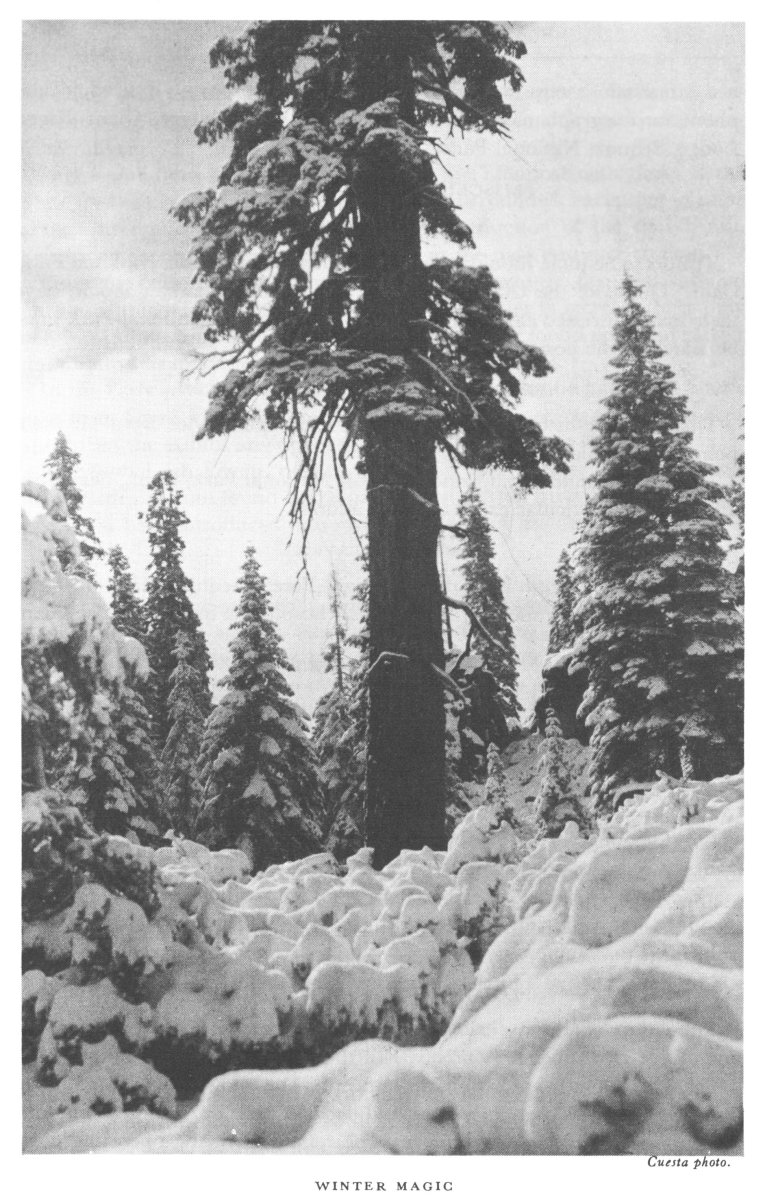
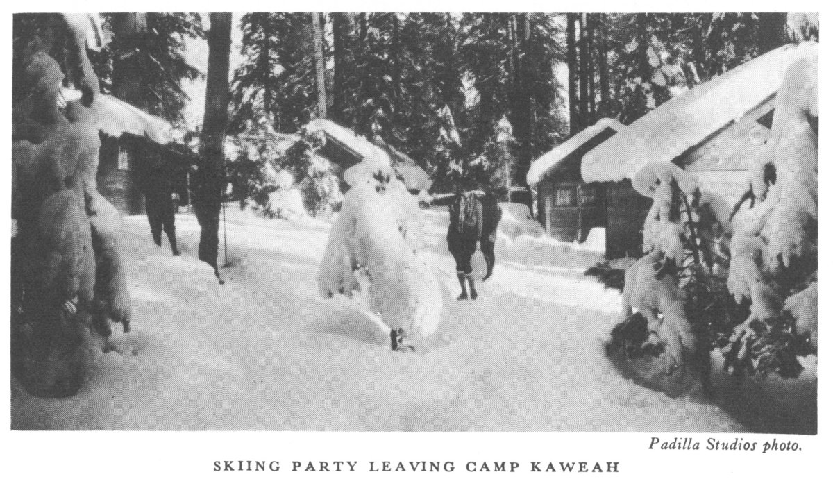
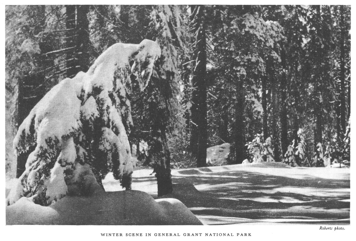
Full winter conditions exist at Lodgepole and at Giant Forest during the months of December to March, when the Big Trees are surrounded by a blanket of snow from 2 to 12 feet deep. The snow sports common to northern climates and resorts are indulged in here during these months. Skis, toboggans, and snowshoes may be rented from the operating company,[Pg 18] as well as heavy clothing desirable for this climate. The winter sports have become so popular that it is advisable that reservations for accommodations be made in advance.
For those who desire to make the day trip only, the National Park Service maintains public camps or picnic grounds at Beetle Rock. A ranger is on duty at all times and is anxious to show the park and make the stay of visitors as enjoyable and profitable as possible.
The operating company issues a leaflet advising people of accommodations, prices, etc. This can be obtained on application to the superintendent.
It is always advisable when driving in the mountains during the winter to carry tire chains, although even in midwinter it is often possible to drive to the Big Trees without them.
Every effort is made by park authorities to keep the Big Trees accessible during the winter months. Sequoia Park is now well known as one of the few places in California where winter vacationists from other sections of the country may be sure of seeing the giant Sequoias.
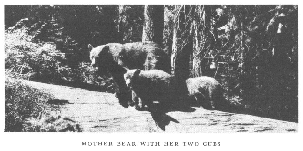
"Bear Hill" is the name given to the spot near the incinerator, where many bears gather to feed daily. The best time to see them is from noon to 7 p. m., when an attendant is on hand, but they are frequently there throughout the day. A ranger naturalist gives a 10-minute talk daily on the habits and characteristics of the bears. The road to Bear Hill branches from the Moro Road near the new village site.
Tharp Cabin, in Log Meadow, one-half mile from end of auto road at Crescent Meadow, may also be reached by Circle and Congress Trails from Alta Trail. This hollow Sequoia log was occupied by Hale Tharp, Three Rivers pioneer and discoverer of Giant Forest in 1858. John Muir stayed several days in this unique "house in a log" in 1875 and has immortalized the "noble den", as he called it, and the surrounding Sequoias and meadows in his book, Our National Parks. The cabin is maintained in its original condition and constitutes an interesting museum.
The National Park Service encourages all forms of outdoor activities, but special attention is paid to fostering a knowledge of the wildlife and natural beauty which the parks were created to preserve. At Giant Forest a small collection of specimens is on display at the naturalist's office during the summer season for the enjoyment of visitors. Lectures given daily by ranger naturalists at Sherman Tree, Moro Rock, and elsewhere present facts of interest at these stations.
The park naturalist is in charge of the guide service. During the summer months camp-fire lectures are given and trail hikes and automobile caravans are conducted. Both half-day and all-day trips are taken, with variety enough to cover all types of interest. Giant Forest Administration Building is the headquarters of this increasingly popular service.
The Giant Forest Lodge campfire is held every night at the lodge under the Sequoias, where community singing, nature and historical talks, music, and general entertainment are provided. This is free to the public, and all visitors are invited to participate.
The Park Service conducts similar programs at Sunset and Lodgepole Camps every evening. Park visitors are cordially invited to assist in making these programs a success by contribution of their talents.
Following the campfires, the dance hall is open every evening, except Sunday, from about the middle of June until September 1.
The social life at Giant Forest is one of the great attractions and holds many people beyond the time allotted for the visit. The average population is about 3,000 people.
One of the most pleasing features of Giant Forest is the number of forest trails leading from it that afford interesting half-day or all-day excursions. Perhaps nowhere else is it possible to hike so easily for hours through such forests of sequoia, pine, and fir. Many of the trails are oiled to eliminate dust. The trail system is well signed, and the map in this pamphlet is used[Pg 21] by many as a guide. It would be impossible to enumerate all the points of attraction or combination trips which can be made. New ones are opened every year. The following are the principal trails and attractions:
Alta Trail.—Nine miles from Giant Forest to Alta Peak (11,211 feet); passes through the Plateau of the Giant Trees and Panther, Mehrten, and Alta Meadows. The view from Alta Peak has been pronounced by members of the Sierra Club as fine as any in the California mountains. It is the nearest point to Giant Forest from which Mount Whitney may be seen. Horses may be ridden to the summit. Alta Meadows is a delightful place to camp. A full day should be allowed for this trip.
Trail of the Sequoias.—Connects the High Sierra Trail from the saddle near Crescent Meadow, 3.7 miles to the Alta Trail, and passes through Big Tree groves rarely seen by the public before the opening of this trail.
Circle, Crescent, and Congress Trails.—All lead from the Alta Trail through the thickest Sequoia forests to meadows and mammoth trees within 2 miles of Giant Forest. From 2 hours to 2 days could be spent covering this area.
Soldier and Bear Hill Trails.—Lead from Giant Forest, 2 miles to Moro Rock, passing near the Parker Group and past the Roosevelt Tree, Hanging Rock, and other points. A half-day stroll.
Sugar Pine Trail.—From Moro Rock, 1½ miles along the plateau edge to Crescent Meadow and Kaweah Vista, with side trip to Bobcat Point.
Twin Lakes Trail.—From Lodgepole Camp, 5 miles to Clover Creek, and 2 miles farther to Twin Lakes, famous for unsurpassed scenic setting at 9,750 feet, and for good trout fishing. Several hundred feet above Twin Lakes on Silliman Shoulder is one of the finest panoramas of mountain scenery in the world. A day is well spent on this trail.
The Watchtower and Heather Lake Trails.—These two trails lead to major scenic spots. From the Watchtower there is a 2,000-foot drop to Tokopah Valley; and Heather, Emerald, and Aster Lakes are mountain jewels on the west slopes of Alta Peak. All of these trips may be made from Giant Forest in half a day, although it is preferable to allow a full day for them. Ranger naturalists conduct nature hikes to these points during the summer.
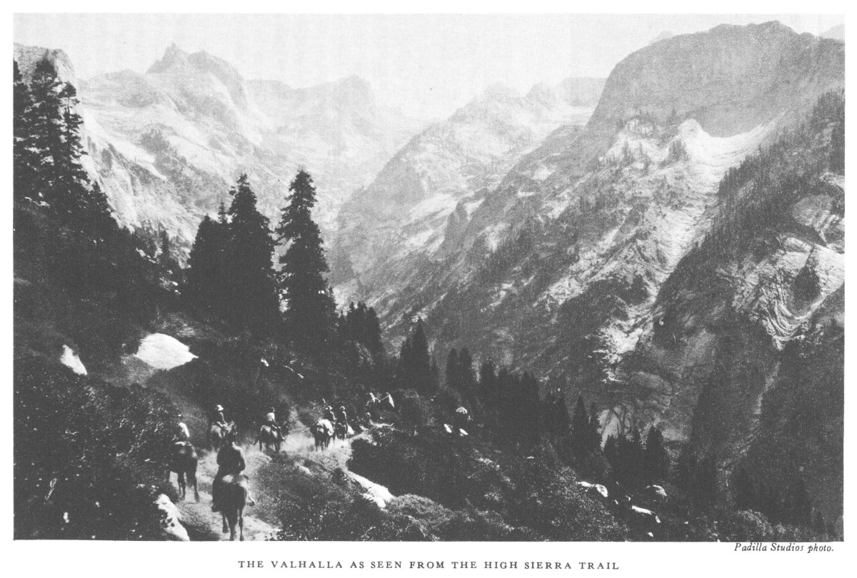
The High Sierra Trail.—This trail, one of the finest mountain routes in America, extends from the Big Trees of the Giant Forest to the summit of Mount Whitney (14,494.7 feet), the highest mountain in continental United States. In Sequoia National Park the largest trees in the world are now linked by a splendid trail to the highest mountain peak in the country.
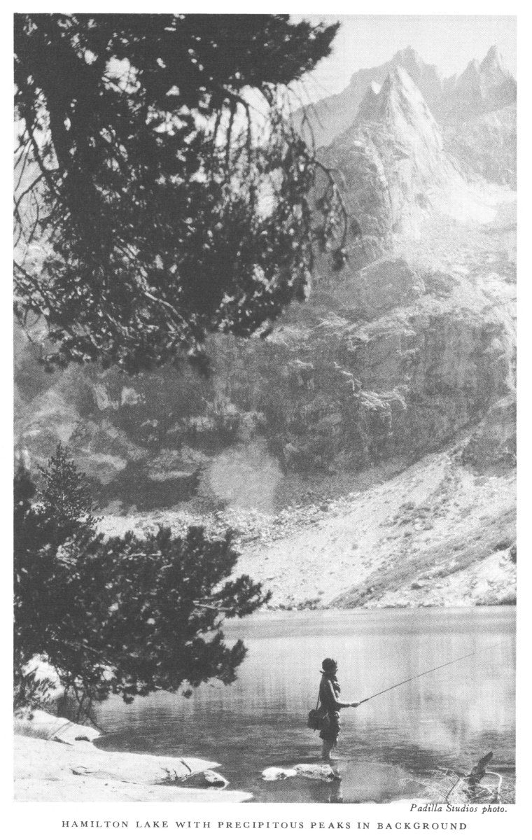
The main features along the High Sierra Trail, with distances shown from Giant Forest, are: Bearpaw Meadow, 12 miles, with view of waterfalls, great cliffs, and River Valley; Hamilton Lake, 16 miles, conceded by those who know the Sierra Nevada to be the "cream of Sierran scenery"; Hamilton Gorge suspension bridge, 18 miles; Kaweah Gap, 20 miles, with expansive views of Kaweah peaks and main crest of the Sierra Nevada, as well as the Big Arroyo immediately below; Moraine Lake, 30 miles; Kern Canyon at Funston Meadows, 34½ miles; Kern Hot Springs, 37 miles; Junction Meadow, 44 miles; Crabtree Meadow, 54½ miles; Mount Whitney summit, 62 miles. From the summit of Mount Whitney there are 13 miles of trail down the east side to end of automobile road, at Whitney Portal, 16 miles from the town of Lone Pine.
Meals and comfortable beds may be obtained at reasonable rates at the outpost station located at Ibex Meadow, making a trip possible to the summit of Mount Whitney and return from the east side without the necessity of packing heavy supplies and equipment.
California mule deer.—So-called because of their large ears. They are abundant everywhere and often tame near campgrounds.
American black bear.—Found throughout the park and are very plentiful at Giant Forest during the spring and early summer months, where several at one time may be seen at the Bear Hill. These bears are not ferocious, and under all ordinary circumstances will run from man. Young of the same litter often vary in color from cinnamon to brown or black. Visitors must not feed the bears. They are fed daily from camp garbage.[Pg 23]
Columbia gray squirrel.—A delight to the eye as it dashes across a road or trail, a blue-gray furry vision that at times appears to be all tail—the largest squirrel.
Douglas squirrel or Sierra chickaree.—Very abundant and thrusts itself upon the public by its quarrelsome and scolding disposition. About two-thirds the size of the gray squirrel, and gray-brown in color.
Chipmunks of several species.—The Alpine, Sierra Nevada, and Sequoia are abundant everywhere in the pine and Sequoia. They become very tame and steal from campers' tables or food supplies.
Sierra golden-mantled ground squirrel.—Often mistakenly called a chipmunk and having much the same habits. At Giant Forest it is as abundant as the chipmunk and may be distinguished by its golden color and larger size.
California Valley ground squirrel.—Has recently arrived at Giant Forest, but it is not plentiful enough to do damage.
In addition to the above, marmots, mountain lions, wildcats, mountain beaver, coyotes, foxes, trade rats, and other animals are found in the park. Information about them may be had at ranger stations, the museum, or the superintendent's office.
The birds commonly noticed by visitors near Giant Forest are the blue fronted or stellar jay, western tanager, western robin, chickadee, junco, red-shafted flicker, white-headed woodpecker, several warblers, sparrows, and finches. The golden eagle and the red-tailed hawk are sometimes seen from Moro Rock. A list of all the birds may be obtained at the Giant Forest Administration Building.[Pg 27]
Even a slight acquaintance with the park flora will vastly increase the pleasure of your visit, and park rangers will gladly answer inquiries.
The trees most noticed near Giant Forest are the Big Trees, sugar pine, yellow pine, white and red fir; the western white pine and the lodgepole pine are found higher up; the incense cedar is abundant; lower down are many varieties of oak, maple, and other hardwoods.
Among shrubs and bushes, the many kinds of sweet-scented ceanothus or deer brush, manzanita, chokecherry, chinquapin, and dogwood are most noticed.
The flowers which by their profusion and brilliancy most attract attention are, among myriads, the lupine, yucca, goldenrod, shooting star, ragwort, Queen Ann's lace, bears clover, false hellebore, many gilias, pentstemons, and monkey flowers.
The entire upper watershed of the Kern River, and the widely known Kern Canyon, added to the park in 1926, is a spectacular area containing the roughest and loftiest peaks of the entire Sierra Nevada, with Mount Whitney at 14,494.7 feet elevation, the highest point in continental United States, only barely thrusting its head above many others of nearly equal height. In the center of this mass of mountain wonderland is the Kern Canyon, with its colorful walls 3,000 feet high extending north and south 25 miles. Hot springs and mineral springs are added attractions, while fishing is unsurpassed anywhere in the Sierra. A minimum of 2 weeks for a trip either by pack or foot is necessary adequately to cover the wonders of this region, but it may be reached in 1 day from Mineral King to Kern Canyon Station (Camp Lewis or Soda Springs). The new High Sierra Trail has linked the Big Trees of Giant Forest to the Kern Canyon by a graded trail. It is a good 2-day journey from Giant Forest to Kern Canyon.
The peaks of the Sierra Nevada and Great Western Divide, as well as the Kaweah Peaks, in Sequoia National Park, offer excellent opportunities for mountaineering. Devotees of this greatest of outdoor sports are visiting the park in increasing numbers. Those interested in mountaineering in the park should communicate with the Sierra Club. Members of that club have made some notable ascents and are fully conversant with the technique of climbing in the Sierra of California.
Among the high peaks in the park, many of them over 14,000 feet, which offer opportunities for mountaineering may be mentioned Mount Whitney,[Pg 28] highest in the United States outside of Alaska, Muir, Langley, Russell, Tyndall, Williamson, Junction, Stanford, Table, Milestone, Kaweah, Sawtooth, and Silliman.
Of the approximately 60 peaks in the United States over 14,000 feet, 13 are in California; and of these, 6—Whitney, Muir, Langley, Russell, Barnard, and Tyndall—are in Sequoia National Park.
Information about mountaineering may be obtained by applying to the superintendent of the park, or at any ranger station therein. Full information about equipment and types of climbs may be obtained by writing to the secretary of the Sierra Club, Mills Tower, San Francisco.
Many inquiries are received relative to hiking and pack trips in the Sierra within and adjacent to the Sequoia National Park. The following information about maps, trails, camps, routes, etc., will be useful to prospective visitors; but in view of the wild nature of the territory and inaccuracy of existing maps, the information must be accepted with reservations.
The country from the Sequoia National Park to Yosemite National Park is shown on the United States Geological Survey quadrangles: Kaweah, Tehipite, Mount Whitney, Olancha, Mount Morrison, Mount Goddard, Bishop, Mount Lyell, Kaiser, and Yosemite. The John Muir Trail crosses parts of these quadrangles. Maps of these areas are based on surveys made from 15 to 25 years ago, with only slight corrections since, and the trails and other artificial features have undergone many changes. These maps may be obtained from the United States Geological Survey, Washington, D. C., or from the superintendent, Sequoia National Park, Calif., at 10 cents each. The parts of the maps of the Tehipite, Kaweah, Mount Whitney, and Olancha quadrangles included within the Sequoia National Park are printed on a single sheet, which may be obtained for 25 cents from the chief ranger, or at the Giant Forest naturalist's office.
Sequoia National Park and the area surrounding it includes a region of as great diversity and wild grandeur as any area of equal size in America. Here are more than 75 peaks over 11,000 feet in elevation, of which 7 are more than 14,000 feet, 35 over 13,000 feet, and 20 more than 12,000 feet high. Here are at least 200 high mountain lakes, and over 300 miles of streams containing the famous golden and Kern River rainbow trout. Good mountain trails traverse this area and lead to the outstanding points of interest.
Camping places and fenced pastures are available, so that parties may[Pg 30] make camp in comfortable places that also provide adequate facilities for the horses.
Pack outfits start for the high mountains during the season. Packing into the High Sierra starts from Giant Forest and Hospital Rock Camps in the park, from points near the park such as at Three Rivers, the Maxon Ranch, and Mineral King, from points in the national forests both north and south, and from Owens Valley towns to the east.
Giant Forest, elevation 6,500 feet, because of its excellent accommodations and general activities of a mountain resort, is becoming more popular each year as a point of departure for the High Sierra. Automobiles left at Giant Forest will be cared for by the park operators and canvas covers furnished.
Main trails lead north from Giant Forest via J. O. Pass to the Kings Canyon, Roaring River, and Sugarloaf districts north of the park; east and south via High Sierra Trail or Redwood Meadows to the Kern Canyon and Mount Whitney in the park; by either Kaweah Gap or Black Rock Pass to the Big Arroyo or by Timber Gap to Mineral King and a choice of trails southward to the Kern River in the lower canyon.
Three Rivers, on the paved highway and a few miles below the park entrance, is the local center for packers and guides to the High Sierra. There are hotel accommodations, stores, and post office located here.
Mineral King, 7,800 feet elevation, 32 miles above Three Rivers by mountain road, is in the Sequoia National Forest, which here forms an indentation from the south into the park area. It is a center for pack outfits and guides and an excellent place from which to leave for Kern Canyon, Mount Whitney, and the High Sierra. There are limited hotel accommodations, a store, and post office.
Lone Pine and Independence, on the east side of the Sierra on the Midland Trail, are centers for pack outfits. Good hotels, stores, garages, and other conveniences are available at these and other towns in the Owens Valley.
From Giant Forest the Kern is best reached by way of the High Sierra Trail to Hamilton Lake or Big Arroyo, first day; Moraine Lake or Funston Meadow in Kern Canyon, second day.
From Mineral King to the Kern there are several alternative routes, and the trip may be made by way of Franklin Pass and Rattlesnake Creek in 1 long day; or Franklin Pass and Soda Creek; or by Farewell Gap, Rifle Creek, and Coyote Pass. It is 1 long day or 2 easy days from Mineral King to the Kern by either Franklin or Coyote Passes.[Pg 31]
The trail generally used in the past between these canyons is not shown on the United States Geological Survey topographic map, but passed through Shepherd and Junction Passes east of Junction Peak to the headwaters of the Kings at Center Basin. This has been replaced by a new trail direct from Tyndall Creek to Center Basin, passing just west of Junction Peak over Foresters Pass. It is known as the John Muir Trail Cut-off. In addition to this route, there is a rough but passable trail from Junction Meadow, near the head of the Kern Canyon, via the Kern-Kaweah River and Colby Pass to Cloud Canyon and the Roaring River section of the Kings.
At an elevation of 6,600 feet, General Grant National Park and places nearby at Hume and Big Meadow are points of departure for the Kings Canyon, Sugarloaf, and Roaring River areas. The most direct routes to these areas are from this park. Good hotel and camping facilities, post office, stores, telephone, and telegraph, repair shops, etc., are located in General Grant National Park.
From the Kings Canyon main trails lead out as follows: Up Copper Creek and via Granite Basin to Simpson Meadow (and down the Middle Fork to Tehipite Valley and Dome), north from Simpson Meadow to John Muir Trail, and over Muir Pass via LeConte Canyon to Yosemite; up Paradise Valley to Woods Creek and John Muir Trail over Pinchot Pass to the upper basin of the South Fork of the Kings River; up Bubbs Creek to intersection with John Muir Trail, or over Kearsarge Pass to the Owens Valley, or via Center Basin, Junction, and Shepherd Passes to the Kern Canyon.
This fine scenic area is covered from Giant Forest via J. O. Pass or Silliman Pass entrances to the park, Rowell Meadow, Sugarloaf Meadow, Scaffold Meadow, up Deadman Canyon to Elizabeth Pass, to Bearpaw Meadow, and to Giant Forest.
The John Muir Trail from Mount Whitney, in the Sequoia National Park, to the Yosemite Valley, in the Yosemite Park, is not clearly defined for all of the way on existing maps, but information concerning it may be secured by writing to the superintendent.[Pg 32]
From the Kern, Mount Whitney is reached either by the new Wallace Creek or Golden Trout Creek Trails. The Wallace Creek Trail leaves the Kern Canyon about a mile and a half north of the mouth of Junction Meadow. The Golden Trout Trail leaves the lower end of the canyon near Kern Canyon Ranger Station. At Camp Lewis, near the Kern Canyon Station entrance to the park, is a small resort, with store and accommodations, and telephone communication.
An outpost tourist camp is maintained at Ibex Meadow on Lone Pine Creek, and a special 3-day round trip from Lone Pine to Mount Whitney and return is provided by a Lone Pine packing outfit. Arrangements have also been made by the same packer for an all-expense trip from Los Angeles and return. Lone Pine may be reached by automobile from the San Joaquin Valley at Bakersfield, or direct from Los Angeles through Mojave.
All packers expecting to conduct parties through the Sequoia National Park should obtain a permit from the superintendent. Parties may then be taken through the park, subject to the National Park Service rules and regulations. Business may only be solicited within the park by the Sequoia & General Grant National Parks Co. (Earl McKee, Three Rivers, Calif.).
The following is a general scale of rates for accommodations, subject to change upon approval by the Secretary of the Interior. A detailed schedule of rates may be procured upon application to the superintendent of the park, the Sequoia & General Grant National Parks Co., at the station upon entrance to the park, or travel bureaus.
American plan—Rate includes room and three meals.
European plan—Rate includes room only, with extra charge for meals as taken.
Housekeeping—Rate includes furnished cabin or bungalow tent room with equipment for preparation of meals by occupant.
American-plan and housekeeping accommodations are available in the park throughout the year. Giant Forest Lodge, Camp Kaweah, and Pinewood Shelter Camp are open from May 25 to September 8. Giant Forest Winter Camp (American plan and housekeeping) opens September 8 and closes May 25. Hospital Rock Camp (European plan and housekeeping) is open all the year. For week ends and holidays, American-plan reservations[Pg 33] should be made in advance. Reservations for housekeeping accommodations are always necessary, and a $5 deposit should accompany each request for a housekeeping camp. Address the Sequoia & General Grant National Parks Co., Sequoia National Park, Calif.
At Giant Forest Lodge, a colony of rustic cabins under the Big Trees with a central community group for meals, campfire entertainment, etc., the rates range from $5 a day each for two persons in a room without bath to $8 for one person in a 1-room cabin with private bath. There is no charge for children under 3; half rates for those up to 11. The rates for meals only are 75 cents for breakfast, $1 for luncheon, and $1.25 for dinner. Discounts for longer stays.
Camp Kaweah, situated opposite the village store, is comprised of bungalow tents and rustic cabins grouped around a central building containing bathrooms and other modern conveniences. They are completely equipped for housekeeping, including linen and the laundering of the same. By the day, the cost ranges from $2 for one person and $3 for two persons to $4.50 for five persons in a camp. By the week, the cost ranges from $12 for one person and $16.50 for two persons to $27 for five persons in a camp. Children under 3 years of age, no charge. European-plan accommodations are also available here at a cost ranging from $2 for one person to $1.25 each per day for three in a room. Children 3 to 10 years, half rate on European-plan accommodations.
Pinewood Shelter Camp is about a mile from Giant Forest on the Generals Highway. For 1 or for 2 persons a cabin costs $1.50 a day; each additional person, 50 cents. These cabins are not equipped with bedding or cooking utensils, but such articles may be rented at the camp if desired.
Hospital Rock Camp, on the Generals Highway, about midway between Ash Mountain entrance and Giant Forest, offers housekeeping accommodations at the same rates as those for Pinewood Shelter Camp. Supplies may be purchased at the central building, where there is also a lunch counter.
European-plan accommodations may also be obtained at the rate of $2 for 1 person, $1.50 each for 2, $1.25 each for 3 or more in a room.
Bearpaw Meadow Camp, along the High Sierra Trail, 11½ miles from Giant Forest, provides meals and tent accommodations for hikers and horseback riders. Lodging per person, $1.50 per night. All meals, $1 each.
Giant Forest Winter Camp offers both American plan and housekeeping accommodations as well as a coffee shop, a la carte service, at reasonable rates.[Pg 34]
A colony of sealed rustic cabins at Camp Kaweah has been constructed especially for winter use. Rates, American plan, are from $5 a day each for 2 persons in a room, without bath, to $8 a day for 1 person in a room, with private bath. Meals: Breakfast, 75 cents; lunch and dinner, $1 each. Children: Under 3, no charge; 3 to 10, inclusive, half rate. For housekeeping cabins: 1 person in room, 2 days or less, $2.50 per day; more than 2 days, $2 each per day; per week, $12. Two persons, 2 days or less, $2 each per day; more than 2 days, $1.50 each per day; per week, $9 each. Three or more persons, 2 days or less, $1.50 each per day; more than 2 days, $1.25 each per day; per week, $7 each. Housekeeping cabins, partially equipped, are available at the rates given for Pinewood Shelter Camp.
Winter sports equipment and wearing apparel may be rented by the hour or day.
The Sequoia and General Grant National Parks Co. operates an auto stage daily from June 10 to September 10 over a Circle Tour route, in one direction only from Fresno, Visalia, and Exeter through both Sequoia and General Grant National Parks. Stage leaves Fresno 8:15 a. m., passing through Visalia and Exeter, arriving at Giant Forest, Sequoia National Park, about 12:15 p. m. Stage leaves Giant Forest about 1:45 p. m. for return trip to Fresno by way of General Grant National Park over the spectacular new Generals Highway arriving at Fresno 6:30 p. m. Fare for round trip from Fresno, Exeter, or Visalia, $10.
For the convenience of visitors in planning their trip a 2-day all expense tour called "Two National Parks in Two Days" is featured over this route. This tour provides an overnight stop at Giant Forest Lodge, Sequoia National Park, with all meals and lodging, a sightseeing trip in Giant Forest, sightseeing stop in General Grant National Park, and complete transportation in connection with stage schedule outlined above. Fare for 2-day all expense tour, $17.50. There is a shorter trip of 1 day and also hotel bus service. Regular and special sightseeing trips are available in Sequoia National Park and over the Generals Highway to General Grant National Park and the Kings River Canyon at reasonable rates.
From September 11 to June 9 "On Call" service by advance reservation is provided from Visalia and Exeter to Giant Forest, Sequoia National Park, and return the same route.
The park's 700 miles of trails are a challenge to visitors, and horseback riding is a favorite way of enjoying them. Saddle horses are rented by the[Pg 35] Sequoia and General Grant National Parks Co. to experienced riders without guides for use in the areas between the Sherman Tree and Moro Rock at $2.50 a half day and $4 a day. A burro may be had for 25 cents an hour or $1.50 a day. For a minimum party of four persons, half-day trips will be made to the following places at a cost of $3 each: Through Giant Forest, Keyhole Tree, High Pine, Abe Lincoln Tree, Congress Circle, Bear's Bathtub, Huckleberry Meadow, John Muir's Home, and many other places of special interest.
For parties of four persons or more, 1-day horseback trips at a cost of $4 each may be made to Alta Peak for views of Kaweah Canyon, the Great Western Divide, and Mount Whitney, and to Twin Lakes and Heather Lake. For smaller parties, the charge is slightly more.
A 3-day all-expense trip to Bearpaw Meadow and surroundings can be arranged.
The park is the starting point for the best of California's High Sierra country, including such famous regions as Kings River Canyon, Kearsarge Pass, Kern River Canyon, and Mount Whitney. For a trip of less than 4 days, saddle horses or packing mules will cost $2 a day; 4 days or more $1.50 a day. The services of guides and packers $5 a day. Cooks cost $6 a day. Pack donkeys, including outfits, $1.50 a day; $7 a week. Outdoor clothing and equipment, such as riding breeches, blankets, dunnage bags, and the like, may be rented at Giant Forest.
This booklet is issued once a year, and the rates mentioned herein may have changed slightly since issuance, but the latest rates approved by the Secretary of the Interior are on file with the superintendent.
In close proximity is General Grant National Park. Although its area is small, only 4 square miles, it contains two magnificent groves of big trees, including the famous General Grant Tree, dedicated several years ago as the Nation's Christmas Tree. The visitor will miss a treat unless he takes the loop around the two parks by way of the Generals Highway.
Services and accommodations similar to those at Sequoia are available.
A circular of information on General Grant National Park is published by the National Park Service and may be obtained at either park headquarters.[Pg 36]
Albright, Horace M., and Taylor, Frank J. Oh, Ranger! A book about the national parks. Illustrated.
Campbell and Abbot. Report of the Smithsonian Institution for 1910.
Evermann, Barton W. The Golden Trout of the Southern High Sierra. Bulletin of the Bureau of Fisheries, vol. 25, for 1925.
Farquhar, Francis P. Exploration of the Sierra Nevada. California Historical Society Quarterly. Vol. IV, 1925.
—— Place Names of the High Sierra. Sierra Club, San Francisco, Calif. 1926.
Frothingham, Robert. Trails Through the Golden West. Robert M. McBride & Co., New York.
Fry, Walter, and White, John R. The Big Trees. A book about the Sequoias. Stanford University Press, Stanford, Calif. 1930. Illustrated.
Hall, Ansel F. Guide to Sequoia and General Grant National Parks. 1930. Illustrated.
Jeffers, Le Roy. The Call of the Mountains. 282 pp. Illustrated. Dodd, Mead & Co. 1922. The Kings and Kern River Regions on pp. 155-173.
Jepson, W. L. The Silva of California. Memoirs of the University of California, vol. 2, 1910. 480 pp. Illustrated.
—— The Trees of California. 1923. 228 pp. Illustrated.
Kelley, Edgemond, and Chick. Three Scout Naturalists in the National Parks. A book by three Eagle Scouts who made a 12,000-mile trip through the western national parks.
King, Clarence. Mountaineering in the Sierra Nevada.
Lawson, Andrew C. Geomorphogeny of the Upper Kern Basin. University Press. Berkeley, Calif. 1904.
Langley, S. P. Researches on Solar Heat. A Report of the Mount Whitney Expedition. Prof. Papers of the Signal Service, No. 15, 1884.
LeConte, Joseph N. The High Sierra of California—Alpina Americana. Published by the American Alpine Club, Philadelphia, Pa. 1907.
Muir, John. Our National Parks. 1909. 382 pp. Illustrated. Sequoia and General Grant National Parks on pp. 268-330.
Mills, Enos A. Your National Parks. 532 pp. Illustrated. Houghton Mifflin Co., 1917. Sequoia and General Grant National Parks on pp. 99-115, 455-459.
Rolfe, Mary A. Our National Parks, Book Two. A supplementary reader on the national parks for fifth and sixth grade students. Benj. H. Sanborn & Co., Chicago. 1928.
Sierra Club Bulletin. Published by the Sierra Club, San Francisco, Calif.
Stewart, George W. Big Trees of the Giant Forest. A book about the Big Trees of Giant Forest, Sequoia National Park. A. M. Robertson, San Francisco.
White, Stewart Edward. The Pass. The Mountains.
Wright, Dixon, and Thompson. Fauna of the National Parks. Government Printing Office, Washington, D. C. Price 20 cents.
Wilson, Herbert Earl. The Lore and the Lure of Sequoia. Wolfer Printing Co., Los Angeles, Calif. 1928.
Yard, Robert Sterling. The Top of the Continent. 1917. 244 pp. Scribners. Sequoia National Park on pp. 188-212.
—— The Book of the National Parks. 444 pp. Illustrated. Scribners. 1926. Sequoia and General Grant National Parks on pp. 69-92.
ACADIA, MAINE.—Combination of mountain and seacoast scenery. Established 1919; 24.08 square miles.
BRYCE CANYON, UTAH.—Canyons filled with exquisitely colored pinnacles. Established 1928; 55.06 square miles.
CARLSBAD CAVERNS, N. MEX.—Beautifully decorated limestone caverns believed largest in the world. Established 1930; 15.56 square miles.
CRATER LAKE, OREG.—Astonishingly beautiful lake in crater of extinct volcano. Established 1902; 250.52 square miles.
GENERAL GRANT, CALIF.—Celebrated General Grant Tree and grove of Big Trees. Established 1890; 3.96 square miles.
GLACIER, MONT.—Unsurpassed alpine scenery; 200 lakes; 60 glaciers. Established 1910; 1,533.88 square miles.
GRAND CANYON, ARIZ.—World's greatest example of erosion. Established 1919; 1,009.08 square miles.
GRAND TETON, WYO.—Most spectacular portion of Teton Mountains. Established 1929; 150 square miles.
GREAT SMOKY MOUNTAINS, N. C.-TENN.—Massive mountain uplift covered with magnificent forests. Established for protection 1930; 617 square miles.
HAWAII: ISLANDS OF HAWAII AND MAUI.—Volcanic areas of great interest, including Kilauea, famous for frequent spectacular outbursts. Established 1916; 245 square miles.
HOT SPRINGS, ARK.—Forty-seven hot springs reserved by the Federal Government in 1832 to prevent exploitation of waters. Made national park in 1921; 1.58 square miles.
LASSEN VOLCANIC, CALIF.—Only recently active volcano in continental United States. Established 1916; 163.32 square miles.
MAMMOTH CAVE, KY.—Interesting caverns, including spectacular onyx cave formation. Established for protection 1936; 38.34 square miles.
MESA VERDE, COLO.—Most notable cliff dwellings in United States. Established 1906; 80.21 square miles.
MOUNT MCKINLEY, ALASKA.—Highest mountain in North America. Established 1917; 3,030.46 square miles.
MOUNT RAINIER, WASH.—Largest accessible single-peak glacier system. Established 1899; 377.78 square miles.
PLATT, OKLA.—Sulphur and other springs. Established 1902; 1.33 square miles.
ROCKY MOUNTAIN, COLO.—Peaks from 11,000 to 14,255 feet in heart of Rockies. Established 1915; 405.33 square miles.
SEQUOIA, CALIF.—General Sherman, largest and perhaps oldest tree in the world; outstanding groves of Sequoia gigantea. Established 1890; 604 square miles.
SHENANDOAH, VA.—Outstanding scenic area in Virginia section of Blue Ridge. Established 1935; 275.81 square miles.
WIND CAVE, S. DAK.—Beautiful cavern of peculiar formations. No stalactites or stalagmites. Established 1903; 18.47 square miles.
YELLOWSTONE, WYO.-MONT.-IDAHO.—World's greatest geyser area and an outstanding game preserve. Established 1872; 3,471.51 square miles.
YOSEMITE, CALIF.—Valley of world-famous beauty; spectacular waterfalls; magnificent High Sierra country. Established 1890; 1,176.16 square miles.
ZION, UTAH.—Beautiful Zion Canyon 1,500 to 2,500 feet deep. Spectacular coloring. Established 1919; 148.26 square miles.
Transcriber's note:
Frenso has been corrected to Fresno. The new text is: via either Visalia
or Fresno.
Inconsistent hyphenation has been left as in the original.
***END OF THE PROJECT GUTENBERG EBOOK SEQUOIA [CALIFORNIA] NATIONAL PARK***
******* This file should be named 37483-h.txt or 37483-h.zip *******
This and all associated files of various formats will be found in:
http://www.gutenberg.org/3/7/4/8/37483
Updated editions will replace the previous one--the old editions will be renamed.
Creating the works from public domain print editions means that no one owns a United States copyright in these works, so the Foundation (and you!) can copy and distribute it in the United States without permission and without paying copyright royalties. Special rules, set forth in the General Terms of Use part of this license, apply to copying and distributing Project Gutenberg-tm electronic works to protect the PROJECT GUTENBERG-tm concept and trademark. Project Gutenberg is a registered trademark, and may not be used if you charge for the eBooks, unless you receive specific permission. If you do not charge anything for copies of this eBook, complying with the rules is very easy. You may use this eBook for nearly any purpose such as creation of derivative works, reports, performances and research. They may be modified and printed and given away--you may do practically ANYTHING with public domain eBooks. Redistribution is subject to the trademark license, especially commercial redistribution.
*** START: FULL LICENSE ***

THE FULL PROJECT GUTENBERG LICENSE
PLEASE READ THIS BEFORE YOU DISTRIBUTE OR USE THIS WORK

To protect the Project Gutenberg-tm mission of promoting the free
distribution of electronic works, by using or distributing this work
(or any other work associated in any way with the phrase "Project
Gutenberg"), you agree to comply with all the terms of the Full Project
Gutenberg-tm License (available with this file or online at
http://www.gutenberg.org/license).


Section 1.  General Terms of Use and Redistributing Project Gutenberg-tm
electronic works

1.A.  By reading or using any part of this Project Gutenberg-tm
electronic work, you indicate that you have read, understand, agree to
and accept all the terms of this license and intellectual property
(trademark/copyright) agreement.  If you do not agree to abide by all
the terms of this agreement, you must cease using and return or destroy
all copies of Project Gutenberg-tm electronic works in your possession.
If you paid a fee for obtaining a copy of or access to a Project
Gutenberg-tm electronic work and you do not agree to be bound by the
terms of this agreement, you may obtain a refund from the person or
entity to whom you paid the fee as set forth in paragraph 1.E.8.

1.B.  "Project Gutenberg" is a registered trademark.  It may only be
used on or associated in any way with an electronic work by people who
agree to be bound by the terms of this agreement.  There are a few
things that you can do with most Project Gutenberg-tm electronic works
even without complying with the full terms of this agreement.  See
paragraph 1.C below.  There are a lot of things you can do with Project
Gutenberg-tm electronic works if you follow the terms of this agreement
and help preserve free future access to Project Gutenberg-tm electronic
works.  See paragraph 1.E below.

1.C.  The Project Gutenberg Literary Archive Foundation ("the Foundation"
or PGLAF), owns a compilation copyright in the collection of Project
Gutenberg-tm electronic works.  Nearly all the individual works in the
collection are in the public domain in the United States.  If an
individual work is in the public domain in the United States and you are
located in the United States, we do not claim a right to prevent you from
copying, distributing, performing, displaying or creating derivative
works based on the work as long as all references to Project Gutenberg
are removed.  Of course, we hope that you will support the Project
Gutenberg-tm mission of promoting free access to electronic works by
freely sharing Project Gutenberg-tm works in compliance with the terms of
this agreement for keeping the Project Gutenberg-tm name associated with
the work.  You can easily comply with the terms of this agreement by
keeping this work in the same format with its attached full Project
Gutenberg-tm License when you share it without charge with others.

1.D.  The copyright laws of the place where you are located also govern
what you can do with this work.  Copyright laws in most countries are in
a constant state of change.  If you are outside the United States, check
the laws of your country in addition to the terms of this agreement
before downloading, copying, displaying, performing, distributing or
creating derivative works based on this work or any other Project
Gutenberg-tm work.  The Foundation makes no representations concerning
the copyright status of any work in any country outside the United
States.

1.E.  Unless you have removed all references to Project Gutenberg:

1.E.1.  The following sentence, with active links to, or other immediate
access to, the full Project Gutenberg-tm License must appear prominently
whenever any copy of a Project Gutenberg-tm work (any work on which the
phrase "Project Gutenberg" appears, or with which the phrase "Project
Gutenberg" is associated) is accessed, displayed, performed, viewed,
copied or distributed:

This eBook is for the use of anyone anywhere at no cost and with
almost no restrictions whatsoever.  You may copy it, give it away or
re-use it under the terms of the Project Gutenberg License included
with this eBook or online at www.gutenberg.org

1.E.2.  If an individual Project Gutenberg-tm electronic work is derived
from the public domain (does not contain a notice indicating that it is
posted with permission of the copyright holder), the work can be copied
and distributed to anyone in the United States without paying any fees
or charges.  If you are redistributing or providing access to a work
with the phrase "Project Gutenberg" associated with or appearing on the
work, you must comply either with the requirements of paragraphs 1.E.1
through 1.E.7 or obtain permission for the use of the work and the
Project Gutenberg-tm trademark as set forth in paragraphs 1.E.8 or
1.E.9.

1.E.3.  If an individual Project Gutenberg-tm electronic work is posted
with the permission of the copyright holder, your use and distribution
must comply with both paragraphs 1.E.1 through 1.E.7 and any additional
terms imposed by the copyright holder.  Additional terms will be linked
to the Project Gutenberg-tm License for all works posted with the
permission of the copyright holder found at the beginning of this work.

1.E.4.  Do not unlink or detach or remove the full Project Gutenberg-tm
License terms from this work, or any files containing a part of this
work or any other work associated with Project Gutenberg-tm.

1.E.5.  Do not copy, display, perform, distribute or redistribute this
electronic work, or any part of this electronic work, without
prominently displaying the sentence set forth in paragraph 1.E.1 with
active links or immediate access to the full terms of the Project
Gutenberg-tm License.

1.E.6.  You may convert to and distribute this work in any binary,
compressed, marked up, nonproprietary or proprietary form, including any
word processing or hypertext form.  However, if you provide access to or
distribute copies of a Project Gutenberg-tm work in a format other than
"Plain Vanilla ASCII" or other format used in the official version
posted on the official Project Gutenberg-tm web site (www.gutenberg.org),
you must, at no additional cost, fee or expense to the user, provide a
copy, a means of exporting a copy, or a means of obtaining a copy upon
request, of the work in its original "Plain Vanilla ASCII" or other
form.  Any alternate format must include the full Project Gutenberg-tm
License as specified in paragraph 1.E.1.

1.E.7.  Do not charge a fee for access to, viewing, displaying,
performing, copying or distributing any Project Gutenberg-tm works
unless you comply with paragraph 1.E.8 or 1.E.9.

1.E.8.  You may charge a reasonable fee for copies of or providing
access to or distributing Project Gutenberg-tm electronic works provided
that

- You pay a royalty fee of 20% of the gross profits you derive from
     the use of Project Gutenberg-tm works calculated using the method
     you already use to calculate your applicable taxes.  The fee is
     owed to the owner of the Project Gutenberg-tm trademark, but he
     has agreed to donate royalties under this paragraph to the
     Project Gutenberg Literary Archive Foundation.  Royalty payments
     must be paid within 60 days following each date on which you
     prepare (or are legally required to prepare) your periodic tax
     returns.  Royalty payments should be clearly marked as such and
     sent to the Project Gutenberg Literary Archive Foundation at the
     address specified in Section 4, "Information about donations to
     the Project Gutenberg Literary Archive Foundation."

- You provide a full refund of any money paid by a user who notifies
     you in writing (or by e-mail) within 30 days of receipt that s/he
     does not agree to the terms of the full Project Gutenberg-tm
     License.  You must require such a user to return or
     destroy all copies of the works possessed in a physical medium
     and discontinue all use of and all access to other copies of
     Project Gutenberg-tm works.

- You provide, in accordance with paragraph 1.F.3, a full refund of any
     money paid for a work or a replacement copy, if a defect in the
     electronic work is discovered and reported to you within 90 days
     of receipt of the work.

- You comply with all other terms of this agreement for free
     distribution of Project Gutenberg-tm works.

1.E.9.  If you wish to charge a fee or distribute a Project Gutenberg-tm
electronic work or group of works on different terms than are set
forth in this agreement, you must obtain permission in writing from
both the Project Gutenberg Literary Archive Foundation and Michael
Hart, the owner of the Project Gutenberg-tm trademark.  Contact the
Foundation as set forth in Section 3 below.

1.F.

1.F.1.  Project Gutenberg volunteers and employees expend considerable
effort to identify, do copyright research on, transcribe and proofread
public domain works in creating the Project Gutenberg-tm
collection.  Despite these efforts, Project Gutenberg-tm electronic
works, and the medium on which they may be stored, may contain
"Defects," such as, but not limited to, incomplete, inaccurate or
corrupt data, transcription errors, a copyright or other intellectual
property infringement, a defective or damaged disk or other medium, a
computer virus, or computer codes that damage or cannot be read by
your equipment.

1.F.2.  LIMITED WARRANTY, DISCLAIMER OF DAMAGES - Except for the "Right
of Replacement or Refund" described in paragraph 1.F.3, the Project
Gutenberg Literary Archive Foundation, the owner of the Project
Gutenberg-tm trademark, and any other party distributing a Project
Gutenberg-tm electronic work under this agreement, disclaim all
liability to you for damages, costs and expenses, including legal
fees.  YOU AGREE THAT YOU HAVE NO REMEDIES FOR NEGLIGENCE, STRICT
LIABILITY, BREACH OF WARRANTY OR BREACH OF CONTRACT EXCEPT THOSE
PROVIDED IN PARAGRAPH 1.F.3.  YOU AGREE THAT THE FOUNDATION, THE
TRADEMARK OWNER, AND ANY DISTRIBUTOR UNDER THIS AGREEMENT WILL NOT BE
LIABLE TO YOU FOR ACTUAL, DIRECT, INDIRECT, CONSEQUENTIAL, PUNITIVE OR
INCIDENTAL DAMAGES EVEN IF YOU GIVE NOTICE OF THE POSSIBILITY OF SUCH
DAMAGE.

1.F.3.  LIMITED RIGHT OF REPLACEMENT OR REFUND - If you discover a
defect in this electronic work within 90 days of receiving it, you can
receive a refund of the money (if any) you paid for it by sending a
written explanation to the person you received the work from.  If you
received the work on a physical medium, you must return the medium with
your written explanation.  The person or entity that provided you with
the defective work may elect to provide a replacement copy in lieu of a
refund.  If you received the work electronically, the person or entity
providing it to you may choose to give you a second opportunity to
receive the work electronically in lieu of a refund.  If the second copy
is also defective, you may demand a refund in writing without further
opportunities to fix the problem.

1.F.4.  Except for the limited right of replacement or refund set forth
in paragraph 1.F.3, this work is provided to you 'AS-IS,' WITH NO OTHER
WARRANTIES OF ANY KIND, EXPRESS OR IMPLIED, INCLUDING BUT NOT LIMITED TO
WARRANTIES OF MERCHANTIBILITY OR FITNESS FOR ANY PURPOSE.

1.F.5.  Some states do not allow disclaimers of certain implied
warranties or the exclusion or limitation of certain types of damages.
If any disclaimer or limitation set forth in this agreement violates the
law of the state applicable to this agreement, the agreement shall be
interpreted to make the maximum disclaimer or limitation permitted by
the applicable state law.  The invalidity or unenforceability of any
provision of this agreement shall not void the remaining provisions.

1.F.6.  INDEMNITY - You agree to indemnify and hold the Foundation, the
trademark owner, any agent or employee of the Foundation, anyone
providing copies of Project Gutenberg-tm electronic works in accordance
with this agreement, and any volunteers associated with the production,
promotion and distribution of Project Gutenberg-tm electronic works,
harmless from all liability, costs and expenses, including legal fees,
that arise directly or indirectly from any of the following which you do
or cause to occur: (a) distribution of this or any Project Gutenberg-tm
work, (b) alteration, modification, or additions or deletions to any
Project Gutenberg-tm work, and (c) any Defect you cause.


Section  2.  Information about the Mission of Project Gutenberg-tm

Project Gutenberg-tm is synonymous with the free distribution of
electronic works in formats readable by the widest variety of computers
including obsolete, old, middle-aged and new computers.  It exists
because of the efforts of hundreds of volunteers and donations from
people in all walks of life.

Volunteers and financial support to provide volunteers with the
assistance they need are critical to reaching Project Gutenberg-tm's
goals and ensuring that the Project Gutenberg-tm collection will
remain freely available for generations to come.  In 2001, the Project
Gutenberg Literary Archive Foundation was created to provide a secure
and permanent future for Project Gutenberg-tm and future generations.
To learn more about the Project Gutenberg Literary Archive Foundation
and how your efforts and donations can help, see Sections 3 and 4
and the Foundation web page at http://www.gutenberg.org/fundraising/pglaf.


Section 3.  Information about the Project Gutenberg Literary Archive
Foundation

The Project Gutenberg Literary Archive Foundation is a non profit
501(c)(3) educational corporation organized under the laws of the
state of Mississippi and granted tax exempt status by the Internal
Revenue Service.  The Foundation's EIN or federal tax identification
number is 64-6221541.  Contributions to the Project Gutenberg
Literary Archive Foundation are tax deductible to the full extent
permitted by U.S. federal laws and your state's laws.

The Foundation's principal office is located at 4557 Melan Dr. S.
Fairbanks, AK, 99712., but its volunteers and employees are scattered
throughout numerous locations.  Its business office is located at
809 North 1500 West, Salt Lake City, UT 84116, (801) 596-1887, email
business@pglaf.org.  Email contact links and up to date contact
information can be found at the Foundation's web site and official
page at http://www.gutenberg.org/about/contact

For additional contact information:
     Dr. Gregory B. Newby
     Chief Executive and Director
     gbnewby@pglaf.org

Section 4.  Information about Donations to the Project Gutenberg
Literary Archive Foundation

Project Gutenberg-tm depends upon and cannot survive without wide
spread public support and donations to carry out its mission of
increasing the number of public domain and licensed works that can be
freely distributed in machine readable form accessible by the widest
array of equipment including outdated equipment.  Many small donations
($1 to $5,000) are particularly important to maintaining tax exempt
status with the IRS.

The Foundation is committed to complying with the laws regulating
charities and charitable donations in all 50 states of the United
States.  Compliance requirements are not uniform and it takes a
considerable effort, much paperwork and many fees to meet and keep up
with these requirements.  We do not solicit donations in locations
where we have not received written confirmation of compliance.  To
SEND DONATIONS or determine the status of compliance for any
particular state visit http://www.gutenberg.org/fundraising/pglaf

While we cannot and do not solicit contributions from states where we
have not met the solicitation requirements, we know of no prohibition
against accepting unsolicited donations from donors in such states who
approach us with offers to donate.

International donations are gratefully accepted, but we cannot make
any statements concerning tax treatment of donations received from
outside the United States.  U.S. laws alone swamp our small staff.

Please check the Project Gutenberg Web pages for current donation
methods and addresses.  Donations are accepted in a number of other
ways including checks, online payments and credit card donations.
To donate, please visit: http://www.gutenberg.org/fundraising/donate


Section 5.  General Information About Project Gutenberg-tm electronic
works.

Professor Michael S. Hart is the originator of the Project Gutenberg-tm
concept of a library of electronic works that could be freely shared
with anyone.  For thirty years, he produced and distributed Project
Gutenberg-tm eBooks with only a loose network of volunteer support.

Project Gutenberg-tm eBooks are often created from several printed
editions, all of which are confirmed as Public Domain in the U.S.
unless a copyright notice is included.  Thus, we do not necessarily
keep eBooks in compliance with any particular paper edition.

Each eBook is in a subdirectory of the same number as the eBook's
eBook number, often in several formats including plain vanilla ASCII,
compressed (zipped), HTML and others.

Corrected EDITIONS of our eBooks replace the old file and take over
the old filename and etext number.  The replaced older file is renamed.
VERSIONS based on separate sources are treated as new eBooks receiving
new filenames and etext numbers.

Most people start at our Web site which has the main PG search facility:

http://www.gutenberg.org

This Web site includes information about Project Gutenberg-tm,
including how to make donations to the Project Gutenberg Literary
Archive Foundation, how to help produce our new eBooks, and how to
subscribe to our email newsletter to hear about new eBooks.

EBooks posted prior to November 2003, with eBook numbers BELOW #10000,
are filed in directories based on their release date.  If you want to
download any of these eBooks directly, rather than using the regular
search system you may utilize the following addresses and just
download by the etext year.

http://www.gutenberg.org/dirs/etext06/

    (Or /etext 05, 04, 03, 02, 01, 00, 99,
     98, 97, 96, 95, 94, 93, 92, 92, 91 or 90)

EBooks posted since November 2003, with etext numbers OVER #10000, are
filed in a different way.  The year of a release date is no longer part
of the directory path.  The path is based on the etext number (which is
identical to the filename).  The path to the file is made up of single
digits corresponding to all but the last digit in the filename.  For
example an eBook of filename 10234 would be found at:

http://www.gutenberg.org/dirs/1/0/2/3/10234

or filename 24689 would be found at:
http://www.gutenberg.org/dirs/2/4/6/8/24689

An alternative method of locating eBooks:
http://www.gutenberg.org/dirs/GUTINDEX.ALL

*** END: FULL LICENSE ***