The Project Gutenberg EBook of Grand Teton [Wyoming] National Park, by
United States Dept. of the Interior

This eBook is for the use of anyone anywhere at no cost and with
almost no restrictions whatsoever.  You may copy it, give it away or
re-use it under the terms of the Project Gutenberg License included
with this eBook or online at www.gutenberg.org


Title: Grand Teton [Wyoming] National Park

Author: United States Dept. of the Interior

Release Date: May 17, 2011 [EBook #36128]

Language: English

Character set encoding: ISO-8859-1

*** START OF THIS PROJECT GUTENBERG EBOOK GRAND TETON [WYOMING] ***


Produced by Juliet Sutherland, Diane Monico, and the Online
Distributed Proofreading Team at http://www.pgdp.net
United States Department of the Interior
Harold L. Ickes, Secretary
NATIONAL PARK SERVICE
Arno B. Cammerer, Director

UNITED STATES
GOVERNMENT PRINTING OFFICE
WASHINGTON: 1937
ACADIA, MAINE.—Combination of mountain and seacoast scenery. Established 1919; 24.08 square miles.
BRYCE CANYON, UTAH.—Canyons filled with exquisitely colored pinnacles. Established 1928; 55.06 square miles.
CARLSBAD CAVERNS, N. MEX.—Beautifully decorated limestone caverns believed largest yet discovered. Established 1930; 15.56 square miles.
CRATER LAKE, OREG.—Astonishingly beautiful lake in crater of extinct volcano. Established 1902; 250.52 square miles.
GENERAL GRANT, CALIF.—Celebrated General Grant Tree and grove of Big Trees. Established 1890; 3.96 square miles.
GLACIER, MONT.—Unsurpassed alpine scenery; 200 lakes; 60 glaciers. Established 1910; 1,533.88 square miles.
GRAND CANYON, ARIZ.—World's greatest example of erosion. Established 1919; 1,009.08 square miles.
GRAND TETON, WYO.—Most spectacular portion of Teton Mountains. Established 1929; 150 square miles.
GREAT SMOKY MOUNTAINS, N. C.-TENN.—Massive mountain uplift covered with magnificent forests. Established for protection 1930; 617 square miles.
HAWAII: ISLANDS OF HAWAII AND MAUI.—Volcanic areas of great interest, including Kilauea, famous for frequent spectacular outbursts. Established 1916; 245 square miles.
HOT SPRINGS, ARK.—Forty-seven hot springs reserved by the Federal Government in 1832 to prevent exploitation of waters. Made national park in 1921; 1.58 square miles.
LASSEN VOLCANIC, CALIF.—Only recently active volcano in continental United States. Established 1916; 163.32 square miles.
MAMMOTH CAVE, KY.—Interesting caverns, including spectacular onyx cave formation. Established for protection 1936; 38.34 square miles.
MESA VERDE, COLO.—Most notable cliff dwellings in United States. Established 1906; 80.21 square miles.
MOUNT McKINLEY, ALASKA.—Highest mountain in North America. Established 1917; 3,030.46 square miles.
MOUNT RAINIER, WASH.—Largest accessible single-peak glacier system. Established 1899; 377.78 square miles.
PLATT, OKLA.—Sulphur and other springs. Established 1902; 1.33 square miles.
ROCKY MOUNTAIN, COLO.—Peaks from 11,000 to 14,255 feet in heart of Rockies. Established 1915; 405.33 square miles.
SEQUOIA, CALIF.—General Sherman, largest and perhaps oldest tree in the world; outstanding groves of Sequoia gigantea. Established 1890; 604 square miles.
SHENANDOAH, VA.—Outstanding scenic area in Virginia section of Blue Ridge. Established 1935; 275.81 square miles.
WIND CAVE, S. DAK.—Beautiful cavern of peculiar formations. No stalactites or stalagmites. Established 1903; 18.47 square miles.
YELLOWSTONE: WYO.-MONT.-IDAHO.—World's greatest geyser area, and an outstanding game sanctuary. Established 1872; 3,471.51 square miles.
YOSEMITE, CALIF.—Valley of world-famous beauty; spectacular waterfalls; magnificent High Sierra country. Established 1890; 1,176.16 square miles.
ZION, UTAH.—Beautiful Zion Canyon 1,500 to 2,500 feet deep. Spectacular coloring. Established 1919; 148.26 square miles.
The Park Regulations are designed for the protection of the natural beauties as well as for the comfort and convenience of visitors. The following synopsis is for the general guidance of visitors, who are requested to assist in the administration of the park by observing them. Copies of the complete rules and regulations promulgated by the Secretary of the Interior for the government of the park may be obtained at the office of the superintendent and at other points of concentration throughout the park.
The destruction, injury, defacement, or disturbance of any buildings, signs, equipment, trees, flowers, vegetation, rocks, minerals, animal, bird, or other life is prohibited.
Camps must be kept clean. Rubbish and garbage should be burned. Refuse should be placed in cans provided for this purpose. If no cans are provided where camp is made, refuse should be buried.
Do not throw paper, lunch refuse, or other trash on the roads and trails. Carry until the same can be burned in camp or placed in receptacle.
Fires shall be lighted only when necessary and when no longer needed shall be completely extinguished. No lighted cigarette, cigar, match, or other burning material shall be thrown from any vehicle or saddle animal or dropped into any leaves, grass, twigs, or tree mold. Smoking or the building of fires may be prohibited by the superintendent when the hazard makes such action necessary.
The hunting, killing, wounding, frightening, capturing, or attempting to capture any wild bird or animal is prohibited. Firearms are prohibited within the park except with the written permission of the superintendent.
When fishing, avoid closed waters. Except where otherwise posted, the limit for a day's catch is 10 fish. The possession of more than 2 days' catch at any one time is prohibited. Fishing in any way other than with hook and line is prohibited.
Still- and motion-picture cameras may be freely used by amateurs in the park for general scenic purposes.
No pictures for commercial use may be taken without special permission from the superintendent.
All mountain climbers must report at a ranger station before and after making the ascent of any peak. No solo climbs are permitted in this park.
Drive carefully at all times. Muffler cut-outs must be kept closed. Speed limits must be observed. All accidents must be reported at the nearest ranger station or to the office of the superintendent.
The penalty for violation of the rules and regulations is a fine not exceeding $500, or imprisonment not exceeding 6 months, or both, together with all costs of the proceedings.
The Government is not responsible for accidents of any nature.
| 1807-8 | Discovery of the Tetons by John Colter. |
| 1811 | The Astorians crossed Teton Pass. |
| 1810-45 | "The Fur Era" in the Rocky Mountains, which reached its height between 1825 and 1840. |
| 1829 | Capt. William Sublette named Jackson Hole after his partner in the fur trade, David Jackson. |
| 1832 | Rendezvous of the fur trappers in Pierres Hole; the Battle of Pierres Hole. |
| 1835 | Rev. Samuel Parker conducted the first Protestant service in the Rocky Mountains a few miles south of the Tetons. |
| 1843 | Michaud attempted an ascent of the Grand Teton. |
| 1860 | Jim Bridger guided Capt. W. F. Reynolds' expedition through the Teton country. |
| 1872 | William H. Jackson, with a geological party of the Hayden survey in the Tetons, secured the first photographs of these famous landmarks. |
| 1877 | The Hayden survey party of Orestes St. John made geological studies in the Tetons. |
| 1879 | Thomas Moran painted the Teton Range. |
| 1884 | The first settlers entered Jackson Hole. |
| 1897 | Teton Forest Reserve created. |
| 1898 | The first major Teton peaks scaled (Buck Mountain and Grand Teton). |
| 1909 | The Upper Gros Ventre landslide. |
| 1925 | The Lower Gros Ventre landslide. |
| 1927 | The Gros Ventre flood. |
| 1929 | Grand Teton National Park created and dedicated. |
| 1930 | The last major Teton peaks scaled (Nez Perce and Mount Owen). |
| Page | |
| History of the Region | 2 |
| Geographic Features | 6 |
| Teton Range | 6 |
| Jackson Hole | 8 |
| The Work of Glaciers | 8 |
| Trails | 10 |
| Mountain Climbing | 13 |
| Wildlife | 17 |
| Trees and Plants | 19 |
| Naturalist Service | 21 |
| Fishing | 23 |
| Swimming | 23 |
| Hunting | 23 |
| Dude Ranches | 23 |
| Administration | 24 |
| How to Reach the Park | 24 |
| By Automobile | 24 |
| By Railroad | 24 |
| By Airplane | 25 |
| Points of Interest Along the Way | 25 |
| Accommodations and Expenses | 26 |
| Public Campgrounds | 27 |
| Saddle Horses | 27 |
| Boating | 27 |
| Guide Service | 27 |
| Photographs | 27 |
| Motor Transportation | 28 |
| Bibliography | 28 |
| Government Publications | 30 |
OPEN FROM JUNE 1 TO OCTOBER 15
The Grand Teton National Park embraces the most scenic portion of the Teton Range of Wyoming, with an area of approximately 150 square miles, or 96,000 acres. It varies from 3 to 9 miles in width and is 27 miles in length. The northern extremity of the park is about 11 miles south of the southern boundary of Yellowstone National Park. This park was established by President Coolidge on February 26, 1929.
In addition to its sublime peaks and canyons, the Grand Teton National Park includes six large lakes and many smaller bodies of water, glaciers, and snowfields, and extensive forests of pine, fir, spruce, cottonwood, and aspen. However, much of the park area is above timber line (10,500 feet), the Grand Teton rising to more than 7,000 feet above the floor of Jackson Hole.
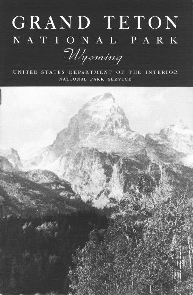
The great array of peaks which constitutes the scenic climax of this national park is one of the noblest in the world. It is alpine in the truest sense. Southwest of Jenny Lake is a culminating group of lofty peaks whose dominating figure is the Grand Teton, the famous mountain after which the park takes its name. The resemblance of this group, whose clustered, tapering spires tower aloft to a height of thousands of feet and are hung with never-melting snowfields, to a vast cathedral, must suggest itself to every observer.
However widely traveled, visitors viewing the Tetons for the first time confess that the beauty of this park and the rugged grandeur of its mountains come to them as a distinct revelation. This is amply proved by the increasingly large number of visitors who return summer after summer to spend their vacations in the Grand Teton National Park. The recreational possibilities of these mountains, they have found, are practically limitless. Here they may camp on the lakes, swim and fish, ride or hike the trails,[Pg 2] engage in the strenuous sport of mountaineering, or—if their needs and wishes so dictate—simply relax and rest.
The Grand, Middle, and South Tetons comprise the historic Trois Tetons, which were noted landmarks to the trappers and explorers of the early nineteenth century. The Three Tetons are seen to best advantage from the west and southwest. As the observer's viewpoint is shifted, the major peaks change greatly in outline and relative position, but despite this fact one soon learns to recognize each.
Eleven peaks are of such boldness and prominence that they receive rank as major peaks. In order of descending altitude they are: Grand Teton, 13,766 feet; Mount Owen, 12,922; Middle Teton, 12,798; Mount Moran 12,594; South Teton, 12,505; Mount Teewinot, 12,317; Buck Mountain, 11,923; Nez Perce, 11,900; Mount Woodring, 11,585; Mount Wister, 11,480; and Mount St. John, 11,412.
In addition to the 11 major peaks there are an even larger number of lesser prominence and altitude, such as Cloudveil Dome, 12,026 feet; Eagle Rest, 11,257; Prospectors Mountain, 11,231; Mount Rockchuck, 11,150; Table Mountain, 11,075; Bivouac Peak, 11,045; Rendezvous Peak, 10,924; Fossil Mountain, 10,912; Rolling Thunder, 10,902; Mount Hunt, 10,775; Symmetry Spire, 10,546; and Storm Point, 10,040, as well as a host of nameless pinnacles and crags which serve still further to make the Teton skyline the most jagged of any on the continent. The larger lakes of the park—Leigh, String, Jenny, Bradley, Taggart, and Phelps—all lie close to the foot of the range and, like beads, are linked together by the sparkling, tumbling waters of Cottonwood Creek and neighboring streams. Nestled in dense forests outside the mouths of canyons, these lakes mirror in their quiet depths nearby peaks whose pointed summits rise with sheer slopes a mile or more above their level.
Many of our national parks have been carved from wilderness areas previously little known to man and but seldom visited. The Tetons, on the contrary, are remarkably rich in historic associations. The Grand Teton itself has been referred to by an eminent historian as "the most noted historic summit of the West."
Up to the beginning of the last century Indians held undisputed sway over the country dominated by the Three Tetons. Then, as now, Jackson Hole was literally a happy hunting ground, and, while the severe winters precluded permanent habitation, during the milder seasons, bands of Indians frequently came into the basin on hunting or warring expeditions.[Pg 3] They represented many tribes, usually hostile to each other. The dreaded Blackfeet, the Crows, the Nez Perce, the Flatheads, the Shoshoni, and others. There is little reason to believe that these Indians ever invaded the more rugged portions of the Tetons, but it is certain they regularly crossed the range, utilizing the several passes.
The Tetons probably first became known to white men in 1807-8, when the intrepid John Colter crossed the range, presumably near Teton Pass on the memorable journey which also made him discoverer of the Yellowstone country. In 1811 the Astorians, under Wilson Price Hunt, entered Jackson Hole by the Hoback Canyon and, failing in an attempt to navigate the Snake River, likewise crossed the Teton Range in the vicinity of Teton Pass, continuing thence to the mouth of the Columbia, where the trading post, Astoria, was founded. The Tetons also figure in the adventures of the returning Astorians in 1812. In Washington Irving's classic account of the Astorian expedition (Astoria, published in 1836) the name "Tetons" first appears in literature.
The decades which follow may truly be referred to as "the Fur Era", for the Tetons became the center of remarkable activities on the part of fur trappers representing both British and American interests, the former by the Northwest and Hudson's Bay Companies, the latter by a succession of companies operating out of St. Louis, Mo. "It was the trio of peaks so distinctively presented from the west and southwest that made the Tetons famous as landmarks among the roving trappers who, guiding their courses by these easily recognized summits, singly or in groups passed over Teton Pass and through Pierres Hole in their seasonal migrations to and from their remote hunting grounds." Could these ancient monuments speak they would make known some of the most interesting events in the annals of the fur trade. For this was the paradise of the trapper. In every direction meandered the streams along which he pursued his trade, and nearby were the valleys where the rival companies gathered in annual conclave to fight the bloodless battles of their business. There is scarcely an acre of open country in sight of it that has not been the scene of forgotten struggles with the implacable Blackfeet, while far and near, in unknown graves, lie many obscure wanderers of whose lonely fate no record survives. Captain Bonneville, Father DeSmet, Rev. Samuel Parker, Jedediah Smith, Bridger, Kit Carson, David Jackson (after whom Jackson Hole and Jackson Lake were named), Sublette, Joe Meek—these are names to conjure with in western history. These and many others equally distinguished appear in the records of the Teton country, particularly in the third and fourth decades of the century. The 1832 rendezvous of the American trappers[Pg 4] was held in Teton Basin, then known as "Pierre's Hole", at the west base of the Tetons. It was attended by many of the most famous trappers of the time, and furnished occasion for the Battle of Pierre's Hole, a notable engagement between the trappers and Gros Ventres.
The picturesque name "Jackson Hole" dates back to 1829, in which year Capt. William Sublette so named it after his fellow trapper, David E. Jackson, who was especially partial to this beautiful valley. The term "hole" was used by the trappers of that period in much the same sense as is the word "basin" today, being applied to any mountain-girt valley.
In the 1840's the value of beaver skins declined and with it the fur trade. By 1845 the romantic trapper of "the Fur Era" had vanished from the Rockies—not, however, without having won for himself an imperishable place in American history. During the next four decades the valleys near the Tetons were largely deserted, except for wandering bands of Indians that still occasionally drifted in. But the frontier was relentlessly closing in, and one Government expedition after another passed through the Teton country or skirted its borders. Most important of these were the Hayden surveys, which in 1871, 1872, 1877, and 1878 sent parties into the region. The names of several members of the 1872 expedition are perpetuated in connection with Leigh, Jenny, Bradley, and Taggart Lakes. Orestes St. John, geologist with the 1877 Hayden party, and the great artist, Thomas Moran, who in 1879 went with a military escort to paint the Tetons, are similarly remembered in the names of two of the principal peaks. To this transition period also belong the earliest prospectors of Jackson Hole, as well as several famous big-game hunters who came here in search of trophies—forerunners of the hundreds of hunters who now annually invade this region.
In the middle eighties came the first settlers. They entered by the Gros Ventre River and Teton Pass, and to begin with naturally settled in the south end of the hole. Here as elsewhere the story of the homesteader has been one of isolation, privations, and hardships, met, however, with persistency and indomitable courage. Nor is the story confined to the past, for maintaining a livelihood amongst these mountains still calls for resourcefulness, fortitude, and—not infrequently—even heroism.
History, here, is still in the making. Teton Forest Reserve was not created until 1897; the railroad reached Victor in 1912; the Jackson Lake Dam was finished in 1914; many of the roads and bridges of the region were constructed within the past decade; and the Grand Teton National Park was created in 1929. The detailed exploration of the range and the conquest of its high peaks have taken place in relatively recent years, and since 1929 trails have been built which for the first time make the Tetons really accessible to the public.
In later paragraphs will be found an account of the mountaineering history of the Tetons. And so the dramatic human story of these mountains is brought down to the present.
On the Jackson Hole side the Teton Range presents one of the most precipitous mountain fronts on the continent. Except for Teton Pass, at its southern end, the range is practically an insuperable barrier. Forty miles in length, it springs abruptly from Jackson Hole and only a few miles west of its base attains elevations of more than 13,000 feet above the sea. Thus most of the range is lifted above timber line into the realm of perpetual snow, and in its deeper recesses small glaciers still linger. The grandeur of the beetling gray crags, sheer precipices, and perennial snow fields, is vastly enhanced on this side by the total absence of foothills and by contrast with the relatively flat floor of Jackson Hole, from which they are usually viewed.
The Teton Range may be described as a long block of the earth that has been broken and uplifted along its eastern margin, thus being tilted westward. Movement of this sort along a fracture is what the geologist terms "faulting." The total amount of uplift along the eastern edge of the block amounts to more than 10,000 feet. Doubtless this uplift was accomplished not by one cataclysm but by a series of small faulting movements distributed over a very long period. Probably the time of faulting was as remote as the middle of the Tertiary period (the period just before the Ice Age, the latest chapter of the earth's history).
Very impressive is the contrast between the east and west sides of the Teton Range. From the east, the Jackson Hole side, one views the precipitous side of the mountain block as it has been exposed by uplift and erosion. From the west, the Idaho side, is seen the broad top of the block, which is gently inclined toward the west. In the eastern front, furthermore, one sees the ancient, deep-seated crystalline rocks (gneiss, schist, and pegmatite) belonging to the earliest known geologic eras, the pre-Cambrian. In places on the top of the block, at the head of Death and Avalanche Canyons, for example, are seen the inclined layers of limestone, quartzite, and shale belonging to the less ancient Paleozoic era. These layers formerly covered the entire block, but they have been worn away from half of the area, thus exposing the underlying crystallines. The west and north flanks of the range are overlapped by relatively young beds of lava that are continuous with those covering eastern Idaho and the Yellowstone plateaus.
Jackson Hole, which adjoins the park on the southeast, is one of the most sequestered valleys in the Rockies, encompassed on all sides as it is by mountain barriers. It is 48 miles long, for the most part 6 to 8 miles wide, and embraces an area of more than 400 square miles. The floor of the valley slopes from an altitude of 7,000 feet at the north end to 6,000 at the south. Jackson Hole lies a few miles west of the Continental Divide, and occupies the central portion of the headwaters area of the Snake River. Mountain streams converge radially toward it from the surrounding highlands, and the Snake River receives these as it flows through the valley.
Jackson Hole has largely been excavated by the Snake River and its tributaries from the shale formations which once extended over the region to a depth of several thousand feet. Rocks surrounding the region, being more resistant, were reduced less rapidly and therefore have been left standing in relief as highlands.
Here, as in several other national parks, the glaciers of the Ice Age, known to the geologist as the Pleistocene period, played a leading role in developing the extraordinary scenic features. Just as the streams now converge toward Jackson Hole, so in ages past glaciers moved down toward, and in many instances into, the basin from the highlands to the east, north, and west. Detailed study has shown that the Ice Age was not a single, simple episode, but is divisible into "stages"—glacial stages, during which extensive ice fields formed, and interglacial stages, during which these were largely or wholly withdrawn. The duration of each is to be thought of in terms of tens of thousands of years. In Jackson Hole, three glacial and two interglacial stages have been recognized. Only the most recent glacial stage need concern us here, the other two having occurred so long ago that their records are much obscured.
This stage ended but yesterday, geologically speaking, and to it is due much of the grandeur of the region. In the Teton Range every canyon from Phillips northward contained a glacier, and many of these reached eastward to the base of the range where they spread widely upon the floor of Jackson Hole. Where Jackson Lake now is there lay a great, sluggish field of ice resulting from the confluence of adjacent alpine glaciers.[Pg 9]
Moraines, outwash plains, and lakes are easily recognizable features that originated during the latest glacial stages, and most of the peaks and canyons were greatly modified.
Moraines are deposits of debris, piled up by the ice itself. Such are the heavily wooded, hummocky embankments which rest along the base of the mountains from Granite Canyon northward, rising in some cases 200 or 300 feet above the floor of Jackson Hole and heaped with enormous boulders quarried by the ice far back in the range.
With two exceptions each of the large moraines incloses a lake. In this way Phelps, Taggart, Bradley, Jenny, Leigh, and Jackson Lakes originated; all ranged along the western border of Jackson Hole. No lakes were formed along the eastern border, inasmuch as on this side no glaciers extended beyond their canyons. String Lake is dammed in part by a gravel fill.
Outwash plains are the deposits formed by streams which, during the Ice Age, issued from the glaciers. Of this origin are the broad, cobble-strewn flats, usually overgrown with sage, which cover the floor of Jackson Hole. They are diversified by bars, abandoned stream channels, terraces and "pitted plains", features of exceptional interest to one who examines them in detail. Several isolated buttes—Signal, Blacktail, and the Gros Ventre Buttes—rise like islands a thousand feet or more above these flats.
Each canyon gives evidence of the vigor with which the glacier it once contained gouged out its channel. In many places the rock of the broad floors and steep sides is still remarkably polished. Every canyon leads up to one or more amphitheaters, or cirques, with sheer bare walls hundreds of feet high. Tracing these ice-gouged canyons headward one will discover many rock-rimmed lakelets, some hung on precipitous mountain sides where one might be pardoned for asserting that no lake could possibly exist.
An unbroken wilderness a few years ago, the Grand Teton National Park is now penetrated by some of the finest trails in the national-park system. These trails, suitable alike for travel afoot or on saddle horses, are 3 to 4 feet wide, free of boulders, and of grade so moderate they may be followed by old or young with full safety and a minimum of physical exertion. While the trails are traversable during the greater part of the summer, some of them may be blocked by snow early in the season. Those visitors expecting to climb the high trails should inquire at park headquarters or the office at the museum at Jenny Lake for information regarding the condition of the high trails.
The Lakes Trail runs parallel to the mountains, following closely the base of the range and skirting the shore of each large body of water from Leigh Lake at the north to Phelps Lake at the south. It makes accessible the most important lakes, canyons, and peaks of the park, and is naturally[Pg 11] the one from which all expeditions into the range begin. One can encircle by trail either Jenny Lake or String Lake, the hike around the former being one of the most popular in the park.
The Canyon Trails described below are spur trails extending westward from the Lakes Trail, back into the most rugged areas in the Teton Range. Intervening canyons have been left in their splendid wildness.
The Teton Glacier Trail extends up the east slope of the Grand Teton to two alpine lakes, Surprise and Amphitheater, at altitudes close to 10,000 feet. By means of the 17 switchbacks on this trail the hiker or horseman climbs to a point on the face of the Grand Teton, 3,000 feet above the floor of the valley, throughout this ascent enjoying matchless panoramas of the entire Jackson Hole country, and witnesses a view extending eastward 80 miles to the Wind River Mountains, whose peaks and glaciers are sharply outlined against the horizon. Amphitheater Lake, at the end of the trail, occupies a protected glacial cirque and is the starting point for Teton Glacier, the most accessible of the ice fields, three-fourths of a mile northwest from the end of the trail. Though seasoned hikers make the climb from Jenny Lake to the glacier by way of this trail, one can, if he chooses, take horses as far as Amphitheater Lake, and continue on foot with a guide over to the glacier.
The Indian Paintbrush Trail starts near the outlet of Leigh Lake and follows up the bottom of Indian Paintbrush Canyon to connect with the Cascade Canyon Trail by way of Lake Solitude, a lakelet of rarest beauty at timber line near the head of the north fork of Cascade Canyon. The wealth of wild flowers along this trail gives name to the canyon, and early or late in the day one may see big game, especially moose, near the lakes and swamps. This trail affords superb views of Jackson and Leigh Lakes eastward beyond the mouth of the canyon, and westward along the Divide glimpses of snowclad ridges and peaks.
The Cascade Canyon Trail passes through a chasm whose walls rise sheer on either side for thousands of feet. By this trail one penetrates into the deepest recesses of the Tetons. It skirts the base of several of the noblest peaks, Teewinot, Mount Owen, Table Mountain, and the Three Tetons, and it enables one to see these titans not only at close range but from new and impressive angles. Lake Solitude may be reached by means of this trail, by taking the Cascade Canyon-Indian Paintbrush loop trail leading up the north fork of Cascade Canyon.
The Death Canyon Trail traverses the full length of a canyon which in its lower portion is of profound depth and grandeur, as awesome as its name, but which above opens into broad, sunny meadows. No canyon better illustrates the difference between the rugged, alpine landscapes developed in the crystalline rock of the Teton east border and the softer contours formed in the sedimentary strata to the west, near the Divide.
The Skyline Trail is that portion of the trail system which connects the Indian Paintbrush, Cascade Canyon, and Death Canyon Trails. Following down the north fork, then up the south fork of Cascade Canyon, it crosses the head of Avalanche Canyon to Alaska Basin, in the western watershed of the Tetons, thence over a high saddle on Buck Mountain and down a series of switchbacks to join the Death Canyon Trail. This trail takes the hiker, or rider, through alpine meadows to rugged cliffs and ledges above timber line from which can be viewed to the westward the valleys and mountains of Idaho, as well as the Wyoming country to the east as far as the Wind River Range. In traversing this loop one completely encircles the three Tetons and adjacent high peaks, viewing them from all sides, and learns to know them with an intimacy impossible to the visitor who contents himself with distant views.
Among American climbers no range enjoys higher rank than the Tetons, and its growing fame abroad is evidenced by increasingly large numbers of foreign mountaineers who come here to climb. Leading mountaineers unhesitatingly rank many of the Teton climbs with the best in the Alps and other world-famous climbing centers. Though the majority of climbs must be considered difficult even for mountaineers of skill and wide experience, there are several peaks, notably the Middle Teton, South Teton, and Mount Woodring, which have relatively easy routes that may be safely followed by anyone of average strength.
Although the conquest of the Tetons has largely been accomplished within the decade just closed, the beginnings of mountaineering go back nearly a century. Naturally the Grand Teton was first to be challenged and the Wyoming historian, Coutant, records that in 1843 a French explorer, Michaud, with a well-organized party, attempted its ascent but was stopped short of the summit by unscalable cliffs. It is possible that even earlier white men—trappers and explorers—matched their strength and strategy against this peak or others in the Tetons, but if so their efforts have gone unrecorded. From the period of the Hayden surveys in the seventies, accounts of several attempts have come down to us, and one party, consisting of N. P. Langford and James Stevenson, purported to have reached the summit on July 29, 1872. This claim to first ascent has[Pg 14] been generally discredited because of the serious discrepancies between Langford's published account and the actual conditions on the peak as now known. In 1891 and again in 1897 William O. Owen, pioneer Wyoming surveyor, headed attempts to reach the summit which likewise failed. Finally in 1898 a party sponsored by the Rocky Mountain Club, of Colorado, and comprising Owen, Bishop Franklin S. Spalding, John Shive, and Frank Petersen, on August 11 discovered the traverse which, 700 feet beneath the summit, leads around the northwest face and so opens up a clear route to the top.
The conquest of the Grand Teton achieved, public interest waned and a quarter century elapsed before the peak was again scaled. In 1923 two parties retraced the route of 1898, and each year thereafter numerous ascents have been made. In recent years as many as 30 to 40 parties have climbed the peak each summer.
Repeated efforts were made to achieve the summit of the Grand Teton by routes other than the traditional one, and in 1929 one of these resulted in a successful ascent of the east ridge by Kenneth A. Henderson and Robert L. M. Underhill. In 1931 no less than three additional routes were discovered: the southwest ridge was climbed by Glenn Exum; the southeast ridge by Underhill, Phil Smith, and Frank Truslow; and the north face by Underhill and Fritiof Fryxell. In 1936 a second route up the extremely hazardous north face was established by Paul and Eldon Petzoldt and Jack Durrance. Thus, six wholly distinct routes have been employed on this mountain, though only the traditional route and possibly the southwest ridge can be recommended to any except most expert alpinists.
Within the last decade other peaks in the range have come in for more and more attention. This they richly deserve, since from both a scenic and mountaineering standpoint many of them are worthy peers of the Grand Teton itself. Mount Moran, Mount Owen, Teewinot, Nez Perce, and the Middle Teton comprise a mountain assemblage which, for nobility of form and grandeur, would be difficult to equal anywhere.
So far as known, Buck Mountain, most southerly of the "Matterhorn peaks", was the first major peak in the range to be scaled, the ascent being made early in 1898 by the topographical party of T. M. Bannon. Thereafter no important ascents were made until 1919, when LeRoy Jeffers scaled the lower summit of Mount Moran. The main summit of this peak was first climbed in 1922 by L. H. Hardy, Ben C. Rich, and Bennet McNulty. In 1923 A. R. Ellingwood climbed both the Middle and South Tetons on the same day, on the South Teton being accompanied by Eleanor Davis. In 1928 Mount Wister was climbed by Phil Smith and[Pg 16] Oliver Zierlein; in 1929 Teewinot and Mount St. John by Fryxell and Smith; in 1930 Nez Perce by Fryxell and Smith; and Mount Owen by Underhill, Henderson, Fryxell, and Smith. With the ascent of Mount Owen the conquest of the major peaks, begun so many years before, was at length completed.
In the meantime the minor peaks were by no means neglected, the first ascents being made principally since 1929 by the climbers whose names have already been mentioned. As in the case of the Grand Teton, a variety of routes have been worked out on almost all of the major and minor peaks. Between 1929 and 1931 the important summits of the range were equipped with standard Government register tubes and register books, in which climbers may enter records of their ascents. The story of the conquest of the Tetons is told in a book entitled "The Teton Peaks and Their Ascents." (See Bibliography.)
Since 1931 authorized guide service has been available in the park. In view of the difficulties one encounters on the Teton peaks and the hazards they present, prospective climbers—especially if inexperienced—are urged to make use of the guide service. If venturing out unguided, climbers[Pg 17] should under all circumstances consult rangers or guides for full information relative to routes and equipment. Failure to heed this caution has, in the past, led to accidents and even fatalities. Climbing parties are required, under all circumstances, to report at either park headquarters or Jenny Lake Ranger Station before and after each expedition, whether guided or unguided. Climbing alone, without a companion, is absolutely prohibited.
The climbing season varies with the amount of snow in the range and the character of the weather, but ordinarily it extends from the middle of June to the end of September, being at its best during July, August, and early September. In most cases it is advisable to allow 2 days for an ascent of the Grand Teton, Mount Owen, or Mount Moran, and one day for the other major peaks. Jenny Lake Campground is the logical outfitting point for most expeditions; it is close to the peaks and the sources of supply as well. For most ascents the usual alpine equipment—ice axes, rope, and hobbed boots or climbing shoes—is essential. In the case of guided parties arrangements for renting equipment may be made with the guides.
For a great many years Jackson Hole has been famed for its big game, and to those who wish to see wild animals the expenditure of a little time in favorable localities usually will reveal them.
The visitor should not be disappointed if he does not see animals from his automobile as he drives through the park. In most cases the roads have been built so as to avoid going through localities inhabited by wildlife for fear of frightening it and driving it away.
Within the actual confines of the park, Shiras' moose is the most common big game animal, and it is frequently seen in the smaller ponds and marshy meadows. Though the moose is the largest member of the deer family, it is not as wary as the deer and is comparatively easy to see.
Mule deer are increasing in the park, as well as in the rest of Jackson Hole. Though quite shy, they are often seen along the many miles of trail which are accessible to both rider and hiker.
The elk, or wapati, have been the most important of the big game animals in Jackson Hole, at least since the occupancy of white men; and they have done much to make the valley known to the world. Their history constitutes one of the most interesting chapters in the story of the valley. Not many years ago as the winter range of the elk was more and more taken up by the cattleman and rancher, depriving the elk of the areas where they might find winter forage not too deeply covered by winter snow, it became apparent that something must be done to save these magnificent animals.[Pg 18] Toward this end a Government ranch was established near the town of Jackson, where the elk could be fed during the winter months. The preservation of the Jackson Hole elk herd is now assured.
In the spring elk leave the low country and the Government feed grounds and move toward the high country in Yellowstone Park and south of it, on Big Game Ridge, the Thorofare Plateau, and in the mountains east of Jackson Hole. A small herd summers in the north end of the Teton Range. With snowfall in the high country, the elk again move down until by November or December they are back on the feed grounds.
A small herd of bighorns, or Rocky Mountain sheep, ranges in the Teton Mountains. Large numbers of bighorns are found, however, in the mountains east and south of Jackson Hole.
In the park there are many smaller mammals, among them the marmot, or "rockchuck", whose shrill whistling makes his presence known at all altitudes from the valley floor to the peak summits. Marmots make interesting pets, and tame ones are not uncommon. Like bears, marmots hibernate through the winter.
Conies (pikas) are common throughout the rock slides, where these little animals find numerous refuges. They are guinea-piglike creatures, usually grayish in color and 7 or 8 inches long. In the rock slides one may find the little hay piles which they make of the plants growing nearby. Though very little is known concerning the winter habits of these alpine animals, it is probable that they do not hibernate but during the winter live on their stored hay and what additional food is to be found under the snow.
Bears are found only in the mountains and canyons of the park. They do not invade the campgrounds.
That most interesting of smaller mammals, the beaver, is common, and it is not difficult to find the houses and dams which they have built. In the campgrounds are pine squirrels, chipmunks, ground squirrels, and mice. Mink, marten, otter, weasels, coyotes, badgers, fox, and lynx also are found in the park.
The Grand Teton National Park offers much to the bird student. Though the region is old in history, it is new in possibilities of avian observation, and the seeker finds types from those which inhabit the arid sagebrush plains to those which spend their lives in the frigid atmosphere far above timber line.
In number, there are more than 100 species, a variety which will keep any ornithologist busy for as long as his stay permits. A list of 93 species was made during June and July 1933, and at least 3 more species were added in 1934. Many of these are easily studied within a few hundred yards of the Jenny Lake Ranger Station.
In several respects the flora of the Tetons is unique. The high mountains have constituted a barrier to plant migration which many forms could not cross; hence the range limit of a number of plants is found here. Representatives from north, south, east, and west are found in this general region, this being the limit, in many instances, of their distribution. There are many plants typical of the central Rockies, and a few known only to this range. Five life zones are recognized within the park, all occurring in a distance of less than 15 miles. Plants migrating from other regions have grown equally well in each zone.
The flowering period begins in the park as soon as the ridges and flats are free of snow in May, and it continues until about August 15 in the Arctic-Alpine Zone. Hence, plants of at least one zone and usually of several may be seen blooming at any time in the spring or summer.
The evergreen trees form an appropriate frame for the majestic Teton peaks and are reflected in the beautiful lakes which they encircle.
Lodgepole pine is the most common tree, covering the floor of the valley and extending up the mountains to about 8,000 feet. The pines may be easily distinguished from the other evergreens by the long slender needles occurring in bundles. Lodgepole has two needles in each bundle. Trees of this species were extensively used by the Indians for lodge poles.
Whitebark pine is the tree of timber line; the occasional specimens found at a lower elevation are usually dwarfed. Needles occur five in each bundle; cones 2 to 3 inches long and almost ovate; the tree is much-branched and of medium size.
Douglas tree has been called "Douglas spruce", "Douglas fir", and "red fir"; however, it is neither a spruce nor a fir but is worthy of separate distinction. One needle; cones 2 to 4 inches long; a three-lobed bract projects from beneath each scale of the cone, a very distinctive character; common at middle elevations.
Alpine fir grows from the base of the mountains to timber line; at high altitudes it is dwarfed and sprawling. One needle, flat; cones 2 to 3 inches long, scales paper-like; tree usually pyramidal and beautifully symmetrical.
Engelmann spruce is the largest tree in the park, and is usually found growing in moist places and near the lakes and streams. One needle, square in cross section, stiff and sharp; cones 2 to 3 inches long, scales papery.
Blue spruce is not common and is found only in the Snake River bottoms. The form found here is not typical, lacking the blue cast. One needle, square in cross section, stiff and sharp; cones 3 to 5 inches long, scales papery.
Creeping juniper is not common. It is a prostrate form, lacking definite trunk. Leaves awllike, one-half inch long or less, stiff and sharp, spreading from the twigs; fruit, berrylike.
Aspen is the most common deciduous tree of the valley, growing on the slopes up to about 8,000 feet. The leaves are on very slender stalks and the slightest breeze puts them into motion, hence the popular names "Quaking asp" and "Quaking aspen." Leaves rounded, 1 to 3 inches broad, with a slender stalk of about the same length; bark smooth and whitish.
Balsam poplar is found along some of the stream banks and is the largest deciduous tree of the park. Leaves about 3 inches long and 2 inches broad, longer than the stalk; bark smooth on the young trees, becoming rough as the trees get older. The small seed pods contain many seeds, to each of which is attached a tuft of white hair or "cotton"; hence one of the common names, "Cottonwood."
At Jenny Lake is located the park museum, which also serves as the ranger station. In it are housed exhibits pertaining to the history, geology, fauna, and flora of the Teton-Jackson Hole country. The collection devoted to mountaineering is in many respects unique. Adjacent to the museum is an open-air amphitheater where campfire talks on geology, wildlife, and other subjects related to the park are given every evening at dusk by a ranger-naturalist. A nature walk, auto caravan, or all-day hike is conducted each day by a member of the ranger-naturalist staff.
An information desk is maintained at the museum, and rangers are there at all hours of the day to answer inquiries. Information service is also maintained at park headquarters.
Grand Teton Park offers splendid opportunities for fishing. Fish may be taken with the artificial fly during most of the summer, but the lake or mackinaw trout which are present in Jackson and Jenny Lakes must be lured with bait and caught with heavy tackle by means of trolling. Other species of trout in park waters are the cutthroat (also known as native, red-throat, and blackspotted) and the brook or speckled trout. The park waters are being stocked through the cooperation of the United States Bureau of Fisheries. A Wyoming fishing license, costing $1.50 for State residents and $3 for nonresidents, is required. For $1.50, however, nonresidents may secure a 5-day fishing permit.
Jenny and Leigh Lakes offer opportunities for those who enjoy lake bathing. A small beach of clean white sand at the end of the Leigh Lake Road is especially frequented by bathers.
Jackson Hole has long been a noted hunting country, and under Wyoming laws elk, deer, sheep, moose, and bear may be hunted in the mountains east and south of Jackson Hole. Parties interested in hunting should consult the local game warden or the State Fish and Game Department at Cheyenne, Wyo., for information as to licenses and seasons.
No hunting is permitted in the Grand Teton National Park, which, of course, will always be a complete sanctuary for wildlife.
The trail of the summer vacationist has deviated during the last decade from the old familiar courses to embrace vast areas in Wyoming and Montana. A veritable invasion of eastern tourists, known in the parlance of men of the range as "dudes", has followed the opening up by modern transportation of this beautiful country.
Located in the mountainous regions of these two far western States, on the last frontier, are the dude ranches, in the mouths of canyons, among foothills, or in clearings in the forest. These ranches are not pretentious places, but are rustic and unique. Their popularity began in 1904, when[Pg 24] Howard, Willis, and Alden Eaton established the now famous Eaton Brothers' "Dude Ranch" at Wolf, Wyo.
Many of these ranches are situated in territory within easy access to the Grand Teton Park. A complete list may be obtained by addressing the Dude Ranchers' Association, Billings, Mont.
The representative of the National Park Service in immediate charge of the park is Thomas E. Whitcraft, superintendent, with office at park headquarters; address, Moose, Wyo.
The Grand Teton National Park is reached by automobile from the north, south, east, and west. Each of these approaches is highly scenic in character affording splendid distant views of the Teton Range and Jackson Hole. United States Highway No. 287 connects Jackson Hole with Yellowstone Park and is the north approach to the Teton Park. One mile north of Moran the traveler reaches United States Highway No. 187 which traverses Jackson Hole and makes the park accessible. From the east United States Highway No. 287, known as the Atlantic-Yellowstone-Pacific Highway, enters Jackson Hole through Togwotee Pass, altitude 9,658 feet, and the Buffalo Fork of the Snake River, joining the road from Yellowstone Park, 1 mile north of Moran. The south road enters Jackson Hole via Hoback Canyon. This is an improved highway (US 187) leaving Rock Springs, Wyo., on the Lincoln Highway. United States Highway No. 89 leading to Kemmerer, Wyo., connects with United States Highway No. 187 at Daniel, Wyo. The western approach road from Idaho, via Teton Pass, to Wilson and Jackson crosses the Teton Range at an altitude of 8,431 feet. This road connects with the West Yellowstone-Salt Lake City Highway (U S 191) at Sugar City, Idaho, or by traveling via Pine Creek Pass and Swan Valley, at Idaho Falls.
At the present time parties may reach the Grand Teton National Park by using rail lines to several gateways. The Union Pacific System has its nearest terminal at Victor, Idaho. It operates daily trains to and from Victor in the tourist season, and there is bus service from the rail terminus to Jackson, Grand Teton National Park, and Moran. Union Pacific passengers upon leaving the train at Rock Springs, Wyo., may make connections[Pg 25] with the mail stage which leaves daily except Sunday to the Teton region, by way of Hoback Canyon.
For many years the Yellowstone Park Transportation Co. has operated daily bus service between Old Faithful and Moran. It makes connections at Old Faithful, which enable passengers coming to Yellowstone Park via the Union Pacific (West Yellowstone Gateway), Northern Pacific (Gardiner Gateway), Chicago, Burlington & Quincy (Cody Gateway), and Chicago, Milwaukee, St. Paul and Pacific (Gallatin Gateway), to reach the Grand Teton National Park.
United Air Lines in its transcontinental route from New York to San Francisco has a stop at Rock Springs, Wyo., which makes available for persons of limited time an opportunity to visit the park.
A mail stage leaves Rock Springs daily, except Sunday, for Grand Teton National Park via the Hoback Canyon.
National Park Airways, connecting with United Air Lines at Salt Lake City, operates daily during the summer season via Idaho Falls and West Yellowstone to Butte and Great Falls, Mont.
The Grand Teton National Park is located in the interior of a vast mountain region, and its avenues of approach are, of necessity, through canyons and passes. These approaches are themselves of great interest and beauty, and afford magnificent distant views of the Teton Range. The country traversed is rich in associations of the Old West and contains numerous historic shrines which deserve the attention of the passing traveler.
The north approach, from Yellowstone Park by United States Highway No. 287, passes over the Continental Divide just a few miles south of West Thumb, and in leaving the Yellowstone Plateau follows the course of Lewis River. In the dense forests along this wilderness stream there are opportunities to see big game, such as elk, deer, moose, and bears. Descending into Jackson Hole, the highway skirts the east shore of Jackson Lake, and the view of the distant Tetons, rising from the far shore of the lake, is one the traveler will not soon forget. At this distance they glisten in delicate blue and white, so sharp they seem actually to bristle.
The west approach, from Salt Lake City and points farther west, leaves United States Highways Nos. 91 and 191 at Idaho Falls or Sugar City, Idaho, traverses historic Teton Basin, the "Pierres Hole" of the early trappers, and passes over Teton Pass, elevation 8,429 feet, to the town of[Pg 26] Jackson, which lies in the south end of Jackson Hole about 15 miles south of Teton Park headquarters. This approach is the only one from which the three Tetons, noted landmarks of a century ago, stand out prominently, and the view of this trio is highly impressive. No less spectacular is the panorama of Jackson Hole revealed as one reaches the summit of Teton Pass. Undoubtedly the Teton Pass view is the finest to be had of this basin from any point on the highways.
The south approach, from Evanston, Kemmerer, Rock Springs, and other towns in southern Wyoming, follows United States Highway No. 187 or US 89, and avoids all high mountain passes, entering Jackson Hole by way of the Hoback Canyon. This road does not open up glimpses of the Tetons until one is well into Jackson Hole, but it affords excellent views of the snow-clad Wind River Range. Strung along its course is a series of interesting monuments marking such historic spots as the site of Fort Bonneville, founded in 1832; the location of the fur trappers' rendezvous of 1824; the grave of John Hoback, guide to the early expedition known as "the Astorians"; and similar interesting places. At a point called "Names Hill", between Kemmerer and Tulsa, Wyo., can be seen names and dates as old as the 1820's carved in sandstone by the early trappers and travelers in this region.
The east approach, from the Black Hills, Casper, and points farther east, crosses the Wind River Range into Jackson Hole over the Continental Divide at Togwotee Pass, on United States Highway No. 287. If so desired, in driving from Casper to Lander one can choose the modern road which retraces part of the Oregon Trail, past such famous landmarks on the old trail as Independence Rock, Devils Gate, Muddy Gap, Whiskey Gap, and Split Rock. From Lander or Riverton a visit to the Shoshone Indian Reservation can be made with little increase of mileage. The approach to Togwotee Pass from either side is surprisingly fine, and the view of the Tetons from points just west of this pass is one of the finest obtainable. For boldness and jaggedness of skyline the Tetons thus seen from a distance of 40 miles have no rival anywhere.
There are no hotels or lodges within the park, but these accommodations are available nearby at Jackson and Moran at reasonable rates. Dude ranches and cabin camps near the park also offer suitable accommodations at reasonable rates. The National Park Service has no control over these enterprises.
There is a modern, well-developed campground at Jenny Lake. This camp is supplied with running water, sanitary facilities, and cooking grates. There are also many camping sites away from the main campground, suitable for overnight stops for pack outfits. Supplies, including fishing tackle, may be procured at Jenny Lake, Moose, Jackson, or Moran.
Grand Teton is primarily a saddle horse park. Access to the interior of the park is possible only by trails, as no highways have been built or are planned.
At the south end of Jenny Lake, near the ranger station, there is maintained an excellent string of saddle and pack horses with good equipment for short or long trips. One may rent saddle horses without guides, but only to ride over well-defined trails in designated areas. Discretion as to the ability of patrons to ride, or to go unguided, rests with the operator. Saddle-horse trips to special points of interest, such as Teton Glacier, are made daily at reasonable rates. Pack trips to any part of the park or surrounding country, with guide, cook, and complete camping equipment may be taken if arrangements are made in advance.
At the south end of Jenny Lake also, D. Kenneth Reimers maintains motorboat and rowboat service. Four or more persons may make a trip around Jenny Lake for 50 cents each. Rowboats may be rented for 50 cents an hour or $2 a day. Motorboats, with a driver, are $2 an hour, $1.50 each additional hour, and $10 a day; without a driver, $1.50 an hour, and $6 a day.
The authorized official guide for mountain-climbing trips in Grand Teton National Park is Paul Petzoldt. He maintains summer headquarters at Jenny Lake, and charges $8 a day, a person, for his services. Climbers may provide their own food or have their meals at $2 each at a timber line camp. Blankets and eiderdown sleeping bags may be rented for $2.
The Crandall Studios maintain up-to-date picture shops at Jenny Lake and Moran. Photographs of the Teton Mountains and the surrounding country in all sizes and styles, as well as hand-painted enlargements, paintings, moving pictures, and souvenir postcards, are on sale. Laboratories in the park are maintained for developing, printing, and enlarging photographs.
This booklet is issued once a year, and the rates mentioned herein may have changed slightly since issuance, but the latest rates approved by the Secretary of the Interior are on file with the superintendent and the park operators.
Regular bus service is maintained between Yellowstone and Moran Wyo.; also from Moran to Victor, Idaho, via Grand Teton National Park. Inquire at any concentration point about rates and schedules.
Albright, Horace M., and Taylor, Frank J. Oh, Ranger! A book about the national parks. Illustrated.
Burt, Struthers. Diary of a Dude Wrangler. Charles Scribner's Sons, 1924. 331 pages.
Fryxell, Fritiof. The Grand Tetons, Our National Park of Matterhorns. American Forests and Forest Life, National Parks Number (August 1929). Pages 453-456.
Wister, Owen. The Virginian. Macmillan Co., 1902. 506 pages. (The setting for portions of this famous novel is taken from the Teton-Jackson Hole region.)
Yard, Robert Sterling. The Book of our National Parks. Charles Scribner's Sons, 1928. Illustrated. The Tetons on pages 227-228.
Alter, J. Cecil. James Bridger. Shepard Book Co., Salt Lake City, 1925.
Chittenden, Brig. Gen. Hiram Martin. The Yellowstone National Park. Stanford University Press, 1933 (fourth edition). Illustrated. 286 pages. The standard history of the Yellowstone region. History of the American Fur Trade of the Far West. 3 volumes. New York, 1902.
Coutant, C. G. History of Wyoming. Volume 1. Laramie, Wyo., 1899. 712 pages. (This volume, the only one issued, contains scattered references to the region.)
Dale, Harrison C. The Ashley-Smith Explorations. Arthur H. Clark Co., Cleveland, 1918.
Fryxell, Fritiof. The Story of Deadman's Bar. Annals of Wyoming, volume 5 (June 1929). Pages 128-148.
Irving, Washington:
Astoria, or Anecdotes of an Enterprise Beyond the Rocky Mountains. New York, 1836. (This classic work contains the earliest known use of the name "Tetons.")
Adventures of Captain Bonneville. New York, 1837. (An important early work containing many references to the region.)
Jackson, William H.:
The Pioneer Photographer. World Book Co., 1929. The Tetons on pages 123-141. 314 pages. (An account of the Hayden surveys in the Teton Region.)
Address Regarding the First Photographing of the Tetons. Prepared for the Dedication of the Grand Teton National Park. Annals of Wyoming, volume 6 (July-October, 1929). Pages 189-191.
Parker, Rev. Samuel. Journal of an Exploring Tour Beyond the Rocky Mountains Andrus, Woodruff, and Gauntlett, Ithaca, New York (4 editions), 1844.
Stone, Elizabeth A. Uinta County, its Place in History.
Vinton, Stallo. John Colter, Discoverer of Yellowstone Park. Edward Eberstadt, publisher, 1926. 114 pages. (Ch. 11, pp. 43-63, is a discussion of the probable crossing of the Teton Range by John Colter in 1807.)
Bradley, Frank H. (Geological.) Report of Snake River Division. In Sixth Annual Report of the U. S. Geological Survey of the Territories (Hayden Surveys of 1872). Washington, 1873. Pages 217-223, 261-271.
Brandegee, T. C. Teton Forest Reserve. In Nineteenth Annual Report, U. S. Geological Survey (for 1898), part V, Washington, 1899. Pages 191-212.
Carey, Merritt. Life Zone Investigations in Wyoming. North American Fauna No. 42, Biological Survey, U. S. Department of Agriculture. Washington, 1917. 95 pages.
Fryxell, Fritiof:
Glacial Features of Jackson Hole, Wyo. Published by Augustana College, Rock Island, Ill., 1930. Illustrated. 128 pages.
Glacial Studies in the Tetons. Journal of Geology, Vol. XLI (1930), pp. 642-646 and 737-747; Vol. XLIII (1935).
Iddings, J. P., and Weed, W. H. Descriptive Geology of the Northern End of the Teton Range. Chapter IV (pp. 149-164) of Monograph XXXII, part II, Geology of the Yellowstone National Park. U. S. Geological Survey, Washington, 1899. 893 pages.
Preble, Edward A. Report on Condition of Elk in Jackson Hole, Wyo., in 1911. Bulletin No. 40, Biological Survey, U. S. Department of Agriculture. Washington, 1911. 23 pages.
Sheldon, Charles. The Conservation of the Elk of Jackson Hole, Wyo. Elk Commission Report. Washington, 1927. 36 pages.
St. John, Orestes. Report of the Geological Field Work of the Teton Division. In Eleventh Annual Report of the U. S. Geological Survey of the Territories (Hayden Surveys of 1877). Washington, 1879. Pages 321-508.
The mountaineering literature on the Teton Range is voluminous and only a few references are cited here. For other articles see the files of Trail and Timberline, Bulletin of the Sierra Club, Appalachia, American Alpine Journal, Canadian Alpine Journal, etc.
Ellingwood, A. R. Our American Matterhorn. Outdoor Life, volume 54 (1924). Pages 181-186.
Fryxell, Fritiof:
The Teton Peaks and Their Ascents. Crandall Studios, Jenny Lake, Wyo., 1932. 106 pages. Illustrated (including map). (A history of mountaineering in the Tetons up to 1931, inclusive. Summarizes the known routes up each peak. Bibliography.)
The Ascent of Mount Owen. American Alpine Journal, 1931, pages 320-326.
Henderson, Kenneth A. The Grand Teton. American Alpine Journal, 1930. Pages 138-139.
Owen, William O. Ascent of the Grand Teton. Outing, volume 38 (1901). Pages 302-307.
Underhill, Robert L. M.:
The Grand Teton by the East Ridge. The Alpine Journal (London), November 1930. Pages 267-277.
Two New Routes Up the Grand Teton. The Canadian Alpine Journal, 1931. Pages 72-86.
Motorist Guide Map of Yellowstone National Park. Shows roads, campgrounds, lodges, and hotels, and gives condensed information about Yellowstone National Park. Distributed in the park only. Free.
Recreational Map. Shows Federal and State recreational areas throughout the United States and gives brief descriptions of principal ones. Address Director, National Park Service, Washington, D. C. Free.
Glimpses of Our National Parks. Brief descriptions of the national parks. Address Director, National Park Service, Washington, D. C. Free.
National Parks Portfolio. By Robert Sterling Yard. Cloth bound and illustrated with more than 300 pictures of places of outstanding scenic interest. Superintendent of Documents, Washington, D. C. $1.50.
Fauna of the National Parks, Series No. 1. By G. M. Wright, J. S. Dixon, and B. H. Thompson. A survey of wildlife with recommendations for adequate protection. 157 pages, illustrated. Superintendent of Documents, Washington, D. C. Price, 20 cents.
Fauna of the National Parks, Series No. 2. By G. M. Wright and B. H. Thompson. Wildlife management in the national parks. 142 pages, illustrated. Superintendent of Documents, Washington, D. C. 20 cents.
Illustrated booklets about the following national parks may be obtained free of charge by writing to the National Park Service:
DO YOU KNOW YOUR NATIONAL PARKS: changed stalacites to stalactites.
(WIND CAVE, S. DAK.—Beautiful cavern.... No stalacites....)
Page 15: Changed climed to climbed.
(... 30 to 40 parties have climed the peak each summer.)
Page 25: Changed magnificient to magnificent.
(and afford magnificient distant views of the Teton Range.)
End of the Project Gutenberg EBook of Grand Teton [Wyoming] National Park, by
United States Dept. of the Interior

*** END OF THIS PROJECT GUTENBERG EBOOK GRAND TETON [WYOMING] ***

***** This file should be named 36128-h.htm or 36128-h.zip *****
This and all associated files of various formats will be found in:
        http://www.gutenberg.org/3/6/1/2/36128/

Produced by Juliet Sutherland, Diane Monico, and the Online
Distributed Proofreading Team at http://www.pgdp.net


Updated editions will replace the previous one--the old editions
will be renamed.

Creating the works from public domain print editions means that no
one owns a United States copyright in these works, so the Foundation
(and you!) can copy and distribute it in the United States without
permission and without paying copyright royalties.  Special rules,
set forth in the General Terms of Use part of this license, apply to
copying and distributing Project Gutenberg-tm electronic works to
protect the PROJECT GUTENBERG-tm concept and trademark.  Project
Gutenberg is a registered trademark, and may not be used if you
charge for the eBooks, unless you receive specific permission.  If you
do not charge anything for copies of this eBook, complying with the
rules is very easy.  You may use this eBook for nearly any purpose
such as creation of derivative works, reports, performances and
research.  They may be modified and printed and given away--you may do
practically ANYTHING with public domain eBooks.  Redistribution is
subject to the trademark license, especially commercial
redistribution.


*** START: FULL LICENSE ***

THE FULL PROJECT GUTENBERG LICENSE
PLEASE READ THIS BEFORE YOU DISTRIBUTE OR USE THIS WORK

To protect the Project Gutenberg-tm mission of promoting the free
distribution of electronic works, by using or distributing this work
(or any other work associated in any way with the phrase "Project
Gutenberg"), you agree to comply with all the terms of the Full Project
Gutenberg-tm License (available with this file or online at
http://gutenberg.org/license).


Section 1.  General Terms of Use and Redistributing Project Gutenberg-tm
electronic works

1.A.  By reading or using any part of this Project Gutenberg-tm
electronic work, you indicate that you have read, understand, agree to
and accept all the terms of this license and intellectual property
(trademark/copyright) agreement.  If you do not agree to abide by all
the terms of this agreement, you must cease using and return or destroy
all copies of Project Gutenberg-tm electronic works in your possession.
If you paid a fee for obtaining a copy of or access to a Project
Gutenberg-tm electronic work and you do not agree to be bound by the
terms of this agreement, you may obtain a refund from the person or
entity to whom you paid the fee as set forth in paragraph 1.E.8.

1.B.  "Project Gutenberg" is a registered trademark.  It may only be
used on or associated in any way with an electronic work by people who
agree to be bound by the terms of this agreement.  There are a few
things that you can do with most Project Gutenberg-tm electronic works
even without complying with the full terms of this agreement.  See
paragraph 1.C below.  There are a lot of things you can do with Project
Gutenberg-tm electronic works if you follow the terms of this agreement
and help preserve free future access to Project Gutenberg-tm electronic
works.  See paragraph 1.E below.

1.C.  The Project Gutenberg Literary Archive Foundation ("the Foundation"
or PGLAF), owns a compilation copyright in the collection of Project
Gutenberg-tm electronic works.  Nearly all the individual works in the
collection are in the public domain in the United States.  If an
individual work is in the public domain in the United States and you are
located in the United States, we do not claim a right to prevent you from
copying, distributing, performing, displaying or creating derivative
works based on the work as long as all references to Project Gutenberg
are removed.  Of course, we hope that you will support the Project
Gutenberg-tm mission of promoting free access to electronic works by
freely sharing Project Gutenberg-tm works in compliance with the terms of
this agreement for keeping the Project Gutenberg-tm name associated with
the work.  You can easily comply with the terms of this agreement by
keeping this work in the same format with its attached full Project
Gutenberg-tm License when you share it without charge with others.

1.D.  The copyright laws of the place where you are located also govern
what you can do with this work.  Copyright laws in most countries are in
a constant state of change.  If you are outside the United States, check
the laws of your country in addition to the terms of this agreement
before downloading, copying, displaying, performing, distributing or
creating derivative works based on this work or any other Project
Gutenberg-tm work.  The Foundation makes no representations concerning
the copyright status of any work in any country outside the United
States.

1.E.  Unless you have removed all references to Project Gutenberg:

1.E.1.  The following sentence, with active links to, or other immediate
access to, the full Project Gutenberg-tm License must appear prominently
whenever any copy of a Project Gutenberg-tm work (any work on which the
phrase "Project Gutenberg" appears, or with which the phrase "Project
Gutenberg" is associated) is accessed, displayed, performed, viewed,
copied or distributed:

This eBook is for the use of anyone anywhere at no cost and with
almost no restrictions whatsoever.  You may copy it, give it away or
re-use it under the terms of the Project Gutenberg License included
with this eBook or online at www.gutenberg.org

1.E.2.  If an individual Project Gutenberg-tm electronic work is derived
from the public domain (does not contain a notice indicating that it is
posted with permission of the copyright holder), the work can be copied
and distributed to anyone in the United States without paying any fees
or charges.  If you are redistributing or providing access to a work
with the phrase "Project Gutenberg" associated with or appearing on the
work, you must comply either with the requirements of paragraphs 1.E.1
through 1.E.7 or obtain permission for the use of the work and the
Project Gutenberg-tm trademark as set forth in paragraphs 1.E.8 or
1.E.9.

1.E.3.  If an individual Project Gutenberg-tm electronic work is posted
with the permission of the copyright holder, your use and distribution
must comply with both paragraphs 1.E.1 through 1.E.7 and any additional
terms imposed by the copyright holder.  Additional terms will be linked
to the Project Gutenberg-tm License for all works posted with the
permission of the copyright holder found at the beginning of this work.

1.E.4.  Do not unlink or detach or remove the full Project Gutenberg-tm
License terms from this work, or any files containing a part of this
work or any other work associated with Project Gutenberg-tm.

1.E.5.  Do not copy, display, perform, distribute or redistribute this
electronic work, or any part of this electronic work, without
prominently displaying the sentence set forth in paragraph 1.E.1 with
active links or immediate access to the full terms of the Project
Gutenberg-tm License.

1.E.6.  You may convert to and distribute this work in any binary,
compressed, marked up, nonproprietary or proprietary form, including any
word processing or hypertext form.  However, if you provide access to or
distribute copies of a Project Gutenberg-tm work in a format other than
"Plain Vanilla ASCII" or other format used in the official version
posted on the official Project Gutenberg-tm web site (www.gutenberg.org),
you must, at no additional cost, fee or expense to the user, provide a
copy, a means of exporting a copy, or a means of obtaining a copy upon
request, of the work in its original "Plain Vanilla ASCII" or other
form.  Any alternate format must include the full Project Gutenberg-tm
License as specified in paragraph 1.E.1.

1.E.7.  Do not charge a fee for access to, viewing, displaying,
performing, copying or distributing any Project Gutenberg-tm works
unless you comply with paragraph 1.E.8 or 1.E.9.

1.E.8.  You may charge a reasonable fee for copies of or providing
access to or distributing Project Gutenberg-tm electronic works provided
that

- You pay a royalty fee of 20% of the gross profits you derive from
     the use of Project Gutenberg-tm works calculated using the method
     you already use to calculate your applicable taxes.  The fee is
     owed to the owner of the Project Gutenberg-tm trademark, but he
     has agreed to donate royalties under this paragraph to the
     Project Gutenberg Literary Archive Foundation.  Royalty payments
     must be paid within 60 days following each date on which you
     prepare (or are legally required to prepare) your periodic tax
     returns.  Royalty payments should be clearly marked as such and
     sent to the Project Gutenberg Literary Archive Foundation at the
     address specified in Section 4, "Information about donations to
     the Project Gutenberg Literary Archive Foundation."

- You provide a full refund of any money paid by a user who notifies
     you in writing (or by e-mail) within 30 days of receipt that s/he
     does not agree to the terms of the full Project Gutenberg-tm
     License.  You must require such a user to return or
     destroy all copies of the works possessed in a physical medium
     and discontinue all use of and all access to other copies of
     Project Gutenberg-tm works.

- You provide, in accordance with paragraph 1.F.3, a full refund of any
     money paid for a work or a replacement copy, if a defect in the
     electronic work is discovered and reported to you within 90 days
     of receipt of the work.

- You comply with all other terms of this agreement for free
     distribution of Project Gutenberg-tm works.

1.E.9.  If you wish to charge a fee or distribute a Project Gutenberg-tm
electronic work or group of works on different terms than are set
forth in this agreement, you must obtain permission in writing from
both the Project Gutenberg Literary Archive Foundation and Michael
Hart, the owner of the Project Gutenberg-tm trademark.  Contact the
Foundation as set forth in Section 3 below.

1.F.

1.F.1.  Project Gutenberg volunteers and employees expend considerable
effort to identify, do copyright research on, transcribe and proofread
public domain works in creating the Project Gutenberg-tm
collection.  Despite these efforts, Project Gutenberg-tm electronic
works, and the medium on which they may be stored, may contain
"Defects," such as, but not limited to, incomplete, inaccurate or
corrupt data, transcription errors, a copyright or other intellectual
property infringement, a defective or damaged disk or other medium, a
computer virus, or computer codes that damage or cannot be read by
your equipment.

1.F.2.  LIMITED WARRANTY, DISCLAIMER OF DAMAGES - Except for the "Right
of Replacement or Refund" described in paragraph 1.F.3, the Project
Gutenberg Literary Archive Foundation, the owner of the Project
Gutenberg-tm trademark, and any other party distributing a Project
Gutenberg-tm electronic work under this agreement, disclaim all
liability to you for damages, costs and expenses, including legal
fees.  YOU AGREE THAT YOU HAVE NO REMEDIES FOR NEGLIGENCE, STRICT
LIABILITY, BREACH OF WARRANTY OR BREACH OF CONTRACT EXCEPT THOSE
PROVIDED IN PARAGRAPH 1.F.3. YOU AGREE THAT THE FOUNDATION, THE
TRADEMARK OWNER, AND ANY DISTRIBUTOR UNDER THIS AGREEMENT WILL NOT BE
LIABLE TO YOU FOR ACTUAL, DIRECT, INDIRECT, CONSEQUENTIAL, PUNITIVE OR
INCIDENTAL DAMAGES EVEN IF YOU GIVE NOTICE OF THE POSSIBILITY OF SUCH
DAMAGE.

1.F.3.  LIMITED RIGHT OF REPLACEMENT OR REFUND - If you discover a
defect in this electronic work within 90 days of receiving it, you can
receive a refund of the money (if any) you paid for it by sending a
written explanation to the person you received the work from.  If you
received the work on a physical medium, you must return the medium with
your written explanation.  The person or entity that provided you with
the defective work may elect to provide a replacement copy in lieu of a
refund.  If you received the work electronically, the person or entity
providing it to you may choose to give you a second opportunity to
receive the work electronically in lieu of a refund.  If the second copy
is also defective, you may demand a refund in writing without further
opportunities to fix the problem.

1.F.4.  Except for the limited right of replacement or refund set forth
in paragraph 1.F.3, this work is provided to you 'AS-IS' WITH NO OTHER
WARRANTIES OF ANY KIND, EXPRESS OR IMPLIED, INCLUDING BUT NOT LIMITED TO
WARRANTIES OF MERCHANTIBILITY OR FITNESS FOR ANY PURPOSE.

1.F.5.  Some states do not allow disclaimers of certain implied
warranties or the exclusion or limitation of certain types of damages.
If any disclaimer or limitation set forth in this agreement violates the
law of the state applicable to this agreement, the agreement shall be
interpreted to make the maximum disclaimer or limitation permitted by
the applicable state law.  The invalidity or unenforceability of any
provision of this agreement shall not void the remaining provisions.

1.F.6.  INDEMNITY - You agree to indemnify and hold the Foundation, the
trademark owner, any agent or employee of the Foundation, anyone
providing copies of Project Gutenberg-tm electronic works in accordance
with this agreement, and any volunteers associated with the production,
promotion and distribution of Project Gutenberg-tm electronic works,
harmless from all liability, costs and expenses, including legal fees,
that arise directly or indirectly from any of the following which you do
or cause to occur: (a) distribution of this or any Project Gutenberg-tm
work, (b) alteration, modification, or additions or deletions to any
Project Gutenberg-tm work, and (c) any Defect you cause.


Section  2.  Information about the Mission of Project Gutenberg-tm

Project Gutenberg-tm is synonymous with the free distribution of
electronic works in formats readable by the widest variety of computers
including obsolete, old, middle-aged and new computers.  It exists
because of the efforts of hundreds of volunteers and donations from
people in all walks of life.

Volunteers and financial support to provide volunteers with the
assistance they need, are critical to reaching Project Gutenberg-tm's
goals and ensuring that the Project Gutenberg-tm collection will
remain freely available for generations to come.  In 2001, the Project
Gutenberg Literary Archive Foundation was created to provide a secure
and permanent future for Project Gutenberg-tm and future generations.
To learn more about the Project Gutenberg Literary Archive Foundation
and how your efforts and donations can help, see Sections 3 and 4
and the Foundation web page at http://www.pglaf.org.


Section 3.  Information about the Project Gutenberg Literary Archive
Foundation

The Project Gutenberg Literary Archive Foundation is a non profit
501(c)(3) educational corporation organized under the laws of the
state of Mississippi and granted tax exempt status by the Internal
Revenue Service.  The Foundation's EIN or federal tax identification
number is 64-6221541.  Its 501(c)(3) letter is posted at
http://pglaf.org/fundraising.  Contributions to the Project Gutenberg
Literary Archive Foundation are tax deductible to the full extent
permitted by U.S. federal laws and your state's laws.

The Foundation's principal office is located at 4557 Melan Dr. S.
Fairbanks, AK, 99712., but its volunteers and employees are scattered
throughout numerous locations.  Its business office is located at
809 North 1500 West, Salt Lake City, UT 84116, (801) 596-1887, email
business@pglaf.org.  Email contact links and up to date contact
information can be found at the Foundation's web site and official
page at http://pglaf.org

For additional contact information:
     Dr. Gregory B. Newby
     Chief Executive and Director
     gbnewby@pglaf.org


Section 4.  Information about Donations to the Project Gutenberg
Literary Archive Foundation

Project Gutenberg-tm depends upon and cannot survive without wide
spread public support and donations to carry out its mission of
increasing the number of public domain and licensed works that can be
freely distributed in machine readable form accessible by the widest
array of equipment including outdated equipment.  Many small donations
($1 to $5,000) are particularly important to maintaining tax exempt
status with the IRS.

The Foundation is committed to complying with the laws regulating
charities and charitable donations in all 50 states of the United
States.  Compliance requirements are not uniform and it takes a
considerable effort, much paperwork and many fees to meet and keep up
with these requirements.  We do not solicit donations in locations
where we have not received written confirmation of compliance.  To
SEND DONATIONS or determine the status of compliance for any
particular state visit http://pglaf.org

While we cannot and do not solicit contributions from states where we
have not met the solicitation requirements, we know of no prohibition
against accepting unsolicited donations from donors in such states who
approach us with offers to donate.

International donations are gratefully accepted, but we cannot make
any statements concerning tax treatment of donations received from
outside the United States.  U.S. laws alone swamp our small staff.

Please check the Project Gutenberg Web pages for current donation
methods and addresses.  Donations are accepted in a number of other
ways including checks, online payments and credit card donations.
To donate, please visit: http://pglaf.org/donate


Section 5.  General Information About Project Gutenberg-tm electronic
works.

Professor Michael S. Hart is the originator of the Project Gutenberg-tm
concept of a library of electronic works that could be freely shared
with anyone.  For thirty years, he produced and distributed Project
Gutenberg-tm eBooks with only a loose network of volunteer support.


Project Gutenberg-tm eBooks are often created from several printed
editions, all of which are confirmed as Public Domain in the U.S.
unless a copyright notice is included.  Thus, we do not necessarily
keep eBooks in compliance with any particular paper edition.


Most people start at our Web site which has the main PG search facility:

     http://www.gutenberg.org

This Web site includes information about Project Gutenberg-tm,
including how to make donations to the Project Gutenberg Literary
Archive Foundation, how to help produce our new eBooks, and how to
subscribe to our email newsletter to hear about new eBooks.


