The Project Gutenberg EBook of Drainage Modifications and Glaciation in
the Danbury Region Connecticut, by Ruth Sawyer-Harvey

This eBook is for the use of anyone anywhere at no cost and with
almost no restrictions whatsoever.  You may copy it, give it away or
re-use it under the terms of the Project Gutenberg License included
with this eBook or online at www.gutenberg.org


Title: Drainage Modifications and Glaciation in the Danbury Region Connecticut
       State of Connecticut State Geological and Natural History
              Survey Bulletin No. 30

Author: Ruth Sawyer-Harvey

Release Date: July 3, 2010 [EBook #33050]

Language: English

Character set encoding: ISO-8859-1

*** START OF THIS PROJECT GUTENBERG EBOOK DRAINAGE MODIFICATIONS AND ***


Produced by Charlene Taylor, Tom Cos and the Online
Distributed Proofreading Team at http://www.pgdp.net (This
file was produced from images generously made available
by The Internet Archive/American Libraries.)
With the following exceptions, the text presented here is that obtained through scanned images from an original copy of the manuscript.
Possible Typographic Errors CorrectedPg. 32 occuying => occupying
PLATE II A. "of" was repeated
Bulletins 1, 9, 12, 17, 21, 25, 27, and 28 are merely administrative reports containing no scientific matter. The other bulletins may be classified as follows:
Geology: Bulletins 4, 6, 7, 8, 13, 18, 23, 24, 29, 36.
Botany: Bulletins 3, 5, 10, 11, 14, 15.
Zoölogy: Bulletins 2, 16, 19, 20, 22, 26, 31.
These bulletins are sold and otherwise distributed by the State Librarian. Postage, when bulletins are sent by mail, is as follows:
| No. | 1 | $0.01 | No. | 13 | $0.08 | No. | 23 | $0.03 | ||
| 3 | .08 | 14 | .16 | 24 | .10 | |||||
| 4 | .06 | 15 | .06 | 25 | .02 | |||||
| 5 | .03 | 16 | .07 | 26 | .06 | |||||
| 7 | .06 | 17 | .02 | 27 | .02 | |||||
| 8 | .05 | 18 | .07 | 28 | .02 | |||||
| 9 | .02 | 19 | .08 | 29 | .03 | |||||
| 10 | .08 | 20 | .14 | 30 | .03 | |||||
| 11 | .07 | 21 | .02 | 31 | ||||||
| 12 | .02 | 22 | .08 |
The prices when the bulletins are sold are as follows, postpaid:
| No. | 1 | $0.05 | No. | 13 | $0.40 | No. | 23 | $0.13 | ||
| 3 | .10 | 14 | .75 | 24 | .65 | |||||
| 4 | .30 | 15 | .35 | 25 | .05 | |||||
| 5 | .15 | 16 | .35 | 26 | .80 | |||||
| 7 | .60 | 17 | .05 | 27 | .05 | |||||
| 8 | .20 | 18 | .25 | 28 | .05 | |||||
| 9 | .05 | 19 | .45 | 29 | .50 | |||||
| 10 | .35 | 20 | .50 | 30 | .45 | |||||
| 11 | .30 | 21 | .05 | 31 | ||||||
| 12 | .05 | 22 | 2.00 |
A part of the edition of these Bulletins have been assembled in volumes substantially bound in cloth, plainly lettered, and sell for the following prices, postpaid:
| Volume | I, | containing Bulletins 1-5 | $1.50 |
| Volume | II, | containing Bulletins 6-12 | 2.45 |
| Volume | III, | containing Bulletins 13-15 | 2.50 |
| Volume | IV, | containing Bulletins 16-21 | 2.15 |
| Volume | V, | containing Bulletin 22 | 2.50 |
It is intended to follow a liberal policy in gratuitously distributing these publications to public libraries, colleges, and [v] scientific institutions, and to scientific men, teachers, and others who require particular bulletins for their work, especially to those who are citizens of Connecticut.
Applications or inquiries should be addressed to
George S. Godard,
In addition to the bulletins above named, published by the State survey, attention is called to three publications of the United States Geological Survey prepared in co-operation with the Geological and Natural Survey of Connecticut. These are the following:
These papers may be obtained from the Director of the United States Geological Survey at Washington.
Connecticut. State geological and natural history survey.
Bulletin no. 30. Drainage Modifications and Glaciation in the Danbury Region, Connecticut. By Ruth S. Harvey, Ph.D. Hartford, 1920.
59 pp., 5 pls., 10 fig., 25cm.
Harvey, Ruth Sawyer, Ph.D.
Drainage Modification and Glaciation in the Danbury Region, Connecticut. By Ruth S. Harvey, Ph.D. Hartford, 1920.
59 pp., 5 pls., 10 figs., 25cm.
[vii][viii] Geology.
Harvey, Ruth S. Drainage Modifications and Glaciation in the Danbury Region, Connecticut. Hartford, 1920.
59 pp., 5 pls., 10 figs., 25cm. [ix]

Publication Approved by the Board of Control
The Danbury region of Connecticut presents many features of geographic and geologic interest. It may be regarded as a type area, for the history of its streams and the effects of glaciation are representative of those of the entire State. With this idea in mind, the field work on which this study is based included a traverse of each stream valley and an examination of minor features, as well as a consideration of the broader regional problems. Much detailed and local description, therefore, is included in the text.
The matter in the present bulletin formed the main theme of a thesis on "Drainage and Glaciation in the Central Housatonic Basin" which was submitted in partial fulfillment of the requirements for the degree of doctor of philosophy at Yale University.
The field work was done in 1907 and 1908 under the direction of Professor Herbert E. Gregory. I am also indebted to the late Professor Joseph Barrell and to Dr. Isaiah Bowman for helpful cooperation in the preparation of the original thesis, and to Dr. H. H. Robinson for assistance in preparing this paper for publication.
[010]
[011]
[^TOC]
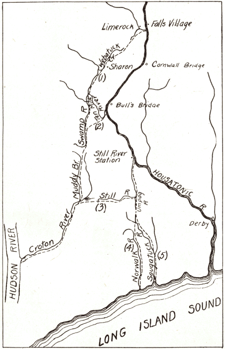
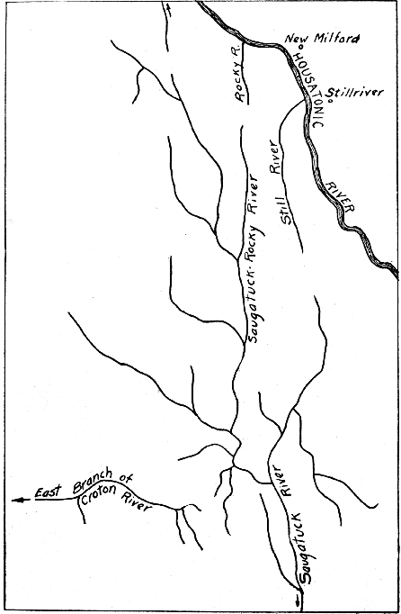
The region discussed in this bulletin is situated in western Connecticut and is approximately 8 miles wide and 18 miles long in a north-south direction, as shown on fig. 1.[1] Throughout, the rocks are crystalline and include gneiss, schist, and marble--the metamorphosed equivalents of a large variety of ancient sedimentary and igneous rocks.
For the purposes of this report, the geologic history may be said to begin with the regional uplift which marked the close of the Mesozoic. By that time the mountains formed by Triassic and Jurassic folding and faulting had been worn down to a peneplain, now much dissected but still recognizable in the accordant level of the mountain tops.
Erosion during Cretaceous time resulted in the construction of a piedmont plain extending from an undetermined line 30 to 55 miles north of the present Connecticut shore to a point south of Long Island.[2] This plain is thought to have been built up of unconsolidated sands, clays, and gravels, the débris of the Jurassic mountains. Inland the material consisted of river-made or land deposits; outwardly it merged into coastal plain deposits. When the plain was uplifted, these loose gravels were swept away. In New York, Pennsylvania, and New Jersey, however, portions of the Cretaceous deposits are still to be found. Such deposits are present, also, on the north shore of Long Island, and a well drilled at Barren Island on the south shore revealed not less than 500 feet of Cretaceous strata.[3] The existence of such thick deposits within 30 miles of the Connecticut shore and certain peculiarities in the drainage have led to the inference that the Cretaceous cover extended over the southern part of Connecticut.
A general uplift of the region brought this period of deposition to a close. As the peneplain, probably with a mantle of Cretaceous deposits, was raised to its present elevation, the larger streams kept pace with the uplift by incising their valleys. The position of the smaller streams, however, was greatly modified in the development of the new drainage system stimulated by the uplift. The modern drainage system may be assumed to have been at first consequent, that is, dependent for its direction on the slope of the uplifted plain, but it was not long before the effect of geologic structure began to make itself felt. In the time when all the region was near baselevel, the harder rocks had no advantage over the softer ones, and streams wandered where they pleased. But after uplift, the streams began to cut into the plain, and those flowing over limestone or schist deepened, then widened their valleys much faster than could the streams which flowed over the resistant granite and gneiss. By a system of stream piracy and shifting, similar to that which has taken place throughout the Newer Appalachians, the smaller streams in time became well adjusted to the structure. They are of the class called subsequents; on the other hand, the Housatonic, which dates at least from the beginning of the uplift if not from the earlier period of peneplanation, is an antecedent stream.
The complex rock surface of western Connecticut had reached a stage of mature dissection when the region was invaded by glaciers.[4] The ice sheet scraped off and redistributed the mantle of decayed rock which covered the surface and in places gouged out the bedrock. The resulting changes were of a minor order, for the main features of the landscape and the principal drainage lines were the same in preglacial time as they are today. It is thus seen that the history of the smaller streams like those considered in this report involves three factors: (1) the normal tendencies of stream development, (2) the influence of geologic structure, and (3) the effect of glaciation.
The cover of glacial deposits is generally thin, but marked variations exist. The fields are overspread with coarse till containing pebbles 6 inches in diameter to huge boulders of 12 feet or more. The abundance, size, and composition of the boulders in the till of a given locality is well represented by the stone fences which border fields.
[014] The regional depression which marked the close of the glacial period slackened the speed of many rivers and caused them to deposit great quantities of modified or assorted drift. Since glacial time, these deposits have been dissected and formed into the terraces which are characteristic of the rivers of the region. A form of terrace even more common than the river-made terrace is the kame terrace found along borders of the lowlands. Eskers in the Danbury region have not the elongated snake-like form by which they are distinguished in some parts of the country, notably Maine; on the contrary, they are characteristically short and broad, many having numerous branches at the southern end like the distributaries of an aggrading river. The material of the eskers ranges from coarse sand to pebbles four inches in diameter, the average size being from one to two inches. No exposures were observed which showed a regular diminution in the coarseness of the material toward their southern end. The clean-washed esker gravels afford little encouragement to plant growth, and the rain water drains away rapidly through the porous gravel. Consequently, accumulations of stratified drift are commonly barren places. A desert vegetation of coarse grasses, a kind of wiry moss, and "everlastings" (Gnaphalius decurrens) are the principal growth. Rattlebox (Crotolaria sagittalis), steeplebush (Spiraea tomentosa), sweet fern (Comptonia asplenifolia), and on the more fertile eskers--especially on the lower, wetter part of the slope--golden rod, ox-eyed daisy, birch, and poplar are also present. All the eskers observed were found to be similar: they ranged in breadth across the top from 100 to 150 feet and the side slopes were about 20 degrees. Only a single heavily wooded esker was found, and this ran through a forest region.
The accumulations of stratified drift are distinguished from other features in the landscape by their smoother and rounder outlines, by their habit of lying unconformably on the bedrock without reference to old erosion lines, and by a slightly different tone in the color of the vegetation covering the water-laid material. The difference in color, which is due to the unique elements in the flora of these areas, may cause a hill of stratified drift in summer to present a lighter green color than that of surrounding hills of boulder clay or of the original rock slopes; in winter the piles of stratified drift stand out because of the uniform light tawny red of the dried grass.
[1] The streams and other topographic features of the Danbury region are shown in detail on the Danbury and the New Milford sheets of the United States Topographic Atlas. These sheets may be obtained from the Director of the United States Geological Survey, Washington, D. C.
[2] It was probably not less than 30 miles, for that is the distance from the mouth of Still River, where the Housatonic enters a gorge in the crystallines, to the sea. Fifty-five miles is the distance to the sea from the probable old head of Housatonic River on Wassaic Creek, near Amenia, New York.
[3] Veatch, A. C., Slichter, C. S., Bowman, Isaiah, Crosby, W. O., and Horton. R. E., Underground water resources of Long Island: U. S. G. S., PP. 44, p. 188 and fig. 24, 1906.
[4] This stage of glaciation is presumably Wisconsin. No definite indication of any older glacial deposits was found.
[Plate I]
| State Geol. Nat. Hist. Survey | Bull. 30. Plate I. | |
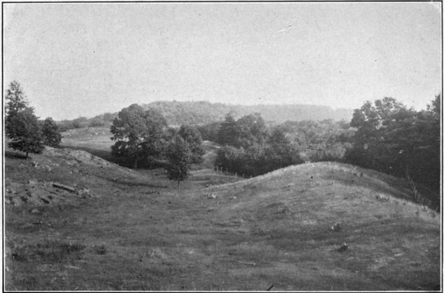 | ||
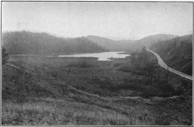
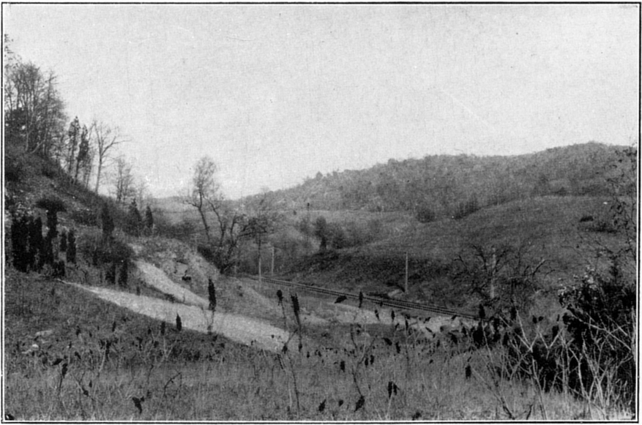
View south on the highland northeast of Neversink Pond. The base of a ridge in which rock is exposed is seen at the left; a crescent-shaped lateral moraine bordering the valley lies at the right.
[015]
[^TOC]
Rocky River begins its course as a rapid mountain brook in a rough highland, where the mantle of till in many places is insufficient to conceal the rock ledges (fig. 1). Near Sherman, about four miles from its source, it enters a broad flood plain and meanders over a flat, swampy floor which is somewhat encumbered with deposits of stratified drift and till. Rocky hills border the valley and rise abruptly from the lowland. The few tributaries of the river in this part of its course are normal in direction.
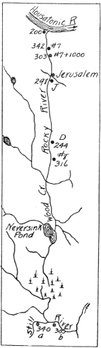
About six miles below Sherman, Rocky River enters Wood Creek Swamp, which is 5½ miles long by about one mile wide and completely covers the valley floor, extending even into tributary valleys. Within the swamp the river is joined by Squantz Pond Brook and Wood Creek. Tributaries to Wood Creek include Mountain Brook and the stream passing through Barses Pond and Neversink Pond. The head of Barses Pond is separated from the swamp only by a low ridge of till. Neversink Pond with its inlet gorge and its long southern tributary record significant drainage modifications, as described in the section entitled "The Neversink-Danbury Valley."
Within and along the margin of Wood Creek Swamp, also east of Wood Creek and at Barses Pond, are rounded, elongated ridges of till, some of which might be called drumlins. East of Neversink Pond is the lateral moraine shown in Pl. I. From the mouth of Wood Creek to Jerusalem, Rocky River is a quiet stream wandering between low banks through flat meadows, which are generally swampy almost to the foot of the bordering hills.
Near Jerusalem bridge two small branches enter Rocky River. Immediately north of the bridge is a level swampy area about one-half mile in length. Where the valley closes in again, bedrock is exposed near the stream, and beginning at a point one-half mile below (north of) Jerusalem, Rocky River--a swift torrent choked by boulders of great size--deserves its name. [016] In spite of its rapid current, however, the river is unable to move these boulders, and for nearly three miles one can walk dry-shod on those that lie in midstream.
At two or three places below Jerusalem, in quiet reaches above rapids, the river has taken its first step toward making a flood plain by building tiny beaches. One-half mile above the mouth of the river the valley widens and on the gently rising south bank there are several well-marked terraces about three feet in height and shaped out of glacial material. A delta and group of small islands at the mouth of Rocky River indicate the transporting power of the stream and the relative weakness of the slow-moving Housatonic.
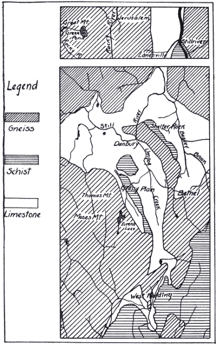
[^TOC]Rocky River is classed with streams which are comformable to the rock structure. This conclusion rests largely on the analogy between Rocky River and other rivers of this region. The latter very commonly are located on belts of limestone, or limestone and schist, and their extension is along the strike. The interfluvial ridges are generally composed of the harder rocks. The valleys of the East Aspetuck and Womenshenuck Brook on the north side of the Housatonic, and of the Still, the Umpog, Beaver Brook, the upper Saugatuck, and part of Rocky River are on limestone beds (fig. 2). In the valleys between Town Hill and Spruce Mountain (south of Danbury), two ravines northwest of Grassy Plain (near Bethel), and the Saugatuck valley north of Umpawaug Pond, the limestone bed is largely buried under drift, talus, and organic deposits, but remnants which reveal the character of the valley floors have been found. The parallelism between the courses of these streams and that of Rocky River and the general resemblance in the form of their valleys, flat-floored with steep-sided walls, as well as the scattered outcrops of limestone in the valley, have led to the inference that Rocky River, like the others, is a subsequent stream developed on beds of weaker rock along lines of foliation.
[017]
The Geological Map of Connecticut[5] shows that the valleys of Still River, Womenshenuck Brook, Aspetuck River, and upper Rocky River are developed on Stockbridge limestone. The lower valley of Rocky River is, however, mapped as Becket gneiss and Thomaston granite gneiss. Although the only outcrops along lower Rocky River are of granite, it is believed that a belt of limestone or schist, now entirely removed, initially determined the course of the river. The assumption of an irregular belt of limestone in this position would account for the series of gorges and flood plains in the vicinity of Jerusalem bridge and for the broad drift-filled valley at the mouth of Rocky River. These features are difficult to explain on any other basis.
[5] Gregory, H. E., Robinson, H. H., Preliminary geological map of Connecticut; Geol. and Nat. Hist. Survey. Bull. 7, 1907.
[^TOC]
One of the distinguishing features of Rocky River is the angle at which it joins the Housatonic (fig. 1). The tributaries of a normal drainage system enter their master stream at acute angles, an arrangement which involves the least expenditure of energy. Rocky River, however, enters the Housatonic against the course of the latter, that is, the tributary points upstream. Still River and other southern tributaries of the Housatonic exhibit the same feature, thus producing a barbed drainage, which indicates that some factor interfered with the normal development of tributary streams. Barbed drainage generally results from the reversal of direction of the master stream[6], but it is impossible to suppose that the Housatonic was ever reversed. As will appear, it is an antecedent master stream crossing the crystalline rocks of western Connecticut regardless of structure, and its course obliquely across the strike accounts for the peculiar orientation of its southern tributaries, which are subsequent streams whose position is determined by the nature of the rock. For the same reason, the northern tributaries of the Housatonic present the usual relations.
[6] Leverett, Frank, Glacial formations and drainage features of the Erie and Ohio basins: U. S. Geol. Survey Mon. 41, pp. 88-91, figs. 1 and 2, 1902. See, also, the Genoa, Watkins, Penn Yan, and Naples (New York) topographic atlas sheets.
[^TOC]
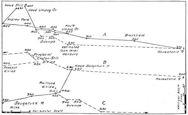
The airline distance from the bend in Rocky River at Sherman to its mouth at the Housatonic is 2¾ miles, but the course of the [019] river between these two points is 15 miles, or 5.4 times the airline distance. This is a more extraordinary digression than that of Tennessee River, which deserts its ancestral course to the Gulf and flows northwest into the Ohio, multiplying the length of its course 3⅓ times. The fall of Rocky River between Sherman and its mouth is 240 feet or 16 feet to the mile, and were the river able to take a direct course the fall would be 87 feet to the mile. The possibility of capture would seem to be imminent from these figures, but in reality there is no chance of it, for an unbroken mountain ridge of resistant rock lies between the two forks of the river. This barrier is not likely to be crossed by any stream until the whole region has been reduced to a peneplain.
Measured from the head of its longest branch, Rocky River is about 19 miles long and falls 950 feet. Of this fall, 710 feet occurs in the first 4 miles and 173 feet in the last 2½ miles of its course. For the remaining distance of 12½ miles, in which the river after flowing south doubles back on itself, the fall is 67 feet, or slightly less than 5½ feet to the mile (fig. 3, A).
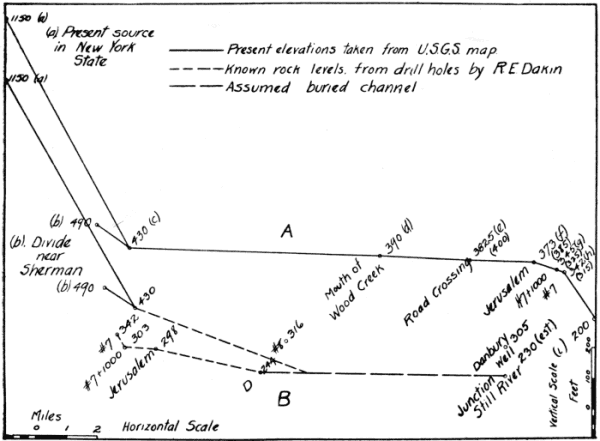
[020]
In tabular form the figures, taken from the Danbury and New Milford atlas sheets and from reports of R. E. Dakin, are as follows:
| Miles | Fall in feet per mile | |
| Source to Sherman | 4 | 177.5 |
| Sherman to Wood Creek | 8 | 6.25 |
| Wood Creek to Jerusalem | 4.5 | 3.8 |
| Jerusalem to mouth | 2.5 | 69.2 |
Near Jerusalem, where Rocky River makes its sudden change in grade, there is an abrupt change in the form of the valley from broad and flat-bottomed to narrow and V-shaped. The profile of Rocky River is thus seen to be sharply contrasted with that of a normal stream, which is characterised throughout its course by a decreasing slope.
[^TOC]The present profile of Rocky River and the singular manner in which the lower course of the river is doubled back on the upper course are believed to represent changes wrought by glaciation. Before the advent of the glacier, Rocky River probably flowed southward through the "Neversink-Danbury Valley," to be described later, and joined the Still at Danbury, as shown in fig. 4. The profile of the stream at this stage in its history is shown in fig. 3, B.
At Sherman a low col separates Rocky River basin from that of the small northward flowing stream which enters the Housatonic about a mile below Gaylordsville. Streams by headward erosion at both ends of the belt of limestone and schist on which they are situated have reduced this divide to an almost imperceptible swell. The rock outcrops in the channel show that the glacier did not produce any change in the divide by damming, though it may have lowered it by scouring. Assume that at one time a divide also existed on the eastern fork of Rocky River, for example near Jerusalem. According to this hypothesis there was, north of this latter divide, a short northward flowing branch of the Housatonic located on a belt of weak rock, similar to the
[021]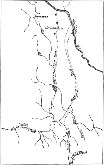
[022] small stream which now flows northward from Sherman, and very like any of the half-dozen parallel streams in the rock mass south and southwest of Danbury, all of which are subsequent streams flowing along the strike. While these stream valleys were growing, the southern ends of the same weak belts of rock were held by southward-flowing streams which united in the broad limestone area now occupied by the city of Danbury.
The southward-flowing streams whose heads were, respectively, above Sherman and near Jerusalem joined at the southern end of the long ridge which includes Towner Hill and Green Mountain. Thence the stream flowed southward along the valley now occupied by Wood Creek and reached Still River by way of the valley which extends southward from Neversink Pond (fig. 4).
The preglacial course of Rocky River, as above outlined, is subject to possible modification in one minor feature, namely, the point where the east and west forks joined. The junction may have been where Neversink Pond is now situated, or three miles farther south than the indicated junction near the mouth of Wood Creek. A low ridge of till is the only barrier that at present prevents the western branch from flowing into the head of Barses Pond and thence into Neversink Pond (fig. 1).
As thus reconstructed the greater part of Rocky River formerly belonged to the Still-Umpog system and formed a normal tributary in that distant period when the Still joined the Saugatuck on its way to the Sound (fig. 9). However, the normal condition was not lasting, for the reversal of Still River, as later described, brought about a complex arrangement of barbed streams (fig. 4) which remained until modified by glacial action.
In a large stream system which has been reversed, considerable evidence may be gathered from the angle at which tributary streams enter. As the original direction of Rocky River in its last 2½ miles is unchanged, normal tributaries should be expected; whereas between Jerusalem and the head of the stream entering Neversink Pond from the south, in accordance with the hypothesis that this portion of the stream was reversed, tributaries pointing upstream might be expected. Such little gullies as join Rocky River near its mouth are normal in direction; between Jerusalem and the mouth of Wood Creek, a distance of 4½ [023] miles, there are no distinct tributaries. South of the mouth of Wood Creek are four tributaries: (1) the brook which enters the valley from the west about one mile south of Neversink Pond, (2) Balls Brook, which empties into Neversink Pond, and (3) two streams on the east side--Mountain Brook and one other unnamed (fig. 1). All these, except Mountain Brook, are normal to the reconstructed drainage. The evidence of the tributaries, though not decisive, is thus favorable to the hypothesis of reversal.
[^TOC]Figures 3 and 5 show what is known of the buried channel of Rocky River. The only definite information as to rock levels is that derived from the drill holes made by R. E. Dakin for the J. A. P. Crisfield Contracting Company in connection with work on a reservoir for the Connecticut Light and Power Company. Numerous holes were drilled at the points indicated on fig. 5 as No. 8, D, J, No. 7+1000, and No. 7, but only those showing the lowest rock levels need be considered. In the following account the elevations quoted are those determined by R. E. Dakin which differ, as shown in fig. 3, A, from those of the New Milford atlas sheet.
Between the mouth of Wood Creek and Jerusalem bridge holes made near the river show that the depth of the drift--chiefly sand, gravel, and clay--varies from 45 to 140 feet. The greatest thickness of drift, consisting of humus, quicksand and clay, is 140 feet at a point 20 feet from the east bank of Rocky River and about 1¾ miles north of the mouth of Wood Creek (fig. 5, D). Although some allowance should be made for glacial scouring, the rock level at this point, 244 feet, is so much lower than any other record obtained between this point and Danbury that one is obliged to assume a buried channel with a level at Danbury at least 75 feet below the rock level found in the lowest well record.[7] It is probable that this well is not situated where the rock is lowest, that is, it may be on one side of the old Still River channel.
[7] Well of J. Hornig, rear of Bottling Works, near foot of Tower Place, 35 ft. to rock, indicated at a, fig. 5. The well of Bartley & Clancey, 94 White Street, 70 ft. to rock, is also indicated at b, fig. 5.
[024]
The level obtained at No. 8 is from a hole drilled within 50 feet of the river. The drill struck rock at an elevation of 316 feet after passing through 69 feet of quicksand, gravel, and till. This is clearly not within the channel as it is quite impossible to reconcile the figure with that at D, less than a mile distant.
South of Jerusalem bridge at J, 150 feet from the river, a hole was bored through 95 feet of clay, sand, and gravel before striking rock at an elevation of 298 feet.
[025]
At the point marked No. 7+1000, about 1¼ miles from the mouth of Rocky River, the evidence derived from 8 drill holes, bored at distances ranging from 200 to 550 feet from the right bank, shows the drift cover to be from 48 to 72 feet in thickness. At 200 feet from the river the drill passed through 72 feet of sand, clay, and gravel before striking rock at 303 feet above sea-level.
At No. 7, about one mile from the mouth of Rocky River, a hole drilled 415 feet from the right bank showed 58 feet of drift, consisting of clay, sand, gravel, and boulders. The drill reached rock at 342 feet, which is the figure given by R. E. Dakin for the elevation of the river at this point. Drill holes made, respectively, at 50 and 60 feet to the right of this one showed a drift cover of 61 feet, so that the underlying rock rises only 4 feet in a distance of 475 feet to the east of the river.
The foregoing evidence, showing a rock level at D 98 feet lower than that at No. 7, leaves no doubt that the preglacial course of Rocky River was to the south from No. 7, and there is nothing in the topography between Jerusalem and Danbury to make improbable the existence of a buried channel.
[^TOC]The preglacial history of Rocky River as outlined assumes that before the glacier covered this part of Connecticut the present lower course of Rocky River was separated from the rest of the system by a divide situated somewhere between the present mouth of the river and the mouth of Wood Creek. It remains to be shown by what process Rocky River was cut off from its southern outlet into Still River and forced up its eastern branch and over the col into a tributary of the Housatonic. Though the preglacial course of Rocky River appears to be more natural than the present one, it is really a longer course to the Housatonic; the older route being 32 miles, whereas the present course is 19 miles. This fact explains, in part, why the glacier had little difficulty in altering the preglacial drainage, and how the change so effected became permanent. Eccentric as [026] the resulting system of drainage is, it would have been still more so had Rocky River when ponded overflowed at the head of its western instead of its eastern fork, taken its way past Sherman into the Housatonic near Gaylordsville, and discharging at this point lost the advantage of the fall of the Housatonic between Gaylordsville and Boardman.
In glaciated regions an area of swamp land may be taken as an indication of interference by the glacier with the natural runoff. The swamp in which Wood Creek joins the upper fork of Rocky River (fig. 1), was formerly a lake due to a dam built across the lower end of a river valley. Although the ponded water extended only a short distance up the steeper side valleys, it extended several miles up the main stream. The whole area of this glacial lake, except two small ponds and the narrow channels through which the river now flows, has been converted into a peat-filled bog having a depth of from 8 to 45 feet.[8]
At the termination of the swampy area on the eastern branch of Rocky River no indication is found of a dam such as would be required for so extensive a ponding of the waters. Here the valley is very narrow, and though the river bed is encumbered with heavy boulders, rock outcrops are so numerous as to preclude the idea of a drift cover raising the water level. This is just the condition to be expected if Rocky River reached its present outlet by overtopping a low col at the head of its former eastern branch.
The southern end of the Neversink Pond valley is the only other place whose level is so low that drift deposits could have interfered with the Rocky River drainage. The moraine at the head of this valley, crossing the country some two miles north of the city of Danbury and binding together two prominent north-and-south ridges, was evidently the barrier which choked the Rocky River valley near its mouth and turned back the preglacial river.
When Rocky River was thus ponded its lowest outlet was found to be at the head of its eastern fork. Here the waters spilled over the old divide and took possession of the channel of [027] a small stream draining into the Housatonic. Accordingly Rocky River should be found cutting its bed where it crosses the former divide. It seems reasonable to regard the gorge half-way between Jerusalem bridge and Housatonic River as approximately the position of the preglacial divide and to consider the small flat area to the north of Jerusalem bridge as a flood plain on softer rock, worn down as low as the outcrops of more resistant rock occurring farther down the valley will permit. The reversal of the river may account for the sudden transition from a flat-bottomed valley to a rocky gorge; and for the abrupt change in the profile, bringing the steepest part of the river near its mouth. The increased volume of water flowing through the channel since glacial time has plainly cut down the bed of the ravine between Jerusalem and the river's mouth, but the channel is still far from being graded.
[8] Report of soundings made in 1907 by T. T. Giffen.
[^TOC]
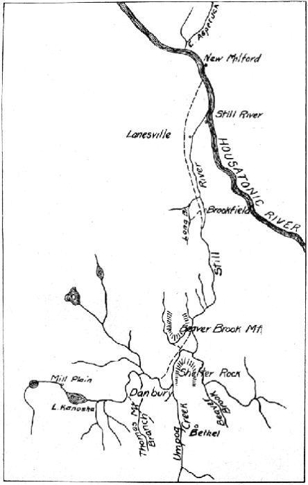
Between Neversink Pond and Danbury extends a deep rock valley, in places filled with drift. As has been shown, this valley was probably occupied in preglacial time by Rocky River, which then flowed southward. At its southern end is Still River, which flows through Danbury from west to east.
The most important tributary of the Still rises northwest of the city, just beyond the New York-Connecticut boundary line, and has two forks. The northern fork, which drains East Lake, Padanaram Reservoir, and Margerie Pond, flows along the northeast side of Clapboard Ridge. The southern fork has two branches; the northern one includes the reservoirs of Upper Kohanza and Lake Kohanza, while the upper waters of the southern branch have been recently dammed to form an extensive reservoir. On approaching the city, the northernmost fork (draining East Lake) turns sharply out of its southeast course and flows in a direction a little east of north. At the end of Clapboard Ridge, the stream makes a detour around a knoll of coarse stratified drift. From this turn until it joins Still River, a distance of about a mile, the stream occupies a broad and partly swampy valley.
[028]At the cemetery in this valley (fig. 1, C) are two eskers of symmetric form, each a few hundred yards in length and trending nearly parallel with the valley axis. East of the valley, and about 1½ miles north of the cemetery, is a broad, flat-topped ridge of till with rock exposed at the ends, forming a barrier which doubtless existed in preglacial time. West of the valley is a hill with rock foundation rounded out on the northeast side by a mass of drift. The preglacial course of Rocky River was between the outcrops at these two localities.
Northwest of the cemetery for one and a half miles the uneven surface is formed of till and small patches of stratified drift. In a swamp near the north end of the cemetery is a curved esker with lobes extending south and southwest. One mile north of this swamp is an area of excessively coarse till containing boulders which range in diameter from 6 to 10 feet and forming a low ridge separating two ravines, in which head streams flowing in opposite directions. The area of coarse till is bounded on the north by a long sinuous esker of coarse gravel terminating in a flat fan, which is superposed on a field of fine till. Associated with the esker is an interesting group of kames and kettleholes, the largest kettlehole being distinguished by distinct plant zones banding the sides of the depression.
North of the area of boulders, eskers, and kames just described lies a swamp whose surface is 30 to 40 feet below the upper level of the kame gravels. Soundings made by T. T. Giffen revealed the presence of 36 feet of peat and 2 feet of silt overlying firm sand, so that 70 feet is the minimum estimate for the difference in level between the surface of the gravels and the floor of the swamp.
Below the rocky cliffs which line the valley sides are boulders brought by the ice from near-by ledges, and about one-half mile above the head of the swamp are remnants of a terrace standing 20 to 30 feet above the level of the stream. Although the terrace appears to consist of till, it may conceal a rock floor which was cut by a former stream. As the valley is followed toward Neversink Pond, the various features of a till-coated, rock-floored valley are seen.
[029][030]
[^TOC]
Still River presents several unusual features, as shown in fig. 6. Tributaries from the west and south unite at Danbury to form a stream flowing northward opposite to the regional land slope. Near its junction with the Housatonic, the river flows northward, whereas its master stream half a mile distant flows southward. The lower valley of the river is broad and flat and apparently much out of proportion to the present stream; it is, indeed, comformable in size and direction with the valley of the Housatonic above the mouth of the Still. The Housatonic, however, instead of choosing the broad lowland in the limestone formation, spread invitingly before it, turns aside and flows through a narrow gorge cut in resistant gneiss, schist, and igneous intrusives. The headwaters of the Still mingle with those of the Croton system, and its chief southern branch, the Umpog, is interlaced with the sources of the Saugatuck on a divide marked by glacial drift and swamps. The explanation of these features involves not only the history of the Still River system, but also that of the Housatonic.
In explanation of the present unusual arrangement of streams in the Still River system, four hypotheses may be considered:
I. Still River valley is the ancient bed of the Housatonic from which that river has been diverted through reversal caused by a glacial dam.
II. The Housatonic has always had its present southeasterly course, but the Still, heading at some point in its valley north of Danbury, flowed initially southward through one of four possible outlets. The latter stream was later reversed by a glacial dam at the southern end, or by glacial scouring at the northern end of its valley which removed the divide between its headwaters and the Housatonic.
III. The Housatonic has always held its present southeasterly course, and the Still initially flowed southward, as stated above. Reversal in this case, however, occurred in a very early stage in the development of the drainage, as the result of the capture [031] of the headwaters of the Still by a small tributary of the Housatonic.
IV. The Housatonic has always held its present southeasterly course, but the Still has developed from the beginning as a subsequent stream in the direction in which it now flows.
The first hypothesis, that the Still is the ancient channel of the Housatonic, has been advocated by Professor Hobbs, who has stated:
"That the valley of the Still was formerly occupied by a large stream is probable from its wide valley area.... The former discharge of the waters of the Housatonic through the Still into the Croton system, on the one hand, or into the Saugatuck on the other, would require the assumption of extremely slight changes only in the rock channels which now connect them.... To turn the river (the Housatonic) from its course along the limestone valley some obstruction or differential uplift within the river basin may have been responsible. The former seems to be the more probable explanation in view of the large accumulations of drift material in the area south and west of Bethel and Danbury."
"The structural valleys believed to be present in the crystalline rocks of the uplands due to post-Newark deformation may well have directed the course of the Housatonic after it had once deserted the limestone ... The deep gorge of the Housatonic through which the river enters the uplands not only crosses the first high ridge of gneiss in the rectilinear direction of one of the fault series, but its precipitous walls show the presence of minor planes of dislocation, along which the bottom of the valley appears to have been depressed."[9]
The hypothesis proposed by Professor Hobbs and also the second and third hypotheses here given involve the supposition of reversal of drainage, and their validity rests on the probability that the stream now occupying Still River valley formerly flowed southward. The first and second hypotheses will be considered in the following section.
[9] Hobbs, W. H., Still rivers of western Connecticut: Bull. Geol. Soc. Am., vol. 13, pp. 17-26, 1901.
[^TOC]
If Still River occupies the valley of a reversed stream, the following physiographic features should be expected:
[032]At the mouth of Still River and for several miles north and south of it there is a plain more than a mile broad. This plain continues southward with a width of about one-half mile until, at Brookfield, it is interrupted by ledges of bare rock. A little distance south of Brookfield the valley broadens again to one-half mile, and this width is retained with some variation as far as Danbury. Drift deposits along the border of the valley make it appear narrower in some places than is indicated by rock outcrops. Between Brookfield and Danbury the narrowest place in the valley is southwest of Beaver Brook Mountain, where the distance between the hills of rock bounding the valley is one-fifth of a mile (fig. 6). Opposite Beaver Brook Mountain, which presents vertical faces of granite-gneiss toward the valley, is a hill of limestone. Ice, crowding through this narrow place in the valley, must have torn masses of rock from the side walls, so that the valley is now broader than in preglacial time. The constrictions in the valley near Shelter Rock are due to the fact that the pre-glacial valley, now partly buried in till, lies to the north. There are stretches of broad floor in the valley of Beaver Brook, in the lower valley of Umpog Creek, in the fields at the south end of Main Street in Danbury, about Lake Kanosha, and where the Danbury Fair Grounds are situated. In the western part of Danbury, however, and at Mill Plain the valley is very narrow, and at the head of Sugar Hollow, the valley lying east of Spruce Mountain, is a narrow col.
[033]The broadest continuous area in the Still-Umpog Valley is, therefore, in the lower six miles between Brookfield and New Milford; south of that portion are several places where the valley is sharply constricted; and beyond the head of the Umpog, about one and a half miles below West Redding station (fig. 7), the Saugatuck Valley is a very narrow gorge. On the whole, the valleys south and southwest of Danbury are much narrower than the valley of the Still farther north. It is evident from these observations that Still River Valley is neither uniformly broad, nor does it increase in width toward the south.
But if a broad valley is to be accepted as evidence of the work of a large river, then there is too much evidence in the Still River valley. The broad areas named above are more or less isolated lowlands, some of them quite out of the main line of drainage, and can not be grouped to form a continuous valley. They can not be attributed to the Housatonic nor wholly to the work of the insignificant streams now draining them. These broad expanses are, in fact, local peneplains developed on areas of soluble limestone. The rock has dissolved and the plain so produced has been made more nearly level by a coating of peat and glacial sand. In a region of level and undisturbed strata, such as the Ohio or Mississippi Valley, a constant relation may exist between the size of a stream and the valley made by it; but in a region of complicated geologic structure, such as western Connecticut, where rocks differ widely in their resistance to erosion, the same result is not to be expected. In this region the valleys are commonly developed on limestone and their width is closely controlled by the width of the belt of limestone. Even the narrow valleys in the upland southwest of Danbury are to be accounted for by the presence of thin lenses of limestone embedded in gneiss and schist.
The opinion of Hobbs that Still River valley is too wide to be the work of the present stream takes into consideration only the broad places, but when the narrow places are considered it may be said as well that the valley is too narrow to be the work of a stream larger than the one now occupying it. Valley width has only negative value in interpreting the history of Still River.
[034][^TOC]
The dominant topographic feature of western Connecticut, as may be seen on the atlas sheets, is elongated oval hills trending north by west to south by east, which is the direction of the axes of the folds into which the strata were thrown at the time their metamorphism took place. Furthermore, the direction of glacial movement in this part of New England was almost precisely that of foliation, and scouring by ice merely accentuated the dominant north-south trend of the valleys and ridges. As a result, the smaller streams developed on the softer rocks are generally parallel to each other and to the strike of the rocks. These streams commonly bend around the ends of the hills but do not cross them. The narrowness of the belts of soft rock makes it easy for the drainage of the valleys to be gathered by a single lengthwise stream. The Still and its larger tributaries conform in this way to the structure.
On the east side of the Still-Umpog every branch, except two rivulets 1¼ miles south of Bethel, points in the normal direction, that is, to the north, or downstream as the river now flows (fig. 6). The largest eastern tributary, Beaver Brook, is in a preglacial valley now converted into a swamp the location and size of which are due entirely to a belt of limestone. It is not impossible that Beaver Brook may have once flowed southward toward Bethel, but the limestone at its mouth, which lies at least 60 feet lower than that at its head, shows that if such were ever the case it must have been before the north-flowing Still River had removed the limestone north of Beaver Brook Swamp.
On the flanks of Beaver Brook Mountain are three tributaries which enter the river against its present course. Examination of the structure reveals, however, that these streams like those on the east side of the river are controlled in their direction by the orientation of the harder rock masses. The southward flowing stream four miles in length which drains the upland west of Beaver Brook Mountain has an abnormal direction in the upper part of its course, but on reaching the flood plain it takes a sharp turn to the north. Above the latter point it is in line with the streams near Beaver Brook Mountain and is abnormal in consequence of a line of weakness in the rock.
[035]The lowland lying west of Umpog valley, extending from Main Street in Danbury to a point one mile beyond Bethel, affords no definite evidence in regard to the direction of tributaries. In reconstructing the history of this valley the chief difficulty arises from the old-age condition of the flood plain. Drainage channels which must once have existed have been obliterated, leaving a swampy plain which from end to end varies less than 20 feet in elevation. It is likely that in preglacial times the part of the valley north of Grassy Plain, if not the entire valley, drained northward into Still River, as now do Umpog Creek and Beaver Brook. From this outlet heavy drift deposits near the river later cut it off. The lowland is now drained by a stream which enters the Umpog north of Grassy Plain. Several small streams tributary to the Umpog south of Bethel also furnish no evidence in favor of the reversal of Still River.
West of Danbury the tributaries of Still River point upstream on one side and downstream on the other side of the valley, in conformity with the rock structure which is here diagonal to the limestone belt on which the river is located. Their direction in harmony with the trend of the rocks has, therefore, no significance in the earlier history of the river.
From the foregoing discussion, it appears that no definite conclusions in regard to the history of Still River can be drawn from the angle at which tributaries enter it. The direction of the branches which enter at an abnormal angle can be explained without assuming a reversal of the main stream, and likewise many of the tributaries with normal trends seem to have adopted their courses without regard to the direction of Still River.
[^TOC]
Although the regional slope of western Connecticut as a whole is contrary to that of Still River, there is no marked lowering of the hill summits between the source of the river and its mouth. As branches on the south side of the Housatonic are naturally to be expected, there is nothing unusual in the Still flowing in opposition to the regional slope, except that it flows toward the north instead of the northeast.
[036][^TOC]
Hobbs has suggested that the waters of the Housatonic may have been ponded at a point near West Redding until they rose high enough to overflow into the "fault gorge" below Still River Station, thus giving the streams of the Danbury region an outlet to the Sound by this route. This hypothesis calls for a glacial dam which has not been found. It is true there are glacial deposits in the Umpog valley south of Bethel. The Umpog flows as it does, however, not because of a glacial "dam" but in spite of it. The river heads on rock beyond and above the glacial deposits and picks its way through them (fig. 7). Drift forms the divide at the western end of Still River valley beyond Mill Plain, but the ponded water which it caused did not extend as far as Danbury (see discussion of Still-Croton valley). The Sugar Hollow pass is also filled with a heavy mantle of drift, but the valley is both too high and too narrow at the col to have been the outlet of the Housatonic.
It might be assumed that just previous to the advent of the ice sheet Still River headed south of its present mouth and flowed southward. In this case the Still, when reversed, should have overflowed at the lowest point on the divide between it and the Housatonic. It should have deepened its channel over the former divide, and the result would have been a gorge if the divide were high, or at least some evidence of river cutting even if the divide were low. On the contrary, Still River joins the Housatonic in a low, broad, and poorly drained plain.
The existing relief is due to the uneven distribution of drift. The river is now cutting a gorge at Lanesville, but the appearance of the valley to the west indicates that glacial deposits forced the river out of its former bed (fig. 6) and that no barrier lay between the preglacial Still River valley and the Housatonic Valley.
[^TOC]
A reversal of Still River may be explained by glacial scouring which caused the northern end of the valley to become lower than the present divides at West Redding and Mill Plain. The evidence of such scour should be an overdeepened, U-shaped main valley and ungraded tributaries.
[037]The northern part of Still River valley has not the typical U form which results from glacial erosion. As contrasted with the U-shaped glacial valley and the V-shaped valley of normal stream erosion, it might be called rectangular so sharply does the flat valley floor terminate against the steep hillsides. The floor is too smooth and flat and the tributary valleys too closely adjusted to the variant hardness of the rocks to be the work of such a rough instrument as the glacier. A level so nearly perfect as that of the flood plain is the natural result of erosion of soft rock down to a baselevel, whereas glacial scouring tends to produce a surface with low rounded hills and hollows.
Overdeepening would be expected, because glaciers erode without reference to existing baselevels. That a river valley should be cut out by ice just enough to leave it graded with respect to the main valley would be an unusual coincidence. This is what is found where the Still River valley joins the Housatonic, and it indicates normal stream erosion. Also, if the limestone of the northern Still River valley were gouged out by the glacier, the action would in all probability have been continuous in the limestone belt to the north of the Housatonic, and where the belt of soft rock crosses the Housatonic the river bed would be overdeepened. Although the valley of the Housatonic near New Milford is very flat, as is natural where a river crosses a belt of weak rock, the outcrops are sufficiently numerous to show that it has not been overdeepened. The limestone area along the East Aspetuck is largely overlain by till, but here again the presence of rock in place shows that the valley has not been overdeepened. Moreover, limestone boulders in the southern part of Still River valley are not as abundant as they should be under the hypothesis that the northern part had been gouged out extensively.
That the northern part of the Still River valley was not deeply carved by ice is shown also by the character of the tributary streams. The three small brooks on the west side of the valley, near Beaver Brook Mountain, were examined to see if their grades indicated an over-deepening of the main valley. These streams, however, and others so far as could be determined, were found to have normal profiles; that is, their grades become increasingly flatter toward their mouths. The streams are cutting [038] through the till cover and are not building alluvial cones where they join the lowland. All their features, in fact, are characteristic of normal stream development.
Throughout the length of the valley, rock outcrops are found near the surface, showing that the changes produced by the glacier were due to scouring rather than to the accumulation of glacial material. Except where stratified drift is collected locally in considerable quantity, the glacial mantle is thin. On the other hand, it has been shown that glacial gouging was not sufficient in amount to affect the course of the stream. The glacier simply cleaned off the soil and rotten rock from the surface, slackening the stream here and hastening it there, and by blocking the course with drift it forced the river at several places to depart slightly from its preglacial course.
The evidence shows, therefore, that if Still River has suffered reversal, glaciation is not responsible for the change, and thus the first two hypotheses for explaining the history of the valley are eliminated. There remain for discussion the third and fourth hypotheses; the former being that reversal was effected in a very early stage in the development of the drainage, the latter that no reversal has occurred. The choice between these two hypotheses rests on evidence obtained in the Umpog, Croton, and other valleys of the Danbury region. This evidence is presented in the three following sections, after which the former courses of Still River will be discussed.
[^TOC]
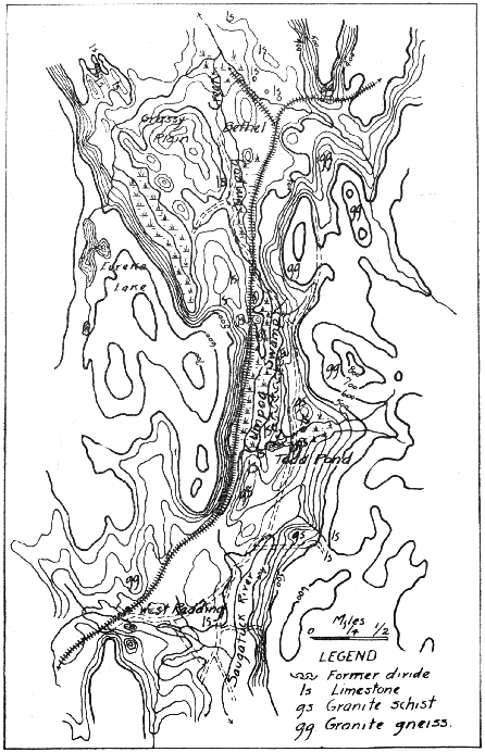
The valley of the Umpog, which extends from Still River to the source of the Saugatuck near West Redding (fig. 7), is a critical area in the study of the Still River system. It is possible that this valley once afforded an outlet for Still River, and it has been suggested that the Housatonic formerly followed this route to Long Island Sound. The relation of this valley to the former drainage system of the Danbury region demands, therefore, a careful examination of the features of the valleys occupied by Umpog Creek and the upper waters of the Saugatuck, and of the divide between those streams.
[039][040]
North of Bethel the Umpog occupies an open valley developed in limestone. Knolls of limestone rise to heights of about 40 feet above the floor of the valley and their upper surfaces are cut across the highly, tilted beds. This truncation, together with a general correspondence in height, suggests that these knolls, as well as the rock terraces found between Bethel and West Redding, and the limestone ridge which forms the divide itself, are portions of what was once a more continuous terrace produced by stream erosion and that they determine a former river level. The absence of accurate elevations and the probability of glacial scour make conclusions regarding the direction of slope of this dissected rock terrace somewhat uncertain. As will be indicated later, however, it seems likely that these terrace remnants mark the course of a southward flowing river that existed in a very early stage in the development of the drainage.
South of Bethel the old Umpog valley, has lost from one-third to one-half its width through deposits of stratified drift (Pl. II, A and B). On the west, gravel beds lie against rock and till; on the east, deposits of sand and coarse gravel form a bench or terrace from 500 to 700 feet broad, which after following the side of the valley for one-half mile, crosses it diagonally and joins the western slope as a row of rounded hills. Through this drift the present stream has cut a narrow channel.
The narrowest part of the Umpog valley is about one mile south of Bethel. Farther upstream the valley expands into the flat occupied by Umpog Swamp, which presents several interesting features. The eastern, southern, and western sides of the swamp are formed of irregular masses of limestone and granite-gneiss 20 to 60 feet high. Near the northwestern edge of the swamp is a terrace-like surface cut on limestone. Its elevation is about the same as that of the beveled rock remnants lying in Umpog valley north of Bethel.
[Plate II]
| State Geol. Nat. Hist. Survey | Bull. 30. Plate II. | |
 | ||
A. View up the valley of Umpog Creek. The valley dwindles in the
distance to the "railroad divide." In the middle distance is Umpog Swamp;
in the foreground the edge of the
southern end of row of Kames which points down the valley.
 |
B. View down the valley of Umpog Creek. To the left is the edge of limestone
terrace; in the middle distance is the Catholic cemetery situated on a terrace
of stratified drift; on the right are mounds of stratified drift; in the distance
is the granite ridge bounding the valley on the east.
[041]
Umpog Swamp was formerly a lake but is now nearly filled with organic matter so that only a small remnant of the old water body remains. Soundings have revealed no bottom at 43 feet[10] and the depth to rock bottom is not less than 45 feet. The swamp situated one-half mile southwest of Bethel has a depth to rock of 35 feet. In their relation to the Still River system these two swamps may be regarded simply as extensions of the Umpog Creek channel, but when the elevations of their bottoms are compared with that of points to the north and south, where the river flows on rock, it will be seen that a profile results which is entirely out of harmony with the present profile of the river. Thus Umpog Creek falls 40 feet at the point where it spills over the rock ledge into the swamp, and if the 45 feet which measures the depth of Umpog Swamp be added, the difference in level is seen to be at least 85 feet. A similar calculation locates the bottom of the smaller swamp near Bethel at an elevation of 340 feet above sea-level or on the same level as the bottom of Umpog Swamp. In a straight line 2¼ miles north of Bethel, Still River crosses rock at a level of 350 feet, or 10 feet higher than the bottom of Umpog Swamp. At Brookfield, 6½ miles north of the mouth of the Umpog, the Still crosses rock at 260 feet, and 4½ miles farther north, it joins the Housatonic on a rock floor 200 feet above sea-level (fig. 8, A). Such a profile can be explained in either of two ways: glaciers gouged out rock basins in the weak limestone, or the river in its lower part has been [042] forced out of its graded bed onto rock at a higher level. Probably both causes have operated, but the latter has produced more marked effects.
Umpog Creek has its source in a small forked stream which rises in the granite hills east of the south end of Umpog Swamp. After passing westward through a flat swampy area, where it is joined by the waters from Todd Pond, the stream turns north and follows a shallow rock gorge until Umpog Swamp is reached. The divide which separates the present headwaters of the Umpog from those of the Saugatuck is a till-covered swampy flat about one-quarter mile east of Todd Pond. This arrangement of tributary streams is correctly shown in fig. 7 and differs essentially from that shown on the Danbury atlas sheet. This divide owes its position to the effects of glaciation. Deposits of till and the scouring of the bed rock so modified the preglacial surface that the upper part of the Saugatuck was cut off and made tributary to the Umpog.
[10] Report by T. T. Giffen, 1907.
[^TOC]
In order to determine whether Still River flowed southward through the Saugatuck Valley just before the advent of the ice sheet, the borders of Umpog Swamp and the region to the south and east were examined. It was found that Umpog Swamp is walled in on the south by ledges of firm crystalline limestone and that the rock-floored ravine leading southward from the swamp, and occupied by the railroad, lies at too high an elevation to have been the channel of a through-flowing stream. A south-flowing Still River, and much less an ancient Housatonic, could not have had its course through this ravine just previous to glaciation. A course for these rivers through the short valley which extends southeastward from Umpog Swamp is also ruled out, because the bedrock floor of this hypothetical passageway is 20 feet higher than the floor of the ravine through which the railroad passes.
The eastern border of Umpog Swamp is determined by a ridge of limestone which separates the swamp from lowlying land beyond. This ridge is continuous, except for the postglacial gorge cut by the tributary entering from the east, and must have been in existence in preglacial times. The entire lowland east [043] of this limestone ridge possesses a unity that is not in harmony with the present division of the drainage. The streams from this hillside and those from the west may have joined in the flat-floored valley at the head of the Saugatuck and from there flowed into the Saugatuck system. The former divide then lay in a line connecting the limestone rim of the swamp with the tongue of highland which the highway crosses south of Todd Pond (fig. 7).
[^TOC]
The deep valley extending from the Danbury Fair Grounds to the East Branch Reservoir in the Croton River system, has given rise to the suggestion that the course of the Housatonic formerly may have been along the line of Still and Croton rivers and thence to the Hudson.[11] From the evidence of the topographic map alone, this hypothesis appears improbable. The trend of the larger streams in western Connecticut is to the south and southeast; a southwesterly course, therefore, would be out of harmony with the prevailing direction of drainage. Also, the distance from the present mouth of Still River to tide-water by the Still-Croton route is longer than the present route by way of the Housatonic.
[11] Hobbs, W. H., Still rivers of western Connecticut: Bull. Geol. Soc. Am., vol. 13, p. 25, 1901.
[044]
[^TOC]
From Danbury to its source Still River occupies a valley whose features are significant in the history of the drainage. Between Danbury and the Fair Grounds (fig. 1) the valley is a V-shaped ravine 1½ miles long, well proportioned to the small stream now occupying it but entirely too narrow for the channel of a large river. Along the valley are outcrops of schist, and granite rock is present on both sides of the valley for a distance of about one-quarter mile. Part of the valley is a mere cleft cut in the rock and is unglaciated. At the Danbury Fair Grounds the valley opens out into a marshy plain, through which the river meanders and receives two tributaries from the south. The plain, which extends beyond Lake Kanosha on the west, has a generally level surface but is diversified in places by mounds of stratified drift.
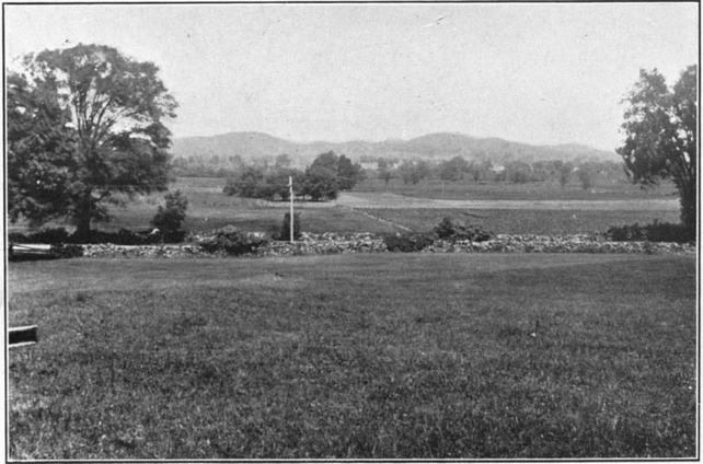
Near the railroad a rock outcrop was found which gives a clue to the nature of the broad lowland. The rock consists mainly of schist, but on the side next the valley there is a facing of rotten limestone. This plain, like all the others in this region, is a local peneplain developed on soluble limestone. A better example could not be found to prove the fallacy of the saying that "a broad valley proves the existence of a large river." The plain is simply a local expansion of a valley which on each side is much narrower. No other river than the one flowing through it can have been responsible for the erosion, for the plain is enclosed by hills of gneiss and schist (Pl. III).
At Mill Plain the valley is crowded by ragged rock outcrops which jut into the lowland. Here the river occupies a ravine cut in till near the north side of the valley. West of Mill Plain station the valley is encumbered with ridges of stratified drift, interspersed with heavy accumulations of till. Near Andrew Pond the true width of the valley--one-eighth mile--is shown by rock outcrops on both the north and south slopes. The valley at this point gives no indication of narrowing toward the headwaters; in fact, it becomes broader toward the west.
Between Andrew Pond and Haines' Pond is the divide which separates the waters of the Still system from those of the Croton. It consists of a jumbled mass of morainal hills, seemingly of boulder clay, that rise from 50 to 60 feet above the level of the ponds. The divide is thus merely a local obstruction in what was formerly a through drainage channel.
[^TOC]
It is evident that before the advent of the glacier a stream must have flowed through the Still-Croton valley past the present divide in order to have excavated the rock valley there found. The Housatonic could not have flowed west through this valley if it was as narrow and shallow as is indicated by known rock outcrops; the river could have flowed through it only in a deep narrow gorge which was later buried under drift, but the evidence at hand does not support this view.
[Plate III]
| State Geol. Nat. Hist. Survey | Bull. 30. Plate III. | |
 | ||
[045] It is most probable that this valley was made by the preglacial Croton River. This explanation demands no change in the direction of Still and Croton Rivers but calls for a divide at some point east of the present one. From a divide between the Fair Grounds and Danbury, a small stream may be supposed to have flowed toward the east, joining the larger northern branch of the Still at a point near the middle of the city of Danbury. The stream flowing westward from this divide formed the headwaters of one branch of the Croton system.
The presence of till in a ravine can be used as a criterion for locating the site of a former divide, for where till is present in the bed of a stream the channel is of preglacial date. Where the river crosses a divide it should be cutting through rock, though till may be present on the valley slopes. Judged by this test, the old divide was situated either just east of the Fair Grounds plain or at the east end of the ravine described in the preceding topic. Of these two positions the one near the Fair Grounds seems the more likely (fig. 1), for at this place the river has excavated a recent channel with steep sides in gneissoid rock. The absence of the limestone at this point may be sufficient in itself to explain the location of the divide.
Exact measurements of the drift in the upper Still valley are needed in order to establish this hypothesis completely and to plot the old channel, but the position of the rock floor of the former channel extending westward from the Fair Grounds may be fixed approximately. The rock at the assumed divide now stands at 420 feet above sea-level and it is reasonable to assume that ten feet has been removed by glacial scouring and postglacial erosion, making the original elevation 430 feet. The present divide between Andrew Pond and Haines' Pond has an elevation of 460, but the bedrock at this place is buried under 60 feet of drift, so that the valley floor lies at 400 feet. According to these estimates the stream which headed east of the Fair Grounds had a fall of 30 feet before reaching the site of the present Haines' Pond (fig. 8, B).
[^TOC]
When the Croton Branch was beheaded by drift choking up its valley west of Andrew Pond, the ponded waters rose to a height of from 20 to 30 feet and then overflowed the basin on the side toward Danbury. The outlet was established across the old divide, and as the gorge by which the water escaped was cut [046] down, the level of the ponded waters was lowered. At the same time, also, the lake was filled by debris washed into it from the surrounding slopes. Thus the present flat plain was formed and the old valley floor, a local peneplain developed on the limestone, was hidden.
[^TOC]
The mountain mass to the south and southwest of Danbury, including Town Hill and Spruce, Moses, and Thomas mountains, is traversed by a series of parallel gorges trending nearly north and south (fig. 2). About midway in each valley is a col, separating north and south-flowing streams. Two of the valleys, those between Spruce and Moses mountains, and Thomas Mountain and Town Hill, form fairly low and broad passes. They were examined to see whether either could have afforded a southerly outlet for Still River.
The rock composing the mountains is granite-gneiss and schist with an average strike of N 30?W, or very nearly in line with the trend of the valleys. The gneiss was found to be characteristic of the high ridges and schist to be more common in the valleys. No outcrops of limestone were found on the ridges, but at two or three localities limestone in place was found on low ground. From the facts observed it is evident that the stronger features of the relief are due to the presence of bodies of resistant rock, whereas the valleys are due to the presence of softer rock. The series of deep parallel valleys is attributed to the presence of limestone rather than schist.
The gorge between Spruce and Moses mountains, locally called "Sugar Hollow," narrows southward as it rises to the col, and the rock floor is buried under till and stratified drift to depths of 25 to 50 feet. Nevertheless it is probable that the valley was no deeper in preglacial time than it is now. The plan of the valley with its broad mouth to the north favored glacial scour so that the ice widened and deepened the valley and gave it a U form. Scouring and filling are believed to have been about equal in amount, and the present height of the divide, about 470 feet, may be taken as the preglacial elevation. This is 70 feet higher than the rock floor of the divide at West Redding. The [047] pass could not, therefore, have served as an outlet for Still River.
The valley west of Town Hill is similar in form and origin to Sugar Hollow. The water parting occurs in a swamp, from each end of which a small brook flows. The height of the pass in this valley--590 feet--precludes its use as an ancient outlet for Still River. Likewise the valley east of Town Hill affords no evidence of occupation by a southward through-flowing stream.
[^TOC]
The conclusion that the Still-Umpog was not reversed by a glacial dam does not preclude the possibility that this valley has been occupied by a south-flowing stream. It is probable that in an early stage in the development of the drainage, the streams of the Danbury region reached Long Island Sound by way of the Still-Umpog-Saugatuck valley. Along this route, as described under the heading "The Still-Saugatuck Divide," is a fairly broad continuous valley at a higher level than the beds of the present rivers. A south-flowing river, as shown in fig. 9, brings all the drainage between Danbury and the Housatonic into normal relations.
This early relationship of the streams was disturbed by the reversal of the waters of the ancient Still in the natural development of a subsequent drainage. The Housatonic lowered the northern end of the limestone belt, in the region between New Milford and Stillriver village, faster than the smaller south-flowing stream was able to erode its bed. Eventually a small tributary of the Housatonic captured the headwaters of the south-flowing river, and by the time the latter had been reversed as far south as the present divide at Umpog Swamp, it is probable that the advantage gained by the more rapid erosion of the Housatonic was offset by the Saugatuck's shorter course to the sea. As a result the divide between Still and Saugatuck Rivers at Umpog Swamp had become practically stationary before the advent of the glacier.
The complex history of Still River is not fully shown in the stream profile, for the latter is nearly normal, except in the rock basins in the valley of the Umpog. This is due to the fact that changes in the course of the Still, caused by the development of [048] a subsequent drainage through differential erosion, were made so long ago that evidence of them has been largely destroyed.
The foregoing conclusion practically eliminates hypothesis IV--that the Still developed from the beginning as a subsequent stream in the direction in which it now flows. This hypothesis holds good only for the short portion of the lower course of the present river, that is, the part representing the short tributary of the Housatonic which captured and reversed the original Still.
[^TOC]
Between Danbury and Beaver Brook Mountain the Still departs widely from its former channel, as shown in fig. 6. At the foot of Liberty Street in Danbury the river makes a sharp turn to the southeast, flows through a flat plain, and for some distance follows the limestone valley of the Umpog, meeting the latter stream in a swampy meadow. It then cuts across the western end of Shelter Rock in a gorge-like valley not over 200 feet wide. Outcrops of a gneissoid schist on the valley sides and rapids in the stream bear witness to the youthfulness of this portion of the river channel.
An open valley which extends from the foot of Liberty Street in a northeasterly direction (the railroad follows it) marks the former course of Still River, but after the stream was forced out of this course and superimposed across the end of Shelter Rock by the accumulation of drift in the central and northern parts of the valley, it was unable to regain its old channel until near Beaver Brook Mountain. The deposits of drift not only have kept the Still confined to the eastern side of its valley but have forced a tributary from the west to flow along the edge of the valley for a mile before it joins its master stream.
About a mile north of Brookfield Junction, Still River valley begins to narrow, and at Brookfield the river, here crowded to the extreme eastern side, is cutting a gorge through limestone. The preglacial course of the Still in the Brookfield region seems to have been near the center of the valley where it was joined by Long Brook and other short, direct streams draining the hillsides. The glacier, however, left a thick blanket of drift in the middle [049] of the valley which turned the Still to the east over rock and forced Long Brook to flow for more than a mile along the extreme western side of the valley.
[050]
The broad valley through which the Still flows in the lower part of its course extends northward beyond it for over two miles, bordering the Housatonic River. At Lanesville near the mouth of the Still, the river has cut a gorge 30 feet deep and one-quarter mile long in the limestone. Upstream from this gorge the river meanders widely in a flat valley, whereas on the downstream side it has cut a deep channel in the drift in order to reach the level of the Housatonic. There is room in the drift-covered plain to the west for a buried channel of Still River which could join the Housatonic at any point between New Milford and Stillriver station. If the depth of the drift be taken at 25 feet, there would seem to be no objection to the supposition that the Still initially joined its master stream opposite New Milford, as shown in fig 6. After the limestone had been worn down to approximate baselevel, the tendency of the Still would have been to seek an outlet farther south in order to shorten its course and reach a lower level on the Housatonic. This stage in the evolution of the river may not have been reached before the ice age, and it is thus possible that glacial deposits may have pushed the river to the extreme southern side of its valley, superimposed it over rock, and forced it to cut its way down to grade.
[^TOC]
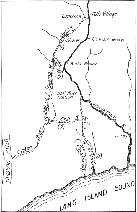
As possible former outlets for the Housatonic, Hobbs has suggested the Still-Umpog-Saugatuck valley or the Still-Croton valley (by way of the East Branch Reservoir)[12], whereas Crosby has suggested the Ten Mile-Swamp River-Muddy Brook-Croton River valley (by way of Webatuck, Wing's Station, and Pawling), or the Fall's Village-Limerock-Sharon-Webatuck Creek-Ten Mile valley.[13] The sketch map, fig. 10, indicates the courses just outlined and one other by way of the Norwalk. The latter [051] is the route followed by the Danbury and Norwalk Division of the Housatonic Railroad. It is natural to assume that the Housatonic might have occupied anyone of these lines of valleys, particularly where they are developed on limestone and seem too broad for the streams now occupying them. Nevertheless, although each of these routes is on soft rock and some give shorter distances to the sea than the present course, it is highly improbable that the Housatonic ever occupied any of these valleys. For had the river once become located in a path of least resistance, such as is furnished by any of these suggested routes, it could not have been dislodged and forced to cut its way for 25 miles through a massive granitic formation, as it does between Still River and Derby, without great difficulty (Pl. IV, A).
An inspection of the larger river systems of Connecticut shows that the streams composing them exhibit two main trends. Likewise, the courses, of the larger rivers themselves, whether trunk streams or tributaries, combine these two trends, one of which is northwest-southeast and the other nearly north-south.
The north-south drainage lines are the result of geologic structure, and many broad, flat-floored valleys, often apparently out of proportion to the streams occupying them, have this direction. On the other hand, the northwest-southeast drainage lines across the strike of formations, coincide with the slope toward the sea of the uplifted peneplain whose dissected surface is represented by the crests of the uplands. The valleys of streams with this trend are generally narrow, and some are gorges where resistant rock masses are crossed. The northwest-southeast trends of master streams thus were determined initially by the slope of the peneplain, whereas the north-south trends represent later adjustments to structure.
It is concluded, therefore, that the Housatonic between Bulls' Bridge and Derby (fig. 10), had its course determined by the slope of the uplifted peneplain and is antecedent in origin. The old headwaters extended northwest from the turn in the river near Bull's Bridge, whereas that part of the river above Bull's Bridge was initially a minor tributary. This tributary, because of its favorable situation, in time captured all the drainage of the extensive limestone belt to the north and then became part of the main stream. The lower Housatonic, therefore, has always maintained its ancient course diagonal to the strike of formations, and differential erosion, which reaches its maximum expression in limestone areas, is responsible for the impression that the Still River lowland and other valleys west of the Housatonic may once have been occupied by the latter stream.
[12] Hobbs, W. H., Still rivers of western Connecticut: Bull. Geol. Soc. Am., vol. 13, p. 25, 1901.
[13] Crosby, W. O., Notes on the geology of the sites of the proposed dams in the valleys of the Housatonic and Ten Mile rivers: Tech. Quart., vol. 13, p. 120, 1900.
[Plate IV]
| State Geol. Nat. Hist. Survey | Bull. 30. Plate IV. | |
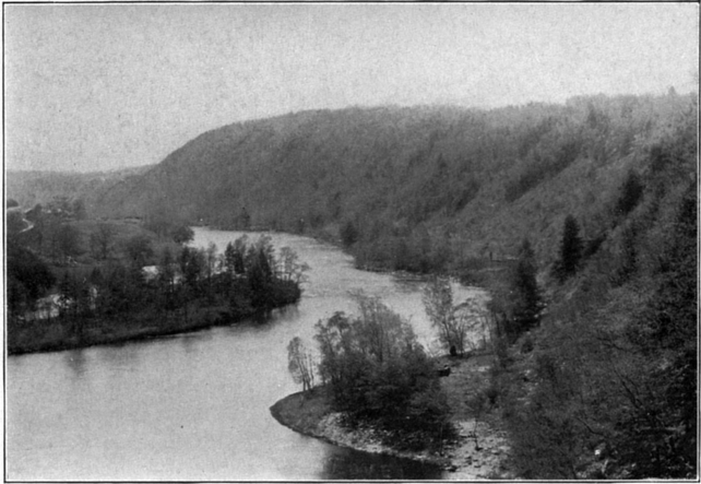 | ||
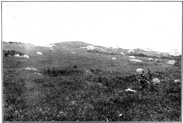 |
[^TOC]
A broad belt of limestone extends along the eastern side of the granite ridge of Shelter Rock and in preglacial time formed a broad-bottomed valley whose master stream had reached old age. When the glacier came it hampered the drainage by scooping out the rock bottom of the valley in places and by dropping deposits at the mouth of Beaver Brook valley, thus forming Beaver Brook Swamp or "The Flat," as it is called (fig. 6).
Among the deposits at the southern end of Beaver Brook Swamp is considerable stratified drift in the form of smoothly rounded hills or kames, which are situated both on the border of the valley and in the swamp. Till containing medium-sized boulders of granodiorite-gneiss occurs along the road which borders the east side of the densely wooded swamp.
Along the northeastern border of the swamp is a flat-topped terrace of till, perhaps a lateral moraine, through which a small stream heading to the north has cut a V-shaped ravine. A lobe of fine till extends into the valley from the northeast and narrows the outlet.Between the railroad and highway, which cross the northern end of the swamp, is an irregular wooded eminence of rock, partly concealed by a veneer of drift. Between this knoll and Shelter Rock are heavy deposits of sand in the form of a short, broad terrace with lobes which point into the Still River valley. A similar terrace is found to the northwest on the opposite side of the valley.
At the northern end of Shelter Rock along the blind road leading to the summit is a peninsula-like body of drift which contains huge granite boulders mixed here and there with pockets of sand and gravel. Stratified drift was found at the foot of the hill, and [054] till overlying it higher up. The more usual arrangement is boulder clay overlain by modified drift, the first being laid down by the ice itself, the second being deposited by streams from the melting glacier in its retreat. Huge boulders, many ten feet or more in diameter, are strewn over the northern slope of Shelter Rock.
[^TOC]
North of the railroad, opposite Shelter Rock (fig. 6), is a most interesting flat-topped ridge of drift which topographically is an extension of the higher rock mass to the northwest. In this drift mass are to be found in miniature a number of the forms characteristic of glacial topography. The broad-topped gravel ridge slopes sharply on the north into a flat-bottomed ravine which is evidently part of the Still River lowland. This portion of the valley has been shut off by drift deposits. The drainage has been so obstructed that the stream in the ravine turns northeast away from its natural outlet. In the valley of "X" brook (fig. 1) are terraces, esker-like lobes, and detached mounds of stratified drift resting on a foundation of till.
Along the eastern border of the hill is to be seen the contact between two forms of glacial deposits (Pl. IV, B). A mass of stratified drift overlies a hummocky deposit of coarse till, but large boulders occurring here and there on top of the stratified drift show that the ice-laid and water-laid materials were not completely sorted. Boulders seem to have been dropping out of the ice at the same time that gravel was being deposited. Boulders of granite-gneiss eight feet or more in diameter, carried by the ice from the hills to the north and northeast, are strewn at the foot of the hill.
[^TOC]About a mile beyond Beaver Brook Mountain, the railroad cuts through the edge of a hill 80 feet in height exposing a section consisting of distinctly stratified layers of fine white quartz sand, coarser yellowish sand, and small round pebbles. The quartz sand was used at one time in making glass. Farther east where the two tracks of the New York and New England railroads converge, a cut shows a section of at least 40 feet of boulder clay. Near the river, limestone boulders are common, indicating that the valley to the north was degraded to some extent by the glacier.
[Plate V]
| State Geol. Nat. Hist. Survey | Bull. 30. Plate V. |
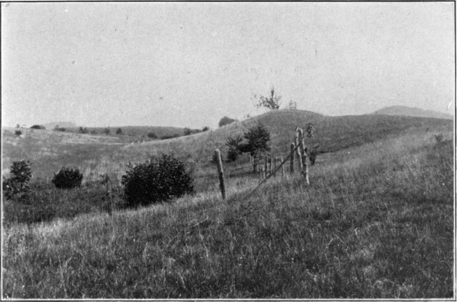 | |
A. Kames in Still River Valley west of Brookfield Junction.
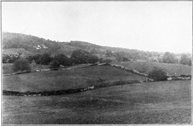 |
B. Till ridges on the western border of Still River Valley, south of Brookfield.
[055] In the valley at Brookfield Junction and on its western side, are thick deposits of clean sand. One mile north of Brookfield Junction, along the western border of the valley, an esker follows an irregular course for several hundred yards approximately parallel to the river and terminates at its southern end in a group of kames (Pl. V, A and B). Opposite the point where these accumulations occur, is a terrace-like deposit of till. Between the gorge at Brookfield and the mouth of Still River, swampy areas, flat meadows, and small hills of drift occur.
In comparison with the Still River lowland, the flat land east of Green Mountain may be called a plateau. The step between the two is made by an east-facing rocky slope, the outline of which has been softened by a lateral moraine separated from the plateau edge by a small ravine. On the lowland below the moraine is a group of kames. Near Lanesville (fig. 6), are thick deposits of water-laid material, including a hill of gravel near the river having a large bowl-shaped depression on one side formed by the melting of an ice block. Two and a half miles south of Lanesville on the west side of the lowland, a wooded esker extends for about one-quarter mile parallel to the valley axis and then merges into the rocky hillside.
[^TOC]The lakes of this region are of two kinds: (1) those due to the damming of river valleys by glacial deposits and (2) rock basins gouged out by the ice.
Among the lakes which owe their origin to drift accumulations in the valleys are Andrew and Haines' ponds at the head of Still River. These are properly parts of the Croton River system, but Andrew Pond has been held back by the deep filling of boulder clay in the valley. Lake Kanosha, in the same valley, is a shallow lake formed in the drift. The lake south of Spruce Mountain at the head of the Saugatuck seems to be enclosed by drift alone. [056] Neversink Pond, Barses Pond, Creek Pond, and Leonard Pond are the remnants of larger water bodies now converted into swamps. Squantz Pond and Hatch Pond have dams of drift. Eureka Lake and East Lake appear to be rock basins whose levels have been raised somewhat by dams of till. Great Mountain Pond and Green's Pond, between Great Mountain and Green Mountain, are surrounded by rock and their level has been raised several feet by artificial dams. Great Mountain Pond is at least 50 feet above the level of Green Pond and separated from it by a rock ridge (fig. 2).
[^TOC]A tongue of the glacier is supposed to have lain in the valley of the Umpog and gradually retreated northward after the ice had disappeared from the uplands on either side. The ridge of intermediate height built of limestone and schist, which extends down the middle of the valley, was probably covered by ice for some time after the glacier had left the highlands.
When the mountain mass extending from Pine Mountain to Town Hill west of the Umpog Basin and the granite hills to the east terminating in Shelter Rock are considered in their relation to the movement of the ice, it is apparent that the valley of the Umpog must have been the most direct and lowest outlet for glacial streams south of Danbury. These streams built up the terraces and other deposits of stratified drift which occupy the valley between Bethel and West Redding.
The heavy deposits of till near West Redding mark a halt in the retreating glacier. The boulders at this point are large and numerous, and kames and gravel ridges were formed. The deposits at the divide, supposed to have formed a glacial dam which reversed the Umpog,[14] are much less heavy than at points short distances north and south of the water parting.
As the ice retreated, sand and gravel in the form of terraces accumulated along the margin of the Umpog valley, where the drainage was concentrated in the spaces left by the melting of the ice lobe from the hillside. Among these deposits are the bodies of sand and gravel which lie against the rocky hillslopes most of [057] the way from the Umpog-Saugatuck divide to Bethel. North of Bethel, the drainage seems to have been gathered chiefly in streams flowing on each side of the low ridge occupying the center of the valley; consequently the gravel was deposited along the sides and southern end of the ridge and in the sag which cuts across its northern end. The row of kames at the north end of Umpog Swamp, several knolls of drift in Bethel, and the kame-like deposits and esker north of Grassy Plain were laid down successively as the ice retreated down the valley. During this period, the drainage was ponded between the ice front and the Umpog-Saugatuck divide.
Uncovering the Still-Croton valley did not give the glacial drainage any lower outlet than the Umpog-Saugatuck divide afforded (fig. 8, B and C.)
The heavy deposits of boulder clay forming the moraine which blocks the Rocky River valley indicate the next halting place of the glacier. In this period the ice margin formed an irregular northeast-southwest line about a mile north of Danbury. The country west and south of Danbury was thus uncovered, but the lower part of Still River valley was either covered by the ice sheet or occupied by an ice lobe. The drainage was, therefore, up the river valley, and being concentrated along the valley sides resulted in the accumulation of sand and gravel at the foot of rocky slopes. It is possible that an ice lobe extended down the old Rocky River valley, perhaps occupying much of the country between Beaver Brook Mountain and the high ridge west of the valley. The streams issuing from this part of the ice front would have laid down the eskers and kame gravels north of Danbury and the thick mantle of drift over which Still River flows through the city. As would be expected, this accumulation of material ponded all the north-flowing streams--Umpog Creek, Beaver Brook, and smaller nameless ones--and at the same time pushed Still River, at its mouth, to the southern side of its valley. Beaver Brook valley, Umpog valley, and all the Danbury basin must have been flooded during this period up to the height of the "railroad divide." Within the area covered by the city, the valley was filled up to at least 70 feet and probably much more than that above its former level. Flowing at this higher level, the river was thrown out of its course and here and there [058] superimposed on hard rock--as, for example, at Shelter Rock.
That part of the drainage coming down the valley opposite Beaver Brook met the drainage from Still River ice lobe in the valley north of Shelter Rock, and as a result heavy deposits of stratified drift were laid down. The peninsula-like mass of drift beyond the river north of Shelter Rock appears from its form to have been built up as the delta of southward and eastward-flowing streams; probably the drainage from the hilltops united with streams coming down the two valleys. The lobes of stratified drift extending from the ridge may have been built first, and later the connecting ridge of gravel which forms the top of the hill may have accumulated as additional material was washed in, tying together the ridges of gravel along their western ends. The mingling in this region of stratified drift of all grades of coarseness indicates the union in the same basin of debris gathered from several sources.
Between Danbury and New Milford no moraine crosses either the Rocky or the Still valley, but the abundance of till which overspreads the whole country indicates a slowly retreating glacier well loaded with rock debris. The mounds of stratified drift scattered along the valley doubtless represent the deltas of streams issuing from the ice front. The waters of Rocky River were ponded until the outlet near Jerusalem was uncovered and the disappearance of ice from the ravine below allowed an escape to the Housatonic. Stratified drift is present in greatest amount along the valleys of Still River and the west fork of Rocky River, indicating that these were the two chief lines of drainage. The uplands are practically without stratified drift.
Along the valley of the Housatonic, glacial material is chiefly in the form of gravel terraces; they extend from Gaylordsville to New Milford, in some places on one side only, in others on both sides of the river. Part of these gravel benches are kame terraces, as shown by their rolling tops and the ravine which separates the terrace from the hillside; others may have been made by the river cutting through the mantle of drift which was laid down in the period of land depression at the time of glacial retreat,[15] or they may be a combination of the two forms. In [059] many places by swinging in its flood plain, the river has cut into the terraces and left steep bluffs of gravel. The valley of Womenshenuck Brook above Merwinsville contains heavy deposits of stratified drift, indicating that this broad valley which extends from Kent on the Housatonic to Merwinsville was an important channel for the water which flowed from the melting ice.
[14] Hobbs, W. H., op. cit.
[15] Rice, W. N. and Gregory, H. E., Manual of the Geology of Connecticut: Conn. Geol. and Nat. Hist. Survey Bull. 6, pp. 34-35, 1906.
End of the Project Gutenberg EBook of Drainage Modifications and Glaciation
in the Danbury Region Connecticut, by Ruth Sawyer-Harvey

*** END OF THIS PROJECT GUTENBERG EBOOK DRAINAGE MODIFICATIONS AND ***

***** This file should be named 33050-h.htm or 33050-h.zip *****
This and all associated files of various formats will be found in:
        http://www.gutenberg.org/3/3/0/5/33050/

Produced by Charlene Taylor, Tom Cos and the Online
Distributed Proofreading Team at http://www.pgdp.net (This
file was produced from images generously made available
by The Internet Archive/American Libraries.)


Updated editions will replace the previous one--the old editions
will be renamed.

Creating the works from public domain print editions means that no
one owns a United States copyright in these works, so the Foundation
(and you!) can copy and distribute it in the United States without
permission and without paying copyright royalties.  Special rules,
set forth in the General Terms of Use part of this license, apply to
copying and distributing Project Gutenberg-tm electronic works to
protect the PROJECT GUTENBERG-tm concept and trademark.  Project
Gutenberg is a registered trademark, and may not be used if you
charge for the eBooks, unless you receive specific permission.  If you
do not charge anything for copies of this eBook, complying with the
rules is very easy.  You may use this eBook for nearly any purpose
such as creation of derivative works, reports, performances and
research.  They may be modified and printed and given away--you may do
practically ANYTHING with public domain eBooks.  Redistribution is
subject to the trademark license, especially commercial
redistribution.


*** START: FULL LICENSE ***

THE FULL PROJECT GUTENBERG LICENSE
PLEASE READ THIS BEFORE YOU DISTRIBUTE OR USE THIS WORK

To protect the Project Gutenberg-tm mission of promoting the free
distribution of electronic works, by using or distributing this work
(or any other work associated in any way with the phrase "Project
Gutenberg"), you agree to comply with all the terms of the Full Project
Gutenberg-tm License (available with this file or online at
http://gutenberg.org/license).


Section 1.  General Terms of Use and Redistributing Project Gutenberg-tm
electronic works

1.A.  By reading or using any part of this Project Gutenberg-tm
electronic work, you indicate that you have read, understand, agree to
and accept all the terms of this license and intellectual property
(trademark/copyright) agreement.  If you do not agree to abide by all
the terms of this agreement, you must cease using and return or destroy
all copies of Project Gutenberg-tm electronic works in your possession.
If you paid a fee for obtaining a copy of or access to a Project
Gutenberg-tm electronic work and you do not agree to be bound by the
terms of this agreement, you may obtain a refund from the person or
entity to whom you paid the fee as set forth in paragraph 1.E.8.

1.B.  "Project Gutenberg" is a registered trademark.  It may only be
used on or associated in any way with an electronic work by people who
agree to be bound by the terms of this agreement.  There are a few
things that you can do with most Project Gutenberg-tm electronic works
even without complying with the full terms of this agreement.  See
paragraph 1.C below.  There are a lot of things you can do with Project
Gutenberg-tm electronic works if you follow the terms of this agreement
and help preserve free future access to Project Gutenberg-tm electronic
works.  See paragraph 1.E below.

1.C.  The Project Gutenberg Literary Archive Foundation ("the Foundation"
or PGLAF), owns a compilation copyright in the collection of Project
Gutenberg-tm electronic works.  Nearly all the individual works in the
collection are in the public domain in the United States.  If an
individual work is in the public domain in the United States and you are
located in the United States, we do not claim a right to prevent you from
copying, distributing, performing, displaying or creating derivative
works based on the work as long as all references to Project Gutenberg
are removed.  Of course, we hope that you will support the Project
Gutenberg-tm mission of promoting free access to electronic works by
freely sharing Project Gutenberg-tm works in compliance with the terms of
this agreement for keeping the Project Gutenberg-tm name associated with
the work.  You can easily comply with the terms of this agreement by
keeping this work in the same format with its attached full Project
Gutenberg-tm License when you share it without charge with others.

1.D.  The copyright laws of the place where you are located also govern
what you can do with this work.  Copyright laws in most countries are in
a constant state of change.  If you are outside the United States, check
the laws of your country in addition to the terms of this agreement
before downloading, copying, displaying, performing, distributing or
creating derivative works based on this work or any other Project
Gutenberg-tm work.  The Foundation makes no representations concerning
the copyright status of any work in any country outside the United
States.

1.E.  Unless you have removed all references to Project Gutenberg:

1.E.1.  The following sentence, with active links to, or other immediate
access to, the full Project Gutenberg-tm License must appear prominently
whenever any copy of a Project Gutenberg-tm work (any work on which the
phrase "Project Gutenberg" appears, or with which the phrase "Project
Gutenberg" is associated) is accessed, displayed, performed, viewed,
copied or distributed:

This eBook is for the use of anyone anywhere at no cost and with
almost no restrictions whatsoever.  You may copy it, give it away or
re-use it under the terms of the Project Gutenberg License included
with this eBook or online at www.gutenberg.org

1.E.2.  If an individual Project Gutenberg-tm electronic work is derived
from the public domain (does not contain a notice indicating that it is
posted with permission of the copyright holder), the work can be copied
and distributed to anyone in the United States without paying any fees
or charges.  If you are redistributing or providing access to a work
with the phrase "Project Gutenberg" associated with or appearing on the
work, you must comply either with the requirements of paragraphs 1.E.1
through 1.E.7 or obtain permission for the use of the work and the
Project Gutenberg-tm trademark as set forth in paragraphs 1.E.8 or
1.E.9.

1.E.3.  If an individual Project Gutenberg-tm electronic work is posted
with the permission of the copyright holder, your use and distribution
must comply with both paragraphs 1.E.1 through 1.E.7 and any additional
terms imposed by the copyright holder.  Additional terms will be linked
to the Project Gutenberg-tm License for all works posted with the
permission of the copyright holder found at the beginning of this work.

1.E.4.  Do not unlink or detach or remove the full Project Gutenberg-tm
License terms from this work, or any files containing a part of this
work or any other work associated with Project Gutenberg-tm.

1.E.5.  Do not copy, display, perform, distribute or redistribute this
electronic work, or any part of this electronic work, without
prominently displaying the sentence set forth in paragraph 1.E.1 with
active links or immediate access to the full terms of the Project
Gutenberg-tm License.

1.E.6.  You may convert to and distribute this work in any binary,
compressed, marked up, nonproprietary or proprietary form, including any
word processing or hypertext form.  However, if you provide access to or
distribute copies of a Project Gutenberg-tm work in a format other than
"Plain Vanilla ASCII" or other format used in the official version
posted on the official Project Gutenberg-tm web site (www.gutenberg.org),
you must, at no additional cost, fee or expense to the user, provide a
copy, a means of exporting a copy, or a means of obtaining a copy upon
request, of the work in its original "Plain Vanilla ASCII" or other
form.  Any alternate format must include the full Project Gutenberg-tm
License as specified in paragraph 1.E.1.

1.E.7.  Do not charge a fee for access to, viewing, displaying,
performing, copying or distributing any Project Gutenberg-tm works
unless you comply with paragraph 1.E.8 or 1.E.9.

1.E.8.  You may charge a reasonable fee for copies of or providing
access to or distributing Project Gutenberg-tm electronic works provided
that

- You pay a royalty fee of 20% of the gross profits you derive from
     the use of Project Gutenberg-tm works calculated using the method
     you already use to calculate your applicable taxes.  The fee is
     owed to the owner of the Project Gutenberg-tm trademark, but he
     has agreed to donate royalties under this paragraph to the
     Project Gutenberg Literary Archive Foundation.  Royalty payments
     must be paid within 60 days following each date on which you
     prepare (or are legally required to prepare) your periodic tax
     returns.  Royalty payments should be clearly marked as such and
     sent to the Project Gutenberg Literary Archive Foundation at the
     address specified in Section 4, "Information about donations to
     the Project Gutenberg Literary Archive Foundation."

- You provide a full refund of any money paid by a user who notifies
     you in writing (or by e-mail) within 30 days of receipt that s/he
     does not agree to the terms of the full Project Gutenberg-tm
     License.  You must require such a user to return or
     destroy all copies of the works possessed in a physical medium
     and discontinue all use of and all access to other copies of
     Project Gutenberg-tm works.

- You provide, in accordance with paragraph 1.F.3, a full refund of any
     money paid for a work or a replacement copy, if a defect in the
     electronic work is discovered and reported to you within 90 days
     of receipt of the work.

- You comply with all other terms of this agreement for free
     distribution of Project Gutenberg-tm works.

1.E.9.  If you wish to charge a fee or distribute a Project Gutenberg-tm
electronic work or group of works on different terms than are set
forth in this agreement, you must obtain permission in writing from
both the Project Gutenberg Literary Archive Foundation and Michael
Hart, the owner of the Project Gutenberg-tm trademark.  Contact the
Foundation as set forth in Section 3 below.

1.F.

1.F.1.  Project Gutenberg volunteers and employees expend considerable
effort to identify, do copyright research on, transcribe and proofread
public domain works in creating the Project Gutenberg-tm
collection.  Despite these efforts, Project Gutenberg-tm electronic
works, and the medium on which they may be stored, may contain
"Defects," such as, but not limited to, incomplete, inaccurate or
corrupt data, transcription errors, a copyright or other intellectual
property infringement, a defective or damaged disk or other medium, a
computer virus, or computer codes that damage or cannot be read by
your equipment.

1.F.2.  LIMITED WARRANTY, DISCLAIMER OF DAMAGES - Except for the "Right
of Replacement or Refund" described in paragraph 1.F.3, the Project
Gutenberg Literary Archive Foundation, the owner of the Project
Gutenberg-tm trademark, and any other party distributing a Project
Gutenberg-tm electronic work under this agreement, disclaim all
liability to you for damages, costs and expenses, including legal
fees.  YOU AGREE THAT YOU HAVE NO REMEDIES FOR NEGLIGENCE, STRICT
LIABILITY, BREACH OF WARRANTY OR BREACH OF CONTRACT EXCEPT THOSE
PROVIDED IN PARAGRAPH F3.  YOU AGREE THAT THE FOUNDATION, THE
TRADEMARK OWNER, AND ANY DISTRIBUTOR UNDER THIS AGREEMENT WILL NOT BE
LIABLE TO YOU FOR ACTUAL, DIRECT, INDIRECT, CONSEQUENTIAL, PUNITIVE OR
INCIDENTAL DAMAGES EVEN IF YOU GIVE NOTICE OF THE POSSIBILITY OF SUCH
DAMAGE.

1.F.3.  LIMITED RIGHT OF REPLACEMENT OR REFUND - If you discover a
defect in this electronic work within 90 days of receiving it, you can
receive a refund of the money (if any) you paid for it by sending a
written explanation to the person you received the work from.  If you
received the work on a physical medium, you must return the medium with
your written explanation.  The person or entity that provided you with
the defective work may elect to provide a replacement copy in lieu of a
refund.  If you received the work electronically, the person or entity
providing it to you may choose to give you a second opportunity to
receive the work electronically in lieu of a refund.  If the second copy
is also defective, you may demand a refund in writing without further
opportunities to fix the problem.

1.F.4.  Except for the limited right of replacement or refund set forth
in paragraph 1.F.3, this work is provided to you 'AS-IS' WITH NO OTHER
WARRANTIES OF ANY KIND, EXPRESS OR IMPLIED, INCLUDING BUT NOT LIMITED TO
WARRANTIES OF MERCHANTIBILITY OR FITNESS FOR ANY PURPOSE.

1.F.5.  Some states do not allow disclaimers of certain implied
warranties or the exclusion or limitation of certain types of damages.
If any disclaimer or limitation set forth in this agreement violates the
law of the state applicable to this agreement, the agreement shall be
interpreted to make the maximum disclaimer or limitation permitted by
the applicable state law.  The invalidity or unenforceability of any
provision of this agreement shall not void the remaining provisions.

1.F.6.  INDEMNITY - You agree to indemnify and hold the Foundation, the
trademark owner, any agent or employee of the Foundation, anyone
providing copies of Project Gutenberg-tm electronic works in accordance
with this agreement, and any volunteers associated with the production,
promotion and distribution of Project Gutenberg-tm electronic works,
harmless from all liability, costs and expenses, including legal fees,
that arise directly or indirectly from any of the following which you do
or cause to occur: (a) distribution of this or any Project Gutenberg-tm
work, (b) alteration, modification, or additions or deletions to any
Project Gutenberg-tm work, and (c) any Defect you cause.


Section  2.  Information about the Mission of Project Gutenberg-tm

Project Gutenberg-tm is synonymous with the free distribution of
electronic works in formats readable by the widest variety of computers
including obsolete, old, middle-aged and new computers.  It exists
because of the efforts of hundreds of volunteers and donations from
people in all walks of life.

Volunteers and financial support to provide volunteers with the
assistance they need, are critical to reaching Project Gutenberg-tm's
goals and ensuring that the Project Gutenberg-tm collection will
remain freely available for generations to come.  In 2001, the Project
Gutenberg Literary Archive Foundation was created to provide a secure
and permanent future for Project Gutenberg-tm and future generations.
To learn more about the Project Gutenberg Literary Archive Foundation
and how your efforts and donations can help, see Sections 3 and 4
and the Foundation web page at http://www.pglaf.org.


Section 3.  Information about the Project Gutenberg Literary Archive
Foundation

The Project Gutenberg Literary Archive Foundation is a non profit
501(c)(3) educational corporation organized under the laws of the
state of Mississippi and granted tax exempt status by the Internal
Revenue Service.  The Foundation's EIN or federal tax identification
number is 64-6221541.  Its 501(c)(3) letter is posted at
http://pglaf.org/fundraising.  Contributions to the Project Gutenberg
Literary Archive Foundation are tax deductible to the full extent
permitted by U.S. federal laws and your state's laws.

The Foundation's principal office is located at 4557 Melan Dr. S.
Fairbanks, AK, 99712., but its volunteers and employees are scattered
throughout numerous locations.  Its business office is located at
809 North 1500 West, Salt Lake City, UT 84116, (801) 596-1887, email
business@pglaf.org.  Email contact links and up to date contact
information can be found at the Foundation's web site and official
page at http://pglaf.org

For additional contact information:
     Dr. Gregory B. Newby
     Chief Executive and Director
     gbnewby@pglaf.org


Section 4.  Information about Donations to the Project Gutenberg
Literary Archive Foundation

Project Gutenberg-tm depends upon and cannot survive without wide
spread public support and donations to carry out its mission of
increasing the number of public domain and licensed works that can be
freely distributed in machine readable form accessible by the widest
array of equipment including outdated equipment.  Many small donations
($1 to $5,000) are particularly important to maintaining tax exempt
status with the IRS.

The Foundation is committed to complying with the laws regulating
charities and charitable donations in all 50 states of the United
States.  Compliance requirements are not uniform and it takes a
considerable effort, much paperwork and many fees to meet and keep up
with these requirements.  We do not solicit donations in locations
where we have not received written confirmation of compliance.  To
SEND DONATIONS or determine the status of compliance for any
particular state visit http://pglaf.org

While we cannot and do not solicit contributions from states where we
have not met the solicitation requirements, we know of no prohibition
against accepting unsolicited donations from donors in such states who
approach us with offers to donate.

International donations are gratefully accepted, but we cannot make
any statements concerning tax treatment of donations received from
outside the United States.  U.S. laws alone swamp our small staff.

Please check the Project Gutenberg Web pages for current donation
methods and addresses.  Donations are accepted in a number of other
ways including checks, online payments and credit card donations.
To donate, please visit: http://pglaf.org/donate


Section 5.  General Information About Project Gutenberg-tm electronic
works.

Professor Michael S. Hart is the originator of the Project Gutenberg-tm
concept of a library of electronic works that could be freely shared
with anyone.  For thirty years, he produced and distributed Project
Gutenberg-tm eBooks with only a loose network of volunteer support.


Project Gutenberg-tm eBooks are often created from several printed
editions, all of which are confirmed as Public Domain in the U.S.
unless a copyright notice is included.  Thus, we do not necessarily
keep eBooks in compliance with any particular paper edition.


Most people start at our Web site which has the main PG search facility:

     http://www.gutenberg.org

This Web site includes information about Project Gutenberg-tm,
including how to make donations to the Project Gutenberg Literary
Archive Foundation, how to help produce our new eBooks, and how to
subscribe to our email newsletter to hear about new eBooks.