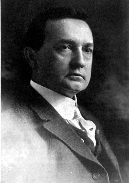
WILLIAM O. HUDSON
President, Board of Commissioners of Port of New Orleans
The Project Gutenberg EBook of The Industrial Canal and Inner Harbor of
New Orleans, by Thomas Ewing Dabney

This eBook is for the use of anyone anywhere at no cost and with
almost no restrictions whatsoever.  You may copy it, give it away or
re-use it under the terms of the Project Gutenberg License included
with this eBook or online at www.gutenberg.org


Title: The Industrial Canal and Inner Harbor of New Orleans
       History, Description and Economic Aspects of Giant Facility
              Created to Encourage Industrial Expansion and Develop
              Commerce

Author: Thomas Ewing Dabney

Release Date: February 25, 2010 [EBook #31383]

Language: English

Character set encoding: ISO-8859-1

*** START OF THIS PROJECT GUTENBERG EBOOK INDUSTRIAL CANAL ***


Produced by The Online Distributed Proofreading Team at
http://www.pgdp.net (This file was produced from images
generously made available by The Internet Archive/American
Libraries.)
FOREWORD.
Oh the mind of man! Frail, untrustworthy, perishable—yet able to stand unlimited agony, cope with the greatest forces of Nature and build against a thousand years. Passion can blind it—yet it can read in infinity the difference between right and wrong. Alcohol can unsettle it—yet it can create a poem or a harmony or a philosophy that is immortal. A flower pot falling out of a window can destroy it—yet it can move mountains.
If Man had a tool that was as frail as his mind, he would fear to use it. He would not trust himself on a plank so liable to crack. He would not venture into a boat so liable to go to pieces. He would not drive a tack with a hammer, the head of which is so liable to fly off.
But Man knows that what the mind can conceive, that can he execute. So Man sits in his room and plans the things the world thought impossible. From the known he dares the unknown. He covers paper with figures, conjures forth a blue print, and sends an army of workmen against the forces of Nature. If his mind blundered, he would waste millions in money and perhaps destroy thousands of lives. But Man can trust his mind; fragile though it is, he knows it can bear the strain of any task put upon it.
All over the world there is the proof: in the heavens above, and in the waters under the earth. And nowhere has Man won a greater triumph over unspeakable odds than in New Orleans, in the dredging of a canal through buried forests 18,000 years old, the creation of an underground river, and the building of a lock that was thought impossible.
| FOREWORD | 2 |
| THE NEED RECOGNIZED FOR A CENTURY | 5 |
| NEW ORLEANS DECIDES TO BUILD CANAL | 8 |
| SMALL CANAL FIRST PLANNED | 13 |
| THE DIRT BEGINS TO FLY | 17 |
| CANAL PLANS EXPANDED | 22 |
| DIGGING THE DITCH | 27 |
| OVERWHELMING ENDORSEMENT BY NEW ORLEANS | 31 |
| SIPHON AND BRIDGES | 36 |
| THE REMARKABLE LOCK | 40 |
| NEW CHANNEL TO THE GULF | 48 |
| WHY GOVERNMENT SHOULD OPERATE CANAL | 54 |
| ECONOMIC ASPECT OF CANAL | 60 |
| CONSTRUCTION COSTS AND CONTRACTORS | 66 |
| OTHER PORT FACILITIES | 70 |
| COMPARISON OF DISTANCES BETWEEN NEW ORLEANS AND THE PRINCIPAL CITIES AND PORTS OF THE WORLD | 78 |
THE NEED RECOGNIZED FOR A CENTURY.
There is a map in the possession of T. P. Thompson of New Orleans, who has a notable collection of books and documents on the early history of this city, dated March 1, 1827, and drawn by Captain W. T. Poussin, topographical engineer, showing the route of a proposed canal to connect the Mississippi River and Lake Pontchartrain, curiously near the site finally chosen for that great enterprise nearly a hundred years later.
New Orleans then was a mere huddle of buildings around Jackson Square; but with the purchase of the Louisiana territory from France, and the great influx of American enterprise that characterized the first quarter of the last century, development was working like yeast, and it was foreseen that New Orleans' future depended largely upon connecting the two waterways mentioned—the river, that drains the commerce of the Mississippi Valley, at our front door, and the lake, with its short-cut to the sea and the commerce of the world, at the back.
When the Carondelet canal, now known as the Old Basin Canal, was begun in 1794, the plan was to extend it to the river. It was also planned to connect the New Basin Canal, begun in 1833, with the Mississippi. This was, in fact, one of the big questions of the period. That the work was not put through was due more to the lack of machinery than of enterprise.
During the rest of the century, the proposal bobbed up at frequent intervals, and the small Lake Borgne canal was finally shoved through from the Mississippi to Lake Borgne, which is a bay of Lake Pontchartrain.
The difference between these early proposals and the plan for the Industrial Canal and Inner Harbor that was finally adopted, is that the purpose in the former case was simply to develop a waterway for handling freight, whereas the object of New Orleans' great facility, now nearing completion, is to create industrial development.
Under the law of Louisiana, inherited from the Spanish and French regimes, river frontage can not be sold or leased to private enterprise. This law prevents port facilities being sewed up by selfish interests and insures a fair deal for all shipping lines, new ones as well as old, with a consequent development of foreign trade; and port officials, at harbors that are under private monopoly, would give a pretty if the Louisiana system could be established there.
But there is no law, however good, that meets all conditions, and a number of private enterprises—warehouses and factories—have undoubtedly been kept out of New Orleans because they could not secure water frontage.
An artificial waterway, capable of indefinite expansion, on whose banks private enterprise could buy or lease, for a long period of time, the land for erecting its buildings and plants, without putting in jeopardy the commercial development of the port; a waterway that would co-ordinate river, rail and maritime facilities most economically, and lend itself to the development of a "free port" when the United States finally adopts that requisite to a world commerce—that was the recognized need of New Orleans when the proposal for connecting the two waterways came to the fore in the opening years of the present century. The Progressive Union, later the Association of Commerce, took a leading part in the propaganda; it was assisted by other public bodies, and forward-looking men, who gradually wore away the opposition with which is received every attempt to do something that grandfather didn't do.
And on July 9, 1914, the legislature of Louisiana passed Act No. 244, authorizing the Commission Council of New Orleans to determine the site, and the Board of Port Commissioners of Louisiana, or Dock Board, as it is more commonly called, to build the Industrial Canal.
The act gave the board a right to expropriate all property necessary for the purpose, to build the "necessary locks, slips, laterals, basins and appurtenances * * * in aid of commerce," and to issue an unlimited amount in bonds "against the real estate and canal and locks and other improvements * * * to be paid out of the net receipts of said canal and appurtenances thereof, after the payment of operating expenses * * * (and) to fix charges for tolls in said canal."
This was submitted to a vote of the people at the regular election in November of that year, and became part of the constitution.
To avoid the complication of a second mortgage on the property, the Dock Board subsequently (ordinance of June 29, 1918) set a limit on the total bond issue. To enable the development that was then seen to be dimly possible, it set this limit high—at $25,000,000.
NEW ORLEANS DECIDES TO BUILD CANAL.
The canal for which the legislature made provision in 1914 bears about the relation to the one that was finally built as the acorn does to the oak. It was to be a mere barge canal that might ultimately be enlarged to a ship canal. Its cost was estimated at $2,400,000, which was less than the cost of digging the New Basin canal nearly a century before, which was a great deal smaller and ran but half way between the lake and river.
The panic of the early days of the World War shoved even this modest plan to one side, and it was not until the next year that enthusiasm caught its second wind. Then the leading men and the press of the city put themselves behind the project once more.
As the New Orleans Item said, October 22, 1915, "the lack of that canal has already proven to have cost the city much in trade and developed industry."
Commenting on the "astonishing exhibition of intelligent public spirit" in New Orleans, the Chicago Tribune said that "no other city in or near the Mississippi Valley, including Chicago, has shown such an awakening to the possibilities and rearrangements that are following the cutting of the Panama canal. * * * The awakening started with the talk of the new canal."
Other papers throughout the country made similar expressions.
In 1915 the engineering firm of Ford, Bacon & Davis made a preliminary survey of conditions and how development would be affected by the canal. At about the same time the Illinois legislature voted to spend $5,000,000 to construct a deep water canal, giving Chicago water connection with the Mississippi River; and the New Orleans Item linked the two projects when it said, January 16, 1916, "the Illinois-Lake Michigan Canal and the New Orleans Industrial Canal are complementary links in a new system of waterways connecting the upper Valley through the Mississippi River and New Orleans with the Gulf and the Panama Canal. This system again gives the differential to the Valley cities in trade with the markets of the Orient, our own west coast, and South America."
Commodore Ernest Lee Jahncke, president of the Association of Commerce, issued a statement to the press January 16, 1916, declaring that the prospect of the canal "brightened the whole business future of this city and the Mississippi Valley"; the New Orleans Real Estate Board and the Auction Exchange, in a joint meeting, urged its speedy building; and Governor Luther E. Hall, in a formal statement to the press January 16, 1916, gave his endorsement to the construction of the canal "long sought by many commercial interests of New Orleans," and said that work would probably begin in "three months."
In August, 1916, the governor dismissed the Dock Board and appointed a new one.
In the confusion attending the reorganization the canal project was again dropped. The New Orleans American, on August 28, 1916, attempted to revive it, but the effort fell flat, and the plan laid on ice until 1918.
America had in the meantime thrown its hat into the ring, and the cry was going up for ships, more ships, and still more ships. National patriotism succeeded where civic effort had failed. New Orleans brought out its Industrial Canal project to help the country build the famous "bridge of boats."
But this new phase of the plan was far from the canal that was finally built. In fact, the accomplishment of this project has shown a remarkable development with the passing years, reminding one of the growth of the trivial hopes of the boy into the mighty achievement of the man.
Ships could not be built on the Mississippi River. The twenty-foot range in the water level would require the ways to make a long slope into the current, a work of prohibitive expense, and as nearly impossible from an engineering standpoint as anything can be.
Early in 1918 a committee of representative Orleanians began to study the situation. This was known as the City Shipbuilding Committee. It comprised Mayor Behrman, O. S. Morris, president of the Association of Commerce; Walter Parker, manager of that body; Arthur McGuirk, special counsel of the Dock Board; R. S. Hecht, president of the Hibernia Bank; Dr. Paul H. Saunders, president of the Canal-Commercial Bank; J. D. O'Keefe, vice-president of the Whitney-Central Bank; J. K. Newman, financier; G. G. Earl, superintendent of the Sewerage and Water Board; Hampton Reynolds, contractor; D. D. Moore, James M. Thompson and J. Walker Ross, of the Times-Picayune, Item and States, respectively.
On February 10, 1918, this committee laid the plans for an industrial basin, connected with the river by a lock, and ultimately to be connected with the lake by a small barge canal. Ships could be built on the banks of this basin, the water in which would have a fixed level.
Mr. Hecht, and Arthur McGuirk, special counsel of the Dock Board, devised the plan by which the project could be financed. The Dock Board would issue long-term bonds, and build the necessary levees with the material excavated from the canal.
The committee's formal statement summarized the public need of this facility as follows:
"1. It will provide practical, convenient and fixed-level water-front sites for ship and boat building and repair plants, for industries and commercial enterprises requiring water frontage.
"2. It will provide opportunities for all enterprises requiring particular facilities on water frontage to create such facilities.
"3. It will permit the complete co-ordination, in the City of New Orleans, of the traffic of the Mississippi River and its tributaries, of the Intracoastal Canal, the railroads and the sea, under the most convenient and satisfactory conditions.
"4. In connection with the publicly-owned facilities on the river front, it will give New Orleans all the port and harbor advantages enjoyed by Amsterdam with its canal system, Rotterdam and Antwerp with their joint river and ocean facilities; Hamburg with its free port, and Liverpool with its capacity as a market deposit.
"5. It will give New Orleans a fixed-level, well protected harbor.
"6. It will serve the purposes of the Intracoastal Canal and increase the benefits to accrue to New Orleans from that canal.
"7. In connection with revived commercial use of the inland waterways upon which the federal government is now determined, it will open the way for an easy solution of the problem of handling, housing and interchange of water-borne commerce, and of the development of facilities for the storage of commodities between the period of production and consumption.
"8. It will prove an important facility in the equipment of New Orleans to meet the new competition the enlarged Erie Canal will create. The original Erie Canal harmed New Orleans because Mississippi River boat lines could not build their own terminal and housing facilities at New Orleans."
|
W. A. KERNAGHAN
Vice-President |
RENÉ CLERC
Secretary |
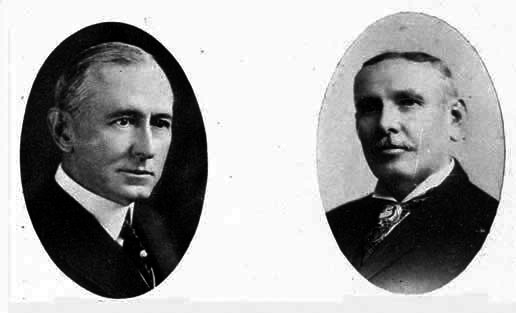
| ALBERT MACKIE | HUGH McCLOSKEY |
COMMISSIONERS
Board of Commissioners of the Port of New Orleans
This meeting made industrial history in New Orleans. The Hecht plan was studied by lawyers and financiers and declared feasible. Mr. Hecht summarized the confidence of the far-visioned men in the new New Orleans when he declared in a public interview: "I feel there is absolutely nothing to prevent the immediate realization of New Orleans' long dream of becoming a great industrial and commercial center and having great shipbuilding plants located within the city limits."
And the Item said, in commenting on the undertaking (February 17, 1918): "Millions of dollars of capital will be ready to engage in shipbuilding in New Orleans the moment that piledrivers and steam shovels are set to work on the shiplock and navigation canal."
It was a time of great industrial excitement. Victory was at last in the grasp of New Orleans. The eyes of the country were on New Orleans. The cry was, "Full Speed Ahead!"
SMALL CANAL FIRST PLANNED.
The plan, at this time, was to have a lock-sill only 16 or 18 feet deep. This would be sufficient to allow empty ships to enter or leave the canal, but not loaded. The mere building of ships was thus the principal thought, despite the rhetoric on commercial and industrial possibilities. Perhaps the leaders who were beating the project into shape were themselves afraid to think in the millions necessary to do the work to which New Orleans finally dedicated itself; perhaps they realized that the figure would stagger the minds of the people and defeat the undertaking, if they were not gradually educated up to the mark.
Meeting on February 15, 1918, the Dock Board resolved unanimously to put the plan through, if it proved feasible. W. B. Thompson was president of the board; the other members were Dr. E. S. Kelly, Thomas J. Kelly, B. B. Hans and O. P. Geren. Later, E. E. Lafaye took Mr. Kelly's place on the board.
The Public Belt Railroad board had in the meantime (February 13) voted to pay the Dock Board $50,000 a year; and the Levee Board (February 14) to give $125,000 a year. As the plans were increased, the Levee Board later increased its bit to $925,000.
Mayor Behrman, Arthur McGuirk and R. S. Hecht laid the proposition before both bodies. Action was unanimous. Colonel J. D. Hill, speaking for the Belt Railroad Board, said: "I am glad that at last there has been outlined a plan which seemingly makes it possible to construct the canal. It will not only result in the eventual construction of a big fleet of ships, but will prepare the way for a tremendous industrial activity in other lines. The consensus has been that a navigation canal is needed to induce large manufacturers, importers and exporters to establish their factories and warehouses here. This project will be the opening wedge."
Members of the Public Belt Board voting, besides Colonel Hill and Mayor Behrman (ex-officio) were Ginder Abbott, Arthur Simpson, John H. Murphy, W. B. Bloomfield, Adam Lorch, George P. Thompson, Thomas F. Cunningham, Victor Lambou, Edgar B. Stern and Sam Segari.
Members of the Levee Board voting were: William McL. Fayssoux, president, Thomas Killeen, Thomas Smith, John F. Muller, James P. Williams, John P. Vezien.
W. B. Thompson, president, put the matter before the Dock Board. "The idea" he said, according to the minutes of the meeting of February 15, 1918, "had always received his approval, and he thought that the mayor would recall that in the preparation, he with the city attorney, had a very considerable part in framing the same, and he had taken an active interest in the matter; he had always been in favor of the Industrial Canal, and he believed in the possibility of development of New Orleans through this, as a terminus; and it was entirely logical that the Dock Board should do all that may lie within its power to bring about the successful consummation of this project; the only doubt in his mind being as to the feasibility of the project from the financial standpoint. It seems now, however, that a plan has been devised, through efforts of the mayor and Mr. Hecht, which gives every promise of success. The co-operation of the city on behalf of the Public Belt Railroad, and of the Levee Board, apparently removed the difficulties in respect to the financial end. The Dock Board welcomes the assistance and co-operation of the city and of the Levee Board, but inasmuch as these boards are merely contributing certain amounts per year, and whereas the Dock Board is the obligor in respect of the principal of the bond issue, it devolves upon the Dock Board to use great caution before committing itself to any particular plan in a matter which so vitally affects the credit of the Dock Board, the city of New Orleans and the Levee Board. President Thompson further stated that he unhesitatingly endorsed the project and that he was sure that every member of the board agreed, and the board would be glad to give prompt consideration to the particular plan in question and reach some conclusion which will insure the realization of this great project."
To estimate the probable cost of the canal, Mayor Behrman appointed the following committee of engineers: W. J. Hardee, city engineer; A. F. Barclay, engineer of the Public Belt Railroad; George G. Earl, superintendent of the Sewerage & Water Board; C. T. Rayner, Jr., engineer of the Levee Board and Hampton Reynolds, contractor.
On February 22, the committee reported that, not counting real estate, a canal could be built for $2,626,876. This estimate called for a lock 600 feet long, 70 feet wide, and 18 feet deep, and a barge canal to the lake. The cost of constructing the lock was put at $1,370,660, and of digging the canal $1,256,216.
This report was first received by a special committee composed of Mayor Behrman, W. B. Thompson, Col. J. B. Hill, R. S. Hecht and Major W. McL. Fayssoux. This committee referred it to the Dock Board, which adopted it February 22.
Financial arrangements were completed at this same meeting. In order to have sufficient to pay for the land which would have to be expropriated for the canal, and to give some leeway, it was decided to issue bonds for $3,500,000, with an option of floating $1,000,000 more within 30 days. A financial syndicate, consisting of the Hibernia, Interstate and Whitney-Central banks of New Orleans, the William R. Compton Investment Company of St. Louis, and the Halsey, Stuart Company of Chicago, agreed to take the entire issue. The bonds were to run 40 years and begin to mature serially after 10 years. They were to bear 5 per cent interest, and to be sold at 95. They would be secured by a mortgage on the real estate of the canal site, and by the taxing powers of the state, for they were a recognized state obligation, as Arthur McGuirk, special counsel of the Dock Board, pointed out in his opinion of July 10, 1918.
He added: "I am likewise of opinion that said bonds are unaffected by any limitations upon the state debt, or upon the rate of taxation for public purposes; that the said bonds are entitled to be paid out of the general funds, or by the exercise of the power of taxation insofar as the revenues, funds or property preferentially pledged or mortgaged to secure said issue may fail, or be insufficient, to pay the same."
The following sat with the Dock Board and its attorneys at the meeting of February 22: Mayor Behrman, J. D. Hill of the Public Belt Railroad, R. S. Hecht, president of the Hibernia Bank, J. D. O'Keefe, vice-president of the Whitney-Central Bank, C. G. Reeves, vice-president of the Interstate Bank, W. R. Compton of the Compton Investment Company, H. L. Stuart of Halsey, Stuart and Company, W. J. Hardee, city engineer, and Hampton Reynolds, contractor.
The selection of the site was left, by the state law, to the commission council. There were a number of possible routes, and the selection was made with the utmost secrecy to prevent real estate profiteering. At first the area bounded by France and Reynes streets was chosen. This was on February 28. On May 9, however, the site was changed to the area bounded by France and Lizardi streets, north from the Mississippi River to Florida Walk, thence to Lake Pontchartrain. This is a virtually uninhabited region in the Third District, through the old Ursulines tract. The site chosen for expropriation is five and a third miles long by 2,200 feet wide, 897 acres.
For this land the Dock Board paid $1,493,532.24, which is at the rate of $1,665 an acre. The valuation was reached by expropriation proceedings.
In the meantime, Commodore Ernest Lee Jahncke had asked to be allotted the first site on the Industrial Canal, and Doullut & Williams for the second. Both were for shipyards. The Foundation Company, which was operating a number of shipyards in various parts of the country, sent an engineer here to see if it would be feasible for the concern to build a shipyard here.
Even before the piledrivers and dredges were on the job, the millions were being counted for investment in the city whose remarkable enterprise had won the admiration of the country.
THE DIRT BEGINS TO FLY.
Until the money for the bond issue should be available, the Hibernia Bank authorized the Dock Board to draw against it on open account. It only remained, then, to secure the authorization of the Capital Issues Committee of the Federal Reserve Board, which controlled all bond issues during the World War, to start the work. The grounds on which the authorization was requested summarize conditions that make possible a great industrial development in New Orleans, and will stand quoting. They are:
"(a) Semi-tropical conditions, which make it feasible to work every day and night in the year;
"(b) Admirable housing conditions which render it feasible for labor to live under most sanitary conditions in houses closely proximate to both the plants and the city, with sewerage and water connections, and with street car transportation facilities to and from the plants and to and from the amusement centers of the city;
"(c) Ample labor supply and satisfactory labor conditions;
"(d) Proximity to timber, steel and coal sources of supply with all water as well as rail transportation facilities thereon;
"(e) State control of the canal facilities and operation of the same, not for profit, but for the economical and expeditious development of shipbuilding."
Two shipyards were established on the canal. They poured millions of dollars into New Orleans. The tremendous tonnage built in the United States during the war, and the slump in foreign trade that followed the armistice, due to financial conditions abroad, have caused many shipyards throughout the United States to close down, among them one of these at New Orleans. The other one is now finishing its war contracts, and will be more or less inactive until the demands of the American Merchant Marine and business in general open up again. If they are not used for shipbuilding, they can be used for ship repairing or building barges. And it is obvious that the same conditions that made ship building an economic possibility, will encourage other industrial production, especially production that requires the co-ordination of river, rail and maritime facilities. The Canal means millions of new money to New Orleans, as its proponents said it would.
On March 12, the authorization of the Capital Issues Committee was given. On March 15, the George W. Goethals Company, Inc., was retained as consulting engineers on the big job. The services of this company were secured as much for its engineering skill, proven by its work on the Panama Canal, as for the prestige of its name. The Goethals Company, co-operating with the engineers of the Dock Board, which did the work, designed the famous lock and directed the entire job. George M. Wells, vice-president of the firm, was put in active charge of the work. General Goethals made occasional visits of supervision.
The dirt began to fly on June 6, 1918.
Before coming to New Orleans to take up his work, Mr. Wells, acting upon instructions of the Dock Board, called at the office of the Foundation Company in New York, whose engineer had already studied the possibilities of establishing a shipyard on the canal, and guaranteed an outlet to the sea by the time its vessels should be finished.
The river end of the site chosen for the canal consisted of low and flat meadow land. There were a few houses helter-skeltered about, like blocks in a nursery, but the principal signs of human life were the cows that grazed where the grazing was good, and sought refuge from the noonday beams of the sun under the occasional oaks that had strayed out into the open and didn't know how to get back. The middle of the site—several miles in extent—was a gray cypress swamp, with five or six hundred trees to the acre, and always awash. The lake end was "trembling prairie" marsh land subject to tidal overflow and very soft.
With dredges, spades, mechanical excavators, piledrivers and dynamite the work opened.
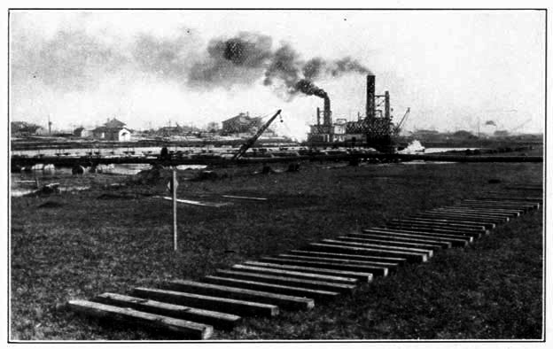
A great force of men began to throw up by hand, the levees that were to serve as banks for the turning basin, the lock and other portions of the canal. This levee would keep the liquid material, dredged out, from running back into the excavation. The turning basin, 950 feet by 1,150 feet, was an expansion of the original industrial basin. Situated several hundred feet from the lock, its purpose is to enable ships entering the canal from the river, and passing through the lock, to turn in, as well as to furnish a site for the concentration of industries. The Foundation Company had in the meantime decided to establish a shipyard on this basin; its engineers were on the ground, and its material was rolling.
One dredge was sent around Lake Pontchartrain to commence boring in from that end. This could not be done on the river end. The Mississippi is too mighty a giant to risk such liberties. The 2,000-foot cut between the river and the lock would have to be done last of all, when the rest of the canal and the lock were finished, and the new levees that would protect the city against its overflow, were solidly set. But a few hundred feet from the turning basin, was Bayou Bienvenu, which runs into Lake Borgne, part of Lake Pontchartrain, and one of the refuges of Lafitte in the brave days when smuggling was more a sport of the plain people than it is now with European travel restricted to the wealthy. So through Bayou Bienvenu a small excavator was sent to cut a passage into the turning basin, to allow the mighty 22-inch dredges to get in and work outwards towards the lake and the lock site.
The problem was further complicated by the Florida Walk drainage system, which emptied into Bayou Bienvenu, and by the railway lines that crossed the site of the Canal.
These railways were the Southern Railway, at the lake end, the Louisville & Nashville, at the middle, and the Southern and Public Belt near the turning basin on Florida Walk. For them, the Dock Board had to build "run-around" tracks, to be used while their lines were cut to enable the dredging to be made and the bridges to be constructed.
For the drainage, the plans called for the construction of an inverted siphon passing under the Canal, a river under a river, so to speak. In the meantime, however, the drainage canal had to be blocked off with two cofferdams, to cut off the water from the city and the bayou, and enable the construction of the siphon between.
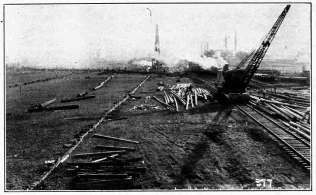
Additional railroad tracks, too, had to be built to handle the immense volume of material needed for the work; roads had to be built for getting supplies on the job by truck; the trolley line had to be extended for the transportation of labor.
Week by week the labor gangs grew, as the men were able to find places in the attacking line of the industrial battle. Great excavators stalked over the land, pulling themselves along by their dippers which bit out chunks of earth as big as a cart when they "took a-hold"; the smack of pile drivers, the thump of dynamite, and the whistle of dredges filled the air. Buildings sprouted like mushrooms; in the meadow, half a mile from the nearest water, the shipyard of the Foundation Company began to take form. It was the plan to finish the Canal by January, 1920.
CANAL PLANS EXPANDED.
Work in the meantime had begun on the commodity warehouse and wharf, another facility planned by the Dock Board to relieve the growing pains. Built on the Canal, but opening on the river, it was to perform the same service for general commodities as the Public Cotton Warehouse and the Public Grain Elevator did for those products. Though not a part of the canal plan, the construction of the warehouse at this point was part of the general scheme to concentrate industrial development on that waterway.
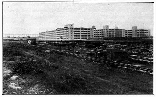
Later, the Federal Government took over this work and gave New Orleans a $13,000,000 terminal, through which it handled army supplies. It is still using the three warehouses for storage purposes, but has leased the half-mile double-deck wharf to the Dock Board, which is devoting it to the general commerce of the port. In time, the Dock Board hopes to get at least one of the buildings.
There can be no doubt but that the enterprise of New Orleans in building the Industrial Canal had a great deal to do with the government's determination to establish a depot at New Orleans.
On May 30, the news came out of Washington that the Doullut & Williams Shipbuilding Company had been awarded a $15,000,000 contract by the Emergency Fleet Corporation to build eight ships of 9,600 tons each. This was the largest shipbuilding contract that had been given the South. The Industrial Canal rendered it possible.
The firm of Doullut & Williams had been engaged for fifteen years or so in the civil engineering and contracting business in New Orleans. Captain M. P. Doullut had built launches with his own hands when a young man, and dreamed of the time when he would have a yard capable of turning out ocean-going vessels. The Doullut & Williams Shipbuilding Company was organized April 25, 1918, with the following officers: M. P. Doullut, president; Paul Doullut, vice-president; W. Horace Williams, secretary-treasurer and general manager; L. H. Guerin, chief engineer; and James P. Ewin, assistant chief engineer.
"I feel that New Orleans is on the eve of a very remarkable development" said Senator Ransdell of Louisiana in a telegram of congratulation, "and earnestly hope our people will continue to work together with energy and hearty accord until we have gone way over the top in shipbuilding and many other lines."
The expression "over the top" had not become the pest that it and other war-time weeds of rhetoric have subsequently proven. That was a time when one could still refer to a "drive" without causing a gnashing of teeth.
Picking the site at the Lake Pontchartrain end of the canal, Doullut & Williams Shipbuilding Company began to erect its shipyard. The plant buildings were erected upon tall piling. As the dredges excavated the material from the cut, they deposited it on the site of the shipyard and raised the elevation several feet, so the buildings were only the usual height above the ground. Both sides of the Canal, it should be added, have been similarly raised by excavation material.
It was planned that the ships from the Doullut & Williams yard should be sent out into the world through Lake Pontchartrain, which empties into the Gulf of Mexico. There was ample water in the lake, without dredging, to accommodate unloaded ships of this size.
But the fact that ships 400 or so feet long and drawing, when loaded to capacity, 27 feet, were to be built at New Orleans, emphasized the belief of those directing the work of the Industrial Canal that the plan on which they were working was too small. An 18-foot canal would not meet the growing needs of New Orleans. Accordingly the Dock Board instructed the engineering department to expand the plans.
By June 11, 1918, the plans had been revised to give a 25-foot channel. This would accommodate all but the largest ships that come to New Orleans. The cost of such a lock and canal, George M. Wells estimated, would be $6,000,000, or $2,500,000 more than the estimate for the original canal. The Levee Board promptly raised its ante to $250,000 to guarantee the interest.
When the Dock Board floated the first bond issue of $3,500,000 in February, at 95, it reserved the option to issue another $1,000,000 of bonds within thirty days, at the same rate.
For $1,500,000 of the new issue, the same syndicate of banks offered 97-1/2, or two and a half points higher than for the first; but for the other million, they held the board to the original rate of 95. President Thompson reported to the Dock Board June 11 that he considered these "very satisfactory terms." He added: "We were able to secure these better prices and conditions because the bond market is in a somewhat better condition now than it was when we made the original contract."
The contract was accepted on that date, and application made to the Capital Issues Committee for the necessary permission. This was given in due time, though there was considerable opposition.
The opposition, said President Thompson, at the Dock Board meeting of February 26, 1919, reviewing the development of the canal plans, "was inspired by vicious and spectacular attacks of certain private interests hostile to the canal project and to the port of New Orleans." Railroads, whose right of way crossed the Canal, were the principal propagandists. They realized that the Dock Board could not be required to build their bridges over the waterway, and although the Thompson board financed the work at the time, they knew that sooner or later would come a day of reckoning. The Hudson Board has since then taken steps to collect several million dollars from these roads.
But why build a canal almost large enough, only? Why build a 25-foot lock when ships drawing 30-feet of water come to New Orleans? A lock cannot be enlarged, once it is completed—and the tendency of the times is towards larger ships. Why not make a capacity facility while they were about it?
These were questions the Dock Board asked itself, and on June 29, 1918, it decided to build the lock with a 30-foot depth over the sill at extreme low water, and make the canal 300 feet wide at the top, and 150 feet wide at the bottom.
To do this, would cost about $1,000,000 more, it was estimated by George M. Wells of the Goethals company—a sum which the Dock Board thought would be realized from the rental-revenues of Doullut & Williams and the Foundation Company, without increasing the second bond issue.
This is the Canal that was finally built—nearly 70 per cent larger than the one that was begun and about 100 per cent larger than the one originally planned, when the newspapers and forward-looking told the people that the lack of such a canal had cost New Orleans millions of dollars in development.
DIGGING THE DITCH.
No rock-problem was encountered in dredging the canal. The cost was below what the engineers estimated it would be—less than thirty cents a cubic yard. But a novel situation did develop; a condition that would have sent the cost sky-rocketing if an Orleanian had not met the difficulty.
Louisiana is what geologists call a region of subsidence. The gulf of Mexico formerly reached to where Cairo, Ill., now is. Washings from the land, during the slow-moving centuries, pushed the shoreline ever outward; the humus of decaying vegetation raised the ground surface still higher. This section of Louisiana, built by the silt of the Mississippi, was of course the most recent formation.
Twenty thousand years ago, say the geologists, there were great forests where Louisiana now is. Among these mighty trees roamed the glyptodont; the 16-foot armadillo with a tail like the morning-star of the old crusaders, monstrously magnified; the giraffe camel; the titanothere; the Columbian elephant, about the size of a trolley car and with 15-foot tusks; the giant sloth which could look into a second-story window; here the saber-toothed tiger fought with the megatherium; mighty rhinoceroses sloshed their clumsy way, and huge and grotesque birds filled the air with their flappings.
As the subsoil packed more solidly, this wilderness in time sunk beneath the waters. The Mississippi built up its sandbars again, storms shaped them above the waves, marsh grass raised the surface with its humus, and another forest grew. This, in turn, sunk. And so the process was repeated, time after time.
At different depths below the surface of the ground the remains of these forests are found today, the wood perfectly preserved by the dampness. And through this tangled mass the dredges had to fight their way.
It was a task too great for the ordinary type of 20 or 22-inch suction dredge, even with the strength of 1,000 horses behind it. When they met these giant stumps and trunks they just stopped.
A. B. Wood, of the sewerage and water department, had already designed and patented a centrifugal pump impeller adapted to the handling of sewerage containing trash. Learning of this, W. J. White, superintendent of dredging on the Canal, asked him to design a special impeller, along similar lines, for the dredge Texas.
Results from the invention were remarkable. During the thirty days immediately preceding the installation the dredge had suffered delays from clogged suction which totalled 130-3/4 hours. During the thirty days immediately succeeding installation the total of delays for the same reason was cut down to 71-1/2 hours. The average yardage was, for the earlier period, 152 an hour, of actual excavation; and for the later period, 445 an hour—an increase of almost 200 per cent. The situation had been met.
This was the period when the cost of labor and material began to jump. Employers were bidding against each other for men, and the government's work practically fixed the price of supplies.
George M. Wells, consulting engineer, in his report of December 9, 1918, to the Dock Board, summarized labor increases over the scale when the work was begun, as follows: Unskilled labor, 54%; pile driver men, 40%; machinists, 40%; blacksmiths, 40%; foremen and monthly, 15 to 40%—an average increase of 40%. Materials had advanced, he went on to show, as follows: Gravel, 72%; sand, 25%; cement, 10%; lumber (form), 70%; timber, 40%; piles, untreated, 40%; piles, treated, 25%. These increases, together with the expansion of the plans requiring a canal of maximum depth, instead of the pilot cut of fifteen feet, as originally planned; the insistence of the Levee Board that levees in the back areas must be raised to elevation 30; development of unforeseen and unforeseeable quicksand conditions in the various excavations; requirements of railroads for bridges of greater capacity and strength than needed; building of a power line to the Foundation Company's plant—not a Dock Board job, but one that the conditions required it should finance then; and other expenses, besides delaying the work, made another bond issue necessary to finish the job.
At its meeting of February 26, 1919, President Thompson laid the matter before the board. It decided to issue $6,000,000 of bonds, for which the same syndicate of bankers that had taken the other two offered 96. Liberty bonds were then selling at a big discount, and this seemed the best terms on which the money could be secured.
This gave a total issue of $12,000,000 to date, the interest on which amounted to $600,000 a year. The Levee Board raised its share of the "rental" to $550,000, to guarantee the interest; the Public Belt Railroad's $50,000 made the total complete.
In the meantime ships were beginning to bulk large on the ways of the Foundation and the Doullut & Williams yards. The Foundation company launched its first, the Gauchy—a 4,200-ton non-sinkable steel ship, built for the French government—in September, 1919; and the Doullut & Williams company launched its first, the New Orleans, a steel vessel of 9,600 tons, the largest turned out south of Newport News, built for the Shipping Board, in January, 1920. These were followed by four sister vessels from the Foundation yard and seven from the Doullut & Williams plant. The former went to sea through Bayou Bienvenu and the latter through Lake Pontchartrain. The Doullut & Williams yard is a large one. Originally planning a mere assembling yard, the Foundation Company had subsequently developed the greatest steel fabricating plant in the South—so confident it was that New Orleans would carry through the project.
And, too, the New Orleans Army Supply Base that Uncle Sam was building on the river end of the Industrial Canal was rapidly rising—the facility that was to double the port storage capacity of New Orleans when it was finally completed in June, 1919.
The canal is 5-1/3 miles long. Between river and lock the canal prism will be 125 feet wide at the bottom and 275 feet at the top; between the lock and the lake, 150 feet wide at the bottom and 300 feet wide at the top. It is an excavation job of 10,000,000 cubic yards. Five hundred thousand flat cars would be required to carry that dirt—a train more than 4,000 miles long.
By September, 1919, the canal had been entirely dredged, except for the 2,000-foot channel between the lock and river, which must be left until the last, to a width of about 150 feet and a depth of 26 feet. Since then, the labor has been concentrated upon the lock. But twenty-six feet will float a vessel carrying 6,000 bales of cotton. Full dimensions, however, will be developed, and the Canal, with a system of laterals and basins such as are found in Europe, will be an Inner Harbor capable of indefinite expansion.
OVERWHELMING ENDORSEMENT BY NEW ORLEANS.
When the Canal was about half finished it received the most tremendous endorsement by every interest of New Orleans in its history. The question was put squarely before the people: "Do you think it is a good thing, and you are willing to be taxed to put it across, and, if so, how much?" And the answer came without hesitation: "It is absolutely necessary to the industrial progress of the city. We must have the Canal at all costs, and are willing to be taxed any amount for it."
On September 24, 1919, George M. Wells, consulting engineer, made a report to the Dock Board, showing that the last bond issue of $6,000,000 had been exhausted, and about $5,000,000 more was needed to finish the Canal.
This was in the last days of the Thompson Board, and it took no action. The Hudson board entered upon its duties October 2. It comprised William O. Hudson, president; William A. Kernaghan, René F. Clerc, Albert Mackie, Thomas H. Roberts. Later, Mr. Roberts resigned and Hugh McCloskey took his place. All are sound business men, with the interests of the port at heart.
They found, in the bank, only $2,067,845.37 to the Industrial Canal Account. After deducting the obligations already made there was left only $112,064.43 to continue the work. Without a public expression from New Orleans they were unwilling to incur the responsibility of issuing $5,000,000 more bonds.
President Hudson called a series of meetings of the representative interests of the city to decide what was to be done. As the people of New Orleans had decided to begin the Canal in the first place, it was only right that they should determine whether the undertaking, costing five times as much as the original plan, should be carried through.
The governor, the mayor, presidents of banks, committees of commercial exchanges, the president of the Public Belt Railroad, the president of the Levee Board, newspaper publishers, labor leaders and prominent business men were invited. Likewise, a general call was made to the community at large to express an opinion as to finishing the Canal.
At the meeting of October 17 the city made its answer.
President Hudson outlined the attitude of the Dock Board as follows:
"The board has no feeling of prejudice against the completion of the Canal. We are in favor of it. We are anxious to complete it. It was fostered by the citizens of New Orleans.
"The floating of the bond issue is a simple matter, if you men think we ought to do it; but where is the money for meeting the interest to come from? The $600,000 interest on bonds now outstanding is being paid, $550,000 by the Levee Board, and $50,000 by the Public Belt Railroad. The Public Belt's share is paid from its earnings; but the Levee Board's share is being paid by direct taxation on the citizens of New Orleans. Must we increase that tax? I personally won't object to any taxation as a citizen to pay my part towards financing the Canal."
"I want to see the canal completed," said Governor Pleasant. "But it is up to the people of New Orleans to say whether they are willing to assume the added obligation."
R. S. Hecht, president of the Hibernia Bank, and a recognized financial leader in New Orleans, then arose.
"I feel," he said, "that all who have the future of New Orleans at heart must agree that we are here to discuss not whether the Canal is to be finished, but how.
"Finished it must be, or our commercial future will be doomed for many years. If the Dock Board were to stop the work, it would forever kill its credit for any other bond issue that might be proposed for wharf development, new warehouses, or anything else.
"The cost of the canal is a surprise to everybody. I was present when the cost was originally estimated at $3,500,000 with a leeway of $1,000,000. I said then, and I repeat now, that the canal could be financed if the people of New Orleans stood squarely behind it.
"The cotton warehouse and the grain elevator cost a great deal more than the original estimates. So the Industrial Canal, though it is costing more than anticipated, because of the increased cost of material and labor and the increased size in the Canal, will, I feel sure, be justified by the development of the future.
"Are we to be taxed for fifty years for our investment of $12,000,000 and get no return, or are we willing to pay a little bit more and get something worth while?"
That expressed the sentiment of the meeting.
"The people of New Orleans," said Hugh McCloskey, financier and dean of all Dock Board presidents, "have never failed to meet a crisis. It is the duty of the Dock Board to finish the Canal, no matter what the doubting Thomases may say."
Similar expressions were made by Thomas Killeen, president of the Levee Board; Thomas Cunningham, of the Public Belt Railroad; D. D. Moore, editor of the Times-Picayune; James M. Thompson, publisher of the Item; B. C. Casanas, president of the Association of Commerce; L. M. Pool, president of the Marine Bank; J. E. Bouden, president of the Whitney-Central Bank; Bernard McCloskey, attorney; Frank B. Hayne, of the Cotton Exchange; Jefferson D. Hardin, of the Board of Trade; William V. Seeber, representative of the Ninth Ward; Marshall Ballard, editor of The Item. Others present, assenting by their silence, included John F. Clark, president, and E. S. Butler, member of the Cotton Exchange; W. Horace Williams, of Doullut & Williams Shipbuilding Company; E. M. Stafford, state senator; C. G. Rives of the Interstate Bank; S. T. DeMilt, president of the New Orleans Steamship Association; R. W. Dietrich of the Bienville Warehouse Corporation; Edgar B. Stern, Milton Boylan, W. H. Byrnes, J. C. Hamilton, and about thirty other representative business and professional men. Mayor Behrman, John T. Banville, president of the Brewery Workers' Union, and George W. Moore, president of the Building Trades Council, at a subsequent meeting, gave their endorsement.
With only one dissenting voice, these meetings were unanimous that the Industrial Canal must be completed at all costs; that without it, the growth of the city would be seriously interrupted. The one protest was by the Southern Realty and Securities Company. It was made October 23 against the Levee Board's underwriting the interest on the new bond issue.
On that date the Levee Board unanimously voted to guarantee these interest charges, amounting to $375,000 a year. This brings the total being paid by that body out of direct taxation to $925,000.00 a year. The other $50,000 is paid by the Public Belt Railroad.
To provide a leeway against the engineer's estimates, the Dock Board made provision for a bond issue of $7,500,000, but actually issued only $5,000,000 worth. This was taken by the same syndicate of bankers that had taken the previous issues, but this time they paid par. That was a point on which President Hudson had insisted. The contract was accepted December 10, 1919.
And the work went on, with every effort concentrated on economical construction.
SIPHON AND BRIDGES.
As an incident in the work of building the Industrial Canal, it was necessary to create a disappearing river.
This is the famous siphon—the quadruple passage of concrete that will carry the city's drainage underneath the shipway. It is one of the largest structures of its kind in the country.
A word about New Orleans' drainage problem. The city is the bowl of a dish, of which the levees against river and lake are the rim. There is no natural drainage. The rainfall is nearly five feet a year, concentrated at times, upon the thousand miles of streets, into cloudbursts of four inches an hour and ten inches in a day. In the boyhood of men now in their early thirties it was a regular thing for the city to be flooded after a heavy rain.
To meet the situation, New Orleans has constructed the greatest drainage system in the world. There are six pumping stations on the east side of the river, connected with each other by canals, and with a discharge capacity of more than 10,000 cubic feet a second. The seven billion gallons of water that these pumps can move a day would fill a lake one mile square and thirty-five feet deep.
Three of the canals empty into Lake Pontchartrain, the fourth, the Florida Walk Canal, into Bayou Bienvenu, which leads into Lake Borgne, an arm of Pontchartrain.
Because of this drainage contamination, the lake shore front of New Orleans has been held back in its development. Yet it is an ideal site for a suburb—on a beautiful body of water, and just half a dozen miles from the business district.
So the Sewerage and Water Board has been planning ultimately to turn the city's entire drainage into Bayou Bienvenu, a stream with swamps on both sides, running into a lake surrounded by marsh.
The Industrial Canal crosses the Florida Walk drainage canal. This made it necessary to build the inverted siphon.
A siphon, in the ordinary sense, is a bent tube, one section of which is longer than the other, through which a liquid flows by its own weight over an elevation to a lower level. But siphon here is an engineering term to describe a channel that goes under an obstruction—the canal—and returns the water to its former level.
Like the famous rivers that drop into the earth and appear again miles further on, the Florida drainage canal approaches to within a hundred or so feet of the Industrial Canal, then dives forty feet underground, passes beneath the shipway, and comes to the surface on the other side, in front of the pumping station, which lifts it into Bayou Bienvenu.
At first it was planned to build a comparatively small siphon, but while the plans were being drawn, New Orleans entered upon its tremendous development. The engineers threw away their blueprints and began over again. They designed one that is capable of handling the entire drainage of the city. And in April, 1920, it was finished—a work of steel and concrete and machinery, costing nearly three-quarters of a million dollars, and with a capacity of 2,000 cubic feet of water a second, 7,200,000 an hour, 172,800,000 a day.
It was a work that presented many difficulties. First the Florida Walk canal had to be closed by two cofferdams. The space between was pumped out, the excavation was made, and the driving of foundation piling begun. Quicksands gave much trouble. They flowed into the cut, until they were stopped with sheet piling. The piles were from 30 to 60 feet in length and from three to five feet apart on centers.
Forty-six feet below the ground surface (-26 Cairo datum) was laid the concrete floor of the siphon.
The siphon is divided into four compartments. There are two storm chambers, measuring 10 by 13 feet each, one normal weather chamber measuring 4 by 10 feet, and one public utilities duct, measuring 6 by 10 feet. These are inside dimensions. The floor of the siphon is two feet thick; the roof, one foot nine inches. The whole structure is a solid piece of concrete and capable of standing a pressure of more than 2,000 pounds to the square foot. Its total length is 378 feet; the shipway passing over it is 105 feet wide and 30 feet deep.
In the public utilities duct are carried the city's water pipes, cables, telephone and telegraph wires, and gas mains.
The storm chambers will handle the rainfall of cloudbursts. In ordinary weather the water will be concentrated through the smaller chamber, in order to produce a strong flow and reduce the settlement of sediment to a minimum.
Eight sluice gates, each 6 by 10 feet, open or close the water chambers. They are operated by hydraulic cylinders of the most approved type.
For sending workmen inside the siphon to make repairs or clearing away an obstruction there are eight manholes. Four measure 6 by 13 feet, two 6 by 6 feet, and two 6 by 4 feet.
As soon as the Florida Walk canal can be deepened and a few link-ups in the drainage system can be made, the entire drainage of New Orleans, in normal weather and during light storms, will, according to announcement by the Sewerage and Water Board, be sent through this outlet. During the occasional cloudbursts it will be necessary to send some of the drainage into the lake, but this will be rapidly flowing water and will sweep offshore. It means a great deal to the suburban development of the city.
A year and a half the siphon was in the making. Preparations for the structure cost more than $250,000—excavation foundation, etc. The concrete alone cost $170,000. Machinery and the work of housing and installing it cost $60,000 more.
Four bascule steel bridges now cross the Industrial Canal. They are the largest in the city. Three of them—at Florida Walk, for the Southern and Public Belt Railways; Gentilly, for the Louisville & Nashville; and on the lake front, for the Southern, weigh 1,600,000 pounds each—superstructure only. The fourth—at the lock—weighs 1,000,000 pounds. They are balanced by 800-ton concrete blocks and concrete adjustment blocks. Their extreme length is 160 feet; the moving leaf has a span of 117 feet.
With a 30-foot right of way for railroad tracks, 11 feet for vehicles and trolley cars and four feet for pedestrians, they are designed to meet traffic conditions of a great and growing city. They will support 50-ton street cars or 15-ton road rollers—New Orleans has nothing as heavy as that now—and trains a great deal heavier than are now coming to the city. No bridge in the South will support as heavy loads.
The tensile strength of the steel of which the bridges are constructed is from 55,000 to 85,000 pounds to the square inch, and they will bear a wind load of 20 pounds to the square inch of exposed surface.
They are operated by two 75-horse power electric motors, 440 volts, 60-cycle, 3-phase current, which is stepped down from 2,200 volts by means of transformers. In addition, there is a 36-horse power gasoline engine, to be used if the electrical equipment is out of order. To open or close the bridges will require a minute and a half.
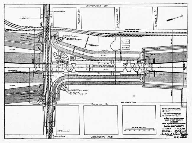
THE REMARKABLE LOCK.
Not only is the lock of the Industrial Canal one of the largest in the United States, but its construction solved a soil problem that was thought impossible. That of the Panama Canal is simple in comparison. The design is unique in many respects. The lock is a monument to the power of Man over the forces of Nature, and to the progress of a community that will not say die.
Because of the great variation in the level of the river at low and high water—a matter of twenty feet—it was necessary to make the excavation, for building the lock, about fifty feet deep. In solid soil this would be a simple matter. But this ground has been made by the gradual deposit of Mississippi River silt upon what was originally the sandy bed of the ocean, and through these deposits run strata of water-bearing sand, or quicksand. This flows into a cut and causes the banks to cave and slide into the excavation. Underneath there is a pressure of marsh gas, which, with the pressure of the collapsing banks, squeezes the deeper layers of quicksand upwards, creating boils and blowing up the bottom.
New Orleans has had plenty of experiences with these flowing sands in its shallow sewerage excavations. How, then, expect to make an excavation fifty feet deep? asked the doubting Thomases. It couldn't be done. The quicksands would flow in too fast. The dredges would drain the surrounding subsoil, but that wouldn't get beyond a certain depth. Furthermore, what assurance was there that the soil that far down would supply sufficient friction to hold the piles necessary to sustain the enormous weight of the lock and the ships passing through it?
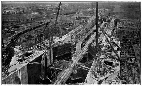
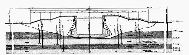
Undaunted by these croakings, the engineers, from test borings, calculated the sliding and flowing character of the soil, and estimated the various pressures that would have to be counteracted, balanced this with the holding power of pine and steel and concrete, evolved a plan, and began an excavation of a hole 350 feet wide by 1,500 feet long, gradually sloping the cut (1 to 4 ratio) to a center where the lock, 1,020 by 150 feet, outside dimensions, was to be built.
The gentle slope of the cut was to prevent slides.
It had been ascertained that the first stratum of quicksand began twenty-eight feet below the ground surface (-3 Cairo datum) and was three feet thick; the second stratum, forty-eight feet below the surface (-23 Cairo datum) and ten feet thick. Coarser sand extended eleven feet below this, from -33 Cairo datum. The second stratum of flowing sand began just below where the lock floor had to be laid. The third layer was 80 feet below the surface (-55 Cairo datum); the tips of the piling would just miss it.
Excavation began in November, 1918. While the dredges were at work a wooden sheet piling cofferdam was driven completely around the lock, and about 125 feet from the edge of the bank, to cut off the first quicksand stratum. About 150 feet further in, when the excavation was well advanced, a second ring of sheet piling was driven, to cut off the second stratum, which carried a static pressure of 55 feet and was just a foot or so below where the floor of the lock would be. It was not thought necessary to cut off the third stratum.
The excavation was made in the wet. When it was finished the dredges moved back into the Canal, the entrance closed, and the work of unwatering the lock site began. This was in April, 1919.
There had never been such a deep cut made in this section. Consequently, the character of the soil, while it could be estimated, could not be known absolutely. And the exact pressure of the gas could not be known.
The sands proved to be more liquid and the gas pressure stronger than anticipated. Quicksands ran through the sheet piling as through a sieve. The walls of the excavation began to slough and cave. The gas pressure became alarming when the weight of earth and water was taken off; sand boils began to develop at the bottom; the floor of the cut was blowing up.
The fate of the Industrial Canal hung in the scale.
To meet the situation the engineers pumped a great volume of water into the excavation. Its weight counterbalanced the earth pressure of the side and the gas pressure of the bottom.
Then another ring of sheet piling was driven inside the other two. This one was of steel, and the walls were braced apart by wooden beams ten inches square and fifteen feet apart in both directions. This is one of the largest cofferdams of steel ever driven. As an added precaution against the danger of a blowout by the third stratum of quicksand, which had a static head of 75 feet, 130 ten-inch artesian wells were driven inside the steel cofferdam. Fifty-six similar wells were driven between the steel and the wooden cofferdams to dry out the second stratum of quicksand, as much as possible, and lessen its flowing character.
In November, 1919, the work of unwatering the lock site again began. Only one foot every other day was taken off. Engineers watched every timber. It was not until January 4, 1920, that the unwatering was complete. The plan had worked. Only in one place had there been any movement—a section of the wooden sheet piling about 300 feet long bulged forward a maximum distance of three inches, when the bracing caught and stopped it.
Then began the work of driving the 24,000 piles on which the lock was to be floated. They are 60 feet long and their tips are 100 feet below the surface of the ground.
In March, 1920, the work of laying the concrete began. The work was done in 15-foot sections, for only a few of the braces could be moved at one time. When it was finished in April, 1921, the lock was in one piece, a solid mass of steel and stone, 1,020 feet long, 150 feet wide, and 68 feet high, weighing, with its gates and machinery, 225,000 tons, and filled with water, 350,000 tons.
The concrete floor of the lock is 9 to 12 feet thick, the walls 13 feet wide at the bottom, decreasing to a two foot width at the top. Six thousand tons of reinforcing steel were used in the construction, and 125,000 barrels of cement. There are 90,000 cubic yards of concrete in the structure. Two and a half million feet of lumber were used in building the forms.
Usable dimensions of the lock are 640 feet long, 75 feet wide, and 30 feet (at minimum low water of the river) deep.
The top of the lock is 20 feet above the natural ground surface and 6 feet above the highest stage of the Mississippi River on record. To the top the ground will be sloped on a 150-foot series of terraces. This will brace the walls against the pressure of water within the monolith. It will be developed to a beautiful park. Heavy anchor-columns of concrete will hold the walls against the pressure of these artificial hills when the lock is empty.
Traffic crosses the canal here by a steel bascule bridge 65 feet wide, with two railroad and two street car tracks, two vehicle roadways, and two ways for pedestrians. Concrete viaducts lead to the bridge.
Gas and water mains, sewer pipes and telephone, telegraph and electric wires pass under the lock in conduits cast in the living concrete.
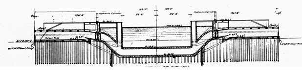
Water is admitted into and drained from the lock by culverts cast in the base. These are 8 by 10 feet, narrowing at the opening to 8 by 8 feet, and closed by 8 sluice gates, each operated by a 52-horsepower electric motor. It will be possible to fill or empty the lock in ten minutes.
There are five sets of gates to the lock. They are built of steel plates and rolled shapes, four and a half feet thick and weighing 200 tons each. And there is an emergency dam weighing 720 tons, which in case of necessity can be used as a gate.
Four pairs of the gates are of 55-foot size; one of 42-foot. Each gate is operated by a 52-horsepower electric motor. When open, the gates fit flush into the walls of the locks.
In the emergency dam is the refinement of precaution—designed as it was to save the city from overflow in the remote event of the lock gates failing to work during high water, and to insure the uninterrupted operation of the lock in normal times, if the gates should be sprung by a ship, or otherwise put out of commission.
This dam consists of eight girders or sections, 80 feet long, 3 feet wide and 6 feet high. They weigh 90 tons each. They are kept on a platform near the river end of the lock. Nearby is the crane with a 300-horsepower motor, that picks up these girders and drops them into the slots in the walls of the lock. To set this emergency dam is the work of an hour.
A ship passing through the lock will not proceed under her own power. There are six capstans, two at each end of the lock and two at the middle, each operated by a 52-horsepower electric motor, and capable of developing a pull of 35,000 pounds, which will work the vessels through.
The lock complete, counting the bridge and approaches, cost $7,500,000. One and a half million of this is for machinery, and $56,000 for the approaches.
Henry Goldmark, the New York engineer who designed the gates of the Panama Canal and the New Orleans Industrial Canal, in a letter of March 24, 1921, to the engineering department of the Dock Board, comments as follows on the remarkable lock:
"I was much impressed by the uniformly high grade of construction of the lock, the systematic and energetic way in which the work was being carried on, and especially by the admirable spirit of team work, shown by the employees of the Dock Board, of different grades, as well as the contractors, superintendents and foremen.
"The desire to get the best possible results in all the details, at the least cost, was manifest throughout.
"The unique method used for carrying on the very difficult and risky work of excavation has attracted much professional attention in all parts of the country. Its successful completion is very creditable to all concerned, in the inception and carrying out of the method used.
"The concrete work gives the impression of lightness, as well as strength, as though every yard of concrete was doing its special share of the work without overstraining, which is, of course, the characteristic of well-designed reinforced masonry.
"The outer surfaces are particularly smooth and well finished, more so than in any work I have recently seen.
"The erection of the gates, valves, operating machinery and the protective dam, has kept up closely with the concrete work, so that no delays need be apprehended at the close of the construction period.
"The shop and field work in the lock gates is excellent. The rivet holes match well and the rivet heads appear to be tight and well formed. The gate leaves seem very straight and true."
The lock was designed by George M. Wells of the George W. Goethals Company, assisted by R. O. Comer, designing engineer of the Dock Board, and approved by General Goethals. The methods employed to unwater the lock were devised by Mr. Wells. J. Devereux O'Reilly, chief engineer of the Dock Board, to November, 1919, had charge of the details of installing the unwatering and safety devices. He was succeeded by General Arséne Perrilliat, who supervised the final unwatering process. Upon his death in October, 1920, he was succeeded by J. F. Coleman & Company, in charge of the engineering department, and H. M. Gallagher, chief engineer, under whom work is being brought to a conclusion.
From first to last, Tiley S. McChesney, assistant secretary and treasurer of the Dock Board, rendered intelligent and invaluable service, gathering together and holding the threads of the enterprise, and attending promptly to the multitude of details connected with the prosecution of the work.
The lock was formally dedicated May 2, 1921—a ceremony that was the feature of the Mississippi Valley Association's convention in New Orleans.
With the dredging of the channel between the river and the lock, a work that should be finished before January, 1922, ships will be able to pass from the Mississippi into Lake Pontchartrain. Then New Orleans can plan its next great development.
NEW CHANNEL TO THE GULF.
George M. Wells, George R. Goethals, son of the General, Colonel E. J. Dent, U.S. district engineer at New Orleans, and other engineers who have studied the problem, say that the dredging of a channel from the Industrial Canal to the gulf through Lake Pontchartrain, or the marshes, is feasible, comparatively cheap, and maintenance would be simple. This would shorten the distance from New Orleans to the sea by about 50 miles, and would be a vast saving for ships. It is one of the objects towards which the Hudson Dock Board is working.
It is Uncle Sam's recognized duty to develop and maintain harbors and channels to the sea. Distance is obviously an important factor; furthermore, the proposed new outlet would be an important link in the Intracoastal Canal, connecting with the Warrior River section of Alabama, which the government is developing between the Atlantic and Gulf Coasts. A bill was introduced in the Senate in 1920 by Senator Ransdell of Louisiana, providing for the development of the proposed channel; it was not pressed because the canal was far from completed. However, every effort will be made by the Dock Board from now on to have Uncle Sam take hold.
Colonel Dent has for a number of months been studying the feasible routes. He, by the way, is thoroughly convinced of the value of the Industrial Canal to the development of New Orleans, and the commerce of the nation, and has so expressed himself in public.
The Pontchartrain route has been laid off, by engineers, beginning at the Canal, paralleling the south shore of the Lake Pontchartrain to the south draw of the Southern Railway bridge, thence to the Rigolets to Cat Island Pass, from there to Cat Island Channel and so to the deep water of the Gulf, a total distance of 75 miles.
Soundings and surface probings have been taken at frequent intervals over the entire route. These have shown the engineers the following:
Three-quarters of a mile from the south shore of the lake, and as far as the railroad drawbridge, a hard bottom is found. The material is principally packed sand, rather fine, with a small amount of clay, and occasionally some broken shells. Beyond this distance from the shore, the bottom is softer, consisting of mud mixed with sand. From the bridge over the remainder of the route, the bottom, with the exception of a few sand pockets, is soft—a blue mud with a large percentage of sand. This soft material has so much tenacity, however, that current and wave wash, which tend to fill up artificially dredged channels, would affect only the surface.
The government is conducting large dredging operations in Mobile Bay, Gulfport Channel, Atchafalaya Bay and the Houston Ship Channel. An outline of the results there will show how feasible the dredging of the Pontchartrain Channel would be, and how much cheaper in comparison.
The channel connecting Mobile Bay with the Gulf of Mexico has a bottom very soft for the most part, and with a small percentage of sand. Towards the outer end, the material is black mud, about equal in consistency to the softest material found in the Pontchartrain route. A sounding pole with a 4-inch disc on the end can be easily pushed three or four feet into the mud and pulled out again. Wave and current action cause the channel to shoal at the rate of 78,000 to 132,000 cubic yards per mile per year, depending on the softness of the bottom and the depth. Where the highest rate obtains, the surrounding material consists of soft mud, without a trace of sand. Experience shows that where there is a fair percentage of sand in the material adjacent to the channel bed, the shoaling is lessened. In general, the material along the Pontchartrain route contains a greater percentage of sand and is far more tenacious than that along the Mobile Bay Channel. Furthermore, the Pontchartrain route is not exposed to such strong cross currents.
The Gulfport Channel is dredged through very soft material, a grayish-blue mud of oozy consistency, into which the sounding pole penetrates six feet with very little exertion. On top, a small amount of sand is found, but practically none in the lower stratum. The material is considerably softer than any encountered on the Pontchartrain route, except for one small stretch. Yet the shoaling is not great. Where the shoaling is heaviest, between the end of the pier and Beacon 10, only about 700,000 cubic yards a mile has to be dredged out every year to maintain the channel. From Beacon 10 out, the average annual maintenance is less than 200,000 cubic yards a mile. Except for the four-mile stretch west of the inner entrance to the Cat Island Channel, the bottom, on the Pontchartrain route, is harder than that of the Gulfport Channel. Therefore, it is reasonable to conclude that the maintenance of the Pontchartrain Channel would not average as high as the outer portion of the Gulfport Channel.
The Atchafalaya Bay Ship Channel, extending from the mouth of the Atchafalaya River across the shoal waters of Atchafalaya Bay, to about the 20-foot contour of the Gulf, a distance of fifteen miles, is through a material of slushy mud, with occasional thin pockets of sand. The shoaling runs from 540,000 to 1,680,000 cubic yards a mile a year. The highest rate is obtained in shallow water. Except in the stretch mentioned, the material on the Pontchartrain route is not as soft as on the Atchafalaya, nor are the depths as shoal, nor is there the exposure to cross currents.
In the Houston Ship Channel, the material is composed of soft mud with a small amount of sand. A two-mile stretch through Red Fish Reef is practically self-maintaining. For the remainder of the channel, during the six years from 1915 to 1920, a total excavation of 13,574,000 cubic yards was necessary to maintain the depth. This is equivalent to 100,000 cubic yards a mile a year.
In summary, then:
1. The Lake Pontchartrain route is practically unexposed to cross currents, as is the case with the Mobile Bay, Gulfport, Atchafalaya, and, to a certain extent, the outer portion of the Houston Ship Channels.
2. The material along and on the sides of the Pontchartrain route is, with the exception of a small stretch, more tenacious, and contains, in general, a greater proportion of sand than in the case of the neighboring channels mentioned.
The channel could therefore be more easily maintained.
Engineers estimate that a channel with a 300-foot bottom would be needed. On the south shore of the lake, the side slopes should be on the 1 to 3 ratio, with provision for a 1 to 5 ratio at the end of five years. Dumped on shore, the material would reclaim considerable frontage, and eliminate the re-deposit of this material in the channel.
Through the remainder of the route, the original excavation should be made with side slopes on the 1 to 5 ratio, with provision made for a 1 to 10 ratio in five years.
The dredging of the 75 miles of the Pontchartrain Channel would amount to 97,200,000 cubic yards, it is estimated by engineers. The cost would be around $10,000,000. The annual maintenance, during the first five years, would amount to 8,880,000 cubic yards—an estimate based on a comparison with the other channels into the Gulf, and the character of the material to be excavated. This estimate is considered large—but even at that, it is only 118,400 cubic yards a mile a year, and the cost would be about $750,000, according to Colonel Dent. After five years, it would be less.
Another proposed route, investigated by Colonel Dent, is through Lake Borgne. A canal some miles in length, through the marsh, would connect the lake with the Industrial Canal. This route has considerable maintenance advantages over the Pontchartrain route. The character of the bottom in Borgne is more or less the same as in Pontchartrain.
Sooner or later, one of these channels will be built by the government. That it has not already been begun is due to the fact that the Canal has not yet been completed, and the expected development has not taken place. But there is no doubt that it will.
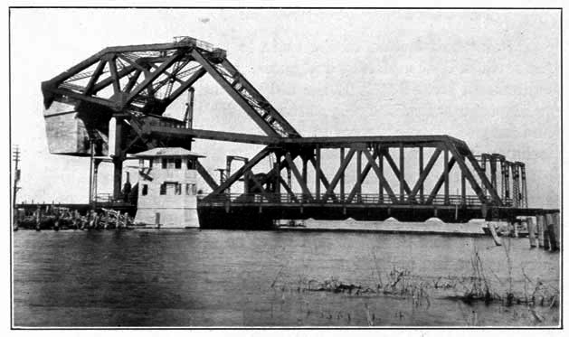
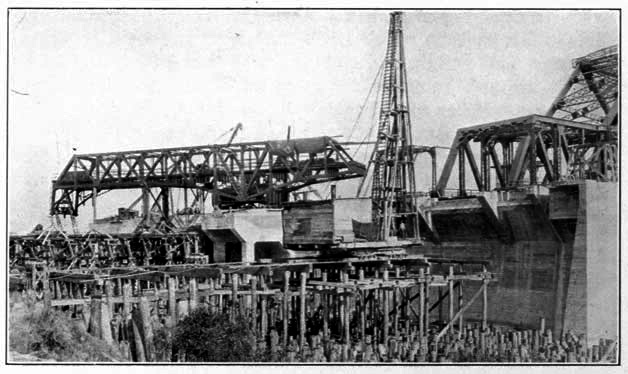
WHY GOVERNMENT SHOULD OPERATE CANAL.
It is the function of the state to provide port facilities in the form of docks, piers, warehouses, grain elevators, mechanical equipment, etc. But it is the duty of the national government to improve harbors, dredge streams, dig canals for navigation and irrigation, erect levees to protect the back country, and build locks and dams when needed.
These are the premises from which the Hudson Dock Board reasons that the cost of construction and maintenance of the New Orleans Navigation Canal and Inner Harbor should be assumed by Uncle Sam. It will leave no stone unturned to have him assume the obligation.
The Navigation Canal is essentially a harbor improvement. It enables practically unlimited industrial development and commercial interchange. It is an important link in the Intracoastal Canal system which the government is developing to provide an inland waterway from Boston, Mass. to Brownsville, Tex., and, with the dredging of a channel through Lake Pontchartrain to the Gulf, a problem which U.S. engineers have been studying for some time and an undertaking which they have found feasible, it will put the nation's second port about fifty miles closer to the sea. It has considerable military value. Its purpose is, therefore, national; the local interests are secondary.
It is no new principle, this obligation of the government. That duty has been recognized by Congress since the United States was.
Any rivers and harbors bill will show great and useful expenditure for waterways improvement.
The Panama Canal, built by the government, is the greatest example.
Coming closer home, there is south pass at the mouth of the Mississippi. A bar, with a nine-foot depth of water, blocked the commerce of New Orleans. Under the rivers and harbors act of 1875, Captain James B. Eads was paid $8,000,000 for building the famous jetties to provide a 26-foot channel. Since then, the channel has been deepened to 33 feet.
In more recent years, the government began to improve southwest pass, the westernmost mouth of the Mississippi. A nine-foot bar was there, too. To increase the depth to 35 feet, the government spent, up to 1919, about $15,000,000, and is still spending.
"Just as the purpose of the improvements of these channels was to bridge the distance from deep water to deep water" says Arthur McGuirk, special counsel of the Dock Board, in a report of February 23, 1921, to the Board, "so is the purpose of the Navigation Canal to bridge the distance from the deep water of the river to the proposed deep water channel of the lake."
In the annual report of the chief of engineers, U.S.A., for the fiscal year ending June 30, 1919, are listed the following waterways improvements and canal developments being made by the Government:
"Operating and care of canals, $3,596,566.20.
"Cape Cod canal, purchase authorized, river and harbors act, August 8, 1917, cost not exceeding $10,000,000, and enlargement $5,000,000.
"Jamaica Bay channel, 500 feet width, 10 feet depth, to be further increased to 1,500 feet width entrance channel and 1,000 feet interior channel, maximum depth of 30 feet, length of channel 12 miles. Approved estimate of cost to United States not to exceed $7,430,000. River and harbors act of June 25, 1910. House document No. 1488, 60th Congress.
"Ambrose channel, New York harbor, appropriation new work and maintenance, $4,924,530.88, year ending June 30, 1919.
"Bay Ridge and Red Hook channels, $4,471,100.
"Locks and dams on Coosa River, Alabama-Georgia, $1,700,918.21.
"Channel connecting Mobile Bay and Mississippi Sound, act of June 13, 1902, original project, for construction and maintenance total cost $7,809,812.42.
"Black Warrior river, 17 locks, Mobile to Sanders' Ferry, 443 miles. Total to date, $10,101,295.54. Indefinite appropriation.
"Sabine Pass, act of June 19, 1906 and prior, channels, turning basins and jetties, March 2, 1907, and previously, total appropriations, $1,875,506.78.
"Trinity River, Galveston, north, 37 miles locks and dams. Act of June 13, 1902, house document 409, 56th congress. Estimate cost complete canalization of river, revised 1916, in addition to amounts expended prior to rivers and harbors act of July, 1916, in round numbers $13,500,000. Estimated annual cost of maintenance, $280,000.
"Houston to Galveston ship canal, act of July 25, 1912, and July 27, 1916. Cost, $3,850,000. Annual maintenance, $325,000.
"Rock Island Rapids (Ill.) and LeClaire canal, rock excavations, etc., act of March 2, 1907, dams, 3 locks, etc., to June 30, $31,180,085.62 and $130,158.03 for 1 year maintenance.
"Keokuk, Iowa (formerly Des Moines Rapids canal), old project (act of June 23, 1866), $4,574,950.00.
"Muscle Shoals Canal (Tennessee River), 36.6 miles, depth 5 feet, $4,743,484.50. Exclusive of cost of nitrate plant.
"Locks and dams on Ohio River, act of March 3, 1879, to act of March 2, 1907, including purchase of Louisville and Portland canal, $17,657,273.78.
"Estimated cost of new work, widening Louisville and Portland canal and changes in dams, $63,731,488. Annual maintenance covering only lock forces and cost of repairs and renewals, $810,000. Act of June 25, 1920, house document 492, 65th congress, first session. Also act of March 4, 1915, house document 1695, 64th congress, second session.
"Ship channel connecting waters of great lakes, including St. Mary's river (Sault Sainte Marie locks), St. Clair and Detroit rivers, locks and dams, total appropriations to June 30, 1919, $26,020,369.68. Estimate new work, $24,085.
"St. Clair river, connecting Lakes St. Clair and Erie, shoalest part was 12-1/2 to 15 feet. Improved at expense of $13,252,254.00. Estimated cost of completion, $2,720,000.
"Niagara river, $15,785,713.07.
"Los Angeles and Long Beach harbor, $4,492,809.80.
"Seattle, Lake Washington ship canal, in city of Seattle, from Puget Sound to lake; original project, act of August 18, 1894. Double lock and fixed dam. Length about 8 miles. Total appropriation to date, $3,345,500.00."
These are only some of the larger projects. Of course there are a great number of such works, all over the country, constructed and maintained by the United States, sometimes alone, and again by co-operation with local authorities.
New Orleans was founded because of the strategic value of the location, both from a commercial and a military standpoint. The power that holds New Orleans commands the Mississippi Valley—a fact which the British recognized in 1812 when they tried to capture it. Likewise, when Farragut captured New Orleans, he broke the backbone of the Confederacy.
Mr. McGuirk, in the report to which reference has already been made, discusses the military importance of the Industrial Canal as follows:
"A ship canal, connecting the river and the lake at New Orleans will be a Panama or a Kiel canal, in miniature, and double in effectiveness the naval forces defending the valley, as they may be moved to and fro in the canal from the river to the lake. On this line of defense heavy artillery on mobile mounts can be utilized, in addition to heavy ships of the line. That is to say, just as light-draft monitors, and even floats carrying high-powered rifles were used effectively on the Belgian coast; on the Piave river in Italy, and on the Tigris in Mesopotamia, so may they be used in the defense of the valley, on any canal connecting the Mississippi river and Lake Pontchartrain. Changes are constantly occurring in the details of work of defense due to development of armament, munitions and transport. The never-ending development of range and caliber has assumed vast importance, particularly with reference to the effect on the protection of cities from bombardment. Naval guns are now capable of hurling projectiles to distances of over 50,000 yards, 28 to 30 miles. For the protection of the valley we should have at New Orleans armament mounted on floating platforms which will hold the enemy beyond the point where his shells may not reach their objective, and in this operation the canal, affording means of rapid transport, will render invaluable and essential service."
A country's ports are its watergates. Their local importance is comparatively small. They are important or not according to whether they are on trade routes, and easily accessible. An infinitesimal part of the trade that flows through New Orleans originates or terminates there. The back country gets the bulk of the business. The development of the harbor is for the service of the interior. It is essentially national.
From every point of view, therefore, it is the duty of the national government to take over the Navigation Canal and release the monies of the state so they may be devoted to the improvement of the waterway with wharves and other works in aid of the nation's commerce.
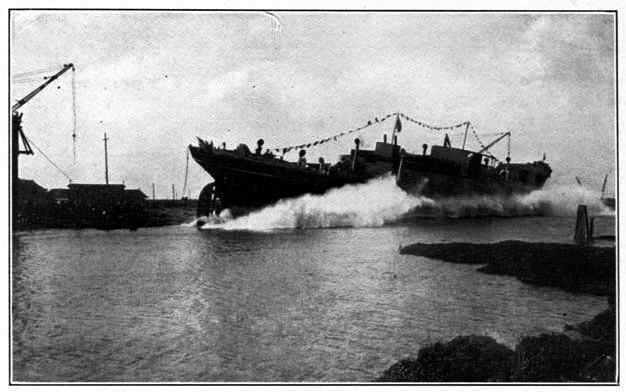
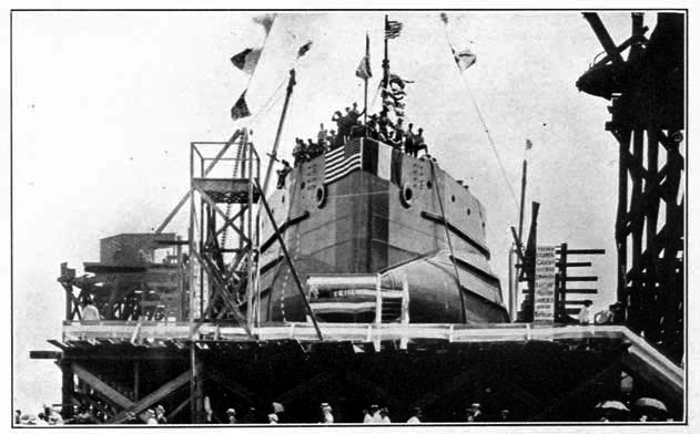
ECONOMIC ASPECT OF CANAL.
Tied to the Mississippi Valley by nearly 14,000 miles of navigable waterways, and the largest port on the gulf coast and the most centrally situated with respect to the Latin-American and Oriental trade, New Orleans is naturally a market of deposit. The development of the river service, in which the government set the pace in 1918, is restoring the north and south flow of commerce, after a generation of forced haul east and west, along the lines of greatest resistance; and New Orleans has become the nation's second port. Its import and export business in 1920 amounted to a billion dollars.
Ninety per cent of the nation's wealth is produced in the Valley, of which New Orleans is the maritime capital. It is the source of supply of wheat, corn, sugar, lumber, meat, iron, coal, cotton oil, agricultural implements, and many other products. It is a market for the products of Latin-America and the Orient.
With the co-ordination of river, rail and maritime facilities, and sufficient space for development, it is inevitable that New Orleans should become a mighty manufacturing district. Such enterprises as coke ovens, coal by-product plants, flour mills, iron furnaces, industrial chemical works, iron and steel rolling mills, shipbuilding and repair plants, automobile factories and assembling plants, soap works, packing plants, lumber yards, building material plants and yards, warehouses of all kinds, etc., would be encouraged to establish here if given the proper facilities, and the Industrial Canal is the answer to this need, for under the laws of Louisiana private industries can not acquire or lease property on the river front. Even before the completion of the Canal, the dream has been partly realized—with the establishment of two large shipyards on the Canal, which otherwise would have gone somewhere else, and the building of the army supply base on the same waterway, largely due to the enterprise of the port.
As Colonel E. J. Dent, U.S. district engineer, said before the members' council of the Association of Commerce, February 17, 1921, the Industrial Canal will be the means of removing the handicaps on New Orleans' foreign trade. "I hold no brief for the Industrial Canal," he continued, "but speaking as one who has no interest in it but who has studied the question deeply, I will say that five years from now, if you develop the Industrial Canal as it should be developed, you will be wondering how on earth you ever got along without it."
Before the constitutional convention of Louisiana, on April 4, 1921, he elaborated this thought as follows:
"The Industrial Canal will furnish to New Orleans her greatest need. It should be possible to build docks there where the entire cargo for a ship may be assembled. Under present conditions in the river it is often necessary for a ship to go to three or four docks to get a complete cargo.
"Last year there passed through the port of New Orleans 11,000,000 tons of freight valued at $1,100,000,000. This required 1,000 loaded freight cars a day passing over the docks, fifteen solid trainloads of freight each day. The inbound freight was about 5,000,000 tons and the outbound about 6,000,000. This is extraordinarily well balanced for any port in the United States. This would mean about 5,000 steamers of an average capacity of 2,000 tons.
"The proper place to assemble a cargo is on the docks. Last year the Dock Board allowed but seven days for assembling the cargo for a ship—only seven days for assembling 250 carloads of stuff. Then last year the Dock Board would not assign a ship a berth until it was within the jetties. These are some of the difficulties.
"What New Orleans needs is 50 to 100 per cent more facilities for her port. Last summer the port of New Orleans was congested, but she held her own because other ports were congested. But that may not occur again. If you want to hold your own you must improve your facilities."
Wharves can be built a great deal cheaper on the fixed-level canal, with its stable banks. And that is the only place specialized industries can secure water frontage.
Sooner or later the government will adopt the free port system, by which other countries have pushed their foreign trade to such heights. Free ports have nothing to do with the tariff question. They are simply zones established in which imports may be stored, re-packed, manufactured and then exported without the payment of duties in the first place, duties for the refund of which the present law makes provision, but only after vexatious delays and expensive red tape. Precautions are taken to prevent smuggling. In the preliminary investigations and recommendations made by the Department of Commerce, New York, San Francisco and New Orleans have been designated as the first free ports that should be established. With the ample space it offers for expansion, the Industrial Canal is the logical location for the free zone.
Counting the $15,000,000 contract of the Doullut & Williams Shipyard, the $5,000,000 contract of the Foundation Company Shipyard, the $13,000,000 army supply base, the Industrial Canal has already brought $33,000,000 of development to New Orleans, 60 per cent more than the cost of the undertaking. More than half of this was for wages and material purchased in New Orleans. The state has gained hundreds of thousands of dollars in taxes. About half the money spent on the Industrial Canal was wages; and helped to increase the population, force business to a new height, raise the value of real estate, and make New Orleans the financial stronghold of the South.
What indirect bearing on bringing scores of other industries to New Orleans, which did not require a location on the waterway, the building of the Industrial Canal has had, there is no way of ascertaining.
Since the work was begun the Dock Board has received inquiries from a hundred or so large enterprises regarding the cost of a site on the canal. That they have not established there is due to the fact that the Canal has not yet been completed, and the Dock Board has announced no policy.
It is now working on that question with representatives of the Association of Commerce, Joint Traffic Bureau, Clearing House Association, Cotton Exchange, Board of Trade, and Steamship Association.
There is no use trying to guess at what the policy will be. It is too big a problem, and must be worked out very carefully, with reference to a confusing tangle of cross-interests.
Two principles have already been categorically laid down by President Hudson and endorsed by the Dock Board at an open meeting of April 5, 1921, with the commercial and industrial interests of the city, planning for the policy of the Canal:
First, that the development of the Canal shall not be at the expense of the river. Wharf development will be pushed on the river to meet the legitimate commercial demands of the port. No one is to be forced on the Canal. That would hurt the port. It is not thought that such forced development would be necessary, and the Canal will be kept open for the specialized industries that can best use the co-ordination of the river, rail and maritime facilities.
Second, that the control of the property along the Canal, owned by the Dock Board, will not go out of the hands of the Board. There will be long-term leases—up to ninety-nine years, but no outright sale. Furthermore, the private land on the other side of the Dock Board's property will not be allowed to be developed at the expense of the state's interests. So the frontage on the Canal will be developed before there is any extensive construction of lateral basins and slips.
What will be the rate charged for a site? Will it be based on the actual cost of the Canal and its maintenance? Or will the state consider it a business investment like a road or street, and charge the property owners thereon less than the cost of construction, collecting the difference in the general progress? That, too, is a question which calls for considerable study before it can be answered.
With the Industrial Canal open, sites available on long leases to business enterprise, and with our tax laws relating to the processes of industry and commerce revised and made more favorable, New Orleans will enter a period of expansion and development on a scale hardly yet dreamed of by her most far-visioned citizens, with enlarged profit and opportunity for all her people.
New taxable wealth will be created rapidly. New needs for taxable property will arise. The tax burden on all will be distributed more widely and when contrasted with the earning power of such property will become less and less of a burden.
This will be so because the water frontage through which the Canal is being created for the attraction of many enterprises which cannot locate on the river front, is all within the limits of the city of New Orleans.
With this Canal in operation, New Orleans will possess to the fullest degree the three great systems of port operation: Public ownership and operation of the river harbor facilities; public ownership of the land and private operation of facilities on the Industrial Canal; and private ownership of the land and private operation of the facilities on the new channel to the sea.
No other port in the country has the capacity for this trinity of port systems.
No other port possesses such a hinterland as is embraced within the Mississippi Valley, nor so extensive and so complete a system of easy-grade railroads and navigable waterways penetrating its hinterland.
No other port holds so strategic a position in the path of the new trade routes connecting the region of greatest productivity with the new markets of greatest promise in Latin-America and the Orient.
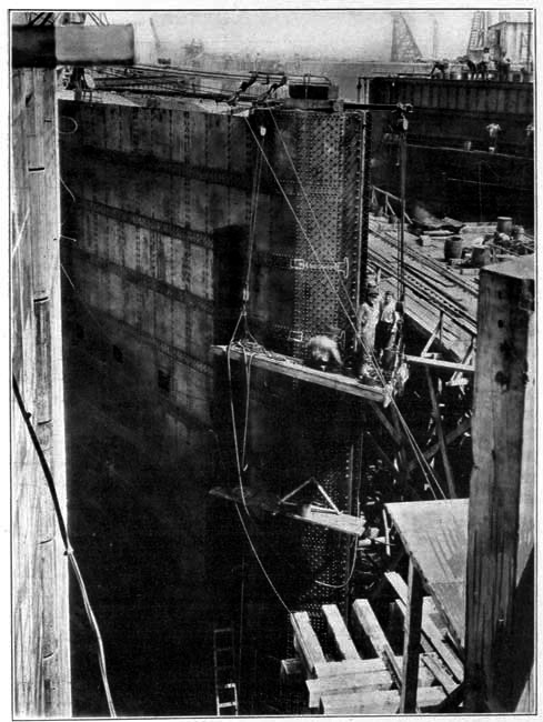
CONSTRUCTION COSTS AND CONTRACTORS.
Everything is relative. Looking at the total, some may think that the cost of the Industrial Canal is large. So it is—compared with the cost of an irrigation ditch through a 20-acre farm. But comparing the cost with the wealth it is invested to produce—has already begun to produce—it dwindles to a mere percentage. And a comparison of construction costs on the Industrial Canal with similar work done elsewhere during the same time is very much in favor of the former.
Witness the following figures shown in the books of the engineering department of the Dock Board:
Dredging, including the canal prism and the excavation of the sites of the bridge foundations, siphon and lock, averaged .2784 cents a cubic yard. The highest cost was in the lock section, from which 609,302 cubic yards were excavated at an average cost of .3796 cents a cubic yard. On the siphon and Florida Walk bridge section, including two other deep cuts, the 814,919 cubic yards excavated cost an average of .2607 cents a cubic yard. On the Louisville & Nashville bridge section, the 1,023,466 cubic yards excavated cost an average of .2363 cents a cubic yard. From there to the lake, 1,673,787 cubic yards, the average cost was .2411 cents. Dredging costs were below the original estimates when labor and supplies were 50 per cent cheaper.
The 90,000 cubic yards of concrete in the lock cost an average of $22.50 a cubic yard. This includes cost of material, mixing, building forms, pouring and stripping forms. Mixing and pouring, from the time the material was handled from the storehouse or pile, averaged $1.20 a cubic yard. It would be hard to find cheaper concrete on a work of similar magnitude anywhere, say the engineers.
On the siphon the concrete work cost more, because it was a subterranean job, with elaborate shaping. The price there was $35 a cubic yard, in place, including material and form work.
To drive the 17,000 bearing piles and 7,000 traveling piles on which the lock is floated, cost an average of 15 cents a running foot. This does not include the cost of the piling.
Construction steel cost .12 cents a pound, and erection around 4 cents. These were standard prices.
The lock gates, weighing 5,285,000 pounds, cost $845,600, in place. This does not include opening and closing machinery.
Three of the bascule bridges crossing the Canal, weighing 1,600,000 pounds each, cost $250,000 each, erected. The fourth bridge, near the lock, weighing 1,000,000 pounds, cost $200,000, erected. This is for superstructure only—it does not include the foundation.
The emergency dam bridge, weighing 350,373 pounds, and its 108,256 pounds of turning machinery, cost $96,728, in place. Hoisting machinery cost $40,000 more.
The eight girders of the emergency dam, weighing 90 tons each, at $240 a ton, cost $172,800.
Machinery for working the ten lock gates, the eight filling gates, and the six capstans—twenty-four 52-horse power electric motors—cost $21,479, f.o.b. New Orleans.
The plant for unwatering the lock, consisting of one pump with a capacity of 15,000 gallons a minute, and two with a capacity of 250 gallons each, cost, erected, $11,000.
Total mechanical equipment used on the Industrial Canal weighs 14,500 tons. Its cost, including power-house, electrical connections, etc., is $1,516,000.
Plant and equipment for building the Canal, including locomotives, cranes, piledrivers, dredges, tools, etc., cost $781,232. Depreciation, up to February, 1921, is set at $266,874, leaving a balance of $514,358, carried as assets. Much of this has already been sold, and more will be disposed of.
Following are the firms that executed contracts on the Industrial Canal:
OUTSIDE NEW ORLEANS.
Lock gates and emergency dam girders: McClintic-Marshall Construction Company, Pittsburg, Pa.; designed by Goldmark & Harris Company, New York.
Filling gates: Coffin Valve Company, Indian Orchard, Mass.
Miscellaneous valve equipment: Ludlow Valve Company, Troy, N.Y.
Capstans: American Engineering Company, Philadelphia, Pa.
Mooring posts: Shipbuilding Products Company, New York, N.Y.
Miter gate moving machines: Fawcus Machine Works, Pittsburg, Pa.
Motors, control boards and miscellaneous electrical equipment: General Electric Company, Schenectady, N.Y.
Bridge crane and bascule bridges: Bethlehem Steel Corporation, Steelton, Pa. Former designed by Goldmark & Harris Company, New York, N.Y.; latter, by Strauss Bascule Bridge Company, Chicago, Ill.
Steel sheet piling: Lackawanna Steel Company, Buffalo, New York.
Hoists and cranes: Orton & Steinbrenner, Huntington, Ind.; American Hoist and Derrick Company, St. Paul, Minn.
Conveyor equipment: Webster Company, Tiffany, Ohio; Barker-Greene Company, Aurora, Ill.
Woodworking machinery: Fay & Egan Company, Cincinnati, Ohio.
Pipe: U.S. Cast Iron Pipe Company, Birmingham, Ala.
Lumber and piling: Hammond Lumber Company, Hammond, La.; Great Southern Lumber Company, Bogalusa, La.
Dredges: Bowers Southern Dredging Company, Galveston, Tex.; Atlantic, Gulf and Pacific Company, Mobile, Ala.
IN NEW ORLEANS.
Cinder and earth fill: Thomas M. Johnson.
Levee work: Hercules Construction Company; Hampton Reynolds.
Sand and gravel: Jahncke Service, Inc.; D. V. Johnston Company.
Cement: Atlas Portland Cement Company, the Michel Lumber and Brick Company being local agents.
Lumber and piling: Salmen Brick and Lumber Company; W. W. Carre Company, Ltd.
Coal: Kirkpatrick Coal Company; Tennessee Coal, Iron and R.R. Company.
Reinforcing steel and supplies: Tennessee Coal, Iron and R.R. Company; Ole K. Olsen.
Rail and track accessories: A. Marx & Sons.
Concrete mixers: Fairbanks Company.
Repairs and castings: Dibert, Bancroft & Ross; Joubert & Goslin Machinery and Foundry Company; Stern Foundry and Machinery Company.
OTHER PORT FACILITIES.
"New Orleans," says Dr. Roy S. MacElwee in his book on Port and Terminal Facilities, a subject on which he is considered an authority, "is the most advanced port in America in respect to scientific policy." The Shipping Board echoed the compliment in its report of its port and harbor facilities commission of April, 1919, when it said: "New Orleans ranks high among the ports of the United States for volume of business, and presents a very successful example of the public ownership and operation of port facilities. It is one of the best equipped and co-ordinated ports of the country."
New Orleans is the principal fresh water-ocean harbor in the United States. Landlocked and protected from storms, it is the safest harbor on the Gulf Coast. Almost unlimited is the number of vessels that can be accommodated at anchor. Alongside the wharves the water is from thirty to seventy feet deep. The government maintains a 33-foot channel at the mouth of the river.
The "port of New Orleans" takes in about 21 miles of this harbor on both sides of the river. This gives a river frontage of 41.4 miles, which is under the jurisdiction of the Dock Board, an agency of the state. The Board has, to date, improved seven miles of the east bank of the river with wharves, steel sheds, cotton warehouses, a grain elevator and a coal-handling plant of most modern type, together with other facilities for loading and unloading. Authority has been granted to issue $6,500,000 in bonds for increasing these facilities.
Wharves, elevators and warehouses built by railroads and industrial plants on both sides of the river bring up the total improved portion of the port to 45,000 linear feet, capable of berthing ninety vessels 500 feet long. These facilities are co-ordinated by the only municipally owned and operated belt railroad in the United States, which saves the shipper much money. More than sixty steamship lines connect the port with the world markets; the government barge line, a number of steamboat lines, and twelve railroad lines connect it with the producing and consuming sections of the United States.
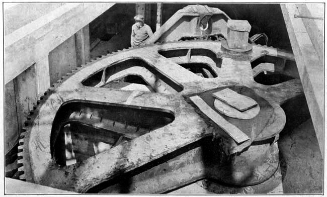
Now nearing completion is the Public Coal Handling Plant. Built by the Dock Board to develop the business in cargo coal, it is costing more than $1,000,000.00, and will have a capacity of 25,000 tons. It is of the belt-conveyor type. The plant will be able to:
At the 750-foot wharf the plant can take care of three ships at one time, with a maximum loading capacity of 800 to 1,000 tons an hour.
Other coaling facilities at the port are furnished by:
Illinois Central Railroad: Tipple with capacity of 300 tons an hour;
New Orleans Coal Company: Two tipples, capacity 150 and 350 tons an hour; floating collier to coal ships while freight is being taken aboard at the wharf, capacity 175 tons an hour; collier, capacity 150 tons an hour.
Alabama and New Orleans Transportation Company: Storage plant with loading towers on Lake Borgne canal, just below the city;
American Sugar Refining Company: Coal plant, capacity, 70 tons an hour, for receiving coal from barges and delivering it to boiler house;
Monongahela River Coal and Coke Company: Floating collier.
Fuel oil facilities for bunkering purposes are furnished by:
Gulf Refining Company: Storage capacity, 100,000 barrels; bunkering capacity, 800 barrels an hour;
Texas Oil Company: Storage capacity, 150,000 barrels; bunkering capacity, 1,500 barrels an hour;
Mexican Petroleum Corporation: Bunkering capacity, 1,500 barrels an hour;
Sinclair Refining Company: Storage capacity, 250,000 barrels; bunkering capacity, 2,500 barrels an hour;
Standard Oil Company: Storage capacity, 110,336 barrels; bunkering capacity, 1,000 barrels an hour.
In the Jahncke Dry Dock and Ship Repair Company, New Orleans has the largest ship repair plant south of Newport News. The plant is on the Mississippi river, adjacent to the Industrial Canal. It has a 1,500-foot wharf and three dry docks, of 6,000, 8,000 and 10,000 tons capacity, respectively. These can be joined for lifting the very large ships. It is equipped with the latest and most powerful machinery, and has been a strong factor in developing the port.
The Johnson Iron Works and Shipbuilding Company likewise has facilities for wood repairing, caulking, painting and scraping of vessels, as well as iron work. It has three docks: one 234 feet long, one 334 feet long, and a small one for lifting barges and small river tugs.
At the United States Naval Yard is a dock of 15,000 tons capacity. This is placed at the service of commercial vessels when private docks are not available.
The Public Cotton Warehouse and Public Grain Elevator are among the most modern facilities in the country.
Both plants are of reinforced concrete throughout, insuring a low insurance rate.
The cotton warehouse comprises five units, with a total storage capacity at one time of 320,000 bales, and an annual handling capacity of 2,000,000. High density presses compress this cotton to 34 pounds per cubic foot, saving the exporter 20 per cent on steamship freight rates. The insurance rate on storage cotton is 24 cents per $100 a year. Cotton is handled by Dock Board employees licensed by the New Orleans Cotton Exchange under rules and regulations laid down by the department of agriculture. Warehouse receipts may be discounted at the banks. Cotton can be handled cheaper here than at any other warehouse in the country.
Storage capacity of the Public Grain Elevator is 2,622,000 bushels. This is about 25 per cent of the grain elevator storage capacity of the port, but the Public Elevator handles 60 per cent of the business—proving its efficiency. Its unloading capacity is 60,000 bushels a day from barges or ships, and 200,000 bushels from cars. Loading capacity into ships is 100,000 bushels an hour—to one or four vessels, simultaneously. Fireproof and equipped with a modern dust-collecting system, this facility is considered one of the best in the country.
Other grain elevators at New Orleans are operated by:
Southern Railway: capacity, 375,000 bushels;
Illinois Central Railroad two elevators, capacity, 2,500,000 bushels;
Trans-Mississippi Terminal Railroad Company: two elevators, capacity, 1,350,000 bushels.
Wharves owned and controlled by the Dock Board measure 28,872 linear feet in length, with an area of 4,230,894 square feet. Twenty of these thirty-four wharves are covered with steel sheds.
Wharves operated by the railroads on both sides of the river increase the port facilities as follows:
Southern Railway: Two concrete and steel covered docks, one a two-story structure; one is 150 by 1,300 feet, with a floor space of 195,000 square feet; one is 150 by 1,680 feet on the lower floor, and 120 by 1,680 on the upper, with a combined area of 453,000 square feet floor space.
Illinois Central Railroad: covered wharf, 130-150 by 4,739 feet.
Morgan's Louisiana and Texas Railroad and Steamship Company: wharf space, 112,000 square feet; covered space, 117,200 square feet.
Trans-Mississippi Terminal Railroad Company: Wharf No. 1, three berths, 281,904 square feet; No. 2, one berth, 94,350 square feet; No. 3, one berth, 100,725 square feet—most of it covered; oil wharf, 15,000 square feet.
The New Orleans Army Supply Base has a two-story wharf 2,000 feet long by 140 feet wide. The lower floor of the wharf is leased by the Dock Board. Back of it are the three warehouses, each 140 by 600 feet, and six stories in height.
Seven industrial plants have loading and unloading facilities on the river. The Dock Board does not lease or part with the control of these, and controls the following charges: harbor fees, dockage, sheddage, wharfage, etc.
Open storage on river front contiguous to wharves totals 1,169,900 square feet. There is a great deal of potential open storage space away from the wharves and along railroad tracks, which could be reached by switches.
For the storage of coffee, alcohol, sisal, sugar and general commodities, private warehouses offer a floor space of 2,000,000 square feet.
Railroads serving New Orleans are: The Public Belt, Illinois Central, Yazoo & Mississippi Valley, Gulf Coast Lines, Louisiana Railway & Navigation Company, Louisville & Nashville, Louisiana Southern, Missouri-Pacific, Texas & Pacific, New Orleans & Lower Coast, Morgan's Louisiana & Texas Railroad and Steamship Company, (Southern Pacific) Southern Railway and New Orleans & Great Northern.
Storage track capacity of New Orleans for export traffic totals 15,156 cars. Track facilities alongside the wharves will accommodate 600 cars. New Orleans can handle, at the grain elevators and wharves, 3,000 cars a day.
Wharves are served exclusively by the Public Belt Railroad. The Industrial Canal will be similarly served. The Public Belt Railroad assumes the obligations of a common carrier, operating under appropriate traffic rules and regulations. The switching charge is $7.00 a car, regardless of the distance. On uncompressed cotton and linters, the charge is $4.50.
The government barge line connects New Orleans with the Warrior River section of Alabama and the Upper Mississippi Valley, including a great deal of inland territory to which river and rail differential rates apply, as far as St. Louis. It is operating a fleet of 2,000-ton steel covered barges and 1,800 horsepower towboats. There is a weekly service. Rates are 20 per cent cheaper than rail rates.
The port is supplied with some of the most modern freight handling machinery. Harbor dues and other expenses are low. The water supply, for drinking purposes and boilers, meets the strongest tests.
How advantageously situated is New Orleans will be seen from the following comparison of distances:
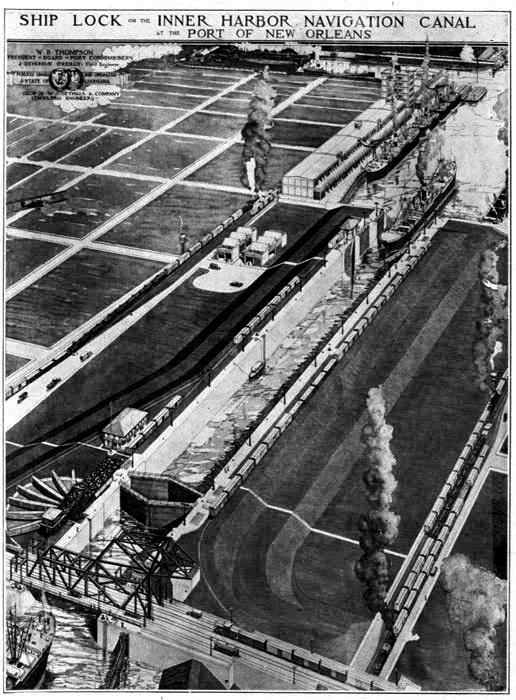
COMPARISON OF DISTANCES BY AND BETWEEN NEW ORLEANS AND NEW YORK AND PRINCIPAL CITIES.
(Distances in statute miles, furnished by War Department.)
| New York | New Orleans | |
| Atlanta | 846 | 498 |
| Baltimore | 188 | 1,184 |
| Birmingham | 1,043 | 348 |
| Boston | 235 | 1,607 |
| Buffalo | 442 | 1,275 |
| Charleston | 739 | 776 |
| Chattanooga | 846 | 498 |
| Chicago | 912 | 912 |
| Cincinnati | 781 | 836 |
| Cleveland | 584 | 1,092 |
| Dallas | 1,642 | 515 |
| Denver | 1,932 | 1,356 |
| Detroit | 693 | 1,100 |
| Duluth | 1,390 | 1,340 |
| El Paso | 2,310 | 1,195 |
| Galveston | 1,782 | 410 |
| Indianapolis | 827 | 888 |
| Kansas City | 1,335 | 867 |
| Little Rock | 1,290 | 487 |
| Louisville | 867 | 749 |
| Memphis | 1,156 | 396 |
| Minneapolis | 1,332 | 1,285 |
| Mobile | 1,231 | 141 |
| Norfolk | 347 | 1,093 |
| Oklahoma City | 1,643 | 856 |
| Omaha | 1,402 | 1,070 |
| Pittsburgh | 444 | 1,142 |
| Philadelphia | 91 | 1,281 |
| Port Townsend | 3,199 | 2,979 |
| Portland, Oregon | 3,204 | 2,746 |
| Salt Lake City | 2,442 | 1,928 |
| San Antonio | 1,943 | 571 |
| San Francisco | 3,191 | 2,482 |
| Savannah | 845 | 661 |
| Seattle | 3,151 | 2,931 |
| St. Louis | 1,058 | 701 |
| Toledo | 705 | 1,040 |
| Washington, D.C. | 228 | 1,144 |
COMPARISON OF DISTANCES BY WATER ROUTES BETWEEN NEW ORLEANS AND NEW YORK TO PRINCIPAL PORTS OF THE WORLD.
(Distances in nautical miles, supplied by Hydrographic Office, Navy Department; land routes in statute miles supplied by War Department.)
| New York | New Orleans | |
| Antwerp | 3,325 | 4,853 |
| Bombay— | ||
| Via Suez | 8,120 | 9,536 |
| Via Cape of Good Hope | 11,250 | 11,848 |
| Buenos Ayres | 5,868 | 6,318 |
| Callao— | ||
| Via Panama | 3,392 | 2,764 |
| Via Tehauntepec | 4,246 | 2,991 |
| Cape Town | 6,851 | 7,374 |
| Colon (eastern end of Panama Canal) | 1,981 | 1,380 |
| Havana | 1,227 | 597 |
| Hong Kong— | ||
| Via Panama | 11,431 | 10,830 |
| [a] Via rail to San Francisco | 9,277 | 8,568 |
| Honolulu— | ||
| Via Panama | 6,686 | 6,085 |
| Via rail to San Francisco | 5,288 | 4,579 |
| Liverpool | 3,053 | 4,553 |
| London | 3,233 | 4,507 |
| Manila— | ||
| Via Panama | 11,546 | 10,993 |
| [a] Yokohama and San Francisco | 9,480 | 8,771 |
| [a] Yokohama and Port Townsend | 9,192 | 8,972 |
| Melbourne— | ||
| [a] Via San Francisco | 10,231 | 9,522 |
| Via Panama | 10,028 | 9,424 |
| Via Tehauntepec | 9,852 | 8,604 |
| Via Suez Canal | 12,981 | 14,303 |
| Mexico City— | ||
| By land and water | 2,399 | 1,172 |
| By land | 2,898 | 1,526 |
| New Orleans— | ||
| Land | 1,372 | |
| Water | 1,741 | |
| Nome, Alaska— | ||
| [a] Via San Francisco | 5,896 | 5,187 |
| [a] Via Port Townsend | 5,555 | 5,335 |
| Via Panama | 8,010 | 7,410 |
| Panama (western end Canal)— | ||
| Via Canal and Colon | 2,028 | 1,427 |
| Pernambuco, Brazil | 3,696 | 3,969 |
| Rio de Janeiro | 4,778 | 5,218 |
| San Juan, P.R. | 1,428 | 1,539 |
| Singapore— | ||
| Via Yokohama and Panama | 13,104 | 12,503 |
| Via Suez | 10,170 | 11,560 |
| San Francisco | 3,191 | 2,482 |
| Via Tehauntepec | 4,415 | 3,191 |
| Via Panama | 5,305 | 4,704 |
| Tehauntepec— | ||
| Eastern end of railroad | 2,036 | 812 |
| Valparaiso— | ||
| Via Panama | 4,637 | 4,035 |
| Yokohama— | ||
| Via Honolulu and Tehauntepec | 9,243 | 7,995 |
| Via Honolulu and Panama | 10,093 | 9,492 |
| Via Panama | 9,869 | 9,268 |
| [a] By land and water. | ||
| [b] By land. |
End of the Project Gutenberg EBook of The Industrial Canal and Inner Harbor
of New Orleans, by Thomas Ewing Dabney

*** END OF THIS PROJECT GUTENBERG EBOOK INDUSTRIAL CANAL ***

***** This file should be named 31383-h.htm or 31383-h.zip *****
This and all associated files of various formats will be found in:
        http://www.gutenberg.org/3/1/3/8/31383/

Produced by The Online Distributed Proofreading Team at
http://www.pgdp.net (This file was produced from images
generously made available by The Internet Archive/American
Libraries.)


Updated editions will replace the previous one--the old editions
will be renamed.

Creating the works from public domain print editions means that no
one owns a United States copyright in these works, so the Foundation
(and you!) can copy and distribute it in the United States without
permission and without paying copyright royalties.  Special rules,
set forth in the General Terms of Use part of this license, apply to
copying and distributing Project Gutenberg-tm electronic works to
protect the PROJECT GUTENBERG-tm concept and trademark.  Project
Gutenberg is a registered trademark, and may not be used if you
charge for the eBooks, unless you receive specific permission.  If you
do not charge anything for copies of this eBook, complying with the
rules is very easy.  You may use this eBook for nearly any purpose
such as creation of derivative works, reports, performances and
research.  They may be modified and printed and given away--you may do
practically ANYTHING with public domain eBooks.  Redistribution is
subject to the trademark license, especially commercial
redistribution.


*** START: FULL LICENSE ***

THE FULL PROJECT GUTENBERG LICENSE
PLEASE READ THIS BEFORE YOU DISTRIBUTE OR USE THIS WORK

To protect the Project Gutenberg-tm mission of promoting the free
distribution of electronic works, by using or distributing this work
(or any other work associated in any way with the phrase "Project
Gutenberg"), you agree to comply with all the terms of the Full Project
Gutenberg-tm License (available with this file or online at
http://gutenberg.org/license).


Section 1.  General Terms of Use and Redistributing Project Gutenberg-tm
electronic works

1.A.  By reading or using any part of this Project Gutenberg-tm
electronic work, you indicate that you have read, understand, agree to
and accept all the terms of this license and intellectual property
(trademark/copyright) agreement.  If you do not agree to abide by all
the terms of this agreement, you must cease using and return or destroy
all copies of Project Gutenberg-tm electronic works in your possession.
If you paid a fee for obtaining a copy of or access to a Project
Gutenberg-tm electronic work and you do not agree to be bound by the
terms of this agreement, you may obtain a refund from the person or
entity to whom you paid the fee as set forth in paragraph 1.E.8.

1.B.  "Project Gutenberg" is a registered trademark.  It may only be
used on or associated in any way with an electronic work by people who
agree to be bound by the terms of this agreement.  There are a few
things that you can do with most Project Gutenberg-tm electronic works
even without complying with the full terms of this agreement.  See
paragraph 1.C below.  There are a lot of things you can do with Project
Gutenberg-tm electronic works if you follow the terms of this agreement
and help preserve free future access to Project Gutenberg-tm electronic
works.  See paragraph 1.E below.

1.C.  The Project Gutenberg Literary Archive Foundation ("the Foundation"
or PGLAF), owns a compilation copyright in the collection of Project
Gutenberg-tm electronic works.  Nearly all the individual works in the
collection are in the public domain in the United States.  If an
individual work is in the public domain in the United States and you are
located in the United States, we do not claim a right to prevent you from
copying, distributing, performing, displaying or creating derivative
works based on the work as long as all references to Project Gutenberg
are removed.  Of course, we hope that you will support the Project
Gutenberg-tm mission of promoting free access to electronic works by
freely sharing Project Gutenberg-tm works in compliance with the terms of
this agreement for keeping the Project Gutenberg-tm name associated with
the work.  You can easily comply with the terms of this agreement by
keeping this work in the same format with its attached full Project
Gutenberg-tm License when you share it without charge with others.

1.D.  The copyright laws of the place where you are located also govern
what you can do with this work.  Copyright laws in most countries are in
a constant state of change.  If you are outside the United States, check
the laws of your country in addition to the terms of this agreement
before downloading, copying, displaying, performing, distributing or
creating derivative works based on this work or any other Project
Gutenberg-tm work.  The Foundation makes no representations concerning
the copyright status of any work in any country outside the United
States.

1.E.  Unless you have removed all references to Project Gutenberg:

1.E.1.  The following sentence, with active links to, or other immediate
access to, the full Project Gutenberg-tm License must appear prominently
whenever any copy of a Project Gutenberg-tm work (any work on which the
phrase "Project Gutenberg" appears, or with which the phrase "Project
Gutenberg" is associated) is accessed, displayed, performed, viewed,
copied or distributed:

This eBook is for the use of anyone anywhere at no cost and with
almost no restrictions whatsoever.  You may copy it, give it away or
re-use it under the terms of the Project Gutenberg License included
with this eBook or online at www.gutenberg.org

1.E.2.  If an individual Project Gutenberg-tm electronic work is derived
from the public domain (does not contain a notice indicating that it is
posted with permission of the copyright holder), the work can be copied
and distributed to anyone in the United States without paying any fees
or charges.  If you are redistributing or providing access to a work
with the phrase "Project Gutenberg" associated with or appearing on the
work, you must comply either with the requirements of paragraphs 1.E.1
through 1.E.7 or obtain permission for the use of the work and the
Project Gutenberg-tm trademark as set forth in paragraphs 1.E.8 or
1.E.9.

1.E.3.  If an individual Project Gutenberg-tm electronic work is posted
with the permission of the copyright holder, your use and distribution
must comply with both paragraphs 1.E.1 through 1.E.7 and any additional
terms imposed by the copyright holder.  Additional terms will be linked
to the Project Gutenberg-tm License for all works posted with the
permission of the copyright holder found at the beginning of this work.

1.E.4.  Do not unlink or detach or remove the full Project Gutenberg-tm
License terms from this work, or any files containing a part of this
work or any other work associated with Project Gutenberg-tm.

1.E.5.  Do not copy, display, perform, distribute or redistribute this
electronic work, or any part of this electronic work, without
prominently displaying the sentence set forth in paragraph 1.E.1 with
active links or immediate access to the full terms of the Project
Gutenberg-tm License.

1.E.6.  You may convert to and distribute this work in any binary,
compressed, marked up, nonproprietary or proprietary form, including any
word processing or hypertext form.  However, if you provide access to or
distribute copies of a Project Gutenberg-tm work in a format other than
"Plain Vanilla ASCII" or other format used in the official version
posted on the official Project Gutenberg-tm web site (www.gutenberg.org),
you must, at no additional cost, fee or expense to the user, provide a
copy, a means of exporting a copy, or a means of obtaining a copy upon
request, of the work in its original "Plain Vanilla ASCII" or other
form.  Any alternate format must include the full Project Gutenberg-tm
License as specified in paragraph 1.E.1.

1.E.7.  Do not charge a fee for access to, viewing, displaying,
performing, copying or distributing any Project Gutenberg-tm works
unless you comply with paragraph 1.E.8 or 1.E.9.

1.E.8.  You may charge a reasonable fee for copies of or providing
access to or distributing Project Gutenberg-tm electronic works provided
that

- You pay a royalty fee of 20% of the gross profits you derive from
     the use of Project Gutenberg-tm works calculated using the method
     you already use to calculate your applicable taxes.  The fee is
     owed to the owner of the Project Gutenberg-tm trademark, but he
     has agreed to donate royalties under this paragraph to the
     Project Gutenberg Literary Archive Foundation.  Royalty payments
     must be paid within 60 days following each date on which you
     prepare (or are legally required to prepare) your periodic tax
     returns.  Royalty payments should be clearly marked as such and
     sent to the Project Gutenberg Literary Archive Foundation at the
     address specified in Section 4, "Information about donations to
     the Project Gutenberg Literary Archive Foundation."

- You provide a full refund of any money paid by a user who notifies
     you in writing (or by e-mail) within 30 days of receipt that s/he
     does not agree to the terms of the full Project Gutenberg-tm
     License.  You must require such a user to return or
     destroy all copies of the works possessed in a physical medium
     and discontinue all use of and all access to other copies of
     Project Gutenberg-tm works.

- You provide, in accordance with paragraph 1.F.3, a full refund of any
     money paid for a work or a replacement copy, if a defect in the
     electronic work is discovered and reported to you within 90 days
     of receipt of the work.

- You comply with all other terms of this agreement for free
     distribution of Project Gutenberg-tm works.

1.E.9.  If you wish to charge a fee or distribute a Project Gutenberg-tm
electronic work or group of works on different terms than are set
forth in this agreement, you must obtain permission in writing from
both the Project Gutenberg Literary Archive Foundation and Michael
Hart, the owner of the Project Gutenberg-tm trademark.  Contact the
Foundation as set forth in Section 3 below.

1.F.

1.F.1.  Project Gutenberg volunteers and employees expend considerable
effort to identify, do copyright research on, transcribe and proofread
public domain works in creating the Project Gutenberg-tm
collection.  Despite these efforts, Project Gutenberg-tm electronic
works, and the medium on which they may be stored, may contain
"Defects," such as, but not limited to, incomplete, inaccurate or
corrupt data, transcription errors, a copyright or other intellectual
property infringement, a defective or damaged disk or other medium, a
computer virus, or computer codes that damage or cannot be read by
your equipment.

1.F.2.  LIMITED WARRANTY, DISCLAIMER OF DAMAGES - Except for the "Right
of Replacement or Refund" described in paragraph 1.F.3, the Project
Gutenberg Literary Archive Foundation, the owner of the Project
Gutenberg-tm trademark, and any other party distributing a Project
Gutenberg-tm electronic work under this agreement, disclaim all
liability to you for damages, costs and expenses, including legal
fees.  YOU AGREE THAT YOU HAVE NO REMEDIES FOR NEGLIGENCE, STRICT
LIABILITY, BREACH OF WARRANTY OR BREACH OF CONTRACT EXCEPT THOSE
PROVIDED IN PARAGRAPH F3.  YOU AGREE THAT THE FOUNDATION, THE
TRADEMARK OWNER, AND ANY DISTRIBUTOR UNDER THIS AGREEMENT WILL NOT BE
LIABLE TO YOU FOR ACTUAL, DIRECT, INDIRECT, CONSEQUENTIAL, PUNITIVE OR
INCIDENTAL DAMAGES EVEN IF YOU GIVE NOTICE OF THE POSSIBILITY OF SUCH
DAMAGE.

1.F.3.  LIMITED RIGHT OF REPLACEMENT OR REFUND - If you discover a
defect in this electronic work within 90 days of receiving it, you can
receive a refund of the money (if any) you paid for it by sending a
written explanation to the person you received the work from.  If you
received the work on a physical medium, you must return the medium with
your written explanation.  The person or entity that provided you with
the defective work may elect to provide a replacement copy in lieu of a
refund.  If you received the work electronically, the person or entity
providing it to you may choose to give you a second opportunity to
receive the work electronically in lieu of a refund.  If the second copy
is also defective, you may demand a refund in writing without further
opportunities to fix the problem.

1.F.4.  Except for the limited right of replacement or refund set forth
in paragraph 1.F.3, this work is provided to you 'AS-IS' WITH NO OTHER
WARRANTIES OF ANY KIND, EXPRESS OR IMPLIED, INCLUDING BUT NOT LIMITED TO
WARRANTIES OF MERCHANTIBILITY OR FITNESS FOR ANY PURPOSE.

1.F.5.  Some states do not allow disclaimers of certain implied
warranties or the exclusion or limitation of certain types of damages.
If any disclaimer or limitation set forth in this agreement violates the
law of the state applicable to this agreement, the agreement shall be
interpreted to make the maximum disclaimer or limitation permitted by
the applicable state law.  The invalidity or unenforceability of any
provision of this agreement shall not void the remaining provisions.

1.F.6.  INDEMNITY - You agree to indemnify and hold the Foundation, the
trademark owner, any agent or employee of the Foundation, anyone
providing copies of Project Gutenberg-tm electronic works in accordance
with this agreement, and any volunteers associated with the production,
promotion and distribution of Project Gutenberg-tm electronic works,
harmless from all liability, costs and expenses, including legal fees,
that arise directly or indirectly from any of the following which you do
or cause to occur: (a) distribution of this or any Project Gutenberg-tm
work, (b) alteration, modification, or additions or deletions to any
Project Gutenberg-tm work, and (c) any Defect you cause.


Section  2.  Information about the Mission of Project Gutenberg-tm

Project Gutenberg-tm is synonymous with the free distribution of
electronic works in formats readable by the widest variety of computers
including obsolete, old, middle-aged and new computers.  It exists
because of the efforts of hundreds of volunteers and donations from
people in all walks of life.

Volunteers and financial support to provide volunteers with the
assistance they need, are critical to reaching Project Gutenberg-tm's
goals and ensuring that the Project Gutenberg-tm collection will
remain freely available for generations to come.  In 2001, the Project
Gutenberg Literary Archive Foundation was created to provide a secure
and permanent future for Project Gutenberg-tm and future generations.
To learn more about the Project Gutenberg Literary Archive Foundation
and how your efforts and donations can help, see Sections 3 and 4
and the Foundation web page at http://www.pglaf.org.


Section 3.  Information about the Project Gutenberg Literary Archive
Foundation

The Project Gutenberg Literary Archive Foundation is a non profit
501(c)(3) educational corporation organized under the laws of the
state of Mississippi and granted tax exempt status by the Internal
Revenue Service.  The Foundation's EIN or federal tax identification
number is 64-6221541.  Its 501(c)(3) letter is posted at
http://pglaf.org/fundraising.  Contributions to the Project Gutenberg
Literary Archive Foundation are tax deductible to the full extent
permitted by U.S. federal laws and your state's laws.

The Foundation's principal office is located at 4557 Melan Dr. S.
Fairbanks, AK, 99712., but its volunteers and employees are scattered
throughout numerous locations.  Its business office is located at
809 North 1500 West, Salt Lake City, UT 84116, (801) 596-1887, email
business@pglaf.org.  Email contact links and up to date contact
information can be found at the Foundation's web site and official
page at http://pglaf.org

For additional contact information:
     Dr. Gregory B. Newby
     Chief Executive and Director
     gbnewby@pglaf.org


Section 4.  Information about Donations to the Project Gutenberg
Literary Archive Foundation

Project Gutenberg-tm depends upon and cannot survive without wide
spread public support and donations to carry out its mission of
increasing the number of public domain and licensed works that can be
freely distributed in machine readable form accessible by the widest
array of equipment including outdated equipment.  Many small donations
($1 to $5,000) are particularly important to maintaining tax exempt
status with the IRS.

The Foundation is committed to complying with the laws regulating
charities and charitable donations in all 50 states of the United
States.  Compliance requirements are not uniform and it takes a
considerable effort, much paperwork and many fees to meet and keep up
with these requirements.  We do not solicit donations in locations
where we have not received written confirmation of compliance.  To
SEND DONATIONS or determine the status of compliance for any
particular state visit http://pglaf.org

While we cannot and do not solicit contributions from states where we
have not met the solicitation requirements, we know of no prohibition
against accepting unsolicited donations from donors in such states who
approach us with offers to donate.

International donations are gratefully accepted, but we cannot make
any statements concerning tax treatment of donations received from
outside the United States.  U.S. laws alone swamp our small staff.

Please check the Project Gutenberg Web pages for current donation
methods and addresses.  Donations are accepted in a number of other
ways including checks, online payments and credit card donations.
To donate, please visit: http://pglaf.org/donate


Section 5.  General Information About Project Gutenberg-tm electronic
works.

Professor Michael S. Hart is the originator of the Project Gutenberg-tm
concept of a library of electronic works that could be freely shared
with anyone.  For thirty years, he produced and distributed Project
Gutenberg-tm eBooks with only a loose network of volunteer support.


Project Gutenberg-tm eBooks are often created from several printed
editions, all of which are confirmed as Public Domain in the U.S.
unless a copyright notice is included.  Thus, we do not necessarily
keep eBooks in compliance with any particular paper edition.


Most people start at our Web site which has the main PG search facility:

     http://www.gutenberg.org

This Web site includes information about Project Gutenberg-tm,
including how to make donations to the Project Gutenberg Literary
Archive Foundation, how to help produce our new eBooks, and how to
subscribe to our email newsletter to hear about new eBooks.