WOODCUT 1: NATIVE OF DAMPIER'S ARCHIPELAGO ON HIS LOG.
The Project Gutenberg EBook of Narrative of a Survey of the Intertropical
and Western Coasts of Australia, by Phillip Parker King
This eBook is for the use of anyone anywhere at no cost and with
almost no restrictions whatsoever. You may copy it, give it away or
re-use it under the terms of the Project Gutenberg License included
with this eBook or online at www.gutenberg.org
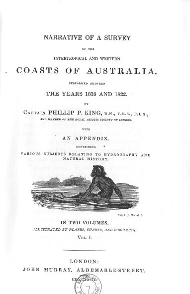
Title: Narrative of a Survey of the Intertropical and Western Coasts of Australia
Performed between the years 1818 and 1822
Author: Phillip Parker King
Release Date: February 21, 2004 [EBook #11203]
Language: English
Character set encoding: ISO-8859-1
*** START OF THIS PROJECT GUTENBERG EBOOK SURVEY OF AUSTRALIA ***
Produced by Sue Asscher
WOODCUT 1: NATIVE OF DAMPIER'S ARCHIPELAGO ON HIS LOG.
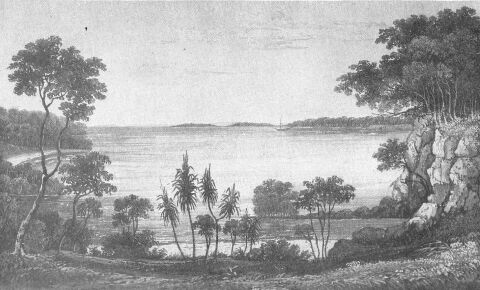
VIEW IN RAFFLES BAY, WITH CROKER'S ISLAND IN THE DISTANCE.
From a sketch by P.P. King.
Published in May 1825 by John Murray, London.
THE rapidly-increasing importance to which the English Colonies in Australia have now arrived, rendering every subject connected with that extensive continent of the greatest interest, whether in respect to its geography, or the extraordinary assemblage of its animal and vegetable productions, has induced me to publish such parts of my Journal as may be useful to accompany the Atlas of the Charts of the Coast recently published by the Board of Admiralty.
One of the results of this voyage has been the occupation of Port Cockburn, between Melville and Bathurst Islands on the North Coast, and the formation of an establishment there which cannot fail to be productive of the greatest benefit to our mercantile communications with the Eastern Archipelago, as well as to increase the influence and power of the mother country in the South Pacific and Indian Oceans; and in contemplating this new extension of her possessions*, I cannot avoid recalling to mind a curious and prophetic remark of Burton, who, in alluding to the discoveries of the Spanish navigator Ferdinando de Quiros (Anno 1612), says: "I would know whether that hungry Spaniard's discovery of Terra Australis Incognita, or Magellanica, be as true as that of Mercurius Britannicus, or his of Utopia, or his of Lucinia. And yet, in likelihood, it may be so; for without all question, it being extended from the tropick of Capricorn to the circle Antarctick, and lying as it doth in the temperate zone, cannot chuse but yeeld in time some flourishing kingdoms to succeeding ages, as America did unto the Spaniards."** Burton's Anatomy of Melancholy, Part 2 Section 2 Number 3.
(*Footnote. The distance between Melville Island and Hobart Town in Van Diemen's Land, the former being the most northern, and the latter the most southern, establishment under the government of New South Wales, is more than 2700 miles, and comprises an extent of coast nearly equal to that of the British possessions in India!)
(**Footnote. Since the land that Quiros discovered and called Terra del Espiritu Santo was, at the time Burton wrote, considered to be the Eastern Coast of New Holland, I am justified in the use I have made of the above curious passage.)
Since the return of the Expedition, my time has been occupied in arranging the narrative, and divesting it of such parts as were neither calculated to amuse the general reader, nor to give information to the navigator; but this has been so much impeded by the more important employment of constructing the Charts of the Survey, as to defer until the present season the publication of the events of a voyage that was completed nearly three years ago.
In addition to the Hydrographical Notices in the Appendix, I have ventured to insert descriptive catalogues of the few subjects of Natural History that were collected during the voyage; these were supplied by some friends, to whom I have in another part of the work endeavoured, inadequately no doubt, to express my sense of the obligation: but since that part has been printed, my friend Mr. Brown has submitted some specimens of the rocks of the western side of the Gulf of Carpentaria, that were collected by him on the Investigator's voyage, to the inspection of Doctor Fitton, by which means that gentleman's valuable communication in the Appendix has been most materially improved. I have, therefore, taken the present opportunity of acknowledging the readiness with which this additional information has been supplied, and of offering Mr. Brown my best thanks.
It now only remains for me to add, that the views with which these volumes are illustrated were engraved by Mr. Finden from my own sketches on the spot: the charts, which are reductions of those in the Admiralty Atlas, were engraved by Mr. Walker; and the three plates of Natural History by Mr. Curtis, from drawings made from the specimens by himself, by Henry C. Field, Esquire, and by Miss M. Field; to each of whom I take this opportunity of returning my best thanks, and also of bearing testimony to the correctness with which the respective subjects have been represented.
London, March 20th, 1826.
Intended mode of proceeding, and departure from Port Jackson.
Visit Twofold Bay.
Natives seen.
Passage through Bass Strait and along the South Coast to King George the Third's Sound.
Transactions there.
Voyage to the North-West Cape, and Survey of the Coast between the North-West Cape and Depuch Island, including the examinations of Exmouth Gulf, Curlew River, and Dampier's Archipelago.
Loss of Anchors, and Interview with the Natives.
Remarks upon Dampier's account of Rosemary Island, and of the Island upon which he landed.
WOODCUT 1: NATIVE OF DAMPIER'S ARCHIPELAGO ON HIS LOG.
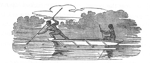
WOODCUT 2: NATIVES OF ROCKINGHAM BAY IN THEIR CANOE.
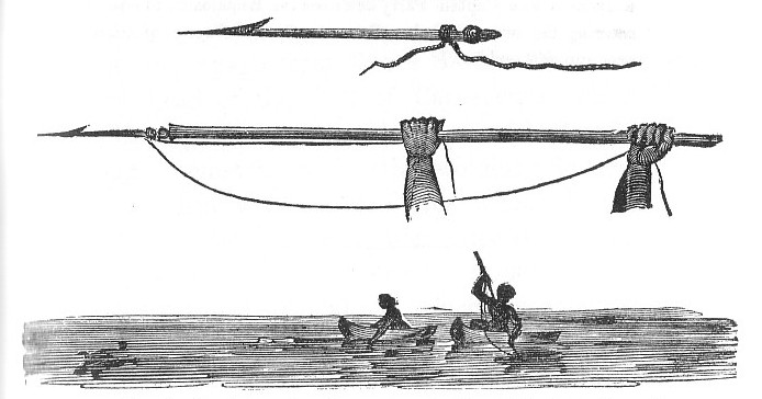
WOODCUT 3: NATIVES OF ENDEAVOUR RIVER IN A CANOE, FISHING.
WOODCUT 4: MANNER IN WHICH THE NATIVES OF THE EAST COAST STRIKE TURTLE.
WOODCUT 5: HUTS OF THE NATIVES AT CAREENING BAY.
PRELIMINARY REMARKS UPON THE DISCOVERY OF THE TERRA AUSTRALIS INCOGNITA.
INSTRUCTIONS FOR THE EXECUTION OF THE VOYAGE.
PASSAGE TO NEW SOUTH WALES.
PURCHASE AND EQUIPMENT OF THE MERMAID.
Nearly three centuries* have now elapsed since our first knowledge of the Great South Land, the Terra Australis Incognita of ancient geographers; and, until within the last century, comparatively little had been done towards making a minute exploration of its coasts: during the seventeenth century several voyages were made by different Dutch navigators, from whom we have the first-recorded description of its shores; but from the jealous disposition of their East India Company, under whose orders these voyages were performed, the accounts of them were so concealed, and consequently lost or destroyed, that few particulars of a detailed nature have been handed down.**
(*Footnote. The late Rear-Admiral Burney, in his History of Discoveries in the South Sea, volume 1 page 380, describes a chart, dated 1542, drawn by Rotz, in which a coast is continued to the 28th degree of south latitude; and immediately below the 30th degree, there is the name of Coste des Herbaiges, answering by an extraordinary coincidence both in climate and in name to Botany Bay.).
(**Footnote. In the voyages of Gautier Schouten, published at Amsterdam in 1708, duodecimo volume 1 page 41 et seq., there is the following curious account of the wreck of a ship on the coast of New Holland:
"Il me semble que je ne dois pas omettre ici une histoire, de la certitude de laquelle on n'eut pas lieu de douter. Des-que la nouvelle fut venue a Batavia [Anno 1659], que le vaisseau le Dragon, qui venoit de Hollande aux Indes, avoit fait naufrage sur les cotes d'une Terre Australe inconnue, on y envoia la flute la Bouee a la Veille, pour ramener ceux des gens de l'equipage qui auroient pu se sauver, et les efets qui auroient ete conservez.
"La flute etant conduite par ceux qui etoient echapez du naufrage dans la chaloupe, et venus a Batavia en aporter la nouvelle, se rendit au parage ou le Dragon avoit peri, et alla mouiller l'ancre dans l'endroit qui parut le plus propre pour son dessein. Aussi tot la chaloupe fut armee pour aller chercher ceux qui s'etoient sauvez le long du rivage. Elle s'aprocha d'abord du bris, pardessus lequel les vagues passoient; puis elle nagea vers le lieu ou l'on avoit dresse des tentes, quand la chaloupe du vaisseau peri partit, pour ceux qu'elle n'avoit pu recevoir, et qui devoient attendre la qu'on vint les y prendre.
"L'equipage etant descendu a terre, trouva les tentes brisees en pieces, et l'on ne decouvrit pas un seul homme dans tout le pais. La surprise ne fut pas mediocre. On regarda partout si l'on ne verroit point de traces qui marquassent qu'on eut construit quelque petit batiment: mais il n'y avoit ni tarriere, ni hache, ni couteaux, ni cloux, etc. Il n'y avoit ni ecrit ni indication par ou l'on put conjecturer ce qu'etoient devenus les gens qu'on avoit la laissez.
"La chaloupe etant retournee a bord, et aiant annonce cette nouvelle, il fut resolu que l'on iroit chercher plus avant dans les terres, et le long du rivage. Pour cet efet on se divisa en plusieurs troupes, et l'on ne reussit pas mieux que la premiere fois. On eut beau crier, apeller, tirer des coups de mousquet, tout fut inutile, et je n'ai pas seu qu'on ait jamais apris ce qu'etoient devenus ces gens-la.
"On retourna donc au bris, dont on ne put rien tirer, les lames aiant emporte les bordages, les ecoutilles, et fracasse tout le vaisseau, tant la mer brise fort en ces parages. Ainsi l'on jugea que le plus expedient etoit de s'en retourner, puis-qu'on n'avoit rien a pretendre, et qu'on avoit a craindre les vents forcez et les tempetes, qui selon les aparences auroient aussi fait perir la flute. Dans ce dessein on alla faire de l'eau. Ceux qui furent a une petite riviere qu'on avoit vue, au-lieu de se hater, se promenerent, et coururent en divers endroits.
"Cependant il s'eleva une si terrible tempete, que la flute fut contrainte de se mettre au large, ou elle atendit encore quelque tems. Mais comme la chaloupe ne revenoit point, on jugea qu'elle avoit peri; si-bien qu'on reprit la route de Batavia, ou l'on fit le raport de ce qui s'etoit passe.
"Quand l'orage eut cesse, l'equipage de la chaloupe se rembarqua pour retourner a bord. 'Mais il ne trouva plus la flute, ni sur la cote, ni au large. La tristesse ne fut pas moindre que l'etonnement, et l'on ne seut quel parti prendre. Enfin il fallut retourner a terre, pour n'etre pas englouti par les flots. Mais on n'avoit point de vivres, et l'on ne voioit rien dans tout le pais qui put servir de nouriture. Les montagnes n'etoient que des rochers; les valees etoient de vrais deserts; les plaines n'etoient que des sables. Le rivage etoit aussi borde de roches, contre lesquelles la mer brisoit avec d'efroiables mugissemens.
"Ceux qui etoient la demeurez se trouvoient au nombre de treize hommes, qui furent bientot fatiguez, afoiblis et attenuez. La faim les pressoit, le froid et l'humidite les faisoient soufrir, et ils se regardoient comme condamnez a la mort. Il n'y avoit rien a esperer du bris; les vagues avoient tout fait rouler ca et la dans la mer. Enfin a force de courir et de chercher quelque chose qu'ils pussent manger, ils apercurent entre les rochers qui etoient le long du rivage, de gros limacons, et de plus petits, qui y venoient de la mer, et dont le gout, qui etoit passable, parut excellent a des gens affamez. Mais n'aiant point de feu pour les faire cuire, l'usage continuel qu'ils en firent, commenca de les incommoder, et ils sentirent bien que ce foible remede ne les empecheroit pas de mourir dans peu de tems.
"Enfin ne voiant de toutes parts qu'une mort certaine, ils prirent la resolution de s'exposer a la merci des flots, dans l'esperance que s'il ne se presentoit rien de plus favorable pour eux sur la mer que sur la terre, au moins la mort qu'ils y trouveroient, seroit plus promte, et les delivreroit plutot de leurs miseres. Cependant ils se flatoient encore de l'esperance de pouvoir aborder en quelque autre pais, ou il y auroit des choses propres pour la nourriture des hommes.
"Ainsi chacun travailla selon ses forces a calfater la chaloupe, a faire provision de limacons, a remplir des futailles d'eau. Apres cela l'on mit le batiment a la mer, et l'on quitta ce lieu, ou l'on n'avoit vu que des deserts arides et des feux folets, et ou il n'y avoit ni betes ni gens. On perdit bientot de vue ce pais sterile, le second Pilote de la flute etant parmi cette troupe desolee, et la guidant par le cours du Soleil, de la Lune et des Etoiles.
"Cependant ils avoient trois a quatre cents lieues de chemin a faire, pour terrir a la cote septentrionale de la grande Java. On peut assez s'imaginer a quelles soufrances ils furent exposez dans un tel batiment, pendent une telle route, et avec si-peu de vivres, et si-mauvais. Par le beau tems ils voguoient encore passablement; mais quand la mer etoit grosse, les lames les couvroient et passoient par-dessus leurs tetes, et la chaloupe etoit toujours sur le point de se voir submergee.
"Mais la plus cruelle avanture fut que les limacons se corrompirent, et il n'y eut plus moien d'en manger, si-bien que pour tout aliment il ne resta que de l'eau. La nuit il faisoit un froid insuportable, et le jour on etoit brule des ardeurs du Soleil. Toute esperance de salut sembloit etre retranchee, et les fatigues, aussi-bien que le manque de nourriture, avoient entierement epuise les forces de ces infortunes, lors-qu'un matin ils decouvrirent les montagnes meridionales de la grande Java."
This ship was probably wrecked in the neighbourhood of Dampier's Archipelago, near which there is also an account of the loss of a ship called the Vianen.)
The first circumstantial account that we have is that of Dampier; who, in his celebrated Buccaneering Voyage in the year 1688, visited that part of the North-West Coast, to which the name of Cygnet Bay has been attached: of this place he gives a faithful and correct account, particularly with respect to its productions, and the savage and degraded state of its inhabitants: the same navigator afterwards (in 1699) visited the West and North-west Coasts in His Majesty's ship Roebuck, in the description of which he has not only been very minute and particular, but, as far as we could judge, exceedingly correct.
Within the last fifty years the labours of Cook, Vancouver, Bligh, D'Entrecasteaux, Flinders, and Baudin have gradually thrown a considerable light upon this extraordinary continent, for such it may be called. Of these and other voyages that were made during the 17th and 18th centuries to various parts of its coasts, an account is given by the late Captain Flinders, in his introduction to the Investigator's voyage; in which, and in that able and valuable work of the late Rear-Admiral Burney, A Chronological Account of Discoveries in the South Sea and Pacific Ocean, the history of its progressive discovery is amply detailed.
It was intended that the whole line of the Australian Coast should have been examined and surveyed by Captain Flinders; but the disgraceful and unwarrantable detention of this officer at the Mauritius by the French Governor, General Decaen, prevented the completion of this project. Captain Flinders had, however, previously succeeded in making a most minute and elaborate survey of the whole extent of the South coast, between Cape Leeuwin and Bass Strait; of the East Coast, from Cape Howe to the Northumberland Islands; of the passage through Torres Strait; and of the shores of the Gulf of Carpentaria.
The French expedition, under Commodore Baudin, had in the mean time visited some few parts of the West Coast, and skirted the islands which front the North-west Coast, without landing upon, and indeed scarcely seeing, any part of the mainland. The whole of the north, the north-west, and the western shores remained, therefore, to be explored; and in the year 1817, among the numerous voyages of survey and discovery upon which a part of the navy of Great Britain was so honourably and so usefully employed, these Coasts of Australia were not forgotten. An expedition for the purpose of completing the survey of its North and North-west Coast was planned, under the joint direction of the Lords Commissioners of the Admiralty, and the Secretary of State for the Colonies, to the command of which I had the honour of being appointed.
The arrangements for providing me with a vessel and crew were made by the latter department; and the Governor of New South Wales was instructed to give up to my use any vessel in the colonial marine establishment that should be deemed capable of performing the service; or, in the event of there being none fit for the purpose, to purchase any suitable one that might be offered for sale.
For my guidance I received the following instructions from the Admiralty and the Colonial Department:--
Admiralty Office, 4th February, 1817.
SIR,
My Lords Commissioners of the Admiralty being informed of the arrangements of Earl Bathurst, His Majesty's principal Secretary of State for the Colonial Department, for employing you in a survey of the unexplored parts of the Coast of New South Wales, have commanded me to express their concurrence therein, and to convey to you the following instructions, to which you are to conform yourself, in addition to those which you may receive from the Secretary of State.
The arrangements for providing you with a proper vessel and crew, and other necessaries for the prosecution of the service having been made by the Colonial Department, my Lords have no directions to give you on these subjects, but to recommend you in the conduct and discipline of the vessel which may be intrusted to your care, to conform, as far as may be practicable, to the established usages of the navy, and to the regulations for preserving health, cleanliness, and good order, which have been established in His Majesty's ships when employed in Voyages of Discovery.
In order to assist you in the care and use of the timekeepers and instruments with which their Lordships have directed the Hydrographer of this department to furnish you, and to follow your orders in all other particulars relating to the service, my Lords have directed Messrs. Frederick Bedwell and John Septimus Roe, two young gentlemen, who have been recommended to them as peculiarly fitted to be of use to you, and for whose appointment you have expressed your wishes, to accompany you and to be under your command.
The principal object of your mission is to examine the hitherto unexplored Coasts of New South Wales, from Arnhem Bay, near the western entrance of the Gulf of Carpentaria, westward and southward as far as the North-west Cape; including the opening, or deep bay called Van Diemen's Bay, and the cluster of islands called Rosemary Islands, and the inlets behind them, which should be most minutely examined; and, indeed, all gulfs and openings should be the objects of particular attention; as the chief motive for your survey is to discover whether there be any river on that part of the coast likely to lead to an interior navigation into this great continent.
It is for several reasons most desirable that you should arrive on this coast, and commence your survey as early as possible, and you will therefore, when the vessel shall be ready, lose no time in proceeding to the unexplored coasts; but you are at liberty to commence your survey at whichever side you may judge proper, giving a preference to that which you think you may be able soonest to reach; but in case you think that indifferent, my Lords would wish you to commence by the neighbourhood of the Rosemary Islands.
Either on your way out, or on returning, you should examine the coast between Cape Leeuwin and the Cape Gosselin, in M. De Freycinet's chart; and generally you will observe, that it is very desirable that you should visit those ranges of coast which the French navigators have either not seen at all, or at too great a distance to ascertain and lay down accurately.
You will provide yourself at Port Jackson with the seeds of such vegetables as it may be considered most useful to propagate on the coasts you may visit, and you will take measures for sowing or planting them in the fittest situations, with a view not only to their preservation, but to their being within the observation and reach of succeeding navigators.
You will take care to make duplicate copies of all your notes, surveys, and drawings; and you are to take every possible opportunity of transmitting one copy to Earl Bathurst, and the other to me for their Lordship's information; but you need not send duplicates by the same conveyance. And you will feel the necessity of writing by every opportunity to acquaint both departments of your progress.
You will remain on this service till you shall have examined all parts of the coast which have not been laid down by Captain Flinders, M. De Freycinet, or preceding navigators, or until you shall receive further orders.
I am, Sir,
Your very humble servant,
(Signed) J.W. CROKER.
To Lieutenant P.P. King.
Downing-street, 8th of February, 1817.
SIR,
As His Majesty's Government has selected you for the command of an expedition which is to be fitted out in New South Wales, for the purpose of exploring the yet undiscovered Coast of New Holland, and for completing, if possible, the circumnavigation of that continent; you will proceed with all practicable expedition to Port Jackson, and you will, on your arrival, deliver to Governor Macquarie the accompanying despatches, which state the object which you have in view, and the means by which it is to be accomplished. The Governor will place at your disposal any colonial vessel which you may consider best calculated for the voyage, and you will concert with him as to the equipment of such vessel, and avail yourself of his knowledge of the several persons in the colony, in order to select a crew on whom reliance can be placed for steadiness and subordination. Besides the persons necessary for the navigation of the vessel, you will receive on board Mr. A. Cunningham, a botanist, now in New South Wales, who has received the orders of Sir Joseph Banks to attend you; and you will engage any other person, if there be such in the colony, who possesses a competent knowledge of Mineralogy or Natural History.
It is on every account most desirable that the Expedition should proceed from Port Jackson as early as possible; you will therefore make every exertion in your power to accelerate your departure from thence, and your arrival at the point specified in your Admiralty instructions.
The Lords Commissioners of the Admiralty having given you detailed instructions relative to the naval objects of the Expedition, I have only to direct your observation to the several points referred to in the enclosed memorandum, as those upon which it is desirable to procure information. You will exercise your own discretion as to landing on the several parts of the coast which you may explore; but on all occasions of landing, you will give every facility to the botanist, and the other scientific persons on board to pursue their inquiries; and you will afford them such assistance in the pursuit as they may require. If the place selected for landing be in any way remarkable in itself, or important from being at the mouth of a river, or a harbour, you will take care to leave some evidence which cannot be mistaken of your having landed, either by erecting a flagstaff, or sowing some seeds, or by resorting to any other means which may at the time present themselves.
You will not fail regularly to keep a journal of your proceedings, and to note down your observations, as they from time to time occur, transmitting home by every opportunity intelligence of the progress which you have made, and of the leading events which may have befallen you.
I have the honour to be, Sir,
Your most obedient, humble servant,
(Signed) BATHURST.
To Lieutenant P.P. King, R.N.
The following will be among the most important subjects, on which it will be more immediately your province, assisted by your officers, to endeavour to obtain information on any occasion which may offer.
The general nature of the climate, as to heat, cold, moisture, winds, rains, periodical seasons; the temperature regularly registered from Fahrenheit's thermometer, as observed at two or three periods of the day.
The direction of the mountains, their names, general appearance as to shape; whether detached or continuous in ranges.
The animals, whether birds, beasts, or fishes; insects, reptiles, etc., distinguishing those that are wild from those which are domesticated.
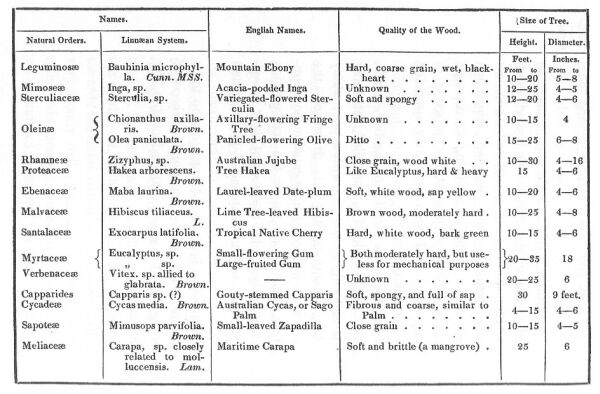
The vegetables, and particularly those that are applicable to any useful purposes, whether in medicine, dyeing, carpentry, etc.; any scented or ornamental woods, adapted for cabinet work and household furniture, and more particularly such woods as may appear to be useful in ship-building; hard woods for tree-nails, block-sheaves, etc., of all which it would be desirable to procure small specimens labelled and numbered, so that an easy reference may be made to them in the journal, to ascertain the quantities in which they are found; the facility or otherwise of floating them down to a convenient place for shipment, etc.
Minerals, any of the precious metals, or stones; how used, or valued by the natives.
The description and characteristic difference of the several tribes or people on the coast.
The occupation and means of subsistence, whether chiefly, or to what extent by fishing, hunting, feeding sheep or other animals, by agriculture or by commerce.
The principal objects of their several pursuits, as mentioned in the preceding paragraphs.
A circumstantial account of such articles growing on the sea-coast, if any, as might be advantageously imported into Great Britain, and those that would be required by the natives in exchange for them.
The state of the arts, or manufactures, and their comparative perfection in different tribes.
A vocabulary of the language spoken by every tribe with which you may meet, using in the compilation of each the same English words.
On the day that my appointment was dated, I received an order for a passage in the ship Dick, a transport, hired to convey the 48th regiment to New South Wales; and on the 17th of February, twelve days after my appointment, left Gravesend; but from a tedious detention in the Downs, and a succession of foul winds, did not finally leave Cork, where the troops embarked, until the 3rd of April.
On the 26th of May, the Dick anchored in the harbour of Rio de Janeiro, and remained for a fortnight, to procure refreshments for the troops, and complete her water.
Hence to New South Wales the voyage was performed, without the occurrence of any incident worth recording. The heads of Port Jackson were seen at daylight on the 1st of September; but being to leeward of the port, the ship did not anchor in Sydney Cove until the 3rd, after a passage from Cork of twenty-two weeks, including the fortnight that was passed at Rio.
The same evening I waited upon his Excellency Governor Macquarie at Parramatta, and delivered to him his letters and the despatches which acquainted him with the particulars of my mission; upon which His Excellency, after expressing himself anxious to give every assistance in his power in forwarding the service I had to perform, informed me that there were only two vessels belonging to the colony that could suit my purpose: one of one hundred tons that had been lately launched, and the other a brig of seventy tons, the Lady Nelson, that was built at Deptford in the year 1799, and sent out to the colony, expressly for the purpose of surveying the coast; she had, however, for the last ten years, been used as a coal-vessel, and was then hauled upon the slips, undergoing a repair. Upon examining the two vessels, I found that the former, although of convenient burden, not only drew too much water, but was in every other way unsuitable for my purpose; and the latter required much repair before she could be sent to sea, but as there was no other vessel at Port Jackson, either for sale or hire, no choice was left but to prepare the Lady Nelson as quickly as possible; and, as it was found absolutely necessary to give her a new keel, stern-post, and cut-water, besides new decks, with many new beams, there was no probability of completing her for at least four months.
Fortunately, however, this arrangement was shortly afterwards rendered unnecessary by the arrival from India, of the Mermaid, a cutter of 84 tons burden, built of teak, and not quite twelve months old: her length was 56 feet; breadth of beam 18 feet 6 inches; and did not, when deep-laden, draw more than 9 feet; her bottom was rather sharper than was convenient for the purpose of taking the ground; but, as I could not expect to find every advantage combined in one vessel that was necessary for the purpose of surveying, the latter objection was of necessity overruled; and being in every other respect superior to the Lady Nelson, and requiring no repairs, she was eventually purchased for the sum of 2000 pounds sterling, and immediately appropriated to my use.
A schooner would have been much more convenient; but, as there was no opportunity of making such an alteration, it could not be effected. My statement of the arrangements that were requisite for our accommodation was approved of by the Governor, who gave the necessary orders to the Engineer, a captain of the forty-sixth regiment; and the Deputy Commissary General was instructed to attend to all my demands, and to supply the requisite quantities of provisions and stores; but, notwithstanding every wish on the part of His Excellency to forward our outfit and complete the vessel for sea without delay, it was not until the 21st of December that the alterations were finished. Had we met with as much opposition and inattention from the commissariat department as from the engineer, the vessel would not have been ready for sea for six months; it is, however, a duty I owe to Deputy Commissary General Allan, to acknowledge the readiness with which that officer's department attended to my wants.
The following is a list of the officers and men who formed the crew of the Mermaid:--
Commander:
Lieutenant Phillip Parker King.
Master's mates, 2:
Mr. Frederick Bedwell.
Mr. John Septimus Roe.
Botanical collector:
Mr. Allan Cunningham.
Seamen, 12.
Boys, 2.
Total, 18.
In addition to this establishment, I accepted the proffered services of Boongaree, a Port Jackson native, who had formerly accompanied Captain Flinders in the Investigator, and also on a previous occasion in the Norfolk schooner. This man is well known in the colony as the chief of the Broken Bay tribe; he was about forty-five years of age, of a sharp, intelligent, and unassuming disposition, and promised to be of much service to us in our intercourse with the natives: this addition made our number amount to nineteen, for which we carried provisions for nine months, and twelve weeks' water.
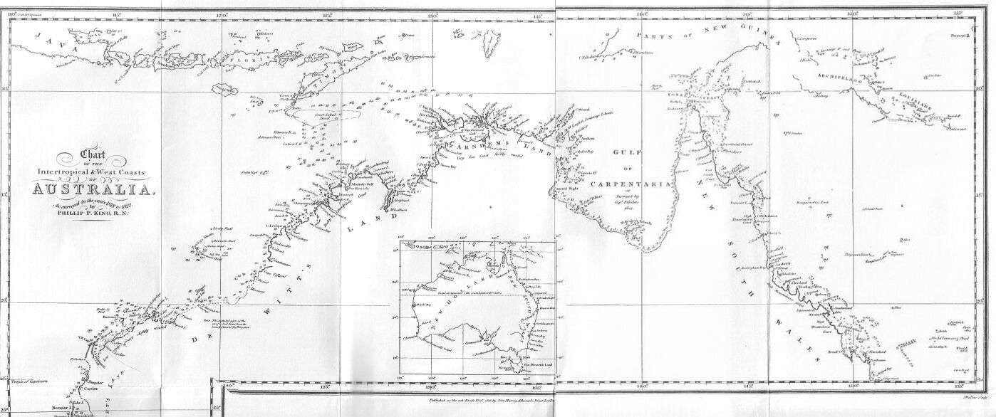
CHART OF THE INTERTROPICAL AND WEST COASTS OF AUSTRALIA.
As surveyed in the years 1818 to 1822 by Phillip P. King, R.N.
Intended mode of proceeding, and departure from Port Jackson.
Visit Twofold Bay.
Natives seen.
Passage through Bass Strait and along the South Coast to King George the Third's Sound.
Transactions there.
Voyage to the North-West Cape, and Survey of the Coast between the North-West Cape and Depuch Island, including the examinations of Exmouth Gulf, Curlew River, and Dampier's Archipelago.
Loss of Anchors, and Interview with the Natives.
Remarks upon Dampier's account of Rosemary Island, and of the Island upon which he landed.
1817. December 21.
At the time that the Mermaid was ready to commence her voyage, it was the season when the westerly monsoon blows over that part of the sea which separates the islands of Timor and New Guinea from Australia; it was therefore necessary, in order to benefit by the direction of the wind, to commence the survey of the coast at its western extremity, the North-West Cape: but, to do this, the passage was to be made, by taking the western route, as it is called; that is, by passing either through Bass Strait, or round Van Diemen's Land, and steering up the West Coast. In doing this, the vessel would, doubtless, have to encounter much bad weather; and, on her arrival might, probably, be more fit to return than to commence the survey of a dangerous and an unknown coast. The passage to the northward, through Torres Strait, would have been, on all accounts, the most advisable route, had the season been more advanced; and, indeed, it would have been even better to wait until March for that purpose; but this would be a loss of time in which much might be effected, were we only fortunate enough to make the western passage without accident: under all these circumstances, I was induced to prefer the route of Bass Strait, rather than remain idle, after the vessel was completed.
Before we left Port Jackson, His Excellency the Governor was made acquainted with my intended mode of proceeding; that, having passed Bass Strait to King George the Third's Sound, I should there complete my water and fuel: then, by steering up the West Coast, to commence my survey at the North-West Cape, and examine the coast easterly until the westerly monsoon should begin to decline; upon which I proposed to leave the land, and proceed as far to the eastward as the remainder of the monsoon would allow; when I might examine the coast back with the easterly monsoon as long as my stock of water lasted; and lastly, if I could not get a supply upon the coast, to go to Timor, by which time my provisions would, probably, be so reduced as to oblige my returning to Port Jackson to prepare for a second voyage.
December 22.
Having made our final arrangements, we left Port Jackson on the 22nd of December, with a fresh northerly breeze, which continued until the evening of the 24th, when we were abreast of Cape Howe. After this a heavy gale of wind from South-West obliged us to run into Twofold Bay for shelter, and to repair some trifling damage which we had already sustained.
Twofold Bay was discovered by Mr. Bass in 1797; and, although it is for the most part too open and exposed to easterly winds for large ships, yet it has a cove on its northern side, in which small vessels find secure anchorage and a convenient place for stopping at, if bound to the southward; and hence its name of Snug Cove. It is completely land-locked, and it also conveniently affords both wood and water, and is neither difficult to enter nor to leave.
December 26.
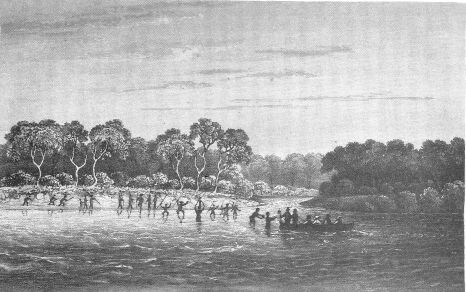
When passing Red Point, which is on the south side of the bay, several natives were seen upon it; one of them came to the verge of the rocks that overhang the extremity of the point, and made violent gestures, but, whether they were those of friendship or hostility, could not be ascertained. Boongaree answered him in the Port Jackson language, but they were equally unintelligible to each other. The native had a spear in one hand, and either a throwing stick, or a club, in the other; both of which, with his legs widely extended, he flourished most furiously over his head. This man was quite naked, but a woman near him wore a kangaroo's skin over her shoulders. Several small parties of natives were seen in the other parts of the bay, but they appeared more anxious to avoid than to court a communication with us.
On anchoring in Snug Cove, I went on shore with Mr. Roe and Mr. Cunningham: Boongaree also accompanied us, clothed in a new dress, which was provided for him, of which he was not a little proud, and for some time kept it very clean.
Wood was abundant and near at hand, and the water, which is in a morass at the back of the beach, although shallow, and covered with a species of azolla, was both good and plentiful.
The soil of the hills, contiguous to Snug Cove, is very good, and covered with luxuriant grass. The country appeared to be thickly wooded, but near the water the trees, which were principally species of the eucalyptus and the casuarina, were small and stunted.
In our strolls during the day along the beach, and over the surrounding hills, we did not encounter any inhabitants, although recent signs of them were visible at every step; several beaten paths were observed leading to the morass from different directions, on the banks of which were many shells (Haliotis gigantea, Linn.) used by the natives for drinking-vessels.
In the evening, after hauling the seine on the beach without success, we were upon the point of embarking, when we discovered, at about seventy or eighty yards up the hill, the heads of three or four natives peeping above the long grass, evidently watching our movements, and probably awaiting our departure to allow them to go to the morass for water. Wishing very much to communicate with these people, we walked towards them, but they suddenly rose and scampered up the hill among the trees, which were so thick as soon to conceal them from our view. Boongaree called to them in vain; and it was not until they had reached some distance that they answered his call in loud shrill voices. After some time spent in a parley, in which Boongaree was spokesman on our part, sometimes in his own language, and at others in broken English, which he always resorted to when his own failed in being understood, they withdrew altogether, and we neither heard nor saw anything more of them.
December 27.
The next morning, the wind being easterly, we left the bay. On passing Red Point, twenty or thirty natives came to the extreme point of the cliff, shouting and hallooing and making violent gestures; a large group of women and children appeared in the background, timidly concealing themselves behind the trees and bushes; another party was quietly seated round small fires on the rocks near the sea-beach, apparently engaged in cooking their fish; and at a little distance from the last group, two canoes were hauled upon the rocks.
The breeze being fresh from the North-North-East, we made rapid progress; and at three o'clock p.m., rounded Cape Howe, with every prospect of passing through Bass Strait before the wind should again veer to the westward. In passing Cape Howe, we observed large fires burning on the hills, made by the natives for the double purpose of burning off the dry grass and of hunting the kangaroos, which are thus forced to fly from the woods, and thereby fall an easy prey to their pursuers.
December 28.
The next day at noon, Kent's Group, in the eastern entrance of Bass Strait, was seen; but, at one o'clock, the wind shifted suddenly and blew a gale from South-West, with heavy rain: after beating against it until the following day, we bore up and ran under the lee of Great Island, intending to pass round Van Diemen's Land: at five o'clock, we passed close to the Babel Islands, on which were heaped incredible numbers of sea-birds of various descriptions, each species huddled together in flocks separate from the other. On another part of the island many seals were seen, by the growl of which, and the discordant screams of the birds, a strange confused noise was made, not ill adapted to the name the island bears.
December 29.
By the following day, we had made some progress along the eastern side of Van Diemen's Land, but in the evening, the wind shifted to South-East, and induced us to try the Strait once more. In passing the low north-easternmost point of the land, called by the French, Cape Naturaliste, we had nearly run ashore from the darkness of the night, and the little elevation of the land. Our sounding in seven fathoms was the first indication of danger; and, on listening attentively, the noise of the surf upon the beach was distinctly heard.
December 30.
The next morning we passed through Banks Strait, and entered Bass Strait.
1818. January 2.
But the wind was so light and baffling, that we made no progress until the 2nd of January; when, with a freshening breeze from the eastward, we moved rapidly on our way, and flattered ourselves with the hope of clearing the strait before night. In this hope we were not deceived; but before it was effected, we had very nearly suffered from the careless look-out of the man at the masthead. At four o'clock we were near Three Hummock Island, and steered so as to pass close to its northern point, in order that we might obtain a correct latitude for sights for the chronometers. Being within half a mile of it, rocks were suddenly seen outside and so close to us, that it was then too late either to haul up or bear away; the rocks to windward and the land to leeward preventing us: nothing was therefore left to us but to proceed and take the chance of finding sufficient depth of water between the point and the rocks; providentially there proved to be a passage of one-eighth of a mile wide, and the cutter passed safely through. These islands were examined by Commodore Baudin, and an elaborate survey made of them by his officers; but this danger is not noticed on their plan of the group. The rocks bear North 30 degrees West (by compass) from the northernmost point of the island, and North 8 degrees East (by compass) from the northernmost hummock. I do not think they extend far from the shore.
At sunset, we were in the meridian of Albatross Island, and by midnight cleared the Strait, when we steered a course for King George the Third's Sound.
Upon examining our bread, we found that a considerable quantity was spoiled from damp and leaks, which necessarily obliged us to go at once upon a reduced allowance of that article.
January 16.
From a succession of westerly winds, the vessel was driven so near to the Archipelago of the Recherche, that we were induced to bear up for the anchorage in Goose Island Bay; but as we steered round Douglas's Isles, the wind veered back to the South-East, and we might have proceeded: we were, however, so near the anchorage, that I determined upon occupying it for the night; and steering in between Middle Island and Goose Island, the anchor was dropped off the first sandy beach to the eastward of the highest hill, at the north-west end of the former.
In the evening I landed with the botanist and Mr. Roe, but we found little that was worthy of our attention. The basis of the island is granitic, and covered with a shallow soil, formed of decayed vegetable matter, mixed with sand, which nourishes the stunted vegetation that thickly clothes the surface, particularly on the north-eastern, which is its most sheltered side.
No animals were observed, excepting some small quadrupeds, which were momentarily seen by Mr. Roe, and, from his description, were kangaroo-rats. On Goose Island, the bird from which it takes its name appeared to be abundant; but there was too much surf to permit our landing upon it, and we were not so much in want of fresh provisions as to induce our risking any damage to the boats: we found the bones of a whale which had been thrown up on the beach where we landed.
January 17.
The wind in the night veered to North-East by East, to which quarter the anchorage is much exposed; towards morning it blew fresh, but the anchor held well. At dawn of day, (17th) we got underweigh and steered through the islands; at noon, we were abreast of Termination Island, the latitude of which we found to be 34 degrees 32 minutes. Our friendly wind died away at midnight, and was succeeded by a short gale from the westward.
January 20.
On the 20th, at daylight, we were close to Bald Island, and in the afternoon took up an anchorage in King George the Third's Sound, between Seal Island and the first sandy beach, at the distance of half a mile to the eastward of a flat rock in seven fathoms, sand and weeds.
In the evening we landed on Seal Island, which we had much difficulty in effecting on account of the surf. Several seals were upon it, one of which we killed; and some penguins were also taken. On the summit of the island or rock, for it scarcely deserves the former appellation, the skeleton of a goat's head was found, and near it were the remains of a glass case bottle; both of which, we afterwards learnt, were left on the island by Lieutenant Forster, R.N., who put into this harbour in 1815, on his passage from Port Jackson to Europe, in the Emu, hired transport. We searched in vain for the bottle which Captain Flinders left there, containing an account of the Investigator's visit; my intention, in looking for this document, was not of course to remove it, but to ascertain its existence, and to add a few lines to the memorandum it contained.
Iguanas, geese, penguins, gulls, and seals of the hairy species, were the sole inhabitants of this rock. After leaving Seal Island, we landed on the sandy beach abreast of the anchorage; in doing this the boat filled, and the instruments were so wetted, that they were left on the beach to dry during our absence. Our ascent, from the hill being steep, and composed of a very loose drift sand, was difficult and fatiguing; but the beautiful flowers and plants, with which the surface of the hill was strewed, repaid us for our toil. These being all new to Mr. Cunningham fully occupied his attention, whilst I remained upon the summit, from whence a good view was obtained of the Eclipse Isles, and Vancouver's breakers, both of which are well laid down by Captain Flinders, whose correctness I had already many occasions to admire. An abundance of shells of the helix tribe (Helix bulimus) was found on the top and sides of the hill; and a calcareous substance was observed protruding from the ground in every part, as noticed both by Vancouver and Flinders;* the former also found it on the bare sandy summit of Bald Head, and supposed it to be coral, a circumstance from which he inferred that the level of the ocean must have sunk. Similar substances have since been discovered by Dr. Clarke Abel, near Simon's Town, at the Cape of Good Hope, and are described by him to be vegetables impregnated with carbonate of lime; but from the specimens we obtained, it would appear that it is neither coral, nor a petrified vegetable substance, but merely sand agglutinated by calcareous matter**.
(*Footnote. Vancouver volume 1 page 49. Flinders volume 1 page 63.)
(**Footnote. Vide Appendix, C.)
January 21.
The next morning we got under weigh, and stood over to the entrance of Oyster Harbour, off which we anchored to examine the bar; after satisfying myself on this head, and choosing a spot within the entrance to anchor at, we got under-sail, and in crossing the bar had not less than thirteen feet and a half, being nearly about the time of high water; but between the heads of the harbour it deepened to five, seven, and eight fathoms. Our anchorage was about twenty-five yards from the eastern shore, and not more than fifty yards within the narrowest part of the entrance; it was convenient for our purposes, as the wood was abundantly procured close to our water-holes, which were dug at the edge of the sand, within thirty yards of the vessel; so that the people employed in these occupations could be protected against the natives by the proximity of the cutter, without preventing the necessary repairs to the rigging being carried on at the same time by the remainder of the crew on board.
January 21 to 31.
During our stay in Oyster Harbour many parts of the neighbourhood were visited by us; and on one occasion, Mr. Roe walked round its shores; in doing which he got into great danger. Upon leaving the vessel, his intention was only to go to a projecting head on the western side, for the purpose of taking a sketch; but being tempted to extend his walk, he had half traversed the shore of the harbour before he thought of returning. He had already waded over the river that falls into the North-West corner of the port, which was not more than four feet deep; and to avoid crossing it again, he preferred returning to the tent, by making the circuit of the harbour: but after proceeding some distance further, he unexpectedly met with another river, deeper and wider than that which he had previously passed; this proved to be the Riviere de Francois of Captain Baudin; it falls into Oyster Harbour at its North-East corner, about two miles to the eastward of the Western River. In attempting to ford this, finding the water deeper than he expected, he was obliged to swim about two hundred yards; and, from being burdened with his clothes, narrowly escaped with his life. Fortunately he met with no further impediment to his return, and reached the tent much fatigued. We afterwards made an excursion up this river, but from the greater part of the day being spent in searching for the entrance, which is both shoal and intricate, we did not succeed in reaching farther than four miles from its mouth. At the part where we left off our examination, it was about sixty yards wide, and from ten to twelve feet deep; bounded on either side by gently rising and well wooded hills; but the soil was neither rich nor deep. The shoals of the river, which at the entrance were very extensive, were covered with large flights of water-fowl; among which curlews and teals were abundant.
Oyster Harbour is plentifully stocked with fish, but we were not successful with the hook, on account of the immense number of sharks that were constantly playing about the vessel. A few fish were taken with the seine, which we hauled on the eastern side of the small central island. At this place Captain Vancouver planted and stocked a garden with vegetables, no vestige of which now remained. Boongaree speared a great many fish with his fiz-gig; one that he struck with the boat-hook on the shoals at the entrance of the Eastern River weighed twenty-two pounds and a half, and was three feet and a half long. The mouths of all the creeks and inlets were planted with weirs, which the natives had constructed for the purpose of catching fish. Mr. Roe, on his excursion round the harbour, counted eleven of these weirs on the flats and shoals between the two rivers, one of which was a hundred yards long, and projected forty yards, in a crescent-shape, towards the sea; they were formed by stones placed so close to each other as to prevent the escape, as the tide ebbed, of such fish as had passed over at high water. This expedient is adopted in many parts of the continent; it was observed by Lieutenant Oxley, R.N., the surveyor-general of New South Wales, in his journey on the banks of the Lachlan River: the same was also seen by me on several parts of the North-West Coast; and, from its being used on the South-East, South-West, and North-West Coasts, it may be concluded to be the practice throughout the country.
While waiting for an opportunity of leaving this harbour, Mr. Roe assisted me in making a survey of the entrance, in the hope of finding it more available for large ships; but in vain; for ships drawing more than twelve feet water cannot pass the bar. The rise and fall of the tide is not only very inconsiderable, but also very irregular; under some circumstances we found that it rose three feet, but this was very unusual.
Our gentlemen made several excursions into the country in various directions, in the hope of meeting with natives, but not the least vestige of their immediate presence was found; they were not however far from us, for the smokes of their fires were seen every evening; probably the fear of punishment kept them away, as they had formerly made rather a mischievous attack upon some of the Emu's crew.
No marks were left of the ship Elligood's garden, which Captain Flinders found at the entrance of Oyster Harbour;* but a lapse of sixteen years will in this country create a complete revolution in vegetation; which is here so luxuriant and rapid that whole woods may have been burnt down by the natives, and grown again within that space of time; and it may be thus that the Elligood's garden is now possessed by the less useful but more beautiful plants and shrubs of the country.
(*Footnote. Flinders Terra Australis volume 1 page 55.)
Excepting the sea-fowl, which consisted of geese, wild ducks, teals, curlews, divers, sea-pies, gulls, and terns, very few birds were seen, and those chiefly of the parrot and cockatoo tribe; a species of the latter was noticed of a rich black plumage, and very like the black cockatoo of New South Wales. Kangaroos from their traces must be numerous, but only a very few were noticed; the only reptile that was found was a black snake, which Mr. Cunningham saw for a moment as it glided past him. This gentleman made a large collection of seeds and dried specimens from the vast variety of beautiful plants and flowers with which nature has so lavishly clothed the hills and plains of this interesting country.
A small spot of ground near the tent was dug up and enclosed with a fence, in which Mr. Cunningham sowed many culinary seeds and peach-stones; and on the stump of a tree, which had been felled by our wooding party, the name of the vessel with the date of our visit was inscribed; but when we visited Oyster Harbour three years and a half afterwards, no signs remained of the garden, and the inscription was scarcely perceptible, from the stump of the tree having been nearly destroyed by fire.
A little without the east entrance of the harbour, we saw one of those prodigious large nests which Captain Flinders observed near Point Possession; it was built on the summit of an almost inaccessible rock, exposed to the South-West winds; it measured four feet in diameter at the top, and nearly seven feet at the base: it appeared to have been deserted for some time, as the branches and sea-weed, with which it was made, were strewed about the rock. Captain Flinders thought it probable that the inhabitant was an eagle; but on our subsequent visit to King George's Sound in 1821, we saw the same nest occupied by a hawk of a moderate size.
On the 31st January we were ready to leave the port; but the weather was so unfavourable that we remained until the following day. In the evening a boat was sent to Seal Island to deposit a bottle, in which was enclosed a memorandum informing future navigators of our visit, and intentions with respect to our further proceedings. When the boat returned she brought two seals, which had been killed on the island for the sake of their skins, to be used for the purpose of refitting the rigging.
1819. February 1.
The next day (February 1st) the cutter was warped out of Oyster Harbour; and, as the wind was from the eastward, we profited by it: after beating out of the Sound we steered along the coast, and at eight o'clock were abreast of West Cape Howe.
On rounding Cape Leeuwin, our crew were attacked with a bowel complaint, and symptoms of dysentery; the want of a surgeon to our establishment was most anxiously felt, from the fear that, by an unskilful or improper use of medicines, I might increase, instead of lessen the progress of complaints, which from the fatigues of such a service, in so warm a climate and in the unhealthy season, threatened to be frequent and severe. One or two of the people had complained of this disorder before we left Oyster Harbour, but it was not until we had sailed, that it assumed any serious appearance. After two days it happily began to subside, or I should of necessity have been obliged to resort to some place for relief, for we had, at one time, only four seamen to keep watch.
February 10.
This sickness prevented our examining any part of the West Coast, as we passed it; our course was therefore held at a distance from the shore, and on the 10th the land to the southward of the North-West Cape was descried at daylight. Its outline was so level as to appear like a thick fog on the horizon; but, as the sun rose, we were undeceived. At seven miles from the shore we found no soundings with 80 fathoms; but at eight o'clock, being three miles nearer, we had 35 fathoms, sand, coral, and shells. The bottom then gradually shoaled to 22 fathoms; upon which we steered along the outer edge of a line of breakers that fronted the shore, and after rounding a projection of the reef, steered to the East-North-East, towards the extreme of the land.
The coast is here tolerably elevated, and may be seen at the distance of six or seven leagues; it is composed of a red-coloured, sandy-looking rock, which is very scantily sprinkled with small shrubs, and appears to be extremely arid and sterile. The shore is fronted with rocks that extend for three or four miles into the sea; on the extremity of which the surf breaks with a continued foam. To the north the land suddenly terminates with rather a steep slope, but a low sandy plain extends to the East-North-East for three miles further, the extremity of which is the North-West Cape. The fall of the high-land was called Vlaming Head, after the navigator who first discovered this part.
After obtaining the meridional observation, we rounded the Cape, and steered between it and a patch of breakers which lie at the distance of a mile and a half from the shore: we were no sooner under the lee of the land, than the air, before of a pleasant and a moderate temperature, became so heated as to produce a scorching sensation; and to raise the mercury in the thermometer from 79 to 89 degrees. We were also assailed by an incredible number of flies and other insects, among which was a beautiful species of libellula. The sea swarmed with turtles, sea-snakes, and fish of various sorts; and the dolphin was eminently conspicuous for its speed, and the varied beauty of its colours.
From the Cape, the low sandy land trended to the South-South-East for a mile and a half, and then with the same character to South-South-West 1/2 West, in which direction it was lost in distance; and in the north east, was a low rocky island.
The wind fell after passing round the Cape, and was so light during the afternoon that we made no progress, and were obliged to anchor at about three or four miles to the eastward of the Cape. At nine o'clock the wind freshened with the flood-tide, which raised a heavy swell in which the cutter rode very uneasily.
February 11.
And, in the morning, when we attempted to weigh the anchor, the cable parted, having been cut by rocks. Owing to the bad construction of the buoy, it did not watch; and, as the tide quickly swept us from the place, we had no chance left of recovering the anchor. As the sun rose the wind gradually fell; and, at noon, we were no farther advanced than a mile and a half to the southward of the north east trend of the Cape. Here the coast is low and sandy, and is of shoal approach. A small clump of mangrove-trees on the beach was the first sign of vegetation that we had seen; and, from the absence of verdure hereabout, is a conspicuous object. The thermometer stood at 89 degrees. The ebb tide then commenced and drifted us out near our last night's anchoring ground, and the evening was spent, without success, in searching for our lost anchor. At sunset a fresh breeze set in from the South-West, and fearing a repetition of our loss, we continued under sail during the night, which was past with great anxiety; and not without reason.
February 12.
For when the day broke, we found ourselves within one mile of the reef off the South-West end of the island in the north east (which proved to be Captain Baudin's Muiron Island), and drifting towards it so rapidly, that in less than half an hour the vessel would have been thrown upon the rocks. Standing to the eastward we discovered the three sandy islets--h, i, and k; and at noon, we were near two other sandy islets, y, and z, which appeared to be the north-westernmost of a group of low, sandy, or rocky islets, extending to the South-East, beyond the limits of our masthead view. The islets, y and z, are of circular shape, and not more than a quarter of a mile in diameter; they are so low as not to be visible from our deck at a greater distance than seven miles. Their summits are crowned with a slight shrubby vegetation, the bright verdure of which, separated from the dark blue colour of the sea by their glittering sandy beaches, formed a pleasing contrast to the dull, monotonous appearance of the mainland. These islets are in fact only the dry parts of a shoal, on which the sand has accumulated, and formed a soil to receive and nourish the seeds of plants, which have either been drifted on shore by the tide, or been brought by birds from the continent.
At sunset we anchored under the land, but soon afterwards the wind blew so fresh, that the fluke of our anchor broke, and we were obliged to drop another; which was the last we possessed, besides a small stream anchor that was too light to use, excepting in a calm.
February 13.
The next morning being fine, and favourable for another search after our lost anchor (the recovery of which from our last night's misfortune had become of very great consequence) we bore up along the shore, and soon arrived at the spot; but after some time spent in the search, without success, we were at last obliged to relinquish the attempt, and gave up all hope of ever finding it.
February 14.
We then returned into the gulf to prosecute its examination, but as usual, the wind fell, and the only progress we made was by the assistance of the flood-tide, which ran until sunset; a fresh breeze then sprung up, and the night was passed under sail. At daylight the following morning the cutter was about four miles from the western shore, but the day was so calm that very little progress was made. The thermometer indicated a temperature of 97 degrees, which, from the absence of the sea-breeze, and from our not having an awning to protect us from the sun's rays, was almost insufferable; and although our crew were happily in good health, yet my fears were momentarily alive lest any should be taken ill. A land-wind at night enabled us to make some progress, and before dark we had reached twenty-five miles into the opening without seeing anything like its termination; the western side still trended in a southerly direction, losing itself in distance, and bore the appearance of being an island.
February 15.
By the next day we descried some hills of peaked shape to the southward, which was the only indication we had of the termination of the gulf: to the eastward the islands were very numerous and low; but to the South-East the land was so continuous as to impress us with the idea of its being the continent. We steered towards it to satisfy our doubts but the water shoaled and prevented our approaching it near enough to ascertain the fact. The gulf was here so much narrower, and the bottom so uneven and rocky, that an anchorage was now of material importance, but our poverty in anchors made me fearful of risking our last upon a bottom of the least questionable nature. Before dark however we were fortunate in finding a bay on the western shore, in which the anchor was dropped in three fathoms muddy bottom, at one mile from the shore.
The discovery of this anchorage proved so welcome to our fatigued crew, that the place was not unaptly named the Bay of Rest. We remained here three days, in which time I was enabled to lay down my plan of the gulf, and give some little respite to the people who had been up both night and day, and most laboriously occupied, since we rounded the North-West Cape.
As soon as the vessel was secured Mr. Bedwell landed on the eastern shore of the bay, and found it to be of bold approach, but lined with coral rocks, and covered with dead shells, among which a buccinum of immense size was noticed. The soil, if such it can be called, is composed of a red quartzose sand; but on the hills it contained also a small portion of earth, which gave it a strong resemblance to brick-dust. The country is slightly sprinkled with a stunted vegetation, and bore a most desert-like appearance; and on the shore we noticed a few mangrove bushes.
The sea was abundantly stocked with fish and turtle, though it did not appear to be the season for the latter to lay their eggs. An immense shark was hooked, but it broke the hook and escaped: its length was about twelve feet, of an ashy-gray colour, spotted all over with darker marks; the belly was white, and the nose short; it was altogether different from any we had before seen. The impression of what appeared to have been an emu's foot was noticed upon the sand, there is reason, however, to think we may have been deceived; we never afterwards saw one of those birds on the north coast.
The country was covered with immense ant-hills; one that Mr. Cunningham measured was eight feet high, and nearly twenty-six in circumference; but on breaking it up, he found it to be deserted by its constructors: an iguana, which was hunted by that gentleman, took refuge in one of these hills, which proved a safe asylum, for, although he broke a great part down, it escaped.
February 16.
During the following day, Mr. Bedwell examined the bottom of the bay, where he found a narrow opening, communicating with an inner basin of small extent, containing from two to five feet water, well stocked with fish: during the afternoon Mr. Roe walked over the sand-ridges behind the beach, and provided me with an outline, and the particular features of a part of the coast.
The country at the back of the bay was in flames during our stay, which proved, if a proof were required, that this arid and barren extremity of Australia is not destitute of inhabitants; and although we saw none, it is probable that they were not ignorant of our presence, but from timidity intentionally avoided us. The heat was very great; on board, the thermometer did not stand higher than 90 degrees, whilst on shore it rose to 105 degrees, and when exposed to the sun to 119 degrees.
February 18.
On the morning of the 18th we resumed the examination of the inlet, but having proceeded only six miles farther, there was every appearance either of its termination, or of its communicating with the sea. The channel had become narrow and shoal, and as I was not prepared for so critical a navigation, the further examination was given up, and we bore up to coast along the eastern shore; but, from the shoalness of the water, we were obliged to sail at so great a distance that its continuity was by no means distinctly traced. The inlet was named Exmouth Gulf, in compliment to the noble and gallant Viscount.
February 19.
Having by night reached a clear space, the cutter was kept under sail; and the next morning Vlaming Head and Muiron Island were seen, as well as the islets y and z, and the others to the South-East. The course was then directed to the eastward, and having reached within four miles of the coast, the depth of water was only two and a half fathoms. At noon, we passed between two other islets; and, during the afternoon, steered along the coast parallel to it, and within a range of low sandy islets, of similar character with y and z, and the other islets in their vicinity. A low, sandy projection of the coast was named after Edward Hawke Locker, Esquire.
Twelve miles to the eastward of Cape Locker the shore is lined with mangroves, among which a small opening, like a rivulet, was observed. On attempting to approach it, we were prevented by a reef of rocks that stretched across its entrance; but we succeeded in finding an anchorage about three miles to the eastward of the inlet, in two and a half fathoms at about a quarter of a mile from the shore.
February 20.
The following morning, we ascended it in a boat for four miles. On our way to the entrance, which was between the reef and the shore, we had some difficulty, even with the boat, in finding a channel; but when we were within the heads, we found a regular depth of from ten to twelve feet, the banks on either side were, for two miles, impenetrably lined with mangrove bushes, which bore the marks of having been torn down by freshes or inundations. Beyond this the banks were low and sandy, but the channel of the river was of mud. At high water we landed to examine the country, and ascended a sand-hillock, the only elevation we could find, to procure a view around; it was so low that our prospect was very limited, yet still it was sufficient to satisfy us of the aridity and poverty of the soil: the country bore the appearance of having been under water, which seemed to be occasioned by high tides, for there were large patches of salt incrustations, which could only have been caused by an inundation of sea-water. Two or three stunted bushes of a species of eucalyptus were the only trees seen, excepting the mangroves. The soil is composed of a mixture of red quartzose sand, mud, and clay, in which the first bore the greatest proportion.
On no part of the coast did we find the heat so intense and oppressive as in this river; the thermometer stood at 94 degrees, and the ground was so heated that we were obliged to beat a bush down to stand upon, whilst we were taking the bearings of some of the islets in the offing.
Some natives and a dog had very recently been crossing the little creeks that fell into the river, for the impressions of their feet were observed below the high-water mark; the mouths of the creeks were planted with weirs, similar to those in the river at Oyster Harbour.
The river appeared to abound in fish, but the only sort that was caught was what the sailors called cat-fish; they were of a nauseous taste. Pelicans and curlews were very numerous, particularly the latter, in consequence of which the inlet was called Curlew River; but the most numerous and annoying of the inhabitants of this part were the flies, from their constantly creeping into the eyes, nostrils, and mouth, particularly during our meals; and it required some little trouble to partake of our repast without also conveying with it several of these troublesome insects. On our return to the cutter, our party very imprudently bathed, which occasioned, to some of them, two or three days' indisposition, and it was fortunate that they did not suffer from a coup de soleil. This indiscretion was, however, never afterwards permitted.
During the absence of the boat, Mr. Bedwell landed abreast the anchorage, and walked a mile inland to one of the salt marshes. On his way, he passed several ant-hills of the same description as those seen by us at the Bay of Rest. The coast is here protected from inroads of the sea by a barrier of sand dunes, from ten to twenty feet high, on which were growing a variety of plants, particularly a species of convolvulus, which, from the great size and length of its stem, being an inch in diameter and extending along the beach for more than thirty yards, is very conspicuous. Behind these dunes the country is flat, and in most parts below the level of the sea; so that when the tides rise high enough to pass over the breaks in the dunes, the country is inundated, when, by the intense heat of the sun, the water is very speedily evaporated, and a salt incrustation, to a great extent, is formed upon the plains. At the distance of four or five miles from the beach, a small range of rocky hills, apparently destitute of vegetation, formed a boundary to the view. The shore is lined by a barrier of sharp rocks, covered with species of ostrea and nerita, but although these were the only living testaceous animals that were found, the beach was covered with a multitude of dead and imperfect shells of various species.
In the evening, after our return from the river, the weather clouded, but afterwards cleared up with a change of wind from the South-East, which, from its heat, and from the listless sensations it caused, resembled the hot land-wind of Port Jackson: this seems to afford additional ground for the hypothesis that the interior of this immense island is occupied by vast sandy deserts.
February 22.
On leaving this anchorage it was low water, when the depth was only six inches more than the vessel's draught; but the bottom being of mud, it deepened inch by inch, until we reached four, five, and six fathoms; and upon this depth we sailed the whole day, passing through a cluster, or rather range of sandy islets. In the evening we anchored under one of larger size than usual, about four miles from the mainland, the shores of which had been traced during the day, without losing sight of any part of it; it was still low, and bounded either by dunes of sand, or an impervious forest of mangroves, beyond which no part of the interior could be seen.
February 23.
The following day was spent in examining a bight, but we were prevented from penetrating to the bottom by the shoalness of the water. We were, however, near enough to see large sheets of water over the mangrove belt that lined the shore, in which many openings were observed that communicated with it. Beyond the lakes was a range of rocky hills, that bounded our masthead view. The bight is fronted by a crowded range of sandy islets, from which we did not extricate ourselves until the next day.
Having passed out between two sandy islets, our course was held to the northward, outside of a range of islets, and parallel to the mainland; which was soon afterwards lost to view by trending to the eastward. At one o'clock we passed round a larger and a more elevated island, as well as of a more rocky character than those to the southward; and then steered to the eastward, towards the next projecting point of the main, named after my friend Richard Preston, Esquire, on our way to which we left a small island about one mile to the northward of our track. In the evening, we steered close round Cape Preston, but were disappointed in an attempt to find anchorage near it, from the rocky state of the bottom, so that the night was passed under sail, which, considering the number of low islets scattered about, was running a dangerous risk, and this was increased by encountering a severe squall of wind from the South-East, which blew so insufferably hot that the thermometer stood at 89 degrees, having been at 91 degrees all the previous day.
February 24.
The next morning it was calm and sultry; at ten o'clock we anchored near a small sandy isle in the centre of the bay, until the sea-breeze set in, which was taken immediate advantage of; and after weighing the course was directed towards a steep rocky head, forming the South-West point of an island, subsequently called Enderby Island, after a very old and valued friend. On our way we had to pass round a sandy islet and a rocky reef of considerable extent; after which we anchored off a sandy beach to the eastward of Rocky Head.
Soon after anchoring the sky became black and clouded over the land to the South-East, and assumed a very threatening appearance; heavy, dense clouds, in which streams of vivid forked lightning momentarily appeared, were rolling rapidly towards us, and made us fear a repetition of last night's storm; the stream-anchor, the only resource we had, was therefore dropped; and, with the topmast struck, we awaited the bursting of the storm with much anxiety, and just cause of alarm for the safety of the vessel: the clouds continued to roll towards us, but just as the storm was on the point of bursting, the clouds suddenly dispersed and in half an hour the night turned out as fine as it had threatened to be the reverse.
February 25.
The next morning I landed with Mr. Roe, and climbed the summit of Rocky Head before the sun rose; in the ascent we crossed several deep ravines which, together with the hills, were thickly covered with a wiry grass (spinifex) growing over and amongst heaps of rocks that were piled up in all directions as if it had been done purposely; the greater part of the surface of the island being covered with these stones, we had a considerable difficulty in advancing, and it was not without some labour that we arrived at the summit of the hill. Here the view was very extensive; the coast to the eastward of Cape Preston trends inward and forms a bay, the shores of which are very low. The land on which we were appeared to be the south-westernmost island of a considerable archipelago; and the land to the eastward was observed to be rocky and high, in comparison to the low sandy country we had been lately passing.
From Dampier's description of Rosemary Island I was, at first, induced to think that we had landed upon the identical island he visited; but this error was soon discovered. An island to the northward, on which are three hummocks, was soon recognised as Captain Baudin's Ile Romarin, it therefore bears the name of Rosemary Island in my chart, and I have no doubt of its being that under which Captain Dampier anchored, but not the one upon which he landed. To the eastward of Enderby Island, a strait of nearly two miles wide separates it from Lewis Island; and between Enderby and Rosemary Islands is Goodwyn Island. The shores of the bay were plentiful in shell-fish, particularly oysters; and beche de mer* were also abundant in the crevices of the rocks; but there were no traces of this part of the coast having been visited by the Malays, who annually visit it to the eastward, for the purpose of taking that animal. The tracks of natives and their fireplaces were everywhere visible and around the latter the bones of kangaroos and fishes were strewed.
(*Footnote. Trepang, a species of Holothuria (Priapulus sp., Lam. iii. 76), an animal collected by the Malays for the Chinese market. Vide Flinders Terra Australis volume 2 pages 231 and 257.)
On the north side of Rocky Head, in a ravine, under the shade of a ficus, eight or ten gallons of water were found and brought on board; and near it on a spot of tolerable soil Mr. Cunningham sowed some peach-stones.
February 26.
At daylight we left this anchorage, and proceeded to penetrate to the eastward towards a deep bight or strait; the wind was, however, so light, that we were compelled to anchor until the sea-breeze set in, when the vessel was again under sail, and proceeded onwards. As we advanced, three natives were seen in the water, apparently wading from an island in the centre of the strait towards Lewis Island: the course was immediately altered to intercept them, but as we approached, it was discovered that each native was seated on a log of wood, which he propelled through the water by paddling with his hands. Having hove to close by them, they became much alarmed, and cried out in loud tones which were increased when our boat was lowered and despatched after them; but it was not without the greatest difficulty that Mr. Bedwell succeeded in bringing one on board. On the boat's coming up with the nearest Indian, he left his log and, diving under the boat's bottom, swam astern; this he did whenever the boat approached him, and it was four or five minutes before he was caught, which was at last effected by seizing him by the hair, in the act of diving, and dragging him into the boat, against which he resisted stoutly, and, even when taken, it required two men to hold him to prevent his escape. During the interval of heaving to and bringing him on board, the cutter was anchored near the central island, where a tribe of natives were collected, consisting of about forty persons, of whom the greater number were women and children; the whole party appeared to be overcome with grief, particularly the women, who most loudly and vehemently expressed their sorrow by cries, and rolling on the ground, and covering their bodies with the sand. When our captive arrived alongside the vessel and saw Boongaree, he became somewhat pacified, and suffered himself to be lifted on board; he was then ornamented with beads and a red cap; and upon our applauding his appearance, a smile momentarily played on his countenance, but it was soon replaced by a vacant stare. He took very little notice of anything until he saw the fire, and this appeared to occupy his attention very much. Biscuit was given to him, which, as soon as he tasted, he spat out, but some sugared water being offered to him, he drank the whole; and upon sugar being placed before him, in a saucer, he was at a loss how to use it, until one of the boys fed him with his fingers, and when the saucer was emptied, he showed his taste for this food by licking it with his tongue. He was then taken to the side of the vessel from which his companions were visible, when he immediately exclaimed, with much earnestness, and in a loud voice, "coma negra," and repeated the words several times. After he had been on board for half an hour, during which time he had been greatly caressed, in order to induce him to give a favourable account of us to his companions, he was taken half way towards the shore in our boat, and then launched upon his log, to which was lashed an axe, and around his neck a bag was suspended containing biscuits, and a little of everything that he appeared to fancy or be amused with during his short captivity.
As soon as he perceived himself clear of the boat he paddled away, and in a short time reached the shore and joined his terrified companions; who, upon his approaching them, ordered him to stand at a distance until he had thrown away his red cap, the bag, and the axe, and had answered several questions which they were apparently putting to him. All this time they had their spears poised and pointed towards him, and stood huddled together in the greatest alarm; the women were kept away, but their curiosity was so much excited that, although they were more terrified than the men, they were seen peeping over the bushes and rocks which concealed them, and attentively watching what was going on. Our friend stood in the position of, and as motionless as, a soldier at drill, and answered all their interrogatories and inquiries without making the least movement. He was soon allowed to approach nearer, and then the whole party cautiously advanced, with their spears still poised, and surrounded him. His body was then carefully examined; and upon the women and children being allowed to approach, they seated themselves in a ring and placed him in the middle, when he told his story, which occupied about half an hour. Upon its being finished, they all got up, and, after shouting and hallooing to us, they went to the opposite side of the island, leaving our presents upon the beach, after having carefully examined them.
Before sunset Mr. Roe and Mr. Cunningham pulled towards the island in the jolly-boat: on its approach the natives came down and appeared anxious for the crew to land; but the shore was too rocky to admit of doing so with security, and after making the natives a few presents, to obtain which they waded up to their arms in the water, the party returned. The natives were much amused with Boongaree's appearance, and frequently addressed him, but his answering them in a strange language surprised them very much; on his taking off his shirt they shouted loudly, and were delighted; but on the return of the boat on board without our party's landing, they were evidently much disappointed.
Our late captive was noticed in the background, but did not approach the boat: he was, for an Australian, a well made man, and was at least six feet in height. His hair was long and curly, and in it was stuck a short sharp-pointed stick; he wore his beard long, no teeth were wanting in his jaws, and there was no appearance of the septum narium having been pierced: at every three inches between the upper part of the chest and navel his body was scarified in horizontal stripes, the cicatrice of which was at least an inch in diameter, and protruded half an inch from the body. He could not have been more than twenty-two or three years of age; and as for the other characteristics of spare limbs, long arms and large head, he was a perfect facsimile of the inhabitants of the eastern coast.
During the night their fires were seen on the island, and some were also noticed on the mainland to the southward.
February 27.
Early the next morning the natives came down to the beach, and called out loudly to us; but the glare of the sun, rising immediately over them, prevented our distinguishing their movements. After this they disappeared, and when we visited the island in the afternoon, we found that they had left it: their shouting to us in the morning was therefore to inform us of their departure, and was probably intended to convey to us their farewell.
Upon landing at the island, we directed our steps to their huts, which were of most miserable construction, being nothing more than a bush stuck in the ground, and forming only a very indifferent shade. Here we found the presents, which had been given to our late captive, deposited carefully on the ground; but the bag, instead of having been opened at the mouth, was torn asunder near the seam at the bottom; a fishing line that had been given to him was also left behind, which surprised us the more because the native had one of his own making attached to his log, and therefore must have known its use.
It appears that the only vehicle by which these savages transport their families and chattels across the water is a log of wood; that which we had brought alongside with our captive friend was made of the stem of a mangrove tree; but as it was not long enough for the purpose, two or three short logs were neatly and even curiously joined together end to end, and so formed one piece that was sufficient to carry and buoyant enough to support the weight of two people. The end is rudely ornamented, and is attached to the extremity by the same contrivance as the joints of the main stem, only that the two are not brought close together. The joint is contrived by driving three pegs into the end of the log, and by bending them, they are made to enter opposite holes in the part that is to be joined on; and as the pegs cross and bend against each other, they form a sort of elastic connexion, which strongly retains the two together. When it is used, they sit astride and move it along by paddling with their hands, keeping their feet upon the end of the log, by which they probably guide its course. Such are the shifts to which the absence of larger timber has reduced these simple savages: they show that man is naturally a navigating animal; and this floating log, which may be called a marine-velocipede, is, I should suppose, the extreme case of the poverty of savage boat-building all round the world.
The island is composed of a rocky basis, covered by a thin layer of sandy soil. On the summit of the bluff east end of the island was observed one of those immense nests that were seen at King George the Third's Sound, the base of which measured seven feet in diameter. Whilst examining the nest, some natives were descried on an adjoining island, and as our principal object was to communicate with these people, we immediately re-embarked and sailed towards it. On approaching the island, we overtook two natives on their logs, who, on perceiving that we were pulling towards them, became frightened, and made violent gestures as if imploring us to go away. Four or five unarmed natives were standing on the shore of the island, and watched our proceedings; and, upon our sheering off and pulling away from the natives upon the logs towards a sandy beach, the party on the shore walked a few steps towards it also, and invited us by signs to go ashore. Upon the boat's touching the beach, I landed, and taking Boongaree with me divested of his clothes, walked towards the natives, who were standing together, a little in the rear of one, who was probably their chief. The whole party were trembling with fear, and appeared quite palsied as we approached and took the chief by the hand. A little coaxing, and the investiture of a red cap upon the chief's head, gradually repossessed them of their senses, and we were soon gabbling each in our own language, and therefore mutually unintelligible.
In a short time I obtained permission, which was asked for and granted by signs, for the rest of our party to approach. The chief who had been attired as above-mentioned was thought by Mr. Cunningham to be one of those who waded into the water to receive the presents from him the preceding evening: he was very inquisitive about our clothes, and expressed the greatest astonishment at everything he noticed about us. He ridiculed our repugnance to partake of a piece of the raw gut of a turtle which he offered to us, and to expose our folly, ate a piece, which he appeared to think a dainty, although it was quite fetid from putrefaction. Our attempts to collect a vocabulary of their language were quite unsuccessful. An axe, some chisels, and other tools were given to them, but they expressed no pleasure in receiving the presents, or astonishment at their effect. On our making signs for water, they all simultaneously pointed to an island bearing North-East from the one on which we were.
We now prepared to embark, and walked towards the boat accompanied by these friendly savages, hand in hand; but as they drew nigh, a water-spaniel belonging to me leapt out of the boat and began to bark, which alarmed them so much that some of them ran off, and kept aloof until we began to play with and caress the dog; and when they recovered their fright, they were highly amused with his swimming after some pieces of wood that were thrown into the water.
Boongaree was of course the object of their greatest attention: the fashion in which his body was scarred was the subject of particular remark; and when he pointed at the sea, to show them whence he came, they set up a shout of admiration and surprise.
We now took leave of these friendly Indians, and went through the ceremony of shaking each other by the hand, a mode of taking leave they appeared perfectly to understand. No women made their appearance, but there was every reason to believe that they were close at hand, for several natives were seen from the cutter concealed close to us, armed with spears ready to repel any attack we might have made, and to defend the women and children of their tribe.
The boat was then steered towards the island to which the natives had directed us; but as we pulled along its shore in search of a landing-place, a party of twenty or thirty Indians were observed descending the rocky hills towards the beach, with an evident intention of preventing our going ashore; and upon our pulling into a small bight, where there was some appearance of a stream of water, they threatened us with spears and stones; at the same time loudly vociferating and pointing to us to retire. Much unintelligible parley now ensued, during which we endeavoured to convince them that we only wanted fresh water, and had no intention of molesting them; but although they appeared perfectly to understand our meaning, they were determined upon resisting our attempt to land. A stone thrown at us by one of the foremost, who stood half up to his middle in the water, was an earnest of their hostile intentions if we persisted, and they were on the point of assaulting us with a shower of spears, when we pulled out and returned on board, leaving the Indians masters of the field. There was no mischievous feeling in their conduct towards us, for we were in their power, and had they been inclined, they might have speared the whole of our party before a musket could have been fired by us. Their object seemed to be merely to get rid of us, and in this they completely and very fairly succeeded, for our party was not numerous enough to force a landing without resorting to means which would have entirely destroyed the friendly intercourse we had just held with the last tribe, and for which we were perhaps solely indebted to the opportune capture that we made upon our arrival.
In consequence of the communication that we had with these natives, the group between Lewis Island and the main was called The Intercourse Islands.
February 28.
Early the next morning, we left the anchorage, and took up a fresh station off the North-East end of the island from which we were repulsed. On our passing the north side of it, we saw no marks of fresh water; if there be any, it must be from rain-water collected and preserved in the holes of the rock. As we passed the east point, two natives were observed crossing over to the main upon their logs, and this was the last we saw of them.
Hence the strait takes a northerly direction, and was named Mermaid's Strait, after our little vessel which had thus first sailed through it. Mr. Roe, in the afternoon, examined an opening in the land to the eastward of our anchorage; but found it to be overrun with mangroves, and entirely destitute of fresh water.
1818. March 1.
The next day we steered through the strait. Three openings were observed on the eastern side, which appeared to be straits separating as many islands; the northernmost was called Gidley Island. To the north of Lewis Island is Malus Island, the north east end of which is formed by a high bluff point, named Courtenay Head; whose summit, from its elevation and position, appeared to offer so good an opportunity of obtaining a bird's-eye view of a great part of the Archipelago, that the cutter was anchored in a bay under its west side; and as soon as the vessel was secured, we landed and climbed the Head, and were repaid for the trouble by a very extensive view, and a useful set of bearings of the islands and rocks in its vicinity.
Malus Island is of the same formation as Enderby Island, and is clothed with the same kinds of plants. The ravines are deep, and the sides of the hills are covered with the same stone, of which a pile was erected on the summit of the head to mark the spot where the circumferentor was placed. Some turtle tracks were seen upon the beach; and when we returned to the vessel Mr. Bedwell landed to watch for their coming on shore, but none appeared, and since we found no eggs, it is probable that the young had already taken to the water.
March 2.
The next morning we sailed, and attempted to steer round the western side of Malus Island; but were prevented from passing between it and Rosemary Island by the shoalness of the water. There is, however, every reason to believe that in mid-channel the water is deep enough for any purpose; but as our persisting would have answered no end, we steered across Mermaid's Strait, and by sunset were abreast of Cape Bruguieres, so named by Captain Baudin, round which the land trended to East by South, forming the south side of a shoal strait, separating Gidley Island from Captain Baudin's Legendre Island: the latter is a narrow, long, rocky island, lying East-South-East and West-North-West, and is of a lower character than the islands to the southward of it. We anchored under the North-West end of this island.
March 3.
But the ground was so uneven and rocky that we considered ourselves fortunate in recovering the anchor the next morning without breaking it; for during the night the anchor dragged and hooked a rock; on weighing it, however, the rock proved to be rotten and broke away. The strait between Legendre and Gidley Islands is full of shoals, which at daylight being dry, were covered with immense flights of pelicans and other water-fowl.
During the day and following night we were becalmed off the north side of Legendre Island.
March 4.
The next day we passed round its South-East end, and, at sunset, anchored in a deep bay. Off the South-East end of Legendre Island the sea is very full of reefs and dry rocks, but between Hauy and Delambre Islands there is a safe channel of nine and ten fathoms deep.
The bay in which we had anchored was called, at Mr. Roe's request, Nickol's Bay; it is open only to the North-East, and affords safe shelter, with good holding-ground. At the bottom of the bay, on both sides of a projecting point of land, on which three round-backed hills were conspicuous, the coast falls back, and forms two bights, the western of which is backed by very low land, lined with mangroves; and may probably contain a small rivulet: the other is smaller, but the land behind it is higher than in the western bay, which of the two appears to be of the most importance; but as the tide did not flow at a greater rate than a quarter of a knot, very little was attached to any opening that may exist there.
At this anchorage we experienced another squall, similar to that off Cape Preston, but not so severe; the sand was blown over us from the shore, although we were at least two miles distant from it.
March 5.
The next morning we steered to the eastward, along the land, and soon after noon passed round Captain Baudin's Bezout Island; a projecting point within it was named in compliment to my friend Aylmer Bourke Lambert, Esquire; behind which a range of hills extends to the South-South-East for five or six leagues, and then trends to the eastward, toward a group of islands named by the French Forestier's Archipelago, the principal of which is Depuch Island. Near this we anchored in five fathoms sandy ground. Our course from Cape Lambert was parallel with the beach, and although we were not more than from three to five miles from it, yet it was so low that it could not be seen from the deck; and even from the masthead it was but very indistinctly traced; nor indeed is it quite certain that what we did see was really the shore of the mainland.
March 6.
The vessel rode out the night rather uneasily on account of the wind blowing a fresh breeze from the South-East, which freshened up when the sun rose with such strength from the same direction that we were prevented from landing upon Depuch Island. We passed the group at one mile off; it consists of six islands, all of which, with the exception of Depuch Island, are small and of a low sandy character. Hence the coast trended to the North-East by East, but it was soon lost to view, for the wind would not permit our making better than a North-East course. Before noon we passed within a quarter of a mile of a part of the Geographe's Bank, which was nearly dry; it lies twenty-two miles North-East from Depuch Island.
Upon comparing my chart with Captain Dampier's description of the Rosemary Islands, there appears to be little doubt but that M. De Freycinet is justified in his conjectures, that the islands, called by them Romarin and Malus, are those seen by that navigator. My conclusion results from his description of the place he landed at, for he says:
"We were now on the inner side of the island, on whose outside is the bluff point: we rode a league from the land, and I presently went on shore, and carried shovels to dig for water, but found none. There grew here two or three sorts of shrubs, one just like rosemary, and, therefore, I call this Rosemary Island. It grew here in great plenty, but had no smell...In the sea, we saw some green turtle, a pretty many sharks, and abundance of water-snakes, of several sorts and sizes. The stones were all of a rusty colour and ponderous."*
(*Footnote. Dampier Octavo 1729 volume 3 page 90.)
The rosemary plants were found by us on Enderby Island, and bore a strong resemblance to the figure of one given by Dampier, which he thus describes: Conyza Novae Hollandiae angustis rorismarini foliis: this plant, found at Enderby Island, may naturally be supposed to grow upon the other islands, since they are all similar in character. Enderby Island he certainly did not visit, but I take Malus Island to be that on which he landed, and the bluff, which he describes as the east end of the island, is no other than our Courtenay Head, for it is the only land of that character hereabouts, and is visible from the deck of a large ship, at the distance of seven leagues. In the bearing that Dampier saw it, namely, South-East, our Rosemary Island would appear to be joined to Malus Island, and hence his opinion that it was "an island five or six leagues in length, and one in breadth."
In one of his draughts (Number 9), he gives a view of the head, bearing East-South-East, six leagues; and this bearing and distance, applied to our Courtenay Head, will cross the latitude of 20 degrees 21 minutes, which is that noted in the draught; and in the next draught (Number 10), when the head bears South-East by South, two black rocks are inserted, bearing South-East by East, and a point of land East: the black rocks readily answer to the two flat rocks of my chart, and the land about Gidley Island will bear East. No light can be thrown upon the subject from his drawings of the headlands, since they are too minute to be compared with nature. That the Montebello Islands are not the Rosemary Islands is evident, from their being low, having no bluff head, and from their not being visible so far as Dampier saw those he described. No other land can answer as to latitude but Rosemary, Malus, Legendre, or Gidley Islands; but, on the two latter, there is no decided bluff, and when bearing South-East by South, no land could be seen bearing East. The rocks of Malus Island, on which we landed, are "of a rusty colour, and ponderous,"* and the bluff, as I have before remarked, very conspicuously forms the east end of the island.
(*Footnote. Vide Appendix C.)
Dampier remarks that Rosemary Island is two hundred and thirty-two miles east of the meridian of Shark's Bay; this, applied to the longitude of that place, will make it in 117 degrees 12 minutes, which is only 35 minutes east of my Courtenay Head.
This group was named by the French Dampier's Archipelago, and as there is ample proof of its being the place which that navigator visited, the name has been admitted by us; but we have also extended it to the islands forming the east side of Mermaid's strait, which are laid down by the French as a part of the mainland.
Examination of Rowley's Shoals, and Passage to the North Coast.
Survey of Goulburn Islands, Mountnorris and Raffles Bays.
Meet a Malay Fleet, and communicate with one of the Proas.
Explore Port Essington.
Attacked by Natives in Knocker's Bay.
Anchor in Popham Bay.
Visit from the Malays.
Examination of Van Diemen's Gulf, including Sir George Hope's Islands and Alligator Rivers.
Survey of the Northern Shore of Melville Island, and Apsley Strait.
Interview with the Natives of Luxmore Head.
Procure wood at Port Hurd.
Natives.
Clarence Strait.
Leave the Coast, and arrival at Timor.
1818. March 6.
The south-east wind, which set in on the morning that we left our anchorage off Depuch Island, continued to blow with thick misty weather, and made us conjecture that the westerly monsoon was nearly expended; we, therefore, steered off the coast with the intention of proceeding to the eastward towards Cape Arnhem, after ascertaining the position of a shoal that was seen by Captain Rowley, in H.M.S. Imperieuse, in 1800, and of two others that are described by Captain Horsburgh to be in its vicinity. They are situated according to the above authorities as follows, namely: Imperieuse Shoal (south end): latitude 17 degrees 35 minutes, longitude 118 degrees 37 minutes.
Shoal seen by the ship Good Hope (north end): latitude 17 degrees 47 1/2 minutes, longitude 119 degrees 18 minutes.
Shoal seen by Captain Clerke (north part): latitude 17 degrees 28 minutes, longitude 119 degrees 2 minutes.
The last is described by its discoverer, to be 230 miles North 49 1/2 degrees East (Magnetic) from the north part of Rosemary Island, which would assign to that island a situation in 20 degrees 6 minutes latitude, and 116 degrees 6 minutes longitude; but on this parallel there is no land to the westward of 118 degrees 40 minutes. The shoal, according to Captain Horsburgh's account, is 264 miles North, 49 degrees East (true) from Trimouille Island, the north-easternmost of the Montebello Group, which must be the one taken by Captain Clerke for Rosemary Island.
March 6 to 12.
After leaving the land, the weather was very dull and damp for six days, during which the wind being light and baffling prevented any progress. Fortunately we were free from sickness, otherwise the heavy rains that fell would have caused a considerable inconvenience to the crew, by confining them to the same small cabin with the sick. Happily, however, I heard of no complaints.
March 13.
And on the 13th at noon, the weather began to clear up with a freshening breeze from the South-East, and soon veered to a steady wind from South-South-West.
March 14.
We then steered East to make the shoal, and at sunset the next evening it was seen about three miles off, when we sounded with 170 fathoms of line without getting bottom.
March 15.
During the night we stood off to the westward, and early in the morning made the shoal again: at noon, it was close to us, at which time our latitude was by observation 17 degrees 33 minutes 12 seconds, from which I deduce the situation of the north end of the shoal to be in:
Latitude 17 degrees 31 minutes 24 seconds: Longitude 118 degrees 50 minutes 30 seconds:
the longitude being ascertained by chronometers from Depuch Island, corrected afterwards for our arrival at the north coast.
On rounding the north end of the shoal, soundings were ineffectually tried for, with 120 fathoms: soon afterwards, we bore up on an eastern course, and in the evening saw another extensive shoal; within two miles of the south end of which we sounded with 170 fathoms of line without reaching the bottom.
The south end of the second shoal, is in:
Latitude 7 degrees 28 minutes 5 seconds: Longitude 119 degrees 18 minutes 00 seconds:
It stretches in a North-West direction for seven or eight miles, and to the eastward the breakers extended beyond the masthead horizon; its limit, therefore, in the latter direction, remained undetermined.
March 16.
The next morning a third shoal was discovered, the south-east end of which, is in:
Latitude 17 degrees 12 minutes: Longitude 119 degrees 35 minutes.
These dangerous reefs were named Rowley's Shoals, in compliment to the discoverer of the westernmost (the Imperieuse), the situation of which is assigned by me to be 13 minutes 30 seconds to the eastward of Captain Rowley's account: the middle shoal, seen by us last evening, is certainly the one that Captain Clerke saw; but the third or north-easternmost, distinguished by the Mermaid's name, seems to be a new discovery.
On the north end of the Imperieuse shoal rocks were distinguishable, and some were also seen near its centre above the level of the sea: all other parts were under water. On the middlemost shoal no rocks were uncovered; but on the south-east end of the Mermaid's Shoal several were observed. These reefs are of a coral formation, and are very dangerous to approach at night, from their vicinity being unfathomable to the depth of 170 fathoms; still, however, the surf that constantly breaks upon them may be heard at a great distance, and will generally be sufficient to warn the navigator of his danger.
March 23.
On the 23rd we passed the meridian of Cape Van Diemen, in latitude 10 degrees 48 minutes. The same evening some land was indistinctly seen bearing South.
March 24.
The ensuing daylight discovered to us several islands in the South-South-East, having previously shoaled our soundings from 31 to 10 fathoms; and during the morning we steered through them.
The group contains several low coral-formed islands; the north-easternmost of which proved to be the New Year's Island of Lieutenant McCluer of the Bombay Marine; they are covered with a shrubby vegetation, and are severally surrounded by a coral reef: the principal of them were named Oxley's, McCluer's, and Lawson's Islands, and a larger and higher island in the South-South-West was named in compliment to my friend Captain Charles Grant, C.B., of the Royal Navy, under whose auspices I entered the naval service.
We steered on to the East-South-East through the first part of the night, with every prospect of reaching Cape Arnhem, where our examination of the coast westwardly was to commence.
March 26.
But at midnight the wind changed to the eastward, and at daylight (26th), the land was visible from south to South-West. At ten o'clock we fetched in close to a low sandy point, and then bore up to the westward along the coast, which appeared, as it afterwards proved to be, a part of the main. The low point which commenced our survey was called Point Braithwaite, and one mile North-West from it is Point Hall: the shore then trends five miles to the westward to Point Cuthbert, from which a shoal communication extends towards a rock on which the sea broke: we passed within the rock, carrying two and a quarter fathoms; and then hauled in for a point of land, called after my friend Captain G.H. Guion, R.N.; but not succeeding in finding anchorage under it, we bore away along the shore, and at night anchored off Point Turner. Between Points Guion and Turner is a deep but rocky bay, at the bottom of which is an appearance of an opening lined with mangroves: to the westward of Point Turner is another bay, which circumstances did not then allow of our examining. From our anchorage the land was traced as far as North-West, and appeared to be an island separated from the main by a strait.
March 27.
The next day we passed through it, and anchored in a bay on the South-West side of the island, at about half a mile from the beach. The Strait was named Macquarie Strait, after the late Major-General Lachlan Macquarie, who administered the government of New South Wales for a period of nearly twelve years.
As the shores of the bay, in which we had anchored, appeared likely to afford both wood and water, of which articles we were much in want, I was induced to take advantage of the opportunity, and immediately made preparation to commence these occupations. In the evening a pit was dug for water, which oozed so fast into it, that we did not anticipate any difficulty on that head, and the wood was both plentiful and convenient to the beach.
It was now about the termination of the rainy season, and everything bore the most luxuriant appearance; the grass, which covered the face of the island, was more than six feet high, and completely concealed us from each other as we walked to the summit of the hill, the sides of which were very thickly wooded. Upon the edge of the beach, the pandanus, the hibiscus, and a variety of other tropical trees and shrubs were growing, and the sand was variegated with the long-stemmed convolvulus in full flower.
The trees upon the hills were principally a small-sized eucalyptus, which we cut for firewood, but the stem was generally found to be unsound, and totally useless for any purpose excepting for fuel. Among the flowers that were strewed about the island was a superb shrubby grevillea, with scarlet flowers. The casuarina grew also near the sandy beach but it seemed to prefer the exposed parts near the extremities of the sandy projections of the land where no other tree would grow. The wood of this tree appeared to be of a closer grain, and of a darker colour than the species that is usually found upon the north coast.
The only edible fruit that we found was a small black grape: it bore a very inferior resemblance to the common sweet-water grape, but the leaf and habit are altogether different.
The centre of the bay is formed by a sandy beach; it is terminated by cliffs of about forty feet in height, the upper stratum of which appeared to be an indurated clay of a very red colour, occasioned by the ferruginous nature of the rocks and soil; the lower part is a stratum of the whitest pipe-clay, the upper limit of which, from the surface having been washed clean by the late rains, was so defined and produced so striking a contrast in point of colour as to give the whole a most remarkable appearance.
At the distance of ten miles behind the beach of the mainland, which is very low, there is a continued ridge of rocky hills which was named Wellington Range, and behind them is the Tor, a remarkable rock that stands alone. The range is about twenty-five miles in extent, and its summit has a very irregular outline; it is visible for eight or nine leagues.
March 28.
The morning after our arrival a baseline was measured upon the beach for the survey of the bay, and whilst we were thus employed our people found and brought to me several traces of Malays, who, as we are informed by Captain Flinders, make annual visits to this part of the coast in large fleets, to fish for beche de mer.
Among the relics were old broken joints of bamboo, which the Malays use to carry their water in, some worn out cordage and a coconut, which had perhaps been left behind by accident. The traces appeared to be of so recent a date, that we conjectured the fleet was but a short distance to the eastward of the islands, and as the easterly monsoon had commenced, we were naturally in daily expectation of being overtaken by them. Our operations, therefore, were hurried, since we could not tell what might be the result of encountering them, as we were totally incapable of defending ourselves, should they be mischievously inclined. A look-out was therefore kept for their approach, and our people were held as much as possible within sight, so that we might be prepared to weigh and leave the place as soon as they should make their appearance.
The hole which had been dug for water was half full, but it was so brackish as to be quite unfit for use.
Upon further search a small pond was found by Mr. Cunningham in a hollow, at the back of the beach; but in the course of the day a run of water was discovered by Boongaree, at the north end of the beach, oozing out from the base of the pipe-clay cliffs, which proved upon examination to yield better water than the former, besides being very much more convenient to obtain.
Our wooding-party commenced operations the day after we arrived, and, on their returning on board at night, imprudently left their tools on shore.
VIEW OF SOUTH-WEST BAY. GOULBURN ISLAND.
Watering party attacked by natives.
From a sketch by P.P. King. Published in May 1825 by John Murray, London.
March 29.
The next day, whilst the people were at dinner, Boongaree, whose eyes were constantly directed to the shore, espied five natives among the grass, which was so high as nearly to conceal them, walking towards our wooding-place; and, as they proceeded, it was perceived that they had stolen one of our station-flags, four of which had been erected on the beach to mark the baseline. On reaching the place where our people had been employed, three of the natives began to throw down a pile of wood that had been heaped up ready to embark, whilst the fourth crept on his hands and knees towards the other station-flags, and succeeded in carrying off two more before he was observed; but as he was on the point of taking the fourth he was detected, and two muskets were fired at him, upon which he fled into the woods, followed by his companions, carrying with them all our wooding tools.
During the morning a canoe, containing six or seven natives, had been seen on the opposite shore under Point Ross; but it had disappeared, and had probably brought the party over who had just robbed us. Mr. Bedwell suggested the idea of their having landed round the south point of the bay, where, if so, their canoe would be found. He was accordingly despatched to bring it away as a reprisal for our stolen flags and tools, and upon his pulling round the point he saw several natives standing by the canoe, which was hauled up on the beach. On the boat pulling in, one of the natives poised a spear, but he retreated with his companions into the wood the moment that our party landed, without throwing it. The canoe was then launched and brought on board. It appeared to have originally belonged to the Malays, for it was made from a log of teak; it was seventeen feet long and two feet broad, and had probably been either captured or stolen by these natives. During Mr. Bedwell's absence I landed, to observe some distances between the sun and moon, and this task was completed without interruption; the thieves were seen all the afternoon standing among the trees, watching our movements; and upon our making an excursion in the evening towards the north end of the bay, they were observed to follow us armed with spears, but they did not show themselves, since they probably perceived we were prepared to receive them.
Before dark the canoe was hoisted up to the stern, and our other boats were secured under it; notwithstanding which the natives swam off, and, when everything was quiet, cut the whale boat's moorings, without being detected, and swam away with her in tow; it was, however, discovered in time, and the boat recovered before the tide had drifted her out of sight.
March 30.
Early the next morning the cutter was removed nearer to the watering-place that Boongaree had found, and in doing this we were watched by ten or twelve natives, who were standing as they thought concealed among the trees. This afforded us so good an opportunity of expressing our anger at their attempt to steal our boat, and of showing them that we were not Malays, that we fired a shot from a six-pounder carronade over their heads, the report of which for a moment scared them; but their alarm was only momentary, for they soon afterwards recovered from their fright and continued to watch us as before.
As soon as the vessel was secured, our watering party commenced their operations, and had been employed for half an hour without interruption, when the natives suddenly appeared on the brink of the cliff that overhung the beach, and threw several large stones at our people, which slightly wounded three of them, before the muskets could be fired, upon which the Indians retreated into the woods. The attack having been observed from the vessel, the jolly-boat was dispatched to the shore with assistance, and with orders to Mr. Bedwell to keep the whale-boat moored at about fifteen or twenty yards from the beach with muskets ready to fire, so that with this protection the watering-party were enabled to continue their task without molestation. In the course of the day the natives collected again behind the trees, and were at one time advancing towards the cliffs, but being seen from the cutter a shot was fired over their heads, which deterred them from coming forward. This hostile conduct of the natives induced me to give up our intention of wooding at this island; since the Indians might easily advance under cover of the thick underwood, and throw their spears before we could be aware of their approach. As soon, therefore, as our watering was completed, I determined upon procuring our fuel from an island to the northward, which, during our visit, we had seen from the North-West point of the bay, and which, together with the one we were at, were called Goulburn Islands, in compliment to the then Under-Secretary of State for the Colonies.
1818. April 1 to 4.
During our stay, Sims' Island, named at the request of Mr. Cunningham after Dr. Sims, the eminent conductor of the Botanical Magazine, was twice visited. It is situated in front of South-West Bay, is about two miles and a half in circumference, and formed of a large and coarse granular quartzose sandstone, large rounded masses of which cover the surface at its northern end, the summit of which was named Sansom's Head. Sims' Island furnished a very large addition to Mr. Cunningham's collection, and among the flowers which it produced was a very beautiful sweet-scented asclepias. No snakes nor reptiles of any description were seen, but birds of various sorts were abundant, particularly the white cockatoo. Of the sea-fowl, a species of tern was the most numerous. An alligator, about fifteen feet long, swam about the vessel for some time, which made us afterwards rather cautious of walking through the high grass; but excepting a dog that followed the natives, no quadrupeds were seen.
Off the north point of the bay, at the distance of a furlong, and separated from it by a channel of from twelve to fifteen feet deep, are two rocks of the same formation as those on Sims' Island; on the largest was deposited a bottle containing a record on parchment of our visit. On this rock all our observations were taken, excepting a few at the south end of the sandy beach, before the natives showed themselves: the longitude of Bottle Rock was subsequently determined to be 133 degrees 19 minutes 40 seconds.*
(*Footnote. Vide Appendix A Section X.)
April 6.
We left South-west Bay on the 4th, and the following morning anchored in a bay on the west side of North Island, and on the 6th we commenced cutting our wood from a group of casuarinas that grew close to the beach.
In the afternoon, when our party returned on board to dinner, some natives were perceived examining our wooding-place, but our late experience had taught us the precaution of bringing our tools away, to prevent any further occasion of quarrel. They did not stop long but walked on, as if they had some other object; at about forty yards farther they halted again, and concealing themselves as they thought behind a bank, they watched us for half an hour; after which they walked away and disappeared among the trees.
April 7.
On our revisiting the shore, we traced their steps through the grass, and came up with a shallow well containing fresh water, which they had evidently taken the opportunity of our absence to drink at. Upon further search we found their encampment; it consisted of three or four dwellings of a very different description from any that we had before, or have since seen: they were of a conical shape, not more than three feet high, and not larger than would conveniently contain one person; they were built of sticks, stuck in the ground, and being united at the top, supported a roof of bark, which was again covered with sand, so that the hut looked more like a sand-hillock than the abode of a human creature: the opening was at one side, and about eighteen inches in diameter; but even this could be reduced when they were inside, by heaping the sand up before it. In one of the huts were found several strips of bamboo, and some fishing-nets, rudely made of the fibres of the bark of trees.
Mr. Cunningham took the advantage of a good spot of soil in the vicinity of our wooding-place to sow every sort of seed that we possessed, namely, peach, apricot, loquat (a Chinese fruit), lemon, seventeen sorts of culinary seeds, tobacco, roses, and a variety of other European plants; and in addition to these, the coconut was planted, which we had found upon the beach of South-West Bay, but it is very doubtful whether any have succeeded, on account of the custom that the natives have when the grass is dry, of setting fire to it, so that there is little doubt but that all the annual plants have been destroyed.
The bay was called Mullet Bay, in consequence of the immense shoals of that fish which were seen near the shores, and of which Boongaree speared several with his fiz-gig. The trepang were found about the rocks on the beach in great numbers, as they were also on the South Island.
April 8.
On the 8th we left Mullet Bay, and made an unsuccessful attempt to beat round the north end of the island, and to return by steering through the strait that separates the Northern from the Southern Island: we were, however, prevented by the freshness of the wind, and the strength of the current.
April 10.
On the 10th, we bore up with the intention of returning to South-West Bay. On approaching it, however, we were surprised with the sight of the Malay fleet steering through Macquarie Strait, towards two of their proas that had already anchored in a sandy bay on the South-West side of Sims' Island. It was therefore determined that we should proceed as far to the westward before nightfall as we could, and as the bay to the South-East of Sims' Island had not been sufficiently seen by us, we steered off so as to reconnoitre the proas, and improve the survey at the same time.
As soon as we had reached the island, all the vessels but one had anchored, and their crews were busily engaged in passing to and from the shore in small canoes, apparently watering. We passed by at a small distance with our colours flying, which was answered by each hoisting a Dutch jack; but one of the proas, which was thought to be the Rajah's vessel, bore a blue flag in addition. Some stragglers on the rocks who appeared to take no part in the labours of the rest, and who were probably the chiefs, waved repeatedly to us to stop; but as their acquaintance could render us no service, I declined their invitations. Our presence did not appear to have excited any particular bustle amongst them, but every precaution was taken on our part to repel any attack. The proas, which were fifteen in number, appeared to be of twenty-five to forty tons burden, and the fleet contained altogether at least three hundred men.
The evening was too far advanced to make any particular examination of the sinuosities of the bay; but, after passing Sims' Island, our course was sufficiently near the coast to perceive the general outline of the beach as far as Point Brogden, off which we were at sunset. To the eastward of Point Brogden, which is more elevated than other parts, the coast assumes a cliffy character, and trends to the North-West towards De Courcy Head, which we reached before dark.
April 11.
During the night we were under weigh, and at daylight were near Grant's Island, which we had seen on the 24th of last month: we then steered for the land, and reached De Courcy Head by eight o'clock, and were on the point of hauling round Cape Cockburn, to explore a bay that trended in on its western side, when the Malay fleet which we passed the preceding evening were seen standing towards us. Not liking to enter it until they had passed by, we made a trip off shore, but to our great mortification, no sooner had they reached the cape, than they hauled in to the bay, and anchoring there, prevented, for the present, our visiting it; we had no wish, in our defenceless state, to form a better acquaintance with so suspicious a crew.
As the land to the westward of Cape Cockburn trended deeply in to the South-West, and formed a deep bay, we steered on to examine it, whilst the Malays occupied the anchorage in what we afterwards called Malay Bay; then passing through a strait separating Point Annesley from Valentia Island, we entered Mountnorris Bay, and after coasting for some distance, until the bottom of the bay was visible, we anchored near the eastern shore, and passed the night.
The coast from Valentia Island to our anchorage is principally formed by sandy beaches, the continuity of which is broken by projecting rocky heads, one of which is Point Coombe. Valentia Island is low and thickly wooded, and partakes of the monotonous appearance of the mainland, which is equally covered with low, small, and apparently-stunted trees.
April 12.
At day-dawn the Malays were observed making a move, and as each proa got under sail, it steered towards us. The anchor was, therefore, immediately weighed, and we prepared to receive them as formidably as our means allowed. Their number was now increased to twenty-one vessels, by their having hoisted out six large canoes; but as they approached there was no appearance of any hostile intention, since some of them steered across the bay, and only a few continued to direct their course towards us. One of the canoes came near with the intention of visiting us, but not liking too intimate an acquaintance with them, we pointed to our carronade, and beckoned to them to go away, which they immediately did. One of the proas soon afterwards passed by with Dutch colours displayed, to which its crew repeatedly pointed, at the same time hailing us in an unintelligible jargon, of which Macassar and Trepang were the only words that were distinguished. They also pointed to the North-West, but whether this was intended to convey to us the direction of the place whence they came, or the course they were about to steer, was not very evident. In a short time the fleet had passed by, and as we were under weigh we returned to the examination of Malay Bay, in which nothing worthy of note was found. It affords good anchorage during the easterly monsoon on a muddy bottom in from four to five fathoms, but its shores are low and its beaches rocky, and so uninteresting, that we returned to our previous anchorage in Mountnorris Bay.
April 13.
The next day we landed on Copeland Island and from its summit obtained extensive bearings for the survey of the bay. The island is surrounded by a coral bank; its north side is formed by a perpendicular argillaceous cliff of a bright yellow colour, and is a conspicuous object to vessels entering the bay. Behind the cliff to the south the land gradually declines and runs off to a low point; the whole surface of the island is covered with trees, among which a beautiful hatchet-shape-leafed acacia in full bloom was very conspicuous. The other trees were principally of the eucalyptus family; but they were all of small size. On the west side of the island was a dry gully, and a convenient landing-place, near to which a bottle was deposited, containing a parchment record of our visit, and of the names bestowed upon the bays and islands hereabout.
Three natives were observed walking along the sandy beach, at the bottom of the bay; but they passed on without taking the least notice of our presence.
We left the anchorage on the 13th, and crossed the bottom of the bay within Copeland Island: then steering up the west side we passed a large opening, trending to the North-West. Here we were detained for some time, by grounding upon a sandbank. But by keeping the sails full, the vessel dragged over it, and we resumed our course to the northward, along the west side of Mountnorris Bay; and, at sunset, anchored between it and Darch's Island, which protected us from both the wind and swell, during a very squally night. Darch's Island, so named after my esteemed friend, Thomas Darch, Esquire, of the Admiralty, is, like Valentia Island, very thickly wooded. Its eastern side is a continued bluff cliffy shore, but the north and south ends are low, and terminate with a shoal; which, off the former, is of rocks; and near its extremity is a single mangrove bush, which was seen and set from Copeland Island's summit.
April 14.
The next morning, at daylight, we passed round the north extremity of the island, which was named Cape Croker, in compliment to the first secretary of the Admiralty; and anchored on the north side of a bight round the cape, which was subsequently named Palm Bay.
In the afternoon we landed, and ascending the hill or bank behind the beach, obtained a view of the coast of the bay: a distant wooded point, called, from its unusual elevation, High Point, bounded our view to the south; but to the South-West some patches of land were indistinctly visible. Tracks of natives were seen in many places, and the marks of footsteps on the beach had been very recently impressed. On the bank a circular spot of ground, of fifteen yards in diameter, was cleared away, and had very lately been occupied by a tribe of natives. The island is thickly wooded with a dwarf species of eucalyptus, but here and there the fan palm and pandanus grew in groups, and with the acacia, served to vary the otherwise monotonous appearance of the country. The soil, although it was shallow and poor, was covered with grass, and a great variety of shrubs and plants in flower, which fully occupied Mr. Cunningham's attention. As we proceeded through the trees, a group of lofty palms attracted our notice, and were at first supposed to be coconut trees that had been planted by the Malays; but on examining them closer, they proved to be the areca, the tree that produces the betel-nut and the toddy, a liquor which the Malays and the inhabitants of all the eastern islands use. Some of these palms were from thirty to forty feet high, and the stem of one of them was bruised and deeply indented by a blunt instrument.
Having spent several hours on shore, without finding anything very interesting or at all useful to us, we returned on board, when we found that we had been watched by three natives, who had walked along the beach, but on coming near us, had concealed themselves among the trees, from which they had, probably, observed all our movements whilst we were on shore. They were perhaps deterred from approaching us from our numbers, and from the muskets which each of us carried; for our experience of the disposition of the natives at Goulburn Island had taught us prudence, and no boat was, after that affair, permitted to leave the vessel without taking a musket for each man. It was, however, fortunate for us that we were not often obliged to resort to them for a defence, for the greater number of the twelve that we possessed were useless, notwithstanding they were the best that could be procured at Port Jackson when the vessel was equipped.
The rocks on the beach and the stones which are scattered about the surface of the ground are all of a ferruginous nature, and appear from their colour and weight to contain a large portion of iron; but the needle of the compass was in no way affected by being placed near them. The soil is also highly coloured by the oxide of iron, and it is this that gives the cliffs of this part of the coast, particularly the upper portion of them, the red appearance that they almost universally possess.
April 15.
The next day we went to High Point, which was found to be the east head of a moderate-sized port, affording good anchorage and perfect security during either monsoon. A sufficient inducement to bring the cutter thus far presented itself; and as it was near sunset, our remarks were merely confined to bearings from the point.
April 16.
On preparing to weigh the next morning, four Malay proas were observed steering across the bay out of an opening which trends round the south head of Palm Bay, and which proved to be a strait communicating with Mountnorris Bay. It was named after my friend James Bowen, Esquire, one of the Commissioners of the Navy. As soon as the proas had reached a sufficient distance to leeward, we got under sail; and on rounding the south point of the bay, and opening the strait, the remaining proas of the fleet that we had previously seen, were observed at anchor close to a sandy beach on the north shore, and their canoes to the number of twenty were fishing on the opposite side of the strait. The latter, on observing us, hoisted their sails, and returned to their proas; but as it was not considered prudent to examine the port until they had passed by, its exploration was deferred, and we returned to our anchorage in Palm Bay. We had not, however, to wait long, for the proas left Bowen's Strait the next morning, and crossed the bay to the westward. Our anchor was weighed immediately, and we steered towards their sternmost vessel, in order to communicate with her, and to show her a letter with which we had been kindly provided by Sir Thomas Stamford Raffles, written in the Malay language, and explanatory of our occupation. On running alongside the proa, the letter was displayed, but they appeared frightened and unwilling to bring to, and repeatedly pointed towards the headmost proa in which their Rajah sailed.
Since our object could not be effected without communicating with their Rajah, and as another opportunity might offer at some future time of communicating with these people, it was abandoned for the present; and we steered into the bay, and anchored within a small island at the entrance, in time to observe the sun's meridional altitude. The evening was spent in pulling round the bay, the shores of which are low, and so overrun with mangroves, that landing was in most parts impracticable; but a small break in them being observed under a cliff, we put ashore to examine the country. Here we found two streams of fresh water, one of which ran over the beach with some force; but they appeared to be only the drainings of the country, and to be merely of temporary duration. The soil was here very good, but the trees and underwood were so thick that we did not venture far from the boat. A native's basket was found, and the usual signs of their having lately been hereabouts. We also landed on a projecting point, at the bottom of the bay, to obtain bearings; and a second time under a remarkable cliffy point on the west side, from the summit of which another set of bearings were obtained, which completed the survey of the port; and we named it Raffles Bay, in compliment to Sir Stamford.
At night, the seine was hauled under High Point, and procured us a good mess of fish.
April 19.
We left Raffles' Bay on the 19th in the morning, and ran along the western shore to the North-West point which we passed round; and, steering between it and a low sandy island, entered a bay, at the bottom of which was an opening, but we were prevented from entering it by shoal water.
The next point to the westward is Point Smith, and at the distance of a mile from it, is a ledge of rocks on which the sea constantly breaks. We passed close round the reef, and hauled into a very considerable opening about six or seven miles wide, and at least five or six leagues deep. At the bottom of this inlet was some higher land than usual, and among it two flat-topped hills were very conspicuous. The eastern shore of the port, for such it proved to be, is formed by a succession of rocky points, between which were ranges of red cliffs, much higher than any we had yet seen, and, if possible, more thickly wooded. As the day was far spent, we anchored on the east side under one of the cliffs, and during the night, the dismal howling of native dogs was heard close to the vessel, a noise that was very frequently heard by us whenever we anchored, and passed a calm night near the shore.
April 20.
The next morning, before we got under weigh, we landed at the mouth of a small salt-water inlet, which trended in among the mangroves: having climbed a hill, we had a distinct view of the bottom of the port, which, at the distance of eight miles higher up, closed to a narrow opening, and then widened to a spacious inner harbour. The country is here thickly, and in some parts almost impenetrably, clothed with eucalyptus, acacia, pandanus, fan palms, and various other trees; whilst the beaches are in some parts studded, and in others thickly lined with mangroves. The soil is chiefly of a gray sandy earth, and in some parts might be called even rich; there were, however, very few places that could bear so favourable a character. The climate seems here to favour vegetation so much that the quality of the soil appears to be of minor importance, for everything thrives and looks verdant.
Having returned on board we got under weigh, and steered for the narrow opening at the bottom of the port. On reaching it, the water deepened, but we were obliged to anchor, and sound the channel, before we succeeded in entering the inner harbour, which we found to be a spacious sheet of water, divided into two bays by a projecting cliffy point, which from its situation was called Middle Head. There we remained at anchor until the 23rd, during which time the shores of the inner harbour were examined, and visits made to various parts of it.
The shores of the inner harbour are thickly wooded to the beach, which is fronted by mudflats, that at low water are dry for a considerable distance.
VIEW OF INNER HARBOUR, PORT ESSINGTON.
From Spear Point.
From a sketch by P.P. King. Published in May 1825 by John Murray, London.
On the western point of entrance, we found the remains of a wrecked canoe, and upon further search Mr. Bedwell discovered a spear which was altogether different from any that we had before seen; it was headed with a sharp pointed splinter of quartz, about four inches long, and an inch and a half broad; the shaft was of the mangrove-tree, seven feet eight inches long, and appeared, from a small hole at the end, to have been propelled by a throwing-stick; the stone head was fastened on by a ligature of plaited grass, covered by a mass of gum: it was the most formidable weapon of the sort we had ever yet seen.
April 22.
At the bottom of the western basin one of our people found the skeleton of a human body; and the skull and some of the bones were brought on board, but they were too imperfect to be worth preserving. The traces of natives were found every where, but they did not show themselves. In one of our excursions a tree was observed that had been cut down by some sharp instrument, and we had afterwards reason to believe that the natives were possessed of iron tools, which they might have obtained from the Malays. A curious mound, constructed entirely of shells, rudely heaped together, measuring thirty feet in diameter, and fourteen feet in height, was also noticed near the beach, and was supposed to be a burying-place of the Indians.
April 23.
Upon leaving the inner harbour we anchored in Knocker's Bay, on the west side of the port, which received the name of Essington, a tribute of my respect for the memory of my lamented friend, the late Vice-Admiral Sir William Essington, K.C.B.: and in the afternoon we set off to examine an opening in the mangroves at the bottom of the bay. After pulling through its various winding channels for about a mile, where it was scarcely broad enough for the boat to pass, its further investigation was given up, and we commenced our return, but the mangroves were so thick, and formed so impervious a net-work, that we had great difficulty in effecting it. When about halfway towards the mouth, we found the boat impeded by the roots of a mangrove bush; and whilst the boat's crew were busily employed in clearing the rudder, we were suddenly startled by the shout of a party of Indians, who were concealed from our view by a projecting bush, not more than eight or ten yards from us: our situation was rather alarming, from the boat being so entangled, and the river not being broad enough for the oars to be used. No sooner had the natives uttered the shout, than they leaped into the water armed with spears and clubs; but the moment they made their appearance round the tree, two muskets loaded with ball, and a fowling-piece with small shot, were fired over their heads, which had the desired effect, for they gave up their premeditated attack, and quickly disappeared among the bushes on the opposite side, where they remained screaming and vociferating loudly in angry threatening voices, whilst we were clearing the boat from the bushes that obstructed our progress. Having at last effected this, we proceeded on our way down the rivulet, and at the same time the natives were observed through the bushes to hasten towards a low part, which we were obliged to pass before we could reach the bay. But as we were aware of their intention we were prepared for the event, and as was expected, we were assailed by a shower of spears and stones from the natives, who were concealed behind the mangroves. Happily, however, we received no damage, although the spears and stones fell about us very thickly, and several of the former struck the boat. A volley of musketry was fired into the mangroves, but we could not ascertain whether any of the balls took effect, since we could not see our assailants. A wound from one of their stone-headed weapons, from our want of surgical knowledge, must in such a climate have proved fatal, and we considered our escape truly providential. As soon as we were out of the reach of their spears, which they continued to throw until it was of no use, we hoisted the sail, and steered round the shores of the bay. We had not proceeded far before their canoe was observed secured to the beach by a small rope, which offered so good an opportunity of punishing these savages for their treacherous attack, that we landed and brought it away; and upon examining its contents, we found not only their clubs, but also a large quantity of bivalve shellfish, (Arca scapha?*) so that we had not only deprived them of their boat, but of their supper, and three very formidable clubs. This must have been a very serious loss to such simple savages, but one that they richly deserved. The canoe was nearly new, it measured eighteen feet in length, and two in breadth, and would easily carry eight persons; the sides were supported by two poles fastened to the gunwhale by strips of a climbing plant (Flagellaria indica), that grows abundantly hereabouts, and with which also the ends of the canoe were neatly, and even tastefully joined; the poles were spanned together on either side by rope constructed of strips of bark. The canoe was made of one sheet of bark, but in the bottom, within it, short pieces were placed cross-ways, in order to preserve its shape, and increase its strength. The description of a canoe seen by Captain Flinders at Blue Mud Bay, in the Gulf of Carpentaria, differs very little from the above.**
(*Footnote. Lamarck tome 6 part 1 page 42. Chemn. Conch. 7 page 201. t. 55 f. 548.)
(**Footnote. Flinders Terra Australis volume 2 page 198.)
Whilst we were bringing away the canoe the natives, who had followed us along the shore, were heard close by among the trees, loudly vociferating, in which the ward ca-no-a was thought to be frequently used.
April 24.
The next morning we sailed out of Knocker's* Bay, and anchored a little within Point Smith, preparatory to our resuming our examination of the coast. The heat was now by no means oppressive, for although the thermometer ranged between 79 and 86 degrees, yet its effect was lessened by the constancy of the breeze, which tended materially to preserve the health of the crew, who were happily all quite well.
After anchoring, a squall that had been gathering all the afternoon burst overhead, and was accompanied by heavy rain and strong gusts of wind, during which a canoe that had been previously observed near the beach drifted past the cutter; it was sent for and brought alongside, but the next morning before we got under weigh, it was taken on shore, and hauled up on the beach out of the reach of the water, and in it were deposited several iron tools, to show the natives that our intentions were friendly.
During our examination of Port Essington, we found no fresh water, but our search for it did not extend beyond the precincts of the sea-beach, since we were not in want of that article, having so lately completed our stock at Goulburn Island; but from the number of natives seen by us, and the frequency of their traces, which were encountered at every step we took, there must be fresh water; and had we dug holes, we should doubtless have succeeded in finding some, particularly in the vicinity of the cliffs.
Wood is abundant and convenient for embarking, but the trees are generally small: the waters are well stocked with fish.
As a harbour, Port Essington is equal, if not superior, to any I ever saw; and from its proximity to the Moluccas and New Guinea, and its being in the direct line of communication between Port Jackson and India, as well as from its commanding situation with respect to the passage through Torres Strait, it must, at no very distant period, become a place of great trade, and of very considerable importance.
April 25.
Early the following morning we sailed out of Port Essington, and passing round its western head, which was named out of respect to my friend Admiral Vashon, we hauled into a bay where a Malay encampment was observed upon the beach, with several proas at anchor close to it; but, as the place offered us no inducement to delay, we steered round the next head, and hauled into another bay, apparently about four miles deep and two broad. The coast here appeared to take a decided turn to the southward, and, as some land was observed on the western horizon, we rightly concluded that we had reached the entrance of the Great Bay of Van Diemen, the examination of which formed a prominent feature in my instructions. The bay was named Popham Bay, and the extremity of the land in sight received the appellation of Cape Don; the former after the late Rear-Admiral Sir Home Popham, K.C.B., and the latter in compliment to Lieutenant-General Sir George Don, K.C.B., the Lieutenant-Governor of the fortress of Gibraltar. The two flat-topped hills, seen from Port Essington, were also observed over the bottom of the bay, and being conspicuous objects, were named Mounts Bedwell and Roe, after the two midshipmen who accompanied me.
As we steered into the bay another division of the Malay fleet was perceived at anchor on the eastern shore, close to an encampment: the number of the proas were four; and as we considered ourselves a match for this number, we determined upon remaining the night, and therefore anchored about two miles without them, with our ensign hoisted at the masthead over a large white flag, which was answered by each proa instantly displaying Dutch colours.
Soon afterwards a canoe came from the proas, but it required some persuasion to entice them alongside; when they did come, we showed them Sir Stamford Raffles' letter, which they could not read, but on our showing them our rough chart they instantly comprehended our employment, and without further hesitation, two of them came on board. The canoe was fitted for fishing; it was paddled by a man and five boys, and was steered by a younger man, who, from his dress and authority, appeared to be of some consequence amongst them. During their visit their curiosity was much excited by everything they saw; and, having drank pretty freely of our port wine, they talked incessantly. They remained with us three hours, during the greater part of which their canoe was absent catching fish. One of our visitors was very communicative, and by means of signs and a few words of the Malay language, which we understood, he explained that their Rajah's proa was armed with two small guns, and carried a compass. On looking at our binnacle, they pointed to the north-west rhumb, and made us easily understand that it was the course they always steered on their return to Macassar.
Upon mentioning the natives of the coast and showing them the stone-headed spear that we had found, they evinced their dislike to them very plainly, they called them Maregas, Marega being, as we afterwards found, their appellation for this part of the coast.
It was now growing late, and as the canoe had not returned, they hailed their companions several times, but not being answered, they asked for a musket, and fired it in the direction of their boat; this had the desired effect, and it very shortly came alongside, but the crew had not been successful, for they had caught only two small fishes which were presented to us: they then took leave, repeatedly assuring us that the next morning they would pay us another visit.
April 26.
But, without waiting for the honour they intended us, we got under weigh early and left them to comment as they pleased upon our disappointing them of the gunpowder, which, to get rid of them, we had promised to give them the next morning.
Being under sail, we steered to the West-South-West, until the land opened round Cape Don in an east-northerly direction for eight miles, and then the coast trended to the south-eastward under Mounts Bedwell and Roe, where the land was lost to view. To the westward the land was observed trending in a north and south direction, and bore the appearance of being an island.
The ebb now commenced setting out, and although we were going three knots through the water, we made no progress over the ground. Seven miles West by South from Cape Don we sounded in fifty fathoms on a bottom of branch-coral, and four miles more to the westward we had but nineteen fathoms. When the flood commenced, it was too dark to profit by it.
April 27.
And no progress was made until the next morning, when, having a fresh breeze, we reached an anchorage in a bay on the north side, and close under the base of Mount Bedwell. On our way we steered through strong tide-ripplings in which, at times, notwithstanding the strength of the breeze, the cutter was quite ungovernable. Off the bay is a low mangrove island which I had the pleasure to name after the Reverend James W. Burford, of Stratford, Essex, and the bay in which we had anchored was called after W. Aiton, Esquire, of the Royal Gardens at Kew.
The bottom of Aiton Bay is shoal and apparently terminates in an inlet or creek; at low water the tide left a considerable space dry that appeared to extend from shore to shore.
Our distance from the beach was so short that the howlings of dogs were distinctly heard, and other noises were distinguished which some of us thought were made by natives, but they were more probably the screams of birds.
April 28.
At daylight the next morning we steered round the land, and passing under the base of Mount Roe, we entered a strait that separates it from Greenhill Island; which is remarkable for having its north-west end terminated by a conspicuous bluff. The coast now took an easterly direction as far as the eye could reach, with a channel of from three to eight miles broad between it and a range of islands (which were named in compliment to the late Vice-Admiral Sir George Hope, K.C.B., then holding a seat in the Board of Admiralty). At noon the tide began to ebb, when we anchored near the land at about six miles east of Mount Roe.
The thermometer now ranged between 80 and 90 degrees, but the heat was by no means oppressive.
April 29.
By the next day at noon we had penetrated four leagues within Sir George Hope's Islands, when the water became so shoal that we could not approach an opening that was seen in the land to the south-eastward; after trying in several directions, the cutter was anchored, and Mr. Roe was sent to sound in a south direction in search of a passage out; but, as it appeared to be shoal and some parts were already dry, it was decided that we should return by the way we came; since our object was not so much to lay down the extent of the banks and directions of the channels, as to find rivers, and trace the coastline. The opening to the South-East of our anchorage certainly appeared to be sufficiently interesting to examine, but we had formed very sanguine expectations of discovering something of much greater importance at the bottom of the bay, and we were naturally anxious to reach it as soon as possible.
On constructing the chart of this part of the coast, it appeared that the land to the eastward of this anchorage is an isthmus four or five miles in breadth, separating the body of water from the bottom of Mountnorris Bay. The peninsula thus formed was honoured by the appellation of Cobourg, after His Royal Highness Prince Leopold.
During the day large smokes were observed on the south horizon, without any appearance of land near them.
1818. May 1.
On our way out we anchored under one of Sir George Hope's Islands, which, on the occasion of our landing upon it the next morning (1st May), was called May-day Island: it is about two miles long, and nearly the same distance across; its formation appears to have been originally of sand that has accumulated upon a rocky basis, and has gradually grown into an island; it is thickly covered with a forest of dwarf trees and impenetrable brushwood. Some recent impressions of a human foot on the sand below high-water mark were seen, and several old fireplaces, and one or two of more recent date were observed, around which were strewed the remains of shell-fish repasts; the natives, however, did not make their appearance.
When returning on board we endeavoured to pass out between May-day and Greenhill Islands, but a bar of sand that appeared to stretch across obstructed our progress: the weather being fine and the sea very smooth, we endeavoured to force her over, but as we did not succeed, we anchored for the night near our former position, to the eastward of Mount Roe.
May 2.
The next day we passed out between the Mount and Greenhill Island, and at night anchored on the south side of May-day Island, at eight miles distance from it.
May 3.
The following day we made some progress to the South-East, and by the afternoon obtained a glimpse of some land bearing between South 3 degrees West and South 18 degrees East.
May 4.
And at sunset the next evening the lowland was traced as far to the southward as South-South-East, upon which several detached hills were seen which probably may have some connexion with Wellington Range.
May 5.
The next day the cutter was anchored within a mile and a half of the south point of a considerable opening, which the boats were prepared to examine.
May 6.
And at daybreak we commenced its exploration, but the greater part of the tide was expended before we reached the entrance, which is fronted by a bank of mud on which there was not more than twelve feet water; the depth, however, increased after we entered the river to four and five fathoms; and as we proceeded up we found the channel to be seven and eight fathoms deep. The banks on either side were very low; they were composed of a soft mud, and so thickly lined with mangroves as to prevent our landing until we had pulled up for seven or eight miles. At ten o'clock the flood ceased and the ebb, setting with considerable strength, prevented our proceeding higher up: here we landed, and after spending some time in taking bearings and examining the country, we returned to the cutter, which we reached early in the afternoon.
The banks where we landed were about two hundred yards apart, but were so low and without a hillock to ascend or a tree to climb to enable us to obtain a view of the country, that we could form but a very slight opinion of the place. A sugar-loaf-shaped hill, which was also visible from the anchorage, bore South 80 degrees East; at the distance of a league was a rocky hill that bore North 88 1/4 degrees East; and, five or six leagues off, was a range of hills extending from East by South to South 27 degrees East. In all other directions the eye wandered over a dreary, low, and uninterruptedly flat country; which in most parts is covered with an arundinaceous grass.
The mangrove bushes on the banks of the river, which was quite salt, were crowded with the nests of an egret, in which the young birds were nearly fledged. Hawks, wild ducks, pelicans, and pigeons, were also abundant, and an immense flight of white cockatoos hovered over the mangroves, and quite disturbed the air with their hideous screamings. A small black water-bird, about the size of a pigeon, with a white neck and a black ring round it, was observed, but not near enough to enable us to ascertain its species. On our course up and down the river we encountered several very large alligators, and some were noticed sleeping on the mud. This was the first time we had seen these animals, excepting that at Goulburn Island, and, as they appeared to be very numerous and large, it was not thought safe to stop all night up the river, which we must have done had we remained for the next flood-tide.
No inhabitants were seen, but the fires that were burning in all directions proved that they could not be far off.
May 7.
The next morning we were underweigh and steering along the coast to the westward towards a low but extensive island; and, as we approached, we found that it fronted a very considerable opening in the land, extending into the interior under the eastern base of Mount Hooper. The channel between the island and the main appearing clear, we did not hesitate to pass through, and within half a mile of the island, where the channel was evidently the deepest, we sounded in eight and nine fathoms. As soon as we entered the opening it assumed a similar appearance to that of the river we examined yesterday, but it was very much more considerable and excited very sanguine hopes in our minds. Besides the low island above-mentioned there is another of smaller size between it and the west point of entrance; so that there are three entrances. The islands were called Barron and Field Islands, after my friend, then presiding as Judge of the Supreme Court of New South Wales.
As we proceeded, the depth continued to be so even, and to shoal so gradually, that we ran up it for six miles, when, as it was near noon, we anchored and landed on the eastern bank, to observe the sun's meridional altitude; but, from the muddy state of the banks, we had great difficulty in reaching the shore. On returning to the vessel, we sailed further up, and, at high water anchored near the end of the first reach, and made preparations for its further investigation. The tide then began to ebb at the rate of three miles per hour, and continued with nearly that velocity during the whole tide. During the evening our preparations were completed.
May 8.
And, at daybreak the next morning, I set off with Mr. Roe and Mr. Cunningham for my companions: when we left the cutter the flood was just making, so that we had the advantage of the whole of the tide, which lasted until noon, when we landed, and observed the latitude to be 12 degrees 38 minutes 47 seconds. Our situation was within three miles of a hill bearing South 25 1/2 degrees West, the bearing of which having previously been taken from the cutter's present anchorage, enabled me to decide with tolerable accuracy upon the station we had reached.
This river, as far as we had examined it, a distance of thirty-six miles, differed from the other only in being of larger size. At the place where the latitude was observed, it was about one hundred and fifty yards wide. From the anchorage the channel deepened from five to eight fathoms, and this depth continued tolerably even and regular for nine miles. It then began to decrease; and, at the furthest part we reached the depth at high water was two and a half fathoms. The banks, which were in most parts thickly lined with mangroves, and in no part more than three feet above high-water mark, are formed of soft mud, which rendered landing, except at high water, impossible. The country on all sides presented a low level plain, the monotony of which was occasionally relieved by a few wooded hills, and some groups of trees, among which the palm-tree was conspicuous, and tended in a trifling degree to improve the view, which, to say the best of it, was unvaried and heavy. The low land, at least that part over which the fires had not passed, Was covered with a thickly matted broom-grass; and, where it was burnt off, the soil was observed to be composed of a hard and stiff clay, the surface of which bore the appearance of having been frequently inundated, either by high tides, or, more probably, by freshes in the rainy season.
We saw very few birds, and those were chiefly cockatoos; but alligators were as numerous as in the other river, whence the name of Alligator Rivers were bestowed upon them.
The water where we landed was fresh enough to be nearly drinkable, and probably would be quite sweet at half ebb.
May 8.
The ebb-tide did not serve to carry us on board, and the boat's crew were so fatigued by having been pulling all day, that we were obliged to drop the grapnel within seven miles of the cutter to await the turn of tide, so that it was not until midnight that we reached the vessel much exhausted.
May 9.
The next day we left our anchorage, and took up a station within Field Island, intending, if possible, to go through the passage between Barron and Field Islands. At low water the banks dried for a considerable extent.
May 10.
But as there was every appearance of the existence of a narrow passage between the islands, we ran through the next morning at high water; and, in passing the narrows, had over-falls between three and fifteen fathoms: as soon as we reached a favourable bottom, we anchored in four fathoms in order to await the uncovering of the shoals at low water, so that we might see our way on, and construct the chart of this entrance with more correctness. Field Island is low and thickly wooded, and is surrounded by a rocky shoal which dries at low water, and extends to a considerable distance off its North-West end. The smoke of a fire having been seen on the island when we passed, it was presumed to have been at that time occupied by natives.
Another opening was observed to the westward of the river we last examined. and as it bore a similar appearance, the name of Alligator Rivers was extended to it.
May 11.
The next morning we resumed our course to the westward; and, after coasting along a low shore, anchored at night in the South-West corner of the gulf, in three and a half fathoms; the land, from being so low, was scarcely distinct, but it appeared to be sandy.
May 12.
The next day we passed a considerable opening, or, as it was thought to be, a bight; for many patches of land were observed on the horizon: The wind blew so fresh from the eastward that I did not venture to run into it, but steered towards some land to the northward that formed the northern boundary of the opening, and which proved to be that which had been seen by us from Popham Bay; and as it afterwards proved to be an island, it was called after the title of the noble Viscount, now First Lord of the Admiralty.
The Gulf which we have now explored is that which was discovered by three Dutch vessels that sailed from Timor in 1705, and to which they gave the name of The Great Bay of Van Diemen. They entered it but did not reach its bottom, having been very likely prevented by the strong tides which in the entrance of Dundas Strait are altogether uncommon. From the nature of the Alligator Rivers there is no doubt but that there are others of a similar character that empty themselves into the Gulf between the easternmost Alligator River and Sir George Hope's Islands, although they are, probably, of smaller size and of less importance. At midnight the cutter, drifted by the tide, passed close to the easternmost point of Melville Island near to which two bright fires were burning.
May 13.
The next morning at eight o'clock we were within two miles of Cape Fleeming, the north-easternmost extremity of the island; and, bearing up along the north coast of Melville Island, passed close to Point Jahleel. On a sandy beach to the westward of the last point two natives were walking, but they passed on without noticing our presence. Eight miles to the South-West of Point Jahleel is Brenton Bay, which we had nearly passed before it was observed: the vessel was brought to the wind.
May 14.
But it was the next morning before we succeeded in fetching into the opening. It terminates in an inlet which probably runs some little distance into the interior of the island. It is about five miles deep, but the depth is so trifling that we were prevented from running into it far enough to obtain shelter from the wind. In the evening we anchored in a picturesque bay which, although open to the north, offers a tolerable shelter during the easterly monsoon: the beach is sandy, but is probably shoal and of rocky approach. The country appeared verdant, and the hills are thickly wooded; at the bottom of the bay a shoal opening trends in between two hills, over which, in the evening, seven natives were observed to cross in a canoe. This was called Lethbridge Bay. On the western side of the bay is a range of cliff like the pipe-clay cliff of Goulburn Island, the upper half being red, and the lower half white; and four miles off the west point of the bay are two patches of rocks on which the sea breaks; these were called the Madford Shoals.
May 15.
Twenty-five miles west from Lethbridge Bay is a projecting point from which the coast takes a north-westerly direction. In passing a breaker that lies off the point our cook fell overboard, but the boat was quickly lowered and picked him up; for some time his life was despaired of, but a little attention, and the warmth of the sun's heat, at last restored him.
On each side of the point which is formed behind Karslake Island is a bay; and at the bottom of each there appeared to be a shoal opening. The coast is here higher than usual, and is thickly wooded; but the coastline to the northward is formed of high cliffs without much wood, and of a remarkable white colour.
May 16.
The next morning we passed round Cape Van Diemen; and in the evening anchored off a tabular-shaped hill that formed the south end of a sandy bay. It was dark when we anchored.
May 17.
The next morning we found that we had anchored in the mouth of a very considerable river-like opening, the size of which inspired us with the flattering hope of having made an important discovery, for as yet we had no idea of the insularity of Melville Island.
The table-shaped hill near our anchorage was named Luxmore Head, and the bay to the north was called St. Asaph's, in compliment to the Right Reverend the Lord Bishop of that diocese.
The day being Sunday our intention was, after taking bearings from the summit of Luxmore Head, to delay our further proceeding until the next morning, but the circumstance that occurred kept us so much on the alert that it was anything but a day of rest. Having landed at the foot of the hill we ascended its summit, but found it so thickly wooded as to deprive us of the view we had anticipated; but, as there were some openings in the trees through which a few distant objects could be distinguished, we made preparations to take their bearings, and while the boat's crew were landing the theodolite, our party were amusing themselves on the top of the hill.
Suddenly however, but fortunately before we had dispersed, we were surprised by natives, who, coming forward armed with spears, obliged us very speedily to retreat to the boat; and in the sauve qui peut sort of way in which we ran down the hill, at which we have frequently since laughed very heartily, our theodolite stand and Mr. Cunningham's insect-net were left behind, which they instantly seized upon. I had fired my fowling-piece at an iguana just before the appearance of the natives, so that we were without any means of defence; but, having reached the boat without accident, where we had our muskets ready, a parley was commenced for the purpose of recovering our losses. After exchanging a silk-handkerchief for a dead bird, which they threw into the water for us to pick up, we made signs that we wanted fresh water, upon which they directed us to go round the point, and upon our pulling in that direction, they followed us, skipping from rock to rock with surprising dexterity and speed. As soon as we reached the sandy beach on the north side of Luxmore Head, they stopped and invited us to land, which we should have done, had it not been that the noises they made soon collected a large body of natives who came running from all directions to their assistance; and in a short time there were twenty-eight or thirty natives assembled. After a short parley with them in which they repeatedly asked for axes by imitating the action of chopping, we went on board, intimating to them our intention of returning with some, which we would give to them upon the restoration of the stand, which they immediately understood and assented to. The natives had three dogs with them.
INTERVIEW WITH THE NATIVES OF ST. ASAPH'S BAY, MELVILLE ISLAND.
From a sketch by P.P. King. Published in May 1825 by John Murray, London.
On our return to the beach the natives had again assembled, and shouted loudly as we approached. Besides the whale boat, in which Mr. Bedwell was stationed with an armed party ready to fire if any hostility commenced, we had our jolly-boat, in which I led the way with two men, and carried with me two tomahawks and some chisels. On pulling near the beach the whole party came down and waded into the water towards us; and, in exchange for a few chisels and files, gave us two baskets, one containing fresh water and the other was full of the fruit of the sago-palm, which grows here in great abundance. The basket containing the water was conveyed to us by letting it float on the sea, for their timidity would not let them approach us near enough to place it in our hands; but that containing the fruit, not being buoyant enough to swim, did not permit of this method, so that, after much difficulty, an old man was persuaded to deliver it. This was done in the most cautious manner, and as soon as he was sufficiently near the boat he dropped or rather threw the basket into my hand and immediately retreated to his companions, who applauded his feat by a loud shout of approbation. In exchange for this I offered him a tomahawk, but his fears would not allow him to come near the boat to receive it. Finding nothing could induce the old man to approach us a second time, I threw it towards him, and upon his catching it the whole tribe began to shout and laugh in the most extravagant way. As soon as they were quiet we made signs for the theodolite stand, which, for a long while, they would not understand; at one time they pretended to think by our pointing towards it, that we meant some spears that were lying near a tree, which they immediately removed: the stand was then taken up by one of their women, and upon our pointing to her, they feigned to think that she was the object of our wishes, and immediately left a female standing up to her middle in the water and retired to some distance to await our proceedings. On pulling towards the woman, who, by the way, could not have been selected by them either for her youth or beauty, she frequently repeated the words "Ven aca, Ven aca," accompanied with an invitation to land; but, as we approached, she retired towards the shore; when suddenly two natives, who had slowly walked towards us, sprang into the water and made towards the boat with surprising celerity, jumping at each step entirely out of the sea, although it was so deep as to reach their thighs. Their intention was evidently to seize the remaining tomahawk which I had been endeavouring to exchange for the stand, and the foremost had reached within two or three yards of the boat when I found it necessary, in order to prevent his approach, to threaten to strike him with a wooden club, which had the desired effect. At this moment one of the natives took up the stand, and upon our pointing at him, they appeared to comprehend our object; a consultation was held over the stand which was minutely examined; but, as it was mounted with brass and, perhaps on that account, appeared to them more valuable than a tomahawk, they declined giving it up, and gradually dispersed; or rather pretended so to do, for a party of armed natives was observed to conceal themselves under some mangrove bushes near the beach, whilst two canoes were plying about near at hand to entice our approach; the stratagem, however, did not succeed, and we lay off upon our oars for some time without making any movement. Soon afterwards the natives, finding that we had no intention of following them, left their canoes, and performed a dance in the water, which very conspicuously displayed their great muscular power: the dance consisted chiefly of the performers leaping two or three times successively out of the sea, and then violently moving their legs so as to agitate the water into a foam for some distance around them, all the time shouting loudly and laughing immoderately; then they would run through the water for eight or ten yards and perform again; and this was repeated over and over as long as the dance lasted. We were all thoroughly disgusted with them, and felt a degree of distrust that could not be conquered. The men were more muscular and better formed than any we had before seen; they were daubed over with a yellow pigment, which was the colour of the neighbouring cliff; their hair was long and curly, and appeared to be clotted with a whitish paint. During the time of our parley the natives had their spears close at hand, for those who were in the water had them floating near them, and those who were on the beach had them either buried in the sand, or carried them between their toes, in order to deceive us and to appear unarmed; and in this they succeeded, until one of them was detected, when we were pulling towards the woman, by his stooping down and picking up his spear.
Finding that we had no chance of recovering our loss, we returned on board, when the natives also withdrew from the beach, and did not afterwards show themselves.
May 18.
The next morning we weighed with the flood and worked up the opening against the wind for sixteen or seventeen miles, when the tide turned, and we anchored in eleven fathoms. In most parts the banks were inaccessible, being nearly overrun with mangroves; but the low appearance of the country within and the mischievous disposition of the natives made me less anxious to examine into the thick woods that surrounded us on all sides. Wherever a clear space presented itself, the sago palm was seen mixed with the fan palm, the pandanus and other trees, among which the eucalyptus as usual appeared to be the most abundant.
May 19.
At eight o'clock the next morning we were again underweigh; and, with the flood-tide in our favour, made rapid progress. The opening had, however, become so much contracted, that it was found prudent to have a boat hoisted out, with the kedge and a hawser ready if the vessel should get on shore. After proceeding two miles further, it took a more easterly course, and as we advanced the general direction of the reaches were east and south. Our speculations ran high with regard to what it might be, and the probability of its being a large river appeared to our sanguine minds so certain that we never once fancied it could be otherwise; when suddenly the open sea appeared, and, demonstrating it to be merely a strait, at once dispelled our hopes.
Upon reaching between the two heads which form the south entrance of this Strait, the tide turned, and, beginning to run so swiftly back that we were prevented from getting out, obliged us very reluctantly to return to an anchorage within, which was not easily found, as the bottom was rocky and thickly studded with shoals. The anchor was at last dropped at three miles within the entrance near an open cliffy bank, on which there were two canoes hauled up, but no sign of their owners.
The night was squally, and the tide ran at the rate of nearly four knots.
May 20.
At low water the next morning the shoals were exposed, and showed us the dangers we had unknowingly encountered in passing over them when they were covered. The passages between them were found to be so intricate that, after sounding them for some time, we gave up all idea of passing out by the south entrance.
May 21.
And, returning by the way we came, the next day anchored near our former position in St. Asaph Bay.
The Strait was named Apsley; and the land on the western side which had thus been proved to be insulated was named in compliment to the Right Honourable Earl Bathurst, his Majesty's Principal Secretary of State for the Colonies.
May 22.
The day following we coasted the North-West side of Bathurst Island; and at sunset anchored off a point from which a reef projects for a considerable distance into the sea.
May 23.
The next day we anchored off an opening at the bottom of an extensive bay, in three and a half fathoms.
It happened to be high water when we anchored; and, although we were three miles from the shore, the tide of ebb reduced the depth so much that there was reason to apprehend the cutter's being left dry at low water; the depth was, however, ten feet and a half, which was only eighteen inches more than the cutter's draught.
May 23.
The opening off which we had anchored was formed between two low, sandy points, and trended in to the South-East; on the land at the back was a long round-backed hill, which, when viewed from the northward, had a flat-topped appearance.
May 24.
Having sounded the space between the anchorage and the shore, it was found that we were on the outer edge of a bar, within which the water deepened to five fathoms, and in the entrance there was as much as eleven and twelve fathoms; we therefore weighed the anchor, and, the wind blowing out, worked up towards the opening, which, as the tide was flowing, it did not take long to effect. On passing the bar, we had not less water than eleven feet (low water soundings), after which the depth gradually increased. An anchorage was taken up in the evening within the entrance.
May 25.
And the next day, after an attempt to reach further up, in which we only succeeded to the distance of a mile, the examination was completed by our boat.
It was found to run in, gradually narrowing and decreasing in depth for eight miles, and to terminate in two salt-water creeks. The banks on both sides were impenetrably lined with mangroves, which effectually defied our attempts to land. Several creeks, communicating with the low inundated land behind the mangroves, joined the main stream at intervals on both sides; but they were not interesting enough in their appearance to detain us. We returned to the cutter at night.
May 26.
And the next day shifted our berth to an anchorage close to the shore on the north side of the entrance, for the purpose of wooding, where the trees were so convenient and close at hand that we completed our stock before dark.
During the evening, whilst we were occupied at the wooding-place, a party of natives were observed running towards us along the beach on the south side without the port, apparently returning from a hunting excursion, for the woods on the south side of the bay had been on fire for the last two days. As they approached they retired behind the beach among the trees, and, upon their reaching the opposite side of the entrance, crept upon their hands and knees behind the bushes, where they remained, as they thought, concealed until the evening. A little before dark they were observed to creep out and range themselves upon the beach, as if meditating upon their plans for the night, but by this time it was so dark that we could not see what they afterwards did; in order to deter them from approaching us, a musket was fired over their heads, and if this had the desired effect, it was a happy circumstance for them, for an immense shark was caught in the middle of the night, which, from the extraordinary capacity of its mouth and maw, could have swallowed one of them with the greatest ease. On opening the animal, we fully expected to discover the limbs of some of the natives, who we assured ourselves had crossed over to our side the water; but we only found a crab that had been so recently swallowed that some of our people made no hesitation in eating it for their supper. The night passed without our being disturbed by or hearing anything of the natives.
May 27.
But, at daylight, on looking at the place where they had been concealed during the last evening, a canoe, which had been observed hauled up among the bushes, was missing, and we concluded that they were close to us; this proved to be the case, for no sooner had we cleared the point, than the natives sallied forth from the thicket, and, running up to their middles in the water to within thirty yards of the vessel, set up a loud shout which startled us not a little; for, busied as we were in securing the anchor and making sail, our attention at the moment was otherwise directed; and the first intimation that we had of their vicinity was from the noise they made, which was accompanied by violent gestures and pressing invitations for our return; but we continued on our way, and disregarded all their solicitations. They were evidently very much disappointed, since they expected to get some axes from us, for they made the same signs as the Luxmore Head natives had done by repeatedly imitating the action of chopping. On the south shore there were some women and children under the protection of two natives, whose voices were also loudly raised for our recall. The natives on our side were unarmed, but two bundles of spears were detected, propped up against a tree, close at hand. After some time they waded back to the shore, and slowly walked towards our wooding-place, where they, of course, found a chisel that had purposely been left for them upon the stump of a tree which had been felled by our wooding-party.
As soon as we crossed the bar we anchored, in order to obtain some lunar distances to fix the longitude of the port, as well as to bring up and complete the chart of this part of the coast. During the day, the natives remained at our wooding-place, and set the bushes on fire, the smoke of which enveloped the horizon and the neighbouring coast.
The names of Port Hurd and Mount Hurd were given to the harbour and the round-backed hill, after the late Captain Thomas Hurd of the Royal Navy, the Hydrographer of the Admiralty; the outer bay was called Gordon Bay.
May 28.
We left Gordon Bay the next morning, and passed round its low South-West extremity, which proved to be Captain Baudin's Cape Helvetius. From this point the coast trends to the southward to Cape Fourcroy. In this interval the shore is formed by cliffs of a very dark red colour, and, half way between, is a projecting sandhill of remarkable appearance.
May 29 and 30.
During this and the following day we made very little progress. On the 30th at daylight we had a southerly wind; by eight o'clock we saw the land in patches to the northward, and some low islands bearing east. The land to the north was a part of the south side of Melville Island. The wind being fresh from the eastward we attempted to beat to windward, with the intention of anchoring near the islands, but the bottom was too rocky to admit of it. We then endeavoured to pass between them and Melville Island, but the ground was also so rocky and irregular that we desisted; and after an unsuccessful attempt to reach the southern pass, we steered off to the westward. This group was called Vernon's Islands. They are situated in mid-channel of the Strait that separates Melville Island from the main, which was named in honour of His Royal Highness the Duke of Clarence. The group consists of four low islands; they are each surrounded by a belt of mangroves, and are probably connected by reefs to the south shore.
May 31.
The next morning after a stormy night we steered to the northward, and made the south entrance of Apsley Strait, which was recognised by the peculiar shape of Buchanan's Islets lying off it, one of which has a flat-topped summit.
The time had now arrived for our leaving the coast: our provisions were drawing to an end, and we had only a sufficiency of bread to carry us back to Port Jackson, although we had been all the voyage upon a reduced allowance: our water had also failed, and several casks which we had calculated upon being full were found to be so bad that the water was perfectly useless: these casks were made at Sydney, and proved, like our bread casks, to have been made from the staves of salt-provision casks: besides this defalcation, several puncheons were found empty, and it was therefore doubly necessary that we should resort to Timor, without any more delay.
We therefore bore up, and at four o'clock the coast was lost sight of from:
Latitude: 11 degrees 43 minutes 45 seconds. Longitude: 129 degrees 47 minutes 0 seconds.
From this, having ran four miles and a half on a North-West course, we passed over a small coral bank in thirteen fathoms; at eight o'clock, we were in forty-two fathoms sandy mud.
1818. June 1.
But between midnight and four a.m., we passed over another coral bank, on which the least water was eighteen fathoms.
June 2.
On the 2nd June, two small birds were caught; they proved to be the Java swallow (Hirundo esculenta), the nest of which is esteemed as a great delicacy, and is an article of trade between the Malays and Chinese. Large quantities of pumice-stone were also seen floating on the water; on one piece was found a sea centipede (Amphinome sp.), about four inches long, covered with fine bristly hair; it was feeding upon two barnacles (Lepas anatifera) which had attached themselves to the stone.
June 3.
This morning the high land of Timor was seen from North-North-West to North-West 1/2 West; and at sunset the highest part bore North 70 degrees West, 30 leagues off.
June 4.
At daybreak the 4th we were off the South-West point of the island, and at nine o'clock entered the Strait of Samow; but, from light winds, we did not get through it until after noon: at half past two o'clock we anchored off the Dutch settlement of Coepang, at one-third of a mile from Fort Concordia, the flag-staff of which bore South-South-East, in four fathoms and a quarter brown sand and mud.
Transactions at Coepang.
Procure Water and Refreshments.
Description of the Town and Productions of the Island.
Account of the Trepang Fishery on the coast of New Holland.
Departure from Timor, and return to the North-west Coast.
Montebello Islands, and Barrow Island.
Leave the Coast.
Ship's company attacked with Dysentery.
Death of one of the crew.
Bass Strait, and arrival at Port Jackson.
Review of the Proceedings of the Voyage.
1818. June 5.
As soon as we anchored, I waited upon Mr. Hazaart, the Dutch Resident, who received me politely, and proffered his personal assistance in expediting the objects which we had in view. A house was offered for my use, but as I purposed to make my visit as short as possible, it was declined.
June 5 to 13.
The first object was to commence our watering, but the operation was tedious, and attended with much delay, since it was necessary to send the casks above the second bridge which crosses the river at the upper end of the town at about half a mile from the entrance; when we had first to wait for low tide, before the water was fresh enough to be used; and then for half flood, before the boat could get out of the river to go on board with her load. One turn, therefore, was as much as could be made during the day, for it was requisite to use this precaution in filling our casks, in order to ensure their contents being untainted by the salt water.
Our fuel had been completed at Port Hurd or we could have procured an abundance at a convenient place about two miles to the westward of the Fort.
Our next object was to procure fresh provisions; but, as there was some difficulty in obtaining a constant supply, Mr. Hazaart kindly presented the ship's company with two karabows (young buffaloes) and a sufficiency of vegetables to last until our own stock was provided; but in procuring it we found much difficulty for want of money, and should not have been able to have furnished ourselves with it had not Mr. Hazaart, at his own personal inconvenience, given me money for a private bill, with which the ship's provisions were purchased.
A small mountain sheep weighing from twelve to twenty pounds cost five shillings: pigs, according to their size, from five to ten shillings each: a karabow, weighing two hundred pounds, was charged twenty shillings; and fowls were from four-pence to five-pence each. Of vegetables we found an abundance, particularly of pumpions and cabbages, in the market; but, as it was not the season for fruit, we only procured some shaddocks, a few bad oranges, and some indifferent limes. At the Chinese shops we procured rice, sugar-candy and coffee, but all these articles were dear, and of very inferior quality: this supply was, however, very acceptable to us; and, had we not afterwards discovered that everything could have been procured at half the price, we should have been well satisfied with our bargains.
A fleet of Malay proas were lying at anchor in the bay, and two small trading vessels were in the river, one of which was undergoing a repair that was very creditable to the shipwrights of this place.
The only exports that the island produces are bees-wax, honey and sandal-wood; these are purchased and exported by the Chinese merchants, who are plentifully distributed over the town, and form the greater proportion of its population.* Its imports are very trifling, for the Batavian government annually supplies the establishment of Coepang with all its wants. The port-charges of twenty dollars for every one hundred tons burden are so exorbitant that no merchant vessels that have not some particular object in view, will visit this place; so that it has very little communication with other parts, excepting through the Chinese traders, who are constantly in motion. In fact it is, to use the Resident's own words in describing it to me, "a poor place," and it seems to be the policy of the Dutch government to keep it so, for no vessel is allowed to trade with Coepang without having first visited either Batavia or Amboyna, for the purpose of procuring permission.
(*Footnote. M. Arago, in his account of Captain de Freycinet's late voyage round the world, estimates the inhabitants of Coepang at 1500, of which 1000 are slaves, and 300 Chinese.)
The town is situated principally on the east bank of the river; which, rising in the mountains, runs through a torrent-worn course until it reaches the valley in which the town is built; here the tide meets it, and at low water its bed is nearly dry: it communicates with the sea by a shoal bar immediately under a rocky eminence on which the Fort of Concordia is constructed. This fort, from its favourable situation, protects the harbour and outer anchorage, as well as commands the town.
From the anchorage, Coepang presents a very picturesque and lively appearance. The houses, a few of which are built of stone, are roofed either with red tiles or thatch, and are shaded from the heat of the sun by thick groves of trees; among which the breadfruit-tree, the Jaca, and a species of hibiscus, were observed. The principal street, as is common in most Dutch towns, is shaded by an avenue of trees, which forms an agreeable walk, and is a great ornament to the place: at the upper end of this street is the Company's garden, but its ruinous state shows that it has long since ceased to be cultivated for the purpose for which it was originally intended.
From the crowds of people in the streets a stranger would imagine it to be a place of great trade, but the only employments of the inhabitants seem to be those of fishing, making straw hats and carrying water; the last occupation is principally performed by the women, who convey it in vessels made of the broad part of the leaf of the fan palm, each containing from two to three gallons. At the door of every house was seen either a man or a woman plaiting straw hats, but this might only have been occasioned by our great demand for them, for we purchased all that could be made whilst we remained.
The detail of the coasts of the island, particularly of its south-eastern side, on which there are many indentations and bays, is very little known; the natives are reported generally to be favourably inclined to Europeans, but it would be dangerous for an unarmed vessel to place too much reliance upon the faith of a Timorean, whose thirst for powder might induce him to commit any mischievous act to obtain it. The mountaineers are described to be a warlike race of men, but since the cession of the island to the Dutch by the King of Ternate, to whom it appears to have originally belonged, they are distributed under the sovereignty of different rajahs, to whom they pay implicit obedience; and are, in fact, little better than mere slaves. On all parts of the coast good wholesome water may be procured, excepting at Sesally on the north coast where it is said to be of a noxious quality, occasioned by a tree or plant that grows on its tanks, and taints the stream. Whatever suspicion there may be attached to the truth of this story, there is no doubt of its being far from wholesome; for it is avoided as poisonous by the people who reside near it. I was curious to discover whether it was occasioned by its flowing near one of the far-famed Poison trees (Upas antiar) of Java, but my informant could not satisfy my inquiry.
The island is very mountainous, and some of its summits, as Captain Flinders observes, may probably rival the Peak of Teneriffe. The country slopes off towards the sea, and appears to be fertile and populous. The recesses of the mountains and the rivulets that derive their sources from them are said to be rich in gold and silver, and they are also reported to yield copper and iron; it is, however, with great difficulty that gold is procured, on account of a superstitious feeling on the part of the mountaineers, who think it necessary to sacrifice a human life for every bottle of gold dust that is collected; and this barbarous custom, we were informed, is rigidly enforced by the chiefs, who, of course, take good care that the lot does not fall upon their own heads. Gold is however sometimes found in the bed of the river near Coepang, particularly after occasional freshes from the mountains, and during the rainy season; but it is detected in so small a quantity as hardly to repay the searchers for their trouble.
Some years since, during the early possession of this part of the island by the Dutch, sixty soldiers were sent into the country to search for gold, but they were all killed by the mountaineers and since then no further attempt has been made; indeed it would take a very considerable force to effect it, on account of the warlike character of these people. Their defensive mode of warfare is to distribute themselves in all directions among the trees and rocks, from which, by their numbers and unerring aim, they might easily destroy a much larger force than the Dutch could afford to send against them from any of their possessions in the east. The policy of the Dutch Government appears to be that of keeping the world in ignorance of the importance and of the riches of Timor; their object is, in fact, to retain possession of it at as little expense as possible, merely to prevent any other country from occupying it. Much jealousy exists between them and the Portuguese settlement of Diely, on the northern side about fifty leagues from Coepang; and our friend Mr. Hazaart was, at the time of our visit, in correspondence with the government of Batavia to explain some political interference, on his part, with that settlement.
The establishment at Coepang consists of the Resident, his Secretary, and forty Javanese soldiers; besides which it possesses a militia consisting of 1000 men who bring their own provisions and arms to the field; and by this force the whole of the south-western part of the island, containing a population of perhaps 50,000 people, is kept in subjection. To solve this riddle, for such it must naturally appear to be, it should be explained that the Dutch have been accustomed to act in the character of mediator between the several rajahs; and whilst the Resident settles the disputes, he takes care at the same time to keep up the balance of power amongst these petty kings, who are constantly encroaching upon the territories of each other, by calling to his aid and uniting the forces of the other rajahs; through which policy he protects the oppressed, and maintains his own power. A formidable chief, Louis, had, however, lately become very troublesome, and was not so easily kept in subjection. A short time previous to our arrival, he had been making some inroads upon his neighbour, and Mr. Hazaart was collecting a force to oppose and drive him back. Whilst we were at Coepang several rajahs had arrived from the country to tender their services in marching against the usurper whom the Resident, in his description of him to me, designated by the name of Bonaparte. For this protection on the part of the Dutch, every rajah pays an annual tribute, according to the extent of his territories; the net amount of which, exceeding the sum of 10,000 rix dollars, very nearly if not quite defrays the expenses of the establishment.
Captain Dampier visited this place in 1699 when he commanded the Roebuck; and at first found great difficulty in obtaining refreshments. He has given a very good and correct description of the island; and his account offers much valuable information even as to its present state.* Since that period it has certainly advanced a few paces in civilization; but in other respects as to its natural and artificial productions it is perfectly conformable to that account.
(*Footnote. Dampier volume 3 pages 157 to 179.)
Coepang is also known by its hospitable reception of Lieutenant (the late Admiral) Bligh, after the mutiny of the Bounty's crew; and in 1802 it was visited by Captain Flinders and Commodore Baudin: each of these navigators have spoken warmly of the hospitality they experienced, and I should be doing an injustice to Mr. Hazaart if I omitted a due acknowledgment of his kind attention to our wants, and of the prompt assistance he afforded us in our operations.
The presence of a fleet of Malay proas in the roads has been before mentioned; it had just returned from an unsuccessful voyage on the south coast of Timor in search of trepang. Dramah, the principal rajah of this fleet, gave me the following information respecting the coast of New Holland, which he had frequently visited in the command of a fleet that annually frequents its shores.
The coast is called by them Marega, and has been known to them for many years. A fleet to the number of 200* proas annually leaves Macassar for this fishery; it sails in January during the westerly monsoon, and coasts from island to island, until it reaches the North-East end of Timor, when it steers South-East and South-South-East, which courses carry them to the coast of New Holland; the body of the fleet then steers eastward, leaving here and there a division of fifteen or sixteen proas, under the command of an inferior rajah, who leads the fleet, and is always implicitly obeyed. His proa is the only vessel that is provided with a compass; it also has one or two swivels or small guns, and is perhaps armed with muskets. Their provisions chiefly consist of rice and coconuts; and their water, which during the westerly monsoon is easily replenished on all parts of the coast, is carried in joints of bamboo.
(*Footnote. This number is perhaps very much exaggerated.)
The method of curing the trepang is thus described by Captain Flinders: "They get the trepang by diving, in from three to eight fathoms water; and where it is abundant, a man will bring up eight or ten at a time. The mode of preserving it is this: the animal is split down on one side, boiled, and pressed with a weight of stones; then stretched open by slips of bamboo, dried in the sun, and afterwards in smoke, when it is fit to be put away in bags, but requires frequent exposure to the sun. A thousand trepang make a picol, of about 125 Dutch pounds; and 100 picols are a cargo for a proa. It is carried to Timor and sold to the Chinese, who meet them there; and when all the proas are assembled, the fleet returns to Macassar. By Timor, seemed to be meant Timor-laoet; for when I inquired concerning the English, Dutch, and Portuguese there, Pobasso (the rajah in command) knew nothing of them: he had heard of Coepang, a Dutch settlement, but said it was upon another island.
"There are two kinds of trepang. The black, called baatoo, is sold to the Chinese for forty dollars the picol; the white, or gray, called koro, is worth no more than twenty. The baatoo seems to be what we found upon the coral reefs near the Northumberland Islands; and were a colony established in Broad Sound or Shoalwater Bay it might perhaps derive considerable advantage from the trepang. In the Gulf of Carpentaria we did not observe any other than the gray slug."*
(*Footnote. Flinders volume 2 page 231.)
After having fished along the coast to the eastward until the westerly monsoon breaks up, they return, and by the last day of May each detached fleet leaves the coast without waiting to collect into one body. On their return they steer North-West, which brings them to some part of Timor, from whence they easily retrace their steps to Macassar, where the Chinese traders meet them and purchase their cargoes. At this time (1818) the value of the trepang was from forty to fifty dollars a picol;* so that if each vessel returns with 100 picols of trepang, her cargo will be worth 5000 dollars. Besides trepang, they trade in sharks' fins and birds' nests, the latter being worth about 3000 dollars the picol.
(*Footnote. The value of the trepang in 1822 was much less; the price had fallen to twenty-five dollars the picol.)
Dramah informed me that there are several rivers upon the coast, but that in procuring water from them they are generally attacked by the Maregas, whom they describe as treacherous and hostile, and by whom they are frequently defeated; for the Indians attack them only when they are unprepared. Their small canoes are frequently stolen from them, which accounts for the one we captured from the natives of Goulburn Island.
A perpetual warfare exists between them, so that it would be a difficult matter for us to procure a friendly communication with a people who cannot, of course, discriminate between us and the Malays. I regretted to hear this, for our force was so small that I feared we should, in our future visits to the coast, be frequently attacked, and perhaps be under the necessity of convincing them of the destructive power of our weapons, which they must first experience before they can dread their fatal effects.
During our stay at Coepang the thermometer ranged between 75 and 91 degrees. The latitude of the flag-staff was observed by several observations to be 10 degrees 9 minutes 40 seconds. No observations were taken for the longitude, on account of my being confined to my bed with an attack of ague, the effects of which remained upon me for some time afterwards; but the result of those made by Captain Flinders and Commodore Baudin were so satisfactory that I had no hesitation in taking the mean of the two, 123 degrees 35 minutes 46 seconds, for the correction of my chronometers, and for the purpose of comparing with the longitudes I had assigned to several parts of the coast that we had just left.
Before we sailed from Coepang the departure of a vessel for Batavia furnished me with the opportunity of acquainting the Lords Commissioners of the Admiralty of my progress; and the letter fortunately arrived in time to contradict a report that had reached England of our "having been wrecked on the South Coast at Cape Northumberland, and that all hands had perished." This report could never be satisfactorily traced to its author, but it was supposed to have been spread by the man who commanded the Mermaid before she was purchased by the government, in revenge for his having lost his employment.
On the 13th we completed everything, and embarked our stock.
June 14.
And the next morning at daylight we left the bay, and, passing round the islands of Samow and Rottee, steered South-West by South (which was as close to the wind as we could steer to make a direct course) across the sea, which might, with some degree of propriety, be called the Great Australian Strait; but this course was too westerly to admit of our reaching the coast so far to the westward as was wished.
June 19.
On the 19th we passed over a coral bank with twenty-six fathoms in latitude 19 degrees 30 minutes and longitude 116 degrees 15 minutes 30 seconds.
The thermometer now ranged no higher than 76 1/2 degrees and obliged us to resume our warmer clothing.
June 20.
At eight o'clock the next morning land was seen bearing South-West by West, and proved to be that laid down by Captain Baudin, to the southward of the Montebello Islands; one of which, Trimouille Island, was also visible in the North-West. We bore up at noon, intending to pass round the south end of the land, seen in West-South-West; but after running about five miles further the land proved to be an island, and was called after John Barrow, Esquire, one of the Secretaries of the Admiralty. We were prevented from steering round it by a very extensive shoal that stretches off its south end towards a low sandy islet, which proved to be one that had been seen by us last February. Several attempts were made to find a channel through the reef, but without success; and at sunset we anchored to the north-west of the islet, from which several islands were recognised by us, particularly a large one to the westward of Cape Preston.
As this part of the coast had been previously seen by us, we did not delay any longer.
June 21.
But the following morning steered to the northward.
June 22.
The next day we passed round Trimouille Island and left the coast.
Off the North-West end of Trimouille Island is a considerable reef. Hermite Island was not seen, but a small lump on the horizon, to the south of the former, was probably Lowendal Island. As we did not see the western side of Barrow's Island, that coast is laid down from M. De Freycinet's chart; the land, although low, is considerably higher than the usual elevation of the neighbouring islands, but it appeared to be equally arid and sterile. Trimouille Island appears scarcely better than a cluster of dry rocks.
Off these islands we had much calm weather, during which we were surrounded by myriads of fish, of which sharks, and small whales, called by the whalers fin-backs, were the most conspicuous. The smaller kinds consisted of bonetas, barracoutas, porpoises, and flying fish. A voracious dolphin was harpooned, in the maw of which was a barracouta in a half-digested state, and in the throat a flying fish, bitten in half, waiting its turn to be swallowed; for its tail had not disappeared out of the dolphin's mouth.
June 24 to 26.
For a few days we had light south-westerly winds, but they soon gave place to the South-East trade, which carried us quickly to the South-West. The situation assigned by the Dutch sloop to the Tryal Rocks was passed, without our noticing any indication of their existence.
June 30.
On the 30th we crossed the Tropic of Capricorn, between the 106th and 107th degree of east longitude; the South-East trade then died away, and was succeeded by light baffling winds, between South-West and South, and from that to East, attended with very cloudy damp weather, and frequent squalls of heavy rain. This unwholesome state of the air increased the number of our sick, for soon after leaving Timor the crew were attacked by dysentery brought on by change of diet; and at one time the disease wore a very alarming appearance.
1818. July 7.
Having reached with difficulty the latitude of 27 degrees 37 minutes and longitude 104 degrees 51 minutes, a breeze freshened up, and gradually veered from South-South-East to East, and East-North-East.
July 9 to 13.
Between the 9th and 13th (on which day we passed the meridian of Cape Leeuwin) we had variable winds between North-East and North-West: on the 9th the wind blew a heavy gale, in which our jolly-boat was washed away, and obliging us to bear up to the South-East prevented our seeing the land about Cape Chatham, as had been intended.
July 14 to 23.
Between this and King's Island we had strong gales from the westward, veering, at times, between north and south, with thick and sometimes rainy weather. During the southerly winds the air was very cold, and lowered the mercury to 47 and 49 degrees; but when the wind veered to the north it rose to 55 degrees, and gave us considerable relief.
On the 23rd soundings were struck off King's Island
July 24.
And the next morning we entered Bass Strait by passing round the south end of the island. Here George Speed, one of our seamen, breathed his last; his death was occasioned by an excessive indulgence in the vegetables and fruits obtained at Timor, and he had been sick ever since we left that place; first with dysentery, and then with an intestinal inflammation.
The weather was so bad when we passed through the south entrance to the Strait that we could make no very particular observation upon Reid's Rocks, but they appear to be correctly placed by Captain Flinders.
July 26.
We did not get through the Strait until the 26th. In passing the Pyramid it was found to be placed five miles too much to the northward in Captain Flinders' chart.
The weather was now thick with heavy rain, and the wind blowing a gale from West-South-West. I became very anxious to arrive at Port Jackson; for we had but five men who could keep watch. The damp weather had attended us with little intermission since our passing Cape Leeuwin, and our people had been constantly wet with the continued breaking over of the sea: indeed the decks had only been twice dry, and that even for a few hours, since we left that meridian.
July 27.
On the 27th, by sunset, we were abreast of Cape Howe.
July 29.
And on the 29th, at noon, the lighthouse on the south head of the port was joyfully descried. At eight o'clock in the evening we entered the heads, and anchored in Sydney Cove at midnight, after an absence of thirty-one weeks and three days.
Upon reviewing the proceedings of the voyage, the result of which bore but a small proportion to what we had yet to do, I saw, with no little satisfaction, that I had been enabled to set at rest the two particular points of my instructions, namely, the opening behind Rosemary Island, and the examination of the great bay of Van Diemen.
Upon rounding the North-West Cape, we had been unfortunate in losing our anchors, which very much crippled our proceedings, and prevented our prosecuting the examination of the coast in so detailed a manner as we otherwise might have done; for we possessed no resource to avail ourselves of, if we had been so unfortunate as to get on shore. A series of fine weather, however, on the first part, and a sheltered coast with good anchorage on the latter part of the voyage, enabled us to carry on the survey without accident; and nearly as much has been effected with one anchor as could have been done had we possessed the whole. It prevented, however, our examining the bottom of Exmouth Gulf, and our landing upon Depuch Island. The latter was a great disappointment to us, on account of the following description which M. Peron gives of the island, in his historical account of Baudin's Voyage, from the report of M. Ronsard, who visited it.
"Au seul aspect de cette ile, on pouvoit deja pressentir qu'elle etoit d'une nature differente de toutes celles que nous avions vues jusqu'a ce jour. En effet, les terres en etoient plus hautes, les formes plus prononcees: a mesure qu'on put s'en rapprocher, la difference devint plus sensible encore. Au lieu de ces cotes uniformement prolongees, qui n'offroient aucune pointe, aucun piton, aucune eminence, on voyait se dessiner sur cette ile des roches aigues, solitaires, qui, comme autant d'aiguilles, sembloient s'elancer de la surface du sol. Toute l'ile etoit volcanique; des prismes de basalte, le plus ordinairement pentaedres, entasses les uns sur les autres, reposant le plus souvent sur leurs angles, en constituoient la masse entiere. La s'elevoient comme des murs de pierre de taille; ailleurs, se presentoient des especes de paves basaltiques, analogues a ceux de la fameuse Chaussee des Geans. Dans quelques endroits on observoit des excavations plus ou moins profondes; les eaux des parties voisines s'y etoient reunies, et formoient des especes de fontaines, dans chacune desquelles nos gens trouverent une tres-petite quantite d'excellente eau ferrugineuse. Dans ces lieux plus humides, la vegetation etoit plus active; on y remarquoit de beaux arbustes et quelques arbres plus gros, qui constituoient de petits bosquets tres-agreables; le reste de l'ile, avec une disposition differente, offroit un coup d'oeil bien different aussi: parmi ces monceaux de laves entassees sans ordre, regne une sterilite generale; et la couleur noire de ces roches volcaniques ajoutoit encore a l'aspect triste et monotone de cette petite ile. La marche y est difficile, a cause des prismes de basalte qui, couches horizontalement sur le sol, presentent leurs aretes aigues en saillantes et dehors."
M. Peron then quotes M. Depuch's (the mineralogist to the expedition) report: "La couleur de ce basalte est d'un gris tirant sur le bleu; sa contexture est tres-serree, son grain fin et d'apparence petro-silicieuse; de petites lames brillantes et irregulierement situees sont disseminees dans toute la masse; il ne fait aucune effervescence avec les acides, et n'affecte pas sensiblement le barreau aimante; sa partie exterieure a eprouve une espece d'alteration produite par les molecules ferrugineuses: cette decomposition n'atteint pas ordinairement au dela de 3 ou 4 millemetres de profondeur."
M. Peron then continues M. Ronsard's report: "M. Ronsard croit devoir penser, d'apres la conformation generale et la couleur de la partie du continent voisine, qu'elle est d'une nature semblable et volcanique. C'eut ete, sans doute un objet d'autant plus important a verifier, que, jusqu'alors, nous n'avions rien pu voir de volcanique sur la Nouvelle Hollande, et que depuis lors encore, nous n'y avons jamais trouve aucun produit de ce genre; mais notre commandant, sans s'inquieter d'une phenomene qui se rattache cependant d'une maniere essentielle a la geographie de cette portion de la Nouvelle Hollande, donna l'ordre de poursuivre notre route."
(*Footnote. Peron Voyage de Decouvertes aux Terres Australes volume 1 page 130.)
The rise of the tide was found by the French officer who landed upon it to be at least twenty-five feet, which fact of itself was sufficient to have induced us to examine into the cause of so unusual a circumstance; for the greatest rise that we had hitherto found was not more than eight or nine feet.
The hills at the back of this group of islands, which Commodore Baudin called L'Archipel Forestier, recede from the coast in the shape of an amphitheatre, which made me suppose that the coast trended in and formed a deep bay; but this still remains to be ascertained, and we quitted the place with much regret: for it unquestionably presented a far more interesting feature than any part that we had previously seen.
On our passage to the north coast we saw the Imperieuse and Clerke's Shoals, and also discovered a third, the Mermaid's.
On the north coast we found some deep bays and excellent ports, and at the bottom of the great bay of Van Diemen we discovered several rivers, one of which we ascended for forty miles. The thickly-wooded shores of the north coast bore a striking contrast to the sandy desert-looking tract of coast we had previously seen, and inspired us with the hope of finding, at a future time, a still greater improvement in the country between the two extremes.
Mr. Cunningham made a very valuable and extensive collection of dried plants and seeds; but, from the small size of our vessel, and the constant occupation of myself and the two midshipmen who accompanied me, we had neither space nor time to form any other collection of Natural History than a few insects, and some specimens of the geology of those parts where we had landed.
Visit to Van Diemen's Land, and examination of the entrance of Macquarie Harbour.
Anchor in Pine Cove and cut wood.
Description of the Trees growing there.
Return to the entrance, and water at Outer Bay.
Interview with the Natives, and Vocabulary of their language.
Arrive at Hobart Town, and return to Port Jackson.
1818. December.
The construction of the charts of the preceding voyage, together with the equipment of the vessel, fully occupied me until the month of December; when, having some time to spare before we could leave Port Jackson on our second voyage to the north coast, in consequence of its being the time when the westerly monsoon prevails, I acquainted His Excellency the Governor of my intention of surveying the entrance of Macquarie Harbour, which had lately been discovered on the western coast of Van Diemen's Land. To make my visit there as useful as possible to the colony, a passage was offered to Mr. Justice Field, the Judge of the Supreme Court, who was at that time about to proceed to Hobart Town to hold his court; and as it was probable that his business would terminate about the time of our return, it was arranged that the Mermaid should also convey him back.
December 24.
We left Sydney Cove on the 24th December.
December 25.
But did not clear the heads of the port until eight o'clock on the following morning, when we sailed with a fresh wind from the North-East.
Red Point was passed soon after noon, at the back of which some of the lately settled farms in the Five Island District were plainly distinguished. The hills here recede from the coast, and form an amphitheatre of rich grazing land, on which is the Lake Alowrie and Tom Thumb's Lagoon of Captain Flinders.
Off Red Point, so named by Captain Cook (but which by the natives is called Illawarra), are five small rocky islands. This group gives a name to the district, which has proved a valuable acquisition to the colony.
About ten miles to the southward of Red Point the hills again approach the coast; which then becomes steep and thickly wooded, until near to Shoal Haven; when they again fall back, and form another large tract of low country, which as yet is little known.
December 27.
On the 27th after sunset we passed Cape Howe and crossed the entrance of Bass Strait with a heavy gale from the South-West.
1819. January 1.
At daylight on the 1st of January Schouten Island, on the east coast of Van Diemen's Land, was seen; before dark Cape Pillar made its appearance.
January 2.
And at two o'clock the next afternoon the Mermaid was anchored off Hobart Town.
On our arrival I learnt that a part of my object had been already accomplished by a Mr. Florance, who had just returned from a partial survey of Macquarie Harbour; but upon examining his chart I found it to be merely a delineation of its coastline; without noticing the depth of water or any of the numerous shoals which crowd the entrance of this extraordinary harbour.
January 10.
As the most essential part therefore remained still to be performed, we left Hobart Town on the 10th of January, and passed through D'Entrecasteaux Channel; which is by the colonists at the Derwent improperly called The Storm Bay Passage. By eight p.m. we were abreast of the South Cape, when the wind veered round to the North-West, and compelled us to stand to the southward.
January 12.
At daylight on the 12th we were abreast of the range of hills, one of which Captain Flinders had named Mount Dewitt; and our course was held parallel to the shore with a fresh breeze from South-South-East and fine weather. Soon after noon we passed Point Hibbs; and at four o'clock hauled round the point of land which forms the western head of the outer road of Macquarie Harbour, which I named Cape Sorell, in compliment to the Lieutenant-Governor of Van Diemen's Land. Between this Cape and Point Hibbs the coast is very rocky, and ought not to be approached. Off the Cape, at the distance of a quarter of a mile, is a detached rock on which the sea continually breaks.
It was dark before we reached an anchorage off the bar of the harbour; having had to work against a strong South-South-East wind blowing directly out. The anchorage was rather exposed to the North-West; but as the weather had a settled appearance I was reconciled to remain for the night, which turned out fine.
January 13.
At daylight the bar was sounded, and a buoy placed on its deepest part to indicate the channel; on which, at that time of tide (about half-flood) there was nine feet water: this was sufficient to allow us to pass it; but in order to prevent delay, I caused the cutter to be lightened as much as possible; and having reduced her draught to seven feet and a half by emptying the water-casks, she was warped over the bar to an anchorage between it and the entrance. As the cutter passed the shoalest part she struck twice, but so lightly as to occasion neither damage nor delay.
January 13 to 16.
An anchorage was taken up in Outer Bay in order to sound the bar whilst the weather was so favourable for the purpose, which employed us until the 16th, when a westerly wind enabled us to enter the harbour; but, from baffling winds and the ebbing tide, and the width of the entrance being only seventy yards, we found a considerable difficulty in effecting it. The anchor was dropped as soon as the cutter was inside, and she was afterwards warped to a more convenient situation out of the strength of the tide.
Here we remained during the evening, in order to obtain bearings from two contiguous stations on the hills. Near one of them we found lying on the rocks a bundle of garments, which, upon examination, were found to be of colonial manufacture; they bore no marks of ever having been worn, and as I afterwards found had been given by Mr. Florance to the natives; who, disliking the confinement of clothes, had abandoned them as useless.
The next day we were employed in moving the vessel up the harbour to Mount Wellington and in the examination of Channel Bay. In doing this a brig passed us on her way out; she proved to be the Sophia of Hobart Town, commanded by Mr. Kelly, the original discoverer of the place. He had just procured a load of pine logs from Pine Cove at the North-East corner of the harbour, and was now homeward bound. In the afternoon we anchored off Round Head and Mr. Kelly came on board to assist me in buoying and examining the channel, which bears his name in my plan, and in which the deepest water in one part is but eight feet. In order that the cutter might pass through this, for it was the only one that communicated with the harbour, we were obliged to buoy it, since the breadth was not more than thirty-five yards, and only six inches deeper than the cutter's draught of water.
January 19 to 21.
While our people were at dinner, a party of natives came to the verge of Round Head, and remained for some time calling to us. As soon as we had dined, we landed, with the intention of communicating with them; they had however left the place, and we returned on board without seeing them: the following day, when I was away with the boat sounding the channels towards Betsey's Island, they came down again, but seeing no boat near the vessel they walked round to the Sophia, which was still at anchor near Mount Wellington: we afterwards found that they had been induced to go on board the brig, and were much pleased with their visit, and gratified with the presents which Mr. Kelly gave them.
On the 21st with a breeze from the North-West we got under weigh and passed through Kelly's Channel; but at eleven o'clock the wind fell, and we were obliged to anchor upon the edge of the bank off River Point; we had not, however, to wait long, for the breeze freshened up again, and we arrived at Pine Cove in time to land and examine the place before sunset.
January 21 to 24.
On our way to the shore in our boat we disturbed two flights of black swans who flew away at our approach. Having landed at the bottom of the cove where the Sophia had obtained her cargo, we found the Huon pine-trees, interspersed with many others of different species, growing in great profusion, within three yards of the edge of the water, upon a soil of decomposed vegetable matter, which in many parts was so soft that we often suddenly sank ankle-deep, and occasionally up to the knees in it: this swampy nature of the soil is to be attributed to the crowded state of the trees; for they grow so close to each other as to prevent the rays of the sun from penetrating to the soil.
The ground is also strewed with fallen trees, the stems of which are covered with a thick coat of moss, in which seedlings of all the varieties of trees and plants that grow here were springing up in the prostrate stem of perhaps their parent tree; and it was not rare to see large Huon pines of three feet in diameter rooted in this manner on the trunk of a sound tree of even larger dimensions that had, perhaps, been lying on the ground for centuries; while others were observed, in appearance sound, and in shape perfect, and also covered with moss, which, upon being trod upon, fell in and crumbled away.
The fructification of this tree, so called from the river, which was named after Captain Huon Kermadie, who commanded L'Esperance under the order of Admiral D'Entrecasteaux, never having been seen, its detection was matter of much curiosity to Mr. Cunningham, who diligently examined every tree that had been felled. It was, however, with some difficulty that he succeeded in finding the flower, which was so minute as almost to require a magnifying lens to observe it; it is a coniferous tree and was supposed by Mr. Cunningham to be allied to dacrydium. Several saplings of this wood were cut for studding-sail booms and oars, as also of the Podocarpos aspleniifolia, Labillardiere; this latter tree is known to the colonists by the name of Adventure Bay Pine, and grows on Bruny Island in Storm Bay; but it is there very inferior in size to those of Pine Cove.
The Carpodontos lucida, or Australian snowdrop, of which Labillardiere has given a figure in his account of Admiral D'Entrecasteaux's voyage, was in full flower, and had a most beautiful appearance.
The following is a list of the several species of trees that grow in this Cove, for which I am indebted to Mr. Cunningham:
January 21 to 24.
On the 24th, having nearly expended our time and having ascertained the forms of the shoals and completed the soundings of the channels in the entrance of this truly remarkable harbour, we left Pine Cove on our return: having a favourable wind we ran through Kelly's Channel and anchored in Outer Bay, between Entrance Island and the bar, in order to complete our water at the stream that runs over the beach, and to obtain some sights on the Island for the rates of the chronometers. On anchoring, several natives were seen on the beach calling to us, but the wind was too fresh to allow of our communicating with them that day.
January 25.
But early the next morning, our boat being sent on shore with our empty baricas and some casks for water, our party was amicably received by a tribe of natives, consisting of six men and four old women; they came forward unarmed, but as we afterwards found, their spears were concealed close at hand.
Some presents were distributed amongst them, of which the most valuable, in their estimation, were empty wine-bottles, which they called moke, this word was however used by them for water also, so that it was doubtful whether the word meant the article itself or the vessel that contained it. Our familiarity increased so rapidly that by the time that we had dug two wells to receive the water which was flowing over the beach, they had become very inquisitive, and made no hesitation in searching our pockets, and asking for everything they saw. One of the men, upon being detected in the act of pilfering a piece of white paper from Mr. Cunningham's specimen box, immediately dropped it, and drew back, much alarmed for fear of punishment, and also ashamed of having been discovered; but after a few angry looks from us, the paper was given to him, and peace was soon restored.
Our dog, being a subject of much alarm, was fastened to the stern of our boat; a circumstance which prevented their curiosity from extending itself in that direction, and thus our arms were kept in convenient readiness without their knowledge.
As soon as our boats were loaded and we had embarked the natives retired to a bush; behind which we observed the heads of several children and young women. As many as sixteen were counted; so that this tribe, or family, might be composed of from twenty-five to thirty persons, of which we only saw six who were grown men.
They were stouter and better proportioned than the natives of New South Wales; and, unlike them, their hair was woolly: the only covering in use amongst them was a kangaroo-skin, which they wore as a cloak over their shoulders. On the return of the boat after breakfast, they did not make their appearance, and it turned out that they had crossed over to the sea-side in search of shellfish; but on the boats going in the afternoon for a third turn of water, two natives whom we had seen in the morning came towards us: one of them submitted his head to the effects of Mr. Cunningham's scissors, which had, much to their gratification and delight, clipped the hair and beard of one of our morning visitors: a slight prick on the nose was not ill-naturedly taken by him, and excited a laugh from his companion.
During the day the following specimen of their language was obtained by Mr. Cunningham:--
Arm : Yir'-ra-wig.
Nose : Me-oun.
Fingers : War'-ra-nook.
Eyes : Nam'-mur-ruck.
Elbow : Nam-me-rick.
Ear : Goun-reek.
Hair of the head : Pipe, or Bi-pipe.
Beard : Ru-ing.
Nipple : Ner-ri-nook.
Knee : None.
Toes : Pe-une.
Teeth : Kouk.
Tongue : Mim.
Neck : Treek, or Lan-gar-ree.
Navel : Wy-lune.
Fire : Lope.
A gull (or a bird) : Tir-ru-rar.
Toe-nails : Wan-dit.
Stone : Jal-lop, or Lone.
Kangaroo : Rag-u-ar.
Kangaroo-skin : Lan-num-mock.
Water, or a vessel to carry it in : Moke.
Yes : Wa-ak.
Come here, or come back : Ar-gar.
NAMES OF PLANTS.
Banksia australis : Tan-gan.
Archistroche lineare : Ta-bel-lak, or Le-vi-lack.
Corrrea rufa : Nirr.
Mesembryanthemum aequilaterale : Nu-ick.
Acacia sophora : Gur-we-er.
Melaleuca : Rone.
A tree : Pill-i-a ere-wig.
January 26.
Early the next morning we sailed over the bar, though not without grounding, for the wind being from the westward we were obliged to make several tacks, by which we necessarily approached the edge of the banks; this accident however did not detain us and by one o'clock we passed round Cape Sorell.
January 29.
On the 29th at eight a.m. the Mewstone was passed and the wind being fresh from South-West we rounded the South-East Cape at nine o'clock, and at sunset we were off Cape Frederick Hendrick, which is the northern head of Adventure Bay: between this and Quoin, or Sloping Island, we stood off and on during the night. At daylight we entered the Derwent River and anchored off Hobart town at seven o'clock in the morning.
1819. February 7.
Here we remained until the 7th of February on which day the judge embarked and we left the place on our return to Port Jackson.
February 14.
On the 14th at dusk we passed Botany Bay, and it was dark when we were abreast of Port Jackson; but, being sufficiently acquainted with the place, and favoured by the wind, we did not hesitate to enter; and anchored off Sydney Cove at nine o'clock in the evening.
Departure from Port Jackson, and commence a running survey of the East Coast.
Examinations of Port Macquarie and the River Hastings in company with the Lady Nelson, colonial brig, and assisted by Lieutenant Oxley, R.N., the Surveyor-general of the Colony.
Leave Port Macquarie.
The Lady Nelson returns with the Surveyor-general to Port Jackson.
Enter the Barrier-reefs at Break-sea Spit.
Discover Rodd's Bay.
Visit the Percy Islands.
Pass through Whitsunday Passage, and anchor in Cleveland Bay.
Wood and water there.
Continue the examination of the East Coast towards Endeavour River; anchoring progressively at Rockingham Bay, Fitzroy Island, Snapper Island, and Weary Bay.
Interview with the Natives at Rockingham Bay, and loss of a boat off Cape Tribulation.
Arrival off Endeavour River.
1819. February 15 to May 7.
Between the period of my return from the Derwent and the second week of March we were prevented from making any preparation for our second voyage to the North Coast by an unusual continuance of the heavy rains incident to that season; which caused three floods on the Hawkesbury and Nepean Rivers and did considerable damage to the ripening crops. This unfavourable weather so retarded our equipment that it was the middle of April before we were ready for sea; after which time we experienced further detention from not being able to complete our crew.
May 8.
But at length we sailed from Port Jackson on the 8th of May.
As it was my intention to take the northerly passage through Torres Strait, I proposed, in my way up the East Coast, to examine Port Macquarie; and, in order that his Excellency the Governor might be informed of the result of our proceedings as soon as possible, Lieutenant Oxley, R.N., the Surveyor-general of the colony, accompanied me in the Lady Nelson, colonial brig.
May 9.
By noon the following day the church of King's Town,* in Port Hunter, was seen. Between Cape Hawke and the Brothers we passed Wallis, Harrington's, and Farquhar's Lakes: and, on the north side of the northernmost Brother, we saw the entrance of Camden Haven; which, although deeper than the Lakes, is only accessible for very small vessels.
(*Footnote. Now more generally known by the name of Newcastle.)
May 10.
The next morning we anchored off Port Macquarie; and whilst the Lady Nelson was beating up to an anchorage Lieutenant Oxley accompanied me in the whale-boat to examine the entrance.
In pulling in we got among the sand rollers on the north side, on which the sea broke so heavy as at one time to endanger the boat's upsetting; but fortunately we escaped with only the loss of an oar; after contending for some time against the tide, which was ebbing with great strength, we landed on the south side; when we were met by five natives, who had been watching us all the morning, and had not been backward in their invitations and entreaties for us to land. At first they kept aloof until approached by Lieutenant Oxley, whom they soon recognised: after a short interview in which they appeared to place the greatest confidence in all our movements, we ascended the hill to observe the channel over the bar; the water of which was so clear that the deepest part was easily seen. As this was the principal object we did not delay longer on shore than was necessary, and upon our return sounded the depth of water upon the bar and in the channel, the particulars of which are detailed upon the plan of the harbour.
May 11.
The next morning the two vessels were warped into the port; and by eleven o'clock were anchored within a few yards of the south shore, and secured to trees near the beach, close to a fresh-water stream which ran into the sea.
May 12.
The following day we pulled three or four miles up the river; on the way up two natives were seen in a canoe but on our approach they landed to avoid us and quickly disappeared. The boat was kept in mid-stream and we passed by without taking any notice of them. Half a mile further on we put ashore on the south bank and took bearings to fix the position of our station and the direction of the next reach upwards, which appeared to be about three miles long and half a mile broad. We then returned to the cutter.
May 14.
And on the 14th Lieutenant Oxley and Mr. Roe accompanied me in one of our boats upon the examination of the river.
After reaching our former station on the south bank we proceeded up the long reach towards Black-man Point, on which a tribe of natives were collected: the river is here divided into two streams; we followed that which trended to the westward as it appeared to be the most considerable. At the end of the next reach the river is again divided into two branches, and as the southernmost was found upon trial to be the shoalest, the other was followed. On our left was a small contracted arm, which probably communicates with the lagoon on Rawdon Island; here we landed to examine the trees which so thickly and beautifully cover both banks: several sorts of large growth were noticed, among which was a tree of the trichillieae, natural order Jussieu (Trichillia glandulosa), which the colonists have flattered with the name of rosewood, and a ficus of gigantic growth, both of which are very abundant. We landed at Point Elizabeth and walked a mile back through a fine open country, well timbered and richly clothed with luxuriant grass and apparently much frequented by kangaroos.
From the edge of the bank Mount Cairncross, a remarkable round-topped hill which is conspicuously seen from the coast over the entrance of the port,* appeared over the next reach, and formed a rich picturesque back-ground for the view.
(*Footnote. See Illustration: View of the Entrance of Port Macquarie.)
VIEW OF THE ENTRANCE OF PORT MACQUARIE.
From a sketch by P.P. King. Published in May 1825 by John Murray, London
VIEW UP THE RIVER HASTINGS.
At its junction with King's River.
From a sketch by P.P. King. Published in May 1825 by John Murray, London.
After refreshing ourselves, we re-embarked, and passed on our right a shoal inlet, in which we saw a native's weir, for the purpose of taking fish; it was formed by sticks stuck in the mud, and so close as to prevent the retreat of such as were inside: three miles above this we landed on an open grassy spot on the south bank, and pitched our tent for the night.
About half an hour before we landed we heard the voices of natives in the woods; who, after we passed by, embarked in two canoes and followed us for some distance, but the near approach of night obliged us to look out for a convenient spot to encamp upon; so that the natives, finding they were unattended to, soon gave up their pursuit.
In the morning, before we embarked, our barica was filled at a water-hole close at hand; on walking about a quarter of a mile back, we came to the borders of a large circular plain, about one mile in diameter, covered with reeds and other indications of its being a morass or lagoon.
We then pursued our way up the river; it soon trended sharply round to the South-East and joined the main stream which we had unknowingly left the preceding evening. There we had to unload and drag the boat over a fall; but, as the ascent was not more than ten or twelve inches, no difficulty was experienced in effecting it. Whilst thus employed, we were visited by ten natives, some of whom, by being painted and ornamented in a remarkable manner, were recognised as those who followed us last evening: their timidity was at first very great, but our conduct gave them confidence, and they very soon came to the boat, and assisted in launching her into deeper water, for which service they were presented with fishing hooks and lines, which they gladly received. Everything we said or did was repeated by them with the most exact imitation; and indeed they appeared to think they could not please us better than by mimicking every motion that we made. Some biscuit was given them which they pretended to eat, but on our looking aside were observed to spit it out. They wished much to take us to their huts; but, the day being much advanced without our having made any progress, we were obliged to decline their invitation; and as soon as the boat was reloaded we took leave of these friendly Indians, whose voices we heard until a turn of the river hid their persons from our view. About two miles higher, at King's River,* Lieutenant Oxley landed and recognised his former tracks which were now much overgrown and nearly effaced; the marks of the axe were, however, sufficiently evident for us to follow them for half a mile along the banks of the river, when we re-embarked, and continued our course upwards.
(*Footnote. See Illustration: View of the River Hastings at its Junction with King's River.)
The river now became much narrower, not being more than seventy or eighty yards wide; four miles higher up we landed and joined Mr. Cunningham, who was botanizing in the Lady Nelson's boat: this gentleman had overtaken us about an hour before and passed on to look for a convenient place to encamp for the night; but for want of a better situation, was obliged to land in a brush, the banks of which were so thickly lined with trees and climbing plants that we should have passed it if the station had not been indicated to us by his boat made fast to the landing place.
Some rain fell during the night, but this inconvenience was trifling compared to the discordant screams of a bird which had roosted over our fires, and which the people called the cat-bird. The trichillia and the ficus, before noticed, are abundant on these banks, and are all intricately connected with each other by climbing plants which grow to an incredible size, and hang down in rich clusters from the summit to the root of the tree, tending considerably to beautify the richness of the scene.
The woods included every tree of the soil and climate, excepting a white and straight stemmed eucalyptus, which is common at Hunter's River, and there called the Flooded Gum; it is used and reckoned valuable for spars, but the few specimens that I have seen of it have been very brittle and bad. Some of these trees were observed by us to be from fifty to sixty feet high, perfectly straight, and without a fork for forty feet.
May 13.
The next morning our boats in company proceeded for two miles farther up; in this space we crossed four falls, the last of which, running with great rapidity, occasioned some difficulty and trouble in passing over it: a little above this fall our exploration terminated, and we stopped to examine the timber. Several cedar-trees (Cedrelea toona), of large growth, were observed; one of which, being measured, was found to be ten feet in diameter at the base. The upper part of the river is studded with islets covered with the Casuarina paludosa which is abundant in the swamps and low grounds at Port Jackson, where the colonists call it the Swamp Oak. The river appeared to be subject to inundations, for marks of floods were visible in all parts, and some considerably beyond the banks.
On our return we landed at a high rocky head on the north bank, from which a tract of open country appeared to recede. From hence Brown's Bluff bore South 32 degrees West. This Bluff is a remarkable hill, and is distinctly seen from the coast: its position was fixed by Mr. Oxley on his last journey, who passing within a few miles, rode to its summit to gain a view of the country, which he described as very extensive and beautiful, and as having abundantly repaid him for his labour.
As we had before passed through the Loudon Branch, we now followed the main stream, and on our way landed on the south bank, upon a piece of open forest land, abundantly clothed with luxuriant grass and moderate-sized timber. The water here began to taste brackish, but it was quite fresh about a quarter of a mile higher up, above a spit of rocks which nearly crosses the channel, leaving a passage of ten feet water, over which there is a trifling fall. About three-quarters of a mile lower down we landed on the north bank, on Rawdon Island, on the edge of the swamp seen near our tent in the Loudon Branch.
We also landed at Black-man Point, and had an interview with twenty-five natives; amongst whom we recognised several that had visited us at the anchorage, and who appeared delighted and happy at meeting us again: after spending half an hour with them we re-embarked, and arrived on board by sunset.
Between this and the 20th our time was busily spent in laying down and making further observations upon the soundings of the port and bar.
May 21.
On the 21st at highwater, having completed our object, we left the harbour; and in steering over the bar found eleven feet water at about thirty-five yards from the sunken rocks. The Lady Nelson, in following, kept more over towards the north side of the channel and, being near the edge of the sand rollers, had but nine feet.
On reaching the offing Lieutenant Oxley embarked in the Lady Nelson to return to Port Jackson, and soon afterwards the two vessels parted company.
In consequence of the report made by Lieutenant Oxley to the Governor upon the result of the expedition, an establishment has been since formed at this harbour; which at present is used only as a penal settlement: hitherto no settlers have been permitted to take their grants at Port Macquarie; but when this is allowed it will, from the superiority of its climate and the great extent of fine country in the interior, become a very important and valuable dependency of the colony of New South Wales.
The natural productions of this place are, in a great measure, similar to those of the neighbourhood of Port Jackson; but many plants were found which are not known in the colony; and as these grow in all parts within the tropic, the climate of Port Macquarie may naturally be suspected to be favourable to the cotton-plant and the sugar-cane, neither of which have yet been cultivated to the southward: among these plants, we found the Pandanus pedunculatus, which Mr. Brown found in the Gulf of Carpentaria, and many other parts within the tropic, in Captain Flinders' voyage. The face of the hill on the south side of the entrance possesses some good soil; and at the time of our visit* was covered with a profusion of herbage, and studded with groups of banksia, which the colonists call the honeysuckle; the wood of which is useful in ship-building on account of the crooked growth of its stem.
(*Footnote. It is on this hill that the penal settlement of Port Macquarie is now built, the situation having been selected at the recommendation of Lieutenant Oxley. It was settled by Captain Allman of the 48th regiment in the early part of the year 1821.)
The banks of the river on both sides were thickly wooded; in most parts the country is open and grassy and is profusely timbered with the varieties of eucalyptus that are common at Port Jackson. There is however a great extent of brushland in which the soil is exceedingly rich, and in which the trees grow to a large size; these, being covered with parasitical plants and creepers of gigantic size, render the forest almost impervious: it is in these brushes that the rosewood and cedar-trees grow, and also the fig-tree before alluded to; this last tree is of immense size and is remarkable for having its roots protruding from the base of the stem, like huge buttresses, to the distance of several yards.
The natives are numerous, but they appear to depend more upon hunting than the sea for their subsistence. This I judged from the very inferior state of their canoes which are very much less ingeniously formed than even the frail ones of the Port Jackson natives; being merely sheets of bark with the ends slightly gathered up to form a shallow concavity, in which they stand and propel them by means of poles. Their huts are more substantially constructed and more useful as dwellings than any to the southward, and will contain eight or ten persons; while those to the southward are seldom large enough to hold three; they are arched over and form a dome with the opening on the land side; so that they are screened from the cold sea-winds, which, unless they blow in the character of the sea-breeze, are generally accompanied by rain. Kangaroos are very numerous, and from their traces appeared of large size; but we saw neither emus nor native dogs.
As a port this place will never be the resort of vessels of larger burthen than 100 tons, there not being more than ten feet water on the bar; which on account of the swell will not admit vessels of a greater draught than nine feet: this is a great drawback upon its prosperity; but the small coasting vessels from Sydney will be sufficiently large for the purposes of conveying produce to Port Jackson. It cannot long remain as a penal establishment for its utility in that respect is already lost, since the convicts find their way back to the colony as soon as an opportunity offers of escaping; and then, for fear of detection, remain concealed in its outskirts, and are necessarily driven to plunder and rob for subsistence. A very great advantage attending the settling of this part is its free communication with the interior, and with that vast space of fine country situated between Lieutenant Oxley's Track on the parallel of 30 degrees, and Bathurst. This region has lately (1823) been travelled over by my indefatigable friend Mr. Cunningham and found to possess a large portion of excellent soil and rich pasturage; it contains altogether at least twelve millions of acres in which it would be difficult to discover a bad tract of country of any extent; but as one-fourth part is the general calculation in the colony for waste land, nine millions of the richest country will be left for future colonization: many years however must elapse before it can be occupied.
The description of the interior of New South Wales is so foreign to my object, and so irrelevant to the subject before me that I must entreat the indulgence of my reader for this digression; and return to the Mermaid, already described as having left the port and parted company with the Lady Nelson, conveying my friend Lieutenant Oxley to Port Jackson, and leaving us to resume our voyage.
As soon as we had obtained an offing the wind freshened up to a strong breeze from the westward, attended with squally and unfavourable weather; but we were enabled to make some useful observations upon the coastline as far as the next point to the southward of Smoky Cape; when night obliged us to steer more off shore.
The country behind the beach was lined with natives' fires which were kindled as we passed to attract our notice. To the southward of Smoky Cape the land is very low and probably occupied by large lagoons.
May 22.
The next evening Mount Warning was seen from the deck although we were at least seventy-eight miles from it.
May 23.
On the 23rd at noon our latitude was 28 degrees 9 minutes 5 seconds, when the Mount bore South 58 degrees West (Magnetic). At sunset the wind died away; and, from the land in the vicinity of the mountain indicating every appearance of the existence of either a large sheet of water or an opening of consequence, I was induced to remain two days to examine the beach more narrowly; but, after beating about with a strong south-easterly current which prevented my tracing the beach to the northward of the Mount, and having only seen an inconsiderable opening that communicates by a shoal channel with a small lagoon at the back of the beach, I gave up the search; still without satisfying myself of the non-existence of an inlet, which, if there be one, probably communicates with the sea nearer to Point Danger.*
(*Footnote. Lieutenant Oxley has since (1823) discovered this to be the case, for he found a stream emptying itself into the sea, by a bar harbour close to Point Danger. Lieutenant Oxley called it the Tweed.)
Mount Warning is the summit of a range of hills which is either distinct from others near it or separated from them by deep ravines. It is very high and may be seen twenty-eight leagues from a ship's deck. West-North-West from it is a much higher range but, having a more regular outline than the mount, is not of so conspicuous a character. Several detached ranges of hills lie between Mount Warning and the beach; they are thickly covered with timber, amongst which was a pine, supposed to be the same that Captain Flinders found growing on Entrance Island in Port Bowen, which is 6 1/2 degrees more to the northward.* Mount Warning is on the same parallel as Norfolk Island, where the Araucaria excelsa grows in remarkable luxuriance and beauty and attains a very large size; if this be the same tree, it is of very stunted growth.**
(*Footnote. Flinders volume 2 page 36.)
(**Footnote. Lieutenant Oxley, in his late expedition to Moreton Bay (1823), found reason to doubt whether the pine that he found in the Brisbane River was the Araucaria excelsa of Norfolk Island.)
The country in the vicinity of Mount Warning appears to be productive and wooded; for although the hills are steep and rather precipitous, yet their verdant and agreeable appearance augurs favourably for the fertility of the valleys between them.
May 25.
Light winds retarded our progress along the coast until the evening of the 25th, when the wind freshened up from the westward, and by the following sunset we were abreast of Cape Moreton.
May 27.
The following morning part of the sandy peninsula was in sight.
May 28.
But we did not pass round Breaksea Spit until the next day. We then steered across Hervey's Bay towards Bustard Bay and passed a small island that was discovered by the ship Lady Elliot in 1816 and that had not yet a place upon the chart of this part of the coast.
(*Footnote. See Appendix A Part 2.)
May 29.
The next day at noon we were off Bustard Bay and passed half a mile without the dry rock which lies off its north end.
The course was now directed for Gatcombe Head of Port Curtis, whither it had become necessary to proceed, to repair some little damage that we had met with during the preceding night; as we proceeded a shoal opening presented itself round the north head of Bustard Bay, probably communicating with the inundated lands at the back: here the coast is lined with rocky hills, on which we saw no timber but what was stunted.
The trending in of the land round the next point led us to the discovery of a considerable inlet which had escaped Captain Flinders' observation. On hauling round the point and steering towards what had at first the appearance of being the principal opening, another presented itself to the eastward, divided from the first by a projecting point (Middle Head); which appeared to be well furnished with grass and trees, and was as picturesque as it was prominent.
As this latter opening appeared to be more considerable than that which trends round the west side of Middle Head and had at first occupied our attention, we proceeded to examine it; and without difficulty found the channel, with good and well-sheltered anchorage within the entrance. In working in, the cutter took the ground on the south side of the port, but was got off again without suffering any damage.
May 30.
In the morning we landed and ascended a hill on the west side of the bay, whence we had an extensive prospect; but it did not impress us with any better opinion of the utility or merits of the bay than that it would afford shelter to moderate-sized vessels. It is a large sheet of water, full of shoals, and probably communicates with the sea by a small opening near the point next to the northward of Bustard Bay; the dry rock off which was distinctly seen over the land. There was also an appearance of its communicating with the swamps at the head of Bustard Bay; but in that direction the trees prevented my ascertaining it with certainty: the opening to the westward of Middle Head appeared to trend to the South-West through a low marsh; and to the southward and south-eastward the face of the country is irregular and mountainous. The hills which surround the bay are rocky; and although they are not deficient in wood and grass the soil is very shallow; and the trees, principally of eucalyptus, are of stunted growth.
1819. June 1.
Thick and rainy weather prevented our leaving this port, which was named Rodd's Bay, until the 1st of June. At four o'clock in the afternoon we hauled round Cape Capricorn and at dark anchored on the bank between that projection and Cape Keppel.
June 2.
The next morning we resumed our course to the northward and passed inside of Hummock Island and between Keppel's great Island and the First Lump.
As we passed Port Bowen we were near enough to the shore to observe the anchorage under Entrance Island. In the evening we anchored about one mile from the Pine Islets in the mouth of the opening round Island Head, in four and three quarters fathoms, fine sand.
June 3.
At daylight the next morning we were steering a course for the Percy Islands; on our way to which we passed three or four miles to the eastward of the 3rd Northumberland Island, which is a steep rock crowned with pine-trees.
At eleven o'clock we were half a mile from a low rock that has not hitherto been noticed in the charts: it lies five miles North 15 degrees East from the 3rd island; and being very low is dangerous for vessels passing near it in the night; but with the 3rd island in sight it may be easily avoided.
Steering on we passed inside the rock that lies off the west end of the Percy Island, Number 1; and anchored in its westernmost sandy bay, to the westward of the small Pine Islet, at about a quarter of a mile from the shore, in two and a half fathoms. The bank being very steep, the anchorage was not considered secure; but as the wind blew off the land and the weather was fine I was reconciled to remain. Upon examining the beach it was found that our water might be very conveniently completed at a stream which ran over its east end. I therefore determined upon taking this opportunity of filling our casks, as well as of repairing our small whale-boat; whilst the sailmaker was employed in altering a tent, and a part of our crew in cutting wood.
The birthday of our late venerable and good king was passed at this island.
June 5.
And the following morning (5th), our tasks being completed, we left the bay.
This island having been already described by Captain Flinders, little is left for me to say. The hills are intersected by numerous gullies and are consequently supplied with streams: but the most convenient watering-place for ships is the one we used, except during a northerly or a westerly wind, when the practicability of landing on any part of the north side of this island is very questionable; for the task was difficult even with the wind blowing off the shore. Tracks of natives, but not of recent date, were noticed. In our walks over the hills we saw abundance of quails but no animals were observed; very few sea-birds frequented the beaches perhaps on account of the contiguity of the barrier reefs, upon which they can much more plentifully procure their food.
On the hills, which are very rocky, the grass grew luxuriantly, although the soil is shallow and poor; but in the gullies Mr. Cunningham found some good loamy ground, in which he sowed a few peach-stones, which would doubtless thrive, were it not for the fires of the natives.
We saw very few pine-trees that exceeded forty feet in height, and the cones were not yet formed. Mr. Cunningham remarked a great similarity between the botanical productions of this part and of the north coast, although there is a difference in latitude of ten degrees.
After weighing, the wind, which was at South-West, gradually died away. During the evening we passed Beverly Group (the Five Island cluster of Captain Flinders) and at sunset anchored in sixteen fathoms fine sand and shells, near Double Isle.
June 6.
The whole of the next day and night was spent in endeavouring to approach the main, but we made very little progress. During the day natives' fires were burning on many of the islands and the coast of the main was enveloped in smoke.
June 7.
At daylight on the 7th the cutter was about eight miles East by South from Point Slade, with a projecting bluff cape in sight, which proved to be Captain Cook's Cape Hilsborough.
The country in the vicinity and particularly to the southward of the Cape is rocky and mountainous; but the lower grounds are verdant and well clothed with timber; and, judging from the numerous fires along the coast, it must be very populous; the islands near it are rocky and very barren, but many of them being wooded with pine-tree have a picturesque appearance.
In the evening, having passed round the Cape, we anchored in Repulse Bay, at about three miles from the shore, which is here low and fronted by a chain of low islands, apparently connected by reefs. Water was seen over the low land at the bottom of the bight in the South-West side of the bay, and is probably a lagoon.
June 8.
The next morning we steered to the North-West to look at the head of Repulse Bay; the bottom of which appears to be correctly described by Captain Cook as being bounded by low land. I obtained a view of it from the summit of one of the islands, named in my chart the Repulse Isles, off which we anchored in the afternoon.
These islets are furnished with a very poor and shallow soil. On the sides of the hills we noticed a species of xanthorrhoea, remarkable for its stunted growth and for the curly habit of its leaves. Pumice-stone was found at the foot of the hills, washed up, perhaps, by the tide; and on the beach was a European ashen oar. Under the projecting rocks several firing and sleeping places were observed which had been recently occupied by the natives.
June 9.
The following morning we sailed and steered for Whitsunday Passage; a little before noon, I landed with Mr. Roe and Mr. Cunningham in a small bight round the north side of Cape Conway, for a meridional observation and bearings.
This Cape is formed by steep rocky hills, rising to the height of nearly 800 feet above the sea; the sides of which were so steep and so impenetrably covered by a thick underwood that we could not accomplish its ascent; we were therefore obliged to confine our observations to the beach. Tracks of natives were observed, and either a wrecked or a worn-out canoe, made of bark, was lying near the ruins of two or three bark huts.
Excellent water, supplied by a stream from the hills, was found just within the beach, which is very steep and affords easy landing. In moderate weather a ship may water here with great facility.
When we returned on board, the cutter was becalmed nearly abreast of Pentecost Island, and was rapidly drifting in a direction towards the west shore, on which course we soon shoaled the water from twenty-eight to ten fathoms. The vessel being quite ungovernable, the boat was sent ahead to tow her round, which we had scarcely time to do, before she was carried by the tide over a bank of hard sand on which the least water was three fathoms; fortunately for us it was nearly high water, or we should have been left dry: its western edge was so steep that we were very quickly in deep water again. We anchored at sunset in the centre of a tide eddy under Pine Head, in sixteen fathoms sand and shells: the night was passed without accident.
June 10.
The next morning we landed on the Island of which Pine Head is the south-easternmost extremity and from its summit obtained an extensive set of bearings.
The island possesses the same rocky character with the rest of this group; but the soil, although shallow, nourished some luxuriant grass which reached up to our middle and concealed the rocks that are plentifully strewed over the ground. The trees are low and stunted, but the steep slope of the head is covered with pines and forms one of the most remarkable features of Whitsunday Passage.
Whilst we were on shore Mr. Bedwell shortened in the cable preparatory to weighing; but on doing it the anchor tripped, and it was with difficulty that the cutter was kept clear of the rocks, close to which she was drifted by the eddies. On arriving on board, we steered to the northward through Whitsunday Passage and afterwards stood towards Captain Cook's Cape Gloucester, the extremity of which turned out to be an island (Gloucester Island) of five miles long: it is separated from the real Cape by a Strait, a mile and a half wide.
June 11.
On passing round Gloucester Island we saw Holborne Island which Captain Cook discovered and named. We then hauled into Edgecumbe Bay, but as the night was advancing had not time to explore its shores. We therefore passed round Middle Island, which had escaped Captain Cook's observation, and steered to the North-West, parallel with the shore of the main, which appeared to be very low.
June 12.
The next morning we were steering towards Mount Upstart, and at noon passed within two miles of its extremity. Behind the Mount, which rises with remarkable abruptness from the low land in its rear, are two prominent hills; the highest of which, Mount Abbott, has a peaked summit; the irregular and mountainous appearance of the range upon which this Mount stands, and a very evident break in the hills on its western side, would lead one to suspect the existence of a river, of which the bay on the western side of the Mount may be the mouth. There is also a bay on the eastern side of Mount Upstart, which also has a river-like appearance. In fact, it is not at all certain whether Mount Upstart may not be an island, and the bay behind it the mouth of a considerable stream. The variation observed by Captain Cook off Mount Upstart was 9 degrees East; but by an Azimuth observed by me close to the Cape, it was found not more than 6 degrees 16 minutes East. The result of Captain Cook's observation must therefore be attributed to some other cause than, as he supposed, to a magnetical power in the hills of this promontory.
June 13.
At daylight of the 13th we passed within four miles of the extremity of Cape Bowling-green, which, although it is very low and sandy, is not destitute of wood or verdure; between Cape Bowling-green and the back mountainous ranges, a distance of nearly thirty miles, the country appears to rise gradually, and gave us reason to regret that the nature of my instructions did not warrant our making a more particular examination of this part of the coast, for it appears to offer a much greater degree of interest and importance than any part of the southward without the tropic. Indeed, this bay appeared to be equally promising in its appearance with those near Mount Upstart; and the peculiar feature of Cape Bowling-green, jutting out into the sea between them, considerably increases the probability of there being more than one or two rivers of importance hereabouts. The barren range, which has almost uninterruptedly continued from the back of Cape Palmerston, a distance of 150 miles, here ceases or retires, and leaves a gap of ten or twelve miles wide of low land; to the North-West of which, Mount Eliot, a hill of considerable height, rises rather abruptly; and, as the shores of the bay were not distinctly traced, there is fair reason for presuming that there is a river at its bottom.
June 14.
The next morning we steered round Cape Cleveland and passed close to some straggling rocks on a reef that extends for four miles to the eastward of it.
Cape Cleveland is the extremity of a mountainous projection, and like Mount Upstart rises abruptly from low land, by which it is separated from the lofty range of Mount Eliot. The wooded and uneven character of the land on its west side indicated so great a likelihood of our finding fresh water that I was induced to despatch Mr. Bedwell to the shore to ascertain whether a delay might be made profitable by completing our hold with wood and water. His return bringing a favourable report, the cutter was anchored in three fathoms, at about one mile from the extremity of the Cape, bearing North 60 1/2 degrees East.
June 14 to 15.
Wooding and watering parties immediately commenced operations, which occupied them that and the following day.
June 15.
On the afternoon of the second day, I landed with Mr. Cunningham and Mr. Roe to ascend one of the hills that overlooks the bay. After two hours' climbing over huge rounded masses of granite, and penetrating through thick bushes of underwood, we arrived only at a summit considerably beneath the one we wished to reach; but as it was too late in the day to proceed further we halted; and I took a set of angles and made some memorandums for the sketch of the bay. A remarkable observation was here made upon the magnetic influence of this land; the variation was observed to be 10 degrees 32 minutes West, but on removing the compass eight yards off, it only gave 2 degrees 50 minutes East. This in some degree corresponds with Captain Cook's record of the irregularity of his compass when he passed near this part of the coast, in consequence of which he called the peaked island to the westward of the cape, Magnetical Island: this irregularity, however, was not noticed by me in my observations near the same spot; and the difference observed by him may very probably have been occasioned by the ship's local attraction, which in those days was unknown. The view obtained from this station was neither so useful nor so extensive as I had expected: the coast for six miles back is low and occupied by a large body of water; beyond which is a range of flat-topped and precipitous rocky hills that appear to be inaccessible, and to form almost an impenetrable barrier between the sea-coast and the interior. From the hazy state of the atmosphere the Palm Islands were not visible: sunset being near at hand we were obliged to hasten our descent, which, by following the course of a torrent-worn gully, proved to be much shorter and easier than, from our rugged and difficult ascent, we were led to apprehend.
At the bottom of the hill the small stream that was trickling down the gully, by which we descended, joined another of larger size running over the beach into the sea, at about a quarter of a mile to the southward of that from which we watered. At the junction of these streams we discovered a native path winding among the high grass, which speedily brought us to our boat.
June 16.
We remained at the anchorage the following day in order to obtain some lunar distances; and in the evening Mr. Bedwell sounded across the bay towards the south end of Magnetical Island, and also the channel between that island and the main. The soundings therefore laid down are from his report, from which it appears that there is a good and clear passage through, and excellent anchorage upon a muddy bottom all over the bay.
No natives were seen during our visit, but the remains of nine huts were counted in different parts of the bay, near the edge of the beach. The inhabitants were not however far off, for the tracks of human feet as well as those of a dog were noticed very recently imprinted on the gravelly bed of the fresh-water stream; and we were probably watched by them in all our proceedings. Near the extremity of the Cape some bamboo was picked up, and also a fresh green coconut that appeared to have been lately tapped for the milk. Heaps of pumice-stone were also noticed upon the beach; not any of this production, however, had been met with floating.
Hitherto, no coconut trees have been found on this continent; although so great a portion of it is within the tropic and its north-east coast so near to islands on which this fruit is abundant. Captain Cook imagined that the husk of one, which his second Lieutenant, Mr. Gore, picked up at Endeavour River, and which was covered with barnacles, came from the Terra del Espiritu Santo of Quiros;* but, from the prevailing winds, it would appear more likely to have been drifted from New Caledonia, which island at that time was unknown to him; the fresh appearance of the coconut seen by us renders, however, even this conclusion doubtful; Captain Flinders also found one as far to the south as Shoal-water Bay.**
(*Footnote. Hawkesworth volume 3 page 164.)
(**Footnote. Flinders volume 2 page 49.)
Several kangaroos were started by our wooding party but none were taken. In the gullies Mr. Cunningham reaped an excellent harvest, both of seeds and plants.
Here as well as at every other place that we had landed upon within the tropic, the air is crowded with a species of butterfly, a great many of which were taken. It is doubtless the same species as that which Captain Cook remarks as so plentiful in Thirsty Sound; he says, "we found also an incredible number of butterflies, so that for the space of three or four acres, the air was so crowded with them, that millions were to be seen in every direction, at the same time, that every branch and twig were covered with others that were not upon the wing."* The numbers seen by us were indeed incredible; the stem of every grass-tree (xanthorrhoea) which plant grows abundantly upon the hills, was covered with them, and on their taking wing the air appeared, as it were, in perfect motion.
(*Footnote. Hawkesworth volume 3 page 125.)It is a new species, and is described by my friend Mr. W.S. Macleay, in the Appendix, under the name of Euploea hamata.
June 17.
On the 17th we left the bay and passed round the north end of Magnetical Island. Several natives were seen on a sandy beach at the north end, where deep gullies indicated the presence of fresh water. Our course was then directed across Halifax Bay towards the Palm Islands, passing inside a small rocky islet marked i, on the chart, and another of larger size, k. In a South by East direction from these islands is an opening in the land round which the sea was observed to trend; it was supposed to communicate with the water seen from the heights of Cape Cleveland over the land at the bottom of the bay; and it is probable, from the mist which this morning occupied a considerable space of the low land fronting the hills, that a large body of water exists there. Calms and light airs detained us until two o'clock, when a fresh breeze sprung up from the eastward, to which we made sail, but the glare of the sun, shining in the direction of our course, obliged our hauling up to avoid the risk of running thus dark with excess of bright upon any rocks or shoals that might be in our way; and as the low coastline of this part of the bar was distinctly traced, we steered towards the island marked 2, near which the cutter was anchored, at eight o'clock, in eleven fathoms' mud.
June 18.
At eight o'clock the following morning we got under sail, but delayed by light winds we were, at noon, within half a league of the island, 2. As there was no immediate appearance of a breeze I landed on a steep beach, at the North-West end of the island, whence the latitude was observed to be 18 degrees 50 minutes 15 seconds, and from which I obtained a useful set of bearings. Near our landing-place were some natives' huts and two canoes; the former appeared to have been recently occupied, and were very snug habitations. They were of a circular shape, and very ingeniously constructed by twigs stuck in the ground and arched over, the ends being artfully entwined so as to give support to each other; the whole was covered with a thatch of dried grass and reeds; they were not larger than two people could conveniently occupy. In one of the huts, which was of a more elliptical shape and of larger dimensions than the other, was a bunch of hair that had been recently clipped from either the head or beard. This proves that these operations are not done solely by fire, as Captain Cook supposed,* but by means of a sharp-edged shell, which must be both tedious and painful to endure; and we have often witnessed the delight shown by the natives at the speedy effect a pair of scissors has produced upon the beard or hair. The canoes were not longer than eight feet and would not safely carry more than two people; the ends were stitched together by strips of the stem of the Flagellaria indica.
(*Footnote. Hawkesworth volume 3 page 229.)
Few palm-trees were seen, but at the large islands, according to Captain Cook's account,* they are probably abundant. A considerable quantity of pumice-stone was found, as is usual in every place that we have landed at within the tropic, heaped up above the highwater mark. During the afternoon we had little wind; in the evening we passed a mile and a half to the eastward of a low and dangerous reef which escaped Captain Cook's observation; the only part of it that was visible above the water were two low rocks, but as the tide ebbed the craggy heads of several smaller ones gradually uncovered, and at low water it is probably quite dry; we passed it in ten fathoms. It is not probable that its extent is greater than what is exposed at low water, but from its steepness it is very dangerous.
(*Footnote. Hawkesworth volume 3 page 136.)
At sunset we anchored about four miles to the eastward of the position assigned to a reef, on which the ship Lady Elliot struck, in 1815; but saw nothing of it.
June 19.
At daybreak we resumed our voyage and steered for Cape Sandwich after passing inside the Palm Island Group. We were now approaching Point Hillock, which is a point of land projecting for two miles into the sea, with a small hillock at its extremity; from which Captain Cook named it; the land rises precipitously behind it to the height of about two thousand feet and forms a mass of bare rocky hills of a singularly grand and imposing appearance. It rises nearly perpendicularly from the lower wooded hills at its base and is as abrupt on its land side as on that which faces the sea. The summit extends from north to south for seven miles and forms a narrow craggy ridge on which are several remarkable peaks. It was called Mount Hinchinbrook and is visible from the deck for eighteen leagues.
An opening was observed to trend round the rear of the Mount, and probably separates it from the mainland. We passed half a mile outside the low rock off Cape Sandwich, within a group of low rocky isles (Brooke's Islands) and then steered towards a peaked hill, which was soon afterwards found to be on the island laid down by Captain Cook in Rockingham Bay, it now received the name of Goold Island. We then entered Rockingham Bay and anchored at two miles off Goold Island.
On passing Cape Sandwich in the afternoon we observed several natives walking on the shore; and, upon our anchoring, a party was also seen collected round their huts, on the sandy beach at the west end of Goold Island; and near them were seven canoes hauled up above the tide mark; they had kindled a fire to attract our attention, but the day was too far advanced to allow communicating with them that evening.
June 20.
At daylight the following morning I was much surprised by being told that five canoes were paddling off to the cutter, four of which only held each one native, but the fifth being rather larger contained two.
WOODCUT 2: NATIVES OF ROCKINGHAM BAY IN THEIR CANOE.
On approaching the cutter they laid off until invited to come alongside; when they approached without the least alarm or hesitation, and made signs for something to eat; some biscuit was given to them which they ate and, unlike all other Australian savages, appeared to relish its taste. Some little persuasion was necessary to induce them to venture on board; but as soon as one mounted the ladder the others followed. Their astonishment was considerably excited at everything that they saw, particularly at our poultry and live stock. Fishing hooks and lines were gladly received by them; and in return they gave us their baskets and turtle pegs; they remained with us for half an hour; upon leaving the vessel they pointed out their huts and invited us by signs to return their visit.
As soon as they had left us Mr. Bedwell and Mr. Cunningham went to the islet off the west end of Goold Island, and on their way met two other canoes, containing three men, coming to the cutter from another part of the bay; after a short communication with our party they paid us the intended visit, and were soon induced to come on board, where they remained for half an hour without betraying the least fear or anxiety for their safety: before they took their leave we had clothed them with some damaged slops; and in order to give each something, the feet of a pair of worsted stockings were cut off to make socks for one, whilst the legs were placed on another's arms; a leathern cap was given to each of them, and thus accoutred, and making a most ridiculous appearance, they left us, highly delighted with themselves and with the reception they had met with.
As soon as they reached a little distance they began to divest themselves of their attire, and we had much amusement in witnessing the difficulty under which the wearer of a shirt laboured to get it off.
Their canoes were not more than five feet long, and generally too small for two people; two small strips of bark, five or six inches square, serves the double purpose of paddling and for baling the water out, which they are constantly obliged to do to prevent their canoe from sinking; in shoal water the paddles are superseded by a pole, by which this fragile bark is propelled. We endeavoured to persuade them to bring off some spears to barter, for they had no weapon of any description with them, but they evidently would not understand our meaning. In the evening our gentlemen proceeded to return these visits, at the spot which was pointed out by our morning guests: on landing they were met by the natives and conducted to their huts, where they saw the whole of the male part of this tribe, which consisted of fifteen, of whom two were old and decrepit, and one of these was reduced to a perfect skeleton by ulcerated sores on his legs that had eaten away the flesh and left large portions of the bone bare; and this miserable object was wasting away without any application or covering to his sores.
No teeth were deficient in their jaws; all had the septum narium perforated, but without wearing any appendage in it. The only ornament they appeared to possess was a bracelet of plaited hair, worn round the upper arm. An open wicker basket, neatly and even tastefully made of strips of the Flagellaria indica, was obtained from one of them by Mr. Roe, in which they carry their food and fishing lines; besides which each native has his gourd, the fruit of the Cucurbita lagenaria, which grows plentifully on all parts of the beach, and furnishes a very useful vessel to these simple savages for the purpose of carrying water.
At the north-east end of the sandy beach a fine stream was noticed, from which water might with facility be obtained. Near this stream Mr. Cunningham observed several of their ovens, similar to those used by the natives of Taheite. A circular hole is dug, at the bottom of which is placed a layer of flat stones, on which, after they have been heated by fire, the meat is placed; this is covered by another layer of stones, and over them they make a fire which very soon cooks their repast. In short, the natives of this bay seem to be much more ingenious and to understand better what is useful than the generality of their countrymen.*
(*Footnote. Lieutenant Jeffreys, of the Kangaroo, armed transport, on his passage to Ceylon in 1815 communicated with these natives; they came on board his vessel and conducted themselves in an amicable manner towards him.)
June 21.
The next morning we left Rockingham Bay; and steering to the northward passed within the three easternmost of the Family Islands, as the Endeavour did, and landed on the north-easternmost of the group, where the latitude was found to be 18 degrees 2 minutes 9 seconds. This island, like the rest, is of small extent, and is surrounded by huge detached rounded blocks of granite, over which it was not easy to pass. It rises to a peaked summit of a moderate height, but the face of the hill is so thickly covered with underwood and climbing plants as to render it perfectly inaccessible.
Dunk Island, a little to the northward, is larger and higher, and is remarkable for its double-peaked summit. No natives were seen in passing these islands, but the smoke of their fires, as usual, lined the coast, which here began to assume a more improved and favourable appearance: the shore is diversified by projecting wooded hills and intervening sandy bays; and, at the back, the hills are very high and separated from each other by deep valleys, where there must be abundance of water and probably good soil.
In the evening the anchor was dropped to the eastward of the two southernmost islands of a group which was named after my friend Edward Barnard, Esquire. We were followed all the afternoon by a large hump-backed whale, a fish which appears to be numerous on all parts of this coast within the reefs. The wind blew so fresh during the night that having only the stream anchor down it had imperceptibly dragged through the mud for nearly a mile to the north-west.
June 22.
At daylight we got under sail but the weather had clouded in and bore a very unsettled appearance. After steering outside the easternmost island of Barnard's Group we passed Double Point; two miles north of which a small opening was seen trending in to the south-west. Between Double Point and Frankland Islands Captain Cook did not see the coast, having passed it during the night; we therefore traced it with some care, but found nothing worth particular notice, being a continuity of sandy bays formed by projecting heads, in some of which natives were observed walking.
At 11 hours 30 minutes a.m. we passed Point Cooper. The summit of the back hills (which were named by Mr. Cunningham's desire after John Bellenden Ker, Esquire) now began to be enveloped in clouds, and the wind to increase; and no meridional altitude was obtained, from the unfortunate state of the weather. At one o'clock we passed between Frankland's largest Island and a group of four smaller ones which are connected together by a surrounding rocky reef. At four o'clock we anchored in a bay on the north-west side of Fitzroy Island, at four miles from the shore, in eleven and a half fathoms' mud, where we found complete shelter from the wind which now blew a fresh gale from south-east.
June 23.
The weather continued so unfavourable all the following day that we remained at the anchorage, and made our stay profitable by filling our water-casks from a hollow at the back of the beach, which is composed entirely of coral that has been washed up by the surf. The coral was of various kinds, but a beautiful specimen of Porites clavaria was obtained by one of our people who dived for it in two fathoms' water, within a few yards of the shore. In many parts the coral had been consolidated into large masses of solid rock.
Tracks of natives were seen in many parts of the island; and their beaten paths were noticed leading from the beach to all parts of it; but it did not appear that it was inhabited during our visit. This delay gave Mr. Cunningham a good opportunity of increasing his botanical collection. Among the various trees which grow upon this island he found a nutmeg tree (Myristica cimicifera), two species of olive (Olea paniculata and Notoloea punctata), and three palms, namely the Corypha australis or large fan palm, the Seaforthia elegans, and another, remarkable for its prickly leaves. We also found and procured seeds of Sophora tomentosa, and a plant of the natural order scitamineae, Hellenia coerulea, Brown: two parasitical plants of orchideae were found growing upon the bark of trees in the shady place near our watering-place; one was Dendrobium caniculatum, Brown; the other was also subsequently found at Cape Grafton and is not yet described; it has oblong, three-nerved, thick and leathery leaves; we saw no quadrupeds and but very few birds.
June 24.
On the 24th we left Fitzroy Island and, steering round Cape Grafton, hauled in towards the centre of Trinity Bay. To the west of Cape Grafton an opening was observed in the beach that bore every appearance of being the mouth of a rivulet, from the broken and irregular form of the hills behind it.
At noon our latitude was 16 degrees 28 minutes 48 seconds, and three small islands were in sight ahead, which we passed to seaward of. They are laid down by Captain Cook as one island, whereas they are distinctly three, but all connected by a reef which was covered when we passed. At 2 hours 30 minutes p.m. we anchored under Snapper Island (so called by Lieutenant Jeffreys), but found the anchorage more open than had been expected.
Snapper Island is high and covered with a thick impenetrable mass of underwood, but no fresh water was found. The ashes of a fireplace, strewed around with broken shells, was the only trace seen of natives. The beach, like that of Fitzroy Island, is composed of dead coral and is fronted by rocks.
June 25.
We left this anchorage the next morning with a fresh breeze of wind from south-east; as we steered round Cape Tribulation the sea ran so heavy that our boat, which was towed astern, filled and overset, and in a moment went to pieces. The wind had now increased to a gale, and the weather threatened so much that we were induced to take advantage of a bight to the northward of the Cape, in which we anchored at three quarters of a mile from the mouth of a rivulet, the entrance of which was blocked up by a ridge of rocks on which the water rippled; we were here tolerably well sheltered by high land from the wind, and the water was quite smooth.
June 26.
On the following day, the weather continued so unfavourable that we remained at the anchorage, and Mr. Bedwell was sent to examine the opening, which was called Blomfield's Rivulet. On his return he reported the bar to be too shoal to admit an entrance to vessels of greater draught than four feet, but that having passed it, the inlet runs up a considerable distance, with soundings from three to four fathoms.
Near the entrance upon the bank of the inlet several huts were noticed, and near them Mr. Bedwell found a canoe; which, being hollowed out of the trunk of a tree, was of very different construction to any we had before seen; its length was twenty-one feet, but its greatest breadth in the bilge did not exceed fifteen inches, whilst at the gunwale the opening was only from six to eight and a half inches wide; an outrigger, projecting about two feet, was neatly attached to one side, which prevented its liability to overset, and at each end was a projection, from fifteen to twenty inches long, on which the natives carry their fire, or sit; nothing was found in the canoe but two paddles and a long pole.
The bay on which we had anchored was called, at first, Shelter Bay; but it was afterwards changed to Weary Bay in consequence of Captain Cook's having given that name to the coast in this vicinity.
The weather was so thick and unsettled during the afternoon, that we did not leave this anchorage until nine o'clock the next morning.
June 27.
When it was found necessary that we should take advantage of the first safe anchorage, where we might remain during the continuance of the bad weather, as well as repair our losses and erect the boat that we had on board in frame, to replace the one we had lately lost; as Endeavour River would afford us the necessary convenience and shelter it was determined that we should visit it, and as its distance from Weary Bay did not exceed ten leagues, there was every reason to expect that we should reach it early enough to enter before dark. At half past ten o'clock we passed between the Hope Islands and the Reef, a. The course was then directed for the hills on the south side of the entrance of Endeavour River, the highest of which, a conspicuous peaked hill, received the name of Mount Cook, in memorial of our celebrated navigator, who suffered so much distress and anxiety at this place. The bay south of it was that which he first examined for shelter after his ship had been got off the rocks, but it was found to be shoal and unfit for his purpose.* It was then that Endeavour River was discovered; and there, as is well known, the ship was repaired sufficiently to enable her to proceed to Batavia.
(*Footnote. Hawkesworth volume 3 page 149.)
We arrived off the south head of Endeavour River early in the afternoon, and anchored close to it in three fathoms, with the outer point bearing South-East. The wind was too fresh to examine the bar until the evening, and it was then too late to enter.
June 28.
But early the next morning the cutter was warped in, in doing which she grounded on the north side of the bar in eight feet. As the water was quite smooth, this little delay occasioned no damage, and by twelve o'clock she was secured to the shore, within ten feet of a steep beach on the south side of the entrance; in all probability the very same spot that Captain Cook landed his stores upon forty-nine years ago.
Transactions at Endeavour River, and intercourse with the Natives.
Examine the River.
Geognostical Remarks.
Leave Endeavour River, and resume the examination of the coast.
Anchor among Howick's Group, and under Flinders' Group.
Explore Princess Charlotte's Bay, and the Islands and Reefs as far as Cape York, anchoring in the way on various parts of the coast.
The cutter nearly wrecked at Escape River.
Loss of anchor under Turtle Island.
Pass round Cape York and through Torres Strait, by the Investigator's route.
1819. June 28.
As soon as the vessel was secured, the boat's frame was landed, and three of our people commenced its erection. Previously however to this, the precaution was taken of burning the grass, to avoid a repetition of the revengeful and mischievous trick which the natives formerly played Captain Cook; for in a fit of rage, at not being allowed to take away some turtles that were lying on the ships' deck, they set fire to the grass to windward of the tents, by which many stores and sails were consumed.*
(*Footnote. Hawkesworth volume 3 page 177.)
The moment that a few embers from our fireplace were scattered under the roots, the grass was in a blaze, and the flames rushed along with frightful rapidity and destructive effect. Having thus very soon cleared sufficient space for our purpose, a sail was suspended between two trees, to shelter the people from the sun at their work upon the boat, the keel of which was laid the same evening. In the afternoon we discovered two streamlets near the tent, from which we obtained our water, and wood was cut close to the beach.
Near the watering-place were some natives' bark-huts and gourds; and two or three baskets, made of the leaf of the cabbage palm, were hanging on the branches of the surrounding bushes. The owners of these implements were not seen, but it was evident they were near at hand, from the recent appearance of their traces; the bones of the kangaroo and scales of fish were strewed about their fireplaces, and close by were ovens similar to those of Goold Island.
June 29.
The following day Mr. Cunningham, being in search of plants, fell in with a party of natives consisting of ten or twelve men; two of them carried each a bundle of spears and a throwing-stick: Mr. Cunningham endeavoured to persuade the three foremost to approach, but they were alarmed at a dog that was with him; seeing this he sent away the only man who accompanied him with the animal, and at last enticed them to draw near. One of them was an elderly man on whose cheek was a recently-healed spear-wound; after some little communication they were easily induced to follow him towards our tent, but the moment they saw the cutter's mast through the trees they stopped, and could not be prevailed upon to advance a step nearer; and, after devoting some time in watching us from the hills, walked away. Upon Mr. Cunningham's making his appearance with the strangers, I went towards him, to prevail upon them to visit our encampment, but they seemed more anxious that we should follow them, intimating by signs that they would give us something to eat; neither party, however, appearing inclined to yield to the other's invitation, they soon went away.
June 30.
But the next day twelve natives boldly visited our watering party, and followed them to the tent, where they remained some time watching our movements with great attention. They repeatedly made signs for hatchets, but evinced great aversion to a clasp-knife, although its use was shown to them. Mr. Bedwell obtained a shield from one of them, of a crescented shape, and painted with black stripes; it was made from the wood of the Erythrina indica or coral tree, which grows abundantly near the anchorage. This interview lasted two hours, at the end of which we parted mutually satisfied with each other. Mr. Cunningham saw a kangaroo in one of his walks, but on mentioning the name of the animal, accompanied by a gesture descriptive of its leap, the natives did not appear to understand what was meant, although it was from these very people that Captain Cook obtained the name;* it was therefore thought to be possible, that in the space of time elapsed since his visit, this word might have become obsolete.
(*Footnote. Hawkesworth volume 3 page 174.)
1819. July 1.
The next day no natives came near us, perhaps by reason of the rainy weather.
July 2.
But on the 2nd whilst our people were at the watering-place washing their clothes, they were visited by twelve natives, some of whom were strangers: one of them, an elderly man, who had his son with him, a little boy of eight or nine years of age, appeared very morose and captious: everything was done by our people to amuse and keep them in good humour; but upon one of the sailors attempting to comb the head of the youngster, the old gentleman became so violently enraged that Mr. Bedwell found it necessary to send away the offender, in order to conciliate them, for the whole party had armed themselves with stones. Peace was thus restored, excepting with the individual before-mentioned, who still continued to be very angry and sulky. When the people left off washing to go on board to dinner they took their clothes with them, much against the wish of the natives who made signs that they should be left and intrusted to their care; this was however prudently and cautiously refused, for the natives had become very inquisitive, and wished to possess themselves of everything they saw: they then followed our party to the tent and amused themselves about us during dinner. They appeared to be particularly struck with the progress that we had made upon the boat, which had by this time assumed its shape. Some of them wanted to go on board, but not liking their appearance and fearful of a rupture by being obliged to refuse them many things that were about the decks, and which they would certainly ask for, I desired Mr. Bedwell to divert them from their wish. After dinner our people returned to resume their washing; and, taking their tubs and clothes, walked towards the watering-place, which was about three hundred yards off. Soon afterwards the natives took their leave, intimating by signs that they were going to eat; but upon passing by our people at their washing-tubs they stopped, and endeavoured to persuade one of the sailors, whose fair complexion led them to imagine that he was of the softer sex, to undress; the man complied with their request so far as to take off his shirt, but upon their requiring still further exposure, he declined it rather unceremoniously, and dressing himself again returned to his occupation. This opposition to their wishes incensed them so much that they could not help showing it; they then wanted to take some of the clothes away by force, and upon being prevented, their conduct evinced strong signs of an impending rupture; and as two of the natives, one of whom had been on the most friendly terms with us, had armed themselves with spears, which had previously been concealed in the mangrove bushes close at hand, one of our people was immediately despatched to the tent for a musket. The spears were then divided amongst the natives who fixed them in their throwing-sticks ready to throw. They then peremptorily insisted that our people should retire, and leave their clothes behind them, but this being again refused, they became highly enraged, and running off to a little distance made a stand, and threw a spear which passed between three of our people, and broke in the ground: seeing that it had not taken effect, another spear was thrown which also fell harmless. At this moment the muskets arrived, and were fired over their heads, upon which they started off at full speed, and were quickly out of sight. The report of the muskets soon brought us to the spot, and being informed of the circumstance, I became alarmed for Mr. Cunningham's safety, who was alone on an excursion; but as his route was known, Mr. Bedwell and Mr. Roe set off with six men to protect his return; in this they were fortunately successful, having met him about two miles off, just as he was about to take a path that would have led him among the natives; who, had they seen him, would certainly have revenged themselves for their previous defeat and disappointment. They met him in the morning as he was going out, and as they knew the direction in which he went they would certainly have way-laid him.
Nothing more was heard of the Indians during the day, but this rupture made us more watchful. A sentry was appointed on shore to protect the carpenters, and at night four of our people slept close at hand: during the day a masthead watch was kept to prevent surprise, for the grass about us was so high that they might have approached unperceived and wounded some of our people before we could have been aware of their presence.
Our work however proceeded without molestation, and the only inconvenience experienced was the confinement of Mr. Cunningham to the vicinity of the tent.
July 2 to 4.
We saw no natives until Sunday the 4th when two, whose faces were not familiar to us, came down to the end of the dry sand opposite the cutter and beckoned for us: they had paddled across from the mangroves at the back of the port to the low sandy point that forms the west end of the long north sandy beach, behind which they had left their canoe. Mr. Bedwell was sent to them in our largest boat, but on his approaching them, and being within ten yards of the beach, they started and ran off with considerable speed towards their canoe. When about half way to it they stopped, and, upon looking back and observing that they were not pursued, beckoned again. Upon seeing this manoeuvre, it was suspected that they might have a strong party concealed at the back of the point, to which they were anxious to decoy our people; the boat was therefore called alongside and armed and again sent after them. By this time they had embarked in their canoe and were paddling with all their strength towards the mangroves on the opposite shore, pursued by our boat until it was stopped by the shoals in the river; the natives, however, easily shoved their canoe over it with poles and soon arrived at the opposite bank, where they were met by several other natives, all of whom immediately retired into the mangrove bushes which concealed them from our view. This manoeuvre was evidently intended to decoy us into their power, and served to increase our caution.
Soon afterwards their fires were seen about a mile behind the mangroves and in the evening the canoe was observed to pass up the river with the same two natives in it.
July 5.
On the 5th we landed at the long north sandy point, and measured a base line of 231 chains from the point to the end of the beach, where it is terminated by a rocky head that forms the base of a steep hill; this we climbed, and from its summit obtained a very extensive view of the reefs near the coast; but as the weather was too hazy to allow of our making any observation upon distant objects, very few of the reefs in the offing were distinctly seen.
On the beach we passed the wreck of a canoe, large enough to carry seven or eight persons; it measured nineteen feet in length, and twenty-two inches in the bilge, and appeared, like that of Blomfield's Rivulet, to be made of the trunk of the Erythrina indica, hollowed out either by fire or by some blunt tool. A piece of teak-wood, one side of which bore the marks of green paint, was found washed up on the beach; it had probably dropped or been thrown overboard from some ship passing by; several coconuts which had been evidently washed on shore were also lying above the tides' mark.
July 6.
The next day our boat was completed and painted. During our stay at this harbour the weather was such as would have prevented our moving, even had we no occupation to detain us; for since our arrival the wind had blown little less than a constant gale from the South-East, accompanied with thick rainy weather. This day however appearing finer, I ascended the hill over the tent; but, on reaching the summit, thick weather set in, and deprived me of a sight of the reefs in the offing for which I had principally taken the walk. In our descent our dog started a kangaroo, but it made its escape before we approached near enough to shoot it.
At night, owing to the strength of the tides, the stern anchor came home, and the cutter swung across the tide.
July 7.
This compelled me to haul out to the bower anchor, and the next morning the cutter was moored in the stream. In the afternoon we again ascended the hills over the anchorage and had a more favourable opportunity of seeing the reefs in the offing, several of which were set.
July 8.
The following morning Mr. Roe and Mr. Cunningham examined the river as far as the boat could penetrate. From Mr. Roe's report the country was low and of unpromising appearance. The river took its course by a very tortuous channel through a low country: for two or three miles from the entrance its banks are overrun with dense forests of mangroves; but beyond this they are superseded by red earthy cliffs, on which was growing abundance of the Hibiscus tiliaceus. Further back the country is open and grassy, upon which a stunted eucalyptus is common; here Mr. Cunningham found two species of grevillea, and the sago palm (Cycas media) which also grows near the mouth of the river, above which the Seaforthia elegans occasionally raised its towering head, and with its picturesque foliage served to vary and enrich the scene.
Mr. Cunningham, in return for the plants he collected, sowed peach and apricot stones in many parts near the banks.
The river is generally very shallow, but at nine miles from the mouth the water is fresh. At the place where the party turned back the width was not more than six yards. On their return they examined another arm on the north side, which proving inconsiderable, and the evening being far advanced, they did not delay to examine it.
July 10.
On the 10th our boat was launched and preparations were made for leaving the place which has afforded us so good an opportunity of repairing our defects.
The basis of the country in the vicinity of this river is evidently granitic; and, from the abrupt and primitive appearance of the land about Cape Tribulation and to the north of Weary Bay, there is every reason to suppose that granite is also the principal feature of those mountains; but the rocks that lie loosely scattered about the beaches and surface of the hills on the south side of the entrance are of quartzose substance; and this likewise is the character of the hills at the east end of the long northern beach, where the rocks are coated with a quartzose crust, that in its crumbled state forms a very unproductive soil. The hills on the south side of the port recede from the banks of the river and form an amphitheatre of low grassy land, and some tolerable soil upon the surface of which, in many parts, we found large blocks of granite heaped one upon another. Near the tent we found coal; but the presence of this mineral in a primitive country, at an immense distance from any part where a coal formation is known to exist, would puzzle the geologist, were I not to explain all I know upon the subject. Upon referring to the late Sir Joseph Banks's copy of the Endeavour's log (in the possession of my friend Mr. Brown) I found the following remark, under date of 21st and 22nd June, 1770. "Employed getting our coals on shore." This is also confirmed in the account of the voyage;* and, when it is taken into consideration that we found it on no other part than the very spot that Captain Cook's coals must, from our local knowledge of the place, have been landed, the difficulty ceases; and there remains no doubt but that it is a relic of that navigator's voyage, which must have been lying undisturbed for nearly half a century.
(*Footnote. Hawkesworth volume 3 page 155.)
Among the varieties of seeds which were collected at this river were the following: Grevillea gibbosa; a species of leea; a cassia; a species of dalea, remarkable for its simple foliage; two species of melaleuca, one bearing a white, the other a crimson flower; an acacia; two species of the natural order convolvolaceae, namely, Ipomoea sp. and Ipomoea gracilis; and a species of the natural order leguminosae allied to galega; Erythrina indica or the coral-tree; several species of eucalyptus; a xanthorrhoea; and a great number of other curious plants which will appear whenever the catalogue of Mr. Cunningham's extensive botanical collection is published.
July 11.
On the 11th at daybreak it was intended that we should leave the river, but the weather being very thick and foggy with no wind, we were compelled to remain. During the morning two natives, whom we afterwards recognised to be the same that came down to the dry sands last Sunday, were perceived walking from the north end of the long sandy beach towards the point; and as they passed abreast of us they frequently hailed. Soon after they had disappeared round the point they were seen to paddle in a canoe towards the mangroves on the opposite shore; they were armed with spears, and were perhaps returning from a hunting excursion. Soon after this they were again perceived paddling along the edge of the mangroves, apparently engaged in spearing fish with a fiz-gig; which the striker used in a similar way to that of the natives of Port Jackson; but from the leisurely manner in which they proceeded it was evidently their intention to approach us under pretence of fishing.
WOODCUT 3: NATIVES OF ENDEAVOUR RIVER IN A CANOE, FISHING.
They were soon lost sight of by the intervention of the land of the south-east corner of the port, but in half an hour re-appeared behind the point which was about fifty yards off. As soon as they found themselves perceived they uttered some unintelligible words, and made signs of friendship by patting their breasts; upon which Mr. Roe went in the jolly-boat, and endeavoured to bring them alongside by keeping their canoe close to his boat and gently pulling towards the vessel; but upon their evincing symptoms of fear as they drew nigh he released them, and beckoned them to follow, which they did for some few seconds; but then gradually edging off, increased their distance from us; after this Mr. Roe came on board and by our entirely disregarding their presence and paying no attention to their movements, the natives assumed confidence and landed to examine the place where our boat had been constructed, which they did with great minuteness; upon this some biscuits were thrown to them from the vessel, which they picked up and pretended to eat. Finding that we were not inclined to take any further notice of them, they soon afterwards re-embarked, and, paddling over to the opposite shore, disappeared round the sandy point.
Early the next morning we succeeded in getting out of the port, but not without difficulty on account of the baffling winds which blew in eddies round the hill. After clearing the bar, the weather began to re-assume its threatening appearance, but tired of the delay of waiting for fine weather we determined to proceed, and steered for Cape Bedford.
July 12.
Having reached this the course was directed for Cape Flattery, on our way to which we steered between the Three Isles Group and a low island. On passing round Cape Flattery our course was directed to Point Lookout, and within the Turtle Island Group, but to seaward of the islands, q. Shortly afterwards the islands of Howick's Group were seen to seaward on our bow, and other low isles ahead; and beyond these was Noble Island. Upon reaching Howick's Group, a favourable place offering under the lee of the southernmost island, Number 3, we hauled in and anchored in the strait or channel that separates it from Number 2. The island, Number 3, being low, protected us only from the swell, and as the wind blew fresh from the South-East during the night, with a cross tide, the cutter rode very uneasily.
July 13.
At four o'clock the next morning the cutter was found to have drifted at least half a mile to leeward, but whether during the first or middle part of the night it was not easy to discover; had the island Number 2 been a quarter of a mile nearer, we should have had little chance of escaping shipwreck, for the night was very dark, and her distance did not exceed that when she was brought up by veering cable. As it was we were so near to the rocks that in making preparations to weigh, we had every reason to expect at least the loss of our anchor. We succeeded, however, in heaving short, and hoisting the sails without starting it; but it soon after tripped, and the cutter at the same time casting the wrong way, I was on the point of ordering the cable to be cut from the bows, when the wind so favoured us as to enable the cutter to weather the reef; all sail was instantly made and happily we succeeded both in clearing the reef, which we passed at the distance of a cables' length, and saving our anchor, which was quickly hove up and secured.
After escaping this danger our course was directed to pass outside of Noble Island, in our way to which four small wooded isles were left inshore of our track, and named, at Mr. Roe's request, after Captain Sir Christopher Cole, K.C.B. Between this group and Noble Island two dry sands were observed. Cape Bowen, so named by Lieutenant Jeffreys, is a remarkable projection in the hills, but not on the coast, for it rather forms a bay. To the northward of it the hills fall back with some appearance of a rivulet, but the sandy beach was traced from the masthead, and the opening, if any, was suspected to be a stream communicating with Ninian Bay. To the eastward of our course, abreast of Point Barrow, is a shoal, s, about three miles long, whose rocks showed their heads above the water; beyond this the weather was too hazy to observe anything.
Point Barrow is eleven miles to the northward of Cape Bowen, and is a narrow promontory forming the south head of a deep bay which I intended to anchor in and examine; for it bore the name of PORT Ninian in Lieutenant Jeffrey's chart; but on entering it our soundings rapidly decreased to three and a half fathoms long before Point Barrow sheltered us from the wind. After steering over to the north side and ascertaining that the shoal water extended across the bay we stood out again, and resumed a course along the most rugged and most stony land I ever saw; the stones are all of rounded form and heaped up in a most extraordinary and confused manner, as if it were effected by some extraordinary convulsion of nature. Might they not have been of diluvian origin? This promontory was named by Lieutenant Jeffreys, Cape Melville. At half past one o'clock we passed between the straggling rocks which lie off the Cape and Pipon Island; and as we hauled round Cape Melville into Bathurst Bay the soundings suddenly decreased upon the edge of a bank, and our endeavours to find anchorage here were unsuccessful; we therefore stood across the bay towards Cape Flinders which is the extremity of a group of islands of high and rugged character forming the western head of Bathurst Bay.
On approaching the Cape we saw with surprise the wreck of a vessel thrown upon the rocks, with her masts and yards lying around her in the greatest confusion; her hull was divided; the stem and forecastle deck were lying in one place, and her stern frame with part of her quarterdeck in another. At some distance from her there were some things like two boats hauled up on the beach, but not the least sign of her crew.
As it was too late in the evening to examine any further we passed on, and, rounding the Cape, anchored on its west side under a flat-topped hill, in ten fathoms and a half, sandy mud.
July 14.
The next morning Mr. Bedwell and Mr. Cunningham accompanied me to examine the wreck. On pulling round the Cape we found it impossible to land near her on account of the surf which, from the freshness of the wind blowing directly upon the place where she was thrown up, was breaking heavily; we therefore landed on the opposite side of the bay and walked round to examine the boats; but on reaching the place we found they were canoes of the natives, of similar construction to that seen on the beach at Endeavour River. In one of them was the apparatus for striking turtles which has been noticed by Captain Cook.* Woodcut 4 is descriptive of the instrument and of the manner in which it is used.
(*Footnote. Hawkesworth Coll. volume 3 page 232.)
On the branch of a tree near at hand were three turtles' heads; and since they had been placed there the young branches had expanded, causing us to wonder at first how the heads could have passed over them. These remains of a turtle feast did not assimilate with our ideas of the character of the Aborigines of this country, and it was then thought much more probable to be a relic of the crew of the wrecked vessel; we have, however, since frequently noticed the same thing, which could only have been left by the natives. After examining the canoes we proceeded round the bay towards the wreck; in our way to it we passed over a long coral flat which had been left dry by the ebbing tide.
On arriving at the wreck a melancholy scene presented itself. It would appear that she was thrown upon the rocks before she went to pieces; the upper part of her stern and hull as far forward as her mizen chains were entire and lying on the stern frame: about 100 yards off was her stem with part of her forecastle deck, and some of her bow timbers; these were the only connected parts remaining; the rest of her timbers, decks, masts, and yards were lying in a confused heap between them. By creeping under her stern, upon which her name was painted, she was found to be The Frederick, which ship we remembered to have sailed from Port Jackson during the early part of last year; search was made for any articles that might be useful to the survivors but nothing was found: the only part belonging to a boat that was noticed was a rudder, from which great hopes were entertained that the crew were enabled, by means of their boats, to escape from this inhospitable coast and effect an arrival at some habitable port. Timor appeared to us to be the only probable place, but we were there last June and nothing had then been heard of them. That the crew had been upon the island was certain, for oars and spars were found erected in the fissures of the rocks at the projections of the cape, evidently placed there by the crew to attract the attention of vessels passing. The mizen mast and main topmast had been cut away, and there were a few marks of the axe upon her mainmast. The natives appeared to have taken notice of the ironwork, for some spike nails were found about their fireplaces; these traces, however, were not very recent, nor was it probable that any natives were upon the island at the time of our visit.
The hills about Cape Flinders and the low shores of the bay in which we found the wreck furnished Mr. Cunningham with a large collection of plants and seeds, and among them was a species of melaleuca, not hitherto known, and which Mr. Cunningham has described under the name of Melaleuca foliosa; he also found a mimusops, and a grevillea (Grevillea gibbosa) remarkable for its ligneous spherical capsules: and on the sandy shore at the south end of the bay we found and procured a large quantity of the bulbous roots of a crinum (angustifolium?).
July 15.
In a bay to the southward of the cutter's anchorage some mud oysters were found, which were not ill flavoured. Shellfish was abundant on the flats in Wreck Bay but we were unsuccessful with the hook and line, although surrounded by fish of various descriptions.
July 16.
On the 16th, as soon as day dawned, we left this anchorage. At sunset we anchored at the bottom of Princess Charlotte's Bay, in three fathoms, from which the low shore was visible as far as west; an opening among the back hills in the South-East probably affords a fresh stream, but as no break was observed on the beach we did not examine it further. About four miles from the anchorage was a small opening in the mangroves, but of too little importance to take any notice of.
July 17.
At daylight the next morning we were under sail and steering up the west side of the bay. The coast trends to the northward and continuing low and wooded is fronted by a sandy beach; several shoals and a range of low wooded islands, which were called Claremont Isles, now began to show themselves as we proceeded, and at sunset we anchored for the night under the island marked 2.
July 18. The following day we passed onward, leaving several low wooded isles to seaward, and steered obliquely towards the coast, which still possessed the same low and wooded appearance as yesterday.
Cape Sidmouth now came in sight, and as we approached it the shoals became much more numerous and dangerous, from being composed either of sand or of a brown-coloured rock. In the offing they are all of coral, the limits of which, from their colour, are so defined that you sail in perfect security; but near Cape Sidmouth the shoals are not visible until close by, and we were twice very nearly thrown upon them. As we advanced we left several low woody isles to seaward of our track; and at sunset anchored under a larger island than is usual hereabout, which, as it will always be a stopping place for vessels bound up the coast, was named Night Island.
July 19.
At nine o'clock the following morning, after a rainy disagreeable night, we proceeded and steered parallel with the shore. At half past eleven o'clock we were abreast and inshore of Sherrard's Islets. Steering onwards we passed within a low sandy island covered with bushes, and to seaward of a bare rock which lies a mile and a half south of Cape Direction; round this projection the land trends to the westward and forms a deep bay with Cape Weymouth, which Lieutenant Jeffreys has named Lloyd's Bay. Upon rounding Cape Weymouth, the land was observed to trend deeply in to the westward; and, as the bay appeared to offer shelter, I was tempted to haul round Bligh's Restoration Island for the purpose of anchoring; but in this we were prevented by the rocky quality of the bottom. On our way to Forbes' Islands, which I wished to visit, our course was intercepted by the reef which extended in a North-West and South-East direction; we steered along its western side, at a quarter of a mile from it, until five o'clock, when we hauled round its north end and again steered for Forbes' Islands; but at sunset, being again impeded by a shoal that crossed our course, we anchored under its lee in fifteen fathoms mud, at about three or four hundred yards off its edge.
July 20.
The next morning was so thick and unfavourable that we delayed getting under weigh until after eight o'clock, when, without its wearing a more improved appearance, we steered to the north-west towards the mainland. At ten o'clock, we passed between Piper's Islets and then steering north passed at about three-quarters of a mile to the eastward of a small rocky shoal on which were two small trees. This particular is recorded as it may be interesting at some future time to watch the progress of this islet, which is now in an infant state; it was named on the occasion Young Island.
A high lump in the North-North-East was named Haggerston's Island; and to the northward is a group of isles off Cape Grenville, which was named in compliment to Sir Everard Home, Bart.
In steering round the group, we came upon Captain Cook's track, but left it again by bearing away to the westward towards a bay on the north side of Cape Grenville. Upon reaching within Sunday Island, so named by Captain Bligh, soundings were struck in seven fathoms, but in three heaves they decreased to two fathoms hard sand, although our distance from the shore was at least three miles. We then bore away to the northward and anchored in five fathoms and a half, at a mile from Sunday Island, which bore between North 23 degrees and 44 degrees East (magnetic). The bay I called Margaret Bay; its shores are low and composed of a remarkable white sand.
July 21 to 22.
We were detained at this anchorage from thick and squally weather for two days. On the 22nd the gentlemen visited Sunday Island. The island is composed of a heap of rocks covered with a thickly-matted underwood, and surrounded by a coral reef; it is about a mile and a half in circumference and rather higher than the islands in its vicinity. It had been visited by the natives some time since, but there were no traces of turtle, nor anything to induce our gentlemen to repeat their visit.
July 24.
Early on the morning of the 24th we left Margaret Bay; and steering to the northward passed close round the western side of the Bird Isles of Captain Cook. Eight or ten natives were standing on the sandy point of the north-easternmost islet, attentively engaged in watching us as we passed by; and near them were two canoes hauled up on the beach. The canoes appeared to be of similar construction to that seen at Endeavour River; but certainly were not more than sixteen or eighteen feet in length. The late Admiral Bligh, in his account of the Bounty's voyage, has described one that he saw and measured at Sunday Island, the place we had just left; it was thirty-three feet long and would hold twenty men; but from his account it must have been of bark, for he says, "the canoe was made of three pieces, the bottom entire, to which the sides were sewed in the common way."* The largest canoe that we have seen did not measure more than eighteen feet in length.
(*Footnote. Bligh's Voyage to the South Seas page 210.)
After leaving this group we experienced a considerable swell from the South-East which would indicate this part of the coast to be less occupied by reefs than it is more to the southward; particularly between Cape Grenville and Cape Tribulation where the outer or barrier reefs are nearer to the coast than in any other part.
Our course was held outside of two groups of islets one of which was called Hannibal's, and the other McArthur's Group. At eleven o'clock a larger islet was passed by; at half past twelve o'clock we were abreast of Captain Cook's Orfordness, and of Captain Bligh's Pudding-Pan Hill; continuing our course parallel to the coast we passed half a mile inside of Cairncross Island which is about half a mile in length; it has a reef extending for more than a mile off its south point, under which a vessel might securely anchor. At 3 hours 30 minutes p.m. Bligh's Turtle Island was seen, for which we steered; but, attracted by the flattering appearance of an opening in Newcastle Bay, we hauled in to examine it. As we stood towards it the soundings were very regular until we were within the projecting points of the coast, when the quality of the bottom changed from mud to sand; and with this the depth began to decrease. The opening trended deeply in to the North-West and bore the character of a river with a good port at its embouchure; the heads of which were rocky and apparently bold, but the light colour of the water between them indicated that its entrance was shoal, and would prove both intricate and dangerous to pass. Sooner however than was expected the water shoaled to three fathoms; and before it was possible to avoid it the vessel struck: the helm was put up, but she continued to beat on a hard sandy bottom as her head paid off. Some time elapsed, for it was blowing strong, before the main sheet could be hauled in to gybe the sail; during which the cutter was running along the shoal or bar in ten feet water, which was not sufficient to float her; for she struck the ground violently every time that the swell passed by. Upon the main boom being got over, and the vessel's heel touching the ground at the same instant, her head flew up in the wind, and she was very nearly thrown back upon the bank. This was, however, fortunately prevented: in a few seconds she reached deeper water and we providentially escaped a danger which had so nearly proved fatal to the vessel and our lives; for had the cutter remained a-ground on the bank during the night the sea was so heavy that there would not have been the least vestige of her the following morning. To commemorate this occurrence, I have distinguished the opening with the name of Escape River.
Having reached an offing we bore up for Turtle Island, intending to pass within it and anchor under its lee; but the appearance of the inner channel being suspicious, the plan was altered and we passed outside. As soon as we were to the northward of it we hauled in, but were prevented from anchoring under its lee by a reef that extended for a considerable distance off its north side. We were now rather critically placed for the evening was closing in with every appearance of bad weather, and we were obliged to anchor in a very exposed situation without any protection either from the wind or sea. During the night the former blew hard from the South-East with thick rainy weather; and, with tide, raised a short deep swell, that caused the cutter to ride very uneasily at her anchor.
July 25.
At four o'clock in the morning the ring of the anchor broke and we drifted a cable's length to leeward before another could be dropped. At daylight the wind blew so hard as to prevent our picking up the broken anchor and we proceeded towards Mount Adolphus, passing half a mile to the eastward of Albany Islands that lie off the south-east end of Cape York.
As the soundings between Mount Adolphus and the Investigator's track to the north of Wednesday and Hammond's Islands had not been previously laid down by Captain Flinders, I determined on passing out that way; and after clearing the channel between Mount Adolphus and Cape York, steered for the North-East end of Wednesday Island, leaving the rock, a, a quarter of a mile to the eastward of our course. Off the extremity of Cape York is an island of conical shape separated from it by a very narrow rocky channel. The land to the westward of this projection trends slightly in and forms a sandy bay fronted by a reef and some rocky islets. The hills at the back of Cape York are moderately high and rugged, and only covered with a slight vegetation.
Mount Adolphus is high and flat topped and there was some appearance of a good anchorage in a bight under its north-west side, where also the side of the hill appeared to be thickly wooded, and worth a visit, but the lateness of the hour did not permit the delay.
In passing near the rocky islet which lies off the south-east end of Wednesday Island we narrowly escaped striking upon some rocks, two of which were seen about fifty yards off under our lee bow, on which the sea broke heavily.
As we passed round the north side of Wednesday Island, six natives were observed running along the beach, waving their arms and hallooing to us: previous to their appearance a large fire had been kindled by them in the woods over the beach, evidently with a view to attract our attention, but in vain, for we were too much occupied for the safety of the vessel to attend to them.
In passing the rock off the north end of Hammond's Island the tide was observed to be rushing past it, with great rapidity to the westward.
At half past one o'clock we hauled up towards the south end of Good's Island, intending to anchor there for the night, that we might have the whole of the next day to leave the Strait. About half a mile from the shore the anchor was let go in seven fathoms gravelly bottom, but in checking the cable the arm of the anchor broke. The strain in bringing up was not so violent as to have caused the accident, had the anchor been properly made; but to its ill shape, and being badly wrought, our misfortune is to be attributed. It was made at Port Jackson. On another occasion it might have caused the loss of the vessel; but fortunately a few hours' daylight and a clear run before us enabled us to proceed, and before sunset we passed Booby Island. A remarkable coincidence of our losses upon the two voyages has now occurred: last year at the North-West Cape we lost two anchors just as we were commencing the survey, and now, on rounding the North-East Cape to commence our examination of the north coast, we have encountered a similar loss, leaving us, in both instances, only one bower anchor to carry on the survey.
Booby Island is a mere rock, the retreat of boobies (Pelecanus fiber, Linn.) and turtles of the hawks-bill species. Some slight vegetation was perceived upon it but it was so entirely covered with the excrement of birds that it had the appearance of being white-washed. The number of these birds was almost incredible, and they hovered over and about us as we passed, as if to drive us from their haunt.
The loss of two anchors prevented our trusting the third while smarting under our misfortune, or we should have anchored under Booby Island to have obtained some sights for the time-keepers, as well as to have furnished the crew with a fresh meal of turtle.
Eleven weeks had now elapsed since leaving Port Jackson; during which time I had been able to lay down the different projections of the coast and our track within the barrier reefs between the Percy Islands and Cape York; besides having surveyed Port Macquarie, examined Rodd's Bay, and constructed our boat at Endeavour River.
Until we passed Cape Grafton the weather was generally fine and favourable for our purpose; but between that Cape and Torres Strait it had been thick and cloudy with frequent rain; which not only increased the danger of the navigation, but also considerably retarded our progress; and, from the continual dampness of the cabins below, which, from the small size of the vessel and our not possessing the advantage of a stove to dry them, it was impossible to prevent, occasioned much sickness; but fortunately it was checked by our reaching a more salubrious climate. The attention I was obliged to pay to the invalids took up a great deal of my time which ought to have been otherwise and more advantageously employed in the object of the voyage. Sailors, of all other people, are the most incautious and careless in contracting illness; but when attacked there are none that require more attendance and nursing; besides, they were unwilling in the first instance to trust to my ignorance, until increasing sickness obliged them, and then my fear was that although I might be of service and check the disorder, their complaint was possibly not understood by me, and that eventually, instead of curing, I might destroy my patient. And to these fears my mind was so constantly alive that on some occasions I thought of little else.
WOODCUT 4: MANNER IN WHICH THE NATIVES OF THE EAST COAST STRIKE TURTLE.
Captain Cook thus describes the method by which the natives of Endeavour River catch turtle: "For striking turtle they have a peg of wood, which is about a foot long, and very well bearded; this fits into a socket, at the end of a staff of light wood, about as thick as a man's wrist, and about seven or eight feet long: to the staff is tied one end of a loose line about three or four fathoms long, the other end of which is fastened to the peg. To strike the turtle, the peg is fixed into the socket, and when it has entered his body, and is retained there by the barb, the staff flies off and serves for a float to trace their victim in the water; it assists also to tire him, till they can overtake him with their canoes and haul him on shore. One of these pegs, as I have mentioned already, we found in the body of a turtle, which had healed up over it. Their lines are from the thickness of a half-inch rope to the fineness of a hair, and are made of some vegetable substance, but what in particular we had no opportunity to learn." Hawkesworth's Coll. volume 3 page 232.The above method differs only from that used by the natives of Rockingham Bay and Cape Flinders; in that the float is another piece of light buoyant wood--the staff being retained in his hand when the turtle is struck. The reader will here recognize, in this instrument, a striking resemblance to the oonak and katteelik, the weapons which Captain Parry describes the Esquimaux to use in spearing the seal and whale. (Parry's Second Voyage of Discovery pages 507 and 509.)
Cross the Gulf of Carpentaria, and resume the survey of the North Coast at Wessel's Islands.
Castlereagh Bay.
Crocodile Islands.
Discovery and examination of Liverpool River.
Natives.
Arrive at Goulburn Island.
Complete wood and water.
Attacked by the natives from the cliffs.
Leave Goulburn Island, and pass round Cape Van Diemen.
Resume the survey of the coast at Vernon's Islands in Clarence Strait.
Paterson Bay.
Peron Island.
Anson Bay.
Mr. Roe examines Port Keats.
Prevented from examining a deep opening round Point Pearce.
Discovery of Cambridge Gulf.
Lacrosse Island.
Natives.
Examination of the Gulf.
Death of one of the crew.
Leave Cambridge Gulf.
Trace the coast to Cape Londonderry.
1819. July 26.
On our voyage from Torres Strait to the western head of the Gulf of Carpentaria, which is Cape Arnhem, no incident occurred of sufficient interest to be worth recording; but no sooner had we passed Torres Strait than a very sensible difference was perceived in the temperature: the thermometer was observed to range between 75 and 83 degrees, which was about 3 degrees higher than it did on the south side of the Strait; this change produced a drier air and finer weather and soon restored our invalids to perfect health.
July 27.
Soon after daylight on the 27th Wessel's Islands, which had been seen the preceding evening, were descried bearing from West-North-West to South-West by West; and shortly afterwards lower land was observed more to the northward, towards the extremity of which we steered.
The eastern side of Wessel's Islands presents a level aspect; only a few shrubby trees appear at intervals to break the uniformity of its gently undulating outline. The point, which is named Cape Wessel, is the extremity of the northernmost island of the group and is separated from that to the southward of it by a narrow and apparently a rocky strait.
On approaching within a mile and a half of the Cape we passed through a strong rippling tide without having soundings with fifteen fathoms. Six natives were seen sitting on the verge of the cliffs that overhang the Cape, watching us as we passed; and farther on two more were observed walking on the beach. On the west side of the Cape is a small sandy bay in which there appeared to be good anchorage.
In passing this bay we fell into another strong tide race, in which the sea curled and foamed about us as if we were in the midst of breakers; but, as before, no bottom was found with fifteen fathoms. The water was very thick, from the mud being stirred up by the violence of the tide, which must have been setting at the rate of three miles and a half per hour; for we were going nearly five knots by the log, and yet made scarcely any way: we were therefore obliged to steer more off, to get out of the influence of the tide, which proved to be the ebb setting to the North-East.
By a meridional observation at noon the latitude of the Cape was found to be 10 degrees 59 1/4 minutes, which is 19 minutes more northerly than the land which bounded Captain Flinders' view when he passed by in the Cumberland. The breadth of these islands is very inconsiderable; for as we sailed down their western coast the cliffs on their opposite sides were occasionally discerned; and at one part half a mile appeared to be the greatest breadth. The low and sandy character of the western sides of these islands differs much from that of the opposite shore, where the coastline is formed by steep rocky cliffs whose bases are washed by the sea. The night was passed at anchor.
July 28.
And the next morning the cutter was, with the assistance of the flood tide, making quick progress to the southward.
At noon we were abreast of the opening through which Captain Flinders passed; it was called Cumberland Strait, after his little vessel. At one o'clock some islands came in sight to the westward of our course (South-West 1/2 South) between which and the range of Wessel's Islands I intended to pass; but after standing on for some distance through the channel against a strong tide setting at the rate of three miles and a half per hour, it was perceived that the opening formed a communication with Arnhem Bay. Being convinced of the fact we tacked and passed round the northernmost extremity of the western range of islands, for doing which we had nearly paid dear; a strong rippling was perceived to extend for three miles off the point; but as it appeared to be occasioned by the tide setting round it we stood on with the intention of going through them. Near their edge soundings were suddenly obtained with nine fathoms and successive casts decreased the depth to six, five, and three and three-quarters fathoms; the helm was put a-lee to return but the wind at the same moment dying away, the vessel became ungovernable, and was drifted over the spit; fortunately however we found sufficient depth to prevent striking. As soon as the danger was passed the water deepened to nine, and in a few heaves we found no bottom with thirteen fathoms; the night was passed at anchor.
July 29.
And the next morning we resumed our course to the southward in a parallel direction with the coast; at noon our observation proved that the rocky islets round which we passed last evening were those off Captain Flinders' Point Dale. There was however an error of ten miles in the latitude, which was so unusual an occurrence in the charts of that navigator that for some time I doubted the justice of my suspicions; but on referring to the account of his voyage it appeared that no meridional observation was obtained by him for the latitude near this channel; and also that the weather when he passed through was thick and cloudy. This error therefore, when he was unassisted by an observation for his latitude in a place where the tide sets at the rate of three or four knots, did not appear at all improbable; and as my conjectures by comparing our respective plans were soon afterwards confirmed, we hauled in for the extremity of the land in sight.
The Strait to the eastward of Point Dale I have named after my friend Robert Brown, Esquire, the profound botanist of that voyage.
In the evening we anchored about three miles from a low rocky island; beyond which is an opening like a rivulet, but it was so inconsiderable in appearance that I was not induced to examine it farther.
July 30.
The next evening we anchored at the bottom of a bay and inside of a group of islands which appear to be the Crocodils Eylandts of the old charts. The bay was called after the late Viscount Castlereagh, then Secretary of State for the Foreign Department. Two or three small openings that were noticed at the bottom of the bay are probably the embouchures of as many rivulets. This part of the country is low and of uninteresting aspect; dwarf timber appears to pervade the summits of the land near the coast, and of so level an outline that it bears a strong resemblance to a clipped hedge.
July 31.
At daylight we were enveloped in a dense fog which nearly concealed the land; but on weighing two conspicuous points were set, by which I was enabled to connect my survey. Soon afterwards the fog spread so thickly over us that the land was entirely concealed; and as the water was shoal we were obliged to anchor until the fog cleared off, when we again got under weigh and ascertained the form of the south-west corner of the bay; it is of very shoal approach: our anchorage at night was not more than four miles and a half to the north-east of that of the evening before.
1819. August 1.
The next day we attempted to steer to sea between the islands but our course was interrupted by a reef which connected the islets on either side of us; being thus embayed, we were obliged to anchor, but as the wind was light no danger was anticipated. Mr. Roe was sent in a boat to sound about our anchorage: on his return he reported the water to be of tolerably even depth, excepting to the southward where there was a spit, on which the least water was four and three quarters fathoms, beyond which it deepened again.
As the night advanced, the wind freshened from the South-East and rendered our situation extremely unsafe. When the tide made against the wind the swell rose and caused our only remaining anchor to drag; more cable was instantly veered; but as the vessel did not bring up and we were drifting towards the reef no alternative was left but to weigh and keep under sail; which, during a long and dark night, and near so extensive a reef, was running great risk. Our loss of anchors was now much felt for no sooner were we under sail than the wind died away; and from the heavy swell the cutter was so ungovernable that the vessel twice missed stays in endeavouring to tack in shoal water; fortunately the water deepened again on standing on, or nothing could have prevented our going on shore. After plying to windward for an hour the weather tide ceased; when the disadvantage of a lee tide was counterbalanced by smoother water and a steadier breeze. We passed a very anxious night, but without encountering any accident.
August 2.
With daybreak the breeze freshened; and at noon we were near the small easternmost islet of the group. The afternoon was passed in steering round the northern side of the island; but before sunset we had to alter the course twice for shoal water, being at one time within half a mile of a reef that was nearly dry.
During this night the cutter was kept under weigh.
August 3.
And at daylight was considerably to the westward of our reckoning from the effect of a current. The land to the westward of the Crocodile Islands trends deeply in, forming a bay in which two low wooded islands were noticed. As we steered into it the water shoaled; and as there was nothing to induce our persevering we steered round the next point of land, and anchored at sunset to leeward of a shoal projecting in a North-West direction from the point. The coast falls back round this point and forms an unsheltered bay seven or eight miles deep.
August 4.
The following morning our course was held parallel with the shores of the bay towards a point of land which afterwards proved to be the eastern head of a deep opening.
To the northward of this point was an island and farther on to seaward a dry sandbank. As we approached the point we were obliged to haul off for there was evidently a shoal communication between it and the island, and every appearance of its being connected with the sandbank in the offing. The dark colour of the water on the other side of this line of communication induced me to stand round the sandbank; when, as was expected, we entered a deep channel leading towards the most distant parts of the bight, which afterwards turned out to be the mouth of a river. The sandbank was called Haul-round Islet and the island Entrance Island. In passing between the latter and a reef on the western side of the channel, about half or three-quarters of a mile from the shore, we had fourteen fathoms mud; after which it gradually decreased in depth; having reached the mouth of the river we anchored in three fathoms about four miles within Entrance Island. The remainder of the day, which was far advanced, was spent in making preparations for our examination of the river; at low water the tide had fallen ten feet and the cutter took the ground; but as it was on soft mud it was of little consequence.
August 5.
The following morning as soon as the ebb tide ceased I left the cutter in a boat, accompanied by Messrs. Bedwell and Cunningham, and proceeded up the river. The banks on either side were, for ten or twelve miles, so thickly and impenetrably lined with very large mangroves as to defy all attempts of landing; above this these trees were less abundant and the banks were occasionally clear from fifty to two hundred yards in extent; however the view thus obtained did not impress us with any flattering idea of the country at the back. On passing the second open bank we observed a canoe hauled up on the shore, and at a little distance farther we saw another; these were the first indications we had observed of the presence of natives, excepting the large fires that were burning a little way in from the banks.
At the next open bank on the eastern side we put ashore to give the boat's crew an opportunity of getting their dinner, and as we landed I discharged my fowling-piece at some birds; upon ascending the bank we found that the report of the gun had alarmed four natives, two of whom were females with children on their backs; they were retreating in haste towards a smoke, the fire of which was concealed from us by high grass: as soon as they reached the fire they stopped and began to call out in loud shrill tones, when they were soon surrounded by twenty-five natives who immediately commenced hallooing and shouting to us in a menacing way; after some consultation two of them advanced armed with spears; upon which I ordered a musket to be brought from the boat, which was concealed from their view by the bank of the river; seeing this the Indians stopped and retreated to their party, who immediately set up a yell of loud and angry cries accompanied with the most furious gesticulations. As the tide was still flowing and I was not very anxious to communicate with these people, from whose neighbours at Goulburn Island we had already experienced much treachery, and who, if inclined to be quarrelsome, might, from the small breadth of the river, considerably annoy and impede our farther progress, we re-embarked and proceeded up the river under the momentary expectation of either seeing or hearing them at every bend and open bank; we were not, however, molested; and at sunset, as we had reached a considerable distance from their encampment, and had not seen any alligators, we landed to pass the night upon the shore, and soon pitched our tent. We had, however, no sooner refreshed and composed ourselves to rest than we were alarmed by a loud shout, and upon listening attentively it was again heard. It was now our firm opinion that we had landed in the vicinity of another tribe, who upon seeing our fire had alarmed their companions.
The muskets were therefore placed in readiness and a watch set to give our party warning if they approached. In the middle of the night the noise was again heard, but upon being repeated several times it was discovered that we had been deceived by the screams of a bird whose note exactly resembled the human cry. Our fears of being attacked by the natives being now dispelled, our party composed themselves again to rest, but without obtaining any sleep in consequence of the immense swarms of mosquitoes, which buzzing about in incredible numbers were not to be kept from stinging us by any measures we could devise. The tent was very soon deserted and many other places were tried in vain; the only method at all successful, by which some respite was obtained, was by lying upon the ground within two feet of the blaze of the fire; the heat and smoke of which, with the danger of our clothes catching fire, were insignificant inconveniences compared with the mosquitoes' stings; and those only who placed themselves in this situation obtained a few hours' sleep.
August 6.
At daylight, begrimed with dirt and smoke, we re-embarked, and pulled five miles further up the river, when its further examination was given up; at this place its breadth was about twenty yards, and being high water the greatest depth was twelve feet; at low water the channel must be nearly dry. We did not reach the cutter until six o'clock in the evening, much exhausted for want of rest, and from exposure to a powerful sun, and a hot land wind that prevailed all day.
This river, which I have named the Liverpool, runs up from a well-formed port about forty miles, taking in its way a very serpentine course; its breadth at Entrance Island is about four miles; ten miles from the mouth its width is about half a mile, after which it very gradually decreases; at about fourteen miles from our anchorage the water is fresh at half tide but at low water it might probably be obtained four or five miles lower down. The bottom is muddy as are also the banks; and in consequence the latter are only accessible at high tide, at which time they are seldom more than two or three feet above the water's edge. The country within is very level, and appeared during the wet season to be occasionally inundated: the soil where we landed is a sour stiff clay on which grew an arundinaceous grass.
At one place where the bank was about fifteen feet high and formed of red clay Mr. Cunningham landed, and collected a variety of interesting plants. The open banks of the river were covered with salicorniae and other common chenopodeae; and, in the midst of the usual assemblage of rhizophoreae, the Avicennia tomentosa, Linn. was observed of remarkable growth, being in many parts from fifty to sixty feet high, three feet in diameter at the base, and of a straight tapering poplar shape.
Fish was plentiful and on the muddy banks, as the water fell, we saw myriads of small amphibious fishes skipping about: they are probably of the same kind as those seen by Captain Cook at Thirsty Sound and by Captain Flinders at Keppel Bay,* on the east coast. Captain Cook describes the species he saw to be a small fish, about the size of a minnow, furnished with two very strong breast fins, by the assistance of which it leaped away upon being approached, as nimbly as a frog. The fish I have just noticed appeared to be of a very similar description, excepting that it did not seem to avoid the water as that of Thirsty Sound; for Captain Cook says in a subsequent paragraph that it preferred the land to water; for it frequently leaped out of the sea, and pursued its way upon dry ground, and chose rather to leap from stone to stone than pass through the puddles of water in its way.**
(*Footnote. Flinders Terra Australis volume 2 page 26.)
(**Footnote. Hawkesworth volume 3 page 125.)
The egret that we had seen last voyage in the Alligator River was also seen here; and white cockatoos were in large flights, but hawks were unusually rare. The bird, called by the colonists at Port Jackson the native companion (Ardea antigone, Linn.) was seen where the natives were. As we returned several alligators swam past the boat; but they were neither so large nor so numerous as those of the Alligator Rivers; the largest not being more than twelve or thirteen feet long. Upon seeing these monsters we congratulated ourselves on our escape, for had we known of their existence in this river before we passed the night on its bank, the danger of being surprised by the natives and the stings of the mosquitoes would have dwindled into insignificance in comparison with the presence of such voracious animals. On our return down the river a snake was seen about five feet long, of a light red colour, but it escaped by gliding into the long matted grass.
August 7.
On the 7th we left the river and proceeded to the westward; round Point Hawkesbury the land falls back extending first in a south-west, and then in a west-north-west direction, until it was lost to our view behind a point, which we afterwards discovered to be the Point Braithwaite of our last voyage, the land of which had the appearance of being an island.
The bay thus formed was called Junction Bay; it was not examined, but, from the direction of its trend, did not appear likely to afford much interest, and could lead to no opening of importance.
August 8.
At eight o'clock the next morning we were near Goulburn Island, steering through Macquarie Strait; and at eleven o'clock we anchored in South-west Bay, near our former watering-place.
As soon as the vessel was secured I went on shore to examine whether water could be obtained. In this object we were successful; and a basin was dug to receive the water that drained through the cliffs; but, from the advanced state of the dry season, it did not flow in half the quantity that it did last year. The vegetation appeared to have suffered much from drought and the grass, which at our last visit was long and luxuriant, was now either parched up by the sun or destroyed by the natives' fires, which at this time were burning on the low land in front of Wellington Range.
In the evening I went to Bottle Rock, but found our bottle had been removed; the rocks were covered with the eggs of terns, of which the boat's crew collected eight dozen. On our return to the cutter a turtle was noticed swimming towards the sandy beach at the north end of the bay, which induced me to send a boat's crew on shore to watch its landing, but in this they were unsuccessful. At their return at night they reported having seen the recent marks of natives and of a dog on the beach.
August 9.
The following morning Mr. Bedwell went with a watering party to the shore; the tide had however reached the hole, and spoilt what had been collected during the night: after cleaning the hole again he visited our last year's wooding-place where he found some remains of our cuttings; but the greater part had been burnt. On his return to the watering-place the well was full, and the party commenced their occupation: they had however scarcely been twenty minutes employed before a shower of large stones was thrown down upon them by a party of natives who suddenly appeared on the verge of the cliff; but as suddenly retreated upon a volley of muskets being fired over their heads from our boat, which we had previously taken the precaution of mooring off the shore as we had done last year. After this our people continued their work without being further molested although many other attacks were premeditated by the natives during the day, they having once or twice approached near the verge of the cliffs; but their courage forsook them before they were sufficiently near to throw either spears or stones with effect. A flag was always hoisted on board whenever they were observed advancing, which prepared our people on the beach to give them a reception. This signal was certainly noticed by the natives, for they always stopped short the moment it was displayed.
The run of water was so trifling that we could not procure more than from sixty to one hundred gallons per day, for while the high tides lasted the well in the morning was always found full of salt water. This inconvenience did not occur last year because it was not found necessary to dig a hole, the stream being of itself sufficiently abundant for our purpose.
August 10 to 16.
The delay however was not lost, inasmuch as it gave an opportunity of finding new rates for the watches, as well as of obtaining a set of lunar observations for the longitude.
On the 13th Mr. Bedwell went to Sims' Island for turtle but no recent tracks were observed, excepting the remains of one that had a week before furnished a repast to the natives. Near to this place were found disinterred some of the bones of a human body that had been buried in a grave close by, not longer than two or three months since. The footsteps of the followers of the body to the grave were still visible in the sand, but other steps appeared to have been more recently impressed; which must have been those of the natives, who had dug the body up either from a motive of curiosity or revenge.
I cannot account for the absence of many of the bones of the skeleton unless the natives are cannibals, of which we have hitherto neither had proofs nor entertained the least suspicion; dogs or birds may certainly have carried them off, or the natives themselves may have removed them as trophies or as evidences of their discovery to their companions on the main. From the quantity of bamboo which was found scattered about the spot there was every reason to conclude it was the grave of a Malay; and according to the time of the Malay fleet's passing these islands last year, they would at this time have quitted it about three months, which will nearly agree with the appearance of the bones and the grave. On returning on board our party brought a great quantity of the bulbous roots of a crinum which grows abundantly among the rocks on Sims' Island.
August 17.
On the 17th our wood and water were embarked; the former having been obtained from the verge of the cliff immediately over the watering-place and thrown over, was readily conveyed to the boats. When our party first mounted the cliffs a throwing stick, a broken spear, and some stones were found that had evidently been left by the natives in their hasty retreat when the muskets were fired: the spear was made of the mangrove tree, hardened and made straight by exposing it to fire; and the throwing stick, of hard wood, probably either of eucalyptus or casuarina; the latter weapon was only two feet in length, and not near so large or long as that used by the natives of Endeavour River. After the first day the natives did not make their appearance; the smoke of their fires was however observed over the south point of the island, about two miles off; but notwithstanding the undisturbed manner in which our occupations advanced, it was found necessary to keep an armed party always ready, for there was no doubt that we were narrowly watched and the first unguarded moment would have been taken advantage of by them for our annoyance, if not to our loss. This precaution prevented my improving my last year's survey of the main coast; and as there did not exist any good reason to attach much importance to the sinuosities of the coast hereabout we did not remain at this anchorage after our wooding and watering were completed, from an anxiety to reach those parts which we had not yet seen, and where we might expect a better chance of finding something of greater interest.
Mr. Cunningham was confined to the vessel during our stay by a serious attack of jaundice brought on by the fatiguing examination of Liverpool River.
The weather during our stay was throughout fine. A breeze usually sprung up at daylight from South-East; and by noon veered to and blew fresh from East, sometimes reaching North-East, from which quarter it was generally strongest; as sunset approached the wind usually died away, and before dark it was quite calm and continued so until the morning. The temperature was much lower than we expected to find it, the thermometer ranging only between 75 and 84 degrees; so that during the day, while the sea breeze lasted, the heat was not at all oppressive.
August 18.
We left South-West Bay on the 18th at daybreak; but from light airs made so little progress that it was not until the following afternoon that we passed between McCluer's and New Year's Islands; between the latter and Oxley's Island we passed over two coral banks, separated from each other by a deep channel. On the easternmost bank were nine fathoms, but on the other we found overfalls between five and seven fathoms. A native's fire that was burning on Oxley's Island served to fix the position of this last bank.
August 19.
The next morning we were off Cape Croker and at noon were passing Port Essington; the projecting heads of which, at the distance of four or five leagues, have the appearance of being two small islands, for the land at the back and on either side is too low to be seen. Between Port Essington and Cape Van Diemen we steered so as to see several parts of the coast of Melville Island in order to compare their relative meridional distances with those of last year's survey.
August 22.
The latter projection, which is the western limit of the north coast, came in sight on the evening of the 22nd when its longitude was found to be 130 degrees 19 minutes 33 seconds, which is 1 minute 2 seconds to the westward of last year's observation; the mean therefore may be considered as its true longitude, which is 130 degrees 20 minutes 30 seconds.
At sunset we were eleven miles from the Cape, bearing South 67 1/2 degrees West.
August 23.
And the next morning it was seen in the South-South-East. After rounding it a course was steered down the western side of Bathurst Island.
August 26.
But it took us until the 26th before we passed Cape Fourcroy.
August 27.
On the following evening we made the land on the south side of Clarence Strait in the vicinity of Vernon's Islands: this was the last land seen by us on leaving the coast in May, 1818.
Between Goulburn Island and this part we had a succession of light baffling winds, with sultry, damp, and hazy weather, which proved very unfavourable for our sick, the number of whom was increasing. Mr. Bedwell was confined to his bed with a serious attack of dysentery, occasioned by exposure to the sun whilst superintending the shore parties at Goulburn Island; and the greater part of the crew were affected with ophthalmia, probably occasioned by the excessive glare and reflection of the sun's rays from the calm glassy surface of the sea.
August 28.
At daylight on the 28th we found ourselves near the land to the south-west of Vernon's Islands, which also were in sight. To the south was a deep opening trending to the south-east of a river-like appearance; but, as it did not seem to be of sufficient importance to detain us, we passed on to the westward.
The land hereabouts is low and thickly wooded to the brink of the deep red-coloured cliffs that form the projecting heads of the coast; the wood near the sea had not the appearance of being of large growth; but the abundance and the verdure of the trees gave this part a pleasing and picturesque character. At the bottom of the opening was a remarkable flat-topped hill under which the waters of the inlet appeared to flow in a south-east direction. The entrance may possibly form a convenient port, for there was no appearance of shoal water near it. The land which forms its westernmost head appeared at first like an island, but was afterwards presumed to be a projecting head, separating the opening from a deep bight which was called Paterson Bay; at the bottom of the bay is another opening or inlet that may have some communication with the first. The western side of Paterson Bay is formed by very low land off which many patches of dry rocks were seen to extend; beyond this the coast appeared to be low and sandy.
August 29.
Light and adverse winds and calms, with a constant easterly current, detained us in the vicinity of Paterson Bay until the following sunset; when, in order to preserve the little progress made, we anchored near the reefs on the western side of the bay. During the preceding day, sixteen or twenty natives were noticed upon the sandy beach that fronts the red cliffs on the eastern side of the bay, engaged in fishing, or perhaps in watching our movements; and this evening the smokes of their fires were observed among the trees near the same spot.
August 30.
The next day we made but little progress along the coast to the south-west which is so low as not to be visible from the cutter's deck, at a greater distance than six miles; this rendered the examination of it very inconvenient and even dangerous, as the rocks and reefs which lined the coast extended in some parts beyond that distance.
The land appeared to be barren and arid, and were it not for a few bushes or mangrove trees, scattered about the beach, it might be called a complete desert.
1819. September 1.
Westerly winds and calms continued without intermission until the 1st of September; during which the thermometer ranged between 79 and 93 degrees. On this day a breeze from the North-East enabled us to make progress to the southward; and after examining an indenture of the coast we anchored at night off a point of land, which, from the circumstance of a very large fire burning upon it, was called Point Blaze. The land still continued low; but more wooded and less sandy than that we had seen within the last two days.
September 2.
The next morning we resumed our course along the coast. To the south-west a sandy hillock was observed, which proved to be on Captain Baudin's Peron Island. This was the first opportunity that had occurred by which I could compare my longitude with that of Captain Baudin; and as the Peak of Peron Island is one of his fixed points, and is placed by him in 127 degrees 34 minutes 36 seconds, I find that my chart is in this part 6 minutes 24 seconds to the eastward.
In order to set at rest the question of the insularity of this land we passed within it, but not without difficulty, from the numerous shoals that are scattered over the channel. A smoke was seen upon the smaller island among the trees for a few minutes, but no people made their appearance as we passed by. The natives of this part of the coast were seen probably by Tasman; for in Mr. Dalrymple's Papua the following paragraph is found: "In latitude 13 degrees 8 minutes and longitude 146 degrees 18 minutes 6 seconds East (probably 129 1/2 degrees East of Greenwich, and answering to this part) the people are bad and wicked, shooting at the Dutch with arrows without provocation, when they were coming on shore. It is here very populous."
On arriving abreast of the peaked hill above-mentioned, a considerable shoal, connected with the mainland, appeared to separate us from it; in crossing it we had three fathoms, and as soon as we passed over it the water deepened instantly to thirteen fathoms. We then bore up and steered through the channel between the islands and the main, which was both narrow and deep towards Channel Point; close to which we had sixteen fathoms, and then hauled up round Peron's South Island.
The land from Channel Point trends to the South-South-East, and forms a tolerably deep bight of low, sandy land, terminated by Cliff Head, a high rocky projection well furnished with trees. In this bay there is probably an opening, but it is small and lined with mangroves. After passing Channel Point the depth rapidly decreased, and as we crossed a shoal which runs off from the south-east end of Peron's South Island and extends deeply into the bay, we carried from two and three-quarters to three and a half fathoms. On clearing it we steered South-South-West, and after dark anchored in five fathoms, mud, Cliff Head bearing South 71 degrees East (Magnetic.)
The bay between the two projections received the name of Anson Bay, after the noble family of that name. During the night we had a remarkable copious fall of dew.
September 3.
The next day at eleven o'clock we were off Cape Ford: from this cape the coast trends in a South 48 degrees West direction for five miles to a low projecting point, near the extremity of which a clump of trees, remarkable for their rounded form and singular appearance, was conspicuous: hence it extends South 5 1/2 degrees West to a distant point; the intervening coast being of moderate height and thickly wooded to the brink of a range of dark red cliffs, two miles in length, rising immediately from the beach; upon which eight natives and a child were observed watching our movements. Our course was held parallel with the shore at about three miles distance. At sunset we tacked off for the night; and the south extreme at dark bore South by West 1/2 West.
The sea hereabout abounds with fish of various sorts, upon which several sharks were feeding most rapaciously. From midnight to daybreak the weather was fine with scarcely a breath of wind; afterwards a light land breeze set in; which at noon was succeeded by the usual sea breeze from the west.
September 4.
At noon the next day our latitude was 13 degrees 33 minutes 41 seconds South. At five o'clock we passed a point (Cape Dombey) off which there is a reef of rocks of circular shape, and of small extent: to the southward of it the coast forms a bay, lined with mangroves, in which there is a small opening; but the breeze was then too fresh to allow of our venturing into it to examine it more closely. At eight o'clock we anchored off a projecting point which appeared to form the eastern head of a deep opening: this projection, on account of a remarkable tree standing above the bushes near to its extremity, was called Tree Point.
At this anchorage the tide rose eighteen feet and ran nearly at the rate of two miles per hour.
September 5.
The next morning at daybreak, when the land became visible, Captain Baudin's Cape Dombey was recognised, bearing South 83 degrees East. Between Capes Ford and Dombey the coast is higher than usual and thickly wooded to the verge of the cliffs, which preserve the same deep red colour with those more to the northward; under them a sandy beach uninterruptedly lines the coast. The bottom, at from three to five miles distance, is rather irregular, and varies in its depth between seven and a half and ten fathoms. An opening in the land is laid down near Cape Dombey in the French charts, before which are placed the Barthelemy Islands, which certainly do not exist, and it was not until after the haze of the day cleared up that two detached quadrilateral shaped hills were seen over the low land; and as these at a distance would assume exactly the figure and appearance of islands they must have been the cause of the mistake; I have therefore called them (by altering the nomenclature as little as possible) the Barthelemy Hills.
At nine o'clock, having weighed at daylight, we reached within three miles of Tree Point; when the ebb tide commenced and obliged our anchoring to wait the turn of tide, in order to examine an opening that trended deeply in to the southward. Accordingly when the flood made we got under weigh, and entered the opening without encountering any difficulties or being impeded by shoals. The deepest channel is about two-thirds over on the eastern side, in which we sounded on a muddy bottom in between nine and five fathoms; after having passed the narrowest part we hauled over to the western shore, in the hope of finding anchorage out of the strength of the tide, but it was with great difficulty, and not until darkness compelled us, that we let go the anchor, upon what appeared to be a hard stony bottom, in five fathoms.
The tide then turned to the ebb and commenced running out so rapidly that we were under apprehensions of the vessel being left dry.
September 6 to 7.
But at low water which took place at 1 hour 20 minutes a.m., although the tide had fallen twenty-two feet, it left nine feet, which depth was just sufficient to float the vessel. Upon stirring up the bottom with an oar, it was found to be of stiff clay, plentifully sprinkled with small iron-stone gravel; it proved however to be of much better quality than had been suspected, and the anchorage was retained during our stay.
As the bottom of this port had a river-like appearance, Mr. Roe prepared to examine it, and set out at daylight accompanied by Mr. Cunningham: they did not return until the following day.
From his report it appears that the shores are overrun with mangroves (rhizophoreae) and that the whole of the back lands are inundated at high water, which accounts for the very strong tides we experienced. The bottom of the port, which at Mr. Roe's desire was named in compliment to Vice Admiral Sir Richard G. Keats, G.C.B., is divided into two saltwater arms, extending towards the foot of a range of thickly-wooded hills, which were seen from the anchorage over the low mangrove shore, and which, from their description, are probably connected with the Barthelemy Hills. Their summit was named Mount Goodwin.
Our party put ashore at the only accessible landing place they found and walked a mile inland. The country was extremely low and sterile, and the soil composed of a tenacious clay in which small iron-stone gravel is thickly mixed; it appeared to be of the same nature as the bottom on which we were anchored; and to have been lately covered with grass, recently burnt; and here and there, among other plants, Mr. Cunningham found a stunted eucalyptus (eudesmia?) about six feet high.
The usual traces of natives were noticed; especially in one part where the mark of a foot had been impressed since the last high water. Large fires were burning three or four miles off but no human beings were seen. As our gentlemen proceeded up the river a large flight of bats flew over the boat. Very few birds were observed but a cry like that of the Ardea antigone was heard; Mr. Roe killed a small snake about two feet long.
Upon this excursion no fresh water was found except a few small drainings; but in this we were not disappointed for the character of the country did not favour the idea or inspire us with any hopes of finding a stream of sufficient consequence to be rendered useful for our purpose. During the absence of the boat several necessary things were done on board the ship which it was not possible to effect under weigh. On opening some of the dry casks their contents were found to have suffered much from weevil and rats: the latter had also made great havoc on our spare sails; and, what was of greater importance and made me very anxious for the consequences, they had gnawed holes in almost every water-cask that remained full; so that we were not certain for a moment of our stock of that article, of which we had no chance of procuring a supply on this dreary coast.
September 8.
The following morning we weighed and stood out of Port Keats. On attempting to steer close round Cape Hay we were obliged to desist and to pass round a reef that extended from it in a North 1/2 West direction to the distance of four leagues.
At sunset no land was in sight.
September 9.
But at eight o'clock the next morning (9th) the north end of the above reef bore East-South-East and the land about Cape Hay South-South-East. The Barthelemy Hills were also seen from the masthead, and reported as islands; this mistake of ours therefore tends still more to excuse the error of the French charts.
During the day we had light winds and the coast was but indistinctly seen. The sea was covered with a brown scum which Captain Cook's sailors called sea saw-dust, from its resemblance to that substance.* Very few fish were noticed, but they were generally more numerous nearer to the shore.
(*Footnote. Hawkesworth volume 3 page 248. Peron Voyage de Decouvertes aux Terres Australes volume 2 chapter 31.)
September 10.
At midnight the land was seen from North-East to South-East and at daylight it was visible between Point Pearce, bearing South-South-East, and a point five or six miles south of Cape Hay which bore North-East by East. The coast is sandy; behind it there appeared a good deal of small stunted timber, and beyond this the range of Mount Goodwin was visible. Round Point Pearce the land trends in a South 59 1/2 degrees East direction and forms a very deep indenture: on approaching this point we observed an extensive dry reef and breakers projecting from it to a considerable distance. No land was seen to the southward of south-east, but the hazy state of the weather prevented our seeing far, especially land which is so low as to be scarcely distinguishable beyond the distance of three or four leagues. As we approached Point Pearce the soundings were very irregular and generally upon a rocky bottom. We passed many ripplings occasioned by the tide setting round the point and meeting the other tide from the southward. As these eddies were driving us towards the shore we steered off south-west. At six o'clock p.m. Point Pearce bore North 65 degrees East eleven miles, and in a line with the hills about Mount Goodwin. Between this time and noon the soundings were between nine and thirty-two fathoms, upon a rocky bottom.
At sunset we were in fourteen fathoms, and during the night continued sounding on a rocky bottom between ten and fourteen fathoms.
September 11.
At daylight of the 11th no land was in sight, we therefore stood to the southward to make it but were obliged to tack off without seeing any, as we shoaled rather suddenly to five fathoms. We then stood to the north-east, close to a fresh land wind from the East-South-East, which brought with it a very unpleasant warmth. As we approached Point Pearce, the land of which, at nine o'clock, came in sight, the water deepened to fifteen and eighteen fathoms. At half-past ten o'clock we were within three miles of the point; when the wind died away, and from the ebbing tide we very soon lost what we had gained during the morning; for there was no anchoring ground fit to trust our only remaining anchor upon. At noon we were about ten miles south-west from Point Pearce. The wind then springing up from the south, sail was set, but the tide being adverse, very little better than a north-east course was made good. Soon after sunset, being three or four miles to the South-South-West of Point Pearce, we tacked to the southward with the intention of steering on to make what progress we could during the night.
The attempt was hazardous, as we were strangers to the part; but if some little risk was not run we had no chance of penetrating. From fifteen fathoms we deepened to twenty-one, but as quickly shoaled again to fifteen, and then suddenly to seven fathoms, hard sand.
The cutter was then put about and we steered off North-West for six miles and passed through several ripplings, occasioned by the tide flowing with rapidity over a rocky and irregular bottom. After running the above distance we again hauled to the wind, but had hardly trimmed sails before we again suddenly shoaled from sixteen to seven fathoms. This was too dangerous to persist in, and I gave up the attempt of venturing forward during the night.
September 12.
The next morning the land was visible about Point Pearce, bearing North-North-East.
The colour of the water here is of a dirty yellow; it was imagined at first to be caused by the tide stirring up the mud; but on examination we found that it arose entirely from the reflection of the bottom, which is a brown and yellow speckled sand. Although this change of the bottom was favourable to the importance of the opening before us, yet it rendered our difficulties greater, and increased the dangers, from its offering less secure anchorage, and being so much more studded with shoals, than the even muddy bottom that we had just left.
At daylight the breeze was strong from East-South-East: at seven o'clock, having fetched in with the land on the north side, we tacked and stood across to the opposite shore. The land in the bight was visible in patches as far as south-east, and the loom of it as far as south-west: three smokes, one bearing south, another South-South-West, and another south-west, proved the contiguity of the main; which is so low that when we were very near it was scarcely distinguishable on account of the haze and smoke with which it was enveloped. At 10 hours 40 minutes we were about a mile and a half from a reef which was dry for more than a mile in extent, and nearer to us was a patch of breakers: in standing towards these shoals our soundings had been regular between nine and ten fathoms; but at this time they unexpectedly shoaled at one cast, from eight to three fathoms: the course was altered in time to prevent the cutter's striking. We were now obliged to steer off, and after running six miles to the North-West by West we steered west to observe the latitude which was found to be 14 degrees 39 minutes 34 seconds South. The land was now visible as far as South-West by West; five minutes after noon the soundings decreased from ten to four and three-quarters fathoms; and within fifty yards of us the water was rippling upon the edge of a shoal which extends to the north-west and is probably dry at low water; we were then obliged to steer to the north-west along the edge of this bank. At about four miles further on we were again upon the bank in four fathoms, and once more fortunately escaped getting on shore; an accident which must have been fatal. To avoid this we hauled up north-east and soon got into clear water; but fearing to encounter more of these overfalls we steered north-east for three miles, five miles North-North-West, and one and a quarter north-west, upon which courses our soundings were between twelve and fifteen fathoms; the bottom being generally hard sand mixed with coral and stones and often with rocks. We then steered west for four miles, and supposing we had cleared the shoal, hauled in South-South-West until dark; by which time we had run seven miles.
Although the evening was clear the horizon over the land was so covered with the smoke of the natives' fires that it could not be discovered, nor any anchorage found: we therefore hauled off for the night and from our vicinity to this dangerous shoal passed it very anxiously, but happily without any unpleasant occurrence.
I now gave up all idea of examining the opening round Point Pearce which appeared of so interesting a character. The danger of remaining under weigh (for our only anchor could not be trusted with safety on so bad a bottom) was too great to run any longer risk, and we left the place with a much stronger impression of its value and importance than we entertained after the examination of an opening that was discovered by us a few days afterwards.
September 13.
At daylight the land about Point Pearce (a sugarloaf hill on the Goodwin Range) bore nearly due east. At eight a.m., having stood to the South-South-West for thirteen miles, the water changed colour; the depth however still continued to be regular in twelve fathoms and we steered on; soon afterwards it shoaled to seven and five fathoms, upon which the helm was put up; but before the vessel's head was got round we were in three fathoms with the swell of the sea breaking so heavily around us that our escape for the fourth time on this shoal was quite providential. After getting into clear water we ran along the edge of the coloured water, sounding in fourteen fathoms hard sand, mixed with shells and stones; at noon we hauled round its north-west extremity and steered for the land, which was soon afterwards visible from south to south-west, the latter bearing being that of a remarkable hill, of quadrilateral shape, answering in position to Captain Baudin's Lacrosse Island. At two o'clock our soundings, for the first time since leaving Port Keats, were on a muddy bottom; at sunset we were within six miles of a small rocky island of half a mile in extent, surrounded by an extensive reef, which was partially dry; the land between South-East and West by South appeared to be a very low sandy coast, and the back lands to the south-east are wooded and level. Nearer to Lacrosse Island the coast is not only more irregular in its outline but of a more mountainous character: on each side of the nearest part of the coast, which was eight miles off and bore South, the shores fall back and form two bays; the land was however so enveloped by the smoke of the natives' fires that the greater part was very indistinctly seen and therefore very imperfectly described. After dark a light breeze sprang up from the South-West, and we stood off shore; but not being able to find an anchorage we continued under weigh during the night.
September 14.
The next morning the land was not in sight: as we stood towards the shore it was soon afterwards discerned, and at noon we were very near to our last night's position but were prevented from steering towards Lacrosse Island by a considerable shoal which extended to the North-West and crossed our course: we anchored near it at sunset in ten fathoms.
The land this day was more visible towards the South-East and observed to join the low land at the back of the reefs that we passed on the 12th.
A remarkable echo was heard in the evening: whilst the cook was chopping his wood every blow was echoed round the bight, although we were eight miles from the shore. After leaving Port Keats we met with large quantities of a very beautiful species of medusa, it appeared to be the Medusa panopyra, figured in Peron's Atlas, (Plate 31 figure 2). It is from this animal that the French have named their Banc des Meduses. No turtle or snakes had for some time been seen and very few sharks; but other fish were numerous.
September 15.
Very little progress was made the next day; several attempts were made to stand toward Lacrosse Island; but we were obliged to give it up as the bank still crossed our course. In the evening we again anchored near the edge of the bank and during the night the breeze blew fresh but the anchor held well.
September 16.
At daylight another ineffectual attempt was made to cross the bank. At two o'clock we passed several detached banks on which were seven and eight fathoms; and soon afterwards rounded the north-west end of the large bank, at a quarter of a mile distance in four fathoms; after which the water deepened to twelve and thirteen fathoms but still the bottom was of hard sand. From the colour of the sea it appeared that we were in a deep channel, extending towards Lacrosse Island: from light winds our progress was so slow that sunset overtook us before we had formed any plan for anchoring; our soundings were between twenty-two and eighteen fathoms hard sandy bottom: the tide was ebbing. The idea of standing out for anchorage after having toiled for the last three days against foul winds and other obstacles was particularly revolting; and increasing darkness found me quite at a loss what course to pursue; for Lacrosse Island appeared so rocky that I despaired of finding anchorage near it: having however two days before seen a white beach off its south-east end (which subsequently proved to be composed of stones whitened by the effect of the weather) we stood towards it as a last resource; and on our way thither we passed over a muddy bottom upon which the anchor was dropped in eight fathoms, at about two miles from the north-west end of the island. This day as usual many medusae were seen; and also a snake, three feet long; its back was black, the belly yellow, and the tail striped black and white.
September 17.
In the morning we landed upon the island at a place which had the appearance of containing fresh water; and after examining several torrent-worn gullies for it without success we ascended a hill to look round for some more probable place; but as the same arid appearance seemed to pervade every part within our view we re-embarked, and shortly landed upon a bluff point at the north-west end of the island; from which a considerable reef of rocks projects into the sea.
Whilst I was employed in taking a set of bearings from this station the boat's crew amused themselves in wandering about the rocks in search of shells; and upon our again embarking they informed me that they had seen some natives on the beach of a sandy bay round the point; but that they had retired without having been noticed. The information proved correct; for on pulling round the point we espied four natives seated on the sand, watching the progress of a fire they had just kindled; which was rapidly spreading through and consuming the dry and parched up grass that grew scantily upon the face of the island. As soon as we were observed three of them got up and stood for some moments motionless with alarm; but upon my calling to them and waving my hat the whole party, seizing their spears, ran off, and in a few seconds disappeared in the hollow behind the beach. On the sand were marks of turtles, which gave me hopes of obtaining some for the ship's company who had not enjoyed a fresh meal, excepting the flesh of three porpoises, since leaving Port Jackson. As our object was to pull round the island we did not stop here; but at a few minutes before noon, being near a projecting point a little further on, we landed and observed the sun's supplementary altitude which made the latitude 14 degrees 45 minutes 56 seconds South. We afterwards landed further on in a small sandy bay where we found more turtle-tracks and the remains of a nest that had been plundered by the natives; who, from the recent impressions of their feet on the sand, had in the morning crossed the beach. The sand was so heated that it was painful to stand upon without constantly relieving our feet; and that the natives we had just seen should sit and bask upon it in this state would have appeared incredible to us had we not witnessed the fact. Upon leaving the bay, the natives, whose number had increased to nine, were observed upon the hills that overhang the beach, watching our proceedings; and as we pulled away they slowly moved toward the place we had just left.
As soon as we arrived on board we got underweigh and steered round the bluff point on the west side of the island; and at half past five o'clock anchored at about half a mile from the shore of the bay on which we had lately landed. From this station we had an opportunity of observing the features of the coast: Lacrosse Island is situated in the entrance of a deep opening trending to the South-South-West towards some steep rugged hills. The character of the country is here entirely changed: irregular ranges of detached rocky hills of sandstone formation, very slightly clothed with small shrubs and rising abruptly from extensive plains of low level land seem to have superseded the low wooded coast that almost uninterruptedly prevails between this and Cape Wessel; a distance of more than six hundred miles. The present change, although more dreary and less inviting, was hailed by us with pleasure; for the broken appearance of the hills inspired us with the hope of finding some fresh stream from which we might complete our water, and thereby prevent our premeditated visit to Timor, whither it would soon be time to resort.
The fires which had been lighted in the course of the day by the natives had rapidly spread over the summit of the hills, and at night the whole island was illuminated and presented a most grand and imposing appearance. After dusk Mr. Roe went with a party on shore in order to take turtle and at eight o'clock returned with one of the hawk's-bill species (Testudo imbricata?) the meat of which weighed seventy-one pounds; about fifty eggs were also procured.
September 18.
The boat was sent again at four o'clock in the morning, as it was then high water, but returned at daylight without success.
Lacrosse Island, so named by Commodore Baudin, is about nine miles in circumference and about six hundred feet high; it is of a rugged character and intersected by numerous deep ravines and gullies; which, in the wet season, doubtless contain water.
The seaward or northern face of the island is formed of a fine-grained sandstone, dipping in strata, with a slight inclination to the South-East: large blocks of the same stone were also found scattered over the hills. The soil with which it is but slightly covered is little better than a thin layer of sandy earth; but notwithstanding its sterile quality it produces a variety of small plants, among which a shrubby acacia* was predominant and sufficiently abundant to tint the sides of the hills where it grew with the sea-green colour of its foliage. At last quarter ebb we got underweigh and proceeded to examine the opening by steering South-South-West towards the deepest part; at twenty-three miles from Lacrosse Island the gulf is divided by Adolphus Island into two arms; one of which trended to the South-South-East and the other to the South-South-West.**
(*Footnote. This plant is described in Mr. Cunningham's Journal as Acacia leucophoea.)
(**Footnote. For the farther description of Cambridge Gulf see the Appendix A Part 4.)
As the western arm appeared to be of most importance we entered it and, with a strong flood tide, proceeded with great rapidity; as sunset approached we began to look for an anchorage, but found much difficulty on account of the strength of the tides, the great depth of water, and, as I at first thought, the unfavourable quality of the bottom: at last the anchor was dropped close to the south-west shore of Adolphus Island in the entrance of another arm which appeared to trend to the south-east under Mount Connexion. The noise made by the chain cable in running through the hawse-hole put to flight a prodigious number of bats that were roosting in the mangrove bushes; and which, flying over and about the cutter's mast, quite darkened the air with their numbers.
September 19.
As I purposed remaining two days at this anchorage to examine the country we landed the next morning under View Hill, a high steep point on the south shore abreast of the anchorage; and, having climbed the summit by a rugged and fatiguing ascent, our labour was amply repaid by a very extensive view of the surrounding country and by obtaining bearings of Lacrosse Island and Shakspeare Hill; which served to fix the position of View Hill.
The south end of Adolphus Island, of which I had a commanding view, is a low, flat salt-swamp surrounded by mangrove bushes. To the south-eastward of Shakspeare Hill but quite detached from it is a range of hills extending in unconnected patches toward Mount Connexion. The principal stream of the gulf, which is the west arm, runs under the base of View Hill; three and a half miles farther on it opens into an extensive basin at the bottom of which is some high land; here the basin is contracted in its size, and trends to the westward round a mangrove point, where it was lost to view.
Mr. Cunningham had also made an excursion upon Adolphus Island; he had walked over the salt-swamp towards the hills, which, from his description, are precisely of the same character as View Hill; the rock formation is principally of sandstone, blocks of which (the largest not exceeding three feet in diameter) are profusely scattered over the sandy soil and are sometimes found covered with a crust of quartz: but notwithstanding the aridity and apparent barrenness of the soil, many plants were recovering from the destructive effects of recent fires and springing up in great luxuriance. In our ascent we passed through several deep gullies which bore the marks of having once yielded abundance of water but were now quite dried up.
September 20.
The next day Mr. Cunningham accompanied me on an excursion round Adolphus Island, taking from the anchorage an easterly direction; and passing to the north of the two mangrove islands. On the eastern side of Adolphus Island we landed on one of two rocky islets, and took some bearings from its summit. It is composed of loose blocks of decomposed sandstone. On the summit we observed a large hawk's nest but it was deserted by its constructor. The only plants that were found upon this rock were a prickly capparis and a leafless ficus, the latter bearing clusters of small, whitish, globular fruit: these plants, with a small hibiscus, were the chief productions of the rock; and have probably been produced from seeds deposited there by birds.
On leaving these rocks I hoped to have reached in time some part of the north-east shore of Adolphus Island where I could observe the sun's meridional altitude on the sea horizon; but we were detained in the arm by strong ripplings and a fresh sea-breeze until it was too late. Upon approaching the northernmost point of the island, which is low and covered with mangroves, we were obliged to pull round a bank that extends for some distance off it: as soon as this was effected the flood-tide commenced; we then landed under Adolphus Island just within the narrow entrance of the western arm; and whilst the people dined I was engaged in taking bearings and Mr. Cunningham ranged about in search of plants. Everything wore the same arid appearance as those parts before visited; but the stems of some trees, of a larger growth than any we had yet seen on the hills, were found washed up on the beach. At five p.m. we returned on board; having made the circuit of Adolphus Island, a distance of twenty-five miles; without seeing the least vestige of man or animal or any appearance of fresh water.
September 22.
The wind and tide were unfavourable the next day for quitting our anchorage until the afternoon: in the morning Mr. Roe sounded and examined the south arm; and as he found the passage to be quite clear we weighed at slack water with the intention of proceeding through it and anchoring in the basin; but the strength of the wind obliged us to anchor under View Hill and detained us the whole of the following day which was unsuccessfully spent in examining the gullies in search of fresh water: a hole was dug in one of the most favourable spots we could find; and at the depth of three or four feet the earth gradually became so moist as to flatter us with the hope that our labours would be rewarded by success: at three feet deeper water began to ooze through; but, upon tasting it, it turned out to be quite salt. Another place higher up was tried with the same result upon which further search was abandoned as useless.
In the evening we ascended a hill near the anchorage; whence a favourable view was obtained for the construction of my chart. The space behind the beach to the foot of the hill is occupied by a level plain that has evidently been formed by the deposition of alluvial soil; over which, in many places, the last night's high tide had passed; but those parts which it had not reached were covered with a thin layer of salt which at a distance exactly resembled hoar-frost. Upon it was observed the track of a dog that had evidently been running towards the saltwater pits to quench its thirst; and this, I fear, is only a proof of the total absence of fresh water, which, indeed, the desolate and burnt up appearance of everything around was sufficient of itself to bespeak. The country at the bottom of the gulf appeared to be of a rugged and mountainous character: the hills were observed in detached ranges to rise abruptly from a low level plain extending to the shore, the edge of which was lined as far as we could see by a belt of mangrove bushes. These plains were covered with salt incrustations over which were scattered the stems and branches of trees that had evidently been washed down from the hills and deposited there by inundations to which this country appears to be frequently subject. The trees appeared to be of so much larger size than any we have seen growing near the coast that we reasonably concluded the interior to be of a much more productive character than the country in the vicinity of the sea. Our means were however too confined to satisfy ourselves of this interesting fact.
September 23.
The following morning, the weather being more favourable, we left the bay and, with the remainder of the flood tide, beat through the narrows; in which, at one cast, we had no bottom at forty-five fathoms. As soon as we passed this strait we entered the basin and a little before high water anchored in eight fathoms on its west side, where at noon, by a meridional observation to the south, the latitude was found to be 15 degrees 21 minutes 53 seconds South. After this we landed in the vicinity of our station; but, finding the country as barren and dreary as before, the evening was spent in sounding between the cutter and the western shore.
September 24.
The next morning we reached the farther end of the basin and anchored under a remarkable range of hills; which, from their appearance, were called the Bastion Hills; the latitude of this station is 15 degrees 29 minutes 38 seconds South. The gulf, which had now assumed the character of a river, trended to the South-West, and at the distance of three or four miles disappeared among some high land in that direction.
In the evening (since we had lately seen no appearance of sharks) the people were allowed to bathe; but they had no sooner finished, and everyone on board, than an alligator swam past the vessel. The appearance of this animal revived some hopes of our yet finding fresh water and also that the gulf would terminate in a river; the breadth here is about a mile and a half and the rise of the tide about twenty-one feet: the ebb set at the rate of three knots per hour and the water was very muddy; but at low tide, upon being tasted, it still retained its saltness.
September 25.
At daylight the next morning we were again under weigh; but, the wind being directly adverse, were obliged to make several tacks: as we proceeded the opening was found to get more contracted and to wind through a very narrow strait between high precipitous hills; and as, on approaching it, the passage appeared too narrow to be attempted with safety, we anchored at about two miles from it near the low west bank; and after breakfast Mr. Cunningham accompanied me in the whale-boat to continue its further exploration.
VIEW OF MOUNT COCKBURN AT THE BOTTOM OF CAMBRIDGE GULF.
Taken from the Gut.
From a sketch by P.P. King. Published in May 1825 by John Murray, London.
The wind was blowing a fresh gale from the South-West directly out of the Gut and impeded us a good deal; but the tide was running with such strength that we were not long before we passed through. This passage is about two miles and a half long, bounded on either side by rocky barren hills rising abruptly from the water. The channel is deep for our boat's lead-line of twenty fathoms did not reach the bottom. At the south end of the gut the land opened out into another basin which, like the former, is surrounded by low land overrun with mangroves and studded with several islets, occasionally covered by the tide. The course of the river still trended to the south-west, in which direction we continued to pull but found some difficulty from its being very shoal; for in the fair way across there was not more water than eighteen feet at three-quarters' flood. At eleven o'clock, having crossed the basin, we landed on an islet which, like the rest, had been covered by the last high tide. The river had now contracted to the width of one hundred to one hundred and fifty yards and trended by a winding course to the south and south-east, but the water was still as salt as ever although we were at least sixty miles from the sea. As there was now no probability of our extending the examination of this river for any useful purpose we stopped at high water and landed on the bank to examine the country whilst the people dined. We were about two or three miles from the base of a most remarkable quadrangular-shaped mass of hills rising abruptly from an extensive flat plain covered with salt: the sides sloped down with a very steep descent to the base and the top of the range was circumvented with cliffs which, protruding at intervals, so perfectly resembled the bastions and ramparts of a formidable fortress that it wanted only the display of a standard to render the illusion complete. It was named Mount Cockburn in compliment to Vice-Admiral Sir George Cockburn, G.C.B., one of the Lord Commissioners of the Admiralty. The accompanying drawing of this remarkable range of hills was taken from the west point of the south entrance of the gut.
All around us bore the most desolate appearance. The grass, which was quite dry, wanted but a spark and a breeze to set the whole country in flames. The soil on which it grows, which is about two feet above the high watermark, is a stiff clay; covered with a slight incrustation of salt on which the tracks of native dogs were noticed; several smokes were observed at a distance but no natives were seen. The tide had now began to ebb; and as there was no inducement to detain us for the next day to examine it farther we set off on our return; and on our way landed for bearings on the small islet in the middle of the Inner Basin. We also went on shore in two places on the west bank within the Gut; at the first we found the marks of an encampment of a tribe of natives: eight or nine spots of circular form were cleared away amongst the grass and in the centre of each were the ashes of a small fire, close to which we noticed some large flattened stones with a smaller one lying upon them, which the natives probably use for the purpose of bruising or grinding the seeds of plants and breaking shellfish. The impressions of dogs' feet were observed about the fireplaces, as well as the recent tracks of kangaroos. The only animal that we saw during our excursion was a small kangaroo-rat; it was skipping about the rocks near the sea. A ravine, of appearance the most favourable for our search for water, was selected from a great many as most likely to afford it; and we landed for that purpose; but we met with our usual bad success; torrents had once poured down it, the effects of which alone were left. Recent traces of kangaroos were again seen here: these animals can require but little drink unless the dew that is nightly deposited is sufficient for the purpose of quenching their thirst, for we did not see a drop of fresh water in any part we landed at.
We reached the vessel a short time before sunset and terminated the examination of this gulf, which at one time bore so flattering an appearance as to leave little doubt of our being able to complete our water, and that even with facility. I felt so much disappointed that two or three small openings, which probably served but to drain the vast plains of inundated country that environ the hills on the shores of this gulf, were passed by unheeded; among which was the extensive branch that trended to the south-east under Mount Connexion; this opening appeared to possess a similar character with that we had just been employed in exploring.
September 25 to 26.
On the 26th we got under weigh to return; but, having to work against a contrary breeze, made no farther progress than the anchorage occupied on the 23rd. The smokes of many fires were seen during the day; but in this country where everything is so parched and dry a fire will lie dormant a considerable time, and as the breeze springs up the flames will kindle and run along in the direction of the wind for many miles.
September 27.
The next day at half-past twelve o'clock when the ebb tide began to make, the wind freshened up from South-East and soon carried us into the narrows: it then veered round to the eastward, and after half an hour's calm a strong sea-breeze set in against us; but the tide being in our favour we made quick progress until half an hour before the time of low water, when we anchored under the north-west end of Adolphus Island.
I have this day to record the death of one of the crew, William Nicholls, who, for some time past, and particularly during the last three days, had been suffering from a dropsical complaint; his death was occasioned by suffocation, having very imprudently laid down with his head to leeward while we were under sail: this poor fellow had been for nearly three months on our sick list; he was a native of Norfolk Island, and, when in health, had been one of my most useful and attentive men.
September 28.
He was interred the next morning on shore; in memorial whereof the north-west point of the island was named after him. Soon after noon the ebb tide made, and we worked out against a strong northerly breeze, which gave us a good opportunity of ascertaining the soundings and breadth of the channel. The tide however did not serve to carry us out of the gulf, and at low water we dropped the anchor near a bank on the western side in six fathoms, sandy bottom, out of the influence of the tide; which in the mid-channel was observed to run with great strength.
After sunset the clouds began to collect in the South-East and threatened the approach of bad weather; but in our situation the anchor, although we had but one, was our best security.
September 29.
At two o'clock in the morning heavy clouds rose in the East-South-East and the wind freshened from that direction; it however soon after veered back to South-East and enabled us to weigh. The weather was cloudy and dark, but as the plan of the gulf had been already roughly formed, and our soundings laid down, I was sufficiently aware of the course we had to steer. The only event to be dreaded was that, in getting under weigh, the cutter might cast with her head inshore, when we should certainly have been thrown upon the bank; our fears however upon this point were happily groundless, and our course being unimpeded, we made quick way towards Lacrosse Island, which was passed at daylight.
Having now cleared this extraordinary inlet which was named Cambridge Gulf in honour of His Royal Highness the Viceroy of Hanover, we bore up along shore to the westward, sufficiently near to it to have perceived any opening that might exist, and to make such remarks as were necessary for its delineation. At sunset we were off Cape St. Lambert of the French and their Mount Casuarina was also seen. M. de Freycinet's description of the hill is very correct, but at the distance which we were it was only visible when it bore between South and West-South-West; for the land in that bearing intervened and concealed it. Large fires were burning three or four miles inland.
September 30.
At sunset we hauled off shore for the night; and the next morning saw Mount Casuarina again bearing south; its latitude was found to be 14 degrees 23 minutes 15 seconds, and its longitude 127 degrees 36 minutes 50 seconds East of Greenwich, which is 3 minutes 10 seconds to the westward of the situation that the French have assigned to it.
Hence the shore takes a north-westerly trend. At noon we were two miles and a half from Cape Rulhieres when our latitude was 13 degrees 51 minutes 58 seconds; at seven miles in a North 37 degrees West direction from the cape, which is a stony point, is Captain Baudin's Lesueur Island, a low flat sandy island. We passed between it and the main, and had soundings with fifteen fathoms.
In passing a projection of land which appeared to be an island and off which is a considerable reef, the bottom shoaled to eight fathoms but as quickly deepened again to no bottom with fifteen fathoms. This probable island may perhaps be the second Lesueur Island, which is laid down upon the French chart; but I have doubts of it; for I do not think it could be distinguished as an island at the distance Captain Baudin was from the shore. The land now extended towards a point which was called Cape Londonderry, whence it took a westerly direction. On arriving up with the reef which extends off Cape Londonderry we hauled off to the northward and passed the ensuing night under easy sail, during which our soundings were between forty and forty-six fathoms. A very large natives' fire was burning about two or three miles inland, but the Indians did not show themselves. Last night our people caught a porpoise, which helped to diminish the bad effect of salt provisions.
We were now very weak-handed; three men, besides Mr. Bedwell who was still an invalid, being ill, considerably reduced our strength; insomuch that being underweigh night and day, with only one spare man on the watch to relieve the masthead look-out, the lead, and the helm, there was great reason to fear the fatigue would very much increase the number of complaints. Since leaving Port Jackson we had never been free from sickness, but it was confined principally to two or three individuals who were not able to endure the very great heat. Upon the whole we thought ourselves very fortunate that, considering the frequency of illness on board and the violence of the diseases by which some of our people had been attacked, particularly in the cases of Mr. Bedwell and Mr. Cunningham, we had only lost one man; and this from a complaint which even medical assistance might not, perhaps, have cured; and by an accident which could not have been prevented, for our people were at the moment so busily employed in working the vessel through a dangerous navigation that the unfortunate man's situation was not known until the vital spark was nearly extinct, and too far gone for any human means to save his life. The thermometer now ranged between 80 and 87 degrees in the shade; and the fast approach of the sun (the declination of which was 3 degrees South) was daily felt.
Examination of the coast between Cape Londonderry and Cape Voltaire, containing the surveys of Sir Graham Moore's Islands, Eclipse Islands, Vansittart Bay, Admiralty Gulf, and Port Warrender.
Encounter with the natives of Vansittart Bay.
Leave the coast at Cassini Island for Coepang.
Obliged to bear up for Savu.
Anchor at Zeeba Bay, and interview with the rajah.
Some account of the inhabitants.
Disappointed in not finding water.
Leave Zeeba Bay, and beat back against the monsoon to Coepang.
Complete wood and water, and procure refreshments.
Return to Port Jackson.
Pass the latitude assigned to the Tryal Rocks.
Arrival in Sydney Cove.
1819. October 1.
We had now reached a part of the coast which, excepting a few of the islands that front it, the French expedition did not see: we should therefore have commenced its examination with more pleasure had we been in a state better fitted for the purpose; for we were rapidly consuming our stock of water without any prospect of finding a supply at this season; and this, added to the loss of our anchors, considerably lessened the satisfaction we should otherwise have felt in viewing the prospect before us.
After a calm and sultry morning a breeze from the North-East carried us towards the land, the situation of which was pointed out by the smoke of natives' fires. A little before three o'clock it was seen from the deck and as we stood towards it we narrowly escaped striking on a part of the shoal that extends off Cape Londonderry: our course was then directed towards some broken land in the South-West which proved to be a group of islands with a considerable sinuosity in the coast behind them; the eastern head of the bay was called Cape Talbot after the then Lord Lieutenant of Ireland. Between this and Cape Londonderry the coast is very low and defended by an extensive reef, which in many parts was dry.
During the night we stood off shore.
October 2.
And at daylight were eight miles from the islands. At nine o'clock, being calm, we anchored to the north of the group, which was named Sir Graham Moore's, in compliment to the gallant admiral then holding a seat at the Admiralty Board. The principal island is more elevated than the rest and has a flat tabular summit: it bore from the anchorage South 19 degrees East three miles and a half.
The sea-breeze set in from North-West with the change of tide; as soon as the sun's meridional altitude was observed we got under sail and steered to the West-South-West; but were soon after obliged to alter the course to avoid a shoal on which the sea was breaking within fifty yards of us. After passing this danger we found ourselves in a deep channel the seaward limit of which was formed by an extensive reef connected with Jones' Island. At sunset we anchored within one mile and a half of the shore in five fathoms and a half, soft sandy mud, off the entrance of a considerable bight or bay; which appeared to be so nearly blocked up by a reef of dry rocks that it was doubtful whether we should be able to penetrate without going round the Eclipse Islands; these islands were so named in consequence of an eclipse of the moon that took place in the evening; and the flat-topped mount which is conspicuous on the principal island of the group was named Eclipse Hill.
October 3.
The next morning was passed in examining the reefs to the southward; we first landed on the south-east end of Long Island, where a set of bearings and a tolerable view up the bay were obtained. Long Island is of a rugged character and formed principally of large water-worn masses of quartzose sandstone superincumbent upon a basis of the same rock. The spaces between them were occupied by a variety of plants, the examination of which fully employed Mr. Cunningham: natives' traces and fireplaces, and the remains of a turtle-feast were observed; but there were no signs of the islands having been very recently visited by the Indians: we afterwards landed upon some dry rocks that lie in the mid-channel, and whilst I was occupied in taking bearings the boat's crew fished, but with little success on account of the rapidity of the tide.
October 4.
After this we found and examined a tolerably wide and deep channel on the eastern side of the Middle Rocks; through which, as it appeared to be free from danger, the cutter was worked the next morning, and afterwards anchored near the western side of the bay; where the verdant appearance of the grass and trees that clothed the sides of the hills induced me to land for the purpose of searching for water; we were, however, disappointed: large streams of water had evidently very lately poured down the gullies; but there was not the least vestige of any remaining.
On the beach of one of the sandy bays the traces of natives were more numerous than usual; for we counted as many as forty small fireplaces arranged in a straight line along the beach; near to each were lying the stones on which the Indians had evidently been bruising seeds, particularly of the fruit of a new species of sterculia, the husks of which were strewed about: near the fireplaces were the remains of two huts; one of them was thrown down, but the other was perfect enough to give us an idea of its form and for us to recognise its resemblance to some we had seen on the East coast.
A curious implement was found on the shore, the use of which we could not at all conjecture, unless it had belonged to the Malays; it was fifteen feet long and five inches in diameter, and composed of three saplings firmly and closely united and covered with grass secured to it by rope twisted of strips of bark; it might have been a fender for the purpose of hanging between the Malay proas when moored together, to prevent their being injured by their sides coming in contact.
The shores and hills were thickly scattered over with large masses of a dark red-coloured sandstone covered with a crust of quartz; the latter substance was not however found in a crystallized state. Everything bore the most parched and arid appearance; the country was certainly seen by us at the most disadvantageous season; but although the hills are thickly wooded the dwarf and stunted habit of the trees is a proof, if we had required it, of the shallow and unproductive quality of the soil. The smoke of three or four large fires were noticed on the opposite side of the bay, the flames of which blazed up as the seabreeze set in. Recent and numerous tracks of the kangaroo were observed in all directions. Fish were abundant, but none were caught. Before returning on board we visited two other places in the bay to make further search for water, but with no better success; and we began to despair of finding any upon the coast.
October 5.
We weighed the next day with the sea-breeze, and anchored in the south-east corner of the bay: in the evening we landed on a projecting point close to the anchorage and ascended its summit, which was so thickly covered with climbing plants that it was called Vine Head. From this station an extensive view was obtained of the bottom of the bay; and as it was nearly low water the time was favourable for my purpose. Near the anchorage was a small mangrove opening, the entrance of which was blocked up by a dry mud bank.
When we landed we found a piece of wood upon the beach with a nail-hole in it: it had probably been part of a Malay proa; for a fleet of such visitors, consisting of twenty-six vessels on the trepang fishery, was seen in this neighbourhood by the French in 1801;* and, according to their report, annually visit this part of the coast.
(*Footnote. Freycinet Terres Australes page 24.)
This day was spent in examining the shores of the bottom of the bay. We first pulled up the arm to the eastward of Vine Head which trends in for one mile, and then examined the bay on its western side, which was found to be both shoal and rocky. We next rowed inside of Jar Island whose peaked summit forms a very good mark for the channel between the Middle and Long Rocks. In pulling towards the west side of the bay, at the back of Jar Island, a native was perceived running along the rocky shore towards the point we were steering for; round which, as we passed it yesterday, there appeared to be a deep cave or inlet. As we pulled along the shore we were amused in watching how nimbly the Indian leaped from rock to rock: he was alone and unarmed. At one time we pulled close to the shore and endeavoured to entice him to approach us, but he stood looking at us from the summit of a rocky eminence close to the beach, without attending to our invitations; and, upon our repeating them and resting on our oars, he retreated towards the smoke of a fire that was burning behind the mangroves on the south shore at the bottom of the inlet into which we were pulling; on approaching it we found that the native had already arrived and given the alarm to a family of Indians, consisting of three men, two women, and four children, who had been cooking their repast.
As soon as our approach was discovered the women took their baskets and moveables and hurried away with the children, whilst the men seized their spears to protect their retreat; but as our object was not to alarm these poor savages, we pulled over to the opposite shore, which was about sixty yards across, and landed: Mr. Cunningham and I then ascended a steep hill that rose immediately from the shore, the summit of which promised to afford us a prospect of the surrounding land. The view however from this eminence, although extensive, did not answer my expectation: a low country of an arid and barren appearance extended to the southward; the northern part of the land on which we were appeared to be that described by the French as Bougainville Island, but it was now clearly and distinctly ascertained to be a peninsula: our view to the north-west was intercepted by higher hills than those we were upon. After taking all the bearings that the confined prospect permitted, without having very materially improved my knowledge of the surrounding country, I began to think of returning to the boat, and on looking towards the natives perceived that they had left the tree and were standing about fifty yards farther back, attentively engaged in consultation and in watching our movements: besides their spears they carried short pieces of wood like throwing sticks, and one of them also held in his hand a shield. After some deliberation they moved quickly forward towards the foot of the hill on which we were, evidently with an intention of intercepting our return to the boat, but when we began to descend the hill they stopped and slowly retired to their former station; had they persevered they would have easily cut off our retreat, and as we had forgotten the precaution of arming ourselves the consequence might have been serious. This movement of the natives made us suspicious of no very friendly intentions on their part and hurried our return to the boat; but, the descent being steep and strewed with rocks which were concealed by grass higher than our middles, we did not reach the bottom of the hill without several bruises.
Upon re-embarking we perceived that the natives had again ascended the tree to watch our movements; but when they saw the boat pulling across the stream towards them they leaped down and retired among the trees. After repeated calls which had not the effect of inducing them to approach, we rowed out of the cove, and, on passing a projecting point that was less wooded than other parts, Mr. Cunningham expressed a wish to collect some specimens of the plants that were growing upon it. Whilst meditating upon the propriety of landing so near to the natives, whose conduct we had already some reason to suspect, a dog which we had before seen with them came from behind a bush near the water's edge and walked up to its knees in the water towards us; the boat was backed in and we endeavoured to entice it within our reach by throwing some food; but the animal, upon discovering that we were strangers, became shy, and after smelling about ran back towards a bush about fifty yards off; from which the natives, who had all the time been concealed behind it, rushed out and with loud shouts ran towards us: upon reaching the water's edge they threw several stones, one of which nearly struck the boat; they then prepared their spears, when it was found necessary to deter them by firing a musket over their heads; the noise of which had the desired effect; for, struck with a sudden panic at the report which echoed through the trees, they turned and fled; and as they scampered off two more balls were fired over them, which, if possible, increased the rapidity of their flight until the trees concealed them from our view; after this we neither heard nor saw anything more of them.
This circumstance gave the name of Encounter Cove to the inlet. On our return we called at Jar Island and walked over it, but with difficulty, on account of the confused heaps of rugged stones that were strewed over its rocky surface. The spinifex that grew in the interstices of the rocks was also no inconsiderable hindrance to our movements. Behind the beach was a large basin full of salt water that, in the wet season, would doubtless furnish fresh, since it appeared to have been formed by the runs from the rocks, the upper surfaces of which were hollowed out by the effect of the rain: these holes or cisterns are probably full of water in the wet season.
On the beach we found a broken earthen pot which decidedly proved the fact of the Malays visiting this part of the coast and explained the mischievous disposition of the natives. Before we returned to the cutter we landed on some rocks in the bay, at the back of Jar Island, to fish, but having very little success we did not delay, and by sunset reached the vessel.
October 7.
On the 7th we left the anchorage under Vine Head, and by the aid of a breeze from the North-West worked out of the western entrance of the bay, which appeared to be quite free from danger of every sort.
At sunset we anchored in the outer part of the entrance in nine fathoms and a half, muddy bottom. On the west side of the peninsula we passed three bays, from one to two miles deep and one mile broad; in each of these inlets there appeared to be good anchorage.
The bay was named Vansittart after the late Chancellor of the Exchequer.
October 8.
At daylight (8th) we weighed and stood out to the North-West between Troughton Island and Cape Bougainville. Round the latter projection the land trends so deeply in to the southward that it was lost to view; but two flat-topped islands were seen in the South-South-West, which afterwards proved to be some of Captain Baudin's Institute Isles; we were now obliged to steer down the western side of the cape, for our further progress to the westward was stopped by a considerable reef extending north and south parallel with the land of Cape Bougainville. During the afternoon we had the wind and tide against us so that we made no progress. Some bights in the coast were approached with the intention of anchoring in them but the water was so deep and the ground so unfavourable for it that the stream anchor was eventually dropped in the offing in twenty-two fathoms: where during the night the tide set with unusual velocity and ran at the rate of one knot and three-quarters per hour.
October 9.
In the morning a view from the masthead enabled me to see a confused mass of rocks and islets in the South-West. At eight o'clock the flood tide commenced and the anchor being weighed, we steered towards the bottom of the gulf; on our way to which the positions of several small rocks and islets, which form a part of this archipelago, were fixed. At noon our latitude was 14 degrees 7 minutes 15 seconds, when the hill, which we ascended over Encounter Cove in Vansittart Bay, was seen bearing South 88 1/2 degrees East. The land to the southward was still far distant but with a fresh sea breeze we made rapid progress towards it and by four o'clock entered an extensive port at the bottom of the gulf and anchored in a bay on its western shore, land-locked, in four fathoms and three-quarters, mud. In finding this anchorage we considered ourselves fortunate for the freshness of the breeze in so dangerous a situation made me feel uneasy for our only anchor, which we must have dropped at night, however exposed our situation might have been: by midnight the breeze fell and we had a dead calm.
October 10.
The next day we landed on the west head of the bay, Crystal Head, where the meridional altitude of the sun was observed and sights for the chronometers taken; in the evening we ascended its summit and by a bearing of the land of Cape Bougainville the survey was connected with Vansittart Bay.
In the morning a young kangaroo was started by Mr. Cunningham but made its escape; the traces of these animals were very numerous on the sides of the hills; several birds new to us were seen, and we also found about the bushes the tail-feathers of the Cuculus phasianus (Index Orn. Sup. page 30). The summit of Crystal Head is of flat tabular form; and the sides, which are both steep and rugged, are covered with stunted trees and high grass, now quite dry: the geology of this part is principally of siliceous sandstone; and on the beach we found large detached water-worn masses of the same rock, incrusted with quartz and epidote in a crystallized state.
(*Footnote. The Centropus phasianus Tem. anal. plate 24.
Polophilus phasianus Shaw's Gen. Zool. volume 9 page 48 plate 11. Zool. Misc. plate 46.
Pheasant Cuckow Gen. Syn. sup. 11 page 137.)
No natives were seen; but, from the large fires that were burning, a numerous party was probably collected at the bottom of the port.
October 11.
On the 11th we got under weigh and anchored again at a few miles further up the port, near a small rocky island where the latitude was observed to be 14 degrees 32 minutes 45 seconds. In the afternoon Mr. Roe and Mr. Cunningham accompanied me in the whale-boat to examine the bottom of the port; which was found to terminate in two inlets winding under either side of a bold prominent range of steep rocky hills, thickly clothed with stunted trees. We pulled up the south-eastern arm; and having proceeded as far as prudence allowed, for from not calculating upon being absent long we had brought no provisions, we returned on board with the intention of examining it further on the following day. In rowing back, a kangaroo was seen skipping over the hills; and an alligator was lying asleep on the beach, but it rushed into the water as we passed the spot.
October 12.
The next day Mr. Roe, accompanied by Mr. Cunningham, explored both arms; and from his report the plan is made: but as they are merely salt-water inlets, they are of little importance. During the absence of the boat the state of our provisions and water was examined, on both of which, as we had anticipated, the rats had made considerable havoc; two of the casks were quite empty from holes gnawed by these animals to get at the water; and several were so short of their contents that we had but a fortnight's allowance left: this discovery induced me to determine on taking the first opportunity that should offer of leaving the coast and resorting to Timor; for, besides our want of water, several of the crew were attacked by scurvy, so that it was also necessary to visit it to procure some fresh provisions for them.
Port Warrender, which name was bestowed upon this fine harbour, is of considerable extent; the land is very rugged and rocky; but although the soil is shallow the hills on the western side are thickly covered with grass and trees; which grew so luxuriantly in the gullies and bore so verdant an appearance that fresh hopes were revived of finding water; we were however very soon convinced of its being entirely destitute of it.
On the eastern side of the port the land is much broken and fronted by several islands which were named after Sir John Osborn, one of the Lords of the Admiralty; among them is a conspicuous steep rocky head, like Mount Cockburn in Cambridge Gulf; it appeared to be perfectly inaccessible.
October 13.
At daylight (13th) we left the port; we had very little wind during the day and by sunset had only reached an anchorage off Point Pickering, so named after a late much-respected friend.
A bay trends to the westward of Point Pickering, which was called Walmsley Bay; it probably affords good anchorage.
October 14.
During the night we had lightning from the North-West, and the next day the wind was so light that we did not make much progress; an anchorage was occupied during the ensuing night to the eastward of Point Biggs, half a mile to the northward of a small rocky island in ten fathoms and a half, muddy bottom. Every succeeding day the weather was getting more and more unfavourable for our purpose; which increased my anxiety to escape from this labyrinth of islands and shoals; for we had evidently no time to spare in order to leave the coast before the rainy season should commence.
The whole of this gulf is admirably formed for the trepang fishery and the animal is extremely abundant among the reefs. Both fish and turtle are plentiful, the latter are of very large size; none however were taken to determine its species. We have seen very few inhabitants on this part of the coast but at this season they are doubtless divided into small detached parties for the greater facility of procuring sustenance, and of making their reservoirs of water, wherever they may be, last longer.
October 15.
The next day, after an ineffectual attempt to pass out through the islands in the vicinity of Cape Voltaire, we anchored about midway between three of high flat-topped form; and at night the boat was despatched to the easternmost island, to watch for turtle, but it returned without having seen any. During the night the wind blew a moderate breeze from South-West with dark cloudy weather.
October 16.
At daylight we weighed, but from light baffling winds it was some time before we cleared the islands. The tide however swept us out and drifted us half a mile to windward of a small peaked island which must be the Pascal Island of the French: this islet is of small size but remarkable for its conical shape and having, as it were, its apex cut off. It is surrounded by a rocky shoal of small extent.
The wind had now veered to West-North-West and obliged our passing to the eastward of Cassini Island (of Captain Baudin); and, from the immense numbers of turtle-tracks that were seen upon its beach, we would gladly have anchored near it, had a convenient place offered; but the bottom was so deep that we could not with safety drop our anchor. The plan given by M. de Freycinet of this archipelago is so defective that many of his islands could not be recognised; but those which were made out preserve his names. Cassini Island is sufficiently well placed by him, and was a useful point for the sake of comparing our longitudes. In the space between Cape Bougainville and Cape Voltaire, which was named the Admiralty Gulf, we have given positions to at least forty islands or islets.
Having now emerged from the archipelago of islands which front this part of the north-west coast we seized the opportunity of taking leave of it for the present and directed our course for Timor. At 4 hours 19 minutes p.m., when the centre of Cassini Island bore South 4 degrees 30 minutes West, distance 6 minutes 8 seconds by survey, sights for the chronometers made the centre of the island in 125 degrees 41 minutes 22 seconds, which is 2 minutes 32 seconds to the eastward of the longitude assigned to its centre in M. de Freycinet's chart.
October 20.
On the 20th in the evening after a succession of damp weather with squalls of thunder, lightning, and rain, and variable baffling winds, a fresh breeze set in from East-South-East.
October 21.
At six o'clock the next morning it settled in the South-East with heavy rain, thunder, and lightning, and afterwards the weather cleared up. As soon as day dawned, sail was made to the North-West and before noon we hauled up North-North-West to allow for a westerly current; at two p.m. the weather clouded in and was followed by squalls of wind and rain from the North-East, which, after passing over us, returned again from the westward with more rain but less wind.
October 22.
At daylight (22nd) we saw the Island of Rottee, but instead of being, according to our account, to windward of it, we were very little to the eastward of its south-west end; having been set forty-three miles to the westward since yesterday noon. During the day, as the wind was at South-East, we endeavoured to pass round its windward side, but the current was setting with such strength to the westward that, finding we had lost ground during the night, we bore up the next morning for the island of Savu, a proceeding which, if we should succeed in procuring refreshments and fresh water there, would be more advantageous than going to Timor: for in the first place there was less chance of incurring sickness among the crew; and secondly we should be farther advanced on our voyage back. Captain Cook, on his visit to Savu in 1770, found a Dutch resident there; and I recollected having been assured by Mr. Hazaart, the Resident at Timor, that the people were well-disposed towards the English: Captain Horsburgh also mentions in his description of Savu that the Dutch have residents on all these islands; and, as a corroboration of these accounts, I had been informed by the master of a merchant schooner at Port Jackson, who had lately been among these islands, that abundance of good water could be procured there. Opposed to this last report, Captain Cook says, "We were upon the coast at the latter end of the dry season (September), when there had been no rain for seven months, and we were told, that when the dry season continues so long, there is no running stream of fresh water upon the whole island, but only small springs, which are at a considerable distance from the sea side:"* this conflicting account was discouraging; but as we had lately had much rain it was hoped that there would be a sufficiency in the springs for our use.
(*Footnote. Hawkesworth Coll. volume 3 page 277.)
October 24.
Having fully weighed all these circumstances we bore up for Savu, and at four p.m. on the 24th anchored in Zeba Bay, on the north-west side of the island. The bank on which the anchor was dropped was so steep that, although the anchor was in twelve fathoms, the vessel was, at the length of forty fathoms of cable, in twenty-two fathoms. As we were bringing up, two muskets were fired from the shore, and a white flag, or rather a rag, was suspended to a pole, around which a group of people had collected. This flag gave us no very favourable idea of the respectability of the place, and the meaning of the muskets we could not divine, nor indeed ever did discover, unless it was that we had anchored on bad ground: the boat was then hoisted out and I went on shore, accompanied by Messrs. Bedwell and Cunningham, to where the flag was displayed. On approaching the shore three people came down to direct us to the proper landing place; for in all other parts of the beach a heavy surf was breaking. We were then conducted to a hut in the rear of the flagstaff, where we found from fifteen to twenty persons assembled; two of whom appeared, by their dress and from the respect paid to them by the rest, to be chiefs. To these I addressed myself and inquired for the Dutch resident, but soon found there was none, and that one of those to whom we were speaking was the Rajah himself. I afterwards found he was the identical Amadima of whom interesting mention is made by Peron in his historical account of Captain Baudin's expedition.*
(*Footnote. Peron tome 1 pages 119, 151, 161, and 162.)
My inquiries were made partly by signs and partly by a few terms in the Malay language that we had collected from Captain Cook,* and from Labillardiere's account of D'Entrecasteaux's voyage. Aer (water) was among the foremost of our inquiries, to which we added the terms for pigs, sheep, fowls, and coconuts, (vavee, doomba, mannu, and nieu). Everything but water was plentiful and could be supplied by paying for them in rupees or bartering them for gunpowder. On repeating the question for water, their constant reply was, trada aer! trada aer! (no water, no water). No misunderstanding could have taken place, for on our inquiry, thinking it was for present use, they brought us some to drink. They afterwards conducted us to a shallow well or spring in which there were about ten or fifteen gallons; and this was all there was near the sea.
(*Footnote. Hawkesworth Coll. volume 3 page 298.)
Amadima, on our landing, sent a horseman to the town with a message, who soon after returned with a paper which was shown to us; but, the substance being in Dutch, we could not understand its purport; the sum of seventy-four rix-dollars was, however, sufficiently plain to show that money was wanted, and this conjecture was afterwards strengthened by a petition whispered in my ear by Amadina himself for sato rupee (one rupee); but, not having provided myself with any, I could not satisfy his wants.
Gunpowder was in great request among them and we were given to understand that we might obtain everything we required, excepting water, for money or for gunpowder. Trada aer was so often repeated that we re-embarked quite disappointed.
On our way to the boat we were accompanied by the whole mob, which had now increased to forty or fifty people: all the men were armed with cresses, and two amongst them had swords and spears; but there was no appearance of hostility or of any unfriendly disposition towards us. When they saw our empty barica in the boat they intimated by signs that we might fill it, and Mr. Bedwell and Mr. Cunningham accordingly accompanied one of our people to the well to take advantage of their offer; for a few gallons of water were now of great importance to us.
We then took a friendly leave of these islanders under the full expectation on their part of our returning in the morning with rupees and powder to barter with their commodities; whereas I had quite determined to leave the bay the moment that the day dawned.
The two following modes of proceeding were now only left to us; namely, either to beat back to Coepang which bore East by North 120 miles, or to bear up and pass through the straits of Lombock or Allas, and go to Madura or Sourabaya for water, of which, on a reduced allowance, we had enough on board for fifteen days.
To do the first would probably take a week or ten days, even if favoured by the wind. At Coepang we could procure everything we wanted; and the only arguments against such a measure were the probable length of the voyage, and when there, the chance of being delayed until the adverse monsoon should set in against us, by which our return to Port Jackson would be perhaps prevented. To undertake the second would, from our being weakly manned, subject us to danger from the Malay piratical proas in passing the Straits; but as the latter mode of proceeding could be resorted to in the event of our failing in the other, our united opinion was that, of the two plans, the better was to go to Timor. Upon this decision all hands were immediately set to work to fill our empty water-casks with salt water and to get all the weighty things off the deck into the hold, in order to give the vessel more stability.
October 25.
This was completed by night and at break of day we left the anchorage with a fresh breeze from East-South-East.
Considering the short time we were on shore it would be the greatest presumption for me to say anything respecting Savu, when so good an account is already before the public in Captain Cook's voyage.* Every circumstance that we could compare with it is still correct, except that the women appear to have lost the decency he describes them to possess; for there were several whom curiosity and the novelty of our arrival had brought down to see us, naked to the hips, which alone supported a petticoat or wrapper of blue cotton stuff that exposed their knees.
(*Footnote. Hawkesworth Coll. Volume 3 page 277 et seq.)
The beach was lined with the areca, or fan-palm tree, from which the well-known liquor called toddy is procured. During our conference with these people they were all busily employed in eating the fruit spike of the piper betle,* which they first thickly covered with shell-lime; after chewing it for some time, they spit it out into the hand of the attendant slave who completes the exhaustion of this luxurious morceau by conveying it to his own mouth.
(*Footnote. Persoon, in his description of areca catechu, makes the following observation: E fructu ab extima pellicula libero, simul cum foliis piperis betle, addito pauxillo calcis ex ostreis, fit masticatorium, quod Indiani continue volvunt in ore, ut malus anhelitus corrigatur, et dentes ac stomachus roborentur. Persoon, Syn. Plant. pars. 2. 577.)
They have a small-sized breed of horses at Savu, similar to that of Rottee; and pigs, sheep, and poultry appeared to be very plentiful. No observations were taken during our stay in Zeba Bay. The tides were scarcely perceptible and their rise and fall uncertain from the steep bank on which we had anchored.
After quitting the bay we made every possible progress towards Timor; and as long as we kept between the Islands of Savu and Rottee we found no perceptible current against us, although the wind was constantly from the South-East.
October 26.
On the 26th the contents of one of our remaining casks of water was found to be so bad that it could not be used for any purpose; upon examination it turned out that the cask had been constructed at Port Jackson of the staves of old salt-provision barrels. This loss, amounting to two days' water, we could but ill spare: two or three gallons were collected from the rain which fell during the evening; and this trifling supply, although it had a tarry taste, was acceptable in our present circumstances.
The next morning was calm. A small coasting proa was seen to the northward but soon afterwards lost sight of, steering towards Timor.
October 28.
At daylight (28th) land was seen bearing East 1/2 North; at noon our latitude was nine degrees 45 minutes 32 seconds; and by the morning and evening sights for the chronometers a current had set us to the North 81 degrees West at nearly one mile and a quarter per hour. The wind, hanging between South-East and South-South-East, prevented our tacking to the southward to get out of the current, which, on our first experiencing it, was thought to have been occasioned by a set through the strait of Rottee; it was however afterwards found that we were on the southern edge of the current that sets to the westward, down the north coast of Timor, and that between Rottee and Savu the current is of trifling consequence.
October 29.
The next morning land was again indistinctly seen bearing East 12 degrees South. At ten a.m. it was clearly visible, as well as a peaked hill which bore East 1/2 North. We were now in a current setting rapidly to the westward and soon lost a great portion of the ground that we had been so long toiling to gain. In the evening the wind veering to East-South-East enabled us to steer to the southward and to get out of the influence of the current.
October 30 to 31.
From this to the 31st we had made little progress to the eastward; but in the afternoon a breeze set in from West-South-West and brightened our prospects: our water being now nearly expended, no time was to be lost, and we steered for the Strait of Rottee in order to pass through that of Samow; but the wind was so light that, not being sufficiently advanced before dark, we bore up, and passed round the west side of Pulo Samow with a breeze from South-East which continued during the night...
1819. November 1.
And by daylight had carried us near the north-west end of the island; at nine a.m. the sea breeze set in from South-West and West, and gradually increasing, we happily succeeded in arriving off the town of Coepang where we moored at one-fifth of a mile from the flagstaff of Fort Concordia, bearing South 14 1/2 degrees East.
Mr. Roe went on shore soon after anchoring to wait upon the Resident, and to inform him of the purport of our visit: he found that our former friend Mr. Hazaart was at Batavia, and that his place was temporarily supplied by Mr. Halewyn; from whom we experienced such assistance and attention as enabled us to complete our wood and water and to obtain refreshments for the crew by the eighth day.
November 1 to 9.
The refreshments consisted of sheep, coconuts, limes, bananas, mangoes, and the Jaca fruit. The sheep weighed from twelve to sixteen pounds and were charged at about seven shillings and seven pence each. Limes were very scarce, and oranges, pompions, and other vegetables which were most wanted, were not to be procured at this season. Honey was very plentiful and good and was preferred by our people to the gulah, of which we got large quantities last year.
The weather during the first three or four days of our stay was fine but afterwards damp and showery with a succession of land winds, which affected us all with colds; so that we lost no time in leaving the bay the moment that our wants were supplied, which was at sunset on the ninth.
From the secretary to the government we obtained information that Captain de Freycinet of the French Corvette L'Uranie had visited Coepang in October last, and remained there fifteen days. L'Uranie was fitting out at Toulon when we left England in 1817 for a voyage round the world, and was expected on her way to touch upon the western coasts of New Holland; but it appeared that the only place which Captain De Freycinet visited was Shark's Bay on the western coast; he remained there a short time for the purpose of swinging his pendulum, and of completing the astronomical observations that had been previously made during Commodore Baudin's voyage. We also heard that the master and four of the crew of the ship Frederick, the wreck of which we had seen at Cape Flinders, had arrived at Coepang in a ship that was in company with her at the time of the accident; but what became of the Frederick's longboat, which left the wreck with twenty-three of the crew, in company with the master's boat, in which were ONLY FOUR OR FIVE people, never afterwards transpired.
November 10.
After leaving Coepang the wind, which freshened up from the East by North, continued steady until the following day, when we were at noon in 10 degrees 36 minutes 47 seconds South, the summit of Savu bearing North 83 degrees West. The wind then fell and veered to South-South-East, but towards evening freshened from South-East and South-East by South.
November 11.
By eight o'clock we steered a South-West course, and passed the islands of Savu and Benjoar; the breeze then freshening veered round to the eastward and brought on heavy rain with much thunder and lightning.
November 12 to 14.
After passing the meridian of Sandelwood Island, the wind varied between north and south by way of east, often suddenly changing eight or ten, and sometimes thirteen points of the compass at once.
November 15.
On the 15th we were at noon in latitude 15 degrees 14 minutes 7 seconds and longitude 115 degrees 2 minutes when the wind changed to West-North-West and cleared up the weather: it then gradually veered round by South-West and South-South-West to the south-east trade.
November 21.
At noon on the 21st we had reached the latitude assigned to the Tryal Rocks by the Dutch sloop, namely, 19 degrees 32 minutes 30 seconds; our longitude was 108 degrees 8 minutes 36 seconds. Other accounts place these rocks in 20 degrees 50 minutes; we therefore stood on with caution, for the wind and the currents to the North-West were too strong for us to lie to with safety for the night.
November 22.
At two a.m. being in latitude 20 degrees 41 minutes 14 seconds and longitude 107 degrees 11 minutes 36 seconds we sounded without success with ninety fathoms of line, and at four o'clock, having ran seven miles on a South-West by South course, had no bottom with ninety-five fathoms: at noon our latitude was 21 degrees 23 minutes 24 seconds, and longitude 106 degrees 41 minutes, when no bottom was reached with eighty fathoms.
The wind continued with little variation between South-East by South and South-East by East until we reached the latitude of 27 1/2 degrees and 102 degrees 20 minutes East; here we had light southerly winds for two days after which the South-East winds carried us as far as 32 degrees South and 99 degrees 45 minutes East; between this and 34 degrees South we had variable light airs from East-South-East to South-South-West. Afterwards alternate northerly and southerly winds, with fine weather and top-gallant breezes, carried us as far as latitude 38 degrees and longitude 117 1/2 degrees. From this we ran along the south coast of New Holland, with strong gales between South-South-West and West; but on approaching Bass Strait the winds hung to the southward, and veering afterwards to South-East we were driven to the northward.
1819. December 24.
On the 24th December at eight p.m. we made the land between Cape Northumberland and Cape Buffon.
December 27.
But from light baffling winds had advanced no farther by noon (27th) than four or five miles South-South-West of Lady Julia Percy's Isle. This island is incorrectly laid down in Captain Flinders' chart, owing to the very unfavourable weather which he experienced in passing this part of the coast; we found it to lie East 3 degrees South (true) seventeen miles and a half from Lawrence Island: a second island has a place in Captain Flinders' chart, but we saw nothing of it. The coast also lies farther back in proportion to the error of the island's position.
1820. January 2.
At four o'clock p.m. 2nd January we entered Bass Strait by the channel on the north side of King's Island.
January 12.
After passing through the strait we experienced so much bad weather and contrary gales of wind that we did not arrive at Port Jackson until the morning of the 12th, having been absent thirty-five weeks and four days.
The result of our proceedings during this voyage has been the survey of 540 miles of the northern coast, in addition to the 500 that were previously examined. Besides which we had made a running survey of that portion of the intertropical part of the east coast that is situated between the Percy Isles and Torres Strait; a distance of 900 miles; the detailed survey of which had never before been made, for Captain Cook merely examined it in a cursory manner as he passed up the coast. The opportunity, therefore, was not lost of making such observations on our voyage as enabled me to present to the public a route towards Torres Strait infinitely preferable on every account to the dangerous navigation without the reefs, which has hitherto been chiefly used.
As it was not intended that I should make the survey of this extensive tract of coast I did not feel myself authorized to examine in any very detailed way the bottom of every bay or opening that presented itself; but merely confined myself to laying down the vessel's track and the positions of various reefs that were strewed on either side of it; and also to fixing the situations of the head-lands. In doing this enough has been effected to serve as the precursor of a more particular examination of the coast, the appearance of which, from its general fertile and mountainous character, made me regret the necessity of passing so hastily over it.
Equipment for the third voyage.
Leave Port Jackson.
Loss of bowsprit, and return.
Observations upon the present state of the colony, as regarding the effect of floods upon the River Hawkesbury.
Re-equipment and final departure.
Visit Port Bowen.
Cutter thrown upon a sandbank.
Interview with the natives, and description of the country about Cape Clinton.
Leave Port Bowen.
Pass through the Northumberland, and round the Cumberland Islands.
Anchor at Endeavour River.
Summary of observations taken there.
Visit from the natives.
Vocabulary of their language.
Observations thereon in comparing it with Captain Cook's account.
Mr. Cunningham visits Mount Cook.
Leave Endeavour River, and visit Lizard Island.
Cape Flinders and Pelican Island.
Entangled in the reefs.
Haggerston's Island, Sunday Island, and Cairncross Island.
Cutter springs a leak.
Pass round Cape York.
Endeavour Strait.
Anchor under Booby Island.
Remarks upon the Inner and Outer routes through Torres Strait.
1820. June 21.
In preparing our little vessel for a third voyage, it became requisite to give her a considerable repair; and among many other things there was an absolute necessity for her being fresh coppered; but from the pretended scarcity of copper sheathing in the colony and other circumstances that opposed the measure, we found more than a common difficulty in effecting it. The cutter was careened at a place appointed for the purpose on the east side of Sydney Cove; and whilst undergoing her repair the crew lived on board a hulk hired for the occasion. This offered so favourable an opportunity for destroying the rats and cockroaches with which she was completely overrun, a measure that, from the experience of our last voyage, was considered absolutely necessary for our comfort as well as for our personal safety, that, as soon as the operation of coppering and caulking was finished, she was secured alongside of the hulk, and there immersed in the water for several days, by which process we hoped effectually to destroy them.
Upon the vessel being raised and the water pumped out, I was rejoiced to find that the measure appeared to have had the desired effect; but, before we left Port Jackson, she was again infested by rats, and we had not been long at sea before the cockroaches also made their appearance in great numbers. In sinking the cutter it seemed, in respect to the insects, that we had only succeeded in destroying the living stock, and that the eggs, which were plentifully deposited in the recesses and cracks of the timbers and sides, proved so impervious to the sea-water, that no sooner had we reached the warmer climate, than they were hatched, and the vessel was quickly repossessed by them; but it was many months before we were so annoyed by their numbers as had been the case during the last voyage.
Our crew, after they had returned the stores and fitted the standing rigging, were paid their wages; when, with only two exceptions, they were at their own wish discharged, and it was some time before a new crew was collected. Whilst we were repairing the defects, H.M. store-ship Dromedary arrived from England and brought us a selection of stores, for the want of which we should otherwise have been detained many months.
By this ship orders were received from the Admiralty to rig the cutter with rope manufactured from the New Zealand hemp (Phormium tenax) but there was a considerable difficulty in procuring enough even for a boom-sheet. This specimen was prepared by a rope-maker of the colony, and the result of the trial has fully justified the good opinion previously formed of its valuable qualities.
In my communication to the Admiralty in June, 1818 from Timor, I had mentioned the necessity of a medical man being attached to the vessel; and upon my last return I found one had arrived with an appointment to the Mermaid; but, to my great mortification, he was unable to join, from being afflicted with mental derangement which continued so long and so severely that I was under the necessity of sending him back to England. We had now every prospect of encountering a third voyage without the assistance of a surgeon. Hitherto we had been fortunate in not having materially suffered from the want of so valuable an officer; but it was scarcely probable we could expect to continue upon such a service much longer without severe sickness. As any assistance therefore was preferable to none, I accepted the proffered services of a young man who was strongly recommended by his Excellency the Governor, and he was on the point of joining me, when a surgeon of the navy, Mr. James Hunter, who had just arrived in charge of a convict ship, volunteered his services which were gladly accepted, and he was immediately attached to the Mermaid's establishment.
The accession of a surgeon to our small party relieved me of a greater weight of anxiety than I can describe; and when it is considered that Mr. Hunter left an employment of a much more lucrative nature to join an arduous service in a vessel whose only cabin was scarcely large enough to contain our mess-table, and which afforded neither comfort nor convenience of any description, I may be allowed here to acknowledge my thanks for the sacrifice he made.
After all our defects were repaired, and we were otherwise quite ready for sea, we were detained nearly a month before our crew was completed.
June 14.
And it was not until the 14th of June that we left Port Jackson.
For a day or two previous to our departure the weather had been very unsettled; and when we sailed, there was every appearance of an approaching gale of wind: we had however been detained so long in collecting a crew that I was glad to sail the moment we were ready: besides I hoped to get to the northward before the threatening storm commenced. Unfortunately however we had no sooner put to sea than it set in; and by the time we were abreast of Smoky Cape the wind, after flying about, fixed itself in the eastern board, and blew extremely hard with thick weather and heavy rain.
June 20 to 22.
The gale lasted with little intermission during the 20th and 21st; and at four o'clock the next morning we had the misfortune to lose our bowsprit by the vessel's plunging into a head sea. We had however made a sufficient offing to enable us to keep away two points, so that, by rigging the wreck of the bowsprit, which was barely long enough to spread the storm jib, we contrived to steer a course we had every reason to think would carry her clear of Port Stevens. We continued to run to the southward until the afternoon, when, supposing we had passed that port, we bore away to the South-West. At midnight the gale fell, and the wind changed to the westward.
June 23.
At daylight land was seen to windward, which, from the distance we had ran, was supposed to be about Port Stevens; but we found ourselves at noon by a meridional observation, off Jervis Bay; so that the current during the gale had set us one hundred and fifty miles to the southward, and for the last twenty-four hours at the rate of nearly three knots per hour.
June 24.
Owing to this we did not arrive at Port Jackson until the following day at noon; and it was sunset before the cutter anchored in the cove.
It appeared on our arrival that the weather had been even worse on the land than we had experienced it at sea. The Nepean and Hawkesbury Rivers had been flooded, by which the growing crops had been considerably injured, but happily the colony has long ceased to suffer from these once much-dreaded inundations: a great portion of upland country out of the reach of the waters is now cultivated, from which the government stores are principally supplied with grain. Individuals who, from obstinacy, persist in the cultivation of the low banks of the Hawkesbury, alone suffer from these destructive floods, which have been known to rise in a few hours to the height of eighty feet above the usual level of the river's bed. The evil, however, deposits its own atonement; and the succeeding crop, if it escapes a flood, repays the settlers for their previous loss: this it is that emboldens them to persist in their ill-advised temerity. At no very distant period a time will arrive when these very lands, the cultivation of which has caused so much distress to the colony and ruin to individuals, will, by being laid down in grass for the purposes of depasturing cattle, become a considerable source of wealth to their possessors.
There has been no general want of grain in the colony since the year 1817, although there have been several floods upon the Hawkesbury and the other rivers that fall into it, which have greatly distressed the farmers of that district. One of the arguments, therefore, with which the enemies of colonizing in New South Wales have hitherto armed themselves, in order to induce emigrants to give the preference to Van Diemen's Land, falls to the ground.
We were fortunate in finding in the naval yard, a spar of the New Zealand cowrie pine (dammara) large enough for our bowsprit.
1820. July 13.
And on the 13th of July, having had our damages repaired, we resumed our voyage under more favourable omens, for we sailed with a fair wind and fine weather.
July 17.
On the 17th July we were off Moreton Bay, and in the afternoon communicated with a whaler which heaved in sight off the Cape (Moreton). My object was to learn whether she had heard any tidings of a boat belonging to the Echo whaler, which ship had been lately wrecked on the Cato's bank: one of her boats, with part of her crew, arrived at Sydney a few days before we sailed; but another boat, in which the master and the remainder of her people embarked, had not been heard of; and I entertained hopes that this vessel had picked them up, but, on the master's coming on board, I found that he was quite ignorant of her loss.
It so happened that both ships belonged to the same owner, Messrs. Bennetts of London; and we had the satisfaction of afterwards hearing that the information we had thus afforded proved useful; for the vessel subsequently succeeded in finding the boat, and preserving the lives of the crew. After giving our visitor some information respecting the coast and the reef off Cape Moreton, which he claimed as his discovery, but which, much to his surprise, we showed him already laid down on Captain Flinders' chart of 1801, he returned to his ship, and we resumed our course to the northward.
July 18.
At nine o'clock the next evening, having passed Indian Head in the morning, we rounded Breaksea Spit, and at midnight brought to the wind in order to make Lady Elliot's Island.
July 19.
But, finding at daylight that a current had drifted us past it, we steered on, and at ten o'clock discovered a group of low woody islets. They were named Bunker's Isles. It has been since ascertained that they abound with turtle and beche de mer, the latter of which, if not both, will at some future time become of considerable importance to the coasting trade of New South Wales.
July 20.
On the 20th we anchored on the south side of Port Bowen, in the entrance of the inlet that extends to the southward within the projection of Cape Clinton; but in doing this we were unfortunate enough to get aground, and receive very serious damage. After passing the Cape and hauling round its inner trend towards the sandy bay, we had to beat to windward to reach the anchorage, and, in the act of tacking on the western side of the inlet, the tide swept us upon a sandbank, over which, as the wind was blowing obliquely upon it, the cutter continued to drive until the sails were taken in and an anchor laid out astern to check her; but before we could extricate her from the dangerous situation in which she was placed, it was found necessary to lay out another bower-anchor, for there was a rolling swell upon the bank, and every time it left her she struck very hard upon the ground. Happily the tide was flowing, and as soon as the vessel floated she was warped into a secure birth within the heads of the inlet.
During the time that the cutter had been on the bank, which was two hours and a half, she was continually striking; and at one time we heard a loud crash which gave us reason to fear that some serious damage had happened. At first it was thought either that the pintles of the rudder were broken or that the stern-post was rent; but upon examination both appeared to have escaped; and as no leak was observed during the night I indulged the hope that the noise was not occasioned by any accident that would inconvenience us, or oblige our premature return to Port Jackson. That this hope proved to be fallacious will soon appear; and, had the extent of the damage received been discovered before we left this anchorage, I should not have ventured further up the coast, but have immediately returned to Port Jackson. Had the tide been falling when the vessel struck, instead of the reverse, our situation must have been attended with more serious damage, if not our total loss; and therefore, comforted by an ideal security, we consoled ourselves under our comparatively good fortune.
July 21.
The next day was spent in watering, getting provisions to hand in the hold, and refitting some temporary damage to the rigging. Mr. Hunter and Mr. Cunningham ranged about the vicinity of the shore whilst Mr. Roe, with a boat's crew, was employed in filling our empty water-casks from a gully at the back of the beach.
Soon after the watering-party commenced their work some shrill voices were heard near them among the trees: in a short time two natives made their appearance and were easily persuaded to approach. They were unarmed, and communicated with confidence, and apparently were disposed to be friendly; one of them gave Mr. Roe a fishing-line spun and twisted of strips of bark, to the end of which was attached a hook made from a turtle-shell.
Our gentlemen revisited the shore in the afternoon but without seeing the natives. In wandering about they discovered some stumps of trees close to the beach that bore marks of having been felled with a sharp instrument; and near some huts they found several strips of canvas lying on the ground, from which it would appear that the place had recently been visited by Europeans.
July 22.
I landed the next morning with a theodolite in order to obtain some bearings from the summit of the hill over the beach, but my intention was frustrated by a visit from the natives, five of whom made their appearance upon the hills as the boat arrived at the shore. The party consisted of three men and two boys: one of the men carried a spear, another had a boomerang* of a smaller size but otherwise similar to that which the Port Jackson natives use; and the boys each carried a short branch of a tree in their hands: they met us halfway and allowed us to approach with our muskets, a circumstance which dispelled all suspicion of any unfriendly feeling towards us; nor do I think any did exist when we first met.
(*Footnote. The boomerang is a very formidable weapon; it is a short, curved piece of heavy wood, and is propelled through the air by the hand in so skilful a manner that the thrower alone knows where it will fall. It is generally thrown against the wind and takes a rapid rotary motion. It is used by the natives with success in killing the kangaroo, and is, I believe, more a hunting than a warlike weapon. The size varies from eighteen to thirty inches in length, and from two to three inches broad. The shape is that of an obtuse angle rather than a crescent: one in my possession is twenty-six inches long, its greatest breadth two inches and a half, thickness half an inch, and the angle formed from the centre is 140 degrees. Boomerang is the Port Jackson term for this weapon, and may be retained for want of a more descriptive name. There is a drawing of it by M. Lesueur in Plate 22 Figure 6 of Peron's Atlas; it is there described by the name of sabre a ricochet. This plate may, by the way, be referred to for drawings of the greater number of the weapons used by the Port Jackson natives, all of which, excepting the identical boomerang, are very well delineated. M. Lesueur has however failed in his sabre a ricochet.)
In order to divert them and obtain as much information as we could whilst the boat's crew were filling the water-casks, we seated ourselves on the grass and commenced a conversation that was perfectly unintelligible to each other, accompanied with the most ridiculous gestures, a species of buffoonery that is always acceptable to the natives of this part of the world, and on more than one occasion has been particularly useful to us. An attempt was made to procure a vocabulary of their language, but without success, for we were soon obliged from their impatience to give it up. Not so easily, however, were they diverted from their object, for every article of our dress, and everything we carried, they asked for with the greatest importunity; our refusal disappointed them so much that they could not avoid showing the hostile feelings they had evidently begun to entertain towards us. Seeing this, I took an opportunity of convincing them of our power, and after some difficulty persuaded the native that carried the spear to throw it at a paper-mark placed against a bush at the distance of twelve yards. He launched it twice, but, much to his mortification, without striking the object. Mr. Hunter then fired and perforated the paper with shot, which increased the shame that the native and his companions evidently felt upon the occasion: Mr. Hunter then killed a small bird that was skipping about the branches of an overhanging tree; upon the bird being given to them, they impatiently and angrily examined it all over, and particularly scrutinized the wound that caused its death.
We now found that the proved superiority of our weapons, instead of quieting them, only served to inflame their anger the more; and we were evidently on the point of an open rupture. One of them seized the theodolite-stand, which I carried in my hand, and I was obliged to use force to retain it. They then made signs to Mr. Hunter to send his gun to the boat; this was of course refused, upon which one of them seized it, and it was only by wrenching it from his grasp that Mr. Hunter repossessed himself of it.
Many little toys were now given to them, on receiving which their countenances relaxed into a smile; and peace would perhaps have been restored, had we not unfortunately presented them with a looking-glass, in which they were, for the first time, witnesses of their hideous countenances, which were rendered still more savage from the ill-humour they were in. They now became openly angry; and in very unequivocal terms ordered us away. Fortunately the Indian that carried the spear was the least ill-tempered of the party, or we should not perhaps have retreated without being under the necessity of firing in self-defence.
We retired however without any farther rupture and left them seated on the bank, whence they continued to watch our movements until the boat was loaded and we left the shore. They then came down to the beach and searched about for whatever things we might accidentally have left behind; and after examining with great attention some marks that, for amusement, some of our party had scratched upon the sand, they separated. The old man and the two boys embarked in a canoe and paddled round the point towards the Cape, in which direction also the other two natives bent their steps.
The tall, slender form of the Port Jackson natives and their other peculiarities of long curly hair, large heads, and spare limbs are equally developed in the inhabitants of this part. The bodies of these people are however considerably more scarified than their countrymen to the southward, and their teeth are perfect. One of our visitors had a fillet of plaited grass, whitened by pigment, bound round his head, and this was the only ornament worn by them.
The spear was of very rude form and seemed to be a branch of the mangrove-tree, made straight by the effect of fire: it did not appear that they used the throwing-stick.
The soil of the hills of Cape Clinton is of good quality but the country at the back of the port appears to be chiefly marshy land. Mr. Hunter sowed orange and lemon seeds in various places in the neighbourhood of the cape; the climate of this part is so well adapted for those trees that, if it were possible to protect them from the fires of the natives, they would soon grow up, and prove a valuable refreshment to voyagers.
Captain Flinders describes the soil at the northern part of the port to be "either sandy or stony, and unfit for cultivation."* The country around Mount Westall is also formed of a shallow soil, but the low lands are covered with grass and trees, and the ravines and sides of the hills are covered with stunted pine-trees which were thought to be the Araucaria excelsa.
(*Footnote. Flinders volume 2 page 38.)
The country between Port Bowen and Shoalwater Bay is low and overrun with mangroves; but Captain Flinders* speaks more favourably of the land about the latter bay, particularly in the vicinity of his Pine Mount, where he describes the soil as being fit for cultivation. At Upper Head in Broad Sound the country appears to be still better;** in addition to which the great rise of tides might be of considerable importance to that place, should a settlement there ever be contemplated.
(*Footnote. Flinders volume 2 page 51.)
(**Footnote. Idem volume 2 page 71.)
Having obtained sights on the beach at Cape Clinton for the time-keepers we sailed out of this port by the same track that we entered; and held our course to the northward towards the Northumberland Islands.
At midnight we were abreast of the Percy Islands.
July 23.
At noon the next day we passed to the westward of the islet, marked kl, and thence steered between the Three Rocks and k2, and, before sunset, were near l2, the island on which Captain Flinders landed.
July 24.
The night was passed under sail and at daylight, when we resumed our course towards the Cumberland Islands, Linne Peak and Shaw's Peak, and the land about Capes Hillsborough and Conway were seen. At noon we were off Pentecost Island.
Hence we steered to the northward within a string of rocky islets. On passing this part, some natives came down to a point, and kindled a fire to attract our attention. At four o'clock in the evening we rounded the north extreme of the Cumberland Islands; and by sunset obtained a set of bearings to connect the present survey with that of last year. A lofty peak on the main, distinctly visible from all parts, particularly from Repulse Bay, was named after the late Jonas Dryander, Esquire; it was ascertained to be 4566 feet high.
The Cumberland Islands are all high and rocky and are covered on their windward or south-east sides with stunted timber and pine-trees; but the leeward sides, being sheltered from the wind, are generally well clothed with grass and timber. The pine-trees on these islands do not appear to be of large dimensions but several vessels have cut spars upon the islands near the south end of Whitsunday Passage, large enough for topmasts and bowsprits for vessels of 400 tons burthen. It is not probable that larger spars can be obtained: they are very tough, but full of knots; and, when carried away by the wind, break short without splintering.
July 25.
We passed Capes Gloucester and Upstart during the night and early part of the next morning. Between the latter cape and the low projection of Cape Bowling-green, we experienced an in-draught of three-quarters of a knot per hour. This also occurred last year; and it should be guarded against by ships passing by: for the land about the latter cape is so low that it cannot be seen at night.
From the period of our entering among the Northumberland Islands, the weather, although fine, had been more than usually hazy; the wind during the day blew moderately from South by East and South, and veered towards night to South-East by East and East-South-East; but when we passed Cape Cleveland it blew a fresh breeze, and was so very hazy that we could not take advantage of our vicinity to the coast by verifying or improving any part of our former survey, except the outer or seaward side of the Palm Island Group, near which we passed in the evening.
July 26.
The next morning we were off the southernmost Barnard's Island, and as the coast between Double Point and Fitzroy Island had not been satisfactorily laid down on the previous examination of this part, we steered near the shore in order to improve it; but the land was much overcast and the summits of Bellenden Ker's Range were so enveloped in clouds that very little improvement was effected.
A breeze, however, in the evening from South-East dispersed the vapours that had collected during the day on the sea horizon. In passing outside of Fitzroy Island, a sandbank situated nine miles East 1/2 South from the island was noticed, and other banks were reported from the masthead; but on my going up I saw nothing more than a bright appearance on the horizon, which is however an indication of their existence that seldom failed in being correct, whenever an opportunity offered of proving it.
Bearing up between Cape Grafton and Green Island we steered North-West 1/2 North, by compass to make the Low Isles in Trinity Bay. The weather was thick and misty with showers of rain; but, as a sight of these islands was of consequence in crossing this bay, we continued to steer for them, and at midnight they were seen. This enabled us to direct the course with more confidence towards Cape Tribulation over Captain Cook's track.
July 27.
At daylight we were off the cape and soon passed to the eastward of the Hope Islands; between which and Endeavour River we had an opportunity of laying down the reefs in the offing, particularly that on which the Endeavour struck, and which so nearly proved fatal to her enterprising commander and his companions.
As it was our intention to visit Endeavour River to complete our former observations for the determination of its longitude, we hauled in for the land and upon reaching the entrance, with which I was sufficiently acquainted, steered over the bar on which the least water was ten feet, and secured the cutter to the beach on the same spot occupied at our last visit.
Being anxious to see what change had taken place during an absence of twelve months, our steps were naturally first directed to the spot where our boat had been built; the remains of our encampment were still visible, and the carpenter's bench was exactly in the same state as it had been left: the Mermaid's name, which had been carved on a tree, was also legible; but in a short time would have been defaced by the young bark which had already nearly covered it. Upon visiting our former watering place we were mortified to find that it was quite dried up; and this may probably account for the absence of natives, for there was not a single vestige of their presence on this side of the port; but as large fires were burning at the back of the north shore it was presumed they were in that direction. On setting fire to the grass to clear a space for our tent, it was quickly burnt to the ground, and the flames continued to ravage and extend over the hills until midnight.
July 28.
The following day we erected tents and commenced some repairs to the jolly-boat, which was hauled up in the usual place; the other two boats were sent to the north end of the long sandy beach on the opposite side to examine the state of the rivulet which we had noticed there last year. On their return they reported it to be still running with a plentiful stream; and although it was rather inconvenient, from the beach being exposed to the swell and surf, yet our boats made daily trips to it without any ill consequences, notwithstanding one of them was once swamped in loading; it did not however sustain any injury.
Another stream of water was subsequently found on the south side, a little without the entrance of the harbour, but too brackish for the purposes of drinking; it was therefore merely used during our stay for the common purposes of washing and cooking.
Whilst our people were thus employed I was assisted by Mr. Roe at the observatory. As the particulars of our observations for this and the preceding years are inserted in the Appendix it will be sufficient here merely to record the position of the observatory; it was situated on the south shore opposite the low sandy north point; and was found to be in:
Latitude: 15 degrees 27 minutes 4 seconds.
Longitude: 145 degrees 10 minutes 49 seconds.
Variation of the compass: 5 degrees 13 3/4 minutes East.
Dip of the south end of the Needle: 38 degrees.
High water at full and change: at eight o'clock.
July 29.
On the 29th Mr. Bedwell went to Captain Cook's Turtle Reef but he was unsuccessful in his search for that animal; neither did he find any shells different from what we had previously seen; only a few clams (Chama gigas) were brought away, besides a small fish of the shark tribe (Squalus ocellatus, Linn.). At high water the reef was overflowed excepting at its north-west end where a patch of sand not larger than the boat was left dry. At low tide the key, or the ridge of rocks heaped up round the edge of the reef, was left dry and formed a barricade for the interior, which is occupied by a shallow lake of circular shape in which many small fish and some sharks were seen swimming about. It was from this reef that Captain Cook, during the repair of his ship, procured turtle for her crew; and, this being the same season, we were disappointed in not obtaining any. On the return of the boat she was placed in some danger from the number of whales, of the fin-back species, that were sporting about the surface of the water and occasionally leaping out of it and lashing the sea with their enormous fins.
July 30.
On the 30th, having hitherto carried on our occupation without seeing or hearing anything of the natives, whilst I was busily employed with Mr. Roe in observing the sun's meridional altitude, I happened on looking round to espy five natives standing about forty or fifty yards off among the high grass watching our movements. As soon as they perceived we had discovered them they began to repeat the word itchew (friend) and to pat their breasts, thereby intimating that their visit had no hostile motive. As the sun was rapidly approaching its meridian I called Mr. Bedwell from on board to amuse them until our observations were completed. The only weapons they appeared to carry were throwing-sticks, which we easily obtained in exchange for some grains of Indian corn.
A few words were obtained by Mr. Cunningham which served to confirm many we had possessed ourselves of last year; and which, being afterwards compared with the vocabulary of the New South Wales language given by Captain Cook, proves that he obtained it at Endeavour River. And here it is not a little curious to remark that, of the only two words which materially differ in the two accounts, one of them is the name of the kangaroo. This word was repeatedly used to them last year, as well as this, accompanied by an imitation of the leap of the animal, which they readily understood; but on repeating the word kangaroo they always corrected us by saying "men-u-ah." This animal has therefore been distinguished by a name which chance alone gave it; and not, as has always been supposed, from the term applied to it by the natives of the part where Captain Cook first saw it.
The resemblance of the words in the following vocabulary proves that the language of these people has not changed since Captain Cook's visit; and that in the term for kangaroo he has been mistaken.
COLUMN 1: ENGLISH WORD.
COLUMN 2: WORD ACCORDING TO OUR VOCABULARY.
COLUMN 3: WORD ACCORDING TO CAPTAIN COOK.
Kangaroo : Men-u-ah : Kangaroo.
Canoe : Mar-a-gan : Maragan.
Eye : Ca-ree, or Me-ell : Meul.
Nose : E-mer-da, or Po-te-er : Bon-joo.
Ear : Mil-kah : Melea.
Teeth : Mol-ear.
Knee : Bon-go : Pongo.
Toes : Eb-e-rah.
Navel : Tool-po-ra : Tool poor.
A quail : Kah-kee or Mool-lar.
Friend : It-chew.
Pigment : Wo-parr.
Feathers : Te-err.
Hair of the head : Mor-re-ah : Morye.
Beard : Wol-lah : Wallar.
Nipples : Coy-o-ber-rah : Cayo.
Fingers : Mun-gal-bah.
Elbow : Ye-er-we.
Huts : Ye-er-kah.
Go along, go away, or go on : Tattee or Tah-tee.
Among the presents made to them were some beads which they appeared to consider of little value; but what pleased them most was a bird that Mr. Hunter shot previous to their appearance.
Their visit did not last longer than a quarter of an hour during which they were very pressing for us to accompany them; finding us however unwilling to trust ourselves in their power, for from our experience of their mischievous behaviour last year we had good reason to be suspicious of their intentions, they went away, but after walking a short distance, one of them returned, and stooping, picked up something with which he immediately slunk off, evidently with the hope of having escaped our notice: but in this he was disappointed; for Mr. Hunter and Mr. Cunningham followed him and ascertained that he had returned to carry away his spear which had been concealed close at hand during their communication with our party; and by the limping gait of the rest it was probable that they all carried spears between their toes; a practice that has been frequently observed among the natives in many parts of New South Wales, when they wish to conceal their being armed; and which generally indicates a mischievous intention.
Shortly after their departure the country towards the back of the harbour was perceived to have been set on fire by them; as the wind was fresh the flames spread about in all directions; and in the evening our people being allowed to range about for amusement, increased the conflagration by setting fire to the surrounding grass; so that the whole surface was in a blaze.
July 31.
The next day, whilst busily employed at the tent in calculating some lunar distances, we were suddenly alarmed by the rapid approach of the flames; but having previously taken the precaution of burning the grass off round the tent, their advance was received with unconcern: the rapidity and fierceness however with which they approached made me fear that the sparks might set fire to the tent, upon which the instruments were moved to the water's edge and the tent pulled down; but, had not the grass been previously cleared away, we could not have saved any article, from the rapidity with which the flames spread through that which had been left standing and which was not more than ten yards from the tent.
1820. August 2.
Three days after the visit from the natives, Mr. Bedwell and Mr. Hunter proceeded to examine among the mangroves at the back of the harbour for a communication with some fresh water ponds which we had discovered the day before; but they returned in the afternoon without success. They had penetrated up two or three openings in the mangroves; in one of which was found a canoe, similar to that described by Woodcut 3: it was hollowed out of the trunk of the erythrina and was furnished with an outrigger. A turtle-peg was found in it, which Mr. Hunter brought away; it measured seventeen inches in length and was in other respects similar to that used by the natives of Rockingham Bay. (See Woodcut 4.) On the mud and close to the canoe the gentlemen noticed the impression of a human foot, that must have been made since the previous high tide. They also saw an alligator but it was not more than eight feet in length.
Mr. Cunningham returned in the evening from a walk to the summit of Mount Cook, much fatigued from the difficulty he experienced in the ascent: he brought with him however a collection of specimens and seeds, which fully repaid him for the toil of his excursion. He also rendered his expedition useful to me by taking the bearings of some reefs in the offing and by furnishing a sketch of the bay on the south side of the mountain, and of the rivulet which falls into it. This did not appear to him to be deep enough for a vessel larger than a boat. It was this bay that Captain Cook first examined for a place to repair his ship after his escape from the reef; but he found it much too inconvenient and exposed for his purpose; and it was after this that Endeavour River was discovered.
On one of Mr. Cunningham's explorations he found several cabbage palms (Seaforthia elegans, Brown); but they were too distant from the tents to induce me to send for any for the ship's company. Besides this he also found a species of yam (Caladium macrorhizum, Cunn. manuscripts) the roots of which would have furnished an excellent substitute for vegetables for us, had the plants been found in abundance and convenient for gathering.
During our stay at this harbour our gentlemen visited every part of the country within five or six miles from the tents. The soil, although covered with grass, was generally remarked to be shallow and of inferior quality; as was sufficiently indicated by the small size of the trees. The distance to which we had penetrated was by no means sufficient to give a fair idea of the nature of the country in the interior; which from its hilly appearance might be expected to possess both a rich soil and a better pasturage than the parts we had seen; but for the latter, the neighbourhood of the entrance of Endeavour River was by no means insignificant.
The small number of our crew prevented my sending away a party to examine the interior with any certainty of protection either to the travellers or to those left in charge of the vessel; and this circumstance, on several occasions, precluded us from forming any correct idea of the productions of the places we visited, which we probably might have been partially enabled to do by a walk of two or three miles from the sea.
Some kangaroos were seen by us during our visit; and Mr. Hunter shot a few birds: among the latter was a specimen of the Psittacus haematodus, or Blue-mountain parrot of Port Jackson; and a crane-like bird, similar to the Ardea antigone, was seen at a distance. Some of our gentlemen observed the impression of a bird's foot, resembling that of an emu; it was nine inches broad: very few insects were found here. We saw no more of the natives after their visit on the 30th but the smokes of their fires were frequently observed in the interior. Mr. Cunningham found some traces of their having eaten the fruit of the pandanus, of which he says, "Pandanus pedunculatus, Brown, forms ornamental clumps on these arid downs, and, being now heavily laden with its compound fruit, afforded me an ample supply of seeds in a well-ripened state. These tempting orange-coloured fruits had induced the natives to gather a quantity for the sake of the little pulp about their base, and I observed that, in order to enjoy themselves without trouble, they had lately kindled their fires immediately beneath some of the trees laden with fruit, which with some shellfish had afforded them a good repast." Cunningham manuscripts.
The weather during our visit has been oftener clouded and hazy than clear: the wind veered between South-South-East and East-South-East, and was generally fresh and accompanied with squalls. The thermometer ranged on board in the shade between 70 and 80 degrees Fahrenheit, and the heat was by no means oppressive.
Having sufficiently attained our object in visiting this place, and having also taken the opportunity of completing our wood and water and repairing our boat, we prepared to sail.
August 5.
And on the 5th at seven o'clock in the morning weighed anchor and made for the bar; but the wind was so baffling and unsteady that we had great difficulty in passing over it.
Our course was then directed round Cape Bedford towards Lizard Island. On our way we noticed several shoals. Off the south-west end of the island we saw a great many whales: soon after three o'clock we anchored in a sandy bay on its south-west side.
August 6.
The wind during the night and the following day blew so fresh as to prevent our proceeding; the delay was therefore taken advantage of by our gentlemen to land and examine the island. It may be recollected that it was from the summit of Lizard Island that Captain Cook discovered the openings in the reefs through which he passed and got to sea; little thinking that, by so doing, he was incurring a greater risk than by remaining within the reefs and steering along the coast. Some of our people walked round the island where they found a whaler's ton butt cast upon the beach: it had probably belonged to the Echo. Near the cask were lying several coconuts, one of which was quite sound and perfect. The beach was strewed with pumice-stone heaped up above the high-water mark.
The basis of the island is a coarse-grained granite. A shallow soil on the sides of the hills, the surface of which was thickly strewed with stones and large masses of rock, nourished a slight clothing of grass and other herbage. The summit of the island forms a peak, and is perhaps about a thousand feet high; the island is thinly wooded with small trees which scarcely deserve the appellation of timber.
No natives were seen but it was evident they had lately been upon the island from the recent appearances of their fireplaces and the perfect state of a hut, which was a more comfortable habitation than we have usually found: it was arched over in the usual way, by twigs bent in the form of a dome; and was neatly thatched with dry grass. No turtle marks were noticed on the beach so that I should think this was not the season for laying their eggs.
August 8.
We were detained at this anchorage from the unfavourable state of the weather until the 8th, on which day we sailed and steered for Howick Group on a direct and unimpeded course. The channel appeared equally free on either side of the group; but as it was a material object, on account of the unfavourable state of the weather, to make sure of reaching the anchorage under Cape Flinders, we did not attempt to pass round the northern side but steered through the strait between 2 and 3, and then over our former track round Cape Melville. At six o'clock we anchored under Cape Flinders. Between Point Barrow and Cape Melville I had an opportunity of improving my chart with respect to the reefs in the offing, and of observing the outer limit of the barrier reefs which were distinguished by the heavy breakers that lined the horizon. On rounding Cape Melville, the remarkable feature of which has been previously described above, a pine-like tree was noticed growing on the summit of the ridge: Mr. Cunningham thought it was the Araucaria excelsa; if his conjecture was right this tree occupies a space of 900 miles of coast, between 14 degrees 10 minutes and 29 degrees 30 minutes. It might however have been a callitris.
On passing round Cape Flinders the remains of the Frederick's wreck were still seen scattered over the rocks but appeared much reduced in quantity.
August 9.
Upon visiting it the next morning we observed evident proofs that some ship had lately been there and taken away several of her principal spars; and that a great portion of the smaller planks had been destroyed by the natives' fires. We took the opportunity of collecting some iron-work and teak planks, which afterwards proved more serviceable than we at the time anticipated.
Mr. Cunningham and Mr. Hunter walked about the island but did not meet the natives. The traces both of men and dogs were so recent as to make us conjecture they were at no great distance; but from our subsequent knowledge of the inhabitants of these islands there is no doubt but that they would have shown themselves had they known of our visit. Mr. Cunningham also ascended a remarkably rugged-looking hill at the south point of the bay on the east side of the island, which, from its appearance, received several appropriate names from our people, such as Mount Dreary and Mount Horrid. Mr. Cunningham calls it Rugged Mount, and says, "it is thinly covered with a small variety of plants similar to those of Cape Cleveland. This mount is a pile of rugged rocks, towered up to a considerable elevation above the sea which washes its base: the stones of the summit being of angular or conical forms (apparently basaltic) whilst the general mass on the slopes or declivities are deeply excavated, furnishing spacious retreats to the natives. I entered one of the caverns (the walls of which were of a decomposing sandstone) having a window formed in it by the falling down of a portion of the side rock. The cave was a large natural chamber, capacious enough to hold conveniently a large tribe of natives; who, from the numerous fireplaces, broken turtle staffs, and other relics, had not very long since dwelt there. I also found numerous fragments of quartzose rocks lying about and pieces of a kind of marble, of a brown colour, were abundant in the cavities, as well as upon the face of the mount." (Cunningham manuscripts.)
August 10.
Upon leaving Cape Flinders we crossed Princess Charlotte's Bay and steered at half to three-quarters of a mile within the reefs: soon after noon it fell calm and we anchored under the lee of Pelican Island, and landed upon it to examine an appearance of turtle marks on the sand; they were however found to be of an old date.
This island, which does not measure more than two-thirds of a mile in circumference, is surrounded by a considerable reef and is remarkable for two clumps of trees upon it, that, standing separately, give the appearance at a distance of its being two distinct islets. It is, like all the islets near it, little better than a sandy key.
While I was employed in levelling the theodolite the gentlemen directed their steps to a flight of pelicans that was seen collected upon the beach; at their approach the old birds took wing and left their unfledged young, to the number of eighteen or twenty, waddling about the sand, all of which were killed and skinned before we embarked for the sake of their white down. On the islet three very neatly-constructed natives' huts were observed, that, from their appearance and the very recent state of the fish-bones and turtle-shells scattered about, had been lately occupied. The reef is of circular shape; the surface is formed principally of a rotten, crumbling coral rock and was destitute of shells or any animal production except the beche de mer: of which the black sort (batoo) appeared the most abundant.
Among the bearings obtained from this station was that of the highest summit of Flinders' Group, which bore South 61 degrees 26 minutes East (magnetic) and, as a connecting bearing, was of considerable importance to the survey.
August 11.
The day was too far advanced to make further progress with any advantage; we, therefore, remained until the following morning when we steered North-North-West, but were soon impeded by a very extensive reef, m, that crossed our course, trending to the North-East. Wishing to ascertain its extent to seaward, as well as to pass round its windward side, we steered along its south-eastern edge; and after proceeding for some time, first in a North-East, then a North, and afterwards in a North-North-West direction, found ourselves running through a narrow channel formed by another considerable reef, l, to the eastward, and lying in a parallel direction with m: the breadth of this pass, or channel, varied between one and two miles. At nine o'clock, having run about ten miles, a break appeared in the innermost reef, m, through which we made an attempt to pass. As we approached it our soundings quickly decreased, yet still we hoped to effect our object; but suddenly shoaling the water to five fathoms, and at the next heave to ten feet and a half, with the coral rocks almost grazing the vessel's bottom, the helm was put down; fortunately she stayed and we escaped the danger. There was every appearance of a termination of the reef a few miles further to the north-east, but the glare of the sun was so deceptious that I preferred returning by the way we came; and having a leading fresh wind, we were by noon steering between the south-west end of the reef m and the woody islands 2 and 3 of Claremont Isles.
Between this and Cape Sidmouth several reefs were seen to seaward that we had not noticed last year. In passing the cape we kept nearer to the sandy islet 7 than before, and had not less water than seven fathoms.
August 12.
The next morning, having passed the night under Night Island, we resumed our course and steered round Cape Direction, with the intention of passing to windward of the long reef, f; but being prevented by its extending too much to the eastward to allow of our weathering it we bore up, and, passing to the eastward of Piper's Islands and of reef l, anchored under Haggerston's Island.
August 13.
As I did not intend running farther than Sunday Island for my next anchorage we did not weigh the following day until we had visited the island and obtained a meridional altitude for its latitude and sights for the time-keeper. It is about a mile and a half in circumference and forms a high rock of steep ascent; its windward side is clothed with a stunted brush, but the lee or north-west side is tolerably well wooded, and is fronted by a sandy beach, on which the traces of natives' fireplaces, scattered with fish-bones and turtle shells, were found in all directions. A considerable coral-reef extends to the northward, having some dry sandy keys at its north extremity. An extensive view of the neighbouring reefs and islands was obtained from the summit, particularly of the reefs n and o, and of the deep-water channel between them.
August 14.
Our next anchorage was under Sunday Island, and on the 14th we proceeded outside the Bird Isles and between two coral reefs, v and w, that appeared last year to be connected. Several reefs were also noticed to seaward that had escaped our observation last year, but they are all of small extent, and on the greater number there is a dry bank of sand which on some is bare, whilst others are covered with bushes and small trees.
As the day was too far advanced to permit us to pass round Cape York before night we anchored in the afternoon under Cairncross Island and spent the evening on shore. This island is low and wooded like the other and is not more than a mile in circumference. It is thickly covered with bushes and trees, among which Mr. Cunningham found a great many plants that interested him, particularly the bulbous roots of a species of pancratium, and some large specimens of Mimusops kauki in fruit, besides which he observed a remarkable tree which he has described in his journal by the name of Gueltarda octandra. "It is a strong luxuriant tree, having a stem six feet diameter, whose base is much like the spurred bulb of a tropical fig." (Cunningham manuscripts.)
The island is situated at the north-west end of the reef which is two miles and a half long and one mile broad, and composed like that of Pelican Island, of dead coral hardened by the weather and cemented by its own calcareous deposit into masses of compact rocks which, being heaped up by the surf, form a key that probably the high-tide scarcely ever covers. The interior is occupied by a shoal lagoon in which, although not more than two feet deep, our people saw a great variety of fish, and among them a shark five feet long, which, notwithstanding there was scarcely sufficient water for it to float in, contrived to escape. A few shells of the Voluta ethiopica and some clams (Chama gigas) were found, but neither sort was plentiful. The natives, as appeared from their traces, occasionally visit the island: our people found some deserted turtles' nests, and Mr. Cunningham saw a pigeon that appeared to be new; it was of large size and of black and white plumage: besides this no other bird was seen.
We now began for the first time to feel the effects of our accident at Port Bowen, for the tide, setting against the wind, caused a short swell, in which the cutter strained so much that she made two inches and a half of water per hour.
August 15.
At noon the next day we rounded Cape York; and, as we had last year taken the route to the northward of Wednesday Island, we now steered round the south side of Prince of Wales Islands through Endeavour Strait.
August 16.
And passing the night under one of the Possession Islands, Number 2, the next day reached Booby Island off which we anchored. On our course to the westward of Cape Cornwall and across the line of shoals that extend from it to Wallis Isles we had not less water than four fathoms.
In the afternoon we landed on Booby Island and at night procured turtles, and about a thousand eggs.
On the summit of the island, or rather the rock, several piles of stones were observed that had been heaped up by the crews of the various ships passing by, as relics of their visit: among other notices of a similar nature we found a board indicating the safe passage through the strait of the ship Sea-Flower, which our logbook informed us left Port Jackson on the 21st of last May; and from the memorandum on the board we found that she took the outer passage, entered Torres Strait at Murray's Island, and arrived off Booby Island, after a voyage of twenty-two days.
A good opportunity was here offered, by comparing our voyage with that of the Sea-Flower, of proving the superiority of the inshore route: the Mermaid left Port Jackson on the 12th July, and passed Booby Island on the 16th August, which is an interval of thirty-five days; from this fifteen must be deducted for the delays occasioned by the survey; namely, at Port Bowen two days, at Endeavour River nine days, at Lizard Island, Cape Flinders, Haggerston's Island, and the Possession Islands, one day each; this leaves twenty days for our passage, being two days shorter than the Sea-Flower's. This comparison therefore is in favour of the inshore route. But it is not only superior to the passage without the reefs, from its being shorter, there are also other advantages: the principal of which are that the weather is more generally fine; the sea is always perfectly smooth; and wood or water may be procured upon various parts of the coast: with only common attention there is no risk; and however laboriously the day may be spent the night is passed without disturbing the crew; for safe and good anchorage may be taken up every night under the lee of an islet or a reef, which in the event of bad weather may be retained as long as is requisite or convenient. No time is lost by the delay, for the anchor may be dropped in the ship's immediate track; and if the cargo consists of live animals such as horses, cattle, or sheep, grass may be obtained for them from the islands near the anchorage.
In the outer passage the sea is strewed with numerous reefs, many yet unknown,* which render the navigation at night extremely dangerous; and if, on approaching the part where it is intended to enter the reefs, the weather should be thick, and the sun too clouded at noon to procure an observation for the latitude, the navigator is placed in a very anxious and a very unenviable situation; for the currents are so strong that the position of the ship is by no means sufficiently known to risk running to leeward to make the reefs. The ensuing night must therefore in all probability be passed in the greatest uncertainty and in the vicinity of extensive coral reefs.
(*Footnote. When this sheet was in the press an account was published in one of the daily newspapers (Morning Herald 3rd of March 1825) recording the discovery of some low coral islands and reefs by the ship Avon, September 18, 1823, in latitude 19 degrees 40 minutes South, longitude 158 degrees 6 minutes East.)
Cross the Gulf of Carpentaria, and anchor at Goulburn's South Island.
Affair with the natives.
Resume the survey of the coast at Cassini Island.
Survey of Montagu Sound, York Sound, and Prince Frederic's Harbour.
Hunter's and Roe's Rivers, Port Nelson, Coronation Islands.
Transactions at Careening Bay.
Repair the cutter's bottom.
General geognostical and botanical observations.
Natives' huts.
Brunswick Bay.
Prince Regent's River.
Leave the coast in a leaky state.
Tryal Rocks, Cloates Island.
Pass round the west and south coasts.
Bass Strait.
Escape from shipwreck.
Botany Bay.
Arrival at Port Jackson.
1820. August 17.
We did not leave our anchorage off Booby Island until the next morning, in order that we might obtain sights for the watches, and have the advantage of daylight for passing over the position assigned to a shoal, said to have been seen by the ship Aurora. After weighing we steered West-South-West for sixty miles without seeing any signs of it; and on this course our soundings very gradually increased to thirty fathoms.
August 18 to 19.
On our passage across the Gulf of Carpentaria we had very fine weather but the horizon was enveloped in haze. The South-East monsoon was steady but very light; and the wind during the day veered occasionally to North-East, which might here be called a sea-breeze.
August 19.
On the 19th we passed Cape Wessel. Hence we steered for Goulburn Islands.
August 21.
And on the afternoon of the 21st anchored in South West Bay, off the watering-place, which was running very slowly; a hole was dug to receive the drainings.
August 22.
And the next morning we commenced operations, but, from the small supply of water, our progress was very slow.
The natives had not made their appearance, but knowing whom we had to deal with, every precaution was taken to prevent surprise: an armed party was stationed to protect the remainder of our people who were cutting down the trees which grew immediately over the watering-place on the brink of the cliff; and the officers and men were severally cautioned against straying away from the shore party without taking the precaution of carrying arms.
Mr. Hunter and Mr. Cunningham ranged about the island near our wooding party; the former gentleman shot for us several birds, among which was a white cockatoo that differed from the species that is common at Port Jackson in being smaller and having a very small white crest or top-knot without any yellow feathers in it: its mandibles and feet were white but the feathers on the under part of the wings had the usual yellow tinge.
Mr. Cunningham was successfully employed in adding to his collections, but the dry season was so far advanced and the country so parched up that everything bespoke the last season as having been unusually dry.
August 23.
On the following day, when our people resumed their occupation, they were again cautioned not to trust to the apparent absence of the natives. In the afternoon Mr. Roe walked along the beach with his gun in quest of birds: on his way he met Mr. Hunter returning from a walk in which he had encountered no recent signs of the Indians. This information emboldened Mr. Roe to wander farther than was prudent, and in the mean time Mr. Hunter returned to our party in order to go on board; he had however scarcely reached our station when the report of a musket and Mr. Roe's distant shouting were heard. The people immediately seized their arms and hastened to his relief and by this prompt conduct probably saved his life.
It appeared that, after parting from Mr. Hunter, he left the beach and pursued his walk among the trees; he had not proceeded more than fifty yards when he fired at a bird: he was cautious enough to reload before he moved from the spot in search of his game, but this was scarcely done before a boomerang* whizzed past his head, and struck a tree close by with great force. Upon looking round towards the verge of the cliff, which was about twenty yards off, he saw several natives; who upon finding they were discovered set up a loud and savage yell, and threw another boomerang and several spears at him, all of which providentially missed. Emboldened by their numbers and by his apparent defenceless situation, they were following up the attack by a nearer approach, when he fired amongst them, and for a moment stopped their advance. Mr. Roe's next care was to reload, but to his extreme mortification and dismay he found his cartouch box had turned round in the belt and every cartridge had dropped out: being thus deprived of his ammunition, and having no other resource left but to make his escape, he turned round and ran towards the beach; at the same time shouting loudly to apprize our people of his danger. He was now pursued by three of the natives, whilst the rest ran along the cliff to cut off his retreat.
(*Footnote. See Note above [re boomerang].)
On his reaching the edge of the water, he found the sand so soft that at every step his feet sunk three or four inches, which so distressed him and impeded his progress that he must soon have fallen overpowered with fatigue had not the sudden appearance of our people, at the same time that it inspired him with fresh hopes of escape, arrested the progress of the natives, who, after throwing two or three spears without effect, stopped and gave him time to join our party, quite spent with the extraordinary effort he had made to save his life.
Whilst this event occurred I was employed on board in constructing my rough chart, but upon Mr. Roe's being seen from the deck in the act of running along the beach pursued by the Indians, I hastened on shore, determined if possible to punish them for such unprovoked hostility. Upon landing, Mr. Hunter, Mr. Roe, and one of the men joined me in pursuit of the natives; but from our comparatively slow movements and our ignorance of the country, we returned after an hour without having seen any signs of them; in the evening before our people left off work we made another circuitous walk, but with the same bad success. The natives had taken the alarm and nothing more was seen of them during the remainder of our stay, excepting the smokes of their fires which appeared over the trees at the back of the island.
Previous to this attack upon Mr. Roe the natives had probably been following Mr. Hunter; and were doubtless deterred from attacking him by witnessing the destructive effects of his gun among a flight of cockatoos, five or six of which he brought away, and left as many more hopping about the grass wounded and making the woods re-echo with their screams. When Mr. Hunter parted from Mr. Roe the natives remained to watch the latter gentleman; and no sooner had he discharged his gun, which they found was of no use until it was reloaded, than they commenced their attack; and from the known dexterity of the natives of this country in throwing the spear it was not a little surprising that they missed him so repeatedly.
Before we embarked for the night I walked with Mr. Roe to the place where he was attacked, in order to look for the spears that had been thrown at him and for the cartridges he had lost; but as neither were found, we were revengeful enough to hope that the natives would burn their fingers with the powder, an event not at all unlikely to occur, from their ignorance of the dangerous effect of placing the cartridges near the fire, which they would be sure to do.
During our visit we were fortunate in having very fine weather; and although it was very hazy we did not experience that excessive heat which, from the advanced state of the season, had been expected. The thermometer ranged between 73 and 83 degrees; but the regularity and strength of the sea-breezes tended materially to keep the air cool and pleasant.
August 25.
On the 25th the gentlemen visited Sims' Island, where they found a considerable quantity of fresh water in holes that had apparently been dug for the purpose by the Malays. Among the insects which they brought back with them was a very fine species of cimex; it was found in great numbers upon the foliage of Hibiscus tiliaceus.
In the evening we left the bay.
August 26.
And the next morning passed to the northward of New Year's Island in order to avoid the calm weather which was experienced at the same season last year.
Off the entrance of Van Diemen's Gulf (Dundas Strait) we passed through large quantities of sea sawdust, some of which was put into a bottle; and when the process of putrefaction had taken place the substance sunk to the bottom and coloured the water with a crimson tinge.
1820. September 3.
After passing the meridian of Cape Van Diemen our course was directed towards Captain Baudin's Banc des Holothuries near Cape Bougainville; but being impeded by calms and light winds did not reach it until the 3rd of September, when we passed between its south-east extremity and Troughton Island. Before dark we passed over the north extremity of the long reef to the westward of Cape Bougainville.
September 5.
The following day at noon we were near Condillac Island, after which a sea-breeze from the westward enabled us to pass Cape Voltaire, at which point our last year's survey terminated. When we were within the Cape we found an ebb-tide setting out of a bight, which trended deeply in to the southward and appeared to be studded with rocky islands. This adverse tide continued to run all the evening and prevented our reaching the bottom; so that at sunset we dropped the anchor a few miles to the south of Cape Voltaire.
To the westward of this position we counted twenty-three islands, the northernmost of which were supposed to be the Montalivet Isles of Baudin. The whole have an uninteresting and rocky appearance but are not altogether destitute of vegetation: a greenish tinge upon the nearest islet saved them from being condemned as absolutely sterile.
September 6.
The next morning a boat visited the outer north-easternmost islet, named in the chart Water Island, which was found to be as rocky in reality as it was in appearance. It is formed of a hard granular quartzose sandstone, of a bluish-gray colour; the basis is disposed in horizontal strata but the surface is covered with large amorphous rocks of the same character that have evidently been detached and heaped together by some convulsion of nature: over these a shallow soil is sprinkled, which nourishes our old acquaintance spinifex, and a variety of plants of which Mr. Cunningham collected more than twenty distinct known genera. The exposed surfaces of the rocks are coloured by the oxide of iron, which is so generally the case upon the northern and north-western coasts that the name of Red Coast might with some degree of propriety be applied to a great portion of this continent.
Mr. Hunter found a large quantity of bulbous-rooted plants; they proved to be a liliaceous plant of the same species as those which we had before found upon Sims' Island, the islands of Flinders' Group on the eastern coast, and at Percy Island.
A meridional altitude of the sun was obtained on the north side of the island; and before we embarked the boat's crew found fresh water enough to fill our barica: this was so unusual a discovery that the island was complimented with a name which will serve rather to record the fact than to distinguish it as a place where so important an article of refreshment may be procured with certainty. In the rainy season a large quantity may always be obtained from cisterns, or holes, which were observed naturally formed upon the surface of the rocks.
The marks of a turtle were noticed upon the beach; and near them was the impression of a native's foot as well as the broken shells of some turtles' eggs which had very recently been eaten. This discovery set the boat's crew on the search for other nests but they were unsuccessful.
An extensive view of the surrounding islands was obtained from its summit, as well as a set of bearings for the survey of this Sound, which was named at Mr. Hunter's request after Robert Montagu, Esquire, Admiral of the White.
A sea-breeze set in before we left the island: upon arriving on board we got underweigh and at four o'clock anchored near the bottom of the bay (Swift's Bay) in the entrance of a strait separating Kater's Island from the main.
In the evening we landed upon the south-east end of Kater's Island and found it to be in character, both geologically and botanically, very similar to Water Island; excepting that there was more vegetation upon it in the shape of shrubs and trees. The surface of the ground was covered by spinifex, which rendered our walking both difficult and painful; this plant diffuses a strong aromatic odour, which quality it possesses, as it were, to counterbalance the annoying effects of its prickly foliage.
September 7.
The next day Mr. Bedwell examined a small inlet at the bottom of the bay. It proved to be merely a salt-water creek bounded by rocks and mangroves. Traces of natives were observed; and he brought on board with him the remains of a fish-pot, nine feet long, made of strips of Flagellaria indica, but so imperfect and disfigured that we could not readily convince ourselves either of its particular construction or use. In the evening we found a few gallons of water in a hollow near the beach upon the south shore of the strait. During Mr. Bedwell's absence a hot land-wind from South-East sprung up and raised the temperature to 90 degrees.
The peculiar verdure of the vegetation in all parts hereabout was a proof that this part of the country had suffered less from drought than the coast to the eastward. The traces of a small species of kangaroo were found in every part but our appearance had frightened them away. The food of this animal appeared to be principally the seeds and leaves of an acacia which they reach easily from the rocks.
Mr. Cunningham, who was as usual most indefatigable in adding to his collection, observed one of the large nests that have been so frequently before described. It was six feet in diameter, formed principally of sticks, among which was found a piece of bamboo about five feet long, that had evidently been cut at its extremities by a sharp-edged tool, probably by the Malays. Whatever the inhabitant of this nest might have been it was doubtless a bird of considerable size and power to have transported a stick of such a length.
September 8.
The next morning after Mr. Roe had sounded the strait that separates Kater's Island from the main we got underweigh and passed through it; and then rounding a high island named after Dr. W.H. Wollaston, we steered to the westward through a group of islets which were too numerous to be correctly placed in a running survey. To the westward of Wollaston Island is a deep bay which, from the broken appearance of the coast at the back, there is some reason to think may prove the embouchure of a small rivulet; but as it was not of sufficient importance to cause delay it was passed with the appellation of Mudge Bay. In the evening we anchored off an island named on account of the peculiar shape of a rock near the beach Capstan Island; and as it wanted yet an hour to sunset we landed and ascended the summit which, from its very rugged ascent, was no easy task. A view however from this elevated station, and an amplitude of the setting sun, repaid me for my trouble; and Mr. Cunningham increased his collection by the addition of some interesting plants and a few papers of seeds.
The distance that the French expedition kept from this part of the coast, of which M. De Freycinet so often and so justly complains, prevented it from ascertaining the detail of its shores: in fact very few parts of it were seen at all. Commodore Baudin's Cape Chateaurenaud must be some low island which we did not see, unless it was the outermost of our Prudhoe Islands.
Montagu Sound is bounded on the west by an island of considerable size which was named in compliment to John Thomas Bigge, Esquire, his Majesty's late Commissioner of Inquiry into the state of the colony of New South Wales. Bigge Island is separated from the main by a strait named after the Reverend Thomas Hobbes Scott, now Archdeacon of New South Wales, formerly Secretary to the above commission.
September 9.
The next morning we steered through Scott's Strait but not without running much risk on account of the muddy state of the water, and from the rocky nature of its channel. It was however passed without accident; but as the tide prevented our doubling Cape Pond the anchor was dropped, and the evening spent on shore upon a rocky island that fronts the Cape, from the summit of which an extensive set of bearings was taken. The land was observed to trend in very deeply to the southward of Cape Pond and the western horizon was bounded by a range of islands on which were two hills of sugarloaf form. This island, like Capstan Island, is a heap of sandstone rocks, clothed with the usual quantity of spinifex and small shrubs. A path of the natives was observed winding among the grass and on the beach were the marks of feet. The tide fell whilst we were on shore twenty-two feet.
September 10.
The next morning we steered round Cape Pond and entered the opening; but, the wind being contrary, we did not reach farther than Anderdon's Islands, where the night was passed.
September 11.
The next day we took advantage of the flood-tide and before high water anchored where the depth at low water was three fathoms. The tide subsequently rose twenty-eight feet.
We were now at the bottom of a very extensive harbour bounded by bold and irregular ranges of precipitous rocky hills, particularly on its eastern side, where three or four peaks were noticed, among which were Manning Peak and Mount Anderdon. Under these hills was the mouth of a large opening; and to the eastward of the anchorage we observed another of greater size but not so interesting in its appearance as the former.
The country hereabout, although equally rocky and rugged, is more wooded than that to the north-east; and from the number of fires that were burning there is reason to suppose it is more populous. We therefore prepared to examine the two openings in view, with sanguine expectations of finding something to repay us for the numerous disappointments we had already encountered.
September 12.
And the next morning Mr. Hunter accompanied me to explore the opening under Manning Peak whilst Mr. Roe and Mr. Cunningham embarked in another boat to examine the river that falls into the bottom of the bay.
After landing at the entrance of the opening we proceeded up a considerable reach, bounded on either side by precipitous rocks, in some parts from two to three hundred feet in height. This reach extends four miles; and being from five to seven fathoms deep, and more than half a mile wide, forms an excellent port: half way up on the north side is a wide inlet; probably the embouchure of a mountain stream, for it appeared to wind under the base of Manning Peak. We landed in many parts on search of fresh water but were on all occasions unsuccessful. At the end of this reach the river, for such it now appeared to be, gradually narrowed and wound with a more serpentine course under the base of the hills which still continued to be rugged and steep; but the banks were now thickly lined by mangroves, whereas in the first or sea reach they are formed principally of large rounded masses of rock that had been detached from the summits of the overhanging hills by the effect of the cascades, some of which must have fallen from a height of 200 feet without interruption in their descent. During the rainy season it would be dangerous to expose a vessel to the strength of the freshes in this river.
At the distance of six miles from the end of the first reach we arrived at the termination of the river where its width was not more than twenty-five yards. Here its bed was blocked up by large water-worn masses of sandstone and, as the boat could not proceed farther, we landed to await the turn of the tide.
About a mile below this part we had unexpectedly found a spring of fresh water bubbling up among the mangroves and yielding a very considerable quantity: whilst we were examining it the tide was nearly up so that we had only time to fill our barica and kettle before the salt water flowed over and mixed with it.
During our detention here we ascended the hills over the landing-place to examine the country; but on reaching the top after a rugged and difficult walk, higher hills obstructed our view in every direction. The bed of the river appeared to continue for some distance through a deep gully formed by precipitous hills. In the wet season this is doubtless a very considerable stream; and then perhaps the water is fresh as low as the upper part of the first reach. At this time the holes in the rocks were filled with fresh water but the tide flowed up as far as it was navigable for our boat. The trees on the tops and sides of the hills had lately been burned: in the shady parts however near the water, the shore was lined with several plants which had escaped destruction; among them was a species of nutmeg (Myristica insipida, Brown), a tree of twenty-five feet high (Maba laurina, Brown), and on the top of the hills and shelving places halfway down were observed several coniferous trees that resembled the Callitris ventenat, or Australian cypress, which grows in the interior of the colony at Port Jackson: they were at this season in fruit.
A steep peaked hill near our landing-place was named Donkin's Hill after the inventor of the preserved meats; upon a canister of which our party dined. This invention is now so generally known that its merits do not require to be recorded here; we had lately used a case that was preserved in 1814 which was equally good with some that had been packed up in 1818. This was the first time it had been employed upon our boat excursions and the result fully answered every expectation, as it prevented that excessive and distressing thirst from which, in all other previous expeditions, we had suffered very much.
On our return we landed at the spring. The tide had covered it; but upon searching another was found farther back among the mangroves, supplying at the rate of two to three gallons a minute; a discovery so valuable that the river was thought worthy of a name and it was called after my companion Mr. Hunter, who shared my pleasure in the gratification of finding what we had hitherto thought, at this season, totally wanting near the coast.
No signs of natives were observed, unless the country, having been lately fired, might indicate their having been in these parts; but, from the very rugged nature of the hills, it is not probable they frequent the neighbourhood of the river.
Kangaroos' tracks were seen and a small opossum observed skipping about the rocks. On our return down the river we landed on several parts where the depth of the gullies and the verdure of the trees indicated a probability of our finding fresh water, but in vain; not a drop was obtained.
On returning we were left by the ebbing tide upon a bank of mud; being however near low water, we had only to exercise our patience for two hours. We reached the vessel by eleven o'clock at night.
Mr. Roe did not return until sunset of the following day from his examination of the river which falls into the bottom of the port. When he left the cutter he pulled to a hill at the entrance of the river, which had been pointed out to him as probably affording an easy ascent and from which he would obtain a commanding view of the country to guide his proceedings. From this elevation the country around appeared to be very stony and barren, although he fancied there was some approach towards improvement; the banks of the river were low and lined with mangroves and intersected by many small saltwater inlets extending through the low country to the foot of the back hills; at low water the shore is fronted by a bank of mud, ten or twelve yards wide, and so soft as to prevent landing. Whilst he was employed at the summit of the hill in taking bearings, twelve natives with two dogs made their appearance on the opposite shore which was separated from the hill on which Mr. Roe landed by a soft mud flat. The natives attempted to cross to him, shouting loudly as they advanced, but when halfway over they desisted and slowly returned. When Mr. Roe descended he perceived several fresh prints of the human foot on the mud, from which he supposed that there were already some natives upon the island. There were several large fires burning in various directions and one was kindled by the natives on the opposite bank.*
(*Footnote. The natives of this part were seen by Tasman, according to the following note of Burgomaster Witsen, as published in Mr. Dalrymple's Papua. "In 14 degrees 58 minutes South, longitude 138 degrees 59 minutes (about 125 degrees East) the people are savage, and go naked: none can understand them.")
A snake about seven feet long was the only animal our party saw, but the dung of the kangaroo was as usual plentifully spread in all directions.
From this station, which was seven miles from the mouth, they followed the course of the river, first on an easterly direction for ten miles, and then it took a sudden turn to the southward and trended alternately South by East and South by West for fifteen miles; at this part the river was upwards of seventy yards wide; the banks were lined with mangroves but the rocks rose precipitously behind them to the height of three hundred feet. Here our party landed to pass the night, and before dark Mr. Roe and his companion Mr. Cunningham with one of the boat's crew climbed the ridge over their heads but encountered much difficulty before they reached the summit, from which they could discover nothing but ridges beyond ridges of rocky wooded hills, precisely similar to what they were upon. One higher than the rest was discerned about ten miles off to the eastward. No signs of human beings were noticed.
The top of the hill was strewed about with ant-hills constructed of dry dusty sand, and this was the only substance that could be called soil; but notwithstanding all this sterility there were trees of the eucalyptus family growing from twenty to forty feet high; and one was measured whose diameter was as much as eighteen inches.
The rocks are of sandstone, in nearly horizontal strata, coated with a crust of crystallized quartz and coloured by a ferruginous oxide.
On their return to the tent they made preparations to pass the night; and as it was prudent, if possible, to keep the boat afloat, one of the men was stationed in her for that purpose; but, overpowered by fatigue, he fell asleep and the boat in a short time was left dry upon the mud; the party on shore were continually disturbed during the night by what was thought to be the rushing of alligators into the water beneath them, but the noise was probably occasioned by stones and lumps of mud falling into it as the tide ebbed; a splash, however, that they heard on the opposite side was very likely an alligator, for they had seen one swimming as they pulled up the river. On hearing this Mr. Roe became very much alarmed on account of the boat-keeper, but no pains to apprize him of his danger had any effect: the only reply that could be got from him was, "Damn the alligators," and the next moment he was asleep again; fortunately for him no alligator came near enough to make him repent his foolhardy insensibility.
The width of the stream at low water, which was quite salt, was not more than twenty-five feet. When the flood commenced it came in so rapidly that the water rose five feet in ten minutes: altogether it rose twenty-four feet; but driftwood and dead branches of trees were noticed among the rocks at least fourteen feet above the ordinary high-water mark, indicating, at other seasons, the frequency of strong freshes or floods. One of the pieces of driftwood had been cut by a sharp instrument.
Mr. Roe further says, "From the appearance of the country and the steep hills, generally about three hundred feet high, among which this river winds, there can be little doubt of its being, during the rainy season, a considerable fresh-water stream; and as I consider the length of its various windings to be twenty-six or twenty-seven miles, there is every prospect of its being navigable for our boat for at least half that distance farther. Fish were plentiful, but principally of that sort which the sailors call cat fish; of these several were caught. Small birds were numerous, together with white cockatoos, cuckoos, some birds with very hoarse discordant notes, and one whose note resembled the beating of a blacksmith's hammer upon an anvil. At daybreak they all exerted themselves in full chorus, and I should then have proceeded farther, but the tide was half out, and a soft mud-bank forty feet broad fronting the shore cut off our communication with the boat."
As soon as the ebb-tide began to make Mr. Roe embarked on his return; and during his passage down saw as many as twelve alligators. Two were fired at but the balls glanced off their tough coats of mail without hurting or scarcely frightening them. A small trickling of water was noticed among the rocks, which they found to be fresh but in too small a quantity to be of any use. The boat was six hours and a half pulling down although for the first five hours the tide was favourable.
The river was named after the rector of Newbury, the reverend father of my zealous and diligent assistant Mr. Roe. It appears to be a very considerable stream and, as Mr. Roe justly observes, in the rainy season or at any other time of the year than during the months of September and October, which terminate the dry season, will doubtless afford a large quantity of fresh water.
The opportunity that offered in Hunter's River of filling our water-casks was not to be lost.
September 14.
And the day after the boat returned from the examination of Roe's River the cutter was moved to an anchorage about half way up the first or sea reach of Hunter's River.
September 15.
And the next morning before daylight the boats were despatched; but owing to the darkness of the morning and the ebb-tide having left the shores dry and almost inaccessible, from the quantity of mud that lined them, they did not reach the spring until late in the day. In the mean time, however, they contrived to wade through the mud to the shore; and then explored the bed of the river for half a mile beyond where our previous examination terminated.
In this space they passed several pools of fresh water which, in some parts, was running over a pebbly bottom; but the supply was so trifling as to be not sufficient to alter the taste of the seawater.
Our gentlemen described the country to be as destitute of soil as we had found it lower down; and so rugged as to be scarcely passable. The ravine is formed by precipitous rocks of sandstone rising perpendicularly on both sides to the height of two hundred feet, here and there lightly sprinkled with a few shrubs which had lately been burnt.
Some of our party thought they saw both an emu and a black swan amongst the bushes on the banks of the river. In some parts of the north coast we have certainly noticed marks on the sand like the impressions of an emu's foot, but as we have never seen the bird it is probable that we have mistaken them for the traces of the Ardea antigone. Black swans we have never seen at all within the tropic and it is equally likely that in this instance we may have also been deceived by the appearance of a bird of similar size and plumage. On the return of the boat two alligators swam past it.
September 19.
After completing our water we left the river; but owing to light winds did not succeed in getting out of the harbour until the following morning. Its examination had been performed as narrowly as time and circumstances admitted: it is of considerable size and in most parts offers good and secure anchorage; with abundance of wood for fuel and perhaps always water of good quality. Its western side was very indistinctly seen; and it was thought probable from appearances that, in the space between Cape Pond and Anderdon Islands, there are perhaps two or three small mountain streams.
The harbour was called Prince Frederic's, and the sound that fronts it York Sound, in honour of his Royal Highness the Duke of York.
September 20.
After passing Point Hardy we entered a fine harbour bounded on the west by a group of islands, and on the east by the projection of land that forms the western side of Prince Frederic's Harbour. The flood-tide was not sufficient to carry us to the bottom so that we anchored off the east end of the southernmost island of the group; which on the occasion of the anniversary of the late king's coronation was subsequently called the Coronation Islands. The harbour was called Port Nelson, and a high rocky hill that was distinguished over the land to the southward received the name of Mount Trafalgar.
Notwithstanding we had constantly experienced since the period of our leaving the east coast both fine weather and smooth water, yet the leaky state of the vessel had been gradually increasing; leading me to fear that the injury received at Port Bowen had been much more serious than we had then contemplated. Having the advantage of smooth water and a fair wind during our passage up the east coast, the damage had not shown itself until we reached Cairncross Island: after this it was occasionally observed, but with more or less effect according to the strength and the direction of the wind and the state of the sea. At the anchorage off Booby Island, being exposed to a swell, she made four inches of water in an hour; but during the examination of Montagu Sound and the harbour we last left it did not show at all: upon leaving Hunter's River and working against a fresh sea-breeze, the leak gained more than three inches in the hour; and in passing round Cape Torrens, the vessel being pressed down in the water from the freshness of the sea-breeze, it gained as much as nine inches in one hour and twenty minutes.
From the alarming increase of the leak it became absolutely necessary to ascertain the full extent of the damage, in order that we might, if possible, repair it, so as not to prevent the further prosecution of the voyage, or at least to ensure our return to Port Jackson.
We were fortunately upon a part of the coast where the tides had a sufficient rise and fall to enable us to lay her on shore without difficulty; but the beaches in York Sound and Prince Frederic's Harbour were all too steep for the purpose.
September 21.
The spring tides were now at hand; and, it being on this account very important that it should be done as speedily as possible, I left the cutter the following morning in search of a convenient place, in which I was fortunately very soon successful; for at the bottom of the port in which we had anchored we landed on the sandy beach of a bay which, to my inexpressible satisfaction, was found in every way suitable for the object we had in view. Deferring therefore any further examination for a more convenient opportunity, I hastened on board and in the course of the morning anchored the cutter close to the beach.
It has been already stated that the construction of the Mermaid was rather sharp, so that it was necessary to land everything before it would be safe to lay her on the ground: her masts were therefore struck and the sails, being sent on shore, were suspended to trees and converted into tents for the preservation of our provisions and stores and for habitations for the officers and crew.
Our anchorage was four hundred yards distant from the beach; which, since the vessel took the ground at low water, was as near as we could prudently approach it but sufficiently close to protect our property from the natives until everything was landed. None had as yet appeared, but, the country having been lately fired, and the impression of a man's foot having been noticed on the sand when we landed in the morning, gave evident proofs that they were not far off. On the beach were the remains of several huts; but they did not appear to have been recently occupied: in order however to avoid surprise or loss, the stores and provisions that had been landed in the evening were placed at a distance from the grass and trees and covered over with a sail: near this pile our four-pounder was planted, loaded with musket balls, ready to be fired at a moment's warning.
Having thus taken all possible precaution our people returned on board to pass the night. My anxiety however prevented my retiring to bed so early and I continued watching our property in the momentary expectation of something occurring. The moon was fortunately at her full and shone sufficiently bright to enable me to distinguish any moving object near the tent. At eight o'clock a light was suddenly observed on the summit of the hill that rises over the beach; but after being stationary for ten minutes it disappeared: at first it was thought to be a native's fire; and afterwards it was suspected to be occasioned by an insect. At midnight, as the light had not again been seen, I retired to rest, leaving a watch on the deck to give alarm should anything occur; but in less than an hour was disturbed by the cry, "The tent's on fire!" On reaching the deck I found the alarm had not been made without reason, for a flame was actually blazing close to them.
At the first appearance of the flames two muskets were fired in the direction of them and our people were immediately landed. On reaching the tent everything was secure and quiet but the fire was still burning at about twenty yards behind it. Having cautiously approached it we found our fears had been groundless and that they were occasioned by no less innocent an enemy than a half-consumed log of wood, in the heart of which a fire had been lying dormant for some days, having been lighted by the fires which had lately passed over the country; it had been fanned into a flame by the land-breeze which sprung up at midnight. The light seen in the early part of the night originated, most likely, from a similar cause; so that we returned to the vessel without further apprehension.
September 22.
The following day all our wet and dry provisions, our wood and guns were landed; and the greater number of the crew slept on shore.
A discovery of great importance was this day made which enabled us to carry on our operations with much greater facility and comfort; this was our finding near the tents some deep holes containing a great abundance of excellent water; so that by emptying our water-casks we avoided the trouble and delay of hoisting them out: our operations were in consequence so much expedited that the next morning at high tide the vessel was warped and secured as far up the beach as the water would allow, preparatory to her taking the ground, which event we awaited with considerable anxiety.
When the tide left her dry we proceeded to examine her bottom, and having stripped the copper off the stern-post, the full extent of the injury she had sustained was detected and found to be greater even than our fears had anticipated.
September 22 to 28.
The after-part of the keel was rent for two feet in an horizontal direction and its connexion with the stern-post and garboard streak so much weakened that, at the first impression, there was every reason to fear we could not remedy the defects sufficiently to ensure even an immediate return to Port Jackson; but when the full extent of our means were considered it was thought not only possible to repair the injury, but to do it so effectually as to permit our completing the voyage according to our original intention.
As it now appeared certain that some considerable time must elapse before we could reload the cutter, she was secured at the next tide in a situation nearer the high-water mark. At low water a deep hole was dug under her bottom, to enable the carpenter to work with his auger; and this operation was necessarily renewed every tide, since the hole was always found filled up after the high water. An armourer's forge and tools were now much wanted but the deficiency of an anvil was supplied by the substitution of a pig of ballast; and some chain plates that we had fortunately taken from the Frederick's wreck, and some bar-iron which was brought out from England by the Dromedary, enabled us to place our vessel in a state of security which we were by no means in before.
In order to connect the keel and stern-post, both of which were almost separated from the frame of the vessel, two bolts, each twenty-four inches long, were driven up obliquely through the keel and two of the same size horizontally through the stern-post into the dead wood; besides which they were also united by a stout iron brace which was fitted under the keel and up each side of the stern-post; by which method the injury appeared to be so well repaired that we had no fears for our safety if the weather should be but moderately fine.
VIEW OF THE ENCAMPMENT IN CAREENING BAY.
Where the Mermaid was repaired.
From a sketch by P.P. King. Published in May 1825 by John Murray, London.
September 28.
These repairs were completed by the 28th but, just as we were congratulating ourselves upon having performed them, a fresh defect was discovered which threatened more alarming consequences even than the other: upon stripping off some sheets of copper, the spike nails which fastened the planks were found to be decaying; and many were so entirely decomposed by oxidation that a straw was easily thrust through the vacant holes. As we had not nails enough to replace the copper, for that was now our only security, we could not venture to remove more than a few sheets from those parts which appeared to be the most suspicious, under all of which we found the nails so defective that we had reason to fear we might start some planks before we reached Port Jackson, the consequence of which would unquestionably be fatal to the vessel and our lives. All that we could do to remedy the defect was to caulk the water-ways and counter, and to nail an additional streak of copper a foot higher than before. This further temporary repair was finished by the 30th.
1820. October 5.
But we were detained until the 5th of October before the tide rose high enough to float the cutter.
During the time that the carpenter was thus occupied all the crew were employed either in assisting him or in cutting wood and filling water; so that I had no opportunity either of visiting the surrounding islands or of examining the country in the vicinity of the bay: but when the repairs were completed and the people were more at leisure I made an excursion as far as Bat Island, off Cape Brewster.
From the summit of this island a set of bearings was obtained, particularly of the islands to the northward and westward. The ascent, on account of its steep and rugged nature, was very difficult and even dangerous, for the stones were so loose and decomposed that no solid footing could be found. The top of the rock is covered with a thick brush of Acacia leucophoea (of Lacrosse Island) many trees of which were obliged to be cut down or cleared away before the various objects could be seen from the theodolite. Mr. Cunningham collected here specimens of eighteen different sorts of plants.
Bat Island is a mass of sandstone superincumbent upon a quartzose basis and intersected by nearly vertical veins of white quartz, the surface of which was in a crystallized state. The floor of the cavern was covered with heaps of water-worn fragments of quartzose rock, containing copper pyrites, in some of which the cavities were covered by a deposit of greenish calcedony. The sides of the cavern had a stalagmitical appearance but the recess was so dark that we could not ascertain either its formation or extent; it did not however appear to be more than twelve or fourteen yards deep. On first entering it we were nearly overpowered by a strong sulphureous smell which was soon accounted for by the flight of an incredible number of small bats which were roosting in the bottom of the cave and had been disturbed by our approach. We attempted to grope our way to the bottom, but, not having a light, were soon obliged to give up its further examination.
The island is connected to the cape by a narrow ridge of rocks which the spring-tides may probably cover. The main corresponds with the island in character and general conformation, being extremely barren and rocky, and of the same description of sandstone, the strata of which appear nearly horizontal; the greatest deviation from that position not being more than an inclination of 5 degrees to the south-east.
Upon our return we landed at Caper Point near the bottom of the bay; where, on taking some bearings, a considerable local magnetic attraction was detected, for the needle of the theodolite was nearly eight degrees in error. Whilst I was thus employed Mr. Cunningham, who was my companion upon this excursion, ranged about among the shrubs in the vicinity and was fortunate in finding the fruit of a tree that was first seen by us at Cambridge Gulf, and had for some time puzzled us from its immense size and peculiar appearance. It proved to be a tree of the natural order Capparides, and was thought to be a capparis; the gouty habit of the stem, which was soft and spongy, gave it an appearance of disease: but as all the specimens, from the youngest plant to the full-grown tree, possessed the same deformed appearance, it was evidently the peculiarity of its habit. The stem of the largest of these trees measured twenty-nine feet in girth whilst its height did not exceed twenty-five feet. "It was at this time in the earliest stages of foliation, the extremities of the naked branches appearing green; and one bud that was opened exhibited the character of Folium quinatum."* One of these trees has been introduced in the view of the encampment at Careening Bay. It bore some resemblance to the adansonia figured in the account of Captain Tuckey's expedition to the Congo.
(*Footnote. Cunningham manuscripts.)
The only quadruped that was seen upon this excursion was a small opossum which appeared to be the same animal that the colonists at Port Jackson call the native cat: its colour was light red with small white spots.
The principal object of my investigation was to find an opening in the bottom of the bay communicating with a large sheet of water that we had seen from the hills to the southward; but as we were not successful in finding any it was supposed that its communication with the sea must be to the westward of Cape Brewster. Mr. Hunter and Mr. Cunningham had previously made an excursion in that direction to the summit of a hill, named by the latter gentleman after Thomas Andrew Knight, Esquire, the President of the Horticultural Society. From this elevation they had a good view of the water which appeared to be either a strait or an inlet of considerable size; it was subsequently called Rothsay Water. The country between it and our encampment was very rocky and rugged; but although almost destitute of soil it was sprinkled with some dwarf timber of various descriptions; and, had it not been for the late fires, there would have been a good share of grass.
The fires were still burning; and while we were employed upon the vessel the little grass that had before escaped the flames was consumed before our eyes, which greatly increased the oppressive heat we were experiencing. The thermometer during the day, exposed to a current of air and shaded from the sun, generally indicated a temperature of between 94 and 98 degrees; and on one occasion although it was exposed to a fresh sea-breeze the mercury stood at 101 degrees at noon: at night however we were usually relieved by its falling to 75 degrees; and at two o'clock in the morning it generally stood at 73 degrees. The maximum and minimum temperature during fourteen days was 101 degrees and 72 1/2 degrees. The daily range of the thermometer was as much as 20 degrees, while the mercury on board did not rise or fall more than 3 or 4 degrees. This great difference is to be attributed to the cooling power of the dew which was precipitated most copiously every night upon the surface of the earth; whilst the water, not being so easily affected by this nightly radiation, took so much longer to cool. In the daytime the reverse took place; for the earth being much more heated by the action of the sun's rays than the water, the temperature on shore was much greater than on the sea.
We had no thermometer with us that could measure the heat of the sand upon which our tents were erected. Mr. Hunter placed his pocket-thermometer in it but the mercury reaching the top of the tube, which was graduated to 130 degrees, he was obliged to withdraw it to preserve the instrument from being damaged. On one occasion we had a hot land-wind from the South-East that veered round as the day advanced to North-East, during which the thermometer stood at 96 degrees; generally however we had a fresh sea-breeze from the north-west, with clear and fine weather; but towards the latter part of our visit we had some very cloudy dull days and a few showers of rain: this change hurried my departure; and we considered ourselves fortunate in embarking our provisions and bread without getting them wetted.
On the 5th, after two ineffectual attempts to heave the cutter off the ground, she floated.
October 8.
And by the 8th, everything being embarked, we made preparations to quit this place which had afforded us the means of repairing our damage and stopping for the present the progress of an injury which had been every day assuming a more serious aspect.
The country in the vicinity of the bay which, from the use we made of it, was called Careening Bay, is only slightly covered with a poor, stony soil; but notwithstanding this drawback the hills are well wooded and vegetation so abundant that, had it not been for the conflagration which has lately spoiled the trees of their leaves, the country would have appeared pleasing and verdant.
The following is a list of some of the trees indigenous to the shores and neighbourhood of Careening Bay, for which I am indebted to Mr. Cunningham:--
"From the summit of the ridge," says Mr. Cunningham, "immediately above Careening Bay, the country continues in a series of barren, stony hills of ordinary elevation, divided by small valleys equally sterile and rugged; clothed, nevertheless, with small trees of a stunted growth, and of species common to the bay of our encampment; nor was there remarked the least change in the habit or state of fructification of the several plants, throughout the whole space of an estimated distance of six miles south of the tents.
"The summits of the hills are, for the most part, very rocky and bare of soil; and that of the valleys, or lower lands, appeared very shallow, of a reddish colour, and of a very poor, hungry nature. The rocks, with which the ground is very generally covered, are of the same sort of sandstone as is found upon the hills above the encampment; but among them we observed a good deal of quartz, remarkable for its purity, of which some specimens were observed in a crystallized state."
"In the season that succeeds that of the rains, the hills are covered with a lofty, reedy grass, whose dead stalks now form a matted stubble among the trees, as was remarked on some patches of the lower lands that had escaped the conflagrations, which at this period are extending their ravages far and wide. Several well-worn watercourses, long since dry, were crossed in the route, and, having the descent to the westward, show at what point their waters, during the rainy season, make their exit.
"No quadrupeds were seen upon this excursion, and only the usual indications of kangaroos: a few birds were observed on the wing, chiefly, however, of the pigeon kind."
We saw no kangaroos or opossums of any kind during our visit; but if we may judge from the number of snakes at so advanced a period of the dry season when they are generally in a dormant state, reptiles are very numerous. Mr. Cunningham found a very curious species of lizard, remarkable for having a thin, membranaceous appendage attached to the back of its head and round the neck and falling over its shoulders in folds as low as the fore arm. It was sent by Mr. Cunningham to the College of Surgeons where it is now preserved. Small lizards, centipedes, and scorpions were numerous about our encampment; and the trees and bushes about the tents were infested by myriads of hornets and other insects, particularly mosquitoes and small sandflies which annoyed us very much in the evenings.
Besides the huts on the beach which were merely strips of bark bent over to form a shelter from the sun, there were others on the top of the hill over the tents of a larger and more substantial construction; no two however were built after the same fashion. One of them was thus erected: Two walls of stones, piled one upon the other to the height of three feet, formed the two ends; and saplings were laid across to support a covering of bark or dried grass: the front, which faced the east, was not closed; but the back, which slanted from the roof to the ground, appeared to have been covered with bark like the roof.
WOODCUT 5: HUTS OF THE NATIVES AT CAREENING BAY.
The other huts were made somewhat of a similar construction, as they are represented in Woodcut 5, but all differed in shape: it did not appear that they had been very recently inhabited for the greater part of the thatch was burnt.
The natives did not make their appearance during our stay; and although an interview with them would have afforded us both amusement and information yet their absence was perhaps more desirable since all our provisions and stores were on shore; and their intimacy would probably have produced a quarrel which, for our own sakes as well as for the safety of future visitors, was best avoided.
The fireplaces near them were strewed with the nuts of the sago palm, the fruit of which appears to be generally eaten by the natives of the north and north-west coasts.
October 9.
On the 9th we left Careening Bay; and passing out between Cape Brewster and the Coronation Islands entered a spacious sound which was called Brunswick Bay in honour of that illustrious house. From Cape Brewster the land extended for six miles to Cape Wellington round which there appeared to be a communication with the water seen over the hills of Careening Bay.
In front of the bay a cluster of islands extends from the north end of the Coronation Islands to the westward and south-westward and approaches the mainland; which, to the westward of Cape Wellington, was only seen in detached portions.
October 10.
The next day, having passed the previous night at anchor off Cape Brewster, it was calm until noon: the sea-breeze then set in and carried us quickly round Cape Wellington into a considerable opening, trending to the southward and bearing a river-like appearance. Having the wind and tide in our favour we stood on and continued to run up until high-water; when, as no anchorage had been found, we were obliged to proceed against the tide. At seven miles from the entrance we passed Rothsay Water, a considerable opening on the east side, and opposite to it was another which was called Munster Water; in front of it were several rocky islands covered with grass and trees. We continued to steel up the main stream and passed a point whence the direction of the river changed to South-East; and after running five miles farther entered an extensive sheet of water, St. George's Basin, in which were the two large islands of St. Andrew and St. Patrick. The evening was now drawing near and we hauled round Strong-tide Point into a strait separating St. Andrew's Island from the main; here we were at last successful in finding an anchorage out of the strength of the tide which, in the narrower parts of the river, was setting at the rate of four and a half and five knots.
October 11 to 12.
The further examination of the opening was continued by our boats; and whilst Mr. Roe explored the northern and eastern shores of the basin I was occupied in examining the river which falls into it at its south-east end.
Mount Trafalgar is a conspicuous object on the north-eastern side of the basin; and another hill close to it being equally remarkable was called Mount Waterloo. These two hills rise precipitously from the plain; and being capped by a wall-like battlement bear a strong resemblance to Steep Head in Port Warrender.
Upon leaving the cutter we crossed St. George's Basin which appeared to receive several streams on the south side and landed on a small wooded islet for bearings; from which the summits of Mounts Waterloo and Trafalgar bore in a line. About two miles farther on the banks of the river again contracted and trended to the south-east on so direct a course that, from the distant land being hidden by the horizon, the river bore the appearance of being a strait. We were now twenty-two miles from the sea and as there was every appearance of this proving a considerable stream it was honoured by the title of Prince Regent.
While I was employed upon the island with the theodolite Mr. Hunter, my companion, shot seven or eight brace of birds: they were of two kinds; one a species of oyster-catcher and the other a sandpiper.
The island is of small extent and is connected to the land by a shoal communication; it is rocky and thickly wooded; the trees were chiefly acacias. The marks of considerable floods were noticed upon its shores; and the wrecks of very large trees were thrown up ten or twelve feet above the high-water mark.
We re-embarked at a quarter to twelve o'clock and pulled fourteen miles farther up the river when a slight turn hid the island on which we had landed from our view; from the width of a mile and a half at the entrance it had decreased to about two-thirds of a mile and still continued gradually to get narrower: its banks throughout are bounded by steep rocky hills rising to the height of two or three hundred feet which, in some parts, were nearly overhanging the water; several mangrove-inlets communicated with the river on either side but they were all salt-water creeks.
The rocks on the hills are formed of a close-grained siliceous sandstone; and the ground is covered with loose masses of the same rock, with spinifex growing between them; this plant is of itself sufficient to indicate the poverty of the soil. As we passed a small round islet an alligator which had been basking in the sun alarmed at our approach, rushed into the water, and, as we came near the spot, rose to reconnoitre us, but instantly sunk again.
The sea-breeze being unimpeded by the intervention of land blew so strong that, when the flood ceased, we were enabled to proceed for some time against the ebb-tide. It also prevented our suffering from the heat which would otherwise have been very oppressive for the thermometer stood all day at 96 and 98 degrees.
At the distance of about seventeen miles from the basin we were surprised by hearing the noise of a fall of water; but distrusting our ears we were not convinced of the fact, until an opening in the mangroves exposed to our view a cascade of water of one hundred and sixty feet in breadth, falling from a considerable height. As the breeze still enabled us to make way against the tide we did not stay to examine it; and therefore deferred our visit until our return.
Three miles farther up we put ashore to rest and refresh the boat's crew; and whilst I was occupied at the beach Mr. Hunter ascended the hill to examine the country but found only a continuation of the same rocky hills and sterile desert. The character of the river had assumed nearly the same appearance as Hunter and Roe's Rivers in Prince Frederic's Harbour, excepting that the hills were less precipitous and rather more wooded. About two miles beyond our station the width began to decrease and the stream to take a more winding course: the banks were also lower and the mangroves appeared to increase in quantity; but unlike the other rivers the bottom was of sand and there was scarcely any mud, excepting on the banks where the mangroves grew. Several places were observed upon the hills where the trees and grass had been burnt by fire, but otherwise there was no sign of the banks of the river ever being frequented by natives.
By the time we had refreshed ourselves it was getting late and we set out on our return; the tide had now ebbed considerably and exposed several banks which, having been covered, had before escaped our observation; we grounded on several as we proceeded, which detained us so long that it was dark when we passed the cascade, and by the time we reached the island on which we had seen the alligator in the morning, the tide had commenced to flow.
Here we determined upon remaining until the ebb; and after satisfying ourselves that there were no alligators upon it landed, and kindled a fire upon the dry summit of the island under a large log of wood that had been washed down the river and deposited there by the freshes. Whilst our refreshment was preparing we searched about for alligators, but not finding any and being quite overpowered by the fatigues of the day, we composed ourselves to rest; during which, although the alligators did not trouble us, we were greatly incommoded by sandflies and mosquitoes; but neither our fear of the former, nor the annoyance of the latter, prevented our sleeping as soundly as we should have done on a more safe and luxurious couch. Mr. Hunter also, who for some time after the rest had fallen asleep walked about in order to keep on the alert, very soon followed our example and we happily passed the night without accident.
At three o'clock the tide began to ebb and the boat-keeper awakened us to re-embark on our return. On looking about we were surprised to find that the tide had reached within three feet of our fireplace and must have risen at least thirty feet since we landed. The air was now so cold from a copious fall of dew that we were obliged to resort to our blankets and cloaks for warmth; but with the sun the mercury rose from 80 to 88 and 90 degrees; and the morning being quite calm became excessively sultry.
On reaching the cutter we found that Mr. Roe had returned the preceding evening from having examined the north-east shore of the basin and traced two openings that trend for a short distance in on either side of the mounts. On his return he pulled round the south side of St. Andrew's Island and landed at its south-west end where he made a fire which spread rapidly through the dried grass and set the surface of the island in a blaze. It continued to burn for several days afterwards.
During our absence the shore of the bay of anchorage had also been examined and several pools of water were discovered, from which we filled our empty casks. Mr. Cunningham ascended the hills which rose nearly perpendicularly for at least 400 feet; they were thickly clothed with trees and plants from which he obtained a large addition to his collection. In wandering about through the spinifex upon the cliffs he saw four small kangaroos; and near the waterholes one of the crew saw a fifth, of a gray colour and of a larger size than usual.
Our people were now all laid up with sores upon their feet and legs from cuts and bruises received in scrambling over the rocks; and several were affected by ophthalmia. Besides this the rainy season was approaching; it commenced last year about the 18th of October, and as the weather was now close and sultry and daily getting more unfavourable, the change was evidently at hand.
October 13.
We therefore determined upon quitting the coast as soon as possible; and as there was nothing to detain us here any longer we weighed the following afternoon as soon as the tide commenced to ebb.
Our distance from the mouth was sixteen miles and the breeze blew directly against us but, as the tide was running out with great strength, we succeeded in reaching an anchorage in Brunswick Bay before dark; not however without incurring considerable danger in passing through strong tide ripplings when abreast of Rothsay Water; which caused me to suspect that it communicated with Prince Frederic's Harbour.
In beating out of the river the cutter leaked a good deal, which showed that our late repair at Careening Bay had not placed us without the pale of danger: and I now began to fear that the leak had been occasioned more from the defect of her fastenings than from the accident that happened to her keel; so that we were in every respect as badly off as before the cutter was careened. This made me decide upon instantly returning to Port Jackson; but it was with great regret that I found it necessary to resolve so; for the land to the westward appeared so indented as to render the necessity of our departure at this moment particularly vexatious.
October 14.
The next day therefore we passed out to sea to the westward of Baudin's Keraudren Island.
The wind, upon leaving the coast, being West-South-West and West-North-West, carried us as far to the north as 11 degrees 43 minutes before we met with southerly winds; after which they gradually veered to the south-east trade.
October 30.
On the 30th at midnight we were upon the parallel of 19 degrees 33 minutes, on which the Tryal rocks have been said to exist; in order therefore to be on the safe side we tacked to the northward for four hours and then passed back again until daylight when we resumed our course.
October 31.
At ten o'clock a.m. we were in the latitude assigned to these rocks by the brig Greyhound, the master of which vessel, on his arrival at Port Jackson from China last year, published an account in the Sydney Gazette of his having seen them at a distance. Had he been certain of the fact he would not have hesitated to approach sufficiently near them to have made all on board sensible of their existence; but it appears that the greater part, if not the whole, of the crew were so obstinate that they either would not, or could not, see them.
Were the tracks of every vessel that has passed over this part laid down, I think there would remain very little belief of their existence; in my own opinion I am convinced that there is no danger of the sort between the coast of New Holland and the meridian of 102 degrees east longitude. The Dutch account records this danger to be forty miles in extent from east to west and fifteen miles in breadth; and the Danish account describes it to extend for twenty-four miles from north-east to south-west. Was there a danger of so considerable an extent in existence in the direct track of outward-bound China-ships, it is hardly possible to conceive it could be passed without having been repeatedly seen.
The existence of Cloates Island also, of which there are so many undeniable and particular descriptions, has been for a long time questioned by navigators; I think however there is no doubt that it does exist but that it is no other than the mainland to the southward of the North West Cape. The descriptions of this island by Captain Nash of the ship House of Austria, as well as that of the Haeslingfield in 1743, and subsequently by Captain Pelly, accord exactly with the appearance of this promontory; nor is the longitude much in error when we consider the strength of the currents which set to the north-west, during the easterly monsoon, in the space between New Holland and Java. Captain Nash places Cloates Island 7 degrees 26 minutes East of Java Head, and the Haeslingfield 7 degrees 12 minutes; the mean of the two accounts is 7 degrees 19 minutes; the true difference of the meridians of Java Head and the North West Cape is 9 degrees 3 minutes, a difference only of 1 degree 44 minutes.
May not the Tryal Rocks also be some of the low islands that skirt the coast? The account of them by the Dutch sloop in 1718 places them in latitude 19 degrees 30 minutes and eighty leagues from the coast of New Holland; but, unless it is Bedout Island (a sandy islet seen by Captain Baudin, in longitude 118 degrees 50 minutes) there is no part of the coast that can at all accord with the description in respect to latitude. The rocks seen by the Fredensberg Castle in 1777 are certainly the Montebello Isles, which answer the Dane's description exactly; for they are very low and rocky and abound in reefs, one of which extends a long distance to the north-west from Trimouille Island. There remains no doubt in my mind but that Barrow's Island and Trimouille Island, and the numerous reefs around them, are the identical Tryal Rocks which have been the theme and dread of every voyager to the eastern islands for the two last centuries.* Captain Flinders** spent some days in an ineffectual search for them and has, I think, decidedly proved their non-existence between the parallels of 20 1/4 and 21 degrees, and the meridians of 103 1/2 and 106 1/2 degrees. The above islands accord exactly as to latitude; and the only argument against the probability of this supposition is their longitude; but during the month of July the current sets with great strength to the westward and might occasion considerable errors in ships' reckonings, which, in former days, were so imperfectly kept that no dependence can be placed upon them.
(*Footnote. The Tryal Rocks obtained their name from the English ship Tryal, said to have been lost upon them in 1622 (vide Horsburg's Indian Directory volume 1 page 100). This danger having been once laid down will, perhaps, never be erased from the chart, although it is generally believed not to exist. It has been placed in various positions according to the account which the compiler gives most credence to. In Arrowsmith's large chart of the South Sea it is laid down in 20 degrees 40 minutes South and 104 1/2 degrees East.)
(**Footnote. Flinders volume 2 pages 261 to 263.)
1820. November 1.
The following afternoon the man at the masthead reported breakers in the West-North-West, and when I went to examine from thence I was for some time equally deceived: the helm was put up and we bore down towards them but, as we approached, they vanished and we found we had been deceived by the reflection of the sun's rays upon the water.* After being sufficiently assured of our mistake, the course was resumed.
(*Footnote. The deceptious appearances that are frequently observed at sea, such as the reflection of the sun, ripplings occasioned by the meeting of two opposite currents, whales asleep upon the surface of the water, shoals of fish, fog-banks, and the extraordinary effect of mirage, than which, as an optical illusion, nothing is more deceiving, have doubtless given birth to many of these non-existing shoals and islands. Were charts to be published (one does exist in manuscript, in the Hydrographical Office at the Admiralty) with all the islands and dangers laid down that have been reported by good and respectable authorities, the navigator would be in a constant fever of anxiety and alarm for the safety of his vessel. The charts of the present day teem with examples of this sort and many islands and reefs are laid down which have not been seen since their first discovery, and which perhaps never existed at all, unless, like Sabrina Island, they were thrown up by a submarine volcano, and disappeared immediately afterwards.)
November 2.
And by the following noon we had passed the parallel of the southernmost limit assigned to these redoubtable rocks.
When we were on the starboard tack two nights before, the cutter leaked so much that we were upwards of an hour pumping out the water that had collected in three hours.
On the 2nd of November we crossed the Tropic of Capricorn in 100 1/2 degrees East.
November 4.
And on the 4th in latitude 28 degrees the trade-wind ceased: the winds were however variable between South and South-East until we reached the latitude of 31 1/2 degrees and longitude 95 degrees 20 minutes; when the wind veered by North-East to North-West and West-North-West and we made rapid progress to the south-east. Between the parallels of 40 and 42 degrees, we had the wind always to the westward of North by East and South by West, with the current uniformly setting to the northward, sometimes at the rate of three-quarters of a mile per hour; to the south-west of Cape Leeuwin it affected us more than one knot: scarcely any easterly current was observed.
November 27.
On the 27th at eight p.m. we sounded in forty-eight fathoms.
November 28.
And at one o'clock the following morning saw the Black Pyramid and soon after entered Bass Strait by the passage on the south side of King's Island. After running into the latitude of Sea Elephant Bay on the east side of King's Island, in an unsuccessful search after some rocks laid down in the French charts but not noticed in those of Captain Flinders, we bore up; and at eleven p.m. passed Sir Roger Curtis Island.
November 29.
And the next day cleared the strait.
1820. December 2.
On the 2nd we were off Mount Dromedary; and the wind blew strong from the East, the weather assuming a threatening appearance.
December 3.
The next day we passed the heads of Jervis Bay at the distance of three or four leagues, and the course was altered to North and North by West parallel to the coast. At noon an indifferent observation for the latitude and a sight of the land, which for a few minutes was visible through the squalls, showed that our situation was very much nearer to the shore than we had expected, a circumstance that was attributed to a current setting into the bight to the northward of Jervis Bay. The wind from the eastward was light and baffling and this, added to the critical situation we were in, made me very anxious to obtain an offing before night for there was every appearance of a gale from the eastward.
After two or three squalls a breeze sprung up from the East-South-East with heavy rain, and a North-North-East course was steered, which should have taken us wide of the coast: having run thirty-seven miles on that course we steered North by East four miles and then North 1/2 West that we might not be more than twenty miles from the shore in the morning and sufficiently near to see the lighthouse on the south head of Port Jackson; but, from an unusual westerly current, we found ourselves, very nearly to our destruction, considerably out of our reckoning.
December 4.
At 2 hours 40 minutes a.m., by the glare of a flash of lightning, the land was suddenly discovered close under our lee: we hauled to the wind immediately but the breeze at the same moment fell, and the swell being heavy, the cutter made but little progress. Sail was made as quickly as possible and as the cutter headed North-North-East there was every likelihood of her clearing the land; but a quarter of an hour afterwards, by the light of another flash, it was again seen close to us, stretching from right ahead to our lee-quarter and so near that the breakers were distinctly seen gleaming through the darkness of the night. A third flash of lightning confirmed our fears as to the dangerous situation we were in; and as there was not room to veer the helm was immediately put a-lee; but, as was feared, the cutter refused stays. We were now obliged to veer as a last resource, and the sails being manoeuvred so as to perform this operation as quickly as possible, we fortunately succeeded in the attempt and the cutter's head was brought to the wind upon the other tack without her striking the rocks: we were now obliged to steer as close to the wind as possible in order to weather the reef on which the sea was breaking, within five yards to leeward of the vessel: our escape appeared to be next to impossible: the night was of a pitchy darkness and we were only aware of our situation from time to time as the lightning flashed: the interval therefore between the flashes, which were so vivid as to illumine the horizon round, was of a most awful and appalling nature, and the momentary succession of our hopes and fears which crowded rapidly upon each other, may be better imagined than described. We were evidently passing the line of breakers very quickly; but our escape appeared to be only possible through the interposition of a Divine Providence, for, by the glare of a vivid stream of forked lightning, the extremity of the reef was seen within ten yards from our lee bow; and the wave which floated the vessel the next moment broke upon the rocks with a surf as high as the vessel's masthead: at this dreadful moment the swell left the cutter, and she struck upon a rock with such force that the rudder was nearly lifted out of the gudgeons: fortunately we had a brave man and a good seaman at the helm, for instantly recovering the tiller, by a blow from which he had been knocked down when the vessel struck, he obeyed my orders with such attention and alacrity that the sails were kept full; so that by her not losing way, she cleared the rock before the succeeding wave flowed from under her, and the next moment a flash of lightning showed to our almost unbelieving eyes that we had passed the extremity of the rocks and were in safety! This sudden deliverance from the brink of destruction was quite unexpected by all on board our little vessel and drew from us a spontaneous acknowledgement of gratitude to the only source from whence our providential escape could be attributed.
It was now doubtful whether we could clear the point under our lee which we first saw, but as the next flash of lightning showed that we were between the heads of Botany Bay, and that the point on which we had nearly been wrecked was, according to Captain Hunter's plan, Cape Banks, its northern head, we bore up and in half an hour were safe at anchor. Daylight now broke and with it the weather began to get worse, so that we were obliged to remain at this anchorage, which was on the south side of the bay near Point Sutherland, until the next morning; when we got under sail and anchored near the opposite shore, under the guard-house, from which the soldiers supplied us with some refreshments.
December 6.
On the 6th His Excellency the Governor was informed of our arrival and of our intention to go round to Port Jackson as soon as the weather cleared up; but we were detained by it until the 9th; when with some difficulty we cleared the entrance of the bay; at noon the anchor was once more dropped in Sydney Cove, after an absence of twenty-five weeks and three days.
End of the Project Gutenberg EBook of Narrative of a Survey of the
Intertropical and Western Coasts of Australia, by Phillip Parker King

*** END OF THIS PROJECT GUTENBERG EBOOK SURVEY OF AUSTRALIA ***

***** This file should be named 11203-h.htm or 11203-h.zip *****
This and all associated files of various formats will be found in:
        https://www.gutenberg.org/1/1/2/0/11203/

Produced by Sue Asscher

Updated editions will replace the previous one--the old editions
will be renamed.

Creating the works from public domain print editions means that no
one owns a United States copyright in these works, so the Foundation
(and you!) can copy and distribute it in the United States without
permission and without paying copyright royalties.  Special rules,
set forth in the General Terms of Use part of this license, apply to
copying and distributing Project Gutenberg-tm electronic works to
protect the PROJECT GUTENBERG-tm concept and trademark.  Project
Gutenberg is a registered trademark, and may not be used if you
charge for the eBooks, unless you receive specific permission.  If you
do not charge anything for copies of this eBook, complying with the
rules is very easy.  You may use this eBook for nearly any purpose
such as creation of derivative works, reports, performances and
research.  They may be modified and printed and given away--you may do
practically ANYTHING with public domain eBooks.  Redistribution is
subject to the trademark license, especially commercial
redistribution.


*** START: FULL LICENSE ***

THE FULL PROJECT GUTENBERG LICENSE
PLEASE READ THIS BEFORE YOU DISTRIBUTE OR USE THIS WORK

To protect the Project Gutenberg-tm mission of promoting the free
distribution of electronic works, by using or distributing this work
(or any other work associated in any way with the phrase "Project
Gutenberg"), you agree to comply with all the terms of the Full Project
Gutenberg-tm License (available with this file or online at
https://gutenberg.org/license).


Section 1.  General Terms of Use and Redistributing Project Gutenberg-tm
electronic works

1.A.  By reading or using any part of this Project Gutenberg-tm
electronic work, you indicate that you have read, understand, agree to
and accept all the terms of this license and intellectual property
(trademark/copyright) agreement.  If you do not agree to abide by all
the terms of this agreement, you must cease using and return or destroy
all copies of Project Gutenberg-tm electronic works in your possession.
If you paid a fee for obtaining a copy of or access to a Project
Gutenberg-tm electronic work and you do not agree to be bound by the
terms of this agreement, you may obtain a refund from the person or
entity to whom you paid the fee as set forth in paragraph 1.E.8.

1.B.  "Project Gutenberg" is a registered trademark.  It may only be
used on or associated in any way with an electronic work by people who
agree to be bound by the terms of this agreement.  There are a few
things that you can do with most Project Gutenberg-tm electronic works
even without complying with the full terms of this agreement.  See
paragraph 1.C below.  There are a lot of things you can do with Project
Gutenberg-tm electronic works if you follow the terms of this agreement
and help preserve free future access to Project Gutenberg-tm electronic
works.  See paragraph 1.E below.

1.C.  The Project Gutenberg Literary Archive Foundation ("the Foundation"
or PGLAF), owns a compilation copyright in the collection of Project
Gutenberg-tm electronic works.  Nearly all the individual works in the
collection are in the public domain in the United States.  If an
individual work is in the public domain in the United States and you are
located in the United States, we do not claim a right to prevent you from
copying, distributing, performing, displaying or creating derivative
works based on the work as long as all references to Project Gutenberg
are removed.  Of course, we hope that you will support the Project
Gutenberg-tm mission of promoting free access to electronic works by
freely sharing Project Gutenberg-tm works in compliance with the terms of
this agreement for keeping the Project Gutenberg-tm name associated with
the work.  You can easily comply with the terms of this agreement by
keeping this work in the same format with its attached full Project
Gutenberg-tm License when you share it without charge with others.

1.D.  The copyright laws of the place where you are located also govern
what you can do with this work.  Copyright laws in most countries are in
a constant state of change.  If you are outside the United States, check
the laws of your country in addition to the terms of this agreement
before downloading, copying, displaying, performing, distributing or
creating derivative works based on this work or any other Project
Gutenberg-tm work.  The Foundation makes no representations concerning
the copyright status of any work in any country outside the United
States.

1.E.  Unless you have removed all references to Project Gutenberg:

1.E.1.  The following sentence, with active links to, or other immediate
access to, the full Project Gutenberg-tm License must appear prominently
whenever any copy of a Project Gutenberg-tm work (any work on which the
phrase "Project Gutenberg" appears, or with which the phrase "Project
Gutenberg" is associated) is accessed, displayed, performed, viewed,
copied or distributed:

This eBook is for the use of anyone anywhere at no cost and with
almost no restrictions whatsoever.  You may copy it, give it away or
re-use it under the terms of the Project Gutenberg License included
with this eBook or online at www.gutenberg.org

1.E.2.  If an individual Project Gutenberg-tm electronic work is derived
from the public domain (does not contain a notice indicating that it is
posted with permission of the copyright holder), the work can be copied
and distributed to anyone in the United States without paying any fees
or charges.  If you are redistributing or providing access to a work
with the phrase "Project Gutenberg" associated with or appearing on the
work, you must comply either with the requirements of paragraphs 1.E.1
through 1.E.7 or obtain permission for the use of the work and the
Project Gutenberg-tm trademark as set forth in paragraphs 1.E.8 or
1.E.9.

1.E.3.  If an individual Project Gutenberg-tm electronic work is posted
with the permission of the copyright holder, your use and distribution
must comply with both paragraphs 1.E.1 through 1.E.7 and any additional
terms imposed by the copyright holder.  Additional terms will be linked
to the Project Gutenberg-tm License for all works posted with the
permission of the copyright holder found at the beginning of this work.

1.E.4.  Do not unlink or detach or remove the full Project Gutenberg-tm
License terms from this work, or any files containing a part of this
work or any other work associated with Project Gutenberg-tm.

1.E.5.  Do not copy, display, perform, distribute or redistribute this
electronic work, or any part of this electronic work, without
prominently displaying the sentence set forth in paragraph 1.E.1 with
active links or immediate access to the full terms of the Project
Gutenberg-tm License.

1.E.6.  You may convert to and distribute this work in any binary,
compressed, marked up, nonproprietary or proprietary form, including any
word processing or hypertext form.  However, if you provide access to or
distribute copies of a Project Gutenberg-tm work in a format other than
"Plain Vanilla ASCII" or other format used in the official version
posted on the official Project Gutenberg-tm web site (www.gutenberg.org),
you must, at no additional cost, fee or expense to the user, provide a
copy, a means of exporting a copy, or a means of obtaining a copy upon
request, of the work in its original "Plain Vanilla ASCII" or other
form.  Any alternate format must include the full Project Gutenberg-tm
License as specified in paragraph 1.E.1.

1.E.7.  Do not charge a fee for access to, viewing, displaying,
performing, copying or distributing any Project Gutenberg-tm works
unless you comply with paragraph 1.E.8 or 1.E.9.

1.E.8.  You may charge a reasonable fee for copies of or providing
access to or distributing Project Gutenberg-tm electronic works provided
that

- You pay a royalty fee of 20% of the gross profits you derive from
     the use of Project Gutenberg-tm works calculated using the method
     you already use to calculate your applicable taxes.  The fee is
     owed to the owner of the Project Gutenberg-tm trademark, but he
     has agreed to donate royalties under this paragraph to the
     Project Gutenberg Literary Archive Foundation.  Royalty payments
     must be paid within 60 days following each date on which you
     prepare (or are legally required to prepare) your periodic tax
     returns.  Royalty payments should be clearly marked as such and
     sent to the Project Gutenberg Literary Archive Foundation at the
     address specified in Section 4, "Information about donations to
     the Project Gutenberg Literary Archive Foundation."

- You provide a full refund of any money paid by a user who notifies
     you in writing (or by e-mail) within 30 days of receipt that s/he
     does not agree to the terms of the full Project Gutenberg-tm
     License.  You must require such a user to return or
     destroy all copies of the works possessed in a physical medium
     and discontinue all use of and all access to other copies of
     Project Gutenberg-tm works.

- You provide, in accordance with paragraph 1.F.3, a full refund of any
     money paid for a work or a replacement copy, if a defect in the
     electronic work is discovered and reported to you within 90 days
     of receipt of the work.

- You comply with all other terms of this agreement for free
     distribution of Project Gutenberg-tm works.

1.E.9.  If you wish to charge a fee or distribute a Project Gutenberg-tm
electronic work or group of works on different terms than are set
forth in this agreement, you must obtain permission in writing from
both the Project Gutenberg Literary Archive Foundation and Michael
Hart, the owner of the Project Gutenberg-tm trademark.  Contact the
Foundation as set forth in Section 3 below.

1.F.

1.F.1.  Project Gutenberg volunteers and employees expend considerable
effort to identify, do copyright research on, transcribe and proofread
public domain works in creating the Project Gutenberg-tm
collection.  Despite these efforts, Project Gutenberg-tm electronic
works, and the medium on which they may be stored, may contain
"Defects," such as, but not limited to, incomplete, inaccurate or
corrupt data, transcription errors, a copyright or other intellectual
property infringement, a defective or damaged disk or other medium, a
computer virus, or computer codes that damage or cannot be read by
your equipment.

1.F.2.  LIMITED WARRANTY, DISCLAIMER OF DAMAGES - Except for the "Right
of Replacement or Refund" described in paragraph 1.F.3, the Project
Gutenberg Literary Archive Foundation, the owner of the Project
Gutenberg-tm trademark, and any other party distributing a Project
Gutenberg-tm electronic work under this agreement, disclaim all
liability to you for damages, costs and expenses, including legal
fees.  YOU AGREE THAT YOU HAVE NO REMEDIES FOR NEGLIGENCE, STRICT
LIABILITY, BREACH OF WARRANTY OR BREACH OF CONTRACT EXCEPT THOSE
PROVIDED IN PARAGRAPH F3.  YOU AGREE THAT THE FOUNDATION, THE
TRADEMARK OWNER, AND ANY DISTRIBUTOR UNDER THIS AGREEMENT WILL NOT BE
LIABLE TO YOU FOR ACTUAL, DIRECT, INDIRECT, CONSEQUENTIAL, PUNITIVE OR
INCIDENTAL DAMAGES EVEN IF YOU GIVE NOTICE OF THE POSSIBILITY OF SUCH
DAMAGE.

1.F.3.  LIMITED RIGHT OF REPLACEMENT OR REFUND - If you discover a
defect in this electronic work within 90 days of receiving it, you can
receive a refund of the money (if any) you paid for it by sending a
written explanation to the person you received the work from.  If you
received the work on a physical medium, you must return the medium with
your written explanation.  The person or entity that provided you with
the defective work may elect to provide a replacement copy in lieu of a
refund.  If you received the work electronically, the person or entity
providing it to you may choose to give you a second opportunity to
receive the work electronically in lieu of a refund.  If the second copy
is also defective, you may demand a refund in writing without further
opportunities to fix the problem.

1.F.4.  Except for the limited right of replacement or refund set forth
in paragraph 1.F.3, this work is provided to you 'AS-IS' WITH NO OTHER
WARRANTIES OF ANY KIND, EXPRESS OR IMPLIED, INCLUDING BUT NOT LIMITED TO
WARRANTIES OF MERCHANTIBILITY OR FITNESS FOR ANY PURPOSE.

1.F.5.  Some states do not allow disclaimers of certain implied
warranties or the exclusion or limitation of certain types of damages.
If any disclaimer or limitation set forth in this agreement violates the
law of the state applicable to this agreement, the agreement shall be
interpreted to make the maximum disclaimer or limitation permitted by
the applicable state law.  The invalidity or unenforceability of any
provision of this agreement shall not void the remaining provisions.

1.F.6.  INDEMNITY - You agree to indemnify and hold the Foundation, the
trademark owner, any agent or employee of the Foundation, anyone
providing copies of Project Gutenberg-tm electronic works in accordance
with this agreement, and any volunteers associated with the production,
promotion and distribution of Project Gutenberg-tm electronic works,
harmless from all liability, costs and expenses, including legal fees,
that arise directly or indirectly from any of the following which you do
or cause to occur: (a) distribution of this or any Project Gutenberg-tm
work, (b) alteration, modification, or additions or deletions to any
Project Gutenberg-tm work, and (c) any Defect you cause.


Section  2.  Information about the Mission of Project Gutenberg-tm

Project Gutenberg-tm is synonymous with the free distribution of
electronic works in formats readable by the widest variety of computers
including obsolete, old, middle-aged and new computers.  It exists
because of the efforts of hundreds of volunteers and donations from
people in all walks of life.

Volunteers and financial support to provide volunteers with the
assistance they need, is critical to reaching Project Gutenberg-tm's
goals and ensuring that the Project Gutenberg-tm collection will
remain freely available for generations to come.  In 2001, the Project
Gutenberg Literary Archive Foundation was created to provide a secure
and permanent future for Project Gutenberg-tm and future generations.
To learn more about the Project Gutenberg Literary Archive Foundation
and how your efforts and donations can help, see Sections 3 and 4
and the Foundation web page at https://www.pglaf.org.


Section 3.  Information about the Project Gutenberg Literary Archive
Foundation

The Project Gutenberg Literary Archive Foundation is a non profit
501(c)(3) educational corporation organized under the laws of the
state of Mississippi and granted tax exempt status by the Internal
Revenue Service.  The Foundation's EIN or federal tax identification
number is 64-6221541.  Its 501(c)(3) letter is posted at
https://pglaf.org/fundraising.  Contributions to the Project Gutenberg
Literary Archive Foundation are tax deductible to the full extent
permitted by U.S. federal laws and your state's laws.

The Foundation's principal office is located at 4557 Melan Dr. S.
Fairbanks, AK, 99712., but its volunteers and employees are scattered
throughout numerous locations.  Its business office is located at
809 North 1500 West, Salt Lake City, UT 84116, (801) 596-1887, email
business@pglaf.org.  Email contact links and up to date contact
information can be found at the Foundation's web site and official
page at https://pglaf.org

For additional contact information:
     Dr. Gregory B. Newby
     Chief Executive and Director
     gbnewby@pglaf.org

Section 4.  Information about Donations to the Project Gutenberg
Literary Archive Foundation

Project Gutenberg-tm depends upon and cannot survive without wide
spread public support and donations to carry out its mission of
increasing the number of public domain and licensed works that can be
freely distributed in machine readable form accessible by the widest
array of equipment including outdated equipment.  Many small donations
($1 to $5,000) are particularly important to maintaining tax exempt
status with the IRS.

The Foundation is committed to complying with the laws regulating
charities and charitable donations in all 50 states of the United
States.  Compliance requirements are not uniform and it takes a
considerable effort, much paperwork and many fees to meet and keep up
with these requirements.  We do not solicit donations in locations
where we have not received written confirmation of compliance.  To
SEND DONATIONS or determine the status of compliance for any
particular state visit https://pglaf.org

While we cannot and do not solicit contributions from states where we
have not met the solicitation requirements, we know of no prohibition
against accepting unsolicited donations from donors in such states who
approach us with offers to donate.

International donations are gratefully accepted, but we cannot make
any statements concerning tax treatment of donations received from
outside the United States.  U.S. laws alone swamp our small staff.

Please check the Project Gutenberg Web pages for current donation
methods and addresses.  Donations are accepted in a number of other
ways including including checks, online payments and credit card
donations.  To donate, please visit: https://pglaf.org/donate


Section 5.  General Information About Project Gutenberg-tm electronic
works.

Professor Michael S. Hart was the originator of the Project Gutenberg-tm
concept of a library of electronic works that could be freely shared
with anyone.  For thirty years, he produced and distributed Project
Gutenberg-tm eBooks with only a loose network of volunteer support.

Project Gutenberg-tm eBooks are often created from several printed
editions, all of which are confirmed as Public Domain in the U.S.
unless a copyright notice is included.  Thus, we do not necessarily
keep eBooks in compliance with any particular paper edition.

Each eBook is in a subdirectory of the same number as the eBook's
eBook number, often in several formats including plain vanilla ASCII,
compressed (zipped), HTML and others.

Corrected EDITIONS of our eBooks replace the old file and take over
the old filename and etext number.  The replaced older file is renamed.
VERSIONS based on separate sources are treated as new eBooks receiving
new filenames and etext numbers.

Most people start at our Web site which has the main PG search facility:

     https://www.gutenberg.org

This Web site includes information about Project Gutenberg-tm,
including how to make donations to the Project Gutenberg Literary
Archive Foundation, how to help produce our new eBooks, and how to
subscribe to our email newsletter to hear about new eBooks.

EBooks posted prior to November 2003, with eBook numbers BELOW #10000,
are filed in directories based on their release date.  If you want to
download any of these eBooks directly, rather than using the regular
search system you may utilize the following addresses and just
download by the etext year.

     https://www.gutenberg.org/etext06

    (Or /etext 05, 04, 03, 02, 01, 00, 99,
     98, 97, 96, 95, 94, 93, 92, 92, 91 or 90)

EBooks posted since November 2003, with etext numbers OVER #10000, are
filed in a different way.  The year of a release date is no longer part
of the directory path.  The path is based on the etext number (which is
identical to the filename).  The path to the file is made up of single
digits corresponding to all but the last digit in the filename.  For
example an eBook of filename 10234 would be found at:

     https://www.gutenberg.org/1/0/2/3/10234

or filename 24689 would be found at:
     https://www.gutenberg.org/2/4/6/8/24689

An alternative method of locating eBooks:
     https://www.gutenberg.org/GUTINDEX.ALL